Embed Size (px)
Citation preview
APPENDIX 5 - SUBDIVISION
GREY DISTRICT PLAN
200
25 APPENDIX 5 - SUBDIVISION RULES
Note: The National Environmental Standard for Assessing and Managing Contaminants in Soil to Protect
Human Health applies to any piece of land on which an activity or industry described in the current edition
of the Hazardous Activities and Industries List (HAIL) is, has been, or is more likely than not to have been
undertaken. Refer to the “Grey District Council NES Contaminants in Soil Process Guide” to determine if
these regulations are applicable to the activity proposed.
25.1 PERMITTED ACTIVITIES
Subdivision is not a permitted activity.
25.2 CONTROLLED ACTIVITIES
Any Subdivision is a controlled activity if it complies with the following standards:
25.2.1 ALLOTMENT SIZE
No allotment created by subdivision consent, including balance titles shall be less than the
minimum specified for each Environmental Area in Table 25.1 below except as provided for in
1 and 2 below.
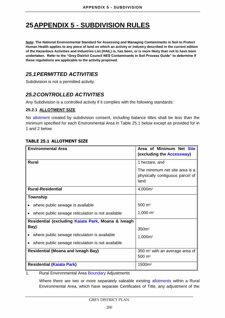
TABLE 25.1 ALLOTMENT SIZE
Environmental Area Area of Minimum Net Site
(excluding the Accessway)
Rural 1 hectare, and
The minimum net site area is a
physically contiguous parcel of
land
Rural-Residential 4,000m2
Township
where public sewage is available
where public sewage reticulation is not available
500 m2
1,000 m2
Residential (excluding Kaiata Park, Moana & Iveagh
Bay)
where public sewage reticulation is available
where public sewage reticulation is not available
350m2
1,000m2
Residential (Moana and Iveagh Bay) 350 m2 with an average area of
500 m2
Residential (Kaiata Park) 1500m2
1. Rural Environmental Area Boundary Adjustments
Where there are two or more separately saleable existing allotments within a Rural
Environmental Area, which have separate Certificates of Title, any adjustment of the
APPENDIX 5 - SUBDIVISION
GREY DISTRICT PLAN
201
boundaries shall be a controlled activity provided that the resultant allotments are not
less than the smallest that existed before subdivision.
2. Access, Utilities, Roads, and Reserves
There shall be no specified minimum allotment sizes in any Environmental Area for
allotments created for access, utilities, reserves or roads.
25.2.2 WATER SUPPLY
1. All new allotments shall be provided with the ability for the respective potential land
uses to connect to a safe potable water supply.
2. Each allotment shall be provided with the ability to connect to the Council’s reticulated
system where such a system is available and a connection shall be laid to the
boundary of each lot created by a subdivision.
3. Where such a system is not available the applicant shall demonstrate that a water
supply suitable for the proposed use of the allotment is available.
4. That any subdivision within Kaiata Park development shall connect into a reticulated
potable water supply.
25.2.3 STORMWATER
1. All allotments shall be provided with a means of disposing of collected stormwater from
the roof of all buildings and impermeable surfaces to an approved system.
2. Where a reticulated stormwater disposal system is available each lot of subdivision
shall be provided with a connection from the boundary of that lot to the system.
3. Where no system is available stormwater shall be disposed of in an approved manner.
4. That any subdivision within the Kaiata Park development area shall connect into an
approved stormwater management system (where such system shall include provision
for ongoing maintenance).
5. That Kaiata Park development shall be in general accordance with the Kaiata Outline
Development Plan (attached as Appendix 12). Note that where reference is made to
reserves these include stormwater management areas.
25.2.4 SANITARY SEWAGE DISPOSAL
1. All allotments shall be provided with a means of disposing of sanitary sewage for the
potential land uses that could be established on the respective allotments.
2. Where a reticulated system is available for connection with the capacity to serve the
potential land uses that could be established on the allotment, each lot of subdivision
shall be provided with a piped sewage system outfall laid to the boundary of that lot.
3. Where a reticulated system is not available the applicant shall provide evidence that
effluent can be satisfactorily disposed of on-site.
4. That any subdivision within the Kaiata Park development area shall connect into an
approved sewerage reticulation system.
25.2.5 ENERGY SUPPLY AND TELECOMMUNICATIONS
1. All allotments shall be provided with the ability to connect an electric supply system
and telecommunications to the boundary of each of the lots.
APPENDIX 5 - SUBDIVISION
GREY DISTRICT PLAN
202
25.2.6 ROADING AND ACCESS STANDARDS
1. All roads shall be constructed in accordance with the Code of Practice (refer Section
25.7 - Schedule 1).
2. All vehicular access to fee simple title allotments, cross lease, unit title, or leased
premises, shall be in accordance with the standards set out below and shall be
constructed, where applicable, in accordance with the Code of Practice (refer Section
25.7 - Schedule 1).
TABLE 25.2 PRIVATE WAY, VEHICULAR ACCESS AND MISCELLANEOUS
PROVISIONS (NOT INCLUDING LEGAL ROADS)
Environmental
Area
Potential
No of
Units
Length Legal
Width
Carriage
-way
Width
Turning
Area
Passing
Bay
Footpaths
Residential
Township
0-4 All
Lengths
4 3.0 Required
if over
50m in
length
Optional Optional
Residential
Township
5-10 0-50 4 3.5 Required Required Optional
Residential
Township
5-10 Over 50 4.5 4.0 Required Required Required
All Other
Environmental
Areas
0-10 All
Lengths
6.0 4.0 Required Optional Optional
All Environmental
Areas
Service
Lanes
All
Lengths
6.0 4.0 Required
if blind
end.
Optional Optional
All Environmental
Areas
Pedestria
n Access
All
Lengths
2.1 2.1 N/A N/A N/A
All Environmental
Areas
Access
Ways and
Cycle
Ways
All
Lengths
2.1 2.1 N/A N/A N/A
Minimum Height Clearances Vehicular Access and Service Lanes 3.5m
3. The maximum number of lots that may be served by a private way or access lots is 10.
4. Every lot shall be of sufficient size and frontage to be capable of providing a complying
access (Refer to Rule 24.3).
5. That any subdivision within the Kaiata Park development area shall be in general
accordance with the Kaiata Outline Development Plan (attached as Appendix 12).

APPENDIX 5 - SUBDIVISION
GREY DISTRICT PLAN
203
6. Any subdivision and/or development in the Kaiata Park area will require the Fairhall
Road intersection with State Highway 7 to be upgraded in accordance with the design
specifications published in the Austroads document ‘Guide to Traffic Engineering
Practice Part 5: Intersection at Grade’ to provide a full T-Junction Intersection with left
turn and right turn lanes from both state highway approaches to the intersection.
7. Any subdivision and/or development in Paroa Developments will require the Clough
Road and State Highway 6 intersection to be upgraded in accordance with the
intersection standard attached as Diagram F in Appendix 4.
25.2.7 ROADING AGREEMENTS
Where during the course of the subdivision it is necessary to make provision for future roads
that cannot be formed or vested immediately, until other land becomes available or are
separated from the frontage road by intervening properties, a caveat will be registered on the
subject land, supported by roading agreement, stipulating that when the other land becomes
available, the Council may call upon the restrictive owners to form and vest and pay the cost
to form and vest the required land for road. The cost of construction will be the current prices
at the time that the Council calls upon the respective owner to form and vest the land.
25.2.8 POINT STRIPS – SITE STANDARDS
Where in the course of subdivision a new road is constructed and vested that will or could
provide frontage to other land, that other land will be separated from the new road by a point
strip, and an agreement will be entered into by the first subdivider with the Council, to ensure
the benefiting owner pays a fair share towards the cost of providing the frontage road. The
point strip agreement sets the amount to be paid, which will be updated from the date of
signature of the agreement by the Consumers Price Index. Such agreements will be held by
the Council and can be identified by the point strip separating the subsequent property from
frontage to the road.
Point Strips may also be required where access to any road would be unsafe.
A point strip of no less than 100mm in width shall be created along the State Highway 7
frontage of any new allotment, or balance allotment created within the Kaiata Park
development area and fronting State Highway 7 including any allotment created to contain the
wetland area. Such point strip shall vest in Her Majesty the Queen for Use in Connection with
a road (point strip).
25.2.9 NATURAL HAZARDS
That the site is not subject to any actual or potential natural hazards.
25.2.10 ELECTRICITY TRANSMISSION NETWORK
The subdivision of a site containing or within 14m of National Grid Infrastructure shall meet all
of the following standards:
1. It is demonstrated that any allotment created can contain a 15m x 15m area of land
which:
a) Is located entirely outside of the National Grid Buffer Area; and
b) Has reasonable physical and legal access; and
c) Could accommodate a building which can comply with all District Plan activity
standards for the Environmental area it is located in.
APPENDIX 5 - SUBDIVISION
GREY DISTRICT PLAN
204
2. The subdivision maintains any existing access to National Grid Infrastructure.
3. Written documentation is provided which demonstrates consultation has occurred with
the National Grid Operator. This shall include any response received from the
Operator.
4. The minimum lot size for any allotment which contains any part of the National Grid
Buffer Area shall be 1 ha.
25.3 MATTERS WHICH COUNCIL RESERVES CONTROL OVER
1. Financial contributions (refer to section 15).
2. Effects of natural hazards.
3. Design and layout of subdivisions.
4. Protection of natural features – vegetation, heritage items, landscapes.
5. Access and roading.
6. Earthworks.
7. Siting of buildings.
8. Provision of services.
9. Esplanade reserves.
10. Effects of and on Public Infrastructure.
25.4 DISCRETIONARY ACTIVITIES
Any subdivision that contravenes a controlled standard, and is not otherwise specified as a
non-complying activity under rule 25.4A is a discretionary activity.
25.4A NON-COMPLYING ACTIVITIES
From 1 July 2018, any subdivision which contravenes Rules 25.2.10(1) or (2) is a non-
complying activity.
25.5 ASSESSMENT MATTERS FOR CONTROLLED AND
DISCRETIONARY MATTERS
In considering whether or not to grant consent or impose conditions, the Council shall have
regard to, but not be limited by, the following assessment matters for the respective standards:
25.5.1 ALLOTMENT SIZE
1. Whether the allotment is of sufficient area to effectively fulfil the intended purpose or
activity, having regard to the relevant Environmental Area standards and general
standards for activities.
2. Whether the proposed lot sizes are sufficient for operational and maintenance
requirements.
3. The relationship of the proposed allotments and their compatibility with the pattern of
the adjoining subdivision and land use activities, and access arrangements.
4. Where a parcel is less than 1 hectare and is part of a non-contiguous title, the
following:

APPENDIX 5 - SUBDIVISION
GREY DISTRICT PLAN
205
a) The number and scale of non-contiguouse parcels of land.
b) Whether it is intended or likely that the site will contain a dwelling.
c) The effects, both positive and adverse, of non-contiguous parcels of land,
particularly if they are grouped or clustered, on
The natural character of waterbodies and wetlands including their margins
and the coastal environment
Areas of outstanding natural features and landscapes and significant
natural areas
Provision of services, including roading and the disposal of effluent and
stormwater
Spaciousness and openness of the rural area, including the potential effect
of structures
Natural and coastal hazards
The function of the state highway network, including the appropriateness of
the access with respect to, but not limited by, location and standard of
access.
d) The reasons for the non-contiguous nature of the site.
25.5.2 PROPERTY ACCESS AND ROADING
1. Whether the frontage road is of sufficient width to cater for the expected traffic
generated by the possible activities that will be established on the allotments being
created, and whether there is any need to upgrade the frontage road.
2. Any impact of roading and access on waterways, ecosystems, drainage patterns or the
amenities of adjoining properties.
3. The application of the requirements of Section 106(1)(c), Resource Management Act
1991, to any subdivided allotment.
4. The provisions of the Code of Practice for Subdivisions (Section 25.7 - Schedule 1).
5. The practicality of providing access elsewhere for vehicles, particularly where
alternative access to the State highway is available.
6. The provisions of the roading hierarchy, the account taken of pedestrian movement,
provision of space for cyclists, amenity values of the street, opportunities for tree
planting in the open space of the road way to enhance the character and identity of the
neighbourhood.
7. The need to provide cycleways in circumstances where the roading network does not
supply sufficient or direct cycle routes through the locality.
8. The degree to which proposed new roads make adequate provision for vehicle
movements, car parking and property access.
9. The need to provide pedestrian accessway facilities in circumstances where the
roading network does not provide sufficient or direct access or easy walking access to
facilities in the vicinity.
10. The need to provide alternative access for car parking and vehicle loading in
commercial or industrial Environmental Areas by way of vested service lanes at the
APPENDIX 5 - SUBDIVISION
GREY DISTRICT PLAN
206
rear of properties having regard to alternative means of access and performance
standards for activities within such Environmental Areas.
11. Any need to require provision be made in a subdivision for the vesting of road reserves
for the purpose of facilitating connections to future roading extensions to serve
surrounding land, or planned road links that may need to pass through the subdivision
and the practicality of creating such easements during the time of subdivision
application in order to facilitate later development.
12. The need to provide for appropriate standards of street lighting having regard to the
classification of the road or the right of way, and the Council's Code of Practice for
Subdivision (Section 25.7 - Schedule 1).
13. Roading layout and access to the State Highway for the Kaiata Park development area
are to be undertaken in accordance with Appendix 12. The provision of the Outline
Development Plan for Kaiata Park will provide assurance that access is provided to an
adequate standard and that the internal roading layout and bridges are positioned in
general accordance with that plan.
14. The need for and extent of any financial contribution to achieve the above matters.
15. Whether the vehicle access to the allotment will provide adequate visibility to adjoining
roads.
25.5.3 NATURAL HAZARDS
1. Any information held on the Grey District Council's and the West Coast Regional
Council’s Hazard registers.
2. Information obtained by suitably qualified experts, whose investigations are required to
be supplied for all subdivision applications, unless the site or property has previously
been certified as suitable for the proposed land use.
3. Potential adverse effects on other land that may be caused by the subdivision or
anticipated land use activities.
4. Any report from a suitably qualified and experienced expert, detailing the measures
that have been or will be taken to avoid, remedy or mitigated any hazard that may
occur on the property.
5. In relation to potential for inundation from any source, Council shall have regard to the
following factors:
a) The effects of any proposed filling being undertaken to avoid inundation and the
consequential effects on the natural drainage pattern and adjoining land.
b) The erection of sea walls and their environmental effects.
c) Any proposed boundary drainage to protect surrounding properties.
d) The adequacy of existing outfalls and any need for upgrading.
e) Any need for retention basins to regulate the rate and volume of surface runoff.
6. In relation to potential for erosion, falling debris or slippage the need for ongoing
conditions aimed at avoiding, remedying or mitigating future potential adverse effects,
and any need for registration of consent notices on the allotment’s Certificate of Title.
7. In relation to potential for subsidence, the provision of suitability certificates, such as
NZS 4431, or if not appropriate, the setting of ongoing conditions, with consent notices
registered on the Certificates of Title.
APPENDIX 5 - SUBDIVISION
GREY DISTRICT PLAN
207
8. In relation to a contaminated site, any soil tests, establishing suitability, and methods to
avoid mitigate or remedy the effects, including removal to approved disposal points.
9. In relation to proposed land filling and excavation operations, the following factors:
a) The effects on surrounding properties.
b) The natural pattern of surface drainage.
c) The type of and placement of fill material.
d) Mitigation, or avoidance, of adverse effects caused by dust or siltation affecting
neighbouring properties.
e) Remedies necessary during emergencies.
25.5.4 WATER SUPPLY
1. Where there is no urban water supply or a Council restricted flow rural type water
supply available for connection, whether it would be appropriate to allow a private
restricted flow rural type water supply system.
2. The suitability of the proposed water supply for fire fighting purposes. A Fire Fighting
Water Supplies Code of Practice is included in 25.7 Schedule 1 and the Council may
obtain a report from the Fire Service.
3. The provisions of the Code of Practice (Schedule 1)in respect to installation of all
necessary water supply pipe lines, and ancillary equipment necessary for the
subdivision, including extensions to existing supply systems, and including mains,
submains, service links and fire hydrants.
4. Whether the existing water supply systems, to which the connection will be made, have
sufficient capacity to service the subdivision and if no,t that the subdivider contribute
towards the upgrading of the system based on the cost of supplying the incremental
increase in demand by the additional lots, in addition to installing the extensions of the
supply within the subdivision.
5. Whether it may be necessary to provide new reservoirs, pumping stations and rising
mains, or increasing pipe sizes leading to the subdivision in existing streets, and the
level of contribution a subdivider should contribute toward this.
6. Whether because of increased demand that the potential land users may impose upon
the system, an upgrading contribution should be made for a programmed plan for
installation of new wells, reservoirs and pumping units.
7. The extent of the water supply headworks upgrading contributions taking account of
the likely use of water by the subdivision and the potential land use activities that could
be permitted on the land.
8. The extent of any financial contribution toward the provision and upgrading of any
public water supply system.
9. The need for a local purpose reserve to be set aside and vested in the Council as a
site for a public utility.
10. Where it is necessary to upgrade the reticulated water supply system in order to cater
for the subdivision, any costs to be borne by the subdivider, calculated on the cost of
supplying the increase in demand as a result of the additional allotments.
11. The provisions of the Council's Code of Practice (Section 25.7 - schedule 1).
APPENDIX 5 - SUBDIVISION
GREY DISTRICT PLAN
208
12. The suitability of any proposed water supply that is supplied by a developer for
drinking.
25.5.5 STORMWATER
1. The provisions of the Code of Practice for Subdivisions (Schedule 1).
2. The adequacy of any proposed means for screening out litter, the capture of chemical
spillages, the containment of contamination from roads and paved areas and of
siltation.
3. The ability to retain open natural waterway systems for stormwater disposal in
preference to piped or canal systems and any adverse impacts on existing waterways.
4. Demonstration that there is sufficient capacity available in the Council's outfall
stormwater system to cater for increased runoff from the proposed allotments.
5. The availability of an approved outfall where stormwater can be directed to, where
such an outfall is capable of absorbing increased runoff.
6. Where an existing outfall is not capable of accepting increased runoff, proposals and
solutions for disposing of runoff; the necessity to provide an on-site retention basin to
contain surface runoff where the capacity of the outfall is incapable of accepting flows,
and where the outfall has limited capacity, any need to restrict the rate of discharge
from the subdivision to the same runoff coefficient that existed on the land before
subdivision takes place.
7. Any adverse effects of the proposed subdivision on drainage on, or from, adjoining
properties and mitigation measures proposed to control any adverse affects.
8. For stormwater pipes and open waterway systems, the provision of appropriate
easements in favour of either the registered user or in the case of the Council,
easements in gross, to be shown on the survey plan for the subdivision, including
private connections passing over other land protected by easements in favour of the
user.
9. Where stormwater disposal cannot be obtained by gravity outfall, the need to ensure
the land is not filled against the fall of the country, solely to obtain such outfall, and
whether it is practical to provide easements through adjoining owners’ land to other
frontage outfall systems.
10. As part of the Kaiata Park development a stormwater management system, including
provision for its ongoing maintenance, is required to be established that will mitigate
any adverse effects on the surrounding environment.
11. The need for and extent of any financial contribution to achieve the above matters.
12. The need for a local purpose reserve to be set aside and vested in the Council as a
site for a public utility for stormwater disposal purposes.
25.5.6 SEWAGE DISPOSAL
1. The capacity, availability, and accessibility of the reticulated system to serve the
proposed subdivision.
2. The installation of all new reticulation.
3. The provisions of the Code of Practice (Schedule 1).

APPENDIX 5 - SUBDIVISION
GREY DISTRICT PLAN
209
4. The relevance of any existing cost sharing scheme and whether the proposed
reticulation will benefit other property owners.
5. Where a reticulated system is not available, or a connection is impractical, provision of
septic tank or other disposal systems in accordance with either a general authorisation
or a discharge permit issued by the Regional Council.
6. Where a reticulated system is not immediately available but is likely to be in the near
future, the appropriateness of temporary systems.
7. Provision made by the applicant for monitoring mechanisms to ensure contaminants
are not discharged into the environment from septic tank or other disposal systems,
together with any consent notices to ensure compliance.
8. The Kaiata Park Outline Development Plan indicates the location of the sewage
treatment plant and stand of trees (approximately 4.5 hectares) which will provide a
buffer between the treatment plant and the Rural Residential Environmental Area. At
the time of any subdivision application with the potential to enable a dwelling to be
constructed within 150m of the Kaiata Park sewage treatment area, confirmation will
be required that a building platform can be located at a distance of greater than 150m
from the edge of the sewage treatment area. Should land use consent be required for
the establishment of the treatment plant consideration of future ownership shall be
undertaken and the potential need for designation reviewed.
9. The extent of any financial contribution toward the provision and upgrading of sewage
reticulation and services.
25.5.7 ENERGY SUPPLY AND TELECOMMUNICATIONS
1. Where the subdivision involves construction of new roads or formed rights of way, the
installation of an extended reticulation system (at the subdivider's responsibility) with
regard to the Subdivision Code of Practice and the network operator’s requirements.
2. The adequacy of the proposed reticulated system to be installed by the subdivider.
3. Where the proposed system will serve other land that is not part of the subdivision,
whether the network operator is providing sufficient capacity, and the cost of such
provision.
4. The practical ability to connect to available systems.
5. Appropriate separation distances are required for buildings and structures from
National Grid infrastructure; refer to the Environmental Area and the subdivision rule
sections of this District Plan.
Where National Grid Infrastructure passes through, or close to, a property proposed to
be subdivided, consideration shall include:
Whether the subdivision design has incorporated measures, including suitable
setbacks, to ensure an allotment is of sufficient dimensions to effectively fulfil the
intended purpose or activity, having regard to the relevant Environmental Area
standards and general standards for activities.
The relationship of the proposed allotments and their compatibility with the National
Grid Infrastructure including any necessary access arrangements for the
maintenance of the network.
APPENDIX 5 - SUBDIVISION
GREY DISTRICT PLAN
210
Whether the proposal includes reference to other regulatory requirements including
safe separation distances in the NZ Electrical Code of Practice for Electrical Safe
Distances (NZECP34:2001)
Technical comment provided by the Network Utility Operator.
Note: The presence of other 66kV transmission lines shown on Planning Maps 2, 3, 4, 7, 8,
10, 12, 13, 16, 31, 33, 34, 35, 37, 40, 41, 43, 46 and 47 is drawn to the attention of persons
proposing to subdivide. If any subdivision is proposed within 20m of these transmission lines,
Transpower New Zealand Ltd should be contacted to obtain details on the necessary safe
clearances between transmission lines and building, structures, vegetation and activities such
as the operation of mobile plant. Council shall be advised on the outcome of any discussion.

APPENDIX 5 - SUBDIVISION
GREY DISTRICT PLAN
211
25.5.8 ESPLANADE RESERVES AND STRIPS
TABLE 25.3
1. Esplanade reserves and strips may be set aside if:
a) Ecological or natural values would be protected or enhanced.
b) Public access would be enhanced having regard to the existing level of
access available.
c) Recreational use would be protected or enhanced.
d) Water quality or aquatic habitat value would be protected or enhanced.
e) The land is within a natural hazard area or where there is an identified risk
from one or more natural hazards (such as coastal erosion).
f) The creation of an esplanade reserve would complete or promote the
marginal protection of a river, lake or coastline.
2. The width of an esplanade reserve and strip may be varied from 20 metres or waived
if:
a) The natural values warrant a wider or narrower esplanade strip or esplanade
reserve; or
b) Topography, or the siting of any building or other feature, renders the 20-
metre width inadequate or excessive; or
c) The protection of waahi tapu, mahinga kai and other taonga requires an
esplanade reserve or esplanade strip of greater or lesser width than 20
metres; or
d) The protection or enhancement of water quality requires an esplanade
reserve or esplanade strip of greater or lesser than 20 metres; or
e) The land is within a natural hazard area of where there is an identified risk
from one or more natural hazards (such as coastal erosion); or
f) The costs of the provision and maintenance of a 20 metre wide esplanade
reserve or esplanade strip are more than the potential public benefits of the
purposes of esplanade reserves or strips; or
g) Where the creation of a 20 metre wide esplanade reserve or esplanade strip
would create result in risks to public safety or the security of property; or
h) There is adequate alternative public access; or
i) There is adequate means of protecting water quality and conservation values;
or
j) There is adequate provision for public recreational use of the area of coast,
river or lake in question.
APPENDIX 5 - SUBDIVISION
GREY DISTRICT PLAN
212
25.5.9 RESERVE CONTRIBUTIONS
NB: As indicated in Section 15.6.7 Financial Contributions Council will generally take 2% as a
maximum amount of the value of each new allotment in a subdivision.
1. Where, within the preceding 5 years, the subdivision creating the allotment made
provision for reserves in excess of the previous subdivision assessment, or where a
development levies, as the case may be, shall be taken into consideration when the
new assessment is made.
2. Where the contribution towards the provision of land or open space and recreation is
not to be paid to the Council before a Conditions certificate is issued pursuant to
Section 224 of the Act, a requirement for the applicants to enter into a bond.
Note: documentation will be registered against the Certificates of Title issued for the
allotment(s), preventing their sale until contribution is paid, and subject to the following:
a) payment of the prescribed fee, including all legal costs.
b) the assessment amount for payment being adjusted in accordance with the
valuation NZ index if not paid within two years of the assessment.
c) payment shall be either:
i) the total assessment being paid on the sale of half the number of
allotments in the subdivision less one; or
ii) an instalment system based on the assessment being divided by the
total number of allotments less one, with payment commencing at the
first transfer.
d) whether the undertaking of works, including the planting of trees or the
regrading or levelling of reserve land that will vest in the Council, or the setting
aside of a reserve to protect any natural features, should be taken into account
when assessing the value of the contribution towards land for open space and
recreation.
25.6 REASONS FOR RULES
25.6.1 STATUS OF SUBDIVISION ACTIVITIES
Because of the location and great variety of site characteristics of subdivision, both
modified and natural, it is not considered possible to predetermine what conditions may
need to be applied to any subdivision. All subdivisions therefore are at least controlled
activities. Failure to meet specific site or Environmental Area standards will require a
controlled or discretionary resource consent.
25.6.2 GENERAL PURPOSE OF SUBDIVISION CONTROL
As subdivision is often the basis for land development it is logical, in relation to the
provision of services, that this provision be co-ordinated at the time of subdivision to
avoid piecemeal provision of services upon individual properties being developed. Co-
ordinated and standardised servicing of subdivisions ensures that the purchasers of
sections and the community can expect and achieve an acceptance level of services
and amenity and protection of the natural and physical resources. Rules for subdivision
have as far as possible been written to address effects, not the type of tenure chosen.
APPENDIX 5 - SUBDIVISION
GREY DISTRICT PLAN
213
25.6.3 SUBDIVISION DESIGN
The purpose of controls on subdivision design are to ensure that allotments are
appropriately located in relation to each other and to available sunshine for energy
conservation purposes, that walkways provide logical links with adjacent areas, that
buildings are located where there is the minimum risk of damage from natural hazards,
and that natural stormwater channels and wetland areas are used for the benefit of
both residents and the natural values of the area.
25.6.4 ALLOTMENT SIZE AND DIMENSIONS
The Rural Areas Objectives and Policies address the reasons for the minimum lot
sizes required in the Rural Environmental Area.
There is a requirement for rural sections to be a minimum size of 1 hectare. A site or
title can be made of separate parcels of land (a non-contiguous layout) but each parcel
must meet the minimum 1 hectare requirement. If a smaller site or parcel of land is
proposed then discretionary resource consent is required.
The 1 hectare minimum size requirement has been set in order to retain the openness
and spaciousness of the rural environment and to protect the natural character of the
coastline and waterbodies and their margins, and to address the provision of services.
The creation of small parcels and sites in the rural environment and the subsequent
erection of dwellings can result in a clustering effect. While there may be benefits in the
clustering of parcels or sites – including the efficient provision of services, the
avoidance of natural hazard areas and retention of areas without built intrusions – it is
considered appropriate that Council maintain discretion over this type of development.
While many of the effects will arise from the erection of dwellings, it is considered
appropriate that subdivisions are assessed given the expectations raised by
subdivision and the likely subsequent land use. Sites and non-contiguous parcels of
land that are smaller than 1 hectare will potentially have a more significant effect if it is
proposed or intended that a dwelling be erected on them.
A small number of non-contiguous 1 hectare subdivisions were being process at the
time of a change to the plan being introduced. It is reasonable to allow these proposals
to proceed as per the provisions in place when they were lodged. Therefore these sites
have been given an exemption in regard to Rule 19.7.2.
The minimum area requirements for Residential, Rural-Residential and Township
Environmental Areas are also addressed in the objectives and policies for these areas,
and reflect a balance between a need for urban consolidation and the protection of
character and amenity on the other hand. In general, the lot sizes aim to maintain the
character of previous development and enable a variety of complying development.
However, in recognition that many sites are subdivided and built on simultaneously,
and that therefore the siting of the buildings is finalised at the subdivision stage, the
rules permit a reduction in minimum area where there is a building commitment and
that building will comply with all relevant standards for the Environmental Area. In
Moana and Iveagh Bay a larger average area is required to recognise the special
amenity of these areas. In Kaiata Park, a larger minimum net site area is required to
remain in keeping with residential properties in the Kaiata and Dobson area and to
retain the overall character of the area.
The larger minimum area for unserviced lots is required to enable sewage to be
adequately collected and disposed on-site.
APPENDIX 5 - SUBDIVISION
GREY DISTRICT PLAN
214
The boundary adjustment provisions recognise that the effects of such alterations are
minor provided no additional allotments are vested.
Allotment dimensions are specified to ensure that, in residential areas in particular,
allotments are of a shape that permits some flexibility in placing a complying building
on-site at a later stage.
The subdivision of a site containing or in close proximity to National Grid Infrastructure
shall include in its design, provision for existing and future buildings or structures to be
erected in compliance with national Grid setback requirements as applied for the
relevant Environmental Area.
25.6.5 TRADE WASTE DISPOSAL
Trade Waste Disposal bylaws are currently being drafted. Council also has the power
to place conditions on subdivisions that set standards for such disposal to avoid
contamination of ground or surface water and to maintain the efficiency and capacity of
general sewage treatment and disposal systems of the District.
25.6.6 WATER SUPPLY
To ensure that a safe and adequate supply of potable water is available, all allotments
in or adjoining areas with Council reticulated water supplies will be required to connect
to such supplies. Financial contributions towards water supply upgrading or the
provision of new water supply infrastructure ensure that the costs of maintaining or
extending water supplies of an acceptable standard are apportioned according to the
demands placed on water supplies by new subdivisions. The assessment matters
enable the consideration of the adequacy of water supply provision on any subdivision
for reasons of public health, convenience and efficient use of supply infrastructure.
25.6.7 STORMWATER
The controls on the disposal of stormwater have the primary purpose of avoiding
adverse effects of stormwater on adjacent land. Stormwater can also impact on the
quality of surface water. In general these concerns are most relevant within settlement
areas where the density of development can result in stormwater flowing onto adjacent
land, or more rapid or contaminated runoff into natural watercourses. Financial
contributions towards stormwater disposal system upgrading or the provision of new
stormwater infrastructure ensure that the costs of maintaining or upgrading stormwater
systems to an acceptable standard are apportioned according to the demands place
on stormwater disposal by new subdivisions.
25.6.8 SEWAGE DISPOSAL
The subdivision rules on sanitary sewage disposal complement the West Coast
Regional Council controls which have the purpose of protecting the quality of ground
and surface water. In the settlement areas where Council reticulated disposal systems
are available the subdivision rules require that all lots be provided with a means of
disposal, being a minimum diameter piped outfall connected onto the Council system.
Because subdivisions in rural areas do not necessarily involve residential use and
because there are few reticulated disposal systems, requirements for sanitary sewage
disposal in other areas would be implemented through building consents. Financial
contributions towards sewage disposal system upgrading or the provision of new
sewage disposal infrastructure, ensure that the costs of maintaining or upgrading
sewage systems to an acceptable standard are apportioned according to the demands
place on sewage disposal by new subdivisions.
APPENDIX 5 - SUBDIVISION
GREY DISTRICT PLAN
215
The stand of trees in Kaiata Park has been specifically cited because this provides a
buffer and helps to ensure that the 150 metres separation of residential buildings from
any sewage treatment plant is maintained, and that the effects on the environment are
minimal. It is vital when allowing development to occur around the treatment site that
new development is not located in a position where it will be sensitive to the operation.
Where land use consent is required and ownership is proposed to be transferred to the
Council the alternative of designation of the site may be appropriate for review at the
time of subdivision and development.
25.6.9 ELECTRIC AND TELEPHONE SUPPLY
The rules require that as a minimum all lots, other than in Rural Environmental Areas
(but including lots principally for residential or other non rural purposes), have the
ability to connect to an electric supply and telephone system at the boundary of the
site. This requirement ensures that services expected by subsequent owners will be
available. In addition, the adequacy of the standard of energy and telecommunications
installations and their co-ordination can be ensured by conditions on the subdivision.
25.6.10 PROPERTY ACCESS
The rules specifying widths for roads and the assessment matters regarding roads are
to ensure that all new roads and property access are created with the capacity to
provide access for residents of the area and link up with the adjoining road network
safely and efficiently, avoiding congestion, and providing for on street parking and
pedestrian/cycle movement.
The rules for private vehicular access are to ensure the accesses can adequately cater
for likely anticipated volumes of traffic. Provision for turning areas and passing bays
also relate to the likely number of users and have the purpose of avoiding hazardous
and inconvenient reverse manoeuvres. Footpaths are required to promote pedestrian
safety. Where more than ten residential units are likely to be served a road is
considered necessary to ensure safe and efficient vehicle movement.
Corner roundings are required to facilitate pedestrian movement and safety. Naming of
streets is provided for to enable ready identification and efficient delivery of services to
all properties including emergency services.
Road upgrading costs have the purpose of ensuring that costs of providing roads of an
acceptable standard is apportioned in accordance with the demands placed on those
roads by development of subdivisions. Point strips can ensure that contributions to
roading will be made in the future as required.
For the purposes of rule 25.2.6.7 any subdivision within Paroa Developments will need
to pay the full cost of upgrading the Clough Road and State Highway 6 intersection and
the financial contribution policy section 15.6.1 of the Plan does not apply.
25.6.11 NATURAL HAZARDS
The controlled activity provision enables the Council to place conditions on the need
for works, the location of services, earthworks and the location of buildings, with the
purpose of limiting likely damage from natural hazards such as erosion, flooding,
landslip and unconsolidated fill. This provision is needed to enable the extent of natural
hazards to be fully ascertained for each site at the time of subdivision as this
information is not always available at the time the District Plan is prepared. Within
areas of high flood risk or high risk of coastal erosion, the discretionary activity

APPENDIX 5 - SUBDIVISION
GREY DISTRICT PLAN
216
provision enables the Council to assess the effect of the subdivision in increasing the
amount of property at risk from natural hazards or in increasing the severity of the
hazard.
APPENDIX 5 - SUBDIVISION
GREY DISTRICT PLAN
217
25.7 SCHEDULE 1 -CODE OF PRACTICE FOR SUBDIVISION
The Code of Practice for subdivision is comprised of the following documents.
Document Status Application Implementation
Date
Land Development and Subdivision
Engineering NZS 4404:2004 (and
any NZ Standard that supersedes
this document and is adopted by the
Council)
New Zealand
Standard
Land Development,
Subdivision
Engineering
Activities
2004
Bridge Manual Guideline
Guideline (M)
Local Roads
State Highways
May 1994
Waterways Design Austroads 1994 Guideline All Roads June 1994
Highway Surface Drainage - Design
guide for Highways with a Positive
Collection System NRB 1997
Guideline All Roads November 1977
Guide to Cycle Facilities NRB/UTC
1985
Guideline All Roads 1985 Approx
Rural Roads: Guide to Geometric
standards for Rural Roads NRB
1985
Guideline New or Upgrade
Projects on Local
Roads Included in
NLTP
1985 Approx
State Highways: Rural Road Design
Guide to the Geometric Design of
Rural Roads Austroads 1989
Guideline (M)
Guideline
State Highways
Recommended for
Local Authority
Roads
1989
Guidelines for Two Lane Rural State
Highways: Changes to Widths
Section 7.1.2(1) and App VII.I of
SHPPM and General Circular 93/8
Cross for State Highways
Guideline (M)
Guideline
State Highway
New or Upgrading
Works
2 July 1993
Safety Barriers and Median Barriers
3.4.0.7 State Highway Control
Manual
Guideline State Highways 1994
Guide to Traffic Engineering Practice
Pt 5 Intersections at Grade NAASRA
1988 with Roading Design
Guidelines RD-1 Intersections at
Grade Transit 1991
Guideline (M)
Guideline
State Highways
All New or
Upgrading Works
1991
APPENDIX 5 - SUBDIVISION
GREY DISTRICT PLAN
218
Document Status Application Implementation
Date
Guide to Traffic Engineering Practice
Pt 6 Roundabouts Austroads 1993
with Roading Design Guidelines RD-
2 I 1991
Guideline (M)
Guideline
State Highways
All New or
Upgrading Works
1991
Bituminous Sealing Manual Transit
1993
Guideline (M)
Guideline
State Highways
All New Seals and
Reseals
1993
Austroads Guide to Structural
Design of Road pavements in NZ
(1992) plus NZ Supplement (Nov
1995
Guideline (M)
State Highways July 1995
Design Guide for Assessing Freeze
Thaw Effects on Pavements
Guideline
Guideline
Local Roads
State Highways
July 1995
Land Transport Programme
Development and Management
Manual
Standard All Road Controlling
Authorities and
Regional Councils
1 July 1994
TR 11 Recommended Practice for
Pedestrian Crossings
Guideline All Roads 1988
Guidelines for Planting for Road
Safety
Guideline (M)
Guideline
State Highways
Local Roads
1991
Manual of Traffic Signs and
Markings Pt1 Traffic Signs Transit/
MOT 1992 for RG, RP, RH, TW and
PW Series Signs Manual of Traffic
Signs and Markings NRB 1975 (for
Information Signs Not yet
Republished)
Guideline (M)
Guideline
State Highways
Local Roads
Ongoing
Manual of Traffic Signs and
Markings Pt2 Markings, Transit/
LTSA 1994
Guideline (M)
Guideline
State Highways
Local Roads
New and
refurbished
installations after
June 1994
General Circular No 95/10
Guidelines for the Implementation of
an Urban Route System
Guideline Local Authority
Roads
24 February
1992

APPENDIX 5 - SUBDIVISION
GREY DISTRICT PLAN
219
Document Status Application Implementation
Date
RTS 1 Guidelines for the
Implementation of Traffic Control at
Crossroads MOT
Guideline (M)
Guideline
State Highways
Local Roads
Progressive from
November 1990
RTS 2 Guidelines for Street name
Signs MOT
Guideline (M)
Guideline
State Highways
Local Roads
Progressive from
November 1990
RTS 5 Guidelines for Rural Road
Marking and Delineation
MOT/Transit 1992
Guideline Local Authority
Roads
Progressive from
October 1990
RTS 2 Guidelines for Visibility at
Driveways MOT
Guideline August 1994
RTS 7 Advertising Signs and Road
Safety
Guideline State Highways August 1994
RTS 8 Guidelines for Safe Kerbline
Protection
Guideline State Highways August 1994
RTS 9 Guidelines for the Signing
and Layout of Slip Lanes
Guideline State Highways August 1994
Standards Criteria and guidelines
Manual
Guideline (M)
Guideline
State Highways
New Zealand
Transport
Agencyand Local
Authorities
December 1993
NZS 6701: 1983 Code of Practice for
Road Lighting
Guideline (M)
Guideline
State Highways
Local Roads
Progressive from
1983
Traffic Signals - A Guide to the
Design of Traffic Signal Installations
NAASRA 1987 with Road and Traffic
Standards No 11 MOT 1990
Guideline (M)
Guideline
State Highways
Local Roads
From June 1990
New Zealand Fire Service Fire
Fighting Water Supplies Code of
Practice SNZ PAS 4509:2003
New Zealand
Standard
Suitability of water
supplies for fire
fighting purposes
2003

APPENDIX 5 - SUBDIVISION
GREY DISTRICT PLAN
220