Embed Size (px)
Citation preview

Climate Classification
GEOG/ENST 2331 – Lecture 19Ahrens: Chapter 17
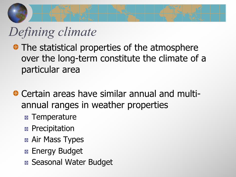
Defining climateThe statistical properties of the atmosphere over the long-term constitute the climate of a particular area
Certain areas have similar annual and multi-annual ranges in weather properties
TemperaturePrecipitationAir Mass TypesEnergy BudgetSeasonal Water Budget

Climate classificationVariables are not independent
Similar regions can be grouped togetherGeneralizations can be useful
Ancient GreeksTropical, temperate and polarClassification based on latitude

Global precipitation pattern predicted by the
general circulation

MountainsTemperature decreases with altitudeRain shadows form downwind
Ahrens: Fig. 16.6

OceansModerate temperatureProvide moisture
A&B: Figure 7-10

Climate classificationAncient Greeks
Latitude (temperature)
The Köppen System (1918)Vegetation used as an indicator because of sparseness of direct observations
Thornthwaite’s SystemP/E index (1930)Potential evapotranspiration (1948)

The Köppen SystemAhrens: Fig. 16.7 See text p. 480


Additional codes for A, C and Df – full year precipitations – driest in summerw – driest in winterm – monsoon
a – hottest summersbcd – coldest summers

A - Tropical ClimatesBetween the Tropics of Cancer and CapricornExhibit warm temperatures and minimal seasonal temperature variation

Af – Tropical wet climate
Climograph for Iquitos, Peru4°S, 73°W130 m above MSLITCZ is always closeWindward side of Andes
Ahrens: Fig. 16.12

Tropical wet climates (Af)Brief but often heavy afternoon thundershowers

Am climographs – Monsoonal
Occur near tropical coastal areas receiving onshore winds through much of the yearPronounced seasonal variations of precipitation

Aw – Tropical wet-and-dry climateTimbo, Guinea10°N, 12°WITCZ in summerSubtropical high in winter
Higher T from sunny skies
Ahrens: Fig. 16.14

Aw climatesRainfall may be unreliable
E.g. Sahel region
Savanna vegetation regimes dominate due to a lack of precipitation and frequent fires in the dry months
Diurnal temperature variations are pronounced in dry season when ranges may be as high as 15 C°
Few cloudsCloser to arid than tropical

B – Dry Climates• Potential evapotranspiration exceeds precipitation• Regions sub-classified as either semi-desert (steppe) or desert

Dry climates (B)Subtropical highsRain shadows and continentalityCold air
Can bring dry climates even to coastal areas

BWh – Arid hot climates
Phoenix, Arizona33°N, 102°WSubtropical highs
Band from 10°-30°
Hot days, cold nights
Ahrens: Fig. 16.17

BSh – Semi-arid hot climates

BWk – Arid cool climates
Extreme continentality and/or rain shadows
Very cold winter nights

BSk – Semi-arid cool climates
Medicine Hat, Alberta50°N, 140°W
Higher annual average precipitation
Ahrens: Fig. 16.20

C – Temperate Climates• Exist between 30° and 60°• Not cold enough for persistent snow in winter• Precipitation regimes vary considerably

Cfa, Cwa – Humid subtropical climates
Heat and moisture from on-shore advection due to off-shore subtropical highs
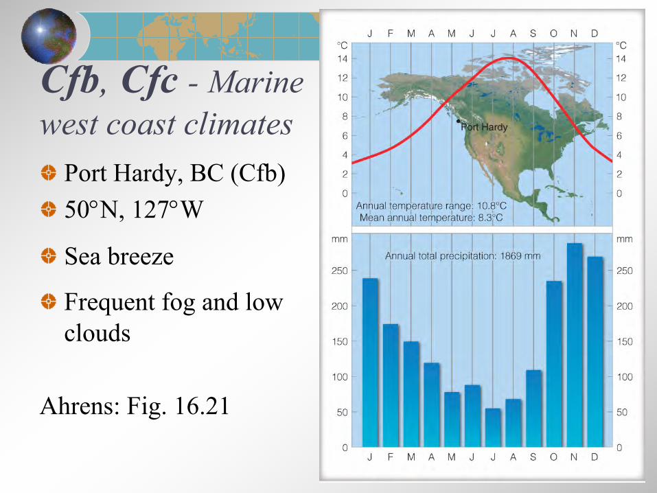
Cfb, Cfc - Marine west coast climates
Port Hardy, BC (Cfb)50°N, 127°W
Sea breeze
Frequent fog and low clouds
Ahrens: Fig. 16.21
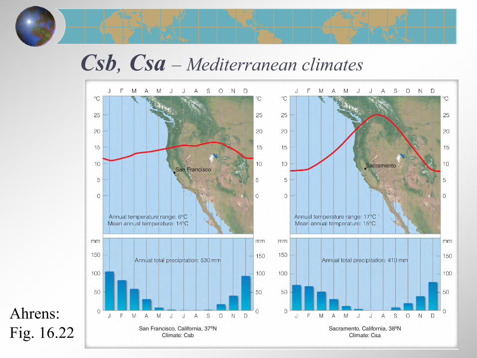
Csb, Csa – Mediterranean climates
Ahrens:Fig. 16.22

D – Cold Climates• Common between 40° and 70°• Cold enough for snow but warm enough for trees

Dfa, Dfb, Dwa, Dwb – Humid continental climates
Ahrens:Fig. 16.25

Dfc, Dfd, Dwc, Dwd – Subpolar climates
Churchill Falls, NL (Dfc)47°N, 53°W
Poleward of humid continental
Summers warm but short
Ahrens: Fig. 16.26

E – Polar Climates• Typically poleward of 70°• Treeless terrain and very cold temperatures

ET – Polar tundra climatesIgloolik, Nunavut69°N, 82°W
Harsh winters
High annual T range
Very low precipitation
Ahrens: Fig. 16.28

Polar tundra climatesNamed for tundra vegetation: low-growing mosses, lichens, shrubsPermafrost is a constant feature
Ahrens: Fig. 16.29

EF – Polar ice cap climatesEismitte, Greenland71°N, 3000 m above sea level
Areas of constant ice cover found in Greenland and Antarctica
Ahrens: Fig. 16.30

H – Highland Climates
Mountainous regions experience rapid temperature variations over short distances as a result of elevation changes
Slope and aspect play a role in energy and water balances• Enhanced precipitation versus rain shadows
Vertical changes become analogous to latitude changes, eventually leading to ice cap conditions in lofty elevation areas
This vertical zonation leads to highly variable local climates, all classified within H climate designation

H – British Columbia
Ahrens: Fig. 16.10

Next lectureGlobal Climatic change


![Volume 2331, A-33207 · 2010-10-15 · Volume 2331, A-33207 67 [ RUSSIAN TEXT – TEXTE RUSSE ] Volume 2331, A-33207 68. Volume 2331, A-33207 69](https://img.pdfslide.us/doc/110x75/5e29fada47cadc7f53049130/volume-2331-a-33207-2010-10-15-volume-2331-a-33207-67-russian-text-a-texte.jpg)