Embed Size (px)
Citation preview
Concept Validation/Pre-Design Technical Memorandum Metcalf & Eddy | Geosyntec Consultants
Westchester Rainwater Improvement Project
westchester pd tm 20080812 final.doc 15 8/12/2008
2.3 OPTIMIZATION OF THE CONCEPT REPORT SCOPE ELEMENTS
PUMPING Although the gravity system presented in the Concept Report is technically feasible, the size and depth
of excavation necessary to install and operate such a system was deemed impractical, based on cost
and construction constraints. Various pumping configurations were evaluated during the Hydrologic
Analysis (See Section 3) to determine the optimal layout and pumping capacities with respect to
excavation, energy requirements, and process efficiency. Pumping capacities ranging from 20 to 255 cfs
were evaluated in combination with options to pump directly from the diversion structure or to use the
URST for flow rate equalization prior to the UIFs. The optimal configuration was determined to be the
installation of a pump after the URST to convey flows to the underground infiltration facility at a steady,
predictable rate. Optimal pumping capacity was determined based on the hydrologic analysis as
described in Section 3.
TRASH CAPTURE AND REMOVAL SYSTEM The Concept Report included provisions for a trash rack, hydrodynamic separator, and underground
settling basin. The selected alternative consolidates these functions to facilitate design, operations, and
maintenance and to reduce capital costs. Prior to entering the URST, the diverted stormwater flow is
pre-treated by passing through a trash and debris removal system designed to treat the 175 cfs design
flow while removing objects 5-mm in diameter and larger. Sediment and debris smaller than 5-mm in
diameter will settle out in the forebay of the URST. The removal of larger particles by the trash and
debris system installed up gradient will reduce the frequency and degree of URST maintenance.
Three potential trash and debris removal systems were evaluated, including a Gross Solids Removal
Device (GSRD) by Roscoe Moss, a Trash Net System by Fresh Creek Technologies, and a Continuous
Deflection Separation System (CDS) by Contech Stormwater Solutions. A GSRD is a perforated well
screen enclosed in a vault. Storm water enters one end of the screened pipe and exits radially through
louvered openings. The solids are retained in the pipe. The GSRD is built in sections, and each section
has a hinged access hatch for cleaning by vacuum hose. The trash net system relies on the natural
energy of the flow to drive the trash and debris into disposable mesh nets. Nets are lifted out and
replaced using a crane or boom truck. The CDS unit removes trash and debris as well as sediment, oil,
and grease by reliance on flow energy. Solids are captured in a sump at the bottom of the unit and are
removed by vacuum hose.
The design team evaluated the maintenance feasibility and frequency for each of the proposed trash
collection systems and discussed the options with the Bureau of Sanitation (maintenance operator).
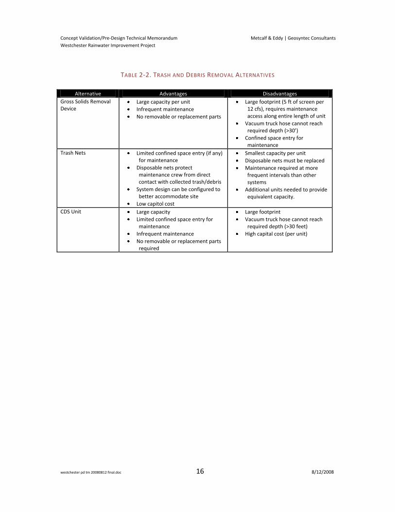
Table 2-2 summarizes the advantages and disadvantages of each unit. The trash net system was
ultimately selected as the Preferred Alternative with respect to the site constraints, design flexibility,
and maintenance technique.
Concept Validation/Pre-Design Technical Memorandum Metcalf & Eddy | Geosyntec Consultants
Westchester Rainwater Improvement Project
westchester pd tm 20080812 final.doc 16 8/12/2008
TABLE 2-2. TRASH AND DEBRIS REMOVAL ALTERNATIVES
Alternative Advantages Disadvantages
Gross Solids Removal Device
Large capacity per unit
Infrequent maintenance
No removable or replacement parts
Large footprint (5 ft of screen per 12 cfs), requires maintenance access along entire length of unit
Vacuum truck hose cannot reach required depth (>30’)
Confined space entry for maintenance
Trash Nets Limited confined space entry (if any) for maintenance
Disposable nets protect maintenance crew from direct contact with collected trash/debris
System design can be configured to better accommodate site
Low capitol cost
Smallest capacity per unit
Disposable nets must be replaced
Maintenance required at more frequent intervals than other systems
Additional units needed to provide equivalent capacity.
CDS Unit Large capacity
Limited confined space entry for maintenance
Infrequent maintenance
No removable or replacement parts required
Large footprint
Vacuum truck hose cannot reach required depth (>30 feet)
High capital cost (per unit)

Concept Validation/Pre-Design Technical Memorandum Metcalf & Eddy | Geosyntec Consultants
Westchester Rainwater Improvement Project
westchester pd tm 20080812 final.doc 17 8/12/2008
3 HYDROLOGIC ANALYSIS
3.1 INTRODUCTION AND PURPOSE
A hydrologic analysis focusing on the wet weather Project scope optimization was completed to support
pre-design of the proposed facility by simulating long-term performance of multiple facility
configurations over a representative period of historical conditions. These simulations are intended to
support pre-design efforts by predicting likely facility performance against TMDL standards and identify
optimized solutions through an iterative process.
The overall method described herein represents an iterative approach to facility pre-design, whereby
initial assumptions are made and then adjusted based on observed performance in the model results.
Thus, the preliminary phase of this effort involved the analysis of several alternative configurations to
develop a matrix of preliminary results. Evaluation of these preliminary results allowed for
development of conceptual relationships between design parameters (i.e. diversion rate, storage
volume, drawdown, etc.) and system performance and was used to develop the Preferred Alternative
design.
METHODOLOGY OVERVIEW The type of facilities proposed and the nature of the TMDL requirements present a number of
challenges in design and analysis. Conventional design storm sizing methods, which are commonly used
in storm water facility sizing, are not appropriate for this Project for the reasons listed below.
Simulation of bacteria concentrations in storm water is a difficult task to undertake with
confidence. Measured bacteria concentrations in stormwater are highly variable both
spatially and temporally and limited monitoring data exist upon which to develop
predictions. Additionally, the types of models required to dynamically predict bacteria
concentrations are generally complex and not well-suited to design applications.
The compliance criteria stipulated by the Santa Monica Bay Beaches Bacteria TMDL are
based on exceedance-days. While these criteria are conducive to monitoring for compliance,
there are no clearly established methods from which design criteria can be based.
Because the compliance criteria are based on a 90th percentile TMDL compliance year and a
reference watershed approach, the approach for quantifying performance and compliance
should incorporate hydrologic variabilities so that appropriate management decisions can be
made. Characteristics such as antecedent (inter-event) watershed conditions become
significantly more critical.
Because there are a limited number of Best Management Practices (BMPs) that can meet
water quality standards for bacteria, from a hydrologic and hydraulic perspective, the types
of facilities proposed will potentially exhibit both volume-limited and flow-limited bypass
Concept Validation/Pre-Design Technical Memorandum Metcalf & Eddy | Geosyntec Consultants
Westchester Rainwater Improvement Project
westchester pd tm 20080812 final.doc 18 8/12/2008
events2 and will exhibit transient storage effects (i.e. filling of storage during storm events
and draining after storm events).
For simulation of water quality concentrations, a conservative assumption was made. It was
assumed that whenever an untreated bypass occurred, the concentration of bacteria in the
bypass flow was higher than the TMDL limits. This assumption was made with the intent of
simplifying the analysis without over-predicting system performance.
To address many of the challenges discussed above, a continuous simulation approach was used.
Continuous simulation hydrologic and hydraulic modeling has emerged over the last 30 plus years as a
robust alternative and complement to event-based simulation. The basic hydrologic principles that
govern continuous simulation models are no different than event-based models: a rainfall hyetograph is
converted to a runoff hydrograph employing time variant mathematical relationships intended to mimic
hydrologic processes (Adams and Papa, 2000). This hydrograph is then routed through the stormwater
conveyance system and through stormwater detention and/or treatment facilities. The main differences
between continuous and event-based models lie in the hydrologic input and the time scale considered.
Where event-based models consider only one event and must assume antecedent conditions,
continuous simulation models utilize observed historic meteorological conditions and account for
antecedent watershed and storage conditions from one storm to the next.
The primary advantage of continuous simulation models are that 1) they can provide predictive results
where there are complex design constraints requiring an iterative process, 2) they are based on
observed long-term hydrologic patterns representative of the region, and 3) the output from
continuous simulation models provides a statistical description of hydrologic response and system
performance. These factors make continuous simulation models a more appropriate tool, and a more
robust approach for predicting future system performance and variability.
MODEL SELECTION The EPA Stormwater Management Model (SWMM) Version 5.0 was used for continuous simulation
analysis of the various facility configurations. SWMM is a dynamic rainfall-runoff simulation model used
for single event or continuous simulation of runoff from primarily urban areas. The model accounts for
various hydrologic processes that combine to produce stormwater runoff from urban areas. The model
also contains a flexible set of hydraulic modeling capabilities used to route runoff and external inflows
through a drainage system network of pipes, channels, storage/treatment units and diversion structures
(USEPA, 2008). SWMM was selected because of its proven capabilities in simulation of urban hydrology
and hydraulics, and its flexibility in representing the proposed systems.
2 Volume-limited bypass events occur when facility is full and cannot accept any more volume, causing
stormwater to bypass the facility untreated. Flow-limited bypass events occur when stormwater flow
rates exceed the diversion capacity of the facility, causing stormwater to bypass the facility untreated.
Concept Validation/Pre-Design Technical Memorandum Metcalf & Eddy | Geosyntec Consultants
Westchester Rainwater Improvement Project
westchester pd tm 20080812 final.doc 19 8/12/2008
MODEL DEVELOPMENT
The baseline model for the Project was developed based on information obtained from the Los Angeles
International Airport Drainage Master Plan (LAWA, 2005). Representations of proposed facilities were
developed from process flow diagrams developed by the project design team based on knowledge of
site opportunities and constraints. Meteorological inputs (i.e. precipitation and evapotranspiration (ET))
were developed from local gages to be representative of historic weather patterns in the region. Note
that due to spatial variability of regional precipitation patterns, these inputs represent approximations
of actual rainfall at the project sites. Assumed model input parameters are provided in Table 3-1.
Assumptions were intended to maintain a reasonable degree of conservatism in the evaluation of
facility performance. As presented in the Westchester-LAX Stormwater Best Management Practices
Project Concept Report (2007), the North Westchester Drainage Area and Project location are
illustrated in Figure 3-1.
Imperviousness of the watershed was based on values provided in the LAX Master Plan which are
consistent with land use-based imperviousness assumptions provided in the Los Angeles County
Hydrology Manual. These values are believed to be appropriate for estimating land use-based
imperviousness depending on residential density. For the project watershed, these values were
believed to be fairly accurate. All imperviousness was simulated as “directly connected” because
estimates of “disconnection” could not be made based on available information about the watershed.
Disconnection of imperviousness is believed to be important for facility performance as it may have
significant effects in small storm events. Future efforts may evaluate the impact of disconnection of
imperviousness on facility design requirements.
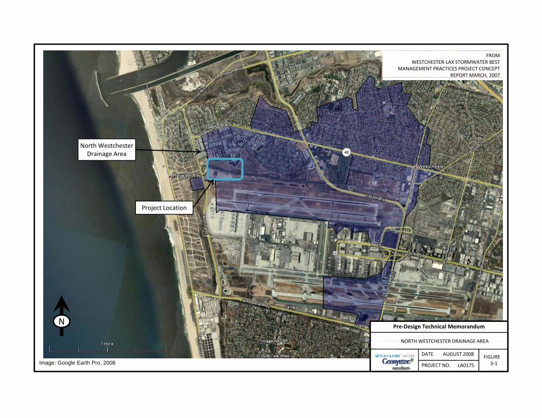
FROM WESTCHESTER‐LAX STORMWATER BEST
MANAGEMENT PRACTICES PROJECT CONCEPT REPORT MARCH, 2007,
North Westchester Drainage Area
Project Location
NORTHWESTCHESTER DRAINAGE AREA
Pre‐Design Technical MemorandumN
DATE AUGUST 2008
PROJECT NO. LA0175
NORTH WESTCHESTER DRAINAGE AREA
FIGURE3‐1Image: Google Earth Pro, 2008
Concept Validation/Pre-Design Technical Memorandum Metcalf & Eddy | Geosyntec Consultants
Westchester Rainwater Improvement Project
westchester pd tm 20080812 final.doc 21 8/12/2008
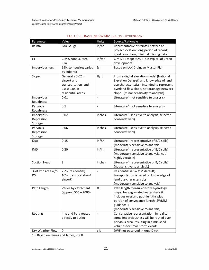
TABLE 3-1. BASELINE SWMM INPUTS - HYDROLOGY
Parameter Value Units Source/Rationale
Rainfall LAX Gauge in/hr Representative of rainfall pattern at project location; long period of record; good resolution; minimal missing data
ET CIMIS Zone 4, 60% ETo
in/mo CIMIS ET map; 60% ETo is typical of urban development
Imperviousness 69% composite; varies by subarea
% Based on LAX Drainage Master Plan
Slope Generally 0.02 in airport and transportation land uses; 0.04 in residential areas
ft/ft From a digital elevation model (National Elevation Dataset) and knowledge of land use characteristics. Intended to represent overland flow slope, not drainage network slope. (minor sensitivity to analysis)
Impervious Roughness
0.01 - Literature1 (not sensitive to analysis)
Pervious Roughness
0.1 - Literature1 (not sensitive to analysis)
Impervious Depression Storage
0.02 inches Literature1 (sensitive to analysis, selected conservatively)
Pervious Depression Storage
0.06 inches Literature1 (sensitive to analysis, selected conservatively)
Ksat 0.15
in/hr Literature1 (representative of B/C soils) (moderately sensitive to analysis
IMD 0.20 in/in Literature1 (representative of B/C soils) (moderately sensitive to analysis, not highly variable)
Suction Head 8 inches Literature1 (representative of B/C soils) (not sensitive to analysis)
% of Imp area w/o DS
25% (residential) 10% (transportation/ airport)
- Residential is SWMM default; transportation is based on knowledge of land use characteristics (moderately sensitive to analysis)
Path Length Varies by catchment (approx. 500 – 2000)
ft Path length measured from hydrology maps; for aggregated watersheds it includes overland path lengths plus portion of conveyance length (SWMM guidance1) (moderately sensitive to analysis)
Routing Imp and Perv routed directly to outlet
- Conservative representation; in reality some imperviousness will be routed over pervious area, resulting in diminished volumes for small storm events
Dry Weather Flow 0 cfs DWF not observed in Argo Ditch
1 – Based on James and James, 2000.
Concept Validation/Pre-Design Technical Memorandum Metcalf & Eddy | Geosyntec Consultants
Westchester Rainwater Improvement Project
westchester pd tm 20080812 final.doc 22 8/12/2008
Soils assumptions based on Natural Resource Conservation Service (NRCS) definition of B and C soil
horizons were considered appropriate for the project drainage area. Per hydrology map number 1-H1.7
(Venice) from the Los Angeles County Hydrology Manual, the predominant soil type in the drainage area
is 010 (Oakley Fine Sand) with minor but significant incidence of 014 (Ramona Sandy Loam). Inspection
of the Hydrology Manual runoff coefficient charts for each soil indicates that both soil types have less
potential to generate runoff than many other soil types within Los Angeles County. Ramona Sandy
Loam is included in NRCS Soil Survey 675 and is reported to be a B soil with infiltration rates ranging
from approximately 0.6 in/hr to 2.0 in/hr. Comparison of the Hydrology Manual runoff coefficient
charts shows that Oakley Fine Sand is likely more infiltrative than Ramona Sandy Loam, hence the
assignment of B/C soil properties for both soils is thought to be appropriate while accounting for
potential reductions in natural infiltration rates as a result of soil disturbance.
Conveyance features were simplified to represent system performance without incorporating detailed
feature attributes (except near the diversion structure). Conveyance losses and in-channel attenuation
effects, which may be significant in Argo Ditch, were not accounted for in the model. This simplification
tends to increase peak flows and decrease volumes, which would provide conservative estimates of
required diversion flow rates. The facility representation considered hydraulic effects relevant to the
purpose of the analysis including diversion rates, diversion shut-down due to limited storage, varying
storage capacity, pump controls, and drawdown rates.
Infiltration rates under the proposed facility were not simulated explicitly, but it was assumed that a
steady discharge rate would be provided to draw down the storage over a set period of time. While
infiltration rates of the underlying soil were still under investigation at the time of this analysis, this
uncertainty was not included in the analysis. Modifying the area of the infiltration gallery and/or
spacing of dry wells would allow the design to compensate for uncertainties in infiltration rate without
nullifying model results. Likewise, other components of the facility design could be adjusted to
compensate for uncertainties in infiltration rate.
MODEL CALIBRATION Calibration of the models was not possible due to an absence of flow data from which to base
calibration and verification efforts. Storm runoff data were not available for the modeled watershed.
Because of the project timeframe, acquisition of runoff data to support model calibration efforts was
not considered feasible. As such, validation of model assumptions relied on literature review of
appropriate inputs, comparison of results to locally-derived empirical relationships (i.e. runoff
coefficient formulas), and limited sensitivity testing of selected model parameters.
Concept Validation/Pre-Design Technical Memorandum Metcalf & Eddy | Geosyntec Consultants
Westchester Rainwater Improvement Project
westchester pd tm 20080812 final.doc 23 8/12/2008
The following rationale supports the ability of uncalibrated models to produce meaningful results for
this effort:
First, uncalibrated models are generally more reliable in watersheds with higher
imperviousness because simulation of impervious area relies on fewer parameters and these
parameters are less variable than pervious area parameters. This supports the use of
uncalibrated models for the project watersheds (69% impervious).
Second, to address the frequency-based nature of the TMDL, the proposed facilities are
intended to capture and treat runoff from small storms, while permitting portions of
moderate to large storms to bypass untreated. In small events, the contribution of pervious
area is expected to be fairly minimal for a broad range of soil conditions. Small events
represent the critical operational range of the facilities; therefore the sensitivity of the
analysis to pervious runoff parameters is expected to be significantly reduced in comparison
to other types of analyses in which pervious runoff may be more important.
MODEL ASSUMPTIONS AND PARAMETERS Preliminary analyses of alternative configurations were based on Storm Years3 1990 through 1999 as
defined by the TMDL (also referred to as compliance years herein). While a period of record of more
than 50 years is available from the local precipitation gage, a subset was used to reduce model runtimes
thereby allowing for a greater number of simulations. The 1990s were selected because they are
approximately representative of long-term average conditions, include both El Niño and La Niña years,
and include the 90th percentile storm year (1993) by number of storms per year. A 55 year period of
record was used for extended simulation of the preferred configuration, discussed below.
Initial configurations simulated for each project were based on Project Concept Reports produced by
the City for each project being conducted by the City to meet the TMDL requirement, in advance of this
effort. These reports specified a diversion flowrate and off-line storage volume for each project which
were developed from watershed characteristics. In addition to these values, baseline rates of facility
drawdown and specifics of facility operation were provided by the project design team. Subsequent
analyses investigated various combinations of diversion rate, storage volume, and drawdown time.
Additional model parameters were added as necessary to account for modifications to facility concepts
(e.g. supplemental in-channel storage, etc). These are provided in Table 3-2.
3 A storm year is defined as November 1 through October 31.
Concept Validation/Pre-Design Technical Memorandum Metcalf & Eddy | Geosyntec Consultants
Westchester Rainwater Improvement Project
westchester pd tm 20080812 final.doc 24 8/12/2008
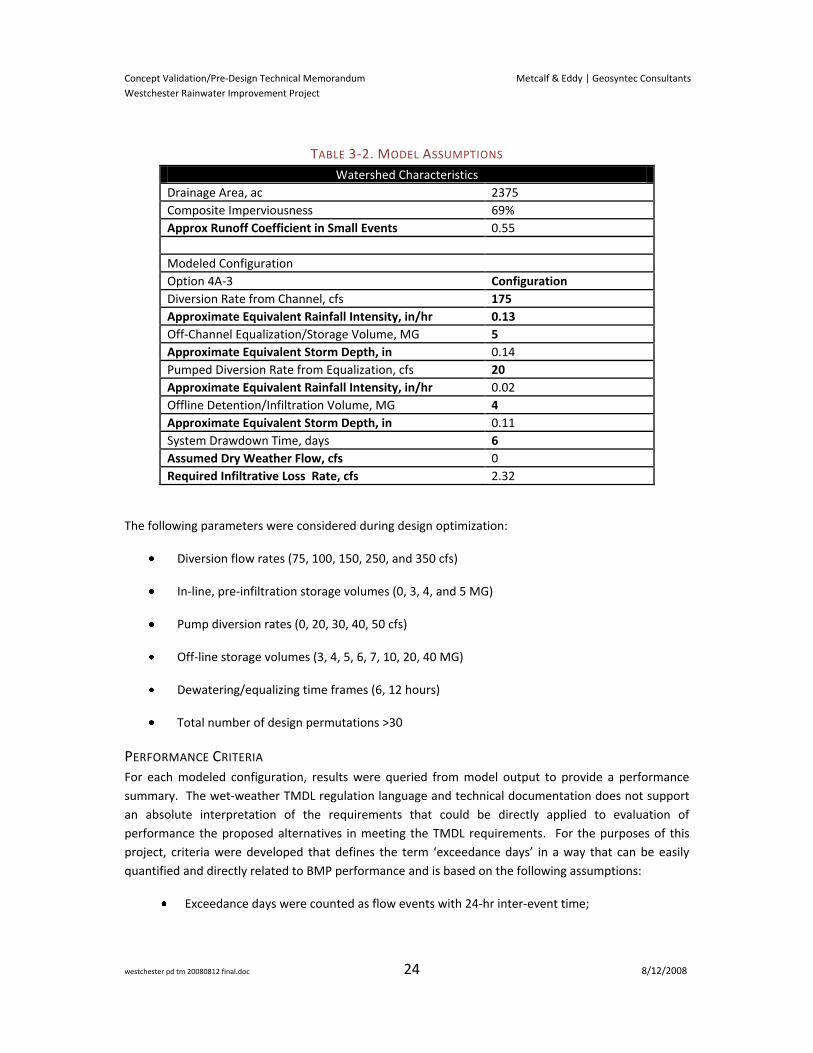
TABLE 3-2. MODEL ASSUMPTIONS
Watershed Characteristics
Drainage Area, ac 2375
Composite Imperviousness 69%
Approx Runoff Coefficient in Small Events 0.55
Modeled Configuration
Option 4A-3 Configuration
Diversion Rate from Channel, cfs 175
Approximate Equivalent Rainfall Intensity, in/hr 0.13
Off-Channel Equalization/Storage Volume, MG 5
Approximate Equivalent Storm Depth, in 0.14
Pumped Diversion Rate from Equalization, cfs 20
Approximate Equivalent Rainfall Intensity, in/hr 0.02
Offline Detention/Infiltration Volume, MG 4
Approximate Equivalent Storm Depth, in 0.11
System Drawdown Time, days 6
Assumed Dry Weather Flow, cfs 0
Required Infiltrative Loss Rate, cfs 2.32
The following parameters were considered during design optimization:
Diversion flow rates (75, 100, 150, 250, and 350 cfs)
In-line, pre-infiltration storage volumes (0, 3, 4, and 5 MG)
Pump diversion rates (0, 20, 30, 40, 50 cfs)
Off-line storage volumes (3, 4, 5, 6, 7, 10, 20, 40 MG)
Dewatering/equalizing time frames (6, 12 hours)
Total number of design permutations >30
PERFORMANCE CRITERIA For each modeled configuration, results were queried from model output to provide a performance
summary. The wet-weather TMDL regulation language and technical documentation does not support
an absolute interpretation of the requirements that could be directly applied to evaluation of
performance the proposed alternatives in meeting the TMDL requirements. For the purposes of this
project, criteria were developed that defines the term ‘exceedance days’ in a way that can be easily
quantified and directly related to BMP performance and is based on the following assumptions:
Exceedance days were counted as flow events with 24-hr inter-event time;
Concept Validation/Pre-Design Technical Memorandum Metcalf & Eddy | Geosyntec Consultants
Westchester Rainwater Improvement Project
westchester pd tm 20080812 final.doc 25 8/12/2008
It was assumed that any untreated flow event would cause an exceedance of bacteria
standards; and
Compliance with the exceedance frequency standards was determined by “Storm Year” or
“Compliance Year”, defined in the TMDL as November 1 through October 31. By comparison,
a standard water year is defined as October 1 through September 30.
Using these criteria, untreated flow events separated by an inter-event time of at least 24 hours were
extracted from the continuous flow records at the project outfalls and tabulated by storm year.
Tabulations of ‘exceedance days’ by storm year were evaluated against the allowable exceedance day
standards set by the wet weather TMDL. Dockweiler Beach, the project receiving water, is allowed 17
exceedance days per year4. Model results were tabulated by ‘years in violation’ (>17 exceedance days
per year), and ‘years close to violation’ (16 or 17 exceedance days per year) for each modeled
configuration. The results showed a range of ‘years in violation’ and ‘years close to violation’ depending
on respective facility design assumptions (i.e. diversion rate, storage volume, drawdown time, etc.).
RESULTS OF PRELIMINARY ANALYSIS OF ALTERNATIVE CONFIGURATIONS The results of the hydrologic analysis of the various alternative configurations modeled support the
following observations:
The results show that storage volumes and diversion rates are both important in facility
design and cannot be viewed separately. As discussed previously, bypass events may occur
as a result of volume-limited conditions or peak-limited conditions.
Model results show sensitivity to drawdown rate which is a function of infiltration rate of
underlying soils. The sensitivity of underlying infiltration rate is mitigated substantially by
the flexibility in facility design which could provide more or less infiltrative area to maintain
specified drawdown times. Results also show that other design parameters may be adjusted
to compensate for changes in drawdown rate.
In general, significantly larger and more expensive facilities would be required to meet TMDL
standards in the worst case year (in this case, compliance year 1998), compared to facilities
that could meet TMDL standards in every other compliance year.
Providing in-channel or off-channel (connected by high-capacity line) flow equalization
storage results in lower total storage volumes and lower pumping rates while achieving
comparable performance.
4 It is recognized that for regulatory compliance purposes, the number of exceedances has been adjusted
to account for monitoring frequency at each ocean outfall. This analysis is intended to be valid regardless
of monitoring frequency, and as such the 17-day criteria was adopted.
Concept Validation/Pre-Design Technical Memorandum Metcalf & Eddy | Geosyntec Consultants
Westchester Rainwater Improvement Project
westchester pd tm 20080812 final.doc 26 8/12/2008
SELECTION OF PREFERRED ALTERNATIVE CONFIGURATION Based on preliminary hydrologic model results and discussion of policy considerations, a Preferred
Alternative configuration was selected (see Section 4 for description). A tradeoff point between
anticipated facility performance and facility cost was agreed-upon by the City. The design criteria
considered potential extreme El Niño years (e.g., 1998), which would have likely resulted in significant
exceedances at the reference watershed location, to be outliers. Full compliance was required for the
90th percentile year, which was the basis for TMDL requirements.
EXTENDED SIMULATION OF PREFERRED CONFIGURATION The Preferred Alternative configuration was simulated using a 55-year period of record that included
compliance year 1952 through 2006. The results of these analyses are summarized in Table 3.3. It was
estimated that 13 of 55 analyzed years were moderate to severe El Nino years (76% were non-El Nino
years) (http://ggweather.com/enso/oni.htm). The analysis predicted that during all non-El Nino years,
and during the majority of historical El Nino years, the Project as conceived would have been in full
TMDL compliance.
TABLE 3-3. SUMMARY OF RESULTS
Summary of Analysis Results (SY 1952 - 2006)
Total Exceedance Days (Project) 654
Total Allowable Exceedance Days (17/yr) 935
% of Years in Compliance 95%
% of Non-El Nino Years in Full Compliance 100%
DISCUSSION SUMMARY
As described earlier in the methodology overview, the analysis performed for the proposed project
made use of continuous simulation concepts as a key part of the pre-design process. This approach is
considered the most robust method of measuring anticipated performance of the proposed facility in
meeting the TMDL requirements, as event-based models cannot capture the interrelated impacts of
multiple variables. The analysis was completed with the intent of accurately representing exceedance
days while maintaining flexibility and balancing underlying uncertainties caused by lack of data for
calibration and verification.
Accuracy and flexibility were maintained in the models by continually testing sensitivity in modeling
assumptions and working closely with the design team to understand the design constraints and
probable detailed design features. Model representations did not represent specific detailed design
features but relied on general simplifications to allow flexibility in subsequent detailed design efforts.
To account for uncertainties, the analysis was based on reasonably conservative assumptions in both
hydrologic and hydraulic model representation consistent with the requirements of the preliminary
design phase of the projects. The overall impact of these assumptions is that infrastructure
requirements developed from this analysis may be somewhat conservative. Because of the
conservative assumptions built into the model, it is anticipated that refinements to the hydrologic and
Concept Validation/Pre-Design Technical Memorandum Metcalf & Eddy | Geosyntec Consultants
Westchester Rainwater Improvement Project
westchester pd tm 20080812 final.doc 27 8/12/2008
hydraulic parameters, as a result of additional site-specific data, would likely reduce facility sizing
requirements.
A key hydrologic uncertainty lies in representation of soils. Soil properties in the tributary watershed
were estimated based on typical urban conditions and may be somewhat conservative based on
information from the Los Angeles County Hydrology Manual as discussed above. However, the
Hydrology Manual contains only coarse soil delineations and may not account for compaction of soil in
typical urban settings. To ensure that the model representation does not under-predict runoff from the
watershed, the sensitivity of infiltration rate on model results was explored by reducing the infiltration
rate by 50 percent. This analysis showed that the reduction in infiltration rate caused no perceptible
change in exceedance day results. Infiltration rate is the most sensitive of soil parameters. A full
hydrologic sensitivity analysis is beyond the scope of this effort, but knowledge of parameter
importance and typical ranges allowed the design team to balance parameter uncertainty with
reasonably conservative estimates where appropriate.
As a check on the water balance in the watershed, SWMM results were compared to the runoff
coefficient method described in the Hydrology Manual. The Hydrology Manual specifies the following
equation for computation of runoff coefficient:
CD = (0.9 Imperviousness) + (1.0 – Imperviousness) CU
Where: CD = Developed Runoff Coefficient Imperviousness = Proportion Impervious (0 to 1) CU = Undeveloped Runoff Coefficient The undeveloped runoff coefficient (CU) in this equation is a function of soil type and rainfall intensity
which may be obtained from the runoff coefficient charts in the Hydrology Manual. For the soils found
in the project watershed (010 & 014), the range of rainfall intensities associated the vast majority of the
cumulative rainfall volume (0.1 to 1.0 in/hr) result in a CU of 0.1. Substituting this value into the
equation above yields:
Runoff Coefficient = 0.008 % Impervious + 0.1
Substituting the watershed imperviousness of 0.69 into the equation above yields a runoff coefficient of
0.65. By comparison, the period of record runoff coefficient for SWMM is approximately 0.66. While
this comparison is not sufficient to fully validate the SWMM model, it provides support for the overall
balance between runoff and losses predicted by the model and the comparability of the model to
regionally accepted methods.
Attenuation effects in the conveyance network and the Argo Ditch were likely underestimated in the
model representation. The resulting effect is that peak events may be higher in magnitude and shorter
in duration than would actually be observed in the channel. No attempt has been made to quantify the
potential impact of this effect on facility performance, but it may be addressed qualitatively. The most
important facility design parameters influenced by shorter, higher peaks would be diversion rate and
Concept Validation/Pre-Design Technical Memorandum Metcalf & Eddy | Geosyntec Consultants
Westchester Rainwater Improvement Project
westchester pd tm 20080812 final.doc 28 8/12/2008
equalization storage volume. It is anticipated that refinements to the routing assumptions would be
more likely to reduce these requirements than to increase them.
All discussions of exceedance days assume that any stormwater discharge that is not treated will
constitute a violation of receiving water standards. While this is an appropriate assumption for planning
and design, it is recognized that should a “first flush” effect be observed it is possible that flows at the
tail end of runoff events may not contribute to exceedances of receiving water standards.
Overall, the modeling approach and selection of parameters were intended to be appropriate with
tendency toward conservatism in certain parameters. Underlying uncertainties such as climatic
variation, concentration of bacteria in stormwater, and bacterial re-growth and die-off processes which
may be very difficult to quantify or predict could potentially result in facility performance that deviates
significantly from predicted values.