Embed Size (px)
Citation preview
23-27 Oct. 2006 3rd International Precipitation Working Group Workshop
Melbourne, Australia
JAXA’s Precipitation Missions
Riko OKI and Misako KACHIEarth Observation Research Center (EORC)Japan Aerospace Exploration Agency (JAXA)

223-27 Oct. 2006 3rd IPWG Workshop
Core Satellite• Dual-frequency Precipitaion Ra
dar (JAXA and NiCT)• Multi-frequency Radiometer (N
ASA)• H2-A Launch (TBD)• TRMM-like Spacecraft• Non-Sun Synchronous Orbit• ~65° Inclination• ~407 km Altitude• ~5 km Horizontal Resolution• 250 m / 500m Vertical Resolutio
n
Constellation Satellites• Small Satellites with
Microwave Radiometers• Aggregate Revisit Time,
3 Hour goal• Sun-Synchronous Polar
Orbits• 500~900 km Altitude
OBJECTIVE: Understand the Horizontal and Vertical Structure of Rainfall and Its Microphysical Element. Provide Training for Constellation Radiometers.
OBJECTIVE: Provide Enough Sampling to Reduce Uncertainty in Short-term Rainfall Accumulations. Extend Scientific and Societal Applications.
Global Precipitation Processing Center
• Capable of Producing Global Precipitation Data Products as Defined by GPM Partners
Precipitation Validation Sites
• Global Ground Based Rain Measurement
GPM Reference Concept
323-27 Oct. 2006 3rd IPWG Workshop
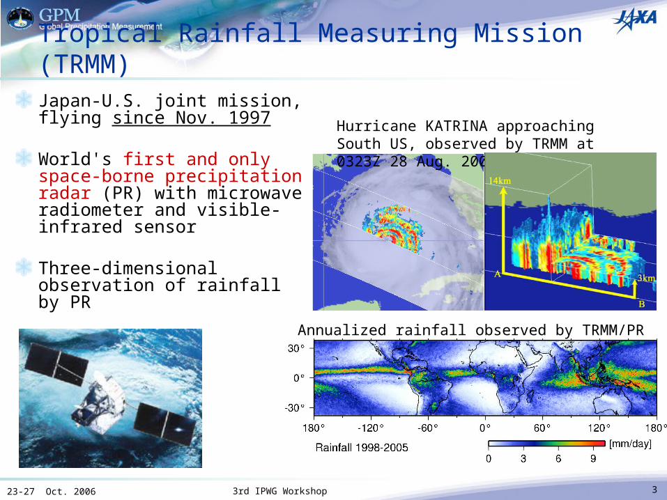
Tropical Rainfall Measuring Mission (TRMM)Japan-U.S. joint mission, flying since Nov. 1997
World's first and only space-borne precipitation radar (PR) with microwave radiometer and visible-infrared sensor
Three-dimensional observation of rainfall by PR
Hurricane KATRINA approaching South US, observed by TRMM at 0323Z 28 Aug. 2005.
Annualized rainfall observed by TRMM/PR
423-27 Oct. 2006 3rd IPWG Workshop
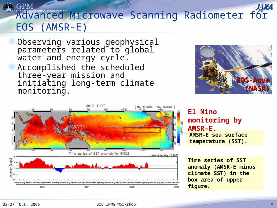
Advanced Microwave Scanning Radiometer for EOS (AMSR-E)
Observing various geophysical parameters related to global water and energy cycle.Accomplished the scheduled three-year mission and initiating long-term climate monitoring.
AMSR-E sea surface temperature (SST).
EOS-AquaEOS-Aqua(NASA)(NASA)
El Nino monitoring by AMSR-E.
Time series of SST anomaly (AMSR-E minus climate SST) in the box area of upper figure.
623-27 Oct. 2006 3rd IPWG Workshop
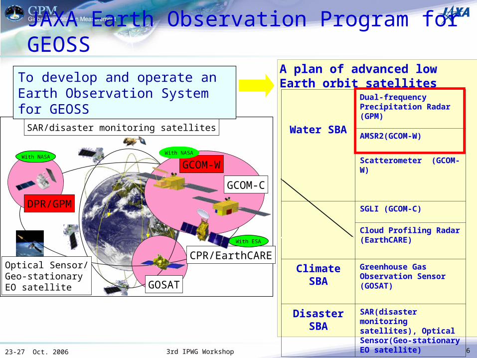
JAXA Earth Observation Program for GEOSSA plan of advanced low Earth orbit satellites
GOSAT
CPR/EarthCARE
Water SBA
Dual-frequency Precipitation Radar (GPM)
AMSR2(GCOM-W)
Scatterometer (GCOM-W)
SGLI (GCOM-C)
Cloud Profiling Radar (EarthCARE)
Climate SBA Greenhouse Gas Observation Sensor (GOSAT)
Disaster SBA
SAR(disaster monitoring satellites), Optical Sensor(Geo-stationary EO satellite)
To develop and operate an Earth Observation System for GEOSS
With ESA
DPR/GPM
With NASA
Optical Sensor/Geo-stationary EO satellite
SAR/disaster monitoring satellites
GCOM-W
GCOM-C
With NASA
723-27 Oct. 2006 3rd IPWG Workshop
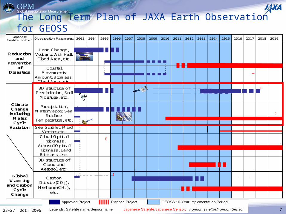
The Long Term Plan of JAXA Earth Observation for GEOSS
GlobalWarming
and CarbonCycle
Change
CarbonDioxide(CO2),Methane(CH4),
etc.
2006
Sea Surafec WindVector, etc.
JapaneseContribution Field 2003 2004
Cloud OpticalThickness,
Aerosol OpticalThickness, Land
Biomass, etc.
ClimateChange
includingWaterCycle
Variation
3D structure ofPrecipitation, Soil
Moisture, etc.
Reductionand
Preventionof
Disasters
2012
CrustalMovements
Amount, Biomass,Flood Area, etc.
2008 2009 20102005 2007 20192017
3D structure ofCloud and
Aerosol, etc.
Precipitation,Water Vapor, Sea
SurfaceTemperature, etc.
Land Change,Volcanic Ash Fall,Flood Area, etc.
20162011Observation Parameter 2013 2014 2015 2018
ALOS / PRISM, AVNIR-2
GOSAT / Greenhouse Gas Observation Sensor (GOS)ADEOS-II/ILAS-II
Aqua /AMSR-E
ADEOS-II/AMSR
ADEOS-II Follow-on #2/GLI Follow-on Sensor
ADEOS-II Follow-on #1/AMSR Follow-on Sensor
ADEOS-II/GLI
EarthCARE /CPR
Next Disaster Monitoring Mission
GPM /DPR (Dual Frequency Precipitation Radar)TRMM /PR
ALOS / PALSAR
Terra /ASTER
ADEOS-II Follow-on #1/Microwave Scatterometer
Next Greenhouse Gas Observation Satellite
ADEOS-II/SeaWinds
923-27 Oct. 2006 3rd IPWG Workshop
GPM program status in JapanDPR DRR (Development Readiness Review) was successfully completed in Dec, 2005.
Approved to start preliminary design and engineering model development of DPR in JAXA
GPM/DPR science and application meeting was held in March, 2006Review and discussion about mission success criteria, mission requirements, DPR specificationOverview of the research and application activities in JapanScience plan
CAPACITY BUILDING IN ASIA "EARTH OBSERVATIONS IN THE SERVICE OF WATER MANAGEMENT"
Held successfully at Bangkok, Thailand in September, 2006Participation of about 120 persons from 22 countries
CEOS precipitation constellation activityJointly led by NASA & JAXA, with participation of various organizationsDraft of the scoping paper was discussed in CEOS SIT-19, and will be submitted to CEOS Plenary-20One year study is planned to generate implementation plan
1023-27 Oct. 2006 3rd IPWG Workshop
GPM program status in Japan (cont.) DPR development schedule was re-defined for accommodating June 2013 GPM core spacecraft launch.DPR observable range specification was changed based on the science requirements, and design has been modified to accommodate this new requirement
Was : 18km to surfaceIs : 19km to surface
Preliminary Design Review (PDR) KuPR and KaPR components PDR will be held in December, 2006DPR – S/C interface PDR planned in March, 2007DPR system PDR planned in April, 2007
Science and application activityAlgorithm development
Simulation data generation for algorithm development startedInvestigation about DPR level 1 and level 2 algorithm (KuPR, KaPR, and dual frequency algorithm), and DPR & GMI combined algorithm have been continued.Development of precipitation map generation algorithm including microwave radiometer data has been continued (cooperation with GSMaP)
-> Drs. Aonashi &UshioGPM science document (in Japanese) was preparedJoint study with Public Works Research Institute has been started regarding GPM application for flood monitoring Preliminary survey about utilization of microwave sounder data for GPM has been started
1123-27 Oct. 2006 3rd IPWG Workshop
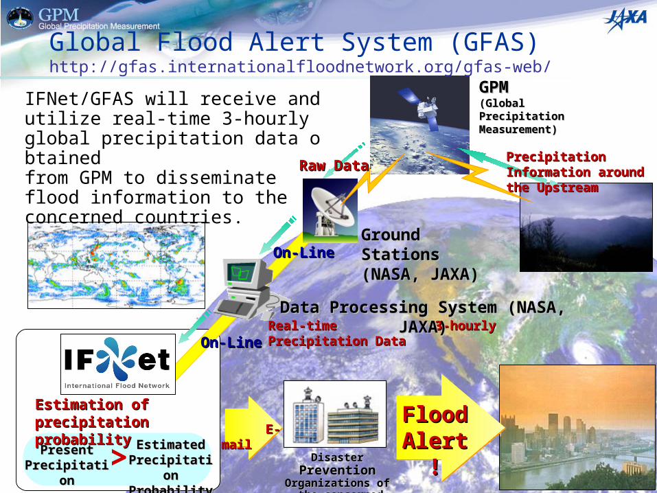
Global Flood Alert System (GFAS)http://gfas.internationalfloodnetwork.org/gfas-web/
Real-time 3-hourly Precipitation DataReal-time 3-hourly Precipitation Data
On-LineOn-Line
On-LineOn-Line
GPMGPM(Global Precipitation (Global Precipitation Measurement) Measurement)
Precipitation Information Precipitation Information around the Upstream around the Upstream
PresentPresentPrecipitationPrecipitation
Estimated Estimated Precipitation Precipitation ProbabilityProbability
IFNet/GFAS will receive and utilize real-time 3-hourly global precipitation data obtained from GPM to disseminate flood information to the concerned countries.
Ground StationsGround Stations(NASA, JAXA)(NASA, JAXA)
Data Processing System (NASA, JAXA)Data Processing System (NASA, JAXA)
Disaster Disaster PreventionPrevention Organizations ofOrganizations of
the concerned countriesthe concerned countries
Estimation of Estimation of precipitation probabilityprecipitation probability
> E-mailE-mail
Flood Flood Alert !Alert !
Raw DataRaw Data
1223-27 Oct. 2006 3rd IPWG Workshop
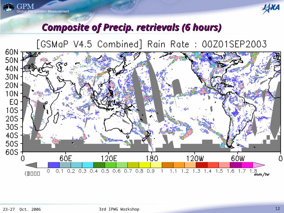
Composite of Precip. retrievals (6 hours)Composite of Precip. retrievals (6 hours)
(欠損値)
1323-27 Oct. 2006 3rd IPWG Workshop
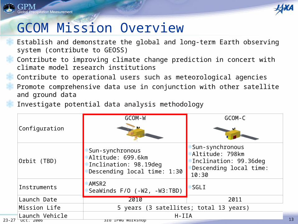
GCOM Mission OverviewEstablish and demonstrate the global and long-term Earth observing system (contribute to GEOSS)Contribute to improving climate change prediction in concert with climate model research institutionsContribute to operational users such as meteorological agenciesPromote comprehensive data use in conjunction with other satellite and ground data Investigate potential data analysis methodology
Configuration
GCOM-W GCOM-C
Orbit (TBD)
Sun-synchronousAltitude: 699.6kmInclination: 98.19degDescending local time: 1:30
Sun-synchronousAltitude: 798kmInclination: 99.36degDescending local time: 10:30
InstrumentsAMSR2SeaWinds F/O (-W2, -W3:TBD)
SGLI
Launch Date 2010 2011Mission Life 5 years (3 satellites; total 13 years)Launch Vehicle H-IIA
1423-27 Oct. 2006 3rd IPWG Workshop
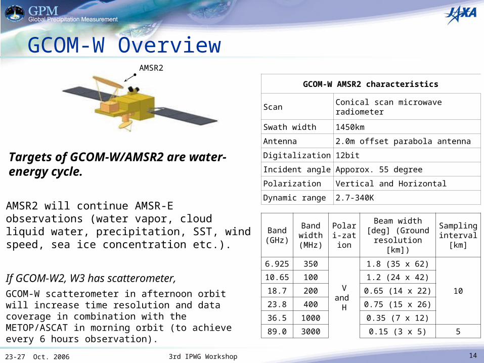
GCOM-W Overview
Targets of GCOM-W/AMSR2 are water-energy cycle.
GCOM-W AMSR2 characteristics
ScanConical scan microwave radiometer
Swath width 1450km
Antenna 2.0m offset parabola antenna
Digitalization 12bit
Incident angle Apporox. 55 degree
Polarization Vertical and Horizontal
Dynamic range 2.7-340K
Band(GHz)
Band width (MHz)
Polari-zation
Beam width [deg] (Ground
resolution [km])
Sampling interval
[km]
6.925 350
Vand
H
1.8 (35 x 62)
10
10.65 100 1.2 (24 x 42)
18.7 200 0.65 (14 x 22)
23.8 400 0.75 (15 x 26)
36.5 1000 0.35 (7 x 12)
89.0 3000 0.15 (3 x 5) 5
AMSR2
AMSR2 will continue AMSR-E observations (water vapor, cloud liquid water, precipitation, SST, wind speed, sea ice concentration etc.).
If GCOM-W2, W3 has scatterometer,GCOM-W scatterometer in afternoon orbit will increase time resolution and data coverage in combination with the METOP/ASCAT in morning orbit (to achieve every 6 hours observation).
1523-27 Oct. 2006 3rd IPWG Workshop
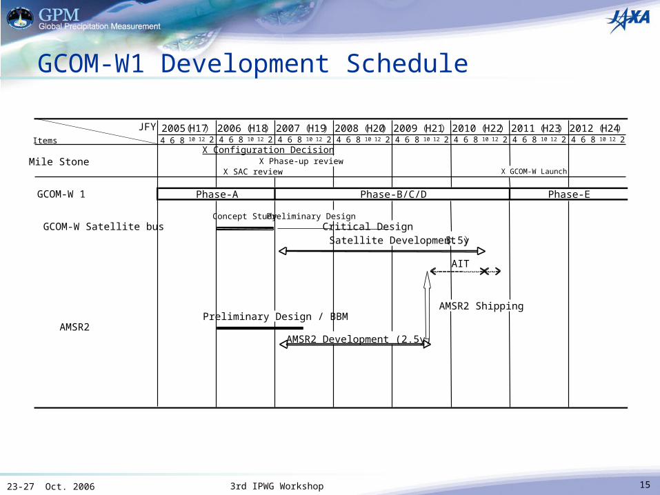
GCOM-W1 Development Schedule
JFYItems 4 6 8 10 12 2 4 6 8 10 12 2 4 6 8 10 12 2 4 6 8 10 12 2 4 6 8 10 12 2 4 6 8 10 12 2 4 6 8 10 12 2 4 6 8 10 12 2
Mile Stone X Phase-up review
GCOM-W 1
Concept Study Preliminary Design GCOM-W Satellite bus Critical Design
Satellite Development (3.5y)
AIT
AMSR2 ShippingPreliminary Design / BBM
AMSR2AMSR2 Development (2.5y)
2005(H17) 2012 (H24)2008 (H20)2007 (H19)2006 (H18) 2009 (H21) 2010 (H22) 2011 (H23)
X SAC review
X Configuration Decision
X GCOM-W Launch
Phase-A Phase-B/C/D Phase-E
1623-27 Oct. 2006 3rd IPWG Workshop
SummaryJAXA’s Earth observation satellites are described as a national key technology in the 3rd Science and Technology Basic Plan (2006) in Japan, and are one of Japanese key contribution to the GEOSS 10-Year Implementation Plan. GPM mission and GCOM-W series will contribute to “Water” Societal Benefit Area in GEOSS, which is one of three major Japanese contribution area.Although delay of GPM mission schedule, development of DPR is going smoothly and making steady progress. To develop high-frequent and high-accuracy precipitation products in GPM era, JAXA coordinates with expanded user community, such as IFNet, ICHARM, etc., and collaborates with GSMaP group led by Prof. Okamoto.Formal GCOM-W1 project will be launched in JFY 2007.