Embed Size (px)
Citation preview

MELBOURNE PLANNING SCHEME
MUNICIPAL STRATEGIC STATEMENT - CLAUSE 21.13 PAGE 1 OF 10
21.13 URBAN RENEWAL AREAS
21.13-1 Southbank
Housing
▪ Support medium scale residential development in the Residential Zones of Southbank
Village.
Economic Development
▪ Support Southbank’s development as an extension of the Central City, providing a mix
of commercial and residential land uses.
▪ Support a mix of uses, including residential development, with ground floor retail and
small scale business uses.
▪ Deliver a good provision of local services and facilities for workers and visitors and
within easy walking distance from all residences.
▪ Support the ongoing operation and establishment of businesses that provide
professional and business support services to the Capital City Zone in the Mixed Use
Zones of Southbank.
Built Environment and Heritage
▪ Connect and integrate Southbank with the Central City and the Yarra River.
▪ Position Southbank as the natural extension of the city establishing the Yarra River at
the City’s centre, not its edge. Provide easy and attractive access to and across the river
from the central and southern parts of Southbank.
▪ Maintain low rise development on the northern and southern sides of the Yarra River
and Arts Precinct to maintain the low scale river edge to protect key views to the Arts
Centre Spire and prevent overshadowing of the south bank of the River.
▪ Encourage high rise tower development to the north of City Link and west of Moore
Street.
▪ Encourage medium scale development in the Arts Precinct and the areas to the east of
Moore Street and to the south of City Link.
▪ Encourage medium scale development in the Southbank Village.
▪ Support the physical integration and connection of the Victorian College of the Arts to
the surrounding area to enhance its connection with other uses in the precinct.
▪ Ensure that buildings along St Kilda Road and in Sturt Street maintain the visual
dominance of the Arts Centre Spire.
▪ Maintain the landscape character of St Kilda Road.
▪ Ensure that development maintains views to the Shrine of Remembrance as an
important landmark.
▪ Ensure that the scale and design of buildings south of Coventry Street preserve the
setting and significance of the Shrine of Remembrance as a historic and cultural
landmark and place of reverence.
08/05/2014 C220
14/11/2016 Proposed GC81

MELBOURNE PLANNING SCHEME
MUNICIPAL STRATEGIC STATEMENT - CLAUSE 21.13 PAGE 2 OF 10
▪ Promote high rise, high density development, south of the Crown Casino and the
Melbourne Exhibition Centre.
▪ Ensure all new development creates a high quality pedestrian environment and
positively enhances the area’s public realm.
▪ Encourage a mix of public and commercial uses at ground level in new developments to
support street life and provide pedestrian interest.
Transport
▪ Improve the public environment of Southbank by providing public spaces, improving
pedestrian facilities and upgrading streetscapes.
▪ Improve streetscapes as a priority along major pedestrian routes.
▪ Strengthen pedestrian and cycle connections between Southbank and the Hoddle Grid
and South Melbourne.
▪ Encourage a continuous network of through block links to increase permeability,
amenity and safety and to improve access to the Yarra River and Arts Precinct.
▪ Give greater priority to pedestrian, cyclist and public transport amenity and access
ahead of private motor vehicle use.
▪ Create a connected and permeable neighbourhood.
Infrastructure
▪ Encourage provision of open space and links between the Port Melbourne foreshore and
the Hoddle Grid.
▪ Support arts and education uses and facilities at Southbank.
▪ Support arts, entertainment, cultural, educational attractions in Southbank, especially in
the Arts Precinct.

MELBOURNE PLANNING SCHEME
MUNICIPAL STRATEGIC STATEMENT - CLAUSE 21.13 PAGE 3 OF 10
Figure 7: Southbank
21.13-2 Docklands
Housing
▪ Support residential development in Docklands that complements its other functions.
▪ Encourage medium to high residential density.
12/09/2013 C162

MELBOURNE PLANNING SCHEME
MUNICIPAL STRATEGIC STATEMENT - CLAUSE 21.13 PAGE 4 OF 10
Economic Development
▪ Support mixed use development including office and commercial development in the
Digital Harbour, Stadium, New Quay, Victoria Harbour, Yarra’s Edge and Batman’s
Hill Precincts.
▪ Encourage active uses in the areas fronting the waterfront to promote maximum usage
and activity at the waterfront.
▪ Support Victoria Harbour waterfront and Waterfront City as the primary retail precinct
for Docklands that complements retailing in the Hoddle Grid.
▪ Limit the impact of marina development on public access to the waterfront.
▪ Encourage local industries and uses such as recreational boating, marinas, fish markets,
and port services, particularly where access to the waterfront is available.
▪ Encourage the establishment of leading edge industries through the development and
promotion of Digital Harbour and the installation of high technology infrastructure.
▪ Encourage the installation of high technology infrastructure throughout Docklands.
▪ Support the consolidation of education and research clusters in Docklands, including
the Digital Harbour Precinct and TAFE facilities.
Built Environment and Heritage
▪ Ensure Docklands is physically and visually linked with the west end of the Hoddle
Grid.
▪ Ensure that buildings provide weather protection and an attractive built form to promote
an attractive, vibrant, safe and comfortable street environment.
▪ Encourage a development pattern that acknowledges Melbourne’s traditional hierarchy
of streets, lanes and arcades. The development pattern should be permeable and fine-
grained to create a clear pattern of access and movement.
▪ Ensure that the design of buildings encourages sustainable outcomes.
▪ Encourage the reuse of heritage buildings.
▪ Encourage interim land uses, reuse of existing buildings, infrastructure and landscaping
which presents an attractive physical environment during the development phase.
▪ Ensure building heights and setbacks along the waterfront in Docklands allow for
optimum climatic conditions on the promenades.
▪ Encourage a built form profile in the Docklands that forms an extension of the Hoddle
Grid building profile.
▪ Maintain and reinforce views to the water from the Hoddle Grid where possible,
particularly along the Collins, Bourke and Latrobe Street corridors.
▪ Ensure buildings on landmark sites which terminate views or vistas or mark key local
focal points are designed to the highest quality.
▪ Ensure development in Docklands extends and reinforces Council’s public environment
initiatives and practices.
▪ Ensure safe, wide and attractive public promenades are provided along the Docklands
waterfront as an integrated part of the development of each precinct.
▪ Ensure continuous pedestrian and cycle promenades along the waterfront in Docklands.

MELBOURNE PLANNING SCHEME
MUNICIPAL STRATEGIC STATEMENT - CLAUSE 21.13 PAGE 5 OF 10
▪ Ensure marina development in Docklands allows for public access to the water and the
waterfront.
▪ Strengthen Harbour Esplanade as a civic spine for the Docklands.
▪ Ensure that new streets and open spaces provide physical and visual linkages to the
waterfront.
Transport
▪ Support pedestrian connections to the Southern Cross Major Transport Hub.
▪ Strengthen pedestrian connections between Docklands and Port Melbourne and West
Melbourne.
▪ Strengthen pedestrian and cycle connectivity between the Hoddle Grid and Docklands.
▪ Require the development of Docklands to incorporate a high level and quality of
pedestrian and bicycle access.
▪ Support a wide variety of transport modes to and in Docklands, including public
transport, vehicular, pedestrian, cycle and water based transport.
▪ Support an integrated public transport system in Docklands with a high degree of
connectivity between tram, rail and bus services.
▪ Support the extension of light rail services to Docklands.
▪ Ensure new developments make provision for on-street car parking and bus and taxi
parking adjacent to key public spaces and land uses.
▪ Encourage the co-location and sharing of car parking facilities where appropriate.
▪ Develop Footscray Road as a western boulevard entry to the City, through the use of
strong urban and landscape design elements.
▪ Ensure the design of roads in Docklands encourages through-traffic to be diverted away
from the harbour waterfront.
▪ Ensure that the provision of car parking for use and development is consistent with the
efficient operation of the Melbourne Docklands area road network and approach roads,
and with environmental considerations.
Infrastructure
▪ Support the development of continual open space links along the Docklands waterfront,
Yarra River and Moonee Ponds Creek that provide for recreational and ecological
purposes.
▪ Support the provision of an integrated network of parks and open spaces in Docklands.
▪ Support the development of Victoria Harbour, Harbour Esplanade and Docklands Park
as the recreational focus for the Docklands.
▪ Ensure adequate and appropriate space is set aside in Docklands for community
facilities and that these facilities can be extended and upgraded when required.

MELBOURNE PLANNING SCHEME
MUNICIPAL STRATEGIC STATEMENT - CLAUSE 21.13 PAGE 6 OF 10
Figure 8: Docklands

MELBOURNE PLANNING SCHEME
MUNICIPAL STRATEGIC STATEMENT - CLAUSE 21.13 PAGE 7 OF 10
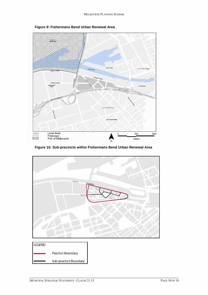
21.13-3 Fishermans Bend Urban Renewal Area - Lorimer
The State Planning Policy identifies Fishermans Bend as a priority urban renewal area. It is
an unparalleled renewal opportunity within Melbourne. It will provide for 80,000 jobs
(40,000 within the mixed use precinct and 40,000 in the Employment Precinct) and a range
of well serviced, high density housing options for 80,000 people. Lorimer is planned to
accommodate 12,000 residents and 6,000 jobs.
The Lorimer precinct will promote a mix of residential, retail, commercial, entertainment
and employment opportunities that complements the functions and built form of the Central
City and Docklands. The area will provide opportunities for co-location of employment
and housing, increasing productivity through decreased travel times for residents
Fishermans Bend urban renewal project is driven by the fundamental principles of
economic prosperity, social equity and environmental quality that takes advantage of its
close proximity to existing employment, residential and transport links in the Central City/
Southbank/ Docklands areas. Design excellence and environmental sustainability is
fundamental to delivering a high quality, high amenity urban environment and realising the
vision for a highly liveable urban renewal area.
The Fishermans Bend Urban Renewal Area will seek to achieve an affordable housing
target of 6% across the precincts. Delivering improved housing affordability, choice and a
diversity in this key area of Melbourne.
The Lorimer precinct has a distinct role in realising the vision for Fishermans Bend and
will have its own distinct character and identity.
Housing
• Ensure new residential areas have a strong sense of community and are welcoming and
convenient places to live.
• Encourage a vibrant, mixed use precinct close to the Yarra River and connected to
Melbourne’s Central City, Docklands and other emerging urban renewal areas.
• Encourage a high density mixed use precinct centred around a linear green spine and
open spaces. To create an important recreational and biodiversity green link,
promoting a healthy and diverse lifestyle for people of all ages and backgrounds.
Economic Development
• Ensure Lorimer has excellent access to employment and public transport, being located
on the doorstep of the Central City, Docklands and adjacent to the Fishermans Bend
Employment Precinct (NEIC), connected by the northern Tram Route.
• Encourage development to deliver high levels of amenity, focus on the attraction and
retention of talent, and to support investment and growth in the knowledge, creative,
design, research, education, innovation, engineering, advanced manufacturing and
service sectors.
• Encourage mixed use outcomes across the four mixed use precincts that create a
significant employment growth, complementing existing industries in the Employment
Precinct (NEIC), and build on strengths in aeronautical and automotive engineering
and defence.
• Ensure that new development implements measures to mitigate itself from potential
amenity impacts from existing industry and warehouse uses, or from ongoing port
operations.
Built Environment and Heritage
• Encourage a visual and physical connection to the Yarra River through a series of new
north-south laneways that will stitch the precinct across Lorimer Street through to the
Yarra River.
14/11/2016 Proposed GC81

MELBOURNE PLANNING SCHEME
MUNICIPAL STRATEGIC STATEMENT - CLAUSE 21.13 PAGE 8 OF 10
• Encourage a diversity of mid and high-rise buildings with taller buildings located along
the less sensitive interface of the West Gate Freeway providing an attractive
architectural backdrop to the precinct.
• Encourage a mix of courtyard, perimeter block apartments, and tower developments
with hybrid developments that accommodate a mix on larger sites strongly
encouraged.
• Ensure heights are reduced in key locations to protect existing and proposed open
spaces from being overshadowed.
• Encourage defined frontages with retail uses activate ground level interfaces with open
spaces. Large and smaller format commercial uses are also encouraged within podium
or lower levels of development.
• Ensure towers are well spaced to provide for outlook and view through to the river,
with setbacks to protect amenity of streets and laneways.
• Encourage higher street walls along the freeway interface, providing a buffer from
freeway traffic.
Sub-precincts: Preferred character outcomes
The following outlines the preferred character within each sub-precinct within the Lorimer
precinct (refer Map 10: Sub-precincts within the Fishermans Bend Urban Renewal Area)
Table 1: Preferred future character
Lorimer Preferred character
Area L1 Hybrid developments of mid-rise perimeter blocks and
tower developments
Slender towers located to minimise overshadowing
impacts on the Lorimer Parkway
Provision of private and communal open space with good
access to sunlight to provide high levels of amenity for
residents and workers.
Activation of the Lorimer Parkway, Ingles Street and the
new north-south street through a diversity of fine-grain
frontages, nominally 4-8 metres wide.
Lower street wall heights along Lorimer Parkway to
maximise the amount of sunlight penetrating between
tower elements to reach the southern side of the parkway
Area L2 Mid-rise developments with activated laneways leading to
Lorimer Street and the Yarra River
Area L3 Slender towers located to minimise overshadowing of the
Lorimer parkway
Lower street wall heights along Lorimer parkway to
maximise the amount of sunlight penetrating between
tower elements to reach the southern side of the parkway.
Area L4 Hybrid developments of mid-rise perimeter blocks and
tower developments
Well-spaced towers that avoid a wall-of-towers effect
when viewed from the Yarra River, Lorimer Parkway,
internal streets and the West Gate Freeway
Towers that create a visual landmark to the West Gate
Freeway recognising that this is an important arrival point

MELBOURNE PLANNING SCHEME
MUNICIPAL STRATEGIC STATEMENT - CLAUSE 21.13 PAGE 9 OF 10
into the central city
Location and design of towers to minimise
overshadowing of parks and streets in the Sandridge
precinct
Activation of new north-south laneways and streets
Lower street wall heights on the east and west of the new
large park on Turner Street
Elsewhere, higher street wall heights that assist in
mitigating noise pollution from the West Gate Freeway
into the Lorimer Precinct.
Service access only on the new service road along the
West Gate boundary
Transport
• Support the creation of the northern tram route along Turner Street and Lorimer Street
providing direct, high frequency public transport connection to Docklands and the
Central City.
• Support the creation of new or upgraded bridges over the Freeway at Ingles Street and
Graham Street to provide public transport, bike and pedestrian access to Sandridge.
Infrastructure
• Support the creation of the Lorimer Central Open Space located in the heart of the
precinct, between Ingles and Boundary Streets
• Support Turner Street closure and widening to create a new Linear Parkway along the
tram route, and creating a green link to the new Lorimer West Open Space, and
additional green link connecting to new open space at intersection of Hartley and
Lorimer Streets.
• Support a network of new streets and laneways to transform the existing industrial
scale blocks into a walkable neighbourhood
• Support a pop-up community hub created on land adjacent to the Bolte Bridge,
evolving into a Health and Well-Being Hub. Education and Community Hub (primary)
is located in the north eastern part of the precinct, and an Art and Cultural Hub is
located in the south eastern part of the precinct.
• Encourage new facilities to be delivered as part of mixed use development, located in
close proximity to the Lorimer Central Open Space or Hartley Street Open Space and
northern tram route.
• Encourage a Sports and Recreation hub (or part of cluster) to be delivered as part of
mixed use development, located within the ‘investigation area’ at the western part of
the precinct.
MELBOURNE PLANNING SCHEME
MUNICIPAL STRATEGIC STATEMENT - CLAUSE 21.13 PAGE 10 OF 10
Figure 9: Fishermans Bend Urban Renewal Area
Figure 10: Sub-precincts within Fishermans Bend Urban Renewal Area