Embed Size (px)
Citation preview
MOUNT ALEXANDER PLANNING SCHEME
MUNICIPAL STRATEGIC STATEMENT - CLAUSE 21.12 PAGE 1 OF 20
21.12 LOCAL AREAS
This clause focuses on local area implementation to support Clause 11 of the StatePlanning Policy Framework. In particular this clause identifies specific objectives andstrategies for the Shire’s local areas based on the hierarchy identified in Clause 11.12(Loddon Mallee South regional growth) and detailed in Clause 21.02 (Vision andFramework Plan) and Clause 21.03 (Settlement). Each section relates to a particulartownship or precinct and should be read in conjunction with the overall structure and visionfor the Shire as set out in Clauses 21.01 to 21.11 of the Municipal Strategic Statement.
The sections are ordered under the following Local Area headings:
Castlemaine
Castlemaine Commercial Centre
Diamond Gully
Maldon
Newstead
Harcourt
Taradale
Elphinstone
Guildford
21.12-1 Castlemaine
Castlemaine (including Campbell’s Creek) is the main population centre in MountAlexander Shire with an estimated 2011 population of 8742 persons, which accounts forabout 50 percent of the Shire’s total population. It is the key administrative andcommercial centre for the Shire.
Objectives and strategies
Objective 1
To facilitate residential development in appropriate locations.
Strategies
1.1 Encourage residential expansion to the west and south of Castlemaine in theMcKenzie Hill, Diamond Gully and Campbells Creek areas.
1.2 Support opportunities for low density housing in Happy Valley/Moonlight Flatarea and serviced residential development at the southern end of Happy ValleyRoad consistent with the Happy Valley/Moonlight Flat Structure Plan, 2004.
Local area implementation
Ensuring that any proposed use or development in Castlemaine is generallyconsistent with the Castlemaine Land Use Framework Plan in Figure 7.
Further strategic work
Preparing incorporated plans or development plans for proposed new residentialareas.
Updating the Castlemaine Residential Strategy.
Preparing a structure plan for Campbell’s Creek and its urban expansion area.
Investigating the preferred location and extent of commercial uses as part ofstructure planning work for Campbells Creek.
13/07/2017C56Proposed C73
13/07/2017C56
MOUNT ALEXANDER PLANNING SCHEME
MUNICIPAL STRATEGIC STATEMENT - CLAUSE 21.12 PAGE 2 OF 20
Investigating the potential for land zoned Rural Living Zone in Little Bendigoand Froomes Road, Castlemaine, to be rezoned for low density residentialdevelopment.
Investigating the housing potential of crown land situated south of Forest Creekand north of Duke Street.
Reference documents
Castlemaine Land Use Strategy, 2004
Castlemaine Residential Strategy, 2004
Happy Valley/Moonlight Flat Strategic Plan: Stage One - Site Analysis, 2003
Happy Valley/Moonlight Flat Strategic Plan: Stage Two - Planning and Design ResponseReport, 2005.
Castlemaine Industrial Strategy, 2001
MOUNT ALEXANDER PLANNING SCHEME
MUNICIPAL STRATEGIC STATEMENT - CLAUSE 21.12 PAGE 3 OF 20
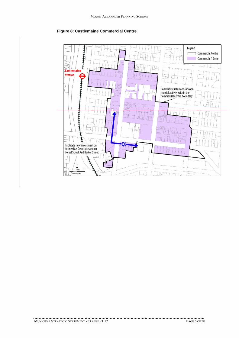
Figure 7: Castlemaine Land Use Framework Plan
MOUNT ALEXANDER PLANNING SCHEME
MUNICIPAL STRATEGIC STATEMENT - CLAUSE 21.12 PAGE 4 OF 20
21.12-2 Castlemaine Commercial Centre
Castlemaine’s commercial centre is the main activity centre in the Shire and provides arange of retail, office and government services. The retail core is focused around MostynStreet and Barker Street.
The centre has approximately 37,800 square metres of floor space of which approximately40 percent is retail and 20 percent is office, with the rest being community, civic and otheruses.
The Planning Scheme seeks to reinforce the centre’s role as the Shire’s primary localservice centre, whilst building on its historic features and improving activity mix,functionality and amenity.
Council’s vision is that the Castlemaine Commercial Centre will offer more retail andcommercial services, with a focus on food for home, personal services, clothing andhousehold goods, local business services, dining, entertainment, art and cultural activities.
Additional retail and commercial investment will be supported and encouraged in theCommercial Centre boundary, with a focus on major new investment on Forest Street.
The primacy of the Castlemaine Commercial Centre will be protected. The use of landoutside the centre for substantial retail activity will be discouraged, although small-scalelocal commercial centre development outside of the centre will be supported under certainconditions.
Objectives and strategies
Objective 1
To reinforce the role of the Castlemaine Commercial Centre as the primary centre in theShire.
Strategies
1.1 Encourage and consolidate new commercial development in the CastlemaineCommercial Centre, as defined in Figure 8.
1.2 Strongly discourage major retail developments of more than 1,500 square metresin floor area that are outside the Castlemaine Commercial Centre area.
1.3 Allow small-scale local convenience centres of between 200 and 1,500 squaremetres in floor area outside the Castlemaine Commercial Centre area if:
the area has a catchment of 1,500 dwellings in which no other centre islocated; and
the centre is located more than one kilometre from the CastlemaineCommercial Centre boundary.
1.4 Discourage major office developments outside the Castlemaine CommercialCentre.
1.5 Support the re-development of the former bus depot site on the corner of Barkerand Forest Streets for major new commercial development.
1.6 Encourage tourism retailing and other tourism related uses in Templeton Street,Castlemaine, and in the vicinity of the Castlemaine Railway Station.
Objective 2
To recognise and strengthen the roles of the highway entrances to Castlemaine.
Strategies
2.1 Recognise the Pyrenees Highway (Duke Street) as the major highway entranceused by tourists from Melbourne by encouraging tourist and commercialenterprises on land abutting the Highway.
2.2 Protect the residential and heritage character of Midland Highway (BarkerStreet) by confining new commercial development to existing business andindustrial zones abutting the Highway.
13/07/2017C56Proposed C73

MOUNT ALEXANDER PLANNING SCHEME
MUNICIPAL STRATEGIC STATEMENT - CLAUSE 21.12 PAGE 5 OF 20
2.3 Promote Pyrenees Highway (Elizabeth Street) from the Bridge to JohnstoneStreet as a highway business precinct.
2.4 Promote highway business in defined precincts along Midland Highway(Johnstone Street).
2.5 Implement the ‘Land Use Concepts’ in the Castlemaine Town Entrances LandUse Strategy (2002), as modified by the recommendations of the AddendumReport (2007).
Objective 3
To protect the identity and existing character of the Castlemaine Commercial Centre.
Strategies
3.1 Discourage development and subdivision within the Castlemaine CommercialCentre for generic chain retail design formats.
3.2 Encourage new development within the Castlemaine Commercial Centre toreflect the existing character of the centre in relation to car parking, streetfurniture, pavements, lighting, tree planting and streetscape aesthetics.
Scheme Implementation
The strategies in relation to commercial development will be implemented through theplanning scheme by:
Local area implementation
Ensuring that any proposed use or development in the Castlemaine Commercial Centre isgenerally consistent with the Castlemaine Commercial Centre Plan in Figure 8.
Policy guidelines
Applying Council’s local heritage policy at Clause 22.01 for all new commercialdevelopment in heritage overlays.
Application of zones and overlays
Applying the Commercial 1 Zone to land for retail, office, business,entertainment and community uses.
Applying the Commercial 2 Zone to land for offices and appropriatemanufacturing and industrial and limited retail uses.
Applying the Design and Development Overlay to the Castlemaine CommercialCentre.
Reference documents
Castlemaine Central Area Urban Design Framework, 2002
Castlemaine Commercial Centre Study, Final Report, October 2012
Castlemaine Town Entrances Land Use Strategy Adendum Report, 2009
Castlemaine Town Entrances Strategy, 2002
MOUNT ALEXANDER PLANNING SCHEME
MUNICIPAL STRATEGIC STATEMENT - CLAUSE 21.12 PAGE 6 OF 20
Figure 8: Castlemaine Commercial Centre
MOUNT ALEXANDER PLANNING SCHEME
MUNICIPAL STRATEGIC STATEMENT - CLAUSE 21.12 PAGE 7 OF 20
21.12-3 Diamond Gully
Diamond Gully will be Castlemaine’s primary urban growth area. Council has adopted theDiamond Gully Structure Plan, 2016 (DGSP) to guide future development of the area. TheDGSP identifies the preferred urban form for the area, and provides for connectivity andlinkages within the area and externally to Castlemaine and Campbells Creek.
The DGSP was prepared with regard to the need to promote subdivision and residentialdevelopment against other considerations including the protection of significant vegetationand the need to prioritise the protection of human life in areas at risk from bushfire.
Objectives and strategies
Objective 1
To reinforce the vision of the DGSP and recognise Diamond Gully as Castlemaine’sprimary urban growth area.
Strategies
1.1 Provide for good connectivity between the DGSP area and CastlemaineTownship centre and Campbells Creek, including vehicle and shared bicycle andpedestrian connections.
1.2 Consider opportunities for the provision of commercial facilities includingmedical centre/child care centre to service the needs of the Diamond Gullycommunity.
1.3 Encourage subdivision and development of low density areas.
1.4 Support clustering of development in the southern residential greenfield precinctwhere the opportunity exists to create shared defendable space.
13/07/2017C56
MOUNT ALEXANDER PLANNING SCHEME
MUNICIPAL STRATEGIC STATEMENT - CLAUSE 21.12 PAGE 8 OF 20
Objective 2
To consider environmental constraints when planning for future residential development,where relevant.
Strategies
2.1 Support hard edges for residential development within the DGSP area to respondto threat from bushfire.
2.2 Support the application of building envelopes and the preparation of Section 173Agreements as a condition on planning permits to protect significant vegetationin areas identified for low density development to the west and south of futureresidential areas.
2.3 Consider including a condition for a Section 173 Agreement restricting thekeeping of domestic animals on permits for future subdivision.
2.4 Encourage water sensitive urban design responses for development across theDGSP area.
2.5 Encourage the provision of open space corridors along watercourses, andappropriate setbacks for dwellings and structures along these areas.
2.6 Ensure that buffers are provided between landfills and new development.
2.7 Observe the five development principles outlined in the DGSP to guidedevelopment in appropriate locations.
Local area implementation
Ensure that any proposed use or development within the DGSP area is generallyconsistent with the Diamond Gully Structure Plan, 2016.
Ensure that development is consistent with Schedule 6 to the EnvironmentalSignificance Overlay.
Further strategic work
Explore the suitability of a new schedule to the Rural Living Zone (RLZ) forthose areas identified for low density residential development that are currentlyzoned RLZ and Township Zone to guide appropriate development in those areas.
Consider consolidation of existing cleared RLZ land to allow some limitedresidential development while managing an appropriate response to the threat ofbushfire.
Investigate the possibility of extending Lushington Reserve in a southerlydirection to include the former landfill cells/council depot.
Reference documents
Diamond Gully Structure Plan, 2016
Castlemaine Landfill Odour and Buffer Assessment, May 2016
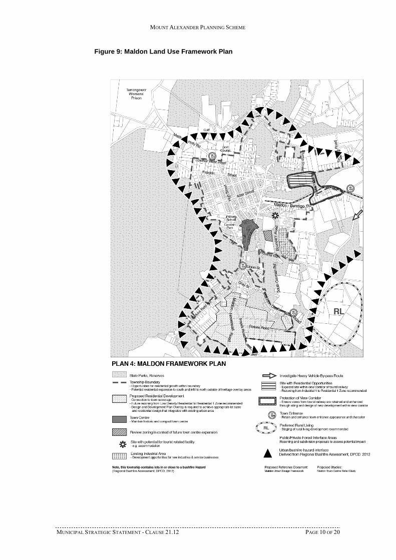
21.12-4 Maldon
Maldon is the second largest township in the Mount Alexander Shire, with an estimated2011 population of 1432 persons. The town has been recognised for its heritagesignificance.
The retail centre in High Street, Maldon, is the second largest retail centre in the Shire. Itprovides local shopping needs for the township and the rural district in the north westernpart of the Shire and serves an important tourism role. Maintaining the viability of the HighStreet and Main Street shops is important for the local and tourist role of the town. A sitefor a supermarket has been identified in Vincents Road, outside the town centre.
13/07/2017C56
MOUNT ALEXANDER PLANNING SCHEME
MUNICIPAL STRATEGIC STATEMENT - CLAUSE 21.12 PAGE 9 OF 20
Objectives and strategies
Objective 1
To ensure that the commercial area is attractive and viable.
Strategy
1.1 Ensure that commercial land in Vincents Road, Maldon, is developed for asingle supermarket business and does not contain separate shops or tenanciesthat would undermine the retail role of High Street and Main Street, Maldon.
Local area implementation
Ensuring that any proposed use or development in Maldon is generallyconsistent with the Maldon Land Use Framework Plan in Figure 9.
Further strategic work
Preparing incorporated plans or development plans for proposed new residentialareas.
Reference documents
Maldon Economic Design Strategy, 1998
Maldon Economic Futures Project, Final Report, 2008
MOUNT ALEXANDER PLANNING SCHEME
MUNICIPAL STRATEGIC STATEMENT - CLAUSE 21.12 PAGE 10 OF 20
Figure 9: Maldon Land Use Framework Plan
MOUNT ALEXANDER PLANNING SCHEME
MUNICIPAL STRATEGIC STATEMENT - CLAUSE 21.12 PAGE 11 OF 20
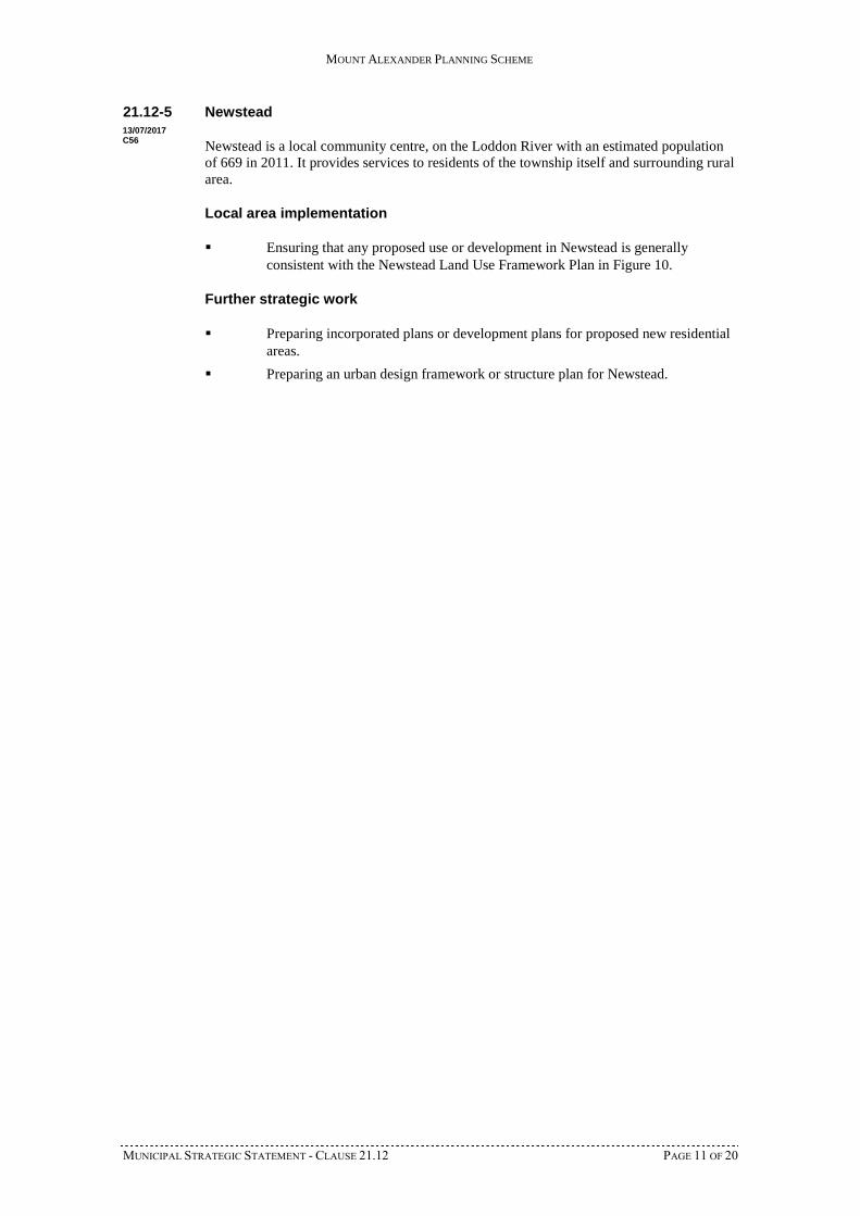
21.12-5 Newstead
Newstead is a local community centre, on the Loddon River with an estimated populationof 669 in 2011. It provides services to residents of the township itself and surrounding ruralarea.
Local area implementation
Ensuring that any proposed use or development in Newstead is generallyconsistent with the Newstead Land Use Framework Plan in Figure 10.
Further strategic work
Preparing incorporated plans or development plans for proposed new residentialareas.
Preparing an urban design framework or structure plan for Newstead.
13/07/2017C56
MOUNT ALEXANDER PLANNING SCHEME
MUNICIPAL STRATEGIC STATEMENT - CLAUSE 21.12 PAGE 12 OF 20
Figure 10: Newstead Land Use Framework Plan
MOUNT ALEXANDER PLANNING SCHEME
MUNICIPAL STRATEGIC STATEMENT - CLAUSE 21.12 PAGE 13 OF 20
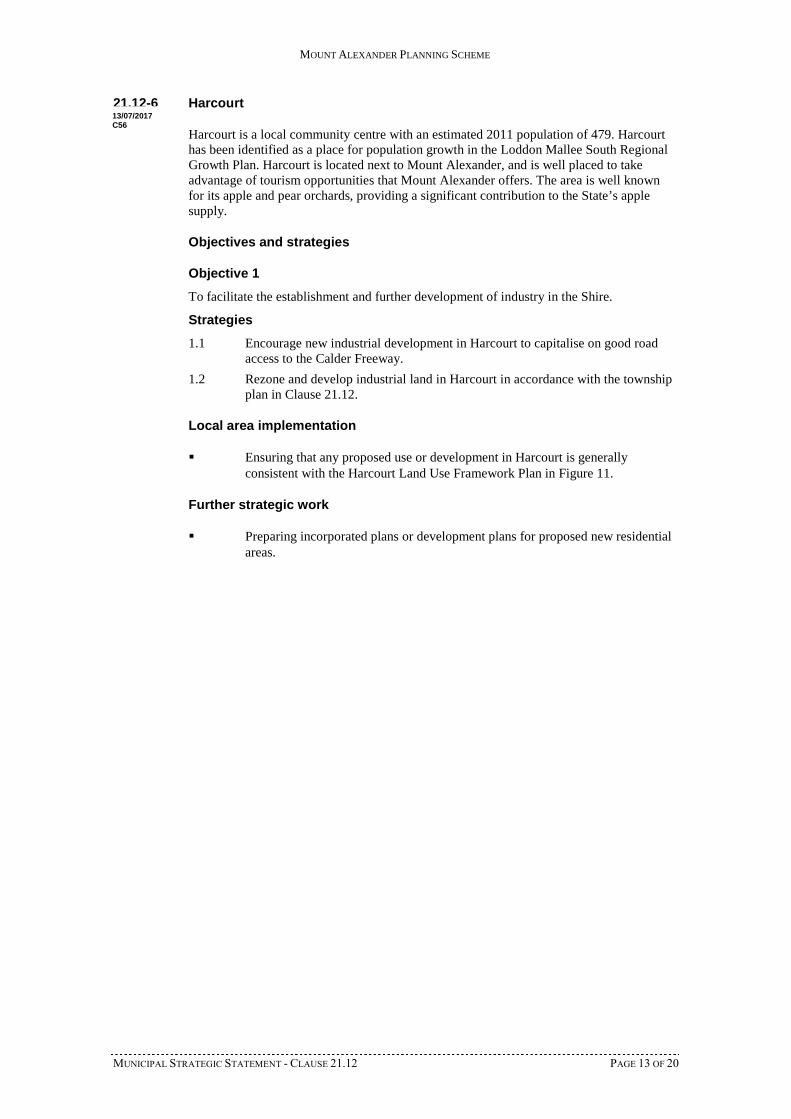
21.12-6 Harcourt
Harcourt is a local community centre with an estimated 2011 population of 479. Harcourthas been identified as a place for population growth in the Loddon Mallee South RegionalGrowth Plan. Harcourt is located next to Mount Alexander, and is well placed to takeadvantage of tourism opportunities that Mount Alexander offers. The area is well knownfor its apple and pear orchards, providing a significant contribution to the State’s applesupply.
Objectives and strategies
Objective 1
To facilitate the establishment and further development of industry in the Shire.
Strategies
1.1 Encourage new industrial development in Harcourt to capitalise on good roadaccess to the Calder Freeway.
1.2 Rezone and develop industrial land in Harcourt in accordance with the townshipplan in Clause 21.12.
Local area implementation
Ensuring that any proposed use or development in Harcourt is generallyconsistent with the Harcourt Land Use Framework Plan in Figure 11.
Further strategic work
Preparing incorporated plans or development plans for proposed new residentialareas.
13/07/2017C56
MOUNT ALEXANDER PLANNING SCHEME
MUNICIPAL STRATEGIC STATEMENT - CLAUSE 21.12 PAGE 14 OF 20
Figure 11: Harcourt Land Use Framework Plan
6 harcourt_framework_gs
MOUNT ALEXANDER PLANNING SCHEME
MUNICIPAL STRATEGIC STATEMENT - CLAUSE 21.12 PAGE 15 OF 20
21.12-6 Taradale
Taradale is a small village at the southern edge of the Shire along the Calder corridor. Theestimated population was 464 in 2011. The town is located along Back Creek which feedsinto the Coliban River. A significant landmark of the town is the Taradale Viaduct alongthe Melbourne to Bendigo railway line, which reaches a height of approximately 36 metres.
Objectives and strategies
Objective 1
To facilitate urban development in small towns.
Strategy
1.1 Support improvement options for wastewater management in Taradale,Elphinstone and Guildford.
Local area implementation
Ensuring that any proposed use or development in Taradale is generallyconsistent with the Taradale Land Use Framework Plan in Figure 12.
Further strategic work
Preparing incorporated plans or development plans for proposed new residentialareas.
13/07/2017C56
MOUNT ALEXANDER PLANNING SCHEME
MUNICIPAL STRATEGIC STATEMENT - CLAUSE 21.12 PAGE 16 OF 20
Figure 12: Taradale Land Use Framework Plan
7 taradale_framework_gs
21.12-7 Elphinstone
Elphinstone is a small village along the Calder Corridor. The estimated population in 2011was 239. The town has good road transport connections, being located where the Pyrenees
13/07/2017C56
MOUNT ALEXANDER PLANNING SCHEME
MUNICIPAL STRATEGIC STATEMENT - CLAUSE 21.12 PAGE 17 OF 20
Highway intersects with the Calder Highway. The railway line also runs through the centreof the town, creating a physical separation.
Objectives and strategies
Objective 1
To facilitate the establishment and further development of industry in the Shire.
Strategies
1.1 Encourage new industrial development in Elphinstone to capitalise on good roadaccess to the Calder Freeway.
1.2 Support the provision of sewerage and other infrastructure to Elphinstone toallow for the development of an industrial precinct in the town.
Objective 2
To protect the amenity of residential areas from uses with adverse amenity potential.
Strategies
2.1 Provide locations for new industrial development adjacent to a highway or majorroad and away from existing or proposed residential areas.
2.2 Support improvement options for wastewater management in Taradale,Elphinstone and Guildford.
Local area implementation
Ensuring that any proposed use or development in Elphinstone is generallyconsistent with the Elphinstone Land Use Framework Plan in Figure 13.
Further strategic work
Preparing incorporated plans or development plans for proposed new residentialareas.
MOUNT ALEXANDER PLANNING SCHEME
MUNICIPAL STRATEGIC STATEMENT - CLAUSE 21.12 PAGE 18 OF 20
Figure 13: Elphinstone Land Use Framework Plan
8 elpho_framework_gs
MOUNT ALEXANDER PLANNING SCHEME
MUNICIPAL STRATEGIC STATEMENT - CLAUSE 21.12 PAGE 19 OF 20
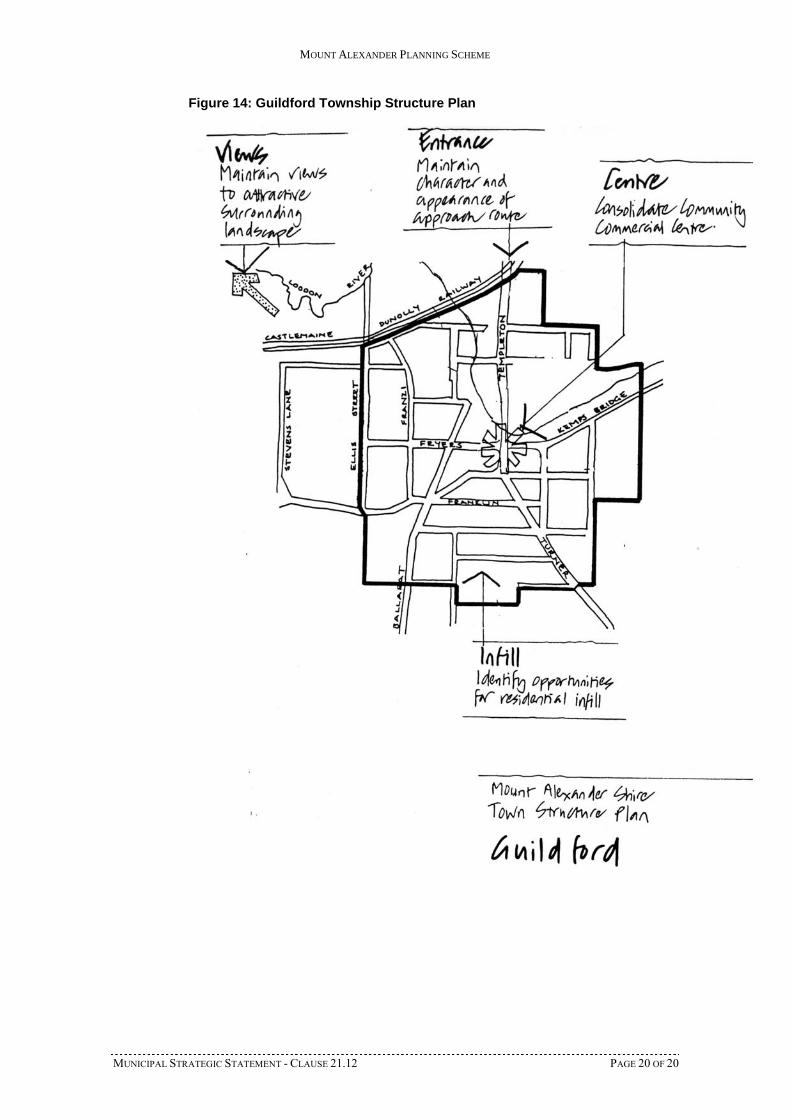
21.12-8 Guildford
Guildford is a small village next to the Loddon River. The community and commercialfacilities are centred around the intersection of Templeton Street and Fryers Road.
Objectives and strategies
Objective 1
To facilitate urban development in small towns.
Strategy
1.1 Support improvement options for wastewater management in Taradale,Elphinstone and Guildford.
Local area implementation
Ensuring that any proposed use or development in Guildford is generallyconsistent with the Guildford Land Use Framework Plan in Figure 14.
Further strategic work
Preparing incorporated plans or development plans for proposed new residentialareas.
13/07/2017C56
MOUNT ALEXANDER PLANNING SCHEME
MUNICIPAL STRATEGIC STATEMENT - CLAUSE 21.12 PAGE 20 OF 20
Figure 14: Guildford Township Structure Plan


![[XLS]admin.inxpress.com.au · Web view2 8.98 12.25 16.330000000000002 19.600000000000001 28.150000000000002 36.239999999999995 57 1.24 2 9.26 12.91 17.470000000000002 21.12 30.520000000000003](https://img.pdfslide.us/doc/110x75/5b1d0bfa7f8b9aad5d8be62e/xlsadmin-web-view2-898-1225-16330000000000002-19600000000000001-28150000000000002.jpg)