Embed Size (px)
Citation preview

35
CHAPTER II
PREVIOUS WORK AND REGIONAL GEOLOGY
2.1 PREVIOUS WORK
The might of Himalaya has inspired and evoked the awe and wonder of the people of the
world from time immemorial. In order to give the previous geological account of the study
area, the present chapter reviews and summarizes the present state of knowledge. After the
first attempt of systematic examination of Himalaya by Captain Herbert (1842), the then
Deputy Surveyor General of India, he divided the Himalayan terrain into four different
zones right of the line of the watershed between the Indus and the Ganga and the low hills
of Siwaliks.
Malla Johar which lies in Uttarakhand Tethys Himalaya earlier considered as part of the
Tibetan Himalaya. Compared to all other domains of Himalaya this part remain invincible
for decades because of many political and mythological causes. Complication in geological
history of Malla Johar is cleared by the line of Doyen of Himalayan Geology A. Gansser
(1964), “In Kumaun Himalayas, the problematic zone of Exotic Blocks”; and also
suspicious about the new work possibilities in the near future. His possibilities remain true
because till date a very little work has been done on the evolution of this problematic zone
except some work on age and depositional environment on the basis of microbiota and
petrographical description by Mehrotra and Sinha (1978, 1981); Shah and Sinha, (1974);
Sinha and Srivastava (1978, 1986); Sinha and Dmitrenko, (1983); Kumar et al (1978);
Garg et al (1981); Juyal et al (2002).
Sangchamalla Formation, which is a flyschoidal unit, attains the status of formation in
early eighties after the expeditions of Wadia Institute of Himalayan Geology, Dehradun
(WIHG) from 1973 to 1980. First worldwide attraction towards this flyschoidal unit was
because of Heim and Gansser (1939a), they considered it as an upper part of Giumal
Sandstone, which is strikingly similar to some Alpine Flysch deposits. Some geologists
named it Jhangu Formation (Garg et al, 1981) but now from the perusal of the literature on
the geology of Kumaun, it is accepted as Sangchamalla Flysch, because it’s best
development occur at Sangcha Malla which lies below the Kiogad peaks, and considered
as the type locality of the Sangchamalla Formation. The detail of previous work done on
Sangchamalla Formation and associated sequence is given before the stratigraphic details
of Sangchamalla formation.
Estelar

36
2.2 REGIONAL GEOLOGY
The main belt of the Tethys Himalaya lies between the Indus Tsangpo Suture to the north
and the Higher Himalaya zone to the south. In western Himalaya the well developed
sequence of Tethyan zone, also called the Tibetan zone is exposed in Malla Johar,
Northern Kumaun, Spiti and Zanskar regions (Heim and Gansser, 1939a, b; Gansser, 1964;
Valdiya, 1980; Sinha, 1989; Thakur, 1992; Hirn et al., 1984). The Kashmir and Chamba
sequences located south of the main belt as well as south of the higher Himalaya zone of
Zanskar, are included in the Tethys Himalaya zone (Thakur, 1992) (figure 2.1).
Figure 2.1: An outline tectonic map of western Himalaya Showing distribution of the Tethys
Himalaya Zone (Thakur, 1992).
The ‘Tethyan’ facies comprises the fossiliferous Precambrian-Palaeozoic–Mesozoic-
Tertiary sequences resting along the Trans Himadri Fault (THF) (Valdiya, 1987) or South
Tibetan Detachment (STD) on a basement of the Central Crystallines, which in turn
overrides the sediments and metasediments complex of the Lesser Himalaya to the south
along the Main
Central Thrust (MCT) (Gansser, 1964; Valdiya, 1981, Sinha, 1989; Thakur, 1992). In the
older classical concept the Tethyan zone sequences was considered as geosynclinal
deposits. In plate tectonic interpretation the Mesozoic sequence of Tethys Himalaya of
ZANSKARS P I T I
MALLAJOHAR KUMAUN
TSO MORARIK A S H M I R
POTWAR PLATEAUPANJAB PLAINS
MBT
MBT
MM
T
ITS
ITS
PESHAWAR BASIN
LAHAUL
CHAMBA KINNAUR
G A N G A B A S I N
ZANSKAR
Tethys Himalaya
Gilgit
Indus R Leh
Kailash
Kargil
NunKun
Jhel
um R
Che
nab
R
Ravi R
Beas R
Satluj R
Chandigarh
Ambala
Yam
una
R
MussoorieAlmora
Nainital
Ka
li R
Lee Pargil
Gartek
Sarchu
Kishtwar
Shimla
Mandi
RampurDharmsala
Udhampur
Punch
Rawalpindi
Murree
Abbotabad
Islamabad
Peshawar
MBT
Astar
Burzil PassNanga Parbat
Nanda DeviMCT
Indus R
Indus R
Srinagar
350
300
750
800
350
300
750
800
Estelar

37
Malla Johar, Kumaun, Kashmir, Zanskar, and Spiti represents the deposits of the southern
Tethys over the north facing Indian margin (Thakur, 1992).
In all the well-developed sequence of Tethyan zone in western Himalaya, Spiti is the best
studied section because of good connectivity and communication, while Malla Johar is less
explored because of poor connectivity and communication. A lithostratigraphic
comparison between Spiti and Malla Johar is given in Table 2.1. The present knowledge
about the Tethyan zone of Malla Johar/ Central Himalaya is provided by the Swiss
expedition in 1936, which was led by late Prof. Arnold Heim. Monograph published in
1939 after this expedition remained till today the authentic literature with the modern
concept of the first half of the twentith century in Geologial sciences. After long time of 50
years another monograph “Geology of the Higher Central Himalaya” by Prof. A. K. Sinha
published in 1989, which is the outcome of a number of post-independence expedition
initiated by the Geological Survey of India (GSI) and Wadia Institute of Himalayan
Geology (WIHG). Preliminary work from GSI was initiated by Mehdi (1966), he was the
first post-independence worker to give the stratigraphical account of Darma Ganga and
Lesser Valley of Tethyan domain, after that Sarvashri Gopendra Kumar, Gyan Prakash and
S. H. Mehdi subsequently published their review of strtigraphy of parts of then known
Uttar Pradesh Tethys Himalaya in 1972. Publication of Sastry et al. (1970), Sastry and
Mamgain (1970, 1975, 1977), and Mamgain and Sastry (1975) was some more work from
GSI on Tethys Himalaya and it was based on account of Cretaceous microflora and
biostratigraphic data from Mesozoic and Paleozoic sediments. After the foundation of
WIHG, the first expedition in Tethys Himalaya was in Kali valley and literature was
published by Valdiya and Gupta (1972), Valdiya et al. (1972), Powar (1972), and Banerjee
(1974).
Lithostratigraphy and trace fossils have been published by Kumar et al. (1977). The
monograph by Sinha (1989) was the outcome of number of expedition organised by WIHG
between 1973 to 1980, and publication came out covering the different aspects of
geological problems from the inaccessible Tethys Himalaya. The problems related to
regional geology, structural, tectonics, biostratigraphy, geochronology, mineralogy-
petrology and metallogeny have been partly covered and touched by many authors like
Shah and Sinha (1974), Banerjee, Tandon, and Sinha (1975), Sinha and Jhingran (1977),
Sinha (1974, 1975, 1977, 1978, 1980, 1981, 1982, 1983, 1984, 1987, 1989), Sinha and
Bagdasarian (1977), Ashgirei et al. (1976, 1977, 1982), Fuchs and Sinha (1974, 1978),
Sinha and Pal (1978), Mehrotra and Sinha (1978, 1981), Sinha and Srivastava (1978, 1979,
Estelar

38
1986), Sharma et al. (1978), Sinha and Nanda (1979), Sinha and Raaben (1979), Sinha and
Mehrotra (1979), Azmi and Sinha (1981), Bist and Sinha (1982), Negi et al. (1982, 1983,
1984), Sinha and Dmitrenko (1983), Khanna et al. (1985), Schwan et al. (1985).
Table 2.1: Stratigraphic correlation between Spiti and Malla Johar Tethys Himalaya (after, Sinha,
1989 and Bhargava, 2008)
SPITI (Bhargava, 2008) MALLA JOHAR (Sinha, 1989)
GROUP FORMATION A G E FORMATION
KANJI DUMBAR Lutetian Mid Eocene
KELCHA Thanetian-Ypresian Late Paleocene to Early Eocene
DISCONFORMITY
LAGUDARSI CHIKKIM Cenomanian-E. Maastrichtian Late Cretaceous SANGCHA MALLA FORMATION
GIUMAL Late Valanginian-Albian Early Cretaceous GIUMAL
SPITI Oxfordian-Early Valanginian Late Jurassic-Early Cretaceous SPITI
DISCONFORMITY
Callovian
Middle Jurassic SULCACTUS THE FERRUGINOUS OOLITE
KIOTO TAGLING Lias Early Jurassic LAPTHAL FORMATION
PARA Late Rhaetian Triassic KIOTO FORMATION
NIMOLOKSA NUNULUKA Late Norian-Early Rhaetian Triassic
KUTI SHALE
ALAROR Late Norian Triassic
HANGRANG Middle Norian Triassic
RANGRIK Early Middle Norian Triassic
SANGLUNG RONGTONG Middle-Late Carnian Triassic
KALAPANI LIMESTONE
RAMA Early Middle Carnian Triassic
TAMBA KURKUR
CHOMULE Ladinian-Early Carnian Triassic
KAGA Ladinian Triassic
MIKIN Induan-Anisian Triassic
DISCONFORMITY
KULING GUNGRI Dzulfian-? E. Dorashamian Late Permian KULING SHALE
DISCONFORMITY
GECHANG Asselian-?Sakamarian Early Permian
DISCONFORMITY
KANAWAR GANMACHIDAM Late Carboniferous Late Carboniferous
PO Visean-Serpukhian Late Early Carboniferous FENESTELLA SHALE
LIPAK Givetian-Tournaisian Mid Devonian
MUTH Early Devonian Early Devonian MUTH QUARTZITE
ANGULAR UNCONFORMITY
SANUGBA TAKCHE Ashgill-?Wenlockian Late Ordovician to Mid Silurian VARIEGATED FORMATION
YONG FORMATION
THANGO Early Ordovician Early Ordovician SHIALA FORMATION
GARBYANG FORMATION
ANGULAR UNCONFORMITY
HAIMANTA KUNZAM LA Early Middle Cambrian Early Middle Cambrian RALAM FORMATION
BATAL Ediacaran-Early Cambrian Ediacaran-Early Cambrian MARTOLI FORMATION
Estelar

39
2.3 TETHYS OF MALLA JOHAR
The Tethys Himalayan sequence of Malla Johar region (figure 2.2) to the south including
the Martoli Formation overlies the Central Crystallines of the Higher Himalaya along the
Trans-Himadri Fault (THF) or South Tibetan Detachment (STD) and extends to the north
upto the Cretaceous and Paleocene-Lower Eocene rocks, which are overlain along a thrust
by the klippen of exotic blocks formation. The stratigraphy of the Tethys Himalayan zone
of Malla Johar is summarized in table 2.2. The account of the regional stratigraphy from
the Vaikrita Group to the Sancha Malla Formation with associated ophiolites and exotic
formation, is mainly based on Kumar et al. (1972), Shah and Sinha (1974), Sinha (1980,
1989); and the environment of deposition is described after Kumar et al. (1977, 1978) and
Valdiya (2010).
2.3.1 VAIKRITA GROUP
It was Griesbach (1891) who introduced the sanskrit word to describe the highly deformed
crystalline complex of rocks of Central Himalaya. In sanskrit, Vaikrita means the
deformed, and the metamorphosed. Subsequent workers have called this unit variously the
Central Crystallines or Basement Complex. Vaikrita delimited at base by the MCT and cut
at the top by the STD or THF fault, the Great Himalaya 6000-10,000m thick lithotectonic
slab squeezed up as a consequence of continued India – Asia convergence (Valdiya, 2010).
Metamorphic rocks of this group show grading from low to high grade catazone
silliminite-kyanite schist with an appreciable thickness of hundreds of meters of quartzite,
sometimes occurring with kyanite – silliminite as well as garnets in the schistose and
gneissose part of the argillaceous sediments. The other components of the crystalline
complex are various grades of gneisses and schists including calc-silicate schistose rocks
and granitic gneisses of different phases (Gansser, 1964; Valdiya, 1988; Sinha, 1989;
Thakur, 1992) (figure 2.2 & 2.3).
The entire Vaikrita Complex is intensely deformed and metamorphosed due to
remobilization and therefore, the role of the Central Crystalline in the palaeogeologic
reconstruction of Himalaya remained an enigma for the workers. This Vaikrita Complex of
uncertain age formed the floor of the Tethys basin in which the Phanerozoic sediments,
ranging in age from the Cambro – Ordovician to the Eocene, were laid down (Valdiya,
2010).
Estelar

40
Figure 2.2: Regional Geological Map of Malla Johar Tethys Himalaya (after Sinha, 1989)
2.3.2 MARTOLI GROUP (ca. 3250 m)
Greisbach (1891) observed that the Vaikrita Complex, which rests conformably on the
granitic gneiss of the southern range along its northern slope, passes gradually into
metamorphosed muddy flysch described by H.H. Hayden in 1904 as the Haimanta (‘snow
–covered’ in Sanskrit) system. Heim and Gansser (1939a) showed the Vaikrita passing
gradually into slightly metamorphosed flysch of the Martoli Formation in NE Kumaun.
The Martoli Formation comprises greywackes showing flute casts and related features and
contain trilobite fossils (Valdiya, 2010). In the entire area of Central Greater Himalaya, the
Martoli group of sediments tectonically and in turn they are unconformably overlain by
Ralam Conglomerate and quartzites. In Malla Johar Pindari, Rilkot and Budhi schists,
represents the locally metamorphosed Martoli sediments at the base (figure 2.3). The
intense tectonic and magmatic activities, and dynamothermal phenomena, caused the
Estelar

41
schistosity of sediment with the development of random growth of porphyritic biotite. The
distribution of Martoli Group is not uniform from the Dhauli valley in the northwest to
Kali gorge in the extreme southeast. The maximum thickness (ca. 6000 m) is attained in
the central part of the arcuate disposition of basin in the region of Nanda Devi and Gori
Ganga gorge; the highest peaks of the Great Himalayan range, viz. Nanda Devi (7820 m),
Api (7140 m), Nanda Kot (6861 m) etc. are all formed by the Martoli Group of
sedimentary rocks (Sinha, 1989).
Table 2.2: Stratigraphic subdivisions and age of the Tethys Himalaya Zone in Malla Johar (after
Shah and Sinha, 1974; Valdiya, 2010) Division Lithology Characteristic Fossils Age
Shah and
Sinha, 1974
Valdiya,
2008
Sangcha Malla Formation
Greenish shales with bands of radiolarian cherts Greenish- grey greywackes and dark shales. Purple marly
shale with foraminiferal ooze Dark greenish shale with greywacke bands
Radiolaria, fucoid, markings,
Globotruncana, Heterohelix, Shackoina, Eouvigerina
Lower Eocene
Upper Cretaceous
Cretaceous Giumal Sandstone
Greenish grey sandstone and sandy shale with thick bands of massive radiolarian cherts
Thick bedded glauconitic sandy shales and sandstones
Not determinable fossil except radiolaria
Spiti Shale
Blach shales with phosphatic, ferruginous and calcareous concretions
Belemnmopsis gerardi, Perisphincts(Virgatosphinctes) fregens,
Lytoceras sp, Hoplites, etc.
Portlandian
Jurassic Sulcactus the ferruginous
Oolite
Ferruginous oolite with coquina Belemnpsis sp., Reineckites sp., Macrocephalites, etc
Callovian
Lapthal Formation
Dark- blue to grey limestone with bands of conquina Pecten sp., Astrate sp., Cardium sp., Trigonia sp., Belemnites sp.
Lias
Kioto Formation
Grey limestone with numerous bands of coquina. Nodular and oolitic limestone. Cross- bedded calcarenite and
arenaceous limestone. Grey and blue dolomitic limestone
Megalodon, Spiriferina, pectin, etc. Rhaetic Rhaetic
Kuti Shale Alternating bands of blach shale and limestone Few pelecypod shells Noric
Upper Triassic
Kalapani Limestone
Nodular limestone, grey massive limestone
Ptychites, Gymnites, halobia, Arcestes, etc.
Carnic- Ladinic
Mid Triassic
Kuling shale Black crumply shale with thin beds of limestone with concretions towards the top
Paramarginifera himalayensis, Cleiothyridium roysii, etc
Upper and Middle
Permian
Late Permian
Muth Quartzite
White sugary orthoquartzite with bands of dirty white quartzite
Chocolate brown quartzite and dolomitic limestone
Schellwienella williami, Leptaena, rhomboidalis, Strophomena sp.
Devonian Silurian
Variegated Formation
Purple limestone and shale with bands of quartzite Atrypa reticularis, Strophonella sp., Orthis (Dalmanella) basalis, Favosites sp.,
Leptaena rhomboidalis
Silurian
Silurian
Yong Formation
Green nodular biohermal and biostromal limestone Calostylis? Dravidiana, Streptaena halo, Favosites sp.? Saffordia sp., Monotrypa
sp. Strophomena sp.,
Shiala Formation
Grey to pinkish sandstone and quartzite with bands of limestone at the top
Alternating bands of sandstone and shale Alternating bands of greenish shale and biostromal
limestone. Green splintery shale with thin bands of arenite
Rafinesquina aranea, R. Muthensis, Triplecia sp., Skendium sp., etc.
Ordovician Late Ordovician
Garbyang Formation
Green needle shales with occasional bands of limestone Alternating bands of sandstone and shale with graded
bedding Cross- bedded calcareous sandstone
Greyish green graded bedded sandy shales, crinoidal and oolitic limestone, brown marl
Brown dolomitic limestone with alternating bands of shale
Eccliotteris kushanesis
Cambrian Mid Ordovician
Ralam Formation
Arenaceous shale Dark coloured quartzite
Conglomerate alternating with quartzite
Precambrian Mid Cambrian
Martoli Formation
Graded bedded grayish black shales, slates and phyllites
Early Cambrian
Vaikrita Group Quartzite, Quartzite schist, calc-silicates, kyanite and silliminite gneisses, migmatites and granites
Proterozoic
Estelar

42
Considering the huge thickness and basal position of the Martoli Group and the
unconformable Ralam Conglomerates at the top, dividing the entire group into four distinct
formations with appreciable thickness and distinct lithological identity. These four
formations, viz. Rilkot, Burphu, Bilju, and Milam, are best exposed in the Gori Ganga
section (figure). On the consideration the age of Garbyang Formation, it could be inferred
that the Martoli Group goes back to Precambrian era (Sinha, 1989)
Figure 2.3: Stratigraphic column of the basal Tethyan sequence with subdivisions of the Martoli
Group (after Sinha, 1989).
VA
IKR
ITA
G
RO
UP
( =
15 K
m)
RIL
KO
T
F
MN
( =
250 m
)
B
UR
PH
U F
MN
( =
2000 m
)
B
ILJU
F
MN
( =
500 m
)
MIL
AM
FM
N (
= 3
500 m
)
RALAM FMN
GA
RB
YA
NG
FM
N
( M
iddle
) >
500m
MA
RT
OL
I G
RO
UP
Greenish Grey Phyll. Calc.
Aren Dolo Phyll.
Dolo Phyllite
Quartzite
Brown Conglomerate
Unconformity
Phyllite, SiltstoneQz Vein + Chloritewith Copper Pyriteminzn.
GreenishSiltstone, Phyllite
Pyrite Quartzite
Graded GreenishSilty Phyllite
Sericite SchistPhyllite
Qz. Ser. Schist
Biotite Porphyry Schist
Tectonic Contact
Kyanite Sill
SchistMica SchistBiotite Schist
Calc. SilicatePgm. Apl.
Estelar

43
2.3.3 RALAM FORMATION (ca. 800 m)
The Ralam series, proposed by Heim and Gansser (1939a, b), is exposed in the spur of the
Ralam pass (5500 m). The characteristic lithology is represented by basal conglomerate
and quartzite. The brick- red conglomerate has quartzitic clasts of hand to smaller size,
unsorted, with a hard quartizitic matrix with bands of quartzites, where clasts are absent, or
with a decrease in the number and size of clasts (figure 2.3). The rock imperceptibly grades
into grey to purple and green, very hard, massive quartzite in the upper horizon. The clasts
are almost invariably of quartzite. The upper part of Ralam consist a dolomitic lithology
and transitionally crosses over to the Garbyang horizon. Since it lies conformably below
the Garbyang dolomitic rocks and with a marked unconformity over the Martoli Group, the
age of the Ralam Formation is regarded as Precambrian- Cambrian. The marked
unconformity may represent the hiatus of Baikalian orogeny (Sinha, 1989). In Malla Johar
Tethyan sector, the Early Cambrian is intriguingly absent and the Late Precambrian
metasediments is succeeded directly by the mid Cambrian Ralam Conglomerate (Valdiya
2010).
2.3.4 GARBYANG FORMATION (ca. 1500 m)
Malla Johar sub-basin of Tethys subprovince saw initiation of Paleozoic sedimentation in
the Mid Ordovician time (Valdiya 2010). Garbyang Formation, first studied by Heim and
Gansser (1939a) in the Kali river valley, was named after a flourishing Bhotia village,
‘Garbyang’ functioning as the centre of Indo- Tibetan trade. In the earlier works of
Greisbach (1891, 1893), this was considered to be the upper part of Haimanta system. The
Garbyang Succession of calcilutite, showing rain prints and mud-cracks in ferruginous
slates, was laid down in a shallow platform (Valdiya 2010). The Garbyang zone was
especially studied since the rich barite- polymetallic mineralization has been discovered to
be confined in this zone (Shah and Sinha, 1974; Sinha, 1977). After the expedition of
WIHG in 1973 stratigraphic status of Garbyang was raised to formation with the division
of three A, B, and C members (figure 2.3). The lowermost Member A conformably
overlying the quartzite of Ralam assumes a thickness of ca. 250 m and the characteristic
lithology is shaly dolomitic limestone, dark blue calcareous phyllite and sericite schist.
This Member A is conformably overlain by massive grey dolomitic limestone with marly
bands and intercalated shaly horizon to an insignificant amount in a huge thickness of 200
m. This ‘Member B’ of Garbyang in its lower part is confining barite-pyrite mineralization.
The uppermost Member C of the Garbyang Group, having a thickness of ca. 550 m, is well
Estelar

44
exposed in the Girthi Ganga near Dobala at the confluence of the Girthi Ganga and the
Kiogad. Garbyang is more or less devoid of identifiable fossils except gastropods, viz.
Eccliopteris Kushanensis and doubtful fragments of trilobites and Linguids (Sinha, 1989).
Heim and Gansser (1939a) reported badly preserved Mid Ordovician gastropods from the
Upper part of the Garbyang Formation.
2.3.5 SHIALA FORMATION (ca. 600 m)
The Garbyang imperceptibly passes upwards into the Shiala formation made up of
olivegreen shales and siltstone interbedded with blue-grey crinoidal limestone and marlite,
with maroon and light grey limestone – shale rhythmite (figure 2.4). Towards the top of the
Shiala Succession a biostromal horizon occurs (Valdiya 2010). The Shiala Series is
assigned to the Late Ordovician and was first described by Heim and Gansser (1939a). It
was named after the Shiala Pass. In the gorge of the Kiogad, a few kilometers before the
Sumna campsite, there is a perfect conformity between the Garbyang Formation and Shiala
Formation. The main distinction in lithology between the two formations is the presence of
a biostromal band in the Shiala. It is taken as a distinctive and important criterion to mark
the boundary between the Garbyang and the Shiala Formations. The Shiala Formation
comprises a sequence of green shale with silty bands towards the base. With the gradual
increase in the arenaceous component, the Shiala Formation becomes essentially quartzitic
towards the top. Throughout the formation, more towards bottom, two bands of biostromal
limestone consisting of fragments of arenaceous , calcareous algae, coral and shells of
brachiopods etc. are met with. They vary in thickness from a few centimeters to about 60
cm, and are seldom persistent. Very often they occur as podshaped bodies within the
predominantly shaly rocks, the imperceptible transition zone between the Shiala and the
Garbyang formations characterized by the lithology of green shale with arenite followed by
the Orthis (Dalmanella) testudinaria zone. As a matter of fact, the occurrence of Orthis
should be taken as the first and the best exposed fossils in the Tethyan column of Central
Himalaya.
The Shiala Formation is rich in fauna and can be divided into four biostratigraphic zones.
They are named after the characteristic fossil taxa, from the base, as: Orthis (Dalmanella)
testudinaria zone, Rafinesquina arenea zone, Monotrypa zone and Rafinesquina alternata
zone. The faunal assemblages clearly indicate an age ranging Middle to Upper Ordovician
(Sinha, 1989).
Estelar

45
Figure 2.4: Stratigraphic column of Tethys Himalaya Zone from Garbyang to Kalapani Limestone
(Sinha, 1989)
2.3.6 YONG LIMESTONE FORMATION
The biota consists of calcareous branching algal, stromatoporids, crinoids, corals and
bryozoans. Formation thickness varies in fifties of meters. It is graiesh-green in colour of
and continuously met from Rimkhim to Yong gad. It comprises a series of reefal structure
with dips in all direction of domal shape and interconnected with one another by bedded
reefal debris (Sinha, 1989) (figure 2.4). The formation has been named after the deserted
village of Yong valley where one of the reefs is exposed on the mule track leading to
Rimkhim. Microfaunal studies have revealed that reasonably rich palynological
assemblage, consisting of 11 chitinozoan and scolecodont forms occur. These forms tend
to suggest an upper Ordovician-Lower Silurian, probably Caradocian to Llandoverian age,
to the Yong Limestone and the Ordovician – Silurian boundary lies in the lower half of this
stratigraphic horizon (Khanna et al., 1985). In Malla Johar sub-basin of Tethyan Himalaya,
algal bioherms characterized by Early Silurian stromatoporoids forms a part of the Yong
Limestone (Shah, S.K. and Shina, 1974: Khanna et.al., 1985). The Yong laterally grades
into what Heim and Gansser (1939a) described as the Variegated Silurian.
2.3.7 VARIEGATED FORMATION (33-400 m)
The name of this horizon is derived from the ‘Variegated Silurian’ proposed by Heim and
Gansser (1939a) in the Kumaun Himalaya, and this formation was called ‘Red Crinoidal
KALAPANI L.ST.
KULING SHALEPERMIAN
MUTHFORMATIONDEVONIAN
SILURIAN
ORDOVICIAN
VARIGA. FMN
YONGLIMESTONE
SHIALA FMN
GARBYANG FMN
Greenish Grey Calc-Phyllites
Calc-Sandstone
Greenish-Grey Limestone
Red Calc Shale
Dolomite Brownish Quartzite
White Massive Quartzite
Carbonaceous Mica Calcareous Shale
1000 m
500 m
0 m
Estelar

46
Limestone’ by Griesbach (1891), and was regarded as carboniferous and basal Silurian.
The mistakes were rectified by Hayden (1904), who ascertained that the Spiti
representative of the ‘red crinoidal limestone’ is certainly not younger than upper Silurian.
The Shiala pass exposure of Variegated Formation was estimated by Heim and Gansser
(1939a): (a) 200-300 m red to green and grey shales with layer of white limestone,
characterized by smaller blood red shale and rusty weathered dolomitic in the upper part;
and (b) 500-600 m of shaly lenticular limestone with crinoidal fragments. Somewhat
nodular limestone of about 100 m thickness has also been observed by them and regarded
as special facies of Variegated Silurian sequence. But now it has been established that this
nodular limestone facies is nothing but reefal Yong horizon. The lower part of the
Variegated formation is represented by purplish algal limestone and phyllite, sometimes
arenaceous followed by upper part mainly composed of purplish and green calcareous
quartzite. This formation is separated distinctly on account of colour contrast with the
underlying green Yong Limestone and the overlying white Muth quartzite (figure 2.4). The
formation is poorly fossiliferous but one characteristic assemblage zone was recorded from
Kiogad valley section named as Strophonella Zone. Valdiya and Gupta (1972) recorded in
their intermediate horizon the various forms: Orthis (Dalmanella) bouchardi and Orthis
(Dalmanella) basalis var. muthensis. The upper limestone members have yielded Favosites
spitiensis and poorly preserved Streptelsma and broken blades of Polygnathids.
2.3.8 MUTH FORMATION (400-1000 m, on average ca. 400 m)
A 300-600m thick band of strikingly snow-white quartzite, forms a blanket of
quartzarenite in Kashmir, Zanskar, Spiti, Kumaun and north-western Nepal known as Muth
Quartzite (Valdiya, 2010). The Muth is one of the very conspicuous datum lines in the
stratigraphic history of the Himalaya. This formation was a time-transgressive unit that
ranged in age from Middle to Late Silurian (Shah, S.K., 2005). The sediments were
deposited very rapidly in a short span of time in a costal environment. The Muth sediments
represent offshore elongate bars and a shoal complex (Bagati, 1990; Bagati et al., 1991).
The Muth marks an epoch of tectonic stability during the Later Silurian period, when
practically the whole of the Tethyan domain stretching from west to east became a site of
shallow-water deposition of well-sorted clean sands (Valdiya, 2010).
In the Malla Johar (Yong valley) section, the variegated Formation is overlain by the Muth
quartzite with an angular unconformity (Sinha, 1989) (figure 2.4). Heim and Gansser
(1939a) also mentioned this angular unconformity and regarded it as lithological rather
Estelar

47
than tectonic. The stratigraphic situation reveals that deposition at the bottom of the deep
sea possibly might have been interrupted for a short period because neither the ‘Variegated
Formation’ nor Muth quartzite represents a deep sea deposit. In the upper reaches the Muth
quartzite forms a cliff (Sinha, 1989).
2.3.9 FENESTELLA SHALE
In the Spiti as well as in Kumaun basin, restriction of water circulation caused
development of anoxic conditions as reflected in the accumulation of thick, black
carbonaceous shale and black limestone, described by H. H. Hayden in 1904 as the Lipak
Limestone and the Po shale, respectively. In Uttarakhand Tethys Himalaya, Fenestella
shale was first recorded by Valdiya and Gupta (1972) in the gorge of Kali River in
Kumaun. Pink and grey silicious limestone, dolomite and sandstone contain Lower
Carboniferous Linoproductus and Chonetes (Valdiya et al, 1972; Mamgain and Mishra,
1989). These shales are characterized by Middle Carboniferous bryozoan fauna: Fenestella
plebei, Protoretepora cf. ampla, Spirifer middlemissi and Productus (= Waagenoconcha cf.
scabriculo) along track towards Lipu lekh just climbing up along eastern slope of Teragad
(Valdiya and Gupta, 1972). In Malla Johar Po has been described as the Fenestella Shale
and reported between Gunji and Kalapani (Sinha, 1989).
2.3.10 KULING SHALE (20-100 m)
The original name has been derived from the locality in the Spiti basin which is called
‘Guling’, a name given by F. Stoliczka in 1865. This persistent horizon of euxenic facies of
black silty micaceous shale of ca. 20 to 100 m thickness with well preserved fossils
exhibits contrasting geology by its situation over white sugar competent quartzite of the
Muth formation (figure 2.4). In the Kiogad valleys a 70 m thick band of black friable
Carboniferous shale is continuously present resting on the Muth Quartzite. Within these
shales thin lenticles of limestone are present. This formation is rich in nodules towards
upper part, which on breaking yield fossils. The first fossil horizon immediately over the
Muth Quartzite is the Paramarginifera himalayensis zone, rich in middle to upper Permian
fossils. This indicate that the Carboniferous lower Permian is completely missing from the
section (Sinha, 1989). The trace fossils reported from the Kuling shale are Cochlichnus
(Tandon and Bhatia, 1978). The geological characteristics of the formation point to a
reducing euxinic lagoonal sea environment.
Estelar

48
2.3.11 THE TRIASSIC OF CENTRAL TETHYAN ZONE
The Triassic of the Tethyan zone of Himalaya as a whole has been worked out in much
greater detail in comparison to other geochronostratigraphic horizons. The basic reason for
such special attention was attributed to the resemblance of fossils assemblage from the
Alps. The pioneer work was done by the group of Austro-German geologists who were
engaged by the Geological Survey of India as early as the end of the last century. The
fundamental contributions have been made by Griesbach (1891), Von Kraft (1902), and
Diener (1912). Amongst them the contribution by Diener were the most valuable, starting
in 1895 and culminating in 1912 with the GSI memoir volume 36, part III. Von Kraft made
special studies of the Triassic in Kumaun in 1900. His stratigraphical and tectonics results
have been summarized in the interesting paper (GSI Memoir volume 32, part III). Soon
after finishing his mission he died suddenly on 22 September, 1901, in Calcutta, then his
material, note books, sketches and fossil collection were passed on to Professor Carl
Diener of Vienna University for completion of the publication of the unfinished valuable
research. The early work on the development of lower Trias in the Central Tethyan Zone
has been known through Griesbach (1891) and Diener (1903), and this work summarized
by Diener (1912).
Heim and Gansser (1939a) proposed the following main lithological divisions on the basis
of early recognized nomenclature given by Diener (1912).
1. Chocolate series (= chocolate limestone, Griesbach).
2. Kalapani limestone (after the famous place in Kali River).
3. Kuti shales (after the Kuti village situated in Kuti Yankti).
4. Kioto limestone (name from Spiti adopted from a sketch of the geography and geology
of Himalaya by Burrard and Hayden and revised by Burrard and Heron (1934).
The above- mentioned subdivisions of Triassic remains undisputable, and henceforth the
description of the individual horizon is taken up.
2.3.11.1 CHOCOLATE FORMATION (30-50 m)
Heim and Gansser (1939a) described this as formation with typical chocolate colour due to
the brown weathering. They have observed that it is more shale than limestone. At the
confluence of the Shalshal and the Yong Gad this horizon was spotted with the underlying
Kuling shale and overlying Kalapani limestone. Kumar et al. (1977) referred this horizon
to the lower Triassic on the basis of conodonts found in them. Azmi (Azmi and Sinha,
1981) reported some typical lower Triassic conodonts at the contact horizon between the
Estelar

49
Kuling shale and the Kalapani limestone exposed in the Kiogad on the way to
Rewalibagar. The fossils reported by Azmi from a sample of Kalapani Limestone from the
Unta Dhura Pass in the Malla Johar region, are: Neospathodus triangularis, and forms
transitional to Neogondolella jubata-N. regalae, indicating latest Scythian age. The
Chocolate series is Lower Triassic or Scythian.
2.3.11.2 KALAPANI LIMESTONE (ca. 50 m)
The Kuling shale in the northwestern part of the area is directly overlain by the Kalapani
limestone, a bluish massive limestone towards the lower part and nodular limestone above
(figure 2.5). It appears to be of the nature of algal biostromes. The maximum thickness is
available in the Kiogad valley and in this valley it does not exceed 20 m. The Kalapani
limestone is highly fossiliferous in certain sections, apart from large numbers of
pelecypods, ammonites of typical Carnic affinity are found. These include among other,
species of Gymnites, Arcestes, Ptichites, Griesbachites, Halobia, etc. This has been given
the name Ptychites zone and seems to correspond the Halobia and Tropites beds of Spiti as
also indicated by Heim and Gansser (1939a). Some conodonts have been reported by Azmi
and Sinha (1981). They are Neogondolella excelsa and Himalayalla dropla indicating
Lower Ladinian age.
2.3.11.3 KUTI FORMATION (ca. 500 m)
The name of the formation is derived from Kuti village situated in the bank of the Kuti
Yankti River. The typical alternating horizon with shale and limestone lying over the
Kalapani limestone formation belonging to Kuti shale is exposed throughout Tethyan zone
of Central Himalaya. This typical lithological complex is found to be conformably
overlying the Kalapani limestone (Sinha, 1989). Its thickness varies from 300 to 500 m.
This horizon is being given the status of formation in conformity with the mode of
stratigraphic nomenclature since it represents a consistent, well demarcated, quite thick
horizon throughout the Tethyan zone. Geomorphologically, the Kuti formation is exposed
along the escarpment wall of the steep gorge in the Kiogad valley on the track through the
campsite to the Rewalibagar top. Its geomorphic feature is controlled by the competent
horizons of the Kalapani limestone and the Muth below it and hard massive limestone of
Kioto overlying it. The upper part of Kuti formation is characterized by regular layers of
great limestone. Sometimes folded disharmonically in such a manner that it forms a
vertical wall and a pillar-like feature. In the Kiogad valley, the Kuti formation is
Estelar

50
represented by at least 400 to 500 m suite of disharmonically folded alternating bands of
shale and limestone. The shale is dominated by black micaceous compounds. The
individual limestone bands do not exceed a meter thickness. Numerous tiny gastropods,
pelecypods, and brachiopods are reported to be Noric fauna, characterized by the numerous
Parajuvavites and Steinmannites (Sinha, 1989).
Figure 2.5: Stratigraphic column of Tethys Himalaya Zone from Kioto Formation to Sangchamalla
Formation, (after Sinha, 1989)
2.3.11.4 KIOTO FORMATION (ca. 700 m)
The Kuti shale is conformably overlain by a thick suite of limestone, occasionally having
an arenaceous composition (figure 2.5). Kioto limestone formation forms a continuous
ridge from Rewalibagar to Rim Khim (figure 2.6) separating the Lapthal-Shalshal plateau
Thrust With Ophiolite & Exotic Blocks
Radiolarian Chert
Greenish Shale
Graywacke
Black Silty Shale
Red Shale With ChertyLimestone Bands
Felspathic Sst.Shaly Sst.Radiolarian Chert
Radiolarian Cherty Sst.Graywacke
Glauconitic Sst.
Black Crumpled Shale
Ferrigenous Oolite
Brownish Sandy Lst.
Limestone
SA
NG
CH
AM
AL
LA
FO
RM
AT
ION
(
FL
YS
CH
)
GIU
MA
L
SPITISHALE
SULCACUTUS
LAPTHAL
KIO
TO
FO
RM
AT
ION
KU
TI
FO
RM
AT
ION
KALAPANI LST.
T
R
I A
S
S
I
CJ
U R
A S
S I
CC
R E
T A
C E
O U
S -
E O
C E
N E
Black Shale and LimestoneEstelar

51
to the northeast from the deeply dissected rugged to the southwest. The lower part of this
formation, in the escarpment of Rewalibagar climbing from Kiogad valley, contains
characteristic pelecypods and Megalodon in addition to number of other fossils like Pecten,
Spiriferina, and Megalodon, reported earlier from the Spiti region. The arenaceous
limestone bottom is criss-crossed by the secondary hydrothermal activities with barite and
calcite veins of a thickness not exceeding 5 to 10 cm.
2.3.12 LAPTHAL FORMATION (91 m, Middle to Upper Dogger)
Lapthal Formation is a horizon of multiple layers of broken shells deposited in shallow
water stretches west from Kungribingri in Nepal border to Painkhanda in Garhwal
(Valdiya, 2010). The name of this formation was given by Heim and Gansser (1939a) from
the locality of the Lapthal camp site situated on the Spiti shales between Chidamu and
Sangcha Malla in Malla Johar. The thickness exposed in the Kiogad gorge type area of
Lapthal formation is found to be 91 m. It has been found that the main lithological
component is calcareous but it is mixed up with arenaceous (figure 2.5). In the section
from Rewalibagar to the Lapthal camp site; this formation has a total thickness of about 80
to 90 m (figure 2.7). About 10 m from the base of the Rewalibagar camp site, a horizon
bearing pelecypods was found and named as Pecten and Astarte assemblage zone (Sinha,
1989). The topmost part of the Kioto limestone consist of black cherty massive limestone
and oolites at the contact point, transitionally superseded by cherty limestone with calcite
and secondary calcite quartz veins. Grey sandy limestone covers the rest 5 m to 10 m
exposed thickness from the bottom being followed by arenaceous limestone of greenish
colour with shales and in this horizon the typical Lumachelle start appearing (Sinha, 1989)
(figure 2.8). The colour becomes brownish and composition is more sandy. Up to further
30 m the brown sandy limestone continues and at the point 45 m measurement from the top
a horizon of 4 m thickness is characterized by black sandy limestone Estelar

52
Figure 2.6: Steep scarp of Kioto Limestone at Rewalibagar en-route to Sangcha Malla
appears with large 7 to 10 cm belemenite. Lumachelle is so characteristic of this horizon
that it assumes the name ‘Lumachelle formation’ in Nepal (Fuchs, 1967, 1977; Fuchs et al.,
1988; Bordet et al., 1971; Bodenhausen and Egeler, 1971; Bassoullet and Mouterde, 1977).
Some of the typical fossils identified from this horizon are: Rhynchonella, Isognomon sp.
The Lapthal bands contain Middle and Upper Dogger fossils. The Lumachelle formation
appears to be a rather consistent horizon in the part of Central Himalaya and it has been
established as Upper Dogger in age by Fuchs (1967, 1977) and also Dogger according to
Bordet et al. (1972).
2.3.13 SULCACTUS THE FERRUGINOUS OOLITE (3m Callovian)
This significant rather thin index bed was discovered in 1895 by Diener in Chirchun area
and is refered to because of its abundant Belemnites as the Sulcactus bed. Lapthal
Formation follows a condensed sequence comprising arenite at the base, and oolitic
limestone forming the bulk of the Ferruginous Oolite Formation (figure 2.5).
Estelar

53
Figure 2.7: Steeply dipping beds of Lapthal Formation at the base of Spiti Shale near Sangcha
Talla base camp
Strikingly golden-reddish in colour and formed in warm water agitated by waves, the oolite
horizon forms one of the most conspicuous and persistent stratigraphic unit in the
Neotethyan domain. Set in iron-rich matrix, the golden oolite and pisolite are seen all along
from southern Tibet, through northern Kumaun, Malla Johar and Spiti to the Quetta region
in Balochistan and then to the Kachchh region in Gujrat (Valdiya, 2010).
Figure 2.8: Lumachelle Beds typical of Lapthal Formation near Sangcha Talla base camp
Estelar

54
2.3.14 SPITI SHALE (250-300 m)
The Upper Jurassic Spiti Shale shows singular geographic persistence without lithological
variation from Hazara in the west to southern Tibet in the east (Valdiya, 2010). It is a shelf
environment in which muds were deposited at a very slow rate, and there were mud flows
occasionally and hard-ground formation frequently (Bhargava et al., 1987). This persistent
horizon of crumpled black shale provides a picture of flat topography between the
competent calcareous Kioto- Lapthal horizons and the sandstone cliffs of Giumal (Sinha,
1989) (figure 2.9 and 2.10). The Spiti shale is highly fossiliferous but a systematic
collection of fossils is not possible from the upper shale because it weathers easily and is
consequently always soil covered. Though the formation is full of fossils, their exact
position within the shale is not determinable, for these are found within the concretions
which are rolled into ravines or mixed with the soil. This fossiliferous horizon was
exploited for a 100 years by orthodox religious Tibetan people and Hindus, treating the
ammonites as ‘Shaligram’, the symbol of ‘Lord Shiva’. The excellent paleontological
script by V. Uhlig (1903-1910) remains as standard work on the ammonites in this
formation. The thickness of soft black carbonaceous clay shale varies greatly, apparently
by stratigraphical and technical causes. Among the rich variety of ammonites forming
Shaligrams are Oerisphinctes, Hoplites, Nacrocephalites, Himalites, Belemnopsis, and
Nucula. The upper part of the Spiti shale has been designated the Perisphinctes- Hoplites
zone (Sinha, 1989).
The Spiti Shale in Malla Johar contains foraminifers of stratigraphic importance (Singh, M.
P., 1979; Singh, M. P. and Kumar, 1978). Upper Jurassic microfauna from the Spiti shale
including foraminifera and ostracods from the exposure at the Lapthal camping ground,
have yielded the Lingulina mallajoharensis (Singh and Kumar, 1978), Bentalina
pseudocommunis, Marginulina batrakiensis, Marginulina sp., Lentinculina variana,
Lenticulina muesteri, Lenticulina sp., Saracenaria reesidei, Shalshalensis, Veginulina
constricta, Pseudonodosaria sp., Involtina sp., Eoqutalina sp., and ostracods: Bythocypris
sp., Monoceratina sp. The microfaunal assemblages correspond well with the Callovian-
Oxfordian microfaunal assemblage.
In the deeper shelf-to-slope faunas of the Spiti Shale in southern Tibet, the ammonite
assemblages comprise (1) Witchellia-Fontannesia assemblage having affinity with the
north-western Australian fauna, and (2) the Oxfordian Graiceras assemblage containing, in
addition to endemic forms, the elements of both the India-Madagascar and the
Mediterranean provinces (Westermann and Yi-gang, 1988).
Estelar

55
The faunal studies infers that ca. 250 m thick Spiti shale sequence near Lapthal represents
a rather continuous succession ranging in age from Oxfordian to Lower Hauterivian.
However, Isocrinids reported by Singh et al. (1980) representing Isocrinus and
Nielsenicrinus from the upper part of the Spiti shale range in age from Cretaceous to
Palaeocene, have revealed a rich assemblage of dinoflagellates and acritarchs along with
some spores and pollen grains.
Fig
ure
2.9
: P
ano
ram
ic v
iew
of
San
gch
a M
alla
fro
m L
apth
al c
am
p s
ite,
show
ing S
pit
i S
hal
e, G
ium
al S
and
sto
ne,
San
gch
a
Mal
la F
orm
atio
n (
fles
h c
olo
ur)
, B
alch
adhura
volc
anic
, ophio
lite
and e
xoti
c blo
cks
of
Mal
la J
oh
ar
Estelar

56
Figure 2.10: Flat topography of Spiti Shale at Lapthal camp site, in background exotic blocks are
sited
2.3.15 GIUMAL SANDSTONE (400 m) (Lower Cretaceous to Upper Neocomian to
Gault)
In Tethyan domain, the Cretaceous succession is a flysch assemblage made up of
rhythmites – glauconitic greywacke interbedded with shale and bedded chert (Valdiya,
2010) known as the Giumal Sandstone. This formation is traceable from Nindam in
Ladakh to Kagbeni and Kampa in southern Tibet (Valdiya, 2010). Spiti Shale upwards
conformably into Giumal, which comprises of moderately sorted, graded to cross-bedded
calcareous sublitharenite interbedded with Belemnites-rich black shale (Valdiya, 2010).
The term Giumal has been derived from a locality in the Spiti basin. Its average thickness
is ca. 400 m. This formation is represented by geomorphologically resistant cliffs
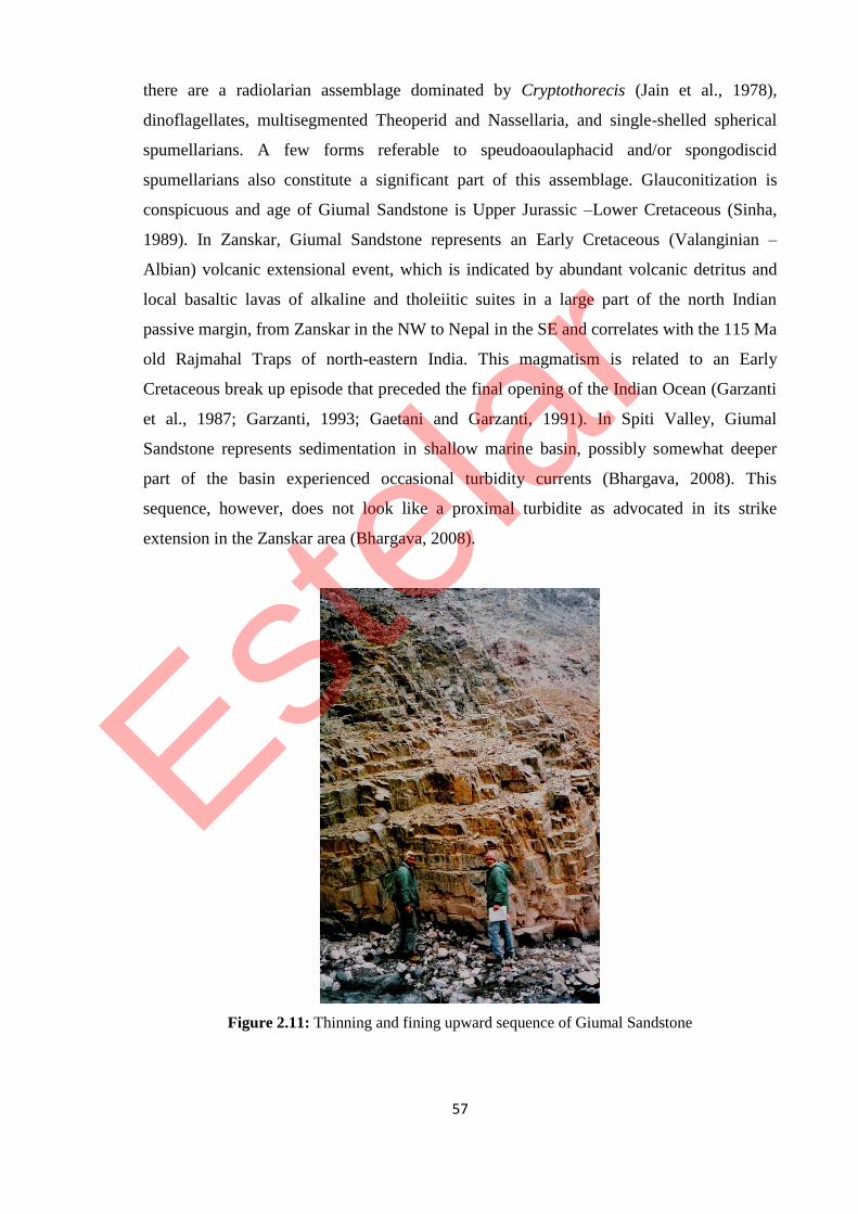
composed of glauconitic sandyshale, sandstone, and chert. The Spiti shale passes
conformably into this thick bedded glauconitic sandstone (figure 2.11). Formerly these
rocks were called ‘Lower Flysch’ by von Kraft (1902). In the Central Himalayan region,
Heim and Gansser (1939a) used this term for the similar rocks of Spiti. Towards the upper
part near Sangchatalla these rocks contain thick bands of radiolarian chert. Sinha and
Nanda (1979) recorded Pseudomontis, Inoceramus, and Gryphea. In the Giumal sandstone
Estelar
57
there are a radiolarian assemblage dominated by Cryptothorecis (Jain et al., 1978),
dinoflagellates, multisegmented Theoperid and Nassellaria, and single-shelled spherical
spumellarians. A few forms referable to speudoaoulaphacid and/or spongodiscid
spumellarians also constitute a significant part of this assemblage. Glauconitization is
conspicuous and age of Giumal Sandstone is Upper Jurassic –Lower Cretaceous (Sinha,
1989). In Zanskar, Giumal Sandstone represents an Early Cretaceous (Valanginian –
Albian) volcanic extensional event, which is indicated by abundant volcanic detritus and
local basaltic lavas of alkaline and tholeiitic suites in a large part of the north Indian
passive margin, from Zanskar in the NW to Nepal in the SE and correlates with the 115 Ma
old Rajmahal Traps of north-eastern India. This magmatism is related to an Early
Cretaceous break up episode that preceded the final opening of the Indian Ocean (Garzanti
et al., 1987; Garzanti, 1993; Gaetani and Garzanti, 1991). In Spiti Valley, Giumal
Sandstone represents sedimentation in shallow marine basin, possibly somewhat deeper
part of the basin experienced occasional turbidity currents (Bhargava, 2008). This
sequence, however, does not look like a proximal turbidite as advocated in its strike
extension in the Zanskar area (Bhargava, 2008).
Figure 2.11: Thinning and fining upward sequence of Giumal Sandstone
Estelar

58
2.4 PREVIOUS WORK ON MALLA JOHAR
We have classified the history of geological investigation of Sangchamalla Flysch and
associated sequences of Malla Johar and adjoining Tibetan region into two epochs: viz. the
Pre-Independence and Post-Independence period of India. On the basis of published
literature an attempt has been made to refold the geodynamic evolution of the Malla Johar
with special emphasis on the Sangchamalla Flysch, especially in context of plate-tectonics.
2.4.1 PRE-INDEPENDENCE WORK ON SANGCHAMALLA FLYSCH AND
ASSOCIATED SEQUENCES
During the Pre-Independence, in the mid Nineteen century, Captain Richard Strachey
(1851) was the pioneer geologist to publish his result on the Kumaun Himalaya and
produced the first maps and sections. With the map, it forms by far the most important
contribution to the geology of this part of Himalaya by distinguishing Azoic to Tertiary
stratigraphic units. More details of the area came through the publications of C. L.
Griesbach (1880, 1891, 1893), who first classified the rocks, recorded the occurrence of a
more or less complete Pre-Cambrian-Paleozoic-Mesozoic sequence, and produced broad
and generalized geologic maps and profiles of the inaccessible part of Kumaun Himalaya,
Sutlej, and Hundes in Tibet. He was the first worker to draw the attention to what is known
as the “Exotic Blocks” of Malla Johar and recognized these Chitichun limestone Blocks as
‘klippen’. According to Greisbach (1893) “this area presents features of structure of
exceptional interest, features which, so far I am aware, have, up to the present, not been
observed in India. There is nothing less than a series of Klippen Zuge as blocs’ exotiques”
(Sinha, 1989).
Diener (1895, 1897, 1898, 1903, 1906, 1912) added further details to the geology of Malla
Johar and explained the mode of occurrence of ‘klippen’ as a result of faulting
accompanied by intrusion of igneous rocks. He further elaborated his work on fauna
collected from Malla Johar and published his work as “The Trias of the Himalaya” in
1912. A few years later Von Kraft (1902) mapped the same region in more detail and came
to the peculiar conclusion that the chaotic block resulted from huge volcanic explosions in
Tibet, and reported the presence of slickenside structures near the contact between the
exotic rocks and the underlying flyschoidal formation. The most of the work on this region
of the central Himalaya was produced by the herculean efforts of Swiss expedition in 1936,
which was led by late Professor Arnold Heim and the Doyen of Himalayan Geology
Professor Augusto Gansser of ETH, Zurich. Monograph entitled “Central Himalaya”
Estelar

59
published in 1939 after Swiss expedition remained until today the only authentic literature
with the modern concept of the first half of the last century in geological sciences. Their
Publications, a travelogue Throne of Gods (1938, 1939b) followed by a monograph
“Central Himalaya” (1939a) mark the advent of systematic geological study of this region
and prepared the geo-traverse map of Kiogad and Southern Tibet exotic region (figure
2.12) (Sinha, 1989).
Heim and Gansser (1939a, b) described that the contact of the Spiti Shale with the
overlying arenaceous Cretaceous, the Giumal Sandstone is gradual. In uppermost Spiti
Shale intercalations of calcareous, glauconitic sandstones grades into the massive
glauconitic Lower Giumal Sandstone. This sandstone is followed by greenish reddish and
black silty shale overlain by a second thick sandstone body- The Upper Giumal Sandstone.
Total thickness of Giumal sandstone section exceeds 500m. Without any sharp break the
Giumal sandstone is followed by argillaceous thick section of red to purplish marly shales,
marly dense limestones with few pelagic foraminifera, black silty shales, slates with thin
partly siliceous sandstone, and a limestone flag with fucoids and top is formed by
characteristic red and green fine siliceous sandstone, red radiolarites and siliceous shales.
This is overthrusted by the exotic thrust sheet with its basic igneous rocks; it represents the
highest section in the Northern Kumaun. Heim and Gansser (1939a) suggested that, the
higher argillaceous silty section of Giumal Sandstone is strikingly similar to some Alpine
Flysch deposits, and it is totally different from the Indus flysch sections. They considered
this flysch like deposits in northern part of the Himalayan range is of special interest, since
flysch sediments are normally missing along the lower Himalayan front and the Siwalik
Molasse. This fact distinguishes the Himalayas from the Alps with their very widespread
Flysch deposits.
Heim & Gansser (1939a) reported the similar exotic blocks in Shib-Chu, Amlang-La,
Raksas anticlinorium and Kailas range in Tibet with characteristics ophiolitic belts and
similar flyschoidal deposits of world-wide importance (Gansser, 1959). Exotic region is
extended to more than 5000 square km upto the south of Kailas range over 100 km to the
ENE (figure 2.12).
2.4.1.1 KIOGAD EXOTIC REGION
Flysch of the Kiogad exotic region of Kumaun Himalayan forms N-S directed structures,
plunging in a northerly direction (figure 2.12). The youngest flysch sediments preserved
locally below the thrust mass are siliceous black, red and green shales and red radiolarites
Estelar

60
of upper Cretaceous age. Exotic blocks are also present within flysch sediments, possibly
related to thrusts connected to larger exotic masses, suggest tectonic complications Exotic
block may not be in their normal position because of the strong solifluction widespread in
region. Contacts of such exotic masses with the flysch are well exposed (Heim and
Gansser, 1939a, Gansser, 1964, Sinha, 1989).
Basic volcanites present in Kiogad form a constant sheet, topped by Kiogad limestone
masses. There volcanites are well exposed in the 5500 m high Balcha Dhura area
northwest of the Kiogad. Volcanite consist of large serpentine sheets with zone of
ophicalcite, some peridotites, diabases, amygdaloidal porphyrites and a variety of basic
tuffs mixed with siliceous flysch sediments.
The exotic mass forming the Kiogad peaks represents a disrupted and highly broken sheet
of dense to fine crystalline massive limestone, 200-300m thick and covering an area of 20
square km, the Kiogad dip regionally to the north and disappear northwards below the
thick quaternary gravel deposits belongs to the Sutlej Basin (Gansser, 1964).
2.4.1.2 AMLANG-LA EXOTIC REGION
Exotic zone of Amlang-La, A more eastern south front of Kiogad exotic zone, present in
southwest of Raksas Lake, at the Amlang-La (figure 2.12). Here the general NW-SE strike
of the Tethys Himalaya, runs from the Kiogad region due east, a strike direction possibly
influenced by the eastward-rising dome-like old crystalline mass of the Gurla Mandhata.
The change in strike is clearly evident in the flysch deposits, forming the core of exotic
zone (Gansser, 1964).
Gansser (1964) divided the flysch section of Amlang-La into a lower and upper section,
each containing a horizon of exotic blocks. The lower flysch begins with shaly sandstones
and intercalated siliceous shales which increases upwards together with argillaceous chert
horizons. Fine, well bedded glauconitic sandstones occur in middle part, which is arkosic
with angular quartz and feldspars grains and contain fragments of ophitic diabase, similar
to the volcanics related to the exotic blocks. Some glauconitic sandstone is unexpectedly
rich in radiolarian and some foraminifera and it contains the exotic blocks of lower level.
They are topped by conspicuous calcite-veined well-bedded foraminiferal limestone,
regarded as upper cretaceous and which separate the lower flysch section from the upper.
The upper flysch section follows with green siliceous shales, locally steeply folded and
200-400m of light yellowish well-bedded sandstone; contains higher exotic blocks. Whole
flysch section is very well bedded, dips regionally at about 300-400 to north.
Estelar

61
Fig
ure
2.1
2:
Geo
-tra
ver
se m
ap o
f ex
oti
c re
gio
n o
f M
alla
Johar
and S
outh
ern T
ibet
(H
eim
an
d G
anss
er,
193
9a)
Estelar

62
Compared to the Kiogad, size and amount of the blocks is somewhat reduced, and both
higher and lower level exotic blocks have different composition. The lower blocks consist
predominantly of white fine crystalline limestone, red limestone rich in middle to lower
Triassic cephalopods. These limestones are strikingly similar to “Alpine” Trias of the
Kiogad region (Gansser, 1964). In upper exotic horizons only blocks of a white brittle and
dense limestone were observed. They are quite distinct from the blocks of lower horizon
and somewhat resemble the Kiogad limestone.
Volcanites cover the northwards dipping flysch and its exotic blocks follow a wide
extension of fresh peridotite. It is uniform and locally serpentinized. It extends over 3500
square km. The coarse grained peridotites shows quite fresh olivine (forestrite) and some
enstatite with lamellar inclusions of monoclinic augite, they all form a rhombic variety
indicate that rocks cooled rather slowly. The northern limit of the main peridotite mass lies
near the west shore of the Raksas Lake at Jungbwa, a name suggested for the whole
peridotite mass. The flysch just below the peridotite is rich in red radiolarian chert, with
well preserved radiolarian (Gansser, 1964).
2.4.1.3 SHIB-CHU EXOTIC REGION
Heim and Gansser (1939a) documented another extension of the Kiogad exotic blocks was
found in the Shib-Chu gorge north of the Kiogad region. The Shib-Chu, draining the
Kiogad region, forms a gorge mostly cut through the thick quaternary Sutlej terraces
(figure 2.12). Within this gorge excellent exposures of a strongly reduced flysch to exotic
block are present. On northwest side, the Jungbwa peridotites overly the flysch, while older
rocks of Chilamkurkur Formation crop out to the east. Due to uplift of Chilamkurkur
Formation in the east, the flysch of the Shib-Chu Gorge strikes abnormally northwards and
dips at about 300-40
0 to the west. Calcareous sandstones alternating with black silty shales
compose the flysch section. On the top of the flysch, lenticular remnants of red and white
limestone blocks occur, which are directly covered by the Jungbwa peridotites. Between
the peridotites and the limestone a conspicuous band of ophicalcite are present. This
ophicalcite is not restricted to the limestone contacts alone, but can be observed further to
the north in the same gorge where exotic blocks have disappeared, and Jungbwa peridotites
rest unconformably onto the more strongly folded flysch. These exposures indicate a
reduction of the exotic zone from the south to the north. After Shib-Chu exposures, only
older formations outcrop all along the northern limit of the exotic rocks, and they reappear
Estelar

63
along the south front of Kailas range, in a northwards thrusted flysch zone with tectonised
zone of exotic blocks.
2.4.1.4 KAILAS FLYSCH ZONE
According to Gansser (1964) the northern limit of the Himalaya is possible to find only on
reaching the Kailas Range in the Tran-Himalayas. After the last gently north dipping
outcrops of the deeper Raksas phyllites, an alluvial plain of over 20 km stretches upto the
foothills of the Kailas Range. South of the Kailas the foothills consist of a highly complex
and steeply south dipping flysch zone (the Kailas Flysch) with intercalated ophiolites and
some exotic blocks (figure 2.12). To the west, this flysch zone is cut out, and the
northwards outcropping Kailas conglomerates reach the alluvial plain. Eastwards the
flysch continues, but its extension is unknown. The Kailas flysch represents the last
remnant of the Himalayas; thrust steeply northwards over the autochthonous Kailas
Conglomerates which transgress over the Kailas granite.
The southernmost outcrops of the flysch zone consist of a most complicated schuppen zone
of sandy slates, red sandstone, slates and red radiolarian chert. It is intruded by massive
enstatite bearing serpentine which is associated with lenses of yellowish to white dolomitic
limestones. These limestones are strikingly similar to certain exotic blocks, and the
serpentine is identical to the Jungbwa peridotites, which are younger than the flysch. The
whole section dips steeply to the south. This flysch is slightly metamorphic and thrust
along a well exposed and 300-40
0 south dipping sharp tectonic contact over the thick and
horizontally bedded Kailas conglomerate. The general strike of the flysch mass is eastwest.
There is hardly any doubt that this flysch section with its ultrabasic rocks and included
exotic limestones corresponds to the north directed exotic thrust mass of Kiogad, Amlang-
La, and Jungbwa. This thrust divides the Himalaya from the Trans-Himalaya, the
allochthonous from the autochthonous, along a sharp contact. Heim & Gansser (1939a) and
Gansser (1964) also could not provide any account about the distribution of this North
Himalayan Flysch Basin.
2.4.2 POST-INDEPENDENCE WORK ON SANGCHAMALLA FLYSCH AND
ASSOCIATED SEQUENCES
Post-Independence, zoom in study of Uttarakhand Tethys Himalaya came after the
inception of Wadia Institute of Himalayan Geology (WIHG) in Dehradun. The result of the
first expedition was published by Kumar et al. (1972), Shah and Sinha (1974) ,Valdiya and
Estelar

64
Gupta (1972), Valdiya et al. (1972), Powar (1972), and Banerjee (1974), after this
subsequent expedition of 1973, 1974, 1975, 1976, 1978, 1979, and 1980 provided the
more detail aspect of regional geology, structural and tectonics, biostratigraphy,
geochronology, petrology and metallogeny and the result came out through the publication
of Sastry and Mamgain (1975), Banerjee et al. (1975), Kumar et al.(1977), Sinha and
Nanda (1979), Mehrotra and Sinha (1981), Jain et al. (1978, 1980, 1984), Sinha and
Srivastava (1986). A monograph entitled “Geology of the Higher Central Himalaya”
(1989) published by Sinha have summarized all the previous work on Malla Johar and
provides a strong foundation for further detail work. After a long gap of decades only one
paper on microfauna and age of Sangcha Malla Formation (Juyal et al. 2002) is published.
A more detailed account of Post-Independence work on Sangchamalla Formation and
associated sequences is as follows.
2.4.2.1 SANGCHAMALLA FORMATION
Sangchamalla Formation in Malla Johar (synonyms: Spiti Valley: Chikkim Limestone;
Zanskar: Fatula Limestone; Cenomanian- Campanian) shows the detached nature of basin
during the deposition as there is marked lateral facies changes from Kumaun to Zanskar.
During the Cenomanian, the outer continental terrace was covered by 100m light grey to
multi coloured pelagic foraminiferal limestone that forms the white Chikkim cliff in the
upper Spiti Valley (Stolickza, 1865; Hayden, 1904) and the multicoloured Fatula
Limestone in Zanskar (Gaetani et al., 1985). This early Cretaceous sedimentation marks
the onset of the opening of the Indian Ocean and the north directed drift of India (anomaly
34, 80 Ma, Campanian, Patriat et al., 1982, Patriat and Achache, 1984).
In Spiti, Chikkim Formation is divided into two members, viz. (a) Limestone Member and
(b) Shale Member. According to Fuchs (1981), Giumal Sandstone passes laterally and
conformably into Chikkim Limestone which represents offshore pelitic sediments and has
yielded Hedbergella infracretacea and Globorotalites aptiensis of Gargesian stage
(Colchen et al., 1986). The Chikkim is a succession of pelagic limestone and marlite
developed as a continental slope deposit in a fast subsiding basin (Valdiya, 2010).
According to Bhargava and Bassi (1998), the Limestone Member represents sedimentation
in shelf to off-basinal environment with occasional periods of restricted circulation. The
Shale member was deposited in outer shelf (Bhargava and Bassi, 1998).
In Malla Johar, overlying the Giumal sandstone without any unconformity, a radiolarian
bearing cherty horizon marks the base of flysch (Sinha, 1989). This radiolarian bearing
Estelar

65
local horizon is followed by shaly and feldspathic sandstone, chocolate reddish-shale with
calcareous and cherty lenses, black silty shale, and greenish shale (figure 2.13). According
to Sinha (1989) “from the perusal of the literature on the geology of other areas of
Kumaun, it is clear that this formation has its best development as Sangcha Malla below
Kiogad where complete sequence is exposed, and this is proposed as the type area of the
Sangchamalla Formation”. The details of the lithological sequence of Sangchamalla
Formation is given by Mehrotra and Sinha, 1981, which is modified after Shah and Sinha,
1974 (Table 2.3).
Table 2.3: Distribution of microplankton in the different levels of Sangchamalla formation (After
Mehrotra and Sinha, 1981), thickness and lithological details after Shah and Sinha, 1974. Stratigraphic unit
Exotic blocks
Characteristic fossils
Age
SA
NG
CH
AM
AL
LA
FO
RM
AT
ION
Greenish shales with bands of
chocolate sandstone and dark grey
radiolarian cherts (300 m)
Predominance of Areosphaeridium
diktyoplokus, A. arcuatum, Homotryblium
tenuispinosum; rare representation of
Oligosphaeridium sp. and Hystrichokolpoma
unispinum
Upper Eocene
(?)
To
Middle
Eocene
Greenish grey greywacke and dark
shales bearing fucoid markings,
with bands of radiolarian cherts
towards the top and a band of
brown feldspathic sandstone near
the base (650 m)
Predominance of Oligosphaeridium complex,
O. pulcherrium, Diphyes colligerium,
Cordosphaeridum exilimurum; first appearance
of Areosphaeridium diktyoplokus, A. arcuatum,
and Homotryblium tenuispinosum
Lower
Eocene
To
Palaeocene
Purple marly shale with brown
bands of foraminiferal ooze (70
m)
Abundant and restricted occurrence of
Odontochitina cribropoda and high
representation of Systematophora schindewolfi
Upper
Cretaceous
Dark greenish shale with a few greywacke bands (50 m)
Giumal sandstone
Figure 2.13: Fining upward flyschoidal sequence of Sangchamalla Formation
Estelar

66
Age of the Sangchamalla Formation is dated as Upper Cretaceous by Heim and Gansser
(1939a) on the basis of few globular radiolarians (Spumelliarians) and imperforate
siliceous foraminifera (Ophthalmididal). Shah and Sinha, 1974 also reported some more
foraminiferal genera- Globotruncana, Heterohelix, Plummerita, Shackonia and
Eouvigerine- from the purple shale samples and supports the Upper Cretaceous dating of
Heim and Gansser. A large number of fossil dinoflagellate species were recorded from the
different stratigraphic levels of the formation and found that the upper age limit of the
formation does not end with Upper Cretaceous but extends into Eocene (Mehrotra and
Sinha, 1978, 1981). The lower part of the Sangchamalla Formation consists of dark green
and purple shales with a few bands of foraminiferal oozes and greywacke. The upper
purple shale (70 m) level of the formation is marked by the abundant occurrence of
Odontochitina cribropoda (Deflandre and Cookson, 1955), this species is well known for
its restricted occurrence in Upper Cretaceous age. This is further strengthened by the
presence of high frequencies of Systematophora schindewolfi (Alberti) from the same
horizon. This species has been reported from Germany and England and occurs in large
numbers only in Upper Cretaceous sediments (Davey et al., 1966), these fossil evidences
are suggestive of an Upper Cretaceous lower limit of the Sangchamalla formation. The
typical Eocene forms, Homotryblium tenuispinosum (Davey et al., 1966), Aerosphaeridium
diktyoplokus (Klumpp) (Eaton, 1971) and A. arcuatum (Eaton, 1971), which occurs
abundantly in the 650 m thick sequence of dark green shales associated with radiolarian
chert, which forms the middle part of the formation. The predominant dinoflagellate genera
recorded are Oligosphaeridium pulcherrium (Deflandre and Cookson, 1955; Davey et al.
1966) Cordosphaeridium exillimurum (Klumpp) (Davey et al., 1966), Hystrichokolpoma
unispinum (Williams and Downie, 1966), and Diphyes colligerum (Davey et al., 1966). All
these forms are well known for their abundant occurrence in the Palaeocene-Lower Eocene
sediments of England (Davey et al., 1966) and India. From Indian Oligosphaeridium
pulcherrium, O. complex and Diphyes colligerum are known from the Lower-Middle
Eocene sediments of North Cacher Hills, Assam while Oligosphaeridium complex is quite
common in the Lower Middle Eocene Subathu sequence of Lesser Himalaya (Khanna,
1978). Cordosphaeridium exillimurum and Aerosphaeridium diktyoplokus are the other
stratigraphic species common in the Subathu and Sangchamalla formation. The appearance
of typical Eocene forms like Aerosphaeridium arcuatum, A. diktyoplokus, and
Homotryblium tenuispinosum in this level also supports its being Eocene in age.
Estelar

67
The topmost greenish shale-radiolarian cherts (300 m) sequence is very rich in
Aerosphaeridium diktyoplokus, A. arcuatum, and Homotryblium tenuispinosum. Presence
of Cordosphaeridium exilimurum is very high and absence of typical Lower Eocene forms
further suggests that the level is definitely younger than the Lower Eocene, i.e. Middle
Eocene. Hence, Middle Eocene is the upper age limit of the Sangchamalla Formation.
The predominance of dinoflagellates in the sequence is an indication of shallow marine
depositional environment, within the flysch sedimentational cycle. It infer that flysch
graben with loaded sediments has experienced pulsating vertical movements with
shallowing and deepening of the basin. The study of glauconite appearing with radiolarian
also affirms the shallowing of purple shaly horizon having marked oxidizing environment
(Sinha and Srivastava, 1978, 1986). Thus the dinoflagellates and glauconite appearance are
complementary to each other affirming a pulsationally sinking and rising flysch basin.
It is very interesting that a large number of species are common in the Sangchamalla and in
the London clay microplankton assemblages. This is attributed to the existence of some sea
link between the two regions during Eocene times. Reid and Chandler (1933) indicated the
existence of this sea route which allowed the Indo-Malayan flora to migrate as far as Great
Britain during the deposition of London clay sediments. Further, Sinha (1989) on the basis
of foraminiferal evidence it has been indicated that the Tethys sea might have extended
from the high ranges of Sind-Baluchistan frontier to Iran, Asia Minor, North Africa,
Turkey and Greece to western Europe as far as the Pyrenees. The close similarity between
the microplankton assemblage of the Subathu (Khanna, 1978) and Sangchamalla
Formations with that of London clay has further strengthened the above probability.
Rich assemblages of coccoliths are reported from the flysch sediments by Sinha and
Dmitrenko, (1983). The forms reported are: Watznaueria barnesae (Black) pereb-Nielson,
W. biporta Bukry, Biscutum constans (Gorka) Black; Staurolithites sp; Braarudosphaera
bigelowi (Gran, Braarud) Deflandre, Thoracosphaera sp., Broinsonia sp., Lucianorthabdus
cayeuxi Deflandre, Marthasterites fureatus (Deflandre) Stradner, Lithraphidites
carniolensis Deflandre etc.
Sedimentation study of the flysch and the occurrence of glauconite with radiolarites have
given an important clue to its history of sedimentation and environment of tectonic
phenomena in the flysch graben (Sinha and Srivastava, 1978, 1986). The occurrence of
Liosphaera sp., Staurocaryum sp., and Cyrtocapsa sp. of radiolarites have been found in the
glauconite bearing medium grained, moderately to poorly sorted greywacke units of Lower
Flysch sediments in Malla Johar of Kumaun (Sinha, 1989).
Estelar

68
2.4.2.2 EXOTIC BLOCKS OF MALLA JOHAR
Overlying the Sangchamalla formation, the ophiolitic mélange with associated exotic
blocks are present (figure 2.14). In 1982, Griesbach, Diener, and Middlemiss discovered
some isolated limestone blocks embodying Permo-Carboniferous and Triassic fossils near
Chirchun in the border region of India and Tibet, in the upper Kiogad valley in higher
Kumaun region (earlier known as Malla Johar). Griesbach (1893) and Diener (1895)
recorded their observations in their geological maps. Griesbach believed them to be due to
faulting while Diener left the ‘Klippen’ unexplained. In 1892, Greiesbach near
Sangchatalla discovered loose blocks of a red and white limestone with Jovites and
concluded that the blocks belonged to the Carnic stage of the Upper Trias. In 1900, Von
Kraft systematically mapped the ‘exotic block’ area, and collected numerous fossils,
chiefly ammonites. His conclusion that “The exotic blocks were brought up to the surface
by a violent volcanic outburst and later disturbance having thrust the whole into confusion”
could not hold good in the context of modern concepts. He died prematurely in Calcutta on
22 September 1901. Later on Professor Carl Diener of Vienna University was entrusted to
work over his collection. Diener (1898) commented “In their occurrence amidst much
younger sediments, and without stratigraphical connection with the later, which makes the
structure of the Chitichun area one of the most intricate and most remarkable in the Central
Himalayas”. Swiss geologist Augusto Gansser in 1936 who came to work with his teacher,
the late Professor Arnold Heim, established that the exotic blocks of Kiogar-Chitichun
extended to more than 5000 km2 and infer that the ‘exotic blocks’ could be classified in to
three categories in accordance to the physical association: (1) Exotic blocks associated
with the flysch; (2) Exotic blocks enclosed in the basic volcanites along the thrust plane,
and (3) The exotic humps along the ridge in Kiogad water divide.
(1) Exotic blocks in flysch have been elaborately described by Von Kraft (1902) in the
south of Kiogad peaks, they all occur as exotics. These blocks of Liassic age was initially
studied by von Kraft and again in 1936 Heim made a detailed study with Gansser (Heim
and Gansser, 1939). von Kraft first discovered Arietites and Phylloceras. The presence of
Sponga spicular and radiolarian in the dense limestone prove the deep sea facies. Many
other Liassic exotic blocks in Upper Cretaceous Eocene flysch are known to be embedded
associated with ophiolitic rocks are represented by serpentinites, spillites and amygdaloidal
basic igneous complex.
(2) A large number of exotic blocks have been noticed to be enclosed in ophiolite (Von
Kraft, 1902; Heim and Gansser, 1939a; Gansser, 1964). The exotics in the basic and
Estelar

69
ultrabasic complex from a widespread sheet showing enclosed limestone exotic blocks in
the ophiolite complex.
There is a wide variation in the composition of basic and ultrabasic rocks of ophiolite. The
igneous masses consist of large serpentine sheets with zones of ophicalcite, some
peridotites, diabases, basic, often amygdaloidal porphyrites and spillitic rock, and variation
of basic tuffs intermixed with siliceous flysch sediments. The K/Ar dating recorded age
are: 107.5 Ma
Figure 2.14: Exotic Block of Kiopeak-1 with ophiolite and Sangchamalla Formation
between Lower and Upper Cretaceous), 75 and 73 Ma (Companian-Maestrichtian) (Sinha
and Bagdasarian, 1977), shows that the earlier 107.5 Ma phase of ophiolitic eruption seems
to be followed by 75 Ma and 73 Ma eruptions. The entire range of Kiogad peaks are within
the ophiolitic complex. The other enclosed components are white Kiogad limestones, red
radiolarian cherts, dense brick-red limestones and marls (Gansser, 1964).
(3) In this category comes the Kiogad peaks (1 to 5) exotic mass. At a glance on the ridge
with Kiogad peaks, it looks like a continuous thrust-sheet, but with desiccated and eroded
features disconnecting each broken sheet of dense and fine marbleized limestone. The
average thickness of the mass is 200 to 300 m and the total area covered is 20 km2
(Gansser, 1964). In some places a vague plane of stratification could be observed which
Estelar
70
dips towards the north. The development of ophicalcite at the contact of limestone and
basic igneous rocks is very conspicuous and its thickness varies at different places from a
few metres to tens of metres (Sinha, 1989). The summits formed by these limestone blocks
vary between 5861 m to 5800 m.
Estelar