Embed Size (px)
Citation preview
2025 L Street /2101 Capitol Avenue Mixed-Use Project Draft Environmental Impact Report Project No. P14-045 – SCH No. 2014112053 Prepared for:
Community Development Department Environmental Planning Services
Prepared by:
AECOM 2020 L Street, Suite 400 Sacramento, CA 95811
April 2015

2025 L Street /2101 Capitol Avenue Mixed-Use Project Draft Environmental Impact Report Project No. P14-045 – SCH No. 2014112053
Prepared for:
The City of Sacramento Community Development Department Environmental Planning Services 300 Richards Boulevard, 3rd Floor Sacramento, CA 95811
Contact:
Dana Mahaffey Associate Planner 916-808-2762
Prepared by:
AECOM 2020 L Street, Suite 400 Sacramento, CA 95811
Contact:
Matthew Gerken, AICP Project Manager 916-414-5800
April 2015
60334359

TABLE OF CONTENTSSection Page
EXECUTIVE SUMMARY ..................................................................................................................ES-1ES.1 Introduction................................................................................................................ES-1ES.2 Lead, Responsible, and Trustee Agencies.................................................................ES-1ES.3 Type of Environmental Impact Report........................................................................ES-1ES.4 Requested Entitlements.............................................................................................ES-1ES.5 Project Characteristics...............................................................................................ES-2ES.6 Summary of Significant and Potentially Significant Impacts and Mitigation
Measures...................................................................................................................ES-3ES.7 Alternatives................................................................................................................ES-3ES.8 Known Areas of Controversy .....................................................................................ES-8ES.9 Public Participation and Additional Steps in the CEQA Review Process ....................ES-8
1 INTRODUCTION ......................................................................................................................... 1-11.1 Project Background ..................................................................................................... 1-11.2 Purpose of the EIR ...................................................................................................... 1-11.3 Project Requiring Environmental Analysis ................................................................... 1-21.4 Tiering and Streamlining.............................................................................................. 1-21.5 Scope of Analysis ........................................................................................................ 1-41.6 Lead, Responsible, and Trustee Agencies................................................................... 1-41.7 Public Review.............................................................................................................. 1-51.8 EIR Organization ......................................................................................................... 1-6
2 PROJECT DESCRIPTION............................................................................................................. 2-12.1 Project Site and Surrounding Land Uses ..................................................................... 2-12.2 Proposed Project Components .................................................................................... 2-12.3 Construction .............................................................................................................. 2-242.4 Schedule ................................................................................................................... 2-242.5 Requested Entitlements............................................................................................. 2-242.6 Project Objectives:..................................................................................................... 2-26
3 LAND USE PLANNING, POPULATION, AND HOUSING................................................................. 3.1-13.1 Land Use and Planning ............................................................................................ 3.1-13.2 Population, Housing, and Employment ................................................................... 3.2-12
4 ENVIRONMENTAL IMPACT ANALYSIS .......................................................................................... 4-14.1 Aesthetics................................................................................................................. 4.1-14.2 Air quality.................................................................................................................. 4.2-14.3 Cultural Resources ................................................................................................... 4.3-14.4 Energy...................................................................................................................... 4.4-14.5 Greenhouse Gas Emissions ..................................................................................... 4.5-14.6 Noise and Vibration .................................................................................................. 4.6-14.7 Transportation and Traffic......................................................................................... 4.7-1
2025 L Street / 2101 Capitol Avenue Mixed-Use Project Draft EIRCity of Sacramento i Table of Contents
5 ALTERNATIVES ......................................................................................................................... 5-15.1 Introduction.................................................................................................................. 5-15.2 Alternatives Considered and Dismissed from Further Consideration ........................... 5-55.3 Alternatives Considered in this Environmental Impact Report ...................................... 5-6
6 OTHER CEQA-REQUIRED CONSIDERATIONS.............................................................................. 6-16.1 Introduction.................................................................................................................. 6-16.2 Significant and Unavoidable Impacts ........................................................................... 6-16.3 Significant Irreversible Environmental Effects .............................................................. 6-26.4 Growth-Inducing Effects............................................................................................... 6-46.5 Cumulative Impacts ..................................................................................................... 6-4
7 REFERENCES ........................................................................................................................... 7-1
8 LIST OF PREPARERS ................................................................................................................. 8-1
AppendicesA Initial Study, NOP, NOP ResponsesB Market Demand StudyC Air Quality and Greenhouse Gas EmissionsD Cultural Resources Tech ReportE Noise and VibrationF Traffic StudyG Project Details (Engineering, Utilities, etc.)
Draft EIR 2025 L Street / 2101 Capitol Avenue Mixed-Use ProjectTable of Contents ii City of Sacramento
ExhibitsExhibit 2-1. Regional Location ..................................................................................................... 2-2Exhibit 2-2. Project Location ........................................................................................................ 2-3Exhibit 2-3. View of 2025 L Street Looking Northeast from the Intersection of L and 20th
Streets ...................................................................................................................... 2-5Exhibit 2-4. 2025 L Street Site Plan ............................................................................................. 2-7Exhibit 2-5. 2025 L Street Exterior Elevations (from South and from West) ................................. 2-9Exhibit 2-6. 2025 L Street Exterior Elevations (from East and from North)................................. 2-11Exhibit 2-7. View of 2101 Capitol Avenue Ground Floor Retail Space and Parking Structure
Looking Northeast from 21st Street toward Capitol Avenue .................................... 2-15Exhibit 2-8. 2101 Capitol Avenue Site Plan ............................................................................... 2-17Exhibit 2-9. 2101 Capitol Avenue Exterior Elevations (from North and from South) ................... 2-19Exhibit 2-10. 2101 Capitol Avenue Exterior Elevations (from East and from West)...................... 2-21Exhibit 2-11. Proposed General Plan Land Use Designation and Zoning Change....................... 2-25Exhibit 3-1. General Plan Land Use Map.................................................................................. 3.1-2Exhibit 3-2. Zoning Map............................................................................................................ 3.1-3Exhibit 3-3. SACOG Community Types and Transit Priority Areas ......................................... 3.1-10Exhibit 4.1-1. Project Site Views - 2025 L Street.......................................................................... 4.1-3Exhibit 4.1-2. 2025 L Street Demolition and Tree Removal ......................................................... 4.1-5Exhibit 4.1-3. Project Site Views - 2101 Capitol Avenue .............................................................. 4.1-7Exhibit 4.1-4. 2101 Capitol Avenue Demolition and Tree Removal .............................................. 4.1-9Exhibit 4.1-5. Surrounding Existing Building Height Context ...................................................... 4.1-19Exhibit 4.5-1 2011 California Greenhouse Gas Emissions by Category...................................... 4.5-5Exhibit 4.6-1 Ambient Noise Measurement Sites ........................................................................ 4.6-8Exhibit 4.6-3 Existing Plus Project Traffic Noise Contours ........................................................ 4.6-21Exhibit 4.6-4 Generalized Ground-Surface Vibration Curves .................................................... 4.6-40Exhibit 4.7-1. Study Area............................................................................................................. 4.7-6Exhibit 4.7-2. Existing Roadway Facilities and Traffic Controls.................................................... 4.7-8Exhibit 4.7-3A. Peak-hour Turning Volumes and Lane Configurations – Existing Conditions ....... 4.7-11Exhibit 4.7-3B. Peak-hour Turning Volumes and Lane Configurations – Existing Conditions ....... 4.7-12Exhibit 4.7-3C. Peak-hour Turning Volumes and Lane Configurations – Existing Conditions ....... 4.7-13Exhibit 4.7-4. Existing Bicycle Facilities ..................................................................................... 4.7-16Exhibit 4.7-5. Existing Transit Facilities ..................................................................................... 4.7-18Exhibit 4.7-6. Inbound Trip Distribution...................................................................................... 4.7-26Exhibit 4.7-7. Outbound Trip Distribution ................................................................................... 4.7-27Exhibit 4.7-8A. Peak-hour Traffic Volumes and Lane Configurations - Existing Plus Project
Conditions............................................................................................................ 4.7-29Exhibit 4.7-8B. Peak-hour Traffic Volumes and Lane Configurations - Existing Plus Project
Conditions............................................................................................................ 4.7-30Exhibit 4.7-8C. Peak-hour Traffic Volumes and Lane Configurations - Existing Plus Project
Conditions............................................................................................................ 4.7-31Exhibit 4.7-9A. Peak-hour Traffic Volumes and Lane Configurations – Cumulative Plus Project
Conditions............................................................................................................ 4.7-38Exhibit 4.7-9B. Peak-hour Traffic Volumes and Lane Configurations - Cumulative Plus Project
Conditions............................................................................................................ 4.7-39Exhibit 4.7-9C. Peak-hour Traffic Volumes and Lane Configurations - Cumulative Plus Project
Conditions............................................................................................................ 4.7-40Exhibit 5-1. Alternative 2 Conceptual Diagram............................................................................. 5-9Exhibit 5-2. Alternative 2 Conceptual Plan................................................................................. 5-11Exhibit 5-3. Alternative 3 Conceptual Diagram........................................................................... 5-13Exhibit 5-4. Alternative 3 Conceptual Plan................................................................................. 5-15
2025 L Street / 2101 Capitol Avenue Mixed-Use Project Draft EIRCity of Sacramento iii Table of Contents

TablesTable ES-1 Summary of Impacts, Mitigation, and Findings........................................................ES-4Table 2 1 Land Use Summary ................................................................................................ 2-13Table 4.2-1 Criteria Air Pollutant Measurement (2008–2012) Number of Days Standards
Were Exceeded and Maximum Concentrations Measured..................................... 4.2-4Table 4.2-2 Ambient Air Quality Standards and Designations................................................... 4.2-7Table 4.2-3 Maximum Daily Unmitigated Construction Emissions Associated with the
Proposed Project ................................................................................................. 4.2-18Table 4.2-4 Daily Operational Emissions Associated with the Proposed Project..................... 4.2-20Table 4.4-1 SMUD Service Area Average Electrical Consumption and Forecast ...................... 4.4-2Table 4.4-2 Existing and Projected Electrical Consumption in the City of Sacramento.............. 4.4-2Table 4.4-3 PG&E Service Area Average Natural Gas Consumption and Forecast .................. 4.4-4Table 4.4-4 Existing and Projected Natural Gas Consumption in the City of Sacramento ......... 4.4-5Table 4.4-5 Existing and Projected Transportation-Related Energy Consumption in the City
of Sacramento ....................................................................................................... 4.4-6Table 4.4-6 Estimated Electrical and Natural Gas Demand from Implementation of the
Proposed Project ................................................................................................... 4.4-8Table 4.5-1 Construction and Annual Operational Greenhouse Gas Emissions Associated
with the Proposed Project .................................................................................... 4.5-13Table 4.6-1 Typical A-Weighted Sound Levels of Common Noise Sources .............................. 4.6-1Table 4.6-2 Sleep Disturbance as a Function of Single-Event Noise Exposure......................... 4.6-4Table 4.6-3 General Human and Structural Responses to Vibration Levels.............................. 4.6-5Table 4.6-4 Summary of Ambient Noise Level Survey Results—December 23, 2014 –
January 9, 2015..................................................................................................... 4.6-7Table 4.6-5 Traffic Noise Contours—Existing Conditions.......................................................... 4.6-9Table 4.6-6 Exterior Noise Compatibility Standards for Various Land Uses ............................ 4.6-14Table 4.6-7 Exterior Incremental Noise Impact Standards for Noise-Sensitive Uses (dBA)..... 4.6-15Table 4.6-8 Noise Ordinance Standards Applicable at Exterior Spaces of Residential Uses... 4.6-16Table 4.6-9 Traffic Noise Contours—Existing and Existing Plus Project Conditions................ 4.6-19Table 4.6-10 Worst-Case Construction Equipment Noise Levels at nearest Uses in the
Project Vicinity ..................................................................................................... 4.6-22Table 4.6-11 Traffic Noise Contours—Existing and Existing plus Construction Traffic
Conditions............................................................................................................ 4.6-24Table 4.6-12 Representative Noise and Vibration Source Levels for Construction Equipment
at 2025 L Street ................................................................................................... 4.6-26Table 4.6-13 Representative Vibration Source Levels for Construction Equipment at 2101
Capitol Avenue .................................................................................................... 4.6-27Table 4.6-14 Traffic Noise Contours—Cumulative and Cumulative Plus Project Conditions ..... 4.6-42Table 4.7-1 Intersection Level of Service Definitions .............................................................. 4.7-10Table 4.7-2 Intersection Operations – Existing Conditions...................................................... 4.7-14Table 4.7-3 Off-Ramp Queuing – Existing Conditions............................................................. 4.7-15Table 4.7-5 Peak-hour Project Site Trips – Existing Conditions .............................................. 4.7-25Table 4.7-6 Intersection Operations – Existing Plus Project Conditions .................................. 4.7-32Table 4.7-7 Off-Ramp Queuing – Existing Plus Project Conditions ......................................... 4.7-33Table 4.7-8 Intersection Operations – Cumulative Plus Project Conditions............................. 4.7-41Table 4.7-9 Off-Ramp Queuing – Cumulative Plus Project Conditions.................................... 4.7-42Table 5-1 Trip Generation Alternative Impact Comparison...................................................... 5-16Table 5-2 Alternative Impact Comparison ............................................................................... 5-19
Draft EIR 2025 L Street / 2101 Capitol Avenue Mixed-Use ProjectTable of Contents iv City of Sacramento

ACRONYMS AND OTHER ABBREVIATIONS°C Celsius μg/m3 micrograms per cubic meter2030 General Plan Sacramento 2030 General Plan AB Assembly Bill ADT average daily traffic ARB California Air Resources Board ATCM Airborne Toxic Control Measure bgs below the ground surface BP Before Present C-2 Zone General Commercial Zone CAA Clean Air Act CAAA 1977 Clean Air Act Amendments CAAQS California Ambient Air Quality Standards CalEEMod California Emissions Estimator Model CALGreen Code California Green Building Standards Code Caltrans California Department of Transportation Calveno California Vehicle Noise CAP Climate Action PlanCAPCOA California Air Pollution Control Officers Capital City Freeway Interstate 80 Business CARB California Air Resources Board CCCP Central City Community Plan CCR California Code of RegulationsCCUDG Central City Urban Design Guidelines CEC California Energy Commission CEQA California Environmental Quality Act City City of Sacramento CNEL community noise equivalent levelCO carbon monoxide CO2 carbon dioxide CO2e CO2 equivalents Conc ConcentrationCPP Cosumnes Power Plant CPTED Crime Prevention through Environmental Design CPUC California Public Utilities Commission CRHR California Register of Historic Resources CSMP Corridor System Management Report CSS combined sewer system dB decibel dBA A-weighted sound levels DOF Department of Finance DPR California Department of Parks and Recreation
2025 L Street / 2101 Capitol Avenue Mixed-Use Project Draft EIRCity of Sacramento v Acronyms and Other Abbreviations

DVMT daily vehicle miles traveled EIR environmental impact report EPA U.S. Environmental Protection Agency ESC Entertainment Sports Center FAR floor-area-ratio FHWA Federal Highway Administration FHWA-RD-77-108 Highway Traffic Noise Prediction Model FRA Federal Railroad Administration FTA Federal Transit Administration GHG greenhouse gas gpm gallons per minute GWP Global warming potential HAPs hazardous air pollutants” HFCs hydrofluorocarbons in/sec inches per second IOUs investor-owned utilities IPCC Intergovernmental Panel on Climate Change Jackson Highway State Route 16 kWh kilowatt-hours lb/day pounds per dayLdn day-night average noise levelLeq equivalent noise levelLmax maximum noise levelLOS Level of Service LT Long term Master EIR Sacramento 2030 General Plan Master EIR Max Maximum MEIR maximally exposed individual at an existing residential receptor MEIW maximally exposed individual at an existing occupational worker
receptor MMT million metric tons mph miles per hour MT metric tons MTIP Metropolitan Transportation Improvement Program MTP/SCS Metropolitan Transportation Plan/Sustainable Communities Strategy MW megawatts MXD Mixed-Use Trip Generation Model NAAQS National Ambient Air Quality Standard NAHC Native American Heritage Commission NCIC North Central Information Center NO2 nitrogen dioxide NOP notice of preparation NOX nitrogen NRHP National Register of Historic Places
Draft EIR 2025 L Street / 2101 Capitol Avenue Mixed-Use ProjectAcronyms and Other Abbreviations vi City of Sacramento

OAP Sacramento Regional Ozone Attainment Plan OEHHA Office of Environmental Health HazardOHP Office of Historic Preservation OR Office-Residential PFCs perfluorocarbons PG&E Pacific Gas and Electric Company PHF peak-hour factor PM10 coarse PM PM2.5 fine PM ppb parts per billionppm parts per millionPPV peak particle velocity PV photovoltaic REL reference exposure level Reporting Rule Greenhouse Gas Reporting Rule RMS root-mean-square R-O Residential-OfficeRO Zone Residential Office Zone ROG reactive organic gases RPS Renewables Portfolio Standard RT Regional Transit SACOG Sacramento Area Council of Governments SB Senate Bill SCH State Clearinghouse Scoping Plan Climate Change Scoping Plan SCS Sustainable Communities Strategy SEL sound exposure level SFNA Sacramento Federal Nonattainment Area SIP State Implementation Plan SMAQMD Sacramento Metropolitan Air Quality Management District SMUD Sacramento Metropolitan Utility District’s SO2 sulfur dioxide ST Short term STAA Service Transportation Assistance Act Std StandardSVAB Sacramento Valley Air Basin SVP Society of Vertebrate Paleontology TACs toxic air contaminants TDM travel demand model TPA Transit Priority Area TPPs transit priority projects TRU transport refrigeration units U.S. 50 U.S. Highway 50 UCMP University of California, Berkeley Museum of Paleontology
2025 L Street / 2101 Capitol Avenue Mixed-Use Project Draft EIRCity of Sacramento vii Acronyms and Other Abbreviations

UPRR Union Pacific Railroad USDA U.S. Department of AgricultureVMT vehicle miles traveled VOC Volatile Organic Compounds
Draft EIR 2025 L Street / 2101 Capitol Avenue Mixed-Use ProjectAcronyms and Other Abbreviations viii City of Sacramento

EXECUTIVE SUMMARY
ES.1 INTRODUCTION
This executive summary highlights the major areas of importance in the environmental analysis for the proposed 2025 L Street/2101 Capitol Avenue Mixed-Use Project (hereafter: “the project”), as required by California Code of Regulations (CCR) Section 15123 of the California Environmental Quality Act (CEQA) Guidelines (CEQA Guidelines). As stated in CCR Section 15123(a) of the CEQA Guidelines, “[a]n EIR shall contain a brief summary of the proposed action and its consequences. The language of the summary should be as clear and simple as reasonably practical.” As required by the CEQA Guidelines, this executive summary includes (1) a summary description of the proposed project, (2) a synopsis of environmental impacts and recommended mitigation measures (Table ES-1), a summary description of cumulative impacts (Table ES-2), (3) identification of the alternatives evaluated, and (4) a discussion of the areas of controversy associated with the proposed project.
ES.2 LEAD, RESPONSIBLE, AND TRUSTEE AGENCIES
This document is an environmental impact report (EIR) prepared for the proposed project. The City of Sacramento (City) is the lead agency for the project under CEQA. Other local and regional agencies are responsible agencies under CEQA when they have jurisdiction over elements of the project (see Section 2.0, “Project Description,” for a list of potential responsible agencies).
ES.3 TYPE OF ENVIRONMENTAL IMPACT REPORT
The development proposal for the project contains enough specificity for a site-specific, project-level environmental review under CEQA, and is intended to allow the consideration of discretionary approvals for this project. The City’s intent in this review is that no further CEQA documentation will be required for additional regulatory approvals following the City’s approval of the project, barring the occurrence of any of the circumstances described in Section 21166 of the California Public Resources Code.
ES.4 REQUESTED ENTITLEMENTS
The City’s discretionary approvals/actions that would be considered for the proposed project include, but are not limited to, the following:
General Plan Amendment to change about 0.16 acre of land designated for Traditional Neighborhood Medium to Urban Corridor Low (2101 Capitol Avenue only) (Exhibit 2-11 illustrates the requested General Plan Amendment and rezone for the 2101 Capitol Avenue property)
Rezone for about 0.406 acre from R-O (Residential-Office) to C-2 (General Commercial) (2101 Capitol Avenue only) (see Exhibit 2-11)
Conditional Use Permit for a retail store exceeding 40,000 gross square feet (2025 L Street only)
Tentative Map (2025 L Street only)
2025 L Street / 2101 Capitol Avenue Mixed-Use Project Draft EIRCity of Sacramento ES-1 Executive Summary

Variance to deviate from the signage allowed (both properties) to provide for an increase in the size and number of signs than are currently allowed in the Building Code.1
Site Plan and Design Review for new construction in the Central City Design Review area with deviations including height over 65 feet (both properties), potential deviation from the City’s openspace standard (2025 L Street only), and a deviation to waive a wall requirement to separate a commercial use from a residentially zoned parcel.
Review of the proposed project by the Planning and Design Commission would be conducted as a part of the environmental review and entitlements process. The proposed project entitlements would ultimately require approval by the City Council.
ES.4.1 OTHER AGENCIES
In addition to the authorizations and approvals requested from the City, permits and other approval actions from other agencies may be required including, but not necessarily limited to:
Sacramento Metropolitan Air Quality Management District (SMAQMD)—issues the Authority to Construct/Permit to Operate pursuant to SMAQMD Regulation 2 (Rule 201 et seq.)
State Water Resources Control Board (SWRCB)/Central Valley Regional Water Quality Control Board (RWQCB)—issues Construction Storm Water Discharge Permits
ES.5 PROJECT CHARACTERISTICS
ES.5.1 PROJECT LOCATION
The proposed project would be located in midtown Sacramento, with project components located at 2025 L Street and 2101 Capitol Avenue. The 2025 L Street property is currently occupied by a two-story parking garage, a two-story office building, and surface parking lots. Surrounding land uses include an art gallery and a surface parking lot to the west, nightclubs, offices, commercial uses, retail stores, and surface parking to the north, retail uses to the east, and office uses and surface parking to the south. Apartments are located to the southwest of the 2025 L Street parcel, across both L and 21st Streets.
The 2101 Capitol Avenue property is currently occupied by a surface parking lot. Surrounding land uses include a restaurant, commercial uses, and apartments to the north, residential uses and a 3-story office building to the east, and offices and residential uses to the south. A surface parking lot is located to the west, across 21st Street.
ES.5.2 PROJECT CHARACTERISTICS
The project would include a new six-story building at 2025 L Street that would house an approximately 42,000-square-foot grocery store on the ground floor.2 The grocery store is anticipated to be occupied
1 The variance to deviate from the signage allowed may be processed as a separate application. 2 This is the total leasable area. The gross commercial square footage is approximately 47,000 square feet.
Draft EIR 2025 L Street / 2101 Capitol Avenue Mixed-Use ProjectExecutive Summary ES-2 City of Sacramento
by a Whole Foods Market, and Whole Foods customer parking would be located on the 2nd and 3rd floors. In addition, approximately 141 apartments in a range of sizes from approximately 544-square-foot studios to approximately 1,330-square-foot, two-bedroom units would be constructed on the 2nd
through 6th floors of the building. A club and fitness center for residents, along with an outdoor kitchen, dining, and lounge spaces, would be located on the 4th floor of the building.
On the 2101 Capitol Avenue property, a six-story structure would include approximately 13,000 square feet of retail / commercial space and parking for the retail on the ground floor. An additional five levels of parking above the ground floor would provide parking for the existing 2020 L Street offices to replace the current parking for these offices currently provided at the 2025 L Street property, replace the existing surface parking on the 2101 Capitol Avenue property, and provide public parking in the evenings and on weekends.
ES.6 SUMMARY OF SIGNIFICANT AND POTENTIALLY SIGNIFICANT IMPACTS AND MITIGATION MEASURES
Table ES-1 displays a summary of impacts and proposed mitigation measures that would avoid, eliminate, minimize, or reduce potential impacts. The level of significance of the impact following implementation of each mitigation measure is identified. Each impact and its significance conclusion are followed by the mitigation requirement. For detailed descriptions of project impacts and mitigation measures, please see Sections 4.1 through 4.7.
ES.7 ALTERNATIVES
The CEQA Guidelines (Section 15126.6) require that an EIR describe a range of reasonable alternatives to the proposed project that could feasibly attain the basic objectives of the project and avoid and/or lessen the environmental effects of the project. Two No Project Alternatives are also part of the alternatives evaluated in this EIR. See Section 5.0, “Alternatives” for additional detail.
The alternatives to the proposed project analyzed in this EIR are:
Alternative 1: No-Project/No-Build. This alternative is required under CEQA.
Alternative 2: No-Project/2101 Capitol Avenue Mixed-Use. This alternative is intended to address potential effects related to noise and vibration and consistency with the City’s General Plan and Sacramento Planning and Development Code.
Alternative 3: No General Plan Amendment. This alternative is intended to address potential effects related to consistency with the City’s General Plan and Sacramento Planning and Development Code, avoid potential conflicts in Liestal Alley between 21st and 22nd streets by providing access to the 2101 Capitol Avenue parking garage from Capitol Avenue. The parking garage height would be reduced on the eastern portion of the 2101 Capitol Avenue site in Alternative 3.
Alternative 4: Office Alternative. This alternative would avoid placing residences near the existing bars, restaurants, and nightclubs north of the 2025 L Street site. Residential uses would be replaced with office uses.
2025 L Street / 2101 Capitol Avenue Mixed-Use Project Draft EIRCity of Sacramento ES-3 Executive Summary

Draft EIR2025 LStreet / 2101 Capitol Avenue Mixed-Use Project
Executive SummaryES-4
City of Sacramento
Table ES-1Summary of Impacts, Mitigation, and Findings
ImpactsSignificance
Before Mitigation
Mitigation MeasuresSignificance
After Mitigation
4.2 Air Quality4.2-1 The proposed project could result in temporary and short-term (construction) emissions of NOx above 85 pounds per day.
PSMitigation Measure 4.2-1: Implement SMAQMD Basic Construction Emission Control Practices. LTS
4.2-2 The proposed project could result in long-term (operational) emissions of ROG or NOx above 65 pounds per day.
LTSNone required.
LTS
4.2-3 The proposed project could conflict with or obstruct implementation of the applicable air quality plan. LTS None required LTS
4.2-4 The proposed project could violate an air quality standard or contribute substantially to an existing or projected air quality violation.
PSMitigation Measure 4.2-4: Implement Mitigation Measure 4.2-1.
LTS
4.2-5 The proposed project could result in CO concentrations that exceed the 1- or 8-hour state ambient air quality standard.
LTSMitigation Measure 4.2-5: Parking Lot Design.
LTS
4.2-6 The proposed project could result in exposure of sensitive receptors to substantial pollutant concentrations. LTS None required LTS
4.2-7 The proposed project could create objectionable odors affecting a substantial number of people. LTS None required LTS
4.2-8 Cumulative impact related to ozone precursors. LCC None required LCC
4.2-9 Cumulative impact related to particulate matter concentrations. LCC Mitigation Measure 4.2-9: Implement Mitigation Measure 4.2-1. LCC
4.2-10 Cumulative impact related to CO concentrations. LCC Mitigation Measure 4.2-10: Implement Mitigation Measure 4.2-5. LCC
4.2-11 Cumulative impact related to exposure of sensitive receptors to substantial pollutant concentrations. LCC None required LCC
4.2-12 Cumulative impact related to odors. LCC None required LCC
NI No Impact LTS Less Than Significant S SignificantPS Potentially Significant LCC Less than Cumulatively Considerable SU Significant and Unavoidable

2025 L Street / 2101 Capitol Avenue Mixed-Use ProjectDraft EIR
City of SacramentoES-5
Executive Summary
Table ES-1Summary of Impacts, Mitigation, and Findings
ImpactsSignificance
Before Mitigation
Mitigation MeasuresSignificance
After Mitigation
4.3 Cultural Resources4.3-1 The proposed project would not result in a substantial adverse change in the significance of an historical resource as defined in State CEQA Guidelines CCR Section 15064.5.
NI
None required
NI
4.3-2 The proposed project could result in a substantial adverse change in the significance of an archaeological resource as defined in State CEQA Guidelines CCR Section 15064.5.
PS
Mitigation Measure 4.3-2: Stop Work If Any Prehistoric or Historic Subsurface Cultural Resources Are Discovered, Consult a Qualified Archaeologist to Assess the Significance of the Find, and Implement Appropriate Measures, as Required.
LTS
4.3-3 The proposed project could damage or destroy previously unknown unique paleontological resources during construction-related activities. PS
Mitigation Measure 4.3-3: Conduct Construction Personnel Education, Stop Work if Paleontological Resources are Discovered, Assess the Significance of the Find, and Prepare and Implement a Recovery Plan, as Required.
LTS
4.3-4 The proposed project could disturb as-yet undiscovered human remains, including those interred outside of formal cemeteries.
PSMitigation Measure 4.3-4: Stop Work If Human Skeletal Remains Are Uncovered, and Follow the Procedures Set Forth In State CEQA Guidelines CCR Section 15064.5(e)(1).
LTS
4.3-5 Cumulative impacts on historical resources. LCC Mitigation Measure 4.3-5: Implement Mitigation Measures 4.3-2and 4.3-4. LCC
4.3-6 Cumulative impacts on paleontological resources. LCC Mitigation Measure 4.3-6: Implement Mitigation Measure 4.3-3. LCC
4.4 Energy4.4-1 The proposed project could develop land uses and patterns that cause wasteful, inefficient, and unnecessary consumption of energy.
LTSNone required
LTS
4.4-2 The proposed project could require or result in the construction of new electrical or natural gas facilities. LTS None required LTS
4.4-3 Cumulative impacts related to land uses and patterns that cause wasteful, inefficient, and unnecessary consumption of energy.
LCCNone required
LCC
4.4-4 Cumulative impacts related to demand for new electrical and natural gas facilities. LCC None required LCC
NI No Impact LTS Less Than Significant S SignificantPS Potentially Significant LCC Less than Cumulatively Considerable SU Significant and Unavoidable

Draft EIR2025 LStreet / 2101 Capitol Avenue Mixed-Use Project
Executive SummaryES-6
City of Sacramento
Table ES-1Summary of Impacts, Mitigation, and Findings
ImpactsSignificance
Before Mitigation
Mitigation MeasuresSignificance
After Mitigation
4.5 Greenhouse Gas Emissions4.5-1 Conflict with the City’s Climate Action Plan. LCC Mitigation Measure 4.5-1: Greenhouse Gas Reduction
Measures to Address Checklist items 6 and 7 LCC
4.6 Noise and Vibration4.6-1 The proposed project could result in exposure to ambient exterior noise levels that exceed standards in the City’s General Plan.
PSMitigation Measure 4.6-1: Select, Locate, Design, and Shield Mechanical Equipment Acceptable to City Standards. LTS
4.6-2 The proposed project could result in residential interior noise levels of 45 dBA Ldn or greater caused by noise-level increases due to project operation.
LTSNone required
LTS
4.6-3 The proposed project could result in construction noise levels that exceed the standards in the City of Sacramento Noise Ordinance or cause a substantial temporary, short-term increase in ambient noise levels.
S
Mitigation Measure 4.6-3a: Minimize Construction Noise.Mitigation Measure 4.6-3b: Prepare and Implement a Noise and Vibration Control Plan for Pile Installation.
SU
4.6-4 The project could permit existing and/or planned residential and commercial areas to be exposed to temporary and short-term vibration peak-particle velocities greater than 0.5-inch per second or vibration levels greater than 80 VdB due to project construction.
PS
Mitigation Measure 4.6-4: Implement Mitigation Measure 4.6-3b
LTS
4.6-5 The project could permit adjacent residential and commercial areas to be exposed to vibration peak particle velocities greater than 0.5-inch per second or vibration levels greater than 80 VdB due to operations.
LTS
None required
LTS
4.6-6 Cumulative impacts related to a permanent increase in ambient exterior noise levels. LCC LCC
4.6-7 Cumulative impacts related to a residential interior noise levels during project operation. LCC LCC
4.6-8 Cumulative impacts related to temporary and short-term construction noise. LCC Mitigation Measure 4.6-8: Implement Mitigation Measures 4.6-
3a and 4.6-3b. LCC
4.6-9 Cumulative impacts related to temporary and short-term construction vibration. LCC Mitigation Measure 4.6-9: Implement Mitigation Measures 4.6-
3a and 4.6-3b. LCC
NI No Impact LTS Less Than Significant S SignificantPS Potentially Significant LCC Less than Cumulatively Considerable SU Significant and Unavoidable

2025 L Street / 2101 Capitol Avenue Mixed-Use ProjectDraft EIR
City of SacramentoES-7
Executive Summary
Table ES-1Summary of Impacts, Mitigation, and Findings
ImpactsSignificance
Before Mitigation
Mitigation MeasuresSignificance
After Mitigation
4.6-10 Cumulative impacts related to operational vibration. LCC LCC
4.7 Transportation and Traffic4.7-1 The proposed project could cause potentially significant impacts to study intersections. LTS None required LTS
4.7-2 The proposed project could cause potentially significant impacts to bicycle facilities. LTS None required LTS
4.7-3 The proposed project could cause potentially significant impacts to pedestrian facilities. LTS None required LTS
4.7-4 The proposed project could cause potentially significant impacts to transit facilities. LTS None required LTS
4.7-5 The proposed project could cause potentially significant impacts due to construction-related activities. PS Mitigation Measure 4.7-5: Construction Management Plan. LTS
4.7-6 Cumulative impacts related to the study intersections. LTS None required LTS
4.7-7 Cumulative impacts related to bicycle facilities. LTS None required LTS
4.7-8 Cumulative impacts related to pedestrian facilities. LTS None required LTS
4.7-9 Cumulative impacts related to transit facilities. LTS None required LTS
4.7-10 Cumulative impacts related to construction activities. PS Mitigation Measure 4.7-10: Implement Mitigation Measure 4.7-5. LTS
Source: Data compiled by AECOM in 2015
NI No Impact LTS Less Than Significant S SignificantPS Potentially Significant LCC Less than Cumulatively Considerable SU Significant and Unavoidable

The State CEQA Guidelines CCR Section 15126.6(e)(2) requires identification of an environmentally superior alternative from among the proposed project and the other alternatives evaluated. Since the No Project/No Development Project is the environmentally superior alternative, followed by Alternative 2: No Project/2101 Capitol Mixed Use, an environmentally superior alternative must be identified from among the other two alternatives. Other than the two no project alternatives reviewed in this section, Alternative 3: No General Plan Amendment is considered the environmentally superior alternative.
ES.8 KNOWN AREAS OF CONTROVERSY
The CEQA Guidelines (Section 15123) require that the summary of an EIR identify areas of controversy known to the lead agency, including issues raised by agencies and the public. Based on comments and input received to date, areas of interest that are related to adverse physical environmental effects include (see Appendix A for a full summary):
Traffic congestion-related effects – including alley access for parking and loading and cumulative increases in traffic on L Street
Bicycle parking and access
Potential incompatibility of residential uses adjacent to existing bars and nightclubs
Potential effects on existing neighborhood
Building heights
Noise impacts of the project
Public service capacity
ES.9 PUBLIC PARTICIPATION AND ADDITIONAL STEPS IN THE CEQA REVIEW PROCESS
This EIR is being distributed to interested agencies, stakeholder organizations, and individuals. This distribution ensures that interested parties have an opportunity to express their views regarding the environmental impacts of the project, and to ensure that information pertinent to permits, authorizations, and approvals is provided to decision makers for the lead agencies and CEQA responsible and trustee agencies.
Comments should be sent to:
Dana MahaffeyAssociate PlannerCity of Sacramento Community Development Department300 Richards Blvd., Third FloorSacramento, CA 95811E-mail: [email protected]
Draft EIR 2025 L Street / 2101 Capitol Avenue Mixed-Use ProjectExecutive Summary ES-8 City of Sacramento

A copy of the draft EIR is available for public review at the City of Sacramento Community Development Department at the address listed above and is available on the Community Development Department’s Web site: http://portal.cityofsacramento.org/Community-Development/Planning/Environmental/Impact-Reports
If comments are provided via e-mail, please include the project title in the subject line and include the commenter’s U.S. Postal Service mailing address.
Once all comments have been assembled and reviewed, responses will be prepared to address topics related to adverse physical environmental impacts of the project. The responses will be included in a final EIR.
2025 L Street / 2101 Capitol Avenue Mixed-Use Project Draft EIRCity of Sacramento ES-9 Executive Summary

This page intentionally left blank.
Draft EIR 2025 L Street / 2101 Capitol Avenue Mixed-Use ProjectExecutive Summary ES-10 City of Sacramento
1 INTRODUCTION
This environmental impact report (EIR) has been prepared by the City of Sacramento (City) as lead agency to evaluate the potential environmental effects of the proposed 2025 L Street/2101 Capitol Avenue Mixed-Use Project (proposed project). This document has been prepared in accordance with the California Environmental Quality Act (CEQA) (Public Resources Code Section 21000 et seq.) and the State CEQA Guidelines (California Code of Regulations Section 15000 et seq.).
1.1 PROJECT BACKGROUND
The City has asked for input from federal, state, and local agencies; organizations; and members of the public regarding the issues that should be evaluated in the EIR. On November 21, 2014, the City circulated a Notice of Preparation (NOP) for the EIR for public review. This NOP was subsequently amended, and the comment period was extended to January 5, 2015. A scoping meeting was held onDecember 10, 2014. The NOP for the EIR and written comments received regarding the content of the EIR, are included with this EIR as Appendix A.
The City also prepared an Initial Study for the proposed project. An initial study is prepared by a lead agency to determine if a project may have a significant effect on the environment (State CEQA Guidelines Section 15063[a]) and is required by Public Resources Code Section 21152(c)(1). Asprovided in section 15063 of the CEQA Guidelines, the City has determined that an EIR would be prepared for the project, and the initial study attached to the NOP has identified key issues that would be evaluated in the EIR (see Appendix A for the Initial Study, NOP, and responses to the NOP).
1.2 PURPOSE OF THE EIR
This document is an EIR prepared for the proposed project for purposes of compliance with CEQA. This EIR has been prepared by the City, as the lead agency under CEQA. A detailed description of the proposed project is included in Chapter 2, “Project Description.”
In its initial form, an EIR is composed primarily of a draft document known as a draft EIR, and the lead agency’s written responses to public and public agency comments on the draft document. This draft EIR evaluates the potential physical adverse impacts on the environment resulting from implementation of the proposed project. The draft EIR proposes mitigation measures and alternatives that may reduce or avoid potentially significant impacts. Following public review of the draft EIR, a final EIR is prepared, in which the City will provide responses to significant comments relating to the analysis provided in the draft EIR.
The City has prepared this EIR to provide responsible and trustee agencies and the public with information about the potential environmental effects associated with implementation of the proposedproject. This draft EIR was prepared in compliance with CEQA (as amended through California Public Resources Code Section 21000 et seq.) and the State CEQA Guidelines (California Code of Regulations Section 15000 et seq.).
Draft EIR 2025 L Street / 2101 Capitol Avenue Mixed-Use ProjectIntroduction 1-1 City of Sacramento
The purpose of an EIR is not to recommend either approval or denial of a project, but to disclose thepotentially significant environmental impacts of a project and potential methods to mitigate those impacts. According to the State CEQA Guidelines (14 California Code of Regulations [CCR] Section 15064[f][1]), preparation of an EIR is required whenever a project may result in a significant environmental impact. An EIR is an informational document used to inform public agency decision makers and the general public of the significant environmental effects of a project, identify possible ways to minimize the significant effects, and describe alternatives to the project that could feasibly attain most of the basic objectives of the project, while substantially lessening or avoiding any of the significant environmental impacts. Public agencies are required to consider the information presented in the EIR when determining whether to approve a project.
CEQA requires that state, regional, and local government agencies consider the environmental effects of projects over which they have discretionary authority before taking action on those projects (Public Resources Code Section 21000 et seq.). CEQA also requires that each public agency avoid or reduce to less-than-significant levels, wherever feasible, the significant environmental effects of projects it approves or implements. If a project would result in significant and unavoidable environmental impacts that cannot be feasibly reduced to less-than-significant levels, the project can still be approved, but the lead agency must issue a “statement of overriding considerations,” explaining in writing the specific economic, social, or other considerations that it believes would make significant effects acceptable.
1.3 PROJECT REQUIRING ENVIRONMENTAL ANALYSIS
The project applicant is requesting that the City approve a plan to construct a grocery store, multi-family residential units, street-level retail, and structured parking at 2025 L Street and 2101 Capitol Avenue in midtown Sacramento. Details of the proposed project are described in Chapter 2, “Project Description.”
1.4 TIERING AND STREAMLINING
CEQA provides for the preparation of environmental documents using a multi-tier approach, whereby a broad-level EIR—called a “program EIR”—includes an analysis of general matters (e.g., the impacts of an entire plan, program, or policy), and subsequent project-level EIRs or negative declarations include analyses of the project-specific effects of projects that are consistent with the program (State CEQA Guidelines Section 15168). State CEQA Guidelines Section 15152 describes the process of “tiering,” where CEQA documents that are prepared subsequent to a program EIR may incorporate by reference and rely on the general discussions, program wide analyses, and program-level mitigation measures from the program EIR, and focus on relevant site-specific impacts of individual projects that implement the plan, program, or policy.
The 2030 General Plan Master EIR examined environmental effects associated with implementing the 2030 General Plan (adopted in 2009). The 2030 General Plan Master EIR does not address the site-specific impacts attributable to each individual development project or action that could be consistent with the 2030 General Plan (see page 1-1 of the 2030 General Plan). The 2030 General Plan Master EIR is used to provide an analysis of cumulative effects, with project-level analysis provided in subsequent documents. As noted in the 2030 General Plan Master EIR (starting on page 1-1):
2025 L Street / 2101 Capitol Avenue Mixed-Use Project Draft EIRCity of Sacramento 1-2 Introduction
With respect to the processing of subsequent site-specific projects, the City intends to avail itself of two separate, but complementary processes authorized by CEQA that are intended to streamline the review of projects consistent with approved general plans and to allow the City to make optimal use of this EIR once it is certified. These two processes are described below to put the public on notice of how, specifically, the City intends to use this EIR in the future.
Tiering refers to the concept of a multi-level approach to preparing environmental documents set forth in State CEQA Guidelines Section 15152. Section 15152 provides that where a first-tier EIR has “adequately addressed” the subject of cumulative impacts, such impacts need not be revisited in second- and/or third-tier documents. According to Section 15152(f)(3), significant effects identified in a first-tier EIR are adequately addressed, for purposes of later approvals, if the lead agency determines that such effects have been either: “mitigated or avoided as a result of the prior [EIR] and findings adopted in connection with that prior [EIR]”; or “examined at a sufficient level of detail in the prior [EIR] to enable those effects to be mitigated or avoided by site-specific revisions, the imposition of conditions, or by other means in connection with the approval of the later project.”
CEQA requires that each of those subsequent development projects be evaluated for its particular site-specific impacts. These site-specific analyses are typically encompassed in second-tier documents, such as project EIRs, focused EIRs, or negative declarations on individual development projects subject to the 2030 General Plan. A program EIR can be incorporated by reference into subsequently prepared environmental documents to address issues such as cumulative impacts and growth-inducing impacts, allowing the subsequent documents to focus on new or site-specific impacts (State CEQA Guidelines Section 15168[d]).
Second, future environmental review can also be streamlined pursuant to Public Resources Code Section 21083.3 and State CEQA Guidelines Section 15183. These provisions generally limit the scope of necessary environmental review for projects consistent with a general plan following the preparation of an EIR for the general plan. For such site-specific approvals, CEQA generally applies only to impacts that are “peculiar to the parcel or to the project” and that have not been disclosed in the general plan EIR, except where “substantial new information” shows that previously identified impacts will be more significant than previously assumed. Impacts are considered not to be “peculiar to the parcel or to the project” if they can be substantially mitigated pursuant to previously adopted “uniformly applied development policies or standards.”
The environmental sections of Chapter 4 of this EIR explain how the City’s General Plan Master EIR is incorporated to address impacts of the proposed project, as appropriate.
The proposed project was initiated when the 2030 General Plan was in force. Since that time, the City has proposed an update to the 2030 General Plan. On March 3, 2015, the City Council passed a Resolution adopting and implementing the Sacramento 2035 General Plan and repealing the 2030 General Plan. As a result, the 2035 General Plan will take effect 30 days from March 3, 2015. As the2030 General Plan remains in effect as of publication of this EIR, the EIR discusses both the 2030 General Plan and changes included in the 2035 General Plan.
This EIR includes a detailed, project-level analysis that is specific to the proposed facilities and improvements of the project. The City anticipates that no additional CEQA review or documentationwould be required for additional regulatory approvals following adoption of the project, barring the
Draft EIR 2025 L Street / 2101 Capitol Avenue Mixed-Use ProjectIntroduction 1-3 City of Sacramento
occurrence of any of the circumstances described in Public Resources Code Section 21166 and CEQA Guidelines Section 15162.
1.5 SCOPE OF ANALYSIS
An NOP was circulated for comments related to the scope of analysis. The NOP for this EIR, along with an Initial Study checklist were circulated to public agencies and the public starting on November 21, 2014, and comments were accepted until January 5, 2015. In addition, the City invited additional comments on the scope of the EIR at a public meeting held on December 10, 2014, at 4:30 p.m. at Sacramento City Hall, 915 I Street.
The Initial Study is included in Appendix A of this EIR. Each environmental topic found to have no impact, a less-than-significant, or less-than-significant impact with mitigation is included, as appropriate and relevant, in the environmental topic sections included in Chapter 4 of this EIR. Consistent with the approach taken in the City’s General Plan Master EIR and other City CEQA documents, land use planning, population, and housing are addressed in Chapter 3, prior to the impact analysis sections that follow.
As noted in the Initial Study, mitigation measures recommended in the Initial Study/NOP to reduce the environmental impacts of the proposed project would be included in the mitigation monitoring and reporting program that the City of Sacramento will prepare (pursuant to State CEQA Guidelines Section15097).
1.6 LEAD, RESPONSIBLE, AND TRUSTEE AGENCIES
1.6.1 LEAD AGENCY
The City of Sacramento is the lead agency for this project. As defined in State CEQA Guidelines Section 15367, the “lead agency” is the public agency that has the principal responsibility for carrying out or approving the project. Additional responsible and trustee agencies (listed below) with potential permit or approval authority over the project, or elements thereof, will have the opportunity to review this document during the public review period, and will be able to use this information in consideration and issuance of any permits required for the project.
1.6.2 RESPONSIBLE AND TRUSTEE AGENCIES
Other state or local public agencies that use the EIR to carry out their discretionary approval power over the project are “responsible agencies,” as defined by Public Resources Code Section 21069 and State CEQA Guidelines Section 15381. “Trustee agencies,” as defined by Public Resources CodeSection 21070, are state agencies that have jurisdiction by law over resources affected by a project that are held in trust for the people of the State of California. Agencies that may have discretionary approval or may have jurisdiction over resources affected by the project or responded in writing to the NOPinclude, but are not necessarily limited to those listed below.
2025 L Street / 2101 Capitol Avenue Mixed-Use Project Draft EIRCity of Sacramento 1-4 Introduction
LOCAL RESPONSIBLE AGENCIES
Sacramento Metropolitan Air Quality Management District (SMAQMD): Exercises permit authority over proposed construction activities related to stationary equipment, particulate matter generation, architectural coatings, and paving materials.
STATE RESPONSIBLE AGENCIES
State Water Resources Control Board/Central Valley Regional Water Quality Control Board:Issues Construction Storm Water Discharge Permits.
CITY APPROVALS
The following approvals by the City of Sacramento are anticipated to be required as part of the project:
Certification of the EIR and adoption of the Mitigation Monitoring Program;
General Plan Amendment to change 0.16 acres of land designated for Traditional Neighborhood Medium to Urban Corridor Low (2101 Capitol Avenue only);
Rezone for 0.406 acres from R-O (Residential-Office) to C-2 (General Commercial) (2101 Capitol Avenue only);
Conditional Use Permit for a retail store exceeding 40,000 gross square feet (2025 L Street only);
Tentative Map (2025 L Street only);
Variance to deviate from the signage allowed (both properties) to provide for an increase in the size and number of signs than are currently allowed in the Building Code.1 and a deviation to waive a wall requirement to separate a commercial use from a residentially zoned parcel, (2025 L Street);and
Site Plan and Design Review for new construction in the Central City Design Review area with deviations including height over 65 feet (both properties), and potentially open space deviations(2025 L Street only).
1.7 PUBLIC REVIEW
The draft EIR is circulated for public comment via a Notice of Availability, which includes the dates of circulation and comment. This draft EIR is circulated to local, state, and federal agencies, and to interested organizations and individuals who may wish to review and comment on the document.
A copy of the draft EIR is available for public review at the City of Sacramento Community Development Department at the address listed above and is available on the Community Development Department’s Web site: http://portal.cityofsacramento.org/Community-Development/Planning/Environmental/Impact-Reports
1 The variance to deviate from the signage allowed may be processed as a separate application.
Draft EIR 2025 L Street / 2101 Capitol Avenue Mixed-Use ProjectIntroduction 1-5 City of Sacramento

Written comments regarding the EIR should be submitted to:
Dana MahaffeyAssociate PlannerCity of Sacramento Community Development Department300 Richards Blvd., Third FloorSacramento, CA 95811E-mail: [email protected]
The City will respond in writing to each comment that relates to an environmental issue. The final EIR will include written comments, responses, and any necessary changes to the draft EIR that are made either in response to comments or as a result of staff review.
The City of Sacramento is responsible for certifying that the EIR has been adequately prepared, in compliance with CEQA. After certification, responsible agencies may use the EIR in making their determination whether to approve any discretionary actions over which they have jurisdiction.
1.8 EIR ORGANIZATION
This EIR is organized into chapters, as identified and briefly described below. Chapters are further divided into sections (e.g., Section 4.2, “Air Quality”).
Executive Summary presents an overview of the project and alternatives and associated environmental impacts/consequences; a listing of environmental impacts/consequences and mitigation measures; and known areas of controversy and issues to be resolved.
Chapter 1, “Introduction,” (this chapter), explains the CEQA process; provides a brief summary of the project that is being evaluated; lists the lead, responsible, and trustee agencies that may have discretionary authority over the project; provides information on public participation; and outlines the organization of the document.
Chapter 2, “Project Description,” describes the project location, background, proposed actions by the City of Sacramento and project applicant, project characteristics, project objectives, and requested project approvals.
Chapter 3, “Land Use Planning, Population, and Housing,” provides a discussion related to land use change, additional population, and housing in relation to the proposed project.
Chapter 4, “Environmental Impacts Analysis,” is divided into topic-specific sections that describe the environmental baseline (i.e., existing conditions), and the regulatory setting, then provides an analysis of impacts and mitigation measures that would avoid or eliminate significant impacts or reduce them to a less-than-significant level, where feasible and available.
Chapter 5, “Alternatives,” describes a range of reasonable alternatives to the project (consistent with State CEQA Guidelines Section 15126.6[a]) that are feasible (i.e., that may be accomplished in a successful manner within a reasonable period of time) and that take economic, environmental, social, and technological factors into account.
2025 L Street / 2101 Capitol Avenue Mixed-Use Project Draft EIRCity of Sacramento 1-6 Introduction

Chapter 6, “Other CEQA-Required Considerations,” discusses significant and unavoidable adverse impacts that would result from project implementation, and discusses any irreversible or irretrievable commitment of resources that could be caused by the project.
Chapter 7, “References,” provides a bibliography of sources cited in the EIR and identifies the names and affiliations of persons who provided information used in preparing the document.
Chapter 8, “List of Preparers,” lists individuals who were involved in preparing this EIR.
Appendices contain the appendix materials cited in the text of the EIR.
Draft EIR 2025 L Street / 2101 Capitol Avenue Mixed-Use ProjectIntroduction 1-7 City of Sacramento

This page intentionally left blank.
2025 L Street / 2101 Capitol Avenue Mixed-Use Project Draft EIRCity of Sacramento 1-8 Introduction

2 PROJECT DESCRIPTION
The 2025 L Street / 2101 Capitol Avenue Mixed-Use Project (proposed project) is a request for entitlements to construct a mixed-use residential, retail/commercial, and parking garage project in midtown Sacramento. The proposed project consists of two new buildings that would be constructed at the following two locations:
2025 L Street, on the half-block on the north side of L Street, between 20th and 21st Streets
2101 Capitol Avenue, northeast of the intersection of 21st Street and Capitol Avenue
2.1 PROJECT SITE AND SURROUNDING LAND USES
The proposed project would be located in midtown Sacramento, with project components located at 2025 L Street and 2101 Capitol Avenue. Exhibit 2-1 shows the location of the project site andExhibit 2-2 shows surrounding land uses.
The 2025 L Street property is currently occupied by a two-story parking garage, a two-story office building, and surface parking lots. Surrounding land uses include an art gallery and a surface parking lot to the west, nightclubs, offices, commercial uses, retail stores, and surface parking to the north, retail uses to the east, and office uses and surface parking to the south. Apartments are located to the southwest of the 2025 L Street parcel, across both L and 21st Streets.
The 2101 Capitol Avenue property is currently occupied by a surface parking lot. Surrounding land uses include a restaurant, commercial uses, and apartments to the north, residential uses and a 3-story office building to the east, and offices and residential uses to the south. A surface parking lot is located to the west, across 21st Street.
2.2 PROPOSED PROJECT COMPONENTS
2.2.1 2025 L STREET
This proposed project component would be located on the half-block north of L Street, between 20th and 21st Streets. An existing above-ground, two-story parking garage and adjacent two-story building at this location would be demolished, an existing surface parking lot would be removed, and a new six-story, mixed-use building would be constructed. Exhibit 2-3 illustrates the proposed development on the 2025 L Street property. Exhibit 2-4 illustrates the ground level site plan. Exhibits 2-5 and 2-6 illustrate exterior elevations for the proposed structure at the 2025 L Street property.
The project would include a new six-story building at 2025 L Street that would house an approximately 42,000-square-foot grocery store on the ground floor.1 The grocery store would be occupied by a Whole Foods Market. Customer parking would be located on the 2nd and 3rd floors. Approximately 141 apartments in a range of sizes from approximately 544-square-foot studios to approximately 1,330-square-foot, two-bedroom units would be constructed on the 2nd through 6th floors of the building. A club
1 This is the total leasable area. The gross commercial square footage is approximately 47,000 square feet.
2025 L Street / 2101 Capitol Avenue Mixed-Use Project Draft EIRCity of Sacramento 2-1 Project Description

Exhibit 2-1. Regional Location
Draft EIR 2025 L Street / 2101 Capitol Avenue Mixed-Use ProjectProject Description 2-2 City of Sacramento

Exhibit 2-2. Project Location
2025 L Street / 2101 Capitol Avenue Mixed-Use Project Draft EIRCity of Sacramento 2-3 Project Description
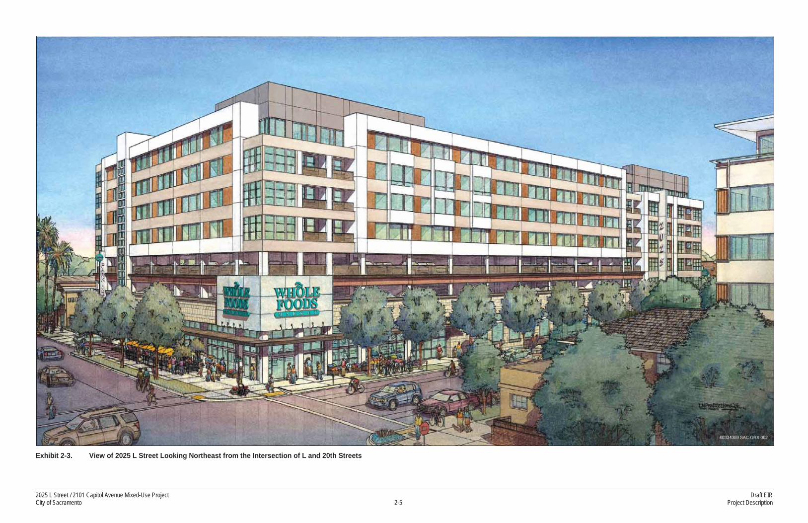
Exhibit 2-3. View of 2025 L Street Looking Northeast from the Intersection of L and 20th Streets
2025 L Street / 2101 Capitol Avenue Mixed-Use Project Draft EIRCity of Sacramento 2-5 Project Description

Exhibit 2-4. 2025 L Street Site Plan
2025 L Street / 2101 Capitol Avenue Mixed-Use Project Draft EIRCity of Sacramento 2-7 Project Description

Exhibit 2-5. 2025 L Street Exterior Elevations (from South and from West)
2025 L Street / 2101 Capitol Avenue Mixed-Use Project Draft EIRCity of Sacramento 2-9 Project Description

Exhibit 2-6. 2025 L Street Exterior Elevations (from East and from North)
2025 L Street / 2101 Capitol Avenue Mixed-Use Project Draft EIRCity of Sacramento 2-11 Project Description

and fitness center for residents, along with an outdoor kitchen, dining, and lounge spaces, would be located on the 4th floor of the building.
Access to parking for the Whole Foods Market would be provided by a ramp from 20th Street in approximately the same location as the existing parking garage ramp. Loading and deliveries for the Whole Foods Market would take place from Kayak Alley (which is located between K and L Streets), with two loading docks recessed into the building for larger trucks. Parking for the proposed residences would be provided in a basement garage underneath the Whole Foods Market. This underground parking would be accessed from 21st Street. The subterranean parking lot for residential uses would be designed with a ventilation system pulling air from the ground and basement levels up to the top of the 2025 L Street building to avoid accumulation of air pollutants in the parking garage. The proposed project includes bulb-outs at 20th Street and 21st Street to improve the streetscape appearance, enhance pedestrian access, and provide outdoor dining opportunities. Table 2-1 presents a summary of land uses and parking for the project, including the 2025 L Street site.
Table 2-1Land Use Summary
2025 L Street SiteCommercial Area 42,307 square feet*Residential Units 141 units, 115,706 square feet**
Automobile Parking 333 spaces
Bicycle Parking 126 long term, 44 short term
Building Height 85 feet2101 Capitol Avenue SiteCommercial Area 13,000 square feetAutomobile Parking 425 spaces
Bicycle Parking 2 long term, 8 spaces short term
Building Height 64.5 feetNote: *This is the total leasable area. The gross commercial square footage is approximately 47,000 square feet and this was used for
analytical purposes. **This is the net rentable area. Gross square footage is used in certain sections of this EIR for analytical purposes, where appropriate.
Source: Data provided by Pappas Investments, and adapted by AECOM in 2015
2.2.2 2101 CAPITOL AVENUE
This proposed project component would be located northeast of the intersection of 21st Street and Capitol Avenue. The existing surface parking lot would be replaced with a six-level structure. The structure would include approximately 13,000 square feet of retail / commercial space and parking for the retail on the ground floor. The structure would include an additional five levels of parking above the ground floor. The existing restaurant, occupied by “Kupros Craft House” would remain in its current location.
The replacement parking structure would serve the existing 2020 L Street offices, which are currently served by the two-story parking garage to be demolished on the 2025 L Street property. This new parking would also replace the existing surface parking on the 2101 Capitol Avenue property. In the
2025 L Street / 2101 Capitol Avenue Mixed-Use Project Draft EIRCity of Sacramento 2-13 Project Description

evenings and on weekends, parking spaces in the structure would also be available for public use. The parking garage would be accessed via the alley located between L Street and Capitol Avenue, where deliveries for the proposed retail development would also be routed. Retail patrons would access parking from Capitol Avenue midway between 21st and 22nd Streets. Exhibit 2-7 illustrates the design of the proposed building at 2101 Capitol Avenue. Exhibit 2-8 presents the ground level site plan for the 2101 Capitol Avenue property. Exhibits 2-9 and 2-10 present exterior elevations for the proposed structure.
Table 2-1 presents a summary of land uses and parking for the project, including the 2101 Capitol Avenue property.
2.2.3 INFRASTRUCTURE
ACCESS AND CIRCULATION
The project site is located in Sacramento’s Central City area. Capitol Avenue, L Street, 20th Street, and 21st Street provide vehicle, bicycle, and pedestrian access to the project site.
WATER SUPPLY DISTRIBUTION
The City of Sacramento Department of Utilities provides water to the city. The City uses water from the American River and the Sacramento River. Two intakes supply raw water to treatment facilities first, then to end users.
The project site is served by existing water mains adjacent to the site. The existing water infrastructure is considered adequate for water supplied for both domestic and fire flows.
For the water and fire supply to the project, the project engineering team completed a fire flow test for the 2025 L Street property and the 2101 Capitol Avenue property (see Appendix G). For the 2025 L Street property, the results indicate that the 6-inch main in Kayak Alley on the north side of the building has a capacity of 1,700 gallons per minute (gpm). The tests also indicated that the 12-inch main in LStreet between 21st and 22nd Streets has a capacity of 5,100 gpm. The project proposes to extend this 12-inch main west along L Street to 20th Street then north to the 8-inch line in Kayak Alley. This willprovide enough capacity to meet the anticipated fire flow demand for the 2025 L Street property. For the 2101 Capitol Avenue property, the water supply in Liestal Alley is 4,300 gpm, which exceeds thefire flow demand for this property (Chavez, pers. comm. 2015).
WASTEWATER COLLECTION
The City of Sacramento Department of Utilities provides wastewater collection services for the City. The City uses a combined sewer system (CSS) that provides sewage and drainage services to more than 24,000 parcels in downtown Sacramento, Midtown, Land Park, and East Sacramento. The system, originally established in the 1800s, collects sewage and stormwater in the same pipe. The combined wastewater is pumped to the Sacramento Regional County Sanitation District’s Sacramento Regional Wastewater Treatment Plant in Elk Grove, where it is treated and released back to local rivers. During heavy-rain events, excess stormwater is also treated at several City facilities before being released back to the river.
Draft EIR 2025 L Street / 2101 Capitol Avenue Mixed-Use ProjectProject Description 2-14 City of Sacramento

Exhibit 2-7. View of 2101 Capitol Avenue Ground Floor Retail Space and Parking Structure Looking Northeast from 21st Street toward Capitol Avenue
2025 L Street / 2101 Capitol Avenue Mixed-Use Project Draft EIRCity of Sacramento 2-15 Project Description

Exhibit 2-8. 2101 Capitol Avenue Site Plan
2025 L Street / 2101 Capitol Avenue Mixed-Use Project Draft EIRCity of Sacramento 2-17 Project Description

Exhibit 2-9. 2101 Capitol Avenue Exterior Elevations (from North and from South)
2025 L Street / 2101 Capitol Avenue Mixed-Use Project Draft EIRCity of Sacramento 2-19 Project Description

Exhibit 2-10. 2101 Capitol Avenue Exterior Elevations (from East and from West)
2025 L Street / 2101 Capitol Avenue Mixed-Use Project Draft EIRCity of Sacramento 2-21 Project Description

The project site is served by existing wastewater lines adjacent to the site. The applicant’s engineering team has reviewed the City standards regarding sewer service in the CSS. The project applicant would be required to participate in the CSS Development Fee Program, which is designed to ensure adequate service in the areas served by the CCS. The project proposes to connect to an existing 24-inch line in 20th Street adjacent to the 2025 L Street property. The project also proposes to connect to the existing 8-inch line in Kayak Alley and a new 12-inch line in L Street for parts of the 2025 L Street building. For the Kayak Alley and L Street connections, the applicant engineering team prepared calculations in accordance with City criteria and found that both lines have sufficient capacity for the intended service needs. For the 2101 Capitol Avenue property, the applicant engineering team prepared calculations in accordance with City criteria and found the line in the alley has sufficient capacity for the proposed use (Chavez, pers. comm. 2015).
STORMWATER COLLECTION
The City of Sacramento Department of Utilities maintains the City’s storm drainage facilities. The project site is within the CSS, and has been previously developed. As a result, the proposed project is required to comply with the City’s “Do No Harm” policy. This policy requires infill areas to fully mitigate any potential increase in flows leaving the project site. The proposed project would construct sufficient on-site detention to ensure that there would be no increase in storm runoff leaving the project site. The project proposes to place a pipe under the 2101 Capitol Avenue property that would drain to the CSS in the alley to provide storage adequate to meet the City’s policy.
ELECTRIC AND GAS UTILITIES
Electric—Sacramento Municipal Utility District
The Sacramento Municipal Utility District (SMUD) supplies electrical service to the project site and the surrounding area. The existing development is served by SMUD’s aboveground and underground electric transmission and distribution lines. SMUD would use existing facilities and the newly-undergrounded lines to supply the necessary service to the project site. The proposed project includes undergrounding of the above-ground electrical lines running along Kayak Alley on the north side of the 2025 L Street property and along Liestal Alley on the north side of the 2101 Capitol Avenue property.On site, the proposed project would include relocation of some existing electrical infrastructure and installation of new pad-mounted transformers and electrical vaults to serve the new buildings.
Natural Gas—Pacific Gas and Electric Company
Pacific Gas and Electric Company (PG&E) supplies natural gas service to the project site and surrounding area. The existing development is served by a grid system of high-pressure natural gas pipelines that range in size from 4 inches to 12 inches in diameter. There is also a secondary low-pressure system that consists of primarily 2-inch and 4-inch lines.
According to PG&E, this grid network of gas lines is sufficient to serve the increased demand for natural gas generated by the proposed project. The existing on-site gas lines would be removed and realigned to serve the new buildings.
2025 L Street / 2101 Capitol Avenue Mixed-Use Project Draft EIRCity of Sacramento 2-23 Project Description

TRANSIT
The project would construct a new bus stop closer to the intersection that would include a bench for riders. The existing Route 62 bus stop on 21st Street adjacent to the proposed 2101 Capitol Avenuestructure would not be moved.
2.3 CONSTRUCTION
The existing parking garage, two-story office building, and surface parking lot on the 2025 L Street property would be demolished to accommodate the proposed project. All construction staging areas would be located on the project site.
The proposed project requires piles for building foundations. The project proposes use of an auger-cast pile foundation system. This technique was selected due to the presence of existing occupied buildings adjacent to the project site and because the technique is essentially a vibration less pile system (Hutchinson, pers. comm. 2015). Auger cast in place grouted piles are a drilled and pumped pile, not a driven pile. This eliminates the hammer impact noise created by driving piles. The elimination of a pile-driving hammer allows the installation of auger cast in place grouted piles adjacent to existing structures without the danger of settlement or damage to existing footings, walls, other structural components, or nearby equipment caused by vibrations.
2.4 SCHEDULE
The project applicant anticipates that construction on the 2101 Capitol Avenue site would occur starting in late summer 2015, extending into spring 2016. Construction on the 2025 L Street site would occur between spring 2016 and the end of 2017.
2.5 REQUESTED ENTITLEMENTS
The City’s discretionary approvals/actions that would be considered for the proposed project include, but are not limited to, the following:
General Plan Amendment to change about 0.16 acre of land designated for Traditional Neighborhood Medium to Urban Corridor Low (2101 Capitol Avenue only) (Exhibit 2-11 illustrates the requested General Plan Amendment and rezone for the 2101 Capitol Avenue property)
Rezone for about 0.406 acre from R-O (Residential-Office) to C-2 (General Commercial) (2101 Capitol Avenue only) (see Exhibit 2-11)
Conditional Use Permit for a retail store exceeding 40,000 gross square feet (2025 L Street only)
Tentative Map (2025 L Street only)
Draft EIR 2025 L Street / 2101 Capitol Avenue Mixed-Use ProjectProject Description 2-24 City of Sacramento
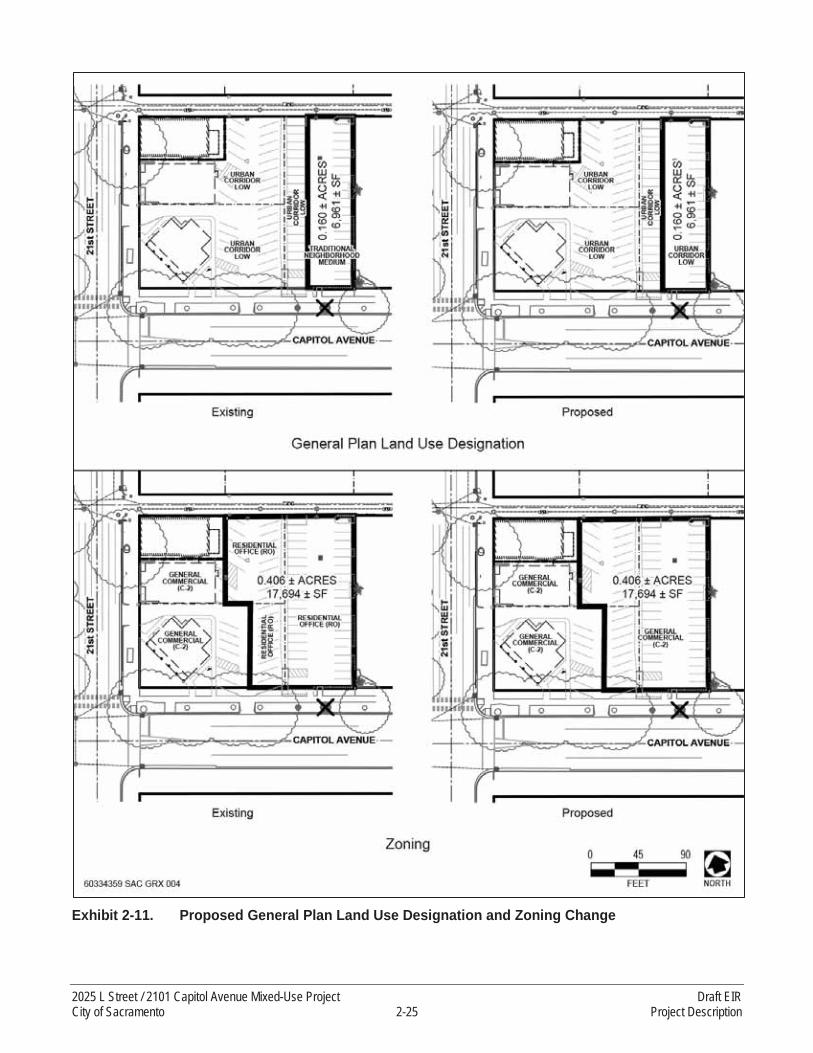
Exhibit 2-11. Proposed General Plan Land Use Designation and Zoning Change
2025 L Street / 2101 Capitol Avenue Mixed-Use Project Draft EIRCity of Sacramento 2-25 Project Description

Variance to deviate from the signage allowed (both properties)2to provide for an increase isn the size and number of signs that are currently allowed in the Building Code.
Site Plan and Design Review for new construction in the Central City Design Review area with deviations including height over 65 feet (both properties), potential deviation from the City’s openspace standard (2025 L Street only), and a deviation to waive a wall requirement to separate a commercial use from a residentially zoned parcelReview of the proposed project by the Planning and Design Commission would be conducted as a part of the environmental review and entitlements process. The proposed project entitlements would ultimately require approval by theCity Council.
Other public agencies whose approval would be required include, but are not necessarily limited to:
Sacramento Metropolitan Air Quality Management District (SMAQMD)—issues the Authority to Construct/Permit to Operate pursuant to SMAQMD Regulation 2 (Rule 201 et seq.)
State Water Resources Control Board (SWRCB)/Central Valley Regional Water Quality Control Board (RWQCB)—issues Construction Storm Water Discharge Permits
2.6 PROJECT OBJECTIVES:
The primary objectives of the 2025 L Street/2101 Capitol Avenue Mixed-Use project are to:
Provide for the reuse of underutilized sites at 2025 L Street and 2101 Capitol Avenue by replacing an existing parking garage, two-story office building, and surface parking with a new mixed-use project.
Provide new dwelling units for City residents in the midtown area with at least 140 units in a mixed-use project along a transit corridor.
Provide retail services within the Central City along L Street between 20th and 21st Street and at 21st Street and Capitol Avenue that are proximate to residential neighborhoods and are also transit oriented and pedestrian and bike friendly.Provide new tenant spaces for retail establishments to support the needs of area residents, businesses and employees.
Provide for a grocery store that will encourage convenient access to healthy foods within the Central City.
Provide employment opportunities for City residents.
Provide proximate replacement parking in a new structure at the northeast corner of 21st Street and Capitol Avenue for the existing office use at 2020 L Street that currently uses the parking structure at 2025 L Street.
2 The variance to deviate from the signage allowed for the 2101 Capitol Avenue property may be processed as a separate application.
Draft EIR 2025 L Street / 2101 Capitol Avenue Mixed-Use ProjectProject Description 2-26 City of Sacramento

Provide replacement parking for the existing surface parking at the northeast corner of 21st Street and Capitol Avenue in the parking structure as well as parking for the proposed ground level retail at that location.
Create a financially viable project that will serve the residents of the City.
Provide for a welcoming neighborhood outdoor dining and gathering place in a pedestrian-friendly environment in the midtown area.
Assist in fulfilling the Sacramento Area Council of Governments Blueprint and Metropolitan Transportation Plan/Sustainable Communities Strategies goals and policies by reusing underutilized land in the Central City and creating a mixed-use development of retail and residential uses that will help reduce regional vehicle miles traveled and greenhouse gas emissions.
Assist in fulfilling City General Plan goals and policies, including but not limited to General Plan Goal LU 6.1 and Policies LU 6.1.1 through LU 6.1.14, which address corridors.
Develop aesthetically pleasing site plans and architectural building designs that complement the existing urban fabric in the area.
2025 L Street / 2101 Capitol Avenue Mixed-Use Project Draft EIRCity of Sacramento 2-27 Project Description

This page left blank intentionally.
Draft EIR 2025 L Street / 2101 Capitol Avenue Mixed-Use ProjectProject Description 2-28 City of Sacramento

3 LAND USE PLANNING, POPULATION, AND HOUSING
This Chapter of the EIR describes existing and planned land uses within and surrounding the project site and consistency and compatibility of the proposed project with adopted land use plans and policies. This Chapter also describes existing and projected population changes associated with implementation of the proposed project in relation to City and regional assumptions regarding population growth.
3.1 LAND USE AND PLANNING
This chapter addresses land use and planning in the project vicinity, as relevant to the proposed project. The analysis describes the existing environmental conditions, the methods used for assessment, and consistency with existing adopted land use plans and regulations. This chapter also provides a brief overview of state, regional, and local laws and regulations pertaining to land use and planning.
3.1.1 EXISTING CONDITIONS
The 2025 L Street property is currently occupied by a two-story parking garage, a two-story office building, and surface parking lots. Surrounding land uses include an art gallery and a surface parking lot to the west, nightclubs, offices, commercial uses, retail stores, and surface parking to the north, retail uses to the east, and office uses and surface parking to the south. Apartments are located to the southeast of the 2025 L Street property, across both L and 21st Streets.
The 2101 Capitol Avenue property is currently occupied by a surface parking lot. Surrounding land uses include a restaurant, commercial uses, and apartments to the north, residential uses and a 3-story office building to the east, and offices and residential uses to the south. A surface parking lot is located to the west, across 21st Street.
Most of the project site and surrounding area are within the Urban Corridor – Low General Plan designation. The eastern portion of the 2101 Capitol Avenue property and other nearby properties to the east of the project site are designated Traditional Neighborhood – Medium Density. Exhibit 3-1illustrates general plan land use designations in the project site vicinity. Most of the project site is in the C-2 General Commercial zone district – a portion of the 2101 Capitol Avenue is in the RO Residential-Office district. Surrounding properties are in the C-2, R-5 Residential, R-3A Residential, and RO zones. Exhibit 3-2 illustrates zoning for the project site and vicinity.
3.1.2 LOCAL AND REGIONAL PLANS
SACRAMENTO 2030 GENERAL PLAN
The City has identified the primary applicable policies from the 2030 General Plan that will guide review of the proposed project, which are listed below (City of Sacramento 2009).
2025 L Street / 2101 Capitol Avenue Mixed-Use Project Draft EIRCity of Sacramento 3.1-1 Land Use Planning, Population, and Housing

Source: City of Sacramento 2014
Exhibit 3-1. General Plan Land Use Map
Draft EIR 2025 L Street / 2101 Capitol Avenue Mixed-Use ProjectLand Use Planning, Population, and Housing 3.1-2 City of Sacramento

Source: Sacramento County 2014
Exhibit 3-2. Zoning Map
2025 L Street / 2101 Capitol Avenue Mixed-Use Project Draft EIRCity of Sacramento 3.1-3 Land Use Planning, Population, and Housing

Urban Form Guidelines
The following are key General Plan urban form characteristics envisioned for the Urban Corridor – Low designation that pertain to the proposed project:
More intense mixed-use development at intersections with stepped down residential uses in between.
Building heights highest at major intersections and lower when adjacent to neighborhoods unless near a major intersection.
Building façades and entrances directly addressing the street.
Buildings with pedestrian-oriented uses such as outdoor cafes located at the street level.
Integrated (vertical and horizontal) residential uses along the corridors.
Parking located to the side or behind buildings, or accommodated in parking structures.
Attractive pedestrian streetscape, with sidewalks designed to accommodate pedestrian traffic, that includes appropriate landscaping, lighting, and pedestrian amenities/facilities.
Public and semi-public outdoor spaces such as plazas, courtyards, and sidewalk cafes.
Please refer also to Section 4.7 of this EIR, which provides an evaluation of pedestrian facilities.
Goals and Policies
Goal LU 2.1 City of Neighborhoods. Maintain a city of diverse, distinct, and well-structured neighborhoods that meet the community’s needs for complete, sustainable, and high-quality living environments, from the historic downtown core to well-integrated new growth areas.
LU 2.1.4 General Plan Density Regulations for Mixed-Density Development Projects. Where a developer proposes a multi-parcel development project with more than one residential density or FAR, the applicable density or FAR range of the General Plan Land Use Designation shall be applied to the net developable area of the entire project site rather than individual parcels within the site. Some parcels may be zoned for densities/intensities that exceed the maximum allowed density/intensity of the project site’s Land Use Designation, provided that the net density of the project as a whole is within the allowed range.
LU 2.1.5 Neighborhood Centers. The City shall promote the development of strategically located (e.g., accessible to surrounding neighborhoods) mixed-use neighborhood centers that accommodate local-serving commercial, employment, and entertainment uses; provide diverse housing opportunities; are within walking distance of surrounding residents; and are efficiently served by transit.
Draft EIR 2025 L Street / 2101 Capitol Avenue Mixed-Use ProjectLand Use Planning, Population, and Housing 3.1-4 City of Sacramento
LU 2.1.6 Neighborhood Enhancement. The City shall promote infill development, redevelopment, rehabilitation, and reuse efforts that contribute positively (e.g., architectural design) to existing neighborhoods and surrounding areas.
Goal LU 6.1 Corridors. Support the development of major circulation corridors that balance their vehicular function with a vibrant mix of uses that contribute to meeting local and citywide needs for retail, services, and housing and provide pedestrian-friendly environments that serve as gathering places for adjacent neighborhoods.
Policy LU 6.1.1 Mixed-Use Corridors. The City shall create or improve mixed-use corridors by requiring compact development patterns that are oriented to and frame the street, establish a safe and comfortable environment for walking, and avoid encroachment upon adjacent residential areas.
Policy LU 6.1.2 Transformed Corridors. The City shall facilitate the transformation of major thoroughfares dominated by auto-oriented strip commercial uses to include a broader mix of uses, both horizontal and vertical, that provides opportunities for medium- and higher-density housing, while also addressing local and citywide demand for retail and services.
Policy LU 6.1.4 Efficient Parcel Utilization. The City shall promote the aggregation of small and irregular shaped parcels along corridors into larger development sites to facilitate their redevelopment.
Policy LU 6.1.5 Corridor Uses. The City shall encourage residential, mixed-use, retail, service commercial, and other pedestrian oriented development along mixed-use corridors to orient to the front of properties with entries and stoops fronting the street. [now Policy LU 6.1.4]
Policy LU 6.1.6 Higher Intensity Nodes. The City shall generally direct higher-intensity land usesand taller buildings to major intersections along arterial roads to facilitate access, enhance transit service, and promote physical differentiation along the corridor. [now Policy LU 6.1.5]
Policy LU 6.1.7 Conversion to Residential. The City shall support proposals to convert nonresidential properties along mixed-use corridors, between major intersections, to residential or mixed-use residential uses. [now Policy LU 6.1.6]
Policy LU 6.1.10 Corridor Transit. The City shall require design and development along mixed-use corridors that promotes the use of public transit and pedestrian and bicycle travel and maximizes personal safety through development features such as:
• Safe and convenient access for pedestrians between buildings and transit stops, parking areas, and other buildings and facilities
• Roads designed for automobile use, efficient transit service as well as pedestrian and bicycle travel [now Policy LU 6.1.8]
Policy LU 6.1.8 Sidewalks and Pedestrian Amenities. The City shall require that sidewalks along mixed-use corridors are wide enough to accommodate significant pedestrian traffic and the integration of public amenities and landscaping.
2025 L Street / 2101 Capitol Avenue Mixed-Use Project Draft EIRCity of Sacramento 3.1-5 Land Use Planning, Population, and Housing

Policy LU 6.1.12 Visual and Physical Character. The City shall promote development patterns and streetscape improvements that transform the visual and physical character of typical automobile-oriented corridors by:
• Enhancing the definition of the corridor by locating buildings at the back of the sidewalk, and establishing a consistent street wall
• Introducing taller buildings that are in scale with the wide, multi-lane street corridors
• Locating off-street parking behind or between buildings (rather than between building and street)
• Reducing visual clutter by regulating the number, size and design quality of signs
• Removing utility poles and under-grounding overhead wires
• Adding street trees [now Policy LU 6.1.10]
SACRAMENTO 2035 GENERAL PLAN
The proposed project was initiated when the 2030 General Plan was in effect. Since that time, the City has prepared an update to the 2030 General Plan. The land use policies in the draft 2035 General Plan are substantially similar to those in the 2030 General Plan. New policies included in the draft 2035 General Plan with relevance to the proposed project include:
LU 2.6.1 Sustainable Development Patterns. The City shall promote compact development patterns, mixed use, and higher-development intensities that use land efficiently; reduce pollution and automobile dependence and the expenditure of energy and other resources; and facilitate walking, bicycling, and transit use.
LU 2.6.2 Transit-Oriented Development. The City shall actively support and facilitate mixed-use retail, employment,
LU 2.6.6 Efficiency Through Density. The City shall support an overall increase in average residential densities throughout the city consistent with the adopted General Plan Land Use & Urban Form Diagram, as new housing types shift from lower-density, large lot developments to higher-density, small lot and multifamily developments as a means to increase energy efficiency, conserve water, and reduce waste.
LU 2.1.7 Good Neighbors: The City shall encourage businesses located within and adjacent to residential developments to conduct their business in a courteous manner by limiting disturbances and nuisances from operations and patrons, and to act as members of the community by makingthemselves available to respond to complaints and by participating in neighborhood/community meetings.
LU 6.1.9 Enhanced Pedestrian Environment. The City shall require that sidewalks along mixed-use corridors are wide enough to accommodate significant pedestrian traffic and promote the
Draft EIR 2025 L Street / 2101 Capitol Avenue Mixed-Use ProjectLand Use Planning, Population, and Housing 3.1-6 City of Sacramento

transformation of existing automobile-dominated corridors into boulevards that are attractive, comfortable, and safe for pedestrians by incorporating the following:
• On-street parking between sidewalk and travel lanes• Few curb cuts and driveways• Enhanced pedestrian street crossings• Building entrances oriented to the street• Transparent ground floor frontages• Street trees• Streetscape furnishings• Pedestrian-scaled lighting and signage
Minor revisions were made to certain policies, including:
LU 2.1.4 General Plan Density Regulations for Mixed-Density Development Projects. Where a developer proposes a multi-parcel development project with more than one residential density or FAR, the City shall, at the discretion of the Community Development Director, apply the applicable density or FAR range of the General Plan Land Use Designation shall be applied to the net developable area of the entire project site rather than individual parcels within the site. Some parcels may be zoned for densities/intensities that exceed the maximum allowed density/intensity of the project site’s Land Use Designation, provided that the net density of the project as a whole is within the allowed range.
Policy LU 6.1.3 4 Efficient Parcel Utilization. The City shall promote the aggregation of small and irregular shaped parcels along corridors into larger development sites to facilitate their redevelopment reuse.
SACRAMENTO AREA COUNCIL OF GOVERNMENTS
Sacramento Area Council of Governments Blueprint
The Sacramento Area Council of Governments (SACOG) adopted the “Blueprint” in 2004, a regional vision for growth through 2050 that promotes compact, mixed-use development and more transit choices as an alternative to low-density development. As a part of the Blueprint, seven principles were developed, along with a Preferred Scenario, which illustrates on a map the consensus for regional growth through 2050.
The proposed project is also consistent with the Blueprint Growth Principles, which accompany the regional vision for growth through 2050. Blueprint Principles include (SACOG 2004c):
1. Transportation Choices: Developments should be designed to encourage people to sometimes walk, ride bicycles, ride the bus, ride light rail, take the train, or carpool. Use of Blueprint growth concepts for land use and right-of-way design would encourage use of these modes of travel and the remaining auto trips would be, on average, shorter.
2. Mixed-Use Developments: Buildings homes and shops, entertainment, office, and even light industrial uses near each other can create active, vital neighborhoods. This
2025 L Street / 2101 Capitol Avenue Mixed-Use Project Draft EIRCity of Sacramento 3.1-7 Land Use Planning, Population, and Housing
mixture of uses can be either in a vertical arrangement (mixed in one building) or horizontal (with a combination of uses in close proximity). These types of projects function as local activity centers, contributing to a sense of community, where people tend to walk or bike to destinations and interact more with each other. Separated land uses, on the other hand, lead to the need to travel more by automobile because of the distance between uses. Mixed land uses can occur at many scales. Examples include: a housing project located near an employment center, a small shopping center located within a residential neighborhood, and a building with ground floor retail and apartments or condominiums on the upper floor(s).
3. Compact Development: Creating environments that are more compactly built and use space in an efficient but aesthetic manner can encourage more walking, biking, and public transit use, and shorten automobile trips.
4. Housing Choice and Diversity: Providing a variety of places where people can live –apartments, condominiums, townhouses, and single-family detached homes on varying lot sizes – creates opportunities for the variety of people who need them: families, singles, seniors, and people with special needs. This issue is of special concern for the people with very low-, low-, and moderate-income, for whom finding housing close to work is challenging. By providing a diversity of housing options, more people have a choice.
5. Use of Existing Assets: In urbanized areas, development on infill or vacant lands, intensification of the use of underutilized parcels (for example, more development on the site of a low-density retail strip shopping center), or redevelopment can make better use of existing public infrastructure. This can also include rehabilitation and reuse of historic buildings, denser clustering of buildings in suburban office parks, and joint use ofexisting public facilities such as schools and parking garages.
6. Quality Design: The design details of any land use development - such as the relationship to the street, setbacks, placement of garages, sidewalks, landscaping, the aesthetics of building design, and the design of the public right-of-way (the sidewalks, connected streets and paths, bike lanes, the width of streets) - are all factors that can influence the attractiveness of living in a compact development and facilitate the ease of walking and biking to work or neighborhood services. Good site and architectural design is an important factor in creating a sense of community and a sense of place.
7. Natural Resources Conservation: This principle encourages the incorporation of public use open space (such as parks, town squares, trails, and greenbelts) within development projects, over and above state requirements; along with wildlife and plant habitat preservation, agricultural preservation, and promotion of environment-friendly practices such as energy efficient design, water conservation and stormwater management, and shade trees to reduce the ground temperatures in the summer. In addition to conserving resources and protecting species, this principle improves overall
Draft EIR 2025 L Street / 2101 Capitol Avenue Mixed-Use ProjectLand Use Planning, Population, and Housing 3.1-8 City of Sacramento
quality of life by providing places for everyone to enjoy the outdoors with family outings and by creating a sense of open space.
The project proposes mixed-use development and the project site is located in an area with transit, bicycle, and pedestrian transportation options. The project proposes relatively compact development and is in an area with existing and proposed compact development. The project proposes use of existing assets by proposing development of vacant and underutilized lands served by existing infrastructure. The project contributes to the mix of housing in the Central City by offering multi-family residences. The project places retail uses along the street level, with landscaping and outdoor seating along the sidewalk. The bulk of the project’s parking is placed above or below the street level, with structured parking at street level on only one of the project’s five street frontages (Capitol Avenue).
Metropolitan Transportation Plan/Sustainable Communities Strategy
The Preferred Blueprint Scenario was incorporated into SACOG's Metropolitan Transportation Plan/Sustainable Communities Strategy (MTP/SCS) for 2035, the long-range transportation plan for the region. The MTP/SCS designates the project site as a Center and Corridor Community and a Transit Priority Area (TPA) (see Exhibit 3-3). A Center and Corridor Community is typically
“…higher density and more mixed than surrounding land uses. Centers and Corridors are identified in local plans as … commercial corridors…, or other high density destinations. They typically have more compact development patterns, a greater mix of uses, and a wider variety of transportation infrastructure compared to the rest of the region. Some have frequent transit service, either bus or rail, and all have pedestrian and bicycling infrastructure that is more supportive of walking and bicycling than other Community Types” (SACOG 2011a:32).
A TPA is within 0.5-mile of a major transit stop (existing or planned light rail, street car, or train station) or an existing or planned high-quality transit corridor (with fixed route bus service at intervals of no longer than 15 minutes during peak commute hours) (SACOG 2011a:46).
The compact and mixed-use character of the vicinity of the project site places existing and proposed residents in proximity to jobs and commercial services. This, along with the presence of transit, makes more walking, bicycling, and transit trips practical, eliminating some vehicle trips. Given the character of the project area, trips that do occur by automobile would be relatively short. The proposed project’s location and design would help to reduce vehicle miles traveled (VMT) and associated physical environment effects (i.e., noise, air pollutant emissions, and greenhouse gas emissions).
The reduction in VMT associated with the location and urban design environment of the project site has been demonstrated through the travel demand analysis that SACOG performed to support the MTP/SCS. The regional VMT per capita in 2008 was estimated to be 26 miles per day. For the traffic analysis zones that include the project site, the average per-capita VMT in 2008 was approximately 7 to 8 miles per day. In 2035, forecast regional average per-capita VMT is 24 miles per day, whereas the project site and vicinity would have an average of approximately 4 to 7 miles per day. Therefore, the 2025 L Street property is estimated to have per capita VMT rates of approximately 73 percent less than the regional average in 2008 and 84 percent less than the regional average in 2035 and the 2101
2025 L Street / 2101 Capitol Avenue Mixed-Use Project Draft EIRCity of Sacramento 3.1-9 Land Use Planning, Population, and Housing
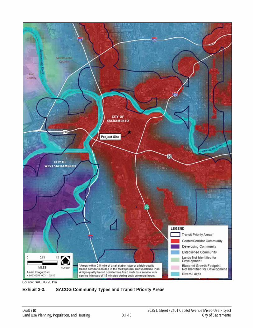
Source: SACOG 2011a
Exhibit 3-3. SACOG Community Types and Transit Priority Areas
Draft EIR 2025 L Street / 2101 Capitol Avenue Mixed-Use ProjectLand Use Planning, Population, and Housing 3.1-10 City of Sacramento

Capitol Avenue property is estimated to have per capita VMT rates of approximately 70 percent less than the regional average in 2008 and 70 percent less than the regional average in 2035 (SACOG 2011b:84).
3.1.3 LAND USE AND PLANNING EVALUATION
This Chapter evaluates whether the proposed project has the potential to physically divide an established community; is compatible with adjacent land uses; and is consistent with applicable adopted goals and policies contained in the City’s 2035 General Plan and other adopted plans, policies, or land use regulations with jurisdiction over the proposed project
The General Plan is a long-term strategic planning document with guiding principles, goals, policies, objectives, and implementation programs for physical, social, economic, and environmental development and conservation. Development proposals must be generally consistent with the overall land use guidance provided in a general plan. Specific development standards, land use controls, and other regulations are applied through the City’s development code, subdivision ordinance, grading ordinance, and other City regulations and ordinances.
GENERAL PLAN CONSISTENCY
The 2025 L Street property is designated as Urban Corridor - Low on the 2030 General Plan Land Use and Urban Form Diagram. The 2101 Capitol Avenue property is currently designated Urban Corridor -Low and Traditional Neighborhood - Medium Density. The proposed project includes a General Plan amendment that would change the designation of part of the 2101 Capitol Avenue property from Traditional Neighborhood - Medium Density to Urban Corridor - Low.
The proposed project is consistent with the General Plan Urban Corridor - Low designation, which envisions street corridors that have multi-story structures and more-intense uses at major intersections, lower-intensity uses adjacent to neighborhoods, and access to transit service throughout. At major intersections, nodes of intense mixed-use development are bordered by lower-intensity, single-use residential, retail, service, and office uses. Street-level frontage of mixed-use projects is developed with pedestrian-oriented uses. The streetscape is appointed with landscaping, lighting, public art, and other pedestrian amenities.
2030 General Plan - Floor Area Ratio
The floor-area-ratio (FAR) is the gross building area on a site, excluding structured parking, to the net developable area of the site. The net developable area is the total area of a site excluding portions that cannot be developed (e.g., right-of-way, public parks, etc.). The General Plan Urban Form designation determines the FAR. The Urban Corridor - Low designation has a FAR range of a minimum of 0.3 to amaximum of 3.0.
While the 2025 L Street property would have a FAR of 3.88 and the 2101 Capitol Avenue property would have an FAR of 0.4, as proposed, the FAR for the project is determined by the entire project’s gross building area and property area size across both properties that comprise the project site.Therefore, the overall FAR of the proposed project is 2.48 which is within the allowable range.
2025 L Street / 2101 Capitol Avenue Mixed-Use Project Draft EIRCity of Sacramento 3.1-11 Land Use Planning, Population, and Housing

General Plan Amendment
The proposed project includes a General Plan amendment at the 2101 Capitol Avenue property to change the designation of approximately 0.16 acres (6,961 square feet) from Traditional Neighborhood - Medium Density to Urban Corridor - Low, resulting in the entire site having the designation of Urban Corridor - Low at both sites.
The Traditional Neighborhood - Medium Density designation provides for higher-intensity housing and neighborhood support uses, including multi-family dwellings and neighborhood-serving commercial. The proposed General Plan amendment applies to a vacant lot that is adjacent to a medical office building. Due to the small area of the proposed amendment, and because the proposed project would not change the fabric of that particular block which is, in fact, more consistent with the Urban Corridor -Low designation, the proposed General Plan amendment would not compromise the vision, goals, or policies of the General Plan or adversely affect the City’s ability to accommodate projected future growth.
CONSISTENCY WITH SURROUNDING LAND USES
The project site is located in an urbanized portion of midtown Sacramento. The project site is currently developed with surface parking, a two-story parking garage, and a two-story office building, currently used for storage. The project site is designated for urban development in the City’s General Plan and the City Planning and Development Code.
The proposed development would require a change in the General Plan designation and zoning at the 2101 Capitol Avenue property. This site currently is predominately Urban Corridor Low and zoned C-2. The proposed changes would extend these designations to the entire site. The proposed development is consistent with these planning designations.
The project site is surrounded by a mix of residential, retail, restaurant, bar and nightclub, and officeuses. The proposed project is compatible with the mix of surrounding land uses and building heights.Physical aspects of compatibility (aesthetics, cultural resources, noise, vibration, light, and glare) are addressed in the relevant technical sections within Chapter 4 of this EIR.
The residences, businesses, and improvements proposed as part of the project would accommodate a portion of the regional growth forecasted and planned for in the City’s General Plan and the MTP/SCS. The proposed project would not affect any existing physical roads, sidewalks, or bicycle connections.The project does not propose new roads or any other type of infrastructure or improvements that would physically divide any existing community.
3.2 POPULATION, HOUSING, AND EMPLOYMENT
Changes in population and housing, in and of themselves, are considered social and economic effects, not physical effects on the environment. CEQA provides that economic or social effects are not considered significant effects on the environment unless the social and/or economic effects are connected to physical environmental effects. A social or economic change related to a physical change may be considered in determining whether the physical change is significant (State CEQA Guidelines
Draft EIR 2025 L Street / 2101 Capitol Avenue Mixed-Use ProjectLand Use Planning, Population, and Housing 3.2-12 City of Sacramento

CCR Section 15382). The direction for treatment of economic and social effects is stated in CCRSection 15131(a) of the State CEQA Guidelines as follows:
Economic or social effects of a project shall not be treated as significant effects on the environment. An EIR may trace a chain of cause and effect from a proposed decision on a project through anticipated economic or social changes resulting from the project to physical changes caused in turn by the economic or social changes. The intermediate economic or social changes need not be analyzed in any detail greater than necessary to trace the chain of cause and effect. The focus of the analysis shall be on physical changes.
While an increase in population resulting from new development does not necessarily cause direct adverse physical environmental effects, indirect physical environmental effects, such as increased vehicle trips and associated increase in air pollutant emissions and noise could occur. The information in this Chapter is used as a basis for the analysis of project impacts in the technical sections contained in Chapter 4 of this EIR (i.e., Section 4.2, “Air Quality,” Section 4.5, “Greenhouse Gas Emissions” and Section 4.7, “Transportation and Traffic”).
3.2.1 EXISTING AND FORECAST CONDITIONS
There are currently no housing units or residents on the project site.
According to the California Department of Finance (DOF), Sacramento’s population was an estimated 475,122 on January 1, 2014 (DOF 2014). The 2013–2021 Housing Element estimated the Central City’s population to be 32,367 in 2010 (City of Sacramento 2013:Table H 3-2). The 2030 General Plan Master EIR forecast that 51,894 people will live in the Central City Plan area in 2025. This represents an increase of an estimated 19,527 new residents between 2010 and 2025.
The 2035 General Plan assumes the city will grow to about 640,400 residents and 390,100 employees by 2035 (City of Sacramento 2014a, p. 2-25). In order to accommodate SACOG forecasts for housing growth, the City of Sacramento would need to add approximately 68,000 new dwelling units, 84 percent of which would need to be multi-family units (City of Sacramento 2014a, p. 3-5). The City estimates that 4,068 new multi-family units will be built in the Central City through 2020 (City of Sacramento 2014b, p. 2-214). Projected employment growth in the Central City through 2020 is 6,455 new jobs (City of Sacramento 2014b, p. 2-215).
3.2.2 PLANS AND REGULATIONS
FEDERAL
No federal regulations related population and housing growth are applicable to the proposed project.
STATE
California law (California Government Code Section 65580 et seq.) requires cities and counties to prepare a housing element as part of their general plans to address housing conservation, rehabilitation, new construction, and special needs for all income groups. Housing elements must be
2025 L Street / 2101 Capitol Avenue Mixed-Use Project Draft EIRCity of Sacramento 3.2-13 Land Use Planning, Population, and Housing

updated every 4 or 8 years, depending on whether they are in compliance with Senate Bill (SB) 375. The housing element must identify and analyze existing and projected housing needs and “make adequate provision for the existing and projected needs of all economic segments of the community,” among other requirements.
LOCAL
Sacramento 2013–2021 Housing Element
The Housing Element was certified by the California Department of Housing and Community Development on March 19, 2014, as being in compliance with state law and SB 375. Policies in the 2013–2021 Housing Element related to City actions to ensure an adequate supply of housing for all income groups are listed below (City of Sacramento 2013):
Goal H-1.2 Provide a variety of quality housing types to encourage neighborhood stability.1
Policy H-1.2.1 The City shall encourage the development and redevelopment of neighborhoods that include a variety of housing tenure, size and types, such as second units, carriage homes, lofts, live-work spaces, cottages, and manufactured/modular housing.
Policy H-1.2.2 The City shall encourage a greater variety of housing types and sizes to diversify, yet maintain compatibility with, single family neighborhoods.
Policy H-1.2.3 The City shall encourage proper siting, landscaping, house design, and property management and maintenance through the development review process to foster public safety and reduce crime.
Policy H-1.2.5 The City shall continue to work with neighborhood associations and residents through the planning and delivery of residential development to ensure that neighborhoods are safe, decent and pleasant places to live & work.
Policy H-1.2.7 The City shall continue to include the Police Department in the review of development projects to adequately address crime and safety, and to promote the implementation of Crime Prevention through Environmental Design (CPTED) strategies.
Goal H-2.1 Adequate Sites. Provide adequate housing sites and opportunities for all households.
Policy H-2.1.1 Adequate Supply of Land. The City shall maintain an adequate supply of appropriately zoned land with public services to accommodate the projected housing needs in accordance with the General Plan.
Goal H-2.2 Development. Assist in creating housing to meet current and future needs.
Policy H-2.2.1 Quality Infill Development. The City shall promote quality residential infill development by maintaining and implementing flexible development standards.
1 These policies are directed to the City and are not applicable to any particular project.
Draft EIR 2025 L Street / 2101 Capitol Avenue Mixed-Use ProjectLand Use Planning, Population, and Housing 3.2-14 City of Sacramento
Policy H-2.2.2 Financial Tools to Diversify Residential Infill Development. To the extent resources are available, the City shall use financial tools to diversify market developments with affordable units, especially in infill areas.
City of Sacramento Mixed-Income Housing Ordinance
Section 17.190 of the City of Sacramento Zoning Code (“Mixed Income Housing”) is intended to ensure that residential projects in new growth areas contain a defined percentage of housing affordable to low-income and very low-income households, to provide for a program of incentives and local public subsidy to assist in this effort, and to implement the mixed income policies of the housing element of the City General Plan.
The project site is not identified as a “new growth area” in the Mixed Income Housing Code and is, therefore, not required to include affordable housing (City of Sacramento 2015).
City of Sacramento 2035 General Plan
On March 3, 2015, the City Council adopted the 2035 General Plan. According to the 2035 General Plan Master EIR, buildout of the 2035 General Plan would accommodate a population of approximately 640,400, compared to the estimated 475,500 in 2012, along with approximately 86,483 new jobs and up to approximately 68,000 new housing units by 2035 (City of Sacramento 2014a pp.3-8, 3-9).
3.2.3 POPULATION, HOUSING, AND EMPLOYMENT EVALUATION
The proposed project would add up to 141 new multi-family housing units to the project site. There are no existing housing units on the project site, so no residents or housing units would be displaced. The additional population added by the proposed project represents less than 1 percent of the projected population of 109,312 for the Central City by 2035, based on an assumed average household size of 1.8 persons (as noted above) (City of Sacramento 2013, Table H 3-3).
The proposed project would also include approximately 55,307 feet of commercial uses, including a grocery store and additional retail space. The grocery store would have approximately 200 to 250 employees, although only approximately 30% to 40% of these employees would be on-site at any given time (60 to 100). Assuming an employment density of 250 square feet per retail employee, the 2101 Capitol Avenue property could accommodate another 52 employees, which is a small fraction of the number of employees that could be accommodate in the City and in the Central City Area under the City’s General Plan (City of Sacramento 2014b, p. 2-228).
The proposed project would involve construction of new residences and businesses and would include on-site infrastructure improvements. However, the project site is in an existing developed area of midtown Sacramento and the new residences, businesses, and improvements proposed as part of the proposed project would accommodate a portion of the regional growth forecast in the City’s General Plan. The projected population increase at buildout of the proposed project is well within the population projections for the Central City included within the General Plan and 2013–2021 Housing Element. The project site is served with existing infrastructure and the project does not propose infrastructure improvements that would open new areas to growth. Although the proposed project would increase
2025 L Street / 2101 Capitol Avenue Mixed-Use Project Draft EIRCity of Sacramento 3.2-15 Land Use Planning, Population, and Housing

economic activity through temporary construction and long-term new commercial facilities, the growth induced by this increased activity would not exceed the growth assumed in the City’s General Plan, and the proposed project would not have a significant growth inducement effect.
3.2.4 SOCIAL AND ECONOMIC CHANGES
According to California Code of Regulations (CCR) Section 15131 of the State CEQA Guidelines, economic or social information may be included in an EIR but shall not be treated as significant effects on the physical environment. However, economic or social effects of a project may be used to determine the significance of physical changes caused by the project. Where an EIR uses economic or social effects to determine that a physical change is significant, the EIR shall explain the reason for determining that the effect is significant.
The project applicant evaluated market demand for the proposed Whole Foods Market, alongsideexisting and planned grocery-anchored retail centers in the Central City area of the city of Sacramento. The competitive market area (trade area) for the proposed Whole Foods Market is based on the expected shopping patterns of residents and workers. The trade area was further broken out into two subareas, the 0-6 minute drivetime for residents, and the 0-5 minute drivetime for employees, to tailor retail demand estimates to the different expenditure profiles of the two segments. The trade area definition corresponds with trade area definitions used in other retail grocery studies, is consistent with shopping center trade areas defined by the Urban Land Institute, and is consistent with observations on potential customers and the retail context in the Central City area of Sacramento. Given that the primary trade area typically accounts for 60 to 80% of total sales at a typical retail center, demand appears sufficient to support the existing competitive grocery stores in the trade area, as well as the proposed Whole Foods Market in the opening year and through the year 2027 (the timeline studied for the purposes of this project).
Please see Appendix B for more details.
Draft EIR 2025 L Street / 2101 Capitol Avenue Mixed-Use ProjectLand Use Planning, Population, and Housing 3.2-16 City of Sacramento

4 ENVIRONMENTAL IMPACT ANALYSIS
4.0.1 SCOPE OF ANALYSIS
This chapter of the EIR discusses the environmental and regulatory setting, impacts, and mitigation measures for each of the following technical issue areas (Sections 4.1 through 4.7):
4.1 Aesthetics4.2 Air Quality4.3 Cultural Resources4.4 Energy4.5 Greenhouse Gas Emissions4.6 Noise and Vibration4.7 Transportation and Traffic
4.0.2 INTRODUCTION TO THE ANALYSIS
The technical sections within Chapter 4 of this EIR include the following four primary subsections:
Environmental Setting Regulatory Setting Impacts and MitigationCumulative Impact Discussion
Each subsection is described in more detail below.
ENVIRONMENTAL SETTING
This subsection of each technical section includes a description of the relevant existing physical environmental conditions to provide the “baseline condition” against which project-related impacts are compared. In general, the baseline conditions are the physical conditions that existed when the notice of preparation (NOP) of an EIR was published. An NOP for this EIR was published on November 21,2014. For analytical purposes, impacts of the proposed project are generally compared against thisbaseline environmental setting. Cumulative impacts associated with implementation of the proposed project are assessed against future, or “cumulative,” conditions, generally defined as buildout of the Sacramento 2030 General Plan (2030 General Plan).
REGULATORY SETTING
This subsection of each technical section provides the federal, state, regional, and local regulations that are applicable to the proposed project. This section also informs the reader of relevant goals and policies included in the Sacramento 2030 General Plan (2030 General Plan).
The proposed project was initiated when the 2030 General Plan was in force. Since that time, the City has prepared an update to the 2030 General Plan. Pertinent changes considered in the 2035 General Plan are described in each technical section of this EIR. As described in the Master EIR for the 2035
2025 L Street / 2101 Capitol Avenue Mixed-Use Project Draft EIRCity of Sacramento 4-1 Environmental Impact Analysis
General Plan Update, “…the proposed 2035 General Plan is a technical update of the 2030 General Plan, and the proposed changes constitute minor revisions” (2035 General Plan Update Draft Environmental Impact Report, pg. ES-1).
The proposed 2035 General Plan retains the overall land use and policy direction established in the 2030 General Plan, and includes a refinement and updating of the goals and policies, including updates to housing, employment, and population projections consistent with the 2035 planning horizon for the Sacramento Area Council of Governments’ (SACOG) Metropolitan Transportation Plan/Sustainable Communities Strategy (MTP/SCS); incorporation of greenhouse gas (GHG) reduction measures, as addressed in the City’s Climate Action Plan; and updates to traffic modeling to implement a more flexible, context-sensitive level of service standard.
IMPACTS AND MITIGATION
This subsection of each technical section provides the methodology used during the impact analysis. The discussion of impact assessment methodology is followed by the thresholds of significance used to evaluate the potential environmental impacts of the proposed project. The State CEQA Guidelines define a significant effect on the physical environment as “a substantial, or potentially substantial, adverse change in any of the physical conditions within the area affected by the project including land, air, water, minerals, flora, fauna, ambient noise, and objects of historic and aesthetic significance” (State CEQA Guidelines California Code of Regulations [CCR] Section 15382). The thresholds of significance set forth in this EIR were developed based on the standards of significance included in the State CEQA Guidelines, as well as the City of Sacramento Environmental Checklist and the City’s 2030General Plan Master EIR. The City’s General Plan Master EIR provides analysis of cumulative impacts of development in the City that is relevant for consideration in this EIR.
The discussion of project impacts and mitigation measures follows. For each environmental topic area, the analysis first summarizes the project-specific impact and reaches an impact conclusion prior to incorporation of any mitigation. In many instances, compliance with applicable laws, policies, or regulations would reduce the significance of an impact.
Potential project-specific impact conclusions prior to incorporation of any mitigation include:
No Impact: This impact conclusion indicates that the proposed project would not have any direct or indirect effects on the physical environment. This impact level does not require mitigation under CEQA.
Less-than-Significant Impact: This conclusion indicates that a substantial or potentially substantial adverse change in the physical environment would not occur and that the impact would not be considered significant under CEQA in consideration of the applicable threshold of significance. This impact level does not require mitigation, even if feasible, under CEQA.
Significant Impact: This impact conclusion is defined by CEQA Section 21068 as one that would cause a substantial, or potentially substantial, adverse change in any of the physical conditionswithin the area affected by the project. Levels of significance can vary by project element, based on the change in the existing physical condition and the applicable threshold of significance. Under
Draft EIR 2025 L Street / 2101 Capitol Avenue Mixed-Use ProjectEnvironmental Impact Analysis 4-2 City of Sacramento

CEQA, mitigation measures must be identified, where feasible and available, to reduce the magnitude of significant impacts.
Potentially Significant Impact. This impact conclusion, if it were to occur, would be considered a significant impact, as described above; however, the occurrence of the impact cannot be immediately determined with certainty. For CEQA purposes, a potentially significant impact is treated as if it were a significant impact and requires that mitigation measures or alternatives to the proposed project be provided, where feasible, to reduce the magnitude of potentially significant impacts.
If mitigation is required, the EIR also reaches an impact conclusion assuming implementation of identified mitigation. State CEQA Guidelines CCR Section 15370 defines mitigation as:
(a) avoiding the impact altogether by not taking a certain action or parts of an action;
(b) minimizing impacts by limiting the degree of magnitude of the action and its implementation;
(c) rectifying the impact by repairing, rehabilitating, or restoring the affected environment;
(d) reducing or eliminating the impact over time by preservation and maintenance operations during the life of the action; or
(e) compensating for the impact by replacing or providing substitute resources or environments.
Impact conclusions assuming incorporation of identified mitigation include:
Less-than-Significant Impact with Mitigation: This conclusion indicates that a substantial adverse change in the physical environment would not occur after implementation of the proposed mitigation measures and the impact, as mitigated, would not be considered significant under CEQAin consideration of the applicable threshold of significance.
Significant and Unavoidable Impact: This conclusion indicates a substantial adverse effect on thephysical environment, and that could not be reduced to a less-than-significant level even with any available, feasible mitigation. A significant and unavoidable impact can also result if there are no feasible mitigation measures or alternatives available to reduce the magnitude of the impact to a less-than-significant level. Under CEQA, a project with significant and unavoidable impacts mayproceed, but the lead agency is required to prepare a “statement of overriding considerations” in accordance with State CEQA Guidelines CCR Section 15093, explaining why the lead agency would proceed with the project despite the potential for significant and unavoidable impacts.
The environmental analysis focuses on baseline at the time the NOP was published (2014). The proposed project is anticipated at this time to be complete in 2017.
CUMULATIVE IMPACT DISCUSSION
This subsection of each technical section provides a cumulative impact discussion specific to the respective environmental resource area. Cumulative impacts refer to the combined effect of project
2025 L Street / 2101 Capitol Avenue Mixed-Use Project Draft EIRCity of Sacramento 4-3 Environmental Impact Analysis

impacts with the impacts of other past, present, and reasonably foreseeable future projects (State CEQA Guidelines CCR Section 15130). The geographic area that could be affected by a project varies, depending on the type of environmental issue being considered and is explained in detail in this subsection of each environmental topic section.
Draft EIR 2025 L Street / 2101 Capitol Avenue Mixed-Use ProjectEnvironmental Impact Analysis 4-4 City of Sacramento

4.1 AESTHETICS
This section addresses aesthetics and visual resources in the project vicinity. The proposed project qualifies as an infill mixed-use residential project because the project site is “located within an urban area that has been previously developed, or on a vacant site where at least 75 percent of the perimeter of the site adjoins, or is separated only by an improved public right-of-way from, parcels that are developed with qualified urban uses.” (California Public Resources Code Sections 21099[a] and21099[d]). The project site is located within a transit priority area defined by the Sacramento Area Council of Governments (SACOG). Aesthetic impacts of infill projects within transit priority areas are not be considered significant effects on the physical environment (California Public Resources Code Section 21099[d]). Therefore, the discussion of aesthetics is included in this EIR for public informational purposes only.
4.1.1 ENVIRONMENTAL SETTING
As noted in Chapter 2, “Project Description”, the project site includes two components: the 2025 L Street property and the 2101 Capitol Avenue property (see Exhibit 2-2). The two project components are described in detail below.
2025 L STREET PROPERTY
The 2025 L Street property includes the half-block on the north side of L Street, bordered by 20thStreet, Kayak Alley, and 21st Street in midtown Sacramento. The property contains a low-rise parking structure with a two-story commercial building. Surrounding land uses include one- and two-story commercial buildings to the north and east, a two-story commercial building (housing and art gallery) and surface parking lot to the west, and two- and five-story commercial buildings and surface parking lot to the south. A five-story apartment building with ground-level commercial space is located at 2110 L Street, directly southeast of the intersection of 21st and L Streets. Exhibit 4.1-1 illustrates views of the 2025 L Street property from surrounding streets and sidewalks.
The 2025 L Street property is flat with 13 street trees distributed along L Street, 20th Street, and 21stStreet. Exhibit 4.1-2 illustrates the location of existing trees. Existing street trees vary in size and species; while none of the trees qualifies as a Heritage Tree, they are considered City Street Trees. AHeritage Tree, as defined by the City of Sacramento, includes any tree of good quality in terms of health, vigor of growth, and conformity to generally accepted horticultural standards of shape and location of its species with a trunk circumference measuring 100 inches or more; any oak, sycamore, buckeye, or riparian tree of good quality in terms of health, vigor of growth, and conformity to generally accepted horticultural standards of shape and location of its species with a trunk circumference measuring 36 inches or more; or any tree designated by the City Council to be of special historical or environmental value or of significant community benefit (City Code Section 12.64.020). A City Street Tree, as defined by the City of Sacramento, is any tree growing on public street right-of-way (City Code Section 12.56.020). The largest of the trees on L Street are Modesto ash, which is of fair health, but is aspecies is known to be highly susceptible to disease and mistletoe. Also along L Street are two newly planted native oak trees that do not meet size criteria to be considered heritage trees. The 2025 L Street property also contains two liquid amber trees and a Chinese hackberry, which are in fair
2025 L Street / 2101 Capitol Avenue Mixed-Use Project Draft EIRCity of Sacramento 4.1-1 Aesthetics
condition. On 20th Street, there are two magnolia trees in fair condition. On 21st Street, the largest tree is a carob tree, which is in fair condition. 21st Street includes a small Holly oak and three small tridentmaple trees that are all in fair condition. The removal of or any work on any City Street Tree requires aTree Permit issued by the Urban Forestry section of the City of Sacramento Department of Public Works (City Code Section 12.56.070).
Public views of the 2025 L Street property are from motorists and pedestrians along adjacent roads andsidewalks (L, 20th, and 21st Streets). The property is also visible to some residents of the apartments located at 2110 L Street, the L Street Lofts located at 1818 L Street, and the 1801 L Apartments located at 1801 L Street, along with office tenants at 2020 L Street. Depending on their location, occupants of the upper floors (above the tree canopy) of these buildings have private long- and mid-range views of midtown and downtown Sacramento, surrounding neighborhoods, the Sacramento River to the west, and the Sierra Nevada mountains to the east.
Long- and mid-range views of the 2025 L Street property are limited because of the relatively flat topography of midtown Sacramento, the presence of multi-story buildings, and mature trees that block views of the property from outside the immediate area. Major highways, including Interstate 5 to the west, U.S. Highway 50 (U.S. 50), and State Route 99 to the south, and Interstate 80 Business (CapitalCity Freeway) do not have views of the 2025 L Street property because of their distance from theproperty, the similar elevation, and the presence of the tree canopy.
During the summer months, tree foliage blocks many views of the 2025 L Street property from street level. Although prominent view locations are limited during the summer months, additional prominent views would be available from the street level during the winter months when less foliage is on the trees.
Viewpoints are available from nearby streets and sidewalks, and from a parking lot on the west side of the 2025 L Street property. Foreground views are dominated by sidewalks, roads, and utility infrastructure with some landscape elements (i.e., trees and some weeds). See Exhibit 4.1-1 for photos depicting some of the above described views.
2101 CAPITOL AVENUE PROPERTY
The 2101 Capitol Avenue property is located at the northeast corner of 21st Street and Capitol Avenue.The property contains a surface parking lot. Surrounding land uses include a restaurant (currently occupied by “Kupros Craft House”), with Liestal Alley and a five-story apartment building (St. Anton Building) beyond, with one- and two-story houses present across the alley to the northeast. A five-story office building is located across 21st Street to the west (2020 L Street building), and two-story office buildings, residential buildings, and a surface parking lot are present across Capitol Avenue to the south. To the east of the 2101 Capitol Avenue property is a three-story office building and a surface parking lot. Exhibit 4.1-3 illustrates views of the 2101 Capitol Avenue property from surrounding streets and sidewalks.
Draft EIR 2025 L Street / 2101 Capitol Avenue Mixed-Use ProjectAesthetics 4.1-2 City of Sacramento

Photo Key for 2025 L Street
View to site from 20th Street View to site from 20th Street and L Street
View to site from parking lot adjacent to 2020 L Street View to site from 21st Street and L Street
View to site from L Street looking west View to site from 21st Street
Source: AECOM 2015
Exhibit 4.1-1. Project Site Views - 2025 L Street
1
2
3 4 5
61 2
3 4
5 6
2025 L Street / 2101 Capitol Avenue Mixed-Use Project Draft EIRCity of Sacramento 4.1-3 Aesthetics

Sources: RSC Engineering 2014, JG+A Architecture and Planning 2014, LPAS Architecture and Design 2014, adapted by AECOM in 2015
Exhibit 4.1-2. 2025 L Street Demolition and Tree Removal
2025 L Street / 2101 Capitol Avenue Mixed-Use Project Draft EIRCity of Sacramento 4.1-5 Aesthetics

Photo Key for 2101 Capitol Avenue
View to site from 21st Street View to site from 21st Street and Capitol Avenue
View to site from Capitol Avenue View to site from 22nd Street and Capitol Avenue
View to site from alley and 22nd Street View to site from alley adjacent to St. Anton Building
Source: AECOM 2015
Exhibit 4.1-3. Project Site Views - 2101 Capitol Avenue
1
2
34
56
1 2
3 4
5 6
2025 L Street / 2101 Capitol Avenue Mixed-Use Project Draft EIRCity of Sacramento 4.1-7 Aesthetics

Sources: RSC Engineering 2014, JG+A Architecture and Planning 2014, LPAS Architecture and Design 2014, adapted by AECOM in 2015
Exhibit 4.1-4. 2101 Capitol Avenue Demolition and Tree Removal
2025 L Street / 2101 Capitol Avenue Mixed-Use Project Draft EIRCity of Sacramento 4.1-9 Aesthetics
The 2101 Capitol Avenue property is flat, with 7 street trees distributed along Capitol Avenue and 21st Street. Existing street trees vary in size and species, with none of the trees qualifying as a heritage tree (Sierra Nevada Arborists 2014). Three large elm trees, two date palm trees, and a small linden street tree are located along Capitol Avenue. One Chinese elm tree is located on the east side of 21st Street and just south of the alley. Exhibit 4.1-4 illustrates the location of existing trees.
Public views of the property are primarily available to people in the immediate vicinity of the 2101 Capitol Avenue property, including motorists and pedestrians along adjacent roads (Capitol Avenueand 21st Street, with pedestrian views from 22nd Street). Private views are available to some residents of the St. Anton Building, as well as residents of the Central Park apartment building at 2110 Capitol Avenue and the apartment building at 2104 Capitol Avenue. Depending on their location, occupants of the upper floors (above the tree canopy) of the St. Anton Building have mid-range views of midtown Sacramento, surrounding neighborhoods, and the Sierra Nevada mountains to the east. However, mid-range views from the two-story apartment buildings to the south are blocked by street trees and other buildings.
Long- and mid-range views of the project site are limited because of the relatively flat topography of midtown Sacramento, the multi-story buildings, and trees that block views of the property from more distant locations. Views from major highways are also not available because of distance, similar elevation, and tree canopy.
Similar to the 2025 L Street property, tree foliage blocks many views of the project site from the street level during the summer months. Although prominent view locations are limited during the summer months, additional prominent views would be available during the winter months when less foliage is on the trees.
Viewpoints are located along sidewalks and an alley near the project site at the north, south, and west sides of the project site looking toward the center point of the site. Foreground views are dominated by hardscape (sidewalks), roads, and utility infrastructure with some landscape elements (i.e., trees,planted ivy, and ruderal vegetation). See Exhibit 4.1-3 for photos depicting some of the views.
LIGHT AND GLARE
Nighttime lighting is necessary to provide and maintain safe, secure, and attractive environments. Light that falls beyond the intended area of illumination is referred to as “light trespass.” The most common cause of light trespass is spillover light, which occurs when a lighting source illuminates surfaces beyond the intended area, such as when building security lighting or parking lot lights shine light onto neighboring property. Spillover light can adversely affect light-sensitive uses, such as residences at nighttime. Light intensity can affect the amount of light spillover that might occur, as can the type of light fixture used. Modern, energy-efficient fixtures that face downward, such as shielded light fixtures, are typically less obtrusive than older light fixtures.
Glare is caused by light reflections from pavement, vehicles, and building materials, such as reflective glass, polished surfaces, or metallic architectural features. During daylight hours, the amount of glare depends on the intensity and direction of sunlight.
2025 L Street / 2101 Capitol Avenue Mixed-Use Project Draft EIRCity of Sacramento 4.1-11 Aesthetics
2025 L Street
The most notable lighting in the vicinity of the 2025 L Street property is from the existing buildings in thevicinity. Lighting is present on the 2020 L Street office building across the street to the south, as well ascommercial buildings immediately adjacent to the project site, especially from the restaurants, bars, and nightclubs located near the intersection of 20th and K Streets. Headlights from vehicles traveling on L, 20th, and 21st Streets, parking lot lights, and lights along sidewalks (including street lights located along the perimeter of the property) are other sources of nighttime lighting in the vicinity of the 2025 L Street property. During the day, the primary sources of glare are from sunlight reflecting off the windows at 2020 L Street.
2101 Capitol Avenue
The most notable lighting in the vicinity of the 2101 Capitol Avenue property is associated with existing buildings that rise above the tree canopy, such as 2020 L Street, the St. Anton Building, and the office building at 2131 Capitol Avenue. Lighting is also present from headlights of vehicles parked at nearby parking lots and traveling on Capitol Avenue, 21st Street, and 22nd Street, parking lot lights, sidewalklights, and street lights located along the site perimeter. During the day, the primary sources of glare are from sunlight reflecting off the windows at 2020 L Street and the St. Anton Building.
4.1.2 REGULATORY SETTING
FEDERAL
There are no federal policies, plans, laws, or regulations pertinent to the proposed project.
STATE
California Scenic Highway Program
California’s Scenic Highway Program was created by the Legislature in 1963 to preserve and protect scenic highway corridors from change that would diminish the aesthetic value of lands adjacent to highways. The State laws governing the Scenic Highway Program are found in the Streets and Highways Code, Section 260 et seq. According to the California Department of Transportation (Caltrans) list of designated scenic highways under the California Scenic Highway Program, there are no highway segments within the City of Sacramento that are designated scenic (Caltrans 2014). State Route 160 from the Contra Costa County line to the southern City limit of Sacramento is the only officially designated State scenic highway near Sacramento. The project site is not visible from State Route 160.
California Legislature Senate Bill No. 743, Chapter 386
The California Legislature approved Senate Bill No. 743 in September, 2013. The State bill allows streamlining of environmental analysis for projects in transit priority areas, and specifies that aestheticsimpacts shall not be considered significant impacts on the physical environment for qualified infill projects in a transit priority area (California Public Resources Code Section 21099, subd. [d][1]).
Draft EIR 2025 L Street / 2101 Capitol Avenue Mixed-Use ProjectAesthetics 4.1-12 City of Sacramento

LOCAL
Sacramento 2030 General Plan
The following goals and policies from the 2030 General Plan (City of Sacramento 2009) are related to aesthetics (i.e., visual character, light, and glare):
Goal LU 2.4 City of Distinctive and Memorable Places. Promote community design that produces a distinctive, high-quality built environment whose forms and character reflect Sacramento’s unique historic, environmental, and architectural context, and create memorable places that enrich community life.
Policy LU 2.4.1 Unique Sense of Place. The City shall promote quality site, architectural and landscape design that incorporates those qualities and characteristics that make Sacramento desirable and memorable including: walkable blocks, distinctive parks and open spaces, tree-lined streets, and varied architectural styles.
Policy LU 2.4.2 Responsiveness to Context. The City shall require building design that respects and responds to the local context, including use of local materials where feasible, responsiveness to Sacramento’s climate, and consideration of cultural and historic context of Sacramento’s neighborhoods and centers.
Policy LU 2.4.4 Iconic Buildings. The City shall encourage the development of iconic public and private buildings in key locations to create new landmarks and focal features that contribute to the city’s structure and identity.
Policy LU 2.4.5 Distinctive Urban Skyline. The City shall encourage the development of a distinctive urban skyline that reflects the vision of Sacramento with a prominent central core that contains the city’s tallest buildings, complemented by smaller urban centers with lower-scale mid-and high-rise development.
Goal LU 2.7 City Form and Structure. Require excellence in the design of the city’s form and structure through development standards and clear design direction.
Policy LU 2.7.3 Transitions in Scale. The City shall require that the scale and massing of new development in higher-density centers and corridors provide appropriate transitions in building height and bulk that are sensitive to the physical and visual character of adjoining neighborhoods that have lower development intensities and building heights.
Policy LU 2.7.4 Public Safety and Community Design. The City shall promote design of neighborhoods, centers, streets, and public spaces that enhances public safety and discourages crime by providing street-fronting uses (“eyes on the street”), adequate lighting and sight lines, and features that cultivate a sense of community ownership.
Policy LU 2.7.6 Walkable Blocks. The City shall require new development and redevelopment projects to create walkable, pedestrian scaled blocks, publicly accessible mid-block and alley
2025 L Street / 2101 Capitol Avenue Mixed-Use Project Draft EIRCity of Sacramento 4.1-13 Aesthetics

pedestrian routes where appropriate, and sidewalks appropriately scaled for the anticipated pedestrian use.
Policy LU 2.7.7 Buildings that Engage the Street. The City shall require buildings to be oriented to and actively engage and complete the public realm through such features as building orientation, build-to and setback lines, façade articulation, ground-floor transparency, and location of parking.
Policy LU 2.7.8 Screening of Off-street Parking. The City shall reduce the visual prominence of parking within the public realm by requiring most off-street parking to be located behind or within structures or otherwise fully or partially screened from public view.
Goal LU 6.1 Corridors. Support the development of major circulation corridors that balance their vehicular function with a vibrant mix of uses that contribute to meeting local and citywide needs for retail, services, and housing and provide pedestrian-friendly environments that serve as gathering places for adjacent neighborhoods.
Policy LU 6.1.12 Visual and Physical Character. The City shall promote development patterns and streetscape improvements that transform the visual and physical character of typical automobile-oriented corridors by:
• Enhancing the definition of the corridor by locating buildings at the back of the sidewalk, and establishing a consistent street wall;
• Introducing taller buildings that are in scale with the wide, multi-lane street corridors;
• Locating off-street parking behind or between buildings (rather than between building and street);
• Reducing visual clutter by regulating the number, size and design quality of signs;
• Removing utility poles and under-grounding overhead wires;
• Adding street trees.
Goal ER 7.1. Visual Resource Preservation. Maintain and protect significant visual resources and aesthetics that define Sacramento.
Policy ER 7.1.1 Protect Scenic Views. The City shall seek to protect views from public places to the Sacramento and American rivers and adjacent greenways, landmarks, and urban views of the downtown skyline and the State Capitol along Capitol Mall.
Policy ER 7.1.3 Minimize Removal of Existing Resources. The City shall require new commercial, industrial, and residential development to minimize the removal of mature trees, and other significant visual resources present on the site.
Policy ER 7.1.4 Standards for New Development. The City shall seek to ensure that new development does not significantly impact Sacramento’s natural and urban landscapes.
Draft EIR 2025 L Street / 2101 Capitol Avenue Mixed-Use ProjectAesthetics 4.1-14 City of Sacramento

Policy ER 7.1.5 Lighting. The City shall minimize obtrusive light by limiting outdoor lighting that is misdirected, excessive, or unnecessary.
Policy ER 7.1.6 Glare. The City shall require that new development avoid the creation of incompatible glare through development design features.
Sacramento 2035 General Plan
The proposed project was initiated when the 2030 General Plan was in force. Since that time, the City has prepared an update to the 2030 General Plan. The 2035 General Plan proposes to delete Policy ER 7.1.4 (Standards for New Development) and replace with the new Policy ER 7.1.4:
ER 7.1.4 Reflective Glass. The City shall prohibit new development from (1) using reflective glass that exceeds 50 percent of any building surface and on the bottom three floors, (2) using mirrored glass, (3) using black glass that exceeds 25 percent of any surface of a building, (4) using metal building materials that exceed 50 percent of any street-facing surface of a primarily residential building, and (5) using exposed concrete that exceeds 50 percent of any building.
Central City Community Plan
The project site is located within the Central City Community Plan (CCCP) area bounded by the Sacramento River on the west, the American River on the north, Interstate Business 80 and Alhambra Boulevard on the east, and parcels fronting southern edge of Broadway on the south. Community plans are intended to supplement Citywide policies, based on conditions or issues unique to the community plan area. The following policies from the CCCP are related to aesthetics:
CC.LU 1.2 Visual Qualities. The City shall improve the visual qualities of improvements, especially signing, building and yard maintenance, commercial developments and overhead utilities.
CC.LU 1.7 Central Business District. The City shall improve the physical and social conditions, urban aesthetics, and general safety of the Central Business District.
Sacramento Central City Urban Design Guidelines – Central City Neighborhood
The Central City Urban Design Guidelines (CCUDG) provide guidance in three areas: the urban design framework, the public realm, and the private realm. They establish a framework of urban design concepts intended to inform all decisions relating to the physical form and character of public and private development throughout the Central City. The CCUDG include guidelines specifically developed for the Central City Neighborhood.
The CCUDG Core Area Private Realm Guidelines provide design guidance related to height, building mass, architectural style, building materials, and other design characteristics of buildings in the downtown area. From a visual perspective, the guidelines related to building façades provide the most direct guidance to the look and visual character of buildings. Façade designs are encouraged to achieve the following principles:
2025 L Street / 2101 Capitol Avenue Mixed-Use Project Draft EIRCity of Sacramento 4.1-15 Aesthetics

Ground Level: The ground floor, especially the area facing onto public sidewalks, shall incorporate the most public and active spaces within the building, to activate the street. Parking shall not be an appropriate use along a building’s public frontage.
Transparency: The façade of a building shall be appropriately transparent to allow active ground floor uses, such as retail, commercial or community uses, to be visible from the street.
Streetwall Articulation: The street walls defining urban blocks shall be articulated to create rhythm and variety, achieving a fine-grained pattern to the urban fabric.
Building Corners: Building corners are a placemaking element that should be designed to accentuate the unique location of the urban corner.
Windows: To provide human scale to buildings, windows shall be well-proportioned, varied across a project, articulate the wall system, and be operable where appropriate.
Entrances: Entrances shall be well-designed, appropriately scaled, and easy to find. They shall be a special feature in the design of the building.
Shade and Cover: Canopies, awnings and sunshade shall be used to provide shade and cover for people and buildings, contributing to comfort and sustainability.
Elevations: Elements that project from a building façade shall serve to animate the building’s elevations, by adding visual variety and interest while enhancing the connection between public andprivate realms.
Façade Materials: Buildings shall be constructed with exterior materials of the highest quality. Exterior materials, textures and colors shall be selected to further articulate the building design.
Lighting: Building facades shall have illumination appropriate to their use and location, with light fixture design selected to best complement the architectural design of the proposed project.
Exterior Signage: All signage on the exterior, or visible from the exterior, of a structure shall be designed to carefully integrate with the structure’s architecture, and should enhance the appearance of the structure as well as contribute to the overall character of the streetscape.
Construction Screening: Temporary construction screening should have a strong graphic appearance in addition to providing for safe pedestrian routes along exposed sides of a construction site.
City of Sacramento Planning and Development Code (Title 17)
The City of Sacramento’s Planning and Development Code (Sacramento City Code Title 17) is intended “[t]o implement the city’s general plan through the adoption and administration of zoning laws, ordinances, rules, and regulations” (Section 17.100.010[B]). To achieve this outcome, the City of Sacramento Planning and Development Code:
Draft EIR 2025 L Street / 2101 Capitol Avenue Mixed-Use ProjectAesthetics 4.1-16 City of Sacramento

regulates the use of land, buildings, or other structures; and
regulates the physical characteristics of buildings, structures, and site development, including the location, height, and size of buildings and structures; yards, courts, and other open spaces; lot coverage; land use intensity through regulation of residential density and floor area ratios; and architectural and site design.
The City of Sacramento Planning and Development Code (adopted April 9, 2013) designates the 2025L Street component of the project site as a General Commercial Zone (C-2 Zone). The purpose of the C-2 Zone is to “provide for the sale of goods; the performance of services, including repair facilities;office uses; dwellings; small wholesale stores or distributors; and limited processing and packaging.” The maximum height in the C-2 Zone is 65 feet; thus, the proposed building (85 feet tall) would requirea height exception as part of the requested entitlements.
The 2101 Capitol Avenue component of the project site is designated as both a C-2 Zone and aResidential Office Zone (RO Zone). The purpose of the RO Zone is to “provide a medium-density multiple-family zone, generally located inside the central city and in certain adjacent areas.” The maximum height in the RO Zone is 35 feet; thus, the proposed building (64 feet and 6 inches tall) would require a height exception as part of the requested entitlements.
4.1.3 AESTHETICS DISCUSSION
Analysis Criteria
In consideration of the performance criteria from the Sacramento 2030 General Plan Master EIR, the CCCP guidelines, Appendix G of the State CEQA Guidelines, and the City of Sacramento Environmental Checklist, the analysis below evaluates the aesthetic changes associated with implementation of the proposed project in consideration of whether the proposed project would:
substantially degrade the existing visual character of the site or its surroundings;create a source of glare that would cause a public hazard or annoyance; orcreate a new source of light that would be cast onto oncoming traffic or residential uses.
As shown in Policy ER 7.1.1 of the 2030 General Plan above, scenic views are limited to “views from public places to the Sacramento and American Rivers and adjacent greenways, landmarks, and urban views of the downtown skyline and the State Capitol along Capitol Mall.” Thus, there are no scenic vistas associated with or affected by the proposed changes at the project site. Although the 2030 General Plan does not designate specific scenic resources, the City does include the Sacramento and American Rivers, streams, and “mature trees” as visual resources (Policies ER 7.1.2 and ER 7.1.3above). Therefore, removal of trees is addressed under “Substantially Degrade the Existing Visual Character or Quality of the Site and its Surroundings,” below. However, because there are no scenic vistas or scenic resources associated with or affected by the proposed project, the following discussion focuses on changes to visual character, light, and glare.
2025 L Street / 2101 Capitol Avenue Mixed-Use Project Draft EIRCity of Sacramento 4.1-17 Aesthetics
EFFECT4.1-1
The proposed project could substantially degrade the existing visual character of the project site or its surroundings. Based on the analysis below, although the proposed project would alter the building composition, landscape, and certain views of the project site, it would not substantially degrade the existing visual character of the project site or surrounding area, because the visual changes would not result in fundamental changes in the developed nature of the surrounding area.
2025 L Street
The 2025 L Street component of the proposed project would change the existing visual character of the project site and would alter the building composition, landscape, and certain views of the project site compared to existing conditions.
The 2025 L Street property would be redeveloped with residential uses, commercial/retail space, and parking. Development of the project site would change the site’s appearance, as viewed from nearby areas.
The proposed architectural design style is informed by the existing building across the street at 2020 L Street, with a similar color scheme of white, light grey, tan, and terra cotta. Please refer to Chapter 2, “Project Description,” for more details regarding the proposed design and building materials, including a rendering of the proposed building in Exhibit 2-3.
The proposed building would be taller than existing adjacent buildings (see Exhibit 4.1-5 below). In particular, the planned 85-foot mixed-use building is taller than the existing 76-foot building at 2020 L Street, and the surrounding one-, two-, and three-story commercial buildings. However, the proposed building height is similar to or lower than other nearby buildings (e.g., L Street Lofts) located to the west of this component of the project site. The project site is surrounded by existing urban development, so the visual change on-site would be a matter of degree rather than a significant fundamental change in the type of visual environment on the project site. Contextually, the proposed project is similar to existing projects currently in midtown Sacramento.
However, the visual character of the site would change relative to existing conditions, affecting both public and private views of and through the site compared to what currently exists. The project would change the perspective of the site, as viewed by motorists on adjacent streets, and pedestrians and cyclists using the public rights-of-way adjacent to the site.
In general, the proposed project would remove the existing low-rise parking structure and adjacent two-story office building and replace these structures with an 85-foot mixed-use building. Although the views of the new building would be partially obstructed by surrounding buildings, the building would bevisible from both nearby and distant locations. This would change the character of the streetscape and public realm, including extending a “corridor effect” on L Street, where multi-story buildings on both sides of the street serve to enclose the streetscape. Although the visual changes would affect public viewers along roadways, bike lanes, and sidewalks, the visual changes would be most noticeable to existing residents of the St. Anton Building, L Street Lofts, and 1801 L Apartments, particularly for residents living on higher floors.
Draft EIR 2025 L Street / 2101 Capitol Avenue Mixed-Use ProjectAesthetics 4.1-18 City of Sacramento

Source: LPAS 2014
Exhibit 4.1-5. Surrounding Existing Building Height Context
2025 L Street / 2101 Capitol Avenue Mixed-Use Project Draft EIRCity of Sacramento 4.1-19 Aesthetics
The proposed project requires site plan and design review by the City’s Planning and Design Commission (Section 17.808 of the City of Sacramento Planning and Development Code) and compliance with applicable design policies included in the Sacramento Central City Urban Design Guidelines. The Guidelines address potential aesthetic effects of the project related to building architecture, scale, and materials by requiring transitions in scale, design, and placement of buildings in a manner that engages the street; inclusion of landscaping and small public open spaces; integration of parking and buildings; interconnected internal circulation for vehicles, pedestrians, and bicycles; and planting of street trees that provide shade and enhance character and identity, among other requirements.
There are 13 trees along the perimeter of the site along L, 20th, and 21st Streets. The proposed project would remove the 13 existing trees and replace them with 15 new large-canopy street trees approved by the Director of Urban Forestry in the City of Sacramento Department of Public Works. In addition, the project proposes improvements along the sidewalk, including outdoor dining areas and bicycle parking, which would displace the planting areas from their current locations. The new trees would beincorporated into the new streetscape design and placed to provide comfort and safety for sidewalk activities. The proposed project would be required to comply with tree removal permits and permit conditions applicable at the time of project approval.
2101 Capitol Avenue
The 2101 Capitol Avenue component of the proposed project would also change the existing visual character of the project site and would alter certain views of and through the project site compared to existing conditions. For continuity, the architectural design reflects the existing 2020 L Street office building, with the upper levels designed to relate to the horizontality and proportions of the 2020 L Street building. The 2101 Capitol Avenue structure would use colors and materials similar to the 2025 L Street building and similarly influenced by the existing 2020 L Street office building. The street level would include pedestrian-oriented commercial space.
The existing surface parking lot would be replaced with a mixed-use structure that would include commercial/retail space and parking. Development of the project site would change the site’s appearance, as seen from nearby areas. The proposed structure would be taller than existing surrounding buildings. In particular, the planned 65-foot mixed-use structure is taller than the existing 5-story St. Anton Building and the surrounding one, two-, and three-story residential and commercial buildings (see Exhibit 4.1-5 above). However, the proposed structure is not as tall as the 2020 L Street building, and other nearby buildings (i.e. L Street Lofts, Capitol Terrace Apartments) that exist in the project vicinity.
Similar to the 2025 L Street component of the project site, this component of the project site is surrounded by existing urban development, so although the intensity of the urban visual character on the 2101 Capitol Avenue site would change, the overall character would remain urban in nature. The proposed project would change the perspective of the site as viewed by motorists on adjacent streets and pedestrians and cyclists using the public rights-of-way adjacent to the site.
In general, the proposed project would remove the existing surface parking lot and add anapproximately 65-foot tall, mixed-use structure containing commercial/retail space and parking. The
2025 L Street / 2101 Capitol Avenue Mixed-Use Project Draft EIRCity of Sacramento 4.1-21 Aesthetics

views of the new structure would be partially obstructed by surrounding buildings, but the new structure would be visible from nearby and distant locations. The visual changes would be most noticeable to existing residents of the St. Anton Building.
Vegetation on the project site is comprised of 6 street trees along Capitol Avenue and 21st Street. Theproject proposes to retain the three elm trees along Capitol Avenue, and proposes to retain (with pruning) a Chinese elm tree on the 21st Street side of the site. Two date palm trees and a small linden tree would be removed.
Conclusion
The project site is located within a transit priority area defined by SACOG (see Exhibit 3-3). The Legislature has determined that changes in aesthetics due to residential, mixed-use, and employment center infill projects within transit priority areas would not be considered a significant effect on the physical environment (California Public Resources Code § 21099 subd. [d][1]). Although the project qualifies as such a project, compliance with the City’s General Plan and Planning and Development Code would ensure that the project does not result in significant impacts with respect to changes to the visual character of the site or its surroundings. The proposed project would comply with policies set forth in the 2030 General Plan that have been implemented by the City’s Planning and Development Code and that relate to quality architectural and landscape design, complementary scale and massing, screening of off-street parking, and preserving visual resources and the general visual character (see policies under Goals LU 2.4, LU 2.7, and ER 7.1 above). Although the proposed project would change the existing visual character of the site and its surroundings, the proposed project would be designed in accordance with the City’s 2030 General Plan goals and guidelines with consideration of the City’s 2035 General Plan goals and guidelines, as well as the City Planning and Development Code, to ensure that the changes are consistent with the City’s development plans.
EFFECT4.1-2
The proposed project could create a new source of glare that could cause a public hazard or annoyance, or new light that could affect vehicles or residential uses. Based on the analysis below, although the proposed project would increase the amount of nighttime light generated and could potentially create potential glare from building windows and external building materials, it would not substantially increase light or glare from the project site that would cause a public hazard, or substantially and adversely affect vehicles or residential uses.
2025 L Street
Nighttime lighting is currently present on the 2025 L Street property; both the low-rise parking garage and the adjacent mid-rise commercial building have building lights, as well as overhead parking lot lights. The proposed project would replace the existing structures with a new 85-foot mixed-usebuilding. This new, larger building could increase the amount of nighttime light generated, and could create potential glare from building windows and exterior building materials. The proposed project would also cast shadows and change the light available to adjacent properties, depending on season and time of day. New lighting fixtures (interior and exterior) would be installed that could increase the amount of nighttime lighting on the project site. Most of the increase in nighttime lighting would originate from within and around the new building, from outdoor lighting along the exterior of the building.
Draft EIR 2025 L Street / 2101 Capitol Avenue Mixed-Use ProjectAesthetics 4.1-22 City of Sacramento

Signage for the proposed building would also be lit, in compliance with applicable City Code requirements. New lighting would be required to be designed according to the City Planning and Development Code to avoid adverse effects to adjacent sites.
2101 Capitol Avenue
Limited nighttime lighting currently exists on the 2101 Capitol Avenue property; overhead lights are present on the existing surface parking lot. There is no source of daytime glare. The proposed project would replace the ground-level parking lot with a new 65-foot mixed-use structure with the potential to increase the amount of nighttime light generated and potential to create glare from building windows and exterior building materials. The use of glass and other reflective materials on buildings could cause daytime glare. The proposed project would also cast shadows and change the light available toadjacent properties, depending on season and time of day. New lighting fixtures (interior and exterior) would be installed that could increase the amount of nighttime lighting on the project site. Most of the increase in nighttime lighting would originate from within and around new building, from outdoor lighting along the exterior of the buildings and as part of landscaping features. New lighting would be required to be designed (according to the City Planning and Development Code) to avoid adverse effects.
Conclusion
Although the Legislature has determined that changes in aesthetics, including increased light and glare, would not be considered significant effects on the physical environment for qualified projects located within a transit priority area (California Public Resources Code § 21099[d][1], such as the proposed project, compliance with existing City requirements would ensure that the project does not result in significant light and glare impacts. While the proposed project would introduce changes to light and glare from both components of the project site, the proposed project would be required to comply with policies set forth in the City’s General Plan that have been implemented by the City Planning and Development Code, and that require that obtrusive light be minimized by limiting outdoor lighting that is misdirected, excessive, or unnecessary. The proposed project would also comply with policies that seek to avoid the creation of incompatible glare through development design features (see policies ER 7.1.5 and ER 7.1.6, above). Following adoption of the 2035 General Plan, the proposed project would also be required to comply with Policy ER 7.1.4 that would limit reflective glass, metal, and concrete building finishes. For the purposes of this discussion, because the proposed project would be designed in accordance with the City’s 2030 General Plan policies, as well as the City Planning and Development Code, new sources of light or glare are not expected to adversely affect day or nighttime views.
4.1.4 CUMULATIVE EFFECTS
EFFECT4.1-3
The proposed project would not contribute to a substantial cumulative aesthetics effect.
Cumulative impacts refer to the combined effect of project impacts with the impacts of other past, present, and reasonably foreseeable future projects. The geographic area that could be affected by a project varies, depending on the type of environmental issue being considered. This cumulative impact analyses does not rely on any list of specific pending, reasonably foreseeable development proposals in the general vicinity of the proposed project. Rather, cumulative impacts of the proposed project are
2025 L Street / 2101 Capitol Avenue Mixed-Use Project Draft EIRCity of Sacramento 4.1-23 Aesthetics

considered in tandem with impacts of buildout conditions described in the City’s General Plan Master EIR.
As described in the City’s 2030 General Plan Master EIR, the development of infill areas and commercial corridors would not substantially degrade visual character or quality. The visual characteristics of infill would be generally consistent with the existing viewshed, and the Commercial Corridors may improve visual quality by replacing older buildings with newer, cohesive designs. In addition, as noted previously in in this Section and as discussed in detail in Section 4.0.3, “California Environmental Quality Act Streamlining,” California Public Resources Code Section 21099(d) provides that aesthetic impacts of a qualifying transit area project shall not be considered significant effects on the environment, including cumulative impacts. The proposed project qualifies as a mixed-use residential project in an infill area that is located in a transit priority area (California Public Resources Code Sections 21099[a] and 21099[d]). Therefore, there is no cumulative aesthetic effect associated with the proposed project.
Draft EIR 2025 L Street / 2101 Capitol Avenue Mixed-Use ProjectAesthetics 4.1-24 City of Sacramento

4.2 AIR QUALITY
This section addresses air quality in the project vicinity, as relevant to the proposed project. The analysis describes the existing environmental conditions, the methods used for assessment, and the potential environmental impacts associated with implementing the proposed project. This section also provides a brief overview of federal, state, regional, and local laws and regulations pertaining to air quality. Analyses included in this section were performed based on the Sacramento Metropolitan Air Quality Management District’s (SMAQMD) CEQA Guide to Air Quality Assessment (SMAQMD 2014a). Mitigation measures are included to address potentially significant impacts of the proposed project.
Project emissions information is included in Appendix C to this EIR.
4.2.1 ENVIRONMENTAL SETTING
Air quality is defined by the concentration of pollutants in relation to human health. Concentrations of air pollutants are determined by the rate and location of emissions released by pollution sources and by the atmosphere’s ability to transport and dilute such emissions. Natural factors that affect transport and dilution include terrain, wind, and sunlight. Ambient air quality conditions are influenced by such natural factors as topography, meteorology, and climate, in addition to the amount of air pollutant emissionspresent.
The project site is located in Sacramento County, which is part of the Sacramento Valley Air Basin (SVAB). The SVAB encompasses Butte, Colusa, Glenn, Tehama, Shasta, Yolo, Sacramento, Yuba, and Sutter Counties and parts of Placer, El Dorado, and Solano Counties. The SVAB is bounded on the north and west by the Coast Ranges, on the east by the southern portion of the Cascade Range and the northern portion of the Sierra Nevada, and on the south by the San Joaquin Valley Air Basin. Summer conditions are typically characterized by high temperatures and low humidity. Rainstorms occur occasionally during winter, and are interspersed by stagnant and sometimes foggy conditions.Rain falls mainly from late October to early May, in amounts that vary substantially each year.
CRITERIA AIR POLLUTANTS
The U.S. Environmental Protection Agency (EPA) and the California Air Resources Board (ARB) have identified six air pollutants as being of nationwide and statewide concern: ozone, carbon monoxide(CO), nitrogen dioxide (NO2), sulfur dioxide (SO2), lead, and particulate matter (EPA 2012). Because the ambient air quality standards for these air pollutants are regulated using human health and environmentally based criteria, they are commonly referred to as “criteria air pollutants” (ARB 2014a). In general, the State of California standards are more stringent – particularly for ozone and particulate matter (PM10 and PM2.5) – than the federal standards. The following section provides a brief description of the criteria air pollutants.
Ozone
Ozone is a colorless, odorless gas that exists primarily as a beneficial component of the ozone layer in the upper atmosphere (stratosphere) and as a pollutant in the lower atmosphere (troposphere). Tropospheric ozone is a principal cause of lung and eye irritation in the urban environment. Ozone is
2025 L Street / 2101 Capitol Avenue Mixed-Use Project Draft EIRCity of Sacramento 4.2-1 Air Quality
formed in the troposphere through a series of reactions involving reactive organic gases (ROG) and oxides of nitrogen (NOX) in the presence of sunlight. Both ROG emissions and NOX emissions are considered critical in ozone formation. Control strategies for ozone have focused on reducing ROG and NOX emissions from vehicles, industrial processes using solvents and coatings, and consumer products. Ozone concentrations are generally greatest in the summer, when atmospheric inversions1
are greatest and the presence of sunlight and heat is high.
Carbon Monoxide
CO is a colorless and odorless gas that, in the urban environment, is associated primarily with the incomplete combustion of fossil fuels in motor vehicles. Overall, CO emissions are decreasing, because the Federal Motor Vehicle Control Program has mandated increasingly lower emission levels for vehicles manufactured since 1973. CO concentrations are typically higher in the winter, because of thehigher rates of combustion inefficiency in colder engines. California has required the use of oxygenated gasoline2 in the winter months to reduce CO emissions.
Relatively high concentrations of CO are typically found near crowded intersections and along heavily used roadways carrying slow-moving traffic. Even under the most severe meteorological and traffic conditions, high concentrations of CO are limited to locations within a relatively short distance (300–600feet) of heavily traveled roadways. Vehicle traffic emissions can cause localized CO impacts, and severe vehicle congestion at major signalized intersections can generate elevated CO levels(“hotspots”) that can be hazardous to humans present adjacent to the intersections.
Nitrogen Dioxide
NO2 is a gas that is a product of the combustion of fossil fuels generated from vehicles and stationary sources, such as power plants and boilers. NO2 is a component of NOX that can cause lung damage and is a principal contributor to ozone and smog production.
Sulfur Dioxide
SO2 is a gas that is a product of the combustion of fossil fuels, with the primary source being power plants and heavy industry that use coal or oil as fuel. SO2 is also a product of diesel engine emissions. The human health effects of SO2 include lung disease and breathing problems for asthmatics. SO2 in the atmosphere contributes to the formation of acid rain. Relatively little combustion of coal and oiloccurs in the SVAB and as a result, SO2 is less of a concern than in other parts of the country.
Lead
Lead is a highly toxic metal that may cause a range of human health effects. Lead anti-knock additives in gasoline represent a major source of lead emissions to the atmosphere. However, lead emissions have decreased substantially as a result of the near-elimination of leaded-gasoline use. Lead-based paint, banned or limited by EPA in the 1980s, is a health hazard when it deteriorates by peeling,
1 An inversion is a deviation from the usual decrease or increase with altitude of the value of an atmospheric property. Most of the time, an inversion refers to an increase in temperature with height. Temperature inversions occur when the air above a certain level is warmer than the air below.
2 Oxygenates are used as gasoline additives to reduce carbon monoxide and soot that is created during the combustion (i.e., burning) of the fuel.
Draft EIR 2025 L Street / 2101 Capitol Avenue Mixed-Use ProjectAir Quality 4.2-2 City of Sacramento

chipping, or cracking, or when it generates lead dust when scraped, sanded, or heated. Lead emissions have decreased substantially as a result of the near-elimination of leaded-gasoline use.
Particulate Matter
Particulate matter (PM) is a complex mixture of extremely small particles and liquid droplets. PM is made up of acids (such as nitrates and sulfates), organic chemicals, metals, and soil or dust particles. Natural sources of particulates include windblown dust and ocean spray. Some particles are emitted directly into the atmosphere. Others, referred to as secondary particles, result from gases that are transformed into particles through physical and chemical processes in the atmosphere.
The size of PM is directly linked to the potential for causing health problems. EPA is concerned about particles that are 10 micrometers in diameter or smaller, because those are the particles that generally pass through the throat and nose and enter the lungs. Once inhaled, these particles can affect the heart and lungs and cause serious health effects, such as aggravation of respiratory and cardiovascular disease, lung disease, and decreased lung function. Individuals particularly sensitive to fine particle exposure include older adults, people with heart or lung disease, and children. EPA groups PM into two categories, coarse PM (PM10), and fine PM (PM2.5), as described below.
Inhalable coarse particles (PM10), such as those found near roadways and dusty industries, are smaller than 10 micrometers in diameter. Sources of coarse particles include crushing or grinding operations and dust from paved or unpaved roads. Control of PM10 is achieved primarily by controlling dust at construction and industrial sites, cleaning paved roads, and wetting or paving frequently used unpaved roads.
PM10 includes the subgroup of finer particles (PM2.5), such as those found in smoke and haze, that have an aerodynamic diameter of 2.5 micrometers or smaller. These finer particles pose an increased health risk, because they can deposit deep in the lungs and contain substances that are particularly harmful to human health. Sources of fine particles include all types of combustion activities, such as motor vehicles, power plants, wood burning, and certain industrial processes. PM2.5 is the major cause of reduced visibility (haze) in California.
Existing Ambient Air Quality
The ARB regional air quality monitoring network provides information on ambient concentrations of nonattainment criteria air pollutants. The closest monitoring stations to the project site are located at (Air Resources Board 2014c):
T Street (monitors ozone as well as PM10 and PM2.5 [defined as respirable and fine particulate matter with aerodynamic resistance diameters of 10 micrometers and 2.5 micrometers or less, respectively]); and
El Camino and Watt Avenues (monitors CO).
Table 4.2-1, contains a 5-year summary of air pollutant (concentration) data collected at these monitoring stations for ozone, PM10, PM2.5, and CO.
2025 L Street / 2101 Capitol Avenue Mixed-Use Project Draft EIRCity of Sacramento 4.2-3 Air Quality

Table 4.2-1Criteria Air Pollutant Measurement (2008–2012) Number of Days Standards Were Exceeded and
Maximum Concentrations Measureda
PollutantApplicableStandard 2008 2009 2010 2011 2012
Ozone – T Street StationDays 1-hour State Std. Exceeded >0.09 ppm 7 3 0 1 1Max. 1-hour Conc. (ppm) 0.107 0.102 0.092 0.100 0.104Days 8-hour National Std. Exceeded >0.075 ppm 9 4 0 1 4Days 8-hour State Std. Exceeded >0.07 ppm 18 13 1 5 9Max. 8-hour Conc. (ppm) 0.092 0.089 0.074 0.087 0.093Suspended Particulates (PM10) – T Street StationEstimated Days Over 24-hour National Std. >150 μg/m3 0 0 0 0 0Estimated Days Over 24-hour State Std. >50 μg/m3 17 6 6 0 0Max. 24-hour Conc. National/State (μg/m3) 73.7/70.9 47.8/50.7 53.5/53.9 38.8/42.2 36.2/36.7State Annual Average (μg/m3) >20 μg/m3 25.1 19.9 17.6 19.2 17.8Suspended Particulates (PM2.5) – T Street StationEstimated Days Over 24-hour National Std. >35 μg/m3 15 3 0 18 0Max. 24-hour Conc. National (μg/m3) 66.1 37.7 30.6 50.5 27.1Annual Average (μg/m3) >12 μg/m3 10.9 9.5 8.0 10.1 8.3Carbon Monoxide – El Camino and Watt StationDays 8-hour Std. Exceeded >9 ppm 0 0 0 0 0Max. 8-hour Conc. (ppm) 2.8 2.8 1.9 2.8 2.1Days 1-hour Std. Exceeded >20 ppm 0 0 0 0 0Max. 1-hour Conc. (ppm) 3.3 3.3 2.3 3.0 2.7Notes: Std = Standard; Conc. = Concentration; ppm = parts per million; ppb=parts per billion; μg/m3 = micrograms per cubic meter.; Max. = Maximuma Exceeded” means number of days exceeded for all days in a given year, except for particulate matter. PM10 and PM2.5 are monitored every
six days.Source: California Air Resources Board 2014c.
Both ARB and EPA use this type of monitoring data to designate the attainment status with respect to the California Ambient Air Quality Standards (CAAQS) and the National Ambient Air Quality Standard (NAAQS), respectively, for criteria air pollutants. The purpose of these designations is to identify those areas with air quality problems and thereby initiate planning efforts for improvement. The three basic designation categories are “nonattainment,” “attainment,” and “unclassified.” A pollutant is designated “nonattainment” if at least one violation of a State standard occurs for that pollutant in the area, or “attainment” if the State standard for that pollutant was not violated at any site in the area during a 3-year period. The category of “unclassified” is used for an area that cannot be classified on the basis of available information as meeting or not meeting standards. In addition, the California designations include a subcategory of the nonattainment designation, called nonattainment-transitional. The nonattainment-transitional designation is given to nonattainment areas that are progressing and nearing attainment. The attainment status for each pollutant, as relevant to the project site, is shown in Table 4.2-2.
Draft EIR 2025 L Street / 2101 Capitol Avenue Mixed-Use ProjectAir Quality 4.2-4 City of Sacramento

TOXIC AIR CONTAMINANTS
There are no significant stationary sources of toxic air contaminants (TACs) on or in the vicinity of the project site. The project site and vicinity consists of residential, retail, and office uses that are not large sources of TAC emissions. The only TACs that would be present on a regular basis in significant quantities on or near the project site would be PM associated with diesel exhaust from motor vehicles on nearby roadways. However, the largest source of diesel exhaust from motor vehicles would be U.S. Highway 50 and Interstate 80, which are located approximately 4,800 feet and 3,000 feet from the project site, respectively. These distances from major roadways are substantially greater than the buffer distance from major roadways recommended by ARB (i.e., 500 feet) for residences (ARB 2005).
ODORS
Odors are generally regarded as an annoyance rather than a health hazard (SMAQMD 2013).However, manifestations of a person’s reaction to foul odors can range from psychological (e.g., irritation, anger, or anxiety) to physiological (e.g., circulatory and respiratory effects, nausea, vomiting, and headache). Quality and intensity are two properties present in any odor. The quality of an odor indicates the nature of the smell experience. Intensity refers to the strength of the odor. Odor intensity depends on the odorant concentration in the air. When an odorous sample is progressively diluted, the odorant concentration decreases. As this occurs, the odor intensity weakens and eventually becomes so low that the detection or recognition of the odor is quite difficult. At some point during dilution, the concentration of the odorant reaches a detection threshold. An odorant concentration below the detection threshold means that the concentration in the air is not detectable by the average human.
Among the industries and/or facilities that are likely to emit objectionable odors are wastewater treatment plants, landfills, composting facilities, petroleum refineries, and chemical and fiberglass manufacturers. The project site and vicinity includes residential and office buildings to the north, south, east, and west and these uses do not typically generate objectionable odors. However, one restaurant is located adjacent to the 2101 Capitol Avenue portion of the project site and surrounding the project site, odors normally associated with an urban mixed-use environment would be expected, such as cooking by residents and food establishments, vehicle exhaust, and solid waste storage.
SENSITIVE RECEPTORS
Some land uses are considered more sensitive to air pollution than others, due to the types of population groups or activities involved. Children, pregnant women, the elderly, and those with existinghealth problems are especially vulnerable to the effects of air pollution. Accordingly, land uses that are typically considered sensitive receptors include residences, schools, day care centers, playgrounds, and medical facilities. The 2025 L Street portion of the project site is surrounded by commercial land uses, with the nearest residential properties located on neighboring blocks approximately 100 feet away to the southeast and over 250 feet to the southwest. The 2101 Capitol Avenue location is also in anarea dominated by office buildings and other small businesses, but it would be closer to sensitive receptors, with the nearest residences directly across the alley from the project site, approximately 25 feet.
2025 L Street / 2101 Capitol Avenue Mixed-Use Project Draft EIRCity of Sacramento 4.2-5 Air Quality

4.2.2 REGULATORY SETTING
FEDERAL
Criteria Air Pollutants
The Clean Air Act (CAA) of 1970 required that regional planning and air pollution control agencies prepare a regional air quality plan to outline the measures by which both stationary and mobile sources of pollutants would be controlled to achieve all national ambient standards by the deadlines specified in the CAA. These ambient air quality standards are intended to protect public health and welfare, and they specify the concentration of pollutants (with an adequate margin of safety) to which the public can be exposed without adverse health effects. They are designed to protect those segments of the public most susceptible to respiratory distress: asthmatics, the very young, the elderly, people weak from other illness or disease, or persons engaged in strenuous work or exercise. Healthy adults can tolerate occasional exposure to air pollution levels that are somewhat above ambient air quality standards before adverse health effects are observed. Table 4.2-2 presents the NAAQS and CAAQS.
With respect to the NAAQS, the region is currently designated as severe nonattainment for ozone. For all other NAAQS, the region is designated as attainment or unclassified.
Toxic Air Contaminants
TACs are regulated under both federal and state laws. Federal laws use the term “hazardous air pollutants” (HAPs) to refer to the same types of compounds that are referred to as TACs under state law. Both terms encompass essentially the same compounds. The 1977 Clean Air Act Amendments (CAAA) required EPA to identify the national emission standards for hazardous air pollutants to protect public health and welfare. These substances include certain volatile organic chemicals, pesticides, herbicides, and radionuclides that present a tangible hazard, based on scientific studies of exposure to humans and other mammals. Under the 1990 CAAA, 189 substances are regulated as HAPs.
Odors
Odors are typically considered a local air quality problem. EPA has not established regulations that deal with the generation of odors. However, local air districts have developed rules that apply to and regulate the generation of odors.
STATE
Criteria Air Pollutants
Although the CAA established the NAAQS, individual states retained the option to adopt more stringent standards and to include other pollution sources. California had already adopted its own air quality standards when federal standards were established, and because of California’s unique meteorology, there is a considerable difference between the CAAQS and NAAQS. As shown above in Table 4.2.2,the CAAQS are at least as protective as NAAQS and are often more stringent. California has also established standards for sulfates, visibility-reducing particles, hydrogen sulfide, and vinyl chloride,which are not addressed by the NAAQS.
Draft EIR 2025 L Street / 2101 Capitol Avenue Mixed-Use ProjectAir Quality 4.2-6 City of Sacramento

Table 4.2-2Ambient Air Quality Standards and Designations
Pollutant AveragingTime
California National Standards1
Standards2,3 Attainment Status4 Primary3,5 Secondary3,6 Attainment
Status7
Ozone 1-hour 0.09 ppm3) N (Serious) –h
Same as Primary
Standard
–h
8-hour 0.070 ppm3) N
0.075 ppm(147
3)N (Severe)
Respirable Particulate Matter (PM10)
Annual Arithmetic
Mean3 N – 8 Same as
Primary Standard
A
24-hour 3 N 3
Fine Particulate Matter (PM2.5)
Annual Arithmetic
Mean3 N 12 3 15 3 U/A
24-hour – – 3Same as Primary
StandardN9
Carbon Monoxide (CO) 1-hour 20 ppm
(23 mg/m3)A
35 ppm(40 mg/m3)
– A8-hour 9.0 ppm
(10 mg/m3)9 ppm
(10 mg/m3)Nitrogen Dioxide (NO2)
Annual Arithmetic
Mean
0.030 ppm3) A
0.053 ppm(100
3) Same as Primary
Standard
U/A
1-hour 0.18 ppm 3) A
0.100 ppm (188
3)U/A
Sulfur Dioxide (SO2)
Annual Arithmetic
Mean– – – – –
24-hour 0.04 ppm3) A – – –
3-hour – – –0.5 ppm(1300
3)–
1-hour 0.25 ppm3) A
0.075 ppm (196
3)– A10
Lead11 30-day Average
3 A – – –
Rolling 3-Month
Average12– – 3
Same as Primary
StandardU/A
2025 L Street / 2101 Capitol Avenue Mixed-Use Project Draft EIRCity of Sacramento 4.2-7 Air Quality
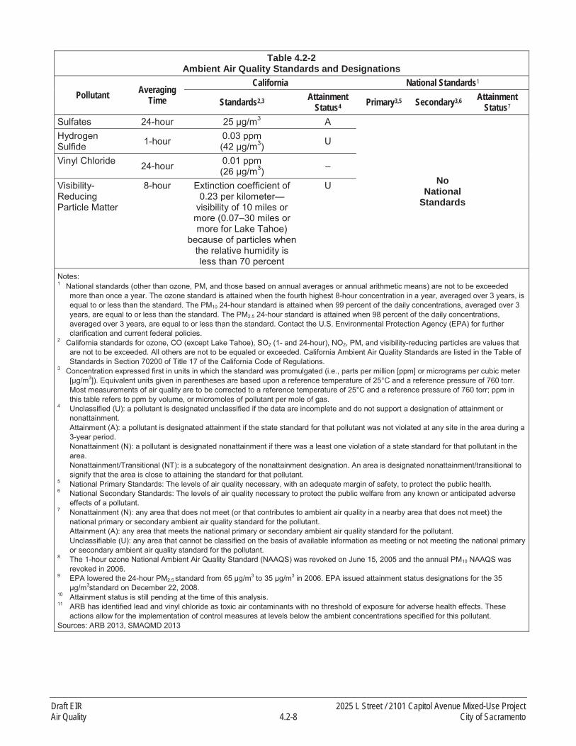
Table 4.2-2Ambient Air Quality Standards and Designations
Pollutant AveragingTime
California National Standards1
Standards2,3 Attainment Status4 Primary3,5 Secondary3,6 Attainment
Status7
Sulfates 24-hour 3 A
NoNational
Standards
Hydrogen Sulfide 1-hour 0.03 ppm
3) U
Vinyl Chloride 24-hour 0.01 ppm3) –
Visibility-Reducing Particle Matter
8-hour Extinction coefficient of 0.23 per kilometer—
visibility of 10 miles or more (0.07–30 miles or more for Lake Tahoe)
because of particles when the relative humidity is less than 70 percent
U
Notes:1 National standards (other than ozone, PM, and those based on annual averages or annual arithmetic means) are not to be exceeded
more than once a year. The ozone standard is attained when the fourth highest 8-hour concentration in a year, averaged over 3 years, is equal to or less than the standard. The PM10 24-hour standard is attained when 99 percent of the daily concentrations, averaged over 3 years, are equal to or less than the standard. The PM2.5 24-hour standard is attained when 98 percent of the daily concentrations, averaged over 3 years, are equal to or less than the standard. Contact the U.S. Environmental Protection Agency (EPA) for further clarification and current federal policies.
2 California standards for ozone, CO (except Lake Tahoe), SO2 (1- and 24-hour), NO2, PM, and visibility-reducing particles are values that are not to be exceeded. All others are not to be equaled or exceeded. California Ambient Air Quality Standards are listed in the Table of Standards in Section 70200 of Title 17 of the California Code of Regulations.
3 Concentration expressed first in units in which the standard was promulgated (i.e., parts per million [ppm] or micrograms per cubic meter 3]). Equivalent units given in parentheses are based upon a reference temperature of 25°C and a reference pressure of 760 torr.
Most measurements of air quality are to be corrected to a reference temperature of 25°C and a reference pressure of 760 torr; ppm in this table refers to ppm by volume, or micromoles of pollutant per mole of gas.
4 Unclassified (U): a pollutant is designated unclassified if the data are incomplete and do not support a designation of attainment or nonattainment.Attainment (A): a pollutant is designated attainment if the state standard for that pollutant was not violated at any site in the area during a 3-year period.Nonattainment (N): a pollutant is designated nonattainment if there was a least one violation of a state standard for that pollutant in the area.Nonattainment/Transitional (NT): is a subcategory of the nonattainment designation. An area is designated nonattainment/transitional to signify that the area is close to attaining the standard for that pollutant.
5 National Primary Standards: The levels of air quality necessary, with an adequate margin of safety, to protect the public health.6 National Secondary Standards: The levels of air quality necessary to protect the public welfare from any known or anticipated adverse
effects of a pollutant. 7 Nonattainment (N): any area that does not meet (or that contributes to ambient air quality in a nearby area that does not meet) the
national primary or secondary ambient air quality standard for the pollutant.Attainment (A): any area that meets the national primary or secondary ambient air quality standard for the pollutant.Unclassifiable (U): any area that cannot be classified on the basis of available information as meeting or not meeting the national primary or secondary ambient air quality standard for the pollutant.
8 The 1-hour ozone National Ambient Air Quality Standard (NAAQS) was revoked on June 15, 2005 and the annual PM10 NAAQS was revoked in 2006.
9 EPA lowered the 24-hour PM2.5 standard from 65 μg/m3 to 35 μg/m3 in 2006. EPA issued attainment status designations for the 35 μg/m3standard on December 22, 2008.
10 Attainment status is still pending at the time of this analysis.11 ARB has identified lead and vinyl chloride as toxic air contaminants with no threshold of exposure for adverse health effects. These
actions allow for the implementation of control measures at levels below the ambient concentrations specified for this pollutant. Sources: ARB 2013, SMAQMD 2013
Draft EIR 2025 L Street / 2101 Capitol Avenue Mixed-Use ProjectAir Quality 4.2-8 City of Sacramento

In 1988, California passed the California Clean Air Act (CCAA) (California Health and Safety Code Section 39600 et seq.). Like its federal counterpart, the CCAA called for the designation of areas as attainment or nonattainment, but based on state ambient air quality standards rather than the federal standards.
With respect to the CAAQS, Sacramento County is currently designated as nonattainment for ozone, PM10, and PM2.5. For all other CAAQS, the region is designated as attainment or unclassifiable. The CCAA requires each air district in which state air quality standards are exceeded to prepare a plan documenting reasonable progress toward attainment. A 3-year update is required.
Toxic Air Contaminants
The California Health and Safety Code defines TACs as air pollutants that may cause or contribute to an increase in mortality or in serious illness, or that may pose a present or potential hazard to human health. The State Air Toxics Program was established in 1983 by Assembly Bill (AB) 1807. A total of 243 substances have been designated TACs under California law. They include the 189 (federal) HAPs adopted in accordance with AB 2728. The Air Toxics “Hot Spots” Information and Assessment Act of 1987 (AB 2588) seeks to identify and evaluate risk from air toxics sources. However, AB 2588 does not regulate air toxics emissions. TAC emissions from individual facilities are quantified and prioritized. “High-priority” facilities must perform a health risk assessment and, if specific thresholds are violated, must communicate the results to the public in the form of notices and public meetings.
In 2000, ARB approved a comprehensive diesel risk reduction plan to reduce emissions from both new and existing diesel-fueled vehicles and engines. The projected emission benefits associated with the full implementation of this plan, including proposed federal measures, are reductions in diesel PM (DPM) emissions and associated cancer risks of 85 percent by 2020 (ARB 2000). Additional regulations apply to new trucks and diesel fuel. Subsequent ARB regulations on diesel emissions include the On-Road Heavy Duty Diesel Vehicle (In-Use) Regulation, the On-Road Heavy Duty (New) Vehicle Program, the In-Use Offroad Diesel Vehicle Regulation, and the New Offroad Compression Ignition Diesel Engines and Equipment Program. All of these regulations and programs have timetables by which manufacturers must comply and existing operators must upgrade their diesel-powered equipment.
Despite these reduction efforts, ARB recommends that proximity to sources of DPM emissions be considered in the siting of new sensitive land uses. In April 2005, ARB published the Air Quality and Land Use Handbook: A Community Health Perspective (Air Quality and Land Use Handbook) (ARB 2005). This handbook is intended to give guidance to local governments in siting sensitive land uses near sources of air pollution. Studies have shown that public exposure to air pollution can be substantially elevated near freeways and certain other facilities, such as ports, rail yards, and distribution centers. Specifically, the Air Quality and Land Use Handbook focuses on risks from emissions of DPM, a known carcinogen, and establishes recommended siting distances of sensitive receptors. With respect to freeways, the handbook’s recommendations are: “Avoid siting new sensitive land uses within 500 feet of a freeway, urban roads with more than 100,000 vehicles per day or rural roads with 50,000 vehicles/day.” ARB notes that these recommendations are advisory and should not be interpreted as defined “buffer zones,” and that local agencies must balance other considerations
2025 L Street / 2101 Capitol Avenue Mixed-Use Project Draft EIRCity of Sacramento 4.2-9 Air Quality
such as transportation needs, the benefits of urban infill, community economic development priorities, and other quality-of-life issues.
Asbestos and Lead-Based Paint
Regulations designed to protect the environmental health will be required for on-site demolition that would involve asbestos and lead-based paint removal. Construction safety orders pertaining to asbestos and lead are included in 8 CCR Sections 1529 and 1532.1 and CFR Part 61, Subpart M (pertaining to asbestos). These regulations govern the specific methods to be used for removal of asbestos and lead-based paint, and specify workplace safety measures that must be used in order to protect the health of construction workers during the removal process.
California Air Resources Board Regulations for Mobile Sources
Idling of Commercial Heavy Duty Trucks (13 CCR 2485)
This Airborne Toxic Control Measure (ATCM) was adopted to control emissions from idling trucks. It prohibits idling for more than 5 minutes for all commercial trucks with a gross vehicle weight rating over 10,000 pounds. The ATCM contains an exception that allows trucks to idle while queuing or involved in operational activities.
In-Use Off-Road Diesel-Fueled Fleets (13 CCR 2449 et seq.)
This ATCM requires that specific fleet average requirements are met for criteria air pollutant emissions, particularly NOx and particulate matter, from in-use off-road diesel-fueled vehicles. Where average requirements cannot be met, Best Available Control Technology requirements apply.
In-Use On-Road Diesel-Fueled Vehicles (13 CCR 2025)
This ATCM was adopted to reduce NOx and particulate matter emissions from most in-use on-road diesel trucks and buses with a gross vehicle weight rating greater than 14,000 pounds and requires use of exhaust retrofit equipment and replacement of older vehicles.
Transport Refrigeration Unit (13 CCR 2477)
This ATCM is part of ARB’s Diesel Risk Reduction Plan (adopted in October 2000) to reduce diesel PM emissions associated with in-use transport refrigeration units (TRU) and TRU generators. The ATCM establishes a phased approach to setting emissions standards on TRUs and electrifying TRUs to minimize and eliminate diesel PM emissions associated with TRU activities (e.g., load docks, truck distribution centers).
Clean Car Standards
As required under AB 1493 (Pavley 2002) and as authorized by the granting of a waiver from the federal CAA, ARB established greenhouse gas (GHG) emission standards for passenger vehicles, light-duty trucks, and other personal vehicles. These standards apply to all new passenger vehicles starting with the 2009 model year.
Draft EIR 2025 L Street / 2101 Capitol Avenue Mixed-Use ProjectAir Quality 4.2-10 City of Sacramento

Senate Bill 656
In 2003, the State Legislature passed Senate Bill (SB) 656 to reduce public exposure to PM10 andPM2.5. The legislation requires ARB, in consultation with local air pollution control and air quality management districts, to adopt a list of the most readily available, feasible, and cost-effective control measures that could be implemented by air districts to reduce PM10 and PM2.5. The legislation establishes a process for achieving near-term reductions in PM throughout California ahead of federally required deadlines for PM2.5, and provides new direction on PM reductions in those areas not subject to federal requirements for PM. Source categories addressed by SB 656 include measures to address residential wood combustion and outdoor green-waste burning; fugitive dust sources, such as paved and unpaved roads and construction; combustion sources, such as boilers, heaters, and charbroiling; solvents and coatings; and product manufacturing. These measures include, but are not limited to, the following:
reduce or eliminate wood-burning devices,prohibit residential open burning,permit and provide performance standards for controlled burns,require water or chemical stabilizers/dust suppressants during grading activities,limit visible dust emissions beyond the project boundary during construction,require paving/curbing of roadway shoulder areas, andrequire street sweeping.
2010 Green Building Code
On January 12, 2010, the California Building Standards Commission adopted the 2010 California Green Building Standards Code, otherwise known as the CALGreen Code. In addition to the new statewide mandates, CALGreen encourages local governments to adopt more stringent voluntary provisions, known as Tier 1 and Tier 2 provisions, to further reduce air pollutant emissions, improve energy efficiency, and conserve natural resources. If a local government adopts one of the tiers, the provisions become mandates for all new construction within that jurisdiction. Significant features of the 2010 CALGreen Code related to air quality include the following:
Mandatory periodic inspections of energy systems (i.e., heat furnace, air conditioner, mechanical equipment) for nonresidential buildings over 10,000 square feet to ensure that all are working at their maximum capacity according to their design efficiencies; and
Mandatory use of low-pollutant-emitting interior finish materials such as paints, carpet, vinyl flooring, and particleboard.
Odors
The California Health and Safety Code includes extensive regulatory guidance to address odors, food safety, worker safety, and related topics, including Sections 114149-114149.3, Ventilation,” and Sections 114244-114245.7, “Refuse.”
2025 L Street / 2101 Capitol Avenue Mixed-Use Project Draft EIRCity of Sacramento 4.2-11 Air Quality

LOCAL
Sacramento Metropolitan Air Quality Management District
SMAQMD is the agency responsible for air quality planning and development of the air quality plan in the project area. The air quality plan establishes the strategies used to achieve compliance with the NAAQS and CAAQS in all areas within SMAQMD’s jurisdiction. All projects within SMAQMD’s jurisdictional area are also subject to adopted rules and regulations in effect at the time of construction and operation. SMAQMD develops rules and regulations and emission reduction programs to control emissions of criteria air pollutants, ozone precursors, TACs, and odors within its jurisdiction.
SMAQMD regulates air quality through its planning and review activities. SMAQMD has permit authority over most types of stationary emission sources; can require stationary sources to obtain permits; and can impose emission limits, set fuel or material specifications, or establish operational limits to reduce air pollutant emissions. SMAQMD regulates new or expanding stationary sources of TACs. For CEQA analyses, SMAQMD has developed their CEQA Guide to Air Quality Assessment (SMAQMD 2014a)that provides guidance on how to evaluate air quality impacts from land use development projects. Because the science and tools used to analyze air quality impacts continues to change, SMAQMD periodically updates the CEQA Guide to Air Quality Assessment to maintain current methodologies, models, and protocols for evaluating air quality. This air quality assessment was developed consistent with the SMAQMD’s CEQA Guide to Air Quality Assessment (SMAQMD 2014a).
For state air quality planning purposes, Sacramento County is classified as a severe nonattainment area for ozone. SMAQMD must update the Clean Air Plan every 3 years to reflect progress in meeting the air quality standards, and to incorporate new information regarding the feasibility of control measures and new emission inventory data. SMAQMD’s record of progress in implementing previous measures must also be reviewed. The Sacramento Regional 8-Hour Ozone Attainment and Reasonable Further Progress Plan (2013 State Implementation Plan [SIP] Revisions) and the 2009 Triennial Report and Plan Revision are the latest plans issued by SMAQMD. These plans address attainment of the federal 8-hour ozone standard and the state ozone standard, respectively.
These attainment plans depend heavily on SMAQMD’s permit authority, which is exercised through SMAQMD’s regulations and rules. With respect to the construction phase of the proposed project, applicable SMAQMD regulations would relate to construction and stationary equipment, fugitive dust/PM generation, and architectural coatings. Equipment used during project construction would be subject to SMAQMD rules and regulations.
The following SMAQMD rules and regulations would be applicable to the proposed project:
Rule 201 – General Permit Requirements: Requires any project that includes the use of certain equipment capable of releasing emissions to the atmosphere as part of project operation to obtain a permit from the SMAQMD prior to operation of the equipment including an emergency generator, boiler, or heater. Portable construction equipment with an internal combustion engine over 50 horsepower are required to have a SMAQMD permit or a ARB portable equipment registration.
Draft EIR 2025 L Street / 2101 Capitol Avenue Mixed-Use ProjectAir Quality 4.2-12 City of Sacramento
Rule 401 – Ringelmann Chart: Prohibits individuals from discharging into the atmosphere from any single source of emissions whatsoever any air contaminant whose opacity3 exceeds certain specified limits.
Rule 402 – Nuisance: To protect the public health, Rule 402 prohibits any person from discharging such quantities of air contaminants that cause injury, detriment, nuisance, or annoyance to any considerable number of persons or to the public.
Rule 403 – Fugitive Dust: Requires a person to take every reasonable precaution not to cause or allow the emissions of fugitive dust from being airborne beyond the property line from which the emission originates, from construction, handling or storage activity, or any wrecking, excavation, grading, clearing of land or solid waste disposal operation.
Rule 442 – Architectural Coatings: Sets Volatile Organic Compounds (VOC) limits for coatings that are applied to stationary structures or their appurtenances. The rule also specifies storage and cleanup requirements for these coatings.
Rule 902 – Asbestos Abatement. The proposed project would be subject to SMAQMD Rule 902 for asbestos abatement.
Sacramento 2030 General Plan
The following goal and policies from the City of Sacramento 2030 General Plan are related to air quality(City of Sacramento 2009):
Goal ER 6.1 Improved Air Quality. Improve the health and sustainability of the community through improved regional air quality and reduced greenhouse gas emissions that contribute to climate change.
Policy ER 6.1.2 New Development. The City shall review proposed development projects toensure projects incorporate feasible measures that reduce construction and operational emissions for reactive organic gases, nitrogen oxides, and particulate matter (PM10 and PM2.5) through project design.
Policy ER 6.1.3 Emissions Reduction. The City shall require development projects that exceed SMAQMD ROG and NOX operational thresholds to incorporate design or operational features that reduce emissions equal to 15 percent from the level that would be produced by an unmitigated project.
Policy ER 6.1.5 Development near TAC Sources. The City shall ensure that new developmentwith sensitive uses located adjacent to TAC sources, as identified by the California Air Resources Board (CARB), minimizes potential health risks. In its review of these new development projects, the City shall consider current guidance provided by and consult with CARB and SMAQMD.
Policy ER 6.1.6 Sensitive Uses. The City shall require new development with sensitive useslocated adjacent to mobile and stationary TACs be designed with consideration of site and building orientation, location of trees, and incorporation of appropriate technology for improved air quality
3 Opacity means degree of transparency.
2025 L Street / 2101 Capitol Avenue Mixed-Use Project Draft EIRCity of Sacramento 4.2-13 Air Quality

(i.e., ventilation and filtration) to lessen any potential health risks. In addition, the City shall require preparation of a health risk assessment, if recommended by Sacramento Metropolitan Air Quality Management District, to identify health issues, reduce exposure to sensitive receptors, and/or toimplement alternative approached to development that reduces exposure to TAC sources.
Policy ER 6.1.14 Zero-Emission and Low-Emission Vehicle Use. The City shall encourage the use of zero-emission vehicles, low-emission vehicles, bicycles and other non-motorized vehicles, and car-sharing programs by requiring sufficient and convenient infrastructure and parking facilities in residential developments and employment centers to accommodate these vehicles.
Policy ER 6.1.4 Protect all Residents Equally. The City shall ensure that all land use decisions are made in an equitable fashion in order to protect residents, regardless of age, culture, ethnicity, gender, race, socioeconomic status, or geographic location, from the health effects of air pollution.
In addition to the 2030 General Plan policies that directly address air quality, there are a large number of general plan policies that indirectly relate to air quality, or that would help to improve air quality as a co-benefit of the implementation of the subject policy. For example, Appendix B of the 2030 General Plan includes a summary of policies that relate to climate change. Some of these policies would reduce GHG emissions, including those from transportation. Those policies from Appendix B – particularly those related to land use, transportation, and urban design – would likely improve local and regional air quality as a co-benefit. See Appendix B of the 2030 General Plan for more detail.
Sacramento 2035 General Plan
The proposed project was initiated when the 2030 General Plan was in force. Since that time, the City has prepared an update to the 2030 General Plan. The 2035 General Plan proposes to delete Policy ER 6.1.5 Development near TAC Sources, and delete Policy ER 6.1.6 Sensitive Uses, and to add Policy ER 6.1.4:
Policy ER 6.1.4 Sensitive Uses. The City shall coordinate with SMAQMD in evaluating exposure of sensitive receptors to toxic air contaminants, and will impose appropriate conditions on projects to protect public health and safety.
4.2.3 IMPACTS AND MITIGATION
METHODS OF ANALYSIS
The discussion below presents the methodologies used for the air quality analysis, as well as to assess the significance of the proposed project’s impacts. All project modeling is included in Appendix C of this EIR.
Criteria Air Pollutants
The construction (including demolition) and operational emissions associated with implementation of the proposed project were compared with the applicable thresholds of significance to determine the level potential impact. SMAQMD’s significance thresholds serve as a proxy for determining whether the
Draft EIR 2025 L Street / 2101 Capitol Avenue Mixed-Use ProjectAir Quality 4.2-14 City of Sacramento

proposed project would result in a violation of any air quality standard, cause a substantial contribution to an existing or projected air quality violation, and/or conflict with any applicable air quality plan.
Construction
Construction consists of building demolition, grading, site preparation, building construction, and application of architectural coatings. The proposed project would be built out over multiple years. For the purposes of this analysis, it is assumed build-out of both phases would occur over an approximate2.5-year period, spanning portions of three calendar years (i.e., 2015, 2016, and 2017). The proposed project’s construction-related criteria air pollutants, precursors, and TACs were modeled using the California Emissions Estimator Model (CalEEMod) Version 2013.2.2 (California Air Pollution Control Officers [CAPCOA] 2013). CalEEMod allows the user to input project-specific construction parameters such as construction schedule, heavy-duty construction equipment numbers and types, haul trucks, and construction workers. The project applicant provided project-specific construction information that was used to estimate the proposed project’s construction emissions such as amount of material to be demolished, volume of cut, and land uses to be constructed. Where project-specific construction information was not available, default parameters contained in CalEEMod were used. It should be noted that CalEEMod defaults typically result in conservative estimates of emissions in order to avoid underestimating emissions when information is not available. To conservatively estimate the maximum daily emissions, the proposed project’s construction emissions were modeled based on a worst-case scenario representing the most intensive day of construction. Because the two constructioncomponents (i.e., 2025 L Street and 2101 Capitol Avenue) do not overlap, the maximum daily emissions were determined from the worst day from either phase. Anticipated phasing is described in Chapter 2, “Project Description,” of this EIR. Phase 1, the 2101 Capitol Avenue structure, is assumed to be constructed between approximately August 2015 and April 2016. Phase 2, 2025 L Street, is assumed to be constructed between approximately May 2016 and November 2017.
Operation
Following construction of the proposed project, operational activities associated with the proposed uses would generate air pollutant emissions. CalEEMod was used to estimate operational emissions based on the proposed land use types and sizes. The operational emissions associated with day-to-dayactivities of the proposed project were quantified using CalEEMod to determine daily operational emissions in units of pounds per day. Default trip generation rates and trip distances for the proposed land uses were obtained from CalEEMod. In reality, given the mixed-use and infill nature of the proposed project, it is anticipated that trip generation rates and trip distances would be less than default factors contained in CalEEMod. Nevertheless, this provides a conservative estimate of the proposed project’s long-term operational emissions.
Emissions associated with area and energy sources were also quantified using default CalEEMod assumptions for the proposed land uses. See Appendix C for further details.
Carbon Monoxide
CO impacts were evaluated using the screening methodology included in SMAQMD’s CEQA Guide to Air Quality Assessment (SMAQMD 2014a).
2025 L Street / 2101 Capitol Avenue Mixed-Use Project Draft EIRCity of Sacramento 4.2-15 Air Quality

Lead
This analysis does not directly evaluate airborne lead. The construction and operation of the proposed project would generate few, if any, quantifiable or foreseeable emissions of these substances. This is because unleaded fuel would be used for construction equipment and no lead would be included in new building materials. Lead-based paint is addressed below.
Toxic Air Contaminants
The AERMOD dispersion model was used to estimate TAC concentrations at specific distances from emission sources, using hourly meteorological data from Sacramento Executive Airport, which is located south of downtown Sacramento (Lakes Environmental 2014). A series of volume sources in AERMOD were used to represent construction activities that would occur on the project site. The volume sources were assumed to be the total acreage of the project site to account for the potential that construction emissions may occur on a given day over that entire area. The volume sources representing emissions from the construction equipment were given an initial exhaust-release height of 5 meters to account for the height of the equipment’s exhaust stack and the initial plume rise of the heated exhaust. An initial vertical dimension of 1.0 meters (calculated by an equation in AERMOD) was also applied to the volume sources.
Appendix C shows the volume source locations and the receptors modeled. Construction emissionpollutant concentrations were modeled for the receptors adjacent to the project site. The receptors were assumed to have a height of 1.8 meters (approximately 6 feet) for the ground-level residences and 3meters higher for each floor in the high-rise residential locations within 0.25-mile of the project site.
This assessment considers exposure via inhalation only. The potential exposure through other pathways (e.g., ingestion) requires substance and site-specific data, and the specific parameters for DPM are not known for these pathways (ARB 1998). The estimated excess lifetime cancer risks, chronic and acute noncancer HIs were compared to the thresholds of significance for TACs for a maximally exposed individual at an existing residential receptor (MEIR) and maximally exposed individual at an existing occupational worker receptor (MEIW). The 70-year Adult and the 9-year child residential cancer risk, as well as the 40-year working cancer risk were calculated in a spreadsheet and adjusted for the length of the proposed project (4/70, 4/9, and 4/40, respectively).
The estimated cancer risk was based on the pollutant concentrations estimated with AERMOD, an inhalation potency factor, and default estimates of breathing rate, body weight, and exposure period (Office of Environmental Health Hazard [OEHHA], 2003) for an adult living at these receptors for all years of the construction period. Additional details are provided in Appendix C.
The chronic noncancer inhalation hazard indices for the proposed project were calculated by dividing the modeled annual average DPM concentrations by the reference exposure level (REL). The REL is the concentration below which no adverse noncancer health effects are anticipated. The OEHHA has recommended an ambient concentration of 5 micrograms per cubic meter as the chronic inhalation REL for DPM. No inhalation REL for acute (i.e., short-term) effects has been determined for DPM by OEHHA; however the components of diesel ROG can be used to calculate the acute hazard index.
Draft EIR 2025 L Street / 2101 Capitol Avenue Mixed-Use ProjectAir Quality 4.2-16 City of Sacramento

THRESHOLDS OF SIGNIFICANCE
In consideration of the significance criteria from Appendix G of the State CEQA Guidelines, the City of Sacramento Environmental Checklist, and relevant guidance from SMAQMD, air quality impacts are considered significant if the proposed project would result in:
Construction emissions of NOX above 85 pounds per day;
operational emissions of NOX or ROG above 65 pounds per day;
a conflict with or the obstruction of implementation of the applicable air quality plan;
violation of any air quality standard or a substantial contribution to an existing or projected air quality violation;
cumulatively considerable net increase of any criteria pollutant for which the project area is in nonattainment under an applicable federal or state ambient air quality standard (including the release of emissions that exceed quantitative thresholds for ozone precursors);
exposure of sensitive receptors to substantial pollutant concentrations;
objectionable odors affecting a substantial number of people;
PM10 concentrations equal to or greater than 5 percent of the state ambient air quality standard (i.e., 50 micrograms per cubic meter for 24 hours) in areas where there is evidence of existing or projected violations of this standard. However, if project emissions of NOX and ROG are below the emission thresholds given above, then the project would not result in violations of the PM10 ambient air quality standards;
CO concentrations that exceed the 1-hour state ambient air quality standard (i.e., 20.0 parts per million [ppm]) or the 8-hour state ambient standard (i.e., 9.0 ppm); or
TAC exposures would create a risk of 10 in 1 million for stationary sources, or substantially increase the risk of exposure to TACs from mobile sources.
IMPACT ANALYSIS AND MITIGATION
IMPACT 4.2-1
The proposed project could result in temporary and short-term (construction) emissions of NOx
above 85 pounds per day. Based on the analysis below, the impact would be less than significant with mitigation.
Project construction would occur over an approximate 2.5-year period and consist of building demolition, grading, site preparation, building construction, and application of architectural coatings.The two locations (i.e., 2025 L Street and 2101 Capitol Avenue) would be developed in sequence and therefore none of the construction activities between the two sites would overlap. The proposed project would result in the temporary and short-term generation of ROG and NOX emissions during construction activities. ROG and NOX emissions are primarily associated with exhaust from mobile
2025 L Street / 2101 Capitol Avenue Mixed-Use Project Draft EIRCity of Sacramento 4.2-17 Air Quality

equipment, including off-road construction equipment and on-road motor vehicles. Exhaust emissions from construction equipment and motor vehicles would also generate PM10 and PM2.5 emissions, but to a lesser extent. Earth and material disturbance activities such as building demolition, grading, and site preparation are the primary sources of fugitive PM dust emissions.
As shown in Table 4.2-3, construction emissions for the proposed project would result in maximum unmitigated daily emissions of approximately 60 pounds per day of ROG and 30 pounds per day of NOX. The maximum daily NOX emissions shown in Table 4.2-3 would not exceed the applicableSMAQMD threshold of significance (85 pounds per day of NOx). See Appendix C of this EIR for detailed modeling assumptions and outputs.
Table 4.2-3Maximum Daily Unmitigated Construction Emissions Associated with the Proposed Project
Emissions SourcePollutant Emissions (lb/day)1
ROG NOX PM102 PM2.5
Maximum Daily Construction Emissions (lb/day) -2025 L Street 40.96 30.03 5.13 2.99
Maximum Daily Construction Emissions (lb/day) -2101 Capitol Avenue 60.15 24.88 2.85 1.53
Maximum Daily Construction Emissions (lb/day) -Overall Project 60.15 30.03 5.13 2.99
SMAQMD Significance Threshold (lb/day) – 85 – –Exceeds Significance Threshold? No No No NoNotes: lb/day = pounds per day; NOX = oxides of nitrogen; PM10 = suspended particulate matter; PM2.5 = fine particulate matter; ROG = reactive organic gases; SMAQMD = Sacramento Metropolitan Air Quality Management District1 PM10 emissions are defined as the sum of particulate matter with aerodynamic diameter 0 to 2.5 micrometers and particulate matter with
aerodynamic diameter 2.5 to 10 micrometers.Source: Data modeled by AECOM in 2015
Although the proposed project’s construction-related emissions would not exceed SMAQMD’s construction threshold of significance, SMAQMD recommends that all projects involving construction activities, regardless of the significance determination, implement SMAQMD’s Basic Construction Emission Control Practices (SMAQMD 2014a). SMAQMD’s Basic Construction Emission Control Practices include such measures as watering the construction site twice daily, limiting vehicle speeds on unpaved roadways to 15 miles per hour, minimizing vehicle idling, covering haul trucks transporting soil, and cleaning paved roads. Without incorporation of SMAQMD’s Basic Construction Control Practices, the impact is conservatively considered to be potentially significant.
Mitigation Measures
As stated above, although the proposed construction emissions (see Table 4.2-3) would not exceed the SMAQMD threshold of significance for NOx, SMAQMD recommends that all projects implement Basic Construction Emission Control Practices. Implementation of Mitigation Measure 4.2-1 would fulfill this requirement and reduce fugitive PM dust and equipment exhaust emissions.
Draft EIR 2025 L Street / 2101 Capitol Avenue Mixed-Use ProjectAir Quality 4.2-18 City of Sacramento

Mitigation Measure 4.2-1: Implement SMAQMD Basic Construction Emission Control Practices.
City approval of any grading or improvement plans shall require the following Basic Construction Emission Control Practices to be implemented by the project applicant:
Water all exposed surfaces two times daily. Exposed surfaces include, but are not limited to soil piles, graded areas, unpaved parking areas, staging areas, and access roads.
Cover or maintain at least 2 feet of free board space on haul trucks transporting soil, sand, or other loose material on the site. Cover any haul trucks that will be traveling along freeways or major roadways.
Use wet power vacuum street sweepers to remove any visible trackout mud or dirt onto adjacent public roads at least once a day. Use of dry power sweeping is prohibited.
Limit vehicle speed on unpaved roads to 15 mph.
Complete pavement of all driveways and sidewalks to be paved as soon as possible. In addition, lay building pads as soon as possible after grading unless seeding or soil binders are used.
Minimize idling time either by shutting equipment off when not in use or reducing the time of idling to 5 minutes (required by California Code of Regulations, Title 13, Sections 2449[d][3]and 2485). Provide clear signage that posts this requirement for workers at the entrances to the site.
Maintain all construction equipment in proper working condition according to manufacturer’s specifications. Have the equipment checked by a certified mechanic and determined to be running in proper condition before it is operated.
Significance after Mitigation
Although the proposed project would not exceed significance thresholds for NOX, implementation of Mitigation Measure 4.2-1 would fulfill the requirement of SMAQMD that all proposed projects implement Basic Construction Control Practices to reduce fugitive PM dust and equipment exhaust emissions, thereby reducing the potentially significant impact to less than significant with mitigation.
IMPACT 4.2-2
The proposed project could result in long-term (operational) emissions of ROG or NOx above 65 pounds per day. Based on the analysis below, the impact would be less than significant.
Daily activities associated with the long-term operation of the proposed project would generate criteria air pollutant emissions and precursors from mobile and area sources. Mobile sources include vehicle trips arriving at, and departing from the planned land uses. Area sources include consumer products (i.e., cleaning supplies, kitchen aerosols, cosmetics, and toiletries), natural gas combustion for water and space heating, landscape maintenance equipment, and periodic architectural coatings.
2025 L Street / 2101 Capitol Avenue Mixed-Use Project Draft EIRCity of Sacramento 4.2-19 Air Quality

Existing land uses at the 2025 L Street portion of the project site include a two-level parking structure, two surface parking lots, and a small office building currently used for storage. The 2101 Capitol Avenue property currently consists of paved, street-level parking and undeveloped land.
Estimated daily operational emissions for the proposed project are shown in Table 4.2-4. As shown in Table 4.2-4, ROG and NOX emissions are estimated to be approximately 7 and 8 pounds per day,respectively, compared to a threshold of 65 pounds per day for each pollutant. Therefore, the proposed project’s long-term operational emissions would not exceed the SMAQMD’s ROG and NOX thresholds of significance. Operational PM emissions are shown in this table, as well, for informational purposes. The impact is considered less than significant.
Mitigation Measures
None required.
Table 4.2-4Daily Operational Emissions Associated with the Proposed Project
Emissions SourcePollutant Emissions (lb/day)
ROG NOX PM10 PM2.5
Area 5.39 0.14 0.06 0.06Energy 0.08 0.71 0.06 0.06Mobile 1.73 7.34 0.86 0.39Project Sources—Maximum Daily Emissions 7.20 8.18 0.98 0.51SMAQMD Significance Threshold 65 65 – –Exceeds Significance Threshold? No No N/A N/ANotes: lb/day = pounds per day; N/A = not applicable; NOX = oxides of nitrogen; PM10 = particulate matter with aerodynamic diameter less than 10 micrometers; PM2.5 = particulate matter with aerodynamic diameter less than 2.5 microns; ROG = reactive organic gases; SMAQMD = Sacramento Metropolitan Air Quality Management DistrictSource: Data modeled by AECOM in 2015
IMPACT 4.2-3
The proposed project could conflict with or obstruct implementation of the applicable air quality plan. Based on the analysis below, the impact would be less than significant.
The Sacramento Regional Ozone Attainment Plan (OAP) was developed by the air districts in the Sacramento Region to bring the region into attainment with the state and federal ambient air quality standards for ozone. As shown in Tables 4.2-3 and 4.2-4, construction and operational emissions of the ozone precursors ROG and NOx for the proposed project, respectively, would be below the SMAQMD’s significance thresholds.
With respect to PM10 and PM2.5, SMAQMD has adopted measures to maintain attainment of the federal ambient air quality standards, as is discussed under Impact 4.2-4.
Significance thresholds are considered the allowable emissions limit for individual projects to avoid impeding the region’s ability to attain and maintain ambient air quality standards. Therefore, because the proposed project’s construction and operational emissions would not exceed the applicable
Draft EIR 2025 L Street / 2101 Capitol Avenue Mixed-Use ProjectAir Quality 4.2-20 City of Sacramento

significance thresholds, the proposed project would not conflict with or obstruct the implementation ofthe OAP and the impact would be less than significant.
Mitigation Measures
None required.
IMPACT 4.2-4
The proposed project could violate an air quality standard or contribute substantially to an existing or projected air quality violation. Based on the analysis below, the impact would be less than significant with mitigation.
SMAQMD considers projects that disturb fewer than 15 acres per day and implement SMAQMD’s Basic Construction Emission Control Practices (see Mitigation Measure 4.2-1) to not have the potential to exceed or contribute to SMAQMD’s concentration-based thresholds of significance for PM10 (i.e., exceed ambient air quality standard or contribute 5 percent of ambient air quality standard) (and therefore PM2.5). The total disturbed acreage for all phases and project components would be less than2 acres. If the proposed project would not include the Basic Construction Emission Control Practices,the impact would conservatively be assumed to be potentially significant.
Mitigation Measures
Mitigation Measure 4.2-4: Implement Mitigation Measure 4.2-1.
Significance after Mitigation
Projects that disturb fewer than 15 acres per day and implement SMAQMD’s Basic Construction Emission Control Practices (see Mitigation Measure 4.2-1) do not have the potential to exceed or contribute to SMAQMD’s concentration-based thresholds of significance for PM10 (i.e., exceed ambient air quality standard or contribute 5 percent of ambient air quality standard) (and therefore PM2.5). Therefore, with implementation SMAQMD’s Basic Construction Emissions Control Practices, this impact is less than significant with mitigation.
IMPACT 4.2-5
The proposed project could result in CO concentrations that exceed the 1- or 8-hour state ambient air quality standard. Based on the analysis below, the impact would be less than significant.
Motor vehicles are the primary source of CO emissions. Local mobile-source CO emissions near roadway intersections are a direct function of traffic volume, speed, and delay. CO concentration depends on motor vehicle activity, particularly during peak commute hours, and meteorological conditions. Transport of CO is limited because it disperses rapidly with distance from the source under normal meteorological conditions. However, under specific meteorological conditions, CO concentrations near roadways and/or intersections may reach unhealthy levels related to local sensitive land uses, such as residences, hospitals, schools, and child care facilities.
SMAQMD has established a two-tier set of screening criteria to determine whether a proposed project would have the potential to exceed the 1-hour ambient air quality standard of 20 ppm or the 8-hour standard of 9.0 ppm for CO. The screening criteria have been developed to help agencies analyze
2025 L Street / 2101 Capitol Avenue Mixed-Use Project Draft EIRCity of Sacramento 4.2-21 Air Quality

potential CO impacts and identify when site-specific CO dispersion modeling would be required. According to SMAQMD’s CEQA Guide to Air Quality Assessment, the first tier of the analysis is based on the level-of-service (LOS) for intersections affected by the proposed project. The proposed project has the potential to cause a localized exceedance of the CO standard if it would (1) generate traffic that causes an intersection’s LOS to deteriorate to LOS E or F, or (2) contribute additional traffic to an intersection that already operates at LOS E or F. If the first tier screening criteria are not met, second tier screening will be evaluated. The second tier screening criteria require that the proposed project fulfill all the following three criteria: (1) the proposed project would not result in an impact to an intersection experiencing more than 31,600 vehicles per hour, (2) the proposed project would not contribute traffic to a tunnel, parking garage, bridge underpass, urban street canyon, or below-grade roadway; or other locations where horizontal or vertical mixing of air will be substantially limited, and (3) the mix of vehicle types at the intersection is not anticipated to be substantially different from the County average.
Under existing plus project conditions, according to the traffic study prepared to support this EIR (see Section 4.7 and Appendix F), all intersections would operate at LOS of C or better with implementation of the proposed project. The proposed 2101 Capitol Avenue parking garage would replace the existing parking garage to replace parking spaces for the existing 2020 L Street office building. The traffic and vehicles that would use the proposed 2101 Capitol Avenue parking garage would be the same vehicles currently using the parking garage that would be demolished as part of the proposed project. Furthermore, the 2101 Capitol Avenue parking garage would also be open to the atmosphere, similar to the existing parking garage to be demolished, to avoid accumulation of CO concentrations. The proposed 2025 L Street parking garage would include traffic for the residential uses, which is not anticipated to be a potential source of CO hotspots. The subterranean for residential uses would be designed with a ventilation system pulling air from the ground and basement levels up to the top of the 2025 L Street building to avoid accumulation of air pollutants in the parking garage. For the commercial land uses at 2025 L Street, the parking lot would be designed to maintain traffic flow (e.g., signage for available parking spaces at the entrance) to avoid a substantial number of vehicles idling. Considering these design features, intensity of uses, and the fact that CO levels in the Sacramento area are relatively low and emissions rates are expected to decline substantially due to cleaner burning fuels,the parking garages are not anticipated to cause an exceedance of the CO NAAQS or CAAQS. Using SMAQMD guidance, the proposed project would meet all of the SMAQMD’s CO hotspot two-tier screening criteria and would not generate traffic volumes that would cause an intersection’s LOS to deteriorate to LOS E or F, or contribute additional traffic to an intersection that already operates at LOS E or F. Given the fulfillment of these criteria, the low level of traffic, and the improved vehicle standards that have substantially reduced CO emission rates, it is not anticipated that the proposed project would generate a significant impact. The impact is less than significant. However, because the proposed project would include construction of a subterranean parking area, the City will impose the following mitigation.
Mitigation Measures
The follow mitigation measure would further minimize any potential for a CO hotspot.
Draft EIR 2025 L Street / 2101 Capitol Avenue Mixed-Use ProjectAir Quality 4.2-22 City of Sacramento
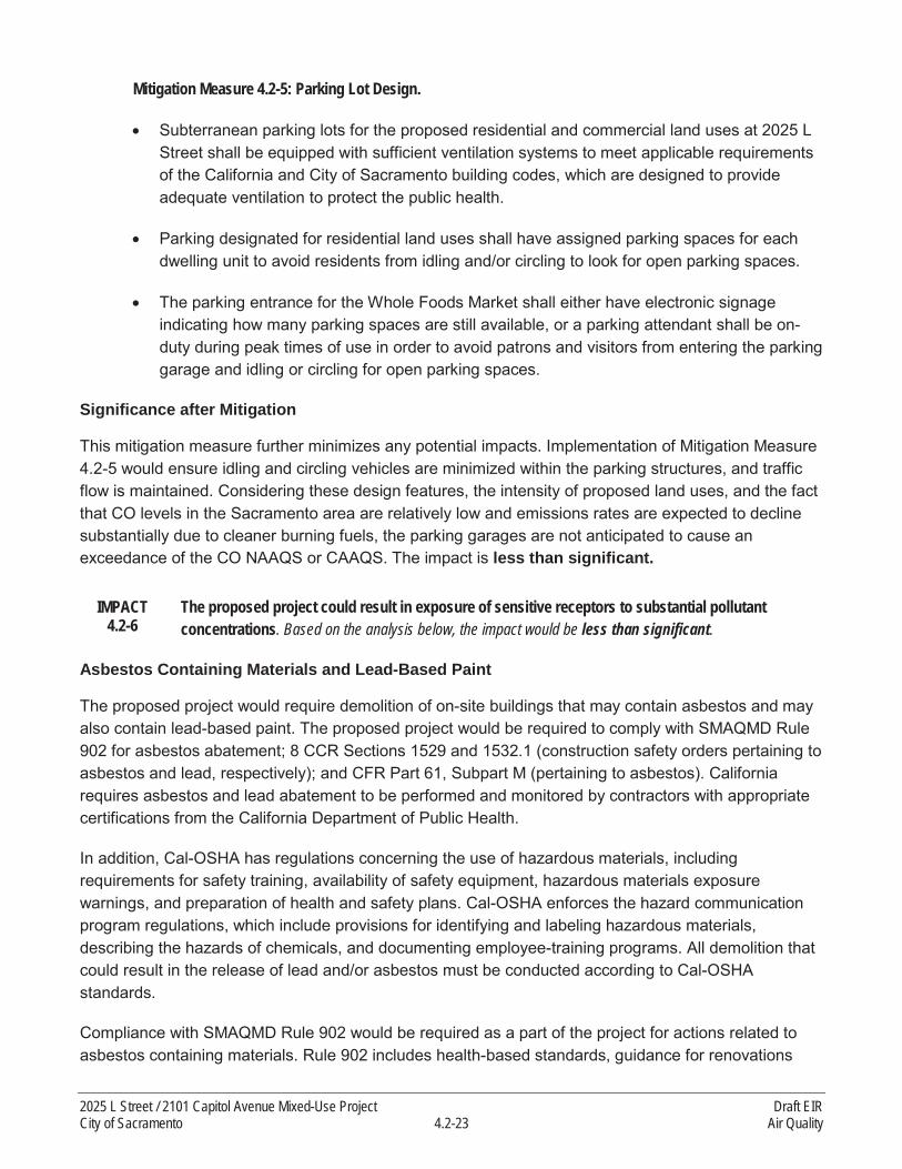
Mitigation Measure 4.2-5: Parking Lot Design.
Subterranean parking lots for the proposed residential and commercial land uses at 2025 L Street shall be equipped with sufficient ventilation systems to meet applicable requirements of the California and City of Sacramento building codes, which are designed to provide adequate ventilation to protect the public health.
Parking designated for residential land uses shall have assigned parking spaces for each dwelling unit to avoid residents from idling and/or circling to look for open parking spaces.
The parking entrance for the Whole Foods Market shall either have electronic signage indicating how many parking spaces are still available, or a parking attendant shall be on-duty during peak times of use in order to avoid patrons and visitors from entering the parking garage and idling or circling for open parking spaces.
Significance after Mitigation
This mitigation measure further minimizes any potential impacts. Implementation of Mitigation Measure 4.2-5 would ensure idling and circling vehicles are minimized within the parking structures, and traffic flow is maintained. Considering these design features, the intensity of proposed land uses, and the fact that CO levels in the Sacramento area are relatively low and emissions rates are expected to decline substantially due to cleaner burning fuels, the parking garages are not anticipated to cause an exceedance of the CO NAAQS or CAAQS. The impact is less than significant.
IMPACT 4.2-6
The proposed project could result in exposure of sensitive receptors to substantial pollutant concentrations. Based on the analysis below, the impact would be less than significant.
Asbestos Containing Materials and Lead-Based Paint
The proposed project would require demolition of on-site buildings that may contain asbestos and may also contain lead-based paint. The proposed project would be required to comply with SMAQMD Rule 902 for asbestos abatement; 8 CCR Sections 1529 and 1532.1 (construction safety orders pertaining to asbestos and lead, respectively); and CFR Part 61, Subpart M (pertaining to asbestos). Californiarequires asbestos and lead abatement to be performed and monitored by contractors with appropriate certifications from the California Department of Public Health.
In addition, Cal-OSHA has regulations concerning the use of hazardous materials, including requirements for safety training, availability of safety equipment, hazardous materials exposure warnings, and preparation of health and safety plans. Cal-OSHA enforces the hazard communication program regulations, which include provisions for identifying and labeling hazardous materials, describing the hazards of chemicals, and documenting employee-training programs. All demolition that could result in the release of lead and/or asbestos must be conducted according to Cal-OSHA standards.
Compliance with SMAQMD Rule 902 would be required as a part of the project for actions related to asbestos containing materials. Rule 902 includes health-based standards, guidance for renovations
2025 L Street / 2101 Capitol Avenue Mixed-Use Project Draft EIRCity of Sacramento 4.2-23 Air Quality

and demolition, special requirements for demolition, waste disposal requirements, testing and recordkeeping procedures, hazard posting requirements, and other measures to avoid adverse health effects.
Existing regulations (8 CCR Sections 1529 and 1532.1) address demolition or salvage of structures where lead or materials containing lead are present; removal or encapsulation of materials containing lead; new construction, alteration, repair, or renovation of structures, substrates, or portions thereof, that contain lead, or materials containing lead; lead contamination/emergency cleanup; transportation, disposal, storage, or containment of lead or materials containing lead on the site or location at which construction activities are performed, and maintenance operations associated with the construction activities described in this section. The impact is less than significant.
Construction
The greatest potential for TAC emissions resulting from construction of the proposed project wouldoriginate from DPM emissions associated with heavy equipment operations during construction activities. People most likely to be affected by air pollutants include children, the elderly, athletes, and people with cardiovascular and chronic respiratory diseases. Sensitive receptors include residences, schools, playgrounds, day care centers, athletic facilities, long-term health-care facilities, rehabilitation centers, convalescent centers, and retirement homes. As described previously, the nearest sensitive receptors are residences on blocks adjacent to the two construction areas.
Project construction would generate DPM emissions from the use of off-road diesel construction equipment required for demolition, excavation, materials handling and installation, and other construction-related activities. Most DPM emissions associated with material delivery trucks and construction worker vehicles would occur off-site. For the purposes of this analysis, PM2.5 exhaust emissions from on-site diesel-fueled construction equipment were used to represent DPM emissions, as DPM is considered to be less than or equal to 10 micrometers in diameter. Therefore, PM2.5
represents the upper limit for DPM emissions associated with construction of the proposed project.
Typically, construction projects generate DPM in a single area for a relatively short period of time. The dose of TACs to which receptors are exposed is the primary factor used to determine health risk. Dose is a function of the concentration of a substance or substances in the environment and the extent of exposure a person has with the substance. Dose is positively correlated with time, meaning that a longer exposure period to a fixed amount of emissions results in a higher exposure level and higher health risks for the maximally exposed individual. The estimated cancer risk for an adult living at this location for the 2.5-year construction period is 0.007 in 1 million (see Appendix C for more detail). The modeled cancer risks would not exceed the significance threshold of 10 in 1 million (construction emissions are treated as “stationary sources” for the purposes of assessing impacts relative to the relevant threshold of significance).
The chronic (i.e., long-term) noncancer hazard index for the nearest sensitive receptor with respect tothe proposed project construction activities would be 0.15, which is less than the SMAQMD significance threshold of 1.0 for noncancer health impacts. The estimated cancer risk for an adult living in the adjacent residences for the 2.5-year construction period is 0.007 in 1 million, which does not exceed the significance threshold of 10 in 1 million; therefore, the impact would be less than significant.
Draft EIR 2025 L Street / 2101 Capitol Avenue Mixed-Use ProjectAir Quality 4.2-24 City of Sacramento

Mitigation Measures
None required.
Operational
For operational TAC impacts, it is important to not only evaluate the impact of the proposed project on nearby receptors, but also the impact of surrounding emissions sources on the proposed residents.With respect to the proposed project’s impact on surrounding receptors, the proposed project would construct residential and commercial land uses that are not typically associated with large sources of TAC emissions. It is not anticipated that these types of land uses would expose nearby receptors to substantial TAC concentrations. Although the 2025 L Street portion of the project site would include a grocery store that would involve regular goods movement, the grocery store is estimated to have two heavy-duty truck trips per day for deliveries, which would not generate a substantial amount of TAC emissions. SMAQMD has developed the Recommended Protocol for Evaluating the Location of Sensitive Land Uses Adjacent to Major Roadways (SMAQMD Protocol) to evaluate the potential health risk impacts of roadway traffic on sensitive receptors based on the roadway volume (vehicles per hour)and distance to the nearest sensitive receptor (SMAQMD 2011). SMAQMD suggests that projects thatwould expose sensitive receptors to health risk impacts below 276 in a million cancer risk (i.e., 70% below the highest exposure level in Sacramento County) would satisfy the evaluation criterion. Although this criterion is not a significance threshold per se, it represents a level where SMAQMD would not recommend any further site-specific analysis. Based on the current vehicle fleet mix in Sacramento County, heavy-duty trucks account for approximately 2% of total on-road vehicles; therefore, the proposed project’s truck traffic for deliveries would be the equivalent of approximately 100 vehicles per day (ARB 2013). The minimum roadway traffic volume to use the SMAQMD Protocol’s screening tables is 4,000 vehicles per hour, which would generate a maximum of 219 cancer risks in a million at receptors located within 10 feet from the roadway source (SMAQMD 2011). Therefore, considering the proposed project’s truck traffic and equivalent roadway traffic would be substantially less than the minimum screening volume, it is anticipated that health risk impacts from the proposed delivery trucks would satisfy SMAQMD’s evaluation criterion. Thus, the project would not expose sensitive receptors to substantial TAC emissions, and no further site-specific analysis is required. Lastly, the proposed land uses would not include stationary sources that would emit substantial amounts of air pollutants or TACs, such as manufacturing facilities that could create substantial pollutant concentrations on-site.
With respect to existing land uses impacting the proposed residents, the project study area is dominated by residential, commercial, and office uses, which are not considered substantial sources of TAC emissions. As described in the “Environmental Setting,” the project site is located substantially farther than the ARB-recommended buffer distance (i.e., 500 feet) between residents and high-volume roadways. The closest freeways to the site are U.S. Highway 50 and Interstate 80, located approximately 4,800 feet and 3,000 feet from the project site, respectively, which is more than six times the ARB-recommended setback distance of 500 feet from large roadway sources to avoid TAC impacts (ARB 2005).
Considering the information above, it is not anticipated that the project’s operational activities would expose nearby receptors to substantial TAC concentrations and that nearby TAC sources would
2025 L Street / 2101 Capitol Avenue Mixed-Use Project Draft EIRCity of Sacramento 4.2-25 Air Quality

expose the proposed residents to substantial TAC concentrations; therefore, this impact would be less than significant.
Mitigation Measures
None required.
IMPACT 4.2-7
The proposed project could create objectionable odors affecting a substantial number of people.Based on the analysis below, the impact would be less than significant.
The occurrence and severity of odor impacts depend on numerous factors, including the nature, frequency, and intensity of the source; wind speed and direction; and the presence of sensitive receptors. Although offensive odors rarely cause any physical harm, they still can be very unpleasant, leading to considerable distress and often generating citizen complaints to local governments and regulatory agencies.
Two situations increase the potential for odor problems. The first occurs when a new odor source is located near existing sensitive receptors. The second occurs when new sensitive receptors are developed near existing sources of odors. SMAQMD recommends that significance determinations be made on a case-by-case basis (SMAQMD 2013). If the receptor would be located upwind from the source, the likelihood of the receptor being exposed to objectionable odors would be lower than if it was downwind from the odor source. SMAQMD has developed recommended screening-level distances for major odor sources.
Potential sources of odors during construction of the proposed residential and commercial land uses would include exhaust from diesel construction equipment. However, construction equipment would operate intermittently throughout the day rather than generating continuous emissions. In addition, all construction-related odor emissions would cease after construction is complete. Considering the low concentrations of diesel exhaust generated during construction activities along with its highly dispersive properties, it is anticipated that residents on neighboring blocks would not be substantially affected by construction-related diesel exhaust odors. The proposed project would not use construction techniques that are known to produce unusual odor concentrations, and construction would be a temporarycondition.
Major sources of odors that occur during project operation typically include wastewater treatment and pumping facilities, sanitary landfills, painting/coating operations, auto body and repair shops, andcomposting facilities. The proposed project would not locate new residential uses close to any of these or similar kinds of existing odor sources.
Operation of the proposed project would not add any major odor sources and any odors generated would be similar to existing odors associated with land uses in the area. The project proposes residential, retail, and parking garage development. These uses are not substantial generators of odor emissions.
For the food service uses developed as part of the 2025 L Street portion of the project site and potentially at the retail space at the 2101 Capitol Avenue structure, cooking processes and the disposal
Draft EIR 2025 L Street / 2101 Capitol Avenue Mixed-Use ProjectAir Quality 4.2-26 City of Sacramento
of food waste could be an odor source detectable for nearby existing and proposed receptors. Compliance with industry-required waste disposal practices (i.e., California Retail Food Code Article 4, “Refuse”, Health and Safety Code Section 114244-114245.7) and SMAQMD’s required Rule 402 (“Nuisance”) would limit any potential odor exposure. Furthermore, any proposed restaurants or other food service uses would be designed to ensure that all kitchen exhaust ventilation systems are installed in accordance with the California Retail Food Code (California Health and Safety Code Section 114149). In addition, for residential land uses, any waste products from on-site operations with the potential to emit odors (e.g., trash enclosures) would be disposed in proper containers and hauled away weekly as part of general collection services provided by the City (City of Sacramento 2014). With compliance with these local and statewide requirements, it is not anticipated that the proposed project’s operational activities, under either scenario, would cause a significant odor impact on a substantial number of sensitive receptors. The proposed project could generate odors during project construction and during operation. However, construction equipment would operate intermittently and would cease after completion of the proposed project. The proposed project does not propose any uses that would generate substantial odors during operation. With regard to the potential food service uses, existing regulations would avoid potentially significant odor impacts. Compliance with the regulations will be required as a condition of project approval and be included in the proposed project’s Mitigation Monitoring and Reporting Program to ensure compliance is monitored. The impact would be less than significant.
Mitigation Measures
None required.
4.2.4 CUMULATIVE EFFECTS
Cumulative impacts refer to the combined effect of project impacts with the impacts of other past, present, and reasonably foreseeable future projects. The geographic area that could be affected by a project varies, depending on the type of environmental issue being considered. This cumulative impact analyses does not rely on any list of specific pending, reasonably foreseeable development proposals in the general vicinity of the proposed project.
For air quality impacts, the geographic focus of the cumulative analysis is the Sacramento Federal Nonattainment Area (SFNA) for ozone, which includes the counties of Sacramento, Yolo, Solano (partial), Sutter (partial), Placer (except the Lake Tahoe Air Basin), and El Dorado (except the Lake Tahoe Air Basin). The exception is for TAC, odorous, and CO emissions, where the impacts are more localized and therefore the focus of the analysis is more localized to the relevant potential sources of emissions from past, present, and future projects that could combine with emissions associated with implementation of the proposed project.
IMPACT 4.2-8
Cumulative impact related to ozone precursors. Based on the analysis below, the impact would be less than cumulatively considerable.
2025 L Street / 2101 Capitol Avenue Mixed-Use Project Draft EIRCity of Sacramento 4.2-27 Air Quality

The proposed project is located within an area that is designated nonattainment for ozone, meaning that existing emissions from all sources in the region are leading to ozone concentrations that exceed the federal and state thresholds. This is a significant cumulative impact.
The infill and mixed-use nature of the proposed project in the City’s midtown area would place residents within a closer proximity to jobs and commercial amenities, which would facilitate walking and biking trips, thereby eliminating some vehicle trips. In addition, the proposed project’s transit-oriented location would make using public transit feasible to reach jobs in both the downtown area and the region. The distances of vehicle trips generated by the proposed project would also be reduced on average and the project site’s proximity to amenities and jobs would further reduce vehicle miles traveled (VMT) in the region, which would have a direct impact on reducing primary ozone precursors, ROG and NOX.
The reduction in VMT associated with the location and urban design environment of the project site has been demonstrated through the travel demand analysis that SACOG performed to support the MTP/SCS. The regional VMT per capita in 2008 was estimated to be 26 miles per day. For the traffic analysis zones that include the project site, the average per-capita VMT in 2008 was approximately 7 to 8 miles per day. In 2035, forecast regional average per-capita VMT is 24 miles per day, whereas the project site and vicinity would have an average of approximately 4 to 7 miles per day. Therefore, the 2025 L Street property is estimated to have per capita VMT rates of approximately 73 percent less than the regional average in 2008 and 84 percent less than the regional average in 2035 and the 2101 Capitol Avenue property is estimated to have per capita VMT rates of approximately 70 percent less than the regional average in 2008 and 70 percent less than the regional average in 2035 (SACOG2011).
SMAQMD guidance provides that, if a project’s emissions do not exceed the NOx or ROG significance thresholds (85 pounds of NOX per day for construction and 65 pounds of ROG and NOX per day for operation), the project’s impact would not be considered cumulatively considerable (SMAQMD 2011, page 8-1). Construction emissions for the proposed project would result in maximum daily emissions ofapproximately 30 pounds of NOX (see Table 4.2-3), which is below the construction threshold of significance. The proposed project would also not exceed SMAQMD’s operational thresholds of significance for ROG or NOx. In accordance with the SMAQMD guidance, a project whose emissions would not exceed the NOx or ROG significance thresholds would not be cumulatively considerable (SMAQMD 2011). The impact is less than cumulatively considerable.
Mitigation Measures
None required.
IMPACT 4.2-9
Cumulative impact related to particulate matter concentrations. Based on the analysis below, the impact would be less than cumulatively considerable.
As noted previously, Sacramento County is currently designated as nonattainment for PM10 and PM2.5.This is a significant cumulative impact.
For particulate matter (PM10 and PM2.5), if a proposed project would not disturb 15 acres on any given day and would incorporate SMAQMD Basic Construction Emission Control Practices, the proposed
Draft EIR 2025 L Street / 2101 Capitol Avenue Mixed-Use ProjectAir Quality 4.2-28 City of Sacramento

project would not be considered cumulatively considerable, according to SMAQMD guidance (SMAQMD 2011, page 8-5).
Because the project site is less than 15 acres and with implementation of Mitigation Measure 4.2-1, the proposed project will meet SMAQMD’s requirements. Therefore, this impact is less than cumulatively considerable.
Mitigation Measures
Mitigation Measure 4.2-9: Implement Mitigation Measure 4.2-1.
IMPACT 4.2-10
Cumulative impact related to CO concentrations. Based on the analysis below, the impact would beless than cumulatively considerable.
The City’s 2035 General Plan Master EIR does not provide an analysis of CO concentrations. In the 2030 General Plan Master EIR, the City identified less-than-significant impacts associated with buildout of the 2030 General Plan and less than significant cumulative effects (pp. 6.1-16 and 6.1-20). There is no significant impact.
As discussed previously, SMAQMD has established a two-tier set of screening criteria for CO. The first tier of the analysis is based on the LOS for intersections affected by the proposed project. The proposed project has the potential to cause a localized exceedance of the CO standard if it would (1) generate traffic that causes an intersection’s LOS to deteriorate to LOS E or F, or (2) contribute additional traffic to an intersection that already operates at LOS E or F. If the first tier screening criteria are not met, second tier screening will be evaluated.
As presented in Section 4.7 of this EIR, “Transportation and Traffic,” all study intersections would operate at an intersection LOS of E or better during both peak hours with the addition of the proposed project under cumulative conditions, which is considered acceptable by the City of Sacramento for vehicular transportation level of service in the areas affected by project traffic. The study intersection that experiences the highest average level of delay under cumulative plus project conditions is the intersection of K and 20th Streets, which is estimated to operate at LOS E during the PM peak hour. This intersection is all-way-stop controlled and does not satisfy the peak-hour traffic volume warrant for consideration of a traffic signal under cumulative plus project conditions.4
The second tier screening criteria require that the proposed project fulfill all the following three criteria: (1) the proposed project would not result in an impact to an intersection experiencing more than 31,600 vehicles per hour, (2) the proposed project would not contribute traffic to a tunnel, parking garage, bridge underpass, urban street canyon, or below-grade roadway; or other locations where horizontal or vertical mixing of air will be substantially limited, and (3) the mix of vehicle types at the intersection is not anticipated to be substantially different from the County average.
The proposed project would contribute to localized CO concentrations during construction and operation primarily from vehicle trips on local roadways and at intersections. However, construction
4 A traffic signal warrant is used to determine when traffic signals are required in order to address potential traffic congestion.
2025 L Street / 2101 Capitol Avenue Mixed-Use Project Draft EIRCity of Sacramento 4.2-29 Air Quality

activities for the 2025 L Street and 2101 Capitol Avenue portions of the project site would be completed in sequence and therefore their associated vehicle trips would not impact the local roadways simultaneously. Furthermore, the grading phase for the 2025 L Street component would involve the highest daily vehicle trips (42 trips per day), which would be spread out over an entire workday (minimum of 8 hours). Therefore, the proposed project’s construction-related traffic contribution to local roadways would be a small fraction of SMAQMD’s 31,600 vehicles per hour screening threshold for CO hotspots. Furthermore, when the maximum daily construction trips are conservatively added to the highest volume intersection impacted by the proposed project, traffic volumes would still not exceed SMAQMD’s screening threshold. Lastly, emissions would be low on a day-to-day basis and spread out over multiple years, minimally contributing to ambient CO levels.
With respect to operational activities, cumulative plus project traffic maximum hourly volumes (2,930 vehicles per hour at the J Street and 29th Street intersection during peak PM) at any of the affected intersections would not approach or exceed SMAQMD’s screening threshold of 31,600 vehicles per hour.
The study intersection that would experience the highest average level of delay under cumulative plus project conditions is the intersection of K and 20th Streets and peak-hour traffic volumes at this intersection are estimated to be a maximum of 1,040 vehicles per hour, which is a small fraction of SMAQMD’s 31,600 vehicles per hour screening criterion. This intersection does not any features where horizontal or vertical mixing of air will be substantially limited.
The 2101 Capitol Avenue parking garage would replace the existing parking garage that would be demolished as part of the proposed project. With respect to the residential and commercial parking garage for the 2025 L Street building, the proposed 2025 L Street parking garage would include occasional traffic for the residential uses that are not anticipated to generate a significant impact. With implementation of Mitigation Measure 4.2-5, the proposed subterranean residential parking garage would be equipped with proper ventilation systems to avoid accumulation of air pollutants. In addition, residential parking spaces would be assigned for each dwelling unit to minimize unnecessary vehicle idling and circling while looking for parking spaces. For the commercial land uses at 2025 L Street, implementation of Mitigation Measure 4.2-5 would maintain traffic flow with electronic signage or a parking attendance to broadcast the availability of parking spaces at the entrance to avoid a substantial number of vehicles idling and circling for open parking spaces. In addition, existing CO levels in the Sacramento area are relatively low and emissions rates are expected to decline substantially due to cleaner burning fuels. Considering the aforementioned information and implementation of Mitigation Measure 4.2-5, CO levels are not expected to exceed the NAAQS or CAAQS.
The proposed project would not add a mix of vehicles that would differ substantially from the County average. Implementing the proposed project would not cause a CO hotspot when considering project traffic along with past, present, and future projects. The impact would be less than cumulatively considerable.
Draft EIR 2025 L Street / 2101 Capitol Avenue Mixed-Use ProjectAir Quality 4.2-30 City of Sacramento

Mitigation Measures
Mitigation Measure 4.2-10: Implement Mitigation Measure 4.2-5.
IMPACT 4.2-11
Cumulative impact related to exposure of sensitive receptors to substantial pollutant concentrations. Based on the analysis below, the impact would be less than cumulatively considerable.
The 2035 General Plan Master EIR identifies less-than-significant impacts related to exposure of sensitive receptors to substantial pollutant concentrations (p. 4.2-11). There is no significantcumulative impact.
The proposed project does not include stationary sources that would emit substantial amounts of air pollutants or TACs, such as manufacturing facilities that could create substantial pollutant concentrations on-site. Therefore, the proposed project would not generate a cumulatively considerable contribution of TAC emissions that would expose existing nearby sensitive receptors to substantial TAC concentrations. In addition, constructing new residential properties at the 2025 L Street location would not expose the proposed residents to any major TAC roadway sources. The closest freeways to the site are U.S. Highway 50 and Interstate 80, located approximately 4,800 feet and 3,000 feet from the project site, respectively, which is more than 6 times the ARB-recommended setback distance of 500 feet from large roadway sources to avoid significant TAC impacts (ARB 2005). Therefore, the proposed project would not site sensitive receptors in an area that would result in exposure of sensitive receptors to substantial cumulative TAC concentrations from nearby land uses.
The project would also not expose nearby sensitive receptors to pollutant concentrations during construction that would result in a significant impact due to the limited use of diesel construction equipment and distribution of emissions over multiple years. There is also no known major construction site adjacent to the proposed project site that would be under construction simultaneously and combine with the on-site TAC emissions to create an impact that is greater than that of the proposed project alone during construction. Thus, the proposed project would not have a cumulatively considerable contribution to construction-related TAC emissions in the area and the impact is less than cumulatively considerable.
Mitigation Measures
None required.
IMPACT 4.2-12
Cumulative impact related to odors. Based on the analysis below, the impact would be less than cumulatively considerable.
The 2035 General Plan Master EIR identifies less-than-significant impacts related to exposure of sensitive receptors to excessive odors (p. 4.2-12). There is no significant cumulative impact.
Potential sources of odors during construction of the proposed project would include exhaust from diesel construction equipment. However, construction equipment would operate intermittently throughout the day rather than generating a continuous plume of emissions. In addition, all construction-related odor emissions would cease after completion of the proposed project. There is no
2025 L Street / 2101 Capitol Avenue Mixed-Use Project Draft EIRCity of Sacramento 4.2-31 Air Quality

major construction site adjacent to the proposed project; therefore, no construction-related odors would combine with on-site odors to create an impact substantially greater than that of the proposed project alone. In addition, the proposed project’s construction-related odor emissions would not be considered a cumulatively considerable contribution considering the short-term and intermittent nature of proposed construction activities (see Impact 4.2-7).
Considering these factors, the proposed project’s construction activities would not expose a substantial number of receptors to objectionable odors. As discussed in Section 4.2.1 above, there are no commonly-known major sources of odors within 0.25-mile of the project site and the project does not propose uses that would add any major odor sources that would combine with existing odor sources to generate a cumulative impact. In addition, the proposed project would not be a cumulatively considerable contribution to odor emissions in the project area as food service uses and trash collection for the proposed project and other past, present, and future projects would be required to comply with existing regulations that reduce the potential for odor emissions. Therefore, the impact is less than cumulatively considerable.
Mitigation Measures
None required.
Draft EIR 2025 L Street / 2101 Capitol Avenue Mixed-Use ProjectAir Quality 4.2-32 City of Sacramento

4.3 CULTURAL RESOURCES
This section describes the existing conditions in the project vicinity and evaluates potential project-related impacts on cultural, historical, and paleontological resources. Specific resources considered in this section include prehistoric or historic-period archaeological sites, built-environment resources, districts of historical significance, and unique paleontological resources.
4.3.1 ENVIRONMENTAL SETTING
ARCHAEOLOGICAL CONTEXT
Native American settlement in the Sacramento area began roughly 12,000 years ago. Following Frederickson (1974) and Moratto (1984), a cultural chronology, based largely on discrete cultural traits observed in the stratigraphic sequence, has been developed for the Central California region (which includes the vicinity of the project site). These periods include the Paleo-Indian (10000 to 6000 BC), the three-staged Archaic (including the Lower [6000 to 3000 BC], Middle [3000 to 1000 BC], and Upper[1000 BC to AD 500]), and the Emergent Periods (AD 500 to 188) (Kelley et al. 2005).
The Paleo-Indian period (circa 10000 to 6000 BC) was a time of major environmental change and rapidly rising sea level, and, as such, few archaeological remains have been identified from this period in northern California. Until recently, it was assumed that Paleo-Indian peoples probably subsisted largely on big game, minimally processed plant foods, and had few trade networks, if any. Current research, however, indicates that sedentism, plant processing, and trading were practiced to a greater extent than previously believed (Arnold and Walsh 2010). The Archaic period (6000 - AD 500) can be divided into three stages, Lower (6000 to 3000 BC), Middle (3000 to 1000 BC), and Upper (1000 BC to AD 500), and can generally be characterized by the increased use of plant foods, the elaboration of burial and grave goods, and the intensified development of trade networks (Bennyhoff and Fredrickson 1994; Moratto 1984). While Lower Archaic sites are still relatively rare in the project vicinity, the substantial increase in the number of known Middle and Upper Archaic archaeological sites may be attributed to increased sedentism during these periods. The Emergent Period (A.D. 500-1800) is marked by the introduction of the bow and arrow, the ascendance of wealth-linked social status, and the elaboration and expansion of trade networks, signified in part by the appearance of clam disc money (Moratto 1984).
ETHNOGRAPHIC PERIOD
The project site is located in the traditional territory of the Nisenan, who were attracted to the area by its year-round water supply and the food sources it provided, including game, fish, seeds, and nuts. Valley Nisenan typically built villages along rivers and streams. Village sites were located on low rises or gentle slopes (Wilson and Towne 1978:388). The Nisenan hunting and gathering culture survived longer than that of other California tribes because of the Nisenan’s relative isolation from the Spanish mission system along the coast. Significant contact with nonnatives eventually occurred in the early 19th century as Spanish, Mexican, and American explorers began to investigate the Sacramento Valley. Those Nisenan who were not killed by the diseases carried by the Europeans were forced from their lands by intimidation and violence. American trappers and settlers arrived in the area in the 1830s,
2025 L Street / 2101 Capitol Avenue Mixed-Use Project Draft EIRCity of Sacramento 4.3-1 Cultural Resources
encouraged by the fur trade and Mexican government land grants. John A. Sutter arrived in 1839 and established a fort and trading post, forming the core of the settlement that became Sacramento.
HISTORIC PERIOD
Early Sacramento History (1840–1940)
John Sutter arrived in California and built a fort, which he named New Helvetia, through the support of a Mexican land grant around 1840 near the confluence of the Sacramento and American Rivers. New Helvetia served as a trading colony and stockade, and was an important stopping point for immigrants traveling on the overland trails. Sutter fell into debt and transferred his property to his son, who took 4 square miles of Sutter’s land and subdivided it. John Sutter, Jr. began selling lots in January 1849. That same year gold was discovered in California and the community, named Sacramento after the river that ran beside it, incorporated and served as an important gateway to California’s gold fields. Although the town was challenged by a cholera epidemic in 1850, severe floods in 1850 and 1852–1853, and a fire in 1852, it became the capital of California in 1854 (McGowan and Willis 1983:35-37).
Massive floods in 1861 and 1862 forced Sacramento to build stronger levees, alter the course of the American River, and raise and grade the streets. Thousands of cubic yards of earth were carted in to raise the streets and sidewalks throughout the city blocks—often by as much as a full building floor. The project was complete by 1873. The Central Pacific Railroad of California was formed in 1861, and groundbreaking commenced in 1863 at Front and K Streets. The railroad had a tremendous impact onSacramento and enabled easier transport of materials and goods in and out of the growing city (McGowan and Willis 1983:59).
Outside the city, agriculture eventually supplanted gold as the main industry in the area. Fruit became a major cash crop and a land boom drew immigrants in large numbers in the late 19th century. Large Mexican land grants around the city were eventually sold to the public for developments and new areas around the city were annexed in the early 1900s. Accessible by the automobile, which was introduced to Sacramento in 1900, the growing city expanded in its population and economy. Suburbs and planned communities that harkened to Sacramento’s agricultural economy grew around the city, such as Orangevale, Citrus Heights, Fair Oaks, and Rancho Del Paso (Casteneda, Simpson et al. 2013:166).
During the early 1930s, the Great Depression affected Sacramento. Transient encampments could be found along both the Sacramento and American Rivers and suburban residential development practically ended. Unemployment affected Sacramento’s two major industries: agriculture and the railroad (Casteneda, Simpson et al. 2013:186-187). Between 1933 and 1939, the federal Public Works Administration and Works Progress Administration provided relief for workers through projects to construct new buildings, including schools, and improve infrastructure. Before the United States entered World War II in 1941, Mather Field, a World War I air base dormant since its closure in the 1920s, was reactivated in 1938. McClellan Air Force Base also operated before World War II, but during the war it expanded and served as a training, repair, and refitting base for aircraft being readied for combat and those that were severely damaged in combat (Casteneda, Simpson et al. 2013:208; McGowan and Willis 1983:85).
Draft EIR 2025 L Street / 2101 Capitol Avenue Mixed-Use ProjectCultural Resources 4.3-2 City of Sacramento

Sacramento Postwar Period (1945–Present)
Sacramento’s population increased dramatically after World War II. Developers enacted large building programs in the north and east areas outside the City limits. Roads were also constructed, improved,and widened. By 1963, Sacramento could be approached from every direction via a freeway (McGowan and Willis 1983:88-89).
As the suburban areas of Sacramento expanded, the city’s downtown was rapidly declining. In 1950, the City established the Sacramento Redevelopment Agency, which started proposing redevelopment plans for Sacramento’s downtown. By 1961, 15 blocks of deteriorated buildings were demolished. Government office buildings were constructed on M Street (renamed Capitol Mall in downtown) in the early 1950s. State government buildings continued to be built in downtown and on Capitol Mall through the late 1970s. Sacramento grew again in the 21st century, attracting new residents and businesses. By 2010, Sacramento encompassed more than 92 square miles and had more than 466,000 residents(McGowan and Willis 1983: 94-101; U.S. Census Bureau 2015).
PALEONTOLOGICAL RESOURCES
Project Site Geology
Wallace Kuhl and Associates (Wallace Kuhl) prepared geotechnical reports for both the 2025 L Street and 2101 Capitol Avenue sites. The results of soil borings from the 2025 L Street site indicate that the project site soils consist of interbedded sand and silt layers to a depth of approximately 26–28 feet below the ground surface (bgs), overlying relatively dense gravels to a depth of 42–44 feet bgs. The gravels are underlain by relatively dense silts extending to the maximum explored depths of 50–51 feet bgs (Wallace Kuhl 2014a:2). The results of soil borings from the 2101 Capitol Avenue site indicate that the project site soils consist of relatively loose silt layers to a depth of approximately 15-25 feet bgs,overlying approximately 7–13 feet of stiff clays with interbedded silt layers. The stiff clays are underlain by relative dense gravels extending to the maximum explored depths of 28–33 feet bgs (Wallace Kuhl 2014b:2).
Based on a review of regional geologic mapping prepared by Wagner et al. 1987, earthmoving activities at the 2025 L Street and 2101 Capitol Avenue sites would occur in the following geologic formations:
Levee and Channel Deposits. Holocene-age deposits of active stream channels and their natural levees, as well as adjacent broad alluvial fans. This formation correlates to the sand and silt layers encountered by the Wallace Kuhl soil borings.
Riverbank Formation. This formation is Pleistocene in age; estimates place the age between 130,000 and 450,000 years Before Present (BP) (Marchand and Allwardt 1981). In the project vicinity, the Riverbank Formation forms higher alluvial fans and terraces of major rivers and can be divided into upper and lower members. Sediments in the Riverbank Formation consist of weathered reddish gravel, sand, and silt that form alluvial terraces and fans. In the Sacramento Valley, thisformation contains more mafic rock fragments than the San Joaquin Valley and thus tends toward stronger soil-profile developments that are more easily distinguishable from the younger Modesto
2025 L Street / 2101 Capitol Avenue Mixed-Use Project Draft EIRCity of Sacramento 4.3-3 Cultural Resources
Formation (Helley and Harwood 1985). This formation correlates to the gravel layers encountered by the Wallace Kuhl soil borings.
Paleontological Resources Inventory
To develop a baseline paleontological resource inventory of the project site and vicinity and to establish the paleontological sensitivity of each geologic unit present within the project site, background research was conducted and each geologic formation present within the project site was assigned a paleontological sensitivity based on the number of previously recorded fossil sites from that unit and the scientific importance of the fossil remains recorded. These methods are consistent with Society of Vertebrate Paleontology (SVP) 1995 guidelines for assessing the importance of paleontological resources.
Geologic maps and available published and unpublished geological and paleontological literature covering the bedrock and surficial geology of the project study area were reviewed to determine the exposed and subsurface rock units, to assess the potential paleontological productivity of each rock unit, and to delineate their respective areal distribution in the project study area. The number and location of previously recorded fossil sites from rock units within the project site and the types of fossil remains each rock unit has produced were evaluated based on published and unpublished geological and paleontological literature.
The literature review was supplemented by a records search from the University of California, Berkeley Museum of Paleontology (UCMP) on January 13, 2015.
Levee and Channel Deposits
The Levee and Channel Deposits are of Holocene age. By definition, to be considered a unique paleontological resource, a fossil must be more than 11,700 years old. Holocene deposits contain only the remains of extant, modern taxa (if any resources are present), which are not considered “unique” paleontological resources. Therefore, these formations are considered to be of low paleontological sensitivity.
Riverbank Formation
The Pleistocene epoch, known as the “great ice age,” began approximately 1.8 million years ago. Based on his survey of vertebrate fauna from the nonmarine late Cenozoic deposits of the San Francisco Bay region, Savage (1951) concluded that two major divisions of Pleistocene-age fossils could be recognized: the Irvingtonian (older Pleistocene fauna) and the Rancholabrean (younger Pleistocene fauna). These two divisions of Quaternary Cenozoic vertebrate fossils are widely recognized today in the field of paleontology. The age of the later Pleistocene, Rancholabrean fauna was based on the presence of bison and of many mammalian species that inhabit the same area today. In addition to bison, larger land mammals identified as part of the Rancholabrean fauna include mammoths, mastodons, camels, horses, and ground sloths. The Irvingtonian fauna is more scarce, and is represented by Borophagus (bone-crushing dogs), hyenas, saber-toothed cats, rabbits, giant marmots, horses, mammoths, and mastodons.
Draft EIR 2025 L Street / 2101 Capitol Avenue Mixed-Use ProjectCultural Resources 4.3-4 City of Sacramento

Remains of land mammals have been found at several localities in alluvial deposits referable to the Riverbank Formation. Jefferson (1991a, 1991b) compiled a database of California Late Pleistocene vertebrate fossils from published records, technical reports, unpublished manuscripts, information from colleagues, and inspection of paleontological collections at more than 40 public and private museums. Jefferson lists six different localities in Sacramento, all referable to the Riverbank Formation. For example, the Teichert Gravel Pit on State Route 16 (Jackson Highway) in southeastern Sacramento County yielded specimens of broad-footed mole, Harlan’s ground sloth, rabbit, California ground squirrel, Botta’s pocket gopher, pocket mouse, groove-toothed harvest mouse, woodrat, vole, coyote, dire wolf, mammoth, horse, western camel, deer, antique bison, fish (carps and minnows), frog, snake, Pacific pond turtle, and the family Anatidae (ducks, geese, and swans).
There are at least nine recorded Rancholabrean-age vertebrate fossil sites from the Riverbank Formation in Sacramento County. Pleistocene-age mammoth remains were discovered on July 2, 2004, during excavation of a Sacramento Municipal Utility District (SMUD) trench in Elk Grove (Kolber 2004). Mammoth remains recovered from that site consisted of a tusk, ribs, teeth, and portions of a shoulder blade. UCMP locality V-74086, located in south Sacramento at Ehrhardt Avenue, also contained fossilized Rancholabrean-age mammoth remains. The other UCMP sites in Sacramento—localities V-6747, V-6846, V-68141, V-69129, and V-75126—contained remains of Rancholabrean-agebison, camel, coyote, horse, Harlan’s ground sloth, mammoth, woodrat, fish, mole, snake, and gopher. Pleistocene-age fossils were recovered from the Riverbank Formation at the ARCO Arena site (Hilton et al. 2000); those fossils included remains of Harlan’s ground sloth, bison, coyote, horse, camel, squirrel, antelope or deer, and mammoth. Finally, San Diego Society of Natural History locality 0663 (Jefferson 1991a, 1991b) included fossil specimens of Rancholabrean-age horse and camel recovered from sediments in Sacramento.
Several localities near the cities of Davis and Woodland have yielded the remains of Rancholabrean-age rodents, snakes, horses, antelope, Harlan’s ground sloth, mammoth, and saber-toothed cat from sediments referable to the Riverbank Formation (Hay 1927; UCMP 2015). Three sites in Sutter County have yielded Rancholabrean vertebrate fossils recovered from Pleistocene-age sediments (UCMP 2015). UCMP locality V-4043 in the Sutter Buttes yielded remains from a Pleistocene-age horse in sediments referable to the Riverbank Formation.
Fossil specimens from the Riverbank Formation have been reported by Marchand and Allwardt (1981) near the type locality in the city of Sacramento. Fossil specimens from sediments referable to the Riverbank Formation have been reported at numerous other locations throughout the Central Valley (UCMP 2015), including Lathrop, Modesto, Stockton, Tracy (along the Delta-Mendota Canal), Manteca, and Merced.
The results of the UCMP paleontological records search (UCMP 2015) indicated that no fossil remains have been recovered from any of the locations where project-related earthmoving activities would occur. However, the occurrence of Pleistocene vertebrate fossil remains in sediments referable to the Riverbank Formation in Sacramento and throughout the Central Valley indicates that this rock formation is paleontologically sensitive.
2025 L Street / 2101 Capitol Avenue Mixed-Use Project Draft EIRCity of Sacramento 4.3-5 Cultural Resources

4.3.2 REGULATORY SETTING
FEDERAL
The project site does not include any federal property and the proposed project does not require any federal approvals. Therefore, no federal cultural resource regulations, including Section 106 of the National Historic Preservation Act, are applicable to the proposed project.
STATE
California Environmental Quality Act
CEQA, as codified in Sections 21000, et seq. of the California Public Resources Code, requires lead agencies to determine if a proposed project would have a significant effect on historical resources, including archaeological resources. The State CEQA Guidelines define a “historical resource” as: (1) a resource included in or eligible for inclusion in the California Register of Historic Resources (CRHR); (2) a resource included in a local register of historical resources, as defined in Section 5020.1(k) of theCalifornia Public Resources Code or identified as significant in an historical resource survey meeting the requirements of Section 5024.1(g) of the California Public Resources Code; or (3) any object, building, structure, site, area, place, record, or manuscript that a lead agency determines to be historically significant or significant in the architectural, engineering, scientific, economic, agricultural, educational, social, political, military, or cultural annals of California, provided the lead agency’s determination is supported by substantial evidence in light of the whole record.
If a lead agency determines that an archaeological site is an historical resource, the provisions of Section 21084.1 of the California Public Resources Code and California Code of Regulations (CCR) Section 15064.5 of the State CEQA Guidelines would apply. If an archaeological site does not meet the CEQA Guidelines criteria for an historical resource, then the site may meet the threshold of Section 21083 of the California Public Resources Code regarding “unique archaeological resources.” A unique archaeological resource is an archaeological artifact, object, or site about which it can be clearly demonstrated that, without merely adding to the current body of knowledge, there is a high probability that it meets any of the following criteria:
(1) contains information needed to answer important scientific research questions and that there is a demonstrable public interest in that information.
(2) has a special and particular quality such as being the oldest of its type or the best available example of its type.
(3) is directly associated with a scientifically recognized important prehistoric or historic event or person (California Public Resources Code Section 21083.2 [g]).
CCR Section 15064.5(c)(4) of the State CEQA Guidelines notes that if a resource is neither a unique archaeological resource nor an historical resource, the effects of the proposed project on that resource shall not be considered a significant effect on the physical environment.
Draft EIR 2025 L Street / 2101 Capitol Avenue Mixed-Use ProjectCultural Resources 4.3-6 City of Sacramento

California Register of Historical Resources
The CRHR is “an authoritative listing and guide to be used by state and local agencies, private groups, and citizens in identifying the existing historical resources of the state and to indicate which resources deserve to be protected, to the extent prudent and feasible, from substantial adverse change” (California Public Resources Code Section 5024.1[a]). The criteria for eligibility to the CRHR are consistent with National Register of Historic Places (NRHP) criteria (California Public Resources CodeSection 5024.1[b]). Certain resources are determined by the statute to be automatically included in the CRHR, including California properties that are formally determined eligible for or listed in the NRHP.
To be eligible for the CRHR, an historical resource must be significant at the local, state, and/or federal level under one or more of the following criteria:
(1) is associated with events that have made a significant contribution to the broad patterns ofCalifornia’s history and cultural heritage;
(2) is associated with the lives of persons important in our past;
(3) embodies the distinctive characteristics of a type, period, region, or method of construction, or represents the work of an important creative individual, or possesses high artistic values; or
(4) has yielded, or may be likely to yield, information important in prehistory or history (California Public Resources Code Section 5024.1[c]).
For a resource to be eligible to the CRHR, it also must retain enough integrity to be recognizable as a historical resource and to convey its significance. The seven aspects or qualities of integrity are defined as location, design, setting, materials, workmanship, feeling, and association.
Forty-five years is the standard-age threshold used by the Office of Historic Preservation (OHP) for determining potential historical significance. As such, any property located on the project site built before 1967 could be eligible for listing in the CRHR if it meets any one of the four criteria listed above and retains sufficient integrity to convey its historical significance.
Historic Preservation, City of Sacramento Code (Title 17)
The City of Sacramento has historic preservation sections in the City Code, though most components can be found in Title 17, Section 17.604. This section provides for the identification, protection, enhancement, and adaptive reuse of significant historic and cultural resources within the city. The ordinance provides the statutory framework for local preservation decisions.
Sacramento 2030 General Plan
The following policies from the City of Sacramento 2030 General Plan Historic and Cultural Resources Element are related to cultural resources (City of Sacramento 2009:2-136 and 2-137):
HCR 2.1.6 Planning: The City shall take historical and cultural resources into consideration in the development of planning studies and documents.
2025 L Street / 2101 Capitol Avenue Mixed-Use Project Draft EIRCity of Sacramento 4.3-7 Cultural Resources

HCR 2.1.10 Early Consultation: The City shall minimize potential impacts to historic and cultural resources by consulting with property owners, land developers, and the building industry early in the development review process.
HCR 2.1.15 Archaeological Resources: The City shall develop or ensure compliance with protocols that protect or mitigate impacts to archaeological, historic, and cultural resources including prehistoric resources.
Sacramento 2035 General Plan
The proposed project was initiated when the 2030 General Plan was in force. Since that time, the City has proposed an update to the 2030 General Plan. There are no relevant substantial changes tocultural resources policies as a part of the 2035 General Plan. The following are minor changes to policies that were included in the 2030 General Plan and carried forward to the 2035 General Plan:
HCR 2.1.10 Early Project Consultation: The City shall minimize potential impacts to historic and cultural resources by consulting with property owners, land developers, and the building industry early in the development review process.
HCR 2.1.156 Archaeological & Cultural Resources: The City shall develop or ensure compliance with protocols that protect or mitigate impacts to archaeological, historic, and cultural resources including prehistoric resources.
Professional Paleontological Standards
The SVP (1995, 1996), a national scientific organization of professional vertebrate paleontologists, has established standard guidelines that outline acceptable professional practices in the conduct of paleontological resource assessments and surveys, monitoring and mitigation, data and fossil recovery, sampling procedures, specimen preparation, analysis, and curation. Most practicing professional paleontologists in the nation adhere to SVP assessment, mitigation, and monitoring requirements, as specifically spelled out in its standard guidelines.
4.3.3 METHODOLOGY
AECOM conducted an investigation of cultural resources on the project site that consisted of records research and a field survey. The results of this investigation are summarized below. Additional information is provided in the cultural resources technical report (Appendix D).
RESEARCH
A qualified AECOM archaeologist conducted a records search for the project site at the North Central Information Center (NCIC) of the California Historical Resources Information System in December 2014. The purpose of the records search was to determine whether known cultural resources have been recorded within or adjacent to the project site; assess the likelihood for unrecorded cultural resources to be present based on historical references and the distribution of previously recorded resources in the vicinity; and develop a context for the identification and preliminary evaluation of cultural resources.
Draft EIR 2025 L Street / 2101 Capitol Avenue Mixed-Use ProjectCultural Resources 4.3-8 City of Sacramento

The records search conducted at the NCIC in December 2014 used a study area defined as the parcels containing the project components and a 0.5-mile radius. The records search at the NCIC failed to indicate any previously identified cultural resources within the project study area.
NATIVE AMERICAN CONSULTATION
A request for a search of Native American Heritage Commission (NAHC) sacred lands file was sent on December 12, 2014. The NAHC response letter stated that the sacred lands database failed to indicate the presence of Native American resources in the immediate project study area, but listed nine NativeAmerican organizations and individuals who may have knowledge of cultural resources in the project area. On January 27, 2015, Mr. Daniel Fonseca, Cultural Resources Director and Tribal Historic Preservation Officer with the Shingle Springs Band of Miwok Indians, requested consultation with the City of Sacramento. A letter dated January 27, 2015 from the United Auburn Indian Community of the Auburn Rancheria requests consultation with the City regarding the proposed project. No other responses have been received at the time of the writing of this EIR. Records of Native American consultation are included as an appendix to the cultural resources technical report.
FIELD SURVEY
Because the project site is developed and consists primarily of paved areas whose soils have been classified as urban land (U.S. Department of Agriculture [USDA] 2014; Meyer and Rosenthal 2008) andwith small areas of street trees and planters, a pedestrian archaeological survey was deemed unnecessary. Also, Sanborn Fire Insurance maps indicate that, although there once was a structure located at 2101 L Street, it was previously torn down, with the area cleared and graded. Therefore, pedestrian archaeological survey of the seemingly undeveloped parcel at 2101 L Street would not be productive and is not warranted. A qualified architectural historian conducted a survey of the project siteand recorded existing buildings and structures through digital photography and handwritten notes.
SITE-SPECIFIC SURVEY FINDINGS
The following section describes known archaeological resource sensitivity and built environmentresources in the project study area, and their significance findings. The completed California Department of Parks and Recreation (DPR) forms for these resources are included in the cultural resources technical report (Appendix D).
Assessment of Archaeological Resource Sensitivity
Much of Sacramento is built on alluvial deposits. Before levees were constructed around the City, the Sacramento River had a wide floodplain. Native Americans would have located village sites on terraces adjacent to the river and above the floodplain (Hamilton et al. 2005:37-38). Creeks, waterways, and high spots are identified as areas that typically are assessed as moderately sensitive for archaeological sites because these areas could have been used for seasonal camping or for specific tasks, such as food procurement. Low-sensitivity areas are locations where previous studies indicate that archaeological sites are unlikely to occur or where prior development has left the subsurface character sufficiently disturbed as to suggest a low potential to contain intact archaeological deposits (City of Sacramento 2009).
2025 L Street / 2101 Capitol Avenue Mixed-Use Project Draft EIRCity of Sacramento 4.3-9 Cultural Resources

Based on the degree of previous urban development as well as information obtained from NCIC,NAHC, and available ethnographic and historic literature, the project site is considered to possess a low sensitivity for prehistoric-period resources and historic-period archaeological resources. A more complete analysis is contained in the cultural resources technical report (Appendix D).
Built-environment Resources
Two built-environment resources are located within the proposed project footprint. A two-story reinforced concrete parking garage located at 2015 L Street and a two-story office building located at 2025 L Street. Both were constructed in 1965 and are 50 years old. The parking garage at 2015 L Street and the office building at 2025 L Street do not appear to meet CRHR criteria at the local, state, or national level, either individually or as part of a larger historic district. They are also not listed in the City’s list of Landmark properties, nor were they included in any adopted historical/architectural survey.Therefore, neither property is considered an historical resource for the purposes of CEQA. A detailed inventory and evaluation of the two buildings is presented in the cultural resources technical report(Appendix D). The basic findings are summarized below.
The parking garage and a small office building were constructed in 1965 to support the California Western States Life Insurance Company that was headquartered at the larger office building at 2020 L Street. The two buildings, although part of a commercial portion of the midtown area of Sacramento,are not significant for their association with a specific event or the general development of commercial enterprises in Sacramento or northern California during the mid-20th century. Similarly, the parking garage and office building are not significant for their association with the lives of persons important to Sacramento, California, or national history.
The parking garage was designed as a utilitarian facility and is not associated with any special engineering or innovative development of parking structures in northern California. The utilitarian nature of the parking garage forwent any expression of aesthetics when it was designed by TY Lin Engineering out of San Francisco. The office building was designed by the local well-known Sacramento architectural firm, Dreyfuss & Blackford. However, its design and construction do notrepresent any notable innovations in building design. The southern façade design appears to have been borrowed from an earlier and more prominent Sacramento commission by the same architects (SMUD Headquarters Building completed in 1959) and was primarily constructed using standardized concrete-masonry-units and common materials for the period, such as anodized aluminum window frames. Finally, the parking garage and office building does not appear to be a source of additional important information.
PALEONTOLOGICAL RESOURCES ASSESSMENT
In its standard guidelines for assessment and mitigation of adverse impacts on paleontological resources, SVP (1995) established three categories of sensitivity for paleontological resources: high, low, and undetermined. Areas where fossils have been previously found are considered to have a high sensitivity and a high potential to produce fossils. Areas that are not sedimentary in origin and that have not been known to produce fossils in the past typically are considered to have low sensitivity. Areas thathave not had any previous paleontological resource surveys or fossil finds are considered to be of undetermined sensitivity until surveys and mapping are performed to determine their sensitivity. After
Draft EIR 2025 L Street / 2101 Capitol Avenue Mixed-Use ProjectCultural Resources 4.3-10 City of Sacramento

reconnaissance surveys, observation of exposed cuts, and possibly subsurface testing, a qualified paleontologist can determine whether the area should be categorized as having high or low sensitivity. In keeping with SVP significance criteria (1995), all vertebrate fossils are generally categorized as being of potentially significant scientific value.
4.3.4 ENVIRONMENTAL IMPACT ANALYSIS AND MITIGATION MEASURES
STANDARDS OF SIGNIFICANCE
The thresholds for determining the significance of impacts in this analysis are consistent with the environmental checklist in Appendix G of the State CEQA Guidelines. The proposed project would have a significant impact on cultural or paleontological resources if it would:
cause a substantial adverse change in the significance of a historical resource as defined in State CEQA Guidelines CCR Section 15064.5;
cause a substantial adverse change in the significance of an archaeological resource pursuant to State CEQA Guidelines CCR Section 15064.5;
directly or indirectly destroy a unique paleontological resource or site, or unique geologic feature; or
disturb any human remains, including those interred outside of formal cemeteries.
For the purposes of this analysis, a unique paleontological resource or site is one that is considered significant under the following professional paleontological standards. An individual vertebrate fossil specimen may be considered unique or significant if it is identifiable and well preserved, and it meets one of the following criteria:
a type specimen (i.e., the individual from which a species or subspecies has been described);
a member of a rare species;
a species that is part of a diverse assemblage (i.e., a site where more than one fossil has been discovered) wherein other species are also identifiable, and important information regarding life history of individuals can be drawn;
a skeletal element different from, or a specimen more complete than, those now available for its species; or
a complete specimen (i.e., all or substantially all of the entire skeleton is present).
The value or importance of different fossil groups varies depending on the age and depositional environment of the rock unit that contains the fossils, their rarity, the extent to which they have already been identified and documented, and the ability to recover similar materials under more controlled conditions (such as for a research project). Marine invertebrates are generally common; the fossil record is well developed and well documented, and they would generally not be considered a unique
2025 L Street / 2101 Capitol Avenue Mixed-Use Project Draft EIRCity of Sacramento 4.3-11 Cultural Resources

paleontological resource. Identifiable vertebrate marine and terrestrial fossils are generally considered scientifically important because they are relatively rare.
IMPACT ANALYSIS
IMPACT 4.3-1
The proposed project would not result in a substantial adverse change in the significance of anhistorical resource as defined in State CEQA Guidelines CCR Section 15064.5. Based on the analysis below, the proposed project would have no impact.
Two built-environment resources are located within the proposed project footprint. A two-story reinforced concrete parking garage located at 2015 L Street and a two-story office building located at 2025 L Street. Both were constructed in 1965 and are 50 years old. The parking garage at 2015 L Street and the office building at 2025 L Street do not appear to meet CRHR criteria at the local, state, or national level, either individually or as part of a larger historic district. They are also not listed in the City’s list of Landmark properties. Therefore, neither property is considered an historical resource for the purposes of CEQA. A detailed inventory and evaluation of the two buildings is presented in the cultural resources technical report (Appendix D). Because there are no built-environment historical resources in the project study area, there would be no impact.
Mitigation Measures
None required.
IMPACT 4.3-2
The proposed project could result in a substantial adverse change in the significance of an archaeological resource as defined in State CEQA Guidelines CCR Section 15064.5. Based on the analysis below, the impact is less than significant with mitigation.
Because the project site has been previously developed, including excavation and leveling, it is unlikely that undocumented archaeological resources would be present on the project site. However, maximum excavation for the proposed project is estimated to be between 26 and 28 feet below ground surface, and, although unlikely, this construction could result in inadvertent damage to unknown unique, buried archaeological deposits. This would be a potentially significant impact.
Mitigation Measures
Mitigation Measure 4.3-2: Stop Work If Any Prehistoric or Historic Subsurface Cultural Resources Are Discovered, Consult a Qualified Archaeologist to Assess the Significance of the Find, and Implement Appropriate Measures, as Required.
If any prehistoric or historic subsurface cultural resources are discovered during ground-disturbing activities, all work within 50 feet of the resources shall be halted and a qualified archaeologist shall be consulted within 24 hours to assess the significance of the find, according to CCR Section 15064.5 of the State CEQA Guidelines. If any find is determined to be significant, representatives from the City and the archaeologist will meet to determine the appropriate avoidance measures or other appropriate mitigation. Cultural resources shall be recorded on DPR Form 523 (Historic Resource Recordation form), and all significant cultural
Draft EIR 2025 L Street / 2101 Capitol Avenue Mixed-Use ProjectCultural Resources 4.3-12 City of Sacramento

materials recovered shall be, as necessary and at the discretion of the consulting archaeologist, subject to scientific analysis, professional museum curation, and documentation according to current professional standards. If it is determined that the proposed development could damage an historical resource or a unique archaeological resource (as defined pursuant to the State CEQA Guidelines), mitigation shall be implemented in accordance with Section 21083.2 of the California Public Resources Code and CCR Section 15126.4 of the State CEQA Guidelines, with a preference for preservation in place. If avoidance is infeasible, other appropriate measures (e.g., data recovery) will be instituted. Work may proceed on other parts of the projectsite while mitigation for historical resources or unique archaeological resources is being carried out.
Consistent with State CEQA Guidelines CCR Section 15126.4(b)(3), this may be accomplished by planning construction to avoid the resource; incorporating the resource within open space; capping and covering the resource; or deeding the site into a permanent conservation easement. If avoidance is not feasible, the qualified archaeologist shall develop a treatment plan in consultation with the City’s Community Development Department and (if the find is of Native American origin) the Native American Heritage Commission shall identify the person or persons it believes to be the most likely descended from the deceased Native American. The treatment plan shall include, but shall not be limited to, data recovery procedures based on location and type of archaeological resources discovered and a preparation and submittal of report of findings to the City’s Preservation Director and the North Central Information Center of the California Historical Resources Information System. Any resources discovered shall be returned to the Native American tribe determined to be the most likely descendant.
Additionally, in accordance with Section 5097.993 of the California Public Resources Code, the project applicant or contractor(s) shall inform project personnel that the collection of any Native American artifact is prohibited by law.
Significance after Mitigation
Implementation of Mitigation Measure 4.3-2 would reduce the potential for inadvertent damage on unknown unique, buried archaeological deposits because a qualified archaeologist would be consulted in the event of a discovery during ground-disturbing activities and appropriate measures would be implemented. In consideration of the fact the soils that underlie the project site have been extensively disturbed as a result of construction of the existing uses on the project site, substantially reducing the likelihood that intact cultural resources are present and would be encountered during construction of the proposed project, the impact would be less than significant with mitigation.
IMPACT 4.3-3
The proposed project could damage or destroy previously unknown unique paleontological resources during construction-related activities. Based on the analysis below, the impact is less than significant with mitigation.
Based on the results of soil borings obtained by Wallace Kuhl (2014a and 2014b), Levee and Channel Deposits are present at the 2025 L Street and 2101 Capitol Avenue portions of the project site to depths of 26–28 feet and 22–28 feet bgs, respectively. The Levee and Channel Deposits are of
2025 L Street / 2101 Capitol Avenue Mixed-Use Project Draft EIRCity of Sacramento 4.3-13 Cultural Resources

Holocene age. Holocene deposits contain only the remains of extant, modern taxa (if any resources are present), which are not considered “unique” paleontological resources. Therefore, this geologic formation is considered to be of low paleontological sensitivity and the majority of earthmoving activities at the project site would have a less-than-significant impact on unique paleontological resources.
However, Wallace Kuhl has indicated that drilling of deep pier foundations into the deeper gravel layer may be required at both the 2025 L Street and 2101 Capitol Avenue portions of the project site. This layer consists of the Pleistocene-age Riverbank Formation. As discussed in detail in the “Environmental Setting” subsection above, numerous vertebrate fossils have been recovered from the Riverbank Formation in northern and central California, including at least nine different localities from Sacramento County. This formation is considered to be paleontologically sensitive. Thus, project-related earthmoving activities in the Riverbank Formation could result in inadvertent damage to or destruction of unique paleontological resources. This impact is considered potentially significant.
Mitigation Measures
Mitigation Measure 4.3-3: Conduct Construction Personnel Education, Stop Work if Paleontological Resources are Discovered, Assess the Significance of the Find, and Prepare and Implement a Recovery Plan, as Required.
To minimize the potential for accidental destruction of or damage to potentially unique, scientifically important paleontological resources during project-related earthmoving activities, the project applicant shall implement the following measures:
Before the start of any earthmoving activities at the 2025 L Street and 2101 Capitol Avenue portions of the project site, the project applicant shall retain a qualified professional to train all construction personnel involved with earthmoving activities, including the site superintendent, regarding the possibility of encountering fossils, the appearance and types of fossils likely to be seen during construction, and proper notification procedures should fossils be encountered.
If paleontological resources are discovered during earthmoving activities, the construction crew shall notify the project applicant and the City of Sacramento Community Development Department and shall immediately cease work in the vicinity of the find. The project applicant shall retain a qualified paleontologist to evaluate the resource and prepare a recovery plan in accordance with SVP guidelines (1996). The recovery plan may include, but is not limited to, a field survey, construction monitoring, sampling and data recovery procedures, museum storage coordination for any specimen recovered, and a report of findings. Recommendations in the recovery plan that are determined by the City of Sacramento to be necessary and feasible shall be implemented before construction activities can resume at the site where the paleontological resources were discovered.
Significance after Mitigation
Implementation of Mitigation Measure 4.3-3 would reduce potentially significant impacts related to potential inadvertent damage or destruction of unique paleontological resources because construction workers would be alerted to the possibility of encountering paleontological resources and, in the event
Draft EIR 2025 L Street / 2101 Capitol Avenue Mixed-Use ProjectCultural Resources 4.3-14 City of Sacramento

that resources were discovered, work would stop immediately and fossil specimens would be recovered and recorded and would undergo appropriate curation. The impact is considered less than significant with mitigation.
IMPACT 4.3-4
The proposed project could disturb as-yet undiscovered human remains, including those interred outside of formal cemeteries. Based on the analysis below, the impact is less than significant with mitigation.
Because the project site already is almost entirely developed and has previously been excavated and leveled, as-yet-undiscovered human remains are unlikely to be present on the project site. As no indication exists that any particular area in the project site has been used for human burial purposes in the recent or distant past, human remains are unlikely to be encountered during construction of the proposed project. However, in the unlikely event that human remains are discovered during subsurface activities, they could be inadvertently damaged. This is considered a potentially significant impact.
Mitigation Measures
Mitigation Measure 4.3-4: Stop Work If Human Skeletal Remains Are Uncovered, and Follow the Procedures Set Forth In State CEQA Guidelines CCR Section 15064.5(e)(1).
In the unlikely event of the inadvertent discovery or recognition of any human remains in any location other than a dedicated cemetery, the project applicant shall take the following steps:
No further excavation or disturbance of the project site or any nearby area reasonably suspected to overlie adjacent human remains shall occur until:
(A) the coroner of Sacramento County in which the remains are discovered has been contacted to determine that no investigation of the cause of death is required, and
(B) if the coroner determines the remains to be Native American:
1. the coroner shall contact the NAHC within 24 hours;
2. the NAHC shall identify the person or persons it believes to be the most likely descended from the deceased Native American; and
3. the most likely descendent may make recommendations to the landowner or the person responsible for the excavation work, for means of treating or disposing of, with appropriate dignity, the human remains and any associated grave goods, as provided in Section 5097.98 of the Public Resources Code; or
Significance after Mitigation
Implementation of Mitigation Measure 4.3-4 would reduce potentially significant impacts related to the inadvertent disturbance or destruction of human remains because the Sacramento County coroner would be contacted to evaluate the remains and appropriate measures would be taken, in compliance
2025 L Street / 2101 Capitol Avenue Mixed-Use Project Draft EIRCity of Sacramento 4.3-15 Cultural Resources

with laws, regulations, and protocols that protect or mitigate impacts on human remains. The impact is considered less than significant with mitigation.
4.3.5 CUMULATIVE EFFECTS
Cumulative impacts refer to the combined effect of project impacts with the impacts of other past, present, and reasonably foreseeable future projects. The geographic area that could be affected by a project varies, depending on the type of environmental issue being considered. This cumulative impact analyses does not rely on any list of specific pending, reasonably foreseeable development proposals in the general vicinity of the proposed project. Rather, cumulative impacts of the proposed project are considered in tandem with impacts of buildout conditions described in the City’s General Plan Master EIR.
For historic resource impacts, the geographic focus of the cumulative analysis is the county of Sacramento, and the cumulative context for archaeological resources would be the known territory of the local Native American population, which includes portions of seven counties (City of Sacramento 2009, p. 6.4-30).
IMPACT 4.3-5
Cumulative impacts on historical resources. Based on the analysis below, the impact is less than cumulatively considerable.
Cumulative impacts would occur when a series of actions lead to a substantial loss of a type of site, building, or resource. For example, although the loss of a single historic building may not be significant to the character of a neighborhood or streetscape, continued loss of such resources on a project-by-project basis could constitute a significant cumulative effect. The cumulative project components indicate that foreseeable development in the city of Sacramento includes demolition of commercial or residential buildings. The status of such buildings as CEQA historical resources is not known, and therefore other projects could result in significant impacts to historical resources. Likewise, urban development in the city over the past decade has resulted in the impairment of historical resources through demolition and alteration of the historic setting of such resources. Although local, state, and federal laws allow for the protection of historic and archeological resources, protecting such resources is not always feasible. Past, present, and future development in Sacramento represents a significantcumulative impact.
As no historic structures and no known documented archaeological resources or human remains are on the project site, development of the proposed project would not contribute to cumulative impacts oncultural resources. Additionally, the existing federal, state, regional, and local regulations and policies described throughout this section would serve to protect any as-yet-undiscovered cultural resources in the City. Cultural resource impacts generally are localized and site specific. Continued compliance with these regulations and implementation of existing policies would reduce the likelihood of impacts to historical, archaeological, and human remains to the maximum extent practicable. No historical resources would be impacted by the proposed project, and unanticipated impacts to archaeological resources and human would be addressed through Mitigation Measures 4.3-2 and 4.3-4 and existing regulations. The impact is less than cumulatively considerable.
Draft EIR 2025 L Street / 2101 Capitol Avenue Mixed-Use ProjectCultural Resources 4.3-16 City of Sacramento

Mitigation Measures
Mitigation Measure 4.3-5: Implement Mitigation Measures 4.3-2 and 4.3-4.
IMPACT 4.3-6
Cumulative impacts on paleontological resources. Based on the analysis below, the impact is less than cumulatively considerable.
Fossil discoveries resulting from excavation and earthmoving activities associated with development are occurring with increasing frequency throughout the State. The value or importance of different fossil groups varies depending on the age and depositional environment of the rock unit that contains the fossils, their rarity, the extent to which they have already been identified and documented, and the ability to recover similar materials under more controlled conditions (such as for a research project). Unique, scientifically-important fossil discoveries are relatively rare, and the likelihood of encountering them is site-specific and based on the type of geologic formations. These rock formations vary from location-to-location. Past, present, and future development in Sacramento represents a significantcumulative impact.
Most of the project-related earthmoving activities would take place within Holocene-age rock formations, which are considered to be of low paleontological sensitivity. However, the Pleistocene-age Riverbank Formation could be encountered at depth as part of on-site excavation for deep pier foundations. The Riverbank Formation is paleontologically sensitive, and thus there is a potential that unique paleontological resources may be damaged or destroyed during construction-related earthmoving activities in this formation at the project site. Implementing Mitigation Measure 4.3-3 would reduce project-related impacts on previously undiscovered unique paleontological resources to a less-than-significant level. Other projects in the Sacramento region and the Central Valley may also entail earthmoving activities in the Riverbank Formation, and could result in significant impacts to unique paleontological resources. However, both the City and County of Sacramento general plans contain policies that require evaluation of and mitigation for adverse impacts to unique paleontological resources from construction activities as part of the CEQA process, and all of the related projects considered in this cumulative analysis would be required to abide by these policies. Furthermore, the presence of unique paleontological resources is site-specific, and a low probability exists that any project would encounter unique, scientifically important fossils. Therefore, with implementation of Mitigation Measure 4.3-3, it is anticipated that the proposed project would not generate a cumulatively considerable incremental contribution to a significant cumulative impact related to damage to or destruction of unique paleontological resources. The impact is less than cumulatively considerable.
Mitigation Measures
Mitigation Measure 4.3-6: Implement Mitigation Measure 4.3-3.
2025 L Street / 2101 Capitol Avenue Mixed-Use Project Draft EIRCity of Sacramento 4.3-17 Cultural Resources

This page intentionally left blank.
Draft EIR 2025 L Street / 2101 Capitol Avenue Mixed-Use ProjectCultural Resources 4.3-18 City of Sacramento

4.4 ENERGY
This section addresses electrical and natural gas services and energy use related to transportation andalso provides a brief overview of state and local laws and regulations pertaining to energy. The analysis considers the primary uses of energy for the proposed project; the benefit of existing regulations that require energy-efficient construction and operation; the location, design, and mix of uses of the proposed project relative to energy use; the degree to which the proposed project would create physical environmental effects related to the construction or expansion of existing transmission facilities; and the potential for the proposed project to result in the wasteful, inefficient, and unnecessary consumption of energy.
4.4.1 ENVIRONMENTAL SETTING
ELECTRICAL SERVICE
The Sacramento Municipal Utility District (SMUD) generates, transmits, and distributes to approximately 1.4 million customers through approximately 10,473 miles of electric transmission and distribution lines within its estimated 900-square-mile service area in Sacramento County and a small portion of Placer County (SMUD 2014).
In 2011, SMUD generated approximately 10,421 million kilowatt-hours (kWh) of electricity within its service area (California Energy Commission [CEC] 2015a). Of this total, the city of Sacramento received 3,691 million kWh, which accounted for 35 percent of the total electrical consumption within the SMUD service area (City of Sacramento 2014a:6-6). Electrical consumption in SMUD’s service area increased by 1.4 percent during 2013 to approximately 10,564 million kWh (CEC 2015a).
Table 4.4-1 shows SMUD’s average historic electrical consumption and forecasts of future consumption. CEC projects the decrease in electrical consumption between 2020 and 2024 wouldresult from greater energy conservation. Electrical consumption is estimated to range between approximately 11,631 million kWh and approximately 12,704 million kWh with the average electrical consumption anticipated to be approximately 12,071 million kWh. Peak electrical demand is projected to reach between 3,291 and 3,698 million kWh by 2024 (CEC 2014b:82).
Table 4.4-2 shows the City’s existing and projected electrical consumption. The total annual electricalconsumption in the City is expected to increase from 3,691 GWh in 2011 to 4,877 GWh in 2035, which represents an increase of approximately 32 percent over the 2011 estimate. However, the proportion of electricity generated from renewable sources is also expected to increase in compliance with Renewables Portfolio Standard (RPS) requirements discussed further below (City of Sacramento 2014a:6-5). Electrical consumption projections shown in Table 4.4-2 do not reflect long-term reductions that would occur from energy efficiency building standards applicable to new development and/or policies in the 2035 General Plan that promote renewable energy generation, energy conservation, retrofitting of existing buildings, and increased energy efficiency of appliances and electronics. Therefore, the 2035 projected electrical consumption is conservative.
2025 L Street / 2101 Capitol Avenue Mixed-Use Project Draft EIRCity of Sacramento 4.4-1 Energy

Table 4.4-1SMUD Service Area Average Electrical Consumption and Forecast
Year Consumption (GWh)1
1990 8,358
2000 9,494
2005 10,536
2010 10,656
2015 11,504
2020 12,131
2024 12,071
Notes: SMUD = Sacramento Municipal Utility District; GWh = gigawatt hours; CEC = California Energy Commission1 Gigawatt equals 1 million kilowatts.Sources: CEC 2009:178; CEC 2013b:82
Table 4.4-2Existing and Projected Electrical Consumption in the City of Sacramento
Land Use Electrical Consumption (GWh/year)1
2011 20352
Residential3 1,344 1,823
Non-Residential4 2,347 3,054
Total 3,691 4,877
Notes: GWh = gigawatt hours1 Gigawatt equals 1 million kilowatts.2 Electrical consumption does not reflect long-term reductions that would occur from energy efficiency building standards applicable to new
development and/or policies in the 2035 General Plan that promote renewable energy generation, energy conservation, retrofitting of existing buildings, and increased energy efficiency of appliances and electronics. Therefore, the 2035 projected natural gas consumption is conservative.
2 Residential electrical consumption for residential uses was projected using population as an indicator of growth in consumption.4 Non-residential electrical consumption was projected using employment as an indicator of growth in consumption.Source: City of Sacramento 2014a:6-5
Energy Sources
SMUD receives power through varied sources, including hydropower, natural-gas-fired generators, renewable energy from solar and wind power, and power purchased on the wholesale market. These power sources are discussed below.
The 500-megawatt (MW) Cosumnes Power Plant (CPP) was completed in 2006. The gas-fired plant provides enough power to meet the annual needs of an estimated 450,000 single-family homes (SMUD 2015a). SMUD currently operates four additional gas-fired plants in its service area: the Central Valley Financing Authority’s Carson Cogeneration Plant, the Sacramento Cogeneration Authority’s Procter & Gamble Cogeneration Plant, the Sacramento Power Authority’s Campbell South Cogeneration Plant,
Draft EIR 2025 L Street / 2101 Capitol Avenue Mixed-Use ProjectEnergy 4.4-2 City of Sacramento

and the Sacramento Power Authority’s McClellan Gas Turbine Plant (City of Sacramento 2014b:4-52).The McClellan Power Plant operates only when there is peak demand for electricity.
In addition to the CPP, SMUD has the Upper American River Project, which consists of 11 reservoirs and eight powerhouses that generate enough electricity to meet nearly 15 percent of SMUD’s customer demand. The Upper American River Project can provide approximately 1.8 billion kWh of electricity during a normal water year, which is enough energy to power about 180,000 homes (SMUD 2015a).Operating and maintaining SMUD’s hydro facilities requires a license from the Federal Energy Regulatory Commission. A new 50-year license was issued in July 2014.
SMUD has supported several new renewables projects that have begun providing electricity to the grid since 1984. SMUD's utility-scale solar array at Rancho Seco generates 3.2 MW-electricity to power about 2,200 single-family homes (SMUD 2015b). The SMUD-owned Solano Wind Project provides 128MW of renewable energy.
SMUD has long-term contracts with other generators to provide an additional 1,192 MW of electricity for distribution per day (City of Sacramento 2014b:4-51). Throughout the year, SMUD buys and sells energy and capacity on a short-term basis to meet load requirements and reduce costs.
Energy Conservation
SMUD has created two separate programs to grow renewable energy supplies for its customers and conserve energy in its service area: a green pricing program called Greenergy and a RPS program. SMUD’s renewable energy supply is accounted separately for these two programs and aggregated to provide a total, non-large hydro-renewable energy supply.
SMUD’s voluntary “Geenergy” green pricing program began in 1997. Greenergy is a voluntary program where customers may elect to obtain 100 or 50 percent, respectively of their electricity from a renewable source by paying a monthly fee (SMUD 2015c). Residential customers also have the option of selecting renewable energy supply for 50 percent of their electricity and offsetting the carbon footprint with special purchases in carbon offset projects.
SMUD’s RPS program was approved by SMUD’s elected board 1 year before the state RPS program was approved by the legislature and governor. To meet its annual renewables goals, SMUD both contracts for renewable electricity from independent power producers and builds and owns renewable energy power plants. SMUD met its renewable energy supply goals of 24 percent for 2011 (20 percentRPS + 4 percent Greenergy in 2011). SMUD has chosen to meet or exceed the state requirements and anticipates meeting the 2020 goal of 37 percent (33 percent RPS plus 4 percent Greenergy) (SMUD 2015c).
NATURAL GAS SERVICE
Natural gas service in Sacramento County is provided by Pacific Gas and Electric Company (PG&E)through portions of PG&E’s approximately 46,000 miles of natural gas distribution pipelines. The Central City area generally is served by a grid system of high pressure natural gas distribution pipelines and a secondary, low pressure system that in some cases runs parallel to high pressure mains. The
2025 L Street / 2101 Capitol Avenue Mixed-Use Project Draft EIRCity of Sacramento 4.4-3 Energy

existing development is served by a grid system of high-pressure natural gas pipelines that range in size from 4 inches to 12 inches in diameter. There is also a secondary low-pressure system that consists of primarily 2-inch and 4-inch lines.
During winter, most natural gas resources are imported from Canada on a supply and demand basis, and the balance is supplied from California production wells. During summer, when gas prices are lower, gas is stored in underground holders for use during winter peak-use periods (City of Sacramento 2014a:4-58).
In 2011, PG&E delivered approximately 4,806 million therms (MM therms) of natural gas throughout its service area (CEC 2015b). Of this total, the City of Sacramento received 144 MM therms, which accounted for 3 percent of the total natural gas deliveries within the PG&E service area (City of Sacramento 2014a:6-6). Natural gas consumption in PG&E’s service area increased less than one percent during 2013 to approximately 4,808 MM therms (CEC 2015b). Table 4.4-3 shows PG&E’saverage historic natural gas consumption and forecasts of future consumption. CEC has determined that the decrease in natural gas consumption between 2005 and 2010 resulted from both greater energy conservation and the slowdown in construction of new homes and businesses (CEC 2009:220).By 2024, natural gas consumption is estimated to range between approximately 4,870 MM therms and approximately 4,909 MM therms with the average natural gas consumption anticipated to be approximately 4,888 MM therms (CEC 2013a:52).
Table 4.4-3PG&E Service Area Average Natural Gas Consumption and Forecast
Year Consumption (MM Therms)
1990 5,275
2000 5,291
2005 4,724
2010 4,186
2015 4,315
2020 4,388
2024 4,888
Notes: PG&E = Pacific Gas and Electric Company; MM therms = million therms; CEC = California Energy CommissionSources: CEC 2009:231; CEC 2013a:52
Table 4.4-4 shows the City’s existing and projected natural gas consumption. Natural gas consumption in the City is anticipated to increase from 145.0 MM therms to 192.7 MM therms by 2035, which represents an increase of approximately 33 percent over the 2011 estimate. It should be noted that natural gas consumption shown in Table 4.4-4 does not reflect long-term reductions that would occur from energy efficiency building standards applicable to new development and/or policies in the City’s 2035 General Plan that promote energy conservation, retrofitting of existing buildings, and increased energy efficiency of appliances. Therefore, the 2035 projected natural gas consumption is conservative.PG&E’s demand projections are continuously updated to ensure PG&E’s system has ample capacity to ensure continued levels of service to all customers within the region, including the City (City of Sacramento 2014a:4.11-23).
Draft EIR 2025 L Street / 2101 Capitol Avenue Mixed-Use ProjectEnergy 4.4-4 City of Sacramento

Table 4.4-4Existing and Projected Natural Gas Consumption in the City of Sacramento
Land Use Natural Gas Consumption (MM Therms/year)
2011 20351
Residential2 74.2 100.6
Commercial3 66.9 87.1
Industrial3 3.9 5.0
Total 145.0 192.7
Notes: MM therms = million therms1 Natural gas consumption projections do not reflect long-term reductions that would occur from energy efficiency building standards
applicable to new development and/or policies in the City’s 2035 General Plan that promote renewable energy generation, energyconservation, retrofitting of existing buildings, and increased energy efficiency of appliances. Therefore, the 2035 projected natural gas consumption is conservative.
2 Natural gas consumption for residential uses was projected using population as an indicator of growth in consumption.3 Commercial and industrial natural gas consumption was projected using employment as an indicator of growth in consumption.Source: City of Sacramento 2014a:6-6
ENERGY USE FOR TRANSPORTATION
Transportation is, by far, the largest energy consuming sector in California, accounting forapproximately 38 percent of all energy use in the state (U.S. Energy Information Administration 2014). Since transportation accounts for more energy consumption than heating, cooling, and powering of buildings, powering industry, or any other use, the travel demand reducing features of the project site and design are important for consideration in an assessment of energy efficiency (Lawrence Berkeley National Laboratory 2013).
As shown in Table 4.4-5, the total gasoline and diesel fuel consumed in the city is expected to increase between 2011 and 2035. However, the per-capita vehicle miles traveled (VMT) in the city of Sacramento are expected to decline during the same time period. In addition, the city of Sacramento’s per capita VMT is anticipated to be less than the regional per capita VMT. The regional per-capita VMT in 2020 is estimated to be 25.4 miles per day, while the city’s per-capita VMT would average 23.8 miles per day (Sacramento Area Council of Governments [SACOG] 2011, Chapter 5B, page 84). In 2035, forecast regional average per capita VMT is 24.1 miles per day, whereas the city would have an average of approximately 22.2 miles per day.
The decrease in per-capita VMT can be attributed to several factors, including alternate modes of transportation in proximity to land uses within the city. Because per-capita VMT would decline, the use of transportation fuels is projected to become more efficient (City of Sacramento 2014a:6-7).
2025 L Street / 2101 Capitol Avenue Mixed-Use Project Draft EIRCity of Sacramento 4.4-5 Energy

Table 4.4-5Existing and Projected Transportation-Related Energy Consumption in the City of Sacramento
Year
2011 2020 2035
VMT 11,600,739 12,588,131 14,233,785
VMT per Capita 24.6 23.8 22.2
Gasoline Consumed (1,000 gallons)
212,388 225,715 256,125
Diesel Fuel Consumed (1,000 gallons)
25,031 30,750 37,100
Note: VMT = vehicle miles traveledSource: City of Sacramento 2014a:6-7
4.4.2 REGULATORY SETTING
FEDERAL
There are no federal policies, plans, laws, or regulations related to energy that are pertinent to the proposed project.
STATE
California Building Energy Efficiency Standards
The proposed project would be required to comply with Title 24 of the California Code of Regulations related to energy efficiency. Title 24 provides energy efficiency standards for both residential and nonresidential buildings. The Building Energy Efficiency Standards were revised in 2013 and became effective on July 1, 2014.
The CEC expects implementation of the 2013 Building Energy Efficiency Standards to reduce the growth in electricity use by 555.5 GWh per year and reduce the growth in natural gas use by 7.0 MM therms per year. The energy savings attributable to new low-rise, multi-family residential buildings is 5.9 GWh, 6.0 MW of demand, and 0.18 MM therms of gas. The energy savings attributable to new nonresidential buildings is 272.3 GWh of electricity, 50.3 MW of demand, and 3.74 MM therms of gas.Alterations to existing non-residential buildings are a substantial part of the projected energy savings. These savings result from retrofit insulation requirements for existing roofs, improvements in interior lighting, and increased efficiency requirements for HVAC equipment. The energy savings attributable to alterations to existing non-residential buildings is 255.4 GWh per year of electricity savings and 2.4 MM therms per year of natural gas savings (CEC 2013c).
In addition, the 2013 California Green Building Code (Part 11, Title 24) requires mandatory inspections of energy systems (e.g., heat furnace, air conditioner, and mechanical equipment) for non-residential buildings over 10,000 square feet to ensure that all are working at their maximum capacity and according to their design efficiencies.
Draft EIR 2025 L Street / 2101 Capitol Avenue Mixed-Use ProjectEnergy 4.4-6 City of Sacramento

The proposed project would be required to comply with the current energy performance standards found in Title 24 of the California Code of Regulations, resulting in reductions in energy demand, including the 2013 California Green Building Code (Part 11 of Title 24).
LOCAL
City of Sacramento Climate Action Plan
On February 14, 2012, the City adopted the City of Sacramento Climate Action Plan (City of Sacramento 2012), which identifies how the City and broader community can reduce greenhouse gas emissions (see Section 4.5, “Greenhouse Gas Emissions,” for further discussion of the City of Sacramento Climate Action Plan). The following strategy and goals from the Climate Action Plan arerelevant to energy.
Strategy 3: Energy Efficiency and Renewable Energy. Increasing the energy efficiency of existing and new buildings and maximizing the use and generation of renewable energy.
Goals: Achieve zero net energy in all new construction by 2030. Achieve an overall 15 percent reduction in energy usage in all existing residential and commercial buildings by 2020.
Sacramento 2030 General Plan
The following goal and policy from the 2030 General Plan Utilities Element are relevant to energy (City of Sacramento 2009):
Goal U 6.1 Adequate Level of Service. Provide for the energy needs of the city and decrease dependence on nonrenewable energy sources through energy conservation, efficiency, and renewable resource strategies.
Policy U 6.1.5 Energy Consumption per Capita. The City shall encourage residents and businesses to consume 25 percent less energy by 2030 compared to the baseline year of 2005.
Sacramento 2035 General Plan
The proposed project was initiated while the 2030 General Plan was in force. Since that time, the City has prepared an update to the 2030 General Plan. There are no new or revised policies from the 2035 General Plan that are relevant to the proposed project.
4.4.3 IMPACTS AND MITIGATION
METHODS OF ANALYSIS
Evaluation of potential energy impacts was based on a review of the following documents and regulations pertaining to the proposed project and surrounding area:
California Energy Demand 2010-2020, Adopted Forecast (CEC 2009);
City of Sacramento 2030 General Plan (City of Sacramento 2009);
2025 L Street / 2101 Capitol Avenue Mixed-Use Project Draft EIRCity of Sacramento 4.4-7 Energy

City of Sacramento Climate Action Plan (City of Sacramento 2012)
Title 24 of the California Code of Regulations, including the 2013 California Green Building Code (Part 11, Title 24)
City of Sacramento 2035 General Plan Update Draft Master Environmental Impact Report (City of Sacramento 2014a); and
City of Sacramento 2035 General Plan Background Report (City of Sacramento 2014b).
Future energy demand was calculated based on proposed land uses and modeling conducted by AECOM for the greenhouse gas inventory using the California Emissions Estimator Model (CalEEMod) Version 2013.2.2 (see Section 4.5, “Greenhouse Gas Emissions,” for further discussion of CalEEMod).Impacts related to energy that would result from implementation of the proposed project were identified by comparing existing capacity against future demand. Table 4.4-6 provides a summary of the proposed project’s increase in electrical and natural gas demands.
Table 4.4-6Estimated Electrical and Natural Gas Demand from Implementation of the Proposed Project
Location Electrical Demand (kWh/year) Natural Gas Demand (kBtu/year)
2025 L Street
Whole Foods Market 2,020,270 1,241,490
Residential 510,193 1,406,820
Parking Structure with elevator 375,624 0
Subtotal 2,906,087 2,648,310
2101 Capitol Avenue
Retail/Commercial 168,610 73,450
Parking Structure with elevator 479,400 0
Subtotal 648,010 73,450
Total 3,554,097 2,721,760
Notes: kWh = kilowatt-hours; kBtu = thousand British thermal unitSource: Data compiled by AECOM in 2015
For transportation-related energy consumption, the reduction in VMT associated with the location of the project site is based on the travel demand analysis that SACOG performed to support the Metropolitan Transportation Plan/Sustainable Communities Strategy (MTP/SCS) (SACOG 2011, Chapter 5B, page 84).
THRESHOLDS OF SIGNIFICANCE
Appendix F of the State CEQA Guidelines provides guidance for assessing impacts related to energy supplies, focusing on the goal of conserving energy by ensuring that projects use energy wisely and efficiently. Because Appendix F does not include specific significance criteria, the following thresholds
Draft EIR 2025 L Street / 2101 Capitol Avenue Mixed-Use ProjectEnergy 4.4-8 City of Sacramento

are based the goal of Appendix F and the City of Sacramento Environmental Checklist. Energy impactsare considered significant if the proposed project would:
develop land uses and patterns that cause wasteful, inefficient, and unnecessary consumption of energy; or
require or result in the construction of new energy production and/or transmission facilities or expansion of existing facilities, the construction of which could cause significant environmental effects.
IMPACTS AND MITIGATION MEASURES
IMPACT4.4-1
The proposed project could develop land uses and patterns that cause wasteful, inefficient, and unnecessary consumption of energy. Based on the analysis below, the impact would be less than significant.
Construction-Related Energy Consumption
Implementation of the proposed project would increase the consumption of energy for the duration of the proposed project’s construction and operation in the form of electricity, natural gas, and petroleum products. The primary energy demands during construction would be associated with construction vehicle fueling. Energy in the form of fuel and electricity would be consumed during this period by construction vehicles and equipment operating on-site, trucks delivering equipment and supplies to the site, and construction workers driving to and from the site. There are no unusual project characteristics that would necessitate the use of construction equipment that would be less energy-efficient than at comparable construction sites in other parts of the city of Sacramento or Sacramento County. Therefore, it is expected that construction fuel consumption associated with the proposed project would not be any more inefficient, wasteful, or unnecessary than at other construction sites in the region.
Residential-Related Energy Consumption
The approximately 141 apartments proposed on the L Street property would generally be more energy efficient than average single-family homes in the City. Most residential energy use goes to space heating, thus smaller units in multifamily buildings that share walls and require less heating and cooling consume less energy than single-family detached homes. The average energy consumption formultifamily housing units is approximately half of the energy consumed by an average single-family detached home (U.S Environmental Protection Agency 2013). In addition, compact residential development in transit-oriented locations generally results in approximately 30 percent less energy consumption than traditional single-family detached homes (U.S. Environmental Protection Agency 2013).
Transportation-Related Energy Consumption
The proposed project is in the Central City area, where there is a highly connected grid street network, frequent transit service, relatively high residential densities and non-residential intensities, and other characteristics that reduce travel demand. The existing character of the project vicinity and design of
2025 L Street / 2101 Capitol Avenue Mixed-Use Project Draft EIRCity of Sacramento 4.4-9 Energy
the project would allow new residents to access jobs and amenities such as stores, restaurants, and cultural events using public transit, walking, and biking, which would reduce overall transportation-related energy consumption. In addition, the average distance for vehicle trips from the proposed project would be shorter due to the proximity of amenities and places of employment, further reducing transportation-related energy consumption.
The reduction in VMT associated with the location of the project site has been demonstrated through the travel demand analysis that SACOG performed to support the MTP/SCS. The regional VMT per capita in 2008 was estimated to be 25.8 miles per day (SACOG 2011, Chapter 5B, page 84). For the traffic analysis zone that includes the project site, the average per capita VMT in 2008 for the 2025 L Street and 2101 Capitol Avenue properties was approximately 7.1 and 7.9 miles per day, respectively. In 2035, forecast regional average per capita VMT is 24.1 miles per day, whereas the 2025 L Street and 2101 Capitol Avenue properties and vicinity would have an average of approximately 3.9 and 7.1miles per day, respectively. Therefore, the 2025 L Street Market property is estimated to have percapita VMT rates of approximately 73 percent less than the regional average in 2008 and 84 percentless than the regional average in 2035 and the 2101 Capitol Avenue property is estimated to have per-capita VMT rates of approximately 70 percent less than the regional average in 2008 and 70 percentless than the regional average in 2035 (SACOG 2011, Chapter 5B, page 84).
Conclusion
As described above, the approximately 141 apartments proposed on the L Street property would generally be more energy efficient than average single-family homes in the City and the proposed project is anticipated to reduce transportation-related energy consumption. In addition, withimplementation of Building Energy Efficiency Standards (Title 24 of the California Code of Regulations), the proposed project would not be expected to cause the inefficient, wasteful, or unnecessary consumption of energy. Therefore, the proposed project would have a less-than-significant impact.
Mitigation Measures
None required.
IMPACT4.4-2
The proposed project could require or result in the construction of new electrical or natural gas facilities. Based on the impact analysis below, the impact would be less than significant.
The existing development is served by SMUD’s aboveground and underground electric transmissionand distribution lines. SMUD would use existing facilities and the newly-undergrounded lines to supply the necessary service to the project site. The proposed project includes undergrounding of the above-ground electrical lines running along Kayak Alley on the north side of the 2025 L Street property and along Liestal Alley on the north side of the 2101 Capitol Avenue property. On site, the proposed project would include relocation of some existing electrical infrastructure and installation of new pad-mounted transformers and electrical vaults to serve the new buildings.
The existing development is served by a grid system of PG&E high-pressure natural gas pipelines that range in size from 4 inches to 12 inches in diameter. There is also a secondary low-pressure system that consists of primarily 2-inch and 4-inch lines. According to PG&E, the existing grid network of gas
Draft EIR 2025 L Street / 2101 Capitol Avenue Mixed-Use ProjectEnergy 4.4-10 City of Sacramento

lines is sufficient to serve the increased demand for natural gas generated by the proposed project. The existing on-site gas lines would be removed and realigned to serve the new buildings.
Electrical demand for the proposed project would be approximately 3.55 million kWh per year, andnatural gas demand for the proposed project would be approximately 2,721,760 thousand British thermal units per year (0.027 MM therms per year) (Table 4.4-6). Based on SMUD’s and PG&E’s total service area and total supply of energy, the energy demands created by the proposed project are not considered substantial in relation to the total amount of existing and future energy supplied by SMUD (10,564 million kWh of electricity in 2013 and 12,071 million kWh in 2024) and PG&E (4,808 MM therms of natural gas in 2013 and 4,888 MM therms in 2024).
As stated in Impact 4.4-1 above, the approximately 141 apartments proposed on the L Street property would generally be more energy efficient than average single-family homes in the city and the proposed project is anticipated to reduce transportation-related energy consumption. The increase in energydemand would not be substantial in relation to existing or future demands in SMUD’s and PG&E’s service area and existing infrastructure is available to serve the proposed project. Therefore, the proposed project would not require or result in the construction of new energy production and/or transmission facilities or expansion of existing facilities, the construction of which could cause significant environmental effects. This impact would be less than significant.
Mitigation Measures
None required.
4.4.4 CUMULATIVE EFFECTS
IMPACT4.4-3
Cumulative impacts related to land uses and patterns that cause wasteful, inefficient, and unnecessary consumption of energy. Based on the analysis below, the impact would be less than cumulatively considerable.
Increased demand for electrical and natural gas supplies is a byproduct of all future land uses and development in the City of Sacramento and the region. Energy is consumed for heating, cooling, and electricity in homes and businesses; for public infrastructure and service operations; and for agriculture, industry, and commercial uses. Each service provider is responsible for ensuring adequate provision of these utilities within their jurisdictional boundaries and would be responsible for ensuring electricity and natural gas supplies are available to meet demands of future development within their service areas.
The City of Sacramento and the cities and counties throughout the region implement general plans that include goals and policies to reduce energy demands through the use design features, building materials, and building practices; encourage the use of renewable energy sources; promote land uses and patterns that would not cause wasteful, inefficient, and unnecessary consumption of energy; and ensure adequate electricity and natural gas and related distribution systems are available to meet energy demands. In addition, many service providers encourage energy conservation through programs, such as offering rebates for installation of energy efficient appliances and lighting fixtures.
2025 L Street / 2101 Capitol Avenue Mixed-Use Project Draft EIRCity of Sacramento 4.4-11 Energy

Compliance with the 2035 General Plan, including the City of Sacramento Climate Action Plan, along with implementation of the Building Energy Efficiency Standards (Title 24 of the California Code of Regulations) would reduce demands for electricity in the city. SMUD provides electrical service to the City of Sacramento, and PG&E provides natural gas. SMUD and PG&E continue to support the use of renewable energy resources by promoting clean energy programs throughout the state. SMUD’s “Greenergy” program in which customers are given the choice to purchase a percentage of their electricity from renewable resources such as solar, wind, geothermal, and hydroelectric sources is an example of these programs. SMUD and PG&E also actively research new forms of renewable energy,such as the biomass resources provided by dairy farms. Continuing these endeavors on the part of SMUD and PG&E would help to minimize the cumulative energy impacts within the City, as well as the entire area serviced by SMUD and PG&E.
Through the policies set forth in the City of Sacramento’s 2035 General Plan, energy conservation would have a major presence in the development of new structures and communities within the city. General plan policies include standards and incentives related to energy-efficiency and promote the use of renewable resources, which would reduce the cumulative impacts associated with non-renewable energy sources, and policies that encourage the City to work closely with utility providers and industries during future development to promote and advance new energy conservation technologies. While the demand for energy within the city would add considerably to the cumulative impacts on energy resources, implementation of 2035 General Plan policies in conjunction with the continued efforts on behalf of SMUD and PG&E to promote energy efficiency and renewable energy would make this impact less than cumulatively considerable (see Impact 4.11-6 of the City of Sacramento 2035 General Plan Master Environmental Impact Report for further discussion.)
As discussed in Impact 4.4-1, impacts associated with the wasteful, inefficient, excessive, and unnecessary consumption of energy would be less than significant. The approximately 141 apartments proposed on the L Street property would generally be more energy efficient than average single-family homes in the City. Most residential energy use goes to space heating,thus smaller units in multi-family buildings that share walls and require less heating and cooling consume less energy and reduceenergy consumption to approximately half of the energy consumed by an average single-family detached home (U.S Environmental Protection Agency 2013).The proposed project would be required to comply with the Building Energy Efficiency Standards (Title 24 of the California Code of Regulations),including the 2013 Building Energy Efficiency Standards, which were developed to enhance the energy efficiency of the design and construction of buildings and construction practices and achieve more than a 15 percent reduction in energy use when compared to previously applicable standards. Furthermore, the existing character of the project vicinity and design of the project will allow residents of the area to access jobs and amenities using public transit, walking, and biking, which would reduce overall transportation-related energy consumption. Compact residential development in transit-oriented locations generally results in approximately 30 percent less energy consumption than traditional single-family detached homes (U.S Environmental Protection Agency 2013). Since transportation is the top user of energy in California, locations and design that facilitate non-automobile travel improve energy efficiency. Therefore, impacts associated with the wasteful, inefficient, excessive, and unnecessary consumption of energy would be less than cumulatively considerable.
Draft EIR 2025 L Street / 2101 Capitol Avenue Mixed-Use ProjectEnergy 4.4-12 City of Sacramento

Mitigation Measures
None required.
IMPACT4.4-4
Cumulative impacts related to demand for new electrical and natural gas facilities. Based on the analysis below, the impact would be less than cumulatively considerable.
As stated above, SMUD would provide electrical service and PG&E would provide natural gas serviceto the proposed project. The increase in demand for natural gas and electrical facilities in the city of Sacramento could result in a potentially significant cumulative impact. SMUD and PG&E would install new distribution facilities, as needed to serve buildout of the City as well as other development within their respective service areas, according to CPUC rules. SMUD and PG&E would conduct a separate environmental analysis to analyze specific impacts and identify any required mitigation measures for construction and operation of new facilities, including both generation and distribution facilities. New residential projects are typically required to construct self-contained distributions systems that connect to the existing electrical and natural gas systems and residential and commercial and infill development also typically connect to the existing electrical and natural gas systems. Individual development projects would be required to assess project impacts during the environmental review and implement mitigation measures in accordance with the certified environmental documents. As part of the development review process, PG&E and SMUD receive sufficient opportunity to provide input on proposed projects to ensure their capability of providing an adequate level of service to the project site. (see Impact 4.11-6 of the City of Sacramento 2035 General Plan Master EIR for further discussion.)
As discussed in Impact 4.4-2, impacts related to the need for electrical and natural gas infrastructure would be less than significant. Existing utility infrastructure is located adjacent to the project sites and neither SMUD nor PG&E has indicated that substantial new facilities would be required to serve the proposed project. Because the proposed project would not require or result in the construction of new facilities or expansion of existing facilities, the construction of which could cause significant environmental effects. it is anticipated that the proposed project would not generate a cumulatively considerable incremental contribution to a potentially significant cumulative effect. The impact would be less than cumulatively considerable.
Mitigation Measures
None required.
2025 L Street / 2101 Capitol Avenue Mixed-Use Project Draft EIRCity of Sacramento 4.4-13 Energy

This page intentionally left blank.
Draft EIR 2025 L Street / 2101 Capitol Avenue Mixed-Use ProjectEnergy 4.4-14 City of Sacramento

4.5 GREENHOUSE GAS EMISSIONS
The analysis describes the existing environmental conditions, the methods used for assessment, and the impacts of implementing the proposed project related to greenhouse gas (GHG) emissions.Mitigation measures are proposed to address potentially significant impacts associated with implementation of the proposed project. This section also provides a brief overview of relevant federal, state, and local laws and regulations.
GHG emissions have the potential to adversely affect the environment because they can contribute, on a cumulative basis, to global climate change. GHG emissions are recognized by this EIR as a potential cumulative impact because although the emissions of one single project would not cause global climate change, GHG emissions from multiple projects could result in a cumulative impact to noticeably change the global average temperature.
4.5.1 ENVIRONMENTAL SETTING
GREENHOUSE GASES
GHGs play a critical role in determining the earth’s surface temperature. A portion of the solar radiation that enters the earth’s atmosphere is absorbed by the earth’s surface, and a smaller portion of this radiation is reflected back toward space. This infrared radiation (i.e., thermal heat) is absorbed by GHGs within the earth’s atmosphere. As a result, infrared radiation released from the earth that otherwise would have escaped back into space is instead “trapped,” resulting in a warming of the atmosphere. This phenomenon, known as the “greenhouse effect,” is responsible for maintaining a habitable climate on the earth.
GHGs are present in the atmosphere naturally, are released by natural and anthropogenic (human-caused) sources, and are formed from secondary reactions taking place in the atmosphere. Natural sources of GHGs include the respiration of humans, animals and plants; decomposition of organic matter; volcanic activity; and evaporation from the oceans. Anthropogenic sources include the combustion of fossil fuels by stationary and mobile sources, waste treatment, and agricultural processes. The following GHGs are widely accepted as the principal contributors to human-induced global climate change:
carbon dioxide (CO2),methane,nitrous oxide,hydrofluorocarbons (HFCs),perfluorocarbons (PFCs),sulfur hexafluoride, andnitrogen trifluoride.1
Natural sources of CO2 include decomposition of dead organic matter; respiration of bacteria, plants, animals, and fungus; and evaporation from oceans. Anthropogenic (human) sources include burning of
1 Nitrogen trifluoride is recognized by the State of California as a GHG (California Health and Safety Code, Section 38505[g]).
2025 L Street / 2101 Capitol Avenue Mixed-Use Project Draft EIRCity of Sacramento 4.5-1 Greenhouse Gas Emissions
coal, oil, natural gas, and wood. Methane is the main component of natural gas and is associated with agricultural practices and landfills. Nitrous oxide is a colorless GHG that results from industrial processes, vehicle emissions, and agricultural practices. HFCs are synthetic chemicals used as a substitute for chlorofluorocarbons in automobile air conditioners and refrigerants. PFCs are produced as a byproduct of various industrial processes associated with aluminum production and themanufacturing of semiconductors. Sulfur hexafluoride is an inorganic, odorless, colorless, nontoxic, nonflammable GHG used for insulation in electric power transmission and distribution equipment and in semiconductor manufacturing. Nitrogen trifluoride is used in the electronics industry during the manufacturing of consumer items, including photovoltaic solar panels and liquid-crystal-display (i.e., LCD) television screens.
Global warming potential (GWP) is a concept developed to compare the ability of each GHG to trap heat in the atmosphere relative to CO2. The GWP of a GHG is based on several factors, including the relative effectiveness of a gas to absorb infrared radiation and the gas’s “atmospheric lifetime” (the length of time that the gas remains in the atmosphere). The reference gas for GWP is CO2, which has a GWP of 1. The GWPs of other GHG pollutants are then determined relative to CO2. For example, the other main GHGs that have been attributed to human activity include methane, which has a GWP of 21, and nitrous oxide, which has a GWP of 310 (Intergovernmental Panel on Climate Change [IPCC]2007). Thus, 1 ton of methane has the same contribution to the greenhouse effect as approximately 21 tons of CO2. GHGs with lower emission rates than CO2 may still contribute to climate change because they are more effective at absorbing outgoing infrared radiation than CO2 (i.e., they have a high GWP). The concept of CO2 equivalents (CO2e) is used to account for the different GWP potentials of GHGs to absorb infrared radiation.
GHG emissions related to human activities have been determined to be highly likely responsible for intensifying the greenhouse effect and leading to a trend of unnatural warming of the earth’s atmosphere and oceans, with corresponding effects on global circulation patterns and climate (IPCC 2007). Similarly, accumulation and effects of GHGs are borne globally, as opposed to the more localized air quality effects of criteria air pollutants and toxic air contaminants. The quantity of GHGs that it takes to ultimately result in climate change is not precisely known; however, no single project alone is expected to measurably contribute to a noticeable incremental change in the global average temperature or to a global climate, local climate, or microclimate.
TRENDS OF CLIMATE CHANGE
Warming of the climate system is considered to be unequivocal, with global surface temperature increasing by approximately 0.3 to 0.6 degree Celsius (°C) over the last 100 years (IPCC 2013). Because GHGs have an atmospherics residence of up to 200 years, continued warming is projected to increase the global average temperature by an average of 0.3°C per decade over the next 100 years (IPCC 2013).
The causes of this warming have been identified as both natural processes and human actions. IPCCconcluded that variations in natural phenomena, such as solar radiation and volcanoes, produced most of the warming from preindustrial times to 1950 and had a small cooling effect afterward. However, since 1950, increasing GHG concentrations resulting from human activity, such as fossil fuel burning
Draft EIR 2025 L Street / 2101 Capitol Avenue Mixed-Use ProjectGreenhouse Gas Emissions 4.5-2 City of Sacramento

and deforestation, have been determined with 95 percent certainty to be responsible for most of the observed temperature increase (IPCC 2013).
EFFECTS OF CLIMATE CHANGE
During the same period when increased global warming has occurred, many other changes have occurred or are predicted to occur in other natural systems. Sea levels have risen; precipitation patterns throughout the world have shifted, with some areas becoming wetter and others drier; snowlines can rise, resulting in changes to the snowpack, runoff, and water storage; increased drought and wildfire risks; and numerous other conditions have been observed. Although it is difficult to prove a definitive cause-and-effect relationship between global warming and other observed changes to natural systems, there is a high level of confidence in the scientific community that these changes are a direct result of increased global temperatures caused by the increased presence of GHGs in the atmosphere (IPCC 2007).
According to the City of Sacramento Climate Action Plan (City of Sacramento 2012), climate change is expected to affect the Sacramento region in the following ways:
variable precipitation patterns, with the possibility of reduced average rainfall;
reduced snowpack and snowline at higher elevations;
earlier, hotter, more frequent, and longer heat waves;
more frequent and extreme storm events and associated flood risk;
diminished air quality:
sea level rise–induced levee failure, leading to critical infrastructure damage in the Sacramento–San Joaquin Delta;
increased pressure on water supplies and diminished water quality;
increased climate-related illnesses (from factors such as extreme heat, air quality, and disease-bearing vectors);
loss of natural habitat and agricultural productivity; and
compromised energy supply and security.
GREENHOUSE GAS EMISSION SOURCES
GHG emissions contributing to global climate change are attributable in large part to human activities. To account for and regulate GHG emissions, sources of GHG emissions are grouped into emission categories. The California Air Resources Board (ARB) identifies the following categories, which account for most anthropogenic GHG emissions generated in California:
Transportation: On-road motor vehicles, recreational vehicles, aviation, ships, and rail.
2025 L Street / 2101 Capitol Avenue Mixed-Use Project Draft EIRCity of Sacramento 4.5-3 Greenhouse Gas Emissions

Electric Power: Use and production of electrical energy.
Industrial: Mainly stationary sources (e.g., boilers and engines) associated with process emissions.
Commercial and Residential: Area sources, such as landscape maintenance equipment, fireplaces, and consumption of natural gas for space and water heating.
Agriculture: Agricultural sources that include off-road farm equipment; irrigation pumps; crop residue burning (CO2); and emissions from flooded soils, livestock waste, crop residue decomposition, and fertilizer volatilization (methane and nitrous oxide).
High-GWP Gases: Refrigerants for stationary- and mobile-source air conditioning and refrigeration, electrical insulation (e.g., sulfur hexafluoride), and various consumer products that use pressurized containers.
Recycling and Waste: Waste management facilities and landfills, primarily CO2 emissions from combustion and methane from landfills and wastewater treatment.
STATE GREENHOUSE GAS EMISSIONS INVENTORY
ARB performs an annual GHG inventory for emissions of the major GHGs. As shown in Exhibit 4.5-1, California produced 448.1 million metric tons (MMT) of CO2e in 2011 (ARB 2013). Combustion of fossil fuels in the transportation category was the single largest source of California’s GHG emissions in 2011, accounting for 38 percent of total GHG emissions in the state. The transportation category was followed by the industrial category, which accounts for 21 percent of total GHG emissions in California, and the electric power category (including in- and out-of-state sources), which accounts for 19 percent of the state’s total GHG emissions (ARB 2013).
4.5.2 REGULATORY SETTING
Although the regulations identified below do not apply directly to the proposed project, they apply to the cumulative context in which the proposed project’s impacts are analyzed.
FEDERAL
U.S. Environmental Protection Agency “Endangerment” and “Cause or Contribute” Findings
In Massachusetts v. Environmental Protection Agency et al., 12 states and cities (including California) along with several environmental organizations sued to require U.S. Environmental Protection Agency (EPA) to regulate GHGs as pollutants under the Clean Air Act (CAA) (127 S. Ct. 1438 [2007]). The United States Supreme Court ruled that GHGs fit within the CAA’s definition of a pollutant and that EPA had the authority to regulate GHGs. On December 7, 2009, the EPA Administrator signed two distinct findings regarding GHGs under Section 202(a) of the CAA:
Endangerment Finding: The current and projected concentrations of the six key GHGs—CO2,methane, nitrous oxide, HFCs, PFCs, and sulfur hexafluoride—in the atmosphere threaten the public health and welfare of current and future generations.
Draft EIR 2025 L Street / 2101 Capitol Avenue Mixed-Use ProjectGreenhouse Gas Emissions 4.5-4 City of Sacramento

Source: ARB 2013
Exhibit 4.5-1 2011 California Greenhouse Gas Emissions by Category
Cause or Contribute Finding: The combined emissions of these GHGs from new motor vehicles and new motor vehicle engines contribute to the GHG pollution that threatens public health and welfare.
U.S. Environmental Protection Agency Mandatory Greenhouse Gas Reporting Rule
On September 22, 2009, EPA released its final Greenhouse Gas Reporting Rule (Reporting Rule). The Reporting Rule is a response to the fiscal year 2008 Consolidated Appropriations Act (House of Representatives Bill 2764; Public Law 110-161), which required EPA to develop “…mandatory reporting of GHGs above appropriate thresholds in all sectors of the economy….” The Reporting Rule applies to most entities that emit 25,000 metric tons of CO2e or more per year. Since 2010, facility owners have been required to submit an annual GHG emissions report with detailed calculations of the facility’s GHG emissions. The Reporting Rule also mandates compliance with recordkeeping and administrative requirements to enable EPA to verify annual GHG emissions reports.
STATE
Climate change and GHG emissions in California are governed by an evolving body of laws, regulations, and case law. Key laws and regulations are summarized below.
2025 L Street / 2101 Capitol Avenue Mixed-Use Project Draft EIRCity of Sacramento 4.5-5 Greenhouse Gas Emissions

California Air Resources Board
ARB is responsible for maintaining GHG emissions inventories for the state, which are used to monitor the state’s ability to meet the GHG emission reduction targets of Assembly Bill (AB) 32 (described further below). ARB is also required to develop the AB 32 Scoping Plan and its updates, which are the blueprints for how the state will achieve its GHG reduction targets.
Executive Order S-3-05
Executive Order S-3-05, issued in recognition of California’s vulnerability to the effects of climate change, set forth the following target dates by which statewide GHG emissions would be progressively reduced: by 2010, reduce GHG emissions to 2000 levels; by 2020, reduce GHG emissions to 1990 levels; and by 2050, reduce GHG emissions to 80 percent below 1990 levels. The longer-term goals expressed in this Executive Order are discussed in ARB’s first update to its Climate Change Scoping Plan, which is discussed below.
Assembly Bill 32
AB 32 (California Health and Safety Code Section 38500 et seq.), also known as the Global Warming Solutions Act, requires ARB to design and implement feasible and cost-effective emissions limits, regulations, and other measures, such that statewide GHG emissions are reduced to 1990 levels by 2020.
Climate Change Scoping Plan
Pursuant to AB 32, ARB adopted the Climate Change Scoping Plan (Scoping Plan) in December 2008, outlining measures to meet the 2020 GHG reduction goals. The Scoping Plan recommends measures that are worth studying further, and that the State of California may implement, such as new fuel regulations. It estimates that a reduction of 174 MMT of CO2e (about 191 million U.S. tons) from the transportation, energy, agriculture, forestry, and other sources could be achieved should the state implement all of the measures in the Scoping Plan. The Scoping Plan relies on the requirements of Senate Bill (SB) 375 (discussed below) to implement the carbon emission reductions anticipated from land use decisions.
ARB is required to update the Scoping Plan at least once every 5 years to evaluate progress and develop future inventories that may guide this process. ARB released First Update to the Climate Change Scoping Plan: Building on the Framework in May 2014 (ARB 2014a). The updated Climate Change Scoping Plan discusses achievement of the AB 32 legislative target, as well as “a broad framework for continued emission reductions beyond 2020, on the path to 80 percent below 1990 levels by 2050,” which is consistent with the S-3-05 goal (ARB 2014a, p. 4). This document discusses, but does not set a mid-term target (between 2020 and 2050), but concludes that achieving a mid-term target with a trajectory consistent with the long-term Executive Order S-3-05 goal (80 percent below 1990 levels):
“…is achievable in California. In fact, if California realizes the expected benefits of existing policy goals (such as 12,000 megawatts [MW] of renewable distributed generation by 2020, net zero energy homes after 2020, existing building retrofits under
Draft EIR 2025 L Street / 2101 Capitol Avenue Mixed-Use ProjectGreenhouse Gas Emissions 4.5-6 City of Sacramento

AB 758, and others) it could reduce emissions by 2030 to levels squarely in line with those needed … to stay on track to reduce emissions to 80 percent below 1990 levels by 2050 [and that] locally driven measures and those necessary to meet federal air quality standards… could lead to even greater emission reductions.” (ARB 2014a, p. 34).
Executive Order S-1-07
Executive Order S-1-07 acknowledges that the transportation sector is the main source of GHG emissions in California. The order established a goal of reducing the carbon intensity of transportation fuels sold in California by a minimum of 10 percent by 2020. It also directed ARB to determine whether this Low Carbon Fuel Standard could be adopted as a discrete, early-action measure after meeting the mandates in AB 32. ARB adopted the Low Carbon Fuel Standard on April 23, 2009.
Senate Bill 97
SB 97, enacted in August 2007, recognizes climate change as a prominent environmental issue that requires analysis under CEQA. On December 30, 2009, the Natural Resources Agency adopted amendments to the State CEQA Guidelines, as required by SB 97. These State CEQA Guidelines amendments provide guidance to public agencies regarding the analysis and mitigation of the effects of GHG emissions in CEQA documents. The amendments became effective March 18, 2010.
Senate Bills 1078 and 107 and Executive Orders S-14-08 and S-21-09
SB 1078 (Chapter 516, Statutes of 2002) requires retail sellers of electricity, including investor-owned utilities and community choice aggregators, to provide at least 20 percent of their supply from renewable sources by 2017. SB 107 (Chapter 464, Statutes of 2006) changed the target date to 2010. In February 2014, the California Public Utilities Commission (CPUC) reported that California’s three large investor-owned utilities (IOUs) (i.e., Pacific Gas and Electric Company, Southern California Edison, and San Diego Gas and Electric Company) collectively provided 22.7 percent of their 2013 retail electricity sales using renewable sources and are continuing progress toward future 2020 requirements (CPUC 2014).
Executive Order S-14-08 expanded the state’s Renewable Portfolio Standard to 33 percent renewable power by 2020. Executive Order S-21-09 directs ARB under its AB 32 authority to enact regulations to help the state meet its Renewable Portfolio Standard (RPS) goal of 33 percent renewable energy by 2020.
The 33 percent-by-2020 goal and requirements were expanded in April 2011 with SB 2 (1X) by requiring CPUC to biennially report the status of RPS procurement, including status of permitting and siting, projected ability to meet RPS goals, and identify barriers and recommendations on how to best achieve RPS requirements. This new RPS applies to all electricity retailers in the state, including publicly owned utilities, investor-owned utilities, electricity service providers, and community choice aggregators. Consequently, the Sacramento Municipal Utility District, which would be the electricity provider for the proposed project, must meet the 33 percent goal by 2020. All of these entities must adopt the new RPS goals of 20 percent of retail sales from renewables by the end of 2013 and 25percent by the end of 2016.
2025 L Street / 2101 Capitol Avenue Mixed-Use Project Draft EIRCity of Sacramento 4.5-7 Greenhouse Gas Emissions

Senate Bill 375
In addition to policy directly guided by AB 32, the Legislature in 2008 passed SB 375, which provides for regional coordination in land use and transportation planning and funding to help meet the AB 32 GHG reduction goals. SB 375 aligns regional transportation planning efforts, regional GHG emissions reduction targets, and land use and housing allocations. SB 375 requires regional transportation plans developed by the state’s 18 metropolitan planning organizations, including the Sacramento Area Council of Governments (SACOG), to incorporate a “sustainable communities strategy” that would achieve GHG emission reduction targets set by ARB.
SACOG’s Metropolitan Transportation Plan/Sustainable Communities Strategy for 2035 (the MTP/SCS)was adopted on April 19, 2012. SACOG’s MTP/SCS calls for meeting and exceeding ARB’s GHG reduction goals for passenger vehicles and light-duty trucks of 7 percent by 2020 and 16 percent by 2035, where 2005 is the baseline year for comparison (SACOG 2012).
An environmental document prepared pursuant to CEQA for a residential or mixed-use residential project that is consistent with the use designation, density, building intensity, and applicable policies specified for the project study area in SACOG’s MTP/SCS is not required to reference, describe, or discuss growth-inducing impacts, or any project-specific or cumulative impacts from cars and light-duty truck trips generated by the proposed project on global warming or the regional transportation network (California Public Resources Code, Section 21159.28[a]).
California Green Building Standards Code
In January 2010, the State of California adopted the California Green Building Standards Code (CALGreen Code), which establishes mandatory green building standards for all buildings in California. The code covers five categories: planning and design, energy efficiency, water efficiency andconservation, material conservation and resource efficiency, and indoor environmental quality. These standards include a mandatory set of minimum guidelines, as well as more rigorous voluntary measures, for new construction projects to achieve specific green building performance levels. This code went into effect as part of local jurisdictions’ building codes on January 1, 2011. The 2013 update to the code has been adopted and became effective January 2014.
REGIONAL AND LOCAL
Sacramento Area Council of Governments Metropolitan Transportation Plan/Sustainable Communities Strategy
In April 2012, SACOG, the designated metropolitan planning organization for the Sacramento region, adopted an MTP/SCS (SACOG 2012). Building on prior plans including the Blueprint Growth Strategy discussed below and the 2008 MTP, the SCS accommodates future growth through a more compact land use pattern largely within the region’s current development footprint, emphasizes operational improvements over new roadway capacity projects, and reflects other factors that have tended to reduce motor vehicle use.
The SCS demonstrates that, if implemented, the region will achieve a 9 percent per-capita GHG reduction in passenger vehicle emissions in 2020 and a 16 percent reduction in 2035. These reductions
Draft EIR 2025 L Street / 2101 Capitol Avenue Mixed-Use ProjectGreenhouse Gas Emissions 4.5-8 City of Sacramento
meet the targets for SACOG of 7 percent and 16 percent per capita GHG reduction from 2005 for the years 2020 and 2035, respectively, established by ARB. In June 2012, ARB issued an Acceptance of GHG Quantification Determination for the SACOG SCS, indicating that ARB concurs with SACOG’s quantification of GHG emission reductions from the final MTP/SCS and its determination that the SCS would achieve the 2020 and 2035 targets established by ARB (ARB 2012).
Sacramento Metropolitan Air Quality Management District
SMAQMD is tasked with attaining and maintaining ambient air quality standards. SMAQMD also assists lead agencies by providing guidance for the evaluation of GHG emissions impacts in CEQA analyses. In November 2014, SMAQMD established numeric thresholds of significance for construction and operational-related GHG emissions (SMAQMD 2014a). SMAQMD’s Thresholds of Significance Table identifies thresholds for both construction and operational phases of projects: 1,100 metric tons CO2eper year for construction and 10,000 metric tons CO2e per year for operational phases.2 However, the body of Chapter 6 of SMAQMD’s CEQA Guide also identifies an operational threshold of 1,100 metric tons CO2e per year and that the 10,000 metric-ton threshold is for projects with stationary source emissions (SMAQMD 2014a, p. 6-9). SMAQMD also offers an alternative to the mass emissions thresholds in Chapter 6 of the updated CEQA Guide for projects that demonstrate at least at 21.7 percent reduction of GHG emissions compared with a theoretical “No Action Taken” version of a proposed project (SMAQMD 2014a, p. 6-12).
Sacramento 2030 General Plan
The 2030 General Plan contains a list of policies that have some relationship to climate change. This full list of 2030 General Plan policies related to climate change is included in Appendix B of the City’s 2030 General Plan. The following goals and policies from the 2030 General Plan are related to GHG emissions (City of Sacramento 2009).
Goal ER 6.1 Improved Air Quality. Improve the health and sustainability of the community through improved regional air quality and reduced greenhouse gas emissions that contribute to climate change.
Policy ER 6.1.7 Greenhouse Gas Reduction Goal. The City shall work with the California Air Resources Board to comply with statewide greenhouse gas reduction goals as established in the Global Warming Solutions Act of 2006 for 2020 and any subsequent targets.
Policy ER 6.1.8 Citywide Greenhouse Gas Assessment. The City shall comply with pertinent State regulations to assess citywide greenhouse gas emissions for existing land uses and the adopted General Plan buildout.
Policy ER 6.1.9 Greenhouse Gas Reduction in New Development. The City shall reduce greenhouse gas emissions from new development by discouraging auto-dependent sprawl and dependence on the private automobile; promoting water conservation and recycling; promoting development that is compact, mixed use, pedestrian friendly, and transit oriented; promoting
2 Please see SMAQMD’s web site for more information: http://www.airquality.org/ceqa/cequguideupdate/Ch2TableThresholds.pdf
2025 L Street / 2101 Capitol Avenue Mixed-Use Project Draft EIRCity of Sacramento 4.5-9 Greenhouse Gas Emissions

energy-efficient building design and site planning; improving the jobs/housing ratio in each community; and other methods of reducing emissions.
Policy ER 6.1.11 Coordination with SMAQMD. The City shall coordinate with SMAQMD to ensure projects incorporate feasible mitigation measures if not already provided for through project design.
Policy ER 6.1.14 Zero-Emission and Low-Emission Vehicle Use. The City shall encourage the use of zero-emission vehicles, low-emission vehicles, bicycles and other non-motorized vehicles, and car-sharing programs by requiring sufficient and convenient infrastructure and parking facilities in residential developments and employment centers to accommodate these vehicles.
Goal LU 2.6 City Sustained and Renewed. Promote sustainable development and land use practices in both new development and redevelopment that provide for the transformation of Sacramento into a sustainable urban city while preserving choices (e.g., where to live, work, and recreate) for future generations.
Policy LU 2.6.6 Efficiency through Density. The City shall support an overall increase in average residential densities throughout the city consistent with the adopted General Plan Land Use & Urban Form Diagram, as new housing types shift from lower-density, large lot developments to higher-density, small lot and multifamily developments as a means to increase energy efficiency, conserve water, and reduce waste.
Sacramento 2035 General Plan
The proposed project was initiated when the 2030 General Plan was in force. Since that time, the City has prepared an update to the 2030 General Plan. Appendix B of the 2035 General Plan includes Climate Action Plan Policies and Programs. The following new policy related to GHG emissions has been added as a part of the 2035 General Plan (City of Sacramento 2014a, p. 2-233):
Policy ER 6.1.9 Climate Change Assessment and Monitoring. The City shall continue to assess and monitor performance of GHG emissions reduction efforts beyond 2020, progress toward meeting long-term GHG emission reduction goals, the effects of climate change, and the levels of risk in order to plan a community that can adapt to changing climate conditions and be resilient to negative changes and impacts.
City of Sacramento Climate Action Plan
On February 14, 2012, to address the issue of climate change and GHG emissions, the City adopted its climate action plan (CAP) (City of Sacramento 2012). The intent of the CAP is to identify the nature of GHG emissions in the City and to implement policies, actions, and measures to reduce existing and future GHG emissions. The CAP established a GHG emissions reduction target of 15 percent below 2005 levels by the year 2020, and reduction goals of 38 percent below 2005 levels by the year 2030 and 83 percent below 2005 levels by the year 2050.3 The CAP presents strategies and measures
3 California’s estimated GHG emissions level in 1990 was approximately 427 MMT CO2e. As noted previously, the goal for the State of California included as a part of Executive Order S-3-05 is 80 percent below 1990 emissions, which at the state level would be approximately 85.4 MMT CO2e. If the City’s long-term goal – 83 percent below 2005 levels – were applied to
Draft EIR 2025 L Street / 2101 Capitol Avenue Mixed-Use ProjectGreenhouse Gas Emissions 4.5-10 City of Sacramento

intended to achieve the 2020 target and move the City toward the longer-term goals. These strategies and measures relate to:
Strategy 1: Sustainable Land UseStrategy 2: Mobility and ConnectivityStrategy 3: Energy Efficiency and Renewable EnergyStrategy 4: Waste Reduction and RecyclingStrategy 5: Water Conservation and Wastewater ReductionStrategy 6: Climate Change AdaptationStrategy 7: Community Involvement and Empowerment
Sacramento’s CAP meets the requirements of State CEQA Guidelines California Code of Regulations (CCR) Section 15183.5 and is considered a “qualified CAP” that can be used to streamline CEQA review when projects are determined to be consistent with the CAP (City of Sacramento 2012, p. 1-14).The proposed project has been evaluated for its consistency with the CAP’s strategies and measures, as discussed below.
4.5.3 IMPACTS AND MITIGATION
METHODS OF ANALYSIS
The issue of global climate change is inherently a cumulative issue as the GHG emissions of individual projects cannot be shown to have any material effect on global climate. Thus, the proposed project’s impact to climate change is addressed only as a cumulative impact; a separate cumulative section is not included in this impact analysis.
In February 2012, the City developed the CAP to reduce GHG emissions pursuant to AB 32. Using the City’s CAP Consistency Review Checklist as a guide, this analysis evaluates whether the proposed project would comply with the City’s CAP. A “yes” or “not applicable” response to each of the CAP Consistency Review Checklist questions would result in a determination that the proposed project complies with the City’s CAP. A “no” response demonstrates the proposed project is not fully compliant with the City’s CAP and that additional analysis would be required.
State CEQA Guidelines CCR Section 15183.5 provides a procedure for the analysis and mitigation of GHG emissions through the preparation and implementation of a CAP that satisfies specific requirements. The City prepared the CAP with the intent that the CAP would implement the climate change-related general plan policies and would qualify under CEQA Guidelines Section 15183.5 as a plan for the reduction of GHG emissions for use in cumulative impact analysis pertaining to development projects. Projects that demonstrate consistency with the CAP would not result in an increase in GHG emissions beyond what the City has identified and mitigated for in the CAP and the impact would be considered less than cumulatively considerable.
the state’s 2005 emissions level, this would result in an emissions level of approximately 82 MMT CO2e. While it is not necessarily appropriate to equate a long-term reduction target for an incorporated city (the boundaries of which may change over time) to the state as a whole, the City’s long-term reduction goal for 2050 (compared to a 2005 baseline) is slightly more aggressive than that for the state as a whole, as expressed in Executive Order S-3-05. ARB has updated the 2020 GHG emissions limit to 431 MMT CO2e (ARB 2014b).
2025 L Street / 2101 Capitol Avenue Mixed-Use Project Draft EIRCity of Sacramento 4.5-11 Greenhouse Gas Emissions

In addition, for public information, as recommended by SMAQMD, the proposed project’s construction and operational GHG emissions were modeled using the same methods and assumptions as those described in Section 4.2, “Air Quality,” of this EIR (see Appendix C for detailed modeling outputs and assumptions). California Emissions Estimator Model (CalEEMod) Version 2013.2.2 can estimate GHG emissions in units of metric tons (MT) of CO2e from construction-related sources and operational activities. Construction-related GHG emissions include those from heavy-duty construction equipment, on-road material haul trucks, and construction worker vehicles.
For operational emissions, in addition to mobile, area, and energy (e.g., electricity and natural gas) sources, CalEEMod also estimates indirect GHG emissions associated with electricity consumption, water consumption, and solid waste disposal. See Appendix C for further details on the modeling inputs and outputs. Project-specific vehicle miles traveled (VMT), modeled as part of the traffic study and presented in Chapter 4.7, “Transportation and Traffic,” were used to estimate the proposed project’s mobile source emissions. The VMT estimated for the project takes into account some aspects of the project site’s surrounding mix of uses and density/intensity of development – characteristics that would reduce trip rates and trip distances when compared with default trip generation rates and trip distances.
THRESHOLDS OF SIGNIFICANCE
For the second Appendix G Checklist item, State CEQA Guidelines CCR Section 15064.4 provides a discussion on how lead agencies can analyze and determine significance for GHG emissions impacts, including whether a proposed project complies with a plan to reduce GHG emissions (CCR Section 15064.4[b][3]). CCR Section 15183.5 of the State CEQA Guidelines expands the discussion of the use of a plan to reduce GHG emissions:
[P]ublic agencies may choose to analyze and mitigate significant greenhouse gas emissions in a plan for the reduction of greenhouse gas emissions or similar document. A plan to reduce greenhouse gas emissions may be used in a cumulative impacts analysis as set forth below. Pursuant to sections 15064(h)(3) and 15130(d), a lead agency may determine that a project’s incremental contribution to a cumulative effect is not cumulatively considerable if the project complies with the requirements in a previously adopted plan or mitigation program under specified circumstances.
The Sacramento CAP was prepared according to CEQA Guidelines Section 15183.5 to be a plan for the reduction of GHG emissions for use in project impact analyses pertaining to development projects(City of Sacramento 2012, p. 1-14). Therefore, pursuant to CCR Section 15183.5 of the State CEQA Guidelines, the proposed project’s GHG emissions would not be cumulatively considerable if the proposed project is consistent with the City’s CAP.
If the City determines a proposed project is consistent with the City’s CAP, this consistency would also help the City to achieve the GHG emission reduction goals of AB 32 because the City’s CAP was developed to help the region meet its fair share portion of AB 32’s emission reduction goals and to achieve a reduction of 83 percent below 2005 levels by the year 2050, which is consistent with the State’s goals, as expressed in Executive Order S-3-05.
Draft EIR 2025 L Street / 2101 Capitol Avenue Mixed-Use ProjectGreenhouse Gas Emissions 4.5-12 City of Sacramento

IMPACT 4.5-1
Conflict with the City’s Climate Action Plan. Based on the analysis below, the impact would be less than cumulatively considerable.
The construction phase would involve removal of surface parking and then buildout at 2101 Capitol Avenue, demolition of the existing structures at 2025 L Street, and then the buildout at 2025 L Street.Construction is anticipated to last from summer 2015 through the end of 2017, when the development at 2025 L Street would become operational.
Emissions generated during the construction phase were estimated using CalEEMod and are presented in Table 4.5-1. Primary sources of emissions include construction equipment, trucks used to haul soil and debris, and worker vehicles traveling to and from the construction sites.
Table 4.5-1Construction and Annual Operational Greenhouse Gas Emissions Associated with the Proposed Project
Construction Emissions Source CO2e per Year (MT)Total construction GHG emissions 822
Annual construction-related emissions, amortized over 30 yrs. 27
Operational Emissions Source CO2e per Year (MT)Area 2
Energy 872Mobile1 1,218Waste 157Water 37Total 2,313
Notes: CO2e = carbon dioxide equivalent; GHG = greenhouse gas; MT = metric tonsTotals may not add due to rounding. 1 Mobile source emissions shown reflect the project site setting, which has a diverse mix of uses and relatively higher densities and
development intensities. These characteristics are known to result in lower vehicle trip generation rates and trip distances compared to “default” assumptions built into air pollutant emissions computer models. For informational purposes, the default CalEEMod trip generation rates and trip distances would result in a daily vehicle miles traveled (DVMT) of approximately 21, 945 DVMT (i.e., 3,393 MT CO2e/yr.)compared with the project-specific DVMT of 6,905 and 1,218 MT CO2e/yr., shown above. Using project-specific estimates of VMT instead of CalEEMod defaults would reduce project-related emissions by 48%.
Source: Modeled by AECOM in 2015
The operational phase of the proposed project would generate GHG emissions primarily from vehicles driven by residents, the retail store workers, and patrons of the retail stores, as well as indirect emissions related to energy, water, and solid waste. Table 4.5-1 also shows the operational emissions. Including construction emissions amortized over the assumed life of the project – conservatively 30 years – the project is estimated to result in approximately 2,313 MT CO2e per year.4
The City includes seven criteria against which new development projects are evaluated for consistency with the CAP. If a proposed project is determined to be consistent with all seven criteria or can justify
4 According to SMAQMD, one option for addressing construction-related GHG emissions is to amortize the construction emissions along with the operational emissions to an annual estimate of GHG emissions that includes both construction and operational emissions (SMAQMD 2014b, p. 6-13).
2025 L Street / 2101 Capitol Avenue Mixed-Use Project Draft EIRCity of Sacramento 4.5-13 Greenhouse Gas Emissions

why certain criteria are not applicable to the proposed project, it is considered to be consistent with the City’s CAP and its impact with respect to GHGs would not be cumulatively considerable. The following list summarizes the proposed project’s compliance with the seven criteria in the CAP. Since the projectis a mixed-use project (proposing more than one land use), it is evaluated as such.
Checklist Item 1: Is the proposed project substantially consistent with the City’s over-all goals for land use and urban form, allowable floor area ratio (FAR) and/or density standards in the City’s 2030 General Plan, as it currently exists?
The 2025 L Street property is designated as Urban Corridor - Low on the City’s General Plan Land Useand Urban Form Diagram. The 2101 Capitol Avenue property is currently designated Urban Corridor -Low and Traditional Neighborhood - Medium Density. The proposed project includes a General Plan amendment that would change the designation of approximately 0.16 acres (6,961 square feet) of the 2101 Capitol Avenue property from Traditional Neighborhood - Medium Density to Urban Corridor -Low.
The Traditional Neighborhood - Medium Density designation provides for higher-intensity housing and neighborhood support uses, including multi-family dwellings and neighborhood-serving commercial. The proposed General Plan amendment applies to a vacant lot that is adjacent to a medical office building. Due to the small area of the proposed amendment, and because the proposed project would not change the fabric of that particular block which is, in fact, more consistent with the Urban Corridor -Low designation, the proposed General Plan amendment would not compromise the vision, goals, or policies of the General Plan or adversely affect the City’s ability to accommodate projected future growth.
The floor-area-ratio (FAR) is the gross building area on a site, excluding structured parking, to the net developable area of the site. The net developable area is the total area of a site excluding portions that cannot be developed (e.g., right-of-way, public parks, etc.). The General Plan Urban Form designation determines the FAR. The Urban Corridor - Low designation has a FAR range of a minimum of 0.3 to a maximum of 3.0.
While the 2025 L Street property would have a FAR of 3.88 and the 2101 Capitol Avenue property would have an FAR of 0.4, as proposed, the FAR for the project is determined by the entire project’s gross building area and property area size across both properties that comprise the project site. Therefore, the overall FAR of the proposed project is 2.48 which is within the allowable range.
The project would promote the City’s goals and policies for land use and urban form. The project is an infill project, and the City wishes to promote infill development (see Policy LU 1.1.4, for example). The City wishes to promote efficient use of land and the project is a relatively compact development that includes a mix of uses (see Policy LU 2.6.1). The project includes reuse and revitalization of underutilized parcels (consistent with Policy LU 2.6.3 and LU 2.6.6, for example). The project engages the street by orienting proposed buildings to the street and including transparent features at the ground level (Policy LU 2.7.7). To the extent that the proposed project requires a General Plan amendment to allow an increase in FAR, relatively compact (dense, intense) development is associated with reductions in travel demand (VMT) and associated GHG emissions on per-unit basis.
Draft EIR 2025 L Street / 2101 Capitol Avenue Mixed-Use ProjectGreenhouse Gas Emissions 4.5-14 City of Sacramento
The project is consistent with this checklist item.
Checklist Item 2: Would the project reduce average vehicle miles traveled (VMT) per capita of the proposed residents, employees, and/or visitors to the project by a minimum of 35% compared to the statewide average?
The proposed project is located in the area identified as providing less than 15.9 VMT per capita per day (Exhibit 1 from the City’s CAP Checklist form). SACOG's Metropolitan Transportation Plan/Sustainable Communities Strategy (MTP/SCS) designates the project site as a Center and Corridor Community and a Transit Priority Area (TPA). According to SACOG, a Center and Corridor Community is typically (SACOG 2011, p. 32):
“…higher density and more mixed than surrounding land uses… typically have more compact development patterns, a greater mix of uses, and a wider variety of transportation infrastructure compared to the rest of the region. Some have frequent transit service, either bus or rail, and all have pedestrian and bicycling infrastructure that is more supportive of walking and bicycling than other Community Types.”
A TPA is within 0.5-mile of a major transit stop (existing or planned light rail, street car, or train station) or an existing or planned high-quality transit corridor (with fixed route bus service at intervals of no longer than 15 minutes during peak commute hours) (SACOG 2011, p. 46).
The relatively compact and mixed-use character of the vicinity of the project site places existing and proposed residents in proximity to jobs and commercial services. This, along with the presence of transit, makes more walking, bicycling, and transit trips practical, eliminating some vehicle trips. Given the character of the project area, trips that do occur by automobile would be relatively short. The proposed project’s location and design would help to reduce VMT and associated physical environment effects (i.e., noise, air pollutant emissions, and greenhouse gas emissions).
The reduction in VMT associated with the location and urban design environment of the project site has been demonstrated through the travel demand analysis that SACOG performed to support the MTP/SCS. The regional VMT per capita in 2008 was estimated to be 26 miles per day. For the traffic analysis zones that include the project site, the average per-capita VMT in 2008 was approximately 7 to 8 miles per day. In 2035, forecast regional average per-capita VMT is 24 miles per day, whereas the project site and vicinity would have an average of approximately 4 to 7 miles per day. Therefore, the 2025 L Street property is estimated to have per capita VMT rates of approximately 73 percent less than the regional average in 2008 and 84 percent less than the regional average in 2035 and the 2101 Capitol Avenue property is estimated to have per capita VMT rates of approximately 70 percent less than the regional average in 2008 and 70 percent less than the regional average in 2035 (SACOG 2011, p. 84).
Although the statewide average VMT per capita is constantly changing and not cited in the City’s CAP, the project’s location has been shown to reduce the rate of VMT by between 70 and 84 percent below the regional average for 2035, compared to the City’s reduction measure, which calls for new
2025 L Street / 2101 Capitol Avenue Mixed-Use Project Draft EIRCity of Sacramento 4.5-15 Greenhouse Gas Emissions

development to reduce VMT per capita by 35 percent compared to the statewide average.5 The additional VMT reduction for the project vicinity beyond that targeted in this reduction measure is important because transportation is the leading source of GHG emissions. The City’s 2005 GHG inventory shows on-road transportation accounting for 48% of the city’s total emissions. The next largest source – building energy (natural gas and electricity, 24%) – accounted for half of the emissions associated with transportation (City of Sacramento 2012, p. 2-6).
The project is consistent with this checklist item.
Checklist Item 3: Would the project incorporate traffic calming measures? (Examples of traffic calming measures include, but are not limited to: curb extensions, speed tables, raised crosswalks, raised intersections, median islands, tight corner radii, roundabouts or mini-circles, on-street parking, planter strips with street trees, chicanes/chokers).
The proposed project proposes street trees in planter wells and includes bulb-outs at the intersection of L and 21st Streets and along 20th Street, which calm traffic. There is on-street parking directly adjacent to the 2101 Capitol Avenue property, which also calms traffic. The proposed project does not include roadway improvements. The project site is bounded by sidewalks, on-street parking, Class II bike lanes, and planter strips with street trees.
The project is consistent with this checklist item.
Checklist Item 4: Would the project incorporate pedestrian facilities and connections to public transportation consistent with the City’s Pedestrian Master Plan?
The project site is served with transit, including a bus stop at 2025 L Street servicing two bus lines (30 and 62), one of which Route 30) has 15-minute headways during commute periods. There are various other bus lines within ¼ and ½ mile of the project site, many of which have 15-minute headways during commute periods. The site is located in an area with high pedestrian activity and premium pedestrian facilities (e.g., shopping, restaurants, and jobs). The proposed commercial land uses would further enhance the pedestrian nature of the area by adding more pedestrian-friendly and accessible amenities for residents and employees in the vicinity of the project site. The City reviewed the proposed project and determined the project is consistent with the Pedestrian Master Plan according to the “Premium” category, which is based on project location, surrounding land uses, proximity to transit, and related topics, including the provision of minimum eight-foot wide sidewalk clearance areas. The project will replace the bus stop located along L Street at the property frontage, following completion of the 2025 L Street component of the proposed project.
The project is consistent with this checklist item.
5 The statewide VMT per-capita average used in development of the CAP presumably was approximately 24.5, since the City has identified areas with per-capita VMT of less than 15.9.
Draft EIR 2025 L Street / 2101 Capitol Avenue Mixed-Use ProjectGreenhouse Gas Emissions 4.5-16 City of Sacramento

Checklist Item 5: Would the project incorporate bicycle facilities consistent with the City’s Bikeway Master Plan, and meet or exceed minimum standards for bicycle facilities in the Zoning Code and CALGreen?
The proposed project would comply with standards for bicycle facilities (i.e., bicycle-to-vehicle parking ratios, permanently anchored bicycle racks, bike racks within 100 feet of a visitor entrance, and visible to passerby for 5 percent of the visitor vehicle parking capacity) pursuant to the City’s Zoning Code and state CALGreen Code requirements. The existing project site and surrounding area includes on-street bike amenities namely Class II bike lanes on L Street, 21st Street, and Capitol Avenue, all streets bordering the proposed project, as well as a signed bike route on 20th Street adjacent to the project site.
For the non-residential component of the 2025 L Street property, 4 long-term bike parking spaces would be required, along with 23 short-term spaces. The project proposes to meet the long-term requirement and exceed by one this short-term requirement. For the residential component of the 2025L Street property, 71 long-term bike parking spaces would be required, along with 14 short-term spaces. The project proposes to meet the short-term requirement and substantially exceed the long-term requirement with 126 spaces. For the 2101 Capitol Avenue property, 7 bike parking spaces would be required. The project proposes to exceed by one (8 spaces).6
The project is consistent with this checklist item.
Checklist Item 6: For residential projects of 10 or more units, commercial projects greater than25,000 square feet, or industrial projects greater than 100,000 square feet, would the project include on-site renewable energy systems (e.g., photovoltaic systems) that would generate at least a minimum of 15% of the project's total energy demand on-site?
The project would require approximately 26,964 square feet of solar photovoltaic (PV) panel/s to offset 15% of its estimated energy use.7 For each property, the roof space is required for a project-related use. For 2025 L Street, there is an active rooftop and for 2101 Capitol Avenue, there is parking on the roof. In addition, this would be a very costly set of improvements and is not considered to be feasible.
The City’s “Climate Action Plan Checklist” identifies some potential “substitutions” for Checklist Item 6 that may substitute a quantity of energy efficiency for renewable energy, as long as the substituted GHG reductions does not “double count” GHG reductions already taken by the CAP. The substitutions
6 City Code Section 17.608.030 describes bicycle parking requirements, including: Urban Parking District - Long Term Bicycle Parking: Multi-unit dwelling: 1 space per 2 dwelling units, Commercial Services (with exception): 1 space per 10,000 gross square feet of building, Restaurant: 1 space per 10,000 square feet of building, Retail store: 1 space per 10,000 square feetof building. Urban Parking District - Short Term Bicycle Parking: Multi-unit dwelling: 1 space per 10 units, Commercial Services (with exception): 1 space per 2,000 gross square feet of building, Restaurant: 1 space per 2,000 square feet of building, Retail store: 1 space per 2,000 square feet of building.
7 U.S. Department of Energy Models for New Construction (Climate Zone 3B) were used to determine the estimated electricity and natural gas use intensities of each applicable proposed land use in the project. The energy use intensities were applied to the proposed development to estimate total projected electricity and natural gas use. The local weather tape (Sacramento Executive Airport) was referenced to estimate the annual global radiation available to the per-unit panel area. PV panel efficiency and loss factors were applied to determine the electricity output of a PV panel per unit area. The PV array area required to offset 15 percent of the projected energy demand was calculated to be 26,964 square feet. This is a planning-level estimate that should be refined during the detailed design phase of a project to determine the final required array size.
2025 L Street / 2101 Capitol Avenue Mixed-Use Project Draft EIRCity of Sacramento 4.5-17 Greenhouse Gas Emissions
must reduce GHG emissions from the project beyond what is already accounted for in the CAP (to avoid double-counting) (City of Sacramento 2013).
The proposed project would be designed in compliance with the 2013 Title 24 Building Energy Efficiency Standards, effective January 1, 2014. The current energy efficiency standards improve energy efficiency of the project compared to that which was assumed in the calculations supporting the City’s Climate Action Plan. For non-residential buildings (the project would be treated as non-residential for the purposes of CAP energy efficiency analysis), the current energy efficiency standards have been estimated to improve energy efficiency by 30 percent compared to previous standards (UC Davis 2014).
The City’s CAP Checklist suggests that commercial projects greater than 25,000 square feet and residential projects of 10 or more dwelling units may substitute a quantity of energy efficiency for renewable energy by proposing, for example, to exceed (current) energy efficiency standards of Title 24, part 6 of the California Building Code by 5 percent or more by submitting building plans which demonstrate that the project will exceed the 2013 Building Energy Efficiency Stations by 5 percent.Plans must state the level of energy efficiency achieved, and must be prepared and certified by a Title 24 Certified Energy Consultant. Other land use (e.g. additional amenities), transportation, bicycle, or pedestrian improvements that would reduce VMT and that are not included for in VMT models under criteria 2.
The location and design of projects is important to their relative level of energy efficiency. According to the EPA, the way “we plan and build our communities also has a significant role to play in creating a more environmentally and economically sustainable future. By understanding the relative share that housing type, location, and "green"… technology have in energy consumption, communities can begin to align their policies and public investments to support a more sustainable path forward” (U.S. EPA 2010). Energy use in lower-density, automobile-dependent dwellings and locations has been shown to have substantially different results related to energy demand compared to more location-efficient, transit-oriented locations and higher-density dwellings. Overall, more compact housing in transit-friendly locations could reduce overall energy demand by more than 70 percent per unit compared to prototypical single-family, detached homes in automobile-dependent locations (Jonathan Rose Companies 2011). The project’s location and design is reflective of these types of energy efficiency benefits.
In addition, the project will be required to participate in a Transportation Management Plan (City Code Section 17.700). The City’s transportation systems management program, which creates therequirement for a Transportation Management Plan is intended to reduce traffic congestion, optimize use of the transportation system, and improve air quality. The Transportation Management Plan would include a variety of measures to encourage and facilitate employee commutes in other than a single-occupant vehicle, such as ridesharing, carpooling, transit, and bicycling.
SMAQMD considers participation in a Transportation Management Association (similar to implementation of a Transportation Management Plan) to reduce VMT (and associated emissions) by 5% (SMAQMD 2013, p. 23). SMAQMD’s “Model Air Quality Element” includes the policy, “…encourage
Draft EIR 2025 L Street / 2101 Capitol Avenue Mixed-Use ProjectGreenhouse Gas Emissions 4.5-18 City of Sacramento

commercial, retail, and residential developments to participate in or create Transportation Management Associations” (SMAQMD 2005, p. 8).
In addition, Sacramento Metropolitan Utility District’s (SMUD) “Greenergy” program allows participants to contribute an additional fee each month to utility bills in exchange for having a portion of the electricity provided by renewable sources. If the 100% renewable option were used only for the residential portion of the project, this would reduce the overall energy demand of the project (including both residential and non-residential components) by approximately 19.5%, which would exceed the 15% of energy from renewable sources sought by this reduction measure.8 This substitute would ensure a greater benefit for this project than would have been the case for implementing Checklist Item 6 and the project would be consistent.
As mentioned previously, the project’s location is associated with vehicular travel demand (VMT) that is approximately 70 to 84 percent lower than the regional average, compared to the City’s CAP target of 35% below the statewide average (SACOG 2011, p. 84).
In summary, the project would comply with the current version of the California Building Code, which would increase building efficiency by approximately 30 percent compared to the version used in the City’s CAP; residential developments of a type and location similar to the project have been shown to reduce total energy demand by more than 70 percent per unit compared with single-family residential dwellings in automobile-dependent areas; the project will implement a Transportation Management Plan, which is similar to Transportation Management Associations that have been found by SMAQMD to reduce VMT by 5 percent; and, the project’s location has been shown by SACOG to be approximately twice as efficient in travel demand as the City’s CAP VMT reduction target.
Nonetheless, since this checklist item is not feasible, it will require replacement with an equally effective or more effective measure or combination of measures (see Mitigation Measure 4.5-1, below).
Checklist Item 7: Would the project (if constructed on or after January 1, 2014) comply with minimum CALGreen Tier I water efficiency standards?
CALGreen Tier 1 water efficiency standards would likely be feasible outdoor water use, however would not be feasible for the Whole Foods Market, based on the needs of this specific use. The retail portion of the 2101 Capitol Avenue property does not currently have a tenant and it is possible that the tenants could change over time. Since this portion of the project does not have a tenant, it is not possible to know whether this voluntary portion of the CALGreen Code (Tier I water efficiency standards) would be feasible. In addition, the City, in its action on this project, is not approving any particular future approach to tenant improvements. The City recognizes that project construction details are often not known at the environmental review stage, and it may be premature for a project proponent to identify compliance with precise requirements of CALGreen.
8 This calculation includes the City’s calculation of the benefit of complying with energy efficiency requirements of the current building code, rather than the one in effect during development of the City’s CAP. This also removes consideration of the benefit of the 33% Renewable Portfolio Standard, which was likely already factored into the City’s CAP.
2025 L Street / 2101 Capitol Avenue Mixed-Use Project Draft EIRCity of Sacramento 4.5-19 Greenhouse Gas Emissions
Water accounts for approximately 1.6 percent of the project’s estimated annual GHG emissions and less than 1 percent of the City’s GHG inventory (City of Sacramento 2012, p. ii). However, since this checklist item is not feasible, it will require replacement with an equally effective or more effective measure or combination of measures (see Mitigation Measure 4.5-1, below).
Summary
As summarized above, the proposed project would meet the requirements of all applicable City CAP consistency review checklist items with the exception of checklist items 6 and 7.
As mentioned previously, SMAQMD established numeric thresholds of significance for construction and operational-related GHG emissions, including a threshold of at least a 21.7 percent reduction of GHG emissions compared with a theoretical “No Action Taken” version of a proposed project. This threshold was developed to show “consistency with AB 32 and ARB Scoping Plan GHG reduction goals” (SMAQMD 2014a, p. 6-12). The use of project-specific VMT estimates rather than the default would reduce project-related emissions by 48%. Given this percentage reduction in GHG emissions associated with the project’s location and design, and given the project’s energy efficiency, location, and associated low travel demand, the project would have a less than cumulatively considerable contribution to the significant cumulative impact of global climate change. However, the City is imposing the following mitigation to ensure consistency with the CAP.
Mitigation Measure
Mitigation Measure 4.5-1: Greenhouse Gas Reduction Measures to Address Checklist items 6 and 7
The project applicant shall identify and implement one or more greenhouse gas reduction measures. The project applicant shall quantify for review and approval by the City that the substitute measure or measures would be as effective or more effective in reducing annual greenhouse gas emissions compared to requiring on-site renewable energy systems that would generate at least a minimum of 15% of the project's total energy demand.
The substitute measures shall be enforceable, effective, and quantifiable and may include, but are not limited to energy efficiency improvements, renewable energy systems, participation in the Sacramento Municipal Utility District Greenergy program, carbon off-sets, land use/transportation measures, transit incentives, other measures, or a combination of these strategies imposed as a part of the project. The City may also approve as a substitute for Checklist items 6 and 7 the project’s location, land use mix, and design, if the reduction in vehicle miles traveled is sufficient to equal or exceed the greenhouse gas emissions potential of Checklist items 6 and 7.
If the Sacramento Municipal Utility District Greenergy program is used, it shall be included as a part of the lease agreement for residents of the 2025 L Street property and the lease agreement language shall be provided to the City for review. If GHG offsets (also known as carbon credits) are used, the emission credit must be in addition to any GHG reduction otherwise required by law or regulation, and any GHG emission reduction that otherwise would occur. The required amount of credits shall be calculated on an annual basis for the estimated lifetime of the
Draft EIR 2025 L Street / 2101 Capitol Avenue Mixed-Use ProjectGreenhouse Gas Emissions 4.5-20 City of Sacramento

proposed project. An enforcement mechanism of some type must be implemented so that theoffset requirement is tracked through the project approval process. Offsets used for mitigation should have a mechanism to monitor the effectiveness of offsets over time to ensure that they accurately account for the needed level of mitigation for the lifetime of the project.
Significance after Mitigation
As described previously, if the 100% Greenergy renewable option were used only for the residential portion of the project, this would ensure a greater benefit for this project than would have been the case for implementing Checklist Item 6 and the project would be consistent. As also described, since water accounts for just 1.6 percent of the project’s emissions, this could be addressed, as well through participation in the SMUD Greenergy program. Other energy efficiency or renewable energy programs could be demonstrated to be effective and feasible in meeting the performance standard for this mitigation measure. Carbon offsets have been shown to be a relatively cost-effective option and could also meet the performance standard for this mitigation measure either alone or in combination with other strategies.
For the potential VMT replacement option described in the mitigation above, at the time the City’s CAP was prepared, the statewide average per-capita VMT was 24.5 and the City’s VMT reduction measure requiring a 35% per-capita VMT reduction would result in a 15.9 VMT per day, per capita. The 2035 General Plan that becomes effective on April 3, 2015, will remove the 35% reduction from the statewide average from requirements, as modeling has shown that the citywide average of VMT has reached the 35% reduction. Since the project was initiated while the 35% VMT reduction measure was effective, so the City may consider an additional VMT reduction beyond this 35% level as a substitution for the 15% onsite renewable energy requirement (CAP Checklist, Question #6). At the time of the writing of this EIR, the City estimates that projects that demonstrate 10 VMT per capita per day or less would provide equivalent reduction to the 15% renewable energy reduction measure (Checklist item #6). The residential component of the project would generate approximately 5.6 VMT per capita per day (Carter,pers. comm. 2015).
Because the City’s CAP was developed to achieve the City’s fair share of the AB 32 reduction target, projects that are consistent with the City’s CAP would also be considered to assist in the state’s effort to achieve AB 32 GHG reduction targets. As described previously, the City’s CAP also has longer-term reduction goals that are consistent with and exceed the State’s 2050 reduction goal expressed in Executive Order S-3-05. With this mitigation measure, which requires the project applicant to identify and implement substitute measures for checklist items 6 and 7, the project would be consistent with the quantified requirements of the City’s CAP and therefore, the proposed project would not impede the state’s effort to meet AB 32 standards for GHG reductions. Accordingly, the GHG impacts and contribution to climate change would be less than cumulatively considerable.
2025 L Street / 2101 Capitol Avenue Mixed-Use Project Draft EIRCity of Sacramento 4.5-21 Greenhouse Gas Emissions

This page intentionally left blank.
Draft EIR 2025 L Street / 2101 Capitol Avenue Mixed-Use ProjectGreenhouse Gas Emissions 4.5-22 City of Sacramento

4.6 NOISE AND VIBRATION
This section addresses noise and vibration. The analysis describes the existing environmental conditions, the methods used for assessment, and impacts associated with implementing the proposed project. Mitigation measures are proposed to address potentially significant impacts. This section also provides a brief overview of relevant policies and regulations pertaining to noise.
4.6.1 ENVIRONMENTAL SETTING
This section provides a brief description of some of the fundamentals of noise and vibration. Additional information about noise fundamentals and descriptors, human response to noise, fundamental noise control options, and vibration fundamentals is provided in Appendix E.
NOISE FUNDAMENTALS AND DESCRIPTORS
Noise is sound that is undesirable or unwanted. The perception of noise is subjective and can vary substantially from person to person. Noise can be generated by mobile (transportation) noise sources,such as automobiles, trucks, and airplanes, and by stationary (non-transportation) noise sources, such as construction activity, machinery, and commercial and industrial operations.
The decibel (dB) scale is a conventional unit for measuring the amplitude of sound that accounts for the large variations in sound pressure amplitudes and reflects the way that people perceive changes in sound amplitude. The addition of sound levels in dB is calculated using a logarithmic (energy) basis.1
There is a strong correlation between the way humans perceive sound and A-weighted sound levels (dBA). All sound levels reported in this section are in terms of A-weighted decibels unless specifically stated otherwise. Typical A-weighted sound levels of common noise sources are shown in Table 4.6-1.
Table 4.6-1Typical A-Weighted Sound Levels of Common Noise Sources
Decibels Description120 Jet aircraft at 100 feet/threshold of pain110 Riveting machine at operator’s position100 Shotgun at 200 feet90 Bulldozer at 50 feet80 Diesel locomotive at 300 feet70 Commercial jet aircraft interior during flight60 Normal conversation speech at 5–10 feet50 Open office background level40 Background level within a residence30 Soft whisper at 2 feet20 Interior of recording studio
Source: National Institute on Deafness and Other Communication Disorders 2008
1 A decibel is logarithmic; it does not follow normal algebraic methods and cannot be directly added. For example, a 65-dB source of sound, such as a truck, when joined by another 65-dB source results in a sound amplitude of 68 dB, not 130 dB (i.e., doubling the source strength increases the sound pressure by 3 dB). A sound level increase of 10 dB corresponds to 10 times the acoustical energy, and an increase of 20 dB equates to a 100-fold increase in acoustical energy.
2025 L Street / 2101 Capitol Avenue Mixed-Use Project Draft EIRCity of Sacramento 4.6-1 Noise and Vibration

Several different terms are used to describe noise levels. The noise descriptors most often used to describe environmental noise are listed and defined below.
Lmax (maximum noise level): The maximum instantaneous noise level during a specific period of time.
Leq (equivalent noise level): The average noise level. The Leq represents an average of the sound energy occurring over a specified time period. The 1-hour, A-weighted equivalent sound level (Leq[h])is the energy average of A-weighted sound levels occurring during a 1-hour period. The Leq shows very good correlation with community response to noise.
Ldn (day-night average noise level): The 24-hour Leq with a 10-dB “penalty” for noise events that occur during the noise-sensitive hours between 10 p.m. and 7 a.m. In other words, 10 dB is “added” to noise events that occur in the nighttime hours, and this generates a higher reported noise level when determining compliance with noise standards. The Ldn accounts for the fact that noise during this specific period of time is a potential source of disturbance with respect to normal sleeping hours.
CNEL (community noise equivalent level): The CNEL is similar to the Ldn described above, but with an additional 5-dB “penalty” added to noise events that occur during the noise-sensitive hours between 7 p.m. and 10 p.m., which are typically reserved for relaxation, conversation, reading, and other activities that could be disrupted by noise. When the same 24-hour noise data are used, the reported CNEL is typically approximately 0.5 dB higher than the Ldn.
HUMAN RESPONSE TO NOISE
Excessive and chronic exposure to elevated noise levels can result in auditory and non-auditory effects on humans. Auditory effects of noise on people are those related to temporary or permanent hearing loss caused by loud noises. Non-auditory effects of exposure to elevated noise levels are those related to behavioral and physiological effects. The non-auditory behavioral effects of noise on humans are associated primarily with the subjective effects of annoyance, nuisance, and dissatisfaction, which lead to interference with activities, such as communications, sleep, and learning. The non-auditory physiological health effects of noise on humans have been the subject of considerable research attempting to discover correlations between exposure to elevated noise levels and health problems, such as hypertension and cardiovascular disease. Research infers that noise-related health issues are predominantly the result of behavioral stressors and not a direct noise-induced response. The extent to which noise contributes to non-auditory health effects remains a subject of considerable research, with no definitive conclusions (The Lacent 2013).
The degree to which noise results in annoyance and interference is highly subjective and may be influenced by several non-acoustic factors. The number and effect of these non-acoustic environmental and physical factors vary depending on individual characteristics of the noise environment, such as sensitivity, level of activity, location, time of day, and length of exposure. One key aspect in the prediction of human response to new noise environments is the individual level of adaptation to an existing noise environment. The greater the change in the noise levels that are attributed to a new
Draft EIR 2025 L Street / 2101 Capitol Avenue Mixed-Use ProjectNoise and Vibration 4.6-2 City of Sacramento

noise source, relative to the environment an individual has become accustomed to, the less tolerable the new noise source will be to the new noise source.
With respect to how humans perceive and react to changes in noise levels, a 1-dBA increase is imperceptible, a 3-dBA increase is barely perceptible, a 6-dBA increase is clearly noticeable, and a 10-dBA increase is subjectively perceived as approximately twice as loud (Egan 1988). These subjective reactions to changes in noise levels were developed on the basis of test subjects’ reactions to changes in the levels of steady-state pure tones or broad-band noise and to changes in levels of a given noise source. This research is most applicable to noise levels in the range of 50 dBA to 70 dBA, as this is the usual range of voice and interior noise levels.
Stationary point sources of noise, including mechanical equipment at commercial or industrial sites or a group of construction equipment, attenuate (lessen) at a rate of approximately 6 dB per doubling of distance from the source. At greater distances from the source, environmental conditions (i.e., atmospheric conditions) can increase the attenuation, as can either vegetative or manufactured noise barriers at any distance between a source and receiver. Moving point sources, typically represented bytraffic along a roadway or train operations along a rail corridor, attenuate at a rate of approximately 4.5 dB per doubling of distance from the source, with the same considerations as point sources regarding atmospheric and barrier effects. Line sources (high-volume roadways, for example) typically attenuate at a rate of approximately 3 dB per doubling of distance from the source.
Single-Event Noise and Sleep Disturbance
A single event is an individual distinct activity, such as a train passage, or any other brief and discrete noise-generating activity. Because noise policies are often specified in terms of 24-hour-averaged descriptors, such as Ldn or CNEL, the potential for annoyance or sleep disturbance associated with individual loud events can be masked by the averaging process.
Extensive studies have been conducted regarding the effects of single-event noise on sleep disturbance, with the sound exposure level (SEL) metric being a common metric used for suchassessments. SEL represents the entire sound energy of a given single-event normalized into a 1-second period, regardless of event duration. As a result, the single-number SEL metric contains information pertaining to both event duration and intensity. There is currently no consensus regarding the appropriateness of SEL criteria as a supplement or replacement for cumulative noise level metrics such as Ldn and CNEL. Nonetheless, because SEL describes a receiver’s total noise exposure from a single impulsive event, SEL is often used to characterize noise from individual brief loud events.
Due to the wide variation in test subjects’ reactions to noises of various levels (some test subjects were awakened by indoor SEL values of 50 dB, whereas others slept through indoor SEL values exceeding 80 dB), no definitive consensus has been reached with respect to a universal criterion to apply to environmental noise assessments. Sleep disturbance is recognized as intrinsically undesirable. Sleep disturbance studies have developed predictive models of awakenings caused by transportation noise sources. Predicted awakening percentages as a function of indoor SELs are shown in Table 4.6-2.
2025 L Street / 2101 Capitol Avenue Mixed-Use Project Draft EIRCity of Sacramento 4.6-3 Noise and Vibration

Table 4.6-2Sleep Disturbance as a Function of Single-Event Noise Exposure
Indoor SEL (dBA) Average Percent Awakened45 0.850 1.055 1.260 1.565 1.870 2.275 2.880 3.485 4.2
Note: SEL = sound exposure level; dBA = A-weighted decibels; Average Percent Awakened = 0.58 + (4.30 * 10-8) * SELSource: Finegold and Bartholomew 2001
VIBRATION FUNDAMENTALS
Vibration is the periodic oscillation of a medium or object with respect to a given reference point. Sources of vibration include natural phenomena (earthquakes, volcanic eruptions, sea waves, landslides) and those introduced by human activity (explosions, machinery, traffic, trains, construction equipment). Vibration sources may be continuous (e.g., operating factory machinery) or transient (e.g., explosions).
Vibration amplitudes are commonly expressed in peak particle velocity (PPV) or root-mean-square (RMS) vibration velocity. PPV is defined as the maximum instantaneous positive or negative peak of a vibration signal. RMS is a measurement of the effective energy content in a vibration signal, expressed mathematically as the average of the squared amplitude of the signal. PPV is typically used in the monitoring of transient and impact vibration and has been found to correlate well to the stresses experienced by buildings (Federal Transit Administration [FTA] 2006, pp. 7-1 to 7-8; California Department of Transportation [Caltrans] 2004, pp. 5-7). PPV and RMS vibration velocity are normally described in inches per second (in/sec).
Although PPV is appropriate for evaluating the potential for building damage, it is not always suitable for evaluating human response to vibration. The response of the human body to vibration relates well to average vibration amplitude. Therefore, vibration impacts on humans are evaluated in terms of RMS vibration velocity. Similar to airborne sound, vibration velocity can be expressed in decibel notation, as vibration decibels (VdB).2
The effects of groundborne vibration include movement of building floors, rattling of windows, shaking of items that are sitting on shelves or hanging on walls, and rumbling sounds. In extreme cases, vibration can cause damage to buildings, although this is not a factor for most projects. Human annoyance from groundborne vibration often occurs when the vibration exceeds the threshold of perception by only a small margin. A vibration level that causes annoyance can be well below the
2 Vibration levels described in VdB are referenced to 1 microinch per second.
Draft EIR 2025 L Street / 2101 Capitol Avenue Mixed-Use ProjectNoise and Vibration 4.6-4 City of Sacramento

damage threshold for normal buildings. General thresholds for human and structural responses to vibration levels are shown in Table 4.6-3.
Table 4.6-3General Human and Structural Responses to Vibration Levels
Response Peak Vibration Threshold (in./sec. ppv)Structural damage to commercial structures 6Structural damage to residential structures 2
Architectural damage to structures (cracking) 1General threshold of human annoyance 0.1
Approximate threshold of human perception 0.01Note: in./sec. ppv = inches/second peak particle velocitySource: Caltrans 2004
EXISTING CONDITIONS
Sensitive Land Uses
Noise-sensitive land uses are those uses where quiet is essential to the purpose of the land use. Noise-sensitive land uses include residences and buildings where people normally sleep (hospitals, hotels), as well as uses where it is important to avoid interference with such activities as speech, meditation, and concentration on reading material, such as schools, libraries, theaters, and houses of worship (City of Sacramento 2014, p. 4.8-5). Noise-sensitive land uses near the project site include residences along 20th Street, L Street, and 22nd Street.
The closest sensitive uses to the 2025 L Street component of the project include the apartments at 2100 L Street (St. Anton building), which are located approximately 120 feet to the southeast, and a house located along 20th Street (1214 22nd Street) is approximately 30 feet to the northeast. . The closest sensitive uses to the 2101 Capitol Avenue component of the proposed project include the apartments at 2100 L Street (St. Anton building), which are located approximately 25 feet to the north, the apartments at 2110 Capitol Avenue (Central Park), which are located approximately 100 feet to the south, and two homes located along 22nd Street, the closest of which (1214 22nd Street) is approximately 30 feet to the northeast.
The closes buildings that would be evaluated for structural damage from vibration are located 5 feet to 30 feet from both project components (2025 L Street, and 2101 Capitol Avenue).
Existing Noise Sources
The existing noise environment near the project site is influenced primarily by vehicular traffic on roadways that surround the project site: L, 19th, 20th, 21st, J, N, and 22nd Streets, Capitol Avenue.Other sources of noise in the vicinity of the project site include the rail line located between 19th and 20th Streets, approximately 200 feet to the west of the 2025 L Street component of the project site, and the car wash (“Harv’s”), which is located approximately 240 feet to the west of the 2025 L Street component of the project site.
2025 L Street / 2101 Capitol Avenue Mixed-Use Project Draft EIRCity of Sacramento 4.6-5 Noise and Vibration

Ambient Noise Level Surveys
Ambient noise level measurements were conducted from Friday, December 19, 2014 through Monday, December 29, 2014 to document the existing (baseline) noise environment and identify noise sources. The measurements of ambient noise levels at each survey location are summarized in Table 4.6-4.Eight receptor locations were selected for short-term measurements (15 minutes), and three locations as long-term (24 hours) measurements (Exhibit 4.6-1).
The long-term measurements were completed at three measurement sites, LT-01, LT-02, and LT-03.Site LT-01 was conducted from Friday, December 19t, 2014 through Monday, December 29, 2014 and is located at the northwest corner of the second floor of the existing parking lot on 20th Street (2025 L Street). The location has captured vehicular traffic and activity along 20th Street (approximately 50 feetto the west), the nightclub (“Face’s”) at 2000 K Street (approximately 30 feet to the north), and the railroad (Union Pacific Railroad [UPRR]) located between 19th and 20th Streets (approximately 200 feet to the west). This location provides an overall assessment of existing noise environment of the 2025 L Street component of the proposed project.
Site LT-02 was conducted from Friday, December 22, 2014 through Wednesday, December 24, 2014 and was located at the second floor patio of the Kupros Restaurant at 1217 21st Street (approximately 5 feet from the 2101 21st Street component of the proposed project).
Site LT-03 was conducted from Friday, December 22, 2014 through Monday, December 29, 2014 and is located at the back patio of the second floor at 1927 L Street (“Sacramento LGBT Community Center”). This location is facing the car wash at 1901 L Street (located approximately 100 feet to the west), and the railroad (UPRR) (located approximately 50 feet to the west).
Short-term (15-minute) monitoring was conducted on Tuesday, December 23, 2014 and January 9, 2015 at 8 locations, ST-01 through ST-08. Average daytime hourly noise levels documented by the short-term measurements range from 54 dBA Leq (Site ST-04) to 68 dB Leq (Site ST-06), with maximum noise levels between 69 and 86 dB (Lmax). Dominant sources of noise included local traffic and natural sources (e.g., wind, birds).3
Roadway Traffic
In addition to the ambient noise measurements, existing traffic noise on the roadways in the project vicinity was estimated, based on the existing traffic volumes (provided in the transportation impact assessment prepared to support this EIR, which is Appendix F of this EIR). Table 4.6-5 summarizes themodeled traffic noise levels 50 feet from the centerline of the roadways near the project site.4 Table 4.6-5 and Exhibit 4.6-2 show the modeled noise levels and estimated distances to the 70 dB Ldn, 65 dB Ldn,and 60 dB Ldn traffic noise contours. As shown in Table 4.6-5, the location of the 70 dB Ldn contour
3 Short-term, 15-minute and continuous, 24-hour long-term measurements of ambient noise levels were taken in accordance with applicable ANSI standards using Larson Davis Laboratories (LDL) Models 820 and 824 precision integrating sound level meters. The sound level meters were calibrated before and after use with an LDL Model CAL200 acoustical calibrator to ensuremeasurement accuracy. The equipment used meets all pertinent ANSI specifications for Class 1 sound-level meters (ANSI S1.4-1983[R2006]).
4 50 feet is a representative distance from the roadway centerline to adjoining noise-sensitive uses, such as residences, based on the width of the public rights-of-way surrounding the project site (approximately 80 feet).
Draft EIR 2025 L Street / 2101 Capitol Avenue Mixed-Use ProjectNoise and Vibration 4.6-6 City of Sacramento

Table 4.6-4Summary of Ambient Noise Level Survey Results—December 23, 2014 – January 9, 2015
Site Noise Sources Land Use Date(s) Time Ldn/CNEL
Average Measured Hourly Noise Levels, dB
Daytime(7 a.m.–7 p.m.)
Nighttime(10 p.m.–7 a.m.)
Leq Lmax Leq Lmax
ST-01 Traffic - Capitol Avenue and 20th Street
2004 Capitol Avenue, outdoor seating area,
(“Waterboy” and “Rubicon Brewing Co.”)
Dec. 23, 2014 9:46 – 66 78 – –
ST-02 Traffic - Capitol Avenue and 21st Street
Balcony of 2110 Capitol Avenue Dec. 23, 2014 10:11 – 60 85 – –
ST-03 Traffic - Capitol Avenue and 22nd Street
Front patio of 2200 Capitol Avenue Dec. 23, 2014 10:38 – 62 77 – –
ST-04 Traffic - 22nd Street Backyard of 1214 22nd Street Dec. 23 10:58 – 54 69 – –
ST-05 Traffic - L Street, 21st Street, and 22nd Street
Vacant Land by the backyard of 2117 L
StreetDec. 23, 2014 11:22 – 61 86 – –
ST-06 Traffic - 21st StreetRetail (“Midikat
Boutique”) 1115 21st Street
Dec. 23, 2014 11:55 – 68 77 – –
ST-07 Traffic - L Street Sidewalk, front of 2020 L Street Dec. 23, 2014 12:11 – 66 83 – –
ST-08 Traffic - 20th Street and L Street
Residential 1217 20th
Street January 9, 2015 16:24 – 56 72 – –
LT-01
Traffic - 20th Street and L Street, nighttime
activities - 20th Street from J Street to Capitol
Avenue, railroad, and car wash (“Harv’s”)
Existing parking structure, future
residences
Dec. 19-20, 2014
20:00to
19:00
72 62 88 66 89Dec. 20-21, 2014 73 59 88 67 99Dec. 21-22, 2014 67 59 87 61 92Dec. 22-23, 2014 66 60 92 59 80Dec. 23-24, 2014 68 59 81 61 81Dec. 24-25, 2014 68 66 83 60 84
Dec. 25-26 71 58 78 66 83Dec. 26-27, 2014 71 62 87 64 87Dec. 27-28, 2014 73 60 87 67 90Dec. 28-29, 2014 67 58 85 61 91
LT-02Traffic - L Street, 21st
Street, and Capitol Avenue
Restaurant patioDec. 22-23, 2014 10:00 to
9:0068 66 94 60 81
Dec. 22-23, 2014 67 65 87 59 78
LT-03
Harv’s Car Wash, Rail pass-by at 19th and L
Streets crossing, traffic -20th Street and L Street,
Nighttime Activities at the Restaurants and Clubs along L Street
between 19th and 20th Streets
Patio
Dec. 22-23, 2014
15:00to
14:00
70 66 90 64 89
Dec. 23-24, 2014 70 69 109 61 87
Dec. 24-25, 2014 63 61 92 55 79
Dec. 25-26, 2014 71 63 91 64 95
Dec. 26-27, 2014 71 63 88 64 89
Dec. 27-28, 2014 72 64 89 66 97
Dec. 28-29, 2014 69 61 90 63 90
Notes: – = non applicable periods for short-term measurements; see note below for explanation. CNEL = community noise equivalent level; dB = A-weighted decibels; Ldn = day-night average noise level; Leq = equivalent noise level; Lmax = maximum instantaneous noise level during a specific period of time; LT = long term; ST = short term. Long term (LT) measurements are taken to measure noise levels continuously over a relatively long period of time (usually 24 hours+) to determine the day, evening, and night (CNEL/Ldn) levels for the project area and the affected vicinity. Short term (ST) measurements are spot checks within the study area used to calibrate the road noise model. Short-term measurements are taken for about 10–30 minutes (depending on traffic volumes) with concurrent traffic counts (for calibration) and during the daytime, when ambient traffic noise is highest.Source: Data compiled by AECOM in 2015
2025 L Street / 2101 Capitol Avenue Mixed-Use Project Draft EIRCity of Sacramento 4.6-7 Noise and Vibration

Source: Data compiled by AECOM in 2014
Exhibit 4.6-1 Ambient Noise Measurement Sites
Draft EIR 2025 L Street / 2101 Capitol Avenue Mixed-Use ProjectNoise and Vibration 4.6-8 City of Sacramento

Table 4.6-5Traffic Noise Contours—Existing Conditions
Roadway Roadway Segment dB, Ldnat 50 feet
Distance to Contours, feet70 dB Ldn 65 dB Ldn 60 dB Ldn
19th Street From Improv Alley to J Street 62.0 8 25 7919th Street From J Street to Jazz Alley 62.5 9 28 8819th Street From K-L Alley (Kayak) to L Street 63.3 11 34 10719th Street From L Street to Liestal Alley 63.9 12 39 12320th Street From Improv Alley to J Street 58.1 3 10 3220th Street From J Street to Jazz Alley 57.0 3 8 2520th Street From Jazz Alley to K Street 57.2 3 8 2620th Street From K Street to K-L Alley (Kayak) 57.3 3 9 2720th Street From K-L Alley (Kayak) to L Street 57.6 3 9 2920th Street From L Street to Liestal Alley 57.1 3 8 2620th Street From Liestal Alley to Capitol Avenue 57.1 3 8 2620th Street From Capitol Avenue to Matsui Alley 57.0 3 8 2520th Street From Matsui Alley to N Street 56.7 2 7 2420th Street From N Street to Neighbors Alley 56.4 2 7 2221st Street From Improv Alley to J Street 64.2 13 42 13221st Street From J Street to Jazz Alley 65.0 16 50 15821st Street From Jazz Alley to K Street 65.0 16 50 15821st Street From K Street to K-L Alley (Kayak) 65.0 16 50 15721st Street From K-L Alley (Kayak) to L Street 64.9 16 49 15621st Street From L Street to Liestal Alley 65.3 17 54 17021st Street From Liestal Alley to Capitol Avenue 65.3 17 53 16821st Street From Capitol Avenue to Matsui Alley 65.5 18 57 17922nd Street From K-L Alley (Kayak) to L Street 56.3 2 7 2122nd Street From L Street to Liestal Alley 55.4 2 6 1722nd Street From Liestal Alley to Capitol Avenue 55.9 2 6 1922nd Street From Capitol Avenue to Matsui Alley 53.4 1 3 1122nd Street From Matsui Alley to N Street 53.3 1 3 1122nd Street From N Street to Neighbors Alley 53.0 1 3 1024th Street From Jazz Alley to K Street 58.2 3 10 3324th Street From K Street to K-L Alley (Kayak) 58.6 4 11 3624th Street From K-L Alley (Kayak) to L Street 58.5 4 11 3624th Street From L Street to Liestal Alley 58.2 3 10 3328th Street From L Street to Capitol Avenue 59.5 4 14 4428th Street From Capitol Avenue to Matsui Alley 59.9 5 15 4929th Street From Improv Alley to J Street 59.8 5 15 4829th Street From J Street to Jazz Alley 64.4 14 43 13729th Street From Capitol Avenue to N Street 65.8 19 60 18829th Street From N Street to Neighbors Alley 64.5 14 45 14130th Street From Improv Alley to J Street 66.0 20 63 20130th Street From J Street to Jazz Alley 64.5 14 44 14030th Street From K-L Alley (Kayak) to L Street 65.2 17 52 16630th Street From L Street to Liestal Alley 65.6 18 57 18130th Street From Matsui Alley to N Street 64.3 14 43 13630th Street From N Street to Neighbors Alley 63.7 12 37 116J Street From 18th Street to 19th Street 65.8 19 60 191J Street From 19th Street to 20th Street 65.6 18 57 181
2025 L Street / 2101 Capitol Avenue Mixed-Use Project Draft EIRCity of Sacramento 4.6-9 Noise and Vibration

Table 4.6-5Traffic Noise Contours—Existing Conditions
Roadway Roadway Segment dB, Ldnat 50 feet
Distance to Contours, feet70 dB Ldn 65 dB Ldn 60 dB Ldn
J Street From 20th Street to 21st Street 65.7 19 59 185J Street From 21st Street to 22nd Street 66.3 21 67 211J Street From 28th Street to 29th Street 65.8 19 61 191J Street From 29th Street to 30th Street 65.5 18 56 178J Street From 30th Street to Alhambra Boulevard 65.1 16 51 162K Street From 19th Street to 20th Street 62.1 8 26 81K Street From 20th Street to 21st Street 62.3 8 27 84K Street From 21st Street to 22nd Street 62.8 9 30 95K Street From 23rd Street to 24th Street 62.9 10 31 97K Street From 24th Street to 25th Street 63.0 10 32 101K-L Alley From 19th Street to 20th Street 49.0 0 1 4K-L Alley From 20th Street to 21st Street 46.9 0 1 2K-L Alley From 21st Street to 22nd Street 46.9 0 1 2L Street From 18th Street to 19th Street 62.9 10 31 97L Street From 19th Street to 20th Street 63.2 11 33 105L Street From 20th Street to 21st Street 63.1 10 32 102L Street From 21st Street to 22nd Street 62.5 9 28 89L Street From 22nd Street to 23rd Street 62.1 8 26 82L Street From 23rd Street to 24th Street 62.5 9 28 88L Street From 24th Street to 25th Street 62.1 8 25 80L Street From 29th Street to 30th Street 61.8 8 24 76L Street From 30th Street to Alhambra Boulevard 59.8 5 15 48L-Capitol Alley From 20th Street to 21st Street 51.2 1 2 7L-Capitol Alley From 21st Street to 22nd Street 51.0 1 2 6L-Capitol Alley From 23rd Street to 24th Street 47.4 0 1 3Capitol Avenue From 19th Street to 20th Street 62.1 8 26 82Capitol Avenue From 20th Street to 21st Street 62.2 8 26 83Capitol Avenue From 21st Street to 22nd Street 62.5 9 28 88Capitol Avenue From 22nd Street to 23rd Street 62.6 9 29 91Capitol Avenue From 27th Street to 28th Street 63.9 12 39 124Capitol Avenue From 28th Street to 29th Street 64.6 14 46 145N Street From 19th Street to 20th Street 63.0 10 31 99N Street From 20th Street to 21st Street 62.9 10 31 97N Street From 21st Street to 22nd Street 62.5 9 28 88N Street From 22nd Street to 23rd Street 62.5 9 28 90N Street From 28th Street to 29th Street 64.0 12 39 125N Street From 29th Street to 30th Street 66.6 23 72 228N Street From 30th Street to Alhambra Boulevard 63.1 10 32 102Notes: dB = A-weighted decibels; Ldn = day-night average noise levelSource: Modeling conducted by AECOM in 2015
Draft EIR 2025 L Street / 2101 Capitol Avenue Mixed-Use ProjectNoise and Vibration 4.6-10 City of Sacramento
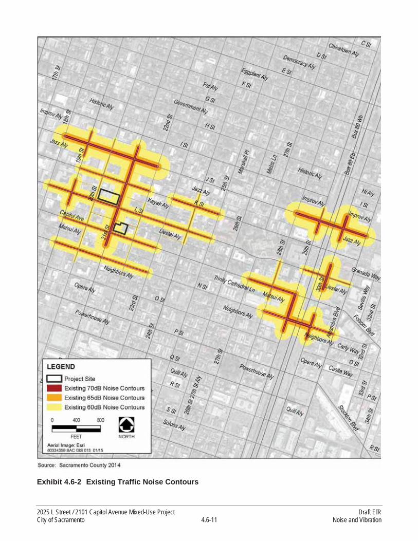
Exhibit 4.6-2 Existing Traffic Noise Contours
2025 L Street / 2101 Capitol Avenue Mixed-Use Project Draft EIRCity of Sacramento 4.6-11 Noise and Vibration
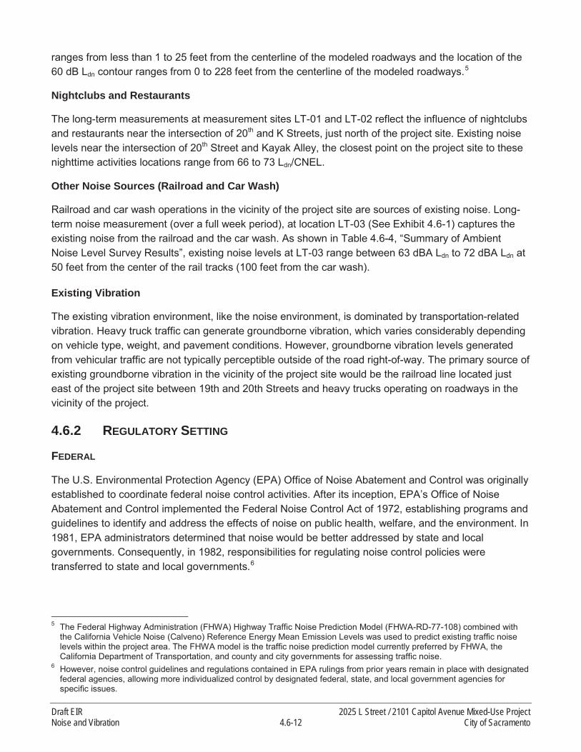
ranges from less than 1 to 25 feet from the centerline of the modeled roadways and the location of the 60 dB Ldn contour ranges from 0 to 228 feet from the centerline of the modeled roadways.5
Nightclubs and Restaurants
The long-term measurements at measurement sites LT-01 and LT-02 reflect the influence of nightclubs and restaurants near the intersection of 20th and K Streets, just north of the project site. Existing noise levels near the intersection of 20th Street and Kayak Alley, the closest point on the project site to these nighttime activities locations range from 66 to 73 Ldn/CNEL.
Other Noise Sources (Railroad and Car Wash)
Railroad and car wash operations in the vicinity of the project site are sources of existing noise. Long-term noise measurement (over a full week period), at location LT-03 (See Exhibit 4.6-1) captures the existing noise from the railroad and the car wash. As shown in Table 4.6-4, “Summary of Ambient Noise Level Survey Results”, existing noise levels at LT-03 range between 63 dBA Ldn to 72 dBA Ldn at 50 feet from the center of the rail tracks (100 feet from the car wash).
Existing Vibration
The existing vibration environment, like the noise environment, is dominated by transportation-related vibration. Heavy truck traffic can generate groundborne vibration, which varies considerably depending on vehicle type, weight, and pavement conditions. However, groundborne vibration levels generated from vehicular traffic are not typically perceptible outside of the road right-of-way. The primary source of existing groundborne vibration in the vicinity of the project site would be the railroad line located just east of the project site between 19th and 20th Streets and heavy trucks operating on roadways in the vicinity of the project.
4.6.2 REGULATORY SETTING
FEDERAL
The U.S. Environmental Protection Agency (EPA) Office of Noise Abatement and Control was originally established to coordinate federal noise control activities. After its inception, EPA’s Office of Noise Abatement and Control implemented the Federal Noise Control Act of 1972, establishing programs and guidelines to identify and address the effects of noise on public health, welfare, and the environment. In 1981, EPA administrators determined that noise would be better addressed by state and local governments. Consequently, in 1982, responsibilities for regulating noise control policies were transferred to state and local governments.6
5 The Federal Highway Administration (FHWA) Highway Traffic Noise Prediction Model (FHWA-RD-77-108) combined with the California Vehicle Noise (Calveno) Reference Energy Mean Emission Levels was used to predict existing traffic noise levels within the project area. The FHWA model is the traffic noise prediction model currently preferred by FHWA, the California Department of Transportation, and county and city governments for assessing traffic noise.
6 However, noise control guidelines and regulations contained in EPA rulings from prior years remain in place with designated federal agencies, allowing more individualized control by designated federal, state, and local government agencies for specific issues.
Draft EIR 2025 L Street / 2101 Capitol Avenue Mixed-Use ProjectNoise and Vibration 4.6-12 City of Sacramento

FTA has published a technical manual titled Transit Noise and Vibration Impact Assessment that provides criteria for groundborne vibration impacts with respect to building damage during construction activities (FTA 2006). Although the proposed project would not be subject to FTA guidelines, they are relevant nonetheless for assessing impacts. According to FTA guidelines, a vibration-damage criterion of 0.20 in/sec PPV should be considered for non-engineered timber and masonry buildings.Furthermore, structures or buildings constructed of reinforced concrete, steel, or timber have avibration-damage criterion of 0.50 in/sec PPV, pursuant to the FTA guidelines.
To address human response (annoyance) to groundborne vibration, FTA has established vibrationthresholds for different land uses. These guidelines recommend 65 VdB or less for land uses where low ambient vibration is essential for interior operations (e.g., hospitals, high-tech manufacturing, laboratory facilities), 80 VdB or less for residential uses and buildings where people normally sleep, and 83 VdB or less for institutional land uses with primarily daytime operations (e.g., schools, churches, clinics, offices) (FTA 2006, p. 8-3).
STATE
Title 24 of the California Code of Regulations, also known as the California Building Standards Code, establishes building standards applicable to all occupancies throughout the state. The code provides acoustical regulations for both exterior-to-interior sound insulation, as well as sound and impact insulation between adjacent spaces of various occupied units. Title 24 regulations state that interior noise levels generated by exterior noise sources shall not exceed 45 dB Ldn, with windows closed, in any habitable room for residential uses.
LOCAL
Sacramento 2030 General Plan
The following goals and policies from the City of Sacramento 2030 General Plan are related to noise and vibration (City of Sacramento 2009):.
Goal EC 3.1 Noise Reduction. Minimize noise impacts on human activity to ensure the health and safety of the community.
Policy EC 3.1.1 Exterior Noise Standards. The City shall require noise mitigation for alldevelopment where the projected exterior noise levels exceed those shown in Table EC 1[reproduced below as Table 4.6-6], to the extent feasible.
Table 4.6-6 presents acceptable and unacceptable community noise exposure limits for various land use categories. The guidelines also present adjustment factors that may be used to arrive at noise acceptability standards, reflecting the noise control goals of the community, the particular community’s sensitivity to noise, and the community’s assessment of the relative importance of noise pollution. In instances where attainment of the normally acceptable exterior noise level is not possible with best available noise reduction measures, the General Plan allows an exterior noise level exceeding the acceptable Ldn, up to the conditionally acceptable range, provided that noise level reduction measures have been implemented and that interior noise level standards are achieved.
2025 L Street / 2101 Capitol Avenue Mixed-Use Project Draft EIRCity of Sacramento 4.6-13 Noise and Vibration

Table 4.6-6Exterior Noise Compatibility Standards for Various Land Uses
Land Use Type Highest Level of Noise Exposure that is Regarded as “Normally Acceptable”a (Ldnb or CNELc)
Residential—Low Densityh Single Family, Duplex, Mobile Homes 60 dBAd,e
Residential—Multi-familyi 65 dBAUrban Residential Infillf and Mixed-Use Projectsg 70 dBATransient Lodging—Motels, Hotels 65 dBASchools, Libraries, Churches, Hospitals, Nursing Homes 70 dBAAuditoriums, Concert Halls, Amphitheaters Mitigation based on site-specific studySports Arena, Outdoor Spectator Sports Mitigation based on site-specific studyPlaygrounds, Neighborhood Parks 70 dBAGolf Courses, Riding Stables, Water Recreation, Cemeteries 75 dBAOffice Buildings—Business, Commercial and Professional 70 dBAIndustrial, Manufacturing, Utilities, Agriculture 75 dBANotes:dBA = A-weighted decibels; Leq = equivalent noise level; CNEL = community noise equivalent levela As defined in the State of California General Plan Guidelines, “Normally Acceptable” means that the “specified land use is satisfactory,
based upon the assumption that any building involved is of normal conventional construction, without any special noise insulation requirements.”
b Ldn or day-night average level is an average 24-hour noise measurement that factors in day and night noise levels.c CNEL or community noise equivalent level measurements are a weighted average of sound levels gathered throughout a 24-hour period.d dBA or A-weighted decibel scale is a measurement of noise levels.e The exterior noise standard for the residential area west of McClellan Airport known as McClellan Heights/Parker Homes is 65 dBA.f With land use designations of Central Business District, Urban Neighborhood (Low, Medium, or High) Urban Center (Low or High), Urban
Corridor (Low or High).g All mixed-use projects located anywhere in the City of Sacramento.h Applies to the primary open space area of a detached single-family home, duplex, or mobile home, which is typically the backyard or fenced
side yard, as measured from the center of the primary open space area (not the property line). This standard does not apply to secondary open space areas, such as front yards, balconies, stoops, and porches.
I Applies to the primary open space areas of townhomes and multi-family apartments or condominiums (private year yards for townhomes; common courtyards, roof gardens, or gathering spaces for multi-family developments).These standards shall not apply to balconies or small attached patios in multistoried multi-family structures.
Source: City of Sacramento 2009a: Table EC 1; adapted by AECOM in 2015
Policy EC 3.1.2 Exterior Incremental Noise Standards. The City shall require noise mitigation for all development that increases existing noise levels by more than the allowable increment shown in Table EC 2 [reproduced below as Table 4.6-7], to the extent feasible.
Policy EC 3.1.3 Interior Noise Standards. The City shall require new development to include noise mitigation to assure acceptable interior noise levels appropriate to the land use type: 45 dBA Ldn for residential, transient lodgings, hospitals, nursing homes and other uses where people normally sleep; and 45 dBA Leq (peak hour) for office buildings and similar uses.
Policy EC 3.1.4 Interior Noise Review for Multiple, Loud Short-Term Events. In cases where new development is proposed in areas subject to frequent, high-noise events (such as aircraft over-flights, or train and truck pass-bys), the City shall evaluate noise impacts on any sensitive receptors from such events when considering whether to approve the development proposal, taking into
Draft EIR 2025 L Street / 2101 Capitol Avenue Mixed-Use ProjectNoise and Vibration 4.6-14 City of Sacramento
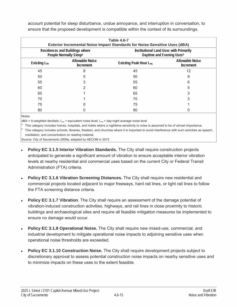
account potential for sleep disturbance, undue annoyance, and interruption in conversation, to ensure that the proposed development is compatible within the context of its surroundings.
Table 4.6-7Exterior Incremental Noise Impact Standards for Noise-Sensitive Uses (dBA)
Residences and Buildings wherePeople Normally Sleepa
Institutional Land Uses with PrimarilyDaytime and Evening Usesb
Existing LdnAllowable Noise
Increment Existing Peak Hour LeqAllowable Noise
Increment45 8 45 1250 5 50 955 3 55 660 2 60 565 1 65 370 1 70 375 0 75 180 0 80 0
Notes:dBA = A-weighted decibels; Leq = equivalent noise level; Leq = day-night average noise levela This category includes homes, hospitals, and hotels where a nighttime sensitivity to noise is assumed to be of utmost importance.b This category includes schools, libraries, theaters, and churches where it is important to avoid interference with such activities as speech,
meditation, and concentration on reading material.Source: City of Sacramento 2009a; adapted by AECOM in 2015
Policy EC 3.1.5 Interior Vibration Standards. The City shall require construction projects anticipated to generate a significant amount of vibration to ensure acceptable interior vibration levels at nearby residential and commercial uses based on the current City or Federal Transit Administration (FTA) criteria.
Policy EC 3.1.6 Vibration Screening Distances. The City shall require new residential and commercial projects located adjacent to major freeways, hard rail lines, or light rail lines to follow the FTA screening distance criteria.
Policy EC 3.1.7 Vibration. The City shall require an assessment of the damage potential of vibration-induced construction activities, highways, and rail lines in close proximity to historic buildings and archaeological sites and require all feasible mitigation measures be implemented to ensure no damage would occur.
Policy EC 3.1.8 Operational Noise. The City shall require new mixed-use, commercial, and industrial development to mitigate operational noise impacts to adjoining sensitive uses when operational noise thresholds are exceeded.
Policy EC 3.1.10 Construction Noise. The City shall require development projects subject to discretionary approval to assess potential construction noise impacts on nearby sensitive uses and to minimize impacts on these uses to the extent feasible.
2025 L Street / 2101 Capitol Avenue Mixed-Use Project Draft EIRCity of Sacramento 4.6-15 Noise and Vibration

Sacramento 2035 General Plan
The proposed project was initiated when the 2030 General Plan was in force. Since that time, the City has prepared an update to the 2030 General Plan. The 2035 General Plan proposes to replace Policy EC 3.1.6 above with the following similar policy:
Policy EC 3.1.6 Vibration Screening Distances. Effects of Vibration. The City shall consider potential effects of vibration when reviewing new residential and commercial projects that are proposed in the vicinity of rail lines or light rail lines.
City of Sacramento Noise Ordinance
The City of Sacramento Noise Ordinance (Section 8.68 of the Sacramento City Code) states that it is unlawful for any person at any location within the City to create any noise that causes ambient noise levels at an affected receptor to exceed the noise standards shown in Table 4.6-8. Table 4.6-9standards are specifically applicable to sources of noise that can be controlled at the local level. TheCity’s standards do not apply to traffic, aircraft, or railroad noise exposure, since control of noise from those sources is subject to state or federal oversight, and not subject to local control.
Table 4.6-8Noise Ordinance Standards Applicable at Exterior Spaces of Residential Uses
Cumulative Duration of Intrusive Sound Noise Metric Daytime, dB Nighttime, dBCumulative period of 30 minutes per hour L50 55 50Cumulative period of 15 minutes per hour L25 60 55Cumulative period of 5 minutes per hour L08 65 60Cumulative period of 1 minute per hour L02 70 65Level not to be exceeded for any time during hour Lmax 75 70Notes: dB = A-weighted decibels; Lmax = maximum noise levelDaytime is defined as 7 a.m. to 10 p.m. and Nighttime is defined as 10 p.m. to 7 a.m. Each of the noise limits specified above shall be
reduced by 5 dBA for impulsive or simple tone noise or for noises consisting of speech or music. If the existing ambient noise levels exceed that permitted in the first four noise-limit categories, the allowable limit shall be increased in 5 dB increments to encompass the ambient.
Source: City of Sacramento
Section 8.68.080.D, Exemptions, exempts from the Noise Ordinance standards those noise sources due to the erection (including excavation), demolition, alteration, or repair of any building or structure between the hours of 7 a.m. and 6 p.m., on Monday through Saturday, and between 9 a.m. and 6 p.m. on Sunday; provided, however, that the operation of an internal combustion engine shall not be exempt pursuant to this subsection if such engine is not equipped with suitable exhaust and intake silencers that are in good working order. The director of building inspections may permit work to be done during the hours not exempt by this subsection in the case of urgent necessity and in the interest of public health and welfare for a period not to exceed three days.
Draft EIR 2025 L Street / 2101 Capitol Avenue Mixed-Use ProjectNoise and Vibration 4.6-16 City of Sacramento
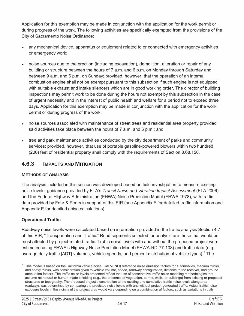
Application for this exemption may be made in conjunction with the application for the work permit or during progress of the work. The following activities are specifically exempted from the provisions of the City of Sacramento Noise Ordinance:
any mechanical device, apparatus or equipment related to or connected with emergency activities or emergency work;
noise sources due to the erection (including excavation), demolition, alteration or repair of any building or structure between the hours of 7 a.m. and 6 p.m. on Monday through Saturday and between 9 a.m. and 6 p.m. on Sunday; provided, however, that the operation of an internal combustion engine shall not be exempt pursuant to this subsection if such engine is not equipped with suitable exhaust and intake silencers which are in good working order. The director of building inspections may permit work to be done during the hours not exempt by this subsection in the case of urgent necessity and in the interest of public health and welfare for a period not to exceed three days. Application for this exemption may be made in conjunction with the application for the work permit or during progress of the work;
noise sources associated with maintenance of street trees and residential area property provided said activities take place between the hours of 7 a.m. and 6 p.m.; and
tree and park maintenance activities conducted by the city department of parks and community services; provided, however, that use of portable gasoline-powered blowers within two hundred(200) feet of residential property shall comply with the requirements of Section 8.68.150.
4.6.3 IMPACTS AND MITIGATION
METHODS OF ANALYSIS
The analysis included in this section was developed based on field investigation to measure existing noise levels, guidance provided by FTA’s Transit Noise and Vibration Impact Assessment (FTA 2006) and the Federal Highway Administration (FHWA) Noise Prediction Model (FHWA 1978), with traffic data provided by Fehr & Peers in support of this EIR (see Appendix F for detailed traffic information and Appendix E for detailed noise calculations).
Operational Traffic
Roadway noise levels were calculated based on information provided in the traffic analysis Section 4.7of this EIR, “Transportation and Traffic.” Road segments selected for analysis are those that would be most affected by project-related traffic. Traffic noise levels with and without the proposed project were estimated using FHWA’s Highway Noise Prediction Model (FHWA-RD-77-108) and traffic data (e.g., average daily traffic [ADT] volumes, vehicle speeds, and percent distribution of vehicle types).7 The
7 This model is based on the California vehicle noise (CALVENO) reference noise emission factors for automobiles, medium trucks, and heavy trucks, with consideration given to vehicle volume, speed, roadway configuration, distance to the receiver, and ground attenuation factors. The traffic noise levels presented reflect the use of conservative traffic noise modeling methodologies that assume no natural or human-made shielding (e.g., the presence of vegetation, berms, walls, or buildings) from existing or proposed structures or topography. The proposed project’s contribution to the existing and cumulative traffic noise levels along area roadways was determined by comparing the predicted noise levels with and without project-generated traffic. Actual traffic noise exposure levels in the vicinity of the project area would vary depending on a combination of factors, such as variations in daily
2025 L Street / 2101 Capitol Avenue Mixed-Use Project Draft EIRCity of Sacramento 4.6-17 Noise and Vibration

modeled roadway noise levels assume no natural or artificial shielding; therefore, these estimates should be considered conservative (potentially overestimating impacts). Actual traffic noise exposure levels near the project site would vary depending on a combination of factors, such as variations in daily traffic volumes, shielding provided by existing and proposed structures, and meteorological conditions. See Appendix E of this EIR for complete modeling inputs and results. Table 4.6-9summarizes modeled Ldn at 50 feet from the roadway centerline. Exhibit 4.6-3 shows the existing plus project traffic noise contours.
Rail Operations
Impacts associated with implementation of the proposed project are evaluated by assessing exposure of noise-sensitive receptors to daily noise from railroad operations relative to the City of Sacramento’s exterior noise compatibility standard of 70 dBA Ldn or CNEL for urban residential infill and mixed-use projects and interior noise standard of 45 dB Ldn. This noise exposure assessment also takes into account the exterior to interior noise attenuation benefit associated with standard construction practices for assessment, relative to interior noise standards. Transmission loss of noise for common building materials ranges between 18 and 40 dBA depending on the type, thickness and weight of walls (FHWA 2011). According to EPA average sound-level reduction would be 15 dB with windows open and 25 dB with windows closed (EPA 1974). The mostly likely range of indoor noise levels is shown in Table 4.6-10 for noise-sensitive uses near the project site. New residential construction and renovation(with insulated windows, door weather stripping and thresholds, and exterior wall insulation) would beexpected to provide an exterior-to-interior noise level reduction of at least 34 dBA with doors and windows closed (FHWA 2011, Building Performance Centre 2007).
Noise-sensitive receptors with exposure to exterior noise levels less than 70 dB Ldn would experience interior noise levels in compliance with the interior standard. To evaluate the effects of the railroad operation noise on the project site, the mean SEL of events measured were calculated. Using the mean SEL, the number of rail operations per day (9) a noise level of 66 dBA Ldn at 50 feet from the center of rail tracks were calculated. The 2025 L Street component of the proposed project would be located at a distance of 200 feet from the railroad tracks. Assuming a standard transportation noise source attenuation rate of 4.5 dB per doubling of distance between the source and receptor, noise-sensitive land uses under the proposed project could be exposed to noise levels of 57 dBA Ldn at the first-floor façade. The second floor, floors above the second floor, and the gathering areas along 20th Street are conservatively assumed to be exposed to 60 dB Ldn because of a +3 dB offset applied to account for building reflections.
Noise is generated at car wash facilities by high pressure water nozzles, automated washing equipment, vacuums, and large blow dryers. Noise measurements of various car wash facilities indicate typical noise average noise levels of 70-80 dBA at a distance of 50 feet from the wash tunnels are common (Sacramento 1993). To evaluate the effects of car washing noise on the project site, 75 dBA Ldn at 50 feet was assumed as the noise level from the car wash, and assuming an attenuation rate of 6 dB per doubling of distance between a point source and receptor, and based on the distance to the project site (250 feet), existing noise from the car wash at the proposed project site would be 62 dB Ldn
traffic volumes, shielding provided by existing and proposed structures, and meteorological conditions. See Appendix E of this EIR for complete modeling inputs and results.
Draft EIR 2025 L Street / 2101 Capitol Avenue Mixed-Use ProjectNoise and Vibration 4.6-18 City of Sacramento
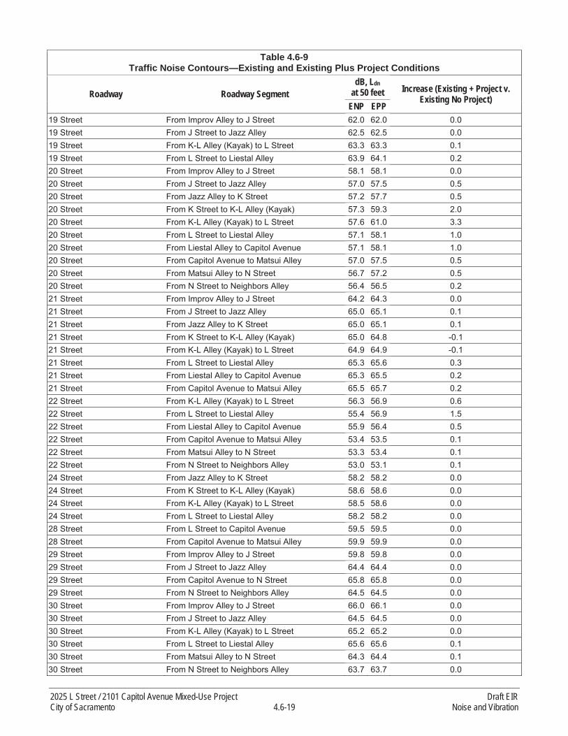
Table 4.6-9Traffic Noise Contours—Existing and Existing Plus Project Conditions
Roadway Roadway SegmentdB, Ldn
at 50 feet Increase (Existing + Project v. Existing No Project)
ENP EPP19 Street From Improv Alley to J Street 62.0 62.0 0.019 Street From J Street to Jazz Alley 62.5 62.5 0.019 Street From K-L Alley (Kayak) to L Street 63.3 63.3 0.119 Street From L Street to Liestal Alley 63.9 64.1 0.220 Street From Improv Alley to J Street 58.1 58.1 0.020 Street From J Street to Jazz Alley 57.0 57.5 0.520 Street From Jazz Alley to K Street 57.2 57.7 0.520 Street From K Street to K-L Alley (Kayak) 57.3 59.3 2.020 Street From K-L Alley (Kayak) to L Street 57.6 61.0 3.320 Street From L Street to Liestal Alley 57.1 58.1 1.020 Street From Liestal Alley to Capitol Avenue 57.1 58.1 1.020 Street From Capitol Avenue to Matsui Alley 57.0 57.5 0.520 Street From Matsui Alley to N Street 56.7 57.2 0.520 Street From N Street to Neighbors Alley 56.4 56.5 0.221 Street From Improv Alley to J Street 64.2 64.3 0.021 Street From J Street to Jazz Alley 65.0 65.1 0.121 Street From Jazz Alley to K Street 65.0 65.1 0.121 Street From K Street to K-L Alley (Kayak) 65.0 64.8 -0.121 Street From K-L Alley (Kayak) to L Street 64.9 64.9 -0.121 Street From L Street to Liestal Alley 65.3 65.6 0.321 Street From Liestal Alley to Capitol Avenue 65.3 65.5 0.221 Street From Capitol Avenue to Matsui Alley 65.5 65.7 0.222 Street From K-L Alley (Kayak) to L Street 56.3 56.9 0.622 Street From L Street to Liestal Alley 55.4 56.9 1.522 Street From Liestal Alley to Capitol Avenue 55.9 56.4 0.522 Street From Capitol Avenue to Matsui Alley 53.4 53.5 0.122 Street From Matsui Alley to N Street 53.3 53.4 0.122 Street From N Street to Neighbors Alley 53.0 53.1 0.124 Street From Jazz Alley to K Street 58.2 58.2 0.024 Street From K Street to K-L Alley (Kayak) 58.6 58.6 0.024 Street From K-L Alley (Kayak) to L Street 58.5 58.6 0.024 Street From L Street to Liestal Alley 58.2 58.2 0.028 Street From L Street to Capitol Avenue 59.5 59.5 0.028 Street From Capitol Avenue to Matsui Alley 59.9 59.9 0.029 Street From Improv Alley to J Street 59.8 59.8 0.029 Street From J Street to Jazz Alley 64.4 64.4 0.029 Street From Capitol Avenue to N Street 65.8 65.8 0.029 Street From N Street to Neighbors Alley 64.5 64.5 0.030 Street From Improv Alley to J Street 66.0 66.1 0.030 Street From J Street to Jazz Alley 64.5 64.5 0.030 Street From K-L Alley (Kayak) to L Street 65.2 65.2 0.030 Street From L Street to Liestal Alley 65.6 65.6 0.130 Street From Matsui Alley to N Street 64.3 64.4 0.130 Street From N Street to Neighbors Alley 63.7 63.7 0.0
2025 L Street / 2101 Capitol Avenue Mixed-Use Project Draft EIRCity of Sacramento 4.6-19 Noise and Vibration

Table 4.6-9Traffic Noise Contours—Existing and Existing Plus Project Conditions
Roadway Roadway SegmentdB, Ldn
at 50 feet Increase (Existing + Project v. Existing No Project)
ENP EPPJ Street From 18th Street to 19th Street 65.8 65.9 0.1J Street From 19th Street to 20th Street 65.6 65.7 0.1J Street From 20th Street to 21st Street 65.7 65.7 0.1J Street From 21st Street to 22nd Street 66.3 66.3 0.1J Street From 28th Street to 29th Street 65.8 65.9 0.1J Street From 29th Street to 30th Street 65.5 65.6 0.1J Street From 30th Street to Alhambra Boulevard 65.1 65.1 0.0K Street From 19th Street to 20th Street 62.1 62.3 0.2K Street From 20th Street to 21st Street 62.3 62.9 0.6K Street From 21st Street to 22nd Street 62.8 62.9 0.1K Street From 23rd Street to 24th Street 62.9 63.0 0.1K Street From 24th Street to 25th Street 63.0 63.1 0.1Kayak Alley (K-L) From 19th Street to 20th Street 49.0 49.3 0.3Kayak Alley (K-L) From 20th Street to 21st Street 46.9 46.9 0.0Kayak Alley (K-L) From 21st Street to 22nd Street 46.9 46.9 0.0L Street From 18th Street to 19th Street 62.9 63.0 0.1L Street From 19th Street to 20th Street 63.2 63.5 0.2L Street From 20th Street to 21st Street 63.1 63.7 0.6L Street From 21st Street to 22nd Street 62.5 62.5 -0.1L Street From 22nd Street to 23rd Street 62.1 62.3 0.2L Street From 23rd Street to 24th Street 62.5 62.6 0.2L Street From 24th Street to 25th Street 62.1 62.2 0.2L Street From 29th Street to 30th Street 61.8 61.9 0.1L Street From 30th Street to Alhambra Boulevard 59.8 59.8 0.0Liestal Alley (L-Capitol) From 20th Street to 21st Street 51.2 51.2 0.0Liestal Alley (L-Capitol) From 21st Street to 22nd Street 51.0 55.7 4.7Liestal Alley (L-Capitol) From 23rd Street to 24th Street 47.4 47.6 0.2Capitol Avenue From 19th Street to 20th Street 62.1 62.2 0.1Capitol Avenue From 20th Street to 21st Street 62.2 62.4 0.2Capitol Avenue From 21st Street to 22nd Street 62.5 62.7 0.2Capitol Avenue From 22nd Street to 23rd Street 62.6 62.8 0.2Capitol Avenue From 27th Street to 28th Street 63.9 64.1 0.1Capitol Avenue From 28th Street to 29th Street 64.6 64.7 0.1N Street From 19th Street to 20th Street 63.0 63.1 0.1N Street From 20th Street to 21st Street 62.9 63.0 0.2N Street From 21st Street to 22nd Street 62.5 62.6 0.1N Street From 22nd Street to 23rd Street 62.5 62.7 0.1N Street From 28th Street to 29th Street 64.0 64.0 0.1N Street From 29th Street to 30th Street 66.6 66.6 0.1N Street From 30th Street to Alhambra Boulevard 63.1 63.1 0.0
Notes: dB = A-weighted decibels; Ldn = day-night average noise level; ENP = Existing No Project; EPP = Existing Plus Project1 Based on Table 4.6-7 “Exterior Incremental Noise Impact Standards for Noise-Sensitive Uses (dBA)”.Source: Modeling conducted by AECOM in 2015
Draft EIR 2025 L Street / 2101 Capitol Avenue Mixed-Use ProjectNoise and Vibration 4.6-20 City of Sacramento
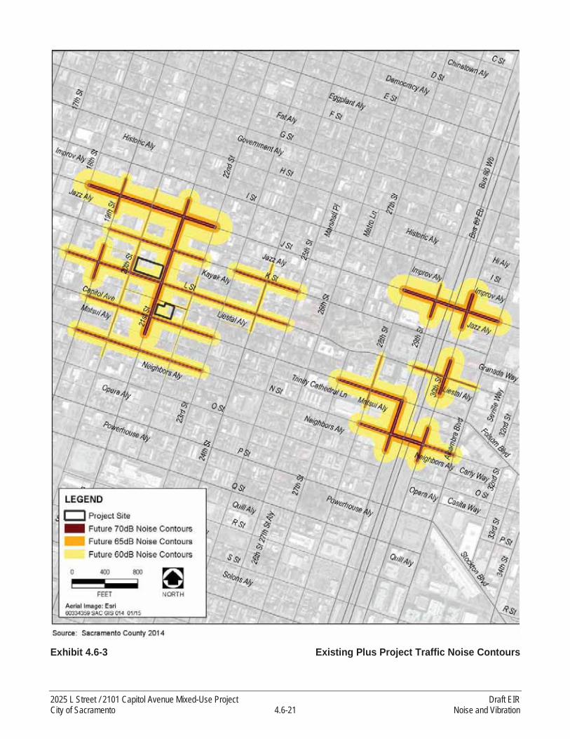
Exhibit 4.6-3 Existing Plus Project Traffic Noise Contours
2025 L Street / 2101 Capitol Avenue Mixed-Use Project Draft EIRCity of Sacramento 4.6-21 Noise and Vibration
Table 4.6-10Worst-Case Construction Equipment Noise Levels at nearest Uses in the Project Vicinity
Project Component Location
Worst-Case (Shortest) Distance Between Noise-
Sensitive Uses and Proposed Construction Areas
Worst-Case Outdoor
Construction Noise Level,
dBA Leq
Doors and Windows
Open, dBA Leq
Doors and Windows
Closed, dBA Leq
2025 L Street
Pool area at 2000 K Street 30 feet to the north 91 76 66
Office building (2020 L Street) 80 feet to the south 83 68 58
Residence 1217 20th Street 250 feet to the south 73 58 48Apartments (St. Anton building) at 2100 L Street 120 feet to the southeast 79 64 54
Outdoor seating areas (1928 L Street) 200 feet to the southwest 75 60 50
2101 Capitol Avenue
Restaurant (1217 21st Street) 5 feet to the north 107 92 82Apartments (St. Anton building) (2100 L Street) 25 feet to the north 93 78 68
Residence at 1214 22nd Street 30 feet to the northeast 91 76 66Office building (2131 Capitol Avenue) 30 feet to the east 91 76 66
Apartments (2110 L Street) 100 feet to the south 81 66 56Outdoor seating areas of restaurants (2004 Capitol Avenue)
350 feet to the west 70 55 45
Notes: dB = A-weighted decibels; Leq = equivalent noise levelSource: Modeling conducted by AECOM in 2015
at the first-floor façade. Second floor and floors above are expected to be exposed to 65 dB Ldn
because of a +3 dB offset applied to account for building reflections.
Construction Equipment Noise
Construction noise levels for the project were estimated using FHWA Roadway Construction Noise Model (FHWA 2006) at nearby off-site sensitive receptors, shown in Table 4.6-10. As shown, compiled noise levels generated by various construction activities during the site grading and excavation stage would be 87 dBA Leq, at 50 feet, resulting a noise levels of 70 dBA Leq to 107 dBA Leq at the nearest sensitive receptors, which are 5 to 350 feet from the nearest proposed construction activities. Transmission loss of noise for common building materials range between 18 and 40 dBA depending on the type, thickness and weight of walls (FHWA 2011). Approximate national average sound-level reduction would be 15 dB with windows open and 25 dB with windows closed (EPA 1974). The mostly likely range of indoor noise levels is shown in Table 4.6-10 for noise sensitive uses near the project site. New residential construction and renovation (with insulated windows, door weather stripping and thresholds, and exterior wall insulation) would be expected to provide an exterior-to-interior noise level reduction of at least 34 dBA with doors and windows closed (FHWA 2011, Building Performance Centre 2007).
Draft EIR 2025 L Street / 2101 Capitol Avenue Mixed-Use ProjectNoise and Vibration 4.6-22 City of Sacramento

Construction Traffic
Construction traffic noise levels were estimated making the assumption of a maximum of 500 daily trips. Project construction is anticipated to involve lower numbers of trips to and from the project site and the assumption of 500 trips per day was made to show conservative results. Project construction–related increases in traffic noise levels along these roadway segments would range from 0.2 to 9.0 dBusing this conservative assumption of the maximum daily trips (Table 4.6-11).
Construction Vibration
Construction activities could result in varying degrees of temporary, short-term ground vibration, depending on the construction equipment used. Ground vibration levels for project construction were estimated by examining various types of construction equipment that could be used on-site and results are displayed for each of the closest vibration-sensitive uses to the project sites (2025 L Street, and 2101 Capitol Avenue).
Pile Installation
The proposed project would also require piles for building foundations. Temporary noise and vibration is associated with different techniques for installing piles. The project proposes use of an auger-cast pile foundation system. This technique was selected due to the presence of existing occupied buildings adjacent to the project site and because the technique is essentially a vibration less pile system (Hutchinson, pers. comm. 2015). As an industry standard of practice, this pile system is typically not monitored during installation due to the very low vibration and noise. Auger cast in place grouted piles are a drilled and pumped pile, not a driven pile. This eliminates the hammer impact noise created by driving piles. The elimination of a pile-driving hammer allows the installation of auger cast in place grouted piles adjacent to existing structures without the danger of settlement or damage to existing footings, walls, other structural components, or nearby equipment caused by vibrations. Vibration and noise associated with this technique for pile installation is expected to be below the City’s significance thresholds (Hutchinson, pers. comm. 2015).
Auger cast in place piles are installed by rotating a continuous flight hollow shaft auger into the soil. High strength sand cement grout is pumped through the hollow shaft as the auger is slowly withdrawn while slowly turning. The resulting grout column hardens and forms an auger cast in place grouted pile (American Deep Foundation 2015).
Operational Vibration
Long-term operational groundborne vibration impacts on the new sensitive uses proposed under the project are also analyzed in this EIR. Groundborne vibration levels resulting from operational activities (from the railroad) near the project site (crossing L Street and between 19th and 20th Streets) were estimated using data and equations published by FTA in its Transit Noise and Vibration Impact Assessment document.
2025 L Street / 2101 Capitol Avenue Mixed-Use Project Draft EIRCity of Sacramento 4.6-23 Noise and Vibration

Table 4.6-11Traffic Noise Contours—Existing and Existing plus Construction Traffic Conditions
Roadway Roadway Segment Existing dB, Leq at 50 Feet
Existing + Construction
dB, Leq at 50 FeetIncrease
19 Street From Improv Alley to J Street 62.5 63.1 0.619 Street From J Street to Jazz Alley 63.0 63.6 0.619 Street From K-L Alley (Kayak) to L Street 63.8 64.3 0.519 Street From L Street to Liestal Alley 64.4 64.9 0.420 Street From Improv Alley to J Street 58.6 60.1 1.420 Street From J Street to Jazz Alley 57.5 59.3 1.720 Street From Jazz Alley to K Street 57.7 59.4 1.720 Street From K Street to K-L Alley (Kayak) 57.9 59.5 1.620 Street From K-L Alley (Kayak) to L Street 58.2 59.7 1.520 Street From L Street to Liestal Alley 57.6 59.3 1.720 Street From Liestal Alley to Capitol Avenue 57.6 59.3 1.720 Street From Capitol Avenue to Matsui Alley 57.5 59.3 1.720 Street From Matsui Alley to N Street 57.3 59.1 1.820 Street From N Street to Neighbors Alley 56.9 58.9 2.021 Street From Improv Alley to J Street 64.8 65.2 0.421 Street From J Street to Jazz Alley 65.5 65.9 0.321 Street From Jazz Alley to K Street 65.5 65.9 0.321 Street From K Street to K-L Alley (Kayak) 65.5 65.8 0.321 Street From K-L Alley (Kayak) to L Street 65.5 65.8 0.321 Street From L Street to Liestal Alley 65.8 66.2 0.321 Street From Liestal Alley to Capitol Avenue 65.8 66.1 0.321 Street From Capitol Avenue to Matsui Alley 66.1 66.4 0.322 Street From K-L Alley (Kayak) to L Street 56.8 58.8 2.022 Street From L Street to Liestal Alley 56.0 58.3 2.322 Street From Liestal Alley to Capitol Avenue 56.4 58.6 2.122 Street From Capitol Avenue to Matsui Alley 54.0 57.2 3.322 Street From Matsui Alley to N Street 53.8 57.2 3.422 Street From N Street to Neighbors Alley 53.5 57.0 3.524 Street From Jazz Alley to K Street 58.7 60.1 1.424 Street From K Street to K-L Alley (Kayak) 59.1 60.4 1.324 Street From K-L Alley (Kayak) to L Street 59.1 60.4 1.324 Street From L Street to Liestal Alley 58.7 60.1 1.428 Street From L Street to Capitol Avenue 60.0 61.1 1.128 Street From Capitol Avenue to Matsui Alley 60.4 61.4 1.029 Street From Improv Alley to J Street 60.3 61.3 1.029 Street From J Street to Jazz Alley 64.9 65.3 0.429 Street From Capitol Avenue to N Street 66.3 66.6 0.329 Street From N Street to Neighbors Alley 65.0 65.4 0.430 Street From Improv Alley to J Street 66.6 66.8 0.330 Street From J Street to Jazz Alley 65.0 65.4 0.430 Street From K-L Alley (Kayak) to L Street 65.7 66.1 0.330 Street From L Street to Liestal Alley 66.1 66.4 0.330 Street From Matsui Alley to N Street 64.9 65.3 0.4
Draft EIR 2025 L Street / 2101 Capitol Avenue Mixed-Use ProjectNoise and Vibration 4.6-24 City of Sacramento

Table 4.6-11Traffic Noise Contours—Existing and Existing plus Construction Traffic Conditions
Roadway Roadway Segment Existing dB, Leq at 50 Feet
Existing + Construction
dB, Leq at 50 FeetIncrease
30 Street From N Street to Neighbors Alley 64.2 64.7 0.4J Street From 18th Street to 19th Street 66.4 66.6 0.3J Street From 19th Street to 20th Street 66.1 66.4 0.3J Street From 20th Street to 21st Street 66.2 66.5 0.3J Street From 21st Street to 22nd Street 66.8 67.0 0.2J Street From 28th Street to 29th Street 66.4 66.6 0.3J Street From 29th Street to 30th Street 66.1 66.3 0.3
J Street From 30th Street to Alhambra Boulevard 65.6 66.0 0.3
K Street From 19th Street to 20th Street 62.6 63.2 0.6K Street From 20th Street to 21st Street 62.8 63.4 0.6K Street From 21st Street to 22nd Street 63.3 63.9 0.5K Street From 23rd Street to 24th Street 63.4 63.9 0.5K Street From 24th Street to 25th Street 63.6 64.1 0.5K-L Alley From 20th Street to 21st Street 47.4 55.3 7.8L Street From 18th Street to 19th Street 63.4 64.0 0.5L Street From 19th Street to 20th Street 63.8 64.3 0.5L Street From 20th Street to 21st Street 63.6 64.1 0.5L Street From 21st Street to 22nd Street 63.1 63.6 0.6L Street From 22nd Street to 23rd Street 62.7 63.3 0.6L Street From 23rd Street to 24th Street 63.0 63.6 0.6L Street From 24th Street to 25th Street 62.6 63.2 0.6L Street From 29th Street to 30th Street 62.3 63.0 0.7
L Street From 30th Street to Alhambra Boulevard 60.3 61.3 1.0
L-Capitol Alley From 20th Street to 21st Street 51.7 56.3 4.6Capitol Avenue From 19th Street to 20th Street 62.7 63.3 0.6Capitol Avenue From 20th Street to 21st Street 62.8 63.4 0.6Capitol Avenue From 21st Street to 22nd Street 63.0 63.6 0.6Capitol Avenue From 22nd Street to 23rd Street 63.1 63.7 0.6Capitol Avenue From 27th Street to 28th Street 64.5 64.9 0.4Capitol Avenue From 28th Street to 29th Street 65.2 65.5 0.4N Street From 19th Street to 20th Street 63.5 64.0 0.5N Street From 20th Street to 21st Street 63.4 63.9 0.5N Street From 21st Street to 22nd Street 63.0 63.6 0.6N Street From 22nd Street to 23rd Street 63.1 63.6 0.6N Street From 28th Street to 29th Street 64.5 64.9 0.4N Street From 29th Street to 30th Street 67.1 67.4 0.2
N Street From 30th Street to Alhambra Boulevard 63.6 64.1 0.5
Notes: dB = A-weighted decibels; Leq = equivalent noise level1 Based on Table 4.6-7 “Exterior Incremental Noise Impact Standards for Noise-Sensitive Uses (dBA)”.Source: Modeling conducted by AECOM in 2015
2025 L Street / 2101 Capitol Avenue Mixed-Use Project Draft EIRCity of Sacramento 4.6-25 Noise and Vibration

Table 4.6-12Representative Noise and Vibration Source Levels for Construction Equipment at 2025 L Street
Equipment
PPV
at 25
Fee
t (in
/sec)
1
Appr
oxim
ate L
v(V
dB) a
t 25 F
eet2
Actu
al L m
ax(d
BA) a
t 50 F
eet
Nearest Receptors: 2025 L Street
North - Pool area (2000K Street)
South - Residence (121720th Street)
South - Office building (2020 L Street)
East - Apartment building (St. Anton Building) at 2100
L StreetWest - Outdoor seating
areas (1928 L Street)
Dist
ance Vi
brat
ion
Noise
Dist
ance Vi
brat
ion
Noise
Dist
ance Vi
brat
ion
Noise
Dist
ance Vi
brat
ion
Noise
Dist
ance Vi
brat
ion
Noise
PPV
VdB
L eq
(dBA
)
PPV
VdB
L eq
(dBA
)
PPV
VdB
L eq
(dBA
)
PPV
VdB
L eq
(dBA
)
PPV
VdB
L eq
(dBA
)
Large bulldozer 0.09 87 85
30
0.07 85 82
250
0.003 85 57
80
0.02 72 74
120
0.01 67 70
200
0.00 60 66
Loaded trucks 0.08 86 88 0.06 84 84 0.002 84 56 0.01 71 76 0.01 66 72 0.00 59 68
Jack-hammer 0.04 79 88 0.03 77 82 0.001 77 49 0.01 64 74 0.00 59 70 0.00 52 66
Small bulldozer 0.00 58 85 0.00 56 85 0.000 56 28 <0.001 43 77 <0.001 38 73 <0.00
1 <40 69
Significance Threshold 0.5 80 0.5 80 0.5 80 0.5 80 0.5 80
Notes: in/sec = inches per second; VdB = vibration decibels; Leq = equivalent noise level; dBA = A-weighted decibels; Lmax = maximum 1 Where PPV is the peak particle velocity.2 here Lv is the root mean square velocity expressed in vibration decibels (VdB), assuming a crest factor of 4.Source: FTA 2006
Draft EIR 2025 L Street / 2101 Capitol Avenue Mixed-Use ProjectNoise and Vibration 4.6-26 City of Sacramento

Table 4.6-13Representative Vibration Source Levels for Construction Equipment at 2101 Capitol Avenue
Equipment
PPV
at 25
Fee
t (in
/sec)
1
Appr
oxim
ate L
v(V
dB) a
t 25 F
eet2
Actu
al L m
ax(d
BA) a
t 50 F
eet
Nearest Receptors: 2101 Capitol Avenue
North – Restaurant (1217 21st Street –
“Kupros Craft House”)
North - Apartments(2100 L Street)
Northeast - Residence(1214 22nd Street)
East - Office Building (2131 Capitol Avenue)
South - Apartments (2110L Street)
West - Outdoor seating areas of restaurants
(2004 Capitol Avenue)
Dist
ance Vi
brat
ion
Noise
Dist
ance Vi
brat
ion
Noise
Dist
ance Vi
brat
ion
Noise
Dist
ance Vi
brat
ion
Noise
Dist
ance Vi
brat
ion
Noise
Dist
ance Vi
brat
ion
Noise
PPV
VdB
L eq
(dBA
)
PPV
VdB
L eq
(dBA
)
PPV
VdB Leq
(dBA) PP
V
VdB
L eq
(dBA
)
PPV
VdB
L eq
(dBA
)
PPV
VdB
L eq
(dBA
)
Large bulldozer 0.09 87 85
5
1.00 108 98
25
0.09 87 84
30
0.07 85 82
30
0.07 85 82
100
0.01 69 72
350
0.00 53 61
Loaded trucks 0.08 86 88 0.85 107 100 0.08 86 86 0.06 84 84 0.06 84 84 0.01 68 74 0.00 52 63
Jack-hammer 0.04 79 88 0.39 100 98 0.04 79 84 0.03 77 82 0.03 77 82 0.00 61 72 0.00 45 61
Small bulldozer 0.00 58 85 0.03 79 101 0.00 58 87 0.00 56 85 0.00 56 85 <0.001 40 75 <0.001 <40 64
Significance Threshold 0.2 80 0.5 80 0.5 80 0.5 80 0.5 80 0.5 80
Notes: in/sec = inches per second; VdB = vibration decibels; Leq = equivalent noise level; dBA = A-weighted decibels1 Where PPV is the peak particle velocity.2 here Lv is the root mean square velocity expressed in vibration decibels (VdB), assuming a crest factor of 4.Source: FTA 2006
2025 L Street / 2101 Capitol Avenue Mixed-Use Project Draft EIRCity of Sacramento 4.6-27 Noise and Vibration

THRESHOLDS OF SIGNIFICANCE
In consideration of the performance criteria from the Appendix G of the State CEQA Guidelines, and the City of Sacramento Environmental Checklist, noise and vibration impacts are considered significant if the proposed project would:
result in exposure to ambient exterior noise levels that exceed standards in the City’s General Plan;
result in residential interior noise levels of 45 dBA Ldn or greater caused by noise level increases due to project operation;
result in construction noise levels that violate the standards in the City of Sacramento Noise Ordinance or cause a substantial temporary increase in ambient noise levels;
expose existing and/or planned residential and commercial areas to vibration peak-particle velocities greater than 0.5-inch per second or vibration levels greater than 80 VdB due to project construction; or
expose adjacent residential and commercial areas to vibration peak particle velocities greater than 0.5 inch per second or vibration levels greater than 80 VdB due to operations.
The proposed project would have no impact related to location within an airport land use plan, within 2miles of a public airport or public-use airport, or be located in the vicinity of a private airstrip.
Also, there are no historic buildings/structures and archaeological sites in the vicinity of the proposed project sites (2025 L Street, and 2101 Capitol Avenue), that would be exposed to vibration-peak-particle velocities greater than 0.2 inch per second due to project construction or operations. However, due to the age of the building 1217 21st Street housed by “Kupros Craft House,” built in approximately the 1920s, it is treated as “historic” for the purposes of this section only.
IMPACTS AND MITIGATION
IMPACT 4.6-1
The proposed project could result in exposure to ambient exterior noise levels that exceed standards in the City’s General Plan. Based on the analysis below, this impact is considered less than significant with mitigation.
Project Traffic Noise Generation
Project operation would result in an increase in traffic volumes, and consequently, an increase in traffic noise. To assess traffic noise impacts on existing noise-sensitive uses, traffic noise levels with andwithout the proposed project were estimated for affected roadway segments. The modeled roadway noise levels assume no natural or artificial shielding. Therefore, these estimates should be considered conservative (potentially overestimating impacts) for purposes of this EIR.
Table 4.6-9 summarizes modeled Ldn at 50 feet from the roadway centerline for affected roadwaysegments under existing conditions and with proposed project implementation. As shown in Table 4.6-9,the noise levels along existing roadways would increase as a result of project operational traffic ranging
Draft EIR 2025 L Street / 2101 Capitol Avenue Mixed-Use ProjectNoise and Vibration 4.6-28 City of Sacramento

from +0.0 dB to +4.7 dB above existing traffic noise levels. However, increases from project operational traffic noise would mostly be below the exterior noise impact criteria shown in Table 4.6-4. The traffic noise increases due to the proposed project would be 1.3 dB and 1.7 dB above the exterior noise impact criteria (shown in Table 4.6-4) and only along two roadway segments (along 20th Street from Kayak Alley to L Street, and along L Street between 23rd and 24th Streets), respectively. There are no exterior noise-sensitive uses along 20th Street from Kayak Alley to L Street, and along L Street between 23rd and 24th Streets, and there would not be any exterior noise sensitive uses under the proposed project along 20th Street from Kayak Alley to L Street. Therefore, this impact is considered less than significant.
Mitigation Measures
None required.
Exposure of Planned Land Uses to Traffic Noise
To satisfy the City’s land use/noise compatibility criteria (2030 General Plan Policy EC 3.1.1, Table 4.6-6) at proposed and existing noise-sensitive uses, where feasible, exterior noise exposure at these uses may not exceed 70 dB Ldn for urban residential infill and mixed-use projects, and schools. As shown in Table 4.6-9, the predicted traffic noise levels along the analyzed roadways would not exceed 66.6 dB Ldn, which would be below the City’s 70-dB Ldn General Plan standard. Based on the noise measurements and the predicted traffic noise levels along the roadways surrounding the project site (i.e., K-L Alley, L, 20th, and 21st Streets), the future proposed residential/hotel uses would be exposed to exterior noise levels ranging from 47 dBA Ldn along the northern boundary (facing K-L Alley) to 65dBA Ldn along the southern boundary (facing L Street). Applying a +3 dB offset to account for building reflections, areas at the edge of the proposed podium gathering areas are expected to be exposed to noise ranging from 50 dBA Ldn to 68 dBA Ldn. Therefore, the exterior noise levels at the residential/gathering uses meet the City’s land use/noise compatibility criteria (2030 General Plan Policy EC 3.1.1, Table 4.6-6) of 70 dB Ldn for urban residential infill and mixed-use projects. This impact is considered less than significant.
Mitigation Measures
None required.
Rail Operations
Implementation of the 2025 L Street component of the proposed project would expose new noise-sensitive receptors to daily noise from the freight train noise that operates in the project vicinity (between 19th Street and 20th Street and crossing L Street). To evaluate the effects of the railroad operation noise on the project site, the mean SEL of events measured was calculated as 99 dBA. Using the mean SEL, the number of rail operations per day (9) a noise level of 66 dBA Ldn at 50 feet from the center of rail tracks was calculated under existing condition, and using the mean SEL of 99 dBA, the number of rail operations per day (18, conservatively assuming 100 percent increase over existingcondition) a noise level of 69 dBA Ldn at 50 feet from the center of rail tracks was calculated for future (2035) condition. The 2025 L Street component of the proposed project would be located at a distance
2025 L Street / 2101 Capitol Avenue Mixed-Use Project Draft EIRCity of Sacramento 4.6-29 Noise and Vibration

of 200 feet from the railroad tracks. Assuming a standard transportation noise source attenuation rate of 4.5 dB per doubling of distance between the source and receptor, noise-sensitive land uses under the proposed project could be exposed to noise levels of 57 dBA Ldn at the first-floor façade. The second floor, floors above the second floor, and the gathering areas along 20th Street are conservatively assumed to be exposed to 60 dB Ldn because of a +3 dB offset applied to account for building reflections. Under future (2035) condition, noise-sensitive land uses under the proposed project could be exposed to noise levels of 60 dBA Ldn at the first-floor façade. The second floor, floors above the second floor, and the gathering areas along 20th Street are conservatively assumed to be exposedto 63 dB Ldn because of a +3 dB offset applied to account for building reflections. These levels of trainnoise would below the threshold of 70 dB Ldn shown above in Table 4.6-6 for Urban Residential Infilland Mixed-Use Projects. Therefore, exterior noise impacts at proposed residential uses from the rail operations are less than significant.
Mitigation Measures
None required.
Stationary Noise Sources
Noise is generated at car wash facilities by high pressure water nozzles, automated washing equipment, vacuums, and large blow dryers. Noise measurements of various car wash facilities indicate typical noise average noise levels of 70-80 dBA at a distance of 50 feet from the wash tunnels are common (Sacramento County2011). To evaluate the effects of car washing noise on the new noise-sensitive uses under the proposed project (2025 L Street), 75 dBA Ldn at 50 feet was conservatively assumed as the noise-level from the car wash for this EIR, and assuming an attenuation rate of 6 dB per doubling of distance between a point source and receptor, and based on the distance to the project site (250 feet), existing noise from the car wash at the project site would be 62 dB Ldn at the first-floor façade and the gathering areas along 20th Street. Second floor and floors above are expected to be exposed to 65 dB Ldn because of a +3 dB offset applied to account for building reflections. This level of noise would be below the threshold of 70 dB Ldn for urban residential infill and mixed-use projects(Table 4.6-6). Therefore, the impact is less than significant.
Occupation of the proposed dwellings would expose adjacent residences to noise. Noise typically associated with residential development includes amplified music, voices, recreational activities, and lawn and home maintenance equipment. Activities associated with residential operations would result in only minor and intermittent temporary noise exposure, as perceived at the closest residential receptors, primarily during the day and evening hours.
The proposed project would result in additional activity and people on the project site – both residents and visitors. However, the character of noise generation after implementation of the proposed project is anticipated to be similar to existing conditions since the project proposes similar land uses to those that exist on-site and in the vicinity of the project site and since noise levels are related to land use types. The proposed project does not propose any on-site substantial sources of noise (such as outdoor manufacturing activities, long-term operation of heavy machinery, or other operational noise sources). Surface parking lots are a source of noise currently and the proposed project would convert some of the surface parking areas to parking garages. This could reduce noise exposure related to vehicle
Draft EIR 2025 L Street / 2101 Capitol Avenue Mixed-Use ProjectNoise and Vibration 4.6-30 City of Sacramento
engine noise and vehicle doors closing since the parking structures would attenuate noise experienced by adjacent sensitive receptors. The 24-hour noise-level measurements taken to document existing conditions, including nighttime activities from uses developed along K Street just north of the 2025 L street property, are representative of a developed, urban environment. Noise sources from these long-term noise measurements were primarily traffic noise. After project implementation, traffic noise is expected to continue to be the primary source of noise in the vicinity of the project site, since the proposed project does not propose any substantial stationary sources of noise.
The proposed project could require the operation of exterior mechanical equipment (i.e., air conditioning units). Air conditioning can produce noise levels in the range of 45-70 dB Leq at a distance of 50 feet (EPA 1974, Stanford University 2010). Depending on the distance between mechanical equipment and adjacent noise-sensitive uses, noise levels could potentially exceed the City’s ambient noise standards. This impact is considered potentially significant.
Mitigation Measures
Mitigation Measure 4.6-1: Select, Locate, Design, and Shield Mechanical Equipment Acceptable to City Standards.
The project applicant and contractor(s) shall demonstrate on building plans that the selection, location, design, and/or shielding of noise-generating equipment on-site will comply with the City’s exterior noise standards prior to issuance of a building permit. Noise-generating mechanical equipment (e.g., HVAC units) shall be selected to be of a type that would not produce noise in excess of City noise standards and/or shall be shielded, designed, or located at a distance that would reduce noise levels at noise-sensitive outdoor activity areas for both on-and off-site residences to acceptable levels, as identified in the City’s General Plan. Shielding may include the use of fences or partial equipment enclosures. To provide effectiveness, fences or barriers shall be continuous or solid, with no gaps, and shall block the line-of-sight to windows of neighboring dwellings.
Significance after Mitigation
Selecting quieter noise-generating mechanical equipment (e.g., HVAC units) and/or shielding or locating equipment at a distance that would reduce noise levels at noise-sensitive outdoor activity areas would reduce noise levels to those considered acceptable under the City’s General Plan. A combination of distance, design, and shielding has been shown to be effective in substantially reducing mechanical noise. Achievable noise reductions from fences or barriers can vary, but typically range from approximately 5-10 dB, depending on construction characteristics, height, and location. Therefore, the impact is less than significant with mitigation.
IMPACT 4.6-2
The proposed project could result in residential interior noise levels of 45 dBA Ldn or greater caused by noise-level increases due to project operation. Based on the analysis below, this impact is considered less than significant.
2025 L Street / 2101 Capitol Avenue Mixed-Use Project Draft EIRCity of Sacramento 4.6-31 Noise and Vibration
Traffic Noise
With respect to interior noise levels, transmission loss of noise for common building materials range between 18 and 40 dBA depending on the type, thickness, and weight of walls (FHWA 2011). According to EPA, average sound-level reductions would be 15 dB with windows open and 25 dB withwindows closed (EPA 1974). The mostly likely range of indoor noise levels is shown in Table 4.6-10 for noise-sensitive uses near the project site. New residential construction and renovation (with insulated windows, door weather stripping and thresholds, and exterior wall insulation) would be expected to provide an exterior-to-interior noise-level reduction of at least 34 dBA with doors and windows closed (FHWA 2011, Building Performance Centre 2007). However, to provide conservative analysis for the purposes of this EIR, assuming a 25-dB attenuation provided by the building exterior façade for existing noise-sensitive uses, noise-sensitive receptors with exposure to exterior noise levels less than 70 dB Ldn would experience interior noise levels in compliance with the City of Sacramento’s 45 dB Ldn
standard. The maximum exterior noise level due to the project traffic increase would be 67 dB Ldn at 50 feet, as shown in Table 4.6-9. The resulting interior noise levels for any sensitive use within 50 feet of the centerline of roadways affected by project traffic noise would be approximately 42 dBA Ldn, which would be below the City’s acceptable 45 dBA Ldn significance threshold. Newer buildings, including those proposed as a part of the proposed project, would exceed the 25-dBA attenuation that is conservatively assumed for the purposes of this analysis since newer building materials and design provide higher levels of noise attenuation compared to older construction, and since materials anticipated to be used in project construction (concrete, steel) are estimated to have higher attenuation benefits (at least 34 dBA of attenuation from outdoor to indoor) (FHWA 2011). Therefore, this impact is considered less than significant.
Mitigation Measures
None required.
Other Noise Sources
Occupation of the proposed dwellings would expose adjacent residences to noise. Noise typically associated with residential development includes amplified music, voices, recreational activities, and lawn and home maintenance equipment. Activities associated with residential operations would result in only minor and intermittent temporary noise exposure, as perceived at the closest residential receptors, primarily during the day and evening hours. Although additional residents would be on-site, the character of noise generation is anticipated to be similar to existing conditions. The proposed project does not propose substantial sources of noise.
New noise-sensitive uses under the 2025 L Street component of the proposed project would be located at a distance of 200 feet from the existing railroad tracks (between 19th Street and 20th Street and crossing L Street). As described under “Methods of Analysis” for the railroad operation, a noise level of 66 dBA Ldn at 50 feet from the center of rail tracks was calculated. Assuming a standard transportation noise source attenuation rate of 4.5 dB per doubling of distance between the source and receptor, noise-sensitive land uses under the proposed project could be exposed to noise levels of 57 dBA Ldn at the first-floor façade. The second floor, floors above the second floor, and the gathering areas along 20th Street are conservatively assumed to be exposed to 60 dB Ldn because of a +3 dB offset applied
Draft EIR 2025 L Street / 2101 Capitol Avenue Mixed-Use ProjectNoise and Vibration 4.6-32 City of Sacramento
to account for building reflections. Under future (2035) condition, noise-sensitive land uses under the proposed project could be exposed to noise levels of 60 dBA Ldn at the first-floor façade. The second floor and floors above the second floor are conservatively assumed to be exposed to 63 dB Ldn
because of a +3 dB offset applied to account for building reflections. Although new residential construction and renovation (with insulated windows, door weather stripping and thresholds, and exterior wall insulation) would be expected to provide an exterior-to-interior noise-level reduction of at least 34 dBA with doors and windows closed, with a conservative assumption of a 25-dB attenuation, noise-sensitive receptors with exposure to exterior noise levels less than 70 dB Ldn would experience interior noise levels in compliance with the City of Sacramento’s 45 dB Ldn standard. Therefore, exterior noise impacts at proposed residential uses from the rail operations are less than significant.
Nighttime activities, particularly those located within commercial areas, such as nightclubs and bars generate noise levels that disturb nearby residents when they are trying to sleep. New noise-sensitive uses under the 2025 L Street component of the proposed project would be exposed to noise from night activities at the restaurants and clubs along 20th Street between K and L Streets. Assuming a 34-dB attenuation for new noise-sensitive uses at 2025 L Street component of the proposed project (FHWA 2011, Building Performance Centre 2007), noise-sensitive receptors with exposure to exterior noise levels less than 79 dB Ldn would experience interior noise levels in compliance with the City of Sacramento’s 45 dB Ldn standard. Noise levels from the night time activities were measured over the weekend at the northeast corner of the project site as shown Exhibit 4.6-1 as LT-01. The measured noise levels at this location (LT-02) were higher the weekends (December 19 and 20, and December 26 and 27, 2014) and ranged from 71 to 73 dBA Ldn over, as shown in Table 4.6-4. Also, as shown, the equivalent noise levels (Leq) over the weekend are higher at nighttime (10 p.m.–7 a.m.) than the levels at daytime (7 a.m.–7 p.m.). Therefore, these levels would represent the worst-case noise levels from the night activities in the project vicinity. The maximum exterior noise level due to the nighttime activities was conservatively assumed to be 73 dB Ldn at the project site. Assuming a 34-dB attenuationfrom outdoor to indoor (FHWA 2011), for new noise-sensitive uses (FHWA at 2025 L Street component of the proposed project, the resulting interior noise levels would be approximately 39 dBA Ldn, which would be below the City’s acceptable 45 dBA Ldn significance threshold. Therefore, this impact is considered less than significant.
Occupation of the proposed dwellings would expose adjacent residences to noise. Noise typically associated with residential development includes amplified music, voices, recreational activities, and lawn and home maintenance equipment. Activities associated with residential operations would result in only minor and intermittent temporary noise exposure, as perceived at the closest residential receptors, primarily during the day and evening hours. Although additional residents would be on-site, the character of noise generation is anticipated to be similar to existing conditions. The proposed project does not propose substantial sources of noise. There would be no impact.
Mitigation Measures
None required.
2025 L Street / 2101 Capitol Avenue Mixed-Use Project Draft EIRCity of Sacramento 4.6-33 Noise and Vibration

IMPACT 4.6-3
The proposed project could result in construction noise levels that exceed the standards in the City of Sacramento Noise Ordinance or cause a substantial temporary, short-term increase in ambient noise levels. Based on the analysis below, this impact is considered significant.
Construction Traffic
Construction of the proposed project would result in additional vehicle trips on the local roadway network as workers commute and equipment and materials are transported. The exact number of daily trips required for project construction is not known at this time. However, based on the level and scale of construction activities, the proposed project is anticipated to require substantially fewer than 500daily one-way trips, even when intensive earth movement activities (e.g., soil import/export) are underway. This is used as a conservative assumption for the purposes of this EIR analysis.
Table 4.6-11 summarizes the modeled traffic noise levels under Existing and Existing plus Construction traffic at 50 feet from the centerline of the studied roadway segments near the project site. As shown, project construction-related increases in traffic noise levels along the studied roadway segments would range from 0.2 dB to 7.8 dB. As described previously, a 3-dBA increase in noise levels is justperceptible (Egan 1988). There would be five segments with an increase of at least 3 dB or more due to construction traffic, using the conservative assumptions outlined above. Of these, the maximum noise level would be approximately 57 dB, Leq at 50 feet from the centerline with the addition of construction-related traffic. This does not approach the City’s exterior noise standards (60 dBA for low-density residential, 65 dBA for multi-family residential, and 70 dBA for urban residential infill and mixed-use projects). Therefore, construction traffic noise impacts are less than significant.
Mitigation Measure
None required.
Construction Equipment
The proposed project would generate construction noise from equipment operating on the project site,building demolition, and from the transport of construction workers and equipment to and from the site.Construction activities would include building demolition, site clearing and excavation and site preparation, building construction, and renovation. Operation of heavy-duty construction equipment would be intermittent throughout the day during construction. Construction would occur over the course of approximately 1 year for the 2101 Capitol Avenue property and approximately 1.5 years for the 2025 L Street property. Construction noise levels would vary over this time. The highest noise levels would be expected to occur in association with demolition and foundation construction. These activities are expected to last for a relatively short amount of time as compared to building construction, which would generate substantially lower levels of construction noise. The approach used in this EIR focuses on the worst-case location regarding sensitive receptors and the worst-case (noisiest) construction activities.
Noise would be generated by equipment such as graders, backhoes, skip loaders, water trucks, pile installation, and other miscellaneous equipment. Construction noise levels for the proposed project were estimated using the FHWA Roadway Construction Noise Model (FHWA 2006) at nearby off-site sensitive receptors, shown in Table 4.6-10. As shown, noise levels generated by various construction
Draft EIR 2025 L Street / 2101 Capitol Avenue Mixed-Use ProjectNoise and Vibration 4.6-34 City of Sacramento
activities during the worst-case site preparation stage would be 70 to 107 dB Leq, at the closest noise-sensitive receptors to the project sites (2025 L Street and 2101 Capitol Avenue). The level of outdoor to indoor noise attenuation ranges from approximately 18 to 40 dBA, depending on the type, thickness,and weight of walls (FHWA 2011). Approximate average sound level reduction would be 15 dB with windows open and 25 dB with windows closed (EPA 1974). The mostly likely range of indoor noise levels is shown in Table 4.6-10 for noise-sensitive uses near the project site. New residential construction and renovation (with insulated windows, door weather stripping and thresholds, and exterior wall insulation) would be expected to provide an exterior-to-interior noise level reduction of at least 34 dBA with doors and windows closed (FHWA 2011, Building Performance Centre 2007). Construction equipment would be used in different portions of the site, but this is the estimated worst-case temporary noise level. Assuming an exterior-to-interior noise level reduction of at least 25 dB for wooden structures (doors and windows closed) (EPA 1974), construction equipment noise could result in a maximum temporary interior noise level of approximately 82 dBA Leq at the restaurant located 1217 21st Street north of the 2101 Capitol Avenue property when the noisiest part of construction activity occurs in the area directly adjacent to this structure. Maximum outdoor noise levels for the apartments at 2100 L Street, north of the 2101 Capitol Avenue property would be approximately 93 dBA Leq during the noisiest phase of construction when construction activities are directly adjacent to the apartment building. Maximum indoor noise levels for the apartments at 2100 L Street, would be approximately 68 dBA Leq during the noisiest phase of construction when construction activities are directly adjacent to the apartment building. Noise levels experienced from construction activities under the proposed project at other nearby receptors would be lower than this worst-case scenario and were estimated to be between 56 and 66 dBA Leq (as shown in Table 4.6-10). The impact is potentially significant,requiring mitigation (see Mitigation Measure 4.6-3a).
Installation of Piles
Foundations of the buildings proposed on-site could require the installation of piles to support the weight of the building (please see Appendix G of this EIR for geotechnical details). Temporary noise and vibration is associated with different techniques for installing piles. The project proposes use of an auger-cast pile foundation system. This technique was selected due to the presence of existing occupied buildings adjacent to the project site and because the technique is essentially a vibration less pile system (Hutchinson, pers. comm. 2015). As an industry standard of practice, this pile system is typically not monitored during installation due to the very low vibration and noise. Auger cast in place grouted piles are a drilled and pumped pile, not a driven pile. This eliminates the hammer impact noise created by driving piles (Hutchinson, pers. comm. 2015). Since this technique produces very low noise levels and is relatively new, the precise noise generation from this technique is not known and therefore the impact is conservatively assumed to be potentially significant, requiring mitigation (see Mitigation Measures 4.6-3a and 4.6-3b).
Noise Ordinance
Section 8.68.080 of the City’s Noise Ordinance exempts certain activities, including “noise sources due to the erection (including excavation), demolition, alteration or repair of any building or structure,” as long as these activities are limited to between the hours of 7 a.m. and 6 p.m. Monday through Saturday, and between the hours of 9 a.m. and 6 p.m. on Sunday. These exemptions are typical of city and
2025 L Street / 2101 Capitol Avenue Mixed-Use Project Draft EIRCity of Sacramento 4.6-35 Noise and Vibration

county noise ordinances and reflect the fact that construction-related noise is temporary and short-term,is generally acceptable when limited to daylight hours, and is expected as part of a typical urban noise environment (along with sirens). If project construction occurred outside City-allowed construction hours, this would represent a potentially significant impact, requiring mitigation (see Mitigation Measures 4.6-3a and 4.6-3b).
Mitigation Measures
Mitigation Measure 4.6-3a: Minimize Construction Noise.
The project applicant and contractor(s) shall implement the following measures throughout all construction phases.
Project construction traffic shall not use any alleys in the vicinity of the project with the exception Kayak Alley from 20th to 21st Street and Liestal Alley from 21st to 22nd Streets. Construction traffic shall avoid use of Liestal Alley from 21st to 22nd Streets to the maximum extent feasible.
The project shall comply with the City of Sacramento Noise Ordinance, including limitations on the hours of construction and conditions related to intake silencers for combustion engines.
Stationary construction equipment, such as compressors, shall have acoustical shielding and shall be placed as far away as is feasible from adjacent noise-sensitive uses when operated.
Idling times of equipment shall be minimized either by shutting equipment off when not in use or reducing the maximum idling time to 5 minutes.
The project applicant or designee shall designate a disturbance coordinator and conspicuously post this person's number around the project site and in construction notifications. The disturbance coordinator shall receive complaints about construction disturbances and, in coordination with the City, determine the cause of the complaint and implementation of feasible measures to alleviate the problem.
The project applicant or its designee shall provide written notice to all known occupied noise-sensitive uses (i.e., residential, educational, religious, lodging) within 400 feet of the edge of the project site boundary at least 2 weeks prior to the start of each construction phase of the construction schedule, as well as the name and contact information of the project disturbance coordinator.
Mitigation Measure 4.6-3b: Prepare and Implement a Noise and Vibration Control Plan for Pile Installation.
Any pile installation determined to be necessary for the project shall use the auger-cast pile foundation system.
Prior to the issuance of any building permit for any phase of project development that proposes the use of piles for foundations, the project applicant shall develop a Noise and Vibration
Draft EIR 2025 L Street / 2101 Capitol Avenue Mixed-Use ProjectNoise and Vibration 4.6-36 City of Sacramento
Control Plan, in coordination with an acoustical consultant, geotechnical engineer, and construction contractor, and submit the plan to the City’s Chief Building Official for review and approval. The plan shall include measures demonstrated to ensure construction noise exposure for the interior of nearby residential dwellings is at or below 45 dB Leq and that vibration exposure for adjacent buildings is less than 0.5 PPV and less than 80 VdB for adjacent residences and less than 0.2 PPV for the building at 1217 21st Street – “Kupros Craft House.” These performance standards shall take into account the reduction in vibration exposure that would occur through coupling loss provided by each affected building structure.
Prior to installation of piles for the 2101 Capitol Avenue property, the applicant shall contact the owner of the building at 1217 21st Street to photo document current conditions. This should include photos of existing cracks and other material conditions present on or at the surveyed building – both exterior and interior.
The construction contractor(s) shall regularly inspect and photograph the building at 121721st Street during installation of piles, collect vibration data, and report vibration levels to the City Chief Building Official on a monthly basis.
If, based on monitoring of building conditions or vibration levels, it is determined necessary to avoid damage, the project applicant shall coordinate with the Chief Building Official to implement corrective actions, which may include, but is not limited to building protection or stabilization.
Significance after Mitigation
The auger-cast pile foundation system was selected due to the presence of existing occupied buildings adjacent to the project site and because the technique is essentially a vibration less pile system (Hutchinson, pers. comm. 2015). Auger cast in place grouted piles are a drilled and pumped pile, not a driven pile. This eliminates the hammer impact noise created by driving piles (Hutchinson, pers. comm. 2015). Routing construction traffic to areas with fewer noise-sensitive receptors would reduce adverse noise impacts, as would limiting construction to less noise-sensitive parts of the day and locating noise-generating stationary equipment behind shields and distant from noise-sensitive uses. Section 8.68.080.D, Exemptions, exempts from the Noise Ordinance standards those noise sources due to the erection (including excavation), demolition, alteration, or repair of any building or structure between the hours of 7 a.m. and 6 p.m., on Monday through Saturday, and between 9 a.m. and 6 p.m. on Sunday; provided, however, that the operation of an internal combustion engine shall not be exempt pursuant to this subsection if such engine is not equipped with suitable exhaust and intake silencers that are in good working order. The disturbance coordinator will allow the project applicant, contractor(s), and the City to address problems that arise during construction, to the extent feasible. These approaches have been shown to be effective in reducing temporary and short-term construction impacts. The City’s Noise Ordinance exempts certain activities, in recognition of the fact that construction-related noise is temporary, more acceptable when limited to daylight hours, and is expected as part of a typical urban noise. Nonetheless, the City cannot demonstrate at this time that these measures would avoid, or fully reduce to less-than-significant levels a substantial temporary, short-term increase in ambient noise levels. Therefore, the impact would remain significant and unavoidable.
2025 L Street / 2101 Capitol Avenue Mixed-Use Project Draft EIRCity of Sacramento 4.6-37 Noise and Vibration

IMPACT 4.6-4
The project could permit existing and/or planned residential and commercial areas to be exposed to temporary and short-term vibration peak-particle velocities greater than 0.5-inch per second or vibration levels greater than 80 VdB due to project construction. Based on the analysis below, this impact is considered less than significant with mitigation.
Construction activities have the potential to result in varying degrees of temporary and short-term ground vibration, depending on the specific construction equipment used and operations involved. In general, vibration-induced structural damage occurs only when certain types of construction activity (e.g., pile driving, and heavy earthmoving) take place very close to existing structures. Vibration-induced disruption/annoyance could occur during more common types of construction activity (e.g., heavy earthmoving equipment) at a greater distance from the activity area. Ground vibration levels associated with various types of construction equipment, as published by FTA, are summarized in Tables 4.6-12 and 4.6-13.
Groundborne noise and vibration levels at the nearest off-site building structures and sensitive uses (surrounding the project site) were predicted based on the VdB and PPV reference vibration levels at 25 feet shown above in Tables 4.6-12 and 4.6-13.
The estimated maximum vibration levels at the nearest vibration-sensitive uses to the north at the apartments at 2100 L Street (St. Anton building) would be 0.09 PPV (87 VdB), at 25 feet, and to the northeast at the residence at 1214 22nd Street would be 0.07 PPV (85 VdB), at 30 feet. The maximum vibration levels to at the nearest structure for the 2025 L Street property (at 2000 K Street) would be 0.07 PPV (85 VdB), at 30 feet.
The project proposes use of an auger-cast pile foundation system. This technique was selected due to the presence of existing occupied buildings adjacent to the project site and because the technique is essentially a vibration less pile system (Hutchinson, pers. comm. 2015). As an industry standard of practice, this pile system is typically not monitored during installation due to the very low vibration and noise. Vibration levels inside these buildings would be reduced due to coupling loss provided by the building structure.8 The general rule is the heavier the building construction, the greater the coupling loss. According to FTA, the coupling loss for a large masonry building would be approximately 10 dB,for a two-story masonry building would be 7 dB, and for a wood frame house would be 5 dB (FTA, 2006). While the technique is considered essentially vibration-less, the City conservatively considers the impact to be potentially significant, requiring mitigation.
Mitigation Measures
Mitigation Measure 4.6-4: Implement Mitigation Measure 4.6-3b
Significance after Mitigation
Implementation of the identified mitigation measure would reduce construction vibration exposure consistent with the performance standards outlined in this EIR. Mitigation would be required to reduce
8 Coupling loss also known as connection loss is the loss that occurs when energy is transferred from one medium to another. Coupling loss is usually expressed in the same units—such as decibels—as in the originating medium.
Draft EIR 2025 L Street / 2101 Capitol Avenue Mixed-Use ProjectNoise and Vibration 4.6-38 City of Sacramento

vibration levels to 80 VdB or less to avoid the impact. This would minimize disruption of activity at vibration-sensitive receptors, consistent with the City’s significance thresholds. With mitigation, the impact is considered less than significant with mitigation.
IMPACT 4.6-5
The project could permit adjacent residential and commercial areas to be exposed to vibration peak particle velocities greater than 0.5-inch per second or vibration levels greater than 80 VdB due to operations. Based on the analysis below, this impact is considered less than significant.
Development proposed adjacent to the railroad line located between 19th and 20th Streets has the potential to be exposed to groundborne vibration that may affect buildings and their occupants (such as by disrupting activities or causing annoyance). In general, the potential for vibration-induced structural damage from such sources would be very rare, since vibration from such sources would not approach levels that would be strong enough to cause damage, but vibration-induced disruption/annoyance could occur if the uses were close enough (within 50 feet) to railroad lines (FTA 2006, p. 9-4).
The closest proposed buildings at the project site would be approximately 200 feet from the existing rail tracks between 19th and 20th Streets. Based on FTA data, heavy rail vehicles operating at 50 miles per hour (mph) would generate groundborne vibration of approximately 0.02 PPV (72 VdB) at a distance of 200 feet from the track’s centerline (FTA 2006, Figure 10-11 [reproduced below as Exhibit 4.6-4]). However, the existing trains in this area operate at a substantially lower speed (less than 30 mph, and generally about 25 mph at the L Street crossing) in the downtown area, which would generate lower groundborne vibration. According to the FTA, vibration generated by a train operating at 25 mph would be approximately 0.01 PPV (66 VdB). Therefore, groundborne vibration generated by the existing rail trains near the future residential building would be approximately 0.01 PPV (66 VdB), which is below the 0.5 PPV and 80 VdB threshold.
The proposed project would not involve activities that would generate substantial vibration during operation and there are no other known sources of existing vibration in the project vicinity to which on-site proposed vibration-sensitive uses or structures would be exposed. Normal operation of residential, office, commercial, and mixed-use buildings would be unlikely to generate substantial vibration or groundborne noise. Therefore, the vibration impacts from the existing rail line on the future residential uses at the project site would be less than significant.
Mitigation Measures
None required.
4.6.4 CUMULATIVE IMPACTS
Cumulative impacts refer to the combined effect of proposed project impacts with the impacts of other past, present, and reasonably foreseeable future projects. The geographic area that could be affected by a project varies, depending on the type of environmental issue being considered. This cumulative impact analyses does not rely on any list of specific pending, reasonably foreseeable development proposals in the general vicinity of the proposed project. Rather, cumulative impacts of the proposed project are considered in tandem with impacts of buildout conditions described in the Sacramento 2035
2025 L Street / 2101 Capitol Avenue Mixed-Use Project Draft EIRCity of Sacramento 4.6-39 Noise and Vibration

Source: FTA 2006, adapted by AECOM in 2015
Exhibit 4.6-4 Generalized Ground-Surface Vibration Curves
General Plan Master EIR.9 The City’s 2035 General Plan Master Environmental Impact Report does not provide a separate identification of cumulative impacts and instead identified that the impact analysis presented throughout the Master EIR is representative of both impacts of implementing the 2035 General Plan and also of cumulative impacts associated with implementation of the 2035 General Plan and other past, present, and future projects (p. 6-10).
For noise and vibration impacts, the geographic focus of the cumulative analysis is the direct project vicinity where project-related noise and vibration could combine with existing and future sources of noise and vibration. Although the proposed project would generate and attract trips on area and regional roadways, as well, as shown in Table 4.6-9, even on the roads most affected by project traffic, the operational traffic noise increase would be 1.3 dB and 1.7 dB above the threshold only along 20Street between Kayak Alley and L Street, and along Liestal Alley between 21st and 22nd Streets, and therefore the proposed project could not contribute in a meaningful way to any cumulative traffic noise impact.
9 Traffic volumes for cumulative scenario were developed to reflect changes in the regional transportation network and socio-demographic land use data between present and 2035 (see Section 4.7, “Transportation and Traffic” of this EIR for more detail). The year 2035 is the cumulative year for the traffic analysis because this is the cumulative year in the most recently updated travel demand model. This scenario also includes land use changes associated with the Entertainment and Sports Center, currently under construction.
Locomotive-PoweredPassenger or Freight (50 mph)
Rapid Transit or Light Rail Vehicles (50 mph)
Rubber-Tired Vehicles(30 mph)
100
95
90
85
80
75
70
65
60
55
5010 20 30 40 50 60 80 100 150 200 300
Draft EIR 2025 L Street / 2101 Capitol Avenue Mixed-Use ProjectNoise and Vibration 4.6-40 City of Sacramento

IMPACT 4.6-6
Cumulative impacts related to a permanent increase in ambient exterior noise levels. Based on the analysis below, the proposed project’s contribution to this cumulative impact is less than cumulatively considerable.
The City’s 2035 General Plan Master EIR identifies significant and unavoidable impacts related to exterior noise exposure (Impact 4.8-1, p. 4.8-8). This is a significant cumulative impact.
Noise impacts, by their nature, are localized impacts. Project operation would result in an increase in traffic volumes in the vicinity of the project site and consequently, an increase in traffic noise. To assesstraffic noise impacts on existing noise-sensitive uses, cumulative traffic noise levels with and without the proposed project were estimated for affected roadway segments. The modeled roadway noise levels assume no natural or artificial shielding. Therefore, these estimates are considered conservative for this EIR (potentially overestimating impacts).
Table 4.6-14 summarizes modeled Ldn at 50 feet from the roadway centerline for affected roadwaysegments under cumulative conditions and with proposed project implementation. As shown in Table 4.6-14, the noise levels along existing roadways would not increase substantially as a result of proposed project operational traffic. For all but three locations, the increase is 1 dB or less and this change in noise levels between cumulative no-project levels under the proposed project is consideredimperceptible. For 20th Street, between K Street and Kayak Alley, the increase associated with project traffic is estimated to be 1.7 dB, but there are no noise-sensitive uses along this segment and the modeled traffic noise levels are lower than existing ambient noise levels.
For 20th Street, between L Street and Kayak Alley, the increase associated with project traffic is estimated to be 2.9 dB, but there are no noise-sensitive uses along this segment and the modeled traffic noise levels are lower than existing ambient noise levels.
For Liestal Alley, between 21st Street and 22nd Street, the increase associated with project traffic is estimated to be 3.8 dB, but the modeled traffic noise levels are lower than existing ambient noise levels and the noise level associated with traffic under cumulative plus project conditions – 56 dB Ldn – is within the range considered acceptable for residential uses in the City’s General Plan.
The proposed project would also result in additional activity and people on the project site – both residents and visitors. However, the character of noise generation after implementation of the proposed project is anticipated to be similar to existing conditions since the project proposes similar land uses to those that exist on-site and in the vicinity of the project site. The proposed project does not propose any on-site substantial sources of noise that could combine with other sources of noise to create a cumulative impact. Furthermore, this EIR includes a project-level evaluation of noise impacts, which demonstrates that the proposed project would not cause a permanent increase in ambient exterior noise levels in excess of noise levels permitted by the City’s General Plan. The impact is considered less than cumulatively considerable.
2025 L Street / 2101 Capitol Avenue Mixed-Use Project Draft EIRCity of Sacramento 4.6-41 Noise and Vibration

Table 4.6-14Traffic Noise Contours—Cumulative and Cumulative Plus Project Conditions
Roadway Roadway SegmentdB, Ldn
at 50 feet Increase: Cumulative with Project v. Cumulative No Project.
CNP CPP19 Street From Improv Alley to J Street 63.1 63.1 0.019 Street From J Street to Jazz Alley 64.0 64.0 0.019 Street From K-L Alley (Kayak) to L Street 64.1 64.1 0.019 Street From L Street to Liestal Alley 64.7 64.8 0.120 Street From Improv Alley to J Street 59.1 59.1 0.020 Street From J Street to Jazz Alley 57.9 58.3 0.420 Street From Jazz Alley to K Street 58.3 58.7 0.420 Street From K Street to K-L Alley (Kayak) 58.1 59.8 1.720 Street From K-L Alley (Kayak) to L Street 58.4 61.3 2.920 Street From L Street to Liestal Alley 58.2 59.0 0.820 Street From Liestal Alley to Capitol Avenue 58.3 59.1 0.820 Street From Capitol Avenue to Matsui Alley 58.1 58.5 0.420 Street From Matsui Alley to N Street 58.1 58.5 0.420 Street From N Street to Neighbors Alley 57.8 58.0 0.121 Street From Improv Alley to J Street 64.7 64.7 0.021 Street From J Street to Jazz Alley 65.4 65.4 0.121 Street From Jazz Alley to K Street 65.4 65.4 0.121 Street From K Street to K-L Alley (Kayak) 65.3 65.2 -0.121 Street From K-L Alley (Kayak) to L Street 65.3 65.2 -0.121 Street From L Street to Liestal Alley 65.6 65.9 0.321 Street From Liestal Alley to Capitol Avenue 65.5 65.7 0.221 Street From Capitol Avenue to Matsui Alley 65.9 66.0 0.122 Street From K-L Alley (Kayak) to L Street 57.7 58.1 0.422 Street From L Street to Liestal Alley 57.3 58.3 1.022 Street From Liestal Alley to Capitol Avenue 58.1 58.4 0.322 Street From Capitol Avenue to Matsui Alley 57.1 57.1 0.022 Street From Matsui Alley to N Street 57.5 57.6 0.022 Street From N Street to Neighbors Alley 56.2 56.2 0.124 Street From Jazz Alley to K Street 58.6 58.7 0.024 Street From K Street to K-L Alley (Kayak) 58.8 58.8 0.024 Street From K-L Alley (Kayak) to L Street 58.8 58.8 0.024 Street From L Street to Liestal Alley 58.6 58.7 0.028 Street From L Street to Capitol Avenue 60.9 60.9 0.028 Street From Capitol Avenue to Matsui Alley 60.9 60.9 0.029 Street From Improv Alley to J Street 64.0 64.0 0.029 Street From J Street to Jazz Alley 66.5 66.5 0.029 Street From Capitol Avenue to N Street 66.2 66.2 0.029 Street From N Street to Neighbors Alley 65.2 65.2 0.030 Street From Improv Alley to J Street 64.9 64.9 0.030 Street From J Street to Jazz Alley 65.2 65.2 0.0
Draft EIR 2025 L Street / 2101 Capitol Avenue Mixed-Use ProjectNoise and Vibration 4.6-42 City of Sacramento

Table 4.6-14Traffic Noise Contours—Cumulative and Cumulative Plus Project Conditions
Roadway Roadway SegmentdB, Ldn
at 50 feet Increase: Cumulative with Project v. Cumulative No Project.
CNP CPP30 Street From K-L Alley (Kayak) to L Street 65.6 65.6 0.030 Street From L Street to Liestal Alley 66.1 66.1 0.030 Street From Matsui Alley to N Street 62.3 62.4 0.130 Street From N Street to Neighbors Alley 67.0 67.0 0.0J Street From 18th Street to 19th Street 66.2 66.3 0.1J Street From 19th Street to 20th Street 65.7 65.8 0.1J Street From 20th Street to 21st Street 65.8 65.9 0.1J Street From 21st Street to 22nd Street 66.4 66.5 0.1J Street From 28th Street to 29th Street 66.0 66.1 0.1J Street From 29th Street to 30th Street 67.0 67.0 0.0J Street From 30th Street to Alhambra Boulevard 65.4 65.4 0.0K Street From 19th Street to 20th Street 62.8 63.0 0.2K Street From 20th Street to 21st Street 62.9 63.5 0.5K Street From 21st Street to 22nd Street 63.4 63.5 0.1K Street From 23rd Street to 24th Street 63.2 63.3 0.1K Street From 24th Street to 25th Street 63.3 63.4 0.1K-L Alley From 19th Street to 20th Street 51.2 51.3 0.2K-L Alley From 20th Street to 21st Street 50.1 50.1 0.0K-L Alley From 21st Street to 22nd Street 49.1 49.1 0.0L Street From 18th Street to 19th Street 63.3 63.4 0.1L Street From 19th Street to 20th Street 63.6 63.8 0.2L Street From 20th Street to 21st Street 63.6 64.1 0.5L Street From 21st Street to 22nd Street 63.4 63.4 0.0L Street From 22nd Street to 23rd Street 63.1 63.2 0.1L Street From 23rd Street to 24th Street 63.2 63.4 0.1L Street From 24th Street to 25th Street 62.8 63.0 0.1L Street From 29th Street to 30th Street 63.3 63.3 0.1L Street From 30th Street to Alhambra Boulevard 61.4 61.4 0.0L-Capitol Alley From 20th Street to 21st Street 52.5 52.5 0.0L-Capitol Alley From 21st Street to 22nd Street 52.4 56.2 3.8L-Capitol Alley From 23rd Street to 24th Street 50.8 50.9 0.1Capitol Avenue From 19th Street to 20th Street 62.5 62.5 0.1Capitol Avenue From 20th Street to 21st Street 62.8 63.0 0.2Capitol Avenue From 21st Street to 22nd Street 63.2 63.4 0.2Capitol Avenue From 22nd Street to 23rd Street 63.4 63.6 0.2Capitol Avenue From 27th Street to 28th Street 64.8 64.9 0.1Capitol Avenue From 28th Street to 29th Street 65.4 65.4 0.1N Street From 19th Street to 20th Street 63.5 63.5 0.1N Street From 20th Street to 21st Street 63.3 63.4 0.1N Street From 21st Street to 22nd Street 62.8 62.9 0.1
2025 L Street / 2101 Capitol Avenue Mixed-Use Project Draft EIRCity of Sacramento 4.6-43 Noise and Vibration

Table 4.6-14Traffic Noise Contours—Cumulative and Cumulative Plus Project Conditions
Roadway Roadway SegmentdB, Ldn
at 50 feet Increase: Cumulative with Project v. Cumulative No Project.
CNP CPPN Street From 22nd Street to 23rd Street 63.0 63.1 0.1N Street From 28th Street to 29th Street 65.0 65.0 0.1N Street From 29th Street to 30th Street 67.1 67.2 0.0N Street From 30th Street to Alhambra Boulevard 61.7 61.7 0.0Notes: dB = A-weighted decibels; Ldn = day-night average noise level; CNP = Cumulative No Project; CPP = Cumulative Plus Project1 Based on Table 4.6-7 “Exterior Incremental Noise Impact Standards for Noise-Sensitive Uses (dBA)”.Source: Modeling conducted by AECOM in 2015
IMPACT 4.6-7
Cumulative impacts related to a residential interior noise levels during project operation. Based on the analysis below, the proposed project’s contribution to this cumulative impact is less than cumulatively considerable.
The City’s 2035 General Plan Master EIR identifies significant and unavoidable impacts related to interior noise exposure for residences (Impact 4.8-2, p. 4.8-17). This is a significant cumulative impact.
The maximum noise level for any sensitive use within 50 feet of roadways affected by cumulative with project traffic would be 67 dB Ldn, as shown in Table 4.6-14. Since traffic would continue to be the dominant source of noise on-site, and since a minimum 25-dBA noise reduction (EPA 1074) would beprovided by the building exterior façade, the expected maximum interior noise levels for any sensitive use would be approximately 42 dBA Ldn, which would be below the City’s acceptable 45-dBA Ldn
significance threshold.
Additional traffic noise caused by this increase would be imperceptible. The proposed project would also result in additional activity and people on the project site – both residents and visitors. However, the character of noise generation after implementation of the project is anticipated to be similar to existing conditions since the project proposes similar land uses to those that exist on-site and in the vicinity of the project site. The project does not propose any on-site substantial sources of noise that could combine with other sources of noise to create a cumulative impact. Furthermore, this EIR includes a project-level evaluation of noise impacts, which demonstrates that the proposed project would not cause a permanent increase in ambient exterior noise levels in excess of noise levels permitted by the City’s General Plan. Therefore, the proposed project’s contribution to this cumulative impact is less than cumulatively considerable.
IMPACT 4.6-8
Cumulative impacts related to temporary and short-term construction noise. Based on the analysis below, the proposed project’s contribution to this cumulative impact is less than cumulatively considerable.
The City’s 2035 General Plan Master EIR identifies less than impacts related to temporary construction-related noise (Impact 4.8-3, p. 4.8-18). There is no significant cumulative impact.
Draft EIR 2025 L Street / 2101 Capitol Avenue Mixed-Use ProjectNoise and Vibration 4.6-44 City of Sacramento

To address future noise from construction activities, the 2035 General Plan includes Policy EC 3.1.10, which requires all development projects subject to discretionary approval that may have construction noise generation potential to mitigate construction noise impacts on sensitive uses. This policy requiresmitigation of construction noise from future development because construction noise is restricted in intensity and hours of operation by the City’s Noise Ordinance contained in Title 8, Chapter 8.68 of the City Code. Section 8.68.060 exempts certain activities from Chapter 8.68, including “noise sources due to the erection (including excavation), demolition, alteration or repair of any building or structure,” as long as these activities are limited to between the hours of 7 a.m. and 6 p.m. Monday through Saturday, and between the hours of 9 a.m. and 6 p.m. on Sunday. The analysis in the 2035 General Plan Master EIR concluded that compliance with the 2035 General Plan’s policies and with the City Code would reduce the severity of construction noise from development under the 2035 General Plan, resulting in a less-than-significant impact.
The construction noise impact associated with the exposure of persons to or generation of noise levels in excess of standards was analyzed in Impact 4.6-3 of this EIR. The analysis identified that construction of new developments could result in temporary noise impacts from grading, paving, clearing, landscaping, staging, excavation, earthmoving, and other related construction activities. Such construction activities require the use of construction equipment (e.g., pile drivers, jackhammers) and vehicles that generate large amounts of noise in the immediate vicinity of the source, often resulting in noise levels substantially higher than under existing conditions. Construction impacts are considered temporary and localized because they would be limited to the project’s construction period and confined to areas adjacent to the construction site. All construction equipment and vehicles would be removed after completion of the proposed project. However, despite the short-term nature of the construction-related noise impacts, the analysis concluded that implementing the proposed project could result in increases in noise that would result in significant impacts. Implementing of Mitigation Measures 4.6-3band 4.6-3c, which includes measures to reduce noise generated by construction, would reduce the impact, but not to a less-than-significant level.
Because of the nature of noise impacts (noise dissipates with distance from the source), construction associated with new development projects will have noise impacts, but such potentially significant impacts will be confined to specific geographies. The proposed project is anticipated to be completed over the course of approximately 2-3 years, resulting in exposure to local residents from equipment noise generated during the construction period. Mitigation Measures 4.6-3a and 4.6-3b in this EIR ensure project construction is conducted in a manner that is consistent with the City’s General Plan.The City is not aware of any large-scale construction project directly adjacent to the project site that would combine with project construction noise to create a cumulative impact. Noise attenuates quickly with distance and therefore construction projects even just blocks away would not combine with project construction noise to increase the impact. Therefore, the proposed project’s contribution to this cumulative impact is less than cumulatively considerable.
Mitigation Measures
Mitigation Measure 4.6-8: Implement Mitigation Measures 4.6-3a and 4.6-3b.
2025 L Street / 2101 Capitol Avenue Mixed-Use Project Draft EIRCity of Sacramento 4.6-45 Noise and Vibration

IMPACT 4.6-9
Cumulative impacts related to temporary and short-term construction vibration. Based on the analysis below, the proposed project’s contribution to this cumulative impact is less than cumulatively considerable.
The City’s 2035 General Plan Master EIR identifies significant and unavoidable impacts related to short-term vibration exposure of existing and/or planned residential or commercial areas (Impact 4.8-4, p. 4.8-19). This is a significant cumulative impact.
Construction vibration impacts associated with the exposure of persons to or generation of excessive groundborne vibration or groundborne noise levels were analyzed in Impact 4.6-4 of this EIR. As concluded in the analysis, the vibration from construction activities may affect existing buildings (by causing structural damage) and their occupants (such as by disrupting activities or causing annoyance) located close enough to the construction sites, as shown in Tables 4.6-12 and 4.6-13. The analysisidentified that construction of new developments could result in temporary vibration impacts from grading, paving, clearing, landscaping, staging, excavation, earthmoving, and other related construction activities. Such construction activities require the use of construction equipment (e.g., pile drivers, jackhammers) and vehicles that generate large amounts of vibration in the immediate vicinity of the source, often resulting in vibration levels substantially higher than under existing conditions. As shown under Impact 4.6-4, the potential for disruption/annoyance impacts at certain receptors would be significant and unavoidable. Implementing of Mitigation Measure 4.6-3a and 3b, which includes measures to reduce noise generated by construction, would reduce the impact, but not to a less-than-significant level.
Because of the nature of vibration impacts (vibration dissipates with distance from the source), construction associated with new development projects will have vibration impacts, but such potentially significant impacts will be confined to specific geographies. Mitigation Measure 4.6-3a and 3b in this EIR ensure project construction is conducted in a manner that is consistent with the City’s General Plan. The City is not aware of any large-scale construction project directly adjacent to the project site that would combine with project construction vibration to create a cumulative impact. Vibration attenuates quickly with distance and therefore construction projects even just blocks away would not combine with project construction vibration to increase the impact. Therefore, the proposed project’scontribution to this cumulative impact is less than cumulatively considerable.
Mitigation Measures
Mitigation Measure 4.6-9: Implement Mitigation Measures 4.6-3a and 4.6-3b.
IMPACT 4.6-10
Cumulative impacts related to operational vibration. Based on the analysis below, the proposed project’s contribution to this cumulative impact is less than cumulatively considerable.
The City’s 2035 General Plan Master EIR identifies less than significant impacts related to operational vibration exposure of residential or commercial areas (Impacts 4.8-5 and 4.8-6, p. 4.8-20). There is nosignificant cumulative impact.
Operational vibration impacts associated with the exposure of persons to or generation of excessive groundborne vibration or groundborne noise levels were analyzed in Impact 4.6-5 of this EIR. As
Draft EIR 2025 L Street / 2101 Capitol Avenue Mixed-Use ProjectNoise and Vibration 4.6-46 City of Sacramento

discussed in the analysis, development proposed for sites alongside rail lines would have the potential to be exposed to groundborne vibration that may affect buildings (by causing structural damage) and their occupants (such as by disrupting activities or causing annoyance). In general, the potential for vibration-induced structural damage from such sources would be very rare under any circumstances, but vibration-induced disruption/annoyance to persons could occur if the uses were close enough to rail lines. Policy EC 3.1.6 requires that a screening analysis (per FTA screening distance criteria) be made for new residential development located adjacent to a rail lines. The 2030 General Plan Master EIR only examined cumulative vibration impacts associated with highway traffic and rail operations, which are not sources that are relevant for consideration as a part of the proposed project (p. 6.8-51).
As analyzed above in the project-specific conclusions, the proposed project’s future residential and gathering area would be located near the existing rail tracks crossing L Street between 19th and 20th Streets. However, the estimated groundborne vibration from the rail lines to the future buildings would be approximately 0.01 PPV (66 VdB), which is below the 0.5 PPV and 80 VdB threshold and impacts would be less than significant.
Also, normal operation of residential, office, commercial, and mixed-use buildings would be unlikely to generate substantial vibration or groundborne noise. Similarly, project operation (for residential and commercial uses) of typical building services’ mechanical equipment and vehicles would not generate excessive groundborne vibration. Therefore, the vibration and groundborne noise impacts related to the land use changes from implementation of the proposed project are less than significant.
The project does not propose any substantial source of vibration and the proposed project’scontribution to a cumulative operational vibration impact is less than cumulatively considerable.
2025 L Street / 2101 Capitol Avenue Mixed-Use Project Draft EIRCity of Sacramento 4.6-47 Noise and Vibration

This page intentionally left blank.
Draft EIR 2025 L Street / 2101 Capitol Avenue Mixed-Use ProjectNoise and Vibration 4.6-48 City of Sacramento

4.7 TRANSPORTATION AND TRAFFIC
The proposed project is an anticipated subsequent project identified in the 2030 and 2035 General Plan Master EIR. This section focuses on the project’s additional potentially significant environmental effects and any new or additional mitigation measures or alternatives that were not identified in the Master EIR. The Master EIR evaluated the effects of development that could occur under the General Plan, and identified and evaluated the effects of the project and future development, including analysis of growth-inducing effects and irreversible environmental effects.
This section analyzes the transportation and traffic impacts associated with implementation of the proposed 2025 L Street / 2101 Capitol Avenue Mixed-Use Project, which would consist of the components described below:
Removal of the following:
• A two-story parking garage (2025 L Street)• A two-story office building currently used for storage (2025 L Street)• Surface parking (2025 L Street and 2101 Capitol Avenue)
Construction of a mixed-use project consisting of two new buildings with the following land uses:
• 47,313 square-foot grocery store that would be occupied by a Whole Foods Market (2025 L Street)1
• 141 apartment units (2025 L Street)
• 13,000 square feet of retail (2101 Capitol Avenue)
In addition to the land uses outlined above, the analysis in this section examines changes in traffic patterns associated with moving structured and surface parking that currently serves the offices at 2020 L Street from the 2025 L Street property to the 2101 Capitol Avenue property.
Specifically, the transportation and circulation analysis in this EIR will address the following impact categories:
IntersectionsFreeway facilities - rampsConstruction-related traffic impactsTransitBicycle facilitiesPedestrian circulation
The potential off-site traffic impacts of the project are analyzed under existing and cumulative conditions. Impacts to bicycle, pedestrian, and transit circulation are also evaluated. Access to the
1 The total leasable area is approximately 42,000 square feet, but the total gross commercial square footage of approximately 47,000 square feet is used in this EIR for certain analytical purposes.
2025 L Street / 2101 Capitol Avenue Mixed-Use Project Draft EIRCity of Sacramento 4.7-1 Transportation and Traffic
project site is analyzed for all modes of travel. Temporary impacts during project construction are also evaluated.
The cumulative impacts on roadway segments, freeway segments, transit, bicycle facilities, pedestrian circulation, and parking from development associated with the General Plan were identified and analyzed in the Master EIR, and this study reviews such issues on a project-specific basis only. Project impacts on intersections were included in the transportation evaluation to determine the project’s conformity with the Mobility Elements of the adopted 2030 General Plan and pending 2035 General Plan Update, and to confirm that no substantial new or additional information indicates that the impacts on the roadway system will be more significant than as described in the Master EIRs for these two documents.
Environmental documents for transit priority projects (TPPs), as defined in Public Resources CodeSection 21155, are not required to reference, describe or discuss: (1) growth inducing impacts, (2) impacts from car and light-duty truck trips on climate change or regional transportation network, or a (3) reduced density alternative to the project. A transit priority project is a project that meets the following four criteria (see Public Resources Code Section 21155[a] through [b]):
1. Contains at least 50 percent residential use, based on total building square footage (and has a floor area ratio of 0.75 and at least 25 percent of total building square footage is dedicated to non-residential uses);
2. Includes a minimum density of at least 20 units per acre;
3. Is located within one-half mile of a major transit stop or high-quality transit corridor included in a regional transportation plan; and
4. Is consistent with the use designation, density, building intensity, and applicable policies specified for the project area in a sustainable communities strategy for which the ARB has accepted the metropolitan planning organization’s determination that the sustainable communities strategy would, if implemented, achieve the greenhouse gas emission reduction targets established by ARB.
The residential density of the project is approximately 75 units per acre, including the entire site’s land area (Criterion 2). The project site is within one-half mile of a major transit stop/high-quality transit stop (Criterion 3). Regional Transit (RT) Route 30 runs on 15-minute headways and has a stop adjacent to the project site. The MTP/SCS designates the project site as a Center and Corridor Community and a Transit Priority Area (Criterion 3). A Center and Corridor Community, according to SACOG is
“…higher density and more mixed than surrounding land uses. Centers and Corridors are identified in local plans as … commercial corridors…, or other high density destinations. They typically have more compact development patterns, a greater mix of uses, and a wider variety of transportation infrastructure compared to the rest of the region. Some have frequent transit service, either bus or rail, and all have pedestrian and bicycling infrastructure that is more supportive of walking and bicycling than other Community Types” (SACOG 2011, p. 32).
Draft EIR 2025 L Street / 2101 Capitol Avenue Mixed-Use ProjectTransportation and Traffic 4.7-2 City of Sacramento

Criterion 4 is met since the project is consistent with the existing General Plan designation of “Urban Corridor Low” and located within a Transit Priority Area in the SACOG 2035 Metropolitan Transportation Plan/Sustainable Communities Strategy (MTP/SCS). The proposed project’s location and design would help to reduce vehicle miles traveled (VMT) and associated physical environment effects (i.e., noise, air pollutant emissions, and greenhouse gas emissions), consistent with the goals and policies of the MTP/SCS (Criterion 4).
As for Criterion 1, the project’s floor area ratio (FAR) is approximately 2.7 and the project contains 59%residential use, based on total building square footage, if the parking removed from the 2025 L Street property is subtracted from the total parking space added, and if the residential parking space at the 2025 L Street parking is counted as a part of the residential space.
The proposed project qualifies as an infill residential project because the project site is “located within an urban area that has been previously developed, or on a vacant site where at least 75 percent of the perimeter of the site adjoins, or is separated only by an improved public right-of-way from, parcels that are developed with qualified urban uses” (California Public Resources Code Sections 21099[a] and 21099[d]). The project site is located within a transit priority area defined by the Sacramento Area Council of Governments (SACOG). Parking impacts of infill projects within transit priority areas are not be considered significant effects on the physical environment (California Public Resources Code Section 21099[d]).
TRAVEL DEMAND
The project is situated within the green area of Exhibit 1 of the City’s Climate Action Plan (CAP).Projects located within the green area are known to generate 35 percent less Vehicle Miles of Travel (VMT) per capita when compared to the statewide average, which is one of the conditions that must be met to conclude that the project is consistent with the City’s CAP. Since the project is located within the green area, no further analysis of VMT is required. However, output from the travel demand model used for the transportation analysis was post-processed to yield the total VMT that would be generated by the project; based on the results of this effort, the proposed project would result in a total of 6,905 daily VMT. This value accounts for all trips to/from the project site, and is calculated by summing the product of daily trips and segment length for all roadway segments within the six-county region that would be used by project trips. Refer to Section 4.7.3 for additional information regarding the traveldemand model used for this evaluation and to the City’s website (at http://portal.cityofsacramento.org/Community-Development/Resources/Online-Library/Sustainability) for additional information pertaining to VMT. The project is also being evaluated for its consistency with SACOG’s Sustainable Communities Strategy (SCS). Projects that achieve this distinction are granted certain CEQA streamlining benefits under Senate Bill 375.
PROJECT DESCRIPTION
The 2025 L Street/2101 Capitol Avenue Mixed-Use Project would construct infill development on portions of two blocks located in the center of the Midtown neighborhood in the City of Sacramento,covering 1.86 acres. The proposed access point to the Whole Foods Market would be located on 20th
Street (between K Street and L Street) and the proposed access point to the residential apartments would be located on 21st Street (between K Street and L Street). The proposed retail component of the
2025 L Street / 2101 Capitol Avenue Mixed-Use Project Draft EIRCity of Sacramento 4.7-3 Transportation and Traffic

project would be located one block to the southeast of the Whole Foods Market and apartments, and would have two access points: one full access located on Capitol Avenue (between 21st and 22nd
Streets) and one ingress-only access located on Liestal Alley (between 21st and 22nd Streets).
The structure containing the retail component of the project located at 2101 Capitol Avenue would also include a 397-space parking garage that would serve as replacement parking for the existing parking garage and surface parking that would be removed by the project. This proposed new parking structure would be served by an access point located on Liestal Alley immediately to the east of the alley access to the retail component of the project.
STUDY AREA
In urban environments such as the study area, roadway capacity is governed by the operations of intersections. For this reason and because roadway segments were included in the traffic analysis for the 2030 General Plan, the City of Sacramento determines impacts on the roadway system based upon the operations of intersections.
The study area includes 26 intersections identified below that are located in the vicinity of the proposed project. These intersections were selected based on their proximity to the project site, expected usage by project traffic, and susceptibility for being impacted. Output from the SACMET regional travel demand model was used to assist with the determination of the study area and the selection of study intersections. The resulting list was reviewed and approved by the City’s Department of Public Works.Refer to Exhibit 4.7-1 for a map that depicts the location of the project and each of the study intersections. The study area also includes bicycle, pedestrian, and transit facilities within the project vicinity.
Study Intersections
1. J Street / 19th Street
2. J Street / 20st Street
3. J Street / 21st Street
4. J Street / 29th Street/Westbound Capital City Freeway off-ramp
5. J Street / 30th Street/Eastbound Capital City Freeway on-ramp
6. K Street / 20th Street
7. K Street / 21st Street
8. K Street / 24th Street
9. 20th Street / Kayak Alley
10. 21st Street / Kayak Alley
11. L Street / 19th Street
12. L Street / 20th Street
Draft EIR 2025 L Street / 2101 Capitol Avenue Mixed-Use ProjectTransportation and Traffic 4.7-4 City of Sacramento

13. L Street / 21st Street
14. L Street / 22st Street
15. L Street / 24th Street
16. L Street / 30st Street
17. 21st Street / Liestal Alley
18. 22nd Street / Liestal Alley
19. Capitol Ave / 20th Street
20. Capitol Ave / 21st Street
21. Capitol Ave / 22nd Street
22. Capitol Ave / 28th Street
23. N Street / 20th Street
24. N Street / 22nd Street
25. N Street / 29th Street / Westbound Capital City Freeway on-ramp
26. N Street / 30th Street / Eastbound Capital City Freeway off-ramp
ANALYSIS SCENARIOS
The following scenarios are analyzed in this study:
Existing Conditions – represents the baseline condition, upon which project impacts are measured. The baseline condition represents conditions in Fall 2014 (i.e., traffic counts were collected in October 2014).
Existing Plus Project Conditions – reflects changes in travel conditions associated with implementation of the proposed project.
Cumulative Plus Project Conditions – Analyzes conditions for a cumulative scenario, which includes reasonably foreseeable land uses, planned transportation improvement projects, andproposed project implementation. Refer to Section 4.7.3 for a discussion of specific assumptions for this scenario.
4.7.1 ENVIRONMENTAL SETTING
This section describes the environmental setting, which is the baseline scenario upon which project-specific impacts are evaluated. The baseline for this study represents conditions based on field observations conducted in October and November 2014. The environmental setting for transportation includes baseline descriptions for the roadway, bicycle, pedestrian, transit, and rail systems.
2025 L Street / 2101 Capitol Avenue Mixed-Use Project Draft EIRCity of Sacramento 4.7-5 Transportation and Traffic

Source: Fehr & Peers 2015
Exhibit 4.7-1. Study Area
ROADWAY SYSTEM
The study area is served by a system of gridded streets comprised of numbered north-south streets and lettered east-west streets. The street grid surrounding the proposed project site covers an area of approximately 4.25 square miles, with lettered and numbered streets spaced approximately every 400 feet. Most portions of the street grid feature east-west running alleys located halfway between lettered streets, resulting in 200 foot north-south spacing of public roadways. Key roadways within this system that would serve trips associated with the proposed project include the following:
19th Street is a primary two-lane north-south roadway that runs one-way southbound within the study area. The street connects the Midtown neighborhood to the Broadway and Freeport Boulevard corridors. 19th Street has two southbound travel lanes, and on-street bicycle lanes and curbside parking located on both sides of the roadway.
Draft EIR 2025 L Street / 2101 Capitol Avenue Mixed-Use ProjectTransportation and Traffic 4.7-6 City of Sacramento

20th Street is a north-south two-way roadway with two travel lanes. The roadway has curbside parking on both sides. The access point to the grocery store component of the proposed project would be located on 20th Street.
21st Street is a primary two-lane north-south roadway that runs one-way northbound within the study area, and forms a couplet with the previously described 19th Street. 21st Street has two southbound travel lanes, and on-street bicycle lanes and curbside parking located on both sides of the roadway.
22nd Street is a north-south two-way roadway with two travel lanes. The roadway has curbside parking on both sides.
29th Street is a three-lane, one-way southbound roadway within the study area. This three-lane roadway travels along the west side of the Capital City Freeway (Business 80) until merging with W Street just north of US Highway 50, and functions as a southbound frontage road for the Capital City Freeway (Business 80). On-street parking is allowed on the west side of the roadway.
30th Street is a three-lane, one-way northbound roadway that forms a couplet with the previously discussed 29th Street. 30th Street is a one-way facility that runs along the eastern side of the Capital City Freeway (Business 80) and serves as a freeway frontage road. On-street parking is allowed on the east side of the roadway.
J Street is a primary east-west roadway extending from Interstate 5 (I-5) through the Downtown, Midtown, and East Sacramento neighborhoods. Within the study area, J Street is a one-wayeastbound street with three lanes and curbside parking on both sides of the roadway. An eastbound on-ramp and a westbound off-ramp to/from the Capital City Freeway (Business 80) are located at J Street in the eastern portion of the study area.
K Street is an east-west two-way roadway with two travel lanes within the study area. The roadway has on-street bicycle lanes and curbside parking on both sides of the roadway.
L Street is a primary east-west roadway extending from Midtown Sacramento through Downtown,terminating at I-5. Within the study area, L Street is a westbound-only street with two travel lanes,on-street bicycle lanes and curbside parking on both sides of the roadway.
Capitol Avenue is an east-west two-way roadway that begins at 15th Street, adjacent to Capitol Park, and extends through Midtown before transitioning into Folsom Boulevard. Within the study area, Capitol Avenue has two travel lanes, on-street bicycle lanes, curbside parking, and additional turn lanes at key intersections. An access point to the retail component of the proposed project would be located on Capitol Avenue.
N Street is an east-west roadway that extends from I-5 through Downtown and Midtown Sacramento before terminating at Folsom Boulevard. Within the study area, N Street is a two-lane eastbound-only street to the west of 21st Street. East of 21st Street, N Street is a two-lane two-way street. The street features on-street bicycle lanes and curbside parking on both sides of the
2025 L Street / 2101 Capitol Avenue Mixed-Use Project Draft EIRCity of Sacramento 4.7-7 Transportation and Traffic
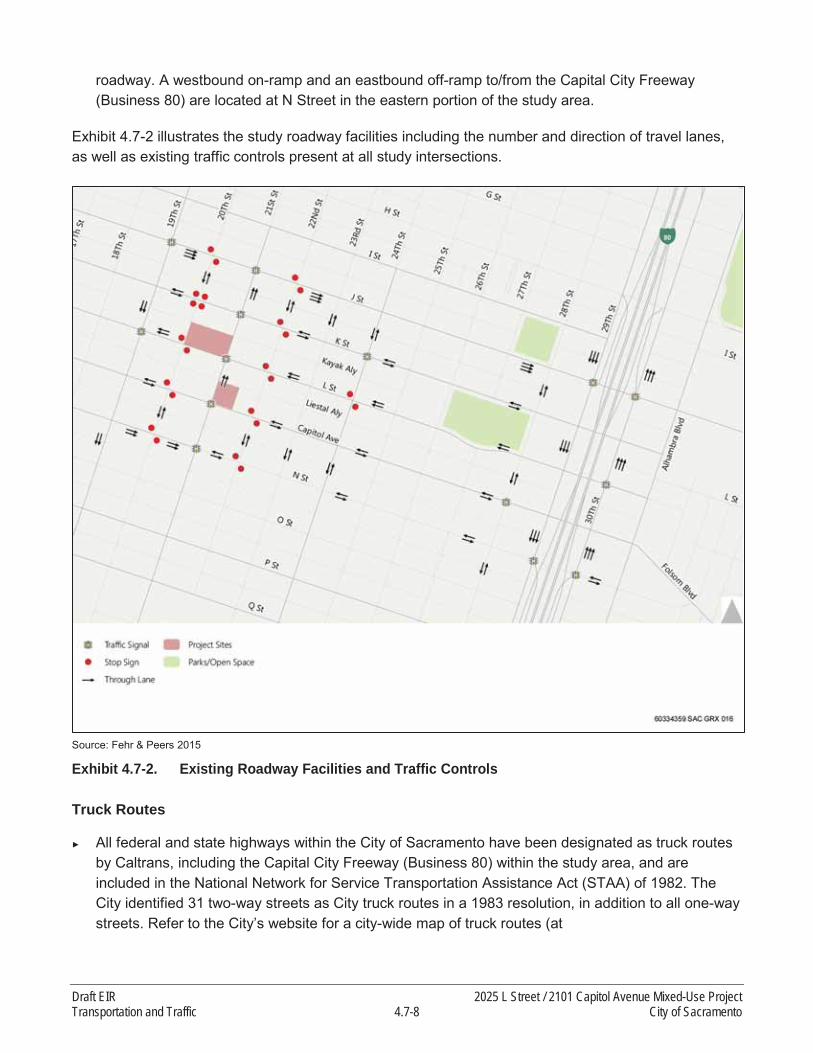
roadway. A westbound on-ramp and an eastbound off-ramp to/from the Capital City Freeway (Business 80) are located at N Street in the eastern portion of the study area.
Exhibit 4.7-2 illustrates the study roadway facilities including the number and direction of travel lanes, as well as existing traffic controls present at all study intersections.
Source: Fehr & Peers 2015
Exhibit 4.7-2. Existing Roadway Facilities and Traffic Controls
Truck Routes
All federal and state highways within the City of Sacramento have been designated as truck routes by Caltrans, including the Capital City Freeway (Business 80) within the study area, and are included in the National Network for Service Transportation Assistance Act (STAA) of 1982. The City identified 31 two-way streets as City truck routes in a 1983 resolution, in addition to all one-way streets. Refer to the City’s website for a city-wide map of truck routes (at
Draft EIR 2025 L Street / 2101 Capitol Avenue Mixed-Use ProjectTransportation and Traffic 4.7-8 City of Sacramento

http://portal.cityofsacramento.org/Public-Works/Transportation/Traffic-Data-Maps). Within the study area, the following streets are considered City truck routes:
19th Street21st Street29th Street30th Street
J StreetL StreetN Street (west of 21st Street)
Methodology
Traffic operations at all study intersections were analyzed for weekday AM and PM peak-hourconditions using procedures and methodologies contained in the Highway Capacity Manual (Transportation Research Board, 2010) for calculating delay at intersections. These methodologies were applied using the SimTraffic software program, which considers the effects of lane utilization, turn pocket storage lengths, upstream/downstream queue spillbacks, coordinated signal timings, pedestrian crossing activity, and other conditions on intersection and overall corridor operations. Utilization of SimTraffic microsimulation analysis is appropriate given the presence of coordinated signal timing plans, close spacing of signalized intersections, and overall levels of traffic and peak-hour congestion within the study area. Reported results are based on an average of 10 runs. The following procedures and assumptions were applied in the development of the SimTraffic model:
Roadway geometric data were gathered using aerial photographs and field observations.
Peak-hour traffic volumes were entered into the model according to the peak hour of the study area.
The peak-hour factor (PHF) was set at 1.0, in accordance with City of Sacramento Traffic Impact Study Guidelines.
The counted pedestrian and bicycle volumes were entered into the model according to the peak-hour measurements.
Signal phasing and timings were based on existing signal timing plans provided by the City of Sacramento and field observations.
Speeds for the model network were based on the posted speed limits.
Each study roadway facility was analyzed using the concept of Level of Service (LOS). LOS is a qualitative measure of traffic operating conditions whereby a letter grade, from A (the best) to F (the worst), is assigned. These grades represent the perspective of drivers and are an indication of the comfort and convenience associated with driving. In general, LOS A represents free-flow conditions with no congestion, and LOS F represents severe congestion and delay under stop-and-go conditions.Table 4.7-1 displays the delay range associated with each LOS category for signalized and unsignalized intersections.
2025 L Street / 2101 Capitol Avenue Mixed-Use Project Draft EIRCity of Sacramento 4.7-9 Transportation and Traffic

Table 4.7-1 Intersection Level of Service Definitions
Level of ServiceAverage Control Delay (seconds/vehicle)1
Signalized UnsignalizedA 0 – 10.0 0 – 10.0B 10.1 – 20.0 10.1 – 15.0C 20.1 – 35.0 15.1 – 25.0D 35.1 – 55.0 25.1 – 35.0E 55.1 – 80.0 35.1 – 50.0F > 80.0 > 50.0
Notes:1 Control delay includes initial deceleration delay, queue move-up time, stopped delay, and acceleration delay based on Highway Capacity
Manual (Transportation Research Board, 2010).Source: Fehr & Peers, 2015.
For signalized intersections, the LOS is based on the average delay experienced by all vehicles passing through the intersection. For side-street stop controlled intersections, the delay and LOS for the worst case movement is reported along with the average delay for the entire intersection.
Traffic Counts
Traffic counts were collected at the study intersections on Wednesday, October 29th, 2014 or on Thursday, October 30, 2014 during the AM (7-9) and PM (4-6) peak periods. During all counts, weather conditions were generally dry, no unusual traffic patterns were observed, and the Sacramento City Unified School District was in full session. In addition to collecting vehicle turning movements at the study intersections, all counts included pedestrian and bicycle activity.
Exhibits 4.7-3A, 4.7-3B, and 4.7-3C display the existing AM and PM peak-hour intersection turning movement volumes, traffic controls, and lane configurations. In general, the AM peak hour within the study area occurred from 7:45 to 8:45, and the PM peak hour occurred from 4:30 to 5:30.
Existing Levels of Service
Table 4.7-2 summarizes the existing peak-hour intersection operations at the study intersections (refer to separate Appendix F for detailed calculations). As shown, all of the study intersectionsoperate with an average of LOS C or better during both the AM and PM peak hours. Overall, the existing roadway system within the area can be characterized as operating efficiently. Motorists typically incur modest delays, do not experience substantial vehicle queues, and benefit from thecoordinated traffic signal system along the primary commute corridors that connect Midtown to the regional freeway system. The study intersections that experience the highest levels of delay are located along 29th Street and 30th Street, adjacent to the Capital City Freeway (Business 80), due primarily to competing traffic flows entering and exiting the freeway.
Draft EIR 2025 L Street / 2101 Capitol Avenue Mixed-Use ProjectTransportation and Traffic 4.7-10 City of Sacramento
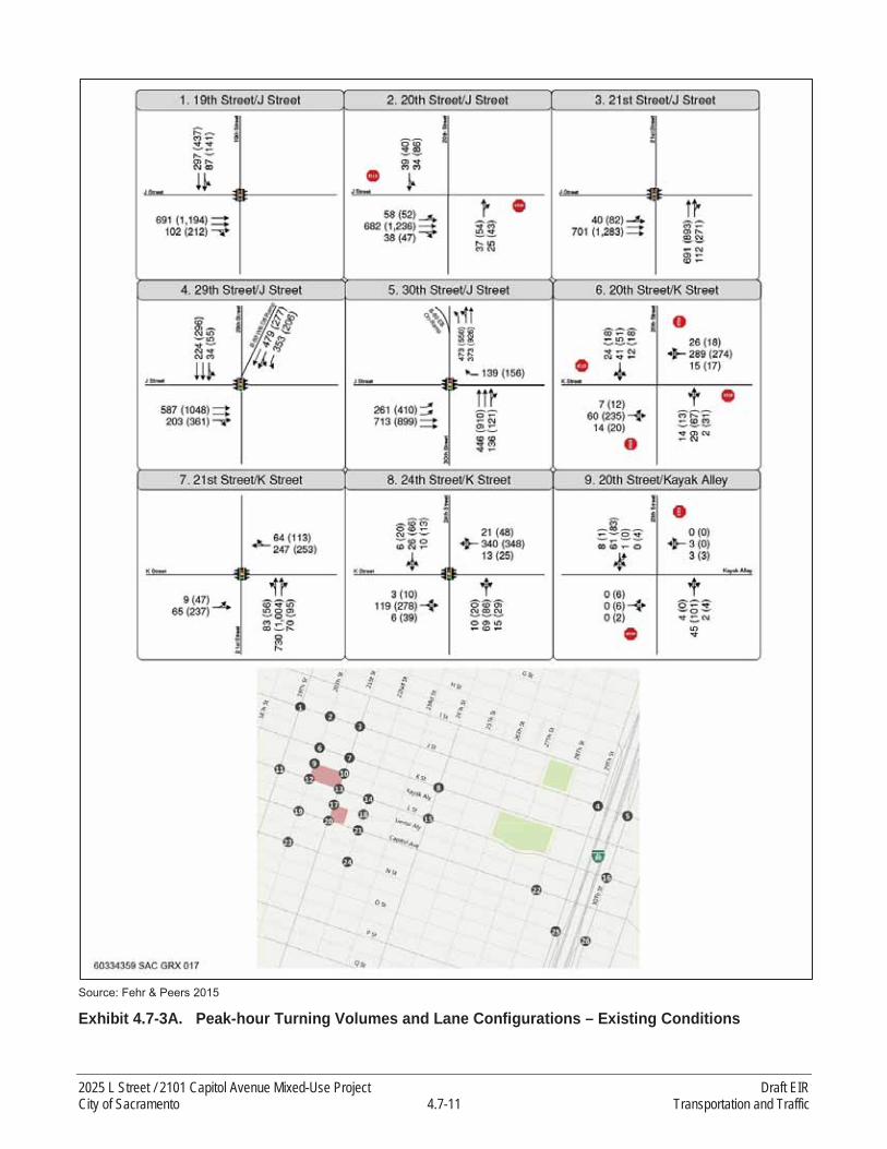
Source: Fehr & Peers 2015
Exhibit 4.7-3A. Peak-hour Turning Volumes and Lane Configurations – Existing Conditions
2025 L Street / 2101 Capitol Avenue Mixed-Use Project Draft EIRCity of Sacramento 4.7-11 Transportation and Traffic
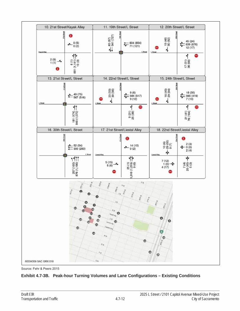
Source: Fehr & Peers 2015
Exhibit 4.7-3B. Peak-hour Turning Volumes and Lane Configurations – Existing Conditions
Draft EIR 2025 L Street / 2101 Capitol Avenue Mixed-Use ProjectTransportation and Traffic 4.7-12 City of Sacramento

Source: Fehr & Peers 2015
Exhibit 4.7-3C. Peak-hour Turning Volumes and Lane Configurations – Existing Conditions
2025 L Street / 2101 Capitol Avenue Mixed-Use Project Draft EIRCity of Sacramento 4.7-13 Transportation and Traffic

Table 4.7-2Intersection Operations – Existing Conditions
Intersection Control Peak Hour Level of Service Average Delay1
1. J Street / 19th St Traffic Signal AMPM
BB
1113
2. J Street / 20th St Side-Street Stop AMPM
A (C)B (F)
4 (15)10 (56)
3. J Street / 21st St Traffic Signal AMPM
AB
611
4. J Street / 29th St Traffic Signal AMPM
CB
2220
5. J Street / 30th St Traffic Signal AMPM
BB
1313
6. K Street / 20th St All-Way Stop AMPM
AC
1015
7. K Street / 21st St Traffic Signal AMPM
AB
613
8. K Street / 24th St Traffic Signal AMPM
AB
1012
9. 20th Street / Kayak Alley Side-Street Stop AMPM
A (A)A (A)
1 (2)1 (5)
10. 21st Street / Kayak Alley Side-Street Stop AMPM
A (A)A (B)
2 (2)4 (12)
11. L Street / 19th St Traffic Signal AMPM
BB
1717
12. L Street / 20th St Side-Street Stop AMPM
A (B)A (B)
2 (14)3 (15)
13. L Street / 21st St Traffic Signal AMPM
AB
810
14. L Street / 22nd St Side-Street Stop AMPM
A (A)A (A)
1 (7)2 (10)
15. L Street / 24th St Side-Street Stop AMPM
A (A)A (A)
2 (9)4 (10)
16. L Street / 30th St Traffic Signal AMPM
BB
1317
17. 21st Street / Liestal Alley Side-Street Stop AMPM
A (A)A (C)
2 (10)4 (18)
18. 22nd Street / Liestal Alley Side-Street Stop AMPM
A (A)A (A)
2 (3)2 (5)
19. Capitol Ave / 20th St Side-Street Stop AMPM
A (A)A (C)
3 (10)5 (16)
20. Capitol Ave / 21st St Traffic Signal AMPM
BB
1015
21. Capitol Ave / 22nd St Side-Street Stop AMPM
A (A)A (B)
2 (8)2 (11)
22. Capitol Ave / 28th St Traffic Signal AMPM
AB
1011
23. N Street / 20th St Side-Street Stop AMPM
A (A)A (B)
2 (8)3 (14)
24. N Street / 22nd St Side-Street Stop AMPM
A (A)A (B)
2 (8)3 (15)
Draft EIR 2025 L Street / 2101 Capitol Avenue Mixed-Use ProjectTransportation and Traffic 4.7-14 City of Sacramento

Table 4.7-2Intersection Operations – Existing Conditions
Intersection Control Peak Hour Level of Service Average Delay1
25. N Street / 29th St Traffic Signal AMPM
CC
2126
26. N Street / 30th St Traffic Signal AMPM
CC
2826
Notes: 1For signalized and all-way stop controlled intersections, average intersection delay is reported in seconds per vehicle for the overall intersection. For side-street stop controlled intersections, the delay is reported in seconds per vehicle for the overall intersection and (worst approach).Source: Fehr & Peers, 2015.
Table 4.7-3Off-Ramp Queuing – Existing Conditions
Location Available Storage Peak Hour Queue1
Capital City Freeway (Business 80) WB Off-Ramp at J Street 1,250 feet AM
PM300 feet200 feet
Capital City Freeway (Business 80) EB Off-Ramp at N Street 1,050 feet AM
PM425 feet225 feet
Notes: 1 Queue length is the maximum queue observed during peak period field observations conducted in October 2014, rounded to the nearest 25 feet.Source: Fehr & Peers, 2015.
Existing Freeway Off-Ramp Queues
Freeway off-ramp queues were observed under existing conditions. As shown in Table 4.7-3, the queues at the two study freeway off-ramps remained within their storage areas during the AM and PM peak hours.
BICYCLE SYSTEM
Exhibit 4.7-4 displays existing bicycle facilities located in the vicinity of the proposed project site based upon data provided by the City of Sacramento and field observations. As discussed above and shown on Exhibit 4.7-4, several roadways within the study area feature bicycle facilities. The following types of bicycle facilities currently exist within the study area:
On-street bike lanes (Class II) – are designated for use by bicycles by striping, pavement legends, and signs.
On-street bike routes (Class III) – are designated by signage for shared bicycle use with vehicles but do not necessarily include any additional pavement width.
Streets with Class II bicycle lanes within the study area include 19th Street, 21st Street, 28th Street, K Street, L Street, Capitol Avenue, and N Street. Streets designated as Class III bicycle routes include 18th Street, 20th Street, and 24th Street.
2025 L Street / 2101 Capitol Avenue Mixed-Use Project Draft EIRCity of Sacramento 4.7-15 Transportation and Traffic

Source: Fehr & Peers 2015
Exhibit 4.7-4. Existing Bicycle Facilities
PEDESTRIAN SYSTEM
The high level of connectivity provided by the study area’s gridded street system, concentration of land uses, and provision of consistent high-quality pedestrian facilities results in an increased level of desirability for pedestrian travel within the study area relative to other portions of the City.According to data from the 2010 Census data, 15 percent of the residents within the Central City (which is comprised of Midtown and Downtown) walk to work on a regular basis, which equates to approximately five times rate of those who choose this form of commute in the City as a whole.
Nearly all streets within the study area feature sidewalks on both sides of the roadway, and sidewalk widths typically range between six and 15 feet. Most sidewalks in Midtown are separated from the roadway by on-street parking and landscaped planter strips, which feature shade trees.These streetscape features increase pedestrian comfort. Crosswalks are typically provided on all approaches to intersections, and intersections between major streets typically feature marked
Draft EIR 2025 L Street / 2101 Capitol Avenue Mixed-Use ProjectTransportation and Traffic 4.7-16 City of Sacramento

crosswalks on all approaches, including all intersections immediately adjacent to the proposed project site. Traffic signals within the study area operate on relatively short cycle lengths, and nearly all have automatic walk signals for pedestrians; combined, these features result in low levels of crossing delay for pedestrians.
TRANSIT SYSTEM
Local transit service within the study area is provided by RT. Regional Transit operates 67 bus routes and 38.6 miles of light rail (on three lines: the Blue Line, Gold Line, and Green Line) throughout a 418 square-mile service area. Light rail service operates on 15-minute headways during the day and 30-minute headways in the evening and on weekends and holidays. Fixed-route bus service operates on headways ranging from 15 to 75 minutes, depending upon the route.Buses and light rail run 365 days a year, using 76 light rail vehicles, 182 buses, and 11 shuttle vans (RT, 2015). RT’s annual ridership has steadily increased on both its bus and light rail systems from 14 million passengers in 1987 to more than 45 million passengers in Fiscal Year 2010. Weekday light rail ridership averages about 46,000, and the weekday bus ridership has increased to approximately 50,000 passengers per day (RT 2015).
The proposed project site is located approximately 0.5 miles from the nearest light rail station on the RT Gold Line (23rd Street Station) and approximately 0.75 miles from the 16th Street Light Rail Station, which serves both the RT Blue and Gold light rail lines and is the busiest light rail station in the RT system. Multiple RT bus lines also serve the study area, including Route 30 and Route 62,which both have stops adjacent to the project site. These two routes are described in detail below:
Route 30-J Street provides connections between the Sacramento Valley Station area and California State University Sacramento. The 30-J Street route operates every 15 minutes on weekdays before 7 PM and every 30 minutes after 7 PM. Weekend and holiday service operates every 30 to 75 minutes. Route 30 has a stop at the northwestern corner of the L Street/21st Street intersection, adjacent to the proposed project site.
Route 62-Freeport connects the Downtown and Pocket areas of Sacramento, providing service every 30 minutes both on weekdays and Saturdays. Its weekday operation runs from 5:30 AM to 9:30 PM, and its Saturday operation runs from 7:00 AM to about 10:00 PM. Route 30 has a stop at the northeastern corner of the Capitol Avenue/21st Street intersection, adjacent to the proposed project site.
Exhibit 4.7-5 displays the locations of existing transit facilities within the study area.
RAILROAD CROSSINGS
A Union Pacific Railroad (UPRR) line runs north-south within the study area, between 19th Street and 20th Street (as shown on Exhibit 4.7-5). This single-track freight line is located approximately 200 feet west of the proposed project. According to the Federal Railroad Administration (FRA), the UPRR line carries an average of 13 freight trains per day, and is typically not used by passenger trains. The UPRR line traverses the length of Midtown, and has at-grade public crossings at all cross streets from C Street to Q Street, resulting in crossings spaced approximately every 400 feet
2025 L Street / 2101 Capitol Avenue Mixed-Use Project Draft EIRCity of Sacramento 4.7-17 Transportation and Traffic

within the study area. All crossings within the study area feature warning bells, flashing lights, pavement markings, and warning signage. The closest crossings to the proposed project site are located at K Street, L Street, and Capitol Avenue. According to the FRA, within the past 20 years, one accident occurred at the L Street crossing and three accidents occurred at the Capitol Avenue crossing. One of these accidents resulted in a fatality when a pedestrian was struck at the Capitol Avenue crossing in 2004.
Source: Fehr & Peers 2015
Exhibit 4.7-5. Existing Transit Facilities
Draft EIR 2025 L Street / 2101 Capitol Avenue Mixed-Use ProjectTransportation and Traffic 4.7-18 City of Sacramento

4.7.2 REGULATORY SETTING
FEDERAL
No pertinent federal regulations affect the proposed project.
STATE
In May 2009, Caltrans released a Corridor System Management Report (CSMP) for the Capital City Freeway (Caltrans 2009). The segments of the freeway located within the study area are covered by this document. CSMPs are long-range comprehensive planning documents that define the current LOS on a facility and the future LOS when considering feasible long-term projects. Based on the CSMPs, the segments of the Capital City Freeway located within the project study area currently operate at LOS F conditions, and are expected to operate at LOS F conditions in the future.
According to the Guide for the Preparation of Traffic Impact Studies (Caltrans 2002), if a freeway facility currently operates at an unacceptable LOS (e.g., LOS F), then the existing LOS should be maintained. A project impact occurs if the addition of project trips exacerbates existing LOS F conditions and leads to a perceptible increase in density on freeway mainline segments or ramp junctions, or a perceptible increase in service volumes in a weaving area. In addition, a project impact occurs when the addition of project trips causes a queue on the off-ramp approach to a ramp terminal intersection to extend beyond its storage area and onto the freeway mainline.
As previously documented on page 4.7-1, the project is an anticipated subsequent project identified inthe 2030 and 2035 General Plan Master EIR. This EIR addresses only the project’s additional potentially significant environmental effects and any new or additional mitigation measures or alternatives that were not identified in the Master EIR. Freeway main line was included in the General Plan Master EIR therefore, it is not necessary to determine impacts to the state transportation system (i.e., Capital City Freeway). However, potential safety impacts related to freeway off-ramp queues extending from study intersections onto the freeway mainline are evaluated.
REGIONAL
SACOG is responsible for the preparation of, and updates to, the MTP/SCS 2035 (SACOG 2012) and the corresponding Metropolitan Transportation Improvement Program (MTIP) for the six-county Sacramento region. The MTP/SCS provides a 20-year transportation vision and corresponding list of projects. The MTIP identifies short-term projects (7-year horizon) in more detail. The MTP/SCS 2035 was adopted by the SACOG board in 2012.
LOCAL
Sacramento 2030 General Plan
The Mobility Element of the City of Sacramento’s 2030 General Plan (City of Sacramento 2009) outlines goals and policies that coordinate the transportation and circulation system with planned land uses. The following LOS policy is relevant to this study:
2025 L Street / 2101 Capitol Avenue Mixed-Use Project Draft EIRCity of Sacramento 4.7-19 Transportation and Traffic

Policy M 1.2.2. The City shall allow for flexible Level of Service (LOS) standards, which will permit increased densities and mix of uses to increase transit ridership, biking, and walking, which decreases auto travel, thereby reducing air pollution, energy consumption, and greenhouse gas emissions.
a. Core Area Level of Service Exemption – LOS F conditions are acceptable during peak hours in the Core Area bounded by C Street, the Sacramento River, 30th Street, and X Street. If a Traffic Study is prepared and identifies a LOS impact that would otherwise be considered significant to a roadway or intersection that is in the Core Area as described above, the project would not be required in that particular instance to widen roadways in order for the City to find project conformance with the General Plan. Instead, General Plan conformance could still be found if the project provides improvements to other parts of the citywide transportation system in order to improve transportation-system-wide roadway capacity, to make intersection improvements, or to enhance non-auto travel modes in furtherance of the General Plan goals. The improvements would be required within the project site vicinity or within the area affected by the project’s vehicular traffic impacts. With the provision of such other transportation infrastructure improvements, the project would not be required to provide any mitigation for vehicular traffic impacts to road segments in order to conform to the General Plan. This exemption does not affect the implementation of previously approved roadway and intersection improvements identified for the Railyards or River District planning areas.
b. Level of Service Standards for Multi-Modal Districts – The City shall seek to maintain the following standards in multi-modal districts including the Central Business District, areas within ½ mile walking distance of light rail stations, and in areas designated for urban scale development (Urban Centers, Urban Corridors, and Urban Neighborhoods as designated in the Land Use and Urban Form Diagram). These areas are characterized by frequent transit service, enhanced pedestrian and bicycle systems, a mix of uses, and higher-density development.
o Maintain operations on all roadways and intersections at LOS A-E at all times, including peak travel times, unless maintaining this LOS would, in the City’s judgment, be infeasible and/or conflict with the achievement of other goals. LOS F conditions may be acceptable, provided that provisions are made to improve the overall system and/or promote non-vehicular transportation and transit as part of a development project or a City-initiated project.
c. Base Level of Service Standard – The City shall seek to maintain the following standards for all areas outside of multi-modal districts:
o Maintain operations on all roadways and intersections at LOS A-D at all times, including peak travel times, unless maintaining this LOS would, in the City’s judgment, be infeasible and/or conflict with the achievement of other goals. LOS E or F conditions may be accepted, provided that provisions are made to improve the overall system and/or
Draft EIR 2025 L Street / 2101 Capitol Avenue Mixed-Use ProjectTransportation and Traffic 4.7-20 City of Sacramento
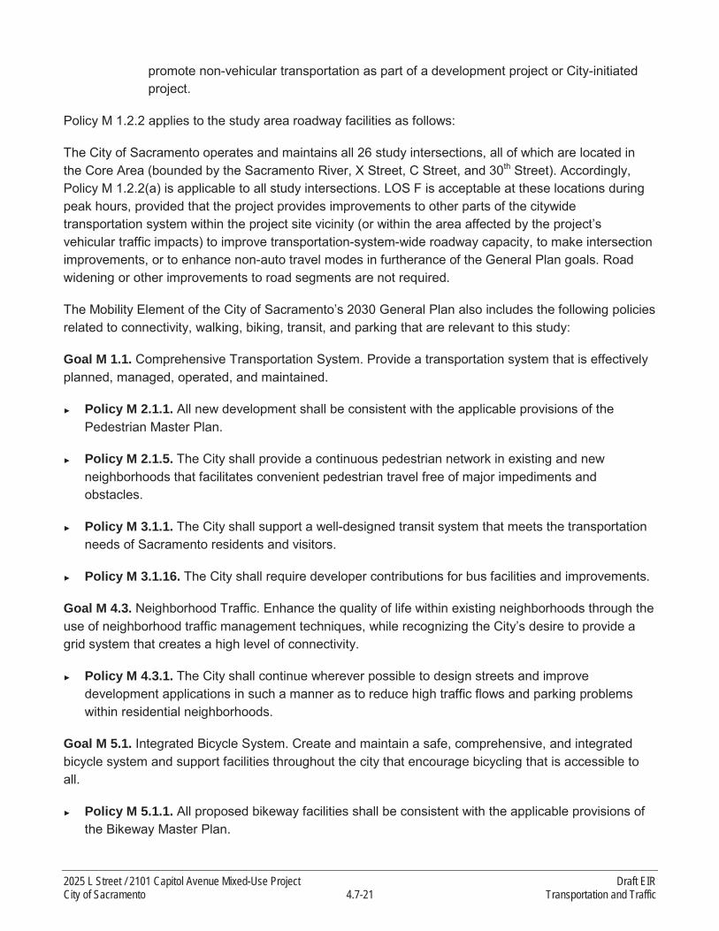
promote non-vehicular transportation as part of a development project or City-initiated project.
Policy M 1.2.2 applies to the study area roadway facilities as follows:
The City of Sacramento operates and maintains all 26 study intersections, all of which are located in the Core Area (bounded by the Sacramento River, X Street, C Street, and 30th Street). Accordingly, Policy M 1.2.2(a) is applicable to all study intersections. LOS F is acceptable at these locations during peak hours, provided that the project provides improvements to other parts of the citywide transportation system within the project site vicinity (or within the area affected by the project’s vehicular traffic impacts) to improve transportation-system-wide roadway capacity, to make intersection improvements, or to enhance non-auto travel modes in furtherance of the General Plan goals. Road widening or other improvements to road segments are not required.
The Mobility Element of the City of Sacramento’s 2030 General Plan also includes the following policies related to connectivity, walking, biking, transit, and parking that are relevant to this study:
Goal M 1.1. Comprehensive Transportation System. Provide a transportation system that is effectively planned, managed, operated, and maintained.
Policy M 2.1.1. All new development shall be consistent with the applicable provisions of the Pedestrian Master Plan.
Policy M 2.1.5. The City shall provide a continuous pedestrian network in existing and new neighborhoods that facilitates convenient pedestrian travel free of major impediments and obstacles.
Policy M 3.1.1. The City shall support a well-designed transit system that meets the transportation needs of Sacramento residents and visitors.
Policy M 3.1.16. The City shall require developer contributions for bus facilities and improvements.
Goal M 4.3. Neighborhood Traffic. Enhance the quality of life within existing neighborhoods through the use of neighborhood traffic management techniques, while recognizing the City’s desire to provide a grid system that creates a high level of connectivity.
Policy M 4.3.1. The City shall continue wherever possible to design streets and improve development applications in such a manner as to reduce high traffic flows and parking problems within residential neighborhoods.
Goal M 5.1. Integrated Bicycle System. Create and maintain a safe, comprehensive, and integrated bicycle system and support facilities throughout the city that encourage bicycling that is accessible to all.
Policy M 5.1.1. All proposed bikeway facilities shall be consistent with the applicable provisions of the Bikeway Master Plan.
2025 L Street / 2101 Capitol Avenue Mixed-Use Project Draft EIRCity of Sacramento 4.7-21 Transportation and Traffic

Policy M 5.1.2. All proposed bikeway facilities are appropriate to the street classifications and types, traffic volume, and speed on applicable rights-of-way.
Policy M 5.1.4. The proposed project shall not result in conflicts between bicyclists and motor vehicles on streets, and bicyclists and pedestrians on multi-use trails and sidewalks.
Goal M 6.1. Managed Parking. Provide and manage parking such that it balances the citywide goals of economic development, livable neighborhoods, sustainability, and public safety with the compact multi-modal urban environment prescribed by the General Plan.
Policy M 6.1.1. The City shall ensure that appropriate parking is provided considering access to existing and funded transit, shared parking opportunities for mixed-use development, and implementation of Transportation Demand Management plans.
Sacramento 2035 General Plan
The proposed project was initiated when the 2030 General Plan was in force. Since that time, the City has prepared an update to the 2030 General Plan and adopted the 2035 General Plan on March 3rd,2015.
The Draft 2035 General Plan includes modifications to Policy M 1.2.2 pertaining to City LOS standards.However, the updated policy allows for LOS F conditions within the Core Area (Central City Community Plan Area). Since all study facilities are located within the Core Area, the modifications to Policy M 1.2.2 included in the Draft General Plan Update would not result in changes to the significance of LOS impacts related to the proposed project or the findings contained in this section.
METHODS OF ANALYSIS
This section describes the analysis techniques, assumptions, and results used to identify potentialsignificant impacts of the proposed project on the transportation system. This section first describes the anticipated travel characteristics of the proposed project. It then presents the expected conditions of the transportation system with the addition of the proposed project.
TRIP GENERATION
The trip generation estimate for the grocery store component of the project (Whole Foods Market) is based upon empirical data collected in 2013 at three Whole Foods stores located in California and published in the Draft Environmental Impact Report for the Talaria at Burbank Mixed Use Project (City of Burbank 2014). Usage of these rates recognizes that rates published in the Trip Generation Manual, 9th Edition (Institute of Transportation Engineers, 2012) may underestimate the trip making characteristics of high-end grocery stores that tend to operate during extended hours and provide food service options that attract more patrons for shorter trips, relative to typical grocery stores. The resulting peak-hour trip generation estimates for the Whole Foods Market (shown in Table 4.7-1) are approximately 64 percent higher during the AM peak hour and 51 percent higher during the PM peak hour relative to the trip generation potential calculated using ITE rates for supermarkets (ITE land use code 850).
Draft EIR 2025 L Street / 2101 Capitol Avenue Mixed-Use ProjectTransportation and Traffic 4.7-22 City of Sacramento

The trip generation potential of the residential component of the 2025 L Street property and the retail component of the 2101 Capitol Avenue property are based upon rates published in the Trip Generation Manual, 9th Edition (Institute of Transportation Engineers, 2012). This document contains trip generation rates for a variety of land uses based on empirical measurements. Most of the observation sites used to develop trip rates were located in suburban settings, which often feature limited transit service, and may not have nearby destinations within close walking/biking distance. Therefore, adjustments to ITE trip rates are warranted based on the proximity of transit service, and numerous nearby attractions within bicycling and walking distance.
The expected amount of internal trip-making between the residential and retail uses, and proportion of external trips made by walking, bicycling, and transit was estimated using the Mixed-Use Trip Generation Model (MXD). This model was developed for the U.S. Environmental Protection Agency (EPA) by consultants and academic researchers to more accurately estimate the external vehicular trip generation of mixed-use land development projects than prior methods (e.g., ITE internalization spreadsheet). The model was developed based on empirical evidence at 240 mixed-use projects located across the U.S. The model considers various built environment variables such as land use density, regional location, proximity to transit, and various design variables when calculating the project’s internal trips, and external trips made by auto, transit, and non-motorized modes. The MXD model has been used in dozens of EIRs and other environmental documents throughout California.
Table 4.7-4 displays the estimated gross trip generation of the proposed project during the weekday AM and PM peak hours, as well as an average weekday daily trip generation estimate (for informational purposes only).
The following adjustments are included in Table 4.7-4:
Internalization: The MXD model predicts that about six percent of trips will remain internal to the project site. This accounts for the interaction between complementary project land uses located in close proximity to one another.
Pass-by Trips: Per Trip Generation Handbook, 3rd Edition (Institute of Transportation Engineers, 2014), 36 percent of non-internal Supermarket and retail trips are expected to be pass-by trips. This accounts for the portion of retail trips made as an intermediate stop on the way from an origin to a primary trip destination without a route diversion.
External Walk/Bike Trips: The MXD model predicts that about 19 percent of non-internal trips will be made by walking or bicycling. This is reasonable given the highly developed urban nature of the study area, the area’s gridded street pattern which provides a high level of connectivity, and the presence of abundant pedestrian and bicycle facilities.
External Transit Trips: The MXD model predicts that about 8 percent of non-internal/pass-by trips will made by transit on a daily basis, and 14 percent of non-internal/pass-by trips will be made by transit during peak hours. This is reasonable given that the project is located approximately 0.5 miles from the nearest light rail station on the Regional Transit (RT) Gold Line (23rd Street Station) and approximately 0.75 miles from the 16th Street Light Rail Station, which serves both the RT Blue and Gold light rail lines and is the busiest light rail station in the RT system. Multiple RT bus lines
2025 L Street / 2101 Capitol Avenue Mixed-Use Project Draft EIRCity of Sacramento 4.7-23 Transportation and Traffic
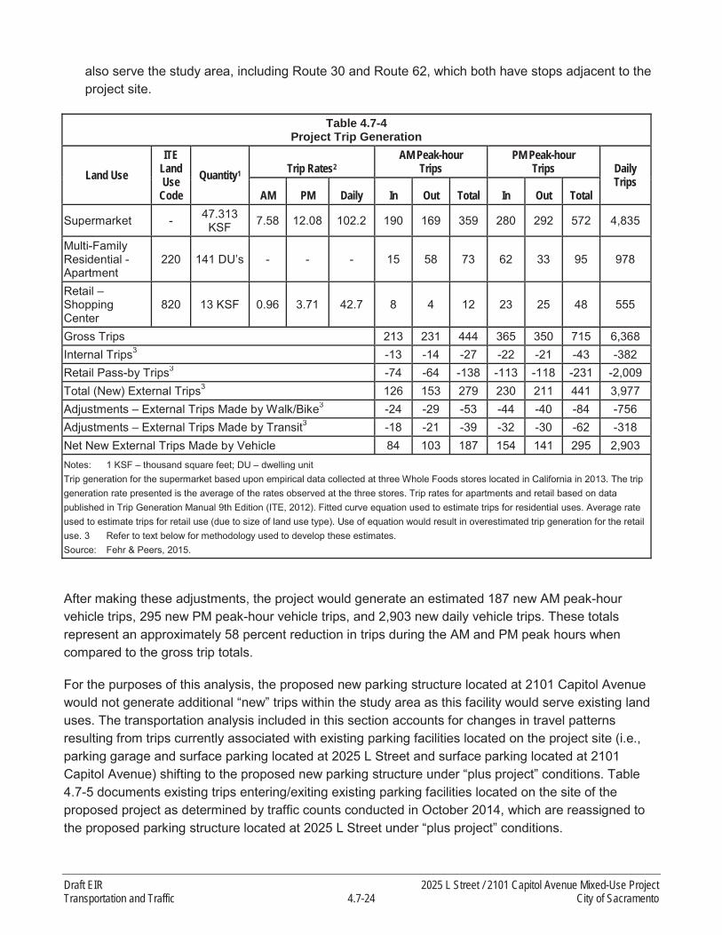
also serve the study area, including Route 30 and Route 62, which both have stops adjacent to the project site.
Table 4.7-4 Project Trip Generation
Land UseITE
Land Use
CodeQuantity1 Trip Rates2
AM Peak-hourTrips
PM Peak-hourTrips Daily
TripsAM PM Daily In Out Total In Out Total
Supermarket - 47.313 KSF 7.58 12.08 102.2 190 169 359 280 292 572 4,835
Multi-Family Residential -Apartment
220 141 DU’s - - - 15 58 73 62 33 95 978
Retail –Shopping Center
820 13 KSF 0.96 3.71 42.7 8 4 12 23 25 48 555
Gross Trips 213 231 444 365 350 715 6,368Internal Trips3 -13 -14 -27 -22 -21 -43 -382Retail Pass-by Trips3 -74 -64 -138 -113 -118 -231 -2,009Total (New) External Trips3 126 153 279 230 211 441 3,977Adjustments – External Trips Made by Walk/Bike3 -24 -29 -53 -44 -40 -84 -756Adjustments – External Trips Made by Transit3 -18 -21 -39 -32 -30 -62 -318Net New External Trips Made by Vehicle 84 103 187 154 141 295 2,903Notes: 1 KSF – thousand square feet; DU – dwelling unitTrip generation for the supermarket based upon empirical data collected at three Whole Foods stores located in California in 2013. The trip generation rate presented is the average of the rates observed at the three stores. Trip rates for apartments and retail based on data published in Trip Generation Manual 9th Edition (ITE, 2012). Fitted curve equation used to estimate trips for residential uses. Average rateused to estimate trips for retail use (due to size of land use type). Use of equation would result in overestimated trip generation for the retail use. 3 Refer to text below for methodology used to develop these estimates.Source: Fehr & Peers, 2015.
After making these adjustments, the project would generate an estimated 187 new AM peak-hourvehicle trips, 295 new PM peak-hour vehicle trips, and 2,903 new daily vehicle trips. These totals represent an approximately 58 percent reduction in trips during the AM and PM peak hours when compared to the gross trip totals.
For the purposes of this analysis, the proposed new parking structure located at 2101 Capitol Avenue would not generate additional “new” trips within the study area as this facility would serve existing land uses. The transportation analysis included in this section accounts for changes in travel patterns resulting from trips currently associated with existing parking facilities located on the project site (i.e.,parking garage and surface parking located at 2025 L Street and surface parking located at 2101 Capitol Avenue) shifting to the proposed new parking structure under “plus project” conditions. Table 4.7-5 documents existing trips entering/exiting existing parking facilities located on the site of the proposed project as determined by traffic counts conducted in October 2014, which are reassigned to the proposed parking structure located at 2025 L Street under “plus project” conditions.
Draft EIR 2025 L Street / 2101 Capitol Avenue Mixed-Use ProjectTransportation and Traffic 4.7-24 City of Sacramento

Table 4.7-5Peak-hour Project Site Trips – Existing Conditions
LocationAM Peak Hour PM Peak Hour
In Out Total In Out Total2025 L Street 106 9 115 4 56 602101 Capitol Avenue 26 3 29 3 23 26Total (assigned to proposed parking structure) 132 12 144 7 79 86Notes: Data based on field observations conducted in October 2014.Source: Fehr & Peers, 2015.
As previously noted, a two-story office building is also located on the site of the proposed 2025 L Street mixed-use building. However, this building is currently used for storage, and it is assumed that none of the trips currently accessing the 2025 L Street site during peak hours are associated with the office building. For this reason, no adjustments to the peak-hour traffic volumes were made to account for the removal of this structure under “plus project” conditions.
TRIP DISTRIBUTION / ASSIGNMENT
The distribution of project trips was estimated using a variety of sources and analytical techniques. Due to the grid-based street system, it was particularly important to determine which parallel streets are most likely to be used by project traffic. The following lists the various sources and analytical techniques used to develop the inbound and outbound trip distribution percentages:
Project-only traffic assignment using the base year SACMET regional travel demand model.
Relative travel time/speed comparisons between the project and key destinations (e.g., Capital City Freeway) for various travel routes.
Review of existing traffic count data.
Relative ease of travel on parallel routes (e.g., coordinated signals and one-way traffic using multiple lanes on J Street and L Street versus bi-directional traffic and more frequent stops on KStreet and Capitol Avenue).
Exhibit 4.7-6 displays the expected distribution of inbound project trips, and Exhibit 4.7-7 displays the expected distribution of outbound project trips. It was necessary to develop separate distributions for inbound/outbound trips due to the number of one-way streets and the location of freeway on- and off-ramps within the study area.
THRESHOLDS OF SIGNIFICANCE
The significance criteria used to evaluate the project impacts are based on Appendix G of the CEQA Guidelines and thresholds adopted by the City in applicable general plans and previous environmental documents.
2025 L Street / 2101 Capitol Avenue Mixed-Use Project Draft EIRCity of Sacramento 4.7-25 Transportation and Traffic

Source: Fehr & Peers 2015
Exhibit 4.7-6. Inbound Trip Distribution
Intersections
Impacts to the roadway system are considered significant if:
The traffic generated by the project degrades LOS from acceptable (without the project) to unacceptable (with the project);
The LOS (without project) is already (or projected to be) unacceptable and project generated traffic increases the average vehicle delay by 5 seconds or more.
General Plan Mobility Element Policy M 1.2.2 sets forth definitions for what is considered an acceptable LOS. As previously discussed, Policy M 1.2.2 applies to the study area roadway facilities as follows:
All study intersections are located in the Core Area and are governed by Policy M 1.2.2 (a). LOS F is acceptable at these locations during peak hours, provided that the project provides improvements
Draft EIR 2025 L Street / 2101 Capitol Avenue Mixed-Use ProjectTransportation and Traffic 4.7-26 City of Sacramento

to other parts of the citywide transportation system within the project site vicinity (or within the area affected by the project’s vehicular traffic impacts) to improve transportation-system-wide roadway capacity, to make intersection improvements, or to enhance non-auto travel modes in furtherance of the General Plan goals. Road widening or other improvements to road segments are not required.
Source: Fehr & Peers 2015
Exhibit 4.7-7. Outbound Trip Distribution
Bicycle Facilities
Impacts to bicycle facilities are considered significant if the proposed project would:
Adversely affect existing or planned bicycle facilities; or Fail to adequately provide for access by bicycle.
2025 L Street / 2101 Capitol Avenue Mixed-Use Project Draft EIRCity of Sacramento 4.7-27 Transportation and Traffic

Pedestrian Circulation
Impacts to pedestrian circulation are considered significant if the proposed project would:
Adversely affect existing or planned pedestrian facilities; or Fail to adequately provide for access by pedestrians.
Transit
Impacts to the transit system are considered significant if the proposed project would:
Adversely affect public transit operations; orFail to adequately provide access to transit.
Construction-Related Traffic Impacts
The project would have a temporarily significant impact during construction if it would:
Degrade an intersection or roadway to an unacceptable level;Cause inconveniences to motorists due to prolonged road closures; orResult in increased frequency of potential conflicts between vehicles, pedestrians, and bicyclists.
IMPACT ANALYSIS AND MITIGATION
Potential impacts of the proposed project upon the transportation system are evaluated in this section based on the thresholds of significance and analysis results. Each impact is followed by a recommended mitigation measure to reduce the significance of identified impacts, if needed.
IMPACT 4.7-1
The proposed project could cause potentially significant impacts to study intersections. Based on the analysis below, the impact would be less than significant.
Project trips were assigned to the study facilities in accordance with the trip generation and distribution calculations presented previously. Project trips were then added to the existing volumes, and trips entering/exiting existing parking facilities located on the project site were reassigned to the proposed replacement parking structure to yield the Existing Plus Project forecasts. Exhibits 4.7-8A, 4.7-8B, and 4.7-8C display the resulting volumes at the study intersections that represent full build-out of the proposed project.
The study intersections were reanalyzed under Existing Plus Project conditions, which includes no changes to land uses or to the transportation system within the study area other than implementation of the proposed project. Table 4.7-6 summarizes the Existing Plus Project intersection analysis results (see detailed technical calculations included in Appendix F).
As shown in Table 4.7-6, all study intersections would continue to operate with an overall intersection LOS of C or better during both peak hours with implementation of the proposed project.
Draft EIR 2025 L Street / 2101 Capitol Avenue Mixed-Use ProjectTransportation and Traffic 4.7-28 City of Sacramento

Source: Fehr & Peers 2015
Exhibit 4.7-8A. Peak-hour Traffic Volumes and Lane Configurations - Existing Plus Project Conditions
2025 L Street / 2101 Capitol Avenue Mixed-Use Project Draft EIRCity of Sacramento 4.7-29 Transportation and Traffic

Source: Fehr & Peers 2015
Exhibit 4.7-8B. Peak-hour Traffic Volumes and Lane Configurations - Existing Plus Project Conditions
Draft EIR 2025 L Street / 2101 Capitol Avenue Mixed-Use ProjectTransportation and Traffic 4.7-30 City of Sacramento

Source: Fehr & Peers 2015
Exhibit 4.7-8C. Peak-hour Traffic Volumes and Lane Configurations - Existing Plus Project Conditions
2025 L Street / 2101 Capitol Avenue Mixed-Use Project Draft EIRCity of Sacramento 4.7-31 Transportation and Traffic
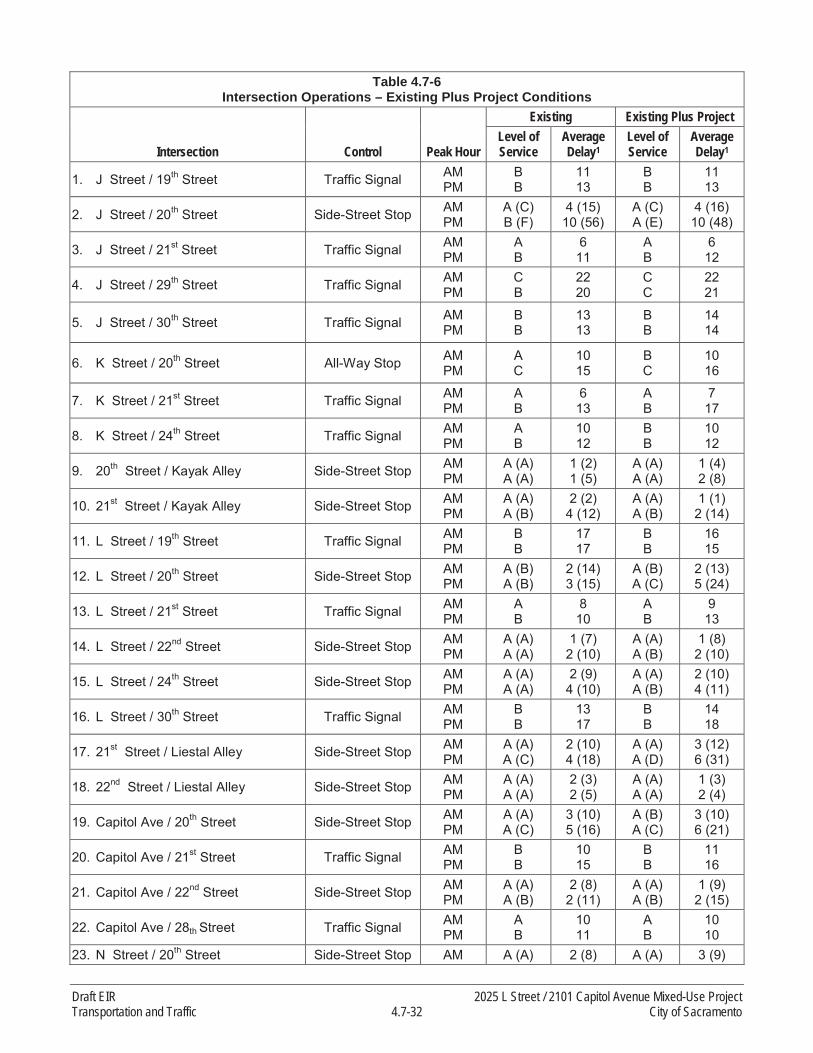
Table 4.7-6Intersection Operations – Existing Plus Project Conditions
Intersection Control Peak Hour
Existing Existing Plus ProjectLevel of Service
Average Delay1
Level of Service
Average Delay1
1. J Street / 19th Street Traffic Signal AMPM
BB
1113
BB
1113
2. J Street / 20th Street Side-Street Stop AMPM
A (C)B (F)
4 (15)10 (56)
A (C)A (E)
4 (16)10 (48)
3. J Street / 21st Street Traffic Signal AMPM
AB
611
AB
612
4. J Street / 29th Street Traffic Signal AMPM
CB
2220
CC
2221
5. J Street / 30th Street Traffic Signal AMPM
BB
1313
BB
1414
6. K Street / 20th Street All-Way Stop AMPM
AC
1015
BC
1016
7. K Street / 21st Street Traffic Signal AMPM
AB
613
AB
717
8. K Street / 24th Street Traffic Signal AMPM
AB
1012
BB
1012
9. 20th Street / Kayak Alley Side-Street Stop AMPM
A (A)A (A)
1 (2)1 (5)
A (A)A (A)
1 (4)2 (8)
10. 21st Street / Kayak Alley Side-Street Stop AMPM
A (A)A (B)
2 (2)4 (12)
A (A)A (B)
1 (1)2 (14)
11. L Street / 19th Street Traffic Signal AMPM
BB
1717
BB
1615
12. L Street / 20th Street Side-Street Stop AMPM
A (B)A (B)
2 (14)3 (15)
A (B)A (C)
2 (13)5 (24)
13. L Street / 21st Street Traffic Signal AMPM
AB
810
AB
913
14. L Street / 22nd Street Side-Street Stop AMPM
A (A)A (A)
1 (7)2 (10)
A (A)A (B)
1 (8)2 (10)
15. L Street / 24th Street Side-Street Stop AMPM
A (A)A (A)
2 (9)4 (10)
A (A)A (B)
2 (10)4 (11)
16. L Street / 30th Street Traffic Signal AMPM
BB
1317
BB
1418
17. 21st Street / Liestal Alley Side-Street Stop AMPM
A (A)A (C)
2 (10)4 (18)
A (A)A (D)
3 (12)6 (31)
18. 22nd Street / Liestal Alley Side-Street Stop AMPM
A (A)A (A)
2 (3)2 (5)
A (A)A (A)
1 (3)2 (4)
19. Capitol Ave / 20th Street Side-Street Stop AMPM
A (A)A (C)
3 (10)5 (16)
A (B)A (C)
3 (10)6 (21)
20. Capitol Ave / 21st Street Traffic Signal AMPM
BB
1015
BB
1116
21. Capitol Ave / 22nd Street Side-Street Stop AMPM
A (A)A (B)
2 (8)2 (11)
A (A)A (B)
1 (9)2 (15)
22. Capitol Ave / 28th Street Traffic Signal AMPM
AB
1011
AB
1010
23. N Street / 20th Street Side-Street Stop AM A (A) 2 (8) A (A) 3 (9)
Draft EIR 2025 L Street / 2101 Capitol Avenue Mixed-Use ProjectTransportation and Traffic 4.7-32 City of Sacramento

Table 4.7-6Intersection Operations – Existing Plus Project Conditions
Intersection Control Peak Hour
Existing Existing Plus ProjectLevel of Service
Average Delay1
Level of Service
Average Delay1
PM A (B) 3 (14) A (C) 3 (14)
24. N Street / 22nd Street Side-Street Stop AMPM
A (A)A (B)
2 (8)3 (15)
A (A)A (C)
2 (9)3 (17)
25. N Street / 29th Street Traffic Signal AMPM
CC
2126
CC
2129
26. N Street / 30th Street Traffic Signal AMPM
CC
2826
CC
2728
Notes: 1For signalized and all-way stop controlled intersections, average intersection delay is reported in seconds per vehicle for the overall intersection. For side-street stop controlled intersections, the delay is reported in seconds per vehicle for the overall intersection and (worst approach).Source: Fehr & Peers, 2015.
Table 4.7-7 displays the maximum expected freeway off-ramp queue lengths within the study area during the AM and PM peak hours. As shown, all study freeway off-ramp queues remain within the available storage area during both the AM and PM peak hours under Existing Plus Project conditions.
Table 4.7-7Off-Ramp Queuing – Existing Plus Project Conditions
Location Available Storage Peak Hour Existing Queue1Existing Plus
Project Queue1
Capital City Freeway (Business 80) WB Off-Ramp at J Street 1,250 feet AM
PM300 feet200 feet
300 ft.225 ft.
Capital City Freeway (Business 80) EB Off-Ramp at N Street 1,050 feet AM
PM425 feet225 feet
450 ft.275 ft.
Notes: 1 Existing queue length is the maximum queue observed during peak period field observations conducted in October 2014, rounded to the nearest 25 feet; Existing Plus Project queue length is based upon output from SimTraffic microsimulation software.Source: Fehr & Peers, 2015.
According to Table 4.7-6, implementation of the proposed project would not result in unacceptable intersection operations. According to Table 4.7-7, no queues from the study intersections would extend onto the freeway mainline. Therefore, all project impacts to study intersections are considered to be less than significant.
Mitigation Measures
None required.
IMPACT 4.7-2
The proposed project could cause potentially significant impacts to bicycle facilities. Based on the analysis below, the impact would be less than significant.
As previously documented, Class II on-street bicycle lanes are currently provided along the project frontage on L Street, 21st Street, and Capitol Avenue. Implementation of the proposed project would not
2025 L Street / 2101 Capitol Avenue Mixed-Use Project Draft EIRCity of Sacramento 4.7-33 Transportation and Traffic
remove any existing bicycle facility, including the existing Class II bicycle lanes, or interfere with the construction of any planned bicycle facilities. The project would include the installation of two separate bicycle racks along L Street, one adjacent to the entrance to the residential lobby and one adjacent to the entrance of the grocery store. A third bicycle rack would also be installed on Capitol Avenue adjacent to the entrance to the retail component of the project. The proposed 2025 L Street mixed-use building would also include a “bike lounge” with 126 bike parking spaces.
Therefore, proposed project impacts to bicycle facilities are considered to be less than significant.
Mitigation Measures
None required.
IMPACT 4.7-3
The proposed project could cause potentially significant impacts to pedestrian facilities. Based on the analysis below, the impact would be less than significant.
Continuous sidewalks exist on both sides of all streets fronting the proposed project. These sidewalks provide eight-foot-wide clear zones for pedestrian travel adjacent to planter strips that provide a buffer between the sidewalk and vehicular travel lanes/parking lanes, and the project proposes to maintain these existing conditions, consistent with City requirements. Consistent with the design of alleys throughout the Central City, the segments of Liestal Alley and Kayak Alley adjacent to the proposed project site do not feature dedicated pedestrian facilities. All intersections adjacent to the proposed project feature marked crosswalks on all approaches. Adjacent signalized intersections (K Street / 21st
Street and L Street / 21st Street) feature pedestrian crossing signals, and operate on relatively short (70 second) cycle lengths with automatic walk signals for pedestrians, which result in low pedestrian crossing delays. The proposed project would not disrupt existing or planned pedestrian facilities and the impact is considered to be less than significant.
Mitigation Measures
None required.
IMPACT 4.7-4
The proposed project could cause potentially significant impacts to transit facilities. Based on the analysis below, the impact would be less than significant.
According to Table 4.7-4, it is estimated that the proposed project would generate 39 transit trips during the AM peak hour and 62 transit trips during the PM peak hour. Multiple transit options exist within the study area, including the Gold Line light rail, which has a station located approximately a half mile from the project site (23rd Street Station). Multiple RT bus lines also serve the study area, including Route 30 and Route 62, both of which have stops adjacent to the project site. Route 30 is one of the most frequent bus routes in the RT system, with buses running every 15 minutes on weekdays. The project is also located in close proximity to the planned Downtown / Riverfront streetcar line that would connect the Midtown neighborhood to Downtown Sacramento and West Sacramento. Current streetcar plans indicate that the closest streetcar stop to the proposed project would be located approximately one block from the project site (19th Street north of L Street). Continuous sidewalks exist on both sides of all
Draft EIR 2025 L Street / 2101 Capitol Avenue Mixed-Use ProjectTransportation and Traffic 4.7-34 City of Sacramento

streets located between the project site and the planned streetcar stop, which would facilitate pedestrian travel between the project and the proposed streetcar.
The proposed project would relocate the existing Route 30 / Route 62 bus stop on the northwest corner of the L Street / 21st Street intersection. Currently, this far-side stop is located approximately 90 feet west of the intersection on L Street due to the presence of a driveway adjacent to 21st Street. The project would construct a new bus stop closer to the intersection that would include a bench for riders.The existing Route 62 bus stop on 21st Street adjacent to the proposed 2101 Capitol Avenue structure would not be altered by the project. This bus stop includes a shelter with a bench. Since operations at study intersections along these two bus routes would continue to operate with low levels of delay (LOS B or better) with implementation of the proposed project, the project would not adversely affect busoperations. For these reasons, proposed project impacts to transit facilities are considered to be less than significant.
Mitigation Measures
None required.
IMPACT 4.7-5
The proposed project could cause potentially significant impacts due to construction-related activities. Based on the analysis below, and with implementation of mitigation, the impact would be less than significant with mitigation.
Construction of the proposed project would generate a variety of truck and employee trips during demolition of existing structures on the project site, and construction of the proposed project. Since the magnitude of these trips during peak hours would be less than that of the proposed project, absolute impacts (in terms of delay and queuing) when compared to Plus Project operations would not be significant. Construction staging and lane closures could cause adverse effects if not carefully planned.Thus, the project could potentially cause a temporary but prolonged impact due to lane closures, traffic hazards to bikes/pedestrians, damage to roadbed, or truck traffic on roadways not designated as truck routes.
For these reasons, project impacts during construction are potentially significant.
Mitigation Measures
Mitigation Measure 4.7-5: Construction Management Plan.
The project applicant shall develop a Construction Traffic Management Plan to the satisfaction of the City’s Traffic Engineer and subject to review by all affected agencies, as required by City Code. The plan shall be designed to ensure acceptable operating conditions on local roadways studied as a part of this EIR and affected by construction traffic. At a minimum, the plan shall include:
Description of trucks including: number and size of trucks per day, expectedarrival/departure times, truck circulation patterns.
2025 L Street / 2101 Capitol Avenue Mixed-Use Project Draft EIRCity of Sacramento 4.7-35 Transportation and Traffic

Description of staging area including: location, maximum number of trucks simultaneously permitted in staging area, use of traffic control personnel, specific signage.
Description of street closures and/or bicycle and pedestrian facility closures including: duration, advance warning and posted signage, safe and efficient access routes for emergency vehicles, and use of manual traffic control.
Description of driveway access plan including: provisions for safe vehicular, pedestrian, and bicycle travel, minimum distance from any open trench, special signage, and private vehicle accesses.
Significance after Mitigation
The impact is considered less than significant with mitigation.
4.7.3 CUMULATIVE IMPACTS
Cumulative impacts refer to the combined effect of project impacts with the impacts of other past, present, and reasonably foreseeable future projects. The geographic area that could be affected by a project varies, depending on the type of environmental issue being considered. This cumulative impact analyses does not rely on any list of specific pending, reasonably foreseeable development proposals in the general vicinity of the proposed project. As described below, this cumulative assessment relies on existing and future development accommodated under the City’s General Plan, which is included in regional travel demand modeling.
For transportation and traffic impacts, the geographic focus of the cumulative analysis is the study areaand intersections previously identified in Exhibit 4.7-1.
TRAFFIC FORECASTS
The most recent version of the SACMET regional travel demand model (TDM) developed and maintained by SACOG was used to forecast cumulative (year 2035) traffic volumes within the study area. The cumulative version of this model accounts for planned land use growth within the City of Sacramento according to the City’s 2030 General Plan, as well as within the surrounding region. The SACMET model also accounts for planned improvements to the surrounding transportation system, and incorporates the current MTP/SCS for the Sacramento region. The version of the model used to develop the forecasts was modified to include the most recent planned land uses and transportation projects within the City of Sacramento.
Modifications to the model included additional transportation network and land use detail within the study area to improve accuracy. Previous modifications to the model involving similar enhancements within the City surrounding major land development and transportation projects were also incorporated.These projects include the Entertainment Sports Center (ESC), the Railyards, and the McKinley Villageland development projects, as well as the I Street Bridge Replacement and the Downtown / Riverfront streetcar projects.
Draft EIR 2025 L Street / 2101 Capitol Avenue Mixed-Use ProjectTransportation and Traffic 4.7-36 City of Sacramento

A forecasting procedure known as the “difference method” was utilized to develop the cumulative background forecasts. This method accounts for potential differences between the base year model and existing traffic counts that could otherwise transfer to the future year model and traffic forecast.This forecasting procedure is calculated as follows:
Cumulative Traffic Forecast = Existing Volume + (Cumulative TDM Forecast – Base Year TDM Forecast)
Trips associated with the proposed project were then layered on top of the cumulative forecasts using the same trip generation, distribution, and assignment procedures described in Section 4.7.2. Exhibits4.7-9A, 4.7-9B, and 4.7-9C display the resulting cumulative plus project peak-hour traffic forecasts at the study intersections. As shown, the same lane configurations and traffic controls as currently exist were assumed at the study intersections since there are no planned roadway improvements within thestudy area.
A comparison of Exhibits 4.7-3B and 4.7-9B indicates that the L Street / 21st Street intersection adjacent to the proposed project is forecast to accommodate approximately 17 percent more traffic during the AM and PM peak hours under cumulative plus project conditions than currently exists.
CUMULATIVE CONDITIONS
This section describes cumulative transportation impacts with build-out of the proposed project.
IMPACT 4.7-6
Cumulative impacts related to the study intersections. Based on the analysis below, the impact would be less than significant.
Table 4.7-8 summarizes the Cumulative Plus Project intersection analysis results (see detailed technical calculations included in Appendix F). As shown in Table 4.7-8, all study intersections wouldcontinue to operate acceptably with an overall intersection LOS of E or better during both peak hours with the addition of the proposed project under cumulative conditions. The study intersection that experiences the highest average level of delay under Cumulative Plus Project conditions is the K Street / 20th Street intersection, which is forecasted to operate at LOS E during the PM peak hour. This intersection is all-way-stop controlled, and does not satisfy the peak-hour traffic volume warrant for consideration of a traffic signal under Cumulative Plus Project conditions.
Table 4.7-9 displays the maximum expected freeway off-ramp queue lengths within the study area during the AM and PM peak hours. As shown, all study freeway off-ramp queues remain within the available storage area during both the AM and PM peak hours under Cumulative Plus Project conditions.
According to Table 4.7-8, implementation of the proposed project under cumulative conditions would not result in unacceptable intersection operations. According to Table 4.7-9, no queues from the study intersections would extend onto the freeway mainline. Therefore, all cumulative impacts to study intersections are considered to be less than significant.
2025 L Street / 2101 Capitol Avenue Mixed-Use Project Draft EIRCity of Sacramento 4.7-37 Transportation and Traffic

Source: Fehr & Peers 2015
Exhibit 4.7-9A. Peak-hour Traffic Volumes and Lane Configurations – Cumulative Plus Project Conditions
Draft EIR 2025 L Street / 2101 Capitol Avenue Mixed-Use ProjectTransportation and Traffic 4.7-38 City of Sacramento

Source: Fehr & Peers 2015
Exhibit 4.7-9B. Peak-hour Traffic Volumes and Lane Configurations - Cumulative Plus Project Conditions
2025 L Street / 2101 Capitol Avenue Mixed-Use Project Draft EIRCity of Sacramento 4.7-39 Transportation and Traffic

Source: Fehr & Peers 2015
Exhibit 4.7-9C. Peak-hour Traffic Volumes and Lane Configurations - Cumulative Plus Project Conditions
Draft EIR 2025 L Street / 2101 Capitol Avenue Mixed-Use ProjectTransportation and Traffic 4.7-40 City of Sacramento

Table 4.7-8Intersection Operations – Cumulative Plus Project Conditions
Intersection Control Peak Hour Level of Service Average Delay1
1. J Street / 19th Street Traffic Signal AMPM
BB
1114
2. J Street / 20th Street Side-Street Stop AMPM
A (C)C (F)
5 (16)16 (85)
3. J Street / 21st Street Traffic Signal AMPM
AB
716
4. J Street / 29th Street Traffic Signal AMPM
CC
2333
5. J Street / 30th Street Traffic Signal AMPM
BD
1739
6. K Street / 20th Street All-Way Stop AMPM
BE
1136
7. K Street / 21st Street Traffic Signal AMPM
AC
924
8. K Street / 24th Street Traffic Signal AMPM
AB
1013
9. 20th Street / Kayak Alley Side-Street Stop AMPM
A (A)C (F)
1 (6)17 (56)
10. 21st Street / Kayak Alley Side-Street Stop AMPM
A (B)A (D)
1 (11)4 (34)
11. L Street / 19th Street Traffic Signal AMPM
BB
1616
12. L Street / 20th Street Side-Street Stop AMPM
A (C)B (E)
5 (18)11 (48)
13. L Street / 21st Street Traffic Signal AMPM
BB
1116
14. L Street / 22nd Street Side-Street Stop AMPM
A (B)A (B)
2 (12)3 (12)
15. L Street / 24th Street Side-Street Stop AMPM
A (A)A (B)
2 (10)4 (12)
16. L Street / 30th Street Traffic Signal AMPM
BB
1420
17. 21st Street / Liestal Alley Side-Street Stop AMPM
A (B)A (F)
3 (13)9 (74)
18. 22nd Street / Liestal Alley Side-Street Stop AMPM
A (A)A (A)
2 (4)3 (6)
19. Capitol Ave / 20th Street Side-Street Stop AMPM
A (B)A (C)
4 (13)8 (24)
20. Capitol Ave / 21st Street Traffic Signal AMPM
BC
1321
21. Capitol Ave / 22nd Street Side-Street Stop AMPM
A (A)A (B)
2 (10)3 (13)
22. Capitol Ave / 28th Street Traffic Signal AMPM
BB
1116
23. N Street / 20th Street Side-Street Stop AMPM
A (A)A (C)
3 (9)6 (23)
24. N Street / 22nd Street Side-Street Stop AMPM
A (A)A (B)
2 (10)4 (14)
2025 L Street / 2101 Capitol Avenue Mixed-Use Project Draft EIRCity of Sacramento 4.7-41 Transportation and Traffic

Table 4.7-8Intersection Operations – Cumulative Plus Project Conditions
Intersection Control Peak Hour Level of Service Average Delay1
25. N Street / 29th Street Traffic Signal AMPM
CD
2142
26. N Street / 30th Street Traffic Signal AMPM
DD
4054
Notes: 1For signalized and all-way stop controlled intersections, average intersection delay is reported in seconds per vehicle for the overall intersection. For side-street stop controlled intersections, the delay is reported in seconds per vehicle for the overall intersection and (worst approach).Source: Fehr & Peers, 2015.
Table 4.7-9Off-Ramp Queuing – Cumulative Plus Project Conditions
Location Available Storage Peak Hour Queue1
Capital City Freeway (Business 80) WB Off-Ramp at J Street 1,250 feet AM
PM300 feet225 feet
Capital City Freeway (Business 80) EB Off-Ramp at N Street 1,050 feet AM
PM450 feet275 feet
Notes: 1 Queue length is based upon output from SimTraffic microsimulation softwareSource: Fehr & Peers, 2015.
Mitigation Measures
None required.
IMPACT 4.7-7
Cumulative impacts related to bicycle facilities. Based on the analysis below, the impact would be less than significant.
As previously documented, Class II on-street bicycle lanes are currently provided along the project frontage on L Street, 21st Street, and Capitol Avenue. Implementation of the proposed project would not remove any existing bicycle facility, including the existing Class II bicycle lanes, or interfere with the construction of any planned bicycle facilities. The project would include the installation of two separate bicycle racks along L Street, one adjacent to the entrance to the residential lobby and one adjacent to the entrance of the grocery store. A third bicycle rack would also be installed on Capitol Avenue adjacent to the entrance to the retail component of the project. The proposed 2025 L Street mixed-use building would also include a “bike lounge” with 126 bike parking spaces.
Therefore, proposed project impacts to bicycle facilities are considered to be less than significant.
Mitigation Measures
None required.
Draft EIR 2025 L Street / 2101 Capitol Avenue Mixed-Use ProjectTransportation and Traffic 4.7-42 City of Sacramento

IMPACT 4.7-8
Cumulative impacts related to pedestrian facilities. Based on the analysis below, the impact would beless than significant.
Continuous sidewalks exist on both sides of all streets fronting the proposed project. These sidewalks provide eight foot wide clear zones for pedestrian travel adjacent to planter strips that provide a buffer between the sidewalk and vehicular travel lanes/parking lanes. Consistent with the design of alleys throughout the Central City, the segments of Liestal Alley and Kayak Alley adjacent to the proposed project site do not feature dedicated pedestrian facilities. All intersections adjacent to the proposed project feature marked crosswalks on all approaches. Adjacent signalized intersections (K Street / 21st
Street and L Street / 21st Street) feature pedestrian crossing signals, and operate on relatively short (70 second) cycle lengths with automatic walk signals for pedestrians, which result in low pedestrian crossing delays. The proposed project would not disrupt existing or planned pedestrian facilities, or conflict with adopted City pedestrian plans, guidelines, policies, or standards.
For these reasons, proposed project impacts to pedestrian facilities are considered to be less than significant.
Mitigation Measures
None required.
IMPACT 4.7-9
Cumulative impacts related to transit facilities. Based on the analysis below, the impact would be less than significant.
According to Table 4.7-4, it is estimated that the proposed project would generate 39 transit trips during the AM peak hour and 62 transit trips during the PM peak hour. Multiple transit options exist within the study area, including the Gold Line light rail which has a station located approximately a half mile from the project site (23rd Street Station). Multiple RT bus lines also serve the study area, including Route 30 and Route 62, both of which have stops adjacent to the project site. Route 30 is one of the most frequent bus routes in the RT system, with buses running every 15 minutes on weekdays. The project is also located in close proximity to the planned Downtown / Riverfront streetcar line that would connect the Midtown neighborhood to Downtown Sacramento and West Sacramento. Current streetcar plans indicate that the closest streetcar stop to the proposed project would be located approximately one block from the project site (19th Street north of L Street). Continuous sidewalks exist on both sides of all streets located between the project site and the planned streetcar stop, which would facilitate pedestrian travel between the project and the proposed streetcar.
The proposed project would relocate the existing Route 30 / Route 62 bus stop on the northwest corner of the L Street / 21st Street intersection. Currently, this far-side stop is located approximately 90 feet west of the intersection on L Street due to the presence of a driveway adjacent to 21st Street. The project would construct a new bus stop closer to the intersection that would include a bench for riders.The existing Route 62 bus stop on 21st Street adjacent to the proposed 2101 Capitol Avenue structure would not be altered by the project. This bus stop includes a shelter with a bench. Since operations at study intersections along these two bus routes would continue to operate with low levels of delay (LOS B or better) with implementation of the proposed project, the project would not adversely affect bus
2025 L Street / 2101 Capitol Avenue Mixed-Use Project Draft EIRCity of Sacramento 4.7-43 Transportation and Traffic

operations. The project would not disrupt existing or planned transit facilities, or conflict with adopted City transit plans, guidelines, policies, or standards.
For these reasons, proposed project impacts to transit facilities are considered to be less than significant.
Mitigation Measures
None required.
IMPACT 4.7-10
Cumulative impacts related to construction activities. Based on the analysis below, and with implementation of mitigation, the impact would be less than significant with mitigation.
Construction of the proposed project would generate a variety of truck and employee trips during demolition of existing structures on the project site, and construction of the proposed project. Since the magnitude of these trips during peak hours would be less than that of the proposed project, absolute impacts (in terms of delay and queuing) when compared to Plus Project operations would not be significant. Construction staging and lane closures could cause adverse effects if not carefully planned.Thus, the project could potentially cause a temporary but prolonged impact due to lane closures, traffic hazards to bikes/pedestrians, damage to roadbed, or truck traffic on roadways not designated as truck routes.
For these reasons, project impacts during construction are potentially significant.
Mitigation Measures
Mitigation Measure 4.7-10: Implement Mitigation Measure 4.7-5.
Significance after Mitigation
The impact is considered less than significant with mitigation.
4.7.4 SITE ACCESS EVALUATION AND RECOMMENDATIONS
This section includes recommendations regarding access to the proposed project based upon a review of the project application materials and site plan.
2101 CAPITOL AVENUE VEHICULAR ACCESS
As previously documented, the proposed 397-space parking garage that would be located at 2101Capitol Avenue would be accessed via Liestal Alley between 21st Street and 22nd Street. As documented in Table 4.7-2, the resulting increase in traffic on the alley is not expected to result in substantial delays for vehicles turning from Liestal Alley onto 21st Street or 22nd Street. Under Existing Plus Project conditions, the most delayed movement at the 21st Street / Liestal Alley and 22nd Street Liestal Alley intersections would be the westbound right-turn from Liestal Alley onto 21st Street during the PM peak hour, where motorists are expected to experience an average delay of 18 seconds (indicative of LOS C).
Draft EIR 2025 L Street / 2101 Capitol Avenue Mixed-Use ProjectTransportation and Traffic 4.7-44 City of Sacramento

While turning delays from the alley are expected to remain modest, the project would introduce additional traffic across a sidewalk from a movement with impeded sight distance. Existing structures flank both sides of the alley’s approach to 21st Street, resulting in limited visibility of oncoming pedestrians to westbound motorists on the alley. For this reason, it is recommended that the project include installation of appropriate measures at this location, which could include the following, which are provided for informational purposes only:
“Fish-eye” mirror mounted on existing utility pole at the southeast quadrant of the 21st Street / Liestal Alley intersection to improve westbound motorists’ visibility of oncoming pedestrians.
Appropriate regulatory and warning signage and pavement markings for westbound motorists (e.g., stop control, “watch for pedestrians,” striping a stop bar on the westbound Liestal Alley approach to 21st Street, etc.).
Stenciling on sidewalk to warn pedestrians of oncoming motorists.
Final designs for all of the above measures are to be reviewed and approved by the City Traffic Engineer.
Truck Access
Plans for the proposed 2101 Capitol Avenue structure include a loading dock for delivery vehicles located on the north side of the building that would be accessed via Liestal Alley. An evaluation of the plans was completed using AutoTURN software to determine if adequate maneuvering distance is available for delivery trucks to access the loading dock. This evaluation found that sufficient clearance exists for an AASHTO 2011 (US) WB-40 design vehicle (45.5 feet total length with a 33 foot long trailer) to access the loading dock, assuming that the delivery vehicle turns onto Liestal Alley from northbound 21st Street and backs into the loading dock.
Delivery vehicles accessing the proposed loading dock would potentially conflict with vehicular traffic on the alley including vehicles entering/exiting the proposed parking structure, which would be accessed via a ramp located approximately 25 feet east of the loading dock. For this reason, it is recommended that deliveries to the 2101 Capitol Avenue loading dock be limited to off-peak hours (i.e., before 7:00 AM, between 9:00 AM and 4:00 PM, and after 6:00 PM) on weekdays.
2025 L STREET VEHICULAR ACCESS
Plans for the proposed 2025 L Street structure include vehicular access points located on 20th Street and 21st Street. The 20th Street access would serve trips to/from parking for the Whole Foods Market, while the 21st Street access would serve trips to/from parking for the residential units. Similar to multiple other parking structures located within the City, these access points would introduce vehicular traffic across an existing sidewalk. It is recommended that appropriate measures be provided at these locations to warn drivers and pedestrians of potential conflicts. These measures could include the following:
Installation of warning signage for motorists exiting the parking facilities onto 20th Street or 21st
Street (e.g., “watch for pedestrians”).
2025 L Street / 2101 Capitol Avenue Mixed-Use Project Draft EIRCity of Sacramento 4.7-45 Transportation and Traffic

Use of textured pavement on the portion of the sidewalk that would be traversed by vehicles to delineate this area.
Installation of a flashing light and/or an audible warning device to alert pedestrians of exiting vehicles.
Final designs for all of the above measures are to be reviewed and approved by the City.
Truck Access
Plans for the proposed 2025 L Street structure include a loading dock for delivery vehicles located on the north side of the building that would be accessed via Kayak Alley. An evaluation of the plans was completed using AutoTURN software to determine if adequate maneuvering distance is available for delivery trucks to access the loading dock. This evaluation found that sufficient clearance exists for a modified California Legal 55 design vehicle (65 feet total length with a 52.5 foot long trailer) to access the loading dock, assuming that the delivery vehicle turns onto Kayak Alley from northbound 21st Street and backs into the loading dock.
Traffic counts collected in October 2014 indicate that the segment of Kayak Alley between 20th Street and 21st adjacent to the loading dock handles a relatively low volume of traffic (i.e., less than 20 trips during the peak hour). Further, apart from delivery vehicles, the proposed project is not expected to result in substantial increases in traffic on the alley as all parking facilities would have direct access to adjacent streets. For these reasons, potential conflicts between delivery vehicles and traffic on the segment of Kayak Alley between 20th Street and 21st Street are expected to be minimal.
Draft EIR 2025 L Street / 2101 Capitol Avenue Mixed-Use ProjectTransportation and Traffic 4.7-46 City of Sacramento

5 ALTERNATIVES
This chapter presents the project objectives; summarizes the significant effects of the proposed project;describes the alternatives that were considered, but dismissed from further evaluation; and, the alternatives selected for evaluation. This chapter also analyzes the comparative effects of the alternatives relative to the proposed project. As required under California Code of Regulations (CCR) Section 15126.6(e) of the State CEQA Guidelines, the environmentally superior alternative is identified.
5.1 INTRODUCTION
The purpose of the alternatives evaluation in an EIR, as stated in CCR Section 15126.6(c) of the State CEQA Guidelines, is to ensure that “[t]he range of potential alternatives to the proposed project shall include those that could feasibly accomplish most of the basic objectives of the project and could avoid or substantially lessen one or more of the significant effects” identified under the proposed project.
An EIR need not evaluate the environmental effects of alternatives in the same level of detail as the proposed project, but must include enough information to allow meaningful evaluation, analysis, and comparison with the proposed project. Pursuant to State CEQA Guidelines, CCR Section 15126.6, an analysis of alternatives to the proposed project is presented in this EIR to provide the public and decision makers with a range of possible alternatives to consider.
5.1.1 FOCUS OF ALTERNATIVES
Several applicable infill streamlining provisions limit the required scope of the CEQA alternatives analysis required for the proposed project. Pursuant to both California Public Resources Code section 21155.2(c)(2) and 21094.5(b)(1) this EIR is not required to evaluate an off-site alternative even if adequate off-site locations were available and the project applicant could obtain control of such locations. Furthermore, California Public Resources Code Section 21159.28(a) provides that this EIR is not required to describe or discuss a reduced residential density alternative to address effects of cars and light trucks generated by the proposed project. Finally, California Public Resources Code Section 21094.5(b)(1) states that the EIR is not required to evaluate reduced density or building intensity alternatives.
CCR Section 15126.6[a] of the State CEQA Guidelines requires that an EIR (1) describe a range of reasonable alternatives to a proposed project, or to the location of the project, that would feasibly attain most of the basic project objectives but would avoid or substantially lessen any of the significant effects of the project and (2) evaluate the comparative merits of the alternatives. Therefore, a key goal of the alternatives analysis included in an EIR is to consider alternatives with the potential to “avoid or substantially lessen one or more of the significant effects” of the proposed project (State CEQA Guidelines, CCR Section 15126.6[c]).
The State CEQA Guidelines recommend that an EIR should briefly describe the rationale for selecting the alternatives to be discussed, identify any alternatives that were considered by the lead agency but were rejected as infeasible, and briefly explain the reasons underlying the lead agency’s determination (State CEQA Guidelines, CCR Section 15126.6[c]).
2025 L Street / 2101 Capitol Avenue Mixed-Use Project Draft EIRCity of Sacramento 5-1 Alternatives

5.1.2 REASONABLE RANGE OF ALTERNATIVES
The State CEQA Guidelines state that an EIR shall describe a reasonable range of alternatives that would avoid or substantially lessen any significant effects of the project, but need not consider every conceivable alternative. The range of alternatives required to be evaluated in an EIR is governed by a “rule of reason” that requires the EIR to set forth only those alternatives necessary to permit a reasoned choice.
The EIR need examine in detail only those alternatives that the lead agency determines could feasibly attain most of the basic project objectives, taking into account factors that include site suitability; economic viability; availability of infrastructure; general plan consistency; other plans or regulatory limitations; jurisdictional boundaries; control or access to alternative sites (State CEQA Guidelines,CCR, Section 15126.6[f]). The State CEQA Guidelines further state that “the discussion of alternatives shall focus on alternatives to the project or its location [that] are capable of avoiding or substantially lessening any significant effects of the project, even if these alternatives would impede to some degree the attainment of the project objectives, or would be more costly” (State CEQA Guidelines, CCRSection 15126.6[b]).
An EIR must also evaluate a “no-project” alternative, which represents “what would be reasonably expected to occur in the foreseeable future if the project were not approved, based on current plans and consistent with available infrastructure and community services” (State CEQA Guidelines CCRSection 15126.6[e][2]). For the 2025 L Street/2101 Capitol Avenue Mixed-Use Project, two “no-project” alternatives are considered. For Alternative 1 (No-Project/No-Build), both the 2025 L Street and the 2101 Capitol Avenue sites would remain as they are currently configured; at 2025 L Street, the existing parking use and office/storage building would remain, and the 2101 Capitol Avenue site would remain vacant, with a portion of the site used for surface parking. For Alternative 2 (No-Project/2101 Capitol Mixed Use Alternative), the 2025 L Street site would continue in its current configuration, but the 2101 Capitol Avenue site would be developed in accordance with the Sacramento General Plan designation and zoning regulations. The No-Project alternatives are described in more detail below in Section 5.3.
CEQA exempts EIRs for transit priority projects from the requirement to analyze off-site alternatives (California Public Resources Code Section 21155.2[c][2]). A transit priority project is a project that meets the following four criteria (see Public Resources Code Section 21155[a] through [b]):
1. Contains at least 50 percent residential use, based on total building square footage (and has a floor area ratio of 0.75 and at least 25 percent of total building square footage is dedicated to non-residential uses);
2. Includes a minimum density of at least 20 units per acre;
3. Is located within one-half mile of a major transit stop or high-quality transit corridor included in a regional transportation plan; and
4. Is consistent with the use designation, density, building intensity, and applicable policies specified for the project area in a sustainable communities strategy for which the ARB has accepted the metropolitan planning organization’s determination that the sustainable
Draft EIR 2025 L Street / 2101 Capitol Avenue Mixed-Use ProjectAlternatives 5-2 City of Sacramento

communities strategy would, if implemented, achieve the greenhouse gas emission reduction targets established by ARB.
The residential density of the project is approximately 75 units per acre, including the entire site’s land area (Criterion 2). The project site is within one-half mile of a major transit stop/high-quality transit stop (Criterion 3) (see Chapter 3 and Section 4.7 of this EIR for more detail). The project is consistent with Sacramento Area Council of Governments’ (SACOG) Metropolitan Transportation Plan/Sustainable Communities Strategy (MTP/SCS) for 2035, the long-range transportation plan for the region (Criterion 4). The MTP/SCS designates the project site as a Center and Corridor Community and a Transit Priority Area (Criterion 3). A Center and Corridor Community, according to SACOG is
“…higher density and more mixed than surrounding land uses. Centers and Corridors are identified in local plans as … commercial corridors…, or other high density destinations. They typically have more compact development patterns, a greater mix of uses, and a wider variety of transportation infrastructure compared to the rest of the region. Some have frequent transit service, either bus or rail, and all have pedestrian and bicycling infrastructure that is more supportive of walking and bicycling than other Community Types” (SACOG 2011, p. 32).
The compact and mixed-use character of the vicinity of the project site places existing and proposed residents in proximity to jobs and commercial services. This, along with the presence of transit, makes more walking, bicycling, and transit trips practical, eliminating some vehicle trips. Given the character of the project area, trips that do occur by automobile would be relatively short. The proposed project’s location and design would help to reduce vehicle miles traveled (VMT) and associated physical environment effects (i.e., noise, air pollutant emissions, and greenhouse gas emissions), consistent with the goals and policies of the MTP/SCS (Criterion 4).
As for Criterion 1, the project’s floor area ratio (FAR) is approximately 2.7 and the project contains 55% residential use, based on total building square footage, if the parking removed from the 2025 L Street property is subtracted from the total parking space added, and if the residential parking space at the 2025 L Street parking is counted as a part of the residential space. The state law is not clear how to address space removed as a part of projects or how to treat space within multi-story buildings devoted to different land uses. In any case, the City is not required to analyze off-site alternatives to the proposed project if the project qualifies as a transit priority project.
However, in this case, it would not be appropriate to analyze off-site alternatives whether or not the project qualifies since there are no on-site resources that could be avoided through development elsewhere in the midtown area. The project site is not an environmentally sensitive location and it has long been designated by the City’s General Plan for urban development. The project site does not contain rare species or habitats that would support rare species and does not contain significant historic resources that would be adversely affected by project development. Although there are noise-sensitive uses in the area and the project proposes construction that would generate noise, most vacant sites in the midtown area that would be suitable for this development have noise-sensitive uses in the vicinity that would be similarly affected. In addition, this is a temporary impact that is not appropriately addressed by alternative site locations. An off-site alternative would not allow the project to fulfill
2025 L Street / 2101 Capitol Avenue Mixed-Use Project Draft EIRCity of Sacramento 5-3 Alternatives

several basic objectives, including, “…reuse of underutilized sites at 2025 L St and 2101 Capitol Avenue…” and “…provide retail services within the Central City along L Street between 20th and 21st Street and at 21st Street and Capitol Avenue that are proximate to residential neighborhoods.” The Whole Foods Market and retail component of the 2101 Capitol Avenue property would be managed from the applicant’s current offices at 2020 L Street, and consideration of off-site alternatives is less feasible.
5.1.3 FEASIBILITY OF ALTERNATIVES
Alternatives in an EIR must be potentially feasible (State CEQA Guidelines, CCR Section 15126.6[a]). The feasibility of an alternative may be determined based on a variety of factors, including, but not limited to site suitability, economic viability, availability of infrastructure, general plan consistency, other plans or regulatory limitations, jurisdictional boundaries, and site accessibility and control (State CEQA Guidelines, CCR Section 15126.6[f][1]). Under CEQA, “feasible” is defined as capable of being accomplished in a successful manner within a reasonable period of time, taking into account economic, environmental, legal, social, and technological factors (State CEQA Guidelines, CCR Section 15364). The concept of “feasibility” also encompasses the question of whether a particular alternative promotes the underlying goals and objectives of a project Moreover, “‘feasibility’ under CEQA encompasses ‘desirability’ to the extent that desirability is based on a reasonable balancing of the relevant economic, environmental, social, legal, and technological factors.
5.1.4 CONSIDERATION OF ALTERNATIVES
The lead agency’s decision making body – in this case, the Sacramento City Council – has the discretion to select a project alternative in-lieu of the project. Approval of any of any alternative, however, could not occur unless the alternative had received sufficient review regarding planning and infrastructure issues, and had been subjected to adequate CEQA review. The required CEQA Findings of Fact, including a mitigation monitoring and reporting program, would need to be prepared that identifies the alternative as the project selected for approval.
5.1.5 PROJECT OBJECTIVES
The selection of alternatives takes into account the project objectives provided in Chapter 2 of this EIR, “Project Description.” The objectives of the proposed 2025 L Street/2101 Capitol Avenue Mixed-Use project provided below were factored into the development and evaluation of the alternatives presented in this chapter:
Objective 1: Provide for the reuse of underutilized sites at 2025 L St and 2101 Capitol Avenue by replacing an existing parking garage, two-story office building, and surface parking with a newmixed-use project.
Objective 2: Provide new dwelling units for City residents in the Midtown area with at least 140 units in a mixed-use project along a transit corridor.
Draft EIR 2025 L Street / 2101 Capitol Avenue Mixed-Use ProjectAlternatives 5-4 City of Sacramento

Objective 3: Provide retail services within the Central City along L Street between 20th and 21st Street and at 21st Street and Capitol Avenue that are proximate to residential neighborhoods and are also transit oriented and pedestrian and bike friendly.
Objective 4: Provide new tenant spaces for retail establishments to support the needs of area residents, businesses and employees.
Objective 5: Provide for a grocery store that will encourage convenient access to healthy foods within the Central City.
Objective 6: Provide employment opportunities for City residents.
Objective 7: Provide proximate replacement parking in a new structure at the northeast corner of 21st Street and Capitol Avenue for the existing office use at 2020 L Street that currently uses the parking structure at 2025 L Street.
Objective 8: Provide replacement parking for the existing surface parking at the northeast corner of 21st Street and Capitol Avenue in the parking structure as well as parking for the proposed ground level retail at that location.
Objective 9: Create a financially viable project that will serve the residents of the City.
Objective 10: Provide for a welcoming neighborhood outdoor dining and gathering place in a pedestrian-friendly environment in the midtown area.
Objective 11: Assist in fulfilling the Sacramento Area Council of Governments Blueprint and Metropolitan Transportation Plan/Sustainable Communities Strategies goals and policies by reusing underutilized land in the Central City and creating a mixed-use development of retail and residential uses that will help reduce regional vehicle miles traveled and greenhouse gas emissions.
Objective 12: Assist in fulfilling City General Plan goals and policies, including but not limited to General Plan Goal LU 6.1 and Policies LU 6.1.1 through LU 6.1.14, which address corridors.
Objective 13: Develop aesthetically pleasing site plans and architectural building designs that complement the existing urban fabric in the area.
5.2 ALTERNATIVES CONSIDERED AND DISMISSED FROM FURTHER CONSIDERATION
An off-site alternative was not considered because there were no significant location-based impacts (for example, biological resources or traffic impacts) which could be reduced by changing the proposed location for the project. As explained earlier, CEQA does not require analysis of off-site alternatives for qualifying transit priority projects (California Public Resources Code § 21155.2[c][2]) and, depending on the interpretation of this legislation, the project would qualify. Moreover, an off-site alternative would notsatisfy Objective 1 concerning the reuse of underutilized sites at 2025 L St and 2101 Capitol Avenue.
2025 L Street / 2101 Capitol Avenue Mixed-Use Project Draft EIRCity of Sacramento 5-5 Alternatives

All of the proposed project’s significant and potentially significant environmental effects would be temporary, short-term construction-related effects. The project site is in an existing urban area, and has been previously developed; the project site has no significant resource constraints. The project site vicinity currently has a mix of uses, including residential, office, retail, restaurant and nightclub uses; an active railroad line also passes the project site approximately 1/2 block to the west. There are few sensitive receptors near the project site; the residents of the apartment building at the southeast corner of L and 21st Streets are the only residential use adjacent to the project site. Because mitigation measures can reduce the proposed project’s non-construction impacts to a less-than-significant level, selection of alternatives for analysis is difficult. In the absence of significant impacts to be reduced or avoided through alternative project designs, the alternative selection process included less substantial issues, including the potential for existing late-night noise from nearby night clubs to affect future residential uses on the project site, the potential to affect private views from the adjacent apartment building, avoiding the need for amendments to the general plan and zoning designation on the 2101 Capitol Avenue site, and avoiding the need for alley parking access at the 2101 Capitol Avenue site.
Alternatives that were considered and rejected include an alternative which would place residential uses on the 2101 Capitol Avenue site and parking above the retail use on the 2025 L Street site; this alternative would not avoid any significant environmental effects. Although it would reduce the potential for existing noise generated from nightclubs to affect future residents of the proposed project, it wouldcreate a temporary lack of vehicle parking for existing office uses at 2020 L Street during the period between demolition of the existing parking garage and construction of the new building and parking garage. Furthermore, the presence of residential uses above the retail facility at the 2025 L Street site is important to meeting the project objectives related to providing a mix of uses.
Other potential alternatives that were explored through the planning process would limit the footprint or size of the project, including alternatives that had reduced building heights on the 2025 L Street site, and alternatives that had reduced building heights or smaller footprints on the 2101 Capitol Avenue site. However, these alternatives were rejected from further consideration because they were similar variations to Alternatives 2, 3, and 4, which are analyzed and described in detail in Section 5.3, below.
5.3 ALTERNATIVES CONSIDERED IN THIS ENVIRONMENTAL IMPACT REPORT
This section describes the range of alternatives to the proposed project that are analyzed in this EIR and presents how specific impacts differ in severity and intensity from those associated with the proposed project.
The alternatives to the proposed project analyzed in this EIR are:
Alternative 1: No-Project/No-Build. This alternative is required under CEQA.
Alternative 2: No-Project/2101 Capitol Avenue Mixed-Use. This alternative is intended to address potential effects related to noise and vibration and consistency with the General Plan and Sacramento zoning code. Alternative 2 also includes smaller structures on the 2101 Capitol Avenue site for a smooth transition to predominantly residential areas east of the site.
Draft EIR 2025 L Street / 2101 Capitol Avenue Mixed-Use ProjectAlternatives 5-6 City of Sacramento

Alternative 3: No General Plan Amendment. This alternative is intended to address potential effects related to consistency with the general plan and Sacramento zoning code, avoid potential conflicts in Liestal Alley between 21st and 22ndstreet by providing access to the 2101 Capitol Avenue parking garage from Capitol Avenue. The parking garage height would be reduced on the eastern portion of the 2101 Capitol Avenue site in Alternative 3, providing a smooth transition to the predominantly residential areas east of the site.
Alternative 4: Office Alternative. This alternative would avoid placing residential uses near the existing bars, restaurants, and nightclubs to the northwest of the 2025 L Street site; residential uses would be replaced with office uses in Alternative 4.
5.3.1 ALTERNATIVE 1: NO-PROJECT/NO-BUILD ALTERNATIVE
Under CEQA, the No-Project Alternative must consider the effects of not developing the proposed project. The No-Project/No-Build Alternative describes the environmental conditions that exist at thetime that the environmental analysis commences (State CEQA Guidelines, CCR Section 15126.6 [e][2]). In the case of the proposed project, the 2025 L Street and 2101 Capitol Avenue sites are already in a mostly developed state, so existing uses (including a parking garage and a small office building on the 2025 L Street site and surface parking on the 2101 Capitol Avenue site) would continue in this alternative. Existing conditions are described in the “Environmental Setting” of each section within Chapter 4 of this EIR.
Under Alternative 1, the No Project/No Build Alternative, the City Council would not approve any project, and none of the mitigation measures identified within this EIR would be implemented. No demolition would occur under Alternative 1, because existing structures and site layout would remain.
5.3.2 ALTERNATIVE 2: NO-PROJECT/2101 CAPITOL MIXED-USE ALTERNATIVE
Alternative 2, the No-Project/2101 Capitol Avenue Mixed-Use Alternative would continue the existing parking and office uses on the 2025 L Street site, but would include a mixed-use development with several buildings on the 2101 Capitol Avenue site, in accordance with the City’s General Plan and zoning designations. Because a portion of the 2101 Capitol Avenue site is in the Traditional Neighborhood Medium General Plan Land Use designation and the Residential-Office zone district, this alternative would include approximately 11,500 feet of retail, 20 apartment units, and 2 live-work units with 20 parking spaces to meet the needs of the residential units and live-work units. The City’s zoning requirements do not require additional parking spaces for the non-residential portion of a mixed-use project where more than half the building square footage is in residential use. Exhibit 5-1 illustrates a conceptual view of Alternative 2, and Exhibit 5-2 illustrates a conceptual plan.
5.3.3 ALTERNATIVE 3: NO GENERAL PLAN AMENDMENT ALTERNATIVE
Under Alternative 3, the 2101 Capitol Avenue site would be developed without a General Plan Amendment or rezoning. Building a parking structure on the 2101 Capitol Avenue site without these entitlements would limit the height on the eastern portion of the project site (within the Office-
2025 L Street / 2101 Capitol Avenue Mixed-Use Project Draft EIRCity of Sacramento 5-7 Alternatives
Residential [OR] zone) to 35 feet (compared to 65 feet in the General Commercial [C-2] zone along 21st Street). Exhibit 2-11 in Chapter 2, “Project Description” illustrates the General Plan and Zoning designations on the 2101 Capitol Avenue project site. The Traditional Neighborhood Medium Density General Plan designation would limit the FAR on the eastern portion of the project site to 1.5 (compared to a FAR of 3.0 within the Urban Corridor – Low designation along 21st Street).
Because the existing zoning and General Plan designations would reduce the permissible height and development intensity on the 2101 Capitol Avenue site, the parking garage in Alternative 3 would have a smaller footprint and a lower height than in the proposed project. To provide parking to meet the needs of the existing 2020 L Street office building, this alternative would not be able to include the 13,000 feet of commercial uses along 21st Street. Because of the smaller structure that could be constructed with the existing entitlements, this alternative would provide approximately 318 parking spaces, compared to approximately 425 spaces in the proposed project. The parking garage would be designed with landscaping and other screening along the Capitol Avenue and 21st Street sides of the structure. Exhibit 5-3 illustrates a conceptual view of Alternative 3, and Exhibit 5-4 illustrates a conceptual plan.
5.3.4 ALTERNATIVE 4: OFFICE ALTERNATIVE
Alternative 4, the Office Alternative, would replace the 141 residential units on the 2025 L Street site with approximately 150,000 square feet of office use. Otherwise, this alternative would be the same as the proposed project.
5.3.1 RELATIVE IMPACTS OF THE ALTERNATIVES
This section compares the relative impacts of the alternatives by issue area. Each topic provides a summary of the proposed project’s impacts, followed by a discussion of the relative impacts of the various alternatives.
AESTHETICS
California Public Resources Code Section 21099(d) provides that aesthetic impacts of a qualifying project shall not be considered significant effects on the physical environment.
Because the existing buildings and site composition would remain under Alternative 1 (No-Project/No-Development), there would be no change in the visual character of the area. Existing lighting on the project site would continue, and there would be no change in light or glare effects.
Changes to the existing visual character would be reduced in Alternatives 2 and 3 compared to the proposed project. Under Alternative 2, the 2025 L Street site would remain in its current configuration, and the 2101 Capitol Avenue site would be developed with a mix of commercial, office, and multifamily residential uses in several different structures. These multiple, smaller structures would reduce the change in visual character compared to the change with the proposed project. Under Alternative 3, the 2025 L Street site would be developed as with the proposed project, but the parking structure on the 2101 Capitol Avenue site would be smaller, with reduced building height on the eastern portion of the
Draft EIR 2025 L Street / 2101 Capitol Avenue Mixed-Use ProjectAlternatives 5-8 City of Sacramento

Source: AECOM 2015
Exhibit 5-1. Alternative 2 Conceptual Diagram
2025 L Street / 2101 Capitol Avenue Mixed-Use Project Draft EIRCity of Sacramento 5-9 Alternatives

Source: AECOM 2015
Exhibit 5-2. Alternative 2 Conceptual Plan
2025 L Street / 2101 Capitol Avenue Mixed-Use Project Draft EIRCity of Sacramento 5-11 Alternatives

This page intentionally left blank.
Draft EIR 2025 L Street / 2101 Capitol Avenue Mixed-Use ProjectAlternatives 5-12 City of Sacramento

Source: AECOM 2015
Exhibit 5-3. Alternative 3 Conceptual Diagram
2025 L Street / 2101 Capitol Avenue Mixed-Use Project Draft EIRCity of Sacramento 5-13 Alternatives

Source: AECOM 2015
Exhibit 5-4. Alternative 3 Conceptual Plan
2025 L Street / 2101 Capitol Avenue Mixed-Use Project Draft EIRCity of Sacramento 5-15 Alternatives
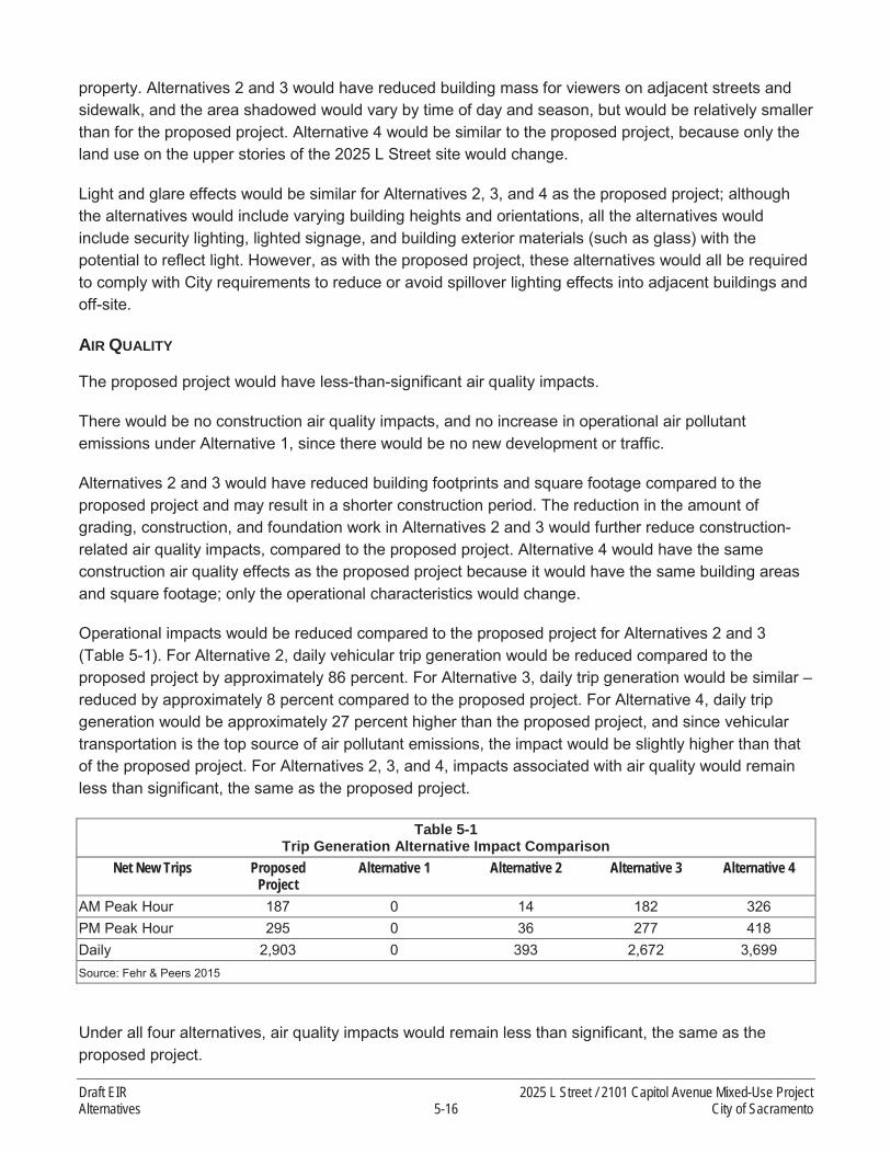
property. Alternatives 2 and 3 would have reduced building mass for viewers on adjacent streets and sidewalk, and the area shadowed would vary by time of day and season, but would be relatively smaller than for the proposed project. Alternative 4 would be similar to the proposed project, because only the land use on the upper stories of the 2025 L Street site would change.
Light and glare effects would be similar for Alternatives 2, 3, and 4 as the proposed project; although the alternatives would include varying building heights and orientations, all the alternatives would include security lighting, lighted signage, and building exterior materials (such as glass) with the potential to reflect light. However, as with the proposed project, these alternatives would all be required to comply with City requirements to reduce or avoid spillover lighting effects into adjacent buildings and off-site.
AIR QUALITY
The proposed project would have less-than-significant air quality impacts.
There would be no construction air quality impacts, and no increase in operational air pollutant emissions under Alternative 1, since there would be no new development or traffic.
Alternatives 2 and 3 would have reduced building footprints and square footage compared to the proposed project and may result in a shorter construction period. The reduction in the amount of grading, construction, and foundation work in Alternatives 2 and 3 would further reduce construction-related air quality impacts, compared to the proposed project. Alternative 4 would have the same construction air quality effects as the proposed project because it would have the same building areas and square footage; only the operational characteristics would change.
Operational impacts would be reduced compared to the proposed project for Alternatives 2 and 3(Table 5-1). For Alternative 2, daily vehicular trip generation would be reduced compared to the proposed project by approximately 86 percent. For Alternative 3, daily trip generation would be similar –reduced by approximately 8 percent compared to the proposed project. For Alternative 4, daily trip generation would be approximately 27 percent higher than the proposed project, and since vehicular transportation is the top source of air pollutant emissions, the impact would be slightly higher than that of the proposed project. For Alternatives 2, 3, and 4, impacts associated with air quality would remain less than significant, the same as the proposed project.
Table 5-1Trip Generation Alternative Impact Comparison
Net New Trips Proposed Project
Alternative 1 Alternative 2 Alternative 3 Alternative 4
AM Peak Hour 187 0 14 182 326PM Peak Hour 295 0 36 277 418Daily 2,903 0 393 2,672 3,699Source: Fehr & Peers 2015
Under all four alternatives, air quality impacts would remain less than significant, the same as the proposed project.
Draft EIR 2025 L Street / 2101 Capitol Avenue Mixed-Use ProjectAlternatives 5-16 City of Sacramento

CULTURAL RESOURCES
The proposed project would have no impact on historical resources, and would have potentially significant impacts related to archaeological resources, paleontological resources, and disturbance of undiscovered human remains. These impacts would be reduced to a less-than-significant level with implementation of Mitigation Measures 4.3-2, 4.3-3, and 4.3-4.
Under Alternative 1, no buildings or site landscape features would be demolished. Therefore, there would be no potential impacts on archaeological or paleontological resources and no potential to disturb undiscovered human remains.
Alternative 2 would have reduced cultural resources impacts compared to the proposed project. This alternative would have a smaller developed footprint on the 2101 Capitol Avenue site, so the potential for encountering archaeological or paleontological resources or human remains would be smaller. As with the proposed project, potentially significant impacts would be reduced to a less-than-significant level with Mitigation Measures 4.3-2, 4.3-3, and 4.3-4.
Alternatives 3 and 4 would have similar cultural resources impacts to the proposed project, because the building footprints would be similar, and so the potential for significant impacts on previously unknown archaeological or paleontological resources or human remains would be similar. As with the proposed project, potentially significant impacts would be reduced to a less-than-significant level with Mitigation Measures 4.3-2, 4.3-3, and 4.3-4.
Under all four alternatives, impacts associated with cultural resources would be potentially significant, reduced to a less-than-significant level with mitigation measures, the same as the proposed project.
GREENHOUSE GAS EMISSIONS
Greenhouse gas (GHG) emissions impacts would be less-than-significant for the proposed projectbecause the project complies with the City’s Climate Action Plan.
There would be no construction GHG emission impacts and no change to operational GHG emissions under Alternative 1, since this alternative does not include any new construction or traffic.
Alternatives 2 and 3 would have smaller development footprints and building square footage compared to the proposed project. The reduction in grading and construction work in Alternatives 2 and 3 would further reduce construction-related GHG impacts compared to the proposed project.
Operational impacts would be reduced compared to the proposed project for Alternatives 2 and 3. For Alternative 2, daily vehicular trip generation would be reduced compared to the proposed project by approximately 86 percent. For Alternative 3, daily trip generation would be similar – reduced by approximately 8 percent compared to the proposed project. For Alternative 4, daily trip generation would be approximately 27 percent higher than the proposed project, and since vehicular transportation is the top source GHG emissions, the impact would be slightly higher than that of the proposed project. Under all four alternatives, impacts associated with GHG emissions would remain less than significant, the same as the proposed project.
2025 L Street / 2101 Capitol Avenue Mixed-Use Project Draft EIRCity of Sacramento 5-17 Alternatives

NOISE AND VIBRATION
Construction vibration impacts of the proposed project would be potentially significant, reduced to a less-than-significant level after implementation of Mitigation Measures 4.9-3, 4.9-4 and 4.9-6.Construction noise impacts would be significant and unavoidable, despite the implementation of Mitigation Measures 4.6-3a and 4.6-3b. Other noise impacts would be less than significant for the proposed project.
There would be no noise or vibration impacts under Alternative 1, because there would be no new development or change to traffic patterns.
Alternatives 2 and 3 would have smaller development footprints and reduced square footage compared to the proposed project. The reduction in construction activity would reduce the length of time when construction noise and vibration would be generated, but during construction, construction noise and vibration effects would be similar to those of the proposed project. Alternative 2 has the potential to reduce the noise effects on nearby uses to the east of the 2101 Capitol Avenue property if the eastern structures were built first, forming a de facto noise wall during construction of the commercial building on the western portion of the 2101 Capitol Avenue property. The same mitigation measures would be required for the alternatives as the proposed project, especially to address noise and vibrational impacts to existing residences and structures in the project vicinity. Alternative 4 would have the same construction characteristics and impacts as the proposed project.
Operational noise and vibration impacts would be reduced for Alternatives 2 and 3 compared to the proposed project since these alternatives would have fewer residential units and reduced non-residential use. Noise associated with these land uses and traffic generated would be reduced compared to the proposed project, although on-site/noise-sensitive uses would be exposed to approximately the same traffic noise levels. These alternatives would have fewer sources of noise, reduced sensitive receptor exposure, and reduced traffic volumes compared to the proposed project.
Operational impacts would be reduced compared to the proposed project for Alternatives 2 and 3. For Alternative 2, daily vehicular trip generation would be reduced compared to the proposed project by approximately 86 percent. For Alternative 3, daily trip generation would be similar – reduced by approximately 8 percent compared to the proposed project. For Alternative 4, daily trip generation would be approximately 27 percent higher than the proposed project. Alternative 4 would have increased operational noise and vibration impacts compared to the proposed project because the residential units would be replaced with office uses, increasing trips and traffic noise. However, this alternative would avoid impacts associated with the on-site noise-sensitive residential uses placed in proximity to existing bars, restaurants, and nightclubs, where activity and noise continue into the evening hours.
Under all four alternatives construction noise impacts would be significant and unavoidable, as with the proposed project. Other noise impacts would remain less than significant, the same as the proposed project.
Draft EIR 2025 L Street / 2101 Capitol Avenue Mixed-Use ProjectAlternatives 5-18 City of Sacramento

TRANSPORTATION AND TRAFFIC
The proposed project would have less-than-significant transportation impacts.
There would be no transportation-related impacts under Alternative 1 because there would no new trips.
Operational impacts would be reduced compared to the proposed project for Alternatives 2 and 3. For Alternative 2, morning peak-hour trip generation would be reduced by approximately 93 percent compared to the proposed project and by approximately 88 percent in the afternoon peak hour. For Alternative 3, trip generation would be decreased by approximately 3 percent in the morning peak hour compared to the proposed project and by 6 percent in the afternoon peak hour. For Alternative 4, trip generation in the morning peak hour would be increased by approximately 74 percent compared to the proposed project and increased by approximately 42 percent in the afternoon peak hour.
Under all four alternatives, impacts associated with transportation and traffic would remain less than significant, the same as the proposed project.
5.3.2 ENVIRONMENTALLY SUPERIOR ALTERNATIVE
The State CEQA Guidelines require that an EIR identify the environmental superior alternative (CCRSection 15126.6 [e][2]). If the environmentally superior alternative is the “No-Project” Alternative, the EIR must identify an environmentally superior alternative from among the other alternatives. Since the No Project/No Development Project is the environmentally superior alternative, followed by Alternative 2: No Project/2101 Capitol Mixed Use, an environmentally superior alternative must be identified from among the other two alternatives. Other than the two no project alternatives reviewed in this section, Alternative 3: No General Plan Amendment is considered the environmentally superior alternative.
Table 5-2 presents a comparison of the alternative impacts.
Table 5-2Alternative Impact Comparison
Alternative 1: No Project/No Build
Alternative 2: No Project/2101 Capitol Mixed Use
Alternative 3: No General Plan Amendment Alternative 4: Office
Aesthetics Reduced Reduced Reduced SimilarAir Quality Reduced Reduced Reduced Increased
Cultural Resources Reduced Reduced Reduced ReducedGHG Emissions Reduced Reduced Reduced Increased
Noise and Vibration Reduced Reduced Reduced SimilarTransportation and Traffic Reduced Reduced Reduced Increased
Although Alternatives 3 and 4 would have reduced impacts compared to the proposed project in aesthetics, air quality, cultural resources, GHG emissions, noise, and traffic, the reductions in individual impacts would be smaller than under Alternative 2. Furthermore, Alternative 4 would have increased air quality, GHG emission, and traffic impacts compared to the proposed project, because of the substitution of higher-intensity office use for the residential uses in the proposed project.
2025 L Street / 2101 Capitol Avenue Mixed-Use Project Draft EIRCity of Sacramento 5-19 Alternatives

Alternatives 2, 3, and 4 would all meet the majority of the project objectives (presented in detail in Section 5.1.5), but to a lesser extent than the proposed project. Alternative 2 would only partially meet Objective 1; it would include new mixed use development on the 2101 Capitol Avenue site but would not replace the existing parking structure and office building on the 2025 L Street site. Alternatives 2 and 4 would not meet Objective 2 because they would have fewer than 140 residential units. Alternative 3 would only partially meet Objective 3, because no retail uses would be provided along 21st Street and Capitol Avenue.
Draft EIR 2025 L Street / 2101 Capitol Avenue Mixed-Use ProjectAlternatives 5-20 City of Sacramento

6 OTHER CEQA-REQUIRED CONSIDERATIONS
6.1 INTRODUCTION
California Code of Regulations (CCR) Section 15126 of the State CEQA Guidelines requires that all phases of a project be considered when evaluating its impact on the physical environment: planning, acquisition, construction, and operation. As part of this analysis, the EIR must also identify:
(1) Significant environmental effects of the proposed project,
(2) Significant environmental effects that cannot be avoided if the proposed project is implemented,
(3) Significant irreversible environmental changes that would result from implementation of the proposed project,
(4) Growth-inducing impacts of the proposed project, and
(5) Alternatives to the proposed project.
Further, the evaluation of significant impacts must consider direct and reasonably foreseeable indirect effects of the project over the short- and long-term. As part of this analysis, the EIR must identifymitigation measures proposed to reduce or minimize significant effects,
Chapter 4, “Environmental Impact Analysis”, identifies the significant and potentially significant environmental effects of the proposed project and contains mitigation measures proposed to minimize or avoid any potentially significant effects. Chapter 4 also addresses cumulative impacts associated with implementing the proposed project. Chapter 5, “Alternatives,” presents a comparative analysis of alternatives to the proposed project. The other CEQA-required analyses identified above are discussedbelow.
6.2 SIGNIFICANT AND UNAVOIDABLE IMPACTS
CCR Section 15126.2(b) of the State CEQA Guidelines requires that an EIR describe any significant impacts that cannot be reduced to less-than-significant levels, even with the implementation of feasiblemitigation measures. The environmental effects of the proposed project on various aspects of the physical environment are discussed in detail in Chapter 4, “Environmental Impact Analysis.” Project-specificimpacts that cannot be reduced to less-than-significant levels if the project is approved as proposedinclude:
Impact 4.6-3: The proposed project could result in construction noise levels that exceed the standards in the City of Sacramento Noise Ordinance or cause a substantial temporary, short-term increase in ambient noise levels. This impact would be significant and unavoidable.
2025 L Street / 2101 Capitol Avenue Mixed Use Project Draft EIRCity of Sacramento 6-1 Other CEQA-Required Considerations

6.3 SIGNIFICANT IRREVERSIBLE ENVIRONMENTAL EFFECTS
Under CEQA, an EIR must analyze the extent to which a proposed project's primary and secondary effects would generally commit future generations to the allocation of nonrenewable resources and to irreversible environmental damage (State CEQA Guidelines CCR Sections 15126.2[c] and 15127). Specifically, CCR Section 15126.2(c) states:
Uses of nonrenewable resources during the initial and continued phases of the project may beirreversible, since a large commitment of such resources makes removal or nonuse thereafterunlikely. Primary impacts and, particularly, secondary impacts (such as highway improvementwhich provides access to a previously inaccessible area) generally commit future generations tosimilar uses. Also, irreversible damage can result from environmental accidents associated withthe project. Irretrievable commitments of resources should be evaluated to assure that suchcurrent consumption is justified.
A proposed project would result in significant irreversible environmental changes if:
the primary and secondary impacts would commit future generations to similar uses;
the project would involve a large commitment of nonrenewable resources;
the project would involve uses in which irreversible damage could result from any potentialenvironmental accidents associated with the project; or
the proposed consumption of resources is not justified (e.g., the project involves the wasteful use ofenergy).
The proposed project would include construction of a mixed-use building on the 2025 L Street property,including a grocery store and up to 141 residential units. On the 2101 Capitol Avenue property, the proposed project would include approximately 13,000 square feet of commercial space, and a 425-space parking garage.
The State CEQA Guidelines also require a discussion of the potential for irreversible environmental damage caused by an inadvertent accident associated with the proposed project. The proposed project could result in the use, transport, storage, and disposal of hazardous wastes during construction and operation. However, all activities would comply with applicable local, state, and federal laws related to hazardous materials, which would substantially reduce the likelihood and severity of accidents that could result in irreversible environmental damage.
Implementation of the proposed project would result in the long-term commitment of resources to urban development. The project would change the visual character of the project site and increase generation of pollutants from vehicular travel and stationary operations. The proposed project would require short-term commitment during construction activities of nonrenewable and/or slowly renewable natural and energy resources, such as water resources. Operations associated with future uses would also consume natural gas and electrical energy.
Draft EIR 2025 L Street / 2101 Capitol Avenue Mixed Use ProjectOther CEQA-Required Considerations 6-2 City of Sacramento

Resource consumption would be reduced due to the regionally central location of the project site and relatively compact design and mixed-use nature of the proposed project. The proposed project is located in a transit priority area. A transit priority area is within 0.5-mile of a major transit stop (existing or planned light rail, street car, or train station) or an existing or planned high-quality transit corridor (with fixed route bus service at intervals of no longer than 15 minutes during peak commute hours) (SACOG 2011a:46).
The relatively compact and mixed-use character of the vicinity of the project site places existing and proposed residents in proximity to jobs and commercial services. This, along with the presence of transit, makes more walking, bicycling, and transit trips practical, eliminating some vehicle trips. Given the character of the project area, trips that do occur by automobile would be relatively short. The proposed project’s location and design would help to reduce vehicle miles traveled (VMT) and associated physical environment effects (i.e., noise, air pollutant emissions, and greenhouse gas emissions).
The reduction in VMT associated with the location and urban design environment of the project site has been demonstrated through the travel demand analysis that SACOG performed to support the MTP/SCS. The regional VMT per capita in 2008 was estimated to be 26 miles per day. For the traffic analysis zones that include the project site, the average per-capita VMT in 2008 was approximately 7 to 8 miles per day. In 2035, forecast regional average per-capita VMT is 24 miles per day, whereas the project site and vicinity would have an average of approximately 4 to 7 miles per day. Therefore, the 2025 L Street property is estimated to have per capita VMT rates of approximately 73 percent less than the regional average in 2008 and 84 percent less than the regional average in 2035 and the 2101 Capitol Avenue property is estimated to have per capita VMT rates of approximately 70 percent less than the regional average in 2008 and 70 percent less than the regional average in 2035 (SACOG 2011b:84). Considering only the travel demand attributable to proposed residential development on the 2025 L Street property, the per-capita daily VMT is approximately 5.6 (Carter, pers. comm. 2015)
The proposed project would be more efficient with regard to energy and other resources and would reduce transportation-related energy use relative to projects built in the past under building codes that did not require the same level of energy and water conservation. The average energy consumption for multi-family housing units is approximately half of the energy consumed by an average single-family detached home (U.S Environmental Protection Agency 2013). In addition, compact residential development in transit-oriented locations generally results in approximately 30 percent less energy consumption than traditional single-family detached homes (U.S Environmental Protection Agency 2013).
Resources that would be permanently and continually consumed by project implementation include water, electricity, natural gas, and fossil fuels; however, the amount and rate of consumption of these resources would not result in the unnecessary, inefficient, or wasteful use of resources. The proposed project would comply with all applicable building codes, including the 2013 Title 24 Energy Efficiency Standards.
2025 L Street / 2101 Capitol Avenue Mixed Use Project Draft EIRCity of Sacramento 6-3 Other CEQA-Required Considerations

Nonetheless, construction activities related to the proposed project would result in the irretrievable commitment of nonrenewable energy resources, primarily in the form of fossil fuels (including fuel oil), natural gas, and gasoline and diesel fuel for automobiles and construction equipment.
6.4 GROWTH-INDUCING EFFECTS
Growth-inducing effects are those that foster economic or population growth, or the construction of additional housing, either directly or indirectly, in the surrounding environment. This includes projects that would remove obstacles to population growth (by construction of expanded infrastructure, for example).
The proposed project would include the construction of up to 141 new multifamily residential units, a grocery store, with ancillary parking, an estimated 13,000 square feet of retail space, and a parking structure. The proposed project would be located on an approximately 2.31-acre infill site in midtownSacramento located close to a variety of transit resources. The proposed project would not require substantial new roadways, utilities, or public service infrastructure improvements. The proposed project would accommodate additional residents, and would provide additional jobs in one of the Sacramento region’s primary job centers. Although the proposed project would accommodate population and job growth, because of its location in an existing, developed area and the lack of additional infrastructurerequired, the proposed project would not have significant adverse growth-inducing effects.
The city of Sacramento and the surrounding region are forecast to grow in population. The City’s 2035 General Plan Master EIR assumes the City will grow to about 640,400 residents and about 390,100 people will be employed in the city. The General Plan identifies how this growth would be accommodated. As discussed in Chapter 3, “Land Use, Population, and Housing,” and in the individual topic sections in Chapter 4, the proposed project is consistent with the intent of the General Plan to accommodate a substantial portion of the forecast population growth in multi-family residential units in infill areas.
6.5 CUMULATIVE IMPACTS
CEQA requires that an EIR contain an assessment of the cumulative impacts that could be associated with the proposed project. This assessment involves examining project-related effects on the physical environment in the context of similar effects that have been caused by past or existing projects, and the anticipated effects of future projects. As indicated in the State CEQA Guidelines, the discussion of cumulative impacts need not provide the same level of detail as project-related impacts. The discussion should be guided by “standards of practicality and reasonableness” (State CEQA Guidelines CCR Section 15130[b]). Although project-related impacts can be individually minor, the cumulative effects of these impacts, in combination with the impacts of other projects, could be significant under CEQA and must be addressed (State CEQA Guidelines Section CCR 15130[a]). Where a lead agency concludes that the cumulative effects of a project, taken together with the impacts of other closely related past, present, and reasonably foreseeable probable future projects are significant, the lead agency then must determine whether the project’s incremental contribution to such significant cumulative impact is “cumulatively considerable” (and thus significant in and of itself).
Draft EIR 2025 L Street / 2101 Capitol Avenue Mixed Use ProjectOther CEQA-Required Considerations 6-4 City of Sacramento

6.5.1 CUMULATIVE CONTEXT
To ensure an adequate discussion of cumulative impacts is included in an EIR, CEQA allows the lead agency to use either a list of past, present, and probable future projects (including those projects outside of the control of the lead agency), or projections included in an adopted local, regional, or statewide plan like a general plan (State CEQA Guidelines, CCR Section 15130[b][1]). The cumulative impact context for evaluating cumulative impacts for the majority of the technical issue areas evaluated in this EIR considers development projections identified in the City’s 2035 General Plan.
The basis of the cumulative analysis varies by technical area. For example, traffic and traffic-related air pollutant emissions and noise analyses assume development that is planned and/or anticipated in the city, as well as the surrounding area, because each contributes to traffic on local and regional roadways that is quantifiable. Operational air quality impacts are evaluated against conditions in the city andsurrounding areas within the Sacramento Federal Nonattainment Area for ozone. The cumulative analysis in each of the technical sections evaluates the proposed project’s contribution to the cumulative scenario. A description of the cumulative context for each issue area evaluated in this EIR is included in the cumulative impacts at the end of each technical section of Chapter 4.
2025 L Street / 2101 Capitol Avenue Mixed Use Project Draft EIRCity of Sacramento 6-5 Other CEQA-Required Considerations

This page intentionally left blank.
Draft EIR 2025 L Street / 2101 Capitol Avenue Mixed Use ProjectOther CEQA-Required Considerations 6-6 City of Sacramento

7 REFERENCES
American Deep Foundation, Inc. 2015 (February 11th). Auger Pile Frequently Asked Questions. Available: http://www.americandeepfoundation.com/faq.php. Last accessed: February 11th,2015.
ARB. See California Air Resources Board.
Arnold, Jeanne and Michael Walsh. 2010. California’s Ancient Past from the Pacific to the Range of Light. SAA Press, Society for American Archaeology, Washington DC.
Bennyhoff, J. A. and D. A. Fredrickson. 1994. A Proposed Integrative Taxonomic System for Central California Archaeology. In Toward a New Taxonomic Framework for Central California Archaeology: Essays by James A. Bennyhoff and David A. Fredrickson, ed. R. E. Hughes, 15–24. Contributions of the University of California Archaeological Research Facility 52.
Building Performance Centre. 2007 (April). Research Study Conducted for Department of Environment, Food, and Rural Affairs (Defra).
California Air Pollution Control Officers Association (CAPCOA). 2013. California Emissions Estimator Model. Available: < http://www.caleemod.com/>. Accessed June 8, 2014.
———. 2013. California Emissions Estimator Model. Available: < http://www.caleemod.com/>. Accessed December 16, 2014.
California Air Resources Board. 2000 (October). Risk Reduction Plan to Reduce Particulate Matter Emissions from Diesel-Fueled Engines and Vehicles. Sacramento, CA.
———. 2005. Air Quality and Land Use Handbook: A Community Health Perspective. Sacramento, CA.
———. 2006 (April). Diesel Particulate Matter Exposure Assessment Study for the Ports of Los Angeles and Long Beach. Final Report. Sacramento, CA.
———. 2012 (June 12th). Executive Order G-12-044. Sacramento Area Council of Governments (SACOG) Sustainable Communities Strategy (SCS) ARB Acceptance of GHG Quantification Determination. Signed by Executive Officer James N. Goldstein.
———. 2013. Mobile Source Emission Inventory. Available: http://www.arb.ca.gov/msei/msei.htm. Last updated in September 2013. Accessed March 28, 2014.
———. 2013. Ambient Air Quality Standards. Available: <http://www.arb.ca.gov/research/aaqs/aaqs2.pdf>. Accessed March 18, 2014
———. 2013. Greenhouse Gas Inventory Data—Graphs. Available: http://www.arb.ca.gov/cc/inventory/data/graph/graph.htm. Accessed October 2013.
2025 L Street / 2101 Capitol Avenue Mixed-Use Project Draft EIRCity of Sacramento 7-1 References

———. 2014a (May). First Update to the Climate Change Scoping Plan: Building on the Framework.Pursuant to AB 32, the California Global Warming Solutions Act of 2006. Sacramento, CA.
———. 2014b (December 22nd). California 1990 Greenhouse Gas Emissions Level and 2020 Limit.Available: http://www.arb.ca.gov/cc/inventory/1990level/1990level.htm. Last accessed February 24, 2015.
———. 2014a. Glossary of Air Pollution Terms. Available: <http://www.arb.ca.gov/html/gloss.htm#criteria>. Accessed December 2, 2014.
———. 2014b. Hotspots Analysis Report Program. Available: <http://www.arb.ca.gov/toxics/harp/harpdownload.htm>. Accessed May 10, 2014.
———. 2014c. http://www.arb.ca.gov/adam/topfour/topfour1.php. Accessed March14, 2014.. Accessed March 14, 2014.
———. 2014. Collection Services. Available: http://portal.cityofsacramento.org/General-Services/RSW/Collection-Services. Accessed June 18, 2014.
California Department of Finance. 2014 (May). E-1 Population Estimates for Cities, Counties and the State with Annual Percent Change — January 1, 2013 and 2014. Available: http://www.dof.ca.gov/research/demographic/reports/estimates/e-1/view.php. Accessed: February 2, 2015.
California Department of Transportation (Caltrans). 2002. Guide for the Preparation of Traffic Impact Studies. December 2002.
———. 2004. Transportation and Construction-Induced Vibration Guidance Manual. Sacramento, CA.
———. 2014. California Scenic Highway Mapping System. Available: http://www.dot.ca.gov/hq/LandArch/scenic_highways/index.htm. Accessed January 19, 2015. Last updated May 5, 2014.
California Energy Commission (CEC). 2009. California Energy Demand 2010-2020, Adopted Forecast. December 2009. Available http://www.energy.ca.gov/2009publications/CEC-200-2009-012/index.html. Accessed: January 8, 2015.
———. 2013a (May). California Energy Demand 2014-2024, Preliminary Forecast. Volume 1: Statewide Electricity Demand, End-User Natural Gas Demand, and Energy Efficiency. Available: http://www.energy.ca.gov/2013publications/CEC-200-2013-004/CEC-200-2013-004-SD-V1.pdf. Accessed January 19, 2015.
———. 2013b (May). California Energy Demand 2014-2024, Preliminary Forecast. Volume 2: Electricity Demand by Utility Planning Area. Available: http://www.energy.ca.gov/2013publications/CEC-200-2013-004/CEC-200-2013-004-SD-V2.pdf.Accessed January 15, 2015.
Draft EIR 2025 L Street / 2101 Capitol Avenue Mixed-Use ProjectReferences 7-2 City of Sacramento

———. 2013c (July). California’s 2013 Building Energy Efficiency Standards Impact Analysis. Available: http://www.energy.ca.gov/2013publications/CEC-400-2013-008/CEC-400-2013-008.pdf . Accessed January 12, 2015.
———. 2015a. 2011 and 2013 Electricity Consumption by Planning Area. SMUD. Available http://www.ecdms.energy.ca.gov/elecbyplan.aspx. Accessed: October 29, 2012.
———. 2015b. 2011 and 2013 Natural Gas Consumption by Entity. PG&E. Available http://www.ecdms.energy.ca.gov/gasbyplan.aspx. Accessed: January 12, 2015.
California Public Utilities Commission (CPUC). 2014 (February). Biennial RPS Program Update. Available: <http://www.cpuc.ca.gov/NR/rdonlyres/F39A3D4C-6EE9-48AA-A0C9-03D6A3B3EF38/0/Section_399_19_Report_FINAL.pdf>. Accessed September 10, 2014.
Caltrans. See California Department of Transportation.
City of Burbank. 2014. Draft Environmental Impact Report for the Talaria at Burbank Mixed Use Project.May 2014.
City of Sacramento. 1996. Traffic Impact Analysis Guidelines. February 1996.
———. 2009. “Mobility Element.” In Sacramento 2030 General Plan. March 3, 2009. http://www.sacgp.org/documents/04_Part2.04_Mobility.pdf.
———. 2009a. Sacramento 2030 General Plan. Adopted March 3, 2009. Sacramento, CA.
———. 2014. Sacramento 2035 General Plan Draft Master Environmental Impact Report.
Carter, David. 2015 (February 27th). Email to Samar Hajeer, City of Sacramento with the subject line, “Whole Foods – TS.”
Casteneda, Christopher and Lee Simpson, eds. 2013. River City and Valley Life: An Environmental History of the Sacramento Region. University of Pittsburgh Press, Pittsburgh, Pennsylvania.
Chavez, Rick, P.E. 2015 (February 17th). Email to Matthew Gerken, AECOM. Subject line: 2025 L St / 2101 Capitol.
City of Sacramento. 2009. Cultural Resources. In Sacramento 2030 General Plan Master Environmental Impact Report. Pages 6.4-3 – 6.4.6.
———. 2009 (Adopted March 3rd). Sacramento 2030 General Plan.
———. 2009 (March). Sacramento 2030 General Plan. Adopted March 3, 2009. Sacramento, CA. Available: http://portal.cityofsacramento.org/Community-Development/Resources/Online-Library/General%20Plan. Accessed January 10, 2015.
2025 L Street / 2101 Capitol Avenue Mixed-Use Project Draft EIRCity of Sacramento 7-3 References

———. 2009 (March). Sacramento 2030 General Plan—Historic and Cultural Resources Element. Sacramento, CA. Available: http://portal.cityofsacramento.org/Community-Development/Resources/Online-Library/General%20Plan. Accessed January 13, 2015.
———. 2009 (March). Sacramento 2030 General Plan. Adopted March 3, 2009. Sacramento, CA.
———. 2010. Report to the City Council on Tree Pruning and Removal Services. April 27, 2010.
———. 2012. City of Sacramento Climate Action Plan.
———. 2012 (February). City of Sacramento Climate Action Plan. Available http://portal.cityofsacramento.org/Community-Development/Resources/Online-Library/Sustainability. Accessed: January 13, 2015.
———. 2012. Sacramento Climate Action Plan. Adopted February 14, 2012. Prepared in consultation with Ascent Environmental, Inc., Mintier Harnish, Fehr & Peers, and The Energy Alliance Association. Sacramento, CA. Pages i–xiv.
———. 2013 (June 27). Climate Action Plan – Consistency Review Checklist.
———. 2013 (September 5). Housing Element. Available: http://www.hcd.ca.gov/hpd/hrc/plan/he/he_documents/sacramento_draft090513.pdf.Last accessed: November 6, 2014.
———. 2013. Planning and Development Code. Sacramento, CA. Adopted April 9th, 2013.
———. 2014a (August). City of Sacramento 2035 General Plan Update Draft Master Environmental Impact Report. Available: http://portal.cityofsacramento.org/Community-Development/Planning/Long-Range/General-Plan/General-Plan-Update#DocsandResources. Accessed January 12, 2015.
———. 2014b (August). City of Sacramento 2035 General Plan Update Background Report Public Review Draft. Available: http://portal.cityofsacramento.org/Community-Development/Planning/Long-Range/General-Plan/General-Plan-Update#DocsandResources. Accessed January 12, 2015.
———. 2014a (December). Sacramento 2035 General Plan. Public Hearing Draft.
———. 2014a. Sacramento 2035 General Plan Draft Master Environmental Impact Report.
———. 2014b. Sacramento 2035 General Plan Background Report.
———. 2015. Summary of Current Mixed Income Housing Ordinance. Available: hhttp://portal.cityofsacramento.org/~/media/Corporate/Files/CDD/Planning/Long%20Range/Housing%20Programs/Mixed%20Income/Summary%20of%20Current%20Mixed%20Income%20Housing%20Ordinance.pdf. Accessed February 6, 2015.
Draft EIR 2025 L Street / 2101 Capitol Avenue Mixed-Use ProjectReferences 7-4 City of Sacramento

Egan, M. David. 1988. Architectural Acoustics.
EPA. See U.S. Environmental Protection Agency.
Ewing, Reid and Robert Cervero. 2001. “Travel and the Built Environment” Transportation Research Record, 1780, Paper No. 01-3515.
Federal Highway Administration. 1978 (December). Highway Traffic Noise Prediction Model. FHWA-RD-77-108. Office of Research, Office of Environmental Policy. Washington, DC.
———. 2006 (May). Transit Noise and Vibration Impact Assessment. FTA-VA-90-1003-06. Washington, DC: Office of Planning and Environment.
———. 2011. Noise Barrier Design Handbook.
Federal Railroad Administration. Office of Safety Analysis. Website. http://safetydata.fra.dot.gov/officeofsafety/ publicsite/Publications.aspx.
FHWA. See Federal Highway Administration.
Finegold, Lawrence and Bartholomew. 2001. “A Predictive Model of Noise Induced Awakenings from Transportation Noise Sources.” Published in Noise Control Engineering Journal, pp. 331-338.
FTA. See Federal Transit Administration.
Fredrickson, D. A. 1974. Cultural Diversity in Early Central California: A View from the North Coast Ranges. Journal of California Anthropology 1(1):41–54.
Hamilton, M. C., W. M. Nettles, B. Ludwig, and C. Gross 2005. The Many Faces of a City; Research Design for Recovery of Archaeological Deposits in Areas of the West Side Projects, City of Sacramento, California. Report submitted to Department of General Services, Real Estate Division, West Sacramento, California.Hay, O. P. 1927. The Pleistocene of the Western Region of North American and its Vertebrated Animals. Carnegie Institute Publication 322B. Washington, DC.
Helley, E.J. and D.S. Harwood. 1985. Geologic Map of the Late Cenozoic Deposits of the Sacramento Valley and Northern Sierran Foothills, California. U.S. Geological Survey. Map MF-1790. Reston, VA.
Hilton, R. P., D. C. Dailey, and H. G. McDonald. 2000 (April 15). A Late Pleistocene Biota from the Arco Arena Site, Sacramento, California. PaleoBios Abstracts 20(1).
Hutchinson, David A., S.E. 2015 (February 12th). Email message to Matthew Gerken, AECOM. Subject: 2010 Capitol Garage – Auger Cast Pile Vibration.
2025 L Street / 2101 Capitol Avenue Mixed-Use Project Draft EIRCity of Sacramento 7-5 References

Intergovernmental Panel on Climate Change. 2007. Climate Change 2007: The Physical Science Basis. Contribution of Working Group I to the Fourth Assessment Report of the IPCC. Geneva, Switzerland.
———. 2013. Climate Change 2013: The Physical Science Basis. Working Group I Contribution to the Fifth Assessment Report of the Intergovernmental Panel on Climate Change. New York:Cambridge University Press.
IPCC. See Intergovernmental Panel on Climate Change.
ITE (Institute of Transportation Engineers). 2012. Trip Generation Manual, 9th Edition.
Jonathan Rose Companies. 2011 (March). Location Efficiency and Housing Type. Boiling It Down to BTUs.
Jefferson, G. T. 1991a. A Catalogue of Late Quaternary Vertebrates from California—Part One, Nonmarine Lower Vertebrate and Avian Taxa. Technical Report No. 5. Natural History Museum of Los Angeles County. Los Angeles, CA.
———. 1991b. A Catalogue of Late Quaternary Vertebrates from California—Part Two: Mammals.Technical Report No. 7. Natural History Museum of Los Angeles County. Los Angeles, CA.
Kelley, John, Susan Huster, and Ben Matzen (2005). A Cultural and Paleontological Resources Study for the Spanos Parcel Project, Stockton, San Joaquin County, California. Submitted to Jerry Sperry, Stockton, California.
Kolber, M. 2004. Mammoth Coup: Discovery of Huge Fossil Near Elk Grove Is a Big Deal for Northern California. Sacramento Bee, July 27, 2004.
Lakes Environmental Software. 2014. AERMOD View. Available: < http://www.weblakes.com/products/aermod/?AspxAutoDetectCookieSupport=1>. Accessed May 5, 2014.
Lawrence Berkeley National Laboratory. 2005 (June). Development of Energy Balances for the State of California.
———. 2013 (April). California Energy Balance Update and Decomposition Analysis for the Industry and Building Sectors. Available: http://www.energy.ca.gov/2013publications/CEC-500-2013-023/CEC-500-2013-023.pdf. Accessed January 9, 2015.
Marchand, D. E., and A. Allwardt. 1981. Late Cenozoic Stratigraphic Units, Northeastern San Joaquin Valley, California. U.S. Geological Survey Bulletin 1470. Washington, DC: U.S. Government Printing Office.
Moratto, M. 1984. California Archaeology. New York: Academic Press.
Draft EIR 2025 L Street / 2101 Capitol Avenue Mixed-Use ProjectReferences 7-6 City of Sacramento

McGowan, Joseph A., and Terry R. Willis.1983. Sacramento: Heart of the Golden State. Windsor Publications, Inc., Woodland Hills, California.
Meyer, J., and J. S. Rosenthal, A Geoarchaeological Overview and Assessment of Caltrans District 3(2008)
National Institute on Deafness and Other Communication Disorders. 2008 (December). Fact Sheet: Noise-Induced Hearing Loss. Publication No. 08-4233.
NIDCD. See National Institute on Deafness and Other Communication Disorders.
Office of Environmental Health Hazard Assessment (OEHHA). 2003. Air Toxics Hot Spots Program Risk Assessment Guidelines. Available: < http://oehha.ca.gov/air/hot_spots/pdf/HRAfinalnoapp.pdf>. Accessed May 10, 2014.
RT (Regional Transit). 2015. About RT. Website. http://www.sacrt.com/rtataglance.stm.
SACOG. See Sacramento Area Council of Governments.
Sacramento Area Council of Governments. 2004a. The Blueprint Vision. Available: http://www.sacregionblueprint.org/adopted/. Accessed November 24, 2014.
———. 2004b. Place Type Menu - Blueprint Transportation/Land Use Study. Available: http://www.sacog.org/publications/list.cfm. Accessed November 24, 2014.
———. 2004c. Discussion Draft Blueprint Preferred Scenario for 2050 Map And Growth Principles. Available: http://www.sacregionblueprint.org/sacregionblueprint/the_project/principles.pdf.Accessed November 24, 2014.
———. 2011. Metropolitan Transportation Plan/Sustainable Communities Strategy.
———. 2011. Metropolitan Transportation Plan/Sustainable Communities Strategy. Chapter 5B. Trends & Performance. Available: http://sacog.org/mtpscs/mtpscs/. Accessed January 14, 2015.
———. 2012. Metropolitan Transportation Plan/Sustainable Communities Strategy 2035.http://www.sacog.org/2035/mtpscs/.
———. 2013 (July). Recommended Guidance for Land Use Emission Reductions Version 3.0 (for Operational Emissions).
———. 2014a. SMAQMD Thresholds of Significance Table. Available: < http://www.airquality.org/ceqa/cequguideupdate/Ch2TableThresholds.pdf>. Accessed December 16, 2014.
———. 2014b. Chapter 6: Greenhouse Gas Emissions. Available: <http://www.airquality.org/ceqa/cequguideupdate/Ch6ghgFINAL.pdf>. Accessed December 16, 2014.
2025 L Street / 2101 Capitol Avenue Mixed-Use Project Draft EIRCity of Sacramento 7-7 References
Sacramento County 2011. County of Sacramento General Plan Noise Element Background. Amended November 9, 2011.
Sacramento Metropolitan Air Quality Management District. 2005 (May). Model General Plan Air Quality Element. Available: http://www.airquality.org/lutran/ModelAQElement.pdf. Last accessed February 26, 2015.
———. 2009. CEQA Guide to Air Quality Assessment. Chapter 8, “Cumulative.” Sacramento, CA. Available: http://www.airquality.org/ceqa/ceqaguideupdate.shtml. Accessed August 15, 2014.
———. 2011. Recommend Protocol for Evaluating the Location of Sensitive Land Uses Adjacent to Major Roadways Version 2.4. Available: < http://www.airquality.org/ceqa/SLUMajorRoadway/SLURecommendedProtoco2.4-Jan2011.pdf>. Accessed February 9, 2015.
———. 2013. Guide to Air Quality Assessment in Sacramento County. Published December 2009; revised September 2010, April 2011, May 2011, April 2013, June 2013, July 2013, August 2013, and October 2013. Sacramento, CA.
———. 2013. Air Quality Standards Attainment Status. Available: http://www.airquality.org/aqdata/attainmentstat.shtml>. Accessed March 18, 2014.
———. 2011 (June). CEQA Guide. Chapter 8, Cumulative Air Quality Impacts. Available: http://www.airquality.org/ceqa/cequguideupdate/Ch8CumulativeFinal.pdf. Last accessed: October 13, 2014.
———. 2014a. CEQA Guide to Air Quality Assessment. Available: <http://airquality.org/ceqa/ceqaguideupdate.shtml>. Accessed December 2, 2014.
———. 2014b (June). CEQA Guide. Chapter 3, Construction-Generated Criteria Air Pollutant and Precursor Emissions. Available: http://www.airquality.org/ceqa/cequguideupdate/Ch3Construction-GeneratedCAPsFINAL.pdf.Last accessed: October 13, 2014.
SMAQMD. See Sacramento Metropolitan Air Quality Management District.
Savage, D. E. 1951. Late Cenozoic Vertebrates of the San Francisco Bay Region. University of California Publications, Bulletin of the Department of Geological Sciences 28(10):215–314.
Sierra Nevada Arborists. 2014 (September 13). Arborist Report and Tree Inventory Summary, 2025 L Street Mixed Use Project.
Sacramento Area Council of Governments. 2011. Metropolitan Transportation Plan/Sustainable Communities Strategy.
Draft EIR 2025 L Street / 2101 Capitol Avenue Mixed-Use ProjectReferences 7-8 City of Sacramento

Sacramento Municipal Utility District (SMUD). 2014. SMUD 2013 Annual Report. Availablehttps://www.smud.org/en/about-smud/company-information/documents/2013-annual-report.pdf.Accessed: January 8, 2015.
———. 2015a. Power Sources. Available https://www.smud.org/en/about-smud/company-information/power-sources.htm. Accessed January 13, 2015.
———. 2015b. Solar Power. Available https://www.smud.org/en/about-smud/environment/renewable-energy/solar.htm. Accessed January 13, 2015.
———. 2015c. SMUD’s Renewable Energy Portfolio. Available https://www.smud.org/en/about-smud/environment/renewable-energy/renewable-energy-portfolio.htm. Accessed January 13, 2015.
Society of Vertebrate Paleontology. 1995. Assessment and Mitigation of Adverse Impacts to Nonrenewable Paleontologic Resources–Standard Guidelines. Society of Vertebrate Paleontology News Bulletin, vol. 163, pp. 22–27.
———. 1996. Conditions of Receivership for Paleontologic Salvage Collections (Final Draft). Society of Vertebrate Paleontology News Bulletin, vol. 166, pp. 31–32.
Stanford University. 2010. Stanford University Medical Center Facilities Renewal and Replacement Draft EIR — Noise.
TRB (Transportation Research Board). 2010. Highway Capacity Manual 2010.
United States Census Bureau. 2015 “State and County Quick Facts.” Available at http://quickfacts.census.gov/qfd/states/06/0664000.html, accessed January.
University of California, Davis (UC Davis). 2014. What’s New in the 2013 Code? Changes to the Mandatory Title 24 Lighting Requirements.
University of California Museum of Paleontology. 2015. Paleontological Collections Database. Accessed January 13, 2015.
USDA 2014. Web Soil Survey. http://websoilsurvey.sc.egov.usda.gov/App/WebSoilSurvey.aspx.Accessed January 2015
U.S. Energy Information Administration. Energy Profiles. Available online: http://tonto.eia.doe.gov/state/. Accessed February 24, 2010.
———. 2013. California Energy Consumption by End-Use Sector, 2012. Available: http://www.eia.gov/state/?sid=CA#tabs-2. Accessed January 9, 2015.
U.S. Environmental Protection Agency (EPA). 1971 (December 31). Noise from Construction Equipment and Operations, Building Equipment and Home Appliances. NTID300.1. Washington, DC.
2025 L Street / 2101 Capitol Avenue Mixed-Use Project Draft EIRCity of Sacramento 7-9 References

———. 1974 (March). Information on Levels of Environmental Noise Requisite to Protect Public Health and Welfare with an Adequate Margin of Safety. Washington, DC.
———. 2012. Six Common Air Pollutants. Available: <http://www.epa.gov/air/urbanair/>. Accessed December 2, 2014.
———.2010. Annual Energy Review.
———. 2013 (June). Our Built and Natural Environments: A Technical Review of the Interactions among Land Use, Transportation, and Environmental Quality. Second Edition.
———. 2013 (October). Location and Efficiency of Housing Types. Available: http://www.epa.gov/smartgrowth/location_efficiency_BTU.htm. Accessed January 29, 2015.
Wagner, D. L., C. W. Jennings, T. L. Bedrossian, and E. J. Bortugno. 1987. Geologic Map of the Sacramento Quadrangle. Regional Geologic Map Series, Map No. 1A. Sacramento: California Division of Mines and Geology.
Wallace Kuhl and Associates. 2014a (January 27). Geotechnical Engineering Report, L Street Mixed Use. WKA No. 9955.01. Prepared for LVP Revocable Trust. Sacramento, CA.
———. 2014b (January 31). Geotechnical Engineering Report, 21st Street and Capital Avenue Mixed Use. WKA No. 9957.01. Prepared for LVP Revocable Trust. Sacramento, CA.
Wilson, N. L. and A. H. Towne. 1978. Nisenan. In Handbook of North American Indians, Volume 8: California, ed. R. F. Heizer, 387–397. Washington, DC: Smithsonian Institution Press.
Draft EIR 2025 L Street / 2101 Capitol Avenue Mixed-Use ProjectReferences 7-10 City of Sacramento

8 LIST OF PREPARERS
8.1 CITY OF SACRAMENTO
Tom Buford.......................................................................................................................Senior Planner
Dana Mahaffey ............................................................................................................Associate Planner
Teresa Haenggi ...........................................................................................................Associate Planner
Samar Hajeer .................................................................................................................Senior Engineer
Aelita Milatzo ......................................................................................................Transportation Engineer
Roberta Deering ..................................................................................................... Preservation Director
Robert Armijo..................................................................................................................Senior Engineer
William Wann.................................................................................................................. Police Sergeant
King Tunson ........................................................................................................... Fire Program Analyst
8.2 AECOM
Francine Dunn .................................................................................................................Project Director
Matthew Gerken ............................................................................................................ Project Manager
Drew Sutton....................................................................................................... Deputy Project Manager
Wendy Copeland .................................................................................................Environmental Scientist
Jenifer King..........................................................................................................Environmental Scientist
Joseph Howell ......................................................................................................Environmental Planner
Issa Mahmodi ................................................................................................................. Noise Specialist
George Lu................................................................... Air Quality/Greenhouse Gas Emissions Specialist
Tammie Beyerl.................................................................................................................Senior Biologist
Tracy Walker ..............................................................................................................................Biologist
Patricia Ambacher .................................................................................................Architectural Historian
Mark Bowen...........................................................................................................Architectural Historian
Madeline Bowen ....................................................................................................Architectural Historian
Denise Jurich...........................................................................................................Senior Archaeologist
Kerry Boutte........................................................................................................................Archaeologist
Anna Starkey ......................................................................................................................Archaeologist
Christine Safriet ............................................................................................................Senior Economist
Feliz Ventura ...........................................................................................................................Economist
2025 L Street / 2101 Capitol Avenue Mixed-Use Project Draft EIRCity of Sacramento 8-1 List of Preparers

Calum Thompson .............................................................................................................Energy Analyst
Eryn Pimentel .................................................................................................................... GIS Specialist
Phi Ngo.............................................................................................................................. GIS Specialist
Lisa Clement...................................................................................................................... GIS Specialist
Brian Perry..........................................................................................................................Graphic Artist
Sangwoo Lee...................................................................................................................Urban Designer
Anh Thai ..........................................................................................................................Urban Designer
Charisse Case ......................................................................................................... Document Specialist
Kristine Olsen .......................................................................................................... Document Specialist
Angela Schwartz...................................................................................................... Document Specialist
8.3 FEHR & PEERS – TRANSPORTATION AND TRAFFIC
David Carter. ......................................................................................................Transportation Engineer
Draft EIR 2025 L Street / 2101 Capitol Avenue Mixed-Use ProjectList of Preparers 8-2 City of Sacramento