Embed Size (px)
Citation preview

Council policy documents change from time to time and it is recommended that you consult
the electronic reference copy at www.casey.vic.gov.au/policiesstrategies to ensure that you
have the current version. Alternatively you may contact Customer Service on 9705 5200.
CASEY.VIC.GOV.AU
2021 Road Management Plan
Version: 1
Date Adopted: 20 July 2021
Responsible Department: City and Asset Planning
1. Purpose
The purpose of this document is to meet the requirements of a Road Management Plan
as defined by the Road Management Act 2004. This plan documents the standards,
policies and management systems used by the City of Casey to discharge its duty to
manage, inspect, repair and maintain the roads for which it is responsible.
2. Definitions
Council Means Casey City Council, being a body corporate constituted as a municipal Council under the Local Government Act 1989
Councilors
Means the individuals holding the office of a member of Casey City Council
Council officer
Means the Chief Executive Officer and staff of Council appointed by the Chief Executive Officer.
The Act For the purposes of this Policy, The Act refers to the Road Management Act 2004.
3. Scope
The objective of this document is to clearly define:
• The road assets the Council maintains
• The standards, policies and procedures used to maintain those assets
• The processes used to establish the appropriate standards.
The scope of this Plan is restricted to the specific requirements identified in the Code
of Practice for Road Management Plans.
This Plan covers only the roads and road sections on Council’s Register of Public
Roads that are identified as being the responsibility of the City of Casey.

2021 Road Management Plan Page 2 of 26
4. Context
Road Management Act 2004
The purpose of the Road Management Act 2004 (The Act) is to enable the coordinated
management of public roads that will promote safe and efficient State and local public road
networks, and the responsible use of road reserves for other legitimate purposes.
The City of Casey is the ‘coordinating road authority’ as defined by The Act for all roads within
its boundaries, except for the road network maintained by the Department of Transport (DoT).
The Act requires Council to identify on its Register of Public Roads all roads for which it is the
coordinating road authority that Council considers are reasonably required for general public
use. The City of Casey is the responsible road authority for all roads on the register, and road
infrastructure on DoT’s roads for which the Council is identified as having care and
management responsibility.
The Act sets out the powers and duties of the road authority to install, manage and maintain
infrastructure for which it is the responsible authority. The Act also provides a policy
defence for road authorities where they can demonstrate responsible management through
an adopted Road Management Plan.
Council responsibility
The Council has the power to determine the standard to which it will construct, inspect,
maintain and repair roadways as set out in The Act. The Council is responsible for
implementing processes and systems to ensure compliance with those standards.
Road-user responsibilities
Road user obligations are set out in Section 17A of the Road Safety Act 1986 (as
amended by the Road Management Act 2004) and summarised below.
A person who drives a motor vehicle on a highway must drive in a safe manner having
regard to all relevant factors including (but not limited to) the:
• physical characteristics of the road
• prevailing weather conditions
• level of visibility
• condition of the motor vehicle
• prevailing traffic conditions
• relevant road laws and advisory signs
• physical and mental condition of the driver.
A road user other than a person driving a motor vehicle must use a highway in a safe
manner having regard to all the relevant factors.
A road user must have regard to the rights of other road users and the community, taking
reasonable care to avoid conduct that may:
• endanger the safety and welfare of other road users
• damage any infrastructure on the road reserve
• harm the environment of the road reserve.

2021 Road Management Plan Page 3 of 26
5. Policy The Code of Practice for Road Management Plans1 outlines the contents for a Road Management Plan. Those contents are included in this document as follows:
Heading Location in this
Document Contents of a RMP as defined by
Code of Practice
City of Casey’s road infrastructure
Appendix A A description of the types of road infrastructure for each of the classes of public roads for which the road authority is the responsible road authority.
Management System
Appendix B Details of the management system, which is established or is to be established and implemented by the road authority to discharge its duty to inspect, maintain and repair.
Inspections Appendix C A description of the inspections required for different types of road infrastructure.
Service Standards Appendix D The standard or target condition to be achieved in the maintenance and repair of different types of road infrastructure.
In setting these inspections, standards and systems the authority is required to take account
community expectations, utilisation of assets, risk, environmental and cultural factors, and
available resources. These factors are accounted for through Council’s Asset Management
Plans that take a long-term holistic view to managing Council’s assets and are considered in
detail in the four-yearly review of this Road Management Plan.
6. Administrative updates
It is recognised that, from time to time, circumstances may change leading to the need for
minor administrative changes to this document. Where an update does not materially alter
this document, such a change may be made administratively. Examples include a change to
the name of a Council department, a change to the name of a Federal or State Government
department, and a minor update to legislation which does not have a material impact.
However, any change or update which materially alters this document must be by resolution
of Council.
7. Review
This Road Management Plan is required by the Road Management (General) Regulations 2016 to be reviewed within the same period that Council prepares its Council Plan. A summary of the findings of this review is available with this Plan at http://www.casey.vic.gov.au/roads-drains/roads/road-management-plan.
.
1 Code of Practice for Road Management Plans: Victoria Government Gazette No. S 201 16 Sept 2004. Copy is available for viewing at www.vicroads.vic.gov.au.

2021 Road Management Plan Page 4 of 26
Appendix A: City of Casey Road Infrastructure
Appendix A: City of Casey’s road infrastructure
Description
The City of Casey is the coordinating road authority and the responsible road authority for
more than 1,800 kilometres of roads within its boundaries. DoT is the coordinating road
authority for the main road network and is responsible for more than 177 kilometres of roads.
Approximately 82 per cent of Casey’s roads are in urban areas and usually include
footpaths and road furniture, and kerb and channel that discharge into a drainage
network. The remaining roads are classified as rural with stormwater usually controlled
by open drains and culverts.
Road hierarchy
Roads within the City of Casey are given a road hierarchy classification based on factors
including traffic volume, traffic type and accessibility, as shown in the table below. These
classifications are recognised and adopted throughout Casey for classifying roads.
Road Hierarchy Responsibility Primary Function
Freeway DoT A road which has fully controlled access and
provides the principal route for movement of goods
and people from one region to another.
Primary arterial
Council/DoT (Shared responsibilities between DoT and Council as detailed in the RMA & Code of Practice)
Roads whose main function is to form the
principal routes for the movement of goods and
people, predominantly from one region to
another. Access to abutting properties and
lower order roads is typically controlled or
denied.
Secondary arterial (Major roads)
Council Roads that supplement the primary arterial roads,
providing through traffic movement to an individually
determined limit, sensitive to roadway
characteristics and abutting land uses. These roads
provide a direct traffic link from one part of a region
to another. Access to abutting properties and lower
order roads is typically limited.
Trunk collector
Council Roads that provide a specialised form of connection
between the local streets and the arterial network
where – due to localised constraints – traffic is
required to be concentrated at a level higher than
desirable for a collector road. Access to abutting
properties is permitted; however, the traffic function
of the road is clearly recognised.
2021 Road Management Plan Page 5 of 26
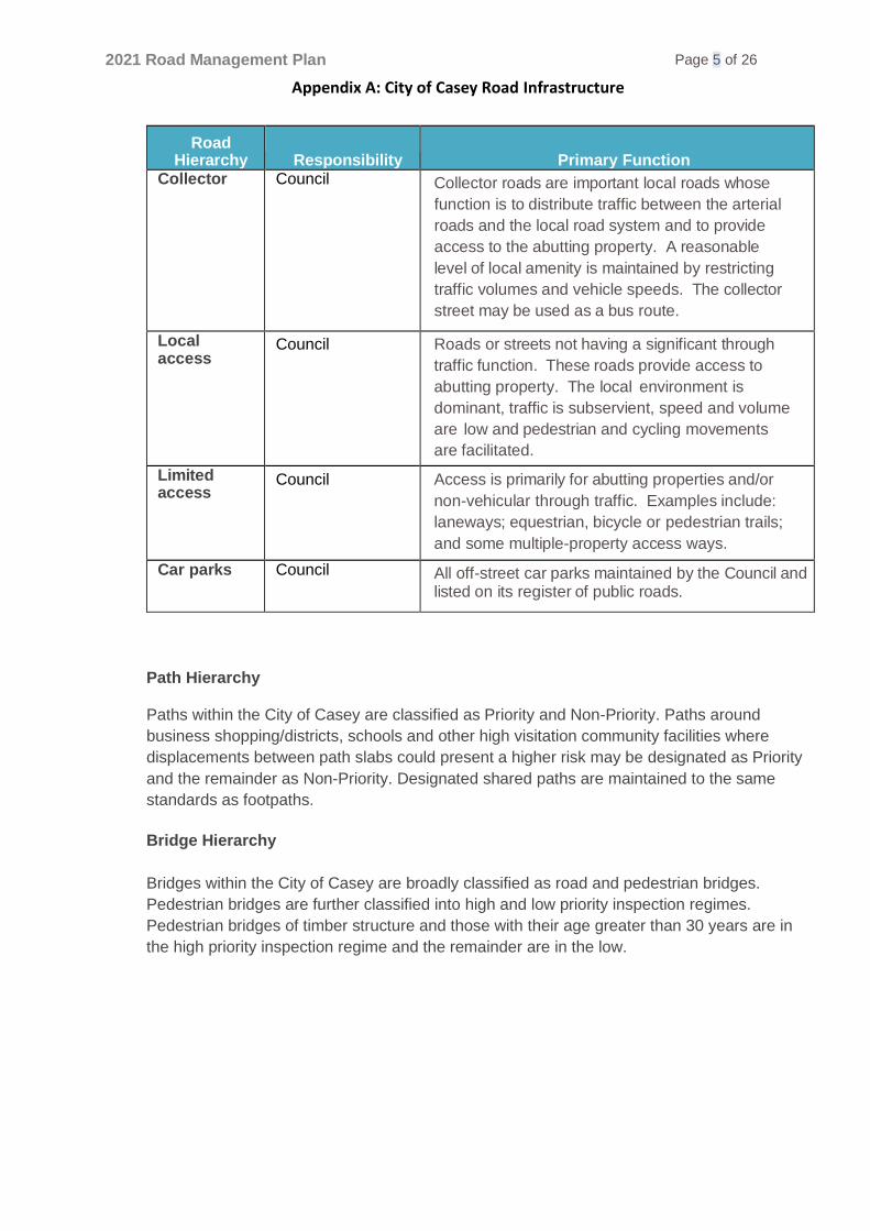
Appendix A: City of Casey Road Infrastructure
Road Hierarchy Responsibility Primary Function
Collector Council Collector roads are important local roads whose
function is to distribute traffic between the arterial
roads and the local road system and to provide
access to the abutting property. A reasonable
level of local amenity is maintained by restricting
traffic volumes and vehicle speeds. The collector
street may be used as a bus route.
Local access
Council Roads or streets not having a significant through
traffic function. These roads provide access to
abutting property. The local environment is
dominant, traffic is subservient, speed and volume
are low and pedestrian and cycling movements
are facilitated.
Limited access
Council Access is primarily for abutting properties and/or
non-vehicular through traffic. Examples include:
laneways; equestrian, bicycle or pedestrian trails;
and some multiple-property access ways.
Car parks Council All off-street car parks maintained by the Council and listed on its register of public roads.
Path Hierarchy Paths within the City of Casey are classified as Priority and Non-Priority. Paths around
business shopping/districts, schools and other high visitation community facilities where
displacements between path slabs could present a higher risk may be designated as Priority
and the remainder as Non-Priority. Designated shared paths are maintained to the same
standards as footpaths.
Bridge Hierarchy
Bridges within the City of Casey are broadly classified as road and pedestrian bridges.
Pedestrian bridges are further classified into high and low priority inspection regimes.
Pedestrian bridges of timber structure and those with their age greater than 30 years are in
the high priority inspection regime and the remainder are in the low.

2021 Road Management Plan Page 6 of 26
Appendix A: City of Casey Road Infrastructure
Register of Public Roads
The City of Casey Council’s Register of Public Roads (Register) defines the public roads and
their classifications for all roads for which Council is the coordinating road authority. The
Register is maintained by Council as a controlled document and is available for public
inspection at Council offices in Narre Warren or on Council’s website. Descriptions on the
Register are supported by map information on Council’s geographic information system.
Maps for specific roads showing the extent of the area maintained, can be provided on
request from Council’s Narre Warren offices.
Council’s policy for registering or removing a road on or from the Register is available from
Council’s website or Narre Warren offices.
For each road, the main details the register records are:
• Name of each public road
• Date on the which the road became a public road
• Identification of start and end points
• Locality
• Classification
• Details of changes to the status of the road as required by the Road Management Act.
Assets covered by this Plan
The assets covered by this plan are confined to those for which Council has statutory
responsibility under the Road Management Act 2004.
These assets are defined in the Road Management Act as:
• Roadway
• Pathway
• Shoulder
• Road-related infrastructure.
In keeping with these definitions, the following assets on roads identified in Council’s
Register are covered by this plan:
• Road surface and supporting pavement
• Constructed pathways (pedestrian, shared and equestrian)
• Car parks within road reserves
• Road shoulders
• Traffic control devices (traffic signals, line marking, speed control devices)
• Bridges and large culverts as part of roads infrastructure
• Kerb and channel
• Signs (regulatory and advisory).
Although Council also carries out inspection and maintenance of roadsides, fire hydrants,
street trees and information signs, the maintenance and inspection of these assets is outside
the scope of this plan. The operation and maintenance of these assets are covered by
separate operational plans.

2021 Road Management Plan Page 7 of 26
Appendix A: City of Casey Road Infrastructure
Council is not responsible for the management and maintenance of utility assets (e.g. water
and sewerage networks, telecommunications, electricity and gas) within the road reserve.
These assets are the responsibility of their respective utility provider.
Streetlights in road reserves provide a service to the community and are funded by the Council
but are owned and maintained by the respective network provider. They are therefore not
covered by this plan. The levels of service relating to these assets are considered through the
Asset Management Plan and arrangements made directly with the appropriate utility.
Roadside vegetation
A road authority does not have a statutory duty or a common law duty to maintain, inspect or
repair land of any public highway that is not a constructed path or roadway (RM Act s.107).
Nature-strips in urban areas are the responsibility of the neighbouring landowner to maintain.
Access to private property
Access to private property is provided by a ‘vehicle crossover’, which is defined as
infrastructure to allow the passage of vehicles between the road formation (or kerb and
channel, where it exists) and the property boundary. Vehicle crossovers may serve several
properties.
Section 107 of the Roads Management Act 2004 provides that Council is under no
statutory duty to inspect, maintain or repair vehicle crossovers on road reserves that
provide access to land adjoining a road. This responsibility rests with the adjoining
landowner. The construction of a vehicle crossover requires a permit and must be
carried out to Council standards. Where modifications to Council assets (e.g. paths and
kerb and channel) are required, these shall be at the landowner’s expense. The
landowner is responsible for ensuring the vehicle crossover and the immediate
surrounds that the crossover impacts on, are maintained in a safe condition. Council’s
responsibility is limited to requiring the landowner to rectify any hazards of which it
becomes aware.
In urban areas, Council has ownership for any footpaths and kerbs and channels. The
landowner has ownership and responsibility for the remainder of the vehicle crossover on
Council property. In rural areas where there is no footpath or kerb and channel, the
landowner is responsible for the entire vehicle crossover, including any culverts that may
be required.
Roadside maintenance responsibilities in urban areas are shown diagrammatically in
Figure 1

2021 Road Management Plan Page 8 of 26
Appendix A: City of Casey Road Infrastructure
Figure 1: Maintenance Responsibilities for Urban Roadside
Consent to perform works on road reserves
Any person who wants to undertake works in a road reserve must obtain consent from the
relevant road authority unless they are exempted under Roads Management Regulations
2005. For works on Council roads, a permit must be obtained from Council. Residents can
get advice by contacting Council customer service during the normal working hours by phone
(03 9705 5200) or in person at any of the customer service centres.
Demarcation and transfer or responsibility
The City of Casey is bounded by six municipalities: the City of Greater Dandenong,
Frankston City Council, Shire of Mornington Peninsula, Shire of Cardinia, Shire of Yarra
Ranges and the City of Knox.
The municipal boundary is in most instances the centreline of a road or follows a watercourse
over which bridges or culverts have been constructed. Council has agreements with the
neighbouring municipalities for boundary roads to clearly assign maintenance responsibilities
for the whole road or bridge to one or other of the authorities. The agreement also identifies
capital works responsibilities.
Melbourne Water manages the main drainage network and owns a number of bridges and
culverts that support Council roads. The City of Casey ensures that, with respect to the
ability of the bridge to provide a safe crossing for traffic, these structures are inspected and
maintained as for Council owned bridges.
DoT has an agreement with the City of Casey which defines the maintenance
responsibilities on main roads owned by DoT. In general, in urban defined areas DoT
maintains the road pavement and kerb and channel, while the City of Casey maintains
the road reserve and footpath.
Nature Strip
Property owner’s responsibility

2021 Road Management Plan Page 9 of 26
Appendix A: City of Casey Road Infrastructure
The following diagram illustrates a typical example of the relationship between assets
managed by the City of Casey and assets managed by DoT. In this example, the City
of Casey is responsible for the management of footpaths, outer separators (nature
strips), trees, service roads, and the roadside furniture within the road reserve. DoT is
responsible for the main carriageway (including kerb and channel), centre median strip,
lighting, and any additional road-related infrastructure defined in the Road
Management Act 2004.
Figure 2: Cross section showing responsibilities on typical primary arterial Road
The following table details the relationships and agreements between the City of
Casey and adjacent authorities.
Name
Authority
Relationship Documented Agreement
City of
Greater
Dandenong
Local
Government
• Maintenance of boundary streets by City of Casey and City of Greater Dandenong.
• Maintenance of footbridge by City of Casey.
In place
Frankston
City
Local
Government
• Maintenance of boundary streets by City of Casey and Frankston City.
In place
Mornington
Peninsula
Shire
Local
Government
• Maintenance of boundary streets by City of Casey and Shire of Mornington Peninsula.
In place
Shire of
Cardinia
Local
Government
• Maintenance of boundary streets by City of Casey and Shire of Cardinia.
• Maintenance of one traffic bridge by City of Casey.
• Maintenance of one traffic bridge by City of Cardinia.
In place
Shire of
Yarra
Ranges
Local
Government
• Maintenance of boundary roads by Shire of Yarra Ranges. (City of Casey pays an annual maintenance fee.)
In place

2021 Road Management Plan Page 10 of 26
Appendix A: City of Casey Road Infrastructure
Name
Authority
Relationship Documented Agreement
City of
Knox
Local
Government
• Maintenance of boundary streets by City of Casey and City of Knox.
In place
DoT Main Roads
Authority
• DoT owns main roads.
• Maintenance of pavement and kerb and channel by Dot.
• Maintenance of road reserves and footpaths by City of Casey.
In place
South East
Water
Water
Authority
• South East Water owns and maintains all water mains and sewerage system within City of Casey.
Management of
road utilities
infrastructure
in road
reserves VicTrack Rail Authority • VicTrack maintains the assets on rail track reserve
Ausnet Electricity Utilities
• Ausnet owns and maintains the electricity assets
AGL Gas service • AGL owns and maintains the gas network.
TXU Gas and
Electricity
• TXU owns and maintains gas and electricity assets.
ABN Co ABN • Maintains the ABN network
Telstra Tele-communications (incl. cable TV)
• Telstra owns and maintains the telecommunications network in the City of Casey.
Optus Cable TV • Optus owns and maintains a portion of the telecommunications network in the City of Casey.
Aquasure Desalination Pipeline
• Aquasure maintains the desalination pipes
Utility owners have rights of access to road openings and installation and maintenance
of their assets in accordance with the Code of Practice for the Management of Road
and Utility Infrastructure in Road Reserves.

2021 Road Management Plan Page 11 of 26
Appendix B: Management System
Appendix B: Management System
Managing asset information
The Council’s asset information is stored on an electronic database known as the Asset
Management System (AMS). This system is continually being developed and
enhanced. The AMS is also increasingly being used to manage information on risk
and to model deterioration and replacement scenarios.
Identifying hazards
Hazards or defects in road infrastructure are identified through inspections and
recorded in the Council’s database. Inspections can be initiated either as part of a
scheduled program as set out in Appendix D or by a request for service. Requests
for service (either generated internally or in response to a customer request) are
responded to using the process identified in Figure 3. All inspections are conducted by
vehicle with the exception of paths which are conducted on foot.
Frequencies for routine inspections are developed for each asset group based on
risk and rates of deterioration. For example, if not dealt with promptly, conditions
on unsealed roads and unsealed shoulders of sealed roads can rapidly change
resulting in increased maintenance cost and safety hazards, justifying frequent
inspections. Footpaths adjacent to business districts, schools and facilities are
identified for 6 monthly inspections and higher maintenance activity than other
footpaths that have less use.
The inspection frequency for road pavements (other than unsealed roads) is carried
out according to the road hierarchy. Secondary arterial and Trunk collector roads are
considered to pose a greater risk because of their higher traffic loads, and therefore
have more frequent inspections.
Assessing condition
The purpose of condition inspections is to assess the remaining life of an asset; for
financial purposes (calculation of depreciation); and for planning and prioritisation of
the City of Casey’s capital works program. The condition assessment processes
also have provision for recording hazards and maintenance defects which are
reported separately for action through the maintenance management system.
Roads and bridges are inspected and rated for condition at least every five years.
However, roads that have shown signs of deterioration are inspected more frequently
so that intervention takes place at the most appropriate time. Footpaths are
inspected and assessed every three years to determine their condition and develop
work programs.
All condition inspections are conducted by a vehicle with the exception of paths
condition inspection which is incorporated with the path hazard inspection and is
conducted on foot.

2021 Road Management Plan Page 12 of 26
Appendix B: Management System
Prioritising work
Requests for service and works orders are initially screened and ‘high’ risk situations
are dealt with immediately to manage the risk. If immediate repairs are not
practicable, steps are taken to reduce the risk and the appropriate intervention is then
scheduled. Activities are programmed to meet the response times identified in
Appendix D.
Delivering and auditing maintenance programs
Maintenance activities identified in Appendix D are carried out by a combination of in-
house resources and external staff.
The City of Casey has the following processes in place to ensure that planned
processes and activities are actioned:
• The Contract Supervisor/Team Leader is responsible for monitoring works activities and reporting results on a quarterly basis.
• Customer Service statistics (response times etc.) are measured and reported quarterly.
• Appropriate Team Leader/Head carries out monthly spot checks to verify operation of data collection process.
• Processes from initial request or inspection result, through to work done and recording are audited externally every second year by Council’s insurer.
The monitoring of work activities is carried out through the Asset Management System
through on-line queries, and standard and custom reports. Non-compliance with
standards will be reported to the Manager City Presentation.
Reactive requests are actioned in accordance with the process shown in Figure 3.

2021 Road Management Plan Page 13 of 26
Appendix B: Management System
Council receives request for service
Request logged into Request
Management System
Is request asset related?
Transfer to another Council
Department?
Change request
category and forward to
appropriate department
Transfer to appropriate
external agency
Request assigned to relevant Work
System category
Activity assessed for risk: high risk
activities phoned through
Task assigned to appropriate officer
or contractor
Task attended to on basis of risk
Y
N
Y
Asset inspected or task actioned?
Task programmed or completed?
Inspected
Details of task included in Works
System
Programmed task completed
Request Closed
N
completed
Programmed
Actioned
Figure 3: Process to Manage Request for Service

2021 Road Management Plan Page 14 of 26
Appendix B: Management System
Replacement programs
Pavement resurfacing, rehabilitation and footpath renewals are the main replacement
activities undertaken on City of Casey road assets.
The type and nature of replacement activity undertaken for road pavements depends
on:
• Condition of the asset
• Road classification
• Traffic volumes
• Proportion of commercial vehicles
• Subgrade conditions
• Rural and urban environment
• Economic factors.
In conjunction with inspection data and priority lists, the City of Casey utilises a
pavement management system to model the timing and type of renewal and
replacement activities that are undertaken to remove defects and manage the
overall condition of roads within the municipality.
Spray seal surfaces (comprising a sprayed bitumen layer with stone aggregate
topping) are common in rural areas and are replaced on a seven-year cycle
approximately.
Asphalt (comprising a mix of graded aggregate and bituminous binder) is
predominantly used for urban roads and is replaced when it deteriorates to a minimum
condition level, usually after 25 to 30 years. This surface type is predominant in urban
areas.
Tactics for new and upgraded assets
The City of Casey’s road network is still developing and continued investment is
required to upgrade existing assets and provide new assets.
New residential streets are generally created as a condition of subdivision
developments and the roads vested in the Council.
The Council has a prioritised unsealed road program to construct and seal selected
unsealed roads. Residents may apply to have other roads constructed and sealed on
the basis that such upgrades would be subject to full cost recovery from owners of land
fronting the road through a special charge scheme established for that purpose.
The City of Casey has a number of strategies that provide guidance in regard to the
need and location of new roads. Principally these strategies relate to the future
development of green-field sites and the associated infrastructure required to service
these areas.
The strategies adopted include:
• Integrated Transport Strategy – which provides a policy framework to guide the detailed planning of transport infrastructure in the municipality.

2021 Road Management Plan Page 15 of 26
Appendix B: Management System
Disposal tactics
As part of the delivery of cost-effective services, Council may consider the disposal of
assets and, in doing so, will take into account risk, costs and benefits, and adverse
effects. Council will dispose of assets only after appropriate notification and full
consultation with affected parties.
Events beyond the control of Council
Council will make every endeavor to meet all aspects of its Road Management Plan.
However, in the case of natural disasters and events (including fires and floods)
as well as human factors (including lack of Council staff or suitably qualified
contractors) Council reserves the right to suspend compliance with its Plan in
accordance with Section 83 of the Victorian Wrongs Act 1958 (as amended).
Pursuant to Section 83 of the said Act, in the event of limited financial resources of
Council and conflicting priorities where the Chief Executive Officer concludes the
Road Management Plan cannot be fully implemented, the Chief Executive Officer
will write to Council’s officer in charge of implementing the plan (Manager City
Presentation) and inform them that some, or all of the timeframes and responses in
Council’s Plan are to be suspended.
Once the events beyond the control of Council have abated, or if the events have partly
abated, Council’s Chief Executive Officer will write to Council’s officer responsible for
implementing the plan and inform them what parts of Council’s Plan are to be
reactivated and when.

2021 Road Management Plan Page 16 of 26
Appendix C: Inspections
Appendix C – Inspections
Reactive inspections
The table below describes reactive inspections carried out on road assets within the City of
Casey in response to a request for service, whether generated externally through a customer
request or internally form incidental observations by Council Staff.
Type Inspection details Person Reporting details
Emergency/safety Defects identified as
likely to create a
danger or serious
inconvenience.
Risk reduced by
repair, barricades or
warnings as
appropriate, within 6
hours from the time
it’s initiated through
the 24 hours, 7
days a week
Council call out
service.
Council
representative with
knowledge of road
maintenance
techniques.
Additional expertise
brought in as
required.
Identify specific
defect, time first
reported, time
inspected, by whom,
subsequent action
and time of
completion.
Recorded in
database.
Reactive
maintenance
Non-urgent (potential
risk but no
immediate danger;
e.g. street name
plate missing)
inspections carried
out within 10 working
days. Any work
requirements are
recorded and
prioritised in
conjunction with
results of
programmed
inspections.
Technical officer or
asset inspector with
knowledge and
experience of road
maintenance
techniques.
As above.
2021 Road Management Plan Page 17 of 26
Appendix C: Inspections
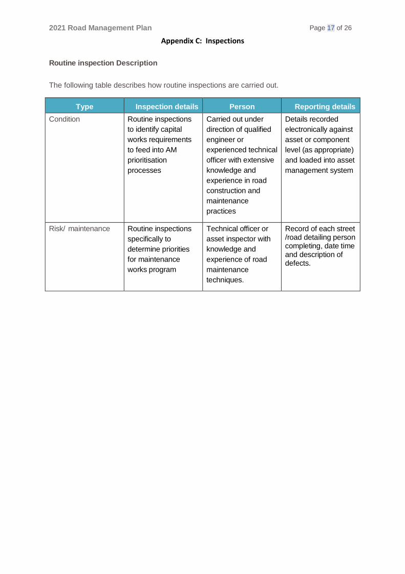
Routine inspection Description
The following table describes how routine inspections are carried out.
Type Inspection details Person Reporting details
Condition Routine inspections
to identify capital
works requirements
to feed into AM
prioritisation
processes
Carried out under
direction of qualified
engineer or
experienced technical
officer with extensive
knowledge and
experience in road
construction and
maintenance
practices
Details recorded
electronically against
asset or component
level (as appropriate)
and loaded into asset
management system
Risk/ maintenance Routine inspections
specifically to
determine priorities
for maintenance
works program
Technical officer or
asset inspector with
knowledge and
experience of road
maintenance
techniques.
Record of each street /road detailing person completing, date time and description of defects.

2021 Road Management Plan Page 18 of 26
Appendix C: Inspections
Routine Inspections – Condition
The table below sets out the routine condition inspection regime used to estimate
remaining life for establishing capital works programs and calculating depreciation.
Asset Classification Inspection
description Frequency
Pavement Flexible and rigid
sealed pavement
Surface inspection for
defects, cracking,
roughness, rutting
5 years maximum
(depending on
condition of last
inspection)
Pavement Flexible and rigid
sealed pavement
Structural pavement
testing
Selected roads where
construction planned
Paths Concrete Visual condition
survey
Incorporated into
routine inspections
Kerb and channel All
Visual condition
survey
5 years - in
conjunction with
pavement condition
inspection
Bridges All
Condition survey
(Level 2)
5 years maximum
(depending on
condition of last
inspection)
Bridges All
Structural safety and
load capacity (Level 3
and 4)
As determined from
Level 1 and 2
inspections
Other assets and classifications are currently not condition rated.

2021 Road Management Plan Page 19 of 26
Appendix C: Inspections
Routine Inspections – Risk / Maintenance The following tables identify the inspections and frequencies for each asset class.
Classification Inspection description Frequency
Maximum
interval between
inspections
Pavement and kerb
Secondary Arterial Maintenance and
hazard inspection of road surface
and kerbs
3 Months 16 weeks
Trunk Collector Maintenance and
hazard inspection of road surface
and kerbs
6 months 30 weeks
Other sealed roads (Collector, Local Access, Limited Access and all carparks)
Maintenance and
hazard inspection of road surface
and kerbs
Yearly 60 weeks
Unsealed Roads, (all classifications)
Maintenance and
hazard inspection of road surface
Monthly 6 weeks
Unsealed
shoulders of sealed
roads
Maintenance and
hazard inspection
Monthly 6 weeks
Footpath and shared paths
Priority areas –
Concrete/asphalt/
Pavers
Defect and hazard
inspection of footpath
6 months 60 weeks
Non priority areas –
Concrete Defect and hazard inspection of
footpath
3 years 4 years
Non priority areas –
Unsealed / gravel Maintenance and hazard
inspection of footpath
Yearly 60 weeks
Non priority areas –
Asphalt Maintenance and hazard
inspection of footpath
Yearly 60 weeks

2021 Road Management Plan Page 20 of 26
Appendix C: Inspections
Classification Inspection description Frequency
Maximum
interval between
inspections
Street furniture/signage (regulatory and advisory)
All Roads Maintenance and
hazard inspection
Yearly 60 weeks
Night-time inspection on Secondary Arterial Roads
Night-time inspection
of reflectivity on secondary
arterial and intersecting
roads
Yearly 60 weeks
Sealed Roads line marking All Roads
Maintenance Inspection of line marking on all relevant roads (including controlled intersections) and car parks
Yearly
15 months
Pedestrian and school crossings
Maintenance inspection and school and pedestrian crossings (all roads) painting.
Yearly 15 months
Drainage
Side entry pits on
roads
Maintenance
inspection and cleanout
2 yearly 2 years, 3 months
Bridges
Road bridges Level 1 hazard and maintenance inspection
24 weeks 28 weeks
Pedestrian Bridges
High priority
Level 1 hazard and maintenance inspection
12 weeks 16 weeks
Low Priority Level 1 hazard and maintenance inspection
24 weeks 28 weeks
Horse trails
Constructed (gravel)
horse-trails
Maintenance and
hazard inspection
Yearly 60 weeks

2021 Road Management Plan Page 21 of 26
Appendix D: Service Standards
Appendix D – Service Standards
The development of standards
Through the Council’s Asset Management Plan, key stakeholders are defined and
their expectations identified in terms of accessibility, safety, responsiveness,
quality, cost effectiveness and environmental considerations. Customer
expectations have initially been inferred by Council staff involved in service delivery
for road activities and are modified as information from ongoing research
(customer requests and feedback analysis, focus groups and surveys) becomes
available. Where appropriate, these expectations are translated into standards
which are modified through the Council’s asset management planning process to:
• Achieve Council’s goals and objectives
• Meet minimum legislative requirements
• Reduce overall costs through timely response.
Inspection standards (nature and frequency) are determined to meet the above
requirements and are confirmed through a risk assessment in accordance with
Council’s risk management framework. These standards are tabled in Appendix D.
The technical standards are assessed prior to each review of this plan and the
standards modified to minimise risk and take account of any legislative changes.
Road safety
The number of reported accidents on Council roads has averaged around 183 accidents
annually over the past five years. The average number of fatalities has remained the
same at 2.6 over the past five years despite a significant increase in traffic volume on
Council roads. Road safety is an important focus for Council’s traffic management
section.
Specific sites identified with a recurring accident trend are assessed for suitability for
remedial treatment under a range of Federal, State and Local Government safety
programs.
Construction standards
The standards for new road infrastructure are set out in the Engineering Design and
Construction Manual2 provided by the Victorian Planning Authority. While new
infrastructure is designed and constructed in accordance with these standards, there is
no obligation on Council to upgrade any existing infrastructure which may not be built
according to this standard.
2 Engineering Design and Construction Manual (April 2011), available from Victorian Planning Authority website at https://vpa.vic.gov.au/strategy-guidelines/engineering-standards./

2021 Road Management Plan Page 22 of 26
Appendix D: Service Standards
Reactive maintenance and intervention levels
Intervention levels define the circumstances under which a defect is no longer tolerable
for a stated level of service. The timeframe in which to address these defects once
they are found is determined from an analysis of risk, benefits and costs. Examples of
these levels and the associated maintenance activities are described in the tables below.
Key Task
Intervention levels Response
times
Performance standard
Roads and street furniture
Response to
emergency
call outs
• Spill creating slippery or other hazardous situation
• Roadwork site unsafe (e.g. signage, plant or materials)
• Obstacles on roadway or shoulder
• Potholes, severe pavement subsidence or surface damage
• Flooding in road reserve
• Missing drainage pit lid
• Unserviceable guard rail
• Structural bridge damage reducing capacity or significant bridge surface defect
6 hours (immediately after initiation, for 7 days a week)
Site inspected and risk reduced appropriately as required
48 hours (immediately after initiation, for 7 days a week)
Assess situation and determine remedial treatment
Sealed roads
pot-hole
patching
Repair all potholes greater than 300mm diameter and 50mm depth
10 working
days
Hole is to be repaired to provide a smooth, safe surface consistent to line and level of surrounding pavement
Sealed roads
- repair of
shoulders
Maintenance is required when:
• the drop from the traffic
lane to the shoulder exceeds 75mm over any length, or
• when there are more than 20 potholes per km of single shoulder of depth greater than 50mm or
• where corrugations exceed 30% of the area of a single road shoulder per km
10 working
days
Provision of a safe trafficable surface which is free draining and prolongs the pavement life

2021 Road Management Plan Page 23 of 26
Appendix D: Service Standards
Key Task
Intervention levels
Response times
Performance standard
Roads and street furniture (Continued)
Kerb and channel displacement
Tripping hazard identified with displacement between kerb sections exceeding 80 mm
20 working days
Restore the alignment and level of the kerb or channel with either replacement of a sections or smoothing the displacement using an asphalt fillet, concrete slurry or similar suitable material. If these repairs are not practicable, the defect will be highlighted with paint until it can be rectified.
Unsealed roads maintenance
When pavement defects (as specified) and/or loose material (greater than 40mm deep) exceed 20% pavement surface area per km
20 working days
Unsealed roads maintenance
Pedestrian and
school
crossing
maintenance
Timber posts to be replaced
when damaged or greater
than 50% wood rot is evident
5 working
days
All crossings and related furniture to be in good conditions and highly visible at all times
Road regulatory
and
advisory
signage
maintenan
ce
Road signs missing or
illegible
20
working
days
Clean or replace damaged signs
Guard rail
maintenance
Guard rails in damaged
condition (other than
immediate safety hazards)
20 working days
Guard rails restored to provide safety to road users and protection of pedestrians and assets.
Guide post
maintenance
Damaged posts/delineators.
50% of the white face of the
post is noticeably degraded
or faded.
20 working days
Posts/delineators replaced to provide clear delineation of the road shoulder edge and culvert/bridge locations
Sealed Roads line marking
When line marking is faded, eroded, worn or non-reflective.
Program Works programmed for repainting in the next financial year

2021 Road Management Plan Page 24 of 26
Appendix D: Service Standards
Key Task
Intervention levels Response
times
Performance
standard
Footpath and Shared Paths
Response to
emergency
call outs
Surface collapse or obstacle.
Other situations on paths
assessed by Council Officers
as being of immediate priority
6 hours Site inspected and
risk reduced
appropriately as
required.
Footpath/shared
path - concrete
Hazard identified with
displacement > 20 mm or
crack width more the 20mm
over length of 0.5 m
Priority
areas - 10
working days
Grinding, filling with
asphalt or replacing
the slabs. If these
repairs are not
practicable, the defect
will be highlighted with
paint until it can be
rectified.
Non-priority areas – 30 working
days
Footpath/shared
path - asphalt
Whenever the number of
potholes exceed two (2) per
100m of footpath or potholes
are greater than 100mm
diameter or 25mm in depth
Whenever cracking exceeds
2m in length and 10mm in
width
Wherever pavement shows
significant concentrated levels
of distress
30
working days Footpaths to be free of
potholes and surface
defects including
depressions that hold
water and cracking in
sealed pavements
greater than 10mm in
width and 2m in
length.
Footpath/shared
path - unsealed
Whenever pavement shows
significant concentrated levels of
distress
Whenever scours of depth
greater than 50mm occur at
any location
30
working days
Footpaths to be free of potholes and surface defects including depressions that hold water

2021 Road Management Plan Page 25 of 26
Appendix D: Service Standards
Key Task
Intervention levels Response
times
Performance standard
Horse trails Whenever trail is impassable
by horse
30
working
days
Trails to be
accessible and free
of obstruction or
temporarily closed.
Drainage
Emergency call
Outs
Flooding of roadway more
than 300mm deep
6 hours Site inspected and
risk reduced or
provides appropriate
warnings as
required.
Culvert cleaning Effective pipe area reduced by
more than 40%
5
working
days
Culverts under roads
clear of weed, silt
and debris
Pits/Side entry pits on roads
Damaged pit lid; pit lintel/surrounding damaged; pit blocked
30 working days
Pit lid/lintel/surrounding repaired or replaced; pit cleared of weeds, silt and debris.
Missing pit lid 10 working days
Repair/replace pit lid
Bridges/structures
All bridges and bridge equivalent structures
Visible damage on components likely to affect users or public safety
30 working days
Temporary repair and/or permanent repair/ replacement of the unsafe/ damaged components. If repair is not applicable, hazard is mitigated and repair is programmed for the next financial year.