Embed Size (px)
Citation preview
i
2020 Impaired Waters List
Summary of Public Comments and the WDNR’s Responses
A public comment period on the Draft 2020 Impaired Waters List was held from October 15, 2019 to
November 22, 2019. A total of 12 entities commented on the Draft 2020 Impaired Waters List. The
following is a summary of comments and the Wisconsin Department of Natural Resources (WDNR)
responses indicating any changes to the Draft 2020 Impaired Waters List. This attachment is submitted to
the EPA for their review of the 2020 Impaired Waters List. After the EPA has reviewed the list and this
supporting documentation, additional changes may be made to ensure compliance with federal
requirements.
This attachment contains:
• Public Notice of the Public Comment Period
• A list of those who submitted comments
• Individual comments and WDNR responses
ii
TABLE OF CONTENTS
PUBLIC NOTICE OF THE PUBLIC COMMENT PERIOD ...................................................................... 1
LIST OF COMMENTERS ........................................................................................................................... 2
COMMENTS AND RESPONSES ............................................................................................................... 3
List Determinations ................................................................................................................................... 3
RESTORATION WATERS LIST ........................................................................................................ 3
HEALTHY WATERS LIST ................................................................................................................. 3
MERCURY DELISTINGS ................................................................................................................... 3
Specific Waterbodies ................................................................................................................................ 4
LITTLE MENOMONEE RIVER ......................................................................................................... 4
BEAVER CREEK ................................................................................................................................ 5
MILWAUKEE RIVER BASIN ............................................................................................................ 5
FLICK CREEK AND HEMLOCK CREEK......................................................................................... 5
MUD CREEK AND PINE CREEK ...................................................................................................... 6
MUKWONAGO RIVER AREA .......................................................................................................... 7
MUSKY BAY ....................................................................................................................................... 8
MUSKY BAY PHOSPHORUS SSC .................................................................................................... 8
MUSKY BAY AND LAC COURTE OREILLES ............................................................................... 9
UNNAMED RIVER, STREAM C, TRIBUTARY TO FLAMBEAU RIVER .................................. 12
WHITE RIVER ................................................................................................................................... 12
EPA Comments ....................................................................................................................................... 13
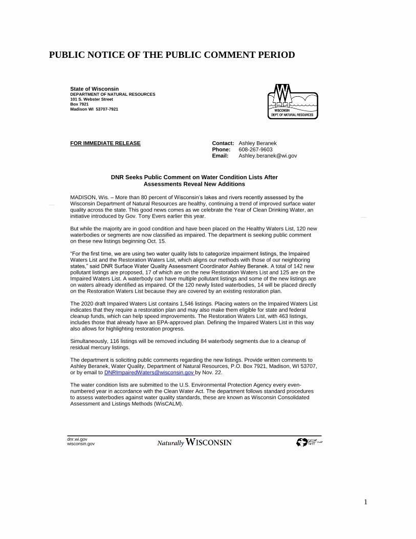
1
FOR IMMEDIATE RELEASE Contact: Ashley Beranek
Phone: 608-267-9603 Email: [email protected]
DNR Seeks Public Comment on Water Condition Lists After Assessments Reveal New Additions
MADISON, Wis. – More than 80 percent of Wisconsin’s lakes and rivers recently assessed by the Wisconsin Department of Natural Resources are healthy, continuing a trend of improved surface water quality across the state. This good news comes as we celebrate the Year of Clean Drinking Water, an initiative introduced by Gov. Tony Evers earlier this year. But while the majority are in good condition and have been placed on the Healthy Waters List, 120 new waterbodies or segments are now classified as impaired. The department is seeking public comment on these new listings beginning Oct. 15. “For the first time, we are using two water quality lists to categorize impairment listings, the Impaired Waters List and the Restoration Waters List, which aligns our methods with those of our neighboring states,” said DNR Surface Water Quality Assessment Coordinator Ashley Beranek. A total of 142 new pollutant listings are proposed, 17 of which are on the new Restoration Waters List and 125 are on the Impaired Waters List. A waterbody can have multiple pollutant listings and some of the new listings are on waters already identified as impaired. Of the 120 newly listed waterbodies, 14 will be placed directly on the Restoration Waters List because they are covered by an existing restoration plan. The 2020 draft Impaired Waters List contains 1,546 listings. Placing waters on the Impaired Waters List indicates that they require a restoration plan and may also make them eligible for state and federal cleanup funds, which can help speed improvements. The Restoration Waters List, with 463 listings, includes those that already have an EPA-approved plan. Defining the Impaired Waters List in this way also allows for highlighting restoration progress. Simultaneously, 116 listings will be removed including 84 waterbody segments due to a cleanup of residual mercury listings.
The department is soliciting public comments regarding the new listings. Provide written comments to Ashley Beranek, Water Quality, Department of Natural Resources, P.O. Box 7921, Madison, WI 53707, or by email to [email protected] by Nov. 22.
The water condition lists are submitted to the U.S. Environmental Protection Agency every even-numbered year in accordance with the Clean Water Act. The department follows standard procedures to assess waterbodies against water quality standards, these are known as Wisconsin Consolidated Assessment and Listings Methods (WisCALM).
State of Wisconsin DEPARTMENT OF NATURAL RESOURCES 101 S. Webster Street Box 7921
Madison WI 53707-7921
dnr.wi.gov wisconsin.gov
PUBLIC NOTICE OF THE PUBLIC COMMENT PERIOD
2
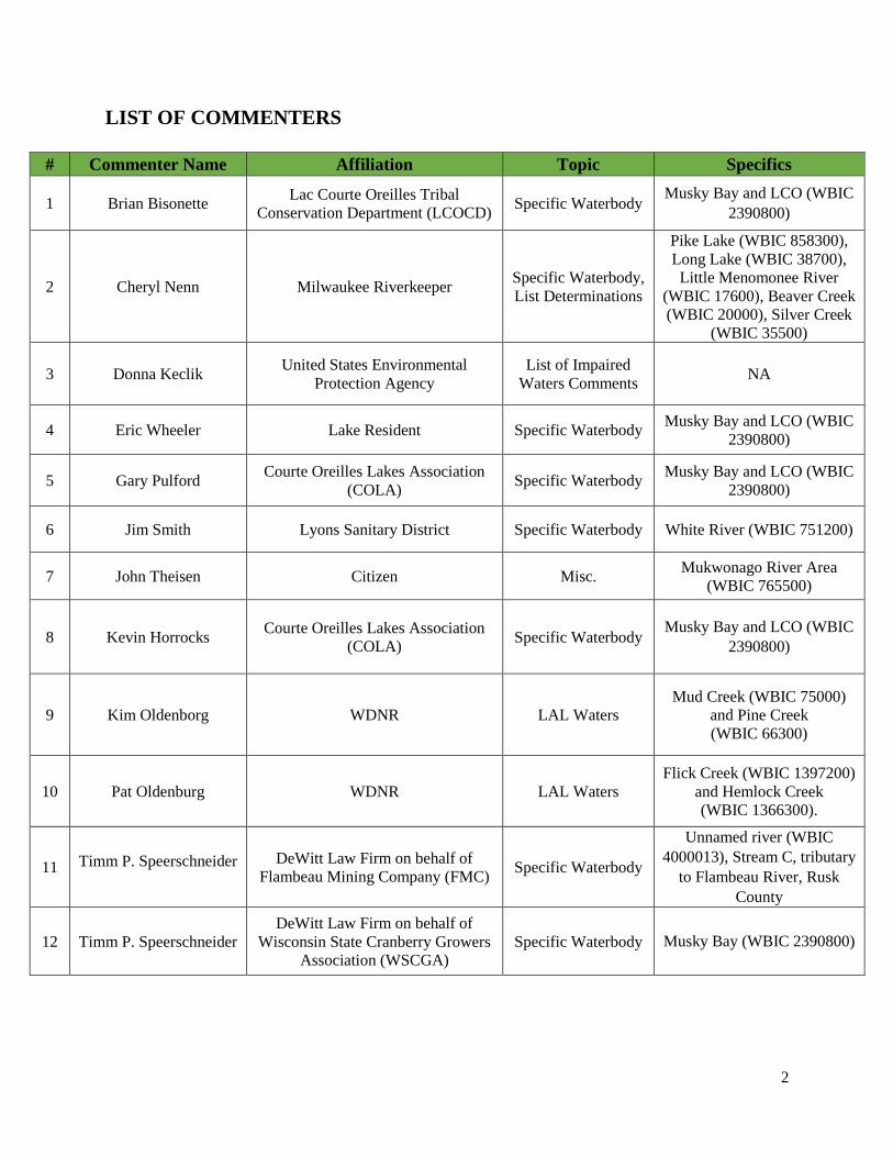
LIST OF COMMENTERS
# Commenter Name Affiliation Topic Specifics
1 Brian Bisonette Lac Courte Oreilles Tribal
Conservation Department (LCOCD) Specific Waterbody
Musky Bay and LCO (WBIC
2390800)
2 Cheryl Nenn Milwaukee Riverkeeper Specific Waterbody,
List Determinations
Pike Lake (WBIC 858300),
Long Lake (WBIC 38700),
Little Menomonee River
(WBIC 17600), Beaver Creek
(WBIC 20000), Silver Creek
(WBIC 35500)
3 Donna Keclik United States Environmental
Protection Agency
List of Impaired
Waters Comments NA
4 Eric Wheeler Lake Resident Specific Waterbody Musky Bay and LCO (WBIC
2390800)
5 Gary Pulford Courte Oreilles Lakes Association
(COLA) Specific Waterbody
Musky Bay and LCO (WBIC
2390800)
6 Jim Smith Lyons Sanitary District Specific Waterbody White River (WBIC 751200)
7 John Theisen Citizen Misc. Mukwonago River Area
(WBIC 765500)
8 Kevin Horrocks Courte Oreilles Lakes Association
(COLA) Specific Waterbody
Musky Bay and LCO (WBIC
2390800)
9 Kim Oldenborg WDNR LAL Waters
Mud Creek (WBIC 75000)
and Pine Creek
(WBIC 66300)
10 Pat Oldenburg WDNR LAL Waters
Flick Creek (WBIC 1397200)
and Hemlock Creek
(WBIC 1366300).
11 Timm P. Speerschneider DeWitt Law Firm on behalf of
Flambeau Mining Company (FMC) Specific Waterbody
Unnamed river (WBIC
4000013), Stream C, tributary
to Flambeau River, Rusk
County
12 Timm P. Speerschneider
DeWitt Law Firm on behalf of
Wisconsin State Cranberry Growers
Association (WSCGA)
Specific Waterbody Musky Bay (WBIC 2390800)
3
COMMENTS AND RESPONSES
List Determinations
RESTORATION WATERS LIST – “I understand that Wisconsin is creating a new list or subset of the
303d list to specify a “restoration waters list,” which denotes the listed waters that have TMDLs that have
been approved. Most of our impaired rivers in the Milwaukee River Basin have now been moved to that
list given our 2018 EPA approved TMDLs for TSS, phosphorus, and bacteria. I find it kind of confusing
and maybe misleading, as just having an approved TMDL does not mean that the waterways are “restored”,
but rather have another tool to help them get closer to achieving standards. This seems largely “semantics”
versus substance, but I guess it does give DNR a sense of how many more TMDLs have to be created. I
just think it could benefit by a more clear designation.” (Cheryl Nenn, Riverkeeper, Milwaukee
Riverkeeper)
RESPONSE: The Restoration Waters List was created for the 2020 assessment cycle as a way to
distinguish which listings had an EPA approved TMDL or TMDL-alternative plan for restoration.
This list does not indicate that the waters are restored, as those would be on the Healthy Waters
List. The water is still considered impaired until applicable water quality standards (WQS) have
been met. This list can also be thought of as an “In-Restoration” list.
HEALTHY WATERS LIST – “I’m confused by the Healthy Waters List and couldn’t find any
description of this on the fact sheet or other materials. I assume these are assessed waters that did not merit
listing based on WisCALM? While some to me seem very high quality, others (like Quaas Creek and Silver
Creek in Washington County) I’m surprised to see on a list of healthy waters given the stark degradation in
water quality over the last decade or so, although they could be not “bad enough” yet to warrant listing. I
haven’t reviewed this list in detail but many I wouldn’t call “healthy”, others yes.” (Cheryl Nenn,
Riverkeeper, Milwaukee Riverkeeper)
RESPONSE: The current Healthy Waters List has waters evaluated with varying levels of
information. Some only had a general assessment with one or two data points. In these cases, there
may be degradation of habitat or other water quality measures unavailable at the time the water was
assessed. A DNR workgroup has been started to work through how to best define “Healthy”. Your
organization has been sent to the workgroup leader as a potential partner during the public partner
discussions. Current Healthy Waters List listing methodology is in the 2020 WisCALM document
(https://dnr.wi.gov/topic/surfacewater/assessments.html) under section 3.3.
Quas Creek (WBIC 34900) is on the Healthy Waters List based on phosphorus data assessed in
2016 and 2018; phosphorus levels were clearly below the criteria of 75 ug/L. Silver Creek (WBIC
35500) is on the Healthy Waters List based on temperature assessments in 2016 and 2018.
Phosphorus was also evaluated and does not clearly exceed criteria.
MERCURY DELISTINGS – “Pike Lake in Washington County (WBIC of 858300) and Long Lake of
Fond du Lac/Sheboygan County are being proposed to be delisted for mercury contaminated fish tissue. I
4
noted in the fact sheet that most of the 84 delistings this year are based on cleanup of mercury or because
the waterways are covered by fish consumption advisories for mercury. I’m not clear about whether Pike
and Long Lakes are being delisted due to the mercury being removed or because there is now an advisory.
I’m presuming the latter. How is posting a fish consumption advisory sufficient for delisting or addressing
the root problem? Is there more information about this? I couldn’t find any information on the list itself (via
footnote) or the supplemental materials. I appreciate that the mercury is from aerial deposition. Is it EPA
policy to not list these mercury impaired waters anymore because they are covered by other programs?”
(Cheryl Nenn, Riverkeeper, Milwaukee Riverkeeper)
RESPONSE: The way the impaired waters list addresses mercury from atmospheric deposition
shifted in 2001. In 2001 the DNR issued a statewide mercury fish consumption advisory for all
waterbodies to better protect developing fetuses and young children. Because this advisory applies
to all waters in the state, the impairment listing methodology shifted to listing only waters with
mercury levels higher than the statewide advisory. While atmospheric deposition of mercury is an
ongoing issue, the assessments program focuses on waters that have more mercury than addressed
by the statewide advisory. For the 2020 assessment process WDNR requested removal of 90
residual mercury listings from prior to 2001. This request was approved by US EPA.
Pike Lake and Long Lake were placed on the 303d impaired waters list in 1998 due to mercury and
are part of this listing cleanup.
Pike Lake Impaired Waters Detail:
https://dnr.wi.gov/water/impairedDetail.aspx?key=18227
Long Lake Impaired Waters Detail:
https://dnr.wi.gov/water/impairedDetail.aspx?key=11325
Here are some additional resources on the Fish Consumption advisories:
https://dnr.wi.gov/topic/fishing/documents/publications/AdminReport73.pdf
https://dnr.wi.gov/topic/fishing/consumption/moreinfo.html
Specific Waterbodies
LITTLE MENOMONEE RIVER (WBIC of 17600) – “The Little Menomonee River from river mile 0
to 9 is being proposed to be delisted for creosote/contaminated sediment. I’ve followed this cleanup for
several decades (the Moss American Superfund site aka Kerr McGee aka Tronox). The waterway is listed
as Ozaukee County but if the creosote contaminated section is in Milwaukee County. In addition, even
though the Superfund site has been formally closed, the polluter went bankrupt before the last section was
cleaned up. We are told that we can’t restore that last section of the river or move any dirt in the floodplain
throughout the entire former Superfund site area of the Little Menomonee, due to concern that there is still
significant creosote/PAH contamination in the river and its floodplains. I realize that there is subsequent
follow up monitoring associated with the Superfund program, and that the EPA considers the clean-up
functionally complete. Although I had also heard that EPA was in litigation with Tronox, and am not sure
of the status of that litigation. Given the remaining contamination closer to the confluence and the lack of
a plan to deal with this remaining contamination, which we have witnessed during woody debris and trash
5
removal activities in the last few years, I think it may be premature to delist this stream.” (Cheryl Nenn,
Riverkeeper, Milwaukee Riverkeeper)
RESPONSE: After additional conversations with internal staff familiar with this project, it was
decided to keep the Creosote listing on the impaired waters list until the next assessment cycle.
Samples of groundwater in wells showed some PAHs present, which could potentially be from
Creosote in the floodplain. After more sampling is done this listing will be reassessed for the 2022
list updates. The river also remains on the 303d listed for chronic and acute aquatic toxicity,
elevated water temperature, degraded biological community, and recreational restrictions-
pathogens.
BEAVER CREEK (WBIC 20000) – “I also question the delisting of Beaver Creek (WBIC of 20000 from
river mile 0 to 2.65. Why is this waterway being delisted? Because of vagueness of the listing? Some
concrete has been removed from this creek but not in these river miles. It is listed as impaired for an
unknown pollutant and because of chronic aquatic toxicity. Given the existing water quality and condition
of most of this waterway, I would not think this has changed. I realize that the creek is listed for phosphorus
and is being proposed for chloride (which we support), so assuming this is being removed due to a
questionable listing or because more specific listings are going to supersede it? Please advise.” (Cheryl
Nenn, Riverkeeper, Milwaukee Riverkeeper)
RESPONSE: The chronic aquatic toxicity impairment was determined to be from chloride,
therefore, the “unknown pollutant” listing is being removed now that a pollutant is identified. In its
place is the new listing for chronic aquatic toxicity impairment due to chloride.
MILWAUKEE RIVER BASIN – “We support the proposed listings in the Milwaukee River Basin for
phosphorus and chloride.” (Cheryl Nenn, Riverkeeper, Milwaukee Riverkeeper)
RESPONSE: Your comments in support of these proposed listings have been noted.
FLICK CREEK AND HEMLOCK CREEK (WBICs 1397200 and 1366300) – “New listings for Flick
Creek (AU# 3999292 and 12272) – AU 3999292 is classified as limited aquatic life in NR 104 so
phosphorus criteria do not apply, so it shouldn’t be listed. Also, the phosphorus criteria only apply to about
the lower mile and a half of AU 12272 (Limited forage fish portion). Similarly, the Hemlock Creek new
listing (AU#18327) is contains both limited aquatic life and limited forage fish classifications in NR 104.”
(Pat Oldenburg, WDNR)
RESPONSE: The proposed phosphorus listing for Flick Creek (AU 3999292) has been removed
from the draft 2020 impaired waters list. Flick Creek (AU 12272) was segmented at mile 1.42 and
only the Limited Forage Fish portion, miles 0 – 1.42, are now proposed for phosphorus listing.
6
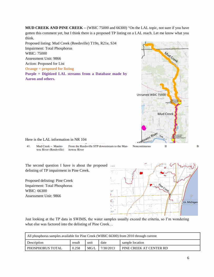
MUD CREEK AND PINE CREEK – (WBIC 75000 and 66300) “On the LAL topic, not sure if you have
gotten this comment yet, but I think there is a proposed TP listing on a LAL reach. Let me know what you
think.
Proposed listing: Mud Creek (Reedsville) T19n, R21e, S34
Impairment: Total Phosphorus
WBIC: 75000
Assessment Unit: 9866
Action: Proposed for List
Orange = proposed for listing
Purple = Digitized LAL streams from a Database made by
Aaron and others.
Here is the LAL information in NR 104
The second question I have is about the proposed
delisting of TP impairment in Pine Creek.
Proposed delisting: Pine Creek
Impairment: Total Phosphorus
WBIC: 66300
Assessment Unit: 9866
Just looking at the TP data in SWIMS, the water samples usually exceed the criteria, so I’m wondering
what else was factored into the delisting of Pine Creek…
All phosphorus samples available for Pine Creek (WIBIC 66300) from 2010 through current
Description result unit date sample location
PHOSPHORUS TOTAL 0.258 MG/L 7/30/2013 PINE CREEK AT CENTER RD
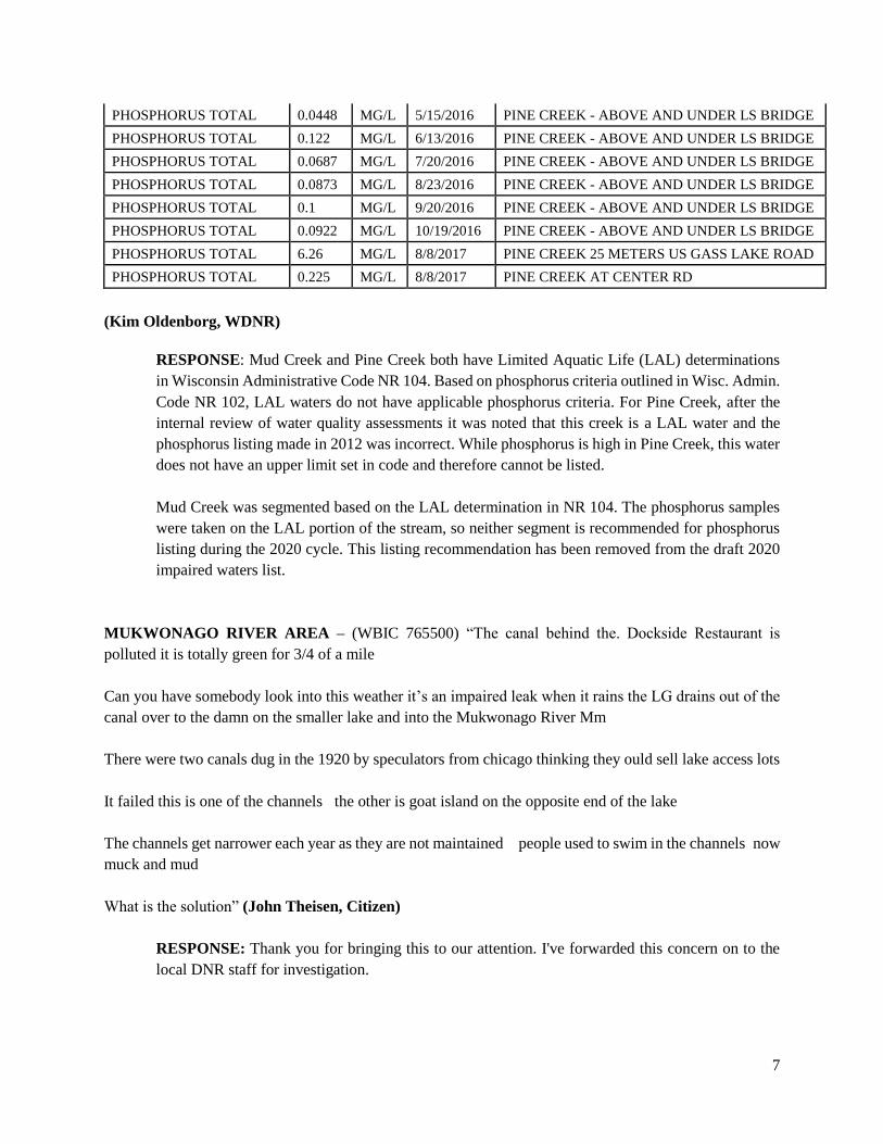
7
PHOSPHORUS TOTAL 0.0448 MG/L 5/15/2016 PINE CREEK - ABOVE AND UNDER LS BRIDGE
PHOSPHORUS TOTAL 0.122 MG/L 6/13/2016 PINE CREEK - ABOVE AND UNDER LS BRIDGE
PHOSPHORUS TOTAL 0.0687 MG/L 7/20/2016 PINE CREEK - ABOVE AND UNDER LS BRIDGE
PHOSPHORUS TOTAL 0.0873 MG/L 8/23/2016 PINE CREEK - ABOVE AND UNDER LS BRIDGE
PHOSPHORUS TOTAL 0.1 MG/L 9/20/2016 PINE CREEK - ABOVE AND UNDER LS BRIDGE
PHOSPHORUS TOTAL 0.0922 MG/L 10/19/2016 PINE CREEK - ABOVE AND UNDER LS BRIDGE
PHOSPHORUS TOTAL 6.26 MG/L 8/8/2017 PINE CREEK 25 METERS US GASS LAKE ROAD
PHOSPHORUS TOTAL 0.225 MG/L 8/8/2017 PINE CREEK AT CENTER RD
(Kim Oldenborg, WDNR)
RESPONSE: Mud Creek and Pine Creek both have Limited Aquatic Life (LAL) determinations
in Wisconsin Administrative Code NR 104. Based on phosphorus criteria outlined in Wisc. Admin.
Code NR 102, LAL waters do not have applicable phosphorus criteria. For Pine Creek, after the
internal review of water quality assessments it was noted that this creek is a LAL water and the
phosphorus listing made in 2012 was incorrect. While phosphorus is high in Pine Creek, this water
does not have an upper limit set in code and therefore cannot be listed.
Mud Creek was segmented based on the LAL determination in NR 104. The phosphorus samples
were taken on the LAL portion of the stream, so neither segment is recommended for phosphorus
listing during the 2020 cycle. This listing recommendation has been removed from the draft 2020
impaired waters list.
MUKWONAGO RIVER AREA – (WBIC 765500) “The canal behind the. Dockside Restaurant is
polluted it is totally green for 3/4 of a mile
Can you have somebody look into this weather it’s an impaired leak when it rains the LG drains out of the
canal over to the damn on the smaller lake and into the Mukwonago River Mm
There were two canals dug in the 1920 by speculators from chicago thinking they ould sell lake access lots
It failed this is one of the channels the other is goat island on the opposite end of the lake
The channels get narrower each year as they are not maintained people used to swim in the channels now
muck and mud
What is the solution” (John Theisen, Citizen)
RESPONSE: Thank you for bringing this to our attention. I've forwarded this concern on to the
local DNR staff for investigation.
8
MUSKY BAY – (WBIC 2390800) “We are providing the following written comments on behalf of the
Wisconsin State Cranberry Growers Association (“WSCGA”) regarding the proposed delisting of Musky
Bay.
WSCGA represents approximately 160 of Wisconsin’s cranberry growers who grow more than 85% of the
state’s cranberry crop. Cranberries are Wisconsin's largest fruit crop and Wisconsin leads the nation in
cranberry production. It is estimated that the state's cranberry industry provides more than 3,400 jobs for
Wisconsin residents and has a $1 billion impact on the state's economy.
WSCGA agrees with the WDNR’s recommendation that Musky Bay be delisted. WSCGA agrees with
WDNR’s conclusions that: 1) the total phosphorous water quality criterion is being met; 2) curly-leaf
pondweed has been reduced; and 3) Musky Bay is in good condition. These conclusions are supported by
the analysis in WDNR’s 2018 Site Specific Criteria Technical Support Document (see attached Section 7
addressing Musky Bay.)” (Tim P. Speerschneider, DeWitt LLP on behalf of the Wisconsin State
Cranberry Growers Association)
RESPONSE: Your comments in support of this proposed delisting have been noted.
MUSKY BAY PHOSPHORUS SSC – (WBIC 2390800) “My folks built a small cabin on the west end of
Lac Court Oreilles in 1949 and my family and I have been swimming, fishing, sailing, canoeing and
otherwise enjoying the lake every year since. Over those 70 years I have observed first hand the
deterioration of water quality and the dramatic increase in aquatic vegetation in the lake, especially in the
west end in and near Musky Bay. Phosphorus levels have increased steadily and substantially, exceeding
40ppb in Musky Bay in 2011-2012. The reasons for this tragic environmental degradation are both obvious
and well documented.
In 2014, LCO's largest bay was designated by the EPA and the WDNR as an impaired water body because
of the high phosphorus concentrations. In 2018, all of LCO was listed as an impaired water body because
of low dissolved oxygen, a result directly attributable to the high phosphorus concentrations. The current
limit of 15 ppb of phosphorus is not adequate to protect LCO. The lake has already experienced extensive
whitefish and cisco die-offs, and there is ample evidence to indicate that the high levels of phosphorus led
to oxygen depletion in the critical habitat layer occupied by these species. These conditions, if allowed to
persist, will surely result in the continued loss of fish habitat and lead to drastic and regrettable change in
the ecology of LCO.
I fully support the NR 102 revision for LCO by the WDNR, specifying a phosphorus limit of 10 ppb. LCO
is a rare Outstanding Resource Water, one of only five lakes in the state with a two-story fishery supporting
both cisco and whitefish. Both are a primary food source of Muskies, a species once plentiful in the lake,
now rare, and for which LCO was previously famous. Option B (no change from the current 15ppb) is
simply not an option when it is obvious that the lake is facing a real crisis as a result of high phosphorus
levels. The status quo is not acceptable. The 600 plus home owners around the lake are counting on the
WDNR to do the right thing.” (Eric Wheeler, Lake Resident)
9
RESPONSE: Your support for a site-specific criterion of 10 ug/L has been noted and passed on to
DNR staff working on this project.
MUSKY BAY AND LAC COURTE OREILLES - (WBIC 2390800) “The Courte Oreilles Lakes
Association (COLA) and the Lac Courte Oreilles Tribal Conservation Department (LCOCD) are providing
the following comments regarding the proposed draft Wisconsin 2020 impaired waters list. Specifically,
these comments pertain to the proposed delisting of Musky Bay (AUID 1850472) of Lac Courte Oreilles
(LCO), and the erroneous “unknown” pollutant” category relating to the dissolved oxygen (DO) impairment
of Lac Courte Oreilles (AUID 15368, WBIC 2390800).
Musky Bay
WDNR is proposing to delist Musky Bay of LCO. COLA and the LCOCD are opposed to the proposed
delisting because the proposed action is contrary to WDNR delisting protocol specified in the Wisconsin
2020 Consolidated Assessment and Listing Methodology (WisCALM) and because the applicable Water
Quality Standards (WQS) and designated uses have not been attained. Much remains to done to “restore”
Musky Bay.
Impairment or Water Use Restrictions
High Phosphorus Levels
While Musky Bay total phosphorus concentrations no longer exceed the 40 µg/L threshold that WDNR has
applied to Musky Bay individually as a shallow drainage lake, the current total phosphorus (TP)
concentrations in Musky Bay continue to impair the designated uses of Musky Bay for recreational use and
aquatic life use and contribute to the impaired (low dissolved oxygen) water quality conditions of LCO.
TP concentration have been slowly decreasing in recent years due to reductions in phosphorus inputs from
agricultural and residential sources within the Musky Bay direct drainage area. Even though TP
concentrations are now below the WDNR applied threshold there has not been a corresponding
improvement in the designated uses that apply to Musky Bay. The 40 ug/L TP threshold that WDNR has
applied to Musky Bay is not sufficiently stringent to restore the recreational and aquatic life uses of Musky
Bay.
In addition, the oxythermal habitat in LCO is impaired, the restoration of the oxythermal habitat in LCO
should be considered holistically and will benefit from further reductions in Musky Bay TP concentrations.
Therefore, COLA and the LCOCD request that Musky Bay remain on the draft Wisconsin 2020 impaired
water list as impaired for total phosphorus and WDNR set a different more stringent TP threshold that,
when achieved, will result in attainment of the WQS and designated uses that apply to Musky Bay.
Recreational Use
Recreational use of Musky Bay is impaired and has not been restored.
10
A review of the Citizen Lake Monitoring Network and SWIMS databases for Musky Bay (MB-1) (station
I.D. 10033577) for the last five (5) years shows that the “recreational” perception is consistently described
as either #3 –“Swimming and aesthetic enjoyment of lake (bay) slightly impaired because of high algae
levels” or #4--“Desire to swim & level of enjoyment lake (bay) substantially reduced because of algae;
would not swim, but boating is OK”.
In addition, algal mat formation on Musky Bay in mid-summer continues to impair recreational use. The
photos below are representative of the algal mat formation that has occurred in the historical past and most
recently in each of the last five (5) years (2014-2019) in Musky Bay.
[Photos of Musky Bay algal mats from 2014 and 2019; see original comment for photos.]
Non-Native Aquatic Plants
Musky Bay was listed as impaired in 2012 due in part to the presence of Curly-leaf Pondweed (CLP), a
non-native plant, at levels that interfered with navigation, fishing and other recreational activities. Chemical
management of the CLP has had mixed results in reducing the total acreage of CLP in Musky Bay over the
last five years. The Lac Courte Oreilles & Little Lac Court Oreilles 2019 Aquatic Plant Survey shows that
CLP currently occupies 51+ acres in Musky Bay. While the total acreage of CLP in Musky Bay has been
reduced from the high of 90+ acres in 2010, CLP continues to impair the recreational use of Musky Bay.
Aquatic life use
The aquatic life use of Musky Bay is impaired and has not been restored.
The historical muskellunge spawning area along the northeastern shoreline of Musky Bay once supported
natural reproduction of muskellunge in LCO. Decades of phosphorus driven excess algal and aquatic plant
production has resulted in an accumulation of soft organic matter that covers much of the spawning area to
a depth of 2+feet, negatively impacting survival of muskellunge eggs and larvae. Therefore, the aquatic life
use of Musky Bay remains impaired.
The above provides ample evidence to show the designate uses for Musky Bay are not currently being
attained and provides justification that Musky Bay should not be delisted from the Wisconsin impaired
water list until these designated uses are fully restored in accordance applicable Statutes, Rules and
protocols specified in WisCALM.
Therefore, COLA and the LCOCD request that Musky Bay remain on the draft Wisconsin 2020 impaired
water list as impaired for total phosphorus until the WQS and designated uses that apply to Musky Bay are
attained.
Lac Courte Oreilles -Low Dissolved Oxygen (DO) impairment
The proposed draft 2020 Wisconsin impaired water list lists LCO as impaired for “Low DO” and includes
“Unknown Pollutant” as the pollutant of concern. The linkage between total phosphorus and dissolved
11
oxygen levels in lakes is well known and documented. Increases in total phosphorus levels contribute to
increases in algae growth in a phosphorus limited lake such as LCO. Algae die and decay. The
decomposition of algae consumes oxygen, whether it occurs in the water column or in the sediment.
Therefore, total phosphorus is clearly contributing to the Low DO impairment. Reducing phosphorus levels
in LCO is the best and possibly only feasible way to improve dissolved oxygen conditions in the lake. Total
phosphorus should be listed as a pollutant of concern.
If DNR believes other pollutants, in addition to total phosphorus, are contributing to the DO impairment,
DNR can choose to list Unknown Pollutants in addition to total phosphorus and conduct investigations to
identify those unknown pollutants.
COLA and the LCOCD request that “total phosphorus” be listed as a pollutant of concern for the Low DO
impairment of Lac Courte Oreilles.” (Brian Bisonette, LCOCD Director; Kevin Horrocks, COLA
President; Gary Pulford, COLA Vice President)
RESPONSE: At this time the Department is delisting Musky Bay for the parameters it was
previously listed for, because it is now attaining them, as explained below. The Department also
discusses the issue of the “unknown pollutant” cause of low dissolved oxygen.
1) Attaining parameters previously listed as impaired:
For lakes, the Department has the following metrics to assess Recreation and Aquatic Life Uses:
phosphorus, chlorophyll a, and aquatic plant community. Musky Bay is now attaining not only
phosphorus and aquatic plant thresholds, for which it was previously listed as impaired, but also
chlorophyll a.
• Phosphorus: The mean phosphorus level in Musky Bay, based on data from 2014 – 2018, was
30 ug/L, which is lower than the criterion of 40 ug/L. The upper confidence limit was 32.2
ug/L. For this reason, phosphorus is proposed for delisting.
• Aquatic plants: Plant data was collected with high spatial resolution in Musky Bay in 2007 and
in all years 2010 – 2016. The plant surveys from 2011 and 2012 showed non-attainment of the
phosphorus response macrophyte condition metric (MAC-P) and recreation via boating was
inhibited. More recent data, from 2013 – 2016, showed attainment of both of the Department’s
plant metrics: general condition of the overall plant community (MAC), and phosphorus
response macrophyte condition (MAC-P). These results indicate that the plant community as a
whole is healthy and is not exhibiting a response to phosphorus.
• Curly-leaf pondweed (CLP) has been actively managed in this lake since 2007 (2018 aquatic
plant report). Management actions have significantly decreased CLP populations within Musky
Bay, even with slightly higher CLP growth in 2019. In the 2019 aquatic plant report it was
pointed out that “[t]hough there is a high frequency of CLP present in Musky Bay, the overall
density is low.” Even with there being 51 acres of low-density CLP at one point in the 2019
growing season, this accounts for only 17% of the bay’s surface area. Ongoing management is
required for CLP in Musky Bay and the lake in general, but recreation does not appear to be
12
impaired by the CLP growth in the bay. Further, the department does not typically list a
waterbody as impaired simply due to the presence of invasive species. It would typically only
be listed as impaired if an invasive species impacts the aquatic plant community to such an
extent that the plant community is impaired, which in this case it is not.
• Chlorophyll a: Algal mats occur on the bay, as evidenced by the photos sent to WDNR, but the
recreation criteria of 30% of days under 20 ug/L chlorophyll a was clearly not exceeded based
on chlorophyll-a data from 2014 - 2018, with the median being 0% of days. While there may
be days where recreation is interrupted by algal mats, there is no metric indicating that
recreation is impaired on the bay.
While the department recognizes that recreational issues are a concern for residents, none of our
available indicators of phosphorus impairment, chlorophyll a, and aquatic plants, indicate an
impairment.
Aquatic Life use in Musky Bay was never listed as impaired. The department does not have fish
community metrics for measuring aquatic life impairment in lakes. Aquatic plants can be used for
assessing aquatic life impairments in lakes, but Musky Bay is attaining its aquatic plant thresholds.
2) Identifying pollutant(s) associated with low dissolved oxygen impairment:
Analysis was done by the department to evaluate the relationship between phosphorus and
oxythermal habitat in Lac Courte Oreilles (2018 LCO SSC Technical Support Document & 2019
Addendum to LCO SSC). Phosphorus was one of the contributing factors, however, following
standard WDNR procedure, since this lake does not exceed its existing phosphorus criterion of 15
ug/L it is inappropriate to list it for phosphorus. We recognize that labeling the pollutant causing
low dissolved oxygen as “Unknown” doesn’t reflect the current understanding of the system, but
there currently is not a method to display this information.
UNNAMED RIVER, STREAM C, TRIBUTARY TO FLAMBEAU RIVER – (WBIC 4000013) “We
are providing the following brief written comments on behalf of Flambeau Mining Company (“FMC”)
regarding WDNR’s proposed deletion of zinc as an impairment in Stream C, Rusk County, Wisconsin. As
you may know, Stream C lies entirely within FMC property. FMC has undertaken several efforts to address
water quality in Stream C. FMC agrees with the WDNR’s analysis of the monitoring data that FMC has
provided:
‘Data collected from 2016 – 2018 was assessed during the 2020 assessment cycle. There were no
exceedances (0/15) of acute aquatic toxicity criteria. This zinc listing is recommended for removal in the
2020 cycle.’” (Timm P. Speerschneider, DeWitt LLP, on behalf of Flambeau Mining Company)
RESPONSE: Your comments in support of this proposed delisting have been noted.
WHITE RIVER – (WBIC 751200) “We are the Lyons Sanitary District Engineer and we are working on
a phosphorus compliance alternatives plan for the District. The treatment plant discharges to the White
13
River which was listed on the State’s 303d list. We understand the River could be delisted for the 2020
cycle according to the following information on your website. I was looking for data on the phosphorus
levels in the River and could not find any for 2019, except for the monitoring station just below Geneva
Lake (Center St 055451345) and some data for a chloride study at STH 50. Do you have any recent
phosphorus sampling data upstream or downstream of the treatment plant’s discharge, which is just south
of Mill Street in Lyons, or at any other locations that were used for the proposed delisting.” (Jim Smith,
Lyons Sanitary District)
RESPONSE: A mapping error for the segments of the White River was found when investigating
the data used for the delisting decision. When the listing was originally made in 2012 the DNR’s
map had the mouth and headwaters locations switched. Between 2012 and 2018 this was fixed, but
the listed segment was then spatially flip-flopped with the unimpaired segment. This impacts the
current evaluation of impairment because the station with low phosphorus values (Center Street
station) was not originally on the listed segment – with this being the case it is not representative
of that segment and can’t be used for a delisting determination.
The maps for these two segments of the White River have been updated; the listed segment is from
the mouth (Fox River in Burlington) to Bloomfield Creek (near Lake Geneva). The original listing
was based on phosphorus data at station ID 653111 (White River at Sth 36 (Bi Sur)) and there is
no current data from that station. There were two stations downstream that showed phosphorus
exceedances with data from 2016 – 2017 (White River at STH 11, White River at Milwaukee Ave),
which are now on the impaired segment as they should have been.
For this assessment cycle the delisting proposal has been removed and the phosphorus listing will
remain until more data are available. New sampling is slated for next year at station 653111 (White
River at State Highway 36 (Bi Sur)) and several other stations along the river in preparation for the
Fox River-IL TMDL.
EPA Comments
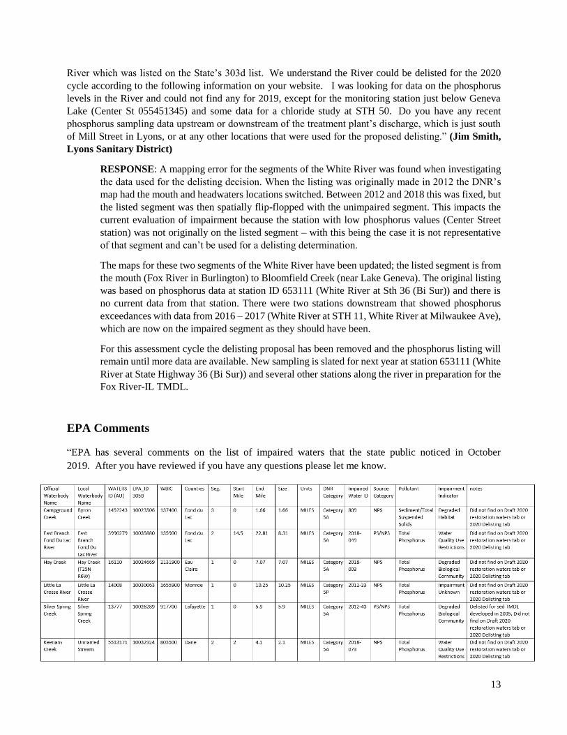
“EPA has several comments on the list of impaired waters that the state public noticed in October
2019. After you have reviewed if you have any questions please let me know.
14
1. There were several waters/impairments that were on the 2018 which do not appear on the 2020 list.
Also I did not find these water/impairments on the delisting tab or the restoration tab in the table
provided during public notice. Please confirm that these waters/impairments should be removed
from the impaired category 5 list. Also please provide the rational for the removal. If the waters
were removed and remain impaired please add them back to the category 5 list of waters.
2. WDNR is encouraged to make assessment determinations for surface waters with the Public Water
Supply Use. If WDNR is not able to, WDNR should indicate the reasons why determinations can’t
be made at this time (e.g., lack of standards, monitoring data, etc.).
3. Since WDNR has processed the public notice outside of ATTAINS, it would be helpful if WDNR
included the Designated Uses that are not met in their impaired waters list.
4. Since WDNR has processed the public notice outside of ATTAINS please provide the action IDs
for all 4A and 4B waters.”
RESPONSE: Wisconsin did not submit their draft impaired waters list to EPA’s ATTAINS system
prior to the public comment period. Due to this there was some information that was not yet shared
with EPA. Assessments are slated for submittal by April 1 of 2020 and will address all four
comments posed by EPA.
1. These waters are all on the impaired waters list and have not been delisted.
2. A Public Water Supply Use assessment was conducted for Lake Winnebago; parameter
attainment and overall use attainment information will be sent to ATTAINS. No impairment
was found.
3. Designated Use attainment will be sent to the ATTAINS system.
4. Actions for all 4A, 4B, and 5W waters will be sent to ATTAINS.


![Apx F Glossary · Impaired Waters [303(d) List] Those water bodies not meeting water quality standards. This list of impaired waters within each state is referred to as the “303(d)](https://img.pdfslide.us/doc/110x75/5f26c22ae482242c820fb600/apx-f-glossary-impaired-waters-303d-list-those-water-bodies-not-meeting-water.jpg)