Embed Size (px)
Citation preview
Ft Bliss
Ft Bliss
Hueco TanksState Park
P/J
DC
P/J
DC
P/J
DC
P/JDC
Coll/U
niv
213
375
375
375375
20
28
404
20
20
375
478
375
443
136
136
498
601
498
183
20
20
375
375
601
375
273
601
182
375
20
225
443
416
375
375
375
El Paso CCD91215
El Paso East CCD 91220
El Paso North Central CCD 91225
El Paso Northwest CCD 91230
28
104.06
40.05
103.35
104.11
12.04
102.24
102.29
37.01
36.02
30
29
20
18
13.02
13.01
105.01
38.03
38.01
37.02
105.02
105.05
103.44
105.04
19
103.64
39.05
39.04
102.18
102.11
102.20
102.22
102.03
102.12
14
104.01
101.01
103.0343.11
43.10
43.09
43.07
8
2.07
34.02
2.08
103.46
43.13
43.17
103.17103.16
103.12
103.38
6
11.15
11.14
26
2524
4.04
4.033.02
2.06
11.18
102.23
23
21
2.05
2.04
9.01
11.17
104.13
1.11
17
16
1.12
43.12
103.65
102.27102.30
12.02
1.10
103.29
11.11
103.27
40.06
102.32
1.09
1.081.07
102.14
11.12
10.02
104.12
9.02 106.01
1.06
103.11
4.01
103.50
103.69
103.67103.53
103.52
1.13
106.02
103.33
43.19
43.03
42.02
102.28
103.63
103.48
103.49
103.58
103.26
103.23
41.0741.0641.0
5
40.07
103.71
103.55
35.02
34.0434.03
102.10
105.06
103.22
1.14
41.04
36.01
11.09
103.54
40.08
33
32
103.59
103.70
22.01
11.10
15.02
3.01
11.07
101.02
22.02
103.66
103.57
102.25
103.07
101.03
103.68
103.62
103.61
9800
104.09
102.13
102.17
43.16
43.14
102.31
103.56
102.26
43.20
103.28
41.03
103.60
103.72
103.34
104.08
40.04
35.01
42.01
104.10
43.18
103.47
103.51
11.19
11.16
104.04
15.01
39.02
39.01
38.04
10.01
103.36
103.37
31
EL PASO 141
DOÑA ANA 013
EL PA
SO 141
OTERO 035
EL PASO 141
HU
DS
PE
TH
22
9
EL
PA
SO
14
1
DOÑA ANA 013
OT
ER
O 0
35
HUDSPETH 229
OTERO 035
TEXAS 48
NEW MEXICO 35
NEW MEXICO 35
MEXICO
TEXA
S 48
MEX
ICO
YSLETA DEL SURPUEBLO 4755
T4755
T4755
T4755
T4755
La Union40220
Santa Teresa 70700
Chaparral14250
Sparks69432
Tornillo 73376
Canutillo12508
Homestead MeadowsSouth 34673
Fabens 25032
Morning Glory 49411
Fort Bliss 26664
Agua Dulce 01390
Homestead Meadows North 34671
Prado Verde 59210
Butterfield 11626
Westway78016
Fort Bliss 26664
Anthony 03820
SunlandPark
75640
Vinton75668
El Paso 24000
SanElizario 65360
Anthony03432
Socorro68636
Horizon City 34832
Clint 15544
El Paso 24000
110
10
10
Hermosa Dr
Craw
ford R
d
Alvarez R
d
Co R d F001
McNutt Rd
S H
wy 2
8
Lom
a Lind
a Rd
el Paso Jal Pipeline Rd
Airport Rd
Pete
V D
om
enic
i M
em
orial H
wy
Pet
e V D
om
enici M
emoria
l Hwy
Westsid
e R
d
Butter
field
Trl
Gato Rd
Cha
ffee
Rd
SD
ese
rtB
lvd
E Red
d Rd
Morrow Bay Ave
Mik
e P
rice
Snoqualime
Alameda Ave
Argyle
Rojas Dr
Bell's Rd
Wingo Reserve Rd
Res
ler Dr
N M
esa
St
Leve
e Rd
Bov ee Rd
N Loop Dr
Pen
dale R
d
Hueco
Tanks
Rd
Buffalo Soldier Rd
Anderp
ont
el Paso Natural G
as Maint Rd
Faith Rd
Border H
wy
Darring
ton
Rd
Kie
ly R
d
Plaza
Cir
Alberton Ave
Border W
est Exp
y
Global Reach Dr
Middle Island R
d
Dale
Rd
Cru
z Ti
err
a
Island Guadalupe Rd
Rc E
lam R
d
W
oodrow Bean Transm
ountain Dr
Diana Dr
Wingo R
eserve Rd
Tom M
ays
Par
k A
cc
ess
R
d
Don
Has
kins
Dr
Wagon
W heel Dr
W F
ront
age
Rd
Bradley Rd
Roy R
ice
Rd
Tam
ara
Dr
West
side D
r
Pullm
an
Dr
Rojas Dr
Woodr
ow
Rd
Doniphan Dr
Rai
lroad
Dr
Colonia Vis
Roberts Ranch Rd
Quinn Ave
Frontage Rd
Hol
e in
the
Wall R
d
Cum
min
gs
Ln
Old Iro
nside
s Ave
N D
ese
rt B
lvd
Bettina AveResler
Dr
Mf Agu
ilera Rd
Jim Bridger Rd
Middle D
rain Rd
Mark Twain Ave
Tigard
St
Hueco
Mountain Rd
Hueco
Tank
s R
d
High Campus Rd
She
ridan R
d
Mor
r ill
Rd
Ara
celi
Ave
Des
ert
Willow
Dr
Texa
s Ave
Torch St
Ltv Rd
Robe
rts R
d
Ser
gea
ntM
ajor
Blv
d
Hend
erso
n Rd
Lee
Blv
d
Alame
da Ave
Frontage Rd
Leigh F ishe
rB
lvd
Las Colonias Rd
Westway B lvd
Alameda Ave
Rai
lroad
Dr
Con
ely
Global Reach D
r
Georg
e Per
ry
Blvd
Athens Ave
Oceanside
Border West Expy
Buffalo
Creek D r
Ole
ary
Dr
Railroa
d Dr
Joe Ba
ttle
Blvd
Tunis
ia S
t
Hope Ave
Hue
co
Tanks
Rd
San Felipe
Simpson
Rd
Emory R
d
Purple Heart Memorial Hwy
Shaffe
r Rd
Lp 375 Frontage Rd
Shadow
Mt
Lake
Rd
Riverside Rd
Island Rd
Stiles Dr
Bosque R
d
Lp 375 Frontage Rd
State Line Dr
Sgt Sims
St
Founders
Blvd
Montana Ave
Bold Eagle Rd
Wild Willow Dr
Drive
r R
d 4
4
Bills R
d
E P N
G P
ipeline R
d
Little Dr
Lberty Expy
S D
eser
t Blv
d
Upper
Valle
yRd
Maya
Dr
E
lswor
thD
r
Hanson Rd
McKinley Ave
Wildcat Dr
Southside Rd
Escobar Dr
Ove
rland S
tage R
d
Hann Rd
Dye
r St
Georg
e Per
ry
Blvd
India
n T
rl
Osh
ea
St
Pe
ytonRd
Old Cuadrilla Rd
San Felipe
Patri
ot Fw
y
J E B
Stu
art
Rd
Doniphan D
r
Kra
g S
t
Boeing Dr
Fairbanks Dr
Patr
iot
Fwy
Gatew
ay Blvd W
Delta Dr
Nor th Carolina Dr
Em
era
ld S
ands
Dr
Alam
eda Ave
E Missouri A
ve
Purple Heart Mem
orial Hwy
Vis ta del Sol Dr
Darrington
Rd
River
Bend
Dr
N MesaSt
Asc
enci
on S
t
Artcraft Dr
Stan Roberts Sr Ave
Cassidy Rd
Kentwood Ave
Helen of Troy
Sce
nic D
r
Altura Ave
S Z
arag
oza
Rd
E Rio G
rande Ave
Faben
s Isla
nd Rd
Darlington Rd
NZa
rago
zaRd
N S
tanton St
Geo
rge
Die
ter D
r
Saul Kleinfeld Dr
Escondi do Dr
McC
om
bs
St
Patr
iot
Fwy
Pipeline Rd
E Paisano Dr
E Robinson Ave
Eastlake Rd
S Clint San Elizario Rd
E Yandell Dr
Edgemere Bl
N Stanton St
Liberty E
xpy
Artcraft Dr
Airport
Rd
Sean Haggerty Dr
Vista de l Sol Dr
Marcus Uribe Dr
Betel Dr
N L
ee
Trevi
no D
r
Str
ahan R
d
N R
esle
r
Dr
Eastlak
e Rd
Hondo Pass Ave
N Am
erica
s Av
e
Northw
estern
Dr
Saul Kle
infe
ld D
r
N Piedras St
Sean Haggerty Dr
Rober
t W
ynn
St
John H
aye
s S
t
Gatew
ay Blvd E
Patri
ot
Fwy
Herri
ng R
d
Levee Rd
Montana Ave
N Clark Dr
Memphis Ave
Geronimo Dr
Gate
way
Blv
dS
Roanoke Dr
Pebble
Hills Blvd
Edgemere Bl
Rich Beem Blvd
N Loop Dr
Album Ave
Executive Center Blvd
N Rio Vista Rd
Airway Blvd
E P
N G
Pip
elin
e R
d
Tangerine Ave
E Glen Dr
Lero
y B
ons
e Dr
Thunderbird Dr
N Yarbrough Dr
Trowbridge Dr
Montwood
Sunland P
ark
Dr
Horizon Blvd
Tier
ra E
ste
Rd
Sam Snead Dr
N Resler Dr
N O
regon S
t
Deer Ave
Frankie Ln
McRae Blvd
Fla
ger
St
Winn Rd
Clint Rd
Dye
r St
NZa
rago
zaRd
Gile
s Rd
Country Club Rd
Gateway Blvd E
Red S
ails
Dr
N M
esa St
Montwood Dr
Pebble Hills Blvd
NZa
rago
za
Rd
Sun Valley Dr
Gateway Blvd N
W P
aisano D
r
Old
Hu
eco
Tanks
Rd
State Line Dr
Doni
ph a
n D
r
Harrison
Ave
Bandolero Dr
Mountain Ave
Ricker Rd
Alameda Ave
Brow n St
Roseway Dr
Hun
ter
Dr
Haan Rd
Lomal
an
dD
r
Sunlan
d Park
Dr
Woodrow Bean Transmountain Dr
Liberty Expy
Viscount Blvd
Hawkins Blvd
Hawkins Blvd
Trowbridge Dr
Turner Rd
Darrington R
d
Woodrow Bean Transmountain Rd
Edgemere Blvd
Wyoming A
ve
Joe
Batt
leB
lvd
N C
ott
on S
t
N A
scencion St
McK
elligon
Canyo
n Rd
Sun Bowl Dr
N Moon Rd
Ken
twood
Rd
Glo
riett
a
Rd
Woodro
w Bea
n Tran
smou
ntain
Dr
Hawkins Blvd
Jess
Harris
Rd
Brisa del Mar Dr
Mart
in L
uth
er
Kin
g J
r B
lvd
S Americas Ave
Woodrow Bean
Ke
nwort
hy
St
Belvi dere St
Pellicano Dr
Border Hwy
Diana Dr
Berr
yvill
e S
t
Alabama S
t
High Ridge Dr
Cru
z Ti
err
a S
t
N Loop Dr
Artcraft Dr
RimRd
Old
But
terfield T
rl
Socorro Rd
Dia
na D
r
O T Smith Rd
W H Burges Dr
Monta
na
Ave
N Y
arb
roug
h D
r
Porter Ave
Mon
toya
Dr
Radfo
rd S
t
Sta
geco
ach
West w ind Dr
John H
aye
s S
t
Chicken
R
anch Rd
E Redd Rd
Elm
St
Am
erica
sAv
e
E San
Anto
nio A
ve
Montana Ave
Alabama St
85
85
62
54
54
54
80
62
62
85
80
54
54
85
180 62
62
85
180
85
180
180
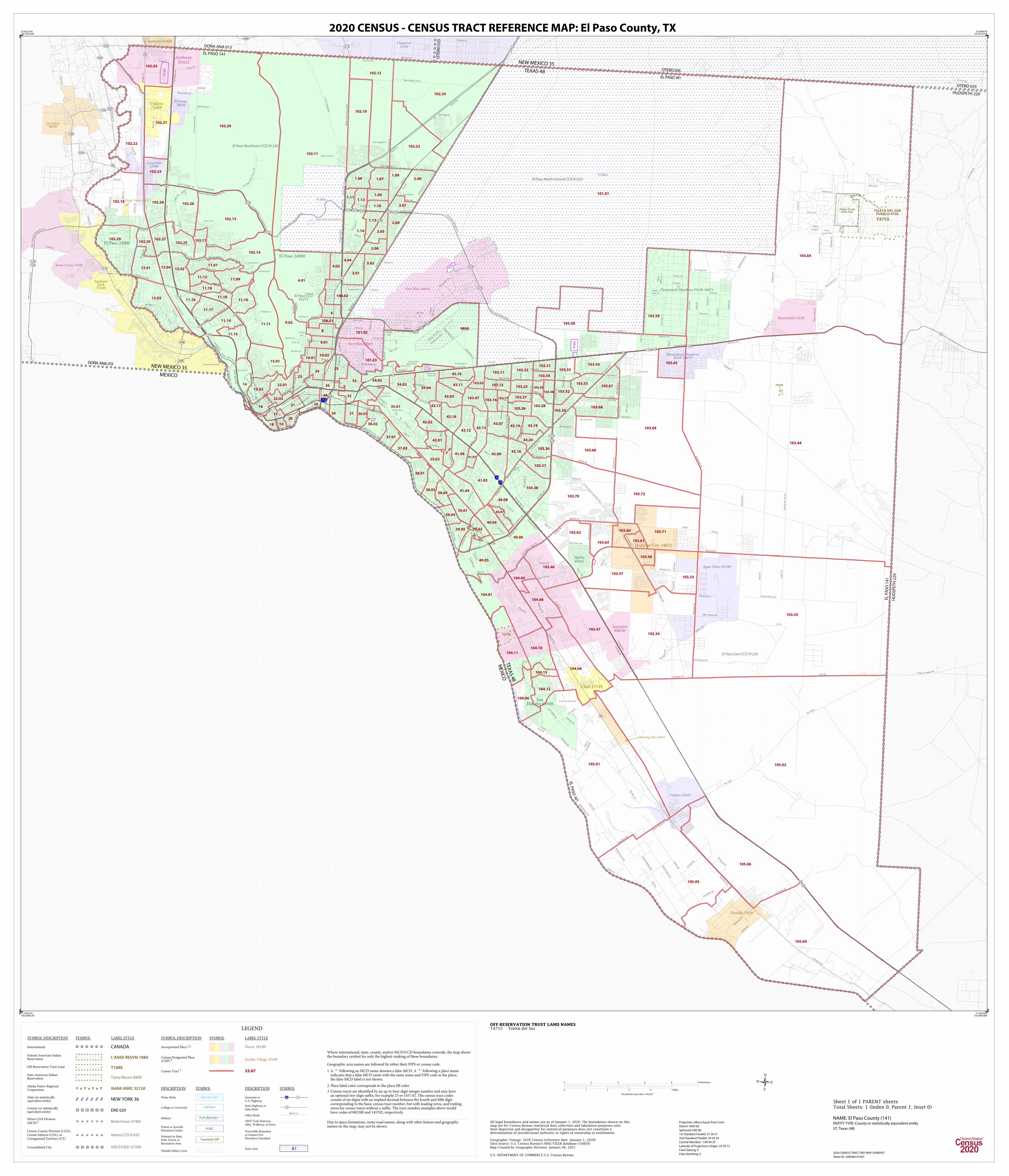
LEGEND
SYMBOL DESCRIPTION SYMBOL LABEL STYLE
International CANADA
Federal American IndianReservation L'ANSE RESVN 1880
Off-Reservation Trust Land T1880
State American IndianReservation Tama Resvn 9400
Alaska Native RegionalCorporation NANA ANRC 52120
State (or statisticallyequivalent entity) NEW YORK 36
County (or statisticallyequivalent entity) ERIE 029
Minor Civil Division(MCD)1 Bristol town 07485
Census County Division (CCD),Census Subarea (CSA), orUnorganized Territory (UT)
Hanna CCD 91650
Consolidated City MILFORD 47500
Incorporated Place 1,2 Davis 18100
Census Designated Place(CDP) 2 Incline Village 35100
Census Tract3 33.07
SYMBOL DESCRIPTION SYMBOL LABEL STYLE
DESCRIPTION SYMBOL DESCRIPTION SYMBOL
Water Body Pleasant Lake
College or University Coll/Univ
Military Fort Belvoir
Prison or JuvenileDetention Center
P/JDC
National or StatePark, Forest, orRecreation Area
Yosemite NP
Outside Subject AreaInset Area A1
Interstate orU.S. Highway
3 2
State Highway orState Road
4
Other RoadMarsh Ln
4WD Trail, Stairway,Alley, Walkway, or Ferry
Nonvisible Boundaryor Feature NotElsewhere Classified
Where international, state, county, and/or MCD/CCD boundaries coincide, the map showsthe boundary symbol for only the highest-ranking of these boundaries.
Geographic area names are followed by either their FIPS or census code. 1 A ' ° ' following an MCD name denotes a false MCD. A ' ° ' following a place name
indicates that a false MCD exists with the same name and FIPS code as the place;the false MCD label is not shown.
2 Place label color corresponds to the place fill color.
3 Census tracts are identified by an up to four-digit integer number and may havean optional two-digit suffix; for example 23 or 1457.02. The census tract codesconsist of six digits with an implied decimal between the fourth and fifth digitcorresponding to the basic census tract number, but with leading zeros, and trailingzeros for census tracts without a suffix. The tract number examples above wouldhave codes of 002300 and 145702, respectively.
Due to space limitations, some road names, along with other feature and geographynames on the map, may not be shown.
OFF-RESERVATION TRUST LAND NAMES T4755 Ysleta del Sur
32.002373N106.704535W
32.038897N105.941357W
31.385304N105.900878W
31.349031N106.658812W
All legal boundaries and names are as of January 1, 2020. The boundaries shown on thismap are for Census Bureau statistical data collection and tabulation purposes only;their depiction and designation for statistical purposes does not constitute adetermination of jurisdictional authority or rights of ownership or entitlement.
U.S. DEPARTMENT OF COMMERCE U.S. Census Bureau
Map Created by Geography Division: January 06, 2021
ENTITY TYPE: County or statistically equivalent entity
NAME: El Paso County (141) Projection: Albers Equal Area Conic
Datum: NAD 83
Spheroid: GRS 80
1st Standard Parallel: 27 36 51
2nd Standard Parallel: 34 43 24
Central Meridian: -100 04 35
Latitude of Projection's Origin: 25 50 13
False Easting: 0
False Northing: 0
Geographic Vintage: 2020 Census (reference date: January 1, 2020)Data Source: U.S. Census Bureau's MAF/TIGER database (TAB20)
ST: Texas (48)
0 2 4 6 8 10 Kilometers
0 1 2 3 4 5 Miles
The plotted map scale is 1:82,257
2020 CENSUS - CENSUS TRACT REFERENCE MAP: El Paso County, TX
2020 CENSUS TRACT REF MAP (PARENT)
Sheet ID: 249648141001
Sheet 1 of 1 PARENT sheetsTotal Sheets: 1 (Index 0; Parent 1; Inset 0)