Embed Size (px)
Citation preview
2019 Seoul INWEPF-PAWEES International Conference
& 16th INWEPF Steering Meeting
New, Green and Smart Paradigm of Agricultural Water
05 - 07 November 2019
1. IntroductionInternational Network for Water and Ecosystem in Paddy Fields(hereinafter referred to as
“INWEPF”) and International Society of Paddy and Water Environment Engineering(hereinafter
referred to as “PAWEES”) jointly held 2019 Seoul INWEPF-PAWEES International
Conference(hereinafter referred to as “2019 Seoul Conference”) with theme of “New, Green and
Smart Paradigm of Agricultural Water” during 5-7 November 2019 in Seoul, Republic of Korea. The
2019 Seoul Conference aims to bring together INWEFPF and PAWEES members including
policymakers, academics, international organizations, experts and students from governments,
institutions and academic bodies from participated countries. The 2019 Seoul Conference
promotes both party discussions, INWEPF which consists of policymakers and the PAWEES which
consist of academics, towards solutions for development of sustainable paddy farming while
protecting nature and conservation of environment.
2. Theme
The theme of 2019 Seoul Conference is “New, Green and Smart Paradigm of Agricultural Water.”
For paddy farming, water is a key element and thus contributes greatly to food security in Asian
countries. However, there is also a growing concern over water scarcity globally amidst growing
water demand from other sectors. Hence, concerted efforts are required to adopt water
management policies and techniques on a larger scale. With close cooperation among INWEPF and
PAWEES member countries, 2019 Seoul Conference provides a valuable platform for policy
planners and experts of member countries. The event stimulates and promotes multidisciplinary
discussions towards sustainable solutions for water management in paddy farming through an
exchange of latest policies and academic reports. The theme of INWEPF is further sub-categorized
into two sub-themes: (Session-1) Innovative and Sustainable Paddy Farming for Water, Food and
Environment and (Session-2) Smart Paddy Farming Policies and Technologies to Address Climate
Change Impact.

3. Date and Venue2019 Seoul Conference will take place in Seoul, Republic of Korea on 5-7 November at Intercontinental Seoul Coex. Following the 2nd INWEPF Steering Meeting in 2005 and the INWEPF-PAWEES International Conference & 7th Steering Meeting in 2010, Korea hosts the conference third time this year.
4. ParticipantsAbout 200 members of INWEPF and PAWEES including policymakers, academics, international organizations, experts and students from governments, institutions and academic bodies from participated countries.List of the countries, international organizations and etc
INWEPF
1 Bangladesh
2 Egypt
3 Ethiopia
4 Ghana
5 India
6 Iran
7 Italy
8 Japan
9 Korea
10 Laos
11 Malaysia
12 Myanmar
13 Nepal
14 Philippines
15 Republic of Cote D'ivoire
16 Sri Lanka
17 Tanzania
18 Thailand
19 Vietnam
20 Zambia
21 Asian Development Bank
22 International Commission on Irrigation and Drainage
23 International Water Management Institute
24 Mekong River Commission
25 Food and Agriculture Organization of the United Nations
PAWEES
1 Bangladesh
2 Indonesia
3 Japan
4 Republic of Korea
5 Taiwan

Time Contents Remarks
PAWEES Session 1Sub-Theme : Irrigation Technology and Management 1
Chair : Prof. Wonho Nam & Prof. Eunmi Hong
Allegro room 1
13:00-15:00
15min./each
Reduction Effect of Cyclic Irrigation on Nutrient Loads to the
Downstream Lake
Toshiaki Iida, Sara Yatabe,
Masaomi Kimura, Hiroki Minakawa
Economic Valuation of Water Table Management in SRI PaddyCultivation
Nur Aini Iswati Hasanah,
Budi Indra Setiawan, Chusnul Arif,
Slamet Widodo, Norman Uphoff
Planning of Ablution Water Treatment Plant (IPA) Using Simple Filter Equipment in Public Junior High School 6, Malang City, East Java Province
Dian Chandrasasi, Tri Budi Prayogo
, Dudiman Juziwijaya
The Determination of Real Requirement for Operations andMaintenance (AKNOP) based on Technical Audit Analysis (Case Study in Tuk Kuning Irrigation Area Klaten Regency Central Java)
Ussy Andawayanti
The Assessment of Water Management Planning to Increase CroppingIntensity in Way Sekampung Irrigation System, Lampung, Indonesia
Nova Anika,RA Bustomi Rosadi,
Ridwan Zahab
Impact force on Different Types of Groundsill Yu-Jen Hou, Hung-Pin Huang
Study on the Difference between Irrigation Water Requirements andBiological Species with Eco-agricultural and Conventional FarmingMethods for Paddy Fields
Sheng-Feng Kuo, Chih-Hung Tan,
Wen-Beh Wang, Hsiang-Yi Hsu
Development of a GIS Based Graphical User Interface for IrrigationManagement for Betwa River Basin, India
Ashish Pandey, Nikhil Mogarekar
15:00-15:30 Break
PAWEES Session 3Sub-Theme : Hydrology and Watershed Management 1
Chair : Prof. Tae-il Jang & Prof. Jong gun Kim
Allegro room 2
13:00-15:00
15min./each
Assimilating Rainfall Runoff Process into 2D Hydraulic Model
Bambang Winarta,
Pitojo Tri Juwono,Very Dermawan,
Ali M. I,
Nurul Nadrah Aqilah Tukimat
Utilizing Rain Harvesting for Sustainable Urban Drainage Managementin Indonesia
Caesaria Asri Setyowati
Evaluation of the Effect of Channel Geometry on Streamflow and Water Quality Modelling and Modification of Channel Geometry Module inSWAT: A Case Study of the Andong Dam Watershed
Jeongho Han, Dongjun Lee,
Seoro Lee, Se-Woong Chung,
Seong Joon Kim, Minji Park,
Kyoung Jae Lim, Jonggun Kim
Development of Relationship between Scatter meter-retrieved SoilMoisture and Observed Discharge over Indian River Basins
Deen Dayal, Abhilash Soni,
Ashish Pandey, Praveen K. Gupta
Estimation of Unit Load of Total Nitrogen from Domestic Wastewater of Urban Areas in Vientiane, Lao PDR
Takuya Okada, Keigo Noda,
Masaomi Kimura, Ken Hiramatsu,
Hiromasa Hamada,
Keoduangchai Keokhamphui,
Somphasith Douangsavanh
Effects of Two Systemic Insecticides, Imidacloprid and Fipronil,on Sympetrum Species Inhabiting Japanese Rice Paddy Fields
Hiroshi Jinguji, Testuyuki Ueda
An Innovative Treatment of Handling AMC in SCS-CN Methodologyfor Runoff Computation
S.K. Mishra, Ishan Sharma,
Ashish Pandey and S.K. Kumre
15:00-15:30 Break

Time Contents Remarks
PAWEES Session 2Sub-Theme : Irrigation Technology and Management 2
Chair : Prof. Eunmi Hong & Prof. Wonho Nam
Allegro room 1
15:30-17:30
15min./each
Analysis of Water Demand in Sumber Bendo Irrigation Network,
Indonesia
Rahmah Dara Lufira,
Dian Chandrasasi, Rispiningtati,
Dian Ambarsari
Analysis of Water Supply Reliability based on the agricultural reservoir watershed ratios and ET approaches
Gun-Ho Cho, Junaid-Ahmad Mirza,
Kyung-Sook Choi
Application of Best Management Practices for Reducing Non-PointSource Pollution in Upland Fields
Jeongha Lim, Minhwan Shin,
Jonggun Kim, Kisung Kim,
Kyoung Jae Lim, Eunmi Hong
Food Consumption Patterns and Food Wastage: Implications on Water Resources Availability for Sustainable Paddy Farming
Bashir Adelodun, Kyung-Sook Choi
Efforts towards Safety to Agricultural products and Irrigation Waterin the Disaster Area of Fukushima, Japan
Moono Shin, Tomijiro Kubota,
Susumu Miyazu, Sangyoon Lee
Water Use and Actual Conditions of Taro Patch in the Republic of PalauKeigo Noda, Natsuki Yamada,
Masaomi Kimura, Akiko Iida-
Assessment of Water Footprint for Koshi River Basin (KRB), NepalKumar Ghimire, R. D. Singh,
Ashish Pandey and G.S. Murthy -
17:30-18:00 Break
PAWEES Session 4Sub-Theme : Hydrology and Watershed Management 2
Chair : Prof. Hak-kwan Kim & Prof. Yoonsik Park
Allegro room 2
15:30-17:30
15min./each
Runoff-Sediment Management Modelling Responses to Land
Use/Land Cover Changes using SWAT Model in West EthiopiaMulugeta Melese, Won-Ho Nam
Sensitivity Analysis of the Agricultural Reservoir Water Balancesimulation model
Sanghyun Kim,
Junaid-Ahmad Mirza,
Kyung-Sook Choi
Evaluation of Stream Flow and Water Quality Impact of Yeongsanand Seomjin Rivers by Juam Dam Water Transfer Using SWAT
Yongwon Kim, Jiwan Lee,
Soyoung Woo, Seong-joon Kim
The Calibration Usefulness of ET in Watershed Hydrological Modelby Referencing SEBAL Spatial ET
Jinuk Kim, Yonggwan Lee,
Jeehun Chung, Seongjoon Kim
A Modified Grid-Base Continuous Hydrological Model for StreamflowRouting Considering Dam and Weir Operation Data
Yonggwan Lee, Wonjin Kim,
Chunggil Jung, Seongjoon Kim
Development of Advanced Web-Based SWAT LUC System ConsideringYearly Land Use Changes and Recession Curve Characteristics
Dongjun Lee, Jeongho Han,
Min Ji Park, bernard A. Engel,
Jonggun Kim, Kyoung Jae Lim,
Won Seok Jang
Potential Use of Soil Databases to Estimate Hydrologic Component ofHSPF model for Accurate Estimation of Local Direct Runoff Baseflowcomponent
Soo Hong Kim, Yun Soo Sung,
Seoro Lee, Dong Seok Yang,
Jonggun Kim, Kyoung Jae Lim
Measures of Runoff Reduction on Expropriation Zone from MostlyPaddy Field
Hung-Pin Huang
17:30-18:00 Break18:00-20:00 Welcome Dinner

Time Contents Remarks
PAWEES Session 5Sub-Theme : Climate Change and Disaster Management 1
Chair : Prof. YongChul Shin & Prof. Se-woon Hwang
Allegro room 1
09:30-11:30
15min./each
Evaluation of Standardized Precipitation Index and Percent Normal
Index Method in Assessment of Drought Characteristic in the Pekalen
River Basin, East Java Province, Indonesia
Donny Harisuseno
Seasonal Climate Variability Impacts on Rice Agriculture inMountainous Watershed Indonesia
Atiqotun Fitriyah,
Alvin Fatikhunnada, Tasuku Kato
Regionalization of Drought Using Hydro-Climatic Characteristics ofSouth Korea
Seung Jin Maeng,
Muhammad Azam,
Ju ha Hwang, Dayea Kim
Evaluation of Leaf Traits Effect on Transportive Cooling in AerobicRice System
Samuel Godson-Amamoo,
Tasuku Kato
Greenhouse Monitoring and Control System based on Humidity andTemperature Sensors
Walaa Kareem Khalaf,
Won-Ho Nam, Yong-Tae Kim
Climatic Drivers of Wheat Yield Variability and their Influences onFuture Water Footprints
Mirza Junaid Ahmad,
Kyung-Sook Choi
Estimation of Slope Displacement using Artificial Neural Network Rong-Jing Ju, Kuo-wei Liao
Evaluate the Impact of Extreme Weather on the Water Resource andCrop Growth in Northern Taiwan
Guan-Zhou Lin, Qun-Zhan Huang,
Shao-Yiu Hsu, Tsung-Yu, Lee
15:00-15:30 Break
PAWEES Session 7Sub-Theme : ICT Convergence and Emerging Issues
Chair : Prof. Inhong Song & Prof. Tae-il Jang
Allegro room 2
09:30-11:30
15min./each
Reliability Analysis for Semi-Rigid Connected Frame Structure Under
Snow Loads
Sangik Lee, Jonghyuk Lee,
Youngjoon Jeong, Won Choi
Integrated Alkaline and Ultrasound Pre-treatment for EnhancedAnaerobic Digestion of Corn Stover
Shu-Yuan Pan, Ning Sun,
Hyunook Kim, Zhaoyang You
Estimation of Leaf Inclination Angle in Three-Dimensional PlantImages Obtained from Lidar
Kenta Itakura, Fumiki Hosoi
Monitoring and Prediction of Small Reservoir Water Level Using ICTand Deep Learning Technique
Daisuke Hayashi, Daiki Matsuura,
Atsushi Yamamoto,
Nobumasa Hatcho,
Yutaka Matsuno
Application of Drone Technology for Investigating Straw and Compost Management Practices in Paddy Irrigation Districts
Jinseok Park, Hyeongjun Kim,
Seongju Jang, Inhong Song
A Feasibility Study of Tributary Mapping using Autonomous Unmanned Aerial Vehicle
Seungwon Kim, Junyoung Kwak,
Chanyoung Ju, Seung-Hwan Yoo,
Hyoung Il Son
Estimation of Spatial Soil Moisture using RNN-LSTM with MODIS andGPM Satellite Data in South Korea
Wonjin Jang, Yonggwan Lee,
Seongjoon Kim
11:30-12:00 Break12:00-13:30 Lunch

Time Contents Remarks
PAWEES Session 6Sub-Theme : Climate Change and Disaster Management 2
Chair : Prof. Se-woon Hwang
Allegro room 1
13:30-15:00
20min./each
The Vulnerability of the Irrigation Water Sector to the Impacts of
Climate Change in Afghanistan
Sayed Shajahan Sadiqi,
Won-Ho Nam, Eun-Mi Hong
Farmers’ Perception of Drought and its Validation in Khon KaenProvince
Miki Nodera, Keigo Noda,
Mallika Srisutham, Koshi Yoshida
Hydrological Data Analysis Using Nonlinear Downscaling Method: Manifold Learning
Yi-Hsuan Shih, Ming-Che Hu,
Shao-Yiu Hsu
Performance Evaluation of Infrared Wave Heating System forPreventing Cold Injury to Fruit Trees
Jonghyuk Lee, Sangik Lee,
Youngjoon Jeong, Seokju Hong,
Sangyeon Kim, Yunhyuk Han,
Kiseok Kim, Won Choi
Break
PAWEES Session 6Sub-Theme : Climate Change and Disaster Management 2
Chair : Prof. YongChul Shin
Allegro room 2
13:30-15:00
20min./each
Land Surface Temperature (LST) Prediction by Summer Heat Wave
Using Multiple Linear Regression in South Korea
Jeehun Chung, Yonggwan Lee,
Jiwan Lee, Seongjoon Kim
Storm Runoff Evaluation Using GPM Satellite Data and KIMSTORM2Model for Yongdam Dam Watershed
Sehoon Kim, Jinuk Kim,
Jeehun Chung, Seongjoon Kim
Effects of River Morphological Processes on Fish HabitatQuality – Implications for River Management in Urban Regulated River
Meng-Chi Hung
- -Break
15:00-16:00 PAWEES Awards ceremony Allegro room 1&2
16:00-18:00 Closing Ceremony
16:00-16:10 Announcement of 2019 Seoul INWEPF-PAWEES Joint Statement INWEPF and PAWEES
16:10-16:20 Overview of Field Trip INWEPF Korea
16:20-16:30 Closing Speech & Photo Session President, PAWEES
Time Contents Remarks
09:00-10:00 Transportation(Venue - Seoul Botanic Park)
10:00-12:00 Technical Tour Seoul Botanic Park
12:00-13:00 LunchCanteen, Seoul Botanic Park
Hub Bibimbap(Korean Mix Bowl)
13:00-14:00 Transportation(Seoul Botanic Park - Majang Reservoir)
14:00-15:30 Technical Tour Majang Reservoir
15:30-17:00 Transportation(Majang Reservoir → Venue)
5. Technical Tour - Thursday 7 November, 2019

6. Oral Session
2019 INWEPF-PAWEES International Conference in Republic of Korea
S1-1
Reduction Effect of Cyclic Irrigation on Nutrient Loads to the Downstream
Lake
Toshiaki Iida (The University of Tokyo, Japan), Sara Yatabe (Chiba University, Japan), Masaomi
Kimura (The University of Tokyo, Japan), Hiroki Minakawa (The National Agriculture and Food
Research Organization, Japan)
Abstract
The Northern Imbanuma lake is located about 50 km east of the center of Tokyo with its water su
rface of about 6.26 km2. The lake is well known for its deterioration of water quality due to excess
nutrients in recent years. In the national irrigation and drainage project launched in 2010 by Japan
Ministry of Agriculture, Forestry and Fishery, not only renovation of old facilities and integration
of pump stations but also cyclic irrigation was adopted for irrigation to paddy fields surrounding th
e lake. In the newly introduced cyclic irrigation system, all the drainage water is collected in the lo
wland drainage canal to return to the pump station. The returned water is pumped from the lowlan
d drainage canal and supplied again to the paddy fields to be reused as irrigation water. Owing to t
he cyclic irrigation, it is expected that the nutrient loads to the lake would be decreased. However,
the actual movement of nutrient loads have not yet been accurately measured due to difficulties of
frequent water sampling at the site. The nutrient reduction effect by cyclic irrigation has not yet be
en quantitatively evaluated so far. The purpose of the current study is evaluation of the effect of cy
clic irrigation on the discharge of nutrient loads to the Northern Imbanuma lake. It was tried to me
asure the water quality more frequently and to quantify the load amount to the lake. As a study site
, the command area of S pump station was selected. The paddy fields of 983 ha are irrigated by the
water from S pump station and the drained water from the paddy fields are collected in the lowlan
d drainage canal to return to S pump station. In order to grasp the nutrient movement, the water sa
mples were taken at 3 or 4 days intervals during the whole irrigation period in 2018 at the followin
g three points: a small drainage channel where drainage water from paddy field plots directly flow
s out, the most downstream point of the lowland drainage canal near the suction sump of S pump s
tation, the Northern Imbanuma lake near the intake from the lake to S pump station. The samples
were analyzed for SS, TOC, TN, NH4-N, NO3+NO2-N, TP, PO4-P concentrations. The relevant p
recipitation data and pump operation data were obtained to calculate the flux of water and nutrient
s between the lake and the lowland drainage canal. It was revealed that the TN and TP concentrati
ons in the lowland drainage canal were comparative to those in the lake during the irrigation perio
d. TN concentration in the lowland drainage canal tended to be lower than that in the lake during l
ate July. For all parameters except NO3+NO2-N, it was calculated that the net effluent load to the l
ake was reduced by cyclic irrigation. The total net reduction during one irrigation period was calcu
lated to be160,930 kg for SS, 15,405 kg for TOC, 2,065 kg for TN, and 244 kg for TP.
Key Words
Cyclic Irrigation, Nutrient Load, Paddy Field, Water Quality Deterioration, Lake Environ
ment
2019 INWEPF-PAWEES International Conference in Republic of Korea
S1-2
Economic Valuation of Water Table Management in SRI Paddy Cultivation
Nur Aini Iswati Hasanah, Budi Indra Setiawan, Chusnul Arif, Slamet Widodo, Norman Uphoff
Abstract
Water table control in SRI paddy field is one of the local specific water management activities tha
t are conducted by farmers to keep enough water in the field. It cannot be denied that different wat
er table depth implementation in SRI paddy field affects its water balance component that related
with productivity and biomass production, and on carbon content and emission that related to its ca
rbon status. This study was conducted to evaluate the best water table for SRI paddy cultivation ba
sed on its economic value. In this study, SRI paddy rice was grown in experimental pots with alter
native water management regimes. Water tables were controlled by using Mariotte tubes set at -12,
-7, -5, -3, 0, and +2 cm from the soil surface. In determining the best water table that potentially i
mplemented, it is necessary to consider the amount of irrigation water that used, the reduction of c
arbon emissions, and of course the yields. The economic value of those three components can be c
alculated; then optimized by using Excel solver with maximizing the balance in economic value as
the objective. The water table depth was set as changing the value with the constraint not less than
-12 and not more than +2. From this analysis, it is found that -5.90 cm from the soil surface is the
best water table depth for SRI paddy cultivation based economical value with regard to the previou
s water and carbon balance analysis result.

2019 INWEPF-PAWEES International Conference in Republic of Korea
S1-3
Planning of Ablution Water Treatment Plant (IPA) Using Simple Filter
Equipment in Public Junior High School 6, Malang City, East Java Province
Dian Chandrasasi, Tri Budi Prayogo, Dudiman Juziwijaya
Abstract
Ablution must be done before prayer. The condition of ablution water in the Al-Hidayah Mosque
in Public Junior High School 6 Malang does not have a water treatment plant for wastewater abluti
on. The purpose of this study was to determine the quality of water from ablution waste. Alternativ
e filter tool between alternatives I (thickness of silicasand 70 cm zeolite 30 cm), alternative II (thic
kness of silicasand 65 cm zeolite 35 cm) and alternative III (thickness of silicasand 60 cm zeolite 4
0 cm) and know the greatest efficiency of the three alternatives to meet the standard of water qualit
y class I according to Government Regulations.No, 82 of 2001. The discharge produced by a simpl
e alternative I filter tool is 340.48 lt/hour, alternative II is 359.04 lt/hour and for alternative III is 3
77.62 lt/hour. Average reduction efficiency and increase in water quality alternative I BOD parame
ter values are 6.68%, COD is 22.57%, DO is 5.86%, pH is 7.50%, TSS is 14.10%, and NH3 is 11.
83%. Decrease efficiency or increase in water quality in alternative II BOD parameter value is 18.
79%, COD is 7.15%, DO is 2.19%, pH is 0.85%, TSS is 37.21% and NH3 is 9.30%.

2019 INWEPF-PAWEES International Conference in Republic of Korea
S1-4
The Determination of Real Requirement for Operations and Maintenance
(Aknop) Based on Technical Audit Analysis (Case Study in Tuk Kuning
Irrigation Area Klaten Regency Central Java)
Ussy Andawayanti, Dwi Priyantoro, Aziz Rizal Prasetyo (Brawijaya University, Indonesia).
Abstract
The irrigation area of Tuk Kuning is a cross-provincial irrigation area, Sleman Regency (Central
Java. Therefore, it needs for the activities of technical audit to analyze performance in Tuk Kuning
’s irrigation, knowing the plan of activities related O&M, and find out the financing of the plan of
activities for real. Technical audit analysis can be obtained by interviewing farmers and surveying i
rrigation channel conditions for obtained existing performance index value. It is this performance i
ndex that is used to determine the number of real requirements for operation and maintenance (RR
OM) of irrigation channels. Existing performance index value of Tuk Kuning’s irrigation area was
a result of the technical audit is 56.31% which means less performance and need attention. Rehabil
itation activities include repairing canals, repairing damaged sluice gates, constructing measuring b
uildings, tapping buildings and steep buildings. Meanwhile, the maintenance activities are dredgin
g sediments, cleaning vegetation and the procurement of nomenclature. The total cost of the plan t
he necessary activities (RROM) of Tuk Kuning’s irrigation area is Rp2.201.702.081,15 with the re
habilitation costs is Rp1.994.571.670,65 and Operation and Maintenance (O&M) costs each year i
s Rp 207.130.410,58 meanwhile the cost of O&M each year each hectare is Rp633.426.33.
Key Words
Technical Audit, RROM, Operation and Maintenance, Rehabilitation Irrigation

2019 INWEPF-PAWEES International Conference in Republic of Korea
S1-5
Water Management Planning Assessment to Increase Cropping Intensity in
the Way Sekampung Irrigation System, Lampung, Indonesia
Nova Anika (Department of Biosystem Engineering Institut Teknologi Sumatera, Indonesia),
Bustomi Rosadi (Department of Agricultural Engineering, Lampung University, Indonesia),
Ridwan (Department of Agricultural Engineering, Lampung University, Indonesia)
Abstract
The agriculture sector uses a large portion of freshwater for irrigation, where irrigation water dem
and is driven mainly by farmers' perceptions, climatic conditions, and factors of production. Increa
sed demand for water resources increases the pressure of the water supply. The irrigation systems
have been under pressure to produce more with lower water supplies. Way Sekampung irrigation s
ystem with a rice field area of 553,73 km2 is located in the Way Sekampung watershed with a total
area of 4,928 km2. Water resources for twice the year's rice cultivation, depending on the availabili
ty of water in the Batutegi reservoir, which has also been used for domestic, industrial, etc. Proper
water resource management strategies are required not only to ensure efficient water use for all sta
keholders but also to increase rice cropping intensity to three times a year due to increased demand
for rice in this region. The Water Evaluation and Planning Program (WEAP) provides a program f
or managing water demand and supply data and seeks to integrate these principles into a realistic
water resource planning tool. This model evaluates water development and management options a
nd shows the best management planning for increasing rice cropping intensity in the Sekampung ir
rigation system.
Key Words
Water Management, Irrigation System, Cropping Intensity

2019 INWEPF-PAWEES International Conference in Republic of Korea
S1-6
Impact force on Different Types of Groundsill
Yu-Jen Hou, Hung-Pin Huang
Abstract
In view of the short and rapid nature of wild creek in Taiwan, different types of groundsill are oft
en used as a soil and water conservation structure to stabilize creekbed, guide flow direction and re
duce scour. However, besides of linear type of groundsill, the planning and design of nonlinear one
s are less systematic, which might cause some damage or even result in destruction. By means of
mathmatic software, engineer could optimize his design parameters according to the result of stres
s analysis on different types of grounsill. This study aims to simulate the impact, moment and displ
acement distribution of different types of groundsill with different water depths on the rigid bed by
means of the structural analysis software, ABAQUS. Comparing with the flume test, the result cou
ld be as a refernece for engineer in the future.

2019 INWEPF-PAWEES International Conference in Republic of Korea
S1-7
Study on the Difference between Irrigation Water Requirements and
Biological Species with Eco-Agricultural and Conventional Farming
Methods for Paddy Fields
Sheng-Feng Kuo (Secretary General, Taiwan Agricultural Irrigation Association, Taiwan), Chih-
Hung Tan (Director, Agricultural Engineering Research Center, Taiwan), Wen-Beh Wang
(Associate Professor, Dept. of Ecological & Environment Resources, National Tainan University,
Taiwan), Hsiang-Yi Hsu (Research Specialist, Agricultural Engineering Research Center, Taiwan),
Shun-An Xie (Graduate Student, Dept. of Ecological & Environment Resources, National Tainan
University, Taiwan)
Abstract
Eco-agriculture when compared with conventional farming are more diversified and transformabl
e in irrigation methods to fit local conditions. The alternate wetting and drying irrigation (AWD) c
an be used so that the field is not always with standing water, provide a variety of living conditions
for insects, amphibians inhabit environment, while saving considerable amount of water. In the in
creasing shortage of water resources and ecological agriculture growing more attention, eco-agricu
lture and irrigation methods need more discussion and investigation. The objectives of this study i
s to evaluate the difference between irrigation water requirements and biological species with eco-
agricultural and conventional farming methods for paddy fields.
Field experiment were performed in Irrigation technology and promotion center of ChaiNan Irrig
ation Association. The instruments include water gauge, tensiometer, PVP tube and water level sen
sor are install to monitor and record paddy field data, and the results show that eco-agriculture met
hod can save water than conventional farming method about 26% to 39%. Sweeping net method a
nd soil collection method are used to investigate the changes of leaf habitat and ground invertebrat
e insects in paddy fields. The results show that the number of invertebrate species, diversity index
(Shannon-Wiener Index) and species uniformity (Evenness) in the eco-agricultural method are hig
her than in the conventional farming method.zxsx.
Key Words
Paddy Fields, Eco-Agriculture, Conventional Farming, Irrigation Water Requirements,
Biological Species
2019 INWEPF-PAWEES International Conference in Republic of Korea
S1-8
Development of a GIS Based Graphical User Interface for Irrigation
Management for Betwa River Basin, India
Ashish Pandey, Nikhil Mogarekar
Abstract
In this study, the Graphical User Interface for Irrigation Management (GUIIM) has been develop
ed with the support of a Geographical Information System (GIS) customization using Visual Basic
for Application (VBA). The developed Interface (GUIIM) was employed for the purpose of analys
is, simulation, handling and integration of a spatial data pertaining to the irrigation management. In
terpolation of point rainfall was carried out through an embedded environment provided by the GI
S for customization with VBA technique. The developed interface tool can be effectively employe
d for a large area and temporal data with interpolation techniques to generate thematic maps of rai
nfall and effective rainfall, reference evapotranspiration (ETo), crop evapotranspiration (ETc) usin
g weather, crop and soil data. Finally, the developed interface was applied for the estimation of spa
tial irrigation water requirement to provide output i.e. spatial maps of rainfall, effective rainfall, dai
ly ETo, daily ETc and net irrigation requirement (NIR) which can be helpful in the decision makin
g of irrigation management in general and Betwa River Basin in particular.

2019 INWEPF-PAWEES International Conference in Republic of Korea
S2-1
Analysis of Water Demand in Sumber Bendo Irrigation Network, Indonesia
Rahmah Dara Lufira, Dian Chandrasasi, Rispiningtati, Dian Ambarwati (Brawijaya University,
Indonesia)
Abstract
Sumber Bendo Jeruk irrigates an area of 1909 Ha. The use of water at Sumber Bendo Jeruk irriga
tion network is still less effective and less efficient, this can be seen when there is a lack of water d
uring the dry season.The aim of the study is to evaluate the water demand in the Sumber Bendo Jer
uk Irrigation Network, then recalculate the water supply using two methods, SCL (Stagnant Const
ant Level), SRI (System of Rice Intensification) and use a combination of the two methods in orde
r to optimize irrigation water demand. The results show that the amount of the intensity of paddy o
n the Sumber Bendo Jeruk Irrigation Network is 117.63% over the intensity of the paddy planed th
at is equal to 106.29%. By using the intensity of plants that have the same water requirements with
the SRI method can save water up to 90%. By combining the two methods (SCL + SRI) the provis
ion of water can save 36%, and by increasing the intensity of rice planting using the SRI method (
259.39% rice) the use of water can still save up to 90% of the SCL method. To increase rice yields
and use water efficiently and effectively, rice planting using the SRI method (Sytem of Rice Intens
ification) is the right solution to be applied to farmers in the study area.
Key Words
Irrigation Water Demand, SCL Method, SRI Method, Intensity of Paddy
2019 INWEPF-PAWEES International Conference in Republic of Korea
S2-2
Analysis of Water Supply Reliability Based on Agricultural Reservoir
Watershed Ratios and ET Approaches
Gunho Cho (Dept. of Agricultural Civil Engineering, Kyungpook National University, Republic
of Korea), Mirza Junaid Ahmad (Dept. of Agricultural Civil Engineering, Kyungpook National
University, Pakistan), Sanghyun Kim (Dept. of Agricultural Civil Engineering, Kyungpook
National University, Republic of Korea), Kyungsook Choi (Dept. of Agricultural Civil
Engineering, Institute of Agricultural Science & Technology, Kyungpook National University,
Republic of Korea)
Abstract
Irrigation water usage accounts for approximately 48% of total water resource in Korea, and agri
cultural reservoirs play an important role in maintaining an uninterrupted irrigation water supply. T
he Modified Penman (MP) method is being used for evapotranspiration (ET) estimation when calc
ulating the paddy rice net duty of water (NDW). Storage capacities of the agricultural reservoirs ar
e evaluated against the yearly maximum water storage requirements associated with a 10-year freq
uency drought. However, the MP method can often result in over-estimating the ET, NDW and wat
er supply reliability. The Food and Agriculture Organization (FAO) recommends using the Penman
-Monteith (PM) method due to its ability to produce relatively accurate and consistent ET estimate
s. Therefore, this study estimated NDW and water supply reliability depending on the two ET met
hods. The study considers 164 agricultural reservoirs having a collective storage capacity equivale
nt to over one million tons in the south western region of Korea. A daily climate dataset from 1987
to 2016 was applied in the analyses. 30-year averaged PM-ET and PM-NDW were 15.3~19.8%, 1
2.3~16.3% smaller than their respective MP counterparts. The selected reservoirs were categorized
as small and large depending on the ratio of paddy field area to the watershed area. In case of the P
M method, the reservoirs featuring a smaller paddy field to watershed area ratio had higher decreas
ing ET and NDW trends compared to the reservoirs having larger ratios. The majority of the small
er reservoirs changed from unstable for applying the MP method to sufficient reliability for adopti
ng the PM method. The larger reservoirs exhibit unstable water supply reliabilities against 10-year
frequency drought water storage requirements regardless of ET approaches.
Key Words
Agricultural Reservoir, Water Supply Reliability, Watershed Ratio, ET Approaches, Paddy
Field
2019 INWEPF-PAWEES International Conference in Republic of Korea
S2-3
Analysis of Water Supply Reliability Based on Agricultural Reservoir
Watershed Ratios and ET Approaches
Jeongha Lim, Minhwan Shin, Jonggun Kim, Kisung Kim, Kyoung Jae Lim, Eunmi Hong
Abstract
Non-point source pollutions from upland fields are the main cause of water pollution in rivers an
d lakes, particulally due to utilization of large amount of fertilizer with high runoff during rainfall i
n the flood season. Gangwon province has a high percentage non-point source pollutions from hig
hland upland. In particulal, soil losses from upland are big issues and happens severelly even in lo
w rainfall event. Fundamental measurements and monitoring are necessary for managing source of
non point pollution and soil losses. Therefore, this study is aimed at reducing NPS as basic data for
developing the most effective best management practices of highland fields. The research site is lo
cated in Jaun 2-ri, Hongcheon-gun, Gangwon-do. Nine field experiment and monnitoring was con
ducted in period with high rainfall events from June to September, 2018. The test BMP was a Vege
ted soil bag, Grass, Onion net, Rye, and Rice straw mulching. The amount of runoff and non-pollu
tion load in the control area and other test areas were compared and the effect of reducing was anal
yzed by monitoring the rain events. Runoff was reduced by 28.2 percent of the Vegeted soil bag, 7
5.9 percent of the Grass, 96.9 percent of the Rice straw mulch, 27.2 percent of the Onion net and 2
3.6 percent of the Rye. The pollution load reduction rate of 50.3 to 67.0 (average 59.5)% was show
n in the Vegeted soil bag, 86.3 to 94.1 (average 90.3)% and the Rice straw mulch 93.2 to 99.7 (ave
rage 96.2)%. Onion nets showed a reduction of 26.3 to 67.3 (average 43.8) percent, while rye sho
wed a reduction of 29.2 to 56.0 (average 47.9 percent). The average SS EMC-reduction effect was
Vegeted soil bag 43.4%, Grass 80.4%, Rice straw mulch 91.3%, Onion net 50.9%, and Rye 17.8%.
The results of this study show that Rice straw mulch and Grass are the most efficient. Onion nets a
nd Vegeted soil bag were damaged due to heavy rain and Rye was not properly deposited due to de
layed timing of the plant. Therefore, in the next year's study, it is necessary to supplement these pr
oblems and evaluate their efficiency more accurately. For efficient management of NPS in the upla
nd, it is deemed necessary to establish a database through long-term monitoring.

2019 INWEPF-PAWEES International Conference in Republic of Korea
S2-4
Food Consumption Patterns and Food Wastage: Implications on Water
Resources Availability for Sustainable Paddy Farming
Bashir Adelodun, Kyung-Sook Choi
Abstract
The sustainability of food production systems, including paddy farming, strongly depends on the
availability of water resources. As the demand for irrigation water for improved crop yields is expe
cted to increase, the renewable water resources, however, is projected to become more variable wit
h a further decrease in its availability under future climate change, notably in food producing regio
ns. Moreover, the most significant percentage of water resources allocated for the agricultural sect
or is used for paddy farming in Korea. Among the available options for meeting future food deman
d, reducing the overall water demand through changing food consumption pattern and reduction of
food wastage has been identified as the most sustainable approach to ensuring the future availabilit
y of water for paddy farming. The study was, therefore conducted to explore the amount of food w
astage relative to food production in Korea. This study quantifies and analyses the food wastage at
various food groups in each stage of the supply chain using the top-down approach of Korean spec
ific food production data. The representative water footprints of selected food crops were used to d
etermine the volume of water inherent in the estimated amount of food wastage. The results showe
d that about 14.14 million tons (0.78 kg/capita/day) were either lost or wasted, accounting for 54.9
2% of domestic food production. Moreover, the fruits and vegetables have the highest percentage (
44.58%) of food wastage by weight when compared to cereals, starchy roots, and pulses and oil cr
ops, with 32.69%, 7.01%, and 0.82%, respectively. This shows significant variations in food wasta
ge among the food consumption groups. Similarly, it was estimated that an average of 56.49 billio
n m3/year water resources was lost due to food wastage. This represents a considerable percentage
(44%) of the country’s water resources (129.7 billion m3). Cereal and meat wastages were respons
ible for the loss of 28.6 and 18.9% of the water resources due to food wastage, respectively. This st
udy demonstrated that changing food consumption patterns and food wastage reduction offer the si
gnificant potential for water resources availability for sustainable paddy farming.

Various decontamination measures, such as topsoil removal, the use of inverting plows, and deco
ntamination using soil puddling with water, were implemented in the paddy fields and irrigation an
d drainage canals after the Tokyo Electric Power Company’s Fukushima Daiichi Nuclear Power Pl
ant in 2011. The decontamination work of the government’s planned agricultural land (31,060 ha)
was completed as of March 2018. Before agricultural activities can safely resume after this accide
nt, it is necessary to evaluate the dynamics of radiocesium in irrigation water in the area. We meas
ured the concentrations of radiocesium in irrigation water and analyzed radiocesium concentration
s in rice and soil samples, the soil to brown rice transfer factor (TF) in two decontaminated paddy f
ields located within the zone where paddy rice culture was prohibited, and radiocesium/water bala
nce in a paddy field in Fukushima prefecture after the accident. In this report, we introduce the eff
orts towards safety to agricultural products and irrigation water in the disaster area of Fukushima p
refecture, Japan. Our key findings were as follows: (1) the soil to brown rice TF was 0.0015–0.006
8 in the decontaminated paddy fields where soil improvement was performed to increase the conte
nt of exchangeable potassium to 200 (mg K)/kg soil before the conventional application and (2) th
e concentration of radiocesium in brown rice was About one tenth or less of the standard limit in J
apan (100 Bq/kg), and the impact on brown rice from radiocesium in the irrigation water was limit
ed.
Key Words
Paddy Field, Irrigation Water, Radiocesium, Fukushima, Decontamination
2019 INWEPF-PAWEES International Conference in Republic of Korea
S2-5
Efforts towards Safety to Agricultural products and Irrigation Water in the
Disaster Area of Fukushima, Japan
Moono Shin (Fukushima University, Republic of Korea), Tomijiro Kubota (National Agriculture
and Food Research Organization, Japan), Susumu Miyazu (Niigata University, Japan), Sangyoon
Lee (National Agriculture and Food Research Organization, Republic of Korea)
Abstract
Acknowledgements
This study was supported partly by a grant-in-aid from the Kurita Water and Environment
Foundation (15A012, 16K004 and 19X003) and JSPS KAKENHI Project (16H01791). We
gratefully acknowledge the help of many people during our research.
References
Ministry of the Environment, Government of Japan (MOE) (2019) Environmental Remediation in
Affected Areas in Japan. http://josen.env.go.jp/en/pdf/environmental_remediation_1901.pdf.
Accessed 14 June 2019
Shin M, Kubota T, Manpuku Y, Suzuki Y, Yasutaka T, Matsunami H, Ota T (2019) Behavior of
radiocesium in decontaminated paddy fields in Fukushima Prefecture, Japan, Paddy Water
Environ. 17(4):703–714
Shin M, Kubota T, Miyazu S, Hikigi S, Lee S (2018) Efforts utilized ICT towards Safety and
Security of Irrigation Water in Fukushima Disaster Area, Water Land Environ Eng 86(4):281–
284 (in Japanese)

2019 INWEPF-PAWEES International Conference in Republic of Korea
S2-6
Water Use and Actual Conditions of Taro Patch in the Republic of Palau
Keigo Noda (Gifu Univ., Japan), Natsuki Yamada (Gifu Univ., Japan), Masaomi Kimura (Univ. of
Tokyo, Japan), Akiko Iida (Univ. of Tokyo, Japan)
Abstract
The island countries including the Republic of Palau have geographical background such as narro
wness of land and sequestration from continents, vulnerability to climate change, reduction of food
self-sufficiency rate, increase of abandoned cultivation area, environmental destruction by develop
ment, etc. The taro which has long been a staple food in Palau is cultivated in a paddy field called t
aro patch. Taropatch plays an important role not only in food self-sufficiency but also in the transm
ission of local culture, and its sustainable management is required. In recent years, the increase of
abandoned taro patch is considered to be a problem due to salt damage and a decrease in demand.
Studies on the ecology and cultivation of taro, and cultural aspects have been done, but the spatial
distribution and progress of the abandonment of cultivation are unclear. In this study, we evaluated
salt damage, geographical conditions, the cultivation situation, and the current condition of abando
nment in Babeldaub Island. Most of the taro patches were located on flat coastal areas with elevati
ons below 10 m, distances from the sea within 1 km, and slopes below 3%. As a result of on-site s
ampling, salt damage reported after the typhoon in 2013 has been recovered. Water was supplied b
y drawing the spring water from the mountain directly into the taro patch, though taro patches wer
e conventionally considered to be irrigated by river water. From this, it was thought that the size of
the catchment area behind directly affects the cultivation in taro patch. From the comparison with t
he past land use map, the group with a large taro patch area per potential collection area has many
plots that have been used since ancient times, while the small group contains many areas that have
not been used in the past. It was suggested that the latter used to be unsuitable for cultivation by th
e local people, because the possibility of soil runoff due to the large catchment area or the distance
from the sea.
Key Words
Water Use, Irrigation, Taropatch, Palau

2019 INWEPF-PAWEES International Conference in Republic of Korea
S2-7Assessment of Water Footprint for Koshi River Basin (KRB), Nepal
Kumar Ghimire, R. D. Singh, Ashish Pandey and G.S. Murthy
Abstract
Nepal is an agrarian country and almost one-third of Gross Domestic Product (GDP) is dependen
t on agricultural sector. Koshi river basin is the largest basin in the country and serves large share o
n agricultural production. Like another country, Nepalese agriculture holds largest water use in agr
iculture. In this context, it is necessary to reduce water use pressure. In this study, water footprint o
f different crop (rice, maize, wheat, millet, sugarcane, potato and barley) have been estimated for t
he year 2005 -2014 to get the average water footprint of crop production during study period. CR
OPWAT model, developed by Food and Agriculture Organization (FAO 2010b) that requires clima
tic data, soil properties, and crop characteristics as input, is applied for the estimation of Water Foo
tprint (WF). It calculates evapotranspiration that is the water consumption in the field. Under the ir
rigation schedule option of the model, medium soil and 70 % irrigation efficiency are considered, a
nd ET of the crops are calculated considering daily moisture balance for both rainfed as well as irri
gation scenarios in the model. Conveyance losses are not considered during the irrigation process.
So, water footprint production of any crop (Mm3/year) doesn’t represent the irrigation diversion re
quirement but represents the crop water use at the field level for producing that crop during the stu
dy period. For the computation of the green and blue water footprints, estimated values of ET (the
output of CROPWAT model) and yield (derived from statistical data) are utilised. Blue and green
water footprint are computed for different districts (16 districts within KRB) / for KRB in different
years (10 years from 2005 to 2014) and crops (considered 7 local crops). The water footprint of cr
ops production for any district or basin represents the average of WF production of seven crops in
the respective district or basin. The study provides a picture of green and blue water use in crop pr
oduction in the field and reduction in the water footprint of crop production by selecting suitable cr
ops at different places in the field. Water footprint of sugarcane has been significantly decreased af
ter the introduction of higher yielding or diseases resistant variety in the year 2010. In the year 200
9, most of the crops have tolerated water stress. During this year, the rainfall was less than the othe
r years and it was recognized as a drought year. In order to meet crop water requirements, more irri
gation water has been supplied during that year. As a result, the blue water use has been significant
ly increased. The Crop, that has lower water footprint, can be intensified at that location and the cr
ops, having higher water footprint, can be discontinued for production or measure for water saving
technique needs to be implemented reducing evapotranspiration. The water footprint of agriculture
crop production can be reduced by increasing the yield of the crops. Some measures like use of an
improved variety of seed, fertilizer, mechanized farming and soil moisture conservation technolog
y may also be used to increase the crop yields. The crop harvested areas include both rainfed as we
ll as irrigated land. Agricultural land occupies 22% of the study area, out of which 94% areas are r
ainfed whereas remaining 6% areas are under irrigation. The study shows 98% of total water use i
n crop production is due to green water use (received from rainfall) and remaining 2 % is due to bl
ue water use received from irrigation (surface and ground water as source). Potato has 22% blue w
ater proportion and contributes 85% share to the total blue water use in the basin. Maize and rice t
ogether hold 77% share of total water use in crops production. The average annual water footprint
of crop production in KRB is 1248 cubic meter/ton having the variation of 9% during the period of
2005-2014. Sunsari, Dhankuta districts have lower water footprint of crop production. The coeffici
ent of variation of water footprint of millet crop production is lower as compared to those of other
crops considered for study whereas sugarcane has a higher variation of water footprint for its prod
uction.

2019 INWEPF-PAWEES International Conference in Republic of Korea
S3-1
Assimilating Rainfall Runoff Process into 2D Hydraulic Model
Bambang Winarta, Pitojo Tri Juwono, Very Dermawan, Ali M. I, Nurul Nadrah Aqilah Tukimat
Abstract
Hydrology model usually adopts a lumped approach where each sub-catchment is assigned a spat
ial average for each model variable. Besides that, the rainfall runoff process is simulated using sim
plistic storage and routing based equations. In order to minimize the error due to this simplicity, tw
o-dimensional hydraulics modeling was proposed in this present study. In term of the spatial varia
bility of model variables, this approach is at a much finer resolution than the hydrology modeling.
The application of rainfall directly onto an HEC-RAS 2D hydraulics model grid offers an alternati
ve scheme for a rainfall-runoff model. Then, this method was applied to simulate flow hydrograph
in Kecau River basin, one of the tributaries of Pahang River, Malaysia. The results of the 2D Hydr
aulic model scheme revealed that the observed and simulated discharge hydrographs were reasona
bly close. This paper also summarized the comparison between the results of a direct rainfall mode
l to 2D hydraulic model and the results of a hydrology modeling using HEC-HMS.

Metropolitan Jakarta is located in straddles around the equator which has relatively tropical clima
te around the years, dry and rainy season. The rainstorms mostly concentrate within 5 (five) month
s whereas the other in 7 (seven) months faces as dry season. The hydrological condition in Metrop
olitan Jakarta has varied rainfall distribution from 800-4000 mm/years. Along with thus hydrologic
al conditions, Jakarta as a metropolitan city also has many complex issues toward urban stormwate
r runoff and water crisis. Furthermore, the growth of population (1,4 % per a year), urbanization in
creases and economics boom slowly pressures spatial utilization of land use from green area refor
m into residentials, public facilities and business centre which later commits problems for urban st
ormwater runoff. The management of urban stormwater runoff has become increasingly complex o
ver recent decades. Rainwater harvesting is one the most ancient practice which has new approach
es since 1970s that contains nuanced understanding of sustainable principles as water supply, detai
ned, reduce urban stormwater runoff and sustainable development tool that in order to overcome in
equality of water during rainy season and dry season. Based from water balance theory, probability
of rainstorm total volume falling into catchment area in the form of low intensity rainfall (<30 mm
/ 24 hours) is about 75%, 25% in the form of moderate intensity rainfall (30-60 mm / 24 hours) an
d 5% of it is high intensity rainfall (> 60 mm / 24 hours) and has potential to cause flooding. Urba
n stormwater runoff management for urban drainage solution is utilizing low to moderate intensity
rainfall with eco-drainage method. At the other hand, high intensity rainfall (5%) occupy flood con
trol management which not to absorb the rainfall but detained, storage the water and if its possible
recycling for domestic used.
The paper analyses the descriptive induction related to rainwater harvesting; the data is collected
from literatures relating to rain water harvesting system based from hydrology analyses and sustain
able urban drainage management. Jakarta where has high intensity rainfall the best way to manage
the urban stormwater runoff is used flood control management which one of the methods is develo
ping Rain Harvesting. Then conducted further hydrological analyses shown the volume of stormw
ater runoff can be accommodated approximately about 20-30 % from rainfall data per year. Rainw
ater harvesting can contribute towards meeting one of targets of sustainable urban stormwater runo
ff management for water supply which on this paper used as for non-potable purpose (e.g. toilet flu
shing, laundry, irrigation and car washing) due to the quality of rainstorms. Furthermore, it’s espec
ially for irrigation small scale urban farming and reducing urban stormwater runoff to manage and
hold the runoff not immediately flows into river.
Key Words
Rainwater Harvesting, Urban Stormwater Runoff, Sustainable Water Management,
Sustainable Urban Drainage, Urban Farming
2019 INWEPF-PAWEES International Conference in Republic of Korea
S3-3
Utilizing Rainwater Harvesting toward Sustainable Urban Stormwater
Runoff Management in Metropolitan Jakarta, Indonesia
Caesaria Asri Setyowati (Engineer at PT. Arsinsi Prima Cipta, Indonesia)
Abstract

2019 INWEPF-PAWEES International Conference in Republic of Korea
S3-4
Evaluation of the Effect of Channel Geometry on Streamflow and Water
Quality Modeling and Modification of Channel Geometry Module in SWAT:
A Case Study of the Andong Dam Watershed
Jeongho Han (Kangwon National University, Republic of Korea), Dongjun Lee (Kangwon
National University, Republic of Korea), Seoro Lee (Kangwon National University, Republic of
Korea), Se-Woong Chung (Chungbuk National University, Republic of Korea), Seong Joon Kim
(Konkuk University, Republic of Korea), Minji Park (Han River Environment Research Center,
Republic of Korea), Kyoung Jae Lim (Kangwon National University, Republic of Korea), Jonggun
Kim (Kangwon National University Republic of Korea)
Abstract
The impact of the channel geometry on water quantity and quality simulation of Soil and Water A
ssessment Tool (SWAT) was evaluated for the Andong Dam watershed. The new equations to deter
mine the bankfull width of the channels and the bottom width of the floodplains were developed u
sing aerials photographs, and its performance was compared with the current equations of SWAT.
The new equations were more exact than the current equations since the current equations tended t
o overestimate the widths of the channel and floodplain. When compared with the observed data, t
he streamflow of the scenario 2 (S2, applying the new equations) showed the lower deviation and t
he higher accuracy than the scenario 1 (S1, applying the current equations) because the peak flow
of S2 captured the observed data better due to the impact of the change geometry. Moreover, the w
ater quality results of S2 outperformed S1 regarding suspended solid, total nitrogen, and dissolved
oxygen. This is attributed to the variables, such as flow travel time, directly related to the channel
geometry. Additionally, SWAT was modified to consider the various channel cross-sectional shape
s. The results of this study suggest that the channel geometry information for the water quantity an
d quality estimation should be carefully applied, which could improve the model performance rega
rding streamflow and water quality simulations (Han et al., 2019).
Key Words
Channel Geometry, SWAT, Hydrological Modeling, Water Quality Modeling

2019 INWEPF-PAWEES International Conference in Republic of Korea
S3-5
Development of Relationship between Scatterometer-retrieved Soil Moisture
and Observed Discharge over Indian River Basins
Deen Dayal, Abhilash Soni, Ashish Pandey, Praveen K. Gupta
Abstract
Microwave remote sensing sensors (scatterometers and radiometers) offer emerging capabilities t
o monitor global soil moisture at high temporal resolution, which is essential for hydrologic model
ing over large river basins. Though, a number of recent studies have geared towards the use of spa
ce-borne soil moisture estimates for the hydrological applications, the concepts regarding the integ
ration of satellite soil moisture data into hydrological models are still ambiguous. In this study, the
high-resolution Advanced Scatterometer (ASCAT) data has been used to compute Basin Water Ind
ex (BWI) over ten catchments from five major river basins (Ganga, Narmada, Krishna, Kaveri, Ma
hanadi) of India for 2007-2016. The BWI is representative of the average soil moisture condition o
f a catchment. A relationship has been established between the BWI and the observed discharge da
ta over these ten catchments. The results reveal an excellent agreement between BWI and the obse
rved discharge. The correlation between the time series of these two variables is high (R2 is up to
0.8). Further, the relationship established for discharge as an exponential function of the BWI yield
s positive Nash-Sutcliffe Efficiency (NSE) values at all the ten cases with a maximum value of 0.6
8. The seasonal changes in the discharge from dry to wet season as well as inter-annual variations
are also well captured by the anomalies of scatterometer-retrieved BWI up to a fair extent. Thus, th
e high temporal resolution scatterometer data has a great potential to replicate relevant hydrologic i
nformation and can be handy for streamflow estimations over Indian monsoon region.

2019 INWEPF-PAWEES International Conference in Republic of Korea
S3-6
Estimation of Unit Load of Total Nitrogen from Domestic Wastewater of
Urban Areas in Vientiane, Lao PDR
Takuya Okada, Keigo Noda, Masaomi Kimura, Hiromasa Hamada, Keoduangchai
Keokhamphui, Somphasith Douangsavanh
Abstract
Vientiane, Lao PDR, has been subject to extensive and ongoing urbanization plans, including dev
elopment of natural marshes and residentialization of paddy fields into suburban areas, despite nat
ural marshes playing a vital role in wastewater treatment from urban areas. They rely on natural
purification systems such as marshes and paddy to treat wastewater due to lack of wastewater facil
ities. However, water deterioration has been progressing beyond the limit of natural purification ca
pacity due to increasing population and industrial activity. Therefore, it is important to estimate the
unit load of Total Nitrogen (TN) in the urban areas to reveal how much amount of TN load dischar
ges into urban drainage canals in order to design appropriate countermeasure. In this study, we con
ducted a periodic survey of drainage canals and Mak Hiao River in the wastewater catchment syste
m of Vientiane. We collected the population data and continuous data of precipitation, discharge an
d concentration of total nitrogen. We described the discharge model of urban drainage canals by us
ing the continuous precipitation and discharge data to predict the discharge of urban drainage for e
ach precipitation events. The discharge model can be used for calculation of TN load which is fluct
uated by discharge. TN load of rainy season is significantly higher than dry season because of inte
nsive precipitation of rainy season. Intensive precipitation has some function such as dilution, flus
hing the sedimentation of riverbed and supplying oxygen.
Key Words
TN Load, Domestic Wastewater, Discharge Model, Lao PDR

2019 INWEPF-PAWEES International Conference in Republic of Korea
S3-7
Effects of Two Systemic Insecticides, Imidcloprid and Fipronil, on
Sympetrum Species Inhabiting Japanese Rice Paddy Fields
Hiroshi Jinguji (Miyagi University, Japan), Testuyuki Ueda (Ishikawa Prefectural College, Japan)
Abstract
The application of insecticides to nursery boxes for rice seedlings prior to transplantation to prote
ct rice plants from pests during the early growth stage has been practiced in Japan since the 1970s.
Depending on the farmer and the pest species being targeted, systemic insecticides of imidacloprid
and fipronil are typically applied to the nursery-box immediately before transplanting or at the tim
e of sowing. The increased usage of these insecticides for rice cultivation since ca. 2000 has had a
detrimental effect on populations of Sympetrum spp.The effect of two relatively selective nursery-
box-applied insecticides on Sympetrum frequens larvae as substitutes for the commonly used, imid
acloprid and fipronil, was examined using an experimental micro-paddy lysimeter (MPL) system.
Fifty hatched larvae were placed on the soil surface of separate MPLs that had been treated with i
midacloprid, fipronil, dinotefuran, and cartap hydrochloride, as well as an untreated control MPL.
At 30 days after transplantation, the complete absence of S. frequens larvae and exuviae in the imi
dacloprid and fipronil-treated MPLs was remarkable. In the control, cartap- and dinotefuran-treate
d MPLs, the mean number of larvae was 31.0 ± 6.0, 27.0 ± 6.0, and 6.3 ± 1.5%, respectively. No
S. frequens adults were observed later in the imidacloprid- and fipronil-treated MPLs. The rate of
emergence did not differ significantly among the control, cartap- and dinotefuran-treated MPLs. H
owever, the mean head width of S. frequens in the dinotefuran-treated MPL was significantly narr
ower than that of S. frequens in the control and cartap-treated MPLs. The mean EM50 in the carta
p-treated MPL was significantly longer than that in the control- and dinotefuran-treated MPLs. Th
e findings showed that the ecological impact of cartap on S. frequens was slightly less than the app
lication of fipronil, imidacloprid and dinotefuran to rice paddy fields.
Key Words
Systemic Insecticide, Imidacloprid, Fipronil, Sympetrum Frequens, Micro-Paddy
Lysimeter

2019 INWEPF-PAWEES International Conference in Republic of Korea
S3-8
An Innovative Treatment of Handling AMC in SCS-CN Methodology for
Runoff Computation
S.K. Mishra, Ishan Sharma, Ashish Pandey, S.K. Kumre
Abstract
The Soil Conservation Service Curve Number (SCS-CN) method now renamed as Natural Resou
rce Conservation Service (NRCS) was originally developed by the Soil Conservation Service unde
r United States Department of Agriculture (USDA) (SCS, 1956, 1972; NRCS, 1997, 2010) to esti
mate the volume of direct surface runoff for given rainfall events. It was documented in the Nation
al Engineering Handbook Section 4 (NEH-4) and it is presently in Part-630 Hydrology of NEH (N
RCS, 2007). SCS-CN method gained its popularity among engineers and researchers because of it
s simplicity, stability and user friendliness. Therefore, it has been adopted by many hydrological an
d ecological models to compute runoff, including CREAMS, AGNPS, ANSWERS, QUALHYMO
, and SWAT (Xia Bo et al., 2011) to name a few. It was extended to estimate sediment yield from a
catchment due to soil erosion and also to model soil moisture (Singh et al. 2008). Nowadays, it is a
part of many GIS and Remote Sensing software for runoff estimation (Satheesh et al. 2017), and th
us, has widened its application to heterogeneous watersheds. The above popular SCS-CN methodo
logy has often faced the criticism of exhibiting quantum jumps in runoff computations because of t
he sudden jumps appearing in CN-values derived from NEH-4 tables for three antecedent moisture
conditions, viz. AMC-I, AMC-II, and AMC-III valid for dry, normal, and wet conditions, respectiv
ely. This paper suggests a novel procedure of handling the antecedent moisture (M) in CN determi
nation and, in turn, eliminating quantum jumps in runoff estimation. Its validity is verified by usin
g the data of 36 US watersheds. CN is shown to behave consistently and rationally with M. Beside
s M having shown to be related with measured water content (W) both theoretically and pragmatic
ally, the inconsistent CN-P behavior is also fully rectified by modifying S as a parameter decaying
exponentially with rainfall.

2019 INWEPF-PAWEES International Conference in Republic of Korea
S4-1
Runoff-Sediment Management Modelling Responses to Land Use/Land
Cover Changes using SWAT Model in West Ethiopia
Mulugeta Melese, Won-Ho Nam
Abstract
Land use/land cover (LULC) change is a conversion of one cover type to another and/or modifica
tion a change within one land use category and it is an undeniable global trend. This study was con
ducted in Dabus watershed in west Ethiopia where there is high soil erosion which aggravated by
LULC change. The objectives of this study were to examine the LULC dynamics in the Dabus wat
ershed in the last three decades, to identify the main drivers of LULC change in the watershed, to a
ssess the soil erosion risk and determine sedimentation to the watershed by using hydrological mo
deling and prioritize land management intervention in the watershed. The study will utilize a differ
ent type of data including Digital Elevation Model (DEM), soil map, Landsat Thematic Mapper (T
M) and Enhanced Thematic Mapper (ETM) satellite and weather data. Three decades, Landsat TM
/ETM, 1986, 2005 and 2017 will use for generating land use and land cover map for a study area a
nd detecting the change between these three time periods and simulated by the Soil and Water Ass
essment Tool (SWAT) compared with measured values. The SWAT model will evaluate through se
nsitivity analysis calibration and validation. Finally, see the results of land use land cover change d
ynamics on runoff and sediment yield on the Dabus subbasin. Prioritizing sub-watersheds which ar
e, first stage and second stage need urgent solutions. Therefore, appropriate land use planning, phy
sical conservation mechanisms (Terracing and contour plowing) and biological conservation (Affo
restation and area closure) should be implemented.
2019 INWEPF-PAWEES International Conference in Republic of Korea
S4-2
Sensitivity Analysis of Input Parameters for the Agricultural Reservoir
Water Balance Simulation Model (HOMWRS)
Sanghyun Kim (Dept. of Agricultural Civil Engineering, Kyungpook National University,
Republic of Korea), Mirza Junaid Ahmad (Dept. of Agricultural Civil Engineering, Kyungpook
National University, Pakistan), Gunho Cho (Dept. of Agricultural Civil Engineering, Kyungpook
National University, Republic of Korea), Kyungsook Choi (Dept. of Agricultural Civil
Engineering, Institute of Agricultural Science & Technology, Kyungpook National University,
Republic of Korea)
Abstract
Currently, Korea uses Hydrological Operation Model for Water Resources System (HOMWRS) f
or designing and operating agricultural reservoirs. HOMWRS incorporates the paddy water deman
ds (PWD) from Modified Penman equation in the irrigated area and watershed inflows (I) with Ta
nk model to establish an operational plan for agricultural reservoirs, and to gauge the inter-annual
water shortages. In the HOMWRS modeling environment, PWD and I estimates are influenced by
various input parameters. Primarily, the irrigation area, conveyance losses, ponding depth and perc
olation losses control the PWD estimate. Height of discharge outlet, the runoff coefficient and the i
nfiltration coefficient control I estimate. In this study, sensitivity coefficients were derived to identi
fy the most influential input parameters dictating the PWD and I estimations in the HOMWRS by
varying them in the range of ±50% with an interval of ±10%. The PWD was highly sensitive to irri
gation area followed by conveyance losses, ponding depth and percolation losses, whereas, I was h
ighly influenced by height of discharge outlet followed by runoff coefficient and infiltration coeffi
cient. The results suggested that conveyance losses and height of discharge coefficients should be
calibrated carefully based on the field observations to avoid extraneous estimates in order to establ
ish a reliable reservoir operation plan. It was concluded that the I simulation module in HOMWRS
require more careful calibration to avoid unrealistic estimates compared to the PWD module. The s
tudy findings could facilitate the field data collection by pin pointing the influential input variables
which could significantly shape the HOMWRS simulation outcomes and the subsequent reservoir
operation plan.
Key Words
HOMWRS, Sensitivity Analysis, Input Parameters, Agricultural Reservoirs

2019 INWEPF-PAWEES International Conference in Republic of Korea
S4-3
Evaluation of Stream Flow and Water Quality Impacts of Yeongsan and
Seomjin Rivers by Juam Dam Water Transfer Using SWAT
Yongwon Kim (Department of Civil, Environmental, and Plant Engineering, Konkuk University,
Republic of Korea), Jiwan Lee (Department of Civil, Environmental, and Plant Engineering,
Konkuk University, Republic of Korea), Soyoung Woo (Department of Civil, Environmental, and
Plant Engineering, Konkuk University, Republic of Korea), SeongJoon Kim (School of Civil and
Environmental Engineering, Konkuk University, Republic of Korea)
Abstract
The Yeongsan river basin (3,371.4 km2), one of the five major basins of South Korea, has the chr
onic problem of streamflow deficiency by streamwater withdrawals for agricultural activities and a
ffects the stream water quality. The necessary waters are come from the neighbor Seomjin river ba
sin (4,896.5 km2) for about 27 % water transfer since 1991 by government decision. Another 54%
of Seomjin water are transferred to 2 river basins of Dongjin and Namhae. Thus, the Seomjin river
basin has the problem of normal streamflow and salt stress in the downstream areas. Now, such wa
ter transfer between watersheds provokes the water troubles and conflicts for sustainable water res
ources management and future healthy water environment. In this study, the Soil and Water Assess
ment Tool (SWAT) was established considering the inter-basin water transfer for Yeongsan and Se
omjin river basins by using SWAT inlet function. The Yeongsan river basin was calibrated at 2 mul
ti-functional weirs (Seungchon and Juksan) with 6 years (2012~2017) daily streamflow and water
quality data and 2 stations (Nampyeong and Mareuk) with 13 years (2005~2017) daily streamflow
data and water quality data. The Nash-Sutcliffe Efficiency (NSE) for streamflows were from 0.45 t
o 0.72 and NSE for water quality data were from 0.47 to 0.81. The Seomjin river basin was calibra
ted at 2 multipurpose dams (Seomjingang and Juam) and 2 stations (Gokseong and Gurye) using 1
3 years (2005~2017) daily streamflow data and water qaulity data with streamflow NSE of 0.43~0
.75. In case of water quality data, The NSE were from 0.46 to 0.82. After the SWAT setup for 2 riv
er basins, the adjustment scenarios of water transfer amount from Seomjin to Yeongsan river basin
were applied to understand the streamflow and water quality changes for each basin river.
Key Words
Yeongsan River Basin, Seomjin River Basin, Water Transfer, Water Resources
Acknowledgements
This subject is supported by Korea Ministry of Environment(MOE) as “Water Management
Research Program(79617)”, and this work was supported by "University Innovation Grant" from
the Ministry of Education and National Research Foundation of Korea.

2019 INWEPF-PAWEES International Conference in Republic of Korea
S4-4
The Calibration Usefulness of ET in Watershed Hydrological Model by
Referencing SEBAL Spatial ET
Jinuk Kim (Department of Civil, Environmental, and Plant Engineering, Konkuk University,
Republic of Korea), Yonggwan Lee (Department of Civil, Environmental, and Plant Engineering,
Konkuk University, Republic of Korea), Jeehun Chung (Department of Civil, Environmental, and
Plant Engineering, Konkuk University, Republic of Korea), SeongJoon Kim (School of Civil and
Environmental Engineering, Konkuk University, Republic of Korea)
Abstract
Calibrating the spatial distribution of hydrological components is difficult due to the lack of credi
ble data and uncertainty in expressing the physical characteristics of a watershed. Therefore, the hy
drological conponents estimated from remote sensing can be used to reflect the uncertain spatial pa
rameters in hydrological model. This study is to estimate the spatial distribution of remote sensing
based evapotranspiration (ET) from 2012 to 2017 using Surface Energy Balance Algorithm for La
nd (SEBAL), and use the results in the calibration of Soil and Water Assessment Tool (SWAT) ET
in Yongdam Dam watershed of South Korea. The SEBAL ET uses the Normarlized Difference Ve
getation Index (NDVI), Land Surface Temperature (LST), Albedo of the Terra Moderate-resolutio
n Imaging Spectroradiometer (MODIS), and meteorological data from five weather stations. The S
EBAL and SWAT ETs were seperately calibrated using eddy flux tower ET data, and the average c
oefficient of determination (R2) were 0.59 and 0.42, respectively. During the 7 years calibrarion pe
riod, the SEBAL ET was 0.91 mm/day ranging from 0 to 5.88 mm/day while SWAT ET was 0.92
mm/day ranging from 0 to 3.60 mm/day. The difference between SEBAL and SWAT ET was main
ly due to the elevation and surface albedo factors in SEBAL, and the land cover and soil characteri
stics in the SWAT respectively. By referencing the SEBAL ET spatial pattern, the SWAT ET will b
e recalibrated by adjusting SWAT ET parameters.
Key Words
SEBAL, Evapotranspiration, SWAT, Terra MODIS, Energy Balance
Acknowledgements
This subject is supported by Korea Ministry of Environment(MOE) as “Water Management
Research Program(79617)”, and this work was supported by "University Innovation Grant" from
the Ministry of Education and National Research Foundation of Korea.
2019 INWEPF-PAWEES International Conference in Republic of Korea
S4-5
A Modified Grid Base Continuous Hydrological Model for Streamflow
Routing Considering Dam and Weir Operation Data
Yonggwan Lee (Department of Civil, Environmental, and Plant Engineering, Konkuk University,
Republic of Korea), Wonjin Kim (Department of Civil, Environmental, and Plant Engineering,
Konkuk University, Republic of Korea), Chunggile Jung (Agricultural and Water Resources
Engineering, Texas A&M AgriLife Research Center at El Paso, USA), Seongjoon Kim (School of
Civil and Environmental Engineering, Konkuk University, Republic of Korea)
Abstract
The natural water cycle structure changes due to rapid urbanization and climate change affects th
e water use trends and causes stream drying phenomena. In order to manage these changes, techni
ques for predicting and assessing stream drying phenomena are needed, and in South Korea the dis
tributed hydrological model, Drying Stream Assessment Tool and Water Flow Tracking (DrySAT-
WFT) based on water budget method has been developed and utilized. Although this model is easy
to detect the vertical water flow in the unit cell, it is difficult to estimate stream flow routing accor
ding to the discharge amount of irrigation facilities such as reservoirs, dams, and weirs. The purpo
se of this study is to improve the runoff simulation performance of the DrySAT-WFT by developin
g a stream routing algorithm in connection with the dam and storm discharge data. Also, through t
he runoff simulation from 1976 to 2015, it is aimed to track and evaluate the causes of stream dryi
ng phenomena for each watershed in the hydrologic unit map. The time series data of forest height,
road network, groundwater use, land use, and soil depth from 1976 to 2015 were used as the influe
nce factors of stream drying. As weather data, relative humidity, average wind speed, temperature
and daylight time were prepared for the same period. The results of the improved DrySAT-WFT ru
noff simulation will be compared and evaluated quantitatively with previous studies.
Key Words
Low Flow Routing, Dam and Weir Discharge, Distributed Hydrological Model, Stream
Drying Phenomena
Acknowledgements
This subject is supported by Korea Ministry of Environment(MOE) as “Water Management
Research Program(79617)”, and this work was supported by "University Innovation Grant" from
the Ministry of Education and National Research Foundation of Korea.

2019 INWEPF-PAWEES International Conference in Republic of Korea
S4-6
Development of Advanced Web-Based SWAT LUC System Considering
Yearly Land Use Changes and Recession Curve Characteristics
Dongjun Lee (Kangwon National University, Republic of Korea), Jeong Ho Han (Kangwon
National University, Republic of Korea), Min Ji Park (National Institute of Environmental
Research, Republic of Korea), Bernard A. Engel (Purdue University, USA), Jonggun Kim
(Kangwon National University, Republic of Korea), Kyoung Jae Lim (Kangwon National
University, Republic of Korea), Won Seok Jang (University of Colorado Boulder, USA)
Abstract
Land use changes need to be considered in hydrological modeling because these affect various hy
drologic components and water quality in a watershed. It cannot predict the hydrological phenome
na accurately without considering the dynamics of land use changes. Most of the hydrological mod
els reflect invariable land use with time. The LUC module that can be used in Soil and Water Asse
ssment Tool (SWAT) has been developed to overcome the issue. To help the users to prepare its in
put files, the SWAT2009_LUC tool and LUU system had been also developed as the subsidiary to
ols. Although these tools can consider the temporal and spatial changes of land use, these tools hav
e several limitations that cannot consider the period between two or more land uses generated at di
fferent years when land use and relative characteristics are changing. Thus, this study developed th
e web-based LUC system with two modules which can supplement the limitations of the previous t
ools. Based on the results of this study, it was found that the model performance (streamflow predi
ction) using the newly developed modules showed an improvement compared with the original mo
del performance. Thus, these modules included in the web-based LUC system are useful to consid
er the dynamics of land use changes sparially as well as temporarily and appropriate recession cur
ve characteristics at watershed scales.
Key Words
Land Use Changes, SWAT, Recession Curve, Web-Based LUC System
Potential Use of Soil Databases to Estimate Hydrologic Component of HSPF
Model for Accurate Estimation of Local Direct Runoff·Baseflow Component
SooHong Kim (Dept. of Regional Infrastructure Engineering, Kangwon National University,
Republic of Korea), YunSoo Sung (Ministry of Environment Won-Ju Regional Environment
Office, Republic of Korea), Seoro Lee (Dept. of Regional Infrastructure Engineering, Kangwon
National University, Republic of Korea), DongSeok Yang (Dept. of Regional Infrastructure
Engineering, Kangwon National University, Republic of Korea), JongGun Kim (Agriculture and
Life Sciences Research Institute, Kangwon National University, Republic of Korea), Kyoung Jae
Lim (Dept. of Regional Infrastructure Engineering, Kangwon National University, Republic of
Korea)
Abstract
2019 INWEPF-PAWEES International Conference in Republic of Korea
S4-7
In order to manage water quality in the watersheds, the Ministry of Environment introduced Total
Maximum Daily Load (TMDL) which allocates the total pollutant load. The Ministry of Environm
ent has used the Hydrologic Simulation Program-Fortran (HSPF) which is able to simulate various
contaminants to assess TMDL. However, HSPF doesn't consider the properties of soil layers and si
mulates hydrology by dividing soil layers into upper zone, lower zone, and groundwater zone. Thi
s could increase uncertainty of the model simulation. Therefore, this study proposed the available
water capacity (AWC) representative values of domestic soil types and the ranges of the parameter
considering the AWC values according to properties of soil layers. Using the range of the paramete
r suggested in this study, the users can reduce the uncertainty of the simulation for water quality m
anagement of watersheds.
Key Words
Available Water Capacity, HSPF, Soil Parameters, Soil Property, TMDL
2019 INWEPF-PAWEES International Conference in Republic of Korea
S4-8
Measures of Runoff Reduction on Expropriation Zone from Mostly Paddy
Field
Hung-Pin Huang
Abstract
The urban renaissance project always carries out by expropriation or land redrawing project. In w
hich, the planning area of expropriation project is usually bigger than that of land redrawing one.
However, the area of residential, commercial and public facilities in expropriation project always t
ransforms from paddy field in Taiwan, recently. Except for agricultural production, paddy field pro
vides the benefits of runoff retention and storage, as well as the groundwater recharge. When majo
rity of paddy field transforms to impermeable land of residential, commercial and community road
, the surface runoff increases with impermeable area. In order to make sure that the urban renaissa
nce project could absorbs its increased runoff for development activities, the local agency usually c
arries out the measures of runoff reduction. The Chunglu expropriation project of Taoyuan City all
ocates the integrated drainage system with detention ponds and permeable facilities of green land,
recreation parks, community road to reduce the surface runoff. This study analyzes and explores th
e effect of these flood prevention and permeable facilities in Chunglu expropriation zone, Taoyuan
City.
2019 INWEPF-PAWEES International Conference in Republic of Korea
S5-1
Evaluation of Standardized Precipitation and Percent Normal Index Method
in Assessment of Drought Characteristic in the Pekalen River Basin, East
Java Province, Indonesia
Donny Harisuseno (University of Brawijaya, Indonesia), Ledib Aprilansi (Division of Water
Resources East Java Province, Indonesia)
Abstract
Drought is a natural hazard which is characterized by the scarcity of water, known as a normal pa
rt of climate and including in a slow-onset natural hazard which may have several impacts on hydr
ology, agriculture, and socioeconomic. Drought monitoring, including its severity, spatial and dura
tion is essential to enhance resilience towards drought, particularly for overcoming drought risk m
anagement and mitigation plan. Many meteorological drought indexes that commonly based on rai
nfall as a single input have been introduced and applied in regions with different climate characteri
stics. This paper has an objective to apply and evaluate the Standardized Precipitation and Percent
Normal Index method in for assessing drought in spatial and temporal at the Pekalen River Basin,
East Java, Indonesia. The rainfall data over period 1999-2018 collected from nine rain gauges wer
e used in this study. The Standardized Precipitation and Percent Normal Index was employed to ob
tain drought index in monthly based that represent drought characteristic. Subsequently, the results
of drought index from the two methods were statistically evaluated and compared with the Souther
n Oscillation Index (SOI), and determine their suitability for assessing of drought attribute in the st
udy area. The results of statistical analysis demonstrated that the SPI exhibited high correlation if c
ompared with the Percent Normal Index, thus it is confirmed that the SPI has a good compatibility
in assessing drought characteristic in the study area. Further analysis showed that the SPI has a go
od agreement with the SOI pattern. Accordingly, the SPI showed more reliable and suitable than th
e Percent Normal Index for estimating drought feature in the study area.
Key Words
Drought, Meteorological Drought Index, Standardized Precipitation Method, Percent of
Normal, Southern Oscillation Index

2019 INWEPF-PAWEES International Conference in Republic of Korea
S5-2
Seasonal Climate Variability Impacts on Rice Agriculture in Mountainous
Watershed Indonesia
Atiqotun Fitriyah (United Graduate School of Agriculture Science, Tokyo University of
Agriculture and Technology, Indonesia), Tasuku Kato (Institute of Agriculture, Tokyo University
of Agriculture and Technology, Japan)
Abstract
Rice production even now is one of the focus priority on food security issues in Indonesia. Aside
from the high demand caused by population increase, climate variability also becoming a great con
cern on securing rice production supply. Indonesia as one of the most vulnerable country in the fac
e of climate change is affected by many factors such as El-Nino Southern Oscillation (ENSO), Ind
ian Ocean Dipole (IOD), and tropical monsoon. Though the potential impacts of such events have
been examined variably from regional to the national scale, because of its spatial coherence the im
pact on each local area has the possibility to be different especially on a topographically distinct ar
ea like a mountain. Here we study the impact of climate variables such as rainfall onset, withdrawa
l, rainfall intensity, and land surface temperature on rice production activity in Keduang watershed,
Wonogiri, Indonesia. Though the land surface temperature showed a positive correlation to ENSO
index, rice production in mountain watershed not necessarily affected because of other factors suc
h as hydrology condition. Seasonal variability of rice production will be examined further with its
relation to climate variables.
Key Words
ENSO, Climate Change, Rice Production

2019 INWEPF-PAWEES International Conference in Republic of Korea
S5-3
Regionalization of Drought Using Hydro-Climatic Characteristics Of South
Korea
Seung Jin Maeng, Muhammad Azam, Ju ha Hwang, Dayea Kim
Abstract
Recent variation of climate on an interdecadal time scale due to global warming across South Kor
ea has a large impact on agriculture production and water resource management. In recent two dec
ades, the occurrence of extreme drought increased abruptly in the East Asian region since 1980. Th
e spatial and temporal relationships of drought occurrence and intensity between South Korea and
East Asia showed strong correlation. Drought is expected to become more frequent and severe, wit
h increasing water shortage due to increase in population and uncertainty in water supplies. Since l
arge urban and industrial areas in Korea showed a significant increase in the annual temperature w
hich may lead to changes in precipitation pattern[1], the meteorological droughts in Korea can be c
orrelated with the attributes such as hydrological, climatic, and physiographic characteristics. Ther
efore, drought events should be characterized by the joint behavior of the variables which are not u
sually independent. Hierarchical Classification on Principal Components (HCPC) analysis results i
ndicate that the South Korea should be divided into four regions which are closer to being homoge
neous. Univariate and bivariate homogeneity and discordancy tests showed the significant differen
ce in their results due to the inability of univariate homogeneity and discordancy measures to consi
der the joint behavior of duration and severity. Results indicate that Region I at the south coastal ar
eas, faced the droughts of longest duration and highest severities as compared to other regions bec
ause of unusual precipitation patterns. The results of this study can be used as basic data required t
o establish proper water demand and supply system on regional scales.

2019 INWEPF-PAWEES International Conference in Republic of Korea
S5-4
Evaluation of Leaf Traits Effect on Transpirative Cooling in Aerobic Rice
System
Samuel Godson-Amamoo (United Graduate School of Agricultural Science, Tokyo University of
Agriculture and Technology, Ghana), Tasuku Kato (Institute of Agriculture, Tokyo University of
Agriculture and Technology, Japan)
Abstract
Aerobic rice system which involves cultivating rice in non-flooded soils improves rice water prod
uctivity (Kato et al., 2009). However, changing rice ecosystems from flooded to non-flooded condi
tions will have significant influence on important physiological processes such as transpirative coo
ling and hence influence the potential yield. Transpirative cooling is the phenomenon whereby pla
nts keep their canopy temperature below air temperature through the carbon dioxide (CO2) – wate
r (H2O) diffusion pathway as a result of latent heat loss.
In non-flooded soils, plant transpirative cooling will be retarded as result of reduced stomatal ope
ning (Kato and Okami, 2010) and therefore canopy temperature will increase. We hypothesize that
some leaf traits could lower the canopy temperature. The effect of different leaf traits on transpirati
ve cooling in aerobic rice is unknown and so our objective in this study is to compare the effect of
some leaf traits in contrasting water regimes (flooded vs aerobic) on transpirative cooling in rice.
In this study, a temperature controlled (29/22 oC, day/night) experiment will be conducted with t
wo contrasting rice gentopyes (Takanari and IRAT109) in two water regimes (flooded vs aerobic) i
n a phytotron. After full heading, thermal images of the rice canopy will be captured with an infrar
ed camera to estimate transpirative cooling. Briefly after capturing thermal images, samplings will
be done on the second leaf from the top of rice canopies between 9am-12pm after measuring singl
e leaf area and thickness. One centimeter sections will be excised from middle portions of leaves i
n the lab and images captured under 10x magnification using a flourescence stereo microscope. Im
age analysis software (imageJ v.1.52a) will be used to analyse the visible longitudinal leaf vein nu
mbers to compute leaf venation traits such as leaf vein density and inter-vein distance. These traits
will be evaluated using a multiple regression method with transpirative cooling as a dependent vari
able.
We expect some leaf venation traits such as increased leaf vein density in the flooded water regim
e to improve transpirative cooling and vice versa for aerobic water regime. Identifying suitable leaf
venation traits responsible for increased transpirative cooling will provide a template for improvin
g rice genotypes for other water saving regimes in rice cultivation.
Key Words
Aerobic Rice, Transpirative Cooling, Leaf Rraits, Water Productivity

2019 INWEPF-PAWEES International Conference in Republic of Korea
S5-5
Greenhouse Monitoring and Control System based on Humidity and
Temperature Sensors
Walaa Kareem Khalaf, Won-Ho Nam, Yong-Tae Kim
Abstract
In the paper we study the environment variables that have an effects on raise of plant and growin
g structures in greenhouses. We suggest optimal humidity levels and optimum temperature range t
hrough using remote sensors network in the greenhouse. Temperature and humidity sensor DH22,
leaf moisture sensor AH-300 and soil moisture sensor FC-28 are used to send the data to microcon
troller (Arduino Uno) and according to the state of environment, sensor data are sent to devices (li
ke heaters, humidifiers, water pumps, fans) to turn on or off. This operation maintains equilibrium
between plants and weather variables inside the prototype of greenhouse. For each of air humidity
and temperature, leaf moisture and soil moisture information are measured by using sensors becau
se of the transpiration dependent on humidity of air. If air humidity is high, then the leaf moisture c
ontent is high and the water absorbed from soil by plant is low. If the air humidity is low, the leaf
moisture content is low and the plant absorbed more water from soil to compensate the water conte
nt loss in it. Also, we study the irrigation status dependent on leaf moisture content and soil moistu
re sensors and decide which status is better according to results.

2019 INWEPF-PAWEES International Conference in Republic of Korea
S5-6
Climatic Drivers of Wheat Yield Variability and Their Influences on Future
Water Footprints
Mirza Junaid Ahmad (Dept. of Agricultural Civil Engineering, Kyungpook National University,
Pakistan), Gunho Cho (Dept. of Agricultural Civil Engineering, Kyungpook National University,
Republic of Korea), Sanghyun Kim (Dept. of Agricultural Civil Engineering, Kyungpook National
University, Republic of Korea), Kyungsook Choi (Dept. of Agricultural Civil Engineering,
Institute of Agricultural Science & Technology, Kyungpook National University, Republic of
Korea)
Abstract
Sustainable wheat production is crucial for economic and food security of Pakistan; since wheat i
s a staple for masses and millions of agricultural workers rely on its production for employment an
d livelihood. In this work, wheat yield sensitivity to the maximum temperature (Tmax), minimum t
emperature (Tmin), solar radiation (Rn) and rainfall (P) was parametrized based on their change tr
ends during the 1980 - 2010 in Punjab, Pakistan. Statistically bias-corrected future projections of t
he climate variables from nine global circulation models were employed to quantify the wheat yiel
d variations along with associated green and blue water footprints by the end of 2080. Historically,
the seasonal averaged Tmax and Tmin trends were positive and the seasonal cumulative Rn and P t
rend was negative. The wheat yield was highly sensitive to Tmin followed by Tmax, P and Rn. Tm
ax and Tmin showed negative and Rn and P showed positive influences on historic wheat yield tre
nds. Future climate projections envisaged substantially hotter and drier wheat growing season feat
uring significant Rn declines. Future climate warming cut short the average wheat growth-span by
7 – 20 days leading to yield losses of 11 – 20%. During the 2030s (2021 – 2050), the seasonal cum
ulative crop evapotranspiration (ET) and irrigation requirements declined because of growth-span
shortening induced by the moderate warming; whereas, during the 2060s (2051 – 2080), they both
increased despite a significant growth span shortening caused by intense warming. Future wheat pr
oduction was more irrigation-dependent because of limited green water availability. Future wheat t
otal water footprint (TWF) continuously increased; implying that the ET decrease would not result
in TWFs reduction. The projected green water footprints (GWF) declined and inclined during the
2030s and 2060s, respectively, showing higher green water availability during the 2nd half of the 2
1st century. During the 2030s, despite the limited green water availability, the blue water footprint
(BWF) increments were marginal because of moderate warming. The BWF increments were highe
r during the 2060s compared to the 2030s; highlighting that higher green water contribution would
not suffice warming driven 2060s-ET increments. The CO2 enrichment effects partially compensat
e for the detrimental climate change impacts on wheat yield and WFs; the reliability of such estima
tes demands a further in-depth examination of crop yield responses to climate change under field c
onditions.
Key Words
Wheat Yield, Climate Change, Water Footprint, Pakistan

2019 INWEPF-PAWEES International Conference in Republic of Korea
S5-7
Estimation of Slope Displacement Using Artificial Neural Network
Rong-Jing Ju (National Taiwan University in the department of Bioenvironmental Systems
Engineering, Taiwan), Kuo-wei Liao (National Taiwan University in the department of
Bioenvironmental Systems Engineering, Taiwan)
Abstract
Slope stability estimation or prediction is an important task for infrastructures and life saftey. In-s
itu monitoring often provides a direct and instant measurement. However, monotoring data cannot
provide a long term prediction. To compensate this drawback, the approach of artificial neural net
work is proposed in this study. Several important factors, such as rainfall, groundwater level, soil d
epth, soil cohesion, internal friction angles, slope degree, are collected. A finite volume-based num
erical model (i.e., Abaqus) is established and calibrated with the in-situ data for stablity analysis, in
which the displacement is selected as the measurement indicator. The calibrated Abaqus is conside
red as an authentic model to provide input and output values for the neural network (Back Propaga
tion Neural Network, BPNN). To be specific, the aforementioned factors are treated as the input of
the BPNN to predict the Abaqus-generated displacement. Sensitivity analysis is then performed usi
ng the built BPNN to reveal the relative weights for each input factor, in which the factors that hav
e most significant influence on slope displacment can be identified. To demonstrate the proposed
method, a case study is provided. Because Nanshi River in the Wulai Zhongzhi area of Xindian in
New Taipei City was identified as a potential debris flow after the Typhoon Sudile in 2015, it is sel
ected as the study area. The predicted displacement can be utilized as a safety indicator to assist th
e decision of a mitigation plan or retrofitting strategy.
Key Words
Riverbank, Displacement, BPNN, Abaqus
2019 INWEPF-PAWEES International Conference in Republic of Korea
S5-8
Evaluate the Impact of Extreme Weather on the Water Resource and Crop
Growth in Northern Taiwan
Guan-Zhou Lin (National Taiwan Normal University, Taiwan), Qun-Zhan Huang (National
Taiwan University, Taiwan), Shao-Yiu Hsu (National Taiwan University, Taiwan), Tsung-Yu Lee
(National Taiwan Normal University, Taiwan)
Abstract
Crop yield is of great concern all over the world and strongly controlled by specific growing con
ditions, including weather and nutrient availability. Climate change is associated with shifts in mea
n climate conditions and the occurrence of severe extreme weather events. The extreme weather ev
ents including the extreme temperature, drought, and extreme precipitation would cause different i
mpacts on crop yield and water resource. We define the extreme temperature event as a 5- to 10-da
y period with temperature continuously larger than 35℃ or less than 10℃. A drought period in thi
s study is a long-term weather event with 30 or 60 consecutive days without rainfall. To evaluate t
he impact of extreme weather events in water resource and rice yield, we apply the Generalized W
atershed Loading Function (GWLF) hydrology model, System Dynamic Model (SDM) and agricul
ture model SWAT (Soil and Water Assessment Tool) to simulate the irrigated amount and crop yie
ld in Taoyuan irrigated area.
The result demonstrates that extreme temperature events will reduce about 2~10% rice yield. Als
o, the beginning date and duration of droughts will impact the rice growth and yield. The rice grow
th rate decreases by 30% due to the chilling injury during low-temperature weather events. Drough
ts reduce about 10~35% rice yield and 50% rice growth rate in this area. The 60 day-drought event
s will reduce about 17~34% irrigation supply in this area. The water deficit seriously impacts rice
cultivation. The extreme weather will occur more frequently, and the adapted strategies will be im
portant to help the farmer to reduce the economic loss and steady the food supply in the future.
Key Words
Extreme Weather, SWAT Model, Water Resource Management, Crop Growth

2019 INWEPF-PAWEES International Conference in Republic of Korea
S6-1
The Vulnerability of the Irrigation Water Sector to the Impacts of Climate
Change in Afghanistan
Sayed Shajahan Sadiqi, Won-Ho Nam, Eun-Mi Hong
Abstract
Access to a safe and reliable water supply for irrigation water sector is recognized as an urgent co
ncern for the people of Afghanistan, because Afghanistan is among water-stressed country and wat
er availability per person is low and decreasing, this situation has a negative implication for the mil
lions of people who depend on irrigation agriculture for their livelihoods and food security, also th
ere is growing concern about the potential impact of climate change like rising temperatures, spurri
ng higher evaporation rates, more glacial melting and potential for more intense rainfall and chang
e in spring and winter rainfall, these are just some of the potential impacts of climate change on the
Afghanistan hydrologic resources. This study is initiated to provide analysis regarding how climat
e change is or could adversely affect the availability of water resources in five river basin of Afgha
nistan, and therefore limit the country's future economic and social development. Its objectives are
to develop a fuller picture of current knowledge to enhance understanding of and capacity to respo
nd to the vulnerability of Afghanistan irrigation water resources to climate change and the potentia
l socioeconomic ramifications of the impact. Water supply and demand analysis synthesize the curr
ent state knowledge regarding how climate change could alter the future availability of irrigation w
ater resources. Policy analysis aimed to boost decision-making capability inside government minis
tries, analysis institutes and therefore the general public in relevance water resource management i
n a very dynamical climate. This study concludes with recommendations regarding how to the gov
ernment of Afghanistan could move forward to enhance in-country capacity to better understand th
e vulnerability of its irrigation water resource to the impact climate change and develop strategies f
or reducing this risk. the recommendations are: research-focused actions, policy-related actions, im
plementation focused actions, infrastructure-focused actions and climate change adaption actions,
which opens the opportunity for extended irrigation water or even additional agricultural husbandr
y when our water resource properly managed.
2019 INWEPF-PAWEES International Conference in Republic of Korea
S6-2
Farmers’ Perception of Drought and its Validation in Khon Kaen Province
Miki Nodera (Gifu university, Japan), Keigo Noda (Gifu university, Japan), Koshi Yoshida
(Ibaraki university, Japan), Mallika Srisutam (Khon Kaen University, Thailand)
Abstract
We need appropriate combination of mitigation and adaptation for avoiding climate change da
mage. A crop calendar adjustment is expected to avoid drought damage and to improve and be stab
ilized farmers living. We conducted a questionnaire survey in Khon Kaen province, Thailand in or
der to grasp farmers’ conditions of water use, cultivation, and recognition of climate change. We al
so analysed rainfall and agricultural production data in order to examine the factor of questionnaire
result. We found that the more easily farmers can use water the more similar crop calendars and th
e rainy season which farmers thought were, and many farmers knew global warming/climate chan
ge and thought rainfall had changed. In addition, some farmers thought yields decreased and rice
was suffering from damage by climate change. As a result of analyzing rainfall data, because dry s
pell which is the period of little rain in the rainy season appears in various timing the more easily f
armers can use water the more similar crop calendar and the rainy season which farmers thought w
ere, and not because rainfall has decreased but because rainfall Parttern was various farmers thoug
ht rainfall had changed and yield decreased by climate change.
Key Words
Northeast Thailand, Climate Change, Crop Calendar, Rainfall

2019 INWEPF-PAWEES International Conference in Republic of Korea
S6-4
Hydrological data analysis using nonlinear downscaling method: manifold
learning
Yi-Hsuan Shih, Ming-Che Hu, Shao-Yiu Hsu (Department of Bioenvironmental Systems
Engineering, National Taiwan University, Taiwan)
Abstract
The physical systems of hydrology are complex and multidimensional. To obtain utile informa
tion from the systems, downscaling method is essential. Most of the downscaling methods are base
d on Euclidean distance, which is the straight line between points. However, the climate data, such
as temperature and rainfall, may affect by the atmospheric circulation and ocean current, thus form
non-linear patterns of data structures. Manifold is a topological space that preserves Euclidean cha
racteristics locally. It can be considered as a smooth curve or surface embedded in a high dimensio
n space. Manifold learning algorithms are under the condition that the data has a smooth manifold
in high dimension. Through manifold learning, data is mapped into lower-dimension Euclidian spa
ce and still preserve the original distribution on the manifold locally. Isomap (isometric feature ma
pping) is one of the popular manifold analysis methods. It projects data points form high dimensio
n to low dimension by applying MDS (multidimensional scaling). Instead of Euclidian distance, ge
odesic distance on manifold is considered as the input of MDS. The geodesic distance is approxim
ated by summation of local Euclidian distance of adjacent map, which each point is only connecte
d to its neighbor points. The study adapted isomap in temperature and rainfall data of the Pacific is
lands, which are considered vulnerable to climate change. The study showed the islands’ connectiv
ity with different climate factors and the dynamic change with time.
Key Words
Manifold, Isometric Feature Mapping (Isomap), Multidimensional Scaling (MDS),
Hydrological Data Analysis

In recent years, the abnormal climate in South Korea has caused a low temperature phenomen
on during flowering season, resulting in the cold damage to flowers of fruit trees. In March 2018,
warm days close to 20℃ continued more than usual, which made the flowering period of the fruit t
rees start one week earlier. However, the abnormal low-temperatures in early April caused critical
damages to flowers of fruit trees. It led to a phenomenon of falling or rotting fruits such as pears, p
eaches, and apples. In order to develop a new heating system preventing unseasonable cold temper
atures over the period of fruit flowering, numerical analysis was executed to optimize the energy i
ntensity and efficiency considering the shape of radiation heating plate and distance from the sourc
e. A thermal distribution simulation model was carried out by calculating the heat flux of the long
wavelength heating device considering both terrain surface and fruit trees.
Key Words
Cold Injury, Fruit Trees, Flowering Season, Infrared Heating System
2019 INWEPF-PAWEES International Conference in Republic of Korea
S6-5
Development and Performance Evaluation of Infrared Wave Heating System
for Preventing Cold Injury to Fruit Trees
Jonghyuk Lee (Department of Rural Systems Engineering, Seoul National University, Republic of Korea),
Sangik Lee (Department of Rural Systems Engineering, Seoul National University, Republic of Korea),
Youngjoon Jeong (Department of Rural Systems Engineering, Seoul National University, Republic of
Korea), Sukju Hong (Department of Biosystems and Biomaterials Science and Engineering, Seoul National
University, Republic of Korea), Sangyeon Kim (Department of Biosystems and Biomaterials Science and
Engineering, Seoul National University, Republic of Korea), Yunhyeok Han (Department of Biosystems and
Biomaterials Science and Engineering, Seoul National University, Republic of Korea), Ghiseok Kim
(Department of Biosystems and Biomaterials Science and Engineering, Seoul National University, Republic
of Korea), Won Choi (Department of Rural Systems Engineering, Seoul National University, Republic of
Korea)
Abstract

2019 INWEPF-PAWEES International Conference in Republic of Korea
S6-6
Land Surface Temperature (LST) Prediction by Summer Heat Wave Using
Multiple Linear Regression in South Korea
Jeehun Chung (Department of Civil, Environmental, and Plant Engineering, Konkuk University,
Republic of Korea), Yonggwan Lee (Department of Civil, Environmental, and Plant Engineering,
Konkuk University, Republic of Korea), Jiwan Lee (Department of Civil, Environmental, and
Plant Engineering, Konkuk University, Republic of Korea), Seongjoon Kim (School of Civil and
Environmental Engineering, Konkuk University, Republic of Korea)
Abstract
Global warming caused by climate change is becoming a severe problem that threatens the sur
vival of mankind by causing abnormal weather phenomena such as drought and heat wave. Accura
te and detailed information of maximum air and surface temperature is essential and important to e
stablish plans for future energy and water secure. The ground measured air temperature has a limit
ation on spatial distribution pattern of heat wave for peoples. In this study, the Terra and Aqua MO
DIS Land Surface Temperature (LST) from 2008 to 2018 were analyzed for summer heat wave air
temperature period of South Korea. The maximum air temperature data for heat wave was collecte
d from 86 meteorological stations. The daily LST was expressed to the multiple linear regression e
quation using the Normalized Difference Vegetation Index (NDVI), elevation, longitude, latitude,
aspect, and solar radiation as independent variables.
Key Words
LST, Terra/Aqua MODIS, Multiple Linear Regression, Extreme Heat, Air Temperature
Acknowledgements
This subject is supported by Korea Ministry of Environment(MOE) as “Water Management
Research Program(79617)”, and this work was supported by "University Innovation Grant" from
the Ministry of Education and National Research Foundation of Korea.

2019 INWEPF-PAWEES International Conference in Republic of Korea
S6-7
Storm Runoff Evaluation Using GPM Satellite Data and KIMSTORM2
Model for Yongdam Dam Watershed
Sehoon Kim (Department of Civil, Environmental, and Plant Engineering, Konkuk University,
Republic of Korea), Jinuk Kim (Department of Civil, Environmental, and Plant Engineering,
Konkuk University, Republic of Korea), Jeehun Chung (Department of Civil, Environmental, and
Plant Engineering, Konkuk University, Republic of Korea), Seongjoon Kim (School of Civil and
Environmental Engineering, Konkuk University, Republic of Korea)
Abstract
This study is to simulate storm runoff using a distributed KIneMatic wave STOrm Runoff Model2
(KIMSTORM2) by applying Global Precipitation Mission (GPM) satellite precipitation (PCP) and Korea
Meteorological Administration (KMA) ground measured PCPs, and compare the effectiveness of both
results. For Yongdam Dam watershed (930 km2), the PCP data of GPM and KMA were prepared for 2
typhoons (NACRI and CHABA) and 2 heavy rain events in 2014 and 2016 respectively. The KMA PCP
data was interpolated by Kriging method and the GPM PCP was corrected by applying three methods of
Conditional Merging (CM), Conditional Merging Ratio (CMR), and Geographical Differential Analysis
(GDA). The KIMSTORM2 will be calibrated using the observed streamflow data at 5 stations (Janggye,
Cheoncheon, Donghyang, Jucheon, and Yongdam) with coefficient of determination (R2), Nash and
Sutcliffe Model Efficiency (NSE) and Volume Conservation Index (VCI).
Key Words
GPM, KIMSTORM2, Conditional Merging, Geographical Differential Analysis
Acknowledgements
This subject is supported by Korea Ministry of Environment(MOE) as “Water Management
Research Program(79617)”, and this work was supported by "University Innovation Grant" from
the Ministry of Education and National Research Foundation of Korea.

2019 INWEPF-PAWEES International Conference in Republic of Korea
S6-8
Effects of River Morphological Processes on Fish Habitat Quality –
Implications for River Management in Urban Regulated Rivers
Meng-Chi Hung (Endemic Species Research Institute, Council of Agriculture, Taiwan)
Abstract
Contractions usually occur due to river width narrowing at the bridge abutment in Taiwan. The river
morphology in the downstream end significantly becomes narrow and unstable due to sudden change of
flow regimes. The Fa-Tzyy River locating at west Taichung metropolitan is one of the major tributaries of
Ta-Tu River in Central Taiwan. Most of its watershed is newly developed area that faces increasing amount
of impermeable area that might affect the flow regimes. Its channel is divided into two sub-channels
heading toward the left and right banks respectively in the downstream end. The channel bed close to the
right bank is continuously degrading due to the secondary current scour. We used the depth and velocity
habitat suitability curves of the dominant endemic species to evaluate the physical habitats through a micro-
habitat simulation by using the two dimensional model CCHE2D. Results indicate limiting flows in the
degrading channel could not only worsen the habitat quality but also obstruct the longitudinal corridor.
A two-year monitoring of fish assemblages and population dynamics in Fa-Tzyy River was also
conducted in 2017-2018 employing catch per unit effort (CPUE). A slight difference was found in catch
compositions between these two years. The respected catch composition includes 13 families, 37 species,
2895 individuals in 2017 and 15 families, 33 species, 3271 individuals in 2018. Oreochromis mossambicus,
Rhinogobius candidianus, Opsariichthys pachycephalus, Acrosscheilus paradoxus are dominant species.
The influence of the longitudinal corridor bottleneck on the physical habitat of the endemic species was
then examined by comparing the habitat suitability for the base discharge to fish assemblages and
abundance. Results indicate the fish compositions in neighboring sites were significantly affected by habitat
quality among species due to river morphology change.
Key Words
Contraction, Morphological Processes, Habitat Quality, Fish Assemblages

2019 INWEPF-PAWEES International Conference in Republic of Korea
S7-1
Reliability Analysis for Semi-Rigid Connected Frame Structure under Snow
Sangik Lee (Seoul National University, Republic of Korea), Jonghyuk Lee (Seoul National
University, Republic of Korea), Youngjoon Jeong (Seoul National University, Republic of Korea),
Won Choi (Seoul National University, Republic of Korea)
Abstract
The prefabricated frame structure is connected in a semi-rigid state, not in a complete bond between the
frames. A typical example is a plastic greenhouse for agriculture. The damage to plastic greenhouses is
increasing due to the recent surge of abnormal weather and natural disasters. Especially, damage to the
facility by heavy snowfall occurs over a relatively long period of time compared to other natural disasters
and can be prevented if adequate precautions are taken. Designing the frame structure, the connection
between frames is usually classified into fixed or rotational condition, which can lead to under or over
estimation. However, the behavior of the connection of the actual structure is in the form of semi-rigid. In
the plastic greenhouse, rafters are installed in the form of arches, and they are combined with the crossbars
using the fastener. The fastener does not provide a perfect combination but a semi-rigid type connection,
and the destruction of one frame element affects the probability of destruction of the other element. The
objective of this study is to estimate the failure probability of one frame of stand-alone greenhouse under
heavy snow load, and to conduct reliability analysis of the whole facility considering the condition of
connections, i.e., rigid; rotational; and semi-rigid; between pipe frames.
Key Words
Greenhouse, Reliability Analysis, Frame Structure, Snow Load, Semi-Rigid

2019 INWEPF-PAWEES International Conference in Republic of Korea
S7-3
Integrated Alkaline and Ultrasound Pretreatment for Enhanced Anaerobic
Digestion of Corn Stover
Shu-Yuan Pan (Department of Bioenvironmental Systems Engineering, National Taiwan
University, Taiwan R.O.C.), Ning Sun (Advanced Biofuels and Bioproducts Process Development
Unit, Lawrence Berkeley National Laboratory, USA), Hyunook Kim (School of Environmental
Engineering, University of Seoul, Republic of Korea), Zhaoyang You (College of Urban
Construction, Nanjing Tech University, PR China)
Abstract
Corn stover provides a great potential of bioenergy and biomaterial production through biorefinery
(such as anaerobic digestion), rather than discarded as solid wastes. For the biorefinery, pretreatment is an
essential step to disrupt lignin in biomass and enhance the accessibility of lignocellulosic compounds.
Appropriate pretreatments also could weaken the intra- and intermolecular hydrogen bonds in cellulose and
enhance its hydrolysis to platform compounds, such as glucose and bio-alcohol. In this study, we develop an
integrated alkaline and ultrasound pretreatment for enhanced anaerobic digestion of corn stover. We
evaluate the effect of CaO/ultrasound-assisted NaOH pretreatment on the properties of corn stover, and then
determine the performance of subsequent biogas production. We also estimate the costs and benefits of the
entire biogas production processes. The results indicated that the developed ultrasound-assisted
pretreatment could effectively improve the lignin conversion to 60%, and promote the biogas production
through anaerobic digestion to over 500 mL per gram of total solid. The benefit-cost ratio of ultrasound-
assisted pretreatment ranged between 1.39‒1.65. It suggests that the combination of ultrasound and CaO
addition should result in a higher lignin conversion, and thus enhance the cost-effectiveness of biogas
production.
Key Words
Lignin, Fermentation, Digestion Time, Cost, Benefit

2019 INWEPF-PAWEES International Conference in Republic of Korea
S7-4
Estimation of Leaf Inclination Angle in Three-Dimensional Plant Images
Obtained from Lidar
Kenta Itakura, Fumiki Hosoi (The University of Tokyo, Japan)
Abstract
The leaf inclination angle is a fundamental variable for determining the plant profile. For example, the
distribution of leaf inclination angle within a foliage would allow to estimate the light distribution in the
canopy with a model like photosynthesis models. In this study, the leaf inclination angle was automatically
estimated from voxel-based three-dimensional (3D) images obtained from lidar. Then, the distribution of
the leaf inclination angle within a tree was calculated. The measured leaf inclination angle and its actual
value were correlated and indicated a high correlation (R2 = 0.95). The absolute error of the leaf inclination
angle estimation was 2.5º.
It was found that even when the distance between the lidar and target leaves was great (e.g., 20 m), the
leaf inclination angle estimation could be done accurately. This suggests that the angle in a top part of a tree
can be estimated well. In addition, when the length of one side of a plane for fitting is about 2.0 to 5.0 cm,
the estimation can be done accurately. In a future work, the inclination angle estimation of a leaf that locates
in a higher place should be directly investigated.
Then, the leaf inclination angle distribution was calculated within one leaf. The difference in the leaf
inclination angle distribution was observed between a top part and lower part of a tree. The distribution at
each part was determined by many factors, such as the light–heat condition. Previously, investigating the
leaf angle was tedious and time-consuming. However, the method proposed here allows for automatic and
accurate leaf inclination estimation. This method is especially effective when a large-scale measurement or
time-series measurement are necessary. Therefore, it is expected that this method will be applied in a wide
variety of fields and objectives, and will help in understanding the mechanisms of the adaptation of plants to
the ambient environment.
Key Words
Azimuth Angle, Leaf Inclination, Lidar, Plant Structural Parameter, Three-Dimensional
(3D)

2019 INWEPF-PAWEES International Conference in Republic of Korea
S7-5
Monitoring and Prediction of Small Reservoir Water Level Using ICT and
Deep Learning Technique
Daisuke Hayash (Kindai University, Japan), Tsumugu Kusudo (Kindai University, Japan), Daiki
Matsuura (Kindai University, Japan), Yutaka Matsuno, Nobumasa Hatcho (Kindai University,
Japan), Haruhiko Horino (Osaka Prefecture University, Japan)
Abstract
Two hundred thousand small agricultural reservoirs have been constructed in Japan. There has been
growing interest in monitoring those reservoirs’ hydrological parameters and predicting the risk of flooding
using modern sensing and simulation technologies. A study has been carried out to develop a low-cost
system to monitor the hydrological parameters of reservoirs using Information and Communication
Technologies (ICT) that is incorporated with a deep learning model to predict the water level using the
Long Short-Term Memory (LSTM) algorithm. Using the LSTM technique, the future water level was
estimated from the series of observed current and past water levels and rainfall data in addition to the
forecasted rainfall data. The system is intended to be used for estimation of possible amounts of water
storage during a future rainfall event so that it could be used to reduce the risk of downstream flooding,
while ensuring enough water storage for irrigation as its ability to determine an appropriate amount of water
release from the reservoir prior to rainfall events. For testing and evaluation of the performance of the
developed system, a reservoir was selected in Nara Prefecture, Japan, which is located in a tributary of
Yamato River Basin. The developed system successfully monitored the hydrological parameters of the
reservoir and predicted the water level changes but would require more training data for increasing its
prediction accuracy. The advantage of the model using LSTM in comparison with traditional hydrological
models is that it may require a smaller number of hydrological parameters and the accuracy could be
increased with an increased number of training and testing data even though the basic structure of the model
remains the same.
Key Words
ICT, Deep Learning, Water Management, Reservoir, Flood Control

2019 INWEPF-PAWEES International Conference in Republic of Korea
S7-6
Application of Drone Technology for Investigating Straw and Compost
Management Practices in Paddy Irrigation Districts
Jinseok Park (Seoul National University, Republic of Korea), Hyeongjun Kim (Seoul National
University, Republic of Korea), Seongju Jang (Seoul National University, Republic of Korea),
Rokgi Hong (Seoul National University, Republic of Korea), Inhong Song (Research Institute of
Agriculture and Life Sciences-Seoul National University, Republic of Korea)
Abstract
Farming practices such as straw management, cover crops and compost management are important
factors in estimating Green House Gas(GHG) emissions from paddy fields. However, previous studies have
used average statistics which is hard to reflect local characteristics, due to the difficulty for investigating
individual farming practices. The objective of this study is to investigate farming practices using drone
technology. Three target areas are selected randomly from the provinces of Chungcheong-do, Jeolla-do and
Gyeongsang-do. Farming practices are photographed in two times per year using eBee drone; February to
March for before-cultivation-season, July to August for midseason. Organic management practices are
extracted by using the color gradient between adjacent pixels of taken images. Using the IPCC guide line,
GHG emissions are estimated by reflecting farming practices and compared with current estimated result.
Key Words
Paddy, Green House Gas, Drone, Farming Practice
2019 INWEPF-PAWEES International Conference in Republic of Korea
S7-7
A Feasibility Study of Tributary Mapping Using Autonomous Unmanned
Aerial Vehicle
Seungwon Kim, Junyoung Kwak, Chanyoung Ju, Seung-Hwan Yoo, Hyoung Il Son (Department
of Rural and Biosystems Engineering, Chonnam National University, Republic of Korea)
Abstract
Korean tributary information is provided through KRF (Korea Reach File) based on GIS (Geographic
Information System). For an efficient management of watershed and water quality, a precise tributary
mapping is needed. Generally, it is very difficult to build a precise map of tributary due to various reasons
such as limitations of access, difficulties of sensing, and so on. To overcome these limitations, in this paper,
we propose a tributary mapping system using autonomous unmanned aerial vehicle (UAV) and deep
learning. Firstly, images of tributary will be captured using an on-board camera in real-time and then the
captured images will be pre-processed to extract features such as the edge of tributary. Secondly, geometry
information such as area, width, and location of tributary will be identified through a deep learning
algorithm by using the extracted features as inputs. Finally, the trajectory of the UAV will be planned based
on the identified geometry information of tributary to follow the tributary autonomously. Currently, the
proposed autonomous tributary mapping system is under implementation in a physics-based hardware-in-
the-loop simulator, Gazebo, and evaluation of robustness of mapping. To test a feasibility of the proposed
tributary mapping system, it will be validated via tributaries near Jeonnam area. For a practical
implementation of the proposed system, we will try to solve the following problems: 1) a hidden tributary
mapping using an enhanced deep learning based estimation/recognition, 2) an obstacle avoidance of UAV
using simultaneous localization and mapping algorithm based on on-board sensor fusion, and 3) a
simultaneous mapping of multiple branch of tributary using multiple UAV system.
Key Words
River Mapping, Tributary Information, Unmanned Aerial Vehicle, Deep Learning
2019 INWEPF-PAWEES International Conference in Republic of Korea
S7-8
Estimation of Spatial Soil Moisture Using RNN-LSTM with MODIS and
GPM Satellite Data in South Korea
Wonjin Jang (Department of Civil, Environmental and Plant Engineering, Konkuk University,
Republic of Korea), Yonggwan Lee (Department of Civil, Environmental and Plant Engineering,
Konkuk University, Republic of Korea), Seongjoon Kim (School of Civil and Environmental
Engineering, Konkuk University, Republic of Korea)
Abstract
In this study soil moisture (SM) estimation algorithm was developed using Recurrent Neural Network –
Long Short Term Memory (RNN-LSTM) with TensorFlow, python open source library created by Google
for machine learning and deep learning. RNN is a kind of artificial neural network specialized for
continuous time series data such as natural language, voice signal, and stock. The RNN is characterized by
a cyclic structure in which the output of the previous stage becomes the input again in the next stage. LSTM
is used to solve the problem of impossible or slow learning due to vanishing gradient when RNN inputs an
excessive amount of data. The primary inputs for the algorithm were the Normalized Difference Vegetation
Index (NDVI), Land Surface Temperature (LST) from a Terra Moderate-resolution Imaging
Spectroradiometer (MODIS), satellite precipitation (PCP) from Global Precipitation Measurement (GPM)
mission, and the soil map from 1:25,000 vector map supplied by the Korea Rural Development
Administration (RDA). All spatial input data were resampled at 1 km resolution, and in particular, LST and
PCP were corrected by applying the conditional merging (CM) technique with observed LST and PCP data
from 95 Korea Meteorological Administration (KMA) stations. To simulate SM using RNN-LSTM,
observed SM data from selected 76 monitoring points through quality control provided by the agricultural
meteorological information service (http://weather.rda.go.kr) were used. Approximately 70% of SM
observation period was used as learning materials, and the remaining 30% were used as the verification data.
The objective functions, coefficient of determination (R2
), Nash-Sutcliffe Efficiency (NSE), and Root Mean Square Error (RMSE) were used to verify the
algorithm. The total average results of algorithm had good correlation with 0.62, 0.53, 3.83%, respectively.
The station Omidong had best results with 0.92, 0.91, 1.87%, respectively and station Cheoingu had worst
results with 0.28, 0.06, 5.16%, respectively.
Key Words
GPM, LSTM, MODIS, RNN, Soil-Moisture
Acknowledgements
This subject is supported by Korea Ministry of Environment(MOE) as “Water Management
Research Program(79617)”, and this work was supported by "University Innovation Grant" from
the Ministry of Education and National Research Foundation of Korea.

7. Poster Session

2019 INWEPF-PAWEES International Conference in Republic of Korea
P01_Jung In Kyun
Adaptation Strategies of Existing Water Supply Systems in Response to Increase
in Cultivation of Other Crops in Paddy Fields
Inkyun Jung (Korea Water Environment Research Institute, Republic of Korea),
Ankook Shin (Rural Research Institute of Korea Rural Community Corporation, Republic of Korea)
Abstract
Acknowledgement
This work was supported by Rural Research Institute of Korea Rural Community
Corporation(Project name : A Study on Remodeling of the Irrigation Facility for Multi-purpose
Use of Agricultural Water Resources)
Water supply system has mainly developed around the paddy field in Korea. Recently, however, t
he cultivation of other crops is increasing in the paddy fields due to the change of the farming para
digm. These effects have greatly reduced the agricultural productivity of existing water supply syst
ems. In addition, the supply of water for existing paddy was smooth, but the supply of water durin
g paddy and other crop cultivation was not smooth due to random change in other crop cultivation
areas in paddy field. In order to improve the agricultural productivity of the water supply system,
we intend to find a way to adapt the existing water supply system to the current agricultural charac
teristics.
In this study, we propose three adaptation schemes for existing water supply systems in response
to the increase of cultivation of other crops in the rice field. As the number of other crops in the pa
ddy field increases, the rice use existing water system and the other crops use groundwater. Howev
er, recent attempts have been made to utilize surface water for groundwater contamination and dep
letion of water resources. Even if the water is supplied to the existing water supply system, the wat
er supply amount of the other crops is decreased because the required water amount is smaller than
that of the rice, and the water level of the water canal is lowered. This is why the supply of water t
o existing rice fields is not smooth. In order to solve this problem, firstly, the water level can be inc
reased by reducing the width of existing waterway(open canal). Secondly, the water level can be in
creased by applying a device such as a water gate to the middle and the end point of the waterway.
The third method is to introduce a facility capable of reserving waste water from the existing water
way, so that the water can be utilized as another crop cultivating water. It can be applied in connect
ion with existing waterway and new storage facilities. These storage facilities serve to feed other c
rops and provide them to rice fields where supply of water is poor.
It will be possible to supply water for rice fields and other crops by changing the water supply sy
stem by adding only the necessary factors for cultivating other crops while maintaining the existin
g water supply system framework. This is expected to improve agricultural productivity.
Key Words
Water Supply System, Other Crops, Water Level, Storage Facility, Open Canal

2019 INWEPF-PAWEES International Conference in Republic of Korea
P02_Chan Gi Park
A Study on Evaluating the Impact to Climate Change on Irrigation Water and
Irrigation Facilities
Hyung Jin Shin (Rural Research Institute, Korea Rural Community Corporation, Republic of Korea), Mi
Sol Kim (Rural Construction Engineering, Kongju National University, Republic of Korea), Sang Min
Jeon (Rural Construction Engineering, Kongju National University, Republic of Korea), Jae Young Lee
(Research Center, Contecheng Co., Ltd, Republic of Korea), Yong Seon Zang (Soil and Fertilizer, National
Academy of Agricultural Science, Rural Development Administration, Republic of Korea), Chan Gi Park
(Rural Construction Engineering, Kongju National University, Republic of Korea)
Abstract
Acknowledgement
This work was carried out with the support of "Cooperative Research Program for Agriculture
Science & Technology Development (Project No. PJ12569032019)" Rural Development
Administration, Republic of Korea.
In the abstract, Recently, the impact and gravity of climate change has started to affect Korea due
to events related to global warming across many areas. Such changes in climate have led to natural
disasters, including droughts, heavy rainfall, and typhoons, causing damage to property as well as
casualties. Following rapid climate change, the frequency of droughts in Korea has increased by 8
6%, with 0.36 droughts per annum from 1904 to 2000 and 0.67 droughts per annum from 2000 to
2015. Furthermore, the drought that began in the southern region of Korea in 2008 affected 1,024
mm, or 78%, of the annual rainfall relative to the average year. The water reserve rate posted 47%,
which is approximately 10% lower than the previous year. In the the spring of 2015, a drought cov
ered 4,536 ha in the regions of Chungbuk and Gyeongbuk, around the capital. As a result of the ex
tended extreme heat and rainfall shortages, most rural areas in Korea suffered from wilting crops, t
hereby raising social interest and requiring urgent countermeasures. In this study, we assessed the
vulnerability of irrigation water in rural areas of Korea. The selected target areas included Gwesan
-gun, in Chungcheongbuk-do. The survey questions were classified into climate exposure, sensitiv
ity, and adaptation ability. The climate exposure questions covered annual precipitation and the nu
mber of consecutive days with no precipitation. Four questions on the sensitivity survey evaluated
the cultivation area, groundwater level, evapotranspiration, and demand for underground water. Th
ere were a total of eight survey questions regarding adaptation ability, including factors such as the
number of tubular wells and distribution rate of the water supply. The vulnerability scores were der
ived for each region using “Vulnerability score = (Climate exposure + Sensitivty – Adaptation abil
ity) x 100”. This formula is used to calculate the vulnerability scores by standardizing the survey r
esults. The derived vulnerability scores were classified as follows: Class I (lowest vulnerability) fo
r 0-25 points, Class II (low vulnerability) for 26-50 points, Class III (high vulnerability) for 51-75
points, and Class IV (very high vulnerability) for 76-100, making a total of four categories. The lo
wer the rating and score, the lower the vulnerability. Gwesan-gun was found to have a vulnerabilit
y score of 23.8 points.
Key Words
Irrigation Water, Irrigation facilities, Vulnerability Score
2019 INWEPF-PAWEES International Conference in Republic of Korea
P03_Jae Young LeeA Study on Improvements to Irrigation Facilities to Cope with Droughts
Jae Young Lee (Research Center, Contecheng Co., Ltd, Republic of Korea), Jong Chan Jeon (Rural
Construction Engineering, Kongju National University, Republic of Korea), Sang Min Jeon (Rural
Construction Engineering, Kongju National University, Republic of Korea), Hyung Jin Shin (Rural
Research Institute, Korea Rural Community Corporation, Republic of Korea), Yong Seon Zang (Soil and
Fertilizer, National Academy of Agricultural Science, Rural Development Administration, Republic of
Korea), Chan Gi Park (Rural Construction Engineering, Kongju National University, Republic of Korea)
Abstract
Acknowledgement
This work was carried out with the support of "Cooperative Research Program for Agriculture
Science & Technology Development (Project No. PJ12569032019)" Rural Development
Administration, Republic of Korea.
In recent years, the frequency and intensity of droughts caused by abnormal climactic conditions
have increased significantly. Given the declining rate of precipitation through May and June, coupl
ed with extreme heat continuing throughout the summer, the reserves of most Korean agricultural r
eservoirs have decreased substantially. As a result, to cope with droughts, both structured counterm
easures, such as securing irrigation water and development of tubular wells, and unstructured coun
termeasures, such as development of a drought information provision system, have been prepared.
However, droughts continue to cause damage. Indeed, many people believe that droughts will bec
ome even more frequent due to the impact of climate change, and stress the need for continued eff
orts to cope with droughts. In this study, we investigated the effect of improving agricultural irrigat
ion facilities to secure irrigation water and thus counter droughts in Korea. Improving the function
ality of agricultural irrigation facilities is one way to increase the amount of water available for agr
iculture, using approaches such as raising the embankments of reservoirs and dredging. To learn ab
out the impact of improving agricultural water facilities, this study performed a drought impact ass
essment for Wanju-gun, Jeollabuk-do, Korea. In this assessment, we considered the water reserve r
ate, area of benefit, reservoir capacity, etc., relative to the average year over the past 25 years. The
results of our drought impact assessment were classified into four types: Type 1 (need for alternati
ve water development), Type 2 (secure agricultural water by improving existing facilities), Type 3
(renovation of water facilities), and Type 4 (rational water management). Wanju-gun, Jeollabuk-do
, was found to be Type 2. Based on the results of our drought impact assessment, this study analyz
ed the effect of functional improvement on agricultural water facilities. In the case of Type 1 reser
voirs, this study found that the available water supply area increased by approximately 25.7%, fro
m 7,831.8 to 9,841.6 ha. In the case of Type 2 reservoirs, the available water supply area increased
by 80.5%, from 448.0 to 808.9 ha. Accordingly, in the case of Korea, it is possible to secure the ag
ricultural water supply by improving agricultural water facilities.
Key Words
Climate Change, Drought, Irrigation Facilities, Performance Improvement

2019 INWEPF-PAWEES International Conference in Republic of Korea
P04_Sung Mun Cho
Field Evaluation of Multi-Functional Storage Tank for Securing Irrigation Water
Hyung Jin Shin (Rural Research Institute, Korea Rural Community Corporation, Republic of Korea), Yeong
Jun Kim (Rural Construction Engineering, Kongju National University, Republic of Korea), Seong Mun Jo
(Rural Construction Engineering, Kongju National University, Republic of Korea), Hwang Hee Kim
(Research Center, Contecheng Co., Ltd, Republic of Korea), Jae Young Lee (Research Center, Contecheng
Co., Ltd, Republic of Korea), Yong Seon Zang (Soil and Fertilizer, National Academy of Agricultural Science,
Rural Development Administration, Republic of Korea), Chan Gi Park (Rural Construction Engineering,
Kongju National University, Republic of Korea)
Abstract
Acknowledgement
This work was carried out with the support of "Cooperative Research Program for Agriculture
Science & Technology Development (Project No. PJ12569032019)" Rural Development
Administration, Republic of Korea.
In Korea, the status of agricultural crops has been affected by recent changes in the use of agricul
tural land. Comparing 1990 to 2014, the ratio of rice paddies and fields changed from 6.4:3.6, to 5.
5:4.5. Furthermore, the frequency of droughts due to climate change has increased by 86%, from 0
.36 droughts per annum from 1904 to 2000, to 0.67 droughts per annum from 2000 to 2015. In the
Jeju region of Korea, a drought continued for 59 days in 2013, and precipitation was between 4.1 a
nd 7.3% that of an average year. Damage to farm products, such as withered crops, including carro
ts and soybeans, devasted 1,227 farms over an area of 1,200 ha, costing KRW 3.2 billion in restora
tion expenses. This study urgently need to improve or develop agricultural water supply facilities t
o cope with such increases in field areas and the frequency of droughts. Accordingly, in this study,
this study investigated the design and installation of field irrigation systems (multi-functional reten
tion tanks) that use surface water. This study surveyed and analyzed methods for calculating the a
mount of farm water to be used for field irrigation water, and for calculating the potential evapotra
nspiration. Furthermore, this study developed a method for calculating the capacity of retention tan
ks, taking into account water quality, the characteristics of the filtration system, and ways to maint
ain the water temperature. Based on our analyses, this study developed a multi-functional retention
tank to enable surface water to be used for irrigation. To field test the irrigation system, we installe
d a heater thermostat and water purification equipment, including a metal sintered net in the main
unit of a multi-functional retention tank made of special treatment steel, which has excellent durabi
lity and constructability. A multi-functional retention tank was installed in an apple field (bare grou
nd cultivation) in Yesan-gun, Chungcheongnam-do. We evaluated the performance of the tank thre
e times. In the case of filtration system test results, after water processing the SS concentration, ac
hieved removal efficiency of approximately 79%. Also, this study set the target temperature to 20
℃ to validate the performance of the heater thermostat. Test results, it is reasonable to conclude th
at it would be possible to increase the temperature of the water to 20℃ within 1 hour by using a he
ater thermostat with a capacity of 25 kW.
Key Words
Drought, Irrigation Water, Multi-Functional Storage Tank

2019 INWEPF-PAWEES International Conference in Republic of Korea
P05_HyungJin Shin
Sensitivity Analysis of Precipitation and Storage Capacity of Agricultural
Reservoir in Korea
Hyung Jin Shin (Rural Research Institute, KRC, Republic of Korea), Jae Nam Lee (Rural Research
Institute, KRC, Republic of Korea), Hae Do Kim (KRC, Republic of Korea), Chan Gi Park
(Department of Rural Construction Eng., Kongju National University, Yesan, Republic of Korea), Mun
Sung Kang (Rural Research Institute, KRC, Republic of Korea)
Abstract
Acknowledgement
This research was supported by a grant(2019-MOIS31-010) from Fundamental Technology
Development Program for Extreme Disaster Response funded by Korean Ministry of Interior and
Safety(MOIS).
The most important factor in the exposure analysis of climate change is the identification of accur
ate rainfall patterns. The changes in the amount of rainfall, which is the climate change inducer (ex
posure), were investigated and analyzed in the upstream area and the beneficiary area of the Birdle
Reservoir located in Korea. Rainfall variability for the test site was compared with the monthly an
d quarterly rainfall data for the periodic change using the Suwon Observatory (1967 ~ 2015), the d
ominant station at the time of designing (standard: 1967 ~ 2000 average). Rainfall changes were a
nalyzed by comparing relative rainfall stations (average rainfall averages) between adjacent rainfal
l stations at the Suwon station. Rainfall drift was analyzed by comparing the maximum rainfall of t
he flood season. As a result of the analysis, the average precipitation in 5 years is 1,292mm compa
red to 1,292mm (comparison 1: 2001 ~ 2005), 1,408mm (comparison 2: 2006 ~ 2010) and 1,349m
m (comparison 3: 2011 ~ 2015) total rainfall on average is on the rise. The indication of the time-
wise move of the rainfall of 5 years rainfall contribution Quarterly unit 2Q (4-6 month) standard pr
eparation (23%) Comparative 1 (25%) compared to 2 (21%), compared to 3 (22%) as compared to
only 1 had slightly elevated sections then were analyzed to gradually Jean rainfall is low. To under
stand the impact of rainfall on agricultural production infrastructure compared the rainfall and rese
rvoir storage ratio. The amount of rainfall that occurred when the water level was not high by year
was analyzed as the effective rainfall amount (effective rainfall amount) in the reservoir. In particul
ar, since the effective rainfall is about 30 ~ 40% in the summer season, but the rainfall contribution
rate has risen to 72 ~ 86% in 2014 ~ 2016, which was the drought season, rainfall-storage capacity
, can be used to affect the agricultural production infrastructure factors to impact indicators of the s
ensitivity analysis on climate change.
Key Words
Sensitivity Analysis, Precipitation, Storage Capacity, Agricultural Reservoir

2019 INWEPF-PAWEES International Conference in Republic of Korea
P06_Jimin Lee
Sustainability Assessment of Regional Rice Cultivation Considering Aging of
Farmers in Korea
Jimin Lee (Research Institute of Agriculture and Life Sciences in Seoul National University, Republic of
Korea)
Abstract
The area of cultivated land in Korea is continuously decreasing. According to the Korea Statistics
, about 30% of the area was reduced compared to 1975. One of the causes of this decline is the inc
rease in the number of farmers abandoning agriculture due to aging. In this study, regional sustaina
bility of rice cultivation was analyzed using age data of rice farmers and rice cultivation area data
by region. Compared to 2015 and 2010, 98,341 ha of rice cultivation area decreased, and rice culti
vation area decreased in all provinces except Jeju Island, and Gyeongsangbuk province showed th
e greatest decrease. The ratio of rice farming managers aged 65 and over increased from 49.19% to
57%, and it was found that Jeju and Chungcheongnam-do showed the greatest increase in rural are
as. Chungcheongbuk-do province was the most vulnerable in 2015 as a result of evaluating the sus
tainability of regional rice cultivation through the ratio of managers over 65 years old and those ov
er 75 years old. When comparing 2015 and 2010, the ratio of manager vulnerability to Gangwon p
rovince increased the most. In addition, we analyzed spatial distribution of aged farmers’ populatio
n at the eup, myeon or dong level(3197 regions in 2010 and 3244 regions in 2015) using local indi
cators of spatial association. These results can be used to find areas with high risk of abandonment
of rice farming due to aging and to apply differentiated policies
Key Words
Rice Cultivation, Aged Farmers, Sustainability, Spatial Analysis

Water-Energy-Food Relationship Evaluation in Greenhouse and Sustainability
Index for WEF Nexus
Pureun Yoon (Ph.D. Course in Department of Rural Systems Engineering, College of Agriculture and
Life Sciences, Seoul National University, Republic of Korea), Jin-Yong Choi (Professor in Department
of Rural Systems Engineering, College of Agriculture and Life Sciences, Seoul National University,
Republic of Korea), Kwihoon Kim (Ph.D. Course in Department of Rural Systems Engineering, College
of Agriculture and Life Sciences, Seoul National University, Republic of Korea), Yoonhee Lee (Ph.D.
Course in Department of Rural Systems Engineering, College of Agriculture and Life Sciences, Seoul
National University, Republic of Korea), Seung Oh Hur (Senior Research & Lab.Head in National
Institute of Agricultural Sciences, Rural Development Administration, Republic of Korea)
Abstract
2019 INWEPF-PAWEES International Conference in Republic of Korea
P07_Pureun Yoon
Due to the population growth, food production demands and water use increase, there is a wide v
ariety of global discussions on resource management in terms of securing resources such as water
and food considering sustainability. The concept of “Water-Food-Energy Nexus” has emerged to i
nterpret the linkage of water, energy and food resources and to suggest an integrated management
plan. There is a trade-off relationship among input resources such as energy, water and cost, for inc
reasing food productivity, therefore, it is necessary to analyze the relationships comprehensively ra
ther than single resource analysis. This study was conducted to evaluate the relationship between
water and food among the water-food-energy nexus of upland crops in the greenhouse. Because th
e growing the upland crops in the greenhouse could control the environmental condition such as th
e temperature, humidity, and wind speed, the analysis based on the scenarios according to the envi
ronmental conditions could be conducted. Also, in the greenhouse, because the energy resources ar
e put in order to provide an appropriate growth environment for crops, it is necessary to analyze th
e relationship between energy and other resources. Thus, this study included estimating the crop yi
eld, irrigation water requirement and water productivity and simulating the response of crops to wa
ter stress, soil condition using AquaCrop model. Also, linking with energy resources such as heatin
g, pumping energy, fertilizer, and calculating the equations between resources, Water-Energy-Food
Nexus was constructed using regression and system dynamics tools. Assessment and comparison o
f scenarios can be accomplished through the calculation of a sustainability index to decide which s
cenario to choose and how much we can endure in terms of different resource requirement. Finally
, the sustainability index for the scenario was calculated for decision-making and policy assessmen
t.
Key Words
Water-Food Relationship, Water-Energy-Food Nexus, AquaCrop, Sustainability Index

2019 INWEPF-PAWEES International Conference in Republic of Korea
P08_Min-Gi Jeon
Extreme Agricultural Drought Hotspot Analysis for Upland Crops in Adaptation
to Climate Change
Min-Gi Jeon (Hankyong National University, Republic of Korea), Won-Ho Nam (Hankyong National
University, Republic of Korea), Eun-Mi Hong (Kangwon National University, Republic of Korea), Seonah
Hwang (Rural Development Administration, Republic of Korea), Junghun Ok (Rural Development
Administration, Republic of Korea), Heerae Cho (Rural Development Administration, Republic of Korea),
Kyung-Hwa Han (Rural Development Administration, Republic of Korea), Kang-Ho Jung (Rural
Development Administration, Republic of Korea), Yong-Seon Zhang (Rural Development Administration,
Republic of Korea), Suk-Young Hong (Rural Development Administration, Republic of Korea)
Abstract
Acknowledgement
This research was supported by the Rural Development Administration (RDA) through
Cooperative Research Program for Agriculture Science & Technology Development, funded by
Ministry of Agriculture, Food and Rural Affairs (MAFRA) (PJ012569022019).
Due to recent climate change, the intensity and frequency of drought damage is increasing. Unlik
e other natural disasters, such as typhoons and heavy rainfall, drought is not clear at the time of oc
currence, and the drought has a wide range of damage, so it is very damaging to society, economic
ally, and, especially agriculture. Estimating water requirements for upland crops are characterized
by standing soil moisture condition during the entire crop growth period. However, scarce rainfall
and intermittent dry spells often cause soil moisture depletion resulting in unsaturated condition in
the fields. Changes in rainfall patterns due to climate change have significant influence on the incr
easing the occurrence of extreme soil moisture depletion. Drought hotspot identification requires c
ontinuous drought monitoring and spatial risk assessment. This study analysed drought events in th
e agriculture using crop water stress, soil moisture, evapotranspiration, drought damage record, dro
ught statistics as a drought indicator. This drought index incorporated different factors that affect cr
op water deficit such as the cropping pattern, soil characteristics, and soil moisture. The objective
of this study is to analysis of extreme drought hotspots for predict the impacts of climate change o
n agricultural drought for upland crops and changes in the temporal trends of drought characteristi
cs. The drought hotspots are identified in the study region and compared with indices based on pre
cipitation, evapotranspiration, and soil moisture.
Key Words
Drought, Upland Crop, Climate Change, Drought Hotspot, Adaptation

2019 INWEPF-PAWEES International Conference in Republic of Korea
P09_Hee-Jin Lee
Application of SWMM Model to Establish Criteria for Reservoir Operation
Rules
Hee-Jin Lee (Hankyong National University, Republic of Korea), Won-Ho Nam (Hankyong National
University, Republic of Korea), Na-Kyoung Bang (Hankyong National University, Republic of Korea),
Han-Joong Kim (Hankyong National University, Republic of Korea), Ku Kang (Hankyong National
University, Republic of Korea), Tae-Hyun Ha (Korea Rural Community Corporation, Republic of
Korea), Kwang-Ya Lee (Korea Rural Community Corporation, Republic of Korea)
Abstract
Acknowledgement
This work was supported by Korea Institute of Planning and Evaluation for Technology in Food,
Agriculture and Forestry (IPET) through Advanced Production Technology Development
Program, funded by Ministry of Agriculture, Food and Rural Affairs (MAFRA) (grant number:
318060-3)
Due to the global warming caused by climate change, changes in weather and environmental fact
ors that directly affect agriculture have been drastically progressed, and the frequency of extreme d
rought is increasing. According to the statistics released by the Korea Meteorological Administrati
on (KMA), Korea's spring precipitation amounted to approximately 50% of its normal level in 201
7, causing water shortage and severe drought. Since the 2000s, the drought damage caused by the l
ack of continuous rainfall has become frequent, and the need for loss reduction through optimal w
ater management is increasing. However, it is difficult to predict whether the distribution of agricul
tural water is properly performed due to the operation of the reservoir through the other standards i
n the current agricultural reservoir by regions. The objective of reservoir operation rules is a compr
ehensive assessment of the ability to operate the repair facilities by evaluating the internal capabilit
y and the water supply capability of the agricultural repair facilities in parallel with the natural phe
nomenon, the meteorological drought. In this study, a functional model of an agricultural repair fac
ility was designed to reflect the characteristics of the inflow of reservoirs, the amount needed for fi
elds, hydrologic operation, and hydrographic network, and built using a Storm Water Management
Model (SWMM) to simulate the water quality of agricultural water. Based on the SWMM model,
we will establish a reservoir water supply system network in Seosan, Korea and quantitatively eval
uate irrigation efficiency to utilize the standardization method of agricultural drought criteria.
Key Words
Agricultural Drought, SWMM, Agricultural Reservoir, Reservoir Operation Rules, Irrigati
on Canal Network

2019 INWEPF-PAWEES International Conference in Republic of Korea
P10_Young-Sik Mun
Development of Climate and Remote Sensing-Based Agricultural Drought Risk
Vulnerability Assessment
Young-Sik Mun (Hankyong National University, Republic of Korea), Won-Ho Nam (Hankyong
National University, Republic of Korea), Min-Gi Jeon (Hankyong National University, Republic of
Korea), Ku Kang (Hankyong National University, Republic of Korea), Dae-Eui Kim (Korea Rural
Community Corporation, Republic of Korea)
Abstract
Acknowledgement
This research was supported by the Ministry of Agriculture, Food and Rural Affairs (MAFRA).
Recently, natural disasters such as droughts, floods, and typhoons have occurred frequently aroun
d the world due to climate change. Unlike other disasters, drought is not clear when it occurs and h
as a major impact on the agricultural sector. The response to the drought is focused on post-manag
ement rather than proactive responses. In this study, we want to evaluate agricultural drought vulne
rabilities and demonstrate preemptive drought response through mapping. We will evaluate the vul
nerability of agricultural drought by selecting drought factors suitable for agriculture drought by ap
plying the concepts of fixed and variable rather than the comprehensive concepts of exposure, sens
itivity and adaptability. The agricultural drought risk vulnerability assessment selected and rated th
e climate- and remote sensing-based vulnerable factors in the event of a drought. The selected fact
ors are weighted by analyzing the Analytic Hierarchy Process (AHP), standardized through Z-scor
e, principal component analysis, and etc. Through the assessment of the vulnerability of agricultur
al drought and the preparation of a vulnerability map in this study, it can be used to proactively res
pond to agricultural drought and to support prioritized decision-making.
Key Words
Agriculture Drought, Vulnerability, Drought Risk, Remote Sensing, AHP

2019 INWEPF-PAWEES International Conference in Republic of Korea
P11_Seul-gi Lee
Instructor Training for Farmers Water Saving Education to Mitigate Drought
Impacts in Agriculture
Seul-gi Lee (Kyungpook National University, Republic of Korea), Gun-ho Cho (Kyungpook National
University, Republic of Korea), Bashir Adelodun (Kyungpook National University, Republic of Korea),
Kyung-sook Choi (Kyungpook National University, Republic of Korea), Jong-won Do (Korea Rural
Community Corporation, Republic of Korea), Gwang-ya Lee (Korea Rural Community Corporation,
Republic of Korea)
Abstract
Driven by the consistent drought occurrences, the water shortage and food insecurity have becom
e an increasingly important issue in the world. In Korea, while the frequency and intensity of drou
ght are increasing due to climate change, the free of charge agricultural water availability, on the ot
her hand, is causing excessive water usage. Under these circumstances, the Korea government has
established adaptation policies for mitigation drought risks, and the farmers’water saving educatio
n program is one of the policies targetted to achieve water security. Korea Rural Community Corp
oration (KRC) is solely responsible for agricultural water management with the farmer’s participat
ion. Thus, the farmers’water saving education program was launched aiming at accessing the farm
ers' awareness towards drought; to encourage the adaptation of water conservation practices, and t
o promote the farming community involvement in the efficient agricultural water management. In
2016, a water-saving education model for farmers was developed, and a pilot education study was
conducted in one of the rural villages experienced drought disaster. The first phase of the project w
as conducted with two hundred and forty-four (244) farmers in eight rural villages in 2017. Afterw
ard, the “Instructor training” was organized with the participation of a total of three hundred and t
wenty-two (322) KRC water managers in 2018. The instructors were introduced to the background
of the water-saving education program for better engagement with farmers at each stage of the far
mers’ education for water saving. KRC water managers were subsequently trained with the educati
on model in order to improve the overall understanding and efficient field application of the model
. After the training, the participant opinions were collected regarding perceptions and behaviors of
farmers on water saving as a measure of drought. Most of the instructors agreed with the farmer’s
waste of water in the fields and were very encouraged about the need for farmers-water saving edu
cation. Also, they emphasized the need for a special budget and more workforce support for the ex
pansion of the education program nationwide. A systematic water saving education for farmers req
uires the development of institutional devices and various educational methods to enhance the far
mers' participation.
Key Words
Drought Measure, Water Saving, Farmer’s Education, Survey
2019 INWEPF-PAWEES International Conference in Republic of Korea
P12_Ankook Shin
Applicability of Water Gate Installation in Open Channel for Water Supply in the
Paddy Field
Ankook Shin (Rural Research Institute of Korea Rural Community Corporation, Republic of Korea),
Inkyun Jung (Korea Water Environment Research Institute, Republic of Korea), Jaeju Lee (Rural
Research Institute of Korea Rural Community Corporation, Republic of Korea), Munsung Kang
(Rural Research Institute of Korea Rural Community Corporation, Republic of Korea)
Abstract
Water supply system has mainly developed around the paddy field in Korea. Recently, however, t
he cultivation of other crops is increasing in the paddy fields due to the change of the farming para
digm. The benefitted area from existing irrigation facilities is steadily declining. These effects mak
e it difficult to operate existing irrigation facilities. For example, the water level of existing open c
hannel is gradually dropping as the total amount of water supply decreased due to the decrease in t
he benefitted area. As the water level is lowered, paddy paddies located at the middle part or the en
d part have difficulty in supplying water.
This study examined the possibility of raising the water level in the open channel in spite of the r
educed amount of water supply for the expanded other crops in paddy fields. When the water level
in the open channel rises, sufficient water is supplied to the inlet entering the paddy fields, so that t
he supply of water is smooth. Since it is uneconomical to completely renew existing water supply
system, it is necessary to derive a plan that can be applied in current water supply system. The met
hod of increasing the water level by reducing the flow velocity in the open channel is the most use
ful method. In order to reduce the flow velocity, a method of raising the water level by installing th
e water gate at the end and the middle point of the open channel has been derived. SWMM was ap
plied to examine the water level in the open channel by water gate installation. It was simulated th
at the water was supplied to the open channel(0.5m×0.5m, 0.07㎥/s). As a result, the water level wa
s 0.12 m at the middle point and 0.08 m at the end. However, as a result of the analysis by installin
g the gates at the middle and the end point in the open channel, it was 0.35 m at the middle point a
nd 0.31 m at the end. The maximum water level rise of 0.23 m was confirmed. Considering the inl
et height of the water into the paddy fields, it is possible to secure sufficient water level through th
e installation of the water gates and to be able to supply the water smoothly.
It has been confirmed that it is possible to assign the same role as the storage tank to the channel
by installing the water gate in the open channel, and it is expected to be useful as a method for red
ucing the increase of the waste water amount which is a disadvantage of the open channel.
Key Words
Water Gate, Open Channel, Water Supply System, Water Level
2019 INWEPF-PAWEES International Conference in Republic of Korea
P13_Juha Hwang
Determination of Optimal Capacity of Rainwater Storage Facility for Field Crops
Juha Hwang, Suhee Park, Seung-jin Maeng
Abstract
Floods and droughts due to weather changes are occurring not only in Korea but also around the
world. In particular, floods occur in low-lying areas and in many areas every year due to torrential
rains in Korea. The annual average rainfall is similar every year, but the frequency of heavy rain su
ch as guerrilla rain is increasing, so the drought period is relatively longer than in the past. In other
words, heavy rains such as guerrilla downpours have become frequent, but precipitation itself can
be seen as a declining trend. Thus, the risk of floods and droughts has increased. Efficient use and
management of agricultural water, which accounts for more than 50% of Korea's water use, has be
come important. In the case of Korea, it is the period of increasing demand for agricultural water b
etween May and September, and in the event of frequent drought situations such as the recent one,
there will be no smooth supply of agricultural water. Therefore, the efficiency of the entire water u
se and management of our area is essential. A minimum water requirement is required depending o
n the growth period of the field crops. Failure to meet the right amount of crop will result in a decr
ease in crop yields. Therefore, rainwater storage that can efficiently store and reuse water are need
ed. Estimation of the sufficiency ratio about how much rainwater can be reused using the water de
mand for the field crops and the height of potential reservoirs, and the optimum rainwater storage
capacity of field crops was suggested according to the demand. In this study, it is possible to know
the amount of water shortage for cultivated crops. Therefore, if water shortages occur due to extre
me drought in the future, it can be provided as basic data necessary for the preparation of drought
and it is expected to be used to determine the capacity of rainwater storage tank construction.
Key Words
Water Requirement , Rainwater Storage, Sufficiency Ratio
Acknowledgement
This work was supported by the Chungbuk Research Institute of Korea

2019 INWEPF-PAWEES International Conference in Republic of Korea
P14_Jaenam Lee
Biological Variation of Rural Area by Applying Intermittent Irrigation in Korea
Jaenam Lee (Rural Research Institute, KRC, Republic of Korea), Hyungjin Shin (Rural Research
Institute, KRC, Republic of Korea), Hyunsang Shin (Sowoon E&C, Republic of Korea), Jaeju Lee
(Rural Research Institute, KRC, Republic of Korea), Munsung Kang (Rural Research Institute, KRC,
Republic of Korea)
Abstract
The lack of agricultural water by climate change is causing difficulties in stable agricultural prod
uction in rural areas, and environmental pollution in rural areas is gradually increasing non-point p
ollutant source by agricultural activities. therefore, it is necessary to reduce irrigation water and im
prove water pollution in response to climate change. this study compares and analyzes biological c
hanges from 2016 to 2018 in the test districts where intermittent irrigation is applied. The test site i
s a Beodeul reservoir located upstream of Hwaseong Lake and is under hydrological monitoring in
6 paddy fields cultivated by farmers. The scope of the study was carried out paddy, drainage, small
river, fish way, small irrigation ponds in the test site, and the range was amphibian, reptile, freshwa
ter fish, benthic macroinvertebrate living on aquatic ecosystem. According to the biological survey
conducted by the paddy water management, when the abundant water was supplied to the paddy, t
he population and species increased and the species composition was similar. this study will be use
d as a basic data for the optimal supply of agricultural water considering the environmental aspect
of rural area.
Key Words
Biodiversity, Biological Survey, Sustainable Agriculture, Intermittent Irrigation

2019 INWEPF-PAWEES International Conference in Republic of Korea
P15_Yun-Gyeong Oh
Solar Photovoltaic Panel Detection on Aerial Images Using Deep Learning
Yun-Gyeong Oh (Institute of Agricultural Science & Technology in Chonnam National University,
Republic of Korea), Hwan Souk Yoo (Rachtec, Republic of Korea), Jimin Lee (Research Institute of
Agriculture and Life Sciences in Seoul National University, Republic of Korea), Seung-Hwan Yoo
(Department of Rural and Bio-systems Engineering, Chonnam National University, Republic of Korea)
Abstract
Solar panels provide a solution in generating energy from nonpolluting resources and therefore pl
acing a solar panel installation is subsidized and encouraged by governments in South Korea. Ther
efore the quantity of solar photovoltaic (PV) installations has grown rapidly in rural areas. Obtaini
ng high quality information about solar PV is useful for important decisions such as energy policy
and landuse planning. This study suggested a method of the solar PV detection on aerial images us
ing deep learning. We used YOLOv3 – real time object detection system which is applied a single
neural network to the full image. This network divides the image into regions and predicts boundin
g boxes and probabilities for each region. This study suggested the feasibility of the first step of th
e proposed approach for detecting solar PV panel in aerial images. These results could be useful fo
r setting up an environmentally sustainable development tool in paddy fields.
Key Words
Solar Photovoltaic Panel, Solar Power Plant, Aerial Image, Deep Learning, YOLO
Acknowledgement
This work was supported by the National Research Foundation of Korea(NRF) grant funded by
the Korea government (Ministry of Science, ICT&Future Planning) (NRF-2016R1A2B1016367).
2019 INWEPF-PAWEES International Conference in Republic of Korea
P16_Hyunji Lee
Analysis of Farmland Inundation Probability Based on Temporal Distribution of
Forecasted-Rainfall
Hyunji Lee (Department of Rural Systems Engineering, College of Agriculture and Life Sciences, Seoul
National University, Republic of Korea), Moon-Seong Kang (Professor, Department of Rural Systems
Engineering, College of Agriculture and Life Sciences, Seoul National University, Republic of Korea),
Sang-Min Jun (Department of Rural Systems Engineering, College of Agriculture and Life Sciences,
Seoul National University, Republic of Korea), Soonho Hwang (Department of Rural Systems
Engineering, College of Agriculture and Life Sciences, Seoul National University, Republic of Korea)
Abstract
The objectives of this study were to estimate inundation probability of farmland based on tempor
al distribution of forecasted-rainfall, and to compare to the probability of inundation depending on
operation of drainage structures. In this study, 6-hr rainfalls were disaggregated into hourly rainfall
using the MRC model, which is a stochastic rainfall time disaggregation model. The discharge of
Cheongmi stream and Danpyeong district was estimated using the Clark method, and the water lev
el of Cheongmi stream was simulated using the HEC-RAS model and the discharge of Cheongmi
stream. Then, the inundation analysis of the farmland was performed using GATE2018 model, the
discharge of Danpyeong district, the water level of Cheongmi stream, stage-storage curve of the D
anpyeong district, and the drainage structure data. The above processes were repeated 1000 times.
1000 inundation analyzes were performed and the inundation probabilities depending on operation
of drainage structures were estimated according to the depth of inundation.
Key Words
Forecasted-Rainfall, MRC, HEC-RAS, GATE2018, Inundation of Farmland

2019 INWEPF-PAWEES International Conference in Republic of Korea
P17_Minyoung Kim
Crop Water Stress in Apple Trees and Its Relationship with Soil Moisture
Content
Minyoung Kim, Yonghun Choi, Jeonghun Park, Woohyun Oh, Yongwon Kim, Junggun Cho, Youngjin
Kim and Jonggil Jeon
Abstract
This study describes the crop water stress index (CWSI) related to the soil moisture content (SM
C) under different irrigation schemes. The experiment was carried out at the experimental station,
National Institute of Horticultural and Herbal Science during one growing season, in an apple orch
ard 5 years old, with cultivar ‘cinnamon sweet’. Experimental plots with different irrigation treatm
ents (75%, 50% and 0% daily ETs irrigated) were prepared and necessary data (continuous canopy
temperature, air temperature, relative humidity, solar radiation, and wind speed) were collected to
quantify the CWSIs throughout the study periods. Timely soil moisture contents at a soil depth of
40 cm was collected at a 30-min interval. The CWSI values ranged from 0.34 to 0.79 during the st
udy periods and did not reach 1.0, which indicates ‘stressed condition’. The study analysis showed
a linear CWSI-SMC relationship that varied with irrigation levels, explaining that CWSI values in
creased with decreasing soil moisture content and decreased after irrigation. The relationship betw
een CWSI and SMC is inverse and highly significant, but with a low coefficient of determination (
R2=0.30~0.41) caused by soil variability, wind gusts, intermittent cloudiness and agronomic factor
s. The findings of this study could contribute to provide practical recommendation in irrigation sch
eduling (time and amount of irrigation) of apple trees.

2019 INWEPF-PAWEES International Conference in Republic of Korea
P18_Minyoung Kim
Interpretation of Canopy Temperature as Crop Water Stress Indicator
Minyoung Kim, Susan O’Shaughnessy, Paul Colaizzi, Yonghun Choi, Youngjin Kim and Jonggil Jeon
Abstract
Timely and accurate determination of temporal and spatial crop water status is essential for prope
r scheduling of irrigations. Field study was conducted on differentially irrigated corn (30%, 50% a
nd 80% Maximum Allowable Depletion, MAD) to investigate the potential use of remotely sensed
canopy temperature which was derived from soil moisture level and meteorological variables. The
experiments were conducted at the Conservation and Production Research Laboratory (CPRL) in
Bushland, TX, USA. Grain corn (Zea mays L.) was grown for high yield using practices common
for the northern Texas Panhandle, Texas. Canopy temperature was measured by wireless infrared t
hermometers (IRTs) and two IRTs were mounted on stationary masts approximately 2.7 m above t
he ground. TDR reading was made every 10 cm up to 1 m and stored every 30 min. Meteorologica
l variables were obtained from a weather station located near the center pivot collecting air temper
ature, relative humidity, wind speed and solar radiation. Dramatic change of soil moisture level wa
s observed at a soil depth of 10 cm due to frequent irrigation events at the early state of corn growt
h. The coefficients of variation over depths ranged from 5 to 21 (30% MAD), 13 to 26 (50% MAD
) and 7 to 25 (80% MAD), respectively. The response of canopy temperature with a change of soil
moisture levels showed the negative correlation with slight time-delay (R=0.67~0.82). The correlat
ion coefficients between canopy temperature and meteorological variables were 0.88 (air temperat
ure), 0.68 (solar radiation), -0.61 (relative humidity) and 0.19 (wind speed).

2019 INWEPF-PAWEES International Conference in Republic of Korea
P19_Qun-Zhan Huang
The Study of the Effect of the Evaporating on New and Old Water Interplay by
Using Pore Doublet Micromodel Experiment
Qun-Zhan Huang (Department of Bioenvironmental System Engineering, National Taiwan University,
Taipei, Taiwan), Jyun-Cong Huang (Graduate Institute of Hydrological & Oceanic Sciences, National
Central University, Taoyuan, Taiwan), Shao-Yu Hsu (Department of Bioenvironmental System
Engineering, National Taiwan University, Taipei, Taiwan), ChiaWen Tsao (Department of Mechanical
Engineering, National Central University, Taoyuan, Taiwan)
Abstract
The "old water", which is the resident water in the porous media, affects the infiltration pattern an
d velocity of the "new water" and influences the interchanging, mixing, of solutes in the new water
and old water. Therefore, the new-old water interplay influences the water quality of groundwater,
stream, and the absorption of the nutrients by the plant. In literature, studies by performing microm
odel experiments showed that a part of the old water was still in the porous media after water-floo
ding through the micromodel. Some studies observed that the plant only intakes the old water duri
ng a series rainfall event. We suspect that the evaporation can affect the old-new water interplay. N
evertheless, the effect of evaporation on this interplay is still unclear. In this study, we performed a
series of wetting-drainage-wetting experiments with pore doublet micromodels (PDM). We control
led different levels of evaporation at the "drainage" step. The old liquid (residual liquid after draina
ge) was mainly trapped in the microchannel. After the secondary wetting step, an air bubble was tr
apped between old and new liquid. The air bubble entrapment was correlated with the levels of the
evaporation. The bubble obstructed the new and old liquid mixing. The corner film next to the air
bubble became the path of the new and old water interplay.
Key Words
Pore Doublet Model, Micromodel, New and Old Water

2019 INWEPF-PAWEES International Conference in Republic of Korea
P20_Yuki Misawa
Upstream Migration of Fish in a Detachable Portable Fishway at a Steep Slope
Section in an Agricaltural Channel, Western Japan
Yuki Misawa (Okayama University, Japan), Naoki Takahashi (National Institute of Technology,
Kagawa College, Japan), Kazuyoshi Nakata (Okayama University, Japan)
Abstract
Many species of aquatic animals are unable to migrate over steep slope sections in agricultural ch
annels because of the water flow with a high velocity and shallow depth. In our previous studies,
we proposed a detachable portable fishway, which has a low cost with a simple structure and can b
e easily carried, to be able to improve such flow conditions in steep slope sections, and clarified th
e lower limit of flow rate to create a suitable condition for fish migration in the fishway (e.g., Misa
wa et al., 2018). In this study, we conducted a field experiment at a steep slope section in an agricu
ltural channel in Okayama Prefecture, western Japan, in June and September 2017, May, October a
nd December 2018 and May 2019, to clarify the effectiveness of the portable fishway for fish migr
ation. Furthermore, we compared species and body size of fish between in upstream and downstre
am area (each of 20 m in length) from the slope in July 2018, to examine whether the slope has a n
egative effect on fish migration. In three fish species, body size of individuals caught downstream
from the slope was significantly smaller compared with upstream, indicating that small fishes were
not able to migrate over the steep slope section. In the field experiment during from May and Sept
ember, eight fish species (Oryzias latipes, Acheilognathus rhombeus, Tanakia limbata, Squalidus c
bankaensis tsucbigae, Pseudogobio esocinus, Opsariichthys platypus, Candidia sieboldii and Micr
opterus salmoides) including individuals with small sizes were able to migrate upstream to the end
of the fishway, indicating that the fishway can assist fish to migrate over steep slopes in agricultura
l channels. In October and December, however, we were not able to observe upstream migration of
fish to the end of the fishway. These results indicate that the effective period for setting the fishwa
y is during May and September.
Key Words
Portable Fishway, Agricultural Channel, Steep Slope, Fish, Upstream Migration
Reference
Misawa, Y., N. Takahashi, R. Yanagawa, T. Tagawa and K. Nakata (2018) Effectiveness of a
portable fishway to enable fish migration for use at a steep slope in agricultural channels.
Abstracts of PAWEES-INWEPF International Conference NARA 2018, p. 246.

2019 INWEPF-PAWEES International Conference in Republic of Korea
P21_Ying-Fei Yang
Consumer-Resource Dynamics of Caenorhabditis Elegans–Escherchia Coli
System Exposed to Nano Zero-Valent Iron (nZVI)
Ying-Fei Yang, Hsing-Chieh Lin, Chi-Yun Chen, Tien-Hsuan Lu, Chung-Min Liao
Abstract
Nano zero-valent iron (nZVI) nanoparticles (NPs) have been widely used in the field of environm
ental remediation, arising concerns for their potential risks to soil ecosystem health. The impact of
nZVI toxicities on consumer-resource dynamics of Caenorhabditis elegans–Escherichia coli ecosy
stem was explored by linking with toxicokinetic analysis. Biokinetic parameters of bacteria and w
orms were adopted from toxicokinetic experiments and related published literature. The modified
Lotka-Volterra model was employed to estimate biomass dynamics of bacteria and worms. Biocon
centration factors (BCFs) and biomagnification factors (BMFs) in worms and bacteria were simula
ted based on the integrated bioaccumulation-consumer-resource dynamic model. Results showed t
hat while biomass of worms steadily increased from 22.25–291.49 g L-1, bacteria biomass decreas
ed from 17.17–4.70 × 10⁻⁸ g L-1 during 96-h exposures of the nZVI. Ratios of nZVI concentratio
ns in worms and bacteria were also found to increase from 0.06 to 26.60 after 96 h exposure. In ad
dition, BCF values in bacteria were estimated to increase from 0.82 to 0.03, whereas BMFs in C. e
legans increased from 0.06 to 57.62 during 96-h exposure. Based on the sensitivity analysis, intern
al concentrations of nZVI in worms were mainly influenced by ingestion rate of bacteria by worms
. We concluded that the impact of nZVI toxicities on C. elegans-E. coli system were associated wit
h the predator-prey behavior and was dominated by physiological parameters in the two biosystem
s.

2019 INWEPF-PAWEES International Conference in Republic of Korea
P22_Chihhao Fan
Integration of Water Quality Monitoring System and Simulation Platform for
Irrigation Water Quality Management
Ning-Jin Kok, Shih-Chi Hsu, Ming-Der Hong, Sheng-Hsin Hsieh, Yu-Jung Hsu, Chihhao Fan
Abstract
For decades, irrigation water in Taiwan is suffering from the contamination by industrial and dom
estic wastewater discharges, and many studies indicated nearly 5% of irrigation water being at the
risk of pollution. In central Taiwan, the densely-situated industrial facilities surrounding the agricul
tural farm lands resulted in a long-term threat to the water environment. To deal with such an issue
, this study integrated a water quality monitoring system and a simulation platform to monitor the i
rrigation water quality and hopefully, to conserve the agricultural farmland. In this study, a heavy
metal monitoring system was established at the irrigation and drainage channels to detect the on-li
ne heavy metal concentrations. The collected data were introduced into the “water quality simulati
on platform” to assess the fate of the contaminants of interest. Long-term monitoring data from the
past 15 years were employed for water quality model construction and verification. It was found th
at many water quality irregularities occurred in the evenings and at nights. To determine the impac
ting area of pollution, Water Quality Analysis Simulation Program (WASP) was employed. The wa
ter quality variation in the investigated area was assessed quantitatively through appropriate calibr
ation and verification processes. The simulation of a selected drainage channel was introduced into
a conversion table containing a variety of parameters which allowed to perform the water quality s
imulation under different scenarios. Through the simulation platform, variation on water quality an
d subsequent impact due to unexpected pollution discharge can be estimated. The integration of w
ater quality monitoring system and simulation platform is considered as a useful tool for irrigation
water quality management in addition to current collaborating mechanism between the authorities
of Agriculture and Environment.
Key Words
Irrigation, Water Quality, Simulation, Water Quality Management

2019 INWEPF-PAWEES International Conference in Republic of Korea
P23_Lin Hao Hua
Investigation of the Effect of Evaporation on the New and Old Water Interplay in
Porous Media by Using Micromodel Experiment
Hao-Hua Lin (National Taiwan University, Taiwan), Shao-Yiu Hsu (National Taiwan University,
Taiwan), Chia-Wen Tsao (National Central University, Taiwan), Yi-Hsuan Shih (National Taiwan
University, Taiwan), Qun-zhan Huang (National Central University, Taiwan)
Abstract
Repeating wetting- drainage event is general in vadose zone, so-called “new and old water interpl
ay”, and affects the interchanging, mixing of solutes in residual (old water) and invading (new wat
er) water. The influence of the evaporation on “new and old water interplay” is unclear. In this stud
y, we performed visualized experiment of wetting-drainage-evaporating-wetting experiment with t
he high transmittance microfluidic device, which was made of Polydimethylsiloxane (PDMS). The
influence of evaporation was discussed at the pore scale. We demonstrated the pattern of residual p
hase during the “drying” which is quantified by Euler number. The Euler number increases as the e
vaporation time increases that revealing that residual phase pattern was more broken. After second
ary wetting step, the new and old liquids interplay were obstruct by entrapment air bubbles. Less o
ld liquid was mixed and displaced by invading liquid (new liquid) than that without “evaporating”
step.
Key Words
Micromodel, Residual Phase, Evaporation, New and Old Water Interplay, Euler Number

The North American invasive crayfish Procambarus clarkii has negative effects on agriculture or
native organisms (e.g., burrowing in paddy fields and grazing on aquatic weeds, etc.). We previous
ly reported that shrimp cage traps with artificial bait are effective to catch P. clarkii (Shiraishi et al.
, 2015). In this study, to examine the appropriate entrance size of shrimp traps for capturing P. clar
kii, we conducted monthly experiments during October 2017 and September 2018 in a pond in the
Handayama Botanical Garden, Okayama, western Japan. We set three shrimp traps consisting of di
fferent entrance diameters (3 cm, 4 cm and 6 cm) at five stations in the pond in late afternoon and r
etrieved them early the following morning. Approximately 90% of all individuals were captured d
uring May and September. The total number of individuals captured during the experimental perio
d was highest in the shrimp traps with the entrance diameter of 3 cm. Significantly smaller crayfish
were captured in the 3 cm traps compared with 4 cm and 6 cm, whereas in the 4 cm traps significa
ntly larger individuals were caught compared to the 3 cm and 6 cm traps. Our results indicate that
using shrimp traps with the entrance size both of 3 cm and 4 cm during May and September is effe
ctive to capture and subsequently control invasive P. clarkii including large and small individuals.
Key Words
Shrimp Trap, Eradication, Red Swamp Crayfish, Invasive Species, Procambarus Clarkii
2019 INWEPF-PAWEES International Conference in Republic of Korea
P24_Kazuyoshi Nakata
Effective Entrance Size of Shrimp Traps for Capturing the Invasive Crayfish
Procambarus Clarkii Inhabiting Paddy Field Areas
Kazuyoshi Nakata, Daiki Fukui (Okayama University, Japan)
Abstract
Acknowledgement
This work was supported by JSPS KAKENHI Grant Number JP 17K08005.
Reference
Shiraishi, R., H. Ushimi and K. Nakata (2015) Cage traps and baits for capturing the North
American invasive crayfish Procambarus clarkii. Ecology and Civil Engineering, 18(2): 115-125.
(in Japanese with an English abstract)

2019 INWEPF-PAWEES International Conference in Republic of Korea
P25_Yusho Suzuki
Modeling of Rainfall-Runoff Process at Paddy Plot
Before and After Plowing during Non-Irrigation Period
Yushi Suzuki (Graduate school of Agriculture, Kyoto University, Japan), Kimihito Nakamura
(Graduate school of Agriculture, Kyoto University, Japan)
Abstract
Due to the climate change in recent years, flood damages have frequently occurred in various reg
ions by large amount and high intensity of rainfall events. Integrated measures in the catchment ar
ea are necessary including not only construction of high bank, dredging of river floor, or water res
ervoirs, but also conservation of paddy and mountainous areas. Paddy field has flood mitigating fu
nction as one of the multifunctional roles and is able to decrease peak flow of the rivers or drainag
e channels by storing rainfall in paddy plots. It is important to quantify the flood mitigation effects
during not only irrigation period but also non-irrigation period because there are sometimes heavy
rainfall events in non-irrigation period and crop-rotated paddy field accounts for nearly 25% of pa
ddy area in Japan. During non-irrigation period, the amounts of infiltration and surface runoff at la
rge rainfall events depend on whether the soil surface layer is tilled or plowed up. In this study, we
examined the validity of the tank model which is used as one of rainfall-runoff process models, an
d especially focused on whether the tank model can accurately represent the water movement in va
riably saturated soil zone based on Richards equation before and after plowing during non-irrigatio
n period. HYDRUS-1D program was used to solve soil water flow with soil hydraulic properties o
f upper (non-plowed and plowed) and lower soil zones. As a result using the 10 year probability ra
infall event, the two-layer tank model, especially for after plowing, cannot reproduce the temporal
changes in water flux at the bottom boundary with high accuracy and underestimate the peak amou
nt of downward water flow. On the other hand, only one-layer tank model can estimate the tempor
al changes in surface runoff from a paddy plot approximately for actual rainfall event. Water depth
in tanks and outflow except surface runoff have only weak physical meanings. The improvement o
f the model is necessary for considering water dynamics in a paddy plot.
Key Words
Plowing, Non-Irrigation Period, HYDRUS-1D, Tank Model

2019 INWEPF-PAWEES International Conference in Republic of Korea
P26_Naoko Koshiyama
The Functionality of the Underdrainage in a Large-sized Paddy Field with a
Groundwater Level Control System
Naoko KOSHIYAMA (Civil Engineering Research Institute for Cold Region, Japan), Takeshi OOTSU
(Civil Engineering Research Institute for Cold Region, Japan), Kiyomi KAWAGUCHI (Civil
Engineering Research Institute for Cold Region, Japan) , Kazumasa NAKAMURA (Civil Engineering
Research Institute for Cold Region, Japan)
Abstract
In recent years, the number of agricultural households in Japan has been decreasing because of th
e aging of farmers and a lack of successors to farms. In Hokkaido, the management area per farm i
s greater than that of farms elsewhere in Japan. In the rice cultivation areas, labor productivity has
been increasing from the promotion of agricultural infrastructure development, including the conso
lidation of small paddy fields into large blocks, the installation of pipelines for water management,
and introduction of smart agriculture. Where rice paddy fields have been consolidated and ground
water level control systems have been developed, the areas for rice cultivation by direct seeding, w
hich requires less labor than conventional cultivation, and the areas where cultivation has shifted fr
om paddy rice cultivation to the cultivation of high-profit crops, have been increasing because of t
he availability of sub-irrigation. In areas such as rice paddy field areas on the Ishikari Plain in Hok
kaido, which are widely distributed with peat soil, it is important to conduct farm management that
uses underdrainage effectively and to appropriately maintain the functionality of underdrainage fac
ilities. However, the performance of underdrainage in large paddy fields with groundwater level co
ntrol systems has not been sufficiently investigated. The authors conducted surveys on the ponding
depth level and groundwater level of paddy fields where farmland consolidation had been done a f
ew years earlier. We will report the findings on the performance of the underdrainage in a large pa
ddy field equipped with a groundwater level control system based on analyses of the changes in th
e groundwater level when underdrainage is conducted during rainfall and during the release of pon
ding water were done.
Key Words
Large-Sized Paddy Field, Ground Water Level Control System, Underdrainage, Groundw
ater Level

2019 INWEPF-PAWEES International Conference in Republic of Korea
P27_Chun-Chia Liu
The Effects of Habitat Connectivity on Arthropod Community in Satoyama and
Satochi Area
Chun-Chia Liu (Department of Bioenvironmental Systems Engineering, National Taiwan University,
Taiwan), Wan-Yu Lien (Department of Bioenvironmental Systems Engineering, National Taiwan
University, Taiwan), Chia-Chi Chang (Department of Bioenvironmental Systems Engineering, National
Taiwan University, Taiwan), Chi-Wei Tsai (Department of Entomology, National Taiwan University,
Taiwan), Chi-Lun Huang (Department of Entomology, National Taiwan University, Taiwan), Wei-Chen
Tang (Department of Science and Technology, Council of Agriculture, Executive Yuan, Taiwan), Yu-Pin
Lin (Department of Bioenvironmental Systems Engineering, National Taiwan University, Taiwan)
Abstract
Farmlands provide abundant resources for the inhabitance of creatures. Nevertheless, pests inside
those farmlands cast negative impact on agricultural production. Natural enemies of pests are able
to control the number of pests. Even those which do not feed on crops play crucial roles in the foo
d chain. Arthropods inhibiting in farmlands is the main concern of our study, and the type of habita
ts is the major factor of influencing the numbers of arthropods in an area. Due to the reason that art
hropods are able to migrate, the area, shape as well as connectivity of habitats can all make change
s to the arthropod communities in farmlands. As a result, quantifying the surrounding landscape co
mposition and configuration of farmlands to integrate with arthropod species and numbers investig
ated helps clarify how the type of a specific habitat can influence the arthropod communities in tha
t area. The rice paddies in Yuanli Township, Miaoli County is used as the study area. Analysis is co
nducted based on the influence of surrounding habitats on arthropods with their different food habi
ts and migration abilities in two different landscapes, Satoyama and Satochi areas. FRAGSTATS s
oftware is used to calculate landscape metrics to quantify landscape characteristics under different
scales. Arthropods are classified into pests, predators, parasitoids, herbivores and neutral species a
ccording to their food habits; they are then further classified based on their migration abilities. In a
ddition, temperature and the usage of pesticides are also taken into consideration. Our study create
s landscape components using PLS regression, and builds the model on the basis of generalized lin
ear model. The initial outcome shows that the smaller the patch area in a farmland, the more the pe
sts; on the other hand, the farther the distance between those patch areas of forests, the less the pre
dators. Moreover, the sensitivity of arthropod numbers to landscape index is different under differe
nt scales. Our study will conduct further analysis using this method to inspect whether the result m
atches with arthropods’ migration abilities, and investigate on the community difference of arthrop
ods in Satoyama and Satochi areas.
Key Words
Eco-Agriculture, Arthropods, Habitat Connectivity, Landscape Metrics

2019 INWEPF-PAWEES International Conference in Republic of Korea
P28_Minyoung Kim
Determination of Crop Water Stress Index and Its Relationship with Soil
Moisture Content
Minyoung Kim, Yonghun Choi, Jeonghun Park, Woohyun Oh, Yongwon Kim, Junggun Choi, Youngjin
Kim, Jonggil Jeon, Sangbong Lee
Abstract
This study describes the crop water stress index (CWSI) related to the soil moisture content (SM
C) under different irrigation schemes. The experiment was carried out at the experimental station,
National Institute of Horticultural and Herbal Science during one growing season, in an apple orch
ard 5 years old, with cultivar ‘cinnamon sweet’. Experimental plots with different irrigation treatm
ents (75%, 50% and 0% daily ETs irrigated) were prepared and necessary data (continuous canopy
temperature, air temperature, relative humidity, solar radiation, and wind speed) were collected to
quantify the CWSIs throughout the study periods. Timely soil moisture contents at a soil depth of
40 cm was collected at a 30-min interval. The CWSI values ranged from 0.34 to 0.79 during the st
udy periods and did not reach 1.0, which indicates ‘stressed condition’. The study analysis showed
a linear CWSI-SMC relationship that varied with irrigation levels, explaining that CWSI values in
creased with decreasing soil moisture content and decreased after irrigation. The relationship betw
een CWSI and SMC is inverse and highly significant, but with a low coefficient of determination (
R2=0.30~0.41) caused by soil variability, wind gusts, intermittent cloudiness and agronomic factor
s. The findings of this study could contribute to provide practical recommendation in irrigation sch
eduling (time and amount of irrigation) for crops.

2019 INWEPF-PAWEES International Conference in Republic of Korea
P29_Minyoung Kim
Evaluation of canopy temperature as crop water stress indicator under different
irrigation treatments
Minyoung Kim, Susan O’Shaughnessy, Paul Colaizzi, Yonghun Choi, Youngjin Kim, Jonggil Jeon, and
Sangbong Lee
Abstract
Timely and accurate determination of temporal and spatial crop water status is essential for prope
r scheduling of irrigations. Field study was conducted on differentially irrigated corn (30%, 50% a
nd 80% Maximum Allowable Depletion, MAD) to investigate the potential use of remotely sensed
canopy temperature which was derived from soil moisture level and meteorological variables. The
experiments were conducted at the Conservation and Production Research Laboratory (CPRL) in
Bushland, TX, USA. Canopy temperature was measured by wireless infrared thermometers (IRTs)
and two IRTs were mounted on stationary masts approximately 2.7 m above the ground. TDR read
ing was made every 10 cm up to 1 m and stored every 30 min. Meteorological variables were obtai
ned from a weather station located near the center pivot collecting air temperature, relative humidit
y, wind speed and solar radiation. Dramatic change of soil moisture level was observed at a soil de
pth of 10 cm due to frequent irrigation events at the early state of corn growth. The coefficients of
variation over depths ranged from 5 to 21 (30% MAD), 13 to 26 (50% MAD) and 7 to 25 (80% M
AD), respectively. The response of canopy temperature with a change of soil moisture levels show
ed the negative correlation with slight time-delay (R=0.67~0.82). The correlation coefficients betw
een canopy temperature and meteorological variables were 0.88 (air temperature), 0.68 (solar radia
tion), -0.61 (relative humidity) and 0.19 (wind speed).

2019 INWEPF-PAWEES International Conference in Republic of Korea
P30_Masaomi Kimura
Characteristics and Modeling of Spatio-Temporal Salinity Variation in Canal
Networks in the Mekong Delta
Masaomi Kimura (Graduate School of Agricultural and Life Sciences, The University of Tokyo, Japan),
Shinji Fukuda (Institute of Agriculture, Tokyo University of Agriculture and Technology, Japan)
Abstract
In the Mekong Delta regions in Vietnam, there are plenty of canals of various scales which have
been closely set up to lead the water for irrigation, aquaculture, ship transportation, etc. In most of
the canals, especially the ones connected to big rivers, the water level, velocity and salinity drastic
ally change according to tidal schedules. A number of tide gates have been constructed so far in or
der to prevent the saltwater intrusion and control the flow regime inside, and additional constructio
n is being planned and scheduled. In order to predict the change of flow regime dynamics and sali
nity environment in the canal network due to the operation activities of existing tide gates and cons
tructions of new tide gates, it is crucial and applicable to develop numerical simulation models suc
h as hydrodynamic analysis which can represent the spatio-temporal variation of flow regime and s
alinity. In addition, detailed observations of the present salinity distribution is indispensable for de
veloping numerical models and verifying the effectiveness of the models. It is also necessary to fig
ure out the mixing intensity of saltwater with freshwater during tidal fluctuation, which may contri
bute to deciding the spatial dimension needed to be adopted to establish the reliable hydrodynamic
flow modeling.
In this study, we conducted a 4-time-a-year survey for the spatio-temporal distribution of salinit
y in canal networks in Ben Tre province, Vietnam. The target canal network is located in the Meko
ng Delta and surrounded by Tien River and Co Chien River. The canal system consists of about 6,
000 km of total length of channels and the number of the canals wider than 50 m is estimated to be
more than 60. We casted a handheld castable CTD sensor tied with a rope, which can measure geo
referenced depth, temperature and electric conductivity and log those data in 5 Hz, from boats or b
ridges at various locations to measure the vertical distribution of each water quality item. As a resu
lt of the survey, we grasped the characteristics of seasonal variation of spatial distribution of salinit
y, and mixing situation during tidal fluctuations. We also found out that the vertical stratification of
salinity was rarely observed in most of the channels although the mixing intensity was low near th
e big river mouth during the tidal level rises. In addition, we developed the hydrodynamic models t
o simulate the salinity variations in the target canal networks by combining the shallow water equa
tions and advection-dispersion equation of saline. We also tested and showed the validity of the pr
oposed numerical models by comparing observed results by our survey with calculated results by t
he models.
Key Words
Tidal River, Saltwater Intrusion, Ben Tre Province, Vietnam

2019 INWEPF-PAWEES International Conference in Republic of Korea
P31_Dong-Hyun Yoon
Application of Unmanned Aerial Vehicle (UAV) Multispectral Remote Sensing to
Precision Agriculture: Evapotranspiration, Vegetation Condition, Crop Water
Stress Estimation
Dong-Hyun Yoon (Hankyong National University, Republic of Korea), Won-Ho Nam (Hankyong
National University, Republic of Korea), In-Kyun Jung (Research Institute, Water Management Co,
Republic of Korea), Geon-Woo Ham (Shinhan Aerial Survey Co, Republic of Korea), Kyong-Ho Bae
(Shinhan Aerial Survey Co, Republic of Korea)
Abstract
Drought is a natural disaster that directly damages social and economic damage and agricultural p
roduction systems and yields, given that the point of occurrence is unclear, slow to progress, and th
at the affected areas are extensive, compared with other natural disasters. Therefore, it is necessary
to make a decision on the drought and to monitor for proactive drought response, such as predictin
g the affected areas and calculating the damage. In this study, we proposed the use of Unmanned A
erial Vehicle (UAV) multispectral images to precision agriculture for various crop-grain field areas
, which is characteristic of the domestic cultivation system. In the case of UAV images, the weathe
r and clouds are relatively less affected by weather conditions compared to satellite images. Becau
se water needs and drought resistance are different for each crop, if drought determination criteria
are established for each crop by using drones, drought monitoring at municipal and provincial leve
ls, subdivided damage areas can be identified, and damage calculation can be made. In this study,
we determined the drought in Anseong City by linking the Normalized Difference Vegetation Inde
x (NDVI) image of the drone with ground observation data such as soil moisture, soil temperature,
and temperature, so that we can evaluate the applicability of the drought monitoring technology us
ing drones.
Key Words
Precision Agriculture, Remote Sensing, Multispectral Image, Evapotranspiration, UAV
Acknowledgement
This work was supported by Korea Institute of Planning and Evaluation for Technology in Food,
Agriculture, Forestry and Fisheries (IPET) through Advanced Production Technology
Development Program, funded by Ministry of Agriculture, Food and Rural Affairs (MAFRA)
(116117-03-3-SB020).

2019 INWEPF-PAWEES International Conference in Republic of Korea
P32_Tetsuya Suzuki
Visualization of Accumulated Damage In-Service Concrete Agro-Infrastructure
by X-ray CT
Tetsuya Suzuki (Niigata University, Japan), Yuma Shimamoto (Kitasato University, Japan)
and Akio Ishigami (Civil Engineering Research Institute for Cold Region, Japan)
Abstract
The agricultural infrastructure is mainly constructed by reinforced concrete. The durability of in-s
ervice structures is affected by accumulated damage in concrete, such as cracking damage. By the
author, the concrete damage was detected by X-ray CT, which was quantitatively evaluated by spat
ial statistics parameters. In this study, material damage is estimated by X-ray CT parameters in ser
vice agricultural infrastructure. Prior to the destructive test, distribution of micro-cracks in a concr
ete-core sample is inspected by helical X-ray CT. Then, freeze-thawed damaged samples are teste
d, which were taken out of a head works in Hokkaido, Japan. These samples are extremely develo
ped cracking damage. Thus, it is demonstrated that the concentration of material damage could be
evaluated by comparing geometrical characteristics of cracks with the “energy rate” of detected ela
stic wave in core test. A relation between elastic wave energy and damage parameters is correlated
, and thus the damage of concrete is qualitatively estimated by X-ray CT parameter and related ph
ysical properties.
Key Words
Agricultural Infrastructure, Concrete Damage, Non-Destructive Inspection

2019 INWEPF-PAWEES International Conference in Republic of Korea
P33_Kazunari Inaba
Visual Inspection of Corroded Conditions in Service Land Slide Protection
Infrastructure
Kazunari Inaba (Niigata University, Japan), Isamu Asano (National Agriculture and Food Research
Organization, Japan), Shohei Kawabe (National Agriculture and Food Research Organization, Japan),
Yuma Shimamoto (Kitasato University, Japan), Tetsuya Suzuki (Niigata University, Japan)
Abstract
The landslide phenomena are induced by groundwater, which is prevented by the drainage well.
It is mostly constructed by steel material, and located in the mountainous area. The long term dura
bility is evaluated by corrosion of structural materials, such as steel member. By the author, devel
opment of the quantitative evaluation method for corroded conditions in service structures have be
en proposed, by applying visual image analysis. In this study, detection of corroded conditions of
steel drainage well was conducted by using 2D image. The monitoring structures was extremely c
orroded, which was constructed after about 30 years. The spatial statistics parameters were analyz
ed by detected visual images. Thus, the corroded characteristics could be evaluated by comparing
the detected images with internal corrosion progress.
Key Words
Landslide, Drainage Well, Non-Destructive Inspection, Material Corrosion, Durability
2019 INWEPF-PAWEES International Conference in Republic of Korea
P34_Taiki Hagiwara
Evaluation of Corroded Conditions in Service Steel Sheet Pail Canal
by Using Infrared Thermography with UAV System
Taiki Hagiwara (Niigata University, Japan), Yuma Shimamoto (Kitasato University, Japan), Uji
Fijimoto (Nippon Steel Corporation, Japan), Norihiro Otaka (Nippon Steel Corporation, Japan),
Tetsuya Suzuki (Niigata University, Japan)
Abstract
As a detailed inspection of agricultural canal structure in service, visible and infrared thermal ima
ges are frequently used for corrosion evaluation. In this study, detection method of corroded condi
tions in service steel sheet pile canal is developed, applying visual and infrared thermal images wit
h UAV. By the author, the quantitative evaluation method for corroded conditions in service struct
ures have been proposed, by applying visual image and spatial statistics. In this study, detection of
degraded conditions of steel sheet pile canal was conducted by precise infrared thermal image. Th
e monitoring structure was extremely corroded. As a result, the spatial statistical processing could
detect the defects in service structure, and thus the corrosion and defects of canal structure is quant
itatively evaluated.
Key Words
Steel Sheet Pail Canal, Corrosion, Non-Destructive Inspection, Infrared Thermography

2019 INWEPF-PAWEES International Conference in Republic of Korea
P35_Yuma Shimamoto
Frequency Characteristics of Acoustic Emission Caused by Drought-Induced
Plant’s Stress
Yuma Shimamoto (Kitasato University, Japan), Taiki Hagiwara (Niigata University, Japan), Tetsuya
Suzuki (Niigata University, Japan)
Abstract
Acoustic emission (AE) applications are utilized to investigate a drought-induced plant’s stress. P
lants emit AE caused by the cavitation. Discriminant between the burst-type AE caused by cavitati
on and the co-occurring other AE waves has been needed to achieve the practical use of AE applic
ations. This paper discusses the method of discrimination of the burst-type AE among four types
of detected waves and the effects of drought-induced stress on the burst-type AE characteristics.
The burst-type AE was discriminated from the others in high accuracy by the centroid time, the ce
ntroid frequency and the signal intensity rate calculated by wavelet transformation and the frequen
cy based on the Rayleigh-Plesset equation. Analyzing the difference between a calculated centro
id frequency by wavelet transformation and an estimated frequency by Rayleigh–Plesset equation,
the drought-induced group was bigger than the control group. These AE characteristics seem to
be efficient parameters for evaluation of a vulnerability to drought-induced plant.
Key Words
Acoustic Emission, Drought-Induced Stress, Wavelet Transformation
2019 INWEPF-PAWEES International Conference in Republic of Korea
P36_Maga Kim
Estimation of Daily Runoff Using Artificial Neural Network Model during the
Non-Irrigation Period with Reservoir Water Level Data
Maga Kim (Department of Rural Systems Engineering, College of Agriculture and Life Sciences, Seoul
National University, Republic of Korea), Jin-Yong Choi (Professor, Department of Rural Systems
Engineering, College of Agriculture and Life Sciences, Seoul National University, Republic of Korea),
Jehong Bang (Department of Rural Systems Engineering, College of Agriculture and Life Sciences,
Seoul National University, Republic of Korea)
Abstract
Runoff is a crucial factor in water resource planning and water quality management. But because
of the complex process in rainfall-runoff relation affected by the watershed factors, the rainfall-run
off process is expressed as non-linear functions and hard to predict. Artificial Neural Network (AN
N) model is the computational models imitating the human brain. ANN models have been used to
solve non-linear problems which appear as natural phenomena such as weather or hydrologic. In K
orea, the Korea Rural Community Corporation (KRC) has been collecting the reservoir water level
data every 10 minutes, which can be utilized to estimate present reservoir storage. Runoff, which s
trongly affects reservoir storage, can be calculated using the change of reservoir storage. Therefore
in this study, the ANN model was utilized to predict daily runoff using reservoir water level and ev
aporation data in the non-irrigated period. The ANN model was composed of input, hidden, and ou
tput layer. Runoff data obtained from reservoir water level and weather data were used to train and
test the ANN model. The dataset was divided into a training and test dataset, and these two dataset
s of the data were used to train and test the ANN model. The results of the model were evaluated b
y comparing to the test data using statistical parameters. This study can be utilized for the research
on estimating and predicting the daily inflow to the reservoir. It also might be useful for planning
water resources management and operation.
Key Words
Runoff, Reservoir Inflow, Artificial Neural Network

2019 INWEPF-PAWEES International Conference in Republic of Korea
P37_Yuki Miyoshi
Reproductive Season of an Endangered Bitterling Fish (Rhodeus atremius
suigensis) Inhabiting Agricultural Channels, Western Japan
Yuki Miyoshi (Okayama University, Japan), Hiroshi Aoe (Water Environment Association of Kurashiki,
Japan), Kazuyoshi Nakata (Okayama University, Japan)
Abstract
In agricultural channels in Japan, the number of fish individuals has declined due to conversion o
f channels to concrete by agricultural land improvement projects to enhance agricultural productivi
ty. In Japan, however, fish conservation has been increasingly considered after the Land Improvem
ent Law was revised in 2001. The bitterling fish species (Rhodeus atremius suigensis), inhabits in
agricultural channels and rivers only in two prefectures (Okayama and Hiroshima) in Japan, has be
en drastically declining due to the effects of agricultural channel or river improvements, prompting
the Ministry of Environment of Japan in 2002 to declare it a Nationally Endangered Species of Wil
d Fauna and Flora. Thus, this fish is a conservation target species in agricultural channel or river i
mprovements. Bitterling fish species including R. atremius suigensis show a unique reproductive b
ehavior to deposit eggs in bivalves by using an ovipositor. To examine conservation methods for th
e population of R. atremius suigensis inhabiting agricultural channels, we firstly need to understan
d the basic ecology (e.g., reproduction and movement patterns, etc.) of this species. In this study,
we conducted aquarium observations during April and August 2018 in a large water aquarium (129
.5 cm l × 86 cm w × 45.7 cm h), where 20 individuals of R. atremius suigensis and three species of
bivalves were placed, and recorded using an underwater digital camera. From the recordings, we o
bserved the reproductive behavior of males and females, including the elongation of the female ovi
positor and male nuptial coloration, both which are seen during the reproductive season of bitterlin
g fish. For females, we calculated the value of “Fin Unit” (F. U.); 1.0 of F. U. corresponds to the lo
ngest ray height of the extended anal fin. For males, we divided the nuptial coloration status into fi
ve stages (0 to 4). We were able to observe the reproductive behavior by a pair of the fish on 21 M
ay. In this fish pair, F. U. and the nuptial coloration stage was 1.02 and 3, respectively. For more th
an half of females, F. U. was ≥1.0 from early May to late June and for more than 30% of males, nu
ptial coloration stage was 3 or 4 from mid May to early July. Namely, the reproductive season of R
. atremius suigensis overlapped between male and female during mid May and late June, indicatin
g that to conserve R. atremius suigensis populations improvement of agricultural channels should
be avoided during the above-mentioned period.
Key Words
Rhodeus atremius suigensis, Freshwater Fish, Agricultural Channel, Reproductive Season
, Endangered Species

2019 INWEPF-PAWEES International Conference in Republic of Korea
P38_Nakyoung Bang
Assessment of Future Mega-Drought Based on CMIP5 GCMs Using Statistical
Frequency Analysis in South Korea
Na-Kyoung Bang (Hankyong National University, Republic of Korea), Won-Ho Nam (Hankyong
National University, Republic of Korea), Dong-Hyun Yoon (Hankyong National University, Republic of
Korea), Moo-Jong Park (Hanseo University, Republic of Korea), Michael J. Hayes (University of
Nebraska-Lincoln, USA)
Abstract
Mega-droughts are persistent droughts that last for a decade or longer-they can be devastating to
both natural ecosystems and human societies. In the future, if greenhouse gases continue to rise at
a high rate the risk for a mega-drought during 2050 to 2100 could skyrocket to 80% or greater. Ev
en if greenhouse gas emissions were kept to more moderate levels, the risk for a mega-drought ma
y still be as high as 60%. In general, future droughts will likely be driven by some combination of
reduced precipitation and increased evaporation, both of which reduce soil moisture, but the intens
ity of each these drivers is expected to vary from region to region. Based on the Intergovernmental
Panel on Climate Change’s (IPCC) Fifth Assessment Report (AR5), GCM (General Circulation M
odels)’s consistently projects higher temperatures for this region, but uncertainties exist in projecte
d decreases in precipitation between results from the CMIP5 (Coupled Model Intercomparison Pro
ject Phase5). To estimate risks for future mega-droughts, we used various CMIP5 GCMs climate s
cenarios to project future simulated mega-drought conditions in South Korea from 2021 to 2100. S
imulations are based on precipitation from normal 30-year trace records from the historical record
of extreme rainfall using frequency analysis. In this study, we use an anticipatory modeling approa
ch designed to build capacity for sustainable water resources management decision making and cli
mate change adaptation.
Key Words
Mega-Drought, CMIP5, Rainfall, Climate Change, Frequency Analysis
Acknowledgement
This research was supported by a grant(2019-MOIS31-010) from Fundamental Technology
Development Program for Extreme Disaster Response funded by Korean Ministry of Interior and
Safety(MOIS).

2019 INWEPF-PAWEES International Conference in Republic of Korea
P39_Mohammad Abdul Kader
Leaf Water Potential Estimation of Mandarin Orange Tree Based on Multiple
Regression and Soil-Plant-Atmosphere Continuum Models
Mohammad Abdul Kader (Kyoto University, Bangladesh), Kimihito Nakamura (Kyoto University,
Japan)
Abstract
Citrus is an economically important crop in the world and mandarin orange is the most popular v
ariety of citrus fruits in Japan which have a great market demand due to the soft texture and sweet
taste. Because rainfall varies considerably in Japan during development and maturity stages of ma
ndarin orange cultivation, tree moisture management is a great challenge to produce high-quality (
greater sugar content with moderate acidity) fruits. Leaf water potential (LWP) is considered as a r
eliable indicator of plant water status which reflects the soil water content and might be used to de
cide irrigation schedule at field site. Therefore, the non-destructive estimation of LWP is crucial fo
r adequate irrigation management. In this study, we developed a relationship among the LWP and
observed soil moisture and meteorological factors, and the multiple regression and soil-plant-atmo
sphere continuum (SPAC) models were examined to identify the LWP. A three-year (2016-2018) fi
eld experiment was carried out under mulch-drip and no-mulch treatments in Arida city of Wakaya
ma Prefecture in Japan. Mulch-drip irrigation system is recently adopted in many areas of study sit
e in which drip-tube is covered by a vapor-permeable plastic film under the orange tree (Shimazak
i and Nesumi 2016). This system controls soil water content from excess rainfall (except heavy rai
nfall events). The wide range of LWP were analyzed from mulch-drip and no-mulch treatments.
We measured the LWP and stomatal conductance at every one-month intervals shortly after sunset
from each treatment by pressure chamber and porometer, respectively. The temporal changes in soi
l water content at 5, 15, 25, 35 and 50 cm depths and meteorological data (rainfall, air temperature,
humidity, wind speed, and solar radiation) were measured at every 30 minutes interval throughout
the experimental periods. Although the multiple regression and SPAC models were estimated LWP
roughly, the reproductivity of LWP by SPAC model was lower than the multiple regression model
using soil water potential, stomatal conductance, air temperature, and vapor pressure deficit as vari
ables.
Key Words
Leaf Water Potential, Soil Water Potential, Vapor Pressure Deficit, Water Management.
Reference
Shimazaki, M., Nesumi, H., 2016. A method for high-quality citrus production using drip
fertigation and plastic sheet mulching. Japan Agric. Res. Q. 50, 301–306.

2019 INWEPF-PAWEES International Conference in Republic of Korea
P40_Taeil Jang
Assessing Water Management Practice for Reducing Nutrient Load Using APEX-
Paddy and SWAT Integrated Model in Paddy Dominant Watershed
Donghyun Kim, Taeil Jang (Department of Rural Construction Engineering, Jeonbuk National
University, Republic of Korea)
Abstract
The objectives of this study were to assess the effect of water management practice using integrat
ed model in paddy dominant agricultural watershed in Korea. SWAT (Soil and water assessment to
ol) and APEX-paddy models were integrated for taking advantage of the strengths of APEX-paddy
and SWAT models. APEX-Paddy model is newly developed and the modified version of APEX (A
gricultural Policy/Environmental eXtender) model for paddy ecosystem. This integrated model (S
WAPX) was calibrated and validated using observed data from 2008 to 2017 in the study watershe
d. The results of R2, RMSE and EI for runoff in SWAPX model showed 0.61-0.84, 1.36-5.17mm/
day and 0.26-0.53, respectively and those for nitrogen were 0.38-0.79, 0.22-0.68mg/L/day and 0.2
7-0.38, respectively. The performance of SWAPX were superior to the SWAT results in annual me
an runoff and nitrogen, and thus integrated model can enhance model accuracy by considering pad
dy rice farming characteristics. SWAPX model can evaluate water management effect by controlli
ng drainage outlet in paddy fields through APEX-paddy model. If the 120 mm height of drainage o
utlet is maintained, it can reduce the nitrogen load of 15% compared with the conventional outlet h
eight (about 70-80 mm) at field scale. We will assess spatial and temporal variability effects of drai
nage outlet control practice compared with baseline scenario (conventional outlet height) in waters
hed scale. This approach will be helpful and practical for decision-makers to develop irrigation pol
icies and to clearly explain management practices effect to farmers.
Key Words
APEX-Paddy, SWAT, Coupled Model, BMP, NPS

2019 INWEPF-PAWEES International Conference in Republic of Korea
P41_Yohei Asada
Investigation of Leak Detection Method Utilizing Damping of Pressure
Fluctuation for Preserving Integrity of Agricultural Pipes
Yohei Asada (Graduate School of Agricultural and Life Sciences, The University of Tokyo, Japan),
Masaomi Kimura (Graduate School of Agricultural and Life Sciences, The University of Tokyo, Japan),
Issaku Azechi (Institute for Rural Engineering, National Agriculture and Food Research Organization,
Japan), Toshiaki Iida (Graduate School of Agricultural and Life Sciences, The University of Tokyo,
Japan), Naritaka Kubo (Graduate School of Agricultural and Life Sciences, The University of Tokyo,
Japan)
Abstract
In Japan, numerous agricultural pipes are passed from reservoir to paddy fields and farmlands for
supplying the necessary water stably and rapidly, and the total extension of these is approximately
ten thousand km. Leakage in agricultural pipes causes heavy losses in a society, such as the subsid
ence of peripheral roads and dwelling land. Therefore, the location and amount of leakage must be
found quickly and accurately to mitigate loss. Thus, there is increasing demand for simple and acc
urate methods of detecting leakage. Recently, technology based on the execution of transient event
(Transient Test-Based Technologies -TTBT) has been paid attention to as an attractive method hav
ing the possibility to detect leakage with a small amount of cost and labor compared with other me
thods. That is because only pressure measurements are needed during no longer than few minutes i
n transient event, where large pressure wave is generated by stopping flow with a valve. Previous r
esearches presented numerous leak detection methods on TTBT: reflected wave method, frequenc
y analysis methods, inverse analysis methods, and a genetic algorithm method. However, these me
thods have difficult to detect leakage in field pipes influenced by high frequency component noise
due to the structure characteristics of pipes even if the structure of pipes is single line, not pipeline
network composed of multiple pipes. On the other hand, the damping of pressure fluctuation is tho
ught to be little effected by high frequency component noise, and more accurate leak detection met
hods are expected applying the damping of pressure fluctuation to estimate leakage location.
In this paper, which focuses on energy dissipation from a leakage point in a pipe which has clos
e relation with the damping of pressure fluctuation, the mathematical model that estimates leakage
location from the damping of the pressure fluctuation is derived, and improved considering the infl
uence of friction on the energy dissipation. The model is verified by an experiment, and leakage lo
cation can be estimated within an error of less than about 4% of total length of the pipeline. The im
plication of findings is whether the model can be applied depend on the value of the non-dimensio
nal parameter represented as the product of Darcy-Weisbach friction factor, and Reynolds number,
that represented as the ratio of the wave travel timescale to the viscosity diffusion timescale
Key Words
Detection of Water Leakage, Pipeline, Water Hammer, Damping of Pressure Fluctuation,
Stock Management of Infrastructure

2019 INWEPF-PAWEES International Conference in Republic of Korea
P42_Mi-Hye Yang
Regional Variations in the Link between Drought Indices and Agricultural Crop
Production in South Korea
Mi-Hye Yang (Hankyong National University, Republic of Korea), Won-Ho Nam (Hankyong National
University, Republic of Korea), Taegon Kim (University of Minnesota, USA), Ji-Hyeon Shin (Hankyong
National University, Republic of Korea), Ju-Eon Lee (Hankyong National University, Republic of Korea)
Abstract
Drought is divided in three stages widely, meteorological droughts, agricultural droughts, hydrolo
gic drought, each of which have different characteristics but be defined a chain of processes that af
fect each other. The processes are a lack of precipitation leads to meteorological droughts, and a co
ntinuous lack of precipitation leads to a soil moisture shortage, resulting in agricultural droughts. A
nd soil moisture shortage has a decisive effect that hydrologic drought occurs. To quantify each dr
ought that have different characteristics, various drought indices have been developed. Through th
e application of the drought index, the correlativity evaluation between the occurrence of drought a
nd the consequent damage is a necessary. Standardized Precipitation Index (SPI) is a representativ
e meteorological drought index that uses precipitation data. The damage from the agricultural drou
ght is mainly related to rice paddies and upland crops. In the case of rice paddies, it is generally us
ed of agricultural water in irrigation facilities, we use both the rice production data and the reservoi
r data. In this study, we verify that whether a correlation between the intensity of a drought impact
s from the meteorological drought index and the change in rice production that damage from agric
ulture drought.
Key Words
Drought Index, Drought Damage, Agricultural Crop, Rice Production, Agricultural Reser
voir
Acknowledgement
This research was supported by a grant(2019-MOIS31-010) from Fundamental Technology
Development Program for Extreme Disaster Response funded by Korean Ministry of Interior and
Safety(MOIS).

2019 INWEPF-PAWEES International Conference in Republic of Korea
P43_Ting-Husan Hsu
Evaluation of Rainfall-Induced Slope Stability Considering Retrofitting Effects
via Two and Three-Dimensional Methods
Ting-Husan Hsu (Department of Bioenvironmental Systems Engineering, College of Bioresources and
Agriculture, National Taiwan University, Taipei 10617, Republic of China), Kuo-Wei Liao (Professor,
Department of Bioenvironmental Systems Engineering, College of Bioresources and Agriculture,
National Taiwan University, Taipei 10617, Republic of China), Li-Han Wang (Department of
Bioenvironmental Systems Engineering, College of Bioresources and Agriculture, National Taiwan
University, Taipei 10617, Republic of China)
Abstract
Rainfall has been long recognized as one of the most significant triggering factors for slope failur
es. This study aims to investigate the mechanism of rainfall-induced slope failure and effects of se
veral retrofitting methods. Three-dimensional slope stability analysis, that is calibrated by the in-sit
u monitoring data, is first used to perform a preliminary evaluation, followed by a more detailed an
alysis conducted via a two-dimensional approach. Failure mechanism such as ground water level a
nd scour depth are considered. Effects of retrofitting methods such as framework vegetation engin
eering, construction of drainage facilities, check dam system and revetment are studied. A case stu
dy, which is Wulai Zhongzhi area, is used to demonstrate details of the proposed methodology. Th
e selected landslide is located on the right bank of a torrent. A massive landslide and debris flow w
ere occurred in Sudile Typhoon (2015), damaging the downstream roads and bridges seriously. Aft
er disaster, this torrent was listed as a potential stream of debris flow. According to the in-situ moni
toring data, a progressive displacement development was observed in S3 slope and an exceptional
attention is needed. The analyzed outcomes are expected to provide an in-depth report to explain t
he aforementioned observations and to assist the decision of a corresponding strategy.
Key Words
Scoops3D, Slope Stability Analysis, Scour Depth, Groundwater Level, Retrofitting Strate
gy
2019 INWEPF-PAWEES International Conference in Republic of Korea
P44_Lichi Chiang
Assessment of Heavy Metals in Irrigation Water from an Agricultural-Industrial
Mixed Area
Li-Chi Chiang (National United University, Taiwan), Chih-Mei Lu (National United University, Taiwan),
Po-Kang Shih (Chung Yuan Christian University, Taiwan)
Abstract
Due to the industrial development, the effluents of high heavy metal concentration discharged fro
m industries (i.e. electronic factories, electroplating factories) have been indicated as one of the im
portant sources of heavy metal pollution. The untreated effluents transported through rivers and irri
gation channels lead to soil contamination, and the heavy metal accumulation in food can be harmf
ul to humans. Moreover, the sludge with accumulated heavy metal could be released during sedim
ent resuspension when heavy rain or high effluent discharge occurs. In Taiwan, factories are scatte
red in paddy fields in certain regions due to lack of inappropriate land use management in past yea
rs. This study aims to investigate the heavy metal concentration in irrigation water in Taoyuan Cou
nty, where Cd-contaminated rice was reported. Two types of auto water sampling and monitoring e
quipment were established at the study areas (San-kuai-tso area and Chungli industrial area) since
2016 for collecting basic water quality parameters (EC, pH and temperature) at 10-min interval per
day and heavy metals (Cd, Pb, Zn, Cr, Cu, Ni) at 3-hr interval per day. The spatio-temporal relatio
nships among different heavy metals and water quality parameters were evaluated. It was found th
at water quality at the downstream of San-kuai-tso area were improved as the targeted factory has f
ollowed the Total Maximum Daily Laods (TMDL) regulation. Moreover, the evaluation of heavy
metal concentration in irrigation water at the Chungli industrial area could be useful for suggesting
TMDL to the factories in the study area.
Key Words
Heavy Metal, Irrigation, EC, TMDL
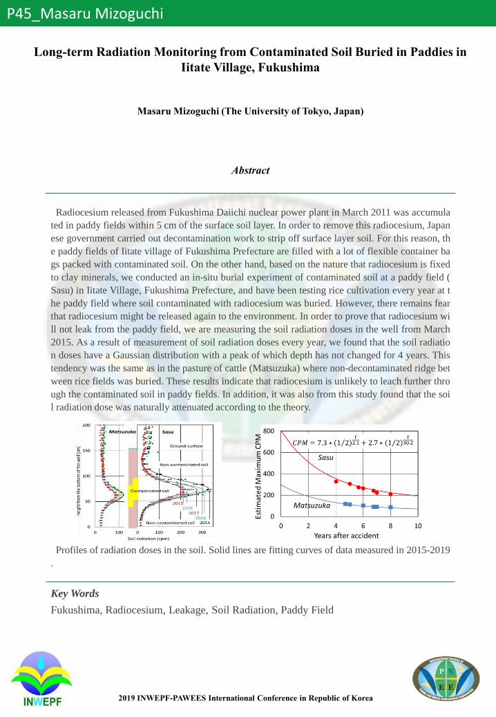
2019 INWEPF-PAWEES International Conference in Republic of Korea
P45_Masaru Mizoguchi
Long-term Radiation Monitoring from Contaminated Soil Buried in Paddies in
Iitate Village, Fukushima
Masaru Mizoguchi (The University of Tokyo, Japan)
Abstract
Radiocesium released from Fukushima Daiichi nuclear power plant in March 2011 was accumula
ted in paddy fields within 5 cm of the surface soil layer. In order to remove this radiocesium, Japan
ese government carried out decontamination work to strip off surface layer soil. For this reason, th
e paddy fields of Iitate village of Fukushima Prefecture are filled with a lot of flexible container ba
gs packed with contaminated soil. On the other hand, based on the nature that radiocesium is fixed
to clay minerals, we conducted an in-situ burial experiment of contaminated soil at a paddy field (
Sasu) in Iitate Village, Fukushima Prefecture, and have been testing rice cultivation every year at t
he paddy field where soil contaminated with radiocesium was buried. However, there remains fear
that radiocesium might be released again to the environment. In order to prove that radiocesium wi
ll not leak from the paddy field, we are measuring the soil radiation doses in the well from March
2015. As a result of measurement of soil radiation doses every year, we found that the soil radiatio
n doses have a Gaussian distribution with a peak of which depth has not changed for 4 years. This
tendency was the same as in the pasture of cattle (Matsuzuka) where non-decontaminated ridge bet
ween rice fields was buried. These results indicate that radiocesium is unlikely to leach further thro
ugh the contaminated soil in paddy fields. In addition, it was also from this study found that the soi
l radiation dose was naturally attenuated according to the theory.
Profiles of radiation doses in the soil. Solid lines are fitting curves of data measured in 2015-2019
.
Key Words
Fukushima, Radiocesium, Leakage, Soil Radiation, Paddy Field

2019 INWEPF-PAWEES International Conference in Republic of Korea
P46_Sanghyun Lee
Implication of Multi-Scale WEF Nexus on Integrated Natural Resource
Management, with a Focus on Holistic Impacts of Food Security and Economic
Growth in Japan
Sang-Hyun Lee (Research Institute for Humanity and Nature , Republic of Korea), Makoto Taniguchi
(Research Institute for Humanity and Nature, Japan), Naoki Masuhara (Research Institute for
Humanity and Nature, Japan)
Abstract
The United Nations has established 17 Sustainable Development Goals(SDGs), and the key facto
r of SDGs is to assess the holistic impacts of socio-economic and environmental issues. For examp
le, food production is related to significant irrigation water, energy, and lands, thus it is important t
o discuss the inter-linkages between food security and resources. In addition, economic growth als
o accompanies with consumption of resources such as water and energy, thus we need to consider t
he trade-off between economic growth and resource security. In this study, we applied the Water-E
nergy-Food(WEF) Nexus, which is well known for analyzing the inter-linkages among resources, t
o assess the holistic impacts of food security and economic growth as case studies. First, we assess
ed the dependency of prefectures on water resources within or outside the region through virtual w
ater flows that indicate the embedded water in food trade through WEF-Trade Nexus. The results s
how that increasing self-supply in the main producing prefectures affected the changes in the entir
e rice distribution network. In particular, as the self-supply in Shiga—the main producing prefectur
e sharing the Yodo-river basin with Osaka in the Kansai region—increases, the dependency of Osa
ka on virtual water flows from outside the Kansai region rises. Second, we assessed the effects of t
he strategies about local GDP increase and resource saving through WEF-Economy Nexus. We set
target national GDP and assigned different increase ratios of GDP to 47 prefectures by economic i
ntensity of water and energy, for example, the lowest increase ratio of GDP was applied to prefect
ures indicating high economic intensity of water and energy use. In case of Kansai region, the strat
egy for industrial freshwater and energy savings led more increase of local GDP in Osaka and Kyo
to because of low water-energy intensity, but the opposite situation was shown in Hyogo and Waka
yama. In particular, prefectures in Kansai region share the Yodo-river basin, thus the economic gro
wth and water use could affect regional water management.
Key Words
Water-Food-Energy Nexus, System Dynamics, Multi-Scale, Food Security, Economic Int
ensity

2019 INWEPF-PAWEES International Conference in Republic of Korea
P47_Seung-Hwan Yoo
Assessment of Holistic Impacts of Climate Change Using Smart Nexus for
Agriculture in Korea (SNAK)
Sang-Hyun Lee (Research Institute for Humanity and Nature, Motoyama 457-4, Kamigamo, Kita-ku,
Kyoto, Japan), Seung-Hwan Yoo (Department of Rural and Bio-systems Engineering, Chonnam
National University, Gwangju, Republic of Korea), Jin-Yong Choi (Department of Rural Systems
Engineering and Research Institute for Agriculture & Life Sciences, Seoul National University, Seoul,
Republic of Korea), Seong-Oh Hur (National Academy of Agricultural Science, Rural Development
Administration, Republic of Korea)
Abstract
Food security is a serious issue worldwide in terms of sustainable development and many countri
es now consider increasing food self-sufficiency. Korea is also one of main importers of food prod
ucts and the policy about food self-sufficiency is strongly related to food security. However, additi
onal use of resources such as water, energy, and lands is essential in increasing domestic food prod
uction for food security. The aim of this study is to develop a Smart Nexus for Agriculture in Kore
a (SANK) platform which can analyze the trade-off between food security and other resources, an
d assess the impacts of food self-sufficiency with a holistic viewpoint. First, we applied rice crop a
s study crop and analyzed the trend rice consumption and paddy rice field area. Second, the portfol
io of resources for rice production was constructed using data of footprints and productivity. Third,
we analyzed the complex relationship among food, water, energy, and lands using system dynamic
s approach, and developed WEFL Nexus module. Finally, the target self-sufficiency ratio of rice in
target year was applied as user scenario and assessed the holistic impacts of food security through
resource availability and sustainability indices in WEFL Nexus.
Key Words
Water-Energy-Food Nexus, Food Self-Sufficient, Sustainable Water Management, System
Dynamics, Smart Nexus for Agriculture in Korea (SANK)
Acknowledgement
This research was supported by Basic Science Research Program through the National Research
Foundation of Korea(NRF) funded by the Ministry of Education(NRF-2018R1A6A3A03010868).
This work was carried out with the support of "Cooperative Research Program for Agriculture
Science and Technology Development (Project No. PJ013435)" Rural Development
Administration, Republic of Korea.

2019 INWEPF-PAWEES International Conference in Republic of Korea
P48_Hirotsugo Kondo
Prediction of Sediment Disaster by Rain Infiltration Simulation Using AMeDAS
and Monitoring Soil Water
Hirotsugu Kondo, Masaru Mizoguchi (Graduate School of Agricultural and Life Sciences The
University of Tokyo, Japan)
Abstract
In 2018, a lot of people were dead or missing by a large amount of sediment disasters in Japan. T
herefore in the purpose of developing a cheap and high accuracy alert system, I conducted a rain in
filtration simulation using precipitation data and soil water monitoring data.
At first, I set a soil sensor 5TE(METER Group, Inc.) into the subject slope to get the Volumetric
Water Content(VWC). The gathered data was send to the cloud by a data transmission device calle
d HALKA(X-ability Co.). And I also obtained a precipitation data from the public weather observe
r AMeDAS.
Secondary, I calculated the change of VWC from the precipitation data by using a simulation soft
HYDRUS(PC-PROGRESS s.r.o.). I adopted the Van-Genuchten Model and used 12 sorts of soil p
arameters which HYDRUS prepares. By comparing the results with the measured value, I identifie
d a sort of the soil in the slope as Loam(L) or Sandy Clay Loam(SCL).
Finally, I conducted an inverse calculation using the measured VWC data and the precipitation da
ta. I set L and SCL parameters as the initial parameters. In this calculation, I estimated a detail of t
he actual soil parameters. The degree of the agreement between the measured VWC and the calcul
ated VWC using these estimated parameters became higher. This result means that the estimated p
arameters are getting close to the actual soil parameters of the slope.
The estimated parameters make it possible to calculate the corresponding VWC change to any rai
nfall. Without conducting a hard experiment of soil analysis, an easy monitoring and the public dat
a may enable us to detect a sign of sediment disasters.
Key Words
Sediment Disaster, HYDRUS, Soil Sensor, Rain Infiltration, Volumetric Water Content
2019 INWEPF-PAWEES International Conference in Republic of Korea
P49_Ishikawa Takahiro
Analyzation of Runoff into the Low-Lying Lake by Using Deep Learning
Takahiro ISHIAKWA (Graduate School of Agricultural and Life Sciences, The University of Tokyo,
Japan), Masaomi KIMURA (Graduate School of Agricultural and Life Sciences, The University of
Tokyo, Japan), Toshiaki IIDA (Graduate School of Agricultural and Life Sciences, The University of
Tokyo, Japan)
Abstract
In Japan, there are many lakes and reservoir Most of these lakes are used for two purpose;
one is to prevent flooding and another is to store irrigation water. For these purpose water in lake
should be managed not to be in short supply and not to be in full. Now this management is operate
d by skilled operator, but in future number of operators will be decreased because of the decline in
birthrate. So this management required to be automated in the future.
Deep learning can be the most suitable method to predict water height of lake. Because it is easie
r than physical model and more accurate than concept model such as tank model.
In this research, runoff into the low-lying lake was analyzed by using deep learning method. Targ
et area is the Toyanogata lake which is located at Niigata prefecture. Model was developed so that
input data was precipitation and quantity of drainage water and output data was runoff into the lak
e. To clarify the suitable epoch and input data, two studies were made in this research. In one study
, model was developed so that input data was only precipitation. In result, 250 times epoch and pre
cipitation at from T-8[time] to T[time] was the best to reproduce runoff at T[time].
In another study model was developed so that input data was precipitation and quantity of draina
ge water. In result, 500 times epoch, precipitation at from T-2[time] to T[time] and quantity of drai
nage water at from T-1[time] to T[time] was the best. And in both studies, accuracy of model was
declined when epoch is over 1000 times.
Key Words
Water Hydrological Statistics, Water Management, Lowland Lake, Machine Learning,
Deep-Learning

2019 INWEPF-PAWEES International Conference in Republic of Korea
P50_Jihye Kim
Effects of Paddy Water Management Techniques for Reducing Irrigation Water
Jihye Kim (Seoul National University, Republic of Korea), Kyeung Kim (Seoul National University,
Republic of Korea), Hyunji Lee (Seoul National University, Republic of Korea), Seok Hyeon Kim (Seoul
National University, Republic of Korea), Jaenam Lee (Rural Research Institute, Republic of Korea),
Moon Seong Kang (Seoul National University, Republic of Korea)
Abstract
There is a lack of management system for controlling agricultural water in Korea so that agricultu
ral water has been excessively supplied, used or wasted unused every year. For efficient use of agri
cultural water, there must be a system to control usage of water in cultivation. In this study, we bui
lt and applied three of water management scenarios(A~C) on paddy fields and analyzed water savi
ng effects of the scenarios. Three groups of paddies were set, one for scenario A, ponding depth of
20~80 mm (conventional irrigation), another for scenario B, ponding depth of 20 mm (intermittent
irrigation), and the other for scenario C, ponding depth of –100 mm (absolute intermittent irrigatio
n). We monitored Irrigation, drainage, ponding depth, infiltration, and weather data with field mea
suring instruments and analyzed water balance for each paddy field. As a result, 11~22% of irrigati
on was reduced in the paddy group B and 20~38% in the paddy group C, compared to the paddy g
roup A, respectively. These results can be used to build a water management system for efficient u
se of irrigation water in paddy fields.
Key Words
Paddy, Irrigation, Water management

2019 INWEPF-PAWEES International Conference in Republic of Korea
P51_Jehong Bang
Vulnerability Assessment of Agricultural Reservoir Water Supply Capacity
Jehong Bang (Dept. of Rural Systems Engineering, Agriculture and Life Sciences, Seoul National
University, Seoul 08826, Republic of Korea), Jin-Yong Choi (Dept. of Rural Systems Engineering,
Agriculture and Life Sciences, Seoul National University, Seoul 08826, Republic of Korea)
Abstract
Paddy rice is a staple food crop in South Korea, and 60 % of paddy fields irrigated are supplied b
y irrigation water from about 17,000 reservoirs. Therefore, the assessment of agricultural reservoir
water supply capacity is crucial to determine drought resistance capability for securing the stable f
ood supply. However, operation rule has been set up with a conventional method and vague standa
rds which only consider real-time water storage rate. To provide a reasonable basis for reservoir op
eration rule, in this study, we assessed the vulnerability of agricultural reservoir daily which consid
ers two variables: potential water supply(PWS) and irrigation water requirement(IWR) within the i
rrigation period. As a pair of PWS and IWR can be produced for a year, more than 30 sets were cal
culated with long term weather data. The vulnerability of a reservoir means a probability that wate
r requirement is higher than water supply; mathematically, P(IWR>PWS). We assessed the vulnera
bility of four study reservoirs daily, and the most hazardous periods was turned out to be the begin
ning of the transplanting season.
Key Words
Drought Response, Vulnerability Probability, Agricultural Reservoir, Potential Water Sup
ply Capacity, Irrigation Water Requirement

2019 INWEPF-PAWEES International Conference in Republic of Korea
P52_Yongchul Shin
Estimation of Sentinel-1A/B SAR Sensors based Soil Moisture
Yongchul Shin, Sangwoo Kim, Taehwa Lee
Abstract
We estimated the spatially-distributed soil moisture values at the high resolution(10m×10m) usin
g the satellite-based Sentinel-1A/B SAR(Synthetic Aperture Radar) sensor images. The Sentinel-1
A/B raw data were pre-processed based on the SNAP(Sentinel Application Platform) tool provided
from ESA(European Space Agency), and then the pre-processed data were converted to the backsc
atter coefficients. Under the assumption that backscatter coefficients have a linear relationship wit
h land surface wetness conditions, the regression equations were derived based on the relationship
s between the TDR(Time Domain Reflectrometry)-based soil moisture measurements and the conv
erted backscatter coefficients. The TDR data from the 51 RDA(Rural Development Administration
) monitoring sites were used to derive the regression equations. Then, the soil moisture values wer
e derived based on the regression equations with the input data of Sentinel-1A/B based backscatter
coefficients. Overall, the soil moisture values showed the linear trends compared to the TDR meas
urements with the high Pearson’s correlations(> 0.7). The Sentinel-1A/B based soil moisture value
s identified well with the TDR measurements with various land surface conditions(bare soil, crop,
forest, and urban), especially for bare soil(R: 0.885∼0.910 and RMSE: 3.162∼4.609). However,
the Mandae-ri(forest) and Taean-eup(urban) sites showed the negative correlations with the TDR
measurements indicating that these uncertainties might be due to limitations of soil surface penetra
tion depths of SAR sensors and complicated land surface conditions(artificial constructions near th
e TDR site) at urban regions. These results may show that Sentinel-1A/B based soil moisture prod
ucts are dependent on land surface conditions. Even though uncertainties exist, the Sentinel-1A/B
based high-resolution soil moisture products could be useful in various areas (hydrology, agricultu
re, drought, flood, wild fire, etc.).
2019 INWEPF-PAWEES International Conference in Republic of Korea
P53_Yongchul Shin
Evaluation of Agricultural Drought Using Satellite-based TRMM/GPM
Precipitation Images
Yongchul Shin, Taehwa Lee, Sangwoo Kim, Younghun jung
Abstract
We evaluated meteorological and agricultural drought conditions using the SPI(Standardized Prec
ipitation Index), SMP(Soil Moisture Percentile), and SMDI(Soil Moisture Deficit Index) indices w
ith satellite-based TRMM(Tropical Rainfall Measuring Mission)/GPM(Global Precipitation Measu
rement) images at the province of Chungcheongbuk-do. The long-term(2000-2015) TRMM/GPM
precipitation data were used to derive the SPI values. Then, the spatially and temporally distribute
d soil moisture dynamics were estimated based on the near-surface soil moisture data assimilation
scheme using the TRMM/GPM and MODIS(MODerate resolution Imaging Spectroradiometer) im
ages. Overall, the SPI values were highly influenced by the precipitation in a spatial domain, while
both the precipitation and land surface conditions affected on the SMP and SMDI values. But the
SMP values showed the relatively extreme wet/dry conditions compared to SPI and SMDI, becaus
e SMP only calculates the percentage of current wetness condition without considering the impacts
of past wetness conditions. When we considered that different drought indices have their own adva
ntages and disadvantages, the SMDI index could be useful to assess agricultural drought and establ
ish efficient water management plans.

2019 INWEPF-PAWEES International Conference in Republic of Korea
P54_Yu-Min Fu
Rainfall-Induced Landslide Potential and Its Distribution in Xiaoyoukeng
Recreation Area, Yangminshan National Park
Yu-Min Fu (Dept of Bioenvironmental Systems Engineering, National Taiwan University), Yu-Chen Hsu
(Dept of Bioenvironmental Systems Engineering, National Taiwan University), Hung-Pin Huang (Dept
of Bioenvironmental Systems Engineering, National Taiwan University)
Abstract
Mt. Qixing is a conical volcano with height of 1,120 meters. It is the highest mountain in the Taip
ei Basin. The special topography such as fumaroles, sulfur crystals, hot springs and collapsed land
formed is scattered around Mt. Qixing. In order to monitor volcanic activities tightly, the Central G
eological Survey, the Academia Sinica and other related agencies setup observation instruments in
Xiaoyoukeng for long-term observation.
Recently, the emerging gases in Yangminshan National Park has been active, causing two places
of collapse at Xiaoyoukeng Recreation Center and Zhonghu Prepared Road in the neighborhood, e
ndanger the trail safety.
In order to evaluate the risk of disaster, this study reviews the literature and collapse data of Yang
minshan National Park, to analyze the potential of landslide.
Considering factors include height, slope, aspect, geology, soil, rainfall, distribution of road, volc
anic fumaroles distribution. This study uses statistical methods to explore the occurrence of landsli
de causing by each factors, and makes the landside calamity potential map appearing in research ra
nge.
Key Words
The Yangminshan National Park, Xiaoyoukeng, Landslide Potential

2019 INWEPF-PAWEES International Conference in Republic of Korea
P55_Kwihoon KimEstimation of Reference Evapotranspiration from Greenhouse Temperature
Model in Korea
Kwihoon Kim (Ph.D. Course in Department of Rural Systems Engineering, College of Agriculture and
Life Sciences, Seoul National University, Republic of Korea), Yoonhee Lee (Ph.D. Course in Department
of Rural Systems Engineering, College of Agriculture and Life Sciences, Seoul National University,
Republic of Korea), Pureun Yoon (Ph.D. Course in Department of Rural Systems Engineering, College
of Agriculture and Life Sciences, Seoul National University, Republic of Korea), Jin-Yong Choi
(Professor in Department of Rural Systems Engineering, College of Agriculture and Life Sciences, Seoul
National University, Republic of Korea)
Abstract
For enhancing the economy in agriculture, increasing crop productivity is the most important thin
g. As the cropland area per capita in Korea is small compared to other countries, many farmers eng
age in greenhouse farming for achieving good profits. The objective of this study was to estimate t
he reference evapotranspiration in the greenhouse. For the estimation, Hargreaves equation was us
ed and the input variables were the temperature inside and outside the greenhouse. Data of outside
temperature were obtained from the nearest climate observation station and data of inside temperat
ure from the Greenhouse Temperature Model. The experimental 4-span greenhouse had an area of
3,000 m2 which is covered with vinyl chloride The estimated values were validated using crop eva
potranspiration calculated by soil water budget method. The results showed 101mm from 22nd Jul
y to 28th October. Though more correction should be accompanied with experimental data from ot
her types of greenhouses, this study can be used for the estimation of regional water demand in gre
enhouse farming.
Key Words
Reference Evapotranspiration, Hargreaves Equation, Greenhouse Soil Water Budget Anal
ysis

2019 INWEPF-PAWEES International Conference in Republic of Korea
P56_Yoonhee LeeAssessment of Regional Differences in Sustainability of Agricultural Production
by Nexus-Based Analysis
Yoonhee Lee (Ph.D. Course in Department of Rural Systems Engineering, College of Agriculture and
Life Sciences, Seoul National University, Republic of Korea), Jin-Yong Choi (Professor in Department
of Rural Systems Engineering, College of Agriculture and Life Sciences, Seoul National University,
Republic of Korea), Pureun Yoon (Ph.D. Course in Department of Rural Systems Engineering, College
of Agriculture and Life Sciences, Seoul National University, Republic of Korea), Kwihoon Kim (Ph.D.
Course in Department of Rural Systems Engineering, College of Agriculture and Life Sciences, Seoul
National University, Republic of Korea)
Abstract
Stable agricultural production needs resource-intensive agricultural production structure, but the s
tability of securing resources such as water has been deteriorating due to recent climate change. Th
e investment in facilities of water requirement for agriculture requires more information because it
has a high cost, such as having the infrastructure. Therefore, this study aims to provide more infor
mation on securing resources needed for agricultural production by clarifying the linkage between
resources in addition to the total amount of resources required for agricultural production. We asse
ssed the sustainability of securing the resources needed for agricultural production through data on
regional production, agricultural energy use, and water use in eight regions of South Korea. In Sou
th Korea, Jeonnam, Jeonbuk, and Chungnam regions are considered to have higher resource efficie
ncy than other regions.
Key Words
Nexus, Rural resources, Trade-off, Sustainability