Embed Size (px)
Citation preview

2019 Ambient Air Monitoring Network Plan
June 2019 Publication xxx

Publication and Contact Information This document is available on the Department of Ecology’s website at: www.xx.xx
For more information contact:
Air Quality Program P.O. Box 47600 Olympia, WA 98504-7600 Phone: 360-407-6800
Washington State Department of Ecology — www.ecology.wa.gov
• Headquarters, Olympia 360-407-6000 • Northwest Regional Office, Bellevue 425-649-7000 • Southwest Regional Office, Olympia 360-407-6300 • Central Regional Office, Union Gap 509-575-2490 • Eastern Regional Office, Spokane 509-329-3400
To request ADA accommodation including materials in a format for the visually impaired, call Ecology at 360-407-6800 or visit https://ecology.wa.gov/accessibility. People with impaired hearing may call Washington Relay Service at 711. People with speech disability may call TTY at 877-833-6341.

2019 Ambient Air Monitoring Network Plan
Prepared by
Jill Schulte
Air Monitoring Coordinator
Air Quality Program
Washington State Department of Ecology
Olympia, Washington

This page is purposely left blank

Publication xx-xx-xxx v June 2019
Table of Contents
2019 Ambient Air Monitoring Network Plan ...................................................................... i
Publication and Contact Information ............................................................................ ii
2019 Ambient Air Monitoring Network Plan ...................................................................... i
Table of Contents ...........................................................................................................v
List of Figures and Tables........................................................................................... vii
Figures................................................................................................................... vii
Tables .................................................................................................................... vii
Acronyms ..................................................................................................................... ix
Executive Summary .......................................................................................................1
Purpose .....................................................................................................................1
Network modifications.............................................................................................1
Introduction ....................................................................................................................3
Background Information ................................................................................................4
Monitoring Objectives .............................................................................................4
Network Evaluation .................................................................................................6
Washington Core-Based Statistical Areas ...............................................................6
Maintenance Areas...................................................................................................8
Monitoring Network Design ........................................................................................10
Carbon monoxide (CO, 42101)..............................................................................13
Nitrogen dioxide (NO2, 42602/42612) ...................................................................14
Ozone (O3, 44201) .................................................................................................16
Sulfur dioxide (SO2, 42401) ..................................................................................18
Particulate matter 10 (PM10, 81102) ......................................................................19
Particulate matter 2.5 (PM2.5, 88101/88502) .........................................................23
Meteorological monitoring (61101/61102/61103/61104/62101) ..........................30
Lead (Pb) ................................................................................................................31
Chemical Speciation Network (CSN) ....................................................................32
National Core (NCore) ...........................................................................................34
National Air Toxics Trends Station (NATTS).......................................................35

Publication xx-xx-xxx vi June 2019
Photochemical Assessment Monitoring Station (PAMS) ......................................35
References ....................................................................................................................37
Appendices ...................................................................................................................38
Appendix A. Criteria Pollutant Design Values ......................................................38
Appendix B. EPA Response to Ecology’s 2018 Annual Network Plan ................43
Appendix C. Monitoring Waivers..........................................................................46
Appendix D. Detailed Site and Monitor Information ............................................54

Publication xx-xx-xxx vii June 2018
List of Figures and Tables Page
Figures Figure 1. Washington's Core-Based Statistical Areas (CBSAs), U.S. Census Bureau 2013 ......... 7
Figure 2. Map of all Washington Network monitoring sites. ...................................................... 10
Figure 3. Map of Washington Network CO monitoring sites ...................................................... 13
Figure 4. Map of Washington Network NO2 and Trace NOy-NO monitoring sites .................... 15
Figure 5. Map of Washington Network ozone monitoring sites .................................................. 17
Figure 6. Map of Washington Network SO2 monitoring sites ..................................................... 19
Figure 7. Map of Washington Network PM10 monitoring sites ................................................... 20
Figure 8. Burbank-Maple St wind rose (February 2018 - April 2019) ......................................... 23
Figure 9. Map of Washington Network PM2.5 monitoring sites .................................................. 25
Figure 10. Map of Washington Network nephelometer monitoring sites ................................... 29
Figure 11. Map of Washington Network meteorological monitoring sites ................................. 31
Figure 12. Map of Washington Chemical Speciation Network monitoring sites ........................ 33
Tables Table 1. Summary of applicable spatial scales for criteria pollutants and monitoring objectives .. 5
Table 2. Washington's CBSA populations over 50,000 (U.S. Census Bureau) .............................. 8
Table 3. Washington PM10 maintenance areas and methods of demonstrating NAAQS attainment......................................................................................................................................................... 8
Table 4. Summary of parameters monitored at Washington Network monitoring sites ............. 11
Table 5. Washington Network CO monitoring sites .................................................................... 13
Table 6. Washington Network NO2 and Trace NOy-NO monitoring sites .................................. 14
Table 7. Washington Network ozone monitoring sites ................................................................ 16
Table 8. EPA minimum monitoring requirements for ozone ...................................................... 17
Table 9. Washington Network SO2 monitoring sites ................................................................... 18
Table 10. Washington Network PM10 monitoring sites ............................................................... 20
Table 11. EPA minimum monitoring requirements for PM10 ..................................................... 21
Table 12. Washington Network PM2.5 monitoring sites .............................................................. 23
Table 13. EPA minimum monitoring requirements for FRM/FEM PM2.5 .................................. 26

Publication xx-xx-xxx viii June 2019
Table 14. PM2.5 collocation requirements .................................................................................... 26
Table 15. Washington Network nephelometer monitoring sites ................................................. 27
Table 16. Washington Network meteorological monitoring sites ............................................... 30
Table 17. Washington Network Chemical Speciation Network monitoring sites ....................... 32
Table 18. Chemical Speciation Network monitoring parameters ................................................ 33
Table 19. NCore parameters monitored at Cheeka Peak and Seattle-Beacon Hill ...................... 34
Table 20. Required PAMS parameters and implementation schedule ........................................ 36
Table 21. Carbon monoxide (CO) 2018 design values ................................................................ 38
Table 22. Nitrogen dioxide (NO2) 2018 design values (ppb) ...................................................... 38
Table 23. Ozone (O3) 2018 design values (ppm) ......................................................................... 38
Table 24. Sulfur dioxide (SO2) 2018 design values (ppb) ........................................................... 39
Table 25. PM10 2018 design values (µg/m3) ................................................................................ 39
Table 26. PM2.5 2018 24-hour design values and pseudo-design values (µg/m3) ....................... 39
Table 27. PM2.5 2018 annual design values and pseudo-design values ....................................... 40

Publication xx-xx-xxx ix June 2019
Acronyms AQS EPA’s Air Quality System database BAM Beta Attenuation Monitor BCAA Benton County Clean Air Agency CBSA Core-Based Statistical Area CFR Code of Federal Regulations CO Carbon Monoxide CSA Combined Statistical Area CSN Chemical Speciation Network DV Design Value Ecology Washington State Department of Ecology EPA U.S. Environmental Protection Agency FDMS Filter Dynamic Measurement System FEM Federal Equivalent Method FRM Federal Reference Method IMPROVE Interagency Monitoring of Protected Visual Environments MSA Metropolitan Statistical Area NAAQS National Ambient Air Quality Standard NATTS National Air Toxics Trends Station NCore National Core NO Nitrogen Oxide NO2 Nitrogen Dioxide NOX Oxides of Nitrogen NOy Total Reactive Oxides of Nitrogen NWCAA Northwest Clean Air Agency O3 Ozone ORCAA Olympic Region Clean Air Agency Pb Lead PM2.5 Particulate matter ≤ 2.5 micrometers in diameter PM10 Particulate matter ≤ 10 micrometer in diameter PM10-2.5 Particulate matter ≤10 microns and > 2.5 micrometers in diameter ppb parts per billion ppm parts per million PAMS Photochemical Assessment Monitoring Station PQAO Primary Quality Assurance Organization PSCAA Puget Sound Clean Air Agency PSD Prevention of Significant Deterioration QA Quality Assurance QA Quality Control SLAMS State or Local Air Monitoring Station SO2 Sulfur Dioxide SPMS Special Purpose Monitoring Site SRCAA Spokane Region Clean Air Agency SWCAA Southwest Clean Air Agency STN Speciation Trends Network TEOM Tapered Element Oscillating Microbalance TSP Total Suspended Particulate µg/m3 micrograms per cubic meter VOC Volatile Organic Compound YRCAA Yakima Region Clean Air Agency


2019 Ambient Air Monitoring Network Plan
Publication xx-xx-xxx 1 June 2019
Executive Summary
Purpose In accordance with the requirements described in 40 C.F.R. Part 58.10, Ecology reviews its ambient air monitoring network each year to ensure that it collects adequate, representative, and useful air quality data on which to base policy decisions. This report summarizes the results of the 2019 review. The annual review process includes:
• Documenting Ecology’s ambient air quality monitoring needs, goals and priorities; • Identifying modifications to Ecology’s ambient air monitoring network since the previous
annual network plan; and • Identifying proposed modifications to the network in the upcoming 18 months.
Network modifications
Recent modifications
NO2 (42602) The NO2 monitoring at the temporary Quincy Special Purpose Monitoring Site (SPMS) was discontinued on September 30, 2018. The site will be retained as a meteorological and nephelometer monitoring site until at least December 2020.
PM2.5 (88101) A collocated Met One BAM 1020 was added to the Tacoma-S 36th monitoring site (530530024) on March 2, 2019.
As approved by EPA on December 13, 2018, the Lynnwood-212th St site (530610005) operated by the Puget Sound Clean Air Agency (PSCAA) was discontinued on December 31, 2018. The state support and PM2.5 grant funding were redirected to a new site established by PSCAA at Auburn-M St (530330089). Monitoring at Auburn began on January 1, 2019.
Nephelometer PM2.5 (88502) The temporary nephelometer monitoring study at Quincy (530251003) was extended until December 2020.
The temporary Okanogan nephelometer SPMS (530470004) was discontinued in June 2018.
Two temporary nephelometer SPMS were established. The Friday Harbor site (530550001) operated from January-May 2019. The White Salmon site was established in June 2018 and will operate indefinitely.

Executive Summary
Publication xxxxxxx 2 June 2019
Planned modifications
PM2.5 (88101) Ecology is currently evaluating potential locations for a second PM2.5 monitoring site in the Spokane-Spokane Valley Metropolitan Statistical Area (MSA) and plans to establish a second site by January 1, 2020. The addition of this site will fulfill the minimum monitoring requirements for PM2.5 described in 40 C.F.R. Part 58 Appendix D.
Chemical Speciation Network (CSN) In the 2018 Annual Network Plan (ANP), Ecology proposed to relocate the Tacoma-L St (530530029) speciation monitor to the Tacoma-S 36th St (530530024) near-road monitoring site. However, since submission of the 2018 ANP, operational challenges to speciation data collection have grown at the Seattle-10th and Weller monitoring site (530330030). As these challenges are more urgent than the pending Tacoma relocation, Ecology delayed the relocation of the Tacoma site to evaluate alternate potential locations for Seattle-10th and Weller speciation monitoring. Ecology hopes to relocate the speciation monitoring equipment from Seattle-10th and Weller to a site in Central Washington but has not yet identified operational resources for this relocation. Ecology will continue to pursue alternatives to speciation monitoring at Seattle-10th and Weller in other high-PM2.5 areas of the state and will revisit relocation of the Tacoma site at a later date.
Photochemical Assessment Monitoring Stations (PAMS) Based on 40 C.F.R. Part 58, Appendix D, state air monitoring agencies are required to begin making PAMS measurements at their NCore location(s) by June 1, 2019. The equipment needed to measure PAMS parameters were to be purchased by EPA using a nationally negotiated contract and delivered to the monitoring agencies. EPA has announced that due to contract delays, the necessary equipment will not be delivered in time to begin making PAMS measurements by June 1, 2019. EPA has indicated that it is working on a proposed rule to extend the start date of PAMS measurements and expects that this proposed rule change will be signed by June 1, 2019. As a result of the delay, Ecology will not begin making PAMS measurements at the Seattle-Beacon Hill NCore location in 2019, and will work with EPA to begin measurements on or before the final revised start date for this network.

2019 Ambient Air Monitoring Network Plan
Publication xx-xx-xxx 3 June 2019
Introduction This document summarizes Ecology’s annual review of the Washington Ambient Air Monitoring Network (Washington Network) in accordance with 40 C.F.R. Part 58.10.
EPA’s ambient air quality surveillance regulations in 40 C.F.R. Part 58 require states to establish air quality surveillance systems in their State Implementation Plans (SIPs). An air quality surveillance system consists of a network of State and Local Air Monitoring Stations (SLAMS). These stations measure ambient concentrations of those air pollutants for which 40 C.F.R. Part 50 sets standards. SLAMS must meet the requirements of 40 C.F.R. Part 58 contained in:
• Appendix A (Quality Assurance Requirements) • Appendix C (Ambient Air Quality Monitoring Methodology) • Appendix D (Network Design Criteria) • Appendix E (Probe and Path Siting Criteria)
States determine if they conform to Appendices A and C in part through periodic system and performance audits. States conform to Appendices D and E by conducting an annual network review of their air quality surveillance systems. This review is documented in an annual network plan that meets the following requirements:
• The plan describes any network modifications planned in the upcoming 18 months. Network modifications are subject to approval of the EPA Regional Administrator.
• For each existing and proposed monitoring site, the plan includes the following information: o The AQS site number o Geographic information, including street address, geographic coordinates, and the
represented MSA, CBSA, CSA or other area o The monitoring objective, special scale, sampling and analysis method, and operating
schedule for each monitor • The plan outlines the state’s approach to implementing PAMS monitoring requirements
where required at National Core (NCore) network sites by June 1, 2019. • The plan must be made available for public inspection and comment for at least 30 days prior
to submission to the EPA. The final plan includes and addresses comments received through the public notification process.
Background Information
Publication xxxxxxx 4 June 2019
Background Information
Monitoring Objectives The Washington Network was designed to meet the three monitoring objectives defined in 40 C.F.R. Part 58 Appendix D:
1. Provide air pollution data to the public in a timely manner. Ecology provides timely air quality data to the public in a variety of ways, including:
o Near-real-time data are available on Ecology’s monitoring website. o Ecology conducts public outreach and issues alerts and bulletins when air quality is
compromised.
2. Support compliance with National Ambient Air Quality Standards (NAAQS) and development of pollution control strategies. Ambient air quality data are used to:
o Determine compliance with the NAAQS o Determine the location of maximum pollutant concentrations o Track the progress of SIPs o Determine the effectiveness of air pollution control programs o Develop responsible and cost-effective emission control strategies o Assist with permitting work
3. Support air pollution research. Ecology and its partners use ambient air quality data to improve our understanding of air pollution and its consequences. Research applications of air quality include:
o Improving air quality forecasting o Evaluating the effects of air pollution on public health o Informing dispersion models o Identifying air quality trends and emerging pollution issues o Analyzing pollution episodes
In order to meet these three objectives, 40 C.F.R. Part 58 Appendix D calls for the design of SLAMS networks to include several different types of monitors. These general types are sites that:
1. Determine the highest pollutant concentrations expected in the area covered by the network.
2. Determine representative pollutant concentrations in areas of high population density.
3. Determine the impact of significant sources or source categories on pollutant concentrations in the ambient air.
4. Determine general background pollutant concentrations.

2019 Ambient Air Monitoring Network Plan
Publication xx-xx-xxx 5 June 2019
5. Determine the regional extent of pollutant transport between populated areas.
6. Determine the impacts on visibility or vegetation (welfare impacts) in more rural and remote areas.
Appendix D also provides guidance on spatial scales of representativeness for stations in a SLAMS network. Ideally, the station is located so that its sample represents the air quality across the scale that the station is intended to represent. Appendix D defines the following spatial scales:
1. Microscale: Area dimensions between several and 100 meters.
2. Middle scale: Areas between 100 and 500 meters, typically several city blocks.
3. Neighborhood scale: Areas between 0.5 and 4 kilometers with relatively uniform land use.
4. Urban scale: Areas with city-like dimensions between 4 and 50 kilometers. Urban and neighborhood scales can overlap considerably. Heterogeneous urban areas may not have a single representative site.
5. Regional scale: Areas from tens to hundreds of kilometers with relatively homogeneous geography and no large sources.
6. National and global scales: Scales representing the nation or globe as a whole.
Table 1 summarizes the appropriate spatial scales for each criteria pollutant and applicable site types.
Table 1. Summary of applicable spatial scales for criteria pollutants and monitoring objectives
Scale SO2 CO O3 NO2 Pb PM10 PM2.5 Site Types
Micro Highest concentration; source impact
Middle Highest concentration; source impact
Neighborhood Highest concentration; population; source impact; general/background
Urban Highest concentration; population; general/background; regional transport; welfare-related impacts
Regional General/background; regional transport; welfare-related impacts

Background Information
Publication xxxxxxx 6 June 2019
Other ambient monitoring data needs In addition to its network of criteria pollutant monitoring sites, Ecology also uses nephelometers throughout Washington to estimate PM2.5 concentrations and inform the public of air quality conditions in communities where criteria pollutant monitoring is not required. Typically, nephelometer monitoring sites use site-specific PM2.5 correlations developed from collocated Federal Reference Method (FRM) or Federal Equivalent Method (FEM) monitor data. Lower concentration sites may use generalized regional correlations developed at sites with similar geographic and source characteristics. These sites are operated in accordance with 40 C.F.R. Part 58 Appendix A requirements for quality assurance and quality control. At nephelometer sites where PM2.5 concentrations are consistently measured at or greater than 80 percent of the NAAQS, Ecology transitions to FEM monitoring.
Network Evaluation Ecology uses a variety of tools to evaluate how well its monitoring network is meeting these goals and objectives. These tools include:
• EPA minimum monitoring requirements in 40 C.F.R. Part 58 Appendix D • Results of Ecology’s most recent 5-year Ambient Air Quality Monitoring Network
Assessment • Analyses of historic monitoring data • Census data on population density and demographics • Dispersion and air quality forecast models • Planning requirements, including SIPs and maintenance plans • Jurisdictional boundaries • Results of special monitoring studies
The suitability of individual monitoring sites is evaluated according to the probe and monitoring path siting criteria described in 40 C.F.R. Part 58 Appendix E.
Washington Core-Based Statistical Areas The minimum monitoring requirements listed in 40 C.F.R. Part 58 Appendix D are based on the core-based statistical areas (CBSAs) defined by the U.S. Office of Management and Budget. Washington’s CBSAs are shown in the map in Figure 1 (U.S. Census Bureau, 2013). Note that since publication of this map, Pend Oreille County has been removed from the Spokane-Spokane Valley MSA. Population estimates throughout this document are based on the latest available census figures in these CBSAs (2018 Annual Estimates of the Resident Population, U.S. Census Bureau, 2019). The populations of CBSAs in Washington over 50,000 people are listed in Table 2.

2019 Ambient Air Monitoring Network Plan
Publication xx-xx-xxx 7 June 2019
Figure 1. Washington's Core-Based Statistical Areas (CBSAs), U.S. Census Bureau 2013

Background Information
Publication xxxxxxx 8 June 2019
Table 2. Washington's CBSA populations over 50,000 (U.S. Census Bureau)
Core-Based Statistical Area 2018 Population Seattle-Tacoma-Bellevue, WA 3,939,363 Portland-Vancouver-Hillsboro, OR-WA 2,478,810 Spokane-Spokane Valley, WA 573,493 Kennewick-Richland, WA 296,224 Olympia-Lacey-Tumwater, WA 286,419 Bremerton-Silverdale-Port Orchard, WA 269,805 Yakima, WA 251,446 Bellingham, WA 225,685 Mount Vernon-Anacortes, WA 128,206 Wenatchee, WA 119,943 Longview, WA 108,987 Moses Lake, WA 97,331 Oak Harbor, WA 84,460 Centralia, WA 79,604 Port Angeles, WA 76,737 Aberdeen, WA 73,901 Shelton, WA 65,507 Walla Walla, WA 64,981 Lewiston, ID-WA 63,018
Washington shares the Portland-Vancouver-Hillsboro CBSA with the state of Oregon. The minimum monitoring requirements for PM10, PM2.5 and ozone in this CBSA are met through a combination of monitors operated by Ecology and the Oregon Department of Environmental Quality (DEQ). Ecology and Oregon DEQ are in the process of developing a Memorandum of Understanding to formalize this arrangement.
Maintenance Areas Washington has ten maintenance areas for criteria pollutants. Maintenance areas demonstrate continued attainment of the NAAQS either through monitoring or through EPA-approved alternate methods. These methods are summarized in Table 3.
Table 3. Washington PM10 maintenance areas and methods of demonstrating NAAQS attainment
Maintenance Area (Pollutant)
End of Maintenance Period
NAAQS Attainment Method
Seattle (PM10) 5/14/2021 Estimated PM10 from Seattle-Duwamish PM2.5 (530330057)
Kent (PM10) 5/14/2021 Estimated PM10 from Kent-Central & James PM2.5 (530332004)

2019 Ambient Air Monitoring Network Plan
Publication xx-xx-xxx 9 June 2019
Maintenance Area (Pollutant)
End of Maintenance Period
NAAQS Attainment Method
Tacoma (PM10) 5/14/2021 Estimated PM10 from Tacoma-Alexander nephelometer PM2.5 (530530031)
Thurston County (PM10)
12/4/2020 Estimated PM10 from Lacey-College St nephelometer PM2.5 (530670013)
Wallula (PM10) 9/26/2025 Burbank-Maple St PM10 monitor (530710006) Spokane (PM10) 8/30/2025 Spokane-Augusta PM10 monitor (530630021) Yakima (PM10) 3/10/2025 Yakima-4th Ave S PM10 monitor (530770009) Tacoma (PM2.5) 3/12/2035 Tacoma-L St PM2.5 monitor (530530029) Yakima (CO) 12/31/2022 Modeled CO vehicle emissions Spokane (CO) 8/30/2025 Modeled onroad, nonroad and residential wood
combustion CO emissions
Washington has several maintenance areas that fall within the jurisdiction of local air agencies. In accordance with the maintenance plans, the local air agencies submitted design values to Ecology for the maintenance areas in their jurisdiction. These design values and their underlying calculations can be found in the document “Verification of Continued Attainment in Limited Maintenance Areas (2019)” submitted concurrently with this plan.

Monitoring Network Design
Publication xxxxxxx 10 June 2019
Monitoring Network Design On January 1, 2019, Ecology and its partners operated 75 monitoring sites that were part of the Washington Network. Those sites are shown on the map in Figure 2, and the parameters monitored are summarized in Table 4. Detailed site information is provided in Appendix D. All monitoring sites described in this plan are operated under the Ecology Primary Quality Assurance Organization (PQAO). Other monitoring sites, such as IMPROVE sites, are operated in Washington as part of separate PQAOs, but those networks are outside the scope of this document.
In its response to Washington’s 2018 Annual Air Monitoring Network Plan, EPA requested that Ecology update the Annual Average Daily Traffic (AADT) counts and roadway distances for each monitoring site. Appendix D includes updated roadway distances and the latest available AADT counts. These values have also been updated in AQS.
Figure 2. Map of all Washington Network monitoring sites.

2019 Ambient Air Monitoring Network Plan
Publication xx-xx-xxx 11 June 2019
Table 4. Summary of parameters monitored at Washington Network monitoring sites
Site Name AQS ID CO NO2/ NOy O3 SO2 PM2.5
(FRM/FEM)
PM2.5 (Non-
FRM/FEM) PM10 Meteorological Other
Aberdeen-Division St 530272002
Anacortes-202 O Ave 530570011
Auburn-M St 530330089 Bellevue-SE 12th St 530330031
Bellingham-Pacific St 530730019
Bremerton-Spruce Ave 530350007
Burbank-Maple St 530710006
Cheeka Peak 530090013
Chehalis-Market Blvd 530410004
Chelan-Woodin Ave 530070007
Cheney-Turnbull 530630001
Clarkston-13th St 530030004
Colville-E 1st St 530650005
Custer-Loomis 530730005
Darrington-Fir St 530610020
Dayton-W Main St 530130002
Ellensburg-Ruby St 530370002
Enumclaw-Mud Mtn. 530330023
Ferndale-Kickerville Road 530730013
Ferndale-Mountain View Rd 530730017
Friday Harbor (Temporary) 530550001 Issaquah-Lake Sammamish 530330010
Kennewick-Metaline 530050002
Kennewick-S Clodfelter Rd 530050003
Kent-Central & James 530332004
Lacey-College St 530670013
LaCrosse-Hill St 530750005
Lake Forest Park 530330024
Leavenworth-Evans St 530070010
Longview-30th Ave 530150015
Malaga-Malaga Hwy 530070012
Marysville-7th Ave 530611007
Mesa-Pepiot Way 530210002
Moses Lake-Balsam St 530251002
Mt Rainier-Jackson Visitors Ctr 530530012
Mt Vernon-S Second St 530570015
Neah Bay-Makah Tribe 530090015
North Bend-North Bend Way 530330017
Omak-Colville Tribe 530470013
Pomeroy (Temporary) 530230001
Port Angeles- E 5th St 530090017
Port Townsend-San Juan Ave 530310003
Pullman-Dexter SE 530750003
Puyallup-128th St 530531018
Quincy-3rd Ave NE (Temporary)
530251003
Ritzville-Alder St 530010003
Rosalia-Josephine St 530750006
Seattle-10th & Weller 530330030
CSN Seattle-Beacon Hill 530330080
CSN, NATTS,
PAMS planned Seattle-Duwamish 530330057
Seattle-South Park 530331011
Shelton-W Franklin 530450007
Spokane-Augusta Ave 530630021

Monitoring Network Design
Publication xxxxxxx 12 June 2019
Site Name AQS ID CO NO2/ NOy O3 SO2 PM2.5
(FRM/FEM)
PM2.5 (Non-
FRM/FEM) PM10 Meteorological Other
Spokane-Greenbluff 530630046
Spokane-Monroe St 530630047
Sunnyside-S 16th St 530770005
Tacoma- L Street 530530029
CSN Tacoma-Alexander Ave 530530031
Tacoma-S 36th St 530530024
Tacoma-Tower Dr 530531016
Taholah-Quinault Tribe 530270011
Toppenish-Yakama Tribe 530770015
Tukwila Allentown 530330069
Twisp-Glover St 530470009
Vancouver NE 84th Ave 530110020
Vancouver-Blairmont Dr 530110011
Walla Walla-12th St 530710005
Wellpinit-Spokane Tribe 530650002
Wenatchee-Fifth St 530070011
White Salmon (Temporary) 530390006 White Swan-Yakama Tribe 530770016
Winthrop-Chewuch Rd 530470010
Yacolt-Yacolt Rd 530110022
Yakima-4th Ave 530770009
CSN Yelm-Northern Pacific 530670005

2019 Ambient Air Monitoring Network Plan
Publication xx-xx-xxx 13 June 2019
Carbon monoxide (CO, 42101) There are three CO monitoring sites in the Washington Network. All Washington Network CO monitoring sites collect data under method code 593 (Teledyne API 300 EU). For detailed site and monitor information, see Appendix D.
Table 5. Washington Network CO monitoring sites
AQS ID Site Name Established Type Scale 530090013 Cheeka Peak 05/2006 SLAMS, NCore Regional 530330030 Seattle-10th & Weller 04/2014 SLAMS, Near-road Microscale 530330080 Seattle-Beacon Hill 03/2007 SLAMS, NCore Urban
Figure 3. Map of Washington Network CO monitoring sites
Minimum monitoring requirements
Ecology is required to operate a CO monitor collocated with one required near-road NO2 monitor in CBSAs with a population of 1,000,000 or more. In the Seattle-Tacoma-Bellevue MSA, this requirement is met at the Seattle-10th & Weller near-road monitoring site (530330030).

Monitoring Network Design
Publication xxxxxxx 14 June 2019
Recommended/proposed modifications: None.
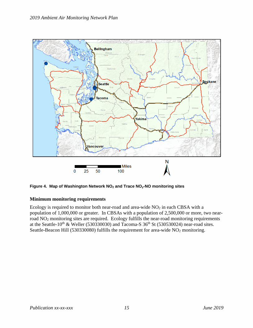
Nitrogen dioxide (NO2, 42602/42612) There are three NO2 (42602) monitoring sites in the Washington Network and two sites that monitor trace NOy-NO (42612). Seattle-Beacon Hill monitors both area-wide NO2 and trace NOy-NO. For detailed site and monitor information, see Appendix D.
Table 6. Washington Network NO2 and Trace NOy-NO monitoring sites
AQS ID Site Name NO2 Trace NOy-NO
Established Type Scale Method
530090013 Cheeka Peak 01/2011 SLAMS,
NCore Regional Teledyne API
200 EU (699) 530330030 Seattle-10th
& Weller 04/2014 SLAMS, Near-road
Microscale Teledyne API 200 EU (599)
530330080 Seattle-Beacon Hill
08/2013 SLAMS, NCore
Urban NO2: Teledyne API T500U (212); Trace NOy-NO: Thermo 42C (674)
530530024 Tacoma-S 36th 01/2016 SLAMS,
Near-road Microscale Teledyne API
200 EU (599)
2019 Ambient Air Monitoring Network Plan
Publication xx-xx-xxx 15 June 2019
Figure 4. Map of Washington Network NO2 and Trace NOy-NO monitoring sites
Minimum monitoring requirements Ecology is required to monitor both near-road and area-wide NO2 in each CBSA with a population of 1,000,000 or greater. In CBSAs with a population of 2,500,000 or more, two near-road NO2 monitoring sites are required. Ecology fulfills the near-road monitoring requirements at the Seattle-10th & Weller (530330030) and Tacoma-S 36th St (530530024) near-road sites. Seattle-Beacon Hill (530330080) fulfills the requirement for area-wide NO2 monitoring.

Monitoring Network Design
Publication xxxxxxx 16 June 2019
Ozone (O3, 44201) There are 13 ozone monitoring sites in the Washington Network. All Washington Network ozone sites collect data under method code 087 (UV Absorbance) using Teledyne API 400 analyzers. For detailed site and monitor information, see Appendix D.
Table 7. Washington Network ozone monitoring sites
AQS ID Site Name Established Type Scale 530570011 Anacortes-202 O Ave 05/2012 SLAMS Neighborhood 530090013 Cheeka Peak 05/2006 SLAMS,
NCore Regional
530630001 Cheney-Turnbull 05/1999 SLAMS Urban 530730005 Custer-Loomis 04/1989 SLAMS Regional 530330023 Enumclaw-Mud Mtn 07/1998 SLAMS Urban 530330010 Issaquah-Lake Sammamish 12/1975 SLAMS Urban 530050003 Kennewick-S Clodfelter Rd 06/2015 SLAMS Urban 530530012 Mt Rainier-Jackson Visitors Ctr 07/1998 SLAMS Regional 530330017 North Bend-North Bend Way 06/1998 SLAMS Neighborhood 530330080 Seattle-Beacon Hill 03/2007 SLAMS,
NCore Urban
530630046 Spokane-Greenbluff 04/1990 SLAMS Urban 530110011 Vancouver-Blairmont 05/1988 SLAMS Urban 530670005 Yelm-Northern Pacific 05/2006 SLAMS Urban

2019 Ambient Air Monitoring Network Plan
Publication xx-xx-xxx 17 June 2019
Figure 5. Map of Washington Network ozone monitoring sites
Minimum monitoring requirements
The Washington Network meets the minimum monitoring requirements for ozone defined in 40 C.F.R. Part 58 Appendix D. In each CBSA, the number of existing ozone monitors exceeds the number of required monitors, as summarized in Table 8. The design values listed are the maximum valid design value of all sites within the CBSA. For a full list of design values at all ozone sites in the Washington Network, see Appendix A.
Table 8. EPA minimum monitoring requirements for ozone
CBSA 2018 Population Estimate
2018 Design Value (ppm)
Number of Required Monitors
Number of Existing Monitors
Seattle-Tacoma-Bellevue, WA 3,939,363 0.077 2 5 Portland-Vancouver-Hillsboro, OR-WA 2,478,810 0.072 2 6 Spokane-Spokane Valley, WA 573,493 0.065 2 2 Kennewick-Richland, WA 296,224 0.071 1 1

Monitoring Network Design
Publication xxxxxxx 18 June 2019
CBSA 2018 Population Estimate
2018 Design Value (ppm)
Number of Required Monitors
Number of Existing Monitors
Olympia-Tumwater, WA 286,419 0.062 1 1 Bellingham, WA 225,685 0.052 0 1 Mount Vernon-Anacortes, WA 128,206 0.045 0 1 Port Angeles, WA 76,737 0.054 0 1
Washington shares the Portland-Vancouver-Hillsboro CBSA with the state of Oregon. The minimum monitoring requirements for ozone in this CBSA are met through a combination of monitors operated by Ecology and Oregon DEQ. Ecology and Oregon DEQ are in the process of developing a Memorandum of Understanding to formalize this arrangement.
Recommended/proposed modifications: None.
Sulfur dioxide (SO2, 42401) There are six SO2 monitoring sites in the Washington Network. For detailed site and monitor information, see Appendix D.
Table 9. Washington Network SO2 monitoring sites
AQS ID Site Name Established Type Scale Method 530570011 Anacortes-202 O
Ave 01/2013 SLAMS Neighborhood TAPI 100 EU
(600) 530090013 Cheeka Peak 05/2006 SLAMS,
NCore Regional TAPI 100 EU
(600) 530730013 Ferndale-
Kickerville Rd 01/2017 SLAMS Microscale TAPI 100
(077) 530730017 Ferndale-Mountain
View Rd 01/2017 SLAMS Microscale TAPI 100
(077) 530070012 Malaga-Malaga
Hwy 01/2017 SLAMS Microscale TAPI 100
(077) 530330080 Seattle-Beacon Hill 03/2007 SLAMS,
NCore Urban TAPI 100 EU
(600)

2019 Ambient Air Monitoring Network Plan
Publication xx-xx-xxx 19 June 2019
Figure 6. Map of Washington Network SO2 monitoring sites
Minimum monitoring requirements The Seattle-Beacon Hill NCore site (530330080) is used to satisfy the minimum monitoring requirement for a CBSA with minimally required monitors based on the Population Weighted Emissions Index.
Recommended/proposed modifications: None.
Particulate matter 10 (PM10, 81102) There are six PM10 monitoring sites in the Washington Network. For detailed site and monitor information, see Appendix D.

Monitoring Network Design
Publication xxxxxxx 20 June 2019
Table 10. Washington Network PM10 monitoring sites
AQS ID Site Name Established Type Scale Method 530710006 Burbank-
Maple St 08/2017 SLAMS Neighborhood TEOM-
Gravimetric (079) 530650005 Colville-E
1st St 10/2015 SLAMS Neighborhood TEOM-
Gravimetric (079) 530050002 Kennewick-
Metaline 10/1994 SLAMS Neighborhood BAM 1020 (122)
530330080 Seattle-Beacon Hill
03/2003 SLAMS, NCore
Urban R&P 2025 (127)
530630021 Spokane-Augusta Ave
03/2009 SLAMS Neighborhood TEOM-Gravimetric (079)
530770009 Yakima-4th Ave S
04/2000 SLAMS Neighborhood BAM 1020 (122)
Figure 7. Map of Washington Network PM10 monitoring sites

2019 Ambient Air Monitoring Network Plan
Publication xx-xx-xxx 21 June 2019
The Washington Network is currently not meeting the PM10 minimum monitoring requirements defined in 40 C.F.R. Part 58 Appendix D in four metropolitan areas, as summarized in Table 11.
Table 11. EPA minimum monitoring requirements for PM10
Metropolitan/Micropolitan Statistical Area
2018 Population Estimate
Annual Average Expected Exceedances (2016-2018)
Number of Required Monitors
Number of Existing Monitors
Seattle-Tacoma-Bellevue, WA 3,939,363 0 2 1 Portland-Vancouver-Hillsboro, OR-WA 2,478,810 0 2 4 Spokane-Spokane Valley, WA 573,493 2 4 2 Kennewick-Richland, WA 296,224 2 3 1 Olympia-Lacey-Tumwater, WA 286,419 0 0 0 Bremerton-Silverdale-Port Orchard, WA 269,805 0 0 0 Yakima, WA 251,446 1.6 3 1
On April 2, 2019, Ecology submitted to EPA Region 10 a request for a waiver for the unmet minimum monitoring requirements. EPA issued Ecology a waiver for the unmet monitoring requirements in the Yakima and Kennewick-Richland MSAs on April 18, 2019. These waivers are provided in Appendix C. EPA is currently evaluating Ecology’s request for monitoring waivers in the Seattle-Tacoma-Bellevue and Spokane-Spokane Valley MSAs.
Burbank site placement: In the 2018 Ambient Air Monitoring Network Plan, Ecology notified EPA of its intent to reclassify the Burbank PM10 monitor a permanent SLAMS as of January 1, 2018. Ecology also requested that Burbank be designated the compliance monitor for the Wallula Maintenance Area (WMA) as of the same date. In its response to the 2018 Annual Network Plan, EPA Region 10 approved this change but encouraged Ecology to seek a PM10 monitoring location closer to a dominant agricultural source further south in the WMA.
Ecology has historically conducted PM10 monitoring closer to the agricultural source referenced by EPA. The compliance monitor for the WMA was located at Wallula Farm (530711001) from 1986 until 2003, at which time the land owner terminated the lease. Ecology contracted with Washington State University (WSU) to conduct a saturation study in 2001. Based on the results of this study and subsequent monitoring by Ecology at multiple sites in the WMA, Ecology determined that Burbank was the most suitable replacement site. EPA concurred with this assessment and approved relocation to the Burbank site in a letter dated November 4, 2004. This analysis and correspondence can be found in Appendix A of the Ecology publication “A Plan for Maintaining Particulate Matter (PM10) Ambient Air Quality Standards in the Wallula PM10 Maintenance Area.”
The Burbank location was chosen as the most suitable location within the WMA for several reasons. First, Burbank is by far the most populous area in the WMA. As of the 2010 census, 63% of people living in the WMA lived in the town of Burbank. In contrast, the agricultural source referenced by EPA in its response letter is located in a sparsely populated area of private land southeast of Burbank. As of the 2010 census, the population density in the encompassing
Monitoring Network Design
Publication xxxxxxx 22 June 2019
block group was approximately 10 persons per square mile, relative to a population density of approximately 377 persons per square mile in Burbank. Source-oriented monitoring in this agricultural area would not be representative of population exposure.
The selection of Burbank as a neighborhood-scale site for population-oriented monitoring is consistent with the objectives of Ecology’s ambient air monitoring network. In addition, there is a historical PM10 monitoring record at Burbank from 2002 to 2011, which allows for comparisons between current and past monitoring data. Finally, as noted by EPA, the logistics of establishing and maintaining a long-term monitoring site in an area dominated by private land are exceedingly challenging. As the Burbank School District owns the property on which the Burbank site is located and is amenable to ongoing monitoring, Ecology anticipates that monitoring can continue uninterrupted at Burbank through the duration of the maintenance period.
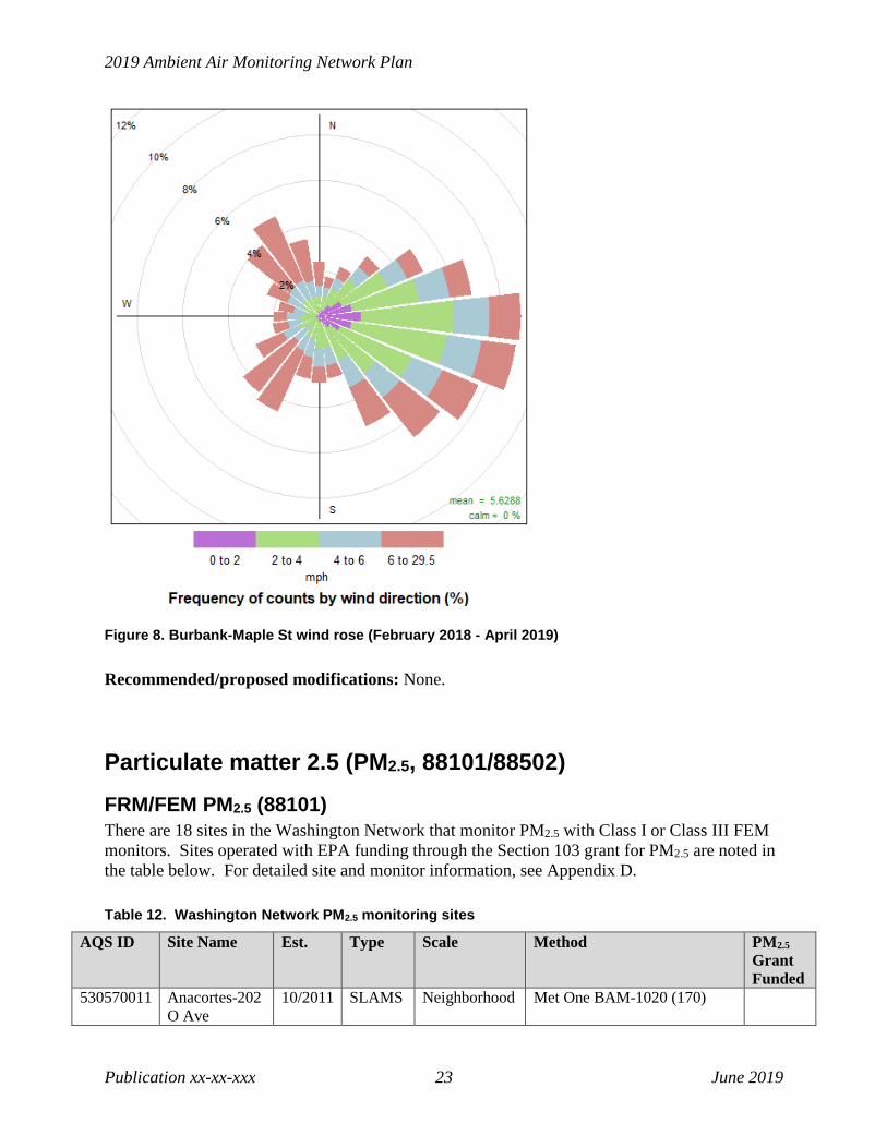
In its August 13, 2018 response letter to the 2018 ANP, EPA Region 10 asserts that Burbank is not sited to capture impacts from agricultural sources in the WMA under prevailing wind conditions. However, an analysis of the meteorological data collected at the Burbank site from February 2018 – April 2019 shows that the dominant wind direction is from the east, followed by the southeast. As Burbank is located northwest of the source, Ecology maintains that it is well-sited to capture both population-oriented exposure and impacts downwind of nearby agricultural sources.
For the reasons stated above, Ecology has no plans to pursue source-oriented PM10 monitoring elsewhere in the WMA.
2019 Ambient Air Monitoring Network Plan
Publication xx-xx-xxx 23 June 2019
Figure 8. Burbank-Maple St wind rose (February 2018 - April 2019)
Recommended/proposed modifications: None.
Particulate matter 2.5 (PM2.5, 88101/88502)
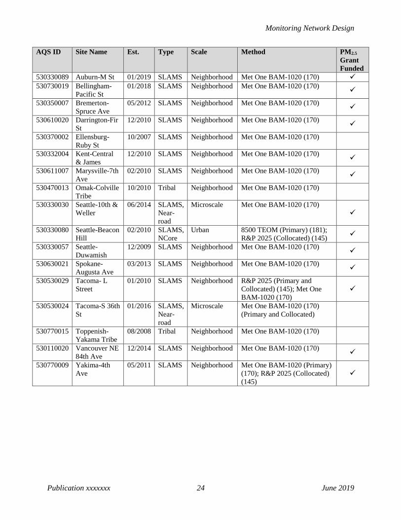
FRM/FEM PM2.5 (88101) There are 18 sites in the Washington Network that monitor PM2.5 with Class I or Class III FEM monitors. Sites operated with EPA funding through the Section 103 grant for PM2.5 are noted in the table below. For detailed site and monitor information, see Appendix D.
Table 12. Washington Network PM2.5 monitoring sites
AQS ID Site Name Est. Type Scale Method PM2.5 Grant Funded
530570011 Anacortes-202 O Ave
10/2011 SLAMS Neighborhood Met One BAM-1020 (170)
Monitoring Network Design
Publication xxxxxxx 24 June 2019
AQS ID Site Name Est. Type Scale Method PM2.5 Grant Funded
530330089 Auburn-M St 01/2019 SLAMS Neighborhood Met One BAM-1020 (170) 530730019 Bellingham-
Pacific St 01/2018 SLAMS Neighborhood Met One BAM-1020 (170)
530350007 Bremerton-Spruce Ave
05/2012 SLAMS Neighborhood Met One BAM-1020 (170)
530610020 Darrington-Fir St
12/2010 SLAMS Neighborhood Met One BAM-1020 (170)
530370002 Ellensburg-Ruby St
10/2007 SLAMS Neighborhood Met One BAM-1020 (170)
530332004 Kent-Central & James
12/2010 SLAMS Neighborhood Met One BAM-1020 (170)
530611007 Marysville-7th Ave
02/2010 SLAMS Neighborhood Met One BAM-1020 (170)
530470013 Omak-Colville Tribe
10/2010 Tribal Neighborhood Met One BAM-1020 (170)
530330030 Seattle-10th & Weller
06/2014 SLAMS, Near-road
Microscale Met One BAM-1020 (170)
530330080 Seattle-Beacon Hill
02/2010 SLAMS, NCore
Urban 8500 TEOM (Primary) (181); R&P 2025 (Collocated) (145)
530330057 Seattle-Duwamish
12/2009 SLAMS Neighborhood Met One BAM-1020 (170)
530630021 Spokane-Augusta Ave
03/2013 SLAMS Neighborhood Met One BAM-1020 (170)
530530029 Tacoma- L Street
01/2010 SLAMS Neighborhood R&P 2025 (Primary and Collocated) (145); Met One BAM-1020 (170)
530530024 Tacoma-S 36th St
01/2016 SLAMS, Near-road
Microscale Met One BAM-1020 (170) (Primary and Collocated)
530770015 Toppenish-Yakama Tribe
08/2008 Tribal Neighborhood Met One BAM-1020 (170)
530110020 Vancouver NE 84th Ave
12/2014 SLAMS Neighborhood Met One BAM-1020 (170)
530770009 Yakima-4th Ave
05/2011 SLAMS Neighborhood Met One BAM-1020 (Primary) (170); R&P 2025 (Collocated) (145)

2019 Ambient Air Monitoring Network Plan
Publication xx-xx-xxx 25 June 2019
Figure 9. Map of Washington Network PM2.5 monitoring sites
Minimum monitoring requirements
Minimum monitoring requirements for PM2.5 are defined in 40 C.F.R. Part 58 Appendix D. Table 16 below summarizes the number of required and existing monitors in each of Washington’s CBSAs where monitoring is conducted. The design values listed are the maximum valid design value of all sites within the CBSA. The Washington Network is currently meeting the minimum monitoring requirements in all CBSAs except Spokane-Spokane Valley. The 2018 design value at the Spokane-Augusta site (530630021) exceeded 85% of the PM2.5 NAAQS for the first time in over 10 years, as a result of the extensive wildfire smoke measured in 2017 and 2018. This increased the number of required monitors from one to two. Ecology is currently evaluating potential locations for a second PM2.5 monitoring site in the Spokane-Spokane Valley MSA and plans to establish a second site by January 1, 2020.
For a full list of design values at all Washington Network PM2.5 monitoring sites, see Appendix A.

Monitoring Network Design
Publication xxxxxxx 26 June 2019
Table 13. EPA minimum monitoring requirements for FRM/FEM PM2.5
CBSA 2018 Population Estimate
2018 Design Value (µg/m3)
Number of Required Monitors
Number of Existing Monitors
Seattle-Tacoma-Bellevue, WA 3,939,363 39 3 9 Portland-Vancouver-Hillsboro, OR-WA 2,478,810 28 2 4 Spokane-Spokane Valley, WA 573,493 38 2 1 Bremerton-Silverdale, WA 269,805 19 0 1 Yakima, WA 251,446 47 1 2 Bellingham, WA 225,685 21 0 1 Mount Vernon-Anacortes, WA 128,206 18 0 1 Ellensburg, WA 47,364 40 0 1
Washington shares the Portland-Vancouver-Hillsboro CBSA with the state of Oregon. The minimum monitoring requirements for PM2.5 in this CBSA are met through a combination of monitors operated by Ecology and the Oregon DEQ. Ecology and Oregon DEQ are in the process of developing a Memorandum of Understanding to formalize this arrangement.
Collocation requirements
The monitoring sites listed in Table are used to fulfill the collocation requirements described in 40 C.F.R. Part 58 Appendix A.
Table 14. PM2.5 collocation requirements
Method Code
# Primary Monitors
# Required Collocated Monitors
# Active Collocated Monitors
Site
118 1 1 1 Tacoma-L St (530530029) 170 17 3 2 Yakima-4th Ave S (530770009);
Tacoma-S 36th (530530024) 181/581 1 1 1 Seattle-Beacon Hill (530330080)
The 8500 TEOM will be replaced with a BAM 1020 at Seattle-Beacon Hill (530330080) to fulfill the unmet collocation requirement for method code 170. All other PM2.5 collocation requirements are currently met.
Recommended/proposed modifications: Ecology is currently evaluating potential locations for a second PM2.5 monitoring site in the Spokane-Spokane Valley MSA and plans to establish a second site by January 1, 2020.
The 8500 TEOM will be replaced with a BAM 1020 at Seattle-Beacon Hill (530330080) to fulfill the unmet collocation requirement for method code 170.

2019 Ambient Air Monitoring Network Plan
Publication xx-xx-xxx 27 June 2019
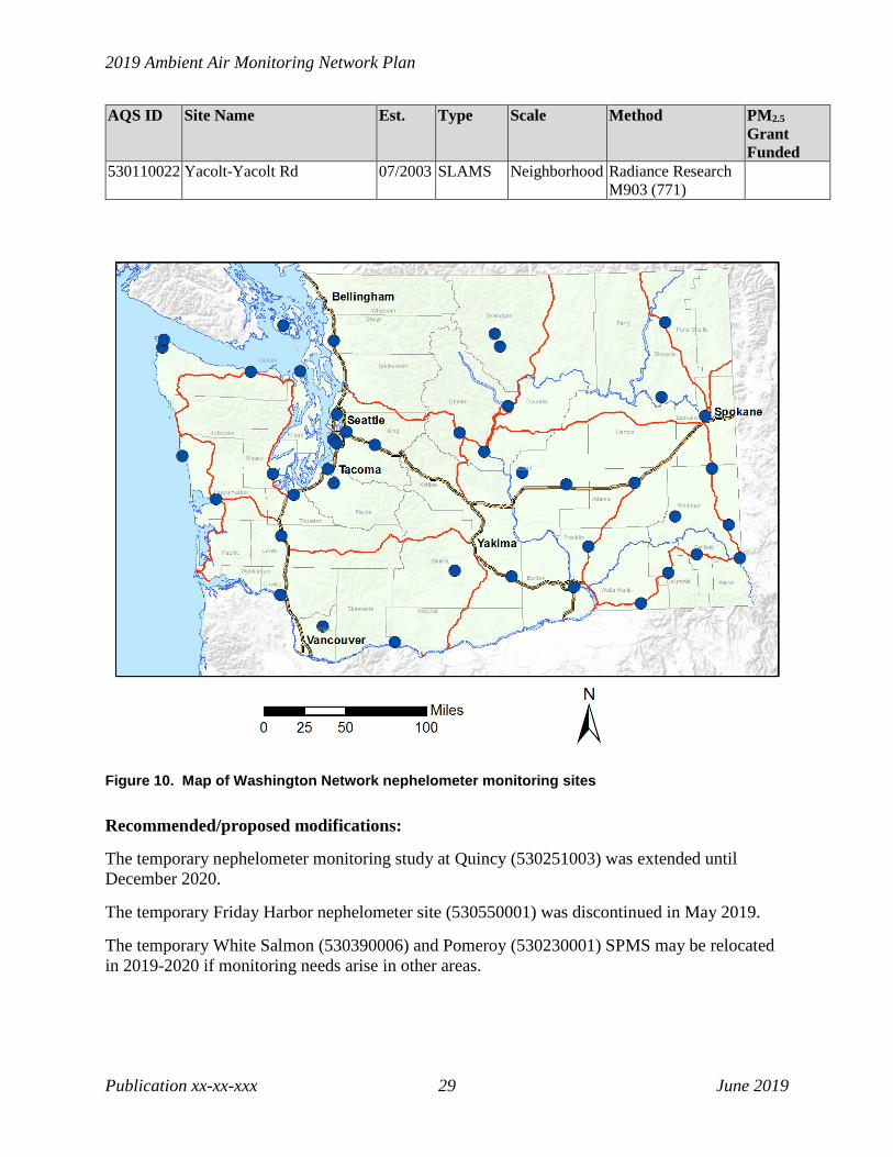
Nephelometer PM2.5 (88502) Ecology and its partners operate 42 monitoring sites with correlated nephelometers used to report estimated PM2.5 concentrations and provide timely information on air quality conditions to the public. Sites operated with EPA funding through the Section 103 grant for PM2.5 are noted in Table 18.
Table 15. Washington Network nephelometer monitoring sites
AQS ID Site Name Est. Type Scale Method PM2.5 Grant Funded
530272002 Aberdeen-Division St 08/2002 SLAMS Neighborhood Radiance Research M903 (771)
530330031 Bellevue-SE 12th St 12/2016 SLAMS Neighborhood Radiance Research M903 (771)
530090013 Cheeka Peak 05/2006 SLAMS, NCore
Regional Radiance Research M903 (771)
530410004 Chehalis-Market Blvd 12/2009 SLAMS Neighborhood Radiance Research M903 (771)
530070007 Chelan-Woodin Ave 12/2002 Non-EPA Federal
Neighborhood Radiance Research M903 (771)
530030004 Clarkston-13th St 03/2007 SLAMS Neighborhood Radiance Research M903 (771)
530650005 Colville-E 1st St 10/2015 SLAMS Neighborhood Radiance Research M903 (771)
530130002 Dayton-W Main St 02/2009 SLAMS Neighborhood Radiance Research M903 (771)
530550001 Friday Harbor (temporary) 1/2019 SPMS Neighborhood Radiance Research M903 (771)
530050002 Kennewick-Metaline 08/2004 SLAMS Neighborhood Radiance Research M903 (771)
530670013 Lacey-College St 09/1990 SLAMS Neighborhood Radiance Research M903 (771)
530750005 LaCrosse-Hill St 10/2002 SLAMS Neighborhood Radiance Research M903 (771)
530330024 Lake Forest Park 10/2003 SLAMS Neighborhood Ecotech M9003 (812)
530070010 Leavenworth-Evans St 07/2005 Non-EPA Federal
Neighborhood Radiance Research M903 (771)
530150015 Longview-30th Ave 03/2003 SLAMS Neighborhood Radiance Research M903 (771)
530210002 Mesa-Pepiot Way 01/2003 SLAMS Neighborhood Radiance Research M903 (771)
530251002 Moses Lake-Balsam St 01/2004 SLAMS Neighborhood Radiance Research M903 (771)
530570015 Mt Vernon-S Second St 07/2005 SLAMS Neighborhood Radiance Research M903 (771)
530090015 Neah Bay-Makah Tribe 02/2010 Tribal Neighborhood Radiance Research M903 (771)

Monitoring Network Design
Publication xxxxxxx 28 June 2019
AQS ID Site Name Est. Type Scale Method PM2.5 Grant Funded
530330017 North Bend-North Bend Way
03/2003 SLAMS Neighborhood Radiance Research M903 (771)
530230001 Pomeroy (Temporary) 05/2017 SPMS Neighborhood Radiance Research M903 (771)
530090017 Port Angeles- E 5th St 04/2015 SLAMS Neighborhood Radiance Research M903 (771)
530310003 Port Townsend-San Juan Ave
10/2002 SLAMS Neighborhood Radiance Research M903 (771)
530750003 Pullman-Dexter SE 10/2002 SLAMS Neighborhood Radiance Research M903 (771)
530531018 Puyallup-128th St 10/2003 SLAMS Neighborhood Ecotech M9003 (812)
530251003 Quincy-3rd Ave NE 06/2017 SPMS Neighborhood Radiance Research M903 (771)
530010003 Ritzville-Alder St 03/2001 SLAMS Neighborhood Radiance Research M903 (771)
530750006 Rosalia-Josephine St 10/2002 SLAMS Neighborhood Radiance Research M903 (771)
530331011 Seattle-South Park 10/2003 SLAMS Microscale Ecotech M9003 (812)
530450007 Shelton-W Franklin 04/2011 SLAMS Neighborhood Radiance Research M903 (771)
530630047 Spokane-Monroe St 05/2004 SLAMS Neighborhood Radiance Research M903 (771)
530770005 Sunnyside-S 16th St 09/2015 SLAMS Neighborhood Radiance Research M903 (771)
530530031 Tacoma-Alexander Ave 10/2003 SLAMS Neighborhood Ecotech M9003 (812)
530270011 Taholah-Quinault Tribe 04/2004 Tribal Neighborhood Radiance Research M903 (771)
530330069 Tukwila Allentown 07/2017 SLAMS Neighborhood Ecotech M9003 (812)
530470009 Twisp-Glover St 11/2003 Non-EPA Federal
Neighborhood Radiance Research M903 (771)
530710005 Walla Walla-12th St 10/2002 SLAMS Neighborhood Radiance Research M903 (771)
530650002 Wellpinit-Spokane Tribe 10/2008 Tribal Neighborhood Radiance Research M903 (771)
530070011 Wenatchee-Fifth St 11/2012 SLAMS Neighborhood Radiance Research M903 (771)
530390006 White Salmon (temporary) 6/2018 SPMS Neighborhood Radiance Research M903 (771)
530770016 White Swan-Yakama Tribe 10/2009 Tribal Neighborhood Radiance Research M903 (771)
530470010 Winthrop-Chewuch Rd 11/2003 Non-EPA Federal
Neighborhood Radiance Research M903 (771)
2019 Ambient Air Monitoring Network Plan
Publication xx-xx-xxx 29 June 2019
AQS ID Site Name Est. Type Scale Method PM2.5 Grant Funded
530110022 Yacolt-Yacolt Rd 07/2003 SLAMS Neighborhood Radiance Research M903 (771)
Figure 10. Map of Washington Network nephelometer monitoring sites
Recommended/proposed modifications:
The temporary nephelometer monitoring study at Quincy (530251003) was extended until December 2020.
The temporary Friday Harbor nephelometer site (530550001) was discontinued in May 2019.
The temporary White Salmon (530390006) and Pomeroy (530230001) SPMS may be relocated in 2019-2020 if monitoring needs arise in other areas.

Monitoring Network Design
Publication xxxxxxx 30 June 2019
Meteorological monitoring (61101/61102/61103/61104/62101) There are 18 meteorological monitoring sites in the Washington Network. All Washington Network meteorological monitoring sites collect scalar and vector wind speed and direction using RM Young or Vaisala sonic anemometers (method codes 062 and 060, respectively) and ambient temperature under method code 040 (electronic or machine average). All Washington Network meteorological sites follow EPA’s monitoring guidelines for prevention of significant deterioration (PSD). For detailed site and monitor information, see Appendix D.
Table 16. Washington Network meteorological monitoring sites
AQS ID Site Name Established Type Scale 530090013 Cheeka Peak 08/2007 SLAMS,
NCore Regional
530650005 Colville-E 1st St 05/2016 SLAMS Neighborhood 530330023 Enumclaw-Mud Mtn. 02/2004 SLAMS Urban 530730017 Ferndale-Mountain View Rd 01/2017 SLAMS Microscale 530050002 Kennewick-Metaline 08/2012 SLAMS Neighborhood 530070012 Malaga-Malaga Hwy 01/2017 SLAMS Microscale 530330017 North Bend-North Bend Way 01/2000 SLAMS Neighborhood 530470013 Omak-Colville Tribe 10/2010 Tribal Neighborhood 530251003 Quincy-3rd Ave NE 06/2017 SPMS Neighborhood 530330030 Seattle-10th & Weller 04/2014 SLAMS,
Near-road Microscale
530330080 Seattle-Beacon Hill 01/1991 SLAMS, NCore
Urban
530630021 Spokane-Augusta Ave 07/2009 SLAMS Neighborhood 530530024 Tacoma-S 36th St 02/2016 SLAMS,
Near-road Microscale
530531016 Tacoma-Tower Dr 01/1991 SLAMS Urban 530770015 Toppenish-Yakama Tribe 06/2009 Tribal Neighborhood 530110011 Vancouver-Blairmont Dr 12/2007 SLAMS Urban 530070011 Wenatchee-Fifth St 11/2012 SLAMS Neighborhood 530770016 White Swan-Yakama Tribe 11/2009 Tribal Neighborhood

2019 Ambient Air Monitoring Network Plan
Publication xx-xx-xxx 31 June 2019
Figure 11. Map of Washington Network meteorological monitoring sites
Recommended/proposed modifications: The temporary Quincy meteorological monitoring site will be retained until December 2020.
Lead (Pb) Ecology reports Pb in PM10 concentrations as part of the National Air Toxics Trends Station (NATTS) monitoring at Seattle-Beacon Hill (530330080). At the request of EPA, Ecology ceased reporting to parameter code 85129 and began reporting to parameter code 85128 as of January 1, 2019.
As described in 40 C.F.R. Part 58, Appendix D § 4.5, source-oriented lead monitoring is required in the vicinity of sources that emit 0.5 tons per year or more of lead. According to the 2017 National Emissions Inventory, Washington’s only source above this threshold is Ardagh Glass in Seattle. Ecology modeled the impact of this facility on ambient air and demonstrated that it would not contribute to a maximum Pb concentration in ambient air above 50 percent of the NAAQS. On April 18, 2019, EPA issued Ecology a waiver for lead monitoring at Ardagh Glass based on the modeling results. This waiver is provided in Appendix C.

Monitoring Network Design
Publication xxxxxxx 32 June 2019
Recommended/proposed modifications: None.
Chemical Speciation Network (CSN) Ecology and its partners operate 4 speciation monitoring sites as part of the national Chemical Speciation Network.
Table 17. Washington Network Chemical Speciation Network monitoring sites
AQS ID Site Name Established Type Scale
530330030 Seattle-10th & Weller 11/2014 SLAMS, Near-road
Microscale
530330080 Seattle-Beacon Hill 02/2000 SLAMS, NCore
Urban
530530029 Tacoma-L St 01/2006 SLAMS Neighborhood
530770009 Yakima-4th Ave S 11/2007 SLAMS Neighborhood

2019 Ambient Air Monitoring Network Plan
Publication xx-xx-xxx 33 June 2019
Figure 12. Map of Washington Chemical Speciation Network monitoring sites
Each speciation site samples the following parameters:
Table 18. Chemical Speciation Network monitoring parameters
Code Parameter Code Parameter Code Parameter Code Parameter 88102 Antimony 88126 Iron 88167 Zinc 88370 OC CSN Rev Unadjusted 88103 Arsenic 88128 Lead 88168 Strontium 88374 OC1 CSN Rev Unadjusted 88104 Aluminum 88131 Indium 88169 Sulfur 88375 OC2 CSN Rev Unadjusted 88107 Barium 88132 Manganese 88176 Rubidium 88376 OC3 CSN Rev Unadjusted 88109 Bromine 88136 Nickel 88180 Potassium 88377 OC4 CSN Rev Unadjusted 88110 Cadmium 88140 Magnesium 88184 Sodium 88378 OP CSN Rev Unadjusted 88111 Calcium 88152 Phosphorus 88185 Zirconium 88380 EC CSN Rev Unadjusted 88112 Chromium 88154 Selenium 88301 Ammonium Ion 88383 EC1 CSN Rev Unadjusted 88113 Cobalt 88160 Tin 88302 Sodium Ion 88384 EC2 CSN Rev Unadjusted 88114 Copper 88161 Titanium 88303 Potassium Ion 88385 EC3 CSN Rev Unadjusted 88115 Chlorine 88164 Vanadium 88306 Total Nitrate 88388 OP CSN Rev Unadjusted 88117 Cerium 88165 Silicon 88355 OC CSN Rev Unadjusted 88403 Sulfate 88118 Cesium 88166 Silver 88357 EC CSN Rev Unadjusted 88502 PM2.5 Speciation Mass

Monitoring Network Design
Publication xxxxxxx 34 June 2019
Recommended/proposed modifications: In its 2018 ANP, Ecology proposed to relocate the Tacoma-L St (530530029) speciation monitor to the Tacoma-S 36th St (530530024) near-road monitoring site. However, since submission of the 2018 ANP, operational challenges to speciation data collection have grown at the Seattle-10th and Weller monitoring site (530330030). Due to the environment around the near-road monitoring site, Ecology has concerns about operators’ safety in accessing the site regularly. Relocating the speciation monitoring equipment to another site would reduce the number of required trips to the near-road monitoring site and help alleviate these safety concerns.
As these challenges are more urgent than the pending Tacoma relocation, Ecology delayed the relocation of the Tacoma site to evaluate alternate potential locations for Seattle-10th and Weller speciation monitoring. Ecology hopes to relocate the speciation monitoring equipment from Seattle-10th and Weller to a site in Central Washington but has not yet identified operational resources for this relocation. Ecology will continue to pursue alternatives to speciation monitoring at Seattle-10th and Weller in other high-PM2.5 areas of the state and will revisit relocation of the Tacoma site at a later date.
With the passage of the Washington State 2018 supplemental operating budget (Engrossed Substitute Senate Bill 6032), Ecology was directed to use state funding to conduct a multiyear source apportionment study at the monitoring site closest to the Port of Tacoma. Ecology began conducting PM2.5 speciation monitoring at PSCAA’s Tacoma-Alexander Ave (530530031) monitoring site on August 6, 2018. Puget Sound Clean Air Agency is conducting a parallel speciation study at the Seattle-Duwamish monitoring site (530330057) concurrently with the Tacoma study. These studies will continue until August 2021.
National Core (NCore) There are two NCore sites in the Washington Network: Seattle-Beacon Hill (530330080) is an urban NCore site, and Cheeka Peak (530090013) is a rural NCore site. The parameters monitored at each site are summarized in Table 22.
Table 19. NCore parameters monitored at Cheeka Peak and Seattle-Beacon Hill
Parameter Cheeka Peak Seattle-Beacon Hill Trace CO (42101) Trace NOy (42600) Area-wide NO2 (42602) Ozone (44201) Trace SO2 (42401) Filter-based PM10 (81102) Filter-based PM2.5 (88101) Continuous FEM PM2.5 (88101) Nephelometer PM2.5 (88502) Meteorological (61101/61102/61103/61104/62101/64101/62201)
PM2.5 speciation PM10-2.5 (86101)

2019 Ambient Air Monitoring Network Plan
Publication xx-xx-xxx 35 June 2019
Recommended/proposed modifications: None.
National Air Toxics Trends Station (NATTS) Seattle-Beacon Hill (530330080) is a National Air Toxics Trends Station (NATTS) as well as a CSN, NCore and SLAMS site.
Recommended/proposed modifications: None.
Photochemical Assessment Monitoring Station (PAMS) Based on 40 C.F.R. Part 58, Appendix D, state air monitoring agencies are required to begin making PAMS measurements at their NCore location(s) by June 1, 2019. The equipment needed to measure PAMS parameters were to be purchased by EPA using a nationally negotiated contract and delivered to the monitoring agencies. EPA has announced that due to contract delays, the necessary equipment will not be delivered in time to begin making PAMS measurements by June 1, 2019. EPA has indicated that it is working on a proposed rule to extend the start date of PAMS measurements and expects that this proposed rule change will be signed by June 1, 2019. As a result of the delay, Ecology will not begin making PAMS measurements at the Seattle-Beacon Hill NCore location in 2019, and will work with EPA to begin measurements on or before the final revised start date for this network.

Monitoring Network Design
Publication xxxxxxx 36 June 2019
Table 20 summarizes the required PAMS parameters and Ecology’s schedule for implementing new monitoring requirements. Parameters that are already monitored at Seattle-Beacon Hill are marked “existing.”
Table 20. Required PAMS parameters and implementation schedule
Parameter Implementation Schedule Hourly averaged VOCs Auto-GC received but ancillary equipment has not been
provided. Ecology has delayed implementation of hourly average VOC sampling until necessary equipment and/or funding are provided by EPA
Three 8-hour averaged carbonyl samples per day on a 1/3 schedule
Carbonyl sampling is already conducted; Ecology has delayed modification to sampling schedule until funding is provided for additional laboratory analysis costs
Hourly averaged O3 Existing Hourly averaged NO, true nitrogen dioxide (NO2), and total reactive nitrogen (NOy)
Existing
Hourly averaged ambient temperature
Existing
Hourly vector-averaged wind direction
Existing
Hourly vector-averaged wind speed Existing Hourly average atmospheric pressure
Existing
Hourly averaged relative humidity Existing Hourly precipitation Implementation delayed until equipment or funding
provided by EPA Hourly averaged mixing height Implementation delayed until equipment or funding
provided by EPA Hourly averaged solar radiation Implementation delayed until equipment or funding
provided by EPA Hourly averaged ultraviolet radiation
Implementation delayed until equipment or funding provided by EPA

2019 Ambient Air Monitoring Network Plan
Publication xx-xx-xxx 37 June 2019
References
Ambient Air Monitoring Reference and Equivalent Methods, 40 C.F.R. Part 53, 2016.
Ambient Air Quality Surveillance, 40 C.F.R. Part 58, 2016.
Ambient Monitoring Guidelines for Prevention of Significant Deterioration (PSD), EPA-450/4-87-007, May 1987.
National Primary and Secondary Ambient Air Quality Standards, 40 C.F.R. Part 50, 2016.
United States Census Bureau. “Metropolitan and Micropolitan Statistical Areas Population Totals: 2010-2017.” https://www.census.gov/data/datasets/2017/demo/popest/total-metro-and-micro-statistical-areas.html (April 18, 2019).
United States Census Bureau. “State-based Metropolitan and Micropolitan Statistical Areas Maps.” https://www.census.gov/geo/maps-data/maps/statecbsa.html (February 2013).
Washington Department of Ecology. “A Plan for Maintaining Particulate Matter (PM10) Ambient Air Quality Standards in the Wallula PM10 Maintenance Area. https://fortress.wa.gov/ecy/publications/SummaryPages/0502008.html (March 2005).

Appendices
Publication xxxxxxx 38 June 2019
Appendices
Appendix A. Criteria Pollutant Design Values Tables 21-27 show criteria pollutant design values for all sites in the Washington Network.
Table 21. Carbon monoxide (CO) 2018 design values
Site AQS ID 2018 Exceedances Cheeka Peak 530090013 0 Seattle 10th & Weller 530330030 0 Seattle Beacon Hill 530330080 0
Table 22. Nitrogen dioxide (NO2) 2018 design values (ppb)
Site AQS ID 2016 98th Percentile
2017 98th Percentile
2018 98th Percentile
2018 Design Value
Seattle 10th & Weller 530330030 58.8 NA 63.7 NA Seattle Beacon Hill 530330080 49.2 NA 44.5 NA Tacoma S 36th 530530024 45.5 43.8 46.4 45
Table 23. Ozone (O3) 2018 design values (ppm)
Site AQS ID 2016 4th Highest D8M*
2017 4th Highest D8M
2018 4th Highest D8M
2018 Design Value
Anacortes 202 Avenue 530570011 0.054 0.041 0.041 0.045 Cheeka Peak 530090013 0.051 0.056 0.056 0.054 Cheney Turnbull 530630001 0.053 0.065 0.063 0.060 Custer Loomis 530730005 0.045 0.050 0.062 0.052 Enumclaw Mud Mtn 530330023 0.061 0.094 0.077 0.077 Issaquah Lake Sammamish 530330010 0.054 0.076 0.067 0.065 Kennewick S Clodfelter 530050003 0.068 0.074 0.073 0.071 Mt Rainier Jackson Visitors Ctr
530530012 0.058 0.069 0.067 0.064
North Bend North Bend Way
530330017 0.054 0.073 0.071 0.066
Seattle Beacon Hill 530330080 0.046 0.047 0.045 0.046 Spokane Greenbluff 530630046 0.056 0.068 0.072 0.065 Vancouver Blairmont Dr 530110011 0.055 0.071 0.062 0.062 Yelm Northern Pacific 530670005 0.058 0.067 0.063 0.062
*D8M is the daily maximum 8-hour average concentration.

2019 Ambient Air Monitoring Network Plan
Publication xx-xx-xxx 39 June 2019
Table 24. Sulfur dioxide (SO2) 2018 design values (ppb)
Site AQS ID 2016 99th Percentile
2017 99th Percentile
2018 99th Percentile
2018 Design Value
Anacortes 202 Ave 530570011 4 3 2 3 Cheeka Peak 530090013 NA NA 1 NA Ferndale-Kickerville Rd 530730013 NA 70 74 NA Ferndale-Mountain View Rd 530730017 NA 114 101 NA Malaga-Malaga Hwy 530070012 NA 1 1 NA Seattle-Beacon Hill 530330080 NA NA 8 NA
Table 25. PM10 2018 design values (µg/m3)
Site AQS ID 2016 Expected Exceedances
2017 Expected Exceedances
2018 Expected Exceedances
3-Year Estimated Exceedances
Burbank Maple St 530710006 NA NA 2 NA Colville E 1st St 530650005 1 1 1.2 1.1 Kennewick Metaline 530050002 0 3 3 2 Seattle Beacon Hill 530330080 0 0 0 0 Spokane Augusta 530630021 0 4 2 2 Yakima 4th Ave S 530770009 0 4.7 0 1.6
Table 26. PM2.5 2018 24-hour design values and pseudo-design values (µg/m3)
Design values from FRM and FEM monitoring sites are shaded. Pseudo-design values from nephelometer sites are estimates only and cannot be used to determine compliance with the NAAQS. DVs in parenthesis are estimated from fewer than three years of available data. The 98th percentiles in parenthesis are estimated from quarters between 50% and 75% complete that fail the maximum quarterly value substitution test (FEM/FRMs only). In years with one or more quarters less than 50% complete, 98th percentiles are not reported.
Site AQS ID 98th Percentile 2016
98th Percentile 2017
98th Percentile 2018
24-Hour Design Value 2018
Aberdeen Division St 530272002 10.3 14.5 12.4 12 Anacortes 202 Avenue 530570011 12.6 13.5 27.7 18 Bellevue SE 12th 530330031 7.8 22.9 9.2 13 Bellingham Yew St 530730015 12.1 27.7 24.0 21 Bremerton Spruce Ave 530350007 9.8 24.0 24.0 19 Cheeka Peak 530090013 4.6 35.4 27.4 22 Chehalis Market Blvd 530410004 13.0 25.2 28.5 22 Chelan Woodin Ave 530070007 NA 24.6 123.6 (74) Clarkston 13th St 530030004 17.0 63.9 37.8 40 Colville E 1st St 530650005 NA 41.8 65.8 (54) Darrington Fir St 530610020 31.0 44.0 41.9 39 Dayton W Main St 530130002 10.8 37.8 37.3 29 Ellensburg Ruby St 530370002 25.2 47.8 46.5 40

Appendices
Publication xxxxxxx 40 June 2019
Site AQS ID 98th Percentile 2016
98th Percentile 2017
98th Percentile 2018
24-Hour Design Value 2018
Kennewick Metaline 530050002 16.5 35.8 32.6 28 Kent Central & James 530332004 18.4 36 32.8 29 Lacey College St 530670013 16.9 28.2 29.6 25 LaCrosse Hill St 530750005 9.6 NA 38.4 (24) Lake Forest Park 530330024 NA NA 50.7 (51) Leavenworth Evans St 530070010 16.4 24.4 60.0 34 Longview 30th Ave 530150015 14.0 16.4 24.8 18 Lynnwood 212 530610005 17.6 NA 34.6 (26) Marysville 7th Ave 530611007 22.3 (30.8) 31.2 (28) Mesa Pepiot Way 530210002 12.3 45.9 32.5 30 Moses Lake Balsam St 530251002 13.1 38.6 37.3 30 Mt Vernon S Second St 530570015 8.2 NA 14.5 (11) Neah Bay 2 Makah Tribe 530090015 6.4 11.3 22.2 13 North Bend North Bend Way 530330017 7.5 43.0 34.6 28 Omak Colville Tribe 530470013 NA NA 93.5 (94) Port Angeles E 5th St 530090017 16.3 27.2 41.9 28 Port Townsend San Juan Ave 530310003 10.4 15.6 28.3 18 Pullman Dexter SE 530750003 10.8 30.7 NA (21) Puyallup 128th St 530531018 16.5 51.2 37.5 35 Quincy 3rd Ave NE 530251003 NA NA 58.4 (58) Ritzville Alder St 530010003 9.1 39.1 44.3 31 Rosalia Josephine St 530750006 11.0 37.2 36.0 28 Seattle 10th & Weller 530330030 17.0 34.4 35.5 29 Seattle Beacon Hill 530330080 13.5 29.9 37.0 27 Seattle Duwamish 530330057 18.0 35.0 41.7 32 Seattle South Park 530331011 NA 50.1 43.8 (47) Shelton W Franklin 530450007 13.4 20.1 25.7 20 Spokane Augusta Ave 530630021 17.3 48.2 49.5 38 Spokane Monroe St 530630047 15.6 54.4 51.0 40 Sunnyside S 16th 530770005 25.7 48.3 62.4 45 Tacoma Alexander Ave 530530031 17.7 23.5 35.1 25 Tacoma L Street 530530029 22.2 38.7 37.5 33 Tacoma S 36th 530530024 15.1 30.0 29.4 25 Taholah Quinault Tribe 530270011 NA 21.6 25.6 (24) Toppenish Yakama Tribe 530770015 35.0 54.6 50.4 47 Tukwila Allentown 530330069 NA NA 51.5 (52) Twisp Glover St 530470009 22.1 67.5 NA (45) Vancouver NE 84th Ave 530110024 (23.6) (35.1) 30.0 (30) Walla Walla 12th St 530710005 16.2 38.1 37.7 31 Wellpinit Spokane Tribe 530650002 10.7 39.8 46.5 32 Wenatchee Fifth St 530070011 17.2 74.4 90.1 61 White Swan Yakama Tribe 530770016 18.7 46.2 51.6 39 Winthrop Chewuch Rd 530470010 NA 69.8 71.7 (71) Yacolt Yacolt Rd 530110022 13.6 30.8 18.4 21 Yakima 4th Ave 530770009 30.6 52.2 47.5 43
Table 27. PM2.5 2018 annual design values and pseudo-design values
Site AQS ID 98th Percentile 2016
98th Percentile 2017
98th Percentile 2018
24-Hour Design Value 2018
Aberdeen Division St 530272002 4.8 5.4 4.9 5.1

2019 Ambient Air Monitoring Network Plan
Publication xx-xx-xxx 41 June 2019
Site AQS ID 98th Percentile 2016
98th Percentile 2017
98th Percentile 2018
24-Hour Design Value 2018
Anacortes 202 Avenue 530570011 5.3 5.7 6.2 5.8 Bellevue SE 12th 530330031 3.4 4.1 3.5 3.7 Bellingham Yew St 530730015 4.8 5.2 5.2 5.1 Bremerton Spruce Ave 530350007 4.2 4.8 4.8 4.6 Cheeka Peak 530090013 1.9 3.4 3.9 3.1 Chehalis Market Blvd 530410004 5.1 6.5 6.9 6.2 Chelan Woodin Ave 530070007 NA 5.5 12.1 (8.9) Clarkston 13th St 530030004 7.0 11.7 9.3 9.4 Colville E 1st St 530650005 NA 11.0 11.5 (11.3) Darrington Fir St 530610020 5.5 8.3 6.6 6.8 Dayton W Main St 530130002 4.1 7.4 5.9 5.8 Ellensburg Ruby St 530370002 6.2 10.9 7.0 8.1 Kennewick Metaline 530050002 5.6 8.5 7.0 7.1 Kent Central & James 530332004 5.5 7.7 7.0 6.8 Lacey College St 530670013 5.5 6.5 5.9 6.0 LaCrosse Hill St 530750005 3.6 NA 5.9 (4.8) Lake Forest Park 530330024 NA NA 8.8 (8.8) Leavenworth Evans St 530070010 5.6 6.2 8.9 7.0 Longview 30th Ave 530150015 5.0 6.0 6.2 5.8 Lynnwood 212 530610005 3.9 NA 5.9 (5.0) Marysville 7th Ave 530611007 6.0 7.9 8.1 7.4 Mesa Pepiot Way 530210002 3.9 7.5 6.5 6.0 Moses Lake Balsam St 530251002 4.8 8.1 7.5 6.8 Mt Vernon S Second St 530570015 3.1 NA 3.4 (3.3) Neah Bay 2 Makah Tribe 530090015 3.4 3.9 4.5 4.0 North Bend North Bend Way 530330017 3.0 5.5 4.6 4.4 Omak Colville Tribe 530470013 NA NA 13.4 (13) Port Angeles E 5th St 530090017 7.0 8.6 9.1 8.3 Port Townsend San Juan Ave 530310003 4.7 5.5 6.3 5.5 Pullman Dexter SE 530750003 3.7 6.6 NA (5.2) Puyallup 128th St 530531018 4.7 7.1 7.1 6.3 Quincy 3rd Ave NE 530251003 NA NA 7.3 (7.3) Ritzville Alder St 530010003 3.7 6.5 6.0 5.4 Rosalia Josephine St 530750006 4.1 6.8 6.5 5.9 Seattle 10th & Weller 530330030 7.8 8.1 9.3 8.4 Seattle Beacon Hill 530330080 5.4 7.0 6.5 6.4 Seattle Duwamish 530330057 6.5 9.6 8.9 8.4 Seattle South Park 530331011 NA 9.5 9.5 (9.6) Shelton W Franklin 530450007 5.3 6.3 6.7 6.2 Spokane Augusta Ave 530630021 7.5 10.8 10.3 9.6 Spokane Monroe St 530630047 5.5 10.3 9.4 8.5 Sunnyside S 16th 530770005 7.9 14.0 11.9 11.3 Tacoma Alexander Ave 530530031 5.9 7.4 8.0 7.2 Tacoma L Street 530530029 6.7 8.1 8.0 7.7 Tacoma S 36th 530530024 6.8 8.3 7.8 7.7 Taholah Quinault Tribe 530270011 NA 4.7 5.5 (5.2) Toppenish Yakama Tribe 530770015 (9.9) 13.5 (10.4) (11.3) Tukwila Allentown 530330069 NA NA 8.6 (8.7) Twisp Glover St 530470009 7.3 12.5 NA (9.9) Vancouver NE 84th Ave 530110024 6.3 8.8 7.3 7.5 Walla Walla 12th St 530710005 5.2 8.2 7.1 6.8 Wellpinit Spokane Tribe 530650002 4.5 7.6 8.1 6.8

Appendices
Publication xxxxxxx 42 June 2019
Site AQS ID 98th Percentile 2016
98th Percentile 2017
98th Percentile 2018
24-Hour Design Value 2018
Wenatchee Fifth St 530070011 5.3 12.0 11.2 9.6 White Swan Yakama Tribe 530770016 5.3 6.2 7.3 6.3 Winthrop Chewuch Rd 530470010 NA 9.4 10.8 (10.2) Yacolt Yacolt Rd 530110022 4.0 6.2 4.7 5.0 Yakima 4th Ave 530770009 8.6 10.3 10.5 9.8
2019 Ambient Air Monitoring Network Plan
Publication xx-xx-xxx 43 June 2019
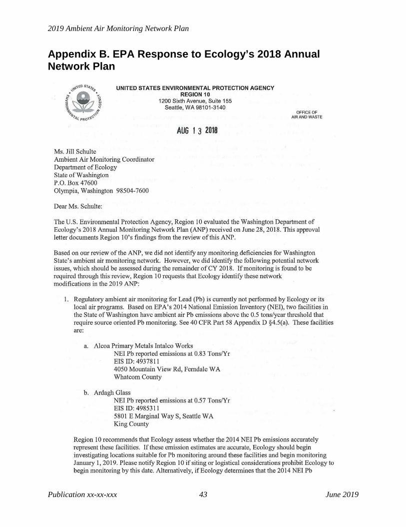
Appendix B. EPA Response to Ecology’s 2018 Annual Network Plan

Appendices
Publication xxxxxxx 44 June 2019
2019 Ambient Air Monitoring Network Plan
Publication xx-xx-xxx 45 June 2019
Appendices
Publication xxxxxxx 46 June 2019
Appendix C. Monitoring Waivers
Lead (Pb) In 2014, EPA approved the use of lead in PM10 measurements as a surrogate for lead in TSP at Seattle-Beacon Hill (530330080). Ecology met this requirement through lead analysis of low-vol PM10 filters analyzed through the NATTS program. In 2016, EPA discontinued the requirement for lead monitoring at NCore sites. Ecology continues to report measurements of lead in PM10 at Seattle-Beacon Hill as a NATTS parameter. In 2017, at the request of EPA Region 10, Ecology redesignated the Seattle-Beacon Hill lead monitor a “NAAQS-exclusion” type monitor. At the further request of EPA, Ecology ceased reporting to parameter code 85129 and began reporting to parameter code 85128 as of January 1, 2019. It is no longer used to demonstrate compliance with the NAAQS.
On April 18, 2019, EPA issued Ecology a waiver for the source-oriented lead monitoring requirement at Ardagh Glass in Seattle. That waiver is provided below.

2019 Ambient Air Monitoring Network Plan
Publication xx-xx-xxx 47 June 2019

Appendices
Publication xxxxxxx 48 June 2019
Yakima CO In 2006, EPA approved the discontinuation of the Yakima CO monitor based on the low concentrations measured at the monitor and predicted reductions in onroad mobile source emissions in Yakima. Below is the approval letter from EPA approving discontinuation of the monitor.

2019 Ambient Air Monitoring Network Plan
Publication xx-xx-xxx 49 June 2019

Appendices
Publication xxxxxxx 50 June 2019

2019 Ambient Air Monitoring Network Plan
Publication xx-xx-xxx 51 June 2019
Spokane CO On July 14, 2016, Federal Register #81 FR 45417, the EPA approved an alternate method of verification of attainment of the CO NAAQS in Spokane and qualification for the limited maintenance plan option under 40 C.F.R. Part 58.14(c) in the Spokane Maintenance Area. Under this alternative, EPA considers the limited maintenance plan criteria met and continued verification of attainment of the CO NAAQS if the total of the three predominant CO emission source categories calculated as part of the triennial emissions inventory (onroad mobile, nonroad, and residential wood combustion) remain below the corresponding total of the 2002 emission inventory source categories approved at the time the Spokane area was redesignated to attainment. SRCAA and Ecology will compare future year 2017, 2020 and 2023 triennial emission analysis results to the baseline 2002.
PM10 In the summers of 2017 and 2018, Washington experienced extended smoke events from regional wildfires in the Pacific Northwest. These smoke events caused repeated exceedances of the PM10 standard in Yakima and Kennewick, which triggered additional monitoring requirements as detailed in 40 C.F.R. Part 58 Appendix D, Table D-4. In addition, Kennewick routinely experiences high wind dust events that cause exceedances of the PM10 standard. Due to the regional and exceptional nature of these events, EPA issued Ecology waivers for the unmet PM10 monitoring requirements in the Yakima and Kennewick-Richland MSAs on April 18, 2019. The waivers are provided below.

Appendices
Publication xxxxxxx 52 June 2019

2019 Ambient Air Monitoring Network Plan
Publication xx-xx-xxx 53 June 2019

Appendices
Publication xxxxxxx 54 June 2019
Appendix D. Detailed Site and Monitor Information The tables below describe the detailed site and monitor information for each monitoring site in the Washington Network. This information demonstrates compliance with the probe and monitoring path siting criteria described in 40 C.F.R. Part 58 Appendix E.
Aberdeen-Division St Site Information AQS ID 530272002
Street Address 359 N Division St (Harbor High School)
Zip Code 98520 Latitude 46.97228 Longitude -123.83173 Date Site Established 20021001 MSA/CBSA/CSA Represented Aberdeen County Grays Harbor Distance from roadway (m) 200 Traffic count (AADT) 12000 Ground cover Asphalt Non-compliance PM2.5 (88502, POC 4) Sampling/Analysis Method
Radiance Research M903 Nephelometer (771)
Parameter Begin Date 20021001 Monitor Objective Population Exposure Measurement Scale Neighborhood Monitor type SLAMS
Collecting agency Olympic Region Clean Air Agency (0815)
Analytical lab N/A
Reporting agency Washington State Department of Ecology (1136)
Sampling frequency Continuous Sampling season Year-round Probe height (m) 5
Distance from supporting structure (m) N/A
Distance from obstruction on roof (m) N/A
Distance from obstruction not on roof (m) N/A
Distance from trees (m) N/A
Distance from furnace or incinerator flue (m) N/A
Unrestricted airflow (deg) 360 Changes in next 18 months? No Suitable for NAAQS comparison? No

2019 Ambient Air Monitoring Network Plan
Publication xx-xx-xxx 55 June 2019
Anacortes-202 Ave Site Information AQS ID 530570011 Street Address 202 O Ave Zip Code 98221 Latitude 48.52059 Longitude -122.61428 Date Site Established 20120501 MSA/CBSA/CSA Represented Mount Vernon-Anacortes County Skagit Distance from roadway (m) 135 Traffic count (AADT) 410 Ground cover Asphalt, gravel Ozone (44201, POC 1) Sampling/Analysis Method UV Absorption (087) Parameter Begin Date 20111012 Monitor Objective Population Exposure Measurement Scale Neighborhood Monitor type SLAMS Collecting agency Northwest Clean Air Agency Analytical lab N/A
Reporting agency Washington State Department of Ecology (1136)
Sampling frequency Continuous Sampling season May-Oct Probe height (m) 3 Distance from supporting structure (m) N/A Distance from obstruction on roof (m) N/A
Distance from obstruction not on roof (m) N/A
Distance from trees (m) N/A
Distance from furnace or incinerator flue (m) N/A
Unrestricted airflow (deg) 360 Probe material Tygon Residence time (sec) (sec) 9.5 Changes in next 18 months? No Suitable for NAAQS comparison? Yes PM2.5 (88101, POC 5) Sampling/Analysis Method Met One BAM-1020 (170) Parameter Begin Date 20111012 Monitor Objective Population Exposure Measurement Scale Neighborhood Monitor type SLAMS Collecting agency Northwest Clean Air Agency Analytical lab N/A
Reporting agency Washington State Department of Ecology (1136)
Sampling frequency Continuous Sampling season Year-round Probe height (m) 3 Distance from supporting structure (m) N/A
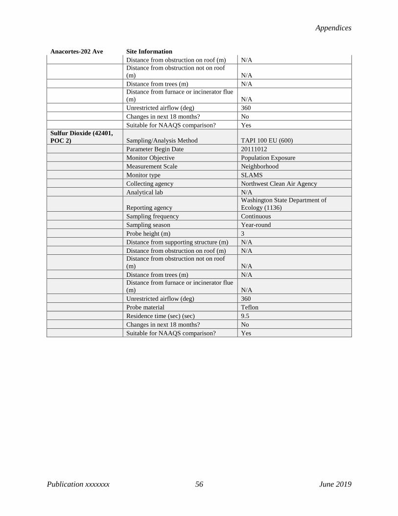
Appendices
Publication xxxxxxx 56 June 2019
Anacortes-202 Ave Site Information Distance from obstruction on roof (m) N/A
Distance from obstruction not on roof (m) N/A
Distance from trees (m) N/A
Distance from furnace or incinerator flue (m) N/A
Unrestricted airflow (deg) 360 Changes in next 18 months? No Suitable for NAAQS comparison? Yes Sulfur Dioxide (42401, POC 2) Sampling/Analysis Method TAPI 100 EU (600) Parameter Begin Date 20111012 Monitor Objective Population Exposure Measurement Scale Neighborhood Monitor type SLAMS Collecting agency Northwest Clean Air Agency Analytical lab N/A
Reporting agency Washington State Department of Ecology (1136)
Sampling frequency Continuous Sampling season Year-round Probe height (m) 3 Distance from supporting structure (m) N/A Distance from obstruction on roof (m) N/A
Distance from obstruction not on roof (m) N/A
Distance from trees (m) N/A
Distance from furnace or incinerator flue (m) N/A
Unrestricted airflow (deg) 360 Probe material Teflon Residence time (sec) (sec) 9.5 Changes in next 18 months? No Suitable for NAAQS comparison? Yes
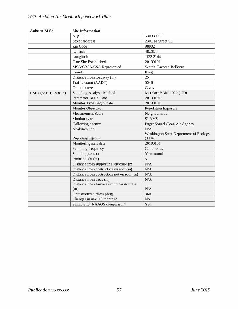
2019 Ambient Air Monitoring Network Plan
Publication xx-xx-xxx 57 June 2019
Auburn-M St Site Information AQS ID 530330089 Street Address 2301 M Street SE Zip Code 98002 Latitude 48.2875 Longitude -122.2144 Date Site Established 20190101 MSA/CBSA/CSA Represented Seattle-Tacoma-Bellevue County King Distance from roadway (m) 25 Traffic count (AADT) 5548 Ground cover Grass PM2.5 (88101, POC 5) Sampling/Analysis Method Met One BAM-1020 (170) Parameter Begin Date 20190101 Monitor Type Begin Date 20190101 Monitor Objective Population Exposure Measurement Scale Neighborhood Monitor type SLAMS Collecting agency Puget Sound Clean Air Agency Analytical lab N/A
Reporting agency Washington State Department of Ecology (1136)
Monitoring start date 20190101 Sampling frequency Continuous Sampling season Year-round Probe height (m) 5 Distance from supporting structure (m) N/A Distance from obstruction on roof (m) N/A Distance from obstruction not on roof (m) N/A Distance from trees (m) N/A
Distance from furnace or incinerator flue (m) N/A
Unrestricted airflow (deg) 360 Changes in next 18 months? No Suitable for NAAQS comparison? Yes

Appendices
Publication xxxxxxx 58 June 2019
Bellevue-SE 12th Site Information AQS ID 530330031 Street Address 14310 SE 12th St Zip Code 98007 Latitude 47.600863 Longitude -122.148397 Date Site Established 20161201 MSA/CBSA/CSA Represented Seattle-Tacoma-Bellevue County King Distance from roadway (m) 200 Traffic count (AADT) 11000 Ground cover Asphalt, concrete, grass Non-compliance PM2.5 (88502, POC 4) Sampling/Analysis Method
Radiance Research M903 Nephelometer (771)
Parameter Begin Date 20161201 Monitor Objective Population Exposure Measurement Scale Neighborhood Monitor type SLAMS
Collecting agency Washington State Department of Ecology (1136)
Analytical lab N/A
Reporting agency Washington State Department of Ecology (1136)
Sampling frequency Continuous Sampling season Year-round Probe height (m) 2
Distance from supporting structure (m) 2
Distance from obstruction on roof (m) N/A
Distance from obstruction not on roof (m) 30
Distance from trees (m) N/A
Distance from furnace or incinerator flue (m) N/A
Unrestricted airflow (deg) 360 Changes in next 18 months? No Suitable for NAAQS comparison? No

2019 Ambient Air Monitoring Network Plan
Publication xx-xx-xxx 59 June 2019
Bellingham-Pacific St Site Information AQS ID 530730019 Street Address 2221 Pacific Street Zip Code 98229 Latitude 48.760036 Longitude -122.456463 Date Site Established 20180102 MSA/CBSA/CSA Represented Bellingham County Skagit Distance from roadway (m) 25 Traffic count (AADT) 2399 Ground cover Roof PM2.5 (88101, POC 5) Sampling/Analysis Method Met One BAM-1020 (170) Parameter Begin Date 20180102 Monitor Type Begin Date 20180102 Monitor Objective Population Exposure Measurement Scale Neighborhood Monitor type SLAMS Collecting agency Northwest Clean Air Agency Analytical lab N/A
Reporting agency Washington State Department of Ecology (1136)
Monitoring start date 20180101 Sampling frequency Continuous Sampling season Year-round Probe height (m) 6 Distance from supporting structure (m) N/A Distance from obstruction on roof (m) N/A Distance from obstruction not on roof (m) N/A Distance from trees (m) N/A
Distance from furnace or incinerator flue (m) N/A
Unrestricted airflow (deg) 360 Changes in next 18 months? No Suitable for NAAQS comparison? Yes

Appendices
Publication xxxxxxx 60 June 2019
Bremerton-Spruce Site Information AQS ID 530350007 Street Address 3250 Spruce Ave Zip Code 98310 Latitude 47.592675 Longitude -122.627397 Date Site Established 20120501 MSA/CBSA/CSA Represented Bremerton-Silverdale County Kitsap Distance from roadway (m) 160 Traffic count (AADT) 35000 Ground cover Grass PM2.5 (88101, POC 5) Sampling/Analysis Method Met One BAM-1020 (170) Parameter Begin Date 20120501 Monitor Objective Population Exposure Measurement Scale Neighborhood Monitor type SLAMS Collecting agency Puget Sound Clean Air Agency Analytical lab N/A
Reporting agency Washington State Department of Ecology (1136)
Sampling frequency Continuous Sampling season Year-round Probe height (m) 3 Distance from supporting structure (m) N/A Distance from obstruction on roof (m) N/A Distance from obstruction not on roof (m) N/A Distance from trees (m) 150
Distance from furnace or incinerator flue (m) N/A
Unrestricted airflow (deg) 360 Changes in next 18 months? No Suitable for NAAQS comparison? Yes

2019 Ambient Air Monitoring Network Plan
Publication xx-xx-xxx 61 June 2019
Burbank-Maple St Site Information AQS ID 530710006 Street Address 755 Maple Street (Columbia High School) Zip Code 99323 Latitude 46.199901 Longitude -119.008329 Date Site Established 20021105 MSA/CBSA/CSA Represented Walla Walla County Walla Walla Distance from roadway (m) 80 Traffic count (AADT) 669 Ground cover Asphalt PM10 (81102, POC 3) Sampling/Analysis Method TEOM-Gravimetric (079) Parameter Begin Date 20170815 Monitor Type Begin Date 20170815 Monitor Objective Population Exposure Measurement Scale Neighborhood Monitor type SLAMS
Collecting agency Washington State Department of Ecology (1136)
Analytical lab N/A
Reporting agency Washington State Department of Ecology (1136)
Sampling frequency Continuous Sampling season Year-round Probe height (m) N/A Distance from supporting structure (m) N/A Distance from obstruction on roof (m) N/A
Distance from obstruction not on roof (m) N/A
Distance from trees (m) N/A
Distance from furnace or incinerator flue (m) N/A
Unrestricted airflow (deg) 360 Changes in next 18 months? No Suitable for NAAQS comparison? Yes Meteorological Sampling/Analysis Method RM Young Sonic Anemometer 85004 (062) Parameter Begin Date 20180301 Monitor Objective Population Exposure Measurement Scale Neighborhood Monitor type SLAMS
Collecting agency Washington State Department of Ecology (1136)
Analytical lab N/A
Reporting agency Washington State Department of Ecology (1136)
Sampling frequency Continuous Sampling season Year-round Probe height (m) 10

Appendices
Publication xxxxxxx 62 June 2019
Burbank-Maple St Site Information Distance from supporting structure (m) N/A Distance from obstruction on roof (m) N/A
Distance from obstruction not on roof (m) N/A
Distance from trees (m) N/A
Distance from furnace or incinerator flue (m) N/A
Unrestricted airflow (deg) 360 Changes in next 18 months? No Suitable for NAAQS comparison? N/A

2019 Ambient Air Monitoring Network Plan
Publication xx-xx-xxx 63 June 2019
Cheeka Peak Site Information AQS ID 530090013
Street Address Located In A Tree Farm (Cheeka Peak)
Zip Code 98381 Latitude 48.29786 Longitude -124.62491 Date Site Established 20060517 MSA/CBSA/CSA Represented Port Angeles County Clallam Distance from roadway (m) 8500 Traffic count (AADT) 1000 Ground cover Shrubs, grass, gravel/dirt Trace NOy (42600/42601/42612, POC 2) Sampling/Analysis Method TAPI 200 EU (699) Parameter Begin Date 20110101 Monitor Objective General/Background Measurement Scale Regional Scale Monitor type SLAMS, NCore
Collecting agency Olympic Region Clean Air Agency (0815)
Analytical lab N/A
Reporting agency Washington State Department of Ecology (1136)
Sampling frequency Continuous Sampling season Year-round Probe height (m) 8
Distance from supporting structure (m) 0.3
Distance from obstruction on roof (m) N/A
Distance from obstruction not on roof (m) N/A
Distance from trees (m) 21
Distance from furnace or incinerator flue (m) N/A
Unrestricted airflow (deg) 175 Probe material Teflon Residence time (sec) 1.6 Changes in next 18 months? No Suitable for NAAQS comparison? No Carbon Monoxide (42101, POC 2) Sampling/Analysis Method TAPI 300 EU (593) Parameter Begin Date 20080101 Monitor Objective General/Background Measurement Scale Regional Scale Monitor type SLAMS, NCore
Collecting agency Olympic Region Clean Air Agency (0815)
Analytical lab N/A

Appendices
Publication xxxxxxx 64 June 2019
Cheeka Peak Site Information
Reporting agency Washington State Department of Ecology (1136)
Sampling frequency Continuous Sampling season Year-round Probe height (m) 6
Distance from supporting structure (m) 0.3
Distance from obstruction on roof (m) N/A
Distance from obstruction not on roof (m) N/A
Distance from trees (m) 21
Distance from furnace or incinerator flue (m) N/A
Unrestricted airflow (deg) 175 Probe material Teflon Residence time (sec) 1.9 Changes in next 18 months? No Suitable for NAAQS comparison? Yes
Meteorological Sampling/Analysis Method RM Young Sonic Anemometer 85004 (062)
Parameter Begin Date 20110101 Monitor Objective General/Background Measurement Scale Regional Scale Monitor type SLAMS, NCore
Collecting agency Olympic Region Clean Air Agency (0815)
Analytical lab N/A
Reporting agency Washington State Department of Ecology (1136)
Sampling frequency Continuous Sampling season Year-round Probe height (m) 10
Distance from supporting structure (m) N/A
Distance from obstruction on roof (m) N/A
Distance from obstruction not on roof (m) N/A
Distance from trees (m) 40
Distance from furnace or incinerator flue (m) N/A
Unrestricted airflow (deg) 360 Changes in next 18 months? No Suitable for NAAQS comparison? N/A Non-compliance PM2.5 (88502, POC 4) Sampling/Analysis Method
Radiance Research M903 Nephelometer (771)
Parameter Begin Date 20060517 Monitor Objective General/Background Measurement Scale Regional Scale

2019 Ambient Air Monitoring Network Plan
Publication xx-xx-xxx 65 June 2019
Cheeka Peak Site Information Monitor type SLAMS, NCore
Collecting agency Olympic Region Clean Air Agency (0815)
Analytical lab N/A
Reporting agency Washington State Department of Ecology (1136)
Sampling frequency Continuous Sampling season Year-round Probe height (m) 6
Distance from supporting structure (m) 0.3
Distance from obstruction on roof (m) N/A
Distance from obstruction not on roof (m) N/A
Distance from trees (m) 21
Distance from furnace or incinerator flue (m) N/A
Unrestricted airflow (deg) 175 Changes in next 18 months? No Suitable for NAAQS comparison? No Ozone (44201, POC 1) Sampling/Analysis Method UV Absorption (087) Parameter Begin Date 20101217 Monitor Objective General/Background Measurement Scale Regional Scale Monitor type SLAMS, NCore
Collecting agency Olympic Region Clean Air Agency (0815)
Analytical lab N/A
Reporting agency Washington State Department of Ecology (1136)
Sampling frequency Continuous Sampling season Year-round Probe height (m) 6
Distance from supporting structure (m) 0.3
Distance from obstruction on roof (m) N/A
Distance from obstruction not on roof (m) N/A
Distance from trees (m) 21
Distance from furnace or incinerator flue (m) N/A
Unrestricted airflow (deg) 175 Probe material Teflon Residence time (sec) 1.9 Changes in next 18 months? No Suitable for NAAQS comparison? Yes Sulfur Dioxide (42401, POC 2) Sampling/Analysis Method TAPI 100 EU (600) Parameter Begin Date 20110101

Appendices
Publication xxxxxxx 66 June 2019
Cheeka Peak Site Information Monitor Objective General/Background Measurement Scale Regional Scale Monitor type SLAMS, NCore
Collecting agency Olympic Region Clean Air Agency (0815)
Analytical lab N/A
Reporting agency Washington State Department of Ecology (1136)
Sampling frequency Continuous Sampling season Year-round Probe height (m) 6
Distance from supporting structure (m) 0.3
Distance from obstruction on roof (m) N/A
Distance from obstruction not on roof (m) N/A
Distance from trees (m) 21
Distance from furnace or incinerator flue (m) N/A
Unrestricted airflow (deg) 175 Probe material Teflon Residence time (sec) 5.8 Changes in next 18 months? No Suitable for NAAQS comparison? Yes

2019 Ambient Air Monitoring Network Plan
Publication xx-xx-xxx 67 June 2019
Chehalis-Market Blvd Site Information AQS ID 530410004 Street Address 350 N Market Blvd Zip Code 98532 Latitude 46.66409 Longitude -122.96732 Date Site Established 20091229 MSA/CBSA/CSA Represented Centralia County Lewis Distance from roadway (m) 30 Traffic count (AADT) 3769 Ground cover Roof Non-compliance PM2.5 (88502, POC 4) Sampling/Analysis Method
Radiance Research M903 Nephelometer (771)
Parameter Begin Date 20091229 Monitor Objective Population Exposure Measurement Scale Neighborhood Monitor type SLAMS
Collecting agency Washington State Department of Ecology (1136)
Analytical lab N/A
Reporting agency Washington State Department of Ecology (1136)
Sampling frequency Continuous Sampling season Year-round Probe height (m) 10
Distance from supporting structure (m) 0.3
Distance from obstruction on roof (m) 11
Distance from obstruction not on roof (m) N/A
Distance from trees (m) 25
Distance from furnace or incinerator flue (m) N/A
Unrestricted airflow (deg) 360 Changes in next 18 months? No Suitable for NAAQS comparison? No
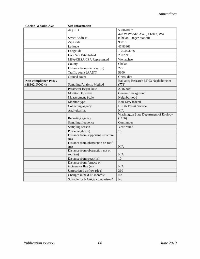
Appendices
Publication xxxxxxx 68 June 2019
Chelan-Woodin Ave Site Information AQS ID 530070007
Street Address 428 W Woodin Ave. , Chelan, WA (Chelan Ranger Station)
Zip Code 98816 Latitude 47.83861 Longitude -120.023076 Date Site Established 20020915 MSA/CBSA/CSA Represented Wenatchee County Chelan Distance from roadway (m) 275 Traffic count (AADT) 5100 Ground cover Grass, dirt Non-compliance PM2.5 (88502, POC 4) Sampling/Analysis Method
Radiance Research M903 Nephelometer (771)
Parameter Begin Date 20160906 Monitor Objective General/Background Measurement Scale Neighborhood Monitor type Non-EPA federal Collecting agency USDA Forest Service Analytical lab N/A
Reporting agency Washington State Department of Ecology (1136)
Sampling frequency Continuous Sampling season Year-round Probe height (m) 10
Distance from supporting structure (m) 1
Distance from obstruction on roof (m) N/A
Distance from obstruction not on roof (m) N/A
Distance from trees (m) 10
Distance from furnace or incinerator flue (m) N/A
Unrestricted airflow (deg) 360 Changes in next 18 months? No Suitable for NAAQS comparison? No

2019 Ambient Air Monitoring Network Plan
Publication xx-xx-xxx 69 June 2019
Cheney-Turnbull Site Information AQS ID 530630001
Street Address S 26010 Smith Road (Turnbull Slough National Wildlife Refuge)
Zip Code 99004 Latitude 47.41645 Longitude -117.52997 Date Site Established 19710701 MSA/CBSA/CSA Represented Spokane-Spokane Valley County Spokane Distance from roadway (m) 1900 Traffic count (AADT) 992 Ground cover Grass, dirt Ozone (44201, POC 1) Sampling/Analysis Method UV Absorption (087) Parameter Begin Date 19990501 Monitor Objective Population Exposure Measurement Scale Urban Scale Monitor type SLAMS Collecting agency Washington State Department of Ecology (1136) Analytical lab N/A Reporting agency Washington State Department of Ecology (1136) Sampling frequency Continuous Sampling season May-Oct Probe height (m) 4
Distance from supporting structure (m) 1
Distance from obstruction on roof (m) N/A
Distance from obstruction not on roof (m) 70
Distance from trees (m) 100
Distance from furnace or incinerator flue (m) N/A
Unrestricted airflow (deg) 360 Probe material Teflon Residence time (sec) 3.8 Changes in next 18 months? No Suitable for NAAQS comparison? Yes
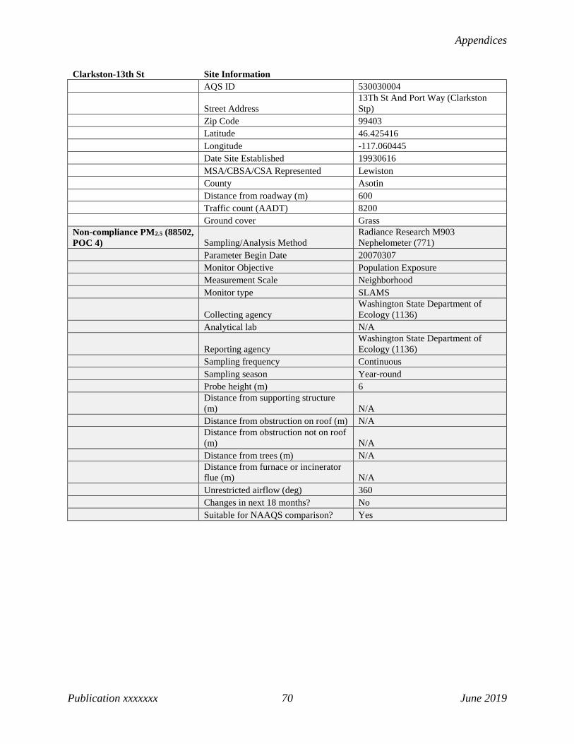
Appendices
Publication xxxxxxx 70 June 2019
Clarkston-13th St Site Information AQS ID 530030004
Street Address 13Th St And Port Way (Clarkston Stp)
Zip Code 99403 Latitude 46.425416 Longitude -117.060445 Date Site Established 19930616 MSA/CBSA/CSA Represented Lewiston County Asotin Distance from roadway (m) 600 Traffic count (AADT) 8200 Ground cover Grass Non-compliance PM2.5 (88502, POC 4) Sampling/Analysis Method
Radiance Research M903 Nephelometer (771)
Parameter Begin Date 20070307 Monitor Objective Population Exposure Measurement Scale Neighborhood Monitor type SLAMS
Collecting agency Washington State Department of Ecology (1136)
Analytical lab N/A
Reporting agency Washington State Department of Ecology (1136)
Sampling frequency Continuous Sampling season Year-round Probe height (m) 6
Distance from supporting structure (m) N/A
Distance from obstruction on roof (m) N/A
Distance from obstruction not on roof (m) N/A
Distance from trees (m) N/A
Distance from furnace or incinerator flue (m) N/A
Unrestricted airflow (deg) 360 Changes in next 18 months? No Suitable for NAAQS comparison? Yes

2019 Ambient Air Monitoring Network Plan
Publication xx-xx-xxx 71 June 2019
Colville-E 1st St Site Information AQS ID 530650005 Street Address 261 E 1St St Zip Code 99114 Latitude 48.544448 Longitude -117.903425 Date Site Established 20151025 MSA/CBSA/CSA Represented Spokane-Spokane Valley County Spokane Distance from roadway (m) 190 Traffic count (AADT) 7300 Ground cover Roof
Meteorological Sampling/Analysis Method RM Young Sonic Anemometer 85004 (062)
Parameter Begin Date 20160520 Monitor Objective Population Exposure Measurement Scale Neighborhood Monitor type SLAMS
Collecting agency Washington State Department of Ecology (1136)
Analytical lab N/A
Reporting agency Washington State Department of Ecology (1136)
Sampling frequency Continuous Sampling season Year-round Probe height (m) 10
Distance from supporting structure (m) N/A
Distance from obstruction on roof (m) N/A
Distance from obstruction not on roof (m) N/A
Distance from trees (m) 50
Distance from furnace or incinerator flue (m) N/A
Unrestricted airflow (deg) 360 Changes in next 18 months? No Suitable for NAAQS comparison? N/A Non-compliance PM2.5 (88502, POC 4) Sampling/Analysis Method
Radiance Research M903 Nephelometer (771)
Parameter Begin Date 20151025 Monitor Objective Population Exposure Measurement Scale Neighborhood Monitor type SLAMS
Collecting agency Washington State Department of Ecology (1136)
Analytical lab N/A
Reporting agency Washington State Department of Ecology (1136)
Sampling frequency Continuous Sampling season Year-round

Appendices
Publication xxxxxxx 72 June 2019
Colville-E 1st St Site Information Probe height (m) 15
Distance from supporting structure (m) N/A
Distance from obstruction on roof (m) N/A
Distance from obstruction not on roof (m) N/A
Distance from trees (m) 50
Distance from furnace or incinerator flue (m) N/A
Unrestricted airflow (deg) 360 Changes in next 18 months? No Suitable for NAAQS comparison? No PM10 (81102, POC 3) Sampling/Analysis Method TEOM-Gravimetric (079) Parameter Begin Date 20151025 Monitor Objective Population Exposure Measurement Scale Neighborhood Monitor type SLAMS
Collecting agency Washington State Department of Ecology (1136)
Analytical lab N/A
Reporting agency Washington State Department of Ecology (1136)
Sampling frequency Continuous Sampling season Year-round Probe height (m) 15
Distance from supporting structure (m) N/A
Distance from obstruction on roof (m) N/A
Distance from obstruction not on roof (m) N/A
Distance from trees (m) 50
Distance from furnace or incinerator flue (m) N/A
Unrestricted airflow (deg) 360 Changes in next 18 months? No Suitable for NAAQS comparison? Yes

2019 Ambient Air Monitoring Network Plan
Publication xx-xx-xxx 73 June 2019
Custer-Loomis Site Information AQS ID 530730005 Street Address 1330 Loomis Trail Rd Zip Code 98240 Latitude 48.95074 Longitude -122.55441 Date Site Established 19890413 MSA/CBSA/CSA Represented Bellingham County Whatcom Distance from roadway (m) 65 Traffic count (AADT) 837 Ground cover Grass Ozone (44201, POC 1) Sampling/Analysis Method UV Absorption (087) Parameter Begin Date 20090606 Monitor Objective Regional Transport Measurement Scale Regional Scale Monitor type SLAMS Collecting agency Northwest Clean Air Agency Analytical lab N/A
Reporting agency Washington State Department of Ecology (1136)
Sampling frequency Continuous Sampling season Year-round Probe height (m) 3 Distance from supporting structure (m) 1 Distance from obstruction on roof (m) N/A Distance from obstruction not on roof (m) N/A Distance from trees (m) 130
Distance from furnace or incinerator flue (m) N/A
Unrestricted airflow (deg) 360 Probe material Teflon Residence time (sec) 9 Changes in next 18 months? No Suitable for NAAQS comparison? Yes

Appendices
Publication xxxxxxx 74 June 2019
Darrington-Fir St Site Information AQS ID 530610020 Street Address 1085 Fir St Zip Code 98241 Latitude 48.2469 Longitude -121.6031 Date Site Established 20060721 MSA/CBSA/CSA Represented Seattle-Tacoma-Bellevue County Snohomish Distance from roadway (m) 1000 Traffic count (AADT) 3800 Ground cover Asphalt PM2.5 (88101, POC 5) Sampling/Analysis Method Met One BAM-1020 (170) Parameter Begin Date 20101228 Monitor Objective Population Exposure Measurement Scale Neighborhood Monitor type SLAMS Collecting agency Puget Sound Clean Air Agency Analytical lab N/A
Reporting agency Washington State Department of Ecology (1136)
Sampling frequency Continuous Sampling season Year-round Probe height (m) 4 Distance from supporting structure (m) N/A Distance from obstruction on roof (m) N/A Distance from obstruction not on roof (m) 25 Distance from trees (m) 200
Distance from furnace or incinerator flue (m) 200
Unrestricted airflow (deg) 360 Changes in next 18 months? No Suitable for NAAQS comparison? Yes

2019 Ambient Air Monitoring Network Plan
Publication xx-xx-xxx 75 June 2019
Dayton-W Main Site Information AQS ID 530130002 Street Address 206 W Main St Zip Code 99328 Latitude 46.318 Longitude -117.985 Date Site Established 20090205 MSA/CBSA/CSA Represented Walla Walla County Walla Walla Distance from roadway (m) 27 Traffic count (AADT) 5500 Ground cover Gravel, asphalt Non-compliance PM2.5 (88502, POC 4) Sampling/Analysis Method
Radiance Research M903 Nephelometer (771)
Parameter Begin Date 20090205 Monitor Objective Population Exposure Measurement Scale Neighborhood Monitor type SLAMS
Collecting agency Washington State Department of Ecology (1136)
Analytical lab N/A
Reporting agency Washington State Department of Ecology (1136)
Sampling frequency Continuous Sampling season Year-round Probe height (m) 6
Distance from supporting structure (m) N/A
Distance from obstruction on roof (m) N/A
Distance from obstruction not on roof (m) N/A
Distance from trees (m) N/A
Distance from furnace or incinerator flue (m) N/A
Unrestricted airflow (deg) 360 Changes in next 18 months? No Suitable for NAAQS comparison? No

Appendices
Publication xxxxxxx 76 June 2019
Ellensburg-Ruby St Site Information AQS ID 530370002 Street Address 201 N. Ruby Zip Code 98926 Latitude 46.99364 Longitude -120.545 Date Site Established 19951104 MSA/CBSA/CSA Represented Ellensburg County Kittitas Distance from roadway (m) 35 Traffic count (AADT) 3625 Ground cover Roof PM2.5 (88101, POC 5) Sampling/Analysis Method Met One BAM-1020 (170) Parameter Begin Date 20141001 Monitor Objective Population Exposure Measurement Scale Neighborhood Monitor type SLAMS
Collecting agency Washington State Department of Ecology (1136)
Analytical lab N/A
Reporting agency Washington State Department of Ecology (1136)
Sampling frequency Continuous Sampling season Year-round Probe height (m) 3 Distance from supporting structure (m) N/A Distance from obstruction on roof (m) N/A Distance from obstruction not on roof (m) N/A Distance from trees (m) N/A
Distance from furnace or incinerator flue (m) N/A
Unrestricted airflow (deg) 360 Changes in next 18 months? No Suitable for NAAQS comparison? Yes Non-compliance PM2.5 (88502, POC 4) Sampling/Analysis Method
Radiance Research M903 Nephelometer (771)
Parameter Begin Date 20180401 Monitor Objective Population Exposure Measurement Scale Neighborhood Monitor type SLAMS
Collecting agency Washington State Department of Ecology (1136)
Analytical lab N/A
Reporting agency Washington State Department of Ecology (1136)
Sampling frequency Continuous Sampling season Year-round Probe height (m) 2 Distance from supporting structure (m) N/A Distance from obstruction on roof (m) N/A

2019 Ambient Air Monitoring Network Plan
Publication xx-xx-xxx 77 June 2019
Ellensburg-Ruby St Site Information Distance from obstruction not on roof (m) N/A Distance from trees (m) N/A
Distance from furnace or incinerator flue (m) N/A
Unrestricted airflow (deg) 360 Changes in next 18 months? No Suitable for NAAQS comparison? No

Appendices
Publication xxxxxxx 78 June 2019
Enumclaw-Mud Mtn Site Information AQS ID 530330023 Street Address 30525 Se Mud Mountain Road Zip Code 98022 Latitude 47.1411 Longitude -121.9379 Date Site Established 19980708 MSA/CBSA/CSA Represented Seattle-Tacoma-Bellevue County King Distance from roadway (m) 3300 Traffic count (AADT) 2600 Ground cover Gravel, dirt, grass
Meteorological Sampling/Analysis Method RM Young Sonic Anemometer 85004 (062)
Parameter Begin Date 20040201 Monitor Objective Regional Transport Measurement Scale Urban Scale Monitor type SLAMS
Collecting agency Washington State Department of Ecology (1136)
Analytical lab N/A
Reporting agency Washington State Department of Ecology (1136)
Sampling frequency Continuous Sampling season Year-round Probe height (m) 10 Distance from supporting structure (m) N/A Distance from obstruction on roof (m) N/A Distance from obstruction not on roof (m) N/A Distance from trees (m) N/A
Distance from furnace or incinerator flue (m) N/A
Unrestricted airflow (deg) 360 Changes in next 18 months? No Suitable for NAAQS comparison? N/A Ozone (44201, POC 1) Sampling/Analysis Method UV Absorption (087) Parameter Begin Date 19980708 Monitor Objective Regional Transport Measurement Scale Urban Scale Monitor type SLAMS
Collecting agency Washington State Department of Ecology (1136)
Analytical lab N/A
Reporting agency Washington State Department of Ecology (1136)
Sampling frequency Continuous Sampling season May-Oct Probe height (m) 3 Distance from supporting structure (m) 0.5 Distance from obstruction on roof (m) N/A
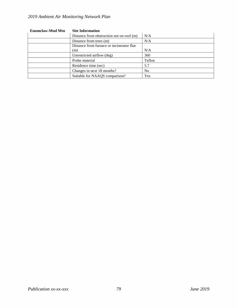
2019 Ambient Air Monitoring Network Plan
Publication xx-xx-xxx 79 June 2019
Enumclaw-Mud Mtn Site Information Distance from obstruction not on roof (m) N/A Distance from trees (m) N/A
Distance from furnace or incinerator flue (m) N/A
Unrestricted airflow (deg) 360 Probe material Teflon Residence time (sec) 5.7 Changes in next 18 months? No Suitable for NAAQS comparison? Yes
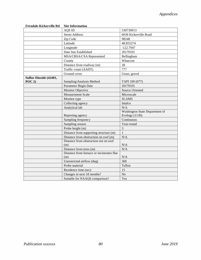
Appendices
Publication xxxxxxx 80 June 2019
Ferndale-Kickerville Rd Site Information AQS ID 530730013 Street Address 6036 Kickerville Road Zip Code 98248 Latitude 48.855274 Longitude -122.7047 Date Site Established 20170101 MSA/CBSA/CSA Represented Bellingham County Whatcom Distance from roadway (m) 28 Traffic count (AADT) 777 Ground cover Grass, gravel Sulfur Dioxide (42401, POC 2) Sampling/Analysis Method TAPI 100 (077) Parameter Begin Date 20170101 Monitor Objective Source Oriented Measurement Scale Microscale Monitor type SLAMS Collecting agency Intalco Analytical lab N/A
Reporting agency Washington State Department of Ecology (1136)
Sampling frequency Continuous Sampling season Year-round Probe height (m) 3 Distance from supporting structure (m) 1 Distance from obstruction on roof (m) N/A
Distance from obstruction not on roof (m) N/A
Distance from trees (m) N/A
Distance from furnace or incinerator flue (m) N/A
Unrestricted airflow (deg) 360 Probe material Teflon Residence time (sec) 15 Changes in next 18 months? No Suitable for NAAQS comparison? Yes

2019 Ambient Air Monitoring Network Plan
Publication xx-xx-xxx 81 June 2019
Ferndale-Mountain View Rd Site Information AQS ID 530730017 Street Address 4050 Mountain View Rd Zip Code 98248 Latitude 48.848065 Longitude -122.688888 Date Site Established 20170101 MSA/CBSA/CSA Represented Bellingham County Whatcom Distance from roadway (m) 460 Traffic count (AADT) 1001 Ground cover Grass
Meteorological Sampling/Analysis Method RM Young Sonic Anemometer 85004 (062)
Parameter Begin Date 20170101 Monitor Objective Source Oriented Measurement Scale Microscale Monitor type SLAMS Collecting agency Intalco Analytical lab N/A
Reporting agency Washington State Department of Ecology (1136)
Sampling frequency Continuous Sampling season Year-round Probe height (m) 10 Distance from supporting structure (m) N/A Distance from obstruction on roof (m) N/A
Distance from obstruction not on roof (m) N/A
Distance from trees (m) 55
Distance from furnace or incinerator flue (m) N/A
Unrestricted airflow (deg) 360 Changes in next 18 months? No Suitable for NAAQS comparison? N/A Sulfur Dioxide (42401, POC 2) Sampling/Analysis Method TAPI 100 (077) Parameter Begin Date 20170101 Monitor Objective Source Oriented Measurement Scale Microscale Monitor type SLAMS Collecting agency Intalco Analytical lab N/A
Reporting agency Washington State Department of Ecology (1136)
Sampling frequency Continuous Sampling season Year-round Probe height (m) 3 Distance from supporting structure (m) 1

Appendices
Publication xxxxxxx 82 June 2019
Ferndale-Mountain View Rd Site Information Distance from obstruction on roof (m) N/A
Distance from obstruction not on roof (m) N/A
Distance from trees (m) 55
Distance from furnace or incinerator flue (m) N/A
Unrestricted airflow (deg) 360 Probe material Teflon Residence time (sec) 15 Changes in next 18 months? No Suitable for NAAQS comparison? Yes
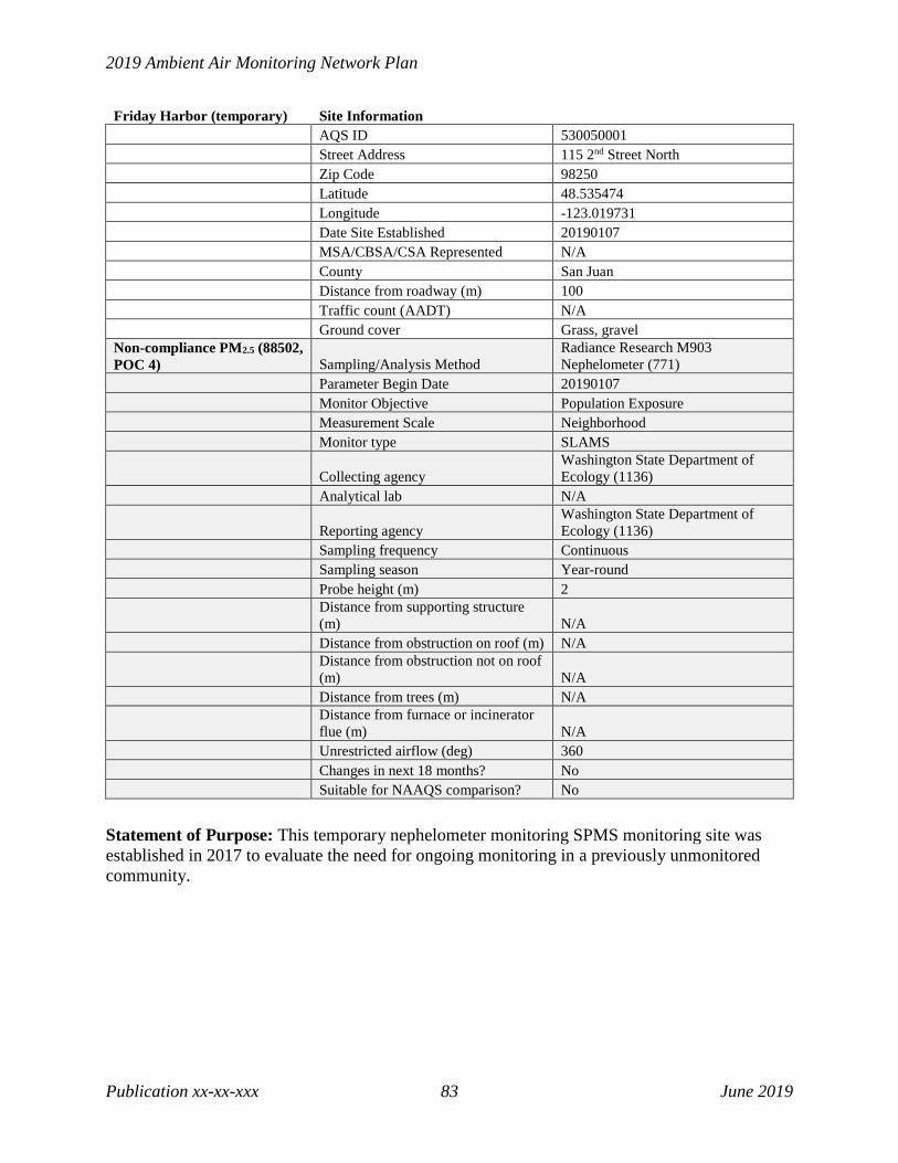
2019 Ambient Air Monitoring Network Plan
Publication xx-xx-xxx 83 June 2019
Friday Harbor (temporary) Site Information AQS ID 530050001 Street Address 115 2nd Street North Zip Code 98250 Latitude 48.535474 Longitude -123.019731 Date Site Established 20190107 MSA/CBSA/CSA Represented N/A County San Juan Distance from roadway (m) 100 Traffic count (AADT) N/A Ground cover Grass, gravel Non-compliance PM2.5 (88502, POC 4) Sampling/Analysis Method
Radiance Research M903 Nephelometer (771)
Parameter Begin Date 20190107 Monitor Objective Population Exposure Measurement Scale Neighborhood Monitor type SLAMS
Collecting agency Washington State Department of Ecology (1136)
Analytical lab N/A
Reporting agency Washington State Department of Ecology (1136)
Sampling frequency Continuous Sampling season Year-round Probe height (m) 2
Distance from supporting structure (m) N/A
Distance from obstruction on roof (m) N/A
Distance from obstruction not on roof (m) N/A
Distance from trees (m) N/A
Distance from furnace or incinerator flue (m) N/A
Unrestricted airflow (deg) 360 Changes in next 18 months? No Suitable for NAAQS comparison? No
Statement of Purpose: This temporary nephelometer monitoring SPMS monitoring site was established in 2017 to evaluate the need for ongoing monitoring in a previously unmonitored community.

Appendices
Publication xxxxxxx 84 June 2019
Issaquah-Lake Sammamish Site Information AQS ID 530330010 Street Address 2000 NW Sammamish Rd Zip Code 98027 Latitude 47.5525 Longitude -122.064722 Date Site Established 19751201 MSA/CBSA/CSA Represented Seattle-Tacoma-Bellevue MSA/CBSA/CSA Represented Seattle-Tacoma-Bellevue County King Distance from roadway (m) 65 Traffic count (AADT) 10901 Ground cover Gravel, grass Ozone (44201, POC 1) Sampling/Analysis Method UV Absorption (087) Parameter Begin Date 19810101 Monitor Objective Population Exposure Measurement Scale Urban Scale Monitor type SLAMS
Collecting agency Washington State Department of Ecology (1136)
Analytical lab N/A
Reporting agency Washington State Department of Ecology (1136)
Sampling frequency Continuous Sampling season May-Oct Probe height (m) 3 Distance from supporting structure (m) 1 Distance from obstruction on roof (m) N/A Distance from obstruction not on roof (m) N/A Distance from trees (m) N/A
Distance from furnace or incinerator flue (m) N/A
Unrestricted airflow (deg) 360 Probe material Teflon Residence time (sec) 2.8 Changes in next 18 months? No Suitable for NAAQS comparison? Yes

2019 Ambient Air Monitoring Network Plan
Publication xx-xx-xxx 85 June 2019
Kennewick-Metaline Site Information AQS ID 530050002
Street Address 5929 W Metaline (Kennewick Skills Center)
Zip Code 99336 Latitude 46.21835 Longitude -119.204153 Date Site Established 19941001 MSA/CBSA/CSA Represented Kennewick-Richland County Benton Distance from roadway (m) 150 Traffic count (AADT) 8476 Ground cover Roof
Meteorological Sampling/Analysis Method RM Young Sonic Anemometer 85004 (062)
Parameter Begin Date 20120807 Monitor Objective Population Exposure Measurement Scale Neighborhood Monitor type SLAMS
Collecting agency Washington State Department of Ecology (1136)
Analytical lab N/A
Reporting agency Washington State Department of Ecology (1136)
Sampling frequency Continuous Sampling season Year-round Probe height (m) 10
Distance from supporting structure (m) N/A
Distance from obstruction on roof (m) 18
Distance from obstruction not on roof (m) N/A
Distance from trees (m) 66
Distance from furnace or incinerator flue (m)
Unrestricted airflow (deg) 360 Changes in next 18 months? No Suitable for NAAQS comparison? N/A Non-compliance PM2.5 (88502, POC 4) Sampling/Analysis Method
Radiance Research M903 Nephelometer (771)
Parameter Begin Date 20051019 Monitor Objective Population Exposure Measurement Scale Neighborhood Monitor type SLAMS Collecting agency Benton Clean Air Agency Analytical lab N/A
Reporting agency Washington State Department of Ecology (1136)
Sampling frequency Continuous Sampling season Year-round

Appendices
Publication xxxxxxx 86 June 2019
Kennewick-Metaline Site Information Probe height (m) 7
Distance from supporting structure (m) N/A
Distance from obstruction on roof (m) 18
Distance from obstruction not on roof (m) N/A
Distance from trees (m) 66
Distance from furnace or incinerator flue (m) N/A
Unrestricted airflow (deg) 360 Changes in next 18 months? No Suitable for NAAQS comparison? No PM10 (81102, POC 3) Sampling/Analysis Method Met One BAM 1020 (122) Parameter Begin Date 20041001 Monitor Objective Population Exposure Measurement Scale Neighborhood Monitor type SLAMS Collecting agency Benton Clean Air Agency Analytical lab N/A
Reporting agency Washington State Department of Ecology (1136)
Sampling frequency Continuous Sampling season Year-round Probe height (m) 7
Distance from supporting structure (m) N/A
Distance from obstruction on roof (m) 18
Distance from obstruction not on roof (m) N/A
Distance from trees (m) 66
Distance from furnace or incinerator flue (m) N/A
Unrestricted airflow (deg) 360 Changes in next 18 months? No Suitable for NAAQS comparison? Yes

2019 Ambient Air Monitoring Network Plan
Publication xx-xx-xxx 87 June 2019
Kennewick-S Clodfelter Site Information AQS ID 530050003 Street Address 526 S Clodfelter Rd Zip Code 99336 Latitude 46.204582 Longitude -119.243743 Date Site Established 20150610 MSA/CBSA/CSA Represented Kennewick-Richland County Benton Distance from roadway (m) 90 Traffic count (AADT) 12261 Ground cover Grass, asphalt Ozone (44201, POC 1) Sampling/Analysis Method UV Absorption (087) Parameter Begin Date 20150610 Monitor Objective Population Exposure Measurement Scale Neighborhood Monitor type SLAMS Collecting agency Benton Clean Air Agency Analytical lab N/A
Reporting agency Washington State Department of Ecology (1136)
Sampling frequency Continuous Sampling season May-Oct Probe height (m) 15 Distance from supporting structure (m) N/A Distance from obstruction on roof (m) N/A Distance from obstruction not on roof (m) N/A Distance from trees (m) N/A
Distance from furnace or incinerator flue (m) N/A
Unrestricted airflow (deg) 360 Probe material Teflon Residence time (sec) 9 Changes in next 18 months? No Suitable for NAAQS comparison? Yes

Appendices
Publication xxxxxxx 88 June 2019
Kent-James & Central Site Information AQS ID 530332004 Street Address 614 Railroad Ave N, Kent Zip Code 98030 Latitude 47.386111 Longitude -122.230278 Date Site Established 19870702 MSA/CBSA/CSA Represented Seattle-Tacoma-Bellevue County King Distance from roadway (m) 65 Traffic count (AADT) 24100 Ground cover Asphalt PM2.5 (88101, POC 5) Sampling/Analysis Method Met One BAM-1020 (170) Parameter Begin Date 20101217 Monitor Objective Population Exposure Measurement Scale Neighborhood Monitor type SLAMS Collecting agency Puget Sound Clean Air Agency Analytical lab N/A
Reporting agency Washington State Department of Ecology (1136)
Sampling frequency Continuous Sampling season Year-round Probe height (m) 3 Distance from supporting structure (m) N/A Distance from obstruction on roof (m) N/A Distance from obstruction not on roof (m) N/A Distance from trees (m) 120
Distance from furnace or incinerator flue (m) N/A
Unrestricted airflow (deg) 360 Changes in next 18 months? No Suitable for NAAQS comparison? Yes

2019 Ambient Air Monitoring Network Plan
Publication xx-xx-xxx 89 June 2019
Lacey-College St Site Information AQS ID 530670013
Street Address 1900 College St Se (Mountain View Elementary School)
Zip Code 98503 Latitude 47.029396 Longitude -122.821548 Date Site Established 19840401 MSA/CBSA/CSA Represented Olympia-Tumwater County Thurston Distance from roadway (m) 65 Traffic count (AADT) 21346 Ground cover Grass Non-compliance PM2.5 (88502, POC 4) Sampling/Analysis Method
Radiance Research M903 Nephelometer (771)
Parameter Begin Date 20140401 Monitor Objective Population Exposure Measurement Scale Neighborhood Monitor type SLAMS
Collecting agency Olympic Region Clean Air Agency (0815)
Analytical lab N/A
Reporting agency Washington State Department of Ecology (1136)
Sampling frequency Continuous Sampling season Year-round Probe height (m) 10
Distance from supporting structure (m) 2
Distance from obstruction on roof (m) N/A
Distance from obstruction not on roof (m) N/A
Distance from trees (m) N/A
Distance from furnace or incinerator flue (m) N/A
Unrestricted airflow (deg) 360 Changes in next 18 months? No Suitable for NAAQS comparison? No

Appendices
Publication xxxxxxx 90 June 2019
LaCrosse-Hill St Site Information AQS ID 530750005 Street Address 111 Hill Street, Lacrosse, WA Zip Code 99143 Latitude 46.8153 Longitude -117.8739 Date Site Established 20020719 MSA/CBSA/CSA Represented Pullman County Whitman Distance from roadway (m) 2000 Traffic count (AADT) 1800 Ground cover Grass Non-compliance PM2.5 (88502, POC 4) Sampling/Analysis Method
Radiance Research M903 Nephelometer (771)
Parameter Begin Date 20021001 Monitor Objective Population Exposure Measurement Scale Neighborhood Monitor type SLAMS
Collecting agency Washington State Department of Ecology (1136)
Analytical lab N/A
Reporting agency Washington State Department of Ecology (1136)
Sampling frequency Continuous Sampling season Year-round Probe height (m) 3 Distance from supporting structure (m) N/A Distance from obstruction on roof (m) N/A
Distance from obstruction not on roof (m) N/A
Distance from trees (m) N/A
Distance from furnace or incinerator flue (m) N/A
Unrestricted airflow (deg) 360 Changes in next 18 months? No Suitable for NAAQS comparison? No
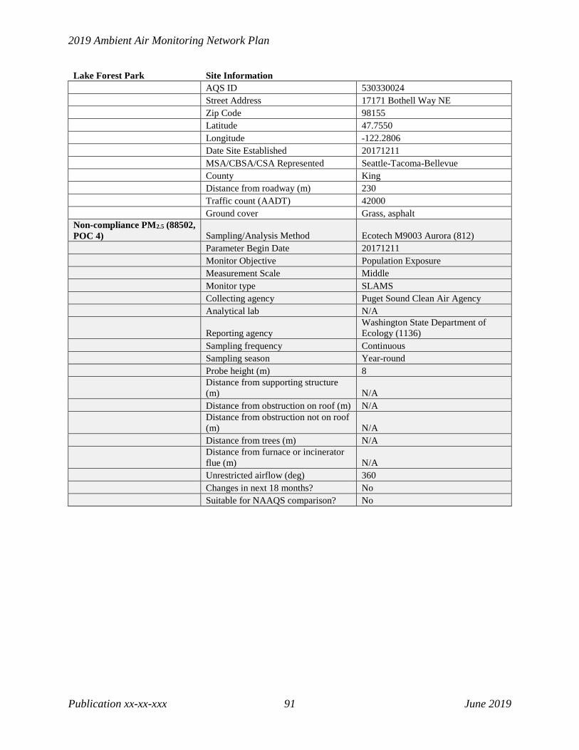
2019 Ambient Air Monitoring Network Plan
Publication xx-xx-xxx 91 June 2019
Lake Forest Park Site Information AQS ID 530330024 Street Address 17171 Bothell Way NE Zip Code 98155 Latitude 47.7550 Longitude -122.2806 Date Site Established 20171211 MSA/CBSA/CSA Represented Seattle-Tacoma-Bellevue County King Distance from roadway (m) 230 Traffic count (AADT) 42000 Ground cover Grass, asphalt Non-compliance PM2.5 (88502, POC 4) Sampling/Analysis Method Ecotech M9003 Aurora (812) Parameter Begin Date 20171211 Monitor Objective Population Exposure Measurement Scale Middle Monitor type SLAMS Collecting agency Puget Sound Clean Air Agency Analytical lab N/A
Reporting agency Washington State Department of Ecology (1136)
Sampling frequency Continuous Sampling season Year-round Probe height (m) 8
Distance from supporting structure (m) N/A
Distance from obstruction on roof (m) N/A
Distance from obstruction not on roof (m) N/A
Distance from trees (m) N/A
Distance from furnace or incinerator flue (m) N/A
Unrestricted airflow (deg) 360 Changes in next 18 months? No Suitable for NAAQS comparison? No
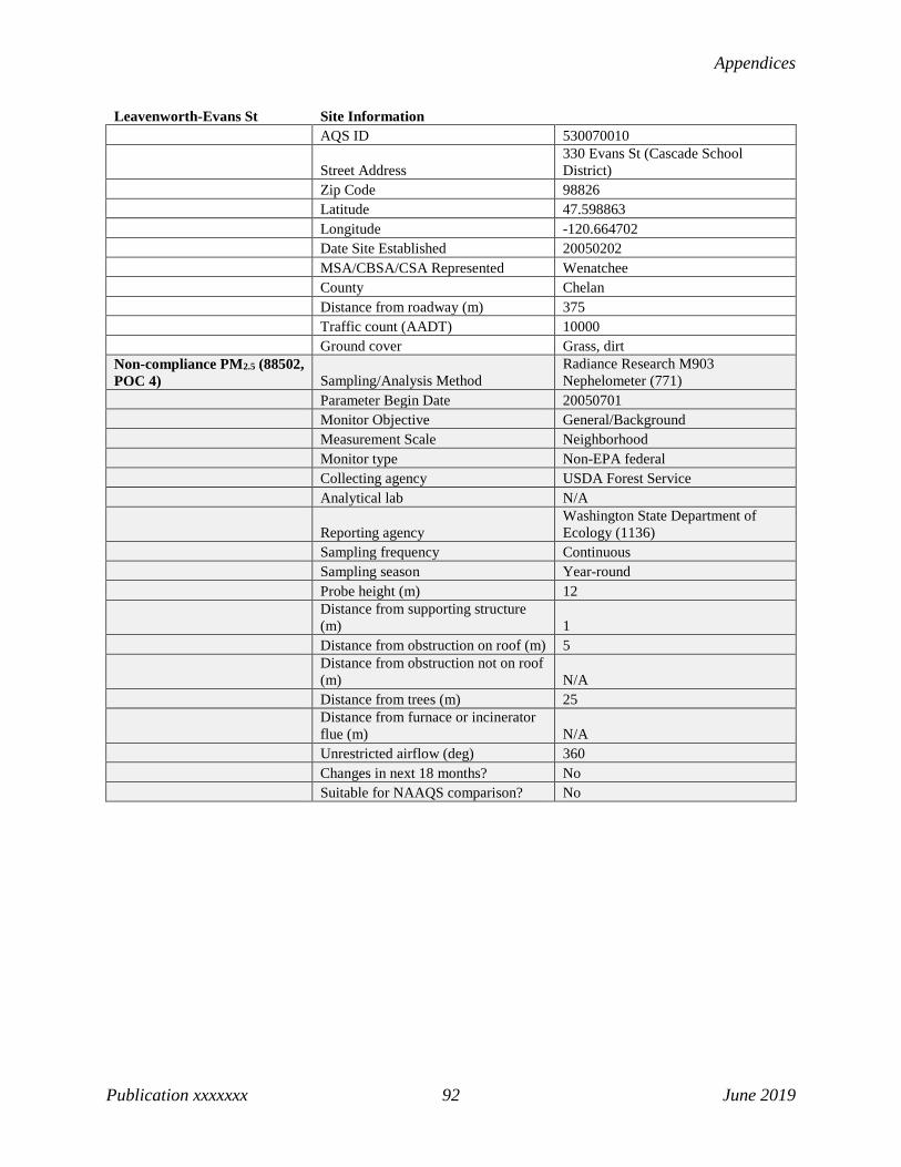
Appendices
Publication xxxxxxx 92 June 2019
Leavenworth-Evans St Site Information AQS ID 530070010
Street Address 330 Evans St (Cascade School District)
Zip Code 98826 Latitude 47.598863 Longitude -120.664702 Date Site Established 20050202 MSA/CBSA/CSA Represented Wenatchee County Chelan Distance from roadway (m) 375 Traffic count (AADT) 10000 Ground cover Grass, dirt Non-compliance PM2.5 (88502, POC 4) Sampling/Analysis Method
Radiance Research M903 Nephelometer (771)
Parameter Begin Date 20050701 Monitor Objective General/Background Measurement Scale Neighborhood Monitor type Non-EPA federal Collecting agency USDA Forest Service Analytical lab N/A
Reporting agency Washington State Department of Ecology (1136)
Sampling frequency Continuous Sampling season Year-round Probe height (m) 12
Distance from supporting structure (m) 1
Distance from obstruction on roof (m) 5
Distance from obstruction not on roof (m) N/A
Distance from trees (m) 25
Distance from furnace or incinerator flue (m) N/A
Unrestricted airflow (deg) 360 Changes in next 18 months? No Suitable for NAAQS comparison? No

2019 Ambient Air Monitoring Network Plan
Publication xx-xx-xxx 93 June 2019
Longview-30th Ave Site Information AQS ID 530150015
Street Address 1324 30th Ave (Olympic Elementary School)
Zip Code 98632 Latitude 46.139444 Longitude -122.961944 Date Site Established 20010401 MSA/CBSA/CSA Represented Longview County Cowlitz Distance from roadway (m) 900 Traffic count (AADT) 23000 Ground cover Grass, asphalt Non-compliance PM2.5 (88502, POC 4) Sampling/Analysis Method
Radiance Research M903 Nephelometer (771)
Parameter Begin Date 20030306 Monitor Objective Population Exposure Measurement Scale Neighborhood Monitor type SLAMS Collecting agency Southwest Clean Air Agency Analytical lab N/A
Reporting agency Washington State Department of Ecology (1136)
Sampling frequency Continuous Sampling season Year-round Probe height (m) 20
Distance from supporting structure (m) 0.5
Distance from obstruction on roof (m) N/A
Distance from obstruction not on roof (m) N/A
Distance from trees (m) N/A
Distance from furnace or incinerator flue (m) N/A
Unrestricted airflow (deg) 360 Changes in next 18 months? No Suitable for NAAQS comparison? No
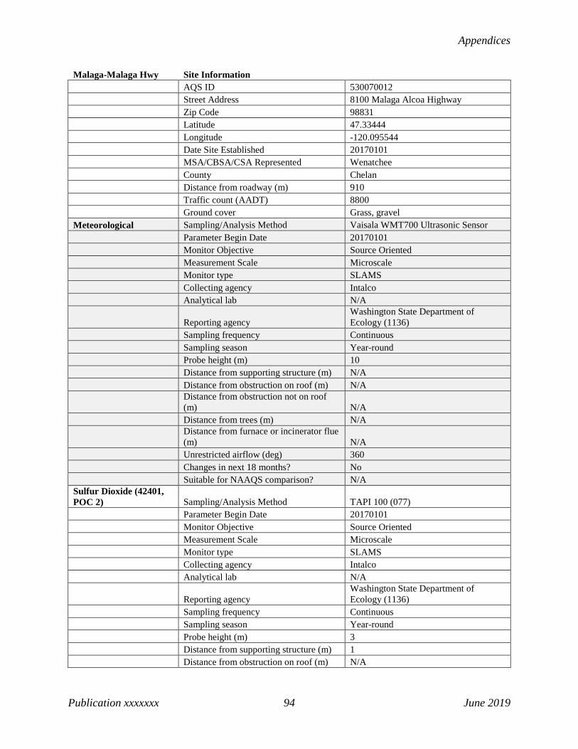
Appendices
Publication xxxxxxx 94 June 2019
Malaga-Malaga Hwy Site Information AQS ID 530070012 Street Address 8100 Malaga Alcoa Highway Zip Code 98831 Latitude 47.33444 Longitude -120.095544 Date Site Established 20170101 MSA/CBSA/CSA Represented Wenatchee County Chelan Distance from roadway (m) 910 Traffic count (AADT) 8800 Ground cover Grass, gravel Meteorological Sampling/Analysis Method Vaisala WMT700 Ultrasonic Sensor Parameter Begin Date 20170101 Monitor Objective Source Oriented Measurement Scale Microscale Monitor type SLAMS Collecting agency Intalco Analytical lab N/A
Reporting agency Washington State Department of Ecology (1136)
Sampling frequency Continuous Sampling season Year-round Probe height (m) 10 Distance from supporting structure (m) N/A Distance from obstruction on roof (m) N/A
Distance from obstruction not on roof (m) N/A
Distance from trees (m) N/A
Distance from furnace or incinerator flue (m) N/A
Unrestricted airflow (deg) 360 Changes in next 18 months? No Suitable for NAAQS comparison? N/A Sulfur Dioxide (42401, POC 2) Sampling/Analysis Method TAPI 100 (077) Parameter Begin Date 20170101 Monitor Objective Source Oriented Measurement Scale Microscale Monitor type SLAMS Collecting agency Intalco Analytical lab N/A
Reporting agency Washington State Department of Ecology (1136)
Sampling frequency Continuous Sampling season Year-round Probe height (m) 3 Distance from supporting structure (m) 1 Distance from obstruction on roof (m) N/A
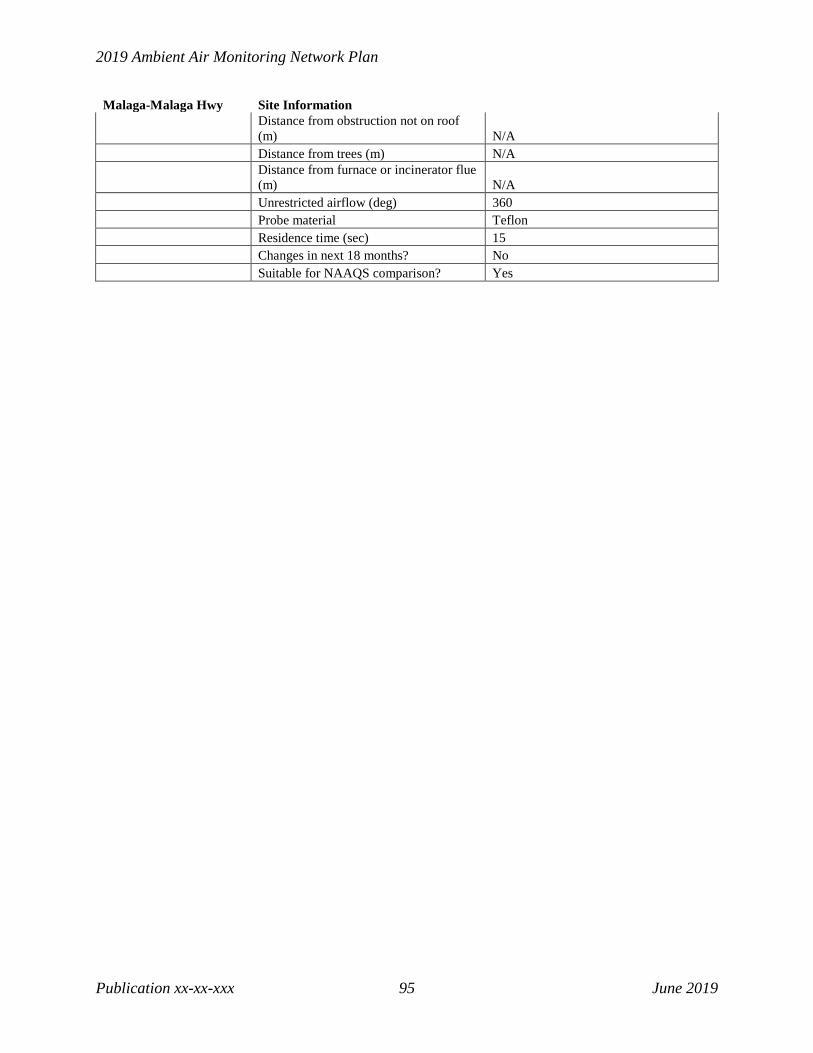
2019 Ambient Air Monitoring Network Plan
Publication xx-xx-xxx 95 June 2019
Malaga-Malaga Hwy Site Information
Distance from obstruction not on roof (m) N/A
Distance from trees (m) N/A
Distance from furnace or incinerator flue (m) N/A
Unrestricted airflow (deg) 360 Probe material Teflon Residence time (sec) 15 Changes in next 18 months? No Suitable for NAAQS comparison? Yes

Appendices
Publication xxxxxxx 96 June 2019
Marysville-7th Ave Site Information AQS ID 530611007 Street Address 1799 7th St Zip Code 98270 Latitude 48.054315 Longitude -122.171529 Date Site Established 19910927 MSA/CBSA/CSA Represented Seattle-Tacoma-Bellevue County Snohomish Distance from roadway (m) 275 Traffic count (AADT) 23000 Ground cover Grass PM2.5 (88101, POC 5) Sampling/Analysis Method Met One BAM-1020 (170) Parameter Begin Date 20110106 Monitor Objective Population Exposure Measurement Scale Neighborhood Monitor type SLAMS Collecting agency Puget Sound Clean Air Agency Analytical lab N/A
Reporting agency Washington State Department of Ecology (1136)
Sampling frequency Continuous Sampling season Year-round Probe height (m) 4 Distance from supporting structure (m) N/A Distance from obstruction on roof (m) N/A Distance from obstruction not on roof (m) N/A Distance from trees (m) 75
Distance from furnace or incinerator flue (m) N/A
Unrestricted airflow (deg) 360 Changes in next 18 months? No Suitable for NAAQS comparison? Yes

2019 Ambient Air Monitoring Network Plan
Publication xx-xx-xxx 97 June 2019
Mesa-Pepiot Way Site Information AQS ID 530210002
Street Address 200 Pepiot Way (Mesa Elementary School)
Zip Code 99343 Latitude 46.5754 Longitude -119.0021 Date Site Established 20030115 MSA/CBSA/CSA Represented Kennewick-Richland County Franklin Distance from roadway (m) 150 Traffic count (AADT) 4800 Ground cover Grass Non-compliance PM2.5 (88502, POC 4) Sampling/Analysis Method
Radiance Research M903 Nephelometer (771)
Parameter Begin Date 20030115 Monitor Objective Population Exposure Measurement Scale Neighborhood Monitor type SLAMS
Collecting agency Washington State Department of Ecology (1136)
Analytical lab N/A
Reporting agency Washington State Department of Ecology (1136)
Sampling frequency Continuous Sampling season Year-round Probe height (m) 6
Distance from supporting structure (m) N/A
Distance from obstruction on roof (m) 33
Distance from obstruction not on roof (m) N/A
Distance from trees (m) N/A
Distance from furnace or incinerator flue (m) N/A
Unrestricted airflow (deg) 360 Changes in next 18 months? No Suitable for NAAQS comparison? No

Appendices
Publication xxxxxxx 98 June 2019
Moses Lake-Balsam St Site Information AQS ID 530251002 Street Address 412 S Balsam St, Moses Lake, WA Zip Code 98837 Latitude 47.1303 Longitude -119.2737 Date Site Established 20030119 MSA/CBSA/CSA Represented Moses Lake-Othello, WA County Grant Distance from roadway (m) 280 Traffic count (AADT) 17000 Ground cover Grass Non-compliance PM2.5 (88502, POC 4) Sampling/Analysis Method
Radiance Research M903 Nephelometer (771)
Parameter Begin Date 20040101 Monitor Objective Population Exposure Measurement Scale Neighborhood Monitor type SLAMS
Collecting agency Washington State Department of Ecology (1136)
Analytical lab N/A
Reporting agency Washington State Department of Ecology (1136)
Sampling frequency Continuous Sampling season Year-round Probe height (m) 6
Distance from supporting structure (m) N/A
Distance from obstruction on roof (m) 2
Distance from obstruction not on roof (m) N/A
Distance from trees (m) 25
Distance from furnace or incinerator flue (m) N/A
Unrestricted airflow (deg) 360 Changes in next 18 months? No Suitable for NAAQS comparison? No
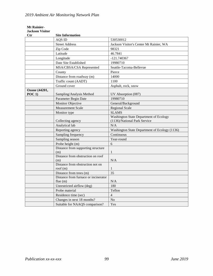
2019 Ambient Air Monitoring Network Plan
Publication xx-xx-xxx 99 June 2019
Mt Rainier-Jackson Visitor Ctr Site Information AQS ID 530530012 Street Address Jackson Visitor's Center Mt Rainier, WA Zip Code 98321 Latitude 46.7841 Longitude -121.740367 Date Site Established 19980710 MSA/CBSA/CSA Represented Seattle-Tacoma-Bellevue County Pierce Distance from roadway (m) 14000 Traffic count (AADT) 1100 Ground cover Asphalt, rock, snow Ozone (44201, POC 1) Sampling/Analysis Method UV Absorption (087) Parameter Begin Date 19980710 Monitor Objective General/Background Measurement Scale Regional Scale Monitor type SLAMS
Collecting agency Washington State Department of Ecology (1136)/National Park Service
Analytical lab N/A Reporting agency Washington State Department of Ecology (1136) Sampling frequency Continuous Sampling season Year-round Probe height (m) 6
Distance from supporting structure (m) 1
Distance from obstruction on roof (m) N/A
Distance from obstruction not on roof (m) 1
Distance from trees (m) 35
Distance from furnace or incinerator flue (m) N/A
Unrestricted airflow (deg) 180 Probe material Teflon Residence time (sec) 4 Changes in next 18 months? No Suitable for NAAQS comparison? Yes
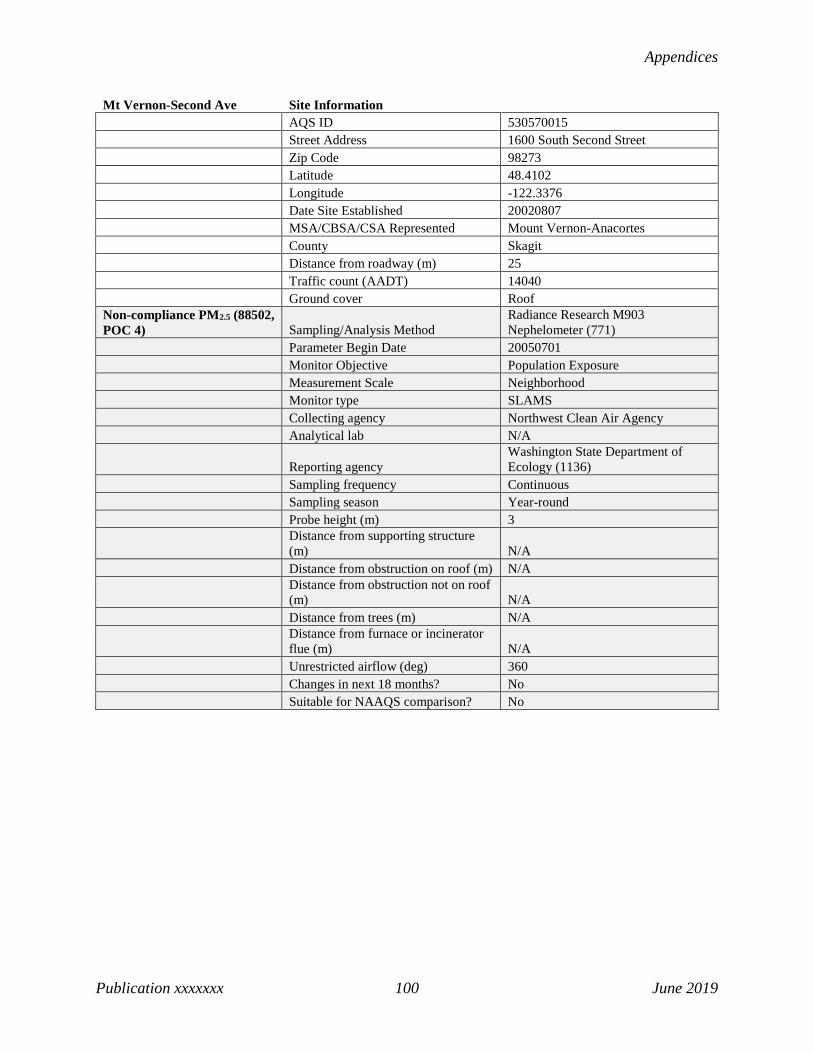
Appendices
Publication xxxxxxx 100 June 2019
Mt Vernon-Second Ave Site Information AQS ID 530570015 Street Address 1600 South Second Street Zip Code 98273 Latitude 48.4102 Longitude -122.3376 Date Site Established 20020807 MSA/CBSA/CSA Represented Mount Vernon-Anacortes County Skagit Distance from roadway (m) 25 Traffic count (AADT) 14040 Ground cover Roof Non-compliance PM2.5 (88502, POC 4) Sampling/Analysis Method
Radiance Research M903 Nephelometer (771)
Parameter Begin Date 20050701 Monitor Objective Population Exposure Measurement Scale Neighborhood Monitor type SLAMS Collecting agency Northwest Clean Air Agency Analytical lab N/A
Reporting agency Washington State Department of Ecology (1136)
Sampling frequency Continuous Sampling season Year-round Probe height (m) 3
Distance from supporting structure (m) N/A
Distance from obstruction on roof (m) N/A
Distance from obstruction not on roof (m) N/A
Distance from trees (m) N/A
Distance from furnace or incinerator flue (m) N/A
Unrestricted airflow (deg) 360 Changes in next 18 months? No Suitable for NAAQS comparison? No

2019 Ambient Air Monitoring Network Plan
Publication xx-xx-xxx 101 June 2019
Neah Bay 2-Makah Tribe Site Information AQS ID 530090015 Street Address 1321 Bay View Avenue, Neah Bay Zip Code 98381 Latitude 48.366058 Longitude -124.610045 Date Site Established 20100216 MSA/CBSA/CSA Represented Port Angeles County Clallam Distance from roadway (m) 100 Traffic count (AADT) 1000 Ground cover Grass, dirt Non-compliance PM2.5 (88502, POC 4) Sampling/Analysis Method
Radiance Research M903 Nephelometer (771)
Parameter Begin Date 20100216 Monitor Objective Population Exposure Measurement Scale Neighborhood Monitor type Tribal Collecting agency Makah Nation Analytical lab N/A
Reporting agency Washington State Department of Ecology (1136)
Sampling frequency Continuous Sampling season Year-round Probe height (m) 9
Distance from supporting structure (m) N/A
Distance from obstruction on roof (m) N/A
Distance from obstruction not on roof (m) N/A
Distance from trees (m) N/A
Distance from furnace or incinerator flue (m) N/A
Unrestricted airflow (deg) 270 Changes in next 18 months? No Suitable for NAAQS comparison? No

Appendices
Publication xxxxxxx 102 June 2019
North Bend-North Bend Way Site Information AQS ID 530330017 Street Address 42404 Se North Bend Way Zip Code 98045 Latitude 47.49022 Longitude -121.77278 Date Site Established 19980601 MSA/CBSA/CSA Represented Seattle-Tacoma-Bellevue County King Distance from roadway (m) 175 Traffic count (AADT) 3149 Ground cover Grass
Meteorological Sampling/Analysis Method RM Young Sonic Anemometer 85004 (062)
Parameter Begin Date 20000111 Monitor Objective Population Exposure Measurement Scale Neighborhood Monitor type SLAMS
Collecting agency Washington State Department of Ecology (1136)
Analytical lab N/A
Reporting agency Washington State Department of Ecology (1136)
Sampling frequency Continuous Sampling season Year-round Probe height (m) 10
Distance from supporting structure (m) N/A
Distance from obstruction on roof (m) N/A
Distance from obstruction not on roof (m) N/A
Distance from trees (m) 20
Distance from furnace or incinerator flue (m) N/A
Unrestricted airflow (deg) 360 Changes in next 18 months? No Suitable for NAAQS comparison? N/A Non-compliance PM2.5 (88502, POC 4) Sampling/Analysis Method
Radiance Research M903 Nephelometer (771)
Parameter Begin Date 20030310 Monitor Objective Population Exposure Measurement Scale Neighborhood Monitor type SLAMS
Collecting agency Washington State Department of Ecology (1136)
Analytical lab N/A
Reporting agency Washington State Department of Ecology (1136)
Sampling frequency Continuous Sampling season Year-round

2019 Ambient Air Monitoring Network Plan
Publication xx-xx-xxx 103 June 2019
North Bend-North Bend Way Site Information Probe height (m) 3
Distance from supporting structure (m) 1
Distance from obstruction on roof (m) N/A
Distance from obstruction not on roof (m) N/A
Distance from trees (m) 20
Distance from furnace or incinerator flue (m) N/A
Unrestricted airflow (deg) 360 Changes in next 18 months? No Suitable for NAAQS comparison? No Ozone (44201, POC 1) Sampling/Analysis Method UV Absorption (087) Parameter Begin Date 19980601 Monitor Objective Population Exposure Measurement Scale Neighborhood Monitor type SLAMS
Collecting agency Washington State Department of Ecology (1136)
Analytical lab N/A
Reporting agency Washington State Department of Ecology (1136)
Sampling frequency Continuous Sampling season May-Oct Probe height (m) 3
Distance from supporting structure (m) 1
Distance from obstruction on roof (m) N/A
Distance from obstruction not on roof (m) N/A
Distance from trees (m) 20
Distance from furnace or incinerator flue (m) N/A
Unrestricted airflow (deg) 360 Probe material Teflon Residence time (sec) 2.8 Changes in next 18 months? No Suitable for NAAQS comparison? Yes
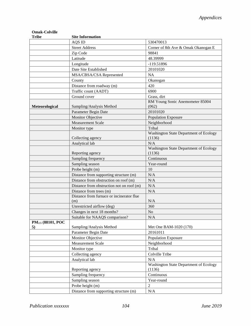
Appendices
Publication xxxxxxx 104 June 2019
Omak-Colville Tribe Site Information AQS ID 530470013 Street Address Corner of 8th Ave & Omak Okanogan E Zip Code 98841 Latitude 48.39999 Longitude -119.51896 Date Site Established 20101020 MSA/CBSA/CSA Represented NA County Okanogan Distance from roadway (m) 420 Traffic count (AADT) 6900 Ground cover Grass, dirt
Meteorological Sampling/Analysis Method RM Young Sonic Anemometer 85004 (062)
Parameter Begin Date 20101020 Monitor Objective Population Exposure Measurement Scale Neighborhood Monitor type Tribal
Collecting agency Washington State Department of Ecology (1136)
Analytical lab N/A
Reporting agency Washington State Department of Ecology (1136)
Sampling frequency Continuous Sampling season Year-round Probe height (m) 10 Distance from supporting structure (m) N/A Distance from obstruction on roof (m) N/A Distance from obstruction not on roof (m) N/A Distance from trees (m) N/A
Distance from furnace or incinerator flue (m) N/A
Unrestricted airflow (deg) 360 Changes in next 18 months? No Suitable for NAAQS comparison? N/A PM2.5 (88101, POC 5) Sampling/Analysis Method Met One BAM-1020 (170) Parameter Begin Date 20161011 Monitor Objective Population Exposure Measurement Scale Neighborhood Monitor type Tribal Collecting agency Colville Tribe Analytical lab N/A
Reporting agency Washington State Department of Ecology (1136)
Sampling frequency Continuous Sampling season Year-round Probe height (m) 2 Distance from supporting structure (m) N/A

2019 Ambient Air Monitoring Network Plan
Publication xx-xx-xxx 105 June 2019
Omak-Colville Tribe Site Information Distance from obstruction on roof (m) N/A Distance from obstruction not on roof (m) N/A Distance from trees (m) 100
Distance from furnace or incinerator flue (m) N/A
Unrestricted airflow (deg) 360 Changes in next 18 months? No Suitable for NAAQS comparison? Yes

Appendices
Publication xxxxxxx 106 June 2019
Pomeroy (Temporary) Site Information AQS ID 530230001 Street Address 572 Pataha St Zip Code 99347 Latitude 46.474438 Longitude -117.614764 Date Site Established 20170504 MSA/CBSA/CSA Represented NA County Garfield Distance from roadway (m) 225 Traffic count (AADT) 1900 Ground cover Asphalt, grass Non-compliance PM2.5 (88502, POC 4) Sampling/Analysis Method
Radiance Research M903 Nephelometer (771)
Parameter Begin Date 20170504 Monitor Objective Population Exposure Measurement Scale Neighborhood Monitor type SPMS
Collecting agency Washington State Department of Ecology (1136)
Analytical lab N/A
Reporting agency Washington State Department of Ecology (1136)
Sampling frequency Continuous Sampling season Year-round Probe height (m) 4
Distance from supporting structure (m) N/A
Distance from obstruction on roof (m) N/A
Distance from obstruction not on roof (m) N/A
Distance from trees (m) N/A
Distance from furnace or incinerator flue (m) N/A
Unrestricted airflow (deg) 360
Changes in next 18 months? Temporary site may be relocated in 2019 or 2020.
Suitable for NAAQS comparison? No
Statement of Purpose: This temporary nephelometer monitoring SPMS monitoring site was established in 2017 to evaluate the need for ongoing monitoring in a previously unmonitored community.

2019 Ambient Air Monitoring Network Plan
Publication xx-xx-xxx 107 June 2019
Port Angeles-5th St Site Information AQS ID 530090017 Street Address 102 E 5th St Zip Code 98362 Latitude 48.115 Longitude -123.436434 Date Site Established 20150406 MSA/CBSA/CSA Represented Port Angeles County Clallam Distance from roadway (m) 110 Traffic count (AADT) 8300 Ground cover Asphalt, grass Non-compliance PM2.5 (88502, POC 4) Sampling/Analysis Method
Radiance Research M903 Nephelometer (771)
Parameter Begin Date 20150406 Monitor Objective Population Exposure Measurement Scale Neighborhood Monitor type SLAMS
Collecting agency Olympic Region Clean Air Agency (0815)
Analytical lab N/A
Reporting agency Washington State Department of Ecology (1136)
Sampling frequency Continuous Sampling season Year-round Probe height (m) 15
Distance from supporting structure (m) N/A
Distance from obstruction on roof (m) N/A
Distance from obstruction not on roof (m) N/A
Distance from trees (m) N/A
Distance from furnace or incinerator flue (m) N/A
Unrestricted airflow (deg) 360 Changes in next 18 months? No Suitable for NAAQS comparison? No

Appendices
Publication xxxxxxx 108 June 2019
Port Townsend-San Juan Site Information AQS ID 530310003
Street Address 3939 San Juan Ave (Blue Heron Middle School)
Zip Code 98368 Latitude 48.12919 Longitude -122.77897 Date Site Established 20000113 MSA/CBSA/CSA Represented NA County Jefferson Distance from roadway (m) 85 Traffic count (AADT) 3450 Ground cover Grass Non-compliance PM2.5 (88502, POC 4) Sampling/Analysis Method
Radiance Research M903 Nephelometer (771)
Parameter Begin Date 20021001 Monitor Objective Population Exposure Measurement Scale Neighborhood Monitor type SLAMS
Collecting agency Olympic Region Clean Air Agency (0815)
Analytical lab N/A
Reporting agency Washington State Department of Ecology (1136)
Sampling frequency Continuous Sampling season Year-round Probe height (m) 12
Distance from supporting structure (m) N/A
Distance from obstruction on roof (m) N/A
Distance from obstruction not on roof (m) N/A
Distance from trees (m) N/A
Distance from furnace or incinerator flue (m) N/A
Unrestricted airflow (deg) 360 Changes in next 18 months? No Suitable for NAAQS comparison? No

2019 Ambient Air Monitoring Network Plan
Publication xx-xx-xxx 109 June 2019
Pullman-Dexter Ave Site Information AQS ID 530750003
Street Address 240 SE Dexter (Pullman Administration Building)
Zip Code 99163 Latitude 46.72447 Longitude -117.18014 Date Site Established 20000119 MSA/CBSA/CSA Represented Pullman County Whitman Distance from roadway (m) 410 Traffic count (AADT) 15000 Ground cover Asphalt, grass Non-compliance PM2.5 (88502, POC 4) Sampling/Analysis Method
Radiance Research M903 Nephelometer (771)
Parameter Begin Date 20150101 Monitor Objective Population Exposure Measurement Scale Neighborhood Monitor type SLAMS
Collecting agency Washington State Department of Ecology (1136)
Analytical lab N/A
Reporting agency Washington State Department of Ecology (1136)
Sampling frequency Continuous Sampling season Year-round Probe height (m) 5
Distance from supporting structure (m) N/A
Distance from obstruction on roof (m) 20
Distance from obstruction not on roof (m) N/A
Distance from trees (m) N/A
Distance from furnace or incinerator flue (m) N/A
Unrestricted airflow (deg) 360 Changes in next 18 months? No Suitable for NAAQS comparison? No

Appendices
Publication xxxxxxx 110 June 2019
Puyallup-128th St Site Information AQS ID 530531018 Street Address 9616 128th St E Zip Code 98373 Latitude 47.14 Longitude -122.3003 Date Site Established 19911207 MSA/CBSA/CSA Represented Seattle-Tacoma-Bellevue County Pierce Distance from roadway (m) 560 Traffic count (AADT) 44000 Ground cover Gravel, grass Non-compliance PM2.5 (88502, POC 4) Sampling/Analysis Method Ecotech M9003 Aurora (812) Parameter Begin Date 20051116 Monitor Objective Population Exposure Measurement Scale Neighborhood Monitor type SLAMS Collecting agency Puget Sound Clean Air Agency Analytical lab N/A
Reporting agency Washington State Department of Ecology (1136)
Sampling frequency Continuous Sampling season Year-round Probe height (m) 3
Distance from supporting structure (m) N/A
Distance from obstruction on roof (m) N/A
Distance from obstruction not on roof (m) N/A
Distance from trees (m) 80
Distance from furnace or incinerator flue (m) 100
Unrestricted airflow (deg) 360 Changes in next 18 months? No Suitable for NAAQS comparison? No

2019 Ambient Air Monitoring Network Plan
Publication xx-xx-xxx 111 June 2019
Quincy-3rd Ave NE Site Information AQS ID 530251003 Street Address 330 3rd Ave NE Zip Code 98848 Latitude 47.241153 Longitude -119.847824 Date Site Established 20170601 MSA/CBSA/CSA Represented Moses Lake-Othello, WA County Grant Distance from roadway (m) 800 Traffic count (AADT) 13000 Ground cover Grass
Meteorological Sampling/Analysis Method RM Young Sonic Anemometer 85004 (062)
Parameter Begin Date 20170601 Monitor Objective Population Exposure Measurement Scale Neighborhood Monitor type SPMS
Collecting agency Washington State Department of Ecology (1136)
Analytical lab N/A
Reporting agency Washington State Department of Ecology (1136)
Sampling frequency Continuous Sampling season Year-round Probe height (m) 10
Distance from supporting structure (m) N/A
Distance from obstruction on roof (m) N/A
Distance from obstruction not on roof (m) N/A
Distance from trees (m) N/A
Distance from furnace or incinerator flue (m) N/A
Unrestricted airflow (deg) 360 Changes in next 18 months? No Suitable for NAAQS comparison? N/A Non-compliance PM2.5 (88502, POC 4) Sampling/Analysis Method
Radiance Research M903 Nephelometer (771)
Parameter Begin Date 20170601 Monitor Objective Population Exposure Measurement Scale Neighborhood Monitor type SPMS
Collecting agency Washington State Department of Ecology (1136)
Analytical lab N/A
Reporting agency Washington State Department of Ecology (1136)
Sampling frequency Continuous Sampling season Year-round

Appendices
Publication xxxxxxx 112 June 2019
Quincy-3rd Ave NE Site Information Probe height (m) 4
Distance from supporting structure (m) N/A
Distance from obstruction on roof (m) N/A
Distance from obstruction not on roof (m) N/A
Distance from trees (m) N/A
Distance from furnace or incinerator flue (m) N/A
Unrestricted airflow (deg) 360 Changes in next 18 months? No Suitable for NAAQS comparison? No
Statement of Purpose: The Quincy SPMS was established for a 1-year study to evaluate markers of diesel exhaust pollution. The small town of Quincy has a number of diesel exhaust sources, including two state highways, an active rail line, and a number of data centers with diesel-powered generators. Due to ongoing interest in the meteorological data, the meteorological and nephelometer data collection was extended until at least December 2020.

2019 Ambient Air Monitoring Network Plan
Publication xx-xx-xxx 113 June 2019
Ritzville-Alder Site Information AQS ID 530010003 Street Address 109 W Alder, Ritzville, WA Zip Code 99169 Latitude 47.12 Longitude -118.3819 Date Site Established 20001021 MSA/CBSA/CSA Represented Moses Lake-Othello, WA County Adams Distance from roadway (m) 1730 Traffic count (AADT) 14000 Ground cover Asphalt, gravel Non-compliance PM2.5 (88502, POC 4) Sampling/Analysis Method
Radiance Research M903 Nephelometer (771)
Parameter Begin Date 20021001 Monitor Objective Population Exposure Measurement Scale Neighborhood Monitor type SLAMS
Collecting agency Washington State Department of Ecology (1136)
Analytical lab N/A
Reporting agency Washington State Department of Ecology (1136)
Sampling frequency Continuous Sampling season Year-round Probe height (m) 8
Distance from supporting structure (m) N/A
Distance from obstruction on roof (m) N/A
Distance from obstruction not on roof (m) N/A
Distance from trees (m) N/A
Distance from furnace or incinerator flue (m) N/A
Unrestricted airflow (deg) 360 Changes in next 18 months? No Suitable for NAAQS comparison? No

Appendices
Publication xxxxxxx 114 June 2019
Rosalia-Josephine Site Information AQS ID 530750006
Street Address 906 South Josephine Avenue (Rosalia Elementary School)
Zip Code 99170 Latitude 47.23136 Longitude -117.36856 Date Site Established 20020619 MSA/CBSA/CSA Represented Pullman County Whitman Distance from roadway (m) 750 Traffic count (AADT) 5000 Ground cover Asphalt Non-compliance PM2.5 (88502, POC 4) Sampling/Analysis Method
Radiance Research M903 Nephelometer (771)
Parameter Begin Date 20021001 Monitor Objective Population Exposure Measurement Scale Neighborhood Monitor type SLAMS
Collecting agency Washington State Department of Ecology (1136)
Analytical lab N/A
Reporting agency Washington State Department of Ecology (1136)
Sampling frequency Continuous Sampling season Year-round Probe height (m) 2
Distance from supporting structure (m) N/A
Distance from obstruction on roof (m) N/A
Distance from obstruction not on roof (m) N/A
Distance from trees (m) N/A
Distance from furnace or incinerator flue (m) 15
Unrestricted airflow (deg) 360 Changes in next 18 months? No Suitable for NAAQS comparison? No

2019 Ambient Air Monitoring Network Plan
Publication xx-xx-xxx 115 June 2019
Seattle-10th & Weller Site Information AQS ID 530330030 Street Address 10th & Weller Zip Code 98104 Latitude 47.597222 Longitude -122.319722 Date Site Established 20140401 MSA/CBSA/CSA Represented Seattle-Tacoma-Bellevue County King Distance from roadway (m) 13 Traffic count (AADT) 150000 Ground cover Concrete, grass Carbon Monoxide (42101, POC 2) Sampling/Analysis Method TAPI 300 EU (593) Parameter Begin Date 20140401 Monitor Objective Source Oriented Measurement Scale Microscale Monitor type SLAMS, Near-road
Collecting agency Washington State Department of Ecology (1136)
Analytical lab N/A
Reporting agency Washington State Department of Ecology (1136)
Sampling frequency Continuous Sampling season Year-round Probe height (m) 3 Distance from supporting structure (m) 3 Distance from obstruction on roof (m) N/A
Distance from obstruction not on roof (m) N/A
Distance from trees (m) N/A
Distance from furnace or incinerator flue (m) N/A
Unrestricted airflow (deg) 360 Probe material Teflon Residence time (sec) 1.6 Changes in next 18 months? No Suitable for NAAQS comparison? Yes
Meteorological Sampling/Analysis Method RM Young Sonic Anemometer 85004 (062)
Parameter Begin Date 20140416 Monitor Objective Source Oriented Measurement Scale Microscale Monitor type SLAMS, Near-road
Collecting agency Washington State Department of Ecology (1136)
Analytical lab N/A
Reporting agency Washington State Department of Ecology (1136)
Sampling frequency Continuous
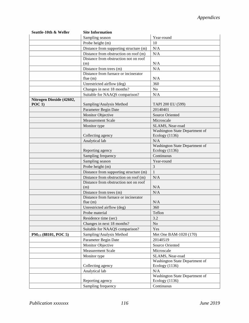
Appendices
Publication xxxxxxx 116 June 2019
Seattle-10th & Weller Site Information Sampling season Year-round Probe height (m) 10 Distance from supporting structure (m) N/A Distance from obstruction on roof (m) N/A
Distance from obstruction not on roof (m) N/A
Distance from trees (m) N/A
Distance from furnace or incinerator flue (m) N/A
Unrestricted airflow (deg) 360 Changes in next 18 months? No Suitable for NAAQS comparison? N/A Nitrogen Dioxide (42602, POC 1) Sampling/Analysis Method TAPI 200 EU (599) Parameter Begin Date 20140401 Monitor Objective Source Oriented Measurement Scale Microscale Monitor type SLAMS, Near-road
Collecting agency Washington State Department of Ecology (1136)
Analytical lab N/A
Reporting agency Washington State Department of Ecology (1136)
Sampling frequency Continuous Sampling season Year-round Probe height (m) 3 Distance from supporting structure (m) 1 Distance from obstruction on roof (m) N/A
Distance from obstruction not on roof (m) N/A
Distance from trees (m) N/A
Distance from furnace or incinerator flue (m) N/A
Unrestricted airflow (deg) 360 Probe material Teflon Residence time (sec) 3.2 Changes in next 18 months? No Suitable for NAAQS comparison? Yes PM2.5 (88101, POC 5) Sampling/Analysis Method Met One BAM-1020 (170) Parameter Begin Date 20140519 Monitor Objective Source Oriented Measurement Scale Microscale Monitor type SLAMS, Near-road
Collecting agency Washington State Department of Ecology (1136)
Analytical lab N/A
Reporting agency Washington State Department of Ecology (1136)
Sampling frequency Continuous

2019 Ambient Air Monitoring Network Plan
Publication xx-xx-xxx 117 June 2019
Seattle-10th & Weller Site Information Sampling season Year-round Probe height (m) 3 Distance from supporting structure (m) 1 Distance from obstruction on roof (m) N/A
Distance from obstruction not on roof (m) N/A
Distance from trees (m) N/A
Distance from furnace or incinerator flue (m) N/A
Unrestricted airflow (deg) 360 Changes in next 18 months? No Suitable for NAAQS comparison? Yes

Appendices
Publication xxxxxxx 118 June 2019
Seattle-Beacon Hill Site Information AQS ID 530330080 Street Address 4103 Beacon Hill S Zip Code 98108 Latitude 47.568236 Longitude -122.308628 Date Site Established 19790604
MSA/CBSA/CSA Represented Seattle-Tacoma-Bellevue
County King
Distance from roadway (m) 110
Traffic count (AADT) 12000 Ground cover Grass, gravel Trace NOy (42600/42601/42612, POC 2)
Sampling/Analysis Method Thermo 42C (674)
Parameter Begin Date 20100801 Monitor Objective General/Background Measurement Scale Urban Scale Monitor type SLAMS, NCore
Collecting agency Washington State Department of Ecology (1136)
Analytical lab N/A
Reporting agency Washington State Department of Ecology (1136)
Sampling frequency Continuous Sampling season Year-round Probe height (m) 3
Distance from supporting structure (m) 1
Distance from obstruction on roof (m) N/A
Distance from obstruction not on roof (m) 10
Distance from trees (m) 20
Distance from furnace or incinerator flue (m) N/A
Unrestricted airflow (deg) 360 Probe material Teflon Residence time (sec) 5.5
Changes in next 18 months? No
Suitable for NAAQS comparison? No
Carbon Monoxide (42101, POC 2)
Sampling/Analysis Method TAPI 300 EU (593)
Parameter Begin Date 20070207 Monitor Objective General/Background Measurement Scale Urban Scale Monitor type SLAMS, NCore

2019 Ambient Air Monitoring Network Plan
Publication xx-xx-xxx 119 June 2019
Seattle-Beacon Hill Site Information
Collecting agency Washington State Department of Ecology (1136)
Analytical lab N/A
Reporting agency Washington State Department of Ecology (1136)
Sampling frequency Continuous Sampling season Year-round Probe height (m) 4
Distance from supporting structure (m) 1
Distance from obstruction on roof (m) N/A
Distance from obstruction not on roof (m) 20
Distance from trees (m) 20
Distance from furnace or incinerator flue (m) N/A
Unrestricted airflow (deg) 360 Probe material Teflon Residence time (sec) 15
Changes in next 18 months? No
Suitable for NAAQS comparison? Yes
Meteorological Sampling/Analysis Method
RM Young Sonic Anemometer 85004 (062)
Parameter Begin Date 20110101 Monitor Objective Population Exposure Measurement Scale Urban Scale Monitor type SLAMS, NCore
Collecting agency Washington State Department of Ecology (1136)
Analytical lab N/A
Reporting agency Washington State Department of Ecology (1136)
Sampling frequency Continuous Sampling season Year-round Probe height (m) 10
Distance from supporting structure (m) N/A
Distance from obstruction on roof (m) N/A
Distance from obstruction not on roof (m) N/A
Distance from trees (m) N/A
Distance from furnace or incinerator flue (m) N/A
Unrestricted airflow (deg) 360
Changes in next 18 months? No

Appendices
Publication xxxxxxx 120 June 2019
Seattle-Beacon Hill Site Information
Suitable for NAAQS comparison? N/A
Nitrogen Dioxide (42602)
Sampling/Analysis Method TAPI 200 EU (599)
Parameter Begin Date 20120801 Monitor Objective Population Exposure Measurement Scale Urban Scale Monitor type SLAMS, NCore
Collecting agency Washington State Department of Ecology (1136)
Analytical lab N/A
Reporting agency Washington State Department of Ecology (1136)
Sampling frequency Continuous Sampling season Year-round Probe height (m) 4
Distance from supporting structure (m) 1
Distance from obstruction on roof (m) N/A
Distance from obstruction not on roof (m) 20
Distance from trees (m) 20
Distance from furnace or incinerator flue (m) N/A
Unrestricted airflow (deg) 360 Probe material Teflon Residence time (sec) 3.7
Changes in next 18 months? No
Suitable for NAAQS comparison? Yes
Ozone (44201, POC 1)
Sampling/Analysis Method UV Absorption (087)
Parameter Begin Date 20080208 Monitor Objective Population Exposure Measurement Scale Urban Scale Monitor type SLAMS, NCore
Collecting agency Washington State Department of Ecology (1136)
Analytical lab N/A
Reporting agency Washington State Department of Ecology (1136)
Sampling frequency Continuous Sampling season Year-round Probe height (m) 4
Distance from supporting structure (m) 1
Distance from obstruction on roof (m) N/A

2019 Ambient Air Monitoring Network Plan
Publication xx-xx-xxx 121 June 2019
Seattle-Beacon Hill Site Information
Distance from obstruction not on roof (m) 20
Distance from trees (m) 20
Distance from furnace or incinerator flue (m) N/A
Unrestricted airflow (deg) 360 Probe material Teflon Residence time (sec) 15
Changes in next 18 months? No
Suitable for NAAQS comparison? Yes
PM2.5 (88101) Primary (POC 3) Collocated (POC 1)
Sampling/Analysis Method 8500 TEOM (181) R & P 2025 (145)
Parameter Begin Date 19981101 19981101 Monitor Objective General/Background General/Background Measurement Scale Urban Scale Urban Scale Monitor type SLAMS, NCore SLAMS, NCore
Collecting agency Washington State Department of Ecology (1136)
Washington State Department of Ecology (1136)
Analytical lab N/A
Washington State Department of Ecology (1136)
Reporting agency Washington State Department of Ecology (1136)
Washington State Department of Ecology (1136)
Sampling frequency Continuous 1/3 Sampling season Year-round Year-round Probe height (m) 4 2
Distance from supporting structure (m) N/A 2
Distance from obstruction on roof (m) N/A N/A
Distance from obstruction not on roof (m) N/A N/A
Distance from trees (m) N/A N/A
Distance from furnace or incinerator flue (m) N/A N/A
Unrestricted airflow (deg) 360 360
Changes in next 18 months? No No
Suitable for NAAQS comparison? Yes Yes
Sulfur Dioxide (42401, POC 2)
Sampling/Analysis Method TAPI 100 EU (600)
Parameter Begin Date 20000214 Monitor Objective General/Background Measurement Scale Urban Scale Monitor type SLAMS, NCore

Appendices
Publication xxxxxxx 122 June 2019
Seattle-Beacon Hill Site Information
Collecting agency Washington State Department of Ecology (1136)
Analytical lab N/A
Reporting agency Washington State Department of Ecology (1136)
Sampling frequency Continuous Sampling season Year-round Probe height (m) 4
Distance from supporting structure (m) 1
Distance from obstruction on roof (m) N/A
Distance from obstruction not on roof (m) 20
Distance from trees (m) 20
Distance from furnace or incinerator flue (m) N/A
Unrestricted airflow (deg) 360 Probe material Teflon Residence time (sec) 15
Changes in next 18 months? No
Suitable for NAAQS comparison? Yes

2019 Ambient Air Monitoring Network Plan
Publication xx-xx-xxx 123 June 2019
Seattle-Duwamish Site Information AQS ID 530330057 Street Address 4700 East Marginal Way South Zip Code 98134 Latitude 47.55975 Longitude -122.338265 Date Site Established 19710802 MSA/CBSA/CSA Represented Seattle-Tacoma-Bellevue County King Distance from roadway (m) 80 Traffic count (AADT) 52400 Ground cover Asphalt PM2.5 (88101, POC 5) Sampling/Analysis Method Met One BAM-1020 (170) Parameter Begin Date 20101227 Monitor Objective Population Exposure Measurement Scale Neighborhood Monitor type SLAMS Collecting agency Puget Sound Clean Air Agency Analytical lab N/A
Reporting agency Washington State Department of Ecology (1136)
Sampling frequency Continuous Sampling season Year-round Probe height (m) 3 Distance from supporting structure (m) N/A Distance from obstruction on roof (m) N/A Distance from obstruction not on roof (m) N/A Distance from trees (m) N/A
Distance from furnace or incinerator flue (m) N/A
Unrestricted airflow (deg) 360 Changes in next 18 months? No Suitable for NAAQS comparison? Yes

Appendices
Publication xxxxxxx 124 June 2019
Seattle-South Park Site Information AQS ID 530331011 Street Address 8201 10th Avenue South Zip Code 98108 Latitude 47.53091 Longitude -122.3208 Date Site Established 20030106 MSA/CBSA/CSA Represented Seattle-Tacoma-Bellevue County King Distance from roadway (m) 1.5 Traffic count (AADT) N/A Ground cover Asphalt Non-compliance PM2.5 (88502, POC 4) Sampling/Analysis Method Ecotech M9003 Aurora (812) Parameter Begin Date 20030106 Monitor Objective Population Exposure Measurement Scale Microscale Monitor type SLAMS Collecting agency Puget Sound Clean Air Agency Analytical lab N/A
Reporting agency Washington State Department of Ecology (1136)
Sampling frequency Continuous Sampling season Year-round Probe height (m) 3
Distance from supporting structure (m) 1
Distance from obstruction on roof (m) N/A
Distance from obstruction not on roof (m) N/A
Distance from trees (m) N/A
Distance from furnace or incinerator flue (m) N/A
Unrestricted airflow (deg) 180 Changes in next 18 months? No Suitable for NAAQS comparison? No

2019 Ambient Air Monitoring Network Plan
Publication xx-xx-xxx 125 June 2019
Shelton-W Franklin Site Information AQS ID 530450007 Street Address 122 W Franklin Zip Code 98584 Latitude 47.21355 Longitude -123.10081 Date Site Established 20110420 MSA/CBSA/CSA Represented Shelton County Mason Distance from roadway (m) 100 Traffic count (AADT) 3800 Ground cover Roof Non-compliance PM2.5 (88502, POC 4) Sampling/Analysis Method
Radiance Research M903 Nephelometer (771)
Parameter Begin Date 20110420 Monitor Objective Population Exposure Measurement Scale Neighborhood Monitor type SLAMS
Collecting agency Olympic Region Clean Air Agency (0815)
Analytical lab N/A
Reporting agency Washington State Department of Ecology (1136)
Sampling frequency Continuous Sampling season Year-round Probe height (m) 15
Distance from supporting structure (m) N/A
Distance from obstruction on roof (m) N/A
Distance from obstruction not on roof (m) N/A
Distance from trees (m) 10
Distance from furnace or incinerator flue (m) N/A
Unrestricted airflow (deg) 320 Changes in next 18 months? No Suitable for NAAQS comparison? No

Appendices
Publication xxxxxxx 126 June 2019
Spokane-Augusta Ave Site Information AQS ID 530630021 Street Address 3104 E Augusta Ave Zip Code 99207 Latitude 47.672482 Longitude -117.364852 Date Site Established 20090329 MSA/CBSA/CSA Represented Spokane-Spokane Valley County Spokane Distance from roadway (m) 70 Traffic count (AADT) 12700 Ground cover Roof Meteorological Sampling/Analysis Method RM Young Sonic Anemometer 85004 (062) Parameter Begin Date 20090713 Monitor Objective Population Exposure Measurement Scale Neighborhood Monitor type SLAMS
Collecting agency Washington State Department of Ecology (1136)
Analytical lab N/A
Reporting agency Washington State Department of Ecology (1136)
Sampling frequency Continuous Sampling season Year-round Probe height (m) 10 Distance from supporting structure (m) N/A Distance from obstruction on roof (m) N/A
Distance from obstruction not on roof (m) N/A
Distance from trees (m) N/A
Distance from furnace or incinerator flue (m) N/A
Unrestricted airflow (deg) 360
Changes in next 18 months? Site will be relocated by 2021 due to highway construction.
Suitable for NAAQS comparison? N/A PM10 (81102, POC 3) Sampling/Analysis Method TEOM-Gravimetric (079) Parameter Begin Date 20120620 Monitor Objective Population Exposure Measurement Scale Neighborhood Monitor type SLAMS Collecting agency Spokane Regional Clean Air Agency Analytical lab N/A
Reporting agency Washington State Department of Ecology (1136)
Sampling frequency Continuous Sampling season Year-round Probe height (m) 6

2019 Ambient Air Monitoring Network Plan
Publication xx-xx-xxx 127 June 2019
Spokane-Augusta Ave Site Information Distance from supporting structure (m) 0.5 Distance from obstruction on roof (m) N/A
Distance from obstruction not on roof (m) N/A
Distance from trees (m) N/A
Distance from furnace or incinerator flue (m) N/A
Unrestricted airflow (deg) 360
Changes in next 18 months? Site will be relocated by 2021 due to highway construction.
Suitable for NAAQS comparison? Yes PM2.5 (88101, POC 5) Sampling/Analysis Method Met One BAM-1020 (170) Parameter Begin Date 20090329 Monitor Objective Population Exposure Measurement Scale Neighborhood Monitor type SLAMS Collecting agency Spokane Regional Clean Air Agency Analytical lab N/A
Reporting agency Washington State Department of Ecology (1136)
Sampling frequency Continuous Sampling season Year-round Probe height (m) 2 Distance from supporting structure (m) 1 Distance from obstruction on roof (m) N/A
Distance from obstruction not on roof (m) N/A
Distance from trees (m) N/A
Distance from furnace or incinerator flue (m) N/A
Unrestricted airflow (deg) 360
Changes in next 18 months? Site will be relocated by 2021 due to highway construction.
Suitable for NAAQS comparison? Yes

Appendices
Publication xxxxxxx 128 June 2019
Spokane-Greenbluff Site Information AQS ID 530630046 Street Address E 9814 Greenbluff Rd, Greenbluff Zip Code 99005 Latitude 47.82728 Longitude -117.27422 Date Site Established 19900401 MSA/CBSA/CSA Represented Spokane-Spokane Valley County Spokane Distance from roadway (m) 41 Traffic count (AADT) 334 Ground cover Grass, gravel Ozone (44201, POC 1) Sampling/Analysis Method UV Absorption (087) Parameter Begin Date 19900401 Monitor Objective Population Exposure Measurement Scale Urban Scale Monitor type SLAMS
Collecting agency Washington State Department of Ecology (1136)
Analytical lab N/A
Reporting agency Washington State Department of Ecology (1136)
Sampling frequency Continuous Sampling season Year-round Probe height (m) 3 Distance from supporting structure (m) 1 Distance from obstruction on roof (m) N/A Distance from obstruction not on roof (m) N/A Distance from trees (m) N/A
Distance from furnace or incinerator flue (m) N/A
Unrestricted airflow (deg) 360 Probe material Teflon Residence time (sec) 5.7 Changes in next 18 months? No Suitable for NAAQS comparison? Yes

2019 Ambient Air Monitoring Network Plan
Publication xx-xx-xxx 129 June 2019
Spokane-Monroe St Site Information AQS ID 530630047 Street Address N 4601 Monroe St Zip Code 99205 Latitude 47.69978 Longitude -117.42635 Date Site Established 19890101 MSA/CBSA/CSA Represented Spokane-Spokane Valley County Spokane Distance from roadway (m) 35 Traffic count (AADT) 15800 Ground cover Roof Non-compliance PM2.5 (88502, POC 4) Sampling/Analysis Method
Radiance Research M903 Nephelometer (771)
Parameter Begin Date 20040517 Monitor Objective Population Exposure Measurement Scale Neighborhood Monitor type SLAMS
Collecting agency Washington State Department of Ecology (1136)
Analytical lab N/A
Reporting agency Washington State Department of Ecology (1136)
Sampling frequency Continuous Sampling season Year-round Probe height (m) 12
Distance from supporting structure (m) N/A
Distance from obstruction on roof (m) N/A
Distance from obstruction not on roof (m) N/A
Distance from trees (m) 40
Distance from furnace or incinerator flue (m) N/A
Unrestricted airflow (deg) 360 Changes in next 18 months? No Suitable for NAAQS comparison? No

Appendices
Publication xxxxxxx 130 June 2019
Sunnyside-S 16th Site Information AQS ID 530770005 Street Address 810 16th St (Harrison Middle School) Zip Code 98944 Latitude 46.31932 Longitude -119.999677 Date Site Established 19980821 MSA/CBSA/CSA Represented Yakima County Yakima Distance from roadway (m) 1450 Traffic count (AADT) 3900 Ground cover Roof Non-compliance PM2.5 (88502, POC 4) Sampling/Analysis Method
Radiance Research M903 Nephelometer (771)
Parameter Begin Date 20150915 Monitor Objective Population Exposure Measurement Scale Neighborhood Monitor type SLAMS Collecting agency Yakima Region Clean Air Agency Analytical lab N/A
Reporting agency Washington State Department of Ecology (1136)
Sampling frequency Continuous Sampling season Year-round Probe height (m) 2
Distance from supporting structure (m) 1
Distance from obstruction on roof (m) N/A
Distance from obstruction not on roof (m) N/A
Distance from trees (m) N/A
Distance from furnace or incinerator flue (m) N/A
Unrestricted airflow (deg) 360 Changes in next 18 months? No Suitable for NAAQS comparison? No

2019 Ambient Air Monitoring Network Plan
Publication xx-xx-xxx 131 June 2019
Tacoma-Alexander Ave Site Information AQS ID 530530031 Street Address 2301 Alexander Ave, Tacoma, WA Zip Code 98421 Latitude 47.2656 Longitude -122.3858 Date Site Established 19870101 MSA/CBSA/CSA Represented Seattle-Tacoma-Bellevue County Pierce Distance from roadway (m) 65 Traffic count (AADT) 638 Ground cover Grass, gravel Non-compliance PM2.5 (88502, POC 4) Sampling/Analysis Method Ecotech M9003 Aurora (812) Parameter Begin Date 20030101 Monitor Objective Population Exposure Measurement Scale Neighborhood Monitor type SLAMS Collecting agency Puget Sound Clean Air Agency Analytical lab N/A
Reporting agency Washington State Department of Ecology (1136)
Sampling frequency Continuous Sampling season Year-round Probe height (m) 3
Distance from supporting structure (m) N/A
Distance from obstruction on roof (m) N/A
Distance from obstruction not on roof (m) N/A
Distance from trees (m) N/A
Distance from furnace or incinerator flue (m) N/A
Unrestricted airflow (deg) 360 Changes in next 18 months? No Suitable for NAAQS comparison? No
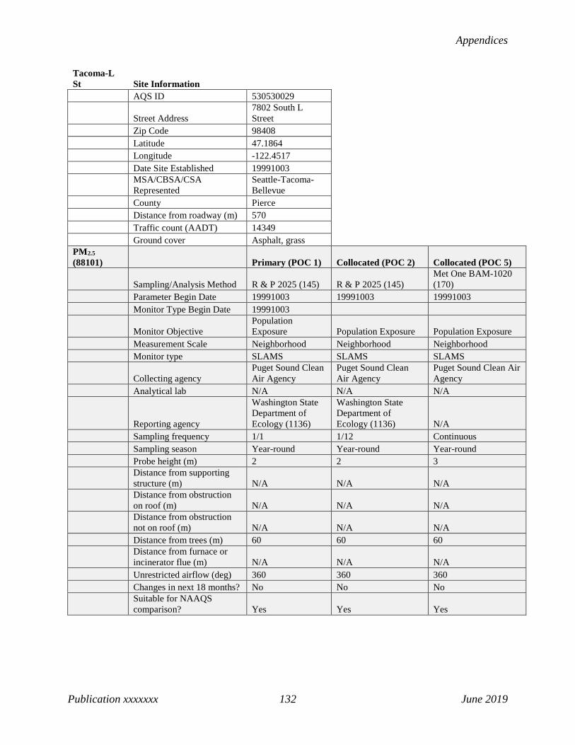
Appendices
Publication xxxxxxx 132 June 2019
Tacoma-L St Site Information AQS ID 530530029
Street Address 7802 South L Street
Zip Code 98408 Latitude 47.1864 Longitude -122.4517 Date Site Established 19991003
MSA/CBSA/CSA Represented
Seattle-Tacoma-Bellevue
County Pierce Distance from roadway (m) 570 Traffic count (AADT) 14349 Ground cover Asphalt, grass PM2.5 (88101) Primary (POC 1) Collocated (POC 2) Collocated (POC 5)
Sampling/Analysis Method R & P 2025 (145) R & P 2025 (145) Met One BAM-1020 (170)
Parameter Begin Date 19991003 19991003 19991003 Monitor Type Begin Date 19991003
Monitor Objective Population Exposure Population Exposure Population Exposure
Measurement Scale Neighborhood Neighborhood Neighborhood Monitor type SLAMS SLAMS SLAMS
Collecting agency Puget Sound Clean Air Agency
Puget Sound Clean Air Agency
Puget Sound Clean Air Agency
Analytical lab N/A N/A N/A
Reporting agency
Washington State Department of Ecology (1136)
Washington State Department of Ecology (1136) N/A
Sampling frequency 1/1 1/12 Continuous Sampling season Year-round Year-round Year-round Probe height (m) 2 2 3
Distance from supporting structure (m) N/A N/A N/A
Distance from obstruction on roof (m) N/A N/A N/A
Distance from obstruction not on roof (m) N/A N/A N/A
Distance from trees (m) 60 60 60
Distance from furnace or incinerator flue (m) N/A N/A N/A
Unrestricted airflow (deg) 360 360 360 Changes in next 18 months? No No No
Suitable for NAAQS comparison? Yes Yes Yes
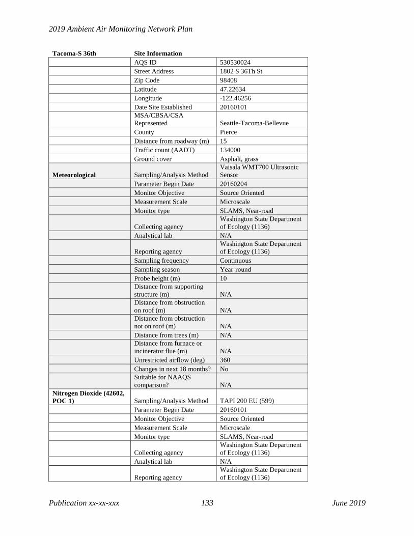
2019 Ambient Air Monitoring Network Plan
Publication xx-xx-xxx 133 June 2019
Tacoma-S 36th Site Information AQS ID 530530024 Street Address 1802 S 36Th St Zip Code 98408 Latitude 47.22634 Longitude -122.46256 Date Site Established 20160101
MSA/CBSA/CSA Represented Seattle-Tacoma-Bellevue
County Pierce Distance from roadway (m) 15 Traffic count (AADT) 134000 Ground cover Asphalt, grass
Meteorological Sampling/Analysis Method Vaisala WMT700 Ultrasonic Sensor
Parameter Begin Date 20160204 Monitor Objective Source Oriented Measurement Scale Microscale Monitor type SLAMS, Near-road
Collecting agency Washington State Department of Ecology (1136)
Analytical lab N/A
Reporting agency Washington State Department of Ecology (1136)
Sampling frequency Continuous Sampling season Year-round Probe height (m) 10
Distance from supporting structure (m) N/A
Distance from obstruction on roof (m) N/A
Distance from obstruction not on roof (m) N/A
Distance from trees (m) N/A
Distance from furnace or incinerator flue (m) N/A
Unrestricted airflow (deg) 360 Changes in next 18 months? No
Suitable for NAAQS comparison? N/A
Nitrogen Dioxide (42602, POC 1) Sampling/Analysis Method TAPI 200 EU (599) Parameter Begin Date 20160101 Monitor Objective Source Oriented Measurement Scale Microscale Monitor type SLAMS, Near-road
Collecting agency Washington State Department of Ecology (1136)
Analytical lab N/A
Reporting agency Washington State Department of Ecology (1136)

Appendices
Publication xxxxxxx 134 June 2019
Tacoma-S 36th Site Information Sampling frequency Continuous Sampling season Year-round Probe height (m) 6
Distance from supporting structure (m) 1
Distance from obstruction on roof (m) N/A
Distance from obstruction not on roof (m) N/A
Distance from trees (m) N/A
Distance from furnace or incinerator flue (m) N/A
Unrestricted airflow (deg) 360 Probe material Teflon Residence time (sec) 3.2 Changes in next 18 months? No
Suitable for NAAQS comparison? Yes
PM2.5 (88101) Primary (POC 5) Collocated (POC 6)
Sampling/Analysis Method Met One BAM-1020 (170) Met One BAM-1020 (170)
Parameter Begin Date 20160204 20190301
Monitor Objective Highest Concentration Highest Concentration
Measurement Scale Microscale Microscale Monitor type SLAMS, Near-road SLAMS, Near-road
Collecting agency Washington State Department of Ecology (1136)
Washington State Department of Ecology (1136)
Analytical lab N/A N/A
Reporting agency Washington State Department of Ecology (1136)
Washington State Department of Ecology (1136)
Sampling frequency Continuous Continuous Sampling season Year-round Year-round Probe height (m) 4 4
Distance from supporting structure (m) 1 1
Distance from obstruction on roof (m) N/A N/A
Distance from obstruction not on roof (m) N/A N/A
Distance from trees (m) N/A N/A
Distance from furnace or incinerator flue (m) N/A N/A
Unrestricted airflow (deg) 360 360 Changes in next 18 months? No No
Suitable for NAAQS comparison? Yes Yes

2019 Ambient Air Monitoring Network Plan
Publication xx-xx-xxx 135 June 2019
Tacoma-Tower Dr Site Information AQS ID 530531016 Street Address 5225 Tower Drive Ne Zip Code 98422 Latitude 47.304444 Longitude -122.412 Date Site Established 19910101 MSA/CBSA/CSA Represented Seattle-Tacoma-Bellevue County Pierce Distance from roadway (m) 33 Traffic count (AADT) N/A Ground cover Asphalt, shrubs Meteorological Sampling/Analysis Method Vaisala WMT700 Ultrasonic Sensor Parameter Begin Date 19910101 Monitor Objective General/Background Measurement Scale Urban Monitor type SLAMS
Collecting agency Washington State Department of Ecology (1136)
Analytical lab N/A
Reporting agency Washington State Department of Ecology (1136)
Sampling frequency Continuous Sampling season Year-round Probe height (m) 10 Distance from supporting structure (m) N/A Distance from obstruction on roof (m) N/A Distance from obstruction not on roof (m) N/A Distance from trees (m) N/A
Distance from furnace or incinerator flue (m) N/A
Unrestricted airflow (deg) 360 Changes in next 18 months? No Suitable for NAAQS comparison? N/A

Appendices
Publication xxxxxxx 136 June 2019
Taholah-Quinault Tribe Site Information AQS ID 530270011 Street Address Chitwin Drive, Taholah, WA Zip Code 98571 Latitude 47.20637 Longitude -124.1722 Date Site Established 20040428 MSA/CBSA/CSA Represented Aberdeen County Grays Harbor Distance from roadway (m) 340 Traffic count (AADT) 1300 Ground cover Grass Non-compliance PM2.5 (88502, POC 4) Sampling/Analysis Method
Radiance Research M903 Nephelometer (771)
Parameter Begin Date 20150818 Monitor Objective Population Exposure Measurement Scale Neighborhood Monitor type Tribal Collecting agency Quinault Tribe Analytical lab N/A
Reporting agency Washington State Department of Ecology (1136)
Sampling frequency Continuous Sampling season Year-round Probe height (m) 4 Distance from supporting structure (m) N/A Distance from obstruction on roof (m) N/A
Distance from obstruction not on roof (m) N/A
Distance from trees (m) N/A
Distance from furnace or incinerator flue (m) N/A
Unrestricted airflow (deg) 360 Changes in next 18 months? No Suitable for NAAQS comparison? No

2019 Ambient Air Monitoring Network Plan
Publication xx-xx-xxx 137 June 2019
Toppenish-Yakama Tribe Site Information AQS ID 530770015 Street Address 141 Ward Rd., Toppenish, WA Zip Code 98948 Latitude 46.38024 Longitude -120.33266 Date Site Established 20060131 MSA/CBSA/CSA Represented Yakima County Yakima Distance from roadway (m) 310 Traffic count (AADT) 14000 Ground cover Grass Meteorological Sampling/Analysis Method Vaisala WMT700 Ultrasonic Sensor Parameter Begin Date 20090608 Monitor Objective Population Exposure Measurement Scale Neighborhood Monitor type Tribal
Collecting agency Washington State Department of Ecology (1136)
Analytical lab N/A
Reporting agency Washington State Department of Ecology (1136)
Sampling frequency Continuous Sampling season Year-round Probe height (m) 10 Distance from supporting structure (m) N/A Distance from obstruction on roof (m) N/A Distance from obstruction not on roof (m) N/A Distance from trees (m) N/A
Distance from furnace or incinerator flue (m) N/A
Unrestricted airflow (deg) 360 Changes in next 18 months? No Suitable for NAAQS comparison? N/A PM2.5 (88101, POC 5) Sampling/Analysis Method Met One BAM-1020 (170) Parameter Begin Date 20151105 Monitor Objective Population Exposure Measurement Scale Neighborhood Monitor type Tribal Collecting agency Yakama Tribe Analytical lab N/A
Reporting agency Washington State Department of Ecology (1136)
Sampling frequency Continuous Sampling season Year-round Probe height (m) 3 Distance from supporting structure (m) N/A Distance from obstruction on roof (m) N/A

Appendices
Publication xxxxxxx 138 June 2019
Toppenish-Yakama Tribe Site Information Distance from obstruction not on roof (m) N/A Distance from trees (m) N/A
Distance from furnace or incinerator flue (m) N/A
Unrestricted airflow (deg) 360 Changes in next 18 months? No Suitable for NAAQS comparison? Yes

2019 Ambient Air Monitoring Network Plan
Publication xx-xx-xxx 139 June 2019
Tukwila-Allentown Site Information AQS ID 530330069 Street Address 11675 44th Ave S, Tukwila Zip Code 98168 Latitude 47.498535 Longitude -122.278385 Date Site Established 20170622 MSA/CBSA/CSA Represented Seattle-Tacoma-Bellevue County King Distance from roadway (m) 300 Traffic count (AADT) 32000 Ground cover Grass Non-compliance PM2.5 (88502, POC 4) Sampling/Analysis Method Ecotech M9003 Aurora (812) Parameter Begin Date 20170701 Monitor Type Begin Date 20170701 Monitor Objective Population Exposure Measurement Scale Neighborhood Monitor type SLAMS Collecting agency Puget Sound Clean Air Agency Analytical lab N/A
Reporting agency Washington State Department of Ecology (1136)
Sampling frequency Continuous Sampling season Year-round Probe height (m) 3 Distance from supporting structure (m) N/A Distance from obstruction on roof (m) N/A
Distance from obstruction not on roof (m) N/A
Distance from trees (m) N/A
Distance from furnace or incinerator flue (m) N/A
Unrestricted airflow (deg) 360 Changes in next 18 months? No Suitable for NAAQS comparison? No
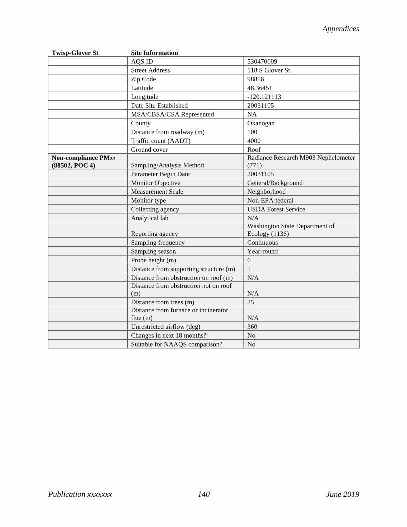
Appendices
Publication xxxxxxx 140 June 2019
Twisp-Glover St Site Information AQS ID 530470009 Street Address 118 S Glover St Zip Code 98856 Latitude 48.36451 Longitude -120.121113 Date Site Established 20031105 MSA/CBSA/CSA Represented NA County Okanogan Distance from roadway (m) 100 Traffic count (AADT) 4000 Ground cover Roof Non-compliance PM2.5 (88502, POC 4) Sampling/Analysis Method
Radiance Research M903 Nephelometer (771)
Parameter Begin Date 20031105 Monitor Objective General/Background Measurement Scale Neighborhood Monitor type Non-EPA federal Collecting agency USDA Forest Service Analytical lab N/A
Reporting agency Washington State Department of Ecology (1136)
Sampling frequency Continuous Sampling season Year-round Probe height (m) 6 Distance from supporting structure (m) 1 Distance from obstruction on roof (m) N/A
Distance from obstruction not on roof (m) N/A
Distance from trees (m) 25
Distance from furnace or incinerator flue (m) N/A
Unrestricted airflow (deg) 360 Changes in next 18 months? No Suitable for NAAQS comparison? No

2019 Ambient Air Monitoring Network Plan
Publication xx-xx-xxx 141 June 2019
Vancouver-Blairmont Site Information AQS ID 530110011
Street Address 1500 SE Blairmont Dr (Mountain View High School)
Zip Code 98683 Latitude 45.616667 Longitude -122.516667 Date Site Established 19880501 MSA/CBSA/CSA Represented Portland-Vancouver-Hillsboro County Clark Distance from roadway (m) 520 Traffic count (AADT) 8939 Ground cover Grass, asphalt Meteorological Sampling/Analysis Method Vaisala WMT700 Ultrasonic Sensor Parameter Begin Date 20071220 Monitor Objective Population Exposure Measurement Scale Urban Scale Monitor type SLAMS
Collecting agency Washington State Department of Ecology (1136)
Analytical lab N/A
Reporting agency Washington State Department of Ecology (1136)
Sampling frequency Continuous Sampling season Year-round Probe height (m) 10 Distance from supporting structure (m) N/A Distance from obstruction on roof (m) N/A Distance from obstruction not on roof (m) N/A Distance from trees (m) N/A
Distance from furnace or incinerator flue (m) N/A
Unrestricted airflow (deg) 360 Changes in next 18 months? No Suitable for NAAQS comparison? N/A Ozone (44201, POC 1) Sampling/Analysis Method UV Absorption (087) Parameter Begin Date 19880501 Monitor Objective Population Exposure Measurement Scale Urban Scale Monitor type SLAMS
Collecting agency Washington State Department of Ecology (1136)
Analytical lab N/A
Reporting agency Washington State Department of Ecology (1136)
Sampling frequency Continuous Sampling season May-Oct Probe height (m) 10
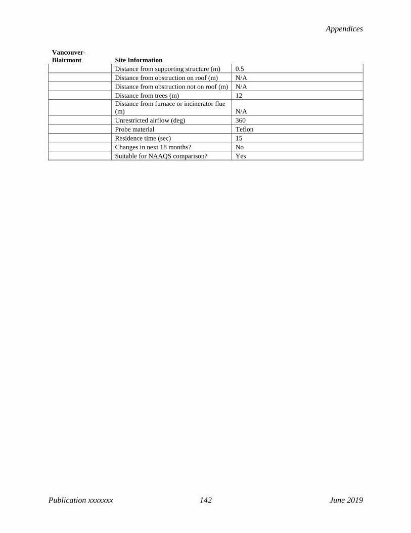
Appendices
Publication xxxxxxx 142 June 2019
Vancouver-Blairmont Site Information Distance from supporting structure (m) 0.5 Distance from obstruction on roof (m) N/A Distance from obstruction not on roof (m) N/A Distance from trees (m) 12
Distance from furnace or incinerator flue (m) N/A
Unrestricted airflow (deg) 360 Probe material Teflon Residence time (sec) 15 Changes in next 18 months? No Suitable for NAAQS comparison? Yes

2019 Ambient Air Monitoring Network Plan
Publication xx-xx-xxx 143 June 2019
Vancouver-NE 84th Ave Site Information AQS ID 530110024 Street Address 2722 Ne 84th Ave Zip Code 98662 Latitude 45.64336 Longitude -122.58737 Date Site Established 20140901 MSA/CBSA/CSA Represented Portland-Vancouver-Hillsboro County Clark Distance from roadway (m) 365 Traffic count (AADT) 11559 Ground cover Grass PM2.5 (88101, POC 5) Sampling/Analysis Method Met One BAM-1020 (170) Parameter Begin Date 20151125 Monitor Objective Population Exposure Measurement Scale Neighborhood Monitor type SLAMS Collecting agency Southwest Clean Air Agency Analytical lab N/A
Reporting agency Washington State Department of Ecology (1136)
Sampling frequency Continuous Sampling season Year-round Probe height (m) 3 Distance from supporting structure (m) 0.5 Distance from obstruction on roof (m) N/A Distance from obstruction not on roof (m) 25 Distance from trees (m) 31
Distance from furnace or incinerator flue (m) N/A
Unrestricted airflow (deg) 360 Changes in next 18 months? No Suitable for NAAQS comparison? Yes

Appendices
Publication xxxxxxx 144 June 2019
Walla Walla-12th St Site Information AQS ID 530710005 Street Address 200 S 12th, Walla Walla, WA Zip Code 99362 Latitude 46.05881 Longitude -118.35147 Date Site Established 19890501 MSA/CBSA/CSA Represented Walla Walla County Walla Walla Distance from roadway (m) 415 Traffic count (AADT) 19000 Ground cover Roof Non-compliance PM2.5 (88502, POC 4) Sampling/Analysis Method
Radiance Research M903 Nephelometer (771)
Parameter Begin Date 20021001 Monitor Objective Population Exposure Measurement Scale Neighborhood Monitor type SLAMS
Collecting agency Washington State Department of Ecology (1136)
Analytical lab N/A
Reporting agency Washington State Department of Ecology (1136)
Sampling frequency Continuous Sampling season Year-round Probe height (m) 2 Distance from supporting structure (m) N/A Distance from obstruction on roof (m) N/A
Distance from obstruction not on roof (m) N/A
Distance from trees (m) N/A
Distance from furnace or incinerator flue (m) N/A
Unrestricted airflow (deg) 360 Changes in next 18 months? No Suitable for NAAQS comparison? No

2019 Ambient Air Monitoring Network Plan
Publication xx-xx-xxx 145 June 2019
Wellpinit-Spokane Tribe Site Information AQS ID 530650002
Street Address 6208 Ford Wellpinit Road, Wellpinit, WA
Zip Code 99040 Latitude 47.88528 Longitude -117.98865 Date Site Established 20061010 MSA/CBSA/CSA Represented Spokane-Spokane Valley County Spokane Distance from roadway (m) 10200 Traffic count (AADT) 1200 Ground cover Asphalt, gravel Non-compliance PM2.5 (88502, POC 4) Sampling/Analysis Method
Radiance Research M903 Nephelometer (771)
Parameter Begin Date 20081015 Monitor Objective Population Exposure Measurement Scale Neighborhood Monitor type Tribal
Collecting agency Washington State Department of Ecology (1136)
Analytical lab N/A
Reporting agency Washington State Department of Ecology (1136)
Sampling frequency Continuous Sampling season Year-round Probe height (m) 4 Distance from supporting structure (m) N/A Distance from obstruction on roof (m) N/A
Distance from obstruction not on roof (m) N/A
Distance from trees (m) N/A
Distance from furnace or incinerator flue (m) N/A
Unrestricted airflow (deg) 360 Changes in next 18 months? No Suitable for NAAQS comparison? No

Appendices
Publication xxxxxxx 146 June 2019
Wenatchee-Fifth St Site Information AQS ID 530070011 Street Address 1300 Fifth Street Zip Code 98801 Latitude 47.43061 Longitude -120.34195 Date Site Established 20121105 MSA/CBSA/CSA Represented Wenatchee County Chelan Distance from roadway (m) 90 Traffic count (AADT) 10691 Ground cover Gravel, grass
Meteorological Sampling/Analysis Method RM Young Sonic Anemometer 85004 (062)
Parameter Begin Date 20121105 Monitor Objective Population Exposure Measurement Scale Neighborhood Monitor type SLAMS
Collecting agency Washington State Department of Ecology (1136)
Analytical lab N/A
Reporting agency Washington State Department of Ecology (1136)
Sampling frequency Continuous Sampling season Year-round Probe height (m) 10 Distance from supporting structure (m) N/A Distance from obstruction on roof (m) N/A
Distance from obstruction not on roof (m) N/A
Distance from trees (m) N/A
Distance from furnace or incinerator flue (m) N/A
Unrestricted airflow (deg) 360 Changes in next 18 months? No Suitable for NAAQS comparison? N/A Non-compliance PM2.5 (88502, POC 4) Sampling/Analysis Method
Radiance Research M903 Nephelometer (771)
Parameter Begin Date 20170401 Monitor Objective Population Exposure Measurement Scale Neighborhood Monitor type SLAMS
Collecting agency Washington State Department of Ecology (1136)
Analytical lab N/A
Reporting agency Washington State Department of Ecology (1136)
Sampling frequency Continuous Sampling season Year-round Probe height (m) 3

2019 Ambient Air Monitoring Network Plan
Publication xx-xx-xxx 147 June 2019
Wenatchee-Fifth St Site Information Distance from supporting structure (m) N/A Distance from obstruction on roof (m) N/A
Distance from obstruction not on roof (m) N/A
Distance from trees (m) N/A
Distance from furnace or incinerator flue (m) N/A
Unrestricted airflow (deg) 360 Changes in next 18 months? No Suitable for NAAQS comparison? No

Appendices
Publication xxxxxxx 148 June 2019
White Swan-Yakama Tribe Site Information AQS ID 530770016 Street Address 321 Signal Peak Rd, White Swan Zip Code 98952 Latitude 46.37543 Longitude -120.72932 Date Site Established 20091027 MSA/CBSA/CSA Represented Yakima County Yakima Distance from roadway (m) 25000 Traffic count (AADT) 16000 Ground cover Grass Meteorological Sampling/Analysis Method Vaisala WMT700 Ultrasonic Sensor Parameter Begin Date 20091109 Monitor Objective Population Exposure Measurement Scale Neighborhood Monitor type Tribal
Collecting agency Washington State Department of Ecology (1136)
Analytical lab N/A
Reporting agency Washington State Department of Ecology (1136)
Sampling frequency Continuous Sampling season Year-round Probe height (m) 10 Distance from supporting structure (m) N/A Distance from obstruction on roof (m) N/A
Distance from obstruction not on roof (m) N/A
Distance from trees (m) N/A
Distance from furnace or incinerator flue (m) N/A
Unrestricted airflow (deg) 360 Changes in next 18 months? No Suitable for NAAQS comparison? N/A Non-compliance PM2.5 (88502, POC 4) Sampling/Analysis Method
Radiance Research M903 Nephelometer (771)
Parameter Begin Date 20091027 Monitor Objective Population Exposure Measurement Scale Neighborhood Monitor type Tribal Collecting agency Yakama Tribe Analytical lab N/A
Reporting agency Washington State Department of Ecology (1136)
Sampling frequency Continuous Sampling season Year-round Probe height (m) 2 Distance from supporting structure (m) N/A

2019 Ambient Air Monitoring Network Plan
Publication xx-xx-xxx 149 June 2019
White Swan-Yakama Tribe Site Information Distance from obstruction on roof (m) N/A
Distance from obstruction not on roof (m) N/A
Distance from trees (m) N/A
Distance from furnace or incinerator flue (m) N/A
Unrestricted airflow (deg) 360 Changes in next 18 months? No Suitable for NAAQS comparison? No
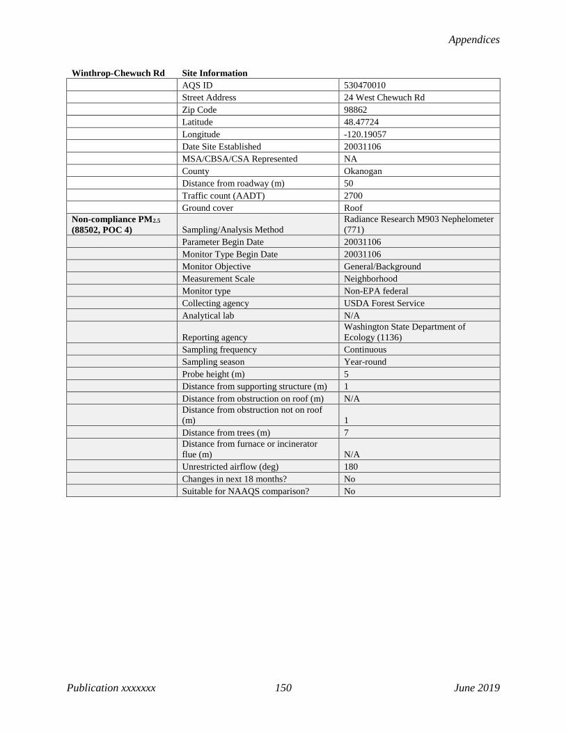
Appendices
Publication xxxxxxx 150 June 2019
Winthrop-Chewuch Rd Site Information AQS ID 530470010 Street Address 24 West Chewuch Rd Zip Code 98862 Latitude 48.47724 Longitude -120.19057 Date Site Established 20031106 MSA/CBSA/CSA Represented NA County Okanogan Distance from roadway (m) 50 Traffic count (AADT) 2700 Ground cover Roof Non-compliance PM2.5 (88502, POC 4) Sampling/Analysis Method
Radiance Research M903 Nephelometer (771)
Parameter Begin Date 20031106 Monitor Type Begin Date 20031106 Monitor Objective General/Background Measurement Scale Neighborhood Monitor type Non-EPA federal Collecting agency USDA Forest Service Analytical lab N/A
Reporting agency Washington State Department of Ecology (1136)
Sampling frequency Continuous Sampling season Year-round Probe height (m) 5 Distance from supporting structure (m) 1 Distance from obstruction on roof (m) N/A
Distance from obstruction not on roof (m) 1
Distance from trees (m) 7
Distance from furnace or incinerator flue (m) N/A
Unrestricted airflow (deg) 180 Changes in next 18 months? No Suitable for NAAQS comparison? No
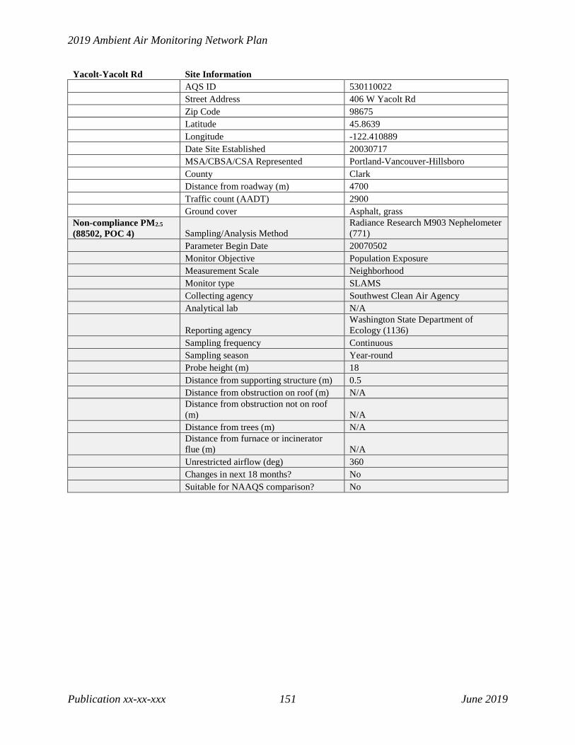
2019 Ambient Air Monitoring Network Plan
Publication xx-xx-xxx 151 June 2019
Yacolt-Yacolt Rd Site Information AQS ID 530110022 Street Address 406 W Yacolt Rd Zip Code 98675 Latitude 45.8639 Longitude -122.410889 Date Site Established 20030717 MSA/CBSA/CSA Represented Portland-Vancouver-Hillsboro County Clark Distance from roadway (m) 4700 Traffic count (AADT) 2900 Ground cover Asphalt, grass Non-compliance PM2.5 (88502, POC 4) Sampling/Analysis Method
Radiance Research M903 Nephelometer (771)
Parameter Begin Date 20070502 Monitor Objective Population Exposure Measurement Scale Neighborhood Monitor type SLAMS Collecting agency Southwest Clean Air Agency Analytical lab N/A
Reporting agency Washington State Department of Ecology (1136)
Sampling frequency Continuous Sampling season Year-round Probe height (m) 18 Distance from supporting structure (m) 0.5 Distance from obstruction on roof (m) N/A
Distance from obstruction not on roof (m) N/A
Distance from trees (m) N/A
Distance from furnace or incinerator flue (m) N/A
Unrestricted airflow (deg) 360 Changes in next 18 months? No Suitable for NAAQS comparison? No

Appendices
Publication xxxxxxx 152 June 2019
Yakima-4th Ave S Site Information AQS ID 530770009 Street Address 402 South 4Th Ave Zip Code 98901 Latitude 46.598056 Longitude -120.499167 Date Site Established 20000421
MSA/CBSA/CSA Represented Yakima
County Yakima Distance from roadway (m) 65 Traffic count (AADT) 7372 Ground cover Roof PM10 (81102) Sampling/Analysis Method TEOM-Gravimetric (079) Parameter Begin Date 20150916 Monitor Objective Population Exposure Measurement Scale Neighborhood Monitor type SLAMS
Collecting agency Yakima Region Clean Air Agency
Analytical lab N/A
Reporting agency Washington State Department of Ecology (1136)
Sampling frequency Continuous Sampling season Year-round Probe height (m) 14
Distance from supporting structure (m) N/A
Distance from obstruction on roof (m) 7
Distance from obstruction not on roof (m) N/A
Distance from trees (m) 34
Distance from furnace or incinerator flue (m) N/A
Unrestricted airflow (deg) 360 Changes in next 18 months? No
Suitable for NAAQS comparison? Yes
PM2.5 (88101) Primary (POC 5) Collocated (POC 1) Sampling/Analysis Method Met One BAM-1020 (170) R & P 2025 (145) Parameter Begin Date 20070202 20070202 Monitor Objective Population Exposure Population Exposure Measurement Scale Neighborhood Neighborhood Monitor type SLAMS SLAMS
Collecting agency Yakima Region Clean Air Agency
Yakima Region Clean Air Agency
Analytical lab N/A N/A
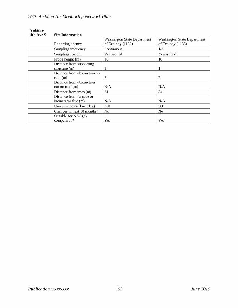
2019 Ambient Air Monitoring Network Plan
Publication xx-xx-xxx 153 June 2019
Yakima-4th Ave S Site Information
Reporting agency Washington State Department of Ecology (1136)
Washington State Department of Ecology (1136)
Sampling frequency Continuous 1/3 Sampling season Year-round Year-round Probe height (m) 16 16
Distance from supporting structure (m) 1 1
Distance from obstruction on roof (m) 7 7
Distance from obstruction not on roof (m) N/A N/A
Distance from trees (m) 34 34
Distance from furnace or incinerator flue (m) N/A N/A
Unrestricted airflow (deg) 360 360 Changes in next 18 months? No No
Suitable for NAAQS comparison? Yes Yes

Appendices
Publication xxxxxxx 154 June 2019
Yelm-Northern Pacific Site Information AQS ID 530670005 Street Address 931 Northern Pacific Road Zip Code 98597 Latitude 46.952562 Longitude -122.59527 Date Site Established 20060501 MSA/CBSA/CSA Represented Seattle-Tacoma-Bellevue County Thurston Distance from roadway (m) 1250 Traffic count (AADT) 14000 Ground cover Gravel, grass Ozone (44201, POC 1) Sampling/Analysis Method UV Absorption (087) Parameter Begin Date 20060501 Monitor Objective Population Exposure Measurement Scale Urban Scale Monitor type SLAMS
Collecting agency Washington State Department of Ecology (1136)
Analytical lab N/A
Reporting agency Washington State Department of Ecology (1136)
Sampling frequency Continuous Sampling season May-Oct Probe height (m) 3 Distance from supporting structure (m) 0.7 Distance from obstruction on roof (m) N/A Distance from obstruction not on roof (m) N/A Distance from trees (m) 50
Distance from furnace or incinerator flue (m) N/A
Unrestricted airflow (deg) 360 Probe material Teflon Residence time (sec) 4.4 Changes in next 18 months? No Suitable for NAAQS comparison? Yes


![ORDERING INFORMATION AND AMBIENT C1D2 ABCD/ … Electric/Home... · 31.9 [810] 31.0 [787] ... * LM-xx & TM-xx are Illumination Engineering Society Standards designed to promote uniformity](https://img.pdfslide.us/doc/110x75/5aec87207f8b9ab24d902788/ordering-information-and-ambient-c1d2-abcd-electrichome319-810-310.jpg)