Embed Size (px)
Citation preview
1 | P a g e
MEMORANDUM Date: January 28th, 2018 To: Ms. Cecilia Lane
Watershed Protection Division Department of Energy and Environment Government of the District of Columbia 1200 First Street NE 5th Floor Washington DC
From: Bryan Arvai, Biohabitats, Inc. RE: Amidon Park Subject: Concept Soils De-Compaction Recommendations ________________________________________________________________________________________________________________________________________________________________
INTRODUCTION/SUMMARY Soils in green spaces with heavy pedestrian and/or vehicle traffic, such as athletic fields and overflow parking areas, can become deeply compacted over time. This compaction of green spaces results in reduced rainwater absorption and infiltration capacities and reduced health of surface vegetation (e.g. grass, shrubs, trees, etc.). As defined in the DOEE Stormwater Management Guidebook (July 2013)1, these areas are considered “compacted cover” and it is assumed that “these lands will generate 25 percent stormwater runoff for a design rain event.” Typical aeration practices (core aeration) can reduce compaction and improve the hydraulic characteristics of the topsoil, but only penetrate a few inches and do not address compaction of soil layers that can develop at greater depths (typically within upper 24 inches) below the surface. This results in a de-compaction practice that has a greater influence on shallow root systems of grasses and does not significantly reduce the overall runoff from a green space. Amidon Park falls into this category of a compacted cover green space that sees consistent use as a permitted athletic field and contributes significant runoff from the site. Biohabitats has currently only performed a desktop assessment of the site and will be field collecting soils data prior to a final recommendation for methods of de-compaction of the field soils. These field measurements will allow Biohabitats to fine tune the de-compaction methods and propose any necessary soil amendments in order to increase infiltration of rainfall and the retention capacity of the soil. Based on the desktop review and best professional judgement, Biohabitats anticipates that the preferred treatment at the site will be to utilize a rotary de-compactor, such as the Imants Shockwave, to provide de-compaction of the top 10-15 inches while minimizing the surface disturbance and allowing the field to be playable immediately following de-compaction. For the best long-term results however, de-compaction of the field should occur when the ground has thoroughly dried and for the field to remain unused for up to a week after de-compaction. At this time, Biohabitats does not have a recommendation regarding soil amendments to be added to the field during de-compaction. In addition to soil de-compaction, Biohabitats recommends airspading an approximately 6-inch by 6-inch trough along the perimeter of the site to identify and avoid any substantial roots from the surrounding trees. The
1 Center for Watershed Protection (prepared for DDOE Watershed Protection Division). “Stormwater Management Guidebook.” 19. July. 2013. https://doee.dc.gov/swguidebook.
2 | P a g e
accompanying “Amidon Park Soil De-Compaction” plans provided along with this memorandum present the proposed locations of the airspading and subsoil de-compaction. EXISTING SITE CONDITIONS/SOILS Web soil survey Biohabitats utilized the United States Department of Agriculture’s (USDA) Natural Resources Conservation Service’s (NRCS) Web Soil Survey (WSS) to perform a preliminary desktop analysis of the existing on-site soils. A full printout of the Web Soil Survey map and legend has been attached to this memorandum. The WSS mapping indicates the soils within the field are Udorthents, Loamy soils. Udorthents, loamy is typically characterized by a soil profile with a 0-2-inch loam surface layer above of a gravelly loam layer (up to 72 inches deep). Depths to a restrictive layer are typically greater than 80 inches deep with depths to the water table between 40 and 72 inches. Soil Borings Soil borings will be performed with a hand auger up to a depth of approximately two-feet deep prior to final recommendations for de-compaction. Soil borings will provide specific soil classification of the existing soils as well as a qualitative assessment of the soil structure, compaction, and root growth of the vegetation. Compaction Testing Compaction testing of existing soils will be performed with a soil penetrometer prior to final recommendations for de-compaction. The results of the compaction testing will provide existing compaction rates of existing soils and identify any constraining layers that may prevent infiltration, informing the depth and degree of decompaction required. SOIL DE-COMPACTION - METHODS Rotary de-compactor A rotary de-compactor, such as the Imants Shockwave, is a subset of subsoiling equipment that includes a series of blades (See Photos 1 and 2 below) attached to a central rotor shaft. Blades are typically 10-15 inches long. As the shaft rotates, the blades enter the soil vertically on a staggered pattern and sequence, cutting the soil to the full blade length. Due to the width of the blades, the soil is pushed laterally, creating cracks and fissures within the soil. As adjacent blades enter the soil, the soil is pushed in the opposite direction, further cracking the soil. The continued cutting/pushing of the soil by the blades creates a wave action within the soil, creating a consistent de-compaction to the full working depth, without excessive damage to the surface. The shafts of rotary de-compactors are connected into the drivetrain of the attached tractor which drives the cutting of the soil. This minimizes the need to pull the device behind the tractor as done in static subsoiling equipment, reducing the horsepower required and subsequent ruts and slippage that can occur with heavier equipment. The lateral de-compaction and smaller equipment required of the rotary de-compactor minimizes the surface disturbance. A roller typically attached to the back of the equipment ensures a smooth final surface. Athletic fields can typically be played on immediately following de-compaction by a rotary de-compactor. However, keeping the fields out of operation for additional time (24 hours – 7 days) can increase the long-term benefits of de-compaction by providing the grass roots time to grow into fractured soil. The saturation of the soil layer during de-compaction can affect the quality of de-compaction, resealing of cuts, and the impact from the pulling equipment on the surface. Soils should be mostly dry and friable to allow for maximum fracturing of soils. Using a rotary de-compactor during wet conditions will also allow cuts to reseal quickly and minimize the long-term benefits of the de-compaction. However, due to equipment size needed and the cutting process of the equipment, rotary de-compaction will not result in the excessive surface disturbance, clumping, and rutting that may be seen in static shank subsoilers when used in wet conditions. Ideal dry conditions typically fall within late summer to early fall.
3 | P a g e
Pros
• Reduced size of equipment needed to pull de-compactor. • Minimal tire ruts and slippage due to drive mechanism. • Fields are immediately accessible following de-compaction.
Cons
• Limited depth (up to 15 inches). • Limited soil upturning.
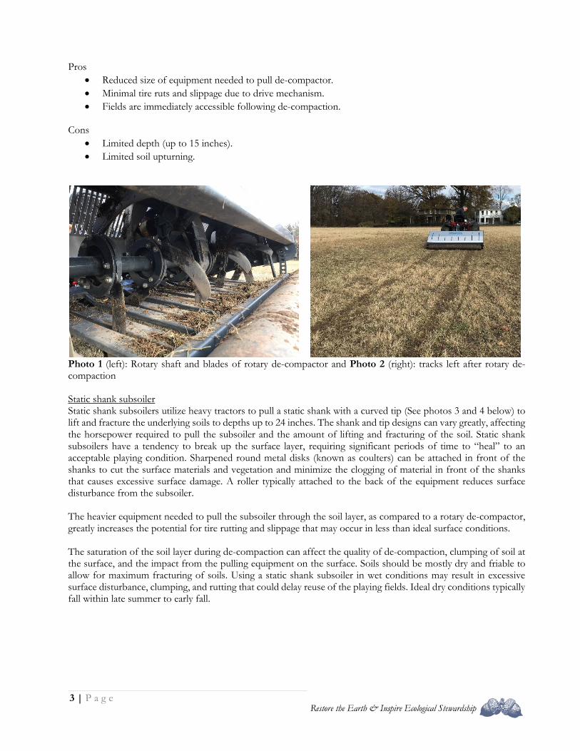
Photo 1 (left): Rotary shaft and blades of rotary de-compactor and Photo 2 (right): tracks left after rotary de-compaction Static shank subsoiler Static shank subsoilers utilize heavy tractors to pull a static shank with a curved tip (See photos 3 and 4 below) to lift and fracture the underlying soils to depths up to 24 inches. The shank and tip designs can vary greatly, affecting the horsepower required to pull the subsoiler and the amount of lifting and fracturing of the soil. Static shank subsoilers have a tendency to break up the surface layer, requiring significant periods of time to “heal” to an acceptable playing condition. Sharpened round metal disks (known as coulters) can be attached in front of the shanks to cut the surface materials and vegetation and minimize the clogging of material in front of the shanks that causes excessive surface damage. A roller typically attached to the back of the equipment reduces surface disturbance from the subsoiler. The heavier equipment needed to pull the subsoiler through the soil layer, as compared to a rotary de-compactor, greatly increases the potential for tire rutting and slippage that may occur in less than ideal surface conditions. The saturation of the soil layer during de-compaction can affect the quality of de-compaction, clumping of soil at the surface, and the impact from the pulling equipment on the surface. Soils should be mostly dry and friable to allow for maximum fracturing of soils. Using a static shank subsoiler in wet conditions may result in excessive surface disturbance, clumping, and rutting that could delay reuse of the playing fields. Ideal dry conditions typically fall within late summer to early fall.
4 | P a g e
Pros
• Provides deeper de-compaction/fracturing of soils. • Can provide more severe de-compaction, overturning soil.
Con: • Longer “healing” time required before use of field (1+ month depending on level of de-compaction
required). • Heavy tractors required to pull static tine/blades, can cause compaction and rutting.
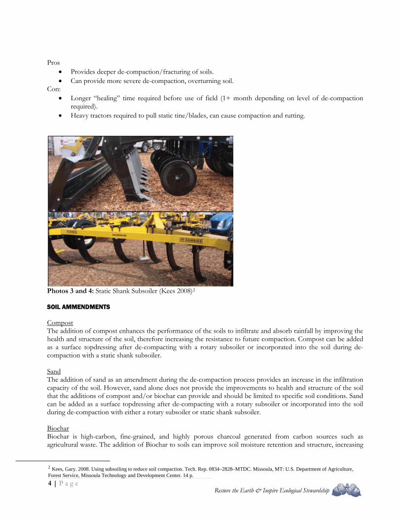
Photos 3 and 4: Static Shank Subsoiler (Kees 2008)2 SOIL AMMENDMENTS Compost The addition of compost enhances the performance of the soils to infiltrate and absorb rainfall by improving the health and structure of the soil, therefore increasing the resistance to future compaction. Compost can be added as a surface topdressing after de-compacting with a rotary subsoiler or incorporated into the soil during de-compaction with a static shank subsoiler.
Sand The addition of sand as an amendment during the de-compaction process provides an increase in the infiltration capacity of the soil. However, sand alone does not provide the improvements to health and structure of the soil that the additions of compost and/or biochar can provide and should be limited to specific soil conditions. Sand can be added as a surface topdressing after de-compacting with a rotary subsoiler or incorporated into the soil during de-compaction with either a rotary subsoiler or static shank subsoiler.
Biochar Biochar is high-carbon, fine-grained, and highly porous charcoal generated from carbon sources such as agricultural waste. The addition of Biochar to soils can improve soil moisture retention and structure, increasing
2 Kees, Gary. 2008. Using subsoiling to reduce soil compaction. Tech. Rep. 0834–2828–MTDC. Missoula, MT: U.S. Department of Agriculture, Forest Service, Missoula Technology and Development Center. 14 p.
5 | P a g e
the soils resistance to future compaction. Biochar can be added as a surface topdressing after de-compacting with a rotary subsoiler or incorporated into the soil during de-compaction with either a rotary subsoiler (grain size dependent) or static shank subsoiler. RECOMMENDATIONS As noted in the introduction, Biohabitats anticipates that the best approach to de-compact the site will be to utilize a rotary de-compactor, such as the Imants Shockwave, to provide de-compaction of the top 10-15 inches of soil. This will minimize the surface disturbance and allow the field to be playable immediately following de-compaction. For the best long-term results however, de-compaction of the field should occur when the ground has thoroughly dried and for the field to remain unused for up to a week after de-compaction. At this time, Biohabitats does not have a recommendation regarding soil amendments to be added to the field during de-compaction. Final recommendations will be provided when field investigations of the soil characteristics are completed. In addition to soil de-compaction, Biohabitats recommends airspading an approximately 6-inch by 6-inch trough along the perimeter of the site to identify and avoid any substantial roots from the surrounding trees.
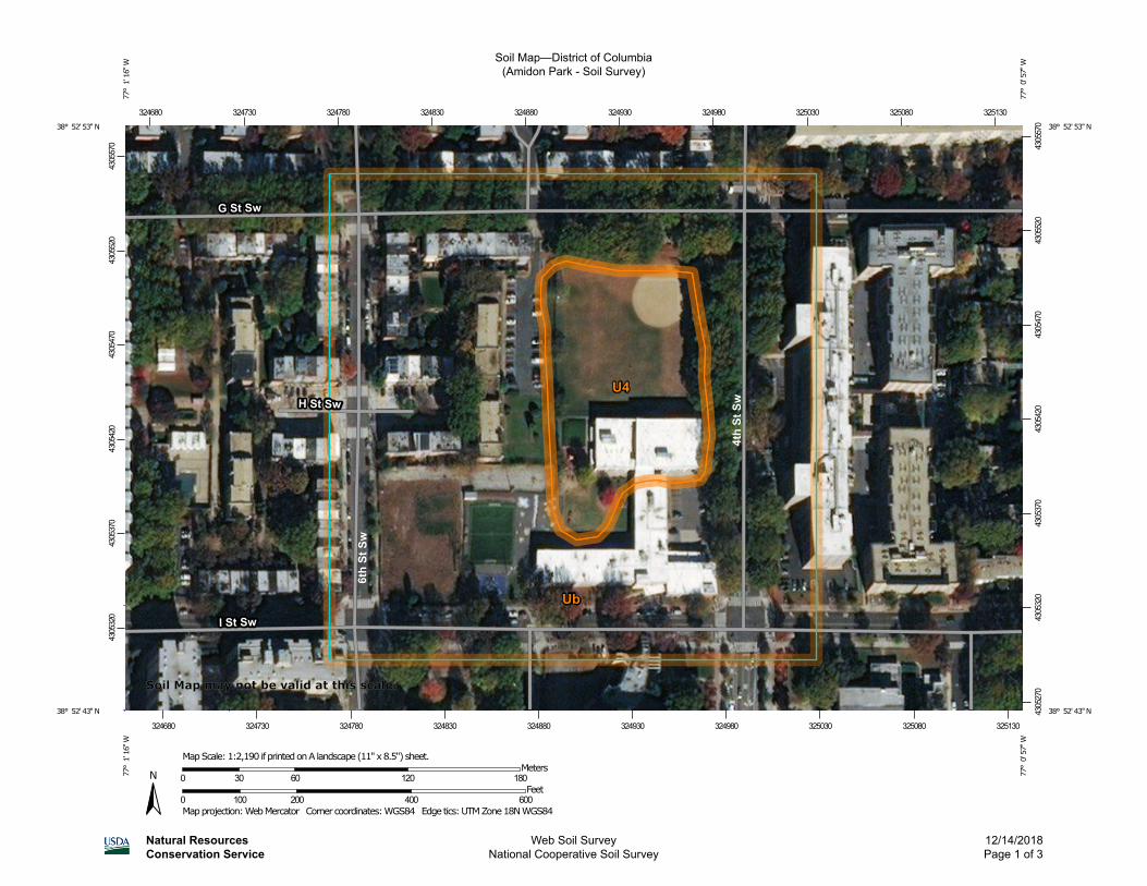
Soil Map—District of Columbia(Amidon Park - Soil Survey)
Natural ResourcesConservation Service
Web Soil SurveyNational Cooperative Soil Survey
12/14/2018Page 1 of 3
4305
320
4305
370
4305
420
4305
470
4305
520
4305
570
4305
270
4305
320
4305
370
4305
420
4305
470
4305
520
4305
570
324680 324730 324780 324830 324880 324930 324980 325030 325080 325130
324680 324730 324780 324830 324880 324930 324980 325030 325080 325130
38° 52' 53'' N77
° 1
' 16'
' W38° 52' 53'' N
77° 0
' 57'
' W
38° 52' 43'' N
77° 1
' 16'
' W
38° 52' 43'' N
77° 0
' 57'
' W
N
Map projection: Web Mercator Corner coordinates: WGS84 Edge tics: UTM Zone 18N WGS840 100 200 400 600
Feet0 30 60 120 180
MetersMap Scale: 1:2,190 if printed on A landscape (11" x 8.5") sheet.
Soil Map may not be valid at this scale.
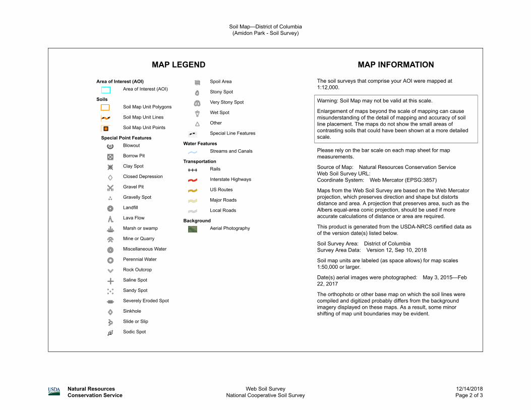
MAP LEGEND MAP INFORMATION
Area of Interest (AOI)Area of Interest (AOI)
SoilsSoil Map Unit Polygons
Soil Map Unit Lines
Soil Map Unit Points
Special Point FeaturesBlowout
Borrow Pit
Clay Spot
Closed Depression
Gravel Pit
Gravelly Spot
Landfill
Lava Flow
Marsh or swamp
Mine or Quarry
Miscellaneous Water
Perennial Water
Rock Outcrop
Saline Spot
Sandy Spot
Severely Eroded Spot
Sinkhole
Slide or Slip
Sodic Spot
Spoil Area
Stony Spot
Very Stony Spot
Wet Spot
Other
Special Line Features
Water FeaturesStreams and Canals
TransportationRails
Interstate Highways
US Routes
Major Roads
Local Roads
BackgroundAerial Photography
The soil surveys that comprise your AOI were mapped at 1:12,000.
Warning: Soil Map may not be valid at this scale.
Enlargement of maps beyond the scale of mapping can cause misunderstanding of the detail of mapping and accuracy of soil line placement. The maps do not show the small areas of contrasting soils that could have been shown at a more detailed scale.
Please rely on the bar scale on each map sheet for map measurements.
Source of Map: Natural Resources Conservation ServiceWeb Soil Survey URL: Coordinate System: Web Mercator (EPSG:3857)
Maps from the Web Soil Survey are based on the Web Mercator projection, which preserves direction and shape but distorts distance and area. A projection that preserves area, such as the Albers equal-area conic projection, should be used if more accurate calculations of distance or area are required.
This product is generated from the USDA-NRCS certified data as of the version date(s) listed below.
Soil Survey Area: District of ColumbiaSurvey Area Data: Version 12, Sep 10, 2018
Soil map units are labeled (as space allows) for map scales 1:50,000 or larger.
Date(s) aerial images were photographed: May 3, 2015—Feb 22, 2017
The orthophoto or other base map on which the soil lines were compiled and digitized probably differs from the background imagery displayed on these maps. As a result, some minor shifting of map unit boundaries may be evident.
Soil Map—District of Columbia(Amidon Park - Soil Survey)
Natural ResourcesConservation Service
Web Soil SurveyNational Cooperative Soil Survey
12/14/2018Page 2 of 3
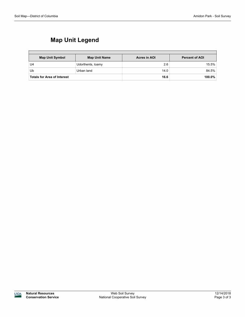
Map Unit Legend
Map Unit Symbol Map Unit Name Acres in AOI Percent of AOI
U4 Udorthents, loamy 2.6 15.5%
Ub Urban land 14.0 84.5%
Totals for Area of Interest 16.6 100.0%
Soil Map—District of Columbia Amidon Park - Soil Survey
Natural ResourcesConservation Service
Web Soil SurveyNational Cooperative Soil Survey
12/14/2018Page 3 of 3
Map Unit Description
The map units delineated on the detailed soil maps in a soil survey represent the soils or miscellaneous areas in the survey area. The map unit descriptions in this report, along with the maps, can be used to determine the composition and properties of a unit.
A map unit delineation on a soil map represents an area dominated by one or more major kinds of soil or miscellaneous areas. A map unit is identified and named according to the taxonomic classification of the dominant soils. Within a taxonomic class there are precisely defined limits for the properties of the soils. On the landscape, however, the soils are natural phenomena, and they have the characteristic variability of all natural phenomena. Thus, the range of some observed properties may extend beyond the limits defined for a taxonomic class. Areas of soils of a single taxonomic class rarely, if ever, can be mapped without including areas of other taxonomic classes. Consequently, every map unit is made up of the soils or miscellaneous areas for which it is named, soils that are similar to the named components, and some minor components that differ in use and management from the major soils.
Most of the soils similar to the major components have properties similar to those of the dominant soil or soils in the map unit, and thus they do not affect use and management. These are called noncontrasting, or similar, components. They may or may not be mentioned in a particular map unit description. Some minor components, however, have properties and behavior characteristics divergent enough to affect use or to require different management. These are called contrasting, or dissimilar, components. They generally are in small areas and could not be mapped separately because of the scale used. Some small areas of strongly contrasting soils or miscellaneous areas are identified by a special symbol on the maps. If included in the database for a given area, the contrasting minor components are identified in the map unit descriptions along with some characteristics of each. A few areas of minor components may not have been observed, and consequently they are not mentioned in the descriptions, especially where the pattern was so complex that it was impractical to make enough observations to identify all the soils and miscellaneous areas on the landscape.
The presence of minor components in a map unit in no way diminishes the usefulness or accuracy of the data. The objective of mapping is not to delineate pure taxonomic classes but rather to separate the landscape into landforms or landform segments that have similar use and management requirements. The delineation of such segments on the map provides sufficient information for the development of resource plans. If intensive use of small areas is planned, however, onsite investigation is needed to define and locate the soils and miscellaneous areas.
An identifying symbol precedes the map unit name in the map unit descriptions. Each description includes general facts about the unit and gives important soil properties and qualities.
Map Unit Description---District of Columbia DOEE DPR I - Amidon Park
Natural ResourcesConservation Service
Web Soil SurveyNational Cooperative Soil Survey
1/29/2019Page 1 of 4
Soils that have profiles that are almost alike make up a soil series. All the soils of a series have major horizons that are similar in composition, thickness, and arrangement. Soils of a given series can differ in texture of the surface layer, slope, stoniness, salinity, degree of erosion, and other characteristics that affect their use. On the basis of such differences, a soil series is divided into soil phases. Most of the areas shown on the detailed soil maps are phases of soil series. The name of a soil phase commonly indicates a feature that affects use or management. For example, Alpha silt loam, 0 to 2 percent slopes, is a phase of the Alpha series.
Some map units are made up of two or more major soils or miscellaneous areas. These map units are complexes, associations, or undifferentiated groups.
A complex consists of two or more soils or miscellaneous areas in such an intricate pattern or in such small areas that they cannot be shown separately on the maps. The pattern and proportion of the soils or miscellaneous areas are somewhat similar in all areas. Alpha-Beta complex, 0 to 6 percent slopes, is an example.
An association is made up of two or more geographically associated soils or miscellaneous areas that are shown as one unit on the maps. Because of present or anticipated uses of the map units in the survey area, it was not considered practical or necessary to map the soils or miscellaneous areas separately. The pattern and relative proportion of the soils or miscellaneous areas are somewhat similar. Alpha-Beta association, 0 to 2 percent slopes, is an example.
An undifferentiated group is made up of two or more soils or miscellaneous areas that could be mapped individually but are mapped as one unit because similar interpretations can be made for use and management. The pattern and proportion of the soils or miscellaneous areas in a mapped area are not uniform. An area can be made up of only one of the major soils or miscellaneous areas, or it can be made up of all of them. Alpha and Beta soils, 0 to 2 percent slopes, is an example.
Some surveys include miscellaneous areas. Such areas have little or no soil material and support little or no vegetation. Rock outcrop is an example.
Additional information about the map units described in this report is available in other soil reports, which give properties of the soils and the limitations, capabilities, and potentials for many uses. Also, the narratives that accompany the soil reports define some of the properties included in the map unit descriptions.
Report—Map Unit Description
District of Columbia
U4—Udorthents, loamy
Map Unit SettingNational map unit symbol: 49whElevation: 0 to 300 feet
Map Unit Description---District of Columbia DOEE DPR I - Amidon Park
Natural ResourcesConservation Service
Web Soil SurveyNational Cooperative Soil Survey
1/29/2019Page 2 of 4
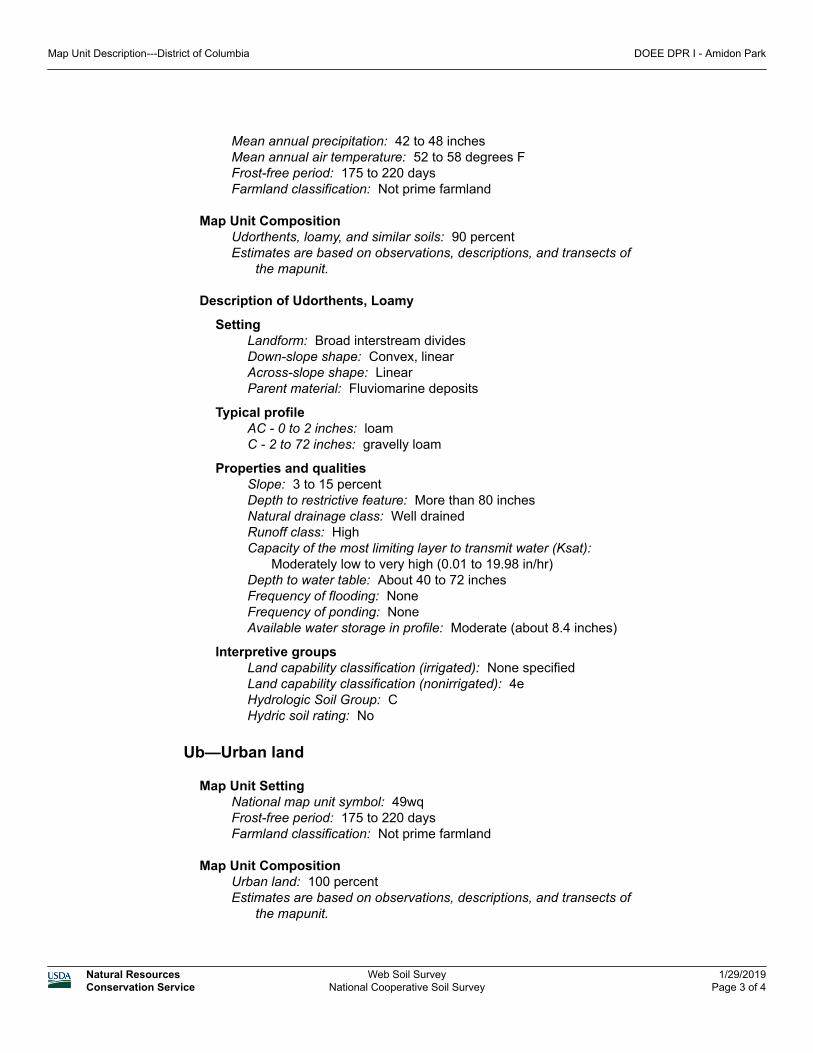
Mean annual precipitation: 42 to 48 inchesMean annual air temperature: 52 to 58 degrees FFrost-free period: 175 to 220 daysFarmland classification: Not prime farmland
Map Unit CompositionUdorthents, loamy, and similar soils: 90 percentEstimates are based on observations, descriptions, and transects of
the mapunit.
Description of Udorthents, Loamy
SettingLandform: Broad interstream dividesDown-slope shape: Convex, linearAcross-slope shape: LinearParent material: Fluviomarine deposits
Typical profileAC - 0 to 2 inches: loamC - 2 to 72 inches: gravelly loam
Properties and qualitiesSlope: 3 to 15 percentDepth to restrictive feature: More than 80 inchesNatural drainage class: Well drainedRunoff class: HighCapacity of the most limiting layer to transmit water (Ksat):
Moderately low to very high (0.01 to 19.98 in/hr)Depth to water table: About 40 to 72 inchesFrequency of flooding: NoneFrequency of ponding: NoneAvailable water storage in profile: Moderate (about 8.4 inches)
Interpretive groupsLand capability classification (irrigated): None specifiedLand capability classification (nonirrigated): 4eHydrologic Soil Group: CHydric soil rating: No
Ub—Urban land
Map Unit SettingNational map unit symbol: 49wqFrost-free period: 175 to 220 daysFarmland classification: Not prime farmland
Map Unit CompositionUrban land: 100 percentEstimates are based on observations, descriptions, and transects of
the mapunit.
Map Unit Description---District of Columbia DOEE DPR I - Amidon Park
Natural ResourcesConservation Service
Web Soil SurveyNational Cooperative Soil Survey
1/29/2019Page 3 of 4
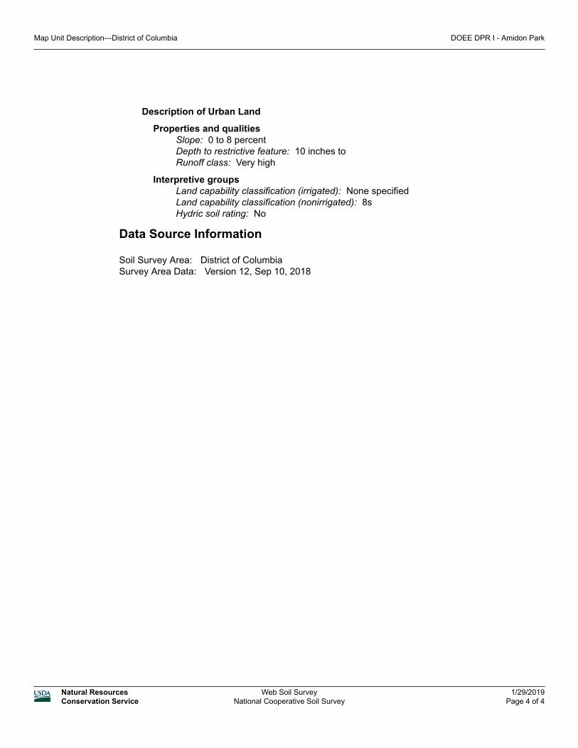
Description of Urban Land
Properties and qualitiesSlope: 0 to 8 percentDepth to restrictive feature: 10 inches to Runoff class: Very high
Interpretive groupsLand capability classification (irrigated): None specifiedLand capability classification (nonirrigated): 8sHydric soil rating: No
Data Source Information
Soil Survey Area: District of ColumbiaSurvey Area Data: Version 12, Sep 10, 2018
Map Unit Description---District of Columbia DOEE DPR I - Amidon Park
Natural ResourcesConservation Service
Web Soil SurveyNational Cooperative Soil Survey
1/29/2019Page 4 of 4


![[Philip R. Amidon] Philostorgius Church History ((Bookos.org)](https://img.pdfslide.us/doc/110x75/55cf9dab550346d033aea3e3/philip-r-amidon-philostorgius-church-history-bookosorg.jpg)