Embed Size (px)
Citation preview

2017 Open Lands pLan Updatea pLan fOr Open space, traiLs and the Use Of tOwn Lands
An element of the Vail Comprehensive PlanAdopted xxx, xxx, Resolution #xx, Series 20xx
Text in red reflects refinements made during the Planning and Environmental Commission review process.November 27, 2017March 26, 2018
DRAFT

tOwn cOUnciLDave Chapin, Mayor Kim LangmaidJenn Bruno, Mayor Protem Jen MasonDick Cleveland Greg MoffetKevin Foley
pLanning and envirOnmentaL cOmmissiOnJohn Rediker Brian GilletteLudwig Kurz Karen Marie PerezBrian Stockmar John Ryan LockmanPam Hopkins
tOwn Of vaiL staffGeorge Ruther Director of Community Development Kristen Bertuglia Environmental Sustainability ManagerChris Neubecker Planning ManagerMatt Panfil PlannerMark Hoblitzell Environmental Sustainability CoordinatorPeter Wadden Water Quality Education Coordinator Gregg Barrie Landscape ArchitectGreg Hall Director of Public Works and TransportationSean Koenig GIS CoordinatorSuzanne Silverthorn Director of Communications
BraUn assOciates, inc.Tom BraunTim Halbakken
se grOUpGabby VoellerScott Prior
ACKNOWLEDGEMENTS
2017 Open Lands Plan Update
DRAFT

execUtive sUmmary
1. intrOdUctiOn 1 - Need to Update the 1994 Open Lands Plan - Goals for Updating the 1994 Plan - Approach to this Update Process - Community Involvement - Organization of this Plan
2. envirOnmentaLLy sensitive Lands 6 - Community Input - Environmentally Sensitive Lands - Evaluation of Undeveloped Privately-Owned Lands - Protection of Environmentally Sensitive Lands - Designated Open Space Lands - Conservation Easements
3. tOwn-Owned Lands and Use Of Lands 15 - Community Input on the Use of Town Lands - Overview of Town-Owned Lands - Land Needs for Public Uses and Community Facilities - Evaluation of Town-Owned Lands - Evaluation of Privately-Owned Lands - Management of Vail’s Open Lands
4. traiLs 23 - Community Input on Trails - Small Group Meetings on Trails - Trails Community Workshop - A Vision for Vail’s Trails - Evaluation of Existing Trails - Wildlife and the Gore Valley - Wildlife and Recreation Trails - Mitigating Measures Prior to the Study of Potential New Trails - Conceptual Trails Plan - Description of Trail Ideas and Opportunities
TAbLE OF CONTENTS
2017 Open Lands Plan Update
- Other Trail Improvements - Trail Types and Standards - Regional Context of Vail’s Trails - Process for Evaluation of Trail Ideas - Easements From Private Land Owners
5. actiOn pLan 41 - 2017 Action Plan
6. impLementatiOn 50 - Environmentally Sensitive Lands - Public Facilities and Community Needs/Use and Management of Town Lands - Recreational Trails - Conclusion
7. appendix -1994 Open Lands Plan - Status of Action Plan Parcels and Trails from the ‘94 Action Plan - Summary of Action Items - Summary of Real Estate Transfer Tax Ordinances - Designated Open Space procedures - USFS Process - Trail Types and Standards - Conceptual Trails Plan/Trails Dropped from Consideration - Colorado Parks and Wildlife - Wildlife in the Gore Valley - Colorado Parks and Wildlife - Wildlife Influence Area Maps - Trail Scoping Session Minutes - September 2017DRAFT

EXECUTIVE SUMMARYIntroductionThe 1994 Comprehensive Open Lands Plan was adopted to “identify and develop strategies for acquiring or protecting key remining open lands in Vail that would be valuable for recreation, protecting sensitive environmental resources, extending or connecting trails, providing adequate neighborhood open space, and creating a small amount of contingency land for unforeseen needs (e.g. employee housing, public facilities)”. This update process was initiated by the Vail Town Council due to the age of the ’94 Plan and in response to many conditions that have changed over the past twenty-four years.
The broad objectives of this planning process were to:• Confirm the community’s goals for the Plan,• Evaluate Action Items from the ’94 Plan and
identify new Action Items to further goals for protecting environmentally sensitive lands and addressing other goals of the Plan,
• Provide better direction regarding recreation trails,
• Evaluate how Town-owned lands can be used to address community needs, and
• Define management strategies for Town-owned lands.
Community Planning ProcessCommunity input was an integral part of this planning process and involved the following:• Three community scoping sessions,• Two community input sessions• Trail-specific small group meetings and a
community-wide meeting
• A wildlife forum• Use of the Town’s web-based portal to
obtain community input, and • Public hearings with the Planning and
Environmental Commission and Town Council.
Environmentally Sensitive LandsThe acquisition and protection of environmentally sensitive and other lands was a major focus of the ’94 Plan. During this update process community input was clear that the protection of sensitive lands remains a very high priority. In 1994, an evaluation of all privately-owned lands was completed that identified thirty environmentally sensitive parcels to be acquired and protected by the Town. A similar process was done as a part of this update process. The updated Plan identifies sixteen such parcels (some of which were also recommend in the ’94 Plan). The Plan also recommends establishing a task force to further study techniques for the protection of environmentally sensitive lands that could include increased use of the Town’s Designated Open Space process and the use of conservation easements.
Town-owned Lands and Use of LandsThe ’94 Plan identified land needs for Town facilities and uses and provided recommendations for the use of eight Town-owned parcels. Many of these needs and recommendations have been implemented. This update process included the evaluation of all Town-owned lands to identify any parcels that may be suitable for Town use. None of the Town’s vacant parcels are suitable for the
DRAFT
Executive Summary

development of public uses or community-oriented facilities. It is possible, however, that public facility needs could be provided by the redevelopment of currently developed parcels (e.g. the east end of the Lionshead Parking Structure or the Vail Municipal Building site). Four privately-owned parcels are identified for potential acquisition by the Town for future public use or community-oriented facilities.
TrailsImproving the trail and bike system was listed as one of the top three priorities for open space and recreation from the ’94 Plan. Many trail and trailhead improvements have been completed since 1994. Trails remain a community priority with the caveat that any new trail development not create adverse environmental or wildlife impacts.
Wildlife resources in and around Vail have been significantly impacted by changes in the Gore Valley that have occurred since the early 1960’s. The use of recreational trails can add to these impacts. For this reason, this update recommends that a number of steps be taken to improve wildlife resources prior to the development of any new trails. These steps include community education regarding how trail use affects wildlife, enforcement of seasonal trail closures, and enhancement of wildlife habitat. Further, it is recommended that a comprehensive analysis of how existing trails, social trails and new trail ideas could impact wildlife, be completed prior to making any decisions on new trail development.
Implementation of the PlanSteps necessary to implement the goals of this Plan are provided in two chapters. The Action Plan chapter provides a summary of all Action Items - land and easement acquisitions necessary for the protection of environmentally sensitive lands and for the potential future development of recreation trails and Town uses. The Implementation Chapter provides a summary of follow-up studies needed to better define future actions and of other programs necessary to implement the goals of this Plan.
2017 Open Lands Plan Update
DRAFT
Executive Summary

2017 Open Lands Plan Update 1
DRAFT
The Town of Vail has a long history of acquiring lands to preserve as open space and to develop park facilities. Over the years the Town has also been diligent in developing a recreational trail system and in the development of necessary public facilities. Toward that end, the 1994 Comprehensive Open Lands Plan (the ‘94 Plan) was adopted for the stated purpose:
“to identify and develop strategies for acquiring or protecting key remaining open lands in Vail that would be valuable for recreation, protecting sensitive environmental resources, extending or connecting trails, providing adequate neighborhood open space, and creating a small amount of contingency land for unforeseen needs (e.g. employee housing, public facilities).”
ChApTER 1 - INTRODUCTION
Chapter 1 - Introduction
2017 Open Lands Plan Update 2
DRAFT
In the spring of 2016 the Vail Town Council initiated a process to update the ’94 Plan.
The ’94 Plan was developed over a period of two years with involvement of the Open Lands Steering Committee and after numerous community meetings. The five objectives of the ‘94 Plan were to:• Identify a comprehensive system of open
space uses such as parks, recreation, protection of environmental resources, trails and to reserve lands for public uses,
• Prioritize available open lands for acquisition or protection,
• Identify creative strategies to implement the acquisition and protection program,
• Define a management system to appropriately manage Town-owned open lands, and
• Buffer neighborhoods with open space.
developing an inventory of environmentally sensitive open lands (with the Colorado Natural Heritage Program) and proposing zone changes for public and private parcels. The 1994 Comprehensive Open Lands Plan served to integrate these efforts and to provide a framework for these and other actions related to open lands.
The main elements of the ’94 Plan included an Action Plan for the acquisition of land or easements and other steps to protect sensitive lands and further the goals of the Plan, a conceptual trails plan, identification of public facility needs and recommended uses for some Town lands, .
need tO Update the 1994 Open Lands pLanThe Vail Town Council directed Town staff to update the ’94 Plan in the Fall of 2016. Discussion of the potential re-development of the Vail Trail was the catalyst that prompted this update. Notwithstanding why the Town Council initiated this process, an update of the ’94 Plan was needed if for no other reason than twenty-three years have passed since its adoption.
There has been a great deal of change in Vail and Eagle County over the past twenty-three years and many of these changes are directly or indirectly related to specific recommendations of the ’94 Plan. Examples of these include:• Significant population growth in Vail and Eagle
County,• Increased summer visitation,• Gore Creek is now listed as Impaired,• Ever increasing challenges with establishing
workforce housing in Vail,
• The development of regionally-oriented recreation facilities in down-valley communities,
• On-going redevelopment in Vail that has increased the density and intensity of use on many properties, and
• A dramatic increase in the level of use and types of use on recreational trails.
• Significant impact on wildlife resources.
Each of these considerations reinforce the need to re-visit the ‘94 Plan.
During the development of the ’94 Plan the Town was involved in a number of related activities. These included inventorying all Town lands, revisiting open space zone districts, working on a Land Ownership Adjustment Plan (LOA) with the United States Forest Service,
Gore Creek is now listed as Impaired.
1994 Comprehensive Open Lands Plan.
gOaLs fOr Updating the 1994 Open Lands pLanThe Town Council specifically asked for an update to the ’94 Plan, and not an entirely new open lands plan. As an update, it has been assumed that the basic format and topics addressed by the ’94 Plan are valid today. As such, the focus of this planning process was to revisit all elements of the ’94 Plan and evaluate how they can be refined to better respond to
Chapter 1 - Introduction

2017 Open Lands Plan Update 3
DRAFT
conditions in Vail today and into the future. In essence, the goal of this planning process was to update the Plan to provide a framework for effectively implementing actions to achieve Vail’s goals for the preservation of open space, the development of trails and the use of Town lands. The process for updating the ’94 Plan was designed to address the following broad objectives:
• Confirm the community’s overall goals and priorities for the Plan,
• Evaluate the Action Plan and identify any new Action Items to protect environmentally sensitive lands or other action to implement the goals of the Plan,
• Provide better direction for the potential development of recreation trails,
• Evaluate Town-owned lands for how they can be used to meet community needs, and
• Define management strategies for Town-owned lands.
• Protection of environmentally sensitive lands/wildlife.
apprOach tO this Update prOcessThe major steps in updating the ’94 Plan included:
Evaluation of the ‘94 Plan A critical review of the ’94 Plan was completed to understand the strengths of the Plan and elements of the Plan that could be improved.
Community Scoping SessionsAt the outset of the project three community scoping meetings were held. Information about Vail’s Comprehensive Plan, the ’94 Plan and related topics were presented. Participants were encouraged to provide questions and comments at these meetings and a portal was established on the Town’s web page as another means for the community to offer comments on the Plan.
Technical AdvisorsThroughout the planning process, technical experts, agencies and potential partners who are involved in topics addressed by the Plan were engaged. Examples of these include Colorado Parks and Wildlife, Vail Resorts trails staff, Eagle County and the Eagle Valley Land Trust.
Evaluation of Lands Extensive evaluations of Town-owned and privately-owned lands were completed to gain a comprehensive understanding of these lands and to identify the role they could play in implementing the goals of this Plan.
Existing section of the Vail Trail.
Chapter 1 - Introduction

2017 Open Lands Plan Update 4
DRAFT
Small group discussion at second community meeting.
Community Meetings Two community meetings were held during the planning process. These meetings focused on various aspects of the update and allowed for community interaction and conversation about the Plan.
Recreation TrailsA series of small group scoping meetings specific to trails and a community-wide trails workshop were held to better understand perspectives regarding existing trails and potential improvements to the Town’s trail system.
Review ProcessFollowing preparation of a draft plan, the proposed update was reviewed by the Vail Planning and Environmental Commission and the Vail Town Council.
cOmmUnity invOLvementCommunity involvement played a significant role in this update process. Input was obtained during three scoping meetings, two community meetings, a series of small group meetings and a community-wide workshop dedicated to trails.
A portal dedicated to open lands was provided on the Town’s web page and input was obtained by written questionnaires that were provided during meetings. Community input was also obtained during the formal review of the Plan by the Planning and Environmental Commission and the Town Council.
Input from the community during the planning process was a major influence in the development of the updated Plan. Trails are a good example of how community input influenced the planning process. During scoping and community meetings, many passionate opinions were expressed about Vail’s existing trails, the need for new trails and the potential impact from trail use on wildlife. To better understand how the community felt about trails and to bring those with divergent viewpoints together for discussion, small group sessions specific to trails and a community-wide trails workshop were held. The SE Group, a design firm that specializes in trail design and planning, was engaged to facilitate these efforts. A wildlife forum was then held to discuss the state of wildlife in the Gore Valley. The effort put towards trails was considerably greater than originally anticipated and this effort was taken in direct response to input from the community.
As with any community planning process, it is often difficult to draw consensus from input that is provided from the community. This is because in most cases community members will have a variety of different viewpoints and while some conclusions can be drawn from opinions provided by those who participate in a planning process, the opinions of those who do not participate are not heard. For many reasons, finding clear consensus on community goals is a difficult thing.
Subsequent chapters of this Plan provide a summary of comments that were heard from the community during this update process. In most cases a wide range of divergent comments were heard. These summaries are not scientific and are not intended to suggest community consensus. Rather, the summaries of community input provided in the following chapters are intended to convey general themes of what was expressed by the community
OrganizatiOn Of this pLanThe 2017 Open Lands Plan Update includes the following chapters:
1. Introduction This chapter provides background on the ’94 Plan, the need, goals for and approach to this update.
2. Environmentally Sensitive Lands This chapter summarizes how the ’94 Plan addressed environmentally sensitive lands and community input during this update process, defines environmentally sensitive lands, outlines measures that have been taken to protect such lands and identifies additional lands that may warrant protection.
3. Town-Owned Lands and Use of Lands A summary of how the ’94 Plan addressed Town-owned lands, community input during this update process, an evaluation of all Town-owned lands and privately-owned lands (that could further the goals of this Plan) are provided in this chapter.
Chapter 1 - Introduction

2017 Open Lands Plan Update 5
DRAFT
4. Trails Goals and accomplishments relating to trails from the ’94 Plan, community input during this update process, a vision for trails, a conceptual trails plan and subsequent steps in the planning and approval processes for any new trail development are provided in this chapter.
5. Action Plan The ’94 Plan includes an Action Plan that identified fifty-one Action Items to acquire easements or land necessary to implement the goals of the Plan. Many of these action items have been accomplished. An updated Action Plan is provided in this chapter.
6. Implementation This chapter outlines implementation steps and follow-up tasks.
7. Appendix The ‘94 Plan and other supplemental information are found in the appendix.
The 2017 Open Lands Plan Update provides a framework for actions the Town can implement for the protection of lands, trails and the use of Town lands. The 2017 Open Lands Plan Update was adopted by Resolution No. XX, Series 20XX by the Vail Town Council after recommendation from the Vail Planning and Environmental Commission. This Plan is an element of the Town’s Comprehensive Plan.
Chapter 1 - Introduction

2017 Open Lands Plan Update 6
DRAFT
ChApTER 2 -ENVIRONMENTALLY SENSITIVE LANDS
Chapter 2 - Environmentally Sensitive Lands
While the ’94 Plan addressed recreational trails, Town facilities and the use and management of Town lands, the identification of environmentally sensitive lands and recommendations for their acquisition and protection was the primary focus of the Plan. The ‘94 Plan’s focus on environmentally sensitive lands is evident a number of ways. Two of the five objectives of the ’94 Plan were to “prioritize available open lands for acquisition or protection” and to “identify creative strategies to implement the acquisition and protection program”. The number one priority for recreation and open space is to “acquire, preserve and protect natural open space” and the top priority for land acquisitions is to “protect sensitive natural habitat areas, riparian areas and hazard areas”. Thirty of the fifty-one Action Items from the ’94 Action Plan involve the acquisition and protection of environmentally sensitive lands and over half of the Action Items that have been implemented have resulted in the acquisition and preservation of such lands.
Since its adoption, the ’94 Plan has been regarded by some as an “open space plan”. While the ’94 Plan is far more than just an open space plan, the emphasis of the ’94 Plan is clearly on the preservation of environmentally sensitive and other open space lands.
The terms “open lands” and “open space” are used throughout this Plan. When used, open lands refer to vacant, undeveloped land that may be owned by the Town or privately-owned. Open lands are generally discussed in the context of how they could be used by the Town to address the need for public
uses or facilities or how the lands could be protected as open space. Open space generally refers to lands owned by the Town that have been assigned as Designated Open Space, or Town-owned or privately-owned lands that are zoned for open space or have a conservation easement. Open space is also used to refer to lands recommended by this Plan for acquisition by the Town for protection as open space, or privately-owned lands that may be appropriate for conservation easements or other protection measures.
This chapter summarizes community input on environmentally sensitive lands and provides an explanation of the type of lands that are considered environmentally sensitive. Explanation of how potentially environmentally sensitive, privately-owned lands were evaluated and recommendations for lands to be acquired by the Town are provided.Finally, techniques to be used for the protection of these lands are addressed. cOmmUnity inpUtThere was very broad support among those who participated in scoping sessions and community meetings for the Town to continue efforts to acquire and protect environmentally sensitive lands. Most felt that the ’94 Plan and the Town’s previous efforts to acquire lands for open space (and for park and trail development) have been very beneficial. Reasons for continuing these efforts varied. For many, the need to protect our environmentally sensitive

2017 Open Lands Plan Update 7
DRAFT
Chapter 2 - Environmentally Sensitive Lands
lands and wildlife resources were the most compelling reasons for the Town to acquire lands. For others, the benefit of acquiring lands was to prevent them from being developed. Acquiring lands to create buffers between neighborhoods and to establish open space that would offset the impacts from the ongoing redevelopment of Vail was also mentioned.
There was a noticeable emphasis in public input regarding the water quality of Gore Creek and the potential benefits of land acquisitions that could contribute to improving the health of this creek and its tributaries.
The Real Estate Transfer Tax (RETT) has been the Town’s primary funding source for the purchase of lands for open space or recreational purposes. There were many comments regarding RETT, ranging from a suggestion to expire the tax due to the lack of lands available for purchase, to refocusing the use of RETT funds on land purchases as opposed to maintenance and other purposes. There were a number of comments that land purchased with RETT funds should only be used for open space or park purposes. A summary of how the RETT ordinance has been amended over the years is found in the appendix.
envirOnmentaLLy sensitive LandsIn the ’94 Plan, the primary reason for the Town to acquire open lands was to protect environmentally sensitive land resources. The protection of the Gore Creek corridor and its importance as a wildlife, riparian and wetland resource and recreation amenity was also
mentioned, as were open space acquisitions that would preserve the “mountain experience and the natural character of the Vail Valley”.
While these reasons provided some guidance in identifying potential parcels for acquisition, they are broadly stated and do not provide specifics with regards to what is meant by environmentally sensitive lands. Considerations below define environmentally sensitive lands:
Plan for improving the health of this water course. The acquisition and protection of parcels along Gore Creek and its tributaries that could help improve water quality and benefit the aquatic health of this water course should be considered.
Wildlife Corridors and HabitatThe abundance and variety of wildlife that can be seen in and around Vail are resources valued by both residents and guests. Population declines of key species such as elk, mule deer and bighorn sheep over the past two decades have been attributed to habitat fragmentation and increased trail and recreational use. Acquisition of parcels which could establish habitat connectivity, potential wildlife corridors and areas known to contain seasonal habitat for species should be considered.
Native Plant HabitatLands that support sensitive or native plant species and other notable vegetation cover that contributes to the Town’s scenic and natural qualities.
Geologically Sensitive LandsLands that include geologically sensitive areas such as avalanche, debris flow, rockfall, steep slope and floodplain hazards.
The considerations above have been used to identify lands that if acquired and protected would further the goals of this Plan.
Wetland / Riparian area along Gore Creek.
Wetland and Riparian AreasWetlands and riparian areas provide flood control, filtration of storm water run-off and important habitat for a myriad of wildlife and plant species. These areas are particularly important to Gore Creek for two reasons. Gore Creek has been listed as Impaired by the Colorado Department of Public Health and Environment due to lack of aquatic life and the lower stretch of the creek is designated Gold Medal Water by Colorado Parks and Wildlife. The Town has responded to this situation a number of ways, most notably by the adoption of Restore the Gore, a Gore Creek Strategic Action

2017 Open Lands Plan Update 8
DRAFT
Chapter 2 - Environmentally Sensitive Lands
evaLUatiOn Of UndeveLOped privateLy-Owned LandsThe major focus of the ’94 Plan was to identify environmentally sensitive lands and to outline strategies for the Town to acquire and protect them. A comprehensive evaluation of all undeveloped lands not owned by the Town was completed. The purpose of this evaluation was to identify specific parcels that if acquired or protected could further the goal of protecting sensitive environmental resources. This evaluation resulted in thirty parcels that were recommended for acquisition and protection.
As a part of this update process, an evaluation similar to that done in 1994 was completed for all privately-owned, undeveloped lands within the Town. The purpose of this evaluation was twofold - to identify any lands that may have been overlooked by the ’94 Plan and to see if changed conditions warrant the inclusion of lands that were not addressed by the ’94 Plan. One hundred and six parcels were evaluated relative to the considerations described above.
The Privately-Owned Lands/Parcels for Acquisition and/or Protection Plan on the following page depicts all undeveloped, privately owned parcels within the Town of Vail and the sixteen parcels recommended for acquisition or protection (note that privately owned also includes land owned by agencies such as the Eagle River Water and Sanitation District and the Colorado Department of Transportation).
Properties identified on the Privately-Owned Lands/Parcels for Acquisition and/or Protection Plan include parcels that:
• Are located adjacent to Gore Creek or one of its tributaries,
• Benefit wildlife habitat by providing movement corridors or other benefits,
• Are inaccessible due to terrain or ownership or where access would have negative impact on the land,
• Include steep slopes or other environmental hazards.
Acquisition of parcels would involve the Town approaching the land owner to gauge their interest in selling their land to the Town. Subject to agreeing on terms, the Town would acquire the land and then take steps to ensure it is protected from development. In lieu of outright acquisition, the protection of lands could also be achieved by the Town working with land owners to protect the land from development. This could be accomplished by placing a conservation easement on the land that would restrict or limit its development. In certain cases, the conservation easement could involve compensation to the land owner for development rights that would be relinquished by the conservation easement. Another alternative could be to work with land owners to rezone property to limit its development potential or to define no-build areas that would prevent development of environmentally sensitive portions of a parcel.
Each of the sixteen parcels identified for acquisition or protection are more specifically discussed in Chapter 5 - Action Plan. Information provided in Chapter 5 includes the parcel size, zoning and ownership, the benefits for acquisition and
Rockfall and steep slope hazards in the Lionsridge neighborhood.
prOtectiOn Of envirOnmentaLLy sensitive Lands The ‘94 Plan addressed the importance of the Town protecting environmentally sensitive lands from future development or changes of use. This was prompted in part by community input during the development of the ‘94 Plan:
“one of the concerns frequently expressed at the public meetings was the need to ensure that once lands are acquired for open space, parks and trails that they be protected from conversion to other uses in the future”From 1994 Open Lands Plan
protection of the land, recommendations for outright acquisition or other protection strategies, and the relative priority for implementation of the Action Item.

2017 Open Lands Plan - Update 9
DRAFT
Chapter 2 - Environmentally Sensitive Lands
- Private Undeveloped Parcels- Environmentally Sensitive Parcels Identified for Aquisition and/or protection (16)
privateLy-Owned Lands/parceLs fOr acqUisitiOn and/Or prOtectiOn pLan

2017 Open Lands Plan Update 10
DRAFT
Chapter 2 - Environmentally Sensitive Lands
In response, the ’94 Plan suggested two approaches for protecting lands – the use of conservation easements or a referendum process that would require voter approval to change the zoning and use of Town-owned lands.
Conservation EasementsConservation easements permanently protect the conservation values of land by limiting the use or development of the land. Establishing a conservation easement is the decision of the land owner and involves working in partnership with an independent land trust, such as the Eagle Valley Land Trust, which would hold the easement. The easement is legally enforceable and is recorded with the property deed. Subject to the goals of the land owner and negotiations with the land trust, an easement may allow for limited uses (such as trails or utilities) that do not compromise the conservation values of the land and may also specify management practices for the land. Once an easement is in place the land owner retains ownership of the land while the land trust is responsible for monitoring the land to ensure its use is consistent with the terms of the easement. Conservation easements are considered to be unchangeable and establish permanent protection of the land’s conservation values.
The role conservation easements can play in the Town’s goals for protection of environmentally sensitive lands is discussed in Chapter 6 – Implementation.
In response to these questions, an evaluation of Town-owned lands that could qualify to be Designated Open Space and Town-owned lands that could be considered for conservation easement protection was completed.
designated Open space LandsSince 1995, the Town has applied the Designated Open Space overlay to fifty-seven Town-owned parcels that comprise 533 acres. The process for applying this designation involves a recommendation from the Open Space Board of Trustees (comprised of the Town manager, one member from the Town Council and one member from the Planning and Environmental Commission) that is presented to the Town Council. The Open Space Board of Trustees recommendation must be unanimous. A three-fourths vote of the entire Town Council is then required to apply the open space designation on a parcel of land.
To be considered for dedication as Designation Open Space, a parcel must be owned by the Town of Vail and zoned either Natural Area Preservation, Outdoor Recreation or Agricultural Open Space. In addition, the parcel must be either:
1. Environmentally sensitive lands (wetlands, riparian areas, critical habitat identified by Colorado Parks and Wildlife, or the Natural Heritage Program);
Referendum/Voter ApprovalA common approach for communities to protect publicly-owned lands from future development or changes of use is to zone the property so that development potential is very limited and then require a vote of the public to change such zoning. Voter approval to change zoning eliminates concerns with future councils changing the decisions of previous councils. This approach is considered to be an effective means for protecting lands but is less permanent than a conservation easement.
While a handful of conservation easements have been established on Town-owned lands, the Town Council amended the Town Charter in 1995 to establish Designated Open Space. Designated Open Space is an overlay designation that can be applied by the Town Council to any Town-owned parcel that satisfies certain criteria. The open space designation cannot be changed, nor can a parcel that has been dedicated Designated Open Space be sold, without a three-fourths vote of the Town Council and then a vote of the public. Specific procedures for Designated Open Space as prescribed by the Town Charter are found in the appendix of this Plan.
Community Input on the Protection of LandsThe protection of Town-owned lands was discussed throughout this update process. This discussion focused on the need for lands to be protected and more specifically the methods used for protection. Two common themes, or questions, were heard:
Are there additional environmentally sensitive lands owned by the Town that warrant being dedicated Designated Open Space?
While the process to change a parcel that has been dedicated Designated Open Space may be challenging, are there lands owned by the Town that warrant further protection via a conservation easement?

2017 Open Lands Plan Update 11
DRAFT
2. High natural hazard areas including the 100-year flood plain, red avalanche hazard area, high rock fall hazard area, and high debris flow hazard area; or
3. Town of Vail parks that provide passive outdoor recreation opportunities.
A map depicting the Town’s Open Space Zoned Lands, Designated Open Space, and Conservation Easements is found on the following page. This Plan depicts:
• Town-owned parcels that are Designated Open Space,
• Town-owned parcels that are zoned Natural Area Preservation, Outdoor Recreation or Agricultural Open Space but do not meet one of the three criteria listed above,
• Town-owned parcels that are zoned Natural Area Preservation, Outdoor Recreation or Agricultural Open Space that do meet one of the other three criteria, and
• Town-owned lands with a conservation easement
A total of twenty-six parcels are appropriately zoned and satisfy one or more of the criteria pertaining to environmental sensitivity, natural hazards or passive recreation. Each of these parcels could potentially be Designated Open Space.
While Designated Open Space parcels can be changed, once a parcel is dedicated as Designated Open Space it is arguably locked up as park or open space land, due to the steps necessary to change such designation. As such, dedicating a parcel Designated Open Space
should only be done after thorough consideration of all relevant factors. The Town must be certain of their commitment and understand that any future or unforeseen land needs that may arise could only be developed on designated parcels if such uses conformed to the limited range of uses permitted by these three open space zone districts.
In depth study of these twenty-six parcels is necessary in order to determine which, if any warrant being dedicated as Designated Open Space. Factors to be studied include site characteristics, zoning and potential opportunities for future Town use. This effort should be initiated by Town Staff and could be supported by a citizen’s task force to ensure there is broad community involvement in this process.
The Designated Open Space process allows for the designation of Town-owned lands that are zoned one of three open space zone districts and that meet certain criteria. As a part of the Task Force efforts, all Town-owned lands should be evaluated to identify any lands that may otherwise be appropriate for Designated Open Space but are not currently zoned one of the three open space zone districts. In such cases, consideration could be given to re-zoning such lands to one of the three open space districts to allow them to be Designated Open Space.
Refer to Chapter 6 – Implementation for more information.
cOnservatiOn easementsThe Town’s Designated Open Space process provides very strong assurances that designated lands will be protected by limiting uses and preventing the sale of such lands. It is very difficult to change Designated Open Space once it has been
A conservation easement has been established on the Town’s waterfall parcel in East Vail.

2017 Open Lands Plan - Update 12
DRAFT
- Zoned OR, NAP or AOS, not currently eligible- Zoned OR, NAP or AOS, eligible for Designated Open Space Overlay- Zoned OR, NAP or AOS and has Designated Open Space Overlay- Conservation Easement
Legend
Mat
chlin
e
Mat
chlin
e
Open space zOned Lands designated Open space andcOnservatiOn easements
Chapter 2 - Environmentally Sensitive Lands
West Vail Interchange
Potato Patch
Intermountain
Booth Falls
East Vail Interchange
Main VailInterchange
DRAFT
Ford Park

2017 Open Lands Plan Update 13
DRAFT
established. Community input has, however suggested the use of conservation easements to provide stronger protection of Vail’s open spaces.
Conservation easements are established to be held in perpetuity which in essence means the land is protected forever. Conservation easements are widely considered the most effective means of protecting lands from development or changes in use that could otherwise affect the conservation values of the land.
The benefit of applying a conservation easement to Town-owned land is that the land would be protected in perpetuity, and in doing so would provide lasting protection of environmentally sensitive lands or lands with other characteristics that are valued by the community for preservation. The potential detriment of applying a conservation easement to Town-owned land is that the Town would be committing to limitations on the use of such lands and giving up the control of or the possibility of any future land use changes on the land.
In response to community sentiment and the value held by many for the importance of the Town to protect key open space parcels in perpetuity, the Task Force efforts described above should also evaluate Town-owned lands that may warrant protection by a conservation easement. Establishing an additional layer of protection afforded by a conservation easement may be beneficial on lands that could otherwise have some level of development potential
or where unique site characteristics may warrant additional protection. The key question when considering the implementation of a conservation easement is whether the value of the land as open space is such that it should always and forever be protected and maintained as open space. By placing a conservation easement on Town-owned land, the Town would be making a statement about its commitment to the environment and leaving a legacy of conservation for future generations. Four parcels that may warrant the protection of a conservation easement are described below. Town Parcels to Consider for Conservation EasementThe four parcels (some of which include multiple parcels) described below are dedicated as Designated Open Space and each provides open space that is highly valued by the community for the scenic qualities, neighborhood buffers or sensitive lands they contain. These parcels are suggested for further evaluation to better understand the potential benefits that could be provided by adding the protection of a conservation easement. This evaluation should not be limited to these four parcels and should consider other Town-owned parcels that may warrant protection by a conservation easement.
Gore Creek CorridorThe Town owns the majority of the Gore Creek corridor between Ford Park and Donovan Park. These parcels total approximately 37 acres and approximately half of these parcels are DOS. These parcels include Gore Creek and associated floodplain, wetlands and riparian areas. With the exception of trails or passive recreation improvements such as benches, these parcels are not buildable. Establishing a conservation easement on these lands would be a strong statement as to the importance of Gore Creeks aquatic health. Any conservation easement would need to acknowledge the limited existing (and future) improvements such as trails, bridges, utilities and drainage improvements, etc.
Chapter 2 - Environmentally Sensitive Lands
2017 Open Lands Plan Update 14
DRAFT
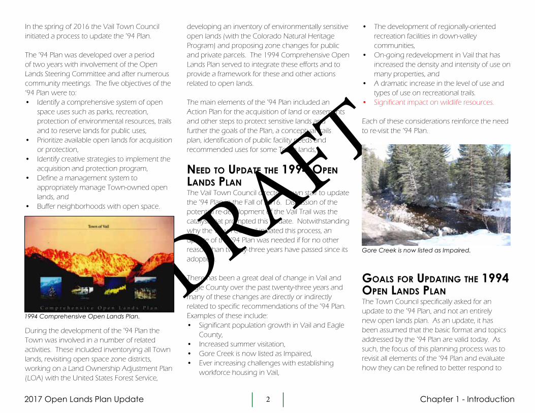
Booth Falls ParcelsTwo parcels located around the Booth Falls neighborhood are both zoned Natural Area Preservation. The easterly parcel is 30.2 acres and is impacted by steep slopes and high severity rockfall hazard. The westerly parcel is 93 acres and is impacted by debris flow hazards. Both parcels are considered critical bighorn sheep range/habitat. The bighorn sheep habitat on these parcels make them unique and this warrants consideration of a conservation easement. If a conservation easement is pursued, reserved rights for trails and maintenance of rockfall mitigation should be established.
Chapter 2 - Environmentally Sensitive Lands
Katsos RanchThe 144 acre Katsos Ranch is arguably Vail’s most renowned open space parcel. The land includes wetlands, Gore Creek and associated floodplain and riparian habitat, high and moderate severity debris flow, high severity rock fall and avalanche hazards. The site provides an important buffer between East Vail and the Aspen Lane neighborhood and coupled with its scenic qualities and environmentally sensitive features, this parcel warrants consideration for a conservation easement. If a conservation easement is pursued, reserved rights for trails and the Memorial Garden should be retained.
Upper Bench of Donovan ParkThe +/-35 acre Upper Bench parcel is zoned Outdoor Recreation and was purchased with RETT funds. The parcel is impacted by high hazard debris flow and steep slopes. The parcel provides an open space buffer within the Matterhorn neighborhood. The property has good access and subject to mitigation of hazards, could have development potential and for this reason this parcel warrants consideration of a conservation easement. If a conservation easement is pursued, reserved rights for trails, passive recreation use and temporary uses such as staging areas for timber removal.

2017 Open Lands Plan Update 15
DRAFT
ChApTER 3 -TOWN-OWNED LANDS AND USE OF LANDS
Chapter 3 - Town Owned Lands and Use of Lands
One of the five objectives of the ’94 Plan was to:
“Identify a comprehensive system of open space uses such as parks, recreation, protection of environmental resources, trails and to reserve lands for public use”
One of the stated purposes of the ‘94 Plan was to “create a small amount of contingency land for unforeseen needs (e.g. employee housing, public facilities)” and an objective of the Plan was to “identify, to the extent possible, future public needs (or needs not currently being met) that will require land”. The Action Plan included recommendations for the use or acquisition of “parcels intended for other community needs such as an additional fire station”.
The ’94 Plan identified five Town of Vail issues and needs for community-oriented projects that would require land:
1. Expansion of the Public Works facility2. New West Vail Fire Station3. Vail Police Department firing range4. Expanded play areas at Red Sandstone
Elementary School5. Employee housing projects at Vail Commons
and the Mountain Bell site
With the exception of the Police Department firing range, each of the projects listed above have been implemented. The Public Works expansion and the Chamonix housing project are located on land that was identified for acquisition by the ’94 Action Plan.
The ’94 Plan also provided recommendations for the use of eight Town-owned parcels. Three of these recommendations involved the development of affordable or employee housing on the Vail Commons parcel, on four lots located on Garmish Drive and on the Mountain Bell site. Each of these recommendations has been implemented. While the Berry Creek parcel located in Edwards was ultimately sold to Eagle County, the Plan’s recommendations for recreational and housing development on this parcel have been implemented by others.
The purpose of this chapter is to understand the Town’s land resources and how they can address the Town’s future land needs. Below is a summary of community input on the use of Town-owned lands and the need for new or expanded community facilities. An evaluation of whether Town-owned lands can accommodate future community-oriented uses, input from Town staff on the need for new or expanded community facilities and an evaluation of all vacant, privately-owned land that could potentially address future public needs is also provided.

2017 Open Lands Plan Update 16
DRAFT
Chapter 3 - Town Owned Lands and Use of Lands
cOmmUnity inpUt On the Use Of tOwn LandsA variety of opinions were expressed by the community regarding Town facilities, the need for expanded or new facilities, the use of Town-owned lands and if or under what circumstances the Town should acquire land for public facilities and community-oriented uses.
As a relatively mature community, Vail operates a wide variety of public facilities and there was a general level of satisfaction with facilities provided by the Town and how they are managed. By way of example, during the preparation of the ’94 Plan there was considerable community support for the development of additional neighborhood parks and the ’94 Plan identified a number of park improvements. Likely due to the development of Donovan Park, Sunbird Park, Booth Creek Park, Ellefson Park and major improvements to other Town parks since 1994, there were no comments or requests to expand the Town’s park facilities during this update process.
The circumstances under which the Town should pursue the acquisition of land for public facilities or community-oriented uses prompted many diverse opinions. There were a preponderance of opinions that land acquisitions should first and foremost be to acquire land for open space to protect environmentally sensitive lands. Further, that any parcel acquired for community uses should only occur if that parcel does not have environmental values that should be protected. For some, only lands that are currently
developed or are zoned for development should be considered for acquisition and use by the Town.
There were also divergent opinions on what constitutes a public facility or a community-oriented use. Many felt that affordable housing is neither a public facility nor a community-oriented use. Further, there were suggestions that the Town should not be in the housing business and that housing should not be addressed by the Open Lands Plan. By the same token, many others felt that affordable housing is a valid community-oriented use, that projects like the Chamonix development are beneficial and that it is appropriate for this Plan to identify lands that may be suitable for housing development. There was much agreement amongst those in support of Town-initiated housing projects that any Town project should be on land that is zoned for development, is located within an established neighborhood and is proximate to public transit. A number of people expressed a preference for re-developing properties that are currently developed.
While a wide spectrum of comments were heard, written comments provided by the community were near evenly split as to whether the Open Lands Plan should address housing with 38% of comments in support and 41% opposed.
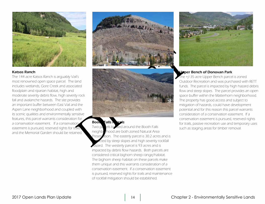
Overview Of tOwn-Owned LandsThere are approximately 2,904 acres of land located within the Town’s boundary and the Town of Vail owns 161 parcels that total 1,040 acres, or 35.8% of all land within the Town. Rights-of-way for Interstate 70 and the Frontage Roads comprise approximately 495 acres and approximately 1,262 acres of land are privately-owned or owned by other governmental entities. All lands immediately surrounding the
Town’s boundary are owned by the United States Forest Service. A plan depicting Town-owned lands is found on the following page.
The Town of Vail has three open space-oriented zone districts – the Agricultural and Open Space District, the Outdoor Recreation District and the Natural Area Preservation District. While the purpose of the Agricultural and Open Space District and Outdoor Recreation District is to preserve open space lands, these districts allow for a limited range of land uses. The Natural Area Preservation District is intended to protect sensitive lands from development and land uses in this district are very limited. 758 acres, or 72.8% of all Town-owned lands are zoned one of these three open space districts. The 57 Town-owned parcels that are Designated Open Space total 533 acres.
Ford Park sports fields.
2017 Open Lands Plan Update 17
DRAFT
tOwn Of vaiL Owned Lands and i-70 r.O.w. Lands
- Town-Owned Lands - 1,040 acres- I-70 Corridor - 495 acres- Privately Owned Lands - 1,262 acres
Chapter 3 - Town Owned Lands and Use of Lands
DRAFT

2017 Open Lands Plan Update 18
DRAFT
Chapter 3 - Town Owned Lands and Use of Lands
Land needs fOr pUBLic Uses and cOmmUnity faciLities While there were suggestions from the community for expanding the supply of public parking, the development of more affordable housing, the development of conference performing art and recreation centers and a disc golf course, there was no single use that generated a significant number of requests from the community.
Town department directors were consulted for their input on the need for new or additional facilities. The Fire Department is interested in a one-acre site for a training facility. The Human Resources Department supported affordable housing to assist in recruitment and retention of employees. The Public Works Department would like to expand the existing snow dump, establish a solar farm and increase public parking, and the Economic Development Department supports the development of conference facilities, a theater and other event areas.
The feasibility of conference, performing art and recreation centers has been discussed and studied over the past few decades. Original plans for Ford Park included an aquatics/recreation center and on more than one occasion a convention center has been proposed, most recently at the east end of the Lionshead Parking Structure. For various reasons none of these facilities have been constructed. The development of additional public parking has been a priority of the Town for many years. A lack of available land and
the cost to construct parking are the two primary challenges to developing additional parking.
evaLUatiOn Of tOwn-Owned LandsAll 161 Town-owned parcels were evaluated to determine if any of these parcels can accommodate the Town’s future needs for public or community-oriented facilities. A fundamental assumption in this evaluation was that existing uses will be maintained and no existing uses would be displaced in order to accommodate other uses.
The initial step in this evaluation considered the existing use and site characteristics of all Town-owned lands. Lands that are currently used for other purposes and lands with site characteristics that would preclude their development were eliminated from consideration. Lands were categorized one of four ways - developed lands such as the Vail Municipal Building, park and recreational lands such as Ford Park and the Vail Golf Club, environmentally constrained lands, and Designated Open Space parcels and conservation easement lands.
After eliminating parcels from the four categories listed above, only eight Town-owned parcels remained. These eight parcels were evaluated based on size, terrain and site characteristics, site context and relationship with surrounding lands, access and covenants restrictions. These eight parcels include:
Parcel #1 - Commonly referred to as the Middle Bench of Donovan Park, this 2.1 acre parcel is zoned Agricultural and Open Space and is located on Matterhorn Circle in the Matterhorn neighborhood. Based on site characteristics such as terrain and
access, this parcel is considered buildable. However, this parcel was purchased with RETT funds and as such land uses are limited to parks, recreation, open space and similar purposes. The Town Council has by resolution designated this parcel as a “park”.
Parcel #2 – This 3.1 acre parcel located in the Glen Lyon neighborhood is zoned Special Development District. While the parcel is buildable based on site characteristics, use of the parcel is restricted by protective covenants.
Parcel #3 – This 1 acre parcel is located at the north portal of the I-70 pedestrian bridge. Use of the parcel is restricted by protective covenants
Parcel #4 – This .3 acre parcel is zoned Lionshead Mixed Use 1 and currently provides a pedestrian connection between Lionshead Place and the Gore Creek bike path. Use of the parcel is also restricted by protective covenants.
Parcel #5 – This .3 acre parcel located along East Lionshead Circle is zoned General Use. The size of this parcel limits its development potential.
Parcel #6 – This .5 acre parcel located on Beaver Dam Road is zoned Natural Area Preservation. The presence of wetlands would render this site to be unbuildable.
Parcel #7 – This 13 acre parcel is located along Bald Mountain Road. It is zoned Outdoor Recreation and the use of the parcel is restricted by protective covenants.

2017 Open Lands Plan - Update 19
DRAFT
evaLUatiOn Of tOwn-Owned Lands
- Town-Owned
- Town-Owned Potential Use Parcels (8)
Legend
Mat
chlin
e
Mat
chlin
e
West Vail Interchange
Potato Patch
Intermountain
Ford Park
Booth Falls
East Vail Interchange
Main VailInterchange
#2
#3
#4#6
#7
#5
#8
Chapter 3 - Town Owned Lands and Use of Lands
DRAFT

2017 Open Lands Plan Update 20
DRAFT
Parcel #8 – This .3 acre parcel is located between the I-70 corridor and Booth Creek Road. The size of this parcel limits its development potential.
Due to parcel size, access constraints, and restrictions due to covenants or land being purchased with RETT funds, none of these eight parcels are currently viable for the development of public uses or community-oriented facilities.
While the Town does not currently own vacant land capable of accommodating new uses, some Town-owned parcels that are currently developed may be capable of accommodating new or expanded uses. An example of this is the shared parking structure with Eagle County Schools, planned for Red Sandstone Elementary. Other examples could include the Public Works Facility, the Vail Municipal Building and the east end of the Lionshead Parking Structure. The Town owns additional lands adjacent to the Public Works facility that could accommodate expansion of the existing snow dump. While the east end of the Lionshead Parking Structure has been studied for the development of conference facility, vail voters have rejected this
idea. The redevelopment of the Municipal Building has been studied for concepts that included additional community uses. Each of these possibilities would require additional study to fully understand the feasibility of accommodating other uses.
evaLUatiOn Of privateLy-Owned LandsThe ’94 Plan recommended a number of vacant, privately owned parcels to be acquired for the future development of public facilities and community-oriented uses. Examples of these are land acquired from Vail Resorts for expansion of the Public Works facility and land in West Vail that now includes the Chamonix housing project. Currently there are approximately 106 privately owned, undeveloped parcels in the Town of Vail. Each of these parcels was evaluated to understand if any could potentially accommodate public facilities and community-oriented uses.
Evaluation of these lands considered parcel size, existing zoning, site characteristics, the context of the site, covenant restrictions and its relationship to surrounding uses. The majority of these 106 parcels were deemed to not be viable for Town use for these reasons:
• Over half of the 106 parcels evaluated were Isolated, low density zoned parcels in established neighborhoods. These were considered to most appropriately be developed in accordance with existing zoning,
• Environmentally sensitive parcels were not considered viable development sites (these parcels are addressed in Chapter 2 – Environmentally Sensitive Lands),
West Vail Parcels along Chamonix Lane.
Development at the East end of Lionshead Parking Structure has been studied in the past.
Chapter 3 - Town Owned Lands and Use of Lands
• Parcel size, site context and covenant restrictions limited the viability of many sites.
Remaining parcels were then considered relative to their ability to potentially accommodate the broad list of public facilities and community-oriented uses suggested by the community and Town staff. Due to parcel locations, site context and the land area requirements, none of the remaining parcels are feasible for the development of parking, conference, performing arts or recreation. There are three sites that could potentially accommodate affordable housing and one site that could accomodate park expansion.
West Vail Parcels along Chamonix LaneIf assembled, these three contiguous parcels could accommodate a small housing development. These parcels are zoned Two-Family Primary/Secondary Residential and located next to multi-family and commercial development. While the parcels total 1.59 acres, development potential will be limited as over half the land area exceeds 40% slope.

2017 Open Lands Plan Update 21
DRAFT
Chapter 3 - Town Owned Lands and Use of Lands
Old Roost LodgeThis 1.9 acre site previously accommodated the Roost Lodge. The site is now vacant and development approvals have been granted for a hotel/affordable housing development. If the approved development does not proceed, the site could be viable for the development of an affordable housing project or other community use.
management Of vaiL’s Open Lands The ’94 Plan included two approaches for the management of open lands. The first was to establish a cooperative management system with both the USFS and Vail Resorts. The second was to develop a management system to provide appropriate stewardship and maintenance for the Town’s open lands. These concepts remain valid today. Community input during this update process echoed these concepts. Suggestions involved managing lands to promote biodiversity, attending to routine maintenance such as weed control and managing erosion or other issues and maintaining trails to ensure they remain sustainable.
Below are management actions for open lands to be addressed by the Town. A number of these steps involve follow-up actions or the preparation of plans that will be completed after the adoption of this Plan. Some of these tasks are further discussed in Chapter 6 – Implementation.
Periodic Maintenance of Open LandsAll open lands will need periodic inspection and routine maintenance. Maintenance actions may include, but not be limited to, vegetation management and weed control, cleaning of litter or debris, resolving any erosion or drainage issues and repair or replace any improvements such as signs or seating. Town staff should establish seasonal inspections of all open lands to identify any maintenance needs. Appropriate staff and budget should be established to implement this management program.
Wildfire and Safety Considerations The Vail Fire & Emergency Services is involved in ongoing efforts to manage vegetation to minimize the potential threat of wildfire in and around Vail. Wildfires do not recognize Town or property boundaries and the Department’s mitigation efforts are not limited to Town-owned lands. That said, any decisions regarding management of the Town’s open lands should be coordinated with the Department’s wildfire mitigation efforts.
Any new recreation trails, whether located on Town land or on USFS lands, should also involve coordination with Vail Fire and Emergency Services. Considerations to be
CDOT/Bighorn ParcelThis 1.8 acre site is owned by CDOT. The primary purpose of this acquisition is to protect the Bighorn Creek corridor. Limited residential development may also be feasible. If development is pursued, ample setbacks from the creek should be provided and the mature spruce trees should be maintained.
Talisa Tennis CourtsTennis courts for the Talisa Hotel are located on this 3 acre site. The site is located immediately adjacent to Donovan Park. If in the future the hotel is interested disposal of this land, the Town could consider acquisition for the expansion of Donovan Park.

2017 Open Lands Plan Update 22
DRAFT
addressed include emergency provider access to trails and mitigation of hazards that may be presented by standing-dead lodgepole located proximate to any new trails.
Managing Lands for BiodiversityBiodiversity refers to the diversity of plants, animals and micro-organisms within an ecosystem. Biodiversity is essential to how an ecosystem functions with respect to cycling of nutrients and water, soil formation and retention, resistance to invasive species and the pollination of plants. Biodiversity will enhance the health and abundance of both plant and animal life.
“Biodiversity as a whole forms a shield protecting each of the species that together compose it, ourselves included.” — E.O. Wilson
The protection and preservation of the natural environment and wildlife resources of Vail’s open lands is a high priority of the community. The recreational use of the Town’s open space is also an important priority. How lands are managed and the level of human activity can impact biodiversity. Decisions on the management and use of the Town’s open space should be made to balance these two priorities so that the impacts from human activity on sensitive habitats (habitats used by rare or endangerd species, or habitats that have special needs such as critical winter range, summer
Chapter 3 - Town Owned Lands and Use of Lands
range, breeding, spawning or nesting areas and migration corridors) are limited or appropriately mitigated.
Recommendations for the implementation of a comprehensive biodiversity program is discussed further in Chapter 6 – Implementation.

2017 Open Lands Plan Update 23
DRAFT
ChApTER 4 -TRAILS
Chapter 4 - Trails
Improving the trail and bike path system in and around Vail was listed as one of the top three priorities of the ’94 Plan for open space and recreation needs and four of the five top “priorities for action” involved improvements to the Town’s recreational trails and paths. These four improvements from the ‘94 Plan included:
• Extend the Vail Trail to East Vail and add several trailheads to access the trail,• Add a new trail on the north side and western half of Town to connect
existing trailheads and neighborhoods,• Add three trailheads in the core area to access Vail Mountain trails and inform
visitors of trail opportunities and provide better access to Gore Creek,• Add bike lanes to the north and south frontage roads (the entire length of
Town) and add paved shoulders to Vail Valley Drive.
Of these five priority improvements, the North Trail has been constructed and bike lanes along the North and South Frontage Roads have been completed. The ’94 Plan included a total of twenty-four other trail system improvements. Many of these improvements have been addressed, most notable among them are wayfinding and trailhead signage and new or improved trailheads at the Buffehr Creek, Davos, Middle Creek and Booth Falls trails.
In addition to specific trail system improvements, the ’94 Plan included a Concept Plan. The Concept Plan provided a framework for specific actions that were recommended by the ’94 Plan, one of which was the idea of a soft surface trail system that looped the perimeter of Town to provide connections between all of Vail’s neighborhoods. This concept was compared to similar trail systems in the Alps where interconnected trails allow hikers to access surrounding villages. This Concept Plan from the ’94 Plan is found on the following page.
Trails were a significant element of the ’94 Plan. In some cases, however, the ’94 Plan lacked detail on future trail development with respect to the purpose for new trails, design standards or user groups to be served by the trails. One of the objectives of this update is to provide more clarity with respect to Vail’s vision for recreation trails.
This chapter includes a summary of community input and a broad vision statement for Vail’s trail system. Existing trails, including unofficial or social trails were inventoried, trail use on key trails was measured and an overall assessment of Vail’s existing trail system has been completed. A conceptual trails plan provides ideas for trails that could be developed in the future, how these trails relate to a more regional context and a recommended process for implementing new trails is also provided.

2017 Open Lands Plan Update 24
DRAFT
Chapter 4 - Trails
Concept Plan from ‘94 Plan DRAFT
2017 Open Lands Plan Update 25
DRAFT
Chapter 4 - Trails
cOmmUnity inpUt On traiLsRecreational trails were a focal point of discussion at community meetings held during this update process. Input was obtained during scoping sessions, community meetings, small group trail meetings and a Town-wide trails workshop.
Scoping Sessions and Community MeetingsWide spread support and appreciation for Vail’s trail system and for surrounding regional trails was expressed by the community. When asked “do you see trails providing a benefit to the community” during the Scoping Sessions, the overwhelming majority of respondents answered “yes”. Trails are viewed as an important resource for living a healthy and active lifestyle, for providing alternative modes of transportation and for contributing to Vail’s tourism-based economy. The need for trail maintenance, improved signage, expanded parking at trailheads and trail management to address user conflicts were also cited. A summary of community input on trails is found in the appendix.
The community was divided on the need for expansion of the existing trail system. While many thought Vail’s system of trails was sufficient and the expansion of trails was not necessary, many others saw potential benefits from the development of new trails. In written community feedback obtained during the Scoping Sessions, when asked “what steps could be taken to improve the Town’s existing trail system” a majority of those who responded were in support of more trails. When asked about the Concept Plan idea of a trail system linking Vail neighborhoods from the ’94 Plan, a
clear majority of those who responded thought this was a good idea. Notwithstanding the input above, there was a clear consensus that if any new trails are developed, that they be designed and constructed in a sensitive and sustainable manner and that any new trails should not have adverse impacts on the natural environment or wildlife resources. Impacts on wildlife that may result from the use of trails was clearly a community concern and in response a Wildlife Forum was held during the preparation of this Plan. The forum included four wildlife biologists and discussion focused on the state of wildlife resources in the Gore Creek Valley and how human activity affects wildlife. The wildlife forum and the importance of wildlife considerations being a part of any discussion regarding recreation trails are addressed below.
Community input on trails was diverse and whether expressed by trail proponents or those not interested in new trail development, opinions about trails were conveyed with great passion. Community input from these meetings highlighted the complexity and challenges associated with defining community goals for trails. In response, the SE Group, a consulting firm with expertise in trail design and planning was engaged to facilitate additional community involvement, to evaluate Vail’s existing trail system, to identify social trails, to define a broad vision for Vail’s trails and develop a conceptual trails plan. smaLL grOUp meetings On
traiLs Five small group meetings were held to discuss the Town’s recreational trail system. The purpose of these meetings was to bring divergent opinions together in small group settings to explore in greater detail issues and opportunities with trails. The goal of these meetings was to find common ground for how the Town’s trail system can be improved.
“Vail can’t be all things to all people”
“Vail should be a mountain biking mecca”
“Build a loop trail around the valley forworld-class connectivity”
“Make the Vail Trail hiking-only”
“We have an amazing place - let’s workwith our existing trails with better signageand maintenance”
“Natural trails as Vail’s signature”
“Vail may not be a trails destination butwe need a trails update to meet existingdemand”
“Vail should be a place where kids can ridea bike safely”
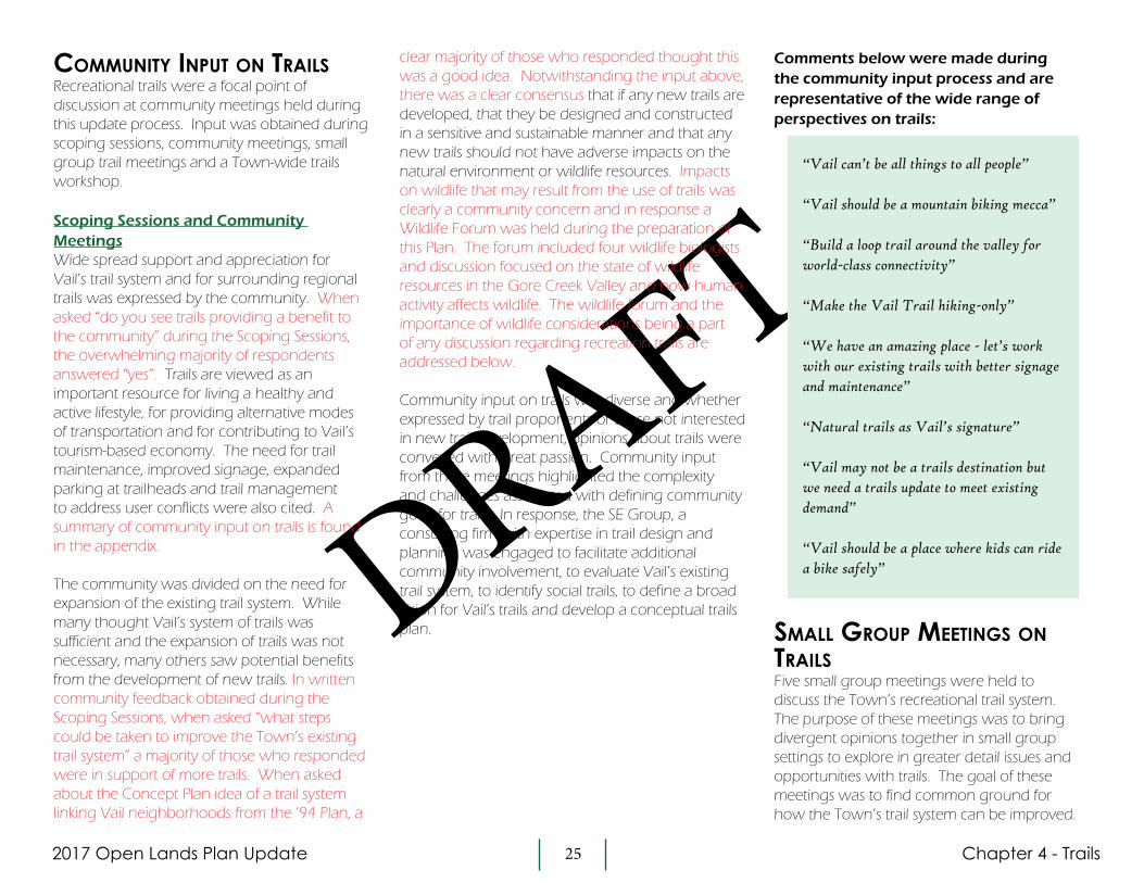
Comments below were made during the community input process and are representative of the wide range of perspectives on trails:

2017 Open Lands Plan Update 26
DRAFT
Chapter 4 - Trails
Approximately 25 people participated in these meetings. Five themes addressing new ideas, issues, opportunities and values with respect to trails were drawn from these discussions:
Safety• Work to minimize user conflict through
signage and education• Safety concerns for all users in certain areas
of Town especially in the roundabout• Complete paved trails segments where
possible to provide more off-roadway opportunities (for example, Vail Mountain School to the East Vail Interchange)
• Prepare for the increasing prevalence of electric assisted bikes or e-bike riders
• Improve wayfinding
Sustainability • Limited trail expansion and coordinate
with neighboring communities instead of duplicating all trail types. “We can’t be all things, to all people”
• Wildlife concerns – ensure protection of important habitats and wildlife populations
• Make improvements to existing trails to make them more sustainable to reduce maintenance costs and preserve the environment
• Repair, improve, adopt and better utilize existing trails and connections before building new trails
• Consider maintenance options such as volunteer groups, youth corps and trail maintenance crews
• Vail’s trails should continue to provide a nature experience for locals and guests
Accessibility• It is difficult to follow the Gore Valley Trail
especially through East Vail (need better
signage or icon to follow)• A soft surface trail parallel to Gore Valley Trail
could function as a commuting route for locals and a beginner trail for guests. (some oppose parallel trails)
• Overcrowding on existing soft surface trails (especially Booth Falls trail) is an existing concern – can these users be dispersed to other trails?
• Improve public access to trail information and push it to hotels and businesses – maps, online information, etc. which could help disperse hikers and bikers
• The adoption of social trails could alleviate congestion on existing trails
• Bus service and connector paths to trailheads could make trails accessible without a vehicle
Diversity• Reduce user conflict by providing a variety of trail
types• Protect the existing Vail Trail as a small footprint,
meandering, hiking trail and provide other similar trail types where possible
• Provide beginner to intermediate mountain biking trails
• Provide easier walking trails for children, elderly, and inexperienced hikers
• Vail’s topography is challenging for trail diversity• Currently other jurisdictions provide a wider
range of trail opportunities (particularly for mountain biking)
• Consider other trail activities when developing trails such as fat bikes, e-bikes, snowshoes, etc
• A pump track and beginner loop in Town could provide mountain biking experience for children
Connectivity• Improve connectivity of both hard and soft
surface trails• Additional connector trails to Forest Service trails
may help mitigate trailhead parking problemsInteraction during the trails specific community workshops.
• Additional short connector trails between neighborhoods (making it easier for kids to ride to school or a friend’s house)
• Convenient neighborhood access points for hiking, biking, and local trips
• Improve connectivity to Vail Resorts’ trails• Build a trail connecting Vail to nearby
Towns (i.e. Minturn) – possibly a regional draw
traiLs cOmmUnity wOrkshOpA trails specific workshop was held to continue the community’s conversation about trails. The workshop was an open house format and was attended by approximately 40 people. Information presented included an overview of the planning and approval process for trails, the five trail themes that came out of the small group meetings, an inventory of user-created social trails, trail usage on both social and sanctioned trails, and design considerations for trails. A Conceptual Trails Plan identifying possible ideas for new trail segments was also presented and additional trail ideas were identified by community members during the workshop.

2017 Open Lands Plan Update 27
DRAFT
Chapter 4 - Trails
a visiOn fOr vaiL’s traiLs
Based on input from the community throughout this update process, the vision for Vail’s system of trails and pathways is:
A system of paved and soft-surface trails that is safe for all users. Through best practices in design, signage and education, trail users with diverse needs and ability levels can safely recreate on trails in the Vail area. Educational and informational programs with an emphasis on safety, awareness and respect for others are provided to trail users.
Trails are maintained to meet the highest standards for sustainability. Managing existing trails to maintain high standards takes priority over expanding the trail network.
All trails are designed and constructed to respect and protect sensitive wildlife habitat and terrain while providing opportunities for both residents and visitors to connect with and experience nature.
A variety of soft and hard-surface trails of varying difficulty levels are available to provide accessibility to all user groups.
Connectivity is key. Trails provide safe, non-vehicular connections between neighborhoods and important destinations in Town. Proper signage will make trails easy to find and follow.
Trails in the Vail area are planned in concert with trails in the surrounding area. Continued collaboration with neighboring towns, Eagle County, and the USFS is essential for a successful trail network.DR
AFT
2017 Open Lands Plan Update 28
DRAFT
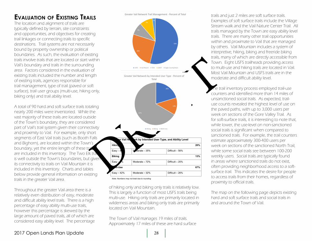
evaLUatiOn Of existing traiLsThe location and alignment of trails are typically defined by terrain, site constraints and opportunities, and objectives for creating trail linkages or connecting trails to specific destinations. Trail systems are not necessarily bound by property ownership or political boundaries. As such, the evaluation of existing trails involve trails that are located or start within Vail’s boundary and trails in the surrounding area. Factors considered in the evaluation of existing trails included the number and length of existing trails, agencies responsible for trail management, type of trail (paved or soft surface), trail user groups (multi-use, hiking only, biking only) and trail ability level.
A total of 90 hard and soft surface trails totaling nearly 200 miles were inventoried. While the vast majority of these trails are located outside of the Town’s boundary, they are considered part of Vail’s trail system given their connectivity and proximity to Vail. For example, only short segments of East Vail trails (such as Booth Falls and Bighorn), are located within the Town’s boundary, yet the entire length of these trails are included in this inventory. The Two Elk trail is well outside the Town’s boundaries, but given its connectivity to trails on Vail Mountain it is included in this inventory. Charts and tables below provide general information on existing trails in the greater Vail area.
Throughout the greater Vail area there is a relatively even distribution of easy, moderate and difficult ability level trails. There is a high percentage of easy ability multi-use trails, however this percentage is skewed by the large amount of paved trails, all of which are considered easy ability level. The percentage
trails and just 2 miles are soft surface trails. Examples of soft surface trails include the Village Stream walk and the Vail Nature Center Trail. All trails managed by the Town are easy ability level trails. There are many other trail opportunities within and proximate to Vail that are managed by others. Vail Mountain includes a system of interpretive, hiking, biking and freeride biking trails, many of which are directly accessible from Town. Eight USFS trailheads providing access to multi-use and hiking trails are located in Vail. Most Vail Mountain and USFS trails are in the moderate and difficult ability level.
The trail inventory process employed trail-use counters and identified more than 14 miles of unsanctioned social trails. As expected, trail-use counts revealed the highest level of use on the paved paths, with up to 3,000 users per week on sections of the Gore Valley Trail. As for soft-surface trails, it is interesting to note that, while lower, the use-level on non-sanctioned social trails is significant when compared to sanctioned trails. For example, the trail counters estimate approximately 300-400 users per week on sections of the sanctioned North Trail, while some social trails see between 100-200 weekly users. Social trails are typically found in areas where sanctioned trails do not exist, often providing neighborhood access to a soft-surface trail. This indicates the desire for people to access trails from their homes, regardless of proximity to official trails.
The map on the following page depicts existing hard and soft surface trails and social trails in and around the Town of Vail.
54%
26%
9%
9%2%
Greater Vail Network Trail Management ‐ Percent of Total
USFS Vail Resort TOV CDOT Eagle County/Avon
20%
13%
67%
Greater Vail Network by Intended User Type ‐ Percent of Total
Hiking Biking Multi Use
Greater Vail Network by Intended User Type, and Ability Level
Hiking 20%
Easy – 8% Moderate – 35% Difficult – 56%
Biking 13%
Easy – 8% Moderate – 72% Difficult – 20%
Multi-Use 67%
Easy – 42% Moderate – 32% Difficult – 26%
Note: Numbers may not total due to rounding
of hiking only and biking only trails is relatively low. This is largely a function of most USFS trails being multi-use. Hiking only trails are primarily located in wilderness areas and biking only trails are primarily located on Vail Mountain.
The Town of Vail manages 19 miles of trails. Approximately 17 miles of these are hard surface

2017 Open Lands Plan - Update 29
DRAFT
Chapter 4 - Trails
Existing Hard Surface Trails
Existing Soft Surface Trails
Existing Social Trails
Bighorn Creek
Pitkin Creek Trail
Mill Creek Road
Vail Trail
Game Creek Trail
Gore Valley Trail
Son of Middle Creek
Davos
Booth Creek Trail
Gore Creek and Deluge Lake Trails
Vail Pass Bike Path
Gore Valley Trail
North Trail
North Recreation Trail
North Trail
North Trail
Buffehr Creek Trail
Vail Mountain
Trails
existing traiLs pLan
DRAFT
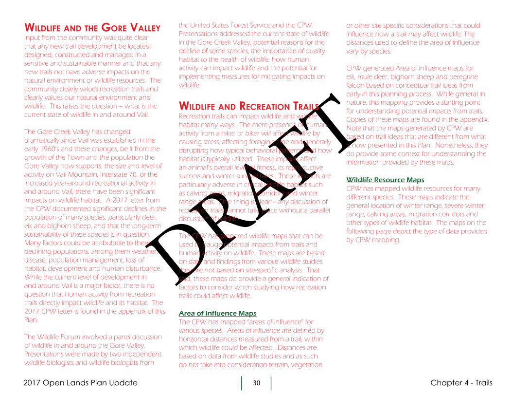
2017 Open Lands Plan Update 30
DRAFT
wiLdLife and the gOre vaLLeyInput from the community was quite clear that any new trail development be located, designed, constructed and managed in a sensitive and sustainable manner and that any new trails not have adverse impacts on the natural environment or wildlife resources. The community clearly values recreation trails and clearly values our natural environment and wildlife. This raises the question – what is the current state of wildlife in and around Vail.
The Gore Creek Valley has changed dramatically since Vail was established in the early 1960’s and these changes, be it from the growth of the Town and the population the Gore Valley now supports, the size and level of activity on Vail Mountain, Interstate 70, or the increased year-around recreational activity in and around Vail, there have been significant impacts on wildlife habitat. A 2017 letter from the CPW documented significant declines in the population of many species, particularly deer, elk and bighorn sheep, and that the long-term sustainability of these species is in question. Many factors could be attributable to these declining populations, among them weather, disease, population management, loss of habitat, development and human disturbance. While the current level of development in and around Vail is a major factor, there is no question that human activity from recreation trails directly impact wildlife and its habitat. The 2017 CPW letter is found in the appendix of this Plan.
The Wildlife Forum involved a panel discussion of wildlife in and around the Gore Valley. Presentations were made by two independent wildlife biologists and wildlife biologists from
the United States Forest Service and the CPW. Presentations addressed the current state of wildlife in the Gore Creek Valley, potential reasons for the decline of some species, the importance of quality habitat to the health of wildlife, how human activity can impact wildlife and the potential for implementing measures for mitigating impacts on wildlife.
wiLdLife and recreatiOn traiLsRecreation trails can impact wildlife and wildlife habitat many ways. The mere presence of human activity from a hiker or biker will affect wildlife by causing stress, affecting foraging time and generally disrupting how typical behavioral patterns and how habitat is typically utilized. These impacts affect an animal’s overall level of fitness, its reproductive success and winter survival rates. These impacts are particularly adverse in critical wildlife habitat such as calving areas, migration corridors and winter range areas. One thing is clear – any discussion of recreation trails cannot take place without a parallel discussion of wildlife.
The CPW has prepared wildlife maps that can be used to gauge potential impacts from trails and human activity on wildlife. These maps are based on data and findings from various wildlife studies they are not based on site-specific analysis. That said, these maps do provide a general indication of factors to consider when studying how recreation trails could affect wildlife.
Area of Influence MapsThe CPW has mapped “areas of influence” for various species. Areas of influence are defined by horizontal distances measured from a trail, within which wildlife could be affected. Distances are based on data from wildlife studies and as such do not take into consideration terrain, vegetation
or other site-specific considerations that could influence how a trail may affect wildlife. The distances used to define the area of influence vary by species.
CPW generated Area of Influence maps for elk, mule deer, bighorn sheep and peregrine falcon based on conceptual trail ideas from early in this planning process. While general in nature, this mapping provides a starting point for understanding potential impacts from trails. Copies of these maps are found in the appendix. Note that the maps generated by CPW are based on trail ideas that are different from what is now presented in this Plan. Nonetheless, they do provide some context for understanding the information provided by these maps.
Wildlife Resource MapsCPW has mapped wildlife resources for many different species. These maps indicate the general location of winter range, severe winter range, calving areas, migration corridors and other types of wildlife habitat. The maps on the following page depict the type of data provided by CPW mapping.
Chapter 4 - Trails

2017 Open Lands Plan Update 31
DRAFT
§̈¦70
§̈¦70
I-70 Exit# 180
(East Vail)
I-70 Exit# 176(Vail)
I-70 Exit# 173
(West Vail)
I-70 Exit# 171
(Minturn)
Seasonal Habitat - Elk
Migration Patterns
Highway Crossings
Summer Concentration Area
Production Area
Severe Winter Range
Winter Concentration Area
Winter Range
Entire area is identified asSummer Range and Overall Range
I0 1 2
MilesMarch 1, 2018
§̈¦70
§̈¦70
I-70 Exit# 180
(East Vail)
I-70 Exit# 176(Vail)
I-70 Exit# 173
(West Vail)
I-70 Exit# 171
(Minturn)
Seasonal Habitat - Bighorn Sheep
Bighorn Migration Patterns
Bighorn Production Area
Bighorn Mineral Lick
Bighorn Winter Concentration Area
Bighorn Winter and Severe Winter Range
Bighorn Summer and Overall RangeI0 1 2
MilesMarch 1, 2018
§̈¦70
§̈¦70
I-70 Exit# 180
(East Vail)
I-70 Exit# 176(Vail)
I-70 Exit# 173
(West Vail)
I-70 Exit# 171
(Minturn)
Seasonal Habitat - Mule Deer
Migration Patterns
Highway Crossing
Concentration Area
Migration Corridors
Winter Range
Entire area is identified asSummer Range and Overall Range
I0 1 2
MilesMarch 1, 2018
DRAFT

2017 Open Lands Plan Update 32
DRAFT
Chapter 4 - Trails
Trail Density MapsTrail density maps depict miles of trails per square mile. This data provides a general indication of the intensity of trail activity within a region. Below is a density map prepared by CPW of existing trails within the Gore Valley and surrounding area. Green indicates areas with less existing trails per square mile, while red areas indicate more trails per square mile. A basic premise when planning recreation trails that are sensitive to wildlife is to locate new trails within areas already influenced by human activity. The Trail Density Map provides information helpful to this effort. It should be noted that the density maps depict trail density only, they do not depict the impact of roads, homes or other development or the amount of use on any exisitng trail.
These maps and feedback from CPW during the planning process was a significant consideration in defining suggestions for new trail ideas.
mitigating measUres priOr tO the stUdy Of pOtentiaL new traiLsThe CPW has documented significant declines in certain wildlife populations in the Gore Valley and the surrounding region and there is near universal agreement that activity from recreation trails can adversely impact wildlife populations and its habitats. In response to the existing condition of wildlife resources in the Gore Valley and value the Vail community places on wildlife, it is recommended that prior to the development of new recreation trails that the following steps be taken in an attempt to improve wildlife resources:
Trail-Free ZonesAreas that are free of trails generally have very little human activity and these areas serve as wildlife sanctuaries where animals benefit from solitude and the lack of disruption from humans. Defining trail-free zones could be a great benefit to wildlife
trail closures, having dogs on leash and not walking off trails are examples of behavior that will help minimize the impacts of trail use. If people understand the importance of being respectful and sensitive to wildlife resources, they will be more likely to behave in a respectful and sensitive manner. Educational programs targeted to both locals and guests should be implemented.
Seasonal Trail ClosuresBy and large, most people comply with seasonal trail closures. However, the impacts to wildlife can be significant when closures are violated. Steps to improve compliance with seasonal closures could include active monitoring of trailheads, taking enforcement action against violators and constructing gates at trails with seasonal closures. These measures will require coordination with CPW and USFS.
Habitat EnhancementWildlife habitat has been impacted by development, fragmentation and overall declining health. Options for improving habitat by enhancing vegetation include: controlled burns, fertilization and manual manipulation of vegetation. Coordination with CPW and USFS should be initiated to define how the Town could assist in programs to enhance habitat in and around Vail.
resources. Trail-free zones are depicted on the Conceptual Trails Plan. These zones are located on USFS land and coordination with the USFS would be necessary to implement these zones. Areas depicted are conceptual in nature and will need further study and refinement during subsequent evaluation of trails and wildlife.
Public EducationEducating the public on how trail use can affect wildlife can be very effective in fostering behavior that is sensitive to wildlife. Respecting

2017 Open Lands Plan Update 33
DRAFT
Chapter 4 - Trails
cOnceptUaL traiLs pLanThe Conceptual Trails Plan identifies twelve soft surface trail and trail connections in and around the Vail area that warrant further study and community discussion. Referred to as “trail ideas”, each is described in detail below and each is depicted on the Conceptual Trails Plan. Trail ideas discussed below include both the possibility of new trail development and possibility of closing existing trails.
Trail ideas were derived from the analysis of Vail’s existing trail system, input received during community scoping sessions and with input from technical experts, agencies and other stakeholders. A summary of community input is found in the appendix. The purpose of the Conceptual Trails Plan is to provide a vision for improvements to Vail’s trail system. A great deal of additional evaluation, planning and design is necessary before final decisions can be made on which, if any, of these trail ideas are constructed. It is very likely that with further study some trails depicted on the Conceptual Trails Plan will be dropped from consideration due to design challenges, environmental or wildlife impacts, cost, public input or other factors. A matrix summarizing each of these trail ideas is found below.
Parameters for defining the Conceptual Trails PlanTrail ideas evolved throughout this planning process. Initially twentyone new trail ideas were identified. Each of these were evaluated based on the vision for Vail’s Trails and key themes that came out of the trails workshop. The following parameters were used to determine the trail ideas to be included in the Conceptual Trails Plan:
• The trail is located such that it may be feasible through design, construction, management and mitigating measures to minimize adverse impacts on wildlife.
• The trail be designed and constructed to be safe for all intended uses or the trail improves the safety of the trail system.
• The trail improves or expands recreational opportunities for one or more user group.
• The trail improves neighborhood connectivity or provides beneficial linkages between existing trails.
When considering these parameters, nine trails were eliminated from consideration. In most cases trails were eliminated due to their potential for wildlife impacts. The removal of these trails is not intended to suggest that other trail ideas will not affect
wildlife resources. Wildlife and environmental analysis for all trail ideas shall be completed as an element of making final decisions on any new trail development. Wildlife considerations relative to trail ideas are discussed further in the Description of Trail Ideas and Opportunity and Process for Evaluation of New Trails sections below.
A plan depicting all trails originally considered and trails dropped from consideration is found in the Appendix. The Conceptual Trails Plan is found on the following page. Each of the twelve trail ideas are discussed below. Follow-up actions necessary for the Town to address prior to the future development of any new trail are described in Chapter 6 Implementation.
This planning effort did not attempt to identify the potential for all minor trail improvements that could establish other pedestrian connections to improve walkability throughout the Town. An example of this could be a new trail along Middle Creek done in conjunction with the redevelopment of the Evergreen Hotel. These types of improvements, while not identified in this Plan, may over time be implemented by the Town.

2017 Open Lands Plan - Update 34
DRAFT
Chapter 4 - Trails
Existing Trails
Trail Ideas and Suggestions
Potential Children’s Bike Facilities
#5 - Intermountain to Lionshead Connector
#8 - Vail Mountain Cross Connector
#9 - Vail Trail
#7 - Son of Middle to Red Sandstone Road Connector
No Trails Area
FEDC
B
A
#2 - Avon/Nottingham Ridge Connector
#1 - North Trail to Davos Connector
#6- Red Sandstone Valley Trail
#3 - Intermountain Trail
#4 - Matterhorn Trail
#10 - Vail Trail Extension
#11 - East Watertank Trail
#12 - Two Elk Connector
cOnceptUaL traiLs pLan
**
*
*New Paved Paths
West Vail Interchange
Potato Patch
Intermountain
Ford Park
Booth Falls
East Vail Interchange
Main VailInterchange
DRAFT
No Trails Area
No Trails Area

2017 Open Lands Plan Update 35
DRAFT
Chapter 4 - Trails
descriptiOn Of traiL ideas and OppOrtUnitiesBelow are descriptions of the twelve trail ideas depicted on the Conceptual Trails Plan. When relevant, factors unique to these trails ideas to be considered in the subsequent study of these trail ideas are also provided. Trails are numbered sequentially from west to east, numbering does not reflect trail priorities.
#1. North Trail to Davos Connector: Proposed multi-use trail to connect segments of the North trail to the Davos Trail to create a moderate loop trail from West Vail. • User groups: Multi-use• Ability Level: Intermediate• Supports Vision Goals: Diversity, Connectivity• Issues/Concerns/Process: wildlife analysis, USFS approval
#2. Avon/Nottingham Ridge Connector: Proposed multi-use trail to connect the North Trail to the existing Nottingham Ridge Trail and future Traer Creek development in Avon. This connection is identified in the current White River National Forest Travel Management Plan.• User groups: Multi-use• Ability Level: Intermediate/Difficult• Supports Vision Goals: Accessibility, Diversity, Connectivity• Issues/Concerns/Process: Wildlife analysis, coordination with Traer Creek
Development Company, Town of Avon, USFS approval
#3. Intermountain Trail: Existing social trail provides intermediate soft-surface hiking opportunity for the Intermountain neighborhood. The upper reaches could be adopted/improved as a hiking-only trail while the lower reach could provide hiking/biking access to Trail Opportunity #5.• User groups: Hiking-only• Ability Level: Intermediate• Supports Vision Goals: Accessibility, Connectivity, Diversity• Issues/Concerns/Process: Steep terrain, safety, wildlife analysis, USFS
approval
#4. Matterhorn Trail: Existing social trail connects Eagles Nest/Game Creek Trail down to the Matterhorn neighborhood. If formally approved by USFS, trail should be realigned in sections to improve sustainability and connected to Trail #5. Potential wildlife impacts from this trail need to be evaluated comprehensively with Trails #3 and #5. An outcome of this analysis could be to take steps to close the Matterhorn Trail.• User groups: Hiking, mountain biking• Ability Level: More difficult• Supports Vision Goals: Sustainability, Connectivity, Diversity• Issues/Concerns/Process: Steep grades, safety, wildlife analysis, USFS
approval
#5. Intermountain to Lionshead Connector: Proposed multi-use trail to connect the Intermountain Trail (#3) to Hank’s Hideaway on Vail Mountain with several neighborhood trailheads to provide access. The alignment could pass through recent timber cuts as a way of reducing environmental impacts.• User groups: Multi-use• Ability Level: Intermediate• Supports Vision Goals: Accessibility, Diversity, Connectivity, • Issues/Concerns/Process: Wildlife analysis, evaluate private property
impacts, USFS approval
#6. Red Sandstone Valley Trail: Proposed multi-use trail connecting Vail to existing and proposed trails in the forest north of Vail. This soft-surface trail parallels Red Sandstone Road and Piney Lake Road to provide a much safer alternative by providing trail users an alternative to Red Sandstone Road. This trail, if deemed feasible from a design and wildlife impact standpoint, will need to be “tight” to Red Sandstone Road in order to minimize habitat fragmentation and impacts from trail use.• User groups: Multi-use• Ability Level: Intermediate• Supports Vision Goals: Accessibility, Diversity, Connectivity, • Issues/Concerns/Process: Wildlife analysis, USFS approval

2017 Open Lands Plan Update 36
DRAFT
Chapter 4 - Trails
#7. Son of Middle Creek to Red Sandstone Road Connector: This trail connects the Son of Middle Creek trail to Red Sandstone Road through Town of Vail and USFS land above Red Sandstone School. This connector creates an intermediate loop with the North Trail and provides a loop alternative between Lionshead and Vail Village on the north side of I-70.• User groups: Multi-use• Ability Level: Intermediate• Supports Vision Goals: Accessibility, Diversity, Connectivity• Issues/Concerns/Process: Terrain, private property impacts, wildlife
analysis, Town of Vail approvals, USFS approval
#8. Vail Mountain Cross Connector: Potential soft-surface trail across the lower reaches of Vail Mountain utilizing existing trail where feasible. Requires planning process and approvals with Vail Resorts and USFS.• User groups: Multi-use• Ability Level: Beginner/Intermediate• Supports Vision Goals: Accessibility, Diversity, Connectivity, Sustainability • Issues/Concerns/Process: Wildlife analysis, evaluate private property
impacts, USFS approval
#9. Vail Trail: Existing social trail provides intermediate soft-surface hiking and limited biking between Vail Village and the Golf Course Clubhouse. The trail currently crosses into USFS and private property and should be formalized with the property owners. Trail improvements are needed to address sustainability and accessibility. This trail is recommended to be a hiking-only trail. Any work to improve this trail should maintain the existing width and informal, organic character of the trail.• User groups: Hiking-only• Ability Level: Intermediate• Supports Vision Goals: Accessibility, Sustainability, Connectivity, Diversity• Issues/Concerns/Process: Steep terrain, hazard areas, private property,
wildlife analysis, USFS approval
#10. Vail Trail Extension: New trail that provides a soft-surface alternative to the paved Gore Valley Trail through the Town-owned Katsos Ranch Open Space. A peregrine falcon nesting site is located in the vicinity of this potential trail and a portion
of the trail is located within Elk Winter Range. Analysis of how this trail may impact these wildlife resources will be necessary to determine if this trail should be constructed and if so, to identify any measures necessary to mitigate impacts on these wildlife resources. The trail alignment should be very close to the Gore Valley Trail to minimize habitat fragmentation. Potential mitigating measures for elk winter range could include seasonal closure of the trail. Potential mitigating measures for the falcon nest could be to reduce the length of the trail by linking it back to the Gore Valley Trail west of the nest to minimize new activity with the nest’s Area of Influence. Taking steps to close social trails around the Vail Memorial Garden should also be considered. • User groups: Multi-use• Ability Level: Beginner• Supports Vision Goals: Accessibility, Diversity, Connectivity • Issues/Concerns/Process: Wildlife analysis/Peregrine falcon habitat,
hazard areas, Town of Vail approvals, USFS/CPW approval
#11. East Water Tank Trail: Existing social trail provides intermediate soft-surface hiking and limited biking for the East Vail neighborhood. Wildlife implications of this social trail will need to be evaluated to determine whether this trail should be formalized or whether steps should be taken to close the trail.• User groups: Hiking, limited mountain biking• Ability Level: More difficult• Supports Vision Goals: Accessibility, Sustainability, Connectivity, Diversity• Issues/Concerns/Process: Steep terrain, wildlife analysis, USFSapproval
#12. Two Elk Connector: This new soft-surface trail would connect the lower reach of the Two Elk Trail with East Vail, eliminating the need to access the Vail Pass bike path. The trail would align low on the hillside south of I-70 and improve a long loop-trail for the Vail area. Wildlife implications of this trail will need to be evaluated. • User groups: Multi-use• Ability Level: Intermediate• Supports Vision Goals: Safety, Accessibility, Diversity, Connectivity• Issues/Concerns/Process: Terrain analysis, private property impacts,
wildlife analysis, USFS approval

2017 Open Lands Plan Update 37
DRAFT
Chapter 4 - Trails
Other traiL imprOvementsTrail Improvements from the 1994 PlanMany of the trail and trail system improvements identified in the ’94 Plan have been completed. A number of improvements that have not been implemented, such as the Vail Trail, the South Trail and a loop trail network around the Town are included in the Conceptual Trails Plan. Below are uncompleted improvements from the ’94 Plan, most of which should still be considered for implementation:
Vail Mountain Access The Town should continue to work with Vail Resorts to improve trailhead information, signage, etc. at Golden Peak, Vail Village and Lionshead. The potential to expand the trail system on Vail Mountain should also be discussed with VR.
Neighborhood TrailheadsThe ’94 Plan identified trailhead improvements that would provide trail connections to existing neighborhoods. The location and design of these connections should be evaluated as a part of the design process for potential new trails.
Paved Shoulders on Vail Valley Drive to Sunburst DriveThe ’94 Plan suggested paved shoulders along Vail Valley Drive to provide a safer connection between Vail Village and the Gore Valley Trail. The potential for this path has been studied and due to narrow right-of-way and existing improvements, this path is not considered to be feasible. As an alternative, traffic calming measures for this road will be studied as part of the update to the Town’s Transportation Master Plan.
Paved TrailsThe following trail segments would connect existing, paved multi-use trail segments to enhance non-motorized connectivity. Refer to the Conceptual Trails Plan for the location of these trails:
Intermountain to West Vail Interchange (#A)Donovan Park to Westhaven Drive (#B)West Lionshead Circle to East Lionshead Circle (#C)Lionhead Parking Structure to Vail Municipal Complex (#D)South Frontage Road to Meadow Drive Connector (#E)Vail Mountain School to East Vail Interchange (#F)
Youth FacilitiesTwo ideas are suggested for improving bike opportunities for children:
Kids Bike Park/Pump TrackA series of short loops, dirt piles, jumps, etc designed for younger kids. This idea was raised multiple times during community input meetings. Potential locations include the Booth Creek I-70 berms and Golden Peak.
Single Track LoopA short loop trail on the upper bench of Donovan Park designed as beginner hiking and kids mountain biking.
Trail Maintenance The need for significant maintenance to three existing trails was identified:
North Trail (Buffehr Creek to Cortina Lane)Existing multi-use trail has several eroded/poorly constructed trail sections. Recommend working with the USFS to improve/reconstruct those sections as needed.
North Trail (Red Sandstone Road to Buffehr Creek Road)Existing multi-use trail has several eroded/poorly constructed trail sections. Recommend working with the USFS to improve/reconstruct those sections as needed.
Buffehr Creek TrailExisting multi-use trail could be improved with several short realignments to improve usability and sustainability. Recommend working with the USFS to improve/reconstruct those sections as needed.
Accessible TrailsVail’s parks, playgrounds, public buildings and other public facilities are designed to be inclusive of varying ability levels. Whether a person’s ability is affected by age or physical disability, the Town strives to provide “accessible” public amenities. When designing new trails or evaluating existing trails, accessible paved and soft-surface trails should be considered as part of the process.
Paved trails are evaluated using criteria from the Americans with Disabilities Act Accessibility Guidelines (ADAAG) balanced with site

2017 Open Lands Plan Update 38
DRAFT
Chapter 4 - Trails
conditions. The U.S. Forest Service evaluates trails though the publication, Forest Service Trail Accessibility Guidelines (FSTAG), which allow for varying levels of accessibility that are correlated with user experience for a given trail type. Accessibility should be addressed as part of any subsequent work on a comprehensive trail plan as described in Chapter 4.
traiL types and standards A variety of improvements to Vail’s existing system of trails and paths are contemplated by this Plan. Hiking-only trails, multi-use trails, beginner level trails, paved trails and wide shoulders are examples of these trail and path improvements. Standards for the design and construction of paved and soft-surface trails will vary depending on the type of trail, intended user groups, terrain and other considerations. Design standards will be one of many factors in determining the feasibility of future trail improvements. A summary of trail and path types along with relevant design standards are found in the appendix of this Plan.
regiOnaL cOntext Of vaiL’s traiLsThe Regional Context Plan on the following page depicts Vail’s trails in a broader context and how trails proximate to Vail interface with outlying trails. The Regional Context Plan also depicts potential trail improvements located outside of the area covered by the Conceptual Trails Plan.
prOcess fOr evaLUatiOn Of traiL ideasThe process for studying the potential development of any new trails will involve a number of steps, the first of which will be direction from the Town Council for staff to prepare a more detailed plan for potential trail improvements. Like the Open Lands Plan update process, this detailed trail planning process will involve public input and will essentially take the Conceptual Trails Plan to a higher level of detail. It is anticipated that this trail planning process will involve revisiting the need for and potential benefits of each trail idea, defining trail alignments and other design considerations, and understanding trail construction and maintenance costs. In addition, site-specific environmental (soil and geologic conditions, vegetation and wetlands, etc.) and wildlife analysis will be completed in order to understand the potential impacts of any new trail that is under consideration. Only after this additional planning and analysis will the Town make decisions on whether to pursue the development of any new or alteration/adoption of existing trails.
Wildlife AnalysisA major element of the next phase of work in evaluating the feasibility of new trail development will be the completion of a detailed, comprehensive environmental analysis, a key element of which will be an evaluation of how trails could impact wildlife resources. It is anticipated that this evaluation will be completed by a consultant retained by the Town and that the evaluation will among other things evaluate existing wildlife resources and habitats, assess potential impacts that may result from trail development, and identify whether it is feasible to implement measures that could mitigate such impacts. The goal of this analysis is to provide a
comprehensive evaluation of all trail ideas and should consider existing and social trails in and around Vail. This evaluation could result in both decisions to work toward the development of new trails and decisions to take steps to close existing trails.
It is expected that CPW will play a significant role in this process by providing baseline information and referral comments on this evaluation.
The findings of this environmental analysis and specifically the wildlife evaluation will be a major factor in the Town’s decisions on any new trail development. If the Town decides to pursue trail development on USFS lands information from this environmental analysis will be included in formal applications to the USFS.
The potential to integrate this analysis with the ecological/biodiversity study recommended for Town lands (see Chapter 6 – Implementation) should be considered.
USFS Process With the exception of the Vail Trail Extension, there is little potential for any new trail development within the Town’s boundary. The majority of new trail ideas are located on USFS lands and will require review and approval by the USFS.
The review of proposals for new trails on USFS lands involves two steps. The USFS process analyzes trails under the National Environmental Protection Act (NEPA) and the Environmental Impact Statement (EIS) process. The first step with the USFS involves submittal of a proposal that includes a comprehensive, Town-wide trails plan. This Town-wide trails plan will define trail

2017 Open Lands Plan - Update 39
DRAFT
#5 - Intermountain to Lionshead Connector
#8 - Vail Mountain Cross Connector
#9 - Vail Trail
#7 - Son of Middle to Red Sandstone Road Connector
#2 - Avon/Nottingham Ridge
Connector
#1 - North Trail to Davos Connector
#6- Red Sandstone Valley Trail
#3 - Intermountain Trail
#4 - Matterhorn Trail
EAGLEVAIL
MINTURN
AVON
#10 - Vail Trail
To Piney
Two Elk Trail
Bowman’sShort-cut
Meadow Mountain
Courage Ridge
Buffehr Creek
Mill Creek Road
Buck Creek
FS 734
FS 728
FS 709
FS 70
0
#11 - East Watertank Trail
#12 - Two Elk Connector
Chapter 4 - TrailsregiOnaL cOntext pLan
Existing Trails
Trail Ideas and Suggestions
New Paved Paths
Potential Children’s Bike Facilities*
***
LostLake
FE
D
C
B
A
DRAFT

2017 Open Lands Plan Update 40
DRAFT
Chapter 4 - Trails
alignments very broadly with 200-yard wide corridors and will identify user groups, trail levels and trail standards. The trails plan will also involve coordination with entities proximate to Vail so that trail planning can be integrated with that of other communities. Environmental information in accordance with the NEPA process is also required and all USFS processes include opportunities for public input. Following USFS review of this initial step, if approved the second step with the USFS involves detailed design of proposed trails and more a detailed NEPA process. As compared with step one which involves the comprehensive trail system, with step two individual trail segments can be proposed for approval and construction.
A comprehensive outline of the USFS process is found in the appendix.
easements frOm private Land OwnersMost new trail segments within the Town will require the Town to obtain easements from private land owners. Chapter 5 – Action Plan identifies privately owned parcels where easements would be necessary to develop trail segments within the Town boundary. Seven such actions are recommended. Refer to Chapter 5 for information on these easements.
Potential CollaborationsA number of the trails identified on the Conceptual Trails Plan are located outside of the Town’s boundaries and would implement more regionally-oriented trail improvements. Examples of these include the adoption of the Matterhorn Trail and the Avon/Nottingham Ridge Connector. It is likely that if these trails are to be developed, they will involve the
Town collaborating with other jurisdictions and organizations. Refer to Chapter 6 Implementation for additional discussion of the implementation of trail improvements.

2017 Open Lands Plan Update 41
DRAFT
ChApTER 5 - ACTION pLAN
Chapter 5 - Action Plan
The Action Plan from the ’94 Plan “provides a framework for obtaining and protecting open lands as well as creating trail linkages in a logical and comprehensive manner”. The Action Plan chapter of the ’94 Plan addressed protection techniques for open lands, established priorities for action, and provided land use recommendations for Town-owned lands and for improvements to the Town’s trail system. The most significant element of the Action Plan is a comprehensive list of recommendations for the acquisition of properties or easements necessary to implement the goals of the Plan. Referred to as Action Items, these acquisitions were recommended to protect environmentally sensitive lands, to facilitate the development of trails, to obtain land needed for community-oriented uses and to simplify the Town’s boundary with adjacent United States Forest Service lands.
The Action Plan from the ’94 Plan identified fifty-one parcels for acquisition or for obtaining easements. Since 1994, thirty of these Action Items have been completed and another eight Action Items have been partially completed. Thirty of the fifty-one Action Items were recommended to protect environmentally sensitive lands and sixteen were for trail development or for access to Gore Creek. Thirty-six of the Action Items were High Priority Items and twenty-five of these high priority items have been completed. The Town has been quite effective in the implementation of Action Items from the ‘94 Plan. A plan depicting the status of Action Items from the ‘94 Plan is found in the appendix.
The updated Action Plan on page 42 identifies twenty-eight Action Items that are recommended to implement improvements and recommendations described in Chapters 2, 3 and 4 of this Plan. Like the ’94 Plan, these Action Items recommend the acquisition of land or easements necessary to further the Town’s goals for the protection of environmentally sensitive lands, trail development and land needed for community-oriented uses. Refer to Chapter 6 Implementation for information on other follow-up actions necessary to implement the goals of this Plan. Each of these Action Items are discussed in greater detail below.
DRAFT

2017 Open Lands Plan Update 42
DRAFT
Chapter 5 - Action Plan
2017 actiOn pLanThe twenty-eight Action Items are shown two ways – all Action Items are identified on the Town-wide Action Plan found on the following page and each Action Item is depicted on more detailed maps along with a description of the Action Item. Descriptions address the purpose for the action, whether the action involves the acquisition of land or easements, the relative priority for the action and other information regarding the parcel and the recommended action. There are four different categories of Action Items:
Action Items from ’94 PlanOf the fifty-one Action Items from the ‘94 Plan, thirty-eight were either implemented, partially implemented, addressed alternative ways or the Action Item has been deemed to no longer be feasible. An example of an Action Item being implemented alternative ways is the Town acquiring an easement for the development of a trail in lieu of the Action Plan recommendation for outright purchase of the parcel. An example of an Action Item no longer being feasible is a vacant parcel that was recommended for acquisition but was developed before it could be acquired. Each of the thirteen uncompleted items from the ‘94 Plan are included in this updated Plan.
Action Items to Protect Environmentally Sensitive LandsSixteen Action Items are recommended to protect environmentally sensitive lands. These items focus on land located adjacent to Gore Creek or its tributaries, lands with access challenges, steep terrain and wildlife resources. The Action Items that address parcels located along water courses and are intended to
reinforce the Town’s initiatives to improve water quality and protect wetlands and riparian habitat. Strategies for Action Items involve the outright purchase of land, working with land owners to re-zone property or to establish conservation easements to limit the development of the land or other techniques to protect these lands.
Action Items to implement Trail ImprovementsSeven Action Items are recommended to facilitate the development of new recreation trails or to improve the Town’s trail system. Strategies for these Action Items involve either the acquisition of land or easements.
Action Items to Address Town/Community Facility NeedsSix parcels are recommended for acquisition to provide land for public facilities or community needs. Three of these Action Items are sites that could potentially be developed with affordable or employee housing, two parcels clarify ownership of a Town road and one parcel is for potential park expansion.
Action Items listed above total more than twenty-eight because some Action Items address multiple goals. A matrix summarizing all recommended action items is found in the appendix.
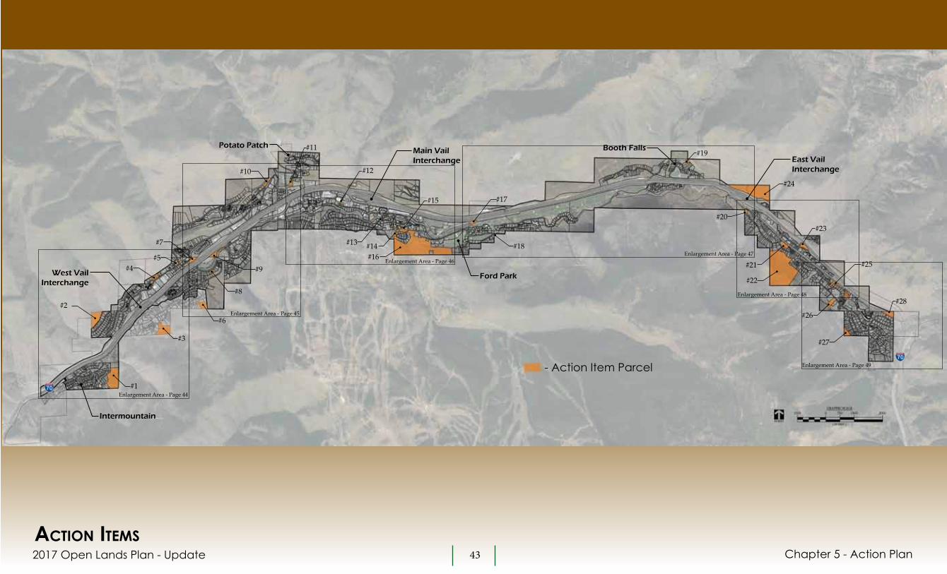
2017 Open Lands Plan - Update 43
DRAFT
- Action Item Parcel#1
Enlargement Area - Page 44
Enlargement Area - Page 45
Enlargement Area - Page 46Enlargement Area - Page 47
Enlargement Area - Page 48
Enlargement Area - Page 49
#3
#6
#8
#9
#23
#24
#25
#19
#17
#18
#20
#21
#22
#26
#27
#28#2
#4#5
#7
#10
#11
#12
#15
#13 #14#16
actiOn itemsChapter 5 - Action Plan
West Vail Interchange
Potato Patch
Intermountain
Ford Park
Booth FallsEast Vail Interchange
Main VailInterchange

2017 Open Lands Plan Update 44
DRAFT
#2
#4#5
#3
#1
actiOn itemsBelow are descriptions of the twenty-eight recommended Action Items.
ACTION ITEM #1Purpose - Establish connection from Intermountain neighborhood to future soft surface trail.Action – Obtain trail easement.Other Information – Parcel is owned by the Eagle River Water and Sanitation District. A water tank is located on the site. ’94 Action Plan - This parcel was Action Item #6 from the ’94 Plan.
ACTION ITEM #2Purpose – Protect environmentally sensitive land from development.Action – Acquire parcel or work with land owner on conservation easement or other measures to eliminate development potential.Other Information – This 6.3 acre site is characterized by very steep terrain and currently has no legal access. Development potential is limited. Parcel is located outside of Town boundary. ’94 Action Plan - This parcel was Action Item #2 from the ’94 Plan.
ACTION ITEM #3Purpose - Establish trail connection from Highland Meadows neighborhood to future soft surface trail.Action – Obtain trail easement.Other Information – Parcel is privately owned. Action Item #6 could provide neighborhood connection if this easement cannot be obtained.’94 Action Plan – N/A
ACTION ITEM #4Purpose – Public facility or community use/affordable or employee housing.Action – Acquire parcels.Other Information – Site consists of three parcels zoned Two-family Primary/Secondary Residential that comprise 1.53 acres. Steep terrain on north half of these parcels will limit development potential. ’94 Action Plan – N/A
ACTION ITEM #5Purpose – Protect creek corridor land from development.Action – Acquire parcel or work with land owner on conservation easement or other measures to eliminate development potential.Other Information – This .31 acre parcel is zoned Two-family Primary/Secondary Residential. Bufferhr Creek and associated riparian habitat bisects the site and floodplain impacts the site. ’94 Action Plan – N/A
Chapter 5 - Action Plan
Intermountain
West Vail Interchange

2017 Open Lands Plan Update 45
DRAFT
#10
#6
#8
#9
#7
Chapter 5 - Action Plan
ACTION ITEM #6Purpose - Establish trail connection from Highland Meadows neighborhood to future soft surface trail.Action – Obtain trail easement.Other Information – Parcel is privately owned. Action Item #3 or the upper bench of Donovan Park could provide neighborhood connections if this easement cannot be obtained.’94 Action Plan – N/A
ACTION ITEM #7Purpose – Public facility or community use/affordable or employee housing.Action – Acquire parcel.Other Information – This 1.76 acre parcel is zoned Public Accommodation and has Special Development District approval for a hotel and affordable housing project. If the approved project does not proceed the site would be viable for an affordable/employee housing or other community needs.’94 Action Plan – N/A
ACTION ITEM #8Purpose – Protect land from development and maintain wildlife movement corridor.Action – Acquire parcel or work with land owner on conservation easement or other measures to eliminate development potential. Prior to pursuing purchase of this parcel monitoring of the site (with game camera) should be done to better understand how wildlife may use this parcel.Other Information – This .46 acre parcel is zoned Two-family Primary/Secondary Residential. Big game are commonly seen crossing parcel to access Gore Creek. ’94 Action Plan – N/A
ACTION ITEM #9Purpose – Park expansion.Action – Acquire parcel for expansion of Donovan Park.Other Information – This 3.0 acre parcel has three tennis courts that are owned and managed by the Hotel Talisa ownership group. In the event the ownership group were interested in disposing of this parcel, the Town’s acquisition could allow for the expansion of Donovan Park for a variety of potential uses.’94 Action Plan - N/A
ACTION ITEM #10Purpose – Protect environmentally sensitive land from development.Action – Acquire parcel or work with land owner on conservation easement or other measures to eliminate development potential.Other Information – This vacant 1.39 acre site is zoned Agricultural and Open Space, is characterized by steep terrain and within a rockfall hazard zone. Development potential is limited. ’94 Action Plan - This parcel was Action Item #14 from the ’94 Plan.
Red Sandstone Road
Donovan Park

2017 Open Lands Plan Update 46
DRAFT
#12#11
#15#13
Chapter 5 - Action Plan
ACTION ITEM #11Purpose - Establish trail connection.Action – Obtain trail easement.Other Information – This 1.3 acre parcel is privately owned. The Town of Vail owns land on either side of this parcel. Easement on this parcel would provide trail design flexibility in responding to surrounding terrain.’94 Action Plan - This parcel was Action Item #18 from the ’94 Plan.
ACTION ITEM #12Purpose – Protect environmentally sensitive land from development.Action – Acquire parcel or work with land owner on conservation easement or other measures to eliminate development potential.Other Information – This vacant .32 acre parcel is owned by the ERWSD. It is zoned Outdoor Recreation. Middle Creek runs through the parcel and both West Meadow Drive and the Gore Valley Trail cross through the southern portion of the parcel. ’94 Action Plan – N/A
ACTION ITEM #13Purpose - Protect environmentally sensitive lands.Action – Acquire parcel.Other Information – This .11 acre parcel is privately owned and zoned Public Accommodation. The parcel is within the Gore Creek floodplain.’94 Action Plan - This parcel was Action Item #22 from the ’94 Plan.
ACTION ITEM #14Purpose - Establish trail connection.Action – Complete research to confirm if easement has been obtained for this trail. If not, obtain trail easement for existing paved recreation trail..Other Information – This .10 acre parcel is privately owned and zoned Agricultural and Open Space. ’94 Action Plan - This parcel was Action Item #24 from the ’94 Plan.
ACTION ITEM #15Purpose - Establish trail connection.Action – Complete research to confirm if easement has been obtained for this trail. If not, obtain trail easement for existing paved recreation trail..Other Information – This 3.28 acre parcel is privately owned and zoned Agricultural and Open Space. ’94 Action Plan - This parcel was Action Item #23 from the ’94 Plan.
ACTION ITEM #16Purpose - Establish trail connection.Action – Complete research to confirm if easement has been obtained for this trail. If not, obtain trail easement for existing paved recreation trail..Other Information – This 47.9 acre parcel is privately owned and zoned Ski Base/Recreation-1. ’94 Action Plan - This parcel was Action Item #25 from the ’94 Plan.
#14
#16
Main Vail Interchange
Lionshead Parking Structure

2017 Open Lands Plan Update 47
DRAFT #20
Chapter 5 - Action Plan
#19
#17
#18
ACTION ITEM #17Purpose - Protect environmentally sensitive lands.Action – Acquire parcel.Other Information – This parcel is privately owned. It was to have been included in the Town’s purchase of land where the Vail Golf Club was subsequently developed, but was not conveyed as a part of that transaction. The parcel includes wetlands and the Gore Creek corridor.’94 Action Plan - N/A
ACTION ITEM #18Purpose – Maintain access to Vail Valley Drive.Action – Acquire portion of parcel that includes Town roadway.Other Information – This parcel is owned by the United States Forest Service.’94 Action Plan – N/A
ACTION ITEM #19Purpose – Protect environmentally sensitive land from development.Action – Acquire parcel or work with land owner on conservation easement or other measures to eliminate development potential.Other Information – This vacant .59 acre site is privately owned and zoned Low Density Multi-family. The parcel is characterized by very steep terrain, is within a rockfall hazard zone and has limited access potential. Development potential is very limited. ’94 Action Plan – N/A
ACTION ITEM #20Purpose – Protect environmentally sensitive land from development.Action – Acquire parcel or work with land owner on conservation easement or other measures to eliminate development potential.Other Information – This privately owned, vacant .65 acre site is privately owned and zoned Two-family Primary/Secondary Residential. The parcel is within the Gore Creek floodplain. Development potential is very limited. ’94 Action Plan – This parcel was Action Item #38 from the ’94 Plan.
Booth Falls
Golf Course Clubhouse

2017 Open Lands Plan Update 48
DRAFT
#22
#21
Chapter 5 - Action Plan
#23
#24
ACTION ITEM #21Purpose - Protect environmentally sensitive land from development.Action – Acquire parcel or work with land owner on conservation easement or other measures to eliminate development potential.Other Information – This 2.16 acre parcel is owned by the Bighorn Mutual Sanitation and Recreation District. A pond encompasses most of the parcel.’94 Action Plan – N/A
ACTION ITEM #22Purpose - Protect environmentally sensitive land from development.Action – Acquire parcel.Other Information – This privately owned, vacant parcel is 45.2 acres and zoned Agricultural and Open Space. The parcel has no legal access and is within avalanche, debris flow and rockfall hazard areas.’94 Action Plan – This parcel was Action Item #44 from the ’94 Plan.
ACTION ITEM #23Purpose - Protect environmentally sensitive portion of parcel, potential for limited residential development.Action – Acquire parcel.Other Information – This 1.78 acre parcel is owned by the Colorado Department of Transportation. Bighorn Creek bisects the parcel and the parcel is impacted by a debris flow zone. ’94 Action Plan – N/A
ACTION ITEM #24Purpose – Protect environmentally sensitive land from development.Action – Acquire parcel or work with land owner on conservation easement or other measures to eliminate development potential.Other Information – This 23 acre parcel includes important bighorn sheep habitat and rockfall hazards. During the process of updating this plan, the land owner applied for the subdivision of this land and for rezoning to17 acres Natural Area Preservation and 5 acres Housing. These applications were approved by the Town. The decision to develop the 5-acre parcel is in the hands of the land owner. If or when development is proposed, it will be important to mitigate to the extent possible, impacts on the bighorn sheep habitat. If the land owner were to decide not to develop this land, the Town should take steps to acquire the property or to work with the land owner on measures to protect the land from development. ’94 Action Plan - This parcel was Action Item #2 from the ’94 Plan.
East Vail Interchange

2017 Open Lands Plan Update 49
DRAFT
Chapter 5 - Action Plan
ACTION ITEM #25Purpose - Protect environmentally sensitive land from development.Action – Acquire parcels or work with land owners on conservation easement or other measures to eliminate development potential.Other Information – This Action Item includes four privately-owned parcels, each of which are located almost entirely within the Gore Creek Corridor.’94 Action Plan – N/A
ACTION ITEM #26Purpose - Protect environmentally sensitive land from development and potential trail development.Action – Acquire parcel or work with land owner on conservation easement or other measures to eliminate development potential.Other Information – This 2.94 acre parcel is owned by the Mountain Meadow Condominium Association. The parcel is within debris flow, rockfall and avalanche hazards areas’94 Action Plan – N/A
#28
#25 ACTION ITEM #27Purpose – Protect environmentally sensitive land from development.Action – Acquire parcel or work with land owner on conservation easement or other measures to eliminate development potential.Other Information – This vacant 1.9 acre site is privately owned. The parcel is characterized by very steep terrain, is within avalanche and rockfall hazard zones and has limited access potential. Development potential is very limited. ’94 Action Plan – N/A
ACTION ITEM #28Purpose – To maintain access to Bighorn RoadAction – Acquire parcel.Other Information – The parcel is owned by the Colorado Department of Transportation. ’94 Action Plan – This parcel was Action Item #50 from the ’94 Plan.
#27
#26

2017 Open Lands Plan Update 50
DRAFT
ChApTER 6 - IMpLEMENTATION
Chapter 6 - Implementation
The Open Lands Plan provides a general framework for the implementation of actions to achieve goals for the acquisition and protection of environmentally sensitive lands, the use and management of Town lands and Town and community facilities and trails. Some recommendations, such as the acquisition of specific parcels or easement are very specific. These recommendations are outlined in Chapter 5 Action Plan. Other recommendations are addressed at a more general level and involve things like the implementation of a program or initiation of a study necessary to make final decisions on if or how to proceed with the Plan’s recommendation. An example of this is the need to complete a detailed environmental and wildlife analysis in order to make final decisions on recreation trails. These types of general recommendations are described in preceding chapters of this Plan. The purpose of this chapter is to provide a summary of these recommendations along with additional guidance on how these recommendations may be addressed, the potential for collaborations and potential funding sources.
envirOnmentaLLy sensitive LandsChapter 3 – Environmentally Sensitive Lands identifies parcels to be acquired and/or protected from development and addresses methods for the protection of such lands.
Action Items from Action PlanThe Action Plan identifies sixteen check number privately- owned environmentally sensitive parcels for acquisition and protection. Refer to Chapter 2 Environmentally Sensitive Lands and Chapter 5 Action Plan for additional information on these parcels. The initial step in implementing these
Action Items is for Town staff to work with the Town Council to establish a work program and priorities for Action Items to be addressed. Once priorities are determined, the initial step will be for staff to initiate dialogue with land owners to gauge their interested in working with the Town on the acquisition of their property or on other steps to protect the land from development (e.g. conservation easement, re-zoning, etc.).
Land AcquisitionsThe ’94 Plan identified techniques for the acquisition of environmentally sensitive lands and for the acquisition of lands for public purposes or community use. These techniques remain valid today:The ’94 Plan identified techniques for the acquisition of environmentally sensitive lands and for the acquisition of lands for public purposes or community use. These techniques remain valid today:• Acquirefeeinterest-This traditional
method involves paying fair market value to a willing seller for full fee interest in the land. A purchase using terms or installments could be beneficial to both the Town and the seller.
• TaxSale- If or when the opportunity presents itself, acquiring land via tax sale would be a very cost effective way for the Town to acquire property.
• Donations- While closely related to benefits from a conservation easement (see below), a private landowners donation of land or development rights to the Town could provide tax benefits to the land owner.
2017 Open Lands Plan Update 51
DRAFT
Chapter 6 - Implementation
• BargainSale- This is a combination of a donation and sale of land or development rights. Bargain sales are considered when a land owner cannot afford to donate the entire value of a property.
Funds generated by the Town’s RETT are one potential source of revenue for land acquisitions. Great Outdoors Colorado (GOCO) programs are another potential funding source. GOCO programs include grants for conservation easement transaction costs and grants for open space acquisitions. The Eagle County Open Space Program is another source of funding that should be pursued.
Conservation Easements on Private LandConservation easements limit development opportunities and protect privately-owned lands from development in a way that can be beneficial to the land owner and to the Town. The benefit to the Town is that a conservation easement would protect the land without the Town expending funds to purchase the land in fee. The land owner may realize tax benefits for the donation of the conservation easement. There are also funding sources available for landowners to assist with implementing a conservation easement. Town could collaborate with a land owner and land trust on conservation easements. For example, the Town could purchase land outright then work with a land trust to obtain grants (to offset the purchase price) in exchange for placing a conservation easement on the land. The Town could also assist a land trust in acquiring a conservation easement by providing funding to reimburse the land owner for the value of the
development rights they will be giving up. These and other opportunities should be explored by the Town.
Designated Open Space and Conservation EasementsThis Plan discusses two approaches for how the Town can protect Town-owned open space parcels – the Designated Open Space process and conservation easements. Twenty-six Town-owned parcels are eligible to be dedicated as Designated Open Space. In addition, this Plan identifies four parcels for consideration of conservation easements. It is recommended that Town Staff initiate a detailed evaluation of these parcels and prepare recommendations for which parcels, if any, warrant being dedicated as Designated Open Space and which parcels, if any, may warrant protection via a conservation easement. This effort can be supported by a citizen’s task force. The findings of this evaluation would then be presented to the Open Space Board of Trustees who would make decisions regarding any recommendations to the Town Council regarding both Designated Open Space parcels and conservation easements.
pUBLic faciLities and cOmmUnity needs/Use and management Of tOwn LandsWorkforce HousingThe Action Plan identifies four parcels of land for potential acquisition for the development of employee/affordable housing and Town facilities. Town staff should initiate dialogue with these land owners to gauge their interest in selling their land. If the landowner(s) have an interest in selling and upon direction from the Town Council,
conceptual site/development feasibility studies should be completed to better understand the development potential of these parcels. The Vail Housing Authority can play a role in these evaluations and assist in the acquisition of the potential housing parcels.
Public Facilities and Community NeedsThere were a number of public facilities and community needs that were discussed during the preparation of this update. An expanded snow dump, solar farm, disc golf course, and event or performing arts centers are some examples of these. While specific locations for these and other facilities are not provided by this Plan, it is assumed that one or more of these ideas may be pursued if or when directed by the Town Council.
Management of lands for BiodiversityThe protection and preservation of vegetation, aquatic resources, riparian and wildlife habitats found on Vail’s open lands is an important community priority. Enhancing these resources and making sound decisions regarding the use and management of Town lands is an objective of this Plan. In order to better understand the natural resources of Vail’s open lands, it is recommended that a comprehensive study of existing conditions be completed, monitoring of these resources be implemented and programs for enhancing these resources be implemented. Evaluation of the types and health of landscape and vegetation, habitat sub-types, hydrologic systems and wildlife resources are examples of what could be considered by this study. It will also be important to understand how existing management and use of Town open lands

2017 Open Lands Plan Update 52
DRAFT
effects these resources. An outome of this effort should be formal policies for the management of Town lands. For example, management policies may vary depending upon the zoning, the use or the existing site characteristics of open lands. This effort should be completed with assistance by an ecological-oriented consulting firm with the underlying objective being to enhance the biodiversity of the Town’s open lands.
Routine Maintenance of Town Open LandsThe Town’s Public Works Department currently manages Town-owned open lands. This effort should be formalized to establish a comprehensive program for the routine maintenance of lands that includes, among other things, periodic inspection of lands, weed control and vegetation management, maintaining of signs and other facilities, clearing of litter, maintaining drainage, etc. Appropriate staff and budget should be established to implement this program. Management programs should be refined based on the findings and policies that may result from the bio-diversity study described in the preceding section.
recreatiOnaL traiLsThis Plan identifies twelve ideas for potential improvements to the soft surface trail system in and around Vail. These ideas include the potential for new trails, the adoption, or formalization of existing social trails or the closure of social trails. These trail ideas and the process for further study and for obtaining approval from the USFS for new trails, easements necessary for new trails and the
potential for collaboration with other organizations are discussed in Chapter 5 – Trails. Below are additional recommendations for actions relative to recreational trails.
Wildlife EnhancementsIn response to the existing condition of wildlife resources in the Gore Valley and the value the Vail community places on wildlife, it is recommended that prior to the development of new recreation trails, that the following steps be taken in an attempt to improve wildlife resources:• Define Trail-Free zones on the Conceptual Trails
Plan (completed as an element of this Plan)• Public Education• Seasonal Trail Closures• Habitat Enhancements• The Town should initiate dialogue with CPW
and USFS on these initiatives.
Action Items from Action PlanThe Action Plan identifies the need for seven easements or land acquisitions that would be necessary to implement Trail Ideas. No action is necessary on these Action Items until environmental and wildlife evaluations are completed and decisions are made on future recreation trails. Decisions on easements and land acquisitions will be made at a later date.
USFS Trails and Trailheads Eight trailheads within the Town of Vail provide access to trails on USFS lands. A number of these trails are new or have been improved in recent years. In many cases the current use of these trailheads is significant, to the point where the trail experience is compromised and there are issues with congestion at the trailheads. This is particularly true with the Booth Falls trail and others in East Vail. The
Town should initiate dialogue with the USFS to discuss options for addressing the use of these trails and implementing necessary management programs.
Chapter 6 - Implementation
Vail Resorts and Vail Mountain TrailsVail Resorts manages a network of interpretive, hiking and biking trails on Vail Mountain. A number of these trails extend into the Town of Vail. Vail Mountain trails represent a significant percentage of the soft surface recreational trails located proximate to or accessible from the Town. While Vail Resorts has no immediate or long-term plans to expand their system of trails, the Town should continue dialogue with Vail Resorts regarding any future trail improvement plans. Coordination with Vail Resorts will be

2017 Open Lands Plan Update 53
DRAFT
needed on Trail #5 Intermountain to Lionshead Connector and Trail #8 Vail Mountain Cross Connector, both of with are located partly or entirely on Vail Mountain.
Trail MaintenanceThe Town of Vail currently maintains all paved and sanctioned soft-surface trails within its boundaries. In addition, the Town maintains the Gore Valley Trail between the Intermountain neighborhood and Highway 6/24 in Dowd Junction. Other trails within the greater Vail network are managed by the USFS, CDOT, ECO Trails and Vail Resorts. Any new soft-surface trails outside of Town boundaries may require that the Town become more active in trail management and trail maintenance. The Town should explore maintenance collaborations with Eagle County Adopt-a-Trail (a USFS and Vail Valley Mountain Bike Association program), Friends of Eagles Nest Wilderness, Vail Resorts EpicPromise and the Colorado Youth Corps,
Trail Use/Education and OutreachDuring community input sessions many concerns were expressed about the Town’s existing trail system. Among these concerns were improving the quality of signs and wayfinding, trail etiquette (specifically conflicts with different user groups and overcrowding at popular trails. These concerns can be addressed by a combination of improved signage and community outreach programs.
Chapter 6 - Implementation
Signage• An evaluation of all directional signs should be
completed and as deemed necessary a program for improving these signs be implemented,
• Provide trail maps at all trailheads, • Adding signs on multi-use trails at switchbacks
and blind spots alerting users to be aware of other trail users, and
• Adding informational signs at trailheads to address topics such as wildlife considerations or trail closures, alerting users to trails being open to multi-use and information on the ability level of the trail.
Outreach ProgramEstablishing outreach programs to provide information on Vail’s trails was considered a viable way to improve the trail experience for all trail users. Outreach programs could provide information on:• Trail etiquette, specifically with regards to
respecting other users on multi-use trails,
• Wildlife or other seasonal closures,• Trail maps, information on ability levels, etc., • Encouraging the use of under-utilized trails
in the area (to disperse users from over-crowded trails)
• Proper planning for trail use (clothing, food and water, emergency supplies),
Information addressing these and other topics could be provided to trail users via local bike shops, the Town’s visitor centers, the Town’s web page and by local hotels.
cOncLUsiOnAs an element of the Town of Vail Comprehensive Plan, the 2017 Open Lands Plan Update addresses opportunities for the acquisition and protection of sensitive lands, provides recommendations on the use of Town lands and outlines steps to take in evaluating existing and future recreation trails. The Plan provides the Vail Town Council and the Vail community with a framework for future actions and decision-making regarding each of these topics. While in many regards the Plan provides fairly explicit direction, the Plan is a master plan document and as such the Plan is general in nature. As noted throughout the Plan, much additional work, analysis and community involvement will be necessary prior to making future decisions.
This Plan is an update to the 1994 Open Lands Plan. It is recommended that this plan be re-visited in the next five to ten years.

AppENDIX
2017 Open Lands Plan Update
-1994 Open Lands Plan- Status of Action Plan Parcels and Trails from the ‘94 Action Plan- Summary of Action Items- Summary of Real Estate Transfer Tax Ordinances- Designated Open Space procedures- USFS Process- Trail Types and Standards- Conceptual Trails Plan/Trails Dropped from Consideration- Colorado Parks and Wildlife - Wildlife in the Gore Valley- Colorado Parks and Wildlife - Wildlife Influence Area Maps- Trail Scoping Session Minutes - September 2017
DRAFT