Embed Size (px)
Citation preview
Page 1 of 39
AZERBAIJAN INTERNATIONAL MINING COMPANY L IMITED
AZƏRBAYCAN İNTERNEYŞNL MAYNİNQ KOMPANİ LİMİTED ŞİRKƏTİ
2017 EXPLORATION ACTIVITY AND RESULTS
Significant exploration activity was carried during 2017, mainly at the Gedabek contract area (“Gedabek”),
but also at the Ordubad contract area (“Ordubad”).
A summary of the key exploration activity carried out at each main target area is as follows:
A. UGUR DEPOSIT (mainly central part and plus minor amount on flanks) to bring the deposit into
production.
• 48 core drill holes with a total length of 5,054 metres.
• 40 reverse circulation (“RC”) drill holes with a total length of 3,700 metres.
• 435 outcrop samples.
• 100,000 square metres of detailed lithological-alteration-structural mapping.
B. GEDABEK OPEN PIT (ore definition drilling to define gold, copper-gold distribution).
• 48 surface core drill holes with a total length of 4,219 metres.
• 75 reverse circulation drill holes with a total length of 4,170 metres.
• On the flanks of the Gedabek mine (Duzyurd area) surface sampling comprised 30 outcrop samples.
C. GADIR (to establish continuity of mineable material and to establish continuity of the mineralised
footprint).
• 10 surface core drill holes with a total length of 4,407 metres.
• 63 underground core drill holes (HQ/NQ diameter) with a total length of 5,043 metres.
• 3,340 metres of underground sidewall and tunnel roof mapping.
D. GEDABEK UNDERGROUND (for exploration of the underground potential below Gedabek open pit).
• Tunnelling from Gadir to mineral zone below Gedabek pit number four (“Pit 4”).
• Core drilling of mineralisation by BQ core drill to establish presence of mineralisation.
E. SOYUDLU
• 150 outcrop samples.
• 8 stream samples.
F. ORDUBAD CONTRACT AREA
• 11,750 metres of road cleaning by bulldozer to access mineral occurrences and deposits.
• Geological mapping over 91 hectares and 140 geochemical samples.
• 1,160 trench samples collected from 1,797 metres of surface trenching.
• 1,374 metres of underground sidewall and roof mapping and collection of 458 channel samples.
A summary of the total Group geological activity (excluding surface mapping) is as follows:
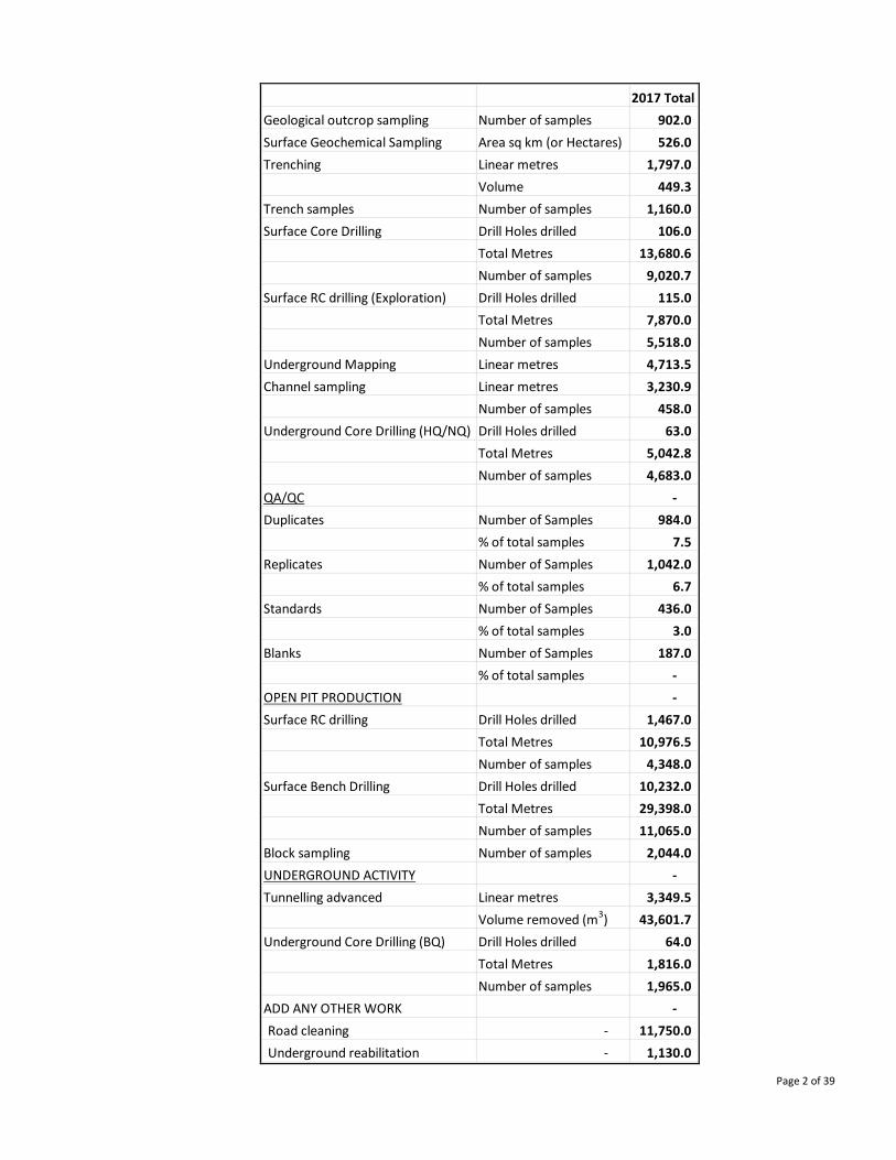
Page 2 of 39
2017 Total
Geological outcrop sampling Number of samples 902.0
Surface Geochemical Sampling Area sq km (or Hectares) 526.0
Trenching Linear metres 1,797.0
Volume 449.3
Trench samples Number of samples 1,160.0
Surface Core Drilling Drill Holes drilled 106.0
Total Metres 13,680.6
Number of samples 9,020.7
Surface RC drilling (Exploration) Drill Holes drilled 115.0
Total Metres 7,870.0
Number of samples 5,518.0
Underground Mapping Linear metres 4,713.5
Channel sampling Linear metres 3,230.9
Number of samples 458.0
Underground Core Drilling (HQ/NQ) Drill Holes drilled 63.0
Total Metres 5,042.8
Number of samples 4,683.0
QA/QC -
Duplicates Number of Samples 984.0
% of total samples 7.5
Replicates Number of Samples 1,042.0
% of total samples 6.7
Standards Number of Samples 436.0
% of total samples 3.0
Blanks Number of Samples 187.0
% of total samples -
OPEN PIT PRODUCTION -
Surface RC drilling Drill Holes drilled 1,467.0
Total Metres 10,976.5
Number of samples 4,348.0
Surface Bench Drilling Drill Holes drilled 10,232.0
Total Metres 29,398.0
Number of samples 11,065.0
Block sampling Number of samples 2,044.0
UNDERGROUND ACTIVITY -
Tunnelling advanced Linear metres 3,349.5
Volume removed (m3) 43,601.7
Underground Core Drilling (BQ) Drill Holes drilled 64.0
Total Metres 1,816.0
Number of samples 1,965.0
ADD ANY OTHER WORK -
Road cleaning - 11,750.0
Underground reabilitation - 1,130.0
Page 3 of 39
A. UGUR DEPOSIT
Background
The Ugur exploration area is located in the Gedabek ore district, which is part of the Shamkir uplift of the
Lok-Karabakh island arc volcanic structural-formation zone in the Lesser Caucasus Mega-anticlinorium,
Azerbaijan, Western Asia. The main Ugur gold deposit is located within the Gedabek-Bittibulag regional
deep fault system. The gold mineralisation developed mainly during the Upper Bajocian tectonic-magmatic
cycle. During Upper Bajocian times, the central tectonic zone formed a right-lateral strike-slip fault
represented by a number of sub-parallel-trending faults (55-85º) with a combined length of 1.0 to 1.5
kilometres.
The Ugur gold deposit was emplaced at the intersection of NW, NE, N and E trending structural systems
regionally controlled by a first order NW transcurrent structures. The fault dips between 70º to 80° to the
north-west. The faults of the central zone control the hydrothermal metasomatic alteration, gold
mineralisation, Upper Bajocian Atabek-Slavyanka plagiogranite massive intrusion, and in some cases are the
borders of the elevated tectonic blocks formed by Lower Bajocian volcanic rocks.
In cross-section, the geological sequence is dominated by secondary quartzites (strongly altered rhyolite)
being formed under the influence of the Atabek-Slavyanka plagiogranite intrusion observed in exposures to
the north of the gold mineralisation area. The oxide mineralisation zone thickness within the area varies
between 80 to 120 metres.
Exploration activity in 2017
• 48 core drill holes with a total length of 5,054 metres.
• 40 reverse circulation (“RC”) drill holes with a total length of 3,700 metres.
• 435 outcrop samples.
• 100,000 square metres of detailed lithological-alteration-structural mapping (over the central part).
The results of this work, combined with exploration results from 2016, provided the data for the JORC (Joint
Ore Reserves Committee) resource and reserve statements. Subsequently, the deposit was brought into
production in the second half of 2017. The drill-hole data can be found appended to the JORC reports that
can be accessed via the Anglo Asian Mining website.
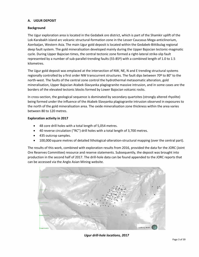
Ugur drill-hole locations, 2017
Page 4 of 39
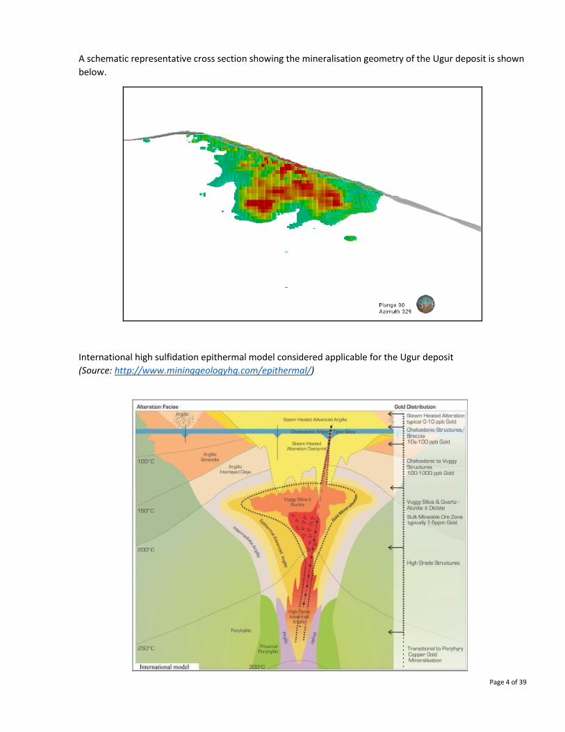
A schematic representative cross section showing the mineralisation geometry of the Ugur deposit is shown
below.
International high sulfidation epithermal model considered applicable for the Ugur deposit
(Source: http://www.mininggeologyhq.com/epithermal/)
Page 5 of 39
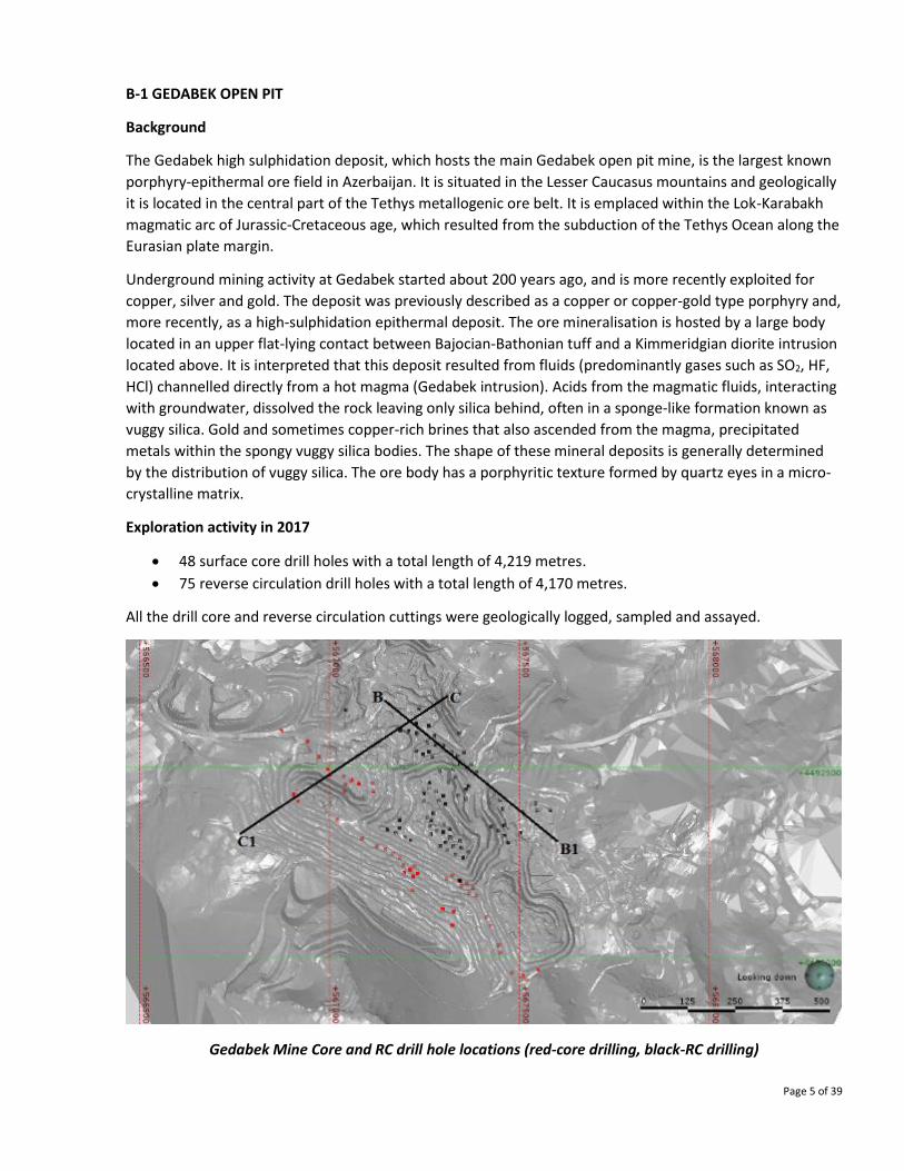
B-1 GEDABEK OPEN PIT
Background
The Gedabek high sulphidation deposit, which hosts the main Gedabek open pit mine, is the largest known
porphyry-epithermal ore field in Azerbaijan. It is situated in the Lesser Caucasus mountains and geologically
it is located in the central part of the Tethys metallogenic ore belt. It is emplaced within the Lok-Karabakh
magmatic arc of Jurassic-Cretaceous age, which resulted from the subduction of the Tethys Ocean along the
Eurasian plate margin.
Underground mining activity at Gedabek started about 200 years ago, and is more recently exploited for
copper, silver and gold. The deposit was previously described as a copper or copper-gold type porphyry and,
more recently, as a high-sulphidation epithermal deposit. The ore mineralisation is hosted by a large body
located in an upper flat-lying contact between Bajocian-Bathonian tuff and a Kimmeridgian diorite intrusion
located above. It is interpreted that this deposit resulted from fluids (predominantly gases such as SO2, HF,
HCl) channelled directly from a hot magma (Gedabek intrusion). Acids from the magmatic fluids, interacting
with groundwater, dissolved the rock leaving only silica behind, often in a sponge-like formation known as
vuggy silica. Gold and sometimes copper-rich brines that also ascended from the magma, precipitated
metals within the spongy vuggy silica bodies. The shape of these mineral deposits is generally determined
by the distribution of vuggy silica. The ore body has a porphyritic texture formed by quartz eyes in a micro-
crystalline matrix.
Exploration activity in 2017
• 48 surface core drill holes with a total length of 4,219 metres.
• 75 reverse circulation drill holes with a total length of 4,170 metres.
All the drill core and reverse circulation cuttings were geologically logged, sampled and assayed.
Gedabek Mine Core and RC drill hole locations (red-core drilling, black-RC drilling)
Page 6 of 39
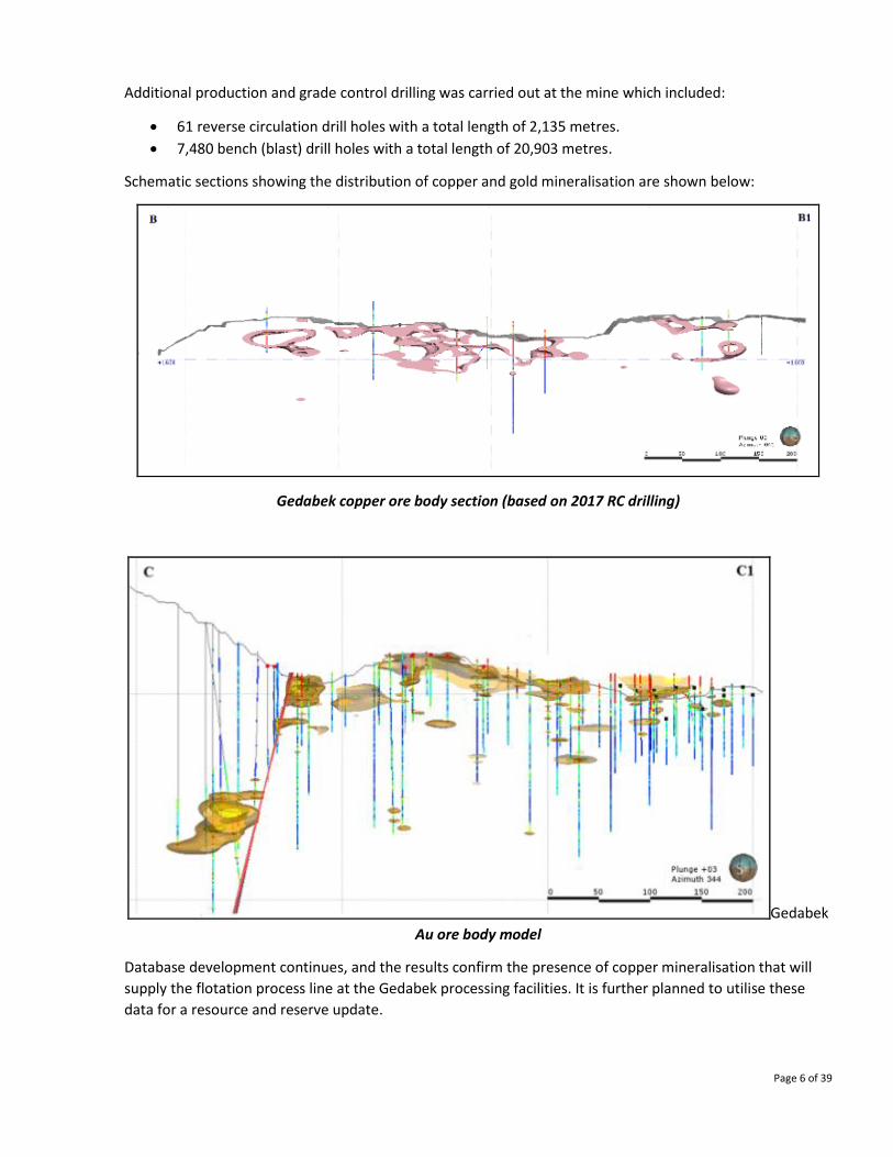
Additional production and grade control drilling was carried out at the mine which included:
• 61 reverse circulation drill holes with a total length of 2,135 metres.
• 7,480 bench (blast) drill holes with a total length of 20,903 metres.
Schematic sections showing the distribution of copper and gold mineralisation are shown below:
Gedabek copper ore body section (based on 2017 RC drilling)
Gedabek
Au ore body model
Database development continues, and the results confirm the presence of copper mineralisation that will
supply the flotation process line at the Gedabek processing facilities. It is further planned to utilise these
data for a resource and reserve update.
Page 7 of 39
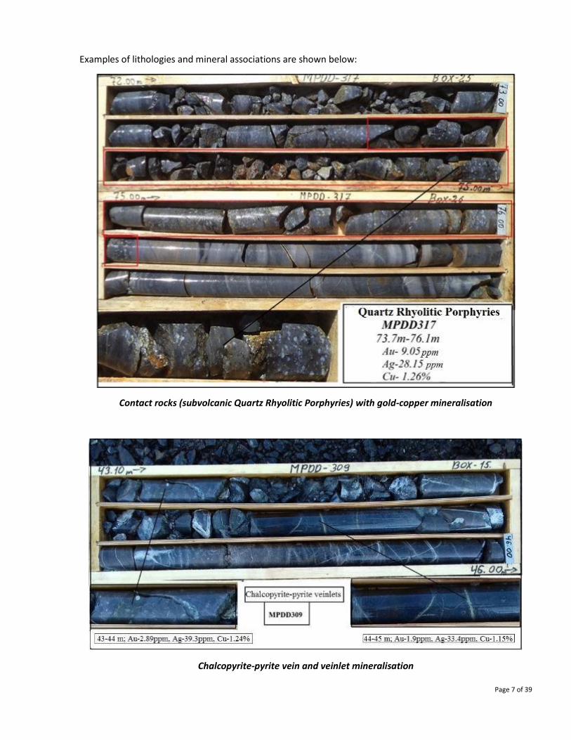
Examples of lithologies and mineral associations are shown below:
Contact rocks (subvolcanic Quartz Rhyolitic Porphyries) with gold-copper mineralisation
Chalcopyrite-pyrite vein and veinlet mineralisation
Page 8 of 39
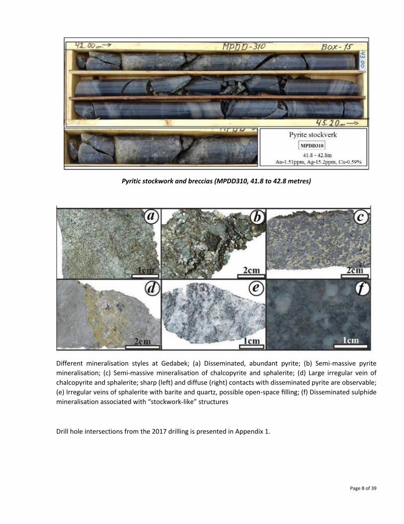
Pyritic stockwork and breccias (MPDD310, 41.8 to 42.8 metres)
Different mineralisation styles at Gedabek; (a) Disseminated, abundant pyrite; (b) Semi-massive pyrite
mineralisation; (c) Semi-massive mineralisation of chalcopyrite and sphalerite; (d) Large irregular vein of
chalcopyrite and sphalerite; sharp (left) and diffuse (right) contacts with disseminated pyrite are observable;
(e) Irregular veins of sphalerite with barite and quartz, possible open-space filling; (f) Disseminated sulphide
mineralisation associated with “stockwork-like” structures
Drill hole intersections from the 2017 drilling is presented in Appendix 1.

Page 9 of 39
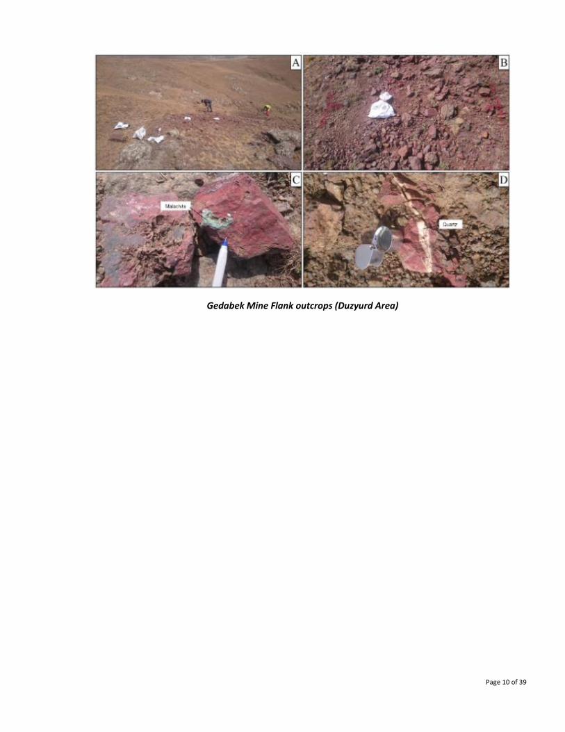
B - 2 GEDABEK OPEN PIT: FLANKS (Duzyurd area)
Background
A mineral occurrence adjacent to the Gedabek Mine is located at the south-west corner of the prospecting
area at a distance of 2.8 kilometres from the Gedabek deposit.
The occurrence is composed of effusive-pyroclastic formations of Lower Bajocian age represented by
andesitic fragmental tuffs and secondary quartzites that were formed under the influence of the Gedabek
polyphase intrusion. Hosted in secondary quartzites are silicified and hematitic andesites, likely to have
been pyroclastic volcanic rocks. They are light-grey with reddish tint in colour, fissured, hematitic and
essentially silicified rocks containing fissures with coatings of hypergene minerals of copper that is mainly
malachite.
Structural mapping defined one quartz vein with pyrite phenocrysts at a northeast strike (060°) with a dip to
the northwest at an angle 70°. The quartz is white and sugar-like. The vein thickness varies up to 1.5 metres.
The main mineralisation in the Duzyurd area consists of quartz, hematite-quartz veins-veinlets and breccia
(see photos below). The main outcrop comprises secondary quartzites with vein-veinlets quartz
mineralisation overprinted by accumulations of hydrous ferric oxides, cemented breccias and secondary
quartzites. In the erosion areas a “reddish mass” of oxidised material is observed which is interpreted to be
a product of subvolcanic origin.
Epidote, chlorite, and leached vugs in the propylitic alteration zone near Duzyurd area were observed. The
outcrop of hematitic subvolcanic rocks is located in the Central part of the propylitic alteration zone.
Exploration activity in 2017
• 30 trench and grab samples.
Rock type in the trenching is intensely oxidised and strongly weathered, typical of a gossan (that often
represents a cap overlaying metalliferous mineralisation zones). The sampled gossan over a thickness of up
to 10 metres contains gold ranging from 0.15 to 0.8 grammes per tonne and silver 1.0 to 10.0 grammes per
tonne. Although the grade is not high, it does indicate the presence of mineralisation on surface. This
therefore warrants further exploratory work and possible follow-up drilling.
Page 10 of 39
Gedabek Mine Flank outcrops (Duzyurd Area)

Page 11 of 39
C. GADIR
Background
The Gadir low sulphidation deposit is located at a distance of 400 metres from the current Gedabek open
pit. The area was first discovered during structural-geological mapping at the flank of the Gedabek mineral
deposit. Here, the outcrop of quartz porphyry subvolcanic formation on the surface was considered as the
key indicator. The ore body is located at the contact between volcanic rocks and the quartz porphyry
(rhyolite-rhyodacite subvolcanic formation). There are disseminated breccias and vein-like ore hosting
hydrothermal structures in the quartz porphyry.
Adularia-sericite alteration is formed during the interaction of groundwater fluids with hot magmatic fluids
(Gedabek intrusion). The protracted boiling of the fluids in low-sulphidation systems produces high grade
gold and silver deposits. The fluids interact with the surrounding rock for a much longer period of time than
the quickly channelled high-sulphidation fluids. As a result, the fluids become dilute and neutralized and the
silica dissolves. Later the silica is precipitated in the veins as quartz, often sealing the fissures closed. When
this occurs, the pressure of the gases inside the sealed fault builds until the seal is ruptured, which provokes
catastrophic boiling and the precipitation of gold. After this, passive conditions return, and quartz
precipitates once again. This cyclical process results in the well-known banded texture of the quartz-adularia
veins typical of the Gadir low-sulphidation vein systems.
Exploration activity in 2017
• 10 surface core drill holes with a total length of 4,407 metres.
• 63 underground core drill holes (HQ/NQ diameter) with a total length of 5,043 metres.
• 3,340 metres of underground sidewall and tunnel roof mapping was completed.
This work resulted in defining ores for the continuation of mining and extended the down dip footprint of
the mineralisation.
Gadir Surface core drill hole location plan, 2017

Page 12 of 39
Gadir Ore body cross-section
(red circle defines area of extended mineralisation defined from surface core drilling)
Gadir: Increased ore zone (red) based on surface and underground drilling (Orthogonal view)
Page 13 of 39
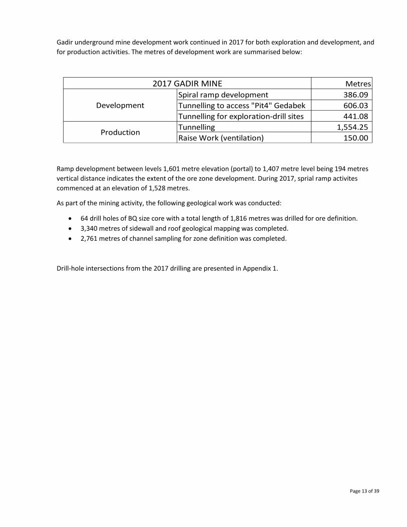
Gadir underground mine development work continued in 2017 for both exploration and development, and
for production activities. The metres of development work are summarised below:
Ramp development between levels 1,601 metre elevation (portal) to 1,407 metre level being 194 metres
vertical distance indicates the extent of the ore zone development. During 2017, sprial ramp activites
commenced at an elevation of 1,528 metres.
As part of the mining activity, the following geological work was conducted:
• 64 drill holes of BQ size core with a total length of 1,816 metres was drilled for ore definition.
• 3,340 metres of sidewall and roof geological mapping was completed.
• 2,761 metres of channel sampling for zone definition was completed.
Drill-hole intersections from the 2017 drilling are presented in Appendix 1.
Metres
Spiral ramp development 386.09
Tunnelling to access "Pit4" Gedabek 606.03
Tunnelling for exploration-drill sites 441.08
Tunnelling 1,554.25
Raise Work (ventilation) 150.00
2017 GADIR MINE
Development
Production
Page 14 of 39
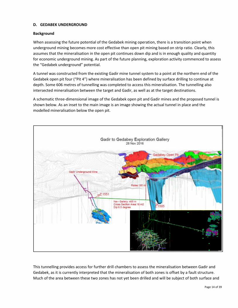
D. GEDABEK UNDERGROUND
Background
When assessing the future potential of the Gedabek mining operation, there is a transition point when
underground mining becomes more cost effective than open pit mining based on strip ratio. Clearly, this
assumes that the mineralisation in the open pit continues down dip and is in enough quality and quantity
for economic underground mining. As part of the future planning, exploration activity commenced to assess
the “Gedabek underground” potential.
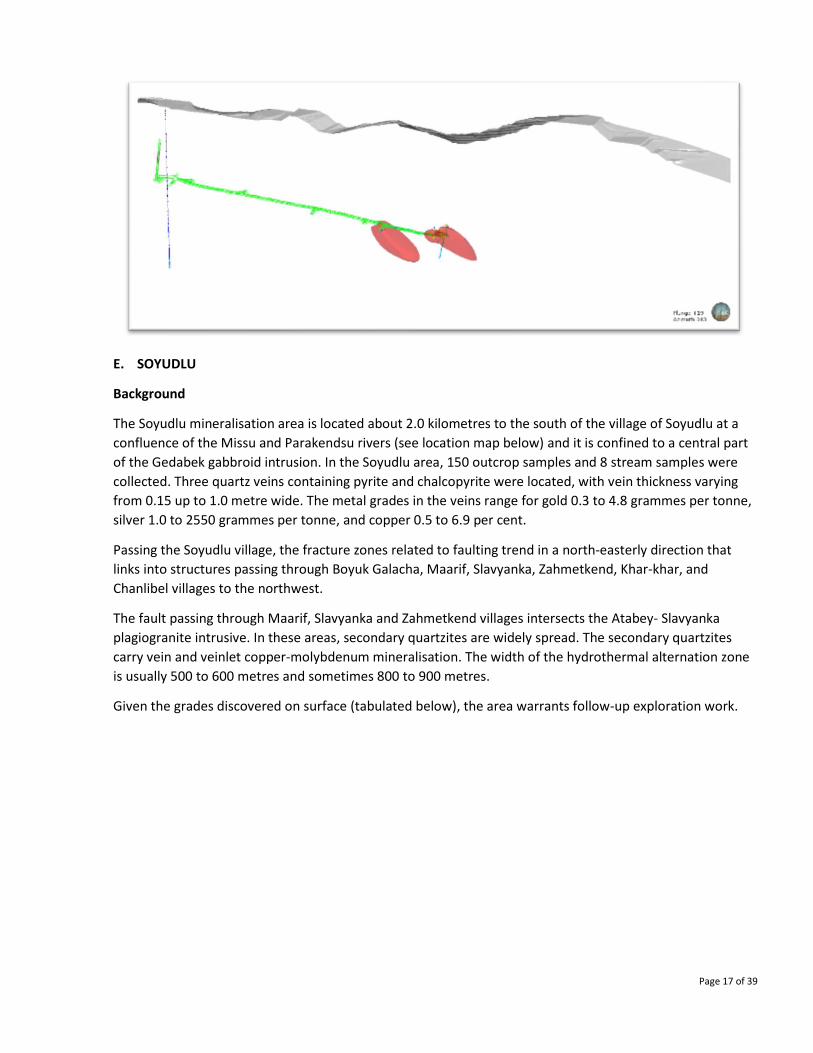
A tunnel was constructed from the existing Gadir mine tunnel system to a point at the northern end of the
Gedabek open pit four (“Pit 4”) where mineralisation has been defined by surface drilling to continue at
depth. Some 606 metres of tunnelling was completed to access this mineralisation. The tunnelling also
intersected mineralisation between the target and Gadir, as well as at the target destinations.
A schematic three-dimensional image of the Gedabek open pit and Gadir mines and the proposed tunnel is
shown below. As an inset to the main image is an image showing the actual tunnel in place and the
modelled mineralisation below the open pit.
This tunnelling provides access for further drill chambers to assess the mineralisation between Gadir and
Gedabek, as it is currently interpreted that the mineralisation of both zones is offset by a fault structure.
Much of the area between these two zones has not yet been drilled and will be subject of both surface and
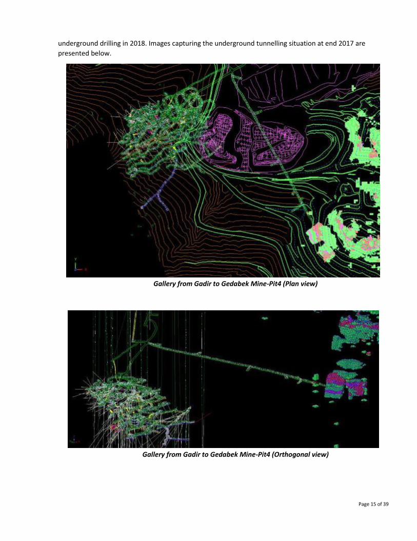
Page 15 of 39
underground drilling in 2018. Images capturing the underground tunnelling situation at end 2017 are
presented below.
Gallery from Gadir to Gedabek Mine-Pit4 (Plan view)
Gallery from Gadir to Gedabek Mine-Pit4 (Orthogonal view)
Page 16 of 39
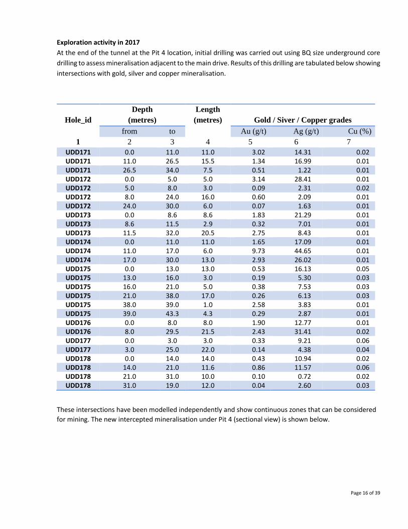
Exploration activity in 2017
At the end of the tunnel at the Pit 4 location, initial drilling was carried out using BQ size underground core
drilling to assess mineralisation adjacent to the main drive. Results of this drilling are tabulated below showing
intersections with gold, silver and copper mineralisation.
Hole_id
Depth
(metres)
Length
(metres)
Gold / Siver / Copper grades
from to Au (g/t) Ag (g/t) Cu (%)
1 2 3 4 5 6 7
UDD171 0.0 11.0 11.0 3.02 14.31 0.02 UDD171 11.0 26.5 15.5 1.34 16.99 0.01 UDD171 26.5 34.0 7.5 0.51 1.22 0.01 UDD172 0.0 5.0 5.0 3.14 28.41 0.01 UDD172 5.0 8.0 3.0 0.09 2.31 0.02 UDD172 8.0 24.0 16.0 0.60 2.09 0.01 UDD172 24.0 30.0 6.0 0.07 1.63 0.01 UDD173 0.0 8.6 8.6 1.83 21.29 0.01 UDD173 8.6 11.5 2.9 0.32 7.01 0.01 UDD173 11.5 32.0 20.5 2.75 8.43 0.01 UDD174 0.0 11.0 11.0 1.65 17.09 0.01 UDD174 11.0 17.0 6.0 9.73 44.65 0.01 UDD174 17.0 30.0 13.0 2.93 26.02 0.01 UDD175 0.0 13.0 13.0 0.53 16.13 0.05 UDD175 13.0 16.0 3.0 0.19 5.30 0.03 UDD175 16.0 21.0 5.0 0.38 7.53 0.03 UDD175 21.0 38.0 17.0 0.26 6.13 0.03 UDD175 38.0 39.0 1.0 2.58 3.83 0.01 UDD175 39.0 43.3 4.3 0.29 2.87 0.01 UDD176 0.0 8.0 8.0 1.90 12.77 0.01 UDD176 8.0 29.5 21.5 2.43 31.41 0.02 UDD177 0.0 3.0 3.0 0.33 9.21 0.06 UDD177 3.0 25.0 22.0 0.14 4.38 0.04 UDD178 0.0 14.0 14.0 0.43 10.94 0.02 UDD178 14.0 21.0 11.6 0.86 11.57 0.06 UDD178 21.0 31.0 10.0 0.10 0.72 0.02 UDD178 31.0 19.0 12.0 0.04 2.60 0.03
These intersections have been modelled independently and show continuous zones that can be considered
for mining. The new intercepted mineralisation under Pit 4 (sectional view) is shown below.
Page 17 of 39
E. SOYUDLU
Background
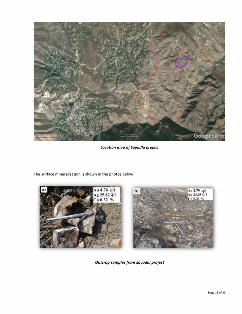
The Soyudlu mineralisation area is located about 2.0 kilometres to the south of the village of Soyudlu at a
confluence of the Missu and Parakendsu rivers (see location map below) and it is confined to a central part
of the Gedabek gabbroid intrusion. In the Soyudlu area, 150 outcrop samples and 8 stream samples were
collected. Three quartz veins containing pyrite and chalcopyrite were located, with vein thickness varying
from 0.15 up to 1.0 metre wide. The metal grades in the veins range for gold 0.3 to 4.8 grammes per tonne,
silver 1.0 to 2550 grammes per tonne, and copper 0.5 to 6.9 per cent.
Passing the Soyudlu village, the fracture zones related to faulting trend in a north-easterly direction that
links into structures passing through Boyuk Galacha, Maarif, Slavyanka, Zahmetkend, Khar-khar, and
Chanlibel villages to the northwest.
The fault passing through Maarif, Slavyanka and Zahmetkend villages intersects the Atabey- Slavyanka
plagiogranite intrusive. In these areas, secondary quartzites are widely spread. The secondary quartzites
carry vein and veinlet copper-molybdenum mineralisation. The width of the hydrothermal alternation zone
is usually 500 to 600 metres and sometimes 800 to 900 metres.
Given the grades discovered on surface (tabulated below), the area warrants follow-up exploration work.
Page 18 of 39
Location map of Soyudlu project
The surface mineralisation is shown in the photos below:
Outcrop samples from Soyudlu project
Page 19 of 39
Assays and analysis of vein samples from Soyudlu area
Sample id Gold / Silver / Copper Grade
Au, ppm Ag, ppm Cu, %
EFW17-37 0.14 2550.0 6.98
EFW17-38 0.23 1849.70 3.26
EFW17-39 0.10 959.00 3.94
SV-GR01 0.10 5.78 0.64
SY-GR01-01 0.28 18.2 1.69
EFW17-89 0.20 119.96 0.40
EFW17-91 0.32 1226.25 4.17
EFW17-95 0.99 15.58 0.08
EFW17-100 4.76 25.82 0.32
EFW17-126 0.52 153.55 0.41
EFW17-132 0.32 122.01 0.81
EFW17-133 2.01 71.86 4.10
EFW17-134 0.74 29.55 0.33
EFW17-135 2.79 23.08 0.20
EFW17-141 1.93 22.38 0.51
EFW17-144 1.12 25.52 0.65
EFW17-145 0.16 9.64 0.16
EFW17-154 3.36 118.92 0.56
EFW17-158 0.28 3.32 0.12
EFW17-159 2.22 6.50 0.17
EFW17-163 4.00 82.96 0.54
EFW17-165 0.26 2.40 0.04
EFW17-169 0.26 2.42 0.06
EFW17-174 0.84 31.74 0.68

Page 20 of 39
F. ORDUBAD CONTRACT AREA
Exploration Acivity in 2017
SHEKERDERE GOLD DEPOSIT
Background
Information about the presence of copper mineralization in the Shekerdere area is found in archive
materials dating back to the 19th century, and the presence of gold was for the first time demonstrated in
1956-1958. Soviet classified estimated resources for the main vein zone were reported as 2.6 million tonnes
of ore, containing 3.7 tonnes of gold, 8.8 tonnes of silver and 40.1 tonnes of copper. These data have not
been substantiated. As a result of the geological exploration activities carried out between 1987 and 1997 at
the 1724 metre horizon, gold mineralisation (with the range of 0.2 to 3.6 grammes per tonne) was detected
in hydrothermally altered andesitic porphyrites in adits No. 10 and 12. Based on the limited data obtained,
resource forecasts of the deposit were made for P1 and P2 categories of gold with an average gold content
of 1.1 grammes per tonne.
Exploration activity in 2017
Shekerdere was the focus for exploration activity in 2017, which is located in the central area of the
Ordubad contract area.
Geological outcrop sampling Number of samples 140.0
Surface Geochemical Sampling Area sq km (or Hectares) 91.0
Trenching Linear metres 1,797.0
Volume 449.3
Trench samples Number of samples 1,160.0
Underground Mapping Linear metres 1,374.0
Channel sampling Linear metres 470.0
Number of samples 458.0
Road cleaning 11,750.0
Underground reabilitation 1,130.0
Page 21 of 39
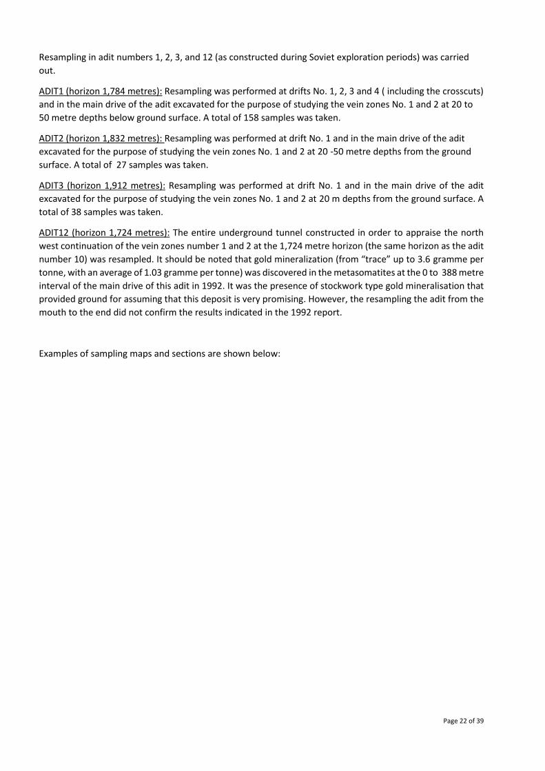
Drill roads near the adit#10
Based on recent understanding of porphyry style mineralisation, a reassessment of the deposit is being
carried out. Also, the relationship between this deposit and adjacent deposits of Pyazbashi and Keleki (vein
gold) and Dirnis (copper malachite on surface) is being investigated.
Page 22 of 39
Resampling in adit numbers 1, 2, 3, and 12 (as constructed during Soviet exploration periods) was carried
out.
ADIT1 (horizon 1,784 metres): Resampling was performed at drifts No. 1, 2, 3 and 4 ( including the crosscuts)
and in the main drive of the adit excavated for the purpose of studying the vein zones No. 1 and 2 at 20 to
50 metre depths below ground surface. A total of 158 samples was taken.
ADIT2 (horizon 1,832 metres): Resampling was performed at drift No. 1 and in the main drive of the adit
excavated for the purpose of studying the vein zones No. 1 and 2 at 20 -50 metre depths from the ground
surface. A total of 27 samples was taken.
ADIT3 (horizon 1,912 metres): Resampling was performed at drift No. 1 and in the main drive of the adit
excavated for the purpose of studying the vein zones No. 1 and 2 at 20 m depths from the ground surface. A
total of 38 samples was taken.
ADIT12 (horizon 1,724 metres): The entire underground tunnel constructed in order to appraise the north
west continuation of the vein zones number 1 and 2 at the 1,724 metre horizon (the same horizon as the adit
number 10) was resampled. It should be noted that gold mineralization (from “trace” up to 3.6 gramme per
tonne, with an average of 1.03 gramme per tonne) was discovered in the metasomatites at the 0 to 388 metre
interval of the main drive of this adit in 1992. It was the presence of stockwork type gold mineralisation that
provided ground for assuming that this deposit is very promising. However, the resampling the adit from the
mouth to the end did not confirm the results indicated in the 1992 report.
Examples of sampling maps and sections are shown below:
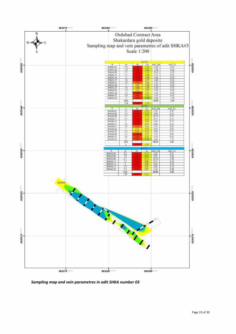
Page 23 of 39
Sampling map and vein parametres in adit SHKA number 03
Page 24 of 39
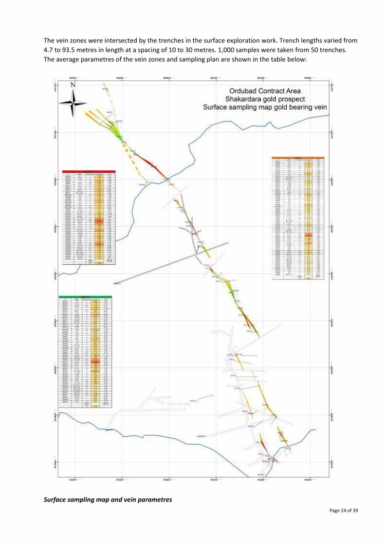
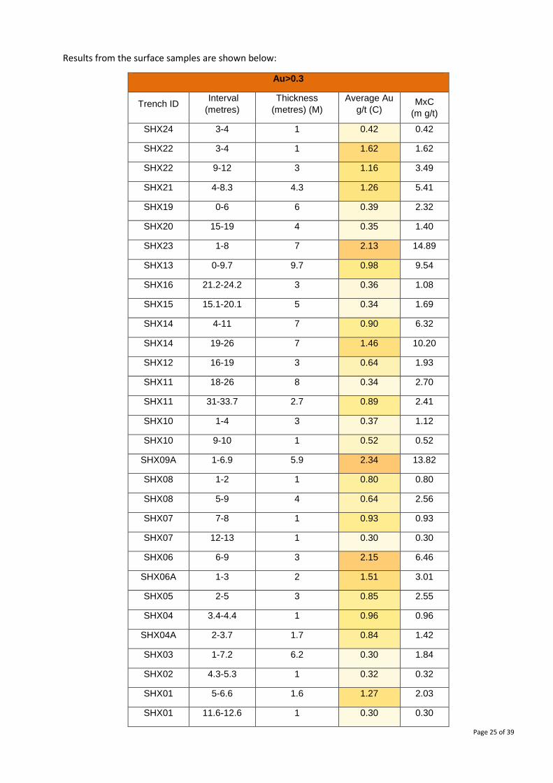
The vein zones were intersected by the trenches in the surface exploration work. Trench lengths varied from
4.7 to 93.5 metres in length at a spacing of 10 to 30 metres. 1,000 samples were taken from 50 trenches.
The average parametres of the vein zones and sampling plan are shown in the table below:
Surface sampling map and vein parametres
Page 25 of 39
Results from the surface samples are shown below:
Au>0.3
Trench ID Interval
(metres)
Thickness
(metres) (M)
Average Au
g/t (C) MxC
(m g/t)
SHX24 3-4 1 0.42 0.42
SHX22 3-4 1 1.62 1.62
SHX22 9-12 3 1.16 3.49
SHX21 4-8.3 4.3 1.26 5.41
SHX19 0-6 6 0.39 2.32
SHX20 15-19 4 0.35 1.40
SHX23 1-8 7 2.13 14.89
SHX13 0-9.7 9.7 0.98 9.54
SHX16 21.2-24.2 3 0.36 1.08
SHX15 15.1-20.1 5 0.34 1.69
SHX14 4-11 7 0.90 6.32
SHX14 19-26 7 1.46 10.20
SHX12 16-19 3 0.64 1.93
SHX11 18-26 8 0.34 2.70
SHX11 31-33.7 2.7 0.89 2.41
SHX10 1-4 3 0.37 1.12
SHX10 9-10 1 0.52 0.52
SHX09A 1-6.9 5.9 2.34 13.82
SHX08 1-2 1 0.80 0.80
SHX08 5-9 4 0.64 2.56
SHX07 7-8 1 0.93 0.93
SHX07 12-13 1 0.30 0.30
SHX06 6-9 3 2.15 6.46
SHX06A 1-3 2 1.51 3.01
SHX05 2-5 3 0.85 2.55
SHX04 3.4-4.4 1 0.96 0.96
SHX04A 2-3.7 1.7 0.84 1.42
SHX03 1-7.2 6.2 0.30 1.84
SHX02 4.3-5.3 1 0.32 0.32
SHX01 5-6.6 1.6 1.27 2.03
SHX01 11.6-12.6 1 0.30 0.30

Page 26 of 39
SHX01 15.6-16.6 1 0.42 0.42
SHX25 4-9.4 5.4 0.76 4.13
SHX26 3.5-9.1 5.6 1.98 11.11
SHX18 6-7 1 0.28 0.28
SHX18 82-85 3 0.59 1.78
SHX17 74.5-75.5 1 0.32 0.32
SHX30 21.5-22 0.5 3.21 1.61
SHX31 2-2.5 0.5 5.68 2.84
SHX32 5-9.7 4.7 1.66 7.82
SHX33 1-2.7 1.7 1.89 3.21
SHX34 2-3.2 1.2 1.05 1.26
SHX34 8.2-10.2 2 3.51 7.02
SHX35 14-20 6 0.64 3.84
SHX36 5-10 5 0.88 4.40
SHX37 3-10 7 0.92 6.44
SHX38 2-6.8 4.8 1.01 4.84
SHX39 4.4-7.8 3.4 1.84 6.26
SHX40 2.8-12.7 9.9 0.33 3.27
SHX40 17.7-25 7.3 0.64 4.67
SHX40 28.8-32.8 4 0.71 2.82
SHX41 33-35.4 2.4 0.56 1.34
SHX41 52.6-53 0.4 1.44 0.58
SHX41 69-73 4 0.30 1.20
SHX42 2.8-3.8 1 0.30 0.30
SHX40a 9-10 1 0.64 0.64
SHX43 4-14 10 0.67 6.70
SHX44 2-3 1 0.37 0.37
SHX45 20.5-21.5 1 0.29 0.29
Further sampling of the vein zones in a north-west direction is planned, and based on the results, drilling
work will be carried out following the next stage of evaluation. Aside from the known vein system, alteration
mapping was carried out, which defined a large halo of altered rocks. Follow-up stream sediment sampling
was carried out in 2017 and analysis for gold, silver and copper carried out that indicated the presence of
mineralisation.
It is further intended to send samples for full multi-element analysis to map elemental gechemical results
that can be correlated to altertion styles of porphyry systems.
Page 27 of 39
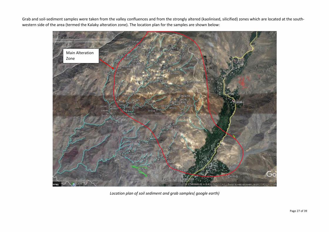
Grab and soil-sediment samples were taken from the valley confluences and from the strongly altered (kaolinised, silicified) zones which are located at the south-
western side of the area (termed the Kalaky alteration zone). The location plan for the samples are shown below:
Location plan of soil sediment and grab samples( google earth)
Main Alteration
Zone
Page 28 of 39
CONCLUSION AND SUMMARY
Extensive exploration work was carried out during 2017 which resulted in:
A. UGUR DEPOSIT
• Completion of the exploration programme provided data for the JORC classified resources and
reserves, on which the mine was constructed and brought into production (in less than one year
from the commencement of exploration drilling in 2016).
B. GEDABEK OPEN PIT
• Production from the main Gedabek open pit was temporarily halted to allow for the core drilling
and reverse circulation drilling to take place. This work confirmed the presence of further mineable
copper and gold ores and allowed for a better understanding of the metals distribution. Resulting
from this work, mine design and planning was carried out.
C. GADIR
• Surface and underground drilling yielded results that show the continuation of the Gadir orebody
down dip, thus providing confidence in short-medium term production. It also expanded the
mineralisation footprint and established that mineralisation is open at depth. Further mine
development work took place for production mining access.
D. GEDABEK UNDERGROUND
• The planned tunnel from the Gadir mine to the down dip mineralisation beneath the Gedabek open
pit (northern part) was successfully completed and exploratory drilling confirmed the presence of
mineralisation. It is planned to extend this tunnel under the Gedabek open pits.
E. SOYUDLU
• A new area was discovered as a result of the reconnaissance mapping programme. High grade
surface mineralisation of copper, gold and silver was established that will be further tested in 2018.
F. ORDUBAD CONTRACT AREA
• The discovery of massive alteration zones of porphyry style and confirmation of copper and gold
mineralisation were the main results of the 2017 work. Preliminary study of the geological
relationships between the known mineral occurrences commenced, with the aim to establish the
genesis of the mineralisation and determine further work programmes.
The positive 2017 exploration and development results provide a robust platform for the 2018 exploration
programmes. AIMC contract areas host many styles of mineralisation and significant concentrations are
known. Prioritisation, exploration and evaluation will allow for these to be placed into the resource to reserve
pipeline, thus firmly establishing the future for sustainable production and company growth.
Page 29 of 39
Competent Person Statement
The information in this report that relates to exploration results is based on information compiled
by Dr Stephen Westhead, Director of Geology & Mining at the Anglo Asian Mining group, who is a
Fellow of The Geological Society of London, a Chartered Geologist, Fellow of the Society of Economic
Geologists, Member of The Institute of Materials, Minerals and Mining and a Member of the Institute
of Directors.
Stephen Westhead has sufficient experience, relevant to the style of mineralisation and type of
deposit under consideration and to the activity, which he is undertaking, to qualify as a qualified
person as defined by the AIM rules. Stephen Westhead has reviewed the exploration data included
in this report.
Page 30 of 39
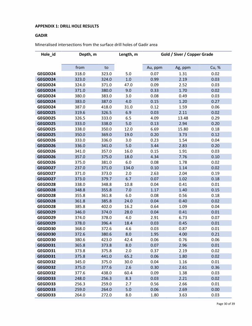
APPENDIX 1: DRILL HOLE RESULTS
GADIR
Mineralised intersections from the surface drill holes of Gadir area
Hole_id Depth, m
Length, m Gold / Siver / Copper Grade
from to Au, ppm Ag, ppm Cu, %
GEGDD24 318.0 323.0 5.0 0.07 1.31 0.02 GEGDD24 323.0 324.0 1.0 0.99 2.19 0.03 GEGDD24 324.0 371.0 47.0 0.09 2.52 0.03 GEGDD24 371.0 380.0 9.0 0.33 1.70 0.02 GEGDD24 380.0 383.0 3.0 0.08 0.49 0.03 GEGDD24 383.0 387.0 4.0 0.15 1.20 0.27 GEGDD24 387.0 418.0 31.0 0.12 1.59 0.06 GEGDD25 319.6 326.5 6.9 0.03 2.11 0.02 GEGDD25 326.5 333.0 6.5 4.09 13.48 0.29 GEGDD25 333.0 338.0 5.0 0.13 2.94 0.20 GEGDD25 338.0 350.0 12.0 6.69 15.80 0.18 GEGDD25 350.0 369.0 19.0 0.20 3.73 0.12 GEGDD26 333.0 336.0 3.0 0.23 1.54 0.04 GEGDD26 336.0 341.0 5.0 3.44 2.83 0.20 GEGDD26 341.0 357.0 16.0 0.15 1.91 0.03 GEGDD26 357.0 375.0 18.0 4.34 7.76 0.10 GEGDD26 375.0 381.0 6.0 0.08 1.78 0.02 GEGDD27 237.0 371.0 134.0 0.10 1.14 0.02 GEGDD27 371.0 373.0 2.0 2.63 2.04 0.19 GEGDD27 373.0 379.7 6.7 0.07 1.02 0.18 GEGDD28 338.0 348.8 10.8 0.04 0.41 0.01 GEGDD28 348.8 355.8 7.0 1.17 1.40 0.15 GEGDD28 355.8 361.8 6.0 0.08 0.56 0.18 GEGDD28 361.8 385.8 24.0 0.04 0.40 0.02 GEGDD28 385.8 402.0 16.2 0.64 1.09 0.04 GEGDD29 346.0 374.0 28.0 0.04 0.41 0.01 GEGDD29 374.0 378.0 4.0 2.91 6.73 0.07 GEGDD29 378.0 396.4 18.4 0.03 0.45 0.01 GEGDD30 368.0 372.6 4.6 0.03 0.87 0.01 GEGDD30 372.6 380.6 8.0 1.95 4.00 0.21 GEGDD30 380.6 423.0 42.4 0.06 0.76 0.06 GEGDD31 365.8 373.8 8.0 0.07 2.96 0.01 GEGDD31 373.8 375.8 2.0 0.37 2.19 0.02 GEGDD31 375.8 441.0 65.2 0.06 1.80 0.02 GEGDD32 345.0 375.0 30.0 0.04 1.16 0.01 GEGDD32 375.0 377.6 2.6 0.30 2.61 0.36 GEGDD32 377.6 438.0 60.4 0.09 1.38 0.03 GEGDD33 248.0 256.3 8.3 0.03 2.21 0.02 GEGDD33 256.3 259.0 2.7 0.56 2.66 0.01 GEGDD33 259.0 264.0 5.0 0.06 2.69 0.00 GEGDD33 264.0 272.0 8.0 1.80 3.63 0.03
Page 31 of 39
GEGDD33 272.0 274.0 2.0 8.50 3.10 0.03 GEGDD33 274.0 278.0 4.0 1.10 2.70 0.03 GEGDD33 278.0 291.0 13.0 0.09 3.02 0.01 GEGDD33 291.0 294.4 3.4 3.37 4.28 0.04 GEGDD33 294.4 301.4 7.0 0.13 2.87 0.01 GEGDD33 301.4 304.4 3.0 0.85 7.69 0.01 GEGDD33 304.4 319.0 14.6 0.04 2.31 0.01
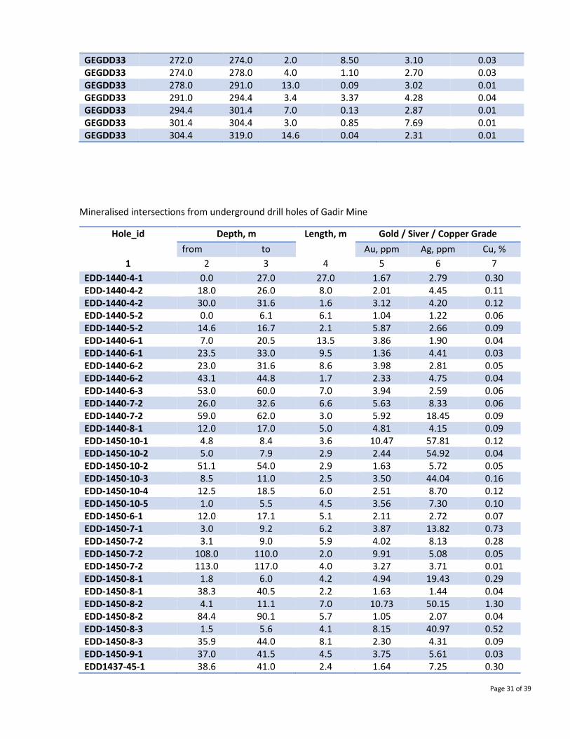
Mineralised intersections from underground drill holes of Gadir Mine
Hole_id Depth, m Length, m Gold / Siver / Copper Grade
from to Au, ppm Ag, ppm Cu, %
1 2 3 4 5 6 7
EDD-1440-4-1 0.0 27.0 27.0 1.67 2.79 0.30 EDD-1440-4-2 18.0 26.0 8.0 2.01 4.45 0.11 EDD-1440-4-2 30.0 31.6 1.6 3.12 4.20 0.12 EDD-1440-5-2 0.0 6.1 6.1 1.04 1.22 0.06 EDD-1440-5-2 14.6 16.7 2.1 5.87 2.66 0.09 EDD-1440-6-1 7.0 20.5 13.5 3.86 1.90 0.04 EDD-1440-6-1 23.5 33.0 9.5 1.36 4.41 0.03 EDD-1440-6-2 23.0 31.6 8.6 3.98 2.81 0.05 EDD-1440-6-2 43.1 44.8 1.7 2.33 4.75 0.04 EDD-1440-6-3 53.0 60.0 7.0 3.94 2.59 0.06 EDD-1440-7-2 26.0 32.6 6.6 5.63 8.33 0.06 EDD-1440-7-2 59.0 62.0 3.0 5.92 18.45 0.09 EDD-1440-8-1 12.0 17.0 5.0 4.81 4.15 0.09 EDD-1450-10-1 4.8 8.4 3.6 10.47 57.81 0.12 EDD-1450-10-2 5.0 7.9 2.9 2.44 54.92 0.04 EDD-1450-10-2 51.1 54.0 2.9 1.63 5.72 0.05 EDD-1450-10-3 8.5 11.0 2.5 3.50 44.04 0.16 EDD-1450-10-4 12.5 18.5 6.0 2.51 8.70 0.12 EDD-1450-10-5 1.0 5.5 4.5 3.56 7.30 0.10 EDD-1450-6-1 12.0 17.1 5.1 2.11 2.72 0.07 EDD-1450-7-1 3.0 9.2 6.2 3.87 13.82 0.73 EDD-1450-7-2 3.1 9.0 5.9 4.02 8.13 0.28 EDD-1450-7-2 108.0 110.0 2.0 9.91 5.08 0.05 EDD-1450-7-2 113.0 117.0 4.0 3.27 3.71 0.01 EDD-1450-8-1 1.8 6.0 4.2 4.94 19.43 0.29 EDD-1450-8-1 38.3 40.5 2.2 1.63 1.44 0.04 EDD-1450-8-2 4.1 11.1 7.0 10.73 50.15 1.30 EDD-1450-8-2 84.4 90.1 5.7 1.05 2.07 0.04 EDD-1450-8-3 1.5 5.6 4.1 8.15 40.97 0.52 EDD-1450-8-3 35.9 44.0 8.1 2.30 4.31 0.09 EDD-1450-9-1 37.0 41.5 4.5 3.75 5.61 0.03 EDD1437-45-1 38.6 41.0 2.4 1.64 7.25 0.30
Page 32 of 39
EDD1437-45-2 34.9 37.1 2.2 1.22 3.48 0.28 EDD1437-45-2 43.0 47.5 4.5 1.88 8.24 0.03 EDD1437-45-2 52.7 56.5 3.8 3.58 5.78 0.11 EDD1437-45-3 36.1 39.1 3.0 1.20 5.70 0.04 EDD1437-45-3 53.7 56.3 2.6 3.32 2.32 0.09 EDD1437-45-3 65.5 68.3 2.8 1.86 2.74 0.20 EDD1437-5-2 32.0 35.8 3.8 1.54 2.86 0.03 EDD1437-5-3 6.9 12.6 5.7 1.43 5.33 0.10 EDD1437-5-3 38.0 41.0 3.0 6.11 7.87 0.12 EDD1437-5-3 46.0 49.1 3.1 1.25 7.38 0.12 EDD1437-35-1 11.5 14.6 3.1 1.99 15.17 0.18 EDD1437-4-1 8.7 10.7 2.0 2.30 4.55 0.01 EDD1437-35-2 8.1 19.0 10.9 2.62 5.93 0.21 EDD1437-4-2 10.2 15.8 5.6 2.45 9.39 0.08 EDD1437-25-1 12.1 18.1 6.0 6.74 36.44 0.49 EDD1437-25-2 13.5 21.0 7.5 12.12 24.84 0.61 EDD1437-25-2 43.5 45.5 2.0 1.50 5.30 0.03 EDD1437-25-2 55.5 57.5 2.0 1.50 4.11 0.01 EDD1437-15-1 13.0 25.0 12.0 4.87 14.28 0.34 EDD1437-4-3 11.6 19.1 7.5 4.50 11.25 0.43 EDD1437-15-2 14.0 16.0 2.0 1.47 13.82 0.17 EDD1437-15-2 20.1 24.0 3.9 2.52 3.55 0.02 EDD1437-3-1 12.0 18.4 6.4 3.34 11.56 0.30 EDD1437-1-1 14.5 16.1 1.6 8.57 36.81 0.35 EDD1437-1-2 58.0 65.7 7.7 15.88 5.02 0.95 EDD1437-3-2 8.5 16.5 8.0 4.75 6.60 0.16 EDD1437-3-3 16.5 21.3 4.8 4.75 5.87 0.44 EDD1437-3-3 49.5 51.3 1.8 1.21 2.28 0.14 EDD1437-1-4 17.0 19.1 2.1 2.86 12.06 0.24 EDD1437-2-3 12.5 14.1 1.6 3.16 0.71 0.66 EDD1437-2-3 17.1 29.6 12.5 51.68 45.46 1.30 EDD1437-2-1 7.0 17.3 10.3 2.35 2.11 0.35 EDD1437-2-2 10.0 14.0 4.0 5.57 3.87 0.13 EDD1437-2-2 17.0 21.1 4.1 1.56 19.40 0.35 EDD1437-2-2 57.0 59.0 2.0 1.91 0.50 0.02 EDD1437KV1-1-2 20.0 30.0 10.0 4.86 4.20 0.10 EDD1437-KV1-1-2 38.0 39.6 1.6 2.58 0.50 0.11 EDD1437-KV1-1-2 56.0 58.5 2.5 2.50 0.50 0.80 EDD1437-KV1-1-3A 32.6 41.0 8.4 2.74 3.05 0.06 EDD1437-KV1-1-3A 46.0 61.0 15.0 1.43 2.50 0.11 EDD1437-KV1-1-3A 61.0 67.0 6.0 9.04 24.25 0.38 EUD-1440-1-1 51.0 54.7 3.7 8.60 0.83 0.24 EUD-1440-3-1 16.5 22.6 6.1 9.87 4.56 0.10 EUD-1440-7-1 75.0 77.0 2.0 1.44 0.38 0.01 EDD1437-2-3 17.1 29.6 12.5 51.68 45.46 1.30
Page 33 of 39
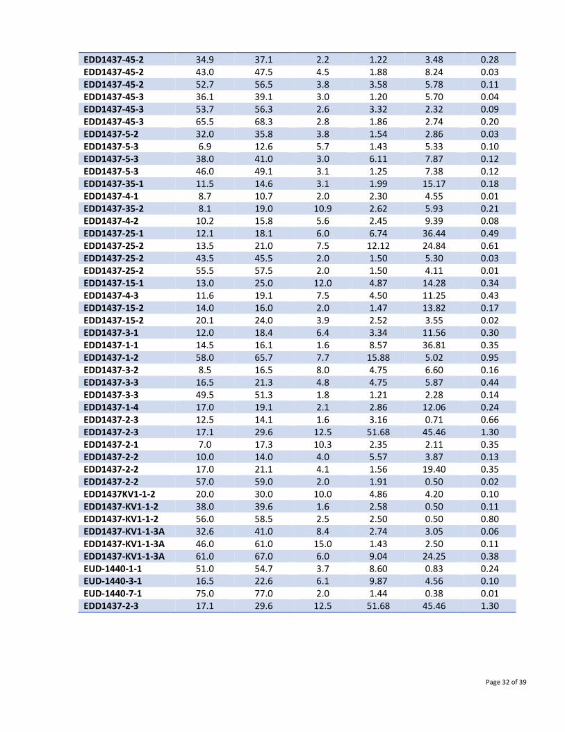
Tab. Intersection of ore intervals in the underground drill holes (BQ) of Gadir Mine
Hole_id Depth, m Length, m Average of useful components
from to Au, ppm Ag, ppm Cu, %
1 2 3 4 5 6 7
UDD123 19.5 22.5 3.0 2.81 0.38 0.01 UDD124 7.5 11.0 3.5 2.64 19.04 0.37 UDD124 11.0 12.0 1.0 11.23 4.11 1.10 UDD124 17.0 23.5 6.5 3.29 1.28 0.04 UDD125 7.3 9.2 1.9 1.87 1.76 0.21 UDD128 25.0 26.5 1.5 1.90 2.33 0.07 UDD129 5.4 8.0 2.7 1.18 3.14 0.11 UDD129 31.0 32.0 1.0 1.05 1.97 0.03 UDD130 7.3 8.4 1.1 2.90 3.13 0.33 UDD132 5.0 5.7 0.7 1.58 8.49 0.41 UDD133 0.0 3.5 3.5 1.28 7.69 0.10 UDD133 9.7 11.0 1.3 10.90 2.18 0.06 UDD133 22.8 23.9 1.1 1.07 1.96 0.04 UDD135 2.0 5.0 3.0 1.11 3.53 0.04 UDD135 12.0 14.3 2.3 2.74 1.66 0.02 UDD135 23.5 26.0 2.5 1.31 2.62 0.34 UDD136 0.0 10.0 10.0 2.07 3.20 0.06 UDD136 17.0 18.0 1.0 1.06 0.78 0.01 UDD137 0.0 6.0 6.0 1.62 14.29 0.05 UDD137 9.0 10.0 1.0 1.23 6.54 0.03 UDD137 15.0 22.6 7.6 1.11 6.32 0.24 UDD138 10.0 14.0 4.0 2.54 5.03 0.04 UDD138 14.0 19.0 5.0 4.10 3.88 0.12 UDD139 29.5 33.5 4.0 2.67 4.28 0.06 UDD140 0.7 3.5 2.8 8.24 4.57 0.15 UDD140 6.0 7.0 1.0 2.48 2.26 0.08 UDD141 27.5 32.5 5.0 1.15 3.56 0.07 UDD142 12.5 13.5 1.0 3.45 3.10 0.06 UDD142 20.5 32.7 12.2 3.55 10.08 0.08 UDD143 19.8 24.5 4.8 4.39 5.65 0.10 UDD143 26.5 29.4 2.9 2.59 18.28 0.04 UDD144 10.0 13.0 3.0 2.23 21.72 0.44 UDD145 2.0 15.2 13.2 1.29 2.55 0.15 UDD147 16.0 21.0 5.0 1.12 3.06 0.09 UDD149 17.5 19.5 2.0 2.45 2.00 0.36 UDD149 22.5 25.2 2.7 1.88 1.01 0.24 UDD151 6.2 10.0 3.8 5.24 17.70 0.09 UDD152 3.2 9.8 6.6 2.97 9.70 0.14
UDD152A 22.5 24.3 1.8 11.00 53.30 0.62 UDD152A 24.3 31.5 7.2 2.64 33.67 0.05 UDD156 2.6 4.9 2.3 1.01 18.26 0.05 UDD156 4.9 5.4 0.5 11.39 71.39 0.60 UDD157 4.4 5.4 1.0 4.50 69.02 0.77
Page 34 of 39
UDD158 4.2 9.0 4.8 1.22 3.90 0.07 UDD159 10.7 18.3 7.6 2.89 21.90 0.17 UDD160 8.5 16.0 7.5 1.07 5.47 0.11 UDD161 0.0 4.0 4.0 1.30 1.54 0.17 UDD164 3.4 5.5 2.1 1.67 2.84 0.28 UDD164 9.0 14.6 5.6 2.14 4.58 0.48 UDD165 8.0 11.0 3.0 1.21 2.04 0.01 UDD165 11.0 12.7 1.7 23.00 25.12 0.22 UDD165 12.7 14.2 1.5 1.54 3.66 0.07 UDD165 50.5 56.0 5.5 1.27 5.42 0.31 UDD166 8.7 16.5 7.8 1.48 3.54 0.12 UDD167 2.0 13.0 11.0 1.39 7.75 0.13 UDD170 0.0 1.0 1.0 2.19 2.36 0.34 UDD180 14.9 22.0 7.1 12.90 4.60 0.06 UDD180 22.0 30.0 8.0 1.10 3.99 0.02 UDD182 2.0 14.8 12.8 1.01 9.18 0.04 UDD183 8.5 16.5 8.0 2.14 11.06 0.02 UDD184 0.0 1.0 1.0 4.49 40.00 0.30 UDD185 0.0 2.0 2.0 1.03 16.00 0.18 UDD186 4.0 21.0 17.0 1.67 8.56 0.03
GEDABEK OPEN PIT
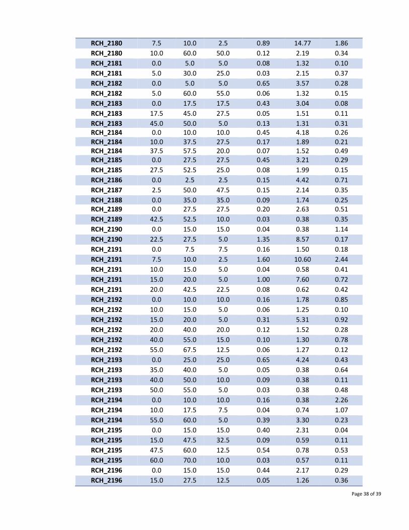
Mineralised intersections from surface drill holes of Gedabek open pit area
Hole_id Depth, m Length, m Gold / Siver / Copper Grade
from to Au, ppm Ag, ppm Cu, % 1 2 3 4 5 6 7
MPDD300 0.0 4.0 4.0 0.44 5.15 0.04 MPDD300 4.0 26.0 22.0 0.20 1.31 0.01 MPDD300 26.0 106.0 80.0 0.10 0.80 0.12 MPDD300 106.0 110.0 4.0 0.60 0.80 1.47 MPDD300 110.0 114.0 4.0 0.05 0.60 0.14 MPDD300 114.0 129.0 15.0 0.12 0.87 0.17
MPDD300 129.0 141.0 12.0 0.05 0.41 0.13
MPDD301 41.0 52.0 11.0 0.27 2.69 0.05
MPDD301 126.5 132.0 5.5 0.79 7.06 0.23
MPDD302 139.0 153.0 14.0 0.97 10.66 0.30
MPDD302 168.0 172.5 4.5 0.27 0.38 0.01
MPDD303 123.2 149.3 26.1 1.23 8.80 0.15
MPDD304 108.5 123.5 15.0 7.81 62.30 1.03
MPDD304 123.5 145.0 21.5 0.20 1.70 0.03
MPDD305A 0.0 10.0 10.0 0.47 2.67 0.06
MPDD305A 85.0 90.0 5.0 4.80 6.36 0.02
MPDD306 40.0 61.5 21.5 0.74 6.10 0.12
MPDD306 61.5 63.5 2.0 1.49 9.70 0.89
Page 35 of 39
MPDD307 51.4 89.0 37.6 0.90 7.30 0.23
MPDD308 35.0 46.0 11.0 0.46 0.60 0.01
MPDD308 54.0 96.0 42.0 0.50 3.70 0.03
MPDD309 28.8 54.5 25.7 2.26 18.85 0.63
MPDD310 40.3 48.0 7.7 1.32 14.26 0.40
MPDD311 38.0 48.3 10.3 0.25 1.03 0.02
MPDD311 48.3 50.3 2.0 0.99 22.65 1.03
MPDD311 50.3 70.0 19.7 0.54 6.50 0.08
MPDD312 65.0 86.1 21.1 2.01 9.43 0.12
MPDD312 86.1 104.0 17.9 0.23 1.69 0.04
MPDD313 40.0 75.5 35.5 0.51 5.42 0.05
MPDD314 7.0 67.0 60.0 0.20 1.19 0.01
MPDD314 67.0 75.0 8.0 2.77 12.83 0.16
MPDD314 75.0 106.0 31.0 0.28 1.75 0.08
MPDD315 45.4 58.0 12.6 3.59 55.13 1.69
MPDD316 60.5 100.0 39.5 0.53 6.15 0.02
MPDD317 73.7 76.1 2.4 9.05 28.15 1.26
MPDD317 76.1 104.7 28.6 1.51 2.61 0.92
MPDD318 16.0 44.0 28.0 0.25 2.32 0.01
MPDD319 36.0 65.7 29.7 0.73 4.34 0.04
MPDD319 65.7 80.0 14.3 0.29 2.65 0.07
MPDD320 62.5 72.0 9.5 0.21 3.33 0.04 MPDD320 76.0 103.0 27.0 1.47 13.26 0.25
MPDD321 11.0 19.0 8.0 0.62 3.10 0.01
MPDD324 53.3 90.0 36.7 0.42 3.99 0.10
MPDD325 44.7 70.0 25.3 0.28 6.98 0.09
MPDD329 49.0 64.0 15.0 0.34 1.33 0.01
MPDD330 65.5 69.3 3.8 1.10 6.20 0.02
MPDD331 8.4 12.5 4.1 0.50 1.30 0.02 MPDD331 44.5 49.5 5.0 0.32 2.22 0.01
MPDD331 62.5 66.5 4.0 1.56 4.02 0.01
MPDD332 0.0 13.0 13.0 0.26 1.66 0.02
MPDD333 0.0 54.0 54.0 0.22 0.65 0.04
MPDD333 54.0 59.0 5.0 1.20 0.38 0.10
MPDD333 59.0 74.0 15.0 0.24 0.45 0.01
MPDD334 0.0 10.0 10.0 0.85 5.54 0.05
MPDD334 22.0 27.0 5.0 9.54 11.08 0.18
MPDD334 78.0 116.0 38.0 0.55 5.16 0.28
MPDD335 0.0 6.0 6.0 0.50 7.13 0.60
MPDD335 26.0 29.0 3.0 0.96 5.17 0.15
MPDD336 14.0 21.0 7.0 0.41 4.18 0.04
MPDD336 32.0 35.0 3.0 0.64 15.83 0.45
MPDD339 62.0 65.0 3.0 0.73 0.93 0.05
MPDD340 0.0 14.0 14.0 0.26 3.00 0.09
MPDD341 0.0 18.0 18.0 0.40 3.97 0.11
Page 36 of 39
MPDD341 18.0 39.0 21.0 0.40 3.73 0.26
MPDD342 0.0 35.0 35.0 0.28 3.30 0.06
MPDD342 51.0 55.0 4.0 0.50 5.50 0.37
MPDD343 0.0 38.0 38.0 0.19 2.34 0.10
MPDD343 38.0 60.0 22.0 0.18 1.27 0.47
MPDD344 8.6 15.0 6.4 0.71 12.44 0.09
MPDD344 34.0 70.0 36.0 0.10 1.25 0.23
MPDD345 22.2 29.0 6.8 0.04 0.59 0.31
MPDD345 29.0 60.3 31.3 0.10 1.80 0.10
MPDD345 60.3 74.0 13.7 0.25 1.98 0.31
RCH_2122 47.5 55.0 7.5 0.03 6.12 0.16
RCH_2123 0.0 35.0 35.0 0.03 0.43 0.46
RCH_2124 0.0 70.0 70.0 0.03 0.87 0.36
RCH_2125 0.0 70.0 70.0 0.03 0.88 0.19
RCH_2126 45.0 70.0 25.0 0.03 0.42 1.08
RCH_2127 0.0 70.0 70.0 0.03 0.38 0.11
RCH_2128 60.0 70.0 10.0 0.03 0.38 0.65
RCH_2129 0.0 2.5 2.5 0.03 0.38 0.60
RCH_2130 40.0 70.0 30.0 0.03 0.63 0.48
RCH_2131 0.0 35.0 35.0 0.03 0.38 0.61
RCH_2132 0.0 15.0 15.0 0.03 1.53 0.27
RCH_2133 0.0 15.0 15.0 0.15 0.72 0.50
RCH_2135 0.0 15.0 15.0 1.17 6.15 0.20
RCH_2135 15.0 40.0 25.0 0.03 2.26 0.06
RCH_2136 0.0 40.0 40.0 0.03 2.73 0.04 RCH_2137 25.0 40.0 15.0 0.03 4.23 0.14
RCH_2138 0.0 10.0 10.0 0.03 2.78 0.21
RCH_2141 0.0 7.5 7.5 0.03 7.98 0.22
RCH_2144 15.0 25.0 10.0 0.03 1.45 0.32
RCH_2145 0.0 5.0 5.0 0.03 2.26 1.39
RCH_2146 0.0 15.0 15.0 0.03 1.07 0.27
RCH_2148 0.0 12.5 12.5 0.03 1.76 0.92
RCH_2149 5.0 10.0 5.0 0.03 2.15 1.18
RCH_2150 20.0 32.5 12.5 0.56 1.74 0.03
RCH_2150 45.0 50.0 5.0 1.52 9.62 0.04
RCH_2150 70.0 72.5 2.5 1.55 6.26 0.06
RCH_2151 20.0 25.0 5.0 0.03 6.38 0.19
RCH_2152 20.0 25.0 5.0 0.03 5.13 0.15
RCH_2153 0.0 27.5 27.5 0.53 2.63 0.01
RCH_2153 27.5 30.0 2.5 1.69 14.52 0.37
RCH_2153 30.0 50.0 20.0 0.32 2.17 0.03
RCH_2155 0.0 15.0 15.0 0.35 2.60 0.36
RCH_2156 0.0 10.0 10.0 0.53 2.64 1.71
RCH_2157 0.0 25.0 25.0 0.16 1.50 0.11
RCH_2158 0.0 22.5 22.5 0.90 5.15 0.10
Page 37 of 39
RCH_2159 0.0 10.0 10.0 1.01 5.27 0.13
RCH_2159 37.5 42.5 5.0 1.50 4.21 0.09
RCH_2160 0.0 10.0 10.0 0.07 2.07 0.14
RCH_2160 10.0 15.0 5.0 0.25 1.85 0.63
RCH_2161 0.0 7.5 7.5 0.27 5.88 0.20
RCH_2162 0.0 25.0 25.0 0.10 1.41 0.12
RCH_2163 0.0 27.5 27.5 0.08 0.38 0.16
RCH_2164 0.0 10.0 10.0 0.21 0.72 0.27
RCH_2164 10.0 27.5 17.5 0.06 0.38 0.70
RCH_2165 0.0 27.5 27.5 0.13 1.57 0.15
RCH_2165 27.5 32.5 5.0 0.12 0.96 0.40
RCH_2166 0.0 7.5 7.5 0.91 5.91 0.10
RCH_2166 7.5 40.0 32.5 0.25 2.56 0.03
RCH_2167 0.0 20.0 20.0 1.31 7.16 0.14
RCH_2167 20.0 40.0 20.0 0.21 1.19 0.01
RCH_2168 0.0 5.0 5.0 0.21 0.38 0.01
RCH_2168 5.0 12.5 7.5 3.67 5.52 0.06
RCH_2168 12.5 40.0 27.5 0.24 0.53 0.02
RCH_2169 0.0 25.0 25.0 0.14 1.48 0.13
RCH_2169 25.0 37.5 12.5 0.15 1.94 0.92
RCH_2169 37.5 45.0 7.5 0.07 1.35 0.18 RCH_2169 45.0 52.5 7.5 0.23 1.36 0.59
RCH_2169 52.5 55.0 2.5 0.49 1.12 0.10
RCH_2170 0.0 12.5 12.5 0.15 1.51 0.03
RCH_2170 12.5 22.5 10.0 0.48 2.22 0.04
RCH_2171 0.0 12.5 12.5 0.42 4.23 0.07
RCH_2172 15.0 52.5 37.5 0.03 1.53 0.25
RCH_2173 10.0 17.5 7.5 0.03 1.74 0.80
RCH_2173 17.5 60.0 42.5 0.03 1.11 0.14
RCH_2174 0.0 12.5 12.5 0.18 10.89 0.17
RCH_2174 12.5 37.5 25.0 0.11 1.72 0.81
RCH_2175 0.0 40.0 40.0 0.12 2.89 0.74
RCH_2176 0.0 30.0 30.0 0.39 4.94 0.61
RCH_2177 0.0 22.5 22.5 0.06 3.36 0.11
RCH_2177 22.5 37.5 15.0 0.03 4.91 0.41
RCH_2177 37.5 47.5 10.0 0.03 0.95 0.15
RCH_2177 47.5 52.5 5.0 0.03 0.38 0.48
RCH_2177 65.0 70.0 5.0 0.03 1.42 0.43
RCH_2178 0.0 12.5 12.5 0.13 2.38 0.16
RCH_2178 12.5 35.0 22.5 0.05 2.28 1.11
RCH_2178 35.0 45.0 10.0 0.04 1.25 0.19
RCH_2178 45.0 52.5 7.5 0.06 2.07 0.72
RCH_2179 10.0 42.5 32.5 0.08 1.80 1.06
RCH_2180 0.0 7.5 7.5 0.59 39.63 0.25
Page 38 of 39
RCH_2180 7.5 10.0 2.5 0.89 14.77 1.86
RCH_2180 10.0 60.0 50.0 0.12 2.19 0.34
RCH_2181 0.0 5.0 5.0 0.08 1.32 0.10
RCH_2181 5.0 30.0 25.0 0.03 2.15 0.37
RCH_2182 0.0 5.0 5.0 0.65 3.57 0.28
RCH_2182 5.0 60.0 55.0 0.06 1.32 0.15
RCH_2183 0.0 17.5 17.5 0.43 3.04 0.08
RCH_2183 17.5 45.0 27.5 0.05 1.51 0.11
RCH_2183 45.0 50.0 5.0 0.13 1.31 0.31 RCH_2184 0.0 10.0 10.0 0.45 4.18 0.26
RCH_2184 10.0 37.5 27.5 0.17 1.89 0.21 RCH_2184 37.5 57.5 20.0 0.07 1.52 0.49 RCH_2185 0.0 27.5 27.5 0.45 3.21 0.29
RCH_2185 27.5 52.5 25.0 0.08 1.99 0.15
RCH_2186 0.0 2.5 2.5 0.15 4.42 0.71
RCH_2187 2.5 50.0 47.5 0.15 2.14 0.35
RCH_2188 0.0 35.0 35.0 0.09 1.74 0.25 RCH_2189 0.0 27.5 27.5 0.20 2.63 0.51
RCH_2189 42.5 52.5 10.0 0.03 0.38 0.35
RCH_2190 0.0 15.0 15.0 0.04 0.38 1.14
RCH_2190 22.5 27.5 5.0 1.35 8.57 0.17
RCH_2191 0.0 7.5 7.5 0.16 1.50 0.18
RCH_2191 7.5 10.0 2.5 1.60 10.60 2.44
RCH_2191 10.0 15.0 5.0 0.04 0.58 0.41
RCH_2191 15.0 20.0 5.0 1.00 7.60 0.72
RCH_2191 20.0 42.5 22.5 0.08 0.62 0.42
RCH_2192 0.0 10.0 10.0 0.16 1.78 0.85
RCH_2192 10.0 15.0 5.0 0.06 1.25 0.10
RCH_2192 15.0 20.0 5.0 0.31 5.31 0.92
RCH_2192 20.0 40.0 20.0 0.12 1.52 0.28
RCH_2192 40.0 55.0 15.0 0.10 1.30 0.78
RCH_2192 55.0 67.5 12.5 0.06 1.27 0.12
RCH_2193 0.0 25.0 25.0 0.65 4.24 0.43
RCH_2193 35.0 40.0 5.0 0.05 0.38 0.64
RCH_2193 40.0 50.0 10.0 0.09 0.38 0.11
RCH_2193 50.0 55.0 5.0 0.03 0.38 0.48
RCH_2194 0.0 10.0 10.0 0.16 0.38 2.26
RCH_2194 10.0 17.5 7.5 0.04 0.74 1.07
RCH_2194 55.0 60.0 5.0 0.39 3.30 0.23
RCH_2195 0.0 15.0 15.0 0.40 2.31 0.04
RCH_2195 15.0 47.5 32.5 0.09 0.59 0.11
RCH_2195 47.5 60.0 12.5 0.54 0.78 0.53
RCH_2195 60.0 70.0 10.0 0.03 0.57 0.11
RCH_2196 0.0 15.0 15.0 0.44 2.17 0.29
RCH_2196 15.0 27.5 12.5 0.05 1.26 0.36

Page 39 of 39
RCH_2196 47.5 90.0 42.5 0.03 0.55 0.30
RCH_2197 0.0 10.0 10.0 0.07 0.49 1.00
RCH_2197 10.0 40.0 30.0 0.03 0.38 0.11
RCH_2197 40.0 55.0 15.0 0.36 1.49 0.41
RCH_2198 0.0 62.5 62.5 0.07 2.65 0.15