Embed Size (px)
Citation preview
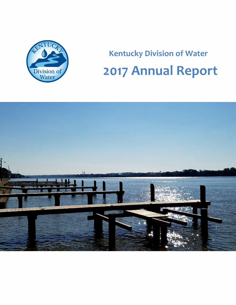
Kentucky Division of Water
2017 Annual Report
2
CONTENTS
CONTENTS ..................................................................................................................................................... 2
EXECUTIVE SUMMARY .................................................................................................................................. 4
MISSION ........................................................................................................................................................ 6
INFRASTRUCTURE PLANNING ....................................................................................................................... 7
Drinking Water Action Plan ....................................................................................................................... 7
Wastewater Action Plan ........................................................................................................................... 8
Risk MAP ................................................................................................................................................... 9
Dams and Levees .................................................................................................................................... 12
Floodplain Management ......................................................................................................................... 13
WATER RESOURCES PLANNING .................................................................................................................. 15
Water Resources Board .......................................................................................................................... 15
Drought Response in 2016 ...................................................................................................................... 15
Source Water Protection Assistance Program (SWPAP) ......................................................................... 18
WATER QUALITY.......................................................................................................................................... 21
EPA Approval of Kentucky’s Revised Criteria for Selenium .................................................................... 21
Surface Water ......................................................................................................................................... 22
Harmful Algal Blooms (HABs) .................................................................................................................. 23
Federal Clean Water Act, Section 305(b) Assessments / Total Maximum Daily Loads (TMDLs) ............ 24
Clean Water Act, Section 401, Certification of USACE Nationwide Permits ........................................... 25
COMPLIANCE AND INSPECTIONS ................................................................................................................ 27
Public Drinking Water Systems ............................................................................................................... 28
Drinking Water Advisory Council (DWAC) .............................................................................................. 30
EPA Office of Water Visit to Kentucky .................................................................................................... 31
WATER MAPS PORTAL (watermaps.ky.gov) ............................................................................................... 32
WATERSHED IMPROVEMENT EFFORTS ...................................................................................................... 33
PERMITTING ................................................................................................................................................ 36
3
Permit Issuance ....................................................................................................................................... 36
New Rules and Challenges ...................................................................................................................... 38
General Permits ...................................................................................................................................... 39
Coal Mining ......................................................................................................................................... 39
Stormwater from Construction Sites .................................................................................................. 39
Stormwater Associated with Industrial Activities ............................................................................... 40
NetDMR Conversion to CDX .................................................................................................................... 40
Combined and Separate Sewer Systems ................................................................................................ 40
Municipal Separate Storm Sewer Systems (MS4s) ................................................................................. 42
4
EXECUTIVE SUMMARY
Dear Reader,
The Kentucky Division of Water (DOW) is pleased to provide its Annual Report for Fiscal Year 2017 (FY17
- July 1 2016 through June 30, 2017). This report summarizes the achievements of DOW scientists,
specialists, and administrative staff in meeting the DOW goals of:
Protecting, managing, and restoring water resources
Full compliance with the Safe Drinking Water Act
Conducting effective water resources planning
Meeting federal and state program requirements
Promoting better management and communication of data
Governor Bevin launched the Red Tape Reduction (RTR) initiative for all state government agencies in July
2016. The primary goal of the initiative is to review and reduce the overall number of state regulations,
however, the RTR also provides the opportunity to evaluate programs and processes in order to identify
how DOW can continue its mission of managing, protecting, and enhancing the water resources of the
Commonwealth with greater efficacy.
DOW began actively reviewing its regulations prior to the implementation of the RTR. In April 2017, the
DOW filed proposed revisions to several regulations contained in 401 KAR Chapter 8 (Public Water
Supply). Through consolidation, DOW will reduce the number of regulations in the chapter from eighteen
to fourteen, as well as revise outdated processes to align with current practice, and place longstanding
policies and guidance into regulatory language. This work will enable the regulated community and the
public transparent access to rules that are more clear and definitive. The proposed regulation changes
moved through the regulatory process pursuant to Kentucky Revised Statutes Chapter 13A, and will go
into effect in Fall 2017.
DOW continued its collaborative efforts with the public and stakeholders on a wide variety of issues.
History demonstrates that collaboration and partnership provide significant opportunities to resolve
issues water-related issues more effectively and efficiently, and that a free exchange of ideas assists in
addressing challenges.
5
The 2017 Kentucky General Assembly passed House Joint Resolution 56 which directed the Division of
Water to examine the myriad of issues regarding small, privately owned wastewater treatment plants
and make recommendations for solutions to the Legislative Research Commission.
The Water Resources Board, established by 2016 HB 529, has been active in advising the cabinet about
water resources needs and planning, especially regarding agriculture and rural community water
resources resiliency and future needs.
The stakeholder-based Wastewater and Drinking Water Advisory Councils continued to work with the
DOW regarding issues and challenges faced by public water and wastewater systems.
The division’s responses to the 2016 drought, drinking water source water threats, and harmful algal
blooms (HABs) also benefited from coordinated, collaborative work between DOW and a wide variety of
federal, state, local, and private partners throughout the Commonwealth.
The Water Maps Portal carried its award-winning recognition as an innovative information resource into
its second year when DOW received the 2017 Esri Award for Special Achievement in GIS. DOW continues
to develop and launch maps, viewers, and story boards so that users can easily and transparently access
important information regarding the Commonwealth’s water resources and local conditions.
I invite you to read more about the activities of DOW, its accomplishments in monitoring, assessing, and
improving the waters of the Commonwealth, and its ongoing efforts to preserve, protect, and manage
these important resources for the benefit and enjoyment of Kentucky citizens.
Peter T. Goodmann, Director
Division of Water
6
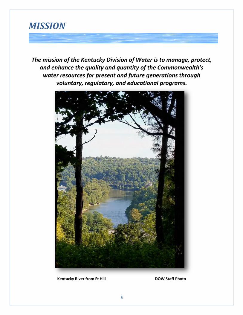
MISSION
The mission of the Kentucky Division of Water is to manage, protect, and enhance the quality and quantity of the Commonwealth’s
water resources for present and future generations through voluntary, regulatory, and educational programs.
Kentucky River from Ft Hill DOW Staff Photo
7
INFRASTRUCTURE PLANNING
The condition of water infrastructure is of concern across the nation. Although many challenges remain,
DOW has taken steps to plan for and implement sustainable solutions to Kentucky’s water-related
infrastructure. DOW actively engages with utilities through the Wastewater Planning and Capacity
Development programs. DOW will review Regional Facility plans for municipal wastewater collection,
conveyance, and treatment systems which are used to evaluate the needs of a system and make
recommendations. The Capacity Development program works directly with Public Water Systems (PWSs)
to assess their financial, managerial, and technical capacity to deliver safe drinking water through on-site
reviews and assistance.
DOW representatives also actively engage in federal and state advisory committees, workgroups, and
associations in order to represent the Commonwealth’s best interests, and provide support to
organizations such as the Association of State Floodplain Managers, Association of State Dam Safety
Officials, Kentucky Association of Mitigation Managers, Kentucky Stormwater Association, and Kentucky
Association of Mapping Professionals. Participation in these groups enables DOW to provide communities
with tools to assess areas of concern and in some cases, providing funding through the State Revolving
Fund in collaboration with the Kentucky Infrastructure Authority (KIA) to address infrastructure needs.
Drinking Water Action Plan
The ability of (PWSs) to provide safe, reliable drinking water is critical to public health and the economic
vitality of Kentucky. As the state administrator of the federal Safe Drinking Water Act (SDWA), DOW
strives to work with its stakeholders and the industry to ensure that PWSs have the ability to provide
drinking water that complies with the Act. Of greatest concern are the condition and management of
drinking water infrastructure because inadequate or failing infrastructure impedes the ability of PWSs to
maintain SDWA compliance, poses a risk to public health, and endangers local economies.
In order to identify and address key infrastructure, economic, regulatory, and programmatic barriers to
the sustainability and resiliency of Kentucky’s public water systems, DOW began developing a Drinking
Water Action Plan during FY17. As a prelude to a fully developed plan, DOW developed a Risk Assessment
Tool to determine the current state of PWSs in Kentucky. The tool utilizes data from the Drinking Water
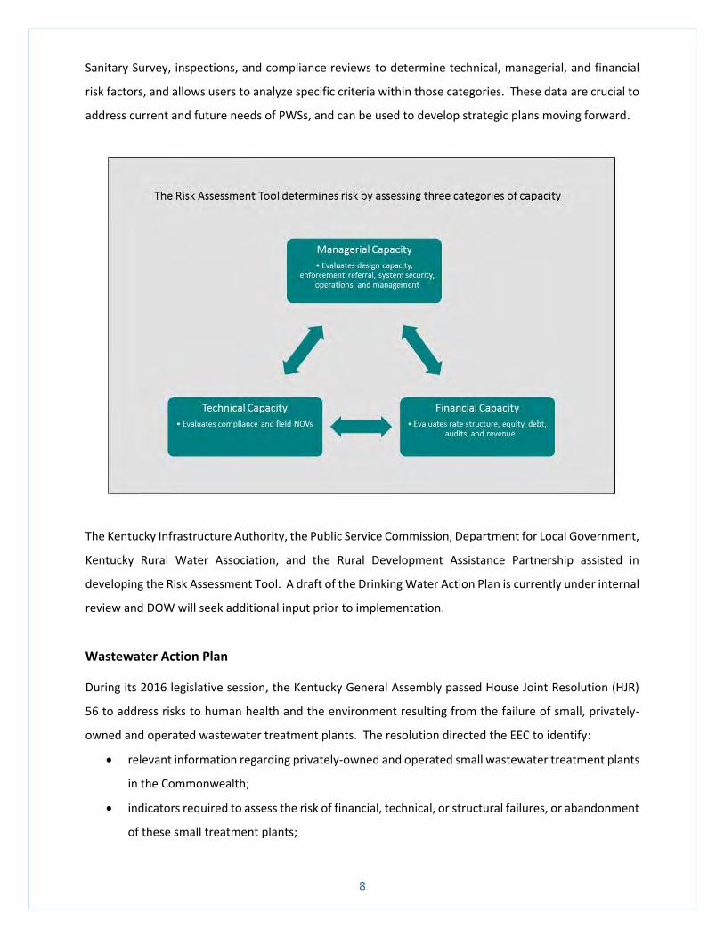
8
Sanitary Survey, inspections, and compliance reviews to determine technical, managerial, and financial
risk factors, and allows users to analyze specific criteria within those categories. These data are crucial to
address current and future needs of PWSs, and can be used to develop strategic plans moving forward.
The Kentucky Infrastructure Authority, the Public Service Commission, Department for Local Government,
Kentucky Rural Water Association, and the Rural Development Assistance Partnership assisted in
developing the Risk Assessment Tool. A draft of the Drinking Water Action Plan is currently under internal
review and DOW will seek additional input prior to implementation.
Wastewater Action Plan
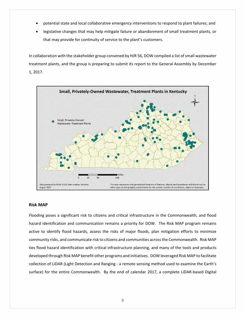
During its 2016 legislative session, the Kentucky General Assembly passed House Joint Resolution (HJR)
56 to address risks to human health and the environment resulting from the failure of small, privately-
owned and operated wastewater treatment plants. The resolution directed the EEC to identify:
relevant information regarding privately-owned and operated small wastewater treatment plants
in the Commonwealth;
indicators required to assess the risk of financial, technical, or structural failures, or abandonment
of these small treatment plants;
9
potential state and local collaborative emergency interventions to respond to plant failures; and
legislative changes that may help mitigate failure or abandonment of small treatment plants, or
that may provide for continuity of service to the plant’s customers.
In collaboration with the stakeholder group convened by HJR 56, DOW compiled a list of small wastewater
treatment plants, and the group is preparing to submit its report to the General Assembly by December
1, 2017.
Risk MAP
Flooding poses a significant risk to citizens and critical infrastructure in the Commonwealth, and flood
hazard identification and communication remains a priority for DOW. The Risk MAP program remains
active to identify flood hazards, assess the risks of major floods, plan mitigation efforts to minimize
community risks, and communicate risk to citizens and communities across the Commonwealth. Risk MAP
ties flood hazard identification with critical infrastructure planning, and many of the tools and products
developed through Risk MAP benefit other programs and initiatives. DOW leveraged Risk MAP to facilitate
collection of LiDAR (Light Detection and Ranging - a remote sensing method used to examine the Earth’s
surface) for the entire Commonwealth. By the end of calendar 2017, a complete LiDAR-based Digital
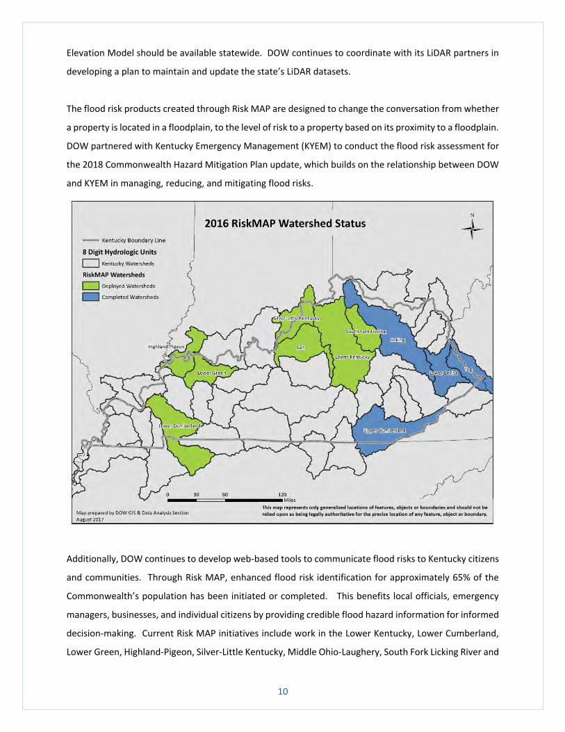
10
Elevation Model should be available statewide. DOW continues to coordinate with its LiDAR partners in
developing a plan to maintain and update the state’s LiDAR datasets.
The flood risk products created through Risk MAP are designed to change the conversation from whether
a property is located in a floodplain, to the level of risk to a property based on its proximity to a floodplain.
DOW partnered with Kentucky Emergency Management (KYEM) to conduct the flood risk assessment for
the 2018 Commonwealth Hazard Mitigation Plan update, which builds on the relationship between DOW
and KYEM in managing, reducing, and mitigating flood risks.
Additionally, DOW continues to develop web-based tools to communicate flood risks to Kentucky citizens
and communities. Through Risk MAP, enhanced flood risk identification for approximately 65% of the
Commonwealth’s population has been initiated or completed. This benefits local officials, emergency
managers, businesses, and individual citizens by providing credible flood hazard information for informed
decision-making. Current Risk MAP initiatives include work in the Lower Kentucky, Lower Cumberland,
Lower Green, Highland-Pigeon, Silver-Little Kentucky, Middle Ohio-Laughery, South Fork Licking River and
11
Rolling Fork watersheds. The information can be easily accessed on the DOW watermaps portal
(http://www.watermaps.ky.gov) and the FEMA Map Service Center (https://msc.fema.gov). Each year,
DOW revises its Risk MAP business plan to reflect new or updated needs and resulting flood risks in
watersheds with high populations.
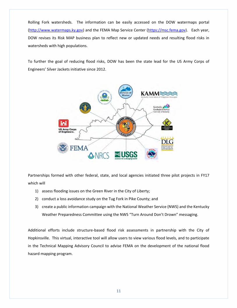
To further the goal of reducing flood risks, DOW has been the state lead for the US Army Corps of
Engineers’ Silver Jackets initiative since 2012.
Partnerships formed with other federal, state, and local agencies initiated three pilot projects in FY17
which will
1) assess flooding issues on the Green River in the City of Liberty;
2) conduct a loss avoidance study on the Tug Fork in Pike County; and
3) create a public information campaign with the National Weather Service (NWS) and the Kentucky
Weather Preparedness Committee using the NWS “Turn Around Don’t Drown” messaging.
Additional efforts include structure-based flood risk assessments in partnership with the City of
Hopkinsville. This virtual, interactive tool will allow users to view various flood levels, and to participate
in the Technical Mapping Advisory Council to advise FEMA on the development of the national flood
hazard mapping program.
12
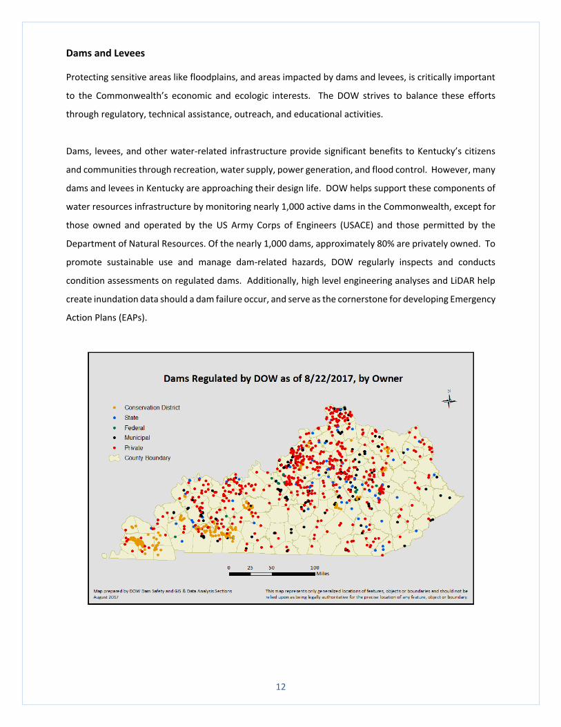
Dams and Levees
Protecting sensitive areas like floodplains, and areas impacted by dams and levees, is critically important
to the Commonwealth’s economic and ecologic interests. The DOW strives to balance these efforts
through regulatory, technical assistance, outreach, and educational activities.
Dams, levees, and other water-related infrastructure provide significant benefits to Kentucky’s citizens
and communities through recreation, water supply, power generation, and flood control. However, many
dams and levees in Kentucky are approaching their design life. DOW helps support these components of
water resources infrastructure by monitoring nearly 1,000 active dams in the Commonwealth, except for
those owned and operated by the US Army Corps of Engineers (USACE) and those permitted by the
Department of Natural Resources. Of the nearly 1,000 dams, approximately 80% are privately owned. To
promote sustainable use and manage dam-related hazards, DOW regularly inspects and conducts
condition assessments on regulated dams. Additionally, high level engineering analyses and LiDAR help
create inundation data should a dam failure occur, and serve as the cornerstone for developing Emergency
Action Plans (EAPs).
13
The Commonwealth, through its various agencies, owns approximately 80 dams which are generally
associated with state parks or wildlife management areas, but may also serve as roads or are used by
universities. The State Owned Dam Repair (SODR) program invests annual appropriations into
Commonwealth-owned dams. Rather than continuing the historical practice of using those funds for
expensive upgrades to dams that have encountered hazard creep or deterioration, DOW recently began
a more holistic approach to dam-related risk management by assessing several repair alternatives,
including downstream mitigation options or a combination of repairs and mitigation. This approach allows
DOW to strategically analyze SODR needs for up to 6 years in the future.
DOW recently received an invitation to submit an application to the US Department for Homeland Security
Science & Technology Directorate for a pilot project to develop dam instrumentation monitoring and flood
warning systems. The project, now approved, will research flood warning and instrumentation monitoring
activities being conducted at dam locations throughout the country, determine which systems are most
applicable to Kentucky dams, and develop a Kentucky-specific implementation plan. Future opportunities
may be identified based on the outcomes of the initial research and implementation plan.
There are approximately 120 miles of USACE-built levees in Kentucky. These levees protect billions of
dollars in assets and range in size from several hundred feet, to almost 40 miles in the Louisville metro
area. With few exceptions, these levees are owned, operated, and maintained by local sponsors and
overseen by USACE to ensure functional soundness. However, many levees protect residential and non-
residential structures, community areas, and agricultural land across the Commonwealth but lack
information regarding how they were constructed, so their potential protection or risk has not yet been
quantified. States are uniquely positioned to work with communities and land owners to better
understand previously unknown levee systems, and federal legislation recently authorized state-led levee
programs. DOW is utilizing process improvements, regulatory authority, and best practices from its
current Risk MAP, Dam Safety, and Floodplain Management programs to potentially expand its levee
safety program and achieve its goal of aligning levee and dam safety.
Floodplain Management
Flooding poses a significant risk to Kentucky’s citizens and critical infrastructure. DOW regulates
floodplain development activities including dams, levees, bridges, culverts, fill, residential and non-
residential structures, and stream alterations, and its Floodplain Management program promotes public
safety through regulatory actions, technical assistance, and regular communication with stakeholders.
14
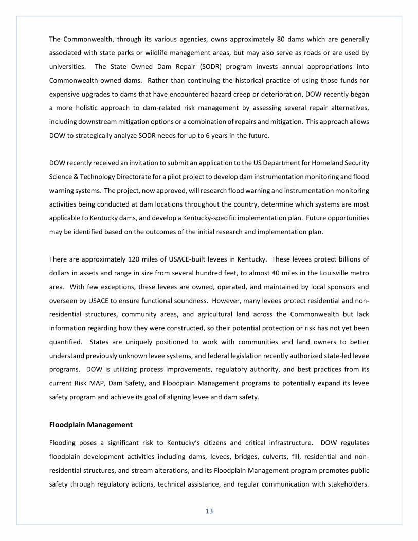
The number of floodplain permits issued by DOW has steadily increased over the last few years which
may be partially attributable to considerable outreach and the availability of better data for more accurate
and expedient flood hazard assessment.
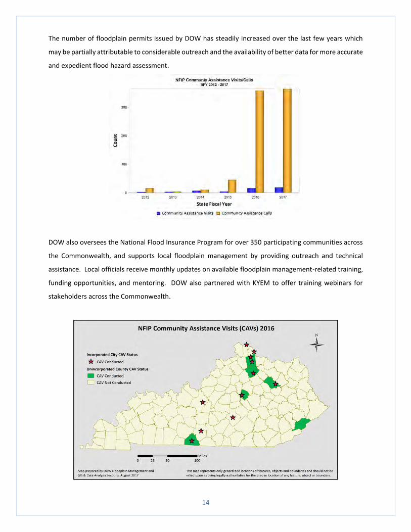
DOW also oversees the National Flood Insurance Program for over 350 participating communities across
the Commonwealth, and supports local floodplain management by providing outreach and technical
assistance. Local officials receive monthly updates on available floodplain management-related training,
funding opportunities, and mentoring. DOW also partnered with KYEM to offer training webinars for
stakeholders across the Commonwealth.
15
WATER RESOURCES PLANNING
Water Resources Board
House Bill 529 created the Water Resources Board (WRB) during the 2016 legislative session. The WRB is
charged with assisting the Energy and Environment Cabinet (EEC) in conducting research and developing
recommendations regarding water resources, especially in relation to agricultural and rural uses.
Water resources monitoring in the long-term is critical to manage current usage and ensure that water is
available for future agricultural and rural water development. The WRB assisted the EEC in identifying
priorities and the need for an expanded statewide groundwater monitoring program focused on areas
with high agricultural water demands. In July, the EEC requested an increase in federal funds to support
expansion of existing water quality and quantity monitoring networks.
The WRB recommended facilitating viable projects or technologies that enhance farm and rural water
availability as priorities in the coming year. DOW will continue developing data and studies to create a
long-term, comprehensive state water plan by collaborating with the Kentucky Farm Bureau Water
Management Working Group, which has already collected relevant data, reviewed policies, and
developed recommendations for enhancing the quality and quantity of water resources in the
Commonwealth.
In the coming year, the WRB will make recommendations for updates to the
Kentucky Drought Mitigation and Response Plan which serves as a
framework to guide local, state, and federal collaboration during times of
drought. While agricultural impacts have long been a primary indicator to
track drought development, the incorporation of agricultural drought
response and mitigation, as well as new data and technologies that were not
available when the plan was initially developed, may be recommended.
Drought Response in 2016
Drought is a natural and recurring feature of Kentucky’s climate, and successful response requires the
collaborative efforts of multiple local, state and federal partners. Guided by the state Drought Mitigation
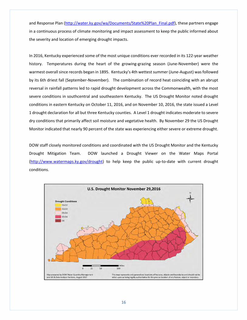
16
and Response Plan (http://water.ky.gov/wa/Documents/State%20Plan_Final.pdf), these partners engage
in a continuous process of climate monitoring and impact assessment to keep the public informed about
the severity and location of emerging drought impacts.
In 2016, Kentucky experienced some of the most unique conditions ever recorded in its 122-year weather
history. Temperatures during the heart of the growing-grazing season (June-November) were the
warmest overall since records began in 1895. Kentucky’s 4th wettest summer (June-August) was followed
by its 6th driest fall (September-November). The combination of record heat coinciding with an abrupt
reversal in rainfall patterns led to rapid drought development across the Commonwealth, with the most
severe conditions in southcentral and southeastern Kentucky. The US Drought Monitor noted drought
conditions in eastern Kentucky on October 11, 2016, and on November 10, 2016, the state issued a Level
1 drought declaration for all but three Kentucky counties. A Level 1 drought indicates moderate to severe
dry conditions that primarily affect soil moisture and vegetative health. By November 29 the US Drought
Monitor indicated that nearly 90 percent of the state was experiencing either severe or extreme drought.
DOW staff closely monitored conditions and coordinated with the US Drought Monitor and the Kentucky
Drought Mitigation Team. DOW launched a Drought Viewer on the Water Maps Portal
(http://www.watermaps.ky.gov/drought) to help keep the public up-to-date with current drought
conditions.
17
Drought development occurred late enough in the growing season that most crop impacts were minimal.
Out of nearly $123,000,000 in crop insurance payments in 2016, only 5% covered crop losses from drought
and heat. However, farm ponds and pastures also suffered, which forced producers to find alternative
water supplies and begin using winter hay reserves exceptionally early. Small lakes that supply some of
Kentucky’s public water systems reached levels low enough that water use restrictions were considered
and even implemented. The most serious impact from the 2016 drought conditions were wildfires that
burned a 10-year high of 71,000 acres.
As conditions deteriorated in October 2016, DOW began routine assessments of drinking water supplies
with a history of drought vulnerability issues. DOW staff provided assistance to systems with emerging
water supply problems to determine the status of their water sources, drought response plans, and
treatment or distribution problems. DOW hosted weekly teleconferences with federal and state agencies
including the Kentucky Departments of Agriculture and Forestry, the Governor’s Office of Agriculture
Policy, the Kentucky State Climatologist, the National Weather Service, and the US Department of
Agriculture to stay apprised of developing conditions and disseminate accurate information.
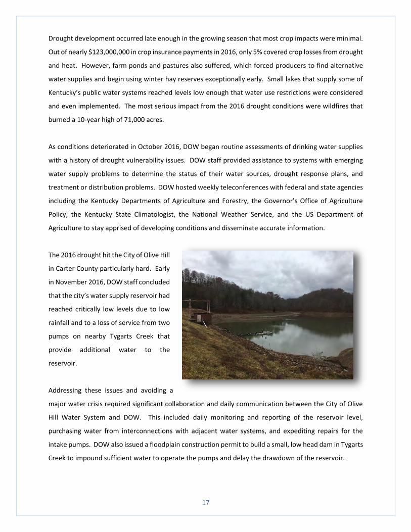
The 2016 drought hit the City of Olive Hill
in Carter County particularly hard. Early
in November 2016, DOW staff concluded
that the city’s water supply reservoir had
reached critically low levels due to low
rainfall and to a loss of service from two
pumps on nearby Tygarts Creek that
provide additional water to the
reservoir.
Addressing these issues and avoiding a
major water crisis required significant collaboration and daily communication between the City of Olive
Hill Water System and DOW. This included daily monitoring and reporting of the reservoir level,
purchasing water from interconnections with adjacent water systems, and expediting repairs for the
intake pumps. DOW also issued a floodplain construction permit to build a small, low head dam in Tygarts
Creek to impound sufficient water to operate the pumps and delay the drawdown of the reservoir.
18
The US Geological Survey (USGS) was also a critical partner during this time. As a partner in the Kentucky
Drought Mitigation Team, the USGS volunteered to assist with critical streamflow monitoring in key
locations across the Commonwealth, including the site near Olive Hill.
The 2016 drought emphasized the value that collaborative relationships bring to the Commonwealth’s
drought management capabilities. In addition to the invaluable assistance received from the USGS, other
essential partners involved in monitoring and managing the 2016 drought conditions included the
Kentucky Division of Forestry, Kentucky Emergency Management, Kentucky Department of Agriculture,
UK Agricultural Weather Center, WKU Kentucky Climate Center, Kentucky Farm Bureau, National Weather
Service, US Department of Agriculture, US Army Corps of Engineers, and National Drought Mitigation
Center.
Drought conditions in Kentucky began retreating in December, and by June 2017 the City of Olive Hill had
a full reservoir. DOW continues to assist Olive Hill to increase its level of drought preparedness. Additional
steps that have been or will be taken include replacing downtown water lines to substantially reduce
finished water loss, bathymetric (waterbody floor depth) analysis of the reservoir to determine its useable
volume, and revising the City’s drought plan to improve utilization of water from the reservoir and river
system by developing triggers for pumping and for implementing local water conservation measures.
Source Water Protection Assistance Program (SWPAP)
Kentucky’s Source Water Protection Assistance Program helps public drinking water systems protect
drinking water sources. Implementation of community-based management plans, within defined water
supply protection areas, assist in safeguarding against potential contamination. The SWPAP program
developed a story map entitled “Source Water Protection in Kentucky” (http://watermaps.ky.gov) to
explain program elements and benefits, and to describe projects to advance this goal.
Using the federal Environmental Protection Agency (EPA) Drinking Water State Revolving Fund set asides
administered by DOW, the SWPAP provides communities with funding to develop and implement projects
to protect public drinking water sources. The SWPAP has provided financial assistance for thirteen
projects since 2014, and funding requests continue to increase every year.
The SWPAP announced total project funding of $150,000 for six projects in FY17, with a single project
maximum of $60,000. These include construction of a water education center, development of a
19
community source water education program, and analysis of aquifer flow. The projects that received
funding in 2016 were:
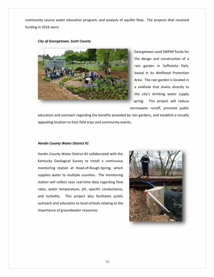
City of Georgetown, Scott County
Georgetown used SWPAP funds for
the design and construction of a
rain garden in Suffoletta Park,
based in its Wellhead Protection
Area. The rain garden is located in
a sinkhole that drains directly to
the city’s drinking water supply
spring. This project will reduce
stormwater runoff, promote public
education and outreach regarding the benefits provided by rain gardens, and establish a visually
appealing location to host field trips and community events.
Hardin County Water District #1
Hardin County Water District #1 collaborated with the
Kentucky Geological Survey to install a continuous
monitoring station at Head-of-Rough-Spring, which
supplies water to multiple counties. The monitoring
station will collect near real-time data regarding flow
rates, water temperature, pH, specific conductance,
and turbidity. This project also facilitates public
outreach and education to local schools relating to the
importance of groundwater resources.
20
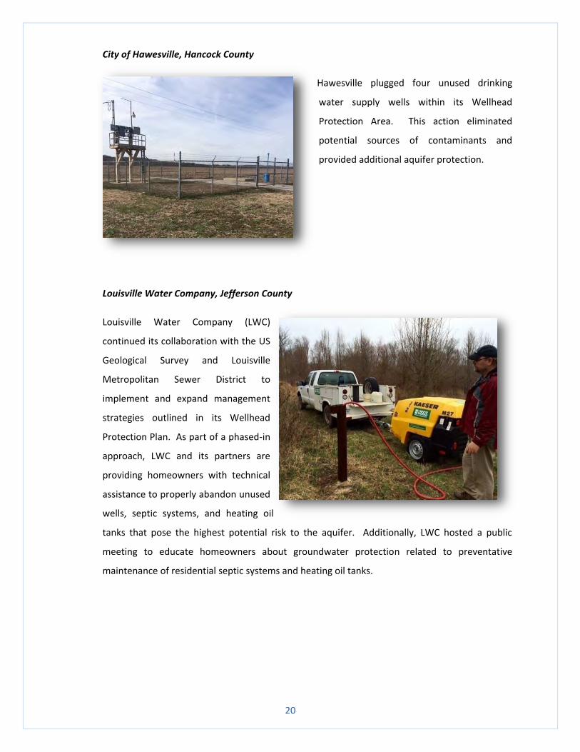
City of Hawesville, Hancock County
Hawesville plugged four unused drinking
water supply wells within its Wellhead
Protection Area. This action eliminated
potential sources of contaminants and
provided additional aquifer protection.
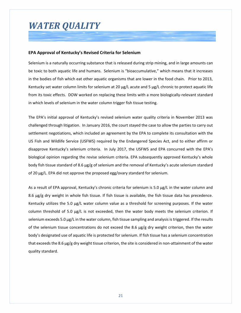
Louisville Water Company, Jefferson County
Louisville Water Company (LWC)
continued its collaboration with the US
Geological Survey and Louisville
Metropolitan Sewer District to
implement and expand management
strategies outlined in its Wellhead
Protection Plan. As part of a phased-in
approach, LWC and its partners are
providing homeowners with technical
assistance to properly abandon unused
wells, septic systems, and heating oil
tanks that pose the highest potential risk to the aquifer. Additionally, LWC hosted a public
meeting to educate homeowners about groundwater protection related to preventative
maintenance of residential septic systems and heating oil tanks.
21
WATER QUALITY
EPA Approval of Kentucky’s Revised Criteria for Selenium
Selenium is a naturally occurring substance that is released during strip mining, and in large amounts can
be toxic to both aquatic life and humans. Selenium is “bioaccumulative,” which means that it increases
in the bodies of fish which eat other aquatic organisms that are lower in the food chain. Prior to 2013,
Kentucky set water column limits for selenium at 20 µg/L acute and 5 µg/L chronic to protect aquatic life
from its toxic effects. DOW worked on replacing these limits with a more biologically-relevant standard
in which levels of selenium in the water column trigger fish tissue testing.
The EPA’s initial approval of Kentucky’s revised selenium water quality criteria in November 2013 was
challenged through litigation. In January 2016, the court stayed the case to allow the parties to carry out
settlement negotiations, which included an agreement by the EPA to complete its consultation with the
US Fish and Wildlife Service (USFWS) required by the Endangered Species Act, and to either affirm or
disapprove Kentucky’s selenium criteria. In July 2017, the USFWS and EPA concurred with the EPA’s
biological opinion regarding the revise selenium criteria. EPA subsequently approved Kentucky’s whole
body fish tissue standard of 8.6 µg/g of selenium and the removal of Kentucky’s acute selenium standard
of 20 µg/L. EPA did not approve the proposed egg/ovary standard for selenium.
As a result of EPA approval, Kentucky’s chronic criteria for selenium is 5.0 µg/L in the water column and
8.6 µg/g dry weight in whole fish tissue. If fish tissue is available, the fish tissue data has precedence.
Kentucky utilizes the 5.0 µg/L water column value as a threshold for screening purposes. If the water
column threshold of 5.0 µg/L is not exceeded, then the water body meets the selenium criterion. If
selenium exceeds 5.0 µg/L in the water column, fish tissue sampling and analysis is triggered. If the results
of the selenium tissue concentrations do not exceed the 8.6 µg/g dry weight criterion, then the water
body’s designated use of aquatic life is protected for selenium. If fish tissue has a selenium concentration
that exceeds the 8.6 µg/g dry weight tissue criterion, the site is considered in non-attainment of the water
quality standard.
22
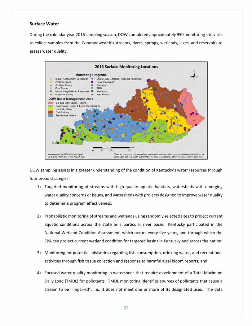
Surface Water
During the calendar year 2016 sampling season, DOW completed approximately 950 monitoring site visits
to collect samples from the Commonwealth’s streams, rivers, springs, wetlands, lakes, and reservoirs to
assess water quality.
DOW sampling assists in a greater understanding of the condition of Kentucky’s water resources through
four broad strategies:
1) Targeted monitoring of streams with high-quality aquatic habitats, watersheds with emerging
water quality concerns or issues, and watersheds with projects designed to improve water quality
to determine program effectiveness;
2) Probabilistic monitoring of streams and wetlands using randomly selected sites to project current
aquatic conditions across the state or a particular river basin. Kentucky participated in the
National Wetland Condition Assessment, which occurs every five years, and through which the
EPA can project current wetland condition for targeted basins in Kentucky and across the nation;
3) Monitoring for potential advisories regarding fish consumption, drinking water, and recreational
activities through fish tissue collection and response to harmful algal bloom reports; and
4) Focused water quality monitoring in watersheds that require development of a Total Maximum
Daily Load (TMDL) for pollutants. TMDL monitoring identifies sources of pollutants that cause a
stream to be “impaired”, i.e., it does not meet one or more of its designated uses. The data
23
enables DOW to determine the maximum amount of a pollutant a waterbody may receive, or the
amount of pollutant reduction necessary, in order for the waterbody to meet its designated uses.
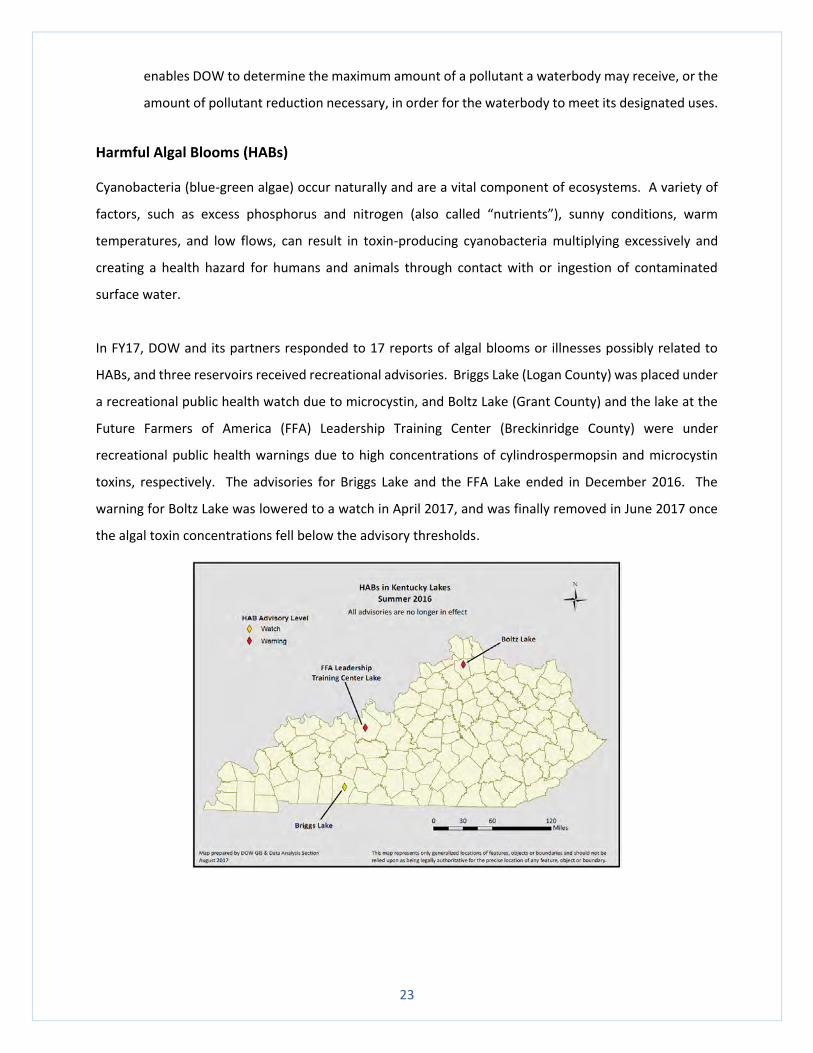
Harmful Algal Blooms (HABs)
Cyanobacteria (blue-green algae) occur naturally and are a vital component of ecosystems. A variety of
factors, such as excess phosphorus and nitrogen (also called “nutrients”), sunny conditions, warm
temperatures, and low flows, can result in toxin-producing cyanobacteria multiplying excessively and
creating a health hazard for humans and animals through contact with or ingestion of contaminated
surface water.
In FY17, DOW and its partners responded to 17 reports of algal blooms or illnesses possibly related to
HABs, and three reservoirs received recreational advisories. Briggs Lake (Logan County) was placed under
a recreational public health watch due to microcystin, and Boltz Lake (Grant County) and the lake at the
Future Farmers of America (FFA) Leadership Training Center (Breckinridge County) were under
recreational public health warnings due to high concentrations of cylindrospermopsin and microcystin
toxins, respectively. The advisories for Briggs Lake and the FFA Lake ended in December 2016. The
warning for Boltz Lake was lowered to a watch in April 2017, and was finally removed in June 2017 once
the algal toxin concentrations fell below the advisory thresholds.
24
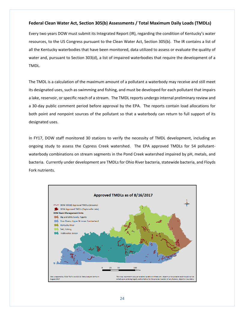
Federal Clean Water Act, Section 305(b) Assessments / Total Maximum Daily Loads (TMDLs)
Every two years DOW must submit its Integrated Report (IR), regarding the condition of Kentucky’s water
resources, to the US Congress pursuant to the Clean Water Act, Section 305(b). The IR contains a list of
all the Kentucky waterbodies that have been monitored, data utilized to assess or evaluate the quality of
water and, pursuant to Section 303(d), a list of impaired waterbodies that require the development of a
TMDL.
The TMDL is a calculation of the maximum amount of a pollutant a waterbody may receive and still meet
its designated uses, such as swimming and fishing, and must be developed for each pollutant that impairs
a lake, reservoir, or specific reach of a stream. The TMDL reports undergo internal preliminary review and
a 30-day public comment period before approval by the EPA. The reports contain load allocations for
both point and nonpoint sources of the pollutant so that a waterbody can return to full support of its
designated uses.
In FY17, DOW staff monitored 30 stations to verify the necessity of TMDL development, including an
ongoing study to assess the Cypress Creek watershed. The EPA approved TMDLs for 54 pollutant-
waterbody combinations on stream segments in the Pond Creek watershed impaired by pH, metals, and
bacteria. Currently under development are TMDLs for Ohio River bacteria, statewide bacteria, and Floyds
Fork nutrients.
25
In October 2016, the EPA approved Kentucky’s 2014 Section 303(d) list which included 62
waterbody/pollutant combinations for removal from the impaired list. The draft 2016 303(d) list went to
public notice on May 2, 2017, and includes a request for the removal of 63 waterbody/pollutant
combinations from the impaired list. Waterbodies removed from the 303(d) list may indicate improved
water quality due to facility upgrades, changes in land use, or successful pollutant abatement projects
within a particular watershed.
Clean Water Act, Section 401, Certification of USACE Nationwide Permits
Every five years the US Army Corps of Engineers (USACE) issues a series of general Nationwide Permits
(NWPs) that authorize activities under the Clean Water Act, Section 404, and the Rivers and Harbors Act
of 1899, Section 10. These NWPs are for projects that will have minimal environmental impact and allow
a streamlined permitting process. DOW issues water quality certifications (WQCs) pursuant to the Clean
Water Act, Section 401, which authorizes states and tribes to certify that the NWPs will comply with state
water quality standards.
The Commonwealth has three options for NWPs:
1) certify “as is” which means that the NWPs meet Kentucky’s water quality standards
2) certify “with conditions” which means that additional conditions must be implemented to meet
Kentucky’s water quality standards, and
3) deny an NWP, meaning that individual WQCs are necessary for the project.
The previous NWPs issued by the USACE expired on March 18, 2017. The new NWPs became effective on
March 19 and will expire on March 18, 2022. When the proposed NWPs were published in the Federal
Register in 2016, DOW spent considerable time reviewing the proposals and developing WQCs, then sent
the proposed general WQCs to public notice for 30 days. The general WQCs became effective on March
19, 2017.
26
27
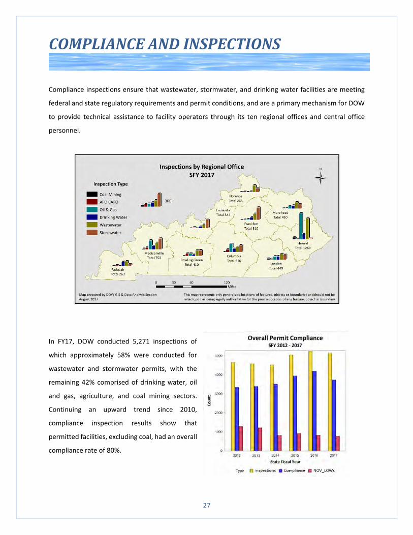
COMPLIANCE AND INSPECTIONS
Compliance inspections ensure that wastewater, stormwater, and drinking water facilities are meeting
federal and state regulatory requirements and permit conditions, and are a primary mechanism for DOW
to provide technical assistance to facility operators through its ten regional offices and central office
personnel.
In FY17, DOW conducted 5,271 inspections of
which approximately 58% were conducted for
wastewater and stormwater permits, with the
remaining 42% comprised of drinking water, oil
and gas, agriculture, and coal mining sectors.
Continuing an upward trend since 2010,
compliance inspection results show that
permitted facilities, excluding coal, had an overall
compliance rate of 80%.
28
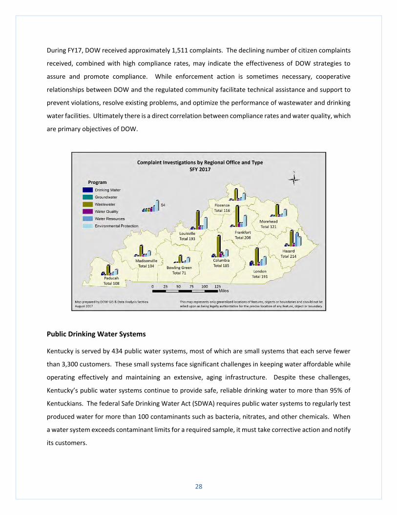
During FY17, DOW received approximately 1,511 complaints. The declining number of citizen complaints
received, combined with high compliance rates, may indicate the effectiveness of DOW strategies to
assure and promote compliance. While enforcement action is sometimes necessary, cooperative
relationships between DOW and the regulated community facilitate technical assistance and support to
prevent violations, resolve existing problems, and optimize the performance of wastewater and drinking
water facilities. Ultimately there is a direct correlation between compliance rates and water quality, which
are primary objectives of DOW.
Public Drinking Water Systems
Kentucky is served by 434 public water systems, most of which are small systems that each serve fewer
than 3,300 customers. These small systems face significant challenges in keeping water affordable while
operating effectively and maintaining an extensive, aging infrastructure. Despite these challenges,
Kentucky’s public water systems continue to provide safe, reliable drinking water to more than 95% of
Kentuckians. The federal Safe Drinking Water Act (SDWA) requires public water systems to regularly test
produced water for more than 100 contaminants such as bacteria, nitrates, and other chemicals. When
a water system exceeds contaminant limits for a required sample, it must take corrective action and notify
its customers.
29
Data from Kentucky’s 434 public water systems in FY2017 demonstrates consistent production of
excellent quality water, a decline in monitoring and reporting violations, and very high rates of compliance
with the SDWA. Data reported by water systems in calendar year 2016 shows that none of Kentucky’s
434 public water systems exceeded federal limits for metals, including lead, or cancer-causing volatile
organic compounds.
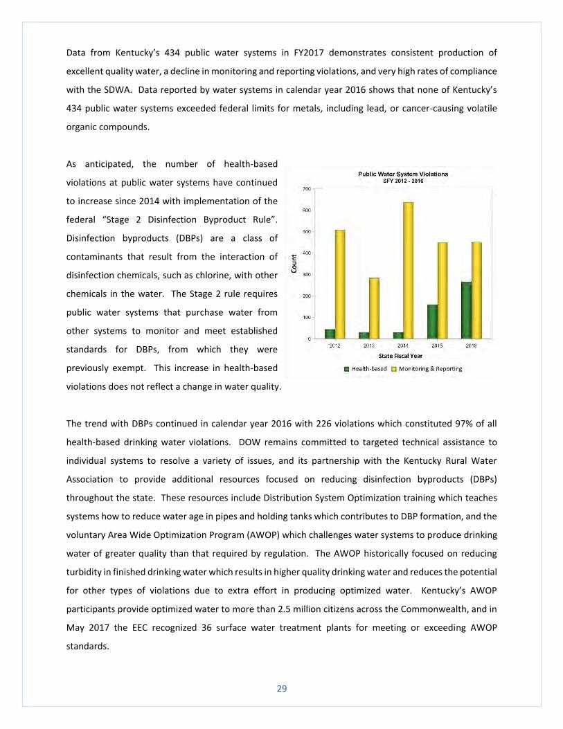
As anticipated, the number of health-based
violations at public water systems have continued
to increase since 2014 with implementation of the
federal “Stage 2 Disinfection Byproduct Rule”.
Disinfection byproducts (DBPs) are a class of
contaminants that result from the interaction of
disinfection chemicals, such as chlorine, with other
chemicals in the water. The Stage 2 rule requires
public water systems that purchase water from
other systems to monitor and meet established
standards for DBPs, from which they were
previously exempt. This increase in health-based
violations does not reflect a change in water quality.
The trend with DBPs continued in calendar year 2016 with 226 violations which constituted 97% of all
health-based drinking water violations. DOW remains committed to targeted technical assistance to
individual systems to resolve a variety of issues, and its partnership with the Kentucky Rural Water
Association to provide additional resources focused on reducing disinfection byproducts (DBPs)
throughout the state. These resources include Distribution System Optimization training which teaches
systems how to reduce water age in pipes and holding tanks which contributes to DBP formation, and the
voluntary Area Wide Optimization Program (AWOP) which challenges water systems to produce drinking
water of greater quality than that required by regulation. The AWOP historically focused on reducing
turbidity in finished drinking water which results in higher quality drinking water and reduces the potential
for other types of violations due to extra effort in producing optimized water. Kentucky’s AWOP
participants provide optimized water to more than 2.5 million citizens across the Commonwealth, and in
May 2017 the EEC recognized 36 surface water treatment plants for meeting or exceeding AWOP
standards.
30
Drinking Water Advisory Council (DWAC)
The DWAC is a group of representatives of public and private sector stakeholders who play a role in
providing safe drinking water to Kentucky citizens. Some of the issues that DWAC subcommittees
addressed in FY17 included DBP-related issues, the availability of certified drinking water system
operators, lead in drinking water, infrastructure sustainability, and DOW and EPA policies and regulations.
The DWAC Compliance subcommittee developed and hosted three DBP symposia at key locations
throughout the Commonwealth. 140 representatives of 40 water systems attended the day-long training
which included detailed presentations regarding the regulation, formation, and treatment of DBPs.
Prompted by national issues regarding lead in drinking water, DOW and DWAC formed its Lead in Drinking
Water workgroup in 2016 to engage in a proactive, coordinated effort to examine the status of lead in
Kentucky’s drinking water, whether and what future action might be needed, and develop
recommendations if appropriate. The Lead in Drinking Water workgroup includes representatives from
the Kentucky Department of Public Health, Kentucky Rural Water Association, the University of Louisville,
and public utilities. The workgroup researched and presented information on lead-related issues
including the complexity of water chemistry, corrosion control, infrastructure, regulations, financing, and
health effects. Through the collective effort of the workgroup, Kentucky is taking a proactive approach to
maintain public health and the confidence of its public water system customers.
31
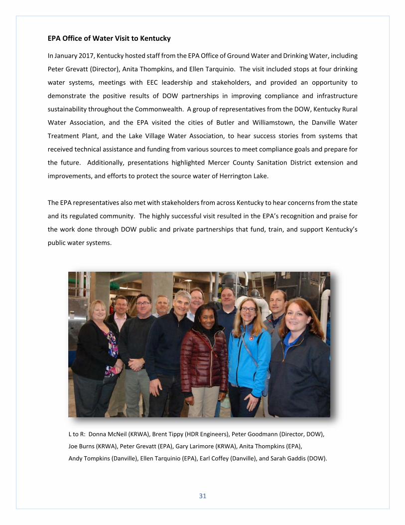
EPA Office of Water Visit to Kentucky
In January 2017, Kentucky hosted staff from the EPA Office of Ground Water and Drinking Water, including
Peter Grevatt (Director), Anita Thompkins, and Ellen Tarquinio. The visit included stops at four drinking
water systems, meetings with EEC leadership and stakeholders, and provided an opportunity to
demonstrate the positive results of DOW partnerships in improving compliance and infrastructure
sustainability throughout the Commonwealth. A group of representatives from the DOW, Kentucky Rural
Water Association, and the EPA visited the cities of Butler and Williamstown, the Danville Water
Treatment Plant, and the Lake Village Water Association, to hear success stories from systems that
received technical assistance and funding from various sources to meet compliance goals and prepare for
the future. Additionally, presentations highlighted Mercer County Sanitation District extension and
improvements, and efforts to protect the source water of Herrington Lake.
The EPA representatives also met with stakeholders from across Kentucky to hear concerns from the state
and its regulated community. The highly successful visit resulted in the EPA’s recognition and praise for
the work done through DOW public and private partnerships that fund, train, and support Kentucky’s
public water systems.
L to R: Donna McNeil (KRWA), Brent Tippy (HDR Engineers), Peter Goodmann (Director, DOW),
Joe Burns (KRWA), Peter Grevatt (EPA), Gary Larimore (KRWA), Anita Thompkins (EPA),
Andy Tompkins (Danville), Ellen Tarquinio (EPA), Earl Coffey (Danville), and Sarah Gaddis (DOW).
32
WATER MAPS PORTAL (watermaps.ky.gov)
The management and dissemination of data to meet the mission of the DOW continues to be a challenge,
but collaboration between DOW, Division of Environmental Program Support (DEPS), and General
Administration and Program Support (GAPS) continues making great strides in improving the delivery of
this information and expanding the maps available for users. In addition to providing data transparency,
DOW realized cost savings from decreased staff time spent releasing data for individual requests and
explaining information to the public, which in turn improves relationships between DOW and the citizens
and businesses that it serves.
Positive reviews received include:
“This is an example of state government getting something right.” (Page One Kentucky)
“I cannot thank your team enough for listening to our concerns and needs up front to get this project
right the first time. This truly will be a tool that businesses of all sizes will utilize across the state.”
(Kentucky Chamber of Commerce)
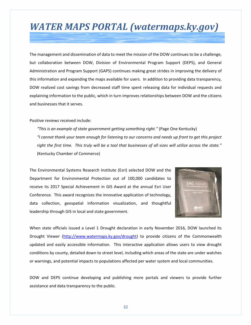
The Environmental Systems Research Institute (Esri) selected DOW and the
Department for Environmental Protection out of 100,000 candidates to
receive its 2017 Special Achievement in GIS Award at the annual Esri User
Conference. This award recognizes the innovative application of technology,
data collection, geospatial information visualization, and thoughtful
leadership through GIS in local and state government.
When state officials issued a Level 1 Drought declaration in early November 2016, DOW launched its
Drought Viewer (http://www.watermaps.ky.gov/drought) to provide citizens of the Commonwealth
updated and easily accessible information. This interactive application allows users to view drought
conditions by county, detailed down to street level, including which areas of the state are under watches
or warnings, and potential impacts to populations affected per water system and local communities.
DOW and DEPS continue developing and publishing more portals and viewers to provide further
assistance and data transparency to the public.
33
WATERSHED IMPROVEMENT EFFORTS
Nonpoint source runoff is the primary source of pollution affecting water quality in Kentucky. DOW
receives Clean Water Act Section 319(h) grant funds from the US EPA to address problems associated with
nonpoint source pollution, and works at both a watershed level and on a statewide scale to protect surface
water and groundwater from nonpoint source pollution, abate pollution threats, and restore degraded
waters. Watershed plans describe conditions in the watershed, identify causes and sources of
impairment, and explain how best management practices (BMPs) can improve water quality conditions
and ultimately meet water quality standards and designated uses.
The Red River Gorge (RRG) is a scenic natural area located in the Daniel Boone National Forest, known for
free-flowing streams, abundant natural stone arches, unusual rock formations, and spectacular sandstone
cliffs. Because of its outstanding beauty and accessibility, RRG draws an estimated half million visitors
from around the world each year, placing a heavy burden on its natural resources. The US Forest Service
(USFS) maintains a network of trails, but users have added almost 200 miles of unauthorized trails and
have created hundreds of campsites, vistas, and rock climbing routes. Since these user-developed features
are not maintained by the USFS, they are very susceptible to erosion and contribute to high sediment
loads in the streams. Additionally, the gorge is located downstream of privately owned land, small towns,
and farms, and therefore water quality is also threatened by pollution from illegal dumps, runoff from
towns, agriculture, and rock quarries, as well as loss of streamside vegetation.
The USFS sought help from DOW to improve the quality of this valuable state resource. The USFS created
a watershed plan to identify causes and sources of pollution in the Red River Watershed, and determine
strategies to address issues identified in the plan. To help with the watershed planning process, the USFS
created strong partnerships with DOW, the Kentucky Department of Fish and Wildlife Resources (DFWR),
and conservation entities and outdoor enthusiasts such as Kentucky Waterways Alliance (KWA), Friends
of the Red River, Student Conservation Association, RRG Trail Volunteers, and RRG Climbers Coalition, the
Wolfe County Solid Waste Coordinator, the Campton Catholic Church, and other local agencies and citizen
groups. These interested parties formed the Red River Watershed Team and were instrumental in helping
with RRG cleanup efforts.
34
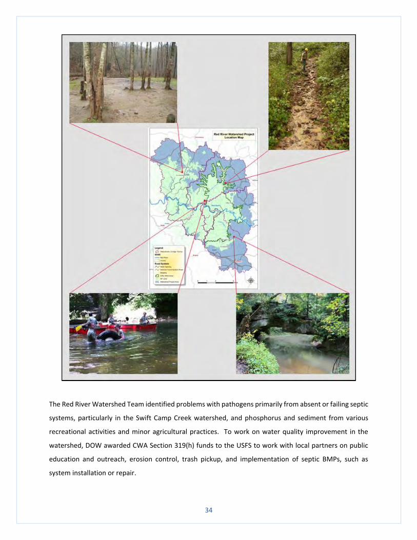
The Red River Watershed Team identified problems with pathogens primarily from absent or failing septic
systems, particularly in the Swift Camp Creek watershed, and phosphorus and sediment from various
recreational activities and minor agricultural practices. To work on water quality improvement in the
watershed, DOW awarded CWA Section 319(h) funds to the USFS to work with local partners on public
education and outreach, erosion control, trash pickup, and implementation of septic BMPs, such as
system installation or repair.
35
The USFS and its partners began addressing erosion and sedimentation by reclaiming and replanting user-
developed campsites and trails, placing materials to deter further use, installing water bars and lead-off
ditches on trails to slow runoff, and removing garbage in the streams. A seasonal trail crew and Student
Conservation Association volunteers helped recover eroding trails and sites within the gorge. In addition
to the trail crew, USFS also worked with DOW, DFWR, Trout Unlimited, and AmeriCorps to reclaim areas
by planting new trees. KWA led outreach efforts by engaging the public in stream cleanup activities and
educating visitors and local students on how to reduce impacts to Kentucky streams through personal
actions. Eastern Kentucky PRIDE assisted USFS in reducing pathogens and other household pollutants
through a septic repair or replace program available to homeowners with improperly functioning or
absent septic systems. This collaborative effort resulted in the rehabilitation of 157 user-developed
campsites, reduced erosion on over 32 miles of trail, eliminated 416 tons of stream sedimentation per
year, and removed trash from over 75 miles of stream.
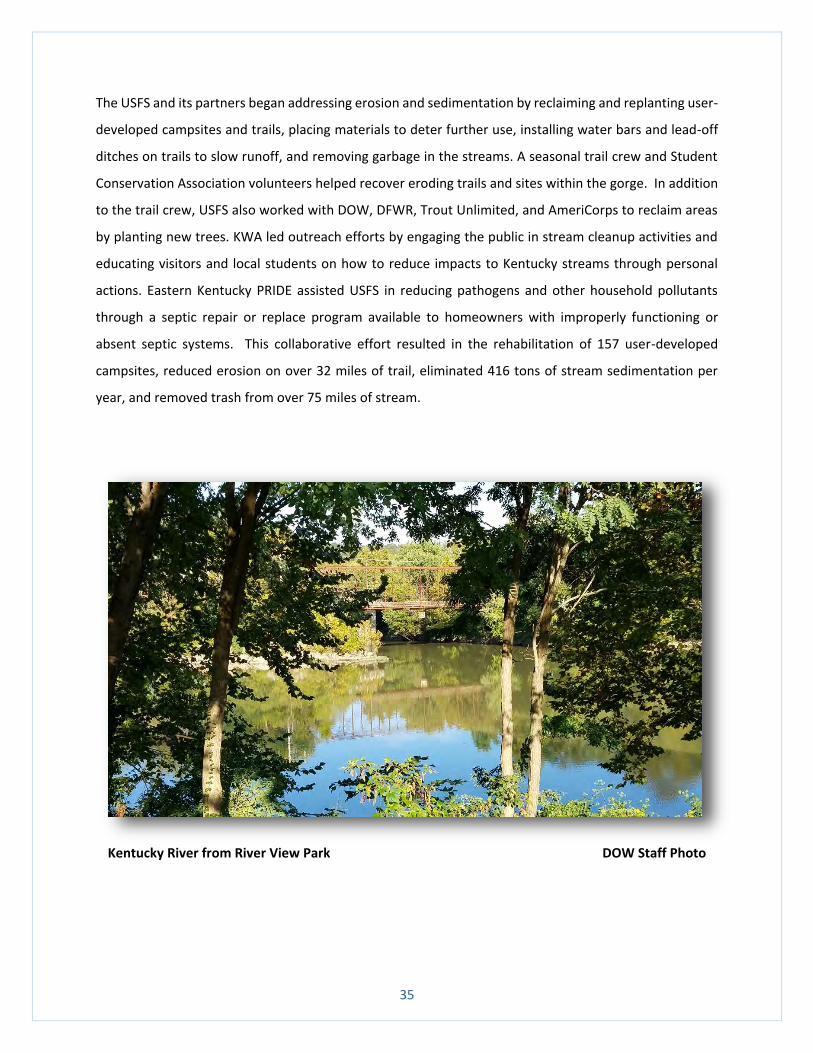
Kentucky River from River View Park DOW Staff Photo
36
PERMITTING
The Clean Water Act prohibits the discharge of pollutants from a point source into waters of the
Commonwealth without a Kentucky Pollutant Discharge Elimination System (KPDES) permit. The KPDES
permit contains provisions to ensure that wastewater discharged from industrial facilities, publicly owned
treatment works, and other sources is not harmful to human health and the environment. The permit
places limitations on what can be discharged, identifies monitoring responsibilities, and establishes
reporting requirements.
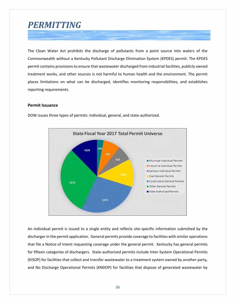
Permit Issuance
DOW issues three types of permits: individual, general, and state-authorized.
An individual permit is issued to a single entity and reflects site-specific information submitted by the
discharger in the permit application. General permits provide coverage to facilities with similar operations
that file a Notice of Intent requesting coverage under the general permit. Kentucky has general permits
for fifteen categories of dischargers. State-authorized permits include Inter-System Operational Permits
(KISOP) for facilities that collect and transfer wastewater to a treatment system owned by another party,
and No Discharge Operational Permits (KNDOP) for facilities that dispose of generated wastewater by
37
means other than a point source discharge. There are approximately 1,450 individual permitted
dischargers, more than 5,800 facilities covered by general permits, 50 KISOPs, and 980 KNDOPs in
Kentucky.
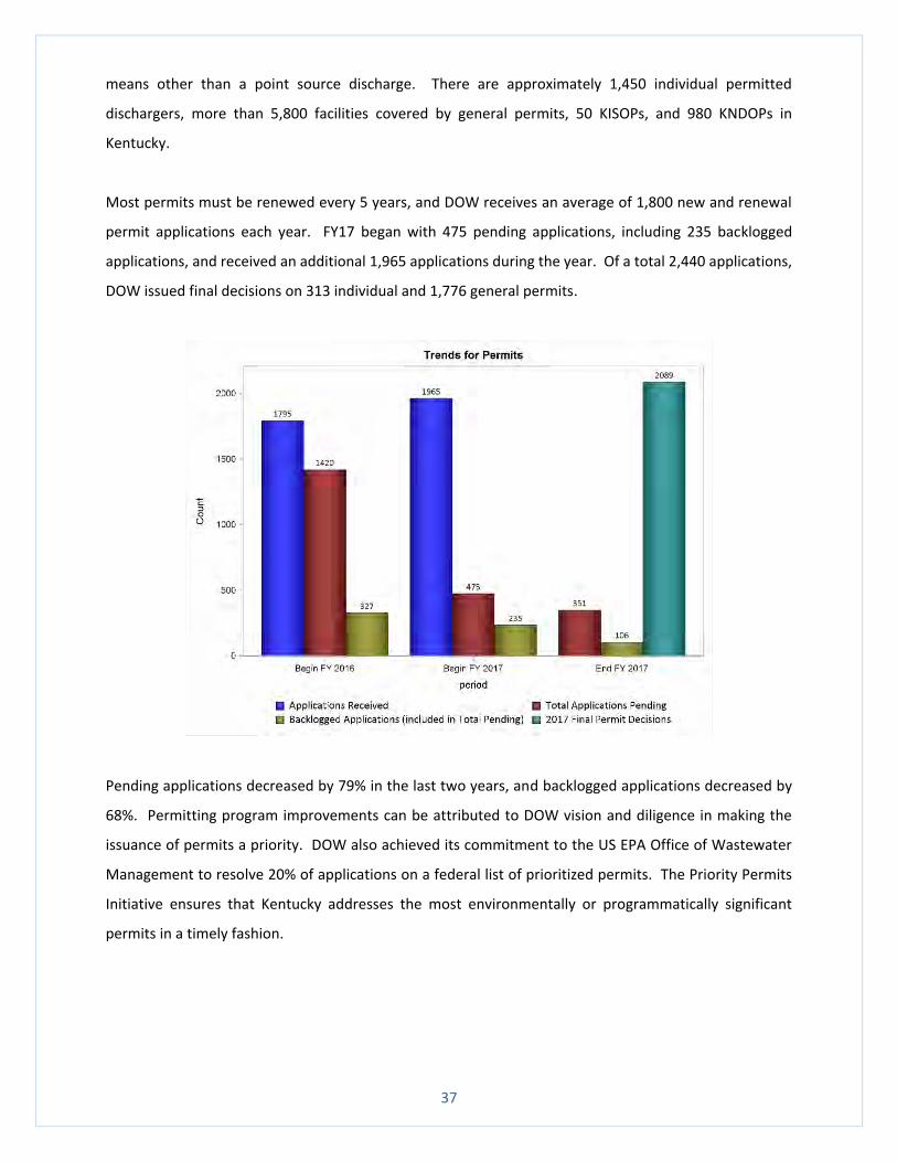
Most permits must be renewed every 5 years, and DOW receives an average of 1,800 new and renewal
permit applications each year. FY17 began with 475 pending applications, including 235 backlogged
applications, and received an additional 1,965 applications during the year. Of a total 2,440 applications,
DOW issued final decisions on 313 individual and 1,776 general permits.
Pending applications decreased by 79% in the last two years, and backlogged applications decreased by
68%. Permitting program improvements can be attributed to DOW vision and diligence in making the
issuance of permits a priority. DOW also achieved its commitment to the US EPA Office of Wastewater
Management to resolve 20% of applications on a federal list of prioritized permits. The Priority Permits
Initiative ensures that Kentucky addresses the most environmentally or programmatically significant
permits in a timely fashion.
38
New Rules and Challenges
Three new US EPA regulations affected Kentucky’s 17 electric-generating plants and required those
facilities to upgrade water intake structures, meet more stringent environmental standards for
discharging scrubber wastewater, and eliminate wet handling of fly ash and bottom ash.
The amendments to Section 316(b) of the federal Clean Water Act required facilities with cooling water
intake structures to use the best technology available to minimize environmental impacts. Intake
structures pull fish and shellfish into a power plant’s cooling system (known as “entrainment”) which may
then be killed or injured by heat, physical stress, or chemicals used to clean the cooling system. Larger
organisms may be killed or injured when they become trapped against screens at the front of an intake
structure (known as “impingement”). The new rule placed a deadline of July 14, 2018 for facilities to
obtain a KPDES permit that identifies the technology and site-specific controls implemented by the facility
to comply with the new rule.
The US EPA amended the effluent limitations guidelines (ELG) for steam electric power generating plants
in 2015, and required facilities to comply with the best available technology requirements for flue gas
desulfurization wastewater, gasification wastewater, fly ash transport water, flue gas mercury control
wastewater, and bottom ash transport water. The ELG changes necessitate substantial modifications to
power plant processes. Facilities must undertake physical, chemical, and biological treatment of scrubber
wastewater by November 1, 2018, and obtain a KPDES permit with the new ELG limitations.
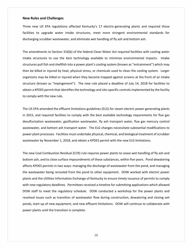
The new Coal Combustion Residual (CCR) rule requires power plants to cease wet handling of fly ash and
bottom ash, and to close surface impoundments of these substances, within five years. Pond dewatering
affects KPDES permits in two ways: managing the discharge of wastewater from the pond, and managing
the wastewater being rerouted from the pond to other equipment. DOW worked with electric power
plants and the Utilities Information Exchange of Kentucky to ensure timely issuance of permits to comply
with new regulatory deadlines. Permittees received a timeline for submitting applications which allowed
DOW staff to meet the regulatory schedule. DOW conducted a workshop for the power plants and
resolved issues such as transition of wastewater flow during construction, dewatering and closing ash
ponds, start-up of new equipment, and new effluent limitations. DOW will continue to collaborate with
power plants until the transition is complete.
39
General Permits
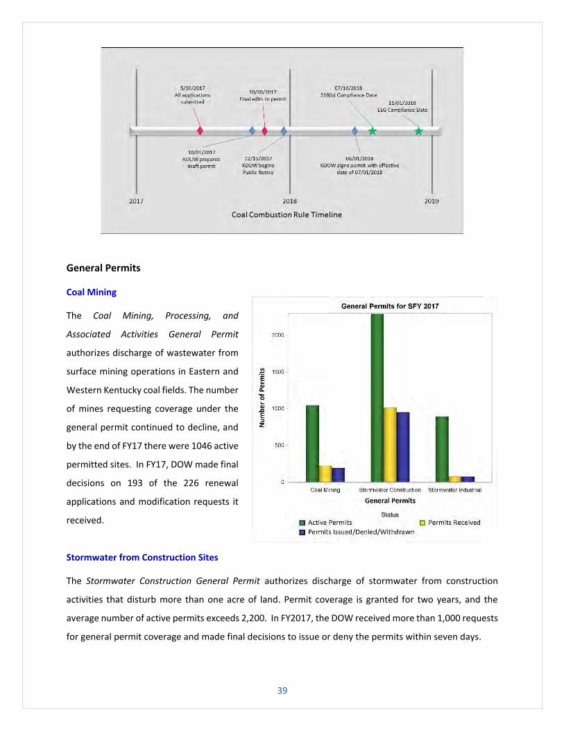
Coal Mining
The Coal Mining, Processing, and
Associated Activities General Permit
authorizes discharge of wastewater from
surface mining operations in Eastern and
Western Kentucky coal fields. The number
of mines requesting coverage under the
general permit continued to decline, and
by the end of FY17 there were 1046 active
permitted sites. In FY17, DOW made final
decisions on 193 of the 226 renewal
applications and modification requests it
received.
Stormwater from Construction Sites
The Stormwater Construction General Permit authorizes discharge of stormwater from construction
activities that disturb more than one acre of land. Permit coverage is granted for two years, and the
average number of active permits exceeds 2,200. In FY2017, the DOW received more than 1,000 requests
for general permit coverage and made final decisions to issue or deny the permits within seven days.
40
Stormwater Associated with Industrial Activities
The Stormwater Industrial Activity General Permit authorizes discharge of stormwater runoff associated
with industrial activity. This permit is valid for 5 years and available to facilities that would normally be
required to have an individual KPDES permit for stormwater coming into contact with industrial activities,
but is unavailable to facilities that must meet national effluent limitations guidelines. There are
approximately 900 active industrial stormwater general permits, and the DOW received 77 requests for
new or expanded discharges in FY17.
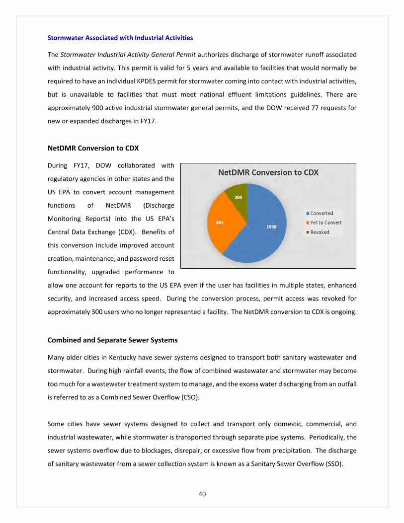
NetDMR Conversion to CDX
During FY17, DOW collaborated with
regulatory agencies in other states and the
US EPA to convert account management
functions of NetDMR (Discharge
Monitoring Reports) into the US EPA’s
Central Data Exchange (CDX). Benefits of
this conversion include improved account
creation, maintenance, and password reset
functionality, upgraded performance to
allow one account for reports to the US EPA even if the user has facilities in multiple states, enhanced
security, and increased access speed. During the conversion process, permit access was revoked for
approximately 300 users who no longer represented a facility. The NetDMR conversion to CDX is ongoing.
Combined and Separate Sewer Systems
Many older cities in Kentucky have sewer systems designed to transport both sanitary wastewater and
stormwater. During high rainfall events, the flow of combined wastewater and stormwater may become
too much for a wastewater treatment system to manage, and the excess water discharging from an outfall
is referred to as a Combined Sewer Overflow (CSO).
Some cities have sewer systems designed to collect and transport only domestic, commercial, and
industrial wastewater, while stormwater is transported through separate pipe systems. Periodically, the
sewer systems overflow due to blockages, disrepair, or excessive flow from precipitation. The discharge
of sanitary wastewater from a sewer collection system is known as a Sanitary Sewer Overflow (SSO).
41
DOW collaborates with federal, state, and local governments to bring communities into compliance with
the Clean Water Act and eliminate sewer overflows in Kentucky. Sixteen Kentucky communities are
working to eliminate SSOs and to mitigate CSOs to the extent economically feasible. These communities
implement projects to reduce overflows, manage capacity, and develop long term control plans. The
projects often include repairing sewer lines and increasing the storage capacity in the sewer system, which
allows additional processing time for wastewater treatment. Final completion dates of these projects
vary depending on the scope of work and financial considerations.
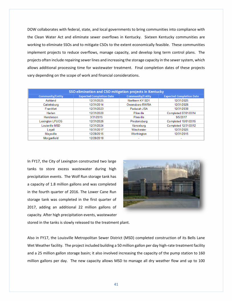
In FY17, the City of Lexington constructed two large
tanks to store excess wastewater during high
precipitation events. The Wolf Run storage tank has
a capacity of 1.8 million gallons and was completed
in the fourth quarter of 2016. The Lower Cane Run
storage tank was completed in the first quarter of
2017, adding an additional 22 million gallons of
capacity. After high precipitation events, wastewater
stored in the tanks is slowly released to the treatment plant.
Also in FY17, the Louisville Metropolitan Sewer District (MSD) completed construction of its Bells Lane
Wet Weather facility. The project included building a 50 million gallon per day high-rate treatment facility
and a 25 million gallon storage basin; it also involved increasing the capacity of the pump station to 160
million gallons per day. The new capacity allows MSD to manage all dry weather flow and up to 100
42
million gallons per day of wet weather flow. This project greatly reduces recurring overflows and the
amount of untreated sewage discharged to the Ohio River.
There are 230 Kentucky communities that have varying degrees of aging infrastructure that cause
bypasses and overflows at wastewater treatment plants. DOW personnel inspect approximately 10% of
the systems in these communities, focusing on systems with frequent and recurring incidents and
complaints. During inspections, DOW staff educate communities on identifying causes of overflows,
prioritizing corrective actions, finding funding resources, and returning collection systems to compliance
with the Clean Water Act. Greater awareness of the seriousness of CSOs and SSOs, and completion of
remedial projects, results in fewer overflows of raw sewage into public streets, parks, yards, and streams.
Kentucky communities continue making progress to minimize discharges of untreated wastewater with
long-term planning and assistance from DOW.
Municipal Separate Storm Sewer Systems (MS4s)
Stormwater runoff from developed urban and suburban areas contributes significant pollution to
Kentucky waters and increases downstream flooding. The purpose of the Municipal Separate Storm Sewer
System (MS4) program is to minimize urban stormwater pollution runoff from entering the waters of the
Commonwealth. The MS4 program requires communities and entities with significant population density
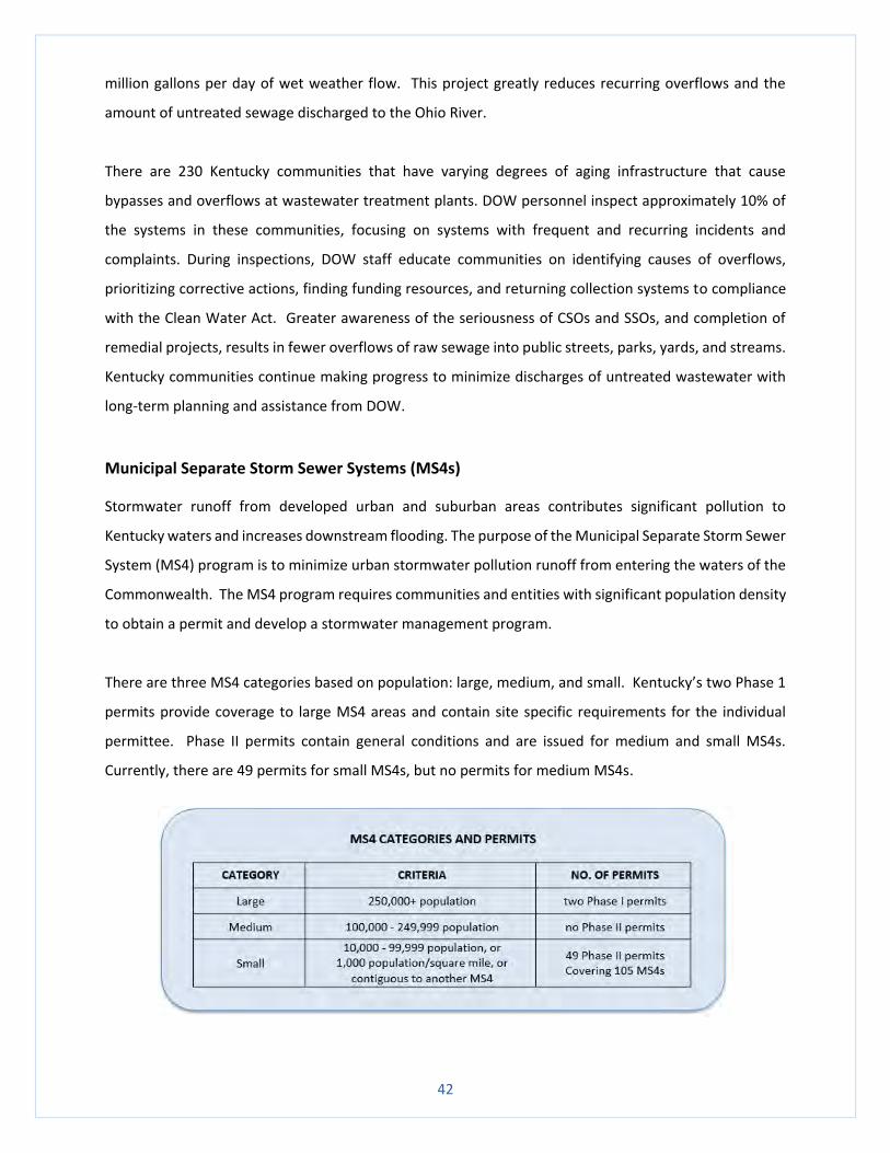
to obtain a permit and develop a stormwater management program.
There are three MS4 categories based on population: large, medium, and small. Kentucky’s two Phase 1
permits provide coverage to large MS4 areas and contain site specific requirements for the individual
permittee. Phase II permits contain general conditions and are issued for medium and small MS4s.
Currently, there are 49 permits for small MS4s, but no permits for medium MS4s.
43
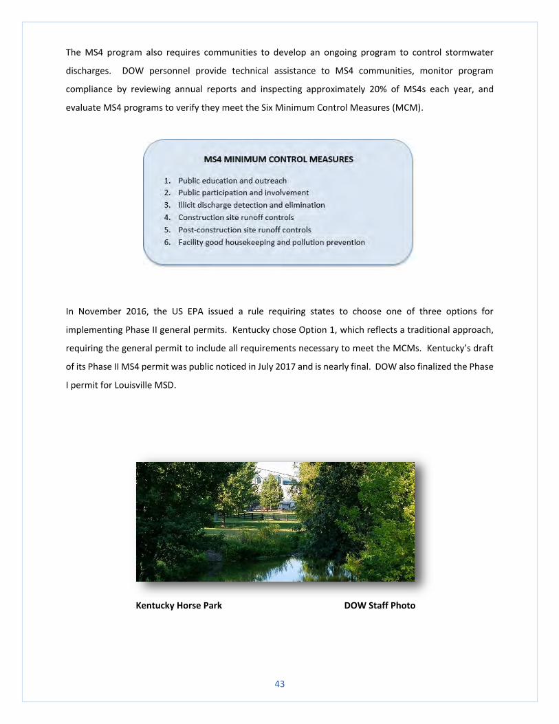
The MS4 program also requires communities to develop an ongoing program to control stormwater
discharges. DOW personnel provide technical assistance to MS4 communities, monitor program
compliance by reviewing annual reports and inspecting approximately 20% of MS4s each year, and
evaluate MS4 programs to verify they meet the Six Minimum Control Measures (MCM).
In November 2016, the US EPA issued a rule requiring states to choose one of three options for
implementing Phase II general permits. Kentucky chose Option 1, which reflects a traditional approach,
requiring the general permit to include all requirements necessary to meet the MCMs. Kentucky’s draft
of its Phase II MS4 permit was public noticed in July 2017 and is nearly final. DOW also finalized the Phase
I permit for Louisville MSD.
Kentucky Horse Park DOW Staff Photo
44
Commonwealth of Kentucky
Matthew G. Bevin, Governor
Energy and Environment Cabinet
Charles G. Snavely, Secretary
Kentucky Department for Environmental Protection
Aaron B. Keatley, Commissioner
Kentucky DOW
Peter Goodmann, Director
Thomas Gabbard, Assistant Director
Branch Managers
Compliance and Technical Assistance Branch Sarah Gaddis
Resource Planning and Program Support Branch Kristie Graham
Surface Water Permits Branch Sara Anderson
Water Infrastructure Branch Jory Becker
Watershed Management Branch John Webb
Water Quality Branch Andrea Keatley