Embed Size (px)
Citation preview
Summary Report Neighbourhood Freight Forum kick-off meeting on April 27, 2017
Location: International Union of Painters & Allied Trades, 132 Toro Road, Toronto, ON
Date: Thursday, April 27, 2017
Time: 12:00pm – 3:00pm
About
In 2016, in collaboration with the DUKE Heights BIA and with the financial support of The
Atmospheric Fund, the Pembina Institute began a three-year pilot project to establish a
Neighbourhood Freight Forum (NFF) in the DUKE Heights BIA, in northwest Toronto.
The goal of the NFF is to bring together local businesses and stakeholders, with the support of
outside experts and policy makers, to identify and implement solutions to make shipping and
deliveries more efficient in the BIA. Goods movement solutions can result in cost savings for
businesses and reduced emissions. This NFF is the first neighbourhood-led freight forum in
Canada.
Over the next three years, regular meetings and forums will be held to identify issues and
advance solutions. On April 27, 2017, the kickoff NFF meeting was held. This document presents
the results of this meeting.
For more information about similar initiatives across the globe, please see:
http://www.pembina.org/pub/improving-urban-freight-efficiency
For more information about the NFF, please contact Dianne Zimmerman, policy director,
transportation and urban solutions, Pembina Institute [email protected] | 647-459-0624 or
see: http://www.pembina.org/blog/your-friendly-neighbourhood-freight-forum
Objectives of the event
The objectives of the first NFF meeting were to:
• Formally launch the project in the DUKE Heights BIA
Pembina Institute Summary Report | 2
• Present the concept of the NFF and what participants can expect • Identify local challenges/issues • Recruit more local businesses and other stakeholders to participate in future forums • Initiate and develop relationships
Agenda
Time Activity
12:00 Registration and lunch
12:30 Presentation/welcome remarks by Matias de Dovitiis, ED of DUKE Heights BIA
Introduction by Dianne Zimmerman, Policy Director, Transportation and Urban Solutions, Pembina Institute
1:10 Participation activity: identifying problems and priorities for shipping and deliveries in the DUKE Heights BIA
Participation in groups and presentations in plenary
Address from Councillor Perruzza (mid-way through the activity)
2:25 Next steps and call to action
2:45 Adjourn
Facilitation The NFF meeting was facilitated by the staff at the Pembina Institute, with support from the
staff at the DUKE Heights BIA. Members of the Project Advisory Group1 participated as facilitators for the group activity.
Participation
Close to 40 people participated in the NFF, representing a wide range of stakeholders,
including: • Local businesses
• Regional businesses • Shippers • The local municipal councilor’s office • Emery Village BIA, the neighbouring BIA
1 The Project Advisory Group (PAG) is made up of members from the Pembina Institute (chair), DUKE Heights BIA, The Atmospheric Fund (funder), City of Toronto, Metrolinx, Ontario Ministry of Transportation, WSP, Ontario Trucking Association, Canadian Fuels Association, UofT and the Region of Peel.
Pembina Institute Summary Report | 3
• City and provincial government staff • Researchers
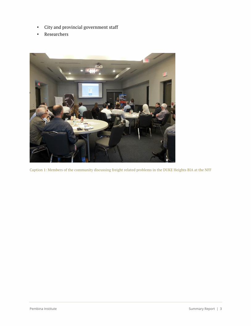
Caption 1: Members of the community discussing freight related problems in the DUKE Heights BIA at the NFF
Pembina Institute Summary Report | 4
What we heard During the forum, we asked participants to discuss three main questions:
1. What are the problems that affect your ability to make/receive deliveries or shipments within the DUKE Heights BIA?
2. If you had to pick the two most important problems to address, what would they be?
3. Who are we missing around the table? Are there others you think should be involved?
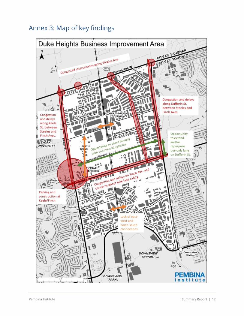
To provide context for the findings, a description of the neighbourhood is provided in Annex 2. A map of the key findings is presented in Annex 3.
Problems to address
Despite there being a wide range of concerns and ideas, participants converged on some key
themes. The problems are listed in approximately the order of how often they arose in the discussion at the forum.
Congestion
Participants felt there is a problem with congestion on many of the neighbourhood’s arterial
and inner roads and at several intersections. Congestion negatively impacts the ability of shippers and receivers to schedule deliveries and ensure they are on time.
Participants attributed congestion to several factors:
• The volume of traffic of all kinds. • Some intersections are considered too small to accommodate large turning trucks. • The timing of traffic lights • The concentration of demand at certain times of day, especially the morning peak.
Congestion was felt to be at its worst from 7:30 to 9:30 a.m. and from 3:00 to 6:30 p.m. • The lack of north-south and east-west connectivity in the neighbourhood due to
physical barriers (for example, the CN rail line and hydro corridor) and a lack of internal roads.2
Congestion was felt to be most significant on Dufferin and Keele Streets, particularly between
Steeles and Finch Avenues, as well as at each of the intersections along Steeles Avenue. In addition, Alness Street has to accommodate a lot of traffic because it is the only north-south
2

Pembina Institute Summary Report | 5
connector in the northern half of the neighbourhood. For example, participants felt there is a missing link between Tangiers and Petrolia Roads.
Construction
Participants also noted that congestion and related delays have been aggravated by the construction of the new subway station at the Keele/Finch intersection, a location where many fuel trucks need to pass to access the fuels terminal. Participants mentioned that since several
development projects are planned for this site3, and since the future Finch West LRT is planned to end at that location, issues related to construction will be ongoing for the foreseeable future. They felt that to date, there has been a lack of information and predictability related to the construction.
Parking
Participants identified a shortage of parking for employees, resulting in illegal parking
throughout the neighbourhood. Of note were strip malls off of Finch Avenue on the west side of the DUKE Heights BIA, near Keele. In anticipation of the subway opening in December 2017, they expressed concern that parking issues would escalate if people choose to drive to the station to board the subway.
Other transportation modes
Many participants emphasized the link between trucking and other modes of transportation.
They mentioned that the existing bike lanes, particularly on Finch Avenue, are unsafe because they offer no protection for cyclists who have to share the road with large trucks. The large blocks mean that pedestrians have long distances to walk in an environment that sometimes feels unpleasant or unsafe. They also expressed a desire for greater access to transit in the neighbourhood. Participants identified that as the neighbourhood grows and these modes of transportation become more prevalent, more conflicts and safety concerns may arise.
Data and monitoring
Participants felt that more and better data will be needed to understand existing problems and
to test future solutions.
Other concerns
Noise from construction and the rail line (GO service and commercial trains) was identified by the participants as a nuisance.
3 The City of Toronto’s “Keele-Finch Plus” is an initiative to plan for the development that will follow the opening of the subway station at Keele and Finch. For more information, visit: http://www1.toronto.ca/wps/portal/contentonly?vgnextoid=57f21159537d2510VgnVCM10000071d60f89RCRD
Pembina Institute Summary Report | 6
Potential solutions
Participants suggested exploring the following solutions:
Congestion • Turn bus-only lanes on Dufferin Street between Finch Avenue and the busway) to HOV
lanes to reduce traffic in the other lanes. • Widen roads.
o Some participants suggested adding an additional lane to Dufferin Street between Finch and Steeles Avenues.
o Some participants suggested widening Alness Street. • Allow commercial vehicles to use the busway in addition to transit vehicles. • Establish a freight hub/freight village where carriers and shippers could work together
to receive shipments and distribute them.
• Optimize traffic light timing at congested intersections and take into consideration truck turns. o Intersections along Steeles Avenue were identified as a priority.
• Offer a special truck discount for Highway 407 to better manage truck traffic. • Establish peak hour restrictions.
• Establish Transportation Demand Management programs. o For example, adjust business schedules to avoid congested periods (e.g. move 9 a.m.
meetings to 10 a.m.) • Improve street connectivity, for example across the CN rail line.
o One participant mentioned that a new road connection through Downsview Park is planned in the future.
• Redirect fuel truck traffic to highways as much as possible. • Continue to inforce no stop/no parking regulations to continue improving traffic flow. • Consider how the arrival of autonomous vehicles (AVs) could change the nature of the
congestion problem in the coming years.
Construction • Better communicate construction delays and better stage/accelerate construction to
reduce negative impact.
Parking • Ensure sufficient parking at new subway station.
Other transportation modes • Better enforce the rules of the road, particularly as the neighbourhood becomes more
multi-modal (e.g. cohabitation between cyclists, car and truck drivers, transit vehicles, etc.).
Pembina Institute Summary Report | 7
• Improve transit access to reduce car use. o In particular, transit service in the area needs to be improved on Sundays and
before 6 a.m. • Improve the bus bays located throughout the neighbourhood. • Improve landscaping and maintenance. • Protect or segregate the bike lanes on the roadway, particularly on Finch Avenue
between Dufferin and Keele Streets.
Data and monitoring • Capture better data on traffic in the neighbourhood, for example: traffic speeds,
demand, and location information (GPS). • Use sensor technology (e.g. embedded in the pavement) at intersections to trigger
traffic lights according to real time traffic flows. • Use evidence-based performance measures. • Waze is an application for commuters (not shippers) to choose their route based on
realtime traffic information.
Other solutions • Pursue low-impact development (LID) to better manage stormwater in the
neighbourhood. • Some participants questioned the location of the fuels terminal in an urban area such as
the DUKE Heights BIA.
Who should be around the table?
Participants identified other groups and individuals who could contribute to the conversation
around goods movement in the DUKE Heights BIA. The groups identified were: • Other companies in the neighbourhood • Other city staff responsible for relevant files such as signal timing • More carriers/shippers
• York University Development Corporation • TTC

Pembina Institute Summary Report | 8
Participant feedback Participants were asked to fill out comment cards to provide feedback. Ten participants filled
out comment cards. The results show a high degree of satisfaction with the event, an agreement that shipping and delivery issues are important in the BIA, and an interest in participating in next steps or in learning more about opportunities to get involved.
In their written comments, participants mentioned that it was interesting to discuss how goods movement issues overlap with pedestrian and transit issues, and they appreciated the opportunity to meet and interact with other stakeholders and businesses in the area.
0
5
10
Yes,absolutely
Alittle Notreally Notatall
IwasabletoparticipateinthediscussionasmuchasIwantedto
0
5
10
Yes,absolutely
Alittle Notreally Notatall
Thiseventhelpedmelearnmoreaboutthefreightforuminmy
neighbourhood
0
5
10
Yes,absolutely
Alittle Notreally Notatall
ImprovingshippinganddeliveriesisanimportantissuefortheDUKE
HeightsBIA
0
5
10
Yes,pleaseaddmetothelist
Maybe,pleasecontactmefor
moreinformation
Nothankyou
Wouldyouliketojoininfuturemeetings?
Pembina Institute Summary Report | 9
Next steps This meeting was the kickoff of the NFF.
Moving forward, the project team will be reaching out to secure participation from additional
businesses and stakeholders. The NFF will meet at least six more times over the next two years to develop and implement solutions to shipping and deliveries in the neighbourhood.
In parallel, the project team is partnering with researchers from the City of Toronto to gather
baseline data in order to be able to develop evidence-based solutions and measure success.
The work of the NFF will continue to be supported by the Project Advisory Group, a group of
experts that provide advice and input into the NFF process.
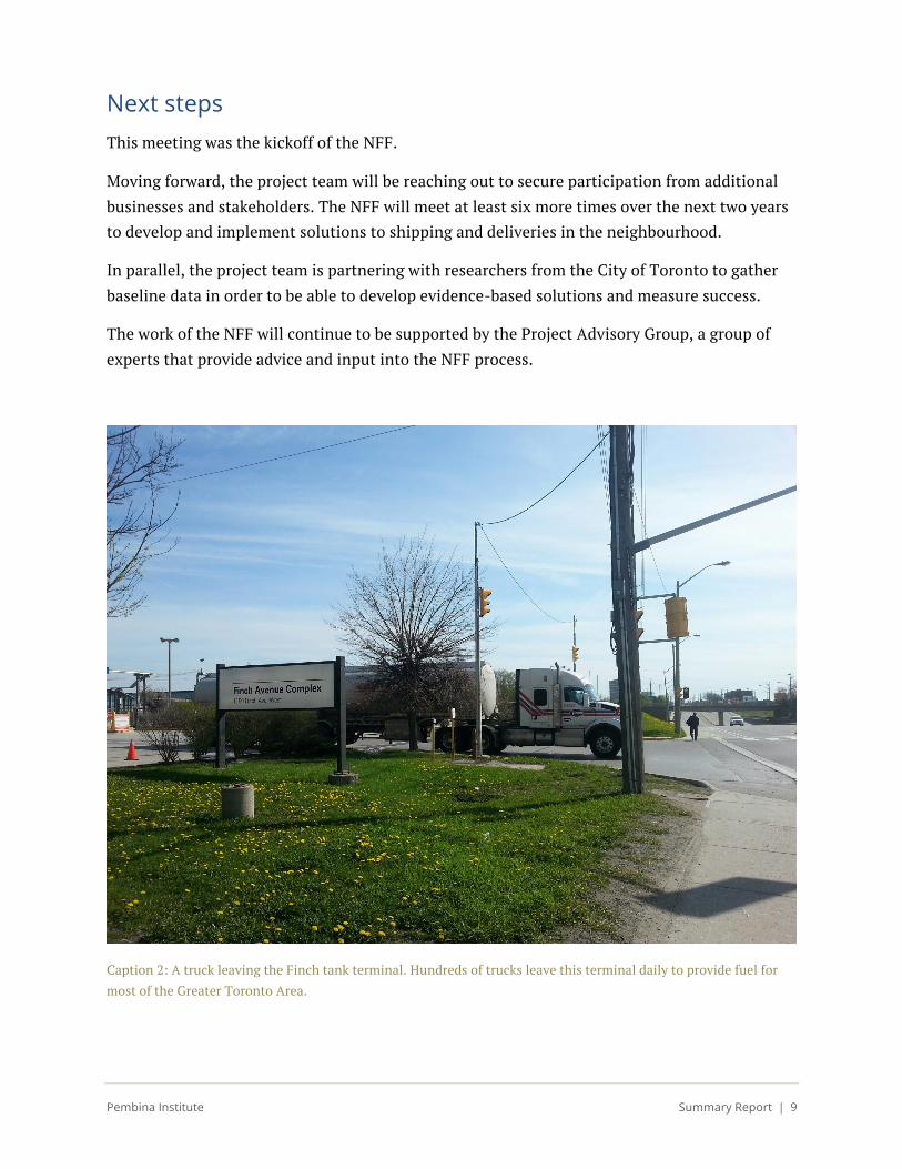
Caption 2: A truck leaving the Finch tank terminal. Hundreds of trucks leave this terminal daily to provide fuel for
most of the Greater Toronto Area.
Pembina Institute Summary Report | 10
Annex 2: Description of the neighbourhood
Land use and built form
At just over 720 hectares in area, the DHBIA is the second largest BIA in the City of Toronto. It
is centered along Finch Avenue West and bound by four major arterial roads: Steeles Avenue, Keele Street, Sheppard Avenue West and Dufferin Street. Though the DHBIA was originally at the urban periphery, the fast-paced development of the Greater Toronto Area in recent decades
has brought development to and beyond the DHBIA area. It is now located in proximity to several important economic, academic and transportation hubs, including Pearson International Airport, Downsview Airport, several 400 series highways, York University, the Yonge-University subway line and North York employment centre. It is also near large urban greenspaces, including Downsview Park and other parklands.
The Finch hydro corridor, which hosts the York University busway and an off-street multiuse
trail, passes from west to east in the northern part of the DHBIA. A CN rail corridor, also used by the Barrie GO line, splits the site in half in the north-south direction and acts as a barrier to east-west travel by car, bike and foot in the northern and southern sectors of the DHBIA.
The majority of the DHBIA area is designated as an “employment area” in the City of Toronto Official Plan. Employment in the area is largely comprised of office, manufacturing and retail/service industries. Finch Avenue has a higher concentration of office and retail functions,
with parking lots generally located in front of buildings.
Some heavy industrial uses are also located within the DHBIA: a large fuel terminal complex in
the northwest quadrant, a waste processing facility in the southeast quadrant, and an iron and metal scrap yard in the southwest quadrant. The fuel terminal complex, considered a critical infrastructure by the Ministry of Energy and Emergency Management Ontario (EMO), is comprised of three fuel terminals and is the largest volume fuel storage/distribution industry complex in Canada, providing approximately 95% of the liquid transportation fuels (gasoline/diesel), heating and other fuels used by businesses, governments, public transit and
private motorists used within the GTA. About 600 to 700 tank trucks per day come in and out of the site, which operates 24 hours a day, seven days a week. Relatively few employees work at the terminals due to the high level of mechanization of operations.
In line with their manufacturing functions, the inner roads of the DHBIA are characterized by
large, low-rise warehouse and commercial buildings on large sites with significant infrastructure for truck deliveries and shipping (Figure 5). Some mid-rise office buildings with retail at grade are located near the intersection of Keele Street and Finch Avenue West, and a pocket of high-rise residential towers is located at the intersection of Dufferin Street and Sheppard Avenue West near Downsview Station. Although the DHBIA has very little residential
Pembina Institute Summary Report | 11
development, the surrounding area is largely designated as residential, with some mixed use along arterial roads. As documented in the Finch Avenue West Light Rail Transit Corridor Profile, the population in the area tends to have a higher proportion of immigrants and young people, and have lower than average private household incomes. The employment and manufacturing functions of the DHBIA mean that shipping and delivery is a key element of operations in the area.
Role as an employment hub
22 employment areas — which are characterized by manufacturing, warehousing, product assembly and commercial business parks — were recognized by the City of Toronto in the 2015
Toronto Employment Survey. Together, employment areas provide more than 400,000 of Toronto’s 1.4 million jobs. The city recognizes that “the lands represented by the Employment Areas are structural elements of Toronto's economic future in order to ensure a stable environment for investment and to maintain and grow the City's revenue base.” Similarly, protecting employment areas and investing in transit, walking and cycling infrastructure in these areas is a recognized priority of the province, as identified in the Growth Plan for the
Greater Golden Horseshoe.
As of 2015, the Dufferin Keele North employment district (the employment area corresponding with the boundaries of the DHBIA) offered the fourth greatest number of jobs from among the
employment areas at 30,980 jobs. This accounts for 7.6% of all employment area jobs and 2.2% of all jobs across the city. Approximately 2,500 businesses are located in the DHBIA.
In recognition of the area’s importance as an employment hub, the DUKE Heights BIA
(originally named the Dufferin Finch BIA) was created in 2014 in order to grow and promote the area’s potential and provide support to businesses. The confirmation that two new major rapid transit projects — the Toronto York Spadina Subway Extension (TYSSE) and Finch West LRT — would bring new transit service to the area was also an important motivator. Indeed, transportation networks — road, transit, active transportation — are key assets for employment hubs and can bring potential for growth.
Pembina Institute Summary Report | 12
Annex 3: Map of key findings