Embed Size (px)
Citation preview
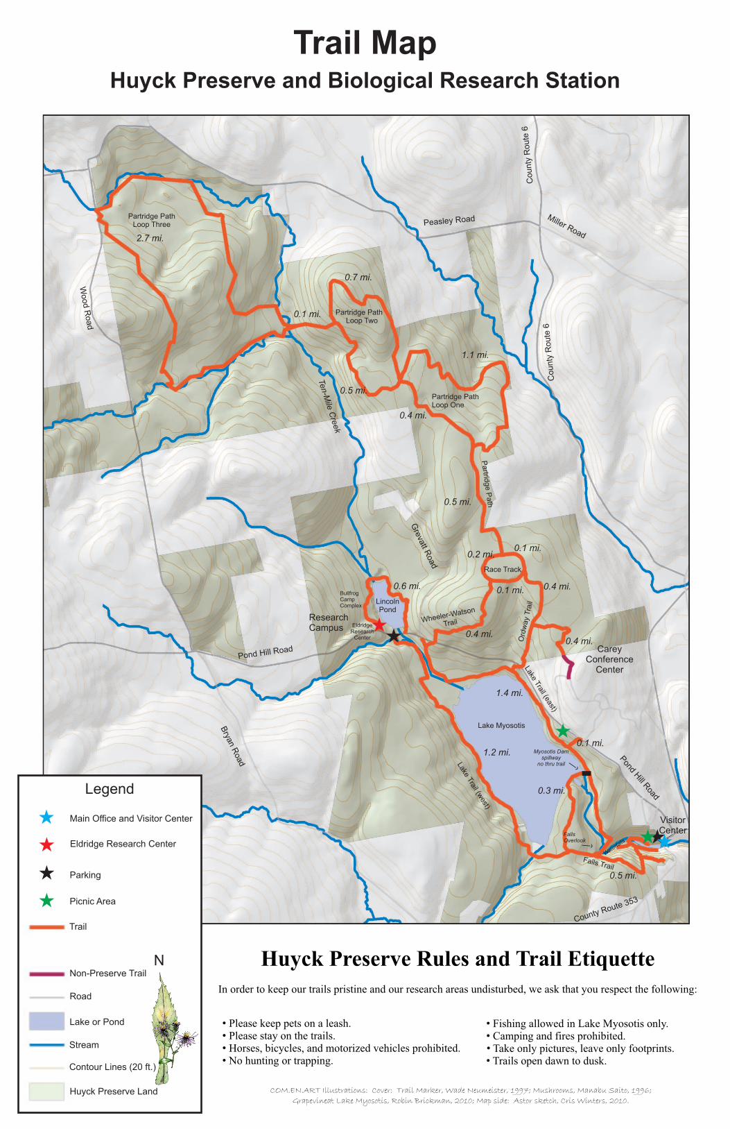
Wheeler-Watson, Race Track and Ordway TrailsWheeler-Watson and Ordway trails mostly act as connector trails between Lake Myosotis Trail and the Race Track which leads to Partridge Path. The Wheeler-Watson trail begins off of Pond Hill Rd. near the Eldridge Research Station parking area, approximately 0.1 miles up the road on the left. From the road, the trail climbs uphill for 0.4 miles meandering through second-growth hardwood forest and thickets in which the Preserve's rich human history can be observed in old apple trees, stone walls, and in the historic Wheeler-Watson cemetery, where many of the early settlers of Rensselaerville find their resting place. The trail ends at the Race Track, where Sunday horse races were once held making it a great place for cross-country skiing and a nice breather after Wheeler-Watson. Taking a left from Wheeler-Watson trail on to Race Track, the trail loops around one of the oldest Pine Plantations on the Preserve and serves as the entrance to Partridge Path Trail system. Alternatively, you can pick up Ordway Trail which appears on your right. Ordway Trail fades from mixed pine forest into a shrubby, grassy field before heading downhill towards Pond Hill Rd. Be sure to keep an eye open for the ruffed grouse and deer in this part of the Preserve. Watch your step has you pass over a slightly rocky and occasionally damp trail before arriving at the road. A right will take you back to the parking area at the Eldridge Research Center or you can cross the road and head downhill to Lake Trail East. Total Distance: ~1.5 milesDifficulty: Uphill climbs on Wheeler-Watson and Ordway Trails and slightly uneven terrain make these trails Moderate to Difficult. Race Track's flat and wide surface make it ideal of cross country skiing and an Easy trail to walk.
Rensselaerville Falls TrailThis trail begins near the Visitor Center at the edge of the historic village of Rensselaerville. Walk straight back from the steps of the Visitors Center, across the parking lot, to find the trail head marked by a kiosk. The trail is wheelchair accessible and ADA compliant as it follows along 10 Mile Creek to the lower falls bridge at the base of the breathtaking Rensselaerville Falls. Look out for the ruins of the Huyck Felt Mill near the bottom of the falls just over the lower bridge. The trail then veers away from the falls to make a somewhat steep climb to the head of the Falls , snaking through mixed deciduous forest and past one of the Preserve's many Pine plantations. Taking a left midway up the climb will lead you the Hilltown Café and Post Office. Continuing up the hill, the trail flattens out as you veer to the right crossing over the remains of a stone wall that once marked a property boundary. A short walk finds you at the top of the falls which you can see if you peak through the trees, following the stairs that appear just to your right will put you at the top of the Falls. A jaunt across the upper falls bridge brings you to the Falls Overlook. The trail can then be followed to the shores of Lake Myosotis by retracing your steps back across the bridge and making a right at the top of the steps or continuing straight from the overlook where the trail continues to the Lake Myosotis trail loop on your left. Total Distance: 1 mile to and from Falls Overlook.Difficulty: There is a significant, but short, climb at the beginning of the trail making this trail Moderate to Difficult
Lake Myosotis TrailThis trail passes through northern hardwood forests and wetlands rich with wildlife and wildflowers as it circumvents Lake Myosotis. The trail can be picked up off of the Falls Trail, Lake Myosotis Beach (open during the summer), or at the trail head located off Pond Hill Rd. across from the Eldridge Research Center. If starting at the trail head, park in the lot next to the kiosk across from the Research Center for ease of access. From this location you can either start at the kiosk to Lake Trail West, or hike up the road ~0.1 miles to the Lake Trail East trailhead on your right. From Lake Trail west continue across the small bridge
taking a moment to tap out a tune on the PVC scale. The trail follows a gentle rise as it heads towards the lake before taking slight right turn to meander through a low lying wetland and heading uphill. The trail crosses another small stream before turning downhill towards the lake. This cooler and shadier side of the lake lends itself towards a few wet spots here and there during early spring and late fall so be sure to wear sturdy shoes. Lake Trail West continues along slightly uneven terrain thanks to hemlock and other tree roots poking up along the trail before heading down hill and to the right to a stream crossing. A gentle rise will bring you back into mixed deciduous forest and a fork to your left with lead you to the top of the spillway for Lake Myosotis Dam. There is no thru access to the other side of the trail from the spillway but this is a nice place to grab a picnic lunch as you look over Lake Myosotis. Backtracking, puts you on the Lake Trail which continues on to the top of the Rensselaerville Falls. Take a left and head down the stairs to cross the Upper Falls Bridge. Take a moment to enjoy the falls from the Overlook before continuing on. The trail takes another turn, this time to the left as you re-enter the forest and head up hill into one of the many Pine Plantations dotting the Preserve's landscape. The Lake Trail East is considerably flatter making for a nice stroll to Lake Myosotis Beach. Follow the trail signs past the beach and the boat racks and a small pine stand on your left. The trail opens up a bit before diving into a shrubby habitat filled with numerous warblers during spring and summer. You will pass Ordway Trail on your left , marking the midway point between the trail end and the beach. Lake Trail East continues into one of the prettiest and most diverse habitats of the Preserve before forking to the left (heading right connects you with Wheeler Watson Trail) and making a gentle climb towards Pond Hill Rd. Hang a left at the road to return to the Eldridge Research Center parking area. Total Distance: ~3 miles Difficulty: Lake Trail East can be considered Moderate to Easy while Lake Trail West, due to roots, wet spots, and a few uphill portions is more Moderate.
Partridge Path (Connector trail and Loops One, Two, and Three)Our newest addition to the Preserve's trail system, the Partridge Path can be accessed from either the Wheeler-Watson trail, Ordway Trail, or from Peasley Rd. Its three loops traverse the northern 1,200 acres of the Preserve. Additionally, Loop Three connects with the famed Long Path in Partridge Run Wildlife Management Area. The trail runs through a variety of different habitats, including large tracts of mature sugar maple forest (look out for evidence of the former sugar industry in the area) and small wetlands of cattails and wild calla lilies.Total Distance: ~ 6 milesDifficulty: Moderate to Difficult due to several short climbs and uneven terrain.
Trail Map
Huyck Preserve and Biological Research Station
PO Box 189Rensselaerville, NY 12147Main Office Tel/Fax: 518-797-3440
Eldridge Research Center Tel: 518-797-5172
www.huyckpreserve.org
Welcome to the Huyck Preserve Trail System!The Huyck Preserve contains a network of over twelve miles of trails which go through a wide variety of habitats, including old growth hemlock forest, freshwater wetland, shrub swamps, second-growth hardwood forest, and pine plantations.
When hiking our trails we encourage hikers to bring water and snacks, wear appropriate clothing and footwear, and plan their excursions keeping in mind hiking ability and time. Trails at the Huyck Preserve are open to the public dawn to dusk.
In case of emergency please call:Adam Caprio, Buildings and Ground Supervisor, 518-813-6472Dawn O'Neal, Executive Director,518-813-5583General DEC Emergency Number:
Lincoln Pond TrailThis trail begins near the Eldridge Research Station at the south end of Lincoln Pond across the bridge over Lincoln Pond Dam. The trail starts out passing through mixed deciduous forest before the trail narrows following closely the edge of the Pond. Continuing on, the trail opens up again hopping over a gentle stream as it passes through a 200 year old hemlock forest. The trail crosses two bridges connected by a span of boardwalk over a wetlands in which abundant beaver activity is evident before turning back into the forest to head gently uphill before depositing hikers at the back of Bullfrog Camp at the Biological Research Station. Continue down the grassy hill pass Horse Cabin to Bullfrog Camp Lane which will lead you back to the Eldridge Research Center and Pond Hill Rd. Look out for red squirrels, fishers, eastern newts and giant ostrich ferns as you traverse this trail. A wide variety of birdlife including warblers, waterfowl and bald eagles are frequently seen in and around the pond.Total Distance: 0.6 milesDifficulty: Even with slightly uneven terrain this is the easiest trail in the Huyck Preserve trail system and one that visitor's of all ages have enjoyed.
Join the Huyck Preserve
For nearly 80 years the Huyck Preserve and Biological Research Station has excelled at our mission of connecting people to nature through research, education, conservation, and recreation. As a member, your dues support not only our mission, but maintenance of the trails and facilities as well as our education and public programming. Members are also entitled to receive our newsletter, and discounts on Preserve programs, merchandise, and books sold at events and in the visitor center. In addition, your membership gives you the privilege of voting at our Annual Meeting.
Join us at as generous membership level as you can. Your annual dues will help to ensure that this beautiful place will be here for a long time.
Visit us online and become a member today!www.huyckpreserve.org
The Edmund Niles Huyck Preserve, Inc is a registred 501(c)3 organization and all gifts including dues are deductible to the extent provided by the law.
Huyck Preserve trail system upgrades funded in part by NYS Office of Parks, Recreation, and Historic Preservation.
Race Track
Partridge PathLoop One
Partridge PathLoop Three
Partridge Path Loop Two
Lincoln Pond
Lake Myosotis
Wheeler-Watson
Trail
Peasley Road
Grevatt R
oad
Carey Conference
Center
Ord
way
Tra
il
Miller Road
County
Route
6
Wood R
oad
Bryan R
oad
Pond Hill Road
County Route 353
1.1 mi.
0.4 mi.
0.6 mi.
0.4 mi.
0.4 mi.
1.4 mi.
2.7 mi.
0.1 mi.
0.7 mi.
0.5 mi.
0.4 mi.
0.5 mi.
0.1 mi.0.2 mi.
0.1 mi.
1.2 mi.
0.3 mi.
0.1 mi.
Trail MapHuyck Preserve and Biological Research Station
«
«
«
0.5 mi.
«
• Please keep pets on a leash. • Please stay on the trails. • Horses, bicycles, and motorized vehicles prohibited. • No hunting or trapping.
• Fishing allowed in Lake Myosotis only. • Camping and fires prohibited. • Take only pictures, leave only footprints. • Trails open dawn to dusk.
Huyck Preserve Rules and Trail EtiquetteIn order to keep our trails pristine and our research areas undisturbed, we ask that you respect the following:
«
««
Legend
Stream
Road
Lake or Pond
Parking
Picnic Area
Main Office and Visitor Center
Trail
Non-Preserve Trail
Contour Lines (20 ft.)
Huyck Preserve Land
N
Pond H
ill Road
Research Campus
Bullfrog Camp Complex
Partrid
ge P
ath
Falls Trail
Lake Trail (west)
Lake Trail (east)
Visitor Center
Waterfa
lls
Myosotis Dam spillway
no thru trail ‹—
Falls Overlook ‹—
Ten-M
ile C
reek
‹—
«Eldridge Research
Center
«Eldridge Research Center
COM.EN.ART Illustrations: Cover: Trail Marker, Wade Neumeister, 1997; Mushrooms, Manabu Saito, 1996; Grapevineat Lake Myosotis, Robin Brickman, 2010; Map side: Astor sketch, Cris Winters, 2010.
County
Route
6
«