Embed Size (px)
Citation preview

2016 Ambient Air Monitoring
Network Plan
Planning, Monitoring and Outreach Division
May 2016 Public Review Draft

2
Table of Contents
Introduction ........................................................................................................................................................ 4
General Information on Air Monitoring Networks ........................................................................................ 5
Air Monitoring Stations in San Luis Obispo County ....................................................................................... 7
Changes to Monitoring Network since the Previous ANP ......................................................................... 9
Opened, Closed, and Relocated Stations ................................................................................................ 9
Ozone Monitoring Network Changes ...................................................................................................... 9
Particulate Monitoring Network Changes ............................................................................................... 9
Nitrogen Dioxide Monitoring Network Changes .................................................................................. 10
Sulfur Dioxide Monitoring Network Changes ....................................................................................... 10
Other Changes .......................................................................................................................................... 10
Detailed Descriptions of the Current Network ......................................................................................... 11
Ozone Monitoring Network ..................................................................................................................... 11
Nitrogen Dioxide Monitoring Network .................................................................................................. 12
Sulfur Dioxide Monitoring Network ....................................................................................................... 13
Particulate Monitoring Network ............................................................................................................. 14
Other Networks ........................................................................................................................................ 16
Proposed Network Changes and Improvements ..................................................................................... 17
New Stations and Station Closures and Relocations ........................................................................... 17
Ozone Monitoring Network ..................................................................................................................... 17
Nitrogen Dioxide Network ....................................................................................................................... 17
Sulfur Dioxide Monitoring Network ....................................................................................................... 17
Particulate Monitoring Network ............................................................................................................. 17
Other Changes and Improvements: ....................................................................................................... 17
Accessing Air Quality Data .............................................................................................................................. 18
Appendix A: Minimum Monitoring Requirements ....................................................................................... 19
Minimum Monitoring Requirements for Ozone (O3) ............................................................................... 19
Minimum Monitoring Requirements for PM2.5 SLAMs............................................................................. 20
Minimum Monitoring Requirements for Continuous PM2.5 Monitors ................................................... 20
Minimum Monitoring Requirements for PM10 ......................................................................................... 21
Minimum Monitoring Requirements for Nitrogen Dioxide (NO2) .......................................................... 21

3
Minimum Monitoring Requirements for Sulfur Dioxide (SO2) ............................................................... 22
Minimum Monitoring Requirements for Carbon Monoxide (CO) .......................................................... 22
Minimum Monitoring Requirements for Lead (Pb) at NCore ................................................................. 23
Source-Oriented Lead Monitoring (Including Airports) ........................................................................... 23
Appendix B: Collocation Requirements......................................................................................................... 24
Appendix C: Detailed Site Information .......................................................................................................... 25
Appendix D: SLOCAPCD Request to Shut Down the Morro Bay NO2 Monitor......................................... 46
Appendix E: EPA Approval of Shut Down Morro Bay NO2 Monitor ........................................................... 49

4
Introduction
Every year, the San Luis Obispo County Air Pollution Control District (SLOCAPCD) submits an
ambient air monitoring network plan (ANP) to the United States Environmental Protection Agency
(EPA); this document comprises the ANP for 2016. It is intended to fulfill the requirements of 40 CFR
58.10 and to provide information about local monitoring activities to the public. Consistent with
these goals and requirements, this ANP will be made available for public review for at least 30 days
prior to its submission to the EPA. All comments received, and any SLOCAPCD responses to those
comments, will be submitted to EPA along with the ANP.
The ANP is a snapshot of the air monitoring network as it currently exists; it documents any changes
since the last ANP (published May 2015) and any anticipated changes to the network over the next
18 months. This review and planning process helps ensure continued consistency with federal
requirements and monitoring objectives. It also confirms and updates information in state and
federal monitoring records. Information is provided for all ambient air pollution monitoring which
occurred in the county, including sites operated by the California Air Resources Board (ARB). Data
for ARB sites were obtained from that agency and are accurate to the best of our knowledge.
As detailed in subsequent sections, a few significant changes were made to the SLOCAPCD
monitoring network since the last ANP:
• The nitrogen dioxide monitor at the Morro Bay station was shut down on March 31, 2016.
This monitor was originally established in 2001 for surveillance of the power plant in Morro
Bay, however, the plant permanently closed in 2014. Discontinuing this monitor was
identified as a potential cost-saving measure in our 2015 Ambient Air Monitoring Network
Assessment.1 SLOCAPCD received pre-approval of the shutdown from the EPA in
March 2016, as documented in Appendices D and E.
• In July 2015, a PM10 monitor was established downwind of undisturbed, natural sand dunes
in the Oso Flaco area of the Oceano Dunes State Vehicular Recreation Area (ODSVRA), a
California State Park. SLOCAPCD Rule 1001 required the California Department of Parks and
Recreation (CDPR) to establish this monitor and CDPR has contracted SLOCAPCD to operate
it.
• As anticipated in our 2015 ANP, the operator of the Price Canyon Oilfield established a
hydrogen sulfide monitor at its facility, which is located between the cities of Pismo Beach
and San Luis Obispo. The monitor came online in February of 2016, and is operated by a
contractor. SLOCAPCD has real-time access to the data generated by this station.
1 San Luis Obispo County Air Pollution Control District, “2015 Ambient Air Monitoring Network
Assessment,” July 2015. http://www.slocleanair.org/images/cms/upload/files/2015-network-plan-
FINAL%281%29.pdf

5
General Information on Air Monitoring Networks
Most ambient air quality monitoring stations operated by air quality agencies are classified as State
and Local Air Monitoring Station (SLAMS). SLAMS are long-term monitoring stations and are
generally considered to be permanent sites. Their primary objective is to collect data for comparison
to the National Ambient Air Quality Standards (NAAQS). Stations may instead be classified as Special
Purpose Monitors (SPM) or Prevention of Significant Deterioration (PSD) stations; these are generally
short-term sites with objectives other than NAAQS comparison.
Appendix D of 40 CFR 58 specifies design criteria for SLAMS networks and states that networks must
be designed to meet a minimum of three basic monitoring objectives: 1. Provide air pollution data to
the public in a timely manner; 2. Support compliance with the NAAQS; and 3. Support air pollution
research. A variety of site types are needed to support these basic objectives, including the six
general types identified in the Appendix:
• Highest Concentration: Sites located to determine the highest concentration expected to
occur in the area covered by the network;
• Population Exposure: Those located to determine representative concentrations in areas of
high population density;
• Source Oriented: Sites located to determine the impact on ambient pollution levels of
significant sources or source categories;
• General/Background: Those located to determine general background concentration levels;
• Regional Transport: Sites located to determine the extent of regional pollutant transport
among populated areas, and in support of secondary standards; and
• Welfare Related Impacts: Sites located to determine the welfare-related impacts in more
rural and remote areas (such as visibility impairment and effects on vegetation).
The physical siting of an air monitoring station must conform to the requirements of the Appendix,
and its location must achieve a spatial scale of representativeness that is consistent with the
monitoring objective and site type. The spatial scale results from the physical location of the site
with respect to the pollutant sources and categories. It estimates the size of the area surrounding
the monitoring site that experiences uniform pollutant concentrations. The categories of spatial
scale defined in the Appendix are:
• Microscale: An area of uniform pollutant concentrations ranging from several meters up to
100 meters;
• Middle Scale: uniform pollutant concentrations in an area of about 110 meters to 0.5
kilometer;
• Neighborhood Scale: an area with dimensions in the 0.5 to 4 kilometer range;
• Urban Scale: Citywide pollutant conditions with dimensions from 4 to 50 kilometers;
• Regional Scale: An entire rural area of the same general geography (this area ranges from
tens to hundreds of kilometers); and
• National and Global Scales.

6
The relationship between site type and spatial scale is summarized in Table 1, below, which is
adapted from Table D-1 of the Appendix.
Table 1: Relationship between Site Type and Spatial Scale
Site Type Appropriate Spatial Scale
Highest Concentration Micro, middle, neighborhood, (sometimes urban
or regional for secondary pollutants)
Population Exposure Neighborhood, urban
Source Oriented Micro, middle, neighborhood
General/Background Neighborhood, urban, regional
Regional Transport Urban, regional
Welfare Related Impacts Urban, regional

7
Air Monitoring Stations in San Luis Obispo County
San Luis Obispo County comprises the San Luis Obispo-Paso Robles Metropolitan Statistical Area
(MSA). Air monitoring responsibilities for the MSA are divided between SLOCAPCD and ARB, as
allowed by Section 2(e) of Appendix D to 40 CFR 58. SLOCAPCD acknowledges this joint responsibility
and is a member of the ARB Primary Quality Assurance Organization (PQAO). The roles and
responsibilities of the two agencies with regard to fulfilling state and federal monitoring
requirements are formalized in a “Roles and Responsibilities” document, which can be viewed on the
ARB website.2
There are currently ten permanent ambient air monitoring stations (SLAMS) in the county/MSA; their
locations are shown in Figure 1. Eight of these stations are operated by the SLOCAPCD, as part of
our network. ARB operates the stations in Paso Robles and in San Luis Obispo, as part of their
network. Table 2 lists these stations, along with the pollutant and meteorological parameters
monitored at each location, as well as the site type.
In addition to these ten SLAMS, the District operates an eleventh station: CDPR’s special purpose
monitoring station located within the ODSVRA. The District also has a data feed from the monitor in
the Price Canyon Oilfield, but does not play any role in data collection or validation. Table 3
summarizes the pollutant and meteorological parameters monitored at these non-SLAMS stations.
Table 2: Summary of Parameters Monitored at SLAMS in San Luis Obispo County
Site Ozoneb Nitrogen
Dioxide
Sulfur
Dioxide PM10 PM2.5 Wind
c Temp
Atascadero P, C P, C P P X X
Carrizo Plains T, B X X
CDF S, C S, C X
Grover Beach X
Mesa2 S, C S S X X
Morro Bay B B d
X
Nipomo Regional Park (NRP) B B B X X
Paso Robles a
P P X X
San Luis Obispo a
P P P X X
Red Hills T, C X X
Site Types: B = General/Background, C = Highest Concentration, P = Population Exposure, T = Regional
Transport, X = Parameter measured at this site, S = Source.
Notes: a Paso Robles and San Luis Obispo are operated by ARB; all other sites are operated by SLOCAPCD.
b Atascadero is the highest concentration site for the western county attainment area, while Red Hills is the
highest concentration site for the eastern county nonattainment area. c Wind speed, wind direction, and sigma
theta. d Discontinued March 31
st, 2016.
2 Air Resources Board, “Quality Management Documents, Document Repository, Finalized Roles and
Responsibilities,” http://arb.ca.gov/aaqm/qa/pqao/repository/rr_docs.htm.

8
Table 3: Summary of Parameters Monitored at Non-SLAMS in San Luis Obispo County
Site Hydrogen
Sulfide PM10
Relative
Humidity Wind
a Temp
Oso Flaco X X X X
Price Canyon Oilfield X X X X
Note: a Wind speed, wind direction, and sigma theta.
Figure 1: Locations of air monitoring stations in San Luis Obispo County from May 2015 to May 2016. The
thin red line depicts the boundary of the ozone nonattainment area.

9
Changes to Monitoring Network since the Previous ANP
Changes to the monitoring network since the publication of the last ANP in May of 2015 are
summarized below.
Opened, Closed, and Relocated Stations
No existing air monitoring stations in San Luis Obispo County have closed or relocated since the
previous ANP. Two new stations have begun operation; however, neither is classified as a SLAMS.
Oso Flaco
Frequent exceedences of the California Ambient Air Quality Standard for 24-hour PM10 (50 µg/m3)
and occasional exceedence of the PM10 NAAQS (150 µg/m3) are observed downwind of the ODSVRA
on the Nipomo Mesa. To address these exceedences, the SLOCAPCD Board of Directors approved
Coastal Dunes Dust Control Rule 1001 in 2011. The rule requires, inter alia, the ODSVRA operator
(i.e., CDPR) to monitor PM10 levels in at least two locations within or downwind of the ODSVRA: one
downwind of an area where off-road vehicle activity is allowed (“riding area monitor”), and another
downwind of a comparable area where off-road vehicle activity is not allowed (“control site
monitor”).3
SLOCAPCD and the operator have agreed to use our CDF monitoring station as the riding area
monitor. This site will continue to be operated by SLOCAPCD as a SLAMS. In July 2015, the operator
established the control site monitor in the Oso Flaco area of the ODSVRA. This site hosts a Met One
BAM 1020 PM10 monitor and a 10-meter tower with meteorological equipment. It is operated by
SLOCAPCD under a contract with CPDR. The District validates and reports data from this site to the
EPA’s Air Quality System (AQS). The monitors at this site are designated as special purpose monitors
rather than as SLAMS.
Price Canyon Oilfield
The Price Canyon Oilfield is located between Pismo Beach and the Edna Valley wine region, just
south of the City of San Luis Obispo. (See Figure 1.) This area has long been plagued by odors
emanating from the field. Therefore, as a condition of a permit for expanded oilfield operations,
SLOCAPCD required on-site monitoring of hydrogen sulfide (H2S). Monitoring began in February
2016. SLOCAPCD has access to raw data in real-time, but plays no role in its collection or validation.
Data is not submitted to AQS, but is available from the District upon request.
Ozone Monitoring Network Changes
The monitor at Carrizo Plains was upgraded from a Teledyne-API 400A to a T400 in April 2016.
Particulate Monitoring Network Changes
Other than the establishment of the non-SLAMS PM10 monitor at Oso Flaco, there have been no
changes to the particulate monitoring network.
3 San Luis Obispo County Air Pollution Control District, “Coastal Dunes Rule 1001,”
http://slocleanair.org/air/pmstudydata.php.

10
Nitrogen Dioxide Monitoring Network Changes
The Morro Bay NO2 monitor, a Teledyne-API T200U, was discontinued on March 31, 2016. This
monitor was originally established in 2001 to monitor emissions from the power plant in Morro Bay;
however, this facility was closed in 2014. In addition, the NO2 levels observed here were generally
low, never exceeding state or federal standards. For these reasons, our 2015 Ambient Air Monitoring
Network Assessment identified this monitor as a candidate for shutdown. See Appendices D and E
for SLOCAPCD’s shutdown request and EPA’s approval.
Sulfur Dioxide Monitoring Network Changes
No changes were made to the sulfur dioxide monitoring network.
Other Changes
• In March 2016, the Teledyne-API 700E gas calibrator at Atascadero was replaced with a T700
calibrator.
• Telemetry at all stations was upgraded from dial-up modem to TCP/IP over cellular modem.

11
Detailed Descriptions of the Current Network
Ozone Monitoring Network
All SLAMS in the county monitor for ozone except for CDF, Mesa2, and Grover Beach (see Table 2).
The SLAMS network in San Luis Obispo County thus features ozone monitors located in Atascadero,
Red Hills, Carrizo Plains, Paso Robles, Morro Bay, San Luis Obispo, and Nipomo Regional Park.
Atascadero – SLOCAPCD has operated an ozone monitor in Atascadero since 1988. As detailed in
last year’s ANP, the station was moved in 2015 from the central business district of downtown
Atascadero, to a nearby city property. The original location was bounded on two sides by public
schools, and the new site is adjacent to a community center. The monitor is classified as population-
oriented and neighborhood scale. It provides a measurement of representative ozone concentration
for the City of Atascadero. Ozone concentrations at this site exhibit strong diurnal fluctuations
caused by the titration of ozone with oxides of nitrogen from nearby mobile and residential sources.
Concentrations at this site are similar to those recorded at Paso Robles, and are often the highest
among the five ozone monitors in the western portion of the county that are classified as attaining
the federal ozone standard. The highest ozone concentrations at Atascadero occur when high
pressure over the interior southwest U.S. causes transport of ozone and other pollutants into the
county from the east. Under these infrequent conditions, transported ozone, enhanced by local
pollutants, can cause highly elevated concentrations. The prevailing winds from the west and
northwest help keep ozone levels at Atascadero low most of the time.
Carrizo Plains – Operated by SLOCAPCD since January 2006, this station monitors background
levels and ozone transport from the interior areas of the state on a regional scale. The monitor is
located in an outbuilding at the Carrisa Plains Elementary School. The ozone concentrations
recorded here are second only to Red Hills in concentration and persistence; it is located within the
Eastern San Luis Obispo County nonattainment area.
Morro Bay – Operated since 1975 by SLOCAPCD, this site provides regional scale and
general/background ozone monitoring. Located in downtown Morro Bay, the monitor generally
measures background levels of ozone from the predominant northwest winds blowing off of the
Pacific Ocean. Under unusual meteorological conditions, the site can record elevated ozone
concentrations transported from urban areas as far south as the Los Angeles basin.
Nipomo Regional Park (NRP) – Operated by SLOCAPCD since 1998, this station provides
monitoring of background levels of ozone on a regional scale. Previously (1979 to 1996) ozone had
been monitored in Nipomo on Wilson Street, several miles away. The ozone concentrations
measured at NRP are representative of interior portions of the Nipomo Mesa and are the highest
recorded in the coastal region of San Luis Obispo County.
Paso Robles – Operated by ARB since 1974, this population-oriented, neighborhood scale ozone
monitor provides a representative ozone concentration for the suburban areas of the City of Paso

12
Robles. The conditions under which elevated ozone levels occur and the location’s prevailing winds
are similar to Atascadero.
Red Hills – Operated by SLOCAPCD since 2000, this station is located on the summit of Red Hills at
an elevation of about 2,000 feet. It is in a very sparsely populated area near the community of
Shandon. This regional scale site is often influenced by ozone transport from distant source areas
outside of the county, and it consistently records the highest and most persistent ozone
concentrations in the network; its site type is thus regional and maximum concentration. In early
2012, the eastern portion of the county was designated as marginally nonattainment for the federal
8-hr ozone standard based on the design value from this site.
San Luis Obispo – ARB has operated a population-oriented, neighborhood scale ozone monitor in
the City of San Luis Obispo since 1970. The monitor has been at its current site since 2005. It
provides a representative ozone concentration for the City of San Luis Obispo. The monitor is
located in the urban area where ozone concentrations are significantly depleted by titration with
local mobile and stationary NOx sources. As a result, the concentrations recorded here are often
lower than at Morro Bay.
As noted in Table 2, the SLAMS site types employed by the existing ozone network are:
1. Highest Concentration – The Red Hills station typically records the highest ozone
concentrations in the county. The high ozone levels tend to occur in the interior areas of the
county during summer, either following long periods of wind stagnation, or as a result of
offshore winds which can transport pollutants from interior regions of the state from distant
sources to the northeast. Among the sites in the western portion of the county, which are
classified as attaining the ozone standard, Atascadero and Paso Robles measure the highest
concentration.
2. Population Exposure – The Paso Robles, Atascadero, and San Luis Obispo monitors provide
a good representation of the ozone levels in the larger cities of the county.
3. Source Impact – Because ozone is a secondary pollutant, the effect of emissions from any
single source are experienced five to seven hours later and often many miles distant. As a
regional pollutant, monitoring for specific sources of ozone is not performed.
4. General/Background – The monitors at Morro Bay, Carrizo Plains, and Nipomo Regional
Park provide regional background ozone levels.
5. Regional Transport – The stations located at Carrizo Plains and Red Hills provide excellent
surveillance of regional transport of ozone in the interior part of the county. Coastal
monitoring stations have provided evidence in the past of regional transport of ozone over
the Pacific Ocean from distant urban sources.
Nitrogen Dioxide Monitoring Network
The SLAMS network in San Luis Obispo County features nitrogen dioxide (NO2) monitors at
Atascadero and Nipomo Regional Park. NO2 was also measured at Morro Bay until March 31, 2016.

13
NO2 levels have always been well below the state and federal standards at all locations in our
county. For this reason, NO2 monitoring is most useful as an indicator of depletion of ambient ozone
through titration with nitric oxide. Having at least one NO2 monitor in each geographical region of
the county also serves a long-term air quality surveillance role.
Atascadero – Operated by SLOCAPCD since 1990 and relocated in 2015, this population-oriented
monitor is considered neighborhood scale. This is the only NO2 monitor in the Salinas River air
basin, and it records the highest NO, NO2 and NOx levels in the county. The monitor’s downtown
location has established a strong diurnal inverse relationship between ozone and NO2 levels caused
by local mobile sources and residential and commercial combustion of natural gas.
Morro Bay – Operated by SLOCAPCD from June 2001 through March 2016, this monitor was
neighborhood scale and was established to monitor emissions from the Morro Bay Power Plant,
located less than a mile upwind. The plant permanently closed in February 2014.
Nipomo Regional Park – Operated by the SLOCAPCD since 1998, this monitor is regional in scale
and is representative of background concentrations on the Nipomo Mesa. The site’s location in a
large natural area away from local or mobile sources makes it ideal for regional surveillance of NO2.
The SLAMS sites in the existing NO2 network are:
1. Highest Concentration – The Atascadero monitor historically has measured the highest
NO2 concentrations in the county. NO2 levels are the result of titration of ambient ozone by
local sources of nitric oxide and as a result values are always relatively low. Levels have
never exceeded the 1-hour NO2 standard (100 ppb), with annual maximum 1-hour
concentrations typically around 50% of the standard.
2. General/Background – With no significant local sources present, the monitors at Nipomo
Regional Park, and previously at Morro Bay, provide excellent information on coastal
background levels of NO2.
Regional Transport and Welfare-Related impacts of NO2 are not currently addressed by the District’s
SLAMS network and are not thought to be significant. With the closure of the Morro Bay Power Plant
in 2014, the only potentially significant point source of NO2 in the county, no monitors in the
network are considered to be source-oriented. The San Luis Obispo-Paso Robles MSA, does not
have, nor per Appendix D, Section 4.3 of 40 CFR 58 is it required to have, any NO2 sites for vulnerable
populations, near-road NO2 monitoring sites, or area-wide NO2 sites.
Sulfur Dioxide Monitoring Network
The sulfur dioxide (SO2) monitoring network in San Luis Obispo County currently consists of one
station: Mesa2.
Mesa2 – Established in 1989 and operated by the SLOCAPCD since 2006, this monitor performs
surveillance of a nearby oil refinery. It is considered middle scale and highest concentration for SO2.
Since it is located close to and downwind of a major source of SO2 emissions, it is representative

14
only of the immediate area. The station was sited to optimize surveillance of the refinery’s nearby
coke calciner, which has since been shut down. Nonetheless, the refinery remains the largest point
source of SO2 in the county, and during upsets, this monitor can record concentrations approaching
and sometimes exceeding the NAAQS. In addition to meeting NAAQS compliance objectives, this site
is also vital for public information and emergency response.
The SLAMS SO2 monitoring objectives met by the network are:
1. Highest Concentration – The monitor at Mesa2 currently records the highest SO2 levels in
the county.
2. Source Impact – The monitor at Mesa2 is invaluable in determining the SO2 source impact
upon the immediate region.
Monitoring objectives not addressed by the existing SO2 network are: General/Background,
Population, Regional Transport, and Welfare-Related. Historical SO2 monitoring performed
elsewhere in the county (at NRP from 1998-2006; Morro Bay, 1979-1995; Grover Beach, 1982-2004;
and at decommissioned stations in Arroyo Grande “Ralcoa” (06-079-1005), 1991-2002, and “Mesa1”
(06-079-3002), 1987-94) has provided good evidence that monitoring for these objectives is not
needed. Furthermore, background levels of SO2 in the county are believed to be negligible, since
more than 98% of hourly SO2 levels from Mesa2 were 1 ppb or less in 2014.
There are no sources within SLOCAPCD’s jurisdiction with annual SO2 emissions greater than 2000
tons; therefore, no monitoring is required to fulfill the “Data Requirements Rule” (40 CFR 51.1203).
Particulate Monitoring Network
The particulate monitoring SLAMS network in San Luis Obispo County consists of six Federal
Equivalent Method (FEM) PM10 monitors (Paso Robles, Atascadero, San Luis Obispo, Mesa2, CDF and
Nipomo Regional Park) and four FEM PM2.5 monitors (Atascadero, CDF, Mesa2 and San Luis Obispo).
The PM10 network has been in place since 1988, and PM2.5 samplers began operation in 1999 in
response to the establishment of a new federal standard for PM2.5 in 1997. Originally, all particulate
monitoring in the county was performed as part of ARB’s network, but eventually all monitors except
those at Paso Robles and San Luis Obispo became part of the SLOCAPCD network. Note that for
quality assurance, the District remains part of the ARB PQAO. SLOCAPCD, therefore, relies on ARB to
perform federally required audits of its particulate monitors and to meet federal collocation
requirements.
Initially, all particulate sampling was conducted by filter-based Federal Reference Method (FRM)
monitors. With the advent of continuous monitoring technologies, all the FRM monitors in the
county have been replaced with FEM monitors in recent years. Currently, these are Met One
Instruments BAM 1020 continuous, semi-real time monitors that report hourly PM concentrations.
The hourly data have greatly improved our abilities to issue timely air quality forecasts, which is a
significant benefit for the advancement of public health goals.

15
In addition to these SLAMS monitors, the District operates the Oso Flaco PM10 SPM, located within
the ODSVRA.
Atascadero – Operated by SLOCAPCD, PM10 monitoring has been conducted here since 1988,
initially via a FRM and currently with a continuous FEM monitor. Collocated FRM PM2.5 monitors
began operation in 1999 and have since been replaced by a single FEM. All monitors are
neighborhood in scale and representative of particulate concentrations in the City of Atascadero. As
previously noted, the station was moved about 400m north of its original location in February 2015.
CDF – Originally established for the SLOCAPCD’s Nipomo Mesa Phase 2 Particulate Study, this site
has become a permanent part of the SLAMS particulate network. The site features continuous FEM
samplers for PM10 and PM2.5, which are neighborhood in scale and measure source impacts from
the ODSVRA. These monitors record the highest particulate levels in the county and are strongly
influenced by the ODSVRA, located directly upwind. In 2012, extensive temporary monitoring on the
Nipomo Mesa confirmed that this site is located within the 1 square mile sector of the study area
that experiences the highest PM10 levels.4
Mesa2 – PM10 sampling began at this site in 1991, and the monitors have been operated by the
SLOCAPCD since 2006. This site initially featured collocated FRM PM10 samplers that were replaced
by a single continuous FEM PM10 monitor in 2009. A continuous PM2.5 FEM monitor was installed at
the same time. This site monitors source impacts from the nearby oil refinery and coastal dunes and
the monitors are considered to be neighborhood in scale. These monitors record some of the
highest particulate levels in the county and are strongly influenced by the extensive coastal sand
dunes and the ODSVRA located upwind.
Nipomo Regional Park – Operated at this location by SLOCAPCD since 1998, it replaced a site at
Wilson Street in Nipomo that operated from 1990-96. The 1-in-6 day FRM PM10 sampler was
replaced with a continuous FEM sampler in 2010. The monitor is regional in scale and is
representative of PM10 concentrations on the Nipomo Mesa.
Oso Flaco – Operated by SLOCAPCD on behalf of CDPR, this non-SLAMS PM10 monitor was
established in July 2015 to fulfill a requirement of SLOCAPCD Rule 1001. It is located within the Oso
Flaco area of the ODSVRA; off-road vehicular activity is not permitted upwind of the monitor. It is
considered neighborhood in scale, and representative of the non-riding areas of the dunes complex.
Paso Robles – Operated by ARB since 1991 this PM10 monitor is urban in scale and representative of
the City of Paso Robles. The FRM sampler at this site was replaced with an FEM PM10 sampler in
August 2009.
San Luis Obispo – Operated by ARB, a PM10 sampler has been in place since 1988, and a PM2.5
sampler since 1999. ARB replaced the FRM samplers with continuous FEM instruments in 2011.
4 San Luis Obispo County Air Pollution Control District, “South County Community Monitoring
Project,” January 2013. Available online: http://slocleanair.org/communitymonitoringproject

16
These population-oriented monitors are neighborhood in scale and represent particulate
concentrations in the City of San Luis Obispo. Due to a site safety issue, these monitors have been
offline since September 2015, but ARB has assured the District that this is only a temporary
shutdown.
Other Networks
San Luis Obispo County, which comprises the San Luis Obispo-Paso Robles MSA, is not required to
have, nor does it have any, NCORE, PAMS, lead, carbon monoxide or near-road monitoring stations.

17
Proposed Network Changes and Improvements
The following sections list any modifications that are planned for the 18-month period after the
publication of this ANP. Note that with a population well below 500,000, the San Luis Obispo-Paso
Robles MSA/CBSA5 is not required to have any near-road NO2, CO, or PM2.5 monitors, and therefore,
SLOCAPCD has no plans to establish any such monitors. Additionally, there are no sources in our
jurisdiction with SO2 emissions greater than 2,000 tons per year, therefore no new SO2 monitoring is
needed nor planned to comply with the SO2 Data Requirements Rule.
New Stations and Station Closures and Relocations
Currently, there are no plans to establish any new SLAMS or SPMs or to close or relocate any
existing stations within the next 18 months.
Ozone Monitoring Network
No changes to the nitrogen dioxide monitoring network are anticipated.
Nitrogen Dioxide Network
No changes to the nitrogen dioxide monitoring network are anticipated.
Sulfur Dioxide Monitoring Network
No changes to the sulfur dioxide monitoring network are anticipated.
Particulate Monitoring Network
No changes to the particulate monitoring network are anticipated.
Statement Regarding Review of Changes to the PM2.5 Network
In the event that SLOCAPCD needs to change the location of a PM2.5 monitor that records violations
of the NAAQS, the agency will notify EPA Region 9 and ARB contact points immediately, and work
closely with ARB to formulate a plan for moving the site. The public will be notified of the plan and
provided with an opportunity to comment for at least 30 days. Finally, the agency will submit formal
notification to EPA. The SLOCAPCD intends to discuss and receive approval of any changes to our
PM2.5 network, whether they affect monitors violating NAAQS or not, with ARB and EPA prior to
making them, however, unforeseen circumstances (e.g. unexpected loss of site access) may preclude
this.
Other Changes and Improvements:
None.
5 San Luis Obispo County, the San Luis Obispo-Paso Robles MSA, and the San Luis Obispo-Paso
Robles Core Based Statistical Area (CBSA) have identical borders and populations.

18
Accessing Air Quality Data
All of the SLAMS and SPM monitoring stations currently operating in the county are registered with
the EPA and ARB and regularly report data to the EPA’s AQS database, ARB’s AQMIS2 website, and
the airnow.gov website. Validated data from SLAMS and SPM sites operated by SLOCAPCD are
typically submitted to AQS by end of the quarter following the quarter in which they were collected.
Usually data is submitted well before this deadline. Raw data is uploaded automatically to AQMIS
and airnow.gov within an hour after being generated in the field. In addition, raw data for the
current day and previous day is available on the SLOCAPCD website. All data generated at these
stations are public information and are available in various formats. Table 3, below, lists some
popular sources for these data.
SLOCAPCD, and when applicable ARB, regularly submit precision and accuracy data to AQS for all
gaseous and particulate pollutants measured in the SLAMS network. Additionally, in accordance with
40 CFR 58.15, SLOCAPCD certifies its AQS dataset for the previous year every spring. SLOCAPCD
submitted a certification package for calendar year 2015 data to EPA on April 25, 2016.
Table 3: Sources for Air Quality Data from San Luis Obispo
Agency Address for Data Requests Website for
Data Access
Data Available Online
SLOCAPCD 3433 Roberto Court,
San Luis Obispo, CA 93401
Table:
www.slocleanair.org/
air/lasthour.php
Map:
http://www.slocleanai
r.org/air/AirForcastin
g_map3.php
Raw data from last 24 to 48
hours for sites in San Luis
Obispo County.
ARB P.O. Box 2815
Sacramento, CA 95812
AQMIS2:
www.arb.ca.gov/aqmi
s2/aqdselect.php
ADAM:
www.arb.ca.gov/ada
m/
Most California sites, including
all sites in San Luis Obispo
County. Real-time raw data
and archived validated data.
EPA Ariel Rios Building
1200 Pennsylvania Ave NW
Washington, DC 20460
AQS:
www.epa.gov/ttn/airs
/airsaqs/detaildata
Validated data from across the
U.S. Typically one to several
months behind current date.
AirNow.gov U.S. EPA – OAQPS – ITG
Mail Code E143-03
Research Triangle Park, NC
27711
www.airnow.gov Current air quality conditions,
nationwide. Based on real
time, raw data.

19
Appendix A: Minimum Monitoring Requirements
The SLOCAPCD monitoring network meets the minimum monitoring requirements for all criteria pollutants as established in 40 CFR 58.
The tables below list the criteria used to determine compliance with Federal regulations. The county population cited in these tables
(269,637) is from the 2010 census; the California Department of Finance estimates the population to be 274,293 as of January 1, 2015.6
Using this figure in lieu of the official census number does not change the required number of sites for any pollutant.
Minimum Monitoring Requirements for Ozone (O3)
MSA County
Population
(Census
Year)
8-hour Design Value
(years)a
Design Value Site
Name (AQS ID)
Number of
Required
Sitesb
Number
of Active
Sites
Number of
Additional
Sites Needed
San Luis
Obispo-Paso
Robles
San Luis
Obispo
269,637
(2010) 73 ppb (2013-15) Red Hills (06-079-8005) 1 7 0
a This Design Value is for eastern San Luis Obispo County, which in early 2012 was designated as marginally nonattainment for the 2008
8-hour ozone standard. The design value for the rest of the county is either 61 ppb (2013-15) from Paso Robles (06-079-0005) or 62 ppb
(2013-15) if data from the two Atascadero locations (06-079-8001 & 06-079-8002) are combined. b Refer to section 4.1 and Table D-2 of Appendix D to 40 CFR Part 58 for requirements.
Monitors required for SIP or Maintenance Plan: None
6 California Department of Finance, “E-1, Population Estimates for Cities, Counties, and the State—January 1, 2014 and 2015.” May 2015.
http://www.dof.ca.gov/research/demographic/reports/estimates/e-1/view.php

20
Minimum Monitoring Requirements for PM2.5 SLAMs
MSA County
Population
(Census
Year)
Annual
Design
Value
(years)
Annual
Design Value
Site
(AQS ID)
Daily
Design
Value
(years)
Daily Design
Value Site
Name
(AQS ID)
Number of
Required
SLAMS
Sitesa
Number
of Active
SLAMS
Sites
Number of
Additional
SLAMS
Sites
Needed
San Luis
Obispo-Paso
Robles
San Luis
Obispo
269,637
(2010)
12.1 µg/m3
(2013-15)
CDF
(06-079-2007)
28 µg/m3
(2013-15)
CDF
(06-079-2007) 1 4 0
a Refer to section 4.7.1 and Table D-5 of Appendix D to 40 CFR Part 58 for requirements.
Monitors required for SIP or Maintenance Plan: None
Minimum Monitoring Requirements for Continuous PM2.5 Monitors
MSA County
Population
(Census
Year)
Annual
Design
Value
(years)
Annual
Design Value
Site
(AQS ID)
Daily
Design
Value
(years)
Daily Design
Value Site
Name
(AQS ID)
Number of
Required
Continuous
Monitorsa
Number of
Active
Continuous
Monitors
Number of
Additional
Continuous
Monitors
Needed
San Luis
Obispo -
Paso Robles
San Luis
Obispo
269,637
(2010)
12.1 µg/m3
(2013-15)
CDF
(06-079-2007)
28 µg/m3
(2013-15)
CDF
(06-079-2007) 1 4 0
a Refer to section 4.7.2 and Table D-5 of Appendix D to 40 CFR Part 58 for requirements.
Monitors required for SIP or Maintenance Plan: None

21
Minimum Monitoring Requirements for PM10
MSA County
Population
(Census
Year)
Maximum
Concentration
(Year)
Maximum
Concentration Site
Name (AQS ID)
Number of
Required
Sitesa
Number
of Active
Sites
Number of
Additional
Sites Needed
San Luis
Obispo-Paso
Robles
San
Luis
Obispo
269,637
(2010) 149 µg/m
3 (2015) CDF (06-079-2007) 0-1 6
b 0
a Refer to section 4.6 and Table D-4 of Appendix D to 40 CFR Part 58 for requirements. b In addition to these 6 SLAMS, there is also a PM10 SPM.
Monitors required for SIP or Maintenance Plan: None
Minimum Monitoring Requirements for Nitrogen Dioxide (NO2)
CBSA
Population
(Census
Year)
Maximum
AADT Count
(Years)
Number of
Required
Near-road
Monitorsa
Number of
Active
Near-road
Monitors
Number of
Additional
Near-road
Monitors
Needed
Number of
Required
Area-wide
Monitorsa
Number
of Active
Area-wide
Monitors
Number of
Additional
Area-wide
Monitors
Needed
San Luis
Obispo-Paso
Robles
269,637
(2010)
76,000
(2013) 0 0 0 0 2 0
a Refer to section 4.3 of Appendix D to 40 CFR Part 58 for requirements.
Monitors required for SIP or Maintenance Plan: None
Monitors required for PAMS: None
EPA Regional Administrator-required monitors per 40 CFR 58, App. D 4.3.4: None

22
Minimum Monitoring Requirements for Sulfur Dioxide (SO2)
CBSA County
Population
(Census
Year)
Total SO2a
(Tons/year)
Population
Weighted
Emissions Index
(million person-
tons/year)b
Data
Requirements
Rule Source(s)
using
Monitoringc
Number
of
Required
Monitorsd
Number
of Active
Monitors
Number of
Additional
Monitors
Needed
San Luis
Obispo-Paso
Robles
San Luis
Obispo
269,637
(2010) 272 73 NA 0 1 0
a From the 2011 National Emissions Inventory. http://www.epa.gov/ttn/chief/net/2011inventory.html
b Product of CBSA population and SO2 emissions, divided by one million.
c Refer to 40 CFR 51 Subpart BB. There are no sources within the county/CBSA/SLOCAPDC jurisdiction with annual emissions over 2,000
tons, therefore, neither monitoring nor modelling is required to meet the “Data Requirements Rule.” d Refer to section 4.4 of Appendix D to 40 CFR Part 58 for requirements.
Monitors required for SIP or Maintenance Plan: None
Minimum Monitoring Requirements for Carbon Monoxide (CO)
CBSA
Population
(Census
Year)
Number of Required
Near-Road Monitorsa
Number of Active
Near-Road Monitors
Number of Additional
Monitors Needed
San Luis Obispo-
Paso Robles
269,637
(2010) 0 0 0
a Refer to section 4.2 of Appendix D to 40 CFR Part 58 for requirements.
Monitors required for SIP or Maintenance Plan: None
EPA Regional Administrator-required monitors per section 4.2.2. of Appendix D to 40 CFR 58: None

23
Minimum Monitoring Requirements for Lead (Pb) at NCore
NCore Site CBSA Population
(Census Year)
Number of
Required Monitorsa
Number of Active
Monitors
Number of Additional
Monitors Needed
none San Luis Obispo-
Paso Robles 269,637 (2010) 0 0 0
a Refer to section 4.5 of Appendix D to 40 CFR Part 58 for requirements.
Source-Oriented Lead Monitoring (Including Airports)
Source Address Pb Emissions
(Tons/yr)
Emissions
Inventory Source
Data (Year)
Max
3-Month
Design Value
Design
Value
Date
Number of
Required
Monitorsa
Number
of Active
Monitors
Number of
Additional
Monitors Needed
none n/a n/a n/a n/a n/a 0 0 0
a Refer to section 4.5 of Appendix D to 40 CFR Part 58 for requirements.
Monitors required for SIP or Maintenance Plan: None
EPA Regional Administrator-required monitors per section 4.5(c) of Appendix D to 40 CFR 58: None

24
Appendix B: Collocation Requirements
Particulate monitoring (PM10, PM2.5, and lead) is subject to the collocation requirements described in
section 3 of Appendix A to 40 CFR 58. The requirements apply at the PQAO level, and monitors are
aggregated by method when determining the number of needed collocated monitors. SLOCAPCD is
part of the ARB PQAO and all particulate monitors in our network are Met One 1020 Beta
Attenuation Monitors (BAMs), which are continuous FEM instruments (PM10 method code: 122; PM2.5
method code: 170). While there are no collocated particulate monitors within the SLOCAPCD
network, there are collocated monitors within the ARB PQAO.
Collocation requirements for PM2.5 are met at the PQAO level and thus, by extension, for the
SLOCAPCD. According to ARB’s most recent Annual Monitoring Report for Small Districts in
California,7 in 2014 there were 33 active PM2.5 FEM BAM 1020 monitors (method 170) in the PQAO;
thus five collocated monitors were needed: three FRM/FEM pairs and two FEM/FEM pairs. The report
indicates that the ARB PQAO met these minimum collocation requirements. This is corroborated by
an AQS Certification and Concurrence Report (AMP600) for 2015 (executed in April 2016), which
reported slightly different numbers of monitors, but nonetheless indicated that collocation
requirements were met for 2015 year. See Table B-1 below.
With regard to PM10 monitoring, all monitors in the District are continuous FEM BAMs, and thus
there are no collocation requirements. Finally, lead monitoring is not done in the county; therefore,
there is no collocation requirement.
Table B- 1: Collocation Requirements for PM2.5, Method Code 170
Data
Source
(see text)
Number of
Primary
Monitors
Number of
Required
Collocated
Monitors
Number of
Active
Collocated FRM
Monitors
Number of Active
Collocated FEM
Monitors (same method
designation as primary)
ARB 33 5 3 2
AMP600 34 5 6 total collocated monitors, type not indicated
7 Air Resources Board, “Annual Monitoring Network Report for Twenty-three Districts in California,”
June 2015. http://www.arb.ca.gov/aqd/amnr/amnr2015v1.pdf.

25
Appendix C: Detailed Site Information
Local site name Paso Robles
AQS ID 06-079-0005
GPS coordinates (decimal degrees) 35.61467, -120.65691
Street Address 235 Santa Fe Ave, Paso Robles
County San Luis Obispo
Distance to roadways (meters) 27 to Santa Fe Ave.
110 to Sherwood Rd.
180 to Creston Rd.
2700 to US 101
Traffic count (AADT, year) Santa Fe Ave.: 75 (estimated) a
Sherwood Rd.: 10,000 (2008) a
Creston Rd: 5,500 (2008) a
US101: 62,700 (2014)
Groundcover (e.g. asphalt, dirt, sand) Asphalt
Representative statistical area name (i.e. MSA, CBSA,
other)
San Luis Obispo – Paso Robles
(MSA)
Pollutant, POC Ozone, 1 PM10, 2
Primary / QA Collocated / Other N/A Primary
Parameter code 44201 81102
Basic monitoring objective(s) NAAQS
Comparison
Public info, NAAQS
Comparison
Site type(s) Population
Exposure
Population
Exposure
Monitor type(s) SLAMS SLAMS
Network Affiliation N/A N/A
Instrument manufacturer and model API 400E Met One BAM 1020
Method code 087 122
FRM/FEM/ARM/other FEM FEM
Collecting Agency ARB ARB
Analytical Lab (i.e. weigh lab, toxics lab, other) N/A N/A
Reporting Agency ARB ARB
Spatial scale (e.g. micro, neighborhood) Neighborhood Neighborhood
Monitoring start date (MM/DD/YYYY) 09/01/1991 06/01/2013 b
Current sampling frequency (e.g. 1:3, continuous) continuous continuous
Calculated sampling frequency (e.g. 1:3/1:1) continuous continuous
Sampling season (MM/DD-MM/DD) 01/01-12/31 01/01-12/31
Probe height (meters) 6.2 5.2
Distance from supporting structure (meters) 2.9 1.9
Distance from obstructions on roof (meters) N/A N/A
Distance from obstructions not on roof (meters) N/A N/A
Distance from trees (meters) N/A N/A
Distance to furnace or incinerator flue (meters) N/A N/A
Distance between monitors fulfilling a QA Collocation
requirement (meters)
N/A N/A

26
Local site name Paso Robles
For low volume PM instruments, is any PM
instrument within 1m of the instrument?
N/A No
For high volume PM instruments, is any PM
instrument within 2m of the instrument?
N/A N/A
Unrestricted airflow (degrees) 360 360
Probe material for reactive gases (e.g. Pyrex, stainless
steel, Teflon)
Teflon N/A
Residence time for reactive gases (seconds) 11.2 N/A
Will there be changes within the next 18 months? No No
Is it suitable for comparison against the annual
PM2.5?
N/A N/A
Frequency of flow rate verification for manual PM
samplers
N/A N/A
Frequency of flow rate verification for automated PM
analyzers
N/A bi-weekly
Frequency of one-point QC check for gaseous
instruments
daily N/A
Date of 2015 Annual Performance Evaluation for
gaseous parameters
12/14/2015
N/A
Dates of 2015 Semi-Annual Flow Rate Audits for PM
monitors
N/A 2/25/2015
8/17/2015 a This is the most current AADT available for this segment.
b This instrument did not begin reporting
PM10-standard (88102) until 06/01/2013, but has been reporting PM10-actual (85101) since
08/11/2009.

27
Local site name Grover Beach
AQS ID 06-079-2001
GPS coordinates (decimal degrees) 35.12393, -120.63222
Street Address 9 Le Sage Drive, Grover Beach
County San Luis Obispo
Distance to roadways (meters) 10 to Le Sage Drive
120 to US 1
Traffic count (AADT, year) Le Sage: 300 (estimated)
US 1: 10,300 (2014)
Groundcover (e.g. asphalt, dirt, sand) Cement and dirt
Representative statistical area name (i.e. MSA, CBSA,
other)
San Luis Obispo – Paso Robles
(MSA)
Pollutant, POC None (this is meteorology-only station)

28
Local site name Mesa2
AQS ID 06-079-2004
GPS coordinates (decimal degrees) 35.02079, -120.56389
Street Address 1300 Guadalupe Rd., Nipomo
County San Luis Obispo
Distance to roadways (meters) 40 to Guadalupe Rd. (US 1)
Traffic count (AADT, year) Guadalupe Rd. (US 1): 5200 (2014)
Groundcover (e.g. asphalt, dirt, sand) Vegetative
Representative statistical area name (i.e. MSA,
CBSA, other)
San Luis Obispo – Paso Robles
(MSA)
Pollutant, POC SO2, 1 PM2.5, 1 PM10, 3
Primary / QA Collocated / Other N/A Primary Primary
Parameter code 42401 88101 81102
Basic monitoring objective(s) NAAQS
Comparison
NAAQS
Comparison
NAAQS
Comparison
Site type(s) Source
Oriented, Max
Concentration
Source
Oriented
Source
Oriented
Monitor type(s) SLAMS SLAMS SLAMS
Network Affiliation N/A N/A N/A
Instrument manufacturer and model API T100U Met One BAM
1020
Met One BAM
1020
Method code 100 170 122
FRM/FEM/ARM/other FEM FEM FEM
Collecting Agency SLOCAPCD SLOCAPCD SLOCAPCD
Analytical Lab (i.e. weigh lab, toxics lab, other) N/A N/A N/A
Reporting Agency SLOCAPCD SLOCAPCD SLOCAPCD
Spatial scale (e.g. micro, neighborhood) Middle Neighborhood Neighborhood
Monitoring start date (MM/DD/YYYY) 05/01/1989 07/01/2009 07/01/2009
Current sampling frequency (e.g. 1:3,
continuous)
continuous continuous continuous
Calculated sampling frequency (e.g. 1:3/1:1) continuous continuous continuous
Sampling season (MM/DD-MM/DD) 01/01-12/31 01/01-12/31 01/01-12/31
Probe height (meters) 4.8 5.4 5.5
Distance from supporting structure (meters) 1.3 1.9 2.0
Distance from obstructions on roof (meters) N/A N/A N/A
Distance from obstructions not on roof
(meters)
N/A N/A N/A
Distance from trees (meters) N/A N/A N/A
Distance to furnace or incinerator flue
(meters)
N/A N/A N/A
Distance between monitors fulfilling a QA
Collocation requirement (meters)
N/A N/A N/A
For low volume PM instruments, is any PM
instrument within 1 m of the instrument?
N/A No No
29
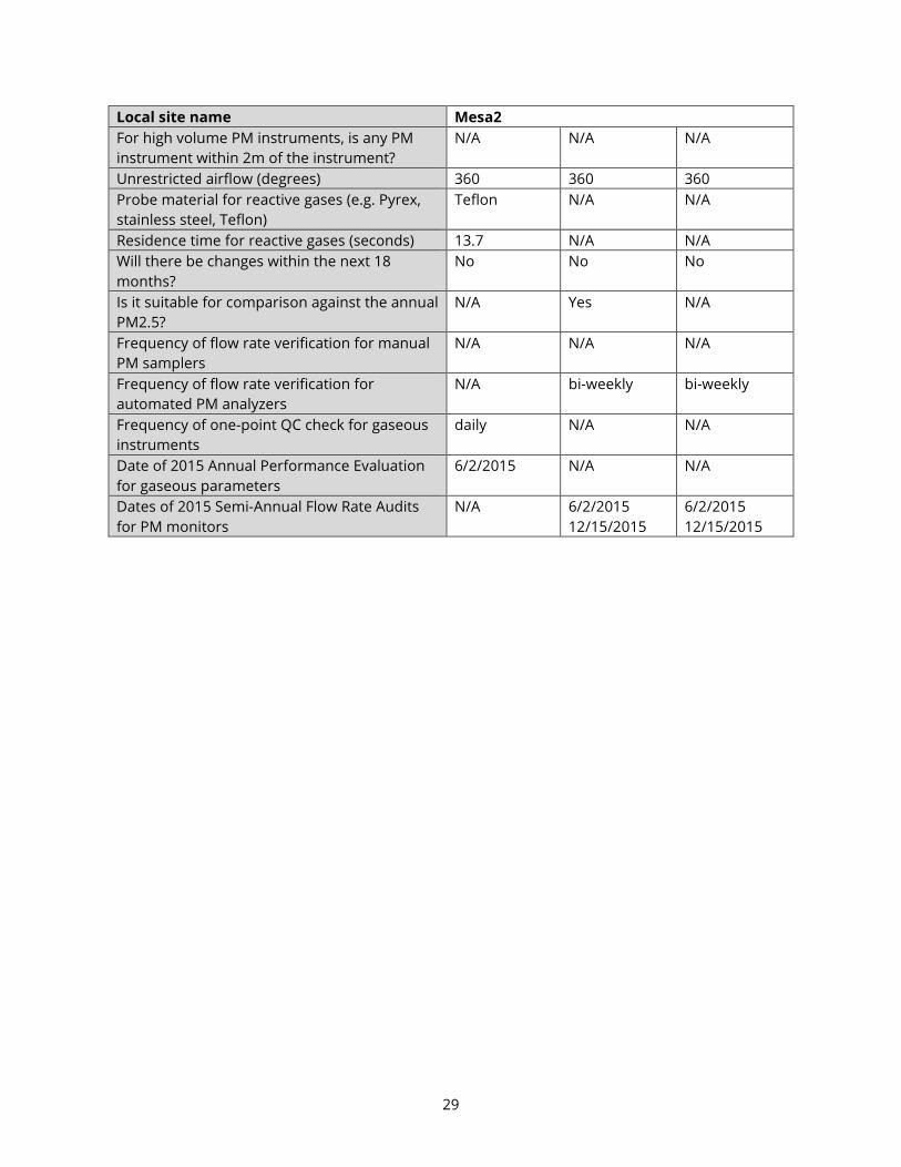
Local site name Mesa2
For high volume PM instruments, is any PM
instrument within 2m of the instrument?
N/A N/A N/A
Unrestricted airflow (degrees) 360 360 360
Probe material for reactive gases (e.g. Pyrex,
stainless steel, Teflon)
Teflon N/A N/A
Residence time for reactive gases (seconds) 13.7 N/A N/A
Will there be changes within the next 18
months?
No No No
Is it suitable for comparison against the annual
PM2.5?
N/A Yes N/A
Frequency of flow rate verification for manual
PM samplers
N/A N/A N/A
Frequency of flow rate verification for
automated PM analyzers
N/A bi-weekly bi-weekly
Frequency of one-point QC check for gaseous
instruments
daily N/A N/A
Date of 2015 Annual Performance Evaluation
for gaseous parameters
6/2/2015 N/A N/A
Dates of 2015 Semi-Annual Flow Rate Audits
for PM monitors
N/A 6/2/2015
12/15/2015
6/2/2015
12/15/2015

30
Local site name San Luis Obispo
AQS ID 06-079-2006
GPS coordinates (decimal degrees) 35.25651, -120.66945
Street Address 3220 South Higuera St., San Luis Obispo
County San Luis Obispo
Distance to roadways (meters) 50 to South Higuera St.
450 to US 101
Traffic count (AADT, year) South Higuera St.: 15,551 (2014)
US 101: 61,100 (2014)
Groundcover (e.g. asphalt, dirt, sand) Vegetative (to the west and north),
Asphalt (east and south)
Representative statistical area name (i.e. MSA,
CBSA, other)
San Luis Obispo – Paso Robles
(MSA)
Pollutant, POC O3, 1 PM2.5, 3 PM10, 2
Primary / QA Collocated / Other N/A Primary Primary
Parameter code 44201 88101 81102
Basic monitoring objective(s) NAAQS
Comparison
NAAQS
Comparison
NAAQS
Comparison,
Public Info
Site type(s) Population
Exposure
General/
Background
Population
Exposure
Monitor type(s) SLAMS SLAMS SLAMS
Network Affiliation N/A N/A N/A
Instrument manufacturer and model API T400 Met One BAM
1020
Met One BAM
1020
Method code 087 170 122
FRM/FEM/ARM/other FEM FEM FEM
Collecting Agency ARB ARB ARB
Analytical Lab (i.e. weigh lab, toxics lab, other) N/A N/A N/A
Reporting Agency ARB ARB ARB
Spatial scale (e.g. micro, neighborhood) Neighborhood Neighborhood Neighborhood
Monitoring start date (MM/DD/YYYY) 09/21/2005 03/15/2011 06/01/2013 a
Current sampling frequency (e.g. 1:3,
continuous)
continuous continuous continuous
Calculated sampling frequency (e.g. 1:3/1:1) continuous continuous continuous
Sampling season (MM/DD-MM/DD) 01/01-12/31 01/01-12/31 01/01-12/31
Probe height (meters) 12.8 12.8 12.8
Distance from supporting structure (meters) 1.8 2.0 2.0
Distance from obstructions on roof (meters) N/A N/A N/A
Distance from obstructions not on roof
(meters)
N/A N/A N/A
Distance from trees (meters) N/A N/A N/A
Distance to furnace or incinerator flue
(meters)
N/A N/A N/A
Distance between monitors fulfilling a QA
Collocation requirement (meters)
N/A N/A N/A

31
Local site name San Luis Obispo
For low volume PM instruments, is any PM
instrument within 1 m of the instrument?
N/A No No
For high volume PM instruments, is any PM
instrument within 2m of the instrument?
N/A N/A N/A
Unrestricted airflow (degrees) 360 360 360
Probe material for reactive gases (e.g. Pyrex,
stainless steel, Teflon)
Teflon N/A N/A
Residence time for reactive gases (seconds) 10.5 N/A N/A
Will there be changes within the next 18
months?
No No No
Is it suitable for comparison against the
annual PM2.5?
N/A Yes N/A
Frequency of flow rate verification for manual
PM samplers
N/A N/A N/A
Frequency of flow rate verification for
automated PM analyzers
N/A bi-weekly bi-weekly
Frequency of one-point QC check for gaseous
instruments
daily N/A N/A
Date of 2015 Annual Performance Evaluation
for gaseous parameters
6/2/2015 N/A N/A
Dates of 2015 Semi-Annual Flow Rate Audits
for PM monitors
N/A 2/25/2015
8/18/2015
2/25/2015
8/18/2015 a This instrument did not begin reporting PM10-standard (88102) until 06/01/2013, but has been
reporting PM10-actual (85101) since 03/15/2011.
32
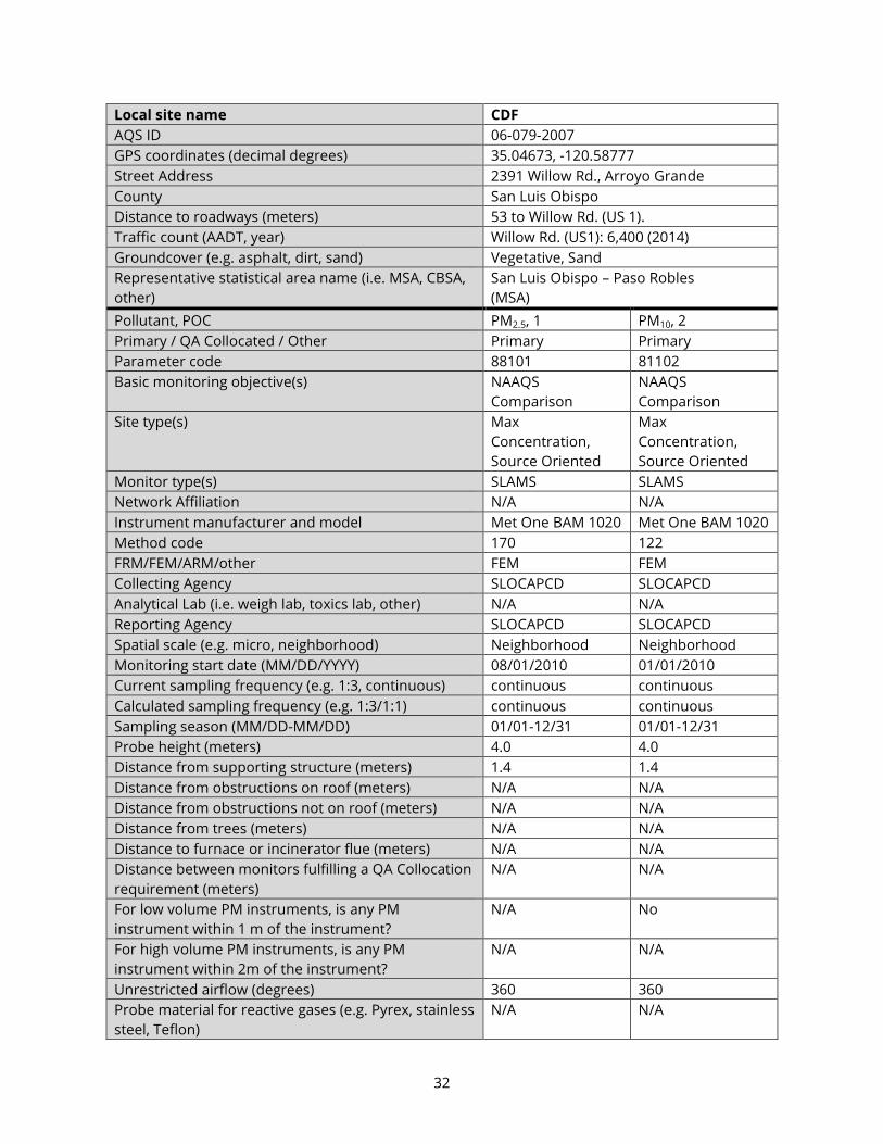
Local site name CDF
AQS ID 06-079-2007
GPS coordinates (decimal degrees) 35.04673, -120.58777
Street Address 2391 Willow Rd., Arroyo Grande
County San Luis Obispo
Distance to roadways (meters) 53 to Willow Rd. (US 1).
Traffic count (AADT, year) Willow Rd. (US1): 6,400 (2014)
Groundcover (e.g. asphalt, dirt, sand) Vegetative, Sand
Representative statistical area name (i.e. MSA, CBSA,
other)
San Luis Obispo – Paso Robles
(MSA)
Pollutant, POC PM2.5, 1 PM10, 2
Primary / QA Collocated / Other Primary Primary
Parameter code 88101 81102
Basic monitoring objective(s) NAAQS
Comparison
NAAQS
Comparison
Site type(s) Max
Concentration,
Source Oriented
Max
Concentration,
Source Oriented
Monitor type(s) SLAMS SLAMS
Network Affiliation N/A N/A
Instrument manufacturer and model Met One BAM 1020 Met One BAM 1020
Method code 170 122
FRM/FEM/ARM/other FEM FEM
Collecting Agency SLOCAPCD SLOCAPCD
Analytical Lab (i.e. weigh lab, toxics lab, other) N/A N/A
Reporting Agency SLOCAPCD SLOCAPCD
Spatial scale (e.g. micro, neighborhood) Neighborhood Neighborhood
Monitoring start date (MM/DD/YYYY) 08/01/2010 01/01/2010
Current sampling frequency (e.g. 1:3, continuous) continuous continuous
Calculated sampling frequency (e.g. 1:3/1:1) continuous continuous
Sampling season (MM/DD-MM/DD) 01/01-12/31 01/01-12/31
Probe height (meters) 4.0 4.0
Distance from supporting structure (meters) 1.4 1.4
Distance from obstructions on roof (meters) N/A N/A
Distance from obstructions not on roof (meters) N/A N/A
Distance from trees (meters) N/A N/A
Distance to furnace or incinerator flue (meters) N/A N/A
Distance between monitors fulfilling a QA Collocation
requirement (meters)
N/A N/A
For low volume PM instruments, is any PM
instrument within 1 m of the instrument?
N/A No
For high volume PM instruments, is any PM
instrument within 2m of the instrument?
N/A N/A
Unrestricted airflow (degrees) 360 360
Probe material for reactive gases (e.g. Pyrex, stainless
steel, Teflon)
N/A N/A

33
Local site name CDF
Residence time for reactive gases (seconds) N/A N/A
Will there be changes within the next 18 months? No No
Is it suitable for comparison against the annual
PM2.5?
Yes N/A
Frequency of flow rate verification for manual PM
samplers
N/A N/A
Frequency of flow rate verification for automated PM
analyzers
bi-weekly bi-weekly
Frequency of one-point QC check for gaseous
instruments
N/A N/A
Date of 2015 Annual Performance Evaluation for
gaseous parameters
N/A
N/A
Dates of 2015 Semi-Annual Flow Rate Audits for PM
monitors
6/4/2015
12/15/2015
6/4/2015
12/15/2015

34
Local site name Morro Bay
AQS ID 06-079-3001
GPS coordinates (decimal degrees) 35.36640, -120.84268
Street Address 899 Morro Bay Blvd., Morro Bay
County San Luis Obispo
Distance to roadways (meters) 37 to Morro Bay Blvd.
220 to CA 1
Traffic count (AADT, year) Morro Bay Blvd.: 12,388 (2015)
CA 1: 21,200 (2014)
Groundcover (e.g. asphalt, dirt, sand) Paved
Representative statistical area name (i.e. MSA,
CBSA, other)
San Luis Obispo – Paso Robles
(MSA)
Pollutant, POC O3, 1 NO2, 1
Primary / QA Collocated / Other N/A Primary
Parameter code 44201 42602
Basic monitoring objective(s) NAAQS Comparison NAAQS Comparison
Site type(s) General/Background General/Background
Monitor type(s) SLAMS SLAMS
Network Affiliation N/A N/A
Instrument manufacturer and model API 400A API T200U
Method code 087 599 a
FRM/FEM/ARM/other FEM FRM
Collecting Agency SLOCAPCD SLOCAPCD
Analytical Lab (i.e. weigh lab, toxics lab, other) N/A N/A
Reporting Agency SLOCAPCD SLOCAPCD
Spatial scale (e.g. micro, neighborhood) Regional Neighborhood
Monitoring start date (MM/DD/YYYY) 01/01/1981 06/01/2001
Monitoring end date (MM/DD/YYYY) N/A 03/31/2016
Current sampling frequency (e.g. 1:3, continuous) continuous continuous
Calculated sampling frequency (e.g. 1:3/1:1) continuous continuous
Sampling season (MM/DD-MM/DD) 01/01-12/31 01/01-12/31
Probe height (meters) 4.2 4.2
Distance from supporting structure (meters) 1.1 1.1
Distance from obstructions on roof (meters) N/A N/A
Distance from obstructions not on roof (meters) N/A N/A
Distance from trees (meters) N/A N/A
Distance to furnace or incinerator flue (meters) N/A N/A
Distance between monitors fulfilling a QA
Collocation requirement (meters)
N/A N/A
For low volume PM instruments, is any PM
instrument within 1 m of the instrument?
N/A N/A
For high volume PM instruments, is any PM
instrument within 2m of the instrument?
N/A N/A
Unrestricted airflow (degrees)
360 360

35
Local site name Morro Bay
Probe material for reactive gases (e.g. Pyrex,
stainless steel, Teflon)
Teflon Teflon
Residence time for reactive gases (seconds) 6.6 5.9
Will there be changes within the next 18 months? No No
Is it suitable for comparison against the annual
PM2.5?
N/A N/A
Frequency of flow rate verification for manual PM
samplers
N/A N/A
Frequency of flow rate verification for automated
PM analyzers
N/A N/A
Frequency of one-point QC check for gaseous
instruments
daily daily
Date of 2015 Annual Performance Evaluation for
gaseous parameters
03/11/2015
03/11/2015
Dates of 2015 Semi-Annual Flow Rate Audits for PM
monitors
N/A N/A
a EPA, “AQS Memo - Changes to Oxides of Nitrogen Analyzer Method Codes,” December 22, 2014.
https://www.epa.gov/aqs/aqs-memo-changes-oxides-nitrogen-analyzer-method-codes

36
Local site name Nipomo Regional Park (NRP)
AQS ID 06-079-4002
GPS coordinates (decimal degrees) 35.03150, -120.50101
Street Address W. Tefft St. and Pomeroy Rd., Nipomo
County San Luis Obispo
Distance to roadways (meters) 500 to Tefft St.
350 to Camino Caballo
240 to Pomeroy Rd.
Traffic count (AADT, year) Tefft St.: 8943 (2012) a
Camino Caballo: 2411 (2011) a
Pomeroy Rd.: 5833 (2014)
Groundcover (e.g. asphalt, dirt, sand) Vegetative
Representative statistical area name (i.e. MSA,
CBSA, other)
San Luis Obispo – Paso Robles
(MSA)
Pollutant, POC O3, 1 NO2, 1 PM10, 2
Primary / QA Collocated / Other N/A Primary Primary
Parameter code 44201 42602 81102
Basic monitoring objective(s) NAAQS
Comparison
NAAQS
Comparison
NAAQS
Comparison
Site type(s) General/
Background
General/
Background
General/
Background
Monitor type(s) SLAMS SLAMS SLAMS
Network Affiliation N/A N/A N/A
Instrument manufacturer and model API 400E API T200U Met One BAM
1020
Method code 087 599 b
122
FRM/FEM/ARM/other FEM FRM FEM
Collecting Agency SLOCAPCD SLOCAPCD SLOCAPCD
Analytical Lab (i.e. weigh lab, toxics lab, other) N/A N/A N/A
Reporting Agency SLOCAPCD SLOCAPCD SLOCAPCD
Spatial scale (e.g. micro, neighborhood) Regional Regional Regional
Monitoring start date (MM/DD/YYYY) 11/01/1998 11/01/1998 05/16/2010
Current sampling frequency (e.g. 1:3,
continuous)
continuous continuous continuous
Calculated sampling frequency (e.g. 1:3/1:1) continuous continuous continuous
Sampling season (MM/DD-MM/DD) 01/01-12/31 01/01-12/31 01/01-12/31
Probe height (meters) 4.0 4.0 4.7
Distance from supporting structure (meters) 1.0 1.0 1.7
Distance from obstructions on roof (meters) N/A N/A N/A
Distance from obstructions not on roof
(meters)
N/A N/A N/A
Distance from trees (meters) N/A N/A N/A
Distance to furnace or incinerator flue
(meters)
N/A N/A N/A
Distance between monitors fulfilling a QA
Collocation requirement (meters)
N/A N/A N/A
37
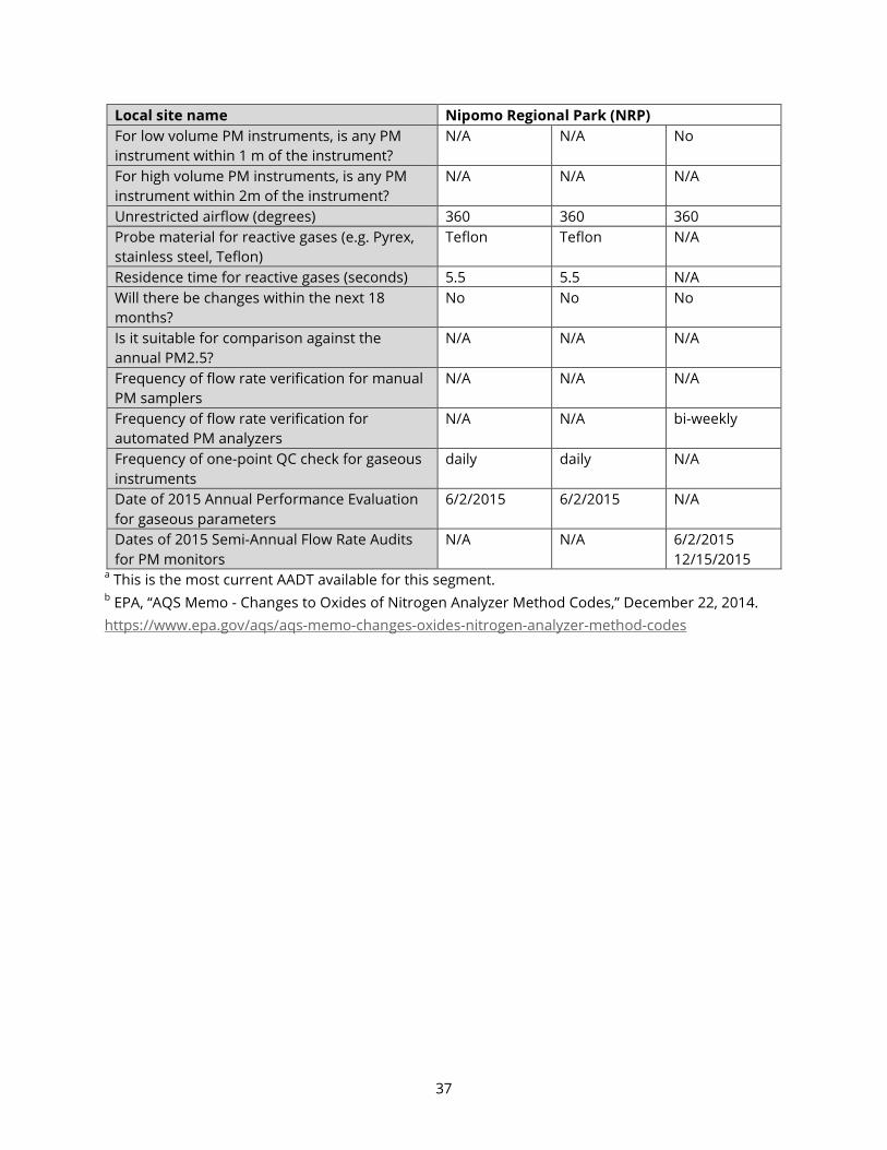
Local site name Nipomo Regional Park (NRP)
For low volume PM instruments, is any PM
instrument within 1 m of the instrument?
N/A N/A No
For high volume PM instruments, is any PM
instrument within 2m of the instrument?
N/A N/A N/A
Unrestricted airflow (degrees) 360 360 360
Probe material for reactive gases (e.g. Pyrex,
stainless steel, Teflon)
Teflon Teflon N/A
Residence time for reactive gases (seconds) 5.5 5.5 N/A
Will there be changes within the next 18
months?
No No No
Is it suitable for comparison against the
annual PM2.5?
N/A N/A N/A
Frequency of flow rate verification for manual
PM samplers
N/A N/A N/A
Frequency of flow rate verification for
automated PM analyzers
N/A N/A bi-weekly
Frequency of one-point QC check for gaseous
instruments
daily daily N/A
Date of 2015 Annual Performance Evaluation
for gaseous parameters
6/2/2015 6/2/2015 N/A
Dates of 2015 Semi-Annual Flow Rate Audits
for PM monitors
N/A N/A
6/2/2015
12/15/2015 a This is the most current AADT available for this segment. b EPA, “AQS Memo - Changes to Oxides of Nitrogen Analyzer Method Codes,” December 22, 2014.
https://www.epa.gov/aqs/aqs-memo-changes-oxides-nitrogen-analyzer-method-codes

38
Local site name Atascadero
AQS ID 06-079-8002
GPS coordinates (decimal degrees) 35.49453, -120.66617
Street Address 5599 Traffic Way, Atascadero, CA
County San Luis Obispo
Distance to roadways (meters) 163 to Traffic Way
770 to US 101
330 to CA 41
Traffic count (AADT, year) Traffic Way: < 7400 (2014)a
US 101: 60,100 (2014)
CA 41: 5600 (2014)
Groundcover (e.g. asphalt, dirt, sand) Vegetative
Representative statistical area name (i.e.
MSA, CBSA, other)
San Luis Obispo – Paso Robles
(MSA)
Pollutant, POC O3, 1 NO2, 1 PM2.5, 3 PM10, 3
Primary / QA Collocated / Other N/A Primary Primary Primary
Parameter code 44201 42602 88101 81102
Basic monitoring objective(s) NAAQS
Comparison
NAAQS
Comparison
NAAQS
Comparison
NAAQS
Comparison
Site type(s) Population
Exposure, Max
Concentration
Population
Exposure, Max
Concentration
Population
Exposure
Population
Exposure
Monitor type(s) SLAMS SLAMS SLAMS SLAMS
Network Affiliation N/A N/A N/A N/A
Instrument manufacturer and model API T400 API T200 Met One BAM
1020
Met One BAM
1020
Method code 087 099 170 122
FRM/FEM/ARM/other FEM FRM FEM FEM
Collecting Agency SLOCAPCD SLOCAPCD SLOCAPCD SLOCAPCD
Analytical Lab (i.e. weigh lab, toxics lab, other) N/A N/A N/A N/A
Reporting Agency SLOCAPCD SLOCAPCD SLOCAPCD SLOCAPCD
Spatial scale (e.g. micro, neighborhood) Neighborhood Neighborhood Neighborhood Neighborhood
Monitoring start date (MM/DD/YYYY) 02/25/2015 02/25/2015 02/25/2015 02/25/2015
Current sampling frequency (e.g. 1:3,
continuous)
continuous continuous continuous continuous
Calculated sampling frequency (e.g. 1:3/1:1) continuous continuous continuous continuous
Sampling season (MM/DD-MM/DD) 01/01-12/31 01/01-12/31 01/01-12/31 01/01-12/31
Probe height (meters) 4.7 4.7 5.8 5.3
Distance from supporting structure (meters) 1.1 1.1 2.2 1.7
Distance from obstructions on roof (meters) N/A N/A N/A N/A
Distance from obstructions not on roof
(meters)
N/A N/A N/A N/A
Distance from trees (meters) N/A N/A N/A N/A
Distance to furnace or incinerator flue
(meters)
N/A N/A N/A N/A
39
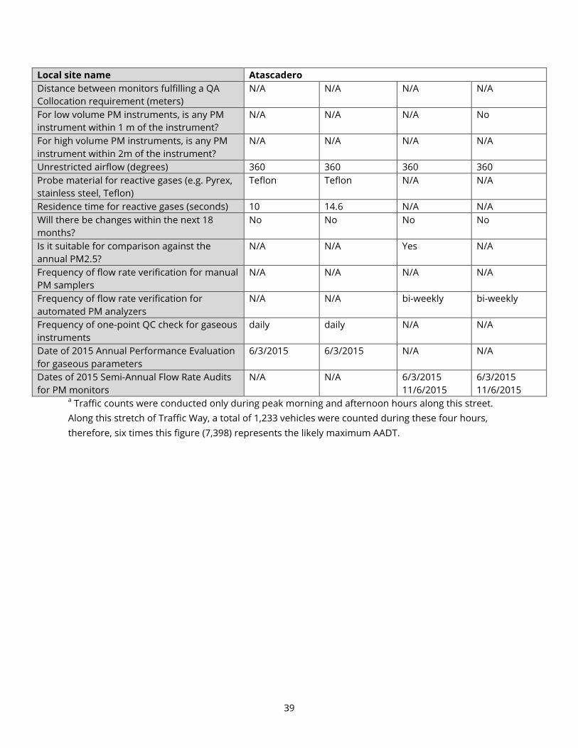
Local site name Atascadero
Distance between monitors fulfilling a QA
Collocation requirement (meters)
N/A N/A N/A N/A
For low volume PM instruments, is any PM
instrument within 1 m of the instrument?
N/A N/A N/A No
For high volume PM instruments, is any PM
instrument within 2m of the instrument?
N/A N/A N/A N/A
Unrestricted airflow (degrees) 360 360 360 360
Probe material for reactive gases (e.g. Pyrex,
stainless steel, Teflon)
Teflon Teflon N/A N/A
Residence time for reactive gases (seconds) 10 14.6 N/A N/A
Will there be changes within the next 18
months?
No No No No
Is it suitable for comparison against the
annual PM2.5?
N/A N/A Yes N/A
Frequency of flow rate verification for manual
PM samplers
N/A N/A N/A N/A
Frequency of flow rate verification for
automated PM analyzers
N/A N/A bi-weekly bi-weekly
Frequency of one-point QC check for gaseous
instruments
daily daily N/A N/A
Date of 2015 Annual Performance Evaluation
for gaseous parameters
6/3/2015 6/3/2015 N/A N/A
Dates of 2015 Semi-Annual Flow Rate Audits
for PM monitors
N/A N/A 6/3/2015
11/6/2015
6/3/2015
11/6/2015 a Traffic counts were conducted only during peak morning and afternoon hours along this street.
Along this stretch of Traffic Way, a total of 1,233 vehicles were counted during these four hours,
therefore, six times this figure (7,398) represents the likely maximum AADT.

40
Local site name Red Hills
AQS ID 06-079-8005
GPS coordinates (decimal degrees) 35.64366, -120.23134
Street Address 3601 Gillis Canyon Rd., Shandon
County San Luis Obispo
Distance to roadways (meters) 100 to Gillis Canyon Rd.
1740 to Bitterwater Rd.
10,400 to CA 41
Traffic count (AADT, year) Gillis Canyon Rd.: 26 (2013) a
Bitterwater Rd.: 51 (2011) a
CA 41: 1650 (2014)
Groundcover (e.g. asphalt, dirt, sand) Vegetative
Representative statistical area name (i.e. MSA,
CBSA, other)
San Luis Obispo – Paso Robles
(MSA)
Pollutant, POC O3, 1
Primary / QA Collocated / Other N/A
Parameter code 44201
Basic monitoring objective(s) NAAQS Comparison
Site type(s) Regional Transport, Max Concentration
Monitor type(s) SLAMS
Network Affiliation N/A
Instrument manufacturer and model API T400
Method code 087
FRM/FEM/ARM/other FEM
Collecting Agency SLOCAPCD
Analytical Lab (i.e. weigh lab, toxics lab, other) N/A
Reporting Agency SLOCAPCD
Spatial scale (e.g. micro, neighborhood) Regional
Monitoring start date (MM/DD/YYYY) 07/01/2000
Current sampling frequency (e.g. 1:3, continuous) continuous
Calculated sampling frequency (e.g. 1:3/1:1) continuous
Sampling season (MM/DD-MM/DD) 01/01-12/31
Probe height (meters) 4.8
Distance from supporting structure (meters) 1.2
Distance from obstructions on roof (meters) N/A
Distance from obstructions not on roof (meters) N/A
Distance from trees (meters) N/A
Distance to furnace or incinerator flue (meters) N/A
Distance between monitors fulfilling a QA
Collocation requirement (meters)
N/A
For low volume PM instruments, is any PM
instrument within 1 m of the instrument?
N/A
For high volume PM instruments, is any PM
instrument within 2m of the instrument?
N/A
Unrestricted airflow (degrees)
360

41
Local site name Red Hills
Probe material for reactive gases (e.g. Pyrex,
stainless steel, Teflon)
Teflon
Residence time for reactive gases (seconds) 9.6
Will there be changes within the next 18 months? No
Is it suitable for comparison against the annual
PM2.5?
N/A
Frequency of flow rate verification for manual PM
samplers
N/A
Frequency of flow rate verification for automated
PM analyzers
N/A
Frequency of one-point QC check for gaseous
instruments
daily
Date of 2015 Annual Performance Evaluation for
gaseous parameters
3/10/2015
Dates of 2015 Semi-Annual Flow Rate Audits for PM
monitors
N/A
a This is the most current AADT available for this segment.

42
Local site name Carrizo Plains
AQS ID 06-079-8006
GPS coordinates (decimal degrees) 35.35474, -120.04013
Street Address 9640 Carrizo Highway (CA 58),
California Valley
County San Luis Obispo
Distance to roadways (meters) 38 to Carrizo Highway (CA 58)
Traffic count (AADT, year) Carrizo Highway (CA 58): 880 (2014)
Groundcover (e.g. asphalt, dirt, sand) Vegetative (to the west, north, and east)
Asphalt (south)
Representative statistical area name (i.e. MSA,
CBSA, other)
San Luis Obispo – Paso Robles
(MSA)
Pollutant, POC O3, 1
Primary / QA Collocated / Other N/A
Parameter code 44201
Basic monitoring objective(s) NAAQS Comparison
Site type(s) Regional Transport, General Background
Monitor type(s) SLAMS
Network Affiliation N/A
Instrument manufacturer and model API T400
Method code 087
FRM/FEM/ARM/other FEM
Collecting Agency SLOCAPCD
Analytical Lab (i.e. weigh lab, toxics lab, other) N/A
Reporting Agency SLOCAPCD
Spatial scale (e.g. micro, neighborhood) Regional
Monitoring start date (MM/DD/YYYY) 01/01/2006
Current sampling frequency (e.g. 1:3, continuous) continuous
Calculated sampling frequency (e.g. 1:3/1:1) continuous
Sampling season (MM/DD-MM/DD) 01/01-12/31
Probe height (meters) 4.7
Distance from supporting structure (meters) 1.1
Distance from obstructions on roof (meters) N/A
Distance from obstructions not on roof (meters) N/A
Distance from trees (meters) N/A
Distance to furnace or incinerator flue (meters) N/A
Distance between monitors fulfilling a QA
Collocation requirement (meters)
N/A
For low volume PM instruments, is any PM
instrument within 1 m of the instrument?
N/A
For high volume PM instruments, is any PM
instrument within 2m of the instrument?
N/A
Unrestricted airflow (degrees) 360
Probe material for reactive gases (e.g. Pyrex,
stainless steel, Teflon)
Teflon

43
Local site name Carrizo Plains
Residence time for reactive gases (seconds) 9.9
Will there be changes within the next 18 months? No
Is it suitable for comparison against the annual
PM2.5?
N/A
Frequency of flow rate verification for manual PM
samplers
N/A
Frequency of flow rate verification for automated
PM analyzers
N/A
Frequency of one-point QC check for gaseous
instruments
daily
Date of 2015 Annual Performance Evaluation for
gaseous parameters
03/10/2015
Dates of 2015 Semi-Annual Flow Rate Audits for PM
monitors
N/A

44
Local site name Oso Flaco
AQS ID 06-079-9001
GPS coordinates (decimal degrees) 35.00876, -120.59998
Street Address Near intersection of Oso Flaco Lake &
Beigle Rds., Nipomo
County San Luis Obispo
Distance to roadways (meters) 1150 to Oso Flaco Lake Rd.
2800 to Guadalupe Rd. (US 1).
Traffic count (AADT, year) Oso Flaco Lake Rd.: 639 (2014).
Guadalupe Rd. (US 1): 4900 (2014).
Groundcover (e.g. asphalt, dirt, sand) Vegetative
Representative statistical area name (i.e. MSA,
CBSA, other)
San Luis Obispo – Paso Robles
(MSA)
Pollutant, POC PM10, 1
Primary / QA Collocated / Other N/A
Parameter code 81102
Basic monitoring objective(s) Public Information, Rule 1001 Compliance
Site type(s) Background
Monitor type(s) SPM
Network Affiliation N/A
Instrument manufacturer and model Met One BAM 1020
Method code 122
FRM/FEM/ARM/other FEM
Collecting Agency SLOCAPCD
Analytical Lab (i.e. weigh lab, toxics lab, other) N/A
Reporting Agency SLOCAPCD
Spatial scale (e.g. micro, neighborhood) Neighborhood
Monitoring start date (MM/DD/YYYY) 07/01/2015
Current sampling frequency (e.g. 1:3, continuous) continuous
Calculated sampling frequency (e.g. 1:3/1:1) continuous
Sampling season (MM/DD-MM/DD) 01/01-12/31
Probe height (meters) 3.3
Distance from supporting structure (meters) 2.0
Distance from obstructions on roof (meters) N/A
Distance from obstructions not on roof (meters) N/A
Distance from trees (meters) N/A
Distance to furnace or incinerator flue (meters) N/A
Distance between monitors fulfilling a QA
Collocation requirement (meters)
N/A
For low volume PM instruments, is any PM
instrument within 1 m of the instrument?
N/A
For high volume PM instruments, is any PM
instrument within 2m of the instrument?
N/A
Unrestricted airflow (degrees) 360
Probe material for reactive gases (e.g. Pyrex,
stainless steel, Teflon)
N/A

45
Local site name Oso Flaco
Residence time for reactive gases (seconds) N/A
Will there be changes within the next 18 months? No
Is it suitable for comparison against the annual
PM2.5?
N/A
Frequency of flow rate verification for manual PM
samplers
N/A
Frequency of flow rate verification for automated
PM analyzers
bi-weekly
Frequency of one-point QC check for gaseous
instruments
N/A
Date of 2015 Annual Performance Evaluation for
gaseous parameters
N/A
Dates of 2015 Semi-Annual Flow Rate Audits for PM
monitors
8/6/2015
12/15/2016

46
Appendix D: SLOCAPCD Request to Shut Down the Morro Bay NO2
Monitor

47

48

49
Appendix E: EPA Approval of Shut Down Morro Bay NO2 Monitor