Embed Size (px)
Citation preview
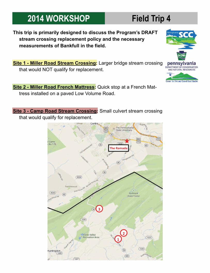
2014 WORKSHOP Field Trip 4 This trip is primarily designed to discuss the Program’s DRAFT
stream crossing replacement policy and the necessary measurements of Bankfull in the field.
Site 1 - Miller Road Stream Crossing: Larger bridge stream crossing that would NOT qualify for replacement.
Site 2 - Miller Road French Mattress: Quick stop at a French Mat-tress installed on a paved Low Volume Road.
Site 3 - Camp Road Stream Crossing: Small culvert stream crossing that would qualify for replacement.
The Ramada
1
2
3
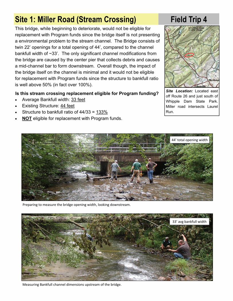
Is this stream crossing replacement eligible for Program funding? Average Bankfull width: 33 feet Existing Structure: 44 feet Structure to bankfull ratio of 44/33 = 133%
NOT eligible for replacement with Program funds.
Site Location: Located east off Route 26 and just south of Whipple Dam State Park. Miller road intersects Laurel Run.
Site 1: Miller Road (Stream Crossing) This bridge, while beginning to deteriorate, would not be eligible for replacement with Program funds since the bridge itself is not presenting a environmental problem to the stream channel. The Bridge consists of twin 22’ openings for a total opening of 44’, compared to the channel bankfull width of ~33’. The only significant channel modifications from the bridge are caused by the center pier that collects debris and causes a mid-channel bar to form downstream. Overall though, the impact of the bridge itself on the channel is minimal and it would not be eligible for replacement with Program funds since the structure to bankfull ratio is well above 50% (in fact over 100%).
Preparing to measure the bridge opening width, looking downstream.
Measuring Bankfull channel dimensions upstream of the bridge.
44’ total opening width
33’ avg bankfull width
Field Trip 4

Site Location: Located east off Route 26 and just south of Whipple Dam State Park.
Site 2: Miller Road (LVR French Mattress)
BEFORE: Pavement breakup occurs every year on Miller Road.
DURING: Fabric and cover being placed over ma ress.
DURING: Placement of AASHTO #1 in French Ma ress.
AFTER: Completed ma ress a er resurfacing.
ma ress outlets ma ress inlet
ma ress inlet
Miller Road was done in July of 2014 as a demonstration project by the Center. It may look dry in October, but the road traverses several lowland areas and small flowing wetlands. The road has been a constant source of headache for the township who re-applies tar and chip every year to address breakups as pictured below. The road also acts as a dam to natural overland flow with a flowing wetland on the uphill side of the road, and a single pipe outlet on the downhill side of the road in several locations.
Several large French Mattresses were installed on a few low-lying locations in Miller Road. The Mattresses will help the road and reduce future maintenance by providing a stable base while elevating the road to prevent it from saturating and breaking up every spring. The Mattresses will also better accommodate the large volumes of water that come to the road from various sources, and let much of it flow through the road without concentrating all drainage to a single pipe outlet.
Field Trip 4

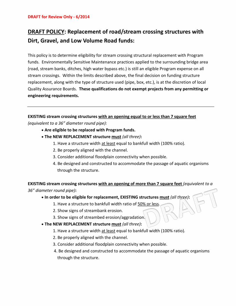
DRAFT for Review Only - 6/2014
DRAFT POLICY: Replacement of road/stream crossing structures with Dirt, Gravel, and Low Volume Road funds: This policy is to determine eligibility for stream crossing structural replacement with Program funds. Environmentally Sensitive Maintenance practices applied to the surrounding bridge area (road, stream banks, ditches, high water bypass etc.) is still an eligible Program expense on all stream crossings. Within the limits described above, the final decision on funding structure replacement, along with the type of structure used (pipe, box, etc.), is at the discretion of local Quality Assurance Boards. These qualifications do not exempt projects from any permitting or engineering requirements.
EXISTING stream crossing structures with an opening equal to or less than 7 square feet (equivalent to a 36” diameter round pipe):
• Are eligible to be replaced with Program funds. • The NEW REPLACEMENT structure must (all three):
1. Have a structure width at least equal to bankfull width (100% ratio). 2. Be properly aligned with the channel. 3. Consider additional floodplain connectivity when possible. 4. Be designed and constructed to accommodate the passage of aquatic organisms
through the structure.
EXISTING stream crossing structures with an opening of more than 7 square feet (equivalent to a 36” diameter round pipe):
• In order to be eligible for replacement, EXISTING structures must (all three): 1. Have a structure to bankfull width ratio of 50% or less. 2. Show signs of streambank erosion. 3. Show signs of streambed erosion/aggradation.
• The NEW REPLACEMENT structure must (all three): 1. Have a structure width at least equal to bankfull width (100% ratio). 2. Be properly aligned with the channel. 3. Consider additional floodplain connectivity when possible.
4. Be designed and constructed to accommodate the passage of aquatic organisms through the structure.

Existing Structure (circle):
PA Dirt Gravel and Low Volume Road Program—Stream Crossing Evaluation Form
Existing Conditions: quantitative assessment Measuring Bankfull Channel Width: Begin first measurement, outside the area of influence of the structure (preferably upstream and at least 5 bankfull widths away from structure) and in a relatively stable area free from influences that may impact cross section (such as debris jams, floodplain obstructions such as fill/roads/etc.). Additional bankfull widths should be measured so that a total of three (with 5 preferred) are collected upstream of the crossing. The second bankfull width measurement should be collected ½ bankfull width upstream of the first measurement. Continue spacing the width measurements ½ bankfull width upstream of the previous measurement until the total number (3 or 5) is collected. Take preceding measurements and average together.
Bankfull width measurements: 1)________ft 2)________ft 3)________ft 4)________ft 5)________ft
A. Avg. Reference bankfull width ________ft If it is impossible to obtain reference bankfull widths upstream of the structure, downstream widths can be used if they are taken out of the structure influence area.
B. Existing structure width ________ft Width of structure at narrowest point. Add structure widths for multiple baseflow openings (not including any elevated floodplain pipes).
C. Structure / Bankfull ratio ________% Structure width divided by average bankfull width. (Line B divided by line A)
D. Max downstream pool width ________ft Width of widest spot on plunge pool (if applicable).
E. Max downstream pool depth ________ft Depth of water in plunge pool at typical flow (if applicable).
F. Vertical Drop at outlet ________in Drop or “waterfall” from structure outlet to water level in plunge pool at typical flow.
Existing Conditions: qualitative assessment
G. Stream Bank Erosion upstream none slight moderate high severe Erosion of banks immediately upstream
and downstream of structure downstream none slight moderate high severe
H. Stream Bed Erosion upstream none slight moderate high severe
Evidence of head-cutting at inlet or plunge pool scour at outlet
downstream none slight moderate high severe
J. Stream Bed Deposition upstream none slight moderate high severe
Evidence of gavel bar formation downstream none slight moderate high severe
K. Bank Armoring unknown none intact failing
round bottomless oval arch
box culvert
footers & bridge
multiple openings
Other :
(describe/draw)
Site Information
County _______________ Township _______________
Road Owning Entity _____________________________________________
Structure Owning Entity _____________________________________________
Road Name _____________________________________________
Stream Name _____________________________________________
Latitude _______________N Longitude _______________W
Site notes: _____________________________________________
______________________________________________________________________
Reviewer Information:
Date: __________________
Reviewer: ______________
Entity: _________________
“UNT” for unnamed tributary to
Eligibility for Crossing Structural Replacement with Program Funds
Is the existing structure opening is equal to or less than 7 square feet (equivalent to a 36” diameter round pipe): NO-see below YES-Eligible For larger structures, the all three criteria below must be met in order to be eligible for replacement with Program funds: Existing structure to bankfull width ratio of 50% or less. What is the existing structure to bankfull ration (line C above): _________% Show signs of streambank erosion. Is stream bank erosion present (line G above): YES NO Show signs of streambed erosion/aggradation. Is streambed erosion/aggradation present (line H&J above): YES NO
Is this stream crossing eligible for replacement with Program funds? YES NO
req
uir
ed
op
tio
nal
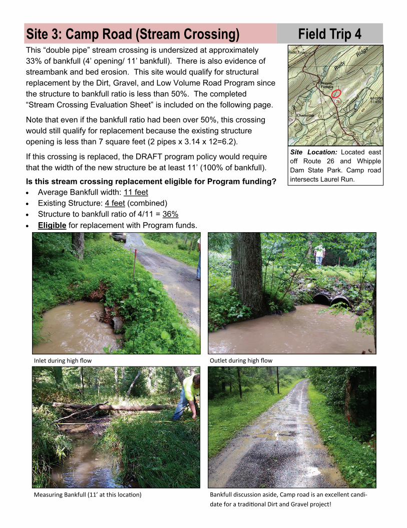
This “double pipe” stream crossing is undersized at approximately 33% of bankfull (4’ opening/ 11’ bankfull). There is also evidence of streambank and bed erosion. This site would qualify for structural replacement by the Dirt, Gravel, and Low Volume Road Program since the structure to bankfull ratio is less than 50%. The completed “Stream Crossing Evaluation Sheet” is included on the following page.
Note that even if the bankfull ratio had been over 50%, this crossing would still qualify for replacement because the existing structure opening is less than 7 square feet (2 pipes x 3.14 x 12=6.2).
If this crossing is replaced, the DRAFT program policy would require that the width of the new structure be at least 11’ (100% of bankfull).
Site 3: Camp Road (Stream Crossing)
Inlet during high flow Outlet during high flow
Measuring Bankfull (11’ at this loca on) Bankfull discussion aside, Camp road is an excellent candi‐
date for a tradi onal Dirt and Gravel project!
Is this stream crossing replacement eligible for Program funding? Average Bankfull width: 11 feet Existing Structure: 4 feet (combined) Structure to bankfull ratio of 4/11 = 36%
Eligible for replacement with Program funds.
Site Location: Located east off Route 26 and Whipple Dam State Park. Camp road intersects Laurel Run.
Field Trip 4


![Field trip[1]](https://img.pdfslide.us/doc/110x75/53fc63ca8d7f72aa518b4749/field-trip1.jpg)
