Embed Size (px)
DESCRIPTION
Do you like to canoe? kayak? Raft, tube, paddle anything that floats in Missouri. You need to read this. The premier Guide to most of the waterways south of the Missouri River.
Citation preview
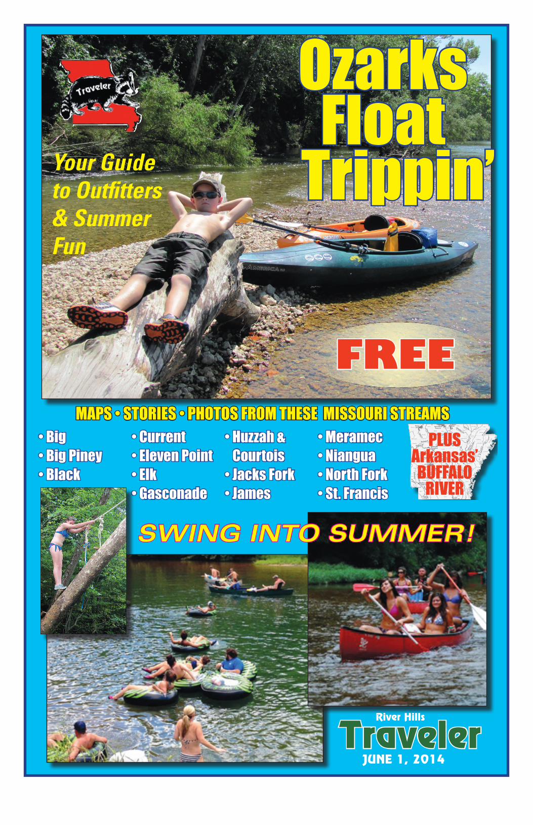
MAPS • STORIES • PHOTOS FROM THESE MISSOURI STREAMS
TravelerJUNE 1, 2014
River Hills
OzarksFloat
Trippin’
• Big • Big Piney • Black
• Current• Eleven Point• Elk• Gasconade
• Huzzah & Courtois• Jacks Fork• James
• Meramec• Niangua • North Fork• St. Francis
PLUSArkansas’BUFFALO
RIVER
FREE
SWING INTO SUMMER!
Your Guideto Outfitters& SummerFun
By Jo Schaper
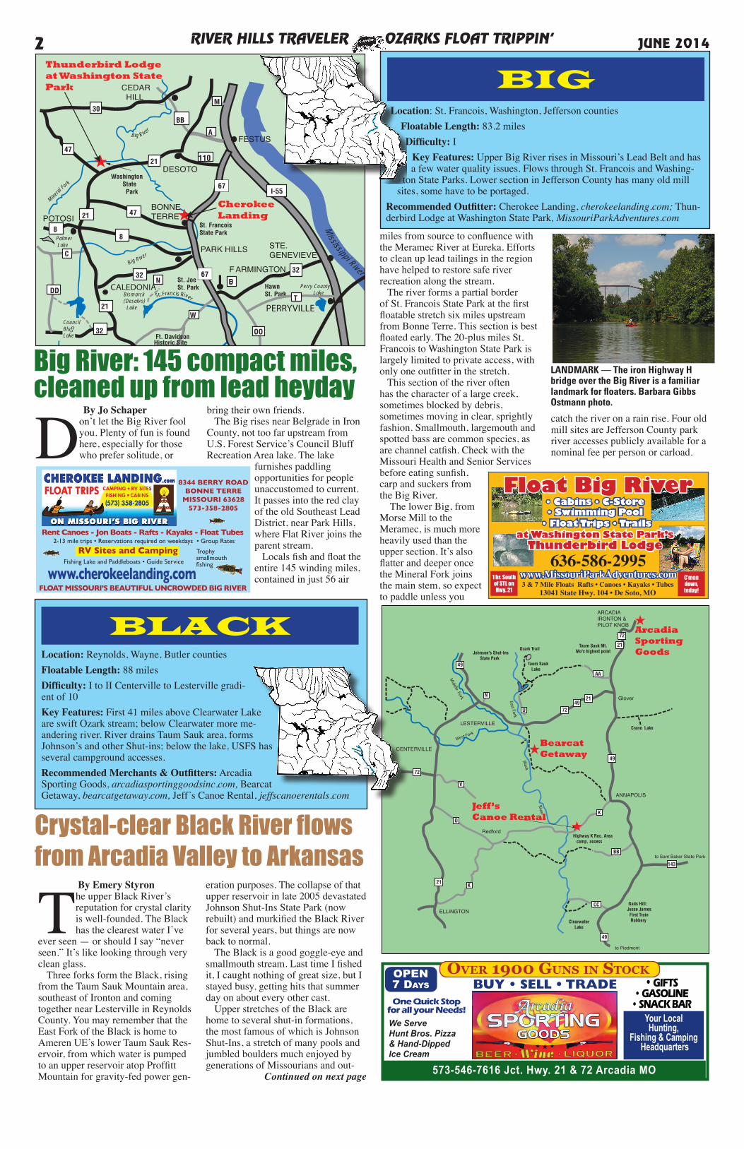
Don’t let the Big River fool you. Plenty of fun is found here, especially for those who prefer solitude, or
bring their own friends. The Big rises near Belgrade in Iron County, not too far upstream from U.S. Forest Service’s Council Bluff Recreation Area lake. The lake
furnishes paddling opportunities for people unaccustomed to current. It passes into the red clay of the old Southeast Lead District, near Park Hills, where Flat River joins the parent stream. Locals fish and float the entire 145 winding miles, contained in just 56 air
miles from source to confluence with the Meramec River at Eureka. Efforts to clean up lead tailings in the region have helped to restore safe river recreation along the stream. The river forms a partial border of St. Francois State Park at the first floatable stretch six miles upstream from Bonne Terre. This section is best floated early. The 20-plus miles St. Francois to Washington State Park is largely limited to private access, with only one outfitter in the stretch. This section of the river often has the character of a large creek, sometimes blocked by debris, sometimes moving in clear, sprightly fashion. Smallmouth, largemouth and spotted bass are common species, as are channel catfish. Check with the Missouri Health and Senior Services before eating sunfish, carp and suckers from the Big River. The lower Big, from Morse Mill to the Meramec, is much more heavily used than the upper section. It’s also flatter and deeper once the Mineral Fork joins the main stem, so expect to paddle unless you
catch the river on a rain rise. Four old mill sites are Jefferson County park river accesses publicly available for a nominal fee per person or carload.
Location: St. Francois, Washington, Jefferson countiesFloatable Length: 83.2 milesDifficulty: I
Key Features: Upper Big River rises in Missouri’s Lead Belt and has a few water quality issues. Flows through St. Francois and Washing-
ton State Parks. Lower section in Jefferson County has many old mill sites, some have to be portaged.
Recommended Outfitter: Cherokee Landing, cherokeelanding.com; Thun-derbird Lodge at Washington State Park, MissouriParkAdventures.com
RIVER HILLS TRAVELER OZARKS FLOAT TRIPPIN’2 JUNE 2014
Big RiverMarine
TheCountryStore
Council BluffLake Rec. Area
TheArbor
ArcadiaSporting Goods
MeatMarket
Olympic Steak House
Cherokee Pass Restaurant
BlackRiver Rats
Big Rive
r
Mineral
Fork
Black River
Crane Pond Lake
Taum Sauk Lake
Bismarck(Desalvo) Lake
Big River
Fredericktown City Lake
Trail of Tears State Park
Johnson'sShut-InsState Park
Taum Sauk St. Park
Ft. DavidsonHistoric Site
St. JoeSt. Park
St. FrancoisState Park
HawnSt. Park
BollingerMill St. Pk.
Washington State Park
Glenallen
110
Perry County Lake
LakeGirardeau
St. Fra
ncis
Rive
r
C asto
r Rive
r
Mississippi River
Palmer Lake
FESTUS
CEDAR HILL
POTOSI
DESOTO
BONNETERRE
PARK HILLS
F ARMINGTON
STE.GENEVIEVE
CAPEGIRARDEAU
ARCADIA VALLEY
30
47
A
BB
M
47
88
32
32
49
21-72-49
72
72
34
34
51
51 I-55
U
E
N
CC
AA
221
W
DDT
OO
32
CouncilBluffLake
I-55
Y PP
RT ZZ
LESTERVILLE
K
21
21
C
67FREDERICKTOWN
67N
St. Francis River
2121
CALEDONIA
PERRYVILLE
67
ED
★CherokeeLanding
★
Thunderbird Lodge at Washington State Park
Location: Reynolds, Wayne, Butler countiesFloatable Length: 88 milesDifficulty: I to II Centerville to Lesterville gradi-ent of 10Key Features: First 41 miles above Clearwater Lake are swift Ozark stream; below Clearwater more me-andering river. River drains Taum Sauk area, forms Johnson’s and other Shut-ins; below the lake, USFS has several campground accesses.Recommended Merchants & Outfitters: Arcadia Sporting Goods, arcadiasportinggoodsinc.com, Bearcat Getaway, bearcatgetaway.com, Jeff’s Canoe Rental, jeffscanoerentals.com
AA
CC
21
72
49
49
N
49
V
O
K
K
143
21
72
2149
72U
BB
ANNAPOLIS
East Fork
CENTERVILLE
LESTERVILLE
ELLINGTON
Clearwater Lake
to Piedmont
Gads Hill:Jesse James First Train Robbery
to Sam Baker State Park
Highway K Rec. Area camp, access
Crane Lake
Glover
Taum Sauk Mt.Mo's highest pointOzark Trail
Taum Sauk Lake
Johnson's Shut-Ins State Park
Redford
Middle Fork
Black
River
West Fork
Jeff’sCanoe Rental
★
BearcatGetaway★
ARCADIAIRONTON & PILOT KNOB ★
ArcadiaSportingGoods
BLACK
BIG
Big River: 145 compact miles,cleaned up from lead heyday
LANDMARK — The iron Highway H bridge over the Big River is a familiar landmark for floaters. Barbara Gibbs Ostmann photo.
By Emery Styron
The upper Black River’s reputation for crystal clarity is well-founded. The Black has the clearest water I’ve
ever seen — or should I say “never seen.” It’s like looking through very clean glass. Three forks form the Black, rising from the Taum Sauk Mountain area, southeast of Ironton and coming together near Lesterville in Reynolds County. You may remember that the East Fork of the Black is home to Ameren UE’s lower Taum Sauk Res-ervoir, from which water is pumped to an upper reservoir atop Proffitt Mountain for gravity-fed power gen-
Crystal-clear Black River flows from Arcadia Valley to Arkansas
8344 BERRY ROADBONNE TERRE
MISSOURI 63628573-358-2805
Rent Canoes - Jon Boats - Rafts - Kayaks - Float Tubes2-13 mile trips • Reservations required on weekdays • Group Rates
Fishing Lake and Paddleboats • Guide Service
www.cherokeelanding.com Trophy smallmouthfishing
FLOAT MISSOURI’S BEAUTIFUL UNCROWDED BIG RIVER
RV Sites and Camping
1 hr. South
of STL on
Hwy. 21
C’mon
down,
today!
636-586-2995
573-546-7616 Jct. Hwy. 21 & 72 Arcadia MO
OPEN7 Days BUY • SELL • TRADE • GIFTS
• GASOLINE • SNACK BAR
Your LocalHunting,
Fishing & Camping Headquarters
One Quick Stop for all your Needs!
We Serve Hunt Bros. Pizza& Hand-DippedIce Cream
Over 1900 Guns in stOck
eration purposes. The collapse of that upper reservoir in late 2005 devastated Johnson Shut-Ins State Park (now rebuilt) and murkified the Black River for several years, but things are now back to normal. The Black is a good goggle-eye and smallmouth stream. Last time I fished it, I caught nothing of great size, but I stayed busy, getting hits that summer day on about every other cast. Upper stretches of the Black are home to several shut-in formations, the most famous of which is Johnson Shut-Ins, a stretch of many pools and jumbled boulders much enjoyed by generations of Missourians and out-
Continued on next page
RIVER HILLS TRAVELER OZARKS FLOAT TRIPPIN’ 3JUNE 2014
Continued from previous pageof-state tourists seeking a cooling dip. The Black flows into Clearwater Lake, which straddles the Reynolds-Wayne County line. The Corps of En-gineer-run Highway K Campground between Annapolis and Ellington is popular with floaters. The gravel bar just north of the Highway K bridge is equally popular with swimmers and picnick-ers. Our float that day was from Brawley to Highway K, the last take-out before the lake. Upstream, where the forks begin, you can float in high water from the Highway 21 bridge above Centerville 8.4 miles to the junction with the Middle Fork, which can also be run only in high water. About a mile downstream, the East Fork joins incoming from Johnson Shut-Ins. In high water you could run the East Fork from Taum Sauk Creek to here. Around Lesterville, there are numer-ous canoe outfitters who can service you. A popular float is from West Fork just above Lesterville to Smiley Face, about a quarter-mile past Bearcat Getaway below Lesterville. That’s a
seven- to eight-mile float that will take five and a half to six and a half hours or longer, depending on river condi-tions and how much you play around — which is of course, the whole point of a float trip. Some outfitters also offer a five-mile float. General gradient for the Black is
4.8 but it runs as high as 11 and 16 on the upper reaches. You can also float below Clearwater Dam, all the way to Poplar Bluff or on into Ar-kansas for that mat-ter. Things flatten out consider-ably once
you get to Bluff and begin to enter Missouri’s delta lands. Fishing aside, the Black is worth floating for the scenery. The water ranges from gin-clear to deep green, and flows past granite bluffs and hilly forests of oak and hickory. The river has an open feel, with plenty of conve-nient gravel bars, enough current to keep you moving and very little trash. If you haven’t floated the Black, put it on your list for this summer.
IT DOESN’T GET ANY BETTER Clear water, plentiful fish and great scenery on the Black River appeal to outdoors people of all ages. Nolan Brunnworth photo.
Float Black for fish or scenery
Jeff’s Canoe RentalFun on the CrystalClear Black River
Is Waiting for You!
www.jeffscanoerentals.com
Give Us a Call: 1-573-598-4555
Reserve Today!
Canoes and Rafts • General Store • Campground Nearby
[email protected] At Hwy K Bridge
Lodging is now available for groups of 2-10. Call for rates and availability.
If you’re looking for a country/rustic-chic wedding venue
on Black River, it’s now available atJeff’s Canoe Rentals, Inc.
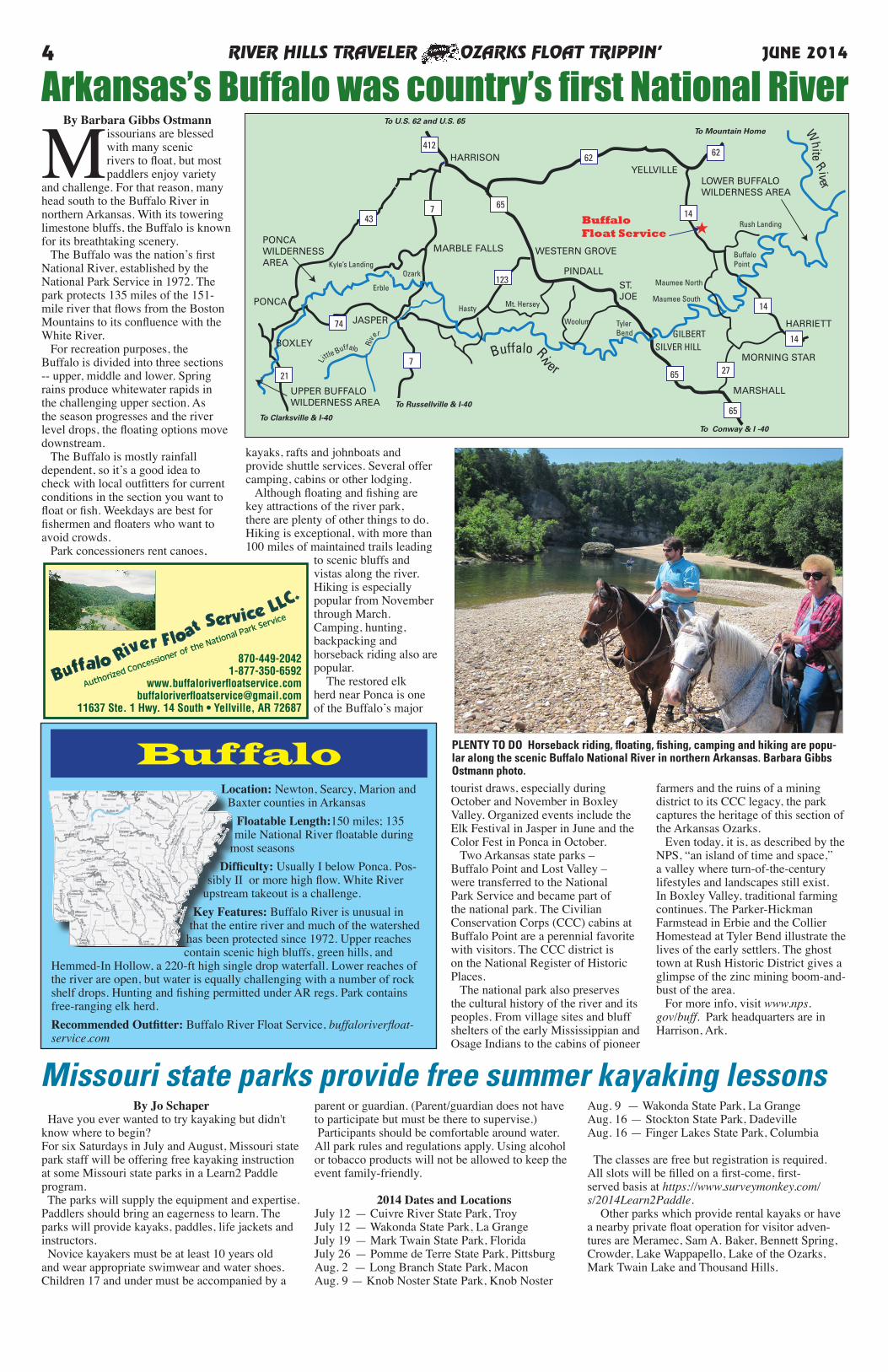
By Barbara Gibbs Ostmann
Missourians are blessed with many scenic rivers to float, but most paddlers enjoy variety
and challenge. For that reason, many head south to the Buffalo River in northern Arkansas. With its towering limestone bluffs, the Buffalo is known for its breathtaking scenery. The Buffalo was the nation’s first National River, established by the National Park Service in 1972. The park protects 135 miles of the 151-mile river that flows from the Boston Mountains to its confluence with the White River. For recreation purposes, the Buffalo is divided into three sections -- upper, middle and lower. Spring rains produce whitewater rapids in the challenging upper section. As the season progresses and the river level drops, the floating options move downstream. The Buffalo is mostly rainfall dependent, so it’s a good idea to check with local outfitters for current conditions in the section you want to float or fish. Weekdays are best for fishermen and floaters who want to avoid crowds. Park concessioners rent canoes,
tourist draws, especially during October and November in Boxley Valley. Organized events include the Elk Festival in Jasper in June and the Color Fest in Ponca in October. Two Arkansas state parks – Buffalo Point and Lost Valley – were transferred to the National Park Service and became part of the national park. The Civilian Conservation Corps (CCC) cabins at Buffalo Point are a perennial favorite with visitors. The CCC district is on the National Register of Historic Places. The national park also preserves the cultural history of the river and its peoples. From village sites and bluff shelters of the early Mississippian and Osage Indians to the cabins of pioneer
farmers and the ruins of a mining district to its CCC legacy, the park captures the heritage of this section of the Arkansas Ozarks. Even today, it is, as described by the NPS, “an island of time and space,” a valley where turn-of-the-century lifestyles and landscapes still exist. In Boxley Valley, traditional farming continues. The Parker-Hickman Farmstead in Erbie and the Collier Homestead at Tyler Bend illustrate the lives of the early settlers. The ghost town at Rush Historic District gives a glimpse of the zinc mining boom-and-bust of the area. For more info, visit www.nps.gov/buff. Park headquarters are in Harrison, Ark.
RIVER HILLS TRAVELER OZARKS FLOAT TRIPPIN’4 JUNE 2014
870-449-20421-877-350-6592
www.buffaloriverfloatservice.combuffaloriverfloatservice@gmail.com
11637 Ste. 1 Hwy. 14 South • Yellville, AR 72687
Authorized Concessioner of the National Park Service
BOXLEY
PINDALL
WESTERN GROVE
HARRISONYELLVILLE
HARRIETT
MARSHALL
MORNING STAR
PONCA
PONCAWILDERNESSAREA
LOWER BUFFALOWILDERNESS AREA
MARBLE FALLS
UPPER BUFFALOWILDERNESS AREA
To U.S. 62 and U.S. 65To Mountain Home
Kyle’s LandingOzark
Erble
JASPERHasty Mt. Hersey
Woolum TylerBend
ST.JOE
Maumee North
Maumee South
Rush Landing
BuffaloPoint
To Conway & I -40
To Russellville & I-40
To Clarksville & I-40
Little Buffalo Ri
ver
Buffalo River
White River
GILBERTSILVER HILL
412
14
65
7 65
6262
123
65
14
14
27
43
74
721
★BuffaloFloat Service
kayaks, rafts and johnboats and provide shuttle services. Several offer camping, cabins or other lodging. Although floating and fishing are key attractions of the river park, there are plenty of other things to do. Hiking is exceptional, with more than 100 miles of maintained trails leading
to scenic bluffs and vistas along the river. Hiking is especially popular from November through March. Camping, hunting, backpacking and horseback riding also are popular. The restored elk herd near Ponca is one of the Buffalo’s major
Arkansas’s Buffalo was country’s first National River
BuffaloLocation: Newton, Searcy, Marion and
Baxter counties in ArkansasFloatable Length:150 miles; 135 mile National River floatable during
most seasonsDifficulty: Usually I below Ponca. Pos-
sibly II or more high flow. White River upstream takeout is a challenge.
Key Features: Buffalo River is unusual in that the entire river and much of the watershed
has been protected since 1972. Upper reaches contain scenic high bluffs, green hills, and
Hemmed-In Hollow, a 220-ft high single drop waterfall. Lower reaches of the river are open, but water is equally challenging with a number of rock shelf drops. Hunting and fishing permitted under AR regs. Park contains free-ranging elk herd. Recommended Outfitter: Buffalo River Float Service, buffaloriverfloat-service.com
PLENTY TO DO Horseback riding, floating, fishing, camping and hiking are popu-lar along the scenic Buffalo National River in northern Arkansas. Barbara Gibbs Ostmann photo.
By Jo Schaper Have you ever wanted to try kayaking but didn't know where to begin? For six Saturdays in July and August, Missouri state park staff will be offering free kayaking instruction at some Missouri state parks in a Learn2 Paddle program. The parks will supply the equipment and expertise. Paddlers should bring an eagerness to learn. The parks will provide kayaks, paddles, life jackets and instructors. Novice kayakers must be at least 10 years old and wear appropriate swimwear and water shoes. Children 17 and under must be accompanied by a
parent or guardian. (Parent/guardian does not have to participate but must be there to supervise.) Participants should be comfortable around water. All park rules and regulations apply. Using alcohol or tobacco products will not be allowed to keep the event family-friendly.
2014 Dates and LocationsJuly 12 — Cuivre River State Park, TroyJuly 12 — Wakonda State Park, La GrangeJuly 19 — Mark Twain State Park, FloridaJuly 26 — Pomme de Terre State Park, PittsburgAug. 2 — Long Branch State Park, MaconAug. 9 — Knob Noster State Park, Knob Noster
Aug. 9 — Wakonda State Park, La GrangeAug. 16 — Stockton State Park, DadevilleAug. 16 — Finger Lakes State Park, Columbia
The classes are free but registration is required. All slots will be filled on a first-come, first-served basis at https://www.surveymonkey.com/s/2014Learn2Paddle. Other parks which provide rental kayaks or have a nearby private float operation for visitor adven-tures are Meramec, Sam A. Baker, Bennett Spring, Crowder, Lake Wappapello, Lake of the Ozarks, Mark Twain Lake and Thousand Hills.
Missouri state parks provide free summer kayaking lessons
RIVER HILLS TRAVELER OZARKS FLOAT TRIPPIN’ 5JUNE 2014
Stray Dog BBQ and PizzaBBQ cooked with Ozark oak and hickory
Open 7 days a week at 11 a.m. to 8, 9 or 10 p.m.
Best Barbecue
Traveler ReadersChoice Awards
Specialty Pulled Pork, BBQ Chicken & Chicken Fajita Pizzas!
CURRENT RIVER’S RESORT HEADQUARTERS
F L OAT I N G , L O D G I N G , & D I N I N G
VAN BUREN, MO. 63965(573) 323-8156 • EATSLEEPFLOAT.COM
HWY. 60 & CURRENT RIVER VAN BUREN
Big Spring RV CampCabin & Tube Rental
Great Variety of Tubes & Tube TripsRiverfront RV & Tent CampingCabin Rentals 573-323-8328www.currentriver.com Van Buren
aa a
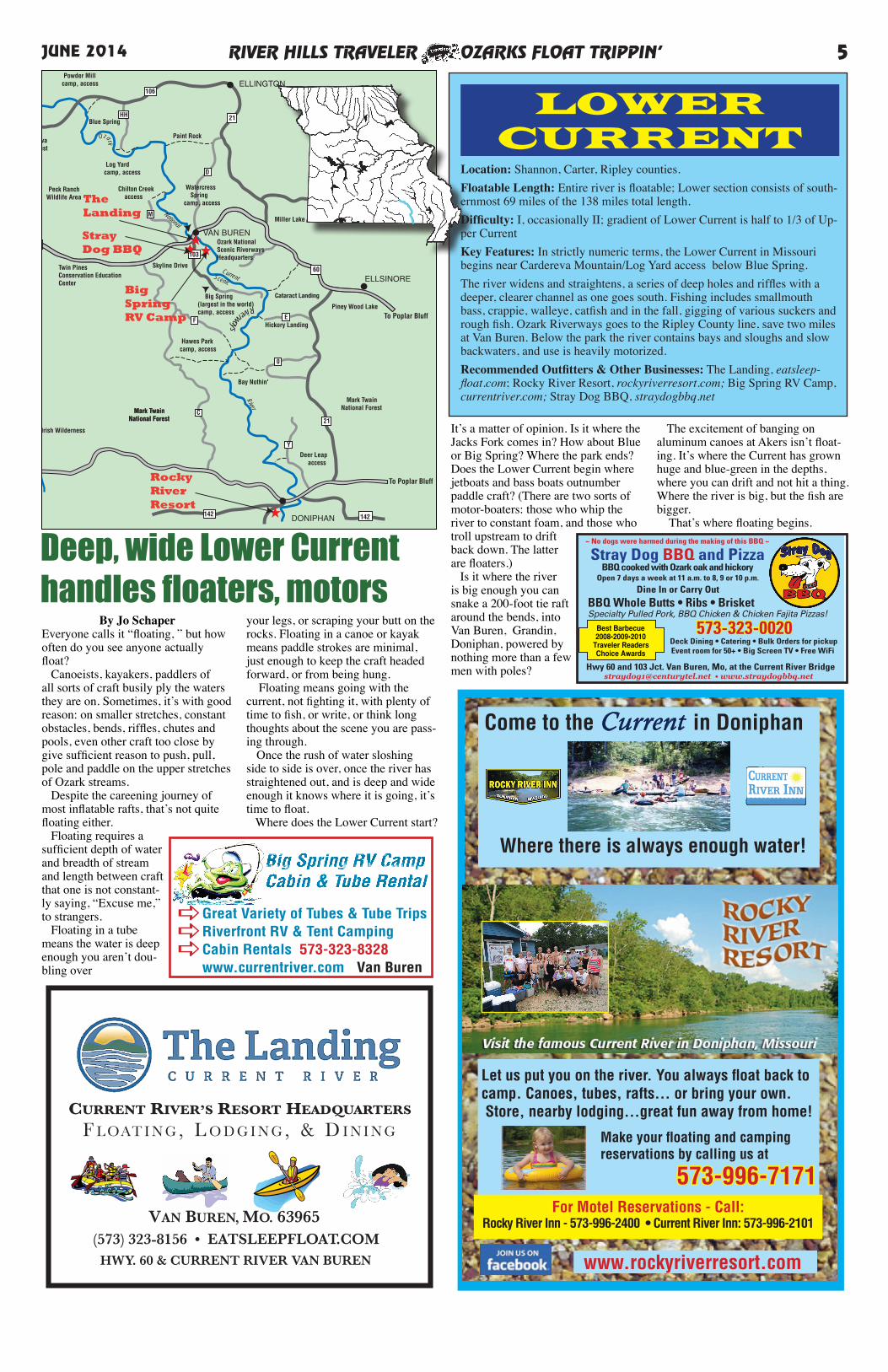
Deep, wide Lower Current handles floaters, motors
By Jo SchaperEveryone calls it “floating, ” but how often do you see anyone actually float? Canoeists, kayakers, paddlers of all sorts of craft busily ply the waters they are on. Sometimes, it’s with good reason: on smaller stretches, constant obstacles, bends, riffles, chutes and pools, even other craft too close by give sufficient reason to push, pull, pole and paddle on the upper stretches of Ozark streams. Despite the careening journey of most inflatable rafts, that’s not quite floating either. Floating requires a sufficient depth of water and breadth of stream and length between craft that one is not constant-ly saying, “Excuse me,” to strangers. Floating in a tube means the water is deep enough you aren’t dou-bling over
your legs, or scraping your butt on the rocks. Floating in a canoe or kayak means paddle strokes are minimal, just enough to keep the craft headed forward, or from being hung. Floating means going with the current, not fighting it, with plenty of time to fish, or write, or think long thoughts about the scene you are pass-ing through. Once the rush of water sloshing side to side is over, once the river has straightened out, and is deep and wide enough it knows where it is going, it’s time to float. Where does the Lower Current start?
WINONA
ELLINGTON
ELLSINORE
DONIPHAN
Mark TwainNational Forest
Mark TwainNational Forest
Peck Ranch Wildlife Area
Cardareva St. Forest
Paint Rock
Watercress Springcamp, access
Blue Spring
Powder Millcamp, access
Log Yardcamp, access
Chilton Creek access
Miller Lake
VAN BURENOzark NationalScenic RiverwaysHeadquarters
Big Spring(largest in the world)camp, access
Cataract Landing
Piney Wood Lake
Hickory Landing
Bay Nothin'
Deer Leap access
Hawes Parkcamp, access
Skyline Drive
National
Scenic
Current
River
21
21
34
142
60
60
103
106
HH
D
M
F
C
E
0
Y
Ozark
Riverways
19
19
ALTON
160
Eleven Point River
★Twin PinesConservation EducationCenter
Irish Wilderness
Mark TwainNational Forest
GreerSpring
To Poplar Bluff
To Poplar Bluff
ToEminence
142
TheLanding
★StrayDog BBQ
RockyRiver Resort
★
★
Big SpringRV Camp
LOWER CURRENT
Location: Shannon, Carter, Ripley counties.Floatable Length: Entire river is floatable; Lower section consists of south-ernmost 69 miles of the 138 miles total length.Difficulty: I, occasionally II; gradient of Lower Current is half to 1/3 of Up-per CurrentKey Features: In strictly numeric terms, the Lower Current in Missouri begins near Cardereva Mountain/Log Yard access below Blue Spring.The river widens and straightens, a series of deep holes and riffles with a deeper, clearer channel as one goes south. Fishing includes smallmouth bass, crappie, walleye, catfish and in the fall, gigging of various suckers and rough fish. Ozark Riverways goes to the Ripley County line, save two miles at Van Buren. Below the park the river contains bays and sloughs and slow backwaters, and use is heavily motorized.Recommended Outfitters & Other Businesses: The Landing, eatsleep-float.com; Rocky River Resort, rockyriverresort.com; Big Spring RV Camp,currentriver.com; Stray Dog BBQ, straydogbbq.net
It’s a matter of opinion. Is it where the Jacks Fork comes in? How about Blue or Big Spring? Where the park ends? Does the Lower Current begin where jetboats and bass boats outnumber paddle craft? (There are two sorts of motor-boaters: those who whip the river to constant foam, and those who troll upstream to drift back down. The latter are floaters.) Is it where the river is big enough you can snake a 200-foot tie raft around the bends, into Van Buren, Grandin, Doniphan, powered by nothing more than a few men with poles?
The excitement of banging on aluminum canoes at Akers isn’t float-ing. It’s where the Current has grown huge and blue-green in the depths, where you can drift and not hit a thing. Where the river is big, but the fish are bigger. That’s where floating begins.
For Motel Reservations - Call: Rocky River Inn - 573-996-2400 • Current River Inn: 573-996-2101
573-996-7171
Make your floating and camping reservations by calling us at
Where there is always enough water!
Come to the Current in Doniphan
Let us put you on the river. You always float back to camp. Canoes, tubes, rafts... or bring your own. Store, nearby lodging...great fun away from home!
www.rockyriverresort.com
RIVER HILLS TRAVELER OZARKS FLOAT TRIPPIN’6 JUNE 2014
Only 150 yards from the Jacks Fork River!
PO Box 94 • N Hwy 19 • Eminence, MO 65466www.shadylanecabins.com
Open Year Round
Come and spend your vacation with us•Cable TVs •Heating & A/C
•Playground Equipment •Laundromat • Full RV Hookups
For reservations call573-226-3893
Coffee in Season
Come Stay With Us and Sit a Spell....
Visit Scenic, Friendly
Eminence:
• Elk Capital of Missouri
• Canoe Capital of the World
•Motel rooms & suites
•Small Cabins (sleep up to 4) Large Cabins
(sleep up to 10)•Story’s Creek
Manor 3-BR ranch sleeps up to 12
www.jacksforkcanoe.com1-800-JACKSFORK1/4 mile east of Eminence
on Highway 1061-800-522-5736 573-858-3221
• Rent Canoes• Riverside Camping• Jacks Fork Store• Family Friendly• Full RV Hookups• Group Camps• Convenient Location
FLOAT THE BEAUTIFUL CURRENT &
JACKS FORK RIVERS PUT IN OR TAKE OUT
HERE!
By Barbara Gibbs Ostmann
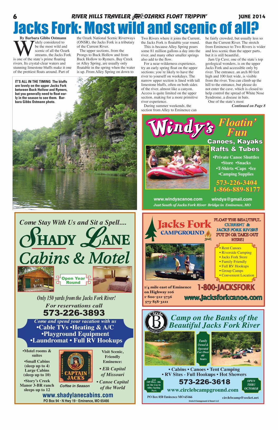
Widely considered to be the most wild and scenic of all the Ozark streams, the Jacks Fork
is one of the state’s prime floating rivers. Its crystal-clear waters and stunning limestone bluffs make it one of the prettiest floats around. Part of
the Ozark National Scenic Riverways (ONSR), the Jacks Fork is a tributary of the Current River. The upper sections, from the Prongs to Buck Hollow and from Buck Hollow to Rymers, Bay Creek or Alley Spring, are usually only floatable in the spring when the water is up. From Alley Spring on down to
Jacks Fork: Most wild and scenic of all?Two Rivers where it joins the Current, the Jacks Fork is floatable year round. This is because Alley Spring pours some 81 million gallons a day into the river, and many other smaller springs also add to the flow. For a near-wilderness experience, try an early spring float on the upper sections; you’re likely to have the river to yourself on weekdays. The narrow upper section is lined with tall limestone bluffs, often on both sides of the river, almost like a canyon. Access is quite limited on the upper section, making for a more primitive river experience. During summer weekends, the section from Alley to Eminence can
be fairly crowded, but usually less so than the Current River. The stretch from Eminence to Two Rivers is wider and less scenic than the upper parts, but it is still beautiful. Jam Up Cave, one of the state’s top geological wonders, is on the upper Jacks Fork and accessible only by river. The entrance, an arch 80 feet high and 100 feet wide, is visible from the river. You can climb up the hill to the entrance, but please do not enter the cave, which is closed to help control the spread of White Nose Syndrome, a disease in bats. One of the state’s most
Continued on Page 8
www.windyscanoe.com [email protected]
•Private Canoe Shuttles •Store •Snacks
•T-Shirts •Caps •Ice•Camping Supplies
Just South of Jacks Fork River Bridge in Eminence, MO
Floatin’Fun
Canoes, Kayaks Rafts & Tubes
573-226-3404 1-866-889-8177
Circle B Campground & Resort LLC
IT’S ALL IN THE TIMING The bluffs are lovely on the upper Jacks Fork between Buck Hollow and Rymers, but you generally need to float ear-ly in the season to see them. Bar-bara Gibbs Ostmann photo.
RIVER HILLS TRAVELER OZARKS FLOAT TRIPPIN’ 7JUNE 2014
Canoe Capital of the Ozarks!
Call Toll Free to arrange your trip anywhere in the spring-fed Upper Current and Jacks Fork area.
1-800-522-57361-800-333-5628573-858-3228
www.currentrivercanoe.com
Meet us on the banks of Jacks Fork and Current Rivers
We rent canoes year round.
Jason Place CampgroundJacks Fork Canoe Rental
Last working ferry in the Ozark Scenic Riverways
Come Float with Us!Gene, Eleanor &Marcus Maggard
CABINS: CAMP:
Located Just South of Salem, MO
HCR 62 Box 368Salem Missouri 65560
1-800-226-6394Or 573-858-3371
www.runningrivercanoe.comCome Float
TheUpper
CurrentRiver!
Canoes • Rafts • KayaksFloater Camping • RV Hookups
Convenience Store
Hwy. 19 - 25 Miles south of Salembetween Hwys. A and EE
At Round Spring CampgroundHCR 1, Box 137
Eminence, MO 65466-9711800-333-3956
www.carrscanoerental.com
At Pulltite CampgroundHCR 62, Box 375Salem, MO 65466-9711877-858-3250www.current-river.com
• CANOES • KAYAKS • TUBES • RAFTS
YOUR FLOATING
HEADQUARTERSFOR:
PULLTITE SPRING
ROUND SPRING
Please visit our websites for current prices.
H
By Barbara Gibbs Ostmann
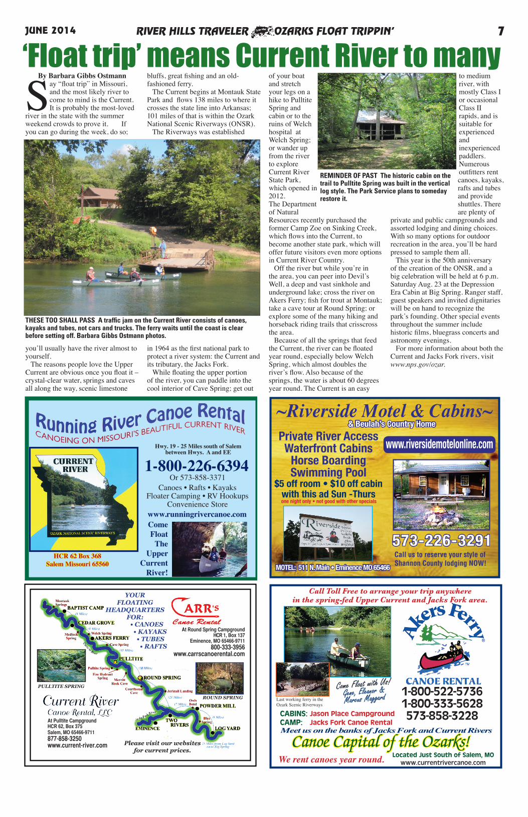
Say “float trip” in Missouri, and the most likely river to come to mind is the Current. It is probably the most-loved
river in the state with the summer weekend crowds to prove it. If you can go during the week, do so;
you’ll usually have the river almost to yourself. The reasons people love the Upper Current are obvious once you float it – crystal-clear water, springs and caves all along the way, scenic limestone
bluffs, great fishing and an old-fashioned ferry. The Current begins at Montauk State Park and flows 138 miles to where it crosses the state line into Arkansas; 101 miles of that is within the Ozark National Scenic Riverways (ONSR). The Riverways was established
in 1964 as the first national park to protect a river system: the Current and its tributary, the Jacks Fork. While floating the upper portion of the river, you can paddle into the cool interior of Cave Spring; get out
of your boat and stretch your legs on a hike to Pulltite Spring and cabin or to the ruins of Welch hospital at Welch Spring; or wander up from the river to explore Current River State Park, which opened in 2012. The Department of Natural Resources recently purchased the former Camp Zoe on Sinking Creek, which flows into the Current, to become another state park, which will offer future visitors even more options in Current River Country. Off the river but while you’re in the area, you can peer into Devil’s Well, a deep and vast sinkhole and underground lake; cross the river on Akers Ferry; fish for trout at Montauk; take a cave tour at Round Spring; or explore some of the many hiking and horseback riding trails that crisscross the area. Because of all the springs that feed the Current, the river can be floated year round, especially below Welch Spring, which almost doubles the river’s flow. Also because of the springs, the water is about 60 degrees year round. The Current is an easy
to medium river, with mostly Class I or occasional Class II rapids, and is suitable for experienced and inexperienced paddlers. Numerous outfitters rent canoes, kayaks, rafts and tubes and provide shuttles. There are plenty of
private and public campgrounds and assorted lodging and dining choices. With so many options for outdoor recreation in the area, you’ll be hard pressed to sample them all. This year is the 50th anniversary of the creation of the ONSR, and a big celebration will be held at 6 p.m. Saturday Aug. 23 at the Depression Era Cabin at Big Spring. Ranger staff, guest speakers and invited dignitaries will be on hand to recognize the park’s founding. Other special events throughout the summer include historic films, bluegrass concerts and astronomy evenings. For more information about both the Current and Jacks Fork rivers, visit www.nps.gov/ozar.
‘Float trip’ means Current River to many
~Riverside Motel & Cabins~
MOTEL: 511 N. Main • Eminence MO 65466
& Beulah’s Country Home
Private River AccessWaterfront Cabins
Horse BoardingSwimming Pool
$5 off room • $10 off cabinwith this ad Sun -Thursone night only • not good with other specials
573-226-3291
www.riversidemotelonline.com
Call us to reserve your style of Shannon County lodging NOW!
REMINDER OF PAST The historic cabin on the trail to Pulltite Spring was built in the vertical log style. The Park Service plans to someday restore it.
THESE TOO SHALL PASS A traffic jam on the Current River consists of canoes, kayaks and tubes, not cars and trucks. The ferry waits until the coast is clear before setting off. Barbara Gibbs Ostmann photos.
RIVER HILLS TRAVELER OZARKS FLOAT TRIPPIN’8 JUNE 2014
72
32
32
63
137
137
60
Y17
FFOOM
E
19H
H
NN
106106
W
O
K
D
ND
B
VV
119
YY
KK
K
E
ZZ
19
A
CCEE
72
P
V
60
SALEM
WINONA
EMINENCE
SUMMERSVILLE
LICKING
BUNKER
to Van Buren, Poplar Bluff
to Springfield
Rocky Falls
Powder MillJerktail Two Rivers
Alley Spring
RoundSpring
MontaukTrout Park
ShannondaleCedarGrove
Jacks Fork River
Current
River
Ozark
National
Scenic Riverways
Ozark Scenic Ri
verw
ays
National Circle BCampground
Shady LaneCabins & Motel
Windy’s Canoe Rental
★
Riverside Motel & Cabins
★★★★
Harvey’s Alley SpringCanoe Rental
★
Jacks Fork Canoe Rental
★
Akers Ferry Canoe Rental &Jason’s Place
Running RiverCanoe Rental
★
★
★
Carr’sCanoe Rental
Current RiverCanoe Rental
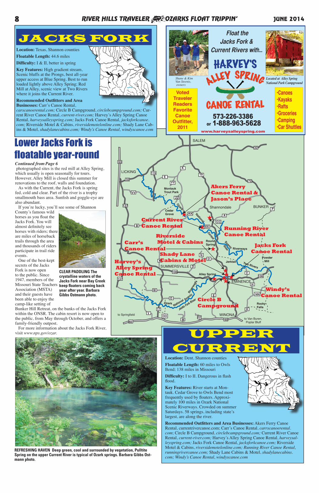
Location: Dent, Shannon countiesFloatable Length: 60 miles to Owls Bend; 138 miles in MissouriDifficulty: I to II. Dangerous in flash flood. Key Features: River starts at Mon-tauk. Cedar Grove to Owls Bend most frequently used by floaters. Approxi-mately 100 miles in Ozark National Scenic Riverways. Crowded on summer Saturdays. 58 springs, including state’s largest, are along the river. Recommended Outfitters and Area Businesses: Akers Ferry Canoe Rental, currentrivercanoe.com; Carr’s Canoe Rental, carrscanoerental.com; Circle B Campground, circlebcampground.com; Current River Canoe Rental, current-river.com; Harvey’s Alley Spring Canoe Rental, harveysal-leyspring.com; Jacks Fork Canoe Rental, jacksforkcanoe.com; Riverside Motel & Cabins, riversidemotelonline.com; Running River Canoe Rental, runningrivercanoe.com; Shady Lane Cabins & Motel, shadylanecabins.com; Windy’s Canoe Rental, windyscanoe.com
•Canoes•Kayaks•Rafts•Groceries•Camping•Car Shuttles
573-226-3386 or 1-888-963-5628
Located at Alley Spring National Park Campground
Shane & KimVan Steenis, owners
www.harveysalleyspring.com
Float theJacks Fork &
Current Rivers with...
VotedTravelerReaders FavoriteCanoe
Outfitter,2011
UPPERCURRENT
Location: Texas, Shannon countiesFloatable Length: 44.6 milesDifficulty: I & II, better in springKey Features: High gradient stream, Scenic bluffs at the Prongs, best all-year upper access at Blue Spring. Best to run loaded lightly above Alley Spring; Red Mill at Alley, scenic view at Two Rivers where it joins the Current River. Recommended Outfitters and Area Businesses: Carr’s Canoe Rental, carscanoerental.com; Circle B Campground, circlebcampground.com; Cur-rent River Canoe Rental, current-river.com; Harvey’s Alley Spring Canoe Rental, harveysalleyspring.com; Jacks Fork Canoe Rental, jacksforkcanoe.com; Riverside Motel & Cabins, riversidemotelonline.com; Shady Lane Cab-ins & Motel, shadylanecabins.com; Windy’s Canoe Rental, windyscanoe.com
JACKS FORK
Continued from Page 6 photographed sites is the red mill at Alley Spring, which usually is open seasonally for tours. However, Alley Mill is closed this summer for renovations to the roof, walls and foundation. As with the Current, the Jacks Fork is spring fed, cold and clear. Part of the river is a trophy smallmouth bass area. Sunfish and goggle-eye are also abundant. If you’re lucky, you’ll see some of Shannon County’s famous wild horses as you float the Jacks Fork. You will almost definitely see horses with riders; there are miles of horseback trails through the area and thousands of riders participate in trail ride events. One of the best-kept secrets of the Jacks Fork is now open to the public. Since 1947, members of the Missouri State Teachers Association (MSTA) and their guests have been able to enjoy the camp-like setting of Bunker Hill Retreat, on the banks of the Jacks Fork within the ONSR. The cabin resort is now open to the public, from May through October, and offers a family-friendly outpost. For more information about the Jacks Fork River, visit www.nps.gov/ozar.
REFRESHING HAVEN Deep green, cool and surrounded by vegetation, Pulltite Spring on the upper Current River is typical of Ozark springs. Barbara Gibbs Ost-mann photo.
CLEAR PADDLING The crystalline waters of the Jacks Fork near Bay Creek keep floaters coming back year after year. Barbara Gibbs Ostmann photo.
Lower Jacks Fork isfloatable year-round
By Barbara Gibbs Ostmann
The Eleven Point River in southeast Missouri is the state’s only National Scenic River. A 44-mile stretch of the Eleven Point, from Thomasville to the Highway
142 bridge, was one of the first eight rivers included in the National Wild and Scenic River System in 1968. The Ozark National Scenic Riverways, established in 1964, laid the groundwork for the Wild and Scenic Rivers Act of 1968. The epitome of an Ozarks stream, the Eleven Point is spring fed, cold and clear. It flows past steep limestone bluffs and forested valleys, through deep pools and rapids. It starts near Thomasville as a narrow stream, and grows wider and deeper as it meanders southward and springs add water to the flow. Greer Spring alone, with its average daily flow of 222 million gallons, doubles the size of the river. Greer Spring, the second largest spring in the state and arguably the most scenic, has been in the news, with the recent transfer of the historic mill from private ownership to the U.S. Forest Service. The Friends of the Eleven Point (see Facebook page of this name) plans canoe races, work days and fundraising events, to help get the mill ready for the public. Whatever you do while down by the Eleven Point, be sure to take time to hike from the trailhead on Highway 19 to Greer Spring. It is one of the prettiest hikes around. Rated a Class I and Class II river, the Eleven Point is a relatively easy river requiring intermediate experience. The chutes at Mary Decker Shoal and Halls Bay can approach a Class III, so if the route looks hazardous, walk your boat around. Floats range from half-day trips to overnighters. The most
popular day trip is from Greer to Whitten, and overnight from Greer to Riverton. Canoes and kayaks are popular on the river. Fishermen seeking smallmouth bass, walleye and trout may opt for flat-bottomed johnboats. Motor boats are restricted to 25 mph. During the week, you will have the river mostly to yourself for a remote,
wilderness-type experience. The U.S. Forest Service maintains seven float camps along the river, each offering picnic table, latrine and fire ring. Camping is allowed on
gravel bars and river banks, but not on private land adjacent to the river. There’s a Forest Service campground at Greer Crossing on Highway 19, and private campgrounds in Alton, Greer and Riverton. In the National Scenic River section of the Eleven Point, there are no impoundments and the shoreline and watershed are mostly undeveloped. About half the lands are private and the rest is Mark Twain National Forest. The western boundary of the Irish Wilderness, a 16,227-acre national wilderness area, is adjacent to the river. Be sure to download a copy of the “Eleven Point Scenic River Travel Guide” at http://www.fs.usda.
gov/Internet/FSE_DOCUMENTS/stelprdb5200703.pdf before your trip, or pick up a copy of the free brochure at an area outfitter.
GreerSpringBranch
GreerAccess
RivertonAccess
SpringsAccess
McDowellAccess
Turner MillAccess
ALTON
WhittenAccess
19
19
AA
160
160
CR 137
CR 127
FF
★Eleven PointCanoe Rental
RIVER HILLS TRAVELER OZARKS FLOAT TRIPPIN’ 9JUNE 2014
ELEVENPOINT
Eleven Point: Missouri’s only National Scenic River
Location: Oregon County.Floatable Length:49 miles in Mis-souri. Sixteen miles above Greer: inquire locally in dry years.Difficulty:I-II Key Features: The Eleven Point River traverses mostly remote and forested areas, much of it under U.S. Forest Service con-trol. Fishing includes sunfish, smallmouth, largemouth bass, pike. Between Greer and Turners Mill, five and one half miles are under Blue Ribbon Trout Management. Primitive camps exist in the Forest above flood levels. Places to see: Irish Wilderness, Greer Spring, The Narrows, Turner’s Mill, Boze Mill Spring. The river is brisk and interesting to traverse, but does not rise to true whitewater. Recommended Outfitter: Eleven Point Canoe Rental, 11pointcanoe.com.
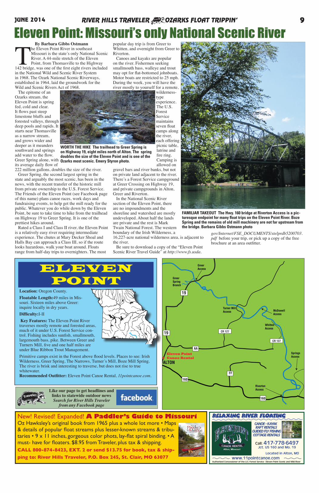
WORTH THE HIKE The trailhead to Greer Spring is on Highway 19, eight miles north of Alton. The spring doubles the size of the Eleven Point and is one of the Ozarks most scenic. Emery Styron photo.
Like our page to get headlines and links to statewide outdoor newsSearch for River Hills Traveler
from any Facebook page
CANOE - KAYAK RAFT RENTALS GUIDED FLY FISHING COTTAGE RENTALS
Authorized Concessioner of the U.S. Forest Service - Eleven Point Scenic and Wild River
relaxing river floating
www.11pointcanoe.com
Call: 417-778-6497Jct. US 160 and Mo. 19
Located in Alton, MO
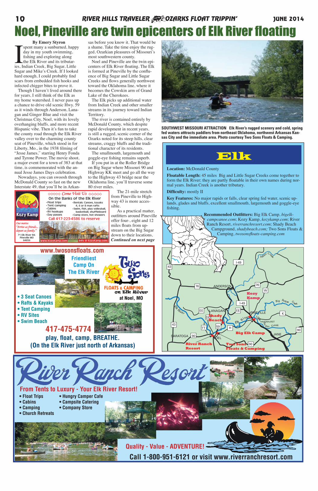
FAMILIAR TAKEOUT The Hwy. 160 bridge at Riverton Access is a pic-turesque endpoint for many float trips on the Eleven Point River. Boze Spring and the remains of old mill machinery are not far upstream from the bridge. Barbara Gibbs Ostmann photo
New! Revised! Expanded! A Paddler’s Guide to MissouriOz Hawksley’s original book from 1965 plus a whole lot more • Maps & details of popular float streams plus lesser-known streams & tribu-taries • 9 x 11 inches, gorgeous color phots, lay-flat spiral binding. • A must- have for floaters. $8.95 from Traveler, plus tax & shipping. CALL 800-874-8423, EXT. 2 or send $13.75 for book, tax & ship-
ping to: River Hills Traveler, P.O. Box 245, St. Clair, MO 63077
RIVER HILLS TRAVELER OZARKS FLOAT TRIPPIN’10 JUNE 2014
play, float, camp, BREATHE.(On the Elk River just north of Arkansas)
417-475-4774
www.twosonsfloats.comFriendliestCamp On
The Elk River
• 3 Seat Canoes• Rafts & Kayaks• Tent Camping• RV Sites• Swim Beach
at Noel, MO
LANAGAN
ANDERSON
NOEL
GOODMAN
SARATOGA
PINEVILLE
JANE
43
43TT
DD
EE
76
I-49I-49
I-49
EE
W
76
90
90
9059 H
HAVENHURST
K
Elk River
Elk R
iver
Indian Creek
Big
Sugarr Creek
Little
Su
gar
Creek
★★
★★
Big Elk Camp
River RanchResort
ShadyBeach
Two SonsFloats & Camping
★
KozyKamp
ElkLocation: McDonald CountyFloatable Length: 45 miles Big and Little Sugar Creeks come together to form the Elk River; they are partly floatable in their own names during nor-mal years. Indian Creek is another tributary.Difficulty: mostly II Key Features: No major rapids or falls, clear spring fed water, scenic up-lands, glades and bluffs, excellent smallmouth, largemouth and goggle-eye fishing.
Recommended Outfitters: Big Elk Camp, bigelk-campcanoe.com; Kozy Kamp, kozykamp.com; River Ranch Resort, riverranchresort.com; Shady Beach
Campground, shadybeach.com; Two Sons Floats & Camping, twosonsfloats-camping.com
By Emery Styron
I spent many a sunburned, happy day in my youth swimming, fishing and exploring along the Elk River and its tributar-
ies, Indian Creek, Big Sugar, Little Sugar and Mike’s Creek. If I looked hard enough, I could probably find scars from embedded fish hooks and infected chigger bites to prove it. Though I haven’t lived around there for years, I still think of the Elk as my home watershed. I never pass up a chance to drive old scenic Hwy. 59 as it winds through Anderson, Lana-gan and Ginger Blue and visit the Christmas City, Noel, with its lovely overhanging bluffs, and more recent Hispanic vibe. Then it’s fun to take the county road through the Elk River valley over to the charming county seat of Pineville, which stood in for Liberty, Mo., in the 1938 filming of “Jesse James,” starring Henry Fonda and Tyrone Power. The movie shoot, a major event for a town of 383 at that time, is commemorated with the an-nual Jesse James Days celebration. Nowadays, you can swoosh through McDonald County so fast on the new Interstate 49, that you’ll be in Arkan-
sas before you know it. That would be a shame. Take the time enjoy the rug-ged, Ozarkian pleasures of Missouri’s most southwestern county. Noel and Pineville are the twin epi-centers of Elk River floating. The Elk is formed at Pineville by the conflu-ence of Big Sugar and Little Sugar Creeks and flows generally northwest toward the Oklahoma line, where it becomes the Cowskin arm of Grand Lake of the Cherokees. The Elk picks up additional water from Indian Creek and other smaller streams in its journey toward Indian Territory. The river is contained entirely by McDonald County, which despite rapid development in recent years, is still a rugged, scenic corner of the Ozarks noted for its steep hills, clear streams, craggy bluffs and the tradi-tional character of its residents. The smallmouth, largemouth and goggle-eye fishing remains superb. If you put in at the Roller Bridge on Big Sugar where Missouri 90 and Highway KK meet and go all the way to the Highway 43 bridge near the Oklahoma line, you’ll traverse some 80 river miles.
The 21-mile stretch from Pineville to High-way 43 is more acces-sible. As a practical matter, outfitters around Pineville offer four-, eight and 12 miles floats from up-stream on the Big Sugar down to their locations,Continued on next page
Noel, Pineville are twin epicenters of Elk River floating
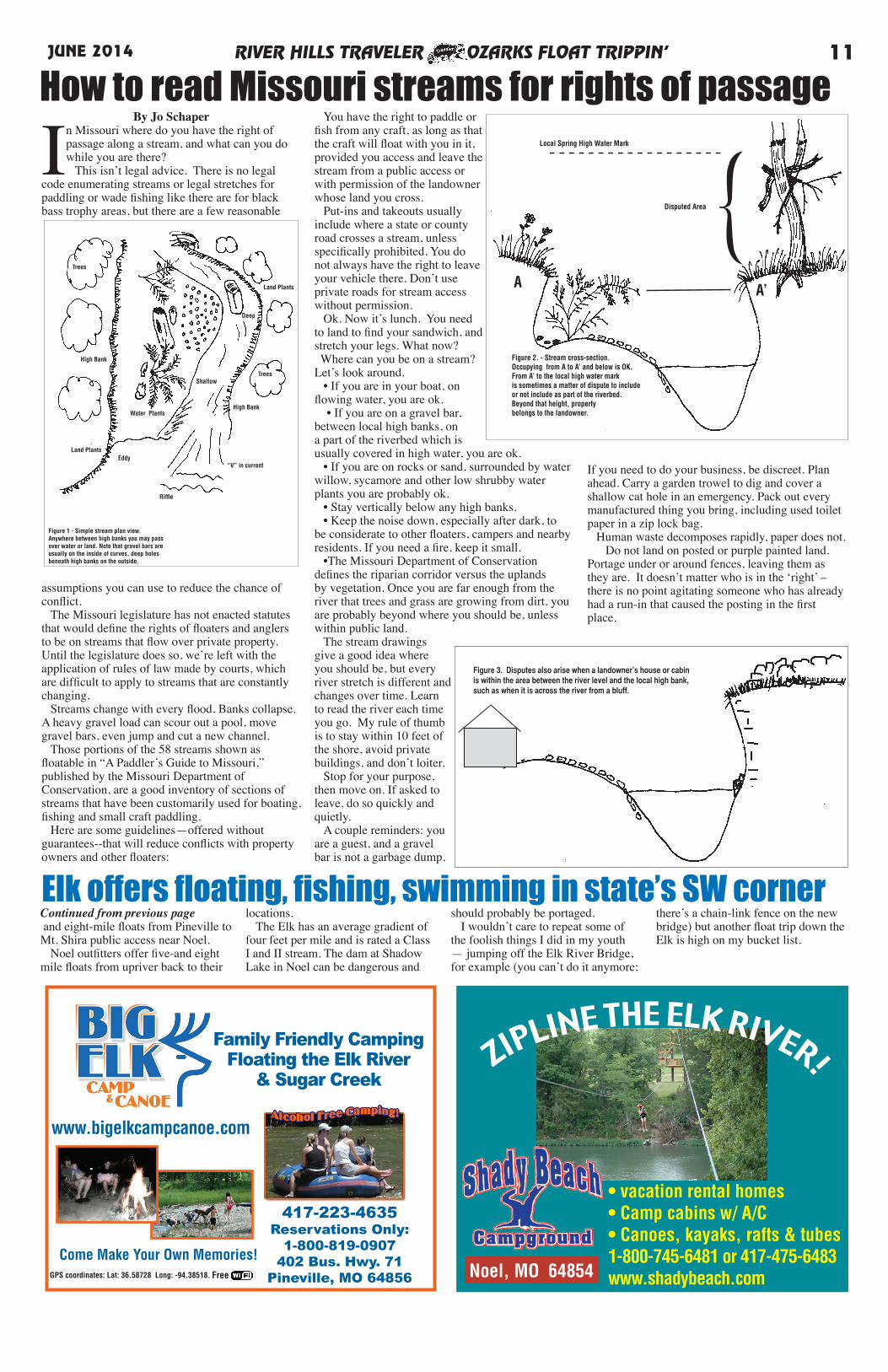
SOUTHWEST MISSOURI ATTRACTION Elk River’s rugged scenery and cold, spring fed waters atttracts paddlers from northeast Oklahoma, northwest Arkansas Kan-sas City and the immediate area. Photo courtesy Two Sons Floats & Camping.
Our motto: “Arrive as friends...depart as family.”
•Float trips•Tent camping•Cabins•RV hookups•Day passes
•Rentals: Canoes, kayaks 4, 6 or 8 man rafts•Swim, fish, play volleyball, basketball, shuffleboard •Camp store, hot showers
On the Banks of the Elk River
71 Elk River Rd.Pineville MO
64856 www.KozyKamp.com info @ KozyKamp.com
Come Visit Us
Call 417-223-4586 to reserve
From Tents to Luxury - Your Elk River Resort!• Float Trips• Cabins• Camping• Church Retreats
• Hungry Camper Cafe• Campsite Catering• Company Store
Quality - Value - ADVENTURE!
Call 1-800-951-6121 or visit www.riverranchresort.com
RIVER HILLS TRAVELER OZARKS FLOAT TRIPPIN’ 11JUNE 2014
Family Friendly CampingFloating the Elk River
& Sugar Creek
417-223-4635Reservations Only:
1-800-819-0907402 Bus. Hwy. 71
Pineville, MO 64856
www.bigelkcampcanoe.com
Come Make Your Own Memories!FreeGPS coordinates: Lat: 36.58728 Long: -94.38518.
ZIPLINE THE ELK RIVER!
• vacation rental homes• Camp cabins w/ A/C• Canoes, kayaks, rafts & tubes1-800-745-6481 or 417-475-6483www.shadybeach.com Noel, MO 64854
Elk offers floating, fishing, swimming in state’s SW corner
By Jo Schaper
In Missouri where do you have the right of passage along a stream, and what can you do while you are there? This isn’t legal advice. There is no legal
code enumerating streams or legal stretches for paddling or wade fishing like there are for black bass trophy areas, but there are a few reasonable
assumptions you can use to reduce the chance of conflict. The Missouri legislature has not enacted statutes that would define the rights of floaters and anglers to be on streams that flow over private property. Until the legislature does so, we’re left with the application of rules of law made by courts, which are difficult to apply to streams that are constantly changing. Streams change with every flood. Banks collapse. A heavy gravel load can scour out a pool, move gravel bars, even jump and cut a new channel. Those portions of the 58 streams shown as floatable in “A Paddler’s Guide to Missouri,” published by the Missouri Department of Conservation, are a good inventory of sections of streams that have been customarily used for boating, fishing and small craft paddling. Here are some guidelines—offered without guarantees--that will reduce conflicts with property owners and other floaters:
You have the right to paddle or fish from any craft, as long as that the craft will float with you in it, provided you access and leave the stream from a public access or with permission of the landowner whose land you cross. Put-ins and takeouts usually include where a state or county road crosses a stream, unless specifically prohibited. You do not always have the right to leave your vehicle there. Don’t use private roads for stream access without permission. Ok. Now it’s lunch. You need to land to find your sandwich, and stretch your legs. What now? Where can you be on a stream? Let’s look around. • If you are in your boat, on flowing water, you are ok. • If you are on a gravel bar, between local high banks, on a part of the riverbed which is usually covered in high water, you are ok. • If you are on rocks or sand, surrounded by water willow, sycamore and other low shrubby water plants you are probably ok. • Stay vertically below any high banks. • Keep the noise down, especially after dark, to be considerate to other floaters, campers and nearby residents. If you need a fire, keep it small. •The Missouri Department of Conservation defines the riparian corridor versus the uplands by vegetation. Once you are far enough from the river that trees and grass are growing from dirt, you are probably beyond where you should be, unless within public land. The stream drawings give a good idea where you should be, but every river stretch is different and changes over time. Learn to read the river each time you go. My rule of thumb is to stay within 10 feet of the shore, avoid private buildings, and don’t loiter. Stop for your purpose, then move on. If asked to leave, do so quickly and quietly. A couple reminders: you are a guest, and a gravel bar is not a garbage dump.
If you need to do your business, be discreet. Plan ahead. Carry a garden trowel to dig and cover a shallow cat hole in an emergency. Pack out every manufactured thing you bring, including used toilet paper in a zip lock bag. Human waste decomposes rapidly, paper does not. Do not land on posted or purple painted land. Portage under or around fences, leaving them as they are. It doesn’t matter who is in the ‘right’ – there is no point agitating someone who has already had a run-in that caused the posting in the first place.
How to read Missouri streams for rights of passage
Figure 1 - Simple stream plan view.Anywhere between high banks you may pass over water or land. Note that gravel bars areusually on the inside of curves, deep holesbeneath high banks on the outside.
Eddy
Riffle
Shallow
“V” in current
Deep
High Bank
High Bank
Trees
Trees
Land Plants
Land Plants
Water Plants
Figure 3. Disputes also arise when a landowner’s house or cabin is within the area between the river level and the local high bank, such as when it is across the river from a bluff.
A A’
{Figure 2. - Stream cross-section.Occupying from A to A’ and below is OK.From A’ to the local high water mark is sometimes a matter of dispute to include or not include as part of the riverbed. Beyond that height, property belongs to the landowner.
Local Spring High Water Mark
Disputed Area
Continued from previous page and eight-mile floats from Pineville to Mt. Shira public access near Noel. Noel outfitters offer five-and eight mile floats from upriver back to their
locations. The Elk has an average gradient of four feet per mile and is rated a Class I and II stream. The dam at Shadow Lake in Noel can be dangerous and
should probably be portaged. I wouldn’t care to repeat some of the foolish things I did in my youth — jumping off the Elk River Bridge, for example (you can’t do it anymore;
there’s a chain-link fence on the new bridge) but another float trip down the Elk is high on my bucket list.
By Jo Schaper
At 253 miles, the Gasconade River (not including any tributaries) is the longest river entirely contained within the state. It rises near Hartville in Wright County, as a shallow, clear, springfed creek, suitable for kayak and canoe. North of Falcon,
three major springs stablize water levels from Hwy. 32 meanders north, joins forces with its major tributary the Osage Fork (at 85 miles, not a short stream itself) near Hazelgreen and just shy of I-44.
Continued on Page 18
Gasconade is longest rivercontained within Missouri
RIVER HILLS TRAVELER OZARKS FLOAT TRIPPIN’12 JUNE 2014
18700 Cliff RoadDixon, MO 65459
Family Camping & CanoeingIn the of the Missouri Ozarks♥
We’re located just north of I-44 exit 163 at Dixon, MO - GPS: N 37°53’23’’ W 92°02’10’’ on the Gasconade River. The best family riverfront floating/camping in mid-Missouri. Call for reservations then come see us!
Location: Texas, Pulaski, Phelps countiesFloatable Length: 85.7 or continue into Gascon-
adeDifficulty: Mostly I, sometimes II after rains
Key Features: Excellent bass fishery, shallow gravel paddle in spots. The Big Piney crosses Ft. Leonard Wood, so be aware of maneuvers. Goes through Mark Twain National Forest. Many
springs. Town of Devils Elbow near the end of river is notable US 66 location.
Recommended Outfitter: Boiling Spring Campground, bscfloattrips.com: LayZDay Canoes & Camping, layzday.com.
Location: Wright, Laclede, Pulaski, Phelps, Maries, Osage, Gasconade counties
Floatable Length: 253.1 milesDifficulty: Mostly I, seldom II
Key Features: Gasconade runs north from the Springfield Plateau to the Missouri River. Spring fed, mostly private access,
pretty crooked in places, easy floating.Recommended Outfitter: Boiling
Spring Campground, bscfloattrips.com; LayZDay Canoes & Camping,
layzday.com.
Gas
cona
deRi
ver
Gas
cona
deRiver
Roub
idoux Cre
ek
Little Piney Creek
BigPiney
River
Osa
geFo
rk
Gas
cona
deRi
ver
I-44
I-44
63
63
72
32
17
17
32
95
17
133
28
133
Rolla
St., Robert
Waynesville
Dixon
Crocker
Richland
Licking
AB
PP
J
K
K
7 Fort Leonard Wood(Army)
32
32
Boiling SpringCampground
★
★
Lay-Z-DayCanoes & CampingBig Piney
Gasconade
By Jo Schaper
The Big Piney River is the only float stream in Missouri where one needs to clear access with Military Range
Control or the Outdoor Adventure Center on Fort. Leonard Wood before floating through about eight miles midstream, and for good reason. The fort is home to Army live fire and chemical weapons training; it is assuredly NOT a good idea to try to sneak through. The Piney, in Texas, Pulaski and Phelps counties, is separated into three sections: the upper section, above the Fort, the Fort section, and the lower, which flows into the Gasconade River
a few miles below the town of Devil’s Elbow. It is possible to float through the fort; that does require special permission, and I’ve never done it. The upper section is mostly forested with a moderately fast drop of four feet per mile, consisting of chutes and pools, with a moderate flow so paddling upstream is not a problem. Abundant medium-sized springs keep the Piney floatable except in drought. It was “just right” for a night frog-gigging expedition some years ago. Boiling Spring Access far south in Texas County is a popular put-in for the float to Hwy. 32. This Boiling Spring is not to be confused with
Continued on Page 18
Big Piney flows through Fort,is home to lunker smallmouth
Give Us a Call for Muli-Day Floats: 573-336-8639
Come enjoy Peaceful floats and quality fishingalong a Trophy Smallmouth stream
www.LayZDay.com
Float Fishing the Old-Fashioned Way
RIVER HILLS TRAVELER OZARKS FLOAT TRIPPIN’ 13JUNE 2014
Map data ©2014 Google 2000 ft
Galena
LayZDay Canoes & Camping, layzday.com.
265
265
265
413
176★James RiverOutfitters
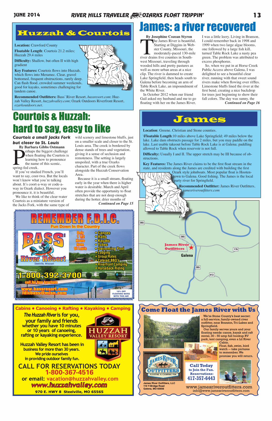
Location: Greene, Christian and Stone counties.\Floatable Length:10 miles above Lake Springfield; 49 miles below the lake. Lake dam obstructs passage for 2 miles, but you may paddle on the lake. Last usable takeout before Table Rock Lake is at Galena; paddling allowed to Table Rock when reservoir is not full.Difficulty: Usually I and II. The upper stretch may be III because of ob-structions. Key Features: The James River claims to be the first float stream in the state, and residents along the James are credited with building the first
Ozark style johnboats. Most popular float is Hooten-town to Galena. Good fishing. The James is the local party river for Springfield.
Recommended Outfitter: James River Outfitters, jamesriveroutfitters.com
James
Location: Crawford CountyFloatable Length: Courtois 21.2 miles; Huzzah 29.4 milesDifficulty: Shallow, but often II with high gradientKey Features: Courtois flows into Huzzah, which flows into Meramec. Clear, gravel bottomed, frequent obstructions, rarely deep. Can flash flood, crowded summer weekends, good for kayaks, sometimes challenging for tandem canoe.Recommended Outfitters: Bass’ River Resort, bassresort.com; Huz-zah Valley Resort, huzzahvalley.com; Ozark Outdoors Riverfront Resort, ozarkoutdoors.net.
Huzzah & Courtois
REMEMBER F.D.I.C.
1-800-392-3700
Only 1 1/2 Hours from
St Louis
• Canoes • Rafts • Kayaks • Tubes • Swimming Pool • Lodging • Group Rates • Catered BBQ's • Riverfront Camping • Horseback Riding
call for free brochure
10% OFF FLOATING RATES WITH THIS AD!
Fun Down In the Country
www.huzzahvalley.com
Cabins • Canoeing • Rafting • Kayaking • Camping
970 E. HWY 8 Steelville, MO 65565
The Huzzah River is for you, your family and friends
whether you have 10 minutes or 10 years of canoeing,
rafting or kayaking experience.
Huzzah Valley Resort has been in business for more than 30 years.
We pride ourselves in providing outdoor family fun.
CALL FOR RESERVATIONS TODAY 1-800-367-4516
or email: [email protected]
Courtois & Huzzah: hard to say, easy to likeCourtois a small Jacks Fork but closer to St. Louis
By Barbara Gibbs Ostmann
Perhaps the biggest challenge when floating the Courtois is learning how to pronounce the name of this scenic,
spring-fed creek. If you’ve studied French, you’ll want to say, coor-twa. But the locals won’t know what you’re talking about. It’s coort-a-way or code-a-way in Ozark dialect. However you pronounce it, it is beautiful. We like to think of the clear-water Courtois as a miniature version of the Jacks Fork, with the same type of
wild scenery and limestone bluffs, just on a smaller scale and closer to the St. Louis area. The creek is bordered by dense stands of trees and vegetation, giving it a sense of seclusion and remoteness. The setting is largely unspoiled, with a true Ozarks character. Part of the creek flows alongside the Huzzah Conservation Area. Because it is a small stream, floating early in the year when there is higher water is desirable. March and April often provide the opportunity to float stretches that are not deep enough during the hotter, drier months of
Continued on Page 15
By Josephine Cozean Styron
The James River is beautiful. Starting at Diggins in Web-ster County, Missouri, the moderately-paced 130-mile
river drains five counties in South-west Missouri, traveling through wooded hills and pretty pastures as well as more urban areas at a nice clip. The river is dammed to create Lake Springfield, then heads south to Galena before becoming an arm of Table Rock Lake, an impoundment of the White River. In October 2012 when our friend Gail asked my husband and me to go floating with her on the James River,
I was a little leery. Living in Branson, I could remember back in 1998 and 1999 when two large algae blooms, one followed by a large fish kill, turned Table Rock Lake a nasty pea green. The problem was attributed to excess phosphorus. So, when we put in at Horse Creek Public Access above Galena, I was delighted to see a beautiful clear river, running with that sweet sound rivers make when flowing over riffles. Limestone bluffs lined the river at the first bend, creating a nice backdrop for trees just beginning to show their fall colors. The day was sunny, the
Continued on Page 16
James: a river recovered
Come Float the James River with Us
James RIver Outfitters, LLC110 Y-Bridge RoadGalena, MO 65656 www.jamesriveroutfitters.com
Call Todayto Join the Fun. Reservations:
417-357-6443
We’re Stone County’s best secret:a full-service, family-owned riveroutfitter, near Branson, Tri-Lakes and Springfield. Our family serves yours and your floating needs: canoe, kayak and raft rental, 30 - 50 amp full hookup RV park, tent camping, even a Lil River
Cabin. Float, fish, swim, bird watch -- take picturesto remember. We promise you wlll return.
RIVER HILLS TRAVELER OZARKS FLOAT TRIPPIN’14 JUNE 2014
To avoid crowds on busy Meramecweekday floats are your best bet
Location: Dent, Crawford, Phelps, Franklin, Jefferson, St. Louis countiesFloatable Length: 193.5 milesDifficulty: Usually I, occasionally IIKey Features: Upper Meramec and Maramec Spring is trout/smallmouth fishery with shallow, clear water; middle to lower Meramec is murky catfish water. Banks have numerous caves, some small springs. Gravel to mud bottom. Lots of public land access. Can be floated all the way to Mis-sissippi River. Popular swimming river. Flows through historically signifi-cant mineral area. Lower portion urban, but still used.Recommended Outfitters: Bass’ River Resort, bassresort.com; Huzzah Valley Resort, huzzahvalley.com; Meramec State Park, meramecpark.com; Old Cove Canoe & Kayak, oldcovecanoe.com; Ozark Outdoors Riverfront Resort, ozarkoutdoors.net; Riverview Ranch, riverviewranch.org; The Rafting Co., theraftingco.com.Recommended Campground: Pheasant Acres, pheasantacresrv.com.
MeramecST. CLAIR
STANTON
SULLIVAN
BOURBON
CUBA
ST. JAMES
Trophy trout, trophy smallmouth areas
Boys TownTourist Info Center
To RollaMaramec Spring Trout Park
Access
Cook Station
SALEM
Indian Trail St. Forest
Dillard MillState Park Mill Tours
Cherryville
RedhorseSt. Access
Little Indian Creek St. Forest
Pea RidgeSt. Forest
Onondaga St. Park
Mark TwainNational Forest
Berryman Trail
To Potosi
To Potosi
Leasburg
Mer
amec
Riv
er
Mer
amec
Riv
er
Access
Huzzah Wildlife Area
Huzzah Creek
Courtois C
reek
44
HN
K
W
U
STEELVILLE
E
T
VC
Y
Y
Z
W
D
W
HuzzahValley Resort
Bass River Resort
PP 30
185
19
49
V V
68
NN
19
TT
F
O
BB
44
ZZ
KK
OzarkOutdoors
88
M
YY
★
MeramecState Park
★
★
★Traveler
★RiverviewRanch
★
TheRaftingCompany
47
★
★PheasantAcres
Old CoveCanoe & Kayak
AH
★
By Barbara Gibbs Ostmann
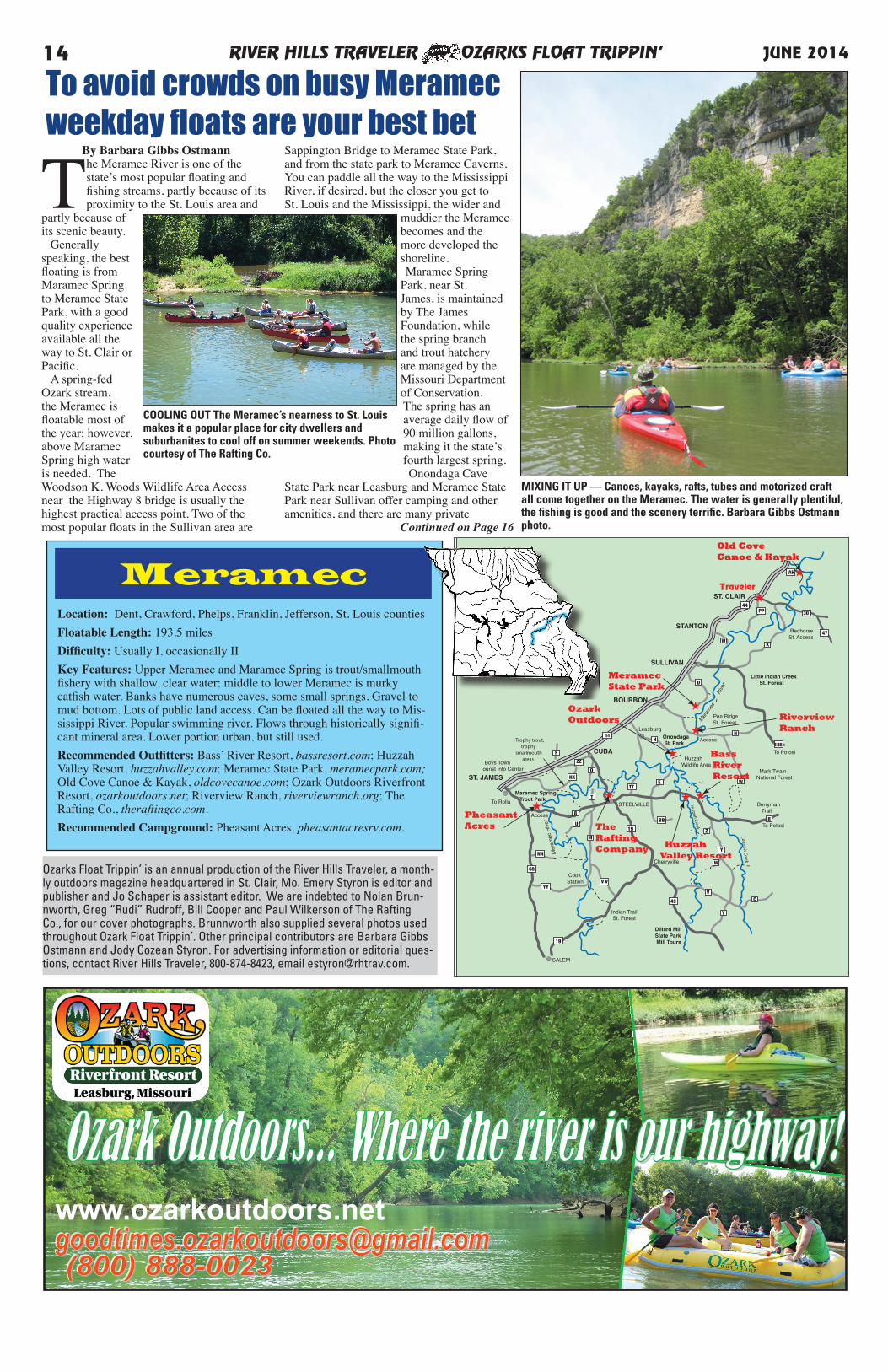
The Meramec River is one of the state’s most popular floating and fishing streams, partly because of its proximity to the St. Louis area and
partly because of its scenic beauty. Generally speaking, the best floating is from Maramec Spring to Meramec State Park, with a good quality experience available all the way to St. Clair or Pacific. A spring-fed Ozark stream, the Meramec is floatable most of the year; however, above Maramec Spring high water is needed. The Woodson K. Woods Wildlife Area Access near the Highway 8 bridge is usually the highest practical access point. Two of the most popular floats in the Sullivan area are
Sappington Bridge to Meramec State Park, and from the state park to Meramec Caverns. You can paddle all the way to the Mississippi River, if desired, but the closer you get to St. Louis and the Mississippi, the wider and
muddier the Meramec becomes and the more developed the shoreline. Maramec Spring Park, near St. James, is maintained by The James Foundation, while the spring branch and trout hatchery are managed by the Missouri Department of Conservation. The spring has an average daily flow of 90 million gallons, making it the state’s fourth largest spring. Onondaga Cave
State Park near Leasburg and Meramec State Park near Sullivan offer camping and other amenities, and there are many private
Continued on Page 16
www.ozarkoutdoors.net
MIXING IT UP — Canoes, kayaks, rafts, tubes and motorized craft all come together on the Meramec. The water is generally plentiful, the fishing is good and the scenery terrific. Barbara Gibbs Ostmann photo.
COOLING OUT The Meramec’s nearness to St. Louis makes it a popular place for city dwellers and suburbanites to cool off on summer weekends. Photo courtesy of The Rafting Co.
Ozarks Float Trippin’ is an annual production of the River Hills Traveler, a month-ly outdoors magazine headquartered in St. Clair, Mo. Emery Styron is editor and publisher and Jo Schaper is assistant editor. We are indebted to Nolan Brun-nworth, Greg “Rudi” Rudroff, Bill Cooper and Paul Wilkerson of The Rafting Co., for our cover photographs. Brunnworth also supplied several photos used throughout Ozark Float Trippin’. Other principal contributors are Barbara Gibbs Ostmann and Jody Cozean Styron. For advertising information or editorial ques-tions, contact River Hills Traveler, 800-874-8423, email [email protected].
RIVER HILLS TRAVELER OZARKS FLOAT TRIPPIN’ 15JUNE 2014
Concessionaire Mike Fleming
1-888-MERAMEC or 573-468-6519
CALL 1-888-MERAMEC or 573-468-65191-888-637-2632 or visit meramecpark.com - weekend reservations
4 Miles South of Sullivan on Hwy 185
Meramec State Park
Fireside Store & Grill
Ice • Firewood • Camping & Fishing Supplies • Licenses • Beer
• MOTEL • CONFERENCE ROOM
Cab in s Now Open un t i l Oc t obe r 31s t
Grill features appetizers, burgers, fries, sandwiches and more!
Groceries • Souvenirs • ATM • Propane
CANOE, RAFT & KAYAK FLOATS on the Meramec River
Fall and Spring Specials: Stay 3 nights, 4th night free after Labor Day, before Memorial Day
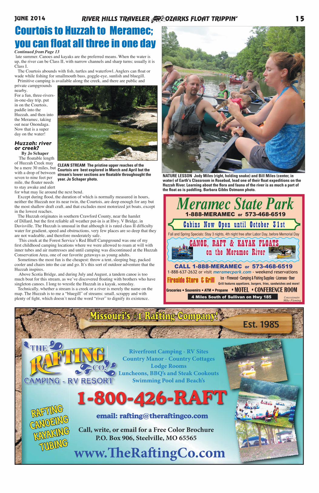
Continued from Page 13 late summer. Canoes and kayaks are the preferred means. When the water is up, the river can be Class II, with narrow channels and sharp turns; usually it is Class I. The Courtois abounds with fish, turtles and waterfowl. Anglers can float or wade while fishing for smallmouth bass, goggle-eye, sunfish and bluegill. Primitive camping is available along the creek, and there are public and private campgrounds nearby. For a fun, three-rivers-in-one-day trip, put in on the Courtois, paddle into the Huzzah, and then into the Meramec, taking out near Onondaga. Now that is a super day on the water!
Huzzah: river or creek?
By Jo Schaper The floatable length of Huzzah Creek may be a mere 30 miles, but with a drop of between seven to nine feet per mile, the floater needs to stay awake and alert for what may lie around the next bend. Except during flood, the duration of which is normally measured in hours, neither the Huzzah nor its near twin, the Courtois, are deep enough for any but the most shallow draft craft, and that excludes most motorized jet boats, except in the lowest reaches. The Huzzah originates in southern Crawford County, near the hamlet of Dillard, but the first reliable all weather put-in is at Hwy. V Bridge, in Davisville. The Huzzah is unusual in that although it is rated class II difficulty water for gradient, speed and obstructions, very few places are so deep that they are not wadeable, and therefore moderately safe. This creek at the Forest Service’s Red Bluff Campground was one of my first childhood camping locations where we were allowed to roam at will with inner tubes and air mattresses and until camping was discontinued at the Huzzah Conservation Area, one of our favorite getaways as young adults. Sometimes the most fun is the cheapest: throw a tent, sleeping bag, packed cooler and chairs into the car and go. It’s this sort of outdoor adventure that the Huzzah inspires. Above Scotia Bridge, and during July and August, a tandem canoe is too much boat for this stream, as we’ve discovered floating with brothers who have singleton canoes. I long to wrestle the Huzzah in a kayak, someday. Technically, whether a stream is a creek or a river is merely the name on the map. The Huzzah is to me a “bluegill” of streams: small, scrappy and with plenty of fight, which doesn’t need the word “river” to dignify its existence.
NATURE LESSON Jody Miles (right, holding snake) and Bill Miles (center, in water) of Earth's Classroom in Rosebud, lead one of their float expeditions on the Huzzah River. Learning about the flora and fauna of the river is as much a part of the float as is paddling. Barbara Gibbs Ostmann photo.
CLEAN STREAM The pristine upper reaches of the Courtois are best explored in March and April but the stream’s lower sections are floatable throughought the year. Jo Schaper photo.
Courtois to Huzzah to Meramec;you can float all three in one day
Continued from Page 13air had the smell of fresh river water. But, the James River hasn’t always been this way. By the 1990s, the once-vaunted river of trophy bass and scenic float trips had become so polluted that the local band, Big Smith, even wrote a song,“The Dirty Old James,” about it. Effluents such as excessive nitrogen and phosphates from industrial, urban and rural sources had turned the water ugly and made swimming and floating on the James an unpleasant experi-ence. That’s when citizen-formed groups stepped in. The James River Basin Partnership formed with the purpose of restoring healthy water quality in the streams and lakes of the water-
shed. Director Joe Pitts said the Environ-mental Protection Agency, working through the Missouri Department of Natural Resources, got Springfield, Ozark and Nixa on the pathway to providing phosphorous removal. After expenditures of millions of dollars, the river and its watershed began to improve. Better water quality benefitted wild-life, too. “I always see birds on the James,” said Gail. “I’ve seen eagles on nests right there on the river. I always see herons, kingfishers, and turkey vultures.” In February this year, my husband Harry and I again floated the James with Gail and other friends. The weather was beautiful and warm for
early spring. In my borrowed kayak, I ventured ahead of the others. In the quiet, I came upon many birds of different species, sometimes sharing a field or bank together. I saw eagles, kingfish-ers, many ducks and Canada geese, that would repeatedly fly up as I ap-proached, then land further down the river. My favorite part of the day came near the end of the float. I quietly “crept up” on a passel of geese and ducks. They watched me warily, but stayed put on the bank. Then my friends came around the river bend, laughing and talking. Suddenly I was surrounded by wings, feathers, and honking as the ducks and geese around me literally exploded into the
air. One goose flew right in so close that I could almost touch it. As we took out near the twin bridges at Galena, I reflected on what a wonderful float this had been. I didn’t know the history of the James River at that time. I only knew that I had had a wonderful time on a beautiful river.
RIVER HILLS TRAVELER OZARKS FLOAT TRIPPIN’16 JUNE 2014
pheasantacresrv.com573-265-5149
20279 Highway 8St James, MO 65559
Latitude: 37° 57’ 29.7” N Longitude: 91° 36’ 29.9” W
Family Friendly - Shady SitesOpen Year Round
Near Trout Fishing - Music ShowsShow Caves - RestaurantsBow Fishing in Season - More
A short drive south from I-44!
CANOEING • RAFTINGCAMPING • FISHING
Hot Showers • Tasty BBQFREE fishing with camping
No permit required
1-573-775-2419www.luckycloverriverresort.com
69 Lucky Clover Rd • Steelville, MO
Canoes • Kayaks • Rafts • Group Camping
Weekend Floats • Canoe Trips for 2starting at $30.00
Less than an hour from St. Louis
4.5 and 9 mile floats back to your carPlenty of gravel bars and bluffs
Stream, creek and spring-fed water
1316 Old Cove Rd St. Clair, MO 63077
www.oldcovecanoe.com636-629-2220
Float The Cove!
CALL FOR RESERVATIONS!
Group and private party camping only. Old Cove does not have a convenience store. Please bring food, drink, and supplies with you. The nearest convenience storegas station is in St. Clair, about 8 miles away.
WHERE DO YOU WANT TO STAY?
HOW DO YOU WANT TO PLAY?
WHERE DO YOU WANT TO GO?
Group cabin, camper cabin, tent or a bag under the stars, we can accommodate you.
Bringing your RV? We have electric sites. We’ve got river spaces and higher places. Go to www.riverviewranch.org, and call to
RESERVE today!
From Riverview Ranch you are in easydriving distance of show caves, old iron furnaces,
plenty of state park and conservation land, antiquing along I-44, local restaurants, Cuba-the
Rt. 66 Mural City, the world’s largest rocking chair, and even St. Louis. Visit the city and sleep
in the quiet under our stars.
You play YOUR way here. Quiet. LOUD. Go for a hike on nearby Vilander Bluff, highest bluff on the upper Meramec. Float. Swim. Strum your guitar. Party hard on one of our music weekends. Bring 400 of your closest friends. Talk to us. We can make it happen.
WHAT DO YOU WANT TO ROW? Canoes. Kayaks. Rafts. Tubes. Your own float-ing craft. At Riverview Ranch floats start upstream and come back to camp at your own speed. No “rushing” to make the takeout in time. Our takeout point isn’t going any-where. Check with us for group and weekday rates.We’ll beat any local advertised prices.
For more information, visit www.riverviewranch.org or call 800-RIV-VIEW (800-748-8439)
Whatever Happens Here A River Runs Through It.
Riverfront Resort
On the Banks of the Meramec RiverJust Down from Campbell Bridge
Hwy. N • South of Bourbon
Continued from Page 14campgrounds and resorts along this stretch of the river. Meramec Caverns, a popular tourist attraction near Stanton, offers cave tours, zipline, boat rides, lodging and dining. Continuing east toward St. Louis, you’ll find Robertsville State Park, Route 66 State Park and Castlewood State Park, all with nearby access to the river. Canoes, kayaks, rafts and tubes are all appropriate for the Meramec, and motorboats are also permitted. The river is rated mostly Class I, with limited Class II, and is suitable for both experienced and novice paddlers. Summer weekends can be crowded and rowdy, especially near some of the larger private campgrounds, but weekdays offer peaceful nature experiences. The Meramec is home to the most diverse aquatic life of any river in the state. There are many unique, rare and endangered mussels, and even
some Ozark hellbenders, a type of salamander. Fishermen will find smallmouth bass, catfish and panfish, plus trout fishing at Maramec Spring Park.
TUBE TIME Tubes are popular on the Meramec and other Ozark streams, probably because they are easy to fall out of. The Rafting Co. photo.
Meramec prized for diversity of aquatic life
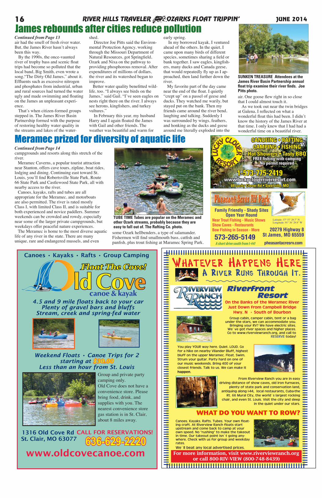
SUNKEN TREASURE Attendees at the James River Basin Partnership annual float trip examine their river finds. Joe Pitts photo.
James rebounds after cities reduce pollution
RIVER HILLS TRAVELER OZARKS FLOAT TRIPPIN’ 17JUNE 2014
Bennett SpringState Park
Nia
n gua
River
64
64
M
arigold Lane
Co
rker
y R
oad
★
★
★
To MO 5, Lebanon& I-44
BarclayConservationArea Coffin Cave
ConservationArea
One-EyedWilly’s
AdventuresFloat Trips
Circle JCampground
OO
NianguaLocation: Dallas, Laclede, Camden countiesFloatable Length: Usually 66 miles, sometimes 79.5 miles
Difficulty: I & IIKey Features: Trout waters at Bennett Spring, usually placid paddle,
mild gradient, decent fishing. Water clear to murky. Forms the Nian-gua Arm of Lake of the Ozarks.
Recommended Outfitters: Adventures Float Trips & Camp-ground, mo-adventures.org; Circle J Campground, circlejcamp-
ground.com; One-Eyed Willy’s, oneeyedwillys.com.
Niangua River, Bennett SpringState Park offer many options
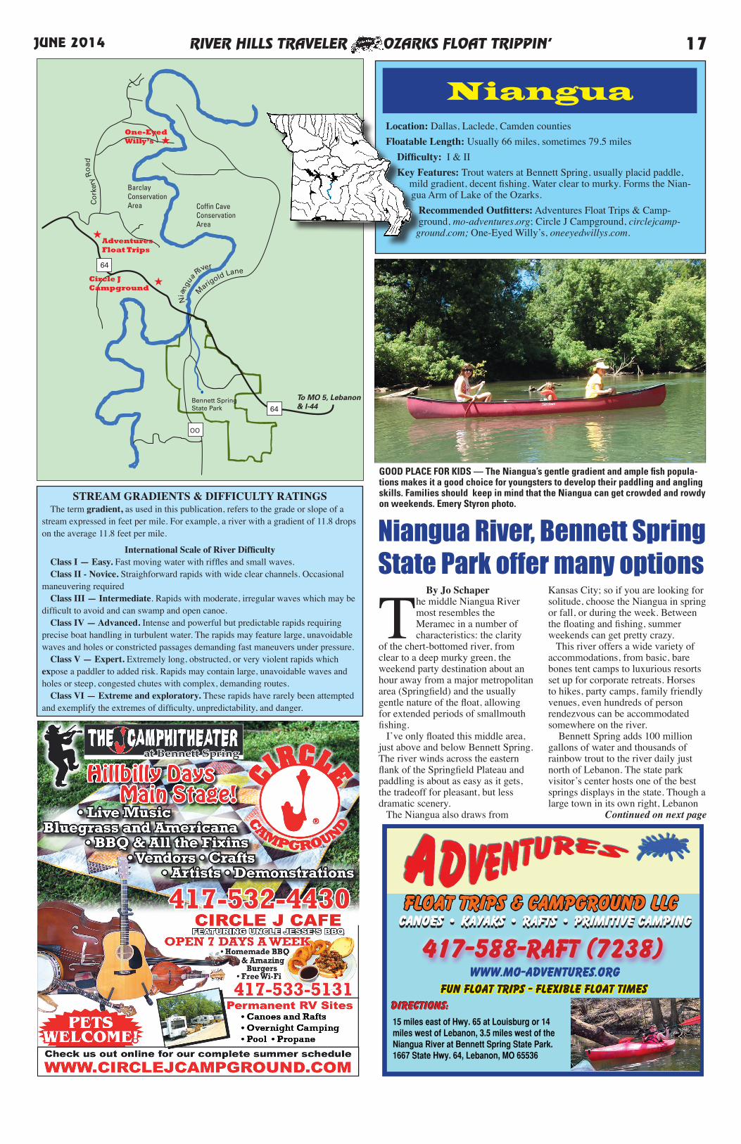
GOOD PLACE FOR KIDS — The Niangua’s gentle gradient and ample fish popula-tions makes it a good choice for youngsters to develop their paddling and angling skills. Families should keep in mind that the Niangua can get crowded and rowdy on weekends. Emery Styron photo.
FLoat trips & Campground LLC
417-588-RAFT (7238)
15 miles east of Hwy. 65 at Louisburg or 14 miles west of Lebanon, 3.5 miles west of the Niangua River at Bennett Spring State Park. 1667 State Hwy. 64, Lebanon, MO 65536
Canoes • Kayaks • Rafts • Primitive CampingCanoes • Kayaks • Rafts • Primitive Camping
Directions:Directions:
www.mo-adventures.orgFun FLoat Trips - Flexible FLoat Times
By Jo Schaper
The middle Niangua River most resembles the Meramec in a number of characteristics: the clarity
of the chert-bottomed river, from clear to a deep murky green, the weekend party destination about an hour away from a major metropolitan area (Springfield) and the usually gentle nature of the float, allowing for extended periods of smallmouth fishing. I’ve only floated this middle area, just above and below Bennett Spring. The river winds across the eastern flank of the Springfield Plateau and paddling is about as easy as it gets, the tradeoff for pleasant, but less dramatic scenery. The Niangua also draws from
Kansas City; so if you are looking for solitude, choose the Niangua in spring or fall, or during the week. Between the floating and fishing, summer weekends can get pretty crazy. This river offers a wide variety of accommodations, from basic, bare bones tent camps to luxurious resorts set up for corporate retreats. Horses to hikes, party camps, family friendly venues, even hundreds of person rendezvous can be accommodated somewhere on the river. Bennett Spring adds 100 million gallons of water and thousands of rainbow trout to the river daily just north of Lebanon. The state park visitor’s center hosts one of the best springs displays in the state. Though a large town in its own right, Lebanon
Continued on next page
STREAM GRADIENTS & DIFFICULTY RATINGS The term gradient, as used in this publication, refers to the grade or slope of a stream expressed in feet per mile. For example, a river with a gradient of 11.8 drops on the average 11.8 feet per mile.
International Scale of River Difficulty Class I — Easy. Fast moving water with riffles and small waves. Class II - Novice. Straighforward rapids with wide clear channels. Occasional maneuvering required Class III — Intermediate. Rapids with moderate, irregular waves which may be difficult to avoid and can swamp and open canoe. Class IV — Advanced. Intense and powerful but predictable rapids requiring precise boat handling in turbulent water. The rapids may feature large, unavoidable waves and holes or constricted passages demanding fast maneuvers under pressure. Class V — Expert. Extremely long, obstructed, or very violent rapids which expose a paddler to added risk. Rapids may contain large, unavoidable waves and holes or steep, congested chutes with complex, demanding routes. Class VI — Extreme and exploratory. These rapids have rarely been attempted and exemplify the extremes of difficulty, unpredictability, and danger.
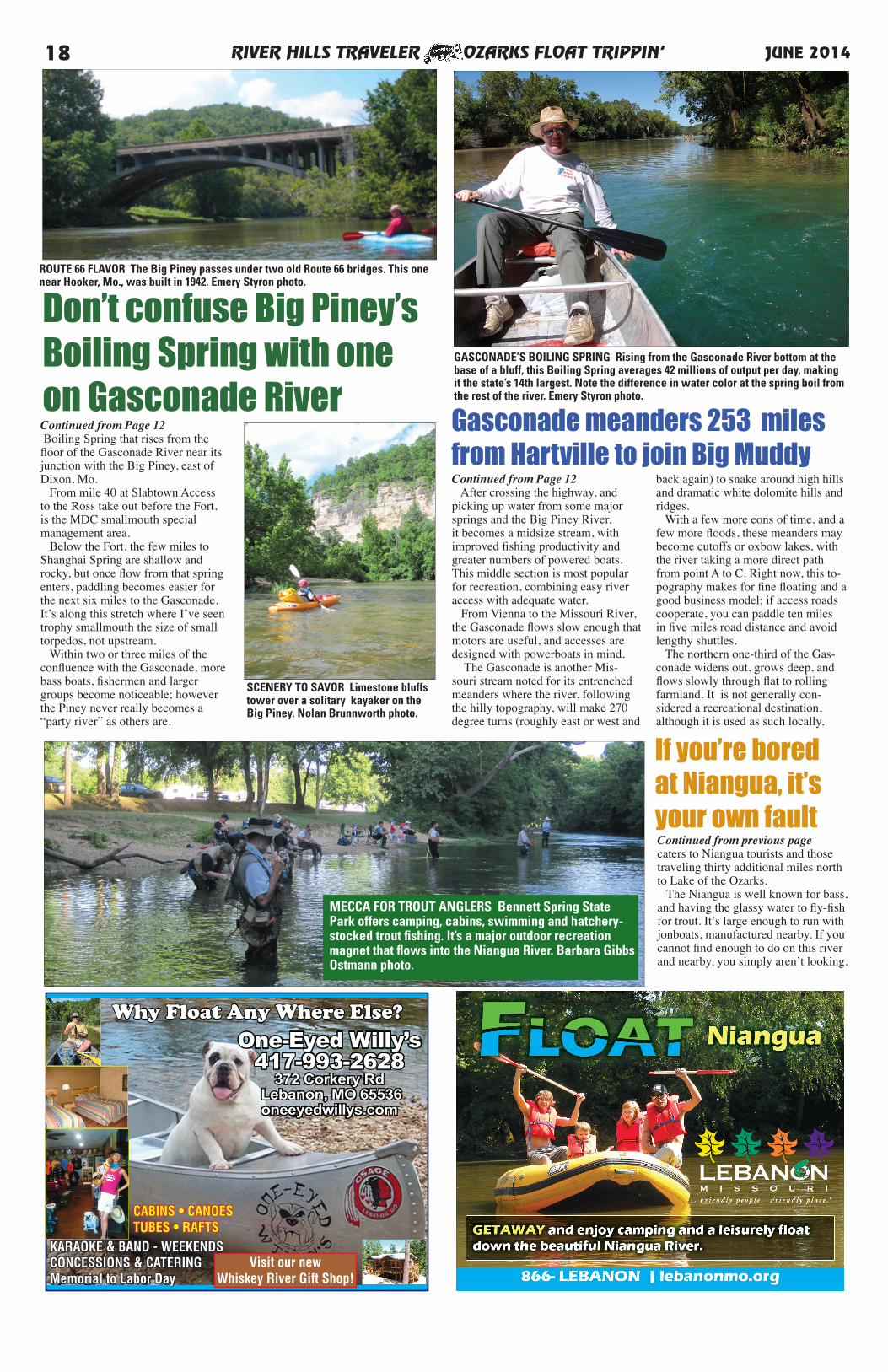
RIVER HILLS TRAVELER OZARKS FLOAT TRIPPIN’18 JUNE 2014
One-Eyed Willy’s417-993-2628
372 Corkery Rd Lebanon, MO 65536oneeyedwillys.com
Why Float Any Where Else?
KARAOKE & BAND - WEEKENDSCONCESSIONS & CATERING Memorial to Labor Day
CABINS • CANOES TUBES • RAFTS
Visit our new Whiskey River Gift Shop!
Continued from Page 12 Boiling Spring that rises from the floor of the Gasconade River near its junction with the Big Piney, east of Dixon, Mo. From mile 40 at Slabtown Access to the Ross take out before the Fort, is the MDC smallmouth special management area. Below the Fort, the few miles to Shanghai Spring are shallow and rocky, but once flow from that spring enters, paddling becomes easier for the next six miles to the Gasconade. It’s along this stretch where I’ve seen trophy smallmouth the size of small torpedos, not upstream. Within two or three miles of the confluence with the Gasconade, more bass boats, fishermen and larger groups become noticeable; however the Piney never really becomes a “party river” as others are.
Continued from Page 12 After crossing the highway, and picking up water from some major springs and the Big Piney River, it becomes a midsize stream, with improved fishing productivity and greater numbers of powered boats. This middle section is most popular for recreation, combining easy river access with adequate water. From Vienna to the Missouri River, the Gasconade flows slow enough that motors are useful, and accesses are designed with powerboats in mind. The Gasconade is another Mis-souri stream noted for its entrenched meanders where the river, following the hilly topography, will make 270 degree turns (roughly east or west and
back again) to snake around high hills and dramatic white dolomite hills and ridges. With a few more eons of time, and a few more floods, these meanders may become cutoffs or oxbow lakes, with the river taking a more direct path from point A to C. Right now, this to-pography makes for fine floating and a good business model; if access roads cooperate, you can paddle ten miles in five miles road distance and avoid lengthy shuttles. The northern one-third of the Gas-conade widens out, grows deep, and flows slowly through flat to rolling farmland. It is not generally con-sidered a recreational destination, although it is used as such locally,
Gasconade meanders 253 milesfrom Hartville to join Big Muddy
Don’t confuse Big Piney’sBoiling Spring with oneon Gasconade River
ROUTE 66 FLAVOR The Big Piney passes under two old Route 66 bridges. This one near Hooker, Mo., was built in 1942. Emery Styron photo.
SCENERY TO SAVOR Limestone bluffs tower over a solitary kayaker on the Big Piney. Nolan Brunnworth photo.
GASCONADE’S BOILING SPRING Rising from the Gasconade River bottom at the base of a bluff, this Boiling Spring averages 42 millions of output per day, making it the state’s 14th largest. Note the difference in water color at the spring boil from the rest of the river. Emery Styron photo.
Continued from previous pagecaters to Niangua tourists and those traveling thirty additional miles north to Lake of the Ozarks. The Niangua is well known for bass, and having the glassy water to fly-fish for trout. It’s large enough to run with jonboats, manufactured nearby. If you cannot find enough to do on this river and nearby, you simply aren’t looking.
If you’re boredat Niangua, it’syour own fault
MECCA FOR TROUT ANGLERS Bennett Spring State Park offers camping, cabins, swimming and hatchery-stocked trout fishing. It’s a major outdoor recreation magnet that flows into the Niangua River. Barbara Gibbs Ostmann photo.
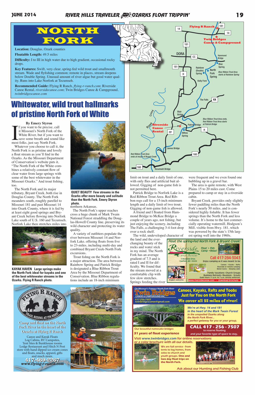
RIVER HILLS TRAVELER OZARKS FLOAT TRIPPIN’ 19JUNE 2014
By Emery Styron
If you want to be precise, call it Missouri's North Fork of the White River, but if you want to save some breath and sound like
most folks, just say North Fork. Whatever you choose to call it, the North Fork is as pristine and lovely a float stream as you’ll find in the Ozarks. As the Missouri Department of Conservation’s website puts it, “The North Fork of the White com-bines a relatively constant flow of clear water from large springs with some of the best whitewater in the Missouri Ozarks.” And trout fishing, too. The North Fork and its major tributary, Bryant Creek, both rise in Douglas County. The North Fork meanders south, roughly parellel to Missouri 181 and past Missouri 14 into Ozark County, where it is fed by at least eight good springs and Bry-ant Creek before flowing into Norfork Lake south of U.S. 160 and Tecumseh. Norfork Lake then stretches miles into
northern Arkansas. The North Fork’s upper reaches cross a huge chunk of Mark Twain National Forest straddling the Doug-las-Howell County line, preserving its wild character and protecting its water quality. A variety of outfitters populate the river between Missouri 14 and Nor-fork Lake, offering floats from five to 23-miles, including multi-day and combined Bryant Creek-North Fork excursions. Trout fishng on the North Fork is a major attraction. The area between Rainbow Spring and Patrick Bridge is designated a Blue Ribbon Trout Area by the Missouri Department of Conservation. Blue Ribbon regula-tions include an 18-inch minimum
181
NorthForkSpring
HammondBridge
DORA
BlueSpring
PP
160
H
KK
CC
181
14
14
160
••
•
•
H
181
181 Rainbow(Double)Spring
Kelly Ford
The Falls
BlairBridge
Patrick Bridge
James Bridge
Tecumseh Bridge
AltheaSpring
Red Ribbon Trout Areaends at mouth of Bryant Creek
Blue Ribbon Trout Area ends,Red Ribbon Trout Area startsat Patrick Bridge
Blue Ribbon Trout Areastarts at Rainbow Spring
Brya
nt
Cre
ek
Flying R Ranch ★
★
★RiversideCanoeRental
Twin BridgesCanoe & Campground
NORTHFORK
Location: Douglas, Ozark countiesFloatable Length: 49.5 milesDifficulty: I to III in high water due to high gradient, occasional rocky drops. Key Features: Swift, very clear, spring-fed wild trout and smallmouth stream. Wade and flyfishing common; remote in places, stream deepens below Double Spring. Unusual amount of river algae but good water qual-ity. Runs into Lake Norfork at Tecumseh. Recommended Guide: Flying R Ranch, flying-r-ranch.com; Riverside Canoe Rental, riversidecanoe.com; Twin Bridges Canoe & Campground, twinbridgescanoe.com
Whitewater, wild trout hallmarksof pristine North Fork of White
limit on trout and a daily limit of one, with only flies and artificial bait al-lowed. Gigging of non-game fish is not permitted here. Patrick Bridge to Norfork Lake is a Red Ribbon Trout Area. Red Rib-bon regs call for a 15-inch minimum length and a daily limit of two trout. Gigging of non-game fish is allowed. A friend and I floated from Ham-mond Bridge to McKee Bridge a couple of years ago, not fishing, but just enjoying the scenery, including The Falls, a challenging 3-4 foot drop over a rock shelf. The wild, undeveloped character of the land and the ever-changing beauty of the rocks and water stick in my mind. The North Fork has an average gradient of 7.5 and is rated I and II for dif-ficulty. We found that the stream moved at a comfortable clip with few slow stretches. Springs feeding the river
were frequent and we even found one bubbling up in a gravel bar. The area is quite remote, with West Plains 15 to 20 miles east. Come prepared to camp or stay in a riverside cabin. Bryant Creek, provides only slightly fewer paddling miles than the North Fork’s nearly 50 miles, and is con-sidered highly fishable. It has fewer springs than the North Fork and less volume. It’s home to the last commer-cially operating watermill, Hodgson’s Mill, visible from Hwy. 181, which was powered by the state’s 15th larg-est spring well into the 1960s.
QUIET BEAUTY Few streams in the Ozarks offer more beauty and solitude than the North Fork. Emery Styron photo.
417-469-2267
Camp and fl oat on the North Fork River in the heart of the
Ozarks at Flying R RanchCanoe and Kayak Floats
Log Cabins, RV Campsites, Tent Sites & Bunkhouse rooms
Lodge Restaurant and Hitch N Post store with hand dipped ice cream cones
and fl oats, snacks, apparel, gift s and much more.
417-469-2267www.flying-r-ranch.com
Camp and fl oat on the North Fork River in the heart of the
Ozarks at Flying R Ranch
Twin BridgesTwin BridgesCANOE & CAMPGROUND INC.
On Missouri’s Famous North Fork River Canoes, Kayaks, Rafts and ToobsJust for You on the North Fork
We cover all 52 miles of river!
We’re at Hwy. 14 and 181in the heart of the Mark Twain Forestin the unspoiled Ozarks alongthe North Fork River...a perfect getaway for you or your group.
Ask about our Hunting and Fishing Club
CALL 417 - 256 - 7507 to reserve floating
and your favorite type of space to stay.
Visit www.twinbridges.com for online reservations or a color brochure with all our details.
Our beautiful namesake bridges
We are full service - from tents to log homes, from solos to church and youth groups. One and two day float trips on the North Fork.
31 years of float experience
Float • FishCamp •Relax!
Family Vacations•Church Groups Business Retreats•Reunions •Scouts
www.riversidecanoe.com • download brochure
Call 417-284-3043 5 Riverside Drive.Caulfield, MO 65626
Float the spring-fed North Fork & Bryant Creek!
Anglers welcome
Enjoy camping as it was meant to be.
Quiet hours 11 p.m. to 7 a.m. strictly enforced.
Canoes • Kayaks • RaftsRiverside or remote camping Motel rooms • Sleeping cabinKAYAK HAVEN Large springs make
the North Fork ideal for kayaks and one of the best whitewater streams in the Ozarks. Flying R Ranch photo.
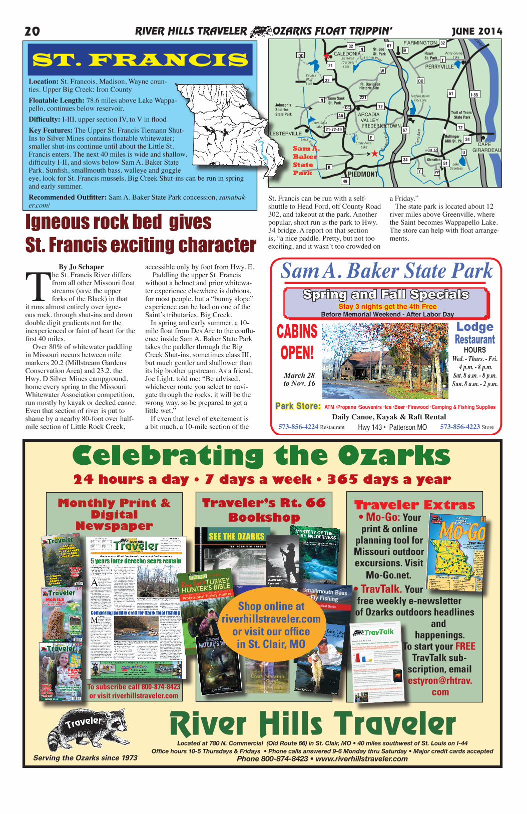
RIVER HILLS TRAVELER OZARKS FLOAT TRIPPIN’20 JUNE 2014
Monthly Print & Digital
Newspaper
Celebrating the OzarksTraveler’s Rt. 66
BookshopTraveler Extras• Mo-Go: Your print & online
planning tool for Missouri outdoor excursions. Visit
Mo-Go.net.• TravTalk. Your free weekly e-newsletter
of Ozarks outdoors headlines and
happenings.To start your FREE
TravTalk sub-scription, email estyron@rhtrav.
com
24 hours a day • 7 days a week • 365 days a year
River Hills Traveler
Shop online atriverhillstraveler.com
or visit our officein St. Clair, MO
From: "Emery Styron, River Hills Traveler" <[email protected]>
Subject: [Test] TravTalk, your free weekly e-newsletter of Missouri outdoor headlines and happenings
Date: May 10, 2013 9:31:15 AM CDT
To: << Test First Name >> <[email protected]>
Reply-To: <[email protected]>
TravTalk No. 6: New Traveler Poll, Missouri ghost stories, more elk coming,
morel recipes & more!
View this email in your browser
Volume 1, No. 6, May 10, 2013
Your weekly e-newsletter of Missouri outdoors headlines & happenings
New Traveler Poll: Bass fishing, shooting, chess, bowling as
sanctioned high school activities? What do you think?
Last week we told you that the Missouri State High
School Activities Association has sanctioned bass
fishing, target shooting, bowling and chess as high
school activities starting next year.
Will this improve our kids' connection with the
outdoors? Will it get more students involved? Are
we just taking up more education resources with non-academic activities?
Vote in Traveler's poll.
Missouri Shadows: ghost stories about Missouri places
Jo Schaper reviews New Haven, MO, policeman Dan Terry's book
detailing ghost sightings througout Missouri.
Terry brings his professional training in forensics, his knowledge of the
rules of evidence, his interviewing skills, plus a fair amount of
“ghostbusting” equipment to a number of allegedly haunted Missouri
locations, from Hannibal to Hornet, and Jefferson to Jackson counties.
Do you have a Missouri ghost story you'd like to share? We'd like to hear about it.
Rocky Mountain Elk Foundation habitat council at Peck Ranch
On Monday, May 6 RMEF volunteers and Missouri Department
of Conservation team members rolled out the red carpet —
burlap that is — for the arrival mid-May of the final installment of
35 elk from Kentucky.
A handful of yummy morel recipes
Jo Schaper shares morel mushroom recipes from sources as varied
as Pat Todd, Cy Littlebee, Martha Stewart and Anthony Bourdain.
She's wishing someone would bring her a batch of mushrooms
already fried up.
To subscribe call 800-874-8423or visit riverhillstraveler.com
Serving the Ozarks since 1973
Located at 780 N. Commercial (Old Route 66) in St. Clair, MO • 40 miles southwest of St. Louis on I-44Office hours 10-5 Thursdays & Fridays • Phone calls answered 9-6 Monday thru Saturday • Major credit cards accepted
Phone 800-874-8423 • www.riverhillstraveler.com
Big RiverMarine
TheCountryStore
Council BluffLake Rec. Area
TheArbor
ArcadiaSporting Goods
MeatMarket
Olympic Steak House
Cherokee Pass Restaurant
BlackRiver Rats
Big Rive
r
Mineral
Fork
Black River
Crane Pond Lake
Taum Sauk Lake
Bismarck(Desalvo) Lake
Big River
Fredericktown City Lake
★
Trail of Tears State Park
Johnson'sShut-InsState Park
Taum Sauk St. Park
Ft. DavidsonHistoric Site
St. JoeSt. Park
St. FrancoisState Park
HawnSt. Park
BollingerMill St. Pk.
Washington State Park
Glenallen
110
Perry County Lake
LakeGirardeau
St. Fra
ncis
Rive
r
Cas
tor R
iver
Mississippi River
Palmer Lake
FESTUS
CEDAR HILL
POTOSI
DESOTO
BONNETERRE
PARK HILLS
F ARMINGTON
STE.GENEVIEVE
CAPEGIRARDEAU
ARCADIA VALLEY
30
47
A
BB
M
47
88
32
32
49
21-72-49
72
72
34
34
51
51 I-55
U
E
N
CC
AA
221
W
DDT
OO
32
CouncilBluffLake
I-55
Y PP
RT ZZ
LESTERVILLE
K
21
21
C
67FREDERICKTOWN
67N
St. Francis River
2121
CALEDONIA
PERRYVILLE
67
ED
★
Sam A.BakerState Park PIEDMONT
Location: St. Francois, Madison, Wayne coun-ties. Upper Big Creek: Iron CountyFloatable Length: 78.6 miles above Lake Wappa-pello, continues below reservoir. Difficulty: I-III, upper section IV, to V in floodKey Features: The Upper St. Francis Tiemann Shut-Ins to Silver Mines contains floatable whitewater; smaller shut-ins continue until about the Little St. Francis enters. The next 40 miles is wide and shallow, difficulty I-II, and slows below Sam A. Baker State Park. Sunfish, smallmouth bass, walleye and goggle eye, look for St. Francis mussels. Big Creek Shut-ins can be run in spring and early summer.Recommended Outfitter: Sam A. Baker State Park concession, samabak-er.com/
ST. FRANCIS
LodgeRestaurant
HOURSWed. - Thurs. - Fri.
4 p.m. - 8 p.m.Sat. 8 a.m. - 8 p.m.Sun. 8 a.m. - 2 p.m.
Daily Canoe, Kayak & Raft Rental 573-856-4224 Restaurant 573-856-4223 StoreHwy 143 • Patterson MO
Park Store: ATM •Propane •Souvenirs •Ice •Beer •Firewood •Camping & Fishing Supplies
Sam A. Baker State Park
CABINSOPEN!
Stay 3 nights get the 4th Free Before Memorial Weekend - After Labor Day
Spring and Fall Specials
March 28to Nov. 16
St. Francis can be run with a self-shuttle to Head Ford, off County Road 302, and takeout at the park. Another popular, short run is the park to Hwy. 34 bridge. A report on that section is, “a nice paddle. Pretty, but not too exciting, and it wasn’t too crowded on
a Friday.” The state park is located about 12 river miles above Greenville, where the Saint becomes Wappapello Lake. The store can help with float arrange-ments.
By Jo Schaper
The St. Francis River differs from all other Missouri float streams (save the upper forks of the Black) in that
it runs almost entirely over igne-ous rock, through shut-ins and down double digit gradients not for the inexperienced or faint of heart for the first 40 miles. Over 80% of whitewater paddling in Missouri occurs between mile markers 20.2 (Millstream Gardens Conservation Area) and 23.2, the Hwy. D Silver Mines campground, home every spring to the Missouri Whitewater Association competition, run mostly by kayak or decked canoe. Even that section of river is put to shame by a nearby 80-foot over half-mile section of Little Rock Creek,
accessible only by foot from Hwy. E. Paddling the upper St. Francis without a helmet and prior whitewa-ter experience elsewhere is dubious, for most people, but a “bunny slope” experience can be had on one of the Saint’s tributaries, Big Creek. In spring and early summer, a 10-mile float from Des Arc to the conflu-ence inside Sam A. Baker State Park takes the paddler through the Big Creek Shut-ins, sometimes class III, but much gentler and shallower than its big brother upstream. As a friend, Joe Light, told me: “Be advised, whichever route you select to navi-gate through the rocks, it will be the wrong way, so be prepared to get a little wet.” If even that level of excitement is a bit much, a 10-mile section of the
Igneous rock bed gives St. Francis exciting character