Embed Size (px)
Citation preview
2014 Geography
Higher Paper 1
Finalised Marking Instructions Scottish Qualifications Authority 2014 The information in this publication may be reproduced to support SQA qualifications only on a non-commercial basis. If it is to be used for any other purposes written permission must be obtained from SQA’s NQ Assessment team. Where the publication includes materials from sources other than SQA (secondary copyright), this material should only be reproduced for the purposes of examination or assessment. If it needs to be reproduced for any other purpose it is the centre’s responsibility to obtain the necessary copyright clearance. SQA’s NQ Assessment team may be able to direct you to the secondary sources. These Marking Instructions have been prepared by Examination Teams for use by SQA Appointed Markers when marking External Course Assessments. This publication must not be reproduced for commercial or trade purposes.
©
Page 2
Part One: General Marking Principles for: Geography Higher Paper 1 This information is provided to help you understand the general principles you must apply when marking candidate responses to questions in this Paper. These principles must be read in conjunction with the specific Marking Instructions for each question. (a) Marks for each candidate response must always be assigned in line with these
general marking principles and the specific Marking Instructions for the relevant question. If a specific candidate response does not seem to be covered by either the principles or detailed Marking Instructions, and you are uncertain how to assess it, you must seek guidance from your Team Leader/Principal Assessor.
(b) Marking should always be positive ie, marks should be awarded for what is correct
and not deducted for errors or omissions. GENERAL MARKING ADVICE: Geography Higher Paper 1 The marking schemes are written to assist in determining the “minimal acceptable answer” rather than listing every possible correct and incorrect answer. The following notes are offered to support Markers in making judgements on candidates’ evidence, and apply to marking both end of unit assessments and course assessments. 1. The maximum mark for Paper 1 is 100. Markers are encouraged to use the whole
range of marks and to give a high assessment for an answer of high quality. 2. The total marks assigned by you for each complete question should be entered in the
outer right-hand margin of the answer book. When a question consists of more than one part, the marks assigned to each part MUST BE SHOWN SEPARATELY in the column provided on the inner right-hand side of the book. It is of great importance that the utmost care should be exercised in adding up the marks. Where appropriate, all summations for totals and grand totals must be carefully checked. Where a candidate has scored zero marks for any question attempted “0” should be shown against the answer.
3. It is helpful in later procedures if points receiving marks are clearly indicated. In
general a mark should be awarded for a correct statement.
4. All mistakes MUST be underlined in red pen. A wavy line (~~~~~~~) should be used
for something that is not quite right, a single line (-------) for mistakes which, though not very serious, are undoubtedly wrong, and a double line (=======) for gross blunders. These corrections are valuable when borderline cases and appeals are being considered. Where a page shows neither a correction nor a mark, a red tick MUST be placed at the bottom right-hand corner

Page 3
5. The marker should take the candidate’s answers strictly as they are written; no
attempt should be made to read into answers ideas which the candidate may have intended to convey but which have not been successfully conveyed. A caret (λ) should be used to indicate an important omission. A question mark (?) should be used to indicate that the marker cannot understand the meaning intended. The letter “R” should be used to indicate that the candidate is repeating something already stated in the answer.
6. Care should be taken that no credit whatsoever is given to irrelevant parts of answers,
however accurate the irrelevant passages may be. Irrelevant passages should be square-bracketed [ ]. It should be noted, however, that a fact or argument which is irrelevant in one candidate's answer may be made quite relevant by another candidate who has the ability to connect it to the question
Page 4
Part Two: Marking Instructions for each Question Question 1: Hydrosphere Question Expected Answer(s) Max
Mark Additional Guidance
1 (a) Assess out of 10. Award up to 4 marks for
appropriate grid references/ names. Each river or valley feature should be credited only once. Award a maximum of 9/10 if no mention of valley.
10
Description could include:
• Meander 736657 Tributaries 740662 Confluence 737660 Pond 747619 Island 748615 Forming of bowlake 734648
• Variations in the width of the valley eg broad, flat flood plain – up to approx 1km wide.
• River – moderate width increasing downstream (735676).
• Upper to middle course. • References to the height of the land,
steepness of the valley sides and direction of flow (credit speed of river if linked to map evidence).
Page 5
Question Expected Answer(s) Max
Mark Additional Guidance
1 (b) Assess out of 8. Award a maximum of 5 for
either description or explanation. Answers should identify various parts of the river level graph, (no marks for describing the precipitation unless as an explanation of changing river levels):
8
• The river level is decreasing from 55 to
54cms until 03.00 due to an initial lack of rain. As the rain starts the river rises quickly. Some rain will infiltrate the soil but as this is in an urban area the rising limb is fairly steep due to the impermeable surfaces of roads/buildings and drains leading directly to the river.
• The river level rises to a peak of 73cms at 09.00 to 08.00 due to the increase in rainfall totals and duration. The heavier rain is filling up storages in the soil/ground because of throughflow and groundwater. The soil is now saturated so water runs off the land and enters the river quickly, leading to a potential flood situation.
• Although the river level starts to fall the rain continues to a second peak at 15.00 and the river level follows closely. The second river level peak of 65cms occurs at 18.00 to 19.00. The short (about 2 or 3 hours) basin lag time could be accounted for by the lack of vegetation cover, references to geology or soil infiltration rates as well as the impermeable urban surfaces.
• From 18.00 until the end of the graph there is no rainfall and the river level decreases slowly to 42cms. The recession limb is more gentle than the rising limb(s) – water is being added into the river from through/ground flow almost as fast as the river is draining it away. Some candidates may comment on the fact that there may have been earlier rainfall so that the ground was saturated the day before (28th April) and the base flow of the River Nene must be less than 40cms.
Page 6
Question 2: Biosphere Question Expected Answer(s) Max
Mark Additional Guidance
2 (a) Assess out of 4. Award a maximum of 1 mark
for an appropriate named example of climax vegetation. Climax vegetation is the final stage in the development of the natural vegetation of an area when the composition of the plant community is relatively stable and in equilibrium with the existing environmental conditions; this is normally determined by climate or soil. Credit should be given for answers showing a knowledge of the evolution of plant life from early colonisation by pioneer species to climax vegetation through succession. Relevant examples could include oak-ash forest in cool temperate areas such as much of Britain or Scots pine-birch in colder, wetter and less fertile Highland environments.
4
2 (b) Assess out of 14. Award a maximum of 5
marks for correctly named plants (one per location). Award a maximum of 4 marks for adaptations to any one plant type. For full marks at least 5 locations must be mentioned, description and explanation needed. Avoid over crediting the same explanatory factors eg shelter, humus etc. Credit should not be given to climax vegetation. 1. Strandline: Likely plant types include Sea
Sandwort, Sea Rocket, Saltwort. Salt tolerant species able to withstand desiccating effects of the sand and wind. Some able to cope with periodic immersion in sea water. Have also to adapt to alkaline conditions (high pH) because of high concentrations of shell fragments along the shore.
2. Embryo Dunes: Examples of plants such as Sand Couch, Lyme Grass, Sea Rocket. These pioneer species grow side/lateral roots and underground stems called rhizomes which bind the sand together. These grassy plants can also tolerate occasional immersion in sea water.
14
Page 7
Question Expected Answer(s) Max Mark
Additional Guidance
2 (b) (Cont.)
3. Fore Dunes: Examples of plants such as
Sea Holly, Sea Bindweed, Sand Sedge. Slightly higher humus content from decayed plants and lower salt content (further from the sea) allows these species to further stabilise the dune and allow the establishment of Marram grass which becomes a key plant in the build-up of the dune.
4. Yellow Dune: mainly Marram Grass but also Sand Fescue, Sand Sedge, Sea Bindweed and Ragwort. Both humus content and soil acidity have increased at this point. Being xerophytic, marram grass thrives on the drier mobile sands and becomes the dominant species, aligning itself with the prevailing wind to prevent moisture loss/reduce transpiration and can keep pace with being buried under deposits of sand thanks to its long, creeping rhizomes spreading laterally and vertically.
5. Grey Dune: Plants often present include: Bird's Foot Trefoil, Heather, Sea Buckthorn. Marram grass dies back, contributing humus. As a result of leaching and the build-up of humus, the soil is considerably more acidic and damper, allowing a wider range of plant species to grow in this more sheltered location. Declining sand supply due to protection of dunes in front.
6. Dune slack: Reeds and Rushes, Cotton grass, small Willows and Alders. The damp, low-lying hollows have a much higher water-table, especially in winter and support a hydrophytic (water tolerant) vegetation cover. Increased organic matter, shelter from the dune ridge in front and, being further inland, a less saline environment also contribute to a wider range of plants. As a result of water logging and the build up of humus, the soil is also more acidic.
Page 8
Question 3: Rural Geography Question Expected Answer(s) Max
Mark Additional Guidance
3 (a) Assess out of 8. Award a maximum of 5
marks for description including one mark for a specific named area and/or tribe. For intensive peasant farming: • Traditionally a subsistence type of farming
practiced in the monsoon lands of SE Asia.
• Small areas of flat, flooded padi fields are cultivated intensively.
• The high labour input is necessary due to the lack of capital for purchasing machinery.
• Farms are small because of the limited capital available, and many farms will have been sub-divided due to inheritance systems.
• Terraces will be created in areas of steep land to increase the area available for cultivation.
• Small earth embankments (bunds) will be used to retain water and separate fields.
• Rice is the main crop grown. • Draught animals, eg water buffalo, or
cultivators are used to plough and prepare the land since fields are too small for large machinery to be used effectively.
• Seeds are planted in the nursery beds. Seedlings are then transplanted to flooded fields.
• When the grain ripens, the water is drained off and the crop is harvested using sickles.
• Villagers often live in nucleated villages (kampongs) close to the fields.
• Trees around the fields give shade but may also provide fruit.
8
Page 9
Question Expected Answer(s) Max Mark
Additional Guidance
3 (b) (i) Assess out of 10 with a maximum of 6 for
either part. To gain full marks candidates must comment on the impact on people, the landscape and environment. 1 mark should be awarded for an appropriate named area. Answers will depend on the area studied. Changes will include: • Amalgamation of farms, with these larger
farms often being owned by businesses rather than families (agribusiness).
• Part time farming, the use of contractors (especially at harvest time) and co-operatives have increased.
• Mechanisation and agricultural technology continues to make the farm more efficient.
• Diversification of crops, with many farmers choosing to grow sunflowers instead of wheat.
• Increasing use of irrigation, pesticides and fertilisers.
• Increase in organic farming, whilst still operating on a large scale.
• Increase in GM crops. • Contour ploughing, strip cultivation and
shelter belt planting have been used to tackle soil erosion.
• Some land has been taken out of production in response to surpluses.
10
Page 10
Question Expected Answer(s) Max Mark
Additional Guidance
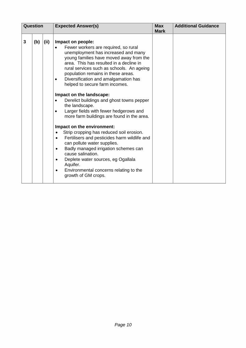
3 (b) (ii) Impact on people:
• Fewer workers are required, so rural unemployment has increased and many young families have moved away from the area. This has resulted in a decline in rural services such as schools. An ageing population remains in these areas.
• Diversification and amalgamation has helped to secure farm incomes.
Impact on the landscape: • Derelict buildings and ghost towns pepper
the landscape. • Larger fields with fewer hedgerows and
more farm buildings are found in the area. Impact on the environment: • Strip cropping has reduced soil erosion. • Fertilisers and pesticides harm wildlife and
can pollute water supplies. • Badly managed irrigation schemes can
cause salination. • Deplete water sources, eg Ogallala
Aquifer. • Environmental concerns relating to the
growth of GM crops.
Page 11
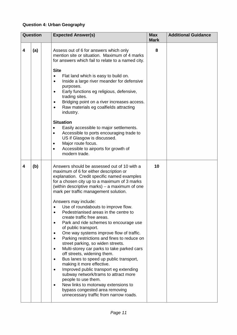
Question 4: Urban Geography Question Expected Answer(s) Max
Mark Additional Guidance
4 (a) Assess out of 6 for answers which only
mention site or situation. Maximum of 4 marks for answers which fail to relate to a named city. Site • Flat land which is easy to build on. • Inside a large river meander for defensive
purposes. • Early functions eg religious, defensive,
trading sites. • Bridging point on a river increases access. • Raw materials eg coalfields attracting
industry. Situation • Easily accessible to major settlements. • Accessible to ports encouraging trade to
US if Glasgow is discussed. • Major route focus. • Accessible to airports for growth of
modern trade.
8
4 (b) Answers should be assessed out of 10 with a
maximum of 6 for either description or explanation. Credit specific named examples for a chosen city up to a maximum of 3 marks (within descriptive marks) – a maximum of one mark per traffic management solution. Answers may include: • Use of roundabouts to improve flow. • Pedestrianised areas in the centre to
create traffic free areas. • Park and ride schemes to encourage use
of public transport. • One way systems improve flow of traffic. • Parking restrictions and fines to reduce on
street parking, so widen streets. • Multi-storey car parks to take parked cars
off streets, widening them. • Bus lanes to speed up public transport,
making it more effective. • Improved public transport eg extending
subway network/trams to attract more people to use them.
• New links to motorway extensions to bypass congested area removing unnecessary traffic from narrow roads.
10
Page 12
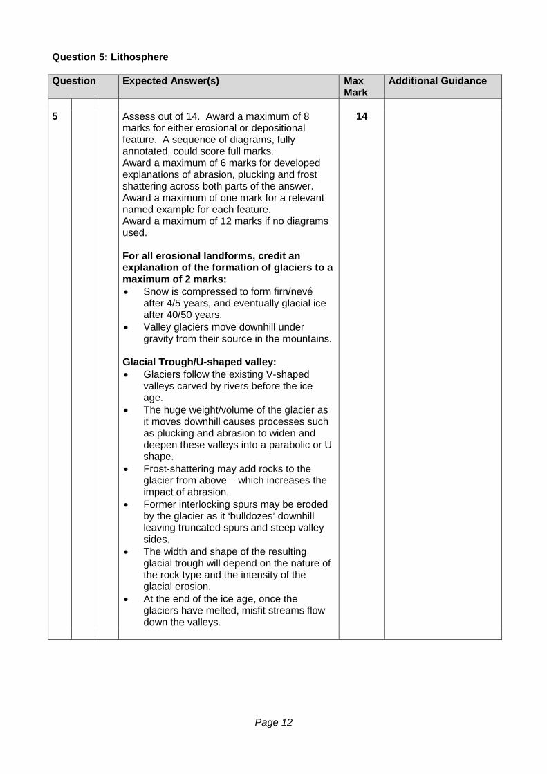
Question 5: Lithosphere Question Expected Answer(s) Max
Mark Additional Guidance
5 Assess out of 14. Award a maximum of 8
marks for either erosional or depositional feature. A sequence of diagrams, fully annotated, could score full marks. Award a maximum of 6 marks for developed explanations of abrasion, plucking and frost shattering across both parts of the answer. Award a maximum of one mark for a relevant named example for each feature. Award a maximum of 12 marks if no diagrams used. For all erosional landforms, credit an explanation of the formation of glaciers to a maximum of 2 marks: • Snow is compressed to form firn/nevé
after 4/5 years, and eventually glacial ice after 40/50 years.
• Valley glaciers move downhill under gravity from their source in the mountains.
Glacial Trough/U-shaped valley: • Glaciers follow the existing V-shaped
valleys carved by rivers before the ice age.
• The huge weight/volume of the glacier as it moves downhill causes processes such as plucking and abrasion to widen and deepen these valleys into a parabolic or U shape.
• Frost-shattering may add rocks to the glacier from above – which increases the impact of abrasion.
• Former interlocking spurs may be eroded by the glacier as it ‘bulldozes’ downhill leaving truncated spurs and steep valley sides.
• The width and shape of the resulting glacial trough will depend on the nature of the rock type and the intensity of the glacial erosion.
• At the end of the ice age, once the glaciers have melted, misfit streams flow down the valleys.
14
Page 13
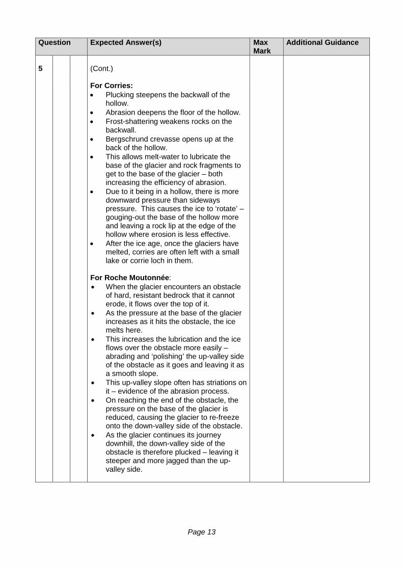
Question Expected Answer(s) Max Mark
Additional Guidance
5 (Cont.) For Corries:
• Plucking steepens the backwall of the hollow.
• Abrasion deepens the floor of the hollow. • Frost-shattering weakens rocks on the
backwall. • Bergschrund crevasse opens up at the
back of the hollow. • This allows melt-water to lubricate the
base of the glacier and rock fragments to get to the base of the glacier – both increasing the efficiency of abrasion.
• Due to it being in a hollow, there is more downward pressure than sideways pressure. This causes the ice to ‘rotate’ – gouging-out the base of the hollow more and leaving a rock lip at the edge of the hollow where erosion is less effective.
• After the ice age, once the glaciers have melted, corries are often left with a small lake or corrie loch in them.
For Roche Moutonnée: • When the glacier encounters an obstacle
of hard, resistant bedrock that it cannot erode, it flows over the top of it.
• As the pressure at the base of the glacier increases as it hits the obstacle, the ice melts here.
• This increases the lubrication and the ice flows over the obstacle more easily – abrading and ‘polishing’ the up-valley side of the obstacle as it goes and leaving it as a smooth slope.
• This up-valley slope often has striations on it – evidence of the abrasion process.
• On reaching the end of the obstacle, the pressure on the base of the glacier is reduced, causing the glacier to re-freeze onto the down-valley side of the obstacle.
• As the glacier continues its journey downhill, the down-valley side of the obstacle is therefore plucked – leaving it steeper and more jagged than the up-valley side.
Page 14
Question Expected Answer(s) Max Mark
Additional Guidance
5 (Cont.) For depositional features, do not credit
references to erosion processes already credited in part (a). Possible answers might include: For Drumlin: • Drumlins are streamlined, elongated hills
made up of glacial deposits/till/boulder clay.
• This is unsorted/un-stratified in nature, as ice deposits all sizes of sediment at the same time. It is made up of angular stones due to the nature of processes that have created the rocks being carried by a glacier.
• They are deposited underneath glaciers as the ice moves downhill.
• The steep ‘stoss’ slope faces up-valley and the more gently-sloping ‘lee’ slope faces down-valley.
• Drumlins are formed as the glacier becomes overloaded with sediment and deposits it, streamlining the sediment as it flows over it.
• Drumlins may also form where there is a deeper than normal layer of sediment that the ice is flowing over. The huge overlying weight of ice causes the pressure to increase on the sediment beneath it, moulding it into the drumlin shapes. (The ‘birth’ of drumlins in this way has been observed under Antarctic glaciers by scientists).
• If there is a small obstacle on the ground, this may act as a trigger point and till/ boulder clay can build up around it (although many drumlins have no such solid ‘anchor’ inside).
• Drumlins may be reshaped by further ice movements after being originally deposited.
• Drumlins are found in swarms or in a ‘basket of eggs’ topography.
Page 15
Question Expected Answer(s) Max Mark
Additional Guidance
5 (Cont.)
For Terminal Moraine: • Terminal moraine is a ridge running
across the valley and made up of glacial deposits/till/boulder clay.
• This is unsorted/un-stratified in nature as ice deposits all sizes of sediment at the same time. It is made up of angular stones due to the nature of processes that have created the rocks being carried by a glacier.
• As the glacier moves downhill under gravity it acts like a bulldozer, pushing sediment in front of it as it goes.
• On reaching lower altitudes and when temperatures rise, the glacier melts, depositing the moraine at its snout.
• Terminal moraine marks the furthest point that the glacier reaches.
• Once the ice has retreated, the terminal (or end) moraine can often form a natural dam, creating a ribbon lake.
For Esker: • Eskers are meandering ridges
occasionally found winding their way down a stretch of the valley.
• They are formed by meltwater streams in or underneath a glacier.
• They are therefore made up of meltwater sands and gravels. These are sorted by size with large stones at the base (because larger stones are dropped first by flowing water and smaller sands carried for longer and dropped last – on top).
• The stones also tend to be more rounded than glacial deposits, because of the action of flowing water rounding the edges.
• As the glacier melts, sub-glacial streams flow.
• With no flood plain (the channel is surrounded by glacial ice), the load is deposited on the channel bed.
• When the glacier eventually melts at the end of the ice age, the meandering ridges are left – showing the position of the former sub-glacial meltwater stream.
• They are often eventually eroded away after the ice age by rivers meandering across the valley floor.
Page 16
Question 6: Atmosphere Question Expected Answer(s) Max
Mark Additional Guidance
6 (a) Assess out of 6 marks with maximum 3 marks
for each air mass. For each air mass, 1 mark for origin and 2 marks for any characteristics. Do not credit origin over sea (x) or land (y). Maritime Tropical (mT) – • Origin – Atlantic ocean/Gulf of Guinea. • Weather characteristics – hot, unstable air
with high humidity. Continental Tropical (cT) – • Origin – Sahara Desert. • Weather characteristics – hot/very hot, dry
and stable air with low humidity.
6
Page 17
Question Expected Answer(s) Max
Mark Additional Guidance
6 (b) Assess out of 8 marks with maximum 5 marks
for either description or explanation. Description should highlight the marked contrast in precipitation totals, seasonal distribution and number of rain days between a very dry north (Nioro with only 305mm) and a much wetter south (Abidjan with 1390mm, tropical rainforest climate). Ouagadougou in central West Africa has an ‘in-between’ amount of both rain days and total annual precipitation (780mm and Savannah climate). Candidates should also refer to the variation in seasonal distribution for each station. Nioro with a limited amount of precipitation in summer, Ouagadougou with a clear wet season/dry season regime and Abidjan with a ‘twin-peak’ regime with a major peak in June and a smaller peak in October/November. Explanation should focus on the role of the ITCZ and the movement of the Maritime Tropical and Continental Tropical air masses over the course of the year. For example, Abidjan, on the Gulf of Guinea coast, is influenced by hot, humid mT air for most of the year, accounting for its higher total annual precipitation and greater number of rain days. The twin precipitation peaks can be attributed to the ITCZ moving northwards in the early part of the year and then southwards later in the year in line with the thermal equator/overhead sun. Nioro, on the other hand, is under the influence of hot, dry cT air for most of the year and therefore has far fewer rain days and a very low total annual precipitation figure as it lies well to the north of the ITCZ for most of the year. Ouagadougou again is in an ‘in-between’ position, getting more rain days and heavy summer precipitation from June-September when the ITCZ is furthest north.
8
Page 18
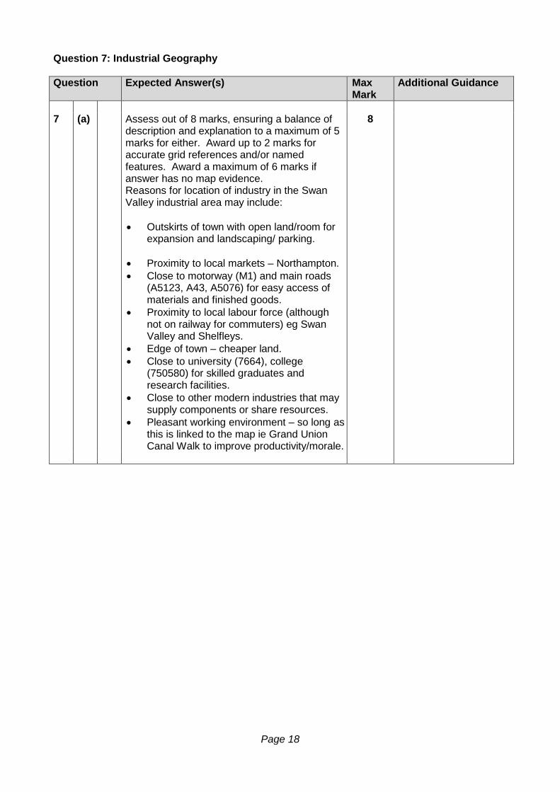
Question 7: Industrial Geography Question Expected Answer(s) Max
Mark Additional Guidance
7 (a) Assess out of 8 marks, ensuring a balance of
description and explanation to a maximum of 5 marks for either. Award up to 2 marks for accurate grid references and/or named features. Award a maximum of 6 marks if answer has no map evidence. Reasons for location of industry in the Swan Valley industrial area may include: • Outskirts of town with open land/room for
expansion and landscaping/ parking. • Proximity to local markets – Northampton. • Close to motorway (M1) and main roads
(A5123, A43, A5076) for easy access of materials and finished goods.
• Proximity to local labour force (although not on railway for commuters) eg Swan Valley and Shelfleys.
• Edge of town – cheaper land. • Close to university (7664), college
(750580) for skilled graduates and research facilities.
• Close to other modern industries that may supply components or share resources.
• Pleasant working environment – so long as this is linked to the map ie Grand Union Canal Walk to improve productivity/morale.
8
Page 19
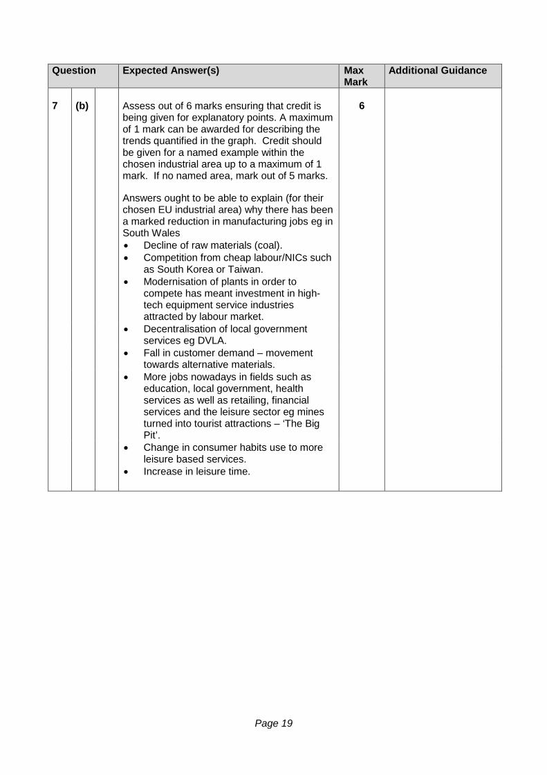
Question Expected Answer(s) Max
Mark Additional Guidance
7 (b) Assess out of 6 marks ensuring that credit is
being given for explanatory points. A maximum of 1 mark can be awarded for describing the trends quantified in the graph. Credit should be given for a named example within the chosen industrial area up to a maximum of 1 mark. If no named area, mark out of 5 marks. Answers ought to be able to explain (for their chosen EU industrial area) why there has been a marked reduction in manufacturing jobs eg in South Wales • Decline of raw materials (coal). • Competition from cheap labour/NICs such
as South Korea or Taiwan. • Modernisation of plants in order to
compete has meant investment in high-tech equipment service industries attracted by labour market.
6
• Decentralisation of local government services eg DVLA.
• Fall in customer demand – movement towards alternative materials.
• More jobs nowadays in fields such as education, local government, health services as well as retailing, financial services and the leisure sector eg mines turned into tourist attractions – ‘The Big Pit’.
• Change in consumer habits use to more leisure based services.
• Increase in leisure time.
Page 20
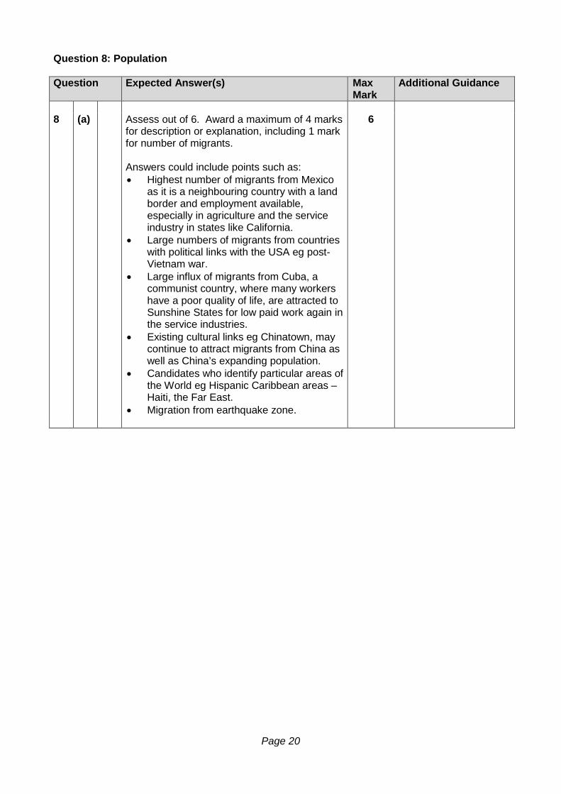
Question 8: Population Question Expected Answer(s) Max
Mark Additional Guidance
8 (a) Assess out of 6. Award a maximum of 4 marks
for description or explanation, including 1 mark for number of migrants. Answers could include points such as: • Highest number of migrants from Mexico
as it is a neighbouring country with a land border and employment available, especially in agriculture and the service industry in states like California.
• Large numbers of migrants from countries with political links with the USA eg post-Vietnam war.
• Large influx of migrants from Cuba, a communist country, where many workers have a poor quality of life, are attracted to Sunshine States for low paid work again in the service industries.
• Existing cultural links eg Chinatown, may continue to attract migrants from China as well as China’s expanding population.
• Candidates who identify particular areas of the World eg Hispanic Caribbean areas – Haiti, the Far East.
• Migration from earthquake zone.
6
Page 21
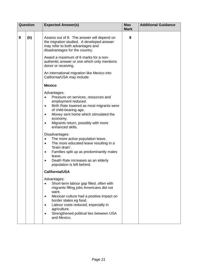
Question Expected Answer(s) Max
Mark Additional Guidance
8 (b) Assess out of 8. The answer will depend on
the migration studied. A developed answer may refer to both advantages and disadvantages for the country. Award a maximum of 6 marks for a non-authentic answer or one which only mentions donor or receiving. An international migration like Mexico into California/USA may include: Mexico Advantages: • Pressure on services, resources and
employment reduced. • Birth Rate lowered as most migrants were
of child-bearing age. • Money sent home which stimulated the
economy. • Migrants return, possibly with more
enhanced skills. Disadvantages: • The more active population leave. • The more educated leave resulting in a
‘brain drain’. • Families split up as predominantly males
leave. • Death Rate increases as an elderly
population is left behind. California/USA Advantages: • Short-term labour gap filled, often with
migrants filling jobs Americans did not want.
• Mexican culture had a positive impact on border states eg food.
• Labour costs reduced, especially in agriculture.
• Strengthened political ties between USA and Mexico.
8

Page 22
Question Expected Answer(s) Max Mark
Additional Guidance
8 (b) (Cont.)
Disadvantages: • Discrimination against migrant workers. • Recent recession has resulted in
increased unemployment and possible racial tensions against Mexicans holding down ‘Americans’ jobs.
• Ghettos develop in poorest areas. • High cost of illegal migration, with border
patrols and holding stations. • Increased drug trafficking. • Increased services needed eg language
schools.
[END OF MARKING INSTRUCTIONS]

2014 Geography
Higher Paper 2
Finalised Marking Instructions Scottish Qualifications Authority 2014 The information in this publication may be reproduced to support SQA qualifications only on a non-commercial basis. If it is to be used for any other purposes written permission must be obtained from SQA’s NQ Assessment team. Where the publication includes materials from sources other than SQA (secondary copyright), this material should only be reproduced for the purposes of examination or assessment. If it needs to be reproduced for any other purpose it is the centre’s responsibility to obtain the necessary copyright clearance. SQA’s NQ Assessment team may be able to direct you to the secondary sources. These Marking Instructions have been prepared by Examination Teams for use by SQA Appointed Markers when marking External Course Assessments. This publication must not be reproduced for commercial or trade purposes.
©
Page 2
Part One: General Marking Principles for: Geography Higher Paper 2 This information is provided to help you understand the general principles you must apply when marking candidate responses to questions in this Paper. These principles must be read in conjunction with the specific Marking Instructions for each question. (a) Marks for each candidate response must always be assigned in line with these
general marking principles and the specific Marking Instructions for the relevant question. If a specific candidate response does not seem to be covered by either the principles or detailed Marking Instructions, and you are uncertain how to assess it, you must seek guidance from your Team Leader/Principal Assessor.
(b) Marking should always be positive ie, marks should be awarded for what is correct
and not deducted for errors or omissions. GENERAL MARKING ADVICE: Geography Higher Paper 2 The marking schemes are written to assist in determining the “minimal acceptable answer” rather than listing every possible correct and incorrect answer. The following notes are offered to support Markers in making judgements on candidates’ evidence, and apply to marking both end of unit assessments and course assessments. 1. The maximum mark for Paper 2 is 100. Markers are encouraged to use the whole range of
marks and to give a high assessment for an answer of high quality. 2. The total marks assigned by you for each complete question should be entered in the outer
right-hand margin of the answer book. When a question consists of more than one part, the marks assigned to each part MUST BE SHOWN SEPARATELY in the column provided on the inner right-hand side of the book. It is of great importance that the utmost care should be exercised in adding up the marks. Where appropriate, all summations for totals and grand totals must be carefully checked. Where a candidate has scored zero marks for any question attempted “0” should be shown against the answer.
The TOTAL mark for the paper should be recorded in the box at the top right-hand corner on the front cover of the script.
3. It is helpful in later procedures if points receiving marks are clearly indicated. In general a
mark should be awarded for a correct statement. 4. All mistakes MUST be underlined in red pen. A wavy line (~~~~~~~) should be used for
something that is not quite right, a single line (-------) for mistakes which, though not very serious, are undoubtedly wrong, and a double line (=======) for gross blunders. These corrections are valuable when borderline cases and appeals are being considered. Where a page shows neither a correction nor a mark, a red tick MUST be placed at the bottom right-hand corner.

Page 3
5. The marker should take the candidate’s answers strictly as they are written; no attempt should be made to read into answers ideas which the candidate may have intended to convey but which have not been successfully conveyed. A caret (λ) should be used to indicate an important omission. A question mark (?) should be used to indicate that the marker cannot understand the meaning intended. The letter "R" should be used to indicate that the candidate is repeating something already stated in the answer.
6. Care should be taken that no credit whatsoever is given to irrelevant parts of answers,
however accurate the irrelevant passages may be. Irrelevant passages should be square-bracketed [ ].
It should be noted, however, that a fact or argument which is irrelevant in one candidate's answer may be made quite relevant by another candidate who has the ability to connect it to the question.
Page 4
Part Two: Marking Instructions for each Question Question 1: Rural Land Resources
Question Expected Answer(s) Max Mark
Additional Guidance
1 (a) Assess out of 20.
Well annotated diagrams could be awarded full credit; maximum of 16 marks if there is no diagram. Credit named examples up to 4 marks; one per feature. Award a maximum of 2 marks for a list of unexplained processes, with a maximum of 8 marks for accurate explanations of appropriate processes. A maximum of 12 marks for erosion or deposition features. Candidates should refer to the processes of coastal erosion and deposition within the answer, ie hydraulic action, abrasion, solution and wave movement up/down beaches with longshore drift. An example of an answer relating to a cave/arch/stack may include: Caves are likely to occur where the coastline consists of hard rock and is attacked by prolonged wave attack along a line of weakness such as a joint or fault in the rock. The waves will attack the weakness by abrasion, hydraulic action or solution and over time, horizontal erosion of the cave may cut through the headland to the other side, forming an arch, eg Durdle Door. A blowhole may be created when compressed air is pushed upwards by the power of the waves and vertical erosion occurs. Continued erosion at the foot of the arch may eventually cause the roof to collapse, leaving a stack, eg Old Harry Rock, isolated from the cliff. This in turn will be further eroded to leave a stump.
20
Page 5
Question Expected Answer(s) Max Mark
Additional Guidance
1 (b) Assess out of 10. Award a maximum of 2 marks
for description, using information from the map and table (visitor numbers, names of roads / population centres). Candidates should be able to offer explanations for the variations in the number of visitors that different National Parks are able to attract: • Central location of Peak District, in contrast
to peripheral Northumberland. • Distance to population centres. • Catchment area. • Accessibility, especially to motorways/main
roads. • Scenery. • Range of activities/attractions. • Publicity/Well established versus newly
created Parks.
10
1 (c) (i) Assess out of 10. Award up to 4 marks across
part (c) for specific named examples of conflicts within an upland or coastal area not already credited. A maximum of 6 marks for any one conflict. Candidates may choose to write a composite answer for part (c). Markers should indicate marks for parts (i) and (ii) separately. Possible answers may include: • Air and noise pollution from traffic. • Traffic congestion, heavy traffic damaging
roads. • Footpath erosion, damage to fences and
walls. • Litter related issues. • Visual pollution from car parks, new
buildings etc. • Impact on lakes or the sea caused by
diesel/oil pollution from boats and ships.
10
Page 6
Question Expected Answer(s) Max Mark
Additional Guidance
1 (c) (ii) Assess out of 10. Over-generalised answers
without authentic examples (place names etc) should be given a maximum of 7 marks. To gain full marks answers must attempt to evaluate the effectiveness of solutions/measures taken to resolve environmental conflicts; a maximum of 8 marks if no comment on effectiveness. Possible answers may include: • Encouraging use of public transport eg park
and ride, minibuses, cycle paths. • Separating local and tourist traffic, permit
use in some areas, priority lane for Windermere ferry vehicles.
• One-way systems, bypasses or complete closures, use of fields for parking at peak times to ease congestion.
• Screening of buildings, car parks etc behind tree cover, use of local stone to reduce visual impact.
• Programme of footpath restoration eg Fix The Fells, pitching technique using local stone to improve durability and aesthetic appeal.
• Litter patrols, removal of bins, visitor education.
• Restrictions, speed limits and bans of use of speedboats, water-skiing etc to reduce noise and water pollution, erosion of banks.
10
Page 7
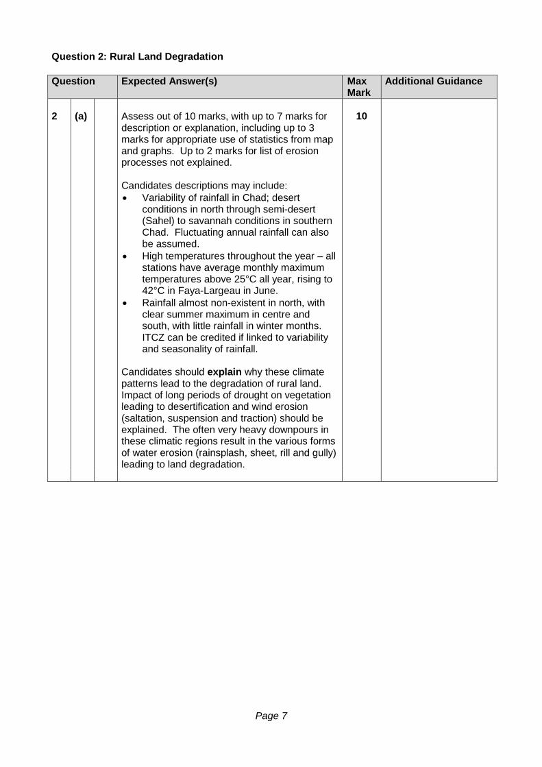
Question 2: Rural Land Degradation Question Expected Answer(s) Max
Mark Additional Guidance
2 (a) Assess out of 10 marks, with up to 7 marks for
description or explanation, including up to 3 marks for appropriate use of statistics from map and graphs. Up to 2 marks for list of erosion processes not explained. Candidates descriptions may include: • Variability of rainfall in Chad; desert
conditions in north through semi-desert (Sahel) to savannah conditions in southern Chad. Fluctuating annual rainfall can also be assumed.
• High temperatures throughout the year – all stations have average monthly maximum temperatures above 25°C all year, rising to 42°C in Faya-Largeau in June.
• Rainfall almost non-existent in north, with clear summer maximum in centre and south, with little rainfall in winter months. ITCZ can be credited if linked to variability and seasonality of rainfall.
Candidates should explain why these climate patterns lead to the degradation of rural land. Impact of long periods of drought on vegetation leading to desertification and wind erosion (saltation, suspension and traction) should be explained. The often very heavy downpours in these climatic regions result in the various forms of water erosion (rainsplash, sheet, rill and gully) leading to land degradation.
10
Page 8
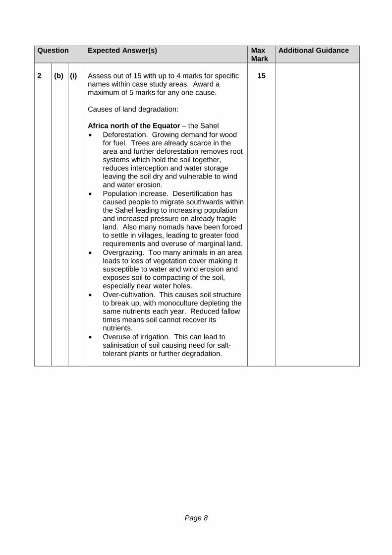
Question Expected Answer(s) Max
Mark Additional Guidance
2 (b) (i) Assess out of 15 with up to 4 marks for specific
names within case study areas. Award a maximum of 5 marks for any one cause. Causes of land degradation: Africa north of the Equator – the Sahel • Deforestation. Growing demand for wood
for fuel. Trees are already scarce in the area and further deforestation removes root systems which hold the soil together, reduces interception and water storage leaving the soil dry and vulnerable to wind and water erosion.
• Population increase. Desertification has caused people to migrate southwards within the Sahel leading to increasing population and increased pressure on already fragile land. Also many nomads have been forced to settle in villages, leading to greater food requirements and overuse of marginal land.
• Overgrazing. Too many animals in an area leads to loss of vegetation cover making it susceptible to water and wind erosion and exposes soil to compacting of the soil, especially near water holes.
• Over-cultivation. This causes soil structure to break up, with monoculture depleting the same nutrients each year. Reduced fallow times means soil cannot recover its nutrients.
• Overuse of irrigation. This can lead to salinisation of soil causing need for salt-tolerant plants or further degradation.
15
Page 9
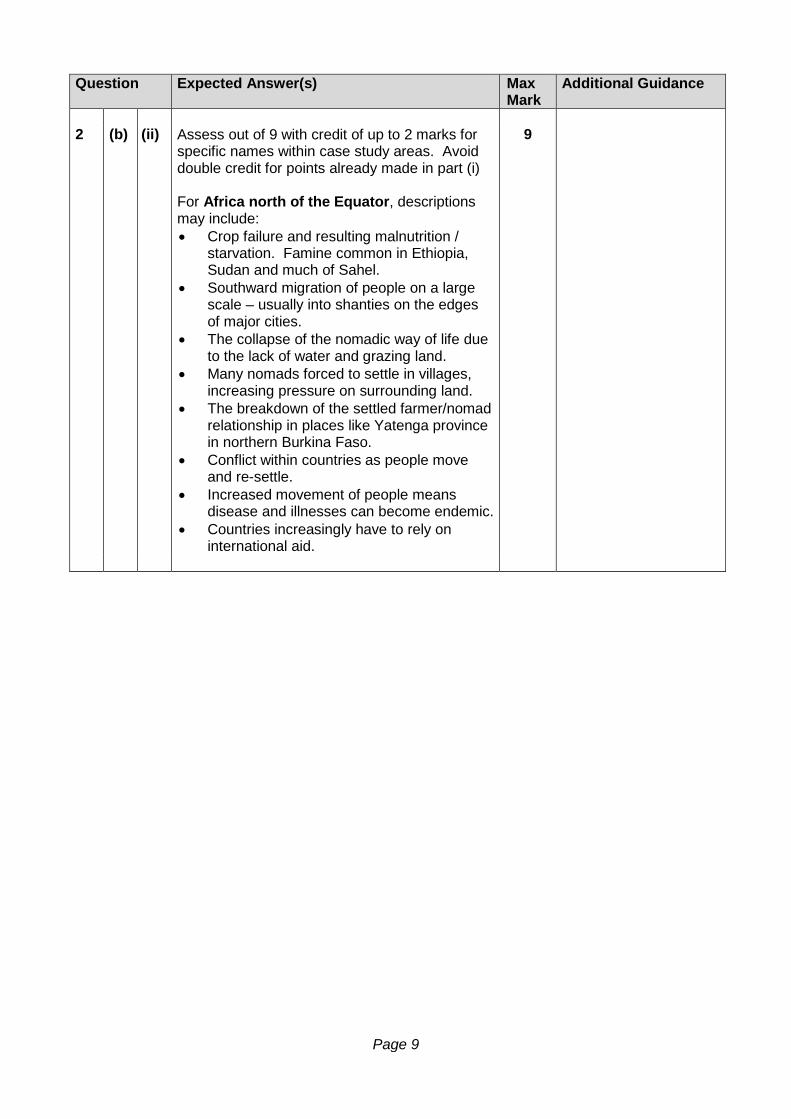
Question Expected Answer(s) Max Mark
Additional Guidance
2 (b) (ii) Assess out of 9 with credit of up to 2 marks for
specific names within case study areas. Avoid double credit for points already made in part (i) For Africa north of the Equator, descriptions may include: • Crop failure and resulting malnutrition /
starvation. Famine common in Ethiopia, Sudan and much of Sahel.
• Southward migration of people on a large scale – usually into shanties on the edges of major cities.
• The collapse of the nomadic way of life due to the lack of water and grazing land.
• Many nomads forced to settle in villages, increasing pressure on surrounding land.
• The breakdown of the settled farmer/nomad relationship in places like Yatenga province in northern Burkina Faso.
• Conflict within countries as people move and re-settle.
• Increased movement of people means disease and illnesses can become endemic.
• Countries increasingly have to rely on international aid.
9
Page 10
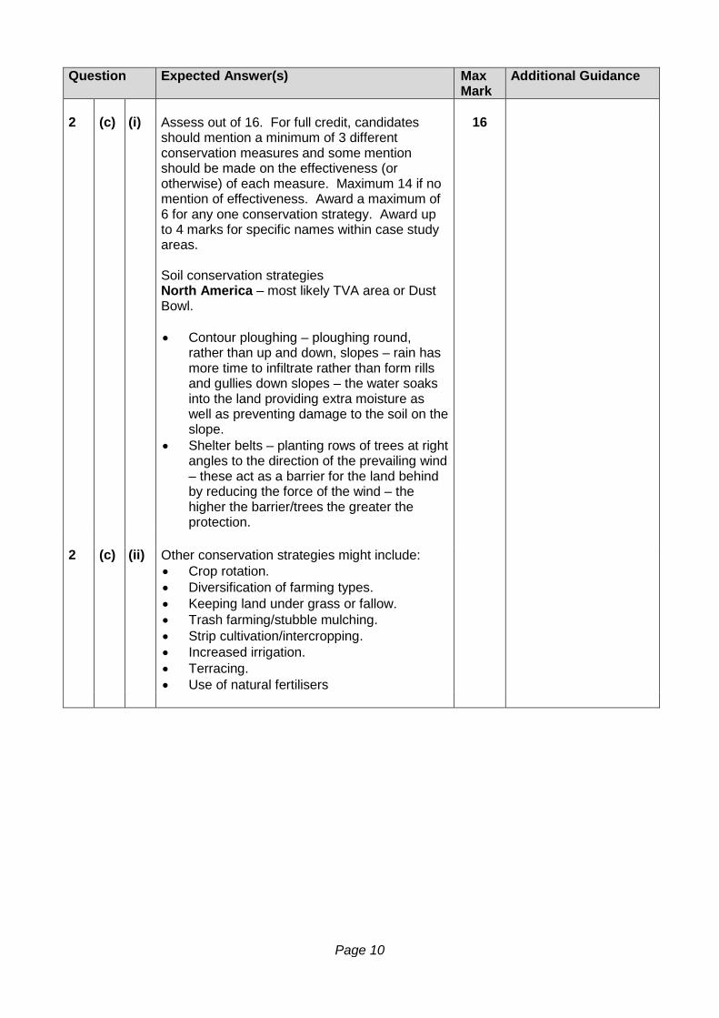
Question Expected Answer(s) Max Mark
Additional Guidance
2 (c) (i) Assess out of 16. For full credit, candidates
should mention a minimum of 3 different conservation measures and some mention should be made on the effectiveness (or otherwise) of each measure. Maximum 14 if no mention of effectiveness. Award a maximum of 6 for any one conservation strategy. Award up to 4 marks for specific names within case study areas. Soil conservation strategies North America – most likely TVA area or Dust Bowl. • Contour ploughing – ploughing round,
rather than up and down, slopes – rain has more time to infiltrate rather than form rills and gullies down slopes – the water soaks into the land providing extra moisture as well as preventing damage to the soil on the slope.
• Shelter belts – planting rows of trees at right angles to the direction of the prevailing wind – these act as a barrier for the land behind by reducing the force of the wind – the higher the barrier/trees the greater the protection.
16
2 (c) (ii) Other conservation strategies might include:
• Crop rotation. • Diversification of farming types. • Keeping land under grass or fallow. • Trash farming/stubble mulching. • Strip cultivation/intercropping. • Increased irrigation. • Terracing. • Use of natural fertilisers
Page 11
Question 3: River Basin Management Question Expected Answer(s) Max
Mark Additional Guidance
3 (a) Assess out of 12 marks. Maximum of 3 marks for figures lifted directly from diagrams. Descriptions and explanations might include: • Large number of tributaries feeding into the
Indus. • Mountains to the north which will provide
snowmelt. • Increasing population of Pakistan increasing
demand for power, irrigation, domestic water supply.
• Hyderabad and Islamabad rainfall graphs indicate wet and dry seasons meaning there is a need for water storage as well as flood control.
• High temperatures particularly in summer leads to high evaporation rates.
• Severe floods and loss of life, farmland and livelihood means water management is needed.
12
3 (b) Assess out of 14 marks with up to 10 marks for either physical or human factors. Physical factors might include: • Geologically stable areas away from
earthquake zones and fault lines. • Solid stable rock foundations for weight of
dam. • Narrow valley cross-section to reduce dam
length and increase strength. • Large, deep valley to flood behind dam to
maximise amount of water storage. • Impermeable rock in the area to avoid
seepage. • Cool climate to lower evaporation rates. • Constant supply of water for reservoir from
rainfall and snowmelt. • Large catchment area above dam to
provide reliable water supply. Human Factors might include: • Cost of dam construction. • Proximity of urban areas for water and
electricity. • Proximity of agricultural areas for irrigation. • Cost of displacing people. • Cost of compensating farmers and home
owners. • Impact on communications.
14
Page 12
Question Expected Answer(s) Max Mark
Additional Guidance
3 (c) Assess out of 24. Answers should be authentic
for the chosen river basin, with maximum of 20 if no named river basin. Up to 6 marks may be awarded for appropriate named examples / figures illustrating the benefits and adverse consequences of the chosen scheme. Candidates must refer to all 6 sections for full marks. Deduct 2 marks for each part missed out. Answers will depend on the river basin chosen. However, for the Colorado River they might include: Social benefits: • Fresh water supply for growing desert cities
eg Phoenix. • Better standard of living in hot, dry climate
with air conditioning, swimming pools, landscaping etc.
• Areas at reservoirs, eg Lake Mead, give opportunities for tourism, water sports, fishing etc.
• Regulation of river greatly improves flood control on river.
Social adverse consequences: • People had to be moved off their land as
valley areas were flooded. • Loss of burial sites and other Native
American sacred areas. • Disagreements between states and
countries with regard to allocation of water from river.
Economic benefits: • Cheap HEP attracted industries eg
electronics to take advantage of the area’s cheap land and low taxes.
• Benefited tourist industry with reliable water supply – attractions like the Grand Canyon, gambling in Las Vegas, Hoover Dam etc.
• Expansion of irrigated land led to agribusiness-style farming.
24
Page 13
Question Expected Answer(s) Max Mark
Additional Guidance
3 (c) (Cont.)
Economic adverse consequences: • Huge cost of building the dams eg Central
Arizona Project cost $6 billion. • High cost of maintaining dams, power
plants and irrigation channels. • Subsidised water for farmers has led to
water wastage and the growing of crops that could be produced cheaper elsewhere.
• Large costs involved in ensuring invasive species such as zebra mussels do not spread
Environmental benefits: • Reservoirs provide sanctuaries for
waterfowl and wading birds like the blue heron.
• The National Recreation Area around Lake Mead has more than 250 species of birds.
• Reliable seasonal water flow for plant and animal life.
Environmental adverse consequences: • Water in river and on farmland becomes
saline with high evaporation rates – farmers downstream have to switch to more salt-tolerant crops.
• Change in river regime has caused the loss of many animal habitats eg the drying up of Colorado delta area where there used to be a great variety of birdlife.
• Huge amounts of water loss by seepage through the sandstone rocks around Lake Powell. Scenic attractions like the Rainbow Bridge are being affected by the high water levels in Lake Powell.
Page 14
Question 4: Urban Change and its Management Question Expected Answer(s) Max
Mark Additional Guidance
4 (a) Assess out of 10, with a maximum of 6 for
description. Award up to 2 descriptive marks for named cities, linked to specific reasons for location.
The answer will depend on the Developing country studied, but for Brazil, answers might include: • Coastal locations: most of Brazil’s large
cities, including Rio de Janeiro, are situated on the country’s eastern coast next to the Atlantic Ocean. This is because the land is accessible by boat, which promoted trade. Some of these coastal cities developed from settlements established by European settlers in the 16th, 17th and 18th centuries. Coastal settlements such as Santos have become ports, especially due to the growth of the coffee industry. Rio de Janeiro is now an important tourist centre. These areas also have a good supply of water and fertile soil for farming.
• Natural route ways and access to raw materials: Manaus, on the River Amazon, was developed as a new settlement to exploit the timber and mineral resources of the rainforest.
• Favourable climates: The coastal areas experience a more favourable climate: it is not as wet and humid as the interior of the country, nor as dry as the north east of the country, where drought restricts farming.
• Planned cities: Brasilia is situated inland because the Government chose this as a new site for the capital city to attract investment inland.
• Large parts of the interior of Brazil do not have any large settlements because of the dense rainforest and hot, humid climate.
10
Page 15
Question Expected Answer(s) Max
Mark Additional Guidance
4 (b) Assess out of 12. Award a maximum of 4
marks across parts (b) and (c) for specific named examples eg of shanties or schemes relevant for the named cities.
Answers will be dependent on the city studied, but could include: • Overcrowding. • Lack of public utilities and amenities of
water supply, electricity and sewerage. • Lack of basic services, eg schools, piped
water and hospitals. • High incidence of disease. • High rates of unemployment and growth of
‘grey’ economy and black market. • Crime, drugs and prostitution. • Poor wages for unskilled jobs. • Unsightly, homemade dwellings made out
of a range of discarded materials. • Unstable sites for housing, eg areas prone
to flooding or landslides. • Problems of waste disposal including open
sewers, toxic industrial waste contaminating water supplies, lack of refuse collection and landfill sites for solid waste.
• Traffic congestion and air pollution.
12
Award a maximum of 7 marks if no comment
on effectiveness.
4 (c) Assess out of 8. Answers will be dependent on
the city studied, but for Rio de Janiero could include: • Self-help schemes where local authorities
provide basic houses made of breeze blocks and roof tiles with local residents supplying labour and digging ditches for water, sewage pipes etc.
• Money saved can then be used to provide amenities such as electricity, clean water supply, tarred roads, community centres and schools.
• High rise apartment blocks built, mainly in the suburbs.
• Building new dormitory or satellite towns to relieve pressure on existing city.
8
Page 16
Question Expected Answer(s) Max Mark
Additional Guidance
4 (d) Assess out of 20. Award a maximum of 4
marks across parts (i) and (ii) for specific named examples within the chosen city.
(i) Reasons for urban sprawl:
• Growth of urban population. • Growth of suburban housing estates,
both privately and council built. • Lower land values in the suburbs. • Development of out of town shopping
malls, recreation facilities and industrial estates.
• Growth of leisure facilities. • Motorway and by-pass developments. • Ability to commute. • Desire to live in attractive
environment, avoiding the pollution, congestion and crime levels of the city centre and inner city.
(ii) Problems of urban sprawl:
• Urban sprawl uses farmland and recreational land.
• Wildlife habitats are threatened. • Increased traffic congestion, energy
consumption and pollution. • Buildings and services in the inner city
are underused or left derelict.
Possible solutions: • Enforcement of greenbelt policy. • Emphasis on brownfield developments.
20
Page 17
Question 5: European Regional Inequalities Question Expected Answer(s) Max
Mark Additional Guidance
5 (a) Assess out of 12 marks. A maximum of 4
marks may be awarded for data taken from the reference table that is used to correctly illustrate a point. Evidence might include the marked difference between Lisboa (containing the capital city Lisbon) with the highest % employed in services, highest % with computer access and best educational attainment; the second best in the other statistics. The Alentejo region is the most disadvantaged overall, with 3rd being the best ranking in the statistics. The Algarve fares worst in the unemployment/ educational attainment statistics while Centro has the lowest service sector %. Alentejo has the lowest % computer access.
12
5 (b) Assess out of 18 marks. Award a maximum of
4 marks for appropriate and relevant examples. Answers will be dependent on the country chosen. For Portugal, the following factors may be mentioned: Physical factors • Relief/geology. • Climate/water/resources. • Soil quality/soil erosion.
Human factors • Remoteness/isolation/communications. • Limited employment opportunities outwith
capital city/tourist areas. • Decline of traditional industry. • Land tenure problems. • Unskilled labour, poorly educated
workforce.
18
Page 18
Question Expected Answer(s) Max Mark
Additional Guidance
5 (c) Assess out of 20 marks ensuring that both
national and EU measures are considered for full marks. If no comment on effectiveness award a maximum of 18 marks. Award up to 5 marks for appropriate and relevant named examples. Responses will be dependent upon the country/region chosen but may include some/all of the following: National measures • Government incentives: training grants,
assistance with labour costs, rent free arrangements.
• Specific assistance to old industrial areas (eg coal mining areas in UK and Belgium).
• Government intervention: relocation of specific government departments (eg DVLA in Swansea).
• In Italy the Cassa per il Mezzogiorno would be a key policy.
European measures • Convergence Region funding includes
support for infrastructure improvements, employment training and education, environment protection and improving access to peripheral areas.
• European Regional Development Fund (ERDF) provides a wide range of direct and indirect assistance to encourage firms to move to disadvantaged areas eg loans, grants, infrastructure improvements.
• European Investment Bank (EIB) provides loans for businesses setting up in disadvantaged areas.
• European Social Fund (ESF) assists with job retraining and relocation.
20
Page 19
Question 6: Development and Health Question Expected Answer(s) Max
Mark Additional Guidance
6 (a) Assess out of 8, giving credit to answers which
make good use of statistics to illustrate comparative statements. Award marks for interpretation/explanation of indicators – ie how they show development. Award maximum of 3 marks for comparative data taken from the table. Candidates should be able to identify several differences between the regions of India using the data in the table. It is clear from looking at all these development indicators that Southern India is the most developed region (1 mark), with Eastern India and The Plains vying for the least developed regions (1 mark).
• For % Literacy Rate, it could be noted that
only 9% separates all the regions so there is not a great difference between them all. However, South India has the highest literacy rate at 83%, whereas Eastern India has the lowest at 74%.
• For Infant Mortality Rate, it could be noted that South India has the lowest (best) figures at 29, whereas The Plains has the highest (worst) infant mortality at 47 (a difference of 18 live births per 1000).
• For Birth Rate, it could be noted that South India has the lowest at 16, whereas The Plains has the highest birth rate at 23.
• For % households using electricity for lighting, South India is again the best with 94%, whereas Eastern India has only 62% (a difference of 32%).
8
Page 20
Question Expected Answer(s) Max
Mark Additional Guidance
6 (b) Assess out of 6 marks, with candidates free to
discuss the drawbacks of using GDP per capita specifically, or of using any one indicator in general. Award one mark for references to inaccurate census collection. Possible answers might include: • As an average number for the whole
country, they disguise differences within the country eg rural/urban, male/female, within urban areas.
• Only focusing on one development indicator does not give a rounded view of the level of development. A country may have focused on this one area and neglected other areas of development. Credit advantages of using composite indicators.
• Development is not only about money – other aspects like freedom of speech, happiness, environmental quality etc are also important.
• GDP per capita does not take into account the fact that the value of money is different in different countries, and that it changes over time.
• GDP per capita does not take into account the informal economy – which can make a huge difference to the development of a place.
• GDP per capita does not take into account subsistence activities.
• GDP per capita does not include any profits made by the country’s multi-national companies operating in other parts of the world (unlike GNP).
6
Page 21
Question Expected Answer(s) Max Mark
Additional Guidance
6 (c) Assess out of 12 marks, with a maximum of 4
marks for names of relevant countries correctly applied. Maximum of 6 marks for generalised responses which fail to make specific/authentic points. Possible answers might include: • Some countries benefit from natural
resources that can be developed for money. For example diamonds in South Africa, oil in Saudi Arabia, timber in Brazil etc.
• Some countries may have corrupt leaders, where money is often not spent on improving the level of development of the country but instead is spent on luxury mansions/items for the elite.
• Civil Wars and conflicts may destroy any development that has taken place and set the country back on its road to development (for example civil war in Libya and wars in Iraq and Afghanistan).
• Some countries suffer from frequent natural disasters, which can restrict development and cause massive damage to infrastructure. For example flooding in Bangladesh, drought in Burkina Faso, earthquakes in Haiti, tsunamis in Indonesia, hurricanes in the Caribbean countries.
• Some governments have managed to attract investment and increase their manufacturing industries (for example the Asian Tiger Economies like Taiwan and South Korea) through offering low labour costs, lax pollution laws and having no trade unions.
• Some countries (for example Barbados) have tourism potential that allows them to attract income and creates job opportunities.
• Some countries are very mountainous like Nepal and Afghanistan, which restricts communications and farming.
• Some countries have a high proportion of their population suffering from ill health and disease, which reduces their ability to work and improve conditions for the country.
12
Page 22
Question Expected Answer(s) Max Mark
Additional Guidance
6 (d) (i) Assess out of 18 marks. Candidates who fail to
provide comparative evaluative comments on at least some of their measures should score a maximum of 14 marks. A maximum of 1 mark each should be allocated for named examples of insecticides, drugs or herbal medicines, with an overall maximum of 4 marks for appropriate named examples. Possible answers for Malaria might include: Measures taken to eradicate the mosquitoes: • Spraying pesticides/insecticides such as
DDT – successful at first but the mosquito adapted and grew resistant. Alternative chemicals, like Malathion, have been developed, and these have been successful in eradicating malaria from Southern Europe and Florida, but they are too expensive for developing countries.
• Mustard seeds thrown on water areas become wet and sticky and drag the mosquito larvae under the water drowning them.
• Egg white sprayed on water surfaces creates a film, which suffocates the larvae by clogging up their breathing tubes.
• Oil sprayed on water surfaces can suffocate the mosquito larvae but pollutes the water source.
• BTI bacteria artificially grown in coconuts – the fermented coconuts are broken open after a few days and thrown into the mosquito larvae-infested ponds. The larvae eat the bacteria and have their stomach lining destroyed. Cheap and environmentally friendly - 2/3 coconuts will control a typical pond for 45 days.
• Putting larvae-eating fish such as the muddy loach into ponds. As the fish breed, this has the added advantage for farmers who can eat some of the fish and add extra protein to their diet.
18
Page 23
Question Expected Answer(s) Max
Mark Additional Guidance
6 (d) (i) (Cont.)
• Flushing reservoirs every 7 days ensures
that larvae cannot emerge into adult mosquitoes.
• Planting eucalyptus trees can help soak up excess moisture and reduce the amount of stagnant water.
• Covering standing water and water storage cans (eg the Oxfam Bucket) reduces the chances of mosquitoes breeding there.
• Genetic engineering, for example, of sterile males and mercenary mosquitoes.
• Mosquito traps, such as those which release a small amount of Carbon Dioxide to mimic animals/humans and so attract mosquitoes, but are too expensive for most developing countries.
Measures taken to treat those suffering from Malaria include: • Drugs like quinine and chloroquine
destroyed the plasmodium parasite – but the parasite adapted and has largely become immune to these drugs.
• Drugs like Larium and Malarone were developed, but have side-effects (nausea) and are very expensive.
• Artemisinin is a powerful drug developed from a traditional Chinese cure using qinghaosu extract from the artemisia plant. Its chemical formula acts like a bomb when it comes into contact with the iron in the parasite. It takes a long time to make Artemisinin, however, and it is expensive. A synthetic version of Artemisinin that is quicker and cheaper to produce, called Oz277 (or ‘Oz’) has been (and continues to be) developed by the Indian pharmaceutical company, Ranbaxy.
• Unfortunately, some parasitic resistance to Artemisinin-based drugs is already developing in Thailand, Vietnam and Cambodia.
Page 24
Question Expected Answer(s) Max Mark
Additional Guidance
6 (d) (i) (Cont.)
• The WHO have not authorised a malaria
vaccine yet, but scientists are working hard to develop this. For example the Bill and Melinda Gates Foundation has invested millions of dollars into this aspect of research alongside drug company GlaxoSmithKline. They have already trialled a vaccine “RTS,S” with 6000 children across Africa and the early results from this are encouraging (a 56% drop in malaria after a year with children who had the vaccine, compared with those who did not).
Measures taken to prevent people being bitten by the mosquito: • Education programmes such as the WHO’s
“Roll back malaria” campaign. In particular educating people in the use of – o Insect repellents; o Covering the skin at dawn/dusk when
mosquitoes are most active; o Sleeping under an insecticide-treated
mosquito net; o Mesh coverings over windows/door
openings.

Page 25
Question Expected Answer(s) Max Mark
Additional Guidance
6 (d) (ii) Assess out of 6 marks, with a maximum of 2
marks for a list of benefits that have not been developed/explained. The benefits of controlling the disease (in this case Malaria) for a developing country might include: • Less money will need to be spent on
health, medicines, doctors, drugs, etc aimed at Malaria. This will allow other diseases to be tackled more effectively.
• With a longer life expectancy and decreased infant mortality rate, the country’s birth rate might drop – reducing population pressures.
• A healthier, fitter population will be able to work and increase the country’s productivity. This will create more money for the country, reducing the national debt and raising the general standard of living.
• More money will be available to be spent on housing and infrastructure – improving the conditions in shanty towns.
• More money will be able to be spent on education – increasing the literacy rate and educational attainment of the population. This will have benefits in all aspects of life in the country.
• More tourists/foreign investment may be attracted if there is less risk of contracting the disease – leading to more job opportunities, foreign currency earnings and increased prosperity.
6
[END OF MARKING INSTRUCTIONS]

![2003 Mathematics Advanced Higher Finalised Marking ...€¦ · [END OF MARKING INSTRUCTIONS] * optional Page 5. 2003 Mathematics Advanced Higher – Section B Finalised Marking Instructions](https://img.pdfslide.us/doc/110x75/6062cbe71ae222684b2c8a01/2003-mathematics-advanced-higher-finalised-marking-end-of-marking-instructions.jpg)