Embed Size (px)
Citation preview
2014 CALENDAR YEAR HUNTING SEASON
ELK OVER-THE-COUNTER NONPERMIT-TAG
INFORMATIONAL HANDOUT
To Report Violations, Call Operation Game Thief at 1-800-352-0700 Page 1 of 14
This Informational Handout for the 2014 Elk Over-the-Counter Nonpermit-tags is being provided for reference only to assist hunters in understanding this unique but limited and restricted hunting opportunity. Hunters are reminded that the 2014 Pronghorn Antelope and Elk Hunt Draw Information booklet has precedence over this informational handout and is the legal controlling document. In this handout you will find:
Overview Common Violations Frequently Asked Questions Seasons Dates, Allowable Weapon Types, Open Areas and Boundary Descriptions Reference Maps of Open Areas
OVERVIEW: The general and archery-only elk over-the-counter nonpermit-tags are for very specific and limited locations where the Department is attempting to create areas with few or no resident elk. Certain areas of the state have been identified as “Limited Population Management Zones” which are areas the Department does not want resident elk herds due to conflicts with private landowners and/or the management focus is on other wildlife such as pronghorn or deer. Elk numbers in these hunt areas are very low; therefore, hunt success is expected to be very low. However, one advantage of these hunts is that they afford the opportunity to hunt with family and friends, which hasn't always been possible because of the difficulty in getting drawn for draw hunts. Hunters need to be attentive to the hunt area boundaries, as they are different in most cases from the unit boundaries. Some of these areas have significant amounts of private property. Hunters who obtain these over-the-counter elk tags should make sure they contact the property owner and obtain permission before hunting on private land. These hunts will not affect your bonus points but do count toward your one-elk-per-calendar-year bag limit. NOTE: Hunters are reminded that many of these hunts occur in lower elevations and during the hotter times of the year. These two conditions make it imperative to quickly field dress your harvested game, including removing the hide to preserve the meat BEFORE transporting. Those hunting in the Verde Valley, Alamo Lake and the 28, 31 and 32 hunt areas should have plenty of coolers and ice to preserve their harvest BEFORE the hunt.
2014 CALENDAR YEAR HUNTING SEASON
ELK OVER-THE-COUNTER NONPERMIT-TAG
INFORMATIONAL HANDOUT
To Report Violations, Call Operation Game Thief at 1-800-352-0700 Page 2 of 14
COMMON VIOLATIONS: * Pick Up All Litter A.R.S. 17-309a.9; 13-1603 * Use Existing Roads Only A.R.S. 17-454 * Minimize Livestock Disturbance A.R.S. 17-309a.3 * Close Gates, Unless Fixed Open A.R.S. 17-309a.3 * Camp At Least 1/4 Mile From Waters A.R.S.17-308 * Do Not Shoot Within 1/4 Mile Of Occupied Buildings A.R.S. 17-309 * Obey All Regulatory Signs * Respect Private Property Rights * Do Not Attempt to Take Wildlife from a Vehicle A.R.S. 17-301b For the complete language on these Title 17 laws and others, visit www.azleg.gov/ArizonaRevisedStatutes.asp?Title=17. A copy of the Arizona Game and Fish Laws and Rules booklet can be purchased from any department office.
FREQUENTLY ASKED QUESTIONS (FAQ’S) Question: WHAT are nonpermit-tags? Answer: Nonpermit-tags are tags that may be purchased over-the-counter from Department offices and in some cases from license dealers without applying though the Department’s computer draw (lottery) process. Question: WHY is the Arizona Game and Fish Department offering nonpermit-tags for elk hunts? Answer: Certain areas of the state have been identified as “Limited Population Management Zones” which are areas the Department does not want resident elk herds due to conflicts with private landowners and/or the management focus is on other wildlife such as pronghorn or deer. In the past, our general hunt structures have not always meet our management goals in these areas, which is why we are implementing the nonpermit-tag elk hunts in certain isolated areas around the state. Question: WHAT is the expected hunt success? Answer: Hunt success is expected to be extremely low on all nonpermit-tag elk hunts; perhaps as low as 1 percent. These areas, as identified through public process, are not traditional elk habitat and their continued occupation is not desired. Elk numbers in these hunt areas are very low; therefore, hunt success is expected to be very low. Question: What type of hunting license and permit do I need for these hunts? Answer: A valid hunting license (Class G, F, M, N, J, or K) and an elk nonpermit-tag (over-the-counter), both valid for the year of the hunt, are required. Question: Do I need both the archery-only and general nonpermit-tags to hunt both weapon type seasons? Answer: No, there is only one nonpermit-tag required that may be used for either weapon type hunt. The separate listings in the regulations are required to identify differences in open areas, seasons, legal
2014 CALENDAR YEAR HUNTING SEASON
ELK OVER-THE-COUNTER NONPERMIT-TAG
INFORMATIONAL HANDOUT
To Report Violations, Call Operation Game Thief at 1-800-352-0700 Page 3 of 14
animals, or weapon types. Hunters can possess one elk nonpermit-tag and adjust their hunt to the seasons and weapon types as permitted by the current elk hunting regulations. Question: WHERE can I hunt with an elk nonpermit-tag? Answer: Open hunting areas are subject to change from year to year. The very nature of this opportunity is to address problem areas. All hunt areas and season dates are subject to change from year to year. Hunters must thoroughly review the appropriate year’s Pronghorn Antelope and Elk Hunt Draw Information booklet, including the notes section, for detailed boundaries of open areas, legal game and other pertinent information. (Note: Open areas are not the same as the familiar Game Management Units in most cases.) Question: WHEN can I hunt with an elk nonpermit-tag? Answer: Open season dates are also subject to change from year to year. The very nature of this opportunity is to address problem areas. All season dates and hunt areas are subject to change from year to year. Hunters must thoroughly review the appropriate year’s Pronghorn Antelope and Elk Hunt Draw Information booklet, including the notes section, for detailed boundaries of open areas, legal game and other pertinent information. Question: Where can I get a map of the open areas for elk nonpermit-tag holders? Answer: All the boundaries of open areas are identified in the notes section of the appropriate year’s Pronghorn Antelope and Elk Hunt Draw Information booklet. Due to the relative newness of this hunting opportunity, and for reference only, the Arizona Game and Fish Department is providing map(s) of the hunt areas. You can log onto the Game and Fish Web site at www.azgfd.gov/otc. Caution: Be sure to pick the appropriate years “Informational Handout.” Question: Do I lose my bonus points if I purchase an elk nonpermit-tag? Answer: No. You do not loose or accrue bonus points when buying an elk nonpermit-tag over-the-counter. Question: If I purchase an elk nonpermit-tag can I still apply for a tag through the Draw? Answer: Yes, however, the annual bag limit for elk is one (1). You cannot harvest more than one (1) elk per calendar year. Question: If I harvest an elk during a nonpermit-tag season and then find out I was awarded a tag through the “Draw” of the same year can I hunt elk again with that permit-tag? Answer: No. The annual bag limit for elk is one (1) per calendar year (excluding special raffle tags per R12-4-120). If you harvest an elk with and during a nonpermit-tag (OTC) hunt, you cannot hunt during another hunt that you were drawn for in the same calendar year. However, you may transfer the elk tag you were drawn for to your minor child, minor grandchild, or donate the permit to a nonprofit organization that provides opportunities to children with life-threatening medical conditions per R12-4-121. For details on transferring a tag, visit www.azgfd.gov/hunting under “Tag Transfer Program.”
2014 CALENDAR YEAR HUNTING SEASON
ELK OVER-THE-COUNTER NONPERMIT-TAG
INFORMATIONAL HANDOUT
To Report Violations, Call Operation Game Thief at 1-800-352-0700 Page 4 of 14
HUNT AREAS & SEASON DATES
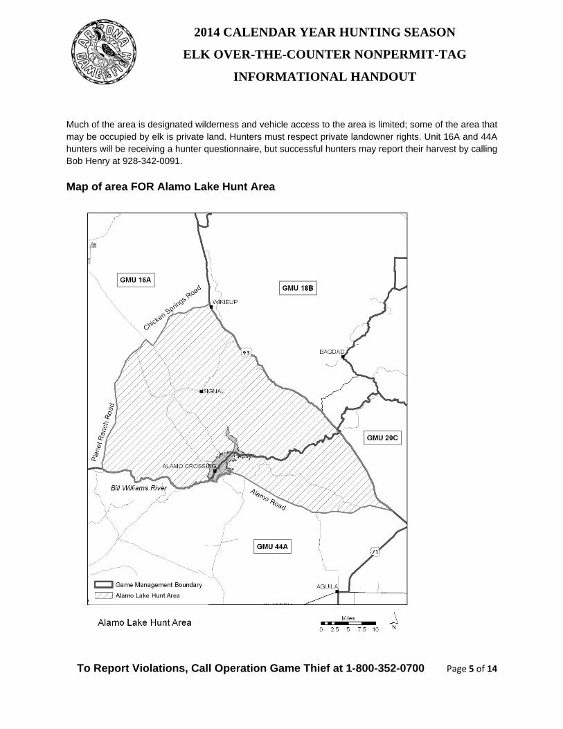
Alamo Lake Hunt Area Hunt Area Boundaries for Alamo Lake Area (per note 24): Alamo Lake Hunt Area in Units 16A and 44A – That portion of Unit 16A south and east of the following: beginning at Bill Williams River and Planet Ranch Road, north on Planet Ranch Road to Yucca-Alamo Road, southeast on Yucca-Alamo Road to Chicken Springs Ranch Road, northeast on Chicken Springs Ranch Road to US Hwy 93; and that portion of Unit 44A north of Alamo-Highway 93 Road and west of AZ Hwy 93. Season Dates for Alamo Lake Hunt Area: Jan. 1 – Mar. 31, 2014 - Any elk Sep. 12 – Oct. 16, 2014 - Any elk Dec. 1 – Dec. 31, 2014 - Any elk Weapon Types for Alamo Lake Hunt Area: General hunt - Any weapon described in Commission Rule R12-4-304.A.6 (centerfire rifles, muzzleloading rifles, centerfire handguns, and archery – see rule for exact details and verbiage). Other notes for Alamo Lake Hunt Area: Elk in this hunt area are limited in number, and most hunters have had poor success finding them. Small groups of elk have been located, throughout the year, in the river bottoms of the Big Sandy and Santa Maria Rivers upstream of Alamo Lake, and those portions of the Bill Williams River about Alamo Lake. The river bottoms are wide and dominated with dense thickets of cottonwood, willow, mesquite and salt cedar trees. There may be multiple stream channels which may or may not contain flowing water or moist soil conditions. Primary access to the Unit 44A portion is the paved Alamo Dam Lake Road beginning in Wenden, to the Wayside Inn Road to the Wayside Inn. Direct access to the Santa Maria from there is on the Three Rivers Road and the road crossing Date Creek (about ¼ mile east of the Wayside Inn. Some hunters have had success locating elk from the bluffs along the south side of the river. Elk can be located along the Santa Maria as far up as the Palmerita Ranch. Motorized vehicle travel is allowed in the Santa Maria upstream from Date Creek. Primary access to the upper Bill Williams and lower Big Sandy portion of Unit 16A, from the south, is the Brown’s Crossing Road (that ends at the gauging station at the confluence of the Santa Maria and the Big Sandy). Travel up the Big Sandy is limited to about a mile to the wilderness boundary. Some elk to tend to center their activity in the vicinity of the gauging station. Primary access from the north is the Alamo Road, from Signal Road or Chicken Springs Road. Some elk can be found as far up the Big Sandy River as Wikieup. Access along the Bill Williams, above the Alamo Lake, west to Planet Ranch Road is essentially foot access.
2014 CALENDAR YEAR HUNTING SEASON
ELK OVER-THE-COUNTER NONPERMIT-TAG
INFORMATIONAL HANDOUT
To Report Violations, Call Operation Game Thief at 1-800-352-0700 Page 5 of 14
Much of the area is designated wilderness and vehicle access to the area is limited; some of the area that may be occupied by elk is private land. Hunters must respect private landowner rights. Unit 16A and 44A hunters will be receiving a hunter questionnaire, but successful hunters may report their harvest by calling Bob Henry at 928-342-0091.
Map of area FOR Alamo Lake Hunt Area
2014 CALENDAR YEAR HUNTING SEASON
ELK OVER-THE-COUNTER NONPERMIT-TAG
INFORMATIONAL HANDOUT
To Report Violations, Call Operation Game Thief at 1-800-352-0700 Page 6 of 14
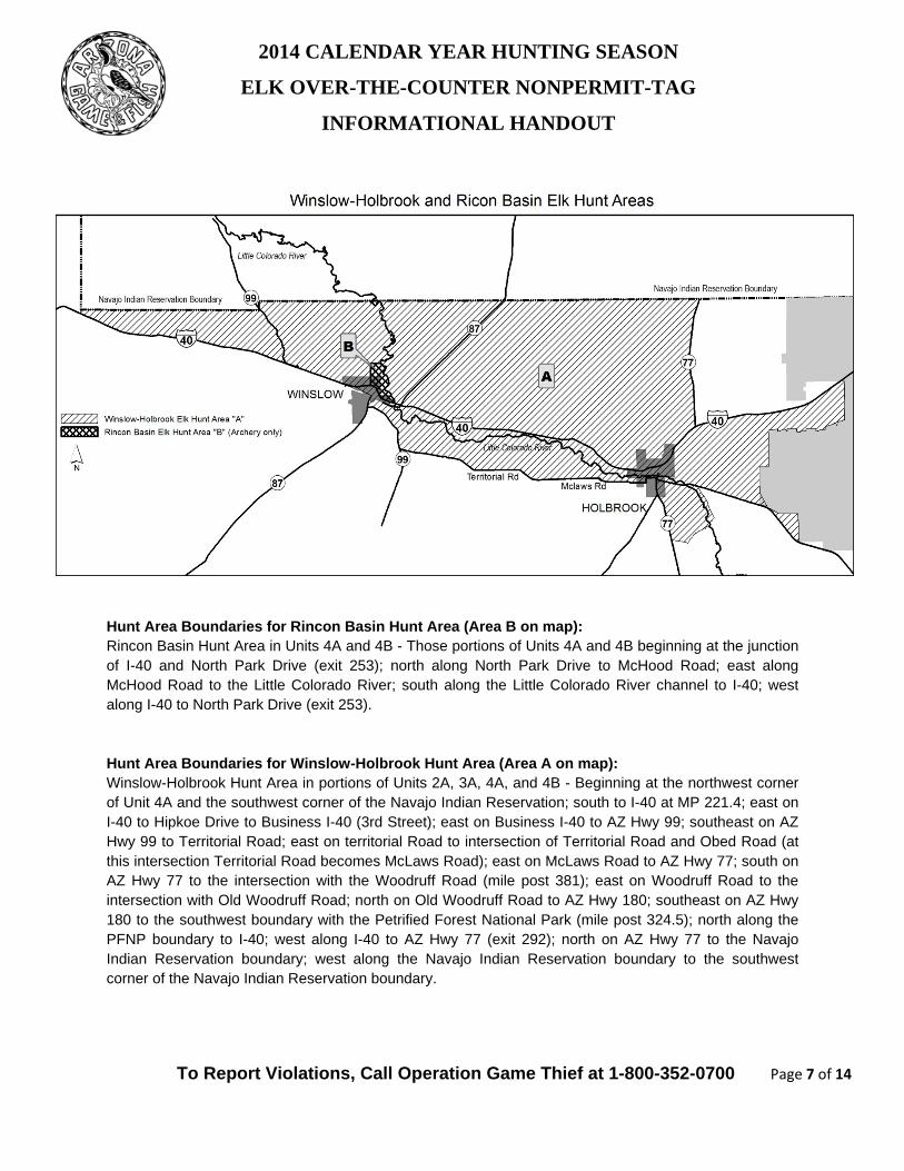
Rincon Basin Hunt Area Hunt Area Boundaries for Rincon Basin Hunt Area (per note 26): Rincon Basin Hunt Area in Units 4A and 4B - Those portions of Units 4A and 4B beginning at the junction of I-40 and North Park Drive (exit 253); north along North Park Drive to McHood Road; east along McHood Road to the Little Colorado River; south along the Little Colorado River channel to I-40; west along I-40 to North Park Drive (exit 253). Season Dates for Rincon Basin Hunt Area: Jan. 1 – Mar. 31, 2014 - Any elk Apr. 1 – Jul. 31, 2014 - Bull elk Aug. 1 – Dec. 31, 2014 - Any elk Weapon Types for Rincon Basin Hunt Area Archery-Only hunt area. Other notes for Rincon Basin Hunt Area Elk densities are low in this area along the Little Colorado River (LCR) between Winslow and the Navajo Indian Reservation. These small transient elk herds may feed on private land adjacent to the LCR which is comprised of irrigated pastures and alfalfa fields. This has been made an archery only area due to conflicts with residences near elk feeding and travel corridors. Hunters must respect private landowner rights. Successful hunters can report elk harvested in this area to Ken Clay III, Wildlife Manager Unit 4A, at 928-856-0816. Map of area Rincon Basin Hunt Area See next page.
2014 CALENDAR YEAR HUNTING SEASON
ELK OVER-THE-COUNTER NONPERMIT-TAG
INFORMATIONAL HANDOUT
To Report Violations, Call Operation Game Thief at 1-800-352-0700 Page 7 of 14
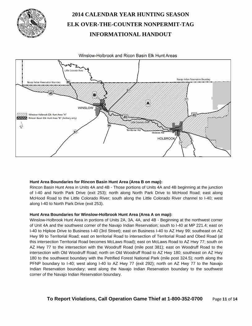
Hunt Area Boundaries for Rincon Basin Hunt Area (Area B on map): Rincon Basin Hunt Area in Units 4A and 4B - Those portions of Units 4A and 4B beginning at the junction of I-40 and North Park Drive (exit 253); north along North Park Drive to McHood Road; east along McHood Road to the Little Colorado River; south along the Little Colorado River channel to I-40; west along I-40 to North Park Drive (exit 253). Hunt Area Boundaries for Winslow-Holbrook Hunt Area (Area A on map): Winslow-Holbrook Hunt Area in portions of Units 2A, 3A, 4A, and 4B - Beginning at the northwest corner of Unit 4A and the southwest corner of the Navajo Indian Reservation; south to I-40 at MP 221.4; east on I-40 to Hipkoe Drive to Business I-40 (3rd Street); east on Business I-40 to AZ Hwy 99; southeast on AZ Hwy 99 to Territorial Road; east on territorial Road to intersection of Territorial Road and Obed Road (at this intersection Territorial Road becomes McLaws Road); east on McLaws Road to AZ Hwy 77; south on AZ Hwy 77 to the intersection with the Woodruff Road (mile post 381); east on Woodruff Road to the intersection with Old Woodruff Road; north on Old Woodruff Road to AZ Hwy 180; southeast on AZ Hwy 180 to the southwest boundary with the Petrified Forest National Park (mile post 324.5); north along the PFNP boundary to I-40; west along I-40 to AZ Hwy 77 (exit 292); north on AZ Hwy 77 to the Navajo Indian Reservation boundary; west along the Navajo Indian Reservation boundary to the southwest corner of the Navajo Indian Reservation boundary.
2014 CALENDAR YEAR HUNTING SEASON
ELK OVER-THE-COUNTER NONPERMIT-TAG
INFORMATIONAL HANDOUT
To Report Violations, Call Operation Game Thief at 1-800-352-0700 Page 8 of 14
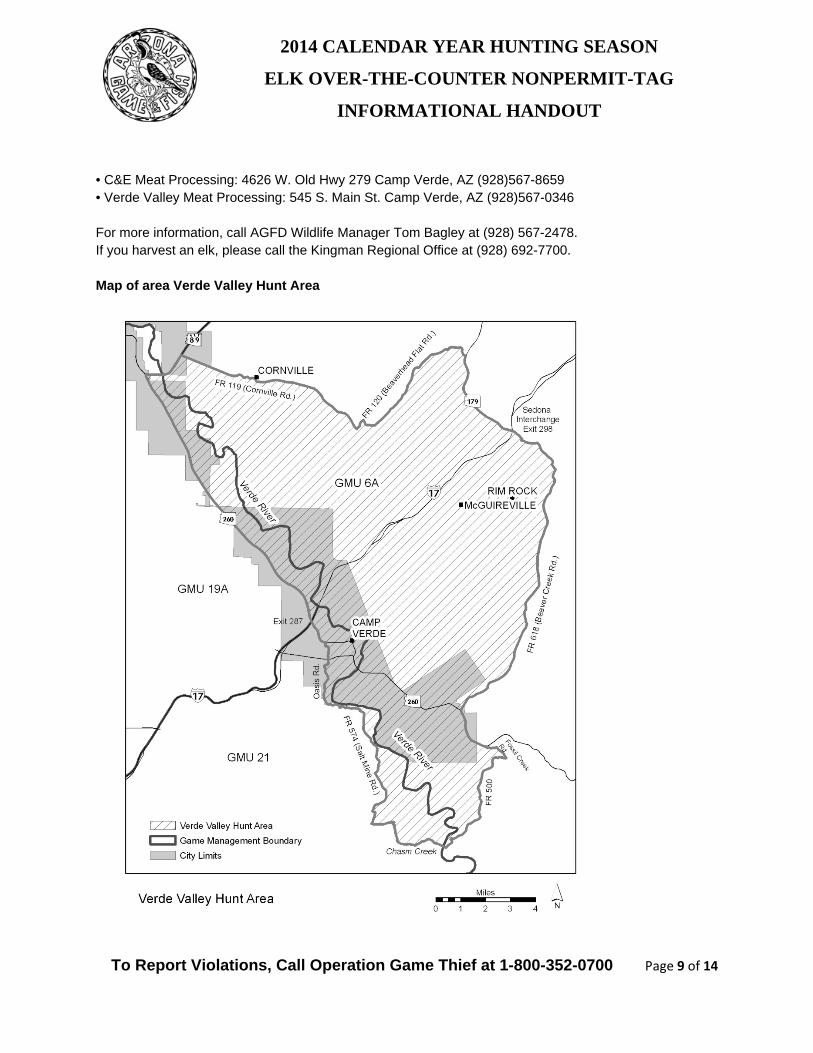
Verde Valley Hunt Area Hunt Area Boundaries for Verde Valley Hunt Area (per note 25): Verde Valley Hunt Area - Beginning in that portion of Unit 6A at the junction of I-17 and FR 618 (Beaver Creek Road); southeasterly along FR 618 to AZ Hwy 260 (General Crook Trail); east along AZ Hwy 260 to FR 708 (Fossil Creek Road); east along FR 708 to FR 500; south along FR 500 to the Verde River to Chasm Creek; west along the bottom of Chasm Creek to FR 574 (Salt Mine Road) in the Prescott National Forest; northwesterly along FR 574 to Oasis Road; westerly along Oasis Road to AZ Hwy 260; west along AZ Hwy 260 to US Hwy 89A; north along US Hwy 89A to FR 119 (Cornville Road); east along FR119 to FR 120 (Bearverhead Flat Road); north along FR 120 to AZ Hwy 179; easterly along AZ Hwy 179 to I-17. Season Dates for Verde Valley Hunt Area: Apr. 1 - Jul. 31, 2014 - Bull elk Jan. 1 - Mar. 31, 2014 - Any elk Aug. 1 - Sep. 11, 2014 - Any elk Dec. 1 - Dec. 31, 2014 - Any elk Weapon Types for Verde Valley Hunt Area: General hunt – any weapon described in Commission Rule R12-4-304.A.6 (centerfire rifles, muzzleloading rifles, centerfire handguns, and archery – see rule for exact details and verbiage). Other notes for Verde Valley Hunt Area: Elk densities are low in this area and hunt success may be very low. Elk are concentrated throughout the year in the riparian areas of the Verde River, Beaver Creek, and Clear Creek. Much of this area is privately owned, so hunters should be aware of property boundaries and respect land-owners’ rights. Much of this area is also within the town limits of Camp Verde (see attached map), where the discharge of a firearm is prohibited. Hunting within town boundaries is limited to archery-only. At night, some elk use agricultural fields adjacent to the Verde River during the growing season, then retreat to the shady riparian areas during the day. Outside of town limits, hunters may use firearms on the public lands north and northeast of Camp Verde on the Coconino National Forest in the vicinities of White Hills and Wickiup Mesa. A Coconino National Forest (US Forest Service) map is helpful in locating area boundaries, access, and roadways. Elk may be found in these locations year-round in low numbers. Throughout much of the year, elk use here is tied closely to available water on these mesas. In the summer months, stock tanks and water troughs may dry up, so these elk will live in the canyons and ravines adjacent to the mesas, above the Verde River, Beaver Creek, and Clear Creek. Hunting is not allowed on the Yavapai-Apache Reservation or within Montezuma Castle & Montezuma Well National Monuments; hunters should be aware of these boundaries. Temperatures in the summer months will exceed 100 degrees. Especially if hunting from April through September, hunters should have a plan to remove elk from the field quickly and get the meat to cold storage without delay, to avoid meat spoilage. Two local meat processors appear in the Verde Valley phone book:
2014 CALENDAR YEAR HUNTING SEASON
ELK OVER-THE-COUNTER NONPERMIT-TAG
INFORMATIONAL HANDOUT
To Report Violations, Call Operation Game Thief at 1-800-352-0700 Page 9 of 14
• C&E Meat Processing: 4626 W. Old Hwy 279 Camp Verde, AZ (928)567-8659 • Verde Valley Meat Processing: 545 S. Main St. Camp Verde, AZ (928)567-0346 For more information, call AGFD Wildlife Manager Tom Bagley at (928) 567-2478. If you harvest an elk, please call the Kingman Regional Office at (928) 692-7700. Map of area Verde Valley Hunt Area
2014 CALENDAR YEAR HUNTING SEASON
ELK OVER-THE-COUNTER NONPERMIT-TAG
INFORMATIONAL HANDOUT
To Report Violations, Call Operation Game Thief at 1-800-352-0700 Page 10 of 14
Winslow-Holbrook Hunt Area Hunt Area Boundaries for Winslow-Holbrook Hunt Area (per note 23): Winslow-Holbrook Hunt Area in portions of Units 2A, 3A, 4A, and 4B - Beginning at the northwest corner of Unit 4A and the southwest corner of the Navajo Indian Reservation; south to I-40 at MP 221.4; east on I-40 to Hipkoe Drive to Business I-40 (3rd Street); east on Business I-40 to AZ Hwy 99; southeast on AZ Hwy 99 to Territorial Road; east on territorial Road to intersection of Territorial Road and Obed Road (at this intersection Territorial Road becomes McLaws Road); east on McLaws Road to AZ Hwy 77; south on AZ Hwy 77 to the intersection with the Woodruff Road (mile post 381); east on Woodruff Road to the intersection with Old Woodruff Road; north on Old Woodruff Road to AZ Hwy 180; southeast on AZ Hwy 180 to the southwest boundary with the Petrified Forest National Park (mile post 324.5); north along the PFNP boundary to I-40; west along I-40 to AZ Hwy 77 (exit 292); north on AZ Hwy 77 to the Navajo Indian Reservation boundary; west along the Navajo Indian Reservation boundary to the southwest corner of the Navajo Indian Reservation boundary. Season Dates for Winslow-Holbrook Hunt Area Apr. 1 – Jul. 31, 2014 - Bull elk Jan. 1 – Mar. 31, 2014 - Any elk Aug. 1 – Dec. 31, 2014 - Any elk Weapon Types for Winslow-Holbrook Hunt Area General hunt – any weapon described in Commission Rule R12-4-304.A.6 (centerfire rifles, muzzleloading rifles, centerfire handguns, and archery – see rule for exact details and verbiage). Other notes for Winslow-Holbrook Hunt Area There is a resident herd of elk along the Little Colorado River (LCR) between Holbrook and Winslow that cause private land conflicts. These elk may feed on private land adjacent to the LCR, which is comprised of irrigated pasture and alfalfa. Hunters must respect private landowner rights. Wintering elk can also be found along the LCR near the Chevelon Wildlife Area. Unit 4A and 4B hunters will be receiving a hunter questionnaire, but successful hunters may report their harvest by calling Evan Lautzenheiser (928) 367-4281. Map of area Winslow-Holbrook Hunt Area See next page for map
2014 CALENDAR YEAR HUNTING SEASON
ELK OVER-THE-COUNTER NONPERMIT-TAG
INFORMATIONAL HANDOUT
To Report Violations, Call Operation Game Thief at 1-800-352-0700 Page 11 of 14
Hunt Area Boundaries for Rincon Basin Hunt Area (Area B on map): Rincon Basin Hunt Area in Units 4A and 4B - Those portions of Units 4A and 4B beginning at the junction of I-40 and North Park Drive (exit 253); north along North Park Drive to McHood Road; east along McHood Road to the Little Colorado River; south along the Little Colorado River channel to I-40; west along I-40 to North Park Drive (exit 253). Hunt Area Boundaries for Winslow-Holbrook Hunt Area (Area A on map): Winslow-Holbrook Hunt Area in portions of Units 2A, 3A, 4A, and 4B - Beginning at the northwest corner of Unit 4A and the southwest corner of the Navajo Indian Reservation; south to I-40 at MP 221.4; east on I-40 to Hipkoe Drive to Business I-40 (3rd Street); east on Business I-40 to AZ Hwy 99; southeast on AZ Hwy 99 to Territorial Road; east on territorial Road to intersection of Territorial Road and Obed Road (at this intersection Territorial Road becomes McLaws Road); east on McLaws Road to AZ Hwy 77; south on AZ Hwy 77 to the intersection with the Woodruff Road (mile post 381); east on Woodruff Road to the intersection with Old Woodruff Road; north on Old Woodruff Road to AZ Hwy 180; southeast on AZ Hwy 180 to the southwest boundary with the Petrified Forest National Park (mile post 324.5); north along the PFNP boundary to I-40; west along I-40 to AZ Hwy 77 (exit 292); north on AZ Hwy 77 to the Navajo Indian Reservation boundary; west along the Navajo Indian Reservation boundary to the southwest corner of the Navajo Indian Reservation boundary.
2014 CALENDAR YEAR HUNTING SEASON
ELK OVER-THE-COUNTER NONPERMIT-TAG
INFORMATIONAL HANDOUT
To Report Violations, Call Operation Game Thief at 1-800-352-0700 Page 12 of 14
12A, 12B, 13A, and 13B Game Management Unit(s) Hunt Area Boundaries for Units 12A, 12B, 13A, and 13B: See current hunting and trapping regulations for unit boundaries per R12-4-108 under Unit12A and 12B. Season Dates for Units 12A and 12B Jan. 1 – Mar. 31, 2014 - Any elk Aug. 1 – Dec. 31, 2014 - Any elk Season Dates for Units 13A and 13B Jan. 1 – Mar. 31, 2014 - Any elk Jun. 15 – Jul. 31, 2014 - Any elk Aug. 22 – Sep. 14, 2014 - Any elk Nov. 7 – Dec. 31, 2014 - Any elk Weapon Types for Units 12A, 12B, 13A, and 13B General hunt – any weapon described in Commission Rule R12-4-304.A.6 (centerfire rifles, muzzleloading rifles, centerfire handguns, and archery – see rule for exact details and verbiage). Other notes for Units 12A, 12B, 13A, and 13B Unit 12A, 12B, 13A, and 13B hunters may be receiving a hunter questionnaire, but successful hunters may report their harvest by calling Tom McCall at (928) 214-1248. The elk in these units probably originated from Utah. The Department is reducing elk numbers in these units so that they do not compete with mule deer. Few elk (6-12 animals) are found in these units. In Units 12A and 12B in recent years, elk have been found North of Jacob Lake in the area of Cooper Ridge and LeFevre Canyon. In addition to these areas, elk have been observed this fall off of Forest Service Roads 205, 224, 240, 249,633 and near Sowats Point. Map of area Units 12A, 12B, 13A, and 13B See current hunting and trapping regulations.
2014 CALENDAR YEAR HUNTING SEASON
ELK OVER-THE-COUNTER NONPERMIT-TAG
INFORMATIONAL HANDOUT
To Report Violations, Call Operation Game Thief at 1-800-352-0700 Page 13 of 14
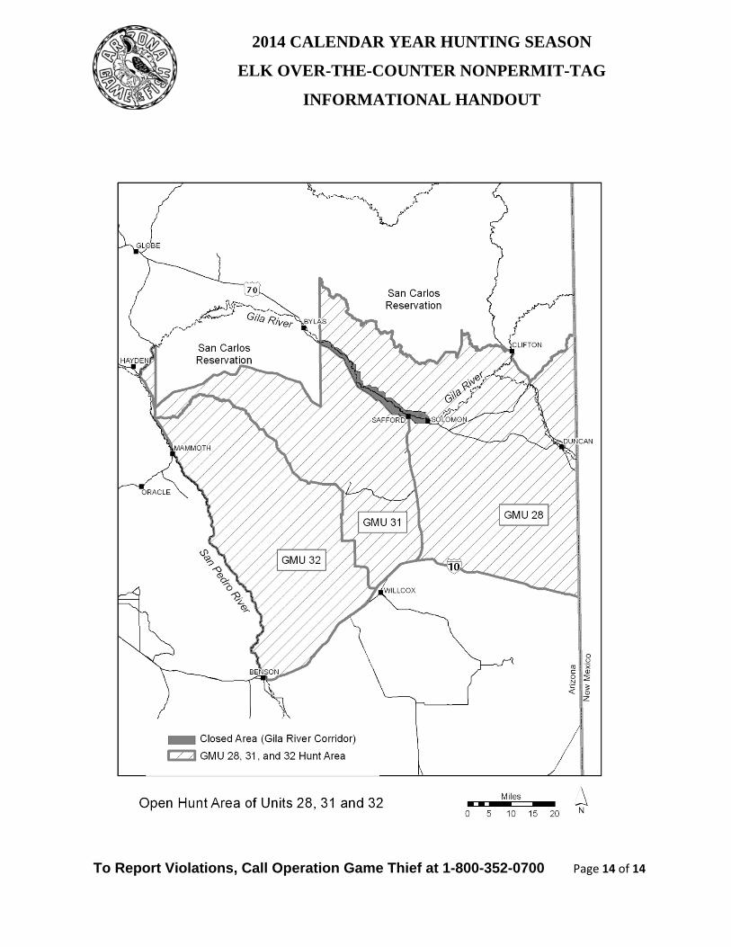
28 (excluding the Gila River corridor), 31 and 32 Game Management Unit(s) Hunt Area Boundaries for Units 28 (excluding the Gila River corridor), 31, and 32: See current regulations for unit boundaries per R12-4-108 under Unit 28 (see closure below), 31 and 32. CLOSED Area Boundaries for Gila River corridor: Gila River Corridor - That portion of Unit 28 within the following boundaries is closed to elk hunting: beginning at the San Carlos Reservation boundary and U.S. Hwy 70 east of Bylas; east along U.S. Hwy 70 to East Sanchez Road (in Solomon); north along East Sanchez Road to North Airport Road; west along North Airport Road to the Safford-Bryce-Eden Road; west along the Safford-Bryce-Eden Road to the San Carlos Reservation boundary; and south along the San Carlos Reservation boundary to U.S. Hwy 70. Season Dates for Units 28 (excluding the Gila River corridor), 31, and 32 Nov. 22 - Dec. 31, 2014 - Any elk Weapon Types for Units 28 (excluding the Gila River corridor), 31, and 32 General hunt – any weapon described in Commission Rule R12-4-304.A.6 (centerfire rifles, muzzleloading rifles, centerfire handguns, and archery – see rule for exact details and verbiage). Other notes for Units 28 (excluding the Gila River corridor), 31, and 32 The Gila River corridor is closed during the over-the-counter elk hunt. This is due to safety concerns for that area. The over-the-counter elk hunt could have the potential for a large number of hunters in this area containing many scattered houses that are not visible from a long distance. This closure would provide safety for the families that live in this area and work in the neighboring farm fields. Some of the areas that elk inhabit are very rough and have very few roads. This hunt may be very difficult with very low success rates. • Unit 28, 31, and 32 hunters will be receiving a hunter questionnaire, but successful hunters may report their harvest by calling the Region V Office at (520) 628-5376. • Elk densities are low in these Game Management Units. Hunters should be aware of the season dates and Unit boundaries. Map of area Units 28 (excluding the Gila River corridor), 31, and 32: See next page.
2014 CALENDAR YEAR HUNTING SEASON
ELK OVER-THE-COUNTER NONPERMIT-TAG
INFORMATIONAL HANDOUT
To Report Violations, Call Operation Game Thief at 1-800-352-0700 Page 14 of 14