Embed Size (px)
DESCRIPTION
This brochure covers only rules for hunting deer, elk, pronghorn, black bear, mountain lion andgray wolf. Information about hunting upland game, turkey, furbearer, waterfowl and moose,bighorn sheep or mountain goat can be found separately in the Upland Game, Furbearer andTurkey, the Waterfowl, or the Moose, Bighorn Sheep and Mountain Goat Seasons and Rulesbrochures.
Citation preview

Big Game 2013 Seasons and Rules
IDAHOIDAHO
FISH & GAM
EFISH & GAM
E
http://fishandgame.idaho.gov 9
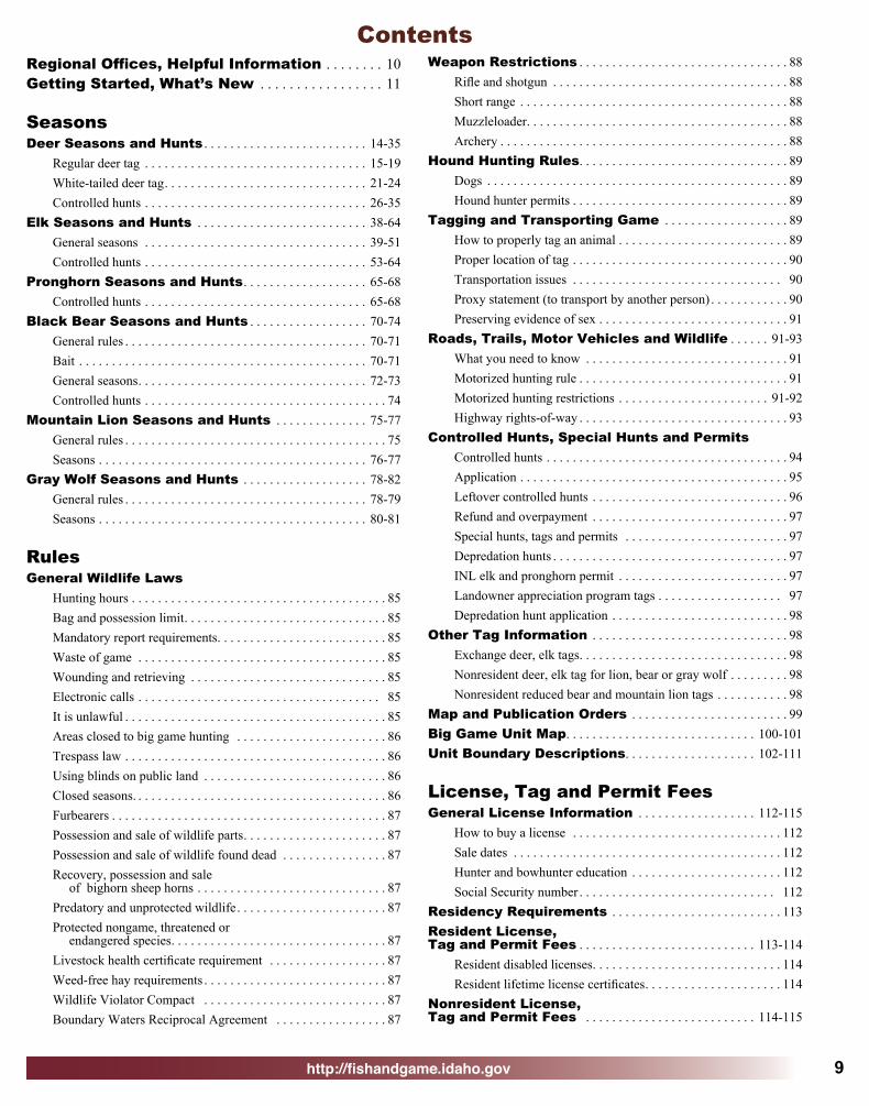
ContentsRegional Offices, Helpful Information . . . . . . . . 10Getting Started, What’s New . . . . . . . . . . . . . . . . . 11
SeasonsDeer Seasons and Hunts . . . . . . . . . . . . . . . . . . . . . . . . . 14-35
Regular deer tag . . . . . . . . . . . . . . . . . . . . . . . . . . . . . . . . . . 15-19White-tailed deer tag. . . . . . . . . . . . . . . . . . . . . . . . . . . . . . . 21-24Controlled hunts . . . . . . . . . . . . . . . . . . . . . . . . . . . . . . . . . . 26-35
Elk Seasons and Hunts . . . . . . . . . . . . . . . . . . . . . . . . . . 38-64General seasons . . . . . . . . . . . . . . . . . . . . . . . . . . . . . . . . . . 39-51Controlled hunts . . . . . . . . . . . . . . . . . . . . . . . . . . . . . . . . . . 53-64
Pronghorn Seasons and Hunts. . . . . . . . . . . . . . . . . . . 65-68Controlled hunts . . . . . . . . . . . . . . . . . . . . . . . . . . . . . . . . . . 65-68
Black Bear Seasons and Hunts . . . . . . . . . . . . . . . . . . 70-74General rules . . . . . . . . . . . . . . . . . . . . . . . . . . . . . . . . . . . . . 70-71Bait . . . . . . . . . . . . . . . . . . . . . . . . . . . . . . . . . . . . . . . . . . . . 70-71General seasons. . . . . . . . . . . . . . . . . . . . . . . . . . . . . . . . . . . 72-73Controlled hunts . . . . . . . . . . . . . . . . . . . . . . . . . . . . . . . . . . . . . 74
Mountain Lion Seasons and Hunts . . . . . . . . . . . . . . 75-77 General rules . . . . . . . . . . . . . . . . . . . . . . . . . . . . . . . . . . . . . . . . 75Seasons . . . . . . . . . . . . . . . . . . . . . . . . . . . . . . . . . . . . . . . . . 76-77
Gray Wolf Seasons and Hunts . . . . . . . . . . . . . . . . . . . 78-82 General rules . . . . . . . . . . . . . . . . . . . . . . . . . . . . . . . . . . . . . 78-79Seasons . . . . . . . . . . . . . . . . . . . . . . . . . . . . . . . . . . . . . . . . . 80-81
RulesGeneral Wildlife Laws
Hunting hours . . . . . . . . . . . . . . . . . . . . . . . . . . . . . . . . . . . . . . . 85Bag and possession limit . . . . . . . . . . . . . . . . . . . . . . . . . . . . . . . 85Mandatory report requirements. . . . . . . . . . . . . . . . . . . . . . . . . . 85Waste of game . . . . . . . . . . . . . . . . . . . . . . . . . . . . . . . . . . . . . . 85Wounding and retrieving . . . . . . . . . . . . . . . . . . . . . . . . . . . . . . 85Electronic calls . . . . . . . . . . . . . . . . . . . . . . . . . . . . . . . . . . . . . 85It is unlawful . . . . . . . . . . . . . . . . . . . . . . . . . . . . . . . . . . . . . . . . 85Areas closed to big game hunting . . . . . . . . . . . . . . . . . . . . . . . 86Trespass law . . . . . . . . . . . . . . . . . . . . . . . . . . . . . . . . . . . . . . . . 86Using blinds on public land . . . . . . . . . . . . . . . . . . . . . . . . . . . . 86Closed seasons. . . . . . . . . . . . . . . . . . . . . . . . . . . . . . . . . . . . . . . 86Furbearers . . . . . . . . . . . . . . . . . . . . . . . . . . . . . . . . . . . . . . . . . . 87Possession and sale of wildlife parts. . . . . . . . . . . . . . . . . . . . . . 87Possession and sale of wildlife found dead . . . . . . . . . . . . . . . . 87Recovery, possession and sale of bighorn sheep horns . . . . . . . . . . . . . . . . . . . . . . . . . . . . . 87Predatory and unprotected wildlife . . . . . . . . . . . . . . . . . . . . . . . 87Protected nongame, threatened or endangered species. . . . . . . . . . . . . . . . . . . . . . . . . . . . . . . . . 87Livestock health certificate requirement . . . . . . . . . . . . . . . . . . 87Weed-free hay requirements . . . . . . . . . . . . . . . . . . . . . . . . . . . . 87Wildlife Violator Compact . . . . . . . . . . . . . . . . . . . . . . . . . . . . 87 Boundary Waters Reciprocal Agreement . . . . . . . . . . . . . . . . . 87
Weapon Restrictions . . . . . . . . . . . . . . . . . . . . . . . . . . . . . . . . 88Rifle and shotgun . . . . . . . . . . . . . . . . . . . . . . . . . . . . . . . . . . . . 88Short range . . . . . . . . . . . . . . . . . . . . . . . . . . . . . . . . . . . . . . . . . 88Muzzleloader. . . . . . . . . . . . . . . . . . . . . . . . . . . . . . . . . . . . . . . . 88Archery . . . . . . . . . . . . . . . . . . . . . . . . . . . . . . . . . . . . . . . . . . . . 88
Hound Hunting Rules. . . . . . . . . . . . . . . . . . . . . . . . . . . . . . . . 89Dogs . . . . . . . . . . . . . . . . . . . . . . . . . . . . . . . . . . . . . . . . . . . . . . 89Hound hunter permits . . . . . . . . . . . . . . . . . . . . . . . . . . . . . . . . . 89
Tagging and Transporting Game . . . . . . . . . . . . . . . . . . . 89How to properly tag an animal . . . . . . . . . . . . . . . . . . . . . . . . . . 89Proper location of tag . . . . . . . . . . . . . . . . . . . . . . . . . . . . . . . . . 90Transportation issues . . . . . . . . . . . . . . . . . . . . . . . . . . . . . . . . 90Proxy statement (to transport by another person) . . . . . . . . . . . . 90Preserving evidence of sex . . . . . . . . . . . . . . . . . . . . . . . . . . . . . 91
Roads, Trails, Motor Vehicles and Wildlife . . . . . . 91-93What you need to know . . . . . . . . . . . . . . . . . . . . . . . . . . . . . . . 91Motorized hunting rule . . . . . . . . . . . . . . . . . . . . . . . . . . . . . . . . 91Motorized hunting restrictions . . . . . . . . . . . . . . . . . . . . . . . 91-92Highway rights-of-way . . . . . . . . . . . . . . . . . . . . . . . . . . . . . . . . 93
Controlled Hunts, Special Hunts and PermitsControlled hunts . . . . . . . . . . . . . . . . . . . . . . . . . . . . . . . . . . . . . 94Application . . . . . . . . . . . . . . . . . . . . . . . . . . . . . . . . . . . . . . . . . 95Leftover controlled hunts . . . . . . . . . . . . . . . . . . . . . . . . . . . . . . 96Refund and overpayment . . . . . . . . . . . . . . . . . . . . . . . . . . . . . . 97Special hunts, tags and permits . . . . . . . . . . . . . . . . . . . . . . . . . 97Depredation hunts . . . . . . . . . . . . . . . . . . . . . . . . . . . . . . . . . . . . 97INL elk and pronghorn permit . . . . . . . . . . . . . . . . . . . . . . . . . . 97Landowner appreciation program tags . . . . . . . . . . . . . . . . . . . 97Depredation hunt application . . . . . . . . . . . . . . . . . . . . . . . . . . . 98
Other Tag Information . . . . . . . . . . . . . . . . . . . . . . . . . . . . . . 98Exchange deer, elk tags. . . . . . . . . . . . . . . . . . . . . . . . . . . . . . . . 98Nonresident deer, elk tag for lion, bear or gray wolf . . . . . . . . . 98Nonresident reduced bear and mountain lion tags . . . . . . . . . . . 98
Map and Publication Orders . . . . . . . . . . . . . . . . . . . . . . . . 99Big Game Unit Map. . . . . . . . . . . . . . . . . . . . . . . . . . . . . 100-101Unit Boundary Descriptions. . . . . . . . . . . . . . . . . . . . 102-111
License, Tag and Permit FeesGeneral License Information . . . . . . . . . . . . . . . . . . 112-115
How to buy a license . . . . . . . . . . . . . . . . . . . . . . . . . . . . . . . . 112Sale dates . . . . . . . . . . . . . . . . . . . . . . . . . . . . . . . . . . . . . . . . . 112Hunter and bowhunter education . . . . . . . . . . . . . . . . . . . . . . . 112Social Security number . . . . . . . . . . . . . . . . . . . . . . . . . . . . . . 112
Residency Requirements . . . . . . . . . . . . . . . . . . . . . . . . . . 113Resident License, Tag and Permit Fees . . . . . . . . . . . . . . . . . . . . . . . . . . . 113-114
Resident disabled licenses. . . . . . . . . . . . . . . . . . . . . . . . . . . . . 114Resident lifetime license certificates. . . . . . . . . . . . . . . . . . . . . 114
Nonresident License, Tag and Permit Fees . . . . . . . . . . . . . . . . . . . . . . . . . . 114-115

http://fishandgame.idaho.gov10
Idaho Department of Fish and GameIdaho Wildlife Policy
“All wildlife, including all wild animals, wild birds, and fish, within the state of Idaho, is hereby declared to be the property of the state of Idaho. It shall be preserved, protected, perpetuated, and managed. It shall be only captured or taken at such times or places, under such conditions, or by such means, or in such manner, as will preserve, protect, and perpetuate such wildlife, and provide for the citizens of this state and, as by law permitted to others, continued supplies of such wildlife for hunting, fishing and trapping.” — Idaho Code Section 36-103
Idaho Fish and Game CommissionRandall Budge, Chairman - Southeast
Tony McDermott - PanhandleFred Trevey - Clearwater
Bob Barowsky - SouthwestVacant - Magic Valley
Kenny Anderson - Upper SnakeWill Naillon - Salmon
Idaho Department of Fish and Game600 S. Walnut St., P.O. Box 25
Boise, ID 83707208-334-3700 - http://fishandgame.idaho.gov
Virgil Moore, DirectorDeputy Directors
Sharon Kiefer - Jim UnsworthRegional Offices
Panhandle Region .......................................... 208-769-1414 2885 W. Kathleen Ave., Coeur d’Alene, ID 83815
Clearwater Region ............................................208-799-5010 3316 - 16th Street, Lewiston, ID 83501
Southwest Region ..............................................208-465-8465 3101 S. Powerline Rd., Nampa, ID 83686
McCall Subregion ......................................... 208-634-8137 555 Deinhard Ln., McCall, ID 83638
Magic Valley Region .........................................208-324-4359 324 S. 417 E.; Suite #1, Jerome, ID 83338
Southeast Region ................................................208-232-4703 1345 Barton Rd., Pocatello, ID 83204
Upper Snake Region .........................................208-525-7290 4279 Commerce Circle, Idaho Falls, ID 83401
Salmon Region ............................................... 208-756-2271 99 Hwy. 93 N., P.O. Box 1336, Salmon, ID 83467Idaho Department of Fish and Game offices are open 8 a.m. to 5 p.m. Monday through Friday except state holidays. Offices in the Panhandle and Clearwater regions are in the Pacific Time zone; all others are in the Mountain Time zone. Idaho Relay Service (TDD) ............................... 1-800-377-3529Internet: .........................................http://fishandgame.idaho.govTo Receive Nonresident License Applications, Call: .................................................................... 1-208-334-3700If you buy a nonresident license this year, you will automatically receive an application form for the following year. Applications will be mailed in November.
Other Information Numbers• Rules booklets, nonresident license applications:
208-334-3700.
• U. S. Forest Service – Boise National Forest: 208-373-4007 or 1-888-246-7523.
• Bureau of Land Management – Idaho Office: 208-373-4007 or 1-888-246-7523.
To Buy a License, Tag or Permit:• In person, go to any Idaho Fish and Game office or
license vendor throughout the state.• By credit card, within the United States call
1-800-554-8685. Outside the U.S., use the Internet or mail.
• On the Internet, go online to http://fishandgame.idaho.gov. A service fee is added for this transaction.
• Commercial licenses, duplicate tags, documents that require proof of disability, lifetime licenses, and bear baiting permits may be purchased only at Fish and Game offices.
You may refer to this link for laws pertaining to this rule book:
Administrative Procedures Act: http://adminrules.idaho.gov
More than 30 states have entered into a “Wildlife Violator Compact.” This means if your hunting, fishing or trapping license is revoked by any of the member states, all the remaining states will revoke the same license or privilege for the same time period. In addition, any nonresident who does not satisfy the requirements of an Idaho citation will have his/her hunting and fishing license revoked in their home state until those requirements are satisfied. For more information on the WVC and a complete list of member states, go to http://fishandgame.idaho.gov/cms/about/enforcement/violator.cfm
Idaho Fish and Game adheres to all applicable state and federal laws and regulations related to discrimination on the basis of race, color, national origin, age, gender, or handicap. If you feel you have been discriminated against in any program, activity, or facility of IDFG, or if you desire further information, please write to: Idaho Department of Fish and Game, P.O. Box 25, Boise, ID 83707; or the U.S. Fish and Wildlife Service, Division of Federal Assistance, Mailstop: MBSP-4020, 4401 N. Fairfax Drive, Arlington, VA 22203. Telephone: (703) 358-2156. This publication will be made available in alternative formats upon request. Please contact the Department of Fish and Game for assistance.
Information in this brochure summarizes the rules and is the official proclamation of the Idaho Fish and Game Commission for the taking of big game. The official rules are available from the Office of Administrative Rules, Department of Administration, Statehouse Mail, Boise, ID 83720, and may be reviewed in some libraries. Maps are for general reference only.
Costs associated with this publication are available from Idaho Fish and Game in accordance with Section 60-202, Idaho Code. 1-2013, 2013-14/350,000/31918/ROS.
To report wildlife crimes, call Citizens Against Poaching at 1-800-632-5999.
Emergency information can be relayed to Fish and Game personnel through any Idaho law
enforcement agency.

http://fishandgame.idaho.gov 11
Getting StartedTo use this brochure:• Pick the species you want to hunt, then refer to the section
on that animal.
• Refer to the map on pages 100 and 101 to find an area to hunt.
• Find the unit numbers on the map and look up the seasons and restrictions for those units.
• For help in this process, try the online Hunt Planner at the Fish and Game website http://fishandgame.idaho.gov.
Big game hunting in Idaho is regulated by numbered game management units. For a map of Fish and Game regions and game management units see pages 100 and 101.
General seasons for black bear, mountain lion, mule deer and white-tailed deer are arranged by these units.
Some seasons labeled regular deer include mule deer and white-tailed deer, other seasons are labeled white-tailed deer only.
General seasons for elk are arranged by larger areas called elk management zones, which are made up of one or more game management units. For a map of elk zones see page 39.
General seasons for gray wolf are arranged by larger areas called wolf management zones, which are made up of one or more game management units. Wolf management zones are not the same as elk management zones. For a map of wolf zones see pages 78 and 79.
Controlled hunts are listed by hunt numbers for controlled hunt areas, which consist of parts of one or more game management units.
Controlled hunt areas for deer are not the same as controlled hunt areas for elk or pronghorn or black bear.
For an explanation of controlled hunts and how to apply, see pages 94-97.
When picking a controlled hunt, make sure to use the hunt number from the current year’s rule book.
Detailed big game hunting rules and restrictions begin on page 85. License requirements and fees begin on page 112.
Note on licenses and tags:A hunting license is required to hunt. A trapping license is required to trap gray wolf. In addition a tag is required for all big game species.
Helicopter Surveys: Hunters may encounter biologists conducting helicopter surveys during late season hunts December – March. They will try to avoid flying where hunters are observed.
What’sNEW?
Deer• New archery controlled hunt in Unit 45.• Increase in either-sex controlled hunt tags in Upper Snake
Region.• New October 5 – November 30 controlled buck hunts in units
21, 28, 30, 36A and 36B.Elk• Net increase of more than 2,000 controlled hunt tags around
the state in response to population increases in some units.• New cap on sales of Bear River Zone B tags – 20 percent
fewer tags will be available this year. Buy your tag early!• New general season A-tag muzzleloader hunt in Pioneer
Zone units 36A and 50!Pronghorn• New youth hunts in units 39 and 54.• Archery hunt in Hunt Area 68 has been split into two
separate hunts.Black Bear• Unit 1 archery only hunt has been converted to any-weapon
and will open two weeks earlier.Mountain Lion• Longer seasons in the Panhandle Region.Gray Wolf• Longer hunting seasons in the Panhandle (private land),
Middle Fork, Beaverhead and Island Park wolf management zones, and in that portion of Unit 16 north of the Selway River.
• New trapping seasons in parts of units 2, 3, 13, 18, and 22. • New trapping seasons in the Salmon and Island Park
zones – foothold traps only, except snares may be used on private land and in that portion of Unit 28 within designated wilderness.
Hunting Passport• Interested in hunting but haven’t completed hunter
education? Sign up for the Hunting Passport and a licensed adult friend or relative can be your hunting mentor for one year. See Page 83.
Fish Idaho! • Nonresidents get a three-day fishing license with hunting
license purchase. Bear Identification• Bear Hunters, please check out our interactive bear
identification training program on our website! http://fishandgame.idaho.gov/public/education/bearIdentification/
See details inside!

http://fishandgame.idaho.gov12

http://fishandgame.idaho.gov 13
Key Dates in 2013• First controlled hunt application period: May 1-June 5. Successful applicants will be notified by
July 10.
• Second controlled hunt application period: August 5-15. Successful applicants will be notified by August 20.
• To apply for controlled hunts see page 95 for application form.
• Early deadline for depredation hunt application: June 30, 2013. See pages 97-98.
• For other important dates, see page 96.
Hunter Responsibilities and Notes• It is the responsibility of the hunter to become familiar with the rules that affect the hunt in
which he or she is participating. This brochure provides seasons for general and controlled hunts, and it provides a summary of rules that govern big game hunting in Idaho. For details about the rules, please refer to these links:
Idaho Administrative Procedures Act: http://adminrules.idaho.gov/rules/current/13/index.html
Idaho Code: http://legislature.idaho.gov/idstat/Title36/T36.htmNotes• This brochure covers only rules for hunting deer, elk, pronghorn, black bear, mountain lion and
gray wolf. Information about hunting upland game, turkey, furbearer, waterfowl and moose, bighorn sheep or mountain goat can be found separately in the Upland Game, Furbearer and Turkey, the Waterfowl, or the Moose, Bighorn Sheep and Mountain Goat Seasons and Rules brochures.
Mandatory Hunting Report• All deer, elk and pronghorn hunters are required to complete a Mandatory Hunter Report for
each tag they purchase. Hunters are required to submit a report by phone or internet within 10 days after harvest. Hunters who do not harvest, or did not hunt, are required to report within 10 days after the close of the hunting season.
• The best way to submit hunt information and the only way to get confirmation that the report was received is to report online at http://fishandgame.idaho.gov
• To submit by phone to a live operator, 24 hours a day, 7 days a week, call toll free 1-877-268-9365 or 1-800-824-3729.
Hunting Passport• Interested in hunting but haven’t taken hunter education? Sign up for the Hunting Passport and
a licensed adult friend or relative can be your hunting mentor for one year. See page 83.
Citizens Against Poaching (CAP)• To report wildlife violators in Idaho by telephone: 1-800-632-5999.
Super Hunt• Buy a chance at a Super Hunt Tag, and help pay for more access to hunting and fishing.
Hunt Planner• Pick a species, date and hunt unit to see all that you can hunt. Links to maps, apps and guides.
Idaho Department of Fish and Game2013 Big Game Seasons and Rules
August 2013 through July 2014
HUNTPLANNER
N
S
W E
HUNT!
WIN THE HUNT
OF A LIFETIME!
HUNTING
PASSPORT
Idaho
Fish and Game
MANDATORY
For Deer, Elkand Pronghorn
HUNT REPORTClick Here!
http://fishandgame.idaho.gov
R E
G U
L A
RD
E E
R
14
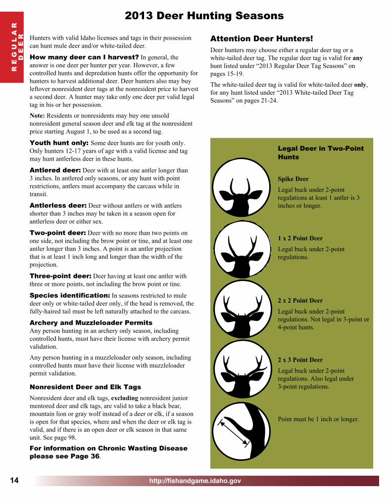
2013 Deer Hunting Seasons
Hunters with valid Idaho licenses and tags in their possession can hunt mule deer and/or white-tailed deer.
How many deer can I harvest? In general, the answer is one deer per hunter per year. However, a few controlled hunts and depredation hunts offer the opportunity for hunters to harvest additional deer. Deer hunters also may buy leftover nonresident deer tags at the nonresident price to harvest a second deer. A hunter may take only one deer per valid legal tag in his or her possession.
Note: Residents or nonresidents may buy one unsold nonresident general season deer and elk tag at the nonresident price starting August 1, to be used as a second tag.
Youth hunt only: Some deer hunts are for youth only. Only hunters 12-17 years of age with a valid license and tag may hunt antlerless deer in these hunts.
Antlered deer: Deer with at least one antler longer than 3 inches. In antlered only seasons, or any hunt with point restrictions, antlers must accompany the carcass while in transit.
Antlerless deer: Deer without antlers or with antlers shorter than 3 inches may be taken in a season open for antlerless deer or either sex.
Two-point deer: Deer with no more than two points on one side, not including the brow point or tine, and at least one antler longer than 3 inches. A point is an antler projection that is at least 1 inch long and longer than the width of the projection.
Three-point deer: Deer having at least one antler with three or more points, not including the brow point or tine.
Species identification: In seasons restricted to mule deer only or white-tailed deer only, if the head is removed, the fully-haired tail must be left naturally attached to the carcass.
Archery and Muzzleloader PermitsAny person hunting in an archery only season, including controlled hunts, must have their license with archery permit validation.
Any person hunting in a muzzleloader only season, including controlled hunts must have their license with muzzleloader permit validation.
Nonresident Deer and Elk TagsNonresident deer and elk tags, excluding nonresident junior mentored deer and elk tags, are valid to take a black bear, mountain lion or gray wolf instead of a deer or elk, if a season is open for that species, where and when the deer or elk tag is valid, and if there is an open deer or elk season in that same unit. See page 98.
For information on Chronic Wasting Disease please see Page 36.
Legal Deer in Two-Point Hunts
Spike DeerLegal buck under 2-point regulations at least 1 antler is 3 inches or longer.
1 x 2 Point DeerLegal buck under 2-point regulations.
2 x 2 Point DeerLegal buck under 2-point regulations. Not legal in 3-point or 4-point hunts.
2 x 3 Point DeerLegal buck under 2-point regulations. Also legal under 3-point regulations.
Point must be 1 inch or longer.
Attention Deer Hunters!Deer hunters may choose either a regular deer tag or a white-tailed deer tag. The regular deer tag is valid for any hunt listed under “2013 Regular Deer Tag Seasons” on pages 15-19.
The white-tailed deer tag is valid for white-tailed deer only, for any hunt listed under “2013 White-tailed Deer Tag Seasons” on pages 21-24.

http://fishandgame.idaho.gov
R E
G U
L A R
D E
E R
15
Illus
tratio
n by
Rob
ert N
eave
s co
urte
sy o
f Mon
tana
Fis
h, W
ildlif
e &
Park
s
DEERCharacteristics of a mule deer
CAUTION!Antlers on yearling buck white-tailed
and mule deer may look similar.Antlers (of older male)fork and fork again
White rump
Rope-likewhite tail
with black tip
Long slit-like gland on hind leg
Large ears in proportion to head
DefinitionsAntlered — A deer with an antler or antlers at least 3 inches in length.Antlerless — A deer without antlers or with antlers less than 3 inches in length.
Characteristics of a white-tailed deer
Antlers (of older males) consist of main beams
with 3 to 5 tines projecting upward
Ears are smaller in proportion to head
than a mule deer
Brown rumpTail is brown with white fringe Bottom of erect tail is all white Short slit-like gland on hind leg
2013 Regular Deer Tag General Any Weapon Seasons
Unit(s) Antlered Antlerless Notes
1Oct 10 - Oct 31
(White-tailed deer only) Nov 1 - Dec 1(White-tailed deer only)
Nov 1 - Dec 1
2, 3, 4A, 5, 6Oct 10 - Nov 9
Nov 1 - Dec 1(White-tailed deer only) See note 1, Page 19Nov 10 - Dec 1
(White-tailed deer only)
4, 7, 9 Oct 10 - Nov 9 Oct 10 - Nov 9(White-tailed deer only)
8, 8A, 10, 10A,12, 15, 16 Oct 10 - Nov 3 Oct 10 - Nov 3
11, 11A Oct 10 - Nov 3(White-tailed deer only)
Oct 10 - Nov 3(White-tailed deer only)
13, 14, 18 Oct 10 - Nov 3(White-tailed deer only)
Oct 10 - Oct 16(White-tailed deer only) Unit 13 has limited access
16A, 17, 19, 20 Sep 15 - Nov 18 Sep 15 - Nov 18
19A Oct 10 - Oct 31 Oct 10 - Oct 31(Youth hunt only)
continued

http://fishandgame.idaho.gov
R E
G U
L A
RD
E E
R
16
20A, 26, 27 Sep 15 - Oct 31 None21, 21A, 28, 29,
30, 36, 36A, 36B, 37, 37A
Oct 10 - Oct 24Oct 10 - Oct 31
(Youth hunt only, Private land only)
See note 3, Page 17, Motorized Hunting Rule Applies in
Units 29, 30, 36A, 37 & 37A, See Pages 91-92
22 Oct 10 - Oct 24(2-point deer only)
Oct 10 - Oct 24(Youth hunt only)
23, 24, 25 Oct 10 - Oct 31 Oct 10 - Oct 31(Youth hunt only) See note 1, Page 17
30A NoneOct 10 - Oct 31
(Youth hunt only, Private land only)
Motorized Hunting Rule Applies, See Pages 91-92
31, 32, 32A Oct 10 - Oct 24 Oct 10 - Oct 24 (Youth hunt only)
See notes 2 & 3, Page 17,Motorized Hunting Rule Applies in Units 32 & 32A, See Pages 91-92
33, 34, 35 Oct 10 - Oct 31 None
39 Oct 10 - Oct 31 Oct 10 - Oct 31(Youth hunt only)
40, 41, 42 Oct 10 - Oct 24(2-point deer only) None See note 3, Page 17
43 Oct 10 - Oct 31 Oct 10 - Oct 31(Youth hunt only)
46 Oct 10 - Oct 31 Oct 10 - Oct 31(Youth hunt only) See notes 2 & 3, Page 17
48, 49 Oct 10 - Oct 31 Oct 10 - Oct 31(Youth hunt only)
Motorized Hunting Rule Applies in Unit 49,See Pages 91-92
50, 51, 56, 58, 59, 59A Oct 10 - Oct 24 Oct 10 - Oct 24
(Youth hunt only)Motorized Hunting Rule Applies,
See Pages 91-92
52A Oct 10 - Oct 31 Oct 10 - Oct 31(Youth hunt only)
60, 61, 62, 62A,64, 65 Oct 10 - Oct 24 Oct 10 - Oct 24
(Youth hunt only) See note 3, Page 17
60A Oct 10 - Oct 24 Oct 10 - Oct 24(Youth hunt only) See note 4, Page 17
66, 69 Oct 10 - Oct 24 Oct 10 - Oct 24(Youth hunt only)
Motorized Hunting Rule Applies, See Pages 91-92
67 Oct 10 - Oct 24 Oct 10 - Oct 24(Youth hunt only) See note 5, Page 17
66A, 68, 71, 72, 73A,
74, 76Oct 10 - Oct 24 Oct 10 - Oct 24
(Youth hunt only)Motorized Hunting Rule Applies in Units 66A & 76, See Pages 91-92
70, 78 None Oct 10 - Oct 24(Youth hunt only)
Motorized Hunting Rule Applies, See Pages 91-92
73 None Oct 10 - Oct 16(Youth hunt only)
Motorized Hunting Rule Applies, See Pages 91-92
2013 Regular Deer Tag General Any Weapon Seasons - continued
Unit(s) Antlered Antlerless Notes

http://fishandgame.idaho.gov
R E
G U
L A R
D E
E R
17
Notes:1. Short-range weapons only in that portion of Unit 24 within the following boundary: Beginning in McCall at the junction of
State Highway 55 and Boydstun Street, then south on Boydstun Street to West Valley Road, then west and south along West Valley Road and West Mountain Road to Cabarton Road, then north on Cabarton Road to State Highway 55, then north on State Highway 55 to Farm-To-Market Road, then north on Farm-To-Market Road to Elo Road, then west on Elo Road to State Highway 55, then north on State Highway 55 to the point of beginning.
2. Short-range weapons only on the islands in the Snake River.
3. Short-range weapons only on C.J. Strike, Chester Wetlands, and Montour Wildlife Management Areas, and Pahsimeroi Access Area.
4. Short-range weapons only in that portion of Unit 60A south and east of the North (Henrys) Fork Snake River, and that portion within 1 mile north and west of the North Fork Snake River.
5. Short-range weapons only in that portion of Unit 67 south and west of State Highway 26.
2013 Regular Deer Tag General Any Weapon Seasons - continued
Unit(s) Antlered Antlerless Notes
75, 77 Oct 10 - Oct 24 Oct 10 - Oct 24(Youth hunt only)
Motorized Hunting Rule Applies,See Pages 91-92
continued

http://fishandgame.idaho.gov
R E
G U
L A
RD
E E
R
18
2013 Regular Deer Tag General Archery Only Seasons - Archery Permit Required
Unit(s) Antlered Antlerless Notes
1, 3, 4, 4A, 5, 6, 7, 9
Aug 30 - Sep 30 Aug 30 - Sep 30(White-tailed deer only)
Dec 10 - Dec 24 Dec 10 - Dec 24(White-tailed deer only)
2
Aug 30 - Sep 30 Aug 30 - Sep 30 (White-tailed deer only) See note 1, Page 19
Nov 1 - Dec 1 Nov 1 - Dec 1(White-tailed deer only) See note 2, Page 19
Dec 10 - Dec 24 Dec 10 - Dec 24(White-tailed deer only) See note 1, Page 19
8, 8A, 10, 10A, 11A, 12, 15, 19A, 21, 21A
Aug 30 - Sep 30 Aug 30 - Sep 30
22 Aug 30 - Sep 30(2-point deer only) Aug 30 - Sep 30
23, 24, 25, 36, 36B Aug 30 - Sep 30 Aug 30 - Sep 30
28 Dec 1 - Dec 31 Dec 1 - Dec 3129, 30, 30A, 32, 32A, 36A, 37,
37AAug 30 - Sep 30 Aug 30 - Sep 30 Motorized Hunting Rule Applies,
See Pages 91-92
31, 33, 34, 35 Aug 30 - Sep 30 Aug 30 - Sep 3038 Aug 30 - Sep 30 Aug 30 - Sep 30 See note 3, Page 19
39 Nov 10 - Nov 30 Nov 10 - Nov 30 See note 4, Page 19,Part of unit closed
40, 41, 42 Aug 30 - Sep 30(2-point deer only) Aug 30 - Sep 30
43, 46, 52A, 54 Aug 30 - Sep 30 Aug 30 - Sep 3047, 48, 49,
50, 51, 56, 57, 58, 59, 59A
Aug 30 - Sep 30 Aug 30 - Sep 30Motorized Hunting Rule Applies in Units 47, 49,
50, 51, 56, 58, 59 and 59A, See Pages 91-92
55 Nov 25 - Dec 19 Nov 25 - Dec 1960, 60A, 62,64, 65, 66,
67, 69
Aug 30 - Sep 30 Aug 30 - Sep 30Motorized Hunting Rule Applies in
Units 66 & 69, See Pages 91-92Nov 1 - Dec 19(White-tailed deer only)
Nov 1 - Dec 19(White-tailed deer only)
61, 62A, 63A Aug 30 - Sep 30 Aug 30 - Sep 30
63Aug 30 - Sep 30 Aug 30 - Sep 30Nov 1 - Dec 19 Nov 1 - Dec 19
66A, 68, 70, 71, 72, 73, 73A, 74, 75, 76, 77, 78
Aug 30 - Sep 30 Aug 30 - Sep 30Motorized Hunting Rule Applies in Units 66A, 70, 73, 75, 76, 77 & 78,
See Pages 91-92

http://fishandgame.idaho.gov
R E
G U
L A R
D E
E R
19
Register Early!COURSE OPTIONS:• Classroom: Recommended for youth under
14 years of age or anyone new to hunting.
• Internet: Interactive, rigorous self-study course for motivated students; requires a Field Day.
• Workbook: A self-paced, rigorous self-study course; requires a Field Day.
First-Time Hunters: Don’t Miss
Your Shotat the Season!
Hunter Education courses fill quickly.Most courses are offered between January and August.
Click on the Hunter Education icon at the bottom of IDFG’s home page to get started, or visit any Fish & Game office.
2013 Regular Deer Tag General Muzzleloader Only Seasons - Muzzleloader Permit Required
Unit(s) Antlered Antlerless Notes
4, 7, 9 Nov 10 - Dec 1 Nov 10 - Dec 1(White-tailed deer only)
39 None Sep 8 - Sep 30
2013 Regular Deer Tag General Deer Short Range Weapon Seasons
Unit(s) Antlered Antlerless Notes38 Oct 10 - Oct 31 Oct 10 - Nov 24 Very limited access, See note 3, Page 19
45 Oct 10 - Nov 6 Oct 10 - Nov 6See note 5, Page 19,
Motorized Hunting Rule Applies, See Pages 91-92
53 Oct 10 - Nov 6 Oct 10 - Nov 6See note 6, Page 19,
Motorized Hunting Rule Applies, See Pages 91-92
63 Oct 10 - Oct 24 Oct 10 - Oct 24(Youth hunt only)
Notes:1. Farragut State Park and Farragut Wildlife Management Area are closed.2. Farragut State Park and Farragut Wildlife Management Area only.
3. That portion of Unit 38 within the Lake Lowell Sector of the Deer Flat National Wildlife Refuge is controlled hunt only.
4. Area Closure: That portion of Unit 39 within Ada County, and that portion of Unit 39 within the following boundary: Beginning at the intersection of State Highway 21 and the Middle Fork Boise River Road (Forest Road 268), east on Forest Road 268 to Cottonwood Creek-Thorn Creek Road (Forest Road 377), to South Fork of Thorn Creek to confluence of Thorn Creek, north and west on Thorn Creek to the confluence with Mores Creek, south and west along the center of Mores Creek including in the Mores Creek arm of Lucky Peak Reservoir to Highway 21 to the point of beginning is closed.
5. That portion of Unit 45 south of Interstate 84. The rest of Unit 45 is controlled hunt only.
6. That portion of Unit 53 west of U. S. Highway 93. The rest of Unit 53 is controlled hunt only.

http://fishandgame.idaho.gov20
The Mule Deer InitiativeMAKING THE COMMITMENT TO ENHANCE IDAHO’S MULE DEER POPULATION
The Mule Deer Initiative is an effort by Fish and Game to:
• Protect and improve habitat.• Improve mule deer numbers.• Increase hunter satisfaction.
Why do we need the Mule Deer Initiative?
• Mule deer numbers have declined over the past two decades.
• Populations in parts of eastern and southern Idaho are lower than desired.
Mule Deer Initiative projects and goals include:
• Habitat improvement.• Population management.• Stepped up enforcement.• Predator control.• Access management.• Provide technical help to
land managers.
The Mule Deer Initiative:• Increased the number of acres
improved annually from a few hundred to thousands. Improved 75,000 acres of mule deer habitat since 2010.
• Provided $100,000 for a multi-million dollar project with other agencies on 32,000 acres of Burley-area mule deer and sage-grouse habitat.
• Planted a million sagebrush, bitterbrush and mountain mahogany shrubs.
• Installed 14 miles of fence along Interstate 15 south of Pocatello, where 1,500 to 2,000 mule deer winter, allowing them to safely use existing underpasses.
Where can I learn more about helping Idaho’s Mule deer?
• Visit the Idaho Fish and Game website below or subscribe to an email notification service.
fishandgame.idaho.gov/content/mdi

http://fishandgame.idaho.gov
WH
ITE
-TAILE
DD
E E
R
21
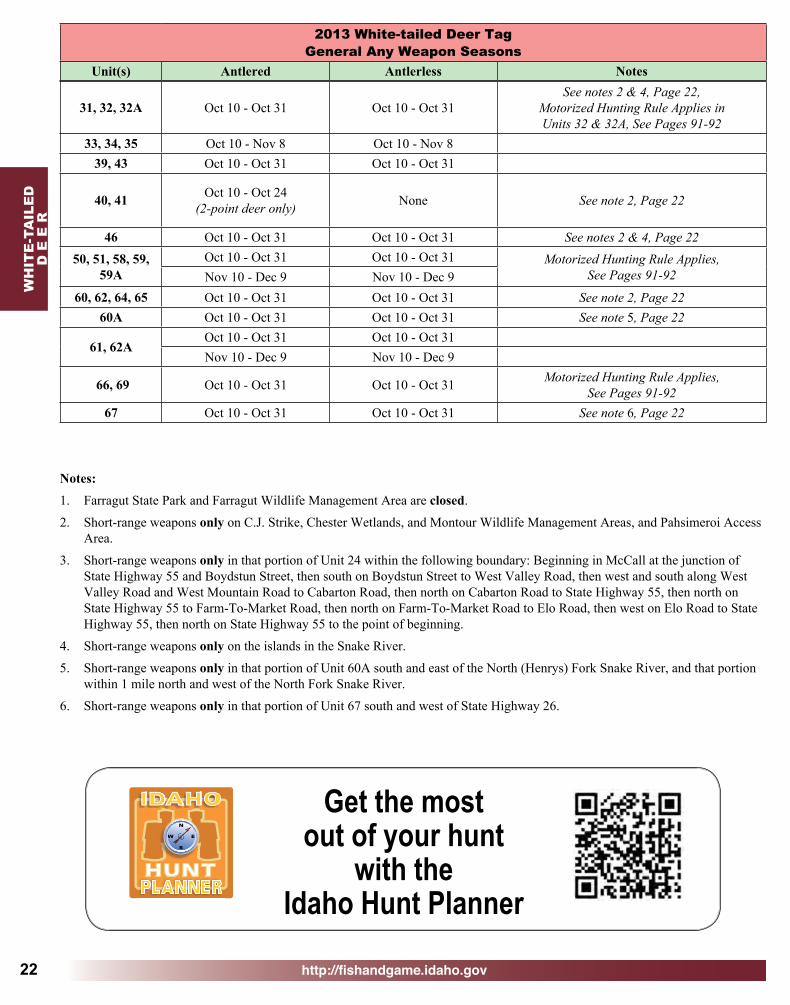
2013 White-tailed Deer Tag General Any Weapon Seasons
Unit(s) Antlered Antlerless Notes1, 2, 3, 4A, 5, 6 Oct 10 - Dec 1 Nov 1 - Dec 1 See note 1, Page 22
4, 7, 9 Oct 10 - Nov 9 Oct 10 - Nov 98, 8A, 10A, 11,
11A Oct 10 - Dec 1 Oct 10 - Dec 1
10, 12, 15, 16 Oct 10 - Nov 20 Oct 10 - Nov 2013 Oct 10 - Nov 3 Oct 10 - Oct 16 Very limited access
14, 18 Oct 10 - Nov 20 Oct 10 - Oct 1616A, 17, 19, 20,
20A, 26, 27 Sep 15 - Nov 18 Sep 15 - Nov 18
19A Oct 10 - Oct 31 Oct 10 - Oct 31
21, 21A, 28, 36B Oct 10 - Oct 31
Oct 10 - Oct 31(Youth hunt only, Private land only)
Very limited access
29, 30, 30A, 36A, 37, 37A Oct 10 - Oct 31
Oct 10 - Oct 31(Youth hunt only, Private land only)
Very limited access, See note 2, Page 22,Motorized Hunting Rule Applies,
See Pages 91-9222, 25 Oct 10 - Oct 31 Oct 10 - Oct 31
23 Oct 10 - Nov 20Oct 10 - Oct 16Oct 17 - Oct 31
(Youth hunt only)24 Oct 10 - Oct 31 Oct 10 - Oct 31 See note 3, Page 22
http://fishandgame.idaho.gov
WH
ITE
-TA
ILE
DD
E E
R
22
31, 32, 32A Oct 10 - Oct 31 Oct 10 - Oct 31See notes 2 & 4, Page 22,
Motorized Hunting Rule Applies inUnits 32 & 32A, See Pages 91-92
33, 34, 35 Oct 10 - Nov 8 Oct 10 - Nov 839, 43 Oct 10 - Oct 31 Oct 10 - Oct 31
40, 41 Oct 10 - Oct 24 (2-point deer only) None See note 2, Page 22
46 Oct 10 - Oct 31 Oct 10 - Oct 31 See notes 2 & 4, Page 2250, 51, 58, 59,
59AOct 10 - Oct 31 Oct 10 - Oct 31 Motorized Hunting Rule Applies,
See Pages 91-92Nov 10 - Dec 9 Nov 10 - Dec 960, 62, 64, 65 Oct 10 - Oct 31 Oct 10 - Oct 31 See note 2, Page 22
60A Oct 10 - Oct 31 Oct 10 - Oct 31 See note 5, Page 22
61, 62AOct 10 - Oct 31 Oct 10 - Oct 31Nov 10 - Dec 9 Nov 10 - Dec 9
66, 69 Oct 10 - Oct 31 Oct 10 - Oct 31 Motorized Hunting Rule Applies, See Pages 91-92
67 Oct 10 - Oct 31 Oct 10 - Oct 31 See note 6, Page 22
2013 White-tailed Deer Tag General Any Weapon Seasons
Unit(s) Antlered Antlerless Notes
Notes:1. Farragut State Park and Farragut Wildlife Management Area are closed.
2. Short-range weapons only on C.J. Strike, Chester Wetlands, and Montour Wildlife Management Areas, and Pahsimeroi Access Area.
3. Short-range weapons only in that portion of Unit 24 within the following boundary: Beginning in McCall at the junction of State Highway 55 and Boydstun Street, then south on Boydstun Street to West Valley Road, then west and south along West Valley Road and West Mountain Road to Cabarton Road, then north on Cabarton Road to State Highway 55, then north on State Highway 55 to Farm-To-Market Road, then north on Farm-To-Market Road to Elo Road, then west on Elo Road to State Highway 55, then north on State Highway 55 to the point of beginning.
4. Short-range weapons only on the islands in the Snake River.
5. Short-range weapons only in that portion of Unit 60A south and east of the North (Henrys) Fork Snake River, and that portion within 1 mile north and west of the North Fork Snake River.
6. Short-range weapons only in that portion of Unit 67 south and west of State Highway 26.
HUNTPLANNER
N
S
W E
Get the most out of your hunt
with the Idaho Hunt Planner

http://fishandgame.idaho.gov
WH
ITE
-TAILE
DD
E E
R
23
2013 White-tailed Deer Tag General Archery Only Seasons - Archery Permit Required
Unit(s) Antlered Antlerless Notes1, 3, 4, 4A, 5, 6,
7, 9Aug 30 - Sep 30 Aug 30 - Sep 30Dec 10 - Dec 24 Dec 10 - Dec 24
2Aug 30 - Sep 30 Aug 30 - Sep 30 See note 1, Page 23Nov 1 - Dec 1 Nov 1 - Dec 1 See note 2, Page 23
Dec 10 - Dec 24 Dec 10 - Dec 24 See note 1, Page 238, 8A, 10,
10A, 11A, 12, 19A, 22, 23, 24,
25
Aug 30 - Sep 30 Aug 30 - Sep 30
15Aug 30 - Sep 30 Aug 30 - Sep 30Dec 5 - Dec 20 Dec 5 - Dec 20
21, 21A, 29, 30, 30A, 36A,
36B, 37, 37AAug 30 - Sep 30 Aug 30 - Sep 30
Very limited access,Motorized Hunting Rule Applies in Units 29, 30,
30A, 36A, 37 & 37A, See Pages 91-9228 Dec 1 - Dec 31 Dec 1 - Dec 31 Very limited access
31, 32, 32A, 33, 34, 35 Aug 30 - Sep 30 Aug 30 - Sep 30 Motorized Hunting Rule Applies in
Units 32 & 32A, See Pages 91-9238 Aug 30 - Sep 30 Aug 30 - Sep 30 See note 3, Page 23
39 Nov 10 - Nov 30 Nov 10 - Nov 30 See note 4, Page 23,Part of unit closed
40, 41 Aug 30 - Sep 30 (2-point deer only) Aug 30 - Sep 30
43, 46 Aug 30 - Sep 30 Aug 30 - Sep 3050, 51, 58,
59, 59A Aug 30 - Sep 30 Aug 30 - Sep 30 Motorized Hunting Rule Applies, See Pages 91-92
60, 60A, 62, 63, 63A, 64, 65, 66,
67, 69
Aug 30 - Sep 30 Aug 30 - Sep 30 Motorized Hunting Rule Applies in Units 66 & 69, See Pages 91-92Nov 1 - Dec 19 Nov 1 - Dec 19
61, 62A Aug 30 - Sep 30 Aug 30 - Sep 30
Notes:1. Farragut State Park and Farragut Wildlife Management Area are closed.
2. Farragut State Park and Farragut Wildlife Management Area only.
3. That portion of Unit 38 within the Lake Lowell Sector of the Deer Flat National Wildlife Refuge is controlled hunt only.
4. Area Closure: That portion of Unit 39 within Ada County, and that portion of Unit 39 within the following boundary: Beginning at the intersection of State Highway 21 and the Middle Fork Boise River Road (Forest Road 268), east on Forest Road 268 to Cottonwood Creek-Thorn Creek Road (Forest Road 377), to South Fork of Thorn Creek to confluence of Thorn Creek, north and west on Thorn Creek to the confluence with Mores Creek, south and west along the center of Mores Creek including in the Mores Creek arm of Lucky Peak Reservoir to Highway 21 to the point of beginning is closed.

http://fishandgame.idaho.gov
WH
ITE
-TA
ILE
DD
E E
R
24
2013 White-tailed Deer Tag General Muzzleloader Only Seasons - Muzzleloader Permit Required
Unit(s) Antlered Antlerless Notes4, 7, 9 Nov 10 - Dec 1 Nov 10 - Dec 1
8A None Dec 2 - Dec 14 See note 1, Page 2410A None Dec 2 - Dec 1416 Nov 21 - Dec 9 Nov 21 - Dec 9
2013 White-tailed Deer Tag Short Range Weapon Seasons
Unit(s) Antlered Antlerless Notes
21, 21A, 28, 29, 30, 30A, 36A, 36B, 37, 37A
Nov 10 - Dec 9 Nov 10 - Dec 9
Very limited access,Motorized Hunting Rule Applies inUnits 29, 30, 30A, 36A, 37 & 37A,
See Pages 91-9224 Nov 1 - Nov 20 None38 Oct 10 - Oct 31 Oct 10 - Nov 24 See note 2, Page 24
63 Oct 10 - Oct 31 Oct 10 - Oct 31(Youth hunt only)
63A Oct 10 - Oct 31 Oct 10 - Oct 31
Notes:
1. Hunt Area 8A: That portion of Unit 8A east of State Highway 6 and State Highway 9 and north of the following line: Beginning at the boundary of Unit 8A at its junction with State Highway 8 at Deary, then east on Highway 8 to Forest Service Road 1963 at Helmer, then south and east on Forest Service Road 1963 to Long Meadow Creek, then southeast on Long Meadow Creek to Dworshak Reservoir, then east along the shoreline of Dworshak Reservoir to the Unit 8A boundary at Dent Bridge.
2. Short-range weapons only. Except that portion of Unit 38 within the Lake Lowell Sector of the Deer Flat National Wildlife Refuge is controlled hunt only.

http://fishandgame.idaho.gov 25
HUNT!
WIN THE HUNT
OF A LIFETIME!
Win the Hunt of a Lifetime
Every year, 34 lucky hunters walk into the field with special Super Hunt tags in their pockets. These tags allow a hunter to pursue an elk, deer, pronghorn or moose in any open hunt in Idaho. Hunters who have won this privilege call it a “hunt of a lifetime.”
The thrill is quadrupled for two Super Hunt Combo winners who are able to hunt all four species in any open hunt. This unqualified freedom to pursue world-class big game in Idaho is an experience winners will long remember.
One entry for as little as $6 offers you the chance to win in the Super Hunt drawings.When you buy more, you receive a discount.
• A single Super Hunt entry for a specific species costs $6, then each additional entry at that time for the same species is $4.
• A single Super Hunt Combo entry costs $20 and each additional entry costs $16 purchased at one time.
Super Hunt tags are in addition to any general and controlled hunt tags a hunter has applied for or may already hold. All other rules of individual hunts apply.
Stories from Super Hunt winners and additional information can be found on Idaho Fish and Game’s website: http://fishandgame.idaho.gov/public/hunt/superhunt
How to Entera Fill out the entry order form.
a Mark the species you hope to hunt and the number of entries you want.
a Add up the fees and make a check payable to Idaho Department of Fish and Game.
a Send the order form along with the check to Idaho Fish and Game headquarters at: IDFG License Section, P.O. Box 25, Boise, ID 83707
a Idaho Fish and Game will enter the number of entries you’ve requested and send you a printed receipt with your ticket numbers.
Tickets are available from Fish and Game offices, license vendor and over the phone at 1-800-554-8685 or at http://fishandgame.idaho.gov/buy_online. Online and telephone vendors add additional processing fees.
Super Hunt DrawingsIdaho Fish and Game has two Super Hunt drawings, one in June and another in August. Hunters may enter both drawings as many times as they like.
Entries for the first drawing must be received at Fish and Game headquarters no later than May 31. Winning numbers will be drawn in June.
Entries for the second drawing must be received at Fish and Game headquarters no later than August 10. Winning numbers will be drawn in August.
IDAHO SUPER HUNT ORDER FORMPlease print
NAME _______________________________________________________ADDRESS ____________________________________________________CITY ______________________STATE _________ ZIP _______________TELEPHONE ( _____________ ) ___________________________________DATE OF BIRTH ________(mo) ____________(day) _____________ (year)HEIGHT ___________WEIGHT __________ HAIR COLOR _____________
EYE COLOR _______GENDER __________
EMAIL: (optional)__________________________________
a Choose the species you hope to hunt and the number of entries. a The first entry for each species is always $6 and each additional
entry is $4. a Add up the fees for a grand total and write a check payable to Idaho
Dept. of Fish and Game. a Mail order form and check to IDFG License Section,
P . O. Box 25, Boise, ID 83707
IDAHO SUPER HUNT COMBO ORDER FORM
ELKFirst Entry = $6.00
_____ Additional Entries @ $4.00 = ______Total $ ______
TOTAL FOR ALL SPECIES $___________
The Super Hunt Combo allows the winner to hunt all four species - deer, elk, pronghorn and moose - in a single season.
Please printNAME _______________________________________________________ADDRESS ____________________________________________________CITY ______________________STATE _________ ZIP _______________TELEPHONE ( _____________ ) ___________________________________DATE OF BIRTH ________(mo) ____________(day) _____________ (year)HEIGHT ___________WEIGHT __________ HAIR COLOR _____________EYE COLOR _______GENDER __________
EMAIL: optional)__________________________________a The first Super Hunt Combo entry is $20 and each addtional
entry is $16. a Add up the total cost and write a check payable to Idaho Dept. of
Fish and Game. a Mail order form and check to IDFG License Section,
P . O. Box 25, Boise, ID 83707
SUPER HUNT COMBOFirst Entry = $20.00
_____ Additional Entries @ $16.00 = ______
TOTAL $___________
Second Drawing
Entries must be at Fish and Game headquarters by
August 10.
First Drawing
Entries must be at Fish and Game headquarters by
May 31.
Tickets submitted for the first drawing WILL NOT be eligible for the second drawing.
DEERFirst Entry = $6.00
_____ Additional Entries @ $4.00 = ______Total $ ______
MOOSEFirst Entry = $6.00
_____ Additional Entries @ $4.00 = ______Total $ ______
PRONGHORNFirst Entry = $6.00
_____ Additional Entries @ $4.00 = ______Total $ ______

http://fishandgame.idaho.gov
CO
NT
RO
LLE
DD
E E
R
26
Deer Controlled Hunts For details on controlled hunt rules and restrictions please See pages 94-97.
Hunters: Please check Deer Controlled Hunt Area descriptions on pages 33-35. Hunt Areas may change annually.2013 Controlled Deer Hunts (13,276 Tags Plus Unlimited Tags)
Antlered Deer
Hunt No. ControlledHunt Areas Tags Season Dates Notes
1001 1a (see pg 33) 60 Aug 30 - Dec 11002 11 74 Oct 10 - Nov 3 Mule deer only1003 11 35 Nov 10 - Nov 24 Mule deer only1004 11A 63 Oct 10 - Nov 3 Mule deer only, Very limited access1005 13 200 Oct 10 - Nov 3 Mule deer only, See note 1, Page 311006 14 180 Oct 10 - Nov 3 Mule deer only1007 18 120 Oct 10 - Nov 3 Mule deer only1008 19A 10 Oct 10 - Nov 241009 20A Unlimited Nov 1 - Nov 181010 21 5 Oct 10 - Nov 301011 22 60 Nov 1 - Nov 241012 23 25 Oct 10 - Nov 241013 25 10 Oct 10 - Nov 241014 26 Unlimited Nov 1 - Nov 181015 27 Unlimited Nov 1 - Nov 18 3-point or larger deer only1016 28-1 5 Oct 10 - Nov 301017 30 5 Oct 10 - Nov 30 Motorized Hunting Rule Applies, See Pages 91-921018 30A 30 Oct 10 - Oct 31 Motorized Hunting Rule Applies, See Pages 91-921019 31 30 Oct 10 - Nov 24
1020 32 40 Oct 10 - Nov 24 See note 2, Page 31, Motorized Hunting Rule Applies, See Pages 91-92
1021 32A 30 Oct 10 - Nov 24 Motorized Hunting Rule Applies, See Pages 91-921022 36A 5 Oct 10 - Nov 30 Motorized Hunting Rule Applies, See Pages 91-921023 36B 5 Oct 10 - Nov 30
1024 38b (see pg 34) 5 Oct 10 - Nov 24Deer Flat National Wildlife Refuge has specific hunting requirements,
Before applying, See note 3, Page 311025 39-1 199 Aug 15 - Sep 301026 40 195 Nov 1 - Nov 241027 41-1 100 Nov 1 - Nov 24 See note 2, Page 311028 42 74 Nov 1 - Nov 241029 44 225 Sep 15 - Oct 31
1030 45-1 75 Oct 15 - Oct 31 See notes 2 & 4, Page 31, Motorized Hunting Rule Applies, See Pages 91-92
1031 47-1 90 Oct 5 - Oct 31 Motorized Hunting Rule Applies, See Pages 91-92
1032 47-2a (see pg 34) 10 Nov 15 - Nov 30 Motorized Hunting Rule Applies in Unit 47, See Pages 91-92
1033 48 10 Nov 10 - Nov 241034 49 10 Nov 10 - Nov 24 Motorized Hunting Rule Applies, See Pages 91-92
a
continueda This hunt includes other units or parts of other units. See controlled hunt area descriptions. b This hunt includes only a portion of this unit. See controlled hunt area descriptions.For details on controlled hunt rules and restrictions, please see pages 94-97.

http://fishandgame.idaho.gov
CO
NT
RO
LLED
D E
E R
27
2013 Controlled HuntsAntlerless Deer
Hunt No. ControlledHunt Areas Tags Season Dates Notes
1052 22 50 Oct 10 - Oct 241053 28-2b (see pg 33) 30 Sep 15 - Oct 31 Portion of unit only1054 31 50 Oct 10 - Oct 24
1055 32 150 Oct 10 - Oct 24 See note 2, Page 31, Motorized Hunting Rule Applies, See Pages 91-92
1056 32A 150 Oct 10 - Oct 24 Motorized Hunting Rule Applies, See Pages 91-921057 39-1 800 Oct 10 - Oct 311058 43 150 Oct 10 - Oct 311059 44 150 Oct 10 - Nov 9
1060 45-1 250 Nov 1 - Nov 14 See notes 2 & 4, Page 31,Motorized Hunting Rule Applies, See Pages 91-92
1061 45-2b (see pg 34) 350 Nov 15 - Nov 30 See note 4, Page 31,Motorized Hunting Rule Applies, See Pages 91-92
1062 45-3b (see pg 34) 50 Dec 1 - Dec 15 See note 4, Page 31,Motorized Hunting Rule Applies, See Pages 91-92
1035 50b (see pg 34) 10 Oct 10 - Nov 30 Portion of Unit only,Motorized Hunting Rule Applies, See Pages 91-92
1036 52-1b (see pg 34) 50 Oct 5 - Oct 31 Motorized Hunting Rule Applies, See Pages 91-921037 54 500 Oct 5 - Oct 311038 54 20 Nov 15 - Nov 301039 55-1 25 Aug 15 - Sep 241040 55-1 375 Oct 5 - Oct 311041 57 109 Oct 5 - Oct 311042 57 10 Nov 15 - Nov 301043 58a (see pg 35) 10 Oct 10 - Nov 30 Motorized Hunting Rule Applies, See Pages 91-921044 60-1a (see pg 35) 25 Oct 10 - Nov 30 See note 2, Page 311045 62 15 Oct 10 - Nov 301046 66 10 Oct 10 - Nov 30 Motorized Hunting Rule Applies, See Pages 91-921047 67 20 Oct 10 - Nov 30 See note 5, Page 311048 69 10 Oct 10 - Nov 30 Motorized Hunting Rule Applies, See Pages 91-92
1049 70 175Aug 30 - Sep 30 Archery only,
Motorized Hunting Rule Applies, See Pages 91-92Oct 10 - Oct 31 Motorized Hunting Rule Applies, See Pages 91-92
1050 73 Unlimited Oct 10 - Oct 16 Motorized Hunting Rule Applies, See Pages 91-92
1051 78 200Aug 30 - Sep 30 Archery only,
Motorized Hunting Rule Applies, See Pages 91-92Oct 10 - Oct 31 Motorized Hunting Rule Applies, See Pages 91-92a
2013 Controlled HuntsAntlered Deer - continued
Hunt No. ControlledHunt Areas Tags Season Dates Notes
a
a This hunt includes other units or parts of other units. See controlled hunt area descriptions. b This hunt includes only a portion of this unit. See controlled hunt area descriptions.For details on controlled hunt rules and restrictions, please see pages 94-97.

http://fishandgame.idaho.gov
CO
NT
RO
LLE
DD
E E
R
28
2013 Controlled HuntsEither Sex Deer
Hunt No. Controlled Hunt Areas Tags Season Dates Notes
1069 60-2a (see pg 35) 200 Oct 5 - Nov 8 See note 2, Page 311070 62 100 Oct 5 - Nov 81071 63A 50 Oct 5 - Nov 15 Mule deer only, Short range weapons only1072 66 25 Oct 5 - Nov 81073 67 75 Oct 5 - Nov 8 See note 5, Page 31
a
2013 Controlled HuntsYouth Only Deer
Hunt No. ControlledHunt Areas Tags Season Dates Notes
1074 11A 25 Oct 10 - Dec 31 Either sex1075 28-2b (see pg 33) 15 Sep 15 - Oct 31 Either sex, Portion of Unit only1076 44 150 Oct 10 - Nov 9 Antlerless only
1077 45-3b (see pg 34) 50 Dec 1 - Dec 15 Antlerless only, See note 4, Page 31,Motorized Hunting Rule Applies, See Pages 91-92
1078 45-4a (see pg 34) 200 Nov 15 - Nov 30 Antlerless only, See note 4, Page 31,Motorized Hunting Rule Applies, See Pages 91-92
1079 47-1 50 Oct 5 - Oct 31 Antlered only, Motorized Hunting Rule Applies, See Pages 91-92
1080 47-1 20 Oct 5 - Oct 31 Antlerless only, Motorized Hunting Rule Applies, See Pages 91-92
1081 54 100 Oct 5 - Oct 31 Antlered only1082 54 130 Oct 5 - Oct 31 Antlerless only1083 55-2a (see pg 35) 50 Oct 5 - Oct 31 Antlered only1084 55-2a (see pg 35) 50 Oct 5 - Oct 31 Antlerless only
a
a This hunt includes other units or parts of other units. See controlled hunt area descriptions. b This hunt includes only a portion of this unit. See controlled hunt area descriptions.For details on controlled hunt rules and restrictions, please see pages 94-97.
1063 48 50 Oct 10 - Oct 311064 49 50 Oct 10 - Oct 31 Motorized Hunting Rule Applies, See Pages 91-921065 52-2 100 Nov 15 - Nov 30 Motorized Hunting Rule Applies, See Pages 91-921066 54 100 Nov 1 - Nov 141067 55-1 100 Nov 1 - Nov 141068 56 100 Nov 15 - Nov 30 Motorized Hunting Rule Applies, See Pages 91-92
2013 Controlled HuntsAntlerless Deer - continued
Hunt No. ControlledHunt Areas Tags Season Dates Notes
a

http://fishandgame.idaho.gov
CO
NT
RO
LLED
D E
E R
29
2013 Controlled HuntsMuzzleloader Only Deer - Muzzleloader Permit Required
Hunt No. ControlledHunt Areas Tags Season Dates Notes
1093 8A 25 Oct 10 - Dec 14 Either sex, White-tailed deer only1094 10A 25 Oct 10 - Dec 14 Either sex, White-tailed deer only1095 33a (see pg 33) 149 Nov 10 - Nov 30 Antlered only
1096 37a (see pg 34) 73 Nov 25 - Dec 9 Antlered only,Motorized Hunting Rule Applies, See Pages 91-92
1097 43 125 Oct 1 - Oct 9 Either sex
1098 45-1 30 Oct 1 - Oct 14 Antlered only, See notes 2 & 4, Page 31,Motorized Hunting Rule Applies, See Pages 91-92
1099 51a (see pg 34) 100 Nov 1 - Nov 30 Either sex,Motorized Hunting Rule Applies, See Pages 91-92
1100 52-3b (see pg 34) 65 Oct 15 - Nov 14 Antlered only, Motorized Hunting Rule Applies, See Pages 91-92
1101 52A 75 Nov 10 - Nov 24 Either sex, Motorized Hunting Rule Applies, See Pages 91-92
1102 61 Unlimited Nov 11 - Dec 9 Either sex1103 64a (see pg 35) 50 Oct 25 - Nov 30 Either sex
a
a This hunt includes other units or parts of other units. See controlled hunt area descriptions. b This hunt includes only a portion of this unit. See controlled hunt area descriptions.For details on controlled hunt rules and restrictions, please see pages 94-97.
2013 Controlled Hunts Archery Only Deer - Archery Permit Required
Hunt No. ControlledHunt Areas Tags Season Dates Notes
1085 22 25 Aug 30 - Sep 30 Either sex
1086 39-2b (see pg 34) 50 Nov 16 - Dec 16 Either sex, See note 6, Page 31,Roads on Boise River WMA closed to Motorized Travel
1087 40 25 Aug 15 - Sep 30 Antlered only1088 41-2a (see pg 34) 25 Aug 15 - Sep 30 Antlered only
1089 45-1 10 Aug 15 - Sep 15 Antlered only, See notes 2 & 4, Page 31, Motorized Hunting Rule Applies, See Pages 91-92
1090 53b (see pg 34) Unlimited Aug 30 - Dec 19 Either Sex,Motorized Hunting Rule Applies, See Pages 91-92
1091 68A Unlimited Aug 30 - Dec 19 Either sex
1092 72a (see pg 35) Unlimited Nov 16 - Dec 5 Antlered only, Motorized Hunting Rule Applies, See Pages 91-92
a

http://fishandgame.idaho.gov
CO
NT
RO
LLE
DD
E E
R
30
2013 Controlled HuntsExtra Antlerless Deer
Hunt No. ControlledHunt Areas Tags Season Dates Notes
1108 1Xb (see pg 33) 300Aug 30 - Sep 30 Archery only, White-tailed deer onlyOct 10 - Dec 24 White-tailed deer only
1109 3Xb (see pg 33) 50 Oct 10 - Dec 1 Private land only, White-tailed deer only
1110 8-1X 350Aug 30 - Sep 30 Archery only, White-tailed deer onlyOct 10 - Dec 14 White-tailed deer only
1111 8AXb (see pg 33) 350Aug 30 - Sep 30 Archery only, White-tailed deer onlyOct 10 - Dec 1 White-tailed deer onlyDec 2 - Dec 14 Muzzleloader only, White-tailed deer only
1112 10AXb (see pg 33) 400Aug 30 - Sep 30 Archery only, White-tailed deer onlyOct 10 - Dec 1 White-tailed deer onlyDec 2 - Dec 14 Muzzleloader only, White-tailed deer only
1113 11Xb (see pg 33) 100 Oct 10 - Dec 1 Mule Deer or White-tailed Deer
1114 11AX 650Aug 30 - Sep 30 Archery only, Unit 11A onlyOct 10 - Dec 14 Mule Deer or White-tailed Deer
1115 15Xb (see pg 33) 100Aug 30 - Sep 30 Archery only, White-tailed deer onlyOct 10 - Nov 20 White-tailed deer onlyDec 5 - Dec 20 Archery only, White-tailed deer only
1116 16Xb (see pg 33) 100Oct 10 - Nov 20 White-tailed deer onlyNov 21 - Dec 9 Muzzleloader only, White-tailed deer only
1117 21Xa (see pg 33) 160 Sep 1 - Dec 31 Short range weapons only, Private land only, Very limited access
1118 32Xb (see pg 33) 100 Aug 1 - Dec 31 Very limited access, Motorized Hunting Rule Applies, See Pages 91-92
1119 36AXa (see pg 34) 105 Sep 1 - Dec 31 Short range weapons only, Private land only, Very limited access,
1120 38Xb (see pg 34) 10 Oct 10 - Oct 29Deer Flat National Wildlife Refuge has
specific hunting requirements, Before applying, See note 3, Page 31
a
a This hunt includes other units or parts of other units. See controlled hunt area descriptions. b This hunt includes only a portion of this unit. See controlled hunt area descriptions.For details on controlled hunt rules and restrictions, please see pages 94-97.
2013 Controlled HuntsYouth Only - Extra Antlerless Deer
Hunt No. ControlledHunt Areas Tags Season Dates Notes
1104 8-2Xa (see pg 33) 200 Aug 30 - Dec 20 Private land only, See note 7, Page 31
1105 21Xa (see pg 33) 50 Sep 1 - Dec 31 Short range weapons only, Private land only, Very limited access
1106 36AXa (see pg 34) 35 Sep 1 - Dec 31 Short range weapons only, Private land only, Very limited access
1107 40Xa (see pg 34) 100 Oct 10 - Nov 24 Portion of Units 40 & 41 only, Very limited access
a

http://fishandgame.idaho.gov
CO
NT
RO
LLED
D E
E R
31
Notes:1. This hunt has very limited access because of few roads and private property.2. Short-range weapons only on CJ Strike, Chester Wetlands, and Montour Wildlife Management Areas, and all of Units 63 and
63A. 3. Short-range weapons only. Portion of Unit 38 within the Deer Flat National Wildlife Refuge (DFNWR) only. Before applying for this hunt please review the special regulations at http://www.fws.gov/deerflat/recreation/hunting.html or
contact DFNWR at (208) 467-9278, 13751 Upper Embankment Rd, Nampa, ID 83686.4. Short-range weapons only on the islands in the Snake River.5. Short-range weapons only in that portion of Unit 67 south and west of State Highway 26.6. Mandatory class required - Anyone drawing a deer controlled archery only hunt tag for this hunt must satisfactorily complete
a mandatory hunter education course. The course will be administered by the Southwest Region and will include the hunt boundaries and legal restrictions, and will emphasize proper hunter ethics. Bowhunter education required.
7. All holders of this tag may only hunt during dates that the individual unit is open to General Tag holders. Hunters are also limited to weapon type that the General Season Tag holder must use for the given dates. Private land only.
8. Short-range weapons only in that portion of Unit 60A south and east of the North (Henrys) Fork Snake River, and that portion within 1 mile north and west of the North Fork Snake River.
a This hunt includes other units or parts of other units. See controlled hunt area descriptions. b This hunt includes only a portion of this unit. See controlled hunt area descriptions.For details on controlled hunt rules and restrictions, please see pages 94-97.
2013 Controlled HuntsExtra Antlerless Deer - continued
Hunt No. ControlledHunt Areas Tags Season Dates Notes
a
1121 38Xb (see pg 34) 10 Oct 30 - Nov 18Deer Flat National Wildlife Refuge has
specific hunting requirements, Before applying, See note 3, Page 31
1122 38Xb (see pg 34) 10 Nov 19 - Dec 8Deer Flat National Wildlife Refuge has
specific hunting requirements, Before applying, See note 3, Page 31
1123 38Xb (see pg 34) 10 Dec 9 - Dec 28Deer Flat National Wildlife Refuge has specific hunting requirements,
Before applying, See note 3, Page 31
1124 50Xa (see pg 34) 1,200
Aug 30 - Sep 30Archery only, White-tailed deer only,
Motorized Hunting Rule Applies in Units 50, 51, 58, 59, 59A, 66 & 69, See Pages 91-92
Oct 10 - Oct 31
White-tailed deer only, See notes 5 & 8, Page 31,
Motorized Hunting Rule Applies in Units 50, 51, 58, 59, 59A, 66 & 69, See Pages 91-92
Nov 1 - Dec 19
Archery only, White-tailed deer only, Units 60, 60A, 62, 63, 64, 65, 66, 67 & 69 only
Motorized Hunting Rule Applies in Units 66 & 69, See Pages 91-92
Nov 10 - Dec 9
White-tailed deer only,Units 50, 51, 58, 59, 59A, 61, & 62A only,
Motorized Hunting Rule Applies in Units 50, 51, 58, 59 & 59A, See Pages 91-92
1125 63AX 300Aug 30 - Sep 30 Archery only, White-tailed deer onlyOct 10 - Oct 31 Short range weapons only, White-tailed deer onlyNov 1 - Dec 19 Archery only, White-tailed deer only
1126 68AX 100 Aug 30 - Oct 31 Archery only, Very limited access

http://fishandgame.idaho.gov
CO
NT
RO
LLE
DD
E E
R
32
2013 Controlled HuntsOutfitter Allocation Deer - Antlered Deer Only
Hunt No. ControlledHunt Areas Tags Season Dates Notes
1127 1a (see pg 33) 1 Aug 30 - Dec 11128 11 1 Oct 10 - Nov 3 Mule deer only1129 11A 2 Oct 10 - Nov 3 Mule deer only1130 13 37 Oct 10 - Nov 3 Mule deer only1131 14 22 Oct 10 - Nov 3 Mule deer only1132 18 9 Oct 10 - Nov 3 Mule deer only1133 21 1 Oct 10 - Nov 301134 22 6 Nov 1 - Nov 241135 28-1 1 Oct 10 - Nov 301136 33a (see pg 33) 1 Nov 10 - Nov 24 Muzzleloader only1137 36A 1 Oct 10 - Nov 30 Motorized Hunting Rule Applies, See Pages 91-921138 36B 1 Oct 10 - Nov 30
1139 37a (see pg 34) 2 Nov 25 - Dec 9 Muzzleloader only,Motorized Hunting Rule Applies, See Pages 91-92
1140 39-1 1 Aug 15 - Sep 301141 40 5 Nov 1 - Nov 241142 42 1 Nov 1 - Nov 24
1143 45-1 1 Aug 15 - Sep 15 Antlered only, Archery only,Motorized Hunting Rule Applies, See Pages 91-92
1144 45-1 2 Oct 15 - Oct 31 Motorized Hunting Rule Applies, See Pages 91-921145 47-1 3 Oct 5 - Oct 31 Motorized Hunting Rule Applies, See Pages 91-92
1146 50b (see pg 34) 1 Oct 10 - Nov 30 Portion of Unit only,Motorized Hunting Rule Applies, See Pages 91-92
1147 54 2 Oct 5 - Oct 311148 54 1 Nov 15 - Nov 301149 55-1 2 Oct 5 - Oct 311150 55-2a (see pg 35) 1 Oct 5 - Oct 31 Youth hunt only, Either sex1151 57 2 Oct 5 - Oct 31
1152 70 1Aug 30 - Sep 30 Archery only,
Motorized Hunting Rule Applies, See Pages 91-92Oct 10 - Oct 31 Motorized Hunting Rule Applies, See Pages 91-92
1153 78 7Aug 30 - Sep 30 Archery only,
Motorized Hunting Rule Applies, See Pages 91-92Oct 10 - Oct 31 Motorized Hunting Rule Applies, See Pages 91-92
Outfitted controlled hunts:Before submitting an application for an outfitter-allocated controlled hunt, hunters must have a written agreement with an outfitter licensed in the hunt area. Successful applicants must hunt with an outfitter licensed for the hunt area. The outfitter must purchase the hunter’s permit and tag by August 20. Successful applicants authorize Idaho Fish and Game to provide names and addresses to the outfitters licensed for that controlled hunt. For a list of licensed outfitters in the applicable controlled hunt area, a sample written agreement, and additional information contact the Idaho Outfitters and Guides Licensing Board at their website - www.oglb.idaho.gov or by calling 208-327-7380.
a
a This hunt includes other units or parts of other units. See controlled hunt area descriptions. b This hunt includes only a portion of this unit. See controlled hunt area descriptions.For details on controlled hunt rules and restrictions, please see pages 94-97.
http://fishandgame.idaho.gov
CO
NT
RO
LLED
D E
E R
33
Deer Controlled Hunt Area Descriptions Please note that hunt areas are different for each species. For full text of legal description and boundaries for Game Mangement Units see pages 102-111 or visit, http://adminrules.idaho.gov/rules/current/13/0108.pdf.
Hunt Area 1 — All of Units 1, 2, 3, 4, 4A, 5, 6, 7 and 9.
Hunt Area 1X — That portion of Unit 1 in Boundary County on and within one mile of private land. For the purpose of this hunt, “private land” does not include corporate timberlands.
Hunt Area 3X — Private lands within that portion of Unit 3 within the following boundary: Beginning at the intersection of Interstate 90 and Highway 95 in Coeur d’Alene, then north along Highway 95 to Forest Road 206 (Ohio Match Road), then east and south along Forest Road 206 to Forest Road 1535 at Burnt Cabin Summit, then south along Forest Road 1535 to Forest Road 499 at Fernan Saddle, then south along Forest Road 499 to Meyer’s Saddle, then south and east along Meyer’s Hill Road, to Wolf Lodge Creek Road, then south along Wolf Lodge Creek Road to Interstate 90, then west along Interstate 90 to Highway 95 in Coeur d’Alene, the point of beginning.
Hunt Area 8-1X — All of Unit 8.
Hunt Area 8-2X — Private lands in Units 8, 8A, 10A, 11, 11A, 13, 14, 15, 16 and 18. For the purpose of this hunt, “private land” does not include coporate timberlands.
Hunt Area 8A — All of Unit 8A.
Hunt Area 8AX — That portion of Unit 8A within one mile of private land. For the purpose of this hunt, “private land” does not include corporate timberlands.
Hunt Area 10A — All of Unit 10A.
Hunt Area 10AX — That portion of 10A within one mile of private land. For the purpose of this hunt, “private land” does not include corporate timberlands.
Hunt Area 11 — All of Unit 11.
Hunt Area 11X — That portion of Unit 11 within one mile of cultivated fields and north of the following boundary: Beginning at the Nez Perce County/Lewis County line on U.S. Highway 95, then west and south on the Nez Perce County/Lewis County line to Soldiers Meadow Road, then west on Soldiers Meadow Road to Zaza Road, then north on Zaza Road to Waha Road, then north on Waha Road to Redbird Road, then west on Redbird Road to the boundary of the Redbird Segment of Craig Mountain WMA, then north and west along the Redbird Segment Boundary to the Snake River.
Hunt Area 11A — All of Unit 11A.
Hunt Areas 11AX — All of Unit 11A.
Hunt Area 13 — All of Unit 13.
Hunt Area 14 — All of Unit 14.
Hunt Area 15X — That portion of Unit 15 within one mile of private land and within the South Fork Clearwater
River drainage downstream from and including the Earthquake Creek and Dump Creek drainages below milepost 12 on State Highway 14.
Hunt Area 16X — That portion of Unit 16 within one mile of private land, but excluding the Selway River drainage.
Hunt Area 18 — All of Unit 18.
Hunt Area 19A — All of Unit 19A.
Hunt Area 20A — All of Unit 20A.
Hunt Area 21 — All of Unit 21.
Hunt Area 21X — Private land within Units 21, 21A, 28, 29, 30, and 30A.
Hunt Area 22 — All of Unit 22.
Hunt Area 23 — All of Unit 23.
Hunt Area 25 — All of Unit 25.
Hunt Area 26 — All of Unit 26.
Hunt Area 27 — All of Unit 27.
Hunt Area 28-1 — All of Unit 28.
Hunt Area 28-2 — That portion of Unit 28 within the following boundary: Beginning on Williams Creek Road (Forest Road 21) at Shoup Bridge, then west on Forest Road 21 to Perreau Creek Road (Forest Road 27), then west and north on Forest Road 27 (approx. 7 miles) to Forest Road 26, then north and west on Forest Road 26 to Forest Road 020, then north on Forest Road 020 to Stormy Peak Road (Forest Road 023), then southeast on Forest Road 023 to U.S. Highway 93, then north on U.S. Highway 93 to the Salmon River, then south along the west bank of the Salmon River to the point of beginning.
Hunt Area 30 — All of Unit 30
Hunt Area 30A — All of Unit 30A.
Hunt Area 31 — All of Unit 31.
Hunt Area 32 — All of Unit 32.
Hunt Area 32A — All of Unit 32A.
Hunt Area 32X — That portion of Unit 32 within the following boundary: Beginning on Weiser River Road at the eastern edge of the City of Weiser, then east on Weiser River Road to Bear Creek Road, then southeast on Bear Creek Road to South Crane Road, then south on South Crane Road to Cove Road, then west on Cove Road to the eastern edge of the City of Weiser, then north along the eastern edge of the City of Weiser to the point of beginning.
Hunt Area 33 — All of Units 33 and 35, and that portion of Unit 34 south and west of the Landmark-Stanley Road.

http://fishandgame.idaho.gov
CO
NT
RO
LLE
DD
E E
R
34
Hunt Area 36A — All of Unit 36A.
Hunt Area 36AX — Private land within Units 36A, 36B, 37 and 37A.
Hunt Area 36B — All of Unit 36B.
Hunt Area 37 — All of Units 29, 37 and 37A.
Hunt Area 38 — That portion of Unit 38 within the Deer Flat National Wildlife Refuge, defined as the areas between the south shoreline of Lake Lowell, the New York Canal on the east, the Refuge’s southern boundary, and Parking Lot 8 on the west. Contact Deer Flat National Refuge for other boundary issues and maps, at (208) 467-9278, 13751 Upper Embankment Rd, Nampa, ID 83686.
Hunt Area 38X — That portion of Unit 38 within the Deer Flat National Wildlife Refuge, defined as the areas between the south shoreline of Lake Lowell, the New York Canal on the east, the Refuge’s southern boundary, and Parking Lot 8 on the west. Contact Deer Flat National Refuge for other boundary issues and maps, at (208) 467-9278, 13751 Upper Embankment Rd, Nampa, ID 83686.
Hunt Area 39-1 — All of Unit 39.
Hunt Area 39-2 — That portion of Unit 39 within the following boundary: Beginning at a point 400 yards west of State Highway 21 at the Ada County Line, south and west on a line 400 yards west of State Highway 21 to Warm Springs Avenue, and west on a line 400 yards north of Warm Springs Avenue to the Highlands-Table Rock powerline, north and west on the Highlands-Table Rock powerline to State Highway 55, north on Highway 55 to the Ada County Line, and southeast on the Ada County Line to the point of beginning.
Hunt Area 40 — All of Unit 40.
Hunt Area 40X — Only that portion of Units 40 and 41 within the following boundary are open to youth antlerless hunting - starting at the Oregon border on the Snake River then upstream to the C.J. Strike Dam Road then south on C.J. Strike Dam Road to Highway 78 at Rim Rock High School, then east on Highway 78 to Highway 51, then south on Highway 51 to the Shoofly Cut-off Road, including the cultivated lands that lie within 2.5 miles south of the Shoofly Cutoff Road and 3.5 miles west of Highway 51, then west on the Shoofly Cut-off Road to the Mudflat Road, then north on the Mudflat Road to Highway 78, continue west on Highway 78 to the powerline that crosses the Snake River about 3 miles south of the Walter’s Ferry Bridge at the 22.5 mile marker, then west along the powerline to the Oregon border, then north along the Oregon border to the Snake River, the point of beginning; and on cultivated fields in that portion of Unit 40 no more than 5 miles south or west of Highway 78. Map available at Southwest Region office and the Fish and Game website at: http://fishandgame.idaho.gov/content/40x
Hunt Area 41-1 — All of Unit 41.
Hunt Area 41-2 — All of Units 41 and 42.
Hunt Area 42 — All of Unit 42.
Hunt Area 43 — All of Unit 43.
Hunt Area 44 — All of Unit 44.
Hunt Area 45-1 — All of Unit 45.
Hunt Area 45-2 — That portion of Unit 45 east of the Bennett Mountain Road and south of the two-pole powerline that extends from 2.8 miles north of Blair Trail Reservoir through White Arrow Ponds (9.5 miles north of Bliss on the Bliss-Hill City Road) to State Highway 46 6.4 miles north of Gooding.
Hunt Area 45-3 — That portion of Unit 45 east of the Bennett Mountain Road and west of the Bliss-Hill City Road and south of the two-pole powerline that extends from 2.8 miles north of Blair Trail Reservoir on the Bennett Mountain Road to White Arrow Ponds (9.5 miles north of Bliss) on the Bliss-Hill City Road.
Hunt Area 45-4 — All of Units 45 and 52.
Hunt Area 47-1 — All of Unit 47.
Hunt Area 47-2 — All of Units 46 and 47.
Hunt Area 48 — All of Unit 48.
Hunt Area 49 — All of Unit 49.
Hunt Area 50 — That portion of Unit 50 west of U.S. Highway 93.
Hunt Area 50X — All of Units 50, 51, 58, 59, 59A, 60, 60A, 61, 62, 62A, 63, 64, 65, 66, 67, and 69.
Hunt Area 51 — All of Unit 51 and that portion of Unit 50 east of U.S. Highway 93.
Hunt Area 52-1 — That portion of Unit 52 west of State Highway 75.
Hunt Area 52-2 — All of Unit 52.
Hunt Area 52-3 — That portion of Unit 52 east of State Highway 75.
Hunt Area 52A — All of Unit 52A. (Caution: See Craters of the Moon closure, page 86.)
Hunt Area 53 — That portion of Unit 53 east of U.S. Highway 93.
Hunt Area 54 — All of Unit 54.
Hunt Area 55-1 — All of Unit 55. Most of the City of Rocks National Reserve is open to hunting. Information about hunting within the Reserve is available to permittees at Idaho Fish and Game offices and at the National Park Service office in Almo.

http://fishandgame.idaho.gov
CO
NT
RO
LLED
D E
E R
35
Hunt Area 55-2 — All of Units 55 and 57. Most of the City of Rocks National Reserve is open to hunting. Information about hunting within the Reserve is available to permittees at Idaho Fish and Game offices and at the National Park Service office in Almo.
Hunt Area 56 — All of Unit 56.
Hunt Area 57 — All of Unit 57.
Hunt Area 58 — All of Units 58, 59, and 59A.
Hunt Area 60-1 — All of Units 60, 62A and that portion of Unit 60A beyond one mile north and west of the North (Henrys) Fork of the Snake River.
Hunt Area 60-2 — All of Units 60, 61, and 62A.
Hunt Area 61 — All of Unit 61.
Hunt Area 62 — All of Unit 62.
Hunt Area 63A — All of Unit 63A.
Hunt Area 63AX — All of Unit 63A.
Hunt Area 64 — All of Units 64 and 65.
Hunt Area 66 — All of Unit 66.
Hunt Area 67 — All of Unit 67.
Hunt Area 68A — All of Unit 68A.
Hunt Area 68AX — All of Unit 68A.
Hunt Area 69 — All of Unit 69.
Hunt Area 70 — All of Unit 70.
Hunt Area 72 — All of Unit 72 and that portion of Unit 76 within the following boundary: From the intersection of Highway 30/34 in Soda Springs, south on Highway 30 to Georgetown, then east on Stringtown Road, then north on the Left Hand Georgetown Canyon Road-Slug Creek Road, then west on the Blackfoot River Road, then south on Highway 34 to the intersection of Highway 30/34 at Soda Springs.
Hunt Area 73 — All of Unit 73.
Hunt Area 78 — All of Unit 78.

http://fishandgame.idaho.gov36
What is Chronic Wasting Disease?• Chronic Wasting Disease (CWD) is a rare but fatal disease of the central
nervous system in deer and elk.
• CWD has been found in wild and captive deer and elk in several other states and Canadian provinces. Fish and Game has tested over 9500 deer and elk for CWD, and it has not been found in Idaho.
• There is no evidence that CWD in deer and elk can be transmitted to or cause disease in humans.
Helping Prevent CWD in Idaho.• Importing captive deer into
Idaho is prohibited.
• IDFG will not transplant deer or elk from out of state into Idaho.
• The Idaho State Department of Agriculture has a CWD monitoring program for privately owned elk.
• Idaho residents hunting in states where CWD is known to exist should be aware of and follow any special restrictions or rules established by that state.
• The threat of spreading CWD should be considered a serious concern. All practical steps to reduce the risk of spreading it should be taken.
Fish and Game recommends hunters should:• Not harvest or eat wild animals that appear sick.
• Wear latex or plastic gloves when field dressing and processing game.
• Clean meat carefully, remove bloodshot tissues and cool the carcass as quickly as possible.
• Use clean equipment for butchering and clean equipment before and after working with carcasses.
• Avoid contact with brain and spinal tissues, ideally by boning out the carcass if possible.
• Avoid eating the brain, spinal cord, eyes, spleen and lymph nodes of harvested animals.
• Properly dispose of carcass remainder in an appropriate landfill. Learn More @
f i s h a n d g a m e . i d a h o . g o v
C H R O N I C W A S T I N G D I S E A S E I N I D A H O

http://fishandgame.idaho.gov 37
Elk Management Planning ProcessIdaho Fish and Game is revising its elk management plan.
Renai C. BrogdonIDFG 2009
Planning Timeline:
We want your help! The revised 10-year plan will be based on hunter preferences and current elk numbers. The plan will include
objectives and strategies for each of the elk management zones in
Idaho. Sign up for e-mail updates on the Fish and Game website, or contact local Fish and Game wildlife managers.
Get Involved: Track the elk
planning progress online.
http://fishandgame.idaho.gov/elkplanning
DATES: DISCUSSION:April – May, 2013 • Regional elk plan public open-house meetings.
• Second public survey. • Online chat to discuss the plan.
June 2013 • Incorporate public input into proposed elk plan. July - August 2013 • Draft elk plan to F&G Commission.
• Draft elk plan out for public comment.August - November, 2013 • Incorporate public comments into final plan.
• Present plan to F&G Commission. January – February, 2014 • Develop elk season proposals and gather public comment.
Educate Yourself & Get Involved, Because Idaho’s Wildlife Belongs to you.

http://fishandgame.idaho.gov
E L
K
38
1
46
4
39
41
40
6
63
38
53
68
50
27
8
17
69
32
5
76
2
5442
28
45
73
12
10
7
3
52A
36
55
10A
51
56
25
24
15
22
52
11
61
49
23
29
37
43
33
8A
74
48
31
26
58
60A
14
44
11A
71
21
6236A
20A
3460
72
9
70
75
64
5747
13
65
20
67
30
16
35
32A36B
59
73A
66
19A18
68A
4A
77
19
59A
78
37A
63A
16A
30A
66A
21A
62A
Panhandle
Owyhee-South Hills
Lolo
McCall
Pioneer
Selway
Big Desert
Boise River
Bannock
Lemhi
Salmon
Palouse
Sawtooth
MiddleFork
Elk City
Snake River
Weis
er R
iver
Island Park
Tex Creek
Beaverhead
Bennett Hills
Snake River
Dwor
shak
Teton
HellsCanyon
Smoky Mtns
BearRiver
Brow
nlee
Palisades
DiamondCreek
Cow Elk Population Objectives
Meeting Objectives
Below Objectives
1
46
4
39
41
40
6
63
38
53
68
50
27
8
17
69
32
5
76
2
5442
28
45
73
12
10
7
3
52A
36
55
10A
51
56
25
24
15
22
52
11
61
49
23
29
37
43
33
8A
74
48
31
26
58
60A
14
44
11A
71
21
6236A
20A
3460
72
9
70
75
64
5747
13
65
20
67
30
16
35
32A36B
59
73A
66
19A18
68A
4A
77
19
59A
78
37A
63A
16A
30A
66A
21A
62A
Panhandle
Owyhee-South Hills
Lolo
McCall
Pioneer
Selway
Big Desert
Boise River
Bannock
Lemhi
Salmon
Palouse
Sawtooth
MiddleFork
Elk City
Snake River
Weis
er R
iver
Island Park
Tex Creek
Beaverhead
Bennett Hills
Snake River
Dwor
shak
Teton
HellsCanyon
Smoky Mtns
BearRiver
Brow
nlee
Palisades
DiamondCreek
Bull Elk Population Objectives
Meeting Objectives
Below Objectives
Elk populations are constantly changing in response to weather, predation, land management, fire events, invasive species and development. To maintain elk hunting experiences desired by sportsmen, the Idaho Department of
Fish and Game must manage herd sizes within desired ranges, provide high quality hunting opportunities, maintain availability of general hunts, and minimize agricultural conflicts, by adjusting hunting seasons and hunter numbers. Fish and Game also works closely with land owners and managers to ensure high quality elk habitat is found throughout the state.
Currently, elk herds meet or exceed management objectives in 20 of 29 elk management zones, and provide hunting opportunities ranging from mature bulls to extra cow hunting opportunities to meet objectives. In the remaining 9 zones, Fish and Game is working hard to improve elk survival to allow elk herds to meet objectives, including cutting back on some hunts and implementing programs to reduce predation.
Changing conditions and management challenges are part of the landscape, but with responsive management and more than 100,000 elk, Idaho continues to provide a variety of elk hunting opportunities desired by sportsmen.
For additional information on elk management objectives and hunter success rates, please visit our website at: http://fishandgame.idaho.gov/cms/hunt/elk/
2013 Elk Population Status by Elk Zonehttp://fishandgame.idaho.gov/cms/hunt/elk/

http://fishandgame.idaho.gov
E L K
39
1
2
3 4
56 7
4A
88A
9
10
10A
11
11A
12
13
1415
16 17
18 1920
16A
21
22
23
24 25
19A20A
26
27
28
21A
30
29
30A37A
3736B
36A36
35
34
33
32A3231
393843
48
5051
58 59A59
61
6062A
Y/P
6260A
6363A
64 65
67
6669
66A
7271
76
7574
70
7877
73
73A
68A6852A
4944
5245
53
54 55
56
5747
464142
40
Panhandle
Dworshak
Hells C
anyon
Brow
nlee
WeiserRiver
Owyhee - South Hills
Snake River
Big Desert
BannockBearRiver
Diam
ond Creek
Teton
Island Park
Snake River
LemhiPioneer
Bennett Hills
Smoky Mtns.BoiseRiver
Sawtooth
Middle Fork
Salmon
Beaverhead
Palisades
SelwayElk City
Palouse
Lolo
McCall
TexCreek
Elk Management ZonesZone Name Units Rules Book Page NumberPanhandle ...........................................1, 2, 3, 4, 4A, 5, 6, 7, 9 ............. 41Palouse .................................................................. 8, 8A, 11A ............. 41Hells Canyon ........................................................... 11, 13, 18 ............. 41Lolo ...............................................................................10, 12 ............. 42Dworshak ......................................................................... 10A ............. 42Elk City ...................................................................14, 15, 16 ............. 42Selway ............................................................16A, 17, 19, 20 ............. 43Middle Fork .........................................................20A, 26, 27 ............. 43Salmon ........................................................ 21, 21A, 28, 36B ............. 43Weiser River ......................................................... 22, 32, 32A ............. 44McCall ............................................................19A, 23, 24, 25 ............. 45Lemhi .............................................................29, 37, 37A, 51 ............. 46Beaverhead ............................................ 30, 30A, 58, 59, 59A ............. 46Brownlee .............................................................................31 ............. 46Sawtooth ...........................................................33, 34, 35, 36 ............. 47Pioneer .................................................................36A, 49, 50 ............. 47Owyhee-South Hills ............38, 40, 41, 42, 46, 47, 54, 55, 57 ............. 47Boise River ..........................................................................39 ............. 48Smoky Mountain .....................................................43, 44, 48 ............. 48Bennett Hills .................................................................45, 52 ............. 48Big Desert ..................................................................52A, 68 ............. 48Snake River ................................................. 53, 63, 63A, 68A ............. 49Island Park .................................................. 60, 60A, 61, 62A ............. 49Teton .............................................................................62, 65 ............. 49Palisades ........................................................................64, 67 ............. 49Tex Creek ......................................................................66, 69 ............. 50Bannock .......................................56, 70, 71, 72, 73, 73A, 74 ............. 50Bear River ...............................................................75, 77, 78 ............. 50Diamond Creek ..........................................................66A, 76 ............. 50

http://fishandgame.idaho.gov
E L
K
40
Elk hunting is managed in 29 elk zones. In addition, Fish and Game has established a two-tag system to offer elk hunters the most general season choices. Hunters may select one zone and choose either an “A tag” or a “B tag” for that zone. A few zones offer only an A tag.
In general, A tags provide more opportunity for muzzleloader and archery hunters, and B tags provide more opportunity for centerfire rifle hunters.
Controlled hunts, allocated by random drawing, also are available in most of the state. Any person who receives a controlled hunt tag for elk is prohibited from hunting in any other elk hunt, except for depredation hunts, extra antlerless elk hunts or by buying a leftover nonresident elk tag, if available.
Note: Residents or nonresidents may buy one unsold nonresident general season deer and elk tag at the nonresident price, starting August 1, to be used as a second tag.
Antlered elk: Only elk with at least one antler longer than 6 inches may be taken in any season which is open for antlered elk only. In antlered seasons, including spike-only, antlers must accompany the carcass while in transit.
Antlerless elk: Only elk without antlers or with antlers shorter than 6 inches may be taken in any season which is open for antlerless elk only.
Spike elk: Only elk with no branching on either antler and at least one antler longer than 6 inches may be taken in any season which is open for spike elk only. A branch is an antler projection at least 1 inch long and longer than the width of the projection.
Brow-tined elk: Only elk having at least one antler with a visible point on the lower half of the main beam which is 4 inches or greater in length may be taken in any season open for brow-tined elk only.
Archery & Muzzleloader PermitsAny person hunting in an archery only season must have their license with archery permit validation. In a muzzleloader only season, hunters must have a muzzleloader permit validation - including controlled hunts.
Resident Youth General Elk TagResident youth elk hunters who purchase a general season elk zone tag while they are between ages 12 and 17, inclusive, may participate in any A or B tag elk season within the specified zone, regardless of whether they purchased an A tag or B tag. All other season, weapon restrictions, and commission rules apply. Controlled hunts are excluded.
Nonresident Deer and Elk TagsNonresident deer and elk tags, excluding nonresident junior mentored deer and elk tags, are valid to take a black bear, mountain lion or gray wolf instead of a deer or elk, if a season is open for that species, where and when the deer or elk tag is valid, and if there is an open deer or elk season in that same unit. See page 98.
For information on Chronic Wasting Disease please see Page 36.
2013 Elk Hunting Seasons
brow tine —
Legal in spike elk huntsSpike ElkOne antler must be at least 6 inches or longer. (Not legal in brow-tined elk hunts.)
Not legal in spike elk hunts or brow-tined elk huntsBranch antlered bull (or larger)Not legal for spike-only hunts if branched point is longer than 1 inch.
Antler branch is a projection1 inch or more in length.
Legal in brow-tined elk hunts
Caution - Archers: “Any weapon” antlerless elk hunts will be open on or within one mile of private fields on which cultivated crops are currently growing, in all or parts of the following zones: Palouse, Salmon, Weiser, Lemhi, Beaverhead, Pioneer, and Smoky Mountain. Additionally, an any-weapon controlled hunt occurs from August 3 - September 15 in a portion of Unit 48 (see Hunt No. 2108, page 56). Please use appropriate caution.

http://fishandgame.idaho.gov
E L K
41
Pan
hand
le Z
one
(Uni
ts 1
, 2, 3
, 4, 4
A, 5
, 6, 7
, 9)
Sept
embe
rO
ctob
erN
ovem
ber
Dec
embe
r
A T
agA
rche
ry o
nly
— a
ntle
red
only
Sep
6 - S
ep 3
0A
ny w
eapo
n —
ant
lere
d on
ly
Oct
25
- Oct
29
Muz
zlel
oade
r on
ly —
ant
lere
d on
lyU
nit 4
onl
yN
ov 2
0 - D
ec 1
Arc
hery
onl
y —
ant
lere
d on
lyD
ec 1
0 - D
ec 1
6
B T
agA
rche
ry o
nly
— a
ntle
red
only
Sep
6 - S
ep 1
2A
ny w
eapo
n —
ant
lere
d on
lyO
ct 1
0 - O
ct 2
4
Pal
ouse
Zon
e (U
nits
8, 8
A, 1
1A)
Aug
ust/S
epte
mbe
rO
ctob
erN
ovem
ber
Dec
embe
r
A T
ag
Any
wea
pon
— a
ntle
rless
onl
yN
ear c
ultiv
ated
fiel
ds o
utsi
de N
atio
nal
Fore
st S
yste
m B
ound
ary,
See
Not
e 2,
Pag
e 51
Aug
1 -
Sep
15
Muz
zlel
oade
r on
ly —
spik
e or
an
tlerle
ss
Uni
t 8A
onl
y D
ec 2
- D
ec 9
See
Not
e 1,
Pag
e 51
Arc
hery
onl
y —
any
elk
A
ug 3
0 - S
ep 3
0 Se
e ar
cher
s cau
tion
Page
40
B T
agA
rche
ry o
nly
— sp
ike
or a
ntle
rless
Aug
30
- Sep
14
Any
wea
pon
— a
ntle
red
only
Oct
10
- Oct
24
Any
wea
pon
— a
ny e
lkO
ct 1
5 - O
ct 2
1Pr
ivat
e La
nds o
nly,
exc
ludi
ng
corp
orat
e tim
ber l
ands
Hel
ls C
anyo
n Z
one
(Uni
ts 1
1, 1
3, 1
8) —
Con
trol
led
Hun
ts O
nly
A T
agN
o A
Tag
s in
this
Zon
e —
See
Con
trol
led
Hun
ts
B T
agN
o B
Tag
s in
this
Zon
e —
See
Con
trol
led
Hun
ts

http://fishandgame.idaho.gov
E L
K
42
Lolo
Zon
e (U
nits
10,
12)
Aug
ust/S
epte
mbe
rO
ctob
erN
ovem
ber
Dec
embe
r
A T
agA
rche
ry o
nly
— a
ntle
red
only
Aug
30
- Sep
30
Not
e: 4
04 A
Tag
Quo
ta A
vaila
ble
Firs
t-Com
e, F
irst-S
erve
d. C
appe
d ta
gs g
o on
sale
for R
esid
ents
7/1
0/20
13 a
nd N
onre
side
nts 1
2/1/
2012
.
B T
agA
ny w
eapo
n —
ant
lere
d on
lyO
ct 1
0 - N
ov 3
Not
e: 1
,088
B T
ag Q
uota
Ava
ilabl
e Fi
rst-C
ome,
Firs
t-Ser
ved.
Cap
ped
tags
go
on sa
le fo
r Res
iden
ts 7
/10/
2013
and
Non
resi
dent
s 12/
1/20
12.
Dw
orsh
ak Z
one
(Uni
t 10
A)
Aug
ust/S
epte
mbe
rO
ctob
erN
ovem
ber
Dec
embe
r
A T
agA
rche
ry o
nly
— a
ny e
lk
Aug
30
- Sep
30
Muz
zlel
oade
r on
ly—
spik
e or
an
tlerle
ssD
ec 2
- D
ec 5
Spik
e on
ly: D
ec 6
- D
ec 1
4
B T
agA
rche
ry o
nly
— sp
ike
or a
ntle
rless
Aug
30
- Sep
14
Any
wea
pon
— a
ntle
red
only
Oct
10
- Nov
3N
ote:
2,3
80 B
Tag
Quo
ta A
vaila
ble
Firs
t-Com
e, F
irst-S
erve
d. C
appe
d ta
gs g
o on
sale
for R
esid
ents
7/1
0/20
13 a
nd N
onre
side
nts 1
2/1/
2012
.
Elk
Cit
y Z
one
(U
nits
14,
15,
16)
A
ugus
t/Sep
tem
ber
Oct
ober
Nov
embe
rD
ecem
ber
A T
agA
rche
ry o
nly
— a
ny e
lkU
nit 1
5 on
ly
Aug
30
- Sep
30
Muz
zlel
oade
r on
ly—
spik
e or
an
tlerle
ssU
nit 1
4 &
16
only
Nov
21
- Dec
9
Arc
hery
onl
y —
any
elk
Uni
t 15
only
Dec
5 -
Dec
20
B T
ag
Arc
hery
onl
y —
spik
e or
ant
lerle
ssU
nit 1
5 on
lyA
ug 3
0 - S
ep 1
4
Any
wea
pon
— a
ntle
red
only
Uni
ts 1
5 &
16
only
: Oct
10
- Nov
3U
nit 1
4 on
ly: O
ct 1
0 - O
ct 2
4
Not
e: 1
,790
B T
ag Q
uota
Ava
ilabl
e Fi
rst-C
ome,
Firs
t-Ser
ved.
Cap
ped
tags
go
on sa
le fo
r Res
iden
ts 7
/10/
2013
and
Non
resi
dent
s 12/
1/20
12.
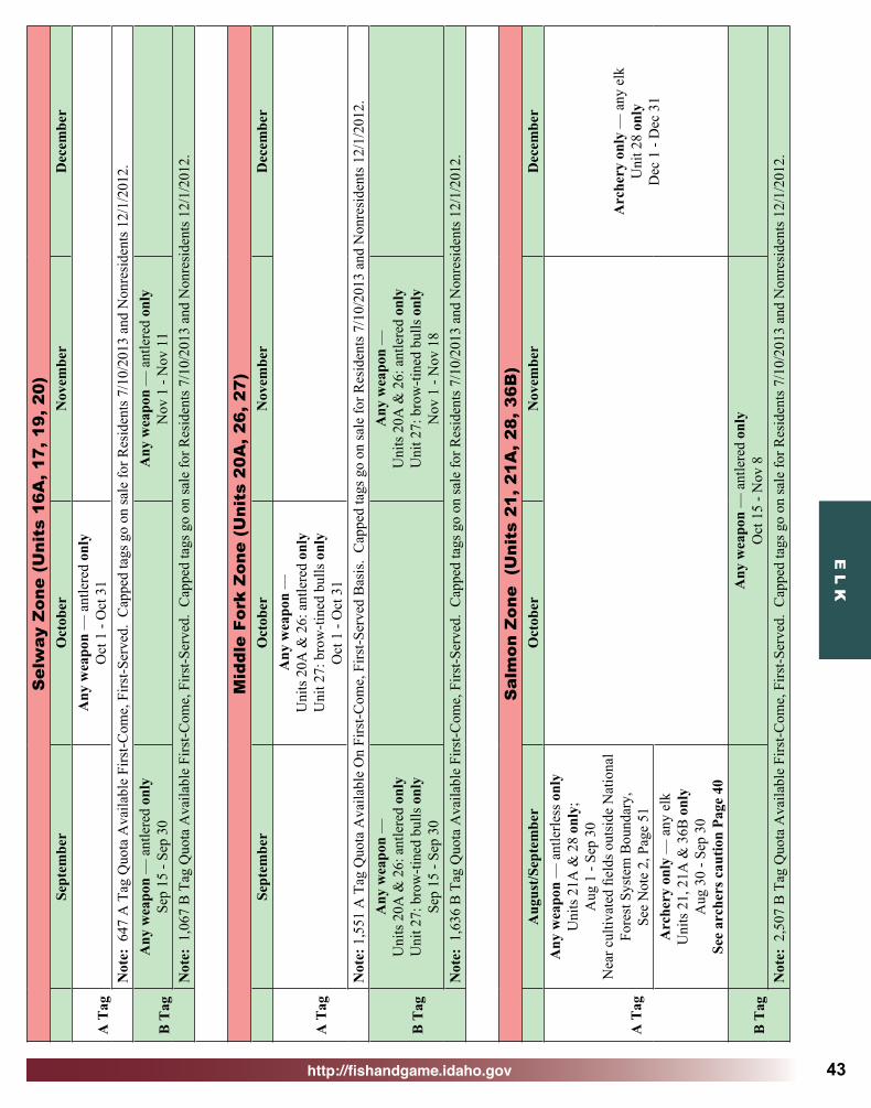
http://fishandgame.idaho.gov
E L K
43
Sel
way
Zon
e (U
nits
16A
, 17,
19,
20)
Sept
embe
rO
ctob
erN
ovem
ber
Dec
embe
r
A T
agA
ny w
eapo
n —
ant
lere
d on
lyO
ct 1
- O
ct 3
1N
ote:
647
A T
ag Q
uota
Ava
ilabl
e Fi
rst-C
ome,
Firs
t-Ser
ved.
Cap
ped
tags
go
on sa
le fo
r Res
iden
ts 7
/10/
2013
and
Non
resi
dent
s 12/
1/20
12.
B T
agA
ny w
eapo
n —
ant
lere
d on
lySe
p 15
- Se
p 30
Any
wea
pon
— a
ntle
red
only
Nov
1 -
Nov
11
Not
e: 1
,067
B T
ag Q
uota
Ava
ilabl
e Fi
rst-C
ome,
Firs
t-Ser
ved.
Cap
ped
tags
go
on sa
le fo
r Res
iden
ts 7
/10/
2013
and
Non
resi
dent
s 12/
1/20
12.
Mid
dle
Fork
Zon
e (U
nits
20A
, 26,
27)
Sept
embe
rO
ctob
erN
ovem
ber
Dec
embe
r
A T
ag
Any
wea
pon
—
Uni
ts 2
0A &
26:
ant
lere
d on
lyU
nit 2
7: b
row
-tine
d bu
lls o
nly
Oct
1 -
Oct
31
Not
e: 1
,551
A T
ag Q
uota
Ava
ilabl
e O
n Fi
rst-C
ome,
Firs
t-Ser
ved
Bas
is.
Cap
ped
tags
go
on sa
le fo
r Res
iden
ts 7
/10/
2013
and
Non
resi
dent
s 12/
1/20
12.
B T
ag
Any
wea
pon
—
Uni
ts 2
0A &
26:
ant
lere
d on
lyU
nit 2
7: b
row
-tine
d bu
lls o
nly
Sep
15 -
Sep
30
Any
wea
pon
—
Uni
ts 2
0A &
26:
ant
lere
d on
lyU
nit 2
7: b
row
-tine
d bu
lls o
nly
Nov
1 -
Nov
18
Not
e: 1
,636
B T
ag Q
uota
Ava
ilabl
e Fi
rst-C
ome,
Firs
t-Ser
ved.
Cap
ped
tags
go
on sa
le fo
r Res
iden
ts 7
/10/
2013
and
Non
resi
dent
s 12/
1/20
12.
Sal
mon
Zon
e (
Uni
ts 2
1, 2
1A, 2
8, 3
6B)
Aug
ust/S
epte
mbe
rO
ctob
erN
ovem
ber
Dec
embe
r
A T
ag
Any
wea
pon
— a
ntle
rless
onl
yU
nits
21A
& 2
8 on
ly;
Aug
1 -
Sep
30N
ear c
ultiv
ated
fiel
ds o
utsi
de N
atio
nal
Fore
st S
yste
m B
ound
ary,
See
Not
e 2,
Pag
e 51
Arc
hery
onl
y —
any
elk
Uni
t 28
only
Dec
1 -
Dec
31
Arc
hery
onl
y —
any
elk
Uni
ts 2
1, 2
1A &
36B
onl
yA
ug 3
0 - S
ep 3
0Se
e ar
cher
s cau
tion
Page
40
B T
agA
ny w
eapo
n —
ant
lere
d on
lyO
ct 1
5 - N
ov 8
Not
e: 2
,507
B T
ag Q
uota
Ava
ilabl
e Fi
rst-C
ome,
Firs
t-Ser
ved.
Cap
ped
tags
go
on sa
le fo
r Res
iden
ts 7
/10/
2013
and
Non
resi
dent
s 12/
1/20
12.

http://fishandgame.idaho.gov
E L
K
44
Wei
ser
Riv
er Z
one
(Uni
ts 2
2, 3
2, 3
2A)
Aug
ust/S
epte
mbe
rO
ctob
erN
ovem
ber
Dec
embe
r
A T
ag
Any
wea
pon
— a
ntle
rless
onl
yU
nits
22
& 3
2A o
nly:
Aug
15
- Sep
30
Out
side
Nat
iona
l For
est S
yste
m
Bou
ndar
y on
ly,
See
Not
e C
bel
ow,
Extre
mel
y Li
mite
d A
cces
sA
rche
ry o
nly
— a
ny e
lkA
ug 3
0 - S
ep 3
0Se
e N
ote
A b
elow
,Se
e ar
cher
s cau
tion
Page
40,
Mot
oriz
ed H
untin
g R
ule
App
lies i
nU
nits
32
& 3
2A, S
ee P
ages
91-
92A
ny w
eapo
n —
ant
lerle
ss o
nly
Uni
t 32
only
: Aug
1 -
Nov
30
Plea
se o
btai
n pe
rmis
sion
to h
unt p
rivat
e la
nd b
efor
e bu
ying
this
tag!
See
Not
e B
bel
ow, E
xtre
mel
y Li
mite
d A
cces
s.M
otor
ized
Hun
ting
Rul
e A
pplie
s, Se
e Pa
ges 9
1-92
B T
ag
Any
wea
pon
— a
ntle
red
only
Oct
25
- Nov
3M
otor
ized
Hun
ting
Rul
e A
pplie
s in
Uni
ts 3
2 &
32A
, See
Pag
es 9
1-92
Sh
ort r
ange
wea
pons
onl
y on
Mon
tour
WM
A
Not
e A
- C
lose
d ar
ea: T
hat p
ortio
n of
Uni
t 32
wes
t of t
he fo
llow
ing
boun
dary
: Beg
inni
ng a
t the
Uni
t 32/
38 b
ound
ary
at E
mm
ett,
then
nor
th o
n H
ighw
ay 5
2 to
the
Van
D
usse
n R
oad,
then
nor
th o
n th
e Fo
ur M
ile R
oad
to th
e U
nit 3
2/32
A b
ound
ary
is c
lose
d .
Not
e B
- O
pen
area
: Tha
t por
tion
of U
nit 3
2 w
est o
f the
follo
win
g bo
unda
ry: B
egin
ning
at t
he U
nit 3
2/38
bou
ndar
y at
Em
met
t, th
en n
orth
on
Hig
hway
52
to th
e V
an
Dus
sen
Roa
d, th
en n
orth
on
the
Four
Mile
Roa
d to
the
Uni
t 32/
32A
bou
ndar
y. M
ost e
lk a
re o
n pr
ivat
e pr
oper
ty in
this
are
a.
Not
e C
- O
pen
area
s: T
hat p
ortio
n of
Uni
t 22
that
lies
out
side
Nat
iona
l For
est S
yste
m B
ound
ary
and
drai
ns in
to th
e W
eise
r Riv
er, u
pstre
am fr
om a
nd in
clud
ing
the
Hor
net
Cre
ek d
rain
age
and
dow
nstre
am fr
om a
nd in
clud
ing
the
Wes
t For
k W
eise
r Riv
er d
rain
age
but e
xclu
ding
the
entir
e Lo
st C
reek
Dra
inag
e. T
hat p
ortio
n of
Uni
t 32A
that
lies
ou
tsid
e N
atio
nal F
ores
t Sys
tem
Bou
ndar
y an
d dr
ains
into
the
Wei
ser R
iver
ups
tream
from
and
incl
udin
g th
e M
iddl
e Fo
rk W
eise
r Riv
er d
rain
age
and
dow
nstre
am fr
om b
ut
excl
udin
g th
e Ea
st F
ork
Wei
ser R
iver
dra
inag
e. M
ost e
lk a
re o
n pr
ivat
e pr
oper
ty in
this
are
a. T
he N
atio
nal F
ores
t Sys
tem
Bou
ndar
y is
a le
gisl
ativ
ely
set b
ound
ary
- it i
s not
ne
cess
arily
the
boun
dary
of F
ores
t Ser
vice
pro
perty
. St
ate,
priv
ate,
and
oth
er la
nds w
ithin
the
Nat
iona
l For
est S
yste
m B
ound
ary
are
not o
pen
to h
untin
g du
ring
this
seas
on.
(Ple
ase
refe
r to
a U
.S. F
ores
t Ser
vice
map
for t
he lo
catio
n of
this
bou
ndar
y.)
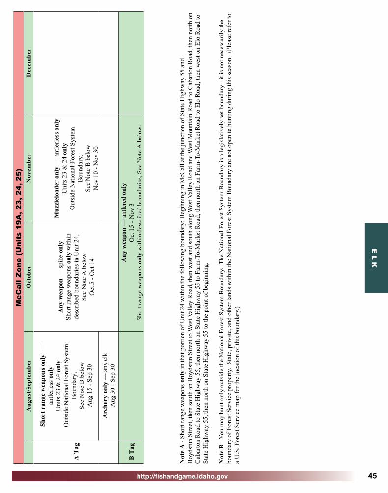
http://fishandgame.idaho.gov
E L K
45
McC
all Z
one
(Uni
ts 1
9A, 2
3, 2
4, 2
5)A
ugus
t/Sep
tem
ber
Oct
ober
Nov
embe
rD
ecem
ber
A T
ag
Shor
t ran
ge w
eapo
ns o
nly
—
antle
rless
onl
yU
nits
23
& 2
4 on
lyO
utsi
de N
atio
nal F
ores
t Sys
tem
B
ound
ary,
Se
e N
ote
B b
elow
Aug
15
- Sep
30
Any
wea
pon
— sp
ike
only
Sh
ort r
ange
wea
pons
onl
y w
ithin
de
scrib
ed b
ound
arie
s in
Uni
t 24,
Se
e N
ote
A b
elow
Oct
5 -
Oct
14
Muz
zlel
oade
r on
ly —
ant
lerle
ss o
nly
Uni
ts 2
3 &
24
only
Out
side
Nat
iona
l For
est S
yste
m
Bou
ndar
y,
See
Not
e B
bel
owN
ov 1
0 - N
ov 3
0A
rche
ry o
nly
— a
ny e
lkA
ug 3
0 - S
ep 3
0
B T
agA
ny w
eapo
n —
ant
lere
d on
lyO
ct 1
5 - N
ov 3
Shor
t ran
ge w
eapo
ns o
nly
with
in d
escr
ibed
bou
ndar
ies,
See
Not
e A
bel
ow.
Not
e A
- Sh
ort r
ange
wea
pons
onl
y in
that
por
tion
of U
nit 2
4 w
ithin
the
follo
win
g bo
unda
ry: B
egin
ning
in M
cCal
l at t
he ju
nctio
n of
Sta
te H
ighw
ay 5
5 an
d B
oyds
tun
Stre
et, t
hen
sout
h on
Boy
dstu
n St
reet
to W
est V
alle
y R
oad,
then
wes
t and
sout
h al
ong
Wes
t Val
ley
Roa
d an
d W
est M
ount
ain
Roa
d to
Cab
arto
n R
oad,
then
nor
th o
n C
abar
ton
Roa
d to
Sta
te H
ighw
ay 5
5, th
en n
orth
on
Stat
e H
ighw
ay 5
5 to
Far
m-T
o-M
arke
t Roa
d, th
en n
orth
on
Farm
-To-
Mar
ket R
oad
to E
lo R
oad,
then
wes
t on
Elo
Roa
d to
St
ate
Hig
hway
55,
then
nor
th o
n St
ate
Hig
hway
55
to th
e po
int o
f beg
inni
ng.
Not
e B
- Yo
u m
ay h
unt o
nly
outs
ide
the
Nat
iona
l For
est S
yste
m B
ound
ary.
The
Nat
iona
l For
est S
yste
m B
ound
ary
is a
legi
slat
ivel
y se
t bou
ndar
y - i
t is n
ot n
eces
saril
y th
e bo
unda
ry o
f For
est S
ervi
ce p
rope
rty.
Stat
e, p
rivat
e, a
nd o
ther
land
s with
in th
e N
atio
nal F
ores
t Sys
tem
Bou
ndar
y ar
e no
t ope
n to
hun
ting
durin
g th
is se
ason
. (P
leas
e re
fer t
o a
U.S
. For
est S
ervi
ce m
ap fo
r the
loca
tion
of th
is b
ound
ary.
)

http://fishandgame.idaho.gov
E L
K
46
Lem
hi Z
one
(Uni
ts 2
9, 3
7, 3
7A, 5
1)A
ugus
t/Sep
tem
ber
Oct
ober
Nov
embe
rD
ecem
ber
A T
ag
Any
wea
pon
— a
ntle
rless
onl
y U
nits
29
& 5
1 on
ly: A
ug 1
- Se
p 15
Nea
r cul
tivat
ed fi
elds
out
side
Nat
iona
l Fo
rest
Sys
tem
Bou
ndar
y,
See
Not
e 2,
Pag
e 51
,M
otor
ized
Hun
ting
Rul
e A
pplie
s, Se
e Pa
ges 9
1-92
Muz
zlel
oade
r on
ly —
ant
lerle
ss o
nly
Nov
25
- Dec
9M
otor
ized
Hun
ting
Rul
e A
pplie
s, Se
e Pa
ges 9
1-92
Arc
hery
onl
y —
any
elk
Aug
30
- Sep
30
See
arch
ers c
autio
n Pa
ge 4
0,M
otor
ized
Hun
ting
Rul
e A
pplie
s,Se
e Pa
ges 9
1-92
Any
wea
pon
— sp
ike
only
Uni
ts 3
7 &
51
only
Nov
1 -
Nov
7M
otor
ized
Hun
ting
Rul
e A
pplie
s,Se
e Pa
ges 9
1-92
B T
agN
o B
Tag
s in
this
Zon
e —
See
Con
trol
led
Hun
ts
Bea
verh
ead
Zon
e (U
nits
30,
30A
, 58,
59,
59A
)A
ugus
t/Sep
tem
ber
Oct
ober
Nov
embe
rD
ecem
ber
A T
ag
Any
wea
pon
— a
ntle
rless
onl
y U
nit 3
0 on
ly: A
ug 1
- Se
p 30
Nea
r cul
tivat
ed fi
elds
out
side
Nat
iona
l Fo
rest
Sys
tem
Bou
ndar
y,
See
Not
e 2,
Pag
e 51
,M
otor
ized
Hun
ting
Rul
e A
pplie
s, Se
e Pa
ges 9
1-92
Muz
zlel
oade
r on
ly —
ant
lerle
ss o
nly
Oct
15
- Oct
31
Mot
oriz
ed H
untin
g R
ule
App
lies,
See
Page
s 91-
92A
rche
ry o
nly
— a
ny e
lkA
ug 3
0 - S
ep 3
0Se
e ar
cher
s cau
tion
Page
40,
Mot
oriz
ed H
untin
g R
ule
App
lies,
See
Page
s 91-
92
B T
agN
o B
Tag
s in
this
Zon
e —
See
Con
trol
led
Hun
ts
Bro
wnl
ee Z
one
(U
nit
31)
Aug
ust/S
epte
mbe
rO
ctob
erN
ovem
ber
Dec
embe
r
A T
agA
rche
ry o
nly—
any
elk
Aug
30
- Sep
30
B T
agN
o B
Tag
s in
this
Zon
e —
See
Con
trol
led
Hun
ts
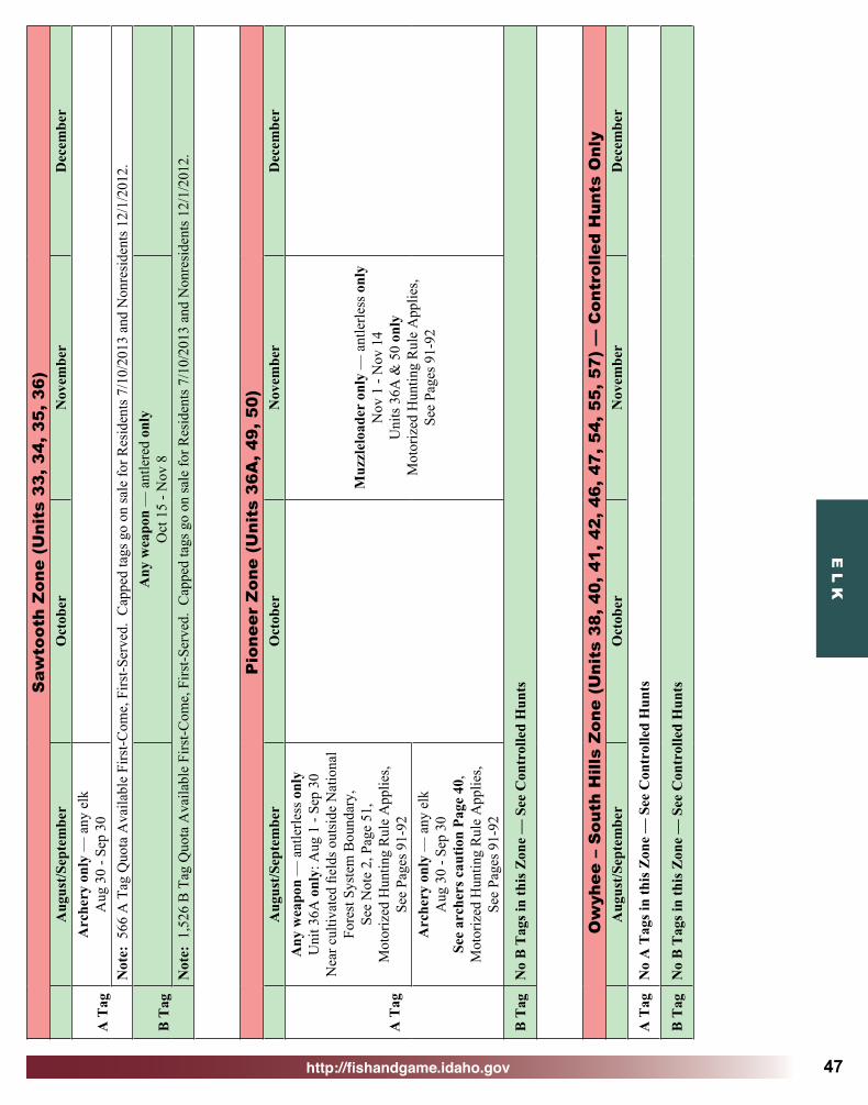
http://fishandgame.idaho.gov
E L K
47
Saw
toot
h Z
one
(Uni
ts 3
3, 3
4, 3
5, 3
6)A
ugus
t/Sep
tem
ber
Oct
ober
Nov
embe
rD
ecem
ber
A T
agA
rche
ry o
nly
— a
ny e
lkA
ug 3
0 - S
ep 3
0N
ote:
566
A T
ag Q
uota
Ava
ilabl
e Fi
rst-C
ome,
Firs
t-Ser
ved.
Cap
ped
tags
go
on sa
le fo
r Res
iden
ts 7
/10/
2013
and
Non
resi
dent
s 12/
1/20
12.
B T
agA
ny w
eapo
n —
ant
lere
d on
lyO
ct 1
5 - N
ov 8
Not
e: 1
,526
B T
ag Q
uota
Ava
ilabl
e Fi
rst-C
ome,
Firs
t-Ser
ved.
Cap
ped
tags
go
on sa
le fo
r Res
iden
ts 7
/10/
2013
and
Non
resi
dent
s 12/
1/20
12.
Pio
neer
Zon
e (U
nits
36A
, 49,
50)
Aug
ust/S
epte
mbe
rO
ctob
erN
ovem
ber
Dec
embe
r
A T
ag
Any
wea
pon
— a
ntle
rless
onl
y U
nit 3
6A o
nly:
Aug
1 -
Sep
30N
ear c
ultiv
ated
fiel
ds o
utsi
de N
atio
nal
Fore
st S
yste
m B
ound
ary,
Se
e N
ote
2, P
age
51,
Mot
oriz
ed H
untin
g R
ule
App
lies,
See
Page
s 91-
92
Muz
zlel
oade
r on
ly —
ant
lerle
ss o
nly
Nov
1 -
Nov
14
Uni
ts 3
6A &
50
only
Mot
oriz
ed H
untin
g R
ule
App
lies,
See
Page
s 91-
92A
rche
ry o
nly
— a
ny e
lkA
ug 3
0 - S
ep 3
0Se
e ar
cher
s cau
tion
Page
40,
Mot
oriz
ed H
untin
g R
ule
App
lies,
See
Page
s 91-
92
B T
agN
o B
Tag
s in
this
Zon
e —
See
Con
trol
led
Hun
ts
Ow
yhee
– S
outh
Hill
s Z
one
(Uni
ts 3
8, 4
0, 4
1, 4
2, 4
6, 4
7, 5
4, 5
5, 5
7) —
Con
trol
led
Hun
ts O
nly
Aug
ust/S
epte
mbe
rO
ctob
erN
ovem
ber
Dec
embe
r
A T
agN
o A
Tag
s in
this
Zon
e —
See
Con
trol
led
Hun
ts
B T
agN
o B
Tag
s in
this
Zon
e —
See
Con
trol
led
Hun
ts

http://fishandgame.idaho.gov
E L
K
48
Boi
se R
iver
Zon
e (U
nit
39)
Sept
embe
rO
ctob
erN
ovem
ber
Dec
embe
r
A T
agA
rche
ry o
nly
— a
ny e
lkN
ov 1
0 - N
ov 3
0Se
e N
ote
3, P
age
51
B T
ag
Any
wea
pon
— a
ntle
red
only
Nov
1 -
Nov
9
Porti
on o
f Uni
t clo
sed,
Se
e N
ote
4, P
age
51
Sm
oky
Mou
ntai
n Z
one
(Uni
ts 4
3, 4
4, 4
8)A
ugus
t/Sep
tem
ber
Oct
ober
Nov
embe
rD
ecem
ber
A T
ag
Arc
hery
onl
y —
any
elk
Uni
ts 4
3 &
48
only
A
ug 3
0 - S
ep 3
0Se
e ar
cher
s cau
tion
Page
40
Any
wea
pon—
spik
e on
lyN
ov 1
- N
ov 7
Not
e: 7
26 A
Tag
Quo
ta A
vaila
ble
Firs
t-Com
e, F
irst-S
erve
d. C
appe
d ta
gs g
o on
sale
for R
esid
ents
7/1
0/20
13 a
nd N
onre
side
nts 1
2/1/
2012
.
B T
agN
o B
Tag
s in
this
Zon
e —
See
Con
trol
led
Hun
ts
Ben
nett
Hill
s Z
one
(Uni
ts 4
5, 5
2)Se
ptem
ber
Oct
ober
Nov
embe
rD
ecem
ber
A T
ag
Muz
zlel
oade
r on
ly —
ant
lerle
ss o
nly
Sep
1 - S
ep 1
4M
otor
ized
Hun
ting
Rul
e A
pplie
s,Se
e Pa
ges 9
1-92
B T
agN
o B
Tag
s in
this
Zon
e —
See
Con
trol
led
Hun
ts
Big
Des
ert
Zon
e (U
nits
52A
, 68)
A
ugus
t/Sep
tem
ber
Oct
ober
Nov
embe
rD
ecem
ber
A T
agA
rche
ry o
nly
— a
ny e
lkA
ug 3
0 - S
ep 3
0
B T
agN
o B
Tag
s in
this
Zon
e —
See
Con
trol
led
Hun
ts

http://fishandgame.idaho.gov
E L K
49
Sna
ke R
iver
Zon
e (U
nits
53,
63,
63A
, 68A
)A
ugus
t/Sep
tem
ber
Oct
ober
Nov
embe
rD
ecem
ber
A T
ag
Arc
hery
onl
y —
any
elk
Uni
t 68A
onl
y: A
ug 1
- Se
p 30
Any
wea
pon
— a
ntle
rless
onl
yU
nit 6
3 on
ly: S
ep 1
- D
ec 3
1Sh
ort r
ange
wea
pons
onl
y on
Mud
Lak
e W
MA
Any
wea
pon
— a
ny e
lkU
nit 6
3 on
ly: A
ug 1
- A
ug 3
1Sh
ort r
ange
wea
pons
onl
y on
M
ud L
ake
WM
A
Shor
t ran
ge w
eapo
ns o
nly
— a
ntle
rless
onl
yU
nit 6
3A o
nly:
Sep
1 -
Dec
31
Shor
t ran
ge w
eapo
ns o
nly
— a
ny e
lkU
nit 6
3A o
nly:
Aug
1 -
Aug
31
Arc
hery
onl
y —
ant
lerle
ss o
nly
Uni
t 68A
onl
y: O
ct 1
- D
ec 3
1Sh
ort r
ange
wea
pons
onl
y —
any
elk
Uni
t 53
only
: Aug
1 -
Dec
31
Mot
oriz
ed H
untin
g R
ule
App
lies,
See
Page
s 91-
92
B T
agN
o B
Tag
s in
this
Zon
e —
See
Con
trol
led
Hun
ts
Isla
nd P
ark
Zon
e (U
nits
60,
60A
, 61,
62A
)A
ugus
t/Sep
tem
ber
Oct
ober
Nov
embe
rD
ecem
ber
A T
agA
rche
ry o
nly
— a
ny e
lkA
ug 3
0 - S
ep 3
0
Any
wea
pon
— sp
ike
only
Oct
15
- Oct
28
Shor
t ran
ge w
eapo
ns o
nly
on
Che
ster
Wet
land
s WM
A
Muz
zlel
oade
r on
ly —
spik
e or
ant
lerle
ssU
nit 6
1 on
lyN
ov 1
1 - D
ec 9
B T
agN
o B
Tag
s in
this
Zon
e —
See
Con
trol
led
Hun
ts
Tet
on Z
one
(Uni
ts 6
2, 6
5)A
ugus
t/Sep
tem
ber
Oct
ober
Nov
embe
rD
ecem
ber
A T
agA
rche
ry o
nly
— a
ny e
lkA
ug 3
0 - S
ep 3
0 A
ny w
eapo
n —
ant
lerle
ss o
nly
Oct
22
- Oct
31
B T
agA
rche
ry o
nly
— sp
ike
or a
ntle
rless
A
ug 3
0 - S
ep 1
4A
ny w
eapo
n —
ant
lere
d on
lyO
ct 1
5 - O
ct 2
1
Pal
isad
es Z
one
(Uni
ts 6
4, 6
7)A
ugus
t/Sep
tem
ber
Oct
ober
Nov
embe
rD
ecem
ber
A T
agA
rche
ry o
nly
— a
ny e
lkA
ug 3
0 - S
ep 3
0A
ny w
eapo
n —
ant
lerle
ss o
nly
Oct
22
- Nov
16
B T
agA
rche
ry o
nly
— sp
ike
or a
ntle
rless
A
ug 3
0 - S
ept 1
4A
ny w
eapo
n —
ant
lere
d on
lyO
ct 1
5 - O
ct 2
1

http://fishandgame.idaho.gov
E L
K
50
Tex
Cre
ek Z
one
(Uni
ts 6
6, 6
9)A
ugus
t/Sep
tem
ber
Oct
ober
Nov
embe
rD
ecem
ber
A T
ag
Arc
hery
onl
y —
any
elk
Aug
30
- Sep
30
Mot
oriz
ed H
untin
g R
ule
App
lies,
See
Page
s 91-
92
Any
wea
pon
— a
ntle
rless
onl
yO
ct 2
2 - N
ov 1
6M
otor
ized
Hun
ting
Rul
e A
pplie
s, Se
e Pa
ges 9
1-92
B T
ag
Arc
hery
onl
y —
spik
e or
ant
lerle
ss
Aug
30
- Sep
14
Mot
oriz
ed H
untin
g R
ule
App
lies,
See
Page
s 91-
92
Any
wea
pon
— a
ntle
red
only
Oct
15
- Oct
21
Mot
oriz
ed H
untin
g R
ule
App
lies,
See
Page
s 91-
92
Ban
nock
Zon
e (U
nits
56,
70,
71,
72,
73,
73A
, 74)
Aug
ust/S
epte
mbe
rO
ctob
erN
ovem
ber
Dec
embe
r
A T
ag
Arc
hery
onl
y —
any
elk
Aug
30
- Sep
30
Mot
oriz
ed H
untin
g R
ule
App
lies i
n U
nits
56,
70
& 7
3, S
ee P
ages
91-
92
Any
wea
pon
— a
ntle
rless
onl
yU
nits
70,
71,
72,
73,
73A
& 7
4 on
lyO
ct 2
5 - N
ov 1
5M
otor
ized
Hun
ting
Rul
e A
pplie
s in
Uni
ts 7
0 &
73,
See
Pag
es 9
1-92
Muz
zlel
oade
r on
ly —
ant
lerle
ss o
nly
Uni
ts 5
6, 7
0, 7
1, 7
3, 7
3A &
74
only
Nov
16
- Nov
30
Mot
oriz
ed H
untin
g R
ule
App
lies i
n U
nits
56,
70
& 7
3, S
ee P
ages
91-
92B
Tag
No
B T
ags i
n th
is Z
one
— S
ee C
ontr
olle
d H
unts
Bea
r R
iver
Zon
e (U
nits
75,
77,
78)
Aug
ust/S
epte
mbe
rO
ctob
erN
ovem
ber
Dec
embe
r
A T
ag
Arc
hery
onl
y —
any
elk
Aug
30
- Sep
30
Mot
oriz
ed H
untin
g R
ule
App
lies,
See
Page
s 91-
92
Any
wea
pon
— a
ntle
rless
onl
yO
ct 2
5 - N
ov 1
5M
otor
ized
Hun
ting
Rul
e A
pplie
s, Se
e Pa
ges 9
1-92
Muz
zlel
oade
r on
ly —
an
tlerle
ss o
nly
Dec
1 -
Dec
31
Mot
oriz
ed H
untin
g R
ule
App
lies,
See
Page
s 91-
92
B T
ag
Arc
hery
onl
y —
spik
e or
ant
lerle
ssA
ug 3
0 - S
ep14
Mot
oriz
ed H
untin
g R
ule
App
lies,
See
Page
s 91-
92
Any
wea
pon
— a
ntle
red
only
Oct
15
- Oct
24
Mot
oriz
ed H
untin
g R
ule
App
lies,
See
Page
s 91-
92N
ote:
550
B T
ag Q
uota
Ava
ilabl
e Fi
rst-C
ome,
Firs
t-Ser
ved.
Cap
ped
tags
go
on sa
le fo
r Res
iden
ts 7
/10/
2013
and
Non
resi
dent
s 12/
1/20
12.
Dia
mon
d C
reek
Zon
e (U
nits
66A
, 76)
Aug
ust/S
epte
mbe
rO
ctob
erN
ovem
ber
Dec
embe
r
A T
ag
Arc
hery
onl
y —
any
elk
Aug
30
- Sep
30
Mot
oriz
ed H
untin
g R
ule
App
lies,
See
Page
s 91-
92N
ote:
1,8
36 A
Tag
Quo
ta A
vaila
ble
Firs
t-Com
e, F
irst-S
erve
d. C
appe
d ta
gs g
o on
sale
for R
esid
ents
7/1
0/20
13 a
nd N
onre
side
nts 1
2/1/
2012
.B
Tag
No
B T
ags i
n th
is Z
one
— S
ee C
ontr
olle
d H
unts

http://fishandgame.idaho.gov
E L K
51
IDFG photo
http://fishandgame.idaho.gov/roadkill
WILDLIFE COLLISIONOBSERVATIONS AND SALVAGE
REPORT ROAD KILLReporting roadkill mortalities gives IDFG and ITD more information to help prevent losses to wildlife and dangers to travelers.
RAISE AWARENESS INCREASE SAFETY MANAGE WILDLIFE
ROAD KILL
ELK GENERAL SEASON SPECIAL AREA DESCRIPTIONS
• Note 1 — Unit 8A Muzzleloader Spike or Antlerless Hunt — That portion of Unit 8A east of State Highway 6 and State Highway 9 and north of the following line: Beginning at the boundary of Unit 8A at its junction with State Highway 8 at Deary, then east on Highway 8 to Forest Service Road 1963 at Helmer, then south and east on Forest Service Road 1963 to Long Meadow Creek, then southeast on Long Meadow Creek to Dworshak Reservoir, then east along the shoreline of Dworshak Reservoir to the Unit 8A boundary at Dent Bridge.
• Note 2 — Outside the National Forest System Boundary in Palouse, Salmon, Lemhi, Beaverhead and Pioneer Zones — Antlerless Hunts: These hunts are open only outside the National Forest System Boundary within 1 mile of private fields on which cultivated crops are currently growing. The National Forest System Boundary is a legislatively set boundary — it is not necessarily the boundary of Forest Service property. State, private and other lands within the National Forest System Boundary are not open to hunting during this season. (Please refer to a U.S. Forest Service map for the location of this boundary.) “Private fields on which cultivated crops are currently growing” is defined as: fields on which soil has been used or broken up for the raising of crops, and artificially irrigated pasture. “Currently” means during the current or most recent growing season. Lands enrolled in the Conservation Reserve Program (CRP) or other set-aside farm programs are specifically excluded.
• Note 3 — Unit 39 Archery Hunt CLOSED Area: That portion of Unit 39 within Ada County, and that portion of Unit 39 within the following boundary: Beginning at the intersection of State Highway 21 and the Middle Fork Boise River Road (Forest Road 268), east on Forest Road 268 to Cottonwood Creek-Thorn Creek Road (Forest Road 377), to South Fork of Thorn Creek to confluence of Thorn Creek, north and west on Thorn Creek to the confluence with Mores Creek, south and west along the center of Mores Creek including the Mores Creek arm of Lucky Peak Reservoir to Highway 21 to the point of beginning is closed.
• Note 4 — Portion of Unit 39 closed: That portion of Unit 39 south and east of Blacks Creek Road and south of the South Fork of Boise River is closed.

http://fishandgame.idaho.gov52
Risk Reduction tips:• Use non-lead, copper or other high-weight
retention ammunition.• Liberally trim around the wound channel.• Discard meat that is bruised, discolored or
contains hair, dirt, bone fragments, or plant material.
• Use caution when rinsing the carcass to avoid spreading lead fragments.
• Ground venison has more lead fragments than steaks and chops.
• Ask commercial processors not to combine meat from other hunters game with yours.
• Avoid cooking venison with acidic substances like vinegar or wine.
• Practice good marksmanship.• Practicecleanfieldhandlingtechniques.
HunteR infoRmation:• Lead can be toxic if ingested.
• The toxicity depends on the level and frequencyofexposure.
• Lead can have physiological effects.• Lead shot is banned in U.S. for waterfowl
hunting, but is still used for other purposes.
• Lead ammunition is still used for purposes other than waterfowl hunting.
• Wildlife can be poisoned from ingesting lead.
• People can ingest lead particles from bullets in hunter harvested game animals.
• Lead particles in venison may be too small to detect by sight, feel or taste.
LEARN ABOUT LEAD

http://fishandgame.idaho.gov
CO
NT
RO
LLED
ELK
53
2013 Controlled Elk Hunts (19,427 Tags Plus Unlimited Tags)Antlered Elk
Hunt No. ControlledHunt Areas Tags Season Dates Notes
2001 11-1 80 Oct 10 - Nov 32002 18-1 225 Oct 10 - Nov 32003 19A 5 Oct 1 - Oct 142004 23-1 5 Oct 1 - Oct 142005 29 180 Oct 1 - Oct 24 Motorized Hunting Rule Applies, See Pages 91-922006 30 75 Nov 1 - Nov 30 Motorized Hunting Rule Applies, See Pages 91-922007 30-1a (see pg 62) 30 Oct 1 - Oct 14 Motorized Hunting Rule Applies, See Pages 91-922008 31-1 50 Oct 15 - Nov 82009 36A-1b (see pg 63) 63 Oct 1 - Oct 31 Motorized Hunting Rule Applies, See Pages 91-922010 36A-2a (see pg 63) 117 Oct 1 - Oct 31 Motorized Hunting Rule Applies, See Pages 91-922011 37 65 Oct 1 - Oct 24 Motorized Hunting Rule Applies, See Pages 91-922012 37A 70 Oct 1 - Oct 24 Motorized Hunting Rule Applies, See Pages 91-922013 40a (see pg 63) 5 Sep 25 - Oct 142014 40a (see pg 63) 50 Oct 15 - Nov 242015 41b (see pg 63) 10 Nov 1 - Nov 15 Very limited access2016 41b (see pg 63) 10 Nov 16 - Nov 30 Very limited access2017 43 10 Sep 25 - Oct 102018 43 90 Oct 15 - Nov 92019 44-1 10 Sep 25 - Oct 102020 44-1 140 Oct 15 - Nov 9
2021 45a (see pg 63) 100 Oct 1 - Oct 31 Very limited access, Motorized Hunting Rule Applies, See Pages 91-92
2022 46a (see pg 63) 10 Oct 15 - Nov 9 Motorized Hunting Rule Applies in Unit 47, See Pages 91-92
2023 46a (see pg 63) 15 Dec 5 - Dec 31 Motorized Hunting Rule Applies in Unit 47, See Pages 91-92
2024 48-1 10 Sep 25 - Oct 102025 48-1 115 Oct 15 - Nov 92026 49 10 Sep 25 - Oct 10 Motorized Hunting Rule Applies, See Pages 91-922027 49 200 Oct 15 - Nov 9 Motorized Hunting Rule Applies, See Pages 91-922028 50-1b (see pg 63) 100 Oct 15 - Oct 31 Motorized Hunting Rule Applies, See Pages 91-922029 51 10 Oct 1 - Oct 14 Motorized Hunting Rule Applies, See Pages 91-922030 51 125 Nov 1 - Nov 30 Motorized Hunting Rule Applies, See Pages 91-922031 52Aa (see pg 63) 75 Oct 1 - Nov 302032 54 15 Oct 15 - Oct 31
2033 55-1a (see pg 64) 25 Oct 15 - Nov 9 Motorized Hunting Rule Applies in Unit 56, See Pages 91-92
2034 58-1a (see pg 64) 75 Nov 1 - Nov 30 Motorized Hunting Rule Applies, See Pages 91-92
a
continued
Elk Controlled Hunts For details on controlled hunt rules and restrictions please See pages 94-97.
Hunters: Please check Elk Controlled Hunt Area descriptions on pages 61-64. Hunt Areas may change annually.
a This hunt includes other units or parts of other units. See controlled hunt area descriptions. b This hunt includes only a portion of this unit. See controlled hunt area descriptions.For details on controlled hunt rules and restrictions, please see pages 94-97.
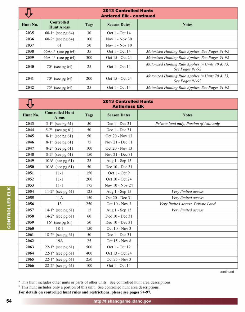
http://fishandgame.idaho.gov
CO
NT
RO
LLE
D E
LK
54
2013 Controlled HuntsAntlerless Elk
Hunt No. Controlled Hunt Areas Tags Season Dates Notes
2043 3-1b (see pg 61) 50 Dec 1 - Dec 31 Private land only, Portion of Unit only2044 5-2b (see pg 61) 50 Dec 1 - Dec 312045 8-1a (see pg 61) 50 Oct 20 - Nov 132046 8-1a (see pg 61) 75 Nov 21 - Dec 312047 8-2a (see pg 61) 100 Oct 20 - Nov 132048 8-2a (see pg 61) 150 Nov 21 - Dec 312049 10Ab (see pg 61) 25 Aug 1 - Sep 152050 10Ab (see pg 61) 50 Dec 10 - Dec 312051 11-1 150 Oct 1 - Oct 92052 11-1 200 Oct 10 - Oct 242053 11-1 175 Nov 10 - Nov 242054 11-2b (see pg 61) 125 Aug 1 - Sep 15 Very limited access2055 11A 150 Oct 20 - Dec 31 Very limited access2056 13 250 Oct 10 - Nov 3 Very limited access, Private Land2057 14-1b (see pg 61) 15 Aug 1 - Sep 15 Very limited access2058 14-2b (see pg 61) 60 Dec 10 - Dec 312059 16b (see pg 61) 50 Dec 10 - Dec 312060 18-1 150 Oct 10 - Nov 32061 18-2b (see pg 61) 50 Dec 1 - Dec 312062 19A 25 Oct 15 - Nov 82063 22-1b (see pg 61) 500 Oct 1 - Oct 122064 22-1b (see pg 61) 400 Oct 13 - Oct 242065 22-1b (see pg 61) 250 Oct 25 - Nov 32066 22-2b (see pg 61) 100 Oct 1 - Oct 14
a
2035 60-1a (see pg 64) 30 Oct 1 - Oct 142036 60-2a (see pg 64) 100 Nov 1 - Nov 302037 61 50 Nov 1 - Nov 102038 66A-1a (see pg 64) 35 Oct 1 - Oct 14 Motorized Hunting Rule Applies, See Pages 91-922039 66A-1a (see pg 64) 300 Oct 15 - Oct 24 Motorized Hunting Rule Applies, See Pages 91-92
2040 70a (see pg 64) 25 Oct 1 - Oct 14 Motorized Hunting Rule Applies in Units 70 & 73, See Pages 91-92
2041 70a (see pg 64) 200 Oct 15 - Oct 24 Motorized Hunting Rule Applies in Units 70 & 73,See Pages 91-92
2042 75a (see pg 64) 25 Oct 1 - Oct 14 Motorized Hunting Rule Applies, See Pages 91-92
2013 Controlled HuntsAntlered Elk - continued
Hunt No. ControlledHunt Areas Tags Season Dates Notes
a
continued
a This hunt includes other units or parts of other units. See controlled hunt area descriptions. b This hunt includes only a portion of this unit. See controlled hunt area descriptions.For details on controlled hunt rules and restrictions, please see pages 94-97.

http://fishandgame.idaho.gov
CO
NT
RO
LLED
ELK
55
2067 22-3 200 Nov 10 - Nov 302068 23-2b (see pg 62) 50 Oct 1 - Oct 142069 23-2b (see pg 62) 30 Oct 15 - Nov 82070 23-3b (see pg 62) 75 Oct 5 - Nov 5 Very limited access2071 23-3b (see pg 62) 25 Dec 1 - Dec 31 Very limited access2072 23-4b (see pg 62) 40 Oct 15 - Nov 8 Very limited access2073 23-4b (see pg 62) 25 Dec 1 - Dec 31 Very limited access2074 24-1b (see pg 62) 150 Oct 15 - Nov 82075 24-2b (see pg 62) 75 Oct 15 - Nov 82076 29 70 Nov 1 - Nov 20 Motorized Hunting Rule Applies, See Pages 91-922077 30 160 Dec 1 - Dec 15 Motorized Hunting Rule Applies, See Pages 91-922078 31-1 200 Oct 1 - Oct 142079 31-1 100 Oct 15 - Nov 9
2080 32-1b (see pg 62) 150 Oct 1 - Nov 3Very limited access,
Short range weapons only on Montour WMA,Motorized Hunting Rule Applies, See Pages 91-92
2081 32-1b (see pg 62) 250 Nov 4 - Nov 30Very limited access,
Short range weapons only on Montour WMA,Motorized Hunting Rule Applies, See Pages 91-92
2082 32A-1 250 Oct 1 - Oct 12 Motorized Hunting Rule Applies, See Pages 91-922083 32A-1 250 Oct 13 - Oct 24 Motorized Hunting Rule Applies, See Pages 91-922084 32A-1 250 Oct 25 - Nov 3 Motorized Hunting Rule Applies, See Pages 91-922085 32A-1 150 Nov 10 - Nov 30 Motorized Hunting Rule Applies, See Pages 91-922086 32A-2b (see pg 62) 50 Dec 1 - Dec 30 Motorized Hunting Rule Applies, See Pages 91-922087 36A-1b (see pg 63) 5 Nov 15 - Nov 30 Motorized Hunting Rule Applies, See Pages 91-922088 36A-2a (see pg 63) 75 Nov 15 - Nov 30 Motorized Hunting Rule Applies, See Pages 91-92
2089 36Bb (see pg 63) 20 Aug 1 - Aug 30 Near cultivated fields outside National Forest Boundary, See note 2, Page 51
2090 36Bb (see pg 63) 20 Sep 1 - Oct 14 Near cultivated fields outside National Forest Boundary, See note 2, Page 51
2091 36Bb (see pg 63) 20 Oct 15 - Nov 20 Near cultivated fields outside National Forest Boundary, See note 2, Page 51
2092 36Bb (see pg 63) 20 Nov 21 - Dec 31 Near cultivated fields outside National Forest Boundary, See note 2, Page 51
2093 37 60 Oct 15 - Oct 31 Motorized Hunting Rule Applies, See Pages 91-922094 37 60 Nov 1 - Nov 20 Motorized Hunting Rule Applies, See Pages 91-92
2095 37-1a (see pg 63) 75 Aug 1 - Sep 30Near cultivated fields outside National Forest Boundary,
See note 2, Page 51, Motorized Hunting Rule Applies, See Pages 91-92
2096 37A 90 Nov 1 - Nov 20 Motorized Hunting Rule Applies, See Pages 91-922097 39-1b (see pg 63) 350 Oct 5 - Oct 312098 39-2a (see pg 63) 300 Oct 5 - Oct 31
2013 Controlled HuntsAntlerless Elk - continued
Hunt No. Controlled Hunt Areas Tags Season Dates Notes
a
continueda This hunt includes other units or parts of other units. See controlled hunt area descriptions. b This hunt includes only a portion of this unit. See controlled hunt area descriptions.For details on controlled hunt rules and restrictions, please see pages 94-97.

http://fishandgame.idaho.gov
CO
NT
RO
LLE
D E
LK
56
2099 40a (see pg 63) 125 Oct 15 - Nov 242100 44-1 90 Nov 10 - Nov 30
2101 45a (see pg 63) 150 Oct 1- Nov 30 Very limited access, Motorized Hunting Rule Applies, See Pages 91-92
2102 46a (see pg 63) 25 Oct 15- Nov 9Motorized Hunting Rule Applies in Unit 47,
See Pages 91-92
2103 46a (see pg 63) 20 Nov 15 - Nov 30Motorized Hunting Rule Applies in Unit 47,
See Pages 91-92
2104 46a (see pg 63) 20 Dec 1 - Dec 14Motorized Hunting Rule Applies in Unit 47,
See Pages 91-92
2105 46a (see pg 63) 20 Dec 15 - Dec 31Motorized Hunting Rule Applies in Unit 47,
See Pages 91-922106 48-2b (see pg 63) 90 Oct 15 - Nov 92107 48-3b (see pg 63) 90 Oct 15 - Nov 92108 48-4a (see pg 63) 65 Aug 3 - Sep 152109 49 125 Oct 15 - Oct 31 Motorized Hunting Rule Applies, See Pages 91-922110 49 125 Nov 1 - Nov 14 Motorized Hunting Rule Applies, See Pages 91-922111 49 120 Nov 15 - Nov 30 Motorized Hunting Rule Applies, See Pages 91-922112 50-2b (see pg 63) 200 Dec 1 - Dec 15 Motorized Hunting Rule Applies, See Pages 91-922113 50-3b (see pg 63) 200 Dec 1 - Dec 15 Motorized Hunting Rule Applies, See Pages 91-922114 51 150 Oct 15 - Nov 3 Motorized Hunting Rule Applies, See Pages 91-922115 51 150 Dec 10 - Dec 31 Motorized Hunting Rule Applies, See Pages 91-922116 52Aa (see pg 63) 150 Oct 10 - Nov 302117 54a (see pg 64) 20 Oct 15- Nov 92118 55-2a (see pg 64) 5 Oct 15 - Nov 92119 56-2b (see pg 64) 35 Aug 1 - Aug 29 Motorized Hunting Rule Applies, See Pages 91-922120 56-3b (see pg 64) 50 Oct 1 - Nov 30 Motorized Hunting Rule Applies, See Pages 91-922121 58-2 250 Nov 1 - Nov 30 Motorized Hunting Rule Applies, See Pages 91-922122 59a (see pg 64) 200 Nov 1 - Nov 30 Motorized Hunting Rule Applies, See Pages 91-922123 60-2a (see pg 64) 150 Nov 1 - Nov 302124 61 100 Nov 1 - Nov 102125 66A-2 300 Oct 25 - Nov 15 Motorized Hunting Rule Applies, See Pages 91-922126 67b (see pg 64) 75 Oct 22 - Dec 14 Very limited access, Portion of Unit only2127 76-1 700 Oct 25 - Nov 15 Motorized Hunting Rule Applies, See Pages 91-922128 76-2a (see pg 64) 100 Nov 16 - Dec 31 Motorized Hunting Rule Applies, See Pages 91-92
2013 Controlled HuntsAntlerless Elk - continued
Hunt No. Controlled Hunt Areas Tags Season Dates Notes
a
a This hunt includes other units or parts of other units. See controlled hunt area descriptions. b This hunt includes only a portion of this unit. See controlled hunt area descriptions.For details on controlled hunt rules and restrictions, please see pages 94-97.

http://fishandgame.idaho.gov
CO
NT
RO
LLED
ELK
57
2013 Controlled HuntsEither Sex Elk
Hunt No. ControlledHunt Areas Tags Season Dates Notes
2129 1 400Sep 6- Sep 30 Archery only
Oct 10 - Oct 24 Any weapon
2130 2 100Sep 6- Sep 30 Archery only
Oct 10 - Oct 24 Any weapon
2131 3-2 300Sep 6- Sep 30 Archery only
Oct 10 - Oct 24 Any weapon
2132 5-1 300Sep 6- Sep 30 Archery only
Oct 10 - Oct 24 Any weapon2133 11-2b (see pg 61) 10 Aug 1 - Sep 15 Very limited access2134 13 335 Oct 10 - Nov 3 Very limited access2135 39-4b (see pg 63) 75 Nov 1 - Nov 9 Very limited access2136 62-2a (see pg 64) 150 Nov 1 - Nov 30
a
2013 Controlled HuntsYouth Only - Antlerless Elk
Hunt No. ControlledHunt Areas Tags Season Dates Notes
2137 29 15 Oct 1 - Nov 20 Motorized Hunting Rule Applies, See Pages 91-922138 30 15 Nov 1 - Dec 15 Motorized Hunting Rule Applies, See Pages 91-922139 36A 25 Oct 1 - Dec 15 Motorized Hunting Rule Applies, See Pages 91-922140 37 25 Oct 1 - Nov 20 Motorized Hunting Rule Applies, See Pages 91-92
2141 44-2a (see pg 63) 150 Nov 10 - Nov 30 Motorized Hunting Rule Applies in Units 45 & 52, See Pages 91-92
2142 50-1b (see pg 63) 100 Oct 15 - Oct 28 Motorized Hunting Rule Applies, See Pages 91-922143 60-1a (see pg 64) 50 Oct 15 - Oct 282144 66a (see pg 64) 100 Oct 22 - Nov 30 Motorized Hunting Rule Applies, See Pages 91-92
a
2013 Controlled HuntsLandowner Permission Required - Antlerless Elk
Hunt No. ControlledHunt Areas Tags Season Dates Notes
2145 30A-2b (see pg 62) 35 Aug 1 - Oct 14 Motorized Hunting Rule Applies, See Pages 91-92, See Page 97 for application information
2146 31-2b (see pg 62) 400 Aug 1 - Dec 31 See Page 97 for application information
2147 32-2b (see pg 62) 100Aug 1 - Aug 29Oct 5 - Dec 31
Motorized Hunting Rule Applies, See Pages 91-92, See Page 97 for application information
2148 39-3b (see pg 63) 100 Dec 1 - Dec 31 See Page 97 for application information
a
a This hunt includes other units or parts of other units. See controlled hunt area descriptions. b This hunt includes only a portion of this unit. See controlled hunt area descriptions.For details on controlled hunt rules and restrictions, please see pages 94-97.

http://fishandgame.idaho.gov
CO
NT
RO
LLE
D E
LK
58
2013 Controlled HuntsMuzzleloader Only Elk - Muzzleloader Permit Required
Hunt No. ControlledHunt Areas Tags Season Dates Notes
2154 11-1 50 Nov 25 - Dec 4 Either sex2155 22-3 150 Dec 1 - Dec 31 Antlerless only2156 24-3 50 Dec 1 - Dec 20 Antlerless only
2157 30A-1 30 Nov 1 - Nov 30 Either sex,Motorized Hunting Rule Applies, See Pages 91-92
2158 32A-3b (see pg 62) 150 Dec 1 - Dec 31 Antlerless only,Motorized Hunting Rule Applies, See Pages 91-92
2159 33-1a (see pg 62) 50 Nov 10 - Nov 30 Antlerless only2160 33-2a (see pg 62) 50 Nov 10 - Nov 30 Antlered only2161 39-5 500 Sep 8 - Sep 30
2162 46a (see pg 63) 10 Sep 25 - Oct 10Antlered only, Motorized Hunting Rule Applies in
Unit 47, See Pages 91-922163 54 5 Sep 25 - Oct 10 Antlered only2164 55-2a (see pg 64) 5 Sep 25 - Oct 102165 61 200 Nov 11 - Dec 9 Either sex2166 62-1a (see pg 64) 25 Oct 1 - Oct 9 Either sex2167 64a (see pg 64) 50 Oct 1 - Oct 9 Either sex
2168 66a (see pg 64) 50 Oct 1 - Oct 9 Either sex, Motorized Hunting Rule Applies, See Pages 91-92
a
a This hunt includes other units or parts of other units. See controlled hunt area descriptions. b This hunt includes only a portion of this unit. See controlled hunt area descriptions.For details on controlled hunt rules and restrictions, please see pages 94-97.
2013 Controlled HuntsLandowner Permission Required EXTRA Antlerless Elk
Hunt No. ControlledHunt Areas Tags Season Dates Notes
2169 45Xb (see pg 63) 75 Aug 1 - Oct 31 Private land only,See Page 97 for application information
2170 45Xb (see pg 63) 25 Nov 1 - Dec 31 Private land only,See Page 97 for application information
a
2013 Controlled HuntsArchery Only Elk - Archery Permit Required
Hunt No. ControlledHunt Areas Tags Season Dates Notes
2149 18-1 75 Aug 30 - Sep 30 Antlered only
2150 45a (see pg 63) 15 Sep 15 - Sep 30 Antlered only, Motorized Hunting Rule Applies, See Pages 91-92
2151 46a (see pg 63) 6 Aug 30 - Sep 20 Antlered only, Motorized Hunting Rule Applies in Unit 47, See Pages 91-92
2152 54 10 Aug 30 - Sep 20 Antlered only2153 55-2a (see pg 64) 5 Aug 30 - Sep 20 Antlered only
a
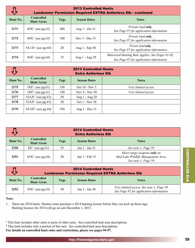
http://fishandgame.idaho.gov
CO
NT
RO
LLED
ELK
59
Note:1. These are 2014 hunts. Hunters must purchase a 2014 hunting license before they can pick up these tags.
Hunting licenses for 2014 will go on sale December 1, 2013.
a This hunt includes other units or parts of other units. See controlled hunt area descriptions. b This hunt includes only a portion of this unit. See controlled hunt area descriptions.For details on controlled hunt rules and restrictions, please see pages 94-97.
2013 Controlled HuntsExtra Antlerless Elk
Hunt No. ControlledHunt Areas Tags Season Dates Notes
2175 18Xb (see pg 61) 150 Oct 10 - Nov 3 Very limited access2176 18Xb (see pg 61) 150 Nov 4 - Nov 30 Very limited access2177 52AXa (see pg 63) 50 Aug 1 - Aug 292178 52AXa (see pg 63) 50 Oct 1 - Nov 30
2179 54-2Xb (see pg 64) 350 Aug 1 - Dec 31
a
2014 Controlled HuntsExtra Antlerless Elk
Hunt No. ControlledHunt Areas Tags Season Dates Notes
2250 8Xa (see pg 61) 55 Jan 1 - Jan 31 See note 1, Page 59
2251 63Xb (see pg 64) 50 Jan 1 - Feb 15Short range weapons only on
Mud Lake Wildlife Management Area,See note 1, Page 59
a2014 Controlled Hunts
Landowner Permission Required EXTRA Antlerless Elk
Hunt No. ControlledHunt Areas Tags Season Dates Notes
2252 39Xb (see pg 63) 50 Jan 1 - Jan 30 Very limited access, See note 1, Page 59See Page 97 for application information
a
2013 Controlled HuntsLandowner Permission Required EXTRA Antlerless Elk - continued
Hunt No. ControlledHunt Areas Tags Season Dates Notes
2171 49Xa (see pg 63) 200 Aug 1 - Oct 31 Private land only,See Page 97 for application information
2172 49Xa (see pg 63) 100 Nov 1 - Dec 31 Private land only,See Page 97 for application information
2173 54-1Xa (see pg 64) 20 Aug 1 - Sep 30 Private land only, See Page 97 for application information
2174 56Xb (see pg 64) 35 Aug 1 - Aug 29Motorized Hunting Rule Applies, See Pages 91-92,
See Page 97 for application information
a

http://fishandgame.idaho.gov
CO
NT
RO
LLE
D E
LK
60
a This hunt includes other units or parts of other units. See controlled hunt area descriptions. b This hunt includes only a portion of this unit. See controlled hunt area descriptions.For details on controlled hunt rules and restrictions, please see pages 94-97.
2013 Controlled HuntsOutfitter Allocation Elk
Hunt No. ControlledHunt Areas Tags Season Dates Notes
2180 11-1 5 Oct 10 - Nov 3 Antlered only2181 13 15 Oct 10 - Nov 3 Either sex2182 18-1 9 Oct 10 - Nov 3 Antlered only
2183 29 7 Oct 1 - Oct 24 Antlered only,Motorized Hunting Rule Applies, See Pages 91-92
2184 36A 3 Oct 1 - Dec 15 Antlerless only, Youth hunt only, Motorized Hunting Rule Applies, See Pages 91-92
2185 36A-1b (see pg 63) 3 Oct 1 - Oct 31 Antlered only,Motorized Hunting Rule Applies, See Pages 91-92
2186 36A-2a (see pg 63) 6 Oct 1 - Oct 31 Antlered only,Motorized Hunting Rule Applies, See Pages 91-92
2187 37 2 Oct 1 - Oct 24 Antlered only2188 37 3 Oct 1 - Nov 20 Antlerless only, Youth hunt only
2189 37A 5 Oct 1 - Oct 24 Antlered only, Motorized Hunting Rule Applies, See Pages 91-92
2190 43 4 Oct 15 - Nov 9 Antlered only
2191 45a (see pg 63) 3 Oct 1 - Oct 31 Antlered only, Motorized Hunting Rule Applies, See Pages 91-92
2192 49 8 Oct 15 - Nov 9 Antlered only,Motorized Hunting Rule Applies, See Pages 91-92
2193 50-1b (see pg 63) 4 Oct 15 - Oct 31 Antlered only,Motorized Hunting Rule Applies, See Pages 91-92
2194 54 1 Aug 30 - Sep 20 Antlered only, Archery only2195 54 1 Sep 25 - Oct 10 Antlered only, Muzzleloader only
2196 58-1a (see pg 64) 2 Nov 1 - Nov 30 Antlered only, Motorized Hunting Rule Applies, See Pages 91-92
2197 61 1 Nov 1 - Nov 10 Antlered only2198 62-2a (see pg 64) 15 Nov 6 - Nov 30 Either sex
2199 66A-1a (see pg 64) 2 Oct 1 - Oct 14 Antlered only, Motorized Hunting Rule Applies, See Pages 91-92
2200 66A-1a (see pg 64) 12 Oct 15 - Oct 24 Antlered only, Motorized Hunting Rule Applies, See Pages 91-92
Outfitted controlled hunts:Before submitting an application for an outfitter-allocated controlled hunt, hunters must have a written agreement with an outfitter licensed in the hunt area. Successful applicants must hunt with an outfitter licensed for the hunt area. The outfitter must purchase the hunter’s permit and tag by August 20. Successful applicants authorize Idaho Fish and Game to provide names and addresses to the outfitters licensed for that controlled hunt. For a list of licensed outfitters in the applicable controlled hunt area, a sample written agreement, and additional information contact the Idaho Outfitters and Guides Licensing Board at their website - www.oglb.idaho.gov or by calling 208-327-7380.
a

http://fishandgame.idaho.gov
CO
NT
RO
LLED
ELK
61
Hunt Area 1 — All of Unit 1.
Hunt Area 2 — All of Unit 2.
Hunt Area 3-1 — That portion of Unit 3 on and within one mile of private land.
Hunt Area 3-2 — All of Unit 3.
Hunt Area 4 — All of Unit 4.
Hunt Area 5-1 — All of Unit 5.
Hunt Area 5-2 — That portion of Unit 5 south of Elder Road and Sun Up Bay Road.
Hunt Area 8-1 — That portion of Units 8 and 8A north of the following line: Beginning at the western boundary of Unit 8 at its junction with State Highway 8, then east on Highway 8 to State Highway 9, then northwest on Highway 9 to State Highway 6, then north on Highway 6 to the Unit 8A boundary.
Hunt Area 8-2 — That portion of Units 8 and 8A south of the following line: Beginning at the western boundary of Unit 8 at its junction with State Highway 8, then east on Highway 8 to Forest Service Road 1963 at Helmer, then south and east on Forest Service Road 1963 to Long Meadow Creek, then southeast along Long Meadow Creek to Dworshak Reservoir, then east along the shoreline of Dworshak Reservoir to the Unit 8A boundary at Dent Bridge.
Hunt Area 8X — All of Units 8, 8A, and 11A outside the National Forest System Boundary within 1 mile of private fields on which cultivated crops are currently growing. The National Forest System Boundary is a legislatively set boundary — it is not necessarily the boundary of Forest Service property. State, private and other lands within the National Forest System Boundary are not open to hunting during this season. (Please refer to a U.S. Forest Service map for the location of this boundary.) “Private fields on which cultivated crops are currently growing” is defined as: fields on which soil has been used or broken up for the raising of crops, and artificially irrigated pasture. “Currently” means during the current or most recent growing season. Lands enrolled in the Conservation Reserve Program (CRP) or other set-aside farm programs are specifically excluded.
Hunt Area 10A — That portion of Unit 10A west of the Clearwater National Forest boundary, south of Forest Service Road 250, south of State Highway 11 from Pierce to Weippe, and Jim Ford Creek from Weippe to its junction with the Clearwater River.
Hunt Area 11-1 — All of Unit 11.
Hunt Area 11-2 — That portion of Unit 11 within ONE mile of cultivated fields and north and east of the following boundary: Beginning at the Unit 11/13 boundary at the Nez Perce County/Lewis County line, then north on the Nez Perce County/Lewis County line to Soldiers Meadow Road, then west
on Soldiers Meadow Road to ZaZa Road, then north on ZaZa Road to Waha Road, then north on Waha Road to Redbird Road, then west on Redbird Road to the boundary of the Craig Mountain WMA, then north and east along the Craig Mountain WMA boundary to the Snake River, then north along the Snake River to the Unit 8/11 boundary.
Hunt Area 11A — All of Unit 11A.
Hunt Area 13 — All of Unit 13.
Hunt Area 14-1 — That portion of Unit 14 west of US 95.
Hunt Area 14-2 — That portion of Unit 14 north and west of the following boundary: Beginning on the Unit 14 western boundary at John Day Creek, then east along the main fork of John Day Creek to the National Forest boundary, then north along the National Forest boundary to Forest Service Road 2025 (Skookumchuck Road), then east along Forest Service Road 2025 to Forest Service Road 243 (Free Use Road), then east along Forest Service Road 243 to Forest Service Road 221, then north along Forest Service Road 221 to the Unit 14 eastern boundary.
Hunt Area 16 — That portion of Unit 16 west of the Nez Perce National Forest perimeter boundary.
Hunt Area 18-1 — All of Unit 18.
Hunt Area 18-2 — That portion of Unit 18 within the Salmon River drainage.
Hunt Area 18X — That portion of Unit 18 within the Snake River drainage.
Hunt Area 19A — All of Unit 19A.
Hunt Area 22-1 — That portion of Unit 22 described as follows: Beginning at the junction of U.S. 95 and the West Fork Weiser River Road (Forest Service Road 127), then north on Forest Service Road 127 to Grouse Creek Road (Forest Service Road 123), then northwest on Forest Service Road 123 to the watershed divide between Lick Creek and Lost Creek drainages, then north on the divide between Lick Creek and Lost Creek drainages to Lick Creek Lookout, then west on Unit 22 boundary to the Snake River, then south on the Snake River to State Highway 71, then southeast on State Highway 71 to Cambridge, then north on U.S. 95 to the point of beginning.
Hunt Area 22-2 — That portion of Unit 22 as follows: Beginning at the junction of U.S. 95 and the West Fork Weiser River Road (Forest Service Road 127), then north on Forest Service Road 127 to Grouse Creek Road (Forest Service Road 123), then northwest on Forest Service Road 123 to the watershed divide between Lick Creek and Lost Creek drainages, then north on the divide between Lick Creek and Lost Creek drainages to Lick Creek Lookout, then east along Unit 22 boundary to U.S. 95 to the point of beginning.
Elk Controlled Hunt Area DescriptionsPlease note that hunt areas are different for each species. For full text of legal description and boundaries for Game Mangement Units see pages 102-111 or visit, http://adminrules.idaho.gov/rules/current/13/0108.pdf.

http://fishandgame.idaho.gov
CO
NT
RO
LLE
D E
LK
62
Hunt Area 22-3 — All of Unit 22.
Hunt Area 23-1 — All of Unit 23.
Hunt Area 23-2 — That portion of Unit 23 within the Little Salmon River drainage, upstream from and including the Boulder Creek drainage on the west side of the Little Salmon River; and upstream from but excluding the Hazard Creek drainage on the east side of the Little Salmon River.
Hunt Area 23-3 — That portion of Unit 23 west of U.S. 95 and north of, and excluding, the Boulder Creek drainage.
Hunt Area 23-4 — That portion of Unit 23 which drains into the main Salmon River upstream from its confluence with the Little Salmon River to the French Creek-Burgdorf Road.
Hunt Area 24-1 — That portion of Unit 24 within the following boundary: Beginning at the junction of State Highway 55 and the Warm Lake Road, then east along Warm Lake Road to the Unit 24/25 boundary, then north along the Unit 24/25/19A boundary to the intersection of the Unit 24/19A/23 boundaries, then south along the Unit 24/23/32A boundary to Forest Service Road 186 at No Business Saddle, then southeast on Forest Service Road 186 to West Mountain Road, then south on West Mountain Road to Tamarack Falls Road, then east on Tamarack Falls Road to Norwood Road, then north on Norwood Road to West Roseberry Road, then east on West Roseberry Road to State Highway 55, then south on State Highway 55 to the point of beginning. Except Short Range Weapons only in that portion within the following boundary: Beginning in McCall at the junction of State Highway 55 and Boydstun Street, then south on Boydstun Street to West Valley Road, then west and south along West Valley Road and west Mountain Road to Tamarack Falls Road, then east on Tamarack Falls Road to Norwood Road, then north on Norwood Road to West Roseberry Road, then east on West Roseberry Road to State Highway 55, then south on State Highway 55 to Farm-to-Market Road then north on Farm-to-Market Road, to Elo Road, then west on Elo Road to State Highway 55, then north on State Highway 55 to the point of beginning.
Hunt Area 24-2 — That portion of Unit 24 within the following boundary: Beginning north of Cascade at the junction of State Highway 55 and Warm Lake Road, then north on Highway 55 to West Roseberry Road, then west on West Roseberry Road to Norwood Road, then south on Norwood Road to Tamarack Falls Road, then west on Tamarack Falls Road to West Mountain Road, then north on West Mountain Road to Forest Service Road 186, then northwest on Forest Service Road 186 to No Business Saddle, then south along the Unit 24/32A unit boundary to the intersection of the Unit 24/32A/33 boundaries at Smith’s Ferry, then north along the Unit 24/33/25 boundary to Warm Lake Road, then
west on Warm Lake Road to the point of beginning. Except Short Range Weapons only within the following boundary: Beginning in Donnelly at the junction of State Highway 55 and West Roseberry Road, then west on West Roseberry Road to Norwood Road, then south on Norwood Road to Tamarack Falls Road, then west on Tamarack Falls Road to West Mountain Road, then south on West Mountain Road to Cabarton Road, then north on Cabarton Road to State Highway 55, then north on State Highway 55 to the point of beginning.
Hunt Area 24-3 — All of Unit 24.
Hunt Area 29 — All of Unit 29.
Hunt Area 30 — All of Unit 30.
Hunt Area 30-1 — All of Units 30, 30A, 58, 59, and 59A.
Hunt Area 30A-1 — All of Unit 30A.
Hunt Area 30A-2 — That portion of Unit 30A outside the National Forest System Boundary and on or within 1 mile of private land on which agricultural crops are currently growing.
Hunt Area 31-1 — All of Unit 31.
Hunt Area 31-2 — That portion of Unit 31 that drains into the Snake River, upstream from and including the Grouse Creek Drainage to the U.S. Highway 95 bridge in Weiser; and that portion of Unit 31 that drains into Monroe Creek from it’s mouth upstream to and including the Sheep Creek drainage.
Hunt Area 32-1 — That portion of Unit 32 east of the following boundary: Beginning at the Unit 32/38 boundary at Emmett, then north on Highway 52 to the Van Dussen Road, then north on Four Mile Road to the Unit 32/32A boundary.
Hunt Area 32-2 — All of Unit 32 south and east of the following boundary: Beginning at the Unit 32 boundary at Gardena, then west on the Brownlee Road to the Sweet Highway, then south to Highway 52, then south and west on Highway 52 to the Unit 32/38 boundary.
Hunt Area 32A-1 — All of Unit 32A.
Hunt Area 32A-2 — That portion of Unit 32A that drains into the Weiser River upstream from and including the Middle Fork Weiser River drainage.
Hunt Area 32A-3 — That portion of Unit 32A that drains into the Payette River drainage and that portion of Unit 32A that drains into the Weiser River drainage downstream from but excluding the Middle Fork Weiser River drainage.
Hunt Area 33-1 — All of Units 33, 34, 35, and 36.
Hunt Area 33-2 — All of Units 33 and 35 and that portion of Unit 34 south and west of the Landmark-Stanley Road.
Hunt Area 36A — All of Unit 36A.

http://fishandgame.idaho.gov
CO
NT
RO
LLED
ELK
63
Hunt Area 36A-1 — That portion of Unit 36A west of the East Fork of the Salmon River and that portion east of the East Fork of the Salmon River upstream from and including the West Pass Creek drainage.
Hunt Area 36A-2 — That portion of Unit 36A east of the East Fork of the Salmon River downstream from but excluding the West Pass Creek drainage, and that portion of Unit 50 north of Trail Creek Road and west of U.S. Highway 93, and that portion of Unit 50 north of the Doublespring Pass Road east of U.S. Highway 93.
Hunt Area 36B — That portion of Unit 36B downstream from, but excluding, Garden Creek drainage, and outside the National Forest Boundary and on or within 1 mile of private land on which agricultural crops are currently growing.
Hunt Area 37 — All of Unit 37.
Hunt Area 37-1 — Those portions of Units 37 and 37A outside the National Forest Boundary and on or within 1 mile of private land on which agricultural crops are currently growing.
Hunt Area 37A — All of Unit 37A.
Hunt Area 39-1 — That portion of Unit 39 south and east of State Highway 21.
Hunt Area 39-2 — That portion of Unit 39 north and west of State Highway 21 and that portion of Unit 33 west of Alder Creek Road (Forest Service Road 615) and south of the Payette River.
Hunt Area 39-3 — That portion of Unit 39 within the following boundary: Beginning at the junction of I-84 and Blacks Creek Road, then east on Blacks Creek Road to USFS Trail No. 500, then southeast on Trail No. 500 to the Danskin Lookout Road, then south on the Danskin Lookout Road to Mayfield Road, then south on Mayfield Road to Martha Ave., then west on Martha Ave to I-84, then west on I-84 to the point of beginning.
Hunt Area 39-4 — That portion of Unit 39 south and east of Blacks Creek Road and south of South Fork of Boise River.
Hunt Area 39-5 — All of Unit 39.
Hunt Area 39X — That portion of Unit 39 within the following boundary: Beginning at the junction of I-84 and Blacks Creek Road, then east on Blacks Creek Road to USFS Trail No. 500, then southeast on Trail No. 500 to the Danskin Lookout Road, then south on the Danskin Lookout Road to Mayfield Road, then south on Mayfield Road to Martha Ave., then west on Martha Ave to I-84, then west on I-84 to the point of beginning.
Hunt Area 40 — All of Units 40 and 42.
Hunt Area 41 — That portion of Unit 41 west of the West Fork Bruneau River.
Hunt Area 43 — All of Unit 43.
Hunt Area 44-1 — All of Unit 44.
Hunt Area 44-2 — All of Units 44, 45, and 52.
Hunt Area 45 — All of Units 45 and 52.
Hunt Area 45X — Private land within Unit 45.
Hunt Area 46 — All of Units 46 and 47 and that portion of Unit 41 east of the West Fork Bruneau River.
Hunt Area 48-1 — All of Unit 48.
Hunt Area 48-2 — That portion of Unit 48 north of Trail Creek and the Ketchum-Warm Springs Creek-Dollarhide Summit Road.
Hunt Area 48-3 — That portion of Unit 48 south of the Ketchum-Warm Springs Creek-Dollarhide Summit Road.
Hunt Area 48-4 — That portion of Unit 48 south and east of the following boundary: Beginning at the junction of the Deer Creek Road and State Highway 75, then west on the Deer Creek Road (Forest Service Road 097) to the Deer Creek Trail (Forest Service Trail 158), then west on the Deer Creek Trail to the Curran Creek Trail (Forest Service Trail 160), then southwest on the Curran Creek Trail to the Unit 44/48 boundary, and that portion of Unit 44 east of Willow Creek and south and east of Little Beaver Creek and Princess Mine Road.
Hunt Area 49 — All of Unit 49.
Hunt Area 49X — Private lands within that portion of Unit 49 within the Silver Creek drainage and that portion of Unit 52 within Blaine County and east of State Highway 75.
Hunt Area 50-1 — That portion of Unit 50 south of the Doublespring Pass Road east of U.S. Highway 93, and that portion south of the Trail Creek Road west of U.S. Highway 93.
Hunt Area 50-2 — That portion of Unit 50 south of the Doublespring Pass Road east of U.S. Highway 93, and that portion south of the Trail Creek Road west of U.S. Highway 93 excluding the East Fork of the Big Lost River drainages and excluding south of the Antelope/Fish Creek Road.
Hunt Area 50-3 — That portion of Unit 50 south of the Antelope/Fish Creek Road and west of Highway 93.
Hunt Area 51 — All of Unit 51.
Hunt Area 52A — All of Units 52A and 68. (Caution: See Craters of the Moon closure, page 86.)
Hunt Area 52AX — That portion of Unit 52A south of the following boundary: Beginning at the junction of the Jim Brown Bridge Road and Highway 93/26, then east along the Jim Brown Bridge Road to the Shale Butte Road, then east along the Shale Butte Road to the Carey-Kimama Road, then south along the Carey-Kimama Road to the Brigham Point/Bear Trap Cave Road, then east along the Brigham Point/Bear Trap Cave Road to the Arco-Minidoka Road (Unit 68 boundary), and that portion of Unit 68 in Blaine County and within 1 mile of cultivated fields.

http://fishandgame.idaho.gov
CO
NT
RO
LLE
D E
LK
64
Hunt Area 54 — All of Unit 54.
Hunt Area 54-1X — Private land within Units 46, 47, 54, 55 and 57 and that portion of Unit 41 east of the West Fork Bruneau River.
Hunt Area 54-2X — Only that portion of Unit 54 within Cassia County and outside the National Forest System Boundary.
Hunt Area 55-1 — All of Units 55, 56 and 57.
Hunt Area 55-2 — All of Units 55 and 57.
Hunt Area 56-1 — All of Unit 56.
Hunt Area 56-2 — That portion of Unit 56 within one mile of cultivated fields.
Hunt Area 56-3 — That portion of Unit 56 south of the Juniper-Holbrook Road.
Hunt Area 56X — That portion of Unit 56 within one mile of cultivated fields.
Hunt Area 58-1 — All of Units 58, 59, and 59A.
Hunt Area 58-2 — All of Unit 58.
Hunt Area 59 — All of Units 59 and 59A.
Hunt Area 60-1 —All of Units 60, 61, and 62A.
Hunt Area 60-2 — All of Units 60 and 60A.
Hunt Area 61 — All of Unit 61.
Hunt Area 62-1 — All of Units 62 and 65.
Hunt Area 62-2 — That portion of Unit 62 within the national forest boundary, all of Unit 62A, and that portion of Unit 65 east of State Highway 33.
Hunt Area 63X — That portion of Unit 63 north of State Highway 33, excluding the Camas National Wildlife Refuge which is closed.
Hunt Area 64 — All of Units 64 and 67.
Hunt Area 66 — All of Units 66 and 69.
Hunt Area 66A-1 — All of Units 66A and 76.
Hunt Area 66A-2 — All of Unit 66A.
Hunt Area 67 — That portion of Unit 67 south and east of the following boundary, beginning at the US 26 bridge over the South Fork Snake River, then east on US 26 to Highway 31 at Swan Valley, then north and east on Highway 31 to the Unit 67 boundary.
Hunt Area 70 — All of Units 70, 71, 72, 73, 73A, and 74.
Hunt Area 75 — All of Units 75, 77, and 78.
Hunt Area 76-1 — All of Unit 76.
Hunt Area 76-2 — That portion of Unit 66A beginning at the Wyoming Border east along the Jackknife Road, the Jackknife Creek drainage east of the mouth of Squaw Creek, and east of the Cabin Creek-Haderlie Ridge Trail (Forest Service Trail 619), and that portion of Unit 76 within the following boundary: Beginning at the intersection of State Highway 34 and the Idaho-Wyoming border then west approximately four miles to the mouth of the South Fork of Tincup Creek and Forest Service Trail 014, then south up Trail 014 to the Stump Creek Road, then south and east along Stump Creek Road to the Idaho-Wyoming border, then north along the border to the junction of State Highway 34, the point of beginning.

http://fishandgame.idaho.gov
PR
ON
GH
OR
N
65
All pronghorn hunting, including archery seasons, is by controlled hunt. Doe or fawn only: Only pronghorn without a black cheek patch or with horns less than 3 inches long may be taken during doe or fawn only pronghorn seasons. To participate in an archery only pronghorn hunting season, hunters must have in their possession an archery permit in addition to required license and tag.
Attention Pronghorn Archery Hunters! Don’t give your sport a black eye. Did you know that leaving blind material is considered littering? And, digging pits on federal land is a violation of federal law? For more information on how to construct a legal blind, see page 86 or contact your local Bureau of Land Management office.
2013 Controlled Pronghorn Hunts (2,055 Tags Plus Unlimited Tags)Either Sex Pronghorn
Hunt No. ControlledHunt Areas Tags Season Dates Notes
4001 29b (see pg 68) 40 Sep 25 - Oct 24 Motorized Hunting Rule Applies, See Pages 91-92
4002 30a (see pg 68) 30 Sep 25 - Oct 24 Motorized Hunting Rule Applies in Unit 30, See Pages 91-92
4003 36Ba (see pg 68) 10 Sep 25 - Oct 244004 37a (see pg 68) 60 Sep 25 - Oct 24 Motorized Hunting Rule Applies, See Pages 91-924005 39b (see pg 68) 25 Sep 25 - Oct 24 Portion of Unit only4006 40-1 75 Sep 25 - Oct 244007 42a (see pg 68) 200 Sep 25 - Oct 24
4008 44-1a (see pg 68) 75 Sep 25 - Oct 24 Motorized Hunting Rule Applies in Unit 45, See Pages 91-92
4009 45-1b (see pg 68) 15 Sep 25 - Oct 24 Motorized Hunting Rule Applies, See Pages 91-924010 46-1 60 Sep 25 - Oct 244011 49 35 Sep 25 - Oct 24 Motorized Hunting Rule Applies, See Pages 91-924012 50 75 Sep 25 - Oct 24 Motorized Hunting Rule Applies, See Pages 91-92
4013 51a (see pg 68) 75 Sep 25 - Oct 24 Motorized Hunting Rule Applies in Unit 51, See Pages 91-92
4014 52a (see pg 68) 25 Sep 25 - Oct 24 Motorized Hunting Rule Applies in Unit 52, See Pages 91-92
4015 52Aa (see pg 68) 25 Sep 25 - Oct 24 Motorized Hunting Rule Applies in Unit 53, See Pages 91-92
4016 54-1 25 Sep 25 - Oct 244017 58 50 Sep 25 - Oct 24 Motorized Hunting Rule Applies, See Pages 91-924018 59a (see pg 68) 50 Sep 25 - Oct 24 Motorized Hunting Rule Applies, See Pages 91-924019 60Aa (see pg 68) 25 Sep 25 - Oct 244020 63-1b (see pg 68) 50 Sep 25 - Oct 244021 68 50 Sep 25 - Oct 244022 76b (see pg 68) 5 Aug 15 - Sep 15 Motorized Hunting Rule Applies, See Pages 91-92
a
Pronghorn Controlled Hunts For details on controlled hunt rules and restrictions please see pages 94-97.
Hunters: Please check Pronghorn Controlled Hunt Area descriptions on page 68. Hunt Areas may change annually.
a This hunt includes other units or parts of other units. See controlled hunt area descriptions. b This hunt includes only a portion of this unit. See controlled hunt area descriptions.For details on controlled hunt rules and restrictions, please see pages 94-97.

http://fishandgame.idaho.gov
PR
ON
GH
OR
N
66
2013 Controlled Hunts Either Sex PronghornArchery Only - Archery Permit Required
Hunt No. ControlledHunt Areas Tags Season Dates Notes
4023 21Aa (see pg 68) Unlimited Aug 15 - Sep 15Motorized Hunting Rule Applies in
Units 29, 30, 30A, 36A, 37, 37A, 45, 49, 50, 51, 53, 59 & 59A, See Pages 91-92
4024 40-2a (see pg 68) 200 Aug 15 - Aug 304025 40-2a (see pg 68) Unlimited Sep 10 - Sep 244026 45-2a (see pg 68) 40 Aug 15 - Aug 30 Motorized Hunting Rule Applies, See Pages 91-924027 45-2a (see pg 68) Unlimited Sep 10 - Sep 24 Motorized Hunting Rule Applies, See pages 91-92
4028 46-2a (see pg 68) 40 Aug 15 - Aug 30 Motorized Hunting Rule Applies in Unit 47, See Pages 91-92
4029 46-2a (see pg 68) Unlimited Sep 10 - Sep 24 Motorized Hunting Rule Applies in Unit 47, See Pages 91-92
4030 54-1 15 Aug 15 - Sep 154031 68 40 Aug 15 - Aug 304032 68 Unlimited Sep 10 - Sep 24
a
2013 Controlled Hunts Doe or Fawn Pronghorn
Hunt No. ControlledHunt Areas Tags Season Dates Notes
4033 44-1a (see pg 68) 50 Oct 5 - Oct 24 Motorized Hunting Rule Applies in Unit 45, See Pages 91-92
4034 44-2a (see pg 68) 100 Nov 1 - Nov 30 Motorized Hunting Rule Applies in Units 45 & 52, See Pages 91-92
4035 49 15 Oct 5 - Oct 24 Motorized Hunting Rule Applies, See Pages 91-92
4036 63-2b (see pg 68) 25 Nov 1 - Nov 30 Short Range weapons only on Mud Lake Wildlife Management Area
a
a This hunt includes other units or parts of other units. See controlled hunt area descriptions. b This hunt includes only a portion of this unit. See controlled hunt area descriptions.For details on controlled hunt rules and restrictions, please see pages 94-97.
Your nonresident hunting license now includes a three-day fishing license!
Use the Fish & Game Fish Planner to find the best fishing locations
Year-round seasons in most waters
You pick the days you want to fish FISHINGPLANNER

http://fishandgame.idaho.gov
PR
ON
GH
OR
N
67
2013 Controlled Hunts Either Sex PronghornMuzzleloader Only - Muzzleloader Permit Required
Hunt No. ControlledHunt Areas Tags Season Dates Notes
4037 30A 40 Sep 25 - Oct 24 Motorized Hunting Rule Applies, See Pages 91-924038 36A 10 Sep 25 - Oct 24 Motorized Hunting Rule Applies, See Pages 91-924039 41b (see pg 68) 40 Sep 25 - Oct 24 Portion of Unit only4040 47 75 Sep 25 - Oct 24 Motorized Hunting Rule Applies, See Pages 91-924041 63-2b (see pg 68) 50 Aug 15 - Sep 184042 63-2b (see pg 68) 50 Sep 19 - Oct 24
2013 Controlled Hunts Either Sex PronghornShort Range Weapon
Hunt No. ControlledHunt Areas Tags Season Dates Notes
4043 61b (see pg 68) 25 Sep 25 - Oct 24 Very limited access,Portion of Unit only
2013 Controlled Hunts PronghornYouth Only
Hunt No. ControlledHunt Areas Tags Season Dates Notes
4044 32a (see pg 68) 15 Sep 25 - Oct 24 Either sex,
Motorized Hunting Rule Applies, See Pages 91-92 Short range weapons only on Montour WMA
4045 39b (see pg 68) 5 Aug 15 - Sep 15 Either sex, Portion of Unit only, Archery only
4046 52a (see pg 68) 25 Sep 25 - Oct 24Doe or Fawn only,
Motorized Hunting Rule Applies in Unit 52, See Pages 91-92
4047 54-2b (see pg 68) 15 Aug 15 - Oct 24 Doe or Fawn only4048 63-2b (see pg 68) 25 Aug 8 - Oct 24 Either sex, Muzzleloader only
2013 Controlled HuntsLandowner Permission Required EXTRA Doe or Fawn Pronghorn
Hunt No. ControlledHunt Areas Tags Season Dates Notes
4049 45-3Xb (see pg 68) 50 Nov 1 - Dec 31 Private land only, See Page 97 for application information
4050 46-3Xa (see pg 68) 25 Aug 15 - Oct 24 Private land only, See Page 97 for application information
aa
a This hunt includes other units or parts of other units. See controlled hunt area descriptions. b This hunt includes only a portion of this unit. See controlled hunt area descriptions.For details on controlled hunt rules and restrictions, please see pages 94-97.
aa

http://fishandgame.idaho.gov
PR
ON
GH
OR
N
68
Pronghorn Controlled Hunt Area DescriptionsPlease note that hunt areas are different for each species. For full text of legal description and boundaries for Game Mangement Units see pages 102-111 or visit, http://adminrules.idaho.gov/rules/current/13/0108.pdf.
Hunt Area 21A — All of Units 21A, 28, 29, 30, 30A, 36, 36A, 36B, 37, 37A, 44, 48, 49, 50, 51, 52A, 53, 58, 59, 59A, 60, 60A, 61, and that portion of Unit 45 within the Camas Creek drainage, and that portion of Unit 63 south of Highway 33. (See Craters of the Moon closure, page 86.)
Hunt Area 29 — All of Unit 29 except the Poison Creek drainage.
Hunt Area 30 — All of Unit 30 and that portion of Unit 21A south and east of Carmen Creek Road.
Hunt Area 30A — All of Unit 30A.
Hunt Area 32 — All of Units 32 and 32A.
Hunt Area 36A — All of Unit 36A.
Hunt Area 36B — All of Unit 36B, and that portion of Unit 28 upstream from and including the Iron Creek drainage.
Hunt Area 37— All of Units 37 and 37A, and that part of Unit 29 in the Poison Creek drainage.
Hunt Area 39 — That portion of Unit 39 south and east of Highway 21.
Hunt Area 40-1 — All of Unit 40.
Hunt Area 40-2 — All of Units 40, 41 and 42.
Hunt Area 41 — That portion of Unit 41 east of State Highway 51.
Hunt Area 42 — That portion of Unit 41 west of State Highway 51 and all of Unit 42.
Hunt Area 44-1 — All of Unit 44 and that portion of Unit 45 within Camas Creek drainage.
Hunt Area 44-2 — All of Units 44, 45 and 52.
Hunt Area 45-1 — All of Unit 45 excluding that portion within Camas Creek drainage.
Hunt Area 45-2 — All of Unit 45 excluding that portion within Camas Creek drainage, and all of Unit 52.
Hunt Area 45-3X — Private land within Unit 45 excluding that portion within the Camas Creek drainage.
Hunt Area 46-1 — All of Unit 46.
Hunt Area 46-2 — All of Units 46 and 47.
Hunt Area 46-3X — Private land within Units 46 and 54 and private land within that portion of Unit 47 east of Salmon Falls Creek.
Hunt Area 47 — All of Unit 47.
Hunt Area 49 — All of Unit 49.
Hunt Area 50 — All of Unit 50. (See Craters of the Moon closure, page 86).
Hunt Area 51 — All of Unit 51 and that portion of Unit 63 within Butte County.
Hunt Area 52 — All of Units 48 and 52.
Hunt Area 52A — All of Units 52A and 53. (See Craters of the Moon closure, page 86.)
Hunt Area 54-1 — All of Unit 54.
Hunt Area 54-2 — All of Unit 54 within one mile of cultivated fields.
Hunt Area 58 — All of Unit 58.
Hunt Area 59 — All of Units 59 and 59A.
Hunt Area 60A — All of Units 60 and 60A, and that portion of Unit 61 west of Hotel Creek.
Hunt Area 61 — That portion of Unit 61 east of Hotel Creek.
Hunt Area 63-1 — That portion of Unit 63 south of State Highway 33.
Hunt Area 63-2 — That portion of Unit 63 north of State Highway 33, excluding the Camas National Wildlife Refuge which is closed.
Hunt Area 68 — All of Unit 68.
Hunt Area 76 — That portion of Unit 76 south of Highway 89.
For details on controlled hunt rules and restrictions please see pages 94-97.

http://fishandgame.idaho.gov 69
Understanding Predation Management in Idaho
To fulfill its statutory responsibility, Idaho Fish and Game must efficiently and effectively manage all fish and wildlife, including predator species, to preserve, protect and perpetuate
fish and wildlife for hunting, fishing and trapping.
When game populations drop below objectives and regulated harvest of predators is not adequate, a more aggressive approach, guided by a predation management plan is sometimes necessary.
FIRST…Idaho Fish and Game biologists study all the possible causes of declining game populations. They look at the quality and quantity of habitat, weather, the health and reproductive rate of the game animals, harvest levels and the impacts of predators. They then undertake the actions most likely to increase game numbers.
MANAGEMENT OPTIONS INCLUDE:•Habitat Improvement – In some cases, habitat improvement
involves prescribed fire, noxious weed control and vegetative plantings to generate new growth and provide food and cover for game animals. Fish and Game also collaborates with federal and state agencies, counties and private landowners to promote similar habitat improvement activities.
•Changes in Hunting Seasons – If hunting pressure is the cause of a population not meeting management goals, wildlife managers may alter seasons or impose harvest quotas. This includes managing hunters using OHV’s during hunting season to improve habitat effectiveness and reduce harvest vulnerability.
•Liberalize Trapping/Hunting Regulations – Hunting and trapping are important tools to manage predation. Where excess pressure from predators push the decline of game populations, managers offer longer seasons, higher bag limits, reduced tag prices or more opportunities to hunt or trap predators.
THEN… When evidence shows predators are limiting game populations,
a predator management plan is developed and implemented.
DIFFERENT STRATEGIES:A single management approach is unlikely to satisfy everyone. Fish and Game uses different strategies in different parts of the state to provide for different values, demands, and
circumstances. Fish and Game uses regulated hunting, fishing
and trapping when feasible to resolve predator conflicts with people or reduce their impacts on game populations. Some situations, however, call for more direct control methods.
Predation control actions are used when regulated hunting, fishing, or trapping is not enough to reduce predator populations to resolve conflicts with people or reduce impacts on game populations.
PREDATOR CONTROL ACTIONS MAY OCCUR:• In areas where game populations are fragmented or isolated,
or where introductions or transplants of potentially vulnerable wildlife have occurred.
• In areas where evidence shows predation to be a significant factor in game populations not meeting management goals.
• In wildlife management areas, especially those managed primarily to provide for production of species, critical winter range, and areas acquired and managed to help mitigate for wildlife losses elsewhere.
NONLETHAL ACTIONS USUALLY NOT FEASIBLEA variety of nonlethal predator controls have been tried, including capturing and relocating bears, mountain lions and wolves. Despite some successes, removing live animals for release in habitats already occupied by the same species often creates additional problems. These techniques are difficult and generally ineffective when predators are limiting game populations. Fish and Game considers the costs and potential benefits before starting a control action.
THE GOAL: Reduction Not EliminationPredator control often involves removal of animals, but the intent is not to eliminate predators. The long-term intent is to reduce predator numbers enough to allow increased game numbers, increased harvest opportunities, and to maintain viable populations of all wildlife.
Controversy will always surround predation management. It is complex and involves balancing diverse interests using biological and social considerations. Left unmanaged, predators and prey are likely to cause private property damage and have significant economic impacts. Unmanaged wildlife populations can also result in increased disease transmission, declines in habitat, food sources, and reduction of hunting, fishing and trapping opportunities.
LONG-TERM WILDLIFE HEALTH:Fish and Game has a 75-year history of managing predator and game species. Populations of bears, mountain lions, wolves, mule and white-tailed deer, elk, moose, turkeys, and many other species are higher today than 75 years ago. The agency will continue to manage all Idaho’s wildlife, with healthy populations, sustainable harvests and conservation as our guiding principles.
Predation management actions will be based on the best available scientific information. Predators will be managed to minimize adverse impacts on other wildlife populations, minimize conflicts, and to ensure Idahoans continue to have healthy game populations for hunting, fishing, trapping and viewing.
Want to know more? Visit the Idaho Fish and Game website @ fishandgame.idaho.gov

http://fishandgame.idaho.gov
B E
A R
70
2013 Fall / 2014 Spring Black Bear Hunting Seasons
KNOW THE DIFFERENCE!Round Front
Track
Straight Front Track
No Hump
Hump
Black BearStraight Face Profile
Grizzly BearDish Face Profile
General Rules• Apply for spring controlled hunts Jan 15-Feb 15.• Apply for fall controlled hunts May 1-June 5.Bag Limit: No person may take more than one black bear per legal tag in his or her possession.
Female Black Bear With Young: No female black bear accompanied by young may be taken.
Evidence of Sex: For black bear, external evidence of sex (either scrotum, penis, or testicles for males or vulva for females) must be left naturally attached to the hide until the mandatory check requirement has been satisfied.
Capturing Black Bears: No person may trap, snare or otherwise capture or hold black bears.
Mandatory Check and Report: Any hunter killing a black bear must, within 10 days of kill:• Present the skull and hide to an Idaho Fish and Game
regional office, official check point, or a Fish and Game conservation officer for removal and retention of a premolar tooth and to have the hide tagged with an official state export tag. No person, who does not possess a fur buyer or taxidermist license with appropriate import documentation, shall have, except during the open season and for 10 days after the close of the season, any raw black bear pelt that does not have an official state export tag attached (either Idaho’s or another state’s official export documentation).
• A hunter may authorize another person to comply with the above requirements if that person possesses enough information to accurately complete the necessary form. Proxy required, see page 90.
• Please thaw your black bear hide and skull before bringing it in for tagging or staff may not be able to complete check-in.
Fish and Game’s headquarters office is not equipped to check in bears. In the Boise area, these animals can be checked at the Fish and Game regional office in Nampa, (3101 S. Powerline Road, 208-465-8465) between 8 a.m. and 5 p.m. or by appointment at the Garden City facility, 109 W. 44th St., 208-327-7095.
Dump Grounds: No person may hunt or pursue a black bear at any time within 200 yards of the perimeter of any designated dump ground or sanitary landfill.
Special TagsSecond tags: Second tags for black bears may be used only in Units 4, 6, 7, 9, 10, 12, 16A, 17, 19, 20, 20A, 26, 27 and that portion of Unit 16 north of the Selway River. Nonresident black bear tags for use in these units are available for $31.75.
Nonresident Deer or Elk tags: A nonresident deer or elk tag, excluding nonresident junior mentored deer and elk tags, may be used to tag a black bear, mountain lion or gray wolf, see page 98 for details.
Nonresident Reduced Bear Tags: Please see page 98.
BaitBait for hunting is any substance placed to attract game animals. Bait may be used to hunt black bear but only under the following conditions:
Time: No bait or bait containers may be placed for the purpose of attracting or taking black bears before the opening of black bear take season, except in Units 10, 12, 16A, 17, 19, 20, 20A, 26, and 27, where bait may be placed up to 7 days before the take season.
• All bait containers and materials must be removed, and all excavations refilled, no later than 7 days after the close of spring, fall, or dog training season.
Location: No bait site may be located within 200 feet of any water (lake, pond, reservoir, or year-round free-flowing stream or spring), or within 200 yards of any maintained trail or any road.
• No bait site may be located within one-half mile of any designated campground or picnic area, administrative site, or dwelling.
Bait: No parts of animals or fish that are currently classified as game animals or game fish in Idaho may be used as bait. This includes game animals and fish that come from the wild and commercial domestic sources (i.e., pen raised game birds/animals or hatchery raised game fish).
• The skin must be removed from any mammal parts or carcasses used as bait.
• No person shall use salt in any form (liquid or solid) for bait.

http://fishandgame.idaho.gov
B E
A R
71
Containers: No bait may be contained within paper, plastic, glass, metal, wood, or other nonbiodegradable materials, except that a single metal container with a maximum size of 55 gallons may be used if securely attached at the bait site.
• No bait may be contained in any excavated hole greater than 4 feet in diameter.
Establishment of Bait Sites: Any structures constructed at bait sites and all materials must be removed by the permit holder within 7 days after the close of the spring and fall black bear seasons.
• All bait sites must be visibly marked at the nearest tree or on the bait container using a tag supplied by Fish and Game.
Baiting Permits: All persons placing bait must possess a baiting permit issued by Fish and Game. Baiting permits are issued by mail or in person from Fish and Game regional and sub-regional offices beginning March 1 of each year.
• Baiting permits will be valid in the calendar year for which they are issued.
• A hunter may possess only one Fish and Game baiting permit each year and may maintain up to three bait sites, except the number of bait sites maintained by outfitters
may be specified by the land management agency in the outfitter’s operating plan.
• Bait site tags are valid for spring and fall seasons in the calendar year for which they are issued.
• No person may hunt over an unlawful bait site.
• Guides and clients of outfitters are not required to obtain a baiting permit, but they must have a copy of the outfitter’s permit in their possession while hunting over a bait site.
• Possession of a Fish and Game baiting permit does not exempt the permit holder from any restrictions placed on users of federal, state or private lands.
Hound HuntingPlease see the section on hound hunting rules on page 89.
Bear IdentificationNEW! To prevent mistaken identity, bear hunters are encouraged to learn to identify black bears and tell them from grizzly bears in the wild. A bear identification training program is available on our website at: http://fishandgame.idaho.gov/public/education/bearIdentification/ This link is provided for educational purposes only.

http://fishandgame.idaho.gov
B E
A R
72
Fall 2013 / Spring 2014 Black Bear Seasons (Females with young are protected!)
Units Take Season Dogs Prohibited Dog Training Notes
1 Aug 30 - Oct 31Apr 15 - May 31 Jan 1 - Dec 31 None Bait and dogs prohibited,
Caution: grizzly bears may be encountered
2, 3 Aug 30 - Oct 31Apr 15 - May 15
Aug 30 - Sep 14Oct 10 - Oct 31Apr 15 - Apr 30
None Caution: grizzly bears may be encountered
4 Aug 30 - Oct 31Apr 15 - May 31
Aug 30 - Sep 14Oct 10 - Oct 31
Apr 15 - April 30June 1 - July 31
Second bear tag may be used,Electronic calls may be used,
Caution: grizzly bears may be encountered
4A Aug 30 - Oct 31Apr 15 - May 31
Aug 30 - Sep 14Oct 10 - Oct 31
Apr 15 - April 30June 1 - July 31 Caution: grizzly bears may be encountered
5 Aug 30 - Oct 31Apr 15 - May 15
Aug 30 - Sep 14Oct 10 - Oct 31Apr 15 - Apr 30
None
6 Aug 30 - Oct 31Apr 15 - June 30 Oct 10 - Oct 31 July 1 - July 31
Second bear tag may be used,Electronic calls may be used,
Caution: grizzly bears may be encountered
7, 9 Aug 30 - Oct 31Apr 15 - July 31 Oct 10 - Oct 31 None
Second bear tag may be used,Electronic calls may be used,
Caution: grizzly bears may be encountered
8 Aug 30 - Oct 31Apr 15 -May 15
Aug 30 - Sep 14Oct 10 - Oct 31Apr 15 -Apr 30
None
8A, 10A Aug 30 - Oct 31Apr 15 - May 31
Aug 30 - Sep 14Oct 10 - Oct 31Apr 15 - Apr 30
June 1 - July 31 Bait prohibited
10, 12 Aug 30 - Nov 3Apr 1 - June 30 Oct 10 - Oct 31 July 1 - July 31
Second bear tag may be used, Electronic calls may be used,
Caution: grizzly bears may be encountered
11 Aug 30 - Oct 31Apr 15 - May 15
Oct 10 - Oct 31Apr 15 - May 15 None
11A Aug 30 - Oct 31Apr 15 - May 15
Aug 30 - Sep 14Oct 10 - Oct 31Apr 15 - Apr 30
None
13 Aug 30 - Oct 31Apr 15 - May 15
Oct 10 - Oct 31Apr 15 - Apr 30 None
14, 18 Aug 30 - Oct 31Apr 15 - May 31
Oct 10 - Oct 31Apr 15 - Apr 30 June 1 - July 31
15 Aug 30 - Oct 31Apr 15 - May 31
Aug 30 - Sep 14Oct 10 - Oct 31Apr 15 - Apr 30
June 1 - July 31
16 Aug 30 - Oct 31Apr 15 - June 30
Oct 10 - Oct 31Apr 15 - Apr 30 July 1 - July 31
Second bear tag may be used North of Selway River,
Remainder of unit: 1 bear tag
16A, 17, 19, 20
Aug 30 - Nov 18Apr 1 - June 30 Sep 15 - Oct 31 None
Second bear tag may be used, Electronic calls may be used , Caution: grizzly bears may be
encountered in Unit 17
19A Aug 30 - Oct 31Apr 15 - June 15 Oct 1 - Oct 31 June 16 - July 31
a

http://fishandgame.idaho.gov
B E
A R
73
Fall 2013 / Spring 2014 Black Bear Seasons (Females with young are protected!)
Units Take Season Dogs Prohibited Dog Training Notes
20A Aug 30 - Nov 18Apr 1 - June 30 Sep 15 - Oct 31 None Second bear tag may be used
21, 21A, 28, 36B
Aug 30 - Oct 31Apr 15 - June 30 Oct 10 - Oct 31 July 1 - July 31
22, 31, 32,32A None May 23 - July 31
Bait prohibited, Motorized Hunting Rule Applies in Units 32&
32A, See Pages 91-92
23 Aug 30 - Oct 31Apr 15 - June 7 Oct 1 - Oct 31 June 8 - July 31
24, 25 Aug 30 - Oct 31Apr 15 - June 7 Oct 5 - Oct 31 June 8 - July 31
26, 27 Aug 30 - Nov 18Apr 1 - June 30 Sep 15 - Oct 31 July 1 - July 31 Second bear tag may be used
29, 30, 30A, 36A,37, 37A
Aug 30 - Oct 31Apr 15 - June 15 Oct 1 - Oct 31 June 16 - July 31 Motorized Hunting Rule Applies, See Pages 91-92
33 Aug 30 - Oct 31Apr 15 - June 15 Oct 5 - Oct 31 June 16 - July 31
That portion of Unit 33 within the Middle Fork of the Payette River drainage
downstream from but excluding Powder House Gulch drainage is closed during
dog training season.
34, 35, 36 Aug 30 - Oct 31Apr 15 - June 30 Oct 5 - Oct 31 July 1 - July 31
39 Aug 30 - Oct 31Apr 15 - June 15 Oct 5 - Oct 31 June 16 - July 31
43, 44, 45,48, 49
Aug 30 - Oct 31Apr 15 - June 15 Oct 1 - Oct 31 June 16 - July 31 Motorized Hunting Rule Applies in Units 45 & 49,
See Pages 91-9250, 51, 58,
59, 59AAug 30 - Oct 31Apr 15 - June 15 Oct 1 - Oct 31 June 16 - July 31 Motorized Hunting Rule Applies, See Pages 91-92
60 Aug 30 - Oct 31Apr 15 - June 30 Oct 1 - Oct 31 None Caution: grizzly bears may be encountered
60A, 63, 63A
Aug 30 - Oct 31Apr 15 - June 30 Oct 1 - Oct 31 July 1 - July 31
61 Aug 30 - Oct 31Apr 15 - June 30 Oct 1 - Oct 31
June 16 - July 31west of Howard Creek in Clark County only.
Bait and dogs prohibited in Fremont County and east of Howard Creek in Clark County ,
Caution: grizzly bears may be encountered
62, 62A Aug 30 - Oct 31Apr 15 - June 30 Jan 1 - Dec 31 None Bait and dogs prohibited,
Caution: grizzly bears may be encountered
64, 65,66, 66A,
67, 69, 76
Aug 30 - Oct 31Apr 15 - June 7 Oct 1 - Oct 31 June 1 - July 31
Motorized Hunting Rule Applies in Units 66, 66A, 69 & 76, See Pages 91-92,
Caution: grizzly bears may be encountered in Units 64, 65, 66 & 67
a
(continued)

http://fishandgame.idaho.gov
B E
A R
74
Spring 2014 Black Bear Controlled Hunts (150 Tags)(Females with young are protected!)
Hunt No. ControlledHunt Areas Tags Season Dates Notes
8001 22a (see pg 74) 75 Apr 1 - May 22 Bait and dogs prohibited
8002 32a (see pg 74) 75 Apr 1 - May 22 Bait and dogs prohibited, Motorized Hunting Rule Applies, See Pages 91-92
a
Black Bear Controlled Hunt Area Descriptions
Hunt Area 1 – That portion of Unit 1 within the following boundary: Beginning at the Idaho/Washington state line where it intersects the Pend Oreille River, then northward along the Idaho/Washington state line to the Lamb Creek drainage, then southeasterly along the northern edge of the Lamb Creek divide to Priest Lake, then along the southern shore of Priest Lake to the Soldier Creek drainage, then easterly along the northern edge of the Soldier Creek drainage to the Selkirk Divide, then southerly along the Selkirk Divide to Baldy Mountain, then easterly along Little Sand Creek to the Pend Oreille River, then westerly along the northern shore of the Pend Oreille River to the point of beginning and that portion of Unit 1 within the following boundary: Beginning at the confluence of the Moyie River and the Kootenai River, then west and north on the Kootenai River to the Copeland Bridge, then east on County Road 45 to the junction with State Highway 1, then south on State Highway 1 to the intersection with State Highway 95, then north and east on State Highway 95 to where State Highway 95 crosses the Moyie River, then south on the Moyie River to the point of beginning.
Hunt Area 22 — All of Units 22 and 31.
Hunt Area 32 — All of Units 32 and 32A.
Notes:1. Controlled hunt tag holders must have a hound-hunter permit to use dogs in this hunt. Any dogs used must be under the control
of the tag holder.
Fall 2013 Black Bear Controlled Hunts (215 Tags)(Females with young are protected!)
Hunt No. ControlledHunt Areas Tags Season Dates Notes
8501 1b (see pg 74) 15 Sep 15 - Oct 9 Bait prohibited. See note 1, Page 74, Caution: grizzly bears may be encountered
8502 22a (see pg 74) 100 Sep 1 - Oct 31Bait prohibited,
Dogs prohibited Oct 1 - Oct 31, See note 1, Page 74
8503 32a (see pg 74) 100 Sep 1 - Oct 31
Bait prohibited, Dogs prohibited Oct 1 - Oct 31,
See note 1, Page 74,Motorized Hunting Rule Applies, See Pages 91-92
a
a This hunt includes other units or parts of other units. See below for hunt area descriptions.b This hunt includes only a portion of this unit. See below for hunt area descriptions.For details on controlled hunt rules and restrictions, please see pages 94-97.
Grizzly bears may be found in 3 areas of Idaho: the Panhandle in big game units 1, 2, 3, 4, 4A, 6, 7 and 9; the Bitterroot Mountains along the Idaho/Montana border in big game units 10, 12 and 17; and Southeast Idaho in the Yellowstone Ecosystem in big game units 60, 61, 62, 62A, 64, 65, 66 and 67.
For safety tips while hunting in grizzly bear country, taking the bear identification training program, and reporting grizzly bear observations, please visit the Fish and Game grizzly bear webpage at:
http://fishandgame.idaho.gov/public/education/
bearIdentification/

http://fishandgame.idaho.gov
MO
UN
TAIN
LION
75
2013-2014 Mountain Lion Hunting Seasons
General RulesKittens, Female With Young: Neither spotted mountain lion young nor female mountain lions accompanied by spotted young may be taken.
Evidence of Sex must be left attached to the hide of any mountain lion taken. For mountain lions, external evidence of sex (either scrotum, penis, or testicles for males, or vulva for females) must be left naturally attached to the hide until the mandatory check requirement has been satisfied.
Bag Limit: No person may take more than one mountain lion per legal tag in his or her possession.
Mandatory Check and Report: Any hunter killing a mountain lion must, within 10 days of the date of kill (Note: where there is a female quota, hunters must report within 5 days):
• Present the skull and hide to an Idaho Fish and Game conservation officer, regional office or other official checkpoint for removal and retention of a premolar tooth and to have the hide tagged with an official state export tag. No person, who does not possess a fur buyer or taxidermist license with appropriate import documentation, shall have, except during the open season and for 5 days after the close of the season, any raw mountain lion pelt that does not have an official state export tag attached (either Idaho’s or another state’s official export documentation).
• A hunter may authorize another person to comply with the above requirements if that person possesses enough information to accurately complete the necessary form. Proxy required, see page 90.
• Please thaw your mountain lion hide and skull before bringing it in for tagging. Staff members may not be able to check a frozen hide or skull.
Fish and Game’s headquarters office is not equipped to check mountain lions. In the Boise area, these animals can be checked at the Fish and Game regional office in Nampa (3101 S. Powerline Rd, 208-465-8465) between the hours of 8 a.m. and 5 p.m. or by appointment at the Garden City facility, 109 W. 44th St., 208-327-7095.
Capturing Mountain Lions: No person may trap, snare or otherwise capture or hold any mountain lion.
Big Game Feeding Sites: It is unlawful to hunt or pursue mountain lions within one-half mile of any active Fish and Game big game feeding site.
Female Mountain Lion Quota
To find out whether the quota on female mountain lions has been met and the season has been closed in a particular management unit, call 1-800-323-4334. For more specific
information about the number of female lions harvested and reported for each management unit, call a Fish and Game regional office or the headquarters office in Boise. See page 10, or http://fishandgame.idaho.gov.
Hound Hunting
Please see the section on hound hunting rules on page 89.
Special Tags
Second tags: Second tags for mountain lions may be used only in Units 7, 9, 10, 12, 16A, 17, 19, 20, 20A, 26, 27 and that portion of Unit 16 north of the Selway River. Nonresident mountain lion tags used in these units are available for $31.75.
Nonresident Deer or Elk tags: A nonresident deer or elk tag, excluding nonresident junior mentored deer and elk tags, may be used to tag a black bear, mountain lion or gray wolf, see Page 98 for details.
Nonresident Reduced Mountain Lion Tags: Please see Page 98.
IDFG photo

http://fishandgame.idaho.gov
MO
UN
TAIN
LIO
N
76
Winter 2013 - 2014 Mountain Lion Seasons
Units Take Season Dogs Prohibited
FemaleQuota Notes
1 Aug 30 - Feb 16 Aug 30 - Dec 13 Dog training season open Feb 17 - Mar 312, 3, 4A, 5 Aug 30 - Feb 16 Oct 10 - Dec 13 Dog training season open Feb 17 - Mar 31
4 Aug 30 - Feb 16 Oct 10 - Nov 9 Dog training season open Feb 17 - Mar 316 Aug 30 - Mar 31 Oct 10 - Dec 1
7, 9 Aug 30 - June 30 Oct 10 - Dec 1 Second lion tag may be used,Electronic calls may be used,
8 Aug 30 - Mar 31 Oct 10 - Dec 1
8A Aug 30 - Mar 31 Aug 30 - Sep 14Oct 10 - Dec 1
10, 12 Aug 30 - June 30 Oct 10 - Oct 31 Second lion tag may be used, Electronic calls may be used
10A Aug 30 - Mar 31 Aug 30 - Sep 14Oct 10 - Dec 1
11, 11A Aug 30 - Mar 31 Oct 10 - Dec 114, 15, 18 Aug 30 - Mar 31 Oct 10 - Nov 20
13 Aug 30 - Mar 31 Oct 10 - Nov 3
16 Aug 30 - Mar 31 Oct 10 - Nov 20 Second lion tag may be used North of Selway River, Remainder of unit:1 lion tag
16A, 1719, 20 Aug 30 - June 30 Sep 15 - Oct 31 Second lion tag may be used,
Electronic calls may be used19A Aug 30 - Mar 31 Oct 1 - Nov 24
20A, 26, 27 Aug 30 - Apr 30 Sep 15 - Oct 31 Second lion tag may be used21, 21A,28, 36B Aug 30 - Mar 31 Oct 10 - Nov 8
22 Aug 30 - Mar 31 Aug 30 - Nov 24 6 See note 1, Page 7723 Aug 30 - Mar 31 Oct 1 - Nov 24 8 See note 1, Page 7724 Aug 30 - Mar 31 Oct 5 - Nov 24 5 See note 1, Page 7725 Aug 30 - Mar 31 Oct 5 - Nov 24 8 See note 1, Page 77
29, 30, 30A, 36A, 37, 37A Aug 30 - Mar 31 Oct 1 - Nov 24 See note 3, Page 77,
Motorized Hunting Rule Applies, See Pages 91-9231 Aug 30 - Mar 31 Aug 30 - Nov 24 3 See note 1, Page 77
32 Aug 30 - Mar 31 Aug 30 - Nov 24 6 See notes 1& 3, Page 77,Motorized Hunting Rule Applies, See Pages 91-92
32A Aug 30 - Mar 31 Aug 30 - Nov 3Nov 10 - Nov 24 5 See notes 1 & 3, Page 77,
Motorized Hunting Rule Applies, See Pages 91-9233, 34, 35 Aug 30 - Mar 31 Oct 5 - Nov 8 15 See note 1, Page 77
36 Aug 30 - Mar 31 Oct 5 - Nov 8 38 Aug 30 - Mar 31 Oct 5 - Nov 3039 Aug 30 - Mar 31 Oct 5 - Nov 9 10 See note 1, Page 7740 Aug 30 - Mar 31 Oct 5 - Nov 24 10 See note 1, Page 77
41, 42 Aug 30 - June 30 Oct 5 - Nov 24 Electronic calls may be used
a
(continued)

http://fishandgame.idaho.gov
MO
UN
TAIN
LION
77
43, 44, 48, 49 Aug 30 - Mar 31 Oct 1 - Nov 30 6See notes 2 & 3, Page 77,
Motorized Hunting Rule Applies in Unit 49, See Pages 91-92
45, 50, 51, 52,52A, 53, 58,
59, 59AAug 30 - Mar 31 Oct 1 - Nov 30
See note 3, Page 77, Motorized Hunting Rule Applies in Units 45, 50, 51,
52, 53, 58, 59 & 59A, See Pages 91-92
46, 47 Aug 30 - Mar 31 Oct 1 - Nov 30 6See notes 2 & 3, Page 77,
Motorized Hunting Rule Applies in Unit 47, See Pages 91-92
54 Aug 30 - Mar 31 Oct 1 - Nov 30 6 See note 2, Page 7755 Aug 30 - Mar 31 Oct 1 - Nov 30 6 See note 2, Page 77
56, 57, 60, 60A, 61, 62,
62A, 63, 63A, 64, 65, 66, 67,
69
Aug 30 - Mar 31 Oct 1 - Nov 30See note 3, Page 77,
Motorized Hunting Rule Applies in Units 56, 66, & 69, See Pages 91-92
66A, 68, 68A, 70, 71, 72, 73, 73A, 74, 75, 76, 77, 78
Aug 30 - Mar 31 Oct 1 - Nov 30 22See notes 2 & 3, Page 77,
Motorized Hunting Rule Applies in Units 66A, 70, 73, 75, 76, 77 & 78, See Pages 91-92
Winter 2013 - 2014 Mountain Lion Seasons - Continued
Units Take Season Dogs Prohibited
FemaleQuota Notes
Notes:1. The take season in this/these unit(s) will remain open for either sex until the female quota is reached or the take season ends.
After the female quota has been reached, the take season in this/these unit(s) will remain open for males only.
2. The take season in this/these unit(s) will remain open until the female quota is reached, or the take season ends, whichever comes first. For these units, a dog training season opens upon the closure of the unit to harvest where a harvest quota is met. If opened, the training season in any of these units shall close March 31.
3. Motorized vehicle use as an aid to hunting for mountain lion is restricted August 30 through December 31 to established roadways open to motorized vehicle traffic capable of travel by full-sized automobiles - any motorized vehicle with a gross vehicle weight of 1,500 pounds. See pages 91-92.
a♦♦ Over-the-counter♦tags♦for♦world♦class♦big♦game
♦♦ 30-day♦general♦archery♦elk♦hunts
♦♦ 70%♦public♦lands♦and♦access♦to♦private♦lands
♦♦ Discounted♦license♦and♦tag♦for♦junior♦mentored♦hunter
♦♦ 3-day♦fishing♦license♦comes♦with♦a♦nonresident♦hunting♦license
♦♦ Opportunity♦to♦buy♦an♦extra♦deer♦and♦elk♦tag♦if♦quotas♦haven’t♦been♦reached♦by♦August♦1
Want♦more♦information?Call♦one♦of♦our♦seven♦regional♦offices♦or♦go♦online:♦fishandgame.idaho.gov
In♦Idaho♦you♦will♦find...

http://fishandgame.idaho.gov
W O
L F
78
1
46
4
39
41
40
6
63
38
53
68
50
27
8
17
69
32
5
76
2
5442
28
45
73
12
10
7
3
52A
36
55
10A
51
56
25
24
15
22
52
11
61
49
23
29
37
43
33
8A
74
48
31
26
58
60A
14
44
11A
71
21
6236A
20A
3460
72
9
70
75
64
5747
13
65
20
67
30
16
35
32A36B
59
73A
66
19A18
68A
4A
77
19
59A
78
37A
63A
16A
30A
66A
21A
62A
Southern Idaho
Sawtooth
Panhandle
McCall-Weiser
Lolo
SouthernMountains
Island Park
Salmon
SelwayDwor
shak
-Elk
City
MiddleFork
Palouse-HellsCanyon
Beaverhead
2013 - 2014 Wolf Hunting Seasons
Closed
Harvest Limits
General Seasons
General RulesWolf Harvest Limits: Harvest limits are established for some management zones. The wolf season in those zones will close immediately when the wolf harvest limit has been met.
To report a wolf harvest, call: 1-855-648-5558.
To find out which hunt zones are closed, call: 1-855-648-5558, or visit http://fishandgame.idaho.gov/public/hunt/?getPage=266.
For more specific information about the number of wolves harvested and reported for each management zone, call an Idaho Fish and Game regional office, headquarters in Boise, or go to the Fish and Game website at: http://fishandgame.idaho.gov/public/hunt/?getPage=266.
Evidence of Sex: Must be left attached to the hide of any wolf taken. External evidence of sex (scrotum, penis, or testicles for males, or vulva for females) must be left naturally attached to the hide until the mandatory check requirement has been satisfied. Either sex may be taken.
Tags: No person may take more wolves than the number for which he or she possesses legal tags. Attention: The number of tags available for use are not the same throughout the state and are different for hunting and trapping. Hunters may purchase up to five gray wolf tags per calendar year. Certified wolf trappers may purchase up to five gray wolf
trapping tags per trapping season. Tags must be validated and securely attached immediately upon killing a wolf.
Big Game Feeding Sites: It is unlawful to hunt, trap or pursue wolves within one-half mile of any active Idaho Fish and Game big game feeding site.
Weapons Restrictions: Same as for other big game animals, see page 88. Except it is legal to dispatch a trapped gray wolf with a rimfire rifle, rimfire handgun or muzzle-loading handgun.
Electronic Calls: Electronic calls may be used to attract wolves for the purpose of harvest.
Telemetry: It is unlawful to take wolves with the aid of radio-telemetry.
Dogs: Use of dogs to attract or pursue wolves is prohibited.
Retrieving Meat: Hunters and trappers are not required to retrieve meat from a harvested wolf. For tips on skinning a wolf, contact a regional Fish and Game office.
Wolves with Radio Collars: Idaho Fish and Game uses radio collars to monitor wolf activity, assess population status and help determine future hunting opportunity. Though it is legal to do so, Fish and Game encourages hunters to avoid harvesting radio-collared wolves. Hunters and trappers are required to return any radio collars when they check in their wolves.
Mandatory Report and Check: Hunters and trappers must report killing a wolf within 72 hours by calling the Wolf Reporting Number at 1-855-648-5558. They must also within 10 days of the date of kill, present the skull and hide to a Fish and Game regional office or conservation officer for removal and retention of a premolar tooth and to have the hide tagged with an official state export tag. To have a raw wolf hide in their possession without an official export tag attached, a person must have a fur buyer or taxidermist license or appropriate import documentation, except during the open season and for 10 days after the close of the season.
A trapper or hunter may authorize another person to comply with the mandatory report, provided that person has enough information to accurately complete the necessary form. Proxy required, see page 90.
Please thaw your wolf hide and skull before bringing it in for tagging.
Nonresident Deer or Elk tags: A nonresident deer or elk tag, excluding nonresident junior mentored deer and elk tags, may be used to tag a black bear, mountain lion or gray wolf, see Page 98.
Wolf Hunting RulesWolf Tags: Hunters may buy up to five gray wolf tags per calendar year. Attention: The number of tags available for use are not the same throughout the state. • No more than two gray wolf hunting tags may be used in the
2013-2014 Gray Wolf Hunting and Trapping Seasons and General Rules
continued . . .

http://fishandgame.idaho.gov
W O
L F
79
1
46
4
39
41
40
6
63
38
53
68
50
27
8
17
69
32
5
76
2
5442
28
45
73
12
10
7
3
52A
36
55
10A
51
56
25
24
15
22
52
11
61
49
23
29
37
43
33
8A
74
48
31
26
58
60A
14
44
11A
71
21
6236A
20A
3460
72
9
70
75
64
5747
13
65
20
67
30
16
35
32A36B
59
73A
66
19A18
68A
4A
77
19
59A
78
37A
63A
16A
30A
66A
21A
62A
Southern Idaho
Sawtooth
Panhandle
McCall-Weiser
Lolo
SouthernMountains
Island Park
Salmon
SelwayDwor
shak
-Elk
City
MiddleFork
Palouse-Hells
Canyon
Beaverhead2013 - 2014 Wolf
Trapping Seasons
Open
Portions Open
Closed
following zones: Salmon, McCall Weiser, Sawtooth, Southern Mountains, Beaverhead, Island Park and Southern Idaho. • No more than five gray wolf hunting tags may be used in the following zones: Panhandle, Palouse-Hells Canyon, Lolo, Dworshak-Elk City, Selway and Middle Fork.Tags must be validated and securely attached immediately upon killing a wolf.
Bait: Baiting or hunting big game over bait is illegal, except for black bears. Wolves may be taken incidentally to bear baiting. It is unlawful to hunt wolves within 200 yards of the perimeter of any designated dump or sanitary landfill.
Wolf Trapping RulesA person must have atrapping license and attend a wolf trapper education class before purchasing tags for wolf trapping. Wolf trapper classes will be offered. Dates and times are posted on the Fish and Game website under the Hunter/Bowhunter/Trapper Education page: http://fishandgame.idaho.gov/public/education/?getPage=30.
Trappers must check traps at least every 72 hours, same as for furbearer trapping.
Wolf Tags: Trappers may buy up to five gray wolf trapping tags per trapping season for use in those zones with an open trapping season. Attention: The number of trapping tags available for use are not the same throughout the state. • No more than three gray wolf trapping tags may be used in the following zones: Salmon, McCall-Weiser and Island Park.
• No more than five gray wolf trapping tags may be used in the following zones: Panhandle, Palouse-Hells Canyon, Lolo, Dworshak-Elk City, Selway and MiddleFork.
In addition to the gray wolf trapping tags, certified wolf trappers may use wolf hunting tags, in zones in which both the hunting and trapping seasons are open at the same time. All hunting and trapping seasons and tag limits apply.
Methods of take: Ground sets are the only legal set allowed for trapping gray wolves. Ground sets are defined as any foothold trap, body-gripping trap or snare originally set in or on the land, including any traps elevated up to a maximum of 36 inches above the natural ground level. Snares must be equipped with diverters and a break-away device or stop within the loop. The inside jaw spread of foot-hold traps must not exceed nine inches.
Trapped gray wolves may be dispatched any time day or night.
Bait: Bait for trapping is any animal parts; except bleached bones or liquid scent.
It is unlawful:• To use any set within 30 feet of any visible bait.• To use a dirt hole set with bait unless the bait remains covered
at all times to protect raptors and other meat-eating birds from being caught accidentally.
• To trap wolves within 200 yards of the perimeter of any designated dump or sanitary landfill.
• To use any part of a domestic or wild origin game bird, big game, upland game, game fish or protected nongame wildlife, or to use live animals as bait or an attractant. See exceptions below.
Except it is legal:• To trap wolves beyond 30 feet of a naturally killed big game
species as long as the carcass is left undisturbed.• To trap wolves beyond 30 feet of a legally salvaged road
kill in the Panhandle Region where noted. Refer to notes for Panhandle Zone.
• To trap wolves beyond 30 feet of a wolf carcass with hide removed.
For additional trapping rules, see the Upland Game, Furbearer & Turkey Seasons and Rules.
Incidental Wolf Take: Trappers who do not have wolf tags and who accidentally capture a wolf must release the wolf uninjured and must report the capture to an Idaho Fish and Game employee within 5 days of release.
Trappers who accidentally capture a wolf that cannot be released uninjured must notify a Fish and Game employee immediately to collect the animal. No one may keep an incidentally taken wolf.
Removing Trapped Animals of Another: No person shall remove a gray wolf from the trap or snare of another.
Tags for Traps: All traps or snares, shall have attached to the snare or the chain of every trap, a metal tag bearing, in legible English, the name and current address of the trapper or a six-digit number assigned by Fish and Game. See pages 41-43 of the Upland Game Furbearer & Turkey Seasons and Rules.

http://fishandgame.idaho.gov
W O
L F
80
2013
- 20
14 W
olf
Sea
sons
Zon
e (G
ame
Man
agem
ent
Uni
ts)
Har
vest
L
imit
Hun
ting
Tra
ppin
g Se
ason
Dat
es N
otes
Seas
on D
ates
Not
es
Panh
andl
e (1
, 2, 3
, 4, 4
A, 5
, 6,
7, 9
)
Aug
30
- Mar
31
5 w
olf h
untin
g ta
gs m
ay b
e us
ed
Nov
15
- Mar
31
5 w
olf t
rapp
ing
tags
may
be
used
,Tr
appi
ng O
pen
in a
ll of
U
nits
1, 4
, 4A,
5, 6
, 7, &
9
Trap
ping
ope
n on
ly in
por
tions
of U
nits
2
& 3
, See
not
es 1
, 2, 3
, & 4
, Pag
e 81
July
1 -
June
30
5 w
olf h
untin
g ta
gs m
ay b
e us
ed,
Priv
ate
land
onl
y
Palo
use-
Hel
ls C
anyo
n (
8, 8
A,
11, 1
1A, 1
3, 1
8)
Aug
30
- Mar
31
5 w
olf h
untin
g ta
gs m
ay b
e us
edN
ov 1
5 - M
ar 1
5
5 w
olf t
rapp
ing
tags
may
be
used
,Tr
appi
ng O
pen
in
Uni
ts 1
3 &
18
on P
riva
te la
nd o
nly,
Uni
ts 8
, 8A
, 11
& 1
1A C
lose
d
Lol
o (
10, 1
2)A
ug 3
0 - J
une
305
wol
f hun
ting
tags
may
be
used
Nov
15
- Mar
31
5 w
olf t
rapp
ing
tags
may
be
used
Dw
orsh
ak-E
lk C
ity
(10A
, 14,
15
, 16)
A
ug 3
0 - M
ar 3
1
5 w
olf h
untin
g ta
gs m
ay b
e us
edH
untin
g op
en in
Uni
ts 1
0A, 1
4, 1
5,
and
that
por
tion
of U
nit 1
6 so
uth
of th
e Se
lway
Riv
er o
nly
Nov
15
- Mar
31
5 w
olf t
rapp
ing
tags
may
be
used
,Tr
appi
ng O
pen
in U
nits
14,
15,
&
16
only
Aug
30
- Jun
e 30
Hun
ting
open
in th
at p
ortio
n of
Uni
t 16
nort
h of
the
Selw
ay R
iver
onl
yFe
b 1
- Mar
31
5 w
olf t
rapp
ing
tags
may
be
used
,Tr
appi
ng O
pen
in U
nit 1
0A o
nly
Selw
ay
(16A
, 17,
19,
20)
Aug
30
- Jun
e 30
5 w
olf h
untin
g ta
gs m
ay b
e us
edN
ov 1
5 - M
ar 3
15
wol
f tra
ppin
g ta
gs m
ay b
e us
ed,
Mid
dle
Fork
(2
0A, 2
6, 2
7)
Aug
30
- Jun
e 30
5 w
olf h
untin
g ta
gs m
ay b
e us
edN
ov 1
5 - M
ar 3
15
wol
f tra
ppin
g ta
gs m
ay b
e us
ed,
Salm
on
(21,
21A
, 28,
36B
)45
Aug
30
- Mar
31
2 w
olf h
untin
g ta
gs m
ay b
e us
ed,
See
note
4, P
age
81N
ov 1
5 - M
ar 3
1
3 w
olf t
rapp
ing
tags
may
be
used
,Fo
otho
ld tr
aps o
nly,
EXC
EPT
snar
es
may
be
used
on
Priv
ate
Land
and
in
that
por
tion
of U
nit 2
8 w
ithin
de
sign
ated
wild
erne
ss,
See
note
4, P
age
81
McC
all-W
eise
r (
19A
, 22,
23,
24
, 25,
31,
32,
32A
)
Aug
30
- Mar
31
2 w
olf h
untin
g ta
gs m
ay b
e us
ed,
See
note
5, P
age
81,
Mot
orize
d H
untin
g Ru
le A
pplie
s in
U
nits
32 &
32A
, See
Pag
es 9
1-92
Nov
15
- Mar
15
3 w
olf t
rapp
ing
tags
may
be
used
,Tr
appi
ng O
pen
in U
nits
19A
& 2
5 on
ly,
Ope
n in
Uni
t 22
on P
rivat
e la
nd o
nly,
Uni
ts 23
, 24,
31,
32,
& 3
2A C
lose
d
Saw
toot
h (
33, 3
4, 3
5, 3
6, 3
9)60
Aug
30
- Mar
31
2 w
olf h
untin
g ta
gs m
ay b
e us
ed,
See
note
4, P
age
81C
lose
d
2013
- 20
14 W
olf
Sea
sons
Zon
e (H
untin
g U
nits
)H
arve
st
Lim
itH
untin
gT
rapp
ing
Seas
on D
ates
Not
esSe
ason
Dat
esN
otes
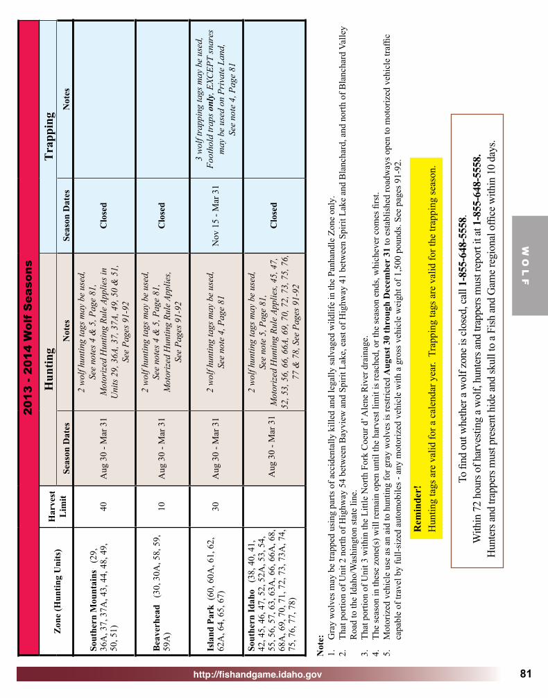
http://fishandgame.idaho.gov
W O
L F
81
2013
- 20
14 W
olf
Sea
sons
Zon
e (H
untin
g U
nits
)H
arve
st
Lim
itH
untin
gT
rapp
ing
Seas
on D
ates
Not
esSe
ason
Dat
esN
otes
Sout
hern
Mou
ntai
ns
(29,
36
A, 3
7, 3
7A, 4
3, 4
4, 4
8, 4
9,
50, 5
1)40
Aug
30
- Mar
31
2 w
olf h
untin
g ta
gs m
ay b
e us
ed,
See
note
s 4 &
5, P
age
81,
Mot
orize
d H
untin
g Ru
le A
pplie
s in
Uni
ts 29
, 36A
, 37,
37A
, 49,
50
& 5
1,
See
Page
s 91-
92
Clo
sed
Bea
verh
ead
(30
, 30A
, 58,
59,
59
A)
10A
ug 3
0 - M
ar 3
1
2 w
olf h
untin
g ta
gs m
ay b
e us
ed,
See
note
s 4 &
5, P
age
81,
Mot
orize
d H
untin
g Ru
le A
pplie
s, Se
e Pa
ges 9
1-92
Clo
sed
Isla
nd P
ark
(60,
60A
, 61,
62,
62
A, 6
4, 6
5, 6
7)30
Aug
30
- Mar
31
2 w
olf h
untin
g ta
gs m
ay b
e us
ed,
See
note
4, P
age
81N
ov 1
5 - M
ar 3
1
3 wo
lf tra
ppin
g ta
gs m
ay b
e us
ed,
Foot
hold
trap
s onl
y, E
XCEP
T sn
ares
m
ay b
e us
ed o
n Pr
ivat
e La
nd,
See
note
4, P
age
81
Sout
hern
Idah
o (
38, 4
0, 4
1,
42, 4
5, 4
6, 4
7, 5
2, 5
2A, 5
3, 5
4,
55, 5
6, 5
7, 6
3, 6
3A, 6
6, 6
6A, 6
8,
68A
, 69,
70,
71,
72,
73,
73A
, 74,
75
, 76,
77,
78)
Aug
30
- Mar
31
2 w
olf h
untin
g ta
gs m
ay b
e us
ed,
See
note
5, P
age
81,
Mot
orize
d H
untin
g Ru
le A
pplie
s, 45
, 47,
52
, 53,
56,
66,
66A
, 69,
70,
72,
73,
75,
76,
77
& 7
8, S
ee P
ages
91-
92
Clo
sed
Not
e:1.
G
ray
wol
ves m
ay b
e tra
pped
usi
ng p
arts
of a
ccid
enta
lly k
illed
and
lega
lly sa
lvag
ed w
ildlif
e in
the
Panh
andl
e Zo
ne o
nly.
2.
That
por
tion
of U
nit 2
nor
th o
f Hig
hway
54
betw
een
Bay
view
and
Spi
rit L
ake,
eas
t of H
ighw
ay 4
1 be
twee
n Sp
irit L
ake
and
Bla
ncha
rd, a
nd n
orth
of B
lanc
hard
Val
ley
Roa
d to
the
Idah
o/W
ashi
ngto
n st
ate
line.
3.
That
por
tion
of U
nit 3
with
in th
e Li
ttle
Nor
th F
ork
Coe
ur d
’ Ale
ne R
iver
dra
inag
e.4.
Th
e se
ason
in th
ese
zone
(s) w
ill re
mai
n op
en u
ntil
the
harv
est l
imit
is re
ache
d, o
r the
seas
on e
nds,
whi
chev
er c
omes
firs
t. 5.
M
otor
ized
veh
icle
use
as a
n ai
d to
hun
ting
for g
ray
wol
ves i
s res
trict
ed A
ugus
t 30
thro
ugh
Dec
embe
r 31
to e
stab
lishe
d ro
adw
ays o
pen
to m
otor
ized
veh
icle
traf
fic
capa
ble
of tr
avel
by
full-
size
d au
tom
obile
s - a
ny m
otor
ized
veh
icle
with
a g
ross
veh
icle
wei
ght o
f 1,5
00 p
ound
s. Se
e pa
ges 9
1-92
.
Rem
inde
r!H
untin
g ta
gs a
re v
alid
for a
cal
enda
r yea
r. T
rapp
ing
tags
are
val
id fo
r the
trap
ping
seas
on.
To fi
nd o
ut w
heth
er a
wol
f zon
e is c
lose
d, ca
ll 1-
855-
648-
5558
.W
ithin
72
hour
s of h
arve
sting
a w
olf,
hunt
ers a
nd tr
appe
rs m
ust r
epor
t it a
t 1-8
55-6
48-5
558.
Hun
ters
and
trapp
ers m
ust p
rese
nt h
ide a
nd sk
ull t
o a F
ish an
d G
ame r
egio
nal o
ffice
with
in 1
0 da
ys.

http://fishandgame.idaho.gov
W O
L F
82
Collared wolves provide important information about
wolves. Biologists rely on radio collars to track wolf movements, monitor wolf activity, assess population status and to help determine future hunting opportunity.
Hunters and trappers are required to return
any radio collar when they present the skull and hide to Fish and Game.
Attention Wolf Hunters:
A few precautions can help avoid conflicts with wolves and other large carnivores:
• After a big game animal is harvested, it is wise to retrieve and quarter the carcass immediately.
• If it must be left in the woods overnight, hang the meat if possible, or skin it and cover it with a breathable cloth game bag and leave articles of clothing at the site.
• When a carcass is retrieved, hang it between two trees, preferably 10 feet off the ground to keep animals from reaching it.
• Hang meat away from camp and stock so that if a large carnivore comes to investigate the scent, it does not scare stock.
• Hound hunters should look for recent wolf sign before turning dogs out on a bear or lion track.
• To prevent conflicts between hounds and wolves, some hound experts recommend that dogs be kept on a leash while tracking until the track gets fresh.
• Hounds should not be allowed to keep an animal treed for very long, as the sound of the hounds may attract wolves.
Hunter Tips to Avoid Conflicts with Carnivores
To find out whether a wolf zone is closed, call 1-855-648-5558.Within 72 hours of harvesting a wolf, hunters and trappers must report it at 1-855-648-5558.
Hunters and trappers must present hide and skull to a Fish and Game regional office within 10 days.
Wolves and other canids are known carriers of a parasitic tapeworm that is linked to hydatid disease in humans. Hunters are encouraged to wear rubber
gloves when skinning canids and avoid handling canid feces.

http://fishandgame.idaho.gov 83
Idaho’s Hunting Passport is a component of Fish and Game’s mentored hunting program. The
Hunting Passport allows any first-time hunter, resident or nonresident, age 8 and older to try hunting for one year with an adult mentor without first having to complete an Idaho hunter education course.
Hunting Passport Highlights:
• Hunting Passports are only available to first time hunters. Those that have previously held a hunting license in any state are not eligible.
• Hunter Education certification is not needed to obtain a Hunting Passport. If an individual has completed a Hunter Education course but has not yet purchased a license, they are eligible for a Hunting Passport.
• The minimum age to hold a Hunting Passport is eight years of age; there is no maximum age.
• The Hunting Passport is a calendar year item just like a hunting license and expires on December 31 of the year in which it was obtained.
• Only one Passport can be purchased in a lifetime. To continue hunting after the Passport expires, completion of a hunter education course and license purchase is required.
• Hunting Passports are available at license vendors and Fish and Game regional offices.
• Cost is $1.75.
fishandgame.idaho.gov
Hunting Passport
HUNTING
PASSPORT
Idaho
Fish and Game
There is simply no better way to introduce a new hunter to the safe, ethical and responsible aspects of hunting than with the close supervision of an adult mentor.
Photo provided by Tim Boyle

http://fishandgame.idaho.gov84
OBSERVATIONSIdaho Fish and Wildlife Information System’s
http://fishandgame.idaho.gov/ifwis/observations
RECORD AN OBSERVATIONSHARE YOUR IDAHO WILDLIFE EXPERIENCES

http://fishandgame.idaho.gov
Big G
ame R
ules
85
Big Game RulesGeneral Wildlife Laws
(For complete laws and rules, see Idaho laws and administrative code http://www.state.id.us/laws_rules/)
All hunters must have a valid Idaho hunting license and the appropriate tags or permits in their possession while
hunting. Hunting Hours: Big game animals may be hunted only from one-half hour before sunrise to one-half hour after sunset.
Definition of Hunting: Hunting means chasing, driving, flushing, attracting, pursuing, worrying, following or on the trail of, shooting at, stalking, or lying in wait for any wildlife whether or not such wildlife is then subsequently captured, killed, taken or wounded.
Age Limit: Only properly licensed youths 12 or older may hunt big game, except an 11-year-old may buy a license to apply for a controlled hunt permit, but he or she must be 12 years old at the time of the hunt. A youth small game license available for hunters of age 10 and 11 is not valid for big game.
Bag and Possession Limits: A hunter may harvest only as many of a big game animal species as he or she has legal tags for in that year. Any animal harvested in a depredation hunt before a controlled hunt in the same unit for which the hunter holds a tag must be included under the limit and tagging rules of the controlled hunt permit. No person may take more than one animal per year during a controlled hunt season by using both a controlled hunt tag and a depredation tag.
Gifts of Wildlife: No person may possess more game animals, birds or fish taken within the state than allowed by personal possession limits.
Mandatory Report Requirements: All deer, elk and pronghorn hunters are required to complete a Mandatory Hunter Report for each tag they purchase. In 2010, mandatory hunter reporting moved to an entirely paperless system. Hunters are required to submit a report by phone or internet within 10 days after harvest. Hunters who do not harvest, or did not hunt with their tag, are required to report within 10 days after the close of the hunting season.
The best way to submit hunt information and the only way to get confirmation that the report was received is to report online. Go to: http://fishandgame.idaho.gov.
To submit by phone to a live operator, 24 hours a day, seven days a week call toll free 1-877-268-9365 or 1-800-824-3729.
Waste of GameHunters are required to remove and care for the edible meat of big game animals, except black bears, mountain lions and gray wolves. This includes the meat from hind quarters as far down as the hock, meat of the front quarters as far down as the knee and meat along the backbone which is the loin and tenderloin. It does not include meat of the head or neck, meat covering or between the ribs, internal organs, or meat on the bones after close trimming.
Wounding and RetrievingNo person shall wound or kill any big game animal without making a reasonable effort to retrieve it and reduce it to possession. It is unlawful to enter private property that is posted, cultivated or in irrigated pasture without landowner permission to retrieve game.
Electronic CallsNo electronic calls may be used to attract big game for the purpose of harvest, except such calls may be used to attract mountain lions, black bears and gray wolves in seasons where approved by Commission proclamation.
It is Unlawful To:• Hunt or take any wildlife without a valid hunting license,
or without required tag or permit in possession.
• Party hunt or help fill another person’s tag.
• Shoot from or across the traveled portion, shoulders or embankments of any road maintained by any government entity.
• Hunt big game or game birds from or by the use of any motorized vehicle, except for holders of a valid handicapped person’s Motor Vehicle Hunting Permit when vehicle is stopped and off public roadways. See Upland Game, Furbearer and Turkey Seasons and Rules brochure for other exceptions.
• Use any motorized vehicle to molest, stir up, rally or drive any game animal or game bird.
• Operate or use as an aid to hunting a motor vehicle in violation of area, trail, or road restrictions.
• Use aircraft to locate game or furbearing animals and communicate location to persons on the ground, or to use any helicopter to transport hunters, gear, or game except at established landing fields.
• Fail to stop – with or without fish or wildlife – at any Fish and Game check station encountered, even if your hunting, fishing or trapping activity occurred outside of Idaho.
• Fail to produce wildlife for inspection upon request of a conservation officer or other person authorized to enforce Idaho Fish and Game rules.
• Hunt any wildlife species with the aid of artificial light, except predatory and unprotected wildlife, see page 87. Permit required from Idaho Fish and Game Regional office. See furbearer rules in Upland Game, Furbearer & Turkey Seasons and Rules brochure for specific regulations and other exceptions.
• Hunt big game with dogs except for black bears and mountain lions. See page 89 for details.

http://fishandgame.idaho.gov
Big
Gam
e R
ules
86
• Transfer any license, tag, or permit or use another’s license, tag, or permit.
• Acquire more controlled hunt tags per species than allowed by Commission rule.
• Destroy or disturb traps, or remove any wildlife from traps belonging to others.
• Enter Idaho with livestock without a health certificate for transport and a brand inspection slip.
• Intentionally interfere with the lawful taking of wildlife or lawful predator control by another.
• Hunt any game animal by means of baiting with the exception of applicable rules for the black bear baiting permit (See pages 70 and 71). Bait is defined as any substance placed to attract game animals, except liquid scent for deer and elk.
• Take big game with the aid of radio telemetry; use of telemetry equipment with hounds or other sporting dogs is allowed.
Areas Closed to Big Game Hunting:• All state parks, except Farragut State Park and Farragut
Wildlife Management Area, and Billingsley Creek Unit of Thousand Springs State Park, Castle Rock State Park and the City of Rocks National Reserve are open to all hunting.
• Part of the Craters of the Moon National Monument is closed to hunting. For information visit: http://www.nps.gov/crmo/planyourvisit/upload/CRMO-Hunting.pdf
• Nez Perce National Historical Park in Clearwater, Idaho and Nez Perce counties.
• Harriman State Park Wildlife Refuge.
• That portion of Ada County between State Highway 21, Warm Springs Avenue, and the Boise City limits.
• Yellowstone National Park in Fremont County.
• State designated wildlife preserves (Myrtle Creek, David Thompson, and Lewiston).
• State wildlife management areas, bird preserves, bird refuges, and bird sanctuaries that have been closed to hunting by legislative or commission action.
• All or portions of national wildlife refuges, except as specified in federal regulations for individual refuges.
• All Snake River islands between Glenns Ferry bridge and Sailor Creek bridge in Elmore County.
• Hagerman Fossil Beds National Monument in Twin Falls County, except that portion within an area 50 feet above the high water level of the Snake River. The upslope area is marked by yellow fiberglass markers, and hunting is permitted downslope to the river.
• Mountain lions and gray wolves may not be hunted or pursued within one-half mile of any active Idaho Fish and Game big game feeding site.
• Black bears and gray wolves may not be hunted or pursued within 200 yards of the perimeter of any designated dump ground or landfill.
Trespass LawNo person may enter private land to hunt, fish or trap or retrieve wildlife without permission if the land is either cultivated or posted with legible “No Trespassing” signs. Proper posting means either signs, 100 square inches of fluorescent orange paint, or an entire fluorescent orange metal fence post every 660 feet around the property and at reasonable access points.
Land that has been loosened or broken up in preparation for raising crops, used for raising crops or as irrigated pasture is considered cultivated.
It is unlawful for anyone to post public land that is not held under an exclusive control lease. Conviction of trespass on posted private property for the purpose of hunting, trapping or fishing carries a mandatory one-year revocation of hunting, fishing or trapping licenses.
Federal law prohibits unauthorized trespass on Indian-owned reservation lands for hunting, fishing, or trapping purposes.
Using Blinds on Public Lands - BLMHunting blinds on public lands managed by the Bureau of Land Management must meet the following criteria:
1. Construction materials – Portable pop-up blinds are encouraged. No permanent placement of materials is allowed, and all materials must be removable. Wire mesh, which may be hazardous to wildlife or livestock, is not allowed. Damage to natural and cultural resources by actions such as digging, trenching or other surface disturbances is prohibited. Cutting live vegetation to build, screen or camouflage blinds is discouraged.
2. Labeling – The hunter’s full name and ZIP code must be permanently attached, etched, engraved or painted on the blind in an obvious location.
3. Placement dates – Blinds may be placed no earlier than 10 days before the beginning of the hunting season for which the hunter has a valid tag, and must be removed within seven days of the close of that hunting season.
4. Right of use – Blinds may be used by hunters on a first-come, first-served basis. Placement of a blind on public land does not create an exclusive right of use. Locking blinds is not allowed. Please be respectful of other hunters’ blinds.
5. Wildlife or livestock developments – Diverting water, tampering with or modifying rangeland developments, such as watering troughs, reservoirs, springs, fences, or related structures or water sources, is prohibited. Hunters may not harass livestock or impede their access to water sources.
For more information, please contact the nearest BLM office.
Closed Seasons: There is no open season for caribou, bison (buffalo), grizzly bear or lynx. With the exception of bison, these species are protected under the Endangered Species Act.

http://fishandgame.idaho.gov
Big G
ame R
ules
87
Furbearers: Bobcats, badgers and red foxes are classified as furbearers and may be hunted or trapped only during the furbearer season. No open season exists for lynx, wolverines or fishers. See upland game and trapping rules.
Possession and Sale of Wildlife Parts: Lawfully harvested wildlife parts – except edible meat from game animals – may be purchased, bartered or sold when accompanied by a written statement showing said wildlife was lawfully harvested. If black bear, mountain lion or gray wolf parts – excluding tanned or finished rugs or mounts – are sold or bartered, a signed written statement showing the taker’s name, address, license and tag numbers, date and the location of kill must be provided to the buyer. Buyers must submit completed transaction statements to Idaho Fish and Game within 10 days of sale.
Wildlife parts legally harvested outside of Idaho may be possessed and sold in Idaho if such sale is not prohibited in Idaho or the state, province or country where harvested, or by federal law.
It is unlawful to possess any wildlife or parts that were killed, taken or obtained unlawfully.
Possession and Sale of Wildlife Found Dead: Protected species of wildlife that have died of natural causes are considered property of the state and may not be possessed. Big game animal parts, such as hides, horns – except horns from bighorn sheep – bones, antlers and teeth, of deer, elk, moose, pronghorn, mountain goat, black bear, mountain lion and gray wolves that have died of natural causes, including legally salvaged road kill, may be recovered, possessed, purchased, bartered, sold or transferred. If sold, black bear and mountain lion parts must be accompanied by documentation on how they were obtained.
Legally salvaged road kill may not be used as bait for hunting or trapping, except in the Panhandle wolf management zone where it may be used as bait in trapping wolves only.
Edible meat from game animals taken from the wild may not be purchased, bartered or sold.
Recovery, Possession and Sale of Bighorn Sheep Horns: Horns from bighorn sheep that have died of natural causes may be recovered and possessed. All bighorn sheep horns must be presented to Fish and Game for marking with a permanent pin within 30 days of recovery. It is unlawful to sell, barter or purchase bighorn sheep horns obtained under these circumstances, or to transfer ownership of recovered bighorn sheep horns without a permit from Idaho Fish and Game.
Predatory and Unprotected Wildlife: Coyotes, skunks, weasels, jackrabbits, raccoons and starlings are classified by Idaho law as predatory. Eurasian collared-doves, English sparrows and feral pigeons are unprotected. Predatory and unprotected wildlife may be taken in any number year-round and at any time by holders of the appropriate valid Idaho hunting or trapping licenses, provided such taking is not in violation of state, county or city laws, ordinances, rules or regulations.
Protected Nongame and Threatened or Endangered Species: No person shall take or possess wildlife species classified as Protected Nongame or Threatened or Endangered at any time or in any manner, except as provided in Sections 36-106(e)5 and 36-1107, Idaho Code, by Commission Regulation, or IDAPA 13.01.10.100.06b.
Livestock Health Certificate Requirement: Anyone bringing livestock or hunting dogs into the state should call the Idaho Department of Agriculture, 208-332-8540, for health certificate requirements.
Weed-Free Hay Requirement: On national forest lands or Idaho Fish and Game wildlife management areas, anyone using pack animals or straw in their camp must use only weed-free certified hay, forage or straw to prevent the spread of noxious weeds. To obtain an up-to-date list of local growers and vendors with noxious weed-free certified forage for sale, call the Department of Agriculture at 208-332-8592, or check: http://www.idahoag.us/Categories/PlantsInsects/NoxiousWeeds/nwffs.php. For more information on the Noxious Weed-Free Forage certification program visit: http://www.idahoag.us/Categories/PlantsInsects/NoxiousWeeds/indexnoxweedmain.php.
Prescribed Burning: Prescribed burning uses fire to restore forests and rangelands and improve conditions for wildlife. Prescribed fire may be planned in your hunting unit. Stay informed. Contact your local land management agencies.
Wildlife Violator CompactMany states including Idaho have entered into a “Wildlife Violator Compact.” If your hunting, fishing, or trapping license is revoked by any of the member states, all the remaining states will revoke the same license or privilege for the same time period. In addition, any nonresident who does not satisfy the requirements of an Idaho citation will have his or her hunting and fishing license revoked in their home state until those requirements are satisfied. For information on the Compact and a list of member states, go to http://fishandgame.idaho.gov.
Boundary Waters Reciprocal AgreementThe Oregon-Idaho boundary water reciprocal agreement recognizes the legal right to fish, hunt or trap in the waters or on the islands of the Snake River where said river forms the boundary line between the state of Oregon and the state of Idaho by the holder of either a valid Oregon or Idaho license in accordance with the laws and rules of the respective state.

http://fishandgame.idaho.gov
Big
Gam
e R
ules
88
Weapon Restrictions Rifle and ShotgunIn any hunt, including any-weapon seasons, it is unlawful to pursue or kill big game animals:• By any means other than approved firearms, muzzleloaders
and archery methods.• With any electronic device attached to, or incorporated
on, the firearm or scope; except scopes containing battery powered or tritium lighted reticles are allowed.
• With any firearm that, in combination with a scope, sling and/or any attachments, weighs more than 16 pounds.
• With any fully automatic firearm.• With any shotgun using shot smaller than #00 buck.• With any rimfire rifle, rimfire handgun, or muzzle-loading
handgun, except for mountain lions or legally-trapped gray wolves.
Short Range WeaponsIn big game seasons restricted to short-range weapons, it is unlawful for hunters to use any weapon other than a muzzleloader, archery equipment, crossbow, a shotgun using slugs or shot of size #00 buck or larger, or a handgun using straight-walled cartridges not originally developed for rifles.
Muzzleloader Caliber RequirementsIn any hunt, including general any-weapon seasons and short-range hunts, it is unlawful to pursue or kill big game animals with any muzzleloading rifle or musket that is less than .45 caliber for deer, pronghorn, mountain lion or gray wolf; or is less than .50 caliber for elk, moose, bighorn sheep, mountain goat or black bear.Muzzleloader Only SeasonAny person hunting in a muzzleloader only season, including controlled hunts, must have in their possession a license with a muzzleloader permit validation. During a muzzleloader-only season, it is illegal to pursue or kill a big game animal with any firearm, muzzleloading pistol, or weapon other than a muzzleloading rifle or musket. In addition, the muzzleloading rifle or musket must be:• Capable of being loaded only from the muzzle.• Equipped with only open or peep sights. Scopes and any
electronics are prohibited. Except hunters with a visual disability may apply for a permit to use nonmagnifying scopes. (Applications are available at Fish and Game offices.)
• Loaded only with loose black powder, loose Pyrodex, or other loose synthetic black powder. Pelletized powders are prohibited.
• Equipped with a single or double-barrel.• Loaded with a projectile that is within .010 inch of the bore
diameter. Sabots are prohibited.• Loaded with a patched round ball or conical non-jacketed
projectile comprised wholly of lead or lead alloy.
• Equipped only with a flint, percussion cap or musket cap. 209 primers are prohibited.
• Equipped with an ignition system in which any portion of
the cap is exposed or visible when the weapon is cocked and ready to fire.
For additional information about muzzleloader equipment visit our website at http://fishandgame.idaho.gov/public/hunt/rules/?getPage=299
Archery EquipmentIn any hunt, including general any-weapon seasons and short-range hunts, it is unlawful to pursue or kill big game animals:• With arrows or bolts having broadheads measuring less
than 7/8 inch in width and having a primary cutting edge less than 0.015 inch thick.
• With any bow having a peak draw weight of less than 40 pounds up to or at a draw of 28 inches or any crossbow having a peak draw weight of less than 150 pounds.
• With an arrow or bolt wherein the broadhead does not precede shaft and nock.
• With any chemicals or explosives attached to the arrow or bolt.
• With arrows or bolts having expanding broadheads.• With arrows or bolts having barbed broadheads, which is
a broadhead with any portion of which forms an angle less than 90 degrees with the shaft or ferrule.
• With any electronic or tritium-powered device attached to an arrow, bolt or bow. Except disabled archery permit holders may use a nonmagnifying sight with battery powered or tritium lighted reticles.
• With any bow capable of shooting more than one arrow at a time.
• With any compound bow set at more than 85 percent let-off.
• With an arrow or bolt, and broadhead with a combined total weight of less than 300 grains.
• With an arrow less than 24 inches from broadhead to nock inclusive.
• With a bolt (crossbow) less than 12 inches from broadhead to nock inclusive.
Archery Only SeasonAny person hunting in an archery only season, including controlled hunts, must have in their possession their license with archery permit validation. During an archery-only season, it is illegal for hunters to use any firearm or implement other than a longbow, compound bow or recurve bow in compliance with general archery equipment requirements, or:• Any bow equipped with magnifying sights.• Any device that holds a bow at partial or full draw.
Except hunters possessing a disabled archery permit may use a device that holds a bow at partial or full draw. (Applications for the use of devices holding a bow at partial or full draw by disabled hunters are available at Fish and Game offices.)
• Any crossbow. Except disabled hunters possessing a permit may use a crossbow. (Applications for the use of crossbows by disabled hunters are available at Fish and Game offices.)

http://fishandgame.idaho.gov
Big G
ame R
ules
89
Photo courtesy Kade Barfuss
Hound Hunting RulesDogsDogs may be used to pursue black bears or mountain lions in either an open take season where use of dogs is allowed, or during a dog training season open for bear or mountain lion. Pursuit is allowed regardless of whether a black bear or lion already has been harvested. During a dog training season, black bears or lions may be pursued and treed, but may not be captured, killed, or possessed. Dogs may not be used to take or pursue any other big game species.
Any dog found running at large and actively tracking, pursuing, harassing, attacking or killing any big game animal, except black bear and mountain lion, may be destroyed without criminal or civil liability by the director of Fish and Game, any peace officer, or other persons authorized to enforce Idaho wildlife laws.
The use of one blood-trailing dog controlled by leash during lawful hunting hours and within 72 hours of hitting a big game animal is allowed to track wounded animals and aid in recovery. A hound hunter permit is not required.
Hound Hunter PermitWhen dogs are being used to hunt black bears or mountain lions, the following persons must have a valid hound hunter permit and a black bear or mountain lion tag for the current year in possession:
• Anyone who owns pursuit dogs.
• Anyone having control of dogs owned by another person.
• Anyone who harvests a black bear, mountain lion, bobcat, raccoon, or fox with the use of dogs. Except, clients of licensed outfitters are not required to have a hound hunter permit.
Resident hound hunter permits may be obtained from any license vendor. There is no limit on the number of resident hound hunter permits.
Limitation on hound hunter permits for nonresidents: Nonresidents hound hunter permits applications must be received at Fish and Game headquarters office by December 1. Permits for the following year are issued in December. Applications are available on the Fish and Game website. No more than 70 nonresident hound hunter permits will be issued to nonresident hunters who are not licensed outfitters (see exceptions for Middle Fork and Selway zones). Nonresident outfitters and guides who have obtained a hound hunter permit shall not use the permit for personal hunting. Sales of nonresident hound hunter permits to the following persons shall not be counted in the quota for nonresidents:
• Persons who have moved into Idaho and by notarized affidavit show proof of their intent to become bona fide Idaho residents but are not yet qualified to buy a resident license.
• Middle Fork Zone: Persons who hound hunt solely in game management units within the Middle Fork elk zone (Units 20A, 26, and 27).
• Selway Zone: Persons who hound hunt solely within the Selway Zone (Units 16A, 17, 19, and 20). A total of 40 permits will be issued for Units 16A, 19, 20, and all of Unit 17, excluding Hunt Area 17-1 which will have 6 permits. Hunt Area 17-1 is defined as that portion of Unit 17 south of the following boundary:
Beginning at the junction of the Unit 17 boundary and Forest Service Trail 24, then west along Forest Service Trail 24 to the Selway River, then north along the Selway River to Forest Service Trail 40, then southwest along Forest Service Trail 40 to Forest Service Trail 3, then west along Forest Service Trail 3 to the Unit 17 boundary.
Hound Hunter Alert: Selway and Middle Fork zones are wilderness areas. Vehicle access is restricted and rugged terrain can make pursuit extremely difficult. Contact the local Forest Service office for maps showing trails and access. Wolves may be present in any game management unit.
Tagging and Transporting GameProper Tagging and Transportation of Animals and MeatImmediately after any deer, elk, pronghorn, black bear, mountain lion, or gray wolf has been killed, the hunter harvesting the animal must comply with the following regulations regarding the proper tagging, transportation and shipment of a carcass:
• The appropriate big game tag must be validated and securely attached to the animal immediately after the kill. The validated tag must remain attached to the carcass until the meat is processed and reaches the place of final storage or personal consumption.
Note: Immediately after the kill, the triangles denoting the month and day must be cleanly and completely removed. Tearing, slicing or punching the tag is not legal.

http://fishandgame.idaho.gov
Big
Gam
e R
ules
90
PROXY STATEMENT (To transport wildlife taken by another person)
Species(Circle) Sex
Description (e.g.: antler points,wrapped, hind quarter,
etc.)
Unit/Hunt Area Kill Location Days
HuntedDate
Killed
ElkMule DeerWhitetail
PronghornBlack BearMtn Lion
Gray WolfMooseOther
OTHER FISH/GAME:Species ________________________________________ How many ____________________________________Species ________________________________________ How many ____________________________________Hunter/Angler’s Name _____________________________ Signature _____________________________________Address ________________________________________ Phone _______________________________________License No. _____________________________________ Tag No. ____________ Permit No. _______________Guided (circle) YES NO Outfitter Name ____________ Method (circle) STILL/STALK INCIDENTAL PRED. CALL
Weapon (circle) RIFLE MUZZLELOADER SHOTGUN HANDGUN OTHER BAIT HOUNDS OTHER ______________
Name of person transporting ________________________ Phone _____________
Proper location of tag:• Deer, elk and pronghorn: Attach to the largest
portion of the carcass.
• Black bears, mountain lions or gray wolves: Attach to the hide.
Any license, tag or permit that is defaced or altered is invalid from the date and time of issue. It is unlawful to use or attempt to use any license that has been defaced or altered.
Transportation issues:Any person who transports any wildlife for another person or receives any wildlife for cleaning, processing, as a gift, or for storage must have a written proxy statement signed by the person who killed the animal specifying the numbers and kinds of wildlife, date taken, hunter’s name and address, license, tag and permit numbers. The proxy form below is provided for your convenience.
Hunters must completely remove two notches indicating month and day of kill.
VOID
How to Properly Validate a Big Game Tag.

http://fishandgame.idaho.gov
Big G
ame R
ules
91
Preserving Evidence of Sex:Deer, elk and pronghorn: If the head or antlers are removed, evidence of sex in the form of testicles, penis, scrotum, udder or vulva must remain naturally attached to the carcass or parts thereof on all harvested big game animals until they reach the final place of storage or personal consumption, or a commercial meat processing facility.
Antlers or horns removed from the head must be left naturally attached to the skull plate where point or brow-tine restrictions apply, and they must accompany the carcass or parts thereof.
Black bears, mountain lions and gray wolves: External evidence of sex in the form of testicles, penis, scrotum or vulva must be left naturally attached to the hide until the mandatory check requirement has been satisfied.
In seasons restricted to mule deer only or white-tailed deer only, if the head is removed, the fully-haired tail must be left naturally attached to the carcass until it reaches the final place of storage or personal consumption, or a commercial meat processing facility.
Roads, Trails, Motor Vehicles and Wildlife
What You Need to KnowMotor vehicles, from pickups and SUVs to motorcycles and ATVs, have changed hunting and some of those changes have created challenges for hunters, land managers and wildlife. Consider the following:
• Roads that are open to motor vehicles increase access into big game habitat, and, as a result, the number of hunters increases. Generally, the number of hunters in an area is directly related to the number of roads.
• The combination of more hunters and their increased mobility in roaded areas increases the vulnerability of deer and elk to harvest. Deer and elk in a heavily roaded area are more likely to be killed during the hunting season, and for that reason these areas have fewer old bulls or bucks. It also means that hunting seasons have to be shorter to prevent over harvest.
• Research shows that slow moving vehicles on primitive roads and trails are more disturbing to elk than fast moving vehicles on highways. Slow moving vehicles traveling cross-country have the same effect. Deer and elk often flee from the sound of motor vehicles and may leave the area.
• Cross-country travel with motor vehicles can create a network of new travel ways that cause erosion, spread noxious weeds, and damage fish and wildlife habitats. Much of this cross-country travel occurs during the hunting season. To reduce these impacts, Idaho’s land and wildlife managers ask all hunters using motorized vehicles to stay on roads and trails and use designated routes where they are established. Do not travel cross-country with a motor vehicle.
Look for Designated Routes on Public Lands• The U.S. Forest Service and Bureau of Land Management
have already established designated routes in several areas of Idaho. Please pay attention to the travel system in the areas you hunt.
For more information about travel management on Idaho’s Federal lands, contact these offices or websites:
• U.S. Forest Service 208-373-4007 website: www.fs.fed.us.
• Bureau of Land Management 1-888-246-7523 or 208-373-4000 or website: www.id.blm.gov
• Idaho Department of Parks and Recreation online mapping application: http://trails.idaho.gov
Access management helps wildlife and hunters. Please observe established road closures and access restrictions. Report road closure violations by calling 1-800-632-5999, or any Idaho Fish and Game, BLM or U.S. Forest Service office.
Motor Vehicle UseWisely managing roads, trails and motor vehicles will:
• Yield more old bucks and bulls.
• Permit more hunting opportunity.
• Allow longer seasons.
• Decrease erosion.
• Reduce conflicts.
• Reduce damage to habitat and the spread of noxious weeds.
Best of all, it will make hunting better.
Remember!• Observe road closures and access restrictions.
• Say no to cross-country travel.
• Stay on roads and trails open to motorized travel.
• Use designated routes where they’re established.
• Follow Idaho’s Motorized Vehicle Restriction Rule.
Motorized Hunting RuleTo resolve many hunters’ concerns about off-road travel, the Fish and Game Commission has adopted restrictions on motor vehicle use while hunting big game. The restricted units are: 29, 30, 30A, 32, 32A, 36A, 37, 37A, 45, 47, 49, 50, 51, 52, 52A (muzzleloader hunt only), 53, 56, 58, 59, 59A, 66, 66A, 69, 70, 72 (late season), 73, 75, 76, 77, and 78.
Motorized Hunting RestrictionsThe use of motorized vehicles by hunters as an aid to hunting big game animals is restricted in certain areas. This use restriction is in addition to all federal, state and local laws, rules, regulations, ordinances and orders; including, but not limited to, any motorized vehicle licensing, registration, and permitting requirements and traffic laws. Hunters must comply with all motorized vehicle limits or prohibitions instituted by the landowner or land manager. Also, this use restriction rule

http://fishandgame.idaho.gov
Big
Gam
e R
ules
92
is not an exception from, and is in addition to, the statutory prohibition against hunting from or by the use of any motorized vehicle set forth in Idaho Code Section 36-1101(b)(1).
Use Restriction. In designated areas and hunts, hunters may use motorized vehicles only on established roadways that are open to motorized traffic and capable of being traveled by full-sized automobiles. Any other use by hunters is prohibited. All off-road use by hunters is prohibited.
Exceptions. This use restriction rule shall not apply to the following permissible motorized vehicle uses:
a. Holders of a valid Handicapped Person’s Motor Vehicle Hunting Permit may use a motorized vehicle as allowed by the land owner or manager.
b. Hunters may use a motorized vehicle to retrieve downed game if such travel is allowed by the land owner or manager.
c. Hunters may use a motorized vehicle to pack camping equipment in or out if such travel is allowed by the land owner or manager, but hunters may not hunt while packing camping equipment.
d. Private landowners, their authorized agents and persons with written landowner permission, may use a motorized vehicle on their private land, but they may not hunt from or by the use of any motorized vehicle.
Restricted Areas and HuntsThis motorized vehicle use restriction applies to identified areas and hunts in all big game management units. Hunts and areas with a motorized vehicle use restriction are identified in each big game season and rules brochure.
Defined Termsa. A full-sized automobile is any motorized vehicle with a
gross weight in excess of 1,500 pounds.
b. An established roadway is as any road built, maintained, approved or designated by any government entity or private landowner for the purpose of travel by full-sized automobiles. An established roadway shows evidence of repeated use by full-sized automobiles, and may include a traveled way of natural earth with depressed wheel tracks and little or no vegetation in the tracks.
c. A hunter is a person engaged in the activity of hunting as defined in Idaho Code Section 36-202(j). “Hunting” means chasing, driving, flushing, attracting, pursuing, worrying, following after or on the trail of, shooting at, stalking, or lying in wait for, any wildlife whether or not such wildlife is then or subsequently captured, killed, taken, or wounded. Such term does not include stalking, attracting, searching for, or lying in wait for, any wildlife by an unarmed person solely for the purpose of watching wildlife or taking pictures thereof.
Owyhee WildernessThe Omnibus Public Lands Management Act of 2009 designated 517,000 acres of public lands in Owyhee County in southwestern Idaho as Wilderness. Please be aware of the wilderness boundaries and regulations. For more information see: http://www.blm.gov/id/st/en/prog/blm_special_areas/wilderness.html.
• Possession and transportation of big game without evidence of sex – evidence of sex must be naturally attached to the carcass or largest portion of meat if boned. See page 91.
• Possession and transportation without proxy statement – a proxy statement is required to transport wildlife taken by another person. See page 90.
• Failure to properly validate and attach tag to big game. Tag must be validated and attached to the carcass immediately following a kill. See page 90.
• Failure to stop and report at a check station. All hunters, with or without game, must stop and report at each check station they encounter during their travel to and from their designated hunting location.
• Shooting from or across public highway right of way. This is a public safety issue for both the shooter and people traveling on the highway.
• Hunting or taking game in a closed season. It is the hunter’s responsibility to know season opening and closing dates, what species and sex may be taken and hunt boundaries.
• Wrong Class License. A hunter or angler is required to purchase and possess the correct class of license. See page 113 for residency requirements.
• Transfer of license or tag to another. Party hunting or killing an animal for somebody else to put their tag on is illegal.
Most Common Hunting Violations:

http://fishandgame.idaho.gov
Big G
ame R
ules
93
HIGHWAY RIGHTS-OF-WAYS
FAVORITE
TRAILHEADNational Forest
MT IDAHO
roadway gravel barrow
RIGHTS-OF-WAY
RIGHTS-OF-WAY
Highway rights-of-way: the entire width between the boundary lines of every highway publicly maintained when any part is open to the use of the public for vehicular travel, the jurisdiction extending to the adjacent property line, including sidewalks, shoulders, berms and rights-of-ways not intended for motorized traffic. No person shall shoot from a public highway or discharge any firearm from or across a public highway.
Special Vehicle Restrictions: State and federal agencies and private landowners have established road closures in key big game areas to protect deer and elk populations. Please check with regional Idaho Fish and Game, Forest Service or Bureau of Land Management offices for information regarding vehicle restrictions on roads, trails, and unroaded areas.

http://fishandgame.idaho.gov
Con
trol
led
Hun
ts, S
peci
al H
unts
, Tag
s an
d P
erm
its
94
Controlled Hunts, Special Hunts, Tags and Permits
What is a Controlled Hunt?It is a hunt with a limited number of tags in a specific area for a specific species. It is like a general season, but the number of hunters is limited. Controlled hunts are often desirable because of location and timing, and success rates are usually higher than general season hunts. Controlled hunt tags are allocated by a random drawing. Any hunter with a valid Idaho hunting license may apply, with some restrictions. The odds of drawing a tag depend on the number of other applicants and the number of tags available. To participate in a controlled hunt, a hunter must have a hunting license. The hunter also must buy a tag for the hunt in which he or she was drawn.
To apply, see instructions on page 95. Controlled hunt applications may be submitted at any hunting and fishing license vendor, Fish and Game office, with a credit card by calling 1-800-55HUNT5 or online at http://fishandgame.idaho.gov.
(Rules for moose, bighorn sheep and mountain goat controlled hunts are covered in their own brochure.)
Eligibility: Any person with a valid Idaho hunting license may apply, subject to the following restrictions:
• Holders of a nongame hunting license may not apply for any controlled hunt.
• A person who has applied for a bighorn sheep, mountain goat, or moose controlled hunt may not apply for any other controlled hunt in the same year, except unlimited controlled hunts, a controlled black bear hunt, controlled turkey hunt, extra deer, extra elk, or extra pronghorn controlled hunts, or a designated depredation hunt. In addition, applicants for bighorn sheep, mountain goat or moose controlled hunts are eligible to participate in the second deer, elk and pronghorn application period and in first-come, first-served deer, elk and pronghorn controlled hunt tag sales.
• A person whose name was drawn in an antlered-only controlled deer hunt may not apply for any other controlled antlered-only deer hunt for one year except for the second deer, elk and pronghorn application period and leftover controlled hunt drawings or sales.
• For example, a hunter who drew a tag in an antlered-only deer hunt in 2012, cannot apply for another antlered-only deer hunt until 2014, in the first application period. However, they can apply for another antlered deer hunt in the 2013 season during the second application period.
• This waiting period also applies to antlered-only controlled elk hunts.
• There is no waiting period to apply for any other deer, elk, pronghorn or black bear controlled hunt tags. The one-year waiting period does not apply to controlled hunts with an unlimited number of tags or Landowner Appreciation tags.
Tags: No person may participate in any controlled hunt without a valid controlled hunt tag in their possession. Tags issued based on erroneous information are invalid, and may not be used. Fish and Game will notify the person if the tag has been invalidated. The person will remain on the drawn list, and if there is a waiting period in a succeeding year, the person will be required to wait the specified time period. Controlled hunt tags may not be exchanged for general season tags.
Any person whose name is drawn in a controlled hunt for deer or elk is prohibited from hunting in any other hunt for the same species (archery, muzzleloader or general), except when the hunter has been selected in a controlled extra tag or depredation hunt drawing, or has purchased a leftover nonresident general season tag for that species at the nonresident price.
Nonresident Tag Limitations: In controlled hunts with 10 or fewer tags, not more than one nonresident tag may be issued. In controlled hunts with more than 10 tags, except unlimited controlled hunts, not more than 10 percent of the tags may be issued to nonresidents. Note: If a resident applies for a controlled hunt on a group application with a nonresident, and the 10-percent nonresident limitation has been met, the entire group application will be rejected, including any residents.Restrictions:• Only one application per person or group will be
accepted for the same species, except a person may apply for one extra deer hunt and one extra elk hunt.
• Several applications may be submitted in a single envelope (see the controlled hunt worksheet, page 95) as long as each application is for a single species.
• Two, three or four hunters applying together for the same deer, elk or pronghorn controlled hunt is considered a group application.
• Two hunters applying together for the same black bear or turkey controlled hunt is considered a group application.
• If a group application exceeds the number of tags available in a hunt, that application will be rejected.
Youth only: Some controlled hunts are limited to youths only. Only hunters under 18 years of age with a valid license may apply for a youth-only hunt, except hunters 65 or older, or possessing a disabled combination license may buy a leftover youth-only controlled hunt tag, first-come, first-served, beginning at 10 a.m. Mountain Time, August 25.

http://fishandgame.idaho.gov
Controlled H
unts, Special H
unts, Tags and P
ermits
95
How Many Hunters Are Applying? (Single application for deer, elk, pronghorn, bear, moose, goat, sheep, or turkey)
(Group application for deer, elk, pronghorn, bear, moose, goat, sheep, or turkey)
(Group application for deer, elk, or pronghorn only)
(Group application for deer, elk, or pronghorn only)
NAME #1 Date of Birth LICENSE NUMBER
NAME #2 Date of Birth LICENSE NUMBER
NAME #3 Date of Birth LICENSE NUMBER
NAME #4 Date of Birth LICENSE NUMBER
1st Choice Hunt Number
Controlled Hunt Applicants: Use this form for one species application only. You may photocopy this form.
Yes No
2nd Choice Hunt Number
DESIGNATE $1 of FEE TO C.A.P?
(Citizens Against Poaching)
To Complete the Application Worksheet: Enter the complete hunt number of your first and second (optional) choice. Controlled hunt numbers are found in the left hand column of the controlled hunt tables. The hunt numbers are subject to change each year so be sure to use this 2013 Big Game Seasons brochure when applying for any deer, elk or pronghorn controlled hunt in 2013 or January 2014. The spring 2014 black bear controlled hunts are also listed in this brochure.
Each hunting license has an 11-digit number. Enter the complete hunting license number.
Group Applicants: Two hunters may apply on the same application for turkey, spring and fall black bear, moose, sheep, or goat. Up to four hunters may apply on the same application for deer, elk, or pronghorn.
Unreadable, Incomplete Applications: Any application that is unreadable, has incomplete or incorrect hunt or license numbers, or that lacks the required fee will be declared void and will not be entered in the drawing.
Any person desiring to change an application after it has been submitted may cancel it at a regional Fish and Game office or headquarters. You must pay all fees again when re-applying.
Application fee is Resident $6.25, Nonresident $14.75 per person per species.
Controlled Hunt Worksheet Application Application worksheets may be mailed, with proper fees, to any Fish and Game office, see page 10.
The main office is Idaho Department of Fish and Game, P. O. Box 25, Boise, ID 83707.
Application Instructions
Drawing results: It is the responsibility of the hunter to find out whether he or she was successful in drawing a controlled hunt.

http://fishandgame.idaho.gov
Con
trol
led
Hun
ts, S
peci
al H
unts
, Tag
s an
d P
erm
its
96
Controlled Hunt ApplicationApplications may be submitted electronically at any Fish and Game license vendor; made using a credit card by calling 1-800-55HUNT5 or on the Internet at http://fishandgame.idaho.gov. Application worksheets may be mailed, with proper fees, to any Fish and Game office (see page 10). The main office is Idaho Department of Fish and Game, P. O. Box 25, Boise, ID 83707.
Use the worksheet page 95 to speed up the application process. Fill in the blanks with your hunting license and controlled hunt numbers before you apply.
FeesApplicants for controlled hunts for deer, elk, pronghorn or black bear must submit a nonrefundable application fee with each application. The fee is $6.25 for each resident and $14.75 for each nonresident applicant for each species; $1 of this fee may be designated for the Citizens Against Poaching program.
A single payment, either cashier’s check, money order, certified check or personal check, may be submitted to cover fees for all applications in the same envelope when using the controlled hunt worksheet and applying by mail. If a payment is insufficient to cover fees, all applications will be voided.
Do not mail cash.Do not include tag fees with controlled hunt application.
Phone applications for controlled hunt drawings for deer, elk, bear or pronghorn may be processed by using Visa, MasterCard, or Discover cards, and calling: 1-800-554-8685. The charge for processing phone-in applications is 3 percent of the transaction plus $5.50, in addition to the nonrefundable application fee.
Internet applications may be made on the Fish and Game website at http://fishandgame.idaho.gov. Internet charge is 3 percent of the transaction plus $3.50, in addition to the nonrefundable application fee.
Drawing ResultsApplicant Notification: All successful applicants, except those applying for spring black bear, will be sent a post card at the address listed on their hunting license by July 10. Successful spring black bear applicants will be notified by mail no later than March 10. Results will also be available on the Fish and Game website, http://fishandgame.idaho.gov. Unsuccessful applicants will not be notified. It is the responsibility of the hunter to find out whether he or she was drawn.Successful applicants for deer, elk, fall black bear or pronghorn controlled hunts must purchase their controlled hunt tag not later than August 1, at any license vendor, Fish and Game office, through the Internet, or by telephone at 800-554-8685. Maps of controlled hunt areas are available at Fish and Game regional offices.
Applicants who already have a general season tag must return it to a Fish and Game office to be exchanged for the appropriate controlled hunt tag.
Nonresident hunting license holders who already have tags will be notified to send them in for exchange.
Lifetime license (Certificate) holders with nonresident tag privileges, who already have tags, will be notified to send them in for exchange.
Unclaimed Tags: All deer, elk or pronghorn controlled hunt tags not picked up by August 1 will be entered into a second controlled hunt drawing.
Leftover Controlled HuntsSecond drawings: To ensure everyone has equal opportunity at leftover and unclaimed controlled hunt tags, there will be two drawings for deer, elk, pronghorn and fall black bear hunts. All unclaimed tags, and all leftovers, (does not include unlimited hunts) will be available for a second drawing on August 20. The application period is from August 5 to 15.
Any tags left over after the second drawing will be sold first-come, first-served. The 10 percent nonresident limitation shall not apply. Applicants for a leftover tag must submit the application fee.Nonresident quotas and waiting period restrictions do not apply in the second drawing or leftover sales.
Leftover controlled hunt tags from the second deer, elk, pronghorn and fall black bear drawing go on sale August 25.Leftover controlled hunt tags for spring black bear go on sale April 1.
Mark your calendar for:• May 1 - June 5 – First deer, elk, pronghorn, fall bear
application period.• July 10 – Winners of first deer, elk, pronghorn drawing
notified by this date.• August 1 – Residents or nonresidents may buy a
leftover nonresident general season deer or elk tag at full nonresident price starting this day, as a second tag.
• August 1 – Last date to purchase tags from first deer, elk, pronghorn, fall bear drawing.
• August 5-15 – Second application period for deer, elk, pronghorn, fall bear.
• August 25 – Winners of second drawing for deer, elk, pronghorn, and fall bear will be notified by this date.
• August 25 – Leftover tags from second deer, elk, pronghorn, bear drawing go on sale at 10 a.m.
• Unsuccessful applicants may participate in general hunts where appropriate tags are available.

http://fishandgame.idaho.gov
Controlled H
unts, Special H
unts, Tags and P
ermits
97
Refunds and OverpaymentRefunds: Fees for hunting licenses will not be refunded to unsuccessful or ineligible applicants. Application fees for controlled hunts are not refundable.
Overpayments: Overpayment of fees of more than $5 will be refunded.
Overpayments of $5 or less will not be refunded and will be retained by Fish and Game.
Extra Deer and Elk HuntsAll controlled deer and elk hunt areas designated by an “X” are extra deer or elk hunts, usually for antlerless deer or elk. Hunters may apply for a regular controlled hunt and a controlled hunt designated for extra deer and elk tags on a separate application. For example, you may apply for a regular controlled hunt and send in a second controlled hunt application for an X hunt. Hunters also may buy a general deer and elk tag, and apply for an X hunt. If you draw a tag for an X hunt, you could harvest a deer or elk during the general season and a second deer or elk in the extra controlled hunt.
Unlimited huntsUnlimited hunts are controlled hunts in which only those who apply during the first controlled hunt application period can obtain a tag.
Special Hunts, Tags and PermitsDepredation HuntsSpecial controlled hunts are sometimes used to relieve big game damage problems on agricultural crops. If these hunts are needed, they will be held on short notice, involve small areas and be limited to a few hunters.
How Can I Participate? If you are an Idaho resident with a valid hunting or combination license, fill out the form on page 98 and mail it to the regional office in the area(s) you are willing to hunt. You, and a partner if you like, may apply for deer, elk, pronghorn, and black bear. However you may only apply once for each species, each year. You don’t need to apply for all four species in the same region. These forms may be copied if necessary.
All applications received before June 30 will be placed in random order. All applications received after June 30 will be placed at the end of the list in the order received. The list will be valid from July 1 to the following June 30.
What Are My Chances of Drawing A Depredation Hunt Tag?
Most regions issue only a handful of depredation tags each year. If a controlled antlerless or doe/fawn hunt is open or about to open in the depredation area, holders of those tags will be given the first option to participate in the depredation hunt. After antlerless or doe/fawn controlled hunts have ended, participants will be selected in order from the depredation hunt list.
Generally, applications received after June 30 have little chance of being selected.
Landowner Permission Hunts These hunts are a form of depredation hunts. They are established in areas with chronic depredation problems where depredation hunts are an annual occurrence. Do not apply for these hunts during the controlled hunt application period. Instead, Landowner Permission Hunt forms (a triplicate form provided by Fish and Game) are provided to landowners prior to the season or upon verifying a depredation problem that cannot be resolved by non-lethal means. Landowners can then provide the permission form to sportsmen. Landowners and sportsmen must fill out and sign their respective portions of the forms. Sportsmen must provide one copy of the form to the landowner and bring the remaining two copies to the Nampa, McCall, Jerome, Pocatello, Salmon or headquarters Fish and Game office where they can purchase their controlled hunt tag after July 15.
Idaho National Laboratory (INL) Elk and Pronghorn PermitA pass is required from the Idaho Fish and Game office, 4279 Commerce Circle, Idaho Falls, to hunt elk in the Lemhi, Beaverhead or Snake River Elk Zones or pronghorn in Units 51, 58, or 63 within one-half mile inside the north and east boundary of the Idaho National Laboratory, which is adjacent to agricultural land. Hunting of all other species on INL land is prohibited.
Landowner Appreciation Program TagsIdaho Code authorizes the Idaho Fish and Game Commission to establish a limited number of controlled hunt tags for landowners that provide important wildlife habitat values for deer, elk, or pronghorn. Landowner Appreciation Program (LAP) tags are made available, through a drawing process, in areas where hunting opportunity is limited to controlled hunts as partial recognition for landowners supporting wildlife and maintaining the hunting heritage. Landowners with at least 320 acres that provide significant habitat values for deer, elk or pronghorn are eligible to apply for any leftover tags after the first drawing. LAP tags are in addition to tags available in regular controlled hunts. In most cases, LAP tags are set at an additional 10 percent of the regular controlled hunt level. In a few areas, such as Units 40, 41, 42, 45, and 52, the Commission has authorized LAP tag levels at an additional 25 percent of regular controlled hunt levels for some species. Landowners registered in the program apply through a separate drawing held during June - July and may or may not successfully draw depending on the number of landowners applying and the number of tags available. If successful, a landowner may designate his or her tag to another individual.
Idaho state law prohibits selling or marketing landowner appreciation tags.For additional information concerning LAP, including land registration, application process, and landowner eligibility rules, visit the Fish and Game website at http://www.fishandgame.idaho.gov.

http://fishandgame.idaho.gov
Con
trol
led
Hun
ts, S
peci
al H
unts
, Tag
s an
d P
erm
its
98
2013 - 2014 DEPREDATION HUNT APPLICATION
1st Hunter __________________________________ Hunting license No. _______________________________Phone (Home) _______________________________ (Work) _________________________________________2nd Hunter __________________________________ Hunting license No. _______________________________Phone (Home) _______________________________ (Work) _________________________________________I/We are applying for (check one) q Deer q Elk q Black Bear q Turkey q Pronghorn Depredation HuntsGame Management Units Send To:1-7, 9 ........................................................................................ 2885 W. Kathleen Avenue, Coeur d’Alene, ID 838158, 8A, 10-19, 20 ...................................................................................................3316 - 16th St., Lewiston, ID 8350119A, 20A, 22-26, 31-35, 38-42 ............................................................3101 South Powerline Rd., Nampa, ID 8368643-49, 52-57 ...................................................................................324 South 417 East, Suite #1, Jerome, ID 8333866A, 68, 68A, 70-78......................................................................................... 1345 Barton Rd., Pocatello, ID 8320450, 51, 58-66, 67, 69 .........................................................................4279 Commerce Circle, Idaho Falls, ID 8340121, 21A, 27-30A, 36-37A ....................................................................................... P.O. Box 1336, Salmon, ID 83467Clip and mail to appropriate Regional Office, Idaho Department of Fish and Game, Attn.: Depredation Hunts.
Exchanging Deer or Elk Tags: Hunters may exchange general season elk tags for use in another zone at any Fish and Game office. Deer hunters may exchange a general season deer tag for a white-tailed deer tag at any Fish and Game office. The exchange must be completed before the first hunt opening date of the tag you currently possess. For elk general seasons with a tag quota, exchange must be made before the quota has been met. Only one exchange is allowed. A fee of $3.75 will be charged.
Resident Youth General Elk Tag
Resident youth elk hunters who purchase a general season elk zone tag while they are between ages 12 and 17, inclusive, may participate in any A or B tag elk season within the specified zone, regardless of whether they purchased an A tag or B tag. All other season, weapon restrictions, and commission rules apply. Controlled hunts are excluded.
Nonresident Deer, Elk Tag for Bear, Mountain Lion or Gray Wolf
Nonresident deer and elk tags, excluding Nonresident Junior Mentored deer or elk tags, are valid to take a black bear, mountain lion or gray wolf, if a season is open for that species, instead of a deer or elk where and when the deer or elk tag is valid, and there is an open deer or elk season in that same unit. Hunters may buy other bear, lion or wolf tags, but after the deer or elk tag is used to harvest a deer, elk, black bear, mountain lion, or gray wolf, a second deer or elk tag may not be purchased – except by buying a leftover nonresident deer or elk tag when available.
Resident Purchase of Nonresident Deer or Elk Tag
Residents or nonresidents may buy one unsold general season nonresident deer tag and/or elk tag at the nonresident price starting August 1, to be used as a second tag. This second nonresident general season deer or elk tag may also be used to tag a black bear, mountain lion or gray wolf instead of a deer.
Other Tag InformationNonresident Reduced Bear and Mountain Lion TagsIn the Lolo, Selway, or Middle Fork Zone units (Units 10, 12, 16A, 17, 19, 20, 20A, 26, and 27), and in that portion of Unit 16 north of the Selway River, nonresidents may use reduced bear or reduced mountain lion tags, available at the discounted price of $31.75. Reduced bear and reduced mountain lion tags are valid only in these units. To hunt bears and lions in any other unit, hunters must purchase a regular bear or lion tag at the regular price.
Hunters who have already purchased a bear or lion tag at the regular price will not get a refund to purchase a reduced tag.
Nonresident Tag Quotas: There is a quota on nonresident deer and elk tags. Quotas may be exceeded under the following conditions:
• Persons who have moved into Idaho and are establishing residency who can, by affidavit, show proof of their intent to become bona fide residents, but are not yet fully qualified to buy a resident license, may purchase a nonresident deer tag and nonresident elk tag through the headquarters or regional offices.
• Fish and Game may, upon receipt of an unused nonresident deer or elk tag and a notarized affidavit stating that the tag buyer has not hunted, issue an additional tag to provide a hunting opportunity within the nonresident hunter quota before the opening of the season for which the tag is valid as follows:
— To another nonresident designated by the buyer.
— If the buyer does not make a choice and has retained an outfitter or guide, the outfitter or guide may make the designation.
— If no designation is made by the above, Idaho Fish and Game may sell the replacement tag on a first-come, first-served basis. The designated buyer will pay the regular fee for the replacement tag.
Note: Nonresident tags may sell out early.

http://fishandgame.idaho.gov 99
HOW TO ORDER MAPS FOR YOUR HUNT UNIT(SAMPLE FOR UNIT 23)
Qty. Maps (list maps by name)
Price each Amount
1 Riggins 8.50 $ 8.501 Warren 8.50 $ 8.501 McCall 8.50 $ 8.50
Map Postage $ 2.50TOTAL $28.00
Ship to: ___________________________________________________________________________________________ _________________________________________________________________________________________________
Address: __________________________________________________________________________________________
City: __________________________________________ State: ___________ Zip Code: ________________________Daytime Phone Number ______________________________________________________________________________Visa/Mastercard Card #: _______________________________________ Expiration Date: ______________________ Cardholder’s Name (if different than above) ______________________________________________________________
Map Name (All items include Idaho sales tax) Unit Price Qty. AmountIdaho Atlas and Gazetteer $19.95Idaho Wild 100 Game Cookbook $10.00Idaho Road and Recreation Atlas $22.95Maps (List map names) Each $8.50
Mail Separately! Do not include with any license/tag order. Postage per order $2.50Credit Card, check or money order, OK Total
TOPOGRAPHIC MAP, The $8.50 price for each 1:100,000 sheet includes Idaho sales tax. All sheet maps will be folded and mailed flat unless you indicate otherwise. To have full coverage of most hunt units, more than one map may be required. The IDAHO ATLAS AND GAZETTEER, a copyright product of DeLorme Maps, has 1:250,000 topographical maps of the state, lists of campground, access areas, boat docks, parks and other facilities. It is sold at the manufacturer’s suggested price plus Idaho sales tax, for a total of $19.95. Using the Atlas along with the more detailed single-sheet maps for the area of specific interest gives the visiting hunter or
angler an excellent reference for the entire state, as well as fine detail in the immediate area of your planned camp or other location.
MAP SOURCESIdaho Department of Fish and GameTopographic maps sold at the headquarters office in Boise and some regional offices. See map grid, this page; order form and information below.
OTHER MAP SOURCESBureau of Land ManagementState and district offices. These maps cover all land statewide and show land ownership as state, federal or private. Idaho BLM map orders call: 208-373-4007.
U. S. Geological SurveyBOX 25046, MS 504, Denver Federal Center, Denver, CO 80225. Topographical quadrangle maps showing the relief of terrain. USGS map orders call: 303-202-4700
U.S. Forest ServiceAll forest supervisor and ranger district offices. Travel plan maps of each forest include all drainages, roads and road closures. Idaho National Forest map orders call: 208-373-4007.
Map OrdersIdaho Department of Fish and Game P.O. Box 25, Boise, ID 83707(208) 334-3700 All orders must be prepaid. Allow 4 weeks for processing.

http://fishandgame.idaho.gov
Oth
er I
mpo
rtan
t In
form
atio
n
100
44
4
4
4
4 4 4
4
4
4
4
4
4
4
4 4
4
4
4
4
4
4
4
4 4
4 4
4
4
4
4
4
4
4
4
4
4
44 4
4 4
4
4 4
4
4
4
44
4
4
44
4
4
4
4
4
4
4 44
4
4
4 4
444
4
4
4
4
4
4
4
4
4 444
44
4
4
4
4
4
4
_̂
4
4
4
4
4
4
4
4
4 4
4
4
4
4 4
4
4
4
44
4 4
£¤95
£ ¤95
£ ¤95
£ ¤95
StJo
eRi
ver
Cayus
eC
reek
NF
Cle
arwaterRiver
Win
ches
ter
11A
11A
EFMoose
Cre
ek
Selway River
Salm
onR
iver
NFPayetteRiver
EF
SF
Sal
mon
River
£ ¤95
NF
Bois
eR
iver
MF
Bois
eR
iver
SF BoiseRIver
Big Woo
dRiver
Beaver Creek
Black foot
Riv er
Rock Creek
Salmon Falls Creek
Devil Creek
Cedar Creek
Bruneau River
Big
JackCreek
Sail or C
reekDeadman C
reek
O w y hee
Rive
rQ R3
£ ¤93
£ ¤93
Q R28 £ ¤93
Q R75
Q R75
Q R75
Q R21
£ ¤30
Q R22
Q R33
£ ¤20
£ ¤93
£ ¤93
£ ¤30
§̈ ¦84
Q R33Q R33
£ ¤20
4646
3939
4141
4040
6363
3838
5353
6868
5050
2727
1717
6969
3232
7676
5454
4242
2828
4545
7373
52A
52A
3636
5555
5151
5656
25252424
1515
2222
5252
6161
4949
2323
2929
3737
4343
3333
7474
4848
3131
2626
5858
1414
60A
60A
4444
7171
2121
6262
2020
36A
36A
20A
20A
34346060
7272
6767
3030
7070
7575
3535
5959
32A
32A
6464
36B
36B
5757
6666
4747
73A
73A
1313 1818
19A
19A
68A
68A
7777
1919
59A
59A
7878
6565
37A
37A
63A
63A
30A
30A
66A
66A
21A
21A
62A
62A
11
44
66
88
5522
1212
1010
77
33
10A
10A
1111
8A8A
1616
99
4A4A
16A
16A
So
uth
we
st
Re
gio
nS
ou
thw
es
t R
eg
ion M
ag
ic V
all
ey
Re
gio
nM
ag
ic V
all
ey
Re
gio
n
Cle
arw
ate
r R
eg
ion
Cle
arw
ate
r R
eg
ion
Up
pe
r S
na
ke
Re
gio
nU
pp
er
Sn
ak
e R
eg
ion
Sa
lmo
n R
eg
ion
Sa
lmo
n R
eg
ion
So
uth
ea
st
Re
gio
nS
ou
the
as
t R
eg
ion
Pa
nh
an
dle
Pa
nh
an
dle
Re
gio
nR
eg
ion
Q R28
Q R55
Q R22
Q R51
Q R33
Q R24
Q R75Q R46
Q R78
Q R34
Q R67
Q R1
Q R37
Q R41
Q R9
Q R32
Q R52
Q R21Q R162
Q R77
Q R57
Q R87
Q R11
Q R45
Q R36
Q R39
Q R29
Q R6
Q R3
Q R200
Q R38
Q R8
Q R16
Q R31
Q R47
Q R48
Q R71
Q R7
Q R14
Q R13
Q R54 Q R5 Q R99Q R97
Q R53
Q R34Q R25
Q R55
Q R78
Q R8
Q R36
Q R55
Q R27
§̈ ¦86
§̈ ¦15
§̈ ¦84
§̈ ¦90
§̈ ¦84
§̈ ¦15
£ ¤20£ ¤93
£ ¤26
£ ¤30
£ ¤95
£ ¤2
£ ¤89
£ ¤12
£ ¤91
£ ¤2
£ ¤30
£ ¤20
£ ¤30
£ ¤20
£ ¤91
£ ¤20
£ ¤26
£ ¤26
£ ¤12
Lake
Pend
Ore
ille
Bea
rLa
ke
Am
eric
anFa
llsR
eser
voir
Gra
ys L
ake
Cas
cade
Res
ervo
ir
Coe
urd'
Ale
neLa
ke
Bla
ckfo
otR
eser
voir
Dw
orsh
akR
eser
voir
Palis
ades
Res
ervo
ir
Bro
wnl
eeR
eser
voir
Lake
Low
ell
Lake
Wal
cott
C J
Str
ike
Res
ervo
ir
Isla
nd P
ark
Res
ervo
ir
Sel
way
Ri v
er
RaftRiver
WeiserRiv
er
BigLo
stR
iver
BearRiver
Litt
leW
oodRiver
Birch Creek
Loch
saRi
ver
Lemhi River
Big
Cre
ek Cam
asC
reek
Teto
nR
iver
Cle
arw
ater
Riv
er Blue C reek
Paye
tte
Riv
er
SheepCreek
Pack River
B
attleCreek
Clo
ver Creek
HenrysForkSn
akeRive
r
SquawCreek
Potl
atchRiver
MiddleFo
rkSa
lmon
River
Will
owCr
eekSF
Snak
e
River
Dry
Bed
Lolo
Cre
ek
BannockCreek
Pahsim
eroi Rive
r
Pa
nthe r Creek
SF
Pay
ette
Riv
er
MoresCreek
Kootena i River
LoonCreek
Mann Creek
Lit t le Lost River
Mars h Creek
Por
tneu
f Riv er
Deep Creek
MarysCreek
GooseCreek
Oro
fino
Cre
e k
Sugar Creek
Lawye
r Cre
ek
Pal
ous
eR
iver
Johnson Creek
Jarbidge River
Canyon
C
reek
Ante
lope
Creek
Grays
Lake Outl
et
Pot H
oleCre
ek
Warm
Riv
er
Pois
on Creek
Big
Willo
w
Creek
Ro
ssFo
rkS
nake
Rive
r
StM
aries
River
MF Payette River
Cot
ton
woo
dC
reek SF
Cle
arw
ater
Riv
e r
Med
ici
ne Lodg
eCre
ek
JordanC
re
ek
SouthFork Rock Creek
SF Owyhee RiverDeep Creek
Cam
asCreek
CamasCre
ek
Clo
verC
reek Deep Creek
EF Salmon River
Little Salmon River
SF Salmon River
Priest River
Lew
isto
n
Coe
ur d
'Ale
ne
Wei
ser
Hai
ley
Emm
ett
Rat
hdru
m
Bla
ckfo
ot
Sand
poin
t
Post
Fal
ls Troy
Arc
o
Hop
e
Ath
ol
Paris
Blis
s
Wor
ley
Alb
ion
Mac
kay
Oak
ley
Salm
on
Vict
or
Pier
ce
Kam
iah
Spen
cer
Lead
ore
Cha
llis
Teto
nia
Pres
ton
Stan
ley
Wal
lace
Rig
gins
Cou
ncil
Abe
rdee
n
Mud
Lak
e
Min
idok
a
Bel
levu
e
Mal
adC
ity
Mon
tpel
ier
Sun
Valle
y
Gra
ndVi
ew
Cla
rk F
ork
Whi
te B
ird
Gra
ngev
ille
Prie
stR
iver
Sain
t Mar
ies
Soda
Sprin
gs
Bon
ners
Ferr
y
Am
eric
an F
alls
Shou
p
Way
an
Pow
ell
Tend
oy
Pica
bo
Rid
dle
Mur
phy
Atla
nta
Bru
neau
Rog
erso
n
Pric
hard
Nor
thFo
rk
Prie
stLa
ke
Yello
w P
ine
Silv
er C
ity
War
m L
akeEl
k C
ity
Low
man
Low
ell
Hor
sesh
oe B
end
Sain
t Ant
hony
Gle
nns
Ferr
y
Isla
nd P
ark
Swan
Val
ley
Idah
o C
ity
Cot
tonw
ood
Cra
igm
ontEl
k R
iver
Fairf
ield
Frui
tland
Cam
brid
ge
Hag
erm
an
Shos
hone
Potla
tch
Oro
finoKel
logg
Cas
cade
Koo
skia
Goo
ding
Shel
ley
Plum
mer
McC
allW
eipp
e
Ash
ton
Dub
ois Dow
ney
Dea
ry
File
r
Inko
m
Rig
by
Buh
l
Mou
ntai
n H
ome
Rex
burg
Mos
cow
Jero
me
Bur
ley
Rup
ert
Idah
o Fa
lls
Twin
Fal
ls
Poca
tello
Mer
idia
nC
aldw
ell
Nam
paB
oise
Big
Gam
e H
untin
g U
nits
Uni
ts 1
, 2, 3
, 4, 4
A, 5
, 6, 7
, 9U
nits
8, 8
A, 1
0, 1
0A, 1
1, 1
1A, 1
2, 1
3, 1
4, 1
5, 1
6, 1
6A, 1
7, 1
8, 1
9, 2
0U
nits
19A
, 20A
, 22,
23,
24,
25,
26,
3
1, 3
2, 3
2A, 3
3, 3
4, 3
5, 3
8, 3
9, 4
0, 4
1, 4
2U
nits
43,
44,
45,
46,
47,
48,
49,
52,
5
2A, 5
3, 5
4, 5
5, 5
6, 5
7U
nits
66A
, 68,
68A
, 70,
71,
72,
73,
7
3A, 7
4, 7
5, 7
6, 7
7, 7
8U
nits
50,
51,
58,
59,
59A
, 60,
60A
, 6
1, 6
2, 6
2A, 6
3, 6
3A, 6
4, 6
5, 6
6,
66A
, 67,
69
Uni
ts 2
1, 2
1A, 2
7, 2
8, 2
9, 3
0, 3
0A,
36,
36A
, 36B
, 37,
37A
Panh
andl
eC
lear
wat
er
Sout
hwes
t
Mag
ic V
alle
y
Sout
heas
t
Upp
er S
nake
Salm
on
Fish
& G
ame
Reg
ions
Reg
ion
Gam
e M
anag
emen
t Uni
tsPh
one
(208
) 769
-141
4(2
08) 7
99-5
010
(208
) 465
-846
5
(208
) 324
-435
9
(208
) 232
-470
3
(208
) 525
-729
0
(208
) 756
-227
1

http://fishandgame.idaho.gov
Other Im
portant Information
101
44
4
4
4
4 4 4
4
4
4
4
4
4
4
4 4
4
4
4
4
4
4
4
4 4
4 4
4
4
4
4
4
4
4
4
4
4
44 4
4 4
4
4 4
4
4
4
44
4
4
44
4
4
4
4
4
4
4 44
4
4
4 4
444
4
4
4
4
4
4
4
4
4 444
44
4
4
4
4
4
4
_̂
4
4
4
4
4
4
4
4
4 4
4
4
4
4 4
4
4
4
44
4 4
£¤95
£ ¤95
£ ¤95
£ ¤95
StJo
eRi
ver
Cayus
eC
reek
NF
Cle
arwaterRiver
Win
ches
ter
11A
11A
EFMoose
Cre
ek
Selway River
Salm
onR
iver
NFPayetteRiver
EF
SF
Sal
mon
River
£ ¤95
NF
Bois
eR
iver
MF
Bois
eR
iver
SF BoiseRIver
Big Woo
dRiver
Beaver Creek
Black foot
Riv er
Rock Creek
Salmon Falls Creek
Devil Creek
Cedar Creek
Bruneau River
Big
JackCreek
Sail or C
reekDeadman C
reek
O w y hee
Rive
rQ R3
£ ¤93
£ ¤93
Q R28 £ ¤93
Q R75
Q R75
Q R75
Q R21
£ ¤30
Q R22
Q R33
£ ¤20
£ ¤93
£ ¤93
£ ¤30
§̈ ¦84
Q R33Q R33
£ ¤20
4646
3939
4141
4040
6363
3838
5353
6868
5050
2727
1717
6969
3232
7676
5454
4242
2828
4545
7373
52A
52A
3636
5555
5151
5656
25252424
1515
2222
5252
6161
4949
2323
2929
3737
4343
3333
7474
4848
3131
2626
5858
1414
60A
60A
4444
7171
2121
6262
2020
36A
36A
20A
20A
34346060
7272
6767
3030
7070
7575
3535
5959
32A
32A
6464
36B
36B
5757
6666
4747
73A
73A
1313 1818
19A
19A
68A
68A
7777
1919
59A
59A
7878
6565
37A
37A
63A
63A
30A
30A
66A
66A
21A
21A
62A
62A
11
44
66
88
5522
1212
1010
77
33
10A
10A
1111
8A8A
1616
99
4A4A
16A
16A
So
uth
we
st
Re
gio
nS
ou
thw
es
t R
eg
ion M
ag
ic V
all
ey
Re
gio
nM
ag
ic V
all
ey
Re
gio
n
Cle
arw
ate
r R
eg
ion
Cle
arw
ate
r R
eg
ion
Up
pe
r S
na
ke
Re
gio
nU
pp
er
Sn
ak
e R
eg
ion
Sa
lmo
n R
eg
ion
Sa
lmo
n R
eg
ion
So
uth
ea
st
Re
gio
nS
ou
the
as
t R
eg
ion
Pa
nh
an
dle
Pa
nh
an
dle
Re
gio
nR
eg
ion
Q R28
Q R55
Q R22
Q R51
Q R33
Q R24
Q R75Q R46
Q R78
Q R34
Q R67
Q R1
Q R37
Q R41
Q R9
Q R32
Q R52
Q R21Q R162
Q R77
Q R57
Q R87
Q R11
Q R45
Q R36
Q R39
Q R29
Q R6
Q R3
Q R200
Q R38
Q R8
Q R16
Q R31
Q R47
Q R48
Q R71
Q R7
Q R14
Q R13
Q R54 Q R5 Q R99Q R97
Q R53
Q R34Q R25
Q R55
Q R78
Q R8
Q R36
Q R55
Q R27
§̈ ¦86
§̈ ¦15
§̈ ¦84
§̈ ¦90
§̈ ¦84
§̈ ¦15
£ ¤20£ ¤93
£ ¤26
£ ¤30
£ ¤95
£ ¤2
£ ¤89
£ ¤12
£ ¤91
£ ¤2
£ ¤30
£ ¤20
£ ¤30
£ ¤20
£ ¤91
£ ¤20
£ ¤26
£ ¤26
£ ¤12
Lake
Pend
Ore
ille
Bea
rLa
ke
Am
eric
anFa
llsR
eser
voir
Gra
ys L
ake
Cas
cade
Res
ervo
ir
Coe
urd'
Ale
neLa
ke
Bla
ckfo
otR
eser
voir
Dw
orsh
akR
eser
voir
Palis
ades
Res
ervo
ir
Bro
wnl
eeR
eser
voir
Lake
Low
ell
Lake
Wal
cott
C J
Str
ike
Res
ervo
ir
Isla
nd P
ark
Res
ervo
ir
Sel
way
Ri v
er
RaftRiver
WeiserRiv
er
BigLo
stR
iver
BearRiver
Litt
leW
oodRiver
Birch Creek
Loch
saRi
ver
Lemhi River
Big
Cre
ek Cam
asC
reek
Teto
nR
iver
Cle
arw
ater
Riv
er Blue C reek
Paye
tte
Riv
er
SheepCreek
Pack River
B
attleCreek
Clo
ver Creek
HenrysForkSn
akeRive
r
SquawCreek
Potl
atchRiver
MiddleFo
rkSa
lmon
RiverW
illow
CreekS
FSn
ake
River
Dry
Bed
Lolo
Cre
ek
BannockCreek
Pahsim
eroi Rive
r
Pa
nthe r Creek
SF
Pay
ette
Riv
er
MoresCreek
Kootena i River
LoonCreek
Mann Creek
Lit t le Lost River
Mars h Creek
Por
tneu
f Riv er
Deep Creek
MarysCreek
GooseCreek
Oro
fino
Cre
e k
Sugar Creek
Lawye
r Cre
ek
Pal
ous
eR
iver
Johnson Creek
Jarbidge River
Canyon
C
reek
Ante
lope
Creek
Grays
Lake Outl
et
Pot H
oleCre
ek
Warm
Riv
er
Poison Creek
Big
Willo
w
Creek
Ro
ssFo
rkS
nake
Rive
r
StM
aries
River
MF Payette River
Cot
ton
woo
dC
reek SF
Cle
arw
ater
Riv
e r
Med
ici
ne Lodg
eCre
ek
JordanC
re
ek
SouthFork Rock Creek
SF Owyhee RiverDeep Creek
Cam
asCreek
CamasCre
ek
Clo
verC
reek Deep Creek
EF Salmon River
Little Salmon River
SF Salmon River
Priest River
Lew
isto
n
Coe
ur d
'Ale
ne
Wei
ser
Hai
ley
Emm
ett
Rat
hdru
m
Bla
ckfo
ot
Sand
poin
t
Post
Fal
ls Troy
Arc
o
Hop
e
Ath
ol
Paris
Blis
s
Wor
ley
Alb
ion
Mac
kay
Oak
ley
Salm
on
Vict
or
Pier
ce
Kam
iah
Spen
cer
Lead
ore
Cha
llis
Teto
nia
Pres
ton
Stan
ley
Wal
lace
Rig
gins
Cou
ncil
Abe
rdee
n
Mud
Lak
e
Min
idok
a
Bel
levu
e
Mal
adC
ity
Mon
tpel
ier
Sun
Valle
y
Gra
ndVi
ew
Cla
rk F
ork
Whi
te B
ird
Gra
ngev
ille
Prie
stR
iver
Sain
t Mar
ies
Soda
Sprin
gs
Bon
ners
Ferr
y
Am
eric
an F
alls
Shou
p
Way
an
Pow
ell
Tend
oy
Pica
bo
Rid
dle
Mur
phy
Atla
nta
Bru
neau
Rog
erso
n
Pric
hard
Nor
thFo
rk
Prie
stLa
ke
Yello
w P
ine
Silv
er C
ity
War
m L
akeEl
k C
ity
Low
man
Low
ell
Hor
sesh
oe B
end
Sain
t Ant
hony
Gle
nns
Ferr
y
Isla
nd P
ark
Swan
Val
ley
Idah
o C
ity
Cot
tonw
ood
Cra
igm
ontEl
k R
iver
Fairf
ield
Frui
tland
Cam
brid
ge
Hag
erm
an
Shos
hone
Potla
tch
Oro
finoKel
logg
Cas
cade
Koo
skia
Goo
ding
Shel
ley
Plum
mer
McC
allW
eipp
e
Ash
ton
Dub
ois Dow
ney
Dea
ry
File
r
Inko
m
Rig
by
Buh
l
Mou
ntai
n H
ome
Rex
burg
Mos
cow
Jero
me
Bur
ley
Rup
ert
Idah
o Fa
lls
Twin
Fal
ls
Poca
tello
Mer
idia
nC
aldw
ell
Nam
paB
oise
Big
Gam
e H
untin
g U
nits
Uni
ts 1
, 2, 3
, 4, 4
A, 5
, 6, 7
, 9U
nits
8, 8
A, 1
0, 1
0A, 1
1, 1
1A, 1
2, 1
3, 1
4, 1
5, 1
6, 1
6A, 1
7, 1
8, 1
9, 2
0U
nits
19A
, 20A
, 22,
23,
24,
25,
26,
3
1, 3
2, 3
2A, 3
3, 3
4, 3
5, 3
8, 3
9, 4
0, 4
1, 4
2U
nits
43,
44,
45,
46,
47,
48,
49,
52,
5
2A, 5
3, 5
4, 5
5, 5
6, 5
7U
nits
66A
, 68,
68A
, 70,
71,
72,
73,
7
3A, 7
4, 7
5, 7
6, 7
7, 7
8U
nits
50,
51,
58,
59,
59A
, 60,
60A
, 6
1, 6
2, 6
2A, 6
3, 6
3A, 6
4, 6
5, 6
6,
66A
, 67,
69
Uni
ts 2
1, 2
1A, 2
7, 2
8, 2
9, 3
0, 3
0A,
36,
36A
, 36B
, 37,
37A
Panh
andl
eC
lear
wat
er
Sout
hwes
t
Mag
ic V
alle
y
Sout
heas
t
Upp
er S
nake
Salm
on
Fish
& G
ame
Reg
ions
Reg
ion
Gam
e M
anag
emen
t Uni
tsPh
one
(208
) 769
-141
4(2
08) 7
99-5
010
(208
) 465
-846
5
(208
) 324
-435
9
(208
) 232
-470
3
(208
) 525
-729
0
(208
) 756
-227
1
44
4
4
4
4 4 4
4
4
4
4
4
4
4
4 4
4
4
4
4
4
4
4
4 4
4 4
4
4
4
4
4
4
4
4
4
4
44 4
4 4
4
4 4
4
4
4
44
4
4
44
4
4
4
4
4
4
4 44
4
4
4 4
444
4
4
4
4
4
4
4
4
4 444
44
4
4
4
4
4
4
_̂
4
4
4
4
4
4
4
4
4 4
4
4
4
4 4
4
4
4
44
4 4
£¤95
£ ¤95
£ ¤95
£ ¤95
StJo
eRi
ver
Cayus
eC
reek
NF
Cle
arwaterRiver
Win
ches
ter
11A
11A
EFMoose
Cre
ek
Selway River
Salm
onR
iver
NFPayetteRiver
EF
SF
Sal
mon
River
£ ¤95
NF
Bois
eR
iver
MF
Bois
eR
iver
SF BoiseRIver
Big Woo
dRiver
Beaver Creek
Black foot
Riv er
Rock Creek
Salmon Falls Creek
Devil Creek
Cedar Creek
Bruneau River
Big
JackCreek
Sail or C
reekDeadman C
reek
O w y hee
Rive
rQ R3
£ ¤93
£ ¤93
Q R28 £ ¤93
Q R75
Q R75
Q R75
Q R21
£ ¤30
Q R22
Q R33
£ ¤20
£ ¤93
£ ¤93
£ ¤30
§̈ ¦84
Q R33Q R33
£ ¤20
4646
3939
4141
4040
6363
3838
5353
6868
5050
2727
1717
6969
3232
7676
5454
4242
2828
4545
7373
52A
52A
3636
5555
5151
5656
25252424
1515
2222
5252
6161
4949
2323
2929
3737
4343
3333
7474
4848
3131
2626
5858
1414
60A
60A
4444
7171
2121
6262
2020
36A
36A
20A
20A
34346060
7272
6767
3030
7070
7575
3535
5959
32A
32A
6464
36B
36B
5757
6666
4747
73A
73A
1313 1818
19A
19A
68A
68A
7777
1919
59A
59A
7878
6565
37A
37A
63A
63A
30A
30A
66A
66A
21A
21A
62A
62A
11
44
66
88
5522
1212
1010
77
33
10A
10A
1111
8A8A
1616
99
4A4A
16A
16A
So
uth
we
st
Re
gio
nS
ou
thw
es
t R
eg
ion M
ag
ic V
all
ey
Re
gio
nM
ag
ic V
all
ey
Re
gio
n
Cle
arw
ate
r R
eg
ion
Cle
arw
ate
r R
eg
ion
Up
pe
r S
na
ke
Re
gio
nU
pp
er
Sn
ak
e R
eg
ion
Sa
lmo
n R
eg
ion
Sa
lmo
n R
eg
ion
So
uth
ea
st
Re
gio
nS
ou
the
as
t R
eg
ion
Pa
nh
an
dle
Pa
nh
an
dle
Re
gio
nR
eg
ion
Q R28
Q R55
Q R22
Q R51
Q R33
Q R24
Q R75Q R46
Q R78
Q R34
Q R67
Q R1
Q R37
Q R41
Q R9
Q R32
Q R52
Q R21Q R162
Q R77
Q R57
Q R87
Q R11
Q R45
Q R36
Q R39
Q R29
Q R6
Q R3
Q R200
Q R38
Q R8
Q R16
Q R31
Q R47
Q R48
Q R71
Q R7
Q R14
Q R13
Q R54 Q R5 Q R99Q R97
Q R53
Q R34Q R25
Q R55
Q R78
Q R8
Q R36
Q R55
Q R27
§̈ ¦86
§̈ ¦15
§̈ ¦84
§̈ ¦90
§̈ ¦84
§̈ ¦15
£ ¤20£ ¤93
£ ¤26
£ ¤30
£ ¤95
£ ¤2
£ ¤89
£ ¤12
£ ¤91
£ ¤2
£ ¤30
£ ¤20
£ ¤30
£ ¤20
£ ¤91
£ ¤20
£ ¤26
£ ¤26
£ ¤12
Lake
Pend
Ore
ille
Bea
rLa
ke
Am
eric
anFa
llsR
eser
voir
Gra
ys L
ake
Cas
cade
Res
ervo
ir
Coe
urd'
Ale
neLa
ke
Bla
ckfo
otR
eser
voir
Dw
orsh
akR
eser
voir
Palis
ades
Res
ervo
ir
Bro
wnl
eeR
eser
voir
Lake
Low
ell
Lake
Wal
cott
C J
Str
ike
Res
ervo
ir
Isla
nd P
ark
Res
ervo
ir
Sel
way
Ri v
er
RaftRiver
WeiserRiv
er
BigLo
stR
iver
BearRiver
Litt
leW
oodRiver
Birch Creek
Loch
saRi
ver
Lemhi River
Big
Cre
ek Cam
asC
reek
Teto
nR
iver
Cle
arw
ater
Riv
er Blue C reek
Paye
tte
Riv
er
SheepCreek
Pack River
B
attleCreek
Clo
ver Creek
HenrysForkSn
akeRive
r
SquawCreek
Potl
atchRiver
MiddleFo
rkSa
lmon
RiverW
illow
CreekS
FSn
ake
River
Dry
Bed
Lolo
Cre
ek
BannockCreek
Pahsim
eroi Rive
r
Pa
nthe r Creek
SF
Pay
ette
Riv
er
MoresCreek
Kootena i River
LoonCreek
Mann Creek
Lit t le Lost River
Mars h Creek
Por
tneu
f Riv er
Deep Creek
MarysCreek
GooseCreek
Oro
fino
Cre
e k
Sugar Creek
Lawye
r Cre
ek
Pal
ous
eR
iver
Johnson Creek
Jarbidge River
Canyon
C
reek
Ante
lope
Creek
Grays
Lake Outl
et
Pot H
oleCre
ek
Warm
Riv
er
Poison Creek
Big
Willo
w
Creek
Ro
ssFo
rkS
nake
Rive
r
StM
aries
River
MF Payette River
Cot
ton
woo
dC
reek SF
Cle
arw
ater
Riv
e r
Med
ici
ne Lodg
eCre
ek
JordanC
re
ek
SouthFork Rock Creek
SF Owyhee RiverDeep Creek
Cam
asCreek
CamasCre
ek
Clo
verC
reek Deep Creek
EF Salmon River
Little Salmon River
SF Salmon River
Priest River
Lew
isto
n
Coe
ur d
'Ale
ne
Wei
ser
Hai
ley
Emm
ett
Rat
hdru
m
Bla
ckfo
ot
Sand
poin
t
Post
Fal
ls Troy
Arc
o
Hop
e
Ath
ol
Paris
Blis
s
Wor
ley
Alb
ion
Mac
kay
Oak
ley
Salm
on
Vict
or
Pier
ce
Kam
iah
Spen
cer
Lead
ore
Cha
llis
Teto
nia
Pres
ton
Stan
ley
Wal
lace
Rig
gins
Cou
ncil
Abe
rdee
n
Mud
Lak
e
Min
idok
a
Bel
levu
e
Mal
adC
ity
Mon
tpel
ier
Sun
Valle
y
Gra
ndVi
ew
Cla
rk F
ork
Whi
te B
ird
Gra
ngev
ille
Prie
stR
iver
Sain
t Mar
ies
Soda
Sprin
gs
Bon
ners
Ferr
y
Am
eric
an F
alls
Shou
p
Way
an
Pow
ell
Tend
oy
Pica
bo
Rid
dle
Mur
phy
Atla
nta
Bru
neau
Rog
erso
n
Pric
hard
Nor
thFo
rk
Prie
stLa
ke
Yello
w P
ine
Silv
er C
ity
War
m L
akeEl
k C
ity
Low
man
Low
ell
Hor
sesh
oe B
end
Sain
t Ant
hony
Gle
nns
Ferr
y
Isla
nd P
ark
Swan
Val
ley
Idah
o C
ity
Cot
tonw
ood
Cra
igm
ontEl
k R
iver
Fairf
ield
Frui
tland
Cam
brid
ge
Hag
erm
an
Shos
hone
Potla
tch
Oro
finoKel
logg
Cas
cade
Koo
skia
Goo
ding
Shel
ley
Plum
mer
McC
allW
eipp
e
Ash
ton
Dub
ois Dow
ney
Dea
ry
File
r
Inko
m
Rig
by
Buh
l
Mou
ntai
n H
ome
Rex
burg
Mos
cow
Jero
me
Bur
ley
Rup
ert
Idah
o Fa
lls
Twin
Fal
ls
Poca
tello
Mer
idia
nC
aldw
ell
Nam
paB
oise
Big
Gam
e H
untin
g U
nits
Uni
ts 1
, 2, 3
, 4, 4
A, 5
, 6, 7
, 9U
nits
8, 8
A, 1
0, 1
0A, 1
1, 1
1A, 1
2, 1
3, 1
4, 1
5, 1
6, 1
6A, 1
7, 1
8, 1
9, 2
0U
nits
19A
, 20A
, 22,
23,
24,
25,
26,
3
1, 3
2, 3
2A, 3
3, 3
4, 3
5, 3
8, 3
9, 4
0, 4
1, 4
2U
nits
43,
44,
45,
46,
47,
48,
49,
52,
5
2A, 5
3, 5
4, 5
5, 5
6, 5
7U
nits
66A
, 68,
68A
, 70,
71,
72,
73,
7
3A, 7
4, 7
5, 7
6, 7
7, 7
8U
nits
50,
51,
58,
59,
59A
, 60,
60A
, 6
1, 6
2, 6
2A, 6
3, 6
3A, 6
4, 6
5, 6
6,
66A
, 67,
69
Uni
ts 2
1, 2
1A, 2
7, 2
8, 2
9, 3
0, 3
0A,
36,
36A
, 36B
, 37,
37A
Panh
andl
eC
lear
wat
er
Sout
hwes
t
Mag
ic V
alle
y
Sout
heas
t
Upp
er S
nake
Salm
on
Fish
& G
ame
Reg
ions
Reg
ion
Gam
e M
anag
emen
t Uni
tsPh
one
(208
) 769
-141
4(2
08) 7
99-5
010
(208
) 465
-846
5
(208
) 324
-435
9
(208
) 232
-470
3
(208
) 525
-729
0
(208
) 756
-227
1

http://fishandgame.idaho.gov
Oth
er I
mpo
rtan
t In
form
atio
n
102
Unit 1 — All of Boundary County and that portion of Bonner County north of the Pend Oreille River, Pend Oreille Lake and Clark Fork River. Myrtle Creek and David Thompson game preserves – closed.
Unit 2—Those portions of Bonner and Kootenai counties within the following boundary: beginning at the intersection of the Idaho-Washington State line and the north bank of the Pend Oreille River, then east along the Pend Oreille River to Pend Oreille Lake at the railroad trestle in the southeast corner of the City of Sandpoint, then south across the railroad trestle, then east and south along the western shore line of Pend Oreille Lake to the south boundary of Farragut State Park, then west along the boundary to State Highway 54 at the west entrance to Farragut State Park, then west on State Highway 54 to U.S. 95, then south on U.S. 95 to Lake Coeur d’Alene at the source of the Spokane River, then west along the southern bank of the Spokane River to the Idaho- Washington State line, then north along the state line to the point of beginning. Farragut State Park and Farragut WMA, closed except for as allowed by Commission proclamation.
Unit 3—Those portions of Kootenai, Shoshone, and Benewah counties within the following boundary: beginning at Mission Point on the St. Joe River and State Highway 3, then northeast on State Highway 3 to Interstate 90, then east on Interstate 90 to Kingston, then north on Forest Highway 9 (North Fork of the Coeur d’Alene River Road) to Forest Service Road 209 (Little North Fork of the Coeur d’Alene River Road), then northwest along Forest Service Road 209, then north along Forest Road 385 to the watershed divide between the Coeur d’Alene River and Pend Oreille Lake, then northwest along the divide to Bernard Peak, then north to Steamboat Rock on Pend Oreille Lake, then west along the lake shore to the south boundary of Farragut State Park, then west along the boundary to State Highway 54 at the west entrance of Farragut State Park, then west on State Highway 54 to U.S. 95, then south on U.S. 95 to Coeur d’Alene Lake, then southeast along the eastern shore line of Coeur d’Alene and Round Lakes to Mission Point, the point of beginning.
Unit 4—Those portions of Bonner, Kootenai, and Shoshone counties within the following boundary: beginning on the Idaho-Montana State line at the watershed divide between Pend Oreille Lake and the Coeur d’Alene River, then southeast along the state line to the watershed divide between the Coeur d’Alene and St. Joe Rivers, then west along the divide to State Highway 3, then northeast on State Highway 3 to Interstate 90, then east on Interstate 90 to Kingston, then north on Forest Highway 9 (North Fork of the Coeur d’Alene River Road) to Forest Service Road 209 (Little North Fork of the Coeur d’Alene River Road), then northwest along Forest Service Road 209, then north along Forest Road 385 to the watershed divide between the Coeur d’Alene River and Pend Oreille Lake, then northeast along the divide to the point of beginning.
Unit 4A—Those portions of Bonner and Kootenai counties within the following boundary: beginning on the Idaho-Montana State line at the watershed divide between Pend Oreille Lake and the Coeur d’Alene River, then southwest along the divide to
Bernard Peak, then north to Steamboat Rock on Pend Oreille Lake, then northwest along the western shoreline of Pend Oreille Lake to the railroad trestle approximately one (1) mile south of Sandpoint, then north on the railroad trestle to Sandpoint, then east along the north banks of Pend Oreille Lake and the Clark Fork River to the Idaho-Montana State line, then south on the state line to the point of beginning.
Unit 5—Those portions of Benewah and Kootenai counties within the following boundary: beginning at the intersection of the Idaho-Washington State line and the Spokane River, then east along the southern bank of the Spokane River to U.S. 95 at Coeur d’Alene Lake, then southeast along the eastern shore line of Coeur d’Alene and Round Lakes to Mission Point, then upstream along the northern bank of the St. Joe River to the mouth of St. Maries River, then upstream along the St. Maries River to the intersection of the St. Maries River and State Highway 3 near Washburn, then south on State Highway 3 to the intersection of State Highway 6, then west on State Highway 6 to the watershed divide between the St. Maries and Palouse Rivers, then northwest along the divide to West Dennis Peak, then west along the watershed divide between Hangman Creek and Palouse River to the Idaho- Washington State line, then north along the state line to the Spokane River, the point of beginning. Heyburn State Park – closed.
Unit 6—Those portions of Kootenai, Shoshone, Benewah, Clearwater, and Latah counties within the following boundary: beginning at St. Maries, then downstream along the northern bank of the St. Joe River to Mission Point on State Highway 3, then north on State Highway 3 to the watershed divide between the St. Joe and Coeur d’Alene Rivers, then east along the divide to the Moon Pass Road, then south on Moon Pass Road to Avery, then west on the St. Joe River Road to the Fishhook Creek Road (Forest Service Road 301), then south on Fishhook Creek Road to Breezy Saddle, then southwest on Forest Service Road 301 to White Rock Springs, then south along the watershed divide between the St. Maries River and Little North Fork of the Clearwater River over Stony Butte to Hemlock Butte, then northwest along the St. Maries River-Potlatch River watershed divide across Bald Mountain to State Highway 6, then northeast on State Highway 6 to the intersection of State Highway 3, then north on State Highway 3 to the St. Maries River, then downstream to St. Maries, the point of beginning.
Unit 7—That portion of Shoshone County within the following boundary: beginning on the Idaho-Montana State line at the watershed divide between the St. Joe and Coeur d’Alene Rivers, then west along the divide to the Moon Pass Road, then south on Moon Pass Road to Avery, then west on the St. Joe River Road to the Fishhook Creek Road (Forest Service Road 301), then south on the Fishhook Creek Road to Forest Service Road 201, then east on Forest Service Road 201 to Bluff Creek Saddle (Dismal Saddle), then southeast past Dismal Lake and Bathtub Springs to the watershed divide between the St. Joe and North Fork of the Clearwater Rivers, then east along the divide to the Idaho-Montana State line, then north along the state line to the point of beginning.
Unit Boundary Descriptions
http://fishandgame.idaho.gov
Other Im
portant Information
103
Unit 8—Those portions of Latah, Nez Perce, and Clearwater counties within the following boundary: Beginning on the Idaho-Washington state line at the watershed divide between Hangman Creek and Palouse River, south along the divide to U.S. 95, then south along U.S. 95 to State Highway 6, then east along State Highway 6 to State Highway 9, then southeast along State Highway 9 to Deary, then south on State Highway 3 to Kendrick, then southeast along County Road P-1 through Southwick and Cavendish to the North Fork of the Clearwater River at Ahsahka, then downstream along the North Fork of the Clearwater River to its junction with the main Clearwater River, then downstream along the main Clearwater River (including islands) to the Idaho-Washington state line, then north to the point of beginning.
Unit 8A—Those portions of Benewah, Latah, Clearwater, and Nez Perce counties within the following boundary: Beginning at Ahsahka on County Road P-1, then northwest along County Road P-1 through Southwick and Cavendish to State Highway 3, then northeast along State Highway 3 to Deary, then northwest along State Highway 9 to State Highway 6, then west along State Highway 6 to U.S. 95, then north along U.S. 95 to the watershed divide between Hangman Creek and Palouse River, then southeast along the divide to West Dennis Mountain, then southeast along the St. Maries watershed divide to Hemlock Butte, then south on Elk Creek Road (Forest Service Road 382.4) to Elk River, then south on the Dent Bridge-Elk River Road to the south shoreline of Dworshak Reservoir, then along the southern shoreline to Dworshak Dam, then downstream along the North Fork of the Clearwater River to Ahsahka, the point of beginning.
Unit 9—Those portions of Shoshone and Clearwater counties within the following boundary: beginning at Getaway Point, then due south to the Little North Fork of the Clearwater River, then upstream to the watershed divide between Bear and Devils Club Creeks, then east along the divide to Larkins Peak, then northeast along the watershed divide between the Little North Fork of the Clearwater River and the North Fork of the Clearwater River to the Surveyors Ridge-Bathtub Springs Road (Forest Service Road 201), then northwest on Surveyors Ridge-Bathtub Springs Road past Bathtub Springs and Bluff Creek Saddle (Dismal Saddle), to the Fishhook Creek Road (Forest Service Road 301), then south on Fishhook Creek Road to Breezy Saddle, then southwest on Fishhook Creek Road to the Goat Mountain-Getaway Point Road, then southeast on the Goat Mountain-Getaway Point Road to Getaway Point, the point of beginning.
Unit 10—Those portions of Shoshone, Clearwater, and Idaho counties within the following boundary: beginning at the confluence of the Little North Fork and the North Fork of the Clearwater Rivers at the upstream end of Dworshak Reservoir, then up the east bank of the reservoir and the Little North Fork of the Clearwater River to the watershed divide between Bear and Devils Club Creeks, then east along the divide to the watershed divide between the Little North Fork and the North Fork of the Clearwater Rivers, then east along the divide to the watershed divide between the North Fork of the Clearwater and the St. Joe Rivers, then east along the divide to the Idaho-Montana State line, then south along the state line to the divide between the North Fork of the Clearwater and the Lochsa Rivers, then west along the divide over Williams Peak to its intersection with the Lolo Motor Way (Forest Service Road 500), then west on Lolo Motor Way to
its intersection with the Hemlock Butte Road (Forest Service Road 104), then northwest on Hemlock Butte Road to Hemlock Butte and the watershed divide between Weitas and Orogrande Creeks, then north along the divide to Cabin Point then northwest along Forest Service Trail 17 to the North Fork Clearwater River then downstream along the North Fork of the Clearwater River and the north bank of Dworshak Reservoir to the mouth of the Little North Fork of the Clearwater River, the point of beginning.
Unit 10A—Those portions of Shoshone, Idaho and Clearwater counties within the following boundary: beginning at the mouth of the North Fork of the Clearwater River, upstream to Dworshak Dam, then up Dworshak Reservoir along the southern shoreline to Dent Bridge, then north on the Elk River Road to Elk River, then north on the Elk Creek Road (Forest Service Road 382) to Hemlock Butte, then north along the watershed divide between the St. Maries and Little North Fork of the Clearwater Rivers over Stony Butte to White Rock Springs, then east on the Gold Center-Roundtop Road (Forest Service Road 301) to the Goat Mountain-Getaway Point Road (Forest Service Roads 457 and 220), then south along Goat Mountain-Getaway Point Road to Getaway Point, then due south to the Little North Fork of the Clearwater River, then downstream to Dworshak Reservoir, then along the east bank of the reservoir to the North Fork of the Clearwater River, then east along the north bank of the reservoir and the North Fork of the Clearwater River, to Forest Service Trail 17, then south along Forest Service Trail 17 to Cabin Point and the watershed divide between Orogrande and Weitas Creeks, then south along the divide to Hemlock Butte and its intersection with Forest Service Road 104, then southeast on Forest Service Road 104 to Lolo Motor Way (Forest Service Road 500), then south along Lolo Motor Way to Smith Creek Road (Forest Service Road 101), then southwest along Smith Creek Road to the Middle Fork of the Clearwater River, then northwest along the Middle Fork of the Clearwater River to the mouth of the North Fork of the Clearwater River, the point of beginning.
Unit 11—Those portions of Nez Perce, Lewis, and Idaho counties within the following boundary: beginning at the mouth of the Clearwater River, upstream to U.S. 95 bridge near Spalding, then southeast on U.S. 95 to the Graves Creek Road at Cottonwood, then south on Graves Creek Road to the Salmon River, then downstream to the Snake River, then downstream to the mouth of the Clearwater River, the point of beginning.
Unit 11A—Those portions of Clearwater, Nez Perce, Lewis, and Idaho counties within the following boundary: beginning on the Clearwater River at the U.S. 95 bridge near Spalding, upstream (excluding islands) to the South Fork of the Clearwater River, then up the South Fork to Harpster Bridge, then southwest on State Highway 13 to U.S. 95 at Grangeville, then northwest on U.S. 95 to Spalding, the point of beginning. Nez Perce National Historical Park – closed.
Unit 12—Those portions of Idaho and Clearwater counties within the following boundary: beginning at the junction of the Smith Creek Road (Forest Service Road 101) and the Middle Fork of the Clearwater River, then northeast on the Smith Creek Road to the Lolo Motor Way (Forest Service Road 500), then north along the Lolo Motor Way to the point where it leaves the watershed divide between the North Fork of the Clearwater and Lochsa
http://fishandgame.idaho.gov
Oth
er I
mpo
rtan
t In
form
atio
n
104
Rivers at the heads of Papoose Creek and Cayuse Creek, then north along the divide over Williams Peak to the Idaho-Montana State line, then southeast along the state line to the watershed divide between the Lochsa and Selway Rivers, then west along the divide over Diablo Mountain, Elk Summit, McConnell Mountain and Fenn Mountain to the confluence of the Lochsa and Selway Rivers, then down the Middle Fork of the Clearwater River to the Smith Creek Road, the point of beginning.
Unit 13—That portion of Idaho County bounded by the Snake River on the west, the Salmon River on the east and north and the White Bird-Pittsburg Landing Road on the south.
Unit 14—That portion of Idaho County within the following boundary: beginning at Riggins on the Salmon River, then upstream to Wind River, then up Wind River to Anchor Creek, then up Anchor Creek to Anchor Meadows, then northeast along the old wagon road (Forest Service Trail 313) to the divide between the Salmon River and South Fork Clearwater River, then west on the divide to Square Mountain, then west on the Square Mountain-Gospel Hill Road (Forest Service Road 444) to the Grangeville-Salmon River Road (Forest Service Road 221), then north on Grangeville-Salmon River Road to State Highway 13 at Grangeville, then west on Highway 13 to U.S. 95, then northwest on U.S. 95 to Cottonwood, then south on the Graves Creek Road to the Salmon River, then upstream to Riggins, the point of beginning. Nez Perce National Historical Park – closed.
Unit 15—That portion of Idaho County within the following boundary: beginning at Grangeville on State Highway 13, then northeast on State Highway 13 to the South Fork of the Clearwater River, then downstream to the road that goes up Sally Ann Creek, then up the road to the town of Clearwater, then southeast along Forest Service Road 284 to Forest Service Road 464, then east along Forest Service Road 464 to the Falls Point Road (Forest Service Road 443), then south on the Falls Point Road to Forest Service Trail 835, then southeast along Forest Service Trail 835 to Anderson Butte, then south over Forest Service Trail 505 to Black Hawk Mountain and Soda Creek Point to the Montana Road (Forest Service Road 468), then west on Montana Road to the Red River Ranger Station- Mackay Bar Road (Forest Service Road 222.3), then southwest on Red River Ranger Station-Mackay Bar Road to Dixie Summit, then west along the watershed divide between the South Fork Clearwater and Salmon Rivers over the Crooked River-Big Creek Divide, Orogrande Summit and Square Mountain to the Moores Guard Station-Adams Ranger Station Road (Forest Service Road 444), then west on Moores Guard Station-Adams Ranger Station Road to the Grangeville-Salmon River Road (Forest Service Road 221), then north on Grangeville-Salmon River Road to Grangeville, the point of beginning.
Unit 16—That portion of Idaho County within the following boundary: beginning at the mouth of the Middle Fork of the Clearwater River, then upstream to the confluence of the Lochsa and Selway Rivers, then east along the watershed divide between the Lochsa and Selway Rivers to the watershed divide between Gedney and Three Links Creeks, then south along the divide to Big Fog Mountain, then along Forest Service Trail 343 to Big Fog Saddle, then south along the Fog Mountain Road (Forest Service Road 319) to the Selway River, then upstream to Meadow Creek, then up the Meadow Creek-Falls Point Road (Forest Service Road 443) to Forest Service Road 464, then west along Forest Service
Road 464 to Forest Service Road 284, then along Forest Service Road 284 to the town of Clearwater, then west along the road down Sally Ann Creek to State Highway 13, then downstream on the South Fork of the Clearwater River to the Middle Fork of the Clearwater River, the point of beginning.
Unit 16A—That portion of Idaho County within the following boundary: beginning at the mouth of Meadow Creek on the Selway River, up the Selway River to Mink Creek, then up the divide between Mink Creek and the drainages of Coyote, Wolf, Jims, and Otter Creeks, over Wolf Point and Highline Ridge to the divide between Meadow Creek and the Selway River, then southeast along the divide over Bilk Mountain and Elk Mountain to the Elk Mountain Road, then southwest on the Elk Mountain-Green Mountain-Montana Road to the watershed divide between the South Fork of the Clearwater River and the Selway River (near Mountain Meadows), then northeast along the divide over Soda Creek Point and around the head of Red River, then northwest along the divide over Black Hawk Mountain to Anderson Butte, then from Anderson Butte northwest on Forest Service Trail 835 to the Falls Point Road (Forest Service Road 443), then northeast on Falls Point Road to the mouth of Meadow Creek, the point of beginning.
Unit 17—That portion of Idaho County within the following boundary: beginning at the Fog Mountain Road (Forest Service Road 319) on the Selway River, then north along Fog Mountain Road to Big Fog Saddle, then north along Forest Service Trail 343 to Big Fog Mountain, then north along the watershed divide between Gedney and Three Links Creeks to the watershed divide between the Lochsa and Selway Rivers, then northeast along the divide over McConnell Mountain and Diablo Mountain to the Idaho-Montana State line, then south along the state line to the watershed divide between the Selway and Salmon Rivers, then west along the divide over Square Top, Waugh Mountain, Salmon Mountain, Burnt Knob and Three Prong Mountain to the Green Mountain-Elk Mountain Road, then north along Green Mountain-Elk Mountain Road to Elk Mountain, then along the watershed divide between the Selway River and Meadow Creek over Elk Mountain and Bilk Mountain to the head of Mink Creek, then down the divide between Mink Creek and the drainages of Otter, Jims, Wolf and Coyote Creeks over Highline Ridge and Wolf Point to the confluence of Three Links Creek with the Selway River, then down the Selway River to the Fog Mountain Road, the point of beginning.
Unit 18—Those portions of Idaho and Adams counties within the following boundary: beginning at Riggins, up the Little Salmon River to Rapid River, then up Rapid River to and including the Shingle Creek drainage to the Snake River divide, then south along the divide to Purgatory Saddle at the head of Granite Creek, then down Granite Creek to the Snake River, then downstream to Pittsburg Landing, then east on the Pittsburg Landing-White Bird Road to the Salmon River, then upstream to Riggins, the point of beginning.
Unit 19—That portion of Idaho County within the following boundary: beginning on the Salmon River at the mouth of Wind River, then up Wind River to Anchor Creek, then up Anchor Creek to Anchor Meadows, then northeast along the old wagon road (Forest Service Trail 313) to the divide between the Salmon River and South Fork Clearwater River, then east on the divide over

http://fishandgame.idaho.gov
Other Im
portant Information
105
Orogrande Summit and the Crooked River-Big Creek divide to Dixie Summit on the Red River Ranger Station-Dixie-Mackay Bar Road, then south on Red River Ranger Station-Dixie-Mackay Bar Road to Mackay Bar, then down the Salmon River to the mouth of Wind River, the point of beginning.
Unit 19A—Those portions of Idaho and Valley counties within the drainage of the south side of the Salmon River from the French Creek-Burgdorf-Summit Creek Road upstream to the South Fork of the Salmon River, the drainage of the west side of the South Fork of the Salmon River from its mouth upstream to and including the Bear Creek watershed, and the drainage of the Secesh River upstream from the mouth of Paradise Creek (including the Paradise Creek watershed), except those portions of the French Creek, Lake Creek and Summit Creek drainages west of the French Creek-Burgdorf- Summit Creek Road.
Unit 20—That portion of Idaho County within the following boundary: beginning at the mouth of the South Fork of the Salmon River, then north along the Mackay Bar-Red River Ranger Station Road (Forest Service Road 222.3) to the Montana Road, then east along Montana Road to the Green Mountain-Elk Mountain Road, then northeast along Green Mountain-Elk Mountain Road to the watershed divide between the Selway and Salmon Rivers around the head of Bargamin Creek, then southeast along the divide over Three Prong Mountain, Burnt Knob, Salmon Mountain and Waugh Mountain, then south down Waugh Ridge to the Salmon River, then downstream to the South Fork of the Salmon River, the point of beginning.
Unit 20A—Those portions of Idaho and Valley counties within the drainage of the south side of the Salmon River from the mouth of the South Fork of the Salmon River upstream to the mouth of the Middle Fork of the Salmon River; the drainage of the east side of the South Fork of the Salmon River from its mouth upstream to and including Hall Creek drainage, and the drainage of the west side of the Middle Fork of the Salmon River from its mouth upstream to but excluding the Big Creek drainage.
Unit 21—That portion of Lemhi County within the following boundary: beginning at the Idaho- Montana State line on U.S. 93, then west along the state line to the Idaho-Lemhi County line, then southwest along the Idaho-Lemhi County line to the Salmon River, then upstream to the town of North Fork, then north on U.S. 93 to the Idaho-Montana State line, the point of beginning.
Unit 21A—That portion of Lemhi County within the drainage of the east side of the Salmon River downstream from and including the Carmen Creek drainage to the town of North Fork, and that portion of the North Fork of the Salmon River drainage east of U.S. 93 between the town of North Fork and the Idaho-Montana State line.
Unit 22—Those portions of Idaho, Adams, and Washington counties within the following boundary: beginning at the mouth of Granite Creek on the Snake River, then up Granite Creek to Purgatory Saddle located on the watershed divide between Rapid River and Snake River, then south along the divide to Lick Creek Lookout, then along the watershed divide between Boulder Creek and the Weiser River to the watershed divide between Mud Creek and the Weiser River, then south along the divide to U.S. 95, then southwest on U.S. 95 to Cambridge, then northwest on State
Highway 71 to Brownlee Dam, then down the Snake River to Granite Creek, the point of beginning.
Unit 23—Those portions of Idaho, Adams, and Valley counties within the drainage of the south side of the Salmon River from its confluence with the Little Salmon River upstream to the French Creek- Burgdorf-Summit Creek Road; those portions of the French Creek, Lake Creek and Summit Creek drainages west of the French Creek-Burgdorf- Summit Creek Road; and within the Little Salmon River drainage, except that portion on the north side of Rapid River from the mouth upstream to and including Shingle Creek drainage.
Unit 24—That portion of Valley County within the drainage of the North Fork of the Payette River, except that portion south of the Smiths Ferry Bridge-Packer John Road on the east side of the river and south of the Smith Ferry-High Valley Road on the west side of the river.
Unit 25—That portion of Valley County within the drainage of the South Fork of the Salmon River south of the Hall Creek drainage on the east side of the river, and south of the Bear Creek drainage on the west side of the river, except that portion of the Secesh River drainage upstream from and including Paradise Creek drainage.
Unit 26—Those portions of Idaho and Valley counties within the drainage of Big Creek (tributary to the Middle Fork of the Salmon River).
Unit 27—Those portions of Lemhi, Valley, and Custer counties within the drainage of the Middle Fork of the Salmon River as follows: the drainages on the east side of the Middle Fork Salmon River from its mouth upstream to Camas Creek; the drainages on the north side of Camas Creek from its mouth upstream to, but excluding, the Yellowjacket Creek drainage; the drainages on the south side of Camas Creek from its mouth upstream to Fell Creek and south of the Camas Creek Trail (Forest Service Trail 134) from J Fell Creek to the Custer County line; the drainages on the east side of the Middle Fork Salmon River from Camas Creek upstream to, but excluding, the Marsh Creek drainage; and the drainages on the west side of the Middle Fork of the Salmon River upstream from, but excluding, the Big Creek drainage to, but excluding, the Sulphur Creek drainage.
Unit 28—That portion of Lemhi County within the drainage of the Salmon River south and west of the river from the mouth of the Middle Fork of the Salmon River upstream to, but excluding, the Ellis Creek and Morgan Creek drainages to the Custer County line, and that portion north of the Camas Creek Trail (Forest Service Trail 134) from the Custer County line to Fell Creek and north of Camas Creek from J Fell Creek downstream to, and including, the Yellowjacket Creek drainage.
Unit 29—That portion of Lemhi County within the Lemhi River drainage south and west of State Highway 28 and that portion of the Salmon River drainage east of the Salmon River from the Salmon River bridge in the City of Salmon upstream to and including the Poison Creek drainage.
Unit 30—That portion of Lemhi County within the Lemhi River drainage north and east of State Highway 28 and north and west of

http://fishandgame.idaho.gov
Oth
er I
mpo
rtan
t In
form
atio
n
106
State Highway 29 and that portion of the Salmon River drainage east of the Salmon River from the U.S. 93 bridge in the City of Salmon downstream to, but excluding, the Carmen Creek drainage.
Unit 30A—That portion of Lemhi County within the Lemhi River Drainage north and east of State Highway 28 and east of State Highway 29.
Unit 31—That portion of Washington County within the following boundary: beginning at Brownlee Dam on the Snake River, then southeast on State Highway 71 to U.S. 95, then southwest on U.S. 95 to the Snake River at Weiser, then down the Snake River to Brownlee Dam, the point of beginning.
Unit 32—Those portions of Adams, Boise, Gem, Payette, Valley, and Washington counties within the following boundary: beginning at Banks, then down State Highway 55 to Floating Feather Road, then west on Floating Feather Road to State Highway 16, then north on State Highway 16 to State Highway 52, then north on State Highway 52 to the Payette River, then downstream (excluding Payette River Islands) to the Snake River, then downstream to Weiser, then northeast on U.S. 95 to the Emmett-Council Road in Indian Valley, then south on Emmett-Council Road to the Sheep Creek Road, then east on the Sheep Creek Road to the Squaw Creek Road, then south on the Squaw Creek Road to Ola, then northeast on the Ola-Smiths Ferry Road to High Valley, then south on the High Valley-Dry Buck Road to Banks, the point of beginning.
Unit 32A—Those portions of Adams, Gem, Valley, and Washington counties within the following boundary: beginning at U.S. 95 on the watershed divide between Weiser River and Mud Creek, then southeast along the watershed divide between Weiser River and Little Salmon River to No Business Lookout, then south along the watershed divide between Weiser River and North Fork Payette River to Lookout Peak, then south along the watershed divide between Squaw Creek and North Fork Payette River to the Smiths Ferry-Ola Road, then northeast on Smiths Ferry-Ola Road to Smiths Ferry, then down the North Fork to Banks, then northwest on the Banks-Dry Buck-High Valley Road to the Ola-High Valley Road, then west on Ola-High Valley Road to Ola, then north on the Squaw Creek Road to the Sheep Creek Road, then west on the Sheep Creek Road to the Emmett-Council Road, then north on Emmett-Council Road to U.S. 95 in Indian Valley, then north on U.S. 95 to the watershed divide between the Weiser River and Mud Creek, the point of beginning.
Unit 33—Those portions of Boise and Valley counties within the North Fork of the Payette River drainage east of the river and south of the Packer John Lookout Road, and the drainage of the Middle and South Forks of the Payette River, (except the drainage of the Deadwood River upstream from and including Nine Mile Creek on the west side, and No Man Creek on the east side), and that portion of the South Fork of the Payette River drainage downstream from and including the Lick Creek drainage on the north side of the South Fork of the Payette River and downstream from, but excluding, the Huckleberry Creek drainage on the south side of the South Fork of the Payette River.
Unit 34—Those portions of Boise and Valley counties within the Middle Fork of the Salmon River drainage on the west side of the river upstream from and including the Sulphur Creek drainage,
the drainage of Bear Valley Creek and the drainage of Deadwood River upstream from and including the Nine Mile Creek drainage on the west side and the No Man Creek drainage on the east side.
Unit 35—That portion of Boise County within the South Fork of the Payette River drainage upstream from, but excluding, the Lick Creek drainage on the north side of the South Fork of the Payette River and upstream from, and including the Huckleberry Creek drainage on the south side of the South Fork of the Payette River.
Unit 36—Those portions of Blaine and Custer counties within the Salmon River drainage upstream from and including the Yankee Fork on the north side of the river, and upstream from, and including the Warm Springs, Treon, Cold, and Beaver Creek drainages on the south side of the Salmon River, and including the Marsh Creek drainage of the Middle Fork of the Salmon River.
Unit 36A—That portion of Custer County within the Salmon River drainage south and west of U.S. 93 between Willow Creek Summit and the U.S. 93 bridge across the Salmon River south of the town of Challis, and all drainages on the southeast side of the Salmon River upstream from the U.S. 93 bridge to, but excluding, the Warm Springs, Treon, Cold, and Beaver Creek drainages.
Unit 36B—That portion of Custer County within the Salmon River drainage on the north and west side of the Salmon River from and including the Ellis Creek drainage upstream to, but excluding, the Yankee Fork drainage.
Unit 37—Those portions of Custer and Lemhi counties within the Salmon and Pahsimeroi River drainages east of the Salmon River, south and west of the Ellis-May-Howe Highway, and north and east of U.S. 93 between the U.S. 93 bridge across the Salmon River south of the town of Challis and Willow Creek Summit.
Unit 37A—Those portions of Custer and Lemhi counties within the Salmon and Pahsimeroi River drainages east of the Salmon River upstream from, but excluding, the Poison Creek drainage and north and east of the Ellis-May-Howe Highway.
Unit 38—Those portions of Ada, Boise, Canyon, Elmore, Gem, and Payette counties within the following boundary: beginning at the confluence of the Payette and Snake Rivers, then up the Payette River (including islands) to State Highway 52 near Emmett, then south on State Highway 52 to State Highway 16, then south on State Highway 16 to Floating Feather Road, then east on Floating Feather Road to State Highway 55, then south on State Highway 55 to State Highway 44, then east on State Highway 44 to Boise, then south on Interstate 84 to Mountain Home, then south on State Highway 51 to the Snake River, then downstream (including islands) to the Idaho-Oregon State line, then north on the state line to the Payette River, the point of beginning.
Unit 39—Those portions of Ada, Boise, and Elmore counties within the following boundary: beginning at the City of Boise, then southeast on Interstate 84 to Mountain Home, then northeast on the Mountain Home-Anderson Ranch Dam Road to Anderson Ranch Dam, then up the South Fork of the Boise River to Fall Creek (center of Anderson Ranch Reservoir), then up Fall Creek to the Anderson Ranch Reservoir-Fall Creek- Trinity Mountain-Rocky Bar-James Creek Road, then north on Anderson Ranch Reservoir-Fall Creek-Trinity Mountain-Rocky Bar-James Creek

http://fishandgame.idaho.gov
Other Im
portant Information
107
Road to James Creek Summit, then east along the watershed divide between the South and Middle Forks of the Boise River to the intersection of the Camas, Blaine and Elmore County lines, then north along the watershed divide between the Boise and Salmon Rivers to the watershed divide between the Boise and South Fork of the Payette Rivers, then west along the divide to Hawley Mountain, then northwest along the divide between the Payette River and the South Fork Payette River to Banks, then south on State Highway 55 to State Highway 44, then east on State Highway 44 to Boise, the point of beginning. That portion of Ada County within Veterans Memorial Park and the area between State Highway 21, Warm Springs Avenue, and the Boise city limits – closed.
Unit 40—That portion of Owyhee County within the following boundary: beginning on the Snake River at the Idaho- Oregon State line, upstream to Grandview, then southeast on State Highway 78 to the Poison Creek Road, then southwest on the Poison Creek-Mud Flat-Deep Creek-Cliffs Road to the North Fork of the Owyhee River, then downstream to the Idaho-Oregon State line, then north to the Snake River, the point of beginning.
Unit 41—That portion of Owyhee County within the following boundary: beginning at Grandview on the Snake River, then southeast on State Highway 78 to the Poison Creek Road, then southwest on the Poison Creek-Mud Flat Road to Poison Creek Summit, then southeast along the watershed divide between the drainages of Poison, Shoofly and Jacks Creeks, and the drainage of Battle Creek to the El Paso Natural Gas Pipeline, then south along the pipeline to the Idaho-Nevada State line, then east to the Rogerson-Three Creek-Jarbidge Road, then north on Rogerson-Three Creek-Jarbidge Road to the Jarbidge River, then downstream to the West Fork of the Bruneau River, then downstream to the Bruneau River, then downstream to State Highway 51, then north on State Highway 51 to the Snake River, then downstream (excluding islands) to Grandview, the point of beginning.
Unit 42—That portion of Owyhee County within the following boundary: beginning on the North Fork of the Owyhee River at the Idaho-Oregon State line, south along the state line to the Idaho-Nevada State line, then east along the state line to the El Paso Natural Gas Pipeline, then north along the pipeline to the watershed divide between Battle and Jacks Creeks, then northwest along the divide and the divide between Battle, Shoofly, and Poison Creeks to the Poison Creek-Mud Flat Road, then west on Poison Creek-Mud Flat Road to the North Fork of the Owyhee River crossing, then downstream to the state line, the point of beginning.
Unit 43—Those portions of Camas and Elmore counties within the following boundary: beginning at the confluence of the South Fork of the Boise River and Fall Creek (center of Anderson Ranch Reservoir), then up Fall Creek to the Anderson Ranch Reservoir-Fall Creek-Trinity Mountain-Rocky Bar-James Creek Road, then north on Anderson Ranch Reservoir-Fall Creek-Trinity Mountain-Rocky Bar-James Creek Road to James Creek Summit, then east along the watershed divide between the Middle and South Forks of the Boise River to the intersection with the Elmore-Camas County line, then north along the Elmore-Camas County line to the junction with the Camas-Blaine County line, then southeast along the Camas-Blaine County line to the Dollarhide Summit-
Carrie Creek-Little Smoky Creek Road (Forest Service Road 227), then southwest on Dollarhide Summit-Carrie Creek-Little Smoky Creek Road to the Five Points Creek-Couch Summit Road (Forest Service Road 094), then south on Five Points Creek-Couch Summit Road to Couch Summit, then west along the South Fork of the Boise River- Camas Creek watershed divide to Iron Mountain, then southwest on the Forest Service trail to and down the Middle Fork of Lime Creek to Lime Creek (Forest Service Trails 050 and 049), then downstream to the South Fork of the Boise River (middle of Anderson Ranch Reservoir) to the confluence of Fall Creek, the point of beginning.
Unit 44—Those portions of Blaine, Camas, and Elmore counties within the following boundary: beginning at the junction of the Camp Creek-Croy Creek Road and U.S. 20, then west on U.S. 20 to the Anderson Ranch Dam Road, then north on the Anderson Ranch Dam Road to Anderson Ranch Dam, then up the South Fork of the Boise River (middle of Anderson Ranch Reservoir) to Lime Creek, then upstream along Lime Creek to the Middle Fork of Lime Creek, then northeast on the Middle Fork Lime Creek Forest Service trail to Iron Mountain (Forest Service Trails 049 and 050), then east along the South Fork Boise River-Camas Creek watershed divide to Couch Summit, then north on the Five Points Creek Road (Forest Service Road 094), to the Little Smoky Creek-Carrie Creek-Dollarhide Summit Road (Forest Service Road 227), then northeast on Little Smoky Creek- Carrie Creek-Dollarhide Summit Road to Dollarhide Summit, then southeast along the Little Smoky Creek- Big Wood River-Camas Creek watershed divide to Kelly Mountain, then south down Kelly Gulch Creek to the Camp Creek- Croy Creek Road, then southwest on Camp Creek-Croy Creek Road to U.S. 20, the point of beginning.
Unit 45—Those portions of Camas, Elmore, And Gooding Counties within the following boundary: beginning at the junction of U.S. 20 and the Anderson Ranch Dam Road, then east on U.S. 20 to State Highway 46, then south on State Highway 46 to Gooding, then west on U.S. 26 to Bliss, then south on U.S. 30 to the Malad River, then downstream to the Snake River, then downstream (excluding all islands) to State Highway 51, then north on State Highway 51 to Mountain Home, then northeast on U.S. 20 to Anderson Ranch Dam Road, the point of beginning. Three Island State Park – closed.
Unit 46—Those portions of Elmore, Owyhee, and Twin Falls counties within the following boundary: beginning at the State Highway 51 bridge on the Snake River, then upstream (including all islands) to the Gridley Bridge across the Snake River near Hagerman, then southeast on U.S. 30 to U.S. 93, then south on U.S. 93 to Rogerson, then southwest on the Rogerson-Three Creek-Jarbidge Road to the Jarbidge River, then downstream to the West Fork of the Bruneau River, then downstream to the Bruneau River, then downstream to State Highway 51, then north on State Highway 51 to the Snake River, the point of beginning. Three Island State Park and all Snake River Islands between the Glenns Ferry Bridge and the Slick Bridge – closed.
Unit 47—Those portions of Owyhee and Twin Falls counties within the following boundary: beginning at Rogerson on U.S. 93, then southwest on the Rogerson-Three Creek-Jarbidge Road to the Idaho-Nevada State line, then east along the state line to U.S. 93, then north on U.S. 93 to Rogerson, the point of beginning.

http://fishandgame.idaho.gov
Oth
er I
mpo
rtan
t In
form
atio
n
108
June 8, 2013June 14, 2014June 13, 2015
FREE FISHING DAY! EVERYONE WELCOME!
For more information, contact the Fish and Game office nearest you.
• How-to clinics• Tackle available• Questions answered• Skills development
No license required
Unit 48—That portion of Blaine County within the following boundary: beginning at Ketchum, then south on State Highway 75 to U.S. 20, then west on U.S. 20 to the Camp Creek-Croy Creek Road, then northeast on Camp Creek-Croy Creek Road to Kelly Gulch Creek, then up Kelly Gulch Creek to the Big Wood River-Camas Creek-South Fork of the Boise River watershed divide, then north, east, and south around the headwaters of the Big Wood River to the Trail Creek Road, then southwest on Trail Creek Road to Ketchum, the point of beginning.
Unit 49—That portion of Blaine County with the following boundary: beginning at Ketchum, then south on State Highway 75 to U.S. 20, then east on U.S. 20 to Lava Lake, then up Copper Creek to the watershed divide between the Little Wood and Big Lost Rivers, then along the divide to the watershed divide between the Big Wood and Big Lost Rivers, then along the divide to the Trail Creek Road, then southwest on Trail Creek Road to Ketchum, the point of beginning.
Unit 50—Those portions of Blaine, Butte, and Custer counties within the Big Lost River drainage north of U.S. 20-26 and State Highway 33, and the area east of Lava Lake and Copper Creek and north of U.S. 20-26.
Unit 51—Those portions of Butte, Custer, and Lemhi counties within the Little Lost River drainage north and west of State Highway 33.
Unit 52—Those portions of Blaine, Camas, Gooding, and Lincoln counties within the following boundary: beginning at Gooding, then north on State Highway 46 to U.S. 20, then east on U.S. 20 to Carey, then southwest on U.S. 93 to Shoshone, then west on U.S. 26 to Gooding, the point of beginning.
Unit 52A—Those portions of Blaine, Butte, Lincoln, and Minidoka counties within the following boundary: beginning at Shoshone, then north and east on U.S. 93 to the Arco-Minidoka Road (appoximately 2 miles SW of Arco), then south on the Arco- Minidoka Road to the East Minidoka Road (approximately 2 miles east of Minidoka), then northwest on the East Minidoka Road to Minidoka, then northwest on State Highway 24 to Shoshone, the point of beginning.
Unit 53—Those portions of Blaine, Cassia, Gooding, Jerome, Lincoln, Minidoka, Power, and Twin Falls counties within the
following boundary: beginning at Twin Falls, then west and north on U.S. 30 to the Snake River, then down the Snake River to the Malad River, then up the Malad River to U.S. 30, then northwest on U.S. 30 to Bliss, then east on U.S. 26 to Shoshone, then southeast on State Highway 24 to Minidoka, then east on the East Minidoka Road approximately 1 mile to the Minidoka-Blaine County line, then south along the Minidoka- Blaine County line to the Minidoka National Wildlife Refuge, then southeast along the refuge boundary to the Cassia-Power County line, then south along the Cassia-Power County line to Interstate 86 near Raft River, then west on Interstate 86 to Yale Road, then southwest on Yale Road over Interstate 84 to State Highway 81, then west on State Highway 81 to Burley, then west on U.S. 30 to Twin Falls, the point of beginning. Minidoka National Wildlife Refuge – closed.
Unit 54—Those portions of Cassia and Twin Falls counties within the following boundary: beginning at Burley, then west on U.S. 30 to U.S. 93 west of Twin Falls, then south on U.S. 93 to the Idaho-Nevada State line, then east along the state line to the Oakley-Goose Creek Road, then north on Oakley-Goose Creek Road to Oakley, then north on State Highway 27 to Burley, the point of beginning.
Unit 55—That portion of Cassia County within the following boundary: beginning at Burley, then south on State Highway 27 to Oakley, then south on the Oakley-Goose Creek Road to the Idaho-Utah State line, then east on the state line to the Strevell-Malta Road, then north on Strevell-Malta Road to Malta and State Highway 81, then northwest on State Highway 81 to Burley, the point of beginning.
Unit 56—Those portions of Cassia, Oneida, and Power counties within the following boundary: beginning at the Yale Road-State Highway 81 junction, then northeast on Yale Road over Interstate 84 to Interstate 86, then east on Interstate 86 to State Highway 37, then south on State Highway 37 to Holbrook, then south on the Holbrook-Stone Road to the Idaho-Utah State line, then west on the state line to Interstate 84, then northwest on Interstate 84 to the Malta-Sublett Road, then west on Malta-Sublett Road to its junction with State Highway 81, then north on State Highway 81 to the point of beginning.
Unit 57—Those portions of Cassia and Oneida counties within

http://fishandgame.idaho.gov
Other Im
portant Information
109
the following boundary: beginning at Malta, then east on the Malta-Sublett Road to Interstate 84, then southeast on Interstate 84 to the Idaho- Utah State line, then west on the state line to the Malta-Strevell Road, then northwest on Malta-Strevell Road to Malta, the point of beginning.
Unit 58—Those portions of Butte, Clark, Jefferson, and Lemhi counties within the Birch Creek drainage northwest of State Highway 22.
Unit 59—That portion of Clark County within the following boundary: beginning at Dubois, then north on Interstate 15 to the Idaho-Montana State line, then west along the state line to Bannock Pass (Clark County), then south on Medicine Lodge Road to State Highway 22, then east on State Highway 22 to Dubois, the point of beginning.
Unit 59A—Those portions of Clark, Jefferson, and Lemhi counties within the following boundary: beginning at Bannock Pass (Clark County) on the Idaho-Montana State line, then west along the state line to the watershed divide between Birch and Crooked Creeks, then south along the divide through Reno Point to State Highway 22, then east on State Highway 22 to Medicine Lodge Road, then north on Medicine Lodge Road to Bannock Pass, the point of beginning.
Unit 60—Those portions of Clark and Fremont counties within the following boundary: beginning at Ashton, then north on U.S. 191-20 to the old (south) Shotgun Valley Road, then west on Shotgun Valley Road to Idmon, then south on the Rexburg-Kilgore Road (Red Road) to the Camas Creek-Jackson Mill Springs Road, then east on Camas Creek-Jackson Mill Springs Road to the Hamilton Hill Road, then southeast on the Hamilton Hill Road to the Sand Creek Road, then southeast on the Sand Creek Road to the old Yellowstone Highway, then east on old Yellowstone Highway to U.S. 191-20, then north on U.S. 191-20 to Ashton, the point of beginning. Harriman State Park Wildlife Refuge – closed.
Unit 60A—Those portions of Clark, Fremont, Jefferson, and Madison counties within the following boundary: beginning at Spencer, east on the Spencer-Kilgore Road to Idmon, then south on the Rexburg-Kilgore Road (Red Road) to the Camas Creek-Jackson Mill Springs Road, then east on Camas Creek- Jackson Mill Springs Road to the Hamilton Hill Road, then southeast on the Hamilton Hill Road to the Sand Creek Road, then south on the Sand Creek Road to the old Yellowstone Highway, then east on old Yellowstone Highway to U.S. 191-20, then south on U.S. 191-20 to Rexburg, then west on State Highway 33 to Sage Junction, then north on Interstate 15 to Spencer, the point of beginning.
Unit 61—Those portions of Clark and Fremont counties within the following boundary: beginning at Spencer, east on the Spencer-Kilgore Road to Idman, then east on the old (south) Shotgun Valley Road to U.S. 20, then south on U.S. 20 to State Highway 47, then southeast on State Highway 47 to the North Hatchery Butte Road, then east on North Hatchery Butte Road to Pineview, then north on the Pineview-Island Park Road to the Baker Draw-Black Mountain Springs Road, then east on Baker Draw-Black Mountain Springs Road to Fish Creek Road, then south on Fish Creek Road to the North Fork of Partridge Creek, then upstream to the Yellowstone Park boundary, then north along the Yellowstone Park boundary to
the Idaho-Montana State line, then west to Monida Pass, then south on Interstate 15 to Spencer, the point of beginning.
Unit 62—Those portions of Fremont, Madison, and Teton counties within the following boundary: beginning at the Leigh Creek Road on the Idaho-Wyoming State line, north along the state line to the Yellowstone Park boundary, then northwest along the Yellowstone Park boundary to Robinson Creek, then downstream to State Highway 47, then southwest on State Highway 47 to Ashton, then south on U.S. 20 to State Highway 33, then east on State Highway 33 to Leigh Creek Road east of Tetonia, then east on Leigh Creek Road to the state line, the point of beginning.
Unit 62A—That portion of Fremont County within the following boundary: beginning at Ashton, then north on U.S. 20 to State Highway 47, then south on State Highway 47 to the North Hatchery Butte Road, then east on North Hatchery Butte Road to Pineview, then north on the Pineview-Island Park Road to the Baker Draw-Black Mountain Springs Road, then east on Baker Draw-Black Mountain Springs Road to Fish Creek Road, then south on Fish Creek Road to the North Fork of Partridge Creek, then upstream to the Yellowstone Park boundary, then south along the park boundary to Robinson Creek, then downstream to State Highway 47, then southwest on State Highway 47 to Ashton, the point of beginning. Harriman State Park Wildlife Refuge – closed.
Unit 63—Those portions of Bingham, Bonneville, Butte, Clark, and Jefferson counties within the following boundary: beginning at Blackfoot then north on Interstate 15 to Dubois, then southwest on State Highway 22 to U.S. 20-26, then southeast on U.S. 26 to Interstate 15 at Blackfoot, the point of beginning. Camas National Wildlife Refuge – closed.
Unit 63A—Those portions of Bonneville, Jefferson, and Madison counties within the following boundary: beginning at Idaho Falls, then east on U.S. 26 to the spot directly above the Heise measuring cable (about 1.5 miles upstream from Heise Hot Springs), then north across the South Fork of the Snake River to the Heise-Archer-Lyman Road (Snake River Road), then northwest on Heise-Archer-Lyman Road to U.S. 191, then north on U.S. 191 to Rexburg, then west on State Highway 33 to Interstate 15 (Sage Junction), then south on Interstate 15 to Idaho Falls, then east on Broadway Street to U.S. 26, the point of beginning.
Unit 64—Those portions of Bonneville, Jefferson, Madison, and Teton counties within the following boundary: beginning at the junction of State Highway 33 and U.S. 20 at Sugar City, then south on U.S. 20 to the Lyman-Archer-Heise Road (Snake River Road), then southeast on Lyman-Archer-Heise Road to the Kelly Canyon-Tablerock Road, then east on Kelly Canyon-Tablerock Road to the Hawley Gulch Road (Forest Service Road 218), then east on Hawley Gulch Road to the Hinckley Creek Road (Forest Service Road 213), then east on the Hinckley Creek Road to the watershed divide between Moody Creek and Big Burns Creek, then northeast along the watershed divide between Moody Creek and Big Burns Creek to the head of Hilton Creek, then east along the watershed divide between Big Burns and Canyon Creeks to Garns Mountain, then north along the watershed divide between Canyon Creek and Teton River to Grandview Point, then north down the Milk Creek Road to State Highway 33, then west on State Highway 33 to U.S. 191, the point of beginning.

http://fishandgame.idaho.gov
Oth
er I
mpo
rtan
t In
form
atio
n
110
Unit 65—Those portions of Bonneville, Madison, and Teton counties within the following boundary: beginning on the Leigh Creek Road at the Idaho-Wyoming State line east of Tetonia, west to State Highway 33, then west on State Highway 33 to Milk Creek Road, then south on Milk Creek Road to Grandview Point, then south along the watershed divide between Canyon Creek and Teton River to Garns Mountain, then southeast along the watershed divide between Pine Creek and Teton River over Red Mountain to Pine Creek Pass, then east on State Highway 31 to Victor, then southeast on State Highway 33 to the state line, then north to the Leigh Creek Road, the point of beginning.
Unit 66 — Those portions of Bingham and Bonneville counties within the following boundary: beginning at the Idaho-Wyoming state line on the South Fork of the Snake River, then downstream to the Swan Valley bridge on U.S. 26, then northwest of U.S. 26 to the watershed divide between Granite and Garden Creeks, then southwest along the divide and the divides between Garden-Antelope Creeks, Antelope-Pritchard Creeks, and Fall-Tex Creeks to the Fall Creek Road (Forest Service Road 077), then west on Fall Creek Road to Skyline Ridge Road (Forest Service Road 077), then south on Skyline Ridge Road to Brockman Guard Station, then down Brockman Creek to Grays Lake Outlet, then upstream along the outlet to the Bone-Grays Lake Road, then east on Bone-Grays Lake Road through Herman to the McCoy Creek Road (Forest Service Road 087), then east on the McCoy Creek Road to the Idaho-Wyoming State line, then north to the point of beginning.
Unit 66A—Those portions of Bonneville and Caribou counties within the following boundary: beginning on the McCoy Creek Road (Forest Service Road 087) at the Idaho-Wyoming State line, west on McCoy Creek Road through Herman to the Bone-Grays Lake Road, then west on the Bone-Grays Lake Road to the West Side Road west of Grays Lake, then south on the West Side Road to State Highway 34, then east on State Highway 34 to the state line, then north along the state line to the point of beginning.
Unit 67—Those portions of Bonneville, Jefferson, Madison, and Teton counties within the following boundary: beginning on State Highway 33 at the Idaho-Wyoming State line, then northwest to Victor, then southwest on State Highway 31 to Pine Creek Pass, then northwest along the watershed divide between Pine Creek and Teton River over Red Mountain to Garns Mountain, then west along the watershed divide between Big Burns and Canyon Creeks to the head of Hilton Creek, then southwest along the watershed divide between Moody Creek and Big Burns Creek to the Hinckley Creek Road (Forest Service Road 213), then west on the Hinckley Creek Road to the Hawley Gulch Road (Forest Service Road 218), then west on Hawley Gulch Road and the Kelly Canyon Road to the South Fork Snake River Road, then upstream to the Heise measuring cable (about 1.5 miles upstream from Heise Hot Springs), then due south across the river to the mean high water line on the south shore of the South Fork Snake River, then upstream along the mean high water line to the divide between Garden and Granite Creeks in Conant Valley, then south up the divide to U.S. 26, then southeast on U.S. 26 to the Swan Valley bridge, then upstream along the mean high water line on the south shore of the South Fork of the Snake River to Palisades Dam, then up the center of Palisades Reservoir to the Idaho-Wyoming State line, then north on the state line to State Highway 33, the point of beginning.
Unit 68—Those portions of Bingham, Blaine, Butte, Cassia, Minidoka, and Power counties within the following boundary: beginning at Arco, then southeast on U.S. 26 to Blackfoot, then southwest on State Highway 39 to American Falls, then southwest on Interstate 86 to the Cassia-Power County line east of Raft River, then north along the Cassia-Power County line to the north bank of the Snake River, then northwest along the northern boundary of the Minidoka National Wildlife Refuge to the Minidoka-Blaine County line, then north along the Minidoka-Blaine County line to the East Minidoka Road, then east on the East Minidoka Road approximately 1 mile to the Arco-Minidoka Road, then north on the Minidoka- Arco Road to U.S. 93 approximately 2 miles southwest of Arco, then northeast approximately 2 miles on U.S. 93 to Arco, the point of beginning.
Unit 68A—Those portions of Bannock, Bingham, Bonneville, and Power counties within the following boundary: beginning at American Falls, then northeast on State Highway 39 to U.S. 26 near Blackfoot, then east on U.S. 26 to Interstate 15, then north on Interstate 15 to Idaho Falls, then east on Broadway Street to U.S. 91 (Old Yellowstone Highway), then south on U.S. 91 to Interstate 15 near Blackfoot, then south on Interstate 15 to Interstate 86, then southwest on Interstate 86 to American Falls, the point of beginning.
Unit 69—Those portions of Bingham, Bonneville, and Caribou counties within the following boundary: beginning at Idaho Falls, then south on U.S. 91 to Blackfoot, then south on Interstate 15 to the Fort Hall interchange, then east on the Fort Hall-Government Dam Road to the Blackfoot River below the Government Dam, then along the north and east shore of the Blackfoot River and Reservoir to State Highway 34, then north on State Highway 34 to the West Side Road, then north on the West Side Road west of Grays Lake to the Bone-Grays Lake Road, then east on the Bone-Grays Lake Road to Grays Lake Outlet, then downstream along the outlet to Brockman Creek, then up Brockman Creek to the Brockman Guard Station, then northwest on the Skyline Ridge Road (Forest Service Road 077) to Fall Creek Road (Forest Service Road 077), then east on the Fall Creek Road to the watershed divide between Fall and Tex Creeks, then north along the Fall Creek-Tex Creek, Antelope Creek-Pritchard Creek, Antelope Creek-Garden Creek and Garden Creek-Granite Creek watershed divides to the South Fork of the Snake River, then downstream along the mean high water line on the south shore of the South Fork to the Heise measuring cable (about 1.5 miles upstream from Heise Hot Springs), then southwest to U.S. 26, then west on U.S. 26 to Idaho Falls, the point of beginning.
Unit 70—Those portions of Bannock and Power counties within the following boundary: beginning at the junction of Interstate 86 and Interstate 15 near Pocatello, then west on Interstate 86 to the Bannock Creek-Arbon Valley Highway, then south along Bannock Creek-Arbon Valley Highway to Mink Creek-Arbon Valley junction near Pauline, then northeast along Mink Creek Road to the Rattlesnake Creek Road, then east along the Rattlesnake Creek-Garden Gap-Arimo Road, then southeast on Rattlesnake Creek-Garden Gap-Arimo Road to Arimo, then north on Interstate 15 to the point of beginning.
Unit 71—Those portions of Bannock, Bingham, and Caribou counties within the following boundary: beginning at Bancroft,

http://fishandgame.idaho.gov
Other Im
portant Information
111
then north on the Bancroft-Chesterfield Road to Chesterfield Dam, then upstream on the Portneuf River to the Government Dam-Fort Hall Road, then west to Fort Hall interchange, then south on Interstate 15 to U.S. 30, then east to the Pebble-Bancroft county road (old U.S. 30N), then northeast to Bancroft, the point of beginning.
Unit 72—Those portions of Bingham and Caribou counties within the following boundary: beginning at State Highway 34 on the Blackfoot River, then west along the east and north shore of the Blackfoot River and Reservoir to the Government Dam Road, then west on the Government Dam-Fort Hall Road to the Portneuf River, then downstream to Chesterfield Dam, then south on the Chesterfield-Bancroft Road to Bancroft, then east on the Pebble-Bancroft county road (old U.S. 30N) to U.S. 30N-State Highway 34, then northeast on State Highway 34 to the point of beginning.
Unit 73—Those portions of Bannock, Franklin, Power, and Oneida counties within the following boundary: beginning on U.S. 91 at the Idaho-Utah State line, then north to Arimo, then northwest on the Arimo-Garden Gap-Rattlesnake Road to the Mink Creek Highway, then south along Mink Creek Highway to the Arbon Valley Highway near Pauline, then south on the Arbon Valley Highway to State Highway 37, then west to Holbrook, then south on the Holbrook-Stone Road to the Idaho-Utah State line, then east along the state line to U.S. 91, the point of beginning.
Unit 73A—Those portions of Bannock, Oneida, and Power counties within the following boundary: beginning at Holbrook, then north on State Highway 37 to Interstate 86, then northeast on Interstate 86 to the Bannock Creek-Arbon Valley Highway, then south on Bannock Creek-Arbon Valley Highway to State Highway 37, then west to Holbrook, the point of beginning.
Unit 74—Those portions of Bannock, Caribou, and Franklin counties within the following boundary: beginning at Preston, then north on U.S. 91 to Interstate 15, then north on Interstate 15 to U.S. 30N, then east on U.S. 30N to the Pebble-Bancroft county road (old U.S. 30N), then northeast to State Highway 34, then south on State Highway 34 to Preston, the point of beginning.
Unit 75—Those portions of Bear Lake, Caribou, and Franklin counties within the following boundary: beginning at Montpelier, then northwest on U.S. 30 to State Highway 34, then south to Cleveland Bridge, then south on the county road to Maple Grove Hot Springs, then east on the Hot Springs- Strawberry Canyon Road to the Strawberry Canyon-Emigration Canyon Road, then east on Strawberry Canyon-Emigration Canyon Road to Ovid, then east on U.S. 89 to Montpelier, the point of beginning.
Unit 76—Those portions of Bear Lake and Caribou counties within the following boundary: beginning at U.S. 89 on the Idaho-Utah State line, then north to Montpelier, then north on U.S. 30 to Soda Springs, then northeast on State Highway 34 to the Idaho-Wyoming State line, then south on the Idaho-Wyoming State line to the Idaho-Utah State line, then west on the Idaho-Utah State line to U.S. 89, the point of beginning.
Unit 77—That portion of Franklin County within the following boundary: beginning at U.S. 91 on the Idaho-Utah State line, then north to Preston, then north on State Highway 34 to Cleveland Bridge, then south on the county road to Maple Grove Hot Springs, then east on the Hot Springs-Strawberry Canyon Road to the Strawberry Canyon-Emigration Canyon Road, then south on the Highline Trail (Forest Service Trail 316) to Danish Pass (Forest Service Road 415), then west on (Forest Service Road 415), then south on the Franklin Basin Road to the Idaho-Utah State line, then west on the state line to U.S. 91, the point of beginning.
Unit 78—Those portions of Bear Lake and Franklin counties within the following boundary: beginning at U.S. 89 on the Idaho-Utah State line, then north to Ovid, then west on the Emigration Canyon-Strawberry Canyon Road, then south on the Highline Trail (Forest Servie Trail 316) to Danish Pass (Forest Service Road 415), then west on (Forest Service Road 415), then south on Franklin Basin Road to the Idaho-Utah State line, then east on the state line to U.S. 89, the point of beginning.
HUNTPLANNER
N
S
W E
The Idaho Hunt Planner is an interactive search & mapping engine for our Hunting Regulations
• Search for a Hunt
• Review Hunt Area Maps
• Browse by Fish and Game Region
• View Hunts by Species
• View Hunts with real-time fire and emergency closures
• Download Fish & Game Hunt Areas for viewing offline or in your GPS.

http://fishandgame.idaho.gov
Lice
nses
, Per
mit
s an
d Fe
es
112
• Independent study courses include a workbook option and an internet-based course for hunter education and internet-based course for bowhunter education as alternatives to the traditional classroom courses for students 10 years or older. There is a small additional cost for the internet courses that is paid directly to the course provider. All independent study courses require the successful completion of an additional six- to seven-hour scheduled field day. Course and registration information can be found on the Hunter Education Program page of the Idaho Fish and Game website at http://fishandgame.idaho.gov/cms/education/hunter_ed/ or obtained from a regional Fish and Game office. Individuals planning to participate in fall hunts are urged to register for a course early in the year and before June 30. The number of classes and independent study course field days available becomes limited because of a decrease in instructor availability close to and during the hunting season. Individuals with disabilities may request reasonable accommodations or obtain additional information by contacting the Fish and Game State Hunter Education Coordinator’s office, 600 S. Walnut St., Boise, ID 83707, phone 208-334-3746, or toll free at 1-866-285-1544 or through the Idaho Relay Service at 1-800-377-2529 (TDD).
Refund Policy: No refunds will be made on resident licenses, tags or permits. Nonresident hunting license and tags may be refunded less issuance fees and a $50 processing fee, in the event of:• Illness or injury that disables a license holder for the entire
applicable hunting season• Military deployment of license holder due to armed
conflict.• Death of the license holder or his or her parent, spouse or
child.Tags and license must be returned with proof (death certificate, obituary, written justification by a licensed medical doctor, or copy of military orders). Hunting license fees will not be refunded after the license is used to apply for a controlled hunt or to buy a turkey, mountain lion, bear or gray wolf tag. The request must be postmarked by December 31 of the year in which the license was valid, except for “event of death” refund, which must be submitted within 1 year of the death.A controlled hunt permit and tag may be made available in the same hunt for purchase by an immediate family member of a person who died before using his or her permit, and whose family had the fees refunded. Contact Fish and Game Licenses at (208) 334-2592.If a refund is requested for any other reason, only the permit and tag fees (not the license fee) may be refunded at the following sliding scale rate:• Postmarked before April 1 – 75 percent refund.• Postmarked April 1 through June 30 – 50 percent refund.• Postmarked July 1 through August 31 – 25 percent refund.• Postmarked September 1 through December 31 – No
refund.Your Social Security Number is Safe: The 1998 Idaho Legislature required that all applicants for licenses issued by the state, including hunting or fishing licenses, tags and permits,
To Buy a License, Tag or Permit In person, go to any Idaho Fish and Game office or license
vendor throughout the state. By credit card, within the United States call 1-800-554-
8685. Outside the U.S., use the Internet or mail. On the Internet, go online to http://fishandgame.idaho.gov. Commercial licenses, duplicate tags, documents that
require proof of disability, lifetime licenses, and bear baiting permits may be purchased only at Fish and Game offices.
When buying licenses by telephone, the buyer, on request, will be assigned a confirmation number that may be used in lieu of the actual license for 14 days from the date of issue. When this number is used, the person must carry their driver’s license or identification card. A confirmation number may not be used in lieu of a tag or salmon/steelhead permit. Purchasers must wait until tags or permits arrive. Licenses purchased online must be printed from the buyer’s computer; they will not be mailed.The charge for phone-in purchases is 3 percent of the transaction plus $5.50; the charge for online purchases is 3 percent of the transaction plus $3.50. Call 208-334-3700 for information. Any license, tag or permit that is defaced or altered is invalid from the date and time of issue. It is unlawful to use or attempt to use any license that has been defaced or altered.Nonresidents: If you hunt with an outfitter in Idaho, the outfitter should buy your tags through the “outfitter set-aside” pool of tags. No outfitter should suggest that you buy your own tags from the general nonresident pool of tags.Sale Dates: Most licenses and tags go on sale December 1 of each year, but resident deer, elk and pronghorn tags are not available until after the controlled hunt drawings are done. All licenses are valid only for the calendar year for which they are issued.
Hunter and Bowhunter Education• To buy a hunting license, all hunters must show proof that
they have completed a hunter education course if they were born on or after January 1, 1975, unless they have held a hunting license from Idaho or another state.
• To buy an archery permit, all bowhunters must possess a valid hunting license and show proof they have completed an approved bowhunter education course or show evidence of having been licensed for an archery-only hunt in Idaho or another state, or complete an affidavit to that effect.
• The Hunter Education Course includes 15-17 class hours plus a two- to four-hour range and live-fire exercise. The curriculum includes training in firearms safety, basic archery safety, hunting ethics, wildlife management, conservation, survival, regulations and a final written exam.
• The Bowhunter Education Course averages 12 class hours plus a field exercise. Subjects include bowhunting equipment, techniques, safety, shot placement, ethics, treestand safety, outdoor preparedness and the state final exam.
License, Tag and Permit FeesUpdated January 2013. The amounts listed include all permits and application fees as of January 1, 2013. Fees may change
without notice. Licenses, permits, validations and tags expire December 31, except where noted.

http://fishandgame.idaho.gov
Licenses, Perm
its and Fees
113
License, Tag and Permit Feesmust give their Social Security number for a license or permit to be issued. The Idaho Privacy Law protects your Social Security number. It is considered confidential, will not be printed on your license and will not be given to any private person or organization.
Idaho Residency RequirementsA previous year’s license is not proof of residency. Proof of residency is required to buy any resident license. 1. Drivers must present: A driver must have a valid Idaho driver’s license and must have been domiciled in the state of Idaho for the last six months prior to purchasing a resident license, tag or permit.2. Non-drivers must present: An Idaho identification card issued by the Department of Transportation; or a combination of two documents bearing your name and address but not issued by yourself. Examples include:• Home utility bills for the previous six months.• Rent receipts or mortgage statements for the previous six
months.• Notarized statement from an employer on business letterhead.• Proof of voter registration dated six months prior.• For a minor child under 18, identification from a parent.3. Military members: A member of the military service of the United States or a foreign country, state national guard or Air National Guard, together with spouse and children under 18 years of age, residing in his/her household, who have been officially transferred, stationed, domiciled and on active duty in the state of Idaho for a period of 30 days last preceding application, as long as such assignment continues, is eligible to purchase a resident license.To show eligibility you need: A current “Military Status and Residency Affidavit” signed by first sergeant, section commander or commander; or a current request and authorization for permanent change of station showing a ‘report no later than’ date within the last 60 days; or a combination of two documents given in number two (2) above dated thirty (30) days prior.This is a summary of residency requirements, for additional details see Idaho Code 36-202(S) and 36-405; http://www.legislature.idaho.gov/idstat/Title36/T36.htm or contact your local fish and game officer. Persons who do not qualify as residents must purchase a nonresident license.
Idaho ResidentsAdult licenses: 18 years of age and older
Sportsman’s Package1 ...............................................$124.25
Combination Hunting and Fishing ................................33.50
Disabled Combination
SSI, SSDI, DAV ..........................................................5.00
Military Furlough Combination ...................................17.50
Hunting .........................................................................12.75
Fishing ..........................................................................25.75
Disabled Fishing .............................................................5.00
Military Furlough Fishing ............................................17.50
Trapping2 (expires June 30) ..........................................26.75
Taxidermist/Furbuyer - 1 year2 (expires June 30) .........40.00
Taxidermist/Furbuyer - 5 year2 (expires June 30) .......176.75
Youth licensesSportsman’s Package1 ...............................................$124.25
Junior Combination Hunting and Fishing (14-17) ........17.50
Junior Hunting (12-17) ..................................................7.25
Junior Fishing (14-17) ..................................................13.75
Youth Small Game Hunting (10-11) ..............................7.25
Youth Trapping2 ..............................................................7.25
Senior license 65 years and older (5 years residency prior to license purchase required)Combination Hunting and Fishing .............................$11.75
Permits and ValidationsArchery Permit ............................................................$18.25
Muzzleloader Permit .....................................................18.25
Hound Hunter Permit ....................................................12.75
Bear Baiting Permit2 .....................................................12.75
WMA Pheasant Permit (17+ years) ............................. 23.75
Sage/Sharp-tailed Grouse Permit ...................................4.75
Migratory Bird Permit .....................................................1.75
Disabled Archery Permit2,3 ..............................................1.75
Disabled Motor Vehicle Permit2,3 ....................................1.75
Salmon Permit .............................................................. 12.75
Steelhead Permit ..........................................................12.75
Two-Pole Permit ..........................................................13.75
Adult TagsDeer .............................................................................$19.75
Elk ................................................................................30.75
Pronghorn .....................................................................31.25
Bear ...............................................................................11.50
Second Bear ..................................................................11.50
Mountain Lion ..............................................................11.50
Second Mountain Lion .................................................11.50
Gray Wolf .....................................................................11.50
Gray Wolf Trapping (expires June 30) ..........................11.50
General Turkey ..............................................................19.75
Extra Turkey..................................................................12.25
Special Unit Turkey ........................................................5.00
Sandhill Crane ...............................................................15.00

http://fishandgame.idaho.gov
Lice
nses
, Per
mit
s an
d Fe
es
114
License, Tag and Permit FeesMoose, Bighorn Sheep, Mountain Goat (controlled hunt tag only, does not include application fee, see below) .........................................166.75
Youth, Senior, and DAV Tags4
Deer4 ............................................................................$10.75
Elk4 ................................................................................16.50
Bear4 ................................................................................6.75
Second Bear4 ..................................................................6.75
General Turkey5 ...........................................................10.75
Extra Turkey5 ................................................................10.75
Controlled HuntsResident Controlled Hunt Application .........................$6.25
Turkey Controlled Hunt Permit .....................................7.75
Notes:1 The sportsman’s package includes deer, elk, turkey, bear, gray wolf and mountain lion tags, and archery, muzzleloader, salmon and steelhead permits.2 Available only at Idaho Fish and Game offices.3Disability must be certified by a medical doctor on a Fish and Game form.4 Must have a senior combination license, a junior combination or hunting license, or a DAV combination license.5 Must have a senior combination license, a junior combination or hunting license, or a DAV combination license, or a Youth Small Game hunting license.
Resident Disabled LicensesAnyone certified as eligible for federal supplemental income (SSI), social security disability income (SSDI), railroad retirement board disability, a nonservice-connected veteran’s pension, or a service-connected veteran’s disability benefit with 40 percent or more disability, may qualify for a “disabled” license. Bring current year documentation when applying. Disabled licenses may be purchased at Fish and Game offices, selected license vendors (see website for list), and through the mail.
Resident Lifetime License CertificatesRegardless of your age, the purchase of a lifetime license certificate could be the best investment you ever make. Lifetime combination hunting and fishing certificates authorize all privileges associated with a corresponding annual license. These certificates are valid for the lifetime of the certificate holder and are available to all Idaho residents. If a lifetime certificate holder moves out of Idaho, they will continue to receive an annual license, but they will have to pay nonresident tag and permit fees. The lifetime certificate does not include tags and permits. Lifetime certificates can be purchased at Idaho Fish and Game headquarters and regional offices only.
Applicant Age Combination Hunting Fishing0 - 1 year $795.50 $276.75 $601.752 - 50 years $1,113.00 $386.75 $841.7551 and older $636.75 $221.75 $481.75
Note: Commercial licenses, duplicate tags, lifetime license, bear baiting permits, and bobcat and otter pelt tags (pelts are tagged at regional offices and the Hunter Education Center only) are available only at Idaho Fish and Game offices.
For licenses not listed, please visit our web page at: http://fishandgame.idaho.gov.
NonresidentCombination Hunting and Fishing ............................$240.00Hunting .......................................................................154.75(A nonresident hunting license includes a three-day fishing license at no extra charge)Small Game Hunting (Not valid for the first five days of pheasant season. Valid for upland and migratory game birds, turkeys, cottontail, snowshoe hare, huntable furbearers and unprotected and predatory birds and animals) ..............97.75Three-Day Nonresident Small Game Hunting (Not valid for the first five days of pheasant season. Valid for upland and migratory game birds, turkeys, cottontail, snowshoe hare, huntable furbearers and unprotected and predatory birds and animals) ..................................................................35.50Nongame Hunting (valid January through August) ......35.50Shooting Preserve Hunting ...........................................23.75Season Fishing .............................................................98.25Daily Fishing (first day) ................................................12.75
Each consecutive day at initial time of purchase add ...................................................6.00
Three-day Salmon/Steelhead (includes three-day general fishing license) ..............................................................37.50Trapping1 (expires June 30) ........................................301.75Taxidermist/Furbuyer1 (expires June 30) ...................170.00Junior Mentored & Youth LicensesJunior Mentored Hunting2 (12-17) ........................... $31.75Youth Small Game Hunting2 (10-11) ...........................20.00Junior Fishing (under 18) ..............................................21.75Daily Fishing (first day) ................................................12.75
Each consecutive day at initialtime of purchase add....................................................6.00
Three-day Salmon/Steelhead (includes three-day general fishing license) .................37.50Permits and ValidationsArchery Permit ............................................................$20.00Muzzleloader Permit .....................................................20.00Hound Hunter Permit1 ................................................169.75Bear Baiting Permit1 .....................................................31.75WMA Pheasant Bird Permit (17+ yrs) ..........................51.75

http://fishandgame.idaho.gov
Licenses, Perm
its and Fees
115
Protect Our Wildlife
CIT
IZE
N
S AGAINST PO
AC
HIN
G
Make the Call!
1 - 8 0 0 - 6 3 2 - 5 9 9 9
If you observe or suspect illegal activity has occurred or may occur, report it to the nearest Idaho Fish and Game
representative, or call the CAP toll-free number 1-800-632-5999.
Callers do not have to reveal their names. A reward may be paid if an arrest is made or a citation is
issued to the suspected violator.
License, Tag and Permit FeesSage/Sharp-tailed Grouse Permit ................................... 4.75Migratory Bird Permit .....................................................4.75Handicapped Archery Permit1, 3 .....................................1.75Handicapped Motor Vehicle Permit1, 3 ...........................1.75Salmon Permit ...............................................................25.75Steelhead Permit ...........................................................25.75Two-Pole Permit ...........................................................15.50Adult TagsDeer (Regular or White-tailed) ................................$301.75Elk ...............................................................................416.75Bear ............................................................................186.00Pronghorn ...................................................................311.75Reduced Bear ...............................................................31.75Second Bear ..................................................................31.75Mountain Lion ...........................................................186.00Reduced Mountain Lion ...............................................31.75Second Mountain Lion ..................................................31.75Gray Wolf ......................................................................31.75Gray Wolf Trapping (expires June 30) ..........................31.75Turkey ...........................................................................80.00Extra Turkey..................................................................80.00Moose, Bighorn Sheep, Mountain Goat (Controlled hunt tag only, does not include application fee, see below) ....................................$2,101.75Junior Mentored Tags4
Deer (Regular, White-tailed)4 .....................................$23.75Elk4 ................................................................................39.75Bear4 ..............................................................................23.75Second Bear4 .................................................................23.75Turkey5 .........................................................................19.75Extra Turkey5 ...............................................................19.75Controlled HuntControlled Hunt Application ...................................... $14.75Turkey Controlled Hunt Permit .....................................7.75
Notes:1These licenses and permits are only available at Idaho Fish and Game offices. 2 Anyone hunting with this license must be accompanied in the field by an adult license holder close enough to be within normal conversation or hearing range without shouting or the aid of electronic devices.3Disability must be certified by a medical doctor on a Fish and Game form.4 Must have a Junior Mentored hunting license. The accompanying adult must have a tag(s) for the same species, valid in the same area(s). The junior mentored deer and elk tags are not valid for bear, gray wolf or mountain lion. Price not
valid for leftover nonresident, general season deer or elk tags purchased as second tags.5 Must have a Junior Mentored hunting license or a Youth Small Game hunting license.
Note: Nonresident lifetime license holders must buy tags at Fish and Game offices if nonresident deer and elk tags are sold out.
For licenses not listed, please visit our web page at: http://fishandgame.idaho.gov.
Hunting PassportsHunting Passports are available only to first time hunters. Anyone who has previously held a hunting license or completed a hunter safety class in any state is not eligible. See Page 83 or online at:
http://fishandgame.idaho.gov/public/licenses/?getPage=332
Hunting Passports are available at license vendors and Fish and Game regional offices. Cost is $1.75.
Super HuntThe first Super Hunt ticket for each species costs $6; each additional ticket for that species purchased at
the same time costs $4. The first Super Hunt Combo ticket costs $20; each additional ticket purchased at
the same time costs $16.