Embed Size (px)
Citation preview
2013 Assessment Year Request for Information
Allocation Area Guide
2013 AY RFI Allocation Area Guide
Page 2 of 22
Contents Purpose of the Allocation Area Guide .......................................................................................................... 3
What are my responsibilities as a linear property operator? ................................................................... 3 Terms and Definitions ............................................................................................................................... 3
General Instructions ...................................................................................................................................... 4 What’s new for assessment year 2013? ................................................................................................... 4 How do I report allocation areas in the 2013 AY RFI Report? .................................................................. 4 Questions? ................................................................................................................................................ 5
Table 1 - New and Updated Allocation Areas ............................................................................................... 6 Table 2 - Expired Allocation Areas ................................................................................................................ 7 Table 3 - Allocation Areas (Tax and Assessment Jurisdictions) ..................................................................... 8
2013 AY RFI Allocation Area Guide
Page 3 of 22
Purpose of the Allocation Area Guide
All operators of linear property must review their existing linear property allocation areas and report any allocation changes in their 2013 Assessment Year (AY) Request for Information (RFI) Report as of October 31, 2013. This guide is to be used as a supplement to your 2013 AY RFI. It provides instructions for determining and reporting the allocation area information required on most RFI inventory file sheets. It also identifies when to add 2013 AY RFI Report records and how to report linear property residing in multiple allocation areas.
What are my responsibilities as a linear property operator? Under sections 292 and 295(1) of the Municipal Government Act and sections 240 and 241(1) of the Lloydminster Charter, all linear property operators in the Province of Alberta and the City of Lloydminster, Saskatchewan are required to provide information about their linear property when requested to do so by the assessor. All operators of linear property, as of October 31, 2013, must report each tax and assessment jurisdiction allocation for the linear property in the 2013 AY RFI Excel file when requested in the 2013 AY RFI.
Terms and Definitions In the 2013 Assessment Year Request for Information Allocation Area Guide: (a) 2013 AY RFI Report means a complete inventory file (including copies of the documents to support the
original construction costs and the claimed excluded costs pursuant to the 2005 Construction Cost Reporting Guide and any supplementary GIS files) submitted to the assessor in response to the 2013 AY RFI.
(b) Act means the Municipal Government Act (RSA 2000 ChM-26).
(c) Alberta means the Province of Alberta and the City of Lloydminster, Saskatchewan.
(d) allocation area means the administrative areas defined by the assessor to determine in which municipality linear property is located.
(e) assessment jurisdiction (AJ) means a geographic area within a tax jurisdiction that may have its own set of tax rules and regulations.
(f) assessor has the meaning given to it in section 284(1)(d) of the Municipal Government Act or section 228(1)(e) of The Lloydminster Charter.
(g) Geographic Information System (GIS) means a map-based application such as MapInfo, ESRI or Intergraph and the application’s associated spatial data (example: line work style, symbols and geometries).
(h) linear property has the meaning given to it in section 284(1)(k) of the Municipal Government Act or section 228(1)(n) of The Lloydminster Charter.
(i) Lloydminster Charter means The Lloydminster Charter (AR212/2012).
(j) municipality has the meaning given to it in section 284(1)(o) of the Municipal Government Act.
(k) operator has the meaning given to it in section 284(1)(p) of the Municipal Government Act or section 228(1)(cc) of The Lloydminster Charter.
(l) Order In Council (OIC) means an order issued by the Lieutenant Governor in Council.
(m) request for information (RFI) means the report referred to in section 292(3), and the information requested by the assessor pursuant to sections 294(1) and 295(1) of the Municipal Government Act or sections 240(1) and 241(1) of The Lloydminster Charter.
(n) tax jurisdiction (TJ) means a geographic area that has its own distinct set of tax rules and regulations.
2013 AY RFI Allocation Area Guide
Page 4 of 22
General Instructions
What’s new for assessment year 2013? New, updated and expired allocation areas for assessment year 2013 are listed in Tables 1 and 2.
What is linear property allocation? Allocation is the process of determining the allocation area your linear property resides in. When linear property resides in multiple allocation areas, allocation also includes the process of determining the length (or quantity) of the linear property in each allocation area. If a municipality has special tax requirements (i.e. to satisfy Order In Council conditions for annexations or tax sharing) that affects linear property, the assessor must report per Order In Council area. In such situations, both a tax jurisdiction and an assessment jurisdiction must be reported in your 2013 AY RFI Report.
How do I report allocation areas in the 2013 AY RFI Report? To get you started, your 2013 AY RFI inventory file has been pre-populated with the best allocation information (TaxJurID, AsmntJurID, AAName columns) known to the assessor. You must update the pre-populated information with additions, deletions and changes as required to reflect the inventory you own, as of October 31, 2013, and its physical location versus the 2013 allocation area boundaries. While most previously reported allocations will be unchanged for your 2013 AY RFI Report, linear property in or near changed allocation areas (see tables 1 and 2) need to be reviewed and re-allocated as required. All operators of linear property as of October 31, 2013 must allocate their linear property to the appropriate 2013 allocation areas as follows:
1. Determine the physical location of each linear property:
a. Paper maps may not accurately represent the location or length of inventory in the field. This ‘distortion’ is necessary to allow people to read inventory line work, symbols and notes in highly congested areas (for example, utility corridors, urban rights-of-way). You must account for this ‘distortion’ when allocating your inventory, especially when it runs close to (and parallels) an allocation area boundary.
b. GIS inventory records may be the true physical location of the inventory (placement geometry) or they may be the simpler cartographic representation (presentation geometry) found in paper maps. As with paper maps, presentation geometries must be adjusted to correctly allocate the inventory.
2. Understand the boundary for each 2013 allocation area by:
a. Loading the ESRI or MapInfo format files (included in your RFI package) into your GIS system. These files are geographic projections with a NAD83 datum.
b. Reviewing the enclosed Adobe files (included in your RFI package). Textual descriptions and map-based interpretations of each Order In Council area are included. As most allocation areas are identical to an Alberta municipal boundary, maps from the municipality or other official sources can also be used to understand the geographic definitions for the allocation area boundaries in Table 3.
c. Note that allocation areas change over time. Municipalities dissolve and boundaries are redrawn through municipal annexations. See Tables 1 and 2 for a summary of these changes. Review your inventory in the impacted areas and adjust your 2013 AY RFI records as required.
d. Note that some tax jurisdictions may have been subdivided into multiple assessment jurisdictions through an Order In Council. Inventory that physically resides in an assessment jurisdiction must be reported as such. It is not enough to simply report the tax jurisdiction in these circumstances.
2013 AY RFI Allocation Area Guide
Page 5 of 22
3. Determine the allocation:
a. Allocate equipment site facilities based on the allocation area for the main entrance of the building, structure or land the inventory resides on.
b. Each customer site and transmission facility must be examined to determine the allocation area(s) that it resides in. If there is more than one, the length/quantity of the facility must be apportioned for each allocation area.
4. Include the allocation details in your 2013 AY RFI Report:
a. You must report one record in the 2013 AY RFI inventory file for each 2013 allocation area that an item of linear property resides in (whether the allocation area is a jurisdiction that taxes or not); and
b. Report the allocation tax jurisdiction (Table 3, column 3) and assessment jurisdiction (Table 3, column 4) in the 2013 AY RFI Excel file when requested in the 2013 AY RFI.
Questions? If you require assistance, please: 1. Contact Claire Pemberton-Pigott at 780-422-8887; or
2. Fax your questions to 780-422-3110; or
3. E-mail your questions to [email protected]
Government of Alberta telephone numbers can be reached toll free from anywhere in Alberta by first dialling your area code, then 310-0000.
2013 AY RFI Allocation Area Guide
Page 6 of 22
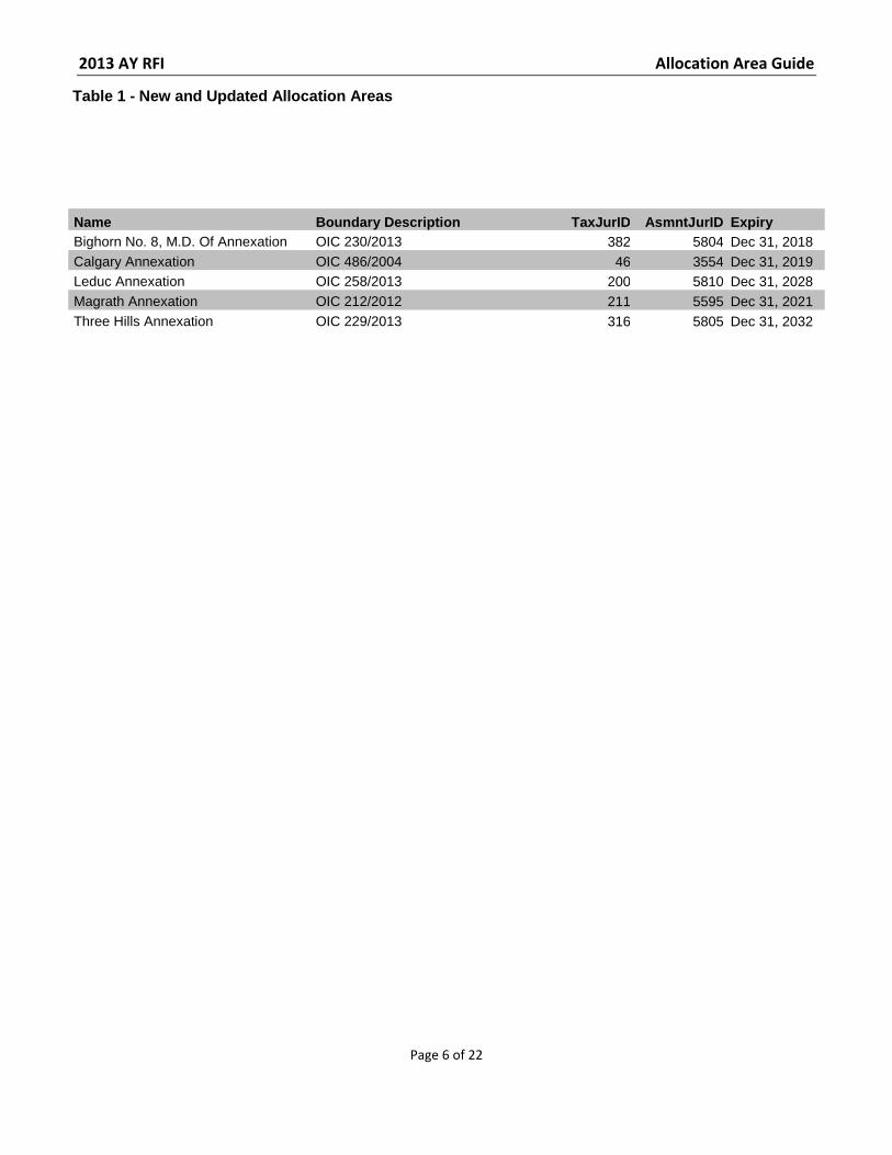
Table 1 - New and Updated Allocation Areas
Name Boundary Description TaxJurID AsmntJurID Expiry Bighorn No. 8, M.D. Of Annexation OIC 230/2013 382 5804 Dec 31, 2018 Calgary Annexation OIC 486/2004 46 3554 Dec 31, 2019 Leduc Annexation OIC 258/2013 200 5810 Dec 31, 2028 Magrath Annexation OIC 212/2012 211 5595 Dec 31, 2021 Three Hills Annexation OIC 229/2013 316 5805 Dec 31, 2032
2013 AY RFI Allocation Area Guide
Page 7 of 22
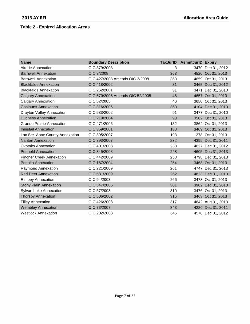
Table 2 - Expired Allocation Areas
Name Boundary Description TaxJurID AsmntJurID Expiry Airdrie Annexation OIC 379/2003 3 3470 Dec 31, 2012 Barnwell Annexation OIC 3/2008 363 4520 Oct 31, 2013 Barnwell Annexation OIC 427/2008 Amends OIC 3/2008 363 4659 Oct 31, 2013 Blackfalds Annexation OIC 418/2002 31 3465 Dec 31, 2012 Blackfalds Annexation OIC 262/2001 31 3471 Dec 31, 2010 Calgary Annexation OIC 570/2005 Amends OIC 52/2005 46 4657 Oct 31, 2013 Calgary Annexation OIC 52/2005 46 3650 Oct 31, 2013 Coalhurst Annexation OIC 316/2006 360 4104 Dec 31, 2010 Drayton Valley Annexation OIC 533/2002 91 3477 Dec 31, 2010 Duchess Annexation OIC 219/2004 93 3502 Oct 31, 2013 Grande Prairie Annexation OIC 471/2005 132 3862 Oct 31, 2013 Innisfail Annexation OIC 359/2001 180 3469 Oct 31, 2013 Lac Ste. Anne County Annexation OIC 395/2007 193 278 Oct 31, 2013 Nanton Annexation OIC 393/2007 232 4395 Dec 31, 2011 Okotoks Annexation OIC 401/2008 238 4627 Dec 31, 2012 Penhold Annexation OIC 345/2008 248 4605 Dec 31, 2013 Pincher Creek Annexation OIC 442/2009 250 4798 Dec 31, 2013 Ponoka Annexation OIC 187/2004 254 3468 Oct 31, 2013 Raymond Annexation OIC 221/2009 261 4747 Dec 31, 2013 Red Deer Annexation OIC 531/2009 262 4823 Dec 31, 2010 Rimbey Annexation OIC 94/2003 266 3473 Oct 31, 2013 Stony Plain Annexation OIC 547/2005 301 3902 Dec 31, 2013 Sylvan Lake Annexation OIC 57/2003 310 3476 Oct 31, 2013 Thorsby Annexation OIC 506/2002 315 3463 Oct 31, 2013 Tilley Annexation OIC 426/2008 317 4642 Aug 31, 2013 Wembley Annexation OIC 73/2007 343 4226 Dec 31, 2011 Westlock Annexation OIC 202/2008 345 4578 Dec 31, 2012
2013 AY RFI Allocation Area Guide
Page 8 of 22
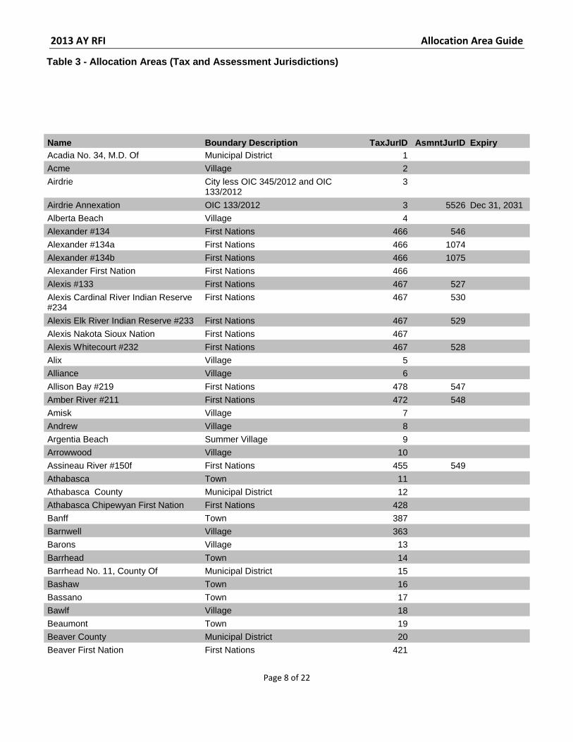
Table 3 - Allocation Areas (Tax and Assessment Jurisdictions)
Name Boundary Description TaxJurID AsmntJurID Expiry Acadia No. 34, M.D. Of Municipal District 1 Acme Village 2 Airdrie City less OIC 345/2012 and OIC
133/2012 3
Airdrie Annexation OIC 133/2012 3 5526 Dec 31, 2031 Alberta Beach Village 4 Alexander #134 First Nations 466 546 Alexander #134a First Nations 466 1074 Alexander #134b First Nations 466 1075 Alexander First Nation First Nations 466 Alexis #133 First Nations 467 527 Alexis Cardinal River Indian Reserve #234
First Nations 467 530
Alexis Elk River Indian Reserve #233 First Nations 467 529 Alexis Nakota Sioux Nation First Nations 467 Alexis Whitecourt #232 First Nations 467 528 Alix Village 5 Alliance Village 6
Allison Bay #219 First Nations 478 547 Amber River #211 First Nations 472 548 Amisk Village 7 Andrew Village 8 Argentia Beach Summer Village 9 Arrowwood Village 10 Assineau River #150f First Nations 455 549 Athabasca Town 11 Athabasca County Municipal District 12 Athabasca Chipewyan First Nation First Nations 428 Banff Town 387 Barnwell Village 363 Barons Village 13
Barrhead Town 14 Barrhead No. 11, County Of Municipal District 15 Bashaw Town 16 Bassano Town 17 Bawlf Village 18 Beaumont Town 19 Beaver County Municipal District 20 Beaver First Nation First Nations 421
2013 AY RFI Allocation Area Guide
Page 9 of 22
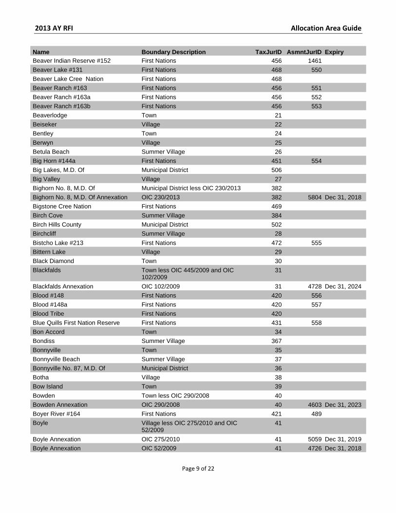
Name Boundary Description TaxJurID AsmntJurID Expiry Beaver Indian Reserve #152 First Nations 456 1461 Beaver Lake #131 First Nations 468 550 Beaver Lake Cree Nation First Nations 468 Beaver Ranch #163 First Nations 456 551 Beaver Ranch #163a First Nations 456 552 Beaver Ranch #163b First Nations 456 553 Beaverlodge Town 21 Beiseker Village 22 Bentley Town 24
Berwyn Village 25 Betula Beach Summer Village 26 Big Horn #144a First Nations 451 554 Big Lakes, M.D. Of Municipal District 506 Big Valley Village 27 Bighorn No. 8, M.D. Of Municipal District less OIC 230/2013 382 Bighorn No. 8, M.D. Of Annexation OIC 230/2013 382 5804 Dec 31, 2018 Bigstone Cree Nation First Nations 469 Birch Cove Summer Village 384 Birch Hills County Municipal District 502 Birchcliff Summer Village 28
Bistcho Lake #213 First Nations 472 555 Bittern Lake Village 29 Black Diamond Town 30 Blackfalds Town less OIC 445/2009 and OIC
102/2009 31
Blackfalds Annexation OIC 102/2009 31 4728 Dec 31, 2024 Blood #148 First Nations 420 556 Blood #148a First Nations 420 557 Blood Tribe First Nations 420 Blue Quills First Nation Reserve First Nations 431 558 Bon Accord Town 34 Bondiss Summer Village 367 Bonnyville Town 35 Bonnyville Beach Summer Village 37 Bonnyville No. 87, M.D. Of Municipal District 36 Botha Village 38 Bow Island Town 39
Bowden Town less OIC 290/2008 40 Bowden Annexation OIC 290/2008 40 4603 Dec 31, 2023 Boyer River #164 First Nations 421 489 Boyle Village less OIC 275/2010 and OIC
52/2009 41
Boyle Annexation OIC 275/2010 41 5059 Dec 31, 2019 Boyle Annexation OIC 52/2009 41 4726 Dec 31, 2018
2013 AY RFI Allocation Area Guide
Page 10 of 22
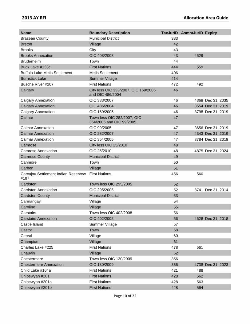
Name Boundary Description TaxJurID AsmntJurID Expiry Brazeau County Municipal District 383 Breton Village 42 Brooks City 43 Brooks Annexation OIC 403/2008 43 4629 Bruderheim Town 44 Buck Lake #133c First Nations 444 559 Buffalo Lake Metis Settlement Metis Settlement 406 Burnstick Lake Summer Village 414 Busche River #207 First Nations 472 492
Calgary City less OIC 333/2007, OIC 169/2005 and OIC 486/2004
46
Calgary Annexation OIC 333/2007 46 4368 Dec 31, 2035 Calgary Annexation OIC 486/2004 46 3554 Dec 31, 2019 Calgary Annexation OIC 169/2005 46 3798 Dec 31, 2019
Calmar Town less OIC 282/2007, OIC 354/2005 and OIC 99/2005
47
Calmar Annexation OIC 99/2005 47 3656 Dec 31, 2019 Calmar Annexation OIC 282/2007 47 4343 Dec 31, 2019
Calmar Annexation OIC 354/2005 47 3784 Dec 31, 2019 Camrose City less OIC 25/2010 48 Camrose Annexation OIC 25/2010 48 4875 Dec 31, 2024 Camrose County Municipal District 49 Canmore Town 50 Carbon Village 51 Carcajou Settlement Indian Reservew #187
First Nations 456 560
Cardston Town less OIC 295/2005 52 Cardston Annexation OIC 295/2005 52 3741 Dec 31, 2014 Cardston County Municipal District 53 Carmangay Village 54 Caroline Village 55 Carstairs Town less OIC 402/2008 56 Carstairs Annexation OIC 402/2008 56 4628 Dec 31, 2018 Castle Island Summer Village 57 Castor Town 58 Cereal Village 60
Champion Village 61 Charles Lake #225 First Nations 478 561 Chauvin Village 62 Chestermere Town less OIC 130/2009 356 Chestermere Annexation OIC 130/2009 356 4738 Dec 31, 2023 Child Lake #164a First Nations 421 488 Chipewyan #201 First Nations 428 562 Chipewyan #201a First Nations 428 563 Chipewyan #201b First Nations 428 564
2013 AY RFI Allocation Area Guide
Page 11 of 22
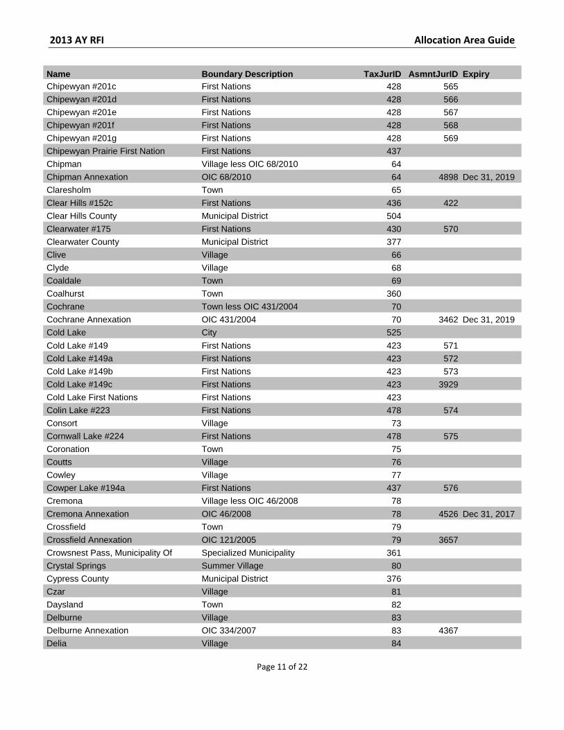
Name Boundary Description TaxJurID AsmntJurID Expiry Chipewyan #201c First Nations 428 565 Chipewyan #201d First Nations 428 566 Chipewyan #201e First Nations 428 567 Chipewyan #201f First Nations 428 568 Chipewyan #201g First Nations 428 569 Chipewyan Prairie First Nation First Nations 437 Chipman Village less OIC 68/2010 64 Chipman Annexation OIC 68/2010 64 4898 Dec 31, 2019 Claresholm Town 65
Clear Hills #152c First Nations 436 422 Clear Hills County Municipal District 504 Clearwater #175 First Nations 430 570 Clearwater County Municipal District 377 Clive Village 66 Clyde Village 68 Coaldale Town 69 Coalhurst Town 360 Cochrane Town less OIC 431/2004 70 Cochrane Annexation OIC 431/2004 70 3462 Dec 31, 2019 Cold Lake City 525
Cold Lake #149 First Nations 423 571 Cold Lake #149a First Nations 423 572 Cold Lake #149b First Nations 423 573 Cold Lake #149c First Nations 423 3929 Cold Lake First Nations First Nations 423 Colin Lake #223 First Nations 478 574 Consort Village 73 Cornwall Lake #224 First Nations 478 575 Coronation Town 75 Coutts Village 76 Cowley Village 77 Cowper Lake #194a First Nations 437 576 Cremona Village less OIC 46/2008 78
Cremona Annexation OIC 46/2008 78 4526 Dec 31, 2017 Crossfield Town 79 Crossfield Annexation OIC 121/2005 79 3657 Crowsnest Pass, Municipality Of Specialized Municipality 361 Crystal Springs Summer Village 80 Cypress County Municipal District 376 Czar Village 81 Daysland Town 82 Delburne Village 83 Delburne Annexation OIC 334/2007 83 4367 Delia Village 84
2013 AY RFI Allocation Area Guide
Page 12 of 22
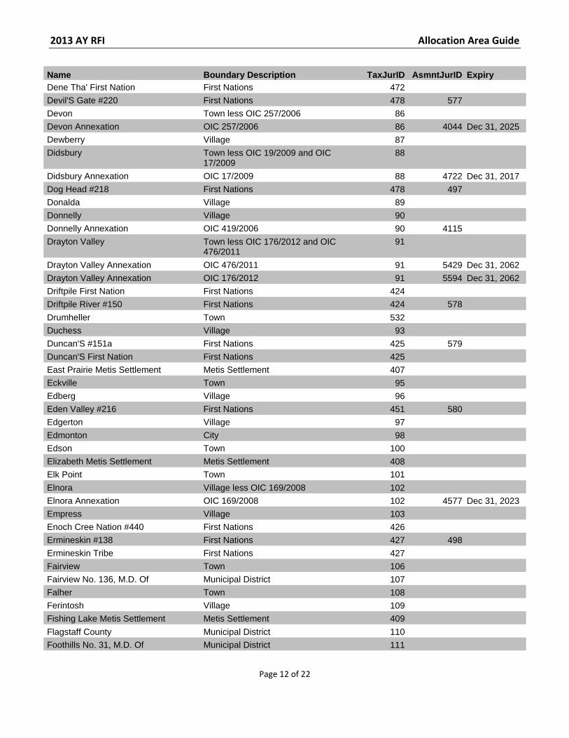
Name Boundary Description TaxJurID AsmntJurID Expiry Dene Tha' First Nation First Nations 472 Devil'S Gate #220 First Nations 478 577 Devon Town less OIC 257/2006 86 Devon Annexation OIC 257/2006 86 4044 Dec 31, 2025 Dewberry Village 87 Didsbury Town less OIC 19/2009 and OIC
17/2009 88
Didsbury Annexation OIC 17/2009 88 4722 Dec 31, 2017 Dog Head #218 First Nations 478 497 Donalda Village 89 Donnelly Village 90 Donnelly Annexation OIC 419/2006 90 4115 Drayton Valley Town less OIC 176/2012 and OIC
476/2011 91
Drayton Valley Annexation OIC 476/2011 91 5429 Dec 31, 2062 Drayton Valley Annexation OIC 176/2012 91 5594 Dec 31, 2062 Driftpile First Nation First Nations 424 Driftpile River #150 First Nations 424 578
Drumheller Town 532 Duchess Village 93 Duncan'S #151a First Nations 425 579 Duncan'S First Nation First Nations 425 East Prairie Metis Settlement Metis Settlement 407 Eckville Town 95 Edberg Village 96 Eden Valley #216 First Nations 451 580 Edgerton Village 97 Edmonton City 98 Edson Town 100 Elizabeth Metis Settlement Metis Settlement 408 Elk Point Town 101
Elnora Village less OIC 169/2008 102 Elnora Annexation OIC 169/2008 102 4577 Dec 31, 2023 Empress Village 103 Enoch Cree Nation #440 First Nations 426 Ermineskin #138 First Nations 427 498 Ermineskin Tribe First Nations 427 Fairview Town 106 Fairview No. 136, M.D. Of Municipal District 107 Falher Town 108 Ferintosh Village 109 Fishing Lake Metis Settlement Metis Settlement 409
Flagstaff County Municipal District 110 Foothills No. 31, M.D. Of Municipal District 111
2013 AY RFI Allocation Area Guide
Page 13 of 22
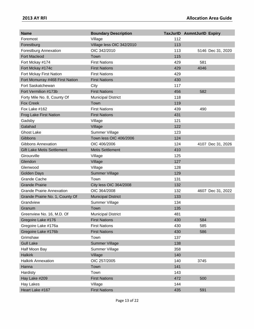
Name Boundary Description TaxJurID AsmntJurID Expiry Foremost Village 112 Forestburg Village less OIC 342/2010 113 Forestburg Annexation OIC 342/2010 113 5146 Dec 31, 2020 Fort Macleod Town 115 Fort Mckay #174 First Nations 429 581 Fort Mckay #174c First Nations 429 4046 Fort Mckay First Nation First Nations 429 Fort Mcmurray #468 First Nation First Nations 430 Fort Saskatchewan City 117
Fort Vermilion #173b First Nations 456 582 Forty Mile No. 8, County Of Municipal District 118 Fox Creek Town 119 Fox Lake #162 First Nations 439 490 Frog Lake First Nation First Nations 431 Gadsby Village 121 Galahad Village 122 Ghost Lake Summer Village 123 Gibbons Town less OIC 406/2006 124 Gibbons Annexation OIC 406/2006 124 4107 Dec 31, 2026 Gift Lake Metis Settlement Metis Settlement 410
Girouxville Village 125 Glendon Village 127 Glenwood Village 128 Golden Days Summer Village 129 Grande Cache Town 131 Grande Prairie City less OIC 364/2008 132 Grande Prairie Annexation OIC 364/2008 132 4607 Dec 31, 2022 Grande Prairie No. 1, County Of Municipal District 133 Grandview Summer Village 134 Granum Town 135 Greenview No. 16, M.D. Of Municipal District 481 Gregoire Lake #176 First Nations 430 584 Gregoire Lake #176a First Nations 430 585
Gregoire Lake #176b First Nations 430 586 Grimshaw Town 137 Gull Lake Summer Village 138 Half Moon Bay Summer Village 358 Halkirk Village 140 Halkirk Annexation OIC 257/2005 140 3745 Hanna Town 141 Hardisty Town 143 Hay Lake #209 First Nations 472 500 Hay Lakes Village 144 Heart Lake #167 First Nations 435 591
2013 AY RFI Allocation Area Guide
Page 14 of 22
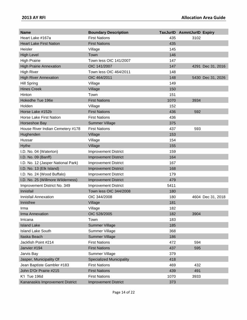
Name Boundary Description TaxJurID AsmntJurID Expiry Heart Lake #167a First Nations 435 3102 Heart Lake First Nation First Nations 435 Heisler Village 145 High Level Town 146 High Prairie Town less OIC 141/2007 147 High Prairie Annexation OIC 141/2007 147 4291 Dec 31, 2016 High River Town less OIC 464/2011 148 High River Annexation OIC 464/2011 148 5430 Dec 31, 2026 Hill Spring Village 149
Hines Creek Village 150 Hinton Town 151 Hokedhe Tue 196e First Nations 1070 3934 Holden Village 152 Horse Lake #152b First Nations 436 592 Horse Lake First Nation First Nations 436 Horseshoe Bay Summer Village 375 House River Indian Cemetery #178 First Nations 437 593 Hughenden Village 153 Hussar Village 154 Hythe Village 155
I.D. No. 04 (Waterton) Improvement District 159 I.D. No. 09 (Banff) Improvement District 164 I.D. No. 12 (Jasper National Park) Improvement District 167 I.D. No. 13 (Elk Island) Improvement District 168 I.D. No. 24 (Wood Buffalo) Improvement District 179 I.D. No. 25 (Willmore Wilderness) Improvement District 479 Improvement District No. 349 Improvement District 5411 Innisfail Town less OIC 344/2008 180 Innisfail Annexation OIC 344/2008 180 4604 Dec 31, 2018 Innisfree Village 181 Irma Village 182 Irma Annexation OIC 528/2005 182 3904 Irricana Town 183
Island Lake Summer Village 185 Island Lake South Summer Village 368 Itaska Beach Summer Village 186 Jackfish Point #214 First Nations 472 594 Janvier #194 First Nations 437 595 Jarvis Bay Summer Village 379 Jasper, Municipality Of Specialized Municipality 418 Jean Baptiste Gambler #183 First Nations 469 432 John D'Or Prairie #215 First Nations 439 491 K'I Tue 196d First Nations 1070 3933 Kananaskis Improvement District Improvement District 373
2013 AY RFI Allocation Area Guide
Page 15 of 22
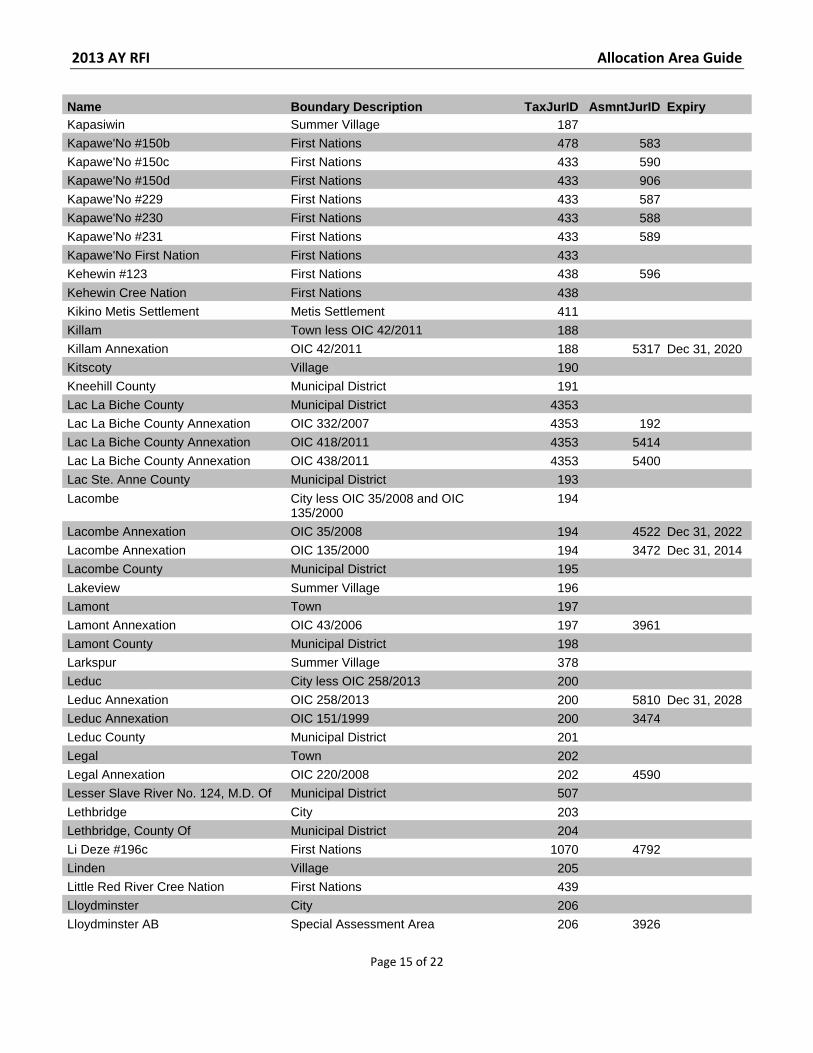
Name Boundary Description TaxJurID AsmntJurID Expiry Kapasiwin Summer Village 187 Kapawe'No #150b First Nations 478 583 Kapawe'No #150c First Nations 433 590 Kapawe'No #150d First Nations 433 906 Kapawe'No #229 First Nations 433 587 Kapawe'No #230 First Nations 433 588 Kapawe'No #231 First Nations 433 589 Kapawe'No First Nation First Nations 433 Kehewin #123 First Nations 438 596
Kehewin Cree Nation First Nations 438 Kikino Metis Settlement Metis Settlement 411 Killam Town less OIC 42/2011 188 Killam Annexation OIC 42/2011 188 5317 Dec 31, 2020 Kitscoty Village 190 Kneehill County Municipal District 191 Lac La Biche County Municipal District 4353 Lac La Biche County Annexation OIC 332/2007 4353 192 Lac La Biche County Annexation OIC 418/2011 4353 5414 Lac La Biche County Annexation OIC 438/2011 4353 5400 Lac Ste. Anne County Municipal District 193
Lacombe City less OIC 35/2008 and OIC 135/2000
194
Lacombe Annexation OIC 35/2008 194 4522 Dec 31, 2022 Lacombe Annexation OIC 135/2000 194 3472 Dec 31, 2014 Lacombe County Municipal District 195
Lakeview Summer Village 196 Lamont Town 197 Lamont Annexation OIC 43/2006 197 3961 Lamont County Municipal District 198 Larkspur Summer Village 378 Leduc City less OIC 258/2013 200 Leduc Annexation OIC 258/2013 200 5810 Dec 31, 2028 Leduc Annexation OIC 151/1999 200 3474 Leduc County Municipal District 201 Legal Town 202 Legal Annexation OIC 220/2008 202 4590 Lesser Slave River No. 124, M.D. Of Municipal District 507
Lethbridge City 203 Lethbridge, County Of Municipal District 204 Li Deze #196c First Nations 1070 4792 Linden Village 205 Little Red River Cree Nation First Nations 439 Lloydminster City 206 Lloydminster AB Special Assessment Area 206 3926
2013 AY RFI Allocation Area Guide
Page 16 of 22
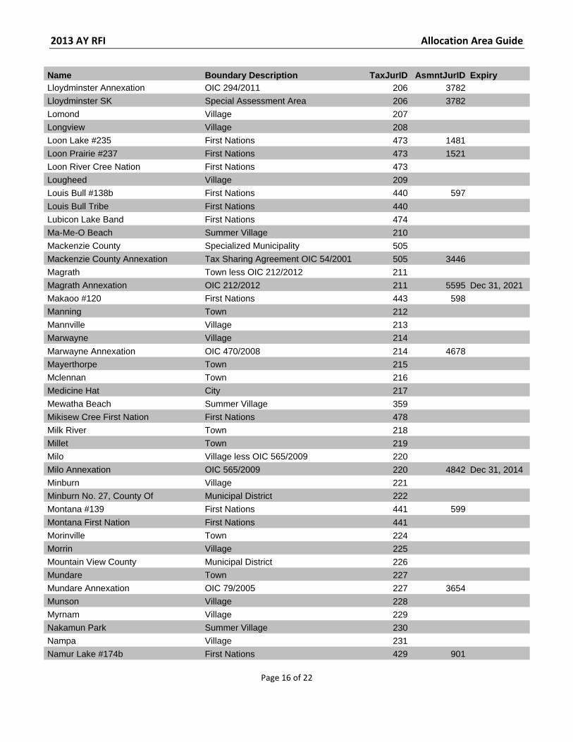
Name Boundary Description TaxJurID AsmntJurID Expiry Lloydminster Annexation OIC 294/2011 206 3782 Lloydminster SK Special Assessment Area 206 3782 Lomond Village 207 Longview Village 208 Loon Lake #235 First Nations 473 1481 Loon Prairie #237 First Nations 473 1521 Loon River Cree Nation First Nations 473 Lougheed Village 209 Louis Bull #138b First Nations 440 597
Louis Bull Tribe First Nations 440 Lubicon Lake Band First Nations 474 Ma-Me-O Beach Summer Village 210 Mackenzie County Specialized Municipality 505 Mackenzie County Annexation Tax Sharing Agreement OIC 54/2001 505 3446 Magrath Town less OIC 212/2012 211 Magrath Annexation OIC 212/2012 211 5595 Dec 31, 2021 Makaoo #120 First Nations 443 598 Manning Town 212 Mannville Village 213 Marwayne Village 214
Marwayne Annexation OIC 470/2008 214 4678 Mayerthorpe Town 215 Mclennan Town 216 Medicine Hat City 217 Mewatha Beach Summer Village 359 Mikisew Cree First Nation First Nations 478 Milk River Town 218 Millet Town 219 Milo Village less OIC 565/2009 220 Milo Annexation OIC 565/2009 220 4842 Dec 31, 2014 Minburn Village 221 Minburn No. 27, County Of Municipal District 222 Montana #139 First Nations 441 599
Montana First Nation First Nations 441 Morinville Town 224 Morrin Village 225 Mountain View County Municipal District 226 Mundare Town 227 Mundare Annexation OIC 79/2005 227 3654 Munson Village 228 Myrnam Village 229 Nakamun Park Summer Village 230 Nampa Village 231 Namur Lake #174b First Nations 429 901
2013 AY RFI Allocation Area Guide
Page 17 of 22
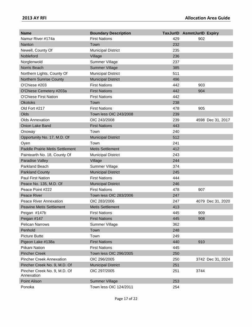
Name Boundary Description TaxJurID AsmntJurID Expiry Namur River #174a First Nations 429 902 Nanton Town 232 Newell, County Of Municipal District 235 Nobleford Village 236 Norglenwold Summer Village 237 Norris Beach Summer Village 385 Northern Lights, County Of Municipal District 511 Northern Sunrise County Municipal District 496 O'Chiese #203 First Nations 442 903
O'Chiese Cemetery #203a First Nations 442 904 O'Chiese First Nation First Nations 442 Okotoks Town 238 Old Fort #217 First Nations 478 905 Olds Town less OIC 243/2008 239 Olds Annexation OIC 243/2008 239 4598 Dec 31, 2017 Onion Lake Band First Nations 443 Onoway Town 240 Opportunity No. 17, M.D. Of Municipal District 512 Oyen Town 241 Paddle Prairie Metis Settlement Metis Settlement 412
Paintearth No. 18, County Of Municipal District 243 Paradise Valley Village 244 Parkland Beach Summer Village 374 Parkland County Municipal District 245 Paul First Nation First Nations 444 Peace No. 135, M.D. Of Municipal District 246 Peace Point #222 First Nations 478 907 Peace River Town less OIC 283/2006 247 Peace River Annexation OIC 283/2006 247 4079 Dec 31, 2020 Peavine Metis Settlement Metis Settlement 413 Peigan #147b First Nations 445 909 Peigan #147 First Nations 445 908 Pelican Narrows Summer Village 362
Penhold Town 248 Picture Butte Town 249 Pigeon Lake #138a First Nations 440 910 Piikani Nation First Nations 445 Pincher Creek Town less OIC 296/2005 250 Pincher Creek Annexation OIC 296/2005 250 3742 Dec 31, 2024 Pincher Creek No. 9, M.D. Of Municipal District 251 Pincher Creek No. 9, M.D. Of Annexation
OIC 297/2005 251 3744
Point Alison Summer Village 253 Ponoka Town less OIC 124/2011 254
2013 AY RFI Allocation Area Guide
Page 18 of 22
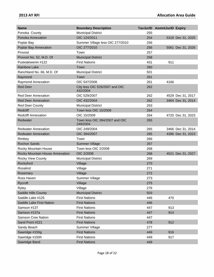
Name Boundary Description TaxJurID AsmntJurID Expiry Ponoka County Municipal District 255 Ponoka Annexation OIC 124/2011 254 5318 Dec 31, 2025 Poplar Bay Summer Village less OIC 277/2010 256 Poplar Bay Annexation OIC 277/2010 256 5061 Dec 31, 2026 Provost Town 257 Provost No. 52, M.D. Of Municipal District 258 Puskiakiwenin #122 First Nations 431 911 Rainbow Lake Town 260 Ranchland No. 66, M.D. Of Municipal District 501
Raymond Town 261 Raymond Annexation OIC 547/2006 261 4166 Red Deer City less OIC 529/2007 and OIC
432/2004 262
Red Deer Annexation OIC 529/2007 262 4529 Dec 31, 2017
Red Deer Annexation OIC 432/2004 262 3464 Dec 31, 2014 Red Deer County Municipal District 263 Redcliff Town less OIC 15/2009 264 Redcliff Annexation OIC 15/2009 264 4720 Dec 31, 2023 Redwater Town less OIC 394/2007 and OIC
249/2004 265
Redwater Annexation OIC 249/2004 265 3466 Dec 31, 2014 Redwater Annexation OIC 394/2007 265 4396 Dec 31, 2023 Rimbey Town 266 Rochon Sands Summer Village 267 Rocky Mountain House Town less OIC 2/2008 268 Rocky Mountain House Annexation OIC 2/2008 268 4521 Dec 31, 2027 Rocky View County Municipal District 269 Rockyford Village 270 Rosalind Village 271 Rosemary Village 272 Ross Haven Summer Village 273
Rycroft Village 275 Ryley Village 276 Saddle Hills County Municipal District 503 Saddle Lake #125 First Nations 446 470 Saddle Lake First Nation First Nations 446 Samson #137 First Nations 447 913 Samson #137a First Nations 447 914 Samson Cree Nation First Nations 447 Sand Point #221 First Nations 478 912 Sandy Beach Summer Village 277 Sawridge #150g First Nations 449 916
Sawridge #150h First Nations 449 917 Sawridge Band First Nations 449
2013 AY RFI Allocation Area Guide
Page 19 of 22
Name Boundary Description TaxJurID AsmntJurID Expiry Seba Beach Summer Village 279 Sedgewick Town 280 Sexsmith Town less OIC 14/2009 281 Sexsmith Annexation OIC 14/2009 281 4719 Dec 31, 2059 Sherwood Park Urban Services Area 302 523 Siksika #146 First Nations 419 918 Siksika Nation First Nations 419 Silver Beach Summer Village 282 Silver Sands Summer Village 283
Slave Lake Town 284 Slaves Band First Nations 450 Smith'S Landing First Nation First Nations 1070 Smoky Lake Town 285 Smoky Lake County Municipal District 286 Smoky River No. 130, M.D. Of Municipal District 287 South Baptiste Summer Village 369 South View Summer Village 288 Special Areas Board Special Area 142 Spirit River Town 289 Spirit River No. 133, M.D. Of Municipal District 290
Spring Lake Village 99 Spruce Grove City less OIC 365/2008 and OIC
390/2007 291
Spruce Grove Annexation OIC 390/2007 291 4394 Dec 31, 2023 Spruce Grove Annexation OIC 365/2008 291 4606 Dec 31, 2023
St. Albert City less OIC 38/2007 292 St. Albert Annexation OIC 38/2007 292 4225 Dec 31, 2018 St. Paul Town less OIC 191/2011, OIC
226/2010 and OIC 375/2006 293
St. Paul Annexation OIC 375/2006 293 4105 Dec 31, 2016 St. Paul Annexation OIC 226/2010 293 5007 Dec 31, 2020
St. Paul Annexation OIC 191/2011 293 5384 Dec 31, 2020 St. Paul No. 19, County Of Municipal District 294 Standard Village 295 Starland County Municipal District 296 Stavely Town 297 Stettler Town less OIC 276/2010 298 Stettler Annexation OIC 276/2010 298 5060 Dec 31, 2019 Stettler No. 6, County Of Municipal District 299 Stirling Village 300 Stirling Annexation OIC 569/2005 300 4136 Stoney #142 First Nations 451 919
Stoney #142b First Nations 451 922 Stoney (Bearspaw) Band First Nations 451
2013 AY RFI Allocation Area Guide
Page 20 of 22
Name Boundary Description TaxJurID AsmntJurID Expiry Stoney (Chiniki) Band First Nations 476 Stoney (Wesley) Band First Nations 477 Stony Plain Town 301 Stony Plain #135 First Nations 426 923 Stony Plain #135a First Nations 426 1421 Strathcona County Specialized Municipality 302 Strathmore Town less OIC 135/2010 303 Strathmore Annexation OIC 135/2010 303 4909 Dec 31, 2039 Strome Village 304
Sturgeon County Municipal District 305 Sturgeon Lake #154 First Nations 452 924 Sturgeon Lake #154a First Nations 452 925 Sturgeon Lake #154b First Nations 452 926 Sturgeon Lake Cree Nation First Nations 452 Sucker Creek #150a First Nations 453 927 Sucker Creek First Nation First Nations 453 Sunbreaker Cove Summer Village 388 Sunchild Cree #202 First Nations 454 928 Sunchild First Nation First Nations 454 Sundance Beach Summer Village 306
Sundre Town less OIC 224/2010 307 Sundre Annexation OIC 224/2010 307 5005 Sep 15, 2019 Sunrise Beach Summer Village 386 Sunset Beach Summer Village 357 Sunset Point Summer Village 308 Swampy Lake #236 First Nations 473 1501 Swan Hills Town 309 Swan River #150e First Nations 455 929 Swan River First Nation First Nations 455 Sylvan Lake Town less OIC 495/2006 310 Sylvan Lake Annexation OIC 495/2006 310 4155 Dec 31, 2016 Taber Town 311 Taber, M.D. Of Municipal District 312
Tallcree #173 First Nations 456 494 Tallcree #173a First Nations 456 495 Tallcree First Nation First Nations 456 Thabacha Nare #196a First Nations 1070 3930 Thebathi #196 First Nations 1070 3931 Thorhild Hamlet 313 Thorhild County Municipal District 314 Thorsby Village less OIC 438/2007 315 Thorsby Annexation OIC 438/2007 315 4408 Dec 31, 2022 Three Hills Town less OIC 229/2013 316 Three Hills Annexation OIC 229/2013 316 5805 Dec 31, 2032
2013 AY RFI Allocation Area Guide
Page 21 of 22
Name Boundary Description TaxJurID AsmntJurID Expiry Tilley Hamlet 317 Tofield Town less OIC 443/2009 318 Tofield Annexation OIC 443/2009 318 4799 Dec 31, 2024 Trochu Town 320 Tsu K'Adhe #196f First Nations 1070 3935 Tsu Tue #196g First Nations 1070 3936 Tsuu T'Ina #145 First Nations 448 915 Tsuu T'Ina Nation First Nations 448 Tthe Jere Ghaili #196b First Nations 1070 3932
Turner Valley Town 321 Two Hills Town 322 Two Hills No. 21, County Of Municipal District 323 Unipouheos #121 First Nations 431 930 Upper Hay River #212 First Nations 472 493 Utikoomak Lake #155 First Nations 457 931 Utikoomak Lake #155a First Nations 457 932 Utikoomak Lake #155b First Nations 457 933 Val Quentin Summer Village 324 Valleyview Town less OIC 496/2006 325 Valleyview Annexation OIC 496/2006 325 4165 Dec 31, 2027
Vauxhall Town 326 Vegreville Town less OIC 642/2009 327 Vegreville Annexation OIC 642/2009 327 4870 Dec 31, 2014 Vermilion Town 328 Vermilion River, County Of Municipal District 329 Veteran Village 330 Viking Town 331 Vilna Village 332 Vulcan Town 333 Vulcan County Municipal District 334 Wabamun Village 364 Wabamun #133a First Nations 444 934 Wabamun #133b First Nations 444 935
Wabasca #166 First Nations 469 936 Wabasca #166a First Nations 469 937 Wabasca #166b First Nations 469 938 Wabasca #166c First Nations 469 939 Wabasca #166d First Nations 469 940 Wadlin Lake #173c First Nations 456 941 Wainwright Town 335 Wainwright Annexation OIC 53/2005 335 3655 Wainwright No. 61, M.D. Of Municipal District 336 Waiparous Summer Village 380 Warburg Village less OIC 476/2010 338
2013 AY RFI Allocation Area Guide
Page 22 of 22
Name Boundary Description TaxJurID AsmntJurID Expiry Warburg Annexation OIC 476/2010 338 5247 Dec 31, 2025 Warner Village 339 Warner No. 5, County Of Municipal District 340 Waskatenau Village 342 Wembley Town 343 West Baptiste Summer Village 370 West Cove Summer Village 344 Westlock Town 345 Westlock County Municipal District 346
Wetaskiwin City 347 Wetaskiwin Annexation OIC 221/2008 347 4589 Wetaskiwin No. 10, County Of Municipal District 348 Wheatland County Municipal District 349 Whispering Hills Summer Village 371 White Sands Summer Village 365 Whitecourt Town 350 Whitefish (Goodfish) Lake First Nation First Nations 1073
Whitefish Lake #128 First Nations 446 471 Whitefish Lake First Nation First Nations 457 William Mckenzie #151k First Nations 425 942 Willingdon Village 352 Willow Creek No. 26, M.D. Of Municipal District 353 Winefred Lake #194b First Nations 437 943 Wood Buffalo, Regional Municipality Of
Specialized Municipality 508
Wood Buffalo, Regional Municipality Of Annexation
Amends Schedule 1 of OIC 817/1994 508 116
Woodland Cree #226 First Nations 475 944 Woodland Cree #227 First Nations 475 945 Woodland Cree #228 First Nations 475 946 Woodland Cree First Nation First Nations 475 Woodlands County Municipal District 480 Yellowhead County Municipal District 482 Yellowstone Summer Village 354 Youngstown Village 355
Zama Lake #210 First Nations 472 947