Embed Size (px)
Citation preview

A Major Qualifying Project submitted to the faculty of Worcester
Polytechnic Institute in partial fulfillment of the requirements for the
Degree of Bachelor of Science.
2012
Patrick Cardone John Erikson Benjamin Timms -Advisors- Professor Mingjiang Tao Professor Suzanne LePage
MASSDOT HIGHWAY INTERCHANGE DESIGN This study examined the highway interchange of Interstate 190 and State Route 140 in Sterling, Massachusetts. Using data collected on-site as well as existing data from government agencies including MassDOT, the specific problem areas of the interchange were identified. Alternative designs were developed for the site characteristics based on industry standards and using engineering software. A single lane roundabout was recommended based on the criteria of safety, cost, and ability to meet future capacity demands.

1 MassDOT Highway Interchange Design
Abstract
This study examined the highway interchange of Interstate 190 and State Route 140 in
Sterling, Massachusetts. Using data collected on-site as well as existing data from
government agencies including MassDOT, the specific problem areas of the interchange
were identified. Alternative designs were developed for the site characteristics based on
industry standards and using engineering software. A single lane roundabout was
recommended based on the criteria of safety, cost, and ability to meet future capacity
demands.
2 MassDOT Highway Interchange Design
Acknowledgements
Our project would not have been possible without the assistance and guidance of a few
people. Joe Frawley of MassDOT was very kind to have given advice on where to take
the project and how to approach the problems. WPI’s lab manager Donald Pellegrino
and the Sterling Police Department were very helpful in coordinating the installation of
the traffic count boxes. Professor Suzanne LePage and Professor Mingjiang Tao advised
the project and provided both technical and moral support. This project would not be a
success without all of the people who contributed.
3 MassDOT Highway Interchange Design
Capstone Design Statement
To meet the Capstone Design requirement, a project must address the seven factors put
forth by the American Society of Civil Engineers. The suggested design identifies and
addresses safety and efficiency concerns by improving the geometry and pavement
design of the interchange. The collection of traffic and site condition data aided in
determining specific issues that needed to be improved upon.
As part of the Capstone Design requirement, this project addressed the constraints
listed by the American Society of Civil Engineers. The items were completed as follows:
Engineering Codes and Standards
o Designs were conducted in accordance with the Mass Highway
Department Project Development and Design Guide and other applicable
design codes.
Constructability
o The designs developed in this project were created with realistic public
funding and construction constraints. The input from Mass DOT regarding
the revised designs allowed for a realistic assessment of the project’s
constructability constraints.
Economic Factors
o Given that this revised interchange would be publicly funded if
constructed, all proposed designs were evaluated on the expected
comparative cost. The costs of the proposed designs were then
compared to the expected long term cost of the current interchange to
determine if a redesign would be fiscally sound.
Sustainability
o The revised interchange accounts for the projected growth in demand
and was designed to function effectively based on a twenty year effective

4 MassDOT Highway Interchange Design
lifetime.
Environmental Effects
o The design process considered how proposed changes to the interchange
might affect the environment and drainage to adjacent properties.
Health and Safety Issues
o The proposed design improved upon safety concerns found in the
existing layout, with the intent of reducing the severity and number of
crashes.
Ethical Considerations
o The design process followed ASCE's code of ethics.
5 MassDOT Highway Interchange Design
Table of Contents
Abstract ............................................................................................................................... 1
Acknowledgements ............................................................................................................. 2
Capstone Design Statement ............................................................................................... 3
Table of Figures ................................................................................................................... 7
List of Tables ....................................................................................................................... 8
Authorship .......................................................................................................................... 9
1 - Project Overview .......................................................................................................... 10
1.1 - Problem Statement ............................................................................................... 11
2 - Background .................................................................................................................. 12
2.1 - Site Background .................................................................................................... 12
2.2 - Interchanges ......................................................................................................... 13
2.3 - Roundabouts ......................................................................................................... 15
2.4 - Transportation Engineering Aspects of Interchange Design ................................ 17
2.5 - Traffic Signal Warrant ........................................................................................... 18
2.6 - Structural and Geotechnical Engineering Aspect of Interchange Design ............. 20
2.7 - Massachusetts DOT Project Need Form ............................................................... 22
3 - Methodology ................................................................................................................ 24
3.1 - Site Visits ............................................................................................................... 29
3.2 - Turning Movement Count .................................................................................... 29
3.3 - ATR Traffic Count with Speed and Weight Classification ..................................... 30
3.4 - Pavement Design .................................................................................................. 33
3.5 - Crash Rate Analysis ............................................................................................... 38
3.6 - Level of Service ..................................................................................................... 38
3.7 – Conceptual Design Evaluation ............................................................................. 39
3.8 - Roundabout Design .............................................................................................. 39
6 MassDOT Highway Interchange Design
3.9 – Design Evaluation ................................................................................................. 40
4 – Results ......................................................................................................................... 41
4.1 - Site Visits ............................................................................................................... 41
4.2 - Manual Turning Counts ........................................................................................ 42
4.3 - ATR Box Speed Data Analysis ................................................................................ 45
4.4 - Traffic Signal Warrant Analysis ............................................................................. 46
4.5 - LOS Analysis .......................................................................................................... 47
4.6 - Crash Analysis ....................................................................................................... 48
4.7 - Pavement Design Results ...................................................................................... 51
4.8 - Design.................................................................................................................... 54
5 - Design Evaluation ......................................................................................................... 60
5.1 – Preliminary Designs .............................................................................................. 60
5.2 - Single Lane Roundabout ....................................................................................... 62
5.3 - Double Lane Roundabout ..................................................................................... 64
6 – Recommendations ...................................................................................................... 65
Works Cited ....................................................................................................................... 66
List of Appendices
Appendix A – Project Proposal
Appendix B – Turning Movement Count Raw Data
Appendix C – Turning Movement Diagrams
Appendix D – ATR Box Collection Raw Data
Appendix E – Raw Crash Data from MassDOT
Appendix F – Existing Pavement Cross Section
Appendix G – ESAL Calculation Spreadsheet
7 MassDOT Highway Interchange Design
List of Figures
FIGURE 1. BIRD’S EYE VIEW OF THE INTERCHANGE ....................................................................... 12
FIGURE 2. SPLITTER ISLAND AT I-190 SB OFF RAMP ..................................................................... 13
FIGURE 3. FEATURES OF A ROUNDABOUT .................................................................................... 16
FIGURE 4. ATR BOX AND TUBES ............................................................................................... 17
FIGURE 5. TYPICAL PAVEMENT CROSS SECTION ............................................................................ 21
FIGURE 6. SCOPE OF WORK DIAGRAM ....................................................................................... 24
FIGURE 7. EXCERPT FROM JAMAR TRAX PLUS USER MANUAL ....................................................... 31
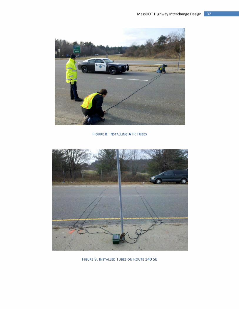
FIGURE 8. INSTALLING ATR TUBES ............................................................................................ 32
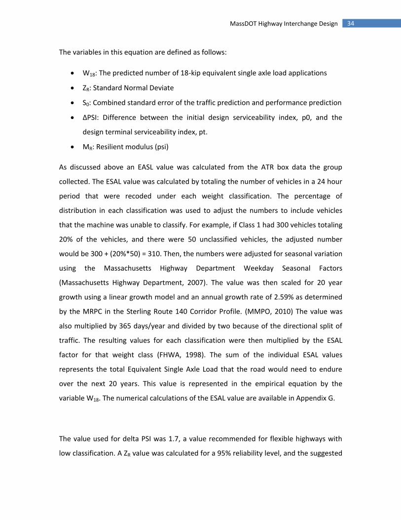
FIGURE 9. INSTALLED TUBES ON ROUTE 140 SB .......................................................................... 32
FIGURE 10. SOIL TEXTURE TRIANGLE PLOT .................................................................................. 35
FIGURE 11. LAYOUT OF MANUAL TURNING COUNTS ..................................................................... 42
FIGURE 12: COLLISION DIAGRAM .............................................................................................. 50
FIGURE 13. NORTH INTERSECTION DOUBLE LANE ......................................................................... 57
FIGURE 14. SOUTH INTERSECTION DOUBLE LANE ......................................................................... 58
FIGURE 15. NORTH INTERSECTION SINGLE LANE .......................................................................... 58
FIGURE 16. SOUTH INTERSECTION SINGLE LANE ........................................................................... 59
8 MassDOT Highway Interchange Design
List of Tables
TABLE 1. EVALUATION CRITERIA FOR MAJOR HIGHWAY, ARTERIAL, AND INTERSECTION IMPROVEMENTS 27
TABLE 2. MANUAL TURNING MOVEMENT COUNT VOLUME RESULTS ............................................... 43
TABLE 3. MANUAL TURNING COUNT TRENDS .............................................................................. 44
TABLE 4. SPEED ANALYSIS RESULTS ........................................................................................... 45
TABLE 5. CALCULATED LOS ...................................................................................................... 47
TABLE 6. LOS FROM MRPC STERLING ROUTE 140 CORRIDOR REPORT............................................ 48
TABLE 7. CRASH RATE ANALYSIS ............................................................................................... 49
TABLE 8. DESIGN PARAMETERS ................................................................................................. 51
TABLE 9. VALUES CALCULATED FROM PARAMETERS AND STRUCTURAL NUMBER ................................ 52
TABLE 10. REQUIRED LAYER THICKNESS ..................................................................................... 54
TABLE 11. DESIGN ALTERNATIVES .............................................................................................. 54
TABLE 12. ROUNDABOUT GEOMETRY DESIGN ............................................................................. 59
TABLE 13. PRELIMINARY DESIGN EVALUATION ............................................................................. 60
TABLE 14. DESIGN EVALUATION RESULTS ................................................................................... 65

9 MassDOT Highway Interchange Design
Authorship
John Erikson was the sole author of sections 1.0, 1.1, 2.1, 2.7, 3.0, 3.1, 3.4, 4.0, 4.1, 4.7
Patrick Cardone was the sole author of sections 2.4, 2.6, 3.2, 3.3, 3.6, 4.2, 4.3, 4.5
Benjamin Timms was the sole author of the Acknowledgements section and Capstone
Design Requirement section as well as sections 2.2, 2.3, 2.5, 2.7, 3.5, 3.7, 3.8, 3.9, 4.4,
4.6, 4.8, 5.0, 5.1, 5.2, 5.3, and 6.0.
Sections not listed were the product of collaboration between multiple authors, and
many sections include edits from all members.
Signed
10 MassDOT Highway Interchange Design
1 - Project Overview
The purpose of this project is a redesign of the Interstate 190 – State Route 140
interchange in order to improve safety and traffic conditions. The design must meet the
WPI’s Major Qualifying Project criteria as well as ABET Capstone Design requirements
and AASHTO standards. The interchange has been deemed potentially unsafe by the
Massachusetts Department of Transportation, and there is a potential that the
intersection is unable to service the current traffic volume at peak hours. The design
worked to improve the Level of Service (LOS) of the interchange by improving the
geometry and layout of the interchange to meet demand.
To achieve the design goals, the team met with members of MassDOT and collected
data from various sources. The focus of the project is on the transportation and
geotechnical aspects of the design. The project team drafted multiple possible designs
of the intersection and determined which design is preferred based on cost, feasibility,
the expected impacts on safety and efficiency, and other factors. The design which best
addresses all of these concerns was chosen and presented.
The findings of this study, including the recommended design, are presented to
Professors Mingjiang Tao and Suzanne LePage, the faculty advisors of the project. The
findings were submitted to Joe Frawley and others from MassDOT as well as other
applicable organizations. The results of the project were presented to the WPI
community during the April 2012 Project Presentation day. The deliverables are as
follows:
Project Need Form for MassDOT
Data findings and report for MassDOT to include:
o Crash Diagram
o Traffic Counts
11 MassDOT Highway Interchange Design
o Turning Movement Counts
o Level-of-Service Analysis
Auto CAD drawings of the recommended designs
Final Presentation to MassDOT
MQP report for WPI
Poster for WPI Project Presentation Day
1.1 - Problem Statement
The interchange between Interstate 190 and Route 140 in Sterling Massachusetts has
been identified as a problematic design. Many design factors of the interchange have
contributed to the perceived safety issues at this site. The interchange is a heavily
traveled one, seeing over 12,000 vehicles per day according to the Montachusett
Regional Planning Commission. In winter months, it services traffic to Mount Wachusett
Ski Resort from populated areas to the south. In addition, the interchange provides a
crucial connection for the town of Sterling to I-190, which links the town to job centers
such as Worcester and Leominster.
The infrastructural importance of this Interchange coupled with its perceived design and
safety flaws demonstrate a necessity for development of a revised interchange design.
12 MassDOT Highway Interchange Design
2 - Background
2.1 - Site Background
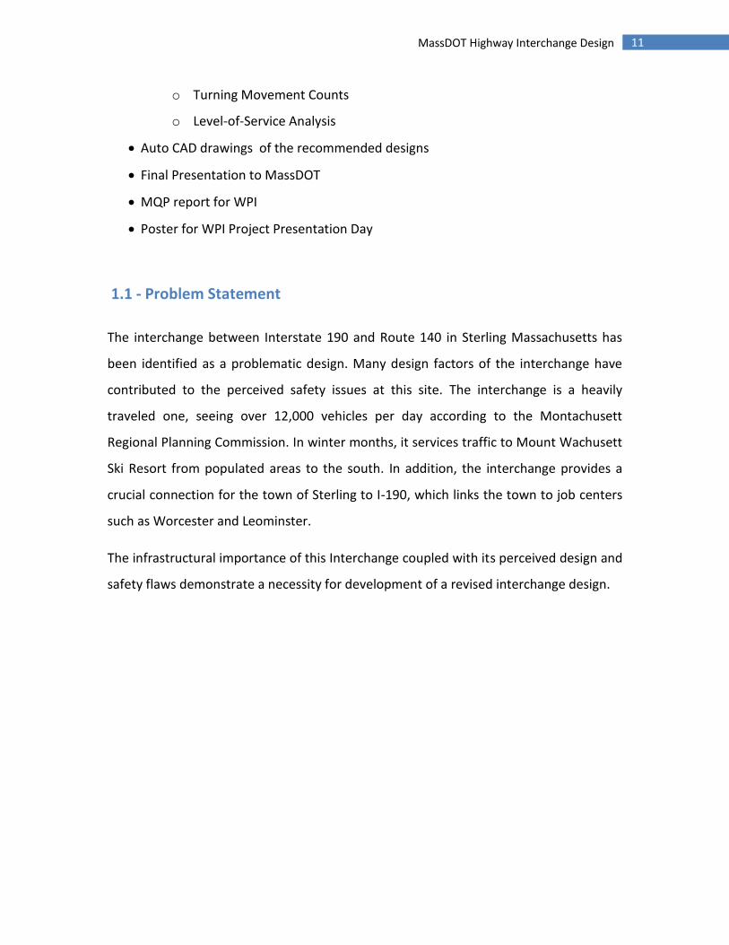
This project deals with the Interstate 190 – State Route 140 interchange located in
Sterling, Massachusetts. Figure 1 shows a bird’s eye view of this interchange. The
interchange is a grade-separated diamond interchange with the off ramps from I-190
intersecting with Route 140 at stop-controlled intersections, with channelized yield-
controlled lanes for right turns. At these intersections, left turn movements must cross
three travel lanes of Route 140. There is also a large concrete island median separating
southbound and westbound traffic on Route 140. The existing foundations supporting
both Interstate 190 roadways appear to be situated upon offsite structural material.
FIGURE 1. BIRD’S EYE VIEW OF THE INTERCHANGE
13 MassDOT Highway Interchange Design
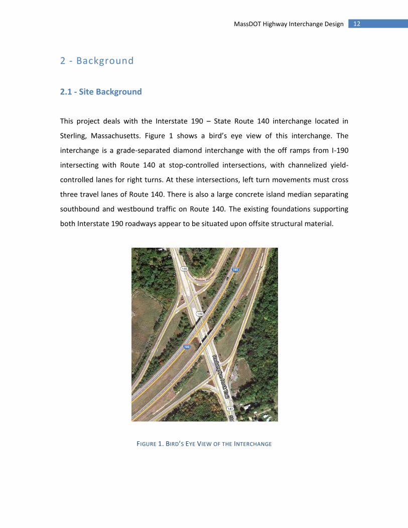
The number of lanes and width of the concrete island increase the travel-time across
the intersection for vehicles turning left onto Route 140 as well as for vehicles making
left turns onto the ramps. In addition, the sight distances on some of the ramps are
inadequate. The sightlines at the end of the southbound exit ramp looking south are
limited by the side slope of I-190 and vegetation, as well as a large sign. In addition, the
side slope and vegetation on the north side of the ramp obscures the view of the
bottom of the ramp, blocking the view of cars stopped at the end of the ramp from cars
traveling down the ramp.
FIGURE 2. SPLITTER ISLAND AT I-190 SB OFF RAMP
2.2 - Interchanges
Interchanges and grade separations occur when two or more roadways cross at
different levels. This eliminates crossing conflicts and improves the intersection's
efficiency. Interchanges provide a connection through a series of ramps to the grade

14 MassDOT Highway Interchange Design
separated roadways. In deciding whether to use a grade separated interchange at an
intersection, multiple factors must be considered. These factors are referred to as
warrants and listed below: (MassDOT, 2006)
Design Designation – Once it is decided to develop a route as a limited-access
freeway, designers must decide whether intersecting highways will be
terminated, rerouted, or provided with a grade separation or interchange, with
traffic flow on the freeway being the chief concern.
Safety – The crash reduction benefit may warrant an interchange selection at a
dangerous at-grade intersection.
Congestion – An interchange may be chosen when an at-grade intersection cannot
provide the desired Level-of-Service.
Site Topography – At certain locations a grade-separated intersection may be
more feasible than an at-grade intersection due to topographical concerns.
Traffic Volume – Interchanges are desirable at cross streets with heavy traffic
volumes to eliminate conflict and improve traffic flow.
Road-User Benefit – Efficiently designed interchanges reduce travel time and cost.
The road- user benefits may outweigh the cost over the life of the interchange.
There are two types of freeway interchanges; system interchanges and service
interchanges. A system interchange connects a freeway to a freeway, while a service
interchange connects a freeway to a lesser facility. The existing service interchange at
the Sterling design site is a diamond interchange. Diamond interchanges use one-way
diagonal ramps in each quadrant with two at grade intersections provided on the minor
road. The preferred design is to elevate the minor roadway over the major roadway to
aid in acceleration to freeway speed and deceleration to minor road speeds. The
advantages to using such an interchange are as follows:

15 MassDOT Highway Interchange Design
Continuity of pedestrian and bicycle accommodations on the minor road are
easier to maintain since merging and diverging movements can be avoided.
Relatively little right-of-way is required.
The configuration allows modifications to provide greater ramp capacity if needed
in the future.
Their common usage has resulted in a high degree of driver familiarity.
All traffic can enter and exit the freeway mainline at relatively high speeds and all
exits are made prior to reaching the structure.
Adequate sight distances can usually be provided and traffic maneuvers are
normally uncomplicated.
The primary disadvantages of a diamond interchange are the potential operational
problems with the two closely spaced intersections on the minor road and the potential
for wrong-way entry onto the ramps. For this reason a median is usually provided to
help with channelization.
2.3 - Roundabouts
Roundabouts are circular intersections with specific design and traffic control features.
The main features of an interchange are shown in Figure 3. These features include yield
control of all entering traffic, channelized approaches, and appropriate geometric
curvature to ensure that travel speeds on the circulatory roadway are typically less than
30 mph. The key features of a roundabout, as defined by Roundabouts: an Informational
Guide, are as follows: (US Department of Transportation)

16 MassDOT Highway Interchange Design
FIGURE 3. FEATURES OF A ROUNDABOUT
“Central Island - The central island is the raised area in the center of a
roundabout around which traffic circulates.
Splitter Island - A splitter island is a raised or painted area on an approach used
to separate entering from exiting traffic, deflect and slow entering traffic, and
provide storage space for pedestrians crossing the road in two stages.
Circulatory roadway - The circulatory roadway is the curved path used by
vehicles to travel in a counterclockwise fashion around the central island
Apron - If required on smaller roundabouts to accommodate the wheel tracking
of large vehicles, an apron is the mountable portion of the central island
adjacent to the circulatory roadway.
Yield line - A yield line is a pavement marking used to mark the point of entry
from an approach into the circulatory roadway and is generally marked along the
inscribed circle. Entering vehicles must yield to any circulating traffic coming
from the left before crossing this line into the circulatory roadway.
Accessible pedestrian crossings - Accessible pedestrian crossings should be
provided at all roundabouts. The crossing location is set back from the yield line,
and the splitter island is cut to allow pedestrians, wheelchairs, strollers, and
bicycles to pass through.
17 MassDOT Highway Interchange Design
Bicycle treatments - Bicycle treatments at roundabouts provide bicyclists the
option of traveling through the roundabout either as a vehicle or as a pedestrian,
depending on the bicyclist’s level of comfort.
Landscaping buffer - Landscaping buffers are provided at most roundabouts to
separate vehicular and pedestrian traffic and to encourage pedestrians to cross
only at the designated crossing locations. Landscaping buffers can also
significantly improve the aesthetics of the intersection.”
2.4 - Transportation Engineering Aspects of Interchange Design
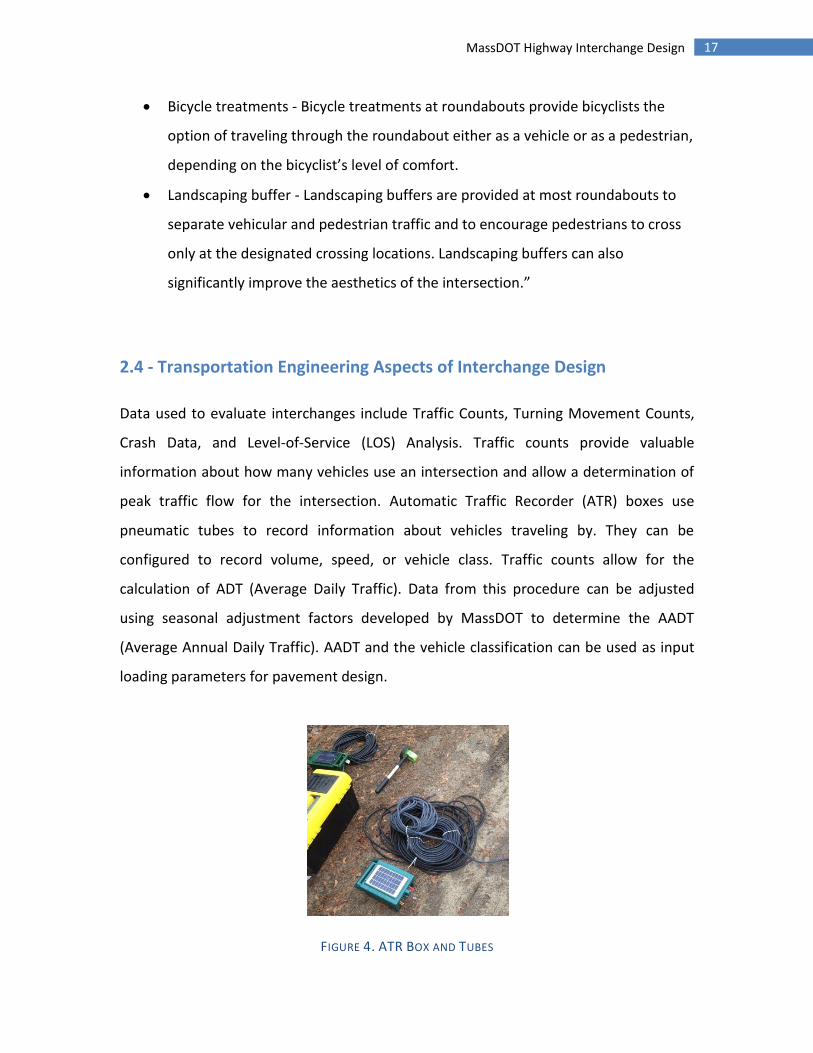
Data used to evaluate interchanges include Traffic Counts, Turning Movement Counts,
Crash Data, and Level-of-Service (LOS) Analysis. Traffic counts provide valuable
information about how many vehicles use an intersection and allow a determination of
peak traffic flow for the intersection. Automatic Traffic Recorder (ATR) boxes use
pneumatic tubes to record information about vehicles traveling by. They can be
configured to record volume, speed, or vehicle class. Traffic counts allow for the
calculation of ADT (Average Daily Traffic). Data from this procedure can be adjusted
using seasonal adjustment factors developed by MassDOT to determine the AADT
(Average Annual Daily Traffic). AADT and the vehicle classification can be used as input
loading parameters for pavement design.
FIGURE 4. ATR BOX AND TUBES

18 MassDOT Highway Interchange Design
Turning Movement Counts record the number of vehicles taking each available route
through the intersection. The number of heavy vehicles (trucks, buses, etc.) traveling
through the intersection is also recorded. This technique of data collection is typically
conducted during peak travel times and is used to calculate Level-of-Service.
Crash data helps to identify the causes of crashes and to identify the root problems
associated with them. By analyzing trends in where and how crashes occur, specific
problem areas of a roadway, intersection, or interchange can be identified. The crash
rate can be calculated and compared to state or regional averages.
Level-of-Service (LOS) Analysis uses data to determine whether or not the current
control measures and lane configurations are appropriate and provide models to adjust
them accordingly in the new design. The LOS is an indicator of operating conditions at
intersections or road segments, and is defined by six levels (“A” through “F”) as per the
2000 edition of the Highway Capacity Manual.
2.5 - Traffic Signal Warrant
To determine if signalization of an intersection is warranted, a traffic signal warrant
analysis is typically performed. This consists of checking to see if the intersection meets
various criteria which would indicate the need for signalized traffic controls. The criteria
that must be met as outlined in chapter 6 of the Massachusetts Highway Department
Project Development and Design Guide are as follows: (MassDOT, 2006)
“Warrant 1: 8-hour vehicular volume - met by 500 to 600 vehicles per hour on
the major street (both directions, two-four lanes respectively) and 150-200
19 MassDOT Highway Interchange Design
vehicles on the minor street (major direction, one-two lanes respectively), for
any combination of 8 hours daily. A variation (“interruption of continuous
traffic”) warrant is met with 750 to 900 vehicles hourly on major street (two-four
lanes, both directions), and 75 to 100 vehicles hourly (major direction, one-two
lanes), on the minor street. These volumes can be reduced under certain
circumstances (see Part 4 of the MUTCD for details).
Warrant 2: four-hour vehicular volume - met on two-lane streets when the
volume approaching the intersection on both major street approaches combined
plus the higher of the minor street approaches is around 900 vehicles hourly, for
four hours daily.
Warrant 3: peak hour - met on two-lane streets when the volume approaching
the intersection on both major street approaches combined plus the higher of
the minor street approaches is around 1,200 vehicles in a single peak hour.
Warrant 4: pedestrian volume - met with intersection or mid-block pedestrian
crossing volumes of at least 100 for each of four hours, or 190 during any one
hour, in combination with fewer than 60 hourly gaps of adequate length to allow
pedestrian crossing when the volume criteria are satisfied.
Warrant 5: school crossing - met with a minimum of 20 students crossing in the
highest crossing hour, and less than one acceptable gap in the traffic stream per
minute during the highest crossing hour. Engineering judgment and attention to
other remedies (such as crossing guards, improved signage, and crossing islands)
are strongly recommended.
Warrant 6: coordinated traffic signal system - where existing traffic signal
spacing does not provide the necessary degree of platooning (grouping) of
traffic, as needed to provide a progressive operation.
Warrant 7: crash experience - met when crash data indicates a problem
remediable by traffic signal installation.
Warrant 8: roadway network - met when the street has importance as a principal
roadway network or is designated as a major route on an official plan, as defined
20 MassDOT Highway Interchange Design
by the Massachusetts Highway Department project Development and Design
Guide.”
2.6 - Structural and Geotechnical Engineering Aspect of Interchange Design
Given the large size and infrastructural importance of highways, evaluating the strength
of supporting members, and associated foundations is a paramount aspect of
interchange design. Furthermore, the existing conditions of an area where an
interchange is to be placed can factor significantly into the design process. The
geological conditions and soil profile of a site will often dictate different aspects of the
roadway’s design criteria
Another important geotechnical aspect of highway design is pavement design.
Pavement is a critical part of the functionality of an intersection or interchange.
Pavement in poor condition can damage vehicles and cause crashes. More than 30% of
traffic fatalities in Massachusetts have reportedly been attributed to poor road
conditions (Mallick and El-Korchi, 2008). A pavement must remain adequately strong
and durable for the duration of its design life.
Pavement can refer to either a rigid pavement made of concrete or a flexible pavement
made with asphalt concrete. Typically, flexible pavements are better suited for cold
weather climates because they are less susceptible to freeze-thaw damage. In warmer
areas, rigid pavements may be favored.
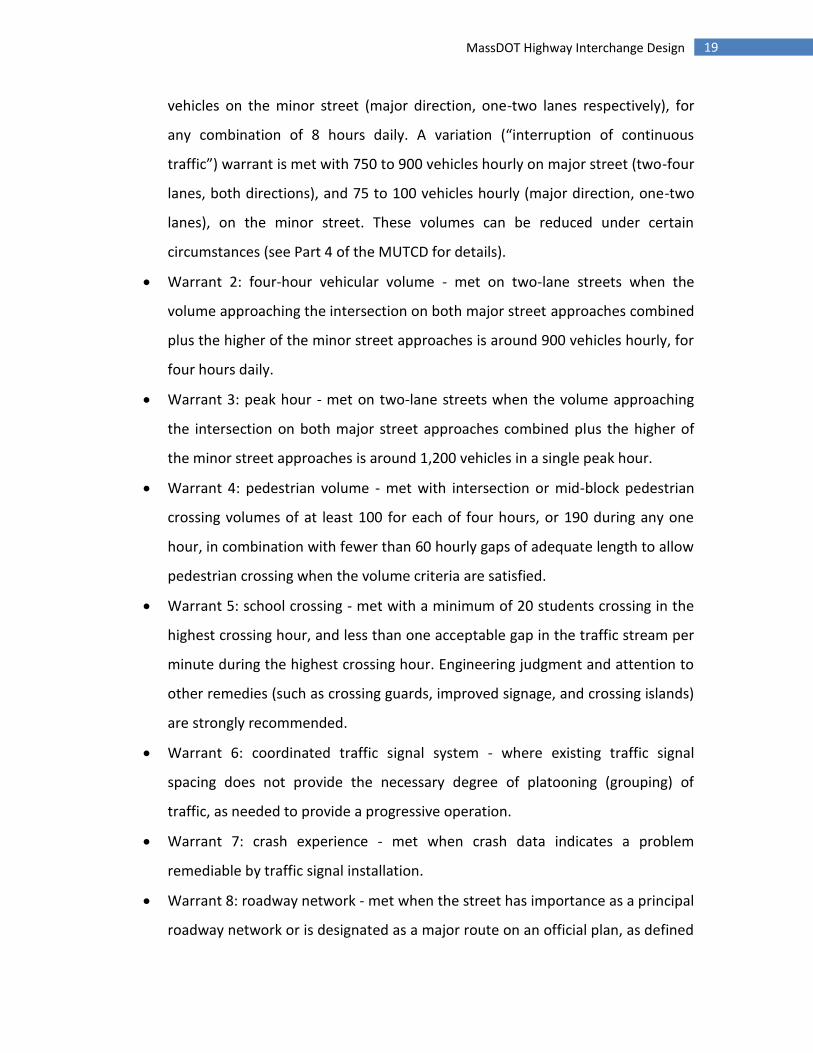
Flexible Pavement usually consists of a number of layers of different materials designed
to protect the underlying soil from the forces of the passing vehicles. A typical asphalt
pavement cross-section is shown below in Figure 5. From bottom to top, the first layer is
the subgrade, which is the term used for the natural ground soil. Often, the subgrade is
21 MassDOT Highway Interchange Design
compacted to give it a higher resistance to the stresses imposed on it by vehicles. The
next layer is typically the subbase, which consists of gravel or crushed stone. A subbase
layer is not always necessary and is sometimes omitted. Typically, a subbase is not
necessary if the existing subgrade is very strong or the pavement will not need to
sustain a large load. Next is the base, which typically consists of gravel or crushed stone
of a higher quality than that of the subbase. Finally, the top layer is the asphalt
concrete, which is the surface layer. This layer is made up of an asphalt concrete, which
is made from asphalt binder mixed with aggregates and other additives. The mixing is
usually done at high temperatures to make the mixture less viscous and easier to work
with. After placement, the Hot Mix Asphalt (HMA) cools and hardens.
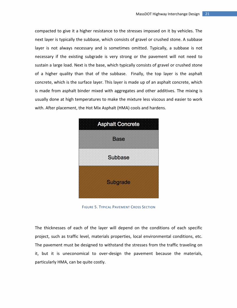
FIGURE 5. TYPICAL PAVEMENT CROSS SECTION
The thicknesses of each of the layer will depend on the conditions of each specific
project, such as traffic level, materials properties, local environmental conditions, etc.
The pavement must be designed to withstand the stresses from the traffic traveling on
it, but it is uneconomical to over-design the pavement because the materials,
particularly HMA, can be quite costly.

22 MassDOT Highway Interchange Design
The makeup of a pavement cross-section can be determined using a variety of methods.
A typical method is the AASHTO Method, which uses the empirical flexible pavement
design equation shown in the Methodology. The equation takes into account the
Equivalent Single Axle Load (ESAL) value. This represents the total loading of vehicles
over the design life of the pavement. The structural number of a pavement represents
the thickness and strengths of various layers, and is taken into account by the equation.
The equation also accounts for reliability of future predictions for traffic data and for the
gradual deterioration of pavement over time.
2.7 - Massachusetts DOT Project Need Form
The Massachusetts Department of Transportation (MassDOT) consists of four divisions:
Highway, Transit, Aeronautics, and Registry of Motor Vehicles. The Highway Division
oversees the roadways, bridges, and tunnels of the commonwealth and is divided into
five districts. This project falls under the jurisdiction of the Highway Division District 3
office, which generally oversees the highways and bridges in central Massachusetts.
Projects that are performed in conjunction with Massachusetts DOT have a pair of forms
that are filled out to determine the necessity, magnitude and details of a specific
transportation project. The first form, which will be completed as part of this project, is
the Project Need Form.
The Massachusetts DOT Project Need Form is a form that assesses the necessity of
redesign. It requires both a description of an alternate design, and an evaluation of
numerous existing site conditions. Mobility within a specific area, safety concerns,
environmental impact, and economic development are all addressed in separate
sections within the form.
The Project Need Form is a basic evaluation of a specific project. Upon the completion

23 MassDOT Highway Interchange Design
of this form, it will be decided whether or not the project will progress to the next step.
The next step in the project is the completion of another form, the Project Initiation
Form. This form is a much more in-depth look at many of the same aspects of the
Project Need Form. The initiation form includes specifics on proposed designs, cost
estimates, sources of funding and other data.
From here a proposed project is a candidate for federal funding and project initiation
form is submitted to the district office, usually a Metropolitan Planning Organization
such as Montachusett Regional Planning Commission. In the case of Massachusetts, the
forms are then sent to MassDOT Highway’s Project Review Committee to review,
evaluate and discuss the project and decide whether or not to proceed. Metropolitan
Planning Organizations are federally funded and regulated transportation policy makers
designed to manage urbanized areas. They coordinate communication between the
local government, transportation authorities and the citizens of their district. Approved
project at this point are ready to be designed and implemented.
24 MassDOT Highway Interchange Design
3 - Methodology
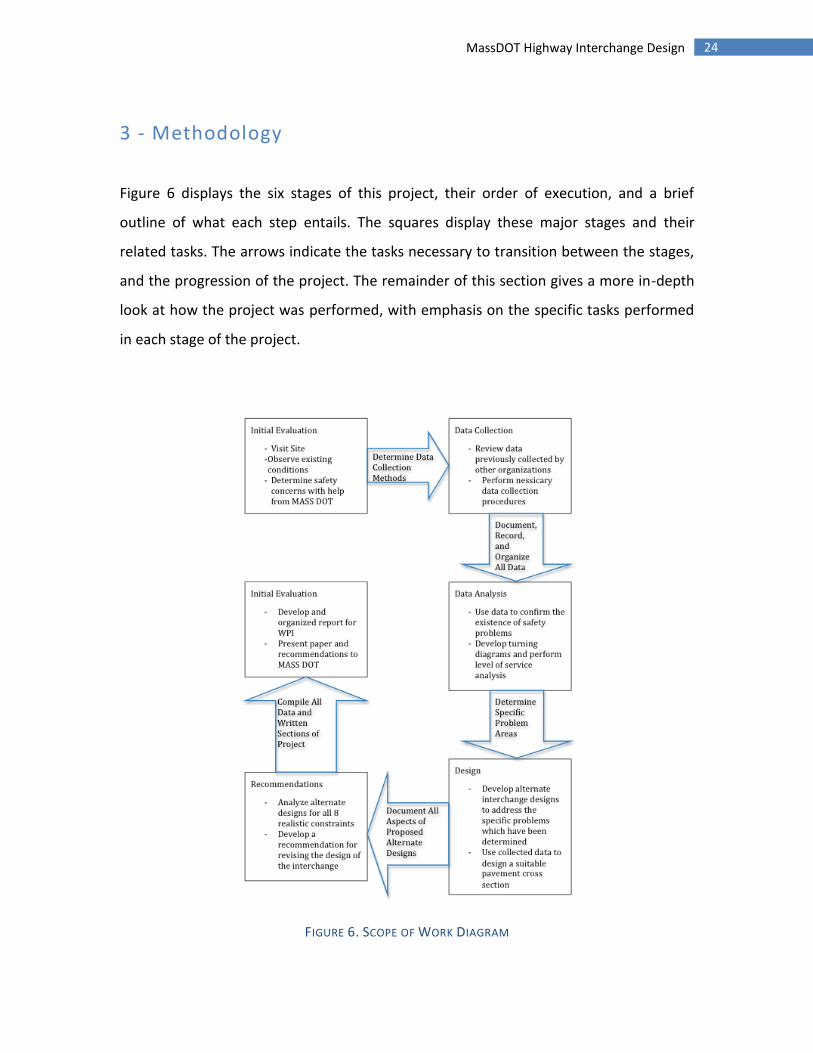
Figure 6 displays the six stages of this project, their order of execution, and a brief
outline of what each step entails. The squares display these major stages and their
related tasks. The arrows indicate the tasks necessary to transition between the stages,
and the progression of the project. The remainder of this section gives a more in-depth
look at how the project was performed, with emphasis on the specific tasks performed
in each stage of the project.
FIGURE 6. SCOPE OF WORK DIAGRAM
25 MassDOT Highway Interchange Design
The first stage of this project is an initial evaluation of the existing Interstate 190 Route
140 interchange. This evaluation was performed in two different ways. First, the project
group visited the site, and looked for any elements of the existing interchange that
could present a danger to vehicles or pedestrians. In addition, the group photographed
the existing site conditions. The next step in evaluating the current interchange design
involved contacting with Mr. Joe Frawley of MassDOT. MassDOT’s existing safety
concerns with the interchange were then reviewed. After all safety concerns were
reviewed, the group determined what data needed to be collected on the site. Mr. Joe
Frawley’s input regarding the necessity of different data collection activities also
contributed to these decisions.
Once the data collection methods were decided, the second stage of the project began.
This phase involved the collection of data from the site, as well as a review of previously
collected data. First, a request was put in for crash data from the Interstate 190 Route
140 interchange. In addition, the group (under guidance of Mr. Joe Frawley and the
advising professors) collected 24-hour ATR counts as well as manual turning movement
counts from the interchange and resulting intersections. Please note that traffic counts
were only preformed on Route 140, and that the only data obtained regarding I-190 is
on-ramp and off-ramp traffic counts. Traffic data collected by the group was
supplemented by previously collected traffic data, which was obtained by the group.
The group measured the sight distance on the Interstate 190 off-ramps.
The third stage of the project commenced when all necessary data had been obtained.
Once this has occurred, the project group analyzed the data. As part of the analysis, the
group compiled collision diagrams pertaining to the interchange and determined its
crash rate. By evaluating the interchange’s crash data, the group was able to determine
which areas of the interchange are the most problematic. The group also analyzed the
existing and future capacities of the intersection based upon the data collected from

26 MassDOT Highway Interchange Design
Route-140 and the I-190 ramps.
This traffic data was reviewed and the existing pavement design examined. After
determining whether a pavement redesign is necessary, traffic data, local climate
conditions, the extents of the roadways and known mechanical properties of pavement
materials were used to determine the required structural specifications of the proposed
new pavement. These specifications were then analyzed to develop the design of an
appropriate pavement
The design and analysis of revised interchange designs composed the fourth stage of the
project. The design process began by reviewing the interchange problems determined
from data analysis. Alternate interchange designs were conceptually developed with
special attention to these specific problems. MassDOT was contacted during the design
process and their input was also considered. Many different realistic constraints were
addressed in the process of designing alternate interchanges. The specific design
procedures varied between the different designs, but structural, geotechnical, and
traffic engineering elements were the main focus of this project. All designs were
performed in accordance with the Mass Highway Department Project Development and
Design Guide. (Massachusetts Highway Department: Project Development and Design
Guide 2006)
Once all alternate interchange designs were completed, the project group evaluated the
designs. The designs were analyzed using the evaluation criteria used by the
Montachusett Metropolitan Planning Organization, who have voting rights over
federally funded transportation projects such as this. The criteria used are shown below
in Table 1.

27 MassDOT Highway Interchange Design
TABLE 1. EVALUATION CRITERIA FOR MAJOR HIGHWAY, ARTERIAL, AND INTERSECTION IMPROVEMENTS
Condition and
Service Quality
Magnitude of
pavement
condition
improvement
Magnitude of
improvement of other
infrastructure elements
Mobility Effect on
magnitude and
duration of
congestion
Effect on travel time
and connectivity/access
Effect on other
modes using
facility
Effect on
regional and
local traffic
Safety and
Security
Effect on crash
rate compared to
state average
Effect on bicycle
and pedestrian saftey
Cost
Effectiveness
Cost Unit Change
in condition
Cost per
Linear Mile
Cost per AADT
Community
Effects and
Support
Residential
effects:
right-of way,
noise, aesthetics,
cutthrough
traffic, other
Effect on serive to
minority
or low-income
neighborhoods
Other
impacts/benefits
to
minority or low-
income
neighborhoods
Public, local
government,
legislative, and
regional
support
Effect on
development
and
redevelopment
of housing
stock
Land Use and
Economic
Development
Business effects:
right-of-way,
access,
noise, traffic,
parking,
freight access,
other
Environmental
Effects
Air Quality/
Climate Effects
Water quality/
supply effects
Historic and
cultural
resources effects
Effect on
wildlife habitat
and
endangered
species
28 MassDOT Highway Interchange Design
The evaluation process was conducted by using a Montachusett Regional Planning
Committee TIP form. This form used a rating system of 1-5 which was used to
individually evaluate the different interchange aspects shown above. The scores from
the different evaluation criteria were added, and thus the improvements of the group’s
interchange redesigns were compared to one another.
After these constraints were considered, the group began the fifth stage of the project
and presented a recommendation based on the analysis. The group prepared a report
analyzing the different design constraints and the resulting design recommendation.
The final stage of this project involved the compilation of all data, figures, tables, and all
written sections. The group presented the findings of this project in an organized report,
which was reviewed by the advising professors before final submission
This project included the completion of a Mass DOT Project Need Form that states the
evaluation of existing site conditions, and displays the findings of the project group’s
proposed interchange design. Although a Project Initiation Form was not completed as
part of this project, an evaluation of the Project Need Form may warrant further analysis
of the revised design, and a Project Initiation Form may be completed at a later time.
The following section discusses the specific methods used to collect data for this project.
Each section expands upon a previously discussed procedure and discusses how the
project group used known methods to assess the existing conditions of the project site.

29 MassDOT Highway Interchange Design
3.1 - Site Visits
The following is a list of site visits, and the various tasks performed on each day:
09/19/2011 – Initial Site Visit: This was an initial evaluation of the site. The group aimed
to document the existing conditions of the interchange, photograph the intersections,
and examine existing safety concerns.
11/09/2011 – Turning Movement Counts: The group visited the site twice on this day in
order to perform manual turning movement counts. The group decided to perform
counts during the AM and PM peak traffic hours
12/14/2011 – Installation of JAMAR Boxes: The group arranged for a Sterling Police
Officer to be present so that the group could install JAMAR boxes.
12/16/2011 – Removal of JAMAR Boxes: The group planned to remove the JAMAR
boxes which had been previously installed.
3.2 - Turning Movement Count
Data was collected for the Turning Movement Counts using two Jamar Technologies,
Inc. DB-100 Intersection Counters. The data collection occurred on Wednesday,
November 9, 2011 during morning and evening peak hours. The morning data was
collected between the hours of 6am and 8am; the evening was collected between the
hours of 4pm and 6pm. During each data collection period, one intersection counter box
was operated at the intersection of Route 140 and the I-190 Northbound ramps, and
one box was operated at the intersection of Route 140 and the I-190 Southbound
ramps. The boxes were operated under standard procedure, with one button being
pressed for each vehicle completing a given turning movement. After the data was
30 MassDOT Highway Interchange Design
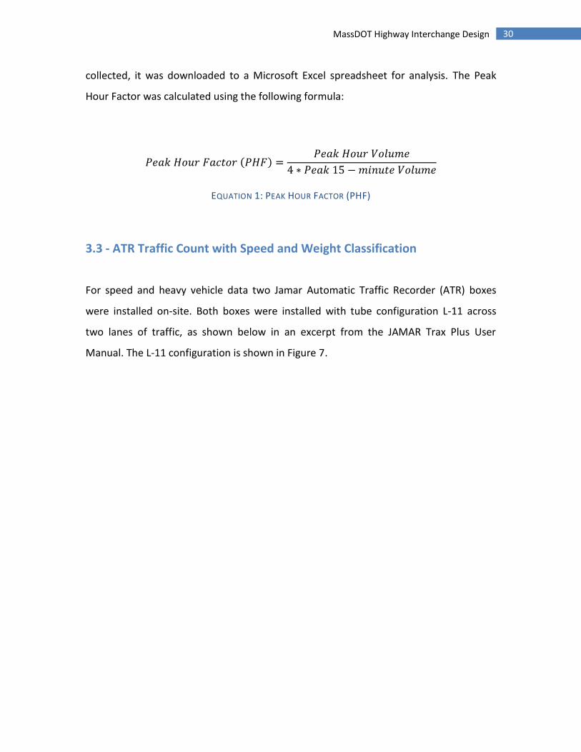
collected, it was downloaded to a Microsoft Excel spreadsheet for analysis. The Peak
Hour Factor was calculated using the following formula:
( )
EQUATION 1: PEAK HOUR FACTOR (PHF)
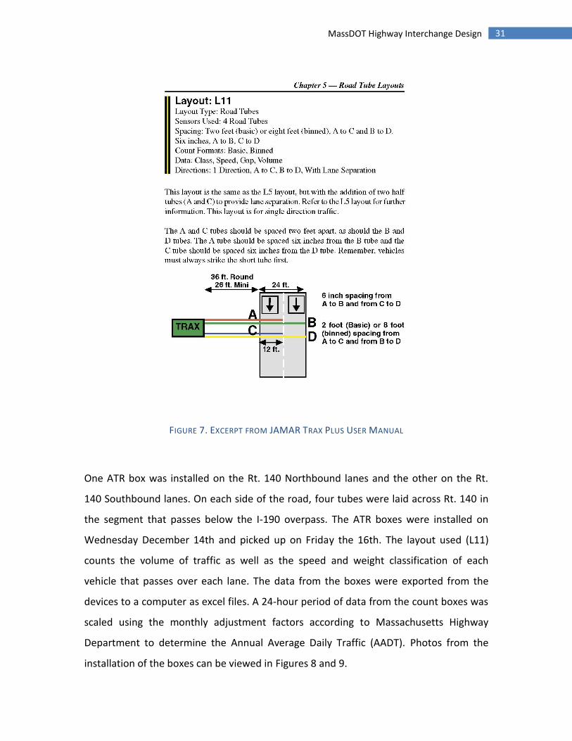
3.3 - ATR Traffic Count with Speed and Weight Classification
For speed and heavy vehicle data two Jamar Automatic Traffic Recorder (ATR) boxes
were installed on-site. Both boxes were installed with tube configuration L-11 across
two lanes of traffic, as shown below in an excerpt from the JAMAR Trax Plus User
Manual. The L-11 configuration is shown in Figure 7.
31 MassDOT Highway Interchange Design
FIGURE 7. EXCERPT FROM JAMAR TRAX PLUS USER MANUAL
One ATR box was installed on the Rt. 140 Northbound lanes and the other on the Rt.
140 Southbound lanes. On each side of the road, four tubes were laid across Rt. 140 in
the segment that passes below the I-190 overpass. The ATR boxes were installed on
Wednesday December 14th and picked up on Friday the 16th. The layout used (L11)
counts the volume of traffic as well as the speed and weight classification of each
vehicle that passes over each lane. The data from the boxes were exported from the
devices to a computer as excel files. A 24-hour period of data from the count boxes was
scaled using the monthly adjustment factors according to Massachusetts Highway
Department to determine the Annual Average Daily Traffic (AADT). Photos from the
installation of the boxes can be viewed in Figures 8 and 9.
32 MassDOT Highway Interchange Design
FIGURE 8. INSTALLING ATR TUBES
FIGURE 9. INSTALLED TUBES ON ROUTE 140 SB

33 MassDOT Highway Interchange Design
The weight classification data recovered from the ATR boxes was used to determine the
Equivalent Single Axle Load (ESAL) for pavement design. The procedure for determining
the ESAL value can be viewed in the next section.
Data for speed was placed into several categories or bins based upon predetermined
values. For example, a vehicle traveling at 18.5 mph would be recorded as one vehicle in
the 16-20 mph bin. The speed data was analyzed using the average speed of each bin
and the number of vehicles in each bin. Using this data, the average speed was
calculated along with the standard deviation. In addition, the 85th percentile speed was
determined, which is the speed below which 85% of drivers are traveling. This is
typically used as a benchmark for speed limits. The average speed was calculated using
the following formula, where the average speed of each bin is halfway between the top
speed and bottom limits of the bin.
∑
EQUATION 2. AVERAGE SPEED FOR BINNED DATA
3.4 - Pavement Design
The design of flexible pavement performed in this report began with using the empirical
flexible pavement equation (Equation 3) to determine the required structural number
for design.
( ) ( ) (
)
( )
( )
EQUATION 3. EMPIRICAL DESIGN EQUATION FOR FLEXIBLE PAVEMENTS (MALIK AND EL KORCHI)
34 MassDOT Highway Interchange Design
The variables in this equation are defined as follows:
W18: The predicted number of 18-kip equivalent single axle load applications
ZR: Standard Normal Deviate
S0: Combined standard error of the traffic prediction and performance prediction
∆PSI: Difference between the initial design serviceability index, p0, and the
design terminal serviceability index, pt.
MR: Resilient modulus (psi)
As discussed above an EASL value was calculated from the ATR box data the group
collected. The ESAL value was calculated by totaling the number of vehicles in a 24 hour
period that were recoded under each weight classification. The percentage of
distribution in each classification was used to adjust the numbers to include vehicles
that the machine was unable to classify. For example, if Class 1 had 300 vehicles totaling
20% of the vehicles, and there were 50 unclassified vehicles, the adjusted number
would be 300 + (20%*50) = 310. Then, the numbers were adjusted for seasonal variation
using the Massachusetts Highway Department Weekday Seasonal Factors
(Massachusetts Highway Department, 2007). The value was then scaled for 20 year
growth using a linear growth model and an annual growth rate of 2.59% as determined
by the MRPC in the Sterling Route 140 Corridor Profile. (MMPO, 2010) The value was
also multiplied by 365 days/year and divided by two because of the directional split of
traffic. The resulting values for each classification were then multiplied by the ESAL
factor for that weight class (FHWA, 1998). The sum of the individual ESAL values
represents the total Equivalent Single Axle Load that the road would need to endure
over the next 20 years. This value is represented in the empirical equation by the
variable W18. The numerical calculations of the ESAL value are available in Appendix G.
The value used for delta PSI was 1.7, a value recommended for flexible highways with
low classification. A ZR value was calculated for a 95% reliability level, and the suggested

35 MassDOT Highway Interchange Design
value of 0.5 was used for the combined standard of error represented by S0. All of these
recommended values were taken from “Pavement Design” By Malick and El Korchi.
The MR value used to solve this equation represents the modulus of resilience for the
pavement’s sub grade material. Upon consulting existing data available from MassGIS, it
was determined that the subsoil existing onsite was either Canton Fine Sandy Loam or
Merrimack Fine Sandy Loam (Massachusetts Office of Geographic Information, 2011).
Typically, in-situ testing would be used to determine the modulus of resilience for this
material; however an inability to perform such tests made it necessary to approximate
this value. Instead, the group utilized a soil texture triangle plot to determine a
representative material composition. Figure 10 displays the soil texture triangle plot
utilized to classify the onsite material.
FIGURE 10. SOIL TEXTURE TRIANGLE PLOT
36 MassDOT Highway Interchange Design
As shown in Figure 10, sandy loam is a soil with a sand composition of 50-75%. In
addition, up to 40% silt and 20% clay may compose the existing on-site material. The
makeup of this soil suggests high plasticity sand, and therefore the soil was
approximated to be silty sand of high plasticity, or MH. (Standard Handbook for Civil
Engineers, Third Edition). Referring to an empirical design guide, an approximate value
of 6 kips per square inch was used for the modulus of elasticity of the existing sub base.
(Guide for Mechanistic-Empirical Design)
Once all necessary variables were determined, the empirical equation for flexible
pavement design was utilized, and a structural number was obtained. Using the
obtained structural number, Equation 4 was utilized to determine the required
thicknesses of the different pavement layers. (Guide for Mechanistic-Empirical Design)
EQUATION 4. PAVEMENT REQUIRED THICKNESS
The variables in this equation are defined as follows. (Guide for Mechanistic-Empirical
Design):
( )
37 MassDOT Highway Interchange Design
The layer coefficient is a value that is based up the elastic moduli of different pavement
layer materials. These coefficients are determined based upon extensive stress and
strain calculations for a multi-layer pavement. (Guide for Mechanistic-Empirical Design)
For typical pavement design, a FWD test would be performed on the existing pavement
and alternate pavement materials in order to determine their layer coefficients. Due to
an inability to perform such procedures, average layer coefficient values were used for
the design of this pavement. The coefficients used were as follows, and were taken from
the Guide for Mechanistic-Empirical Design:
( )
( )
( )
Using the structural number determined using Equation 3, Equation 4 was solved using
a spread sheet. The average layer coefficients were input into the equation, and the
layer drainage coefficients were assumed to be 1. Using the spreadsheet, different layer
thicknesses were examined until a pavement design exhibited a structural number
adequate to satisfy the previously determined value.
38 MassDOT Highway Interchange Design
3.5 - Crash Rate Analysis
To determine if there is a safety issue at an intersection, a crash rate (number of crashes
per million entering vehicles) is determined through a process defined by the MassDOT
highway division. This number compared to the state average for a specific road
classification gives a good idea of the relative safety of the interchange. To calculate the
crash rate, the following data is needed:
Peak hour entering volume for the intersection
K value of 0.09 calculated from peak hour traffic divided by total traffic.
Crash data for intersection and time period over which crash information was
collected
With this, the average daily traffic can be calculated. The formula given for crash rate by
the MassDOT crash rate intersection work sheet is as follows:
EQUATION 5. CRASH RATE CALCULATION
3.6 - Level of Service
The Level-of-Service was determined based on the turning movement counts conducted
Wednesday, November 9, 2011. The data was analyzed to determine the peak hour,
peak hour factor, and percent heavy vehicles. The data was not adjusted with a monthly
adjustment factor in order to produce a more conservative result. The monthly
adjustment factor that would have been used is 0.98 (Massachusetts Highway
39 MassDOT Highway Interchange Design
Department, 2007). The turning movement count data was input into the HCS2000
Highway Capacity Software by McTrans. The data was analyzed for an unsignalized two-
way stop-controlled intersection. An analysis was performed for both the intersection
with the northbound ramps and the southbound ramps for both the morning and
evening peak hours.
3.7 – Conceptual Design Evaluation
Of the possible designs, the scope of the project only allowed the in depth evaluation of
a few alternatives. To rule out the designs that were not feasible or were inefficient at
dealing with the design problem, each idea was evaluated informally on the expected
impact based on the evaluation template. Early designs considered included a reduction
in number of lanes, a single point urban interchange, full or partial cloverleaf
interchanges, adjustments to lane geometry and channelization, roundabouts, and no
change. The designs chosen to be investigated further were a single lane roundabout
and a double lane roundabout, along with the option for no change. These alternatives
were in line with suggestions provided by Mr. Joe Frawley of MassDOT at the beginning
of this study.
3.8 - Roundabout Design
Roundabout design involves trade-offs among safety, operations, and accommodating
large vehicles. Some roundabout features are uniform, while others vary depending on
the location and size of the roundabout. The design process requires multiple iterations
to ensure safety, operational analysis, and layout performance. The design process
followed is the one outlined in the Roundabout Design Guide by the US Department of
Transportation. Before design can begin, the three main concerns are finding the
optimal roundabout size, position, and alignment.

40 MassDOT Highway Interchange Design
The main constraints in determining the radius of a roundabout are the speed through
which vehicles will be able to travel through it along with the turning radii of various
types of vehicles, especially emergency vehicles such as fire trucks. By setting the
maximum speed that vehicles will be traveling through the roundabout, the appropriate
radius for each of the arc paths that vehicles will be traveling can be determined. Entry
and exit radii are likewise determined by the speeds that vehicles will be traveling, with
a smaller entry radius to decrease speed for vehicles entering the roundabout and a
larger exit radius for vehicles traveling out of the roundabout. Design values for other
features such as splitter islands and crosswalks are derived from the USDOT
Roundabout Design Guide.
3.9 – Design Evaluation
The revised interchange designs were evaluated using a TIP evaluation form. This form
took into account transportation criteria and cost as well as community effect and
support, land use and economic development and environmental effects. The full
descriptions of factors considered are shown in Table 1. The factors the conditions were
judged on were Condition, Mobility, Safety, Cost Effectiveness, Community Effects and
Support, Land Use and Economic Development, and Environmental Effects. Each factor
was rated on a scale of 1 to 5 based on the expected change using the group’s
judgment.
41 MassDOT Highway Interchange Design
4 – Results
The following section addresses the specific data obtained from the procedures
described in the “Methodology” section. All raw data obtained for this project can be
viewed in the appendices of this report.
4.1 - Site Visits
09/19/2011 – Initial Site Visit: This was an initial evaluation of the site. The group
documented the existing conditions of the interchange, photographed the two
intersections, and examined existing safety concerns.
11/09/2011 – Turning Movement Counts: The group visited the site twice on this day to
perform manual turning movement counts. The group was present on site from 6am to
8 am, and then again from 4pm to 6 pm. Turning movement counts were performed
from a car on the shoulder of the road.
12/14/2011 – Installation of JAMAR Boxes: The group was on site from 8:20 am to
10:30 am in order to place two JAMAR boxes on Route 140. A Sterling Police Officer was
also present to direct traffic around the installation.
12/16/2011 – Removal of JAMAR Boxes: The group was on site from 5 pm until 5:35 pm
to remove the previously installed boxes. Tubes and nails were removed from the road,
and the boxes were brought back so that data could be extracted.
42 MassDOT Highway Interchange Design
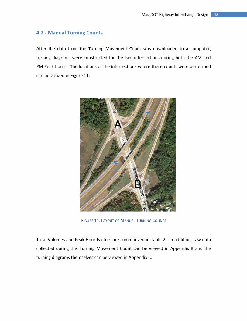
4.2 - Manual Turning Counts
After the data from the Turning Movement Count was downloaded to a computer,
turning diagrams were constructed for the two intersections during both the AM and
PM Peak hours. The locations of the intersections where these counts were performed
can be viewed in Figure 11.
FIGURE 11. LAYOUT OF MANUAL TURNING COUNTS
Total Volumes and Peak Hour Factors are summarized in Table 2. In addition, raw data
collected during this Turning Movement Count can be viewed in Appendix B and the
turning diagrams themselves can be viewed in Appendix C.
43 MassDOT Highway Interchange Design
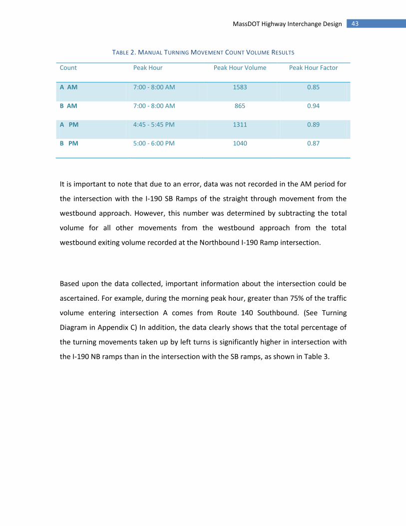
TABLE 2. MANUAL TURNING MOVEMENT COUNT VOLUME RESULTS
Count Peak Hour Peak Hour Volume Peak Hour Factor
A AM 7:00 - 8:00 AM 1583 0.85
B AM 7:00 - 8:00 AM 865 0.94
A PM 4:45 - 5:45 PM 1311 0.89
B PM 5:00 - 6:00 PM 1040 0.87
It is important to note that due to an error, data was not recorded in the AM period for
the intersection with the I-190 SB Ramps of the straight through movement from the
westbound approach. However, this number was determined by subtracting the total
volume for all other movements from the westbound approach from the total
westbound exiting volume recorded at the Northbound I-190 Ramp intersection.
Based upon the data collected, important information about the intersection could be
ascertained. For example, during the morning peak hour, greater than 75% of the traffic
volume entering intersection A comes from Route 140 Southbound. (See Turning
Diagram in Appendix C) In addition, the data clearly shows that the total percentage of
the turning movements taken up by left turns is significantly higher in intersection with
the I-190 NB ramps than in the intersection with the SB ramps, as shown in Table 3.
44 MassDOT Highway Interchange Design
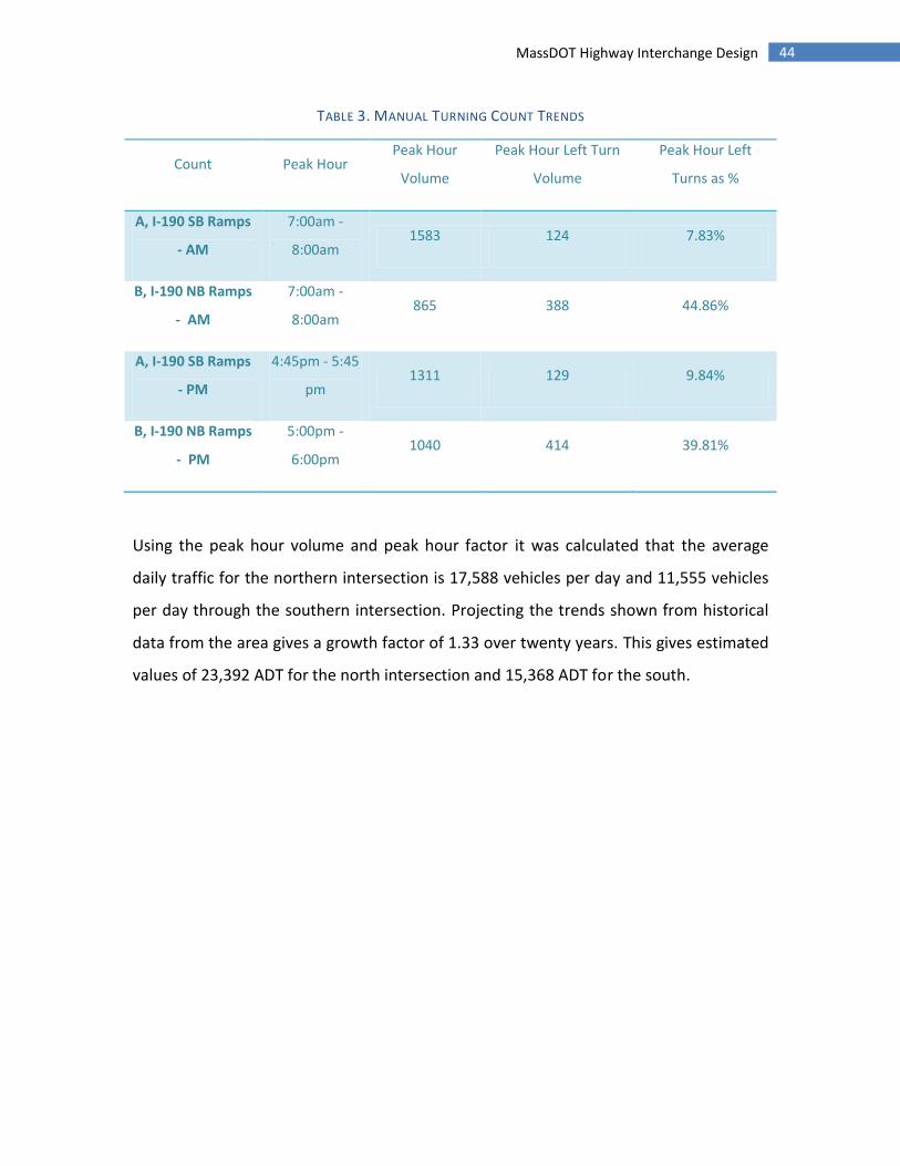
TABLE 3. MANUAL TURNING COUNT TRENDS
Count Peak Hour Peak Hour
Volume
Peak Hour Left Turn
Volume
Peak Hour Left
Turns as %
A, I-190 SB Ramps
- AM
7:00am -
8:00am 1583 124 7.83%
B, I-190 NB Ramps
- AM
7:00am -
8:00am 865 388 44.86%
A, I-190 SB Ramps
- PM
4:45pm - 5:45
pm 1311 129 9.84%
B, I-190 NB Ramps
- PM
5:00pm -
6:00pm 1040 414 39.81%
Using the peak hour volume and peak hour factor it was calculated that the average
daily traffic for the northern intersection is 17,588 vehicles per day and 11,555 vehicles
per day through the southern intersection. Projecting the trends shown from historical
data from the area gives a growth factor of 1.33 over twenty years. This gives estimated
values of 23,392 ADT for the north intersection and 15,368 ADT for the south.
45 MassDOT Highway Interchange Design
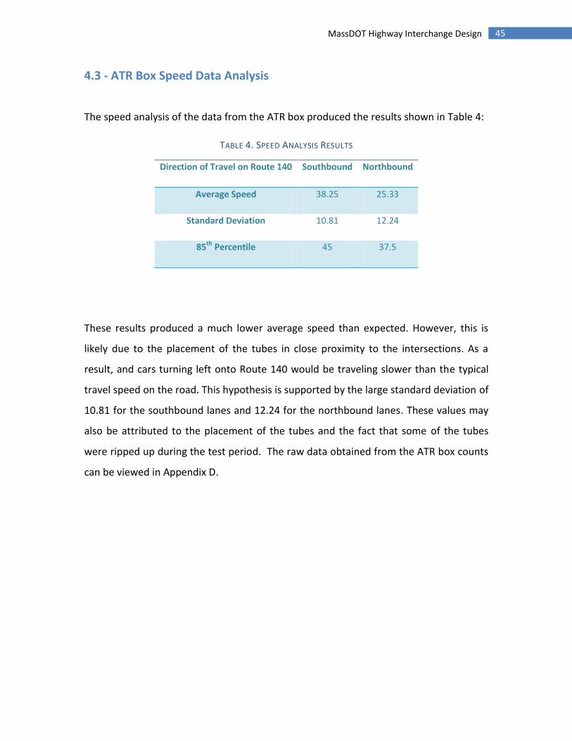
4.3 - ATR Box Speed Data Analysis
The speed analysis of the data from the ATR box produced the results shown in Table 4:
TABLE 4. SPEED ANALYSIS RESULTS
Direction of Travel on Route 140 Southbound Northbound
Average Speed 38.25 25.33
Standard Deviation 10.81 12.24
85th Percentile 45 37.5
These results produced a much lower average speed than expected. However, this is
likely due to the placement of the tubes in close proximity to the intersections. As a
result, and cars turning left onto Route 140 would be traveling slower than the typical
travel speed on the road. This hypothesis is supported by the large standard deviation of
10.81 for the southbound lanes and 12.24 for the northbound lanes. These values may
also be attributed to the placement of the tubes and the fact that some of the tubes
were ripped up during the test period. The raw data obtained from the ATR box counts
can be viewed in Appendix D.

46 MassDOT Highway Interchange Design
4.4 - Traffic Signal Warrant Analysis
Using the signal warrant procedures discussed earlier in this report, the group evaluated
the possibility of signalization. The results were as follows:
Warrant 1: 8-hour vehicular volume
o The collected traffic count data shows that there were not large enough
volumes to consistently reach 600 vehicles on the main road and 150
cross road vehicles for eight consecutive hours. While the intersections
have an average volume of 796 vehicles for eight hours, the distribution
between the main road and cross road was not enough to satisfy the
warrant.
Warrant 2: four-hour vehicular volume
o The highest volume period observed by the group was a four hour total
volume of 698 vehicles. This does not reach the required hourly volume
of 900 vehicles.
Warrant 3: peak.
o The peak hour warrant requires a volume of 1200 vehicles. For peak
hour, the south intersection actually satisfies the warrant with a volume
of 1583 vehicles. The north intersection falls short at around 1040
vehicles however.
Warrant 4: pedestrian volume
o No pedestrian traffic was observed during data collection, and the rural
nature of the intersection suggests a low volume of pedestrian traffic.
Warrant 5: school crossing
o There were no signs of either intersection being used as a school
crossing, and there are no schools in the vicinity of the interchange.
Warrant 6: coordinated traffic signal system
47 MassDOT Highway Interchange Design
o Due to the fact that there aren’t other traffic signals in the area, this
warrant is not met.
Warrant 7: crash experience.
o Both North and South intersections have crash rates above the state
average at .94 and .97 crashes per million entering vehicles respectively.
This could possibly be remedied by a traffic control and would meet a
warrant.
Warrant 8: roadway network
o While I-190 is a major part of the interstate highway system, the
interchange itself does not seem to play a critical role as part of an
evacuation plan or other prioritized plan.
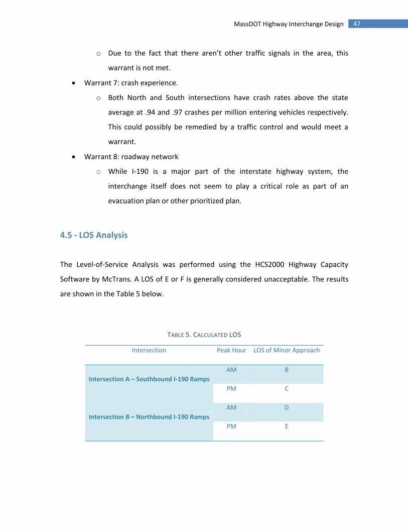
4.5 - LOS Analysis
The Level-of-Service Analysis was performed using the HCS2000 Highway Capacity
Software by McTrans. A LOS of E or F is generally considered unacceptable. The results
are shown in the Table 5 below.
TABLE 5. CALCULATED LOS
Intersection Peak Hour LOS of Minor Approach
Intersection A – Southbound I-190 Ramps
AM B
PM C
Intersection B – Northbound I-190 Ramps
AM D
PM E
48 MassDOT Highway Interchange Design
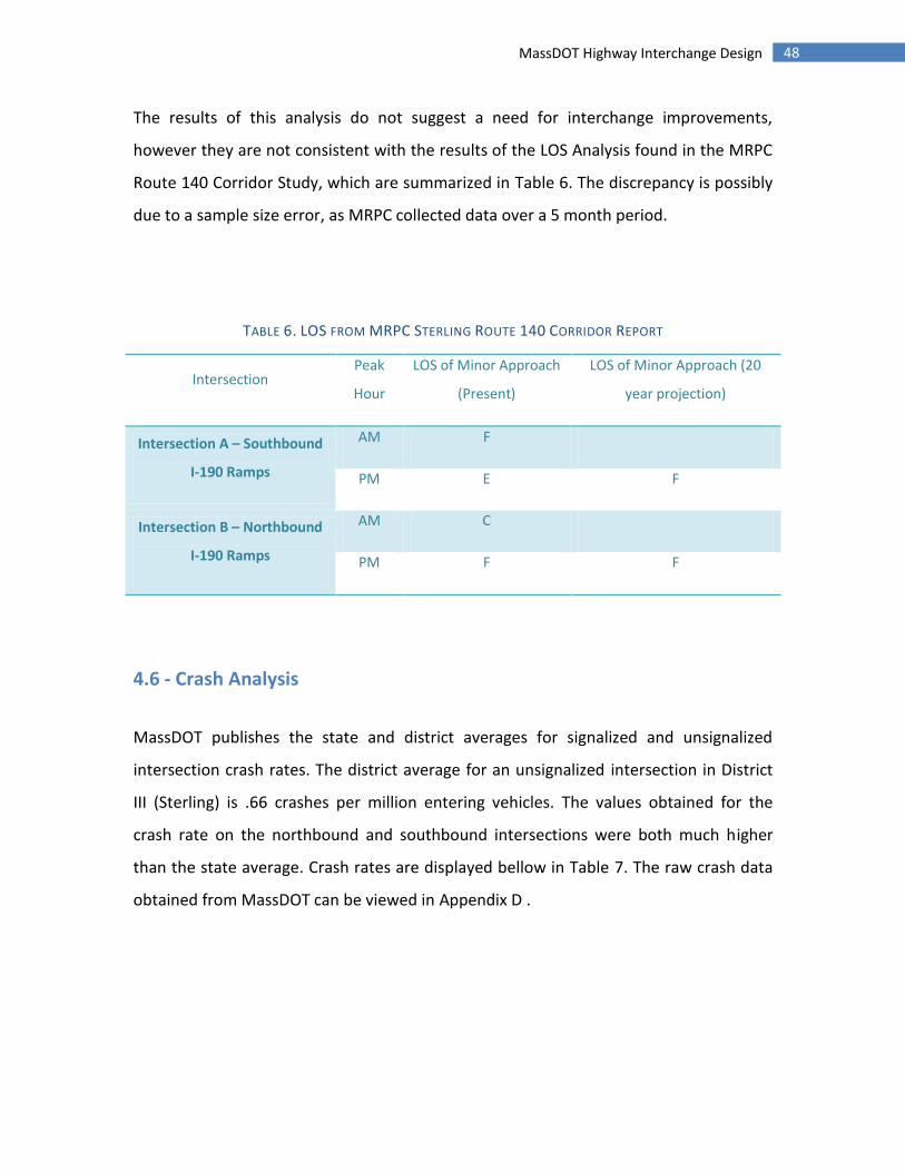
The results of this analysis do not suggest a need for interchange improvements,
however they are not consistent with the results of the LOS Analysis found in the MRPC
Route 140 Corridor Study, which are summarized in Table 6. The discrepancy is possibly
due to a sample size error, as MRPC collected data over a 5 month period.
TABLE 6. LOS FROM MRPC STERLING ROUTE 140 CORRIDOR REPORT
Intersection Peak
Hour
LOS of Minor Approach
(Present)
LOS of Minor Approach (20
year projection)
Intersection A – Southbound
I-190 Ramps
AM F
PM E F
Intersection B – Northbound
I-190 Ramps
AM C
PM F F
4.6 - Crash Analysis
MassDOT publishes the state and district averages for signalized and unsignalized
intersection crash rates. The district average for an unsignalized intersection in District
III (Sterling) is .66 crashes per million entering vehicles. The values obtained for the
crash rate on the northbound and southbound intersections were both much higher
than the state average. Crash rates are displayed bellow in Table 7. The raw crash data
obtained from MassDOT can be viewed in Appendix D .

49 MassDOT Highway Interchange Design
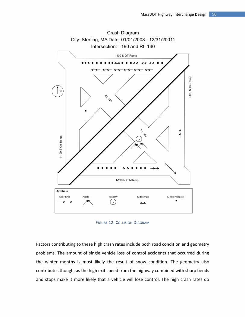
TABLE 7. CRASH RATE ANALYSIS
In the case of the southbound off ramp, many of the crashes were rear end crashes and
single vehicle loss of control accidents. This is consistent with the conditions at the
intersection, as the southbound off ramp has a sight distance problem as well as having
a steeper grade and tighter turning radius off of a short high speed off ramp. The
northbound intersection had more angle collisions and injuries than the southbound
despite having fewer total accidents. There was also a fatal accident recorded during the
period of time reviewed due to a left turn angle collision. The collision diagram for the
interchange can be viewed in Figure 12.
North Intersection .94 crashes per million entering vehicles
South Intersection .97 crashes per million entering vehicles
50 MassDOT Highway Interchange Design
FIGURE 12: COLLISION DIAGRAM
Factors contributing to these high crash rates include both road condition and geometry
problems. The amount of single vehicle loss of control accidents that occurred during
the winter months is most likely the result of snow condition. The geometry also
contributes though, as the high exit speed from the highway combined with sharp bends
and stops make it more likely that a vehicle will lose control. The high crash rates do
51 MassDOT Highway Interchange Design
show that this interchange is a problem and needs to be improved. As the volume of
traffic grows, the crash rate is only going to get worse until these problems are
addressed.
4.7 - Pavement Design Results
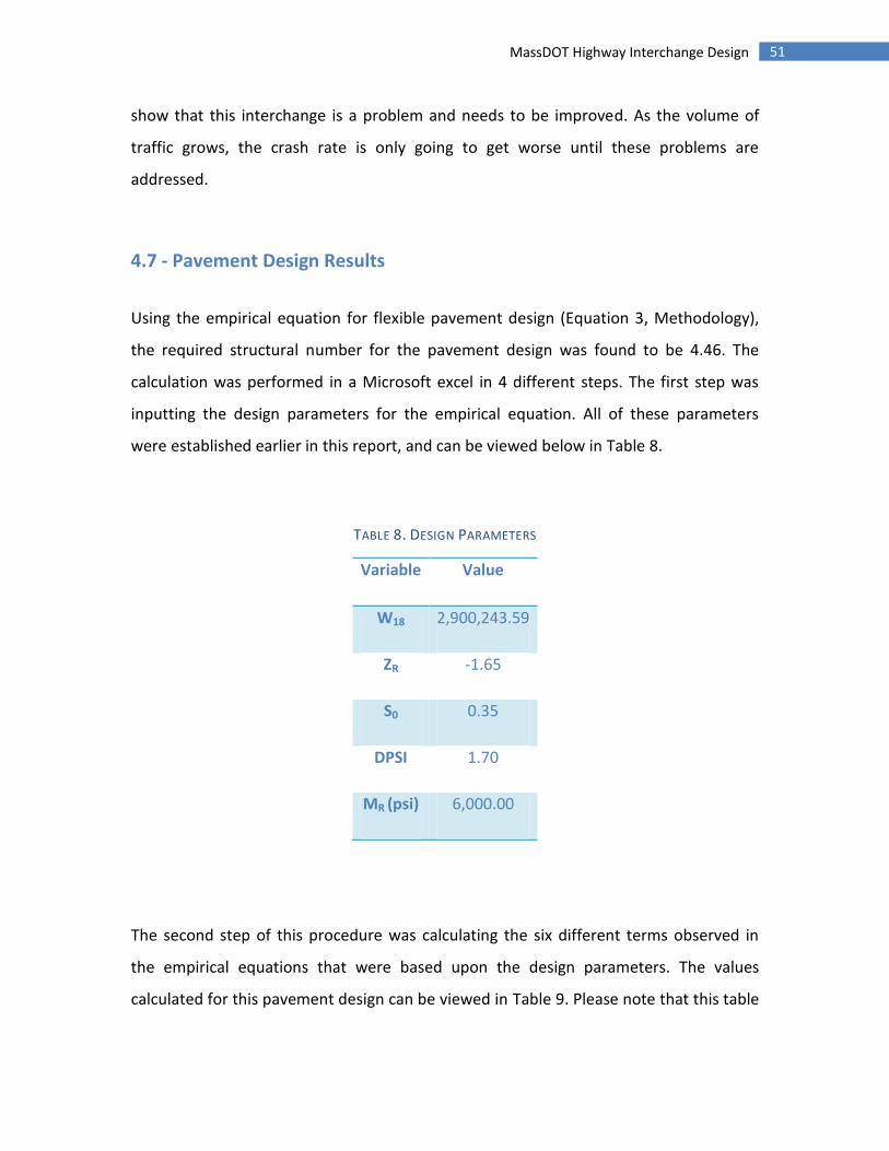
Using the empirical equation for flexible pavement design (Equation 3, Methodology),
the required structural number for the pavement design was found to be 4.46. The
calculation was performed in a Microsoft excel in 4 different steps. The first step was
inputting the design parameters for the empirical equation. All of these parameters
were established earlier in this report, and can be viewed below in Table 8.
TABLE 8. DESIGN PARAMETERS
Variable Value
W18 2,900,243.59
ZR -1.65
S0 0.35
DPSI 1.70
MR (psi) 6,000.00
The second step of this procedure was calculating the six different terms observed in
the empirical equations that were based upon the design parameters. The values
calculated for this pavement design can be viewed in Table 9. Please note that this table
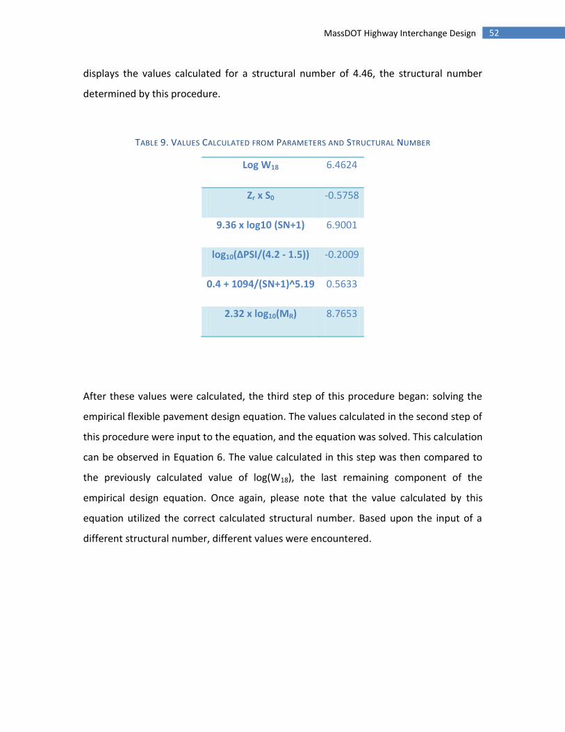
52 MassDOT Highway Interchange Design
displays the values calculated for a structural number of 4.46, the structural number
determined by this procedure.
TABLE 9. VALUES CALCULATED FROM PARAMETERS AND STRUCTURAL NUMBER
Log W18 6.4624
Zr x S0 -0.5758
9.36 x log10 (SN+1) 6.9001
log10(ΔPSI/(4.2 - 1.5)) -0.2009
0.4 + 1094/(SN+1)^5.19 0.5633
2.32 x log10(MR) 8.7653
After these values were calculated, the third step of this procedure began: solving the
empirical flexible pavement design equation. The values calculated in the second step of
this procedure were input to the equation, and the equation was solved. This calculation
can be observed in Equation 6. The value calculated in this step was then compared to
the previously calculated value of log(W18), the last remaining component of the
empirical design equation. Once again, please note that the value calculated by this
equation utilized the correct calculated structural number. Based upon the input of a
different structural number, different values were encountered.

53 MassDOT Highway Interchange Design
( ) ( ) (
)
( ) ( )
( )
( )
EQUATION 6. REQUIRED STRUCTURAL NUMBER FOR PAVEMENT DESIGN
The fourth step of this procedure was a trial and error assessment of the structural
number. Varying structural numbers were put into the spreadsheet, and the resulting
value calculated from the empirical equation was compared to the log(W18) value. The
structural number which produced a value equal to the log(W18) value was determined
to be the design structural number.
Once the design structural number was determined, a new spreadsheet was utilized to
assess the required thicknesses of each of the pavement layers. Using Equation 3
(methodology), the average layer coefficients established earlier in this report, and
drainage coefficients of 1, the required structural number was expressed as a function
of the three layer depths. A trial and error procedure was utilized to determine
appropriate layer thicknesses that would satisfy the structural number requirements.
The existing pavement cross-section displayed in Appendix F was used as a guide for
reasonable layer thicknesses in order to start this trial and error process. The table used
to calculate these layer thicknesses is shown in Table 10.

54 MassDOT Highway Interchange Design
TABLE 10. REQUIRED LAYER THICKNESS
Material A Thickness
Asphaltic Concrete Surface Course 0.44 6 SN = a1T1 + a2T2 x 1 + a3T3 x 1
GP: Crushed Stone Base Course 0.14 2 SN = 4.46
SW: Sandy Gravel Sub Base 0.11 14
The values calculated in Table 10 completed the pavement cross-section redesign. Lastly
a pavement cross-section was drawn in AutoCAD to display the layer materials and the
required layer thicknesses of the pavement redesign.
4.8 - Design
The design capacities of the roundabouts that were considered are shown below in
Table 11 (US Department of Transportation). These values are based off of a left turn
percentage of 40% based on the turning counts.
TABLE 11. DESIGN ALTERNATIVES
Single Lane 33% minor traffic 20,000 – 23,000 AADT
Single Lane 50% minor traffic 24,000 – 26,000 AADT
Double Lane 33% minor traffic 40,000 – 44,000 AADT
Double Lane 50% minor traffic 47,000 – 52,000 AADT
55 MassDOT Highway Interchange Design
The main design control of the intersection is the desired speed through the
roundabout. Approach speed based on the traffic data fits in the 45 mph range for this
calculation. Deceleration starts about 325 feet before reaching the entrance of the
roundabout according to the procedure. For a rural single lane roundabout a design
entry speed of 25 mph is optimal. Since the radius of the fastest path through the
intersection is the control for speed, the radius of the three arcs involved in the
roundabout determines the speed profile of the intersection. The curvature that would
reduce speeds to 25-27 mph is 166’-205’, so anywhere in that range would be ideal. The
exit curve should be a larger radius than the entrance curve, so a value above 205’
would work. The radius around the island is in between these two at 198’, giving a
speed of around 25 mph through the whole intersection. For a double lane roundabout
the design speed is 30 mph, and the entry/exit/island curves are 272-275’/above
272’/333’ respectively. In the case of the double lane roundabout a smaller radius is
required for the entrance because of spatial constraints of the site, limiting it to 250’
and a slightly lower average speed.
The design vehicle for the roundabout is a class WB-20 multi-axle truck. This in turn
limits the minimum radius through the roundabout and further precludes the use of a
single lane roundabout without modification. To accommodate a WB-20 multi-axle
truck, a mountable shoulder is included on the single lane design. Furthermore, the
pedestrian and bicycle traffic volume of both intersections is very low. The design
includes crosswalks on the legs of the roundabouts and ramps for handicap access.
The alignment of the existing intersections is modified in the new design within the
given right of way. The approach to the roundabout will be changed to approach at as
close to a right angle as the available space permits. This will be helpful in allowing the
roundabout to function as intended, as oblique angle approaches reduce sight distance
and have higher design speeds because of reduced deflection.

56 MassDOT Highway Interchange Design
For a rural single lane roundabout to function at the design entry speed of 25 mph, an
inscribed circle diameter of between 115’ and 130’ is desirable. A double lane
roundabout would function at between 180’ and 200’. Entry width is the limiting factor
for speed, and a range of 14’-16’ is effective for a single lane roundabout (>20’ for
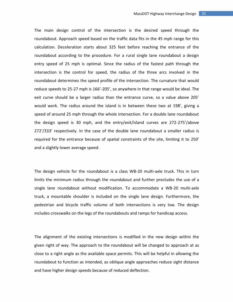
double lane). To reach this width from the standard lane width of 12’, a flared road
section of 130’ in length is suggested.
The circular roadway width may be up to 120% of the size of the entry width, giving a
range of between 12’ and 18’ for a single lane and up to 30’ for a two lane roundabout.
The width cannot be too small though, as there should be a minimum of 2’ from the tire
edge to the curb while the vehicle is driving in the center of the lane. With the
remaining available space, the diameter of the center island is 100’ across on the single
lane and between 120’ and 140’ for the double lane. The truck apron for the single lane
may be between 3’ and 13’ with a 4% cross slope.
The entry curve radius for the roundabout can increase the capacity up to 65’, past that
has little effect. For a single lane roundabout, a radius of between 33’ and 98’ is optimal
for a tradeoff between safety and capacity. The radius should be chosen so that travel
speed is reduced no more than 12 mph from the speed of the main road. Any greater
reduction of speed should be made through curves before the roundabout. The exit
curve should have a larger radius than the entrance curve, with a minimum radius of
about 50’.
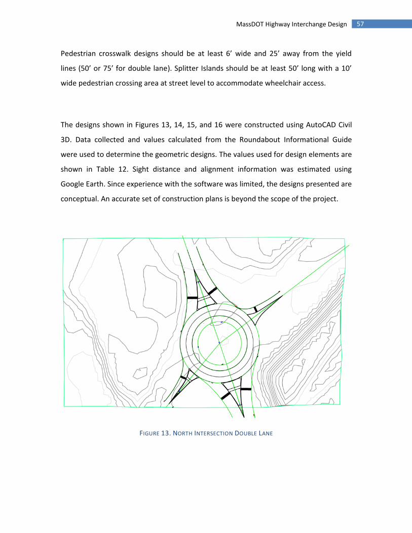
57 MassDOT Highway Interchange Design
Pedestrian crosswalk designs should be at least 6’ wide and 25’ away from the yield
lines (50’ or 75’ for double lane). Splitter Islands should be at least 50’ long with a 10’
wide pedestrian crossing area at street level to accommodate wheelchair access.
The designs shown in Figures 13, 14, 15, and 16 were constructed using AutoCAD Civil
3D. Data collected and values calculated from the Roundabout Informational Guide
were used to determine the geometric designs. The values used for design elements are
shown in Table 12. Sight distance and alignment information was estimated using
Google Earth. Since experience with the software was limited, the designs presented are
conceptual. An accurate set of construction plans is beyond the scope of the project.
FIGURE 13. NORTH INTERSECTION DOUBLE LANE
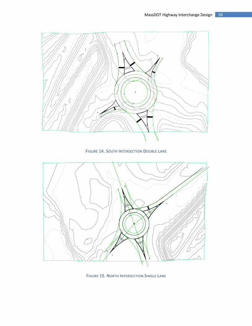
58 MassDOT Highway Interchange Design
FIGURE 14. SOUTH INTERSECTION DOUBLE LANE
FIGURE 15. NORTH INTERSECTION SINGLE LANE
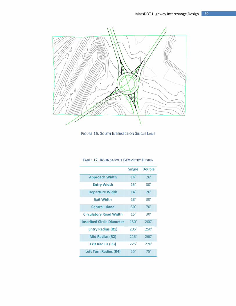
59 MassDOT Highway Interchange Design
FIGURE 16. SOUTH INTERSECTION SINGLE LANE
TABLE 12. ROUNDABOUT GEOMETRY DESIGN
Single Double
Approach Width 14’ 26’
Entry Width 15’ 30’
Departure Width 14’ 26’
Exit Width 18’ 30’
Central Island 50’ 70’
Circulatory Road Width 15’ 30’
Inscribed Circle Diameter 130’ 200’
Entry Radius (R1) 205’ 250’
Mid Radius (R2) 215’ 260’
Exit Radius (R3) 225’ 270’
Left Turn Radius (R4) 55’ 75’
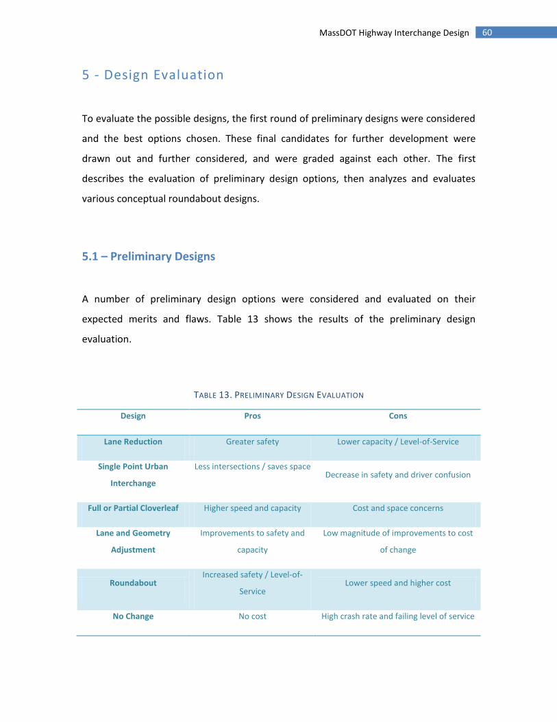
60 MassDOT Highway Interchange Design
5 - Design Evaluation
To evaluate the possible designs, the first round of preliminary designs were considered
and the best options chosen. These final candidates for further development were
drawn out and further considered, and were graded against each other. The first
describes the evaluation of preliminary design options, then analyzes and evaluates
various conceptual roundabout designs.
5.1 – Preliminary Designs
A number of preliminary design options were considered and evaluated on their
expected merits and flaws. Table 13 shows the results of the preliminary design
evaluation.
TABLE 13. PRELIMINARY DESIGN EVALUATION
Design Pros Cons
Lane Reduction Greater safety Lower capacity / Level-of-Service
Single Point Urban
Interchange
Less intersections / saves space Decrease in safety and driver confusion
Full or Partial Cloverleaf Higher speed and capacity Cost and space concerns
Lane and Geometry
Adjustment
Improvements to safety and
capacity
Low magnitude of improvements to cost
of change
Roundabout Increased safety / Level-of-
Service Lower speed and higher cost
No Change No cost High crash rate and failing level of service

61 MassDOT Highway Interchange Design
Lane reduction would be a possible solution to the safety issues found at the
interchange. Fewer lanes to cross would mean a lower amount of conflict points, which
would significantly impact the crash rate. The problem that would occur with this design
is that the reduction in capacity could negatively affect the Level-of-Service of the
interchange and adjacent road segments.
At one point in the project the group considered a single point urban interchange, but
the confusing layout and the lack of driver familiarity with this kind of interchange ruled
out this possibility. Essentially the interchange would be a signalized six way intersection
under I-190 consisting of eight lanes of traffic coming from all directions. Since this
would not solve the safety issues already present, and most likely would introduce more
issues, this design was not considered further.
Since a common design for interchanges is the full or partial cloverleaf, the group
evaluated the benefits before ruling it out. The main concern with using a cloverleaf for
the interchange re-design was the added cost and the lack of right of way. Since the
area around the interchange is already developed, the placement of new road is near
impossible without crossing over other property or buildings. The cost of buying the
right of way to fit this type of interchange would be extremely expensive given the
existing development, so this design was not considered further.
Adjusting the lane geometry and changing channelization was the most reasonable
option given the project scope. Changes to the existing geometry could potentially fix
sight distance problems and help direct traffic. This design did not seem like it would be
able to significantly change the existing level of service though, and would only have a
62 MassDOT Highway Interchange Design
small effect on the crash rate. The number of conflict points would also remain almost
the same. This design was not considered further because of the existence of more
effective options.
The option of using a roundabout was considered early in the process, and was
suggested by Joseph Frawley of MassDOT to look into. Since roundabouts reduce
conflict points and lower entry speeds into intersections, it was expected that crash
rates would be reduced. The capacity of roundabouts can be modified by changing the
geometry, so it was feasible that a proposed design could be altered to handle the
traffic load required. The designs are also space and cost efficient solutions, and are
reasonably familiar to drivers.
In order to have a complete evaluation, the option of no change needs to be considered.
The existing conditions of the pavement seem sufficient, but further investigation is
needed. An estimate of the condition would be that the road needs repair, and since
cracks are present the road should probably be resurfaced soon. Data obtained from
MRPC as well as the group’s findings show failing or near failing Level-of-Service ratings
for both intersections. Crash rates are above the state average for this type of
interchange.
5.2 - Single Lane Roundabout
The evaluation of the designs considered was rated on a 1 to 5 scale using the group’s
judgment. The final scores were compared and can be seen in Table 14.
63 MassDOT Highway Interchange Design
For the condition factor, the single lane roundabout would require complete removal
and replacement of the pavement and infrastructure of the route 140 section of the
interchange. This would mean brand new pavement and the ability to access and
replace the existing base layers if needed. Rating 5
The mobility rating takes into account changes to congestion and travel time of the
interchange. Since the single lane roundabout would be a vast improvement over the
existing conditions in terms of ability to handle volume, it is expected that the level of
service would increase to passing levels for many years to come. The capacity of the
single lane roundabout is not as high as the double lane roundabout, and travel speeds
are lower. Rating 3
The safety rating considers the effect improvements would have on crash rate
compared to state average and the effect on bicycle and pedestrian traffic. The
reduction in conflict points and the reduced travel speed would improve safety for
vehicles. Pedestrian and bicycle traffic did not have large volumes based on the data,
but would be positively affected by the inclusion of traffic islands and crosswalks. The
addition of lighting would also contribute greatly to the safety of the area. Rating 5
Cost Effectiveness is the expected additional expenses over the lifetime of the proposed
design. Although a roundabout is an expensive option, a drastic change to the
interchange would be required eventually because of growth in traffic volume. Of the
possible redesigns, a roundabout would be moderately expensive compared to changes
in lane configuration or other alternatives. Rating 3

64 MassDOT Highway Interchange Design
The effects of both designs on the community, land use and economic development and
the environment are complicated and require more data. While a single lane
roundabout would not have as great of an effect on the hydrology of the area, a double
lane roundabout could further reduce congestion. The impact on the environmental and
social aspects for each design cannot be judged with confidence without further
investigation, so these factors were not considered in the grading process.
5.3 - Double Lane Roundabout
As with the single lane roundabout design construction would require the complete
removal of the existing pavement. The road conditions would be improved because of
new pavement, and access to the existing infrastructure would allow for maintenance.
The rating is the same as the single lane design because of this. Rating 5
Mobility would be greatly improved with a double lane roundabout. Since the capacity
will be more than enough even accounting for twenty years of growth, level of service is
expected to be an A. Speed through the intersection is greater than the single lane
roundabout design. Rating 5
Safety in the case of a double lane roundabout is expected to be better than existing
conditions but worse than a single lane roundabout. The increase in conflict points and
higher speeds will contribute to a higher crash rate than the single lane roundabout.
Also, pedestrian and bicycle traffic would have a greater distance to cross. Rating 4

65 MassDOT Highway Interchange Design
The cost of a double lane roundabout would be substantially higher than for a single
lane roundabout. Much wider lanes, bigger diameters and more pavement combined
with the potential need for greater right of way mean costs would be very high. Rating 1
TABLE 14. DESIGN EVALUATION RESULTS
Design Condition Mobility Safety Cost Total
Single Lane Roundabout 5 3 5 3 16
Double Lane Roundabout 5 5 4 1 15
6 – Recommendations
The results of the evaluation show that the single lane roundabout is the best option in
the group’s opinion. The main differences between the single-and double-lane
interchanges were the expected cost and the safety improvements. The double-lane
roundabout would be more expensive and potentially less safe than the single lane
roundabout. The total score of the single lane roundabout over the initial conditions
shows that changing the intersection would have significant effects on the quality of the
interchange. For these reasons the single lane roundabout redesign is recommended.
Since reconstructing the interchange would require federal funding, the next step to
take would be the submittal of the project initiation form. Depending on the priority
placed on the interchange and available funds, the project could eventually be approved
or rejected. From there, MassDOT would be able to put together a full design of
engineered plans and proceed with construction of the interchange.
66 MassDOT Highway Interchange Design
Works Cited
Crash Rate Information, Massachusetts Department of Transportation Highway Division,
<http://www.mhd.state.ma.us/default.asp?pgid=content/traffic/crashRateInfo&sid=abo
ut>
Federal Highway Administration. Schmoyer, Hu. Analysis of Vehicle Classification and
Truck Weight Data of the New England States. Oak Ridge National Laboratory. 1998.
<http://www.fhwa.dot.gov/ohim/reg1rpt.pdf>
Frederick S. Merritt. Standard Handbook for Civil Engineers. 3rd.
Mc Graw-Hill Book Company, 1983. Print.
Massachusetts Highway Department: Project Development and Design Guide 2006
Massachusetts Highway Department. Weekday Seasonal Factors. 2007.
Massachusetts Office of Geographic Information. "Surficial Geology." GIS Datalayers
(2011). MassGIS. Web.
Montachusett Metropolitan Planning Organization. Sterling – Princeton - Westminster
Route 140 Corridor Profile - Sterling Segment. 2010.
67 MassDOT Highway Interchange Design
National Cooperative Highway Research Program, Guide for Mechanistic-Empirical
Design of new and rehabilitated pavement structures, March 2001
Nicholas, Garber, and Hoel, Lester. Traffic and Highway Engineering. 4th. Toronto:
Cengage Learning, 2009. Print.
Rajib, Mallick, and El-Korchi Tahar. Pavement Engineering: Principles and Practice. 1st.
CRC Press, 2008. Print.
Roundabouts: an Information Guide, US Department of Transportation, Federal Highway
Administration
Traffic Signal Warrants: Guidelines for Conducting a Traffic Signal Warrant Analysis, 2nd
Edition

!
"##$%&'(!"!
!
!
!
!
#)*+$,-!
#)*#*."/!

Page 1 of 13
MassDOT Highway Interchange Design I-190 Rt. 140 Interchange
Sterling, MA
Major Qualifying Project Proposal
Benjamin Timms
John Erikson
Patrick Cardone
Advisors
Professor Suzanne LePage
Professor Mingjiang Tao
Oct 10th 2011

Page 2 of 13
Table of Contents
Page
Number
Cover Page
2 Table of Contents
3 Capstone Design Requirement
4 Project Overview
Deliverables
Problem Statement
5-7 Background
Interchanges
Transportation Engineering
Structural and Geotechnical Engineering
8 Methodology
9-10 Scope of Work
11 Table 1: Detailed Schedule of Task List Overview
12 Table 2: Detailed Schedule of Complete Task List

Page 3 of 13
Capstone Design Requirement
To meet the Capstone Design requirement, a project must meet certain engineering and design
criteria. This project involves the planning and design of a highway interchange. Our design will
identify and fix safety concerns and reduce maintenance on the roadway by improving the geometry
and pavement design.
To accomplish this design, we have to investigate many parameters. In engineering the
interchange from a transportation perspective, we have to collect relevant traffic counts and crash data
to help identify problem areas. Soil conditions at the site as well as traffic data will aid in the design of
pavement cross section. In addition, opinions of those in the community are important to our design
because if implemented, our design would affect the volume of traffic in the area.
As part of the Capstone Design requirement, our project must address the constraints listed by
the American Society of Civil Engineers. Each one will be addressed as follows.
! Engineering Codes and Standards
! Our design will be done in accordance with the Mass Highway Department Project
Development and Design Guide and other applicable design codes.
! Manufacturability
! The final design of our project will be realistic in terms of expectations of public funding and
construction.
! Economic Factors
! Given that our project would be publicly funded if constructed, our design must be done with
what funding is available from the state and federal budget.
! Sustainability
! The design must be effective over the lifetime of the interchange and take into account the
future demands and growth of the roadway.
! Environmental Effects
! Changes to the interchange can easily effect the environment and drainage properties of the
area. This must be taken into account in our design.
! Health and Safety Issues
! Our design focuses on improving the safety and sight distance.
! Ethical Considerations
Our project must follow ASCE's code of ethics.

Page 4 of 13
Project Overview
This project will identify and attempt to improve upon a problematic highway interchange. A
organized and systematic design process will be planned and executed by the project group. The project
will involve the consideration of realistic design constraints as alternate interchange designs are
created.
The focus of this project will be on the transportation engineering and geotechnical aspects of
design. The project team will draft multiple possible designs of the intersection and identify which
design we believe to be most effective. The design decision process will be carried out using a decision
matrix, which will take into account variables including cost, effectiveness, feasibility, and other
realistic constraints of design. Data pertaining to existing site conditions and traffic patterns will be
collected and organized in a way that can be useful to MassDOT. The deliverables associated with this
project include the following:
Deliverables
1. AutoCAD draft of our design
2. Collision diagram showing crash data
3. Project Need Form for MassDOT
4. Data findings and report for MassDOT
5. Final Presentation to MassDOT
6. MQP report for WPI
7. Poster for WPI Project Presentation Day
Problem Statement
The interchange between Interstate 190 and Route 140 in Sterling Massachusetts has been
identified as a problematic design. Many design factors of the interchange have contributed to the
perceived safety issues at this site. This project will utilize data collected by the project group and other
organizations to perform an analysis and design process with realistic constraints to develop alternate
designs of the interchange.
Page 5 of 13
Background
This project deals with the Interstate 190, Route 140 interchange located in Sterling, MA.
MassDOT, which is serving as an external project adviser, has identified a number of problems
associated with the existing interchange design. The interchange is a grade-separated diamond
interchange with the off ramps from I-190 coming to stop-controlled intersections with Route 140. At
the points of the stop-controlled intersections, 140 has two travel lanes in addition to a left-turn lane on
the near side of Route 140. There is also a large concrete island median separating eastbound and
westbound traffic on Route 140. The high number of lanes and wide concrete island increase the travel
time across the intersection for vehicles turning left onto Route 140. In addition, the sight distances on
some of the ramps do not allow drivers to see if vehicles are stopped at the stop sign.
Interchanges
Interchanges and grade separations occur when two or more roadways cross at different levels.
This eliminates crossing conflicts and improves the intersection's efficiency. Interchanges provide a
connection through a series of ramps to the grade separated roadways.
In deciding whether to use a grade separated interchange at an intersection, multiple factors must be
considered. These factors are referred to as warrants and include:
! Design Designation – Once it is decided to develop a route as a freeway, designers must decide
whether intersecting highways will be terminated, rerouted, or provided with a grade separation
or interchange, with traffic flow on the freeway being the chief concern.
! Safety – The crash reduction benefit may warrant an interchanges selection at a dangerous at
grade intersection.
! Congestion – An interchange may be chosen when an at grade intersection cannot provide the
desired level of service.
! Site Topography – At certain locations a grade separated intersection may be more feasible
than an at grade intersection due to topographical concerns.
! Traffic Volume – Interchanges are desirable at cross streets with heavy traffic volume to
eliminate conflict and improve traffic flow.
! Road-User Benefit – Efficiently designed intersections reduce travel time and cost. The road-
user benefits may outweigh the cost over the life of the interchange.
There are two types of freeway interchanges. A system interchange connects a freeway to a
freeway, while a service interchange connects a freeway to a lesser facility. The existing interchange at
our design site is a diamond interchange. Diamond interchanges use one-way diagonal ramps in each
quadrant with two at grade intersections provided on the minor road. The preferred design is to elevate
the minor roadway over the major roadway to aid in acceleration to freeway speed and deceleration to
minor road speeds. The advantages to using such an intersection are as follows:
1. Continuity of pedestrian and bicycle accommodations on the minor road are easier to maintain
since merging and diverging movements can be avoided.
2. Relatively little right of way is required.
3. The configuration allows modifications to provide greater ramp capacity if needed in the future.
Page 6 of 13
4. Their common usage has resulted in a high degree of driver familiarity.
5. All traffic can enter and exit the freeway mainline at relatively high speeds and all exits are
made prior to reaching the structure.
6. Adequate sight distances can usually be provided and traffic maneuvers are normally
uncomplicated.
The primary disadvantages of a diamond interchange are the potential operational problems
with the two closely spaced intersections on the minor road and the potential for wrong way entry onto
the ramps. For this reason a median is usually provided to help channelization.
Transportation Engineering
Data that can be used to evaluate the interchange include Traffic Counts, Turning Movement
Counts, Crash Data, and Level of Service Analysis.
The Traffic counts will provide valuable information about how many vehicles use the
intersection and will allow us to determine peak traffic flow for the intersection. The team will utilize
count boxes, which will record 24-hour traffic flow at various locations on the site. ADT (Average
Daily Traffic) will be calculates. The data will then be adjusted using adjustment factors developed by
MassDOT to determine the AADT (Average Annual Daily Traffic).
Turning Movement counts will be incorporated, where team members will observe the
intersection during peak travel times and record the number of vehicles taking each available route
through the intersection. This technique of data collection will be applied to both stop-controlled
intersections of Route 140 and the I-190 ramps.
Crash data will help us to identify the causes of crashes and to identify the root problems
associated with them. We can then incorporate that information into the redesign of the interchange.
Crash data will be obtained through the MassDOT crash database and more detailed crash reports will
be obtained though the Sterling Police Department.
Level of Service (LOS) Analysis will allow us to determine whether or not the current control
measures and lane configurations are appropriate and to adjust them accordingly in the new design. The
LOS is an indicator of operating conditions at intersections or road segments, and is defined by six
levels (“A” through “F”) as per the 2000 edition of the Highway Capacity Manual.
.
Structural and Geotechnical Engineering
Given the large size and infrastructural importance of highways, evaluating the strength of
supporting members, and associated foundations is a paramount aspect of interchange design.
Furthermore, the existing conditions of an area where an interchange is to be placed can factor
significantly into the design process. The subsoil that will compose the bearing surface for the
highway’s foundations must be adequate to support the weight applied to it without settling. In
addition, the stability of any load bearing soil must be assessed if the foundations or any other element
of the interchange are located on a significant slope.
The current interchange of Interstate 190 and Route 140 consists of several large piers that
support Interchange 190 in both directions. Revised design of this structure will most likely not involve
Page 7 of 13
the alteration of these existing structural elements, however addition load bearing members may be
utilized if required in a revised design. In addition, the existing slope of the area containing the
interchange is minimal, so slope stability evaluation and associated aspects of the design may be
negligible.
The existing foundations supporting both Interstate 190 roadways appear to be situated upon
offsite structural material. If design of additional foundations is to be conducted, an analysis of existing
subsoil will need to be conducted. If this analysis reveals that the existing on-site material is unsuitable
for use as a structural fill, offsite materials will be considered. Analysis of surrounding conditions may
reveal a suitable alternate material.
Another geotechnical aspect of highway design that will need to be addressed is pavement
design. Pavement consists of several different layers, which consist of different materials. Pavement
design generally involves the determination of the required pavement layer thickness and which
material should be used for each of the different layers. In order to perform pavement design, traffic
data, climate conditions, and mechanical properties of pavement materials are all required.
For the interchange between Interstate 190 and Route 140, traffic data will be reviewed and the
existing pavement design will be examined. If pavement redesign is necessary, traffic data, local
climate conditions, the extents of the roadways and known mechanical properties of pavement
materials will be used to determine the required structural specifications of the proposed new
pavement. These specifications will then be met with the design of an appropriate pavement.
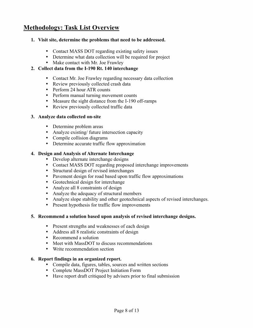
Page 8 of 13
Methodology: Task List Overview
1. Visit site, determine the problems that need to be addressed.
• Contact MASS DOT regarding existing safety issues
• Determine what data collection will be required for project
• Make contact with Mr. Joe Frawley
2. Collect data from the I-190 Rt. 140 interchange
• Contact Mr. Joe Frawley regarding necessary data collection
• Review previously collected crash data
• Perform 24 hour ATR counts
• Perform manual turning movement counts
• Measure the sight distance from the I-190 off-ramps
• Review previously collected traffic data
3. Analyze data collected on-site
• Determine problem areas
• Analyze existing/ future intersection capacity
• Compile collision diagrams
• Determine accurate traffic flow approximation
4. Design and Analysis of Alternate Interchange
• Develop alternate interchange designs
• Contact MASS DOT regarding proposed interchange improvements
• Structural design of revised interchanges
• Pavement design for road based upon traffic flow approximations
• Geotechnical design for interchange
• Analyze all 8 constraints of design
• Analyze the adequacy of structural members
• Analyze slope stability and other geotechnical aspects of revised interchanges.
• Present hypothesis for traffic flow improvements
5. Recommend a solution based upon analysis of revised interchange designs.
• Present strengths and weaknesses of each design
• Address all 8 realistic constraints of design
• Recommend a solution
• Meet with MassDOT to discuss recommendations
• Write recommendation section
6. Report findings in an organized report.
• Compile data, figures, tables, sources and written sections
• Complete MassDOT Project Initiation Form
• Have report draft critiqued by advisers prior to final submission
Page 9 of 13
Scope of Work:
In order to assure the completion of all aspects of a design project, the required tasks of this
project have been broken into six different stages. These stages have all been set to a schedule in an
attempt to streamline the project’s progression. These schedules can be viewed at the end of this report
in Table 1 and Table 2.
The first stage of this project is an initial evaluation of the existing Interstate 190 Route 140
interchange. This evaluation will be performed in two different ways. First, the project group will visit
the site, and look for any elements of the existing interchange that could present a danger to vehicles or
pedestrians. In addition, the group will photograph the existing site conditions.
The next step in evaluating the current interchange design will involve contact with Mr. Joe
Frawley of MassDOT. MassDOT’s existing safety concerns with the interchange will be reviewed.
After all safety concerns have been reviewed, the group will determine what data will be collected on
the site. Mr. Joe Frawley’s input regarding the necessity of different data collections will also
contribute to this decision.
Once the data collection methods have been decided, the second stage of the project will begin.
This phase involves the collection of data from the site, as well as a review of previously collected data.
First, a request will be put in to request crash data from the Interstate 190 Route 140 interchange. In
addition, the group will (under guidance of Mr. Joe Frawley and the advising professors) collect 24
hour ATR counts as well as manual turning movement counts from the interchange and resulting
intersections. Traffic data collected by the group will be supplemented by previously collected traffic
data, which will be obtained by the group. Lastly, the group will measure the sight distance on the
Interstate 190 off-ramps.
The third stage of the project will commence when all necessary data has been obtained and
collected. Once this occurs, the project group will analyze the data. In addition, the group will compile
collision diagrams pertaining to the interchange. By evaluating the interchange’s crash data, the group
will determine which areas of the interchange are the most problematic. The group will also analyze the
existing and future capacities of the interchange and resulting intersections. All raw data will be
formatted and included in the final project report. In addition, significant analysis will be included in
the paper with the use of tables and figures.
The design and analysis of revised interchange designs will compose the fourth stage of the
project. The design process will begin by reviewing the interchange problems determined from data
analysis. Alternate interchange designs will be roughly developed with special attention to these
specific problems. MassDOT will be contacted during the design process, and any of their existing
interchange revision designs will also be considered. Once alternate designs have been roughly
developed, the design of the alternate interchanges will begin.
Many different realistic constraints will be addressed in the design process of alternate
interchanges. The specific design procedures will vary between the different designs, but structural,
geotechnical, and traffic engineering elements will all be focused on in this project. Structural adequacy
of structural members will be evaluated when needed. In addition, the assessment of existing site soil
conditions and pavement design may be required for design of certain alternate interchanges. All design
Page 10 of 13
will be performed in accordance with the Mass Highway Department Project Development and Design
Guide. All calculations involved in the design process will be included in the final report.
Once all alternate interchange designs are completed, the project group will analyze the designs.
The designs will be analyzed for the 8 realistic constraints of design. Emphasis will be put upon the
analysis of: health and safety issues, accordance with engineering codes and standards, economic
factors, and manufacturability.
When all of these constraints have been considered, the group will begin the fifth stage of the
project and present a recommendation based on this analysis. Figures displaying the benefits and
drawbacks of each alternate design will be included in the project. In addition, the group will prepare a
written section explaining the analysis of different design constraints and the resulting design
recommendation. The recommendation developed by the group will then be presented to MassDOT.
The final stage of this project involves the compilation of all data, figures, tables, and all written
sections. The group will present the findings of this project in an organized report, which will be
reviewed by the advising professors before final submission. In addition, the group will complete a
MassDOT project initiation form and all additional material required by MassDOT.
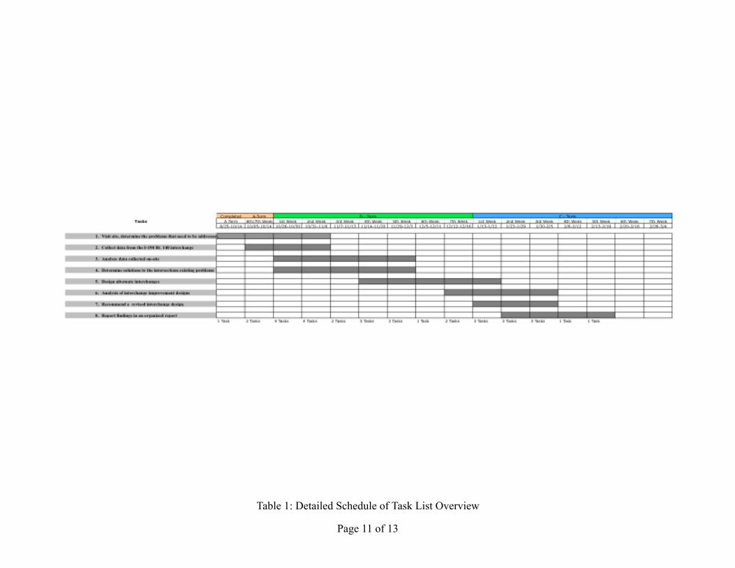
Page 11 of 13
Table 1: Detailed Schedule of Task List Overview
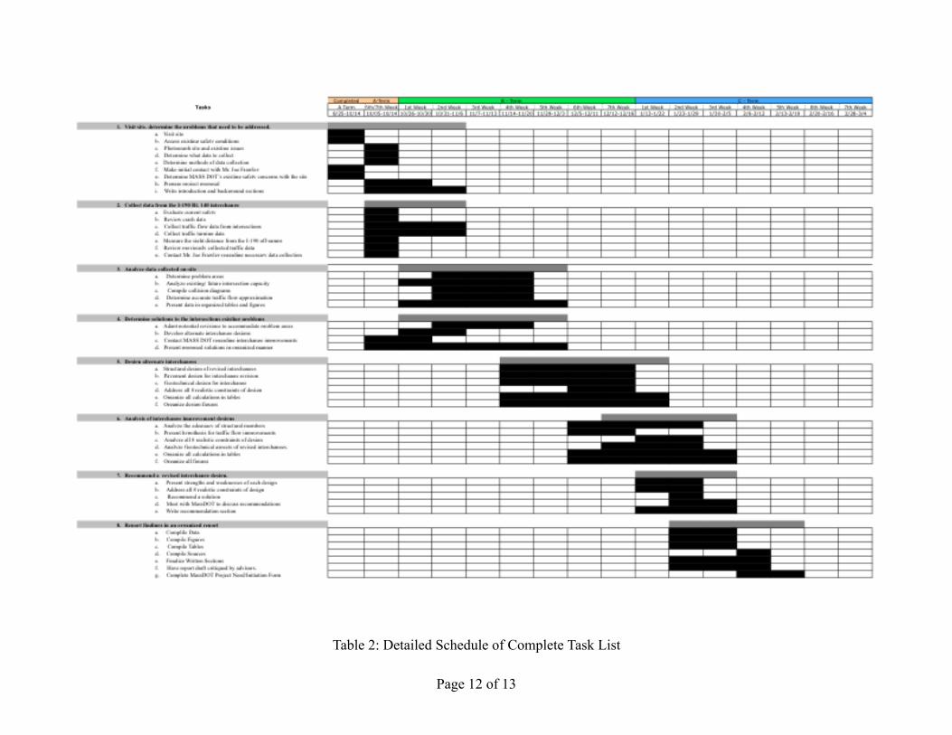
Page 12 of 13
Table 2: Detailed Schedule of Complete Task List

Page 13 of 13
Sources Used
Traffic & Highway Engineering 4th ed
Garber, Nicholas J., and Lester A. Hoel... Toronto: Cenage Learning, 2009
Highway Capacity Manual. Transportation Research Board, Washington, D.C.. 2000.
Massachusetts Highway Department - Project Development and Design Guide
Geotechnical Engineering: Principles and Practices
Donald P.Coduto - Man-Chung Yeung - William A.Kitch - Pearson – 2011

APPENDIX B
TURNING
MOVEMENT
COUNT
RAW DATA !
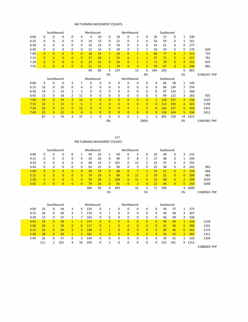
!"#$%&'(')#"*+,",'$#-*%'$.
/011 1 1 1 1 1 2 31 1 34 1 3 1 5/ 56 1 3 31/
/037 1 1 1 1 1 31 35 1 88 1 5 1 72 79 1 3 3/3
/051 1 1 1 1 1 31 39 1 89 1 5 1 77 /3 1 1 366
/027 1 1 1 1 1 38 32 1 59 1 8 3 71 79 1 1 36/ /81
6011 1 1 1 1 1 34 39 3 8/ 1 7 3 // 66 1 3 833 687
6037 1 1 1 1 1 86 8/ 3 57 1 3 3 76 63 1 3 836 643
6051 1 1 1 1 1 82 88 1 52 1 8 3 63 64 1 2 853 457
6027 1 1 1 1 1 83 37 3 89 1 2 5 61 /6 1 1 81/ 4/7
91 48 5 382 38 / 8/2 895 / 4/7
8: 2: 3: 1;95/326 <=>
/011 9 1 / 5 3 1 1 1 1 1 1 1 1 // 74 3 321
/037 31 1 31 1 2 1 1 1 1 1 1 1 1 9/ 352 6 872
/051 32 7 32 8 7 1 1 1 1 1 1 1 1 96 355 3 8/4
/027 35 1 34 8 33 1 1 1 1 1 1 1 1 99 388 5 8/5 987
6011 82 1 82 5 38 1 1 1 1 1 1 1 5 334 356 2 534 3315
6037 32 3 35 1 7 3 1 1 1 1 1 1 1 332 395 2 523 3391
6051 82 1 83 1 38 1 1 1 1 1 3 8 1 352 886 / 239 3523
6027 87 1 38 1 4 1 1 1 1 1 1 1 1 38/ 3/5 7 552 3238
46 3 61 5 56 3 1 1 1 1 3 8 5 298 681 39 3238
1: 811: 8: 1;428248 <=>
366
<"#$%&'(')#"*+,",'$#-*%'$.
2011 1 1 1 1 3 29 8/ 3 /9 1 2 1 8/ 21 1 5 837
2037 1 1 1 1 1 71 8/ 1 91 1 4 3 86 24 1 3 829
2051 1 1 1 1 1 /4 3/ 8 318 1 38 8 88 57 1 2 877
2027 1 1 1 1 1 /5 37 1 9/ 1 9 1 88 54 1 1 825 9/8
7011 1 1 1 1 1 74 39 1 /9 1 6 3 37 73 1 8 839 9//
7037 1 1 1 1 1 62 82 5 49 1 33 3 39 73 1 1 8/4 947
7051 1 1 1 1 1 95 84 3 312 1 33 1 37 24 1 8 899 3189
7027 1 1 1 1 1 69 82 1 43 1 8 1 88 2/ 1 1 872 3121
512 97 2 525 53 8 63 39/ 2 3121
3: 3: 3: 1;4/97/7 <=>
2011 85 1 72 5 / 331 1 3 1 1 1 1 1 25 56 3 865
2037 8/ 1 74 2 6 339 1 3 1 1 1 1 1 29 24 5 516
2051 35 1 78 3 6 3/5 1 / 1 1 1 1 1 2/ 29 2 551
2027 82 1 74 3 7 326 1 1 1 1 1 1 1 21 22 3 534 3884
7011 8/ 3 79 1 / 336 1 3 1 1 1 1 1 23 5/ 7 84/ 3823
7037 55 1 /9 8 7 324 1 3 1 1 1 1 1 21 2/ 1 523 3867
7051 84 1 /9 3 8 343 1 1 1 1 1 1 1 58 77 5 5/6 3538
7027 8/ 1 76 1 5 322 1 1 1 1 1 1 1 59 23 8 531 3512
333 3 877 2 34 795 1 8 1 1 1 1 1 375 343 9 3538
1;444845 <=>
.?@ABC?@DE FGHAC?@DE '?IABC?@DE ,JHAC?@DE
.?@ABC?@DE FGHAC?@DE '?IABC?@DE ,JHAC?@DE
.?@ABC?@DE FGHAC?@DE '?IABC?@DE ,JHAC?@DE
.?@ABC?@DE FGHAC?@DE '?IABC?@DE ,JHAC?@DE

APPENDIX C
TURNING
MOVEMENT
DIAGRAMS !
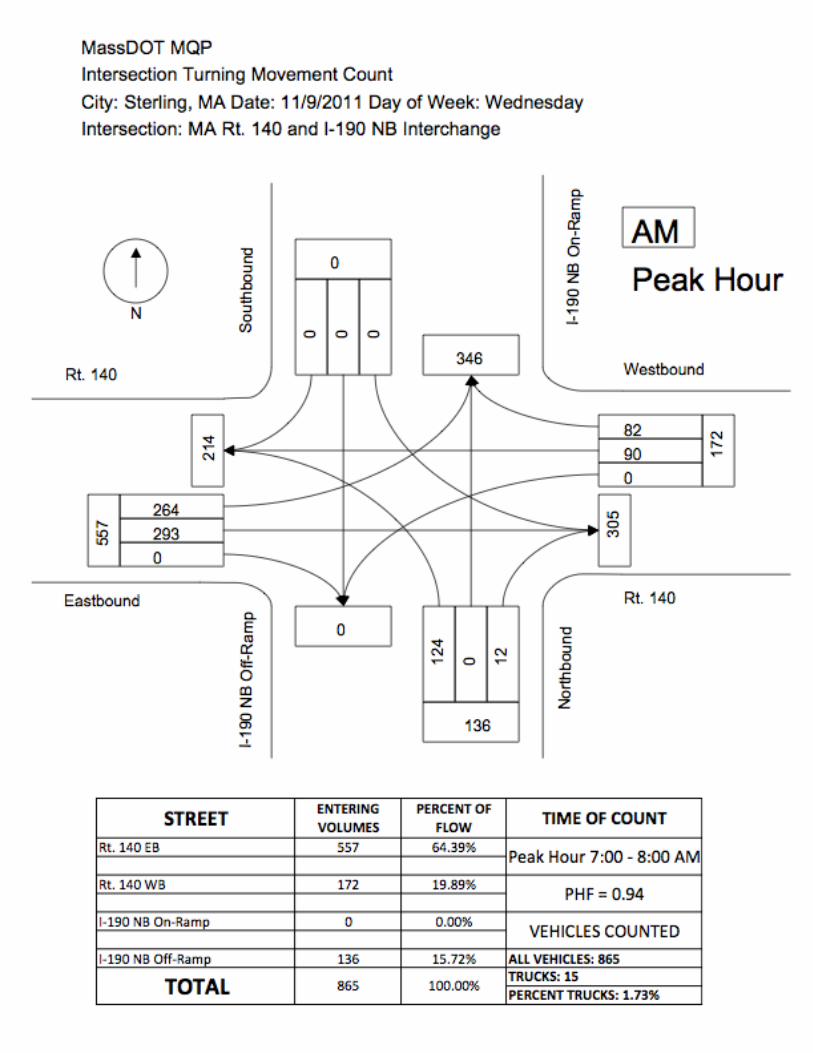


APPENDIX D
ATR BOX
COLLECTION
RAW DATA !
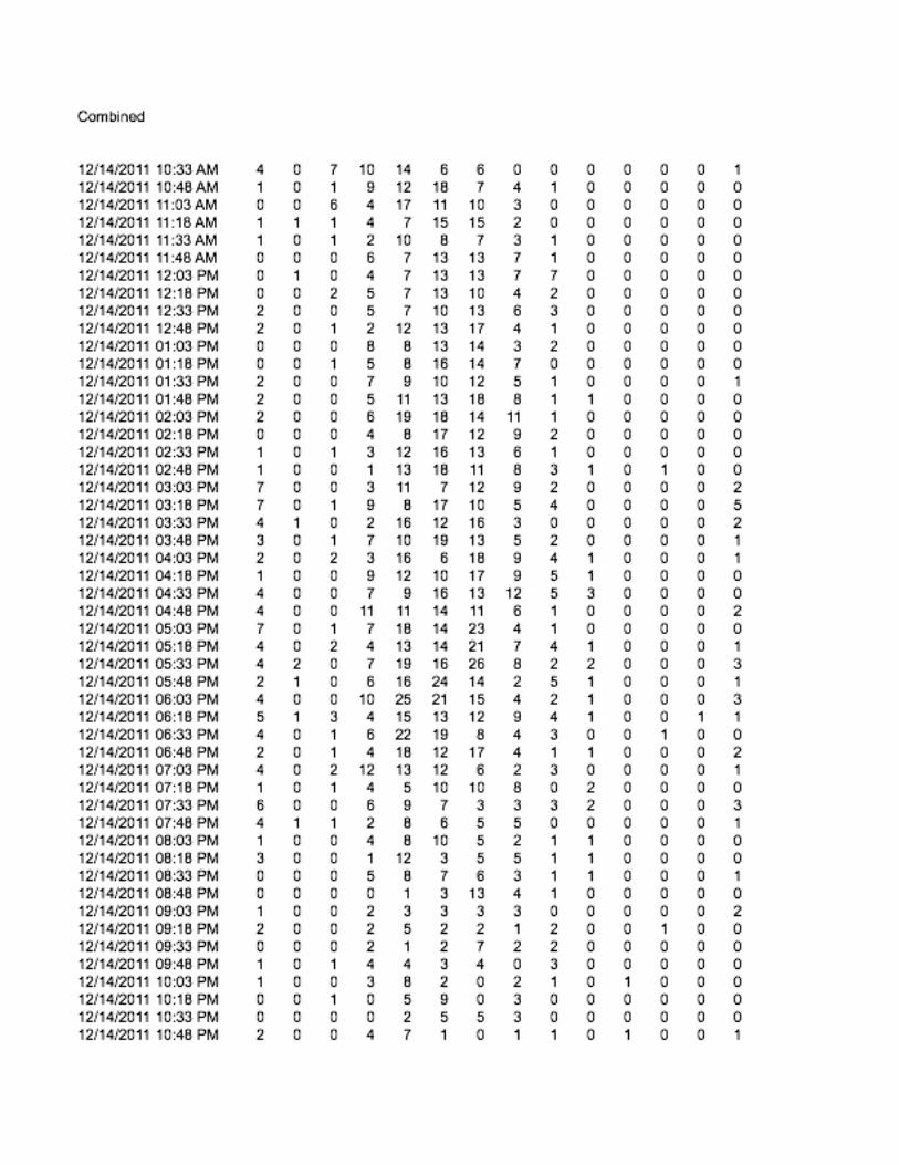
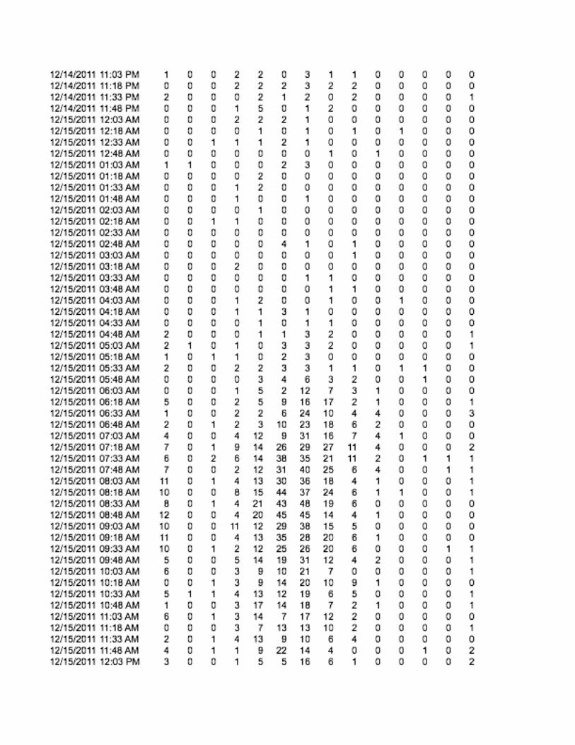

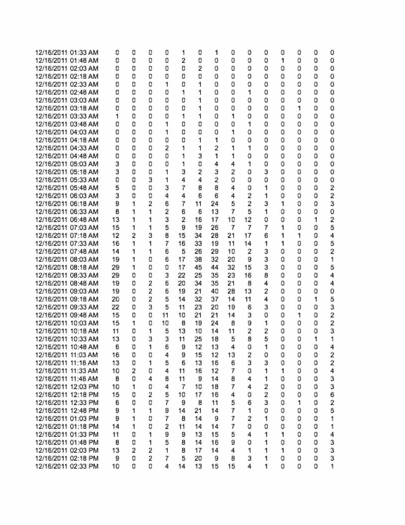
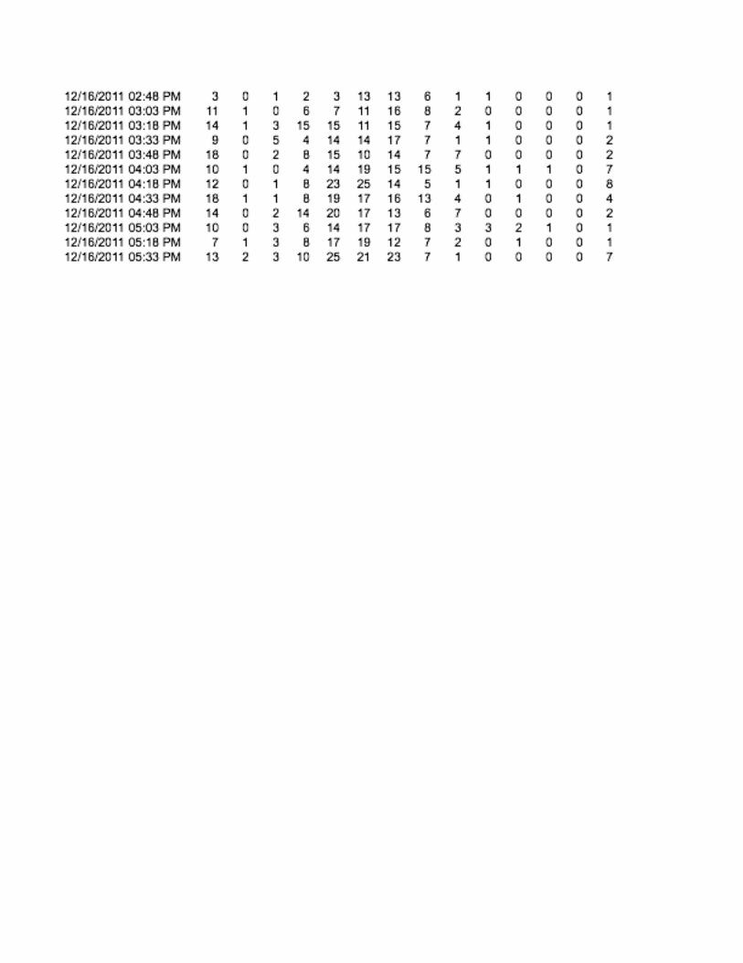


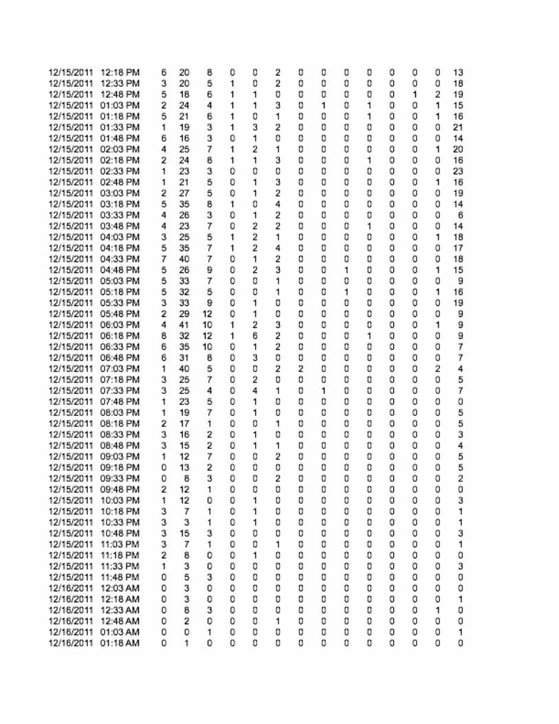
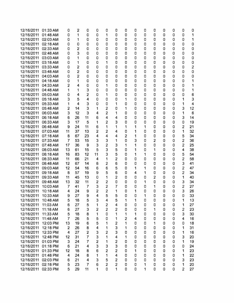
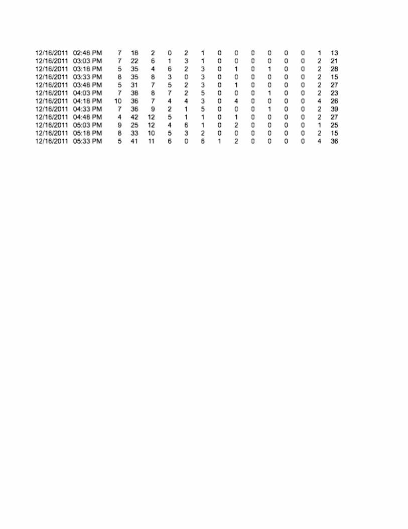


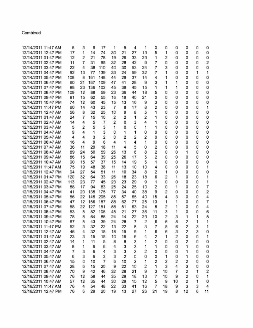


APPENDIX E
RAW CRASH DATA
FROM MASSDOT !
November 4, 2011
John Erikson
District Three
Worcester P I
E-mail: [email protected]
CRASH DATA TRANSMITTAL
In accordance with your request, MassDOT is pleased to transmit the following crash
data:
REQUEST NO.: 11-2211
CITIES/TOWN(S): Sterling
YEAR(S): 2007-2009
X Via E-mail
CD-ROM
Paper Report
All files are Microsoft Excel except as noted. Please note that all crash locations are
presented as “raw text” as received from the Registry of Motor Vehicles (RMV).
See the file named Support_Information_1-10.doc for more information.
The submitted information is subject to the terms of 23 United States Code, Section 409,
which provides that any reports, surveys, schedules, lists, or data compiled shall not be
subject to discovery or admitted into evidence in a Federal or State court proceeding or
considered for other purposes in any action for damages arising from any occurrence at a
location mentioned or addressed in such reports, surveys, schedules, lists, or data.
Direct all questions and requests to:
Neil E. Boudreau
State Traffic Engineer
ATTN: Rosalynd Scott
Massachusetts Department of Transportation – Highway Division
Traffic Engineering Section
10 Park Plaza, Rm. 7210
Boston, MA 02116
E-mail: [email protected]

All-Crash-Data.xls Page 1
Crash Number City/Town Name Crash Date Crash Time Crash Severity
Number of
Vehicles
Total
Nonfatal
Injuries
Total
Fatal
Injuries Manner of Collision Vehicle Action Prior to Crash Vehicle Travel Directions Most Harmful Events Vehicle Configuration
2300105 STERLING 02-Jan-2007 6:26 AM Non-fatal injury 1 1 0 Single vehicle crash V1: Travelling straight ahead V1:Eastbound V1: Overturn/rollover
V1: Light truck(van, mini-van,
panel, pickup, sport utility)
with only four tires
2268312 STERLING 02-Jan-2007 7:15 AM Non-fatal injury 1 1 0 Single vehicle crash
V1: Slowing or stopped in
traffic V1:Southbound V1: Not reported
V1: Light truck(van, mini-van,
panel, pickup, sport utility)
with only four tires
2234336 STERLING 06-Jan-2007 12:15 PM
Property damage
only (none
injured) 1 0 0 Single vehicle crash V1: Turning left V1:Southbound V1: Collision with utility pole V1: Passenger car
2300093 STERLING 06-Jan-2007 8:20 PM
Property damage
only (none
injured) 1 0 0 Single vehicle crash V1: Travelling straight ahead V1:Westbound V1: Collision with guardrail V1: Passenger car
2300086 STERLING 07-Jan-2007 5:12 PM Non-fatal injury 1 2 0 Single vehicle crash V1: Turning left V1:Westbound V1: Collision with tree V1: Passenger car
2300082 STERLING 08-Jan-2007 9:18 AM
Property damage
only (none
injured) 2 0 0 Angle
V1: Entering traffic lane /
V2:Travelling straight ahead V1:Eastbound / V2:Eastbound
V1: Collision with motor
vehicle in traffic / V2:
Collision with motor vehicle in
traffic
V1: Passenger car /
V2:Passenger car
2157072 STERLING 08-Jan-2007 10:04 AM
Property damage
only (none
injured) 1 0 0 Single vehicle crash
V1: Slowing or stopped in
traffic V1:Northbound
V1: Collision with
embankment V1: Passenger car
2300076 STERLING 09-Jan-2007 5:40 PM Non-fatal injury 2 1 0 Rear-end
V1: Entering traffic lane /
V2:Travelling straight ahead
V1:Northbound /
V2:Northbound
V1: Collision with motor
vehicle in traffic / V2:
Collision with motor vehicle in
traffic
V1: Passenger car /
V2:Passenger car
2291456 STERLING 15-Jan-2007 5:45 AM Non-fatal injury 2 1 0 Rear-end
V1: Entering traffic lane /
V2:Travelling straight ahead
V1:Northbound /
V2:Northbound
V1: Collision with motor
vehicle in traffic / V2:
Collision with motor vehicle in
traffic
V1: Passenger car / V2:Light
truck(van, mini-van, panel,
pickup, sport utility) with only
four tires
2359040 STERLING 18-Jan-2007 7:30 AM Not Reported 2 0 0 Single vehicle crash
V1: Slowing or stopped in
traffic / V2:Slowing or stopped
in traffic
V1:Not reported / V2:Not
reported
V1: Not reported / V2: Not
reported
V1: Light truck(van, mini-van,
panel, pickup, sport utility)
with only four tires /
V2:Passenger car
2286879 STERLING 18-Jan-2007 10:30 AM
Property damage
only (none
injured) 1 0 0 Single vehicle crash V1: Travelling straight ahead V1:Northbound V1: Other V1: Passenger car
2300564 STERLING 18-Jan-2007 7:56 PM Non-fatal injury 1 1 0 Single vehicle crash V1: Travelling straight ahead V1:Eastbound V1: Collision with curb V1: Passenger car
2301255 STERLING 19-Jan-2007 8:08 AM Not Reported 1 0 0 Single vehicle crash V1: Travelling straight ahead V1:Eastbound V1: Collision with guardrail V1: Not reported
2301260 STERLING 20-Jan-2007 10:25 AM
Property damage
only (none
injured) 2 0 0 Angle
V1: Travelling straight ahead /
V2:Turning left
V1:Northbound /
V2:Southbound
V1: Collision with motor
vehicle in traffic / V2:
Collision with motor vehicle in
traffic
V1: Light truck(van, mini-van,
panel, pickup, sport utility)
with only four tires /
V2:Passenger car
2301263 STERLING 21-Jan-2007 3:57 AM
Property damage
only (none
injured) 1 0 0 Single vehicle crash V1: Travelling straight ahead V1:Eastbound
V1: Collision with other
movable object V1: Passenger car
2301280 STERLING 23-Jan-2007 8:18 AM Non-fatal injury 1 1 0 Single vehicle crash V1: Travelling straight ahead V1:Southbound V1: Collision with tree V1: Passenger car
2301286 STERLING 23-Jan-2007 9:27 AM
Property damage
only (none
injured) 2 0 0
Sideswipe, opposite
direction
V1: Travelling straight ahead /
V2:Turning right
V1:Southbound /
V2:Eastbound
V1: Collision with motor
vehicle in traffic / V2:
Collision with motor vehicle in
traffic
V1: Passenger car /
V2:Passenger car
2295729 STERLING 24-Jan-2007 5:40 AM
Property damage
only (none
injured) 1 0 0 Single vehicle crash V1: Travelling straight ahead V1:Northbound V1: Collision with tree
V1: Light truck(van, mini-van,
panel, pickup, sport utility)
with only four tires
2301297 STERLING 24-Jan-2007 8:29 AM Non-fatal injury 1 1 0 Single vehicle crash V1: Travelling straight ahead V1:Westbound V1: Collision with tree V1: Passenger car
2301300 STERLING 02-Feb-2007 6:39 AM
Property damage
only (none
injured) 1 0 0 Single vehicle crash V1: Travelling straight ahead V1:Southbound V1: Collision with tree V1: Passenger car
2274461 STERLING 03-Feb-2007 9:30 AM
Property damage
only (none
injured) 1 0 0 Single vehicle crash
V1: Slowing or stopped in
traffic V1:Southbound V1: Collision with guardrail V1: Passenger car
2284902 STERLING 07-Feb-2007 3:30 AM
Property damage
only (none
injured) 2 0 0 Rear-end
V1: Slowing or stopped in
traffic / V2:Slowing or stopped
in traffic
V1:Northbound /
V2:Westbound
V1: Collision with motor
vehicle in traffic / V2: Not
reported
V1: Passenger car / V2:Light
truck(van, mini-van, panel,
pickup, sport utility) with only
four tires
2301313 STERLING 07-Feb-2007 10:23 AM
Property damage
only (none
injured) 2 0 0 Rear-end
V1: Travelling straight ahead /
V2:Travelling straight ahead
V1:Southbound /
V2:Southbound
V1: Collision with motor
vehicle in traffic / V2:
Collision with motor vehicle in
traffic
V1: Passenger car /
V2:Passenger car
2362400 STERLING 08-Feb-2007 4:00 PM
Property damage
only (none
injured) 2 0 0 Rear-end
V1: Slowing or stopped in
traffic / V2:Travelling straight
ahead V1:Eastbound / V2:Eastbound
V1: Not reported / V2: Not
reported
V1: Passenger car /
V2:Passenger car
2298515 STERLING 08-Feb-2007 5:04 PM Non-fatal injury 2 1 0 Angle
V1: Travelling straight ahead /
V2:Travelling straight ahead
V1:Northbound /
V2:Eastbound
V1: Collision with motor
vehicle in traffic / V2:
Collision with motor vehicle in
traffic
V1: Passenger car /
V2:Passenger car
2300038 STERLING 11-Feb-2007 5:05 PM Non-fatal injury 1 1 0 Single vehicle crash V1: Travelling straight ahead V1:Northbound V1: Collision with tree
V1: Light truck(van, mini-van,
panel, pickup, sport utility)
with only four tires
2301347 STERLING 12-Feb-2007 6:58 AM Not Reported 1 0 0 Single vehicle crash V1: Turning right V1:Westbound
V1: Collision with light pole or
other post/support V1: Tractor/semi-trailer
2337427 STERLING 12-Feb-2007 7:40 AM
Property damage
only (none
injured) 2 0 0 Rear-end
V1: Slowing or stopped in
traffic / V2:Travelling straight
ahead V1:Eastbound / V2:Eastbound
V1: Not reported / V2: Not
reported
V1: Light truck(van, mini-van,
panel, pickup, sport utility)
with only four tires / V2:Light
truck(van, mini-van, panel,
pickup, sport utility) with only
four tires
2301365 STERLING 12-Feb-2007 2:24 PM
Property damage
only (none
injured) 2 0 0 Rear-end
V1: Entering traffic lane /
V2:Entering traffic lane
V1:Northbound /
V2:Northbound
V1: Collision with motor
vehicle in traffic / V2:
Collision with motor vehicle in
traffic
V1: Passenger car /
V2:Passenger car
2301372 STERLING 14-Feb-2007 1:24 AM
Property damage
only (none
injured) 1 0 0 Single vehicle crash V1: Travelling straight ahead V1:Westbound V1: Collision with ditch V1: Passenger car
2287663 STERLING 14-Feb-2007 1:39 PM
Property damage
only (none
injured) 2 0 0 Rear-end
V1: Turning left / V2:Making U-
turn V1:Eastbound / V2:Eastbound
V1: Collision with motor
vehicle in traffic / V2:
Collision with motor vehicle in
traffic
V1: Bus (seats for more than
15 people, including driver) /
V2:Light truck(van, mini-van,
panel, pickup, sport utility)
with only four tires
2301378 STERLING 21-Feb-2007 10:00 AM Not Reported 1 0 0 Single vehicle crash V1: Travelling straight ahead V1:Southbound V1: Collision with pedestrian V1: Passenger car
2301387 STERLING 22-Feb-2007 10:35 PM Non-fatal injury 1 1 0 Single vehicle crash V1: Travelling straight ahead V1:Westbound V1: Collision with utility pole V1: Passenger car
2352447 STERLING 27-Feb-2007 6:00 AM
Property damage
only (none
injured) 2 0 0 Angle
V1: Travelling straight ahead /
V2:Turning right
V1:Southbound /
V2:Eastbound
V1: Not reported / V2: Not
reported
V1: Passenger car /
V2:Passenger car
MassHighway Crash Report for STERLING in the year 2007
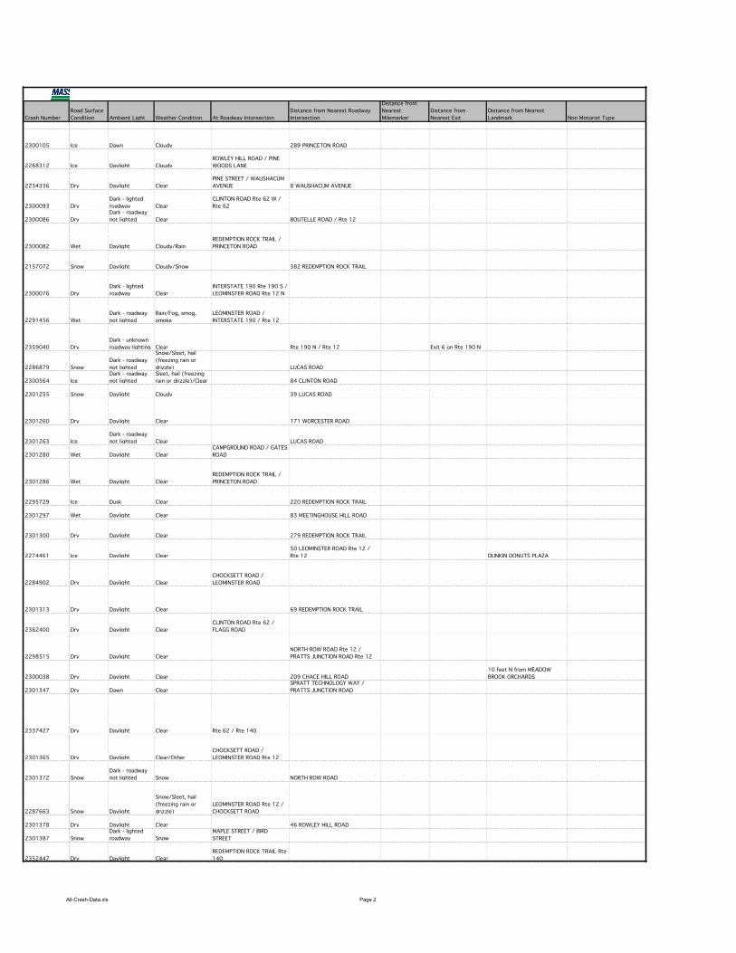
All-Crash-Data.xls Page 2
Crash Number
2300105
2268312
2234336
2300093
2300086
2300082
2157072
2300076
2291456
2359040
2286879
2300564
2301255
2301260
2301263
2301280
2301286
2295729
2301297
2301300
2274461
2284902
2301313
2362400
2298515
2300038
2301347
2337427
2301365
2301372
2287663
2301378
2301387
2352447
Road Surface
Condition Ambient Light Weather Condition At Roadway Intersection
Distance from Nearest Roadway
Intersection
Distance from
Nearest
Milemarker
Distance from
Nearest Exit
Distance from Nearest
Landmark Non Motorist Type
Ice Dawn Cloudy 289 PRINCETON ROAD
Ice Daylight Cloudy
ROWLEY HILL ROAD / PINE
WOODS LANE
Dry Daylight Clear
PINE STREET / WAUSHACUM
AVENUE 8 WAUSHACUM AVENUE
Dry
Dark - lighted
roadway Clear
CLINTON ROAD Rte 62 W /
Rte 62
Dry
Dark - roadway
not lighted Clear BOUTELLE ROAD / Rte 12
Wet Daylight Cloudy/Rain
REDEMPTION ROCK TRAIL /
PRINCETON ROAD
Snow Daylight Cloudy/Snow 382 REDEMPTION ROCK TRAIL
Dry
Dark - lighted
roadway Clear
INTERSTATE 190 Rte 190 S /
LEOMINSTER ROAD Rte 12 N
Wet
Dark - roadway
not lighted
Rain/Fog, smog,
smoke
LEOMINSTER ROAD /
INTERSTATE 190 / Rte 12
Dry
Dark - unknown
roadway lighting Clear Rte 190 N / Rte 12 Exit 6 on Rte 190 N
Snow
Dark - roadway
not lighted
Snow/Sleet, hail
(freezing rain or
drizzle) LUCAS ROAD
Ice
Dark - roadway
not lighted
Sleet, hail (freezing
rain or drizzle)/Clear 84 CLINTON ROAD
Snow Daylight Cloudy 39 LUCAS ROAD
Dry Daylight Clear 171 WORCESTER ROAD
Ice
Dark - roadway
not lighted Clear LUCAS ROAD
Wet Daylight Clear
CAMPGROUND ROAD / GATES
ROAD
Wet Daylight Clear
REDEMPTION ROCK TRAIL /
PRINCETON ROAD
Ice Dusk Clear 220 REDEMPTION ROCK TRAIL
Wet Daylight Clear 83 MEETINGHOUSE HILL ROAD
Dry Daylight Clear 279 REDEMPTION ROCK TRAIL
Ice Daylight Clear
50 LEOMINSTER ROAD Rte 12 /
Rte 12 DUNKIN DONUTS PLAZA
Dry Daylight Clear
CHOCKSETT ROAD /
LEOMINSTER ROAD
Dry Daylight Clear 69 REDEMPTION ROCK TRAIL
Dry Daylight Clear
CLINTON ROAD Rte 62 /
FLAGG ROAD
Dry Daylight Clear
NORTH ROW ROAD Rte 12 /
PRATTS JUNCTION ROAD Rte 12
Dry Daylight Clear 209 CHACE HILL ROAD
10 feet N from MEADOW
BROOK ORCHARDS
Dry Dawn Clear
SPRATT TECHNOLOGY WAY /
PRATTS JUNCTION ROAD
Dry Daylight Clear Rte 62 / Rte 140
Dry Daylight Clear/Other
CHOCKSETT ROAD /
LEOMINSTER ROAD Rte 12
Snow
Dark - roadway
not lighted Snow NORTH ROW ROAD
Snow Daylight
Snow/Sleet, hail
(freezing rain or
drizzle)
LEOMINSTER ROAD Rte 12 /
CHOCKSETT ROAD
Dry Daylight Clear 46 ROWLEY HILL ROAD
Snow
Dark - lighted
roadway Snow
MAPLE STREET / BIRD
STREET
Dry Daylight Clear
REDEMPTION ROCK TRAIL Rte
140
MassHighway Crash Report for STERLING in the year 2007
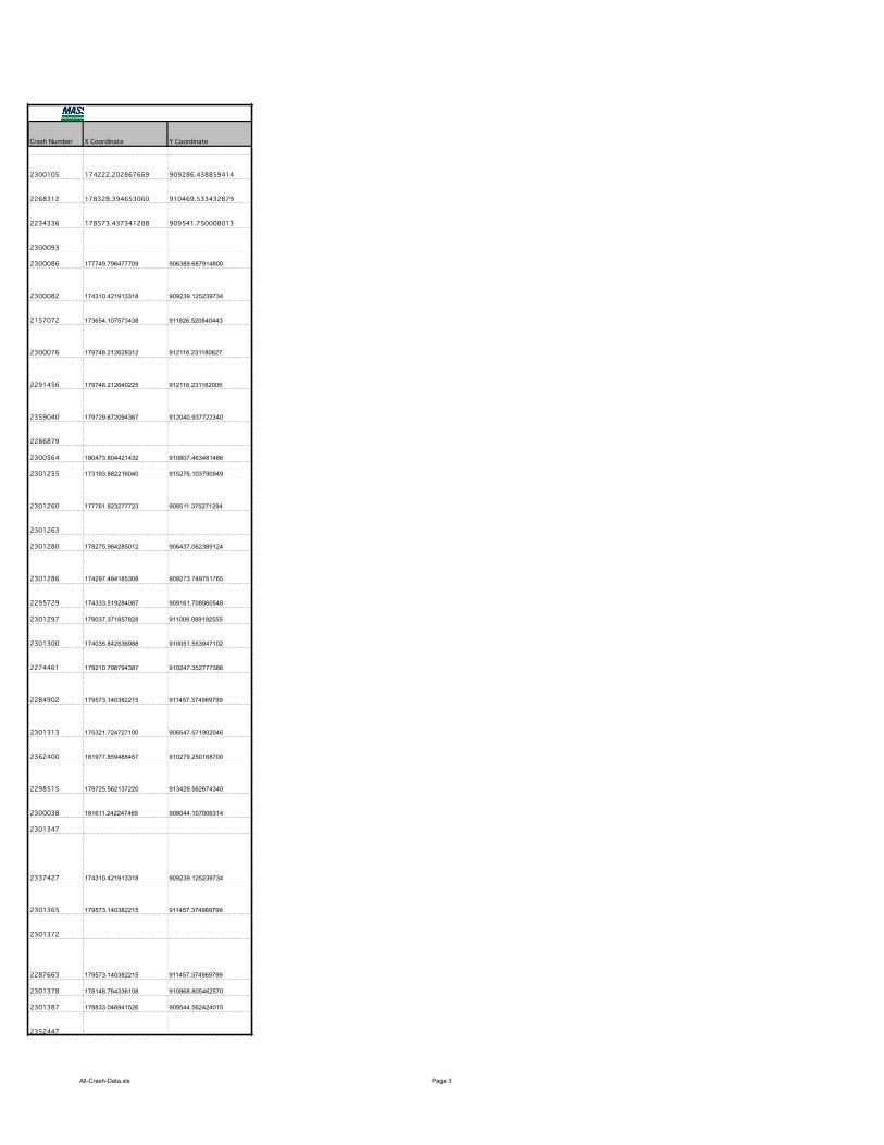
All-Crash-Data.xls Page 3
Crash Number
2300105
2268312
2234336
2300093
2300086
2300082
2157072
2300076
2291456
2359040
2286879
2300564
2301255
2301260
2301263
2301280
2301286
2295729
2301297
2301300
2274461
2284902
2301313
2362400
2298515
2300038
2301347
2337427
2301365
2301372
2287663
2301378
2301387
2352447
X Coordinate Y Coordinate
174222.202867669 909286.438859414
178328.394653060 910469.533432879
178573.437341288 909541.750008013
177749.796477709 906389.687914800
174310.421913318 909239.125239734
173654.107573438 911826.520840443
179748.212628312 912116.231180627
179748.212640225 912116.231162005
179729.672094367 912040.937722340
180473.804421432 910807.463481486
173193.882216040 915276.103790949
177761.823277723 908511.375271294
178275.984285012 906437.062389124
174297.484185308 909273.749751765
174333.519284087 909161.708060548
179037.371857828 911009.089192555
174035.842536988 910051.553947102
179210.798794387 910247.352777386
179573.140382215 911457.374969799
175321.724727100 906547.571902046
181977.859488457 910279.250168700
179725.562137220 913429.562674340
181611.242247465 908044.107006314
174310.421913318 909239.125239734
179573.140382215 911457.374969799
179573.140382215 911457.374969799
178148.764336108 910868.805462570
178833.046941526 909544.562424015
MassHighway Crash Report for STERLING in the year 2007
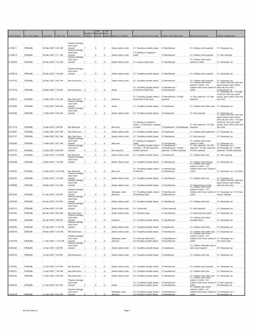
All-Crash-Data.xls Page 4
Crash Number City/Town Name Crash Date Crash Time Crash Severity
Number of
Vehicles
Total
Nonfatal
Injuries
Total
Fatal
Injuries Manner of Collision Vehicle Action Prior to Crash Vehicle Travel Directions Most Harmful Events Vehicle Configuration
2160811 STERLING 02-Mar-2007 6:50 AM
Property damage
only (none
injured) 1 0 0 Single vehicle crash V1: Travelling straight ahead V1:Northbound V1: Collision with guardrail V1: Passenger car
2160814 STERLING 02-Mar-2007 7:11 AM
Property damage
only (none
injured) 1 0 0 Single vehicle crash
V1: Slowing or stopped in
traffic V1:Northbound V1: Collision with guardrail V1: Not reported
2165904 STERLING 02-Mar-2007 7:33 AM
Property damage
only (none
injured) 1 0 0 Single vehicle crash V1: Leaving traffic lane V1:Southbound
V1: Collision with motor
vehicle in traffic V1: Passenger car
2160818 STERLING 02-Mar-2007 7:36 AM
Property damage
only (none
injured) 1 0 0 Single vehicle crash V1: Travelling straight ahead V1:Northbound V1: Collision with guardrail V1: Passenger car
2161552 STERLING 02-Mar-2007 9:45 AM Non-fatal injury 1 1 0 Single vehicle crash V1: Travelling straight ahead V1:Northbound V1: Collision with guardrail V1: Passenger car
2277870 STERLING 04-Mar-2007 2:50 PM Non-fatal injury 2 3 0 Angle
V1: Travelling straight ahead /
V2:Entering traffic lane
V1:Northbound /
V2:Northbound
V1: Collision with motor
vehicle in traffic / V2:
Collision with motor vehicle in
traffic
V1: Light truck(van, mini-van,
panel, pickup, sport utility)
with only four tires /
V2:Passenger car
2348272 STERLING 10-Mar-2007 2:55 AM Non-fatal injury 2 2 0 Unknown
V1: Travelling straight ahead /
V2:Entering traffic lane
V1:Northbound / V2:Not
reported
V1: Not reported / V2: Not
reported
V1: Passenger car / V2:Light
truck(van, mini-van, panel,
pickup, sport utility) with only
four tires
2303084 STERLING 11-Mar-2007 8:04 AM
Property damage
only (none
injured) 1 0 0 Angle V1: Travelling straight ahead V1:Eastbound V1: Collision with utility pole V1: Passenger car
2303086 STERLING 11-Mar-2007 8:40 AM
Property damage
only (none
injured) 1 0 0 Single vehicle crash V1: Travelling straight ahead V1:Eastbound V1: Not reported V1: Passenger car
2371416 STERLING 12-Mar-2007 4:00 PM Not Reported 2 0 0 Rear-end
V1: Slowing or stopped in
traffic / V2:Slowing or stopped
in traffic V1:Eastbound / V2:Eastbound
V1: Not reported / V2: Not
reported
V1: Light truck(van, mini-van,
panel, pickup, sport utility)
with only four tires / V2:Light
truck(van, mini-van, panel,
pickup, sport utility) with only
four tires
2303087 STERLING 13-Mar-2007 8:07 AM Non-fatal injury 1 1 0 Single vehicle crash V1: Travelling straight ahead V1:Eastbound V1: Collision with pedestrian V1: Passenger car
2350137 STERLING 13-Mar-2007 8:07 AM Non-fatal injury 1 1 0 Single vehicle crash V1: Travelling straight ahead V1:Westbound V1: Not reported V1: Passenger car
2303090 STERLING 13-Mar-2007 9:21 AM
Property damage
only (none
injured) 1 0 0 Rear-end
V1: Slowing or stopped in
traffic V1:Southbound
V1: Collision with motor
vehicle in traffic V1: Passenger car
2284155 STERLING 16-Mar-2007 8:00 AM
Property damage
only (none
injured) 4 0 0 Not reported
V1: Travelling straight ahead /
V2:Other / V3:Not reported /
V4:Not reported
V1:Southbound /
V2:Southbound / V3:Not
reported / V4:Not reported
V1: Not reported / V2: Not
reported / V3: Not reported /
V4: Not reported
V1: Passenger car /
V2:Passenger car / V3:Not
reported / V4:Not reported
2303093 STERLING 16-Mar-2007 12:49 PM Not Reported 1 0 0 Single vehicle crash V1: Travelling straight ahead V1:Eastbound V1: Collision with tree V1: Not reported
2300598 STERLING 18-Mar-2007 1:42 AM
Property damage
only (none
injured) 1 0 0 Single vehicle crash V1: Travelling straight ahead V1:Westbound V1: Collision with mail box V1: Passenger car
2300595 STERLING 19-Mar-2007 10:29 AM Not Reported 2 0 0 Rear-end
V1: Travelling straight ahead /
V2:Backing
V1:Westbound /
V2:Westbound
V1: Collision with motor
vehicle in traffic / V2:
Collision with motor vehicle in
traffic V1: Passenger car / V2:Other
2300592 STERLING 24-Mar-2007 3:18 AM
Property damage
only (none
injured) 1 0 0 Single vehicle crash V1: Travelling straight ahead V1:Southbound V1: Collision with tree V1: Passenger car
2189086 STERLING 26-Mar-2007 9:10 AM
Property damage
only (none
injured) 1 0 0 Single vehicle crash V1: Travelling straight ahead V1:Southbound V1: Reported but invalid
V1: Light truck(van, mini-van,
panel, pickup, sport utility)
with only four tires
2267003 STERLING 01-Apr-2007 3:05 PM
Property damage
only (none
injured) 2 0 0
Sideswipe, same
direction
V1: Travelling straight ahead /
V2:Changing lanes
V1:Northbound /
V2:Northbound
V1: Collision with motor
vehicle in traffic / V2:
Collision with motor vehicle in
traffic
V1: Passenger car / V2:Truck
tractor (bobtail)
2300589 STERLING 04-Apr-2007 4:10 PM
Property damage
only (none
injured) 1 0 0 Single vehicle crash V1: Travelling straight ahead V1:Westbound V1: Collision with tree V1: Passenger car
2349272 STERLING 04-Apr-2007 4:10 PM
Property damage
only (none
injured) 1 0 0 Single vehicle crash V1: Turning left V1:Not reported V1: Not reported V1: Passenger car
2187383 STERLING 06-Apr-2007 8:03 AM Non-fatal injury 1 1 0 Single vehicle crash V1: Changing lanes V1:Southbound V1: Reported but invalid V1: Passenger car
2300585 STERLING 06-Apr-2007 3:00 PM
Property damage
only (none
injured) 1 0 0 Unknown V1: Travelling straight ahead V1:Southbound
V1: Collision with other
movable object V1: Passenger car
2300583 STERLING 07-Apr-2007 11:55 PM
Property damage
only (none
injured) 1 0 0 Single vehicle crash V1: Travelling straight ahead V1:Eastbound V1: Collision with ditch V1: Passenger car
2300578 STERLING 09-Apr-2007 4:16 AM Non-fatal injury 1 1 0 Single vehicle crash V1: Travelling straight ahead V1:Northbound V1: Collision with utility pole V1: Passenger car
2187439 STERLING 11-Apr-2007 11:07 AM
Property damage
only (none
injured) 2 0 0
Sideswipe, same
direction
V1: Entering traffic lane /
V2:Travelling straight ahead
V1:Southbound /
V2:Southbound
V1: Collision with motor
vehicle in traffic / V2:
Collision with motor vehicle in
traffic
V1: Passenger car /
V2:Truck/trailer
2300562 STERLING 12-Apr-2007 2:46 PM
Property damage
only (none
injured) 1 0 0 Single vehicle crash V1: Travelling straight ahead V1:Eastbound
V1: Collision with light pole or
other post/support V1: Passenger car
2300559 STERLING 12-Apr-2007 3:54 PM Non-fatal injury 1 1 0 Single vehicle crash V1: Travelling straight ahead V1:Eastbound V1: Collision with tree V1: Passenger car
2187461 STERLING 12-Apr-2007 5:33 PM Not Reported 1 0 0 Single vehicle crash V1: Travelling straight ahead V1:Northbound V1: Collision with guardrail V1: Passenger car
2300557 STERLING 13-Apr-2007 7:43 AM Non-fatal injury 1 1 0 Single vehicle crash V1: Travelling straight ahead V1:Southbound V1: Collision with tree V1: Passenger car
2300555 STERLING 17-Apr-2007 8:56 AM Non-fatal injury 1 1 0 Single vehicle crash V1: Travelling straight ahead V1:Westbound V1: Collision with utility pole V1: Passenger car
2300552 STERLING 21-Apr-2007 6:07 PM
Property damage
only (none
injured) 2 0 0 Angle
V1: Travelling straight ahead /
V2:Travelling straight ahead
V1:Westbound /
V2:Southbound
V1: Collision with motor
vehicle in traffic / V2:
Collision with motor vehicle in
traffic
V1: Not reported /
V2:Passenger car
2300538 STERLING 21-Apr-2007 8:52 PM
Property damage
only (none
injured) 2 0 0
Sideswipe, same
direction
V1: Travelling straight ahead /
V2:Travelling straight ahead
V1:Northbound /
V2:Northbound
V1: Collision with motor
vehicle in traffic / V2:
Collision with motor vehicle in
traffic
V1: Passenger car /
V2:Passenger car
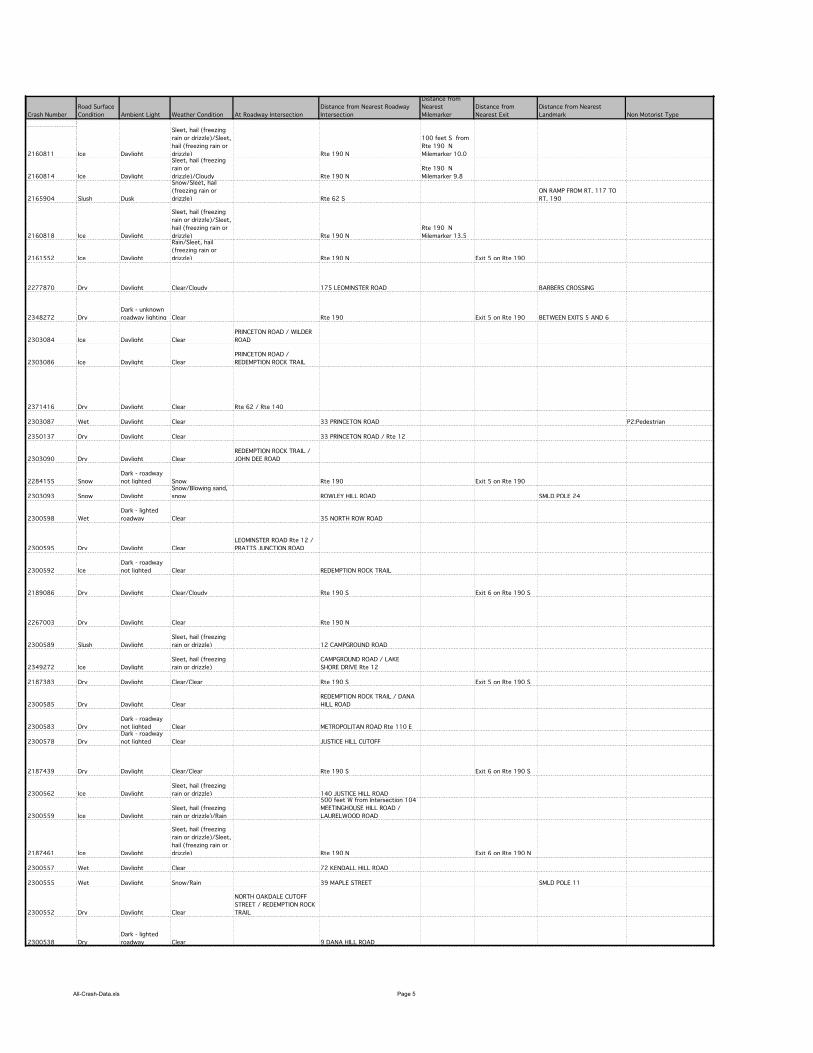
All-Crash-Data.xls Page 5
Crash Number
2160811
2160814
2165904
2160818
2161552
2277870
2348272
2303084
2303086
2371416
2303087
2350137
2303090
2284155
2303093
2300598
2300595
2300592
2189086
2267003
2300589
2349272
2187383
2300585
2300583
2300578
2187439
2300562
2300559
2187461
2300557
2300555
2300552
2300538
Road Surface
Condition Ambient Light Weather Condition At Roadway Intersection
Distance from Nearest Roadway
Intersection
Distance from
Nearest
Milemarker
Distance from
Nearest Exit
Distance from Nearest
Landmark Non Motorist Type
Ice Daylight
Sleet, hail (freezing
rain or drizzle)/Sleet,
hail (freezing rain or
drizzle) Rte 190 N
100 feet S from
Rte 190 N
Milemarker 10.0
Ice Daylight
Sleet, hail (freezing
rain or
drizzle)/Cloudy Rte 190 N
Rte 190 N
Milemarker 9.8
Slush Dusk
Snow/Sleet, hail
(freezing rain or
drizzle) Rte 62 S
ON RAMP FROM RT. 117 TO
RT. 190
Ice Daylight
Sleet, hail (freezing
rain or drizzle)/Sleet,
hail (freezing rain or
drizzle) Rte 190 N
Rte 190 N
Milemarker 13.5
Ice Daylight
Rain/Sleet, hail
(freezing rain or
drizzle) Rte 190 N Exit 5 on Rte 190
Dry Daylight Clear/Cloudy 175 LEOMINSTER ROAD BARBERS CROSSING
Dry
Dark - unknown
roadway lighting Clear Rte 190 Exit 5 on Rte 190 BETWEEN EXITS 5 AND 6
Ice Daylight Clear
PRINCETON ROAD / WILDER
ROAD
Ice Daylight Clear
PRINCETON ROAD /
REDEMPTION ROCK TRAIL
Dry Daylight Clear Rte 62 / Rte 140
Wet Daylight Clear 33 PRINCETON ROAD P2:Pedestrian
Dry Daylight Clear 33 PRINCETON ROAD / Rte 12
Dry Daylight Clear
REDEMPTION ROCK TRAIL /
JOHN DEE ROAD
Snow
Dark - roadway
not lighted Snow Rte 190 Exit 5 on Rte 190
Snow Daylight
Snow/Blowing sand,
snow ROWLEY HILL ROAD SMLD POLE 24
Wet
Dark - lighted
roadway Clear 35 NORTH ROW ROAD
Dry Daylight Clear
LEOMINSTER ROAD Rte 12 /
PRATTS JUNCTION ROAD
Ice
Dark - roadway
not lighted Clear REDEMPTION ROCK TRAIL
Dry Daylight Clear/Cloudy Rte 190 S Exit 6 on Rte 190 S
Dry Daylight Clear Rte 190 N
Slush Daylight
Sleet, hail (freezing
rain or drizzle) 12 CAMPGROUND ROAD
Ice Daylight
Sleet, hail (freezing
rain or drizzle)
CAMPGROUND ROAD / LAKE
SHORE DRIVE Rte 12
Dry Daylight Clear/Clear Rte 190 S Exit 5 on Rte 190 S
Dry Daylight Clear
REDEMPTION ROCK TRAIL / DANA
HILL ROAD
Dry
Dark - roadway
not lighted Clear METROPOLITAN ROAD Rte 110 E
Dry
Dark - roadway
not lighted Clear JUSTICE HILL CUTOFF
Dry Daylight Clear/Clear Rte 190 S Exit 6 on Rte 190 S
Ice Daylight
Sleet, hail (freezing
rain or drizzle) 140 JUSTICE HILL ROAD
Ice Daylight
Sleet, hail (freezing
rain or drizzle)/Rain
500 feet W from Intersection 104
MEETINGHOUSE HILL ROAD /
LAURELWOOD ROAD
Ice Daylight
Sleet, hail (freezing
rain or drizzle)/Sleet,
hail (freezing rain or
drizzle) Rte 190 N Exit 6 on Rte 190 N
Wet Daylight Clear 72 KENDALL HILL ROAD
Wet Daylight Snow/Rain 39 MAPLE STREET SMLD POLE 11
Dry Daylight Clear
NORTH OAKDALE CUTOFF
STREET / REDEMPTION ROCK
TRAIL
Dry
Dark - lighted
roadway Clear 9 DANA HILL ROAD

All-Crash-Data.xls Page 6
Crash Number
2160811
2160814
2165904
2160818
2161552
2277870
2348272
2303084
2303086
2371416
2303087
2350137
2303090
2284155
2303093
2300598
2300595
2300592
2189086
2267003
2300589
2349272
2187383
2300585
2300583
2300578
2187439
2300562
2300559
2187461
2300557
2300555
2300552
2300538
X Coordinate Y Coordinate
175760.117998248 906941.065690619
175745.584592916 906650.062335880
181577.695579042 915258.918395555
178994.713363706 911370.009386320
175525.605695785 905843.637049904
179789.368238323 912387.153003030
175525.605695785 905843.637049904
175155.687322102 909485.874935962
174297.484185308 909273.749751765
174310.421913318 909239.125239734
177928.391340030 909291.681126137
175114.250138067 907276.437749904
175510.472223557 905885.472423811
179193.417238805 913530.856638807
179725.562270358 913429.562619634
179739.077294800 912111.162273067
179998.343582615 912189.062394480
178385.537211440 906390.769803117
177790.688090080 905769.250067024
175693.716891124 906388.755337297
175378.906036859 906322.437253193
180024.131598404 912273.827117507
174532.658395701 913970.551525428
179191.394994039 911168.017331920
179163.866266963 911598.802218519
179666.066879031 908315.435367268
179063.943709905 909348.387820781
173720.797080768 911326.562553677
175435.893918570 906374.439801713
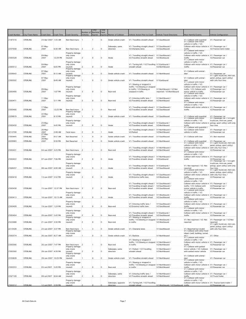
All-Crash-Data.xls Page 7
Crash Number City/Town Name Crash Date Crash Time Crash Severity
Number of
Vehicles
Total
Nonfatal
Injuries
Total
Fatal
Injuries Manner of Collision Vehicle Action Prior to Crash Vehicle Travel Directions Most Harmful Events Vehicle Configuration
2187516 STERLING 23-Apr-2007 1:35 AM Non-fatal injury 1 1 0 Single vehicle crash V1: Travelling straight ahead V1:Southbound V1: Collision with guardrail V1: Passenger car
2257658 STERLING
01-May-
2007 6:30 AM Non-fatal injury 2 2 0
Sideswipe, same
direction
V1: Travelling straight ahead /
V2:Changing lanes
V1:Southbound /
V2:Southbound
V1: Collision with motor
vehicle in traffic / V2:
Collision with motor vehicle in
traffic
V1: Passenger car /
V2:Tractor/semi-trailer
2300528 STERLING
04-May-
2007 12:29 PM
Property damage
only (none
injured) 2 0 0 Angle
V1: Travelling straight ahead /
V2:Travelling straight ahead
V1:Southbound /
V2:Westbound
V1: Collision with motor
vehicle in traffic / V2:
Collision with motor vehicle in
traffic
V1: Passenger car /
V2:Passenger car
2300512 STERLING
04-May-
2007 6:05 PM
Property damage
only (none
injured) 2 0 0 Angle
V1: Turning left / V2:Travelling
straight ahead
V1:Eastbound /
V2:Northbound
V1: Collision with motor
vehicle in traffic / V2:
Collision with motor vehicle in
traffic
V1: Passenger car /
V2:Passenger car
2209643 STERLING
07-May-
2007 8:15 AM
Property damage
only (none
injured) 1 0 0 Single vehicle crash V1: Travelling straight ahead V1:Northbound
V1: Collision with animal -
deer V1: Passenger car
2300502 STERLING
07-May-
2007 8:49 AM
Property damage
only (none
injured) 1 0 0 Single vehicle crash V1: Travelling straight ahead V1:Eastbound
V1: Collision with animal -
deer
V1: Light truck(van, mini-van,
panel, pickup, sport utility)
with only four tires
2300490 STERLING
09-May-
2007 1:07 PM
Property damage
only (none
injured) 3 0 0 Rear-end
V1: Slowing or stopped in
traffic / V2:Slowing or stopped
in traffic / V3:Slowing or
stopped in traffic
V1:Northbound / V2:Not
reported / V3:Northbound
V1: Collision with motor
vehicle in traffic / V2:
Collision with motor vehicle in
traffic / V3: Collision with
motor vehicle in traffic
V1: Passenger car /
V2:Passenger car /
V3:Passenger car
2300471 STERLING
11-May-
2007 5:11 PM
Property damage
only (none
injured) 2 0 0 Rear-end
V1: Entering traffic lane /
V2:Travelling straight ahead
V1:Northbound /
V2:Northbound
V1: Collision with motor
vehicle in traffic / V2:
Collision with motor vehicle in
traffic
V1: Passenger car /
V2:Passenger car
2300466 STERLING
17-May-
2007 12:25 PM Non-fatal injury 2 1 0 Rear-end
V1: Travelling straight ahead /
V2:Travelling straight ahead
V1:Southbound /
V2:Southbound
V1: Collision with motor
vehicle in traffic / V2:
Collision with motor vehicle in
traffic
V1: Passenger car /
V2:Passenger car
2209879 STERLING
22-May-
2007 8:10 PM
Property damage
only (none
injured) 1 0 0 Single vehicle crash V1: Travelling straight ahead V1:Southbound V1: Collision with guardrail V1: Passenger car
2300450 STERLING
23-May-
2007 4:45 PM
Property damage
only (none
injured) 2 0 0 Angle
V1: Travelling straight ahead /
V2:Travelling straight ahead
V1:Eastbound /
V2:Northbound
V1: Collision with motor
vehicle in traffic / V2:
Collision with motor vehicle in
traffic
V1: Passenger car / V2:Light
truck(van, mini-van, panel,
pickup, sport utility) with only
four tires
2212700 STERLING
26-May-
2007 2:48 AM Fatal injury 2 0 1 Angle
V1: Travelling straight ahead /
V2:Parked
V1:Northbound /
V2:Northbound
V1: Collision with guardrail /
V2: Collision with motor
vehicle in traffic
V1: Passenger car /
V2:Passenger car
2300445 STERLING
27-May-
2007 8:57 AM Not Reported 1 0 0 Single vehicle crash V1: Travelling straight ahead V1:Southbound V1: Collision with tree V1: Not reported
2209983 STERLING
28-May-
2007 9:50 PM Not Reported 1 0 0 Single vehicle crash V1: Travelling straight ahead V1:Northbound V1: Collision with guardrail V1: Passenger car
2300431 STERLING 04-Jun-2007 3:25 PM Non-fatal injury 2 1 0 Rear-end
V1: Travelling straight ahead /
V2:Travelling straight ahead
V1:Northbound /
V2:Northbound
V1: Collision with motor
vehicle in traffic / V2:
Collision with motor vehicle in
traffic
V1: Light truck(van, mini-van,
panel, pickup, sport utility)
with only four tires /
V2:Passenger car
2300422 STERLING 07-Jun-2007 7:06 PM
Property damage
only (none
injured) 2 0 0 Angle
V1: Travelling straight ahead /
V2:Travelling straight ahead
V1:Northbound /
V2:Eastbound
V1: Collision with motor
vehicle in traffic / V2:
Collision with motor vehicle in
traffic
V1: Passenger car /
V2:Passenger car
2368457 STERLING 08-Jun-2007 6:00 AM
Property damage
only (none
injured) 2 0 0 Angle
V1: Travelling straight ahead /
V2:Travelling straight ahead
V1:Eastbound /
V2:Southbound
V1: Not reported / V2: Not
reported
V1: Passenger car / V2:Light
truck(van, mini-van, panel,
pickup, sport utility) with only
four tires
2300418 STERLING 13-Jun-2007 5:52 PM
Property damage
only (none
injured) 2 0 0 Angle
V1: Travelling straight ahead /
V2:Entering traffic lane
V1:Southbound /
V2:Westbound
V1: Collision with motor
vehicle in traffic / V2:
Collision with motor vehicle in
traffic
V1: Light truck(van, mini-van,
panel, pickup, sport utility)
with only four tires /
V2:Passenger car
2300458 STERLING 15-Jun-2007 12:37 PM Non-fatal injury 3 2 0 Rear-end
V1: Travelling straight ahead /
V2:Travelling straight ahead /
V3:Travelling straight ahead
V1:Southbound /
V2:Southbound /
V3:Southbound
V1: Collision with motor
vehicle in traffic / V2:
Collision with motor vehicle in
traffic / V3: Collision with
motor vehicle in traffic
V1: Passenger car /
V2:Passenger car /
V3:Passenger car
2300413 STERLING 16-Jun-2007 10:13 AM
Property damage
only (none
injured) 2 0 0 Angle
V1: Travelling straight ahead /
V2:Travelling straight ahead
V1:Westbound /
V2:Southbound
V1: Collision with motor
vehicle in traffic / V2:
Collision with motor vehicle in
traffic
V1: Passenger car /
V2:Passenger car
2300409 STERLING 19-Jun-2007 1:24 PM
Property damage
only (none
injured) 2 0 0 Rear-end
V1: Entering traffic lane /
V2:Entering traffic lane
V1:Southbound /
V2:Southbound
V1: Collision with motor
vehicle in traffic / V2:
Collision with motor vehicle in
traffic
V1: Passenger car /
V2:Passenger car
2300404 STERLING 20-Jun-2007 5:45 PM
Property damage
only (none
injured) 2 0 0 Rear-end
V1: Travelling straight ahead /
V2:Travelling straight ahead
V1:Eastbound /
V2:Southbound
V1: Collision with motor
vehicle in traffic / V2:
Collision with motor vehicle in
traffic
V1: Passenger car /
V2:Passenger car
2322688 STERLING 21-Jun-2007 3:30 PM
Property damage
only (none
injured) 2 0 0 Rear-end
V1: Slowing or stopped in
traffic / V2:Slowing or stopped
in traffic
V1:Westbound /
V2:Westbound
V1: Not reported / V2: Not
reported
V1: Passenger car / V2:Not
reported
2215428 STERLING 23-Jun-2007 3:37 PM Non-fatal injury 1 3 0 Single vehicle crash V1: Changing lanes V1:Southbound V1: Reported but invalid
V1: Light truck(van, mini-van,
panel, pickup, sport utility)
with only four tires
2300374 STERLING 26-Jun-2007 8:27 AM
Property damage
only (none
injured) 1 0 0 Single vehicle crash V1: Backing V1:Northbound
V1: Collision with other fixed
object (wall, building, tunnel,
etc.) V1: Other
2300366 STERLING 26-Jun-2007 7:47 PM Non-fatal injury 2 1 0 Rear-end
V1: Slowing or stopped in
traffic / V2:Slowing or stopped
in traffic
V1:Northbound /
V2:Northbound
V1: Collision with motor
vehicle in traffic / V2:
Collision with motor vehicle in
traffic
V1: Passenger car /
V2:Passenger car
2300360 STERLING 28-Jun-2007 4:39 PM
Property damage
only (none
injured) 2 0 0
Sideswipe, same
direction
V1: Parked / V2:Travelling
straight ahead
V1:Northbound /
V2:Northbound
V1: Collision with parked
motor vehicle / V2: Collision
with parked motor vehicle
V1: Passenger car /
V2:Passenger car
2220828 STERLING 28-Jun-2007 10:20 PM
Property damage
only (none
injured) 1 0 0 Single vehicle crash V1: Travelling straight ahead V1:Northbound
V1: Collision with animal -
deer V1: Passenger car
2300353 STERLING 03-Jul-2007 5:20 PM
Property damage
only (none
injured) 2 0 0 Rear-end
V1: Slowing or stopped in
traffic / V2:Slowing or stopped
in traffic
V1:Northbound /
V2:Northbound
V1: Collision with motor
vehicle in traffic / V2:
Collision with motor vehicle in
traffic
V1: Passenger car /
V2:Passenger car
2267109 STERLING 09-Jul-2007 8:04 AM
Property damage
only (none
injured) 2 0 0
Sideswipe, same
direction
V1: Entering traffic lane /
V2:Travelling straight ahead
V1:Northbound /
V2:Northbound
V1: Collision with motor
vehicle in traffic / V2:
Collision with motor vehicle in
traffic
V1: Passenger car /
V2:Truck/trailer
2300312 STERLING 12-Jul-2007 3:59 PM
Property damage
only (none
injured) 2 0 0
Sideswipe, opposite
direction
V1: Turning left / V2:Travelling
straight ahead V1:Westbound / V2:Eastbound
V1: Collision with motor
vehicle in traffic / V2:
Collision with motor vehicle in
traffic
V1: Tractor/semi-trailer /
V2:Passenger car

All-Crash-Data.xls Page 8
Crash Number
2187516
2257658
2300528
2300512
2209643
2300502
2300490
2300471
2300466
2209879
2300450
2212700
2300445
2209983
2300431
2300422
2368457
2300418
2300458
2300413
2300409
2300404
2322688
2215428
2300374
2300366
2300360
2220828
2300353
2267109
2300312
Road Surface
Condition Ambient Light Weather Condition At Roadway Intersection
Distance from Nearest Roadway
Intersection
Distance from
Nearest
Milemarker
Distance from
Nearest Exit
Distance from Nearest
Landmark Non Motorist Type
Dry Not reported Clear/Clear Rte 190 S Exit 5 on Rte 190 S 190S PRIOR TO EXIT 5
Dry Daylight Cloudy Rte 190 S Exit 5 on Rte 190 S
Dry Daylight Clear
PRATTS JUNCTION ROAD /
LEOMINSTER ROAD
Dry Daylight Clear 140 LEOMINSTER ROAD
Dry Daylight Clear Rte 190 N / Rte 190 Exit 5 on Rte 190
Dry Daylight Clear 22 CLINTON ROAD
Dry Daylight Clear 135 LEOMINSTER ROAD
Dry Daylight Cloudy
CHOCKSETT ROAD /
LEOMINSTER ROAD / Rte 12
Dry Daylight Clear
INTERSTATE 190 /
LEOMINSTER ROAD / Rte 12
Dry Dusk Clear/Clear Rte 190 S Exit 5 on Rte 190 S
Dry Daylight Clear
LEOMINSTER ROAD /
CHOCKSETT ROAD
Dry
Dark - roadway
not lighted Clear/Clear Rte 190 N
Rte 190 N
Milemarker 10.7 Exit 5 on Rte 190 N
Dry Daylight Cloudy/Clear 329 REDEMPTION ROCK TRAIL
Dry
Dark - roadway
not lighted Clear/Clear Rte 190 N Exit 5 on Rte 190
Wet Daylight Rain/Cloudy 50 LEOMINSTER ROAD
10 feet S from DUNKIN
DONUTS
Dry Daylight Cloudy
REDEMPTION ROCK TRAIL /
PRINCETON ROAD
Dry Daylight Clear Rte 62 / Rte 140
Dry Daylight Cloudy
LEOMINSTER ROAD /
CHOCKSETT ROAD / Rte 12
Dry Daylight Clear
INTERSTATE 190 Rte 190 S /
LEOMINSTER ROAD / Rte 12
Dry Daylight Clear
BOUTELLE ROAD / MUDDY
POND ROAD
Dry Daylight Clear
INTERSTATE 190 /
REDEMPTION ROCK TRAIL
Dry Daylight Clear REDEMPTION ROCK TRAIL FOUR SONS WAY
Dry Daylight Clear CHOCKSETT ROAD Rte 12 / Rte 12
Dry Daylight Clear Rte 190 S Exit 5 on Rte 190 S
Dry Daylight Clear 205 UPPER NORTH ROW ROAD
Dry Daylight Clear
LEOMINSTER ROAD /
CHOCKSETT ROAD
Dry Daylight Clear
MAIN STREET / WAUSHACUM
AVENUE
Dry
Dark - roadway
not lighted Clear Rte 190 N Exit 6 on Rte 190 N
Dry Daylight Clear 32 REDEMPTION ROCK TRAIL
Dry Daylight Clear Rte 190 N Exit 6 on Rte 190 N
Dry Daylight Clear FLAGG ROAD

All-Crash-Data.xls Page 9
Crash Number
2187516
2257658
2300528
2300512
2209643
2300502
2300490
2300471
2300466
2209879
2300450
2212700
2300445
2209983
2300431
2300422
2368457
2300418
2300458
2300413
2300409
2300404
2322688
2215428
2300374
2300366
2300360
2220828
2300353
2267109
2300312
X Coordinate Y Coordinate
175693.716891124 906388.755337297
175510.462932804 905885.459659649
179725.562270358 913429.562619634
179652.434204443 911812.724388821
175525.604927836 905843.636370495
179706.452197092 910314.116012903
179643.529808083 911717.108768010
179573.140382215 911457.374969799
179748.212628312 912116.231180627
175510.462932804 905885.459659649
179573.140382215 911457.374969799
176410.463793689 907842.863340793
174019.908511269 910145.927727792
175525.604927836 905843.636370495
179210.798794387 910247.352777386
174297.484185308 909273.749751765
174310.421913318 909239.125239734
179573.140382215 911457.374969799
179748.212628312 912116.231180627
176952.468891777 907324.937461950
175517.531546444 905833.125108562
173472.281496537 912353.624826633
179573.140383355 911457.374957231
175510.462932804 905885.459659649
175831.263972177 913969.935963255
179573.140382215 911457.374969799
178508.000157230 909638.625016104
179720.853377159 912036.704765158
175435.558850746 906093.343504483
179720.853377159 912036.704765158
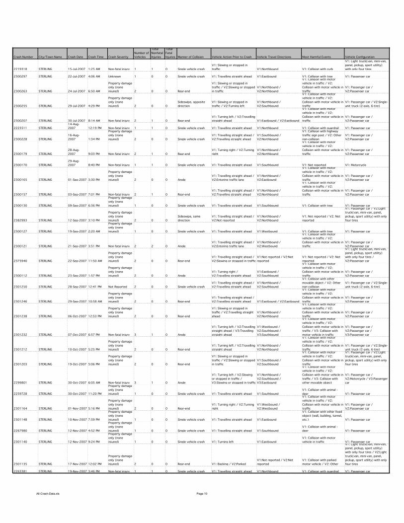
All-Crash-Data.xls Page 10
Crash Number City/Town Name Crash Date Crash Time Crash Severity
Number of
Vehicles
Total
Nonfatal
Injuries
Total
Fatal
Injuries Manner of Collision Vehicle Action Prior to Crash Vehicle Travel Directions Most Harmful Events Vehicle Configuration
2219318 STERLING 15-Jul-2007 1:25 AM Non-fatal injury 1 1 0 Single vehicle crash
V1: Slowing or stopped in
traffic V1:Northbound V1: Collision with curb
V1: Light truck(van, mini-van,
panel, pickup, sport utility)
with only four tires
2300297 STERLING 22-Jul-2007 4:06 AM Unknown 1 0 0 Single vehicle crash V1: Travelling straight ahead V1:Eastbound V1: Collision with tree V1: Passenger car
2300263 STERLING 24-Jul-2007 6:50 AM
Property damage
only (none
injured) 2 0 0 Rear-end
V1: Slowing or stopped in
traffic / V2:Slowing or stopped
in traffic
V1:Northbound /
V2:Northbound
V1: Collision with motor
vehicle in traffic / V2:
Collision with motor vehicle in
traffic
V1: Passenger car /
V2:Passenger car
2300255 STERLING 29-Jul-2007 4:29 PM
Property damage
only (none
injured) 2 0 0
Sideswipe, opposite
direction
V1: Slowing or stopped in
traffic / V2:Turning left
V1:Northbound /
V2:Southbound
V1: Collision with motor
vehicle in traffic / V2:
Collision with motor vehicle in
traffic
V1: Passenger car / V2:Single-
unit truck (2-axle, 6-tire)
2300207 STERLING 30-Jul-2007 8:14 AM Non-fatal injury 2 1 0 Rear-end
V1: Turning left / V2:Travelling
straight ahead V1:Eastbound / V2:Eastbound
V1: Collision with motor
vehicle in traffic / V2:
Collision with motor vehicle in
traffic
V1: Passenger car /
V2:Passenger car
2223511 STERLING
14-Aug-
2007 12:19 PM Non-fatal injury 1 1 0 Single vehicle crash V1: Travelling straight ahead V1:Northbound V1: Collision with guardrail V1: Passenger car
2300228 STERLING
16-Aug-
2007 1:34 PM
Property damage
only (none
injured) 2 0 0 Single vehicle crash
V1: Travelling straight ahead /
V2:Travelling straight ahead
V1:Southbound /
V2:Northbound
V1: Collision with highway
traffic sign post / V2: Other
non-collision
V1: Passenger car /
V2:Passenger car
2300179 STERLING
28-Aug-
2007 9:03 PM Non-fatal injury 2 1 0 Rear-end
V1: Turning right / V2:Turning
right
V1:Northbound /
V2:Northbound
V1: Collision with motor
vehicle in traffic / V2:
Collision with motor vehicle in
traffic
V1: Passenger car /
V2:Passenger car
2300170 STERLING
29-Aug-
2007 8:40 PM Non-fatal injury 1 1 0 Single vehicle crash V1: Travelling straight ahead V1:Southbound V1: Not reported V1: Motorcycle
2300165 STERLING 01-Sep-2007 3:30 PM
Property damage
only (none
injured) 2 0 0 Angle
V1: Travelling straight ahead /
V2:Entering traffic lane
V1:Northbound /
V2:Eastbound
V1: Collision with motor
vehicle in traffic / V2:
Collision with motor vehicle in
traffic
V1: Passenger car /
V2:Passenger car
2300157 STERLING 03-Sep-2007 7:01 PM Non-fatal injury 2 1 0 Rear-end
V1: Travelling straight ahead /
V2:Travelling straight ahead
V1:Northbound /
V2:Northbound
V1: Collision with motor
vehicle in traffic / V2:
Collision with motor vehicle in
traffic
V1: Passenger car /
V2:Passenger car
2300130 STERLING 09-Sep-2007 6:36 PM
Property damage
only (none
injured) 1 0 0 Single vehicle crash V1: Travelling straight ahead V1:Southbound V1: Collision with tree V1: Passenger car
2382993 STERLING 12-Sep-2007 3:10 PM
Property damage
only (none
injured) 2 0 0
Sideswipe, same
direction
V1: Travelling straight ahead /
V2:Not reported
V1:Northbound /
V2:Northbound
V1: Not reported / V2: Not
reported
V1: Passenger car / V2:Light
truck(van, mini-van, panel,
pickup, sport utility) with only
four tires
2300127 STERLING 19-Sep-2007 2:20 AM
Property damage
only (none
injured) 1 0 0 Single vehicle crash V1: Travelling straight ahead V1:Westbound V1: Collision with tree V1: Passenger car
2300121 STERLING 21-Sep-2007 3:51 PM Non-fatal injury 2 2 0 Angle
V1: Travelling straight ahead /
V2:Entering traffic lane
V1:Northbound /
V2:Westbound
V1: Collision with motor
vehicle in traffic / V2:
Collision with motor vehicle in
traffic
V1: Passenger car /
V2:Passenger car
2375940 STERLING 22-Sep-2007 11:50 AM
Property damage
only (none
injured) 2 0 0 Rear-end
V1: Travelling straight ahead /
V2:Slowing or stopped in traffic
V1:Not reported / V2:Not
reported
V1: Not reported / V2: Not
reported
V1: Light truck(van, mini-van,
panel, pickup, sport utility)
with only four tires /
V2:Passenger car
2300112 STERLING 23-Sep-2007 1:57 PM
Property damage
only (none
injured) 2 0 0 Angle
V1: Turning right /
V2:Travelling straight ahead
V1:Eastbound /
V2:Southbound
V1: Collision with motor
vehicle in traffic / V2:
Collision with motor vehicle in
traffic
V1: Passenger car /
V2:Passenger car
2301250 STERLING 28-Sep-2007 12:41 PM Not Reported 2 0 0 Single vehicle crash
V1: Travelling straight ahead /
V2:Travelling straight ahead
V1:Northbound /
V2:Southbound
V1: Collision with other
movable object / V2: Other
non-collision
V1: Passenger car / V2:Single-
unit truck (2-axle, 6-tire)
2301246 STERLING 29-Sep-2007 10:58 AM
Property damage
only (none
injured) 2 0 0 Rear-end
V1: Travelling straight ahead /
V2:Travelling straight ahead V1:Eastbound / V2:Eastbound
V1: Collision with motor
vehicle in traffic / V2:
Collision with motor vehicle in
traffic
V1: Passenger car /
V2:Passenger car
2301238 STERLING 06-Oct-2007 12:53 PM
Property damage
only (none
injured) 2 0 0 Rear-end
V1: Slowing or stopped in
traffic / V2:Travelling straight
ahead
V1:Northbound /
V2:Northbound
V1: Collision with motor
vehicle in traffic / V2:
Collision with motor vehicle in
traffic
V1: Passenger car /
V2:Passenger car
2301232 STERLING 07-Oct-2007 6:57 PM Non-fatal injury 3 1 0 Angle
V1: Turning left / V2:Travelling
straight ahead / V3:Travelling
straight ahead
V1:Westbound /
V2:Southbound /
V3:Southbound
V1: Collision with motor
vehicle in traffic / V2:
Collision with motor vehicle in
traffic / V3: Collision with
motor vehicle in traffic
V1: Passenger car /
V2:Passenger car /
V3:Passenger car
2301212 STERLING 10-Oct-2007 5:25 PM
Property damage
only (none
injured) 2 0 0 Rear-end
V1: Turning left / V2:Travelling
straight ahead
V1:Northbound /
V2:Northbound
V1: Collision with motor
vehicle in traffic / V2:
Collision with motor vehicle in
traffic
V1: Passenger car / V2:Single-
unit truck (2-axle, 6-tire)
2301203 STERLING 19-Oct-2007 5:06 PM
Property damage
only (none
injured) 2 0 0 Rear-end
V1: Slowing or stopped in
traffic / V2:Slowing or stopped
in traffic
V1:Southbound /
V2:Southbound
V1: Collision with motor
vehicle in traffic / V2:
Collision with motor vehicle in
traffic
V1: Passenger car / V2:Light
truck(van, mini-van, panel,
pickup, sport utility) with only
four tires
2299801 STERLING 30-Oct-2007 6:05 AM Non-fatal injury 3 1 0 Angle
V1: Turning left / V2:Slowing
or stopped in traffic /
V3:Slowing or stopped in traffic
V1:Northbound /
V2:Southbound /
V3:Eastbound
V1: Collision with motor
vehicle in traffic / V2:
Collision with motor vehicle in
traffic / V3: Collision with
other movable object
V1: Passenger car /
V2:Motorcycle / V3:Passenger
car
2259728 STERLING 30-Oct-2007 11:20 PM
Property damage
only (none
injured) 1 0 0 Single vehicle crash V1: Travelling straight ahead V1:Southbound
V1: Collision with animal -
deer V1: Passenger car
2301164 STERLING 01-Nov-2007 5:16 PM
Property damage
only (none
injured) 2 0 0 Rear-end
V1: Turning right / V2:Turning
right
V1:Westbound /
V2:Westbound
V1: Collision with motor
vehicle in traffic / V2:
Collision with motor vehicle in
traffic
V1: Passenger car /
V2:Passenger car
2301148 STERLING 10-Nov-2007 7:59 PM
Property damage
only (none
injured) 1 0 0 Single vehicle crash V1: Travelling straight ahead V1:Eastbound
V1: Collision with other fixed
object (wall, building, tunnel,
etc.) V1: Passenger car
2267980 STERLING 12-Nov-2007 4:52 PM
Property damage
only (none
injured) 1 0 0 Single vehicle crash V1: Travelling straight ahead V1:Southbound
V1: Collision with animal -
deer V1: Passenger car
2301140 STERLING 12-Nov-2007 9:24 PM
Property damage
only (none
injured) 1 0 0 Single vehicle crash V1: Turning left V1:Eastbound
V1: Collision with motor
vehicle in traffic V1: Passenger car
2301135 STERLING 17-Nov-2007 12:02 PM
Property damage
only (none
injured) 2 0 0 Rear-end V1: Backing / V2:Parked
V1:Not reported / V2:Not
reported
V1: Collision with parked
motor vehicle / V2: Other
V1: Light truck(van, mini-van,
panel, pickup, sport utility)
with only four tires / V2:Light
truck(van, mini-van, panel,
pickup, sport utility) with only
four tires
2263381 STERLING 19-Nov-2007 3:46 PM Non-fatal injury 1 1 0 Single vehicle crash V1: Travelling straight ahead V1:Northbound V1: Collision with guardrail V1: Passenger car
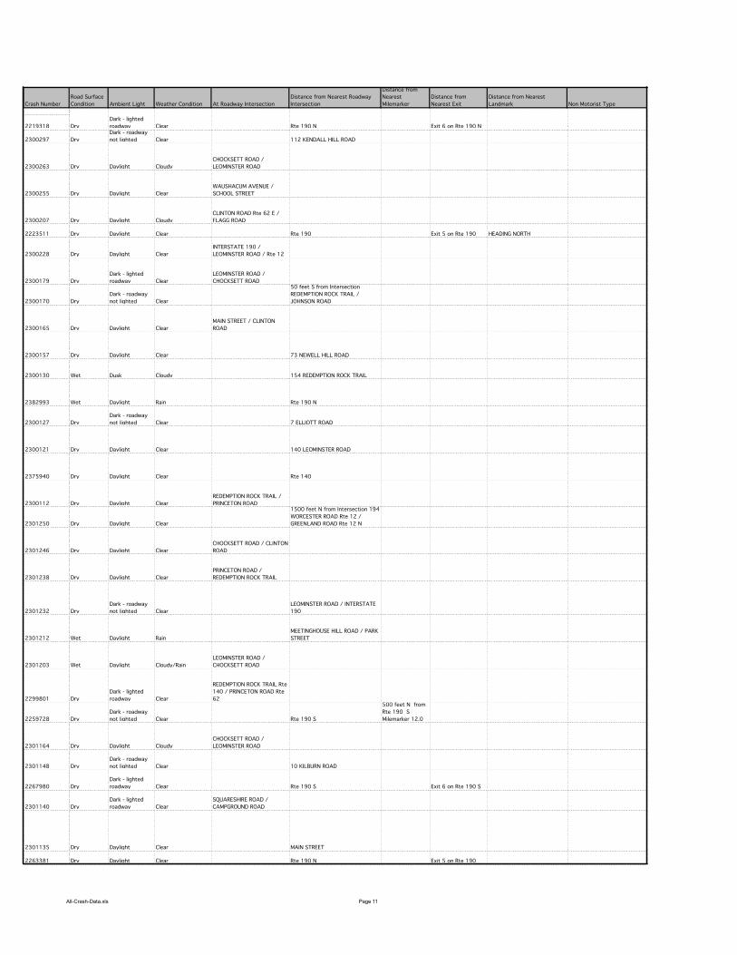
All-Crash-Data.xls Page 11
Crash Number
2219318
2300297
2300263
2300255
2300207
2223511
2300228
2300179
2300170
2300165
2300157
2300130
2382993
2300127
2300121
2375940
2300112
2301250
2301246
2301238
2301232
2301212
2301203
2299801
2259728
2301164
2301148
2267980
2301140
2301135
2263381
Road Surface
Condition Ambient Light Weather Condition At Roadway Intersection
Distance from Nearest Roadway
Intersection
Distance from
Nearest
Milemarker
Distance from
Nearest Exit
Distance from Nearest
Landmark Non Motorist Type
Dry
Dark - lighted
roadway Clear Rte 190 N Exit 6 on Rte 190 N
Dry
Dark - roadway
not lighted Clear 112 KENDALL HILL ROAD
Dry Daylight Cloudy
CHOCKSETT ROAD /
LEOMINSTER ROAD
Dry Daylight Clear
WAUSHACUM AVENUE /
SCHOOL STREET
Dry Daylight Cloudy
CLINTON ROAD Rte 62 E /
FLAGG ROAD
Dry Daylight Clear Rte 190 Exit 5 on Rte 190 HEADING NORTH
Dry Daylight Clear
INTERSTATE 190 /
LEOMINSTER ROAD / Rte 12
Dry
Dark - lighted
roadway Clear
LEOMINSTER ROAD /
CHOCKSETT ROAD
Dry
Dark - roadway
not lighted Clear
50 feet S from Intersection
REDEMPTION ROCK TRAIL /
JOHNSON ROAD
Dry Daylight Clear
MAIN STREET / CLINTON
ROAD
Dry Daylight Clear 73 NEWELL HILL ROAD
Wet Dusk Cloudy 154 REDEMPTION ROCK TRAIL
Wet Daylight Rain Rte 190 N
Dry
Dark - roadway
not lighted Clear 7 ELLIOTT ROAD
Dry Daylight Clear 140 LEOMINSTER ROAD
Dry Daylight Clear Rte 140
Dry Daylight Clear
REDEMPTION ROCK TRAIL /
PRINCETON ROAD
Dry Daylight Clear
1500 feet N from Intersection 194
WORCESTER ROAD Rte 12 /
GREENLAND ROAD Rte 12 N
Dry Daylight Clear
CHOCKSETT ROAD / CLINTON
ROAD
Dry Daylight Clear
PRINCETON ROAD /
REDEMPTION ROCK TRAIL
Dry
Dark - roadway
not lighted Clear
LEOMINSTER ROAD / INTERSTATE
190
Wet Daylight Rain
MEETINGHOUSE HILL ROAD / PARK
STREET
Wet Daylight Cloudy/Rain
LEOMINSTER ROAD /
CHOCKSETT ROAD
Dry
Dark - lighted
roadway Clear
REDEMPTION ROCK TRAIL Rte
140 / PRINCETON ROAD Rte
62
Dry
Dark - roadway
not lighted Clear Rte 190 S
500 feet N from
Rte 190 S
Milemarker 12.0
Dry Daylight Cloudy
CHOCKSETT ROAD /
LEOMINSTER ROAD
Dry
Dark - roadway
not lighted Clear 10 KILBURN ROAD
Dry
Dark - lighted
roadway Clear Rte 190 S Exit 6 on Rte 190 S
Dry
Dark - lighted
roadway Clear
SQUARESHIRE ROAD /
CAMPGROUND ROAD
Dry Daylight Clear MAIN STREET
Dry Daylight Clear Rte 190 N Exit 5 on Rte 190
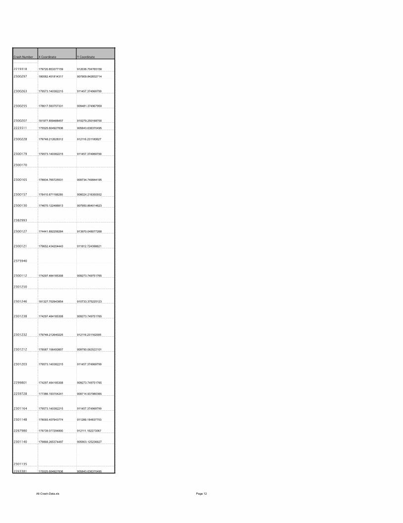
All-Crash-Data.xls Page 12
Crash Number
2219318
2300297
2300263
2300255
2300207
2223511
2300228
2300179
2300170
2300165
2300157
2300130
2382993
2300127
2300121
2375940
2300112
2301250
2301246
2301238
2301232
2301212
2301203
2299801
2259728
2301164
2301148
2267980
2301140
2301135
2263381
X Coordinate Y Coordinate
179720.853377159 912036.704765158
180062.401814317 907909.842832714
179573.140382215 911457.374969799
178617.593757331 909481.374967959
181977.859488457 910279.250168700
175525.604927836 905843.636370495
179748.212628312 912116.231180627
179573.140382215 911457.374969799
178834.765725531 909734.749944195
178410.871188285 908024.218350932
174670.122496813 907950.864014623
174441.892256284 913970.048077268
179652.434204443 911812.724388821
174297.484185308 909273.749751765
181327.702943854 910733.375225123
174297.484185308 909273.749751765
179748.212640225 912116.231162005
178587.156450807 909790.062522101
179573.140382215 911457.374969799
174297.484185308 909273.749751765
177386.193704241 909714.937980365
179573.140382215 911457.374969799
178093.407943774 911289.184837753
179739.077294800 912111.162273067
179868.265374497 905903.125236627
175525.604927836 905843.636370495

All-Crash-Data.xls Page 13
Crash Number City/Town Name Crash Date Crash Time Crash Severity
Number of
Vehicles
Total
Nonfatal
Injuries
Total
Fatal
Injuries Manner of Collision Vehicle Action Prior to Crash Vehicle Travel Directions Most Harmful Events Vehicle Configuration
2301128 STERLING 19-Nov-2007 5:26 PM
Property damage
only (none
injured) 2 0 0 Angle
V1: Travelling straight ahead /
V2:Entering traffic lane
V1:Southbound /
V2:Westbound
V1: Collision with motor
vehicle in traffic / V2:
Collision with motor vehicle in
traffic
V1: Passenger car /
V2:Passenger car
2267982 STERLING 20-Nov-2007 9:55 AM Non-fatal injury 1 1 0 Single vehicle crash V1: Travelling straight ahead V1:Northbound V1: Reported but invalid
V1: Light truck(van, mini-van,
panel, pickup, sport utility)
with only four tires
2372341 STERLING 20-Nov-2007 10:15 AM Non-fatal injury 2 1 0 Not reported
V1: Travelling straight ahead /
V2:Travelling straight ahead
V1:Northbound /
V2:Northbound
V1: Not reported / V2: Not
reported
V1: Passenger car /
V2:Tractor/semi-trailer
2301108 STERLING 21-Nov-2007 7:25 AM
Property damage
only (none
injured) 1 0 0 Single vehicle crash V1: Travelling straight ahead V1:Eastbound V1: Collision with tree V1: Other
2327730 STERLING 21-Nov-2007 9:07 AM
Property damage
only (none
injured) 1 0 0 Single vehicle crash V1: Travelling straight ahead V1:Southbound V1: Not reported V1: Not reported
2328443 STERLING 21-Nov-2007 11:00 AM Non-fatal injury 1 1 0 Not reported V1: Turning right V1:Not reported V1: Not reported V1: Not reported
2301099 STERLING 23-Nov-2007 9:40 PM
Property damage
only (none
injured) 1 0 0 Single vehicle crash V1: Travelling straight ahead V1:Northbound V1: Collision with tree
V1: Light truck(van, mini-van,
panel, pickup, sport utility)
with only four tires
2349135 STERLING 26-Nov-2007 8:50 AM
Property damage
only (none
injured) 2 0 0 Angle
V1: Slowing or stopped in
traffic / V2:Travelling straight
ahead
V1:Southbound /
V2:Northbound
V1: Not reported / V2: Not
reported
V1: Not reported /
V2:Passenger car
2301095 STERLING 28-Nov-2007 5:50 PM
Property damage
only (none
injured) 1 0 0 Single vehicle crash V1: Travelling straight ahead V1:Northbound
V1: Collision with animal -
deer V1: Passenger car
2301091 STERLING 29-Nov-2007 8:00 AM
Property damage
only (none
injured) 1 0 0 Single vehicle crash V1: Travelling straight ahead V1:Northbound V1: Collision with guardrail V1: Passenger car
2301089 STERLING 30-Nov-2007 10:00 AM Not Reported 2 0 0
Sideswipe, opposite
direction
V1: Slowing or stopped in
traffic / V2:Travelling straight
ahead
V1:Northbound /
V2:Southbound
V1: Collision with motor
vehicle in traffic / V2:
Collision with motor vehicle in
traffic
V1: Passenger car /
V2:Truck/trailer
2301083 STERLING 03-Dec-2007 6:35 AM Not Reported 2 0 0
Sideswipe, opposite
direction
V1: Travelling straight ahead /
V2:Travelling straight ahead V1:Eastbound / V2:Westbound
V1: Collision with motor
vehicle in traffic / V2:
Collision with motor vehicle in
traffic
V1: Passenger car /
V2:Passenger car
2301082 STERLING 03-Dec-2007 11:07 AM Not Reported 1 0 0 Single vehicle crash V1: Travelling straight ahead V1:Eastbound V1: Not reported V1: Passenger car
2298266 STERLING 06-Dec-2007 12:45 PM Non-fatal injury 1 1 0 Not reported V1: Travelling straight ahead V1:Not reported V1: Not reported V1: Passenger car
2301079 STERLING 06-Dec-2007 12:52 PM Non-fatal injury 2 1 0 Angle
V1: Turning left / V2:Slowing
or stopped in traffic
V1:Southbound /
V2:Eastbound
V1: Collision with motor
vehicle in traffic / V2:
Collision with motor vehicle in
traffic
V1: Passenger car /
V2:Passenger car
2301081 STERLING 07-Dec-2007 4:59 PM
Property damage
only (none
injured) 1 0 0 Single vehicle crash V1: Travelling straight ahead V1:Northbound V1: Collision with tree V1: Passenger car
2301078 STERLING 08-Dec-2007 1:57 AM Non-fatal injury 2 4 0 Rear-end
V1: Travelling straight ahead /
V2:Parked V1:Eastbound / V2:Eastbound
V1: Collision with parked
motor vehicle / V2: Collision
with motor vehicle in traffic
V1: Passenger car /
V2:Passenger car
2265036 STERLING 10-Dec-2007 5:55 AM
Property damage
only (none
injured) 2 0 0 Rear-end
V1: Travelling straight ahead /
V2:Travelling straight ahead
V1:Northbound /
V2:Northbound
V1: Collision with motor
vehicle in traffic / V2:
Collision with motor vehicle in
traffic
V1: Light truck(van, mini-van,
panel, pickup, sport utility)
with only four tires / V2:Light
truck(van, mini-van, panel,
pickup, sport utility) with only
four tires
2301076 STERLING 11-Dec-2007 6:28 PM Not Reported 2 0 0 Rear-end
V1: Slowing or stopped in
traffic / V2:Slowing or stopped
in traffic
V1:Northbound /
V2:Northbound
V1: Collision with motor
vehicle in traffic / V2:
Collision with motor vehicle in
traffic
V1: Passenger car /
V2:Passenger car
2301074 STERLING 12-Dec-2007 5:44 PM Not Reported 1 0 0 Single vehicle crash V1: Travelling straight ahead V1:Northbound V1: Collision with utility pole V1: Passenger car
2301073 STERLING 13-Dec-2007 12:58 PM Non-fatal injury 2 1 0
Sideswipe, same
direction
V1: Travelling straight ahead /
V2:Travelling straight ahead V1:Westbound / V2:Eastbound
V1: Collision with utility pole
/ V2: Collision with motor
vehicle in traffic
V1: Light truck(van, mini-van,
panel, pickup, sport utility)
with only four tires /
V2:Passenger car
2301072 STERLING 13-Dec-2007 6:36 PM Non-fatal injury 2 3 0 Head-on
V1: Travelling straight ahead /
V2:Travelling straight ahead
V1:Northbound /
V2:Southbound
V1: Collision with motor
vehicle in traffic / V2:
Collision with motor vehicle in
traffic
V1: Passenger car /
V2:Passenger car
2301071 STERLING 13-Dec-2007 9:00 PM
Property damage
only (none
injured) 1 0 0 Single vehicle crash V1: Travelling straight ahead V1:Eastbound V1: Collision with tree V1: Passenger car
2300576 STERLING 14-Dec-2007 8:27 AM
Property damage
only (none
injured) 2 0 0 Rear-end
V1: Backing / V2:Slowing or
stopped in traffic
V1:Westbound /
V2:Westbound
V1: Collision with motor
vehicle in traffic / V2:
Collision with motor vehicle in
traffic
V1: Passenger car /
V2:Passenger car
2300566 STERLING 17-Dec-2007 11:49 AM
Property damage
only (none
injured) 2 0 0 Angle
V1: Turning right / V2:Turning
left
V1:Northbound /
V2:Northbound
V1: Collision with motor
vehicle in traffic / V2:
Collision with motor vehicle in
traffic
V1: Passenger car / V2:Light
truck(van, mini-van, panel,
pickup, sport utility) with only
four tires
2300549 STERLING 17-Dec-2007 10:07 PM
Property damage
only (none
injured) 2 0 0 Angle
V1: Travelling straight ahead /
V2:Entering traffic lane
V1:Westbound /
V2:Southbound
V1: Collision with motor
vehicle in traffic / V2:
Collision with motor vehicle in
traffic
V1: Passenger car /
V2:Passenger car
2300540 STERLING 19-Dec-2007 8:31 AM
Property damage
only (none
injured) 2 0 0 Rear-end
V1: Slowing or stopped in
traffic / V2:Slowing or stopped
in traffic
V1:Southbound /
V2:Southbound
V1: Collision with motor
vehicle in traffic / V2:
Collision with motor vehicle in
traffic
V1: Passenger car /
V2:Passenger car
2300527 STERLING 20-Dec-2007 4:12 PM
Property damage
only (none
injured) 2 0 0 Head-on
V1: Slowing or stopped in
traffic / V2:Slowing or stopped
in traffic
V1:Northbound /
V2:Southbound
V1: Collision with motor
vehicle in traffic / V2:
Collision with motor vehicle in
traffic
V1: Bus (seats for more than
15 people, including driver) /
V2:Passenger car
2300511 STERLING 26-Dec-2007 12:45 PM
Property damage
only (none
injured) 1 0 0 Single vehicle crash V1: Travelling straight ahead V1:Northbound V1: Collision with guardrail V1: Passenger car
2319524 STERLING 27-Dec-2007 6:51 PM
Property damage
only (none
injured) 2 0 0 Head-on
V1: Travelling straight ahead /
V2:Turning left
V1:Southbound /
V2:Southbound
V1: Collision with motor
vehicle in traffic / V2:
Collision with motor vehicle in
traffic
V1: Passenger car /
V2:Passenger car
2300503 STERLING 28-Dec-2007 9:08 AM Non-fatal injury 2 4 0 Angle
V1: Travelling straight ahead /
V2:Turning left
V1:Westbound /
V2:Northbound
V1: Collision with motor
vehicle in traffic / V2:
Collision with motor vehicle in
traffic
V1: Passenger car /
V2:Passenger car
2300483 STERLING 28-Dec-2007 10:36 AM Not Reported 2 0 0 Angle
V1: Turning left /
V2:Overtaking/passing
V1:Southbound /
V2:Southbound
V1: Collision with motor
vehicle in traffic / V2:
Collision with motor vehicle in
traffic
V1: Passenger car /
V2:Passenger car
2300476 STERLING 31-Dec-2007 10:37 AM
Property damage
only (none
injured) 1 0 0 Unknown V1: Travelling straight ahead V1:Northbound V1: Jackknife V1: Truck/trailer
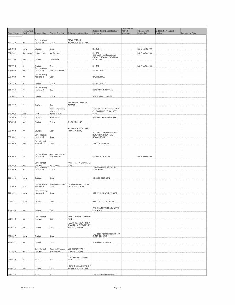
All-Crash-Data.xls Page 14
Crash Number
2301128
2267982
2372341
2301108
2327730
2328443
2301099
2349135
2301095
2301091
2301089
2301083
2301082
2298266
2301079
2301081
2301078
2265036
2301076
2301074
2301073
2301072
2301071
2300576
2300566
2300549
2300540
2300527
2300511
2319524
2300503
2300483
2300476
Road Surface
Condition Ambient Light Weather Condition At Roadway Intersection
Distance from Nearest Roadway
Intersection
Distance from
Nearest
Milemarker
Distance from
Nearest Exit
Distance from Nearest
Landmark Non Motorist Type
Dry
Dark - roadway
not lighted Cloudy
CROWLEY ROAD /
REDEMPTION ROCK TRAIL
Snow Daylight Snow Rte 190 N Exit 5 on Rte 190
Not reported Not reported Not Reported Rte 190 Exit 6 on Rte 190
Wet Daylight Cloudy/Rain
500 feet E from Intersection
CROWLEY ROAD / REDEMPTION
ROCK TRAIL
Dry Daylight Clear Rte 190 Exit 6 on Rte 190
Wet
Dark - roadway
not lighted Fog, smog, smoke Rte 12 / Rte 12
Dry
Dark - roadway
not lighted Clear HASTING ROAD
Dry Daylight Cloudy Rte 12 / Rte 12
Dry
Dark - roadway
not lighted Clear REDEMPTION ROCK TRAIL
Dry Daylight Cloudy 301 LEOMINSTER ROAD
Dry Daylight Clear
BIRD STREET / SHOLAN
TERRACE
Snow Dawn
Sleet, hail (freezing
rain or
drizzle)/Cloudy
50 feet E from Intersection 167
CLINTON ROAD / CHOCKSETT
ROAD
Snow Daylight Rain/Cloudy 338 UPPER NORTH ROW ROAD
Wet Daylight Cloudy Rte 62 / Rte 140
Dry Daylight Clear
REDEMPTION ROCK TRAIL /
PRINCETON ROAD
Ice
Dark - roadway
not lighted Snow
500 feet S from Intersection 372
REDEMPTION ROCK TRAIL /
BEAMAN ROAD
Wet
Dark - lighted
roadway Clear 153 CLINTON ROAD
Ice
Dark - roadway
not lighted
Sleet, hail (freezing
rain or drizzle) Rte 190 N / Rte 190 Exit 5 on Rte 190
Wet
Dark - lighted
roadway Rain/Cloudy
MAIN STREET / LEOMINSTER
ROAD
Dry
Dark - roadway
not lighted Cloudy
TWINE ROAD Rte 12 / GATES
ROAD Rte 12
Snow Daylight Snow 32 CHOCKSETT ROAD
Snow
Dark - roadway
not lighted
Snow/Blowing sand,
snow
LEOMINSTER ROAD Rte 12 /
LAURELWOOD ROAD
Snow
Dark - roadway
not lighted Snow 298 UPPER NORTH ROW ROAD
Slush Daylight Clear DANA HILL ROAD / Rte 140
Wet Daylight Clear
261 LEOMINSTER ROAD / NORTH
ROW ROAD
Ice
Dark - lighted
roadway Clear
PRINCETON ROAD / BEAMAN
ROAD
Wet Daylight Clear
REDEMPTION ROCK TRAIL /
JENNIFER LANE / RAMP - RT
140 TO RT 190 NB
Snow Daylight Snow
500 feet E from Intersection 130
CHACE HILL ROAD
Dry Daylight Clear 50 LEOMINSTER ROAD
Wet
Dark - lighted
roadway
Sleet, hail (freezing
rain or drizzle)
LEOMINSTER ROAD /
CHOCKSETT ROAD
Dry Daylight Clear
CLINTON ROAD / FLAGG
ROAD
Wet Daylight Clear
NORTH OAKDALE CUT OFF /
REDEMPTION ROCK TRAIL
Snow Daylight Clear 160 REDEMPTION ROCK TRAIL
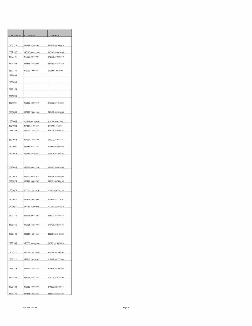
All-Crash-Data.xls Page 15
Crash Number
2301128
2267982
2372341
2301108
2327730
2328443
2301099
2349135
2301095
2301091
2301089
2301083
2301082
2298266
2301079
2301081
2301078
2265036
2301076
2301074
2301073
2301072
2301071
2300576
2300566
2300549
2300540
2300527
2300511
2319524
2300503
2300483
2300476
X Coordinate Y Coordinate
174684.875161663 907925.062390510
175525.604927836 905843.636370495
179720.827469991 912036.689603659
174833.678330005 907957.988181859
179739.108068371 912111.179638409
179560.620990139 913899.074914294
178787.765661485 909488.562423963
181722.062289430 910524.360175041
174897.317395316 914011.175821071
174310.421913318 909239.125239734
174297.484185308 909273.749751765
173683.975727407 911683.582992499
181567.224265487 910635.087894346
175525.604927836 905843.636370495
178730.984349437 909749.312248208
178268.906397007 906501.437685184
180500.270329734 911238.496761235
179617.809875065 911625.574112020
175186.578460694 913987.174374870
175378.906182287 906322.437534344
179725.562270358 913429.562619634
176804.156315640 909951.250168394
175555.062682480 905781.625076514
181021.403170570 907566.932390294
179210.798794387 910247.352777386
179573.140382215 911457.374969799
181977.859488457 910279.250168700
173720.797080770 911326.562553678
174616.785626824 908074.028416504
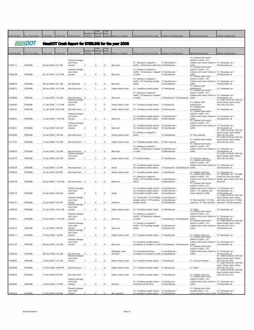
All-Crash-Data.xls Page 16
Crash Number City/Town Name Crash Date Crash Time Crash Severity
Number of
Vehicles
Total
Nonfatal
Injuries
Total
Fatal
Injuries Manner of Collision Vehicle Action Prior to Crash Vehicle Travel Directions Most Harmful Events Vehicle Configuration
Crash Number City/Town Name Crash Date Crash Time Crash Severity
Number of
Vehicles
Total
Nonfatal
Injuries
Total
Fatal
Injuries Manner of Collision Vehicle Action Prior to Crash Vehicle Travel Directions Most Harmful Events Vehicle Configuration
2308111 STERLING 04-Jan-2008 6:32 PM
Property damage
only (none
injured) 2 0 0 Rear-end
V1: Slowing or stopped in
traffic / V2:Entering traffic lane
V1:Northbound /
V2:Northbound
V1: Collision with motor
vehicle in traffic / V2:
Collision with motor vehicle in
traffic
V1: Passenger car /
V2:Passenger car
2308108 STERLING 05-Jan-2008 12:27 PM
Property damage
only (none
injured) 2 0 0 Rear-end
V1: Slowing or stopped in
traffic / V2:Slowing or stopped
in traffic
V1:Northbound /
V2:Northbound
V1: Collision with motor
vehicle in traffic / V2:
Collision with motor vehicle in
traffic
V1: Passenger car /
V2:Passenger car
2308074 STERLING 08-Jan-2008 8:21 AM Not Reported 2 0 0 Rear-end
V1: Slowing or stopped in
traffic / V2:Travelling straight
ahead
V1:Southbound /
V2:Southbound
V1: Collision with motor
vehicle in traffic / V2:
Collision with motor vehicle in
traffic
V1: Passenger car /
V2:Passenger car
2308072 STERLING 08-Jan-2008 10:31 PM Non-fatal injury 1 1 0 Single vehicle crash V1: Travelling straight ahead V1:Westbound
V1: Collision with
embankment V1: Passenger car
2308069 STERLING 11-Jan-2008 7:54 AM Non-fatal injury 2 1 0 Rear-end
V1: Slowing or stopped in
traffic / V2:Slowing or stopped
in traffic V1:Eastbound / V2:Eastbound
V1: Collision with motor
vehicle in traffic / V2:
Collision with motor vehicle in
traffic
V1: Passenger car /
V2:Passenger car
2308060 STERLING 11-Jan-2008 11:15 PM
Property damage
only (none
injured) 1 0 0 Single vehicle crash V1: Travelling straight ahead V1:Eastbound
V1: Collision with
embankment
V1: Light truck(van, mini-van,
panel, pickup, sport utility)
with only four tires
2306732 STERLING 12-Jan-2008 00:00 AM Non-fatal injury 1 1 0 Single vehicle crash V1: Travelling straight ahead V1:Northbound
V1: Collision with
embankment V1: Passenger car
2308057 STERLING 12-Jan-2008 11:02 AM
Property damage
only (none
injured) 2 0 0 Rear-end
V1: Travelling straight ahead /
V2:Travelling straight ahead
V1:Northbound /
V2:Northbound
V1: Collision with motor
vehicle in traffic / V2:
Collision with motor vehicle in
traffic
V1: Passenger car /
V2:Passenger car
2300831 STERLING 14-Jan-2008 6:58 AM
Property damage
only (none
injured) 2 0 0 Rear-end
V1: Travelling straight ahead /
V2:Travelling straight ahead
V1:Southbound /
V2:Southbound
V1: Collision with motor
vehicle in traffic / V2:
Collision with motor vehicle in
traffic
V1: Passenger car /
V2:Passenger car
2406986 STERLING 14-Jan-2008 7:30 AM Non-fatal injury 1 1 0 Single vehicle crash
V1: Slowing or stopped in
traffic V1:Southbound V1: Not reported
V1: Light truck(van, mini-van,
panel, pickup, sport utility)
with only four tires
2271707 STERLING 14-Jan-2008 7:55 AM Non-fatal injury 1 1 0 Single vehicle crash V1: Travelling straight ahead V1:Not reported
V1: Collision with median
barrier
V1: Light truck(van, mini-van,
panel, pickup, sport utility)
with only four tires
2308053 STERLING 14-Jan-2008 7:58 AM Non-fatal injury 2 1 0 Rear-end
V1: Slowing or stopped in
traffic / V2:Slowing or stopped
in traffic
V1:Northbound /
V2:Northbound
V1: Collision with motor
vehicle in traffic / V2:
Collision with motor vehicle in
traffic
V1: Passenger car /
V2:Passenger car
2326070 STERLING 14-Jan-2008 8:20 AM
Property damage
only (none
injured) 1 0 0 Single vehicle crash V1: Changing lanes V1:Southbound V1: Overturn/rollover
V1: Light truck(van, mini-van,
panel, pickup, sport utility)
with only four tires
2308259 STERLING 14-Jan-2008 1:23 PM Non-fatal injury 2 1 0 Angle
V1: Travelling straight ahead /
V2:Travelling straight ahead V1:Eastbound / V2:Westbound
V1: Collision with motor
vehicle in traffic / V2:
Collision with motor vehicle in
traffic
V1: Passenger car /
V2:Passenger car
2308254 STERLING 18-Jan-2008 6:36 PM Non-fatal injury 1 1 0 Single vehicle crash V1: Travelling straight ahead V1:Westbound V1: Collision with tree V1: Passenger car
2308748 STERLING 22-Jan-2008 11:39 AM Non-fatal injury 2 2 0 Rear-end
V1: Slowing or stopped in
traffic / V2:Travelling straight
ahead
V1:Northbound /
V2:Northbound
V1: Collision with motor
vehicle in traffic / V2:
Collision with motor vehicle in
traffic
V1: Passenger car / V2:Light
truck(van, mini-van, panel,
pickup, sport utility) with only
four tires
2308770 STERLING 23-Jan-2008 9:08 AM
Property damage
only (none
injured) 3 0 0 Angle
V1: Travelling straight ahead /
V2:Travelling straight ahead /
V3:Travelling straight ahead
V1:Southbound /
V2:Northbound /
V3:Southbound
V1: Collision with motor
vehicle in traffic / V2:
Collision with motor vehicle in
traffic / V3: Collision with
motor vehicle in traffic
V1: Passenger car /
V2:Passenger car /
V3:Passenger car
2408121 STERLING 23-Jan-2008 5:07 PM
Property damage
only (none
injured) 3 0 0 Unknown
V1: Turning left / V2:Travelling
straight ahead / V3:Travelling
straight ahead
V1:Northbound /
V2:Southbound /
V3:Southbound
V1: Not reported / V2: Not
reported / V3: Not reported
V1: Light truck(van, mini-van,
panel, pickup, sport utility)
with only four tires / V2:Not
reported / V3:Not reported
2308535 STERLING 27-Jan-2008 10:51 AM
Property damage
only (none
injured) 1 0 0 Single vehicle crash V1: Travelling straight ahead V1:Northbound V1: Other V1: Passenger car
2309941 STERLING 27-Jan-2008 11:44 AM
Property damage
only (none
injured) 2 0 0 Rear-end
V1: Slowing or stopped in
traffic / V2:Slowing or stopped
in traffic V1:Eastbound / V2:Eastbound
V1: Collision with motor
vehicle in traffic / V2:
Collision with motor vehicle in
traffic
V1: Passenger car /
V2:Passenger car
2308523 STERLING 31-Jan-2008 4:09 PM
Property damage
only (none
injured) 2 0 0 Rear-end
V1: Slowing or stopped in
traffic / V2:Travelling straight
ahead
V1:Westbound /
V2:Westbound
V1: Collision with motor
vehicle in traffic / V2:
Collision with motor vehicle in
traffic
V1: Light truck(van, mini-van,
panel, pickup, sport utility)
with only four tires /
V2:Passenger car
2308511 STERLING 01-Feb-2008 1:58 PM
Property damage
only (none
injured) 1 0 0 Single vehicle crash V1: Travelling straight ahead V1:Westbound V1: Collision with tree V1: Passenger car
2301342 STERLING 08-Feb-2008 1:54 AM
Property damage
only (none
injured) 2 0 0 Rear-end
V1: Travelling straight ahead /
V2:Slowing or stopped in traffic V1:Eastbound / V2:Eastbound
V1: Collision with motor
vehicle in traffic / V2:
Collision with motor vehicle in
traffic
V1: Passenger car /
V2:Passenger car
2308505 STERLING 08-Feb-2008 7:42 AM Not Reported 2 0 0
Sideswipe, same
direction
V1: Overtaking/passing /
V2:Slowing or stopped in traffic
V1:Southbound /
V2:Southbound
V1: Collision with motor
vehicle in traffic / V2:
Collision with motor vehicle in
traffic
V1: Passenger car /
V2:Passenger car
2308495 STERLING 10-Feb-2008 1:27 AM
Property damage
only (none
injured) 1 0 0 Single vehicle crash V1: Travelling straight ahead V1:Eastbound V1: Overturn/rollover
V1: Light truck(van, mini-van,
panel, pickup, sport utility)
with only four tires
2308469 STERLING 12-Feb-2008 10:08 PM Non-fatal injury 1 1 0 Single vehicle crash V1: Travelling straight ahead V1:Westbound V1: Other
V1: Light truck(van, mini-van,
panel, pickup, sport utility)
with only four tires
2308452 STERLING 13-Feb-2008 9:03 PM Non-fatal injury 1 1 0 Single vehicle crash V1: Travelling straight ahead V1:Southbound V1: Collision with tree
V1: Light truck(van, mini-van,
panel, pickup, sport utility)
with only four tires
2308445 STERLING 14-Feb-2008 5:10 PM
Property damage
only (none
injured) 2 0 0 Head-on
V1: Travelling straight ahead /
V2:Entering traffic lane
V1:Eastbound /
V2:Southbound
V1: Collision with motor
vehicle in traffic / V2:
Collision with motor vehicle in
traffic
V1: Passenger car /
V2:Passenger car
2289220 STERLING 21-Feb-2008 5:00 PM
Property damage
only (none
injured) 2 0 0 Not reported
V1: Travelling straight ahead /
V2:Travelling straight ahead
V1:Southbound /
V2:Southbound
V1: Collision with other
movable object / V2:
Cargo/equipment loss or shift
V1: Passenger car /
V2:Passenger car
MassDOT Crash Report for STERLING for the year 2008
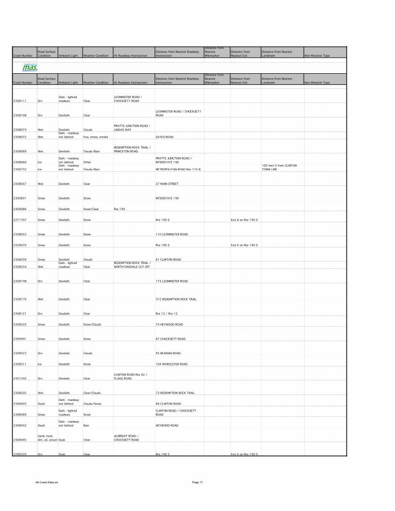
All-Crash-Data.xls Page 17
Crash Number
Crash Number
2308111
2308108
2308074
2308072
2308069
2308060
2306732
2308057
2300831
2406986
2271707
2308053
2326070
2308259
2308254
2308748
2308770
2408121
2308535
2309941
2308523
2308511
2301342
2308505
2308495
2308469
2308452
2308445
2289220
Road Surface
Condition Ambient Light Weather Condition At Roadway Intersection
Distance from Nearest Roadway
Intersection
Distance from
Nearest
Milemarker
Distance from
Nearest Exit
Distance from Nearest
Landmark Non Motorist Type
Road Surface
Condition Ambient Light Weather Condition At Roadway Intersection
Distance from Nearest Roadway
Intersection
Distance from
Nearest
Milemarker
Distance from
Nearest Exit
Distance from Nearest
Landmark Non Motorist Type
Dry
Dark - lighted
roadway Clear
LEOMINSTER ROAD /
CHOCKSETT ROAD
Dry Daylight Clear
LEOMINSTER ROAD / CHOCKSETT
ROAD
Wet Daylight Cloudy
PRATTS JUNCTION ROAD /
LINDAS WAY
Wet
Dark - roadway
not lighted Fog, smog, smoke GATES ROAD
Wet Daylight Cloudy/Rain
REDEMPTION ROCK TRAIL /
PRINCETON ROAD
Ice
Dark - roadway
not lighted Other
PRATTS JUNCTION ROAD /
INTERSTATE 190
Ice
Dark - roadway
not lighted Cloudy/Rain METROPOLITAN ROAD Rte 110 N
100 feet S from CLINTON
TOWN LINE
Wet Daylight Clear 27 MAIN STREET
Snow Daylight Snow INTERSTATE 190
Snow Daylight Snow/Clear Rte 190
Snow Daylight Snow Rte 190 S Exit 6 on Rte 190 S
Snow Daylight Snow 110 LEOMINSTER ROAD
Snow Daylight Snow Rte 190 S Exit 6 on Rte 190 S
Snow Daylight Cloudy 61 CLINTON ROAD
Wet
Dark - lighted
roadway Clear
REDEMPTION ROCK TRAIL /
NORTH OAKDALE CUT OFF
Dry Daylight Clear 175 LEOMINSTER ROAD
Wet Daylight Clear 372 REDEMPTION ROCK TRAIL
Dry Daylight Clear Rte 12 / Rte 12
Snow Daylight Snow/Cloudy 74 HEYWOOD ROAD
Snow Daylight Snow 67 CHOCKSETT ROAD
Dry Daylight Cloudy 95 BEAMAN ROAD
Ice Daylight Snow 104 WORCESTER ROAD
Dry Daylight Clear
CLINTON ROAD Rte 62 /
FLAGG ROAD
Wet Daylight Clear/Cloudy 73 REDEMPTION ROCK TRAIL
Slush
Dark - roadway
not lighted Cloudy/Snow 84 CLINTON ROAD
Snow
Dark - lighted
roadway Snow
CLINTON ROAD / CHOCKSETT
ROAD
Slush
Dark - roadway
not lighted Rain HEYWOOD ROAD
Sand, mud,
dirt, oil, gravel Dusk Clear
ALBRIGHT ROAD /
CHOCKSETT ROAD
Dry Dusk Clear Rte 190 S Exit 6 on Rte 190 S
MassDOT Crash Report for STERLING for the year 2008
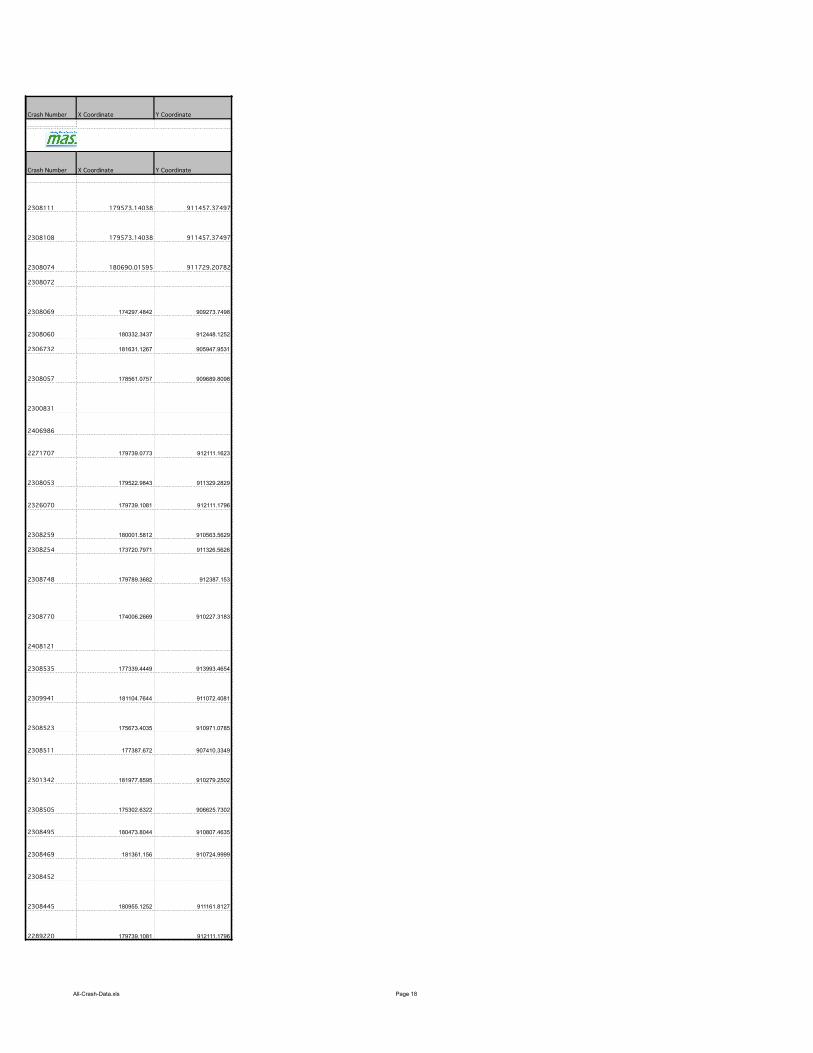
All-Crash-Data.xls Page 18
Crash Number
Crash Number
2308111
2308108
2308074
2308072
2308069
2308060
2306732
2308057
2300831
2406986
2271707
2308053
2326070
2308259
2308254
2308748
2308770
2408121
2308535
2309941
2308523
2308511
2301342
2308505
2308495
2308469
2308452
2308445
2289220
X Coordinate Y Coordinate
X Coordinate Y Coordinate
179573.14038 911457.37497
179573.14038 911457.37497
180690.01595 911729.20782
174297.4842 909273.7498
180332.3437 912448.1252
181631.1267 905947.9531
178561.0757 909689.8098
179739.0773 912111.1623
179522.9843 911329.2829
179739.1081 912111.1796
180001.5812 910563.5629
173720.7971 911326.5626
179789.3682 912387.153
174006.2669 910227.3183
177339.4449 913993.4654
181104.7644 911072.4081
175673.4035 910971.0785
177387.672 907410.3349
181977.8595 910279.2502
175302.6322 906625.7302
180473.8044 910807.4635
181361.156 910724.9999
180955.1252 911161.8127
179739.1081 912111.1796
MassDOT Crash Report for STERLING for the year 2008
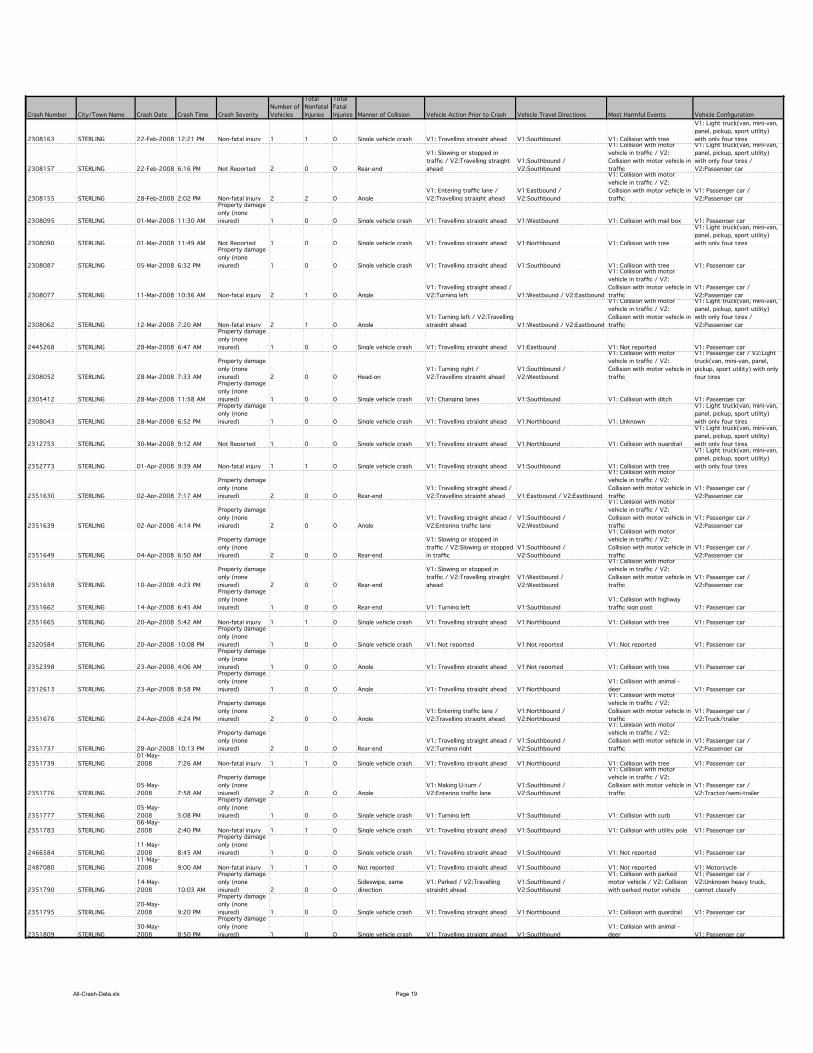
All-Crash-Data.xls Page 19
Crash Number City/Town Name Crash Date Crash Time Crash Severity
Number of
Vehicles
Total
Nonfatal
Injuries
Total
Fatal
Injuries Manner of Collision Vehicle Action Prior to Crash Vehicle Travel Directions Most Harmful Events Vehicle Configuration
2308163 STERLING 22-Feb-2008 12:21 PM Non-fatal injury 1 1 0 Single vehicle crash V1: Travelling straight ahead V1:Southbound V1: Collision with tree
V1: Light truck(van, mini-van,
panel, pickup, sport utility)
with only four tires
2308157 STERLING 22-Feb-2008 6:16 PM Not Reported 2 0 0 Rear-end
V1: Slowing or stopped in
traffic / V2:Travelling straight
ahead
V1:Southbound /
V2:Southbound
V1: Collision with motor
vehicle in traffic / V2:
Collision with motor vehicle in
traffic
V1: Light truck(van, mini-van,
panel, pickup, sport utility)
with only four tires /
V2:Passenger car
2308155 STERLING 28-Feb-2008 2:02 PM Non-fatal injury 2 2 0 Angle
V1: Entering traffic lane /
V2:Travelling straight ahead
V1:Eastbound /
V2:Southbound
V1: Collision with motor
vehicle in traffic / V2:
Collision with motor vehicle in
traffic
V1: Passenger car /
V2:Passenger car
2308095 STERLING 01-Mar-2008 11:30 AM
Property damage
only (none
injured) 1 0 0 Single vehicle crash V1: Travelling straight ahead V1:Westbound V1: Collision with mail box V1: Passenger car
2308090 STERLING 01-Mar-2008 11:49 AM Not Reported 1 0 0 Single vehicle crash V1: Travelling straight ahead V1:Northbound V1: Collision with tree
V1: Light truck(van, mini-van,
panel, pickup, sport utility)
with only four tires
2308087 STERLING 05-Mar-2008 6:32 PM
Property damage
only (none
injured) 1 0 0 Single vehicle crash V1: Travelling straight ahead V1:Southbound V1: Collision with tree V1: Passenger car
2308077 STERLING 11-Mar-2008 10:36 AM Non-fatal injury 2 1 0 Angle
V1: Travelling straight ahead /
V2:Turning left V1:Westbound / V2:Eastbound
V1: Collision with motor
vehicle in traffic / V2:
Collision with motor vehicle in
traffic
V1: Passenger car /
V2:Passenger car
2308062 STERLING 12-Mar-2008 7:20 AM Non-fatal injury 2 1 0 Angle
V1: Turning left / V2:Travelling
straight ahead V1:Westbound / V2:Eastbound
V1: Collision with motor
vehicle in traffic / V2:
Collision with motor vehicle in
traffic
V1: Light truck(van, mini-van,
panel, pickup, sport utility)
with only four tires /
V2:Passenger car
2445268 STERLING 28-Mar-2008 6:47 AM
Property damage
only (none
injured) 1 0 0 Single vehicle crash V1: Travelling straight ahead V1:Eastbound V1: Not reported V1: Passenger car
2308052 STERLING 28-Mar-2008 7:33 AM
Property damage
only (none
injured) 2 0 0 Head-on
V1: Turning right /
V2:Travelling straight ahead
V1:Southbound /
V2:Westbound
V1: Collision with motor
vehicle in traffic / V2:
Collision with motor vehicle in
traffic
V1: Passenger car / V2:Light
truck(van, mini-van, panel,
pickup, sport utility) with only
four tires
2305412 STERLING 28-Mar-2008 11:58 AM
Property damage
only (none
injured) 1 0 0 Single vehicle crash V1: Changing lanes V1:Southbound V1: Collision with ditch V1: Passenger car
2308043 STERLING 28-Mar-2008 6:52 PM
Property damage
only (none
injured) 1 0 0 Single vehicle crash V1: Travelling straight ahead V1:Northbound V1: Unknown
V1: Light truck(van, mini-van,
panel, pickup, sport utility)
with only four tires
2312753 STERLING 30-Mar-2008 9:12 AM Not Reported 1 0 0 Single vehicle crash V1: Travelling straight ahead V1:Northbound V1: Collision with guardrail
V1: Light truck(van, mini-van,
panel, pickup, sport utility)
with only four tires
2352773 STERLING 01-Apr-2008 9:39 AM Non-fatal injury 1 1 0 Single vehicle crash V1: Travelling straight ahead V1:Southbound V1: Collision with tree
V1: Light truck(van, mini-van,
panel, pickup, sport utility)
with only four tires
2351630 STERLING 02-Apr-2008 7:17 AM
Property damage
only (none
injured) 2 0 0 Rear-end
V1: Travelling straight ahead /
V2:Travelling straight ahead V1:Eastbound / V2:Eastbound
V1: Collision with motor
vehicle in traffic / V2:
Collision with motor vehicle in
traffic
V1: Passenger car /
V2:Passenger car
2351639 STERLING 02-Apr-2008 4:14 PM
Property damage
only (none
injured) 2 0 0 Angle
V1: Travelling straight ahead /
V2:Entering traffic lane
V1:Southbound /
V2:Westbound
V1: Collision with motor
vehicle in traffic / V2:
Collision with motor vehicle in
traffic
V1: Passenger car /
V2:Passenger car
2351649 STERLING 04-Apr-2008 6:50 AM
Property damage
only (none
injured) 2 0 0 Rear-end
V1: Slowing or stopped in
traffic / V2:Slowing or stopped
in traffic
V1:Southbound /
V2:Southbound
V1: Collision with motor
vehicle in traffic / V2:
Collision with motor vehicle in
traffic
V1: Passenger car /
V2:Passenger car
2351658 STERLING 10-Apr-2008 4:23 PM
Property damage
only (none
injured) 2 0 0 Rear-end
V1: Slowing or stopped in
traffic / V2:Travelling straight
ahead
V1:Westbound /
V2:Westbound
V1: Collision with motor
vehicle in traffic / V2:
Collision with motor vehicle in
traffic
V1: Passenger car /
V2:Passenger car
2351662 STERLING 14-Apr-2008 6:45 AM
Property damage
only (none
injured) 1 0 0 Rear-end V1: Turning left V1:Southbound
V1: Collision with highway
traffic sign post V1: Passenger car
2351665 STERLING 20-Apr-2008 5:42 AM Non-fatal injury 1 1 0 Single vehicle crash V1: Travelling straight ahead V1:Northbound V1: Collision with tree V1: Passenger car
2320584 STERLING 20-Apr-2008 10:08 PM
Property damage
only (none
injured) 1 0 0 Single vehicle crash V1: Not reported V1:Not reported V1: Not reported V1: Passenger car
2352398 STERLING 23-Apr-2008 4:06 AM
Property damage
only (none
injured) 1 0 0 Angle V1: Travelling straight ahead V1:Not reported V1: Collision with tree V1: Passenger car
2312613 STERLING 23-Apr-2008 8:58 PM
Property damage
only (none
injured) 1 0 0 Angle V1: Travelling straight ahead V1:Northbound
V1: Collision with animal -
deer V1: Passenger car
2351676 STERLING 24-Apr-2008 4:24 PM
Property damage
only (none
injured) 2 0 0 Angle
V1: Entering traffic lane /
V2:Travelling straight ahead
V1:Northbound /
V2:Northbound
V1: Collision with motor
vehicle in traffic / V2:
Collision with motor vehicle in
traffic
V1: Passenger car /
V2:Truck/trailer
2351737 STERLING 28-Apr-2008 10:13 PM
Property damage
only (none
injured) 2 0 0 Rear-end
V1: Travelling straight ahead /
V2:Turning right
V1:Southbound /
V2:Southbound
V1: Collision with motor
vehicle in traffic / V2:
Collision with motor vehicle in
traffic
V1: Passenger car /
V2:Passenger car
2351739 STERLING
01-May-
2008 7:26 AM Non-fatal injury 1 1 0 Single vehicle crash V1: Travelling straight ahead V1:Northbound V1: Collision with tree V1: Passenger car
2351776 STERLING
05-May-
2008 7:58 AM
Property damage
only (none
injured) 2 0 0 Angle
V1: Making U-turn /
V2:Entering traffic lane
V1:Southbound /
V2:Southbound
V1: Collision with motor
vehicle in traffic / V2:
Collision with motor vehicle in
traffic
V1: Passenger car /
V2:Tractor/semi-trailer
2351777 STERLING
05-May-
2008 5:08 PM
Property damage
only (none
injured) 1 0 0 Single vehicle crash V1: Turning left V1:Southbound V1: Collision with curb V1: Passenger car
2351783 STERLING
06-May-
2008 2:40 PM Non-fatal injury 1 1 0 Single vehicle crash V1: Travelling straight ahead V1:Southbound V1: Collision with utility pole V1: Passenger car
2466584 STERLING
11-May-
2008 8:45 AM
Property damage
only (none
injured) 1 0 0 Single vehicle crash V1: Travelling straight ahead V1:Southbound V1: Not reported V1: Passenger car
2487080 STERLING
11-May-
2008 9:00 AM Non-fatal injury 1 1 0 Not reported V1: Travelling straight ahead V1:Southbound V1: Not reported V1: Motorcycle
2351790 STERLING
14-May-
2008 10:03 AM
Property damage
only (none
injured) 2 0 0
Sideswipe, same
direction
V1: Parked / V2:Travelling
straight ahead
V1:Southbound /
V2:Southbound
V1: Collision with parked
motor vehicle / V2: Collision
with parked motor vehicle
V1: Passenger car /
V2:Unknown heavy truck,
cannot classify
2351795 STERLING
20-May-
2008 9:20 PM
Property damage
only (none
injured) 1 0 0 Single vehicle crash V1: Travelling straight ahead V1:Northbound V1: Collision with guardrail V1: Passenger car
2351809 STERLING
30-May-
2008 8:50 PM
Property damage
only (none
injured) 1 0 0 Single vehicle crash V1: Travelling straight ahead V1:Southbound
V1: Collision with animal -
deer V1: Passenger car
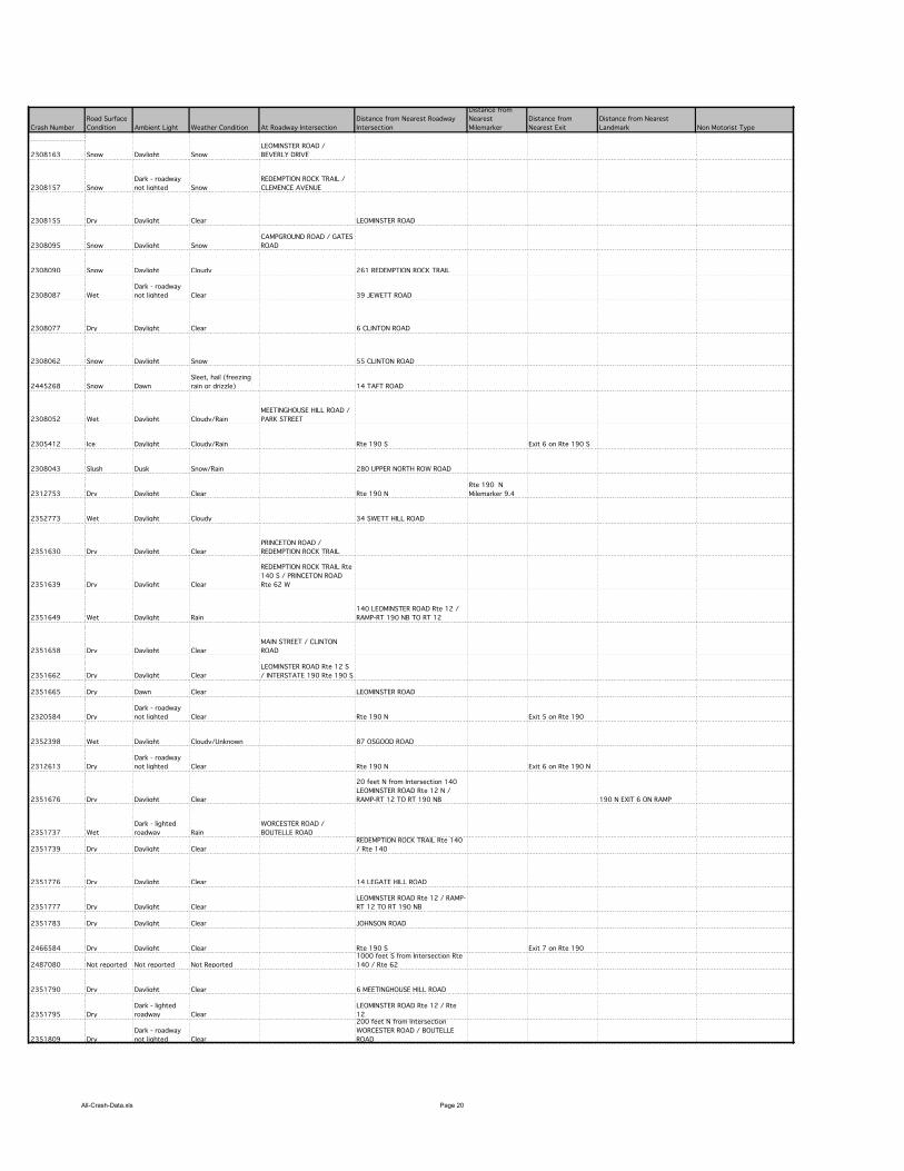
All-Crash-Data.xls Page 20
Crash Number
2308163
2308157
2308155
2308095
2308090
2308087
2308077
2308062
2445268
2308052
2305412
2308043
2312753
2352773
2351630
2351639
2351649
2351658
2351662
2351665
2320584
2352398
2312613
2351676
2351737
2351739
2351776
2351777
2351783
2466584
2487080
2351790
2351795
2351809
Road Surface
Condition Ambient Light Weather Condition At Roadway Intersection
Distance from Nearest Roadway
Intersection
Distance from
Nearest
Milemarker
Distance from
Nearest Exit
Distance from Nearest
Landmark Non Motorist Type
Snow Daylight Snow
LEOMINSTER ROAD /
BEVERLY DRIVE
Snow
Dark - roadway
not lighted Snow
REDEMPTION ROCK TRAIL /
CLEMENCE AVENUE
Dry Daylight Clear LEOMINSTER ROAD
Snow Daylight Snow
CAMPGROUND ROAD / GATES
ROAD
Snow Daylight Cloudy 261 REDEMPTION ROCK TRAIL
Wet
Dark - roadway
not lighted Clear 39 JEWETT ROAD
Dry Daylight Clear 6 CLINTON ROAD
Snow Daylight Snow 55 CLINTON ROAD
Snow Dawn
Sleet, hail (freezing
rain or drizzle) 14 TAFT ROAD
Wet Daylight Cloudy/Rain
MEETINGHOUSE HILL ROAD /
PARK STREET
Ice Daylight Cloudy/Rain Rte 190 S Exit 6 on Rte 190 S
Slush Dusk Snow/Rain 280 UPPER NORTH ROW ROAD
Dry Daylight Clear Rte 190 N
Rte 190 N
Milemarker 9.4
Wet Daylight Cloudy 34 SWETT HILL ROAD
Dry Daylight Clear
PRINCETON ROAD /
REDEMPTION ROCK TRAIL
Dry Daylight Clear
REDEMPTION ROCK TRAIL Rte
140 S / PRINCETON ROAD
Rte 62 W
Wet Daylight Rain
140 LEOMINSTER ROAD Rte 12 /
RAMP-RT 190 NB TO RT 12
Dry Daylight Clear
MAIN STREET / CLINTON
ROAD
Dry Daylight Clear
LEOMINSTER ROAD Rte 12 S
/ INTERSTATE 190 Rte 190 S
Dry Dawn Clear LEOMINSTER ROAD
Dry
Dark - roadway
not lighted Clear Rte 190 N Exit 5 on Rte 190
Wet Daylight Cloudy/Unknown 87 OSGOOD ROAD
Dry
Dark - roadway
not lighted Clear Rte 190 N Exit 6 on Rte 190 N
Dry Daylight Clear
20 feet N from Intersection 140
LEOMINSTER ROAD Rte 12 N /
RAMP-RT 12 TO RT 190 NB 190 N EXIT 6 ON RAMP
Wet
Dark - lighted
roadway Rain
WORCESTER ROAD /
BOUTELLE ROAD
Dry Daylight Clear
REDEMPTION ROCK TRAIL Rte 140
/ Rte 140
Dry Daylight Clear 14 LEGATE HILL ROAD
Dry Daylight Clear
LEOMINSTER ROAD Rte 12 / RAMP-
RT 12 TO RT 190 NB
Dry Daylight Clear JOHNSON ROAD
Dry Daylight Clear Rte 190 S Exit 7 on Rte 190
Not reported Not reported Not Reported
1000 feet S from Intersection Rte
140 / Rte 62
Dry Daylight Clear 6 MEETINGHOUSE HILL ROAD
Dry
Dark - lighted
roadway Clear
LEOMINSTER ROAD Rte 12 / Rte
12
Dry
Dark - roadway
not lighted Clear
200 feet N from Intersection
WORCESTER ROAD / BOUTELLE
ROAD

All-Crash-Data.xls Page 21
Crash Number
2308163
2308157
2308155
2308095
2308090
2308087
2308077
2308062
2445268
2308052
2305412
2308043
2312753
2352773
2351630
2351639
2351649
2351658
2351662
2351665
2320584
2352398
2312613
2351676
2351737
2351739
2351776
2351777
2351783
2466584
2487080
2351790
2351795
2351809
X Coordinate Y Coordinate
179564.3289 913892.8745
175229.7655 906911.9373
178275.9843 906437.0624
174120.6748 909749.1022
177166.8795 907940.2977
179104.2945 909780.1804
179918.3863 910499.5429
178121.9647 910661.8729
178587.1564 909790.0623
179739.1081 912111.1796
175315.8213 913943.9007
175634.6354 906021.8173
180119.6935 907580.9429
174297.4842 909273.7498
174297.4842 909273.7498
179660.6371 911843.196
178834.7657 909734.7499
179748.2126 912116.2312
175510.4722 905885.4724
176825.612 911480.4292
179720.8275 912036.6896
179705.1554 911947.4776
177749.7968 906389.6875
179927.9068 913753.7725
179686.7967 911936.8747
174397.1697 908950.2634
178617.5484 909868.5161
177739.2614 906449.7188

All-Crash-Data.xls Page 22
Crash Number City/Town Name Crash Date Crash Time Crash Severity
Number of
Vehicles
Total
Nonfatal
Injuries
Total
Fatal
Injuries Manner of Collision Vehicle Action Prior to Crash Vehicle Travel Directions Most Harmful Events Vehicle Configuration
2351811 STERLING 01-Jun-2008 9:39 AM
Property damage
only (none
injured) 2 0 0
Sideswipe, opposite
direction
V1: Travelling straight ahead /
V2:Turning right
V1:Eastbound /
V2:Southbound
V1: Collision with motor
vehicle in traffic / V2:
Collision with motor vehicle in
traffic
V1: Light truck(van, mini-van,
panel, pickup, sport utility)
with only four tires / V2:Light
truck(van, mini-van, panel,
pickup, sport utility) with only
four tires
2351816 STERLING 01-Jun-2008 5:09 PM
Property damage
only (none
injured) 2 0 0 Rear-end
V1: Entering traffic lane /
V2:Slowing or stopped in traffic
V1:Northbound /
V2:Northbound
V1: Collision with motor
vehicle in traffic / V2:
Collision with motor vehicle in
traffic
V1: Passenger car /
V2:Passenger car
2453085 STERLING 02-Jun-2008 5:00 AM Not Reported 1 0 0 Single vehicle crash V1: Travelling straight ahead V1:Eastbound V1: Not reported V1: Not reported
2332841 STERLING 03-Jun-2008 2:52 PM
Property damage
only (none
injured) 2 0 0 Angle
V1: Entering traffic lane /
V2:Travelling straight ahead
V1:Northbound /
V2:Eastbound
V1: Collision with motor
vehicle in traffic / V2:
Collision with motor vehicle in
traffic
V1: Passenger car /
V2:Passenger car
2351827 STERLING 07-Jun-2008 8:07 AM
Property damage
only (none
injured) 2 0 0 Rear-end
V1: Travelling straight ahead /
V2:Backing
V1:Northbound /
V2:Northbound
V1: Collision with motor
vehicle in traffic / V2:
Collision with motor vehicle in
traffic
V1: Passenger car /
V2:Unknown heavy truck,
cannot classify
2351830 STERLING 10-Jun-2008 4:25 PM Non-fatal injury 2 2 0 Angle
V1: Turning left / V2:Travelling
straight ahead
V1:Southbound /
V2:Westbound
V1: Collision with motor
vehicle in traffic / V2:
Collision with motor vehicle in
traffic
V1: Passenger car /
V2:Passenger car
2437497 STERLING 11-Jun-2008 8:25 AM Non-fatal injury 2 1 0 Angle
V1: Turning left / V2:Travelling
straight ahead V1:Westbound / V2:Eastbound
V1: Not reported / V2: Not
reported
V1: Passenger car /
V2:Passenger car
2351835 STERLING 12-Jun-2008 3:57 PM Non-fatal injury 2 1 0 Single vehicle crash
V1: Travelling straight ahead /
V2:Turning left
V1:Southbound /
V2:Northbound
V1: Collision with other fixed
object (wall, building, tunnel,
etc.) / V2: Not reported
V1: Motorcycle / V2:Passenger
car
2351851 STERLING 15-Jun-2008 11:49 AM Not Reported 2 0 0 Rear-end V1: Parked / V2:Backing
V1:Southbound /
V2:Southbound
V1: Collision with motor
vehicle in traffic / V2:
Collision with parked motor
vehicle
V1: Passenger car /
V2:Passenger car
2351861 STERLING 19-Jun-2008 3:41 AM
Property damage
only (none
injured) 1 0 0 Single vehicle crash V1: Travelling straight ahead V1:Northbound V1: Not reported V1: Passenger car
2351866 STERLING 19-Jun-2008 7:01 PM
Property damage
only (none
injured) 2 0 0 Rear-end
V1: Travelling straight ahead /
V2:Turning left V1:Eastbound / V2:Eastbound
V1: Collision with motor
vehicle in traffic / V2:
Collision with motor vehicle in
traffic
V1: Passenger car / V2:Light
truck(van, mini-van, panel,
pickup, sport utility) with only
four tires
2351869 STERLING 19-Jun-2008 9:49 PM
Property damage
only (none
injured) 2 0 0
Sideswipe, opposite
direction
V1: Travelling straight ahead /
V2:Travelling straight ahead
V1:Northbound /
V2:Southbound
V1: Collision with motor
vehicle in traffic / V2:
Collision with motor vehicle in
traffic
V1: Passenger car / V2:Not
reported
2351881 STERLING 20-Jun-2008 10:55 AM Non-fatal injury 1 1 0 Single vehicle crash V1: Not reported V1:Northbound V1: Not reported V1: Passenger car
2351887 STERLING 21-Jun-2008 7:01 PM
Property damage
only (none
injured) 2 0 0 Rear-end
V1: Turning right / V2:Turning
right
V1:Westbound /
V2:Westbound
V1: Collision with motor
vehicle in traffic / V2:
Collision with motor vehicle in
traffic
V1: Passenger car /
V2:Passenger car
2351891 STERLING 26-Jun-2008 3:30 PM
Property damage
only (none
injured) 2 0 0 Angle
V1: Travelling straight ahead /
V2:Turning left
V1:Southbound /
V2:Eastbound
V1: Collision with motor
vehicle in traffic / V2:
Collision with motor vehicle in
traffic
V1: Passenger car /
V2:Passenger car
2351894 STERLING 27-Jun-2008 4:49 AM
Property damage
only (none
injured) 1 0 0 Single vehicle crash V1: Travelling straight ahead V1:Northbound V1: Collision with tree V1: Passenger car
2351898 STERLING 27-Jun-2008 3:34 PM Non-fatal injury 2 1 0 Rear-end
V1: Slowing or stopped in
traffic / V2:Travelling straight
ahead
V1:Southbound /
V2:Southbound
V1: Collision with motor
vehicle in traffic / V2:
Collision with motor vehicle in
traffic
V1: Passenger car /
V2:Passenger car
2351905 STERLING 29-Jun-2008 2:03 PM
Property damage
only (none
injured) 2 0 0
Sideswipe, same
direction
V1: Changing lanes /
V2:Travelling straight ahead
V1:Northbound /
V2:Northbound
V1: Collision with motor
vehicle in traffic / V2:
Collision with motor vehicle in
traffic
V1: Passenger car /
V2:Passenger car
2497054 STERLING 13-Jul-2008 5:30 PM
Property damage
only (none
injured) 2 0 0
Sideswipe, opposite
direction
V1: Turning left / V2:Travelling
straight ahead
V1:Northbound /
V2:Southbound
V1: Not reported / V2: Not
reported
V1: Not reported / V2:Not
reported
2353933 STERLING 25-Jul-2008 1:35 AM Non-fatal injury 1 1 0 Single vehicle crash V1: Entering traffic lane V1:Southbound
V1: Collision with motor
vehicle in traffic
V1: Light truck(van, mini-van,
panel, pickup, sport utility)
with only four tires
2509363 STERLING
07-Aug-
2008 4:45 AM
Property damage
only (none
injured) 2 0 0 Angle
V1: Travelling straight ahead /
V2:Making U-turn
V1:Northbound /
V2:Southbound
V1: Not reported / V2: Not
reported
V1: Passenger car /
V2:Passenger car
2485810 STERLING
11-Aug-
2008 12:45 PM Non-fatal injury 2 1 0 Rear-end
V1: Slowing or stopped in
traffic / V2:Travelling straight
ahead V1:Eastbound / V2:Eastbound
V1: Not reported / V2: Not
reported
V1: Passenger car / V2:Light
truck(van, mini-van, panel,
pickup, sport utility) with only
four tires
2476362 STERLING
25-Aug-
2008 2:51 AM Non-fatal injury 2 1 0 Angle
V1: Turning left / V2:Travelling
straight ahead
V1:Southbound /
V2:Eastbound
V1: Not reported / V2: Not
reported
V1: Motorcycle / V2:Light
truck(van, mini-van, panel,
pickup, sport utility) with only
four tires
2493875 STERLING 05-Sep-2008 8:15 AM Non-fatal injury 2 1 0 Rear-end
V1: Turning right / V2:Turning
right
V1:Westbound /
V2:Westbound
V1: Not reported / V2: Not
reported
V1: Passenger car /
V2:Passenger car
2512015 STERLING 07-Sep-2008 2:30 AM Not Reported 2 0 0 Angle
V1: Travelling straight ahead /
V2:Travelling straight ahead
V1:Southbound /
V2:Westbound
V1: Not reported / V2: Not
reported
V1: Passenger car / V2:Light
truck(van, mini-van, panel,
pickup, sport utility) with only
four tires
2502575 STERLING 13-Sep-2008 3:35 AM Non-fatal injury 2 1 0
Sideswipe, same
direction
V1: Travelling straight ahead /
V2:Travelling straight ahead
V1:Southbound /
V2:Southbound
V1: Not reported / V2: Not
reported
V1: Motorcycle /
V2:Motorcycle
2502451 STERLING 13-Sep-2008 3:35 PM Non-fatal injury 1 1 0 Not reported V1: Travelling straight ahead V1:Southbound V1: Not reported V1: Not reported
2508625 STERLING 19-Sep-2008 7:41 AM Unknown 2 0 0 Head-on
V1: Travelling straight ahead /
V2:Turning left
V1:Northbound /
V2:Eastbound
V1: Not reported / V2: Not
reported
V1: Light truck(van, mini-van,
panel, pickup, sport utility)
with only four tires /
V2:Passenger car
2376457 STERLING 25-Sep-2008 7:38 PM
Property damage
only (none
injured) 1 0 0 Single vehicle crash V1: Travelling straight ahead V1:Southbound
V1: Collision with motor
vehicle in traffic
V1: Light truck(van, mini-van,
panel, pickup, sport utility)
with only four tires
2521367 STERLING 29-Sep-2008 7:35 AM Non-fatal injury 2 1 0 Rear-end
V1: Slowing or stopped in
traffic / V2:Turning left V1:Eastbound / V2:Eastbound
V1: Not reported / V2: Not
reported
V1: Not reported / V2:Not
reported
2457147 STERLING 01-Oct-2008 5:45 PM
Property damage
only (none
injured) 2 0 0 Not reported
V1: Slowing or stopped in
traffic / V2:Travelling straight
ahead
V1:Westbound /
V2:Westbound
V1: Not reported / V2: Not
reported
V1: Single-unit truck (2-axle, 6-
tire) / V2:Passenger car
2392410 STERLING 24-Oct-2008 12:56 PM
Property damage
only (none
injured) 1 0 0 Single vehicle crash V1: Travelling straight ahead V1:Southbound
V1: Collision with animal -
deer
V1: Light truck(van, mini-van,
panel, pickup, sport utility)
with only four tires
2397788 STERLING 30-Oct-2008 2:37 AM
Property damage
only (none
injured) 1 0 0 Single vehicle crash V1: Travelling straight ahead V1:Southbound
V1: Collision with animal -
deer
V1: Light truck(van, mini-van,
panel, pickup, sport utility)
with only four tires
2394936 STERLING 10-Nov-2008 11:10 PM Non-fatal injury 1 1 0 Single vehicle crash V1: Travelling straight ahead V1:Southbound V1: Collision with guardrail V1: Passenger car
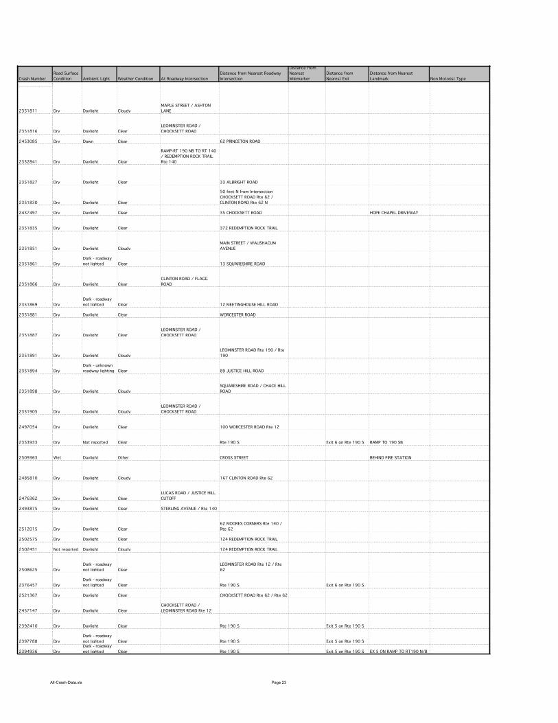
All-Crash-Data.xls Page 23
Crash Number
2351811
2351816
2453085
2332841
2351827
2351830
2437497
2351835
2351851
2351861
2351866
2351869
2351881
2351887
2351891
2351894
2351898
2351905
2497054
2353933
2509363
2485810
2476362
2493875
2512015
2502575
2502451
2508625
2376457
2521367
2457147
2392410
2397788
2394936
Road Surface
Condition Ambient Light Weather Condition At Roadway Intersection
Distance from Nearest Roadway
Intersection
Distance from
Nearest
Milemarker
Distance from
Nearest Exit
Distance from Nearest
Landmark Non Motorist Type
Dry Daylight Cloudy
MAPLE STREET / ASHTON
LANE
Dry Daylight Clear
LEOMINSTER ROAD /
CHOCKSETT ROAD
Dry Dawn Clear 62 PRINCETON ROAD
Dry Daylight Clear
RAMP-RT 190 NB TO RT 140
/ REDEMPTION ROCK TRAIL
Rte 140
Dry Daylight Clear 33 ALBRIGHT ROAD
Dry Daylight Clear
50 feet N from Intersection
CHOCKSETT ROAD Rte 62 /
CLINTON ROAD Rte 62 N
Dry Daylight Clear 35 CHOCKSETT ROAD HOPE CHAPEL DRIVEWAY
Dry Daylight Clear 372 REDEMPTION ROCK TRAIL
Dry Daylight Cloudy
MAIN STREET / WAUSHACUM
AVENUE
Dry
Dark - roadway
not lighted Clear 13 SQUARESHIRE ROAD
Dry Daylight Clear
CLINTON ROAD / FLAGG
ROAD
Dry
Dark - roadway
not lighted Clear 12 MEETINGHOUSE HILL ROAD
Dry Daylight Clear WORCESTER ROAD
Dry Daylight Clear
LEOMINSTER ROAD /
CHOCKSETT ROAD
Dry Daylight Cloudy
LEOMINSTER ROAD Rte 190 / Rte
190
Dry
Dark - unknown
roadway lighting Clear 89 JUSTICE HILL ROAD
Dry Daylight Cloudy
SQUARESHIRE ROAD / CHACE HILL
ROAD
Dry Daylight Cloudy
LEOMINSTER ROAD /
CHOCKSETT ROAD
Dry Daylight Clear 100 WORCESTER ROAD Rte 12
Dry Not reported Clear Rte 190 S Exit 6 on Rte 190 S RAMP TO 190 SB
Wet Daylight Other CROSS STREET BEHIND FIRE STATION
Dry Daylight Cloudy 167 CLINTON ROAD Rte 62
Dry Daylight Clear
LUCAS ROAD / JUSTICE HILL
CUTOFF
Dry Daylight Clear STERLING AVENUE / Rte 140
Dry Daylight Clear
62 MOORES CORNERS Rte 140 /
Rte 62
Dry Daylight Clear 124 REDEMPTION ROCK TRAIL
Not reported Daylight Cloudy 124 REDEMPTION ROCK TRAIL
Dry
Dark - roadway
not lighted Clear
LEOMINSTER ROAD Rte 12 / Rte
62
Dry
Dark - roadway
not lighted Clear Rte 190 S Exit 6 on Rte 190 S
Dry Daylight Clear CHOCKSETT ROAD Rte 62 / Rte 62
Dry Daylight Clear
CHOCKSETT ROAD /
LEOMINSTER ROAD Rte 12
Dry Daylight Clear Rte 190 S Exit 5 on Rte 190 S
Dry
Dark - roadway
not lighted Clear Rte 190 S Exit 5 on Rte 190 S
Dry
Dark - roadway
not lighted Clear Rte 190 S Exit 5 on Rte 190 S EX 5 ON RAMP TO RT190 N/B
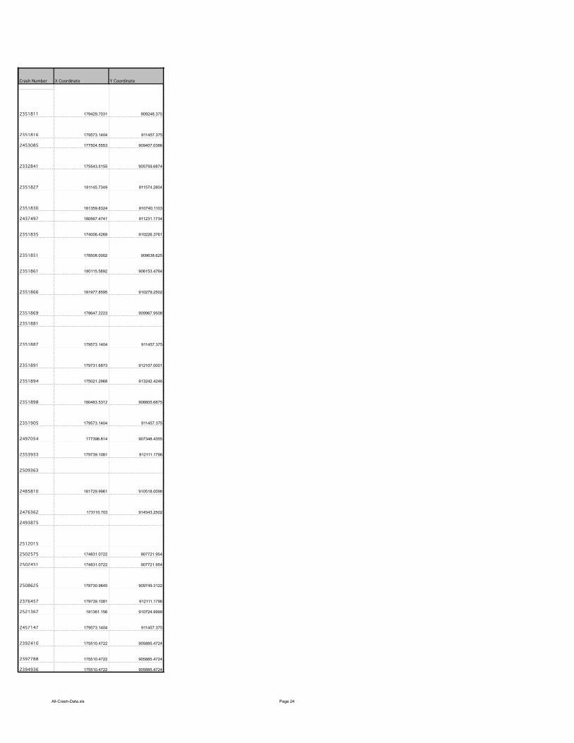
All-Crash-Data.xls Page 24
Crash Number
2351811
2351816
2453085
2332841
2351827
2351830
2437497
2351835
2351851
2351861
2351866
2351869
2351881
2351887
2351891
2351894
2351898
2351905
2497054
2353933
2509363
2485810
2476362
2493875
2512015
2502575
2502451
2508625
2376457
2521367
2457147
2392410
2397788
2394936
X Coordinate Y Coordinate
179429.7031 909248.375
179573.1404 911457.375
177504.5553 909407.0386
175543.5155 905759.6874
181145.7349 911574.2804
181359.8324 910740.1103
180567.4741 911231.1734
174006.4269 910226.3761
178508.0002 909638.625
180115.5892 906153.4764
181977.8595 910279.2502
178647.2223 909967.9508
179573.1404 911457.375
179731.6873 912107.0001
175021.2968 913242.4246
180483.5312 906605.6875
179573.1404 911457.375
177396.814 907348.4355
179739.1081 912111.1796
181729.9961 910518.0098
173110.703 914543.2502
174831.0722 907721.954
174831.0722 907721.954
178730.9845 909749.3122
179739.1081 912111.1796
181361.156 910724.9999
179573.1404 911457.375
175510.4722 905885.4724
175510.4722 905885.4724
175510.4722 905885.4724
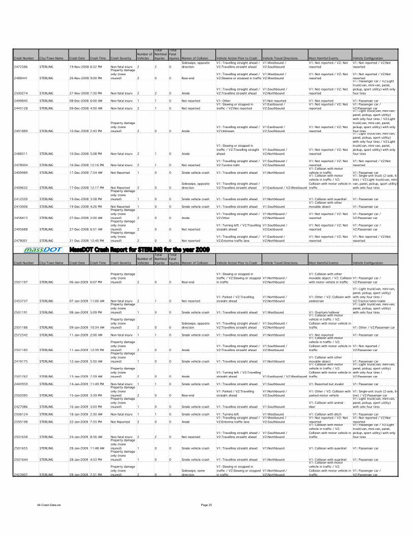
All-Crash-Data.xls Page 25
Crash Number City/Town Name Crash Date Crash Time Crash Severity
Number of
Vehicles
Total
Nonfatal
Injuries
Total
Fatal
Injuries Manner of Collision Vehicle Action Prior to Crash Vehicle Travel Directions Most Harmful Events Vehicle Configuration
2472586 STERLING 19-Nov-2008 6:52 PM Non-fatal injury 2 2 0
Sideswipe, opposite
direction
V1: Travelling straight ahead /
V2:Travelling straight ahead
V1:Westbound /
V2:Southbound
V1: Not reported / V2: Not
reported
V1: Not reported / V2:Not
reported
2488441 STERLING 26-Nov-2008 9:00 PM
Property damage
only (none
injured) 2 0 0 Rear-end
V1: Travelling straight ahead /
V2:Slowing or stopped in traffic
V1:Westbound /
V2:Westbound
V1: Not reported / V2: Not
reported
V1: Not reported / V2:Not
reported
2500274 STERLING 27-Nov-2008 7:30 PM Non-fatal injury 2 2 0 Angle
V1: Travelling straight ahead /
V2:Travelling straight ahead
V1:Southbound /
V2:Northbound
V1: Not reported / V2: Not
reported
V1: Passenger car / V2:Light
truck(van, mini-van, panel,
pickup, sport utility) with only
four tires
2499845 STERLING 08-Dec-2008 6:00 AM Non-fatal injury 1 1 0 Not reported V1: Other V1:Not reported V1: Not reported V1: Passenger car
2445128 STERLING 09-Dec-2008 4:50 AM Non-fatal injury 2 1 0 Not reported
V1: Slowing or stopped in
traffic / V2:Not reported
V1:Eastbound /
V2:Southbound
V1: Not reported / V2: Not
reported
V1: Passenger car /
V2:Passenger car
2491889 STERLING 10-Dec-2008 2:43 PM
Property damage
only (none
injured) 2 0 0 Angle
V1: Travelling straight ahead /
V2:Unknown
V1:Eastbound /
V2:Southbound
V1: Not reported / V2: Not
reported
V1: Light truck(van, mini-van,
panel, pickup, sport utility)
with only four tires / V2:Light
truck(van, mini-van, panel,
pickup, sport utility) with only
four tires
2488311 STERLING 10-Dec-2008 5:08 PM Non-fatal injury 2 1 0 Angle
V1: Slowing or stopped in
traffic / V2:Travelling straight
ahead
V1:Southbound /
V2:Northbound
V1: Not reported / V2: Not
reported
V1: Light truck(van, mini-van,
panel, pickup, sport utility)
with only four tires / V2:Light
truck(van, mini-van, panel,
pickup, sport utility) with only
four tires
2478004 STERLING 16-Dec-2008 12:16 PM Non-fatal injury 2 1 0 Not reported
V1: Travelling straight ahead /
V2:Turning right
V1:Southbound /
V2:Southbound
V1: Not reported / V2: Not
reported
V1: Not reported / V2:Not
reported
2409989 STERLING 17-Dec-2008 7:54 AM Not Reported 1 0 0 Single vehicle crash V1: Travelling straight ahead V1:Northbound
V1: Collision with motor
vehicle in traffic V1: Passenger car
2409632 STERLING 17-Dec-2008 12:17 PM Not Reported 2 0 0
Sideswipe, opposite
direction
V1: Travelling straight ahead /
V2:Travelling straight ahead V1:Eastbound / V2:Westbound
V1: Collision with motor
vehicle in traffic / V2:
Collision with motor vehicle in
traffic
V1: Single-unit truck (2-axle, 6-
tire) / V2:Light truck(van, mini-
van, panel, pickup, sport utility)
with only four tires
2412550 STERLING 19-Dec-2008 3:58 PM
Property damage
only (none
injured) 1 0 0 Single vehicle crash V1: Travelling straight ahead V1:Northbound V1: Collision with guardrail V1: Passenger car
2410006 STERLING 19-Dec-2008 4:26 PM Not Reported 1 0 0 Single vehicle crash V1: Travelling straight ahead V1:Southbound
V1: Collision with other
movable object V1: Passenger car
2458415 STERLING 27-Dec-2008 2:00 AM
Property damage
only (none
injured) 2 0 0 Angle
V1: Travelling straight ahead /
V2:Other
V1:Northbound /
V2:Northbound
V1: Not reported / V2: Not
reported
V1: Passenger car /
V2:Passenger car
2495688 STERLING 27-Dec-2008 6:51 AM
Property damage
only (none
injured) 2 0 0 Not reported
V1: Turning left / V2:Travelling
straight ahead
V1:Southbound /
V2:Eastbound
V1: Not reported / V2: Not
reported
V1: Passenger car /
V2:Passenger car
2478001 STERLING 31-Dec-2008 12:40 PM
Property damage
only (none
injured) 2 0 0 Not reported
V1: Travelling straight ahead /
V2:Entering traffic lane
V1:Eastbound /
V2:Northbound
V1: Not reported / V2: Not
reported
V1: Not reported / V2:Not
reported
Crash Number City/Town Name Crash Date Crash Time Crash Severity
Number of
Vehicles
Total
Nonfatal
Injuries
Total
Fatal
Injuries Manner of Collision Vehicle Action Prior to Crash Vehicle Travel Directions Most Harmful Events Vehicle Configuration
2501197 STERLING 06-Jan-2009 6:07 PM
Property damage
only (none
injured) 2 0 0 Rear-end
V1: Slowing or stopped in
traffic / V2:Slowing or stopped
in traffic
V1:Northbound /
V2:Northbound
V1: Collision with other
movable object / V2: Collision
with motor vehicle in traffic
V1: Passenger car /
V2:Passenger car
2453737 STERLING 07-Jan-2009 11:00 AM Non-fatal injury 2 1 0 Not reported
V1: Parked / V2:Travelling
straight ahead
V1:Northbound /
V2:Northbound
V1: Other / V2: Collision with
pedestrian
V1: Light truck(van, mini-van,
panel, pickup, sport utility)
with only four tires /
V2:Tractor/semi-trailer
2501191 STERLING 08-Jan-2009 5:09 PM
Property damage
only (none
injured) 1 0 0 Single vehicle crash V1: Travelling straight ahead V1:Westbound V1: Overturn/rollover
V1: Light truck(van, mini-van,
panel, pickup, sport utility)
with only four tires
2501186 STERLING 09-Jan-2009 10:34 AM
Property damage
only (none
injured) 2 0 0
Sideswipe, opposite
direction
V1: Travelling straight ahead /
V2:Travelling straight ahead
V1:Southbound /
V2:Northbound
V1: Collision with motor
vehicle in traffic / V2:
Collision with motor vehicle in
traffic V1: Other / V2:Passenger car
2572342 STERLING 11-Jan-2009 2:00 AM Non-fatal injury 1 1 0 Single vehicle crash V1: Travelling straight ahead V1:Northbound V1: Not reported V1: Passenger car
2501183 STERLING 11-Jan-2009 12:39 PM
Property damage
only (none
injured) 2 0 0 Angle
V1: Travelling straight ahead /
V2:Travelling straight ahead
V1:Southbound /
V2:Westbound
V1: Collision with motor
vehicle in traffic / V2:
Collision with motor vehicle in
traffic
V1: Not reported /
V2:Passenger car
2419175 STERLING 12-Jan-2009 5:50 AM
Property damage
only (none
injured) 1 0 0 Single vehicle crash V1: Travelling straight ahead V1:Northbound
V1: Collision with other
movable object V1: Passenger car
2501762 STERLING 13-Jan-2009 7:59 AM
Property damage
only (none
injured) 2 0 0 Angle
V1: Turning left / V2:Travelling
straight ahead V1:Eastbound / V2:Westbound
V1: Collision with motor
vehicle in traffic / V2:
Collision with motor vehicle in
traffic
V1: Light truck(van, mini-van,
panel, pickup, sport utility)
with only four tires /
V2:Passenger car
2443959 STERLING 14-Jan-2009 11:49 PM Non-fatal injury 1 1 0 Single vehicle crash V1: Travelling straight ahead V1:Southbound V1: Reported but invalid V1: Passenger car
2502095 STERLING 15-Jan-2009 3:39 PM
Property damage
only (none
injured) 2 0 0 Rear-end
V1: Parked / V2:Travelling
straight ahead
V1:Northbound /
V2:Southbound
V1: Other / V2: Collision with
parked motor vehicle
V1: Single-unit truck (2-axle, 6-
tire) / V2:Passenger car
2427086 STERLING 16-Jan-2009 3:03 PM
Property damage
only (none
injured) 1 0 0 Single vehicle crash V1: Travelling straight ahead V1:Southbound
V1: Collision with animal -
deer
V1: Light truck(van, mini-van,
panel, pickup, sport utility)
with only four tires
2506124 STERLING 18-Jan-2009 2:30 AM Non-fatal injury 1 1 0 Single vehicle crash V1: Turning left V1:Westbound V1: Collision with ditch V1: Passenger car
2595198 STERLING 22-Jan-2009 7:35 PM Not Reported 2 0 0 Angle
V1: Travelling straight ahead /
V2:Entering traffic lane
V1:Westbound /
V2:Southbound
V1: Not reported / V2: Not
reported
V1: Not reported / V2:Not
reported
2501658 STERLING 24-Jan-2009 8:56 AM Non-fatal injury 2 2 0 Not reported
V1: Travelling straight ahead /
V2:Travelling straight ahead
V1:Southbound /
V2:Northbound
V1: Collision with motor
vehicle in traffic / V2:
Collision with motor vehicle in
traffic
V1: Passenger car / V2:Light
truck(van, mini-van, panel,
pickup, sport utility) with only
four tires
2501655 STERLING 28-Jan-2009 11:48 AM
Property damage
only (none
injured) 1 0 0 Single vehicle crash V1: Travelling straight ahead V1:Northbound V1: Collision with guardrail V1: Passenger car
2501644 STERLING 28-Jan-2009 4:53 PM
Property damage
only (none
injured) 1 0 0 Single vehicle crash V1: Travelling straight ahead V1:Northbound V1: Collision with guardrail V1: Passenger car
2423907 STERLING 28-Jan-2009 7:51 PM
Property damage
only (none
injured) 2 0 0
Sideswipe, same
direction
V1: Slowing or stopped in
traffic / V2:Slowing or stopped
in traffic
V1:Northbound /
V2:Northbound
V1: Collision with motor
vehicle in traffic / V2:
Collision with motor vehicle in
traffic
V1: Passenger car /
V2:Passenger car
MassDOT Crash Report for STERLING for the year 2009
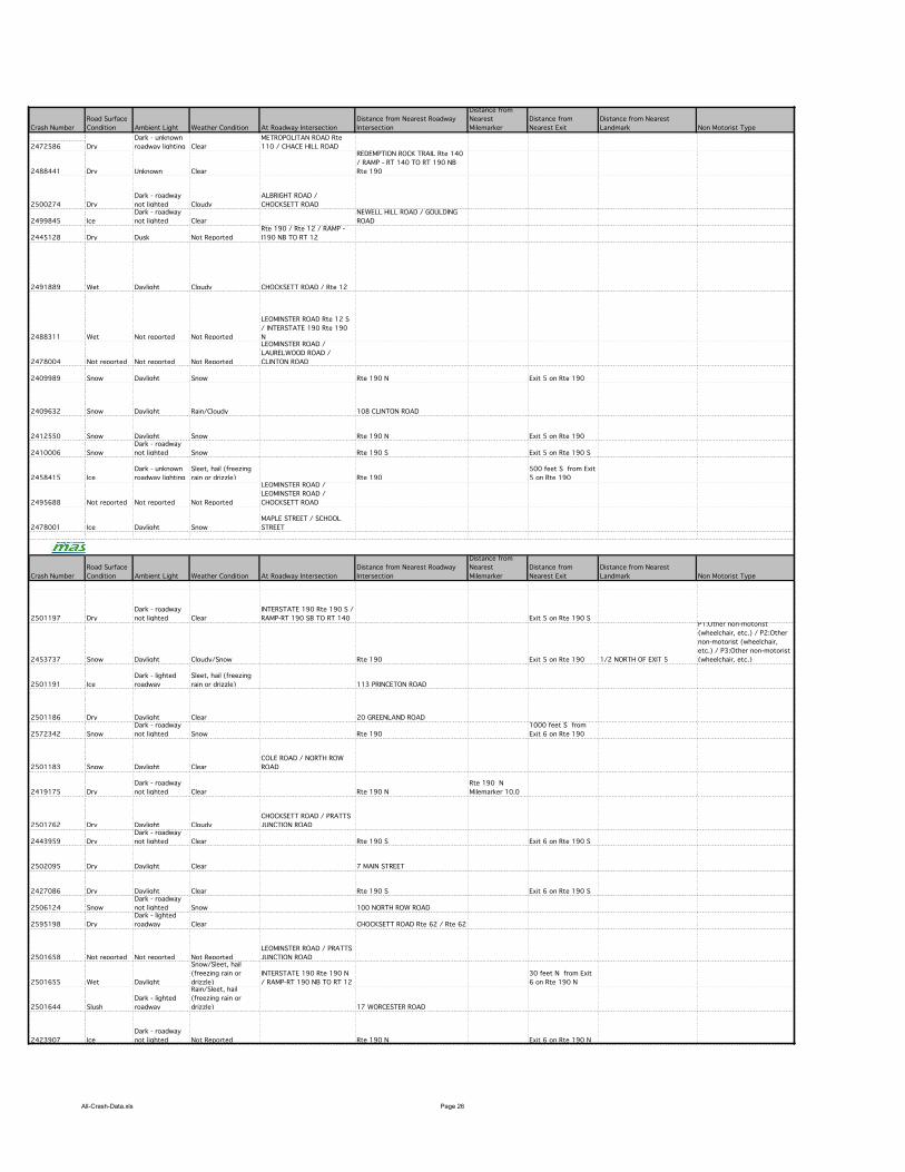
All-Crash-Data.xls Page 26
Crash Number
2472586
2488441
2500274
2499845
2445128
2491889
2488311
2478004
2409989
2409632
2412550
2410006
2458415
2495688
2478001
Crash Number
2501197
2453737
2501191
2501186
2572342
2501183
2419175
2501762
2443959
2502095
2427086
2506124
2595198
2501658
2501655
2501644
2423907
Road Surface
Condition Ambient Light Weather Condition At Roadway Intersection
Distance from Nearest Roadway
Intersection
Distance from
Nearest
Milemarker
Distance from
Nearest Exit
Distance from Nearest
Landmark Non Motorist Type
Dry
Dark - unknown
roadway lighting Clear
METROPOLITAN ROAD Rte
110 / CHACE HILL ROAD
Dry Unknown Clear
REDEMPTION ROCK TRAIL Rte 140
/ RAMP - RT 140 TO RT 190 NB
Rte 190
Dry
Dark - roadway
not lighted Cloudy
ALBRIGHT ROAD /
CHOCKSETT ROAD
Ice
Dark - roadway
not lighted Clear
NEWELL HILL ROAD / GOULDING
ROAD
Dry Dusk Not Reported
Rte 190 / Rte 12 / RAMP -
I190 NB TO RT 12
Wet Daylight Cloudy CHOCKSETT ROAD / Rte 12
Wet Not reported Not Reported
LEOMINSTER ROAD Rte 12 S
/ INTERSTATE 190 Rte 190
N
Not reported Not reported Not Reported
LEOMINSTER ROAD /
LAURELWOOD ROAD /
CLINTON ROAD
Snow Daylight Snow Rte 190 N Exit 5 on Rte 190
Snow Daylight Rain/Cloudy 108 CLINTON ROAD
Snow Daylight Snow Rte 190 N Exit 5 on Rte 190
Snow
Dark - roadway
not lighted Snow Rte 190 S Exit 5 on Rte 190 S
Ice
Dark - unknown
roadway lighting
Sleet, hail (freezing
rain or drizzle) Rte 190
500 feet S from Exit
5 on Rte 190
Not reported Not reported Not Reported
LEOMINSTER ROAD /
LEOMINSTER ROAD /
CHOCKSETT ROAD
Ice Daylight Snow
MAPLE STREET / SCHOOL
STREET
Road Surface
Condition Ambient Light Weather Condition At Roadway Intersection
Distance from Nearest Roadway
Intersection
Distance from
Nearest
Milemarker
Distance from
Nearest Exit
Distance from Nearest
Landmark Non Motorist Type
Dry
Dark - roadway
not lighted Clear
INTERSTATE 190 Rte 190 S /
RAMP-RT 190 SB TO RT 140 Exit 5 on Rte 190 S
Snow Daylight Cloudy/Snow Rte 190 Exit 5 on Rte 190 1/2 NORTH OF EXIT 5
P1:Other non-motorist
(wheelchair, etc.) / P2:Other
non-motorist (wheelchair,
etc.) / P3:Other non-motorist
(wheelchair, etc.)
Ice
Dark - lighted
roadway
Sleet, hail (freezing
rain or drizzle) 113 PRINCETON ROAD
Dry Daylight Clear 20 GREENLAND ROAD
Snow
Dark - roadway
not lighted Snow Rte 190
1000 feet S from
Exit 6 on Rte 190
Snow Daylight Clear
COLE ROAD / NORTH ROW
ROAD
Dry
Dark - roadway
not lighted Clear Rte 190 N
Rte 190 N
Milemarker 10.0
Dry Daylight Cloudy
CHOCKSETT ROAD / PRATTS
JUNCTION ROAD
Dry
Dark - roadway
not lighted Clear Rte 190 S Exit 6 on Rte 190 S
Dry Daylight Clear 7 MAIN STREET
Dry Daylight Clear Rte 190 S Exit 6 on Rte 190 S
Snow
Dark - roadway
not lighted Snow 100 NORTH ROW ROAD
Dry
Dark - lighted
roadway Clear CHOCKSETT ROAD Rte 62 / Rte 62
Not reported Not reported Not Reported
LEOMINSTER ROAD / PRATTS
JUNCTION ROAD
Wet Daylight
Snow/Sleet, hail
(freezing rain or
drizzle)
INTERSTATE 190 Rte 190 N
/ RAMP-RT 190 NB TO RT 12
30 feet N from Exit
6 on Rte 190 N
Slush
Dark - lighted
roadway
Rain/Sleet, hail
(freezing rain or
drizzle) 17 WORCESTER ROAD
Ice
Dark - roadway
not lighted Not Reported Rte 190 N Exit 6 on Rte 190 N
MassDOT Crash Report for STERLING for the year 2009
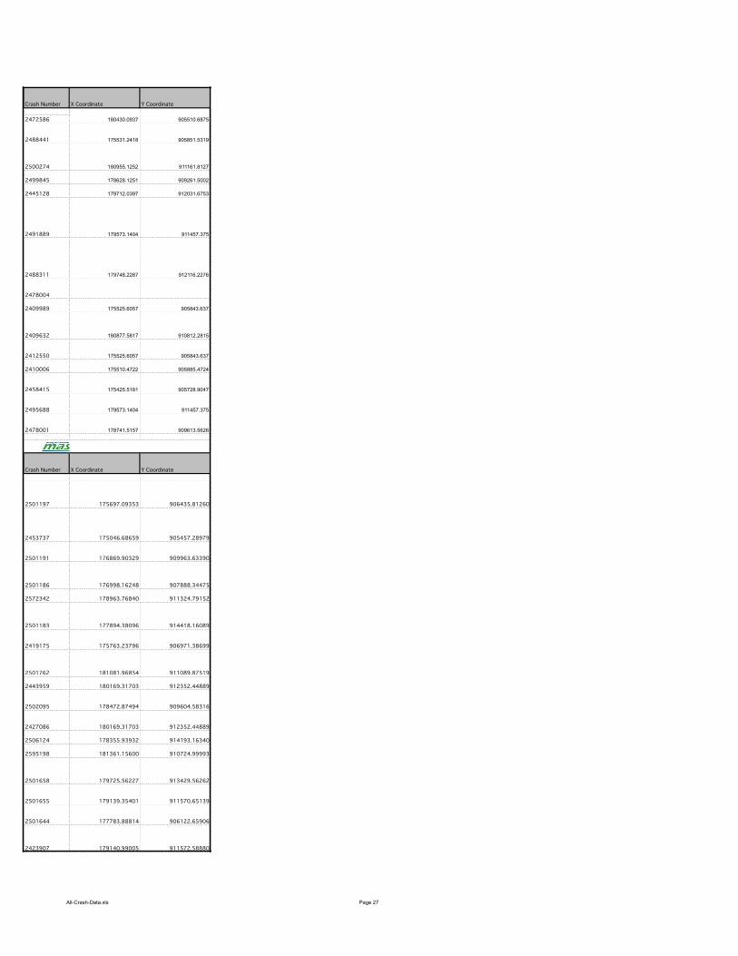
All-Crash-Data.xls Page 27
Crash Number
2472586
2488441
2500274
2499845
2445128
2491889
2488311
2478004
2409989
2409632
2412550
2410006
2458415
2495688
2478001
Crash Number
2501197
2453737
2501191
2501186
2572342
2501183
2419175
2501762
2443959
2502095
2427086
2506124
2595198
2501658
2501655
2501644
2423907
X Coordinate Y Coordinate
180430.0937 905510.6875
175531.2418 905851.5319
180955.1252 911161.8127
178628.1251 909261.5002
179712.0397 912031.6753
179573.1404 911457.375
179748.2287 912116.2276
175525.6057 905843.637
180877.5817 910812.2815
175525.6057 905843.637
175510.4722 905885.4724
175425.5181 905728.9047
179573.1404 911457.375
178741.5157 909613.5626
X Coordinate Y Coordinate
175697.09353 906435.81260
175046.68659 905457.28979
176869.90329 909963.63390
176998.16248 907888.34475
178963.76840 911324.79152
177894.38096 914418.16089
175763.23796 906971.38699
181081.96854 911089.87519
180169.31703 912352.44889
178472.87494 909604.58316
180169.31703 912352.44889
178355.93932 914193.16340
181361.15600 910724.99993
179725.56227 913429.56262
179139.35401 911570.65139
177783.88814 906122.65906
179140.99005 911572.58880
MassDOT Crash Report for STERLING for the year 2009

All-Crash-Data.xls Page 28
Crash Number City/Town Name Crash Date Crash Time Crash Severity
Number of
Vehicles
Total
Nonfatal
Injuries
Total
Fatal
Injuries Manner of Collision Vehicle Action Prior to Crash Vehicle Travel Directions Most Harmful Events Vehicle Configuration
2501641 STERLING 30-Jan-2009 3:13 PM
Property damage
only (none
injured) 2 0 0
Sideswipe, same
direction
V1: Travelling straight ahead /
V2:Travelling straight ahead V1:Westbound / V2:Eastbound
V1: Collision with motor
vehicle in traffic / V2:
Collision with motor vehicle in
traffic
V1: Passenger car /
V2:Passenger car
2501637 STERLING 04-Feb-2009 8:13 AM Not Reported 2 0 0 Rear-end
V1: Slowing or stopped in
traffic / V2:Travelling straight
ahead
V1:Southbound /
V2:Southbound
V1: Collision with motor
vehicle in traffic / V2:
Collision with motor vehicle in
traffic
V1: Passenger car /
V2:Passenger car
2501635 STERLING 05-Feb-2009 3:04 PM
Property damage
only (none
injured) 2 0 0 Angle
V1: Travelling straight ahead /
V2:Entering traffic lane
V1:Northbound /
V2:Westbound
V1: Collision with motor
vehicle in traffic / V2:
Collision with motor vehicle in
traffic
V1: Light truck(van, mini-van,
panel, pickup, sport utility)
with only four tires /
V2:Passenger car
2556481 STERLING 09-Feb-2009 12:30 PM
Property damage
only (none
injured) 2 0 0 Rear-end
V1: Travelling straight ahead /
V2:Slowing or stopped in traffic
V1:Northbound /
V2:Northbound
V1: Not reported / V2: Not
reported
V1: Light truck(van, mini-van,
panel, pickup, sport utility)
with only four tires / V2:Light
truck(van, mini-van, panel,
pickup, sport utility) with only
four tires
2501623 STERLING 09-Feb-2009 4:55 PM
Property damage
only (none
injured) 2 0 0 Angle
V1: Travelling straight ahead /
V2:Slowing or stopped in traffic
V1:Northbound /
V2:Westbound
V1: Collision with motor
vehicle in traffic / V2:
Collision with motor vehicle in
traffic
V1: Passenger car /
V2:Passenger car
2550293 STERLING 16-Feb-2009 9:47 PM
Property damage
only (none
injured) 2 0 0 Single vehicle crash
V1: Travelling straight ahead /
V2:Travelling straight ahead
V1:Northbound /
V2:Northbound
V1: Collision with other
movable object / V2: Collision
with mail box
V1: Passenger car /
V2:Passenger car
2463081 STERLING 17-Feb-2009 10:45 PM Non-fatal injury 2 1 0 Rear-end
V1: Travelling straight ahead /
V2:Travelling straight ahead
V1:Southbound /
V2:Southbound
V1: Collision with motor
vehicle in traffic / V2:
Collision with motor vehicle in
traffic
V1: Passenger car /
V2:Passenger car
2501605 STERLING 21-Feb-2009 10:45 AM
Property damage
only (none
injured) 2 0 0
Sideswipe, opposite
direction
V1: Travelling straight ahead /
V2:Travelling straight ahead
V1:Southbound / V2:Not
reported
V1: Collision with motor
vehicle in traffic / V2:
Collision with motor vehicle in
traffic
V1: Passenger car /
V2:Passenger car
2501602 STERLING 22-Feb-2009 3:06 PM Non-fatal injury 1 1 0 Single vehicle crash V1: Travelling straight ahead V1:Westbound V1: Overturn/rollover V1: Passenger car
2501595 STERLING 22-Feb-2009 6:32 PM
Property damage
only (none
injured) 1 0 0 Single vehicle crash V1: Travelling straight ahead V1:Northbound
V1: Collision with light pole or
other post/support V1: Other
2501590 STERLING 23-Feb-2009 8:25 AM
Property damage
only (none
injured) 2 0 0 Angle
V1: Travelling straight ahead /
V2:Travelling straight ahead V1:Westbound / V2:Eastbound
V1: Collision with motor
vehicle in traffic / V2:
Collision with motor vehicle in
traffic
V1: Passenger car /
V2:Passenger car
2501583 STERLING 27-Feb-2009 1:55 PM
Property damage
only (none
injured) 1 0 0 Single vehicle crash V1: Travelling straight ahead V1:Southbound V1: Collision with utility pole V1: Passenger car
2501577 STERLING 28-Feb-2009 11:51 PM
Property damage
only (none
injured) 1 0 0 Single vehicle crash V1: Travelling straight ahead V1:Northbound V1: Collision with tree V1: Passenger car
2501573 STERLING 03-Mar-2009 5:01 PM
Property damage
only (none
injured) 2 0 0 Single vehicle crash
V1: Travelling straight ahead /
V2:Entering traffic lane
V1:Southbound /
V2:Southbound
V1: Collision with curb / V2:
Other
V1: Passenger car /
V2:Passenger car
2609909 STERLING 04-Mar-2009 4:00 PM
Property damage
only (none
injured) 2 0 0 Rear-end
V1: Slowing or stopped in
traffic / V2:Turning right
V1:Not reported / V2:Not
reported
V1: Not reported / V2: Not
reported
V1: Not reported / V2:Not
reported
2489720 STERLING 04-Mar-2009 9:26 PM
Property damage
only (none
injured) 2 0 0
Sideswipe, same
direction
V1: Travelling straight ahead /
V2:Changing lanes
V1:Southbound /
V2:Southbound
V1: Collision with motor
vehicle in traffic / V2:
Collision with motor vehicle in
traffic
V1: Passenger car / V2:Light
truck(van, mini-van, panel,
pickup, sport utility) with only
four tires
2463141 STERLING 07-Mar-2009 5:00 PM
Property damage
only (none
injured) 1 0 0 Single vehicle crash V1: Travelling straight ahead V1:Southbound V1: Collision with guardrail V1: Passenger car
2500566 STERLING 09-Mar-2009 9:30 AM Not Reported 2 0 0
Sideswipe, opposite
direction
V1: Travelling straight ahead /
V2:Backing
V1:Southbound /
V2:Southbound
V1: Collision with motor
vehicle in traffic / V2:
Collision with motor vehicle in
traffic
V1: Unknown heavy truck,
cannot classify / V2:Unknown
heavy truck, cannot classify
2501569 STERLING 09-Mar-2009 3:24 PM
Property damage
only (none
injured) 1 0 0 Single vehicle crash V1: Turning left V1:Southbound
V1: Collision with
embankment V1: Passenger car
2501567 STERLING 09-Mar-2009 4:19 PM
Property damage
only (none
injured) 1 0 0 Single vehicle crash V1: Travelling straight ahead V1:Southbound V1: Collision with utility pole V1: Passenger car
2501562 STERLING 12-Mar-2009 11:44 AM
Property damage
only (none
injured) 2 0 0 Rear-end
V1: Slowing or stopped in
traffic / V2:Travelling straight
ahead
V1:Northbound /
V2:Northbound
V1: Collision with motor
vehicle in traffic / V2:
Collision with motor vehicle in
traffic
V1: Passenger car /
V2:Passenger car
2501457 STERLING 17-Mar-2009 6:18 PM
Property damage
only (none
injured) 2 0 0 Rear-end
V1: Entering traffic lane /
V2:Entering traffic lane
V1:Northbound /
V2:Northbound
V1: Collision with motor
vehicle in traffic / V2:
Collision with motor vehicle in
traffic
V1: Passenger car /
V2:Passenger car
2501453 STERLING 19-Mar-2009 8:05 PM
Property damage
only (none
injured) 1 0 0 Single vehicle crash V1: Travelling straight ahead V1:Southbound V1: Collision with utility pole V1: Passenger car
2501444 STERLING 06-Apr-2009 2:36 PM
Property damage
only (none
injured) 2 0 0
Sideswipe, opposite
direction
V1: Travelling straight ahead /
V2:Travelling straight ahead
V1:Northbound /
V2:Southbound
V1: Collision with motor
vehicle in traffic / V2:
Collision with motor vehicle in
traffic
V1: Passenger car /
V2:Passenger car
2500564 STERLING 14-Apr-2009 3:04 PM
Property damage
only (none
injured) 2 0 0 Rear-end
V1: Entering traffic lane /
V2:Slowing or stopped in traffic
V1:Northbound /
V2:Northbound
V1: Collision with motor
vehicle in traffic / V2:
Collision with motor vehicle in
traffic
V1: Passenger car /
V2:Tractor/semi-trailer
2501441 STERLING 16-Apr-2009 2:05 PM
Property damage
only (none
injured) 1 0 0 Single vehicle crash V1: Travelling straight ahead V1:Eastbound V1: Other V1: Passenger car
2501435 STERLING 16-Apr-2009 4:16 PM
Property damage
only (none
injured) 2 0 0 Head-on
V1: Travelling straight ahead /
V2:Slowing or stopped in traffic
V1:Westbound /
V2:Southbound
V1: Collision with motor
vehicle in traffic / V2:
Collision with motor vehicle in
traffic
V1: Passenger car /
V2:Passenger car
2501431 STERLING 17-Apr-2009 7:27 AM
Property damage
only (none
injured) 1 0 0 Single vehicle crash V1: Travelling straight ahead V1:Westbound V1: Collision with utility pole
V1: Light truck(van, mini-van,
panel, pickup, sport utility)
with only four tires
2457805 STERLING 19-Apr-2009 5:24 PM Non-fatal injury 2 2 0 Rear-end
V1: Turning left / V2:Travelling
straight ahead
V1:Southbound /
V2:Southbound
V1: Collision with motor
vehicle in traffic / V2:
Collision with motor vehicle in
traffic
V1: Motorcycle /
V2:Motorcycle
2471711 STERLING 21-Apr-2009 2:07 PM
Property damage
only (none
injured) 2 0 0 Rear-end V1: Parked / V2:Backing
V1:Southbound /
V2:Southbound
V1: Collision with motor
vehicle in traffic / V2:
Collision with parked motor
vehicle
V1: Passenger car /
V2:Passenger car
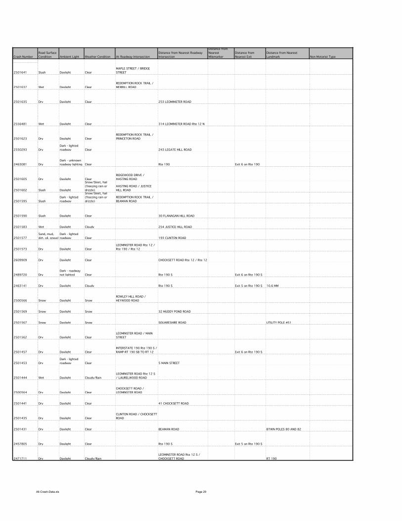
All-Crash-Data.xls Page 29
Crash Number
2501641
2501637
2501635
2556481
2501623
2550293
2463081
2501605
2501602
2501595
2501590
2501583
2501577
2501573
2609909
2489720
2463141
2500566
2501569
2501567
2501562
2501457
2501453
2501444
2500564
2501441
2501435
2501431
2457805
2471711
Road Surface
Condition Ambient Light Weather Condition At Roadway Intersection
Distance from Nearest Roadway
Intersection
Distance from
Nearest
Milemarker
Distance from
Nearest Exit
Distance from Nearest
Landmark Non Motorist Type
Slush Daylight Clear
MAPLE STREET / BRIDGE
STREET
Wet Daylight Clear
REDEMPTION ROCK TRAIL /
MERRILL ROAD
Dry Daylight Clear 253 LEOMINSTER ROAD
Wet Daylight Clear 314 LEOMINSTER ROAD Rte 12 N
Dry Daylight Clear
REDEMPTION ROCK TRAIL /
PRINCETON ROAD
Dry
Dark - lighted
roadway Clear 243 LEGATE HILL ROAD
Dry
Dark - unknown
roadway lighting Clear Rte 190 Exit 6 on Rte 190
Dry Daylight Clear
RIDGEWOOD DRIVE /
HASTING ROAD
Slush Daylight
Snow/Sleet, hail
(freezing rain or
drizzle)
HASTING ROAD / JUSTICE
HILL ROAD
Slush
Dark - lighted
roadway
Snow/Sleet, hail
(freezing rain or
drizzle)
REDEMPTION ROCK TRAIL /
BEAMAN ROAD
Slush Daylight Clear 30 FLANAGAN HILL ROAD
Wet Daylight Cloudy 254 JUSTICE HILL ROAD
Sand, mud,
dirt, oil, gravel
Dark - lighted
roadway Clear 193 CLINTON ROAD
Dry Daylight Clear
LEOMINSTER ROAD Rte 12 /
Rte 190 / Rte 12
Dry Daylight Clear CHOCKSETT ROAD Rte 12 / Rte 12
Dry
Dark - roadway
not lighted Clear Rte 190 S Exit 6 on Rte 190 S
Dry Daylight Cloudy Rte 190 S Exit 5 on Rte 190 S 10.6 MM
Snow Daylight Snow
ROWLEY HILL ROAD /
HEYWOOD ROAD
Snow Daylight Snow 32 MUDDY POND ROAD
Snow Daylight Snow SQUARESHIRE ROAD UTILITY POLE #51
Dry Daylight Clear
LEOMINSTER ROAD / MAIN
STREET
Dry Daylight Clear
INTERSTATE 190 Rte 190 S /
RAMP-RT 190 SB TO RT 12 Exit 6 on Rte 190 S
Dry
Dark - lighted
roadway Clear 5 MAIN STREET
Wet Daylight Cloudy/Rain
LEOMINSTER ROAD Rte 12 S
/ LAURELWOOD ROAD
Dry Daylight Clear
CHOCKSETT ROAD /
LEOMINSTER ROAD
Dry Daylight Clear 41 CHOCKSETT ROAD
Dry Daylight Clear
CLINTON ROAD / CHOCKSETT
ROAD
Dry Daylight Clear BEAMAN ROAD BTWN POLES 80 AND 82
Dry Daylight Clear Rte 190 S Exit 5 on Rte 190 S
Dry Daylight Cloudy/Rain
LEOMINSTER ROAD Rte 12 S /
CHOCKSETT ROAD RT 190

All-Crash-Data.xls Page 30
Crash Number
2501641
2501637
2501635
2556481
2501623
2550293
2463081
2501605
2501602
2501595
2501590
2501583
2501577
2501573
2609909
2489720
2463141
2500566
2501569
2501567
2501562
2501457
2501453
2501444
2500564
2501441
2501435
2501431
2457805
2471711
X Coordinate Y Coordinate
178774.43728 909594.12505
175334.96873 906495.93727
179682.26305 913330.94217
179531.36436 913948.02697
174297.48419 909273.74975
179970.00425 914020.68023
180169.31703 912352.44889
173533.41276 915437.05523
173406.79670 915084.93747
173668.43740 911781.24979
180680.37840 913081.17658
173602.80236 914763.73015
181981.59400 910273.37099
179731.30578 912107.09890
179573.14038 911457.37496
180169.31703 912352.44889
175697.09328 906435.81221
176983.14076 912240.68735
176953.23420 907326.78721
178730.9843 909749.3122
180169.3173 912352.4493
178455.1898 909587.4467
179175.8908 910189.9999
179573.1404 911457.375
180728.3598 911213.4809
181327.7029 910733.3752
175697.0933 906435.8122
179573.1404 911457.3749

All-Crash-Data.xls Page 31
Crash Number City/Town Name Crash Date Crash Time Crash Severity
Number of
Vehicles
Total
Nonfatal
Injuries
Total
Fatal
Injuries Manner of Collision Vehicle Action Prior to Crash Vehicle Travel Directions Most Harmful Events Vehicle Configuration
2500251 STERLING 23-Apr-2009 10:52 AM Non-fatal injury 2 1 0 Angle
V1: Backing / V2:Travelling
straight ahead
V1:Westbound /
V2:Westbound
V1: Collision with motor
vehicle in traffic / V2:
Collision with motor vehicle in
traffic
V1: Tractor/semi-trailer /
V2:Passenger car
2501423 STERLING 24-Apr-2009 8:38 PM Non-fatal injury 1 1 0 Single vehicle crash V1: Travelling straight ahead V1:Southbound V1: Overturn/rollover V1: Motorcycle
2501428 STERLING 25-Apr-2009 7:41 PM
Property damage
only (none
injured) 3 0 0 Head-on
V1: Turning left / V2:Travelling
straight ahead / V3:Slowing or
stopped in traffic
V1:Southbound /
V2:Northbound /
V3:Westbound
V1: Collision with motor
vehicle in traffic / V2:
Collision with motor vehicle in
traffic / V3: Collision with
motor vehicle in traffic
V1: Light truck(van, mini-van,
panel, pickup, sport utility)
with only four tires /
V2:Passenger car /
V3:Passenger car
2501421 STERLING 29-Apr-2009 11:16 PM
Property damage
only (none
injured) 2 0 0 Rear-end
V1: Turning right / V2:Turning
right
V1:Northbound /
V2:Northbound
V1: Collision with motor
vehicle in traffic / V2:
Collision with motor vehicle in
traffic
V1: Passenger car /
V2:Passenger car
2506210 STERLING
03-May-
2009 2:30 AM
Property damage
only (none
injured) 1 0 0 Single vehicle crash V1: Travelling straight ahead V1:Northbound V1: Collision with tree V1: Passenger car
2500256 STERLING
07-May-
2009 4:23 PM
Property damage
only (none
injured) 2 0 0
Sideswipe, opposite
direction V1: Other / V2:Turning left V1:Eastbound / V2:Westbound
V1: Collision with motor
vehicle in traffic / V2:
Collision with motor vehicle in
traffic
V1: Bus (seats for 7-15
people, including driver) /
V2:Passenger car
2466933 STERLING
08-May-
2009 4:43 PM
Property damage
only (none
injured) 2 0 0
Sideswipe, same
direction
V1: Travelling straight ahead /
V2:Travelling straight ahead
V1:Southbound /
V2:Southbound
V1: Collision with motor
vehicle in traffic / V2:
Collision with motor vehicle in
traffic
V1: Passenger car / V2:Single-
unit truck (2-axle, 6-tire)
2506212 STERLING
13-May-
2009 4:55 PM
Property damage
only (none
injured) 2 0 0 Rear-end
V1: Slowing or stopped in
traffic / V2:Travelling straight
ahead
V1:Northbound /
V2:Northbound
V1: Collision with motor
vehicle in traffic / V2:
Collision with motor vehicle in
traffic
V1: Passenger car /
V2:Passenger car
2490210 STERLING
16-May-
2009 2:47 PM
Property damage
only (none
injured) 2 0 0 Rear-end
V1: Entering traffic lane /
V2:Travelling straight ahead
V1:Southbound /
V2:Northbound
V1: Collision with motor
vehicle in traffic / V2:
Collision with motor vehicle in
traffic
V1: Passenger car / V2:Light
truck(van, mini-van, panel,
pickup, sport utility) with only
four tires
2501417 STERLING
18-May-
2009 10:03 PM
Property damage
only (none
injured) 1 0 0 Single vehicle crash V1: Travelling straight ahead V1:Westbound
V1: Collision with animal -
deer V1: Passenger car
2501416 STERLING
22-May-
2009 5:29 PM
Property damage
only (none
injured) 2 0 0 Rear-end
V1: Slowing or stopped in
traffic / V2:Slowing or stopped
in traffic
V1:Northbound /
V2:Northbound
V1: Collision with motor
vehicle in traffic / V2:
Collision with motor vehicle in
traffic
V1: Passenger car /
V2:Passenger car
2501415 STERLING
24-May-
2009 10:37 AM
Property damage
only (none
injured) 2 0 0 Angle
V1: Turning left / V2:Travelling
straight ahead
V1:Southbound /
V2:Northbound
V1: Collision with motor
vehicle in traffic / V2:
Collision with motor vehicle in
traffic
V1: Light truck(van, mini-van,
panel, pickup, sport utility)
with only four tires / V2:Light
truck(van, mini-van, panel,
pickup, sport utility) with only
four tires
2501412 STERLING 10-Jun-2009 3:59 PM
Property damage
only (none
injured) 2 0 0 Rear-end
V1: Slowing or stopped in
traffic / V2:Travelling straight
ahead
V1:Westbound /
V2:Westbound
V1: Collision with motor
vehicle in traffic / V2:
Collision with motor vehicle in
traffic
V1: Passenger car /
V2:Passenger car
2501411 STERLING 18-Jun-2009 6:56 AM Non-fatal injury 2 1 0 Rear-end
V1: Travelling straight ahead /
V2:Travelling straight ahead
V1:Northbound /
V2:Northbound
V1: Collision with motor
vehicle in traffic / V2:
Collision with motor vehicle in
traffic
V1: Passenger car /
V2:Passenger car
2495542 STERLING 20-Jun-2009 10:17 AM
Property damage
only (none
injured) 2 0 0 Not reported
V1: Slowing or stopped in
traffic / V2:Backing
V1:Southbound /
V2:Southbound
V1: Collision with motor
vehicle in traffic / V2:
Collision with motor vehicle in
traffic
V1: Passenger car /
V2:Passenger car
2501409 STERLING 22-Jun-2009 7:39 AM
Property damage
only (none
injured) 1 0 0 Single vehicle crash V1: Travelling straight ahead V1:Eastbound
V1: Collision with animal -
deer V1: Passenger car
2501382 STERLING 05-Jul-2009 6:31 PM
Property damage
only (none
injured) 1 0 0 Single vehicle crash V1: Travelling straight ahead V1:Northbound
V1: Collision with highway
traffic sign post V1: Passenger car
2609625 STERLING 08-Jul-2009 5:30 PM Not Reported 2 0 0 Rear-end
V1: Slowing or stopped in
traffic / V2:Travelling straight
ahead V1:Eastbound / V2:Eastbound
V1: Not reported / V2: Not
reported
V1: Passenger car / V2:Not
reported
2501378 STERLING 10-Jul-2009 3:59 PM
Property damage
only (none
injured) 2 0 0 Angle
V1: Travelling straight ahead /
V2:Travelling straight ahead
V1:Northbound /
V2:Southbound
V1: Collision with motor
vehicle in traffic / V2:
Collision with motor vehicle in
traffic
V1: Passenger car /
V2:Passenger car
2501376 STERLING 10-Jul-2009 9:55 PM
Property damage
only (none
injured) 2 0 0
Sideswipe, opposite
direction
V1: Not reported / V2:Slowing
or stopped in traffic
V1:Not reported /
V2:Westbound
V1: Not reported / V2:
Collision with motor vehicle in
traffic
V1: Not reported /
V2:Passenger car
2501348 STERLING 12-Jul-2009 8:26 AM
Property damage
only (none
injured) 2 0 0 Angle
V1: Travelling straight ahead /
V2:Travelling straight ahead
V1:Southbound /
V2:Northbound
V1: Collision with motor
vehicle in traffic / V2:
Collision with motor vehicle in
traffic
V1: Passenger car /
V2:Passenger car
2650619 STERLING 12-Jul-2009 5:48 PM Non-fatal injury 2 2 0 Rear-end
V1: Travelling straight ahead /
V2:Slowing or stopped in traffic
V1:Northbound /
V2:Northbound
V1: Collision with motor
vehicle in traffic / V2:
Collision with motor vehicle in
traffic
V1: Passenger car /
V2:Passenger car
2500242 STERLING 13-Jul-2009 4:01 PM Non-fatal injury 2 2 0 Rear-end
V1: Slowing or stopped in
traffic / V2:Travelling straight
ahead V1:Eastbound / V2:Eastbound
V1: Collision with motor
vehicle in traffic / V2:
Collision with motor vehicle in
traffic
V1: Passenger car /
V2:Tractor/semi-trailer
2500118 STERLING 15-Jul-2009 12:24 PM
Property damage
only (none
injured) 2 0 0 Rear-end V1: Backing / V2:Parked
V1:Northbound /
V2:Northbound
V1: Collision with parked
motor vehicle / V2: Collision
with parked motor vehicle
V1: Bus (seats for 7-15
people, including driver) /
V2:Passenger car
2604930 STERLING 16-Jul-2009 8:40 PM Not Reported 2 0 0 Rear-end
V1: Slowing or stopped in
traffic / V2:Travelling straight
ahead
V1:Northbound /
V2:Northbound
V1: Not reported / V2: Not
reported
V1: Passenger car / V2:Light
truck(van, mini-van, panel,
pickup, sport utility) with only
four tires
2501345 STERLING 17-Jul-2009 7:45 AM
Property damage
only (none
injured) 2 0 0 Rear-end
V1: Travelling straight ahead /
V2:Travelling straight ahead
V1:Southbound /
V2:Southbound
V1: Collision with motor
vehicle in traffic / V2:
Collision with motor vehicle in
traffic
V1: Passenger car /
V2:Passenger car
2501340 STERLING 23-Jul-2009 1:47 PM Not Reported 2 0 0 Angle
V1: Travelling straight ahead /
V2:Travelling straight ahead
V1:Eastbound /
V2:Northbound
V1: Collision with motor
vehicle in traffic / V2:
Collision with motor vehicle in
traffic V1: Passenger car / V2:MOPED
2657522 STERLING
11-Aug-
2009 8:40 PM Not Reported 1 0 0
Sideswipe, same
direction
V1: Slowing or stopped in
traffic V1:Westbound V1: Not reported V1: Not reported
2520529 STERLING
26-Aug-
2009 3:47 PM
Property damage
only (none
injured) 2 0 0 Rear-end
V1: Slowing or stopped in
traffic / V2:Slowing or stopped
in traffic
V1:Southbound /
V2:Southbound
V1: Collision with motor
vehicle in traffic / V2:
Collision with motor vehicle in
traffic
V1: Light truck(van, mini-van,
panel, pickup, sport utility)
with only four tires / V2:Light
truck(van, mini-van, panel,
pickup, sport utility) with only
four tires
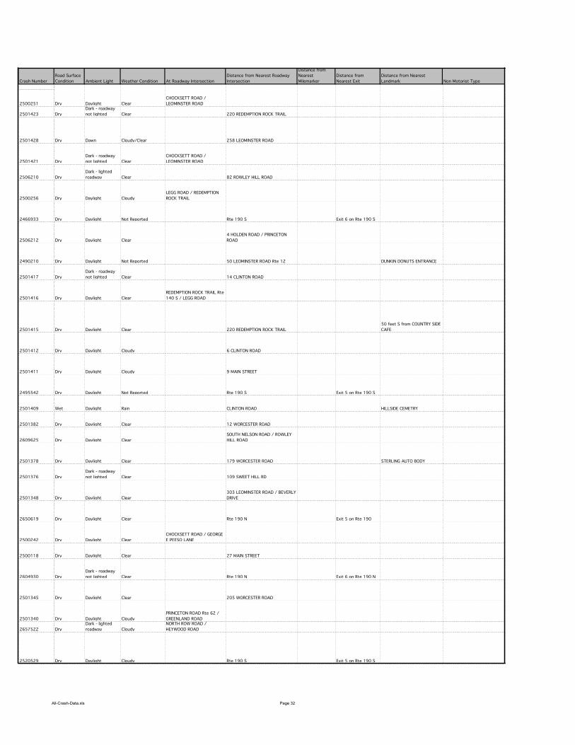
All-Crash-Data.xls Page 32
Crash Number
2500251
2501423
2501428
2501421
2506210
2500256
2466933
2506212
2490210
2501417
2501416
2501415
2501412
2501411
2495542
2501409
2501382
2609625
2501378
2501376
2501348
2650619
2500242
2500118
2604930
2501345
2501340
2657522
2520529
Road Surface
Condition Ambient Light Weather Condition At Roadway Intersection
Distance from Nearest Roadway
Intersection
Distance from
Nearest
Milemarker
Distance from
Nearest Exit
Distance from Nearest
Landmark Non Motorist Type
Dry Daylight Clear
CHOCKSETT ROAD /
LEOMINSTER ROAD
Dry
Dark - roadway
not lighted Clear 220 REDEMPTION ROCK TRAIL
Dry Dawn Cloudy/Clear 258 LEOMINSTER ROAD
Dry
Dark - roadway
not lighted Clear
CHOCKSETT ROAD /
LEOMINSTER ROAD
Dry
Dark - lighted
roadway Clear 82 ROWLEY HILL ROAD
Dry Daylight Cloudy
LEGG ROAD / REDEMPTION
ROCK TRAIL
Dry Daylight Not Reported Rte 190 S Exit 6 on Rte 190 S
Dry Daylight Clear
4 HOLDEN ROAD / PRINCETON
ROAD
Dry Daylight Not Reported 50 LEOMINSTER ROAD Rte 12 DUNKIN DONUTS ENTRANCE
Dry
Dark - roadway
not lighted Clear 14 CLINTON ROAD
Dry Daylight Clear
REDEMPTION ROCK TRAIL Rte
140 S / LEGG ROAD
Dry Daylight Clear 220 REDEMPTION ROCK TRAIL
50 feet S from COUNTRY SIDE
CAFE
Dry Daylight Cloudy 6 CLINTON ROAD
Dry Daylight Cloudy 9 MAIN STREET
Dry Daylight Not Reported Rte 190 S Exit 5 on Rte 190 S
Wet Daylight Rain CLINTON ROAD HILLSIDE CEMETRY
Dry Daylight Clear 12 WORCESTER ROAD
Dry Daylight Clear
SOUTH NELSON ROAD / ROWLEY
HILL ROAD
Dry Daylight Clear 179 WORCESTER ROAD STERLING AUTO BODY
Dry
Dark - roadway
not lighted Clear 109 SWEET HILL RD
Dry Daylight Clear
303 LEOMINSTER ROAD / BEVERLY
DRIVE
Dry Daylight Clear Rte 190 N Exit 5 on Rte 190
Dry Daylight Clear
CHOCKSETT ROAD / GEORGE
E PEESO LANE
Dry Daylight Clear 27 MAIN STREET
Dry
Dark - roadway
not lighted Clear Rte 190 N Exit 6 on Rte 190 N
Dry Daylight Clear 205 WORCESTER ROAD
Dry Daylight Cloudy
PRINCETON ROAD Rte 62 /
GREENLAND ROAD
Dry
Dark - lighted
roadway Cloudy
NORTH ROW ROAD /
HEYWOOD ROAD
Dry Daylight Cloudy Rte 190 S Exit 5 on Rte 190 S

All-Crash-Data.xls Page 33
Crash Number
2500251
2501423
2501428
2501421
2506210
2500256
2466933
2506212
2490210
2501417
2501416
2501415
2501412
2501411
2495542
2501409
2501382
2609625
2501378
2501376
2501348
2650619
2500242
2500118
2604930
2501345
2501340
2657522
2520529
X Coordinate Y Coordinate
179573.1404 911457.375
174333.7393 909160.7894
179705.7943 913379.2819
179573.1404 911457.375
177732.5862 911370.967
175378.906 906322.4374
180169.317 912352.4489
174019.7186 909414.8124
179286.3217 910444.3546
179203.4121 909863.1954
175378.906 906322.4374
174333.7393 909160.7894
179103.9091 909779.9494
178490.5696 909621.6658
175697.0933 906435.8122
179515.6541 910139.7699
177782.731 905734.4971
176289.6875 912485.1873
177853.7651 908595.9047
180359.5151 907165.5533
179556.8131 913905.4396
175046.6866 905457.2898
178560.6305 909689.4251
179140.99 911572.5888
178151.6503 908934.5684
174471.0471 909267.7501
177328.9532 914138.6877
175697.0933 906435.8122
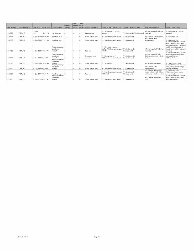
All-Crash-Data.xls Page 34
Crash Number City/Town Name Crash Date Crash Time Crash Severity
Number of
Vehicles
Total
Nonfatal
Injuries
Total
Fatal
Injuries Manner of Collision Vehicle Action Prior to Crash Vehicle Travel Directions Most Harmful Events Vehicle Configuration
2603325 STERLING
27-Aug-
2009 12:45 PM Not Reported 2 0 0 Not reported
V1: Turning right / V2:Not
reported V1:Eastbound / V2:Eastbound
V1: Not reported / V2: Not
reported
V1: Not reported / V2:Not
reported
2520545 STERLING 04-Sep-2009 00:00 AM Non-fatal injury 1 1 0 Single vehicle crash V1: Travelling straight ahead V1:Northbound V1: Collision with guardrail V1: Passenger car
2520555 STERLING 07-Sep-2009 11:17 AM Non-fatal injury 1 1 0 Single vehicle crash V1: Travelling straight ahead V1:Southbound
V1: Collision with
embankment V1: Passenger car
2604159 STERLING 20-Sep-2009 11:20 AM
Property damage
only (none
injured) 2 0 0 Rear-end
V1: Slowing or stopped in
traffic / V2:Slowing or stopped
in traffic
V1:Southbound /
V2:Eastbound
V1: Not reported / V2: Not
reported
V1: Light truck(van, mini-van,
panel, pickup, sport utility)
with only four tires / V2:Light
truck(van, mini-van, panel,
pickup, sport utility) with only
four tires
2520677 STERLING 24-Sep-2009 2:50 PM
Property damage
only (none
injured) 2 0 0
Sideswipe, same
direction
V1: Changing lanes /
V2:Travelling straight ahead
V1:Southbound /
V2:Southbound
V1: Not reported / V2:
Collision with motor vehicle in
traffic
V1: Light truck(van, mini-van,
panel, pickup, sport utility)
with only four tires /
V2:Truck/trailer
2527949 STERLING 30-Sep-2009 10:03 AM
Property damage
only (none
injured) 1 0 0 Single vehicle crash V1: Turning left V1:Northbound V1: Reported but invalid V1: Tractor/semi-trailer
2525470 STERLING 03-Oct-2009 6:30 AM
Property damage
only (none
injured) 1 0 0 Single vehicle crash V1: Travelling straight ahead V1:Southbound
V1: Collision with
embankment
V1: Light truck(van, mini-van,
panel, pickup, sport utility)
with only four tires
2525697 STERLING 08-Oct-2009 11:08 AM Non-fatal injury 2 1 0 Rear-end
V1: Travelling straight ahead /
V2:Parked
V1:Northbound /
V2:Eastbound
V1: Collision with parked
motor vehicle / V2: Collision
with motor vehicle in traffic
V1: Passenger car /
V2:Unknown heavy truck,
cannot classify
2535205 STERLING 09-Nov-2009 6:47 PM
Property damage
only (none
injured) 1 0 0 Single vehicle crash V1: Travelling straight ahead V1:Southbound
V1: Collision with animal -
deer
V1: Light truck(van, mini-van,
panel, pickup, sport utility)
with only four tires
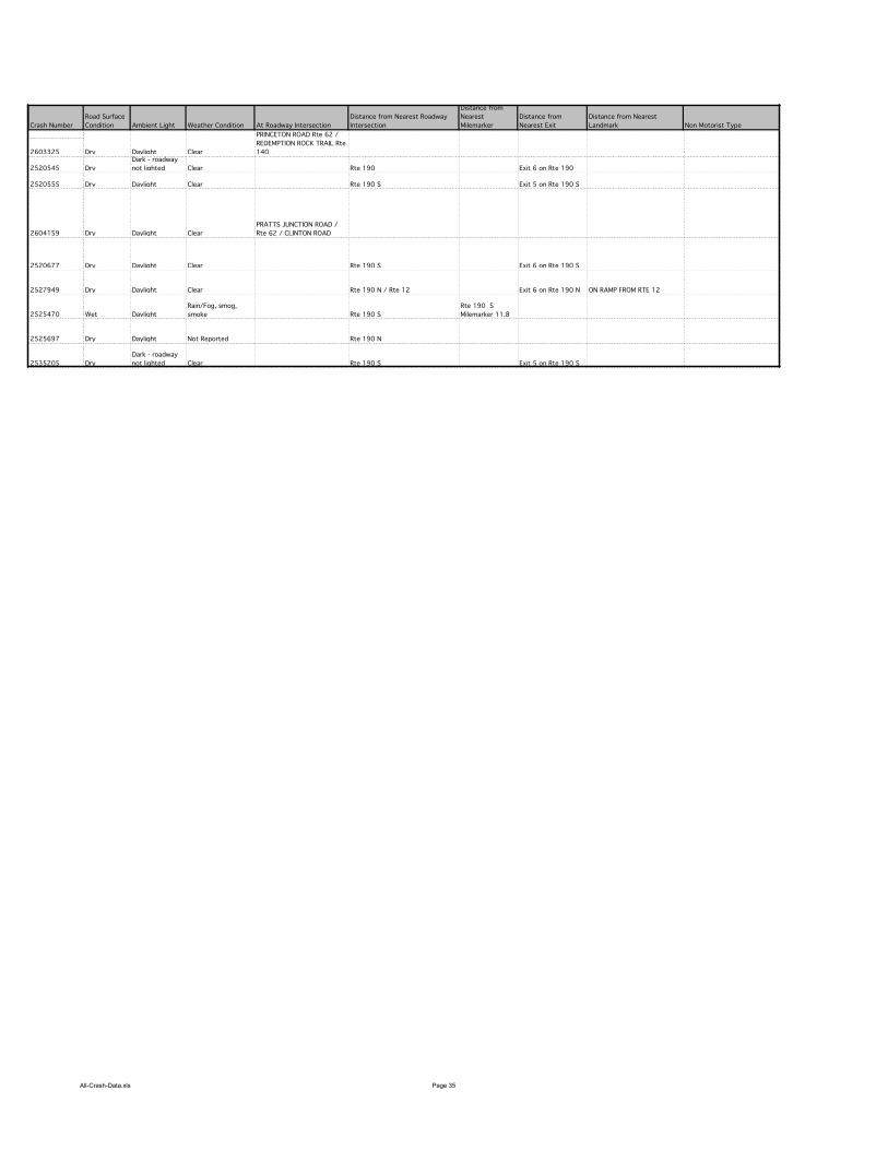
All-Crash-Data.xls Page 35
Crash Number
2603325
2520545
2520555
2604159
2520677
2527949
2525470
2525697
2535205
Road Surface
Condition Ambient Light Weather Condition At Roadway Intersection
Distance from Nearest Roadway
Intersection
Distance from
Nearest
Milemarker
Distance from
Nearest Exit
Distance from Nearest
Landmark Non Motorist Type
Dry Daylight Clear
PRINCETON ROAD Rte 62 /
REDEMPTION ROCK TRAIL Rte
140
Dry
Dark - roadway
not lighted Clear Rte 190 Exit 6 on Rte 190
Dry Daylight Clear Rte 190 S Exit 5 on Rte 190 S
Dry Daylight Clear
PRATTS JUNCTION ROAD /
Rte 62 / CLINTON ROAD
Dry Daylight Clear Rte 190 S Exit 6 on Rte 190 S
Dry Daylight Clear Rte 190 N / Rte 12 Exit 6 on Rte 190 N ON RAMP FROM RTE 12
Wet Daylight
Rain/Fog, smog,
smoke Rte 190 S
Rte 190 S
Milemarker 11.8
Dry Daylight Not Reported Rte 190 N
Dry
Dark - roadway
not lighted Clear Rte 190 S Exit 5 on Rte 190 S
All-Crash-Data.xls Page 36
Crash Number
2603325
2520545
2520555
2604159
2520677
2527949
2525470
2525697
2535205
X Coordinate Y Coordinate
174297.4842 909273.7498
179140.99 911572.5888
175697.0933 906435.8122
180169.317 912352.4489
179729.0369 912042.0914
177226.5868 909268.0293
175697.0933 906435.8122

Support Information for Using Year 2002 through 2009
MassDOT (formerly MassHighway) Crash Data Files As of 5/26/2011
Note: This document pertains only to year 2002 through year 2009 crash data. See the file named
Support_Information_10-02a for crash data for earlier years.
Crash data for years 2002 through 2009 are derived from the Registry of Motor Vehicles (RMV) Crash Data System (CDS). The RMV Division of MassDOT obtains crash reports from local police, State Police, other police agencies, and operators (motorists) who were involved in crashes, and enters the data into CDS. The reporting threshold is any crash involving an injury or fatality, or damage to any one vehicle or other personal property in excess of $1000. Crashes not on public ways are often, but not always, excluded. The RMV is dependent upon the cooperation of police agencies and the public in sending crash reports in a complete and timely fashion. The Highway Division of MassDOT has geocoded (where possible) the RMV crash data and makes the crash data files available upon request.
The year 2009 Statewide crash data contain 117,762 crashes, compared to 136,384 crashes in 2008, 144,510 crashes in 2007, 149,860 crashes in 2006, 158,084 crashes in 2005 and 138,635 crashes in 2004. The decrease in the total number of crashes in recent years is in part attributable to different reporting rates by different police jurisdictions, but also to the declining number of operator-only reports (reports submitted by motorists who are involved in crashes, for which no police report was submitted) that were entered in CDS by the RMV in recent years. An Excel file named 'Total Crashes by Town and Year1990-2009.xls' is available to show the differences in total crash reports by city/town from year to year. The chart on the next page shows that the number of operator-only reports that have been entered in the Registry's Crash Data System has been declining each year since 2005. This is not due to a decrease in the number of reports received, but is due to the number of reports that have actually been entered. In recent years not all operator reports that have been received have been entered. However, all police reports received (that have been determined by RMV to be reportable and valid) have been entered. For cities/towns where local police regularly report all motor vehicle crashes to the RMV, the effects of missing operator-only reports is minimal. However, for those cities/towns where local police do not routinely submit crash reports, or underreport crashes to RMV, the effects of missing operator-only reports in the database is significant when comparisons of crash data are made between years.
Page 2 of 7
Number of Crashes in Crash Data System by Year and Report Source
0
20,000
40,000
60,000
80,000
100,000
120,000
140,000
160,000
180,000
2003 2004 2005 2006 2007 2008 2009
Year
Nu
mb
er
of
Rep
ort
ed
Cra
sh
es in
Cra
sh
Data
Syste
m
Operator Only Reports
State police
Local police
As can be seen from the chart above, the total number of crashes reported by and entered from local and State police agencies has been reasonably consistent in recent years. However, due to limited data entry staff at RMV, there has been a significant decline in the number of operator-only reports entered by RMV within the past several years. It cannot be assumed that all operator-only reports are for property damage only crashes. In fact, approximately 25% of all crashes reported by operators and entered into the RMV Crash Data System were non-fatal injury crashes (which is nearly identical to the percentage of injury crashes reported by local police). On a Statewide level the percentage of reports that are property damage only has remained relatively constant in recent years (64.3% in 2009, 63.1% in 2008 and 62.2% in 2007) despite the declining number of operator reports that have been entered each year. However, this may not be the case in each city/town due to different levels of reporting by local police agencies. Cities/towns with the lowest rates of local police crash reporting in 2009 are shown in the table below (In some cases, actions are being taken to increase reporting in subsequent years):
NUMBER OF CRASHES REPORTED BY
CITY/TOWN Total
Crashes Operator-Only State Police Local Police MBTA Police
BARNSTABLE 202 120 78 4 0
BOSTON 4626 1523 2109 952 42
DUXBURY 76 28 46 2 0
SPRINGFIELD 561 132 421 8 0
WINCHENDON 24 23 0 1 0
BOXBOROUGH 31 8 23 0 0
Support Information for Using 2002-2009 MassDOT Crash Data Files 5/26/2011

Page 3 of 7
EASTHAMPTON 78 59 19 0 0
GROVELAND 9 9 0 0 0
LEE 31 13 18 0 0
WELLFLEET 15 15 0 0 0
WEST BRIDGEWATER 78 40 38 0 0
WHATELY 41 3 38 0 0
Some other cities/towns under-reported year 2009 crashes to a lesser degree. See the file named 'Police_Crosstabs_2002-2009 5-11-2011.xls' for further information on individual city/town crash data showing the percentages of crashes by source of report. The year 2009 crash data files from the Highway Division of MassDOT are in the same format as the year 2007 and 2008 files. X and Y coordinates are included in the last two columns in the data files but note that these columns have been excluded from the default print range. For year 2009 about 94% and for 2008 about 88% of the records have X and Y coordinates. However these are Statewide averages and do not apply to particular crash locations. Attempts have been made to prevent duplicate crashes from appearing in the crash data, however sometimes they occur. If the crash date, time and location are identical (or nearly identical), the crash may be a duplicate, but with a different crash number.
The data MassDOT Highway Division has supplied is in Microsoft Excel 2003 format. Sorting the data by location may be difficult because of the five different columns that may contain location data. Crash data are not completely standardized. Several different variations of a street name (or other field) may exist. Due to the format of the year 2002-2009 data, searching may be more useful than sorting. Search all five crash location columns for each occurrence of a street name. When selected records are found, they can be copied and pasted into another sheet in the same Workbook.
Explanation of columns and abbreviations in Excel Spreadsheets
A. Crash Number – Unique number used by Registry of Motor Vehicles to identify each
crash. Each crash could have several reports: police, operator(s), so this is the master record ID number. There is no relationship between this number and police department incident numbers.
B. City/Town Name – The city or town in which the crash occurred. If the crash was reported as occurring in a locality (neighborhood name) within the city or town, this is shown in parentheses after the proper city/town name. However if the crash was just reported as occurring in the city/town (rather than in a locality/neighborhood), then the locality name is not shown. Therefore, searching/sorting by locality name will not identify all crashes that actually occurred in that locality.
C. Crash Date – Date of the Crash D. Crash Time - Time of Crash E. Crash Severity – Type of Crash
! Fatal injury
! Non-fatal injury
Support Information for Using 2002-2009 MassDOT Crash Data Files 5/26/2011

Page 4 of 7
! Property damage only (none injured)
! Not Reported
! Unknown F. Number of Vehicles – Total number of vehicles involved in the crash G. Total Nonfatal Injuries - Number of persons injured in the crash excluding fatalities H. Total Fatal Injuries - Number of persons killed in the crash I. Manner of Collision - Manner of Collision or Collision Type
! Angle
! Head-on
! Rear-end
! Rear-to-Rear
! Sideswipe, opposite direction
! Sideswipe, same direction
! Single vehicle crash
! Unknown
! Not reported J. Vehicle Action Prior to Crash – The action that each vehicle was taking prior to the
crash; V1 = Vehicle 1, V2 = Vehicle 2, etc.
! Travelling straight ahead
! Slowing or stopped in traffic
! Turning right
! Turning left
! Changing lanes
! Entering traffic lane
! Leaving traffic lane
! Making U-turn
! Overtaking/passing
! Backing
! Parked
! Other
! Not reported
! Unknown K. Vehicle Travel Directions – Direction that each vehicle was traveling at time of the
crash; V1 = Vehicle 1, V2 = Vehicle 2, etc. L. Most Harmful Events – Most harmful event for each vehicle. Only reported if the
source of data was from a police report. Not reported if the only source of data was
from an operator report.
! Collision with motor vehicle in traffic
! Collision with parked motor vehicle
! Collision with pedestrian
! Collision with cyclist (bicycle, tricycle, unicycle)
! Collision with animal – deer
! Collision with animal – other
! Collision with moped
! Collision with workzone maintenance equipment
Support Information for Using 2002-2009 MassDOT Crash Data Files 5/26/2011

Page 5 of 7
! Collision with railway vehicle (train, engine)
! Collision with other movable object
! Collision with curb
! Collision with tree
! Collision with utility pole
! Collision with light pole or other post/support
! Collision with guardrail
! Collision with median barrier
! Collision with ditch
! Collision with embankment
! Collision with highway traffic sign post
! Collision with overhead sign support
! Collision with fence
! Collision with mailbox
! Collision with impact attenuator/crash cushion
! Collision with bridge
! Collision with bridge overhead structure
! Collision with other fixed object (wall, building, tunnel)
! Collision with unknown fixed object
! Overturn/rollover
! Fire/explosion
! Immersion
! Jackknife
! Cargo/equipment loss or shift
! Other
! Other non-collision
! Unknown non-collision
! Unknown
! Reported but invalid
M. Vehicle Configuration – The type of each vehicle involved in the crash
! Passenger car
! Light truck (Van, mini-van, pick-up, sport utility)
! Motorcycle
! Bus (with seats for more than 15 people, including driver)
! Bus (with seats for 7-15 people, including driver)
! Single unit truck (2 axles, 6 tires)
! Single unit truck (3 or more axles)
! Truck/trailer
! Truck tractor (Bobtail)
! Tractor/semi-trailer
! Tractor/doubles
! Tractor/triples
! Unknown heavy truck
! Motor home/recreational
Support Information for Using 2002-2009 MassDOT Crash Data Files 5/26/2011
Page 6 of 7
! Other
! Unknown N. Road Surface Condition –The condition of the road’s surface at the time of the crash
! Dry
! Wet
! Snow
! Ice
! Sand, mud, dirt, oil, gravel
! Water (standing, moving)
! Slush
! Other
! Unknown O. Ambient Light – Light conditions
! Daylight
! Dawn
! Dusk
! Dark – lighted roadway
! Dark – roadway not lighted
! Dark – unknown roadway lighting
! Other
! Unknown P. Weather Condition – A maximum of two weather conditions may be reported
! Clear
! Cloudy
! Rain
! Snow
! Sleet, hail, freezing rain
! Fog, smog, smoke
! Severe crosswinds
! Blowing sand, snow
! Other
! Unknown Q. At Roadway Intersection – If crash location information was entered in the AT
INTERSECTION side of the report, the route numbers and/or roadway names will appear in this column. The route/roadway where the crash occurred will appear first, followed by a slash (/), followed by up to two combinations of routes and/or roadway names.
R. Distance from Nearest Roadway Intersection – If crash location information was entered in the NOT AT INTERSECTION side of the report, and if the crash was referenced as occurring at some distance and direction from the nearest intersecting street, the crash location information will appear in this column. However, sometimes only a route and/or roadway name will appear, or other information such as address numbers may appear in this column.
S. Distance from Nearest Milemarker – If crash location information was entered in the NOT AT INTERSECTION side of the report, and if the crash was referenced as occurring at some distance and direction from the nearest milemarker, the crash
Support Information for Using 2002-2009 MassDOT Crash Data Files 5/26/2011

Page 7 of 7
location information will appear in this column. However, sometimes only a route and/or roadway name will appear, or other information may appear in this column.
T. Distance from Nearest Exit – If crash location information was entered in the NOT AT INTERSECTION side of the report, and if the crash was referenced as occurring at some distance and direction from the exit or interchange, the crash location information will appear in this column. However, sometimes only a route number or other information may appear in this column.
U. Address/Distance from Nearest Landmark – If crash location information was entered in the NOT AT INTERSECTION side of the report, and if the crash was referenced as occurring at a street address or at a landmark, or at some distance and direction from them, the crash location information will appear in this column. However, sometimes only a roadway name, route number, or other information may appear in this column. There may be some data in this column that duplicates data in other crash location columns. Landmark text is limited to a maximum of 32 characters (the portion enclosed by parentheses). Beginning with year 2006 data, address information was eliminated from this column because it usually duplicated information that was already contained in column "P."
V. Non Motorist Type – For any Non Motorists that were reported as being involved in the crash, the Person Number (P1, P2, etc.) of the Non Motorist is shown, followed by that person's role: Pedestrian, Pedalcyclist (bicycle, tricycle, unicycle, pedal car), Skater, Railroad or Trolley Passenger, or Other non-motorist (wheelchair, etc.).
Crash location data as described above will only be shown in the format described above if it was correctly entered by police or operators and/or RMV. Offset and/or direction of offset may be missing, or the nearest intersecting street/milemarker/exit number may be missing. Shown are X and Y coordinates for crashes that have been geocoded (located
to a point) by the MassDOT Highway Division GIS (Geographic Information System) crash geocoding application. Coordinates are shown only for crashes that were successfully geocoded to a point or to an approximate point based on available crash location data. Users should be aware that for many crashes (especially ones located at or near an exit, highway interchange, rotary, etc.) these coordinates are only approximate, depending on the quality of the source crash location data. Crashes referenced by an exit number or interchange may in fact actually have occurred some distance from that exit or interchange. Coordinates are in Massachusetts Mainland State Plane NAD 83 meters. The X and Y coordinate columns have been excluded from the default print range in order to keep the font size of printed report pages reasonably legible.
W, X.
Support Information for Using 2002-2009 MassDOT Crash Data Files 5/26/2011

APPENDIX F
EXISTING
PAVEMENT
CROSS-SECTION !

APPENDIX G
ESAL CALCULATION
SPREADSHEET

Box 1SB on MA-140Lane 1
11:48 AM 0 28 3 0 2 0 0 1 0 0 0 0 0 2 3612:03 PM 0 38 2 1 2 0 0 1 0 0 0 0 0 0 4412:18 PM 0 24 6 3 0 1 0 0 0 0 0 0 0 1 3512:33 PM 0 27 9 0 0 0 0 1 0 0 0 0 0 2 3912:48 PM 0 28 2 0 1 0 0 1 0 0 0 0 0 2 341:03 PM 0 28 5 0 1 0 0 0 1 0 0 0 0 0 351:18 PM 0 29 8 1 1 0 0 0 0 0 0 0 0 0 391:33 PM 0 26 7 2 1 0 0 0 1 0 0 0 0 0 371:48 PM 1 33 6 0 1 2 0 0 1 0 0 0 0 2 462:03 PM 0 41 11 1 2 0 1 0 0 0 0 0 1 0 572:18 PM 1 30 8 0 1 0 0 0 1 0 0 0 0 1 422:33 PM 4 25 7 0 0 2 0 0 0 0 0 0 2 5 452:48 PM 1 27 5 0 1 1 0 0 0 0 0 0 1 3 393:03 PM 5 13 1 0 1 2 0 0 0 0 0 0 1 11 343:18 PM 1 23 3 0 0 7 0 0 0 0 0 0 1 12 473:33 PM 4 17 0 0 0 3 0 0 0 0 0 0 2 15 413:48 PM 3 24 2 0 0 1 0 0 0 0 0 0 1 11 424:03 PM 1 32 1 0 1 1 0 0 1 0 0 0 0 18 554:18 PM 5 24 1 0 1 3 0 0 0 0 0 0 1 11 464:33 PM 2 29 6 0 1 3 0 0 0 0 0 0 1 8 504:48 PM 2 19 4 0 0 2 0 0 0 0 0 0 0 14 415:03 PM 0 26 8 0 1 5 0 0 0 0 0 0 0 19 595:18 PM 3 24 4 0 1 4 0 0 0 0 0 0 1 15 525:33 PM 1 34 8 0 0 5 0 0 0 0 0 0 0 16 645:48 PM 2 28 8 0 0 3 0 0 0 0 0 0 0 18 596:03 PM 4 26 1 0 2 8 0 0 0 0 0 0 1 22 646:18 PM 2 20 7 0 0 4 0 0 0 0 0 0 0 21 546:33 PM 3 25 5 0 0 4 0 0 0 0 0 0 2 16 556:48 PM 0 15 4 0 0 1 0 0 0 0 0 0 0 15 357:03 PM 2 17 2 0 0 2 0 0 0 0 0 0 0 17 407:18 PM 3 17 5 0 0 1 0 0 0 0 0 0 0 7 337:33 PM 1 9 4 0 0 2 0 0 0 0 0 0 0 7 237:48 PM 0 7 0 0 0 0 0 0 0 0 0 0 0 13 208:03 PM 2 16 1 0 0 3 0 0 0 0 0 0 0 5 278:18 PM 1 15 2 0 0 1 0 1 0 0 0 0 0 6 268:33 PM 1 15 0 0 0 1 0 0 0 0 0 0 0 8 258:48 PM 1 9 3 0 0 1 0 0 0 0 0 0 0 3 179:03 PM 0 6 1 0 0 1 0 0 0 0 0 0 0 3 119:18 PM 0 5 1 0 0 0 0 0 0 0 0 0 0 6 129:33 PM 3 7 2 0 0 2 0 0 0 0 0 0 0 0 149:48 PM 1 5 4 0 0 0 0 0 0 0 0 0 0 7 17
10:03 PM 0 6 2 0 0 1 0 0 0 0 0 0 0 5 1410:18 PM 0 6 1 0 0 2 0 0 0 0 0 0 0 9 1810:33 PM 1 9 0 0 0 2 0 0 0 0 0 0 0 3 1510:48 PM 0 4 0 0 0 2 0 0 0 0 0 0 0 4 1011:03 PM 1 4 0 0 0 0 0 0 0 0 0 0 0 3 811:18 PM 0 4 0 0 1 3 0 0 0 0 0 0 0 1 911:33 PM 1 3 0 0 0 1 0 0 0 0 0 0 0 0 511:48 PM 1 4 1 0 0 0 0 0 0 0 0 0 0 2 8
12/16/2015 0 1 1 0 0 1 0 0 0 0 0 0 0 2 512:18 AM 0 2 1 0 0 0 0 0 0 0 0 0 0 1 412:33 AM 0 2 0 0 0 0 0 0 0 0 0 0 0 1 312:48 AM 0 0 0 0 0 0 0 0 0 0 0 0 0 0 01:03 AM 0 3 0 0 0 0 0 0 0 0 0 0 0 0 31:18 AM 0 1 0 0 0 0 0 0 0 0 0 0 0 1 21:33 AM 0 1 1 0 0 0 0 0 0 0 0 0 0 1 31:48 AM 0 1 0 0 0 0 0 0 0 0 0 0 0 0 12:03 AM 0 1 0 0 0 0 0 0 0 0 0 0 0 0 12:18 AM 0 0 0 0 0 0 0 0 0 0 0 0 0 0 02:33 AM 0 0 0 0 0 0 0 0 0 0 0 0 0 0 02:48 AM 0 3 0 0 0 2 0 0 0 0 0 0 0 0 53:03 AM 0 1 0 0 0 0 0 0 0 0 0 0 0 0 13:18 AM 0 0 0 0 0 0 0 0 0 0 0 0 0 2 23:33 AM 0 1 0 0 0 0 0 0 0 0 0 0 0 0 13:48 AM 0 2 0 0 0 0 0 0 0 0 0 0 0 0 24:03 AM 1 2 0 0 0 0 0 0 0 0 0 0 0 1 44:18 AM 0 2 1 0 0 0 0 0 0 0 0 0 0 0 34:33 AM 0 1 1 0 0 0 0 0 0 0 0 0 0 0 2
4:48 AM 1 1 1 0 0 0 0 0 0 0 0 0 0 2 55:03 AM 1 2 0 0 0 0 0 0 0 0 0 0 0 4 75:18 AM 1 2 0 0 0 0 0 0 0 0 0 0 0 0 35:33 AM 1 5 2 0 0 1 0 0 0 0 0 0 0 3 125:48 AM 1 7 1 0 0 2 0 0 0 0 0 0 0 5 166:03 AM 0 11 4 0 0 1 0 0 0 0 0 0 0 7 236:18 AM 4 25 4 0 1 4 0 0 0 0 0 0 0 10 486:33 AM 4 23 8 0 1 2 0 0 0 0 0 0 0 5 436:48 AM 6 30 5 0 1 3 0 0 0 0 0 0 0 6 517:03 AM 5 32 10 0 1 2 0 0 0 0 0 0 1 14 657:18 AM 2 58 15 0 1 9 0 0 0 0 0 0 0 20 1057:33 AM 14 52 13 0 0 7 0 0 0 0 0 0 0 24 1107:48 AM 9 55 12 1 2 7 0 0 0 0 0 0 0 14 1008:03 AM 9 47 7 0 1 7 0 0 0 0 0 0 0 21 928:18 AM 7 63 14 0 0 11 0 0 0 1 0 0 0 19 1158:33 AM 10 66 12 1 1 7 0 0 0 1 0 0 0 22 1208:48 AM 11 76 6 0 0 3 0 0 0 0 0 1 1 26 1249:03 AM 4 53 6 1 0 5 0 0 0 0 0 0 2 23 949:18 AM 3 53 5 0 0 6 0 0 0 1 0 0 2 24 949:33 AM 8 42 5 0 1 2 0 0 0 0 0 0 0 19 779:48 AM 2 33 12 0 2 9 0 0 0 0 0 0 1 13 72
10:03 AM 3 19 3 0 0 1 0 0 0 0 0 0 0 12 3810:18 AM 5 25 6 0 0 3 0 0 0 0 0 0 3 9 5110:33 AM 1 24 8 0 1 3 0 0 0 0 0 0 0 14 5110:48 AM 8 26 4 0 1 3 0 0 0 0 0 0 0 12 5411:03 AM 2 25 2 0 1 1 0 0 0 0 0 0 1 12 4411:18 AM 2 18 5 0 1 3 0 0 0 0 0 0 0 6 3511:33 AM 0 18 7 0 0 1 0 0 0 0 0 0 0 13 39
Total 189 1846 353 11 38 193 1 5 5 3 0 1 26 737 3408 2671Percentage 0.07076001 0.69112692 0.13216024 0.00411831 0.01422688 0.07225758 0.00037439 0.00187196 0.00187196 0.00112317 0 0.00037439 0.00973418Weighted addition from unclassified vehicle category 52.150131 509.360539 97.4020966 3.03519281 10.4852115 53.2538375 0.27592662 1.3796331 1.3796331 0.82777986 0 0.27592662 7.1740921
Adjusted Total 241.150131 2355.36054 450.402097 14.0351928 48.4852115 246.253838 1.27592662 6.3796331 6.3796331 3.82777986 0 1.27592662 33.1740921 3408
Lane 211:48 AM 0 5 4 1 0 0 0 0 0 0 0 0 0 1 1112:03 PM 1 3 2 0 1 0 0 0 0 0 0 0 0 1 812:18 PM 1 3 3 1 0 0 0 0 0 0 0 0 0 0 812:33 PM 1 3 2 1 0 0 0 0 0 0 0 0 0 0 712:48 PM 0 10 3 0 3 0 0 0 0 0 0 0 0 2 181:03 PM 3 6 3 0 1 0 0 0 0 0 0 0 0 0 131:18 PM 0 8 3 0 1 0 0 0 0 0 0 0 0 0 121:33 PM 1 3 0 0 2 0 0 0 0 0 0 0 0 4 101:48 PM 1 7 1 0 0 0 0 0 0 0 0 0 1 3 132:03 PM 2 6 2 0 1 0 0 0 0 0 0 0 0 3 142:18 PM 1 5 3 1 0 0 0 0 0 0 0 0 0 0 102:33 PM 0 0 1 1 1 0 0 0 1 0 0 0 0 4 82:48 PM 0 10 3 0 2 0 0 0 0 0 0 0 0 3 183:03 PM 1 1 0 2 0 0 0 1 0 0 0 0 0 14 193:18 PM 1 2 0 1 1 1 0 0 0 0 0 0 0 13 193:33 PM 1 0 1 0 2 0 0 0 0 0 0 0 0 11 153:48 PM 1 8 1 0 1 0 0 0 0 0 0 0 0 8 194:03 PM 0 1 1 1 0 0 0 0 0 0 0 0 0 4 74:18 PM 3 9 2 0 2 0 0 0 0 0 0 0 0 2 184:33 PM 1 6 0 0 3 0 0 0 0 0 0 0 0 9 194:48 PM 2 2 4 1 0 0 0 0 0 0 0 0 0 10 195:03 PM 2 4 2 0 0 0 0 0 0 0 0 0 0 8 165:18 PM 0 4 3 1 0 0 0 0 0 0 0 0 0 11 195:33 PM 0 7 2 2 1 0 0 0 0 0 0 0 0 13 255:48 PM 1 5 2 0 0 0 0 0 0 0 0 0 0 5 136:03 PM 0 7 1 1 0 0 0 0 0 0 0 0 1 11 216:18 PM 1 1 0 0 1 0 0 0 0 0 0 0 0 12 156:33 PM 1 5 1 0 0 1 0 0 0 0 0 0 0 5 136:48 PM 3 15 1 1 2 0 0 0 0 0 0 0 0 5 27

7:03 PM 1 2 1 0 2 0 0 0 0 0 0 0 0 9 157:18 PM 3 0 0 0 1 0 0 0 0 0 0 0 1 3 87:33 PM 3 4 3 0 0 0 0 0 0 0 0 0 0 9 197:48 PM 0 1 1 0 1 0 0 0 0 0 0 0 0 10 138:03 PM 0 0 0 0 0 0 0 1 0 0 0 0 0 4 58:18 PM 0 0 0 0 0 0 0 0 0 0 0 0 1 4 58:33 PM 1 2 1 1 1 0 0 0 0 0 0 0 0 1 78:48 PM 0 2 2 0 0 0 0 0 0 0 0 0 0 1 59:03 PM 1 1 1 1 1 0 0 0 0 0 0 0 0 1 69:18 PM 0 1 0 1 0 0 0 0 0 0 0 0 0 3 59:33 PM 0 0 1 0 0 0 0 0 0 0 0 0 0 1 29:48 PM 0 2 1 0 0 0 0 0 0 0 0 0 0 0 310:03 PM 0 1 0 0 0 0 0 0 0 0 0 0 0 3 410:18 PM 0 0 0 0 0 0 0 0 0 0 0 0 0 0 010:33 PM 0 0 0 0 0 0 0 0 0 0 0 0 0 0 010:48 PM 0 1 0 0 0 0 0 0 0 0 0 0 0 7 811:03 PM 0 1 0 0 0 0 0 0 0 0 0 0 0 1 211:18 PM 0 1 0 0 2 0 0 0 0 0 0 0 0 1 411:33 PM 1 1 0 1 0 0 0 0 0 0 0 0 0 2 511:48 PM 0 1 0 0 0 0 0 0 0 0 0 0 0 0 1
12/16/2015 0 1 0 0 0 0 0 0 0 0 0 0 0 1 212:18 AM 0 0 0 0 0 0 0 0 0 0 0 0 0 0 012:33 AM 0 1 1 0 1 0 0 0 0 0 0 0 0 0 312:48 AM 0 1 0 0 0 0 0 0 0 0 0 0 0 1 21:03 AM 1 1 0 0 0 0 0 0 0 0 0 0 0 2 41:18 AM 0 0 0 0 0 0 0 0 0 0 0 0 0 0 01:33 AM 0 0 0 0 0 0 0 0 0 0 0 0 0 0 01:48 AM 0 0 0 0 0 0 0 0 0 0 0 0 0 1 12:03 AM 0 0 0 0 0 0 0 0 0 0 0 0 0 0 02:18 AM 0 1 0 1 0 0 0 0 0 0 0 0 0 0 22:33 AM 0 0 0 0 0 0 0 0 0 0 0 0 0 0 02:48 AM 0 0 0 0 1 0 0 0 0 0 0 0 0 0 13:03 AM 0 0 0 0 0 0 0 0 0 0 0 0 0 0 03:18 AM 0 0 0 0 0 0 0 0 0 0 0 0 0 0 03:33 AM 0 0 1 0 0 0 0 0 0 0 0 0 0 0 13:48 AM 0 0 0 0 0 0 0 0 0 0 0 0 0 0 04:03 AM 0 1 0 0 0 0 0 0 0 0 0 0 0 0 14:18 AM 1 1 1 0 0 0 0 0 0 0 0 0 0 0 34:33 AM 0 0 0 0 1 0 0 0 0 0 0 0 0 0 14:48 AM 0 0 0 0 0 0 0 0 0 0 0 0 0 5 55:03 AM 0 2 0 1 0 0 0 0 0 0 0 0 0 3 65:18 AM 0 0 2 0 0 0 0 0 1 0 0 0 0 2 55:33 AM 0 0 0 0 0 0 0 0 0 0 0 0 0 4 45:48 AM 0 0 1 0 1 0 0 0 0 0 0 0 0 1 36:03 AM 2 3 0 0 1 0 0 0 0 0 0 0 0 2 86:18 AM 0 2 0 0 0 0 0 0 0 0 0 0 0 8 106:33 AM 0 5 2 1 0 0 0 0 0 0 0 0 0 5 136:48 AM 0 8 4 0 0 0 0 0 0 0 0 0 0 4 167:03 AM 3 9 3 0 0 0 0 0 0 0 0 0 0 8 237:18 AM 2 6 2 1 0 1 0 0 0 0 0 0 0 13 257:33 AM 2 6 4 0 3 0 0 0 0 0 0 0 0 13 287:48 AM 0 12 4 1 0 0 0 0 0 0 0 0 0 12 298:03 AM 1 6 2 0 1 0 0 0 0 0 0 0 0 17 278:18 AM 1 8 2 1 1 0 0 0 0 0 0 0 0 19 328:33 AM 0 8 5 0 1 0 0 0 0 0 0 0 0 16 308:48 AM 0 2 0 0 1 0 0 0 0 0 0 0 0 18 219:03 AM 0 10 4 0 0 0 0 0 0 0 0 0 0 12 269:18 AM 0 5 1 0 0 0 0 0 0 0 0 0 0 18 249:33 AM 0 6 1 0 1 1 0 0 0 0 0 0 0 18 279:48 AM 1 3 3 2 1 1 0 0 0 0 0 0 0 10 21
10:03 AM 0 3 3 0 1 0 0 0 0 0 0 0 0 12 1910:18 AM 2 10 1 1 1 0 0 0 0 0 0 0 0 1 1610:33 AM 0 3 2 0 2 0 0 0 0 0 0 0 0 9 1610:48 AM 0 6 1 0 1 0 0 0 0 0 0 0 0 2 1011:03 AM 1 4 1 1 2 0 0 0 0 0 0 0 0 9 1811:18 AM 2 6 1 1 1 1 0 0 0 0 0 0 0 2 1411:33 AM 1 1 0 0 2 0 0 0 0 0 0 0 0 6 10
Total 59 308 114 30 57 6 0 2 2 0 0 0 4 476 1058 582Percentage 0.10137457 0.52920962 0.19587629 0.05154639 0.09793814 0.01030928 0 0.00343643 0.00343643 0 0 0 0.00687285Weighted addition from unclassified vehicle category 48.2542955 251.90378 93.2371134 24.5360825 46.6185567 4.90721649 0 1.63573883 1.63573883 0 0 0 3.27147766
Adjusted Total 107.254296 559.90378 207.237113 54.5360825 103.618557 10.9072165 0 3.63573883 3.63573883 0 0 0 7.27147766 1058
Box 2NB on MA-140Lane 1
12:47 PM 2 109 17 1 3 0 0 2 0 0 0 0 0 2 1361:47 PM 1 108 19 3 3 0 0 1 1 0 0 0 1 0 1372:47 PM 1 149 25 2 2 2 0 2 2 0 0 0 0 2 1873:47 PM 0 186 28 1 4 1 0 0 1 0 0 0 0 1 2224:47 PM 12 189 32 1 3 6 0 0 2 0 0 0 0 41 2865:47 PM 17 213 14 0 0 18 3 0 0 0 0 0 4 114 3836:47 PM 26 243 18 0 1 11 0 0 2 2 0 0 5 79 3877:47 PM 18 243 6 0 0 7 0 0 1 0 0 0 2 49 3268:47 PM 18 136 5 0 0 1 0 0 0 0 0 0 0 24 1849:47 PM 7 113 1 0 0 3 0 0 0 0 0 0 0 2 126
10:47 PM 10 86 2 0 0 4 0 0 0 0 0 0 0 10 11211:47 PM 8 61 4 0 0 2 0 1 0 0 0 0 0 11 87
12/16/2015 8 52 3 0 0 1 1 0 0 0 0 0 0 5 701:47 AM 1 26 0 0 0 0 0 0 0 0 0 0 0 3 302:47 AM 0 12 0 0 0 1 0 0 0 0 0 0 0 3 163:47 AM 0 5 0 0 0 0 0 0 0 0 0 0 0 3 84:47 AM 2 4 0 0 0 0 0 0 0 0 0 0 0 2 85:47 AM 1 3 1 0 0 1 0 0 0 0 0 0 0 1 76:47 AM 0 17 2 0 0 2 0 0 0 0 0 0 0 1 227:47 AM 3 39 6 0 1 2 0 0 1 0 0 0 0 1 538:47 AM 14 107 10 0 2 7 0 0 0 0 0 0 0 8 1489:47 AM 12 105 6 0 1 5 0 0 1 1 0 0 0 4 135
10:47 AM 11 87 9 0 2 2 0 0 1 0 0 0 0 7 11911:47 AM 10 61 8 0 2 6 0 0 0 0 0 0 0 13 100
Total 182 2354 216 8 24 82 4 6 12 3 0 0 12 386 3289 2903Percentage 0.06269377 0.81088529 0.07440579 0.00275577 0.00826731 0.02824664 0.00137788 0.00206683 0.00413365 0.00103341 0 0 0.00413365Weighted addition from unclassified vehicle category 24.1997933 313.001722 28.7206338 1.06372718 3.19118154 10.9032036 0.53186359 0.79779538 1.59559077 0.39889769 0 0 1.59559077
Adjusted Total 206.199793 2667.00172 244.720634 9.06372718 27.1911815 92.9032036 4.53186359 6.79779538 13.5955908 3.39889769 0 0 13.5955908 3289
Lane 2 12:47 PM 0 43 12 1 5 0 0 0 0 0 0 0 0 6 671:47 PM 1 51 16 1 4 0 0 1 1 0 0 0 0 5 802:47 PM 1 54 8 2 2 2 0 1 0 0 0 0 0 7 773:47 PM 0 74 16 2 3 1 0 0 0 0 0 0 0 13 1094:47 PM 3 93 26 3 17 1 0 7 2 0 0 0 8 33 1935:47 PM 5 73 19 1 8 2 1 8 0 0 0 0 15 39 1716:47 PM 1 50 8 0 3 0 0 4 0 0 0 0 15 19 1007:47 PM 2 86 13 0 7 1 0 4 0 0 0 0 15 42 1708:47 PM 5 123 29 0 16 0 0 5 0 0 0 0 5 27 2109:47 PM 1 117 21 1 18 2 0 2 0 1 0 0 1 19 183
10:47 PM 6 82 11 1 6 1 0 0 0 0 0 0 0 28 13511:47 PM 2 54 7 1 15 0 0 1 0 0 0 0 1 15 96
12/16/2015 12 45 5 0 8 1 0 0 0 0 0 0 0 13 841:47 AM 3 11 3 1 2 0 0 0 0 0 0 0 0 14 342:47 AM 1 16 1 0 3 0 0 1 0 0 0 0 0 2 243:47 AM 0 7 1 1 1 0 0 0 0 0 0 0 0 0 104:47 AM 0 4 0 0 5 0 0 0 0 0 0 0 0 2 115:47 AM 1 7 0 0 3 0 0 0 1 0 0 0 0 0 12
6:47 AM 8 6 1 0 3 2 0 0 0 1 0 0 0 2 237:47 AM 3 37 6 0 8 2 1 1 0 0 0 0 0 5 638:47 AM 8 59 16 5 11 3 0 1 0 0 0 0 2 25 1309:47 AM 12 73 21 5 8 5 0 4 1 0 0 0 2 13 144
10:47 AM 19 54 17 3 12 3 0 2 2 0 0 0 1 21 13411:47 AM 6 56 10 5 27 1 0 0 2 0 0 0 2 20 129
Total 100 1275 267 33 195 27 2 42 9 2 0 0 67 370 2389 2019Percentage 0.04952947 0.63150074 0.13224368 0.01634473 0.09658247 0.01337296 0.00099059 0.02080238 0.00445765 0.00099059 0 0 0.03318474Weighted addition from unclassified vehicle category 18.3259039 233.655275 48.9301634 6.04754829 35.7355126 4.94799406 0.36651808 7.69687964 1.64933135 0.36651808 0 0 12.2783556
Adjusted Total 118.325904 1508.65527 315.930163 39.0475483 230.735513 31.9479941 2.36651808 49.6968796 10.6493314 2.36651808 0 0 79.2783556 2389
TOTAL 672.930124 7090.92132 1218.29001 116.682551 410.030462 382.012252 8.17430829 66.510047 34.260294 9.59319563 0 1.27592662 133.319516 10144
MEF adjusted 666.200823 7020.0121 1206.10711 115.515725 405.930158 378.192129 8.0925652 65.8449465 33.9176911 9.49726367 0 1.26316735 131.986321 10042.56
Growth adjusted Design Volume 6575135.64 69284711.5 11903794.7 1140094 4006368.29 3732605.04 79870.3815 649863.284 334754.044 93734.1935 0 12466.9565 1302652.19 271550.822
ESAL Factor 0 0 0 0.57 0.26 0.42 0.42 0.3 1.2 0.93 0.82 1.06 1.39
Design ESAL 0 0 0 649853.581 1041655.75 1567694.12 33545.5602 194958.985 401704.853 87172.8 0 13214.9739 1810686.55 5800487.17
Directional Split 50%
Design ESAL 2900243.59