Embed Size (px)
Citation preview
1
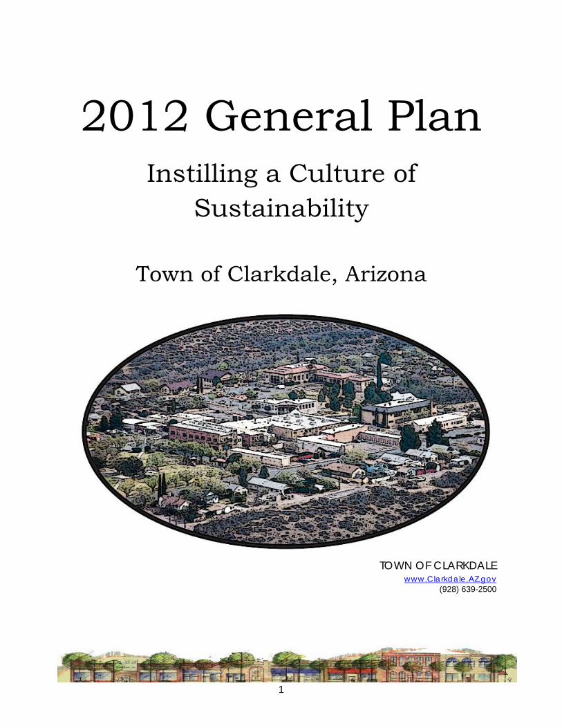
2012 General Plan Instilling a Culture of
Sustainability
Town of Clarkdale, Arizona
TOWN OF CLARKDALE www.Clarkdale.AZ.gov
(928) 639-2500

DOCUMENT MAINTENANCE LOG CLARKDALE GENERAL PLAN
2
DOCUMENT MAINTENANCE LOG DATE ACTION
September 20, 2011 Public Hearing Planning Commission unanimously recommended General Plan Update to Council General Plan Update year changed to 2012 to reflect year of targeted voter ratification
October 11, 2011 Public Hearing Council adopted this plan with the following updates: Add former Planning Commission member names to
the Acknowledgements Add an action to the Open Space Implementation
Strategies as follows: “Continue the Town’s support for intergovernmental and other agreements that support these policies.”

ACKNOWLEDGMENTS CLARKDALE GENERAL PLAN
3
ACKNOWLEDGMENTS
The Town staff would like to thank the General Plan Update Committee, the Planning Commission, the Town Council, and the many participants of the Focus Groups for their endless hours, their counsel and their great understanding. This has been the development of a General Plan, totally unique to Clarkdale reflecting the public’s image of where the Town can go.
GENERAL PLAN UPDATE COMMITTEE
Janet Regner – Chair Lew Dodendorf – Vice-Chair Ida deBlanc Karen Daniels Lisa O’Neill Jack Van Wye Ruth Wicks
CLARKDALE’S TOWN COUNCIL Doug Von Gausig – Mayor Richard Dehnert – Vice-Mayor Curt Bohall Bill Regner Pat Williams
PLANNING COMMISSION Jorge Olguin – Chair Jack Van Wye – Vice Chair Karen Daniels Dave Puzas Vic Viarengo
FORMER COMMISSIONERS Amy Bayless Robyn Prud’homme-Bauer Bill Regner Sarah Vinson
FOCUS GROUP MEMBERS Ellie Bauer Howard Beck Bethany Bezdek Winifred Bohall Max Castillo Maria Contreras Karen Daniels Lee Daniels Kathy Davis Peter deBlanc Krysta Dehnert Lew Dodendorf Randall Garrison Sally Hess-Samuelson Carol Johnson Sharon Kim Darrel Macey Lisa O’Neill
FOCUS GROUP MEMBERS Robyn Prud’homme-Bauer Bill Regner Janet Regner Pastor Larry Rollin Maya Radoccia Frank Sa Elaine Sakelarius Christine Schwab Charles Sculley Clair F. Smith Josh Stackhouse Ruth Wicks Jerry Wiley Pat Wiley Walter Wagner Walter Warren Sean Watson Barbara Van Wye Linda Zanolli

ACKNOWLEDGMENTS CLARKDALE GENERAL PLAN
4
TOWN STAFF Gayle Mabery - Town Manager Sherry Bailey – Community Development Director Kathy Bainbridge – Town Clark & Finance Director Wayne Debrosky – Utilities & Public Works Director Guss Espolt – GIS Jodie Filardo – Community & Economic Development Director Paul Grasso – Building Official Pat Haynie – Chief of Police Vicki McReynolds – Administrative Support Joe Moore – Chief, Clarkdale Fire Department Dawn Norman – Parks & Recreation Janet Perry – Community Services Director

TABLE OF CONTENTS CLARKDALE GENERAL PLAN
5
TABLE OF CONTENTS DOCUMENT MAINTENANCE LOG ............................................................................................... 2
ACKNOWLEDGMENTS ...................................................................................................................... 3
Chapter 1 INTRODUCTION ............................................................................................................. 10
WHY DOES CLARKDALE HAVE A GENERAL PLAN? .............................................................. 10
CHAPTER CONSISTENCY ......................................................................................................... 10
HONORING OUR PAST AND PLANNING OUR FUTURE ......................................................... 11
PUBLIC PARTICIPATION PROCESS ........................................................................................... 11
GENERAL PLAN REVISION PROCESS ...................................................................................... 12
MAJOR AND MINOR AMENDMENTS ..................................................................................... 12
Major Amendment ............................................................................................................. 13
Minor Amendment .............................................................................................................. 13
THE COMMUNITY VISION PROGRAM .................................................................................... 13
2001 MAJOR THEMES: A Shared Vision for Clarkdale’s Future ......................................... 14
GENERAL ISSUES FOR CLARKDALE......................................................................................... 14
BUILDING ON THE VISION ....................................................................................................... 15
Where are we now? .................................................................................................................. 15
Where are we going? ................................................................................................................ 16
Where do we want to be? ........................................................................................................ 16
How do we get there? ............................................................................................................... 20
What does a new reality mean? ........................................................................................... 20
CLARKDALE HISTORY AND COMMUNITY DESCRIPTION ...................................................... 21
Background & History............................................................................................................ 21
Planning Area ....................................................................................................................... 21
THE NATURAL ENVIRONMENT ............................................................................................. 22
Chapter 2 LAND USE .................................................................................................................. 24
REGIONAL PLANNING ............................................................................................................. 24
Regional Planning Issues ....................................................................................................... 24
Transportation ...................................................................................................................... 24
Open Space ......................................................................................................................... 25

TABLE OF CONTENTS CLARKDALE GENERAL PLAN
6
Water ..................................................................................................................................... 25
Parks and Recreation ........................................................................................................... 25
CLARKDALE PLANNING SUB-AREAS ...................................................................................... 25
Downtown Central Business District ..................................................................................... 25
Historic Residential Neighborhoods ..................................................................................... 26
Historic Industrial Area .......................................................................................................... 26
State Route 89A Corridor ...................................................................................................... 26
Foothills Residential and Open Space Area ................................................................... 26
Central Residential and Open Space Area .................................................................... 27
Verde River Corridor/Pecks Lake ............................................................................................ 27
Prescott National Forest Annexation Area ........................................................................... 27
LAND USE PLAN ....................................................................................................................... 28
Density .................................................................................................................................. 28
Intensity ................................................................................................................................. 28
General Plan Land Use Classifications ............................................................................. 28
High Residential (HR) ........................................................................................................... 29
Medium High Residential (MHR) ........................................................................................ 30
Medium Residential (MR) ................................................................................................... 31
Low Residential (LR) ............................................................................................................ 32
Very Low Residential (VLR) ................................................................................................. 33
Central Business District (CBD) .............................................................................................. 34
NC (Neighborhood Commercial) ............................................................................................ 35
HC (Highway Commercial) .................................................................................................... 36
Light Industrial/ Industrial Park (LI) ....................................................................................... 37
Heavy Industrial (HI) ............................................................................................................ 38
Public Lands and Facilities (PL) ............................................................................................ 39
Mixed Use (MU) ...................................................................................................................... 40
Open Space (O) .................................................................................................................... 41
NF National Forest ................................................................................................................. 42
LAND USE GOALS, OBJECTIVES AND POLICIES.................................................................... 43
LAND USE IMPLEMENTATION STRATEGIES ............................................................................. 45
Chapter 3 CIRCULATION ........................................................................................................ 47
FUNCTIONAL CLASSIFICATION ............................................................................................... 48
ROAD DESIGN ISSUES .............................................................................................................. 50

TABLE OF CONTENTS CLARKDALE GENERAL PLAN
7
MULTI-MODAL TRANSPORTATION ........................................................................................... 50
REGIONAL TRANSPORTATION ................................................................................................. 51
CIRCULATION GOALS, OBJECTIVES AND POLICIES ............................................................. 51
CIRCULATION IMPLEMENTATION STRATEGIES ....................................................................... 55
Chapter 4 EDUCATION .............................................................................................................. 57
EDUCATION IS IMPORTANT TO CLARKDALE ...................................................................... 57
OUR EDUCATION COMMUNITY - Elementary Education ................................................. 58
Clarkdale Jerome School District ....................................................................................... 58
Cottonwood Oak Creek School District .......................................................................... 58
Private or Charter Schools ................................................................................................... 58
HIGHER EDUCATION................................................................................................................ 59
Mingus Union High School ................................................................................................. 59
Yavapai College, Verde Valley Campus ........................................................................ 59
Lifelong Education .............................................................................................................. 59
Libraries of the Future .......................................................................................................... 60
GOALS, OBJECTIVES AND POLICIES FOR EDUCATION .................................................................... 60
EDUCATION IMPLEMENTATION STRATEGIES ......................................................................... 62
Chapter 5 OPEN SPACE .......................................................................................................... 63
TYPES OF PARKS AND RECREATION FACILITIES ..................................................................... 65
Neighborhood Parks ............................................................................................................. 65
Community Parks .................................................................................................................. 65
Regional Park ......................................................................................................................... 66
SUMMARY OF ECONOMIC BENEFITS FROM PARKS AND OPEN SPACE ............................. 66
Real Property Values .............................................................................................................. 66
Tax Benefits ............................................................................................................................. 66
Multiplier Effect .................................................................................................................... 67
Resident Expenditures ............................................................................................................ 67
Tourism Revenues ................................................................................................................... 67
Sporting Events ...................................................................................................................... 67
Corporate Relocation .......................................................................................................... 67
Other Benefits ........................................................................................................................ 68
OPEN SPACE GOALS, OBJECTIVES AND POLICIES. ............................................................. 68
OPEN SPACE IMPLEMENTATION STRATEGIES ........................................................................ 72
Chapter 6 WATER RESOURCES ............................................................................................... 75

TABLE OF CONTENTS CLARKDALE GENERAL PLAN
8
WATER PROGRAM ...................................................................................................................... 75
Groundwater ....................................................................................................................... 75
Availability of Existing Supplies ............................................................................................. 76
Regional Water Planning ...................................................................................................... 76
Water Quality ........................................................................................................................ 76
Arsenic ................................................................................................................................... 77
Conservation Programs ......................................................................................................... 77
Development of New Sources.............................................................................................. 77
WASTEWATER PROGRAM ............................................................................................................ 78
Effluent ................................................................................................................................... 78
Rainwater Harvesting ............................................................................................................ 78
Gray Water ............................................................................................................................. 78
WATER RESOURCES GOALS, OBJECTIVES AND POLICIES.................................................... 79
WATER RESOURCES IMPLEMENTATION STRATEGIES ............................................................. 81
Chapter 7 ENVIRONMENTAL PLANNING .................................................................................. 83
ENVIRONMENTAL PLAN ............................................................................................................... 83
Air Quality ............................................................................................................................. 84
Water Quality and Conservation .......................................................................................... 84
Natural Resources .................................................................................................................. 85
Waste and Resource Recovery .............................................................................................. 85
Energy Conservation ............................................................................................................. 85
ENVIRONMENTAL PLANNING GOALS, OBJECTIVES AND POLICIES .................................................... 85
ENVIRONMENTAL PLANNING IMPLEMENTATION STRATEGIES............................................. 89
Chapter 8 COST OF DEVELOPMENT ...................................................................................... 90
FINANCING ALTERNATIVES ............................................................................................................. 90
General Fund ....................................................................................................................... 90
FINANCING AUTHORITIES ........................................................................................................... 93
COST OF DEVELOPMENT GOALS, OBJECTIVES AND POLICIES ............................................................. 93
COST OF DEVELOPMENT IMPLEMENTATION STRATEGIES .................................................... 95
Chapter 9 GROWTH AREA ...................................................................................................... 96
GROWTH AREA PLAN .................................................................................................................. 98
The Growth Areas ................................................................................................................. 98
GROWTH AREA GOALS, OBJECTIVES AND POLICIES ......................................................................... 100
GROWTH AREA IMPLEMENTATION STRATEGIES .................................................................. 102

TABLE OF CONTENTS CLARKDALE GENERAL PLAN
9
Chapter 10 HOUSING .......................................................................................................... 103
FACTORS AFFECTING THE DEVELOPMENT OF AFFORDABLE HOUSING ........................................ 104
HOUSING GOALS, OBJECTIVES AND POLICIES .............................................................................. 105
HOUSING IMPLEMENTATION STRATEGIES ............................................................................ 108
Chapter 11 COMMUNITY DESIGN ...................................................................................... 110
CONVENTIONAL ZONING ..................................................................................................... 112
FORM-BASED CODES ............................................................................................................ 112
GOALS, OBJECTIVES AND POLICIES FOR COMMUNITY DESIGN ....................................................... 113
COMMUNITY DESIGN IMPLEMENTATION STRATEGIES ........................................................ 115
Chapter 12 ECONOMIC DEVELOPMENT ............................................................................... 116
SUSTAINABLE ECONOMIC DEVELOPMENT .................................................................................... 116
Support for Local Businesses .............................................................................................. 117
Clarkdale Sustainability Park ................................................................................................ 117
Education and the Workforce ........................................................................................... 117
ECONOMIC DEVELOPMENT GOALS, OBJECTIVES AND POLICIES .................................................... 118
ECONOMIC DEVELOPMENT IMPLEMENTATION STRATEGIES ............................................ 120
Chapter 13 SUSTAINABILITY ..................................................................................................... 122
SUSTAINABILITY ....................................................................................................................... 122
Consideration of Environmental, Economic and Social Impacts .................................... 123
SUSTAINABILITY GOALS, OBJECTIVES AND POLICIES ......................................................... 123
SUSTAINABILITY IMPLEMENTATION STRATEGIES ................................................................... 124

CHAPTER 1 - INTRODUCTION CLARKDALE GENERAL PLAN
10
Chapter 1 INTRODUCTION
The Town of Clarkdale’s (hereinafter referred to as “the Town”) General Plan (referred to herein as the “Plan”) is the official statement of both short and long-range goals and strategies to guide growth and development within the Town. The Plan is the guiding document which provides focus, advice and direction on improving the physical environment of the Town as well as the quality of life of the citizens. The Plan is intended to be an effective working tool employed by the Town in making community decisions and achieving planning goals.
WHY DOES CLARKDALE HAVE A GENERAL PLAN? Arizona state law (ARS 9-461-05A) requires that each Town adopt a comprehensive, long-range General Plan to guide the physical development of their community. The Town of Clarkdale’s code also establishes that the Town shall have a General Plan.
This General Plan contains the state required chapters: Land Use, Circulation, Open Space, Growth Area, Environmental Planning, Water Resources, and Cost of Development.
The Clarkdale General Plan also contains chapters for the following:
• Community Design • Economic Development • Housing • Education • Sustainability
As the issues are discussed within the chapters policies are developed that address those issues. Goals, objectives and action items will be developed to guide the community, its elected officials, boards and commissions, as difficult choices must be made.
CHAPTER CONSISTENCY No policy conflicts can exist, either in the text or graphics, between the components of an otherwise complete general plan. Different policies must be balanced and reconciled within the plan.
There are five principles of a consistent general plan:
1. Equal status among chapters 2. Consistency between chapters
CHAPTER 1 - INTRODUCTION CLARKDALE GENERAL PLAN
11
3. Consistency within chapters 4. Regional plan consistency, and 5. Text, graphic and diagram consistency.
HONORING OUR PAST AND PLANNING OUR FUTURE To ensure that the community honors its rich and varied history and builds a path into a future that works for all the people of the Town of Clarkdale have established guidelines in these distinct areas:
1. Accessibility
2. Environmental Stewardship
3. Community Planning
4. Prosperity
5. Citizen Participation
6. Education and Information
7. Sustainability
Arizona State Law requires that a community’s General Plan be revised and ratified every ten years. To be an effective tool, a General Plan needs to consider the long-term effects of the stated goals, policies, and actions on the community. Clarkdale’s General Plan promotes the community’s vision by establishing policies, goals, objectives and action items for each of the chapters.
PUBLIC PARTICIPATION PROCESS The process for the 2011 revision of the Town of Clarkdale General Plan began in 2008 to:
• Engage community participation;
• Develop Focus Groups comprised of these participants working with staff liaison support (one group to focus specifically on each chapter of the General Plan);
• Have each group of stakeholders meet regularly over the course of five (5) months to digest and provide feedback on each Element;
• Have each group of stakeholders debate the relevance of the existing General Plan information coming to a consensus for the proposed Element draft revision;
• Form a General Plan Committee comprised of representatives from the Focus Groups to coordinate and oversee a final draft proposal which goes to Planning and Zoning;
• Present to Town Council the final draft for adoption.

CHAPTER 1 - INTRODUCTION CLARKDALE GENERAL PLAN
12
GENERAL PLAN REVISION PROCESS The Town Council appointed a General Plan Update Committee charged with amending the existing general plan to reflect the work of the Focus Groups. They also updated the plan to reflect the changes in the community’s vision for Clarkdale as well as the ever-changing federal and state mandates. The Update Committee also reflected on the potential issues the community may face in the future as growth occurs plus the probable impacts growth might have on the community. The Update Committee worked with the Planning Commission to make sure the proposed changes were consistent with the General Plan as a whole.
Once the General Plan Update Committee finalized its work, the Planning Commission reviewed the updated document and conducted public meetings on the proposed changes to the General Plan. Once satisfied that the revised general plan reflected the concerns of the community and the vision the community holds for the Town, the Planning Commission sent the revised document to the Town Council.
The Town Council held public hearings on the revised General Plan, made their changes, and adopted the revised plan. Once that took place, the newly-approved revised General Plan went to the voters for ratification at the next regular election in March, 2012.
MAJOR AND MINOR AMENDMENTS State law provides some guidance to communities on the process needed for amendment of an existing General Plan. However each community is given room to establish their own approach to their amendment process. It is understood the Town may want to update their policies and actions as they review their yearly accomplishments.
1. The amendments of the General Plan, both minor and major, shall be by resolution of the Council, which shall be approved by an affirmative vote of at least two-thirds (2/3) of the members. All major amendments proposed for adoption shall be presented at a single public hearing during the same calendar year the proposals are made. The Community Development Director shall make the determination as to whether a proposed amendment constitutes a major or minor amendment. Appeals of such determinations shall be made to the Council. It should be noted that major amendments cannot be enacted through emergency measures and that any such enactments could be subject to further public referendum.
2. Major amendments shall be considered on an annual basis by the Common Council of Clarkdale and must be approved by a minimum two-thirds (2/3) majority vote.
3. The meeting of the Common Council of Clarkdale will be scheduled for a date in December.
4. It is recommended that applications for major amendments be made no later than August 31st of the calendar year in which the amendment is proposed.

CHAPTER 1 - INTRODUCTION CLARKDALE GENERAL PLAN
13
5. The Planning Commission must hold at least one (1) public hearing a year to consider major amendment(s).
6. Fees for amendments to the General Plan are to be set by resolution of the Council.
7. Major amendments are subject to public participation and input as defined in the General Plan Public Participation Program.
Major Amendment
A major amendment refers to a substantial alteration of the mixture or balance as established in the Land Use Element.
The following criteria shall be used to determine whether a proposed amendment to the Land Use Plan constitutes a major amendment:
1. Change in residential land use designation exceeding one hundred (100) acres.
2. Change in non-residential land use designation exceeding 100 acres.
3. Change from a residential to a non-residential land use classification on one hundred (100) acres or more.
4. Change from a non-residential to a residential land use on 100 acres or more.
5. Any proposal in aggregate that includes changes in land use designations exceeding one hundred (100) acres as part of a single request.
6. Any proposal that results in a significant change to the Circulation Plan, including but not limited to, a change in the functional classification of existing or planned public roadways and/or the relocation or displacement of existing or planned public roadways.
Minor Amendment
A minor amendment is any proposal that affects an area twenty (20) acres in size or greater and does not otherwise meet the criteria for major amendment.
Minor amendments are subject to the requirements for public participation and input as defined in the General Plan Public Participation Program but may be scheduled for consideration by the Common Council at any time throughout the year. A minor amendment may be enacted by emergency clause.
THE COMMUNITY VISION PROGRAM The Community Vision Program in 2001 was presented as a tool to assist in the preparation of the General Plan. It was acknowledged there were a diversity of people and opinions in Clarkdale, and there were many different ideas about the future of Clarkdale. It was those differences that led to a comprehensive approach for Clarkdale’s future.
CHAPTER 1 - INTRODUCTION CLARKDALE GENERAL PLAN
14
We know most people want a good, safe, attractive place to live; they want a good place for their children to grow up; they want a clean, healthy environment; they want high quality jobs and a strong economy; and they want a place that will retain all those elements as the Town grows.
Defining the common values of the community was a starting point for creating a dialogue to address the inevitable differences. There was a blending of opinions clarifying our collective aspirations, hopes and dreams. Consensus was desirable but not required. More important was a willingness to work together to discover areas of agreement as the starting point for developing a community vision program.
Establishing a community vision statement was a way to identify and talk about the ideas of meaning and value. The value-based ideas of the vision serve as the foundation for setting the physical goals for future development and growth that may occur in the Town.
2001 MAJOR THEMES: A Shared Vision for Clarkdale’s Future Vision statements are big, broad and comprehensive. They take in the whole Town and everybody who lives, works and has an interest there.
Environment The natural environment within and surrounding the Town is very important.
Economy The economic well-being of the community is critically important.
Lifestyle Family-oriented, small Town qualities are critical aspects that define the Town.
Community Family, neighborhood and community are key values that define the shared vision for Clarkdale.
GENERAL ISSUES FOR CLARKDALE
• Preserve Small Town Character
• Enhance Neighborhood Qualities
• Provide Efficient Transportation System
• Ensure Efficient Growth Patterns

CHAPTER 1 - INTRODUCTION CLARKDALE GENERAL PLAN
15
• Protect Natural Environment
• Protect Verde River
• Protect and Improve Water Resources
• Improve Recreational Opportunities
• Encourage Affordable Housing Opportunities
• Encourage Mixed Use in Historic Downtown
• Improve Existing Roadways, Trails and Paths
• Buffer Residential Uses from Non-Residential Uses
• Provide Adequate Infrastructure for Growing Community, i.e. roads, utilities, parks and public safety
• Economic Development without losing the Town’s identity
BUILDING ON THE VISION To continue from the 2002 General Plan with ‘Building on the Vision’ for Clarkdale today, we first need to establish the basis from which this updated document is stemming. With that intent in mind, we are revisiting the questions and concepts which provided the framework for the 2002 document, but through the eyes of Clarkdale today.
This exercise has been accomplished through a variety of interfaces with the General Plan Update Focus Group participants. Specific feedback from participants in each of the different focus groups was enlisted and is reported on in this section. Beyond that, the residual text for ‘Building on the Vision’ was either gleaned from the participants’ thoughts and comments expressed during focus group meetings, or are statistical in nature.
Where are we now?
At the time of the 2002 Clarkdale General Plan, indicators from all directions predicted a future where the Town would not be spared the pressures and challenges which come with tremendous growth. In the decade from 1990 to 2000, the state of Arizona experienced a remarkable 40% growth in population. And through the first half of the following decade those numbers continued to escalate. In 2002 alone, Arizona experienced the second highest percentage of population growth among all other states, at a rate of 6.4%. (Patton, 2007, 2-4)
For a small Town adhering to its value-based ideals, facing growth at a rapid rate presents a multitude of issues. And, because the future was painted with such a clear picture of accelerating numbers, following 2002 and over the next few years, growth became the defining condition – not only for Clarkdale, but also for most every community in Arizona.
How would Clarkdale balance the varied and inevitable influxes, along with the threats and advantages? In response to that question, and in recognition of that reality, the Town worked to prepare itself, its citizens, and its infrastructure, to move forward and greet the coming changes.

CHAPTER 1 - INTRODUCTION CLARKDALE GENERAL PLAN
16
By 2006, Arizona had inched out Nevada as having the highest rate of growth nationwide. Between 2000 and 2008 Yavapai County experienced a 35.7% population growth rate. During that same eight-year span, the population growth rate in Clarkdale was 17.8%. (Patton, 2007, 5)
Where are we now? From 2002 to 2006 the problems associated with climate change were becoming the largest global threat. But by 2007, the perils confronting us were far different. And now, in 2010, what started as a massive economic downturn a couple of years ago was deemed a recession in 2008 and progressively has become the largest nationwide and global economic downturn since the Great Depression.
The growth engine that had been driving so many municipalities across the country virtually stalled in mid-step in late 2007 and economic ramifications spiraled downward. The rate of home foreclosures has skyrocketed, as more and more people can no longer carry their mortgages. As of June 2009, the unemployment rate in Arizona is 8.9%; in Yavapai County that rate is 9.2%; nationwide that rate is 9.5%. (Bureau of Labor Statics, 2010)
Clarkdale’s largest housing development to date, filed Chapter 11 Bankruptcy in 2008, leaving a neighborhood half-built, and future years of legal tangles to unravel. Other building developments in earlier stages were also stopped due to lack of funding.
The effects of these challenging times have been dramatic for the Town organization and for Clarkdale residents. While the Town organization had been a model in forethought at the first signs of fiscal distress, as the severity of the downturn continued and worsened, more drastic measures were sought. A sampling of the tactics implemented were: closing of the community pool beginning with the 2009 season; stopping plans to move forward with a new wastewater treatment facility; surrendering a temporary office building in mid-lease; holding open the staff positions which were either planned for or vacated; cutting pay for all staff by 10%; shortening the workweek to thirty-six (36) hours.
Where are we going?
There are signs and predictions that in 2010 the worst of this economic crisis will be over, and the tactics adopted to survive in the interim can be let go. Clarkdale will be making any steps forward very carefully, in a very enlightened manner.
Clarkdale’s answer to this question in 2010 is fairly close to what the answer was in 2002, the difference being that the passage of time has not rendered the progress of the better future in 2010 which had been envisioned in 2002.
As of June 2010 there is some Building Permit activity being generated in Clarkdale, but virtually all are for small remodeling projects. There are also some interested parties investigating new commercial development.
Where do we want to be?
Over past decades many other cities and Towns have been victims of sprawl and now seek to

CHAPTER 1 - INTRODUCTION CLARKDALE GENERAL PLAN
17
redefine themselves as more Town-centered and community driven. Those value-based qualities have always defined Clarkdale. Those qualities are the basis on which the Town was originally built, and it is the main reason that people are attracted to Clarkdale today.
Case in point: when surveyed about revisiting the visioning process in this General Plan update, members of the Update Focus Groups responded with answers that spoke to qualities and values.
Clarkdale was described in their following words:
• Small Town with minimal services, very friendly in a beautiful setting.
• Low-key place, not much industry or commercial, low crime rate, close to open areas and outdoor activities.
• Wonderful people & climate. Everyone knows each other, likes and respects each other. One can walk to nature; see lovely hills, mountains and a variety of animals. Our air is clean and traffic is light. You feel safe, and able to have fun. o Small Town, big heart
• Old living with new – looks like it could go on forever here. Sits pretty well in its environment, comfortable, special place. It’s home.
• Former mining Town with a unique history that is reflected in the layout and architectural design of its historic districts. Transitioning between the smelter-centered past, now lost, and the possibilities for varied future directions – whether to remain bedroom community or develop an economic critical mass through further development and coordination of economic generators.
• Small Town geographically & culturally, historic bedroom Town for mining industry, uniquely different from other Verde Valley communities.
• Wonderful small Town in beautiful central AZ, friendly people who say hello, a lot to offer people of all ages and incomes.
• Great small Town, friendly people, beautiful vistas, no traffic, wildlife.
• A nice neat old company Town, now beginning to grow.
• Quaint, nice place to live, raise family, friendly. Bigger than first appears. Good community services.
• Small, friendly Town, historic due to smelter. Uniqueness of housing and buildings.
• Home Town full of special places.
• Good location in the middle of paradise.
• Friendly community made of individual neighbor hoods. Downtown is struggling.
When posed with the questions “ Who are we? Where are we from? Where are we going?” the Update Focus Group participants expressed the following thoughts and comments:
CHAPTER 1 - INTRODUCTION CLARKDALE GENERAL PLAN
18
• Protect the historic, aesthetic & visual attractive ness of the Town.
• Maintain & strengthen Clarkdale’s reputation as a historic community.
• Maintain Clarkdale’s historic Town character.
• Maintain a strong sense of place.
• Emphasize significance of the Verde River and marshes.
• Achieve quality architecture and design of public and private projects that reflect Clarkdale’s identification.
• Smart, sensible growth/development that serves the economy, community and the environment.
• Key words – unique, balance, character.
Other “Clarkdale Values” expressed during the process:
• A small Town look and feel.
• Light motor vehicular traffic.
• Cordial and friendly people.
• Knowing one’s neighbors regardless of where in the community they live.
• Beautiful unobstructed surrounding scenery.
• A sense of personal safety and security, i.e., a low crime rate.
• An opportunity to contribute meaningfully to the community.
• Enjoying the community with fellow residents.
• A relatively ‘dark sky’ community.
• A quiet and peaceful “family” environment, “…we even have a gazebo!”
• Few, if any, adverse distractions, e.g., no large industrial parks, no loud and heavy traffic, and few other types of noise and environmental pollution.
• A community with historical roots, both from the more recent mining era, all the way back to prehistoric Native American cultures.
• A slow-paced, clean lifestyle.
• Community camaraderie.

CHAPTER 1 - INTRODUCTION CLARKDALE GENERAL PLAN
19
• A safe and clean environment in which to raise children.
• A community that feels limited growth and expansion are good things.
• A “centralized” Town that is easy to get to and from.
• Residents who are helpful, but yet, appreciate personal space and individual privacy.
• A community of dedicated residents who want to help preserve all that we have in Clarkdale.
• A responsible community government that lives within its means.
CHAPTER 1 - INTRODUCTION CLARKDALE GENERAL PLAN
20
How do we get there?
While the destination in the future has not changed much from 2002 to now, the route and mode of transportation has, in fact, changed. Times of crisis demand thought processes and problem solving which otherwise might not normally have been investigated. Clarkdale’s aspirations are still evident and no less enterprising. But ambitions are now being sought out and considered by a more engaged community. While lessons have been learned since 2002, the greater wisdom has come from the understanding that the community will be a healthier one if it emerges from these challenging times not expecting things to be as they were. It is not as if the stalled economy simply caused delays on the path. What has taken place has challenged communities to reassess what has sustained them in the past; what worked, what can be improved upon. Communities who do not confront this will return to that same path, only with a delay. As long as the objective of preserving and protecting the qualities that define Clarkdale’s values and character remain well in hand, entertaining a ‘new reality’ is not necessarily a threatening proposition. From there, we go forward.
What does a new reality mean?
For Clarkdale, it means a connected community with passionate citizens. It means communicating continually, reprioritizing frequently, collaborating, and making tough decisions for the right reasons. It means moving forward with possibly less, and with fewer people doing the work. It means being flexible in the face of change. It means revisiting goals and values and, at times, restating them. It means focusing on a sustainable way of life. It means appreciating that Clarkdale can embrace a dynamic future without losing its identity.
This General Plan update process has come at a time when it is serving as the tool for precisely that. This process is providing the vehicle to express what has been challenged, identify what has changed, recommit to what is held dear, and acknowledge how to move forward as a community in a new reality. In order to plan for its future, Clarkdale knows a balance is required between past and present, residents of all ages and ethnic backgrounds, nature, a business community, and the area’s culture.
While most Clarkdale residents in 2002 professed value in the Town’s history, its small Town character and natural surrounding beauty, looking back, what was ‘appreciation’ then is being communicated now as a ‘reverence’. Citizens of Clarkdale better understand (or are at least expressing) the bigger picture of their own futures, simply by now owning what is important about the Town, and no longer needing to try to define it.
If we were to have initiated a formal Branding Campaign during this update process rather than carry forth on the visioning which was done in 2002, the product might well have been as confident and succinct as: Clarkdale, historic by nature.

CHAPTER 1 - INTRODUCTION CLARKDALE GENERAL PLAN
21
CLARKDALE HISTORY AND COMMUNITY DESCRIPTION
Background & History
Clarkdale was founded in 1912 by the United Verde Copper Company as a company Town to support their smelter operations. The extensive smelter complex located near the Verde River processed copper ore brought down from the mines in Jerome. In 1913, the United Verde Copper Company transferred almost 1,200 acres of land to the Clarkdale Improvement Company for the Town site.
Unlike other company Towns of the period that grew haphazardly, Clarkdale was designed and built from a unified master plan. The main Town site was located on a ridge overlooking the industrial smelter complex and was developed with homes, including upper and lower-income housing, a commercial area, an administrative center, schools, recreational and cultural facilities, and parks. They intended to include all the parts typically found in a small Town within a comprehensive planned design.
Throughout its early years the Town was owned, controlled and managed by the United Verde Copper Company and subsidiaries. The peak population for the Town in this period occurred in 1929, when the mining and smelter operations were at their peak production. After the stock market crash and start of the Great Depression in 1929, copper mining and related activity in the Town was significantly reduced. The entire operation, including the industrial site and the Town site itself, was sold to the Phelps Dodge Mining Corporation in 1935. Copper production and activity in the Town picked up again in the early 1940’s due to World War II, however, activity began to drop immediately after the end of the war in 1945. Copper production along with some zinc production continued until all operations ceased in 1953, due to a combination of low copper prices and the playing out of the main ore bodies in the mines. After that the smelter operation in Clarkdale was permanently shut down.
Planning Area
The Town of Clarkdale has a population of 4,074 people and occupies approximately 10.1 square miles in the Verde Valley of North Central Arizona in Yavapai County. Other cities and Towns in the Verde Valley include Cottonwood, Camp Verde, Jerome and Sedona. The historic central business district of the Town site is located in Section 20, Township 16 North, Range 3 East, Gila and Salt River Base and Meridian. The Verde River bisects the north portion of the Town at a low elevation of around 3,300’. The west side of the Town boundary is located along the foothills of Mingus Mountain in the

CHAPTER 1 - INTRODUCTION CLARKDALE GENERAL PLAN
22
Black Hills Range at a high elevation of approximately 4,600’ above sea level. The Town is approximately 110 miles north of Phoenix and approximately 50 miles southwest of Flagstaff. Lands of the Prescott National Forest to the west, lands of the Coconino National Forest to the east, portions of the City of Cottonwood to the south and various unincorporated private lands in Yavapai County surround the Town. In addition, trust lands of the Yavapai Apache Nation are located within the Town boundary.
The Town of Clarkdale and the City of Cottonwood share eastern and southern borders. As the com- munities continue to grow, some unique opportunities for both communities will be examined in this document. Jerome, to the west, and Clarkdale are concerned about maintaining open space separation between the two communities. There is also concern about the lack of a consistent development pattern or plan for the surrounding county land. The adjoining national forest lands and preserving those lands as open space is an issue that needs to be considered by the Town of Clarkdale and the community as they plan for the future. As we move forward through these document chapters, special attention will be paid to these and other areas of concern.
THE NATURAL ENVIRONMENT
Climate Clarkdale’s climate can be characterized as semi-desert with average annual precipitation of 8 inches. The average annual high temperature is about 86 degrees F with the average annual low temperature around 59 degrees F. Summer daytime temperatures are usually around 100 degrees or more although the monsoon weather pattern in July and August typically provides afternoon cloud cover and some rain showers. Winter nights typically go below freezing with morning temperatures ranging from the upper 20’s to lower 30’s. Most winters there is at least some snowfall; occasionally there will be snow cover down to the river.
Geology & Soils The geology and soils of this region have formed through a number of geologic processes that occurred at various times over many millions of years. Major continental-scale uplifting, faulting and erosion that occurred over a period of hundreds of millions of years formed the basic structure of the Verde Valley. Then there was volcanic activity that occurred at various times throughout the region, including around two million years ago, which contributed to soil development. Around two million years ago most of present day Clarkdale and the upper Verde Valley was under a giant lake that had formed when lava flows blocked the river below Camp Verde. The ancient lake contributed to the construction of soils and basic geologic structure through major sedimentation of the low areas. These distinctive deposits of eroded sandy loams are identified as the Verde Formation. More recent alluvial erosion coming down the side washes from the Black Hills over the past few million years also contributed to sedimentary deposits at the base of the foothills and along the washes to the river.
Plants & Wildlife Clarkdale is described as a semi-desert environment. The middle elevations are mostly mesquite and cat claw covered slopes. A variety of low grasses cover the rocky soils. The Verde River and the feeder washes bisect a corner of the Town forming a major riparian corridor lined with large cottonwood trees. The upper slopes along the foothills include shrub oak, prickly pear and crucifixion thorn. The Verde River flow rate runs from 50-200 cubic feet per second (CFS) in the dry period of the summer to

CHAPTER 1 - INTRODUCTION CLARKDALE GENERAL PLAN
23
several thousand CFS after the spring runoff. Mostly it is a slow flowing stream popular with a range of wildlife such as: blue herons, eagles, hawks, vultures, mountain lion, deer, antelope, javelina, coyote, lizards and snakes.
CHAPTER 2 – LAND USE CLARKDALE GENERAL PLAN
24
Chapter 2 LAND USE
The Land Use Element establishes the primary framework for shaping the Town’s development pattern. This element is the long range planning tool used to balance the interests of preserving and enhancing the qualities of life which people appreciate with the need to guide growth as it may occur. The Land Use Chapter seeks to integrate land use development with both transportation planning and natural area preservation in a manner respecting the interests of both property owners and the community at large.
REGIONAL PLANNING It is a goal of the general plan process to recognize that regional conditions have a significant effect on conditions within Clarkdale. The Town does not exist isolated from the effects of regional growth and development especially as this relates to impacts on land uses, transportation networks, infrastructure systems, natural resources and community facilities. It is very important to the long-term wellbeing of the entire region that the various communities, government entities, land management agencies and community groups coordinate their planning to ensure the best, most efficient use of limited resources to meet the needs of a growing population.
The intent of the regional planning process is that municipalities, government jurisdictions and other land management agencies throughout the Verde Valley develop a coordinated and comprehensive plan to address ongoing growth and development, including transportation systems, preservation of open space, air and water resources, scenic vistas and corridors, environmental resources, sustainable agriculture, cultural and historic preservation, affordable housing and economic development concerns.
Regional Planning Issues
The process to enact a regional planning process in the Verde Valley has included efforts to look at economic development, open space preservation, parks and recreation, water resources and transportation planning.
Transportation
The Verde Valley Regional Transportation Planning Organization (VVTPO) includes elected officials and staff from Clarkdale, Cottonwood, Sedona, Camp Verde, and Yavapai County as well as representatives from Northern Arizona Council of Governments (NACOG) and the Arizona Department of Transportation (ADOT). They meet to identify and recommend regional funding priorities and to address annual and long-range priorities.
The Cottonwood Area Transportation Plan prepared by BRW, Inc., includes sections on Clarkdale

CHAPTER 2 – LAND USE CLARKDALE GENERAL PLAN
25
as well as Cottonwood and the surrounding County areas. The report was released in July 2001 and includes a variety of short and long-range transportation projects. A summary of the proposed projects and time lines is included in the Circulation Element.
Open Space
Staff members from Clarkdale, Cottonwood, Sedona, Yavapai County, the Forest Service and State Lands Department, as well as representatives of several unincorporated areas met regularly during part of 2007 and 2008 to develop a regional open space plan. The plan was presented by staff members at public meetings in 2008 and adopted by every incorporated community and Yavapai County. The Regional plan corresponds to Clarkdale’s own plan.
Water
The Town of Clarkdale has supported efforts to address regional water planning through a series of Water Town Hall meetings convened in the spring and summer of 2001. Representatives of local, regional and state agencies as well as interested citizens met to consider plans to improve conditions for water resources throughout the region.
Parks and Recreation
Staff members and interested citizens from Clarkdale, Sedona, Yavapai County, Camp Verde, Village of Oak Creek and others have met to consider ways to improve regional parks and recreation facilities available to residents throughout the Verde Valley. This includes not only open park lands but also developed facilities including ball fields, swimming pools, recreation centers, trail systems and developed parks.
CLARKDALE PLANNING SUB-AREAS Eight areas of the Town are designated as planning sub-areas. The delineation of planning sub-areas is a tool to understand how different areas have unique and interrelated characteristics in terms of planning concerns. The goal of the planning sub-areas is to consider the unique concerns and issues found within each area, while recognizing each area’s connection with the entire Town as a whole.
Additionally, it is a goal of the planning process to ensure that the needs of each area are addressed in terms of providing an appropriate balance of land uses, transportation systems and infrastructure facilities.
Downtown Central Business District
The historic Central Business District includes the corridor and side streets along Main Street from the Town Park at Eleventh Street east to Broadway and the portion of First North Street between Tenth and Ninth Streets. This area is comprised of commercial storefronts, restaurants, bars, offices, upstairs residential uses, a service station, and government offices. There are a number of outstanding successful businesses in the historic downtown district; however, there is also a significant amount of vacant commercial

CHAPTER 2 – LAND USE CLARKDALE GENERAL PLAN
26
space. Plans to revitalize this area have been underway for a number of years and there is a great deal of potential for further success.
Historic Residential Neighborhoods
The original Town site of the company town was designed as a planned community. This included the residential areas of Upper Clarkdale and Lower Clarkdale with various properties listed on the State and National Register of Historic P laces . The Upper and Lower Clarkdale historic residential neighborhood areas are defined by modest sized lots, tree-lined streets, pedestrian-oriented areas, traditional housing styles, mid-block alleys and close walking distance to parks and recreational facilities, the elementary school and the central business district. Additionally, the area of Patio Park, also known as Patio Town, and the area east of Lower Town referred to as Rio Vista are part of the historic neighborhood planning area. Patio Park was originally constructed to house the Mexican smelter workers in an area separated from the main Town by Bitter Creek Wash.
Historic Industrial Area
Clarkdale was originally built to support the copper smelting operations located adjacent to the Verde River. The mining operations were shut down in 1951 and the Clarkdale smelter was essentially closed by 1953. The industrial area located across the wash to the north of the historic Town site still contains the abandoned ruins of the major smelter buildings. Several businesses currently operate in this area including light manufacturing facilities. The area has several unique aspects that suggest a great deal of potential for regionally-oriented economic development. The central area has over 100 (one-hundred) acres of potentially usable land for development. There is a railroad line that connects to the main inter-continental line at Ash Fork which could be used for additional delivery and export of products to and from the area. The industrial area has a history of intensive use, has significant buffering from adjacent uses and is currently zoned for industrial development.
State Route 89A Corridor
State Route 89A connects Clarkdale and the Verde Valley with Jerome and Prescott to the west and Cottonwood and Sedona to the east. This high speed arterial highway recently was redesigned by the Arizona Department of Transportation to include five roundabouts to facilitate traffic movement. There are several commercial, industrial and institutional-type uses located with direct driveway access to the highway. A number of residential areas are accessed by collector roadways. The majority of properties along the highway are undeveloped and currently zoned in the Commercial District. It is anticipated this corridor will become increasingly more attractive for commercial development as similar properties with arterial frontage in the adjacent jurisdictions become filled.
Foothills Residential and Open Space Area
The area to the west of State Route 89A and the Cement Plant Road is indicated primarily as low and very low density residential development. Additionally, lands within this area would be anticipated to remain as undeveloped open space due to the designation of flood plain status within the major washes and due to the steepness of terrain on the slopes of the foothills below Mingus Mountain. This
CHAPTER 2 – LAND USE CLARKDALE GENERAL PLAN
27
area includes a mixture of platted subdivisions, scattered residential developments and large tracts of undeveloped land on rolling scrub covered hillsides and slopes. Almost all of the roadways outside the subdivisions are indicated as private unpaved easements. This area has had the highest rates of growth from new home building over the past decade.
Central Residential and Open Space Area
The area to the east of State Route 89A and Cement Plant Road and south of the historic Town site which stretches east to the Verde River corridor is considered as the Central Residential and Open Space planning area. This area contains several platted subdivisions, other developed areas and large areas of undeveloped land. Centerville, Mingus Shadows, Paz and Cota, Palisades, the Bent River Road area, the Broadway corridor and part of Tuzigoot Road are in this area. In addition, this planning sub-area includes the Yavapai Apache Nation, the Clarkdale Jerome School, and the area along Eleventh Street.
Verde River Corridor/Pecks Lake
The Verde River corridor is considered a very important resource by the majority of Clarkdale residents. Unfortunately, the history of the area includes a legacy of high impact industrial development along the river. Public recreational access is allowed along the river near the Tuzigoot Bridge.
The Pecks Lake area is owned by the copper and gold mining corporation Freeport-McMoRan.
There has been a signed development agreement for this area since 1991, referred to as the Verde Valley Ranch Development (VVRD). This project allows a mixed use development to be built around the Pecks Lake area containing up to 900 homes, commercial buildings, a golf course and various public facilities and infrastructure. The existing development agreement has to be considered as the principal legal document defining the allowable use of this area. However, discussions have been held with Freeport-McMoRan about the long term viability of this property. This acreage is one of three under consideration by the Town for a renewal energy project called the Clarkdale Sustainability Park.
Prescott National Forest Annexation Area
As of November 2001, an area of approximately 1,854 acres, located immediately south of the Town boundary adjacent to the Haskell Springs area and Yavapai College, has been annexed to the Town of Clarkdale. This area is primarily a portion of the Prescott National Forest consisting of foothill slopes and rolling hillsides cut by numerous washes. Principal access to this area is from Mingus Avenue which becomes Forest Road 413 as it bisects the site. In addition to the high desert chaparral, the area contains abandoned landfill sites, informal target shooting areas and extensive off-road vehicle use. This area is controlled and managed by the Prescott National Forest, and federal jurisdiction supersedes local regulations. At the time of annexation, the entire area was zoned as RS3 (Suburban Residential, three acre minimum lot size residential zoning district).

CHAPTER 2 – LAND USE CLARKDALE GENERAL PLAN
28
LAND USE PLAN The Land Use Plan has thirteen (13) land use classifications including five residential categories, three commercial categories, two industrial categories, one public lands and facilities category including Open Space, one National Forest and one Mixed Use category. The classifications are based on the density or intensity of use that is allowed, as well as the types of use anticipated.
Density
The concept of density in terms of land use refers to the number of residential units in relation to an acre (43,560 square feet) of land.
Intensity
The intensity of use on a property is typically used to refer to non-residential developments, including various commercial and industrial uses. Intensity may refer to a range of indicators, such as the square feet of building development per acre, the parking requirements of various uses, the amount of traffic generated, the number of employees per development or similar methods to compare the impacts of different uses.
General Plan Land Use Classifications
The classifications for various properties are based on a variety of factors, including an analysis of existing and projected uses, the existing zoning classifications, the availability of infrastructure including roads and utilities, the general topography, the relationship to any flood plains and washes and the general nature of surrounding uses.
• Residential classifications are based on the maximum allowable density of development that otherwise meets Town development standards as defined in the Town Zoning Code.
• Commercial and Industrial classifications are based on the type of use, the amount of traffic generated, the scale of the operation, whether or not there is outdoor activity and the relationship to surrounding uses.
• Public Land and Facilities refers to those uses and properties owned and/or operated by various types of government entities in the public interest.
• Mixed Use classification applies to those properties, including planned developments with a mixture of various uses such as residential, commercial, recreational and institutional uses within one development where there is adequate infrastructure, access and separation from other surrounding uses.
It is understood that some of these long-range land use classifications do not correspond to the existing Zoning District classifications in the Town Zoning Code. In order to address the intent of these General Plan classifications, it would be necessary to amend the Zoning Code to include new and revised Zoning Districts.

CHAPTER 2 – LAND USE CLARKDALE GENERAL PLAN
29
High Residential (HR) [Fourteen (14) or more units per acre.]
This classification is intended to allow larger multi-unit apartment complex developments. This category is found in areas with adequate infrastructure.

CHAPTER 2 – LAND USE CLARKDALE GENERAL PLAN
30
Medium High Residential (MHR) [Maximum of eleven (11) units per acre.]
This classification is intended to allow small apartments and Townhouse residential developments configured with fourplex, triplex or duplex style housing on larger lots with adequate infrastructure available.

CHAPTER 2 – LAND USE CLARKDALE GENERAL PLAN
31
Medium Residential (MR) [Maximum of nine (9) units per acre.]
This classification is intended to allow for single-family residential development on smaller lots, including within historic residential neighborhoods and for manufactured home developments.

CHAPTER 2 – LAND USE CLARKDALE GENERAL PLAN
32
Low Residential (LR) [Maximum of five (5) units per acre.]
This classification allows for single-family development and would typically include subdivision neighborhoods with developed infrastructure including roads and utilities.

CHAPTER 2 – LAND USE CLARKDALE GENERAL PLAN
33
Very Low Residential (VLR) [One dwelling unit, or fewer, per acre.]
This classification is intended for larger lots in areas with minimal services available.
CHAPTER 2 – LAND USE CLARKDALE GENERAL PLAN
34
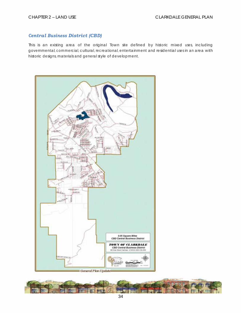
Central Business District (CBD)
This is an existing area of the original Town site defined by historic mixed uses, including governmental, commercial, cultural, recreational, entertainment and residential uses in an area with historic designs, materials and general style of development.

CHAPTER 2 – LAND USE CLARKDALE GENERAL PLAN
35
NC (Neighborhood Commercial)
This classification is intended for commercial retail and service needs that provide the surrounding neighborhoods and residents of Clarkdale with their basic day-to-day needs. This classification is characterized by various retail outlets, offices and restaurants. Such uses include adequate off-street parking, landscaping and generally-improved site development.

CHAPTER 2 – LAND USE CLARKDALE GENERAL PLAN
36
HC (Highway Commercial)
This classification is intended for a wider range of community-wide and regional commercial uses. These uses would typically be found along arterial highways or major collector streets with minimal association with local neighborhood roads.
CHAPTER 2 – LAND USE CLARKDALE GENERAL PLAN
37
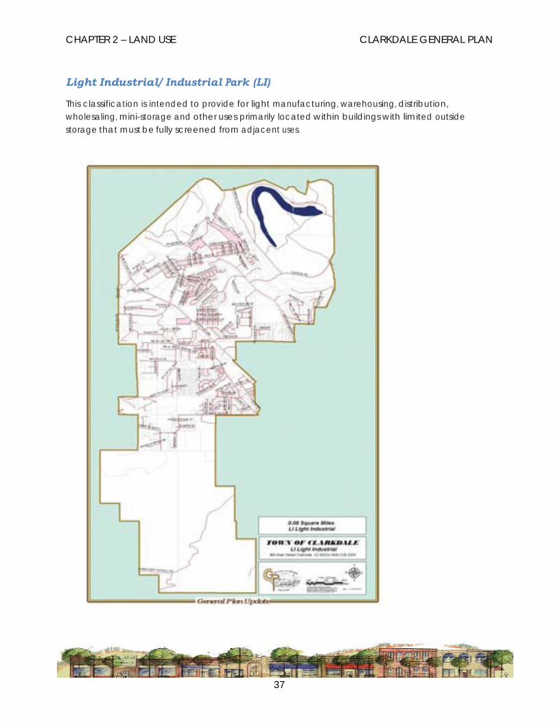
Light Industrial/ Industrial Park (LI)
This classification is intended to provide for light manufacturing, warehousing, distribution, wholesaling, mini-storage and other uses primarily located within buildings with limited outside storage that must be fully screened from adjacent uses.

CHAPTER 2 – LAND USE CLARKDALE GENERAL PLAN
38
Heavy Industrial (HI)
This classification is intended to provide locations for more intensive industrial uses that may include large amounts of exterior storage and outside work areas, primary material processing facilities, contractor storage yards, distribution and transportation facilities that generate trucking and traffic impacts, and various major public facilities including recycling facilities and waste water treatment plants, electric substations or other uses by utilities.

CHAPTER 2 – LAND USE CLARKDALE GENERAL PLAN
39
Public Lands and Facilities (PL)
These areas are intended to provide for a range of public land uses including government offices, public schools, community colleges, public utility facilities, community centers, fire stations, libraries, recreational facilities, parks and open space areas.

CHAPTER 2 – LAND USE CLARKDALE GENERAL PLAN
40
Mixed Use (MU)
The Mixed Use category is intended for planned development projects that include a mix of uses such as residential, commercial, recreational, open space, institutional and/or community facilities.

CHAPTER 2 – LAND USE CLARKDALE GENERAL PLAN
41
Open Space (O)
The Open Space classification is intended for both public and private land designated as open space. This not only includes undeveloped natural areas but also a variety of outdoor recreational uses, ranching and agricultural uses, historic sites and conservation areas.

CHAPTER 2 – LAND USE CLARKDALE GENERAL PLAN
42
NF National Forest
The National Forest classification is solely for the Prescott National Forest lands currently subject to the jurisdiction of the United States Forest Service (USFS) and located within the boundaries of the Town. The Town has explored possible land uses in the event these lands become exchange lands. Areas that have been identified as having public benefit are reflected in the Land Use

CHAPTER 2 – LAND USE CLARKDALE GENERAL PLAN
43
LAND USE GOALS, OBJECTIVES AND POLICIES The following section includes the Goals, Objectives and Policies developed to define the Land Use Chapter. These are intended to address issues relating to various uses that may be found within the Town of Clarkdale so as to identify the Town’s concerns and intentions relating to the character of development, the relationship of the use to the stated community priorities, related environmental considerations and where the proposed use meets the community sustainability criteria.
GOAL 2.1 PROVIDE A BALANCE OF LAND USES AND MEANINGFUL GUIDELINES FOR THE USE OF LANDS
OBJECTIVE 2.1.a Preserve and enhance the unique aspects of the character of Clarkdale.
Policy: Encourage development practices that preserve and enhance existing neighborhoods.
Policy: Support historic preservation of residential, commercial and institutional buildings.
Policy: Promote the preservation and revitalization of the original Town site by establishing a variety of housing, civic, recreational, cultural and business opportunities.
OBJECTIVE 2.1.b Provide for orderly patterns of growth and development.
Policy: Promote development located near existing utility and transportation infrastructure.
Policy: Support well-designed mixed-use, master planned community developments and planned subdivisions.
GOAL 2.2. ENCOURAGE APPROPIATE ECONOMIC DEVELOPMENT OPPORTUNITIES
OBJECTIVE 2.2.a Promote the development of commercial, business park, and industrial development areas which are compatible with existing land uses and which serve the economic needs of the community.
Policy: Develop standards to address shared access, architectural compatibility and locally appropriate landscaping for commercial areas along arterial and major collector corridors.
Policy: Encourage clustering of commercial development as opposed to strip commercial
CHAPTER 2 – LAND USE CLARKDALE GENERAL PLAN
44
development.
GOAL 2.3 SUPPORT HOUSING PROGRAMS TO MEET THE NEEDS OF ALL RESIDENTS
OBJECTIVE 2.3.a Develop policies and incentives to ensure an adequate supply of affordable housing to meet the needs of an economically-diverse and growing population.
Policy: Support policies and programs to improve affordable housing opportunities in existing neighborhoods.
GOAL 2.4 PRESERVE AND PROTECT THE NATURAL ENVIRONMENT, OPEN SPACES AND SCENIC RESOURCES IN CLARKDALE.
OBJECTIVE 2.4.a Provide policies to identify and protect open space resources within existing developed areas by ensuring appropriate standards for compatible development.
Policy: Provide for density increase options in exchange for open space through various development standards.
Policy: Provide options for development to meet open space/recreation requirements.
GOAL 2.5 ENSURE THAT ALL DEVELOPMENT MEET THE TOWN’S SUSTAINABILITY STANDARDS
OBJECTIVE 2.5.a Work to achieve economic, social and environmental sustainability through both local and regional cooperation.
Policy: Identify the standards for Clarkdale that will lead to a culture of sustainability.
Policy: Provide leadership in the development of a sustainable Verde Valley.

CHAPTER 2 – LAND USE CLARKDALE GENERAL PLAN
45
LAND USE IMPLEMENTATION STRATEGIES Objective Policy Action Time Frame Preserve and enhance the unique aspects of the character of Clarkdale.
.
Encourage orderly patterns of growth and development.
Promote the development of commercial, business park, and industrial development areas which are compatible with existing land uses and which serve the economic needs of the community.
Encourage development Amend the zoning code to 1 to 3 years practices that preserve provide for blending of and enhance existing new development with
neighborhoods. existing neighborhoods.
Support historic Amend the zoning code to 1 to 3 years. preservation of resi provide for historic dential, commercial and preservation design codes. institutional buildings. Promote the preservation Working with the Parks and 1 to 5 years. and revitalization of the Recreation Committee to original town site by encourage and/or develop
establishing a variety of events and public places
housing, civic, in the old town area.
recreational, cultural and business opportunities. Encourage development Amend the town code to 1 to 2 years. located near existing require dedicated public utility and transportation access to all development. infrastructure. Support well designed, Develop the Form-Based 1 to 5 years. mixed-use, master Codes Standards and work planned community to encourage involvement
developments and in that process. planned subdivisions.
Develop standards to Revise existing 1 to 3 years address shared access, development codes to architectural reflect the desire for
compatibility, and locally limiting access to
appropriate landscaping commercial development, encouraging cluster
for commercial areas development and along arterial and major landscaping requirements collector corridors. that reflect the best use of
native vegetation.

CHAPTER 2 – LAND USE CLARKDALE GENERAL PLAN
46
Objective Policy Action Time Frame Develop policies and incentives to ensure an adequate supply of affordable housing types to meet the needs of an economically diverse and growing
Support policies and Continue with the Ongoing. programs to improve Regional Housing affordable housing Workgroup to develop a
opportunities in existing regional approach to meet
neighborhoods. housing needs throughout the valley.
Encourage policies to identify and protect open space resources within existing developed areas by ensuring appropriate standards for compatible development.
Work to achieve economic, social and environmental sustainability through both local and regional cooperation.
Provide for density Implement code changes in 1 to 2 years. increase options in the development code exchange for open that provide for density
space through various bonuses. development standards.
Provide options for Options for development 1 to 2 years. development to meet to encourage the town’s open space/recreation priorities needs to be
requirements. part of the overall code revisions.
Identify the standards Develop a Sustainability 1 to 3 years for Clarkdale that will Strategic Plan and process lead to a culture of for implementation. sustainability.
Put the plan into 3 to 5 years operation.
Provide leadership in Continue the education of Ongoing the development of a the public on the sustainable Verde sustainable goals for the
Valley. community and make sure the policies adopted by the town support that goal.

CHAPTER 3 - CIRCULATION CLARKDALE GENERAL PLAN
47
Chapter 3 CIRCULATION
The Town of Clarkdale has experienced substantial growth over the past five years and there is every indication that growth will continue into the future although at a slower pace. The annexation set for later in 2012 of the 450 acres owned by the Clarkdale Metals Corporation will expand the Town to the north and west away from the only transportation corridor in and out of the Town, State Route (SR) 89A. This 450 acres and the remaining industrial/ commercially-zoned land owned by Clarkdale Metals are due to start development by 2010. At least 600 homes will eventually be built to the north with 250 acres of commercial and industrial land between the mountain development and the existing Town. That industrial base will be competing for the SR 89A corridor which is already stretched to the limit with the trucks from Salt River Materials Group and the product transportation coming from the Clarkdale Metals site. All of this traffic now has to compete with Cottonwood’s ever growing traffic congestion since we share borders along the south and eastern edges of our Towns.
Both industries are trying to develop new transportation route concepts so they can study the economic feasibility of build out. They have requested Clarkdale’s involvement in the process. Whatever concepts are developed we know that they have to accommodate traffic movement to alleviate the ever growing transportation congestion. We have two strong viable industries looking to expand with their greatest problem being the inability to move their product.
With the growth in the Verde Valley and our region’s direct tie to Yavapai County, the growing traffic over the mountain to Prescott has become a major concern. Daily commuting traffic has to compete with the tourist traffic to Jerome and large truck traffic has to go through Clarkdale and Cottonwood to I-17 to State Route (SR) 169 in order to reach Prescott. Mixing transportation uses on the existing roads with their existing congestion is a concern in both the Clarkdale and Cottonwood General Plans. The exploration of alternative routes or traffic solutions has been part of the overriding concerns of the Verde Valley Transpiration Group for the past few years. It is a regional problem, not just a Clarkdale problem.
The Circulation chapter addresses the Town’s transportation system and provides tools such as the goals, objectives and policies, and the Circulation Plan map. A principal emphasis of the Circulation chapter is to support the integrated coordination of transportation systems with land use development. The Circulation chapter is developed in a linear relationship with the land use program as outlined in the Land Use Element, including the long-range Land Use Plan which identifies existing and proposed land use patterns.
A map of the proposed transportation system, referred to as the Circulation Plan, is used to identify the general location of existing and proposed streets and multi-modal transportation opportunities. This includes a system of classification for various types of streets and related development standards based on the level of use, the nature of the land uses served by such streets, and the goals of providing a coherent, rational system.

CHAPTER 3 - CIRCULATION CLARKDALE GENERAL PLAN
48
This plan may be used to guide long range capital improvement projects but also potentially ties new development into levels of street improvement requirements as specified in the plan. The Circulation Plan looks at projected growth patterns in terms of level of use and coherency of the overall system by showing the locations of proposed arterial and collector streets in specific relation to existing properties.
FUNCTIONAL CLASSIFICATION A system that classifies streets according to their function in the overall Town-wide street circulation system is intended to provide for the efficient and orderly flow of traffic throughout the Town and to guide development decisions on properties adjacent to or otherwise serviced by such streets. The street classification system is based on the level of service and general principals of planning. For example, commercial development would be located along collector or arterial roadways and single-family residential development would have direct access to local roads which have a lower volume of traffic.
Private access easements could be constructed according to any of the functional classifications based on other considerations such as zoning classification, lot size and existing uses. Dedicated public right-of-way is intended to be constructed to minimum standards and is the responsibility of the Town to maintain. Private access easements are maintained by property owners either through some type of joint maintenance agreement or by individual responsibility. Arterial, collector, local, rural collector, rural local and alley define the system of functional classifications, as follows:
CLASSIFICATION DESCRIPTION
Arterial Roads and highways intended for higher volume, higher speed travel through the community or between neighboring communities.
Arterial road classifications usually indicate four or more travel lanes but for Clarkdale this classification includes two lane roads based on the level of service. Two lane arterial roads would be expected to have adequate center turn lanes and side acceleration and deceleration lanes for all street and driveway intersections.
Collector Medium to high volume road intended to connect local streets serving residential or non-residential uses with arterial highways. Two lane collector roads would be expected to include the installation of center turn lanes and side acceleration and deceleration lanes for
CHAPTER 3 - CIRCULATION CLARKDALE GENERAL PLAN
49
CLASSIFICATION DESCRIPTION
abutting commercial or institutional development.
Local Lower volume, lower speed road intended to provide direct access to abutting properties and to serve as the primary framework for the local circulation system within sub-areas of the Town. Most of the dedicated roads within platted subdivisions and historic areas of Clarkdale are indicated as Local roads.
Rural Collector Rural roads are intended for residential areas with a minimum one acre or greater zoning classification. Such roads may be unpaved and have minimal improvements. Rural collectors serve to connect local roads with other collector roads, as well as with arterial roads.
Rural Local Rural roads are intended for residential areas with a minimum one acre or greater zoning classification. Such roads may be unpaved and have minimal improvements. Rural local roads are intended to provide direct access to residential properties.
Alley Secondary access intended for limited travel from a local road to parking areas at the rear of properties. Alleys are typically located through the middle of a block of properties within a developed area. Public alleys are found in Upper and Lower Clarkdale and in Centerville.
Examples of Road Classifications in Clarkdale:
• Arterial - State Route 89A, Cement Plant Road, and South Broadway.
• Collector - Portions of Main Street, Old Jerome Highway, Bent River Road, Black Hills Drive and Lisa Lane.
• Local - Third North Street, Calle Carillo, Sky Drive, Deborah Drive, and Panorama Way.
• Rural Collector - Mescal Spur, Minerich Road and Haskell Springs Road.

CHAPTER 3 - CIRCULATION CLARKDALE GENERAL PLAN
50
• Rural Local - Most private easement roads in the foothills area, including Peaks View, Mountain Road, Abbey Road North and South, and Redtail Hawk and Cliffside Drive off of Bent River Road.
• Alley - Mid block right-of-way in Upper Clarkdale, Lower Clarkdale and Centerville.
The Town has adopted standards for the development of each road classification.
ROAD DESIGN ISSUES The Town of Clarkdale applied for and received a Planning Assistance for Rural Areas (PARA) transportation planning grant from the Arizona Department of Transportation. That study is progressing on a parallel path with the General Plan Update. It is intended the Town will adopt that transportation plan and the standards associated with that plan when it is completed. Many of the issues raised by the General Plan Update Focus Groups will be addressed by that plan. This General Plan Update process will incorporate elements of that transportation plan by reference at the time of the General Plan’s approval.
MULTI-MODAL TRANSPORTATION A comprehensive approach to considering transportation needs and opportunities looks at not only automobiles but also all other methods of moving goods and people. The Circulation chapter emphasizes the broad-based benefits to be derived from support for multi-modal transportation planning. There are significant social, environmental and economic benefits derived from modes of transportation other than single-occupant vehicles. Walking, bicycling, and public transit serve these purposes.
The street circulation system has a continuing need to address a range of improvements, including those related to roadway surface conditions, drainage features, traffic control, intersection design upgrades and the integration of pedestrian and bicycle facilities.
Pedestrian Walking offers a wide range of benefits as a mode of transportation for relatively short distances within local sub-areas and to connect adjacent areas. In order to function as a safe and efficient means of transportation, pedestrian facilities need to be continuous, interconnected and meet minimum engineering criteria. Sidewalks, off-road pathways, and “pedestrian-friendly” intersection design are basic components of a pedestrian transportation system.
Bicycle Bicycling is a cost-effective, energy-efficient, non-polluting, healthy alternative for transportation. Generally, people are more likely to ride bicycles for transportation if there is a perception of adequate and safe facilities, such as occurs with wider lanes. The separation of most of Clarkdale from shopping, employment and other common destinations at a regional level makes cycling a less desirable alternative for such uses for many people. It is more likely that the bicycle can be an effective component of the transportation mix for shorter trips at the neighborhood level.

CHAPTER 3 - CIRCULATION CLARKDALE GENERAL PLAN
51
A comprehensive program to improve conditions for bicycling typically has a number of components including designating continuous routes on existing roads, requiring adequate roadway width for new roads and other street improvement projects, establishing a consistent system of signs, providing secure bicycle parking facilities at various destinations and supporting education and traffic enforcement laws for bicyclists for safety purposes.
Transit A fixed-route general transit system was begun in January 2002 that includes Clarkdale in a line route system with Cottonwood. The Cottonwood Area Transit (CAT) also provides on-demand, door-to-door Para transit (dial-a-ride and reserve-a-ride) service in Clarkdale and Cottonwood, as well as in nearby county areas and connecting to Sedona. Continued cooperation between communities is beneficial for both the efficiencies for the system and for the riders.
REGIONAL TRANSPORTATION Regional transportation planning will continue to be a major concern in the Verde Valley over the next decade as the population continues to grow.
Verde Valley Transportation Planning Organization The Verde Valley Transportation Planning Organization (VVTPO) is comprised of elected and appointed officials (as well as agency staff) from the Northern Arizona Council of Governments (NACOG), various incorporated municipalities, Yavapai County and ADOT. They make recommendations on regional road projects and recommend priorities for ADOT’s annual and five-year transportation plans.
CIRCULATION GOALS, OBJECTIVES AND POLICIES The following goals, objectives and policies provide direction and guidance for transportation and street circulation concerns in Clarkdale:
GOAL 3.1 PROVIDE FOR A COMPREHENSIVE, INTEGRATED TRANSPORTATION SYSTEM THAT SERVES THE COMMUNITY IN A SAFE, EFFICIENT, COST EFFECTIVE AND AESTHETICALLY PLEASING MANNER.
OBJECTIVE 3.1.a Emphasize live, work, and play land use relationships to optimize the use of Town-wide systems and reduce the strain on regional and local/neighborhood systems.
Policy: Emphasize the relationship and balance of land uses within general areas of the Town to determine if an appropriate mixture exists that will reduce the demand on regional and local systems.
Policy: Encourage, where appropriate, mixed use developments that physically

CHAPTER 3 - CIRCULATION CLARKDALE GENERAL PLAN
52
incorporate residential, shopping and work environments within one area or project and place strong emphasis on connectivity with non-motorized access development.
Policy: Ensure that land uses, site designs, and street improvements do not limit future mobility options. Unless there are convenient parallel facilities, all major roads that are not highways should safely accommodate bicyclists, pedestrians and transit.
Policy: Promote the development and use of recreational trails as transportation routes to connect housing with services, entertainment, and employment.
Policy: Require new development to provide pedestrian and bicycle access and facilities as appropriate, including connected paths along washes.
OBJECTIVE 3.1.b Develop and maintain a comprehensive transportation system that efficiently carries a variety of modes of traffic within and through the community.
Policy: Maximize connectivity between streets to increase travel options.
Policy: Combine education with enforcement to instill safe and courteous use of the shared public roadway.
Policy: Design roadway improvements and facility modifications to minimize the potential for conflict between pedestrians, bicycles, and automobiles.
OBJECTIVE 3.1.c Ensure the circulation system is coordinated with existing and proposed land uses.
Policy: Discourage direct residential driveway access to collector and arterial streets.
Policy: Ensure that commercial and industrial developments have access to collector streets and arterial streets and not local streets.
Policy: Commercial developments are encouraged to coordinate shared driveway access to collector and arterial streets.
Policy: The installation of secondary frontage roads parallel to arterial and collector roads is encouraged to provide access to abutting commercial and planned developments.
Policy: Protect neighborhood streets from major high-speed, through traffic.
OBJECTIVE 3.1.d Respect neighborhood and environmental quality.

CHAPTER 3 - CIRCULATION CLARKDALE GENERAL PLAN
53
Policy: Install and maintain transportation improvements to minimize adverse impacts on the quality of life in Clarkdale.
Policy: Develop road standards for existing roads that allow the Town of Clarkdale to accept dedication of existing collector and arterial streets necessary to the Town’s traffic management plan.
OBJECTIVE 3.1. e Ensure adequate funding and implementation mechanisms to address short and long term circulation needs.
Policy: Encourage the establishment of improvement districts to address street improvements in certain areas.
Policy: Coordinate the long-range use and distribution of federal, state or county roadway funding programs with other local jurisdictions in the region through regional planning.
Policy: Require development projects to be responsible for the implementation of the Circulation Plan as shown, including dedication of right-of-way and construction of improvements.
Policy: Coordinate transportation and street improvement projects with the Town’s Capital Improvement Program.
GOAL 3.2 DEVELOP OPPORTUNITIES FOR ALTERNATE MODES OF TRANSPORTATION.
OBJECTIVE 3.2.a Provide an adequate, safe, convenient and interconnected system of pedestrian facilities throughout the Town.
Policy: Identify walkway engineering standards and design criteria for new development and upgrades to existing neighborhoods.
OBJECTIVE 3.2.b Improve opportunities for bicycling.
Policy: Establish a comprehensive bicycle program that includes physical improvements to streets, bicycle parking facilities, signed route systems and education programs for people of various ages.

CHAPTER 3 - CIRCULATION CLARKDALE GENERAL PLAN
54
OBJECTIVE 3.2.c Improve opportunities for public transit.
Policy: Require new development, through subdivision, rezoning, and planned area development or annexation processes, to consider opportunities for transit.
GOAL 3.3 SUPPORT REGIONAL TRANSPORTATION PROGRAMS.
OBJECTIVE 3.3a Support regional, multi-jurisdictional, transportation planning.
Policy: The Town shall participate with surrounding jurisdictions, the County, NACOG and ADOT on regional transportation studies and project coordination.
CHAPTER 3 - CIRCULATION CLARKDALE GENERAL PLAN
55
CIRCULATION IMPLEMENTATION STRATEGIES
Objective Policy Action Time Frame Emphasize live, work, and play land use relationships to optimize the use of town wide systems and reduce the strain on regional and local/neighborhood systems.
Emphasize the relationship and balance of land uses within general areas of the town to determine if an appropriate mixture exists that will reduce the demand on regional and local systems.
Analyze existing land uses and street classification relationships and provide recommendations for achieving a good transportation balance.
1 to 3 years
Ensure that land uses, site designs, and street improvements do not limit future mobility options. Unless there are convenient parallel facilities, all major roads that are not highways should safely accom- modate bicyclists, pedestrians and transit
The evaluation criteria considered by the Planning Commission, the Design Review Board and the Town Council should contain an analysis of the traffic patterns generated by any development and the land uses involved.
0 to 1 year
.
Require new development to provide pedestrian and bicycle access and facilities as appropriate, including connected paths along washes.
Amend the existing codes to require these facilities and infrastructure.
1 to 3 years
Develop and maintain a comprehensive transportation system that efficiently carries a variety of modes of traffic within and through the community.
Maximize connectivity between streets to increase travel options. Design roadway improvements and facility modifications to minimize the potential for conflict between pedestrians, bicycles,
Amend the subdivision code to require connectivity. Work with the Public Works Director to develop standards.
1 to 5 years 1 to 2 years
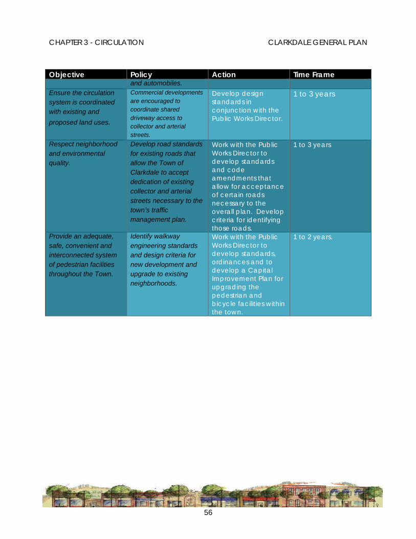
CHAPTER 3 - CIRCULATION CLARKDALE GENERAL PLAN
56
Objective Policy Action Time Frame and automobiles.
Ensure the circulation system is coordinated with existing and proposed land uses.
Commercial developments are encouraged to coordinate shared driveway access to collector and arterial streets.
Develop design standards in conjunction with the Public Works Director.
1 to 3 years
Respect neighborhood and environmental quality.
Develop road standards for existing roads that allow the Town of Clarkdale to accept dedication of existing collector and arterial streets necessary to the town’s traffic management plan.
Work with the Public Works Director to develop standards and code amendments that allow for acceptance of certain roads necessary to the overall plan. Develop criteria for identifying those roads.
1 to 3 years
Provide an adequate, safe, convenient and interconnected system of pedestrian facilities throughout the Town.
Identify walkway engineering standards and design criteria for new development and upgrade to existing neighborhoods.
Work with the Public Works Director to develop standards, ordinances and to develop a Capital Improvement Plan for upgrading the pedestrian and bicycle facilities within the town.
1 to 2 years.

CHAPTER 4 - EDUCATION CLARKDALE GENERAL PLAN
57
Chapter 4 EDUCATION
EDUCATION IS IMPORTANT TO CLARKDALE The Education chapter is not required by state law; rather it is an optional chapter within the General Plan. Since Education is not mandatory there are no strict guidelines as to what should be included with this chapter. The role of education, particularly in Clarkdale, is central to the core of what Clarkdale is and where Sustainable Clarkdale is going. Working to support existing agencies, providing input when desired, working with businesses to meet their workforce training needs, communicating topic specific information to the public and providing a venue for education programs are all roles for the Town.
Clarkdale and the Verde Valley cities and towns offer a wealth of educational opportunities to residents of the Town and the valley, including early childhood learning centers, the Clarkdale – Jerome Public School, private and charter K-12 schools where Clarkdale residents also send their children, and Yavapai Community College. These institutions operate through a variety of funding and management structures, with limited involvement by the Town of Clarkdale. The Town has many opportunities, however, to ensure quality lifelong education for Clarkdale residents. Access to appropriate facilities, a diverse mix of students, strong neighborhood connections, and opportunities for learning outside of the classroom all contribute to a well-performing school. Through its role in providing planning and infrastructure, the Town will continue to create an environment supporting lifelong learning.

CHAPTER 4 - EDUCATION CLARKDALE GENERAL PLAN
58
OUR EDUCATION COMMUNITY - Elementary Education
Clarkdale Jerome School District
A challenge for the future will be to help the Clarkdale-Jerome School district anticipate potential facility needs, to plan those facilities so that they are seamlessly integrated into the community. The future of schools in Clarkdale and the continued excellent rating is critical to the strength of the community as we move forward with economic development efforts in the Town. Recognizing the school’s existing sustainability program and developing partnering opportunities contributes to Sustainable Clarkdale.
Cottonwood Oak Creek School District
Presently Clarkdale is in two school districts, with the Cottonwood – Oak Creek School district drawing from the southern portion of Clarkdale. This has resulted in a lot of cross jurisdictional applications for children to attend school with many of their friends who attend the Clarkdale-Jerome School. Discussions have occurred sporadically among residents to redraw the district lines. Such an action would involve all elements of the community, including Town government, but could result in a more unified long term approach to education in Clarkdale.
Private or Charter Schools
Within seven miles of Clarkdale are eight charter or private schools and a number of faith-based schools providing a plethora of different teaching programs and creative learning experiences. These institutions serve students from Clarkdale and provide excellent educational experiences. The Town can support the growth and development of these types of educational centers by providing community leadership encouraging educational diversity and welcomes creative learning. Clarkdale is a community that is supportive of Education and has it as a Town priority.

CHAPTER 4 - EDUCATION CLARKDALE GENERAL PLAN
59
HIGHER EDUCATION
Mingus Union High School
MUHS serves Clarkdale, Cottonwood and Jerome plus some of the outlying unincorporated areas. For the Verde Valley, this is truly the melding point. With well over 1000 students it brings together the educational opportunities afforded schools with larger populations, while recognizing the unique mixture of rural and city populations. The school vision, in part, states that “Mingus High School is dedicated to unifying home, community and school. We are committed to promoting critical thinking and technical literacy...” These fundamental values match well with Clarkdale’s commitment to education.
Associated with MUHS is the VACTE of Valley Academy for Career and Technology. This is the technical vocational arm of MUHS providing career training in multiple areas. This program provides practical application training for a new available workforce. (Mingus Union High School)
Yavapai College, Verde Valley Campus
The Verde Valley campus of Yavapai College is located in Clarkdale. This is a tremendous advantage to the community. It is what makes Clarkdale a college Town, and helps drive education as a community priority. Sustainable Clarkdale is partnering with the college to engage them in a leadership role. Sustainable agriculture, the Viticulture Program, returning veterans training, workforce training, small business development, the Business Assistance Center partnership, along with traditional educational programing provided by the college makes them an important partner in how Clarkdale continues to develop.
The college’s future development plan is part of the Town’s Future Land Use plan and included in the Clarkdale General Plan. The Town was part of the group that developed the Yavapai plan and has been working with the college to provide development opportunities.
Sustainable Clarkdale has also been engaging Arizona State University, Northern Arizona University and the University of Arizona in partnership discussions for interns in multiple sustainability efforts. Research and development opportunities within the sustainability project and the ability to work together have been at the heart of the Clarkdale Program. These opportunities also attract major education institutions. The Town is working with these educational institutions to develop a curriculum designed to develop a sustainable workforce able to take advantage of the opportunities within cities and Towns.
Lifelong Education
Continued education opportunities through formal and informal opportunities create the

CHAPTER 4 - EDUCATION CLARKDALE GENERAL PLAN
60
opportunity for continuous lifelong development contributing to a person’s quality of life. Today, with less defined changes in life roles, there is need for new strategies to motivate lifelong learning. Clarkdale recognizes the value of supporting programs providing lifelong education opportunities. Whether partnering with the college, individuals, agencies or groups to provide an atmosphere that helps provide learning opportunities or developing programs through Community Services, Clarkdale is committed to lifelong education.
Libraries of the Future
Thomas Fey has said that “libraries are really a life form. They exist as a human system, and as such tend to take on many of the same attributes of the communities they serve.” (Cortese, 2003 p. 16)
That statement is certainly true of Clarkdale. The Clark Memorial Library has been the community center. It was also the cultural and historical center for Clarkdale. Over the past couple of years the role of the library has been changing to accommodate the evolution of not only Clarkdale, but the world. There is a very strong survival instinct around the library.
Libraries in general are adapting to a changing world and the Clark Memorial Library is changing, too.
GOALS, OBJECTIVES AND POLICIES FOR EDUCATION
GOAL 4.1 CLARKDALE’S GOAL IS TO MAINTAIN ITS COMMITTMENT TO SUPPORTING EXCELLENT EDUCATIONAL OPPORTUNITIES FOR ALL THE RESIDENTS OF CLARKDALE.
OBJECTIVE 4.1.a Maintain a singular focus in keeping education as a priority in the Town of Clarkdale.
Policy: Facilitate open communication between the Town, the School Districts and the development community to coordinate development and growth in a way that mitigates impacts to the school systems and provides for the continuation of the existing quality education for school students.
Policy: Encourage the school districts, the Town and developers to engage in early discussions regarding the nature and scope of proposed projects and possible fiscal impacts and mitigation measures.

CHAPTER 4 - EDUCATION CLARKDALE GENERAL PLAN
61
Policy: Cooperate with all of the School Districts and Yavapai College Clarkdale Campus in the joint planning, development and use of school facilities which may result in partnering opportunities for recreation facilities, libraries, and community services/ programs.
Policy: Provide all pertinent information on General Plan amendments, rezoning and other development proposals to the school districts and Yavapai College.
Policy: Work to develop a cooperative Town/District planning collaboration that supports efforts of mutual benefit between the School Districts and the Town, and Yavapai College and the Town.
Policy: Provide leadership and participation in supporting efforts of the education community to increase the percent of youth that graduate, attend higher educational programs - including Yavapai College - and who are employed in high quality jobs in the Verde Valley.
Policy: Collaborate with the school districts, the community, post-secondary institutions, businesses and industry to ensure availability of necessary resources to meet learner needs.
Policy: Continue to work with the school districts through programs such as the Safe Routes to Schools program to improve pedestrian and bicycle safety and encourage walking and biking to and from school.
Policy: Encourage the use of available school facilities for after-school care, private community gathering facilities, public recreation facilities and other dual and multi-use purposes.

CHAPTER 4 - EDUCATION CLARKDALE GENERAL PLAN
62
EDUCATION IMPLEMENTATION STRATEGIES
Objective Policy Action Time Frame To maintain a singular focus in keeping education as a priority in the Town of Clarkdale.
Facilitate open communication between the Town, the school districts and the development community to coordinate development and growth in a way that mitigates impacts to the school systems and provides for the continuation of the existing quality education for school students. Developing joint planning, development and use of school facilities which may result in partnering opportunities for recreation facilities, libraries, and community services/programs. Provide leadership and participation in supporting efforts of the education community to increase the percent of youth that graduate, attend higher educational programs moving toward higher quality employment in the Verde Valley.
Formalize the existing relationship and establish some guidelines that can enable this process. Build on the existing grant work to address issues the schools or the district may have. . Build on existing relationships and involve other institutions in the planning and development of the Town. Possible programs and plans should be developed during strategic planning sessions of the town’s leadership.
1 to 2 years 1 to 2 years 3 years

CHAPTER 5- OPEN SPACE CLARKDALE GENERAL PLAN
63
Chapter 5 OPEN SPACE
This chapter establishes a set of integrated visions, policies, goals, objectives and implementation strategies that guide decision-making and lead toward the provision of a comprehensive open space system and recreational plan for a sustainable future for Clarkdale. Furthermore, this chapter represents an important step in the Town’s continuing effort to enhance the public’s ability and opportunities to enjoy recreation, both active and passive, in Clarkdale. These facilities and programs enhance the social, psychological and physical well-being of the citizens by providing them with enjoyable activities and settings in which to spend their leisure time. The parks and recreation system of developed open space provide opportunities for active recreation activities. The trails and bike paths provide both a means for active enjoyment and an alternative method to get from home to work or school or play. The open space areas preserve the natural setting which the community has developed. The environmental policies establish an approach against which citizens, the Town leadership and developers can weigh decisions.
In examining the Verde Valley and the Town of Clarkdale’s relationship within that regional context, the discussion always turns to open space. There is recognition of the importance of the National Forest to that community value. There is also a strong feeling of independence and the ability for the communities within the Verde Valley to exist as individual players within the larger context of the whole. For Clarkdale, as we look chapter one and the ongoing process, we see this community has a sense of environmental responsibility and internalizes its role of stewardship. Clarkdale desires to be an example of an environmentally-responsible community in balance with the natural setting of the river, the desert and the hillside ecosystem. Clarkdale seeks to reduce the community’s carbon footprint and reduce the impacts on the natural environment of growth and development within this community. The goals, policies and objectives as outlined in this chapter were developed by the environmental focus group to accomplish the environmental vision Clarkdale has defined for itself.

CHAPTER 5- OPEN SPACE CLARKDALE GENERAL PLAN
65
Open Space Chapter Clarkdale General Pla
TYPES OF PARKS AND RECREATION FACILITIES A comprehensive park facility master plan to serve the interests of all segments of the population of Clarkdale includes both active recreational opportunities such as play grounds, ball courts and athletic facilities, and other facilities such as picnic areas, walking paths and sitting areas. A variety of park types and facilities will serve the diverse interests of a growing population. In addition to meeting the needs of residents and visitors, it is recognized parks and recreation facilities have become standard amenities in communities across the country. Any future interest in promoting quality economic development in Clarkdale will have to contend with this fact as a consideration when competing for desirable economic development.
Neighborhood Parks
The opportunity to walk to a neighborhood park facility from each home is a desirable amenity addressing a range of quality of life issues as well as economic development concerns.
Neighborhood parks should be located within existing residential areas, and should be required as part of all new planned developments and subdivisions. Neighborhood parks are usually from one-half to five acres in size and would service an area approximately one-half mile in radius, or a convenient walking distance from surrounding homes. Each park should correspond to the prevailing interests of the nearby residents and could include amenities such as a children’s play area, picnic tables, walking paths, ball courts, ball fields, pet areas and open space areas.
Community Parks
A community park would be 25 (twenty-five) to 50 (fifty) acres in size so as to serve a wider range of interests than neighborhood parks. Additional acreage may be considered if areas of open space

CHAPTER 5- OPEN SPACE CLARKDALE GENERAL PLAN
66
preservation are included with developed facilities. A Town-wide community park would have both indoor and outdoor facilities. A multi-purpose building could include recreational facilities as well as meeting space for community groups, a senior center and other community uses. Outdoor recreational facilities could include baseball, softball and soccer fields, basketball and tennis courts, a children’s play area, walking trails, pet areas, covered picnic areas and quiet areas for sitting. This type of park should have adequate off-street parking and be separated from less intensive uses by adequate open space or landscaped area. Clarkdale should consider planning for a Community Park and Recreation facility to serve the entire Town.
Regional Park
Regional park facilities encompass a larger area of land and may be 50 acres in size or larger. This type of park usually serves the residents of several Towns and surrounding areas. It is in the interest of Clarkdale residents to support and participate in regional park facilities whether they are located within the Town or in a neighboring community. Regional parks may include all the things found in a Town-wide park, such as baseball and soccer fields, as well as larger developed facilities, including swimming pools, indoor recreational facilities, multi-purpose trails, an outdoor amphitheater, camping areas and larger areas of land preserved as open space.
Park Acreage Per 1,000 Population
PARK TYPE STANDARDS Town of Clarkdale National Parks & Recreation
Association
Neighborhood 1 to 2 acres 1.5 acres Local 5 to 10 acres 10 acres
Community 20 to 25 acres 25 acres
Regional 50 + acres 65+ acres
(National Recreation and Park Association, 1996)
SUMMARY OF ECONOMIC BENEFITS FROM PARKS AND OPEN SPACE
Real Property Values
Open space and parks are desirable amenities that contribute to increased resale values and increased property values for properties located in proximity.
Tax Benefits
Increased property values result in increased sales values, increased assessments and increased property tax revenue. Studies indicate increased tax revenues can offset initial park development costs. Assessed values may lag behind market values but will eventually show results.

CHAPTER 5- OPEN SPACE CLARKDALE GENERAL PLAN
67
Multiplier Effect
Economic models indicate recreational expenditures generate 1 ½ to 3 times more to the local economy than the actual amount of direct expenses. There are direct and indirect benefits of spending on recreation uses which contribute in a chain reaction to the local economy. Management and maintenance expenditures contribute to salaries, equipment costs and material expenses.
Resident Expenditures
National studies indicate that local residents typically spend from one to a few extra dollars per day in relation to use of local parks, trails and recreation facilities, which adds up to measurable benefits.
Tourism Revenues
Parks and recreation sites can attract visitors who spend on food, lodging, fuel and various hard goods. Tourists may be encouraged to spend extra days in the area.
Sporting Events
Certain organized sporting events such as running and cycling races, kayak and canoe racing, triathlons and similar sanctioned events can generate hundreds of thousands to millions of dollars to a local economy from a single organized sporting event.
Corporate Relocation
Quality of life considerations are increasingly important in competitive relocation and retention of attractive businesses. Parks and recreation facilities are considered among the most important amenities in national surveys concerning quality of life indicators. (APA, 2002. pp 2-14)

CHAPTER 5- OPEN SPACE CLARKDALE GENERAL PLAN
68
Other Benefits
Open space and park development addresses clean air, clean water and public health benefits. Healthy residents contribute to a range of intangible personal and community benefits including lower medical expenses and higher worker productivity. Such facilities provide outstanding opportunities for healthy, family-oriented activities which ultimately contribute to a range of positive social benefits such as decreased juvenile crime and lower school drop-out rates.
OPEN SPACE GOALS, OBJECTIVES AND POLICIES. The following goals, policies and objectives provide direction and guidance for open space and recreation in Clarkdale:
GOAL 5.1: WORK TOWARD CLARKDALE HAVING A SUSTAINABLE ENVIRONMENT THAT PRESERVES ITS OPEN SPACE AND NATURAL ASSETS WHILE PROVIDING FOR RECREATIONAL ACTIVITIES TO HELP CITIZENS MAINTAIN A HEALTHY LIFE-STYLE.
OBJECTIVE 5.1.a Support an integrated system of open space and natural resource areas to serve the residents of Clarkdale.
Policy: Provide a park system that at a minimum is composed of a core system of parks and with 6.25 to 10.5 acres of developed open space per 1,000 people.
Policy: Provide a variety of opportunities for passive and active outdoor recreational activities.
Policy: Work with the Parks and Recreation Commission to develop a master plan reflecting the Town’s commitment to open space and recreational opportunities for all ages and levels of experience encouraging healthy lifestyles.
Policy: Evaluate and pursue various funding mechanisms to improve the parks and recreation program.

CHAPTER 5- OPEN SPACE CLARKDALE GENERAL PLAN
69
OBJECTIVE 5.1.b Provide and maintain an open space network of Town-owned and private lands throughout the community.
Policy: Evaluate open space design with these primary determinants: aesthetics, public safety, maintenance needs, water consumption, drainage considerations, wildlife corridors, multi-use and desert preservation.
Policy: Encourage the use of development incentives to promote integrated open space networks within future developments.
Policy: Pursue opportunities to identify and protect natural areas in proximity to existing neighborhoods.
Policy Encourage the preservation and connection of open spaces within future developments.
Policy: Adopt standards for residential landscaping that preserves native landscaping in new developments including native plant lists, plant survey methods and related procedures.
OBJECTIVE 5.1.c Protect significant natural areas within the Town, including floodplains, the Verde River corridor, steep slopes and scenic view area.
Policy: Identify and prioritize scenic assets and sensitive lands that should be preserved including major topographic features, natural vegetation, drainage ways, wildlife habitat and travel corridors, riparian areas and vista corridors.
Policy: Develop community support for an open space preservation and acquisition program to plan, prioritize, acquire and manage open space.
Policy: Provide adequate land development standards in the Town Zoning Code to address protection of sensitive natural resource areas.
OBJECTIVE 5.1.d Develop parks and recreation facilities and an interconnected system of trails and urban pathways to meet the community’s recreational needs and provide access to open space.
Policy: Explore further development of partnerships with local school districts and private interests for the joint use of recreational facilities to the ultimate

CHAPTER 5- OPEN SPACE CLARKDALE GENERAL PLAN
70
benefit of all.
Policy: Where applicable, provide linkage to and integration with other local and regional open space system.
Policy: Support regional planning efforts with local, county, state and federal governmental entities to create and maintain coordinated regional open space programs.
Policy: Support the Verde River Greenway Program.
OBJECTIVE 5.1.e Work with the United States Forest Service to ensure the preservation and stewardship of National Forest lands within and adjacent to the Town.
Policy: Provide for an urban interface beneficial to the residents and visitors of Clarkdale which protects the natural environment of the National Forest lands.
Policy: Identify uses and development standards appropriate for private lands in the urban interface with the National Forest and identify other methods of protecting the wild land character of National Forest lands adjacent to private development.
OBJECTIVE 5.1.f Work with valley communities and the county to ensure that the Verde Valley communities do not grow together. Make sure that significant open spaces are maintained between communities and along highway corridors. Jointly work to identify other priority areas that should be preserved as open space in the Valley.
Policy: Continue to participate in the regional open space planner’s group that is working to implement the adopted Regional Open Space Plan for the Verde Valley.
Policy: Help to formulate an implementation strategy for preservation and acquisition of priority open space lands in the Verde Valley.
OBJECTIVE 5.1.g Work to achieve sustainability through regional cooperation on open space issues
Policy: Clarkdale must work to maintain significant open space within the Town limits while also striving to accommodate regional growth that would otherwise

CHAPTER 5- OPEN SPACE CLARKDALE GENERAL PLAN
71
contribute to sprawl in the adjoining county area.
Policy: Clarkdale must place a premium on the personal responsibility of each individual for the cleanliness and beauty of our environment.
Government, businesses, and non-profit organizations can only accomplish so much without a concerted commitment by private citizens to take individual action to attain and maintain a cleaner, healthier environment.
Policy: Implement broad-based environmental education programs for people of all ages in the community, emphasizing how individuals can contribute to the stewardship of their environment.
Policy: Establish a Sustainability Commission to advise the Council, commissions and committees on agenda matters directly related to Clarkdale’s efforts to achieve a sustainable community.

CHAPTER 5- OPEN SPACE CLARKDALE GENERAL PLAN
72
OPEN SPACE IMPLEMENTATION STRATEGIES
Objective Policy Action Time Frame Provide an integrated system of open space and natural resource areas to serve the residents of Clarkdale.
Work with the Parks and Recreation Commission to develop a master plan that reflects the town’s commitment to open space and recreational opportunities for all ages and levels of experience encouraging a healthy lifestyle.
Continue the process of working with the Parks and Recreation Commission to develop the Parks & Recreation Master Plan in a specific plan format.
1 year
Evaluate and pursue various funding mechanisms to improve the parks and recreation program.
This action should be part of the Parks & Recreation Master Plan developed with the Parks & Recreation Commission.
1 year
Provide and maintain an open space network of town-owned and private lands throughout the community.
Evaluate open space design with these primary determinants: aesthetics, public safety, maintenance needs, water consumption, drainage considerations, wildlife corridors, multi-use and desert preservation.
This is an ongoing task that should be part of all development review.
Ongoing
Encourage the use of development incentives to promote integrated open space networks within future developments.
This requires specific council policy changes and changes to existing ordinances.
2 to 3 years
Adopt standards for residential landscaping that preserves native landscaping in new developments, including native plant lists, plant survey methods and related procedures.
Complete work on the Water Conservation Ordinance including single family landscape requirements.
1 to 3 years
Protect significant natural areas within
Identify and prioritize scenic assets and sensitive lands that
.Develop the program and maps to accomplish this
2 to 4 years

CHAPTER 5- OPEN SPACE CLARKDALE GENERAL PLAN
73
Objective Policy Action Time Frame the town, including floodplains, the Verde River corridor, steep slopes and scenic view area.
should be preserved including major topographic features, natural vegetation, drainage ways, wildlife habitat and travel corridors, riparian areas and vista corridors.
priority.
Provide adequate land development standards in the Town Zoning Code to address protection of sensitive natural resource areas.
Review existing codes, amend or revise as necessary to accomplish this protection.
1 to 2 years
Develop parks and recreation facilities and an interconnected system of trails and urban pathways to meet the community’s recreational needs and provide access to open space.
Develop partnerships with the school district, private interest, the national forest, other communities, the state and the county to facilitate joint recreational uses, integrated trails, and access to open space.
Continue the ongoing efforts to partner in efforts to provide open space and recreational opportunities.
Ongoing.
Work with valley communities and the county to ensure that the Verde Valley communities do not grow together. Make sure that significant open spaces are maintained between communities and along highway corridors. Jointly work to identify other priority areas
Continue to participate in the regional open space planners’ group that is working to implement the adopted Regional Open Space Plan for the Verde Valley. Help to formulate an implementation strategy for preservation and acquisition of priority open space lands in the Verde Valley.
Continue the Town’s participation and leadership in efforts to protect and preserve significant open space areas in the valley. Continue the Town’s support for intergovernmental and other agreements that support these policies.
Ongoing efforts.

CHAPTER 5- OPEN SPACE CLARKDALE GENERAL PLAN
74
Objective Policy Action Time Frame that should be preserved as open space in the valley. Work to achieve sustainability through regional cooperation on open space issues.
Establish a Sustainability Commission that advises the council, commissions and committees on matters directly related to Clarkdale’s efforts to achieve a sustainable community.
Research other Sustainability Commissions and develop the program for Clarkdale that accomplishes its priorities.
1 to 3 years

CHAPTER 6 – WATER RESOURCES CLARKDALE GENERAL PLAN
75
Chapter 6 WATER RESOURCES
Water, the use of it, the availability of it, the lack of it and where to get it are one of the largest questions facing Arizona communities in the future. Communities cannot maintain their lifestyle without securing water for their future citizens.
It is the purpose of the Water Resources Element to address the following:
1. Currently available surface water, groundwater and effluent supplies.
2. Sources to provide projected new development with water.
3. Opportunities to obtain additional new water supplies.
4. Water conservation recommendations.
WATER PROGRAM A comprehensive water program would address availability and protection of existing sources, water
conservation programs, and policies to find and develop new sources to meet the needs of a growing population.
Groundwater
Groundwater is the primary source for water in Clarkdale. The Haskell Springs wells and the Mountain Gate well provide the main source of water. The Mescal well will be brought on line
to provide water to the Black Hills and Foothills areas as well as backup capability for the main wells. Individual private wells throughout the Town also serve residential, commercial and other water uses. The total amount of water drawn from these well sources on an annual basis is unknown. The amount of groundwater potentially available from sources within the Town is also unknown and without additional data any amount calculated would only be

CHAPTER 6 – WATER RESOURCES CLARKDALE GENERAL PLAN
76
speculation. One of the big questions to be answered regards challenges from the Salt River Project (SRP) concerning their senior surface water rights on the Verde River and the relation of “sub-flow” water in areas within the Verde River corridor. Since the water drawn from the sub-flow zone is said to be hydraulically connected to the Verde River, the water from these wells is considered the same as surface water. There are questions as to the boundaries of the sub-flow zone associated with the Verde River and this could affect future abilities to locate new wells in those areas. It is generally considered that the wells at the lower elevations near the river are drawing on water associated with the Verde River sub-flow zone. There are additional questions concerning whether the water drawn from the Holocene alluvium, which is characterized by sand and gravel deposits near the side drainage washes is also part of the Verde River sub-flow zone. The criteria for determining the delineation of the sub-flow zone still has to be determined by the Arizona Department of Water Resources. The determination of the sub-flow zone could have profound impacts on the ability to locate new private, commercial or municipal wells in Clarkdale.
Availability of Existing Supplies
Surface water sources, such as from the Verde River or the privately owned Pecks Lake, are not considered as available sources due to prior allocations and claims. Groundwater sources are identified at Haskell Springs, Mountain Gate well and the Mescal well. The development of new private wells in the vicinity of Haskell Springs and the Mingus foothills is considered a threat to the main Town water source. Additional untapped groundwater sources may exist within the Town but development of those sites would require additional study to identify potential sites for municipal well location.
Regional Water Planning
Coordination of comprehensive water programs including source development, infrastructure development, wastewater treatment to drinking water standards and associated programs should be considered in terms of cooperative regional efforts that could potentially include adjacent municipalities, the County and various state agencies. Whether or not actual partnering occurs on specific projects, there should still be close coordination and communication of efforts between regional entities as that will ensure the most efficient and equitable approach for everyone in the region.
Water Quality
“Non-point source pollution”
This term is used to describe water pollution that does not come from a single identifiable source but instead comes from a variety of dispersed locations. Run-off of oil and gas from street surfaces is a typical “non-point source pollution” condition that affects water quality. Automobiles and trucks commonly leak small amounts of fluids on to streets. Rain washes these trace amounts of toxic surface deposits into side ditches and this can eventually make its way to water sources. Another major problem that has long-term negative effects on water quality concerns the disposal of used motor oil and other automotive or household hazardous wastes into sewer systems, septic systems or simply into the street or a nearby ditch. Efforts to educate the public and provide alternative disposal sites

CHAPTER 6 – WATER RESOURCES CLARKDALE GENERAL PLAN
77
for household and automotive hazardous wastes would provide some relief for this ongoing problem. The use of chemical fertilizers, herbicides and pesticides for landscaping and lawns can also be a major contributor to non-point source pollution.
Arsenic
Federal standards for arsenic in drinking water have been reduced to levels lower than that which occurs naturally in many water sources in Arizona. The arsenic standard previously set at 50 ppb (parts per billion) has been reduced to 10 ppb. Relatively high levels of naturally occurring arsenic have been documented in certain Verde Valley water sources in the past. In order to meet the new standard, ADEQ Safe Drinking Water Division is working on a state-wide Arsenic Master Plan to assist small water systems in complying with the new standard.
Conservation Programs
Programs to encourage residents, businesses and other water users to reduce water use can result in substantial savings of water resources. This can pay off in the long term with reduced costs associated with developing new water sources and ensure adequate supplies during times of drought. Water restrictions, even during temporary seasonal fluctuations, result in serious disruptions to people’s lives, business operations and local economic considerations. Water rationing and shortages require costly organized efforts to provide alternative sources, such as hauling water in tanker trucks. In a desert setting an ethic of water conservation should be thought of as a standard component of the way of life. The following list summarizes a few conservation programs that are known to have a positive effect. Other ideas should be considered as part of a permanent coordinated program.
• Drought-resistant landscaping
• Landscape reduction rebates
• Water-saving plumbing fixtures
• Rebate Programs
Development of New Sources
There may or may not be additional sources of water in Clarkdale that could be developed for use by Clarkdale residents. The Town has to decide how it wants to address long-range water concerns. Long-range water resource development can be either on an individual basis or be developed from a regional perspective. The lack of a long-term water resource strategy or plan needs to be part of a comprehensive development plan for the Town.

CHAPTER 6 – WATER RESOURCES CLARKDALE GENERAL PLAN
78
WASTEWATER PROGRAM The Town of Clarkdale owns and operates a wastewater treatment plant located adjacent to the Verde River near Tuzigoot Road. Sewer lines providing wastewater to this facility serve a portion of the Town, including the historic Town site and industrial area, Centerville, a third of Mountain Gate and some properties along S R 89A. The facility has a treatment capacity of 250,000 gallons per day (gpd) but capacity is also limited by the ability to properly dispose of effluent. The average daily flow to the wastewater treatment plant in 2010 is estimated to be approximately 165,000 gpd. By comparison, in 1991, the Town’s daily flows averaged approximately 100,000 gpd.
Effluent
As the wastewater goes through the treatment process, a certain amount of solids and biological contaminants are removed through settling, aeration and solar radiation on the surface of the ponds. In Clarkdale’s case, effluent is treated to a B+ standard. Wastewater that is treated to a B+ standard is appropriate for a variety of uses, including irrigation of landscaping and certain industrial uses. Clarkdale presently leases 60 acres from Clarkdale Minerals Corporation in the industrial park, for land application.
Rainwater Harvesting
Rainwater harvesting is an innovative alternative water supply approach anyone can use. Rainwater harvesting captures, diverts, and stores rainwater for later use. Captured rainwater is often used in landscaping because the water is free of salts and other harmful minerals and does not have to be treated. It is also useful in attracting and providing water for wildlife.
Gray Water
Household wastewater that originates from bathtubs, showers, bathroom sinks or clothes washers is considered to be “gray water” and may be appropriate for certain types of household irrigation purposes. No special permit is required from the Arizona Department of Environmental Quality to install a household gray water system but their guidelines for gray water use must be followed and inspection by the Town of Clarkdale of the gray water system is required. Although gray water may be diverted directly to irrigation uses, it is recommended that some type of pre-filtering system, such as a trickle-down sand filter, be used. Use of gray water systems requires some amount of education of residents. Residents must pay special attention to the type of soaps, detergents and other materials that are disposed of in the system. Household cleaners, chemicals,

CHAPTER 6 – WATER RESOURCES CLARKDALE GENERAL PLAN
79
solvents and other toxic materials must not be disposed of in the gray water system at any time.
WATER RESOURCES GOALS, OBJECTIVES AND POLICIES The following Goals, Objectives and Policies provide direction and guidance for existing and future water resources concerns for Clarkdale:
GOAL 6.1 ENSURE CLARKDALE HAS AN ADEQUATE, SAFE WATER SUPPLY TO MEET THE EXISTING AND LONG-TERM NEEDS OF RESIDENTS, BUSINESSES AND OTHER USES.
OBJECTIVE 6.1.a Develop a Water Resource Master Plan for Clarkdale to address short and long-range strategic planning for water sources, water treatment facilities, water distribution infrastructure, wastewater systems, reclaimed water systems, conservation programs and funding plans.
Policy: The Water Resource Master Plan shall conform to and support the objectives and policies of the General Plan and the Capital Improvement Plan.
Policy: The Water Resource Master Plan shall be updated annually and undertake comprehensive revisions on at least a five-year cycle so as to address ongoing growth in the area.
Policy: Coordinate development of the Water Resource Master Plan with similar plans in the Region.
Policy: As part of the Town’s overall plan, apply for the Town’s Assured Water Designation from Arizona Department of Environmental Quality.
Policy: Explore options for the development of alternative water resources including treating wastewater to potable drinking water standards, effluent recharge and water conservation programs.
OBJECTIVE 6.1.b The Town shall pursue efforts to locate and develop Clarkdale General Plan Water Resources new water sources.
Policy: Support efforts to acquire water rights either within the Town of Clarkdale or through regional partnerships.
Policy: Look for alternatives to conventional water resources.
OBJECTIVE 6.1.c Develop and support comprehensive water conservation policies and programs.

CHAPTER 6 – WATER RESOURCES CLARKDALE GENERAL PLAN
80
Policy: Develop and adopt a water conservation ordinance.
GOAL 6.2 PROVIDE ADEQUATE WASTEWATER TREATMENT FACILITIES TO MEET THE EXISTING AND LONG-TERM NEEDS OF CLARKDALE
OBJECTIVE 6.2.a Maintain and update the Wastewater Master Plan as necessary to address the needs of Clarkdale.
Policy: The Wastewater Master Plan shall conform to goals and policies of the General Plan in terms of meeting current and future community needs.
Policy: Require new development, including commercial expansion, planned developments and subdivisions, to participate in wastewater facility programs and to provide adequate facilities to address the new development, including associated sewer lines and reclaimed water systems.
OBJECTIVE 6.2.b Pursue construction of the wastewater treatment plant to ensure current and long-range needs will be addressed.
Policy: Support current and long-range efforts to provide an adequate wastewater system to serve the entire Town, including collection lines, treatment plant and effluent disposal.

CHAPTER 6 – WATER RESOURCES CLARKDALE GENERAL PLAN
81
WATER RESOURCES IMPLEMENTATION STRATEGIES
Objective Policy Action Time Frame Develop Water Resource Master Plan
Resource Master Plan shall conform to General Plan goals, shall be updated or reviewed annually.
Work with Town Council to set as a priority at strategic planning.
Ongoing once started
Coordinate regionally on development of valley wide resource plan.
Clarkdale should take the lead in developing a regional approach to resource planning or working to establish an independent agency to head up a region-wide effort.
1 year
The town needs to pursue efforts to locate and develop new water sources.
Support efforts to acquire water rights or develop alternative options.
This should be part of the overall Water Resource Master Plan.
Ongoing
Develop water conservation policies and programs.
Adopt a water conservation ordinance.
Finish the water conservation ordinance development and adopt.
1 year
Maintain and update the wastewater master plan.
. The wastewater master plan must be consistent with the general plan and new development required to participate in meeting the goals of the plan.
This requirement should be part of all development reviews.
Ongoing
Develop and build a new wastewater treatment plant that meets the needs of the Town and can be expanded to accommodate future growth.
Maintain the momentum for design and construction of the new plant.
Existing commitments, if maintained, will require construction of a new plant to meet forecasted needs
1 year

CHAPTER 6 – WATER RESOURCES CLARKDALE GENERAL PLAN
82
Objective Policy Action Time Frame Develop Water Resource Master Plan
Resource Master Plan shall conform to General Plan goals, shall be updated or reviewed annually.
Work with Town Council to set as a priority at strategic planning.
Ongoing once started
Coordinate regionally on development of valley wide resource plan.
Clarkdale should take the lead in developing a regional approach to resource planning or working to establish an independent agency to head up a region-wide effort.
1 year
The town needs to pursue efforts to locate and develop new water sources.
Support efforts to acquire water rights or develop alternative options.
This should be part of the overall Water Resource Master Plan.
Ongoing
Develop water conservation policies and programs.
Adopt a water conservation ordinance.
Finish the water conservation ordinance development and adopt.
1 year
Maintain and update the wastewater master plan.
. The wastewater master plan must be consistent with the general plan and new development required to participate in meeting the goals of the plan.
This requirement should be part of all development reviews.
Ongoing
Develop and build a new wastewater treatment plant that meets the needs of the Town and can be expanded to accommodate future growth.
Maintain the momentum for design and construction of the new plant.
Existing commitments, if maintained, will require construction of a new plant to meet forecasted needs
1 year
CHAPTER 7 – ENVIRONMENTAL PLANNING CLARKDALE GENERAL PLAN
83
Chapter 7 ENVIRONMENTAL PLANNING
This is a critical time for people to rethink how we meet the needs of today while helping to ensure a sustainable future for following generations. Each of our residents must play his part in helping our community stay healthy and whole. We have entered an era where human generated pressures on the natural world are unprecedented and threaten our current way of life. It is incumbent upon local government officials to work with our residents and those desiring to do business in Clarkdale. By doing so we ensure that Clarkdale will remain a community focused on a sustainable future.
Individual roles as consumers are particularly important to sustainability. Commitments to supporting and using public transportation, minimizing automobile use, contributing to neighborhood cleanup activities, using products that have minimal impact on water and air quality and purchasing goods and services from local businesses are critical. So, too, is a commitment to being involved in the community, voting in every election and taking every opportunity to participate in decision-making about major issues affecting neighborhoods and the Town as a whole.
Preservation of the natural environment in a clean, healthy state is very important to the people of Clarkdale. It is the purpose of the Environmental Planning Chapter to ensure that growth and development which occurs should be balanced with the interest of protecting natural resources including open space, wildlife habitat, natural washes and floodplains as well as addressing related issues of energy conservation, recycling and air and water quality.
The Environmental Planning Chapter includes analysis, policies and strategies to address the effects of the plan on such issues as air quality, water quality, energy conservation and natural resources. These policies and strategies address Town-wide concerns and do not address specific environmental assessments or impact statements.
ENVIRONMENTAL PLAN The Environmental Plan consists of five major categories, including:
1. Air Quality
2. Water Quality
3. Natural Resources
4. Waste and Resource Recovery

CHAPTER 7 – ENVIRONMENTAL PLANNING CLARKDALE GENERAL PLAN
84
5. Energy Conservation
Air Quality
Poor air quality can have a significant effect on public health and welfare. Additionally, air pollution is associated with a range of environmental and economic impacts. Burning of fuels from automobiles and industrial sources contributes to a range of air pollutants, including carbon monoxide, ozone, sulfur dioxide, nitrogen dioxide and lead. Particulate matter whose aerodynamic size is less than ten micrometers (PM10) is primarily caused by a combination of wind-borne dust, wood stoves, automotive travel on dirt roads and unpaved parking lots. The Arizona Department of Environmental Quality recommends paving dirt roads when use exceeds 250 vehicle trips per day; there are many sections of unpaved roads in Clarkdale which already exceed that level of use.
As Clarkdale and the region continue to grow, good, clean air will become increasingly at risk. Automobiles and trucks, unpaved roads and parking lots, old-style wood burning stoves, general construction activities, sand and gravel mining operations, and other industrial uses contribute to air quality problems.
Land use planning that encourages mixed use and planned developments may result in fewer automobile trips which means a reduction in vehicle emissions. Circulation Chapter policies to encourage walking, bicycling and transit use also can result in lower automobile emissions.
Programs to require paved roads and parking lots in association with new development will address significant air quality concerns associated with particulate matter.
Water Quality and Conservation
Programs to affect water conservation through pricing and regulatory controls are the next steps the Town is pursuing. Water conservation programs can be more easily administered through a municipal system since individual use can be directly monitored and tracked. Conservation programs, whether voluntary incentives or regulatory controls, can be more readily linked to a centralized system than to independent private wells which operate with limited oversight. Sources of water pollution include non-point source pollution, such as run-off from streets and dumping of household toxic and automotive wastes. Programs to encourage alternative
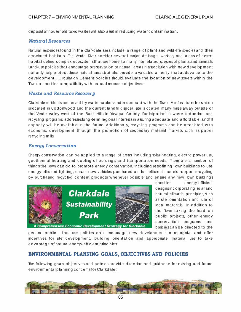
CHAPTER 7 – ENVIRONMENTAL PLANNING CLARKDALE GENERAL PLAN
85
disposal of household toxic wastes will also assist in reducing water contamination.
Natural Resources
Natural resources found in the Clarkdale area include a range of plant and wild-life species and their associated habitats. The Verde River corridor, several major drainage washes, and areas of desert habitat define complex ecosystems that are home to many interrelated species of plants and animals. Land-use policies that encourage preservation of natural areas in association with new development not only help protect those natural areas but also provide a valuable amenity that adds value to the development. Circulation Element policies should evaluate the location of new streets within the Town to consider compatibility with natural resource objectives.
Waste and Resource Recovery
Clarkdale residents are served by waste haulers under contract with the Town. A refuse transfer station is located in Cottonwood and the current landfill disposal site is located many miles away outside of the Verde Valley west of the Black Hills in Yavapai County. Participation in waste reduction and recycling programs addresses long-term regional interests in assuring adequate and affordable landfill capacity will be available in the future. Additionally, recycling programs can be associated with economic development through the promotion of secondary material markets, such as paper recycling mills.
Energy Conservation
Energy conservation can be applied to a range of areas, including solar heating, electric power use, geothermal heating and cooling of buildings, and transportation needs. There are a number of things the Town can do to promote energy conservation, including retrofitting Town buildings to use energy-efficient lighting, ensure new vehicles purchased are fuel-efficient models, support recycling by purchasing recycled content products whenever possible and ensure any new Town buildings
consider energy-efficient designs incorporating solar and natural climatic principles, such as site orientation and use of local materials. In addition to the Town taking the lead on public projects, other energy conservation programs and policies can be directed to the
general public. Land-use policies can encourage new development to recognize and offer incentives for site development, building orientation and appropriate material use to take advantage of natural energy-efficient principles.
ENVIRONMENTAL PLANNING GOALS, OBJECTIVES AND POLICIES The following goals, objectives and policies provide direction and guidance for existing and future environmental planning concerns for Clarkdale:

CHAPTER 7 – ENVIRONMENTAL PLANNING CLARKDALE GENERAL PLAN
86
GOAL 7.1 TO ENSURE CLARKDALE MAINTAINS A SUSTAINABLE ENVIRONMENT THAT PRESERVES ITS OPEN SPACE, NATURAL ASSETS AND A HEALTHY ENVIRONMENT FOR ITS RESIDENTS AND VISITORS TO ENJOY.
OBJECTIVE 7.1.a Support actions enabling natural assets and green spaces to contribute to the health of the community and the Town’s overall efforts to reduce impacts of climate change.
Policy: Protect important natural assets and areas of Clarkdale to maintain their roles in absorbing carbon dioxide from the atmosphere.
Policy: Support efforts to preserve creeks, washes and steep slopes in their natural state.
Policy: Support efforts to preserve native landscaping in new developments and limit grading on projects to the building envelope.
Policy: Encourage efforts to replace and/or restore damaged, natural habitat.
OBJECTIVE 7.1. b Support actions that reduce greenhouse gas (GHG) emissions from transportation.
Policy: Support development patterns in new development and redevelopment that minimize the emission of green-house gas from vehicle miles traveled (VMT) to meet basic needs.
Policy: Promote infill development and redevelopment of existing neighborhoods, preservation of historic structures and the adaptive reuse of buildings within the currently developed areas.
Policy: Support programs resulting in paving of dirt and gravel roads and unpaved parking lots with the latest financially and environmentally sound methods.
OBJECTIVE 7.1. c Encourage use of renewable energy sources.
Policy: Encourage the use of solar energy for residential, commercial and industrial uses.
Policy: Support new energy programs to utilize waste or renewable products.
Policy: Support upgrading of Town buildings and facilities to use renewable energy

CHAPTER 7 – ENVIRONMENTAL PLANNING CLARKDALE GENERAL PLAN
87
and energy efficient heating and cooling systems.
Policy: Develop a plan for installing energy-efficient street lighting and public parking lot lighting.
OBJECTIVE 7.1. d Support comprehensive waste reduction and resource recovery programs.
Policy: Support innovative programs for waste reduction, product development and public education.
Policy: Encourage economic development programs that support use of secondary materials in local businesses.
OBJECTIVE 7.1. e Support efforts to protect open space, manage growth and encourage economic development through programs like cluster development, transfer of development rights (TDR), conservation easements, partnering with land trusts and the development of the Clarkdale Sustainability Park.
Policy: Work to revise the Town’s codes and policies to allow creative approaches to accomplish the Town’s Sustainability priorities.
Policy: Establish a Sustainability Commission to advise the council, commissions and committees on matters directly related to Clarkdale’s efforts to achieve a sustainable community.
Policy: Implement broad-based environmental education programs for people of all ages in the community, emphasizing how individuals can make a difference in their environment.

CHAPTER 7 – ENVIRONMENTAL PLANNING CLARKDALE GENERAL PLAN
88
OBJECTIVE 7.1.f Work to achieve sustainability through regional cooperation on environmental issues.
Policy: Continue to work with organizations to address items of regional concern while striving to reach a sustainable solution to the Verde Valley environmental issues.

CHAPTER 7 – ENVIRONMENTAL PLANNING CLARKDALE GENERAL PLAN
89
ENVIRONMENTAL PLANNING IMPLEMENTATION STRATEGIES
Objective Policy Action Time Frame Enable the town’s natural resources and green spaces to contribute to the town’s efforts to reduce the effects of climate change.
Protect natural resources, preserve creeks, washes and steep slopes, encourage native landscaping and limit grading and develop ordinances that call for restoration of damaged habitat.
Review Town ordinances to accomplish general plan goals.
1 to 3 years.
Support actions to reduce greenhouse gas emissions from transportation.
Encourage development patterns that accomplish less vehicle trips per day. Provide infill and reuse incentives. Require paving of dirt roads in areas with increasing traffic.
Comprehensive review and development of Town ordinances that accomplish general plan goals and objectives.
1 to 3 years
Encourage use of renewable energy.
Develop programs that promote and incentivize renewable energy usage Town-wide.
Establish programs through community development and utilities that enable and reward the use of renewable energy.
1 to 3 years.
Encourage comprehensive waste reduction and resource recovery programs.
Develop programs that accomplish these general plan goals.
Expand the existing programs to accomplish these goals.
1 year
Utilize creative approaches to facilitate sustainable economic development.
Establish a Sustainability Commission that advises the council on the efforts to become a sustainable community.
Design and develop the programs necessary.
1 to 2 years.
Continue to work for regional sustainability.
Maintain involvement in region-wide efforts.
Continue to take an active role in regional efforts.
Ongoing.

CHAPTER 8 – COST OF DEVELOPMENT CLARKDALE GENERAL PLAN
90
Chapter 8 COST OF DEVELOPMENT
The purpose of the Cost of Development Chapter is to identify the scope of impacts generated by new development and methods for providing funding for these new services and facilities. The Town of Clarkdale has long held the philosophy that new development should “pay for itself” and not burden existing residents and property owners with the cost of infrastructure, public services and facilities needed by that new development.
Through the zoning process and the development review process, the Town can evaluate appropriate dedications, development fees, and infrastructure requirements. In 2007 the Town adopted Impact Fees for new development intended to meet the facility and infrastructure needs generated by new development. It is important to recognize that the likelihood of a large master planned community establishing the infrastructure in large areas of the Town is slimmer now than in the past. In the past, exactions from developers have been used to obtain parks, school sites and public trail easements. The Town will need to look to other methods, work with the private sector and advocates of specific facilities and services and continue to be creative in providing and financing the needed community amenities.
FINANCING ALTERNATIVES Growth causes a range of public service needs to be generated both within new developments and at a Town-wide level. Various infrastructure requirements can be addressed within new subdivisions and planned developments through the development application process, but this only addresses a portion of new development in the Town. Even with considerable responsibilities placed on the developer to address their own impacts, there will be additional impacts to Town-wide systems to be addressed by other means. Typically, new residential development must be subsidized by other revenue sources since property taxes only pay for a fraction of costs generated by development. Infrastructure and service upgrades, such as sewer and water systems, street circulation facilities, fire and police protection, recreational facilities and Town administration must all be addressed as the Town grows unless people are willing to settle for reduced services. (Nelson, pp 117-128) A number of financing alternatives are available to address the cost of development.
A partial list includes the following:
General Fund
Current revenues, consisting of local sales tax and property tax, state-shared revenues and various grant sources can be used to pay for all or part of service expansions. However, given the state of Arizona’s economy, there is no guarantee these sources will continue. This is typically limited to smaller amounts due to competing interests with general operating expenses. General Fund revenues can be used where a cash match is required for grant requests and funds can be set aside over a number of years to build up revenues.

CHAPTER 8 – COST OF DEVELOPMENT CLARKDALE GENERAL PLAN
91
Transaction Privilege (Sales) Tax
Sales of products and services to the end-user are subject to retail sales tax. Sales tax includes state, county and town portions.
Specialty Industry Tax (Restaurants, Bars, Hotels)
Many jurisdictions place a tax on certain types of specialty uses, such as restaurants, bars and hotels. Typically, these taxes are targeted towards uses that primarily depend on non-residents. The tax collected may be directed towards specific uses also benefitting those businesses being taxed, such as recreational, cultural or street improvement projects.
Revenue Bonds
With revenue bonds, funds borrowed to finance public service expansion are paid back through future revenues pledged to the bond issuer. Revenues pledged are generally portions of sales tax and Highway User Revenue Funds (HURF) that come to the Town from state fuel taxes. Use of revenue bonds must be approved by public vote.
General Obligation Bonds
General obligation bonds are funds borrowed to finance public service expansion, such as sewer, water and parks that are paid back through future property tax revenues. Typically, the Town could borrow for up to 20 percent of its secondary assessed valuation with an additional 6 percent available for special projects. The use of general obligation bonds must be approved by public vote.
Municipal Property Corporation Bonds
Municipal property corporation bonds are funds borrowed for improvements to municipal facilities, such as Police and Library facilities; these bonds require pledges of all the Town’s excise tax revenues. Excise taxes include local and state-shared taxes, franchise taxes, licenses, permits and fines collected plus state revenue sharing. No election is required.
Improvement District Bonds
Typically used to finance local sewer, water or street improvements, or to acquire an existing water operation, improvement district bonds assess each parcel in the district based on the share of benefit to be derived. The assessment district may be defined as the entire Town or as a specific area to be determined. Assessments may be paid by property owners up front in cash or financed through issuance of bonds. This tool allows the contractor to be paid in full for work completed while a schedule of payments is assessed to be paid over a number of years. Bonds are secured by a lien on the property within the defined district. This requires app rov a l o f at least 51% of the property owners in the affected area as evidenced through a petition process.
Community Facility District Bonds
Allowing for the financing of a range of public infrastructure projects through general obligation

CHAPTER 8 – COST OF DEVELOPMENT CLARKDALE GENERAL PLAN
92
bonds, revenue bonds or assessment bonds within an improvement district, community facility district bonds obligate the property owners in the district, and not the Town if default should occur. Water and wastewater projects, street improvements, downtown redevelopment and public facilities may be financed through issuance of Community Facility District Bonds.
Development (Impact) Fees
Clarkdale has adopted development impact fees intended to impose on landowners in a benefit area the obligation to pay for a proportionate share of the public facilities required to serve those landowners. The statute applicable to municipalities allows development fees to be assessed for necessary public services - interpreted to include parks and open space areas. Development fees are typically assessed at the time of issuance of a building permit. If the open space or planned park is not located near a proposed development, then development fees will not be a viable mechanism for the funding of that park or open space. This is a fee that has not received builder or developer support in Arizona.
Reimbursement Ordinance
The Reimbursement Ordinance may be used by an applicant to recover prorated costs of extending water or sewer lines when developers have extended water or sewer lines from locations not adjacent to their site. Such funds are collected and disbursed by the city, and the agreement exists for a specified period of time.
User Fees
User fees are assessed for the specific use of a service or activity. A user fee can be utilized to defray a portion of the total cost of the entire project. One advantage of the user fee is that it is incurred by the person using the specific service.
Grant Sources
Grants are available for most public service expansion, including transportation related projects, water and sewer expansion, historic building renovation, economic development projects, police and fire vehicles, and public facility improvements. Grant sources may be federal, state, corporate or private funds. Grants may require matching funds through cash match or from in-kind sources. Grants are typically competitive and cannot be expected as a guaranteed source.
Community Development Block Grant (CDBG)
Every four years the CDBG program provides direct grants to the Town of Clarkdale for a range of programs and facility improvements, including street and infrastructure upgrades. These grants are dispersed through the Arizona Department of Commerce. Public Hearings are held on the projects to be selected and rigorous criteria must be met and adhered to during the expenditure of these funds. Potential projects must meet community needs and assist low to moderate income areas.

CHAPTER 8 – COST OF DEVELOPMENT CLARKDALE GENERAL PLAN
93
FINANCING AUTHORITIES
Greater Arizona Development Authority (GADA)
Through the GADA Fund, bonds to finance infrastructure can be issued. Additionally, they provide a range of professional assistance in securing financing for infrastructure development and construction.
Water Infrastructure Financing Authority (WIFA)
An independent entity authorized to finance water, wastewater, reclaimed water and other water projects, WIFA offers Water Quality Bonds which allow municipalities to borrow money at lower interest rates and lower financing costs for water-related infrastructure development. Typically they offer 20-year terms with simple interest payments. There is a limited state-wide loan pool and requests are competitive.
USDA Rural Development Authority (USDA/RDA)
U.S. Department of Agriculture program provides assistance to rural Towns in the form of direct grants, technical assistance, guaranteed loans, research and educational materials to address water, sewer and waste disposal, electricity, housing and business development.
COST OF DEVELOPMENT GOALS, OBJECTIVES AND POLICIES
GOAL 8.1 EQUITABLY ASSESS AND MANAGE THE FISCAL AND CAPITAL IMPACTS RESULTING FROM NEW DEVELOPMENT.
OBJECTIVE 8.1.a Identify methods to measure the impacts of development on existing services to determine reasonable requirements imposed on the cost of development.
Policy: Maintain annual traffic counts on major roadways throughout the Town as a baseline for traffic impact studies for new development projects.
Policy: Support regional transportation planning programs that provide funding sources for roadway improvements impacting the Town of Clarkdale.
Policy: Support efforts to annually update the wastewater master plan to measure the impacts of growth on the Town sewer system and wastewater facility.
Policy: Annually review the impact study plan and revise as necessary.
OBJECTIVE 8.1. b Maintain community development standards for public services and

CHAPTER 8 – COST OF DEVELOPMENT CLARKDALE GENERAL PLAN
94
facilities.
Policy: Establish minimum level of service standards to address various areas of the Town.
Policy: Encourage new development to be located in areas already served by existing infrastructure a.k.a Infill development
Policy: Develop policies and guidelines for street and sidewalk development rules and regulations for all new commercial development including multi-family residential.
OBJECTIVE 8.1. c Ensure any mechanisms adopted by the municipality under this element result in a beneficial use to the development, bear a reasonable relationship to the burden imposed on the municipality to provide additional necessary public services to the development, and otherwise are imposed according to law.
Policy: Require new subdivisions, planned developments and major new commercial development to adequately assess the fiscal and capital impacts resulting from new development.
Policy: If additional capacity is needed at any municipally-owned utility due to a new subdivision or planned area development, the developer shall be accessed a monetary amount equal to the amount determined for the upgrade.
Policy: Encourage the use of local volunteers (including community service workers through the court system) for maintenance of parks, trails, other recreational facilities.
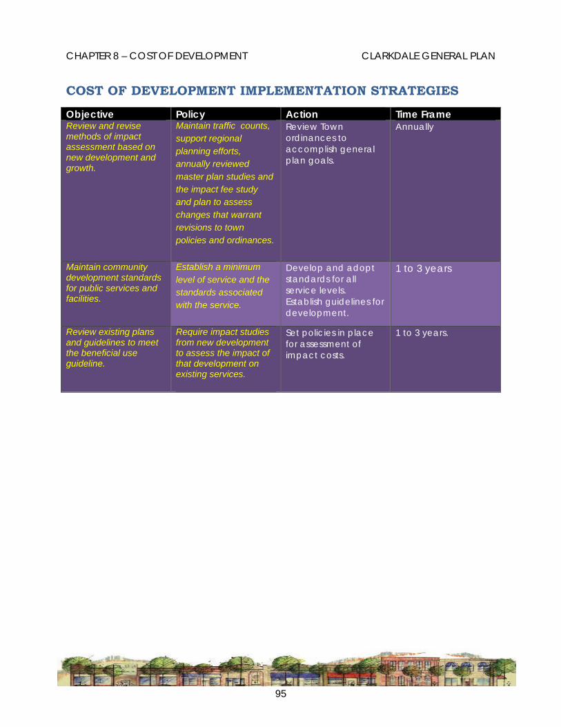
CHAPTER 8 – COST OF DEVELOPMENT CLARKDALE GENERAL PLAN
95
COST OF DEVELOPMENT IMPLEMENTATION STRATEGIES
Objective Policy Action Time Frame Review and revise methods of impact assessment based on new development and growth.
Maintain traffic counts, support regional planning efforts, annually reviewed master plan studies and the impact fee study and plan to assess changes that warrant revisions to town policies and ordinances.
Review Town ordinances to accomplish general plan goals.
Annually
Maintain community development standards for public services and facilities.
Establish a minimum level of service and the standards associated with the service.
Develop and adopt standards for all service levels. Establish guidelines for development.
1 to 3 years
Review existing plans and guidelines to meet the beneficial use guideline.
Require impact studies from new development to assess the impact of that development on existing services.
Set policies in place for assessment of impact costs.
1 to 3 years.
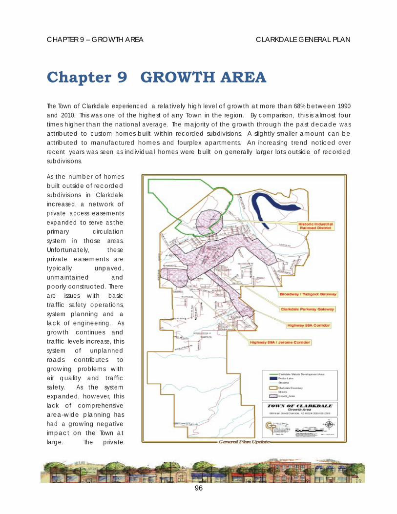
CHAPTER 9 – GROWTH AREA CLARKDALE GENERAL PLAN
96
Chapter 9 GROWTH AREA
The Town of Clarkdale experienced a relatively high level of growth at more than 68% between 1990 and 2010. This was one of the highest of any Town in the region. By comparison, this is almost four times higher than the national average. The majority of the growth through the past decade was attributed to custom homes built within recorded subdivisions. A slightly smaller amount can be attributed to manufactured homes and fourplex apartments. An increasing trend noticed over recent years was seen as individual homes were built on generally larger lots outside of recorded subdivisions.
As the number of homes built outside of recorded subdivisions in Clarkdale increased, a network of private access easements expanded to serve as the primary circulation system in those areas. Unfortunately, these private easements are typically unpaved, unmaintained and poorly constructed. There are issues with basic traffic safety operations, system planning and a lack of engineering. As growth continues and traffic levels increase, this system of unplanned roads contributes to growing problems with air quality and traffic safety. As the system expanded, however, this lack of comprehensive area-wide planning has had a growing negative impact on the Town at large. The private

CHAPTER 9 – GROWTH AREA CLARKDALE GENERAL PLAN
97
easement circulation network which has been constructed parcel by parcel has resulted in growing complaints about air quality, dangerous intersections, narrow bottlenecks and a range of localized drainage problems.
Based on current densities, zoning and development trends, Clarkdale’s private land base can support a total population of approximately 16,000. At current development rates, the current population of 4,074 (as of the 2010 Census) will nearly double by the year 2034. Orderly placement of new construction is paramount for a cost-effective development pattern of current vacant land areas. Build out of the present Town boundaries, subject to zoning restrictions is estimated to occur around 2052. Proposed future annexations can push the projected build out date too far into the future to accurately anticipate when build out will actually be reached.
The Growing Smarter Plus legislation, which governs the general plan process in Arizona addresses the problems with poorly planned growth patterns by identifying areas suitable for more efficient and coordinated growth patterns. Areas more suitable for future development, referred to as ‘growth areas,’ are those areas in proximity to existing infrastructure and community facilities. The preferred growth areas are able to tie into existing roads, sewer and water infrastructure, and are in close
proximity to various existing community amenities such as schools and fire stations.
Development patterns providing a mix of uses within a general area, so people may be able to walk or ride a bike from their homes to nearby shopping areas or community facilities, also help define the preferred growth areas. Additionally, the preferred growth areas are those that can best integrate the development with open space networks and natural areas.
In many ways, the objectives of the Growth Area Element result in a development pattern resembling traditional American neighborhoods. These same ideas are seen in the historic neighborhoods of Upper and Lower Clarkdale. The planned layout of the historic Town had different styles of homes to meet a range of economic levels, and different
uses, were all located relatively close to each other, and included residential areas, the downtown commercial district, the administrative center, cultural facilities, parks and schools. Front porches and tree-lined streets were part of the environment inviting people to walk and visit neighbors, creating the idea of community. Most importantly, the design placing everything within walking distance governed the growth patterns for Clarkdale for most of its early years. It was not until the seventies that development started to occur away from the Town and service center.
The Growth Area chapter approaches growth management from a perspective of identifying those

CHAPTER 9 – GROWTH AREA CLARKDALE GENERAL PLAN
98
areas of the community that are most appropriate for development. Having certain “growth areas” of the community that will best accommodate future growth allows increased focus on creating or enhancing transportation systems and infrastructure coordinated with development activity. In the “growth areas,” the Town can concentrate on improvements to support a variety of uses (mixed uses) such as residential, office, commercial, tourism and industrial uses. Growth areas are intended to discourage sprawl by focusing new development into targeted areas most appropriate for integrating open spaces and natural resources while accommodating a variety of land uses and multi-modal transportation (shuttles or buses, pedestrian, bicycling, and autos).
GROWTH AREA PLAN The Growth Area Plan identifies the areas most suitable for future development according to the objectives of well-planned, efficient, cost-effective, coordinated, community-oriented design criteria.
These concerns are addressed in the Growing Smarter legislation according to the following concepts:
• Provide a rational pattern of land development.
• Support a planned concentration of a variety of uses.
• Provide efficient automobile, transit and multi-modal transportation opportunities.
• Conserve natural resources and open-space resources.
• Ensure economical infrastructure expansion.
• Coordinate public infrastructure expansion with private development activity.
Most of the land areas identified are currently privately owned and are subject to the interests of those private land owners. However, these policies are intended to provide mutual benefits for both the property owners and the Town in general. More efficient growth patterns are generally more cost-effective and they provide a range of desirable community amenities, such as less traffic, more open space and a stronger sense of community. (Nelson,2004. pp. 34-39)
The Growth Areas
Five areas in Clarkdale have been identified as offering the best opportunities for encouraging efficient development practices.
1. The Clarkdale Parkway Gateway District is the one area in Clarkdale at this time that most closely addresses the ‘growth area’ criteria.
2. The Broadway Tuzigoot Gateway also offers opportunities for more efficient development, however, that area is more likely to develop after other surrounding development. Still, this area is worth identifying because it is such an important location as an entryway into historic Clarkdale and because of its proximity to the Verde River.

CHAPTER 9 – GROWTH AREA CLARKDALE GENERAL PLAN
99
3. The Historic Industrial Railroad District not only offers unique opportunities for commercial and industrial development but also could provide some amount of multi-unit residential development if it was carefully located.
4. The State Route 89A Corridor is an area likely to see continued strip commercial development expanding out from Cottonwood. The concern and opportunity here is to consider how infill development can occur in a way that addresses the forces of economic development while best integrating with the interests of adjoining residents and neighborhoods.
5. The fifth area is on the south side of State Route 89A as it moves up the hill to Jerome. With the expansion of the sewer line to the water tank area on State Route 89A, this area is set to open up for development. Historically what has held this area to large-lot development is the lack of Town utilities. Both commercial and residential uses can benefit from service expansion.
The Clarkdale Parkway Gateway The area on both sides of Clarkdale Parkway from State Route 89A to Upper Clarkdale and between Broadway and Centerville is identified as the Clarkdale Parkway Gateway District. The Land Use Plan identifies this area as Mixed Use; the Circulation Plan identifies a major collector through a portion of the area to provide access through the area when it is developed. Development of this area would serve as a ‘gateway’ from State Route 89A which is the main arterial access route serving Clarkdale to the historic Town site area. This area is highly visible from throughout the Town and development here will have a profound and lasting impact on the character of Clarkdale. This area is surrounded by major roads, is close to the wastewater treatment plant and is bisected by a couple of major washes, which help define natural boundaries to the area. Because of the high visibility of this area, it should be identified as a major planning priority to ensure that any future development is done in a manner sensitive to the historic context. A Clarkdale Parkway Overlay designation would allow a mix of uses, including residential, commercial, recreational and open space.
The Broadway Tuzigoot Gateway With development of the Clarkdale Parkway Gateway District there is likely to be pressure on the Broadway corridor to address land use and traffic planning, especially in the vicinity of the intersection with Tuzigoot Road. Zoning designations in this area currently include a mix of commercial, residential and industrial. The wastewater treatment plant is here, as well as important natural and cultural resources, such as the Verde River and Tuzigoot National Monument. The existing mix of uses and variety of land forms create some unique challenges which could be assisted by a coordinated master planned development approach for this sub area. This area also serves as one of the areas being considered for the proposed Clarkdale Sustainability Park, an industrial park/natural area for renewable energy development at the site of the old tailings area and the Pecks Lake/Tavasci Marsh natural area.
The Historic Industrial Railroad District The area defined by the historic smelter site and tourist railroad depot is identified as a unique kind of ‘Growth Area’. The area between Bitter Creek Wash and Patio Park offers a unique opportunity for development. There could be higher density residential development, such as well-designed town homes in the vicinity of Bitter Creek Wash while commercial and light industrial uses would be suitable

CHAPTER 9 – GROWTH AREA CLARKDALE GENERAL PLAN
100
around the railroad depot and back towards the hillside. If the area was carefully planned with just the right mix of uses, the result could be a great improvement over the existing conditions.
The State Route 89A Corridor Overlay The alternative to the typical development pattern is to consider this corridor as another kind of unique ‘Growth Area’. With a partnership between property owners, residents and the Town, there could be solutions that would benefit everyone. A master concept plan approach for this corridor could define a vision including incentives for developments addressing both buffering and linkages between adjacent neighborhoods, mixed-use concepts, pedestrian amenities, and low-volume secondary access roads. Arizona Department of Transportation has a limited access plan in place for this corridor which lends itself to a creative approach to development.
The State Route 89A/Jerome Corridor This area located on the south side of the highway has become a focus for development in the past four years because of the expansion of the sewer and water utilities to the water tank site. This now provides for both commercial and residentially focused development. This area is part of the foothill bench area which lends itself to become an attractive development area.
GROWTH AREA GOALS, OBJECTIVES AND POLICIES
The following goals, objectives and policies provide direction and guidance for identifying areas most suitable for growth according to the principles of the Growth Area Element.
GOAL 9.1. DIRECT AND SUSTAIN GROWTH AND EXPANSION IN AREAS OF THE TOWN THAT CAN SUPPORT A CONCENTRATION OF A VARIETY OF USES AND ARE PARTICULARLY SUITABLE FOR MULTIMODAL TRANSPORTATION AND INFRASTRUCTURE EXPANSION AND IMPROVEMENTS.
OBJECTIVE 9.1.a Promote infrastructure expansion where it will be most efficient and effective while minimizing adverse impacts outside the identified areas.
Policy: Identify existing, measurable edges of growth areas and the transitions between adjacent growth areas.
Policy: Promote the coordination of infrastructure development and upgrades with opportunities for infill development and development activity to encourage a mix of uses and support pedestrian and transit activity
Policy: Give priority in the Capital Improvements Plan (CIP) to upgrades and improvements serving identified growth areas.
Policy: Create techniques allowing for mixed-use activity within designated growth

CHAPTER 9 – GROWTH AREA CLARKDALE GENERAL PLAN
101
areas.
Policy: Define policies and implementation strategies designed to:
• -make infrastructure expansion more cost-effective;
• provide for a rational pattern of land development; and
• identify and support opportunities for regional connectivity.
OBJECTIVE 9.1.b Encourage development to occur in areas served by existing and planned infrastructure, including roads, sewer lines and water lines.
Policy: Achieve meaningful open space as an integral part of activity cores and conserve significant natural resources and open space areas within growth areas.
Policy: Provide open spaces in designated growth areas encouraging public gathering, enhancing aesthetics, preserving viewsheds, and serving as buffers between uses of significantly differing function and intensity.
OBJECTIVE 9.1.c Promote development timing guided by the adequacy of existing and/or expandable infrastructure, services, and facilities.
Policy: Plan and promote the orderly building of infrastructure, such as water, sewer, drainage, and transportation facilities.
Policy: Ensure development approval is related to commitments for the construction of primary water, wastewater, and circulation systems.
Policy: Focus infrastructure improvements in designated growth areas and contiguous to existing development.
Policy: Ensure development outside of designated growth areas pays for all related infrastructure improvements.
Policy: Anticipate the need and secure land for public facilities such as water treatment plants, reservoirs, transportation rights-of-way, parks, libraries, community centers and other public needs such as police and fire.

CHAPTER 9 – GROWTH AREA CLARKDALE GENERAL PLAN
102
GROWTH AREA IMPLEMENTATION STRATEGIES
Objective Policy Action Time Frame Promote infrastructure expansion where it will be most efficient and effective and minimizes adverse impacts outside the identified area
Promote coordination of infrastructure and infill development. Develop a Capital Improvement Program that coordinates with the growth areas.
Adopt policies that give incentives for development in identified growth areas and develop a Capital Improvement Program that coordinates development within those areas.
Annually
Encourage development to occur in areas served by existing and planned infrastructure, including roads, sewer lines and water lines.
Conserve significant open space areas within growth areas. Develop plans that enhance the open space areas within the identified growth areas and coordinate their use.
Develop and adopt policies that provide for and award the conservation of open space areas within growth areas. Establish guidelines for development.
1 to 3 years
Promote development timing that is guided by the adequacy of existing and/or expandable infrastructure, services, and facilities.
Plan for infrastructure improvements adjacent to existing services and within growth areas. Anticipate and secure the land for public facilities.
Coordinate and plan all infrastructure development and facilities based on growth-area identification.
1 to 3 years.

CHAPTER 10 - HOUSING CLARKDALE GENERAL PLAN
103
Chapter 10 HOUSING
Housing is fundamental to the foundation of a community. How the community meets those needs for all of its citizens is what defines a community. Clarkdale is part of a very diverse region in the Verde Valley that makes room for the rich, the poor, the socially isolated, the creative and the entrepreneurial spirit. Where cheap land has bred sprawl and an independent spirit has led to eclectic housing choices, urban density is starting to make more sense in Clarkdale.
Employees earning workforce wages fill the majority of jobs in nearly every sector of our economy. Those jobs are the teachers, the police and fire officers, the retail workers and the public employees in all nature of jobs. Workforce households are defined as those households whose members collectively earn from 80 percent up to 120 percent of Yavapai County’s annual Area Median Income (“AMI”)as defined by the U.S. Department of Housing and Urban Development’s (“HUD”) Median Family Income (”MFI”). The 2008 AMI is $42,311. (Meek Et. Al., 2003. Pp. 23-27)
Clarkdale’s housing stock is mainly single family. It is divided into those homes built in the 1920’s, in upper and lower Clarkdale, on smaller lots, and those homes built in the 1980’s to present day. The homes built later are larger, on larger lots, but still basically single family in nature. Over the past six years, the housing market value has increased substantially. Even after two years of housing prices spiraling downward with the recession, the price of homes has not decreased significantly. A 2000 sq. ft. home in 2008 was priced on average at $365,000. The smaller homes in upper and lower Clarkdale were listed at $275,000 to $325,000. Those same homes now go for $225,000 and $295,000, while a 2000 sq. ft. home is now listed for $290,000. This is well above the family’s means that earns a salary near the medium family income. Even in today’s economic downturn, in Clarkdale the price of homes has not dropped as it has in other Arizona cities. Clarkdale homes have depreciated only 6.6% in the past twelve months. (AOL, June, 2011)
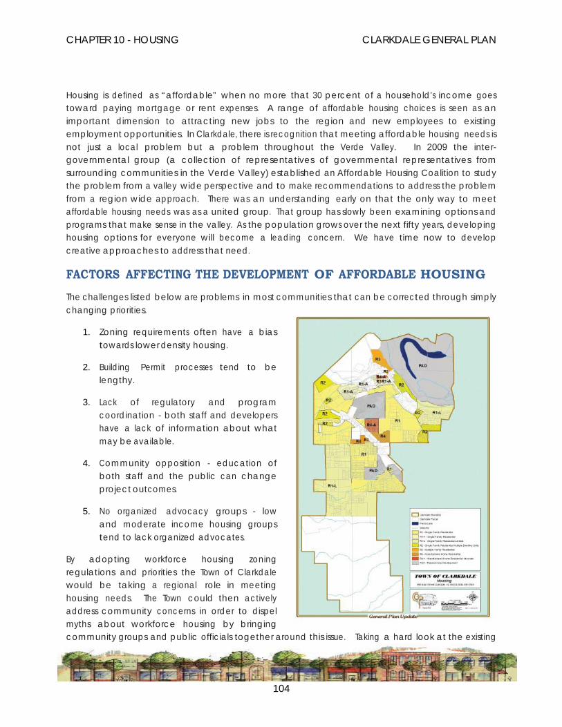
CHAPTER 10 - HOUSING CLARKDALE GENERAL PLAN
104
Housing is defined as “affordable” when no more that 30 percent of a household’s income goes toward paying mortgage or rent expenses. A range of affordable housing choices is seen as an important dimension to attracting new jobs to the region and new employees to existing employment opportunities. In Clarkdale, there is recognition that meeting affordable housing needs is not just a local problem but a problem throughout the Verde Valley. In 2009 the inter-governmental group (a collection of representatives of governmental representatives from surrounding communities in the Verde Valley) established an Affordable Housing Coalition to study the problem from a valley wide perspective and to make recommendations to address the problem from a region wide approach. There was an understanding early on that the only way to meet affordable housing needs was as a united group. That group has slowly been examining options and programs that make sense in the valley. As the population grows over the next fifty years, developing housing options for everyone will become a leading concern. We have time now to develop creative approaches to address that need.
FACTORS AFFECTING THE DEVELOPMENT OF AFFORDABLE HOUSING The challenges listed below are problems in most communities that can be corrected through simply changing priorities.
1. Zoning requirements often have a bias towards lower density housing.
2. Building Permit processes tend to be lengthy.
3. Lack of regulatory and program coordination - both staff and developers have a lack of information about what may be available.
4. Community opposition - education of both staff and the public can change project outcomes.
5. No organized advocacy groups - low and moderate income housing groups tend to lack organized advocates.
By adopting workforce housing zoning regulations and priorities the Town of Clarkdale would be taking a regional role in meeting housing needs. The Town could then actively address community concerns in order to dispel myths about workforce housing by bringing community groups and public officials together around this issue. Taking a hard look at the existing

CHAPTER 10 - HOUSING CLARKDALE GENERAL PLAN
105
housing stock and zoning regulations, although a difficult task for most communities, gives the community base information as it moves towards meeting housing needs. Encouraging the development of alternative housing options at the same time is another approach to meeting housing needs.
HOUSING GOALS, OBJECTIVES AND POLICIES
GOAL 10.1 CONTINUE TO WORK WITH THE REGIONAL HOUSING COALITION TO DEVELOP AN AFFORDABLE/ OBTAINABLE HOUSING ANALYSIS FOR THE VERDE VALLEY.
OBJECTIVE 10.1.a Evaluate options to meet the affordable housing need from a regional perspective; including a Certified Housing and Development Organization (CHADO), a Housing Trust, land set aside, inclusionary housing and a Housing Authority.
Policy: Work with the Housing Coalition to develop a projection model of the housing needs for the valley for the next ten years in order to develop a plan to address those needs.
Policy: Promote and facilitate non-traditional housing types and options, including co-housing, assisted living facilities, live-work spaces, and artist lofts.
Policy: Develop an Infill Overlay Zone and Downtown Specific Plan as a tool to facilitate higher density residential and mixed-use development.
OBJECTIVE 10.1.b Maintain and improve the quality of existing housing and residential neighborhoods in Clarkdale.
Policy: Encourage citizen involvement in addressing the housing needs
GOAL 10.2. PROMOTE EQUAL OPPORTUNITY FOR ALL RESIDENTS TO LIVE IN THE HOUSING OF THEIR CHOICE.
OBJECTIVE 10.2.a Facilitate the provision of a range of housing types to meet the diverse needs of the community.
Policy: Provide high quality housing for current and future residents with a diverse range of income levels.

CHAPTER 10 - HOUSING CLARKDALE GENERAL PLAN
106
Policy: Promote housing developed under modern sustainable community standards.
Policy: Promote higher density housing as part of mixed-use developments.
OBJECTIVE 10.2.b Mitigate or remove any potential governmental constraints to housing production and affordable design.
Policy: Provide flexibility in development standards to accommodate new models and approaches to providing affordable housing.
Policy: Review the Town’s codes to accommodate workforce housing and remove or amend any codes inhibiting the development of workforce housing.
OBJECTIVE 10.2.c Encourage sustainability and green building in the Town’s development ordinances.
Policy: Work to continue the culture of sustainability in Town projects while encouraging sustainability in the private sector.
CHAPTER 10 - HOUSING CLARKDALE GENERAL PLAN
107

CHAPTER 10 - HOUSING CLARKDALE GENERAL PLAN
108
HOUSING IMPLEMENTATION STRATEGIES Objective Policy Action Timeframe Maintain and improve the quality of existing housing and residential neighborhoods in Clarkdale.
Encourage citizen involvement in addressing the maintenance and improvement of the maintenance and improvement of the housing stock and neighborhood quality. Continue to preserve and maintain the City’s historical and architecturally significant buildings and neighborhoods
Work with neighborhood groups to accomplish this policy. Develop community design ordinances that facilitate this project.
1 to 3 years
Facilitate the provision of a range of housing types to meet the diverse needs of the community.
Provide high quality housing for current and future residents with a diverse range of income levels. Promote housing that is developed under modern sustainable community standards. Promote higher density housing as part of mixed-use developments.
Work with developers and state and federal programs to achieve this objective.
1 to 3 years.
Mitigate or remove any potential governmental constraints to housing production and affordable design.
Provide flexibility in development standards to accommodate new models and approaches to providing affordable housing. Review the town’s codes to accommodate
Review existing codes and modify where necessary.
1 to 3 years.
CHAPTER 10 - HOUSING CLARKDALE GENERAL PLAN
109
Objective Policy Action Timeframe workforce housing and remove or amend any codes that inhibit the development of workforce housing.
Encourage sustainability and green building in the Town’s development ordinances.
Work to continue the culture of sustainability in town projects while encouraging sustainability in the private sector.
Design a program that identifies Town projects and establishes guidelines for the private sector.
1 year.

CHAPTER 11 – COMMUNITY DESIGN CLARKDALE GENERAL PLAN
110
Chapter 11 COMMUNITY DESIGN
When talking to residents of Clarkdale about their Town you get descriptive statements like: the “small Town” character; the neighborhood feel; the central park as a meeting and event place; and the sense of community. Most of the descriptions about Clarkdale describe the “original” Town area. However, Clarkdale is made up of eight distinct sub-areas each with individual design aspects unique to each sub-area. In fact Clarkdale, like most communities, is made up of different neighborhoods.
In the two years since the Local Government Commission’s Smart Growth Zoning Codes: A Resource Guide was first published, the movement to reform zoning codes has gained momentum. Today, form-based codes have become an increasingly popular approach to achieve these reforms and create communities where people want to live, work and play.
The old adage “form follows function” describes the common approach behind land use regulation as it has been practiced in the past. Form-based codes turn that relationship on its head. Since the primary basis for regulation is the buildings, not the uses, “function follows form.” These codes concentrate first on the visual aspect of development: building height and bulk, façade treatments, the location of parking, and the relationship of the buildings to the street and to one another. Simply put, form-based codes emphasize the appearance and qualities of the public realm, the places created by buildings.
As with other smart growth concepts, form-based codes have been applied in new growth areas, in existing neighborhoods, in limited situations to special districts, and in wholesale code revisions for entire communities.
Community design then begins with context. The context of a place considers its history as well as its future. It also includes knowing how the place or neighborhood fits into the community as a whole. From there, you can start to identify the key design conventions that have determined the building scale and proportion for each area. A community applies design standards when a Town’s reason to exist endures and the residents see their community as a place fulfilling their commercial, social and psychological needs. The community then sees value in preserving that place.

CHAPTER 11 – COMMUNITY DESIGN CLARKDALE GENERAL PLAN
111
As the focus group looked at each sub-area, some design elements were consistent within each similar use area but many design elements were unique to that subarea. Any community design program would have to start with a specific regulating plan for each subarea. That plan would contain architectural standards, creation of a public realm, designing public street space standards, connectivity requirements for pedestrians, bicycles and automobiles, natural feature preservation and graphic depictions as examples. Before the specific regulating plan can be created for each subarea, there are multiple subarea community outreach efforts that need to occur in order to set the framework for the plan. At the end of the process, the Town will have the ability to set the direction of each subarea as it evolves.
The Town has examined new approaches to community design. The first approach was
an outgrowth of the state’s Growing Smarter legislation. Smart Growth and New Urbanism are both approaches a community can adopt. Design is then centered on why the Town is here, the Town center, and the initial development plan. For many places that works well. Clarkdale has grown up as an area of distinct neighborhoods, each with their own design quality but not linked to each other or to the original Upper and Lower Clarkdale and Patio Park design. While there are design elements those three areas have in common, most of the rest of Clarkdale is different in character and design.
In reviewing the literature, the concept that keeps surfacing is a Form-Based Code approach. This approach is vision-based, requiring that all development work together to create the place envisioned by the community. Form Based Codes work from the street level to the building
What are form-based codes?
Form-based codes place a primary emphasis on building type, dimensions, parking location and façade features, and less emphasis on uses. They stress the appearance of the streetscape, or public realm, over long lists of different use types.
These codes have the following characteristics:
➜ Zoning Districts – Form-based codes are defined around districts, neighborhoods and corridors where conventional zoning districts may bear no relationship to the transportation framework or the larger area.
➜ Regulatory Focus – Form-based codes de-emphasize density and use regulation in favor of rules for building form. They recognize that uses may change over time, but the building will endure.
➜ Uses – Form-based codes emphasize mixed use and a mix of housing types to bring destinations into close proximity to housing and provide housing choices to meet many individuals’ needs at different times in their lives.
➜ Design – Greater attention is given to streetscape and the design of the public realm, and the role of individual buildings in shaping the public realm. Form-based codes recognize how critical these public spaces are to defining and creating a “place.”
➜ Public Participation – A design-focused public participation process is essential to assure thorough discussion of land use issues as the code is created. This helps reduce conflict, misunderstanding and the need for hearings as individual projects are reviewed.
Modified from definition by Paul Crawford, AICP

CHAPTER 11 – COMMUNITY DESIGN CLARKDALE GENERAL PLAN
112
envelope. They address both private and public space to create a whole design working together. The whole design concept is based on the unique characteristics of the neighborhood and community. In using this concept, Clarkdale could set development standards that are less about uses and more about how the proposed development fits into the neighborhood based on design, spatial context and mass. (Parolek Et. Al. 2008. Pp. 17 - 38)
The following is a comparison between the existing conventional zoning using the Form-Based Codes approach. (Parolek, 2008. Pp 126-129)
CONVENTIONAL ZONING • Segregates activities by zone.
• Uses a zoning map to establish a range of alpha-numerical land-use designations that specify a list of allowed, restricted and prohibited uses; and dimensional standards.
• Zoning designations are placeholders, seldom tied to a specific community vision. Each subsequent revision to the zoning standards makes the ordinance more abstract and complex, drifting it further from the community’s vision as called out in the master plan.
• Proscriptive: prohibits development not consistent with the code.
• Shows existing streets and blocks. Typically future roads and blocks are not addressed.
• Typically includes open space requirement.
• May be subject to discretionary review-outcome difficult to predict.
FORM-BASED CODES • Unifies and connects activities.
• Typically consists of documents such as regulating plan([a drawing that adds further details to what is loosely defined in the master plan); standards related to the form of the

CHAPTER 11 – COMMUNITY DESIGN CLARKDALE GENERAL PLAN
113
public realm; and in some cases architectural standards.
• Regulations codify the physical form of a community based on a specific regulating plan.
• Prescriptive: outlines what is expected of development, specifically the form of the buildings, streets, and public spaces, while permitting a greater flexibility in the use and activity.
• Concise, and uses drawings, diagrams, and photographs readily understood by public, public officials and professionals.
• Includes all [existing and proposed] streets and blocks.
• Indicates location of public parks, squares, and greenbelts, and rough footprints of planned public buildings.
• The tight physical framework of the regulating plan is developed with public input. Because all expectations are stated up front in clear, concise and easy-to-follow codes, the discretionary review is eliminated and the outcome becomes fairly predictable.
GOALS, OBJECTIVES AND POLICIES FOR COMMUNITY DESIGN
GOAL 11.1 DEVELOP THE COMMUNITY DESIGN MODEL PARAMETERS FOR THE CLARKDALE SUB-AREAS.
OBJECTIVE 11.1.a Engage the community sub-area stakeholders in the development of the Community Design Parameters.
Policy: Engage each sub-area in a design charrette to obtain local stakeholder input.
Policy: Present a scope of work for the Community Design model.
Policy: Adopt development standards and design guidelines that reflect the character of each individual sub-area.
OBJECTIVE 11.1.b Develop public realm concepts and public street space standards in conjunction with the Community Design model.
Policy: Identify neighborhood and community attributes that can be strengthened to establish connections to the entire Town.
Policy: Work to develop standards that decrease urban sprawl.

CHAPTER 11 – COMMUNITY DESIGN CLARKDALE GENERAL PLAN
114
Policy: Analyze equitable distribution of parks, open space, and services, and then create standards that provide for balanced distribution.
OBJECTIVE 11.1.c Develop sustainability standards providing for preservation of local natural features, historic buildings and culturally sensitive areas.
Policy: Develop codes encouraging infill and discourage urban sprawl.
Policy: Adopt building codes, development codes and design codes to encourage green building and sustainable practices.
Policy: Adopt landscape design standards that are reflective of the natural environment and protective of natural resources.

CHAPTER 11 – COMMUNITY DESIGN CLARKDALE GENERAL PLAN
115
COMMUNITY DESIGN IMPLEMENTATION STRATEGIES
Objective Policy Action Time Frame Engage the community sub-area stakeholders in the development of the Community Design Parameters.
Engage each sub-area in a design charrette to obtain local stakeholder impute. Present a scope of work for the Community Design model. Adopt development standards and design guidelines that reflect s the character of each individual sub-area.
Schedule the design charrettes and develop the scope of work for the model. Review existing standards from other communities and formulate standards and guidelines that are unique to Clarkdale.
1 – 3 years.
Develop public realm concepts and public street space standards in conjunction with the Community Design model.
Identify neighborhood and community attributes that can be strengthened to establish connections to the entire town. Work to develop standards that decrease urban sprawl. Analyze equitable distribution of parks, open space, and services, then create standards that provide for balanced distribution.
Review existing conditions and establish guidelines that accomplish the policy goals.
1 to 3 years
Develop sustainability standards that provide for preservation of local natural features, historic buildings, and culturally sensitive areas.
Develop codes that encourage infill and discourage urban sprawl. Adopt building codes, development codes and design codes that encourage green building and sustainable practices. Adopt landscape design standards that are reflective of the natural environment and protective of natural resources.
Research and review other examples of codes and standards that accomplish the stated policies.
1 to 3 years.

CHAPTER 12 – ECONOMIC DEVELOPMENT CLARKDALE GENERAL PLAN
116
Chapter 12 ECONOMIC DEVELOPMENT SUSTAINABLE ECONOMIC DEVELOPMENT As used in this document, the concept of “sustainable economic development” is meant to convey a goal of creating a local economy serving a variety of needs while creating long-term strength and stability, minimizing adverse impacts, and reflecting the unique environment and character of Clarkdale. In order to maintain and improve on the special qualities of life unique to this community, consideration should be given to strategies and actions with positive long-term community impacts, not only in terms of the local economy, but also on the local environment and in the cultural and social realms. Such considerations should include impacts to the environment, community character, socioeconomic diversity, public revenues, traffic, historic preservation, effects to other local businesses, and meeting the needs and goals of the community. Also, support of community-based businesses should be emphasized whenever possible.
Ecological systems sustain life and provide the context for human activity. In considering economic development actions, careful consideration should be given to the effect of such actions on natural resources, including but not limited to land, animal and plant communities, water, and air. Actions should be taken with awareness of the principles of resource conservation and protection, minimizing the ‘footprint’ of impacts and enhancement of resources.
Actions must also be “sustainable” by providing for community participation and collaboration in policy formulation and decision making so economic development occurs with broad community comprehension and support. Social and cultural systems also contribute to the special nature of Clarkdale. Economic development actions are just one of many forces creating a community. Such actions must also consider social and cultural impacts and how will specific economic development actions relate to goals of socioeconomic diversity. As the Economic Development Strategy is implemented, these issues should be considered.
A great community is a prosperous community. A successful Town brings people, institutions, ideas, and capital together in creative ways to enrich the lives of those who live and work there. That is the approach Clarkdale intends on taking as it moves forward with its Sustainable Economic Development plan. The Town is positioning itself to become a model of innovation in the “new economic reality.”

CHAPTER 12 – ECONOMIC DEVELOPMENT CLARKDALE GENERAL PLAN
117
Support for Local Businesses
Locally-owned businesses generally provide more benefits to the community, such as keeping more profits circulating in the local economy, supporting other businesses and generally tending to contribute more time and money to local causes than do absentee-owner firms. Thus, support and nurturing of locally owned and community based businesses and development of a positive network of community based enterprises should be supported whenever possible.
Not having businesses locally causes dollars to leave the community (“leakage”), and the loss of potential tax revenues. Furthermore, the range of local employment opportunities is reduced. In addition, the lack of such businesses forces residents and business owners in Clarkdale to go to Cottonwood or other areas to meet their needs. This creates an imbalance in the community, resulting in a less economically sustainable Clarkdale. Recapturing some of this business for Clarkdale and providing a greater diversity of retailers would create a healthier local economy. Working with the local businesses to coordinate economic development efforts and to foster a cooperative business climate means everyone wins.
Clarkdale Sustainability Park
The Clarkdale Sustainability Park is intended to be a major Economic Development strategy for the Town of Clarkdale – an evolutionary solution for a sustainable community. It is not an “industrial park” in the conventional sense of the term. It is a concept of a mix of private and public interdependent enterprises all of which have one overarching principal: a dedication to environmental, energy, economic and social independence and sustainability. The Clarkdale Sustainability Park will also be an educational opportunity for other governments interested in sustainability for their citizens. (The Clarkdale Sustainability Park White Paper-April 16, 2010)
Education and the Workforce
Quality education contributes to Clarkdale’s attractiveness and makes it a unique community. With the Verde Campus of Yavapai College located within the Town, resources can be used to leverage high-end economic development. This educational hub attracts students from around the valley bringing new money into the community. It is important to continue to foster an integrated system of workforce development responding to the lifelong learning needs of the current and future workforce. Jobs, education and training are inexorably intertwined and critical to Clarkdale’s economic vitality.

CHAPTER 12 – ECONOMIC DEVELOPMENT CLARKDALE GENERAL PLAN
118
Emphasis on connecting jobs with local skills and the provision of appropriate training and retraining programs will help ensure employment for residents. Education, quality job training and skill development lead to high quality, living wage jobs, and thus, job quality, job diversity and an improved standard of living.
Education enhances the upward mobility of the workforce. A well-trained, well-compensated and diversified labor force contributes to a healthy local economy and a positive community image that will assist in attracting new job opportunities.
ECONOMIC DEVELOPMENT GOALS, OBJECTIVES AND POLICIES
GOAL 12.1 OUR GOAL IS TO ATTRACT AND RETAIN ENTERPRISES THAT PROVIDE HIGH-VALUE, HIGH WAGE JOBS; TO DIVERSIFY AND GROW THE LOCAL ECONOMY; TO INCREASE THE LOCAL TAX BAS E;AND TO ANTICIPATE OUR ECONOMIC FUTURE IN ORDER TO STRENGTHEN OUR ECONOMY AND HELP FUND VITAL PUBLIC SERVICES.
OBJECTIVE 12.1.a Clarkdale needs to establish a clear economic strategy.
Policy: The Town needs to participate in regional economic development efforts.
Policy: Every effort should be made to encourage the public and private sectors to work together to achieve prosperity.
Policy: The Town should continue to work on the Clarkdale Sustainability Park as part of a comprehensive economic development strategy for the community.
OBJECTIVE 12.1.b Work to make the local economic climate more supportive of business investment in the community.
Policy: Review and revise existing and proposed Town procedures, policies and regulations to take into account the needs of business enterprises.
Policy: Work to support location neutral business development.
OBJECTIVE 12.1.c Assist efforts to develop the downtown as a mixed-use activity center including a variety of economic development choices and services.
Policy: Promote the preservation of historically significant structures and identify

CHAPTER 12 – ECONOMIC DEVELOPMENT CLARKDALE GENERAL PLAN
119
various means of protection.
Policy: Support existing businesses and encourage opportunities for infill and expansion of a variety of retail enterprises, including galleries, restaurants and specialty retail.
Policy: Encourage efforts to enhance and upgrade the physical appearance and infrastructure of the downtown area.
OBJECTIVE 12.1.d Support tourism opportunities.
Policy: Promote outdoor recreation as part of a visitor opportunities strategy. Policy: Partner with the Chamber of Commerce to promote Clarkdale events.
OBJECTIVE 12.1.e Work with the community to develop the organizational infrastructure to evaluate and develop specific strategies to maintain the economic health of the Town.
Policy: The Town will develop a network of resources and individuals to provide recommendations on maintaining the economic health of the community.
Policy: The Town will utilize the available economic development network to build on its resources in looking for new economic opportunities.
OBJECTIVE 12.1.f Support educational efforts to provide employment training and opportunity development for the local work force.
Policy: Support local job educational training programs at all levels.
Policy: Help identify the workforce needs of local employers and support efforts to meet those needs.
Policy: Develop an economic development/business brain trust that can help facilitate the development and execution of ideas.
Policy: Continue the work already underway.
Policy: Work more closely with Yavapai College to support workforce development needs.
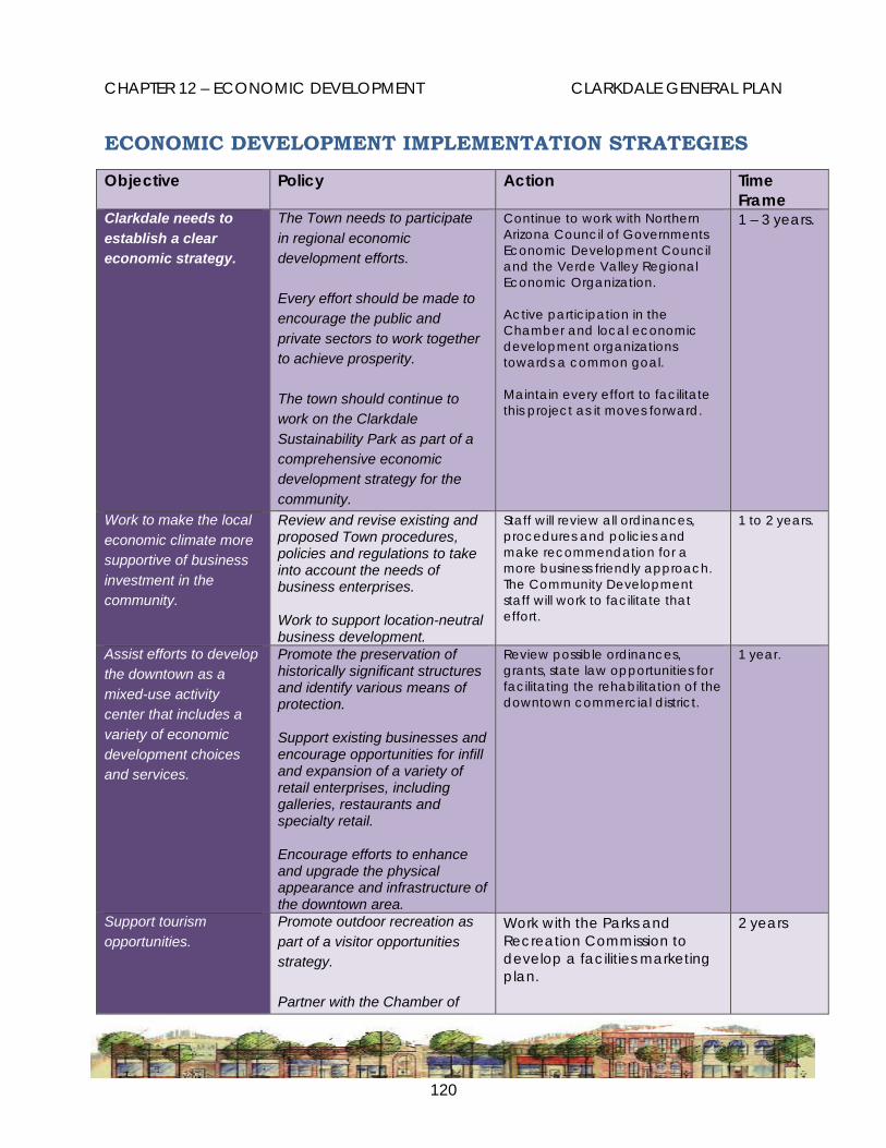
CHAPTER 12 – ECONOMIC DEVELOPMENT CLARKDALE GENERAL PLAN
120
ECONOMIC DEVELOPMENT IMPLEMENTATION STRATEGIES
Objective Policy Action Time Frame
Clarkdale needs to establish a clear economic strategy.
The Town needs to participate in regional economic development efforts. Every effort should be made to encourage the public and private sectors to work together to achieve prosperity. The town should continue to work on the Clarkdale Sustainability Park as part of a comprehensive economic development strategy for the community.
Continue to work with Northern Arizona Council of Governments Economic Development Council and the Verde Valley Regional Economic Organization. Active participation in the Chamber and local economic development organizations towards a common goal. Maintain every effort to facilitate this project as it moves forward.
1 – 3 years.
Work to make the local economic climate more supportive of business investment in the community.
Review and revise existing and proposed Town procedures, policies and regulations to take into account the needs of business enterprises. Work to support location-neutral business development.
Staff will review all ordinances, procedures and policies and make recommendation for a more business friendly approach. The Community Development staff will work to facilitate that effort.
1 to 2 years.
Assist efforts to develop the downtown as a mixed-use activity center that includes a variety of economic development choices and services.
Promote the preservation of historically significant structures and identify various means of protection. Support existing businesses and encourage opportunities for infill and expansion of a variety of retail enterprises, including galleries, restaurants and specialty retail. Encourage efforts to enhance and upgrade the physical appearance and infrastructure of the downtown area.
Review possible ordinances, grants, state law opportunities for facilitating the rehabilitation of the downtown commercial district.
1 year.
Support tourism opportunities.
Promote outdoor recreation as part of a visitor opportunities strategy. Partner with the Chamber of
Work with the Parks and Recreation Commission to develop a facilities marketing plan.
2 years

CHAPTER 12 – ECONOMIC DEVELOPMENT CLARKDALE GENERAL PLAN
121
Objective Policy Action Time Frame
Commerce to promote Clarkdale events.
Continue and expand the efforts to work with the Chamber on Clarkdale events.
On going.
Work with the community to develop the organizational infrastructure to evaluate and develop specific strategies to maintain the economic health of the Town.
The town will take the lead to develop a network of resources and individuals to provide recommendations on maintaining the economic health of the community. The Town will utilize the available economic development network to build on its resources in looking for new economic opportunities.
Develop an economic development/business brain trust that can help facilitate the development and execution of ideas. Continue the work that has begun.
1 to 3 years. On going.
Support educational efforts to provide employment training and opportunity development for the local work force.
Support local job educational training programs at all levels. Help identify the workforce needs of local employers and support efforts to meet those needs.
Work more closely with Yavapai College to meet local business needs.
1 to 3 years

CHAPTER 13 - SUSTAINABILITY CLARKDALE GENERAL PLAN
122
Chapter 13 SUSTAINABILITY
SUSTAINABILITY ....”is the capability to equitably meet the vital human needs of the present without compromising the ability of future generations to meet their own needs by preserving and protecting the area’s ecosystems and natural resources.” (APA Policy Guide on Sustainability, April16, 2000)
Community sustainability is a philosophy and framework for decision-making. The sustainability process involves examination of the links between economic, social and environmental issues as they relate to basic service provision and new initiatives. When considered together, resources can be leveraged to make the solutions more cost effective. Other benefits of considering sustainability from this broader perspective are a healthier community, economy and environment.
The sustainability process integrates:
• Economic vitality;
• Social equity; and
• Environmental quality goals
The Town recognizes the critical relationship among economic, social and environmental sustainability and seeks to maintain and enhance the livability and vitality of Clarkdale now and in the future.
Clarkdale recognizes:
• The critical interrelationships among economic, social and environmental equity;
• The way we produce, trade and consume impacts our ability to sustain natural resources;
• Social and cultural equity and diversity create valuable human capital that contribute to the economy and environmental sustainability;
• Planned physical development has an impact on social conditions and should be considered in community planning; and
• The quality of environmental, economic and social equity is built upon the full engagement and involvement of the community.
Clarkdale seeks to maintain and enhance the livability, health and vitality of the Verde Valley and the natural systems to which it is a part, now and in the long-term future. The Town seeks to preserve

CHAPTER 13 - SUSTAINABILITY CLARKDALE GENERAL PLAN
123
choices for future generations and to anticipate and adapt to changing community needs and external influences.
The Town of Clarkdale agrees it may apply the principles of sustainability to its actions and decisions.
The Town Council will act as community leaders and stewards of our resources, serving as role models for others and striving to create a sustainable community living as part of the planet and ecosystems we inhabit. Through the Town’s master plans, General Plan, policies and programs the Town will strive to create a healthy, vibrant and sustainable community for future generations.
Consideration of Environmental, Economic and Social Impacts
The Town may consider social, economic and environmental impacts in the legislative decision-making process. The Town needs to establish indicators of sustainability specific to Clarkdale. The choice of indicators will be based on Clarkdale’s ability to provide feedback to support and strengthen efforts taken to move the community towards sustainability. (Beatley, 1997, p.19)
SUSTAINABILITY GOALS, OBJECTIVES AND POLICIES
GOAL 12.1 ESTABLISH A PROCESS TO ENABLE CLARKDALE TO BECOME A SUSTAINABLE COMMUNITY.
OBJECTIVE 12.1.a Establish a Sustainability Commission to advise the Council on those factors that may impact the sustainability of Clarkdale.
Policy: Adopt policies, standards and guidelines that measure the impacts of actions on the sustainability of Clarkdale.
Policy: Evaluate the studies on sustainability and design a program best suited to Clarkdale.

CHAPTER 13 - SUSTAINABILITY CLARKDALE GENERAL PLAN
124
SUSTAINABILITY IMPLEMENTATION STRATEGIES
Objective Policy Action Time Frame Establish a Sustainability Commission to advise the council on those factors that may impact the sustainability of Clarkdale.
Adopt policies, standards and guidelines that measure the impact of actions on the sustainability of Clarkdale. Evaluate the studies on sustainability and design a program best suited to Clarkdale.
The Commission and staff need to review the literature for adaptability for Clarkdale, design the program with community impute, and present it to council.
1 – 3 years.