Embed Size (px)
Citation preview
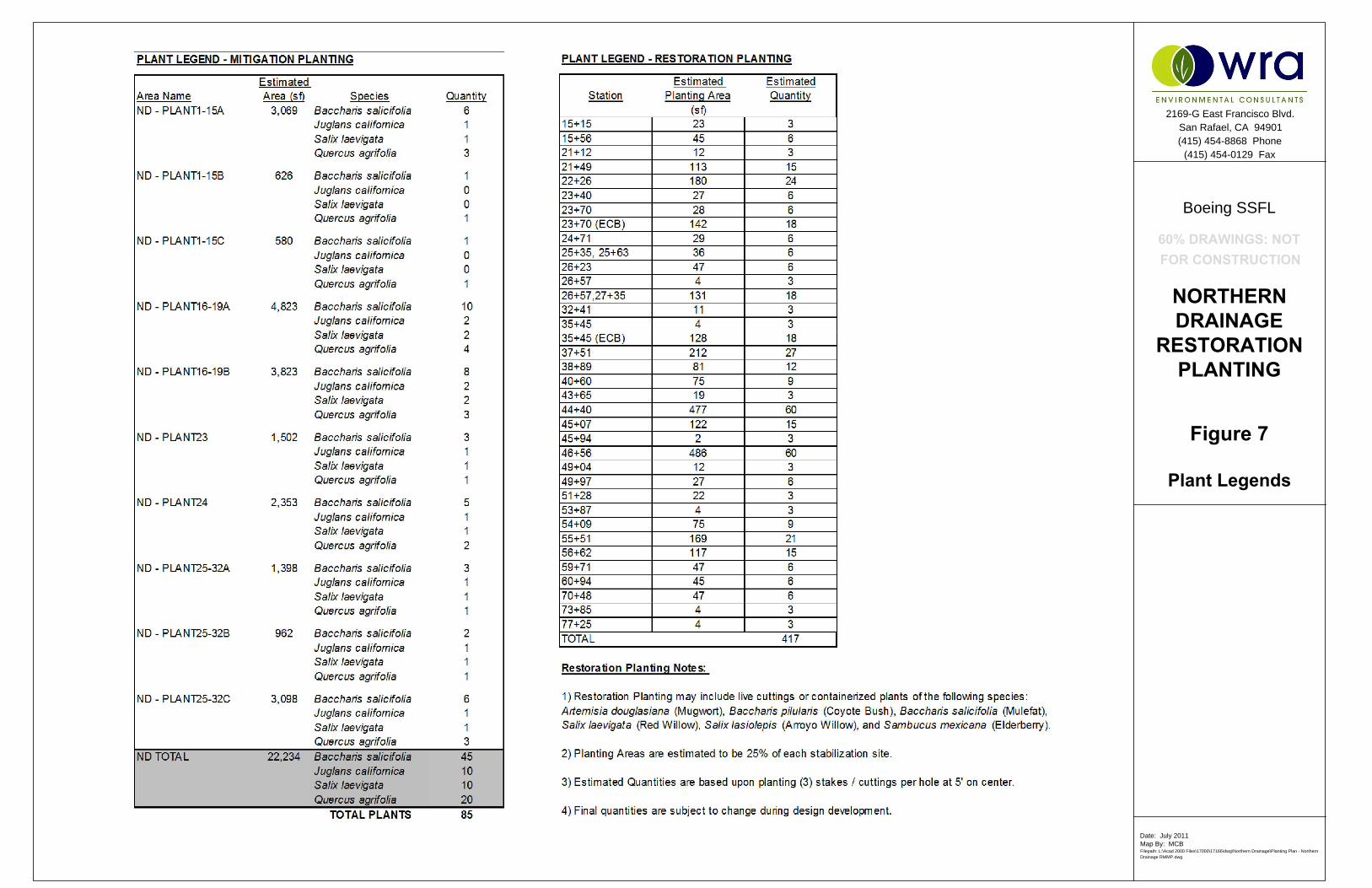
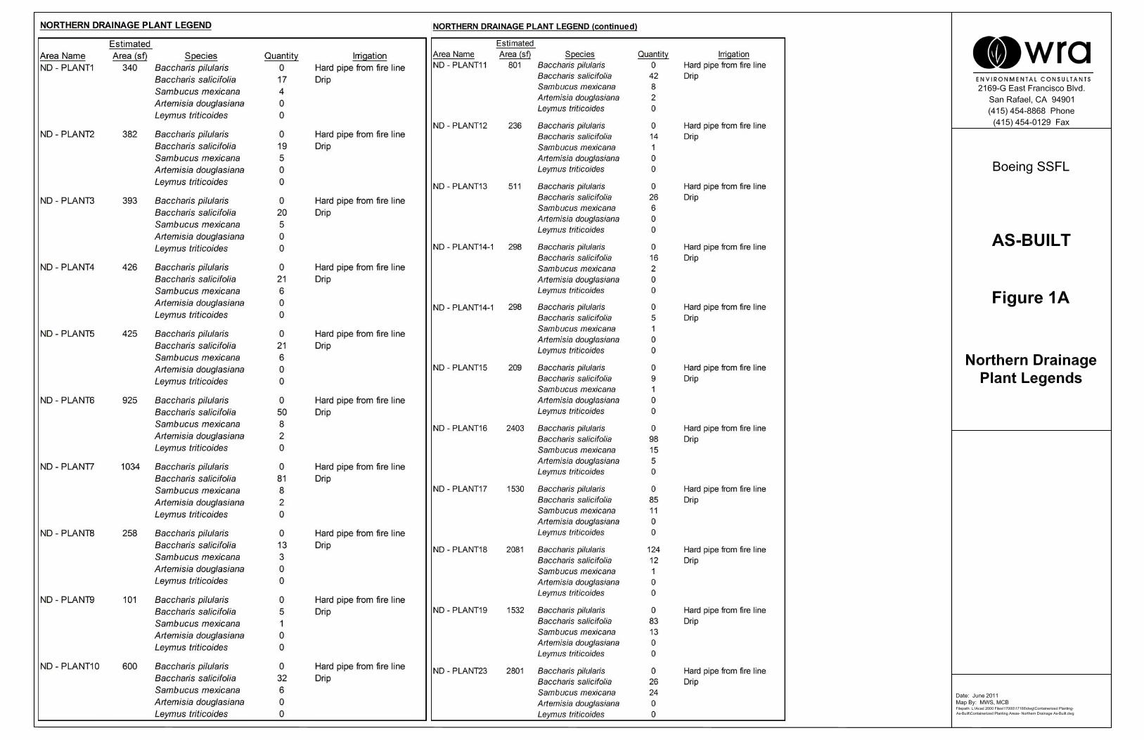
Figure 7
Plant Legends
Boeing SSFL
Date: July 2011
Map By: MCB
Filepath: L:\Acad 2000 Files\17000\17166\dwg\Northern Drainage\Planting Plan - Northern
Drainage RMMP.dwg
2169-G East Francisco Blvd.
San Rafael, CA 94901
(415) 454-8868 Phone
(415) 454-0129 Fax
NORTHERN
DRAINAGE
RESTORATION
PLANTING
60% DRAWINGS: NOT
FOR CONSTRUCTION
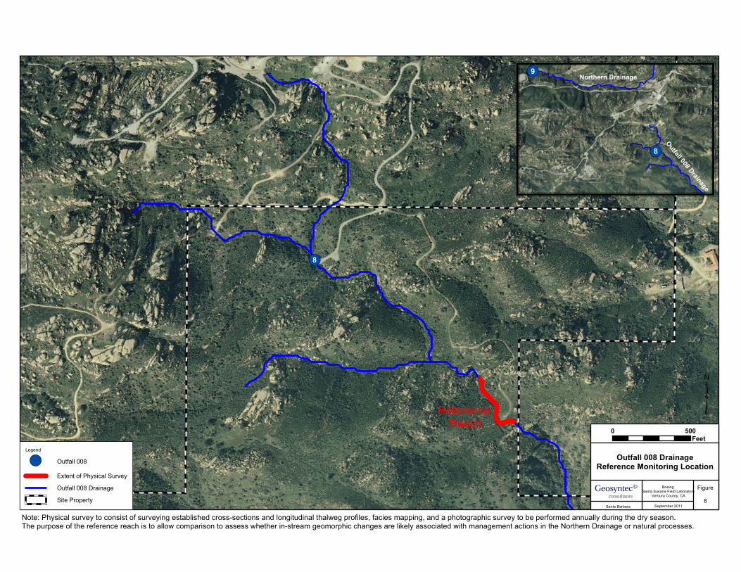
!(8
Legend
!( Outfall 008Extent of Physical SurveyOutfall 008 DrainageSite Property
Reference Reach
Outfall 008 DrainageReference Monitoring Location
Figure8
Santa Barbara September 2011
Boeing Santa Susana Field Laboratory
Ventura County, CA
0 500Feet
Note: Physical survey to consist of surveying established cross-sections and longitudinal thalweg profiles, facies mapping, and a photographic survey to be performed annually during the dry season. The purpose of the reference reach is to allow comparison to assess whether in-stream geomorphic changes are likely associated with management actions in the Northern Drainage or natural processes.
!(
!(9
8
Northern DrainageOutfall 008 Drainage
³
9
LegendOutfall 009Extent of Physical SurveyExtent of Stream WalkNorthern DrainageSite Property
Reach 1
Northern Drainage In-streamStabilization MeasuresMonitoring Locations
Figure9
Santa Barbara September 2011
Boeing Santa Susana Field Laboratory
Ventura County, CA
0 500Feet
Reach 2
Downstream Reach
Note: Physical survey to consist of surveying established cross-sections and longitudinal thalweg profiles, facies mapping, and a photographic survey to be performed annually during the dry season. Stream walk to consist of a visual survey of the study reach, conducted annually by a qualified engineer or scientist, to identify geomorphic changes in locations that are not otherwise monitored.
³
APPENDIX A
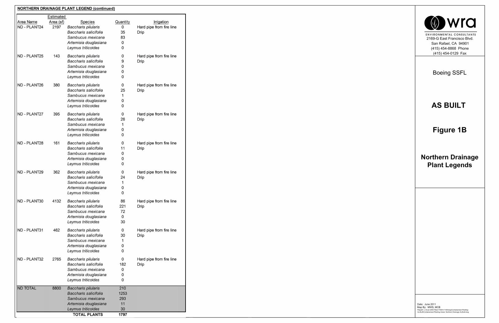
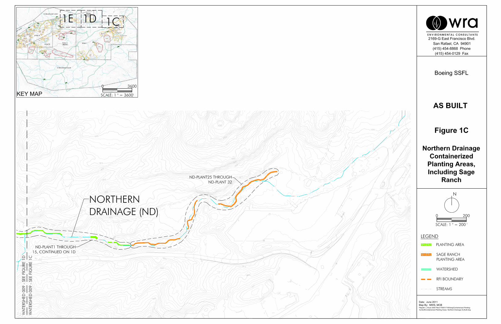
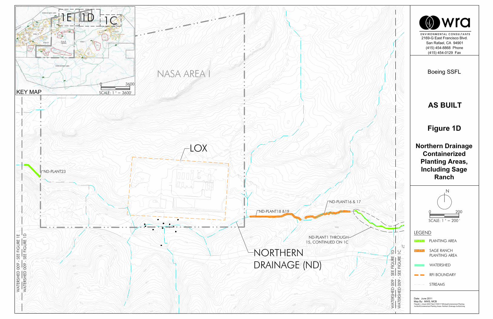
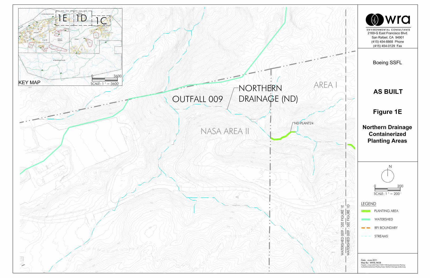
As-Built Northern Drainage Containerized Planting Areas, Including Sage Ranch
APPENDIX B
Roles and Responsibilities
APPENDIX B
ROLES AND RESPONSIBILITES
Page B-1
The following Boeing contractors assisted in the development of this RMMP: Geosyntec Consultants, Haley & Aldrich, Inc., MWH Americas, Inc., Padre Associates, Inc., and the Storm Water Expert Panel. Provided below is additional information about the roles and responsibilities for each contractor. Geosyntec Consultants 6701 Center Drive West Suite 550 Los Angeles, California 90045 Contact: Brandon Steets, P.E. (805.897.3800, ext. 210)
Discussion of existing conditions, summary of hydraulic analyses, restoration stability thresholds (Section 1.7);
Development of design criteria, location, selection and sizing of stabilization measures, and site preparation (Section 4.1);
Discussion of short-term construction erosion and sedimentation controls and selection, (Section 5);
Development of operation and maintenance activities for selected channel restoration/stabilization measures (Section 6.1); and
Development of performance standards, monitoring methods and monitoring schedule (Section 7.1).
Haley & Aldrich, Inc. 9040 Friars Road, Suite 220 San Diego, California 92108-5860 Contact: Richard Farson (619.285.7112)
Cross section surveys and development of the United States Army Corps of Engineers (USACE) Hydraulic Engineering Centers River Analysis System (HEC-RAS) hydraulics model for existing conditions (Section 1.7.1.1), schedule (Section 10.0); and
Editing of this report. MWH Americas, Inc. 618 Michillinda Avenue, Suite 200 Arcadia, California 91007 Contact: Glenn Jaffe (818.391.4243)
Geologic description (Section 1.6); and
Permit requirements (Section 4.3).
APPENDIX B
ROLES AND RESPONSIBILITES
Page B-2
Padre Associates, Inc. 1861 Knoll Drive Ventura, California 93003 Contact: Chris Dunn (805.644.2220, ext 12)
Discussion of compensatory mitigation for plants, terrestrial habitat and aquatic habitat (Section 2); Description of proposed restoration and mitigation site (Section 3);
Rationale for mitigation success, site preparation, and planting, seeding and irrigation plans (Section 4.2);
Development of performance standards, monitoring methods and monitoring schedule (Section 7.2); Reporting and completion of compensatory mitigation (Section 8.0); and
Contingency measures (Section 9.0). Surface Water Expert Panel Dr. Michael Stenstrom (UCLA) Dr. Michael Josselyn (WRA, Inc.) Jon Jones, P.E. (Wright Water Engineering) Dr. Robert Pitt (University of Alabama) Dr. Robert Gearheart (Humboldt State University)
Overall review and participation in the development of the plan with specific focus on problem identification, stream bed restoration actions, bank erosion control, and riparian planting measures.
G:\20090_SSFL\484-486 MitMon Workplan\Global\Deliverables\FINAL RMMP\Appendices\2011_0930_HAI_AppdxB_F.docx
![[PPT]Facies and Facies Models - UCSC Directory of individual …mclapham/eart120/slides/Facies... · Web viewWhat is a facies? A sedimentary unit with consistent characteristics (lithology,](https://img.pdfslide.us/doc/110x75/5aef4a8a7f8b9a8c308bc665/pptfacies-and-facies-models-ucsc-directory-of-individual-mclaphameart120slidesfaciesweb.jpg)