Embed Size (px)
Citation preview
8/3/2019 2010 Flood Damage Assessment Report II Annexure
http://slidepdf.com/reader/full/2010-flood-damage-assessment-report-ii-annexure 1/36
Assessment of 2010 Flood Impacts in Pakistan NRD-PARC
Pakistan Agricultural Research Council Page i
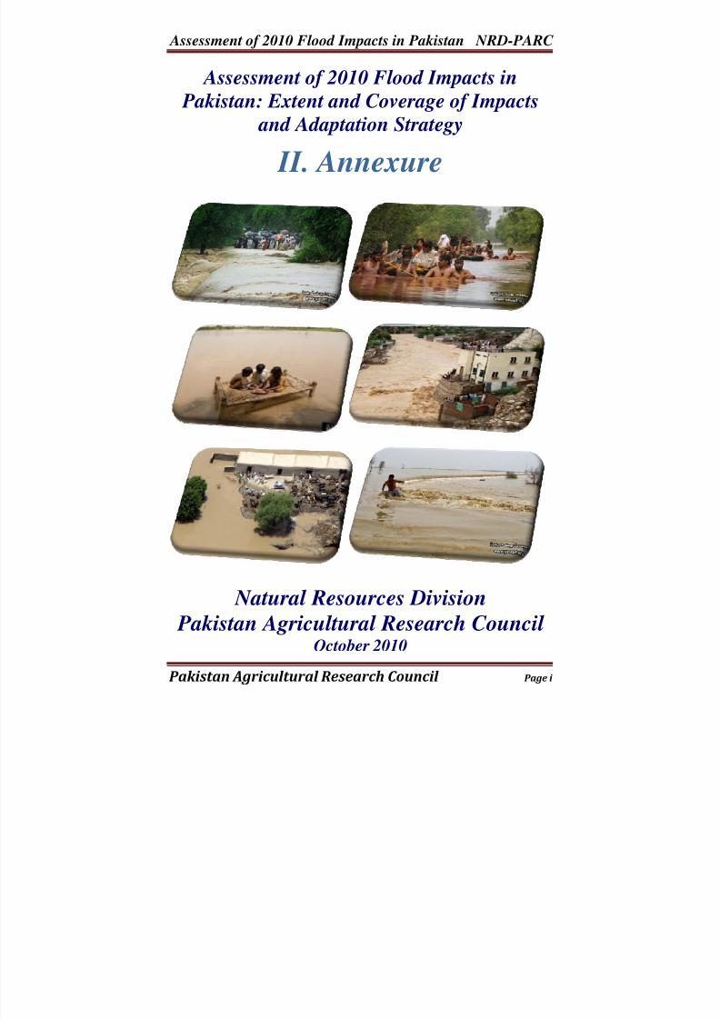
Assessment of 2010 Flood Impacts in
Pakistan: Extent and Coverage of Impacts
and Adaptation Strategy
II. Annexure
Natural Resources Division
Pakistan Agricultural Research Council October 2010
8/3/2019 2010 Flood Damage Assessment Report II Annexure
http://slidepdf.com/reader/full/2010-flood-damage-assessment-report-ii-annexure 2/36
Assessment of 2010 Flood Impacts in Pakistan NRD-PARC
Pakistan Agricultural Research Council Page 2
Why Flood Assessment is needed?
Natural Resources Division (NRD) of Pakistan Agricultural Research Council (PARC) initiated thePreliminary Assessment of the Floods of 2010 in relation to the agriculture sector specifically the crop sector. The preliminary report was dispatched to over 1100 persons during September 2010 covering experts, decision makers, generalists, members of civil society organizations and individuals. The response received was highly encouraging and motivated the Team of NRD to have second assessment
covering the period of July to September 2010.
In addition to the delineation of the flood affected areas crops and cropped area affected by floods was also assessed with an objective to estimate the economic losses to crops due to flood damages. Final Report is presented in two volumes. Volume I covers the Main Report. Volume II covers all the Annexure.
I would also like to acknowledge the support provided by UNOSAT in the provision of shape files and GIS data, IRSA in providing the data of river flows and other institutions like PMD, etc.
The special contribution made by the few individuals is also acknowledged including Dr. Bashir Ahmad, Mr. Irfan Ali,and Mr. Imran Ahmad. The contribution made by the GIS
Team of WRRI is fully acknowledged.
I hope the readers will provide their comments in further fine tuning the report.
Dr. Shahid AhmadMember Natural Resources
8/3/2019 2010 Flood Damage Assessment Report II Annexure
http://slidepdf.com/reader/full/2010-flood-damage-assessment-report-ii-annexure 3/36
Assessment of 2010 Flood Impacts in Pakistan NRD-PARC
Pakistan Agricultural Research Council Page 3
Annexure I:
District-Wise Area Affected by 2010Floods under Different Land Use
Systems for Provinces of Pakistan
8/3/2019 2010 Flood Damage Assessment Report II Annexure
http://slidepdf.com/reader/full/2010-flood-damage-assessment-report-ii-annexure 4/36
Assessment of 2010 Flood Impacts in Pakistan NRD-PARC
Pakistan Agricultural Research Council Page 4
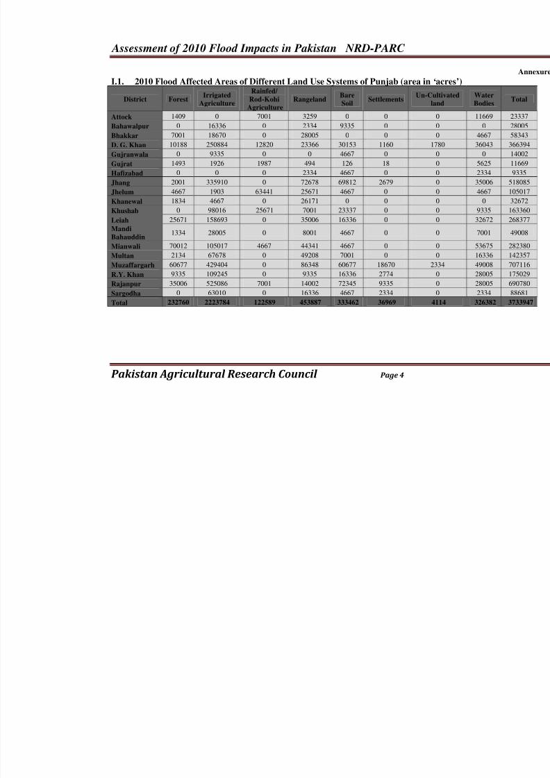
I.1. 2010 Flood Affected Areas of Different Land Use Systems of Punjab (area in ‘acres’)
District ForestIrrigated
Agriculture
Rainfed/
Rod-Kohi
Agriculture
RangelandBare
Soil
SettlementsUn-Cultivated
land
Attock 1409 0 7001 3259 0 0 0
Bahawalpur 0 16336 0 2334 9335 0 0
Bhakkar 7001 18670 0 28005 0 0 0
D. G. Khan 10188 250884 12820 23366 30153 1160 1780
Gujranwala 0 9335 0 0 4667 0 0
Gujrat 1493 1926 1987 494 126 18 0
Hafizabad 0 0 0 2334 4667 0 0
Jhang 2001 335910 0 72678 69812 2679 0
Jhelum 4667 1903 63441 25671 4667 0 0
Khanewal 1834 4667 0 26171 0 0 0
Khushab 0 98016 25671 7001 23337 0 0 Leiah 25671 158693 0 35006 16336 0 0
Mandi
Bahauddin1334 28005 0 8001 4667 0 0
Mianwali 70012 105017 4667 44341 4667 0 0
Multan 2134 67678 0 49208 7001 0 0
Muzaffargarh 60677 429404 0 86348 60677 18670 2334
R.Y. Khan 9335 109245 0 9335 16336 2774 0
Rajanpur 35006 525086 7001 14002 72345 9335 0
Sargodha 0 63010 0 16336 4667 2334 0
Total 232760 2223784 122589 453887 333462 36969 4114
8/3/2019 2010 Flood Damage Assessment Report II Annexure
http://slidepdf.com/reader/full/2010-flood-damage-assessment-report-ii-annexure 5/36
Assessment of 2010 Flood Impacts in Pakistan NRD-PARC
Pakistan Agricultural Research Council Page 5
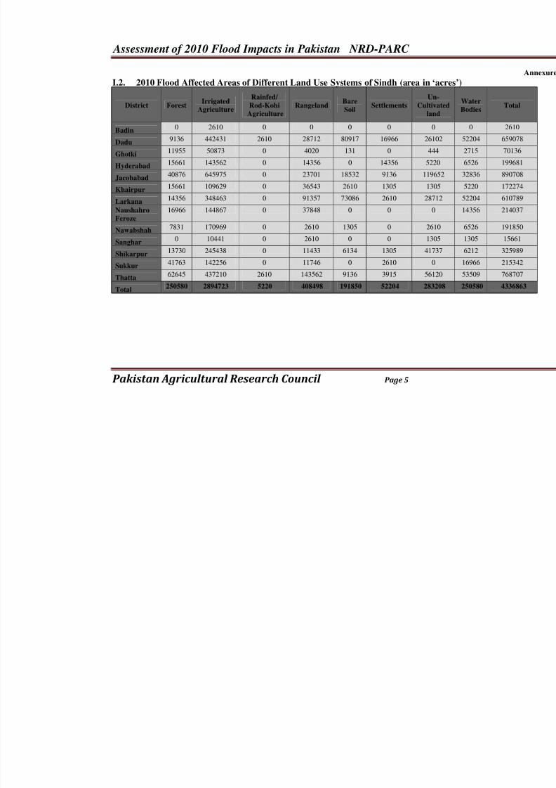
I.2. 2010 Flood Affected Areas of Different Land Use Systems of Sindh (area in ‘acres’)
District ForestIrrigated
Agriculture
Rainfed/
Rod-KohiAgriculture
RangelandBare
Soil Settlements
Un-
Cultivatedland
W
B
Badin0 2610 0 0 0 0 0
Dadu9136 442431 2610 28712 80917 16966 26102 5
Ghotki11955 50873 0 4020 131 0 444 2
Hyderabad15661 143562 0 14356 0 14356 5220 6
Jacobabad40876 645975 0 23701 18532 9136 119652 3
Khairpur15661 109629 0 36543 2610 1305 1305 5
Larkana14356 348463 0 91357 73086 2610 28712 5
NaushahroFeroze 16966 144867 0 37848 0 0 0 1
Nawabshah7831 170969 0 2610 1305 0 2610 6
Sanghar0 10441 0 2610 0 0 1305
Shikarpur13730 245438 0 11433 6134 1305 41737 6
Sukkur41763 142256 0 11746 0 2610 0 1
Thatta62645 437210 2610 143562 9136 3915 56120 5
Total250580 2894723 5220 408498 191850 52204 283208 25
8/3/2019 2010 Flood Damage Assessment Report II Annexure
http://slidepdf.com/reader/full/2010-flood-damage-assessment-report-ii-annexure 6/36
Assessment of 2010 Flood Impacts in Pakistan NRD-PARC
Pakistan Agricultural Research Council Page 6
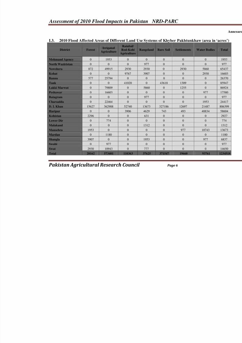
I.3. 2010 Flood Affected Areas of Different Land Use Systems of Khyber Pakhtunkhaw (
District ForestIrrigated
Agriculture
Rainfed/ Rod-Kohi
Agriculture
Rangeland Bare Soil Settlements Wat
Mohmand Agency 0 1953 0 0 0 0
North Waziristan 0 0 0 977 0 0
Nowshera 872 49915 2930 2930 0 2930
Kohat 0 0 9767 3907 0 0
Bannu 577 25794 0 0 0 0
Tank 0 0 41020 0 43618 1309
Lakki Marwat 0 79809 0 5860 0 1255
Peshawar 0 16603 0 0 0 0 Batagram 0 0 0 977 0 0
Charsadda 0 22464 0 0 0 0
D. I. Khan 15627 362988 52740 13673 327186 12697 2
Haripur 0 0 3906 4629 743 493 4
Kohistan 2296 0 0 631 0 0
Lower Dir 0 774 0 0 0 0
Malakand 0 0 0 1312 0 0
Mansehra 1953 0 0 0 0 977 1
Mardan 0 1180 0 0 0 0
Shangla 3907 0 0 1953 0 0
Swabi 0 977 0 0 0 0
Swat 2930 10943 0 777 0 0
Total 28162 573401 110363 37625 371547 19660 9
8/3/2019 2010 Flood Damage Assessment Report II Annexure
http://slidepdf.com/reader/full/2010-flood-damage-assessment-report-ii-annexure 7/36
Assessment of 2010 Flood Impacts in Pakistan NRD-PARC
Pakistan Agricultural Research Council Page 7
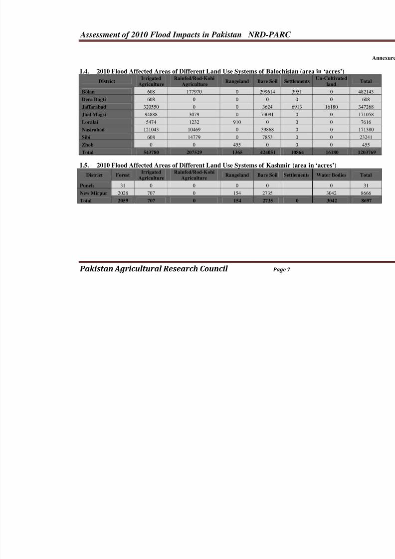
I.4. 2010 Flood Affected Areas of Different Land Use Systems of Balochistan (area in ‘ac
DistrictIrrigated
Agriculture
Rainfed/Rod-Kohi
AgricultureRangeland Bare Soil Settlements
Un-Cu
la
Bolan 608 177970 0 299614 3951
Dera Bugti 608 0 0 0 0
Jaffarabad 320550 0 0 3624 6913 16
Jhal Magsi 94888 3079 0 73091 0
Loralai 5474 1232 910 0 0
Nasirabad 121043 10469 0 39868 0
Sibi 608 14779 0 7853 0
Zhob 0 0 455 0 0
Total 543780 207529 1365 424051 10864 16
I.5. 2010 Flood Affected Areas of Different Land Use Systems of Kashmir (area in ‘acres
District ForestIrrigated
Agriculture
Rainfed/Rod-Kohi
AgricultureRangeland Bare Soil Settlements Water
Punch 31 0 0 0 0
New Mirpur 2028 707 0 154 2735 30
Total 2059 707 0 154 2735 0 30
8/3/2019 2010 Flood Damage Assessment Report II Annexure
http://slidepdf.com/reader/full/2010-flood-damage-assessment-report-ii-annexure 8/36
Assessment of 2010 Flood Impacts in Pakistan NRD-PARC
Pakistan Agricultural Research Council Page 8
Annexure II:
District-Wise Cropped Area of MajorCrops, Fruits and Vegetables
Affected by 2010 Floods for
Provinces of Pakistan
8/3/2019 2010 Flood Damage Assessment Report II Annexure
http://slidepdf.com/reader/full/2010-flood-damage-assessment-report-ii-annexure 9/36
Assessment of 2010 Flood Impacts in Pakistan NRD-PARC
Pakistan Agricultural Research Council Page 9
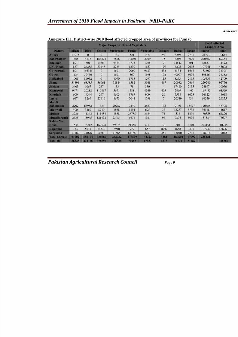
Annexure II.1. District-wise 2010 flood affected cropped area of provinces for Punjab
Major Crops, Fruits and Vegetables
District Miaze Rice Cotton Sugarcane Fruits Vegetable Tobacco Bajra Jawar
Attock 11075 0 0 133 521 1471 92 3269 9741
Bahawalpur 1468 4337 186274 7806 10860 2709 75 3269 4070
Bhakkar 801 801 5404 9474 4773 1035 7 12543 801
D.G. Khan 867 24285 63448 2735 1339 1657 199 6205 7005
Gujranwala 801 166325 0 1601 2060 9187 432 1534 1668
Gujrat 1134 39430 0 1601 860 1598 102 40097 5004
Hafizabad 1001 86932 0 4070 1713 1297 115 8273 2135
Jhang 31891 68585 36961 58844 6582 3168 467 20082 2669
Jhelum 3403 1067 267 133 78 330 4 17480 2135
Khanewal 9474 20282 110417 5671 15881 4369 405 2469 467 Khushab 600 14344 267 4603 1767 909 20 5538 8073
Layya 667 3269 25619 8673 5044 1598 5 20549 934
Mandi
Bahauddin 2202 63982 1334 20282 7249 2557 135 9140 13477
Mianwali 400 3269 8940 1868 1894 695 37 13277 5738
Multan 3936 11342 111484 1868 26788 3134 71 534 1201
Muzaffargarh 2335 15945 121492 23484 1671 1981 97 9874 5004
Rahim Yar
Khan 1534 16212 169528 59378 21356 3711 30 801 1601
Rajanpur 133 5671 84530 8940 977 657 1836 1668 3336
Sargodha 17280 34026 4603 41565 62185 2261 351 13010 2735
Total (Acres) 91002 580104 930569 262732 173599 44323 4481 189610 77792 Total (ha) 36828 234765 376596 106326 70255 17937 1813 76734 31482
8/3/2019 2010 Flood Damage Assessment Report II Annexure
http://slidepdf.com/reader/full/2010-flood-damage-assessment-report-ii-annexure 10/36
Assessment of 2010 Flood Impacts in Pakistan NRD-PARC
Pakistan Agricultural Research Council Page 10
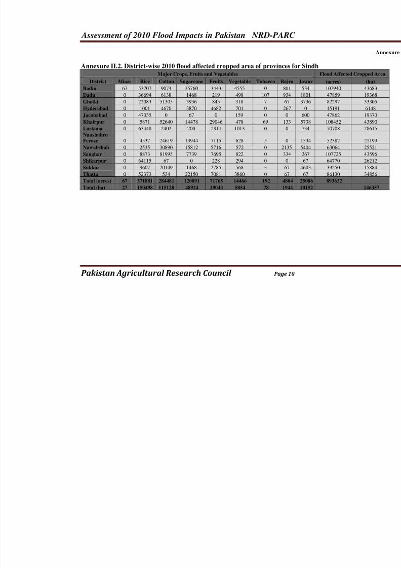
Annexure II.2. District-wise 2010 flood affected cropped area of provinces for SindhMajor Crops, Fruits and Vegetables Flood A
District Miaze Rice Cotton Sugarcane Fruits Vegetable Tobacco Bajra Jawar (acre
Badin 67 53707 9074 35760 3443 4555 0 801 534 1079
Dadu 0 36694 6138 1468 219 498 107 934 1801 4785
Ghotki 0 22083 51305 3936 845 318 7 67 3736 8229
Hyderabad 0 1001 4670 3870 4682 701 0 267 0 1519
Jacobabad 0 47035 0 67 0 159 0 0 600 4786
Khairpur 0 5871 52640 14478 29046 478 69 133 5738 1084
Larkana 0 63448 2402 200 2911 1013 0 0 734 7070
Naushahro
Feroze 0 4537 24619 13944 7115 628 5 0 1534 5238
Nawabshah 0 2535 30890 15812 5716 572 0 2135 5404 6306
Sanghar 0 8873 81995 7739 7695 822 0 334 267 1077Shikarpur 0 64115 67 0 228 294 0 0 67 6477
Sukkur 0 9607 20149 1468 2785 568 3 67 4603 3925
Thatta 0 52373 534 22150 7081 3860 0 67 67 8613
Total (acres) 67 371881 284481 120891 71765 14466 192 4804 25086 8936
Total (ha) 27 150498 115128 48924 29043 5854 78 1944 10152
8/3/2019 2010 Flood Damage Assessment Report II Annexure
http://slidepdf.com/reader/full/2010-flood-damage-assessment-report-ii-annexure 11/36
Assessment of 2010 Flood Impacts in Pakistan NRD-PARC
Pakistan Agricultural Research Council Page 11
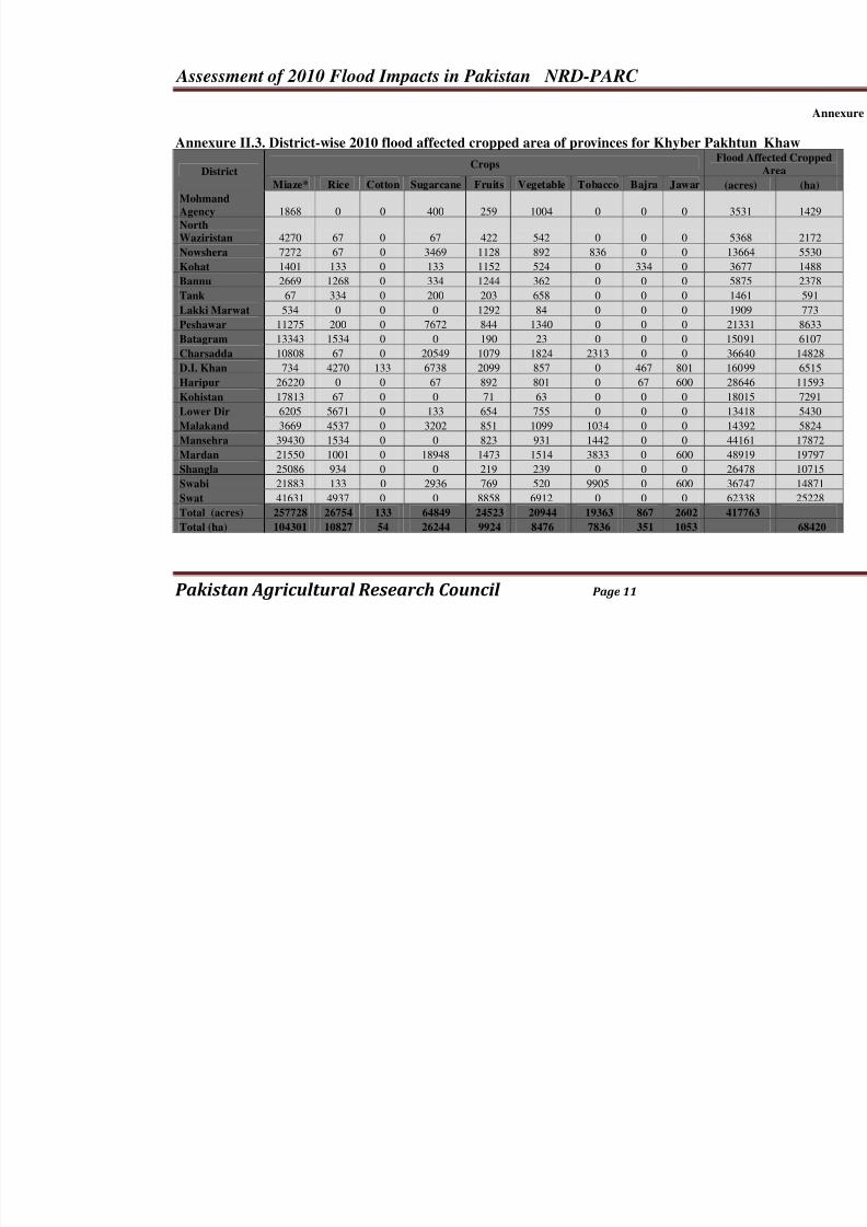
Annexure II.3. District-wise 2010 flood affected cropped area of provinces for Khyber Pak
District CropsFl
Miaze* Rice Cotton Sugarcane Fruits Vegetable Tobacco Bajra Jawar
Mohmand
Agency 1868 0 0 400 259 1004 0 0 0
North
Waziristan 4270 67 0 67 422 542 0 0 0
Nowshera 7272 67 0 3469 1128 892 836 0 0
Kohat 1401 133 0 133 1152 524 0 334 0
Bannu 2669 1268 0 334 1244 362 0 0 0
Tank 67 334 0 200 203 658 0 0 0
Lakki Marwat 534 0 0 0 1292 84 0 0 0
Peshawar 11275 200 0 7672 844 1340 0 0 0
Batagram 13343 1534 0 0 190 23 0 0 0
Charsadda 10808 67 0 20549 1079 1824 2313 0 0
D.I. Khan 734 4270 133 6738 2099 857 0 467 801
Haripur 26220 0 0 67 892 801 0 67 600
Kohistan 17813 67 0 0 71 63 0 0 0
Lower Dir 6205 5671 0 133 654 755 0 0 0
Malakand 3669 4537 0 3202 851 1099 1034 0 0
Mansehra 39430 1534 0 0 823 931 1442 0 0
Mardan 21550 1001 0 18948 1473 1514 3833 0 600
Shangla 25086 934 0 0 219 239 0 0 0
Swabi 21883 133 0 2936 769 520 9905 0 600
Swat 41631 4937 0 0 8858 6912 0 0 0 Total (acres) 257728 26754 133 64849 24523 20944 19363 867 2602 4
Total (ha) 104301 10827 54 26244 9924 8476 7836 351 1053
8/3/2019 2010 Flood Damage Assessment Report II Annexure
http://slidepdf.com/reader/full/2010-flood-damage-assessment-report-ii-annexure 12/36
Assessment of 2010 Flood Impacts in Pakistan NRD-PARC
Pakistan Agricultural Research Council Page 12
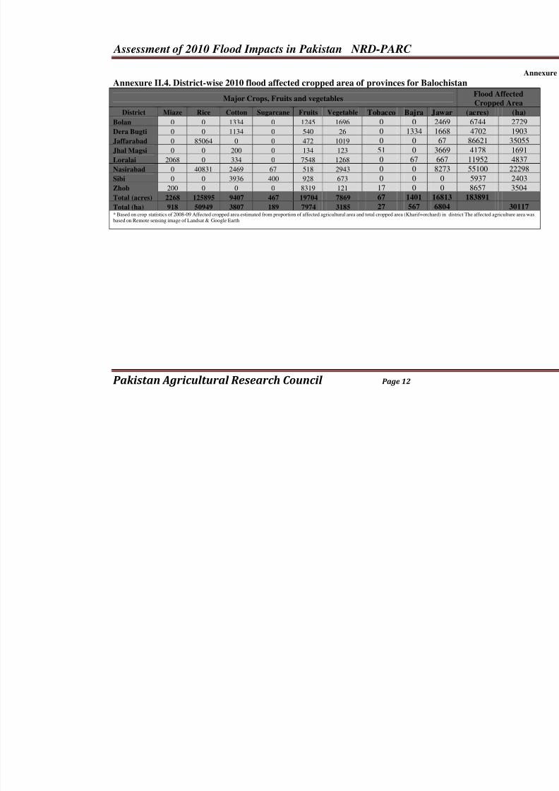
Annexure II.4. District-wise 2010 flood affected cropped area of provinces for Balochistan
Major Crops, Fruits and vegetables
District Miaze Rice Cotton Sugarcane Fruits Vegetable Tobacco Bajra Jawar (
Bolan 0 0 1334 0 1245 1696 0 0 2469
Dera Bugti 0 0 1134 0 540 26 0 1334 1668
Jaffarabad 0 85064 0 0 472 1019 0 0 67
Jhal Magsi 0 0 200 0 134 123 51 0 3669
Loralai 2068 0 334 0 7548 1268 0 67 667
Nasirabad 0 40831 2469 67 518 2943 0 0 8273
Sibi 0 0 3936 400 928 673 0 0 0
Zhob 200 0 0 0 8319 121 17 0 0
Total (acres) 2268 125895 9407 467 19704 7869 67 1401 16813 1
Total (ha) 918 50949 3807 189 7974 3185 27 567 6804 * Based on crop statistics of 2008-09 Affected cropped area estimated from proportion of affected agricultural area and total cropped area (Kharif+orchard) in district Tbased on Remote sensing image of Landsat & Google Earth
8/3/2019 2010 Flood Damage Assessment Report II Annexure
http://slidepdf.com/reader/full/2010-flood-damage-assessment-report-ii-annexure 13/36
Assessment of 2010 Flood Impacts in Pakistan NRD-PARC
Pakistan Agricultural Research Council Page 13
Annexure IIIa:
Spatial Maps of 2010 Flood AffectedAreas at National, Provincial and
Command Level in Pakistan
Maps of Flood Affected Area inPakistan1
1Maps are developed by UNOSAT, ICIMOD, USAID and other agencies individually or jointly. These maps are
reproduced for knowledge purposes and duly acknowledged. The purpose is only for knowledge and education .
All these maps are also available on the website of UNOSAT and can be accessed directly if further information
is needed.
8/3/2019 2010 Flood Damage Assessment Report II Annexure
http://slidepdf.com/reader/full/2010-flood-damage-assessment-report-ii-annexure 14/36
Assessment of 2010 Flood Impacts in Pakistan NRD-PARC
Pakistan Agricultural Research Council Page 14
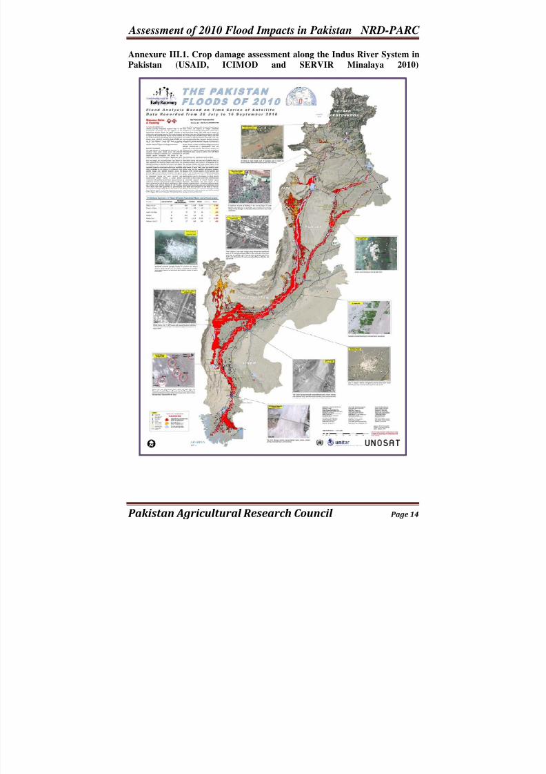
Annexure III.1. Crop damage assessment along the Indus River System in
Pakistan (USAID, ICIMOD and SERVIR Minalaya 2010)
8/3/2019 2010 Flood Damage Assessment Report II Annexure
http://slidepdf.com/reader/full/2010-flood-damage-assessment-report-ii-annexure 15/36
Assessment of 2010 Flood Impacts in Pakistan NRD-PARC
Pakistan Agricultural Research Council Page 15
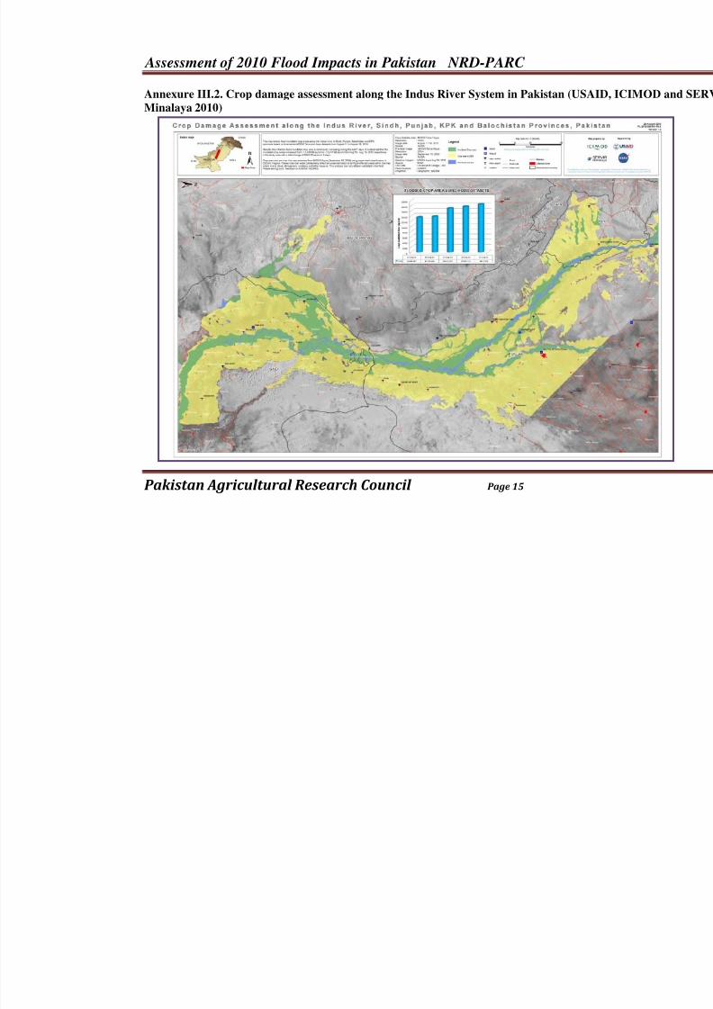
Annexure III.2. Crop damage assessment along the Indus River System in Pakistan (USAI
Minalaya 2010)
8/3/2019 2010 Flood Damage Assessment Report II Annexure
http://slidepdf.com/reader/full/2010-flood-damage-assessment-report-ii-annexure 16/36
Assessment of 2010 Flood Impacts in Pakistan NRD-PARC
Pakistan Agricultural Research Council Page 16
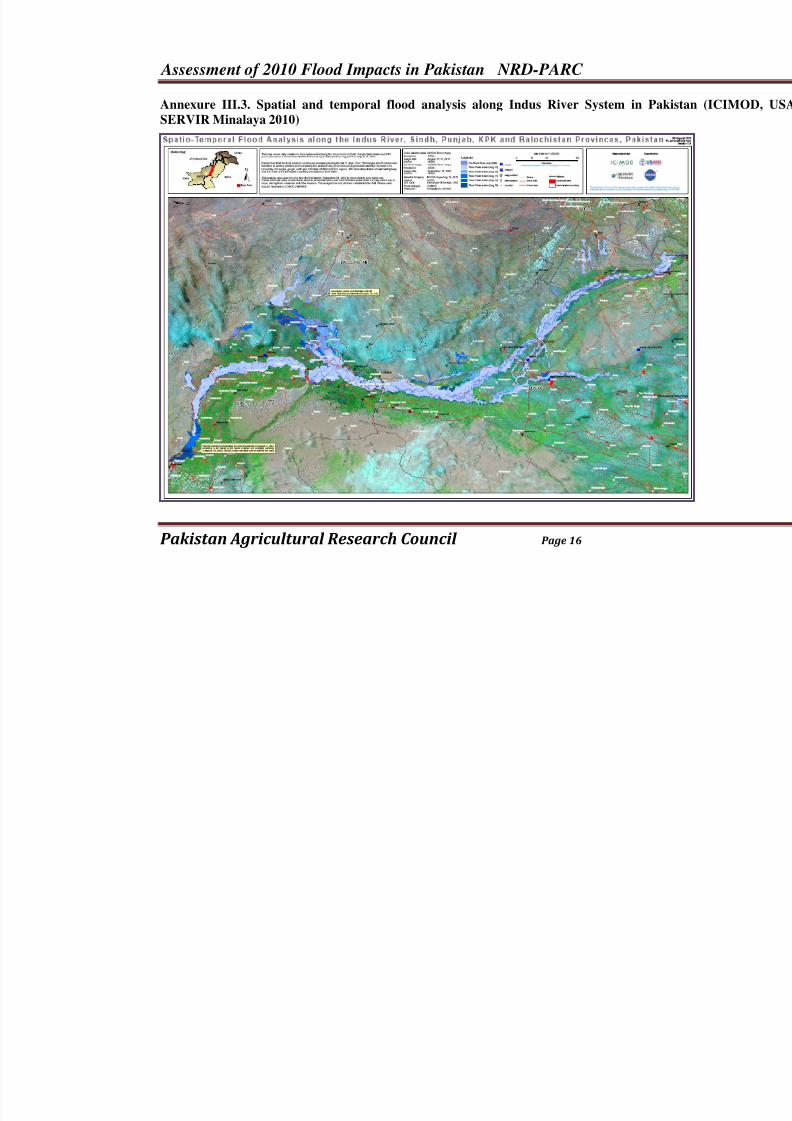
Annexure III.3. Spatial and temporal flood analysis along Indus River System in Pa
SERVIR Minalaya 2010)
8/3/2019 2010 Flood Damage Assessment Report II Annexure
http://slidepdf.com/reader/full/2010-flood-damage-assessment-report-ii-annexure 17/36
Assessment of 2010 Flood Impacts in Pakistan NRD-PARC
Pakistan Agricultural Research Council Page 17
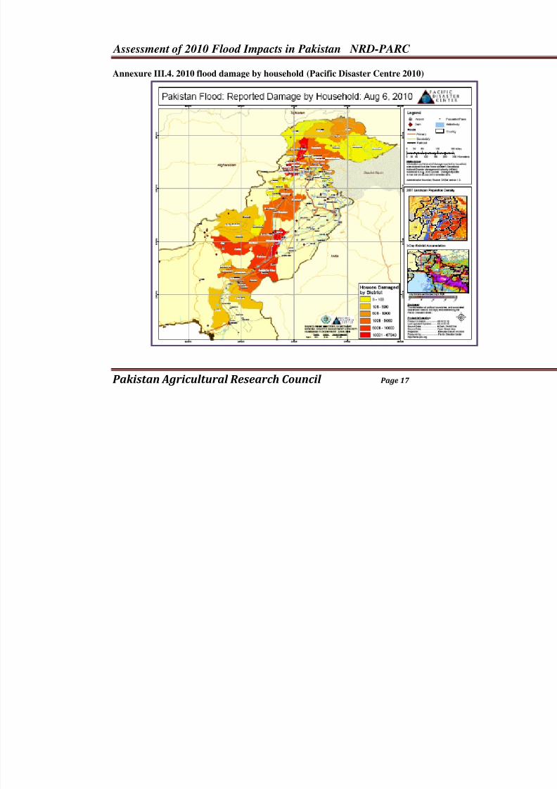
Annexure III.4. 2010 flood damage by household (Pacific Disaster Centre 2010)
8/3/2019 2010 Flood Damage Assessment Report II Annexure
http://slidepdf.com/reader/full/2010-flood-damage-assessment-report-ii-annexure 18/36
Assessment of 2010 Flood Impacts in Pakistan NRD-PARC
Pakistan Agricultural Research Council Page 18
Annexure IIIb:
Spatial Maps of 2010 Flood AffectedAreas at National, Provincial and
Command Level in Pakistan
Maps of Flood Affected Areas inPunjab2
2Maps are developed by UNOSAT, ICIMOD, USAID and other agencies individually or jointly. These maps are
reproduced for knowledge purposes and duly acknowledged. The purpose is only for knowledge and education .
All these maps are also available on the website of UNOSAT and can be accessed directly if further information
is needed.
8/3/2019 2010 Flood Damage Assessment Report II Annexure
http://slidepdf.com/reader/full/2010-flood-damage-assessment-report-ii-annexure 19/36
Assessment of 2010 Flood Impacts in Pakistan NRD-PARC
Pakistan Agricultural Research Council Page 19
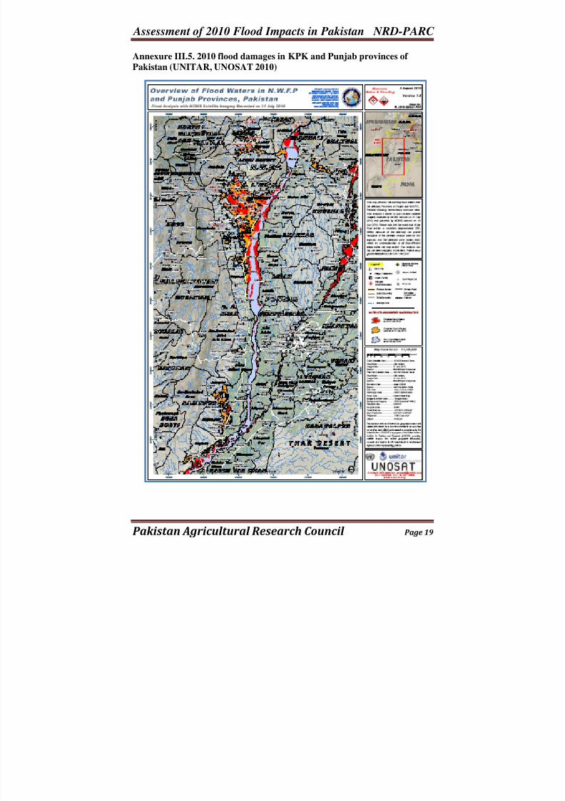
Annexure III.5. 2010 flood damages in KPK and Punjab provinces of
Pakistan (UNITAR, UNOSAT 2010)
8/3/2019 2010 Flood Damage Assessment Report II Annexure
http://slidepdf.com/reader/full/2010-flood-damage-assessment-report-ii-annexure 20/36
Assessment of 2010 Flood Impacts in Pakistan NRD-PARC
Pakistan Agricultural Research Council Page 20
Annexure IIIc:
Spatial Maps of 2010 Flood AffectedAreas at National, Provincial and
Command Level in Pakistan
Maps of Flood Affected Areas inSindh3
3Maps are developed by UNOSAT, ICIMOD, USAID and other agencies individually or jointly. These maps are
reproduced for knowledge purposes and duly acknowledged. The purpose is only for knowledge and education .
All these maps are also available on the website of UNOSAT and can be accessed directly if further information
is needed.
8/3/2019 2010 Flood Damage Assessment Report II Annexure
http://slidepdf.com/reader/full/2010-flood-damage-assessment-report-ii-annexure 21/36
Assessment of 2010 Flood Impacts in Pakistan NRD-PARC
Pakistan Agricultural Research Council Page 21
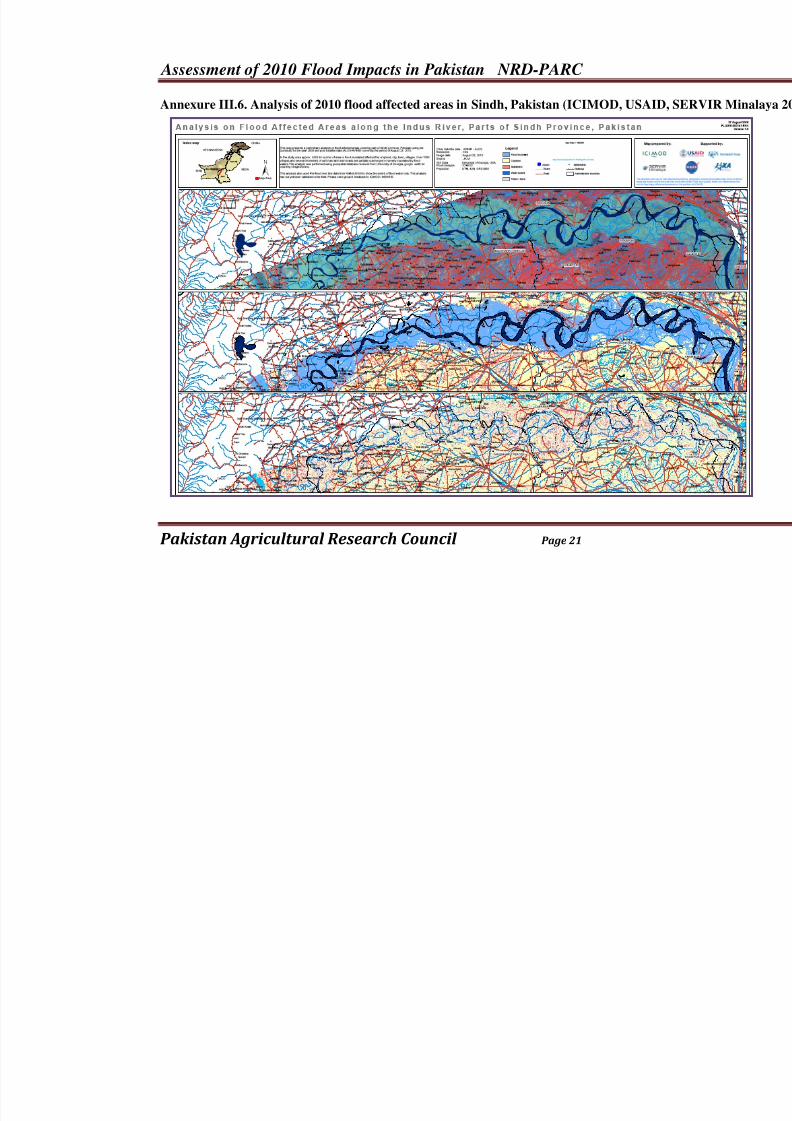
Annexure III.6. Analysis of 2010 flood affected areas in Sindh, Pakistan (ICIMOD, USAID
8/3/2019 2010 Flood Damage Assessment Report II Annexure
http://slidepdf.com/reader/full/2010-flood-damage-assessment-report-ii-annexure 22/36
Assessment of 2010 Flood Impacts in Pakistan NRD-PARC
Pakistan Agricultural Research Council Page 22
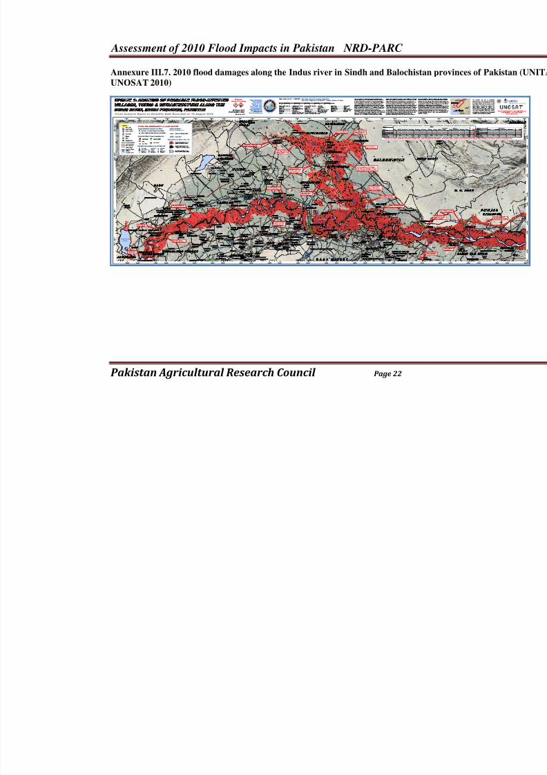
Annexure III.7. 2010 flood damages along the Indus river in Sindh and Balochistan provin
UNOSAT 2010)
8/3/2019 2010 Flood Damage Assessment Report II Annexure
http://slidepdf.com/reader/full/2010-flood-damage-assessment-report-ii-annexure 23/36
Assessment of 2010 Flood Impacts in Pakistan NRD-PARC
Pakistan Agricultural Research Council Page 23
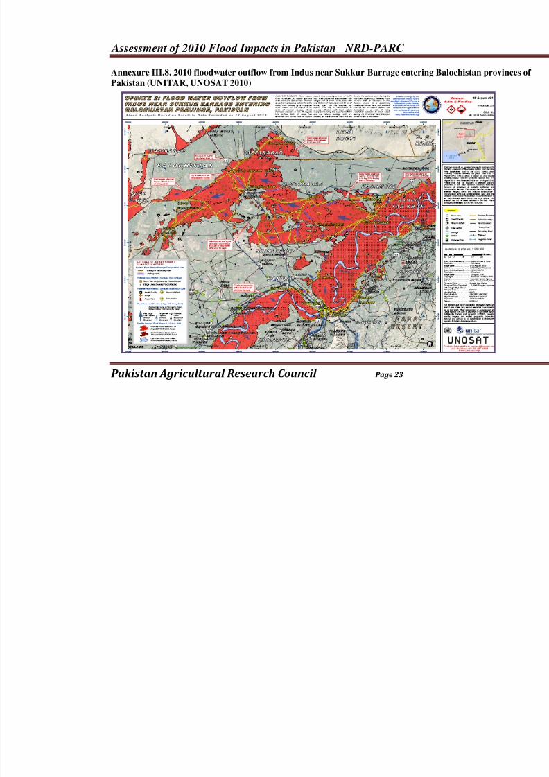
Annexure III.8. 2010 floodwater outflow from Indus near Sukkur Barrage entering Baloch
Pakistan (UNITAR, UNOSAT 2010)
8/3/2019 2010 Flood Damage Assessment Report II Annexure
http://slidepdf.com/reader/full/2010-flood-damage-assessment-report-ii-annexure 24/36
Assessment of 2010 Flood Impacts in Pakistan NRD-PARC
Pakistan Agricultural Research Council Page 24
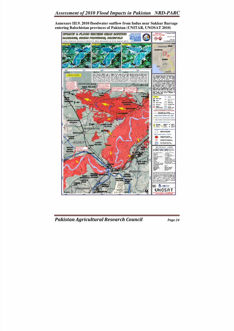
Annexure III.9. 2010 floodwater outflow from Indus near Sukkur Barrage
entering Balochistan provinces of Pakistan (UNITAR, UNOSAT 2010)
8/3/2019 2010 Flood Damage Assessment Report II Annexure
http://slidepdf.com/reader/full/2010-flood-damage-assessment-report-ii-annexure 25/36
Assessment of 2010 Flood Impacts in Pakistan NRD-PARC
Pakistan Agricultural Research Council Page 25
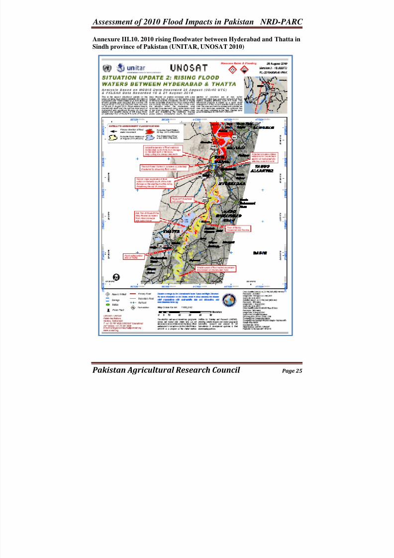
Annexure III.10. 2010 rising floodwater between Hyderabad and Thatta in
Sindh province of Pakistan (UNITAR, UNOSAT 2010)
8/3/2019 2010 Flood Damage Assessment Report II Annexure
http://slidepdf.com/reader/full/2010-flood-damage-assessment-report-ii-annexure 26/36
Assessment of 2010 Flood Impacts in Pakistan NRD-PARC
Pakistan Agricultural Research Council Page 26
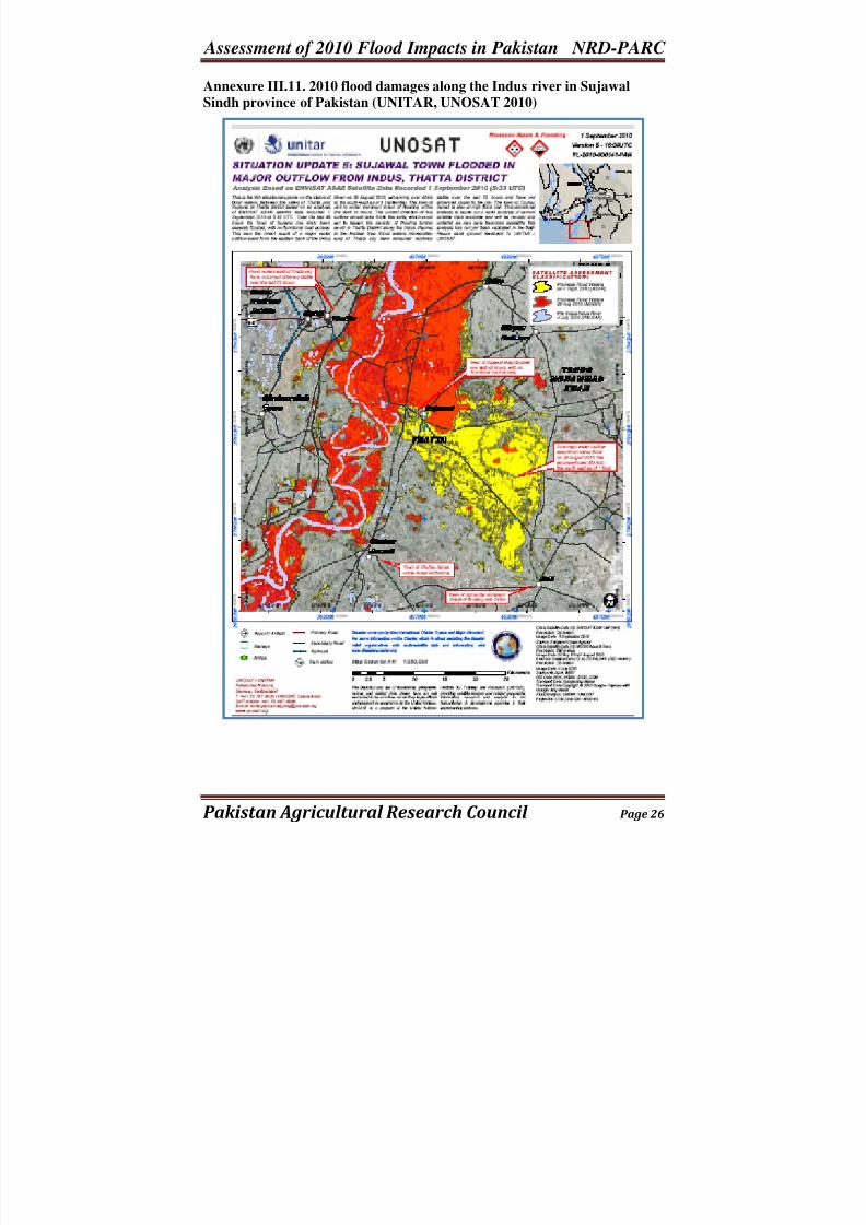
Annexure III.11. 2010 flood damages along the Indus river in Sujawal
Sindh province of Pakistan (UNITAR, UNOSAT 2010)
8/3/2019 2010 Flood Damage Assessment Report II Annexure
http://slidepdf.com/reader/full/2010-flood-damage-assessment-report-ii-annexure 27/36
Assessment of 2010 Flood Impacts in Pakistan NRD-PARC
Pakistan Agricultural Research Council Page 27
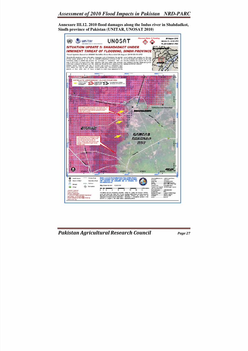
Annexure III.12. 2010 flood damages along the Indus river in Shahdadkot,
Sindh province of Pakistan (UNITAR, UNOSAT 2010)
8/3/2019 2010 Flood Damage Assessment Report II Annexure
http://slidepdf.com/reader/full/2010-flood-damage-assessment-report-ii-annexure 28/36
Assessment of 2010 Flood Impacts in Pakistan NRD-PARC
Pakistan Agricultural Research Council Page 28
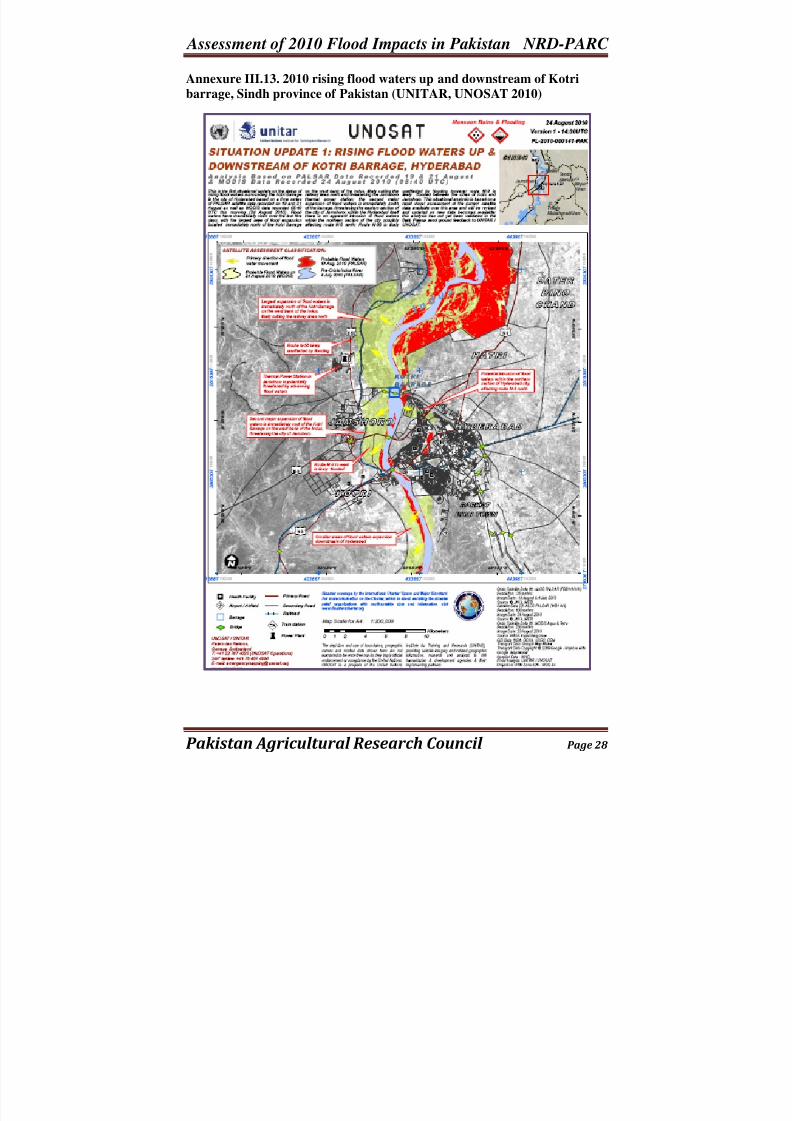
Annexure III.13. 2010 rising flood waters up and downstream of Kotri
barrage, Sindh province of Pakistan (UNITAR, UNOSAT 2010)
8/3/2019 2010 Flood Damage Assessment Report II Annexure
http://slidepdf.com/reader/full/2010-flood-damage-assessment-report-ii-annexure 29/36
Assessment of 2010 Flood Impacts in Pakistan NRD-PARC
Pakistan Agricultural Research Council Page 29
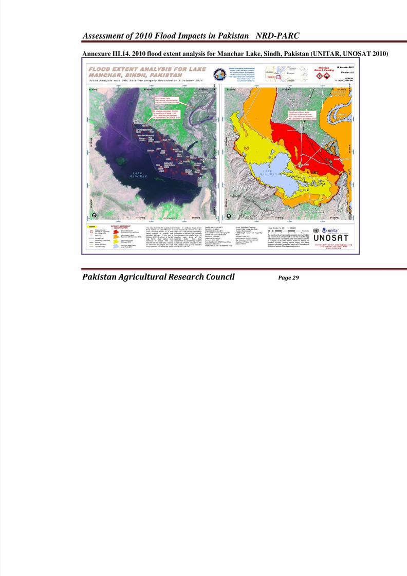
Annexure III.14. 2010 flood extent analysis for Manchar Lake, Sindh, Pakistan (UNITAR,
8/3/2019 2010 Flood Damage Assessment Report II Annexure
http://slidepdf.com/reader/full/2010-flood-damage-assessment-report-ii-annexure 30/36
Assessment of 2010 Flood Impacts in Pakistan NRD-PARC
Pakistan Agricultural Research Council Page 30
Annexure IIId:
Spatial Maps of 2010 Flood AffectedAreas at National, Provincial and
Command Level in Pakistan
Maps of Flood Affected Areas inKPK4
4Maps are developed by UNOSAT, ICIMOD, USAID and other agencies individually or jointly. These maps are
reproduced for knowledge purposes and duly acknowledged. The purpose is only for knowledge and education .
All these maps are also available on the website of UNOSAT and can be accessed directly if further information
is needed.
8/3/2019 2010 Flood Damage Assessment Report II Annexure
http://slidepdf.com/reader/full/2010-flood-damage-assessment-report-ii-annexure 31/36
Assessment of 2010 Flood Impacts in Pakistan NRD-PARC
Pakistan Agricultural Research Council Page 31
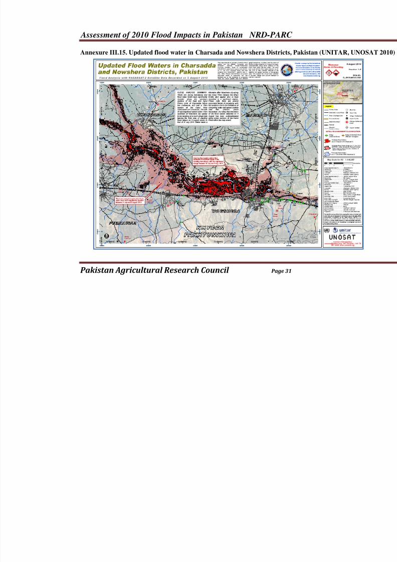
Annexure III.15. Updated flood water in Charsada and Nowshera Districts, Pakistan (UNI
8/3/2019 2010 Flood Damage Assessment Report II Annexure
http://slidepdf.com/reader/full/2010-flood-damage-assessment-report-ii-annexure 32/36
Assessment of 2010 Flood Impacts in Pakistan NRD-PARC
Pakistan Agricultural Research Council Page 32
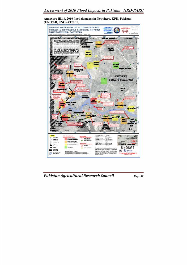
Annexure III.16. 2010 flood damages in Nowshera, KPK, Pakistan
(UNITAR, UNOSAT 2010)
8/3/2019 2010 Flood Damage Assessment Report II Annexure
http://slidepdf.com/reader/full/2010-flood-damage-assessment-report-ii-annexure 33/36
Assessment of 2010 Flood Impacts in Pakistan NRD-PARC
Pakistan Agricultural Research Council Page 33
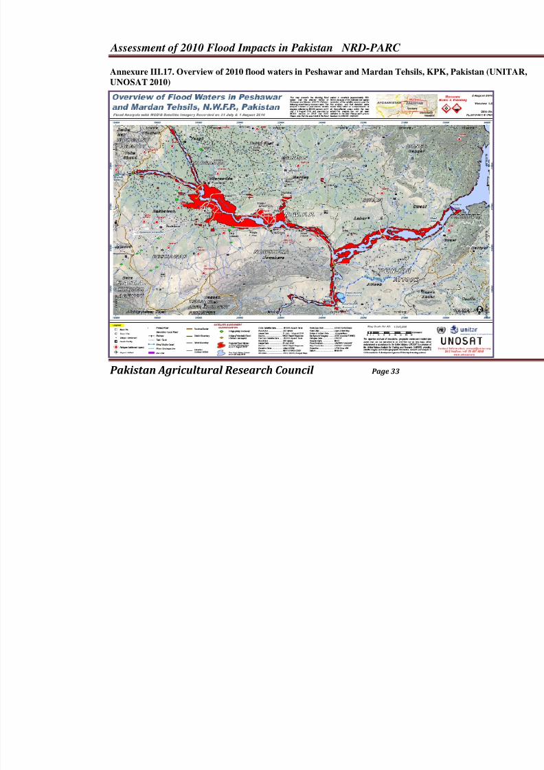
Annexure III.17. Overview of 2010 flood waters in Peshawar and Mardan Tehsils, KPK, P
UNOSAT 2010)
8/3/2019 2010 Flood Damage Assessment Report II Annexure
http://slidepdf.com/reader/full/2010-flood-damage-assessment-report-ii-annexure 34/36
Assessment of 2010 Flood Impacts in Pakistan NRD-PARC
Pakistan Agricultural Research Council Page 34
Annexure IIIe:
Spatial Maps of 2010 Flood AffectedAreas at National, Provincial and
Command Level in Pakistan
Maps of Flood Affected Areas inBalochistan5
5
Maps are developed by UNOSAT, ICIMOD, USAID and other agencies individually or jointly. These maps are
reproduced for knowledge purposes and duly acknowledged. The purpose is only for knowledge and education .
All these maps are also available on the website of UNOSAT and can be accessed directly if further information
is needed.
8/3/2019 2010 Flood Damage Assessment Report II Annexure
http://slidepdf.com/reader/full/2010-flood-damage-assessment-report-ii-annexure 35/36
Assessment of 2010 Flood Impacts in Pakistan NRD-PARC
Pakistan Agricultural Research Council Page 35
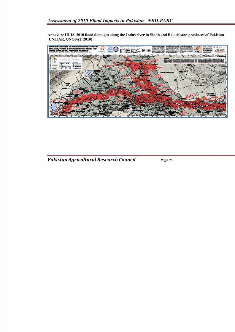
Annexure III.18. 2010 flood damages along the Indus river in Sindh and Balochistan provi
(UNITAR, UNOSAT 2010)
8/3/2019 2010 Flood Damage Assessment Report II Annexure
http://slidepdf.com/reader/full/2010-flood-damage-assessment-report-ii-annexure 36/36
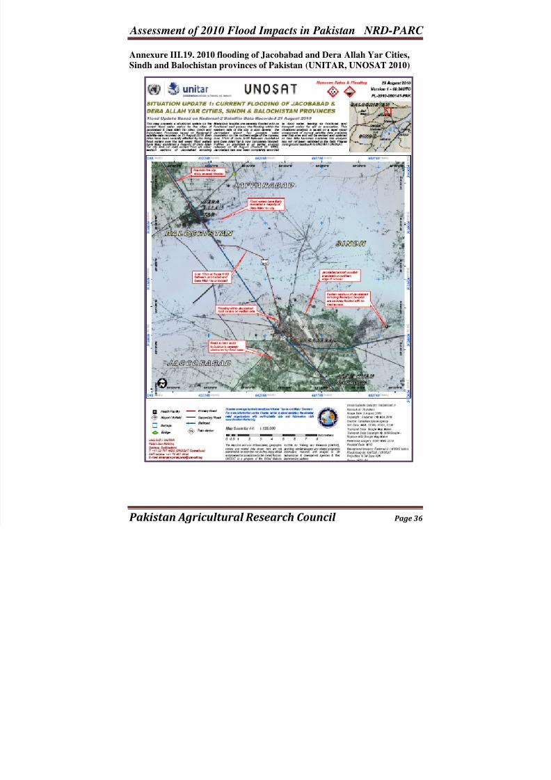
Assessment of 2010 Flood Impacts in Pakistan NRD-PARC Annexure III.19. 2010 flooding of Jacobabad and Dera Allah Yar Cities,
Sindh and Balochistan provinces of Pakistan (UNITAR, UNOSAT 2010)