Embed Size (px)
Citation preview

2009 HOUSING ELEMENT SITES INVENTORY
Map ID APN
Street
Number Street Name Zone
Sub-
zone
Allowable
Density
Square
Feet
Lot
Acres Existing Use
Year
Built
Redev.
Area
Env.
Const.
Existing
Units (A)
Maximum
Capacity
Realistic
Capacity
(B)
Net Yield
(B-A) Notes
Community/
Area or
Specific Plan
Plan
Designation
M1 080C048403004 936 Delano St R-1 8.71 19,110 0.44
Res,Single
Family
Residence 1958 Y N 1 4 3 2 Ashland/ Eden
Low and Medium
Density
Residential
M2 080C048403300 964 Delano St R-1 8.71 28,729 0.66
Res,Single
Family
Residence 1951 Y N 2 6 4 2
Merger potrential
for M2 and M5 Ashland/ Eden
Low and Medium
Density
Residential
M3 080C048402306 820 Elgin St R-S D-25 17.45 46,008 1.06
Res,Single
Family
Residence 1940 Y N 1 18 14 13
Merger potrential
for M3 and M4 Ashland/ Eden
Medium Density
Residential
M4 080C048402500 854 Elgin St R-S D-25 17.45 21,399 0.49
Res,Multi,2-4
Single Family
Homes 1923 Y N 2 9 6 4
Merger potrential
for M3 and M4 Ashland/ Eden
Medium Density
Residential
M5 080C048403600 928 Elgin St R-S D-25 17.45 39,533 0.91
Res,Single
Family
Residence 1948 Y N 1 16 12 11
Merger potrential
for M2 and M5 Ashland/ Eden
Medium Density
Residential
M6 080C048500504 887 Elgin St R-S D-25 17.45 10,096 0.23
Res,Single
Family
Residence 1967 Y N 1 4 3 2
Merger potrential
for M6 and M7 Ashland/ Eden
High and Medium
Density
Residential
M7 080C048500604 895 Elgin St R-S D-25 17.45 10,654 0.24
Res,Single
Family
Residence 1930 Y N 1 4 3 2
Merger potrential
for M6 and M7 Ashland/ Eden
High and Medium
Density
Residential
M8 080C048500802 925 Elgin St R-S D-25 17.45 14,032 0.32
Res,Single
Family
Residence 1932 Y N 1 6 4 3 Ashland/ Eden
High and Medium
Density
Residential
M9 080D056301700 Dermody Ave R-3/R-4 30.00 37,897 0.87
BART parking
lot Y Y 0 26 20 20
Flood Zone
within 50 feet of
parcel. Merger
Potential with M9
- M13 Ashland/ Eden
Medium Density
Residential
M10 080D056502900 Wagner St R-3/R-4 30.00 84,071 1.93
BART parking
lot Y Y 0 58 43 43
Flood Zone
within 50 feet of
parcel,
watercourse near
property. Merger
Potential with M9
- M13 Ashland/ Eden
Medium Density
Residential
M11 080D056503000 Wagner St R-3/R-4 30.00 43,560 1.00
BART parking
lot Y Y 0 30 23 23
Merger Potential
with M9 - M13 Ashland/ Eden
Medium Density
Residential
M12 080D056803000 Wagner St R-3/R-4 30.00 65,776 1.51
BART parking
lot Y Y 0 45 34 34
Flood Zone
within 50 feet of
parcel. Merger
Potential with M9
- M13 Ashland/ Eden
Medium Density
Residential
M13 080D056803100 Wagner St R-S D-15 30.00 78,844 1.81
BART parking
lot Y Y 0 54 41 41
Creek/watercour
se close to
property. Merger
Potential with M9
- M13 Ashland/ Eden
Medium Density
Residential
1 of 94

2009 HOUSING ELEMENT SITES INVENTORY
Map ID APN
Street
Number Street Name Zone
Sub-
zone
Allowable
Density
Square
Feet
Lot
Acres Existing Use
Year
Built
Redev.
Area
Env.
Const.
Existing
Units (A)
Maximum
Capacity
Realistic
Capacity
(B)
Net Yield
(B-A) Notes
Community/
Area or
Specific Plan
Plan
Designation
M14 080 005704000 16110 E 14th ACBD TA 50.00 55,500 1.27 Retail Sales Y N 0 64 48 48
Approved for 48
units Ashland/ Eden
General
Commercial or
Medium High
Density
Residential
M15 080C047600100 16035 E 14th St ACBD TA 50.00 8,882 0.20
Commercial,
Miscellaneous,
Improved 1932 Y N 0 10 8 8
Merger potential
M15-20 Ashland/ Eden
General
Commercial or
Medium High
Density
Residential
M16 080C047600200 16039 E 14th St ACBD TA 50.00 7,970 0.18 One story store 1947 Y N 0 9 7 7
Merger potential
M15-20 Ashland/ Eden
General
Commercial or
Medium High
Density
Residential
M17 080C047600300 16043 E 14th St ACBD TA 50.00 6,390 0.16
Commercial,
Miscellaneous,
Improved 1930 Y N 0 8 6 6
Merger potential
M15-20 Ashland/ Eden
General
Commercial or
Medium High
Density
Residential
M18 080C047600501 16064 Ashland Ave ACBD TA 50.00 10,560 0.24
Four living
units; e.g.
fourplex or
triplex w/SFR 1910 Y N 4 12 9 5
Merger potential
M15-20 Ashland/ Eden
General
Commercial or
Medium High
Density
Residential
M19 080C047601101 16151 E 14th St ACBD TA 50.00 6,869 0.16 One story store 1942 Y N 0 8 6 6
Merger potential
M15-20 Ashland/ Eden
General
Commercial or
Medium High
Density
Residential
M20 080C047601103 16115 E 14th St ACBD TA 50.00 111,514 2.56
Mobile home
park 1950 Y N 44 128 96 52
Merger potential
M15-20 Ashland/ Eden
General
Commercial or
Medium High
Density
Residential
M21 080C047902200 16331 Kent R-1 50.00 19,000 0.44
Single Family
Residence 1947 Y N 1 22 16 15
50 du/acre,
mixed use per
ACBDSP,
potential RDA
site Ashland/ Eden
General
Commercial or
Medium High
Density
Residential
2 of 94
2009 HOUSING ELEMENT SITES INVENTORY
Map ID APN
Street
Number Street Name Zone
Sub-
zone
Allowable
Density
Square
Feet
Lot
Acres Existing Use
Year
Built
Redev.
Area
Env.
Const.
Existing
Units (A)
Maximum
Capacity
Realistic
Capacity
(B)
Net Yield
(B-A) Notes
Community/
Area or
Specific Plan
Plan
Designation
M22 080C047902301 16309 Kent ACBD TA 50.00 53,000 1.22
Residential,
manufactured,
mobile home
park 1949 Y N 16 61 46 30
50 du/acre,
mixed use per
ACBDSP,
potential RDA
site Ashland/ Eden
General
Commercial or
Medium High
Density
Residential
M23 080C047902302 16325 Kent R-1 50.00 10,080 0.23
Single Family
Residence 1959 Y N 1 12 9 8
50 du/acre,
mixed use per
ACBDSP,
potential RDA
site Ashland/ Eden
General
Commercial or
Medium High
Density
Residential
M24 080C049500103 16021 Ashland Ave ACBD TA 50.00 81,881 1.88 Warehouse 1991 Y Y 0 94 70 70
Flood Zone
within 50 feet of
parcel, close to
creek and
riparian area.
Lot merger
potential M24-
M29 Ashland/ Eden
General
Commercial or
Medium High
Density
Residential
M25 080C050002401 15951 E 14th St ACBD TA 50.00 16,783 0.39 One story store 1981 Y Y 0 19 14 14
Flood Zone
within 50 feet of
parcel. Lot
merger potential
M24-M29 Ashland/ Eden
General
Commercial or
Medium High
Density
Residential
M26 080C050002500 15957 E 14th St ACBD TA 50.00 12,851 0.30
Miscellaneous
improved
commercial 1960 Y Y 0 15 11 11
Flood Zone
within 50 feet of
parcel. Lot
merger potential
M24-M29 Ashland/ Eden
General
Commercial or
Medium High
Density
Residential
M27 080C050002600 15959 E 14th St ACBD TA 50.00 25,077 0.58
Mobile home
park 1946 Y Y 12 29 22 10
Flood Zone
within 50 feet of
parcel. Lot
merger potential
M24-M29 Ashland/ Eden
General
Commercial or
Medium High
Density
Residential
M28 080C050002700 15965 E 14th St ACBD TA 50.00 22,500 0.52
Multiple
residential
building of 5 or
more units. 1940 Y Y 11 26 19 8
Flood Zone
within 50 feet of
parcel. Lot
merger potential
M24-M29 Ashland/ Eden
General
Commercial or
Medium High
Density
Residential
M29 080C050002800 15995 E 14th St ACBD TA 50.00 4,297 0.10 One story store 1949 Y Y 0 5 4 4
Flood Zone
within 50 feet of
parcel. Lot
merger potential
M24-M29 Ashland/ Eden
General
Commercial or
Medium High
Density
Residential
99 801 601 502TOTAL - ASHLAND
3 of 94
2009 HOUSING ELEMENT SITES INVENTORY
Map ID APN
Street
Number Street Name Zone
Sub-
zone
Allowable
Density
Square
Feet
Lot
Acres Existing Use
Year
Built
Redev.
Area
Env.
Const.
Existing
Units (A)
Maximum
Capacity
Realistic
Capacity
(B)
Net Yield
(B-A) Notes
Community/
Area or
Specific Plan
Plan
Designation
Map ID APN
Street
Number Street Name Zone
Sub-
zone
Allowable
Density
Square
Feet
Lot
Acres Existing Use
Year
Built
Redev.
Area
Env.
Const.
Existing
Units (A)
Maximum
Capacity
Realistic
Capacity
(B)
Net Yield
(B-A) Notes
Community/
Area or
Specific Plan
Plan
Designation
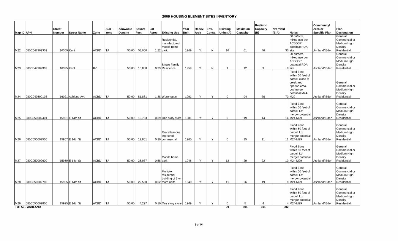
CH1 414 002609801 694 Hampton Rd R-S SU 8.71 28,320 0.65
Res,Multi,2-4
Single Family
Homes Y Y 2 6 4 2
Within 50 feet of
a flood zone
Cherryland/
Eden
Low and Medium
Density
Residential
CH2 429 001004100 310 Cherry Way R-S SU 8.71 19,957 0.46
Res,Single
Family
Residence 1940 Y N 1 4 3 2
Merger potential
with CH7
Cherryland/
Eden
Low and Medium
Density
Residential
CH3 429 001400700 303 Medford Ave R-S SU 8.71 24,412 0.56
Res,Single
Family
Residence 1926 Y N 1 5 4 3
Merger potential
with CH4
Cherryland/
Eden
Low and Medium
Density
Residential
CH4 429 001400802 323 Medford Ave R-S SU 8.71 37,757 0.87
Res,Multi,2-4
Single Family
Homes 1957 Y N 2 8 6 4
Merger potential
with CH3
Cherryland/
Eden
Low and Medium
Density
Residential
CH5 429 001403300 350 Cherry Way R-S SU 8.71 19,923 0.46
Res,Single
Family
Residence 1948 Y N 1 4 3 2
Merger potential
with CH6
Cherryland/
Eden
Low and Medium
Density
Residential
CH6 429 001403400 342 Cherry Way R-S SU 8.71 19,849 0.46
Res,Single
Family
Residence 1947 Y N 1 4 3 2
Merger potential
with CH5
Cherryland/
Eden
Low and Medium
Density
Residential
CH7 429 001403700 316 Cherry Way R-S SU 8.71 19,660 0.45
Res,Single
Family
Residence 1952 Y N 1 4 3 2
Merger potential
with CH2
Cherryland/
Eden
Low and Medium
Density
Residential
CH8 429 001903500 567 Cherry Way R-S SU 8.71 27,823 0.64
Res,Multi,2-4
Single Family
Homes 2005 Y N 1 6 4 3
Cherryland/
Eden
Low and Medium
Density
Residential
CH9 429 001904000 21065 Western Blvd R-S SU 8.71 17,130 0.39
Res,Single
Family
Residence 1940 Y N 1 3 3 2
Cherryland/
Eden
Low and Medium
Density
Residential
CH10 429 006402402 227 Willow Ave R-S D-35 12.45 16,682 0.38
Vacant,Res
Land Zoned 4
Units Y N 0 5 4 4
Cherryland/
Eden
Medium Density
Residential
CH11 414 007609300 770 Grove Way R-S D-35 12.45 17,811 0.41
Res,Single
Family
Residence 1924 Y N 1 5 4 3
Merger potential
CH11-14
Cherryland/
Eden
Medium Density
Residential
CH12 414 007609400 752 Grove Way R-S D-35 12.45 20,366 0.47
Res,Multi,2-4
Single Family
Homes Y N 2 6 4 2
Merger potential
CH11-14
Cherryland/
Eden
Medium Density
Residential
CH13 414 007609500 730 Grove Way R-S D-35 12.45 19,848 0.46
Res,Single
Family
Residence 1920 Y N 1 6 4 3
Merger potential
CH11-14
Cherryland/
Eden
Medium Density
Residential
CH14 414 007609600 710 Grove Way R-S D-35 12.45 19,465 0.45
Res,Single
Family
Residence 1925 Y N 1 6 4 3
Merger potential
CH11-14
Cherryland/
Eden
Medium Density
Residential
CH15 429 001006100 140 Blossom Way R-S D-35 12.45 19,771 0.45
Res,Single
Family
Residence 1937 Y N 2 6 4 2
Merger potential
CH24 and 25
Cherryland/
Eden
Medium Density
Residential
CH16 429 001408700 296 Blossom Way R-S D-35 12.45 21,775 0.50
Res,Single
Family
Residence 1942 Y N 1 6 5 4
Cherryland/
Eden
Medium Density
Residential
4 of 94

2009 HOUSING ELEMENT SITES INVENTORY
Map ID APN
Street
Number Street Name Zone
Sub-
zone
Allowable
Density
Square
Feet
Lot
Acres Existing Use
Year
Built
Redev.
Area
Env.
Const.
Existing
Units (A)
Maximum
Capacity
Realistic
Capacity
(B)
Net Yield
(B-A) Notes
Community/
Area or
Specific Plan
Plan
Designation
CH17 429 002302000 396 Grove Way R-S D-35 12.45 19,215 0.44
Res,Single
Family
Residence 1928 Y N 1 5 4 3
Cherryland/
Eden
Medium Density
Residential
CH18 431 001607500 22472 Meekland Ave R-S DV 12.45 8,264 0.19 Restaurant Y N 0 2 2 2
Cherryland/
Eden
Low and Medium
Density
Residential
CH19 429 000502100 19635 Meekland Ave R-S D-3 14.52 19,467 0.45
Res,Single
Family
Residence 1950 Y N 1 6 5 4
Cherryland/
Eden
Medium Density
Residential
CH20 429 000502200 19745 Meekland Ave R-S D-3 14.52 20,090 0.46
Single Family
Residence 1942 Y N 1 7 7 7
Entitled for 14-
unit condo per
TR-7925
Cherryland/
Eden
Medium Density
Residential
CH21 429 000502300 19755 Meekland Ave R-S D-3 14.52 21,523 0.49
Single Family
Residence 1942 Y N 2 7 7 7
Entitled for 14-
unit condo per
TR-7925
Cherryland/
Eden
Medium Density
Residential
CH22 429 001002300 19350 Meekland Ave R-S D-3 14.52 10,260 0.24 Industrial 1918 Y N 1 3 3 2
Industrial uses,
adjacent
residential,
potential RDA
site
Cherryland/
Eden
Low and Medium
Density
Residential
CH23 429 001002400 19356 Meekland Ave R-S D-3 14.52 7,925 0.18 Industrial 1946 Y N 0 3 2 2
Industrial uses,
adjacent
residential,
potential RDA
site
Cherryland/
Eden
Low and Medium
Density
Residential
CH24 429 001005800 19870 Meekland Ave R-S D-3 14.52 13,287 0.31
Res,Single
Family
Residence 1939 Y N 1 4 3 2
Merger potential
with CH15 and
25
Cherryland/
Eden
Medium Density
Residential
CH25 429 001006000 126 Blossom Way R-S D-3 14.52 19,761 0.45
Res,Single
Family
Residence 1937 Y N 1 7 5 4
Merger potential
with CH15 and
24
Cherryland/
Eden
Medium Density
Residential
CH26 429 003200200 20337 Meekland Ave R-S D-3 14.52 15,983 0.37
Res,Single
Family
Residence 1943 Y N 1 5 4 3
Cherryland/
Eden
Medium Density
Residential
CH27 429 003200400 20449 Meekland Ave R-S D-3 14.52 15,744 0.36
Res,Single
Family
Residence 1953 Y N 1 5 4 3
Merger Potential
CH 27-30
Cherryland/
Eden
Medium Density
Residential
CH28 429 003200500 20555 Meekland Ave R-S D-3 14.52 15,833 0.36
Res,Single
Family
Residence 1955 Y N 1 5 4 3
Merger Potential
CH 27-30
Cherryland/
Eden
Medium Density
Residential
CH29 429 003200600 20661 Meekland Ave R-S D-3 14.52 16,444 0.38
Res,Single
Family
Residence 1943 Y N 1 5 4 3
Merger Potential
CH 27-30
Cherryland/
Eden
Medium Density
Residential
CH30 429 003200700 20667 Meekland Ave R-S D-3 14.52 15,868 0.36
Res,Single
Family
Residence 1943 Y N 1 5 4 3
Merger Potential
CH 27-30
Cherryland/
Eden
Medium Density
Residential
CH31 429 003200901 Meekland Av R-S D-3 14.52 8,578 0.20
Vacant,Res
Land Zoned 4
Units 1975 Y N 0 3 2 2
Merger potential
with CH32
Cherryland/
Eden
Medium Density
Residential
5 of 94

2009 HOUSING ELEMENT SITES INVENTORY
Map ID APN
Street
Number Street Name Zone
Sub-
zone
Allowable
Density
Square
Feet
Lot
Acres Existing Use
Year
Built
Redev.
Area
Env.
Const.
Existing
Units (A)
Maximum
Capacity
Realistic
Capacity
(B)
Net Yield
(B-A) Notes
Community/
Area or
Specific Plan
Plan
Designation
CH32 429 003201000 20987 Meekland Ave R-S D-3 14.52 14,282 0.33
Res,Single
Family
Residence Y N 1 5 4 3
Merger potential
with CH31
Cherryland/
Eden
Medium Density
Residential
CH33 414 005102804 Locust St R-S DV 12.45 14,400 0.33
Vacant, Public
Agency,
Exempt Y Y 0 4 3 3
Vacant
State/County
property,
approximate lot
size, Alquist-
Priolo Study
Area. Merger
potentrial with
CH34
Cherryland/
Eden
Low and Medium
Density
Residential
CH34 414 005103002 Foothill Blvd R-S DV 21.78 20,576 0.47
Vacant, Public
Agency,
Exempt Y Y 0 10 8 8
Vacant
State/County
property,
approximate lot
size, Alquist-
Priolo Study
Area. Merger
potentrial with
CH33
Cherryland/
Eden
Low and Medium
Density
Residential
CH35 414 005104800 20922 Locust St R-S DV 21.78 22,293 0.51
Single Family
Residence 1910 Y Y 1 11 8 7
Alquist-Priolo
Study Area.
Merger potentrial
with CH36
Cherryland/
Eden
Low and Medium
Density
Residential
CH36 414 005104900 20914 Locust St R-S DV 12.45 7,504 0.17
Single Family
Residence 1925 Y Y 1 2 2 1
Alquist-Priolo
Study Area.
Merger potentrial
with CH35
Cherryland/
Eden
Low and Medium
Density
Residential
CH37 414 008605700 21438 Locust St R-S DV 12.45 7,500 0.17
One story
Commercial Y Y 0 2 2 2
Alquist-Priolo
Study Area
Cherryland/
Eden
Low and Medium
Density
Residential
CH38 414 008606300 21358 Locust St R-S DV 12.45 13,629 0.31
Multi-Family
Residential, 2-
4 SFRs 1900 Y Y 1 4 3 2
Alquist-Priolo
Study Area
Cherryland/
Eden
Low and Medium
Density
Residential
CH39 429 005501404 410 Sunset Blvd R-S DV 12.45 14,300 0.33
Single family
residential
homes used as
such 1938 Y N 1 4 3 2
Cherryland/
Eden
Medium Density
Residential
CH40 429 005501700 384 Sunset Blvd R-S DV 12.45 17,800 0.41
Single family
residential
homes used as
such 1947 Y N 1 5 4 3
Merger potential
with CH41 and
45
Cherryland/
Eden
Medium Density
Residential
CH41 429 005501900 360 Sunset Blvd R-S DV 12.45 18,450 0.42
Single family
residential
homes used as
such 1934 Y N 1 5 4 3
Merger potential
with CH40 and
45
Cherryland/
Eden
Medium Density
Residential
6 of 94
2009 HOUSING ELEMENT SITES INVENTORY
Map ID APN
Street
Number Street Name Zone
Sub-
zone
Allowable
Density
Square
Feet
Lot
Acres Existing Use
Year
Built
Redev.
Area
Env.
Const.
Existing
Units (A)
Maximum
Capacity
Realistic
Capacity
(B)
Net Yield
(B-A) Notes
Community/
Area or
Specific Plan
Plan
Designation
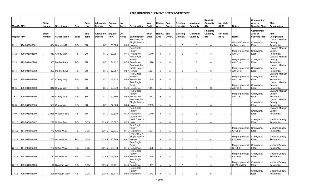
CH42 429 005502200 318 Sunset Blvd R-S DV 12.45 15,000 0.34
Single family
residential
homes used as
such 1948 Y N 1 4 3 2
Merger potential
CH42-44
Cherryland/
Eden
Medium Density
Residential
CH43 429 005502800 21836 Princeton St R-S DV 21.78 20,000 0.46
Two, three or
four single
family homes 1943 Y N 4 10 8 4
Merger potential
CH42-44
Cherryland/
Eden
Medium Density
Residential
CH44 429 005502900 21806 Princeton St R-S DV 12.45 18,200 0.42
Single family
residential
homes used as
such 1930 Y N 1 5 4 3
Merger potential
CH42-44
Cherryland/
Eden
Medium Density
Residential
CH45 429 005505100 366 Sunset Blvd R-S DV 21.78 30,945 0.71
Multiple
residential
building of 5 or
more units. 1974 Y N 8 15 12 4
Merger potential
with CH40 and
41
Cherryland/
Eden
Medium Density
Residential
CH46 429 005902100 21823 Princeton St R-S DV 12.45 12,320 0.28
Single family
residential
homes used as
such 1950 Y N 1 4 3 2
Merger potential
with CH47
Cherryland/
Eden
Medium Density
Residential
CH47 429 005902202 21837 Princeton St R-S DV 12.45 15,800 0.36
Multiple
residential
building of 5 or
more units. 1963 Y N 1 5 3 2
Merger potential
with CH46
Cherryland/
Eden
Medium Density
Residential
CH48 429 006403502 122 Sunset Blvd R-S DV 21.78 20,860 0.48
Miscellaneous
improved
commercial 1947 Y N 1 10 8 7
Merger potential
with CH49
Cherryland/
Eden
Medium Density
Residential
CH49 429 006403600 130 Sunset Blvd R-S DV 21.78 19,100 0.44 Warehouse Y N 0 10 7 7
Need to surveyto
verify lot size.
Merger potential
with CH48
Cherryland/
Eden
Medium Density
Residential
CH50 429 006403800 148 Sunset Blvd R-S DV 12.45 12,850 0.29
Single family
residential
homes used as
such 1928 Y N 1 4 3 2
Merger potential
with CH51
Cherryland/
Eden
Medium Density
Residential
CH51 429 006403900 152 Sunset Blvd R-S DV 12.45 16,600 0.38
Single family
residential
homes used as
such 1932 Y N 1 5 4 3
Merger potential
with CH50
Cherryland/
Eden
Medium Density
Residential
CH52 429 006404700 145 Sunset Blvd R-S DV 12.45 17,370 0.40
Single family
residential
homes used as
such 1923 Y N 1 5 4 3
Merger potential
with CH53
Cherryland/
Eden
Medium Density
Residential
CH53 429 006405402 22008 Meekland Ave R-S DV 21.78 44,431 1.02
Miscellaneous
improved
commercial Y N 0 22 17 17
Merger potential
with CH52
Cherryland/
Eden
High and Medium
Density
Residential
CH54 429 008602501 155 Poplar Ave R-S DV 12.45 13,818 0.32
Single family
residential
homes used as
such 1925 Y N 1 4 3 2
Cherryland/
Eden
Medium Density
Residential
7 of 94
2009 HOUSING ELEMENT SITES INVENTORY
Map ID APN
Street
Number Street Name Zone
Sub-
zone
Allowable
Density
Square
Feet
Lot
Acres Existing Use
Year
Built
Redev.
Area
Env.
Const.
Existing
Units (A)
Maximum
Capacity
Realistic
Capacity
(B)
Net Yield
(B-A) Notes
Community/
Area or
Specific Plan
Plan
Designation
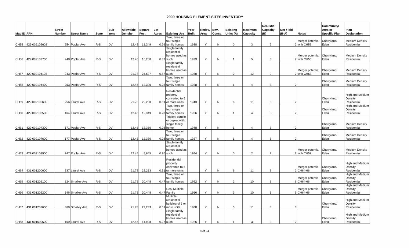
CH55 429 009102602 254 Poplar Ave R-S DV 12.45 11,349 0.26
Two, three or
four single
family homes 1938 Y N 0 3 2 2
Merger potential
with CH56
Cherryland/
Eden
Medium Density
Residential
CH56 429 009102700 248 Poplar Ave R-S DV 12.45 16,200 0.37
Single family
residential
homes used as
such 1923 Y N 1 5 3 2
Merger potential
with CH55
Cherryland/
Eden
Medium Density
Residential
CH57 429 009104103 243 Poplar Ave R-S DV 21.78 24,697 0.57
Single family
residential
homes used as
such 1930 Y N 2 12 9 7
Merger potential
with CH63
Cherryland/
Eden
Medium Density
Residential
CH58 429 009104400 263 Poplar Ave R-S DV 12.45 12,300 0.28
Two, three or
four single
family homes 1928 Y N 1 4 3 2
Cherryland/
Eden
Medium Density
Residential
CH59 429 009105600 256 Laurel Ave R-S DV 21.78 22,200 0.51
Residential
property
converted to 5
or more units 1943 Y N 6 11 8 2
Cherryland/
Eden
High and Medium
Density
Residential
CH60 429 009106500 164 Laurel Ave R-S DV 12.45 12,349 0.28
Two, three or
four single
family homes 1926 Y N 1 4 3 2
Cherryland/
Eden
High and Medium
Density
Residential
CH61 429 009107300 171 Poplar Ave R-S DV 12.45 12,350 0.28
Triplex; double
or duplex with
single family
home 1948 Y N 1 4 3 2
Cherryland/
Eden
Medium Density
Residential
CH62 429 009107600 177 Poplar Ave R-S DV 12.45 12,350 0.28
Two, three or
four single
family homes 1927 Y N 1 4 3 2
Cherryland/
Eden
Medium Density
Residential
CH63 429 009109900 247 Poplar Ave R-S DV 12.45 8,645 0.20
Single family
residential
homes used as
such 1984 Y N 0 2 2 2
Merger potential
with CH57
Cherryland/
Eden
Medium Density
Residential
CH64 431 001200600 337 Laurel Ave R-S DV 21.78 22,233 0.51
Residential
property
converted to 5
or more units Y N 6 11 8 2
Merger potential
CH64-66
Cherryland/
Eden
High and Medium
Density
Residential
CH65 431 001202100 324 Smalley Ave R-S DV 21.78 20,448 0.47
Two, three or
four single
family homes 1952 Y N 2 10 8 6
Merger potential
CH64-66
Cherryland/
Eden
High and Medium
Density
Residential
CH66 431 001202200 346 Smalley Ave R-S DV 21.78 20,448 0.47
Res.,Multiple
Family 1956 Y N 3 10 8 5
Merger potential
CH64-66
Cherryland/
Eden
High and Medium
Density
Residential
CH67 431 001202600 368 Smalley Ave R-S DV 21.78 22,233 0.51
Multiple
residential
building of 5 or
more units. 1988 Y N 5 11 8 3
Cherryland/
Eden
High and Medium
Density
Residential
CH68 431 001600500 169 Laurel Ave R-S DV 12.45 11,928 0.27
Single family
residential
homes used as
such 1926 Y N 1 3 3 2
Cherryland/
Eden
High and Medium
Density
Residential
8 of 94

2009 HOUSING ELEMENT SITES INVENTORY
Map ID APN
Street
Number Street Name Zone
Sub-
zone
Allowable
Density
Square
Feet
Lot
Acres Existing Use
Year
Built
Redev.
Area
Env.
Const.
Existing
Units (A)
Maximum
Capacity
Realistic
Capacity
(B)
Net Yield
(B-A) Notes
Community/
Area or
Specific Plan
Plan
Designation
CH69 431 001601001 207 Laurel Ave R-S DV 21.78 23,928 0.55
Single family
residential
homes used as
such 1920 Y N 1 12 9 8
Cherryland/
Eden
High and Medium
Density
Residential
CH70 431 001601400 261 Laurel Ave R-S DV 21.78 20,448 0.47
Res., Multiple
Family 1952 Y N 4 10 8 4
Merger potential
CH70 and 71
Cherryland/
Eden
High and Medium
Density
Residential
CH71 431 001601500 275 Laurel Ave R-S DV 21.78 20,448 0.47
Four living
units; e.g.
fourplex or
triplex w/SFR 1965 Y N 4 10 8 4
Merger potential
CH70 and 71
Cherryland/
Eden
High and Medium
Density
Residential
CH72 431 001603600 204 Smalley Ave R-S DV 12.45 20,448 0.47
Two, three or
four single
family homes 1961 Y N 2 6 4 2
Cherryland/
Eden
High and Medium
Density
Residential
CH73 431 001604500 22358 Meekland Ave R-S DV 12.45 10,359 0.24
One to five
story office
building Y N 0 3 2 2
Cherryland/
Eden
High and Medium
Density
Residential
CH74 431 001605200 159 Smalley Ave R-S DV 21.78 19,400 0.45 Church Y N 0 10 7 7
Boundary
adjustment to
meet RS-D20
requirement
Cherryland/
Eden
High and Medium
Density
Residential
CH75 414 005602101 21030 Mission Blvd ACBD TC 50.00 14,820 0.34 One story store 1953 Y Y 0 17 13 13
Flood Zone
within 50 feet of
parcel. Merger
potential sites
CH75-93
Cherryland/
Eden
General
Commercial/
Medium/High
Density
Residential
CH76 414 005602301 21050 Mission Blvd ACBD TC 50.00 9,693 0.22
Commercial
repair garage 1957 Y Y 0 11 8 8
Flood Zone
within 50 feet of
parcel. Merger
potential sites
CH75-93
Cherryland/
Eden
General
Commercial/
Medium/High
Density
Residential
CH77 414 008100101 21070 Mission Blvd ACBD TC 50.00 9,250 0.21
Single family
residential
homes used as
such 1923 Y Y 1 11 8 7
Flood Zone
within 50 feet of
parcel. Merger
potential sites
CH75-93
Cherryland/
Eden
General
Commercial/
Medium/High
Density
Residential
CH78 414 008100200 21098 Mission Blvd ACBD TC 50.00 7,903 0.18
Vacant
commercial
land (may
include misc.
imps) Y Y 1 9 7 6
Flood Zone
within 50 feet of
parcel. Merger
potential sites
CH75-93
Cherryland/
Eden
General
Commercial/
Medium/High
Density
Residential
CH79 414 008100300 21106 Mission Blvd ACBD TC 50.00 10,987 0.25 One story store 1966 Y Y 0 13 9 9
Flood Zone
within 50 feet of
parcel. Merger
potential sites
CH75-93
Cherryland/
Eden
General
Commercial/
Medium/High
Density
Residential
CH80 414 008100400 21120 Mission Blvd ACBD TC 50.00 7,405 0.17 One story store 1951 Y Y 0 9 6 6
Flood Zone
within 50 feet of
parcel. Merger
potential sites
CH75-93
Cherryland/
Eden
General
Commercial/
Medium/High
Density
Residential
9 of 94
2009 HOUSING ELEMENT SITES INVENTORY
Map ID APN
Street
Number Street Name Zone
Sub-
zone
Allowable
Density
Square
Feet
Lot
Acres Existing Use
Year
Built
Redev.
Area
Env.
Const.
Existing
Units (A)
Maximum
Capacity
Realistic
Capacity
(B)
Net Yield
(B-A) Notes
Community/
Area or
Specific Plan
Plan
Designation
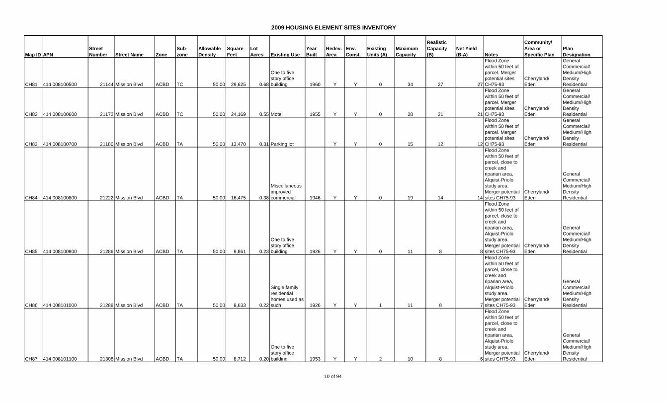
CH81 414 008100500 21144 Mission Blvd ACBD TC 50.00 29,625 0.68
One to five
story office
building 1960 Y Y 0 34 27 27
Flood Zone
within 50 feet of
parcel. Merger
potential sites
CH75-93
Cherryland/
Eden
General
Commercial/
Medium/High
Density
Residential
CH82 414 008100600 21172 Mission Blvd ACBD TC 50.00 24,169 0.55 Motel 1955 Y Y 0 28 21 21
Flood Zone
within 50 feet of
parcel. Merger
potential sites
CH75-93
Cherryland/
Eden
General
Commercial/
Medium/High
Density
Residential
CH83 414 008100700 21180 Mission Blvd ACBD TA 50.00 13,470 0.31 Parking lot Y Y 0 15 12 12
Flood Zone
within 50 feet of
parcel. Merger
potential sites
CH75-93
Cherryland/
Eden
General
Commercial/
Medium/High
Density
Residential
CH84 414 008100800 21222 Mission Blvd ACBD TA 50.00 16,475 0.38
Miscellaneous
improved
commercial 1946 Y Y 0 19 14 14
Flood Zone
within 50 feet of
parcel, close to
creek and
riparian area,
Alquist-Priolo
study area.
Merger potential
sites CH75-93
Cherryland/
Eden
General
Commercial/
Medium/High
Density
Residential
CH85 414 008100900 21286 Mission Blvd ACBD TA 50.00 9,861 0.23
One to five
story office
building 1926 Y Y 0 11 8 8
Flood Zone
within 50 feet of
parcel, close to
creek and
riparian area,
Alquist-Priolo
study area.
Merger potential
sites CH75-93
Cherryland/
Eden
General
Commercial/
Medium/High
Density
Residential
CH86 414 008101000 21288 Mission Blvd ACBD TA 50.00 9,633 0.22
Single family
residential
homes used as
such 1926 Y Y 1 11 8 7
Flood Zone
within 50 feet of
parcel, close to
creek and
riparian area,
Alquist-Priolo
study area.
Merger potential
sites CH75-93
Cherryland/
Eden
General
Commercial/
Medium/High
Density
Residential
CH87 414 008101100 21308 Mission Blvd ACBD TA 50.00 8,712 0.20
One to five
story office
building 1953 Y Y 2 10 8 6
Flood Zone
within 50 feet of
parcel, close to
creek and
riparian area,
Alquist-Priolo
study area.
Merger potential
sites CH75-93
Cherryland/
Eden
General
Commercial/
Medium/High
Density
Residential
10 of 94
2009 HOUSING ELEMENT SITES INVENTORY
Map ID APN
Street
Number Street Name Zone
Sub-
zone
Allowable
Density
Square
Feet
Lot
Acres Existing Use
Year
Built
Redev.
Area
Env.
Const.
Existing
Units (A)
Maximum
Capacity
Realistic
Capacity
(B)
Net Yield
(B-A) Notes
Community/
Area or
Specific Plan
Plan
Designation
CH88 414 008101200 21328 Mission Blvd ACBD TA 50.00 8,276 0.19
One to five
story office
building Y Y 0 10 7 7
Flood Zone
within 50 feet of
parcel, close to
creek and
riparian area,
Alquist-Priolo
study area.
Merger potential
sites CH75-93
Cherryland/
Eden
General
Commercial/
Medium/High
Density
Residential
CH89 414 008101300 21344 Mission Blvd ACBD TA 50.00 8,650 0.20
One to five
story office
building 1940 Y Y 0 10 7 7
Flood Zone
within 50 feet of
parcel, close to
creek and
riparian area,
Alquist-Priolo
study area.
Merger potential
sites CH75-93
Cherryland/
Eden
General
Commercial/
Medium/High
Density
Residential
CH90 414 008101400 21366 Mission Blvd ACBD TA 50.00 8,300 0.19
Residential
Imps on
Commercial
Land 1928 Y Y 1 10 7 6
Flood Zone
within 50 feet of
parcel, close to
creek and
riparian area,
Alquist-Priolo
study area.
Merger potential
sites CH75-93
Cherryland/
Eden
General
Commercial/
Medium/High
Density
Residential
CH91 414 008101500 21376 Mission Blvd ACBD TA 50.00 7,775 0.18 One story store 1942 Y Y 0 9 7 7
Flood Zone
within 50 feet of
parcel, close to
creek and
riparian area,
Alquist-Priolo
study area.
Merger potential
sites CH75-93
Cherryland/
Eden
General
Commercial/
Medium/High
Density
Residential
CH92 414 008101600 21380 Mission Blvd ACBD TA 50.00 7,300 0.17
Triplex; double
or duplex with
single family
home 1941 Y Y 3 8 6 3
Flood Zone
within 50 feet of
parcel, close to
creek and
riparian area,
Alquist-Priolo
study area.
Merger potential
sites CH75-93
Cherryland/
Eden
General
Commercial/
Medium/High
Density
Residential
11 of 94
2009 HOUSING ELEMENT SITES INVENTORY
Map ID APN
Street
Number Street Name Zone
Sub-
zone
Allowable
Density
Square
Feet
Lot
Acres Existing Use
Year
Built
Redev.
Area
Env.
Const.
Existing
Units (A)
Maximum
Capacity
Realistic
Capacity
(B)
Net Yield
(B-A) Notes
Community/
Area or
Specific Plan
Plan
Designation
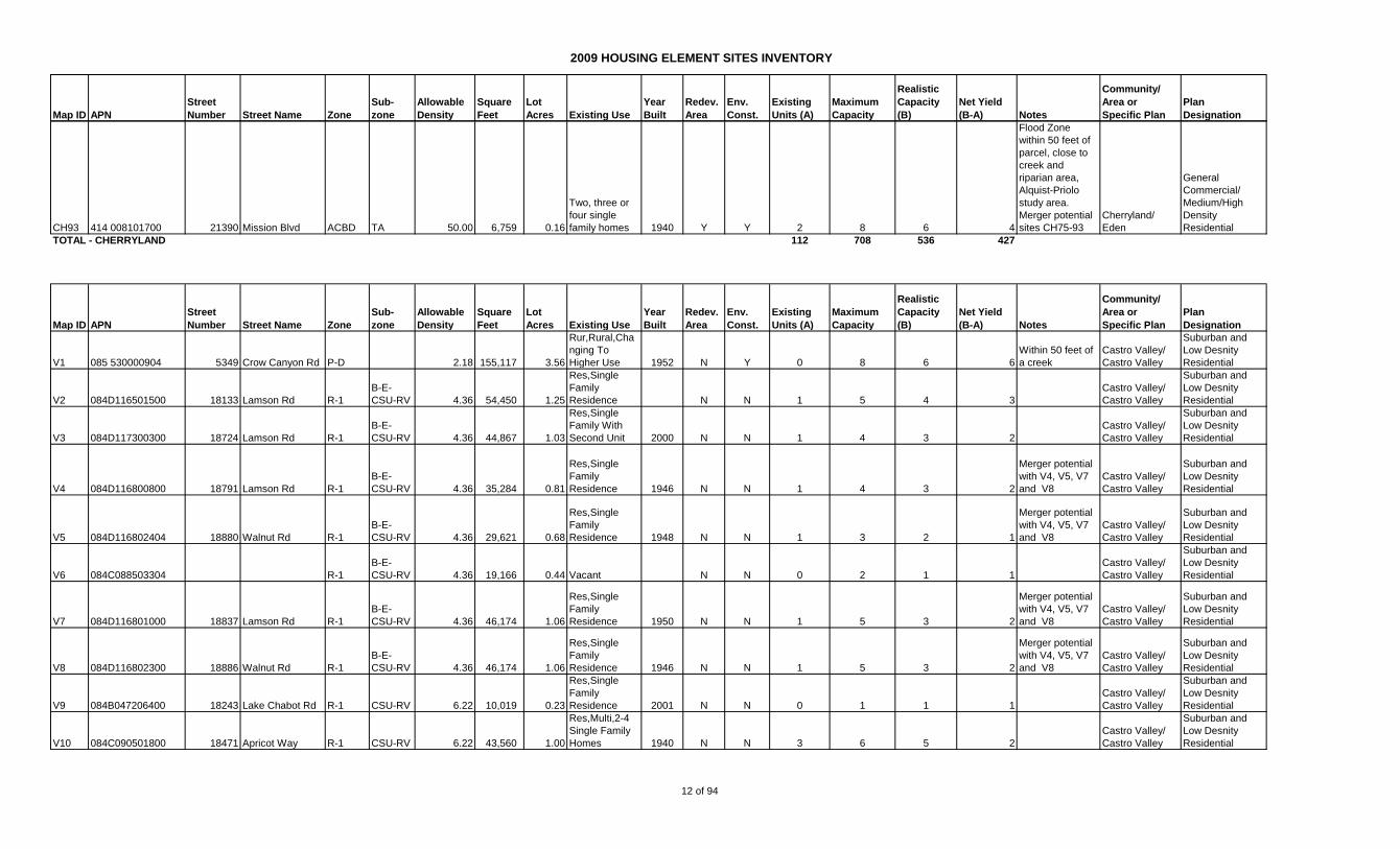
CH93 414 008101700 21390 Mission Blvd ACBD TA 50.00 6,759 0.16
Two, three or
four single
family homes 1940 Y Y 2 8 6 4
Flood Zone
within 50 feet of
parcel, close to
creek and
riparian area,
Alquist-Priolo
study area.
Merger potential
sites CH75-93
Cherryland/
Eden
General
Commercial/
Medium/High
Density
Residential
TOTAL - CHERRYLAND 112 708 536 427
Map ID APN
Street
Number Street Name Zone
Sub-
zone
Allowable
Density
Square
Feet
Lot
Acres Existing Use
Year
Built
Redev.
Area
Env.
Const.
Existing
Units (A)
Maximum
Capacity
Realistic
Capacity
(B)
Net Yield
(B-A) Notes
Community/
Area or
Specific Plan
Plan
Designation
V1 085 530000904 5349 Crow Canyon Rd P-D 2.18 155,117 3.56
Rur,Rural,Cha
nging To
Higher Use 1952 N Y 0 8 6 6
Within 50 feet of
a creek
Castro Valley/
Castro Valley
Suburban and
Low Desnity
Residential
V2 084D116501500 18133 Lamson Rd R-1
B-E-
CSU-RV 4.36 54,450 1.25
Res,Single
Family
Residence N N 1 5 4 3
Castro Valley/
Castro Valley
Suburban and
Low Desnity
Residential
V3 084D117300300 18724 Lamson Rd R-1
B-E-
CSU-RV 4.36 44,867 1.03
Res,Single
Family With
Second Unit 2000 N N 1 4 3 2
Castro Valley/
Castro Valley
Suburban and
Low Desnity
Residential
V4 084D116800800 18791 Lamson Rd R-1
B-E-
CSU-RV 4.36 35,284 0.81
Res,Single
Family
Residence 1946 N N 1 4 3 2
Merger potential
with V4, V5, V7
and V8
Castro Valley/
Castro Valley
Suburban and
Low Desnity
Residential
V5 084D116802404 18880 Walnut Rd R-1
B-E-
CSU-RV 4.36 29,621 0.68
Res,Single
Family
Residence 1948 N N 1 3 2 1
Merger potential
with V4, V5, V7
and V8
Castro Valley/
Castro Valley
Suburban and
Low Desnity
Residential
V6 084C088503304 R-1
B-E-
CSU-RV 4.36 19,166 0.44 Vacant N N 0 2 1 1
Castro Valley/
Castro Valley
Suburban and
Low Desnity
Residential
V7 084D116801000 18837 Lamson Rd R-1
B-E-
CSU-RV 4.36 46,174 1.06
Res,Single
Family
Residence 1950 N N 1 5 3 2
Merger potential
with V4, V5, V7
and V8
Castro Valley/
Castro Valley
Suburban and
Low Desnity
Residential
V8 084D116802300 18886 Walnut Rd R-1
B-E-
CSU-RV 4.36 46,174 1.06
Res,Single
Family
Residence 1946 N N 1 5 3 2
Merger potential
with V4, V5, V7
and V8
Castro Valley/
Castro Valley
Suburban and
Low Desnity
Residential
V9 084B047206400 18243 Lake Chabot Rd R-1 CSU-RV 6.22 10,019 0.23
Res,Single
Family
Residence 2001 N N 0 1 1 1
Castro Valley/
Castro Valley
Suburban and
Low Desnity
Residential
V10 084C090501800 18471 Apricot Way R-1 CSU-RV 6.22 43,560 1.00
Res,Multi,2-4
Single Family
Homes 1940 N N 3 6 5 2
Castro Valley/
Castro Valley
Suburban and
Low Desnity
Residential
12 of 94
2009 HOUSING ELEMENT SITES INVENTORY
Map ID APN
Street
Number Street Name Zone
Sub-
zone
Allowable
Density
Square
Feet
Lot
Acres Existing Use
Year
Built
Redev.
Area
Env.
Const.
Existing
Units (A)
Maximum
Capacity
Realistic
Capacity
(B)
Net Yield
(B-A) Notes
Community/
Area or
Specific Plan
Plan
Designation
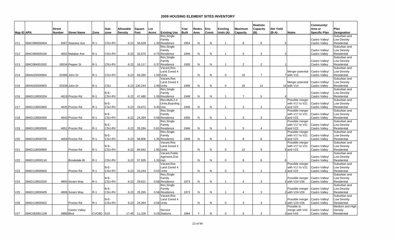
V11 084C086000404 5067 Seaview Ave R-1 CSU-RV 6.22 56,628 1.30
Res,Single
Family
Residence 1954 N N 1 8 6 5
Castro Valley/
Castro Valley
Suburban and
Low Desnity
Residential
V12 084C090505100 4652 Malabar Ave R-1 CSU-RV 6.22 32,670 0.75
Res,Single
Family
Residence 1946 N N 1 5 3 2
Castro Valley/
Castro Valley
Suburban and
Low Desnity
Residential
V13 084C084001002 18534 Pepper St R-1 CSU-RV 6.22 16,117 0.37
Res,Single
Family
Residence 1930 N N 1 2 2 1
Castro Valley/
Castro Valley
Suburban and
Low Desnity
Residential
V14 084A025000904 20396 John Dr R-1 CSU-RV 6.22 69,260 1.59
Vacant,Res
Land Zoned 4
Units N N 0 10 7 7
Merger potential
with V15
Castro Valley/
Castro Valley
Suburban and
Low Desnity
Residential
V15 084A025000903 20338 John Dr R-1 CSU 6.22 130,244 2.99
Vacant,Res
Land Zoned 4
Units 1906 N N 0 19 14 14
Merger potential
with V14
Castro Valley/
Castro Valley
Suburban and
Low Desnity
Residential
V16 084D118000204 4619 Proctor Rd R-1
B-E-
CSU-RV 6.22 47,480 1.09
Res,Single
Family
Residence 1948 N N 1 7 5 4
Castro Valley/
Castro Valley
Suburban and
Low Desnity
Residential
V17 084D118002800 4635 Proctor Rd R-1
B-E-
CSU-RV 6.22 19,672 0.45
Res,Multi,2-4
Units,Boarding
Use 1946 N N 1 3 2 1
Possible merger
with V17 to V21
and V23
Castro Valley/
Castro Valley
Suburban and
Low Desnity
Residential
V18 084D118000400 4643 Proctor Rd R-1
B-E-
CSU-RV 6.22 24,394 0.56
Res,Single
Family
Residence 1955 N N 1 3 3 2
Possible merger
with V17 to V21
and V23
Castro Valley/
Castro Valley
Suburban and
Low Desnity
Residential
V19 084D118000500 4651 Proctor Rd R-1
B-E-
CSU-RV 6.22 35,284 0.81
Res,Single
Family
Residence 1946 N N 1 5 4 3
Possible merger
with V17 to V21
and V23
Castro Valley/
Castro Valley
Suburban and
Low Desnity
Residential
V20 084D118000700 4659 Proctor Rd R-1
B-E-
CSU-RV 6.22 58,806 1.35
Res,Single
Family
Residence 1948 N N 1 8 6 5
Possible merger
with V17 to V21
and V23
Castro Valley/
Castro Valley
Suburban and
Low Desnity
Residential
V21 084D118000800 Proctor Rd R-1
B-E-
CSU-RV 6.22 84,942 1.95
Vacant,Res
Land Zoned 4
Units N N 0 12 9 9
Possible merger
with V17 to V21
and V23
Castro Valley/
Castro Valley
Suburban and
Low Desnity
Residential
V22 084D110000116 Brookdale Bl R-1 CSU-RV 6.22 57,935 1.33
Vacant,Public
Agencies,Exe
mpt N N 0 8 6 6
Castro Valley/
Castro Valley
Suburban and
Low Desnity
Residential
V23 084D118000600 Proctor Rd R-1
B-E-
CSU-RV 6.22 23,244 0.53
Vacant,Res
Land Zoned 4
Units N N 0 3 2 2
Possible merger
with V17 to V21
and V23
Castro Valley/
Castro Valley
Suburban and
Low Desnity
Residential
V24 084D118502200 4800 Sorani Way R-1
B-E-
CSU-RV 6.22 29,621 0.68
Res,Single
Family
Residence 1973 N N 1 4 3 2
Possible merger
with V24-V26
Castro Valley/
Castro Valley
Suburban and
Low Desnity
Residential
V25 084D119000405 4806 Sorani Way R-1
B-E-
CSU-RV 6.22 25,265 0.58
Res,Single
Family
Residence 1973 N N 1 4 3 2
Possible merger
with V24-V26
Castro Valley/
Castro Valley
Suburban and
Low Desnity
Residential
V26 084D119000502 Proctor Rd R-1
B-E-
CSU-RV 6.22 24,394 0.56
Vacant,Res
Land Zoned 4
Units N N 0 3 3 3
Possible merger
with V24-V26
Castro Valley/
Castro Valley
Suburban and
Low Desnity
Residential
V27 084C063001109 3889
Castro Valley
Blvd CVCBD S10 17.45 11,326 0.26
Service
Stations 1964 Y N 0 5 3 3
Possble to
merge with V44
and V43
Castro Valley/
Castro Valley
Medium and High
Density
Residential
13 of 94

2009 HOUSING ELEMENT SITES INVENTORY
Map ID APN
Street
Number Street Name Zone
Sub-
zone
Allowable
Density
Square
Feet
Lot
Acres Existing Use
Year
Built
Redev.
Area
Env.
Const.
Existing
Units (A)
Maximum
Capacity
Realistic
Capacity
(B)
Net Yield
(B-A) Notes
Community/
Area or
Specific Plan
Plan
Designation
V28 084C066100606 3970
Castro Valley
Blvd CVCBD S10 17.45 104,544 2.40
Mobile home
park 1984 Y N 49 42 31 -18
49 unit mobile
home site, higher
density may be
allowed subject
to specific plan
guidelines.
Castro Valley/
Castro Valley
Medium and High
Density
Residential
V29 415 016000100 21112 Oak St R-S DV 21.78 10,484 0.24
Vacant, Public
Agency,
Exempt Y Y 0 5 4 4
Vacant State
property, Alquist-
Priolo Study
area. Lot merger
possible for sites
V29 -V33
Castro Valley/
Castro Valley
Unspecified in
current General
Plan. Proposed:
Residential,
Medium Density
Multi-family
V30 415 016000200 21120 Oak St R-S DV 21.78 9,740 0.22
Vacant, Public
Agency,
Exempt Y Y 0 5 4 4
Vacant State
property, Alquist-
Priolo Study
area. Lot merger
possible for sites
V29 -V33
Castro Valley/
Castro Valley
Unspecified in
current General
Plan. Proposed:
Residential,
Medium Density
Multi-family
V31 415 016000300 21128 Oak St R-S DV 21.78 8,935 0.21
Vacant, Public
Agency,
Exempt Y Y 0 4 3 3
Vacant State
property, Alquist-
Priolo Study
area. Lot merger
possible for sites
V29 -V33
Castro Valley/
Castro Valley
Unspecified in
current General
Plan. Proposed:
Residential,
Medium Density
Multi-family
V32 415 016000400 21134 Oak St R-S DV 21.78 8,373 0.19
Vacant, Public
Agency,
Exempt Y Y 0 4 3 3
Vacant State
property, Alquist-
Priolo Study
area. Lot merger
possible for sites
V29 -V33
Castro Valley/
Castro Valley
Unspecified in
current General
Plan. Proposed:
Residential,
Medium Density
Multi-family
V33 415 016000500 21144 Oak St R-S DV 21.78 8,006 0.18
Vacant, Public
Agency,
Exempt Y Y 0 4 3 3
Vacant State
property, Alquist-
Priolo Study
area. Lot merger
possible for sites
V29 -V33
Castro Valley/
Castro Valley
Unspecified in
current General
Plan. Proposed:
Residential,
Medium Density
Multi-family
V34 415 023001100 22447 Ruby St R-S D-20 21.78 7,500 0.17
Single Family
Residence,
Public Agency,
Exempt Y Y 1 4 3 2
State Property,
238 Study area,
within creek
buffer. Lot
merger possible
V34 to V41, V48
and V49.
Castro Valley/
Castro Valley
Unspecified in
current General
Plan. Proposed:
Residential,
Medium Density
Multi-family
V35 415 023001200 22459 Ruby St R-S D-20 21.78 7,500 0.17
Single Family
Residence,
Public Agency,
Exempt Y Y 1 4 3 2
State Property,
238 Study area,
within creek
buffer. Lot
merger possible
V34 to V41, V48
and V49.
Castro Valley/
Castro Valley
Unspecified in
current General
Plan. Proposed:
Residential,
Medium Density
Multi-family
14 of 94
2009 HOUSING ELEMENT SITES INVENTORY
Map ID APN
Street
Number Street Name Zone
Sub-
zone
Allowable
Density
Square
Feet
Lot
Acres Existing Use
Year
Built
Redev.
Area
Env.
Const.
Existing
Units (A)
Maximum
Capacity
Realistic
Capacity
(B)
Net Yield
(B-A) Notes
Community/
Area or
Specific Plan
Plan
Designation
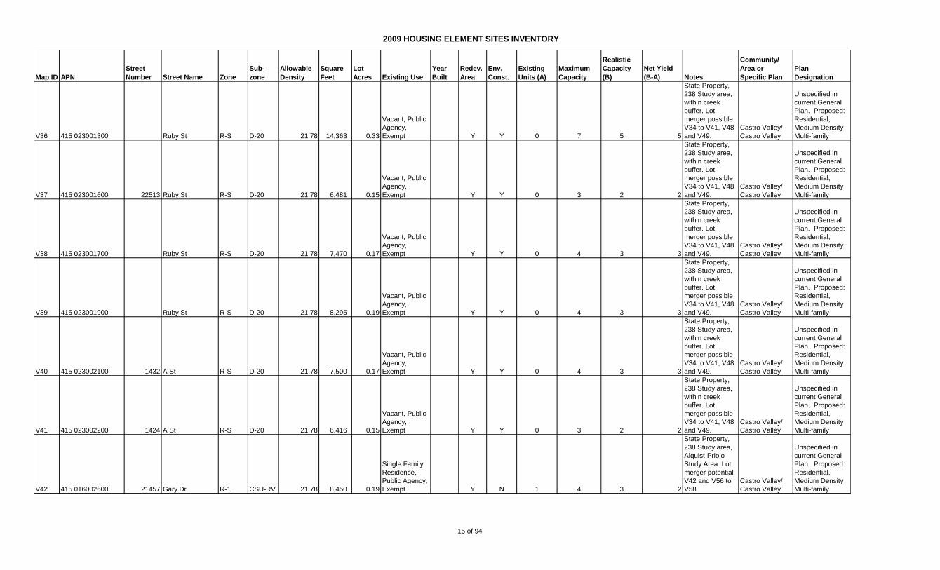
V36 415 023001300 Ruby St R-S D-20 21.78 14,363 0.33
Vacant, Public
Agency,
Exempt Y Y 0 7 5 5
State Property,
238 Study area,
within creek
buffer. Lot
merger possible
V34 to V41, V48
and V49.
Castro Valley/
Castro Valley
Unspecified in
current General
Plan. Proposed:
Residential,
Medium Density
Multi-family
V37 415 023001600 22513 Ruby St R-S D-20 21.78 6,481 0.15
Vacant, Public
Agency,
Exempt Y Y 0 3 2 2
State Property,
238 Study area,
within creek
buffer. Lot
merger possible
V34 to V41, V48
and V49.
Castro Valley/
Castro Valley
Unspecified in
current General
Plan. Proposed:
Residential,
Medium Density
Multi-family
V38 415 023001700 Ruby St R-S D-20 21.78 7,470 0.17
Vacant, Public
Agency,
Exempt Y Y 0 4 3 3
State Property,
238 Study area,
within creek
buffer. Lot
merger possible
V34 to V41, V48
and V49.
Castro Valley/
Castro Valley
Unspecified in
current General
Plan. Proposed:
Residential,
Medium Density
Multi-family
V39 415 023001900 Ruby St R-S D-20 21.78 8,295 0.19
Vacant, Public
Agency,
Exempt Y Y 0 4 3 3
State Property,
238 Study area,
within creek
buffer. Lot
merger possible
V34 to V41, V48
and V49.
Castro Valley/
Castro Valley
Unspecified in
current General
Plan. Proposed:
Residential,
Medium Density
Multi-family
V40 415 023002100 1432 A St R-S D-20 21.78 7,500 0.17
Vacant, Public
Agency,
Exempt Y Y 0 4 3 3
State Property,
238 Study area,
within creek
buffer. Lot
merger possible
V34 to V41, V48
and V49.
Castro Valley/
Castro Valley
Unspecified in
current General
Plan. Proposed:
Residential,
Medium Density
Multi-family
V41 415 023002200 1424 A St R-S D-20 21.78 6,416 0.15
Vacant, Public
Agency,
Exempt Y Y 0 3 2 2
State Property,
238 Study area,
within creek
buffer. Lot
merger possible
V34 to V41, V48
and V49.
Castro Valley/
Castro Valley
Unspecified in
current General
Plan. Proposed:
Residential,
Medium Density
Multi-family
V42 415 016002600 21457 Gary Dr R-1 CSU-RV 21.78 8,450 0.19
Single Family
Residence,
Public Agency,
Exempt Y N 1 4 3 2
State Property,
238 Study area,
Alquist-Priolo
Study Area. Lot
merger potential
V42 and V56 to
V58
Castro Valley/
Castro Valley
Unspecified in
current General
Plan. Proposed:
Residential,
Medium Density
Multi-family
15 of 94
2009 HOUSING ELEMENT SITES INVENTORY
Map ID APN
Street
Number Street Name Zone
Sub-
zone
Allowable
Density
Square
Feet
Lot
Acres Existing Use
Year
Built
Redev.
Area
Env.
Const.
Existing
Units (A)
Maximum
Capacity
Realistic
Capacity
(B)
Net Yield
(B-A) Notes
Community/
Area or
Specific Plan
Plan
Designation
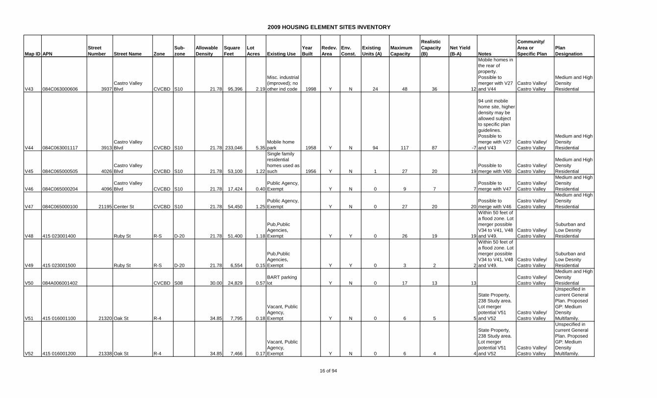
V43 084C063000606 3937
Castro Valley
Blvd CVCBD S10 21.78 95,396 2.19
Misc. industrial
(improved); no
other ind code 1998 Y N 24 48 36 12
Mobile homes in
the rear of
property.
Possible to
merger with V27
and V44
Castro Valley/
Castro Valley
Medium and High
Density
Residential
V44 084C063001117 3913
Castro Valley
Blvd CVCBD S10 21.78 233,046 5.35
Mobile home
park 1958 Y N 94 117 87 -7
94 unit mobile
home site, higher
density may be
allowed subject
to specific plan
guidelines.
Possible to
merge with V27
and V43
Castro Valley/
Castro Valley
Medium and High
Density
Residential
V45 084C065000505 4026
Castro Valley
Blvd CVCBD S10 21.78 53,100 1.22
Single family
residential
homes used as
such 1956 Y N 1 27 20 19
Possible to
merge with V60
Castro Valley/
Castro Valley
Medium and High
Density
Residential
V46 084C065000204 4096
Castro Valley
Blvd CVCBD S10 21.78 17,424 0.40
Public Agency,
Exempt Y N 0 9 7 7
Possible to
merge with V47
Castro Valley/
Castro Valley
Medium and High
Density
Residential
V47 084C065000100 21195 Center St CVCBD S10 21.78 54,450 1.25
Public Agency,
Exempt Y N 0 27 20 20
Possible to
merge with V46
Castro Valley/
Castro Valley
Medium and High
Density
Residential
V48 415 023001400 Ruby St R-S D-20 21.78 51,400 1.18
Pub,Public
Agencies,
Exempt Y Y 0 26 19 19
Within 50 feet of
a flood zone. Lot
merger possible
V34 to V41, V48
and V49.
Castro Valley/
Castro Valley
Suburban and
Low Desnity
Residential
V49 415 023001500 Ruby St R-S D-20 21.78 6,554 0.15
Pub,Public
Agencies,
Exempt Y Y 0 3 2 2
Within 50 feet of
a flood zone. Lot
merger possible
V34 to V41, V48
and V49.
Castro Valley/
Castro Valley
Suburban and
Low Desnity
Residential
V50 084A006001402 CVCBD S08 30.00 24,829 0.57
BART parking
lot Y N 0 17 13 13
Castro Valley/
Castro Valley
Medium and High
Density
Residential
V51 415 016001100 21320 Oak St R-4 34.85 7,795 0.18
Vacant, Public
Agency,
Exempt Y N 0 6 5 5
State Property,
238 Study area.
Lot merger
potential V51
and V52
Castro Valley/
Castro Valley
Unspecified in
current General
Plan. Proposed
GP: Medium
Density
Multifamily.
V52 415 016001200 21338 Oak St R-4 34.85 7,466 0.17
Vacant, Public
Agency,
Exempt Y N 0 6 4 4
State Property,
238 Study area.
Lot merger
potential V51
and V52
Castro Valley/
Castro Valley
Unspecified in
current General
Plan. Proposed
GP: Medium
Density
Multifamily.
16 of 94

2009 HOUSING ELEMENT SITES INVENTORY
Map ID APN
Street
Number Street Name Zone
Sub-
zone
Allowable
Density
Square
Feet
Lot
Acres Existing Use
Year
Built
Redev.
Area
Env.
Const.
Existing
Units (A)
Maximum
Capacity
Realistic
Capacity
(B)
Net Yield
(B-A) Notes
Community/
Area or
Specific Plan
Plan
Designation
V53 415 016001400 21406 Oak St R-4 34.85 7,530 0.17
Vacant, Public
Agency,
Exempt Y N 0 6 5 5
State Property,
238 Study area.
Mereger
potential V53 to
V55
Castro Valley/
Castro Valley
Unspecified in
current General
Plan. Proposed
GP: Medium
Density
Multifamily.
V54 415 016001500 21420 Oak St R-4 34.85 7,758 0.18
Vacant, Public
Agency,
Exempt Y N 0 6 5 5
State Property,
238 Study area.
Mereger
potential V53 to
V55
Castro Valley/
Castro Valley
Unspecified in
current General
Plan. Proposed
GP: Medium
Density
Multifamily.
V55 415 016001600 21408 Oak St R-4 34.85 6,917 0.16
Residential
building of 2 or
more
units,Public
Agencies,
Exempt Y N 2 6 4 2
State Property,
238 Study area.
Mereger
potential V53 to
V55
Castro Valley/
Castro Valley
Unspecified in
current General
Plan. Proposed
GP: Medium
Density
Multifamily.
V56 415 016001800 21454 Oak St R-4 34.85 7,426 0.17
Vacant, Public
Agency,
Exempt Y N 0 6 4 4
State Property,
238 Study area.
Lot merger
potential V42
and V56 to V58
Castro Valley/
Castro Valley
Unspecified in
current General
Plan. Proposed
GP: Medium
Density
Multifamily.
V57 415 016001900 21462 Oak St R-4 34.85 7,405 0.17
Single Family
Residence,
Public Agency,
Exempt 1940 Y N 1 6 4 3
State Property,
238 Study area.
Lot merger
potential V42
and V56 to V58
Castro Valley/
Castro Valley
Unspecified in
current General
Plan. Proposed
GP: Medium
Density
Multifamily.
V58 415 016002000 21484 Oak St R-4 34.85 7,330 0.17
Vacant, Public
Agency,
Exempt Y N 0 6 4 4
State Property,
238 Study area.
Lot merger
potential V42
and V56 to V58
Castro Valley/
Castro Valley
Unspecified in
current General
Plan. Proposed
GP: Medium
Density
Multifamily.
V59 084C065000611 21767 Center St CVCBD S10 40.00 19,602 0.45
Vacant
residential
land, zoned 4
units or less Y N 0 18 14 14
Castro Valley/
Castro Valley
Medium and High
Density
Residential
V60 415 021005001 1452 Crescent Ave. R-S D-15 29.04 70567 1.62
Vacant, Public
Agency,
Exempt Y N 0 47 35 35
State Property,
238 Study area
Castro Valley/
Castro Valley
Unspecified in
current General
Plan. Proposed
GP: Medium
Density
Multifamily.
V61 415 018006801 Grove Way R-S D-15 29.04 68825 1.58
Vacant, Public
Agency,
Exempt Y N 0 46 34 34
State Property,
238 Study area.
Lot merger
possible V61 -
V63
Castro Valley/
Castro Valley
Unspecified in
current General
Plan. Proposed
GP: Medium
Density
Multifamily.
17 of 94

2009 HOUSING ELEMENT SITES INVENTORY
Map ID APN
Street
Number Street Name Zone
Sub-
zone
Allowable
Density
Square
Feet
Lot
Acres Existing Use
Year
Built
Redev.
Area
Env.
Const.
Existing
Units (A)
Maximum
Capacity
Realistic
Capacity
(B)
Net Yield
(B-A) Notes
Community/
Area or
Specific Plan
Plan
Designation
V62 415 018006901 Grove Way R-S D-15 29.04 129373 2.97
Vacant, Public
Agency,
Exempt Y N 0 86 65 65
State Property,
238 Study area.
Lot merger
possible V61 -
V63
Castro Valley/
Castro Valley
Unspecified in
current General
Plan. Proposed
GP: Medium
Density
Multifamily.
V63 415 018007300 1459 Grove Way R-S D-15 29.04 35247 0.81
Single Family
Residence,
Public Agency,
Exempt Y N 1 24 18 17
State Property,
238 Study area.
Lot merger
possible V61 -
V63
Castro Valley/
Castro Valley
Unspecified in
current General
Plan. Proposed
GP: Medium
Density
Multifamily.
TOTAL - CASTRO VALLEY 194 795 597 403
Map ID APN
Street
Number Street Name Zone
Sub-
zone
Allowable
Density
Square
Feet
Lot
Acres Existing Use
Year
Built
Redev.
Area
Env.
Const.
Existing
Units (A)
Maximum
Capacity
Realistic
Capacity
(B)
Net Yield
(B-A) Notes
Community/
Area or
Specific Plan
Plan
Designation
F1 417 011006300 22502 Woodroe Ave R-1 6.00 134,944 3.10 Ins,Schools 1954 N N 0 19 14 14
Fairview/
Fairview
R-1; 5,000 sq. ft.
MBSA
F2 417 008000504 22505 Woodroe Ave R-1 6.00 40,605 0.93
Res,Sgl Family
With
Commercial
Use 1976 N N 2 6 4 2
Fairview/
Fairview
R-1; 5,000 sq. ft.
MBSA
F3 417 019006500 23031 Henry Ln R-1 6.00 20,970 0.48
Res,Single
Family
Residence 1925 N N 1 3 2 1
Potential to
merge all Henry
lane parcels
Fairview/
Fairview
R-1; 5,000 sq. ft.
MBSA
F4 417 019006600 23039 Henry Ln R-1 6.00 22,455 0.52
Res,Single
Family
Residence 1950 N N 1 3 2 1
Potential to
merge all Henry
lane parcels
Fairview/
Fairview
R-1; 5,000 sq. ft.
MBSA
F5 417 019010300 23047 Henry Ln R-1 6.00 20,502 0.47
Res,Single
Family
Residence N N 1 3 2 1
23047 Henry
lane parcels
were merged in
2008. Potential
to merge all
Henry lane
parcels
Fairview/
Fairview
R-1; 5,000 sq. ft.
MBSA
F6 417 019010400 23047 Henry Ln R-1 Vacant N N 0 0
Potential to
merge all Henry
lane parcels
Fairview/
Fairview
R-1; 5,000 sq. ft.
MBSA
F7 417 019006800 23063 Henry Ln R-1 6.00 16,787 0.39
Res,Single
Family
Residence 1954 N N 1 2 2 1
Potential to
merge all Henry
lane parcels
Fairview/
Fairview
R-1; 5,000 sq. ft.
MBSA
F8 417 006007100 2700 Kelly St R-1 6.00 29,374 0.67
Res,Single
Family
Residence 1947 N Y 1 4 3 2
Within 50 feet of
a creek. Lot
merger potential
F8 to F11
Fairview/
Fairview
R-1; 5,000 sq. ft.
MBSA
18 of 94

2009 HOUSING ELEMENT SITES INVENTORY
Map ID APN
Street
Number Street Name Zone
Sub-
zone
Allowable
Density
Square
Feet
Lot
Acres Existing Use
Year
Built
Redev.
Area
Env.
Const.
Existing
Units (A)
Maximum
Capacity
Realistic
Capacity
(B)
Net Yield
(B-A) Notes
Community/
Area or
Specific Plan
Plan
Designation
F9 417 006007000 2658 Kelly St R-1 6.00 19,744 0.45
Res,Single
Family
Residence 1928 N Y 1 3 2 1
Within 50 feet of
a creek. Lot
merger potential
F8 to F11
Fairview/
Fairview
R-1; 5,000 sq. ft.
MBSA
F10 417 006007600 2600 Kelly St R-1 6.00 26,203 0.60
Res,Single
Family
Residence 1979 N Y 1 4 3 2
Within 50 feet of
a creek. Lot
merger potential
F8 to F11
Fairview/
Fairview
R-1; 5,000 sq. ft.
MBSA
F11 417 006007700 2598 Kelly St R-1 6.00 53,444 1.23
Res,Single
Family
Residence 1922 N N 1 7 6 5
Lot merger
potential F8 to
F11
Fairview/
Fairview
R-1; 5,000 sq. ft.
MBSA
F12 417 021000500 2931 Kelly St R-1 6.00 20,657 0.47
Res,Single
Family
Residence 1946 N N 1 3 2 1
Fairview/
Fairview
R-1; 5,000 sq. ft.
MBSA
F13 417 021000700 2921 Kelly St R-1 6.00 20,020 0.46
Res,Single
Family
Residence 1951 N N 1 3 2 1
Fairview/
Fairview
R-1; 5,000 sq. ft.
MBSA
F14 416 018006200 22866 Mansfield Ave R-1 6.00 14,224 0.33
Res,Single
Family
Residence 1954 N N 1 2 1 0
May be possible
to merger into
single Mansfield
development.
Fairview/
Fairview
R-1; 5,000 sq. ft.
MBSA
F15 416 018006100 22866 Mansfield Ave R-1 6.00 17,832 0.41
Vacant,Res
Land Zoned 4
Units N N 0 2 2 2
May be possible
to merger into
single Mansfield
development.
Fairview/
Fairview
R-1; 5,000 sq. ft.
MBSA
F16 416 018000100 Mansfield Av R-1 6.00 60,171 1.38
Vacant,Res
Land Zoned 4
Units N N 0 8 6 6
May be possible
to merger into
single Mansfield
development.
Fairview/
Fairview
R-1; 5,000 sq. ft.
MBSA
F17 416 020000200 23000 Mansfield Ave R-1 6.00 37,563 0.86
Res,Single
Family
Residence 1979 N N 1 5 4 3
May be possible
to merger into
single Mansfield
development.
Fairview/
Fairview
R-1; 5,000 sq. ft.
MBSA
F18 416 020000100 23093 Mansfield Ave R-1 6.00 87,875 2.02
Res,Single
Family
Residence 1975 N N 1 12 9 8
May be possible
to merger into
single Mansfield
development.
Fairview/
Fairview
R-1; 5,000 sq. ft.
MBSA
19 of 94

2009 HOUSING ELEMENT SITES INVENTORY
Map ID APN
Street
Number Street Name Zone
Sub-
zone
Allowable
Density
Square
Feet
Lot
Acres Existing Use
Year
Built
Redev.
Area
Env.
Const.
Existing
Units (A)
Maximum
Capacity
Realistic
Capacity
(B)
Net Yield
(B-A) Notes
Community/
Area or
Specific Plan
Plan
Designation
F19 416 020000300 23090 Mansfield Ave R-1 6.00 30,369 0.70
Res,Single
Family
Residence 1944 N N 1 4 3 2
May be possible
to merger into
single Mansfield
development.
Fairview/
Fairview
R-1; 5,000 sq. ft.
MBSA
F20 416 020000400 23098 Mansfield Ave R-1 6.00 60,370 1.39
Res,Single
Family
Residence 1927 N N 1 8 6 5
May be possible
to merger into
single Mansfield
development.
Fairview/
Fairview
R-1; 5,000 sq. ft.
MBSA
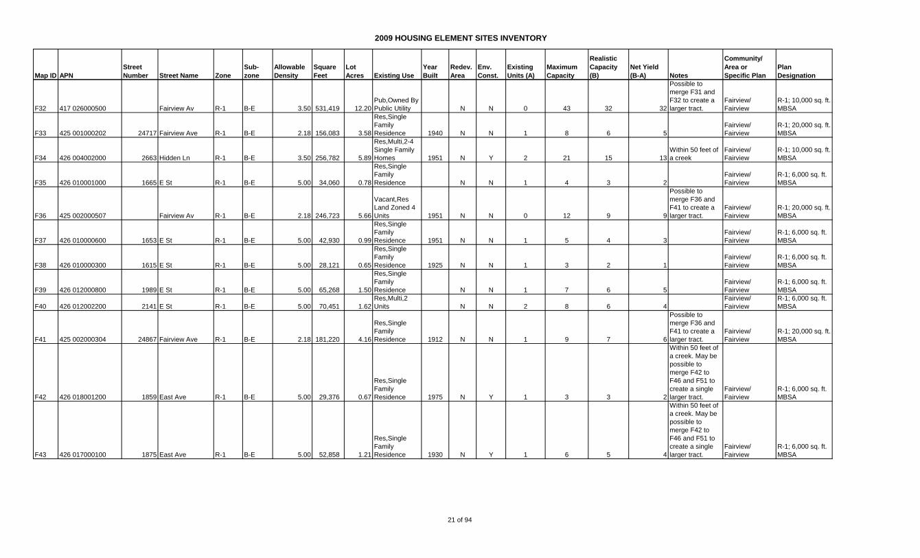
F21 417 022001201 3216 D St R-1 B-E 3.50 106,860 2.45
Vacant,Res
Land Zoned 4
Units 1937 N N 1 9 6 5
Possible to
merge F21, F23,
F25, F26 and
F28
Fairview/
Fairview
R-1; 10,000 sq. ft.
MBSA
F22 417 022004100 23572 Maud Ave R-1 5.00 27,660 0.63
Res,Single
Family
Residence 1948 N N 1 3 2 1
Fairview/
Fairview
R-1; 6,000 sq. ft.
MBSA
F23 417 022001104 3230 D St R-1 B-E 3.50 44,744 1.03
Res,Single
Family
Residence 1960 N N 1 4 3 2
Possible to
merge F21, F23,
F25, F26 and
F28
Fairview/
Fairview
R-1; 10,000 sq. ft.
MBSA
F24 417 024001204 3289 D St R-1 B-E 3.50 81,458 1.87
Res,Single
Family
Residence N N 1 7 5 4
Possible o merge
F24 and F29
Fairview/
Fairview
R-1; 10,000 sq. ft.
MBSA
F25 417 022002500 23756 Maud Ave R-1 6.00 24,015 0.55
Res,Single
Family
Residence 1953 N N 1 3 2 1
Possible to
merge F21, F23,
F25, F26 and
F28
Fairview/
Fairview
R-1; 5,000 sq. ft.
MBSA
F26 417 022002400 23790 Maud Ave R-1 6.00 32,464 0.75
Res,Single
Family
Residence 1927 N N 1 4 3 2
Possible to
merge F21, F23,
F25, F26 and
F28
Fairview/
Fairview
R-1; 5,000 sq. ft.
MBSA
F27 417 024000100 3247 D St R-1 B-E 3.50 130,644 3.00
Res,Single
Family
Residence 1925 N N 1 10 8 7
Possible to
merge F27 and
F30
Fairview/
Fairview
R-1; 10,000 sq. ft.
MBSA
F28 417 022002200 23830 Maud Ave R-1 6.00 24,239 0.56
Res,Single
Family
Residence 1960 N N 1 3 3 2
Possible to
merge F21, F23,
F25, F26 and
F28
Fairview/
Fairview
R-1; 5,000 sq. ft.
MBSA
F29 417 024000500 3291 D St R-1 B-E 3.50 82,880 1.90
Res,Single
Family
Residence 1877 N N 1 7 5 4
Possible o merge
F24 and F29
Fairview/
Fairview
R-1; 10,000 sq. ft.
MBSA
F30 417 025000100 3231 D St R-1 B-E 3.50 35,399 0.81
Res,Single
Family
Residence 1953 N N 1 3 2 1
Possible to
merge F27 and
F30
Fairview/
Fairview
R-1; 10,000 sq. ft.
MBSA
F31 417 026000400 Fairview Av R-1 B-E 3.50 330,441 7.59
Vacant,Res
Land Zoned 4
Units N N 0 27 20 20
Possible to
merge F31 and
F32 to create a
larger tract.
Fairview/
Fairview
R-1; 10,000 sq. ft.
MBSA
20 of 94
2009 HOUSING ELEMENT SITES INVENTORY
Map ID APN
Street
Number Street Name Zone
Sub-
zone
Allowable
Density
Square
Feet
Lot
Acres Existing Use
Year
Built
Redev.
Area
Env.
Const.
Existing
Units (A)
Maximum
Capacity
Realistic
Capacity
(B)
Net Yield
(B-A) Notes
Community/
Area or
Specific Plan
Plan
Designation
F32 417 026000500 Fairview Av R-1 B-E 3.50 531,419 12.20
Pub,Owned By
Public Utility N N 0 43 32 32
Possible to
merge F31 and
F32 to create a
larger tract.
Fairview/
Fairview
R-1; 10,000 sq. ft.
MBSA
F33 425 001000202 24717 Fairview Ave R-1 B-E 2.18 156,083 3.58
Res,Single
Family
Residence 1940 N N 1 8 6 5
Fairview/
Fairview
R-1; 20,000 sq. ft.
MBSA
F34 426 004002000 2663 Hidden Ln R-1 B-E 3.50 256,782 5.89
Res,Multi,2-4
Single Family
Homes 1951 N Y 2 21 15 13
Within 50 feet of
a creek
Fairview/
Fairview
R-1; 10,000 sq. ft.
MBSA
F35 426 010001000 1665 E St R-1 B-E 5.00 34,060 0.78
Res,Single
Family
Residence N N 1 4 3 2
Fairview/
Fairview
R-1; 6,000 sq. ft.
MBSA
F36 425 002000507 Fairview Av R-1 B-E 2.18 246,723 5.66
Vacant,Res
Land Zoned 4
Units 1951 N N 0 12 9 9
Possible to
merge F36 and
F41 to create a
larger tract.
Fairview/
Fairview
R-1; 20,000 sq. ft.
MBSA
F37 426 010000600 1653 E St R-1 B-E 5.00 42,930 0.99
Res,Single
Family
Residence 1951 N N 1 5 4 3
Fairview/
Fairview
R-1; 6,000 sq. ft.
MBSA
F38 426 010000300 1615 E St R-1 B-E 5.00 28,121 0.65
Res,Single
Family
Residence 1925 N N 1 3 2 1
Fairview/
Fairview
R-1; 6,000 sq. ft.
MBSA
F39 426 012000800 1989 E St R-1 B-E 5.00 65,268 1.50
Res,Single
Family
Residence N N 1 7 6 5
Fairview/
Fairview
R-1; 6,000 sq. ft.
MBSA
F40 426 012002200 2141 E St R-1 B-E 5.00 70,451 1.62
Res,Multi,2
Units N N 2 8 6 4
Fairview/
Fairview
R-1; 6,000 sq. ft.
MBSA
F41 425 002000304 24867 Fairview Ave R-1 B-E 2.18 181,220 4.16
Res,Single
Family
Residence 1912 N N 1 9 7 6
Possible to
merge F36 and
F41 to create a
larger tract.
Fairview/
Fairview
R-1; 20,000 sq. ft.
MBSA
F42 426 018001200 1859 East Ave R-1 B-E 5.00 29,376 0.67
Res,Single
Family
Residence 1975 N Y 1 3 3 2
Within 50 feet of
a creek. May be
possible to
merge F42 to
F46 and F51 to
create a single
larger tract.
Fairview/
Fairview
R-1; 6,000 sq. ft.
MBSA
F43 426 017000100 1875 East Ave R-1 B-E 5.00 52,858 1.21
Res,Single
Family
Residence 1930 N Y 1 6 5 4
Within 50 feet of
a creek. May be
possible to
merge F42 to
F46 and F51 to
create a single
larger tract.
Fairview/
Fairview
R-1; 6,000 sq. ft.
MBSA
21 of 94
2009 HOUSING ELEMENT SITES INVENTORY
Map ID APN
Street
Number Street Name Zone
Sub-
zone
Allowable
Density
Square
Feet
Lot
Acres Existing Use
Year
Built
Redev.
Area
Env.
Const.
Existing
Units (A)
Maximum
Capacity
Realistic
Capacity
(B)
Net Yield
(B-A) Notes
Community/
Area or
Specific Plan
Plan
Designation
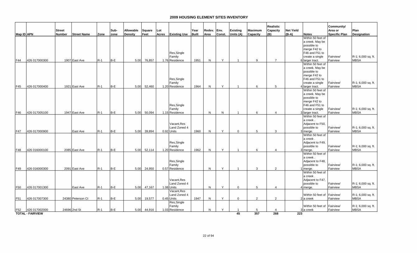
F44 426 017000300 1907 East Ave R-1 B-E 5.00 76,857 1.76
Res,Single
Family
Residence 1951 N Y 1 9 7 6
Within 50 feet of
a creek. May be
possible to
merge F42 to
F46 and F51 to
create a single
larger tract.
Fairview/
Fairview
R-1; 6,000 sq. ft.
MBSA
F45 426 017000400 1921 East Ave R-1 B-E 5.00 52,460 1.20
Res,Single
Family
Residence 1964 N Y 1 6 5 4
Within 50 feet of
a creek. May be
possible to
merge F42 to
F46 and F51 to
create a single
larger tract.
Fairview/
Fairview
R-1; 6,000 sq. ft.
MBSA
F46 426 017005100 1947 East Ave R-1 B-E 5.00 50,094 1.15
Res,Single
Family
Residence N N 1 6 4 3
Within 50 feet of
a creek. May be
possible to
merge F42 to
F46 and F51 to
create a single
larger tract.
Fairview/
Fairview
R-1; 6,000 sq. ft.
MBSA
F47 426 017000900 East Ave R-1 B-E 5.00 39,894 0.92
Vacant,Res
Land Zoned 4
Units 1960 N Y 0 5 3 3
Within 50 feet of
a creek .
Adjacent to F50,
possible to
merge.
Fairview/
Fairview
R-1; 6,000 sq. ft.
MBSA
F48 426 016000100 2085 East Ave R-1 B-E 5.00 52,114 1.20
Res,Single
Family
Residence 1962 N Y 1 6 4 3
Within 50 feet of
a creek .
Adjacent to F49,
possible to
merge.
Fairview/
Fairview
R-1; 6,000 sq. ft.
MBSA
F49 426 016000300 2091 East Ave R-1 B-E 5.00 24,950 0.57
Res,Single
Family
Residence N Y 1 3 2 1
Within 50 feet of
a creek .
Adjacent to F48,
possible to
merge.
Fairview/
Fairview
R-1; 6,000 sq. ft.
MBSA
F50 426 017001300 East Ave R-1 B-E 5.00 47,167 1.08
Vacant,Res
Land Zoned 4
Units N Y 0 5 4 4
Within 50 feet of
a creek .
Adjacent to F47,
possible to
merge.
Fairview/
Fairview
R-1; 6,000 sq. ft.
MBSA
F51 426 017007300 24380 Peterson Ct R-1 B-E 5.00 19,577 0.45
Vacant,Res
Land Zoned 4
Units 1947 N Y 0 2 2 2
Within 50 feet of
a creek
Fairview/
Fairview
R-1; 6,000 sq. ft.
MBSA
F52 426 017002000 24696 2nd St R-1 B-E 5.00 44,916 1.03
Res,Single
Family
Residence N Y 1 5 4 3
Within 50 feet of
a creek
Fairview/
Fairview
R-1; 6,000 sq. ft.
MBSA
TOTAL - FAIRVIEW 45 357 268 223
22 of 94
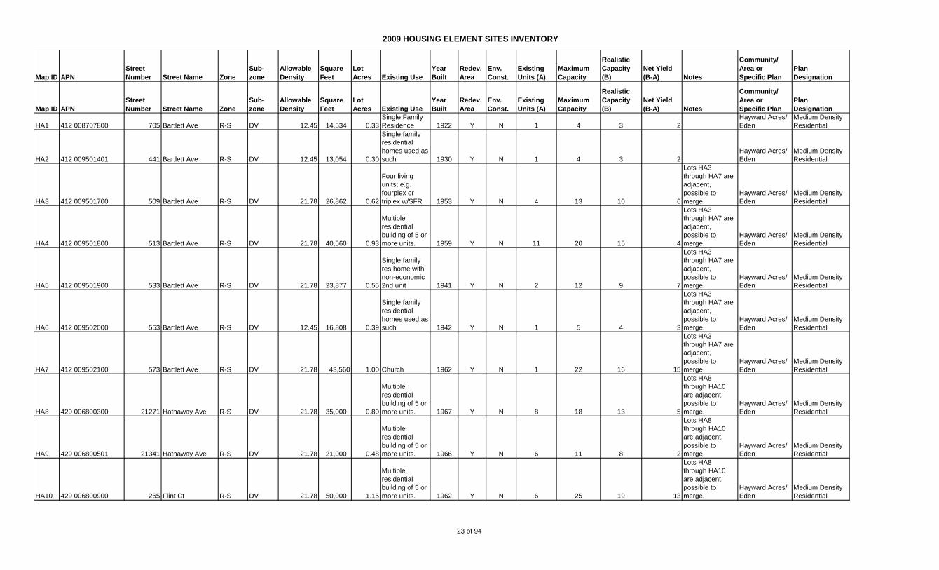
2009 HOUSING ELEMENT SITES INVENTORY
Map ID APN
Street
Number Street Name Zone
Sub-
zone
Allowable
Density
Square
Feet
Lot
Acres Existing Use
Year
Built
Redev.
Area
Env.
Const.
Existing
Units (A)
Maximum
Capacity
Realistic
Capacity
(B)
Net Yield
(B-A) Notes
Community/
Area or
Specific Plan
Plan
Designation
Map ID APN
Street
Number Street Name Zone
Sub-
zone
Allowable
Density
Square
Feet
Lot
Acres Existing Use
Year
Built
Redev.
Area
Env.
Const.
Existing
Units (A)
Maximum
Capacity
Realistic
Capacity
(B)
Net Yield
(B-A) Notes
Community/
Area or
Specific Plan
Plan
Designation
HA1 412 008707800 705 Bartlett Ave R-S DV 12.45 14,534 0.33
Single Family
Residence 1922 Y N 1 4 3 2
Hayward Acres/
Eden
Medium Density
Residential
HA2 412 009501401 441 Bartlett Ave R-S DV 12.45 13,054 0.30
Single family
residential
homes used as
such 1930 Y N 1 4 3 2
Hayward Acres/
Eden
Medium Density
Residential
HA3 412 009501700 509 Bartlett Ave R-S DV 21.78 26,862 0.62
Four living
units; e.g.
fourplex or
triplex w/SFR 1953 Y N 4 13 10 6
Lots HA3
through HA7 are
adjacent,
possible to
merge.
Hayward Acres/
Eden
Medium Density
Residential
HA4 412 009501800 513 Bartlett Ave R-S DV 21.78 40,560 0.93
Multiple
residential
building of 5 or
more units. 1959 Y N 11 20 15 4
Lots HA3
through HA7 are
adjacent,
possible to
merge.
Hayward Acres/
Eden
Medium Density
Residential
HA5 412 009501900 533 Bartlett Ave R-S DV 21.78 23,877 0.55
Single family
res home with
non-economic
2nd unit 1941 Y N 2 12 9 7
Lots HA3
through HA7 are
adjacent,
possible to
merge.
Hayward Acres/
Eden
Medium Density
Residential
HA6 412 009502000 553 Bartlett Ave R-S DV 12.45 16,808 0.39
Single family
residential
homes used as
such 1942 Y N 1 5 4 3
Lots HA3
through HA7 are
adjacent,
possible to
merge.
Hayward Acres/
Eden
Medium Density
Residential
HA7 412 009502100 573 Bartlett Ave R-S DV 21.78 43,560 1.00 Church 1962 Y N 1 22 16 15
Lots HA3
through HA7 are
adjacent,
possible to
merge.
Hayward Acres/
Eden
Medium Density
Residential
HA8 429 006800300 21271 Hathaway Ave R-S DV 21.78 35,000 0.80
Multiple
residential
building of 5 or
more units. 1967 Y N 8 18 13 5
Lots HA8
through HA10
are adjacent,
possible to
merge.
Hayward Acres/
Eden
Medium Density
Residential
HA9 429 006800501 21341 Hathaway Ave R-S DV 21.78 21,000 0.48
Multiple
residential
building of 5 or
more units. 1966 Y N 6 11 8 2
Lots HA8
through HA10
are adjacent,
possible to
merge.
Hayward Acres/
Eden
Medium Density
Residential
HA10 429 006800900 265 Flint Ct R-S DV 21.78 50,000 1.15
Multiple
residential
building of 5 or
more units. 1962 Y N 6 25 19 13
Lots HA8
through HA10
are adjacent,
possible to
merge.
Hayward Acres/
Eden
Medium Density
Residential
23 of 94
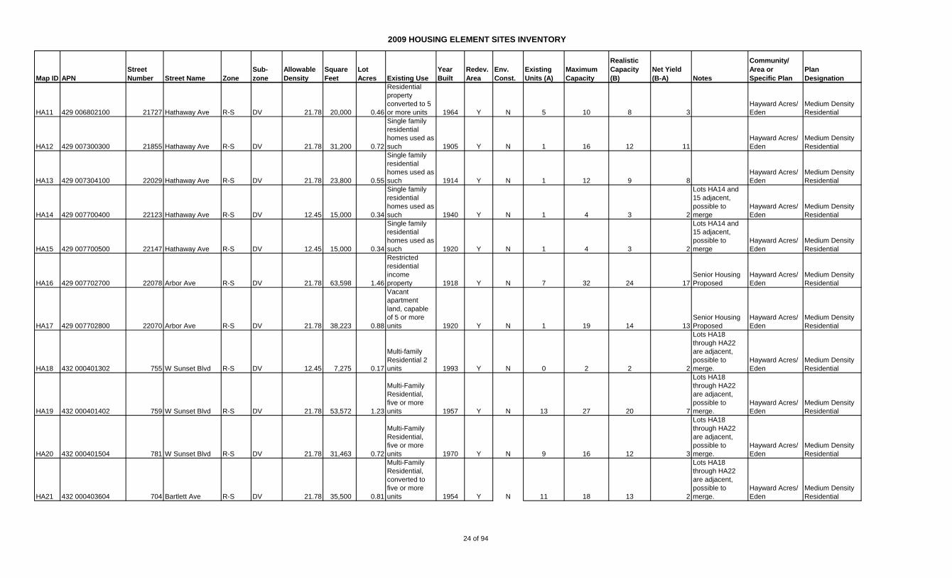
2009 HOUSING ELEMENT SITES INVENTORY
Map ID APN
Street
Number Street Name Zone
Sub-
zone
Allowable
Density
Square
Feet
Lot
Acres Existing Use
Year
Built
Redev.
Area
Env.
Const.
Existing
Units (A)
Maximum
Capacity
Realistic
Capacity
(B)
Net Yield
(B-A) Notes
Community/
Area or
Specific Plan
Plan
Designation
HA11 429 006802100 21727 Hathaway Ave R-S DV 21.78 20,000 0.46
Residential
property
converted to 5
or more units 1964 Y N 5 10 8 3
Hayward Acres/
Eden
Medium Density
Residential
HA12 429 007300300 21855 Hathaway Ave R-S DV 21.78 31,200 0.72
Single family
residential
homes used as
such 1905 Y N 1 16 12 11
Hayward Acres/
Eden
Medium Density
Residential
HA13 429 007304100 22029 Hathaway Ave R-S DV 21.78 23,800 0.55
Single family
residential
homes used as
such 1914 Y N 1 12 9 8
Hayward Acres/
Eden
Medium Density
Residential
HA14 429 007700400 22123 Hathaway Ave R-S DV 12.45 15,000 0.34
Single family
residential
homes used as
such 1940 Y N 1 4 3 2
Lots HA14 and
15 adjacent,
possible to
merge
Hayward Acres/
Eden
Medium Density
Residential
HA15 429 007700500 22147 Hathaway Ave R-S DV 12.45 15,000 0.34
Single family
residential
homes used as
such 1920 Y N 1 4 3 2
Lots HA14 and
15 adjacent,
possible to
merge
Hayward Acres/
Eden
Medium Density
Residential
HA16 429 007702700 22078 Arbor Ave R-S DV 21.78 63,598 1.46
Restricted
residential
income
property 1918 Y N 7 32 24 17
Senior Housing
Proposed
Hayward Acres/
Eden
Medium Density
Residential
HA17 429 007702800 22070 Arbor Ave R-S DV 21.78 38,223 0.88
Vacant
apartment
land, capable
of 5 or more
units 1920 Y N 1 19 14 13
Senior Housing
Proposed
Hayward Acres/
Eden
Medium Density
Residential
HA18 432 000401302 755 W Sunset Blvd R-S DV 12.45 7,275 0.17
Multi-family
Residential 2
units 1993 Y N 0 2 2 2
Lots HA18
through HA22
are adjacent,
possible to
merge.
Hayward Acres/
Eden
Medium Density
Residential
HA19 432 000401402 759 W Sunset Blvd R-S DV 21.78 53,572 1.23
Multi-Family
Residential,
five or more
units 1957 Y N 13 27 20 7
Lots HA18
through HA22
are adjacent,
possible to
merge.
Hayward Acres/
Eden
Medium Density
Residential
HA20 432 000401504 781 W Sunset Blvd R-S DV 21.78 31,463 0.72
Multi-Family
Residential,
five or more
units 1970 Y N 9 16 12 3
Lots HA18
through HA22
are adjacent,
possible to
merge.
Hayward Acres/
Eden
Medium Density
Residential
HA21 432 000403604 704 Bartlett Ave R-S DV 21.78 35,500 0.81
Multi-Family
Residential,
converted to
five or more
units 1954 Y N 11 18 13 2
Lots HA18
through HA22
are adjacent,
possible to
merge.
Hayward Acres/
Eden
Medium Density
Residential
24 of 94
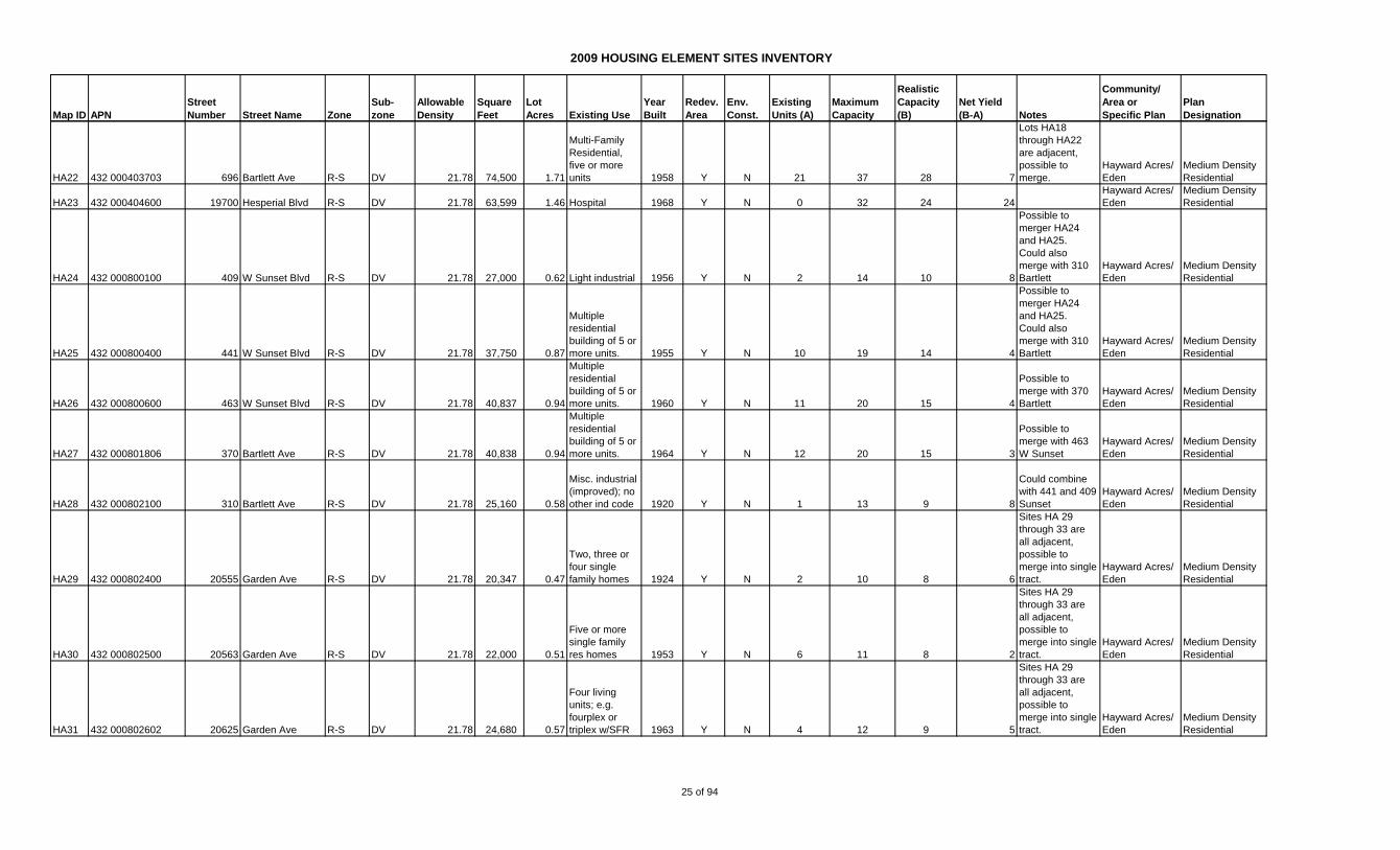
2009 HOUSING ELEMENT SITES INVENTORY
Map ID APN
Street
Number Street Name Zone
Sub-
zone
Allowable
Density
Square
Feet
Lot
Acres Existing Use
Year
Built
Redev.
Area
Env.
Const.
Existing
Units (A)
Maximum
Capacity
Realistic
Capacity
(B)
Net Yield
(B-A) Notes
Community/
Area or
Specific Plan
Plan
Designation
HA22 432 000403703 696 Bartlett Ave R-S DV 21.78 74,500 1.71
Multi-Family
Residential,
five or more
units 1958 Y N 21 37 28 7
Lots HA18
through HA22
are adjacent,
possible to
merge.
Hayward Acres/
Eden
Medium Density
Residential
HA23 432 000404600 19700 Hesperial Blvd R-S DV 21.78 63,599 1.46 Hospital 1968 Y N 0 32 24 24
Hayward Acres/
Eden
Medium Density
Residential
HA24 432 000800100 409 W Sunset Blvd R-S DV 21.78 27,000 0.62 Light industrial 1956 Y N 2 14 10 8
Possible to
merger HA24
and HA25.
Could also
merge with 310
Bartlett
Hayward Acres/
Eden
Medium Density
Residential
HA25 432 000800400 441 W Sunset Blvd R-S DV 21.78 37,750 0.87
Multiple
residential
building of 5 or
more units. 1955 Y N 10 19 14 4
Possible to
merger HA24
and HA25.
Could also
merge with 310
Bartlett
Hayward Acres/
Eden
Medium Density
Residential
HA26 432 000800600 463 W Sunset Blvd R-S DV 21.78 40,837 0.94
Multiple
residential
building of 5 or
more units. 1960 Y N 11 20 15 4
Possible to
merge with 370
Bartlett
Hayward Acres/
Eden
Medium Density
Residential
HA27 432 000801806 370 Bartlett Ave R-S DV 21.78 40,838 0.94
Multiple
residential
building of 5 or
more units. 1964 Y N 12 20 15 3
Possible to
merge with 463
W Sunset
Hayward Acres/
Eden
Medium Density
Residential
HA28 432 000802100 310 Bartlett Ave R-S DV 21.78 25,160 0.58
Misc. industrial
(improved); no
other ind code 1920 Y N 1 13 9 8
Could combine
with 441 and 409
Sunset
Hayward Acres/
Eden
Medium Density
Residential
HA29 432 000802400 20555 Garden Ave R-S DV 21.78 20,347 0.47
Two, three or
four single
family homes 1924 Y N 2 10 8 6
Sites HA 29
through 33 are
all adjacent,
possible to
merge into single
tract.
Hayward Acres/
Eden
Medium Density
Residential
HA30 432 000802500 20563 Garden Ave R-S DV 21.78 22,000 0.51
Five or more
single family
res homes 1953 Y N 6 11 8 2
Sites HA 29
through 33 are
all adjacent,
possible to
merge into single
tract.
Hayward Acres/
Eden
Medium Density
Residential
HA31 432 000802602 20625 Garden Ave R-S DV 21.78 24,680 0.57
Four living
units; e.g.
fourplex or
triplex w/SFR 1963 Y N 4 12 9 5
Sites HA 29
through 33 are
all adjacent,
possible to
merge into single
tract.
Hayward Acres/
Eden
Medium Density
Residential
25 of 94
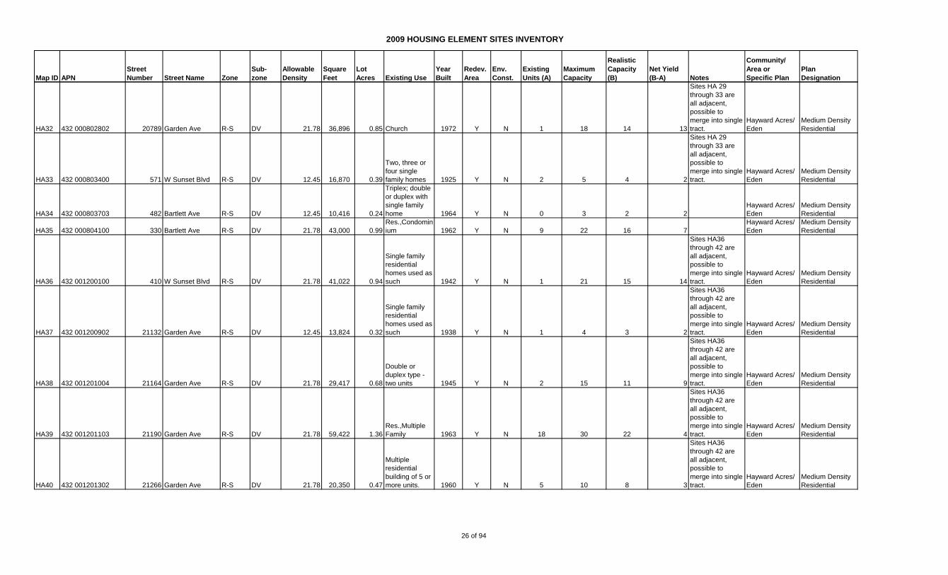
2009 HOUSING ELEMENT SITES INVENTORY
Map ID APN
Street
Number Street Name Zone
Sub-
zone
Allowable
Density
Square
Feet
Lot
Acres Existing Use
Year
Built
Redev.
Area
Env.
Const.
Existing
Units (A)
Maximum
Capacity
Realistic
Capacity
(B)
Net Yield
(B-A) Notes
Community/
Area or
Specific Plan
Plan
Designation
HA32 432 000802802 20789 Garden Ave R-S DV 21.78 36,896 0.85 Church 1972 Y N 1 18 14 13
Sites HA 29
through 33 are
all adjacent,
possible to
merge into single
tract.
Hayward Acres/
Eden
Medium Density
Residential
HA33 432 000803400 571 W Sunset Blvd R-S DV 12.45 16,870 0.39
Two, three or
four single
family homes 1925 Y N 2 5 4 2
Sites HA 29
through 33 are
all adjacent,
possible to
merge into single
tract.
Hayward Acres/
Eden
Medium Density
Residential
HA34 432 000803703 482 Bartlett Ave R-S DV 12.45 10,416 0.24
Triplex; double
or duplex with
single family
home 1964 Y N 0 3 2 2
Hayward Acres/
Eden
Medium Density
Residential
HA35 432 000804100 330 Bartlett Ave R-S DV 21.78 43,000 0.99
Res.,Condomin
ium 1962 Y N 9 22 16 7
Hayward Acres/
Eden
Medium Density
Residential
HA36 432 001200100 410 W Sunset Blvd R-S DV 21.78 41,022 0.94
Single family
residential
homes used as
such 1942 Y N 1 21 15 14
Sites HA36
through 42 are
all adjacent,
possible to
merge into single
tract.
Hayward Acres/
Eden
Medium Density
Residential
HA37 432 001200902 21132 Garden Ave R-S DV 12.45 13,824 0.32
Single family
residential
homes used as
such 1938 Y N 1 4 3 2
Sites HA36
through 42 are
all adjacent,
possible to
merge into single
tract.
Hayward Acres/
Eden
Medium Density
Residential
HA38 432 001201004 21164 Garden Ave R-S DV 21.78 29,417 0.68
Double or
duplex type -
two units 1945 Y N 2 15 11 9
Sites HA36
through 42 are
all adjacent,
possible to
merge into single
tract.
Hayward Acres/
Eden
Medium Density
Residential
HA39 432 001201103 21190 Garden Ave R-S DV 21.78 59,422 1.36
Res.,Multiple
Family 1963 Y N 18 30 22 4
Sites HA36
through 42 are
all adjacent,
possible to
merge into single
tract.
Hayward Acres/
Eden
Medium Density
Residential
HA40 432 001201302 21266 Garden Ave R-S DV 21.78 20,350 0.47
Multiple
residential
building of 5 or
more units. 1960 Y N 5 10 8 3
Sites HA36
through 42 are
all adjacent,
possible to
merge into single
tract.
Hayward Acres/
Eden
Medium Density
Residential
26 of 94

2009 HOUSING ELEMENT SITES INVENTORY
Map ID APN
Street
Number Street Name Zone
Sub-
zone
Allowable
Density
Square
Feet
Lot
Acres Existing Use
Year
Built
Redev.
Area
Env.
Const.
Existing
Units (A)
Maximum
Capacity
Realistic
Capacity
(B)
Net Yield
(B-A) Notes
Community/
Area or
Specific Plan
Plan
Designation
HA41 432 001201502 21338 Garden Ave R-S DV 21.78 30,238 0.69
Residential
property
converted to 5
or more units 1945 Y N 7 15 11 4
Sites HA36
through 42 are
all adjacent,
possible to
merge into single
tract.
Hayward Acres/
Eden
Medium Density
Residential
HA42 432 001202500 387 Lupine Way R-S DV 21.78 41,818 0.96
Multiple
residential
building of 5 or
more units. 1960 Y N 10 21 16 6
Sites HA36
through 42 are
all adjacent,
possible to
merge into single
tract.
Hayward Acres/
Eden
Medium Density
Residential
HA43 432 001601603 21155 Garden Ave R-S DV 21.78 24,867 0.57
Multi-Family
Residential, 2-
4 SFRs 1924 Y N 3 12 9 6
Hayward Acres/
Eden
Medium Density
Residential
HA44 432 001601700 21233 Garden Ave R-S DV 21.78 20,500 0.47
Multi-family
Residential 3
units 1963 Y N 3 10 8 5
Possible to
merge HA44 to
HA46
Hayward Acres/
Eden
Medium Density
Residential
HA45 432 001601800 21247 Garden Ave R-S DV 21.78 41,000 0.94
Multi-Family
Residential,
five or more
SFRs 1946 Y N 5 21 15 10
Possible to
merge HA44 to
HA46
Hayward Acres/
Eden
Medium Density
Residential
HA46 432 001602000 21335 Garden Ave R-S DV 21.78 37,000 0.85
Multi-Family
Residential,
five or more
units 1953 Y N 11 19 14 3
Possible to
merge HA44 to
HA46
Hayward Acres/
Eden
Medium Density
Residential
HA47 432 001602402 21631 Garden Ave R-S DV 21.78 40,760 0.94
Multi-Family
Residential,
five or more
units 1965 Y N 12 20 15 3
Hayward Acres/
Eden
Medium Density
Residential
HA48 432 001603802 21134 Royal Ave R-S DV 21.78 41,060 0.94
Multi-Family
Residential,
five or more
units 1956 Y N 11 21 15 4
Possible to
merge HA48 to
HA51
Hayward Acres/
Eden
Medium Density
Residential
HA49 432 001604102 20962 Royal Ave R-S DV 21.78 40,760 0.94
Multi-Family
Residential,
five or more
units 1958 Y N 11 20 15 4
Possible to
merge HA48 to
HA51
Hayward Acres/
Eden
Medium Density
Residential
HA50 432 001604202 20930 Royal Ave R-S DV 21.78 40,760 0.94
Multi-Family
Residential,
converted to
five or more
units 1959 Y N 11 20 15 4
Possible to
merge HA48 to
HA51
Hayward Acres/
Eden
Medium Density
Residential
HA51 432 001606600 21064 Royal Ave R-S DV 21.78 52,141 1.20
Multi-Family,
Condominium Y N 17 26 20 3
Possible to
merge HA48 to
HA51
Hayward Acres/
Eden
Medium Density
Residential
HA52 432 002000300 20913 Royal Ave R-S DV 21.78 110,000 2.53
Multi-Family
Residential,
five or more
units 1960 Y N 24 55 41 17
Next to 21031
Royal
Hayward Acres/
Eden
Medium Density
Residential
27 of 94

2009 HOUSING ELEMENT SITES INVENTORY
Map ID APN
Street
Number Street Name Zone
Sub-
zone
Allowable
Density
Square
Feet
Lot
Acres Existing Use
Year
Built
Redev.
Area
Env.
Const.
Existing
Units (A)
Maximum
Capacity
Realistic
Capacity
(B)
Net Yield
(B-A) Notes
Community/
Area or
Specific Plan
Plan
Designation
HA53 432 002000400 21031 Royal Ave R-S DV 21.78 20,500 0.47
Multi-Family
Residential,
five or more
units 1939 Y N 6 10 8 2
Next to 20913
Royal
Hayward Acres/
Eden
Medium Density
Residential
HA54 432 002000600 21135 Royal Ave R-S DV 12.45 14,364 0.33
Single Family
Residence 1935 Y N 1 4 3 2
Hayward Acres/
Eden
Medium Density
Residential
HA55 432 002002816 897 W A St R-S DV 21.78 35,667 0.82 Industrial 1980 Y N 0 18 13 13
Hayward Acres/
Eden
Medium Density
Residential
HA56 432 002003100 878 W Sunset Blvd R-S DV 21.78 20,250 0.46
Multi-Family
Residential,
converted to
five or more
units 1959 Y N 5 10 8 3
Hayward Acres/
Eden
Medium Density
Residential
HA57 432 002003402 830 W Sunset Blvd R-S DV 21.78 41,000 0.94
Multi-Family
Residential,
five or more
units Y N 12 21 15 3
Lot configuration
suggests
potential to
merge lots HA57
to HA60
Hayward Acres/
Eden
Medium Density
Residential
HA58 432 002003500 806 W Sunset Blvd R-S DV 21.78 41,060 0.94
Multi-Family
Residential,
converted to
five or more
units 1948 Y N 5 21 15 10
Lot configuration
suggests
potential to
merge lots HA57
to HA60
Hayward Acres/
Eden
Medium Density
Residential
HA59 432 002003602 790 W Sunset Blvd R-S DV 21.78 40,760 0.94
Multi-Family
Residential,
five or more
units 1961 Y N 11 20 15 4
Lot configuration
suggests
potential to
merge lots HA57
to HA60
Hayward Acres/
Eden
Medium Density
Residential
HA60 432 002003702 766 W Sunset Blvd R-S DV 21.78 44,300 1.02
Multi-Family
Residential,
converted to
five or more
units 1965 Y N 9 22 17 8
Lot configuration
suggests
potential to
merge lots HA57
to HA60
Hayward Acres/
Eden
Medium Density
Residential
TOTAL - HAYWARD ACRES 344 994 745 372
Map ID APN
Street
Number Street Name Zone
Sub-
zone
Allowable
Density
Square
Feet
Lot
Acres Existing Use
Year
Built
Redev.
Area
Env.
Const.
Existing
Units (A)
Maximum
Capacity
Realistic
Capacity
(B)
Net Yield
(B-A) Notes
Community/
Area or
Specific Plan
Plan
Designation
Z1 411 006301700 1233 Bockman Rd
PD-
2209 21.78 168,627 3.87
Vacant
Commercial Y N 28 84 81 53
Approved for 81
units residential
and some
commercial use
per PD-2209
San Lorenzo/
Eden
Medium and High
Density
Residential
28 of 94
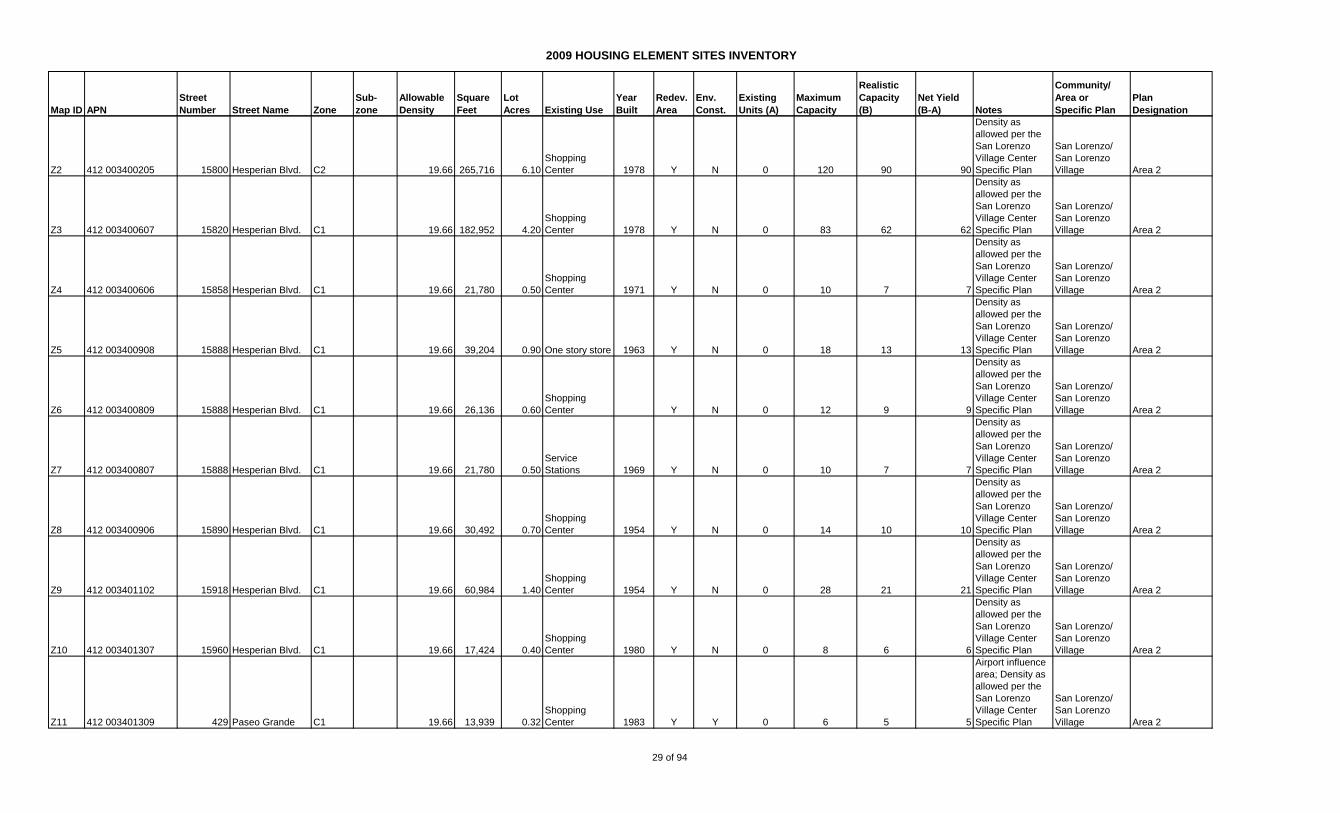
2009 HOUSING ELEMENT SITES INVENTORY
Map ID APN
Street
Number Street Name Zone
Sub-
zone
Allowable
Density
Square
Feet
Lot
Acres Existing Use
Year
Built
Redev.
Area
Env.
Const.
Existing
Units (A)
Maximum
Capacity
Realistic
Capacity
(B)
Net Yield
(B-A) Notes
Community/
Area or
Specific Plan
Plan
Designation
Z2 412 003400205 15800 Hesperian Blvd. C2 19.66 265,716 6.10
Shopping
Center 1978 Y N 0 120 90 90
Density as
allowed per the
San Lorenzo
Village Center
Specific Plan
San Lorenzo/
San Lorenzo
Village Area 2
Z3 412 003400607 15820 Hesperian Blvd. C1 19.66 182,952 4.20
Shopping
Center 1978 Y N 0 83 62 62
Density as
allowed per the
San Lorenzo
Village Center
Specific Plan
San Lorenzo/
San Lorenzo
Village Area 2
Z4 412 003400606 15858 Hesperian Blvd. C1 19.66 21,780 0.50
Shopping
Center 1971 Y N 0 10 7 7
Density as
allowed per the
San Lorenzo
Village Center
Specific Plan
San Lorenzo/
San Lorenzo
Village Area 2
Z5 412 003400908 15888 Hesperian Blvd. C1 19.66 39,204 0.90 One story store 1963 Y N 0 18 13 13
Density as
allowed per the
San Lorenzo
Village Center
Specific Plan
San Lorenzo/
San Lorenzo
Village Area 2
Z6 412 003400809 15888 Hesperian Blvd. C1 19.66 26,136 0.60
Shopping
Center Y N 0 12 9 9
Density as
allowed per the
San Lorenzo
Village Center
Specific Plan
San Lorenzo/
San Lorenzo
Village Area 2
Z7 412 003400807 15888 Hesperian Blvd. C1 19.66 21,780 0.50
Service
Stations 1969 Y N 0 10 7 7
Density as
allowed per the
San Lorenzo
Village Center
Specific Plan
San Lorenzo/
San Lorenzo
Village Area 2
Z8 412 003400906 15890 Hesperian Blvd. C1 19.66 30,492 0.70
Shopping
Center 1954 Y N 0 14 10 10
Density as
allowed per the
San Lorenzo
Village Center
Specific Plan
San Lorenzo/
San Lorenzo
Village Area 2
Z9 412 003401102 15918 Hesperian Blvd. C1 19.66 60,984 1.40
Shopping
Center 1954 Y N 0 28 21 21
Density as
allowed per the
San Lorenzo
Village Center
Specific Plan
San Lorenzo/
San Lorenzo
Village Area 2
Z10 412 003401307 15960 Hesperian Blvd. C1 19.66 17,424 0.40
Shopping
Center 1980 Y N 0 8 6 6
Density as
allowed per the
San Lorenzo
Village Center
Specific Plan
San Lorenzo/
San Lorenzo
Village Area 2
Z11 412 003401309 429 Paseo Grande C1 19.66 13,939 0.32
Shopping
Center 1983 Y Y 0 6 5 5
Airport influence
area; Density as
allowed per the
San Lorenzo
Village Center
Specific Plan
San Lorenzo/
San Lorenzo
Village Area 2
29 of 94
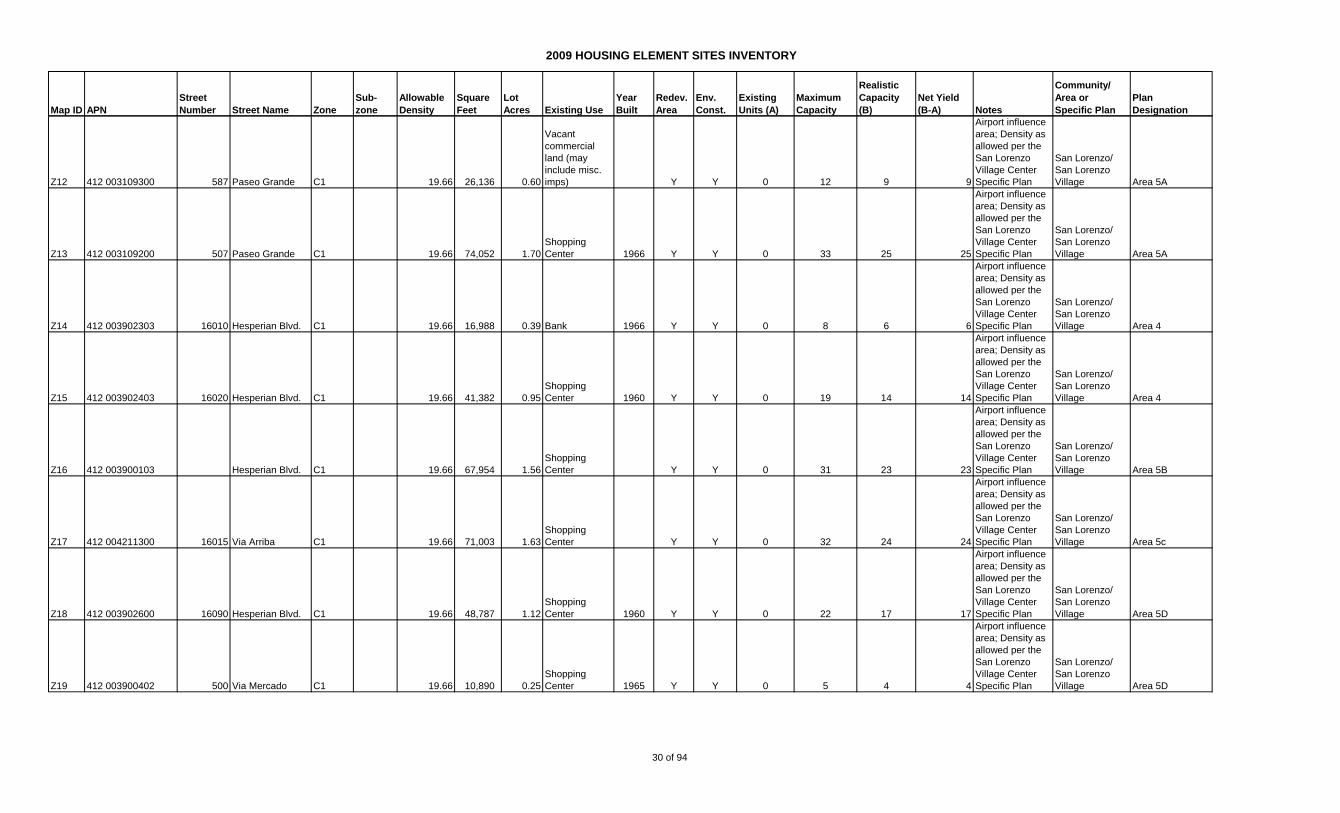
2009 HOUSING ELEMENT SITES INVENTORY
Map ID APN
Street
Number Street Name Zone
Sub-
zone
Allowable
Density
Square
Feet
Lot
Acres Existing Use
Year
Built
Redev.
Area
Env.
Const.
Existing
Units (A)
Maximum
Capacity
Realistic
Capacity
(B)
Net Yield
(B-A) Notes
Community/
Area or
Specific Plan
Plan
Designation
Z12 412 003109300 587 Paseo Grande C1 19.66 26,136 0.60
Vacant
commercial
land (may
include misc.
imps) Y Y 0 12 9 9
Airport influence
area; Density as
allowed per the
San Lorenzo
Village Center
Specific Plan
San Lorenzo/
San Lorenzo
Village Area 5A
Z13 412 003109200 507 Paseo Grande C1 19.66 74,052 1.70
Shopping
Center 1966 Y Y 0 33 25 25
Airport influence
area; Density as
allowed per the
San Lorenzo
Village Center
Specific Plan
San Lorenzo/
San Lorenzo
Village Area 5A
Z14 412 003902303 16010 Hesperian Blvd. C1 19.66 16,988 0.39 Bank 1966 Y Y 0 8 6 6
Airport influence
area; Density as
allowed per the
San Lorenzo
Village Center
Specific Plan
San Lorenzo/
San Lorenzo
Village Area 4
Z15 412 003902403 16020 Hesperian Blvd. C1 19.66 41,382 0.95
Shopping
Center 1960 Y Y 0 19 14 14
Airport influence
area; Density as
allowed per the
San Lorenzo
Village Center
Specific Plan
San Lorenzo/
San Lorenzo
Village Area 4
Z16 412 003900103 Hesperian Blvd. C1 19.66 67,954 1.56
Shopping
Center Y Y 0 31 23 23
Airport influence
area; Density as
allowed per the
San Lorenzo
Village Center
Specific Plan
San Lorenzo/
San Lorenzo
Village Area 5B
Z17 412 004211300 16015 Via Arriba C1 19.66 71,003 1.63
Shopping
Center Y Y 0 32 24 24
Airport influence
area; Density as
allowed per the
San Lorenzo
Village Center
Specific Plan
San Lorenzo/
San Lorenzo
Village Area 5c
Z18 412 003902600 16090 Hesperian Blvd. C1 19.66 48,787 1.12
Shopping
Center 1960 Y Y 0 22 17 17
Airport influence
area; Density as
allowed per the
San Lorenzo
Village Center
Specific Plan
San Lorenzo/
San Lorenzo
Village Area 5D
Z19 412 003900402 500 Via Mercado C1 19.66 10,890 0.25
Shopping
Center 1965 Y Y 0 5 4 4
Airport influence
area; Density as
allowed per the
San Lorenzo
Village Center
Specific Plan
San Lorenzo/
San Lorenzo
Village Area 5D
30 of 94
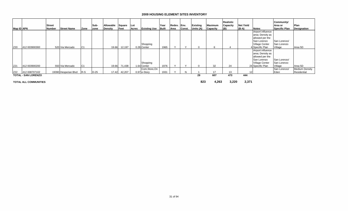
2009 HOUSING ELEMENT SITES INVENTORY
Map ID APN
Street
Number Street Name Zone
Sub-
zone
Allowable
Density
Square
Feet
Lot
Acres Existing Use
Year
Built
Redev.
Area
Env.
Const.
Existing
Units (A)
Maximum
Capacity
Realistic
Capacity
(B)
Net Yield
(B-A) Notes
Community/
Area or
Specific Plan
Plan
Designation
Z20 412 003900300 520 Via Mercado C1 19.66 12,197 0.28
Shopping
Center 1965 Y Y 0 6 4 4
Airport influence
area; Density as
allowed per the
San Lorenzo
Village Center
Specific Plan
San Lorenzo/
San Lorenzo
Village Area 5D
Z21 412 003900200 550 Via Mercado C1 19.66 71,438 1.64
Shopping
Center 1976 Y Y 0 32 24 24
Airport influence
area; Density as
allowed per the
San Lorenzo
Village Center
Specific Plan
San Lorenzo/
San Lorenzo
Village Area 5D
Z22 412 008707102 19390 Hesperian Blvd R-S D-25 17.42 42,207 0.97
Com,Store,On
e-Story 1931 Y N 1 17 13 12
San Lorenzo/
Eden
Medium Density
Residential
TOTAL - SAN LORENZO 29 607 473 444
TOTAL ALL COMMUNITIES 823 4,263 3,220 2,371
31 of 94
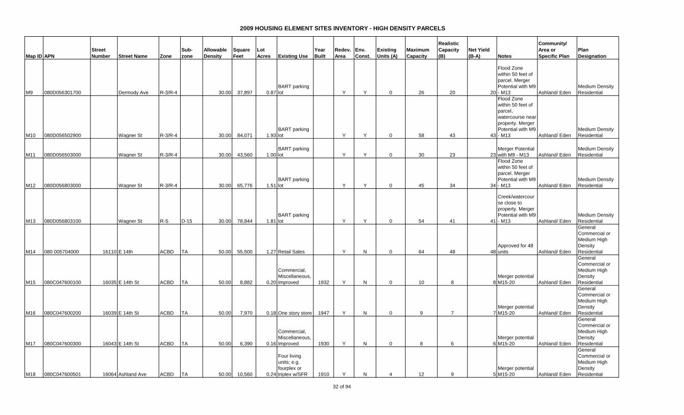
2009 HOUSING ELEMENT SITES INVENTORY - HIGH DENSITY PARCELS
Map ID APN
Street
Number Street Name Zone
Sub-
zone
Allowable
Density
Square
Feet
Lot
Acres Existing Use
Year
Built
Redev.
Area
Env.
Const.
Existing
Units (A)
Maximum
Capacity
Realistic
Capacity
(B)
Net Yield
(B-A) Notes
Community/
Area or
Specific Plan
Plan
Designation
M9 080D056301700 Dermody Ave R-3/R-4 30.00 37,897 0.87
BART parking
lot Y Y 0 26 20 20
Flood Zone
within 50 feet of
parcel. Merger
Potential with M9
- M13 Ashland/ Eden
Medium Density
Residential
M10 080D056502900 Wagner St R-3/R-4 30.00 84,071 1.93
BART parking
lot Y Y 0 58 43 43
Flood Zone
within 50 feet of
parcel,
watercourse near
property. Merger
Potential with M9
- M13 Ashland/ Eden
Medium Density
Residential
M11 080D056503000 Wagner St R-3/R-4 30.00 43,560 1.00
BART parking
lot Y Y 0 30 23 23
Merger Potential
with M9 - M13 Ashland/ Eden
Medium Density
Residential
M12 080D056803000 Wagner St R-3/R-4 30.00 65,776 1.51
BART parking
lot Y Y 0 45 34 34
Flood Zone
within 50 feet of
parcel. Merger
Potential with M9
- M13 Ashland/ Eden
Medium Density
Residential
M13 080D056803100 Wagner St R-S D-15 30.00 78,844 1.81
BART parking
lot Y Y 0 54 41 41
Creek/watercour
se close to
property. Merger
Potential with M9
- M13 Ashland/ Eden
Medium Density
Residential
M14 080 005704000 16110 E 14th ACBD TA 50.00 55,500 1.27 Retail Sales Y N 0 64 48 48
Approved for 48
units Ashland/ Eden
General
Commercial or
Medium High
Density
Residential
M15 080C047600100 16035 E 14th St ACBD TA 50.00 8,882 0.20
Commercial,
Miscellaneous,
Improved 1932 Y N 0 10 8 8
Merger potential
M15-20 Ashland/ Eden
General
Commercial or
Medium High
Density
Residential
M16 080C047600200 16039 E 14th St ACBD TA 50.00 7,970 0.18 One story store 1947 Y N 0 9 7 7
Merger potential
M15-20 Ashland/ Eden
General
Commercial or
Medium High
Density
Residential
M17 080C047600300 16043 E 14th St ACBD TA 50.00 6,390 0.16
Commercial,
Miscellaneous,
Improved 1930 Y N 0 8 6 6
Merger potential
M15-20 Ashland/ Eden
General
Commercial or
Medium High
Density
Residential
M18 080C047600501 16064 Ashland Ave ACBD TA 50.00 10,560 0.24
Four living
units; e.g.
fourplex or
triplex w/SFR 1910 Y N 4 12 9 5
Merger potential
M15-20 Ashland/ Eden
General
Commercial or
Medium High
Density
Residential
32 of 94
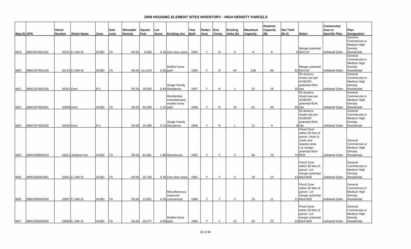
2009 HOUSING ELEMENT SITES INVENTORY - HIGH DENSITY PARCELS
Map ID APN
Street
Number Street Name Zone
Sub-
zone
Allowable
Density
Square
Feet
Lot
Acres Existing Use
Year
Built
Redev.
Area
Env.
Const.
Existing
Units (A)
Maximum
Capacity
Realistic
Capacity
(B)
Net Yield
(B-A) Notes
Community/
Area or
Specific Plan
Plan
Designation
M19 080C047601101 16151 E 14th St ACBD TA 50.00 6,869 0.16 One story store 1942 Y N 0 8 6 6
Merger potential
M15-20 Ashland/ Eden
General
Commercial or
Medium High
Density
Residential
M20 080C047601103 16115 E 14th St ACBD TA 50.00 111,514 2.56
Mobile home
park 1950 Y N 44 128 96 52
Merger potential
M15-20 Ashland/ Eden
General
Commercial or
Medium High
Density
Residential
M21 080C047902200 16331 Kent R-1 50.00 19,000 0.44
Single Family
Residence 1947 Y N 1 22 16 15
50 du/acre,
mixed use per
ACBDSP,
potential RDA
site Ashland/ Eden
General
Commercial or
Medium High
Density
Residential
M22 080C047902301 16309 Kent ACBD TA 50.00 53,000 1.22
Residential,
manufactured,
mobile home
park 1949 Y N 16 61 46 30
50 du/acre,
mixed use per
ACBDSP,
potential RDA
site Ashland/ Eden
General
Commercial or
Medium High
Density
Residential
M23 080C047902302 16325 Kent R-1 50.00 10,080 0.23
Single Family
Residence 1959 Y N 1 12 9 8
50 du/acre,
mixed use per
ACBDSP,
potential RDA
site Ashland/ Eden
General
Commercial or
Medium High
Density
Residential
M24 080C049500103 16021 Ashland Ave ACBD TA 50.00 81,881 1.88 Warehouse 1991 Y Y 0 94 70 70
Flood Zone
within 50 feet of
parcel, close to
creek and
riparian area.
Lot merger
potential M24-
M29 Ashland/ Eden
General
Commercial or
Medium High
Density
Residential
M25 080C050002401 15951 E 14th St ACBD TA 50.00 16,783 0.39 One story store 1981 Y Y 0 19 14 14
Flood Zone
within 50 feet of
parcel. Lot
merger potential
M24-M29 Ashland/ Eden
General
Commercial or
Medium High
Density
Residential
M26 080C050002500 15957 E 14th St ACBD TA 50.00 12,851 0.30
Miscellaneous
improved
commercial 1960 Y Y 0 15 11 11
Flood Zone
within 50 feet of
parcel. Lot
merger potential
M24-M29 Ashland/ Eden
General
Commercial or
Medium High
Density
Residential
M27 080C050002600 15959 E 14th St ACBD TA 50.00 25,077 0.58
Mobile home
park 1946 Y Y 12 29 22 10
Flood Zone
within 50 feet of
parcel. Lot
merger potential
M24-M29 Ashland/ Eden
General
Commercial or
Medium High
Density
Residential
33 of 94

2009 HOUSING ELEMENT SITES INVENTORY - HIGH DENSITY PARCELS
Map ID APN
Street
Number Street Name Zone
Sub-
zone
Allowable
Density
Square
Feet
Lot
Acres Existing Use
Year
Built
Redev.
Area
Env.
Const.
Existing
Units (A)
Maximum
Capacity
Realistic
Capacity
(B)
Net Yield
(B-A) Notes
Community/
Area or
Specific Plan
Plan
Designation
M28 080C050002700 15965 E 14th St ACBD TA 50.00 22,500 0.52
Multiple
residential
building of 5 or
more units. 1940 Y Y 11 26 19 8
Flood Zone
within 50 feet of
parcel. Lot
merger potential
M24-M29 Ashland/ Eden
General
Commercial or
Medium High
Density
Residential
M29 080C050002800 15995 E 14th St ACBD TA 50.00 4,297 0.10 One story store 1949 Y Y 0 5 4 4
Flood Zone
within 50 feet of
parcel. Lot
merger potential
M24-M29 Ashland/ Eden
General
Commercial or
Medium High
Density
Residential
89 734 551 462
Map ID APN
Street
Number Street Name Zone
Sub-
zone
Allowable
Density
Square
Feet
Lot
Acres Existing Use
Year
Built
Redev.
Area
Env.
Const.
Existing
Units (A)
Maximum
Capacity
Realistic
Capacity
(B)
Net Yield
(B-A) Notes
Community/
Area or
Specific Plan
Plan
Designation
CH75 414 005602101 21030 Mission Blvd ACBD TC 50.00 14,820 0.34 One story store 1953 Y Y 0 17 13 13
Flood Zone
within 50 feet of
parcel. Merger
potential sites
CH75-93
Cherryland/
Eden
General
Commercial/
Medium/High
Density
Residential
CH76 414 005602301 21050 Mission Blvd ACBD TC 50.00 9,693 0.22
Commercial
repair garage 1957 Y Y 0 11 8 8
Flood Zone
within 50 feet of
parcel. Merger
potential sites
CH75-93
Cherryland/
Eden
General
Commercial/
Medium/High
Density
Residential
CH77 414 008100101 21070 Mission Blvd ACBD TC 50.00 9,250 0.21
Single family
residential
homes used as
such 1923 Y Y 1 11 8 7
Flood Zone
within 50 feet of
parcel. Merger
potential sites
CH75-93
Cherryland/
Eden
General
Commercial/
Medium/High
Density
Residential
CH78 414 008100200 21098 Mission Blvd ACBD TC 50.00 7,903 0.18
Vacant
commercial
land (may
include misc.
imps) Y Y 1 9 7 6
Flood Zone
within 50 feet of
parcel. Merger
potential sites
CH75-93
Cherryland/
Eden
General
Commercial/
Medium/High
Density
Residential
CH79 414 008100300 21106 Mission Blvd ACBD TC 50.00 10,987 0.25 One story store 1966 Y Y 0 13 9 9
Flood Zone
within 50 feet of
parcel. Merger
potential sites
CH75-93
Cherryland/
Eden
General
Commercial/
Medium/High
Density
Residential
CH80 414 008100400 21120 Mission Blvd ACBD TC 50.00 7,405 0.17 One story store 1951 Y Y 0 9 6 6
Flood Zone
within 50 feet of
parcel. Merger
potential sites
CH75-93
Cherryland/
Eden
General
Commercial/
Medium/High
Density
Residential
TOTAL - ASHLAND
34 of 94
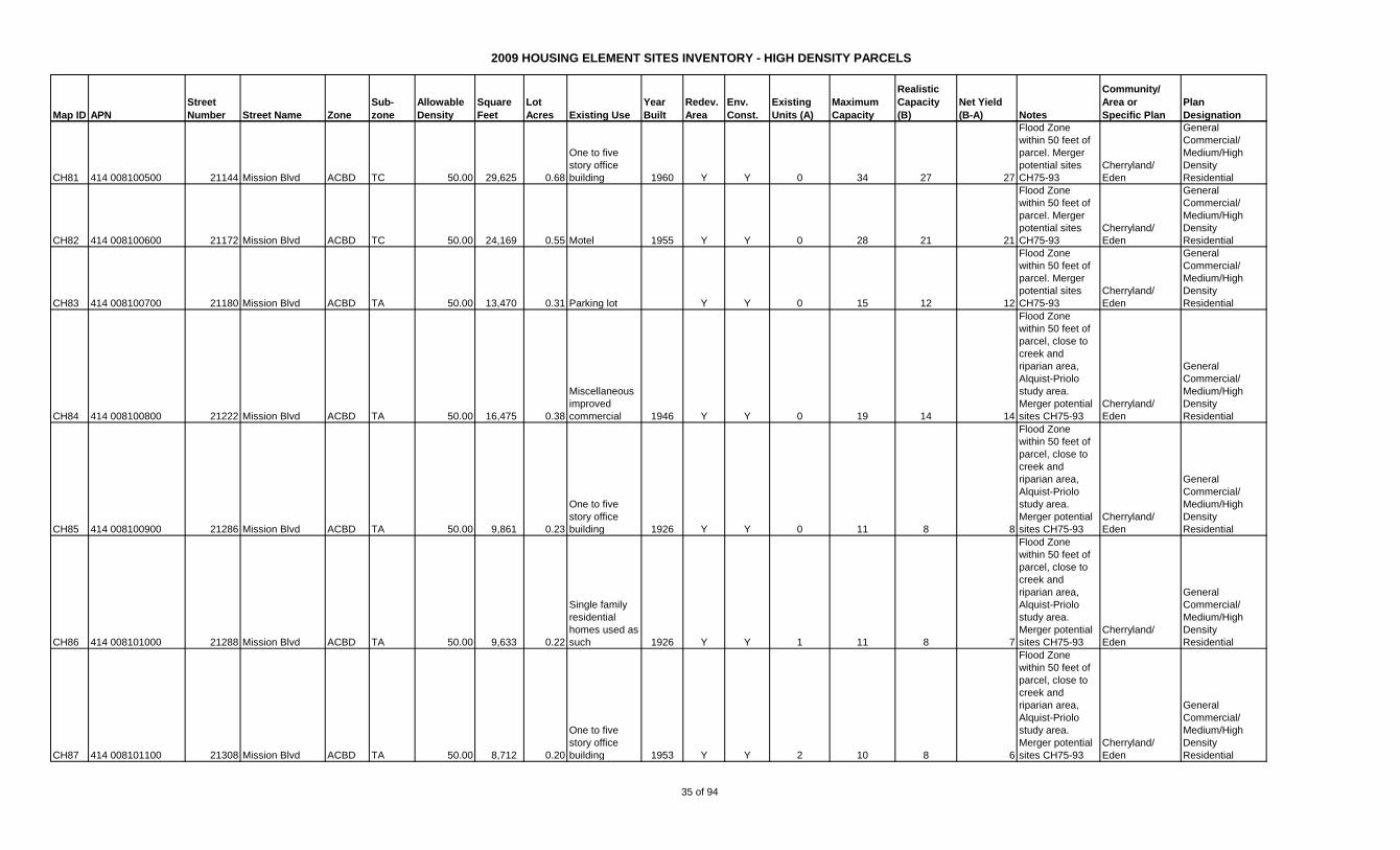
2009 HOUSING ELEMENT SITES INVENTORY - HIGH DENSITY PARCELS
Map ID APN
Street
Number Street Name Zone
Sub-
zone
Allowable
Density
Square
Feet
Lot
Acres Existing Use
Year
Built
Redev.
Area
Env.
Const.
Existing
Units (A)
Maximum
Capacity
Realistic
Capacity
(B)
Net Yield
(B-A) Notes
Community/
Area or
Specific Plan
Plan
Designation
CH81 414 008100500 21144 Mission Blvd ACBD TC 50.00 29,625 0.68
One to five
story office
building 1960 Y Y 0 34 27 27
Flood Zone
within 50 feet of
parcel. Merger
potential sites
CH75-93
Cherryland/
Eden
General
Commercial/
Medium/High
Density
Residential
CH82 414 008100600 21172 Mission Blvd ACBD TC 50.00 24,169 0.55 Motel 1955 Y Y 0 28 21 21
Flood Zone
within 50 feet of
parcel. Merger
potential sites
CH75-93
Cherryland/
Eden
General
Commercial/
Medium/High
Density
Residential
CH83 414 008100700 21180 Mission Blvd ACBD TA 50.00 13,470 0.31 Parking lot Y Y 0 15 12 12
Flood Zone
within 50 feet of
parcel. Merger
potential sites
CH75-93
Cherryland/
Eden
General
Commercial/
Medium/High
Density
Residential
CH84 414 008100800 21222 Mission Blvd ACBD TA 50.00 16,475 0.38
Miscellaneous
improved
commercial 1946 Y Y 0 19 14 14
Flood Zone
within 50 feet of
parcel, close to
creek and
riparian area,
Alquist-Priolo
study area.
Merger potential
sites CH75-93
Cherryland/
Eden
General
Commercial/
Medium/High
Density
Residential
CH85 414 008100900 21286 Mission Blvd ACBD TA 50.00 9,861 0.23
One to five
story office
building 1926 Y Y 0 11 8 8
Flood Zone
within 50 feet of
parcel, close to
creek and
riparian area,
Alquist-Priolo
study area.
Merger potential
sites CH75-93
Cherryland/
Eden
General
Commercial/
Medium/High
Density
Residential
CH86 414 008101000 21288 Mission Blvd ACBD TA 50.00 9,633 0.22
Single family
residential
homes used as
such 1926 Y Y 1 11 8 7
Flood Zone
within 50 feet of
parcel, close to
creek and
riparian area,
Alquist-Priolo
study area.
Merger potential
sites CH75-93
Cherryland/
Eden
General
Commercial/
Medium/High
Density
Residential
CH87 414 008101100 21308 Mission Blvd ACBD TA 50.00 8,712 0.20
One to five
story office
building 1953 Y Y 2 10 8 6
Flood Zone
within 50 feet of
parcel, close to
creek and
riparian area,
Alquist-Priolo
study area.
Merger potential
sites CH75-93
Cherryland/
Eden
General
Commercial/
Medium/High
Density
Residential
35 of 94
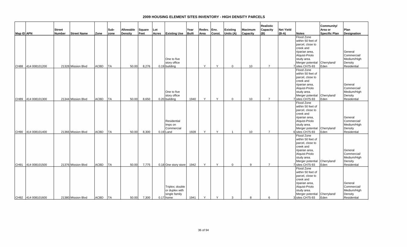
2009 HOUSING ELEMENT SITES INVENTORY - HIGH DENSITY PARCELS
Map ID APN
Street
Number Street Name Zone
Sub-
zone
Allowable
Density
Square
Feet
Lot
Acres Existing Use
Year
Built
Redev.
Area
Env.
Const.
Existing
Units (A)
Maximum
Capacity
Realistic
Capacity
(B)
Net Yield
(B-A) Notes
Community/
Area or
Specific Plan
Plan
Designation
CH88 414 008101200 21328 Mission Blvd ACBD TA 50.00 8,276 0.19
One to five
story office
building Y Y 0 10 7 7
Flood Zone
within 50 feet of
parcel, close to
creek and
riparian area,
Alquist-Priolo
study area.
Merger potential
sites CH75-93
Cherryland/
Eden
General
Commercial/
Medium/High
Density
Residential
CH89 414 008101300 21344 Mission Blvd ACBD TA 50.00 8,650 0.20
One to five
story office
building 1940 Y Y 0 10 7 7
Flood Zone
within 50 feet of
parcel, close to
creek and
riparian area,
Alquist-Priolo
study area.
Merger potential
sites CH75-93
Cherryland/
Eden
General
Commercial/
Medium/High
Density
Residential
CH90 414 008101400 21366 Mission Blvd ACBD TA 50.00 8,300 0.19
Residential
Imps on
Commercial
Land 1928 Y Y 1 10 7 6
Flood Zone
within 50 feet of
parcel, close to
creek and
riparian area,
Alquist-Priolo
study area.
Merger potential
sites CH75-93
Cherryland/
Eden
General
Commercial/
Medium/High
Density
Residential
CH91 414 008101500 21376 Mission Blvd ACBD TA 50.00 7,775 0.18 One story store 1942 Y Y 0 9 7 7
Flood Zone
within 50 feet of
parcel, close to
creek and
riparian area,
Alquist-Priolo
study area.
Merger potential
sites CH75-93
Cherryland/
Eden
General
Commercial/
Medium/High
Density
Residential
CH92 414 008101600 21380 Mission Blvd ACBD TA 50.00 7,300 0.17
Triplex; double
or duplex with
single family
home 1941 Y Y 3 8 6 3
Flood Zone
within 50 feet of
parcel, close to
creek and
riparian area,
Alquist-Priolo
study area.
Merger potential
sites CH75-93
Cherryland/
Eden
General
Commercial/
Medium/High
Density
Residential
36 of 94
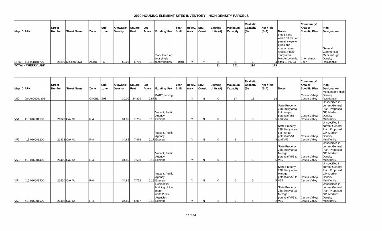
2009 HOUSING ELEMENT SITES INVENTORY - HIGH DENSITY PARCELS
Map ID APN
Street
Number Street Name Zone
Sub-
zone
Allowable
Density
Square
Feet
Lot
Acres Existing Use
Year
Built
Redev.
Area
Env.
Const.
Existing
Units (A)
Maximum
Capacity
Realistic
Capacity
(B)
Net Yield
(B-A) Notes
Community/
Area or
Specific Plan
Plan
Designation
CH93 414 008101700 21390 Mission Blvd ACBD TA 50.00 6,759 0.16
Two, three or
four single
family homes 1940 Y Y 2 8 6 4
Flood Zone
within 50 feet of
parcel, close to
creek and
riparian area,
Alquist-Priolo
study area.
Merger potential
sites CH75-93
Cherryland/
Eden
General
Commercial/
Medium/High
Density
Residential
TOTAL - CHERRYLAND 11 251 190 179
Map ID APN
Street
Number Street Name Zone
Sub-
zone
Allowable
Density
Square
Feet
Lot
Acres Existing Use
Year
Built
Redev.
Area
Env.
Const.
Existing
Units (A)
Maximum
Capacity
Realistic
Capacity
(B)
Net Yield
(B-A) Notes
Community/
Area or
Specific Plan
Plan
Designation
V50 084A006001402 CVCBD S08 30.00 24,829 0.57
BART parking
lot Y N 0 17 13 13
Castro Valley/
Castro Valley
Medium and High
Density
Residential
V51 415 016001100 21320 Oak St R-4 34.85 7,795 0.18
Vacant, Public
Agency,
Exempt Y N 0 6 5 5
State Property,
238 Study area.
Lot merger
potential V51
and V52
Castro Valley/
Castro Valley
Unspecified in
current General
Plan. Proposed
GP: Medium
Density
Multifamily.
V52 415 016001200 21338 Oak St R-4 34.85 7,466 0.17
Vacant, Public
Agency,
Exempt Y N 0 6 4 4
State Property,
238 Study area.
Lot merger
potential V51
and V52
Castro Valley/
Castro Valley
Unspecified in
current General
Plan. Proposed
GP: Medium
Density
Multifamily.
V53 415 016001400 21406 Oak St R-4 34.85 7,530 0.17
Vacant, Public
Agency,
Exempt Y N 0 6 5 5
State Property,
238 Study area.
Mereger
potential V53 to
V55
Castro Valley/
Castro Valley
Unspecified in
current General
Plan. Proposed
GP: Medium
Density
Multifamily.
V54 415 016001500 21420 Oak St R-4 34.85 7,758 0.18
Vacant, Public
Agency,
Exempt Y N 0 6 5 5
State Property,
238 Study area.
Mereger
potential V53 to
V55
Castro Valley/
Castro Valley
Unspecified in
current General
Plan. Proposed
GP: Medium
Density
Multifamily.
V55 415 016001600 21408 Oak St R-4 34.85 6,917 0.16
Residential
building of 2 or
more
units,Public
Agencies,
Exempt Y N 2 6 4 2
State Property,
238 Study area.
Mereger
potential V53 to
V55
Castro Valley/
Castro Valley
Unspecified in
current General
Plan. Proposed
GP: Medium
Density
Multifamily.
37 of 94

2009 HOUSING ELEMENT SITES INVENTORY - HIGH DENSITY PARCELS
Map ID APN
Street
Number Street Name Zone
Sub-
zone
Allowable
Density
Square
Feet
Lot
Acres Existing Use
Year
Built
Redev.
Area
Env.
Const.
Existing
Units (A)
Maximum
Capacity
Realistic
Capacity
(B)
Net Yield
(B-A) Notes
Community/
Area or
Specific Plan
Plan
Designation
V56 415 016001800 21454 Oak St R-4 34.85 7,426 0.17
Vacant, Public
Agency,
Exempt Y N 0 6 4 4
State Property,
238 Study area.
Lot merger
potential V42
and V56 to V58
Castro Valley/
Castro Valley
Unspecified in
current General
Plan. Proposed
GP: Medium
Density
Multifamily.
V57 415 016001900 21462 Oak St R-4 34.85 7,405 0.17
Single Family
Residence,
Public Agency,
Exempt 1940 Y N 1 6 4 3
State Property,
238 Study area.
Lot merger
potential V42
and V56 to V58
Castro Valley/
Castro Valley
Unspecified in
current General
Plan. Proposed
GP: Medium
Density
Multifamily.
V58 415 016002000 21484 Oak St R-4 34.85 7,330 0.17
Vacant, Public
Agency,
Exempt Y N 0 6 4 4
State Property,
238 Study area.
Lot merger
potential V42
and V56 to V58
Castro Valley/
Castro Valley
Unspecified in
current General
Plan. Proposed
GP: Medium
Density
Multifamily.
V59 084C065000611 21767 Center St CVCBD S10 40.00 19,602 0.45
Vacant
residential
land, zoned 4
units or less Y N 0 18 14 14
Castro Valley/
Castro Valley
Medium and High
Density
Residential
TOTAL - CASTRO VALLEY 3 83 62 59
38 of 94
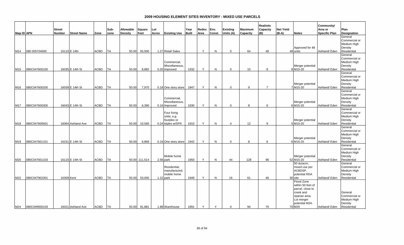
2009 HOUSING ELEMENT SITES INVENTORY - MIXED USE PARCELS
Map ID APN
Street
Number Street Name Zone
Sub-
zone
Allowable
Density
Square
Feet
Lot
Acres Existing Use
Year
Built
Redev.
Area
Env.
Const.
Existing
Units (A)
Maximum
Capacity
Realistic
Capacity
(B)
Net Yield
(B-A) Notes
Community/
Area or
Specific Plan
Plan
Designation
M14 080 005704000 16110 E 14th ACBD TA 50.00 55,500 1.27 Retail Sales Y N 0 64 48 48
Approved for 48
units Ashland/ Eden
General
Commercial or
Medium High
Density
Residential
M15 080C047600100 16035 E 14th St ACBD TA 50.00 8,882 0.20
Commercial,
Miscellaneous,
Improved 1932 Y N 0 10 8 8
Merger potential
M15-20 Ashland/ Eden
General
Commercial or
Medium High
Density
Residential
M16 080C047600200 16039 E 14th St ACBD TA 50.00 7,970 0.18 One story store 1947 Y N 0 9 7 7
Merger potential
M15-20 Ashland/ Eden
General
Commercial or
Medium High
Density
Residential
M17 080C047600300 16043 E 14th St ACBD TA 50.00 6,390 0.16
Commercial,
Miscellaneous,
Improved 1930 Y N 0 8 6 6
Merger potential
M15-20 Ashland/ Eden
General
Commercial or
Medium High
Density
Residential
M18 080C047600501 16064 Ashland Ave ACBD TA 50.00 10,560 0.24
Four living
units; e.g.
fourplex or
triplex w/SFR 1910 Y N 4 12 9 5
Merger potential
M15-20 Ashland/ Eden
General
Commercial or
Medium High
Density
Residential
M19 080C047601101 16151 E 14th St ACBD TA 50.00 6,869 0.16 One story store 1942 Y N 0 8 6 6
Merger potential
M15-20 Ashland/ Eden
General
Commercial or
Medium High
Density
Residential
M20 080C047601103 16115 E 14th St ACBD TA 50.00 111,514 2.56
Mobile home
park 1950 Y N 44 128 96 52
Merger potential
M15-20 Ashland/ Eden
General
Commercial or
Medium High
Density
Residential
M22 080C047902301 16309 Kent ACBD TA 50.00 53,000 1.22
Residential,
manufactured,
mobile home
park 1949 Y N 16 61 46 30
50 du/acre,
mixed use per
ACBDSP,
potential RDA
site Ashland/ Eden
General
Commercial or
Medium High
Density
Residential
M24 080C049500103 16021 Ashland Ave ACBD TA 50.00 81,881 1.88 Warehouse 1991 Y Y 0 94 70 70
Flood Zone
within 50 feet of
parcel, close to
creek and
riparian area.
Lot merger
potential M24-
M29 Ashland/ Eden
General
Commercial or
Medium High
Density
Residential
39 of 94
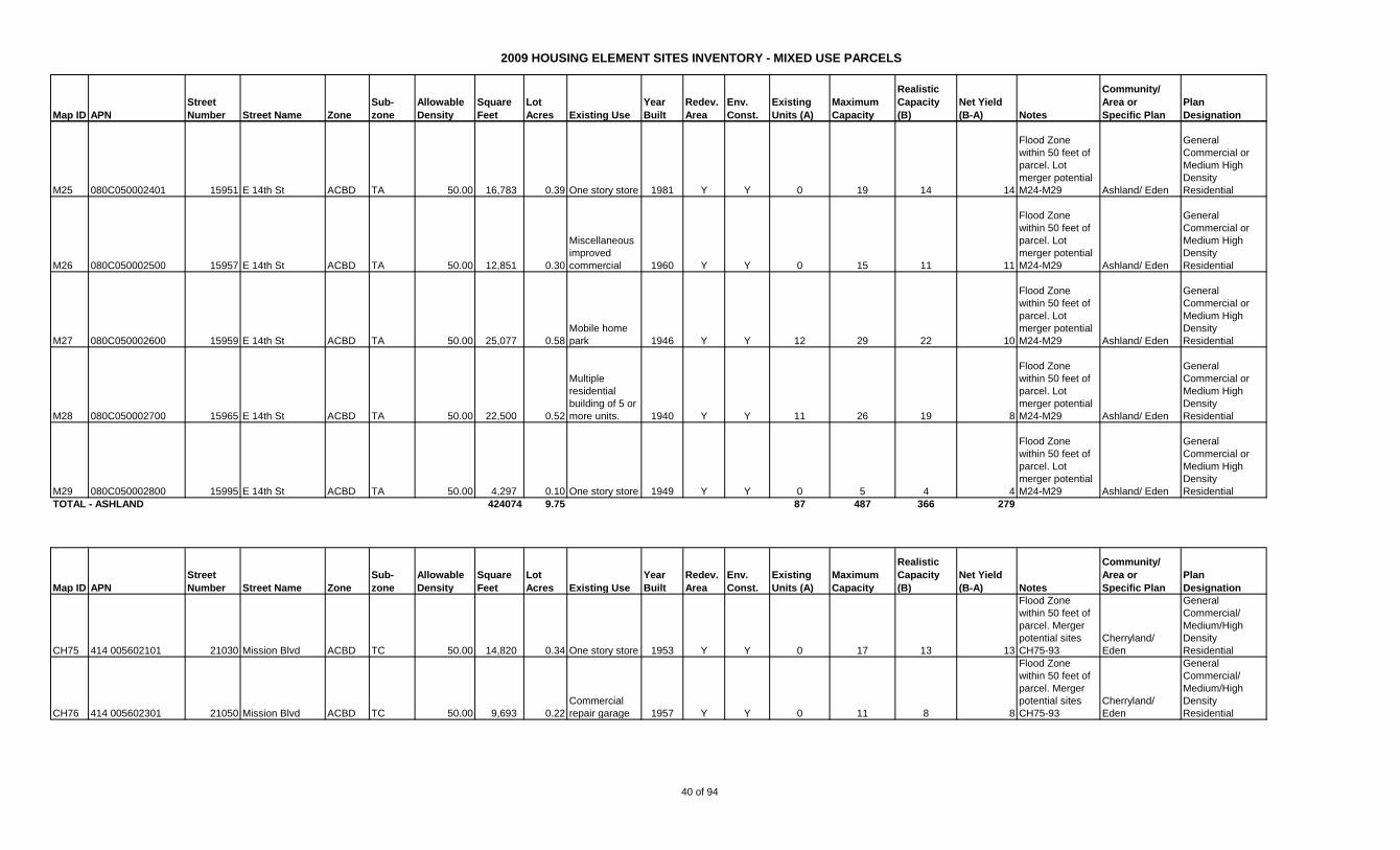
2009 HOUSING ELEMENT SITES INVENTORY - MIXED USE PARCELS
Map ID APN
Street
Number Street Name Zone
Sub-
zone
Allowable
Density
Square
Feet
Lot
Acres Existing Use
Year
Built
Redev.
Area
Env.
Const.
Existing
Units (A)
Maximum
Capacity
Realistic
Capacity
(B)
Net Yield
(B-A) Notes
Community/
Area or
Specific Plan
Plan
Designation
M25 080C050002401 15951 E 14th St ACBD TA 50.00 16,783 0.39 One story store 1981 Y Y 0 19 14 14
Flood Zone
within 50 feet of
parcel. Lot
merger potential
M24-M29 Ashland/ Eden
General
Commercial or
Medium High
Density
Residential
M26 080C050002500 15957 E 14th St ACBD TA 50.00 12,851 0.30
Miscellaneous
improved
commercial 1960 Y Y 0 15 11 11
Flood Zone
within 50 feet of
parcel. Lot
merger potential
M24-M29 Ashland/ Eden
General
Commercial or
Medium High
Density
Residential
M27 080C050002600 15959 E 14th St ACBD TA 50.00 25,077 0.58
Mobile home
park 1946 Y Y 12 29 22 10
Flood Zone
within 50 feet of
parcel. Lot
merger potential
M24-M29 Ashland/ Eden
General
Commercial or
Medium High
Density
Residential
M28 080C050002700 15965 E 14th St ACBD TA 50.00 22,500 0.52
Multiple
residential
building of 5 or
more units. 1940 Y Y 11 26 19 8
Flood Zone
within 50 feet of
parcel. Lot
merger potential
M24-M29 Ashland/ Eden
General
Commercial or
Medium High
Density
Residential
M29 080C050002800 15995 E 14th St ACBD TA 50.00 4,297 0.10 One story store 1949 Y Y 0 5 4 4
Flood Zone
within 50 feet of
parcel. Lot
merger potential
M24-M29 Ashland/ Eden
General
Commercial or
Medium High
Density
Residential
424074 9.75 87 487 366 279
Map ID APN
Street
Number Street Name Zone
Sub-
zone
Allowable
Density
Square
Feet
Lot
Acres Existing Use
Year
Built
Redev.
Area
Env.
Const.
Existing
Units (A)
Maximum
Capacity
Realistic
Capacity
(B)
Net Yield
(B-A) Notes
Community/
Area or
Specific Plan
Plan
Designation
CH75 414 005602101 21030 Mission Blvd ACBD TC 50.00 14,820 0.34 One story store 1953 Y Y 0 17 13 13
Flood Zone
within 50 feet of
parcel. Merger
potential sites
CH75-93
Cherryland/
Eden
General
Commercial/
Medium/High
Density
Residential
CH76 414 005602301 21050 Mission Blvd ACBD TC 50.00 9,693 0.22
Commercial
repair garage 1957 Y Y 0 11 8 8
Flood Zone
within 50 feet of
parcel. Merger
potential sites
CH75-93
Cherryland/
Eden
General
Commercial/
Medium/High
Density
Residential
TOTAL - ASHLAND
40 of 94
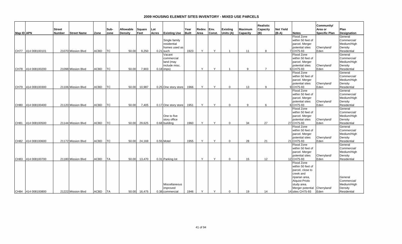
2009 HOUSING ELEMENT SITES INVENTORY - MIXED USE PARCELS
Map ID APN
Street
Number Street Name Zone
Sub-
zone
Allowable
Density
Square
Feet
Lot
Acres Existing Use
Year
Built
Redev.
Area
Env.
Const.
Existing
Units (A)
Maximum
Capacity
Realistic
Capacity
(B)
Net Yield
(B-A) Notes
Community/
Area or
Specific Plan
Plan
Designation
CH77 414 008100101 21070 Mission Blvd ACBD TC 50.00 9,250 0.21
Single family
residential
homes used as
such 1923 Y Y 1 11 8 7
Flood Zone
within 50 feet of
parcel. Merger
potential sites
CH75-93
Cherryland/
Eden
General
Commercial/
Medium/High
Density
Residential
CH78 414 008100200 21098 Mission Blvd ACBD TC 50.00 7,903 0.18
Vacant
commercial
land (may
include misc.
imps) Y Y 1 9 7 6
Flood Zone
within 50 feet of
parcel. Merger
potential sites
CH75-93
Cherryland/
Eden
General
Commercial/
Medium/High
Density
Residential
CH79 414 008100300 21106 Mission Blvd ACBD TC 50.00 10,987 0.25 One story store 1966 Y Y 0 13 9 9
Flood Zone
within 50 feet of
parcel. Merger
potential sites
CH75-93
Cherryland/
Eden
General
Commercial/
Medium/High
Density
Residential
CH80 414 008100400 21120 Mission Blvd ACBD TC 50.00 7,405 0.17 One story store 1951 Y Y 0 9 6 6
Flood Zone
within 50 feet of
parcel. Merger
potential sites
CH75-93
Cherryland/
Eden
General
Commercial/
Medium/High
Density
Residential
CH81 414 008100500 21144 Mission Blvd ACBD TC 50.00 29,625 0.68
One to five
story office
building 1960 Y Y 0 34 27 27
Flood Zone
within 50 feet of
parcel. Merger
potential sites
CH75-93
Cherryland/
Eden
General
Commercial/
Medium/High
Density
Residential
CH82 414 008100600 21172 Mission Blvd ACBD TC 50.00 24,169 0.55 Motel 1955 Y Y 0 28 21 21
Flood Zone
within 50 feet of
parcel. Merger
potential sites
CH75-93
Cherryland/
Eden
General
Commercial/
Medium/High
Density
Residential
CH83 414 008100700 21180 Mission Blvd ACBD TA 50.00 13,470 0.31 Parking lot Y Y 0 15 12 12
Flood Zone
within 50 feet of
parcel. Merger
potential sites
CH75-93
Cherryland/
Eden
General
Commercial/
Medium/High
Density
Residential
CH84 414 008100800 21222 Mission Blvd ACBD TA 50.00 16,475 0.38
Miscellaneous
improved
commercial 1946 Y Y 0 19 14 14
Flood Zone
within 50 feet of
parcel, close to
creek and
riparian area,
Alquist-Priolo
study area.
Merger potential
sites CH75-93
Cherryland/
Eden
General
Commercial/
Medium/High
Density
Residential
41 of 94
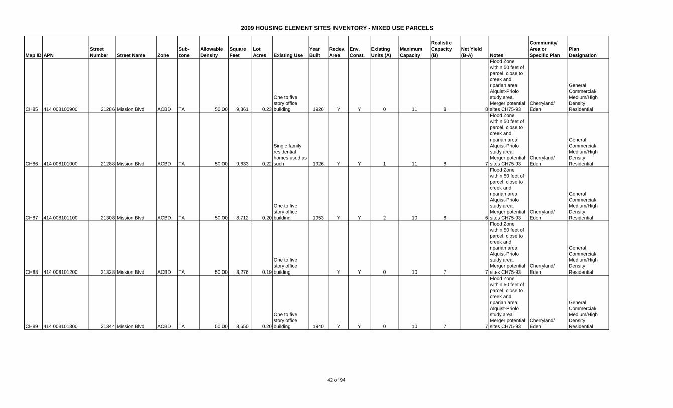
2009 HOUSING ELEMENT SITES INVENTORY - MIXED USE PARCELS
Map ID APN
Street
Number Street Name Zone
Sub-
zone
Allowable
Density
Square
Feet
Lot
Acres Existing Use
Year
Built
Redev.
Area
Env.
Const.
Existing
Units (A)
Maximum
Capacity
Realistic
Capacity
(B)
Net Yield
(B-A) Notes
Community/
Area or
Specific Plan
Plan
Designation
CH85 414 008100900 21286 Mission Blvd ACBD TA 50.00 9,861 0.23
One to five
story office
building 1926 Y Y 0 11 8 8
Flood Zone
within 50 feet of
parcel, close to
creek and
riparian area,
Alquist-Priolo
study area.
Merger potential
sites CH75-93
Cherryland/
Eden
General
Commercial/
Medium/High
Density
Residential
CH86 414 008101000 21288 Mission Blvd ACBD TA 50.00 9,633 0.22
Single family
residential
homes used as
such 1926 Y Y 1 11 8 7
Flood Zone
within 50 feet of
parcel, close to
creek and
riparian area,
Alquist-Priolo
study area.
Merger potential
sites CH75-93
Cherryland/
Eden
General
Commercial/
Medium/High
Density
Residential
CH87 414 008101100 21308 Mission Blvd ACBD TA 50.00 8,712 0.20
One to five
story office
building 1953 Y Y 2 10 8 6
Flood Zone
within 50 feet of
parcel, close to
creek and
riparian area,
Alquist-Priolo
study area.
Merger potential
sites CH75-93
Cherryland/
Eden
General
Commercial/
Medium/High
Density
Residential
CH88 414 008101200 21328 Mission Blvd ACBD TA 50.00 8,276 0.19
One to five
story office
building Y Y 0 10 7 7
Flood Zone
within 50 feet of
parcel, close to
creek and
riparian area,
Alquist-Priolo
study area.
Merger potential
sites CH75-93
Cherryland/
Eden
General
Commercial/
Medium/High
Density
Residential
CH89 414 008101300 21344 Mission Blvd ACBD TA 50.00 8,650 0.20
One to five
story office
building 1940 Y Y 0 10 7 7
Flood Zone
within 50 feet of
parcel, close to
creek and
riparian area,
Alquist-Priolo
study area.
Merger potential
sites CH75-93
Cherryland/
Eden
General
Commercial/
Medium/High
Density
Residential
42 of 94
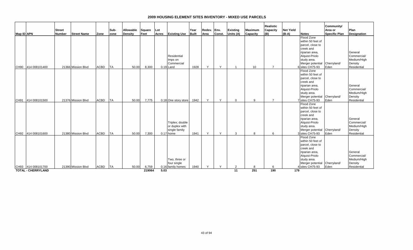
2009 HOUSING ELEMENT SITES INVENTORY - MIXED USE PARCELS
Map ID APN
Street
Number Street Name Zone
Sub-
zone
Allowable
Density
Square
Feet
Lot
Acres Existing Use
Year
Built
Redev.
Area
Env.
Const.
Existing
Units (A)
Maximum
Capacity
Realistic
Capacity
(B)
Net Yield
(B-A) Notes
Community/
Area or
Specific Plan
Plan
Designation
CH90 414 008101400 21366 Mission Blvd ACBD TA 50.00 8,300 0.19
Residential
Imps on
Commercial
Land 1928 Y Y 1 10 7 6
Flood Zone
within 50 feet of
parcel, close to
creek and
riparian area,
Alquist-Priolo
study area.
Merger potential
sites CH75-93
Cherryland/
Eden
General
Commercial/
Medium/High
Density
Residential
CH91 414 008101500 21376 Mission Blvd ACBD TA 50.00 7,775 0.18 One story store 1942 Y Y 0 9 7 7
Flood Zone
within 50 feet of
parcel, close to
creek and
riparian area,
Alquist-Priolo
study area.
Merger potential
sites CH75-93
Cherryland/
Eden
General
Commercial/
Medium/High
Density
Residential
CH92 414 008101600 21380 Mission Blvd ACBD TA 50.00 7,300 0.17
Triplex; double
or duplex with
single family
home 1941 Y Y 3 8 6 3
Flood Zone
within 50 feet of
parcel, close to
creek and
riparian area,
Alquist-Priolo
study area.
Merger potential
sites CH75-93
Cherryland/
Eden
General
Commercial/
Medium/High
Density
Residential
CH93 414 008101700 21390 Mission Blvd ACBD TA 50.00 6,759 0.16
Two, three or
four single
family homes 1940 Y Y 2 8 6 4
Flood Zone
within 50 feet of
parcel, close to
creek and
riparian area,
Alquist-Priolo
study area.
Merger potential
sites CH75-93
Cherryland/
Eden
General
Commercial/
Medium/High
Density
Residential
TOTAL - CHERRYLAND 219064 5.03 11 251 190 179
43 of 94
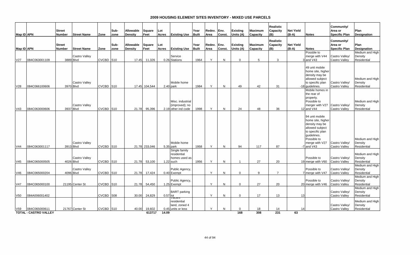
2009 HOUSING ELEMENT SITES INVENTORY - MIXED USE PARCELS
Map ID APN
Street
Number Street Name Zone
Sub-
zone
Allowable
Density
Square
Feet
Lot
Acres Existing Use
Year
Built
Redev.
Area
Env.
Const.
Existing
Units (A)
Maximum
Capacity
Realistic
Capacity
(B)
Net Yield
(B-A) Notes
Community/
Area or
Specific Plan
Plan
Designation
Map ID APN
Street
Number Street Name Zone
Sub-
zone
Allowable
Density
Square
Feet
Lot
Acres Existing Use
Year
Built
Redev.
Area
Env.
Const.
Existing
Units (A)
Maximum
Capacity
Realistic
Capacity
(B)
Net Yield
(B-A) Notes
Community/
Area or
Specific Plan
Plan
Designation
V27 084C063001109 3889
Castro Valley
Blvd CVCBD S10 17.45 11,326 0.26
Service
Stations 1964 Y N 0 5 3 3
Possble to
merge with V44
and V43
Castro Valley/
Castro Valley
Medium and High
Density
Residential
V28 084C066100606 3970
Castro Valley
Blvd CVCBD S10 17.45 104,544 2.40
Mobile home
park 1984 Y N 49 42 31 -18
49 unit mobile
home site, higher
density may be
allowed subject
to specific plan
guidelines.
Castro Valley/
Castro Valley
Medium and High
Density
Residential
V43 084C063000606 3937
Castro Valley
Blvd CVCBD S10 21.78 95,396 2.19
Misc. industrial
(improved); no
other ind code 1998 Y N 24 48 36 12
Mobile homes in
the rear of
property.
Possible to
merger with V27
and V44
Castro Valley/
Castro Valley
Medium and High
Density
Residential
V44 084C063001117 3913
Castro Valley
Blvd CVCBD S10 21.78 233,046 5.35
Mobile home
park 1958 Y N 94 117 87 -7
94 unit mobile
home site, higher
density may be
allowed subject
to specific plan
guidelines.
Possible to
merge with V27
and V43
Castro Valley/
Castro Valley
Medium and High
Density
Residential
V45 084C065000505 4026
Castro Valley
Blvd CVCBD S10 21.78 53,100 1.22
Single family
residential
homes used as
such 1956 Y N 1 27 20 19
Possible to
merge with V60
Castro Valley/
Castro Valley
Medium and High
Density
Residential
V46 084C065000204 4096
Castro Valley
Blvd CVCBD S10 21.78 17,424 0.40
Public Agency,
Exempt Y N 0 9 7 7
Possible to
merge with V47
Castro Valley/
Castro Valley
Medium and High
Density
Residential
V47 084C065000100 21195 Center St CVCBD S10 21.78 54,450 1.25
Public Agency,
Exempt Y N 0 27 20 20
Possible to
merge with V46
Castro Valley/
Castro Valley
Medium and High
Density
Residential
V50 084A006001402 CVCBD S08 30.00 24,829 0.57
BART parking
lot Y N 0 17 13 13
Castro Valley/
Castro Valley
Medium and High
Density
Residential
V59 084C065000611 21767 Center St CVCBD S10 40.00 19,602 0.45
Vacant
residential
land, zoned 4
units or less Y N 0 18 14 14
Castro Valley/
Castro Valley
Medium and High
Density
Residential
TOTAL - CASTRO VALLEY 613717 14.09 168 308 231 63
44 of 94

2009 HOUSING ELEMENT SITES INVENTORY - MIXED USE PARCELS
Map ID APN
Street
Number Street Name Zone
Sub-
zone
Allowable
Density
Square
Feet
Lot
Acres Existing Use
Year
Built
Redev.
Area
Env.
Const.
Existing
Units (A)
Maximum
Capacity
Realistic
Capacity
(B)
Net Yield
(B-A) Notes
Community/
Area or
Specific Plan
Plan
Designation
Map ID APN
Street
Number Street Name Zone
Sub-
zone
Allowable
Density
Square
Feet
Lot
Acres Existing Use
Year
Built
Redev.
Area
Env.
Const.
Existing
Units (A)
Maximum
Capacity
Realistic
Capacity
(B)
Net Yield
(B-A) Notes
Community/
Area or
Specific Plan
Plan
Designation
Z1 411 006301700 1233 Bockman Rd
PD-
2209 21.78 168,627 3.87
Vacant
Commercial Y N 28 84 81 53
Approved for 81
units residential
and some
commercial use
per PD-2209
San Lorenzo/
Eden
Medium and High
Density
Residential
Z2 412 003400205 15800 Hesperian Blvd. C2 19.66 265,716 6.10
Shopping
Center 1978 Y N 0 120 90 90
Density as
allowed per the
San Lorenzo
Village Center
Specific Plan
San Lorenzo/
San Lorenzo
Village Area 2
Z3 412 003400607 15820 Hesperian Blvd. C1 19.66 182,952 4.20
Shopping
Center 1978 Y N 0 83 62 62
Density as
allowed per the
San Lorenzo
Village Center
Specific Plan
San Lorenzo/
San Lorenzo
Village Area 2
Z4 412 003400606 15858 Hesperian Blvd. C1 19.66 21,780 0.50
Shopping
Center 1971 Y N 0 10 7 7
Density as
allowed per the
San Lorenzo
Village Center
Specific Plan
San Lorenzo/
San Lorenzo
Village Area 2
Z5 412 003400908 15888 Hesperian Blvd. C1 19.66 39,204 0.90 One story store 1963 Y N 0 18 13 13
Density as
allowed per the
San Lorenzo
Village Center
Specific Plan
San Lorenzo/
San Lorenzo
Village Area 2
Z6 412 003400809 15888 Hesperian Blvd. C1 19.66 26,136 0.60
Shopping
Center Y N 0 12 9 9
Density as
allowed per the
San Lorenzo
Village Center
Specific Plan
San Lorenzo/
San Lorenzo
Village Area 2
Z7 412 003400807 15888 Hesperian Blvd. C1 19.66 21,780 0.50
Service
Stations 1969 Y N 0 10 7 7
Density as
allowed per the
San Lorenzo
Village Center
Specific Plan
San Lorenzo/
San Lorenzo
Village Area 2
Z8 412 003400906 15890 Hesperian Blvd. C1 19.66 30,492 0.70
Shopping
Center 1954 Y N 0 14 10 10
Density as
allowed per the
San Lorenzo
Village Center
Specific Plan
San Lorenzo/
San Lorenzo
Village Area 2
Z9 412 003401102 15918 Hesperian Blvd. C1 19.66 60,984 1.40
Shopping
Center 1954 Y N 0 28 21 21
Density as
allowed per the
San Lorenzo
Village Center
Specific Plan
San Lorenzo/
San Lorenzo
Village Area 2
45 of 94
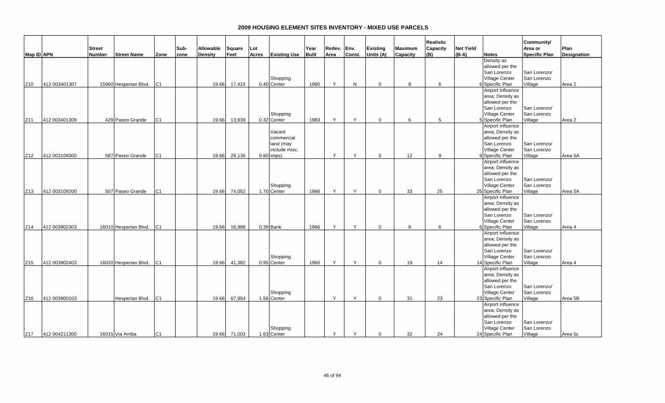
2009 HOUSING ELEMENT SITES INVENTORY - MIXED USE PARCELS
Map ID APN
Street
Number Street Name Zone
Sub-
zone
Allowable
Density
Square
Feet
Lot
Acres Existing Use
Year
Built
Redev.
Area
Env.
Const.
Existing
Units (A)
Maximum
Capacity
Realistic
Capacity
(B)
Net Yield
(B-A) Notes
Community/
Area or
Specific Plan
Plan
Designation
Z10 412 003401307 15960 Hesperian Blvd. C1 19.66 17,424 0.40
Shopping
Center 1980 Y N 0 8 6 6
Density as
allowed per the
San Lorenzo
Village Center
Specific Plan
San Lorenzo/
San Lorenzo
Village Area 2
Z11 412 003401309 429 Paseo Grande C1 19.66 13,939 0.32
Shopping
Center 1983 Y Y 0 6 5 5
Airport influence
area; Density as
allowed per the
San Lorenzo
Village Center
Specific Plan
San Lorenzo/
San Lorenzo
Village Area 2
Z12 412 003109300 587 Paseo Grande C1 19.66 26,136 0.60
Vacant
commercial
land (may
include misc.
imps) Y Y 0 12 9 9
Airport influence
area; Density as
allowed per the
San Lorenzo
Village Center
Specific Plan
San Lorenzo/
San Lorenzo
Village Area 5A
Z13 412 003109200 507 Paseo Grande C1 19.66 74,052 1.70
Shopping
Center 1966 Y Y 0 33 25 25
Airport influence
area; Density as
allowed per the
San Lorenzo
Village Center
Specific Plan
San Lorenzo/
San Lorenzo
Village Area 5A
Z14 412 003902303 16010 Hesperian Blvd. C1 19.66 16,988 0.39 Bank 1966 Y Y 0 8 6 6
Airport influence
area; Density as
allowed per the
San Lorenzo
Village Center
Specific Plan
San Lorenzo/
San Lorenzo
Village Area 4
Z15 412 003902403 16020 Hesperian Blvd. C1 19.66 41,382 0.95
Shopping
Center 1960 Y Y 0 19 14 14
Airport influence
area; Density as
allowed per the
San Lorenzo
Village Center
Specific Plan
San Lorenzo/
San Lorenzo
Village Area 4
Z16 412 003900103 Hesperian Blvd. C1 19.66 67,954 1.56
Shopping
Center Y Y 0 31 23 23
Airport influence
area; Density as
allowed per the
San Lorenzo
Village Center
Specific Plan
San Lorenzo/
San Lorenzo
Village Area 5B
Z17 412 004211300 16015 Via Arriba C1 19.66 71,003 1.63
Shopping
Center Y Y 0 32 24 24
Airport influence
area; Density as
allowed per the
San Lorenzo
Village Center
Specific Plan
San Lorenzo/
San Lorenzo
Village Area 5c
46 of 94

2009 HOUSING ELEMENT SITES INVENTORY - MIXED USE PARCELS
Map ID APN
Street
Number Street Name Zone
Sub-
zone
Allowable
Density
Square
Feet
Lot
Acres Existing Use
Year
Built
Redev.
Area
Env.
Const.
Existing
Units (A)
Maximum
Capacity
Realistic
Capacity
(B)
Net Yield
(B-A) Notes
Community/
Area or
Specific Plan
Plan
Designation
Z18 412 003902600 16090 Hesperian Blvd. C1 19.66 48,787 1.12
Shopping
Center 1960 Y Y 0 22 17 17
Airport influence
area; Density as
allowed per the
San Lorenzo
Village Center
Specific Plan
San Lorenzo/
San Lorenzo
Village Area 5D
Z19 412 003900402 500 Via Mercado C1 19.66 10,890 0.25
Shopping
Center 1965 Y Y 0 5 4 4
Airport influence
area; Density as
allowed per the
San Lorenzo
Village Center
Specific Plan
San Lorenzo/
San Lorenzo
Village Area 5D
Z20 412 003900300 520 Via Mercado C1 19.66 12,197 0.28
Shopping
Center 1965 Y Y 0 6 4 4
Airport influence
area; Density as
allowed per the
San Lorenzo
Village Center
Specific Plan
San Lorenzo/
San Lorenzo
Village Area 5D
Z21 412 003900200 550 Via Mercado C1 19.66 71,438 1.64
Shopping
Center 1976 Y Y 0 32 24 24
Airport influence
area; Density as
allowed per the
San Lorenzo
Village Center
Specific Plan
San Lorenzo/
San Lorenzo
Village Area 5D
TOTAL - SAN LORENZO 28 590 461 433
TOTAL ALL COMMUNITIES 294 1,637 1,247 953
47 of 94
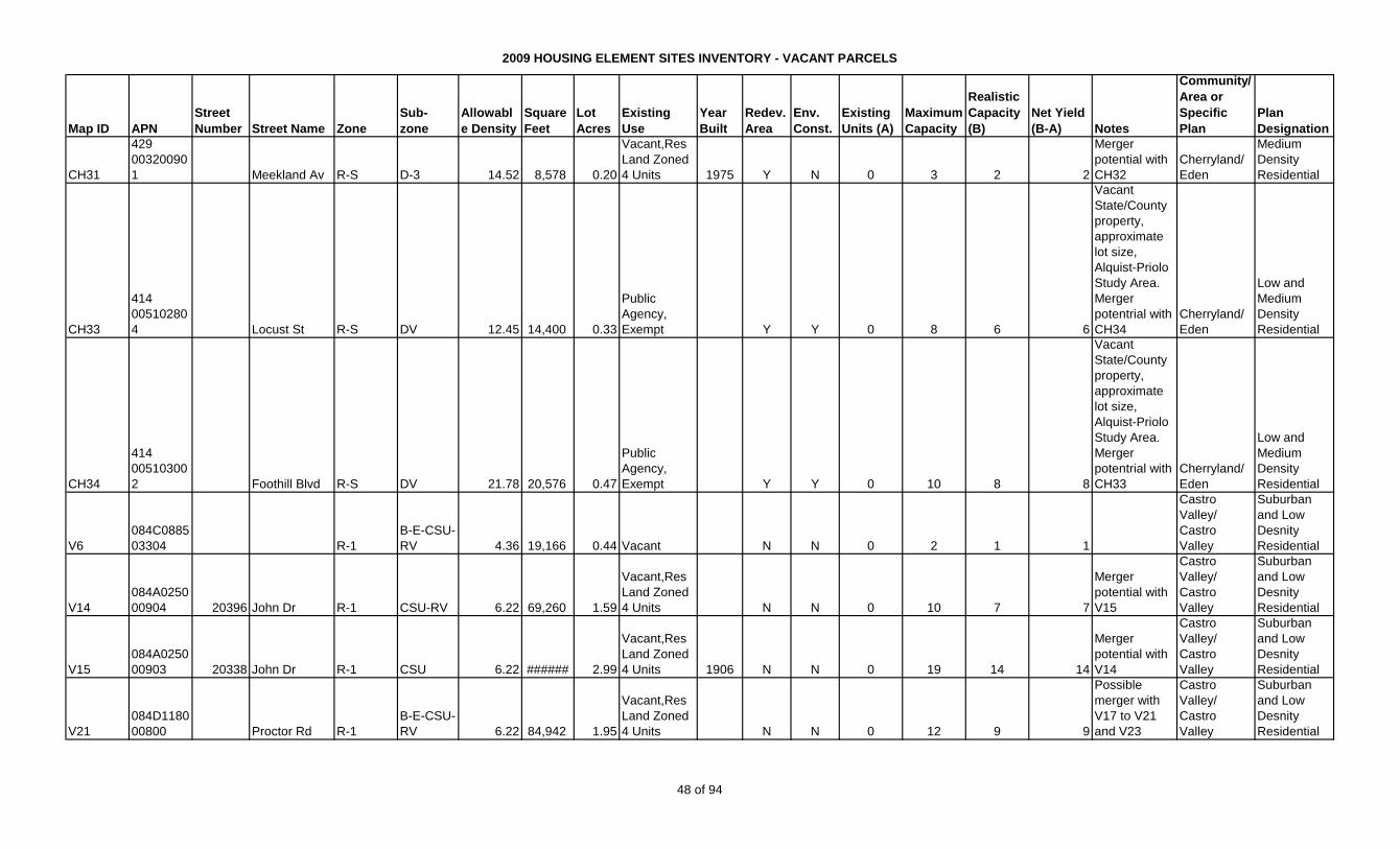
2009 HOUSING ELEMENT SITES INVENTORY - VACANT PARCELS
Map ID APN
Street
Number Street Name Zone
Sub-
zone
Allowabl
e Density
Square
Feet
Lot
Acres
Existing
Use
Year
Built
Redev.
Area
Env.
Const.
Existing
Units (A)
Maximum
Capacity
Realistic
Capacity
(B)
Net Yield
(B-A) Notes
Community/
Area or
Specific
Plan
Plan
Designation
CH31
429
00320090
1 Meekland Av R-S D-3 14.52 8,578 0.20
Vacant,Res
Land Zoned
4 Units 1975 Y N 0 3 2 2
Merger
potential with
CH32
Cherryland/
Eden
Medium
Density
Residential
CH33
414
00510280
4 Locust St R-S DV 12.45 14,400 0.33
Public
Agency,
Exempt Y Y 0 8 6 6
Vacant
State/County
property,
approximate
lot size,
Alquist-Priolo
Study Area.
Merger
potentrial with
CH34
Cherryland/
Eden
Low and
Medium
Density
Residential
CH34
414
00510300
2 Foothill Blvd R-S DV 21.78 20,576 0.47
Public
Agency,
Exempt Y Y 0 10 8 8
Vacant
State/County
property,
approximate
lot size,
Alquist-Priolo
Study Area.
Merger
potentrial with
CH33
Cherryland/
Eden
Low and
Medium
Density
Residential
V6
084C0885
03304 R-1
B-E-CSU-
RV 4.36 19,166 0.44 Vacant N N 0 2 1 1
Castro
Valley/
Castro
Valley
Suburban
and Low
Desnity
Residential
V14
084A0250
00904 20396 John Dr R-1 CSU-RV 6.22 69,260 1.59
Vacant,Res
Land Zoned
4 Units N N 0 10 7 7
Merger
potential with
V15
Castro
Valley/
Castro
Valley
Suburban
and Low
Desnity
Residential
V15
084A0250
00903 20338 John Dr R-1 CSU 6.22 ###### 2.99
Vacant,Res
Land Zoned
4 Units 1906 N N 0 19 14 14
Merger
potential with
V14
Castro
Valley/
Castro
Valley
Suburban
and Low
Desnity
Residential
V21
084D1180
00800 Proctor Rd R-1
B-E-CSU-
RV 6.22 84,942 1.95
Vacant,Res
Land Zoned
4 Units N N 0 12 9 9
Possible
merger with
V17 to V21
and V23
Castro
Valley/
Castro
Valley
Suburban
and Low
Desnity
Residential
48 of 94
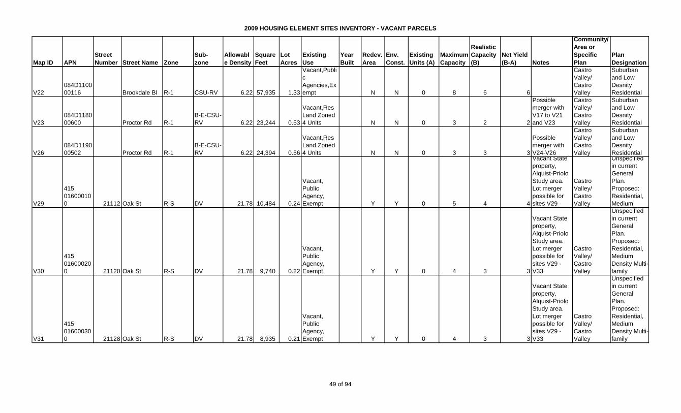
2009 HOUSING ELEMENT SITES INVENTORY - VACANT PARCELS
Map ID APN
Street
Number Street Name Zone
Sub-
zone
Allowabl
e Density
Square
Feet
Lot
Acres
Existing
Use
Year
Built
Redev.
Area
Env.
Const.
Existing
Units (A)
Maximum
Capacity
Realistic
Capacity
(B)
Net Yield
(B-A) Notes
Community/
Area or
Specific
Plan
Plan
Designation
V22
084D1100
00116 Brookdale Bl R-1 CSU-RV 6.22 57,935 1.33
Vacant,Publi
c
Agencies,Ex
empt N N 0 8 6 6
Castro
Valley/
Castro
Valley
Suburban
and Low
Desnity
Residential
V23
084D1180
00600 Proctor Rd R-1
B-E-CSU-
RV 6.22 23,244 0.53
Vacant,Res
Land Zoned
4 Units N N 0 3 2 2
Possible
merger with
V17 to V21
and V23
Castro
Valley/
Castro
Valley
Suburban
and Low
Desnity
Residential
V26
084D1190
00502 Proctor Rd R-1
B-E-CSU-
RV 6.22 24,394 0.56
Vacant,Res
Land Zoned
4 Units N N 0 3 3 3
Possible
merger with
V24-V26
Castro
Valley/
Castro
Valley
Suburban
and Low
Desnity
Residential
V29
415
01600010
0 21112 Oak St R-S DV 21.78 10,484 0.24
Vacant,
Public
Agency,
Exempt Y Y 0 5 4 4
Vacant State
property,
Alquist-Priolo
Study area.
Lot merger
possible for
sites V29 -
Castro
Valley/
Castro
Valley
Unspecified
in current
General
Plan.
Proposed:
Residential,
Medium
V30
415
01600020
0 21120 Oak St R-S DV 21.78 9,740 0.22
Vacant,
Public
Agency,
Exempt Y Y 0 4 3 3
Vacant State
property,
Alquist-Priolo
Study area.
Lot merger
possible for
sites V29 -
V33
Castro
Valley/
Castro
Valley
Unspecified
in current
General
Plan.
Proposed:
Residential,
Medium
Density Multi-
family
V31
415
01600030
0 21128 Oak St R-S DV 21.78 8,935 0.21
Vacant,
Public
Agency,
Exempt Y Y 0 4 3 3
Vacant State
property,
Alquist-Priolo
Study area.
Lot merger
possible for
sites V29 -
V33
Castro
Valley/
Castro
Valley
Unspecified
in current
General
Plan.
Proposed:
Residential,
Medium
Density Multi-
family
49 of 94

2009 HOUSING ELEMENT SITES INVENTORY - VACANT PARCELS
Map ID APN
Street
Number Street Name Zone
Sub-
zone
Allowabl
e Density
Square
Feet
Lot
Acres
Existing
Use
Year
Built
Redev.
Area
Env.
Const.
Existing
Units (A)
Maximum
Capacity
Realistic
Capacity
(B)
Net Yield
(B-A) Notes
Community/
Area or
Specific
Plan
Plan
Designation
V32
415
01600040
0 21134 Oak St R-S DV 21.78 8,373 0.19
Vacant,
Public
Agency,
Exempt Y Y 0 4 3 3
Vacant State
property,
Alquist-Priolo
Study area.
Lot merger
possible for
sites V29 -
V33
Castro
Valley/
Castro
Valley
Unspecified
in current
General
Plan.
Proposed:
Residential,
Medium
Density Multi-
family
V33
415
01600050
0 21144 Oak St R-S DV 21.78 8,006 0.18
Vacant,
Public
Agency,
Exempt Y Y 0 4 3 3
Vacant State
property,
Alquist-Priolo
Study area.
Lot merger
possible for
sites V29 -
V33
Castro
Valley/
Castro
Valley
Unspecified
in current
General
Plan.
Proposed:
Residential,
Medium
Density Multi-
family
V36
415
02300130
0 Ruby St R-S D-20 21.78 14,363 0.33
Vacant,
Public
Agency,
Exempt Y Y 0 7 5 5
State
Property, 238
Study area,
within creek
buffer. Lot
merger
possible V34
Castro
Valley/
Castro
Valley
Unspecified
in current
General
Plan.
Proposed:
Residential,
Medium
V37
415
02300160
0 22513 Ruby St R-S D-20 21.78 6,481 0.15
Vacant,
Public
Agency,
Exempt Y Y 0 3 2 2
State
Property, 238
Study area,
within creek
buffer. Lot
merger
possible V34
Castro
Valley/
Castro
Valley
Unspecified
in current
General
Plan.
Proposed:
Residential,
Medium
V38
415
02300170
0 Ruby St R-S D-20 21.78 7,470 0.17
Vacant,
Public
Agency,
Exempt Y Y 0 3 3 3
State
Property, 238
Study area,
within creek
buffer. Lot
merger
possible V34
Castro
Valley/
Castro
Valley
Unspecified
in current
General
Plan.
Proposed:
Residential,
Medium
50 of 94
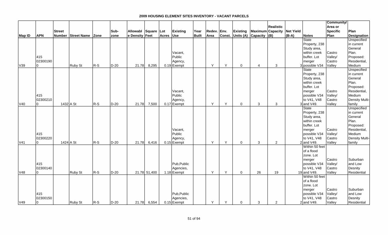
2009 HOUSING ELEMENT SITES INVENTORY - VACANT PARCELS
Map ID APN
Street
Number Street Name Zone
Sub-
zone
Allowabl
e Density
Square
Feet
Lot
Acres
Existing
Use
Year
Built
Redev.
Area
Env.
Const.
Existing
Units (A)
Maximum
Capacity
Realistic
Capacity
(B)
Net Yield
(B-A) Notes
Community/
Area or
Specific
Plan
Plan
Designation
V39
415
02300190
0 Ruby St R-S D-20 21.78 8,295 0.19
Vacant,
Public
Agency,
Exempt Y Y 0 4 3 3
State
Property, 238
Study area,
within creek
buffer. Lot
merger
possible V34
Castro
Valley/
Castro
Valley
Unspecified
in current
General
Plan.
Proposed:
Residential,
Medium
V40
415
02300210
0 1432 A St R-S D-20 21.78 7,500 0.17
Vacant,
Public
Agency,
Exempt Y Y 0 3 3 3
State
Property, 238
Study area,
within creek
buffer. Lot
merger
possible V34
to V41, V48
and V49.
Castro
Valley/
Castro
Valley
Unspecified
in current
General
Plan.
Proposed:
Residential,
Medium
Density Multi-
family
V41
415
02300220
0 1424 A St R-S D-20 21.78 6,416 0.15
Vacant,
Public
Agency,
Exempt Y Y 0 3 2 2
State
Property, 238
Study area,
within creek
buffer. Lot
merger
possible V34
to V41, V48
and V49.
Castro
Valley/
Castro
Valley
Unspecified
in current
General
Plan.
Proposed:
Residential,
Medium
Density Multi-
family
V48
415
02300140
0 Ruby St R-S D-20 21.78 51,400 1.18
Pub,Public
Agencies,
Exempt Y Y 0 26 19 19
Within 50 feet
of a flood
zone. Lot
merger
possible V34
to V41, V48
and V49.
Castro
Valley/
Castro
Valley
Suburban
and Low
Desnity
Residential
V49
415
02300150
0 Ruby St R-S D-20 21.78 6,554 0.15
Pub,Public
Agencies,
Exempt Y Y 0 3 2 2
Within 50 feet
of a flood
zone. Lot
merger
possible V34
to V41, V48
and V49.
Castro
Valley/
Castro
Valley
Suburban
and Low
Desnity
Residential
51 of 94
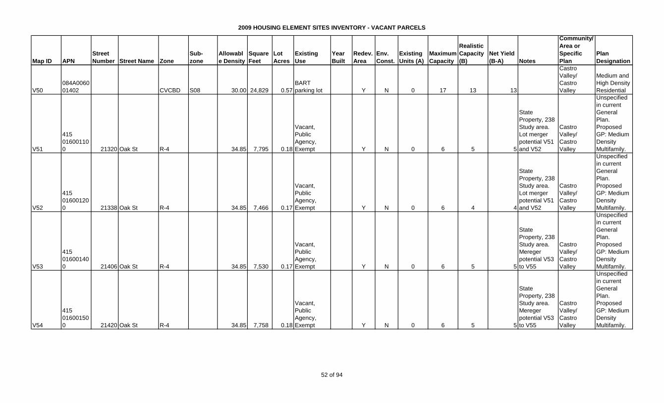
2009 HOUSING ELEMENT SITES INVENTORY - VACANT PARCELS
Map ID APN
Street
Number Street Name Zone
Sub-
zone
Allowabl
e Density
Square
Feet
Lot
Acres
Existing
Use
Year
Built
Redev.
Area
Env.
Const.
Existing
Units (A)
Maximum
Capacity
Realistic
Capacity
(B)
Net Yield
(B-A) Notes
Community/
Area or
Specific
Plan
Plan
Designation
V50
084A0060
01402 CVCBD S08 30.00 24,829 0.57
BART
parking lot Y N 0 17 13 13
Castro
Valley/
Castro
Valley
Medium and
High Density
Residential
V51
415
01600110
0 21320 Oak St R-4 34.85 7,795 0.18
Vacant,
Public
Agency,
Exempt Y N 0 6 5 5
State
Property, 238
Study area.
Lot merger
potential V51
and V52
Castro
Valley/
Castro
Valley
Unspecified
in current
General
Plan.
Proposed
GP: Medium
Density
Multifamily.
V52
415
01600120
0 21338 Oak St R-4 34.85 7,466 0.17
Vacant,
Public
Agency,
Exempt Y N 0 6 4 4
State
Property, 238
Study area.
Lot merger
potential V51
and V52
Castro
Valley/
Castro
Valley
Unspecified
in current
General
Plan.
Proposed
GP: Medium
Density
Multifamily.
V53
415
01600140
0 21406 Oak St R-4 34.85 7,530 0.17
Vacant,
Public
Agency,
Exempt Y N 0 6 5 5
State
Property, 238
Study area.
Mereger
potential V53
to V55
Castro
Valley/
Castro
Valley
Unspecified
in current
General
Plan.
Proposed
GP: Medium
Density
Multifamily.
V54
415
01600150
0 21420 Oak St R-4 34.85 7,758 0.18
Vacant,
Public
Agency,
Exempt Y N 0 6 5 5
State
Property, 238
Study area.
Mereger
potential V53
to V55
Castro
Valley/
Castro
Valley
Unspecified
in current
General
Plan.
Proposed
GP: Medium
Density
Multifamily.
52 of 94
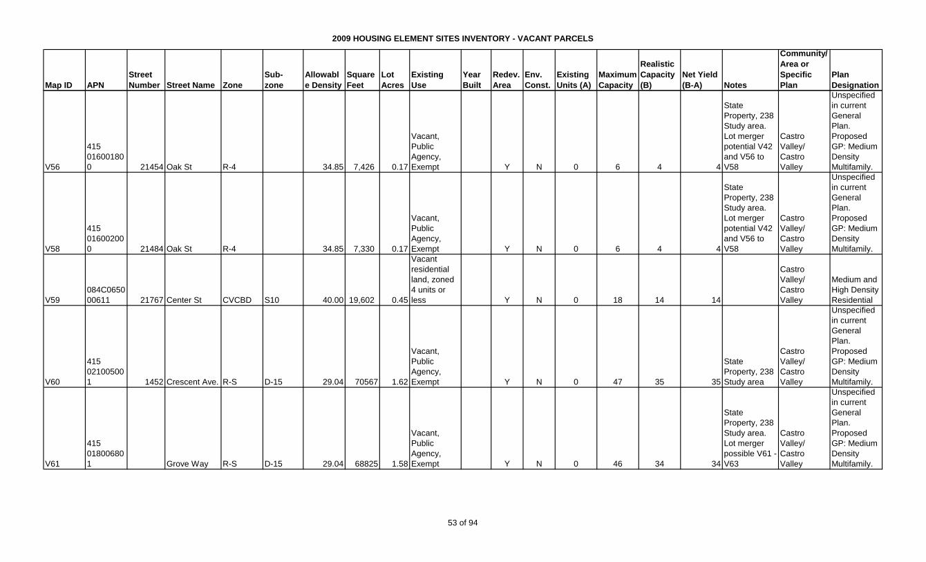
2009 HOUSING ELEMENT SITES INVENTORY - VACANT PARCELS
Map ID APN
Street
Number Street Name Zone
Sub-
zone
Allowabl
e Density
Square
Feet
Lot
Acres
Existing
Use
Year
Built
Redev.
Area
Env.
Const.
Existing
Units (A)
Maximum
Capacity
Realistic
Capacity
(B)
Net Yield
(B-A) Notes
Community/
Area or
Specific
Plan
Plan
Designation
V56
415
01600180
0 21454 Oak St R-4 34.85 7,426 0.17
Vacant,
Public
Agency,
Exempt Y N 0 6 4 4
State
Property, 238
Study area.
Lot merger
potential V42
and V56 to
V58
Castro
Valley/
Castro
Valley
Unspecified
in current
General
Plan.
Proposed
GP: Medium
Density
Multifamily.
V58
415
01600200
0 21484 Oak St R-4 34.85 7,330 0.17
Vacant,
Public
Agency,
Exempt Y N 0 6 4 4
State
Property, 238
Study area.
Lot merger
potential V42
and V56 to
V58
Castro
Valley/
Castro
Valley
Unspecified
in current
General
Plan.
Proposed
GP: Medium
Density
Multifamily.
V59
084C0650
00611 21767 Center St CVCBD S10 40.00 19,602 0.45
Vacant
residential
land, zoned
4 units or
less Y N 0 18 14 14
Castro
Valley/
Castro
Valley
Medium and
High Density
Residential
V60
415
02100500
1 1452 Crescent Ave. R-S D-15 29.04 70567 1.62
Vacant,
Public
Agency,
Exempt Y N 0 47 35 35
State
Property, 238
Study area
Castro
Valley/
Castro
Valley
Unspecified
in current
General
Plan.
Proposed
GP: Medium
Density
Multifamily.
V61
415
01800680
1 Grove Way R-S D-15 29.04 68825 1.58
Vacant,
Public
Agency,
Exempt Y N 0 46 34 34
State
Property, 238
Study area.
Lot merger
possible V61 -
V63
Castro
Valley/
Castro
Valley
Unspecified
in current
General
Plan.
Proposed
GP: Medium
Density
Multifamily.
53 of 94
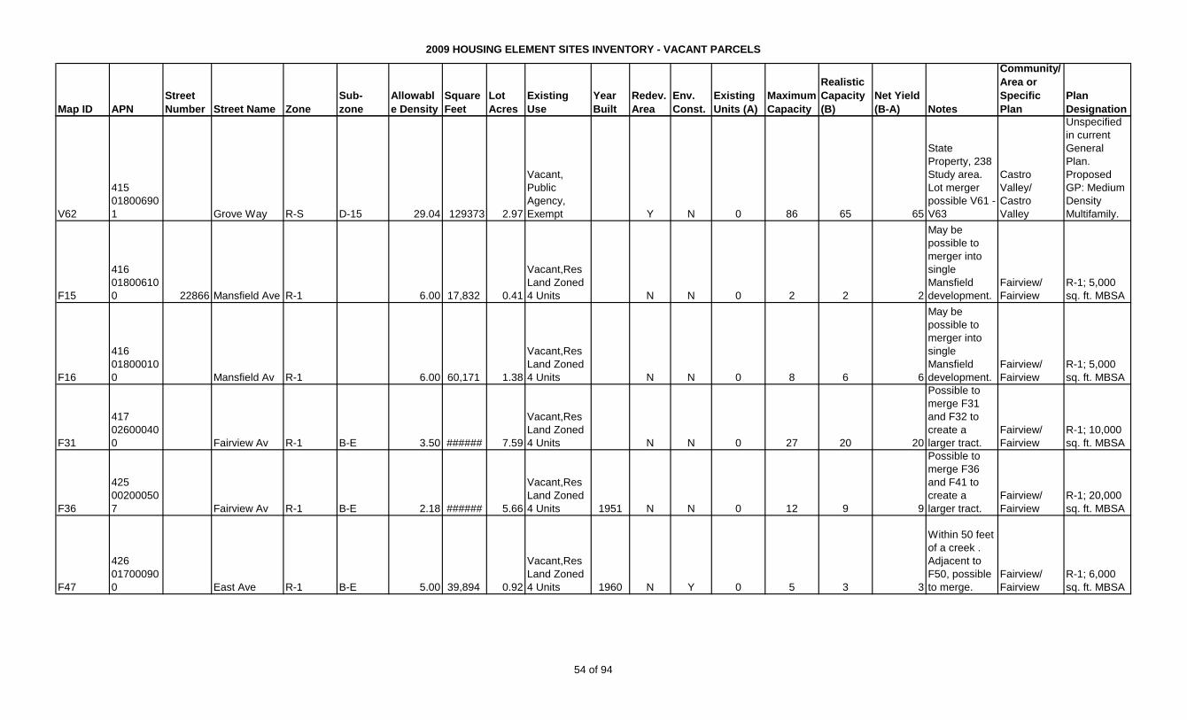
2009 HOUSING ELEMENT SITES INVENTORY - VACANT PARCELS
Map ID APN
Street
Number Street Name Zone
Sub-
zone
Allowabl
e Density
Square
Feet
Lot
Acres
Existing
Use
Year
Built
Redev.
Area
Env.
Const.
Existing
Units (A)
Maximum
Capacity
Realistic
Capacity
(B)
Net Yield
(B-A) Notes
Community/
Area or
Specific
Plan
Plan
Designation
V62
415
01800690
1 Grove Way R-S D-15 29.04 129373 2.97
Vacant,
Public
Agency,
Exempt Y N 0 86 65 65
State
Property, 238
Study area.
Lot merger
possible V61 -
V63
Castro
Valley/
Castro
Valley
Unspecified
in current
General
Plan.
Proposed
GP: Medium
Density
Multifamily.
F15
416
01800610
0 22866 Mansfield Ave R-1 6.00 17,832 0.41
Vacant,Res
Land Zoned
4 Units N N 0 2 2 2
May be
possible to
merger into
single
Mansfield
development.
Fairview/
Fairview
R-1; 5,000
sq. ft. MBSA
F16
416
01800010
0 Mansfield Av R-1 6.00 60,171 1.38
Vacant,Res
Land Zoned
4 Units N N 0 8 6 6
May be
possible to
merger into
single
Mansfield
development.
Fairview/
Fairview
R-1; 5,000
sq. ft. MBSA
F31
417
02600040
0 Fairview Av R-1 B-E 3.50 ###### 7.59
Vacant,Res
Land Zoned
4 Units N N 0 27 20 20
Possible to
merge F31
and F32 to
create a
larger tract.
Fairview/
Fairview
R-1; 10,000
sq. ft. MBSA
F36
425
00200050
7 Fairview Av R-1 B-E 2.18 ###### 5.66
Vacant,Res
Land Zoned
4 Units 1951 N N 0 12 9 9
Possible to
merge F36
and F41 to
create a
larger tract.
Fairview/
Fairview
R-1; 20,000
sq. ft. MBSA
F47
426
01700090
0 East Ave R-1 B-E 5.00 39,894 0.92
Vacant,Res
Land Zoned
4 Units 1960 N Y 0 5 3 3
Within 50 feet
of a creek .
Adjacent to
F50, possible
to merge.
Fairview/
Fairview
R-1; 6,000
sq. ft. MBSA
54 of 94

2009 HOUSING ELEMENT SITES INVENTORY - VACANT PARCELS
Map ID APN
Street
Number Street Name Zone
Sub-
zone
Allowabl
e Density
Square
Feet
Lot
Acres
Existing
Use
Year
Built
Redev.
Area
Env.
Const.
Existing
Units (A)
Maximum
Capacity
Realistic
Capacity
(B)
Net Yield
(B-A) Notes
Community/
Area or
Specific
Plan
Plan
Designation
F50
426
01700130
0 East Ave R-1 B-E 5.00 47,167 1.08
Vacant,Res
Land Zoned
4 Units N Y 0 5 4 4
Within 50 feet
of a creek .
Adjacent to
F47, possible
to merge.
Fairview/
Fairview
R-1; 6,000
sq. ft. MBSA
F51
426
01700730
0 24380 Peterson Ct R-1 B-E 5.00 19,577 0.45
Vacant,Res
Land Zoned
4 Units 1947 N Y 0 2 2 2
Within 50 feet
of a creek
Fairview/
Fairview
R-1; 6,000
sq. ft. MBSA
TOTAL - CAPACITY VACANT, UNIMPROVED PARCELS 0 462 351 351
55 of 94
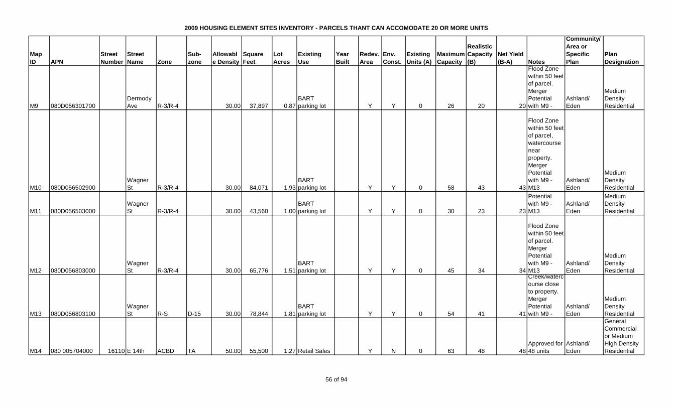
2009 HOUSING ELEMENT SITES INVENTORY - PARCELS THANT CAN ACCOMODATE 20 OR MORE UNITS
Map
ID APN
Street
Number
Street
Name Zone
Sub-
zone
Allowabl
e Density
Square
Feet
Lot
Acres
Existing
Use
Year
Built
Redev.
Area
Env.
Const.
Existing
Units (A)
Maximum
Capacity
Realistic
Capacity
(B)
Net Yield
(B-A) Notes
Community/
Area or
Specific
Plan
Plan
Designation
M9 080D056301700
Dermody
Ave R-3/R-4 30.00 37,897 0.87
BART
parking lot Y Y 0 26 20 20
Flood Zone
within 50 feet
of parcel.
Merger
Potential
with M9 -
Ashland/
Eden
Medium
Density
Residential
M10 080D056502900
Wagner
St R-3/R-4 30.00 84,071 1.93
BART
parking lot Y Y 0 58 43 43
Flood Zone
within 50 feet
of parcel,
watercourse
near
property.
Merger
Potential
with M9 -
M13
Ashland/
Eden
Medium
Density
Residential
M11 080D056503000
Wagner
St R-3/R-4 30.00 43,560 1.00
BART
parking lot Y Y 0 30 23 23
Merger
Potential
with M9 -
M13
Ashland/
Eden
Medium
Density
Residential
M12 080D056803000
Wagner
St R-3/R-4 30.00 65,776 1.51
BART
parking lot Y Y 0 45 34 34
Flood Zone
within 50 feet
of parcel.
Merger
Potential
with M9 -
M13
Ashland/
Eden
Medium
Density
Residential
M13 080D056803100
Wagner
St R-S D-15 30.00 78,844 1.81
BART
parking lot Y Y 0 54 41 41
Creek/waterc
ourse close
to property.
Merger
Potential
with M9 -
Ashland/
Eden
Medium
Density
Residential
M14 080 005704000 16110 E 14th ACBD TA 50.00 55,500 1.27 Retail Sales Y N 0 63 48 48
Approved for
48 units
Ashland/
Eden
General
Commercial
or Medium
High Density
Residential
56 of 94
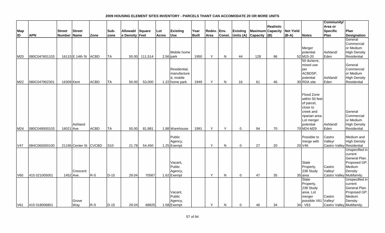
2009 HOUSING ELEMENT SITES INVENTORY - PARCELS THANT CAN ACCOMODATE 20 OR MORE UNITS
Map
ID APN
Street
Number
Street
Name Zone
Sub-
zone
Allowabl
e Density
Square
Feet
Lot
Acres
Existing
Use
Year
Built
Redev.
Area
Env.
Const.
Existing
Units (A)
Maximum
Capacity
Realistic
Capacity
(B)
Net Yield
(B-A) Notes
Community/
Area or
Specific
Plan
Plan
Designation
M20 080C047601103 16115 E 14th St ACBD TA 50.00 111,514 2.56
Mobile home
park 1950 Y N 44 128 96 52
Merger
potential
M15-20
Ashland/
Eden
General
Commercial
or Medium
High Density
Residential
M22 080C047902301 16309 Kent ACBD TA 50.00 53,000 1.22
Residential,
manufacture
d, mobile
home park 1949 Y N 16 61 46 30
50 du/acre,
mixed use
per
ACBDSP,
potential
RDA site
Ashland/
Eden
General
Commercial
or Medium
High Density
Residential
M24 080C049500103 16021
Ashland
Ave ACBD TA 50.00 81,881 1.88 Warehouse 1991 Y Y 0 94 70 70
Flood Zone
within 50 feet
of parcel,
close to
creek and
riparian area.
Lot merger
potential
M24-M29
Ashland/
Eden
General
Commercial
or Medium
High Density
Residential
V47 084C065000100 21195 Center St CVCBD S10 21.78 54,450 1.25
Public
Agency,
Exempt Y N 0 27 20 20
Possible to
merge with
V46
Castro
Valley/
Castro Valley
Medium and
High Density
Residential
V60 415 021005001 1452
Crescent
Ave. R-S D-15 29.04 70567 1.62
Vacant,
Public
Agency,
Exempt Y N 0 47 35 35
State
Property,
238 Study
area
Castro
Valley/
Castro Valley
Unspecified in
current
General Plan.
Proposed GP:
Medium
Density
Multifamily.
V61 415 018006801
Grove
Way R-S D-15 29.04 68825 1.58
Vacant,
Public
Agency,
Exempt Y N 0 46 34 34
State
Property,
238 Study
area. Lot
merger
possible V61
- V63
Castro
Valley/
Castro Valley
Unspecified in
current
General Plan.
Proposed GP:
Medium
Density
Multifamily.
57 of 94
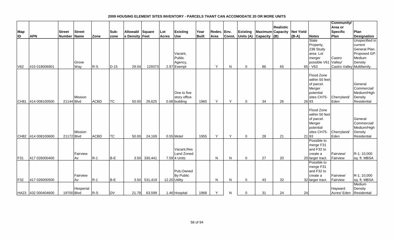
2009 HOUSING ELEMENT SITES INVENTORY - PARCELS THANT CAN ACCOMODATE 20 OR MORE UNITS
Map
ID APN
Street
Number
Street
Name Zone
Sub-
zone
Allowabl
e Density
Square
Feet
Lot
Acres
Existing
Use
Year
Built
Redev.
Area
Env.
Const.
Existing
Units (A)
Maximum
Capacity
Realistic
Capacity
(B)
Net Yield
(B-A) Notes
Community/
Area or
Specific
Plan
Plan
Designation
V62 415 018006901
Grove
Way R-S D-15 29.04 129373 2.97
Vacant,
Public
Agency,
Exempt Y N 0 86 65 65
State
Property,
238 Study
area. Lot
merger
possible V61
- V63
Castro
Valley/
Castro Valley
Unspecified in
current
General Plan.
Proposed GP:
Medium
Density
Multifamily.
CH81 414 008100500 21144
Mission
Blvd ACBD TC 50.00 29,625 0.68
One to five
story office
building 1960 Y Y 0 34 26 26
Flood Zone
within 50 feet
of parcel.
Merger
potential
sites CH75-
93
Cherryland/
Eden
General
Commercial/
Medium/High
Density
Residential
CH82 414 008100600 21172
Mission
Blvd ACBD TC 50.00 24,169 0.55 Motel 1955 Y Y 0 28 21 21
Flood Zone
within 50 feet
of parcel.
Merger
potential
sites CH75-
93
Cherryland/
Eden
General
Commercial/
Medium/High
Density
Residential
F31 417 026000400
Fairview
Av R-1 B-E 3.50 330,441 7.59
Vacant,Res
Land Zoned
4 Units N N 0 27 20 20
Possible to
merge F31
and F32 to
create a
larger tract.
Fairview/
Fairview
R-1; 10,000
sq. ft. MBSA
F32 417 026000500
Fairview
Av R-1 B-E 3.50 531,419 12.20
Pub,Owned
By Public
Utility N N 0 43 32 32
Possible to
merge F31
and F32 to
create a
larger tract.
Fairview/
Fairview
R-1; 10,000
sq. ft. MBSA
HA23 432 000404600 19700
Hesperial
Blvd R-S DV 21.78 63,599 1.46 Hospital 1968 Y N 0 31 24 24
Hayward
Acres/ Eden
Medium
Density
Residential
58 of 94
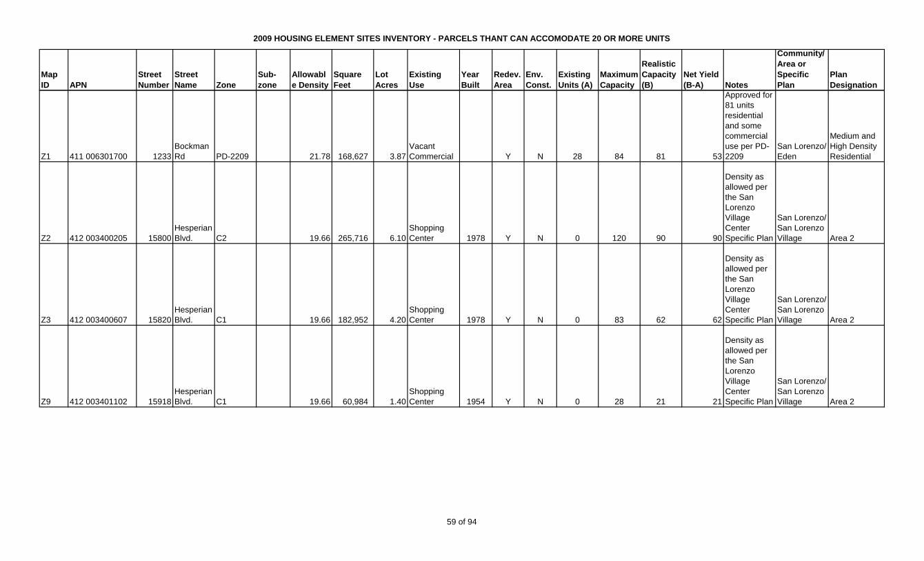
2009 HOUSING ELEMENT SITES INVENTORY - PARCELS THANT CAN ACCOMODATE 20 OR MORE UNITS
Map
ID APN
Street
Number
Street
Name Zone
Sub-
zone
Allowabl
e Density
Square
Feet
Lot
Acres
Existing
Use
Year
Built
Redev.
Area
Env.
Const.
Existing
Units (A)
Maximum
Capacity
Realistic
Capacity
(B)
Net Yield
(B-A) Notes
Community/
Area or
Specific
Plan
Plan
Designation
Z1 411 006301700 1233
Bockman
Rd PD-2209 21.78 168,627 3.87
Vacant
Commercial Y N 28 84 81 53
Approved for
81 units
residential
and some
commercial
use per PD-
2209
San Lorenzo/
Eden
Medium and
High Density
Residential
Z2 412 003400205 15800
Hesperian
Blvd. C2 19.66 265,716 6.10
Shopping
Center 1978 Y N 0 120 90 90
Density as
allowed per
the San
Lorenzo
Village
Center
Specific Plan
San Lorenzo/
San Lorenzo
Village Area 2
Z3 412 003400607 15820
Hesperian
Blvd. C1 19.66 182,952 4.20
Shopping
Center 1978 Y N 0 83 62 62
Density as
allowed per
the San
Lorenzo
Village
Center
Specific Plan
San Lorenzo/
San Lorenzo
Village Area 2
Z9 412 003401102 15918
Hesperian
Blvd. C1 19.66 60,984 1.40
Shopping
Center 1954 Y N 0 28 21 21
Density as
allowed per
the San
Lorenzo
Village
Center
Specific Plan
San Lorenzo/
San Lorenzo
Village Area 2
59 of 94

2009 HOUSING ELEMENT SITES INVENTORY - PARCELS THANT CAN ACCOMODATE 20 OR MORE UNITS
Map
ID APN
Street
Number
Street
Name Zone
Sub-
zone
Allowabl
e Density
Square
Feet
Lot
Acres
Existing
Use
Year
Built
Redev.
Area
Env.
Const.
Existing
Units (A)
Maximum
Capacity
Realistic
Capacity
(B)
Net Yield
(B-A) Notes
Community/
Area or
Specific
Plan
Plan
Designation
Z13 412 003109200 507
Paseo
Grande C1 19.66 74,052 1.70
Shopping
Center 1966 Y Y 0 33 25 25
Airport
influence
area; Density
as allowed
per the San
Lorenzo
Village
Center
Specific Plan
San Lorenzo/
San Lorenzo
Village Area 5A
Z16 412 003900103
Hesperian
Blvd. C1 19.66 67,954 1.56
Shopping
Center Y Y 0 31 23 23
Airport
influence
area; Density
as allowed
per the San
Lorenzo
Village
Center
Specific Plan
San Lorenzo/
San Lorenzo
Village Area 5B
Z17 412 004211300 16015 Via Arriba C1 19.66 71,003 1.63
Shopping
Center Y Y 0 32 24 24
Airport
influence
area; Density
as allowed
per the San
Lorenzo
Village
Center
Specific Plan
San Lorenzo/
San Lorenzo
Village Area 5c
60 of 94
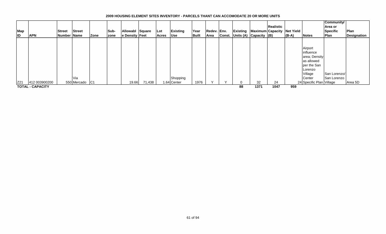
2009 HOUSING ELEMENT SITES INVENTORY - PARCELS THANT CAN ACCOMODATE 20 OR MORE UNITS
Map
ID APN
Street
Number
Street
Name Zone
Sub-
zone
Allowabl
e Density
Square
Feet
Lot
Acres
Existing
Use
Year
Built
Redev.
Area
Env.
Const.
Existing
Units (A)
Maximum
Capacity
Realistic
Capacity
(B)
Net Yield
(B-A) Notes
Community/
Area or
Specific
Plan
Plan
Designation
Z21 412 003900200 550
Via
Mercado C1 19.66 71,438 1.64
Shopping
Center 1976 Y Y 0 32 24 24
Airport
influence
area; Density
as allowed
per the San
Lorenzo
Village
Center
Specific Plan
San Lorenzo/
San Lorenzo
Village Area 5D
88 1371 1047 959TOTAL - CAPACITY
61 of 94
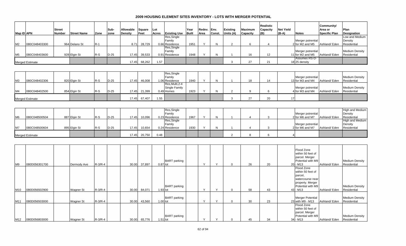
2009 HOUSING ELEMENT SITES INVENTORY - LOTS WITH MERGER POTENTIAL
Map ID APN
Street
Number Street Name Zone
Sub-
zone
Allowable
Density
Square
Feet
Lot
Acres Existing Use
Year
Built
Redev.
Area
Env.
Const.
Existing
Units (A)
Maximum
Capacity
Realistic
Capacity
(B)
Net Yield
(B-A) Notes
Community/
Area or
Specific Plan
Plan
Designation
M2 080C048403300 964 Delano St R-1 8.71 28,729 0.66
Res,Single
Family
Residence 1951 Y N 2 6 4 2
Merger potrential
for M2 and M5 Ashland/ Eden
Low and Medium
Density
Residential
M5 080C048403600 928 Elgin St R-S D-25 17.45 39,533 0.91
Res,Single
Family
Residence 1948 Y N 1 16 12 11
Merger potrential
for M2 and M5 Ashland/ Eden
Medium Density
Residential
17.45 68,262 1.57 3 27 21 18
Assumes RS-D-
25 density
M3 080C048402306 820 Elgin St R-S D-25 17.45 46,008 1.06
Res,Single
Family
Residence 1940 Y N 1 18 14 13
Merger potrential
for M3 and M4 Ashland/ Eden
Medium Density
Residential
M4 080C048402500 854 Elgin St R-S D-25 17.45 21,399 0.49
Res,Multi,2-4
Single Family
Homes 1923 Y N 2 9 6 4
Merger potrential
for M3 and M4 Ashland/ Eden
Medium Density
Residential
17.45 67,407 1.55 3 27 20 17
M6 080C048500504 887 Elgin St R-S D-25 17.45 10,096 0.23
Res,Single
Family
Residence 1967 Y N 1 4 3 2
Merger potrential
for M6 and M7 Ashland/ Eden
High and Medium
Density
Residential
M7 080C048500604 895 Elgin St R-S D-25 17.45 10,654 0.24
Res,Single
Family
Residence 1930 Y N 1 4 3 2
Merger potrential
for M6 and M7 Ashland/ Eden
High and Medium
Density
Residential
17.45 20,750 0.48 2 8 6 4
M9 080D056301700 Dermody Ave R-3/R-4 30.00 37,897 0.87
BART parking
lot Y Y 0 26 20 20
Flood Zone
within 50 feet of
parcel. Merger
Potential with M9
- M13 Ashland/ Eden
Medium Density
Residential
M10 080D056502900 Wagner St R-3/R-4 30.00 84,071 1.93
BART parking
lot Y Y 0 58 43 43
Flood Zone
within 50 feet of
parcel,
watercourse near
property. Merger
Potential with M9
- M13 Ashland/ Eden
Medium Density
Residential
M11 080D056503000 Wagner St R-3/R-4 30.00 43,560 1.00
BART parking
lot Y Y 0 30 23 23
Merger Potential
with M9 - M13 Ashland/ Eden
Medium Density
Residential
M12 080D056803000 Wagner St R-3/R-4 30.00 65,776 1.51
BART parking
lot Y Y 0 45 34 34
Flood Zone
within 50 feet of
parcel. Merger
Potential with M9
- M13 Ashland/ Eden
Medium Density
Residential
Merged Estimate
Merged Estimate
Merged Estimate
62 of 94

2009 HOUSING ELEMENT SITES INVENTORY - LOTS WITH MERGER POTENTIAL
Map ID APN
Street
Number Street Name Zone
Sub-
zone
Allowable
Density
Square
Feet
Lot
Acres Existing Use
Year
Built
Redev.
Area
Env.
Const.
Existing
Units (A)
Maximum
Capacity
Realistic
Capacity
(B)
Net Yield
(B-A) Notes
Community/
Area or
Specific Plan
Plan
Designation
M13 080D056803100 Wagner St R-S D-15 30.00 78,844 1.81
BART parking
lot Y Y 0 54 41 41
Creek/watercour
se close to
property. Merger
Potential with M9
- M13 Ashland/ Eden
Medium Density
Residential
30.00 310,147 7.12 0 214 160 160
M15 080C047600100 16035 E 14th St ACBD TA 50.00 8,882 0.20
Commercial,
Miscellaneous,
Improved 1932 Y N 0 10 8 8
Merger potential
M15-20 Ashland/ Eden
General
Commercial or
Medium High
Density
Residential
M16 080C047600200 16039 E 14th St ACBD TA 50.00 7,970 0.18 One story store 1947 Y N 0 9 7 7
Merger potential
M15-20 Ashland/ Eden
General
Commercial or
Medium High
Density
Residential
M17 080C047600300 16043 E 14th St ACBD TA 50.00 6,390 0.16
Commercial,
Miscellaneous,
Improved 1930 Y N 0 8 6 6
Merger potential
M15-20 Ashland/ Eden
General
Commercial or
Medium High
Density
Residential
M18 080C047600501 16064 Ashland Ave ACBD TA 50.00 10,560 0.24
Four living
units; e.g.
fourplex or
triplex w/SFR 1910 Y N 4 12 9 5
Merger potential
M15-20 Ashland/ Eden
General
Commercial or
Medium High
Density
Residential
M19 080C047601101 16151 E 14th St ACBD TA 50.00 6,869 0.16 One story store 1942 Y N 0 8 6 6
Merger potential
M15-20 Ashland/ Eden
General
Commercial or
Medium High
Density
Residential
M20 080C047601103 16115 E 14th St ACBD TA 50.00 111,514 2.56
Mobile home
park 1950 Y N 44 128 96 52
Merger potential
M15-20 Ashland/ Eden
General
Commercial or
Medium High
Density
Residential
50.00 152,185 3.51 48 175 132 84
M21 080C047902200 16331 Kent R-1 50.00 19,000 0.44
Single Family
Residence 1947 Y N 1 22 16 15
50 du/acre,
mixed use per
ACBDSP,
potential RDA
site Ashland/ Eden
General
Commercial or
Medium High
Density
Residential
Merged Estimate
Merged Estimate
63 of 94

2009 HOUSING ELEMENT SITES INVENTORY - LOTS WITH MERGER POTENTIAL
Map ID APN
Street
Number Street Name Zone
Sub-
zone
Allowable
Density
Square
Feet
Lot
Acres Existing Use
Year
Built
Redev.
Area
Env.
Const.
Existing
Units (A)
Maximum
Capacity
Realistic
Capacity
(B)
Net Yield
(B-A) Notes
Community/
Area or
Specific Plan
Plan
Designation
M22 080C047902301 16309 Kent ACBD TA 50.00 53,000 1.22
Residential,
manufactured,
mobile home
park 1949 Y N 16 61 46 30
50 du/acre,
mixed use per
ACBDSP,
potential RDA
site Ashland/ Eden
General
Commercial or
Medium High
Density
Residential
M23 080C047902302 16325 Kent R-1 50.00 10,080 0.23
Single Family
Residence 1959 Y N 1 12 9 8
50 du/acre,
mixed use per
ACBDSP,
potential RDA
site Ashland/ Eden
General
Commercial or
Medium High
Density
Residential
50.00 82,080 1.88 18 94 71 53
M24 080C049500103 16021 Ashland Ave ACBD TA 50.00 81,881 1.88 Warehouse 1991 Y Y 0 94 70 70
Flood Zone
within 50 feet of
parcel, close to
creek and
riparian area.
Lot merger
potential M24-
M29 Ashland/ Eden
General
Commercial or
Medium High
Density
Residential
M25 080C050002401 15951 E 14th St ACBD TA 50.00 16,783 0.39 One story store 1981 Y Y 0 19 14 14
Flood Zone
within 50 feet of
parcel. Lot
merger potential
M24-M29 Ashland/ Eden
General
Commercial or
Medium High
Density
Residential
M26 080C050002500 15957 E 14th St ACBD TA 50.00 12,851 0.30
Miscellaneous
improved
commercial 1960 Y Y 0 15 11 11
Flood Zone
within 50 feet of
parcel. Lot
merger potential
M24-M29 Ashland/ Eden
General
Commercial or
Medium High
Density
Residential
M27 080C050002600 15959 E 14th St ACBD TA 50.00 25,077 0.58
Mobile home
park 1946 Y Y 12 29 22 10
Flood Zone
within 50 feet of
parcel. Lot
merger potential
M24-M29 Ashland/ Eden
General
Commercial or
Medium High
Density
Residential
M28 080C050002700 15965 E 14th St ACBD TA 50.00 22,500 0.52
Multiple
residential
building of 5 or
more units. 1940 Y Y 11 26 19 8
Flood Zone
within 50 feet of
parcel. Lot
merger potential
M24-M29 Ashland/ Eden
General
Commercial or
Medium High
Density
Residential
M29 080C050002800 15995 E 14th St ACBD TA 50.00 4,297 0.10 One story store 1949 Y Y 0 5 4 4
Flood Zone
within 50 feet of
parcel. Lot
merger potential
M24-M29 Ashland/ Eden
General
Commercial or
Medium High
Density
Residential
Merged Estimate
64 of 94
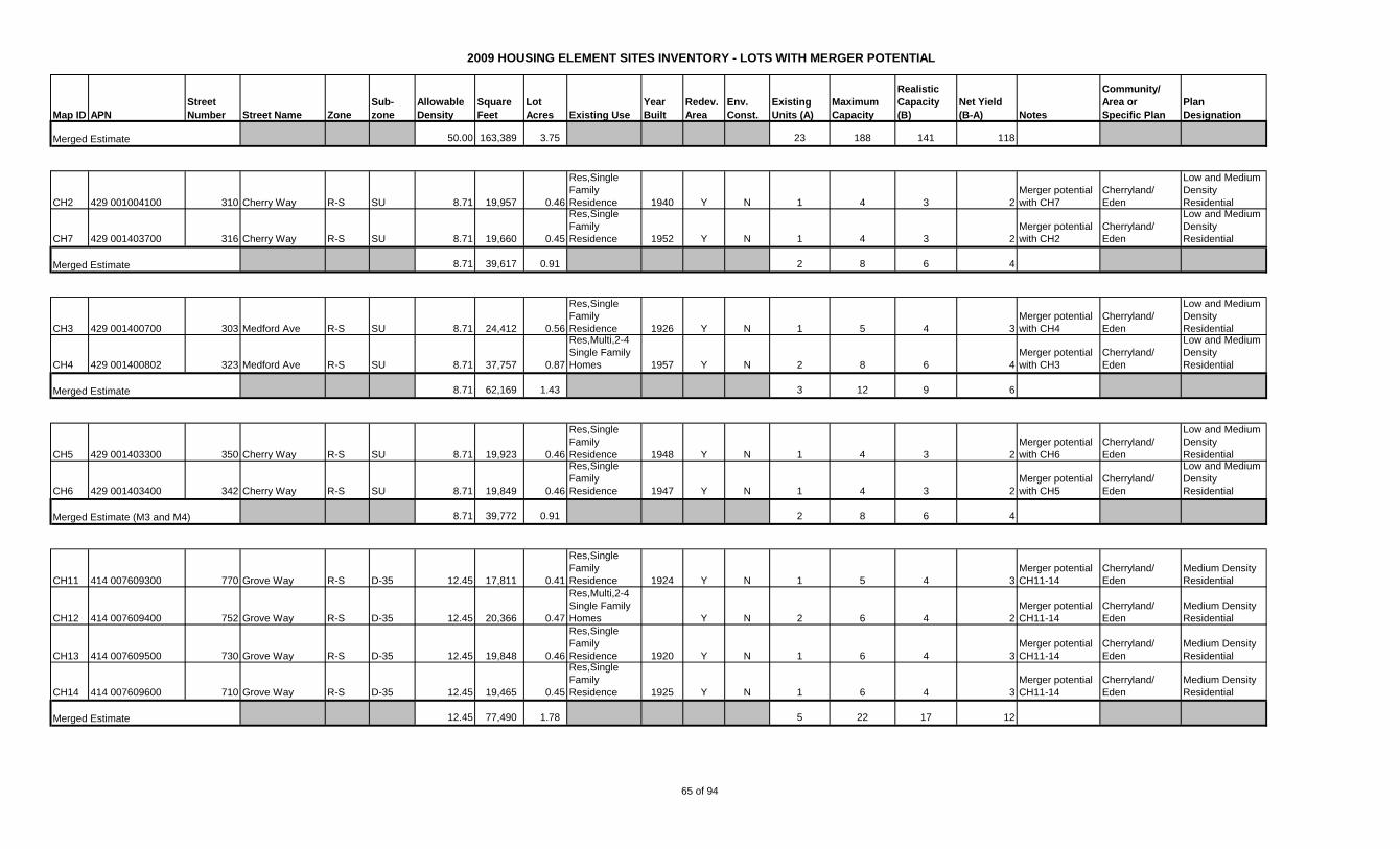
2009 HOUSING ELEMENT SITES INVENTORY - LOTS WITH MERGER POTENTIAL
Map ID APN
Street
Number Street Name Zone
Sub-
zone
Allowable
Density
Square
Feet
Lot
Acres Existing Use
Year
Built
Redev.
Area
Env.
Const.
Existing
Units (A)
Maximum
Capacity
Realistic
Capacity
(B)
Net Yield
(B-A) Notes
Community/
Area or
Specific Plan
Plan
Designation
50.00 163,389 3.75 23 188 141 118
CH2 429 001004100 310 Cherry Way R-S SU 8.71 19,957 0.46
Res,Single
Family
Residence 1940 Y N 1 4 3 2
Merger potential
with CH7
Cherryland/
Eden
Low and Medium
Density
Residential
CH7 429 001403700 316 Cherry Way R-S SU 8.71 19,660 0.45
Res,Single
Family
Residence 1952 Y N 1 4 3 2
Merger potential
with CH2
Cherryland/
Eden
Low and Medium
Density
Residential
8.71 39,617 0.91 2 8 6 4
CH3 429 001400700 303 Medford Ave R-S SU 8.71 24,412 0.56
Res,Single
Family
Residence 1926 Y N 1 5 4 3
Merger potential
with CH4
Cherryland/
Eden
Low and Medium
Density
Residential
CH4 429 001400802 323 Medford Ave R-S SU 8.71 37,757 0.87
Res,Multi,2-4
Single Family
Homes 1957 Y N 2 8 6 4
Merger potential
with CH3
Cherryland/
Eden
Low and Medium
Density
Residential
8.71 62,169 1.43 3 12 9 6
CH5 429 001403300 350 Cherry Way R-S SU 8.71 19,923 0.46
Res,Single
Family
Residence 1948 Y N 1 4 3 2
Merger potential
with CH6
Cherryland/
Eden
Low and Medium
Density
Residential
CH6 429 001403400 342 Cherry Way R-S SU 8.71 19,849 0.46
Res,Single
Family
Residence 1947 Y N 1 4 3 2
Merger potential
with CH5
Cherryland/
Eden
Low and Medium
Density
Residential
8.71 39,772 0.91 2 8 6 4
CH11 414 007609300 770 Grove Way R-S D-35 12.45 17,811 0.41
Res,Single
Family
Residence 1924 Y N 1 5 4 3
Merger potential
CH11-14
Cherryland/
Eden
Medium Density
Residential
CH12 414 007609400 752 Grove Way R-S D-35 12.45 20,366 0.47
Res,Multi,2-4
Single Family
Homes Y N 2 6 4 2
Merger potential
CH11-14
Cherryland/
Eden
Medium Density
Residential
CH13 414 007609500 730 Grove Way R-S D-35 12.45 19,848 0.46
Res,Single
Family
Residence 1920 Y N 1 6 4 3
Merger potential
CH11-14
Cherryland/
Eden
Medium Density
Residential
CH14 414 007609600 710 Grove Way R-S D-35 12.45 19,465 0.45
Res,Single
Family
Residence 1925 Y N 1 6 4 3
Merger potential
CH11-14
Cherryland/
Eden
Medium Density
Residential
12.45 77,490 1.78 5 22 17 12
Merged Estimate
Merged Estimate
Merged Estimate (M3 and M4)
Merged Estimate
Merged Estimate
65 of 94
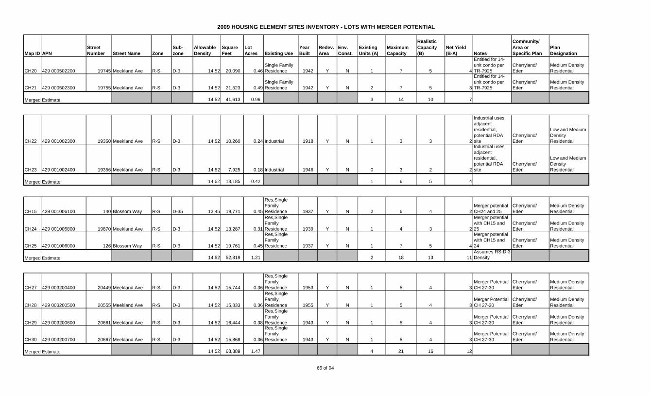
2009 HOUSING ELEMENT SITES INVENTORY - LOTS WITH MERGER POTENTIAL
Map ID APN
Street
Number Street Name Zone
Sub-
zone
Allowable
Density
Square
Feet
Lot
Acres Existing Use
Year
Built
Redev.
Area
Env.
Const.
Existing
Units (A)
Maximum
Capacity
Realistic
Capacity
(B)
Net Yield
(B-A) Notes
Community/
Area or
Specific Plan
Plan
Designation
CH20 429 000502200 19745 Meekland Ave R-S D-3 14.52 20,090 0.46
Single Family
Residence 1942 Y N 1 7 5 4
Entitled for 14-
unit condo per
TR-7925
Cherryland/
Eden
Medium Density
Residential
CH21 429 000502300 19755 Meekland Ave R-S D-3 14.52 21,523 0.49
Single Family
Residence 1942 Y N 2 7 5 3
Entitled for 14-
unit condo per
TR-7925
Cherryland/
Eden
Medium Density
Residential
14.52 41,613 0.96 3 14 10 7
CH22 429 001002300 19350 Meekland Ave R-S D-3 14.52 10,260 0.24 Industrial 1918 Y N 1 3 3 2
Industrial uses,
adjacent
residential,
potential RDA
site
Cherryland/
Eden
Low and Medium
Density
Residential
CH23 429 001002400 19356 Meekland Ave R-S D-3 14.52 7,925 0.18 Industrial 1946 Y N 0 3 2 2
Industrial uses,
adjacent
residential,
potential RDA
site
Cherryland/
Eden
Low and Medium
Density
Residential
14.52 18,185 0.42 1 6 5 4
CH15 429 001006100 140 Blossom Way R-S D-35 12.45 19,771 0.45
Res,Single
Family
Residence 1937 Y N 2 6 4 2
Merger potential
CH24 and 25
Cherryland/
Eden
Medium Density
Residential
CH24 429 001005800 19870 Meekland Ave R-S D-3 14.52 13,287 0.31
Res,Single
Family
Residence 1939 Y N 1 4 3 2
Merger potential
with CH15 and
25
Cherryland/
Eden
Medium Density
Residential
CH25 429 001006000 126 Blossom Way R-S D-3 14.52 19,761 0.45
Res,Single
Family
Residence 1937 Y N 1 7 5 4
Merger potential
with CH15 and
24
Cherryland/
Eden
Medium Density
Residential
14.52 52,819 1.21 2 18 13 11
Assumes RS-D-3
Density
CH27 429 003200400 20449 Meekland Ave R-S D-3 14.52 15,744 0.36
Res,Single
Family
Residence 1953 Y N 1 5 4 3
Merger Potential
CH 27-30
Cherryland/
Eden
Medium Density
Residential
CH28 429 003200500 20555 Meekland Ave R-S D-3 14.52 15,833 0.36
Res,Single
Family
Residence 1955 Y N 1 5 4 3
Merger Potential
CH 27-30
Cherryland/
Eden
Medium Density
Residential
CH29 429 003200600 20661 Meekland Ave R-S D-3 14.52 16,444 0.38
Res,Single
Family
Residence 1943 Y N 1 5 4 3
Merger Potential
CH 27-30
Cherryland/
Eden
Medium Density
Residential
CH30 429 003200700 20667 Meekland Ave R-S D-3 14.52 15,868 0.36
Res,Single
Family
Residence 1943 Y N 1 5 4 3
Merger Potential
CH 27-30
Cherryland/
Eden
Medium Density
Residential
14.52 63,889 1.47 4 21 16 12
Merged Estimate
Merged Estimate
Merged Estimate
Merged Estimate
66 of 94
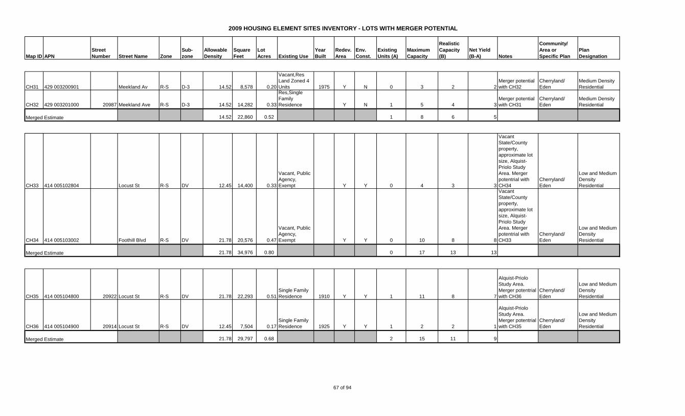
2009 HOUSING ELEMENT SITES INVENTORY - LOTS WITH MERGER POTENTIAL
Map ID APN
Street
Number Street Name Zone
Sub-
zone
Allowable
Density
Square
Feet
Lot
Acres Existing Use
Year
Built
Redev.
Area
Env.
Const.
Existing
Units (A)
Maximum
Capacity
Realistic
Capacity
(B)
Net Yield
(B-A) Notes
Community/
Area or
Specific Plan
Plan
Designation
CH31 429 003200901 Meekland Av R-S D-3 14.52 8,578 0.20
Vacant,Res
Land Zoned 4
Units 1975 Y N 0 3 2 2
Merger potential
with CH32
Cherryland/
Eden
Medium Density
Residential
CH32 429 003201000 20987 Meekland Ave R-S D-3 14.52 14,282 0.33
Res,Single
Family
Residence Y N 1 5 4 3
Merger potential
with CH31
Cherryland/
Eden
Medium Density
Residential
14.52 22,860 0.52 1 8 6 5
CH33 414 005102804 Locust St R-S DV 12.45 14,400 0.33
Vacant, Public
Agency,
Exempt Y Y 0 4 3 3
Vacant
State/County
property,
approximate lot
size, Alquist-
Priolo Study
Area. Merger
potentrial with
CH34
Cherryland/
Eden
Low and Medium
Density
Residential
CH34 414 005103002 Foothill Blvd R-S DV 21.78 20,576 0.47
Vacant, Public
Agency,
Exempt Y Y 0 10 8 8
Vacant
State/County
property,
approximate lot
size, Alquist-
Priolo Study
Area. Merger
potentrial with
CH33
Cherryland/
Eden
Low and Medium
Density
Residential
21.78 34,976 0.80 0 17 13 13
CH35 414 005104800 20922 Locust St R-S DV 21.78 22,293 0.51
Single Family
Residence 1910 Y Y 1 11 8 7
Alquist-Priolo
Study Area.
Merger potentrial
with CH36
Cherryland/
Eden
Low and Medium
Density
Residential
CH36 414 005104900 20914 Locust St R-S DV 12.45 7,504 0.17
Single Family
Residence 1925 Y Y 1 2 2 1
Alquist-Priolo
Study Area.
Merger potentrial
with CH35
Cherryland/
Eden
Low and Medium
Density
Residential
21.78 29,797 0.68 2 15 11 9
Merged Estimate
Merged Estimate
Merged Estimate
67 of 94

2009 HOUSING ELEMENT SITES INVENTORY - LOTS WITH MERGER POTENTIAL
Map ID APN
Street
Number Street Name Zone
Sub-
zone
Allowable
Density
Square
Feet
Lot
Acres Existing Use
Year
Built
Redev.
Area
Env.
Const.
Existing
Units (A)
Maximum
Capacity
Realistic
Capacity
(B)
Net Yield
(B-A) Notes
Community/
Area or
Specific Plan
Plan
Designation
CH40 429 005501700 384 Sunset Blvd R-S DV 12.45 17,800 0.41
Single family
residential
homes used as
such 1947 Y N 1 5 4 3
Merger potential
with CH41 and
45
Cherryland/
Eden
Medium Density
Residential
CH41 429 005501900 360 Sunset Blvd R-S DV 12.45 18,450 0.42
Single family
residential
homes used as
such 1934 Y N 1 5 4 3
Merger potential
with CH40 and
45
Cherryland/
Eden
Medium Density
Residential
CH45 429 005505100 366 Sunset Blvd R-S DV 21.78 30,945 0.71
Multiple
residential
building of 5 or
more units. 1974 Y N 8 15 12 4
Merger potential
with CH40 and
41
Cherryland/
Eden
Medium Density
Residential
21.78 67,195 1.54 9 34 25 16Merged Estimate
68 of 94

2009 HOUSING ELEMENT SITES INVENTORY - LOTS WITH MERGER POTENTIAL
Map ID APN
Street
Number Street Name Zone
Sub-
zone
Allowable
Density
Square
Feet
Lot
Acres Existing Use
Year
Built
Redev.
Area
Env.
Const.
Existing
Units (A)
Maximum
Capacity
Realistic
Capacity
(B)
Net Yield
(B-A) Notes
Community/
Area or
Specific Plan
Plan
Designation
CH42 429 005502200 318 Sunset Blvd R-S DV 12.45 15,000 0.34
Single family
residential
homes used as
such 1948 Y N 1 4 3 2
Merger potential
CH42-44
Cherryland/
Eden
Medium Density
Residential
CH43 429 005502800 21836 Princeton St R-S DV 21.78 20,000 0.46
Two, three or
four single
family homes 1943 Y N 4 10 8 4
Merger potential
CH42-44
Cherryland/
Eden
Medium Density
Residential
CH44 429 005502900 21806 Princeton St R-S DV 12.45 18,200 0.42
Single family
residential
homes used as
such 1930 Y N 1 5 4 3
Merger potential
CH42-44
Cherryland/
Eden
Medium Density
Residential
21.78 53,200 1 5 27 20 15
CH46 429 005902100 21823 Princeton St R-S DV 12.45 12,320 0.28
Single family
residential
homes used as
such 1950 Y N 1 4 3 2
Merger potential
with CH47
Cherryland/
Eden
Medium Density
Residential
CH47 429 005902202 21837 Princeton St R-S DV 12.45 15,800 0.36
Multiple
residential
building of 5 or
more units. 1963 Y N 1 5 3 2
Merger potential
with CH46
Cherryland/
Eden
Medium Density
Residential
21.78 28,120 0.65 2 14 11 9
CH48 429 006403502 122 Sunset Blvd R-S DV 21.78 20,860 0.48
Miscellaneous
improved
commercial 1947 Y N 1 10 8 7
Merger potential
with CH49
Cherryland/
Eden
Medium Density
Residential
CH49 429 006403600 130 Sunset Blvd R-S DV 21.78 19,100 0.44 Warehouse Y N 0 10 7 7
Need to surveyto
verify lot size.
Merger potential
with CH48
Cherryland/
Eden
Medium Density
Residential
21.78 39,960 0.92 1 20 15 14
CH50 429 006403800 148 Sunset Blvd R-S DV 12.45 12,850 0.29
Single family
residential
homes used as
such 1928 Y N 1 4 3 2
Merger potential
with CH51
Cherryland/
Eden
Medium Density
Residential
CH51 429 006403900 152 Sunset Blvd R-S DV 12.45 16,600 0.38
Single family
residential
homes used as
such 1932 Y N 1 5 4 3
Merger potential
with CH50
Cherryland/
Eden
Medium Density
Residential
21.78 29,450 0.68 2 15 11 9
Merged Estimate (M3 and M4)
Merged Estimate
Merged Estimate
Merged Estimate
69 of 94

2009 HOUSING ELEMENT SITES INVENTORY - LOTS WITH MERGER POTENTIAL
Map ID APN
Street
Number Street Name Zone
Sub-
zone
Allowable
Density
Square
Feet
Lot
Acres Existing Use
Year
Built
Redev.
Area
Env.
Const.
Existing
Units (A)
Maximum
Capacity
Realistic
Capacity
(B)
Net Yield
(B-A) Notes
Community/
Area or
Specific Plan
Plan
Designation
CH52 429 006404700 145 Sunset Blvd R-S DV 12.45 17,370 0.40
Single family
residential
homes used as
such 1923 Y N 1 5 4 3
Merger potential
with CH53
Cherryland/
Eden
Medium Density
Residential
CH53 429 006405402 22008 Meekland Ave R-S DV 21.78 44,431 1.02
Miscellaneous
improved
commercial Y N 0 22 17 17
Merger potential
with CH52
Cherryland/
Eden
High and Medium
Density
Residential
21.78 61,801 1.42 1 31 23 22
CH55 429 009102602 254 Poplar Ave R-S DV 12.45 11,349 0.26
Two, three or
four single
family homes 1938 Y N 0 3 2 2
Merger potential
with CH56
Cherryland/
Eden
Medium Density
Residential
CH56 429 009102700 248 Poplar Ave R-S DV 12.45 16,200 0.37
Single family
residential
homes used as
such 1923 Y N 1 5 3 2
Merger potential
with CH55
Cherryland/
Eden
Medium Density
Residential
21.78 27,549 0.63 1 14 10 9
CH57 429 009104103 243 Poplar Ave R-S DV 21.78 24,697 0.57
Single family
residential
homes used as
such 1930 Y N 2 12 9 7
Merger potential
with CH63
Cherryland/
Eden
Medium Density
Residential
CH63 429 009109900 247 Poplar Ave R-S DV 12.45 8,645 0.20
Single family
residential
homes used as
such 1984 Y N 0 2 2 2
Merger potential
with CH57
Cherryland/
Eden
Medium Density
Residential
21.78 33,342 0.77 2 17 13 11
CH64 431 001200600 337 Laurel Ave R-S DV 21.78 22,233 0.51
Residential
property
converted to 5
or more units Y N 6 11 8 2
Merger potential
CH64-66
Cherryland/
Eden
High and Medium
Density
Residential
CH65 431 001202100 324 Smalley Ave R-S DV 21.78 20,448 0.47
Two, three or
four single
family homes 1952 Y N 2 10 8 6
Merger potential
CH64-66
Cherryland/
Eden
High and Medium
Density
Residential
CH66 431 001202200 346 Smalley Ave R-S DV 21.78 20,448 0.47
Res.,Multiple
Family 1956 Y N 3 10 8 5
Merger potential
CH64-66
Cherryland/
Eden
High and Medium
Density
Residential
21.78 40,896 0.94 5 20 15 10
CH70 431 001601400 261 Laurel Ave R-S DV 21.78 20,448 0.47
Res., Multiple
Family 1952 Y N 4 10 8 4
Merger potential
CH70 and 71
Cherryland/
Eden
High and Medium
Density
Residential
Merged Estimate
Merged Estimate
Merged Estimate
Merged Estimate
70 of 94
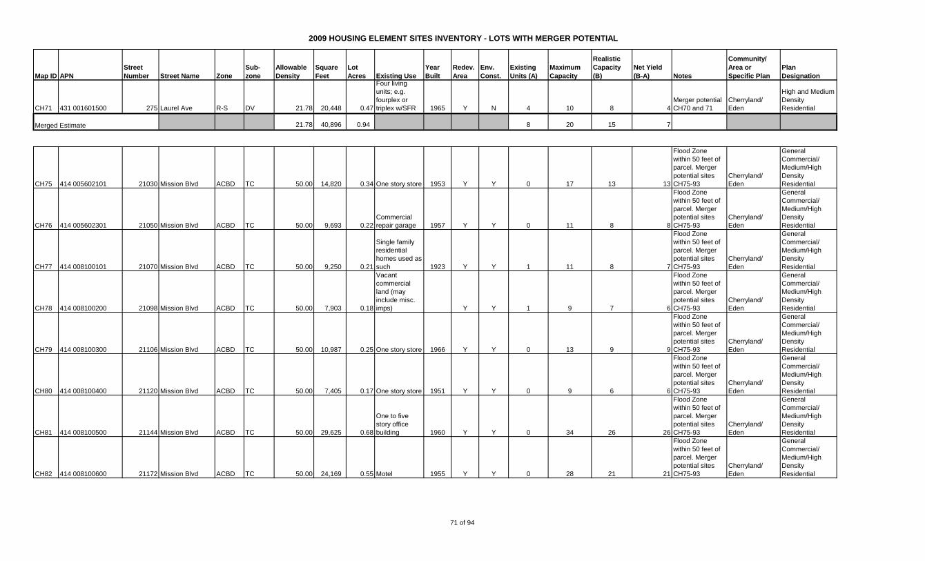
2009 HOUSING ELEMENT SITES INVENTORY - LOTS WITH MERGER POTENTIAL
Map ID APN
Street
Number Street Name Zone
Sub-
zone
Allowable
Density
Square
Feet
Lot
Acres Existing Use
Year
Built
Redev.
Area
Env.
Const.
Existing
Units (A)
Maximum
Capacity
Realistic
Capacity
(B)
Net Yield
(B-A) Notes
Community/
Area or
Specific Plan
Plan
Designation
CH71 431 001601500 275 Laurel Ave R-S DV 21.78 20,448 0.47
Four living
units; e.g.
fourplex or
triplex w/SFR 1965 Y N 4 10 8 4
Merger potential
CH70 and 71
Cherryland/
Eden
High and Medium
Density
Residential
21.78 40,896 0.94 8 20 15 7
CH75 414 005602101 21030 Mission Blvd ACBD TC 50.00 14,820 0.34 One story store 1953 Y Y 0 17 13 13
Flood Zone
within 50 feet of
parcel. Merger
potential sites
CH75-93
Cherryland/
Eden
General
Commercial/
Medium/High
Density
Residential
CH76 414 005602301 21050 Mission Blvd ACBD TC 50.00 9,693 0.22
Commercial
repair garage 1957 Y Y 0 11 8 8
Flood Zone
within 50 feet of
parcel. Merger
potential sites
CH75-93
Cherryland/
Eden
General
Commercial/
Medium/High
Density
Residential
CH77 414 008100101 21070 Mission Blvd ACBD TC 50.00 9,250 0.21
Single family
residential
homes used as
such 1923 Y Y 1 11 8 7
Flood Zone
within 50 feet of
parcel. Merger
potential sites
CH75-93
Cherryland/
Eden
General
Commercial/
Medium/High
Density
Residential
CH78 414 008100200 21098 Mission Blvd ACBD TC 50.00 7,903 0.18
Vacant
commercial
land (may
include misc.
imps) Y Y 1 9 7 6
Flood Zone
within 50 feet of
parcel. Merger
potential sites
CH75-93
Cherryland/
Eden
General
Commercial/
Medium/High
Density
Residential
CH79 414 008100300 21106 Mission Blvd ACBD TC 50.00 10,987 0.25 One story store 1966 Y Y 0 13 9 9
Flood Zone
within 50 feet of
parcel. Merger
potential sites
CH75-93
Cherryland/
Eden
General
Commercial/
Medium/High
Density
Residential
CH80 414 008100400 21120 Mission Blvd ACBD TC 50.00 7,405 0.17 One story store 1951 Y Y 0 9 6 6
Flood Zone
within 50 feet of
parcel. Merger
potential sites
CH75-93
Cherryland/
Eden
General
Commercial/
Medium/High
Density
Residential
CH81 414 008100500 21144 Mission Blvd ACBD TC 50.00 29,625 0.68
One to five
story office
building 1960 Y Y 0 34 26 26
Flood Zone
within 50 feet of
parcel. Merger
potential sites
CH75-93
Cherryland/
Eden
General
Commercial/
Medium/High
Density
Residential
CH82 414 008100600 21172 Mission Blvd ACBD TC 50.00 24,169 0.55 Motel 1955 Y Y 0 28 21 21
Flood Zone
within 50 feet of
parcel. Merger
potential sites
CH75-93
Cherryland/
Eden
General
Commercial/
Medium/High
Density
Residential
Merged Estimate
71 of 94
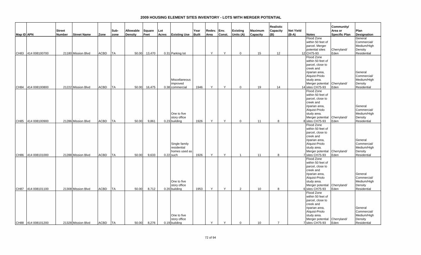
2009 HOUSING ELEMENT SITES INVENTORY - LOTS WITH MERGER POTENTIAL
Map ID APN
Street
Number Street Name Zone
Sub-
zone
Allowable
Density
Square
Feet
Lot
Acres Existing Use
Year
Built
Redev.
Area
Env.
Const.
Existing
Units (A)
Maximum
Capacity
Realistic
Capacity
(B)
Net Yield
(B-A) Notes
Community/
Area or
Specific Plan
Plan
Designation
CH83 414 008100700 21180 Mission Blvd ACBD TA 50.00 13,470 0.31 Parking lot Y Y 0 15 12 12
Flood Zone
within 50 feet of
parcel. Merger
potential sites
CH75-93
Cherryland/
Eden
General
Commercial/
Medium/High
Density
Residential
CH84 414 008100800 21222 Mission Blvd ACBD TA 50.00 16,475 0.38
Miscellaneous
improved
commercial 1946 Y Y 0 19 14 14
Flood Zone
within 50 feet of
parcel, close to
creek and
riparian area,
Alquist-Priolo
study area.
Merger potential
sites CH75-93
Cherryland/
Eden
General
Commercial/
Medium/High
Density
Residential
CH85 414 008100900 21286 Mission Blvd ACBD TA 50.00 9,861 0.23
One to five
story office
building 1926 Y Y 0 11 8 8
Flood Zone
within 50 feet of
parcel, close to
creek and
riparian area,
Alquist-Priolo
study area.
Merger potential
sites CH75-93
Cherryland/
Eden
General
Commercial/
Medium/High
Density
Residential
CH86 414 008101000 21288 Mission Blvd ACBD TA 50.00 9,633 0.22
Single family
residential
homes used as
such 1926 Y Y 1 11 8 7
Flood Zone
within 50 feet of
parcel, close to
creek and
riparian area,
Alquist-Priolo
study area.
Merger potential
sites CH75-93
Cherryland/
Eden
General
Commercial/
Medium/High
Density
Residential
CH87 414 008101100 21308 Mission Blvd ACBD TA 50.00 8,712 0.20
One to five
story office
building 1953 Y Y 2 10 8 6
Flood Zone
within 50 feet of
parcel, close to
creek and
riparian area,
Alquist-Priolo
study area.
Merger potential
sites CH75-93
Cherryland/
Eden
General
Commercial/
Medium/High
Density
Residential
CH88 414 008101200 21328 Mission Blvd ACBD TA 50.00 8,276 0.19
One to five
story office
building Y Y 0 10 7 7
Flood Zone
within 50 feet of
parcel, close to
creek and
riparian area,
Alquist-Priolo
study area.
Merger potential
sites CH75-93
Cherryland/
Eden
General
Commercial/
Medium/High
Density
Residential
72 of 94

2009 HOUSING ELEMENT SITES INVENTORY - LOTS WITH MERGER POTENTIAL
Map ID APN
Street
Number Street Name Zone
Sub-
zone
Allowable
Density
Square
Feet
Lot
Acres Existing Use
Year
Built
Redev.
Area
Env.
Const.
Existing
Units (A)
Maximum
Capacity
Realistic
Capacity
(B)
Net Yield
(B-A) Notes
Community/
Area or
Specific Plan
Plan
Designation
CH89 414 008101300 21344 Mission Blvd ACBD TA 50.00 8,650 0.20
One to five
story office
building 1940 Y Y 0 10 7 7
Flood Zone
within 50 feet of
parcel, close to
creek and
riparian area,
Alquist-Priolo
study area.
Merger potential
sites CH75-93
Cherryland/
Eden
General
Commercial/
Medium/High
Density
Residential
CH90 414 008101400 21366 Mission Blvd ACBD TA 50.00 8,300 0.19
Residential
Imps on
Commercial
Land 1928 Y Y 1 10 7 6
Flood Zone
within 50 feet of
parcel, close to
creek and
riparian area,
Alquist-Priolo
study area.
Merger potential
sites CH75-93
Cherryland/
Eden
General
Commercial/
Medium/High
Density
Residential
CH91 414 008101500 21376 Mission Blvd ACBD TA 50.00 7,775 0.18 One story store 1942 Y Y 0 9 7 7
Flood Zone
within 50 feet of
parcel, close to
creek and
riparian area,
Alquist-Priolo
study area.
Merger potential
sites CH75-93
Cherryland/
Eden
General
Commercial/
Medium/High
Density
Residential
CH92 414 008101600 21380 Mission Blvd ACBD TA 50.00 7,300 0.17
Triplex; double
or duplex with
single family
home 1941 Y Y 3 8 6 3
Flood Zone
within 50 feet of
parcel, close to
creek and
riparian area,
Alquist-Priolo
study area.
Merger potential
sites CH75-93
Cherryland/
Eden
General
Commercial/
Medium/High
Density
Residential
CH93 414 008101700 21390 Mission Blvd ACBD TA 50.00 6,759 0.16
Two, three or
four single
family homes 1940 Y Y 2 8 6 4
Flood Zone
within 50 feet of
parcel, close to
creek and
riparian area,
Alquist-Priolo
study area.
Merger potential
sites CH75-93
Cherryland/
Eden
General
Commercial/
Medium/High
Density
Residential
73 of 94
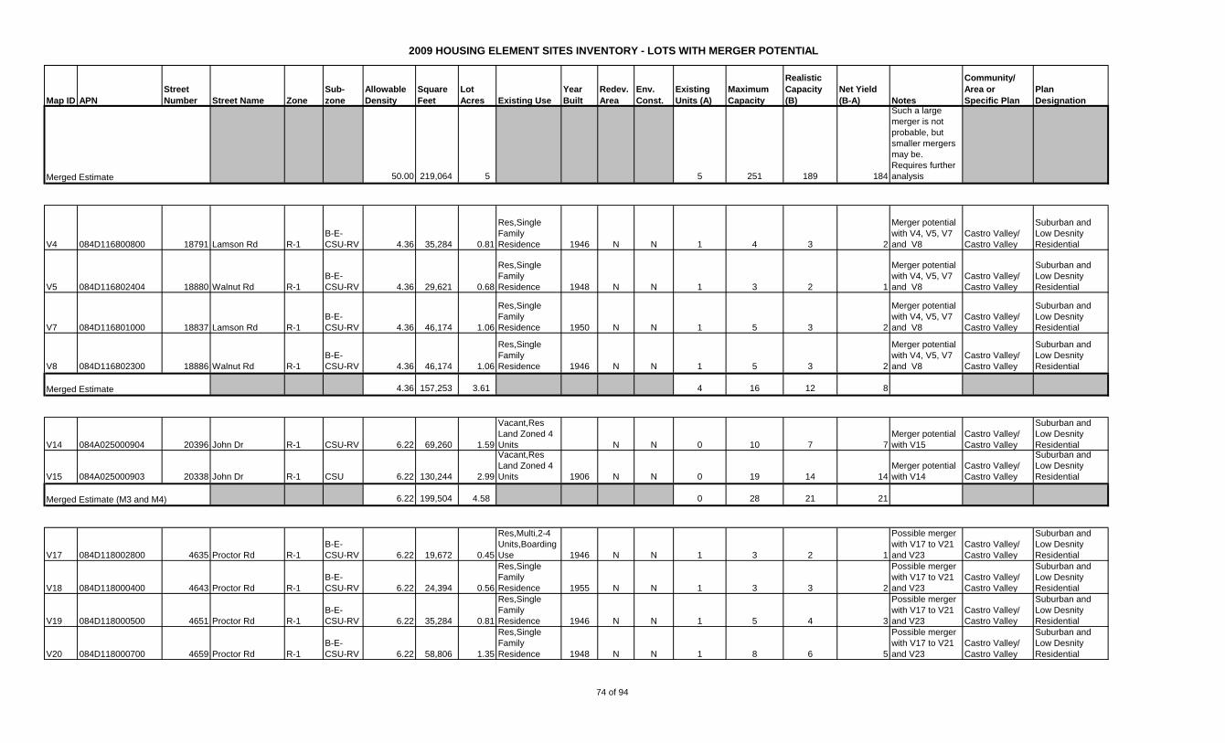
2009 HOUSING ELEMENT SITES INVENTORY - LOTS WITH MERGER POTENTIAL
Map ID APN
Street
Number Street Name Zone
Sub-
zone
Allowable
Density
Square
Feet
Lot
Acres Existing Use
Year
Built
Redev.
Area
Env.
Const.
Existing
Units (A)
Maximum
Capacity
Realistic
Capacity
(B)
Net Yield
(B-A) Notes
Community/
Area or
Specific Plan
Plan
Designation
50.00 219,064 5 5 251 189 184
Such a large
merger is not
probable, but
smaller mergers
may be.
Requires further
analysis
V4 084D116800800 18791 Lamson Rd R-1
B-E-
CSU-RV 4.36 35,284 0.81
Res,Single
Family
Residence 1946 N N 1 4 3 2
Merger potential
with V4, V5, V7
and V8
Castro Valley/
Castro Valley
Suburban and
Low Desnity
Residential
V5 084D116802404 18880 Walnut Rd R-1
B-E-
CSU-RV 4.36 29,621 0.68
Res,Single
Family
Residence 1948 N N 1 3 2 1
Merger potential
with V4, V5, V7
and V8
Castro Valley/
Castro Valley
Suburban and
Low Desnity
Residential
V7 084D116801000 18837 Lamson Rd R-1
B-E-
CSU-RV 4.36 46,174 1.06
Res,Single
Family
Residence 1950 N N 1 5 3 2
Merger potential
with V4, V5, V7
and V8
Castro Valley/
Castro Valley
Suburban and
Low Desnity
Residential
V8 084D116802300 18886 Walnut Rd R-1
B-E-
CSU-RV 4.36 46,174 1.06
Res,Single
Family
Residence 1946 N N 1 5 3 2
Merger potential
with V4, V5, V7
and V8
Castro Valley/
Castro Valley
Suburban and
Low Desnity
Residential
4.36 157,253 3.61 4 16 12 8
V14 084A025000904 20396 John Dr R-1 CSU-RV 6.22 69,260 1.59
Vacant,Res
Land Zoned 4
Units N N 0 10 7 7
Merger potential
with V15
Castro Valley/
Castro Valley
Suburban and
Low Desnity
Residential
V15 084A025000903 20338 John Dr R-1 CSU 6.22 130,244 2.99
Vacant,Res
Land Zoned 4
Units 1906 N N 0 19 14 14
Merger potential
with V14
Castro Valley/
Castro Valley
Suburban and
Low Desnity
Residential
6.22 199,504 4.58 0 28 21 21
V17 084D118002800 4635 Proctor Rd R-1
B-E-
CSU-RV 6.22 19,672 0.45
Res,Multi,2-4
Units,Boarding
Use 1946 N N 1 3 2 1
Possible merger
with V17 to V21
and V23
Castro Valley/
Castro Valley
Suburban and
Low Desnity
Residential
V18 084D118000400 4643 Proctor Rd R-1
B-E-
CSU-RV 6.22 24,394 0.56
Res,Single
Family
Residence 1955 N N 1 3 3 2
Possible merger
with V17 to V21
and V23
Castro Valley/
Castro Valley
Suburban and
Low Desnity
Residential
V19 084D118000500 4651 Proctor Rd R-1
B-E-
CSU-RV 6.22 35,284 0.81
Res,Single
Family
Residence 1946 N N 1 5 4 3
Possible merger
with V17 to V21
and V23
Castro Valley/
Castro Valley
Suburban and
Low Desnity
Residential
V20 084D118000700 4659 Proctor Rd R-1
B-E-
CSU-RV 6.22 58,806 1.35
Res,Single
Family
Residence 1948 N N 1 8 6 5
Possible merger
with V17 to V21
and V23
Castro Valley/
Castro Valley
Suburban and
Low Desnity
Residential
Merged Estimate
Merged Estimate
Merged Estimate (M3 and M4)
74 of 94
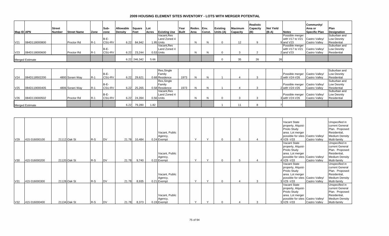
2009 HOUSING ELEMENT SITES INVENTORY - LOTS WITH MERGER POTENTIAL
Map ID APN
Street
Number Street Name Zone
Sub-
zone
Allowable
Density
Square
Feet
Lot
Acres Existing Use
Year
Built
Redev.
Area
Env.
Const.
Existing
Units (A)
Maximum
Capacity
Realistic
Capacity
(B)
Net Yield
(B-A) Notes
Community/
Area or
Specific Plan
Plan
Designation
V21 084D118000800 Proctor Rd R-1
B-E-
CSU-RV 6.22 84,942 1.95
Vacant,Res
Land Zoned 4
Units N N 0 12 9 9
Possible merger
with V17 to V21
and V23
Castro Valley/
Castro Valley
Suburban and
Low Desnity
Residential
V23 084D118000600 Proctor Rd R-1
B-E-
CSU-RV 6.22 23,244 0.53
Vacant,Res
Land Zoned 4
Units N N 0 3 2 2
Possible merger
with V17 to V21
and V23
Castro Valley/
Castro Valley
Suburban and
Low Desnity
Residential
6.22 246,342 5.66 0 35 26 26
V24 084D118502200 4800 Sorani Way R-1
B-E-
CSU-RV 6.22 29,621 0.68
Res,Single
Family
Residence 1973 N N 1 4 3 2
Possible merger
with V24-V26
Castro Valley/
Castro Valley
Suburban and
Low Desnity
Residential
V25 084D119000405 4806 Sorani Way R-1
B-E-
CSU-RV 6.22 25,265 0.58
Res,Single
Family
Residence 1973 N N 1 4 3 2
Possible merger
with V24-V26
Castro Valley/
Castro Valley
Suburban and
Low Desnity
Residential
V26 084D119000502 Proctor Rd R-1
B-E-
CSU-RV 6.22 24,394 0.56
Vacant,Res
Land Zoned 4
Units N N 0 3 3 3
Possible merger
with V24-V26
Castro Valley/
Castro Valley
Suburban and
Low Desnity
Residential
6.22 79,280 1.82 1 11 8 7
V29 415 016000100 21112 Oak St R-S DV 21.78 10,484 0.24
Vacant, Public
Agency,
Exempt Y Y 0 5 4 4
Vacant State
property, Alquist-
Priolo Study
area. Lot merger
possible for sites
V29 -V33
Castro Valley/
Castro Valley
Unspecified in
current General
Plan. Proposed:
Residential,
Medium Density
Multi-family
V30 415 016000200 21120 Oak St R-S DV 21.78 9,740 0.22
Vacant, Public
Agency,
Exempt Y Y 0 5 4 4
Vacant State
property, Alquist-
Priolo Study
area. Lot merger
possible for sites
V29 -V33
Castro Valley/
Castro Valley
Unspecified in
current General
Plan. Proposed:
Residential,
Medium Density
Multi-family
V31 415 016000300 21128 Oak St R-S DV 21.78 8,935 0.21
Vacant, Public
Agency,
Exempt Y Y 0 4 3 3
Vacant State
property, Alquist-
Priolo Study
area. Lot merger
possible for sites
V29 -V33
Castro Valley/
Castro Valley
Unspecified in
current General
Plan. Proposed:
Residential,
Medium Density
Multi-family
V32 415 016000400 21134 Oak St R-S DV 21.78 8,373 0.19
Vacant, Public
Agency,
Exempt Y Y 0 4 3 3
Vacant State
property, Alquist-
Priolo Study
area. Lot merger
possible for sites
V29 -V33
Castro Valley/
Castro Valley
Unspecified in
current General
Plan. Proposed:
Residential,
Medium Density
Multi-family
Merged Estimate
Merged Estimate
75 of 94

2009 HOUSING ELEMENT SITES INVENTORY - LOTS WITH MERGER POTENTIAL
Map ID APN
Street
Number Street Name Zone
Sub-
zone
Allowable
Density
Square
Feet
Lot
Acres Existing Use
Year
Built
Redev.
Area
Env.
Const.
Existing
Units (A)
Maximum
Capacity
Realistic
Capacity
(B)
Net Yield
(B-A) Notes
Community/
Area or
Specific Plan
Plan
Designation
V33 415 016000500 21144 Oak St R-S DV 21.78 8,006 0.18
Vacant, Public
Agency,
Exempt Y Y 0 4 3 3
Vacant State
property, Alquist-
Priolo Study
area. Lot merger
possible for sites
V29 -V33
Castro Valley/
Castro Valley
Unspecified in
current General
Plan. Proposed:
Residential,
Medium Density
Multi-family
21.78 45,538 1.05 0 23 17 17
V34 415 023001100 22447 Ruby St R-S D-20 21.78 7,500 0.17
Single Family
Residence,
Public Agency,
Exempt Y Y 1 4 3 2
State Property,
238 Study area,
within creek
buffer. Lot
merger possible
V34 to V41, V48
and V49.
Castro Valley/
Castro Valley
Unspecified in
current General
Plan. Proposed:
Residential,
Medium Density
Multi-family
V35 415 023001200 22459 Ruby St R-S D-20 21.78 7,500 0.17
Single Family
Residence,
Public Agency,
Exempt Y Y 1 4 3 2
State Property,
238 Study area,
within creek
buffer. Lot
merger possible
V34 to V41, V48
and V49.
Castro Valley/
Castro Valley
Unspecified in
current General
Plan. Proposed:
Residential,
Medium Density
Multi-family
V36 415 023001300 Ruby St R-S D-20 21.78 14,363 0.33
Vacant, Public
Agency,
Exempt Y Y 0 7 5 5
State Property,
238 Study area,
within creek
buffer. Lot
merger possible
V34 to V41, V48
and V49.
Castro Valley/
Castro Valley
Unspecified in
current General
Plan. Proposed:
Residential,
Medium Density
Multi-family
V37 415 023001600 22513 Ruby St R-S D-20 21.78 6,481 0.15
Vacant, Public
Agency,
Exempt Y Y 0 3 2 2
State Property,
238 Study area,
within creek
buffer. Lot
merger possible
V34 to V41, V48
and V49.
Castro Valley/
Castro Valley
Unspecified in
current General
Plan. Proposed:
Residential,
Medium Density
Multi-family
V38 415 023001700 Ruby St R-S D-20 21.78 7,470 0.17
Vacant, Public
Agency,
Exempt Y Y 0 4 3 3
State Property,
238 Study area,
within creek
buffer. Lot
merger possible
V34 to V41, V48
and V49.
Castro Valley/
Castro Valley
Unspecified in
current General
Plan. Proposed:
Residential,
Medium Density
Multi-family
V39 415 023001900 Ruby St R-S D-20 21.78 8,295 0.19
Vacant, Public
Agency,
Exempt Y Y 0 4 3 3
State Property,
238 Study area,
within creek
buffer. Lot
merger possible
V34 to V41, V48
and V49.
Castro Valley/
Castro Valley
Unspecified in
current General
Plan. Proposed:
Residential,
Medium Density
Multi-family
Merged Estimate
76 of 94
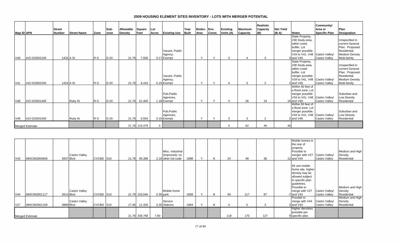
2009 HOUSING ELEMENT SITES INVENTORY - LOTS WITH MERGER POTENTIAL
Map ID APN
Street
Number Street Name Zone
Sub-
zone
Allowable
Density
Square
Feet
Lot
Acres Existing Use
Year
Built
Redev.
Area
Env.
Const.
Existing
Units (A)
Maximum
Capacity
Realistic
Capacity
(B)
Net Yield
(B-A) Notes
Community/
Area or
Specific Plan
Plan
Designation
V40 415 023002100 1432 A St R-S D-20 21.78 7,500 0.17
Vacant, Public
Agency,
Exempt Y Y 0 4 3 3
State Property,
238 Study area,
within creek
buffer. Lot
merger possible
V34 to V41, V48
and V49.
Castro Valley/
Castro Valley
Unspecified in
current General
Plan. Proposed:
Residential,
Medium Density
Multi-family
V41 415 023002200 1424 A St R-S D-20 21.78 6,416 0.15
Vacant, Public
Agency,
Exempt Y Y 0 3 2 2
State Property,
238 Study area,
within creek
buffer. Lot
merger possible
V34 to V41, V48
and V49.
Castro Valley/
Castro Valley
Unspecified in
current General
Plan. Proposed:
Residential,
Medium Density
Multi-family
V48 415 023001400 Ruby St R-S D-20 21.78 51,400 1.18
Pub,Public
Agencies,
Exempt Y Y 0 26 19 19
Within 50 feet of
a flood zone. Lot
merger possible
V34 to V41, V48
and V49.
Castro Valley/
Castro Valley
Suburban and
Low Desnity
Residential
V49 415 023001500 Ruby St R-S D-20 21.78 6,554 0.15
Pub,Public
Agencies,
Exempt Y Y 0 3 2 2
Within 50 feet of
a flood zone. Lot
merger possible
V34 to V41, V48
and V49.
Castro Valley/
Castro Valley
Suburban and
Low Desnity
Residential
21.78 123,479 3 0 62 46 46
V43 084C063000606 3937
Castro Valley
Blvd CVCBD S10 21.78 95,396 2.19
Misc. industrial
(improved); no
other ind code 1998 Y N 24 48 36 12
Mobile homes in
the rear of
property.
Possible to
merger with V27
and V44
Castro Valley/
Castro Valley
Medium and High
Density
Residential
V44 084C063001117 3913
Castro Valley
Blvd CVCBD S10 21.78 233,046 5.35
Mobile home
park 1958 Y N 94 117 87 -7
94 unit mobile
home site, higher
density may be
allowed subject
to specific plan
guidelines.
Possible to
merge with V27
and V43
Castro Valley/
Castro Valley
Medium and High
Density
Residential
V27 084C063001109 3889
Castro Valley
Blvd CVCBD S10 17.45 11,326 0.26
Service
Stations 1964 Y N 0 5 3 3
Possble to
merge with V44
and V43
Castro Valley/
Castro Valley
Medium and High
Density
Residential
21.78 339,768 7.80 118 170 127 9
Higher densities
possible per
specific plan.
Merged Estimate
Merged Estimate
77 of 94

2009 HOUSING ELEMENT SITES INVENTORY - LOTS WITH MERGER POTENTIAL
Map ID APN
Street
Number Street Name Zone
Sub-
zone
Allowable
Density
Square
Feet
Lot
Acres Existing Use
Year
Built
Redev.
Area
Env.
Const.
Existing
Units (A)
Maximum
Capacity
Realistic
Capacity
(B)
Net Yield
(B-A) Notes
Community/
Area or
Specific Plan
Plan
Designation
V46 084C065000204 4096
Castro Valley
Blvd CVCBD S10 21.78 17,424 0.40
Public Agency,
Exempt Y N 0 9 7 7
Possible to
merge with V47
Castro Valley/
Castro Valley
Medium and High
Density
Residential
V47 084C065000100 21195 Center St CVCBD S10 21.78 54,450 1.25
Public Agency,
Exempt Y N 0 27 20 20
Possible to
merge with V46
Castro Valley/
Castro Valley
Medium and High
Density
Residential
21.78 71,874 1.65 0 36 27 27
V51 415 016001100 21320 Oak St R-4 34.85 7,795 0.18
Vacant, Public
Agency,
Exempt Y N 0 6 5 5
State Property,
238 Study area.
Lot merger
potential V51
and V52
Castro Valley/
Castro Valley
Unspecified in
current General
Plan. Proposed
GP: Medium
Density
Multifamily.
V52 415 016001200 21338 Oak St R-4 34.85 7,466 0.17
Vacant, Public
Agency,
Exempt Y N 0 6 4 4
State Property,
238 Study area.
Lot merger
potential V51
and V52
Castro Valley/
Castro Valley
Unspecified in
current General
Plan. Proposed
GP: Medium
Density
Multifamily.
34.85 15,261 0.35 0 12 9 9
V53 415 016001400 21406 Oak St R-4 34.85 7,530 0.17
Vacant, Public
Agency,
Exempt Y N 0 6 5 5
State Property,
238 Study area.
Mereger
potential V53 to
V55
Castro Valley/
Castro Valley
Unspecified in
current General
Plan. Proposed
GP: Medium
Density
Multifamily.
V54 415 016001500 21420 Oak St R-4 34.85 7,758 0.18
Vacant, Public
Agency,
Exempt Y N 0 6 5 5
State Property,
238 Study area.
Mereger
potential V53 to
V55
Castro Valley/
Castro Valley
Unspecified in
current General
Plan. Proposed
GP: Medium
Density
Multifamily.
V55 415 016001600 21408 Oak St R-4 34.85 6,917 0.16
Residential
building of 2 or
more
units,Public
Agencies,
Exempt Y N 2 6 4 2
State Property,
238 Study area.
Mereger
potential V53 to
V55
Castro Valley/
Castro Valley
Unspecified in
current General
Plan. Proposed
GP: Medium
Density
Multifamily.
34.85 22,205 1 2 18 13 11
Merged Estimate
Merged Estimate
Merged Estimate
78 of 94
2009 HOUSING ELEMENT SITES INVENTORY - LOTS WITH MERGER POTENTIAL
Map ID APN
Street
Number Street Name Zone
Sub-
zone
Allowable
Density
Square
Feet
Lot
Acres Existing Use
Year
Built
Redev.
Area
Env.
Const.
Existing
Units (A)
Maximum
Capacity
Realistic
Capacity
(B)
Net Yield
(B-A) Notes
Community/
Area or
Specific Plan
Plan
Designation
V42 415 016002600 21457 Gary Dr R-1 CSU-RV 21.78 8,450 0.19
Single Family
Residence,
Public Agency,
Exempt Y N 1 4 3 2
State Property,
238 Study area,
Alquist-Priolo
Study Area. Lot
merger potential
V42 and V56 to
V58
Castro Valley/
Castro Valley
Unspecified in
current General
Plan. Proposed:
Residential,
Medium Density
Multi-family
V56 415 016001800 21454 Oak St R-4 34.85 7,426 0.17
Vacant, Public
Agency,
Exempt Y N 0 6 4 4
State Property,
238 Study area.
Lot merger
potential V42
and V56 to V58
Castro Valley/
Castro Valley
Unspecified in
current General
Plan. Proposed
GP: Medium
Density
Multifamily.
V57 415 016001900 21462 Oak St R-4 34.85 7,405 0.17
Single Family
Residence,
Public Agency,
Exempt 1940 Y N 1 6 4 3
State Property,
238 Study area.
Lot merger
potential V42
and V56 to V58
Castro Valley/
Castro Valley
Unspecified in
current General
Plan. Proposed
GP: Medium
Density
Multifamily.
V58 415 016002000 21484 Oak St R-4 34.85 7,330 0.17
Vacant, Public
Agency,
Exempt Y N 0 6 4 4
State Property,
238 Study area.
Lot merger
potential V42
and V56 to V58
Castro Valley/
Castro Valley
Unspecified in
current General
Plan. Proposed
GP: Medium
Density
Multifamily.
34.85 30,611 0.70 2 24 18 16
Assumes R-4
density
V45 084C065000505 4026
Castro Valley
Blvd CVCBD S10 21.78 53,100 1.22
Single family
residential
homes used as
such 1956 Y N 1 27 20 19
Possible to
merge with V60
Castro Valley/
Castro Valley
Medium and High
Density
Residential
V60 415 021005001 1452 Crescent Ave. R-S D-15 29.04 70567 1.62
Vacant, Public
Agency,
Exempt Y N 0 47 35 35
State Property,
238 Study area
Castro Valley/
Castro Valley
Unspecified in
current General
Plan. Proposed
GP: Medium
Density
Multifamily.
29.04 123,667 2.84 1 82 62 61
Assumes higher
density for 4026
Castro Valley
Blvd as allowed
in the Specific
Plan.
Merged Estimate
Merged Estimate
79 of 94
2009 HOUSING ELEMENT SITES INVENTORY - LOTS WITH MERGER POTENTIAL
Map ID APN
Street
Number Street Name Zone
Sub-
zone
Allowable
Density
Square
Feet
Lot
Acres Existing Use
Year
Built
Redev.
Area
Env.
Const.
Existing
Units (A)
Maximum
Capacity
Realistic
Capacity
(B)
Net Yield
(B-A) Notes
Community/
Area or
Specific Plan
Plan
Designation
V61 415 018006801 Grove Way R-S D-15 29.04 68825 1.58
Vacant, Public
Agency,
Exempt Y N 0 46 34 34
State Property,
238 Study area.
Lot merger
possible V61 -
V63
Castro Valley/
Castro Valley
Unspecified in
current General
Plan. Proposed
GP: Medium
Density
Multifamily.
V62 415 018006901 Grove Way R-S D-15 29.04 129373 2.97
Vacant, Public
Agency,
Exempt Y N 0 86 65 65
State Property,
238 Study area.
Lot merger
possible V61 -
V63
Castro Valley/
Castro Valley
Unspecified in
current General
Plan. Proposed
GP: Medium
Density
Multifamily.
V63 415 018007300 1459 Grove Way R-S D-15 29.04 35247 0.81
Single Family
Residence,
Public Agency,
Exempt Y N 1 24 18 17
State Property,
238 Study area.
Lot merger
possible V61 -
V63
Castro Valley/
Castro Valley
Unspecified in
current General
Plan. Proposed
GP: Medium
Density
Multifamily.
29.04 233,445 5 1 156 117 116
F3 417 019006500 23031 Henry Ln R-1 6.00 20,970 0.48
Res,Single
Family
Residence 1925 N N 1 3 2 1
Potential to
merge all Henry
lane parcels
Fairview/
Fairview
R-1; 5,000 sq. ft.
MBSA
F4 417 019006600 23039 Henry Ln R-1 6.00 22,455 0.52
Res,Single
Family
Residence 1950 N N 1 3 2 1
Potential to
merge all Henry
lane parcels
Fairview/
Fairview
R-1; 5,000 sq. ft.
MBSA
F5 417 019010300 23047 Henry Ln R-1 6.00 20,502 0.47
Res,Single
Family
Residence N N 1 3 2 1
23047 Henry
lane parcels
were merged in
2008. Potential
to merge all
Henry lane
parcels
Fairview/
Fairview
R-1; 5,000 sq. ft.
MBSA
F6 417 019010400 23047 Henry Ln R-1 Vacant N N 0 0
Potential to
merge all Henry
lane parcels
Fairview/
Fairview
R-1; 5,000 sq. ft.
MBSA
F7 417 019006800 23063 Henry Ln R-1 6.00 16,787 0.39
Res,Single
Family
Residence 1954 N N 1 2 2 1
Potential to
merge all Henry
lane parcels
Fairview/
Fairview
R-1; 5,000 sq. ft.
MBSA
6.00 80,714 1.85 1 11 8 7
F8 417 006007100 2700 Kelly St R-1 6.00 29,374 0.67
Res,Single
Family
Residence 1947 N Y 1 4 3 2
Within 50 feet of
a creek. Lot
merger potential
F8 to F11
Fairview/
Fairview
R-1; 5,000 sq. ft.
MBSA
Merged Estimate
Merged Estimate
80 of 94
2009 HOUSING ELEMENT SITES INVENTORY - LOTS WITH MERGER POTENTIAL
Map ID APN
Street
Number Street Name Zone
Sub-
zone
Allowable
Density
Square
Feet
Lot
Acres Existing Use
Year
Built
Redev.
Area
Env.
Const.
Existing
Units (A)
Maximum
Capacity
Realistic
Capacity
(B)
Net Yield
(B-A) Notes
Community/
Area or
Specific Plan
Plan
Designation
F9 417 006007000 2658 Kelly St R-1 6.00 19,744 0.45
Res,Single
Family
Residence 1928 N Y 1 3 2 1
Within 50 feet of
a creek. Lot
merger potential
F8 to F11
Fairview/
Fairview
R-1; 5,000 sq. ft.
MBSA
F10 417 006007600 2600 Kelly St R-1 6.00 26,203 0.60
Res,Single
Family
Residence 1979 N Y 1 4 3 2
Within 50 feet of
a creek. Lot
merger potential
F8 to F11
Fairview/
Fairview
R-1; 5,000 sq. ft.
MBSA
F11 417 006007700 2598 Kelly St R-1 6.00 53,444 1.23
Res,Single
Family
Residence 1922 N N 1 7 6 5
Lot merger
potential F8 to
F11
Fairview/
Fairview
R-1; 5,000 sq. ft.
MBSA
6.00 128,765 2.96 4 18 13 9
F14 416 018006200 22866 Mansfield Ave R-1 6.00 14,224 0.33
Res,Single
Family
Residence 1954 N N 1 2 1 0
May be possible
to merger into
single Mansfield
development.
Fairview/
Fairview
R-1; 5,000 sq. ft.
MBSA
F15 416 018006100 22866 Mansfield Ave R-1 6.00 17,832 0.41
Vacant,Res
Land Zoned 4
Units N N 0 2 2 2
May be possible
to merger into
single Mansfield
development.
Fairview/
Fairview
R-1; 5,000 sq. ft.
MBSA
F16 416 018000100 Mansfield Av R-1 6.00 60,171 1.38
Vacant,Res
Land Zoned 4
Units N N 0 8 6 6
May be possible
to merger into
single Mansfield
development.
Fairview/
Fairview
R-1; 5,000 sq. ft.
MBSA
F17 416 020000200 23000 Mansfield Ave R-1 6.00 37,563 0.86
Res,Single
Family
Residence 1979 N N 1 5 4 3
May be possible
to merger into
single Mansfield
development.
Fairview/
Fairview
R-1; 5,000 sq. ft.
MBSA
F18 416 020000100 23093 Mansfield Ave R-1 6.00 87,875 2.02
Res,Single
Family
Residence 1975 N N 1 12 9 8
May be possible
to merger into
single Mansfield
development.
Fairview/
Fairview
R-1; 5,000 sq. ft.
MBSA
Merged Estimate
81 of 94
2009 HOUSING ELEMENT SITES INVENTORY - LOTS WITH MERGER POTENTIAL
Map ID APN
Street
Number Street Name Zone
Sub-
zone
Allowable
Density
Square
Feet
Lot
Acres Existing Use
Year
Built
Redev.
Area
Env.
Const.
Existing
Units (A)
Maximum
Capacity
Realistic
Capacity
(B)
Net Yield
(B-A) Notes
Community/
Area or
Specific Plan
Plan
Designation
F19 416 020000300 23090 Mansfield Ave R-1 6.00 30,369 0.70
Res,Single
Family
Residence 1944 N N 1 4 3 2
May be possible
to merger into
single Mansfield
development.
Fairview/
Fairview
R-1; 5,000 sq. ft.
MBSA
F20 416 020000400 23098 Mansfield Ave R-1 6.00 60,370 1.39
Res,Single
Family
Residence 1927 N N 1 8 6 5
May be possible
to merger into
single Mansfield
development.
Fairview/
Fairview
R-1; 5,000 sq. ft.
MBSA
6.00 308,404 7.08 5 42 32 27
F21 417 022001201 3216 D St R-1 B-E 3.50 106,860 2.45
Vacant,Res
Land Zoned 4
Units 1937 N N 1 9 6 5
Possible to
merge F21, F23,
F25, F26 and
F28
Fairview/
Fairview
R-1; 10,000 sq. ft.
MBSA
F23 417 022001104 3230 D St R-1 B-E 3.50 44,744 1.03
Res,Single
Family
Residence 1960 N N 1 4 3 2
Possible to
merge F21, F23,
F25, F26 and
F28
Fairview/
Fairview
R-1; 10,000 sq. ft.
MBSA
F25 417 022002500 23756 Maud Ave R-1 6.00 24,015 0.55
Res,Single
Family
Residence 1953 N N 1 3 2 1
Possible to
merge F21, F23,
F25, F26 and
F28
Fairview/
Fairview
R-1; 5,000 sq. ft.
MBSA
F26 417 022002400 23790 Maud Ave R-1 6.00 32,464 0.75
Res,Single
Family
Residence 1927 N N 1 4 3 2
Possible to
merge F21, F23,
F25, F26 and
F28
Fairview/
Fairview
R-1; 5,000 sq. ft.
MBSA
F28 417 022002200 23830 Maud Ave R-1 6.00 24,239 0.56
Res,Single
Family
Residence 1960 N N 1 3 3 2
Possible to
merge F21, F23,
F25, F26 and
F28
Fairview/
Fairview
R-1; 5,000 sq. ft.
MBSA
6.00 232,322 5.33 2 32 24 22
Assumes higher
6 du/ac
F24 417 024001204 3289 D St R-1 B-E 3.50 81,458 1.87
Res,Single
Family
Residence N N 1 7 5 4
Possible o merge
F24 and F29
Fairview/
Fairview
R-1; 10,000 sq. ft.
MBSA
F29 417 024000500 3291 D St R-1 B-E 3.50 82,880 1.90
Res,Single
Family
Residence 1877 N N 1 7 5 4
Possible o merge
F24 and F29
Fairview/
Fairview
R-1; 10,000 sq. ft.
MBSA
3.50 164,338 3.77 2 13 10 8
Merged Estimate
Merged Estimate
Merged Estimate (M3 and M4)
82 of 94

2009 HOUSING ELEMENT SITES INVENTORY - LOTS WITH MERGER POTENTIAL
Map ID APN
Street
Number Street Name Zone
Sub-
zone
Allowable
Density
Square
Feet
Lot
Acres Existing Use
Year
Built
Redev.
Area
Env.
Const.
Existing
Units (A)
Maximum
Capacity
Realistic
Capacity
(B)
Net Yield
(B-A) Notes
Community/
Area or
Specific Plan
Plan
Designation
F27 417 024000100 3247 D St R-1 B-E 3.50 130,644 3.00
Res,Single
Family
Residence 1925 N N 1 10 8 7
Possible to
merge F27 and
F30
Fairview/
Fairview
R-1; 10,000 sq. ft.
MBSA
F30 417 025000100 3231 D St R-1 B-E 3.50 35,399 0.81
Res,Single
Family
Residence 1953 N N 1 3 2 1
Possible to
merge F27 and
F30
Fairview/
Fairview
R-1; 10,000 sq. ft.
MBSA
3.50 166,043 3.81 2 13 10 8
F31 417 026000400 Fairview Av R-1 B-E 3.50 330,441 7.59
Vacant,Res
Land Zoned 4
Units N N 0 27 20 20
Possible to
merge F31 and
F32 to create a
larger tract.
Fairview/
Fairview
R-1; 10,000 sq. ft.
MBSA
F32 417 026000500 Fairview Av R-1 B-E 3.50 531,419 12.20
Pub,Owned By
Public Utility N N 0 43 32 32
Possible to
merge F31 and
F32 to create a
larger tract.
Fairview/
Fairview
R-1; 10,000 sq. ft.
MBSA
3.50 861,860 19.79 0 69 52 52
F36 425 002000507 Fairview Av R-1 B-E 2.18 246,723 5.66
Vacant,Res
Land Zoned 4
Units 1951 N N 0 12 9 9
Possible to
merge F36 and
F41 to create a
larger tract.
Fairview/
Fairview
R-1; 20,000 sq. ft.
MBSA
F41 425 002000304 24867 Fairview Ave R-1 B-E 2.18 181,220 4.16
Res,Single
Family
Residence 1912 N N 1 9 7 6
Possible to
merge F36 and
F41 to create a
larger tract.
Fairview/
Fairview
R-1; 20,000 sq. ft.
MBSA
2.18 427,943 9.82 1 21 16 15
F42 426 018001200 1859 East Ave R-1 B-E 5.00 29,376 0.67
Res,Single
Family
Residence 1975 N Y 1 3 3 2
Within 50 feet of
a creek. May be
possible to
merge F42 to
F46 and F51 to
create a single
larger tract.
Fairview/
Fairview
R-1; 6,000 sq. ft.
MBSA
F43 426 017000100 1875 East Ave R-1 B-E 5.00 52,858 1.21
Res,Single
Family
Residence 1930 N Y 1 6 5 4
Within 50 feet of
a creek. May be
possible to
merge F42 to
F46 and F51 to
create a single
larger tract.
Fairview/
Fairview
R-1; 6,000 sq. ft.
MBSA
Merged Estimate
Merged Estimate (M3 and M4)
Merged Estimate
83 of 94
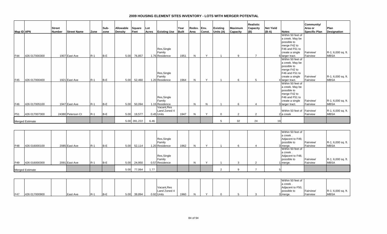
2009 HOUSING ELEMENT SITES INVENTORY - LOTS WITH MERGER POTENTIAL
Map ID APN
Street
Number Street Name Zone
Sub-
zone
Allowable
Density
Square
Feet
Lot
Acres Existing Use
Year
Built
Redev.
Area
Env.
Const.
Existing
Units (A)
Maximum
Capacity
Realistic
Capacity
(B)
Net Yield
(B-A) Notes
Community/
Area or
Specific Plan
Plan
Designation
F44 426 017000300 1907 East Ave R-1 B-E 5.00 76,857 1.76
Res,Single
Family
Residence 1951 N Y 1 9 7 6
Within 50 feet of
a creek. May be
possible to
merge F42 to
F46 and F51 to
create a single
larger tract.
Fairview/
Fairview
R-1; 6,000 sq. ft.
MBSA
F45 426 017000400 1921 East Ave R-1 B-E 5.00 52,460 1.20
Res,Single
Family
Residence 1964 N Y 1 6 5 4
Within 50 feet of
a creek. May be
possible to
merge F42 to
F46 and F51 to
create a single
larger tract.
Fairview/
Fairview
R-1; 6,000 sq. ft.
MBSA
F46 426 017005100 1947 East Ave R-1 B-E 5.00 50,094 1.15
Res,Single
Family
Residence N N 1 6 4 3
Within 50 feet of
a creek. May be
possible to
merge F42 to
F46 and F51 to
create a single
larger tract.
Fairview/
Fairview
R-1; 6,000 sq. ft.
MBSA
F51 426 017007300 24380 Peterson Ct R-1 B-E 5.00 19,577 0.45
Vacant,Res
Land Zoned 4
Units 1947 N Y 0 2 2 2
Within 50 feet of
a creek
Fairview/
Fairview
R-1; 6,000 sq. ft.
MBSA
5.00 281,222 6.46 5 32 24 19
F48 426 016000100 2085 East Ave R-1 B-E 5.00 52,114 1.20
Res,Single
Family
Residence 1962 N Y 1 6 4 3
Within 50 feet of
a creek .
Adjacent to F49,
possible to
merge.
Fairview/
Fairview
R-1; 6,000 sq. ft.
MBSA
F49 426 016000300 2091 East Ave R-1 B-E 5.00 24,950 0.57
Res,Single
Family
Residence N Y 1 3 2 1
Within 50 feet of
a creek .
Adjacent to F48,
possible to
merge.
Fairview/
Fairview
R-1; 6,000 sq. ft.
MBSA
5.00 77,064 1.77 2 9 7 5
F47 426 017000900 East Ave R-1 B-E 5.00 39,894 0.92
Vacant,Res
Land Zoned 4
Units 1960 N Y 0 5 3 3
Within 50 feet of
a creek .
Adjacent to F50,
possible to
merge.
Fairview/
Fairview
R-1; 6,000 sq. ft.
MBSA
Merged Estimate
Merged Estimate
84 of 94
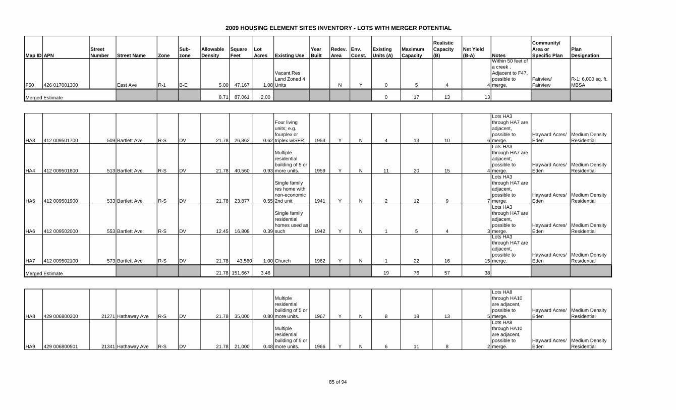
2009 HOUSING ELEMENT SITES INVENTORY - LOTS WITH MERGER POTENTIAL
Map ID APN
Street
Number Street Name Zone
Sub-
zone
Allowable
Density
Square
Feet
Lot
Acres Existing Use
Year
Built
Redev.
Area
Env.
Const.
Existing
Units (A)
Maximum
Capacity
Realistic
Capacity
(B)
Net Yield
(B-A) Notes
Community/
Area or
Specific Plan
Plan
Designation
F50 426 017001300 East Ave R-1 B-E 5.00 47,167 1.08
Vacant,Res
Land Zoned 4
Units N Y 0 5 4 4
Within 50 feet of
a creek .
Adjacent to F47,
possible to
merge.
Fairview/
Fairview
R-1; 6,000 sq. ft.
MBSA
8.71 87,061 2.00 0 17 13 13
HA3 412 009501700 509 Bartlett Ave R-S DV 21.78 26,862 0.62
Four living
units; e.g.
fourplex or
triplex w/SFR 1953 Y N 4 13 10 6
Lots HA3
through HA7 are
adjacent,
possible to
merge.
Hayward Acres/
Eden
Medium Density
Residential
HA4 412 009501800 513 Bartlett Ave R-S DV 21.78 40,560 0.93
Multiple
residential
building of 5 or
more units. 1959 Y N 11 20 15 4
Lots HA3
through HA7 are
adjacent,
possible to
merge.
Hayward Acres/
Eden
Medium Density
Residential
HA5 412 009501900 533 Bartlett Ave R-S DV 21.78 23,877 0.55
Single family
res home with
non-economic
2nd unit 1941 Y N 2 12 9 7
Lots HA3
through HA7 are
adjacent,
possible to
merge.
Hayward Acres/
Eden
Medium Density
Residential
HA6 412 009502000 553 Bartlett Ave R-S DV 12.45 16,808 0.39
Single family
residential
homes used as
such 1942 Y N 1 5 4 3
Lots HA3
through HA7 are
adjacent,
possible to
merge.
Hayward Acres/
Eden
Medium Density
Residential
HA7 412 009502100 573 Bartlett Ave R-S DV 21.78 43,560 1.00 Church 1962 Y N 1 22 16 15
Lots HA3
through HA7 are
adjacent,
possible to
merge.
Hayward Acres/
Eden
Medium Density
Residential
21.78 151,667 3.48 19 76 57 38
HA8 429 006800300 21271 Hathaway Ave R-S DV 21.78 35,000 0.80
Multiple
residential
building of 5 or
more units. 1967 Y N 8 18 13 5
Lots HA8
through HA10
are adjacent,
possible to
merge.
Hayward Acres/
Eden
Medium Density
Residential
HA9 429 006800501 21341 Hathaway Ave R-S DV 21.78 21,000 0.48
Multiple
residential
building of 5 or
more units. 1966 Y N 6 11 8 2
Lots HA8
through HA10
are adjacent,
possible to
merge.
Hayward Acres/
Eden
Medium Density
Residential
Merged Estimate
Merged Estimate
85 of 94
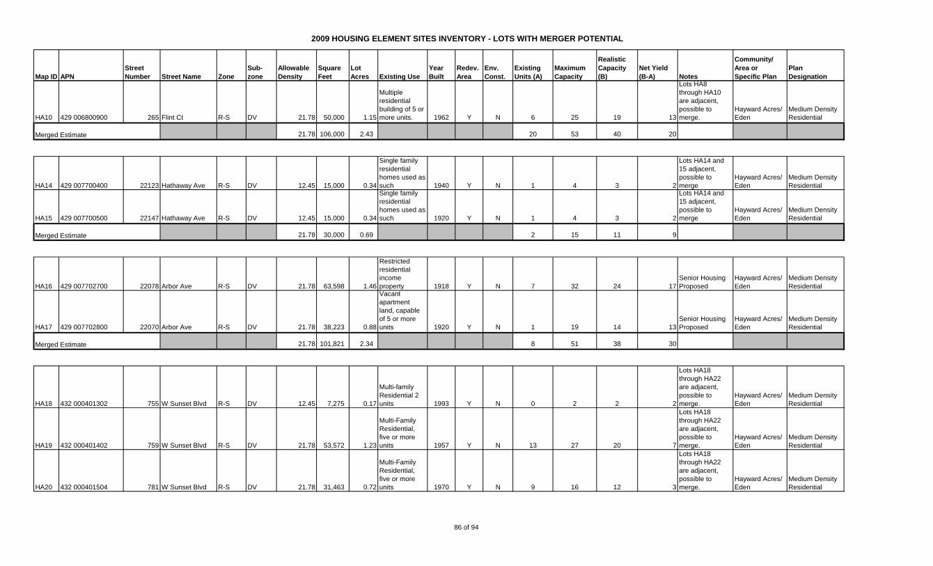
2009 HOUSING ELEMENT SITES INVENTORY - LOTS WITH MERGER POTENTIAL
Map ID APN
Street
Number Street Name Zone
Sub-
zone
Allowable
Density
Square
Feet
Lot
Acres Existing Use
Year
Built
Redev.
Area
Env.
Const.
Existing
Units (A)
Maximum
Capacity
Realistic
Capacity
(B)
Net Yield
(B-A) Notes
Community/
Area or
Specific Plan
Plan
Designation
HA10 429 006800900 265 Flint Ct R-S DV 21.78 50,000 1.15
Multiple
residential
building of 5 or
more units. 1962 Y N 6 25 19 13
Lots HA8
through HA10
are adjacent,
possible to
merge.
Hayward Acres/
Eden
Medium Density
Residential
21.78 106,000 2.43 20 53 40 20
HA14 429 007700400 22123 Hathaway Ave R-S DV 12.45 15,000 0.34
Single family
residential
homes used as
such 1940 Y N 1 4 3 2
Lots HA14 and
15 adjacent,
possible to
merge
Hayward Acres/
Eden
Medium Density
Residential
HA15 429 007700500 22147 Hathaway Ave R-S DV 12.45 15,000 0.34
Single family
residential
homes used as
such 1920 Y N 1 4 3 2
Lots HA14 and
15 adjacent,
possible to
merge
Hayward Acres/
Eden
Medium Density
Residential
21.78 30,000 0.69 2 15 11 9
HA16 429 007702700 22078 Arbor Ave R-S DV 21.78 63,598 1.46
Restricted
residential
income
property 1918 Y N 7 32 24 17
Senior Housing
Proposed
Hayward Acres/
Eden
Medium Density
Residential
HA17 429 007702800 22070 Arbor Ave R-S DV 21.78 38,223 0.88
Vacant
apartment
land, capable
of 5 or more
units 1920 Y N 1 19 14 13
Senior Housing
Proposed
Hayward Acres/
Eden
Medium Density
Residential
21.78 101,821 2.34 8 51 38 30
HA18 432 000401302 755 W Sunset Blvd R-S DV 12.45 7,275 0.17
Multi-family
Residential 2
units 1993 Y N 0 2 2 2
Lots HA18
through HA22
are adjacent,
possible to
merge.
Hayward Acres/
Eden
Medium Density
Residential
HA19 432 000401402 759 W Sunset Blvd R-S DV 21.78 53,572 1.23
Multi-Family
Residential,
five or more
units 1957 Y N 13 27 20 7
Lots HA18
through HA22
are adjacent,
possible to
merge.
Hayward Acres/
Eden
Medium Density
Residential
HA20 432 000401504 781 W Sunset Blvd R-S DV 21.78 31,463 0.72
Multi-Family
Residential,
five or more
units 1970 Y N 9 16 12 3
Lots HA18
through HA22
are adjacent,
possible to
merge.
Hayward Acres/
Eden
Medium Density
Residential
Merged Estimate
Merged Estimate
Merged Estimate
86 of 94
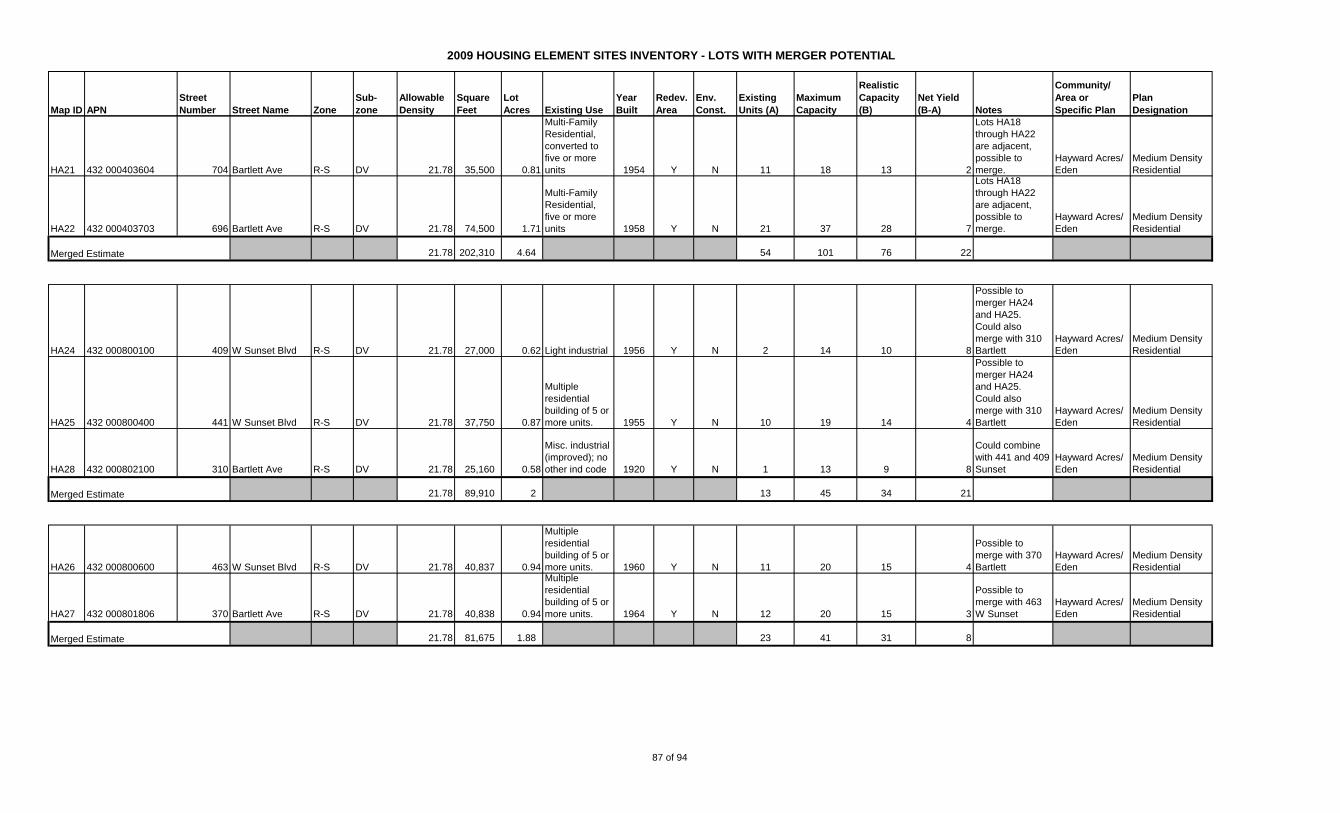
2009 HOUSING ELEMENT SITES INVENTORY - LOTS WITH MERGER POTENTIAL
Map ID APN
Street
Number Street Name Zone
Sub-
zone
Allowable
Density
Square
Feet
Lot
Acres Existing Use
Year
Built
Redev.
Area
Env.
Const.
Existing
Units (A)
Maximum
Capacity
Realistic
Capacity
(B)
Net Yield
(B-A) Notes
Community/
Area or
Specific Plan
Plan
Designation
HA21 432 000403604 704 Bartlett Ave R-S DV 21.78 35,500 0.81
Multi-Family
Residential,
converted to
five or more
units 1954 Y N 11 18 13 2
Lots HA18
through HA22
are adjacent,
possible to
merge.
Hayward Acres/
Eden
Medium Density
Residential
HA22 432 000403703 696 Bartlett Ave R-S DV 21.78 74,500 1.71
Multi-Family
Residential,
five or more
units 1958 Y N 21 37 28 7
Lots HA18
through HA22
are adjacent,
possible to
merge.
Hayward Acres/
Eden
Medium Density
Residential
21.78 202,310 4.64 54 101 76 22
HA24 432 000800100 409 W Sunset Blvd R-S DV 21.78 27,000 0.62 Light industrial 1956 Y N 2 14 10 8
Possible to
merger HA24
and HA25.
Could also
merge with 310
Bartlett
Hayward Acres/
Eden
Medium Density
Residential
HA25 432 000800400 441 W Sunset Blvd R-S DV 21.78 37,750 0.87
Multiple
residential
building of 5 or
more units. 1955 Y N 10 19 14 4
Possible to
merger HA24
and HA25.
Could also
merge with 310
Bartlett
Hayward Acres/
Eden
Medium Density
Residential
HA28 432 000802100 310 Bartlett Ave R-S DV 21.78 25,160 0.58
Misc. industrial
(improved); no
other ind code 1920 Y N 1 13 9 8
Could combine
with 441 and 409
Sunset
Hayward Acres/
Eden
Medium Density
Residential
21.78 89,910 2 13 45 34 21
HA26 432 000800600 463 W Sunset Blvd R-S DV 21.78 40,837 0.94
Multiple
residential
building of 5 or
more units. 1960 Y N 11 20 15 4
Possible to
merge with 370
Bartlett
Hayward Acres/
Eden
Medium Density
Residential
HA27 432 000801806 370 Bartlett Ave R-S DV 21.78 40,838 0.94
Multiple
residential
building of 5 or
more units. 1964 Y N 12 20 15 3
Possible to
merge with 463
W Sunset
Hayward Acres/
Eden
Medium Density
Residential
21.78 81,675 1.88 23 41 31 8Merged Estimate
Merged Estimate
Merged Estimate
87 of 94
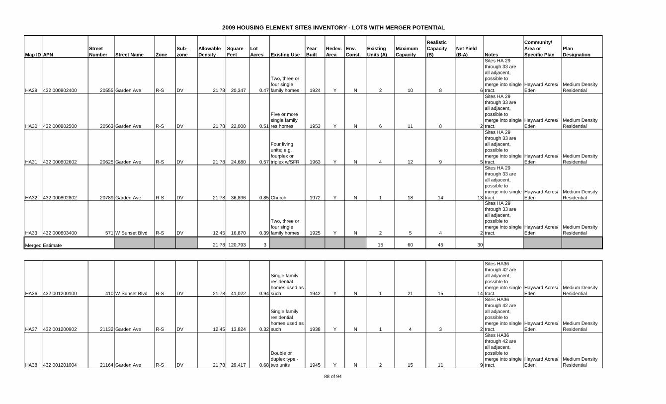
2009 HOUSING ELEMENT SITES INVENTORY - LOTS WITH MERGER POTENTIAL
Map ID APN
Street
Number Street Name Zone
Sub-
zone
Allowable
Density
Square
Feet
Lot
Acres Existing Use
Year
Built
Redev.
Area
Env.
Const.
Existing
Units (A)
Maximum
Capacity
Realistic
Capacity
(B)
Net Yield
(B-A) Notes
Community/
Area or
Specific Plan
Plan
Designation
HA29 432 000802400 20555 Garden Ave R-S DV 21.78 20,347 0.47
Two, three or
four single
family homes 1924 Y N 2 10 8 6
Sites HA 29
through 33 are
all adjacent,
possible to
merge into single
tract.
Hayward Acres/
Eden
Medium Density
Residential
HA30 432 000802500 20563 Garden Ave R-S DV 21.78 22,000 0.51
Five or more
single family
res homes 1953 Y N 6 11 8 2
Sites HA 29
through 33 are
all adjacent,
possible to
merge into single
tract.
Hayward Acres/
Eden
Medium Density
Residential
HA31 432 000802602 20625 Garden Ave R-S DV 21.78 24,680 0.57
Four living
units; e.g.
fourplex or
triplex w/SFR 1963 Y N 4 12 9 5
Sites HA 29
through 33 are
all adjacent,
possible to
merge into single
tract.
Hayward Acres/
Eden
Medium Density
Residential
HA32 432 000802802 20789 Garden Ave R-S DV 21.78 36,896 0.85 Church 1972 Y N 1 18 14 13
Sites HA 29
through 33 are
all adjacent,
possible to
merge into single
tract.
Hayward Acres/
Eden
Medium Density
Residential
HA33 432 000803400 571 W Sunset Blvd R-S DV 12.45 16,870 0.39
Two, three or
four single
family homes 1925 Y N 2 5 4 2
Sites HA 29
through 33 are
all adjacent,
possible to
merge into single
tract.
Hayward Acres/
Eden
Medium Density
Residential
21.78 120,793 3 15 60 45 30
HA36 432 001200100 410 W Sunset Blvd R-S DV 21.78 41,022 0.94
Single family
residential
homes used as
such 1942 Y N 1 21 15 14
Sites HA36
through 42 are
all adjacent,
possible to
merge into single
tract.
Hayward Acres/
Eden
Medium Density
Residential
HA37 432 001200902 21132 Garden Ave R-S DV 12.45 13,824 0.32
Single family
residential
homes used as
such 1938 Y N 1 4 3 2
Sites HA36
through 42 are
all adjacent,
possible to
merge into single
tract.
Hayward Acres/
Eden
Medium Density
Residential
HA38 432 001201004 21164 Garden Ave R-S DV 21.78 29,417 0.68
Double or
duplex type -
two units 1945 Y N 2 15 11 9
Sites HA36
through 42 are
all adjacent,
possible to
merge into single
tract.
Hayward Acres/
Eden
Medium Density
Residential
Merged Estimate
88 of 94
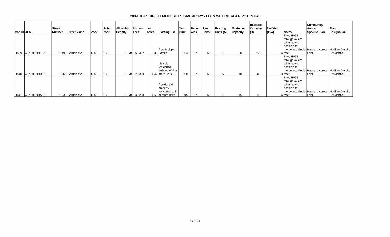
2009 HOUSING ELEMENT SITES INVENTORY - LOTS WITH MERGER POTENTIAL
Map ID APN
Street
Number Street Name Zone
Sub-
zone
Allowable
Density
Square
Feet
Lot
Acres Existing Use
Year
Built
Redev.
Area
Env.
Const.
Existing
Units (A)
Maximum
Capacity
Realistic
Capacity
(B)
Net Yield
(B-A) Notes
Community/
Area or
Specific Plan
Plan
Designation
HA39 432 001201103 21190 Garden Ave R-S DV 21.78 59,422 1.36
Res.,Multiple
Family 1963 Y N 18 30 22 4
Sites HA36
through 42 are
all adjacent,
possible to
merge into single
tract.
Hayward Acres/
Eden
Medium Density
Residential
HA40 432 001201302 21266 Garden Ave R-S DV 21.78 20,350 0.47
Multiple
residential
building of 5 or
more units. 1960 Y N 5 10 8 3
Sites HA36
through 42 are
all adjacent,
possible to
merge into single
tract.
Hayward Acres/
Eden
Medium Density
Residential
HA41 432 001201502 21338 Garden Ave R-S DV 21.78 30,238 0.69
Residential
property
converted to 5
or more units 1945 Y N 7 15 11 4
Sites HA36
through 42 are
all adjacent,
possible to
merge into single
tract.
Hayward Acres/
Eden
Medium Density
Residential
89 of 94
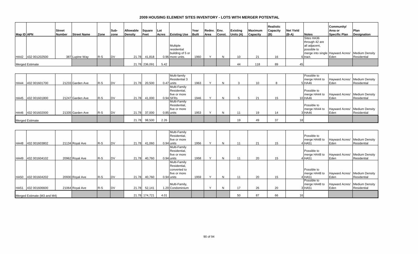
2009 HOUSING ELEMENT SITES INVENTORY - LOTS WITH MERGER POTENTIAL
Map ID APN
Street
Number Street Name Zone
Sub-
zone
Allowable
Density
Square
Feet
Lot
Acres Existing Use
Year
Built
Redev.
Area
Env.
Const.
Existing
Units (A)
Maximum
Capacity
Realistic
Capacity
(B)
Net Yield
(B-A) Notes
Community/
Area or
Specific Plan
Plan
Designation
HA42 432 001202500 387 Lupine Way R-S DV 21.78 41,818 0.96
Multiple
residential
building of 5 or
more units. 1960 Y N 10 21 16 6
Sites HA36
through 42 are
all adjacent,
possible to
merge into single
tract.
Hayward Acres/
Eden
Medium Density
Residential
21.78 236,091 5.42 44 118 89 45
HA44 432 001601700 21233 Garden Ave R-S DV 21.78 20,500 0.47
Multi-family
Residential 3
units 1963 Y N 3 10 8 5
Possible to
merge HA44 to
HA46
Hayward Acres/
Eden
Medium Density
Residential
HA45 432 001601800 21247 Garden Ave R-S DV 21.78 41,000 0.94
Multi-Family
Residential,
five or more
SFRs 1946 Y N 5 21 15 10
Possible to
merge HA44 to
HA46
Hayward Acres/
Eden
Medium Density
Residential
HA46 432 001602000 21335 Garden Ave R-S DV 21.78 37,000 0.85
Multi-Family
Residential,
five or more
units 1953 Y N 11 19 14 3
Possible to
merge HA44 to
HA46
Hayward Acres/
Eden
Medium Density
Residential
21.78 98,500 2.26 19 49 37 18
HA48 432 001603802 21134 Royal Ave R-S DV 21.78 41,060 0.94
Multi-Family
Residential,
five or more
units 1956 Y N 11 21 15 4
Possible to
merge HA48 to
HA51
Hayward Acres/
Eden
Medium Density
Residential
HA49 432 001604102 20962 Royal Ave R-S DV 21.78 40,760 0.94
Multi-Family
Residential,
five or more
units 1958 Y N 11 20 15 4
Possible to
merge HA48 to
HA51
Hayward Acres/
Eden
Medium Density
Residential
HA50 432 001604202 20930 Royal Ave R-S DV 21.78 40,760 0.94
Multi-Family
Residential,
converted to
five or more
units 1959 Y N 11 20 15 4
Possible to
merge HA48 to
HA51
Hayward Acres/
Eden
Medium Density
Residential
HA51 432 001606600 21064 Royal Ave R-S DV 21.78 52,141 1.20
Multi-Family,
Condominium Y N 17 26 20 3
Possible to
merge HA48 to
HA51
Hayward Acres/
Eden
Medium Density
Residential
21.78 174,721 4.01 50 87 66 16
Merged Estimate
Merged Estimate
Merged Estimate (M3 and M4)
90 of 94
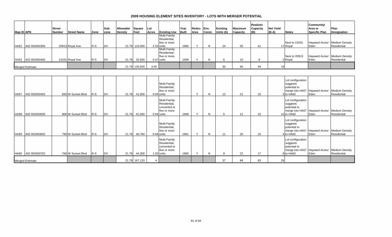
2009 HOUSING ELEMENT SITES INVENTORY - LOTS WITH MERGER POTENTIAL
Map ID APN
Street
Number Street Name Zone
Sub-
zone
Allowable
Density
Square
Feet
Lot
Acres Existing Use
Year
Built
Redev.
Area
Env.
Const.
Existing
Units (A)
Maximum
Capacity
Realistic
Capacity
(B)
Net Yield
(B-A) Notes
Community/
Area or
Specific Plan
Plan
Designation
HA52 432 002000300 20913 Royal Ave R-S DV 21.78 110,000 2.53
Multi-Family
Residential,
five or more
units 1960 Y N 24 55 41 17
Next to 21031
Royal
Hayward Acres/
Eden
Medium Density
Residential
HA53 432 002000400 21031 Royal Ave R-S DV 21.78 20,500 0.47
Multi-Family
Residential,
five or more
units 1939 Y N 6 10 8 2
Next to 20913
Royal
Hayward Acres/
Eden
Medium Density
Residential
21.78 130,500 3.00 30 65 49 19
HA57 432 002003402 830 W Sunset Blvd R-S DV 21.78 41,000 0.94
Multi-Family
Residential,
five or more
units Y N 12 21 15 3
Lot configuration
suggests
potential to
merge lots HA57
to HA60
Hayward Acres/
Eden
Medium Density
Residential
HA58 432 002003500 806 W Sunset Blvd R-S DV 21.78 41,060 0.94
Multi-Family
Residential,
converted to
five or more
units 1948 Y N 5 21 15 10
Lot configuration
suggests
potential to
merge lots HA57
to HA60
Hayward Acres/
Eden
Medium Density
Residential
HA59 432 002003602 790 W Sunset Blvd R-S DV 21.78 40,760 0.94
Multi-Family
Residential,
five or more
units 1961 Y N 11 20 15 4
Lot configuration
suggests
potential to
merge lots HA57
to HA60
Hayward Acres/
Eden
Medium Density
Residential
HA60 432 002003702 766 W Sunset Blvd R-S DV 21.78 44,300 1.02
Multi-Family
Residential,
converted to
five or more
units 1965 Y N 9 22 17 8
Lot configuration
suggests
potential to
merge lots HA57
to HA60
Hayward Acres/
Eden
Medium Density
Residential
21.78 167,120 4 37 84 63 26Merged Estimate
Merged Estimate
91 of 94
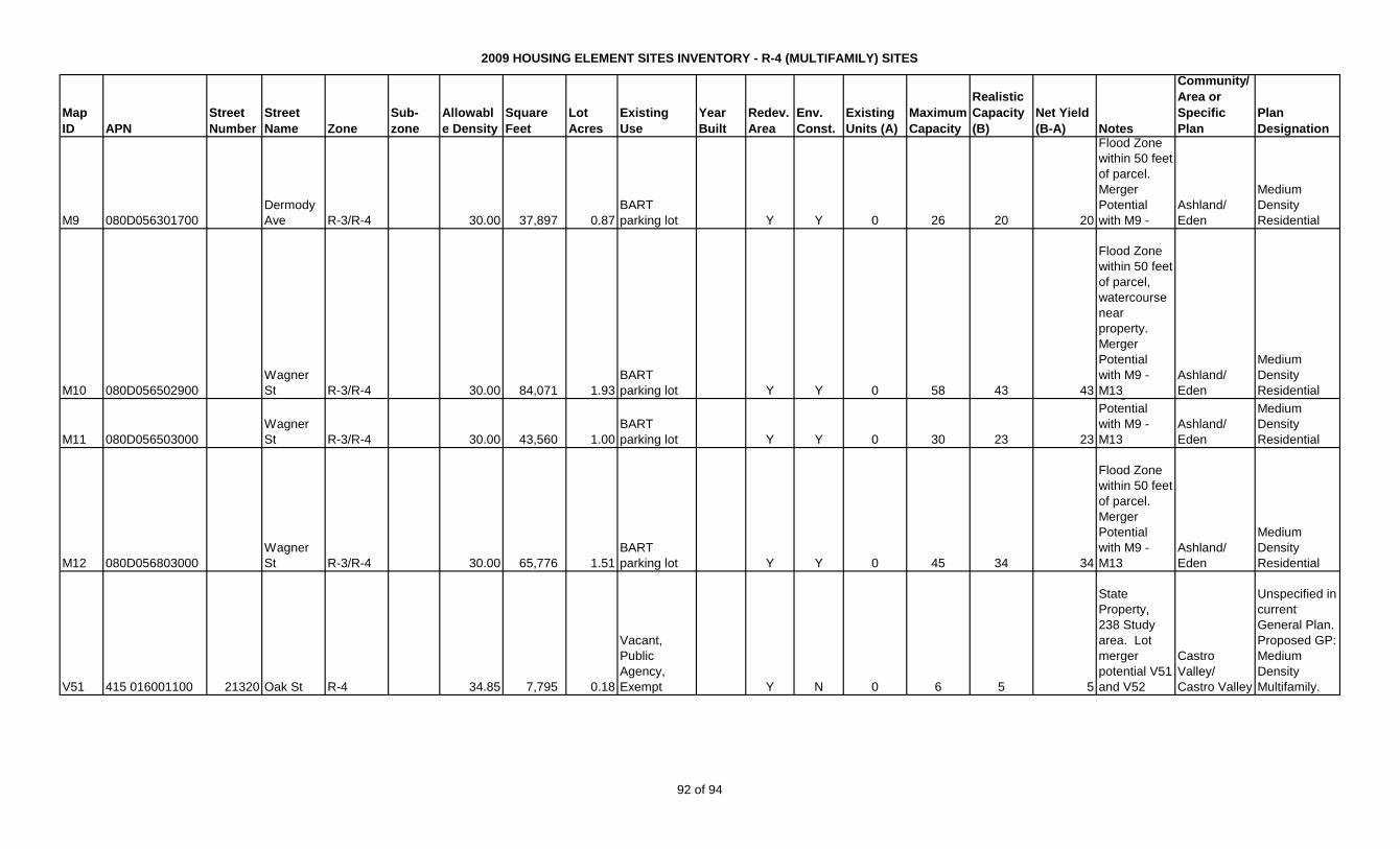
2009 HOUSING ELEMENT SITES INVENTORY - R-4 (MULTIFAMILY) SITES
Map
ID APN
Street
Number
Street
Name Zone
Sub-
zone
Allowabl
e Density
Square
Feet
Lot
Acres
Existing
Use
Year
Built
Redev.
Area
Env.
Const.
Existing
Units (A)
Maximum
Capacity
Realistic
Capacity
(B)
Net Yield
(B-A) Notes
Community/
Area or
Specific
Plan
Plan
Designation
M9 080D056301700
Dermody
Ave R-3/R-4 30.00 37,897 0.87
BART
parking lot Y Y 0 26 20 20
Flood Zone
within 50 feet
of parcel.
Merger
Potential
with M9 -
Ashland/
Eden
Medium
Density
Residential
M10 080D056502900
Wagner
St R-3/R-4 30.00 84,071 1.93
BART
parking lot Y Y 0 58 43 43
Flood Zone
within 50 feet
of parcel,
watercourse
near
property.
Merger
Potential
with M9 -
M13
Ashland/
Eden
Medium
Density
Residential
M11 080D056503000
Wagner
St R-3/R-4 30.00 43,560 1.00
BART
parking lot Y Y 0 30 23 23
Merger
Potential
with M9 -
M13
Ashland/
Eden
Medium
Density
Residential
M12 080D056803000
Wagner
St R-3/R-4 30.00 65,776 1.51
BART
parking lot Y Y 0 45 34 34
Flood Zone
within 50 feet
of parcel.
Merger
Potential
with M9 -
M13
Ashland/
Eden
Medium
Density
Residential
V51 415 016001100 21320 Oak St R-4 34.85 7,795 0.18
Vacant,
Public
Agency,
Exempt Y N 0 6 5 5
State
Property,
238 Study
area. Lot
merger
potential V51
and V52
Castro
Valley/
Castro Valley
Unspecified in
current
General Plan.
Proposed GP:
Medium
Density
Multifamily.
92 of 94
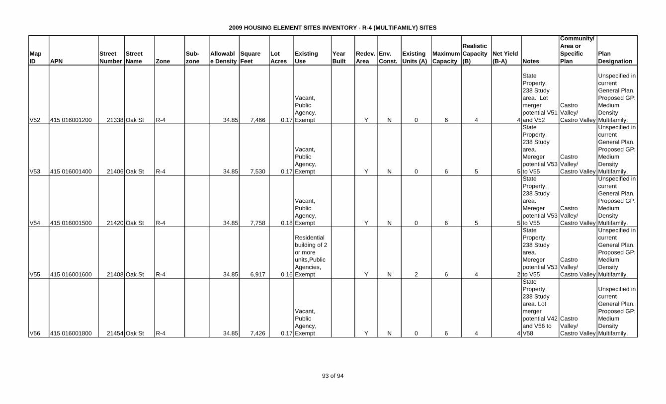
2009 HOUSING ELEMENT SITES INVENTORY - R-4 (MULTIFAMILY) SITES
Map
ID APN
Street
Number
Street
Name Zone
Sub-
zone
Allowabl
e Density
Square
Feet
Lot
Acres
Existing
Use
Year
Built
Redev.
Area
Env.
Const.
Existing
Units (A)
Maximum
Capacity
Realistic
Capacity
(B)
Net Yield
(B-A) Notes
Community/
Area or
Specific
Plan
Plan
Designation
V52 415 016001200 21338 Oak St R-4 34.85 7,466 0.17
Vacant,
Public
Agency,
Exempt Y N 0 6 4 4
State
Property,
238 Study
area. Lot
merger
potential V51
and V52
Castro
Valley/
Castro Valley
Unspecified in
current
General Plan.
Proposed GP:
Medium
Density
Multifamily.
V53 415 016001400 21406 Oak St R-4 34.85 7,530 0.17
Vacant,
Public
Agency,
Exempt Y N 0 6 5 5
State
Property,
238 Study
area.
Mereger
potential V53
to V55
Castro
Valley/
Castro Valley
Unspecified in
current
General Plan.
Proposed GP:
Medium
Density
Multifamily.
V54 415 016001500 21420 Oak St R-4 34.85 7,758 0.18
Vacant,
Public
Agency,
Exempt Y N 0 6 5 5
State
Property,
238 Study
area.
Mereger
potential V53
to V55
Castro
Valley/
Castro Valley
Unspecified in
current
General Plan.
Proposed GP:
Medium
Density
Multifamily.
V55 415 016001600 21408 Oak St R-4 34.85 6,917 0.16
Residential
building of 2
or more
units,Public
Agencies,
Exempt Y N 2 6 4 2
State
Property,
238 Study
area.
Mereger
potential V53
to V55
Castro
Valley/
Castro Valley
Unspecified in
current
General Plan.
Proposed GP:
Medium
Density
Multifamily.
V56 415 016001800 21454 Oak St R-4 34.85 7,426 0.17
Vacant,
Public
Agency,
Exempt Y N 0 6 4 4
State
Property,
238 Study
area. Lot
merger
potential V42
and V56 to
V58
Castro
Valley/
Castro Valley
Unspecified in
current
General Plan.
Proposed GP:
Medium
Density
Multifamily.
93 of 94

2009 HOUSING ELEMENT SITES INVENTORY - R-4 (MULTIFAMILY) SITES
Map
ID APN
Street
Number
Street
Name Zone
Sub-
zone
Allowabl
e Density
Square
Feet
Lot
Acres
Existing
Use
Year
Built
Redev.
Area
Env.
Const.
Existing
Units (A)
Maximum
Capacity
Realistic
Capacity
(B)
Net Yield
(B-A) Notes
Community/
Area or
Specific
Plan
Plan
Designation
V57 415 016001900 21462 Oak St R-4 34.85 7,405 0.17
Single
Family
Residence,
Public
Agency,
Exempt 1940 Y N 1 6 4 3
State
Property,
238 Study
area. Lot
merger
potential V42
and V56 to
V58
Castro
Valley/
Castro Valley
Unspecified in
current
General Plan.
Proposed GP:
Medium
Density
Multifamily.
V58 415 016002000 21484 Oak St R-4 34.85 7,330 0.17
Vacant,
Public
Agency,
Exempt Y N 0 6 4 4
State
Property,
238 Study
area. Lot
merger
potential V42
and V56 to
V58
Castro
Valley/
Castro Valley
Unspecified in
current
General Plan.
Proposed GP:
Medium
Density
Multifamily.
290,931 6.68 3 207 155 152TOTAL - CAPACITY
94 of 94