Embed Size (px)
Citation preview
STATE OF ALASKA DEPARTMENT OF TRANSPORTATION AND PUBLIC FACILITIES
NORTHERN REGION
2009 Field Investigation Summary Report
Project No. 62210
January, 2010

F o o t h i l l s W e s t T r a n s p o r t a t i o n A c c e s s 2 0 0 9 F i e l d I n v e s t i g a t i o n S u m m a r y R e p o r t
S t a t e o f A l a s k a 2 | P a g e D e p a r t m e n t o f T r a n s p o r t a t i o n a n d P u b l i c F a c i l i t i e s N o r t h e r n R e g i o n
TABLE OF CONTENTS
LIST OF PREPARERS ................................................................................................................................................................. 3
I. EXECUTIVE SUMMARY .................................................................................................................................................... 4
II. STUDY AREA HISTORY/BACKGROUND ............................................................................................................................. 5
TRADITIONAL, CULTURAL AND EARLY INDUSTRIAL HISTORY OF THE AREA ........................................................................................................... 5 FOUNDING AND EARLY EXPLORATION OF NAVAL PETROLEUM RESERVE #4 ...................................................................................................... 6 U.S. NAVY TESTING AND DEVELOPMENT OF UMIAT‐AREA PETROLEUM RESOURCES ......................................................................................... 11 EARLY PIPELINE AND ROADBUILDING EFFORTS ASSOCIATED WITH THE REGION ................................................................................................ 16
III. GALBRAITH CORRIDOR DESCRIPTION .........................................................................................................................19
LOCATION ...................................................................................................................................................................................... 19 CLIMATE ........................................................................................................................................................................................ 20 GENERAL CORRIDOR DESCRIPTION ....................................................................................................................................................... 22
IV. ENGINEERING FIELD PROGRAM SUMMARY ...............................................................................................................28
BASE MAPPING, SURVEYING, AERIAL PHOTOGRAPHY, AND TOPOGRAPHIC MAPPING ...................................................................................... 28 PROJECT DESIGN CRITERIA ................................................................................................................................................................. 34 HYDROLOGY ................................................................................................................................................................................... 37 GEOTECHNICAL INVESTIGATIONS.......................................................................................................................................................... 52 TERRAIN CHARACTERIZATIONS ............................................................................................................................................................ 56
V. ENVIRONMENTAL FIELD WORK SUMMARY ....................................................................................................................69
WETLAND AND VEGETATION DATA COLLECTION AND PRELIMINARY DELINEATION .......................................................................................... 69
VI. WILDLIFE AND HABITAT RESOURCES FIELDWORK SUMMARY ....................................................................................75
PRELIMINARY AGENCY INPUT AND FIELDWORK PREPARATIONS ................................................................................................................... 75 THREATENED AND ENDANGERED (T&E) SPECIES REVIEW .......................................................................................................................... 78 WILDLIFE FIELD SURVEY PLANNING AND EXECUTION ................................................................................................................................ 79
VII. FISH AND FISH HABITAT RESOURCES FIELD STUDIES ..................................................................................................84
FISH LIFE HISTORY CONCERNS ............................................................................................................................................................. 84 FISH HABITAT CONCERNS .................................................................................................................................................................. 85
VIII. SUBSISTENCE RESOURCES FIELDWORK SUMMARY .....................................................................................................86
DIRECT DATA COLLECTION FROM SUBSISTENCE USERS .............................................................................................................................. 87 SUBSISTENCE DATA GAP ANALYSIS ....................................................................................................................................................... 91
IX. CULTURAL AND HISTORICAL RESOURCES FIELD WORK SUMMARY .............................................................................92
LOCAL & TRADITIONAL KNOWLEDGE DATA COLLECTION AND PRESERVATION ................................................................................................ 93 HISTORICAL AND ARCHEOLOGICAL RESOURCES DATA COLLECTION AND PRESERVATION .................................................................................... 95
X. HAZARDOUS MATERIALS PRELIMINARY FIELD INVESTIGATIONS ....................................................................................98
BRIEF UMIAT CAMP/NPR‐A CONTAMINATION STATUS ........................................................................................................................... 98 PRELIMINARY SITE INSPECTIONS AND DATA COLLECTION ........................................................................................................................... 99
REPORTS DEVELOPED IN CONJUNCTION WITH THE 2009 FIELD SEASON ............................................................................... 102
REFERENCES ......................................................................................................................................................................... 103

F o o t h i l l s W e s t T r a n s p o r t a t i o n A c c e s s 2 0 0 9 F i e l d I n v e s t i g a t i o n S u m m a r y R e p o r t
S t a t e o f A l a s k a 3 | P a g e D e p a r t m e n t o f T r a n s p o r t a t i o n a n d P u b l i c F a c i l i t i e s N o r t h e r n R e g i o n
LIST OF PREPARERS
State of Alaska Department of Transportation and Public Facilities:
Northern Region Design Section
Northern Region Materials Section
Northern Region Survey Section
Northern Region Maintenance and Operations
Statewide Bridge Section, Hydraulic Engineering Staff
Foothills West Team Contributors and Support:
University of Alaska Fairbanks, Northern Institute of Engineering (UAF)
Three Parameters Plus, Inc. (3PPI) – with the following sub‐consultants:
Stephen R. Braund and Associates
Kelley Hegarty & Associates, LLC
RECON, LLC
Resource Data, Inc.
R&M Consultants, Inc. – with the following sub‐consultants:
Kodiak Mapping, Inc.
Airborne Imaging, Inc.
Air Logistics, Inc.; Prism Helicopters, Inc.; Wright’s Air, Inc.; Arctic Air Alaska; Quicksilver Helicopters
Umiat Lodge (UIC, Inc.), Happy Valley Lodge
Crowley CATCO Services

F o o t h i l l s W e s t T r a n s p o r t a t i o n A c c e s s 2 0 0 9 F i e l d I n v e s t i g a t i o n S u m m a r y R e p o r t
S t a t e o f A l a s k a 4 | P a g e D e p a r t m e n t o f T r a n s p o r t a t i o n a n d P u b l i c F a c i l i t i e s N o r t h e r n R e g i o n
I. EXECUTIVE SUMMARY
The Foothills West Transportation Access Project is a proposed road from the Dalton Highway to Umiat that would provide increased opportunities for the accessing, exploration and development of oil and gas resources in the foothills of the Brooks Range and the National Petroleum Reserve – Alaska (NPRA). The proposed road would initially extend only to the Gubik Gas Fields southeast of Umiat, then potentially be extended to cross the Colville River at Umiat. The proposed 30‐foot wide, two‐lane gravel road would be engineered to address the challenges of permafrost, snow load and industrial traffic, and may cross any combination of BLM lands, state lands, and lands belonging to ASRC. Industry is actively exploring the project area, with Anadarko, FEX, and Renaissance working within the project study area.
Presently, the State of Alaska has only provided project funding for preliminary engineering, geological, hydrological, environmental and cultural field studies. No additional public or private funding has been identified or assigned to further the design or construction of the road at this time.
The project study area and proposed study corridors have been addressed in the DOT&PF “Draft Interim ‐ Corridor Analysis/Decisional Matrix” dated September, 2009. The Corridor Analysis/Decisional Matrix document was developed to provide a framework for future corridor studies, and contains information about how the project study areas were selected, and why. This study recommended a northwest trending corridor titled “Galbraith Corridor.” This corridor is the subject of the 2009 Field Investigation Summary Report.
In 2009, preliminary field studies were undertaken to investigate and collect data on various engineering, environmental and cultural parameters within portions of the proposed Galbraith Corridor. This program of studies and their respective investigating entities included:
a) Geotechnical investigations of potential material sites ‐ DOT&PF
b) Geotechnical investigations of potential bridge crossing sites – DOT&PF
c) Engineering studies of potential road alignment corridors – DOT&PF and 3PPI, Inc.
d) Preliminary engineering surveys of potential bridge crossing sites – DOT&PF
e) Establishing survey control network – DOT&PF
f) Aerial Photography and LIDAR acquisition and processing – R&M Consultants, Inc with Kodiak Mapping, Inc., and Airborne Imaging, Inc.
g) Subsistence use surveys of the project study area – DOT&PF and 3PPI, Inc. in consultation with ADF&G, ICAS, the Native Village of Anaktuvuk Pass, the Native Village of Nuiqsut, the Native Village of Barrow, the North Slope Borough Fish and Game Management Committee
h) Cultural resources investigations – 3PPI, Inc.
i) Hydrological surveys of rivers in the study area – University of Alaska, Fairbanks, Institute of Northern Engineering
j) Preliminary wetland data collection for potential corridors – 3PPI, Inc.
k) Bear den and habitat surveys of potential corridors – DOT&PF and 3PPI, Inc.
l) Raptor nest surveys of potential corridors – DOT&PF and 3PPI, Inc.
m) Threatened and Endangered Species potential in project study area – DOT&PF and 3PPI, Inc in consultation with the USFWS
n) Fish habitat surveys of project study area lakes and rivers – DOT&PF and 3PPI, Inc. in consultation with ADF&G.

F o o t h i l l s W e s t T r a n s p o r t a t i o n A c c e s s 2 0 0 9 F i e l d I n v e s t i g a t i o n S u m m a r y R e p o r t
S t a t e o f A l a s k a 5 | P a g e D e p a r t m e n t o f T r a n s p o r t a t i o n a n d P u b l i c F a c i l i t i e s N o r t h e r n R e g i o n
II. STUDY AREA HISTORY/BACKGROUND
TRADITIONAL, CULTURAL AND EARLY INDUSTRIAL HISTORY OF THE AREA
Pre‐historic times and the early history of the Foothills project area are diverse, spanning a period from 11,000 years ago to the past 100 years. The firm of Stephen R. Braund and Associates (SRB&A) has provided an exhaustive analysis of this period as part of a Preliminary Cultural Resources Report for the Foothills project (See Section XI). The following brief summary is adapted from the full text and references found in the source document.
The period before 10,800 years ago was one of continental glaciation and variable sea levels. Vegetation was likely cold steppe and the climate was colder and dryer than currently. Large mammals dominated, most of which are extinct due to glacial retreat approximately 9,000 years ago. Plant communities and climatic patterns stabilized by approximately 6,5000 years ago to those similar to today, but fluctuations affected human inhabitants of the region to some degree.
Most archaeologists agree that northern Alaska was initially occupied by immigrants from northeast Asia who had crossed the land bridge from Siberia to Alaska more than 12,000 years ago. The early prehistory of the North Slope area has been documented at sites in northern Alaska that date to the transition from the end of the Pleistocene to the beginning of the Holocene, approximately 10,000 years ago. These sites can be attributed to bearers of Paleoindian cultures and traditions, which seemed to disappear from the North Slope's archaeological record after 9,800 years ago, and to those carrying the Old World‐affiliated Paleo‐Arctic tradition, which persisted.
Late prehistoric cultures in and around the study area are defined here as those of the last 2,000 years. During this period, ancestral forms of historic Native cultures emerged and underwent development that led to those first encountered by Russian and European explorers in the 18th century. Some of the earliest recorded observations of northern Alaska and its inhabitants occurred in the Arctic region in the early to mid‐nineteenth century when contact between Euro‐American explorers, as well as the arctic whaling fleet, and Alaskan Natives first occurred.
In 1826, Capt. F.W. Beechey traveled to Point Barrow, and Sir John Franklin, who was supposed to rendezvous with Beechey, came from the east and made it to Return Reef (Return Islands west of Prudhoe Bay). Thomas Elson, a member of Beechey’s crew, was dispatched to Point Barrow where he observed that Iñupiat were familiar with European trade goods. In 1837, Thomas Simpson of the Hudson’s Bay Company traveled from the east to Point Barrow. In 1849, Lt. Pullen, of the HMS Plover, surveyed the Arctic coast from Wainwright Inlet to the Mackenzie River. Between 1848 and 1854 contact between Europeans and the Iñupiat increased due to the influx of whalers to the
Figure II.1: View of four three‐masted whale ships offshore from Barrow, 1890s (http://vilda.alaska.edu/u?/cdmg21,873)

F o o t h i l l s W e s t T r a n s p o r t a t i o n A c c e s s 2 0 0 9 F i e l d I n v e s t i g a t i o n S u m m a r y R e p o r t
S t a t e o f A l a s k a 6 | P a g e D e p a r t m e n t o f T r a n s p o r t a t i o n a n d P u b l i c F a c i l i t i e s N o r t h e r n R e g i o n
region, and between 1852 and 1853, R. Maguire of the HMS Plover wintered at Point Barrow. Beginning in 1881, the International Polar Expedition spent two years at Point Barrow, and J. Murdoch and Lt. P.H. Ray collected ethnographic information. Captain Stockton visited the area in 1889 and stated “…There are no permanent settlements here or elsewhere between the vicinity of Herschel Island and Barrow. The country is sterile, affording but little upon which to live, the sea also having little or no animal life in its waters. The Eskimo give to this part of the Arctic Ocean a native name which signifies ‘the sea where there is always ice.’’’
Mission schools were established between 1890 and 1910 at Wales, Point Hope and Barrow, and trading posts set up near the missions and schools became focal points for the Native population and settlements. Also at the beginning of the 20th century, Presbyterian missionary Sheldon Jacksom introduced reindeer herding to Alaskan Natives. Reindeer herds were maintained by Iñupiat near Wainwright, Barrow and Nuiqsut, and the area between Brownlow Point and Demarcation Bay was divided into reindeer herding areas. A hard winter in 1935‐36 resulted in a depletion of game, and though the Bureau of Indian Affairs performed a survey to determine if more reindeer should be imported to the area, attempts to bring in additional reindeer failed, and herding ended in 1938.
At the start of the 20th century, whale oil and baleen decreased in commercial importance, replaced by petroleum and spring steel. The fur trade filled some of the economic gap left by the demise of commercial whaling in 1915, and trader Charles Brower began fur trading operations at Demarcation Point in 1917.
During the period of 1920‐1934, many Nunamiut (inland Iñupiat) moved to the coast due to declines in subsistence resources, particularly caribou, as well as for trade goods that could be acquired at coastal communities. Most of the trading posts closed in the 1940s, and as airplanes became increasingly more prevalent, and opportunities for trade and acquiring modern goods increased, some Iñupiat families moved back into the interior.
FOUNDING AND EARLY EXPLORATION OF NAVAL PETROLEUM RESERVE #4
The General Withdrawal or Pickett Act of 25 June 1910 (36 Stat. 847) authorized the federal government to classify public lands according to what it considered their best uses to be, whether recreation, mining, grazing, forestry, or farming. That provided authority for President Taft, by a series of Executive Orders in 1910, to withdraw several large areas of potential oil‐bearing lands in California and Wyoming as sources of fuel for the Navy to address increasing federal concern for an assured supply of oil in the event of war or a national emergency. These Naval Petroleum Reserves, #1 & #2 in California and #3 in Wyoming, were initially put under control of the Department of the Interior (DOI), but in 1920, the U.S. Navy's Fuel Oil Office assumed responsibility for their management.
When Warren Harding was elected President in 1920, he soon appointed development‐minded Senator Albert Fall as Secretary of the Interior. Fall managed to get the Reserves placed back under DOI in 1921 with an eye toward development, but his receipt of bribes in leasing Reserve lands to friends in the oil business was exposed, eventually generating the Teapot Dome Scandal in 1924 which forced control of the Reserves back to the Navy. During this period, in February of 1923, Harding signed an Executive Order adding another huge area, in northern Alaska, to the Reserve lands.1
1 From: http://www.globalsecurity.org/military/facility/npr.htm. Accessed last on 11/30/09.

F o o t h i l l s W e s t T r a n s p o r t a t i o n A c c e s s 2 0 0 9 F i e l d I n v e s t i g a t i o n S u m m a r y R e p o r t
S t a t e o f A l a s k a 7 | P a g e D e p a r t m e n t o f T r a n s p o r t a t i o n a n d P u b l i c F a c i l i t i e s N o r t h e r n R e g i o n
Over the years 1923‐26, teams of geologists and mapping specialists with the U.S. Geological Survey (U.S.G.S.) acquired as much information on the new Alaska NPR‐#4 as they could, conducting a number of field surveys to the best of their ability given the Reserve’s vast nature and remote location. With pack dogs and sleds, canoes, and on foot, they mounted with rudimentary field gear what was an enormous undertaking even by current standards (Figure II.2).
Their goals were simple: confirm earlier reports of places where oil was rumored to occur, and study geological information of the area to determine where else oil may be found or intensive exploration might be warranted after making estimates of the “…magnitude of the deposits.”
Figure II.2: Circa. 1924‐25 Alaska Survey photos by W.R. Smith & J.P Mertie. USGS Photo Library.

F o o t h i l l s W e s t T r a n s p o r t a t i o n A c c e s s 2 0 0 9 F i e l d I n v e s t i g a t i o n S u m m a r y R e p o r t
S t a t e o f A l a s k a 8 | P a g e D e p a r t m e n t o f T r a n s p o r t a t i o n a n d P u b l i c F a c i l i t i e s N o r t h e r n R e g i o n
Much of the preliminary information on oil seepages and oil‐bearing rocks that 1920’s‐era U.S.G.S. teams relied on were oral descriptions by visitors to the region, early USGS field explorations in 1909‐19, and tidbits from oil company geologists who provided data to the government as a courtesy. These all suggested there were oil seeps at Cape Simpson, northeast of Point Barrow, and many noted anecdotal tales of seeps and oil‐bearing rocks scattered throughout the giant Reserve. However, by the end of nearly five years of exploration between 1922‐27, having witnessed only a few seeps where they had previously been confirmed and finding other reported sources consisting solely o f iron oxides having only the appearance of oil, the only conclusions the USGS teams could report were:
“In spite of the fact that these examinations have covered tens of thousands of square miles…, no additional seepages or other direct evidences of petroleum have been found, and several reported seepages have been determined not to show any signs of petroleum.”
While oil seeps at Cape Simpson were reconfirmed, the authors’ report took on a decidedly negative tone as to the presence of oil elsewhere in the Reserve, their findings on Location of Known or Reported Occurrences stating:
“…the only seepages that are now actually known are those near Cape Simpson. It is rather amusing, however, that as the area has become better and better surveyed, rumors of oil indications in the more remote regions that have not been critically studied constantly crop up…[and]…while it would be entirely unwarranted to discredit these statement on a priori grounds,…the way in which these rumored finds constantly migrate into unknown regions induces extreme skepticism as to the their occurrence.”
As for oil and regional geology, their Summary of Geologic Conclusions Relating to Oil Accumulation reported:
“Sources of oil in Paleozoic rocks…make the probability of oil pools in them extremely doubtful... [though]…oil shale near the base of the Lower Cretaceous series…is likely to have supplied extensive pools in widely distributed favorable structural features,…[and]…No widespread sources of oil are recognized in the Upper Cretaceous or in most of the Lower Cretaceous rocks, so…oil pools…are likely to be small and extremely sparse…”
Finally, after a three‐page litany on the negative geographic, climatic, logistical, social and fiscal considerations of developing arctic Alaska’s oil, the report’s Recommendations Regarding Further Investigations concluded:
“Unless…a very large potential field is indicated, development is not justified, so that the relatively large sums… required to find out the real situation will be only an insignificant part of the investment…needed. Consequently, a search for oil in this region should not be undertaken by any organization that is not able and willing to finance adequately the necessary preliminary work, even though that work should prove that the field is not capable of commercial development…Prospecting for oil in this region at the present time is wildcatting of the most speculative kind…Some oil occurs in that region. How much and where are questions that still challenge the resourcefulness of geologists, petroleum engineers and leaders of business…”.2.
And as the first comprehensive report on the Alaska Reserve went to print in 1930 providing an assessment that its rumored oil resources were a combination of myth, madness and massive capital investment, America entered the Great Depression as the very model of an organization the authors’ had warned should not undertake oil exploration in the Alaskan arctic, that is, one “…not able to finance adequately the necessary preliminary work.”
2 Smith, P.E. and J.B. Mertie, Jr. 1930. Geology and Mineral Resources of Nortewestern (sic) Alaska. United States Department of the Interior.
Geological Survey Bulletin 815. U.S. Government Printing Office, Washington. 352 pp.

F o o t h i l l s W e s t T r a n s p o r t a t i o n A c c e s s 2 0 0 9 F i e l d I n v e s t i g a t i o n S u m m a r y R e p o r t
S t a t e o f A l a s k a 9 | P a g e D e p a r t m e n t o f T r a n s p o r t a t i o n a n d P u b l i c F a c i l i t i e s N o r t h e r n R e g i o n
In 1927, the Office of the Naval Petroleum and Oil Shale Reserves was created in the U.S. Navy, and the Reserves had an official name of Naval Petroleum Reserves, or NPRs. Set aside as reserve oil sources not for immediate use, the Naval Petroleum Reserves sat idle for many years. However, at the onset of World War II, the United States again foresaw a critical need for oil production as a mechanized war and the need for the oil to fuel it drove an interest in tapping the NPR system. In 1942, NPR‐1 in California was opened to development. But while it was still acknowledged that the vast NPR‐4 contained oil, how much and where was still very much an unknown.3
To aid the war effort, in January of 1943 the Secretary of the Interior withdrew all potential oil bearing lands in Alaska, including every federal acre north of the Brooks Range, for the purposes of conducting the war. Soon after, the U.S. Navy, encouraged by information from a naval officer who had participated in an early exploration of NPR‐4 in the 1920s, commissioned a new survey of areas earlier investigators had ignored or regarded as unproductive.
In the fall of 1943 and with WWII escalating, the U.S. Bureau of Mines dispatched a team that included geologist Hank Joesting of their staff, Norm Ebbley with the Alaskan Territorial Department of Mines, and Army Engineer Captain Henry Thomas, to investigate oil seeps historically reported in NPR‐4 by local Natives and other explorers of the Brooks Range and Arctic Coastal Plain (Figure II.3). While they knew active seeps along the north coast (notably at Cape Simpson) had been confirmed in the 1920’s but mainly disregarded, they sought to determine if other anecdotal reports of substantial seeps in the region were genuine or otherwise just so much Arctic lore.
Figure II.3: Uncredited photo from 1943 U.S. Bureau of Mines final report
Key to their success, the team was both guided by Simon Paneak, a Nunamiut of the region who was an expert in its history and geography, and traveled by air with pioneering bush pilot Sigurd “Sig” Wien, icon of early aviation in Alaska. Over their two month, region‐wide, 8000 mile expedition, these five men would set an historic course for the future development of oil resources in northern Alaska. And that future would begin at the first location noted in their final report, a small bench on a bend of the Colville River, known to Native people of the region as "Umiat".
3From: http://www.globalsecurity.org/military/facility/npr.htm . Accessed last on 1/10/09.

F o o t h i l l s W e s t T r a n s p o r t a t i o n A c c e s s 2 0 0 9 F i e l d I n v e s t i g a t i o n S u m m a r y R e p o r t
S t a t e o f A l a s k a 10 | P a g e D e p a r t m e n t o f T r a n s p o r t a t i o n a n d P u b l i c F a c i l i t i e s N o r t h e r n R e g i o n
At Umiat, the team confirmed the years‐old rumors of its petroleum seeps there, reporting:
“The oil seep previously reported to occur near the Colville River...has been determined to be the Umiat Mountain seep. Seven years ago...a gallon sample was collected by Simon Paneak and taken to the Arctic Ocean where it was burned in a lamp by Jack Smith, a former trader at Beachy (sic) Point.”
Two additional oil seeps, and a site venting natural gas, were also found at Umiat. Additionally, an oil sheen was seen some distance out in the Colville River adjacent to Umiat Mountain (Figure II.4). The rumors were now facts.
Figure II.4: Sketch of Umiat area seeps from 1943 U.S. Bureau of Mines final report.
In their summary report4, the Bureau of Mines team noted the initial intent of the reconnaissance was to:
“…obtain information bearing upon the occurrance (sic) of petroleum in this area and to establish data proving the existence of additional seepages other than those at Cape Simpson...”,
This they accomplished throughout the fall of 1943, as their efforts continued to confirm rumors of, or discover, oil seeps across northeastern Alaska. Having taken up the gauntlet to debunk USGS skeptics about the full extent of NPR‐4’s oil resources, and aided by Paneak’s traditional knowledge of f the area and Wien's ability to get them where few non‐Natives had been, the team’s success appears to have surpassed even their own expectations. Again and again, the Bureau of Mines data refuted the disbeliefs and lukewarm assessments of northern Alaska oil made by U.S.G.S. investigators several decades earlier, highlighted by passages in their final report that might even be
4 Joesting, H.R., and Ebbley, Norman, Jr., 1943, Report of investigation of petroleum seepages, Arctic Slope area, Alaska Report of investigation
of petroleum seepages, Arctic Slope area: Alaska Territorial Department of Mines Miscellaneous Report 195‐27, 80 p.

F o o t h i l l s W e s t T r a n s p o r t a t i o n A c c e s s 2 0 0 9 F i e l d I n v e s t i g a t i o n S u m m a r y R e p o r t
S t a t e o f A l a s k a 11 | P a g e D e p a r t m e n t o f T r a n s p o r t a t i o n a n d P u b l i c F a c i l i t i e s N o r t h e r n R e g i o n
Interpreted as professional jabs at their colleagues that had missed so much, so often:
“Prior to this investigation, the state of information on petroleum occurrences in [NPR‐4] as established through [previous] examination by the Geological Survey…was that...“the only seepages that are now actually known are those near Cape Simpson.” The investigations by the Geological Survey had convinced that organization that “extreme skepticism” should be felt as to the validity of other rumored occurrences.”
“[Our work]...does not, however, support the findings of the Geological Survey in this respect. Upon investigation by the Bureau, the rumors of oil occurrences invariably proved to be actual petroleum seepages. These seepages are found to exist throughout an area 325 miles in length along the Arctic coastal plain, and to extend inland for 100 miles. A total of six separate localities containing evidences of petroleum were examined, samples being collected from twelve seepages in these areas.”
Not only were the skeptics silenced, they were “…invariably…” and repeatedly silenced at all six locations the Bureau of Mines team visited. And not just once at each site, but by the total of “...twelve seepages in these areas.” In conclusion, the team issued a revised verdict on the fate of future oil exploration of the region, stating:
“That petroleum–bearing formations exist over a considerable portion of Northern Alaska is demonstrated by the occurrences of active seeps. The writers feel that indications are sufficiently favorable to justify an exploratory program for the purposes of obtaining definite information concerning the accumulation of oil in commercial amounts.”
And, unable to resist one last opportunity to poke at their skeptical colleagues at USGS, the team’s findings were reiterated in their supplemental notes, stating:
“These seeps were found over a large area in which geological conditions are similar and in general favorable to the accumulation of oil. Reconnaissance surveys in northwest Alaska by the Geological Survey likewise indicated that the geological structure in several areas is not unfavorable to the accumulation of oil. Apparently the unfavorable conclusions of that organization concerning the likelihood of finding oil in significant amounts were based largely on the assumption that the only seeps in northern Alaska are those in the Cape Simpson area.”
U.S. NAVY TESTING AND DEVELOPMENT OF UMIAT‐AREA PETROLEUM RESOURCES
In January of 1945, efforts were ramped up by the US Navy to conduct deep‐well testing of the surficial oil seepages “re‐discovered” by the Bureau of Mines near Umiat. This effort was a part of larger naval operations code-named “Barex’44” and “Barex’45” (short for “Barrow Expedition” and the respective year) that focused on shipping and landing over 27,000 tons of vehicles, construction material, fuel, heavy equipment, men and field supplies to various points on Alaska’s north coast, primarily Point Barrow and Point Simpson. These military efforts, though plagued with setbacks due to sea ice, severe storms, rough seas, fog and unfamiliar bathymetry, successfully assembled a large construction camp at Point Barrow that would serve as the base for nearly all subsequent US Navy efforts at investigating and developing oil resources within NPR‐4.
From the camp at Point Barrow, the first of three freighting operations to Umiat in 1945 mobilized heavy tractors to pull specialize sleds and trailers of construction materials, fuel, pre‐fabricated living quarters and personnel overland to the remote, inland site (Figures II.5 & II.6).

F o o t h i l l s W e s t T r a n s p o r t a t i o n A c c e s s 2 0 0 9 F i e l d I n v e s t i g a t i o n S u m m a r y R e p o r t
S t a t e o f A l a s k a 12 | P a g e D e p a r t m e n t o f T r a n s p o r t a t i o n a n d P u b l i c F a c i l i t i e s N o r t h e r n R e g i o n
These “Cat Trains” originated at Point Barrow, travelled southeast to Cape Simpson, then south up the frozen Chipp and Ikpikpuk rivers to a point where they headed overland to Umiat. Departing on 24 February the five tractors, eleven large sleds and a towed crane traversed over 250 miles of the deep snow banks, winding ice channels and hidden sandbars of the Chipp and Ikpikpuk Rivers southward. Upon reaching the first point of overland travel, soldiers with the Alaska Territorial Scouts carefully flagged trail for the final 65 miles to Umiat using dog teams and sleds, as the mechanized equipment was unable to proceed any farther without detailed prior reconnaissance.
Figure II.5: First Cat train from Pt. Barrow to Umiat. (http://ibiblio.net/hyperwar/USN/Building_Bases/img/bases2‐p189.jpg)
Delivering the load of construction materials, equipment, portable living quarters and personnel to the Umiat camp site, the first Cat train had accomplished its mission in 22 days of arctic winter, covering approximately 635 miles round trip. Sadly, the unfortunate loss of Alaskan Scout Corporal A.A. Curtin, who went missing in a severe storm
and was presumed dead after a nearly three week search, dimmed the otherwise bright success of the efforts.
Figure II.6: Cat train hauling living quarters and gear to Umiat Camp (from www. Alsap.org/Umiat/Umiat.htm)
F o o t h i l l s W e s t T r a n s p o r t a t i o n A c c e s s 2 0 0 9 F i e l d I n v e s t i g a t i o n S u m m a r y R e p o r t
S t a t e o f A l a s k a 13 | P a g e D e p a r t m e n t o f T r a n s p o r t a t i o n a n d P u b l i c F a c i l i t i e s N o r t h e r n R e g i o n
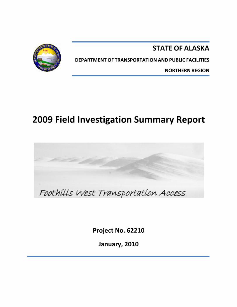
Two more Cat trains from Pt. Barrow followed in March and April, 1945. Each route was shorter in distance or time from the original, down to 586 mi./18 days for the second trip, and 614 mi./16 days for the third, due to shortcuts discovered on previous trips and use of Sig Wein’s plane for scouting. Once on site at Umiat with their initial load of equipment and supplies, U.S. Navy Seabees immediately began full-scale construction in March,
1945, on several large gravel pads to support both a camp and the establishment of permanent structures and a functional airfield (Figure II.7).
Additionally, in May, 1945 construction on framed tents, a boiler house and an oil rig were begun at the first oil well test site, which was approximately 8 miles away from camp.
Figure II.7.: Initial Umiat Camp structures (http://www.alsap.org/Umiat/Aukerman_Umiat_1947_camps.jpg)
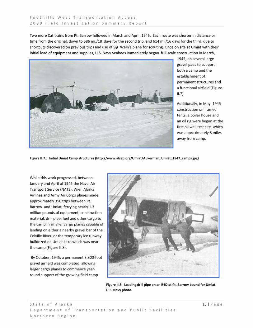
While this work progressed, between January and April of 1945 the Naval Air Transport Service (NATS), Wien Alaska Airlines and Army Air Corps planes made approximately 350 trips between Pt. Barrow and Umiat, ferrying nearly 1.3 million pounds of equipment, construction material, drill pipe, fuel and other cargo to the camp in smaller cargo planes capable of landing on either a nearby gravel bar of the Colville River or the temporary ice runway bulldozed on Umiat Lake which was near the camp (Figure II.8).
By October, 1945, a permanent 3,300‐foot gravel airfield was completed, allowing larger cargo planes to commence year‐round support of the growing field camp.
Figure II.8: Loading drill pipe on an R4D at Pt. Barrow bound for Umiat. U.S. Navy photo.
F o o t h i l l s W e s t T r a n s p o r t a t i o n A c c e s s 2 0 0 9 F i e l d I n v e s t i g a t i o n S u m m a r y R e p o r t
S t a t e o f A l a s k a 14 | P a g e D e p a r t m e n t o f T r a n s p o r t a t i o n a n d P u b l i c F a c i l i t i e s N o r t h e r n R e g i o n
With a workable camp largely completed late in 1945, efforts to drill test wells and characterize the petroleum resources of the area began in earnest 1946. Barex ’46 landed additional materials and manpower to the northern
Alaska coast, and Cat trains continued to supplement aerial supply missions from Pt. Barrow to Umiat.
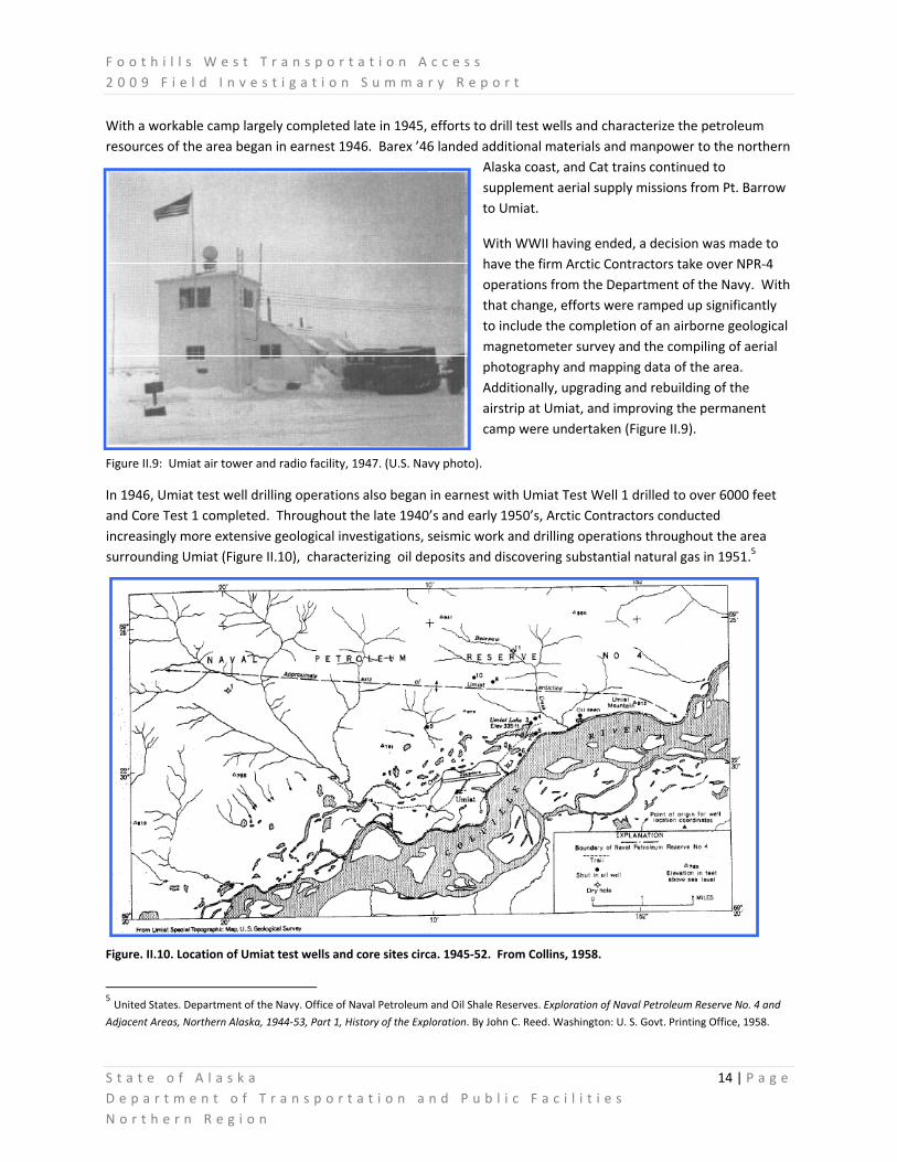
With WWII having ended, a decision was made to have the firm Arctic Contractors take over NPR‐4 operations from the Department of the Navy. With that change, efforts were ramped up significantly to include the completion of an airborne geological magnetometer survey and the compiling of aerial photography and mapping data of the area. Additionally, upgrading and rebuilding of the airstrip at Umiat, and improving the permanent camp were undertaken (Figure II.9).
Figure II.9: Umiat air tower and radio facility, 1947. (U.S. Navy photo).
In 1946, Umiat test well drilling operations also began in earnest with Umiat Test Well 1 drilled to over 6000 feet and Core Test 1 completed. Throughout the late 1940’s and early 1950’s, Arctic Contractors conducted increasingly more extensive geological investigations, seismic work and drilling operations throughout the area surrounding Umiat (Figure II.10), characterizing oil deposits and discovering substantial natural gas in 1951.5
Figure. II.10. Location of Umiat test wells and core sites circa. 1945‐52. From Collins, 1958.
5 United States. Department of the Navy. Office of Naval Petroleum and Oil Shale Reserves. Exploration of Naval Petroleum Reserve No. 4 and
Adjacent Areas, Northern Alaska, 1944‐53, Part 1, History of the Exploration. By John C. Reed. Washington: U. S. Govt. Printing Office, 1958.

F o o t h i l l s W e s t T r a n s p o r t a t i o n A c c e s s 2 0 0 9 F i e l d I n v e s t i g a t i o n S u m m a r y R e p o r t
S t a t e o f A l a s k a 15 | P a g e D e p a r t m e n t o f T r a n s p o r t a t i o n a n d P u b l i c F a c i l i t i e s N o r t h e r n R e g i o n
Field operations from the Umiat Camp supported the drilling of eleven test wells and multiple core samples on the Umiat anticline between 1945 and 1952 (Figure II.11). These more fully investigated the geological structure and petroleum production possibilities of the area.6 Concurrently, major supply operations continued to ship material and equipment to Point Barrow, where they were transported to Umiat by aircraft or, during winter
months, by ongoing Cat trains that had been further refined by development of more efficient sleds and tractors.
Figure II.11: 1947 Umiat core sampling with Umiat Test Well #2 in background. (U.S. Navy photo)
Similarly, two test wells were drilled on the Gubik anticline approximately 16 miles northeast of Umiat (Figure II.12). At these, gas was discovered before one well was plugged and the second blew out, caught fire and was abandoned.7 Figure II.12: Gubik test well and rig camp near Chandler River. (U.S. Navy photo)
Confirming the initial optimism of U.S. Bureau of Mines investigators 10 years earlier, continued invest igations at Umiat proved it to be the most extensive oil field discovered during that period of exploration, and in addition provided indications that it contained significant natural gas deposits as well. However, due to its remote location and the reduced need for petroleum to fuel wartime naval efforts, in 1953 the decision was made by the U.S. Navy to cease explorations in NPR‐4 and simultaneously transfer the majority of the Umiat Camp and equipment to the Air Force , which subsequently utilized the camp and facilities for support of its Alaskan operations.
6 Collins, F. R., 1958. Test Wells, Umiat Area, Alaska,. U.S. Geol. Survey Prof. Paper 305‐B, p. 71‐198, pls. 7‐12, text‐figs.
7 Robinson, F.M., 1958, TEST WELLS, GUBIK AREA, Alaska: U.S. Geological Survey Professional Paper 305‐C, p. 207‐264, 2 sheets. blue line.

F o o t h i l l s W e s t T r a n s p o r t a t i o n A c c e s s 2 0 0 9 F i e l d I n v e s t i g a t i o n S u m m a r y R e p o r t
S t a t e o f A l a s k a 16 | P a g e D e p a r t m e n t o f T r a n s p o r t a t i o n a n d P u b l i c F a c i l i t i e s N o r t h e r n R e g i o n
EARLY PIPELINE AND ROADBUILDING EFFORTS ASSOCIATED WITH THE REGION
Throughout the development of Umiat Camp and the U.S. Navy test well drilling program, efforts had concurrently been made to survey and establish a pipeline corridor from Fairbanks to Umiat. Pioneered and flagged by the Alaskan Scouts and explored by contractors Lytle and Green in 1945, the proposed route would have followed an established road from Fairbanks to Livengood, from there head north to cross the Yukon River to continue to Bettles. From Bettles, it would proceed up the John River though Anaktuvuk Pass, down the Anaktuvuk River on the north side of the Brooks Range and then head west to the drilling sites at Umiat (Figure II.13). This wartime pipeline effort never came to any practical fruition, however its developmental legacy was resurrected during the two years following discovery of oil at Prudhoe Bay in 1968.
Figure II.13: Lytle & Green Cat‐train heading to Bettles, 1945 (http://jukebox.uaf.edu/haul_road/htm/img_scoug_19.htm)
Wishing to capitalize on the Prudhoe Bay oil discovery in 1968, then‐Alaska Governor Walter Hickel directed that a winter ice road be constructed to northern Alaska in 1969 from the terminus of an existing road from Fairbanks to Livengood. The road, dubbed the “Hickel Highway”, was a bulldozer‐bladed trail over which wheeled trucks could travel only when it was maintained to expose frozen ground, and that allowed the crossing of rivers and streams only by temporary ice bridges. However, because the surface organic mat was disturbed in many places during

F o o t h i l l s W e s t T r a n s p o r t a t i o n A c c e s s 2 0 0 9 F i e l d I n v e s t i g a t i o n S u m m a r y R e p o r t
S t a t e o f A l a s k a 17 | P a g e D e p a r t m e n t o f T r a n s p o r t a t i o n a n d P u b l i c F a c i l i t i e s N o r t h e r n R e g i o n
construction, substantial summer thawing took place resulting in those portions of the Hickel Highway becoming virtually impassable quagmires when spring thaws began in 1970. 8
The Alaska Department of Highways was in charge of building the road from Livengood (Figure II.16). The route went north from Livengood across the Yukon River to Bettles Field, Ninemile Hills, and Crevice Creek. Then it ran northward along the John River to Anaktuvuk Pass (Figure II.14), along the Anaktuvuk River to Schrader Bluff, then northeast to the Itkillik River. Then the route ran eastward across the Kupuruk River to the Toolik River to the Sagavanirktok River and continued along the Sagavanirktok River, terminating at an airstrip at Sagwon.9
While the Hickel Highway was considered an economic failure as the cost of its construction resulted in an actual use of the highway being possible for only one month in total, the project nonetheless proved that viable land motor routes through the Brooks Range could be developed that might allow future year‐round access to the North Slope (Figure II.15).
Figure II.14: Present day road sign at a small vestige of the Hickel Highway near Anaktuvuk Pass airport. (DOT&PF photo)
Figure II.15: Construction equipment headed north on the Hickel Highway, 1970.
8 Brown, Jerry, and Kreig, R.A., 1983, Guidebook to permafrost and related features along the Elliott and Dalton Highways, Fox
to Prudhoe Bay, Alaska: Alaska Division of Geological & Geophysical Surveys Guidebook 4, 230 p.
9 The Dalton Highway: a multimedia history of Alaska’s Arctic Road. University of Alaska website accessed 01/08/10 at
http://jukebox.uaf.edu/haul_road/index.htm

F o o t h i l l s W e s t T r a n s p o r t a t i o n A c c e s s 2 0 0 9 F i e l d I n v e s t i g a t i o n S u m m a r y R e p o r t
S t a t e o f A l a s k a 18 | P a g e D e p a r t m e n t o f T r a n s p o r t a t i o n a n d P u b l i c F a c i l i t i e s N o r t h e r n R e g i o n
Figure II.16: 1969 “Hickel Highway” route (RS2477). Data from Alaska DNR, Division of Mining, Land, and Water.

F o o t h i l l s W e s t T r a n s p o r t a t i o n A c c e s s 2 0 0 9 F i e l d I n v e s t i g a t i o n S u m m a r y R e p o r t
S t a t e o f A l a s k a 19 | P a g e D e p a r t m e n t o f T r a n s p o r t a t i o n a n d P u b l i c F a c i l i t i e s N o r t h e r n R e g i o n
III. GALBRAITH CORRIDOR DESCRIPTION
The Galbraith Corridor is approximately 6 miles wide trending predominantely northwest/southeast from the mountainous region of the Brooks Range near Galbraith Lake, through the Arctic Foothills, and terminating at Umiat along the Colville River. The terrain is varied throughout the corridor, ranging from large mountains to river lowlands. Major river crossings include the Itkillik, Anaktuvuk, Chandler, and Colville.
LOCATION
The approximate southern extent and origin of the Galbraith Stud y Corridor is Dalton Highway Milepost 278, due north of Galbraith Lake (latitude and longitude coordinates are roughly 68°32.5'N, 149°29'W) and approximately 130 miles north of the Arctic Circle. The corridor mostly follows a northwest direction to end at Umiat, which has latitude and longitude coordinates of roughly 69°22'N, 152° 8.5'W. The corridor lies within the boundaries of the North Slope Borough and contains mostly state land, but also involves some Bureau of Land Management acreage andd Arctic Slope Regional Corporation land (Native lands). The National Petroleum Reserve – Alaska is immediately northwest of the project study area, with both the Gates of the Arctic National Park and Preserve and the Arctic National Wildlife Refuge to the south of the study area.

F o o t h i l l s W e s t T r a n s p o r t a t i o n A c c e s s 2 0 0 9 F i e l d I n v e s t i g a t i o n S u m m a r y R e p o r t
S t a t e o f A l a s k a 20 | P a g e D e p a r t m e n t o f T r a n s p o r t a t i o n a n d P u b l i c F a c i l i t i e s N o r t h e r n R e g i o n
CLIMATE
Overall, historical climate data within the project study area is limited to data collected at the Umiat, which can be accessed at the Western Regional Climate Center http://www.wrcc.dri.edu/summary/climsmak.html. This station has a period of record from 1949 to 2001. The data suggests a true arctic climate, with an average maximum yearly temperature of 19.9 degrees Fahrenheit, and an average minimum yearly temperature of 1.5 degrees Fahrenheit. Average total precipitation is limited to 5.46 inches, of which snowfall is recorded in the average total amount of 33.2 inches. The coldest temperature at Umiat was recorded at ‐66 degrees Fahrenheit during January of several years of record. A high temperature of 92 degrees Fahrenheit was recorded during July of 1993. The maximum 24‐hour precipitation event occurred in June, 1980, and is recorded as 4.3 inches. Other 24 hour maximum precipitation events are in the range of 1 – 2 inches.
As part of the Foothills West Transportation Access project, DOT&PF and DNR contracted with the University of Alaska Fairbanks, Northern Institute of Engineering, to install a network of meteorological stations throughout the project study area for the purpose of conducting hydrology studies for the project. These stations collect air temperature and relative humidity data, wind speed and direction, net radiation, summer precipitation, snow depth, and soil temperature and moisture. This data is not only useful for hydrology studies, but also in developing climate models for arctic road embankment design,
snow drifting analyses, and erosion and sediment control evaluations. Several of the stations are also equipped with near real‐time cameras, which improve travel safety during field studies. This meteorological station network collects data in near real‐time, and all data is posted on the following website:
http://www.uaf.edu/water/projects/umiat_corridor/stations.html
As described in the “Meteorological and Hydrological Data and Analysis Report for Bullen Point and Foothills Projects: 2006‐2008”, the Foothills West Transportation Access study corridor is best evaluated in comparison with the overall North Slope climatology. “The Arctic Climate combined with the elevation difference from the inland mountain region to the Coastal Plain creates distinct physiographic regions.” These regions are described as mountain, foothills, and coastal plain. The three regions can be summed in terms of

F o o t h i l l s W e s t T r a n s p o r t a t i o n A c c e s s 2 0 0 9 F i e l d I n v e s t i g a t i o n S u m m a r y R e p o r t
S t a t e o f A l a s k a 21 | P a g e D e p a r t m e n t o f T r a n s p o r t a t i o n a n d P u b l i c F a c i l i t i e s N o r t h e r n R e g i o n
temperature, precipitation, and wind. The warmest summertime temperatures are maintained in the foothills region, and the coolest summertime temperatures are along the coastal plain. During winter months, the coldest temperatures are along the coastal plain, with the mountain region having the warmest temperatures. Winter precipitation is greatest in the foothills region, with the mountain region accumulating the least amount of snow precipitation of the three regions. The greatest summertime precipitation occurs in the mountain region, and decreases northward toward the coastal plain, due to orographic influences. Winds in all three regions are generally out of the southwest and east ‐ northeast, although terrain can influence the wind directions in localized areas. This localized terrain effect becomes predominate in the mountain region. High winds occur more frequently along the coastal plain throughout the year and are the highest on average for the project area. The high wind direction on the Coastal Plain is predominately out of the east‐northeast.
The Foothills West Transportation Access study area lies primarily within the foothills physiographic region. The study corridor can be described in the winter as having the greatest precipitation of the region, with very cold temperatures. Winds are generally out of the northeast/southwest, but mountain terrain has localized effects, which become greater further south within the project study area. During summertime, precipitation is relatively moderate, but temperatures can be very warm. Thunderstorms have been documented in increasing frequency over the past few years.
It is important to note that in the following descriptions, summertime photos graphically depict general conditions in the project corridor. It is also important to consider wintertime conditions, as these conditions exist for seven to eight months of the year. A reconnaissance flight was made in April, 2009 evaluating these conditions in general terms. A brief report is available from DOT&PF addressing these conditions (See Section XI).

F o o t h i l l s W e s t T r a n s p o r t a t i o n A c c e s s 2 0 0 9 F i e l d I n v e s t i g a t i o n S u m m a r y R e p o r t
S t a t e o f A l a s k a 22 | P a g e D e p a r t m e n t o f T r a n s p o r t a t i o n a n d P u b l i c F a c i l i t i e s N o r t h e r n R e g i o n
GENERAL CORRIDOR DESCRIPTION
The Galbraith Corridor can be generally described as paralleling the northwestern foothills of the Brooks Range in Northern Alaska. The corridor has characteristics of three distinct physiographic regions: Arctic Mountain, Arctic Foothills, and Arctic Coastal Plain. The corridor itself can be described in more detail by dividing it into three segments: the southern, the middle, and the northern segment. The southern segment describes the area between the Dalton Highway and the Itkillik River; the middle segment describes the area between the Itkillik River and the Anaktuvuk River; and the northern segment describes the area between the Anaktuvuk River and Umiat.

F o o t h i l l s W e s t T r a n s p o r t a t i o n A c c e s s 2 0 0 9 F i e l d I n v e s t i g a t i o n S u m m a r y R e p o r t
S t a t e o f A l a s k a 23 | P a g e D e p a r t m e n t o f T r a n s p o r t a t i o n a n d P u b l i c F a c i l i t i e s N o r t h e r n R e g i o n
SOUTHERN CORRIDOR SEGMENT (DALTON HIGHWAY TO ITKILLIK RIVER)
The Foothills West Transportation Access corridor begins at the Dalton Highway (between mileposts 278 and 281) just north of Galbraith Lake where the landscape can be described as rugged, with glacially sculptured peaks, valleys, and lakes. As the corridor deviates from the Dalton Highway, it is constrained to a narrow parcel of Bureau of Land Management (BLM) land classified as “BLM Administered Utility Corridor”. This parcel bisects two BLM Areas of Critical Environmental Concern (ACEC): the “Toolik Lake Research Natural Area” to its north, and the “Galbraith Lake Outstanding Natural Area” to its south. The “Toolik Lake Research Natural Area” is currently leased from BLM by the University of Alaska for environmental and biological research.
The Galbraith Corridor trends due‐west approximately 4 miles through the “BLM Administered Utility Corridor” over moderately rolling terrain. The corridor then turns north for approximately 10 miles on State owned lands toward Itigaknit Mountain, circumventing the Toolik Lake basin to the east, as well as Itigaknit Lake, the headwaters of the Itkillik River and numerous smaller lakes to its west. Although the potential corridor currently encompasses all of Itigaknit Mountain, any single, final route could curve either eastward or westward around the mountain through gradual terrain, avoiding potential snow drifting, avalanche, and slope stability hazards.
Once past Itigaknit Mountain, the corridor descends northwesterly for approximately 12 miles through state owned lands on gently sloping, dry terraces lying between the Itkillik and Kuparuk Rivers. The next segment of the corridor leading up to the Itkillik River provides the option for the potential road alignment to either gradually descend and cross the Itkillik River to travel on the west side of the river, or to continue downstream on the east side of the river and make a crossing further north.
The Itkillik River at the southern crossing location is characterized by a narrow
channel and relatively stable banks. Large boulders are visible in the river itself. As the river flows north, it becomes more dynamic, separating into multiple, active channels where the river floodplain widens considerably. A crossing further to the north would most likely require a considerably longer structure and at the proposed southern location. Crossings are discussed in detail in the Hydrology section of this report.

F o o t h i l l s W e s t T r a n s p o r t a t i o n A c c e s s 2 0 0 9 F i e l d I n v e s t i g a t i o n S u m m a r y R e p o r t
S t a t e o f A l a s k a 24 | P a g e D e p a r t m e n t o f T r a n s p o r t a t i o n a n d P u b l i c F a c i l i t i e s N o r t h e r n R e g i o n
This southernmost twenty five miles of the corridor has characteristics of an Arctic Mountain physiographic region. The southern corridor section varies in elevation from 3,450 to 1,150 feet and includes terrain typical of a recently glaciated era.
Geomorphic features include kettle lakes, irregular buttes, knobs, mesas, east‐west‐trending ridges, u‐shaped valleys, and intervening, gently
irregular uplands. Large scale rock and gravel outcroppings are visible throughout this region. The mountain physiographic characteristics transition to foothills characteristics in the general vicinity of the project’s proposed Itkillik River crossing.
MIDDLE CORRIDOR SEGMENT (ITKILLIK RIVER TO ANAKTUVUK RIVER)
At the Itkillik River, several options exist to travel northward along the project corridor. One option is to cross the Itkillik River immediately at the beginning of this segment, and head northwest on the raised terraces west of, and parallel, to the Itkillik River. The crossing of the Iktillik River is straightforward at this location due to the constricted channel and seemingly stable banks. The another option would be to travel north along the east side of the Itkillik River for approximately 30 miles before crossing and proceeding west. This area appears to be flatter, and may consist of alluvial materials deposited from the historical, westward migration of the Itkillik River’s active channel. This second option requires more study, as uncertainties exist as to how stable

F o o t h i l l s W e s t T r a n s p o r t a t i o n A c c e s s 2 0 0 9 F i e l d I n v e s t i g a t i o n S u m m a r y R e p o r t
S t a t e o f A l a s k a 25 | P a g e D e p a r t m e n t o f T r a n s p o r t a t i o n a n d P u b l i c F a c i l i t i e s N o r t h e r n R e g i o n
the ground is on the east side of the river, and how much longer the river crossing would be due to the braided and multichannel nature of the river at the northern location.
Within the middle corridor segment, the landscape is characterized by broad east‐west‐trending ridges and local mesa‐like mountains. Northward, the terrain decreases in elevation from about 1,150 to 590 feet. The corridor between the Itkillik and Nanushuk Rivers is characterized by rolling, gradually descending terrain crossing numerous small tributaries of the Itkillik River as well as several larger, incised drainages. North of the Nanushuk River, the number of tributary crossings decreases, grades flatten, and overall drainage becomes poor. North of VABM 1069 (a benchmark noted on the USGS Topographic Map) the area is characterized by numerous lakes of varying size and configuration, cross‐flow drainage patterns, and marshy ground. Sub‐soil conditions are generally anticipated to be unstable.
Undulating terrain within this corridor section increasingly becomes characterized by permafrost features normally found on the Coastal Plain, such as beaded streams and polygonal ground. One unique feature within this region is that of watertracks. Large scale lineal features are apparent on low relief terrain. In discussions with UAF, Institute of Northern Engineering staff, these features are described as water flow marks over areas with permafrost, indicating low infiltration rates and sheet flow events during summer precipitation. These tracks can be an indicator of large scale drainage patterns in the region.
Progressing through the forty miles of the middle study corridor section, the terraces west of the Itkillik River were scorched by a tundra fire during the summer of 2007. Known as the Anaktuvuk River Fire, this is the largest recorded tundra fire on the North Slope of Alaska. The fire burned for nearly three months, consuming more than 245,000 acres. The conditions potentially responsible for this large tundra fire include modeled record‐high summer temperatures, record‐low summer precipitation, a late‐season high‐pressure system located over the Beaufort Sea, extremely dry soil conditions throughout the summer, and sustained southerly winds during the period of vegetation senescence.10 This fire is likely to have induced thermokarsts in the area, causing slumping and thaw pits.
10 Jones, Benjamin M; Kolden, Crystal A.; Jandt, Randi; Abatzoglou, John T.; Urban, Frank; Arp, Christopher D.; Fire Behavior, Weather, and
Burn Severity of the 2007 Anaktuvuk River Tundra Fire, North Slope, Alaska : Arctic, Antarctic, and Alpine Research, 2009, vol. 41, no3, pp. 309‐316

F o o t h i l l s W e s t T r a n s p o r t a t i o n A c c e s s 2 0 0 9 F i e l d I n v e s t i g a t i o n S u m m a r y R e p o r t
S t a t e o f A l a s k a 26 | P a g e D e p a r t m e n t o f T r a n s p o r t a t i o n a n d P u b l i c F a c i l i t i e s N o r t h e r n R e g i o n
Descending from of the Itkillik River terraces to the Anaktuvuk River presents challenges. The northern half of this corridor segment is characterized by small scale ridges of high ground separated by what appear to be drained thaw lakes. The high ground appears relatively thaw‐stable, while the drained thaw lakes appear unstable. Connecting alignments through this area to maximize thaw stable soils will be challenging, as high ground trends perpendicularly to the corridor alignment. Traversing large areas of poorly drained unstable ground may be unavoidable.
West of the Itkillik River terraces, the corridor descends due west to the Anaktuvuk River in the vicinity of benchmarks VABM 515 and VABM 555, located to the south of Square Lake. This section of the corridor contains numerous, established winter trails trending east‐west, as well as abandoned drilling wells and old development features. Shallow relief drainages are common in this area, leading down to the Anaktuvuk River. The bluffs on the east side of the Anaktuvuk River are of moderate grades. The mile‐wide flat floodplain on the east side of the river is characterized by numerous inactive river channels and what appears to be thaw unstable ground on the margins of the floodplain.
NORTHERN CORRIDOR SEGMENT (ANAKTUVUK RIVER TO UMIAT)
Crossing the Anaktuvuk and Chandler Rivers within this segment will be challenging. Within the project study corridor the Anaktuvuk River is a large, dynamic, braided stream that has large bluffs on both sides. Heading west after crossing the Anaktuvuk, the terrain is moderately rolling, and appears to be relatively dry. Permafrost characteristics such as polygons and nets can be seen within drainages along the segment. Approaching the Chandler River (approximately 7 miles away), bluffs predominate the landscape before entering its floodplain. The Chandler River is also a large, dynamic braided river, but appears to not exhibit the larger scale, dynamic features

F o o t h i l l s W e s t T r a n s p o r t a t i o n A c c e s s 2 0 0 9 F i e l d I n v e s t i g a t i o n S u m m a r y R e p o r t
S t a t e o f A l a s k a 27 | P a g e D e p a r t m e n t o f T r a n s p o r t a t i o n a n d P u b l i c F a c i l i t i e s N o r t h e r n R e g i o n
of the Anaktuvuk River. Heading west, a series of two‐hundred foot high bluffs once again predominate the landscape. Incised drainages cut through the bluffs, and may provide areas to ramp up to higher ground without excavating the frozen terrain.
Between the Chandler River and Umiat (approximately 15 miles), the corridor is characterized of three distinct benches that parallel the Colville River to the south. An upper bench appears to be dry ground on moderately rolling terrain, but contains large drainages and possibly thermokarst
features. A mid‐level bench appears to have more moderate drainage features and yet appears to be dry, but large scale permafrost features such as polygons and cross drainages appear abundant. The lower bench is characterized by dry ground, narrow (but deep) drainage crossings, and more stable and well draining subsurface materials.
Descending to the Colville River floodplain appears challenging with moderate grades. The Colville River at this location is characterized by large scale gravel bars with very course material. The river characteristics near the State Airport at Umiat appear conducive to a bridge crossing site in this area.

F o o t h i l l s W e s t T r a n s p o r t a t i o n A c c e s s 2 0 0 9 F i e l d I n v e s t i g a t i o n S u m m a r y R e p o r t
S t a t e o f A l a s k a 28 | P a g e D e p a r t m e n t o f T r a n s p o r t a t i o n a n d P u b l i c F a c i l i t i e s N o r t h e r n R e g i o n
IV. ENGINEERING FIELD PROGRAM SUMMARY
Engineering field work began in early spring of 2009 and continued through October 2009. Fieldwork was prioritized based on budgets available and critical information required. Priorities were based on the need to collect information critical for required environmental documentation, continuing the development of road plans, and developing cost estimates. Overall, the field program was very successful in collecting critical data in the short field season timeframe.
In order to focus field season efforts more efficiently, reasonable transportation corridors were developed in the field based on engineering observations and available topographic information. No preferred alignment corridor has been considered to date, as more detailed imagery and topographic data will be available for analysis in January of 2010.
FACTORS CONSIDERED IN DEVELOPING THE ENGINEERING FIELD PROGRAM:
In general, the methodology utilized for this project was to evaluate the alignments at a reconnaissance level utilizing the following constraints:
1. Develop base maps and begin survey work required for engineering studies immediately.
2. Develop draft road design criteria to assist in determining geometric design constraints in the field.
3. Determine, at a reconnaissance level, potential river and stream crossing sites within the project study corridor. Road alignments would converge at these locations.
4. Determine, at a reconnaissance level, potential material sites located within the project study corridor. Road alignments would be located as close to potential material sites as feasible in order to minimize construction haul distances.
5. Characterize the terrain of the study corridor for the purpose of avoiding areas of potential subsidence, settlement, or other hazards.
The development of actual road routing options requires the data and analyses outlined above. The goal was to have sufficient information to develop focused transportation corridors for further, detailed analyses during the 2010 field season if the project continues.
BASE MAPPING, SURVEYING, AERIAL PHOTOGRAPHY, AND TOPOGRAPHIC MAPPING
Surveying work was completed during the 2009 field season that included on the ground surveys, as well as LiDAR and aerial photography acquisition and photogrammetry. This data is a priority for any environmental and engineering studies. Aerial photography of a reasonable scale and topographic data of reasonable accuracy is required to evaluate environmental considerations such as wetlands and wildlife, cultural resources, hazardous materials, and erosion and sediment control. For engineering studies, aerial photography and topographic data is critical in the development of road alignments and river crossing locations, to develop quantity and cost estimates. Overall, the 2009 field season accomplished the objectives set forth at the beginning of the project.

F o o t h i l l s W e s t T r a n s p o r t a t i o n A c c e s s 2 0 0 9 F i e l d I n v e s t i g a t i o n S u m m a r y R e p o r t
S t a t e o f A l a s k a 29 | P a g e D e p a r t m e n t o f T r a n s p o r t a t i o n a n d P u b l i c F a c i l i t i e s N o r t h e r n R e g i o n
PROJECT BASE MAP DEVELOPMENT
During the initial stages of the project, and several months before spring began within the project study area, the development of Base Maps was initiated by DOT&PF. Base maps are required for developing potential project options, as well as to develop field study plans for engineers and environmental analysts operating in the field prior to collecting more detailed data. These base maps are the basis of future project work.
To establish the base maps, a project coordinate system was selected as the basis of geospatial coordinates for all disciplines including engineering, survey, and environmental. The project coordinate system is based on the Alaska State Plane Coordinates. All data for the project will be collected in NAD 83 Alaska Zone 4 state plane coordinates or project coordinates based on a control point located at VABM Lieb of the USGS Umiat Quadrangle.
Initial data for project base maps was acquired from a combination of “data mining” geospatial datasets that exist both internally to DOT&PF (developed on other projects in the region) and over the internet from other state and federal agency databases. It is important to note that the data recovered from multiple sources likewise is accurate to their varying levels of precision. Metadata documenting the accuracy of those datasets are utilized in determining the applicability of their respective spatial data to the tasks at hand.
The following is a summary of the datasets that exist within the project base map:
OIL AND GAS LEASE BOUNDARIES (DNR) OIL AND GAS ACCUMULATION OUTLINES (DNR) PROJECT STUDY AREA (DOT&PF) PROJECT CORRIDOR(S) (DOT&PF) RECONNAISSANCE LEVEL MATERIAL SITES (DOT&PF) ROLLIGON ROUTES (DOT&PF) BLM TRANSECTS (BLM) TOOLIK LAKE RESEARCH LOCATIONS (UAF) ALASKA HIGHWAY CENTERLINE DATA (DOT&PF) ACMP COASTAL DISTRICT BOUNDARIES (DGC) ABANDONED AIRPORTS (DOT&PF) ALASKA GENERAL LAND STATUS (DNR) HICKEL HIGHWAY RS2477 (DNR) HISTORICAL ICE ROADS IN THE REGION (VARIOUS INDUSTRY) NATIVE ALLOTTMENTS (BLM) METEOROLOGICAL AND RIVER GAUGING STATIONS (UAF) PIPELINES (DOT&PF) RAPTORS/BIRDS (3PPI) BEAR DENS (3PPI) BARRELS (3PPI) ALASKA PLSS SECTION GRID (DNR) WATERSHEDS (3PPI)

F o o t h i l l s W e s t T r a n s p o r t a t i o n A c c e s s 2 0 0 9 F i e l d I n v e s t i g a t i o n S u m m a r y R e p o r t
S t a t e o f A l a s k a 30 | P a g e D e p a r t m e n t o f T r a n s p o r t a t i o n a n d P u b l i c F a c i l i t i e s N o r t h e r n R e g i o n
Imagery and topograpic data are critical components to base map development. For the original base map applications, USGS mapping was utilized to provide initial topography information required for preliminary studies. Due to the remote location of the region, existing imagery was difficult to obtain. In response, DOT&PF let a contract to acquire any historical data for the region for the purpose of developing base maps. The requirements of the data were that “…the data be without snow cover at elevations below 2000’, and suitable for wetlands and vegetation mapping as determined by the Department. Cloud cover shall be limited to 5% per square kilometer.” A contractor, ABEO, Inc., was able to acquire Quickbird satellite imagery data that met DOT&PF specifications for 95% of the project study area (approximately 14,460 sq. km). This data was suitable to ensure unimpeded progress for 2009 field season activities, and a geospatial basis for studies was developed.
SURVEY PROGRAM
The survey program consisted of a combination of DOT&PF staff performing control surveys within the project corridor, and consultants providing control point locations and performing data reduction activities. Overcoming logistical challenges of access and weather were key components in making the survey work efficient in this area. Utilizing in‐house staff for on the ground survey work provided flexibility in the program, as DOT&PF surveyors could shift their efforts to adjacent Dalton Highway work if weather precluded aerial access to survey sites within the Foothills project study area.
FIELDWORK PREPARATION
Preparation for the field activities was initiated by entering into contractual agreements with R&M Consultants Inc. (R&M) to provide aerial photography and topographic data reduction services required for the project. R&M was provided data for the “Galbraith Corridor” limits to begin evaluating the level of survey control needed for the product desired. Discussions focused on obtaining the best product for the most reasonable price, due to the large size of the data acquisition area (approximately 600 square miles). All disciplines were consulted to ensure the data would meet the requirements of both the engineers and environmental scientists.

F o o t h i l l s W e s t T r a n s p o r t a t i o n A c c e s s 2 0 0 9 F i e l d I n v e s t i g a t i o n S u m m a r y R e p o r t
S t a t e o f A l a s k a 31 | P a g e D e p a r t m e n t o f T r a n s p o r t a t i o n a n d P u b l i c F a c i l i t i e s N o r t h e r n R e g i o n
DOT&PF directed the consultant to develop a plan to meet the following requirements:
• Topographic mapping shall be controlled to provide 2 foot horizontal and vertical accuracies within the entire Galbraith Corridor.
• Topographic data compilation will be completed for a 4 foot contour interval and a plot scale of 1”=200’.
• Topographic mapping to be completed using LiDAR (Light Detection And Ranging) and edited with aerial photography and planimetric mapping.
• Aerial photography will be acquired for the entire Galbraith Corridor at a nominal scale of 1:18,000 (1”=1500’) with sufficient overlap to provide stereo photo coverage.
• Ortho Imagery will be processed at 1’ per pixel (Sufficient for plot scale of 1”=200’).
• Aerial photography flown during “leaf on” conditions.
• Metadata will be provided for all deliverables.
Once constraints for the data were developed, the consultant, coordinating with DOT&PF survey staff, developed an aggressive plan to acquire data in June, and post‐process the data by December, of 2009.
State survey crews proceeded with planning activities for establishing survey control points in the field. 36 control points were required throughout the project area, utilizing National Geodetic Tri‐Stations for 13 of them. Logistical planning was conducted, travel/living arrangements were made, and helicopter support was secured for the surveyors’ use.
2009 SUMMER FIELD WORK
The 2009 survey field season began on June 9th, with State survey crews arriving at Happy Valley camp to begin work on establishing ground control for the project. Field survey crews consisted of a crew chief, instrument person, chain person, and a survey supervisor. A Eurocopter AS350 B2 Helicopter was chartered from ERA helicopters, based in Deadhorse. The helicopter was chartered for the sole use by surveyors accomplishing control work on the project.
The weather immediately became a factor in operations, but the surveyors were able to substitute Dalton Highway work to maintain project efficiency. Due to the helicopter’s fuel limitations and the long distances associated with the project corridor, a helicopter fuel cache was immediately established at a location within the project area noted on USGS maps as VABM ARUK (Geographic Coordinates: 68d53m53sN, 149d,56m,17sW, Elev 2047ft). The fuel cache was approved and permitted by Alaska DNR and constructed to ensure

F o o t h i l l s W e s t T r a n s p o r t a t i o n A c c e s s 2 0 0 9 F i e l d I n v e s t i g a t i o n S u m m a r y R e p o r t
S t a t e o f A l a s k a 32 | P a g e D e p a r t m e n t o f T r a n s p o r t a t i o n a n d P u b l i c F a c i l i t i e s N o r t h e r n R e g i o n
proper containment. This fuel cache of 6 drums (300 gal.) was utilized several times to ensure safe and uninterrupted survey activities, and proved very useful and cost efficient as commercial fuel was only available at Happy Valley Camp and Umiat Lodge, which are approximately 100 miles apart.
Primary control points were established at Galbraith Airport, NGS Points (VABMs) ARUK, LIEB, OKPIK, and at a new control point set at Umiat Airport. Once the primary control was established, the remaining monuments and photo control panels were set throughout the project corridor utilizing helicopter support.
State survey forces used static and kinematic GPS methods to establish 3D coordinates on the photo panels and existing NGS and BLM monumentation. The OPUS utility was used in order to establish ties to the National Reference System and existing survey monumentation along the Dalton Highway. These methods allow alignments to be tied to the Dalton Highway Right of Way, the National Reference System in both the horizontal and vertical systems, and reference the data to the BLM Quadrangle System.
Kinematic GPS data were also collected at random locations along the project corridor in order to confirm the LIDAR and photo mapping requirements. Several ID points were also tied to the system for the purposes of controlling satellite imagery, if that becomes necessary.
Photo panels were placed and ready for photo acquisition by June 24th, 2009. Additional survey work continued to finalize the control points, and the entire ground control effort was completed by July 1, 2009.
The aerial photography mission was conducted on July 3, 2009. Aerial photography was flown by Kodiak Mapping, Inc. utilizing a Wild RC30, six inch USGS certified aerial camera, with a Wild Universal Aviogon 4‐S lens. The camera was calibrated by the USGS on December 1, 2006. Weather at the time was outstanding, and the photography mission went smoothly.

F o o t h i l l s W e s t T r a n s p o r t a t i o n A c c e s s 2 0 0 9 F i e l d I n v e s t i g a t i o n S u m m a r y R e p o r t
S t a t e o f A l a s k a 33 | P a g e D e p a r t m e n t o f T r a n s p o r t a t i o n a n d P u b l i c F a c i l i t i e s N o r t h e r n R e g i o n
The LiDAR missions were conducted between June 24 and July 1, 2009. Subcontractor Airborne Imaging Inc. was utilized to collect the data using an Optech ALTM 3100 EA LiDAR sensor. LiDAR image acquisition doesn’t require clear skies since the method relies on technology that measures the time delay between the transmission of laser pulses and detection of their reflected signals. The specific LiDAR sensor used for this project had pulse repetition rates of up to 150,000 measurements per second, was capable of collecting terrain information to an accuracy of 2 feet, and acquired points at a density of approximately one per square meter. A flight altitude of 1000 meters was used for the six missions required to fly the project corridor. All missions went smoothly, and all data were acquired without complication.
DATA PROCESSING AND DELIVERABLES
Once the fieldwork was complete, DOT&PF staff and consultants began the post‐processing of the data. The State efforts focused on the ground control survey network, and consultants focused on the topographic mapping and aerial photography deliverables. The schedule was aggressive due to the size of the project corridor, and required maintained, focused effort to meet the desired timetable.
Topographic Data: Data processing focused on combining LiDAR and stereo photographic data to efficiently produce the most accurate, topographic mapping available from the technologies used. Initially, a “bare earth” dataset was developed from the LiDAR data acquired for the project. Next, the LiDAR data was checked and edited with stereo photography to correct and supplement the bare earth surface created during the LiDAR processing. This methodology ensures a surface that is accurate in areas which are steep and rugged (historically difficult for LiDAR to acquire) as well as includes a second check for any outlier data that LiDAR acquires. Also, LiDAR data alone does not provide critical breakline information, which is required for steep terrain, areas of complex hydrography, and developed areas.
Orthophotography: Once the aerial photography was acquired and processed, the images were scanned at 12 microns, resulting in a 0.71 feet per pixel resolution. The Contractor utilized the provided survey control, observed tie points, and airborne GPS data to produce an ortho mosaic that was visually seamless. The imagery was resampled to produce ortho images that are 1 foot per pixel resolution.
Deliverables: Project corridor datasets currently available from DOT&PF by request include:
1. Contact Prints
2. Corridor orthophoto in both .tif and Mr.Sid formats
3. DTM of project corridor
4. Contour data of project corridor
5. Planimetric data of project corridor
6. Appropriate metadata and spatial references

F o o t h i l l s W e s t T r a n s p o r t a t i o n A c c e s s 2 0 0 9 F i e l d I n v e s t i g a t i o n S u m m a r y R e p o r t
S t a t e o f A l a s k a 34 | P a g e D e p a r t m e n t o f T r a n s p o r t a t i o n a n d P u b l i c F a c i l i t i e s N o r t h e r n R e g i o n
PROJECT DESIGN CRITERIA
Specific design criteria are required for developing roads and bridges, as well as for considering the inclusion of other utilities into their resulting transportation corridor concepts. As the specific purpose of the Foothills project is to provide access to oil and gas resources in the region for exploration and development, a transportation corridor concept must be developed that while providing basic access to those resources, also allows for the integration of utilities such as gas and oil pipelines or other facilities needed to transport resources to market.
ROAD DESIGN
Preliminary road design criteria were established based on DOT&PF development of previous industrial road projects on the North Slope. Additional refinement of these criteria is needed, and will require coordination with both State and Federal agencies and industry to determine the most appropriate requirements. The following is a summary of the proposed preliminary criteria:
• Special Resource Recovery Road as defined by AASHTO
• Road Width: 24’ with 3’ shoulders (30’ total width to accommodate typical drill rigs operating on the North Slope)
• Road Construction: gravel embankment with crushed gravel surfacing – embankment depth requires further thermal analysis
• Turnouts every 5 miles to allow for limited delays during drill rig transport
• Road Access Restriction undetermined at this time
BRIDGE DESIGN
Preliminary bridge design criteria were developed for the purpose of preliminary cost estimating and development of preliminary bridge concepts. These preliminary criteria were established based on DOT&PF development of previous industrial road projects on the North Slope. Additional refinement of these criteria is needed and will require coordination with both State and Federal agencies and industry, to determine the most appropriate requirements. The following is a summary of the proposed preliminary criteria:
• Bridges accommodate a 30’ driving surface
• Bridges designed to standard AASHTO HL‐93 bride loadings (more research needed on design vehicles to be utilized in this region)
• Could include gas and oil pipeline loads
• Removable bridge rails to accommodate large equipment passage
• Designed to span 50 year flood plain
F o o t h i l l s W e s t T r a n s p o r t a t i o n A c c e s s 2 0 0 9 F i e l d I n v e s t i g a t i o n S u m m a r y R e p o r t
S t a t e o f A l a s k a 35 | P a g e D e p a r t m e n t o f T r a n s p o r t a t i o n a n d P u b l i c F a c i l i t i e s N o r t h e r n R e g i o n
DESIGN CONSIDERATIONS FOR OIL AND GAS PIPELINES
As part of development of a transportation corridor for this project, oil and gas pipeline design criteria will be included. Corridor options should be developed that ensure oil and gas pipeline alignment requirements are considered, and that oil or gas pipelines can be constructed within any final corridor considered at a future date.
Some research has been performed by in‐house staff to establish preliminary pipeline alignment considerations. Considerable work remains to be completed to address detailed pipeline design criteria with industry professionals.
PRELIMINARY PIPELINE ALIGNMENT CONSIDERATIONS
Permafrost conditions in the arctic bring two pipeline construction modes into investigation, elevated or buried. In their paper “Permafrost and related engineering problems in Alaska”, Ferrians, Kachadoorian, and Greene (1969) touch on some of the more important design considerations of constructing a pipeline in the Arctic. The paper demonstrates that the temperature of the transported oil or gas, and the extant soil conditions, will largely dictate the design of the pipeline. A pipeline design study involving thermal analysis should be conducted to determine the potential effects on the permafrost.
A pipeline can potentially be buried in thawed or thaw‐stable soils and in bedrock, where thawing of permafrost would not cause loss of soil support for the pipe. Special refrigerated sections were used in the Trans‐Alaska Pipeline where the pipe had to be buried in thaw‐unstable soils. Elevating the pipeline should be considered when thawing of the permafrost would create thaw‐unstable conditions. The following are the design considerations made by Ferrians, Kachadoorian, and Greene:
“If the pipeline is placed underground, the vegetation cover overlying the permafrost is destroyed, disrupting the thermal regime. This disruption can cause differential settlement of the pipeline, and, since it is underground, the settlement may not be noticed until the pipeline has been ruptured. If the line carries a warm fluid, it will thaw the permafrost and cause differential subsidence which could cause the structure to lose support.
Pipelines on the surface or on a supporting structure are subjected to frost heaving during the winter and subsidence during the summer. This action will be especially strong if the line passes over fine‐grained sediment or over a bog or swamp. Other areas to be avoided are solifluction lobes where slow gravitational flowage of masses of surficial material occurs. These masses move downslope during the summer months after the active layer is thawed. If a pipeline were placed in or on these solifluction lobes, it probably would be damaged by the downslope movement. Therefore, such areas should be recognized and avoided. Another place to be avoided is the bottom of a stream channel, where winter ice on the stream might damage the pipeline.
In areas where the permafrost contains ice wedges, severe damage to an above‐ground pipeline will occur if the ice wedges are allowed to thaw.”
Ferrians, Kachadoorian, and Greene also added during their conclusions …
“Consider the following problems when pipelines are laid across creeks or rivers:

F o o t h i l l s W e s t T r a n s p o r t a t i o n A c c e s s 2 0 0 9 F i e l d I n v e s t i g a t i o n S u m m a r y R e p o r t
S t a t e o f A l a s k a 36 | P a g e D e p a r t m e n t o f T r a n s p o r t a t i o n a n d P u b l i c F a c i l i t i e s N o r t h e r n R e g i o n
a) If the pipeline crosses the creek or river underground, it may be damaged by the slumping of huge blocks of permafrost undercut at the banks, or it may be exposed by erosion and damaged by boulders, ice, or other debris during flood stage.
b) Pipelines placed on the surface of a flood plain may be subject to inundation and possible damage by ice and floating debris.”
Shown below is a photo taken during construction of the Trans‐Alaska Pipeline. In the photo a trench is being dug for an 8‐inch buried gas line along the “Haul Road”. The gas line runs from Prudhoe Bay to Pump Station Number 4 near Galbraith Lake. This is an example of a buried gas line constructed during the winter in order to keep the subsurface frozen.
Photographer: Steve McCutcheon, 1975? (Steve McCutcheon Trans Alaska Pipeline System Construction Collection, Alaska Digital Archives)
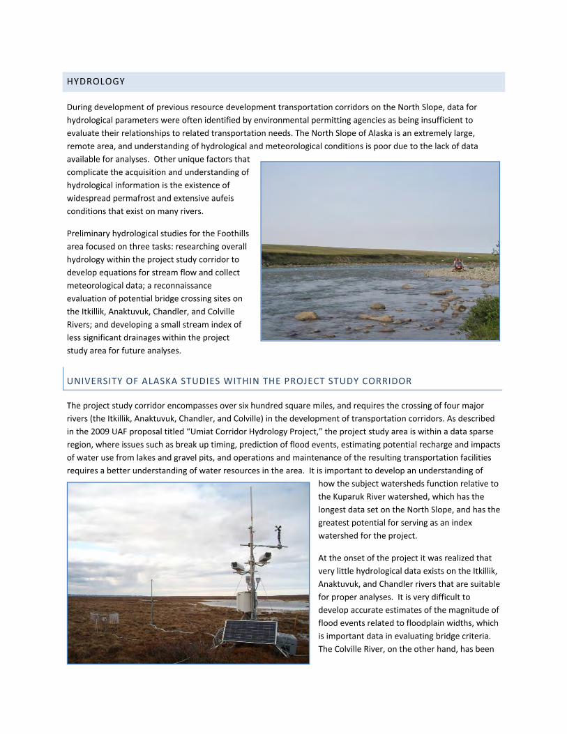
HYDROLOGY
During development of previous resource development transportation corridors on the North Slope, data for hydrological parameters were often identified by environmental permitting agencies as being insufficient to evaluate their relationships to related transportation needs. The North Slope of Alaska is an extremely large, remote area, and understanding of hydrological and meteorological conditions is poor due to the lack of data available for analyses. Other unique factors that complicate the acquisition and understanding of hydrological information is the existence of widespread permafrost and extensive aufeis conditions that exist on many rivers.
Preliminary hydrological studies for the Foothills area focused on three tasks: researching overall hydrology within the project study corridor to develop equations for stream flow and collect meteorological data; a reconnaissance evaluation of potential bridge crossing sites on the Itkillik, Anaktuvuk, Chandler, and Colville Rivers; and developing a small stream index of less significant drainages within the project study area for future analyses.
UNIVERSITY OF ALASKA STUDIES WITHIN THE PROJECT STUDY CORRIDOR
The project study corridor encompasses over six hundred square miles, and requires the crossing of four major rivers (the Itkillik, Anaktuvuk, Chandler, and Colville) in the development of transportation corridors. As described in the 2009 UAF proposal titled “Umiat Corridor Hydrology Project,” the project study area is within a data sparse region, where issues such as break up timing, prediction of flood events, estimating potential recharge and impacts of water use from lakes and gravel pits, and operations and maintenance of the resulting transportation facilities requires a better understanding of water resources in the area. It is important to develop an understanding of
how the subject watersheds function relative to the Kuparuk River watershed, which has the longest data set on the North Slope, and has the greatest potential for serving as an index watershed for the project.
At the onset of the project it was realized that very little hydrological data exists on the Itkillik, Anaktuvuk, and Chandler rivers that are suitable for proper analyses. It is very difficult to develop accurate estimates of the magnitude of flood events related to floodplain widths, which is important data in evaluating bridge criteria. The Colville River, on the other hand, has been

F o o t h i l l s W e s t T r a n s p o r t a t i o n A c c e s s 2 0 0 9 F i e l d I n v e s t i g a t i o n S u m m a r y R e p o r t
S t a t e o f A l a s k a 38 | P a g e D e p a r t m e n t o f T r a n s p o r t a t i o n a n d P u b l i c F a c i l i t i e s N o r t h e r n R e g i o n
studied to a limited degree over time due to oil and gas related development activities near Umiat area and to the North, which both required these engineering evaluations be made.
The University of Alaska Fairbanks, Institute of Northern Engineering (UAF) entered into an agreement with DOT&PF in 2006 to begin evaluating hydrological conditions on the North Slope as related to several potential transportation projects. As part of this work, UAF began establishing a network of meteorological stations within the Foothills project study area. These stations monitor air temperature and relative humidity, wind speed and direction, net radiation, summer precipitation, snow depth, and soil temperature/moisture contents. This initial network was focused on the project study area east of the Itkillik River, and tied into the network already established by UAF for other project locations on the North Slope, including the Bullen Point project, which was funded by both DNR and DOT&PF.
In 2009, DOT&PF developed an additional agreement with UAF to expand the meteorological network into the project study area west of the Itkillik river, including the following tasks: establish a single continuous surface water monitoring gauging site on the Anaktuvuk River; establish meteorological stations, gaging staffs and cameras on the Itkillik, Anaktuvuk, and Chandler Rivers; develop surface water flow models for drainages impacting transportation routes within the corridor; measure spring snowpack conditions in the related watersheds of the Itkillik, Anaktuvuk, and Chandler rivers; and install, maintain and collect
data from a network of meteorological sites to provide basic weather data related to stream flow in the related watersheds of the Itkillik, Anaktuvuk and Chandler Rivers. All data from the meteorological network are near real‐time and available at the following website:
http://www.uaf.edu/water/projects/umiat_corridor/stations.html
The cameras located at meteorological sites have improved safety on the project by assisting pilots and field crews in determining meteorological conditions in the area whenever weather is questionable for flying. UAF is currently funded through June, 2010 to continue these studies.
In addition to these tasks, UAF also completed spring break up studies during May of 2009. The following is a summary written by UAF discussing the results to date. A full report and analysis will be completed later in 2010.

F o o t h i l l s W e s t T r a n s p o r t a t i o n A c c e s s 2 0 0 9 F i e l d I n v e s t i g a t i o n S u m m a r y R e p o r t
S t a t e o f A l a s k a 39 | P a g e D e p a r t m e n t o f T r a n s p o r t a t i o n a n d P u b l i c F a c i l i t i e s N o r t h e r n R e g i o n
HYDROLOGICAL AND METEOROLOGICAL MEASUREMENTS OF DRAINAGES IN THE EASTERN COLVILLE DRAINAGE
SUMMARY REPORT TO AKDOT&PF
JANUARY 1, 2010
PREPARED BY FACULTY AND STAFF, UAF/WERC
During the spring of 2009, a data collection effort was initiated to quantify the meteorology and hydrology of the Itkillik, Anaktuvuk and Chandler watersheds (Figure IV.1). Five meteorological stations and three hydrological stations were installed in 2009, for typical site see Figure IV.2. The hydrological stations (red triangles in Figure IV.1) on the Itkillik, Anaktuvuk and Chandler Rivers were installed in early spring to capture the spring snowmelt runoff event. Unfortunately, the late initiation of funding for this project that resulted in delays of getting equipment and an unseasonably warm period in April across all of the North Slope of Alaska resulted in some early runoff not being measured. Water levels were monitored in all three watersheds for most of the breakup period and summer (Figures IV.3, 4 and 5). The stage data is mainly collected using pressure transducers. For the Anaktuvuk River, discharge measurements were made several times during snowmelt and a few times during the summer (see Figure IV.5).
Figure IV.1: Location of the three hydrological (red triangles) and five meteorological (open white squares) stations in the eastern Colville River basin. The Chandler, Anaktuvuk and Itkillik watersheds are the three most westerly watersheds shown. Other watersheds to the east are ones where similar data are or have been collected recently.

F o o t h i l l s W e s t T r a n s p o r t a t i o n A c c e s s 2 0 0 9 F i e l d I n v e s t i g a t i o n S u m m a r y R e p o r t
S t a t e o f A l a s k a 40 | P a g e D e p a r t m e n t o f T r a n s p o r t a t i o n a n d P u b l i c F a c i l i t i e s N o r t h e r n R e g i o n
Meteorological stations were installed shortly after breakup. This resulted in five stations being installed (Figure IV.1); two in the Brooks Range, two in the foothills and one at a gauging site on the Anaktuvuk River.
Each weather station records air temperature, wind speed and direction, rainfall precipitation, relative humidity, snow depth, upper soil temperatures, upper soil moisture content and net radiation. Shown in Figure IV.6 is cumulative summer precipitation at the five precipitation gauges we installed, plus a sixth gauge installed by
another group on the Itkillik catchment burn site. Since the gauge on the Itkillik burn had already been installed prior to 2009, they captured some early June rainfall that we missed because our gauges had not been installed yet.
One other activity that we completed in early 2009 was to measure the snow depth and snow water equivalent at several sites in these three basins near winter’s end. Eighteen sites were uniformly distributed around mostly the Anaktuvuk River
basin, and 50 snow depths at 1 m increments in an L‐shaped pattern, and five density measurements are made at each site. To document the hydrologic activity more completely, we have installed several cameras at all hydrological stations (looking both upstream and downstream).
In addition, when we visit sites we try to take pictures that capture what is going on at each site (for examples, see Figures IV.7 & 8). We are in the process of analyzing all of this data now and preparing for the spring 2010 season.
Figure IV.2: Typical hydrological site for recording river stage, some meteorological variables (air temperature, relative humidity, etc.) and housing a camera.

F o o t h i l l s W e s t T r a n s p o r t a t i o n A c c e s s 2 0 0 9 F i e l d I n v e s t i g a t i o n S u m m a r y R e p o r t
S t a t e o f A l a s k a 41 | P a g e D e p a r t m e n t o f T r a n s p o r t a t i o n a n d P u b l i c F a c i l i t i e s N o r t h e r n R e g i o n
Figure IV.3: Stage data for Itkillik River, Colville River basin, 2009. The blue triangles represent visual observations of stage.
Figure IV.4: Stage data for Anaktuvuk River, Colville River basin, 2009.The blue triangles represent visual observations of stage. Note that some discharge measurements are indicated on the graph.
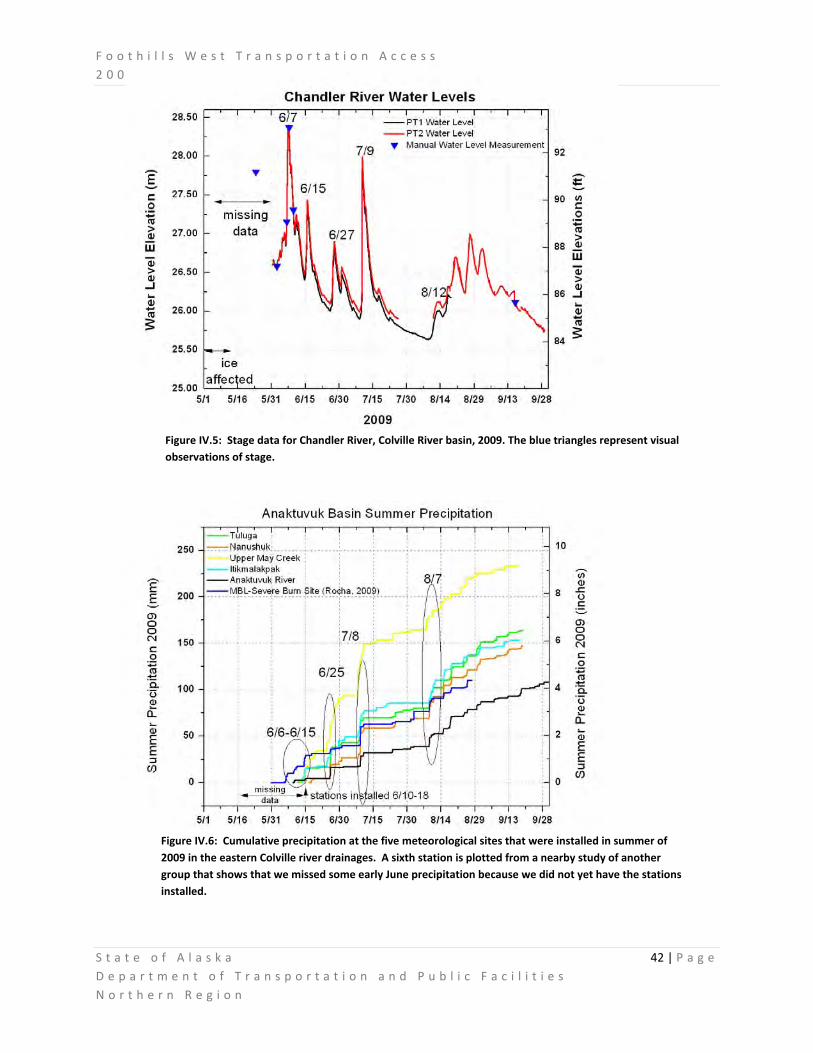
F o o t h i l l s W e s t T r a n s p o r t a t i o n A c c e s s 2 0 0 9 F i e l d I n v e s t i g a t i o n S u m m a r y R e p o r t
S t a t e o f A l a s k a 42 | P a g e D e p a r t m e n t o f T r a n s p o r t a t i o n a n d P u b l i c F a c i l i t i e s N o r t h e r n R e g i o n
Figure IV.5: Stage data for Chandler River, Colville River basin, 2009. The blue triangles represent visual observations of stage.
Figure IV.6: Cumulative precipitation at the five meteorological sites that were installed in summer of 2009 in the eastern Colville river drainages. A sixth station is plotted from a nearby study of another group that shows that we missed some early June precipitation because we did not yet have the stations installed.

F o o t h i l l s W e s t T r a n s p o r t a t i o n A c c e s s 2 0 0 9 F i e l d I n v e s t i g a t i o n S u m m a r y R e p o r t
S t a t e o f A l a s k a 43 | P a g e D e p a r t m e n t o f T r a n s p o r t a t i o n a n d P u b l i c F a c i l i t i e s N o r t h e r n R e g i o n
Figure IV.8: Anaktuvuk River at gauging site during 2009 breakup (May 21), view upstream from ground level.
Figure IV.7: Anaktuvuk River at gauging site after breakup 2009 (June 9), looking upstream from helicopter.

F o o t h i l l s W e s t T r a n s p o r t a t i o n A c c e s s 2 0 0 9 F i e l d I n v e s t i g a t i o n S u m m a r y R e p o r t
S t a t e o f A l a s k a 44 | P a g e D e p a r t m e n t o f T r a n s p o r t a t i o n a n d P u b l i c F a c i l i t i e s N o r t h e r n R e g i o n
RECONNAISSANCE BRIDGE SITE INVESTIGATION
On July 20‐21, 2009, hydraulic engineering staff from the Statewide Bridge Section completed a field reconnaissance of the Foothills West Transportation Access corridor with Northern Region Design. The trip involved nearly two full days of field inspection by helicopter. The inspection team flew the project corridor, flying upstream and downstream several miles at each proposed river crossing to identify additional bridge location options within the study reach.
DATA GAPS/NEEDS
Key design variables. For bridge design, we need to quantify key design variables to determine the required bridge length, height, and necessary scour protection provisions. Examples of key information needed are listed below.
• High ice elevation and the lateral extents of aufeis accumulation; • General spring snowmelt and breakup patterns; • Ice thickness, floe size, and jamming potential at each bridge; • Depths and velocity ranges that can be anticipated during floods; • Rates of erosion, lateral migration potential near the bridge crossings;
Ice thickness and floe sizes. More data on ice conditions during the spring breakup to allow quantifying ice loads on the bridge substructures.
Fluvial geomorphic analysis. Review and interpret visible geomorphic features to estimate rates of erosion, lateral channel migration potential, and other channel stability hurdles.
Uncommon habitat provisions. Caribou crossing provisions beneath bridges has been discussed as a potential environmental concern.
Other bridges. An assessment of bridge needs at ravine crossings and at tributary stream crossings. Sediment Transport. Changes in sediment transport has been an issue identified by the agencies with other on‐going bridge projects on the North Slope. This issue will need to be addressed early in this project, to ensure adequate data is collected up front for analysis.
Predominant wind direction and its effect on snow drift potential. The studied river reaches are bordered by elevated bluffs. Excavations (i.e., road cuts) or embankments may be needed to match the road profile to the bridge. Snow drift potential is often a maintenance burden at road cuts. Wind data may help our designers mitigate snow drift potential through geometric road design and the strategic layout of bridges. The bridges crossing the four major drainages along the Foothills West Access Route will be “long” by most standards. Additional information is required before accurate span length estimates can be made.

F o o t h i l l s W e s t T r a n s p o r t a t i o n A c c e s s 2 0 0 9 F i e l d I n v e s t i g a t i o n S u m m a r y R e p o r t
S t a t e o f A l a s k a 45 | P a g e D e p a r t m e n t o f T r a n s p o r t a t i o n a n d P u b l i c F a c i l i t i e s N o r t h e r n R e g i o n
For example, it is anticipated that spanning the active channels of these rivers may be necessary; however, a complete span of the “meander belt” would likely be over‐conservative. For spatial context, Table IV.1 below presents the ranges of widths for river and cross‐valley features near the proposed river crossing sites. TABLE IV.1. Summary of widths for river features near the proposed bridge crossing locations.
River Active Channel Widths
Floodplain or “Braid Plain” Widths
“Meander Belt” Widths
(ft) (ft) (ft) Colville River 3,000‐6,000 6,000‐11,000 7,000‐15,000 Chandler River 1,000‐2,000 3,000‐5,000 7,000‐11,000 Anaktuvuk River 2,000‐4,000 4,200‐6,200 7,000‐10,000 Itkillik River 300 ‐ 600 500‐1200 N/A
The term “meander belt” refers to the area between the extreme limits of successive fully developed river meanders; in other words, the area that a river has occupied in the past and may one day reoccupy in the future through natural channel migration processes. The term “braid plain” is used here to describe the area between the outermost active channels across the valley floor. Floodplain widths are those areas periodically inundated by floods. These widths were inferred from color variations of vegetation across the valley floor. (Areas of bright green were interpreted to be within the active floodplain). The term “active channel” is used here to reflect the total sum of channel(s) across the valley floor, including inundated and exposed gravel segments. All widths reported here were derived from aerial photographs in Google Earth using its distance measuring tool.

F o o t h i l l s W e s t T r a n s p o r t a t i o n A c c e s s 2 0 0 9 F i e l d I n v e s t i g a t i o n S u m m a r y R e p o r t
S t a t e o f A l a s k a 46 | P a g e D e p a r t m e n t o f T r a n s p o r t a t i o n a n d P u b l i c F a c i l i t i e s N o r t h e r n R e g i o n
RIVER CROSSING SITES
Colville River The Colville River crossing would likely require the longest bridge of the Foothills West Access Road project. Figures IV.9 & 10 below illustrate a favorable crossing location that would span the main stem active channel of the river. The length shown on the figures conveys the spatial scale of this river crossing. Additional span length may be required at the bridge ends to account for future river erosion and channel migration. A second bridge would be required to span a secondary channel to the east (left side of the oblique photograph). Additional research and study are needed to determine the rates of erosion along the river banks and to assess the relative permanence of the floodplain “islands”. This information will help the ADOT&PF bridge section make a final determination on the required bridge length.
FIGURE IV.9. An upstream view of the Colville River. Umiat, Alaska is situated to the right of the photographed area. The line illustrates a possible bridge alignment across the main stem of the Colville River.
FIGURE IV.10. An aerial view of the main stem of the Colville River with its secondary channel to the east (right), requiring an additional bridge crossing. A single bridge across the two channels and intermediary flood plain would be about 8,000 ft long. Note the vegetation color variations across the valley floor. (Photo by Google Earth)

F o o t h i l l s W e s t T r a n s p o r t a t i o n A c c e s s 2 0 0 9 F i e l d I n v e s t i g a t i o n S u m m a r y R e p o r t
S t a t e o f A l a s k a 47 | P a g e D e p a r t m e n t o f T r a n s p o r t a t i o n a n d P u b l i c F a c i l i t i e s N o r t h e r n R e g i o n
Chandler River Multiple crossing locations are being considered for the Chandler River. Bridge site selection will consider road geometric needs to provide a smooth vertical curve at the bridge end(s) and to mitigate any snow drift potential. Figures IV.11 & 12 below illustrate the crossing locations investigated during the field reconnaissance trip. Again, the lengths shown on the figures convey the spatial scale of this river crossing. As with the Colville River, additional span length may be required at the bridge ends to account for future river erosion and channel migration. Numerous remnant oxbows are evident in Figure IV.11, indicating a very dynamic river system. Additional research and study is needed to assess the temporal scale of these river alignment changes and to assess the relative permanence of the adjacent floodplain areas. This information will help the ADOT&PF bridge section make a final determination on the required bridge length.
FIGURE IV.11. An upstream view of the Chandler River. The blue lines represent three possible bridge crossing locations currently being considered. The bridge lengths shown are preliminary only. Snow drifts are frequently a problem at road cuts. The bluff on the right side of the photograph therefore represents a geometric design challenge.
FIGURE IV.12. An aerial view of the Chandler River and the bridge crossing locations being considered. Note the differences in vegetation color across the floodplain. The bridge lengths shown are preliminary only. (Photo by Google Earth)

F o o t h i l l s W e s t T r a n s p o r t a t i o n A c c e s s 2 0 0 9 F i e l d I n v e s t i g a t i o n S u m m a r y R e p o r t
S t a t e o f A l a s k a 48 | P a g e D e p a r t m e n t o f T r a n s p o r t a t i o n a n d P u b l i c F a c i l i t i e s N o r t h e r n R e g i o n
Anaktuvuk River Multiple crossing locations are being considered for the Anaktuvuk River. Bridge site selection will consider road geometric needs. Figures IV 13 & 14 below illustrate the crossing locations investigated during the field reconnaissance trip. Again, the lengths shown on the figures convey the spatial scale of this river crossing. As with the previous rivers, additional span length may be required at the bridge ends to account for future river erosion and channel migration. Numerous remnant oxbows are evident in Figure IV.13, indicating a very dynamic river system. Additional research and study is needed to assess the temporal scale of these river alignment changes and to assess the relative permanence of the adjacent floodplain areas. This information will help the ADOT&PF bridge section make a final determination on the required bridge length. FIGURE IV.13. A downstream view of the Anaktuvuk River. The blue lines represent three bridge crossing locations currently being considered. The bridge lengths shown are preliminary only. The amount of floodplain that must be spanned (beyond the active channel) has yet to be determined.
FIGURE IV.14. An aerial view of the Anaktuvuk River and bridge crossing locations currently being considered. The bridge lengths shown are preliminary only. (Photo by Google Earth)

F o o t h i l l s W e s t T r a n s p o r t a t i o n A c c e s s 2 0 0 9 F i e l d I n v e s t i g a t i o n S u m m a r y R e p o r t
S t a t e o f A l a s k a 49 | P a g e D e p a r t m e n t o f T r a n s p o r t a t i o n a n d P u b l i c F a c i l i t i e s N o r t h e r n R e g i o n
Iktillik River The Itkillik is less dynamic than the other rivers, simplifying the bridge site selection process. Figures IV.15 & 16 below illustrate a favorable crossing location identified in the field. Again, the length shown on the figures conveys the spatial scale of this river crossing. Additional span length may be required to account for erosion potential at the Itkillik bridge too, but to a lesser extent than the other three bridges. From preliminary reconnaissance, a 700 ft bridge appears to be a reasonable length for preliminary estimates.
FIGURE IV.15. A downstream view of the Itkillik River. The blue line represents a bridge crossing location currently being considered.
FIGURE IV.16. An aerial view of the Itkillik River and the bridge crossing location being considered. The bridge length shown is preliminary only. (Image by Google Earth)

F o o t h i l l s W e s t T r a n s p o r t a t i o n A c c e s s 2 0 0 9 F i e l d I n v e s t i g a t i o n S u m m a r y R e p o r t
S t a t e o f A l a s k a 50 | P a g e D e p a r t m e n t o f T r a n s p o r t a t i o n a n d P u b l i c F a c i l i t i e s N o r t h e r n R e g i o n
SMALL STREAM/DRAINAGE INDEX
Rivers and smaller drainages on the North Slope function differently than those south of the Brooks Range. Road alignments need to consider potential drainage impacts from spring runoff and summer storm events due to large volumes of precipitation that can travel quickly through localized drainage patterns. Due to the shallow depth to permafrost, Infiltration rates in tundra are minimal. Areas that seem dry, places with “beaded streams” and incised channels require special considerations.
Small drainages on the North Slope can become significant during peak flows at break up and during extreme rainfall events. During break up, large volumes of snow melt can create a large flow volume in a localized location. During peak rainfall events, precipitation begins flowing immediately along the surface because of the impermeability of shallow permafrost in the region. Other significant drainage features in the region are in the form of incised channels and beaded streams, which are formed as a result of permafrost melting in unstable soils. Beaded drainages occur in areas underlain by systems of ice wedges (polygonal ground). The heat in the flowing surface water thaws the underlying ice masses (usually at ice‐wedge intersections) forming depressions occupied by pools of water connected by the normally flowing stream.
Drainage areas observed within the project corridor were generally characterized by polygonal ground, differential settlement, and very poor drainage. Finding optimum locations to cross these areas will be a challenge, requiring evaluation of soil and drainage conditions at each location.
In order to evaluate drainage crossings in the numerous smaller drainages throughout the project corridor, a drainage index was developed to begin cataloguing the many unnamed drainages in the corridor. A helicopter

F o o t h i l l s W e s t T r a n s p o r t a t i o n A c c e s s 2 0 0 9 F i e l d I n v e s t i g a t i o n S u m m a r y R e p o r t
S t a t e o f A l a s k a 51 | P a g e D e p a r t m e n t o f T r a n s p o r t a t i o n a n d P u b l i c F a c i l i t i e s N o r t h e r n R e g i o n
reconnaissance effort was conducted from August 18 and 19, 2009 to document small drainages. Approximately 82 drainages were located using GPS and photographed from an aerial aspect. The drainages were assigned a numbering scheme, and then using GPS‐Photo Link software (created by Geospatial Experts) the photos were linked to their GPS locations. This created photo points that were added to the project GIS Database which allows the photographs to be accessed by selecting a photo point on the map. Currently, work is being done to include short descriptions of each drainage catalogued included the GIS dataset.
This data is important in the consideration of drainage structures throughout the corridor. The next phase will be to establish drainage basins and begin developing drainage structure concepts for the various smaller drainages. Typical drainage structures may include corrugated steel culverts, structural plate culverts, culvert batteries, small bridges or box culverts. The drainage index will be a useful tool for evaluating stream conditions.
The above image shows an example of photo points in the small drainage catalogue imported into Google Earth. The camera icons show the GPS locations of photos collected. The software allows the viewer to select various photo points to reveal the photo taken at that particular location.

GEOTECHNICAL INVESTIGATIONS
A geotechnical program was developed to focus on locating suitable material sites for road construction. DOT&PF objectives for this project are to locate material sites approximately every 10 miles along potential transportation corridors, and prove up 1 million cubic yards of suitable quality material at each site. The foothills project study area has very limited geotechnical data available for use in analysis. Historical drilling in the area was focused on oil and gas development, and very little information was noted within the subsurface region where gravel would be found. Additional geotechnical information related to road alignments and bridge crossing sites is also needed, but due to the short duration of the field season, this information will be obtained in a later phase.
OFFICE STUDIES AND RESEARCH
At the beginning of the project, the DOT&PF Northern Region Materials Section began research on available literature pertaining to materials investigations. Although little research information was available, the following documents were utilized in developing the project needs:
• Surficial geologic map of the Philip Smith Mountains Quadrangle, Alaska: USGS11 Miscellaneous Field Studies MF‐879‐A (1978)
• Bedrock geologic map of the Philip Smith Mountains Quadrangle, Alaska: USGS Miscellaneous Field Studies Map MF‐879‐B (1979)
• Stream Icing Zones in Alaska: Alaska DGGS 12 Report of Investigations 84‐16 (1984)
• Engineering‐geologic maps of northern Alaska, Umiat Quadrangle: USGS Open‐File Report 86‐335 (1986)
• Generalized geologic map of the Chandler Lake Quadrangle, north‐central Alaska: USGS Miscellaneous Field Studies MF‐2144‐A (1990)
• Surficial geology of the Dalton Highway (Itkillik‐Sagavanirktok Rivers) area, southern Arctic Foothills, Alaska: Alaska DGGS Professional Report PR‐121 (2003)
• Survey of the geology, geologic materials, and geologic hazards in proposed access corridors in the Umiat Quadrangle, Alaska: Alaska DGGS Miscellaneous Publication MP‐119 (2003)
• Geologic map of the Umiat Quadrangle, Alaska: USGS Scientific Investigations Map SIM‐2817‐A (2004)
Once the existing data was compiled, geologic features were analyzed using existing geologic data and project base mapping including aerial photography and topographic maps. 34 potential material sites were identified for field inspections as a result of this process.
11 USGS – United States Geological Survey 12 DGGS – Division of Geological & Geophysical Surveys
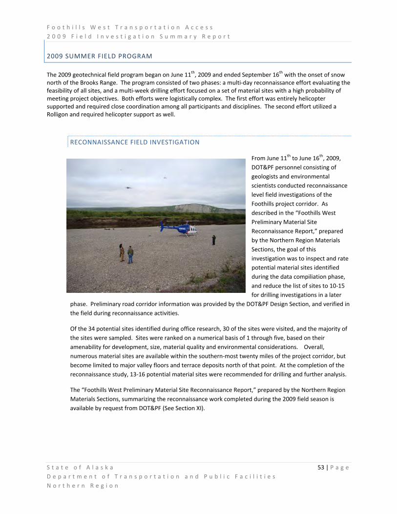
F o o t h i l l s W e s t T r a n s p o r t a t i o n A c c e s s 2 0 0 9 F i e l d I n v e s t i g a t i o n S u m m a r y R e p o r t
S t a t e o f A l a s k a 53 | P a g e D e p a r t m e n t o f T r a n s p o r t a t i o n a n d P u b l i c F a c i l i t i e s N o r t h e r n R e g i o n
2009 SUMMER FIELD PROGRAM
The 2009 geotechnical field program began on June 11th, 2009 and ended September 16th with the onset of snow north of the Brooks Range. The program consisted of two phases: a multi‐day reconnaissance effort evaluating the feasibility of all sites, and a multi‐week drilling effort focused on a set of material sites with a high probability of meeting project objectives. Both efforts were logistically complex. The first effort was entirely helicopter supported and required close coordination among all participants and disciplines. The second effort utilized a Rolligon and required helicopter support as well.
RECONNAISSANCE FIELD INVESTIGATION
From June 11th to June 16th, 2009, DOT&PF personnel consisting of geologists and environmental scientists conducted reconnaissance level field investigations of the Foothills project corridor. As described in the “Foothills West Preliminary Material Site Reconnaissance Report,” prepared by the Northern Region Materials Sections, the goal of this investigation was to inspect and rate potential material sites identified during the data compiliation phase, and reduce the list of sites to 10‐15 for drilling investigations in a later
phase. Preliminary road corridor information was provided by the DOT&PF Design Section, and verified in the field during reconnaissance activities.
Of the 34 potential sites identified during office research, 30 of the sites were visited, and the majority of the sites were sampled. Sites were ranked on a numerical basis of 1 through five, based on their amenability for development, size, material quality and environmental considerations. Overall, numerous material sites are available within the southern‐most twenty miles of the project corridor, but become limited to major valley floors and terrace deposits north of that point. At the completion of the reconnaissance study, 13‐16 potential material sites were recommended for drilling and further analysis.
The “Foothills West Preliminary Material Site Reconnaissance Report,” prepared by the Northern Region Materials Sections, summarizing the reconnaissance work completed during the 2009 field season is available by request from DOT&PF (See Section XI).

F o o t h i l l s W e s t T r a n s p o r t a t i o n A c c e s s 2 0 0 9 F i e l d I n v e s t i g a t i o n S u m m a r y R e p o r t
S t a t e o f A l a s k a 54 | P a g e D e p a r t m e n t o f T r a n s p o r t a t i o n a n d P u b l i c F a c i l i t i e s N o r t h e r n R e g i o n
2009 DRILLING PROGRAM
Between August 13th and September 16th 2009, the Northern Region Materials Section conducted a drilling program within the project corridor. The work was conducted with Rolligon and helicopter support provided by contractors. The first pass drilling objectives were to determine depth of overburden, thicknesses of gravels, and confirm the presence of at least 1 million cubic yards of useable material at each site.
Several permits were required in order to conduct the field investigations. Summertime Rolligon travel on State lands required the acquisition of a general use land travel permit issued by the Alaska Department of Natural Resources, Division of Mining Land and Water. Alaska Department of Fish and Game stream crossing permits were also acquired for the associated stream crossings. A North Slope Borough (NSB) Permit was also acquired for field work within the project corridor, as the entire project study area is within the Borough. The NSB permit contains several stipulations for Rolligon travel, and requires the use of “Subsistence Monitors”, which are described later in this document. A BLM permit was applied for to drill the recommended material site “Junction,” but due to time constraints in developing additional information requested by BLM, this site was not drilled during 2009 investigations. Letters of non‐objection for field work activities have been received from both ASRC for work between the Chandler River and Umiat, and from Alyeska Pipeline for Rolligon crossings of buried pipeline segments to access the study area.
Thirty six test holes were drilled at eight locations: Itagiknit North, Flat Top, Ridge 5, Ridge 6, Itkillik 8, Itkillik 7, Itkillik 6, and Itkillik 5. Six of these sites inferred a resource of greater than 1 million cubic yards of usable gravel. A seventh location requires additional drilling to identify the required volume of material, but is considered likely to be successful. The drilling program was suspended on September 16th as early snow made Rolligon travel impractical.
The additional drilling required to complete the material site program is scheduled for February of 2010, before breakup begins. This program will be similar to the 2009 program, requiring Rolligon and helicopter support, but will be conducted in wintertime conditions. It is anticipated that a BLM permit for access to federal land will be acquired before the program begins to ensure the southernmost potential material site location can be sampled.

F o o t h i l l s W e s t T r a n s p o r t a t i o n A c c e s s 2 0 0 9 F i e l d I n v e s t i g a t i o n S u m m a r y R e p o r t
S t a t e o f A l a s k a 55 | P a g e D e p a r t m e n t o f T r a n s p o r t a t i o n a n d P u b l i c F a c i l i t i e s N o r t h e r n R e g i o n
An interim report has been completed by the Northern Region Materials Section that summarizes the summer field work, presents observations at each site and laboratory results returned to date. This report also contains proposals for further work at investigated sites, along with proposed work to advance the project through environmental permitting. This report is available from DOT&PF by request (See Section XI).
2010 NEXT STEPS
The “Foothills West Interim Material Site Report” describes the next steps for geotechnical work for the project: Centerline drilling is needed to aid in route selection. Due to the length of the project, and the expectation that the corridor is entirely underlain by permafrost (except at the large drainages), it is expected that drilling of landforms along the alignment may provide sufficient information for the selection of focused project corridors. This type of drilling will aid in embankment design along selected routes. Geology and wetland maps, along with the existing aerial photography, provide a good basis for landform mapping. Preliminary foundation drilling for river crossing selection, as well as preliminary bridge and culvert design are needed for environmental document development. Bridge foundation information in this region is critical for the development of bridge concepts at challenging river crossing sites. Alternative material sources may be identified as contingencies during the environmental process. Although the material sources have been visited by various agency personnel, future envrironmental studies could find negative environmental factors associated with a material site that have not yet been identified. Alternative material sites may be developed as the environmental process progresses. Conceptual mining and reclamation plans will be required for each material site. These plans will factor detailed topographic and environmental data into developing a reasonable plan to conduct mining operations and reclaim the sites once completed. Additional drilling may be required at selected sites to increase the confidence level of the inferred resources. This drilling will reduce test hole spacings to those appropriate for each site. Depending on the site characteristics, this spacing could range from 500’x500’ to 500’x1000’.

F o o t h i l l s W e s t T r a n s p o r t a t i o n A c c e s s 2 0 0 9 F i e l d I n v e s t i g a t i o n S u m m a r y R e p o r t
S t a t e o f A l a s k a 56 | P a g e D e p a r t m e n t o f T r a n s p o r t a t i o n a n d P u b l i c F a c i l i t i e s N o r t h e r n R e g i o n
TERRAIN CHARACTERIZATIONS
The Arctic Foothills and the Arctic Coastal Plain are underlain by thick continuous permafrost. Development of potential alignments will have to consider the engineering benefits and obstacles along the route, with regard to the arctic environment and terrain. Identifying the potential geotechnical issues along these alignments will determine which alignments may be feasible alternatives.
PERMAFROST AND FROST ACTION
Permafrost is defined exclusively on the basis of temperature. It is rock or soil material, with or without included moisture or organic matter, that has remained below 0⁰ C (32⁰ F) continuously for two or more years. Sources show that the thickness of the permafrost for the study area is quite thick. From about 130 kilometers (80 miles) south of the Arctic Ocean, ice bearing permafrost was found to be 200 meters (656 feet) thick (Osterkamp and Payne, 1981). The map from “Permafrost Characteristics of Alaska”, a document produced by Jorgenson and others (2008), shows six data points in the upper region of the Galbraith Study Corridor . The six data points vary in permafrost depth from 235 meters to 356 meters (771 feet to 1168 feet).
Within the arctic Foothills area, permafrost is thickest in the highly porous Tertiary and Quaternary deposits, successively thinner in the less porous Upper Cretaceous rocks, and thinnest in the least porous Lower Cretaceous rocks. Thickness of the active layer is generally less than 2 feet in predominantly fine‐grained soils. Unfrozen zones are generally limited to deep river channels, some of which have unfrozen gravel beneath them, and large, deep lake basins. Perennial springs indicate that local zones of unfrozen bedrock provide avenues for recharge and discharge of ground‐water systems. (Brown and Kreig, 1983)
Diagram of effects of surface features on distribution of permafrost in a continuous permafrost zone (Lachenbruch, 1968)
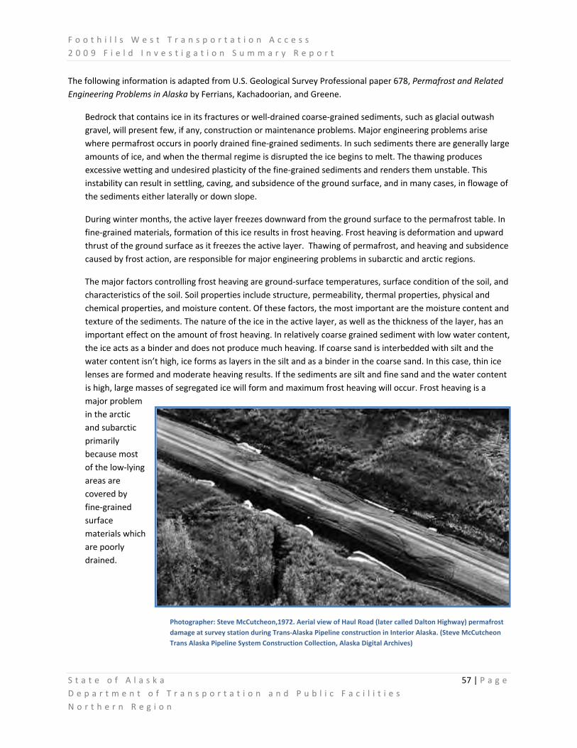
F o o t h i l l s W e s t T r a n s p o r t a t i o n A c c e s s 2 0 0 9 F i e l d I n v e s t i g a t i o n S u m m a r y R e p o r t
S t a t e o f A l a s k a 57 | P a g e D e p a r t m e n t o f T r a n s p o r t a t i o n a n d P u b l i c F a c i l i t i e s N o r t h e r n R e g i o n
The following information is adapted from U.S. Geological Survey Professional paper 678, Permafrost and Related Engineering Problems in Alaska by Ferrians, Kachadoorian, and Greene.
Bedrock that contains ice in its fractures or well‐drained coarse‐grained sediments, such as glacial outwash gravel, will present few, if any, construction or maintenance problems. Major engineering problems arise where permafrost occurs in poorly drained fine‐grained sediments. In such sediments there are generally large amounts of ice, and when the thermal regime is disrupted the ice begins to melt. The thawing produces excessive wetting and undesired plasticity of the fine‐grained sediments and renders them unstable. This instability can result in settling, caving, and subsidence of the ground surface, and in many cases, in flowage of the sediments either laterally or down slope.
During winter months, the active layer freezes downward from the ground surface to the permafrost table. In fine‐grained materials, formation of this ice results in frost heaving. Frost heaving is deformation and upward thrust of the ground surface as it freezes the active layer. Thawing of permafrost, and heaving and subsidence caused by frost action, are responsible for major engineering problems in subarctic and arctic regions.
The major factors controlling frost heaving are ground‐surface temperatures, surface condition of the soil, and characteristics of the soil. Soil properties include structure, permeability, thermal properties, physical and chemical properties, and moisture content. Of these factors, the most important are the moisture content and texture of the sediments. The nature of the ice in the active layer, as well as the thickness of the layer, has an important effect on the amount of frost heaving. In relatively coarse grained sediment with low water content, the ice acts as a binder and does not produce much heaving. If coarse sand is interbedded with silt and the water content isn’t high, ice forms as layers in the silt and as a binder in the coarse sand. In this case, thin ice lenses are formed and moderate heaving results. If the sediments are silt and fine sand and the water content is high, large masses of segregated ice will form and maximum frost heaving will occur. Frost heaving is a major problem in the arctic and subarctic primarily because most of the low‐lying areas are covered by fine‐grained surface materials which are poorly drained.
Photographer: Steve McCutcheon,1972. Aerial view of Haul Road (later called Dalton Highway) permafrost damage at survey station during Trans‐Alaska Pipeline construction in Interior Alaska. (Steve McCutcheon Trans Alaska Pipeline System Construction Collection, Alaska Digital Archives)
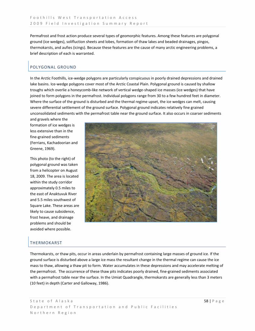
F o o t h i l l s W e s t T r a n s p o r t a t i o n A c c e s s 2 0 0 9 F i e l d I n v e s t i g a t i o n S u m m a r y R e p o r t
S t a t e o f A l a s k a 58 | P a g e D e p a r t m e n t o f T r a n s p o r t a t i o n a n d P u b l i c F a c i l i t i e s N o r t h e r n R e g i o n
Permafrost and frost action produce several types of geomorphic features. Among these features are polygonal ground (ice wedges), solifluction sheets and lobes, formation of thaw lakes and beaded drainages, pingos, thermokarsts, and aufies (icings). Because these features are the cause of many arctic engineering problems, a brief description of each is warranted.
POLYGONAL GROUND
In the Arctic Foothills, ice‐wedge polygons are particularly conspicuous in poorly drained depressions and drained lake basins. Ice‐wedge polygons cover most of the Arctic Coastal Plain. Polygonal ground is caused by shallow troughs which overlie a honeycomb‐like network of vertical wedge‐shaped ice masses (ice wedges) that have joined to form polygons in the permafrost. Individual polygons range from 30 to a few hundred feet in diameter. Where the surface of the ground is disturbed and the thermal regime upset, the ice wedges can melt, causing severe differential settlement of the ground surface. Polygonal ground indicates relatively fine grained unconsolidated sediments with the permafrost table near the ground surface. It also occurs in coarser sediments and gravels where the formation of ice wedges is less extensive than in the fine‐grained sediments (Ferrians, Kachadoorian and Greene, 1969).
This photo (to the right) of polygonal ground was taken from a helicopter on August 18, 2009. The area is located within the study corridor approximately 0.5 miles to the east of Anaktuvuk River and 5.5 miles southwest of Square Lake. These areas are likely to cause subsidence, frost heave, and drainage problems and should be avoided where possible.
THERMOKARST
Thermokarsts, or thaw pits, occur in areas underlain by permafrost containing large masses of ground ice. If the ground surface is disturbed above a large ice mass the resultant change in the thermal regime can cause the ice mass to thaw, allowing a thaw pit to form. Water accumulates in these depressions and may accelerate melting of the permafrost. The occurrence of these thaw pits indicates poorly drained, fine‐grained sediments associated with a permafrost table near the surface. In the Umiat Quadrangle, thermokarsts are generally less than 3 meters (10 feet) in depth (Carter and Galloway, 1986).

F o o t h i l l s W e s t T r a n s p o r t a t i o n A c c e s s 2 0 0 9 F i e l d I n v e s t i g a t i o n S u m m a r y R e p o r t
S t a t e o f A l a s k a 59 | P a g e D e p a r t m e n t o f T r a n s p o r t a t i o n a n d P u b l i c F a c i l i t i e s N o r t h e r n R e g i o n
The 2007 Anaktuvuk River Fire, a fire that burned for nearly three months and consumed more than 245,000 acres, is likely to have induced thermokarsts in the area. Scientists stationed at the Toolik Lake Field Station conducted research on the impacts of that
wildfire in a tundra landscape. This research included measurements of soil thaw depth during the summer 2008 between the months of May and August as part of the Circumpolar Active Layer Monitoring (CALM) Program. Thaw depth was dramatically affected by the burning, although the
differences among sites narrowed over the course of the summer season. Monitoring in the beginning in late May, showed that mean thaw depth in unburned tundra was approximately 11 cm, the mean thaw depth at the moderately‐burned sites was approximately 22 cm, while in severely burned tundra was >30 cm. By the end of August, mean thaw depth at the unburned site was 47 cm, 52 cm at the moderately burned site, and 56 cm at the severely‐burned site. The images on this page of thermokarst and thaw slump areas were taken by the researchers involved in the burn project, July‐August 2008 (2008 Annual Report – Alaska Land Use Permit #LAS 26840).

F o o t h i l l s W e s t T r a n s p o r t a t i o n A c c e s s 2 0 0 9 F i e l d I n v e s t i g a t i o n S u m m a r y R e p o r t
S t a t e o f A l a s k a 60 | P a g e D e p a r t m e n t o f T r a n s p o r t a t i o n a n d P u b l i c F a c i l i t i e s N o r t h e r n R e g i o n
SOLIFLUCTION
Solifluction describes the seasonal freeze‐thaw action upon saturated sediments which induces a gradual downslope movement by gravity. In other words, the topsoil becomes waterlogged, and flows like a liquid. In the warmer months, when the snow and ice melts, the landscape is effectively inundated with a winter’s worth of precipitation in the space of a couple of days. The surficial materials become especially mobile in the permafrost region because the active layer is commonly supersaturated with moisture. This condition is caused by the impermeability of the underlying permafrost and by the low evaporation rate. On steep slopes, solifluction often indicates bedrock near the surface, and on gentle slopes, a shallow permafrost table. Solifluction sheets and lobes can range from less than a foot to hundreds of feet in width. These features occur throughout the Galbraith Study Corridor and are common in the arctic. They can occur on slopes as low as 3⁰. (Ferrians, Kachadoorian, and Green, 1969)
This photo was taken August 19, 2009 within the Galbraith Study Corridor, approximately 3 miles north of the UAF Itkillik River Gaging Station. These features are most abundant near the beginning of the corridor where the slopes are steeper, but are still a common occurrence throughout the entire corridor.

F o o t h i l l s W e s t T r a n s p o r t a t i o n A c c e s s 2 0 0 9 F i e l d I n v e s t i g a t i o n S u m m a r y R e p o r t
S t a t e o f A l a s k a 61 | P a g e D e p a r t m e n t o f T r a n s p o r t a t i o n a n d P u b l i c F a c i l i t i e s N o r t h e r n R e g i o n
BEADED DRAINAGE
Beaded drainages occur in areas underlain by systems of ice wedges. The heat in flowing surface water thaws the underlying ice masses (usually at ice‐wedge intersections) forming depressions occupied by pools of water that are connected by the normally flowing stream. The overall appearance, viewed from the air, is like a string of beads; hence the name "beaded drainage." Beaded drainages are a surface indicator of the presence of permafrost.
These photos of a beaded drainage were taken August 19, 2009 from a helicopter south of Itigaknit Mountain and west of Itigaknit Lake. These types of
drainages are common within the study corridor and should be avoided if possible. They typically occurred in areas of polygonal ground and in smaller less developed drainages.
ICINGS
In arctic and subarctic regions, water which reaches the surface in the winter from a river, seep, or spring may freeze in successive sheets, until the ice covers a large area. These sheet‐like masses are termed icings, but are also referred to as “aufeis”. Icings are usually small‐seldom larger than a few acres. However, icings in the Kuparuk River, 30 miles to the east of the Galbraith Study Corridor, are quite large. A study conducted from 1999 to 2001 measured the Kuparuk River aufeis to be 17 million cubic meters in volume (Yoshikawa, Hinzman, and Kane, 2007).
Winter icing increases road maintenance costs, for it necessitates extra labor, special equipment, and special techniques to combat the growing ice mass. Countermeasures to reduce icing, such as the construction of larger culverts to divert the sources of the icings, also increase construction costs. Construction in areas with natural icings should be avoided whenever possible or, if such areas must be used, a diversionary drainage should be utilized.

F o o t h i l l s W e s t T r a n s p o r t a t i o n A c c e s s 2 0 0 9 F i e l d I n v e s t i g a t i o n S u m m a r y R e p o r t
S t a t e o f A l a s k a 62 | P a g e D e p a r t m e n t o f T r a n s p o r t a t i o n a n d P u b l i c F a c i l i t i e s N o r t h e r n R e g i o n
This photo of Kuparuk River aufeis was taken July 20, 2009, approximately 30 miles east of the Galbraith Study Corridor. This area of aufeis is of notable size and thick enough to persist in the river throughout the summer.
LAKES
There are many lakes within the Galbraith Study Corridor. Most are thaw lakes. Thaw lakes are common throughout the permafrost region and usually indicate poorly drained, fine‐grained, unconsolidated sediments with the permafrost table near the surface. These lakes are characterized by undercutting and caving along their margins, processes that are caused by the presence of thawing permafrost.
Oriented lakes, a very common type of thaw lake in the Arctic Coastal Plain, cover more than 25,000 square miles of northern Alaska. These oriented lakes only begin to appear in the northernmost region of the Galbraith Study Corridor as the terrain transitions from the Arctic Foothills to the Arctic Coastal Plain. Oriented lakes range in size from small ponds to more than 9 miles long and 3 miles wide. The long axis of these lakes is usually oriented in a northwesterly direction (ranging from 10⁰ to 15⁰ west of true north). This preferred orientation is strikingly shown on the topographic maps of northern Alaska (Carson and Hussey, 1962).

F o o t h i l l s W e s t T r a n s p o r t a t i o n A c c e s s 2 0 0 9 F i e l d I n v e s t i g a t i o n S u m m a r y R e p o r t
S t a t e o f A l a s k a 63 | P a g e D e p a r t m e n t o f T r a n s p o r t a t i o n a n d P u b l i c F a c i l i t i e s N o r t h e r n R e g i o n
Other types of lakes found within the Southern Segment of the Galbraith Study Corridor are called kettle lakes (shown in the photo to the left). A kettle is a depression formed when a block of stranded, buried glacier ice gradually melts out – causing the overlying land surface to collapse downward. Where such kettles are deep enough to intercept the water table, a lake occupies the depression (Pidwirny, 2006).
Shallow lakes in the Arctic may freeze completely in the winter, thus, they behave like the active layer of the nearby terrain. However, the spring warming is
accomplished efficiently by water circulating around and beneath the deteriorating ice, whereas the fall cooling is achieved inefficiently by conduction through the ice. The result is that mean annual temperatures of shallow lake bottoms are higher than those of the surrounding land, and permafrost is thinned beneath them.
Deeper lakes (greater than 6 feet in depth) that do not freeze completely during the winter typically have mean annual bottom temperatures above freezing, and thus are underlain by a thawed basin. The permafrost beneath a thawed basin is also thinned by upward indentation. If the lake is drained, the thawed basin refreezes and expansion of the ice within it creates a pingo.

F o o t h i l l s W e s t T r a n s p o r t a t i o n A c c e s s 2 0 0 9 F i e l d I n v e s t i g a t i o n S u m m a r y R e p o r t
S t a t e o f A l a s k a 64 | P a g e D e p a r t m e n t o f T r a n s p o r t a t i o n a n d P u b l i c F a c i l i t i e s N o r t h e r n R e g i o n
PINGOS
Pingos are small ice‐cored conical hills that are common in the continuous permafrost zone along the Arctic Coastal Plain. Commonly, they have craters on their summits, which are occupied by ponds. Pingos indicate fine sediments and the presence of ground water (with some hydraulic head) that is confined between the seasonal frost and permafrost table, or is flowing in a thawed zone within the permafrost (Ferrians, Kachadoorian, and Greene, 1969). In the Umiat Quadrangle, pingos occur primarily in lake deposits developed in the eolian sand and attain a maximum height of about 30 feet (Carter and Galloway, 1986).
The circular feature in the image to the right is of a pingo with a diameter of approximately 600 feet. This pingo was found using the aerial photography collected during the summer 2009 and is within the Northern Segment of the Galbraith Study Corridor, approximately 3 miles to the west of the Anaktuvuk River. This pingo was identified by Carter and Galloway (1986) and is mapped on their Engineering‐Geologic Maps of Northern Alaska, Umiat Quadrangle.
CONSIDERATIONS FOR ROAD CONSTRUCTION
Road engineers and designers, and construction and maintenance personnel, are continuously plagued by issues resulting from severe frost heaving, subsidence due to melting ground ice, solifluction, landslides, and icings related to the presence of permafrost.
To minimize disturbance of permafrost and subsurface thermal regimes, a passive method of road construction should be used. The thermal regime in an area, in a natural undisturbed state, is normally in quasi‐equilibrium with all other environmental factors. However, in many areas this state of equilibrium is very sensitive. The simple passage of a tracked vehicle that destroys the vegetation mat is enough to upset the delicate balance and to cause the top of the permafrost layer to thaw. This thawing can cause differential settlement of the surface of the ground, drainage problems, and severe frost action. Once the equilibrium is upset, the whole process can feed on itself and be practically impossible to reverse. On the other hand, if a structure is founded on permafrost that remains frozen, the frozen ground provides rocklike bearing strength (Ferrians, Kachadoorian, and Greene, 1969).

F o o t h i l l s W e s t T r a n s p o r t a t i o n A c c e s s 2 0 0 9 F i e l d I n v e s t i g a t i o n S u m m a r y R e p o r t
S t a t e o f A l a s k a 65 | P a g e D e p a r t m e n t o f T r a n s p o r t a t i o n a n d P u b l i c F a c i l i t i e s N o r t h e r n R e g i o n
Past projects in the area have become lessons on the importance of keeping the permafrost frozen. Examples include the Hickel Highway and an abandoned road to/from the Umiat Airstrip:
“In the 2 years following discovery of oil at Prudhoe Bay in 1968, a winter ice road was constructed north from Livengood to northern Alaska. The road, called the Hickel Highway after Walter Hickel, then governor of Alaska, was a bulldozer‐bladed trail over which trucks drove on the exposed frozen ground, crossing streams on ice bridges. Because the surface organic mat was disturbed in many places, substantial summer thawing took place, and portions of the road became a quagmire.” (Brown and Kreig, 1983).
Photo Credit: Harold Tilleson ‐ Jerry Luebke (left) from Glennallen and Harry "Feruck" Loev from Fairbanks (right) putting up the first and only sign on the winter ice road. The Umiat ‐ Sagwon sign was put up at the only intersection on the road, where the trail from Umiat connected into the Hickel Highway. It was used to direct truckers to head northeast to Sagwon, and not northwest to Umiat. (http://jukebox.uaf.edu/haul_road/htm/img_tilleson_18.htm)
“In order not to disrupt the thermal equilibrium in permafrost areas, more fill is necessary in the roadbed. The amount of this extra fill is variable under different geological conditions, but it is always a major cost factor…In many places the thickness of the fill used by the road crews is insufficient to prevent the thawing of the permafrost under the roadbed. An excellent example of one such place is shown in figure 25 [below]. The photograph shows the remains of a road from the Umiat Airstrip to several drilling sites in the area; it was constructed about 1950 and abandoned around 1953. The road is underlain by fine‐grained sediments containing ice‐wedge polygons. The breaks across the roadway are due to the melting of the ice wedges. Such conditions will occur again if the potential effects of thawing permafrost are not considered during highway planning and construction.” (Ferrians, Kachadoorian, and Greene, 1969).
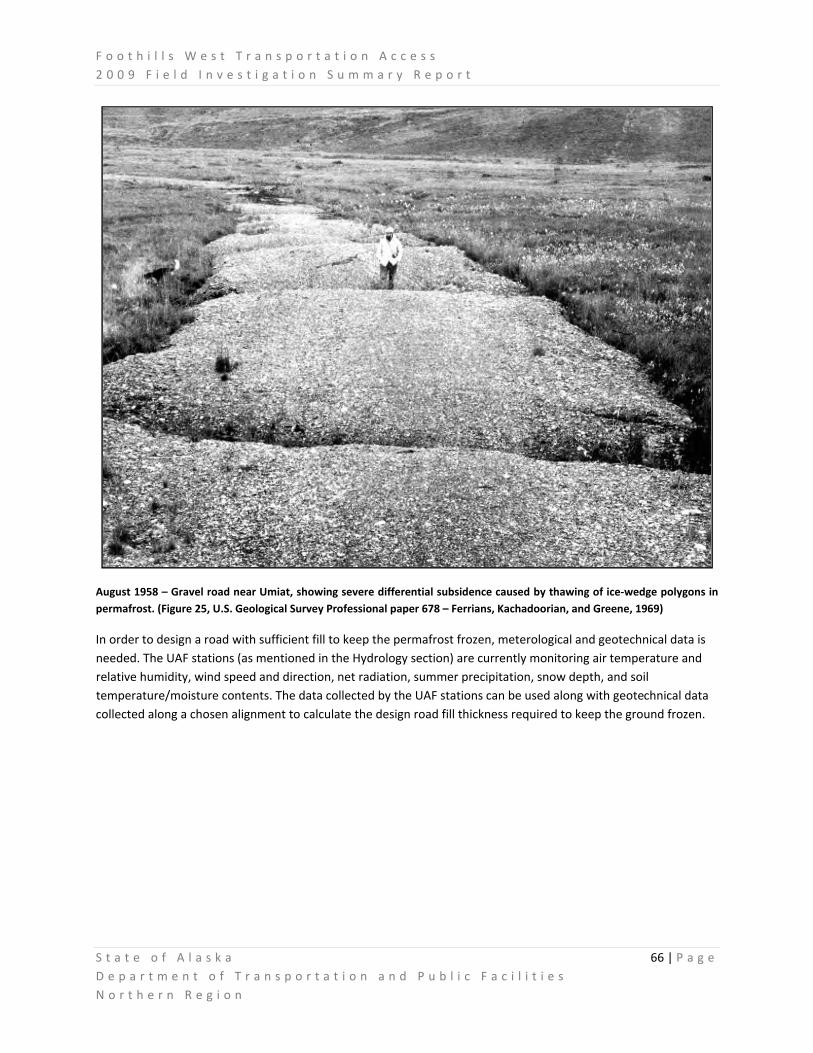
F o o t h i l l s W e s t T r a n s p o r t a t i o n A c c e s s 2 0 0 9 F i e l d I n v e s t i g a t i o n S u m m a r y R e p o r t
S t a t e o f A l a s k a 66 | P a g e D e p a r t m e n t o f T r a n s p o r t a t i o n a n d P u b l i c F a c i l i t i e s N o r t h e r n R e g i o n
August 1958 – Gravel road near Umiat, showing severe differential subsidence caused by thawing of ice‐wedge polygons in permafrost. (Figure 25, U.S. Geological Survey Professional paper 678 – Ferrians, Kachadoorian, and Greene, 1969)
In order to design a road with sufficient fill to keep the permafrost frozen, meterological and geotechnical data is needed. The UAF stations (as mentioned in the Hydrology section) are currently monitoring air temperature and relative humidity, wind speed and direction, net radiation, summer precipitation, snow depth, and soil temperature/moisture contents. The data collected by the UAF stations can be used along with geotechnical data collected along a chosen alignment to calculate the design road fill thickness required to keep the ground frozen.

F o o t h i l l s W e s t T r a n s p o r t a t i o n A c c e s s 2 0 0 9 F i e l d I n v e s t i g a t i o n S u m m a r y R e p o r t
S t a t e o f A l a s k a 67 | P a g e D e p a r t m e n t o f T r a n s p o r t a t i o n a n d P u b l i c F a c i l i t i e s N o r t h e r n R e g i o n
The figures below, adapted from Ferrians, Kachadoorian and Green (1969), depict the effects of a gravel pad or fill upon the temperature fluctuations, depth to the permafrost table, and thickness of the active layer. The result of too little fill is shown in Figure IV.17. In this example, the insulating effects of the fill plus the compacted active layer is less than the insulating effect before construction. The result is thawing permafrost and an increase in the thickness of the active layer.
Figure IV.18 shows what will happen if the insulating effects of the fill and the compacted layer are greater than the original active layer. In this case, the permafrost table is raised because the amplitude of the seasonal temperature variation is smaller. When the calculated thickness of fill becomes so great as to be impractical, alternative procedures are necessary, such as using insulating materials under the fill.
Figure IV.17. Effect on permafrost table if insulating of fill plus compacted active layer is less than the insulating effects of original active layer.
Figure IV.18. Effect on permafrost table if insulating effect of fill and active layer is greater than the insulating effect of the original active layer.

F o o t h i l l s W e s t T r a n s p o r t a t i o n A c c e s s 2 0 0 9 F i e l d I n v e s t i g a t i o n S u m m a r y R e p o r t
S t a t e o f A l a s k a 68 | P a g e D e p a r t m e n t o f T r a n s p o r t a t i o n a n d P u b l i c F a c i l i t i e s N o r t h e r n R e g i o n
Highways underlain by permafrost are subject to heaving from frost action. If constructed improperly, the road will require costly maintenance. Improper drainage of the fill causes additional problems. If the fill is allowed to saturate, it is much more susceptible to frost heaving and solifluction. In addition, if runoff is allowed to channel along the side of the embankment, the water could thaw the permafrost and collapse the edge of the roadway or the roadway itself.
Some suggested guidelines from Ferrians, Kachadoorian, and Greene (1969) are listed below and should be used to minimize the adverse effects of permafrost and frost heaving:
• Wherever possible, locate structures on coarse grained materials. Avoid fine‐grained, poorly drained, ice‐rich sediments, since they are subject to much greater frost‐heaving and, if the permafrost is thawed, to greater differential settlement. Surface geology, soil testing, and drill logs should be used to determine preferred soil types.
• Make the embankment sufficiently thick to prevent permafrost from thawing. Thermal modeling with appropriate soil and surface temperatures should be used to test the design thickness over various soil types.
• Provide ample and proper drainage to prevent the thawing of permafrost and to minimize frost action and icings.
• Avoid the disruption or destruction of the vegetation overlying permafrost
• Avoid borrow pits upslope or downslope from structures. Thawing of the sites may cause drainage problems or damaging slumps and landslides.
• Where parallel linear structures‐such as pipelines, roads, or telephone lines‐follow the contours of the slope, minimize disruption of the vegetation so that slumping along one structure will not damage the other.

F o o t h i l l s W e s t T r a n s p o r t a t i o n A c c e s s 2 0 0 9 F i e l d I n v e s t i g a t i o n S u m m a r y R e p o r t
S t a t e o f A l a s k a 69 | P a g e D e p a r t m e n t o f T r a n s p o r t a t i o n a n d P u b l i c F a c i l i t i e s N o r t h e r n R e g i o n
V. ENVIRONMENTAL FIELD WORK SUMMARY
WETLAND AND VEGETATION DATA COLLECTION AND PRELIMINARY DELINEATION
Three Parameters Plus Inc. (3PPI) was contracted by DOT&PF to plan and conduct a preliminary wetland and vegetation delineation throughout portions of a potential Foothills West Transportation Access Corridor (FWTAC) during the summer of 2009. Should the Foothills project eventually be funded for final design and construction, the data collected during the 2009 fieldwork, and baseline information derived from that data, will serve as a foundation for more comprehensive investigations on more specific wetland parameters for the purpose of producing the necessary environmental documents and obtaining the appropriate permits for construction.
FIELD STUDY PLANNING AND PREPARATION
Prior to beginning wetlands and vegetation data collection and delineation fieldwork, 3PPI prepared two working documents and reviewed published and other available literature on recent, similar studies conducted near the project study area.
The two documents produced by 3PPI were designed to aid field teams in identifying common and rare plants and characterize vegetation communities by photo signature. These included:
1. The 3PPI Draft Vegetation Photo Signature Guide. This guide lists dominant vegetation communities expected to be found within the potential FWTAC. This guide is designed to be a dynamic, working document. While currently incomplete pending updates when 2009 field data and photos are reviewed, it serves as a starting point for future work and will be further refined as necessary. Community type

F o o t h i l l s W e s t T r a n s p o r t a t i o n A c c e s s 2 0 0 9 F i e l d I n v e s t i g a t i o n S u m m a r y R e p o r t
S t a t e o f A l a s k a 70 | P a g e D e p a r t m e n t o f T r a n s p o r t a t i o n a n d P u b l i c F a c i l i t i e s N o r t h e r n R e g i o n
descriptions are based on Viereck et al. (1992).13 On‐the‐ground photographs of each vegetation type are provided, as well as the typical, corresponding photo‐signature from aerial photography. Also included are vegetation types found and described during the June 24, 2009 interagency survey of the potential route. Probable hydrogeomorphic (HGM) and National Wetlands Inventory (Cowardin) codes are also provided for each vegetation community (See Section XI).
2. The 3PPI North Slope Plant Guide. This guide provides easy‐to‐use keys and identification features for common dominant plants of the North Slope of Alaska and any potential FWTAC project areas. A listing of published rare or sensitive plant species on the North Slope is included, as well as identification sheets for most other plants. Because of copyright considerations, this document is only issued to 3PPI field teams. When more information is available, additional datasheets will be added to the collection (See Section XI).
Material gleaned from these documents and available geographical information system (GIS) data were used to compile both potential plant species and vegetation community‐type lists for the Foothills project area. An interagency field trip along one potential project corridor on June 24, 2009 also allowed for early site‐specific field data collection, and the production of specific plant and vegetation community lists near several of the potential material sites.
2009 SUMMER FIELD WORK AND DATA COLLECTION METHODS
Two 3PPI wetlands field crew from Anchorage met with four additional crew members in Fairbanks and on 30 July, 2009 drove to the field camp base at Happy Valley, located on the Dalton Highway approximately 80 miles south of Prudhoe Bay. Lodging was contracted with Arctic Wilderness Lodge for the five days required for the wetland data collection field program. No delays or cancellations due to weather were encountered. A Quicksilver Air Hughes 500 helicopter was contracted to ferry crews to the field. Field operations were conducted from 31 July – 4 Aug, 2009, and demobilization took place on 5 Aug, 2009.
To identify daily priorities, field verification target areas along the sampling route were chosen each day by crew leaders. Three teams were then utilized for efficiency, with one team focused on working from Umiat to the Anaktuvuk River, another team working between the Anaktuvuk River and the Itkillik River, and a third team working from the Itkillik River south toward the boundary of BLM land in the study corridor. No BLM land was surveyed, as permits were not granted by BLM allowing that portion of the study area to be accessed in 2009.
13 Viereck, L.A., C.T. Dryness, A.R. Batten, K.J. Wenzlick. 1992. The Alaska Vegetational Classification. General Tech. Report. PNW‐GTR‐286. Portland, Oregon: U.S.D.A. Forest Service, Pacific Northwest Research Sta. 278 pp. July.

F o o t h i l l s W e s t T r a n s p o r t a t i o n A c c e s s 2 0 0 9 F i e l d I n v e s t i g a t i o n S u m m a r y R e p o r t
S t a t e o f A l a s k a 71 | P a g e D e p a r t m e n t o f T r a n s p o r t a t i o n a n d P u b l i c F a c i l i t i e s N o r t h e r n R e g i o n
Quicksilver Air flew two routine flights daily to put the three teams in the field. Once on the ground, teams used project field maps to verify their location, identify various vegetation photo signatures, and sample sites to determine vegetation type and wetlands status. The helicopter was then used intermittently throughout the day to move sampling crews to new target areas as necessary and maximize the efficiency of the teams’ reconnaissance sampling efforts.
FIELD DATA EVALUATIONS
3PPI crews sampled numerous vegetation types along much of the potential FWTAC to determine trends in wetlands status. 3PPI conducted 75 Jurisdictional Determination (JD) plots, 24 Functional Assessment (FA) plots, and 85 additional photopoints; including pictures of representative uplands, representative wetlands, stream crossings, and water bodies.
PRELIMINARY JURISDICTIONAL WETLAND DETERMINATIONS
Jurisdictional wetland determinations were made in the field using criteria found in the 2007 Regional Supplement to the Corps of Engineers Wetland Delineation Manual (Version 2.0) 14 and the 1987 Corps of Engineers Wetlands Delineation Manual.15
During the jurisdictional wetland field evaluations, detailed information on 0.1 acre plots was collected in representative vegetation types or preliminary wetland mapping types.
Field plots were sampled in representative stands of vegetation at slope peaks, elevation breaks, and at
visible vegetation interfaces. Sampling effort was concentrated within the potential FWTAC between Umiat
and the upper Itkillik River drainage to the west of Toolik Lake, though no data was collected on federal lands managed by BLM or within the drainages of the Toolik River or Toolik Lake.
14 Environmental Laboratory. 2007. Regional Supplement to the Corps of Engineers Wetland Delineation Manual: Alaska Region (Version 2.0). ERDC/EL TR‐07‐24, September, 2007. U.S. Army Corps of Engineers, Wash. DC 114 pp.
15 Environmental Laboratory. 1987. Corps of Engineers wetlands delineation manual. Technical Report Y‐87‐1. U.S. Army Waterways Experiment Station, Vicksburg, MS. NTIS No. AD A176 912.

F o o t h i l l s W e s t T r a n s p o r t a t i o n A c c e s s 2 0 0 9 F i e l d I n v e s t i g a t i o n S u m m a r y R e p o r t
S t a t e o f A l a s k a 72 | P a g e D e p a r t m e n t o f T r a n s p o r t a t i o n a n d P u b l i c F a c i l i t i e s N o r t h e r n R e g i o n
Generally, the data collected at each jurisdictional wetland plot included:
• Percent coverage of plant species (tree, shrub, and herbaceous species) and their corresponding U.S. Fish and Wildlife Service wetland indicator status16, including bryophytes, lichens, fungi, bare ground, water, rock and other non‐plant material. Using this data, a Draft FWTAC Master Plant List (as of November 23, 2009) was produced (See Section XI).
• Soil type and comments on characteristics
• Comments on visible or readily apparent hydrologic characteristics
• Notes on topographic characteristics such as slope, aspect, elevation, terrain, and landform
• Wildlife observations, including indirect observations such as trails, scats, dens and browse utilization.
16 Reed, P.B., Jr. 1988. National List of Plan Species that Occur in Wetlands: 1988 National Summary. Biological Report 88 (24). Washington,
DC; USF&WS.
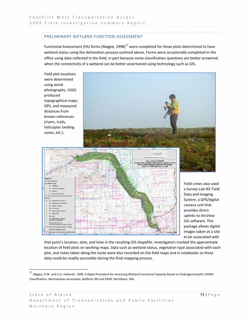
F o o t h i l l s W e s t T r a n s p o r t a t i o n A c c e s s 2 0 0 9 F i e l d I n v e s t i g a t i o n S u m m a r y R e p o r t
S t a t e o f A l a s k a 73 | P a g e D e p a r t m e n t o f T r a n s p o r t a t i o n a n d P u b l i c F a c i l i t i e s N o r t h e r n R e g i o n
PRELIMINARY WETLAND FUNCTION ASSESSMENT
Functional Assessment (FA) forms (Magee, 1998)17 were completed for those plots determined to have wetland status using the delineation process outlined above. Forms were occasionally completed in the office using data collected in the field, in part because some classification questions are better answered when the connectivity of a wetland can be better ascertained using technology such as GIS.
Field plot locations were determined using aerial photographs, USGS produced topographical maps, GPS, and measured distances from known references (rivers, trails, helicopter landing zones, etc.).
Field crews also used a Survey Lab IKE Field Data and Imaging System, a GPS/digital camera unit that provides direct uplinks to ArcView GIS software. This package allows digital images taken at a site to be associated with
that point’s location, date, and time in the resulting GIS shapefile. Investigators marked the approximate location of field plots on working maps. Data such as wetland status, vegetation type associated with each plot, and notes taken along the route were also recorded on the field maps and in notebooks so these data could be readily accessible during the final mapping process.
17 Magee, D.W. and G.G. Hollands. 1998. A Rapid Procedure for Assessing Wetland Functional Capacity Based on Hydrogeomorphic (HGM)
Classification. Normandeau Associates, Bedford, NH and ENSR, Northboro, MA.
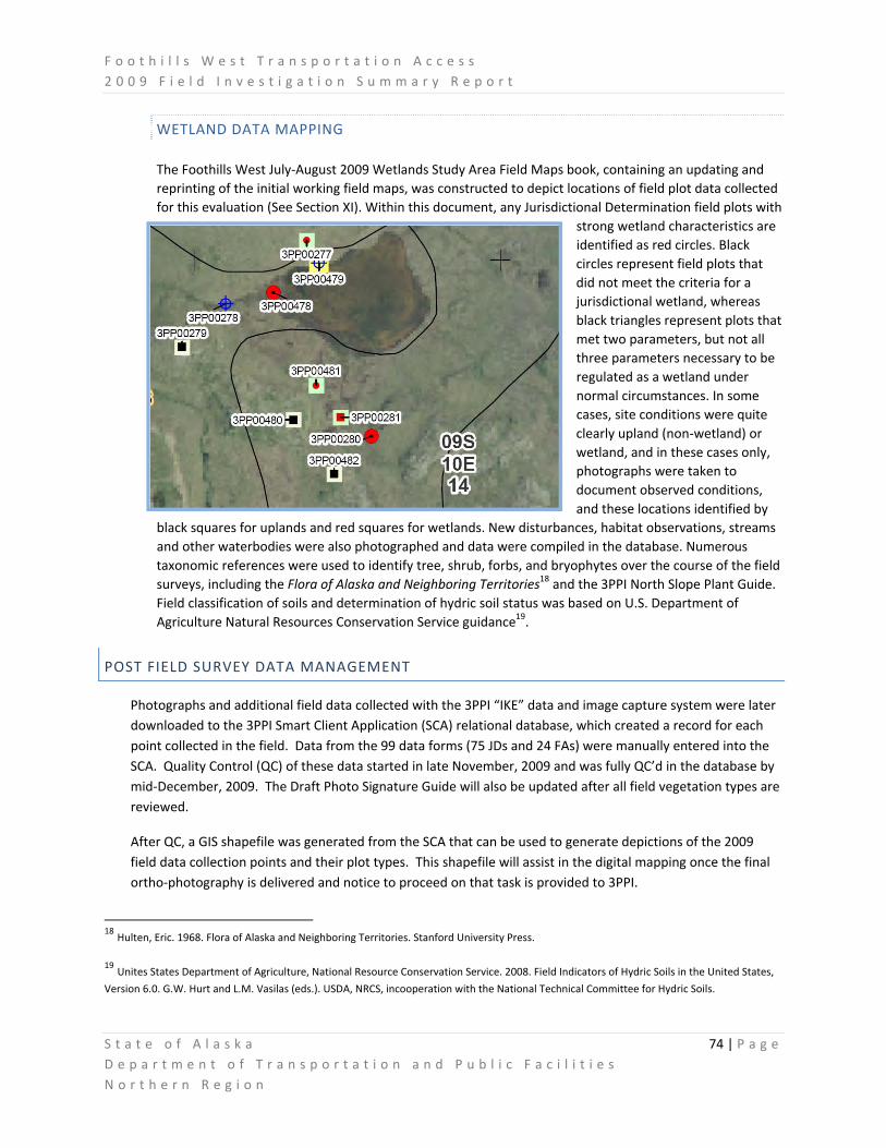
F o o t h i l l s W e s t T r a n s p o r t a t i o n A c c e s s 2 0 0 9 F i e l d I n v e s t i g a t i o n S u m m a r y R e p o r t
S t a t e o f A l a s k a 74 | P a g e D e p a r t m e n t o f T r a n s p o r t a t i o n a n d P u b l i c F a c i l i t i e s N o r t h e r n R e g i o n
WETLAND DATA MAPPING
The Foothills West July‐August 2009 Wetlands Study Area Field Maps book, containing an updating and reprinting of the initial working field maps, was constructed to depict locations of field plot data collected for this evaluation (See Section XI). Within this document, any Jurisdictional Determination field plots with
strong wetland characteristics are identified as red circles. Black circles represent field plots that did not meet the criteria for a jurisdictional wetland, whereas black triangles represent plots that met two parameters, but not all three parameters necessary to be regulated as a wetland under normal circumstances. In some cases, site conditions were quite clearly upland (non‐wetland) or wetland, and in these cases only, photographs were taken to document observed conditions, and these locations identified by
black squares for uplands and red squares for wetlands. New disturbances, habitat observations, streams and other waterbodies were also photographed and data were compiled in the database. Numerous taxonomic references were used to identify tree, shrub, forbs, and bryophytes over the course of the field surveys, including the Flora of Alaska and Neighboring Territories18 and the 3PPI North Slope Plant Guide. Field classification of soils and determination of hydric soil status was based on U.S. Department of Agriculture Natural Resources Conservation Service guidance19.
POST FIELD SURVEY DATA MANAGEMENT
Photographs and additional field data collected with the 3PPI “IKE” data and image capture system were later downloaded to the 3PPI Smart Client Application (SCA) relational database, which created a record for each point collected in the field. Data from the 99 data forms (75 JDs and 24 FAs) were manually entered into the SCA. Quality Control (QC) of these data started in late November, 2009 and was fully QC’d in the database by mid‐December, 2009. The Draft Photo Signature Guide will also be updated after all field vegetation types are reviewed.
After QC, a GIS shapefile was generated from the SCA that can be used to generate depictions of the 2009 field data collection points and their plot types. This shapefile will assist in the digital mapping once the final ortho‐photography is delivered and notice to proceed on that task is provided to 3PPI.
18 Hulten, Eric. 1968. Flora of Alaska and Neighboring Territories. Stanford University Press.
19 Unites States Department of Agriculture, National Resource Conservation Service. 2008. Field Indicators of Hydric Soils in the United States,
Version 6.0. G.W. Hurt and L.M. Vasilas (eds.). USDA, NRCS, incooperation with the National Technical Committee for Hydric Soils.

F o o t h i l l s W e s t T r a n s p o r t a t i o n A c c e s s 2 0 0 9 F i e l d I n v e s t i g a t i o n S u m m a r y R e p o r t
S t a t e o f A l a s k a 75 | P a g e D e p a r t m e n t o f T r a n s p o r t a t i o n a n d P u b l i c F a c i l i t i e s N o r t h e r n R e g i o n
VI. WILDLIFE AND HABITAT RESOURCES FIELDWORK SUMMARY
DOT&PF and 3PPI staff jointly conducted preliminary wildlife and habitat delineations along a potential Foothills West Transportation Access Corridor (FWTAC) during the summer of 2009. As a component of the suite of environmental field studies to be undertaken, wildlife and their associated habitats are considered by the public to be of significant importance owing to their obvious integration with subsistence values and cultural history of the region.
Consequently, a systematic approach was undertaken to solicit preliminary input from agency sources, the public, and likewise carry out field studies to confirm existing information or add to the body of knowledge regarding species’ use of the project study area, their life histories, and their important habitats.
PRELIMINARY AGENCY INPUT AND FIELDWORK PREPARATIONS
DOT&PF staff held preliminary, informal meetings with the Alaska Department of Fish and Game (ADF&G) and the U.S. Fish and Wildlife Service (FWS) to seek guidance, solicit concerns and obtain information regarding potential
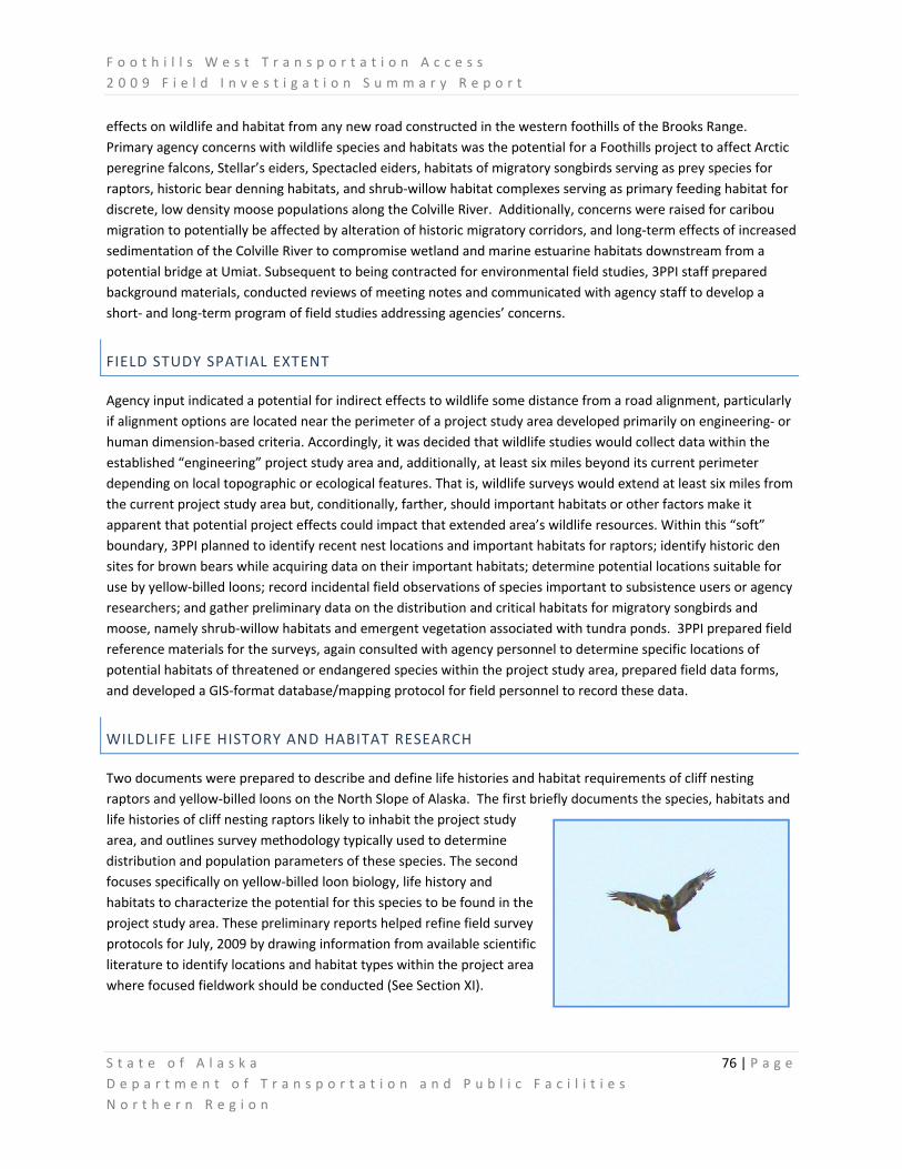
F o o t h i l l s W e s t T r a n s p o r t a t i o n A c c e s s 2 0 0 9 F i e l d I n v e s t i g a t i o n S u m m a r y R e p o r t
S t a t e o f A l a s k a 76 | P a g e D e p a r t m e n t o f T r a n s p o r t a t i o n a n d P u b l i c F a c i l i t i e s N o r t h e r n R e g i o n
effects on wildlife and habitat from any new road constructed in the western foothills of the Brooks Range. Primary agency concerns with wildlife species and habitats was the potential for a Foothills project to affect Arctic peregrine falcons, Stellar’s eiders, Spectacled eiders, habitats of migratory songbirds serving as prey species for raptors, historic bear denning habitats, and shrub‐willow habitat complexes serving as primary feeding habitat for discrete, low density moose populations along the Colville River. Additionally, concerns were raised for caribou migration to potentially be affected by alteration of historic migratory corridors, and long‐term effects of increased sedimentation of the Colville River to compromise wetland and marine estuarine habitats downstream from a potential bridge at Umiat. Subsequent to being contracted for environmental field studies, 3PPI staff prepared background materials, conducted reviews of meeting notes and communicated with agency staff to develop a short‐ and long‐term program of field studies addressing agencies’ concerns.
FIELD STUDY SPATIAL EXTENT
Agency input indicated a potential for indirect effects to wildlife some distance from a road alignment, particularly if alignment options are located near the perimeter of a project study area developed primarily on engineering‐ or human dimension‐based criteria. Accordingly, it was decided that wildlife studies would collect data within the established “engineering” project study area and, additionally, at least six miles beyond its current perimeter depending on local topographic or ecological features. That is, wildlife surveys would extend at least six miles from the current project study area but, conditionally, farther, should important habitats or other factors make it apparent that potential project effects could impact that extended area’s wildlife resources. Within this “soft” boundary, 3PPI planned to identify recent nest locations and important habitats for raptors; identify historic den sites for brown bears while acquiring data on their important habitats; determine potential locations suitable for use by yellow‐billed loons; record incidental field observations of species important to subsistence users or agency researchers; and gather preliminary data on the distribution and critical habitats for migratory songbirds and moose, namely shrub‐willow habitats and emergent vegetation associated with tundra ponds. 3PPI prepared field reference materials for the surveys, again consulted with agency personnel to determine specific locations of potential habitats of threatened or endangered species within the project study area, prepared field data forms, and developed a GIS‐format database/mapping protocol for field personnel to record these data.
WILDLIFE LIFE HISTORY AND HABITAT RESEARCH
Two documents were prepared to describe and define life histories and habitat requirements of cliff nesting raptors and yellow‐billed loons on the North Slope of Alaska. The first briefly documents the species, habitats and life histories of cliff nesting raptors likely to inhabit the project study area, and outlines survey methodology typically used to determine distribution and population parameters of these species. The second focuses specifically on yellow‐billed loon biology, life history and habitats to characterize the potential for this species to be found in the project study area. These preliminary reports helped refine field survey protocols for July, 2009 by drawing information from available scientific literature to identify locations and habitat types within the project area where focused fieldwork should be conducted (See Section XI).

F o o t h i l l s W e s t T r a n s p o r t a t i o n A c c e s s 2 0 0 9 F i e l d I n v e s t i g a t i o n S u m m a r y R e p o r t
S t a t e o f A l a s k a 77 | P a g e D e p a r t m e n t o f T r a n s p o r t a t i o n a n d P u b l i c F a c i l i t i e s N o r t h e r n R e g i o n
FIELD IDENTIFICATION GUIDES
In anticipation of the deployment of wetlands and vegetation delineation field crews in July‐August 2009, 3PPI produced field guides and project data forms to aid staff with identification and cataloging of project‐critical targeted species as well as general mammalian and avian species expected to be encountered in the field. Pictures and descriptions of various wildlife species were laminated for field use in rapid identification assistance.
These field guides and associated data forms focus on key raptors, loons, songbirds and mammals potentially encountered in the project area, and provide for quick references for field personnel to accurately collect sighting, location, and additional data on wildlife. Preliminary field data can then be used to further refine and focus additional surveys necessary for projection of more complex environmental documents.

F o o t h i l l s W e s t T r a n s p o r t a t i o n A c c e s s 2 0 0 9 F i e l d I n v e s t i g a t i o n S u m m a r y R e p o r t
S t a t e o f A l a s k a 78 | P a g e D e p a r t m e n t o f T r a n s p o r t a t i o n a n d P u b l i c F a c i l i t i e s N o r t h e r n R e g i o n
THREATENED AND ENDANGERED (T&E) SPECIES REVIEW
DOT&PF and 3PPI staff met with state and federal agencies to determine if there has been any recorded presence of threatened and/or endangered wildlife or plant species within the FWTAC during any part of their life stages. Should these species be present, a comprehensive program of evaluation to determine measures for avoidance or mitigation of potential impacts would be required to obtain necessary permits from the USF&WS.
AVIAN SPECIES
It was necessary to assess whether Spectacled eiders (Somateria fischeri) and/or Stellars eiders (Polysticta stelleri) were likely to use any portion of the potential project area for nesting or brood‐rearing. USF&WS requirements stipulate that if nests are in a project area, special permits are required for the construction of permanent facilities, the placement of fill or alteration of habitat or other activities that might result in adverse effects to the species.20 A meeting between DOT&PF staff and the USFWS concluded that these Federal Threatened species’ prime nesting and rearing habitat areas were typically not contained within the potential FWTAC.
3PPI followed up this work with informal calls to USFWS to determine the contemporary status of the Yellow‐Billed Loon (YBL) (Gavia adamsii) in the FWTAC. In March of 2009, the USFWS announced their determination that listing the YBL as a threatened or endangered species is warranted under the Endangered Species Act, but that listing is precluded by other higher priority species. As a result, the YBL is now designated as a candidate species only.21
On June 19, 2009, 3PPI conducted an informal phone conversation with Ted Swem, USFWS, who heads the T&E species program for the North Slope. Mr. Swem stated that YBL did not use the area of the FWTAC, and that a Section 7 Consultation letter could be prepared for this project if the data on that current distribution did not change. However, 3PPI subsequently learned from the camp manager of the Toolik Field Station that a nesting pair of YBL, and an additional, individual bird were observed on Toolik Lake during the summer of 2009. This information and future determinations by the USFWS on YBL status may justify a review of lake habitats within the project area to determine which are capable of overwintering fish that constitute prey for YLB, and consequently justify those waters as potential brood rearing habitat for this candidate species.
MAMMALIAN SPECIES
Another informal conversation with USFWS took place on June 23, 2009 in regards to the potential for Federally Endangered polar bears (Ursus maritimus) to use the FWTAC. 3PPI obtained current information on polar bear life history, distribution, habitat preferences and anecdotal sightings proximate to the greater Foothills project study
20 U. S. Fish & Wildlife Service Fact Sheets; accessed at: http://alaska.fws.gov/media/StellEider_FactSheet.htm & http://alaska.fws.gov/media/SpecEider_FactSheet.htm . Date of last access: 12/03/09.
21 U. S. Fish & Wildlife Service.; accessed at:. http://alaska.fws.gov/fisheries/endangered/yellow_billed_loon.htm . Date of last access: 12/03/09.

F o o t h i l l s W e s t T r a n s p o r t a t i o n A c c e s s 2 0 0 9 F i e l d I n v e s t i g a t i o n S u m m a r y R e p o r t
S t a t e o f A l a s k a 79 | P a g e D e p a r t m e n t o f T r a n s p o r t a t i o n a n d P u b l i c F a c i l i t i e s N o r t h e r n R e g i o n
area from Mr. Scott Schliebe. Mr. Schliebe also provided information on historic reports of polar bear denning, and also potential den sites, to the north of the project area. The USFWS indicated that polar bears are not considered likely to occur within the FWTAC and are not expected to be directly affected by the Foothills project.
WILDLIFE FIELD SURVEY PLANNING AND EXECUTION
3PPI prepared field plans for conducting grizzly bear (Ursus arctos horribilis) denning and raptor nesting surveys. Summary plans can be found in Section XI. These plans provided a working description of grizzly bear den and cliff nesting raptor survey protocols established for the FWTAC project prior to deployment of field personnel. 3PPI also prepared working field maps for the ‘Galbraith Corridor’ identified in the DOT&PF Draft Corridor Analysis and
Decisional Matrix for this project. This corridor was established as a focal point of preliminary survey efforts.
Two wildlife biologists from 3PPI traveled to Prudhoe Bay on June 30th to conduct bear denning and raptor surveys within and/or near the Galbraith Corridor. Work was based out of Prudhoe Bay for the first two days, June 30th‐July 1st. Biologist Paul Karczmarczyk from DOT&PF joined the 3PPI survey crew in Prudhoe Bay on July 2nd and accompanied them for the remainder of survey operations based out of Umiat Camp, from July 2nd ‐4th. Details of surveys are included in the final bear den and raptor nesting survey reports provided in Section XI. The biologists departed Umiat for Prudhoe Bay and returned to Fairbanks and Anchorage on July 5th.
BEAR DEN SURVEY
Prism Helicopters provided an AS‐350 A‐Star helicopter for the wildlife surveys. This helicopter was already located at Umiat Camp and was under contract to the State, and it was determined to be more cost effective to utilize than having another, smaller helicopter brought to the remote site solely for wildlife surveys.
Survey biologists spent each day systematically flying the potential corridor looking for grizzly bear dens and raptor nesting sites. Bear dens were expected in drier habitats (bluffs, stream banks, hill sides) and these areas were surveyed intensively for the presence of bear presence and denning or digging activity.
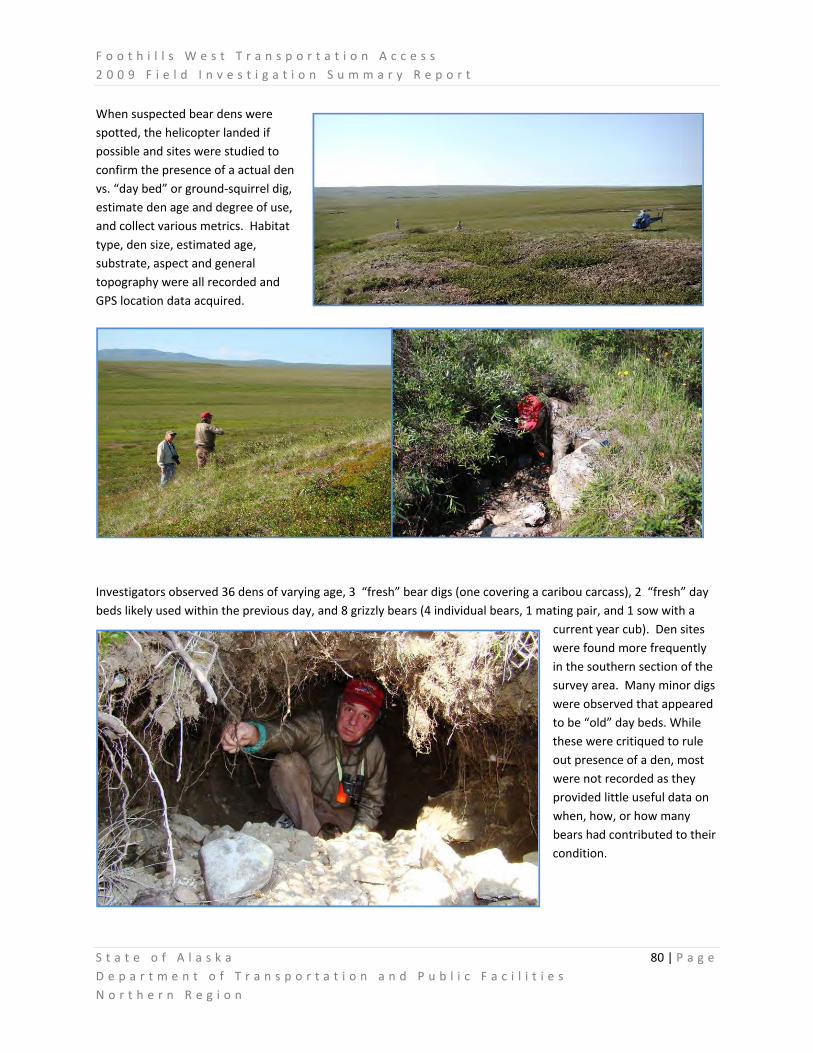
F o o t h i l l s W e s t T r a n s p o r t a t i o n A c c e s s 2 0 0 9 F i e l d I n v e s t i g a t i o n S u m m a r y R e p o r t
S t a t e o f A l a s k a 80 | P a g e D e p a r t m e n t o f T r a n s p o r t a t i o n a n d P u b l i c F a c i l i t i e s N o r t h e r n R e g i o n
When suspected bear dens were spotted, the helicopter landed if possible and sites were studied to confirm the presence of a actual den vs. “day bed” or ground‐squirrel dig, estimate den age and degree of use, and collect various metrics. Habitat type, den size, estimated age, substrate, aspect and general topography were all recorded and GPS location data acquired.
Investigators observed 36 dens of varying age, 3 “fresh” bear digs (one covering a caribou carcass), 2 “fresh” day beds likely used within the previous day, and 8 grizzly bears (4 individual bears, 1 mating pair, and 1 sow with a
current year cub). Den sites were found more frequently in the southern section of the survey area. Many minor digs were observed that appeared to be “old” day beds. While these were critiqued to rule out presence of a den, most were not recorded as they provided little useful data on when, how, or how many bears had contributed to their condition.

F o o t h i l l s W e s t T r a n s p o r t a t i o n A c c e s s 2 0 0 9 F i e l d I n v e s t i g a t i o n S u m m a r y R e p o r t
S t a t e o f A l a s k a 81 | P a g e D e p a r t m e n t o f T r a n s p o r t a t i o n a n d P u b l i c F a c i l i t i e s N o r t h e r n R e g i o n
RAPTOR NESTING SURVEY
Raptors and/or their nests were also surveyed. Raptor nests were expected to be located along river bluffs or hillsides where appropriate site conditions for nesting were present (based on pre‐fieldwork research). When nest sites were discovered by the sighting of either birds or areas of whitewash (bird feces) that often build up in the vicinity of occupied nest sites, the helicopter would land an appropriate distance away and investigators would utilize binoculars and spotting scopes to attempt to determine the species present , whether the nest was active and if any young were in nests, record the nesting substrate and other metrics, and acquire GPS location data. The team used established procedures to minimize disturbance to nesting birds. This sometimes required returning to a nest several hours or a day later to finalize observations.
During the survey, the biologists found a total of 7 active or recently used raptor nests and 1 perching location, observed 16 raptors in flight and 3 perching, and noted a pair of arctic loons (Gavia arctica). By BLM request, no surveys were conducted on BLM lands or in the vicinity of high bluffs of the Colville River near Umiat. As there is ample evidence from previous research that these areas contain abundant raptor nesting habitat and annually support active nests, it was not prudent to risk nest disturbance to verify this data. However, the 2009 preliminary survey identified areas
that may be surveyed more extensively if establishment of potential Foothills routing alternatives are developed by an environmental process.

F o o t h i l l s W e s t T r a n s p o r t a t i o n A c c e s s 2 0 0 9 F i e l d I n v e s t i g a t i o n S u m m a r y R e p o r t
S t a t e o f A l a s k a 82 | P a g e D e p a r t m e n t o f T r a n s p o r t a t i o n a n d P u b l i c F a c i l i t i e s N o r t h e r n R e g i o n
INCIDENTAL WILDLIFE SIGHTINGS OF NOTE
During the five day wetlands and vegetation delineation survey (July 31‐August 4), field crews recorded wildlife sightings on data forms and in field notebooks. Log sheets for sightings were created and observations recorded daily. Tables V.1 and V.2 below summarize species observed and number of sightings recorded. Many bird sightings were of more than one individual of that species, but exact numbers were not always recorded. Several moose and grizzly bears were also seen as crews flew from Happy Valley to the FWTAC, but these were not recorded as no specific location data was acquired during the flights.
Table VI.1: Preliminary List of Bird Species Observed by 3PPI Wetland Delineation Teams, July 31‐ Aug. 4, 2009.
Species Number of Sightings Notes
Long Tailed Jaegar 8 Flock of 3 and 10
Lapland Longspur 10 In flocks
Gull spp. 5 Noted as ‘gulls’
Songbirds (unidentified) 4 Flocks
Ptarmigan spp. 3 Flock of 7
Duck species 3 Flock of 15+
Snowy Owls 1 Pair
Owl species 1 single
Common Raven 2
Loon spp. 2 Pair
Redpoll spp. 1 Many
White Crowned Sparrow 1
Common Snipe 1
Northern Harrier 1
American Robin 1
Geese 2 More than 1 at each

F o o t h i l l s W e s t T r a n s p o r t a t i o n A c c e s s 2 0 0 9 F i e l d I n v e s t i g a t i o n S u m m a r y R e p o r t
S t a t e o f A l a s k a 83 | P a g e D e p a r t m e n t o f T r a n s p o r t a t i o n a n d P u b l i c F a c i l i t i e s N o r t h e r n R e g i o n
Table VI.2: Preliminary List of Mammals and Signs Observed by 3PPI Wetland Teams; July 31‐ Aug. 4, 2009.
Species Sightings/Notes
Grizzly Bear 2 bears, different sites – Near Plot, Itkillik River (1 from aircraft)
Wolf 1 – With Prey along Itkillik River (from aircraft)
Moose Bull – Anaktuvuk River (from aircraft)
Caribou 2 bulls – Anaktuvuk River (from aircraft)
Wolverine 1 site
Bear Dens/Digs 4 sites
Ground Squirrel Burrows 1 site
Large Mammal Scat 4 sites +
Caribou (Rangifer tarandus) were most notable by their general absence within the potential FWTAC during 2009 wetland, bear den and raptor surveys, and during numerous aerial surveys of engineering and other parameters.
From approximately April 15‐August 10, caribou were an uncommon sighting, with often only single animals observed in typically non‐characteristic habitats. One specific caribou was repeatedly sighted “in residence” on a +250 acre expanse of persistent aufeis on the Kuparuk River, while another was observed several times nearly on the peak of Imnavait Mountain living in a boulder field that would typically be considered Dall sheep habitat. Not until late‐August and into September were significant numbers of caribou witnessed migrating south‐ and westward from spring calving and summer feeding habitats along the northern coastal plain. Additional field study will be required to determine the most appropriate route configuration, engineering design and construction timing to avoid and/or mitigate possible effects of the potential Foothills project on caribou habitats, life history and migration patterns.

F o o t h i l l s W e s t T r a n s p o r t a t i o n A c c e s s 2 0 0 9 F i e l d I n v e s t i g a t i o n S u m m a r y R e p o r t
S t a t e o f A l a s k a 84 | P a g e D e p a r t m e n t o f T r a n s p o r t a t i o n a n d P u b l i c F a c i l i t i e s N o r t h e r n R e g i o n
VII. FISH AND FISH HABITAT RESOURCES FIELD STUDIES
DOT&PF staff met with ADF&G Habitat Biologists in March of 2009 to discuss the potential Foothills project and solicit information on possible impacts to fish and fish habitat resources in the project study area. ADF&G indicated that the majority of the project area contained only resident fish such as Arctic grayling (Thymallus arcticus), Dolly varden (Salvelinus malma) and several whitefish species, that there were limited runs of chum salmon (Oncorhynchus keta ) and pink salmon (Oncorhynchus gorbuscha ) in the lower Itkillik, Anaktuvuk, Chandler and Colville that represented subsistence stocks for local users. Fish habitats in the project area ranged from fish‐bearing tundra lakes to smaller tributaries during summer months to the larger rivers where overwintering fish populations congregate seasonally. An ADF&G Habitat Biologist accompanied DOT&PF and 3PPI staff on an interagency tour of the project area on June 23, 2009 to obtain an overview perspective of the stream morphology of those waters where Foothills project elements, including material sites, bridge crossings and potentially alignment segment, potentially may occur and impact fish bearing waters.
FISH LIFE HISTORY CONCERNS
Regarding impacts to fish life history, growth and survival, the primary concern for ADF&G is the potential for material site excavations or scour areas associated with bridge footings to create unnatural, off‐channel ponds only intermittently connected to main channels of rivers or, alternatively, deep in‐stream overwintering pools that are not natural to or characteristic of various drainages. Respectively, these could result in fish being trapped in off‐channel ponds and perishing due to an inability to out‐migrate; or in the latter case, various fish species “unnaturally” overwintering in deep pools caused by excavation changing population dynamics and inter‐specific competition for food or other resources. An example provided of the latter was the potential for whitefish species to overwinter in non‐traditional habitats where they would be likely to prey on salmonid eggs and fry, thereby reducing survival of those important subsistence species.

F o o t h i l l s W e s t T r a n s p o r t a t i o n A c c e s s 2 0 0 9 F i e l d I n v e s t i g a t i o n S u m m a r y R e p o r t
S t a t e o f A l a s k a 85 | P a g e D e p a r t m e n t o f T r a n s p o r t a t i o n a n d P u b l i c F a c i l i t i e s N o r t h e r n R e g i o n
FISH HABITAT CONCERNS
ADF&G also expressed concerns regarding the potential for fish habitats to be adversely affected by various Foothills project elements. These included siltation of important spawning and overwintering habitat due to sediment laden runoff being introduced to area streams and rivers by construction work, material site excavation or, long term, roadway dust from the use of any potentially constructed road. While area rivers experience seasonal flooding events that may result in increased sediment loads which affect fish habitats, the addition of sedimentation during periods of low flow or during critical life‐history functions (spawning, fry emergence, etc.) would present unnatural conditions and potentially increase mortality or reduce the probability for successful spawning to take place.
Additional concerns were raised regarding the installation of properly configured drainage facilities within the numerous smaller stream crossings potentially required for a Foothills road. DOT&PF was advised that culverts and other crossing structures must maintain and accommodate bank‐full conditions to assure fish passage for resident and anadromous fish that migrate seasonally within watersheds. In that regard, DOT&PF was advised that single‐pipe culverts were more desirable than multi‐pipe arrays, and that it would be important to obtain hydrological data to insure any structure placed would accommodate a full range of seasonal flows possible for each drainage.
ADF&G expressed appreciation for DOT&PF efforts to engage that agency very early in the preliminary field study process. DOT&PF was offered assistance in design review of drainage structures, material sites, bridge configuration and other project elements that might affect fish and fish habitats. It is anticipated that ADF&G will be continuously involved with the project pre‐design and, if funded, environmental process, final design and construction both through their ability to provide expertise to avoid and mitigate potential effects to fish resources and their authority to issue requisite permits for project work.

F o o t h i l l s W e s t T r a n s p o r t a t i o n A c c e s s 2 0 0 9 F i e l d I n v e s t i g a t i o n S u m m a r y R e p o r t
S t a t e o f A l a s k a 86 | P a g e D e p a r t m e n t o f T r a n s p o r t a t i o n a n d P u b l i c F a c i l i t i e s N o r t h e r n R e g i o n
VIII. SUBSISTENCE RESOURCES FIELDWORK SUMMARY
In early 2009, DOT&PF was made aware of strong concerns that potential development the Foothills project within traditional subsistence use areas may deleteriously impact subsistence resources and users. Preliminary discussions with residents of the Foothills project region, meetings with public agency officials responsible for subsistence resource management, and contemporary literature on regional subsistence issues all suggested that potential impacts may include direct harm to subsistence species’ habitats, life history, and distribution or
abundance; and/or also a potential increase in demand or competition for subsistence resources by non‐local publics via an improved road access to subsistence areas. Through those initial public inputs, DOT&PF recognized that additional studies on subsistence resources and investigations into trends of subsistence use were necessary to determine how a potential Foothills project could be integrated into the regional landscape without significant adverse effects on traditional subsistence resource users.
Early in the data gathering process, DOT&PF consulted with the Alaska Department of Fish and Game, Division of Subsistence regarding potential impacts to subsistence resources and users by the potential Foothills project activities. DOT&PF was advised to seek input directly from the potentially affected villages and regional governments, and also to bring the project information directly to the North Slope Borough Fish and Game Management Committee for early feedback and guidance on interactions with local interests. DOT&PF has since accomplished these tasks, and based on input from those entities is currently seeking further input from the North Slope Borough Wildlife Department.
In addition to direct agency efforts, as part of the potential Foothills project’s preliminary subsistence studies, Three Parameters Plus Inc. (3PPI), on contract with the State of Alaska Department of Transportation and Public Facilities (DOT&PF), gathered data on local use; attended project public meetings in Nuiqsut, Anaktuvuk Pass, and Barrow; conducted a subsistence data gap analysis; and initiated scheduling for subsistence documentation field work in three potentially affected communities.
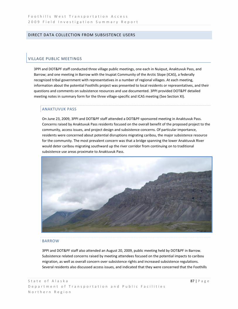
F o o t h i l l s W e s t T r a n s p o r t a t i o n A c c e s s 2 0 0 9 F i e l d I n v e s t i g a t i o n S u m m a r y R e p o r t
S t a t e o f A l a s k a 87 | P a g e D e p a r t m e n t o f T r a n s p o r t a t i o n a n d P u b l i c F a c i l i t i e s N o r t h e r n R e g i o n
DIRECT DATA COLLECTION FROM SUBSISTENCE USERS
VILLAGE PUBLIC MEETINGS
3PPI and DOT&PF staff conducted three village public meetings, one each in Nuiqsut, Anaktuvuk Pass, and Barrow; and one meeting in Barrow with the Inupiat Community of the Arctic Slope (ICAS), a federally recognized tribal government with representatives in a number of regional villages. At each meeting, information about the potential Foothills project was presented to local residents or representatives, and their questions and comments on subsistence resources and use documented. 3PPI provided DOT&PF detailed meeting notes in summary form for the three village‐specific and ICAS meeting (See Section XI).
ANAKTUVUK PASS
On June 23, 2009, 3PPI and DOT&PF staff attended a DOT&PF‐sponsored meeting in Anaktuvuk Pass. Concerns raised by Anaktuvuk Pass residents focused on the overall benefit of the proposed project to the community, access issues, and project design and subsistence concerns. Of particular importance, residents were concerned about potential disruptions migrating caribou, the major subsistence resource for the community. The most prevalent concern was that a bridge spanning the lower Anaktuvuk River would deter caribou migrating southward up the river corridor from continuing on to traditional subsistence use areas proximate to Anaktuvuk Pass.
BARROW
3PPI and DOT&PF staff also attended an August 20, 2009, public meeting held by DOT&PF in Barrow. Subsistence related concerns raised by meeting attendees focused on the potential impacts to caribou migration, as well as overall concern over subsistence rights and increased subsistence regulations. Several residents also discussed access issues, and indicated that they were concerned that the Foothills

F o o t h i l l s W e s t T r a n s p o r t a t i o n A c c e s s 2 0 0 9 F i e l d I n v e s t i g a t i o n S u m m a r y R e p o r t
S t a t e o f A l a s k a 88 | P a g e D e p a r t m e n t o f T r a n s p o r t a t i o n a n d P u b l i c F a c i l i t i e s N o r t h e r n R e g i o n
road would replay the same problems encountered during the development of the Dalton Highway unless a more comprehensive effort was made to incorporate local subsistence issues into the planning process.
NUIQSUT
3PPI and DOT&PF staff attended the DOT&PF meeting held in Nuiqsut on June 11, 2009. Nuiqsut residents’ concerns on subsistence focused on potential impacts to subsistence users and subsistence resources. A specific concern related to subsistence use raised by residents during the June meeting focused on the potential influx of outsiders (e.g., tourists, sport hunters, recreationalists) into the Colville River area, and the potential impacts to caribou, moose, fish, and other subsistence resources. Residents were also concerned about potential impacts on access to subsistence use areas, displacement of subsistence resources from the potential road area, downstream effects on the watershed fauna from construction at Umiat, and the need for adequate studies to address potential impacts to subsistence. Some residents claimed that existing conflicts with non‐local guides and outfitters would increase were there better access to the Colville River floodplain, and several residents related accounts of local residents being disturbed, harassed and, in the extreme, shot at from aircraft while conducting their subsistence activities.
INUPIAT COMMUNITY OF THE ARCTIC SLOPE (ICAS)
3PPI and DOT&PF staff also attended an August 20, 2009 Board meeting of ICAS held in Barrow. Information on the Foothills project was presented to ICAS as a means to share information about the project to ICAS village representatives. ICAS Board members representatives provided various insights and shared their concerns over potential impacts to subsistence resources and users, and while the ICAS comments were similar in nature to those aired in individual villages, the greater geographic coverage of the ICAS village representatives’ comments clearly indicated that potential effects to subsistence users and resources caused by the Foothills project would generate apprehension and concern over a much larger area than simply the project study area and nearby villages. There was a general concern that an access road to the region would bring an escalation of subsistence/non‐subsistence hunter conflicts. ICAS again reiterated a desire that any project not generate a repeat of negative experiences of residents during Dalton Highway construction, and encouraged DOT&PF to seek guidance from village Elders on all matters.
During the ICAS meeting, DOT&PF solicited input on the most effective and appropriate way to incorporate Subsistence Monitors into field study programs as required by the North Slope Borough Development permit for preliminary investigations. While it was initially considered that ICAS would serve as a clearinghouse for current and any future subsistence field monitoring staff, ICAS Executive Director Price Leavitt suggested that DOT&PF establish individual Memoranda of Agreement with the Villages of Nuiqsut and Barrow on their own, while an ICAS representative would work with the agency to establish an agreement directly with the Village of Anaktuvuk Pass.

F o o t h i l l s W e s t T r a n s p o r t a t i o n A c c e s s 2 0 0 9 F i e l d I n v e s t i g a t i o n S u m m a r y R e p o r t
S t a t e o f A l a s k a 89 | P a g e D e p a r t m e n t o f T r a n s p o r t a t i o n a n d P u b l i c F a c i l i t i e s N o r t h e r n R e g i o n
CONTRACTING OF SUBSISTENCE FIELD MONITORS AS PER NSB PERMIT 09‐454
The North Slope Borough Development Permit 09‐454 for preliminary Foothills field studies stipulated in part that DOT&PF be diligent in minimizing the potential for disrupting subsistence activities during the 2009 Rolligon‐ and helicopter‐based geotechnical fieldwork:
To meet these stipulations as set forth, DOT&PF worked with ICAS and the Villages of Anaktuvuk Pass and Nuiqsut to establish Memoranda of Understanding to contract required Subsistence Monitors (See Section XI).
During the 2009 field season, Village Subsistence Monitors Andrew Hopson (Anaktuvuk Pass) and Duane Hopson (Nuiqsut) flew approximately 20 combined hours of helicopter survey to assist DOT&PF staff with air reconnaissance of potential corridor routes to prevent conflicts with subsistence resources or users, observed Rolligon based geotechnical crews conducting sample borings at potential materials sites, provided input on important locations and traditional methods and timing of subsistence activities, and relayed any concerns of their respective villages.
DOT&PF intends that if the Foothills project is funded for full design and construction, Subsistence Monitors would be employed long‐term to provide expertise and oversight to project components. As there have been comments from the Village of Barrow and North Slope Borough Department of Wildlife Management regarding interest in participating in subsistence monitoring or resources surveys, DOT&PF considers their involvement welcome benefits to pending investigations, and will seek their guidance on future subsistence field work.

F o o t h i l l s W e s t T r a n s p o r t a t i o n A c c e s s 2 0 0 9 F i e l d I n v e s t i g a t i o n S u m m a r y R e p o r t
S t a t e o f A l a s k a 90 | P a g e D e p a r t m e n t o f T r a n s p o r t a t i o n a n d P u b l i c F a c i l i t i e s N o r t h e r n R e g i o n
FUTURE SUBSISTENCE FIELD WORK
Stephen R. Braunde and Associates (SRB&A), subcontracted by 3PPI, has sent introductory letters to nine community organizations in three potentially affected communities (Anaktuvuk Pass, Barrow, and Nuiqsut):
• Anaktuvuk Pass organizations include the City of Anaktuvuk Pass and Village of Anaktuvuk Pass ‐ Naqsragmiut Tribal Council. SRB&A has also contacted Anaktuvuk Pass organizations by telephone.
• Barrow organizations include the City of Barrow and Native Village of Barrow Iñupiat Traditional Government.
• Nuiqsut organizations include the City of Nuiqsut, Native Village of Nuiqsut, and Kuukpik Subsistence Oversight Panel, Inc.
In addition to these local organizations, SRB&A has sent introductory letters to the Iñupiat Community of the Arctic Slope (ICAS) and North Slope Borough Department of Wildlife.
The purpose of these introductory communications is to introduce the potential Foothills project, receive community approval for subsistence field work to address data gaps and, contingent upon community approval, schedule subsistence field work during the winter months of 2009‐2010.
The proposed field work will involve interviewing knowledgeable elders and subsistence harvesters who are familiar with the project area to document their knowledge about the physical and biological environment of the FWTAC in addition to giving them a chance to raise issues and concerns about the proposed project, provide their observations about other road projects on the North Slope, and make suggestions regarding current project design and management.
SRB&A will also gather information about important habitat areas and any changes in resource use, abundance, quality, distribution or migration. In addition, interviews in Anaktuvuk Pass will document knowledgeable harvesters’ subsistence use areas for the past 10 years, including hunting camp/cabin locations and travel routes, to address data gaps listed above.

F o o t h i l l s W e s t T r a n s p o r t a t i o n A c c e s s 2 0 0 9 F i e l d I n v e s t i g a t i o n S u m m a r y R e p o r t
S t a t e o f A l a s k a 91 | P a g e D e p a r t m e n t o f T r a n s p o r t a t i o n a n d P u b l i c F a c i l i t i e s N o r t h e r n R e g i o n
SUBSISTENCE DATA GAP ANALYSIS
To efficiently plan future subsistence studies and facilitate accurate future assessments of potential project effects on subsistence resources and users, 3PPI conducted a Subsistence Data Gap Analysis. The purpose of this analysis was to identify subsistence research that had been conducted for the potentially affected communities, determine if subsistence uses and use areas overlap with, or may be affected by, the potential Foothills project, and identify what, if any, additional subsistence information (i.e., data gaps) should be collected to accurately assess potential effects to subsistence. Data gap analyses (See Section XI) provide a) reviews of concerns raised during June 2009 project review meetings in Nuiqsut and Anaktuvuk Pass, b) existing subsistence and traditional knowledge (TK) data sources, c) identification of subsistence data gaps, and, d) recommendations for future subsistence work in potentially affected communities. 3PPI submitted the Subsistence Data Gap Analysis to DOT&PF on July 24, 2009.
3PPI recommended the following tasks be completed to address the identified data gaps:
• Acquire the forthcoming report and data from the North Slope Borough regarding the most recent harvest data for Anaktuvuk Pass, Barrow, and Nuiqsut.
• Seek permission from the Mineral Management Service (MMS) to use the most recent subsistence use area data for the communities of Barrow and Nuiqsut.
• Conduct a subsistence mapping project in Anaktuvuk Pass to gather current information related to subsistence use areas, species, timing of subsistence activities, and other use area variables.
• Review TK sources for information pertaining to the project area.
• Research the current status of the MMS Traditional Knowledge Database.
• Conduct focused TK interviews with knowledgeable residents of Anaktuvuk Pass, Barrow, and Nuiqsut that address characteristics of the physical, biological, and human environment in the vicinity of the potential FWTAC project. These interviews would also focus on knowledgeable residents’ suggestions regarding project design, construction, and operation of the potential transportation corridor, best management practices (BMPs), and mitigation ideas for any potential impacts.

F o o t h i l l s W e s t T r a n s p o r t a t i o n A c c e s s 2 0 0 9 F i e l d I n v e s t i g a t i o n S u m m a r y R e p o r t
S t a t e o f A l a s k a 92 | P a g e D e p a r t m e n t o f T r a n s p o r t a t i o n a n d P u b l i c F a c i l i t i e s N o r t h e r n R e g i o n
IX. CULTURAL AND HISTORICAL RESOURCES FIELD WORK SUMMARY
Cultural and historical resources are present throughout the Foothills West Transportation Access Project (Foothills) study area, and span the spectrum of time. From clearly identifiable features signifying locations of prehistoric campsites; to barely visible artifacts at sites where stone tools were crafted, game butchered or modern weapons first used; to more recent remnants of Alaska’s military history or industrial development – the remaining evidence from the past can provide us snapshots of the people, cultures and former uses of the region.
Three required land use permits for the Foothills field study program included language or stipulations requiring DOT&PF to avoid or protect cultural and historical resources during the course of field operations:
ADNR Land Use Permit LAS‐27222 (GCD‐19 of Alaska Coastal Management Program);
North Slope Borough (NSB) Development Permit #NSB 09‐454;

F o o t h i l l s W e s t T r a n s p o r t a t i o n A c c e s s 2 0 0 9 F i e l d I n v e s t i g a t i o n S u m m a r y R e p o r t
S t a t e o f A l a s k a 93 | P a g e D e p a r t m e n t o f T r a n s p o r t a t i o n a n d P u b l i c F a c i l i t i e s N o r t h e r n R e g i o n
BLM Land Use Permit (pending) Section 106 National Historic Preservation Act regulations (36 CFR 800.4.b.1):
(1) Level of effort. The agency official shall make a reasonable and good faith effort to carry out appropriate
identification efforts, which may include background research, consultation, oral history interviews, sample field investigation, and field survey. The agency official shall takeinto account past planning, research and studies, the magnitude and nature of the undertaking and the degree of Federal involvement, the nature and extent of potential effects on historic properties, and the likely nature and location of historic properties within the area of potential effects. The Secretary's Standards and Guidelines for Identification provide guidance on this subject. The agency official should also consider other applicable professional, State, tribal and local laws, standards and guidelines. The agency official shall take into account any confidentiality concerns raised by Indian tribes or Native Hawaiian organizations during the identification process.
As part of the potential Foothills project’s preliminary cultural resources studies, Three Parameters Plus Inc. (3PPI), on contract with the State of Alaska Department of Transportation and Public Facilities (DOT&PF) attended project public meetings in Nuiqsut, Anaktuvuk Pass, and Barrow; designed a Bureau of Land Management (BLM) cultural resource monitoring plan; created a Preliminary Cultural Resource Report; and is drafting a preliminary research design for future cultural resource field studies. This section summarizes progress of completed and ongoing DOT&PF & 3PPI cultural resources work as of November 2009.
In addition to solely contracted cultural resource studies, staff with the Alaska Department of Natural Resources, Office of History and Archeology (OHA) graciously assisted staff from DOT&PF and 3PPi in conducting a preliminary field reconnaissance of portions of the study area to provide guidance to DOT&PF on future investigations necessary to characterize potential impacts to historical and archeological resources. The survey consisted of helicopter‐supported, on‐the‐ground inspections of various locations of known or suspected cultural resource sites within potential route corridors and material sites.
LOCAL & TRADITIONAL KNOWLEDGE DATA COLLECTION AND PRESERVATION
VILLAGE PUBLIC MEETINGS
3PPI and DOT&PF staff conducted three village public meetings, one each in Nuiqsut, Anaktuvuk Pass, and Barrow; and one meeting in Barrow with the Inupiat Community of the Arctic Slope (ICAS), a federally recognized tribal government with representatives in the many regional villages. At each meeting, information about the potential Foothills project was presented to local residents or representatives, and their questions and comments on cultural and historical issues documented. 3PPI provided DOT&PF detailed meeting notes in summary form for the three village‐specific and ICAS meetings (See Section XI).

F o o t h i l l s W e s t T r a n s p o r t a t i o n A c c e s s 2 0 0 9 F i e l d I n v e s t i g a t i o n S u m m a r y R e p o r t
S t a t e o f A l a s k a 94 | P a g e D e p a r t m e n t o f T r a n s p o r t a t i o n a n d P u b l i c F a c i l i t i e s N o r t h e r n R e g i o n
ANAKTUVUK PASS
On June 23, 2009, 3PPI and DOT&PF staff attended a DOT&PF sponsored meeting in Anaktuvuk Pass. Concerns raised by Anaktuvuk Pass residents focused on the overall cost/benefit of the project to the community, access issues, project design, and subsistence concerns. Regarding cultural resources, residents expressed concern that burial sites should be avoided.
BARROW
3PPI and DOT&PF staff attended an August 20, 2009, public meeting organized by DOT&PF in Barrow. Concerns voiced by residents and related to cultural resources focused on how the discovery of potential cultural resource sites and burials will be addressed. Residents wanted to know who would own any artifacts discovered during the course of field studies. They also expressed the need for a buffer zone around any cultural resource sites discovered.
NUIQSUT
3PPI and DOT&PF staff attended a DOT&PF‐sponsored meeting in Nuiqsut on June 11, 2009. While Nuiqsut residents raised concerns during the meeting about potential impacts to subsistence users and resources, the meeting attendees did not raise any specific cultural resource concerns.
INUPIAT COMMUNITY OF THE ARTIC SLOPE (ICAS)
3PPI and DOT&PF staff were guests at an August 20, 2009 Board meeting of the Inupiat Community of the Arctic Slope. Information on the Foothills project was presented to ICAS as a means to share information

F o o t h i l l s W e s t T r a n s p o r t a t i o n A c c e s s 2 0 0 9 F i e l d I n v e s t i g a t i o n S u m m a r y R e p o r t
S t a t e o f A l a s k a 95 | P a g e D e p a r t m e n t o f T r a n s p o r t a t i o n a n d P u b l i c F a c i l i t i e s N o r t h e r n R e g i o n
about the project to ICAS village representatives. ICAS Board members and representatives provided various insights and shared their concerns over potential impacts to cultural and historical resources potentially being caused by the project, many mirroring comments and questions aired at previous village meetings.
HISTORICAL AND ARCHEOLOGICAL RESOURCES DATA COLLECTION AND PRESERVATION
ADNR‐OHA FIELD RECONNAISANCE OF POTENTIAL CORRIDOR AND MATERIAL SITES
State Historic Preservation Officer (SHPO) Judith Bittner of the ADNR‐OHA generously provided the historical and archeological assessment expertise of her office to DOT&PF and the Foothills field study program on two occasions during the 2009 summer field study season.
Between June 23‐25, 2009, Deputy SHPO and Alaska State Archeologist Dave McMahan accompanied staff from DOT&PF, the Alaska Department of Fish and Game (ADF&G) and 3PPI on a helicopter reconnaissance of the general study corridor and potential material sites, as well as to the village informational meeting in Anaktuvuk Pass. Mr. McMahan visited nearly all the potential Foothills material sites identified by DOT&PF Materials Section earlier in the field season as well as several known Alaska Historic Resources Survey (AHRS) sites proximate to the study area. At several potential material sites, evidence of previously unrecorded human use was found, essentially ruling out those material sites from primary consideration and immediately validating the desirability of including the ADNR‐OHA early in the data gathering process for the project.
Dep. SHPO McMahan flew the entire study corridor to highlight to DOT&PF the topographic and spatial characteristics and typical locations of landforms predisposed to containing archeological or historic resources. Where possible, these resources were mapped, photographed and GPS data collected to preserve a record of locations and observations.

F o o t h i l l s W e s t T r a n s p o r t a t i o n A c c e s s 2 0 0 9 F i e l d I n v e s t i g a t i o n S u m m a r y R e p o r t
S t a t e o f A l a s k a 96 | P a g e D e p a r t m e n t o f T r a n s p o r t a t i o n a n d P u b l i c F a c i l i t i e s N o r t h e r n R e g i o n
At the Anaktuvuk Pass public meeting, Dep. SHPO McMahan provided ADNR‐OHA insights and expertise to residents concerned about potential damage or loss of cultural or historic materials or sites, and speaking with the authority of his agency, reassured the public that DOT&PF and ADNR were committed to preserving the integrity and historical value of any cultural or archeological sites discovered or potentially affected by the Foothills project.
From August 10‐13, 2009, ADNR‐OHA staff Archeologist Alan Depew accompanied DOT&PF staff on an extensive helicopter reconnaissance of the Foothills Rolligon Preliminary Geotechnical Sampling route to clear the path of potential conflicts with, or impacts to, any cultural or historic resources.
Mr. Depew spent several days in the field to review areas to be sampled for materials, and to familiarize DOT&PF staff with important considerations for accessing remote areas potentially containing cultural and historic resources.
ADNR/OHA input to project fieldwork was instrumental in qualifying DOT&PF efforts to insure compliance with procedures outlined in General Concurrence 19 that stipulate avoidance of potential AHRS sites during summer tundra travel in order to meet requirements of ADNR Land Use Permit #LAS‐27222 for Foothills fieldwork.
CULTURAL RESOURCE MONITORING PLAN FOR PRELIMINARY FIELDWORK ON BLM LAND
BLM has required DOT&PF to develop and implement a comprehensive Cultural Resource Monitoring Plan that addresses avoidance and mitigation of potential impacts by Foothills preliminary field study activities on cultural resources on federal lands in the Foothills study area. 3PPI, on behalf of DOT&PF, designed and produced a monitoring plan proposal for BLM outlining the necessary procedures to evaluate Rolligon‐based geotechnical survey travel and field activities on BLM lands (per criteria of Section 106 of the National Historic Preservation Act, the Native American Graves Protection and Repatriation Act, and Archaeological Resource Protection Act). Those DOT&PF field study activities on BLM land would include the following:
• Rolligon travel for geotechnical field work for 10 days in February or March, 2010.

F o o t h i l l s W e s t T r a n s p o r t a t i o n A c c e s s 2 0 0 9 F i e l d I n v e s t i g a t i o n S u m m a r y R e p o r t
S t a t e o f A l a s k a 97 | P a g e D e p a r t m e n t o f T r a n s p o r t a t i o n a n d P u b l i c F a c i l i t i e s N o r t h e r n R e g i o n
• Geotechnical sampling activities including the accessing of four to five test sites along the sampled route, and conducting up to four each, six‐inch‐diameter borings collectively affecting +3 square feet of surface area per each 5‐ to 10‐acre site sampled.
3PPI has proposed to monitor pending Rolligon travel and geotechnical sampling on BLM land to ensure cultural resources and/or burial sites potentially encountered during the course of field work are not deleteriously affected. Included in the monitoring plan are monitoring methods, procedures to be followed in the event of inadvertent discovery of cultural resources or human remains, and a description of the contents of a monitoring report to be provided BLM following completion of 2010 field work. As part of BLM monitoring requirements, 3PPI has submitted applications in October, 2009 for a BLM Archaeological Resource Protection Act permit and BLM Fieldwork Authorization permit for DOT&PF. 3PPI also acquired a curation agreement with the University of Alaska, Museum of the North, which agreed to serve as repository for collections generated from the project, though final acceptance of artifacts is contingent on compliance with their curation guidelines. 3PPI submitted a Draft Monitoring Plan and Preliminary Cultural Resource Report to DOT&PF on October, 2009 (See Section XI).
PRELIMINARY CULTURAL RESOURCE REPORT
To more fully characterize cultural and historical resources of the Foothills field study area and model the type and degree of potential effects to those resources should a Foothill project go forward, 3PPI drafted a Preliminary Cultural Resource Report (See Section XI) identifying cultural resources in the project study area; and describing Areas of Potential Effect (APE) for potential project work based on a summary of available literature, the Alaska Heritage Resource Survey (AHRS), the Traditional Land Use Inventory (TLUI), and an archival review.
FUTURE CULTURAL RESEARCH DESIGN
In anticipation of further cultural resources‐based permitting requirements and data collection in order to conduct further field study, 3PPI is creating a research design for cultural resource surveys as required by the State Historic Preservation Office (SHPO). The deliverable associated with this task is a preliminary report with a field plan for proposed surveys. 3PPI evaluated data gaps regarding those resources and potential means of resolving those data gaps through literature or field surveys. To address cultural resource data gaps associated with the Foothills field studies, this research design proposes to gather information through:
• Background research of existing literature (survey reports) and databases/inventories (AHRS, TLUI, Simon Paneak Museum Sites).
• Local consultations and interviews with local residents.
• Pedestrian surveys and subsurface tests.
3PPI has requested the TLUI data from the North Slope Borough Iñupiat History, Language, and Culture Division. The TLUI documents place names, landmarks, traditional land use sites, travel routes, and significant locations remembered by the Iñupiat people through time, in order to protect these sites from disturbance or destruction due to development activities on the North Slope.
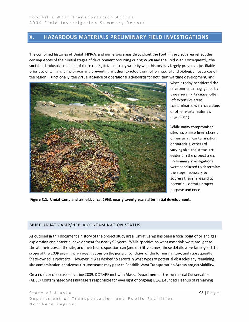
F o o t h i l l s W e s t T r a n s p o r t a t i o n A c c e s s 2 0 0 9 F i e l d I n v e s t i g a t i o n S u m m a r y R e p o r t
S t a t e o f A l a s k a 98 | P a g e D e p a r t m e n t o f T r a n s p o r t a t i o n a n d P u b l i c F a c i l i t i e s N o r t h e r n R e g i o n
X. HAZARDOUS MATERIALS PRELIMINARY FIELD INVESTIGATIONS
The combined histories of Umiat, NPR‐A, and numerous areas throughout the Foothills project area reflect the consequences of their initial stages of development occurring during WWII and the Cold War. Consequently, the social and industrial mindset of those times, driven as they were by what history has largely proven as justifiable priorities of winning a major war and preventing another, exacted their toll on natural and biological resources of the region. Functionally, the virtual absence of operational sideboards for both that wartime development, and
what is today considered the environmental negligence by those serving its cause, often left extensive areas contaminated with hazardous or other waste materials (Figure X.1).
While many compromised sites have since been cleared of remaining contamination or materials, others of varying size and status are evident in the project area. Preliminary investigations were conducted to determine the steps necessary to address them in regard to potential Foothills project purpose and need.
Figure X.1. Umiat camp and airfield, circa. 1963, nearly twenty years after initial development.
BRIEF UMIAT CAMP/NPR‐A CONTAMINATION STATUS
As outlined in this document’s history of the project study area, Umiat Camp has been a focal point of oil and gas exploration and potential development for nearly 90 years. While specifics on what materials were brought to Umiat, their uses at the site, and their final disposition can (and do) fill volumes, those details were far beyond the scope of the 2009 preliminary investigations on the general condition of the former military, and subsequently State‐owned, airport site. However, it was desired to ascertain what types of potential obstacles any remaining site contamination or adverse circumstances may pose to Foothills West Transportation Access project viability.
On a number of occasions during 2009, DOT&PF met with Alaska Department of Environmental Conservation (ADEC) Contaminated Sites managers responsible for oversight of ongoing USACE‐funded cleanup of remaining

F o o t h i l l s W e s t T r a n s p o r t a t i o n A c c e s s 2 0 0 9 F i e l d I n v e s t i g a t i o n S u m m a r y R e p o r t
S t a t e o f A l a s k a 99 | P a g e D e p a r t m e n t o f T r a n s p o r t a t i o n a n d P u b l i c F a c i l i t i e s N o r t h e r n R e g i o n
contamination at Umiat camp and its associated satellite sites through the Defense Environmental Restoration Program /Formerly Used Defense Sites (DERP/FUDS) program. DOT&PF was provided with an extensive amount of historical documentation and the results of environmental site assessments characterizing known and potential materials of concern at the sites. Additionally, DOT&PF was invited to participate with ADEC in all future discussions or interagency meetings regarding future clean‐up efforts at Umiat.
A generic description of the current status of contamination at Umiat and future DERP/FUDS activities at the site is that the situation is active, dynamic and largely dependant on future funding and priorities. Over the past decades, significant efforts have been made by USACE to remove remaining drums of various contaminants buried or sunken in lakes near Umiat, remove remnants of oil well casings eroding into the Colville River, excavate and remediate soils contaminated with diesel range organics (DRO), other hydrocarbon residues and PCBs, and on occasion remove materials buried in a gravel bar of the Colville River adjacent to the camp. Of these, the buried materials site remains the biggest concern to Foothills project staff, as this estimated 10‐acre landfill is predicted to contain upward of 80,000 crushed 55‐gal. drums (not cleaned prior to burial), a variety of demolished building debris, vehicles and equipment, 1940’s‐era electrical transformers, and other waste material as yet unknown.
In September of 2009, DOT&PF presented the Foothills project status to the Barrow Restoration Advisory Board (BRAB), an interagency panel of representatives from ADEC, the North Slope Borough, various Native Villages throughout the region, staff from the U.S. Air Force, U.S. Navy, U.S. Army Corps of Engineers, and other interested agencies and organizations. The focus of the BRAB is to maintain working associations between these agencies to insure coordination of effort and information flow for DERP/FUDS work in the region. At the meeting, DOT&PF was invited to be a member of the BRAB in acknowledgement of its interest and association with DERP/FUDS sites.
PRELIMINARY SITE INSPECTIONS AND DATA COLLECTION
During 2009 preliminary environmental field operations, DOT&PF and 3PPI staff collected data on potential hazardous waste and material sites as they were encountered during surveys for other environmental data. Specifically, staff maintained a vigilance for remote sites containing caches of drums, discarded remnants of oilfield development from the 1940’s‐50’s, any obvious signs of contaminated soil or waters, and any information obtained from literature or the public regarding incidents of contamination release or discovery.
For the former, GPS locations were obtained when drums were encountered during field surveys, and it is estimated that nearly 300 drums were seen at
several dozen sites. Locations were marked for future reference should the project be funded for continued environmental surveys. In that case, Phase I Site Assessments will be conducted to characterize any contamination at these sites and, oddly, concurrently determine if they hold historical significance as artifacts of the early regional

F o o t h i l l s W e s t T r a n s p o r t a t i o n A c c e s s 2 0 0 9 F i e l d I n v e s t i g a t i o n S u m m a r y R e p o r t
S t a t e o f A l a s k a 100 | P a g e D e p a r t m e n t o f T r a n s p o r t a t i o n a n d P u b l i c F a c i l i t i e s N o r t h e r n R e g i o n
development. Regardless the future of the Foothills project, these data will be shared with ADEC and the BRAB to insure locations of potential contamination are not simply archived, ignored and forgotton.
At Umiat, an inspection of the landfill was conducted in June, 2009 to determine any potential to conflict with a possible Foothills project bridge spanning the Colville River. According to ADEC 22 , seasonal flooding of the Colville River causes a slough associated with the gravel bar containing the landfill to be scoured of overburden, often thereby excavating discarded drums, vehicle parts, demolished building debris and other materials.
22 Tamar Stephens, ADEC Contaminated Sites Manager for Umiat, personal communication with Paul Karczmarczyk, DOT&PF Environmental
Analyst.

F o o t h i l l s W e s t T r a n s p o r t a t i o n A c c e s s 2 0 0 9 F i e l d I n v e s t i g a t i o n S u m m a r y R e p o r t
S t a t e o f A l a s k a 101 | P a g e D e p a r t m e n t o f T r a n s p o r t a t i o n a n d P u b l i c F a c i l i t i e s N o r t h e r n R e g i o n
One Colville River flooding event several years ago was significant enough to uncover, dislodge and mobilize several buried electrical transformers that were subsequently found to contain and be leaking PCB oils, and while these devices were again lost before they could be removed due to a repeat flood event several days later, the soils where they had been buried tested positive for high levels of PCBs and were subsequently excavated and removed from the site. However, the transformers were apparently either reburied or washed downstream by the flood, and were never recovered or seen again.
The brief physical site inspection revealed a wide range of material being uncovered and “exhumed” by this scouring. While current operators of the Umiat Lodge have periodically regraded and filled these scours as needed to maintain vehicle access to the Colville River, these efforts are at best repeated, temporary repairs. As a consequence, the scour channel of the slough has deepened to the point that it has reached the upper extent of the buried materials and these are evident throughout the channel.
As an example of less apparent evidence of Umiat site contamination and its origins, a (paraphrased) story adapted from one heard often “in the field” bears mentioning to illustrate the value of anecdotal information:
At some point in the 1970’s , the U.S. Navy had sealed the Umiat test wells drilled in the 1940’s‐50’s to insure they would not be tampered with or filled by locals. To prevent their rusting out, perforating, filling with water, freezing due to permafrost and bursting, the Navy filled the casings with diesel fuel, effectively creating various +2000’ x 8” underground storage tanks. As one might expect, this did not go unnoticed by others in the area, and within a few years these were broken into and “tapped” with a standard submersible well pump to supply “free” fuel for vehicles, generators, etc. However, eventually the well pump lost its prime…but a discarded, “convenient” drum of light oil found on site was utilized to re‐establish prime for the well pump. What was unfortunately discovered two decades later was that the drum had been filled with PCB oil, and the priming action had effectively injected PCBs into the diesel column in the well. The discovery was made when the casing was in the process of eroding into the Colville River, water had entered the casing, and contamination was being emitted.
DOT&PF will continue to work with ADEC, BRAB and the USACE to coordinate ongoing Foothills project activities with any future scope of investigations, mitigation plans or actions for contaminated sites at Umiat and throughout the project study area. Should additional environmental studies be funded through the Foothills project, DOT&PF will maximize the opportunity to build upon, rather than reiterate, investigations and assessments that have been carried out to date by the partnership of agencies attending to Umiat site remediation work.

F o o t h i l l s W e s t T r a n s p o r t a t i o n A c c e s s 2 0 0 9 F i e l d I n v e s t i g a t i o n S u m m a r y R e p o r t
S t a t e o f A l a s k a 102 | P a g e D e p a r t m e n t o f T r a n s p o r t a t i o n a n d P u b l i c F a c i l i t i e s N o r t h e r n R e g i o n
XI REPORTS DEVELOPED IN CONJUNCTION WITH 2009 FIELD SEASON
The following reports were prepared by:
Alaska Department of Transportation & Public Facilities, Northern Region, Design Section
Foothills West Transportation Access Trip Summary – Winter Reconnaissance Fly Over – April 2009
Village and Inupiat Community of the Arctic Slope (ICAS) Meeting Notes – June through August 2009
Subsistence Monitor Memoranda of Understanding – August 2009
Foothills West Transportation Access Draft Interim Corridor Analysis/Decisional Matrix – September 2009
Alaska Department of Transportation & Public Facilities, Northern Region, Materials Section
Foothills West Preliminary Material Site Reconnaissance Report – June 2009
Foothills West Interim Material Site Report – December 2009
Kodiak Mapping, Inc.
LiDAR (Light Detection and Ranging) Data for the Galbraith Study Corridor
Aerial Photography for the Galbraith Study Corridor
Three Parameters Plus, Inc.
Brown Bear and Raptor Field Survey Plan and Protocols – July 2009
Draft Field Guide to the Plants of the North Slope – July 2009
Foothills West Transportation Access Vegetation Type Photo Signature Guide – Draft – July 2009
Raptor Life History Report – July 2009
Yellow‐billed Loon Life History Report – July 2009
Subsistence Data Gap Analysis – July 2009
Foothills West Transportation Access Project Preliminary Cultural Resources Report – November 2009
Draft Cultural Resources Monitoring Plan – November 2009
Foothills West Transportation Access Corridor Summer 2009 Wetland Study Area Maps – December 2009
Foothills West Transportation Access Corridor Project ‐ 2009 Summary Reports • Bear Den and Raptor Nest • Cultural Resources • Public Involvement • Subsistence Wetland and Vegetation Delineation • Wildlife and Habitat Delineation
University of Alaska Fairbanks, Water and Environmental Research Center
Meteorological and Hydrological Data and Analysis Report for Bullen Point and Foothills Projects: 2006‐2008

F o o t h i l l s W e s t T r a n s p o r t a t i o n A c c e s s 2 0 0 9 F i e l d I n v e s t i g a t i o n S u m m a r y R e p o r t
S t a t e o f A l a s k a 103 | P a g e D e p a r t m e n t o f T r a n s p o r t a t i o n a n d P u b l i c F a c i l i t i e s N o r t h e r n R e g i o n
REFERENCES
2008 Annual Report ‐ Alaska Land Use Permit #LAS 26840, “This annual report describes work done in 2008 under Alaska Land Use Permit # LAS 26840. The permit authorizes access to the area known as the Anaktuvuk River Burn, a 400 square mile area on State Land on the North Slope of Alaska, for the purpose of scientific research on the impacts of wildfire in a tundra landscape.”
Brown, J., and R.L. Berg. 1980. Environmental engineering and ecological baseline investigations along the Yukon River‐Prudhoe Bay haul road: U.S. Army Cold Regions Research and Engineering Laboratory Report 80‐19, 203 p.
Brown, Jerry, and R.A. Kreig., 1983. Guidebook to permafrost and related features along the Elliott and Dalton Highways, Fox to Prudhoe Bay, Alaska: Alaska Division of Geological & Geophysical Surveys Guidebook 4, 230 p.
Carson, C.E. and K.M. Hussey, 1962. The Oriented Lakes of Arctic Alaska: The Journal of Geology. Volume 70, Issue 4, p 417–439.
Carter, L.D. and Galloway, J.P., 1986. Engineering‐geologic maps of northern Alaska, Umiat quadrangle: United States Department of The Interior Geological Survey, Open‐File Report 86‐335. Dalton Highway: a multimedia history of Alaska’s Arctic Road. University of Alaska website accessed 01/08/10 at http://jukebox.uaf.edu/haul_road/index.htm
Ebbley, Jr., N. and H. R. Joesting. 1943. Report of Investigation of Petroleum Seepages, Arctic Slope Area Alaska. Joint Report of the Unites States Bureau of Mines and the Alaska Territorial Department of Mines. October, 1943. 33 pp. + appendices and supplemental notes.
Ferrians, O.J., Jr., Kachadoorian, R. and G.W. Greene. 1969. Permafrost and related engineering problems in Alaska: U.S. Geological Survey Professional Paper 678, 37 p.
GlobalSecurity.org, 2006, Naval Petroleum Reserve, http://www.globalsecurity.org/military/facility/npr.htm, Accessed 11/30/09.
Jorgenson, T., and others, 2008. Permafrost Characteristics of Alaska: Institute of Northern Engineering, University of Alaska Fairbanks. (December update to July NICOP map)
Lachenbruch, A. H., 1968, Permafrost, in Fairbridge, R. W., ed., The encyclopedia of geomorphology: New York, Reinhold Publishing Corp., p. 833‐839.
McCutcheon, Steve, “8 inch gas line will go from Prudhoe to Pump Stat[ion] N[umbe]r 4 at Galbraith Lake”: Steve McCutcheon Trans Alaska Pipeline System Construction Collection, Alaska Digital Archives, photo; http://vilda.alaska.edu/u?/cdmg2,5648
Osterkamp, T.E. and M.W. Payne. 1981. Estimates of permafrost thickness from well logs in northern Alaska: Cold Regions Science and Technology, v. 5, p. 13‐27.
Pidwirny, M., 2006. "Landforms of Glaciation". Fundamentals of Physical Geography, 2nd Edition. Accessed 01/05/10. http://www.physicalgeography.net/fundamentals/10af.html

F o o t h i l l s W e s t T r a n s p o r t a t i o n A c c e s s 2 0 0 9 F i e l d I n v e s t i g a t i o n S u m m a r y R e p o r t
S t a t e o f A l a s k a 104 | P a g e D e p a r t m e n t o f T r a n s p o r t a t i o n a n d P u b l i c F a c i l i t i e s N o r t h e r n R e g i o n
Smith, P.E. and J.B. Mertie, Jr. 1930. Geology and Mineral Resources of Nortewestern (sic) Alaska. United States Department of the Interior. Geological Survey Bulletin 815. U.S. Government Printing Office, Washington. 352 pp.
Tilleson, Harold, “First sign on the winter ice road”: Harold Tilleson Collection (photo) in The Dalton Highway: A Multi‐Media History of Alaska’s Arctic Road, Project Jukebox, University of Alaska Fairbanks, http://jukebox.uaf.edu/haul_road/htm/img_tilleson_18.htm
Yoshikawa, K., L. D. Hinzman, and D. L. Kane. 2007. Spring and aufeis (icing) hydrology in Brooks Range, Alaska: Journal of Geophysical Research, 112.