Embed Size (px)
Citation preview
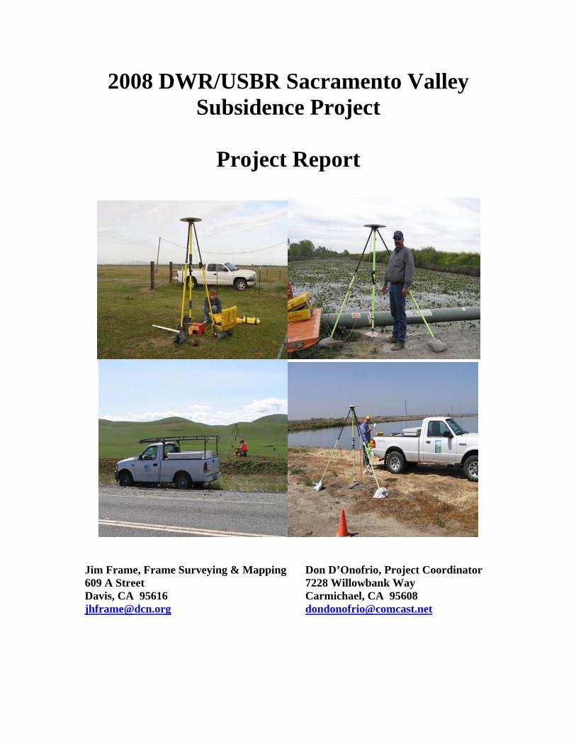
2008 DWR/USBR Sacramento Valley Subsidence Project
Project Report
Jim Frame, Frame Surveying & Mapping Don D’Onofrio, Project Coordinator 609 A Street 7228 Willowbank Way Davis, CA 95616 Carmichael, CA 95608 [email protected] [email protected]
Frame Surveying & Mapping 1
PROJECT REPORT
2008 CALIFORNIA DEPARTMENT OF WATER RESOURCES and U.S. BUREAU OF RECLAMATION SACRAMENTO VALLEY GPS
SUBSIDENCE PROJECT
September 30, 2008
Introduction
A. Purpose
The primary purpose of the project is to provide a comprehensive Sacramento Valley GPS subsidence network to serve as a framework for monitoring land subsidence resulting from underground water withdrawal. The California Department of Water Resources (DWR) is interested in monitoring land subsidence as part of its groundwater management activities. The secondary purpose of the project is to extend high-accuracy geodetic control to facilities operated by the U.S. Bureau of Reclamation (USBR). Toward this end, the network encompasses portions of Shasta and Folsom Lakes.
B. Time Period The observations began on March 17, 2008 and were concluded on June 17, 2008. The project consisted of three primary phases and two sub-phases. The first phase was the Primary Base Station observations. These were observed from March 17 through March 25. These observations were completed by California Department of Water Resources personnel from the Precise Unit, the Sacramento Office and the Red Bluff North Region. The second phase was completed by a number of observers from numerous public and quasi-public agencies. A complete listing of observers is provided in Appendix D. The first portion of this phase was observed from April 1 through April 28 and included most

Frame Surveying & Mapping 2
of the northern part of the Sacramento Valley. The second portion was observed from May 5 through May 22 and included the remainder of the Valley. The two sub-phases included networks adjacent to the subsidence network. One of these was a network around Lake Oroville. There were 12 additional stations observed concurrently with the subsidence network observations by DWR Precise Unit personnel. The second was a small four station network in the vicinity of the proposed Sites Reservoir in Colusa County. The observations were also performed concurrently with the subsidence network observations. The third phase was the re-observations performed to measure baselines not meeting the 2-centimenter guidelines or for other reasons explained in Section F. Re-observations were begun on May 28 and completed on June 17. The Primary Base Station and Local Network Station schedules are included in Appendix B. Re-observation schedules for the Local Network Stations are included in Appendix C.
C. Points of Contact Project Administrators – Chuck Owens California Department of Water Resources
Division of Planning & Local Assistance HQ Conjunctive Water Management Branch 901 P Street, 2nd Floor Sacramento, CA 95814-5511 (916) 651-9224 [email protected] Terri Reaves Branch Chief, Surveys & Mapping U.S. Bureau of Reclamation 2800 Cottage Way Sacramento, CA 95825 (916) 978-5306 [email protected]
Prime Contractor - Jim Frame Frame Surveying & Mapping 609 A Street Davis, CA 95616 (530) 756-8584 [email protected] Project Consultant - Don D’Onofrio 7228 Willowbank Way

Frame Surveying & Mapping 3
Carmichael, CA 95608 (916) 944-7879 [email protected]
D. Accuracy Standard The project was conducted according to the National Geodetic Survey’s “Guidelines for Establishing GPS-Derived Ellipsoid Heights” NOAA TM NOS NGS-58, July, 1997, Zilkoski, Frakes & D’Onofrio and “Guidelines for Establishing GPS-Derived Orthometric Heights” NOAA TM NOS NGS-59, Zilkoski, Carlson & Smith. The 2-centimeter standard was followed for the project. There were two variations from the Guidelines: local network sessions were observed for 60 minutes and all adjacent baselines were observed at least twice. Both variations exceeded the Guideline requirements. There were generally at least ten stations per Local Network Station observing session. Coupled with geographic issues which lengthened inter-station drive times we decided to increase session lengths in the event observers could not reach their respective stations on time. Several observers were late to their stations but usually managed to exceed the minimum Guideline requirements.
E. Location The project included most of the Sacramento Valley from central Shasta County on the north to the south end of Yolo and Sacramento Counties. All existing Continuous GPS (CGPS) sites in the valley were included in the network. All stations in the valley that were part of the 2004 California Department of Transportation Height Modernization Project were included. The project also included all stations in Glenn and Yolo Counties that were part of the 2004 and 2005 (respectively) Height Modernization Projects.
F. Conditions Affecting Operations All observations were obtained using fixed-height (constant height) poles. All poles were 2.000 meters. One of the Trimble integrated receiver/antennas used in the project required an adapter in order to mount properly on the fixed-height pole. The adapter length was carefully measured and added to the pole height to obtain the correct antenna height. All receivers and antennas were used in the same pairings throughout the project with one exception. A different antenna was used in session M185-169-1. See Appendix E for a complete listing of all equipment used during the project. On April 7 (JD98) the observer arrived at station MICHIGAN to find a GPS system over the station with no observer present. We were unable to occupy the stations but were later able to determine the owner of the equipment and obtain the data for the period of our session. Baseline processing using this data was successful. The equipment at station MICHIGAN is owned by a firm in southern California, Airborne One. The receiver and antenna types used at the station are included in Appendix E.

Frame Surveying & Mapping 4
On April 24 (JD119) the observer was unable to locate the station due to construction at the site. The station was ultimately recovered but too late to save the session. In the same session another observer did not observe the planned station. All missed adjacent baseline observations were observed during the re-observation phase. On May 19 (JD140) almost all baselines scheduled for session 2 failed the 2-centimeter criterion. We were unable to resolve the issue and scheduled all of the affected baselines for re-observation. Also on the same day a schedule error had two observers showing up at the same station in session 4. The resulting missed baseline was re-observed during the re-observation phase. One new station (PUMP RESET) and one existing station (M 1078) replaced stations PUMP and LOGAN respectively in Glenn County. Station PUMP is at the downstream end of a spillway and the foundation under the mark is being eroded somewhat. Station LOGAN was replaced as it was deemed a little too difficult to occupy with a fixed-height pole. A double-run level tie was made between each pair of stations to perpetuate the elevation of the original stations. Data downloading was accomplished at various locations throughout the project. Efforts were made to download data at locations as close to the ending station locations of the last session of the day. No other significant conditions affected the operations.
G. Agency Participation Numerous agencies participated in the project. The listing of these agencies and the personnel who participated in the project are included in Appendix D. The project included personnel from David Greenwell Associates and Veterans, a Disabled Veteran Business Enterprise (DVBE). The DWR contract requires a 3% DVBE component and Greenwell staff helped to meet that requirement. Other than equipment provided by participating agencies, additional equipment was provided by the University of California Davis (UCD) and Caltrans. The UCD has provided equipment in support of almost all Height Modernization projects in the Sacramento Valley since 1999. The California Department of Water Resources provided fully equipped observers for all Primary Base Station observations and some of the re-observations. The DWR also provided some support during the Local Network observations. The USBR provided one fully equipped observer for the second portion of the Local Network observations.
H. Field Work
Frame Surveying & Mapping 5
Chronology – Reconnaissance for the project was begun in September. All stations that were part of earlier Height Modernization Projects in the valley were included in the network. New monuments were established as necessary to meet spacing requirements. USA tickets were obtained for all new stations requiring the establishment of driven rod monuments. Remaining new stations were established in existing concrete foundations. Primary Base Stations were observed beginning on April 17 and ending April 24. Local Network stations were observed beginning April 1 and ending May 22. There was a short break in observations from April 25 through May 4 to allow for training and transfer of equipment to the south portion personnel. Re-observations were performed from May 28 through June 17. The schedule of re-observations is included in Appendix C. Instrumentation – A complete listing of equipment used in the project included in Appendix E.
I. Data Processing Baseline processing was performed by Frame Surveying & Mapping using Trimble Geomatics Office software. All project data will be processed and adjusted by Mike Potterfield of Geodetic Solutions. The results of this processing and adjustment will be forwarded to the National Geodetic Survey for review and publication.
J. Statistics Stations Occupied – There were a total of 346 stations in the project. Of these, 330 stations were observed for the base subsidence project and 16 were observed by DWR as part of two supplemental surveys, the Sites Reservoir project (four stations) and the Lake Oroville project (12 stations). A complete listing of stations can be found in Appendix A. NSRS stations (not including CGPS stations) 226 New stations set: 62 Disks in concrete 33 Class B rod marks 29 New stations recovered (not in NGS IDB): 17 CGPS stations: 14 CORS, PBO in NGSIDB 6 PBO not in NGSIDB 9 New DWR stations (Lake Oroville, Sites Reservoir) 16 Total Stations: 335 Total Observing Days and Sessions – There were a total of 43 observing days during the project: six days for Primary Base Station occupations; 28 days for Local Network Station occupations; and, nine days for re-observations. There were a total of 1250 station occupations: 48 for Primary Base Stations; 1090 for Local Network Stations; and, 112 for re-observations. 58 separate downloads were made for Continuous GPS stations.

Frame Surveying & Mapping 6
The Lake Oroville and Sites Reservoir observations were performed by DWR personnel. The Sites Reservoir observations were performed as part of the ongoing project operations. The four Sites reservoir stations were observed in eight sessions of two receivers requiring 14 station occupations to ensure that all necessary adjacent station baselines were observed. The Lake Oroville observations were made separately from 12 stations over a two day period. DWR wanted to ensure the highest practical accuracy for these stations and they were occupied for eight hours on each of the two days (JD106 and JD108). Re-observations – There were a total of 884 baselines measured in the project. Of these, 49 failed the 2 centimeter criterion, as follows: 11 baselines – 2.5 to 2.9cm 26 baselines – 3.0 to 3.9cm 8 baselines – 4.0 to 4.9cm 4 baselines - >5cm It should be noted that eight of these baseline failures came from Session 4 on May 19 (JD140). There were 20 additional baselines that were re-observed due to human error (6 for missed occupation) and 14 for baselines where the second set of observations would not process.
K. Comments and Recommendations Observers were visited throughout the course of the observing phases to ensure that project guidelines and safety procedures were being followed. Guidelines and safety procedures were discussed in formal training sessions prior to the beginning of the Primary Base Stations observations in Sacramento, the north phase of Local Network observations in Red Bluff and the south phase of Local Network observations in Yuba City. Data downloading was accomplished in various participants’ offices or local motels nearby to the location of stations occupied at the end of each observing day. We decided to opt for 60 minute sessions with a minimum of 75 minutes between sessions. There are several areas in the valley where a move between stations involved excessive drive times. This was a result of having to cross features like the Sutter Bypass or the Sacramento River where road crossings significantly lengthened distances and drive times. Several occupations were late starting due to this issue but all met or exceeded the minimum observing time required by the Guidelines. This was the first time many observers had been exposed to these types of operations or to the GPS surveys. They all demonstrated exemplary attitude and professionalism throughout the project. Nine DWR personnel participated in the Primary Base Station

Frame Surveying & Mapping 7
observations and 19 different personnel participated in each of the two Local Network Station observation phases (north and south). The original Observation Logs were digitized and forwarded to Mike Potterfield at Geodetic Solutions. The NGS-format digital description file (D-File) for all stations was also submitted to Mike Potterfield. Data processing and adjustment will be performed by Geodetic Solutions and forwarded to NGS for final review and publication. A digital file of the observation data and baseline comparison results will also be forwarded along with a digital copy of the free adjustment prepared by Frame Surveying & Mapping.
Jim Frame, Frame Surveying & Mapping Don D’Onofrio, Project Coordinator
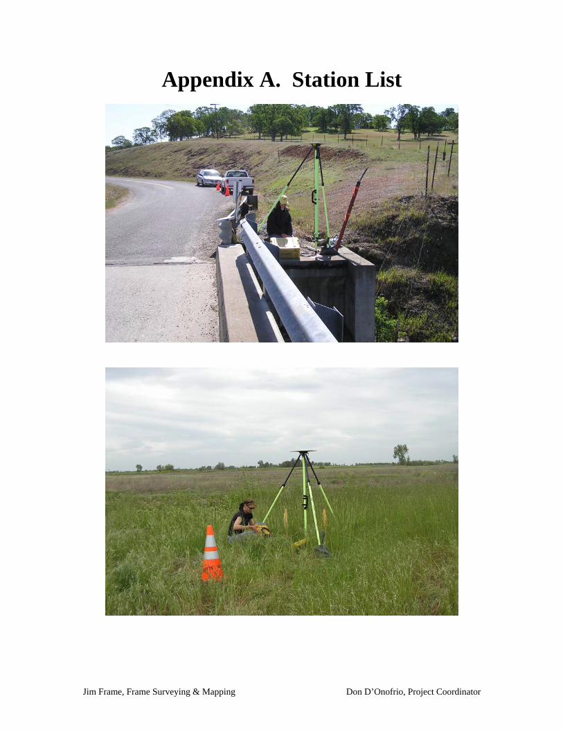
Appendix A. Station List

STATION NAME SSN 4-Ch PID LATITUDE LONGITUDE ELEVATIONID
BUTTE COUNTY121 BB USGS 1001 121B KS1029 39 23 07.7 121 32 43.1 37.7272655 BB 1006 55BB KS1187 39 34 51.8 121 37 10.17 MILE 2001 7MIL 39 38 10.7 121 54 35.9BC 1090 2007 B109 39 32 16.9 121 54 29.9BC 1305 2008 B130 39 50 27.1 121 59 51.0BC 428 2009 B428 39 39 10.1 121 51 42.0BC 635 2010 B635 39 53 58.3 121 55 08.0BC 728 2011 B728 39 49 19.2 121 51 47.4BC 743 2012 B743 39 21 46.1 121 43 12.1BC EXTN 2 2013 BCEX 39 34 37.4 121 54 29.9BLOCK 2017 BLOC 39 19 08.2 121 43 19.8BUZ 2022 BUZZ 39 25 52.6 121 33 11.1C 1434 1035 C434 KS1937 39 40 56 121 45 51 63.152CARRICO 2023 CRCO 39 25 14.3 121 49 38.6CREST RM 2 1053 CRST DB7123 39 27 29.40155 121 34 37.33815 79.6D 146 RESET 1055 D14R KS1013 39 29 37.19840 121 39 36.31547 48.988DURHAM 2033 DHAM 39 38 41.0 121 47 57.8EATON 2035 EATO 39 46 35.9 121 50 38.6F 853 1070 F853 KS0997 39 27 52.11192 121 47 57.49784 27.8FAIRLEE 2041 FLEE KS1863 39 19 19.6 121 48 45.4FARMLAND 2042 FARM 39 47 48.7 121 59 14.7FARRIS 2043 FARR 39 23 06.9 121 46 54.6FARWELL 2044 FREX 39 39 55.9 121 55 30.2FENN 2045 FENN 39 36 34.9 121 51 26.4G 1434 1082 G434 KS1939 39 39 22 121 43 53 55.73GORRILL 2050 GORR 39 36 09.8 121 47 04.8GRAY 2052 GRAY 39 21 43.1 121 49 27.5HARRIS 2053 HARR 39 25 15.8 121 45 47.6HONCUT 1098 HONC KS1035 39 19 30.36003 121 33 25.38509 28.039HUMBOLT ROAD 1119 HMBT KS1898 39 44 56.68029 121 45 44.95346 169.3J 1434 1121 J143 KS1942 39 36 58.45 121 40 55.09J 847 1122 J847 KS1155 39 32 26.40299 121 41 19.92163 40.6JOHNSON 2057 JOHN 39 29 35.0 121 48 03.8MERIDIAN 1142 MERI DH6532 39 45 11.55598 121 56 18.44859 42.8
Frame Surveying Mapping 11/22/2008 1

MOREHEAD 2063 MORE 39 43 01.1 121 51 47.9NELSON 2065 NELS 39 33 32.2 121 46 02.5NLD 127 2068 NLD7 39 21 43.7 121 52 05.1NLD 128 2069 NLD8 39 33 05.7 121 50 25.7NORD 1147 NORD KS1918 39 47 52.36476 121 54 12.94494 55.081P 1430 1155 P143 KS1922 39 50 25.16138 121 56 26.97724 58.684PARK 1158 PARK KS2045 39 32 03.17236 121 35 08.27986PENTZ RM 2 1159 PEN2 DB7511 39 38 50.12701 121 37 52.46635 96.3S 381 1173 S381 KS1056 39 22 57.18199 121 36 05.92495 31.296S 853 1174 S853 KS0895 39 24 18.45426 121 42 35.21821 28.381SHEPPARD 2083 SHEP 39 31 09.1 121 45 09.2TALLOW 2088 TALL 39 35 18.2 121 41 21.3TOWNSHIP 1191 TWSP DH6525 39 20 39.15123 121 41 14.03640 28.1V 853 1196 V853 KS0890 39 27 52.90319 121 43 54.95176 31.584WILLIAMS 2092 WLMS 39 30 13.0 121 51 23.5OROVPORT 8008 OROV KS1952 39 29 44.95292 121 37 00.76443 59.854
(50 stations)
COLUSA COUNTYCOLIND 2026 COLI 39 11 06.5 121 59 40.6D 850 RESET 1971 1056 D850 KT0487 39 08 33.63006 122 13 02.10476 37.2DELEVAN 2030 DELE 39 16 31.0 122 06 20.1DELPHOS RM 2 1058 DLP2 KT0310 39 11 28.05130 122 10 16.52848 23.8DODGE 1059 DODG DH6519 39 22 38.58663 122 01 14.53220 24.2F 200 1069 F200 KT0329 39 19 09.12178 122 11 29.55030 26.3FINKS 1073 FINK DH6518 39 15 29.80322 122 11 29.32274 28.4GORDON 1085 GORD DH3656 39 24 34.42540 122 00 35.87826 26.27GRAINO 2051 GRNO 39 03 23.9 121 58 08.9H 62 USGS 1091 H62U KT0414 39 07 14.13691 122 17 27.38995 68.8HAHN 1092 HAHN DH6516 39 04 50.45269 122 05 54.15171 27.1HARBISON 1095 HARB DH6520 39 14 50.41643 122 01 52.59696 17.9HOPKINS 2054 HPKN 39 13 03.8 122 05 19.8JIMENO RM 4 1124 JRM4 AI5047 38 55 39.86130 121 50 35.87435 12.3LAUX 2058 LAUX 39 14 43.7 121 57 31.2LONESTAR 1137 LONE DH6517 39 10 37.25468 122 04 42.66473 16.3LUSA RM 2 1138 LUSA JT0091 38 58 14 122 01 32 46.63NLD 126 2067 NLD6 39 06 51.9 122 01 05.8
Frame Surveying Mapping 11/22/2008 2

PUTNAM 2078 PTNM 39 19 54.5 121 57 16.3SECO 1178 SECO KT0274 39 01 43.79854 122 03 50.15218 39SR 65 1182 SR65 DH6632 39 18 55.05085 122 02 02.41256 22.4STEGEMAN 2086 STEG 39 20 29.4 122 05 03.3T 644 1188 T644 KT0293 39 07 54.60347 122 07 55.53112 27.5W 850 1203 W850 KT0506 39 22 40 122 14 53 34.9WAYNE 2091 WAYN 38 59 36.9 121 57 29.5WHEAT 1206 WHEA DH6501 39 04 35.82711 121 53 39.35604 20.5WILKENS 1208 WILK DH6502 38 59 26.07953 121 52 01.52515 9WILSON BEND 1212 WBND DH6521 39 02 30.73376 121 50 12.69724 18.5
(28 stations)
GLENN11 227 CADH 1004 1122 DH3655 39 30 54.05117 121 55 48.12986 29.841500 1003 1500 DH3654 39 27 50.60515 121 55 31.40277 26.59208.56 USBR 1005 2085 DH3676 39 44 47.88751 122 07 21.69182 64.56296.66 USBR 1007 2966 DH3671 39 47 25.23009 122 13 33.09142 91.1160.64 1012 6064 DH3649 39 23 58.70593 122 17 16.91750 65.75A 1079 1016 A107 KT0126 39 35 08.29629 122 24 17.70358 151.06ADOBE 1018 ADOB DH3657 39 23 26.69919 121 57 00.54559 21.87AGUIAR 1019 AGUI DH3669 39 43 33.88201 122 14 26.10054 83.65ARTOIS 1023 ARTO DH3672 39 37 27.53289 122 12 17.01165 59.07B 1079 1024 B107 KT0737 39 36 40.90269 122 31 42.87259 215.44BIG BUTTE 1028 BIGB DH3658 39 27 51.24509 121 52 13.93581 26.31BIG W 1029 BIGW DH3670 39 40 21.14573 122 20 10.15729 139.51C 200 1036 C200 KT0343 39 24 22.66349 122 11 32.19634 28.73CAPAY 1040 CAPA DH3675 39 46 56.78971 122 06 14.48483 60.87CHEROKEE 1043 CHER DH3673 39 40 05.34934 122 15 11.41713 70.13CREEK 1052 CREE DH3668 39 43 53.37337 122 24 47.93526 157.82EXT1 1067 EXT1 DH3661 39 37 46.82529 122 06 07.90976 46.08FRENCH 1077 FREN DH3667 39 34 56.73960 122 14 58.85423 49.96GLENN 1084 GLEN KT0178 39 31 17.92685 122 00 53.29 29.64H 285 USGS 1089 H285 KT0120 39 33 07.29767 122 21 26.02164 104.78HAMILTON 1094 HAMI KT1807 39 44 39.73296 122 01 14.04332 47.96HOWARD 1099 HOWA DH3659 39 25 12.40826 121 53 52.38358 22.82JACINTO 1123 JACI DH3660 39 34 56.70003 122 00 36.01111 34.05K 852 1127 K852 KT0183 39 41 48.97195 122 11 42.87 70.32
Frame Surveying Mapping 11/22/2008 3
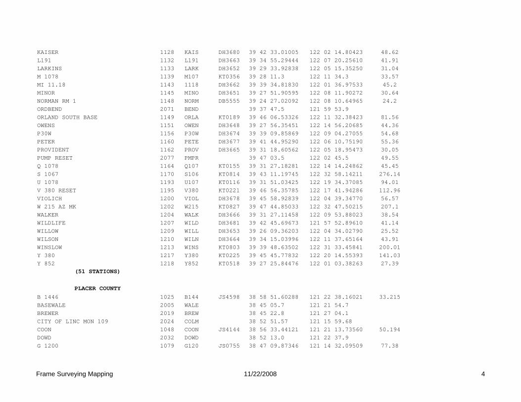
KAISER 1128 KAIS DH3680 39 42 33.01005 122 02 14.80423 48.62L191 1132 L191 DH3663 39 34 55.29444 122 07 20.25610 41.91LARKINS 1133 LARK DH3652 39 29 33.92838 122 05 15.35250 31.04M 1078 1139 M107 KT0356 39 28 11.3 122 11 34.3 33.57MI 11.18 1143 1118 DH3662 39 39 34.81830 122 01 36.97533 45.2MINOR 1145 MINO DH3651 39 27 51.90595 122 08 11.90272 30.64NORMAN RM 1 1148 NORM DB5555 39 24 27.02092 122 08 10.64965 24.2ORDBEND 2071 BEND 39 37 47.5 121 59 53.9ORLAND SOUTH BASE 1149 ORLA KT0189 39 46 06.53326 122 11 32.38423 81.56OWENS 1151 OWEN DH3648 39 27 56.35451 122 14 56.20685 44.36P30W 1156 P30W DH3674 39 39 09.85869 122 09 04.27055 54.68PETER 1160 PETE DH3677 39 41 44.95290 122 06 10.75190 55.36PROVIDENT 1162 PROV DH3665 39 31 18.60562 122 05 18.95473 30.05PUMP RESET 2077 PMPR 39 47 03.5 122 02 45.5 49.55Q 1078 1164 Q107 KT0155 39 31 27.18281 122 14 14.24862 45.45S 1067 1170 S106 KT0814 39 43 11.19745 122 32 58.14211 276.14U 1078 1193 U107 KT0116 39 31 51.03425 122 19 34.37085 94.01V 380 RESET 1195 V380 KT0221 39 46 56.35785 122 17 41.94286 112.96VIOLICH 1200 VIOL DH3678 39 45 58.92839 122 04 39.34770 56.57W 215 AZ MK 1202 W215 KT0827 39 47 44.85033 122 32 47.50215 207.1WALKER 1204 WALK DH3666 39 31 27.11458 122 09 53.88023 38.54WILDLIFE 1207 WILD DH3681 39 42 45.69673 121 57 52.89610 41.14WILLOW 1209 WILL DH3653 39 26 09.36203 122 04 34.02790 25.52WILSON 1210 WILN DH3664 39 34 15.03996 122 11 37.65164 43.91WINSLOW 1213 WINS KT0803 39 39 48.63502 122 31 33.45841 200.01Y 380 1217 Y380 KT0225 39 45 45.77832 122 20 14.55393 141.03Y 852 1218 Y852 KT0518 39 27 25.84476 122 01 03.38263 27.39
(51 STATIONS)
PLACER COUNTYB 1446 1025 B144 JS4598 38 58 51.60288 121 22 38.16021 33.215BASEWALE 2005 WALE 38 45 05.7 121 21 54.7BREWER 2019 BREW 38 45 22.8 121 27 04.1CITY OF LINC MON 109 2024 COLM 38 52 51.57 121 15 59.68COON 1048 COON JS4144 38 56 33.44121 121 21 13.73560 50.194DOWD 2032 DOWD 38 52 13.0 121 22 37.9G 1200 1079 G120 JS0755 38 47 09.87346 121 14 32.09509 77.38
Frame Surveying Mapping 11/22/2008 4

HPGN CA 03 09 1105 0309 JS4669 38 43 40.44881 121 17 10.61451 52.3INDUSTRIAL 1120 INDU DH6533 38 47 22.39871 121 18 30.17431 42.3MOORE 2062 MOOR 38 52 05.7 121 27 06.3NEWFIDDY 2066 FIDY 38 47 44.7 121 21 31.4P 1200 1154 120P JS0768 38 49 43.37051 121 11 25.70317 127.675PHILLIP 2075 PHLP 38 48 09 121 25 07T 1435 1186 T143 JS4600 38 54 48.09197 121 19 08.98884 44.565W 1474 1201 W147 DG6522 38 50 20.9 121 19 03.5 38.79WISE 2094 WISE 38 55 34.9 121 24 18.7
(16 stations)
SACRAMENTO COUNTYBRADSHAW 1032 BRAD DH6483 38 33 42.05654 121 20 53.68120 17.6BUREAU 2020 BURO DK2884 38 37 22.9 121 13 53.1CAPITOL RESERVOIR 1041 CRES DE9128 38 39 02.32516 121 30 26.67010 4.8CONTROL MONUMENT LR 208 1047 R208 AC9237 38 39 18.54312 121 23 14.17816 23.39DOUGLAS 2031 DOUG 38 33 39.7 121 14 40.1ELKHORN 1063 ELKH DH6491 38 40 54.09676 121 29 03.49524 10.8ELVERTA 1064 ELVT DH6489 38 42 52.27573 121 32 27.54593 5.1EXCELSIOR 1066 EXCL DH6506 38 30 54.64180 121 17 03.89418 37.5FAIR 2040 FAIO DK2883 38 40 43.5 121 15 47.6GARFIELD 2048 GARF 38 37 54.6 121 20 13.8GIBSON 2049 GIBS 38 42 19.3 121 25 46.4GREENBACK 1086 GRBK DH6485 38 41 31.13545 121 20 47.91721 46.6HOWE 1100 HOWE DH6484 38 36 47.57405 121 25 57.71853 14.7HPGN D CA 03 AA 1112 03AA AC9226 38 36 52.10409 121 30 52.07494 6.08HPGN D CA CSUS 1222 CSUS AC9218 38 33 14.56895 121 25 23.72001 13.31LEROY 2059 LROY 38 34 59.8 121 11 09.7SHELDON 1179 SHEL JS1177 38 29 36.45431 121 12 38.98999 59.49ZINFANDEL 1221 ZINF DH6482 38 35 23.60701 121 17 18.80164 30.5
(18 stations)
SHASTA COUNTY44 SHA 15.59 1009 2HK3 DH6393 40 31 00.04638 122 05 41.25229 309.744 SHA 6.94 1010 2HJ2 DH6602 40 33 28.91529 122 14 22.18058 141.3ASH 2004 ASHH 40 25 01.8 122 11 46.5G 1429 1080 G142 LU1871 40 34 56.64205 122 25 57.29345 218.563
Frame Surveying Mapping 11/22/2008 5
HPGN D CA 02 GH 1108 02GH AE9980 40 30 04.45170 122 22 34.14721 146.03U 345 1194 U345 LU0205 40 26 17.61262 122 17 00.50632 139.963
(6 stations)
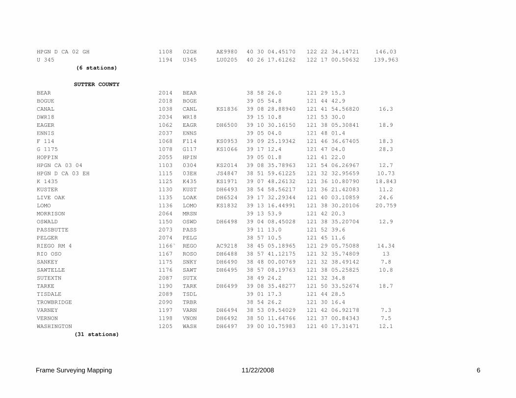
SUTTER COUNTYBEAR 2014 BEAR 38 58 26.0 121 29 15.3BOGUE 2018 BOGE 39 05 54.8 121 44 42.9CANAL 1038 CANL KS1836 39 08 28.88940 121 41 54.56820 16.3DWR18 2034 WR18 39 15 10.8 121 53 30.0EAGER 1062 EAGR DH6500 39 10 30.16150 121 38 05.30841 18.9ENNIS 2037 ENNS 39 05 04.0 121 48 01.4F 114 1068 F114 KS0953 39 09 25.19342 121 46 36.67405 18.3G 1175 1078 G117 KS1066 39 17 12.4 121 47 04.0 28.3HOPPIN 2055 HPIN 39 05 01.8 121 41 22.0HPGN CA 03 04 1103 0304 KS2014 39 08 35.78963 121 54 06.26967 12.7HPGN D CA 03 EH 1115 03EH JS4847 38 51 59.61225 121 32 32.95659 10.73K 1435 1125 K435 KS1971 39 07 48.26132 121 36 10.80790 18.843KUSTER 1130 KUST DH6493 38 54 58.56217 121 36 21.42083 11.2LIVE OAK 1135 LOAK DH6524 39 17 32.29344 121 40 03.10859 24.6LOMO 1136 LOMO KS1832 39 13 16.44991 121 38 30.20106 20.759MORRISON 2064 MRSN 39 13 53.9 121 42 20.3OSWALD 1150 OSWD DH6498 39 04 08.45028 121 38 35.20704 12.9PASSBUTTE 2073 PASS 39 11 13.0 121 52 39.6PELGER 2074 PELG 38 57 10.5 121 45 11.6RIEGO RM 4 1166` REGO AC9218 38 45 05.18965 121 29 05.75088 14.34RIO OSO 1167 ROSO DH6488 38 57 41.12175 121 32 35.74809 13SANKEY 1175 SNKY DH6490 38 48 00.00769 121 32 38.49142 7.8SAWTELLE 1176 SAWT DH6495 38 57 08.19763 121 38 05.25825 10.8SUTEXTN 2087 SUTX 38 49 24.2 121 32 34.8TARKE 1190 TARK DH6499 39 08 35.48277 121 50 33.52674 18.7TISDALE 2089 TSDL 39 01 17.3 121 44 28.5TROWBRIDGE 2090 TRBR 38 54 26.2 121 30 16.4VARNEY 1197 VARN DH6494 38 53 09.54029 121 42 06.92178 7.3VERNON 1198 VNON DH6492 38 50 11.64766 121 37 00.84343 7.5WASHINGTON 1205 WASH DH6497 39 00 10.75983 121 40 17.31471 12.1
(31 stations)
Frame Surveying Mapping 11/22/2008 6

TEHAMA COUNTY36 TEH 48.89 1008 2EK4 DH6582 40 14 55.50432 122 08 57.52231 188.999 TEH 17.88 1013 2DK4 DH6619 40 06 26.6 122 06 34.3 74.299 TEH 22.63 1014 2EK3 DH6620 40 09 54.04106 122 09 16.26592 82.699 TEH 9.22 1015 2CK1 DH6621 39 59 08.54708 122 04 55.26423 62.5BARHAM 1027 BRHM DH6090 39 57 25.74374 122 12 10.79851 90.2BEND BRIDGE 2015 BNBR 40 15 47.6 122 13 16.8BUTTE GAGE 2021 BUTG 39 49 05.7 122 19 32.2BOWMAN 1031 BOWM DH6091 40 22 08.87125 122 16 55.59034 126C 1430 1034 C430 LU2280 40 07 10.7 122 11 50.1 86.627CORNBUTTE 2027 CORN 39 55 22.0 122 21 10.4EUCALYPTUS 2038 EUCA 39 53 34.6 122 18 13.4EVERGREEN 2039 EGRN 40 21 37.0 122 19 51.2FWS 271 2047 271F 39 50 02.2 122 05 06.5FLORES 1074 FLOR DH6623 40 05 02.95277 122 13 08.47380 88.9G 1430 1081 G143 LU2284 40 02 29.98057 122 08 34.41298 69.034HESS 1097 HESS LU1960 40 12 10.19710 122 14 38.93614 97.16HPGN CA 02 22 1102 0222 LU2291 40 09 35.65424 122 13 26.31262 95.4HPGN D CA 02 CJ 1106 02CJ AE9295 39 54 23.48732 122 12 41.99237 89.1HPGN D CA 02 FJ 1107 02FJ AE9985 40 19 36.36692 122 16 48.62627 174.84JELLYS 2056 JELL 40 19 10.8 122 11 19.1K 276 1126 K276 KT0091 39 51 20.1 122 21 17.7 153.4L 1430 1131 L143 KS1919 39 53 58.25944 121 59 43.71676 63.606LIBERAL 2060 LBRL 39 52 54.5 122 13 41.6M 185 1140 M185 LU0322 40 13 26.68599 122 20 15.38537 139.1MCCLURE 2061 MCCL 40 00 03.5 122 17 55.0MICHIGAN 1144 MICH DH6625 39 54 23.62087 122 06 51.25814 65.8N 852 1146 N852 KT0195 39 48 34.52910 122 10 21.16347 75.35OAK SL 2070 OKSL 40 22 19.0 122 09 39.8Q 1065 1163 Q106 KT0073 39 55 50.4 122 17 19.4 114.54RAWSON 1118 RAWS DH6540 40 01 44.82871 122 13 30.24340 94.8REDBANK 2081 RBNK 40 07 44.0 122 16 16.3SCALE 1177 SCLE LU1967 40 12 45.99403 122 10 47.96287 125.1SOUR GRASS 1181 SRGS DH6628 39 50 13.21155 122 11 51.22382 83.3WILLOW 2093 WLOW 40 03 18.2 122 17 01.0
(34 stations)
Frame Surveying Mapping 11/22/2008 7

YUBA COUNTYALGONDON 1020 ALGO DH6487 39 01 34.25531 121 32 52.74356 14.7BLAIR 2016 BLAI 39 07 45.8 121 27 19.5H 380 1090 H380 KS0752 39 00 49.80100 121 25 46.20379 24.907HALLWOOD 1093 HALL DH6522 39 10 28.68777 121 32 57.31460 28.1HPGN D CA 03 FH 1116 03FH KS2035 39 02 32.12082 121 28 33.65920 22.73HPGN D CA 03 HJ 1117 03HJ KS2038 39 13 28.63289 121 26 07.89575 59.4OSTROM 2072 OSTR 39 04 32.5 121 23 47.8POWER LINE 2076 PWRL 39 05 53.1 121 32 44.8R276 2079 R276 39 16 59.8 121 28 28.8RAMIREZ 1165 RAMZ DH6539 39 15 52.80318 121 34 32.90976 25S 214 1171 S214 KS0774 39 12 51.33858 121 29 39.08819 28.569WOODRUFF 1215 WDRF DH6523 39 13 12.50553 121 33 27.22561 23.9
(12 stations)
YOLO169 1002 1699 JS2170 38 44 12.69568 121 57 15.85660 52.5ABUT 1017 ABUT AI5050 38 38 05.70584 121 57 06.70255 53.01ALHAMBRA 1021 ALHA AI5051 38 33 31.09757 121 42 26.68762 12.97ANDREW 1022 ANDR AE9864 38 23 12.17743 121 38 18.71969 3.68B 849 1026 B849 JS2151 38 32 01.29090 121 58 15.18331 39.68BIRD 1030 BIRD AI5052 38 50 54.73498 122 02 37.47696 94.11BRIDGE 1033 BRID AI5053 38 42 41.39518 122 02 50.18340 64.2CALDWELL 1037 CALD AE9863 38 27 33.51280 121 39 24.21307 5.42CANAL 1039 CANA AI5054 38 37 02.05407 121 51 30.11560 29.79CASTRO AZ MK RESET 1042 CAST JS4556 38 33 50.77536 121 38 37.80288 5.27CHURCH 1044 CHUR AI5055 38 39 48.00509 121 48 09.05752 24.12CODY 1045 CODY AI5056 38 47 30.59722 121 46 29.01978 12.75CONAWAY 1046 CONA AI5057 38 37 05.49414 121 38 40.42822 7.71COTTON 1049 COTT AI5058 38 38 20.24426 122 02 08.12167 91.52COURTLAND 1050 COUR JS4311 38 20 24.75925 121 33 40.05033 8.06COY DUMP 1051 COY1 AI5059 38 35 28.05097 121 41 31.83411 8.55CVAP 02 1054 CVAP AI5060 38 50 19.76338 121 50 39.17593 8.01DAVEPORT 1057 DAVE JS4617 38 31 59.46429 121 47 14.17621 19.39DRAIN 1060 DRAI AI5061 38 55 31.04473 121 54 52.46219 12.97DUFOUR 1061 DUFO JS2238 38 45 48.09569 121 50 39.06776 20.25EX 1 1065 EX11 AI5073 38 38 46.40916 121 40 03.02450 7.86
Frame Surveying Mapping 11/22/2008 8

F 859 RESET 1071 F859 AI5062 38 47 34.20043 121 43 36.01698 14.21FERRY 1072 FERR JS2338 38 40 32.00674 121 37 49.18003 12.13FORD RM 2 1075 FORD AI5046 38 43 33.23507 121 43 47.39158 17.53FREMONT 1076 FREM AI5063 38 45 52.89327 121 38 08.00521 12.56GAFFNEY 1083 GAFF AE9851 38 24 25.68438 121 34 56.13556 1GWM 17 1087 GW17 JT0105 38 46 52.25771 122 02 38.10735 84.79GWM 32 1088 GW32 JT0026 38 44 21.97065 122 09 59.02755 112.58HERSHEY 1096 HERS AI5064 38 52 28.84718 121 54 51.96511 13.97HPGN CA 03 08 1104 0308 JS4668 38 43 01.99778 121 48 07.54090 23.73HPGN D CA 03 BG 1113 03BG AC9219 38 30 20.00860 121 34 55.09118 9.91HPGN D CA 03 DG 1114 03DG AC9223 38 38 27.43690 121 45 39.59540 24.09KEATON 1129 KEAT AI5065 38 42 33.52245 121 53 11.08244 35.83LIBRARY 1134 LIBR AI5066 38 40 44.18419 121 46 28.10008 19.9MADISON 1141 MADI JS2364 38 41 00.22740 121 58 36.36010 47P 1031 1152 1031 JS2344 38 40 38.14441 121 42 34.07731 10.26P 1075 1153 1075 JS2130 38 50 51.29489 121 56 00.25761 14.87PALA 1157 PALA DH6510 38 33 38.01407 121 32 19.52129 13PLAINFIELD 1161 PLAI AI5068 38 35 05.49717 121 48 11.62107 19.96RD2068 2080 2068 DK4488 38 24 54.2 121 43 48.6 12.4RIVER 1168 RIVE AI5069 38 38 50.46071 121 34 20.06216 12.02RUSSELL RANCH 2 1169 RUSS AC9893 38 32 38.06502 121 52 33.83768 29.37RWF1 2082 RWF1 DK4487 38 35 10 121 45 05.1 14.6SM NO 15 1180 SM15 AI5070 38 43 51.60375 121 37 59.39187 7.33SURVEYOR 1183 SURV AE9862 38 27 08.54400 121 44 56.17263 13.54SYCAMORE 1184 SYCA AI5071 38 50 19.12265 121 45 06.38892 7.66T 1069 1185 1069 JS2157 38 35 09.99936 121 58 17.45546 54.71T 462 1187 T462 JS1556 38 26 25.99174 121 30 17.76157 9.14T 849 1189 T849 JS2177 38 47 24.93233 121 54 56.34425 36.17TYNDALL 1192 TYND AI5072 38 52 26.17670 121 49 03.81149 9.08VINCOR 1199 VINC DE9127 38 48 08.11883 121 59 00.32187 48.28WILSON 1211 WILS AE9857 38 29 41.85081 121 41 31.51403 9.6WOODPORT 1214 WOOD JS3886 38 40 17.76114 121 52 20.38066 39.74X 200 RESET 1216 X200 JS2144 38 54 20.73108 121 58 59.79141 29.88YOLO CO AP BASE LINE POINT 6 1219 YCAP DE9129 38 34 20.34417 121 51 18.37282 29.61
ZAMX 1220 ZAMX AI5074 38 46 45.78460 121 48 44.62949 13.03(56 STATIONS)
Frame Surveying Mapping 11/22/2008 9

LAKE SHASTA USBR(to be observed)
5 SHA 40.65 7001 2LH2 DH6395 40 53 11.57549 122 23 02.73969 332.6BUTCHER 7002 BUTR 40 45 17.3 122 26 48.9FOWLER 7003 FOWL 40 50 05.0 122 09 09.6
HIRZ 7004 HIRZ 40 51 49.4 122 15 17.8HPGN CA 02 12 1101 0212 LU2288 40 57 25.62074 122 26 05.71210 428HPGN D CA 02 JH 1109 02JH AE9983 40 39 42.34289 122 21 24.42949 206.24HPGN D CA 02 JK 1110 02JK AF8158 40 41 20.86805 122 07 26.10096 328.9HPGN D CA 02 KJ 1111 02KJ AF8159 40 48 26.66267 122 19 18.42941 419.68JONES 7005 JONE 40 44 21.0 122 12 58.8MCCLOUD 7006 CLOD 40 56 25.6 122 14 44.6P349 7007 P349 40 53 51.8 122 19 09.5SHASTA 7008 SHAS 40 42 58.4 122 24 59.1SUGARLOAF 7009 LOAF 40 50 51.2 122 24 59.8SUGARPINE 7010 PINE 40 44 27.1 122 05 32.8
(14 stations)
CGPS SITESCHICO 6 CORS ARP 9001 CHO6 DK2666 39 25 58.35462 121 39 53.52837
LINCOLN 1 CORS ARP 9002 LNC1 DF7465 38 50 47.42500 121 21 00.79097 36.47
ORVB OROVILLE DAM CORS GRM 9003 ORVB AI4496 39 33 16.64301 121 30 00.99282 368
P208 9004 P208 39 06 33.5 122 18 13.9
P265 9005 P265 38 31 48.7 121 57 15.1
P267 9006 P267 38 22 49.21 121 49 23.64
P268 9007 P268 38 28 24.69 121 38 47.08
P270 9009 P270 39 14 37.6 122 03 18.8
WOODLAND1 CA2004 CORS ARP 9010 P271 DG8213 38 39 26.44614 121 42 52.32300
P272 9011 P272 39 08 43.7 121 56 35.0
P344 9012 P344 39 55 44.8 122 01 40.6
P345 9013 P345 40 16 16.4 122 16 14.9
SUTTER BUTTES CORS POINT 9014 SUTB AF9713 39 12 20.99460 121 49 14.10094 645.9
UCD1 UC DAVIS GEOL 1 CORS ARP 9015 UCD1 AI4467 38 32 10.44759 121 45 04.37720 31.44
(14 stations)
DWR STATIONS
Frame Surveying Mapping 11/22/2008 10
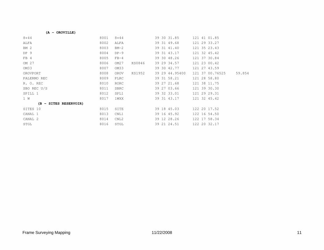
(A - OROVILLE)8+44 8001 8+44 39 30 31.85 121 41 01.85ALFA 8002 ALFA 39 31 49.68 121 29 33.27BM 2 8003 BM-2 39 31 41.40 121 35 23.43DP 9 8004 DP-9 39 31 43.17 121 32 45.42FB 4 8005 FB-4 39 30 48.26 121 37 30.84OM 27 8006 OM27 KS0846 39 29 34.57 121 23 00.42OM33 8007 OM33 39 30 42.77 121 27 43.59OROVPORT 8008 OROV KS1952 39 29 44.95400 121 37 00.76525 59.854PALERMO REC 8009 PLRC 39 31 58.21 121 28 58.80R. O. REC 8010 RORC 39 27 21.68 121 38 11.75SBO REC U/S 8011 SBRC 39 27 03.66 121 39 30.30SPILL 1 8012 SPL1 39 32 33.01 121 29 29.311 W 8017 1WXX 39 31 43.17 121 32 45.42
(B - SITES RESERVOIR)SITES 10 8015 SITE 39 18 45.03 122 20 17.52CANAL 1 8013 CNL1 39 16 45.92 122 16 54.50CANAL 2 8014 CNL2 39 12 28.26 122 17 58.34STGL 8016 STGL 39 21 24.51 122 20 32.17
Frame Surveying Mapping 11/22/2008 11

Jim Frame, Frame Surveying & Mapping Don D’Onofrio, Project Coordinator
Appendix B. Project Observation Schedule

1 Frame Surveying & Mapping 3/2/2009
Appendix B
2008 CADWR/USBR Sacramento Valley Subsidence Project
PRIMARY BASE STATION OCCUPATION SCHEDULE
SCENARIO #1 (NORTH)
MONDAY, MARCH 17 (JD 77) START: 12:00PM (UTC 1900) STOP 5:00PM (UTC 2400) TUESDAY, MARCH 18 (JD 78) START: 9:00AM (UTC 1600) STOP: 2:00PM (UTC 2100) WEDNESDAY, MARCH 19 (JD 79) START: 9:00AM (UTC 1600) STOP: 2:00PM (UTC 2100)
SCENARIO #2 (SOUTH) THURSDAY, MARCH 20 (JD 80)
START: 9:00AM (UTC 1600) STOP: 2:00PM (UTC 2100) MONDAY, MARCH 24 (JD 84) START: 12:00PM (UTC 1900) STOP 5:00PM (UTC 2400) TUESDAY, MARCH 25 (JD 85 START: 9:00AM (UTC 1600) STOP: 2:00PM (UTC 2100)
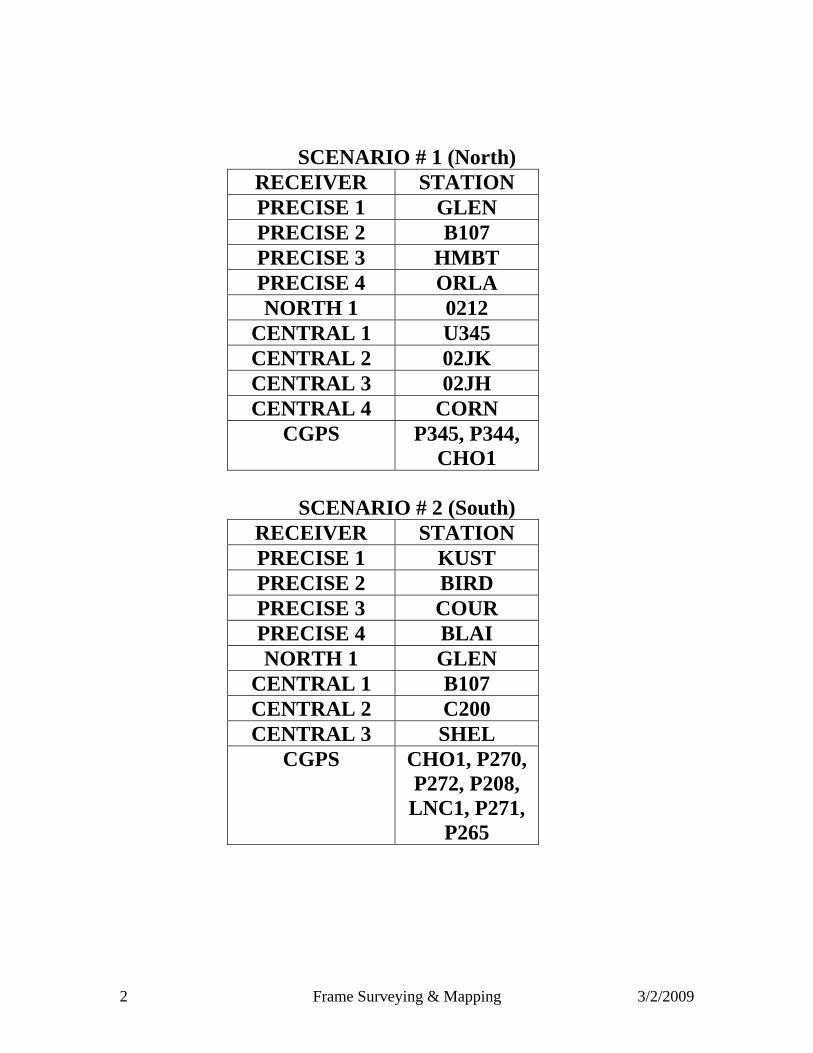
2 Frame Surveying & Mapping 3/2/2009
SCENARIO # 1 (North) RECEIVER STATION PRECISE 1 GLEN PRECISE 2 B107 PRECISE 3 HMBT PRECISE 4 ORLA NORTH 1 0212
CENTRAL 1 U345 CENTRAL 2 02JK CENTRAL 3 02JH CENTRAL 4 CORN
CGPS P345, P344, CHO1
SCENARIO # 2 (South)
RECEIVER STATION PRECISE 1 KUST PRECISE 2 BIRD PRECISE 3 COUR PRECISE 4 BLAI NORTH 1 GLEN
CENTRAL 1 B107 CENTRAL 2 C200 CENTRAL 3 SHEL
CGPS CHO1, P270, P272, P208,
LNC1, P271, P265
3 Frame Surveying & Mapping 3/2/2009
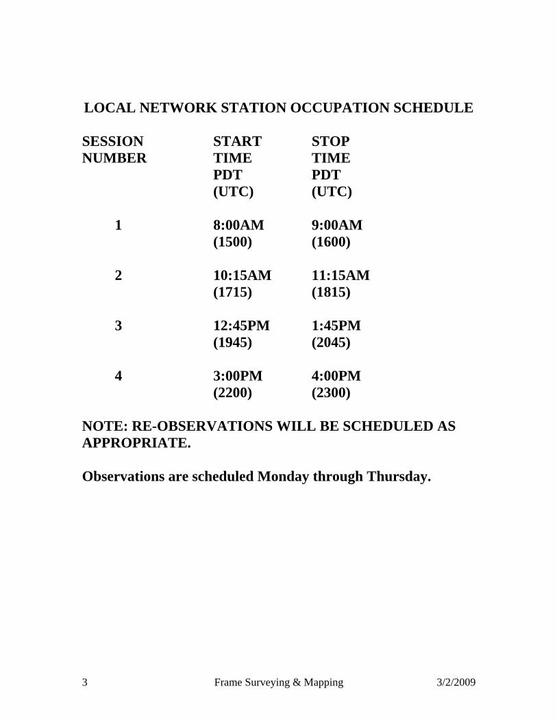
LOCAL NETWORK STATION OCCUPATION SCHEDULE SESSION START STOP NUMBER TIME TIME PDT PDT (UTC) (UTC) 1 8:00AM 9:00AM (1500) (1600) 2 10:15AM 11:15AM (1715) (1815) 3 12:45PM 1:45PM (1945) (2045) 4 3:00PM 4:00PM (2200) (2300) NOTE: RE-OBSERVATIONS WILL BE SCHEDULED AS APPROPRIATE.
Observations are scheduled Monday through Thursday.

4 Frame Surveying & Mapping 3/2/2009
DAY 1 TUESDAY, APRIL 1 (JD 92) OBSERVER SESSION 1 SESSION 2 SESSION 3 SESSION 4 Glenn 1 BOWM BOWM RBNK RBNK Glenn 2 02FJ 02FJ G143 G143 DWR 1 G142 JELL 2EK3 WLOW Green 1 2HJ2 OPEN 0222 RAWS Butte 1 2HK3 M185 C430 MCCL Butte 2 02GH HESS HESS BRHM Butte 3 U345 SCLE SCLE 02CJ Tehama 1 ASHH 2EK4 2EK4 MICH Tehama 2 OKSL OKSL 2DK4 2CK1 Tehama 3 EGRN BNBR FLOR FLOR CGPS P345 P344 DAY 2 WEDNESDAY, APRIL 2 (JD 93) OBSERVER SESSION 1 SESSION 2 SESSION 3 SESSION 4 Glenn 1 RBNK RBNK BOWM BOWM Glenn 2 G143 G143 02FJ 02FJ DWR 1 2EK3 WLOW G142 JELL Green 1 0222 RAWS 2HJ2 OPEN Butte 1 C430 MCCL 2HK3 M185 Butte 2 HESS BRHM 02GH HESS Butte 3 SCLE 02CJ U345 SCLE Tehama 1 2EK4 MICH ASHH 2EK4 Tehama 2 2DK4 2CK1 OKSL OKSL Tehama 3 FLOR FLOR EGRN BNBR CGPS P344 P345

5 Frame Surveying & Mapping 3/2/2009
DAY 3 THURSDAY, APRIL 3 (JD 94) OBSERVER SESSION 1 SESSION 2 SESSION 3 SESSION 4 Glenn 1 SRGS SRGS NORD ORLA Glenn 2 LBRL LBRL VIOL CREE DWR 1 Q106 L143 PMPR V380 Green 1 CORN MICH CAPA W215 Butte 1 MCCL P143 P143 SRGS Butte 2 BRHM B635 N852 N852 Butte 3 02CJ 02CJ FARM Y380 Tehama 1 K276 271F 271F K276 Tehama 2 BUTG B130 B130 BUTG Tehama 3 EUCA B728 B728 2966 CGPS P344 DAY 4 MONDAY, APRIL 7 (JD 98) OBSERVER SESSION 1 SESSION 2 SESSION 3 SESSION 4 Glenn 1 NORD ORLA SRGS SRGS Glenn 2 VIOL CREE LBRL LBRL DWR 1 PMPR V380 Q106 L143 Green 1 CAPA W215 CORN MICH Butte 1 P143 SRGS MCCL P143 Butte 2 N852 N852 BRHM B635 Butte 3 FARM Y380 02CJ 02CJ Tehama 1 271F K276 K276 271F Tehama 2 B130 BUTG BUTG B130 Tehama 3 B728 2966 EUCA B728 CGPS P344

6 Frame Surveying & Mapping 3/2/2009
DAY 5 TUESDAY, APRIL 8 (JD 99) OBSERVER SESSION 1 SESSION 2 SESSION 3 SESSION 4 Glenn 1 V380 2085 WALK PUMP Glenn 2 W215 ORLA Q107 FARM Glenn 3 S106 CHER CHER WILD Glenn 4 WINS H285 H285 KAIS Butte 1 Y380 FREN FREN 2085 Butte 2 B107 K852 K852 K852 Butte 3 A107 A107 U107 PETE Tehama 1 BIGW BIGW WILN HAMI Tehama 2 AGUI AGUI ARTO VIOL Tehama 3 CREE CAPA P30W P30W DAY 6 WEDNESDAY, APRIL 9 (JD 100) OBSERVER SESSION 1 SESSION 2 SESSION 3 SESSION 4 Glenn 1 WALK PUMP V380 2085 Glenn 2 Q107 FARM W215 ORLA Glenn 3 CHER WILD S106 CHER Glenn 4 H285 KAIS WINS H285 Butte 1 FREN 2085 Y380 FREN Butte 2 K852 K852 B107 K852 Butte 3 U107 PETE A107 A107 Tehama 1 WILN HAMI BIGW BIGW Tehama 2 ARTO VIOL AGUI AGUI Tehama 3 P30W P30W CREE CAPA
7 Frame Surveying & Mapping 3/2/2009
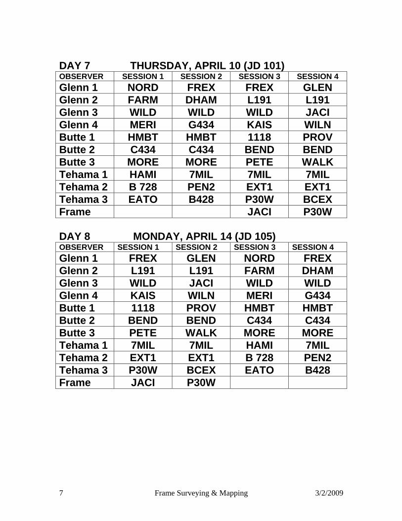
DAY 7 THURSDAY, APRIL 10 (JD 101) OBSERVER SESSION 1 SESSION 2 SESSION 3 SESSION 4 Glenn 1 NORD FREX FREX GLEN Glenn 2 FARM DHAM L191 L191 Glenn 3 WILD WILD WILD JACI Glenn 4 MERI G434 KAIS WILN Butte 1 HMBT HMBT 1118 PROV Butte 2 C434 C434 BEND BEND Butte 3 MORE MORE PETE WALK Tehama 1 HAMI 7MIL 7MIL 7MIL Tehama 2 B 728 PEN2 EXT1 EXT1 Tehama 3 EATO B428 P30W BCEX Frame JACI P30W DAY 8 MONDAY, APRIL 14 (JD 105) OBSERVER SESSION 1 SESSION 2 SESSION 3 SESSION 4 Glenn 1 FREX GLEN NORD FREX Glenn 2 L191 L191 FARM DHAM Glenn 3 WILD JACI WILD WILD Glenn 4 KAIS WILN MERI G434 Butte 1 1118 PROV HMBT HMBT Butte 2 BEND BEND C434 C434 Butte 3 PETE WALK MORE MORE Tehama 1 7MIL 7MIL HAMI 7MIL Tehama 2 EXT1 EXT1 B 728 PEN2 Tehama 3 P30W BCEX EATO B428 Frame JACI P30W
8 Frame Surveying & Mapping 3/2/2009
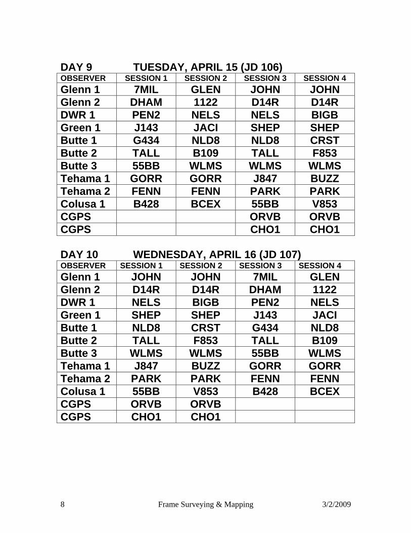
DAY 9 TUESDAY, APRIL 15 (JD 106) OBSERVER SESSION 1 SESSION 2 SESSION 3 SESSION 4 Glenn 1 7MIL GLEN JOHN JOHN Glenn 2 DHAM 1122 D14R D14R DWR 1 PEN2 NELS NELS BIGB Green 1 J143 JACI SHEP SHEP Butte 1 G434 NLD8 NLD8 CRST Butte 2 TALL B109 TALL F853 Butte 3 55BB WLMS WLMS WLMS Tehama 1 GORR GORR J847 BUZZ Tehama 2 FENN FENN PARK PARK Colusa 1 B428 BCEX 55BB V853 CGPS ORVB ORVB CGPS CHO1 CHO1 DAY 10 WEDNESDAY, APRIL 16 (JD 107) OBSERVER SESSION 1 SESSION 2 SESSION 3 SESSION 4 Glenn 1 JOHN JOHN 7MIL GLEN Glenn 2 D14R D14R DHAM 1122 DWR 1 NELS BIGB PEN2 NELS Green 1 SHEP SHEP J143 JACI Butte 1 NLD8 CRST G434 NLD8 Butte 2 TALL F853 TALL B109 Butte 3 WLMS WLMS 55BB WLMS Tehama 1 J847 BUZZ GORR GORR Tehama 2 PARK PARK FENN FENN Colusa 1 55BB V853 B428 BCEX CGPS ORVB ORVB CGPS CHO1 CHO1
9 Frame Surveying & Mapping 3/2/2009
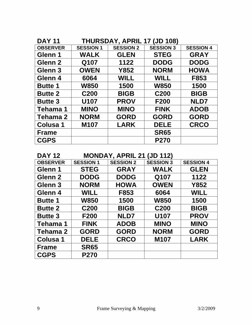
DAY 11 THURSDAY, APRIL 17 (JD 108) OBSERVER SESSION 1 SESSION 2 SESSION 3 SESSION 4 Glenn 1 WALK GLEN STEG GRAY Glenn 2 Q107 1122 DODG DODG Glenn 3 OWEN Y852 NORM HOWA Glenn 4 6064 WILL WILL F853 Butte 1 W850 1500 W850 1500 Butte 2 C200 BIGB C200 BIGB Butte 3 U107 PROV F200 NLD7 Tehama 1 MINO MINO FINK ADOB Tehama 2 NORM GORD GORD GORD Colusa 1 M107 LARK DELE CRCO Frame SR65 CGPS P270 DAY 12 MONDAY, APRIL 21 (JD 112) OBSERVER SESSION 1 SESSION 2 SESSION 3 SESSION 4 Glenn 1 STEG GRAY WALK GLEN Glenn 2 DODG DODG Q107 1122 Glenn 3 NORM HOWA OWEN Y852 Glenn 4 WILL F853 6064 WILL Butte 1 W850 1500 W850 1500 Butte 2 C200 BIGB C200 BIGB Butte 3 F200 NLD7 U107 PROV Tehama 1 FINK ADOB MINO MINO Tehama 2 GORD GORD NORM GORD Colusa 1 DELE CRCO M107 LARK Frame SR65 CGPS P270

10 Frame Surveying & Mapping 3/2/2009
DAY 13 TUESDAY, APRIL 22 (JD 113) OBSERVER SESSION 1 SESSION 2 SESSION 3 SESSION 4 Glenn 1 121B GRAY STEG H62U Glenn 2 HONC FARR DODG D850 Glenn 3 S381 CRCO PTNM HPKN Glenn 4 CRST F853 HARB HARB Butte 1 S853 S853 SR65 T644 Butte 2 B743 B743 NLD7 LONE Butte 3 TWSP FLEE FLEE FINK Tehama 1 BUZZ HARR LAUX DELE Tehama 2 BLOC BLOC WR18 HAHN Colusa 1 V853 V853 ADOB DLP2 Frame PASS CGPS CHO1 P270 P270 CGPS P208
DAY 14 WEDNESDAY, APRIL 23 (JD 114) OBSERVER SESSION 1 SESSION 2 SESSION 3 SESSION 4 Glenn 1 STEG H62U 121B GRAY Glenn 2 DODG D850 HONC FARR Glenn 3 PTNM HPKN S381 CRCO Glenn 4 HARB HARB CRST F853 Butte 1 SR65 T644 S853 S853 Butte 2 NLD7 LONE B743 B743 Butte 3 FLEE FINK TWSP FLEE Tehama 1 LAUX DELE BUZZ HARR Tehama 2 WR18 HAHN BLOC BLOC Colusa 1 ADOB DLP2 V853 V853 Frame PASS CGPS P270 P270 CHO1 CGPS P208

11 Frame Surveying & Mapping 3/2/2009
DAY 15 THURSDAY, APRIL 24 (JD 115) OBSERVER SESSION 1 SESSION 2 SESSION 3 SESSION 4
Glenn 1 SECO 0304 MRSN WDRF Glenn 2 WBND TARK HONC BLAI Glenn 3 WAYN G117 G117 EAGR Glenn 4 HARB WR18 LOAK 03HJ Butte 1 GRNO SUTA SUTA HALL Butte 2 LONE WHEA LOMO LOMO Butte 3 NLD6 FLEE TWSP CANL Tehama 1 LAUX BLOC BLOC S214 Tehama 2 HAHN PASS RAMZ RAMZ Colusa 1 COLI COLI R276 R276 Frame WHEA CGPS P272 P272 CGPS SUTB
DAY 16 MONDAY, APRIL 28 (JD 119) OBSERVER SESSION 1 SESSION 2 SESSION 3 SESSION 4
Glenn 1 MRSN WDRF SECO 0304 Glenn 2 HONC BLAI WBND TARK Glenn 3 G117 EAGR WAYN G117 Glenn 4 LOAK 03HJ HARB WR18 Butte 1 SUTA HALL GRNO SUTA Butte 2 LOMO LOMO LONE WHEA Butte 3 TWSP CANL NLD6 FLEE Tehama 1 BLOC S214 LAUX BLOC Tehama 2 RAMZ RAMZ HAHN PASS Colusa 1 R276 R276 COLI COLI Frame WHEA CGPS P272 P272 CGPS SUTB
NOTE: NO OBSERVATIONS THROUGH MAY 5, 2008

12 Frame Surveying & Mapping 3/2/2009
DAY 17 MONDAY, MAY 5 (JD 126)
OBSERVER SESSION 1 SESSION 2 SESSION 3 SESSION 4 UCD MRSN PWRL PWRL WBND PCWA TARK K435 WISE PELG DAVIS F114 EAGR ALGO ALGO SACTO ENNS OSTR OSTR ENNS SUTTER SUTA HALL BEAR WASH YCWA WHEA OSWD B144 OSWD ROSE1 CANL CANL ROSO TSDL USBR BOGE BLAI COON BOGE RD108 HPIN HPIN H380 HPIN YCFCWCD WBND 03FH 03FH WILK
DAY 18 TUESDAY, MAY 6 (JD 127)
OBSERVER SESSION 1 SESSION 2 SESSION 3 SESSION 4 UCD PWRL WBND MRSN PWRL PCWA WISE PELG TARK K435 DAVIS ALGO ALGO F114 EAGR SACTO OSTR ENNS ENNS OSTR SUTTER BEAR WASH SUTA HALL YCWA B144 OSWD WHEA OSWD ROSE1 ROSO TSDL CANL CANL USBR COON BOGE BOGE BLAI RD108 H380 HPIN HPIN HPIN YCFCWCD 03FH WILK WBND 03FH
13 Frame Surveying & Mapping 3/2/2009
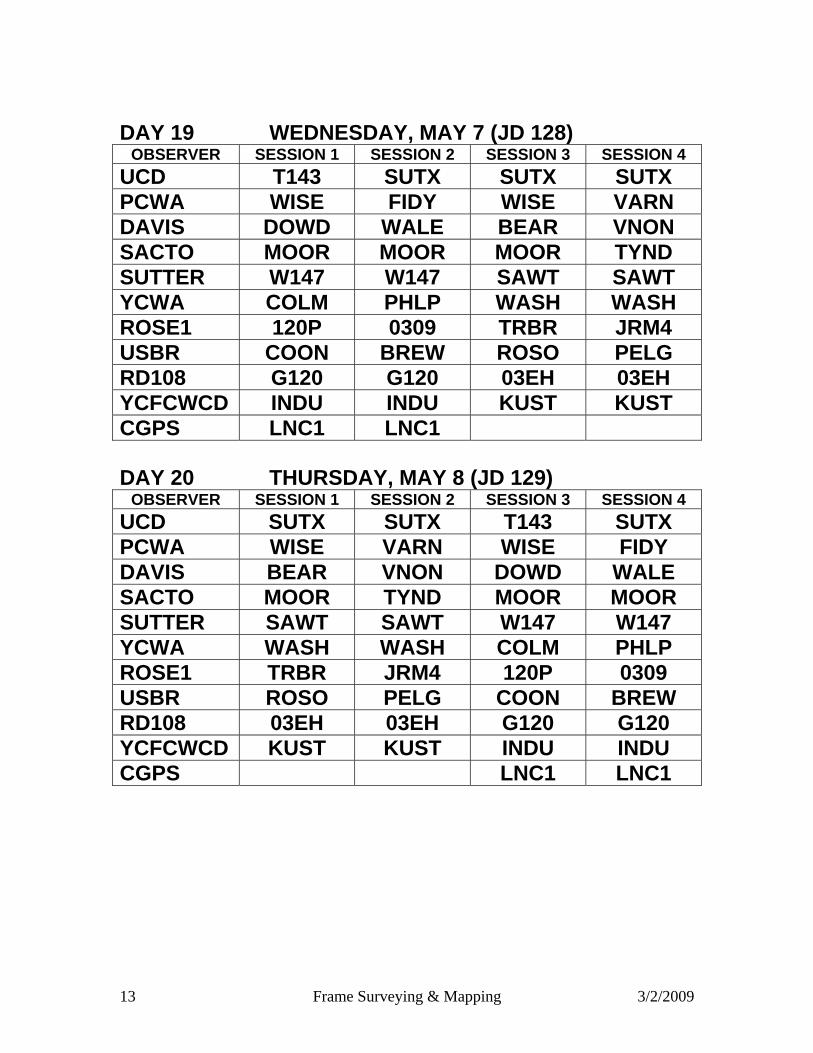
DAY 19 WEDNESDAY, MAY 7 (JD 128)
OBSERVER SESSION 1 SESSION 2 SESSION 3 SESSION 4 UCD T143 SUTX SUTX SUTX PCWA WISE FIDY WISE VARN DAVIS DOWD WALE BEAR VNON SACTO MOOR MOOR MOOR TYND SUTTER W147 W147 SAWT SAWT YCWA COLM PHLP WASH WASH ROSE1 120P 0309 TRBR JRM4 USBR COON BREW ROSO PELG RD108 G120 G120 03EH 03EH YCFCWCD INDU INDU KUST KUST CGPS LNC1 LNC1
DAY 20 THURSDAY, MAY 8 (JD 129)
OBSERVER SESSION 1 SESSION 2 SESSION 3 SESSION 4 UCD SUTX SUTX T143 SUTX PCWA WISE VARN WISE FIDY DAVIS BEAR VNON DOWD WALE SACTO MOOR TYND MOOR MOOR SUTTER SAWT SAWT W147 W147 YCWA WASH WASH COLM PHLP ROSE1 TRBR JRM4 120P 0309 USBR ROSO PELG COON BREW RD108 03EH 03EH G120 G120 YCFCWCD KUST KUST INDU INDU CGPS LNC1 LNC1

14 Frame Surveying & Mapping 3/2/2009
DAY 21 MONDAY, MAY 12 (JD 133)
OBSERVER SESSION 1 SESSION 2 SESSION 3 SESSION 4 UCD REGO CSUS CSUS FERR PCWA BREW ZINF ELKH FREM DAVIS WALE BURO CRES CRES SACTO 0309 LROY HOWE SUTX SUTTER GRBK SHEL 03AA VNON YCWA GIBS EXCL ELVT ELVT ROSE1 ELKH BRAD BRAD RIVE USBR R208 DOUG R208 SM15 ROSE2 FAIO FAIO REGO REGO WOODLND GARF GARF GARF SNKY FRAME PHLP
DAY 22 TUESDAY, MAY 13 (JD 134)
OBSERVER SESSION 1 SESSION 2 SESSION 3 SESSION 4 UCD CSUS FERR REGO CSUS PCWA ELKH FREM BREW ZINF DAVIS CRES CRES WALE BURO SACTO HOWE SUTX 0309 LROY SUTTER 03AA VNON GRBK SHEL YCWA ELVT ELVT GIBS EXCL ROSE1 BRAD RIVE ELKH BRAD USBR R208 SM15 R208 DOUG ROSE2 REGO REGO FAIO FAIO WOODLND GARF SNKY GARF GARF FRAME PHLP
15 Frame Surveying & Mapping 3/2/2009
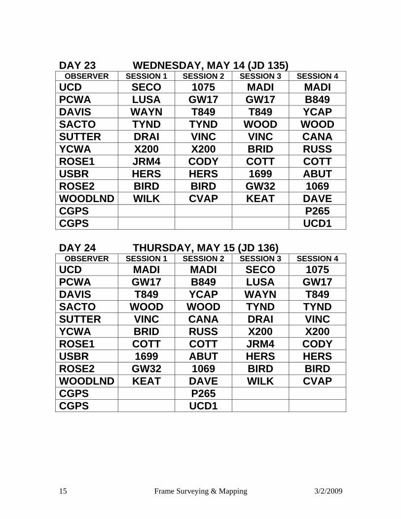
DAY 23 WEDNESDAY, MAY 14 (JD 135)
OBSERVER SESSION 1 SESSION 2 SESSION 3 SESSION 4 UCD SECO 1075 MADI MADI PCWA LUSA GW17 GW17 B849 DAVIS WAYN T849 T849 YCAP SACTO TYND TYND WOOD WOOD SUTTER DRAI VINC VINC CANA YCWA X200 X200 BRID RUSS ROSE1 JRM4 CODY COTT COTT USBR HERS HERS 1699 ABUT ROSE2 BIRD BIRD GW32 1069 WOODLND WILK CVAP KEAT DAVE CGPS P265 CGPS UCD1
DAY 24 THURSDAY, MAY 15 (JD 136)
OBSERVER SESSION 1 SESSION 2 SESSION 3 SESSION 4 UCD MADI MADI SECO 1075 PCWA GW17 B849 LUSA GW17 DAVIS T849 YCAP WAYN T849 SACTO WOOD WOOD TYND TYND SUTTER VINC CANA DRAI VINC YCWA BRID RUSS X200 X200 ROSE1 COTT COTT JRM4 CODY USBR 1699 ABUT HERS HERS ROSE2 GW32 1069 BIRD BIRD WOODLND KEAT DAVE WILK CVAP CGPS P265 CGPS UCD1

16 Frame Surveying & Mapping 3/2/2009
DAY 25 MONDAY, MAY 19 (JD 140)
OBSERVER SESSION 1 SESSION 2 SESSION 3 SESSION 4 UCD SYCA KEAT FERR PLAI PCWA VARN DUFO EX11 EX11 DAVIS F859 T849 03DG 03DG SACTO TYND ZAMX WOOD CONA SUTTER VNON CODY CANA CANA YCWA FREM 0308 0308 RWF1 ROSE1 CODY 1031 1031 YCAP USBR FORD FORD FORD DAVE GREEN SM15 SM15 CHUR COY1 WOODLND CVAP CVAP LIBR RIVE CGPS P271 P271 P271 CGPS UCD1
DAY 26 TUESDAY, MAY 20 (JD 141)
OBSERVER SESSION 1 SESSION 2 SESSION 3 SESSION 4 UCD FERR PLAI SYCA KEAT PCWA EX11 EX11 VARN DUFO DAVIS 03DG 03DG F859 T849 SACTO WOOD CONA TYND ZAMX SUTTER CANA CANA VNON CODY YCWA 0308 RWF1 FREM 0308 ROSE1 1031 YCAP CODY 1031 USBR FORD DAVE FORD FORD GREEN CHUR COY1 SM15 SM15 WOODLND LIBR RIVE CVAP CVAP CGPS P271 P271 P271 CGPS UCD1

17 Frame Surveying & Mapping 3/2/2009
DAY 27 WEDNESDAY, MAY 21 (JD 142) OBSERVER SESSION 1 SESSION 2 SESSION 3 SESSION 4 UCD CSUS GAFF GAFF CAST PCWA PALA PALA ANDR DAVE DAVIS RIVE CAST 2068 ALHA SACTO CONA CONA SURV SURV SUTTER 03AA 03BG MILL RWF1 YCWA T462 T462 COUR WILS GREEN COY1 COY1 CALD CALD FRAME COY1 CGPS P268 P268 P268 CGPS UCD1 CGPS P267 P267
DAY 28 THURSDAY, MAY 22 (JD 143) OBSERVER SESSION 1 SESSION 2 SESSION 3 SESSION 4 UCD GAFF CAST CSUS GAFF PCWA ANDR DAVE PALA PALA DAVIS 2068 ALHA RIVE CAST SACTO SURV SURV CONA CONA SUTTER MILL RWF1 03AA 03BG YCWA COUR WILS T462 T462 GREEN CALD CALD COY1 COY1 FRAME COY1 CGPS P268 P268 P268 CGPS UCD1 CGPS P267 P267

Jim Frame, Frame Surveying & Mapping Don D’Onofrio, Project Coordinator
Appendix C. Project Re-observation Schedule

1 Frame Surveying & Mapping 3/2/2009
Appendix C
Re-observation Schedules
Day 1, Wednesday, May 28 (JD 149) Observer
8:30 – 9:30 10:00 – 11:00 11:30 – 12:30 1:00 – 2:00
Frame CANA PLAI PLAI PLAI D’Onofrio YCAP YCAP 03DG RWF1
Day 2, Thursday, May 29 (JD 150) Observer TBD TBD TBD TBD TBD
Frame SM15 ELVT BREW 0309 W147 D’Onofrio FERR FERR WALE G120 G120
Day 3, Tuesday, June 3 (JD 155)
9:00 to 10:00am 11:30 to 12:30pm 2:00 to 3:00pm Observer Session 1 Session 2 Session 3
Frame Open WILK HAHN D’Onofrio LUSA TSDL NLD6
DWR 1 TARK BOGE COLI DWR 2 WHEA ENNS LONE DWR 3 GRNO PELG GRNO DWR 4 SECO WBND SECO
Day 4, Wednesday, June 4 (JD156) 9:00 to 10:00 11:30 to 12:30 2:00 to 3:00 4:00 to 5:00
Observer Session 1 Session 2 Session 3 Session 4 Frame FINK FREM T849 JRM4
D’Onofrio H62U FORD CVAP PELG DWR 1 HPKN CODY DUFO DWR 2 D850 ZAMX ZAMX DWR 3 03FH F859 KEAT DWR 4 BEAR SNKY 0308
Day 5, Thursday, June 5 (JD 157)*
Observer Session 1 Session 2 Session 3 Session 4 Session 5 D’Onofrio HALL S214 S214 R276 HONC GREEN BLAI BLAI 03HJ 03HJ R276

2 Frame Surveying & Mapping 3/2/2009
Day 6, MONDAY, JUNE 9 (JD 161)
8:00 to 9:00 10:00 to 11:00 12:00 to 1:00 2:00 to 3:00 RECEIVER SESSION 1 SESSION 2 SESSION 3 SESSION 4
D’ONOFRIO BIGB BCEX B109 C434 GREEN HOWA HARR WLMS PEN2 GLENN ADOB CRCO 1500 G434 FRAME 1122 7MIL
Day 7, TUESDAY, JUNE 10 (JD 162) 7:30 to 8:30 9:15 to 10:15 11:00 to 12:00 12:45 to 1:45 2:15 to 3:15 RECEIVER SESSION 1 SESSION 2 SESSION 3 SESSION 4 SESSION 5
D’ONOFRIO S106 V380 SRGS SRGS PMPR GREEN CREE 2966 2966 271F B130 GLENN ORLA N852
Day 8, WEDNESDAY, JUNE 11 (JD 163) 7:30 to 8:30 9:15 to 10:15 11:00 to 12:00 12:30 to 1:30 2:15 to 3:15 RECEIVER SESSION 1 SESSION 2 SESSION 3 SESSION 4 SESSION 5 D’ONOFRIO MCCL BRHM 0222 0222 M185
GREEN WLOW G143 2EK3 SCLE HESS DWR/WEST RAWS 2CK1 C430
Day 9, Tuesday, June 17 (JD 169) RECEIVER SESSION 1 SESSION 2
Observing period 9:00am to 10:00am 11:00am to 12:00 noon D’ONOFRIO C434 B109
GLENN 1/Kline G434 1500 GLENN2/Hubbard PEN2 WLMS
Day 9, Tuesday, June 17 (JD 169) RECEIVER SESSION 1
Observing period 11:00am to 12:00 noon
DWR/West M185 DWR/Hummer HESS
Jim Frame, Frame Surveying & Mapping Don D’Onofrio, Project Coordinator
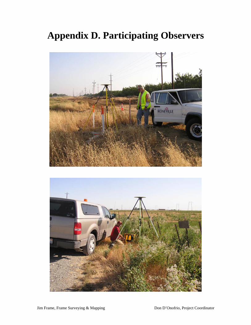
Appendix D. Participating Observers

1 Frame Surveying & Mapping 3/2/2009
Appendix D
2008 CADWR/USBR Sacramento Valley Subsidence Project
Observing Personnel and Agency
I. Cooperating Agencies Personnel Agency Ron Almeida Sacramento County Survey Reed Bekins UC Davis Chris Burdick David Greenwell Associates & Veterans Norman Cote Sutter County Tom Dixon Yuba County Water Agency Todd DiAngelo RD 108 Brad Elliot Tehama County Public Works Jordana Ellis Glenn County Dept. of Agriculture Todd Estes Butte County Public Works Allan Fulton UCD Coop Extension Tim Gomes Colusa County Public Works David Greenwell David Greenwell Associates & Veterans Kristen Hard (McKillop) Butte County Water & Resource Conservation Larry Hatch City of Woodland Jon Heisler City of Roseville Engineering Carrie Hubbard Glenn County Dept. of Agriculture Wyatt Jenkins Butte County Public Works Jarvis Jones Sutter County Robert Keller U.S. Bureau of Reclamation Jennifer Kline Glenn County Dept. of Agriculture Dottie Lacroix Glenn County Dept. of Agriculture Dave Landon Butte County Public Works Tomas Loera Glenn-Colusa Irrigation District Jennifer Masters Colusa County RCD Leslie Morgan Yuba County Water Agency/Yuba RCD Jerry Orr Sutter County Gerald Peatross Placer County Water Agency Jon Picou Glenn-Colusa Irrigation District
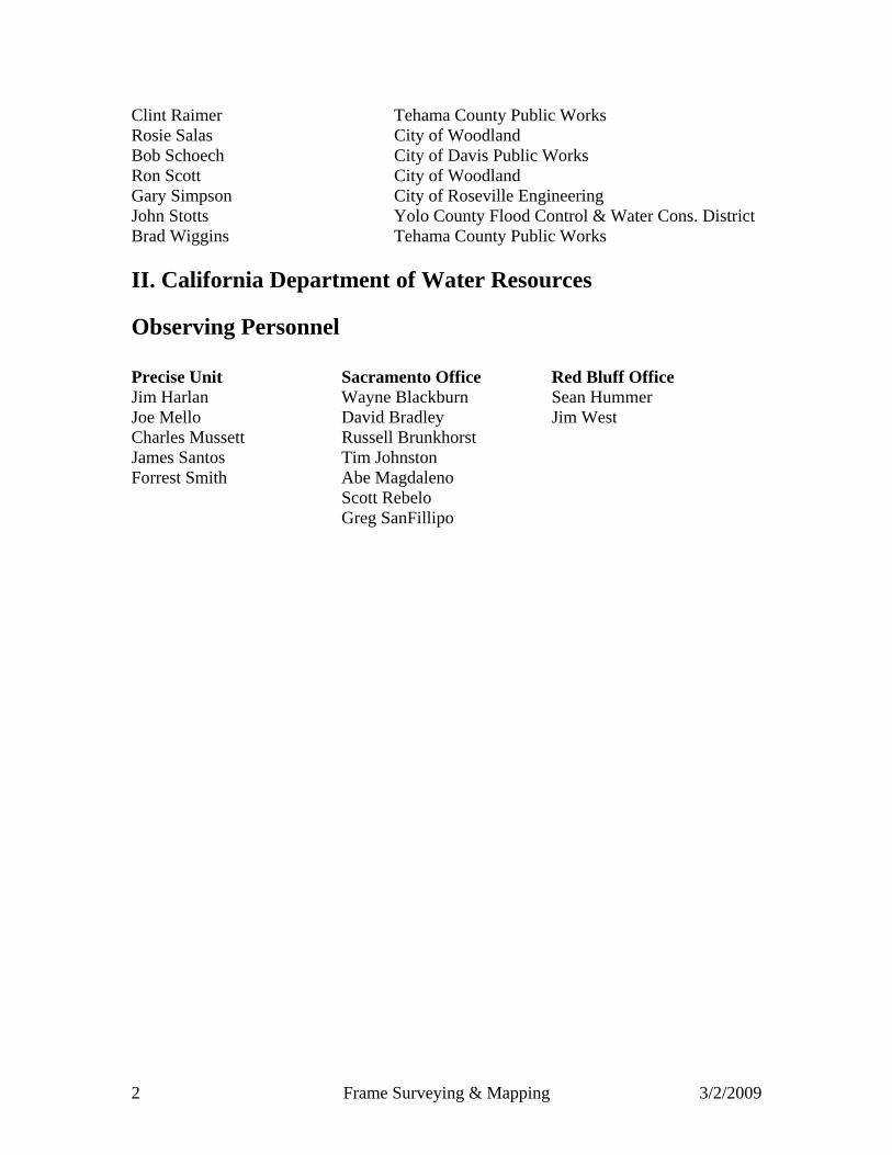
2 Frame Surveying & Mapping 3/2/2009
Clint Raimer Tehama County Public Works Rosie Salas City of Woodland Bob Schoech City of Davis Public Works Ron Scott City of Woodland Gary Simpson City of Roseville Engineering John Stotts Yolo County Flood Control & Water Cons. District Brad Wiggins Tehama County Public Works II. California Department of Water Resources Observing Personnel Precise Unit Sacramento Office Red Bluff Office Jim Harlan Wayne Blackburn Sean Hummer Joe Mello David Bradley Jim West Charles Mussett Russell Brunkhorst James Santos Tim Johnston Forrest Smith Abe Magdaleno
Scott Rebelo Greg SanFillipo

Jim Frame, Frame Surveying & Mapping Don D’Onofrio, Project Coordinator
Appendix E. Equipment
1 Frame Surveying & Mapping 3/2/2009
Appendix E
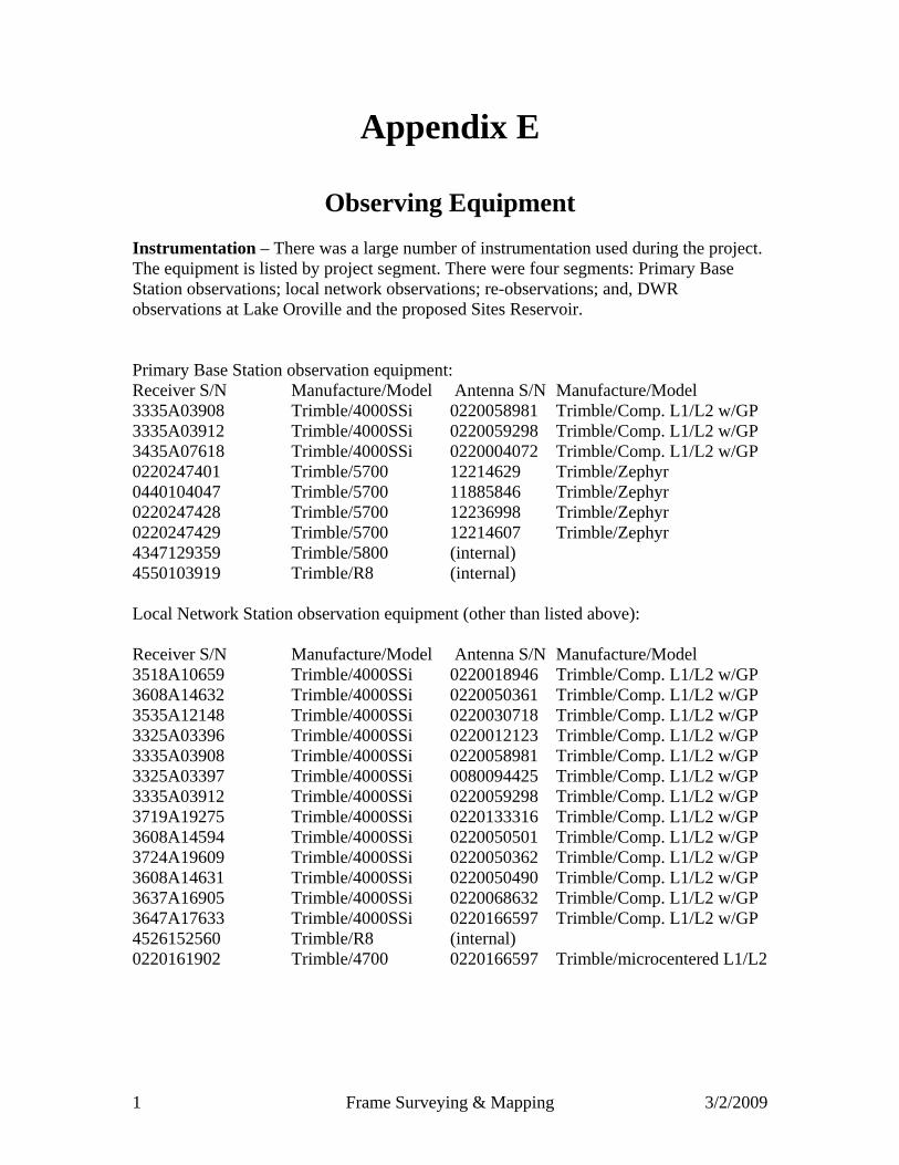
Observing Equipment Instrumentation – There was a large number of instrumentation used during the project. The equipment is listed by project segment. There were four segments: Primary Base Station observations; local network observations; re-observations; and, DWR observations at Lake Oroville and the proposed Sites Reservoir. Primary Base Station observation equipment: Receiver S/N Manufacture/Model Antenna S/N Manufacture/Model 3335A03908 Trimble/4000SSi 0220058981 Trimble/Comp. L1/L2 w/GP 3335A03912 Trimble/4000SSi 0220059298 Trimble/Comp. L1/L2 w/GP 3435A07618 Trimble/4000SSi 0220004072 Trimble/Comp. L1/L2 w/GP 0220247401 Trimble/5700 12214629 Trimble/Zephyr 0440104047 Trimble/5700 11885846 Trimble/Zephyr 0220247428 Trimble/5700 12236998 Trimble/Zephyr 0220247429 Trimble/5700 12214607 Trimble/Zephyr 4347129359 Trimble/5800 (internal) 4550103919 Trimble/R8 (internal) Local Network Station observation equipment (other than listed above): Receiver S/N Manufacture/Model Antenna S/N Manufacture/Model 3518A10659 Trimble/4000SSi 0220018946 Trimble/Comp. L1/L2 w/GP 3608A14632 Trimble/4000SSi 0220050361 Trimble/Comp. L1/L2 w/GP 3535A12148 Trimble/4000SSi 0220030718 Trimble/Comp. L1/L2 w/GP 3325A03396 Trimble/4000SSi 0220012123 Trimble/Comp. L1/L2 w/GP 3335A03908 Trimble/4000SSi 0220058981 Trimble/Comp. L1/L2 w/GP 3325A03397 Trimble/4000SSi 0080094425 Trimble/Comp. L1/L2 w/GP 3335A03912 Trimble/4000SSi 0220059298 Trimble/Comp. L1/L2 w/GP 3719A19275 Trimble/4000SSi 0220133316 Trimble/Comp. L1/L2 w/GP 3608A14594 Trimble/4000SSi 0220050501 Trimble/Comp. L1/L2 w/GP 3724A19609 Trimble/4000SSi 0220050362 Trimble/Comp. L1/L2 w/GP 3608A14631 Trimble/4000SSi 0220050490 Trimble/Comp. L1/L2 w/GP 3637A16905 Trimble/4000SSi 0220068632 Trimble/Comp. L1/L2 w/GP 3647A17633 Trimble/4000SSi 0220166597 Trimble/Comp. L1/L2 w/GP 4526152560 Trimble/R8 (internal) 0220161902 Trimble/4700 0220166597 Trimble/microcentered L1/L2
2 Frame Surveying & Mapping 3/2/2009
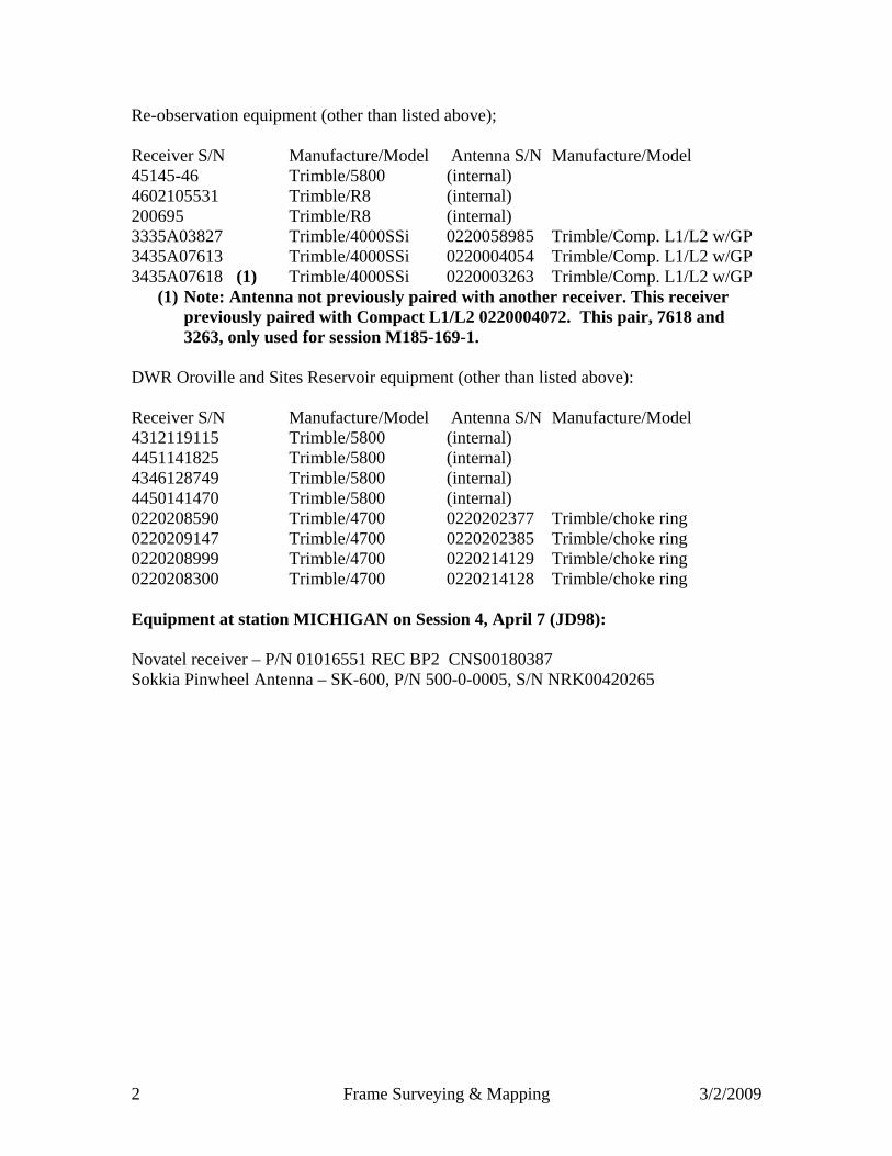
Re-observation equipment (other than listed above); Receiver S/N Manufacture/Model Antenna S/N Manufacture/Model 45145-46 Trimble/5800 (internal) 4602105531 Trimble/R8 (internal) 200695 Trimble/R8 (internal) 3335A03827 Trimble/4000SSi 0220058985 Trimble/Comp. L1/L2 w/GP 3435A07613 Trimble/4000SSi 0220004054 Trimble/Comp. L1/L2 w/GP 3435A07618 (1) Trimble/4000SSi 0220003263 Trimble/Comp. L1/L2 w/GP
(1) Note: Antenna not previously paired with another receiver. This receiver previously paired with Compact L1/L2 0220004072. This pair, 7618 and 3263, only used for session M185-169-1.
DWR Oroville and Sites Reservoir equipment (other than listed above): Receiver S/N Manufacture/Model Antenna S/N Manufacture/Model 4312119115 Trimble/5800 (internal) 4451141825 Trimble/5800 (internal) 4346128749 Trimble/5800 (internal) 4450141470 Trimble/5800 (internal) 0220208590 Trimble/4700 0220202377 Trimble/choke ring 0220209147 Trimble/4700 0220202385 Trimble/choke ring 0220208999 Trimble/4700 0220214129 Trimble/choke ring 0220208300 Trimble/4700 0220214128 Trimble/choke ring Equipment at station MICHIGAN on Session 4, April 7 (JD98): Novatel receiver – P/N 01016551 REC BP2 CNS00180387 Sokkia Pinwheel Antenna – SK-600, P/N 500-0-0005, S/N NRK00420265

Jim Frame, Frame Surveying & Mapping Don D’Onofrio, Project Coordinator
Appendix F. Project Map