Embed Size (px)
Citation preview

P.O. Box 68, Asheville, NC 28802 • www.carolinamtnclub.org • e-mail: [email protected]
Quarterly News Bulletin and Hike Schedule
FIRST QUARTER 2009
1
HIKING INFORMATION: CMC hikes are open to all and we welcome guests, but hikers are expected to join CMC after participating in a few hikes. Non-members need to call or e-mail the hike leader to introduce themselves and find out more about the hike. All hikers are encouraged to call or e-mail the leader if they have questions about the hike or the loca-tion of the meeting place. Hikes may be canceled by the leader due to adverse weather or dangerous roads. Minors are welcome on CMC hikes, if accompanied by a responsible adult. Dogs are not allowed on CMC hikes. Hikers will carpool from the meeting places to the trailhead and back. Passengers are expected to contribute 10 cents per mile towards the driver’s operating expenses. Most CMC hikes do not require reservations. However, check the hiking schedule to determine whether a reservation is required, and if so, call or e-mail the leader to reserve your space.
Hike leaders have the right to reject participants who are not properly equipped for the hike or who are unlikely to be able to complete the hike. All hikers are expected to follow the leader's instructions. No one should get ahead of the leader, or lag behind the sweep, without specific permission. Hikers should obtain the leader’s permission if they wish to leave the hike before its completion.
CLOTHING AND EQUIPMENT: CMC’s website (www.carolinamtnclub.org) has a full list of day hiking needs. Most critical are water, footwear, rain gear and a first aid kit. Carry at least two quarts of liquid (water, Gatorade, juice) for a full day hike, no matter what time of year. Hiking boots are recommended for all hikes. They should be broken in before the hike. Weather changes quickly in the mountains. Even if there is no sign of rain in the morning, you need to be prepared for an afternoon shower. Your first aid kit should include any personal medication, including allergy medication, if needed. Wear layered clothing – you’ll want to take layers off during a strenuous climb or as the day proceeds, then put them back on in cooler conditions.
TRAIL MAINTENANCE AND CONSTRUCTION: CMC maintains 92 miles of the Appalachian Trail, 130 miles of the Mountains-To-Sea Trail, and over 100 miles of other trails. It is also active in the construction of new trails. There are a variety of ways for individuals to become involved in these activities. Phone the Councilor for Trail Maintenance for details.
RESPONSIBILITY FOR SAFETY: Each CMC member and guest agrees to accept personal responsibility for his or her own safety and for the safety of accompany-ing minors. The Club cannot ensure the safety of any
participant on hikes or trail maintenance activities. Each participant agrees to hold harmless and free from
blame event leaders and the CMC, its officers and members, for any accident, injury or illness which might be sustained from par-
ticipating in Club hikes and other activities.
CONSERVATION: CMC works with other organizations concerned about the protection of our natural heritage to protect trails and the hiking experience in our hiking area. Phone the Councilor for Conservation for details.
MEMBERSHIP: Everyone is eligible for CMC membership by completing a Membership Application Form and paying dues. Membership Application Forms are available on the Club website or by mail. Annual dues are $20 for individuals and $30 for families. Applications should be sent to Carolina Mountain Club, P.O. Box 68, Asheville, NC, 28802. Hikers are expected to join CMC after participating in a few hikes. Some trail maintenance activities are only open to members.
CAROLINA MOUNTAIN CLUB OFFICERSPresident: Becky Smucker, 298-5013Vice-President: Barth Brooker, 299-0298Secretary: Kathleen Hannigan, 298-4591Treasurer: Don Gardner, 754-4067Immediate Past President: Lenny Bernstein, 236-0192Councilor for Communication: Stuart English, 883-2447Councilor for Conservation: Ruth Hartzler, 251-0886Councilor for Education: Cindy McJunkin, 213-1794Councilor for Hiking: Charlie Ferguson, 398-0213Councilor for Membership: Ashok Kudva, 698-7119Councilor for Trail Maintenance: Jeff Dektor, 274-4254 Jeff Dektor, 274-4254 Jeff DektorCouncilors at Large: Marcia Bromberg, 505-0471; Jim Reel, 738-0751
Editor: Stuart English, 883-2447, [email protected] next issue: February 15, 2009
8
Carolina Mountain ClubP.O. Box 68Asheville, NC 28802
Return Service Requested
Nonmembers, call leader, Bruce Bente, 828-692-0116, [email protected]*Note early start time. We have obtained permission to hike on land that has been protected by a conservation ease-ment. We will drive up a rough road (high clearance vehicles preferred), ford a stream by car, and then hike up old forest roads to enjoy the beautiful view from Pretty Place, and then return via the same route. Topo: Standingstone Mtn.
HALF-DAY NO. H0901-172 Mar. 22John Rock Loop *12:30 PMHike 5.7, Drive 72, 1300 ft. ascent, Rated C-BNonmembers, call leader, Lucy Prim, 828-693-6580, [email protected] *Note early start time. This moderate loop hike, with good views from the top, starts at the Fish Hatchery parking lot. Second meeting place: Fish Hatchery parking lot, off FS 475 at 1:10 PM.
HALF-DAY NO. H0901-046 Mar. 29Bent Creek Loop #12, MST side *1:00 PMHike 5, Drive 15, Rated C-CNonmembers, call leader, Gerry McNabb, 828-274-0057, [email protected] *Note early start time. This loop hike will pass by Lake Powhatan and ascend to the Mountains-to-Sea Trail via the Sherman Stambaugh Trail. We will then descend on the Sleepy Gap Trail and wander along the Explorer and Pine Tree Trails.
N E X T C M C C O U N C I L M E E T I N GWhen: Thursday, February 5, 2009Where: Botanical Gardens meeting roomTime: 6:00 - 9:00 PMInfo: Call Becky at 828-298-5013 if you would like to attend. All CMC members are welcome.
Further information about
regulations is available at www.carolinamtnclub.org
COUNCIL CORNER
On November 1, 130 CMC members and their families gathered at The Chariot in Hendersonville for the club’s annual dinner and meeting. Five people were elected to 2-year terms to fill existing Council positions. Kathleen Hannigan has been Secretary for the past year and will continue for two more. Don Gardner will be our new Treasurer. Don has served as Councilor at Large and Chair of the Challenge Committee. He will replace Carroll Koepplinger as Treasurer after 8 years of service. Ruth Hartzler will serve a one year term as Councilor for Conservation, a position she has filled for the past three years. Jeff Dektor was elected as Councilor for Maintenance. Marcia Bromberg, our new Data Base Maintainer, will fill the Councilor at Large position left open by Don Gardner. Stuart English will hold the new position, created by a bylaws change, of Councilor of Communications.
In the awards section of the dinner, Gerry and Paula McNabb were made Honorary Lifetime Members for their years of service with the club. Charlie Ferguson was given
the Award of Appreciation for his many efforts throughout the past year. Becky Smucker received a cap for 100 hours of trail maintenance and a special gift from Bill Newton for her work in establish-ing the WHOS (Work Hike On Saturday) Crew. This crew is introducing relatively new hikers to trail maintenance.
Peter Barr and Jack Fitzgerald were available to discuss their two new challenge programs: the Lookout Tower Challenge and the Waterfall Challenge, respectively.
Adrienne Wallace, Superintendent of Chimney Rock State Park, gave a slide-show presentation about the future of this new area for public recreation.
CMC officers elected at Annual Meeting: From left are Barth Brooker, Marcia Bromberg, Don Gardner, Stuart English, Becky Smucker, Kathleen Hannigan, Jim Reel, Ruth Hartzler, Charlie Ferguson, Cindy McJunkin and Ashok Kudva. Not pictured are Lenny Bernstein and Jeff Dektor.
By the time this issue of Let’s Go is off the press, we hope to have had a w o n d e r f u l
HAPPY 90TH BIRTHDAY, BERNARD!
time celebrating this milestone with Bernard Elias, our member of longest standing. Our membership database says he joined in 1941, so you do the math.
Bernard’s early career in the Navy and later as a photographer took him all over the world, so we’re glad he decided to settle back home in the Asheville area. He was recently featured in the Biltmore Beacon as the person who’s lived in Biltmore Forest longer than any other person. He’s been active in CMC ever since settling back here, especially as a hiker and hike leader.
Many of you own the hiking map, 100 Favorite Trails, which Bernard and CMC compiled and published multiple versions of in and around the 1970s. Did you know that even though that map has been out of date and out of print for a long time now, we still get occasional inquiries about it from interested buyers? Bernard says it’s up to someone else to update and publish a new version, but he’d be glad to serve as advi-sor. The updates would not be too substantial, he thinks.
Interested, anyone?Becky Smucker
2008 CMC ANNUAL DINNER AND MEETING
Spring Social April 25This year our annual Spring Social will
take place on April 25 at the NC Arboretum. It will feature awards of the photo contest and a slide show of the pictures. More about the social will be in the next Let’s Goand future editions of the eNews.
2 7
Harmon Den trails
Moderate hikes new this quarter
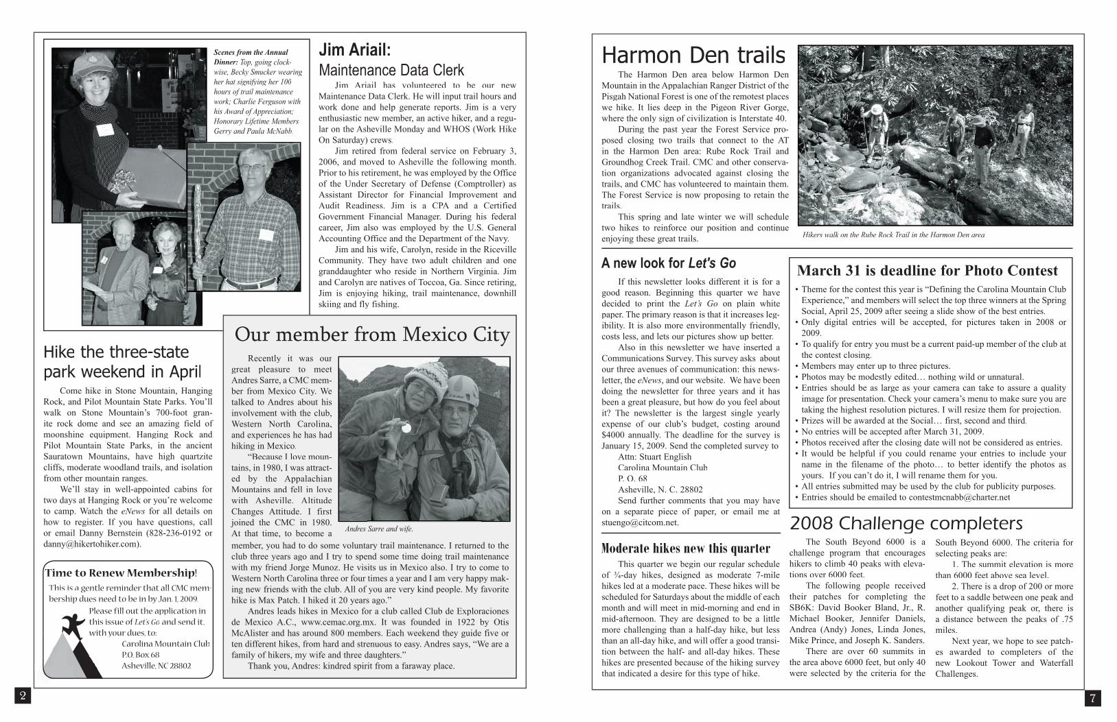
Hikers walk on the Rube Rock Trail in the Harmon Den area.
Hike the three-state park weekend in April
This quarter we begin our regular schedule of ¾-day hikes, designed as moderate 7-mile hikes led at a moderate pace. These hikes will be scheduled for Saturdays about the middle of each month and will meet in mid-morning and end in mid-afternoon. They are designed to be a little more challenging than a half-day hike, but less than an all-day hike, and will offer a good transi-tion between the half- and all-day hikes. These hikes are presented because of the hiking survey that indicated a desire for this type of hike.
A new look for Let's GoIf this newsletter looks different it is for a
good reason. Beginning this quarter we have decided to print the Let’s Go on plain white paper. The primary reason is that it increases leg-ibility. It is also more environmentally friendly, costs less, and lets our pictures show up better.
Also in this newsletter we have inserted a Communications Survey. This survey asks about our three avenues of communication: this news-letter, the eNews, and our website. We have been doing the newsletter for three years and it has been a great pleasure, but how do you feel about it? The newsletter is the largest single yearly expense of our club’s budget, costing around $4000 annually. The deadline for the survey is January 15, 2009. Send the completed survey to
Attn: Stuart EnglishCarolina Mountain ClubP. O. 68Asheville, N. C. 28802Send further comments that you may have
on a separate piece of paper, or email me at [email protected].
Jim Ariail has volunteered to be our new Maintenance Data Clerk. He will input trail hours and work done and help generate reports. Jim is a very enthusiastic new member, an active hiker, and a regu-lar on the Asheville Monday and WHOS (Work Hike On Saturday) crews.
Jim retired from federal service on February 3, 2006, and moved to Asheville the following month. Prior to his retirement, he was employed by the Office of the Under Secretary of Defense (Comptroller) as Assistant Director for Financial Improvement and Audit Readiness. Jim is a CPA and a Certified Government Financial Manager. During his federal career, Jim also was employed by the U.S. General Accounting Office and the Department of the Navy.
Jim and his wife, Carolyn, reside in the Riceville Community. They have two adult children and one granddaughter who reside in Northern Virginia. Jim and Carolyn are natives of Toccoa, Ga. Since retiring, Jim is enjoying hiking, trail maintenance, downhill skiing and fly fishing.
Come hike in Stone Mountain, Hanging Rock, and Pilot Mountain State Parks. You’ll walk on Stone Mountain’s 700-foot gran-ite rock dome and see an amazing field of moonshine equipment. Hanging Rock and Pilot Mountain State Parks, in the ancient Sauratown Mountains, have high quartzite cliffs, moderate woodland trails, and isolation from other mountain ranges.
We’ll stay in well-appointed cabins for two days at Hanging Rock or you’re welcome to camp. Watch the eNews for all details on how to register. If you have questions, call or email Danny Bernstein (828-236-0192 or [email protected]).
The Harmon Den area below Harmon Den Mountain in the Appalachian Ranger District of the Pisgah National Forest is one of the remotest places we hike. It lies deep in the Pigeon River Gorge, where the only sign of civilization is Interstate 40.
During the past year the Forest Service pro-posed closing two trails that connect to the AT in the Harmon Den area: Rube Rock Trail and Groundhog Creek Trail. CMC and other conserva-tion organizations advocated against closing the trails, and CMC has volunteered to maintain them. The Forest Service is now proposing to retain the trails.
This spring and late winter we will schedule two hikes to reinforce our position and continue enjoying these great trails.
2008 Challenge completersThe South Beyond 6000 is a The South Beyond 6000 is a
challenge program that encourages hikers to climb 40 peaks with eleva-tions over 6000 feet.
The following people received their patches for completing the SB6K: David Booker Bland, Jr., R. Michael Booker, Jennifer Daniels, Andrea (Andy) Jones, Linda Jones, Mike Prince, and Joseph K. Sanders.
There are over 60 summits in the area above 6000 feet, but only 40 were selected by the criteria for the
South Beyond 6000. The criteria for selecting peaks are:
1. The summit elevation is more than 6000 feet above sea level.
2. There is a drop of 200 or more feet to a saddle between one peak and another qualifying peak or, there is a distance between the peaks of .75 miles.
Next year, we hope to see patch-es awarded to completers of the new Lookout Tower and Waterfall Challenges.
This is a gentle reminder that all CMC mem-bership dues need to be in by Jan. 1, 2009.
Time to Renew Membership!
Please fill out the application in this issue of Let's Go and send it, with your dues, to: Carolina Mountain Club P.O. Box 68 P.O. Box 68 Asheville, NC 28802 Asheville, NC 28802
Jim Ariail:Maintenance Data Clerk
Scenes from the Annual Dinner: Top, going clock-wise, Becky Smucker wearing her hat signifying her 100 hours of trail maintenance work; Charlie Ferguson with his Award of Appreciation; Honorary Lifetime Members Gerry and Paula McNabb.
Recently it was our great pleasure to meet Andres Sarre, a CMC mem-ber from Mexico City. We talked to Andres about his involvement with the club, Western North Carolina, and experiences he has had hiking in Mexico.
“Because I love moun-tains, in 1980, I was attract-ed by the Appalachian Mountains and fell in love with Asheville. Altitude Changes Attitude. I first joined the CMC in 1980. At that time, to become a
Our member from Mexico City
member, you had to do some voluntary trail maintenance. I returned to the club three years ago and I try to spend some time doing trail maintenance with my friend Jorge Munoz. He visits us in Mexico also. I try to come to Western North Carolina three or four times a year and I am very happy mak-ing new friends with the club. All of you are very kind people. My favorite hike is Max Patch. I hiked it 20 years ago.”
Andres leads hikes in Mexico for a club called Club de Exploraciones de Mexico A.C., www.cemac.org.mx. It was founded in 1922 by Otis McAlister and has around 800 members. Each weekend they guide five or ten different hikes, from hard and strenuous to easy. Andres says, “We are a family of hikers, my wife and three daughters.”
Thank you, Andres: kindred spirit from a faraway place.
• Theme for the contest this year is “Defining the Carolina Mountain Club Experience,” and members will select the top three winners at the Spring Social, April 25, 2009 after seeing a slide show of the best entries.
• Only digital entries will be accepted, for pictures taken in 2008 or 2009.
• To qualify for entry you must be a current paid-up member of the club at the contest closing.
• Members may enter up to three pictures.• Photos may be modestly edited… nothing wild or unnatural.• Entries should be as large as your camera can take to assure a quality
image for presentation. Check your camera’s menu to make sure you are taking the highest resolution pictures. I will resize them for projection.
• Prizes will be awarded at the Social… first, second and third.• No entries will be accepted after March 31, 2009.• Photos received after the closing date will not be considered as entries.• It would be helpful if you could rename your entries to include your
name in the filename of the photo… to better identify the photos as yours. If you can’t do it, I will rename them for you.
• All entries submitted may be used by the club for publicity purposes.• Entries should be emailed to [email protected]
March 31 is deadline for Photo Contest
Andres Sarre and wife.

should see some early spring flowers and who knows what else. Topo: Canton
SATURDAY NO. A0901-270 March 28Cedar Rock Mtn.–John Rock Loop *9:00 AMHike 8, Drive 80, 2000 ft. ascent, Rated B-AVictoria Tripp, 828-348-4505, [email protected] *Note later start time. This trip features two of the spectacular bare rock faces in the Pisgah National Forest, with great views from both. Starting at the Fish Hatchery, we’ll have our major climb up to Cat Gap and then on to Cedar Rock for lunch enjoying the view. We’ll return via John Rock. Second meeting place: Pisgah Fish Hatchery at 9:40 AM. Topo: Shining Rock.
ALL DAY NO. A0901-636 March 29Coontree – Bennett Gap – Pressley Cove Lollipop *9:00 AMHike 8.4, Drive 75, 1900 ft. ascent, Rated B-AAshok Kudva, 828-698-7119, [email protected] * Note later start time. Meet at Westgate at 9:00 AM to form carpools to accommodate an optional post-hike supper near Brevard, and meet the leader at Pisgah Forest Bi-Lo at 9:30 AM. This hike is an extension of the popular half-day Coontree Loop hike. We start ascending the left branch of Coontree trail, proceed in and out on Bennett Gap and Pressley Cove trails and descend on the right branch of Coontree trail to the cars. We will visit an old homestead chimney, a remnant of the farming community between Pressley Cove and Maxwell Cove. Topo: Pisgah Forest; also Nat’l. Geo. PRD map #780
HALF-DAY SUNDAY HIKESNewcomers are welcome, but non-members MUST call the leader before the hike to determine the requirements. Half-day hikes submitted by Lucy Prim, [email protected], 828-693-6580. Driving distance is round-trip from Asheville. All hikes assemble at the east end of the Westgate Shopping Center near Exit 3B off I-240 UNLESS OTHERWISE NOTED. Some hikes will have second meeting places as described in hike list-ings.
HALF-DAY NO. H0901-295 Jan. 4Pump Gap, AT Loop *12:30 PMHike 5, Drive 70, 1200 ft. ascent, Rated C-BNonmembers, call leader, Tom Sanders, 828-252-6327, [email protected]*Note early start time. From Hot Springs we will ascend on the Pump Gap Trail to the AT. We will then go south on the AT via Lovers Leap with outstanding views of the French Broad River, then hike back to Hot Springs.
HALF-DAY NO. H0901-434 Jan. 11Laurel Mountain Trail *12:30 PMHike 5.4 miles, Drive 40, 700 ft. ascent, Rated C-C
Nonmembers, call leader, Greg Goodman, 828-684-9703, [email protected] *Note early start time. Meet at Westgate at 12:30 PM to form carpools, and meet leader at the North Mills River parking area at 1:00 PM. This loop hike will start at FS 1206, go along a ridge trail toward Black Mountain, and return via the Laurel Mountain Trail. There should be good views of the Mills River Valley.
HALF-DAY NO. H0901-381 Jan. 18Snowball Trail *12:30 PMHike 5.5, Drive 50, 900 ft. ascent, Rated B-BNonmembers call leader, Jorge Munoz, 828-658-0606, [email protected]*Note early start time. This is a moderate in-and-out hike with a steady climb (some hikers consider it to be steep) to High Rocks (Hawkbill Mtn.). Diverse and centennial trees to be admired all the way on the ridge. Stop for a snack at Snowball Mountain before return. Second meet-ing place: Craven Gap on Blue Ridge Parkway at 12:50 PM.
HALF-DAY NO. H0901-153 Jan. 25Cove Creek/Caney Bottom Loop *12:30 PMHike 5, Drive 80, 1300 ft. ascent, Rated C-BNonmembers, call leader, Lee Belknap, 828-698-9394, [email protected] *Note early start time. Meet at Westgate at 12:30 PM to form carpools, and meet hike leader at the Pisgah Ranger Station off US 276 at 1:10 PM. A pleasant walk through the woods, with streams, waterfalls, and bridge crossings.
HALF-DAY NO. H0901-637 Feb. 1Destination Center / Folk Art Center / MST *12:30 PMHike 5.8, Drive 20, Rated C-CNonmembers, call leader, Don Walton, 828-654-9904, [email protected]*Note early start time. The hike starts at the Destination Center Parking Lot at the MST blue blaze access. This includes the new 1.4 mile loop passing by the BRP Headquarters Building, then crossing the BRP near US 74 and heading east on the MST towards the Folk Art Center. We will return to the access trail to complete the loop under the BRP back to the parking lot. Second meeting place: Destination Center Parking Lot on the BRP at 12:45 PM.
HALF-DAY NO. H0901-498 Feb. 8High Windy *12:30 PMHike 6, Drive 40, 1700 feet ascent, Rated B-ANonmembers, call leader, Renate Rikkers, 828-298-9988, [email protected]*Note early start time. Meet at Westgate at 12:10 PM to form carpools, and meet leader at parking lot adjacent to McDonald’s in Black Mountain off Exit 64 of I-40. From the grounds of the 12,000-acre Blue Ridge Assembly in Black Mountain, we will combine the Carolina Loop Trail with High Windy Trail for a gradual but
steady 1700 ft. ascent to the 4370-foot summit of High Windy for rewarding views.HALF-DAY NO. H0901-638 Feb. 15DuPont Forest Hooker Falls P.L. #4 – Cannon Creek to Rock Quarry *12:00 PMHike 5, Drive 85, Rated C-CNonmembers, call leader, Becky Elston, 828-749-1886, [email protected]*Note early start time. This in/out hike starts off Rich Mountain Road. Meet at Westgate at 12:00 PM to form carpools, and meet hike leader at the Hooker Falls parking lot in DuPont at 12:45 PM.
HALF-DAY NO. H0901-431 Feb. 22Chestnut Cove to MST to Sleepy Gap to Explorer Trail *1:00 PMHike 5, Drive 20, 900 ft. ascent, Rated C-C Nonmembers, call leader, Joe Burchfield, 828-398-8413, [email protected]*Note early start time. This loop hike begins with a moderately steep climb from the Bent Creek Gap Road to the MST, but is otherwise an easy walk. Second Meeting Place: Ingles park-ing lot across from Biltmore Square Mall on NC 191 at 1:15 P.M.
HALF-DAY NO. H0901-283 Mar. 1Montreat Ramble #2 - Lookout Mtn. *12:30 PMHike 6, Drive 40, 1400 ft. ascent, Rated C-BNonmembers, call leader, Marcia Bromberg, 828-505-0471, [email protected]*Note early start time. We begin by hiking up Lookout Mountain, enjoying the views at Lookout Rock, then picking up the East Ridge Trail to Sourwood Gap. This will take us over Boggs Bunion and Brushy Mountain (our high points). From Sourwood we’ll take the Old Mitchell Toll Road, then switch to the Old Trestle Road at Long Gap. The last leg of the hike is downhill on the Graybeard Trail to the trailend where cars will be parked to shuttle us back to the trailhead. Second meeting place: Parking lot adjacent to McDonald’s at Exit 64 of I-40 at 12:50 PM.
HALF-DAY NO. H0901-485 Mar. 8Old U.S. 70 and the Railroad *1:00 PMHike 5, Drive 60, 1300 ft ascent, Rated C-BNonmembers, call leader, Gail Lamb, 828-350-0450, [email protected]*Note early start time. We will walk up on old old U.S. 70, now blocked off from traffic, to Swannanoa Gap. We will enjoy a view of the valley, railroad and tunnel featured in “The Road” by John Ehle, a book about building the railroad up to Swannanoa Gap. Second meeting place: Parking lot adjacent to McDonald’s at Exit 64 of I-40 at 1:20 PM. Topos: Old Fort, Black Mountain.
HALF-DAY NO. H0901-639 Mar. 15Pretty Place from the NC side *1:00 PMHike 6, Drive 60, 600 ft ascent, Rated C-C
3
HIKE SCHEDULEFirst Quarter 2009
Hike RatingsFirst Letter Second LetterDistance Elevation GainAA: Over 12 miles AA: Over 2,000 ft.A: 9-12 miles A: 1,500-2,000 ft.B: 6-9 miles B: 1,000-1,500 ft.C: Under 6 miles C: Under 1,000 ft.
Also in the hike descriptions, the terms easy, moderate or strenuous reflect the overall trail conditions, physical challenge and other factors influencing hike difficulty. If you have questions or if the weather on the day of the hike is ques-tionable, contact the leader. If it's not possible for a hiker to go on the regularly scheduled hike, it may be possible to accompany the hike leader when the hike is scouted. Scouts typically take place one to six weeks before the scheduled date. Call or email the hike leader.
CHALLENGE PROGRAMS:SB6K For hiking all 40 peaks above 6000’. SB6K For hiking all 40 peaks above 6000’. SB6KFor information, contact Don Gardner, [email protected] For hiking every trail in Pisgah Ranger District. For information, contact Don Gardner, [email protected] For hiking every trail in GSMNP. For infor-mation, contact John Gallemore, [email protected] For hiking to all 24 Lookout Towers in WNC. For information, contact Don Gardner, [email protected] For hiking to the 100 best waterfalls in the mountains of WNC, SC and the Smokies. For information, contact Jack Fitzgerald, 828-685-2897, [email protected]
WEDNESDAY HIKESWednesday hikes submitted by Charlie Ferguson, [email protected]. Driving distance is round-trip from Asheville. All Wednesday hikes assem-ble at Westgate Shopping Center near I-240 exit 3B UNLESS OTHERWISE NOTED. Some hikes will have second meeting places as described in the schedule, and start times vary.
WEDNESDAY NO. W0901-631 Jan. 7DuPont Forest Hooker Falls P.L. #3 (3 Falls & 2 Lakes) 8:30 AM
Hike 9, Drive 80, 1200 ft. ascent, Rated B-BJay Bretz, 828-658-1220, [email protected] This hike goes to 3 of the best water-falls and 2 lakes in the DuPont State Forest. We will be going to Triple and High Falls, and then to Lake Dense. We will use the newly opened Conservation Road to get to the south part of the Little River, across the dam to Lake Julia. After lunch at Lake Julia, we’ll hike to the old airstrip, horse barn, and then beautiful Bridal Veil Falls. Second meeting place: Bi-Lo at Pisgah Forest at 9:05 AM. Topo: Standingstone Mtn.; also DuPont State Forest Map
WEDNESDAY NO. W0901-101 Jan. 14Big Laurel River *8:45 AMHike 7, Drive 60, 300 ft. ascent, Rated C-CBecky Elston, 828-749-1886, [email protected] follows Big Laurel River to the conflu-ence with the French Broad River, lunch here. Pass thru Runion, which was a thriving logging town in the early 1900’s. Fairly rocky in spots. *Meet at Westgate at 8:45 AM to form car-pools, and meet leader at Ingles on US 25/70 at the Marshall Bypass at 9:30 AM. Topo: Hot Springs
WEDNESDAY NO. W0901-053 Jan. 21East Fork Pigeon River *8:30 AMHike 7.5, Drive 74, 1200 ft. ascent, Rated B-BBarbara Morgan, 828-738-3395, [email protected] *Wilderness area, limit 10, so contact leader for reservation. A stroll along one of WNC’s most beautiful streams, the East Fork of the Pigeon River, which is often spectacular in the winter. We will ascend to Dark Prong for lunch and then return. Second meeting place: Big East parking area on US 276, north of BRP at 9:15 AM. Topo: Shining Rock; also Nat’l. Geo. PRD map #780
WEDNESDAY NO. W0901-457 Jan. 28AT: Brown Gap to Max Patch and return 8:30 AMHike 7, Drive 100, 1100 ft. ascent, Rated B-BMary Beth Gwynn, 828-254-2042,[email protected] in and out hike on the AT, with a steep uphill for the first mile, then leveling off into moderate ups and downs, with a final climb to the top of Max Patch for lunch. If we’re lucky, it will be clear for the beautiful views. Second meeting place: Pilot Truck Stop, exit 24, off I-40 at 9:05 AM. Topo: Lemon Gap
WEDNESDAY NO. W0901-629 Feb. 4Rough Creek Trail – Canton Watershed 8:45 AMHike 7.5, Drive 54, 1800 ft. ascent, Rated B-AKen & Carol Deal, 828-281-4530, [email protected]
This is a new hiking trail opened in the spring of '08 in the Canton Watershed. During this loop hike, we walk uphill in the morning, largely on old roads, to a ridgeline with long distance views. Shortly after we start down, we’ll have lunch on rocks overlooking a lovely valley. After lunch, we return downhill, crossing Rough Creek on a bridge. Topo: Canton
WEDNESDAY NO. W0901-498 Feb. 11High Windy and High Top 9:00 AMHike 7.6, Drive 40, 1900 ft. ascent, Rated B-AKeiko Merl, 828-628-2396, [email protected] fairly steep ascent on beautiful backwoods trails in the YMCA Blue Ridge Assembly area. High Windy is the former site of a lookout tower. We’ll hike another mile to High Top for more views to the north and east. Back the same way we came. Second meeting place: Parking lot adjacent to McDonald's at Exit 64 of I-40 at 9:20 AM.Topo: Black Mt; Blue Ridge Assy. Trails
WEDNESDAY NO. W0901-632 Feb. 18Cantrell Lodge History Hike out and back 8:30 AMHike 8, Drive 55, 700 ft. ascent, Rated B-BDanny Bernstein, 828-236-0192,[email protected] This hike follows the South Mills River Trail to the Cantrell Lodge site and chimney, fol-lowing an old logging railroad grade. On the way, we’ll cross three pedestrian suspension bridges and a couple of unusual carsonite signs. Second meeting place: Turkey Pen parking lot at 9:00 AM, but notify leader first. Topo: Pisgah Forest; also Natl. Geo. PRD map #780
WEDNESDAY NO. W0901-278 Feb. 25Kitsuma Peak *9:00 AMHike 8, Drive 60, 2000 ft. ascent, Rated B-AJoe Burchfield, 828-298-8413, [email protected]*Meet at Westgate at 9:00 AM to form car-pools, and meet leader at parking lot next to McDonald's at Exit 64 of I-40 at 9:20 AM.Our hike up Young’s Ridge offers great views of Greybeard, Green Knob and the Mt. Mitchell area. We will start from the picnic area near Old Fort. Also we’ll enjoy a grandstand view of the Swannanoa valley from our lunch spot. Topo: Old Fort, Black Mtn.
WEDNESDAY NO. W0901-560 Mar. 4Rube Rock/Groundhog Creek Loop 8:00 AMHike 9, Drive 100, 1900 ft. ascent, Rated A-AStuart English, 828-883-2447, [email protected] beautiful loop hike located in the Harmon Den area of Pisgah Nat’l. Forest. We’ll start at Brown Gap, southbound on the AT to Rube Rock Trail which descends into the Pigeon River Gorge. Then we’ll climb the Groundhog Creek Trail to the AT and back to Brown Gap. Second meeting place: Pilot Truck Stop off I-40 at Exit 24 at
6
SATURDAY WORK DAYHere is a great chance to learn what is
involved in trail maintenance. The quarterly Saturday work day will be in February; call Les Love at 828-658-1489 ([email protected]) to verify date.

down Ruth’s Ridge and the Lower Sidehill Trail to cars. Second meeting place: Ingles Parking lot across from Biltmore Sq. on NC 191 at 8:45 AM. Topos: Enka, Dunsmore Mtn.; also Nat’l. Geo. PRD map #780ALL DAY NO. A0901-633 Feb. 1Mackay Mtn. Roadless Area *9:00 AM(moderate)Hike 8, Drive 70, 1400 ft. ascent, Rated B-BBrent Martin, 828-369-7084, [email protected]*Note later start time. This hike will cover approximately 8 miles through remnant old growth forest with spectacular views of the Black Mtns. and surrounding area. About half of the hike will be along a ridgeline. Second meeting place: parking lot adjacent to McDonald's at Exit 64 of I-40 at 9:20 AM. Topo: Old Fort
ALL DAY NO. A0901-282 Feb. 8Black Mtn. – Avery Creek *8:00 AMHike 9, Drive 62, 3000 ft. ascent, Rated A-AA+Stuart English, 828-883-2447, [email protected] *Meet at Westgate at 8:00 AM to form carpools, and meet leader at Pisgah Forest Bi-Lo at 8:30 AM. From the trailhead, we will climb steadily up to 4286 ft. Black Mtn. and Clawhammer Mtn. and then to Buckhorn Gap and Twin Falls, ending at FS 477. A great winter hike. Car shuttle. Topos: Pisgah Forest, Shining Rock; also Nat’l. Geo. PRD map #780
ALL DAY NO. A0901-418 Feb. 15Newton Bald – Kanati Fork 8:00 AMHike 11.5, Drive 120, 3600 ft. ascent, Rated A-AAJanet Martin, 502-494-9309 (cell),[email protected] This great winter hike near Cherokee climbs Newton Bald, continues on Thomas Divide and then descends on Kanati Fork Trail. Nice scenery and even more fun if we hike up into snow-covered scenery. Short car shuttle. Second meeting place: back of Post Office parking lot on US 276 in Maggie Valley at 8:30 AM, but call leader first. Topo: Clingman’s Dome; also Nat’l. Geo. GSMNP map #229
ALL DAY NO. A0901-634 Feb. 22High Top Tower Site 8:00 AMHike 10, Drive 65, 1900 ft. ascent, Rated A-ATom Sanders, 828-252-6327, [email protected] This hike was a longtime favorite of the scouts at Camp Daniel Boone years ago when this leader was on the camp staff. From the camp we will ascend to High Top with its excellent views, and then follow the Fork Mtn. ridge before descending to the rushing Little East Fork of the Pigeon River. Car shuttle. Topo: Shining Rock; also Nat’l. Geo. PRD map #780
ALL DAY NO. A0901-635 March 1Deep Creek – Pole Rd. Creek – Noland Divide *7:30 AM(strenuous)Hike 17, Drive 136, 3200 ft. ascent, Rated AA+-AA+Don Gardner, 828-754-4067, [email protected] *Note early start time. This very strenu-ous hike is designed to get some of those difficult 900M miles. Plan on a long day and bring a headlamp or flashlight in case we return later than expected. We will go up Deep Creek trail and turn steeply uphill on the Pole Road Creek trail to Upper Sassafras Gap. Then we’ll hike mostly downhill on the Noland Divide trail to Deep Creek Campground. Short car shuttle. Second meeting place: Rest area on US 23/74 beyond Waynesville at 8:00 AM. Topos: Bryson City, Clingman’s Dome; also Nat’l. Geo. GSMNBP map #229
ALL DAY NO. A0901-236 March 1Dupont Forest –Fawn Lake P.L. #1 *8:30 AM(moderate)Hike 8, Drive 95, 1000 ft. ascent, Rated B-BJay Bretz, 828-658-1220, [email protected]*Note later start time. A moderate hike featuring beautiful waterfalls and lakes. We’ll see Corn Mill Shoals, Bridal Veil Falls, Lake Julia and Fawn Lake at an easy pace. The last time we did this hike, we saw an otter at the lunch spot. Second meeting place: Bi-Lo parking lot in Pisgah
Forest at 9:05 AM. Topo: Standingstone Mtn.; also Dupont Forest trail map
ALL DAY NO. A0901-332 March 8Foothills Trail: Upper and Lower Whitewater Falls *8:30 AM(strenuous)Hike 11.6, Drive 115, 1600 ft. ascent, Rated A-ACharlie Ferguson, 828-778-2431, [email protected]*NOTE: First day of Daylight Savings time. The later start time turns out to be earlier due to DST. Come to hike in the warm weather at the lower elevations! We’ll hike part of the Foothills Trail in NC and SC, featuring two of the region’s most stunning waterfalls. We will begin at the Upper Whitewater Falls parking lot, and hike to the footbridge over the Thompson River. We’ll partially retrace our steps, then take the side trail to Lower Whitewater Falls, and finish at the Duke Power Co. Bad Creek parking lot. Short car shuttle. Second meeting place: Bi-Lo in Pisgah Forest at 9:00 AM. Topos: Reid, Cashiers; also Foothills Trail map
ALL DAY NO. A0901-056 March 15Black Mountain Ramble 8:00 AMHike 9.4, Drive 60, 2800 ft. ascent, Rated A-AAMichael & Kathy Cornn, 828-698-3672,[email protected] This great winter hike starts at Turkey Pen parking area, then over Sharpy Mtn. and around Black Mtn., ending at the Pisgah Maintenance parking lot. A long uphill, but with good views from our lunch spot at Black Mtn. Second Meeting place: Intersection of NC 280 and Turkey Pen Rd. at 8:30 AM. Car shuttle. Topo: Pisgah Forest; also Nat’l. Geo. PRD map #780
ALL DAY NO. A0901-629 March 22Rough Creek – Canton Watershed *8:30 AMHike 8, Drive 54, 2200 ft. ascent, Rated B-ALenny Bernstein, 828-236-0192, [email protected]*Note later start time. The town of Canton has recently built trails in its watershed and opened the area to hikers. Come and join the leader in exploring this new hiking area, on a loop hike mostly on old roads and with nice views. We
4
8:30 AM. Topo: Waterville, also USFS Harmon Den & Hot Springs Area Trail Map.
WEDNESDAY NO. W0901-076 Mar. 11Craggy to Little Snowball 8:30 AMHike 7.2, Drive 70, 2630 ft. ascent, Rated B-AADon Walton, 828-654-9904, [email protected](rescheduled from October) From Bee Tree Gap at Craggy Gardens, we’ll go 135 feet on MST South, then get on Snowball trail over high rocks (Hawkbill Mtn.) to Little Snowball tower site for great views. We’ll return on the same route. Second meeting place: Bee Tree Gap at 9:00 AM. Topo: Craggy Pinnacle; also USFS South Toe River, Mt. Mitchell & Big Ivy Trail Map
WEDNESDAY NO. W0901-400 Mar. 18Ferrin Knob via Spencer Branch *8:30 AMHike 9, Drive 50, 2200 ft. ascent, Rated B-AARuth Hartzler, 828-251-0886, [email protected] P400 We will ascend on the Fletcher Creek and Spencer Branch Trails, to our lunch spot atop 4060 ft. Ferrin Knob, the former site of a fire tower. Return via the MST and the Trace Ridge Trail. Second meeting place: North Mills Recreation parking lot at 9:05 AM, but call leader first. Topo: Dunsmore Mtn.; also Natl. Geo PRD map #780
WEDNESDAY NO. W0901-349 Mar. 25Buck Spring Trail *8:00 AMHike 12, Drive 85, 1200 ft. ascent, Rated A-BBrenda Worley, 828-684-8656,[email protected] *Meet at Westgate at 8:00 AM to form carpools, and meet leader at Pisgah Ranger Station at 8:40 AM. Starting at the Buck Spring Trailhead at US 276 we will hike 6 miles up to the Pisgah Inn. We will have lunch on the back porch of the Inn with great views to the south. Then hike 6 miles back on the same trail to our cars. Topos: Cruso, Shining Rock; also Natl. Geo. PRD map #780
ALL DAY SATURDAY AND SUNDAY HIKESAll-day hikes submitted by Bruce Bente, 828-692-0116, [email protected]. Driving dis-tance is round-trip from Asheville. All Saturday and Sunday hikes assemble at Westgate Shopping Center near I-240 exit 3B UNLESS OTHERWISE NOTED.
NEW YEARS DAY NO. A0901-281 Jan. 1Green River Gamelands *8:00 AM breakfast, 9:15 AM hikeHike 6.5 or 8, Drive 70, 1300 or 1500 ft. ascent, Rated B-BBruce Bente, 828-692-0116, [email protected]*Meet at Westgate at 7:30 AM to form car-pools and meet leader at times above at the
NE corner of the Cracker Barrel parking lot in Hendersonville (exit 53 on I-26). After breakfast, we’ll do our traditional New Year’s Day hike on a series of trails around the Green River Gamelands. We’ll hike down to and along the Green River, with a late lunch at the big rocks on the Green River, and then hike up and out on the Pulliam Creek trail. Short car shuttle. Topo: Cliffield Mtn.; also Map of the Green River Gamelands Trails
ALL DAY NO. A0901-564 Jan. 4Greybeard and Rocky Knob 8:00 AM(strenuous)Hike 9, Drive 40, 3400 ft. ascent, Rated A-AA+Paul Benson, 828-251-1909, [email protected] along for a good workout above Montreat, which will be even more challenging if there is snow at the higher elevations. We’ll climb up the Big Piney Ridge and West Ridge trails, then take the manway over to Rocky Knob for lunch. We’ll return via the Rocky Knob Trail to the Old Toll Rd. to Greybeard Trail. Topo: Montreat
ALL DAY NO. A0901-631 Jan. 4Dupont Forest Hooker Falls P.L. #3 (3 Falls & 2 Lakes) *8:30 AM(moderate)Hike 9, Drive 80, 1200 ft. ascent, Rated B-B Jay Bretz, 828-658-1220, [email protected] *Note later start time. This hike goes to three of the best waterfalls and two lakes in the Dupont State Forest. We will be going to Triple and High Falls and then to Lake Dense. We will use the newly opened Conservation Road to get to the south part of the Little River, across the dam to Lake Julia. After lunch at Lake Julia we hike to the old airstrip, horse barn and then the beautiful cascade of water over Bridal Veil Falls. Second meeting place: Bi-Lo at Pisgah Forest at 9:05 AM. Topo: Standingstone Mtn.; also DuPont State Forest Map
ALL DAY NO. A0901-001 Jan. 11Case Camp – Seniard Ridge Loop 8:00 AMHike 8 or 9.8, Drive 80, 2000 ft. ascent, Rated A-ACindy McJunkin, 828-712-9646, [email protected] This loop hike features a short steep climb up to the MST, some MST hiking, and 50-ft. frozen cascades along the closed BRP. Possible additional distance to see additional ice sheets, depending upon weather. After lunch with a great view of the surrounding mountains, we’ll hike through some beautiful woods on the Seniard Ridge trail. Second meeting place: Pisgah Ranger Station at 8:30 AM. Topo: Shining Rock; also pg. 50 of MST Profiles book and Nat’l. Geo. PRD map #780
ALL DAY NO. A0901-203 Jan. 18
Tanyard Gap –AT – Lovers Leap – Pump Gap loop *9:00 AMHike 9, Drive 70, 2200 ft. ascent, Rated A-AATish Desjardins, 828-656-2191, [email protected]*Note later start time. After the hike there will be a potluck supper in the nearby Bear River Community Lodge. Food will be taken to a refrigerator before the hike. Please phone the leader to coordinate what food to bring. We’ll do a moderate loop in the Hot Springs area, starting and ending at Tanyard Gap. We’ll start on the AT up to Mill Ridge, then continue over Lovers Leap down to the river. Next we’ll road-walk to the Silvermine Trailhead and take the Pump Gap Trail back up to the AT and retrace our steps to Tanyard Gap. Topo: Hot Springs
ALL DAY NO. A0901-268 Jan. 25Hospital Rock – Rainbow Falls *8:15 AMHike 10, Drive 95, 2000 ft. ascent, Rated A-AMatt Sowles, 864-855-6861, [email protected]*Note later start time. Meet at Westgate at 8:15 AM to form carpools, and meet leader at Jones Gap State Park parking lot at 9:00 AM. Hendersonville hikers will meet at Cracker Barrel at Exit 53 of I-26 at 8:45 AM. This is a challenging hike in Jones Gap State Park in S.C. Hiking past Hospital Rock, we will enjoy a great view at lunchtime from Pretty Place. After lunch we will walk along a road for a short distance, then turn downhill past beautiful Rainbow Falls onto a newly constructed trail down to the river and back to our cars. NOTE: $2/car parking fee at trailhead. Topos: Cleveland, Standingstone Mtn.; also Mountain Bridge Wilderness map
SATURDAY NO. A0901-632 Jan. 31Cantrell Lodge History Hike *8:30 AMHike 9, Drive 55, 1500 ft. ascent, Rated B-BDanny Bernstein, 828-236-0192,[email protected] *Note later start time. This hike takes the South Mills River Trail to the Cantrell Lodge site and chimney, following an old logging railroad grade. On the way, we’ll cross three pedestrian suspension bridges and a couple of unusual car-sonite signs. On our return, we’ll take some side trails and return on the former route of the Mullinax Trail, then called the Mullineaux Trail. Second meeting place: Turkey Pen parking lot at 9:00 AM, but notify leader first. Topo: Pisgah Forest; also Nat’l. Geo. PRD map #780
ALL DAY NO. A0901-493 Feb. 1Pine Mtn. Loop II *8:30 AM(strenuous) Hike 10, Drive 20, 2400 ft. ascent, Rated A-AAJoanne Tulip, 828-299-3495, [email protected] *Note later start time. Hike up to Pine Mtn. from the Bent Creek side via Explorer loop, Chestnut Cove Trail and MST. Bushwhack up to Pine Mtn from BRP, then down other side to MST,
5
SATURDAY NO. A0901-019 Feb. 28Winter Plant ID hike *8:30 AMHike 8, Drive 20, 1200 ft. ascent, Rated B-BBecky Smucker, 828-298-5013, [email protected] *Note later start time. This moderate-paced hike is designed for identification of plants in the winter. Bring magnifying glasses if you have them. We’ll hike the MST between the French Broad River Overlook and a little beyond Walnut Cove, stopping often to look at various plants along the way. Limited to 15 people; con-tact leader for reservation. Topo: Skyland also Nat’l. Geo. PRD map #780 and MST Profiles book, pg. 57
SATURDAY NO. A0901-280 Feb. 14Art Loeb Trail/North Slope Trail 10:00 AMHike 7.5, Drive 60, 1600 ft. ascent, Rated B-AMarcia Bromberg, 828-505-0471,[email protected] We start at the Davidson River Campground and ascend gradually on the Art Loeb Trail to the North Slope Connector. We’ll eat lunch at the intersection before we start down the connector to the North Slope Trail. Then we have a lovely, easy stroll along the river to the cars. Second meeting place: Pisgah Ranger Station at 10:40 AM. Topos: Pisgah Forest, Shining Rock; also Nat’l. Geo. PRD map #780
SATURDAY NO. A0901-256 March 14Moore Cove Figure-8 Loop *10:00 AMHike 7, Drive 70, 1000 ft. ascent, Rated B-BJan Onan, 828-698-3237, [email protected] This moderate double-loop trail follows two old USFS paths. There are a couple of short steep sections and two minor creek crossings. There is a good view of Looking Glass Rock from near Bennett Gap, and other views visible only in the winter. *Meet at Westgate at 10:00 AM to form carpools, and meet leader at the Pisgah Ranger Station on US 276 at 10:40 AM. Topo: Shining Rock; also Nat’l. Geo. PRD map #780