Embed Size (px)
Citation preview
2007 Ocean Surface Topography
Science Team Meeting
Wrest Point Hobart Tasmania Australia
March 12-15 2007
cover image (NASA World Wind) Tasmania from an altitude of 1336km
Contents
Agenda helliphelliphelliphelliphelliphelliphelliphelliphelliphelliphelliphelliphelliphelliphelliphelliphelliphelliphelliphelliphelliphelliphellip 3
Poster lists
Abstracts Oral (or oral+poster)
Poster
Splinter session agendas helliphelliphelliphelliphelliphelliphelliphelliphelliphelliphelliphelliphelliphelliphelliphellip 7
Outreach helliphelliphelliphelliphelliphelliphelliphelliphelliphelliphelliphelliphelliphelliphelliphelliphelliphelliphelliphelliphelliphelliphelliphellip 11 Sea-State Bias and Re-tracking Analysis helliphelliphelliphelliphelliphelliphelliphelliphelliphelliphellip 11 Tides and High-Frequency Aliases helliphelliphelliphelliphelliphelliphelliphelliphelliphelliphelliphelliphellip 11 Local and Global CalibrationValidation helliphelliphelliphelliphelliphelliphelliphelliphelliphelliphellip 12 Precision Orbit Determination and Geoid helliphelliphelliphelliphelliphelliphelliphelliphelliphelliphellip 14 Multi-satelliteOperational applicationshelliphelliphelliphelliphelliphelliphelliphelliphelliphelliphelliphellip 15 Science Results helliphelliphelliphelliphelliphelliphelliphelliphelliphelliphelliphelliphelliphelliphelliphelliphelliphelliphelliphelliphellip 17
Science Results - Invited Plenary helliphelliphelliphelliphelliphelliphelliphelliphelliphelliphellip 23 Local and Global CalibrationValidation helliphelliphelliphelliphelliphelliphelliphellip 35 Outreach helliphelliphelliphelliphelliphelliphelliphelliphelliphelliphelliphelliphelliphelliphelliphelliphelliphelliphelliphelliphellip 46 Sea-State Bias and Re-tracking Analysis helliphelliphelliphelliphelliphelliphelliphellip 52 Precision Orbit Determination and Geoid helliphelliphelliphelliphelliphelliphelliphellip 56 Multi-satelliteOperational applicationshelliphelliphelliphelliphelliphelliphelliphelliphellip 60 Tides and High-Frequency Aliaseshelliphelliphelliphelliphelliphelliphelliphelliphelliphelliphellip 75
Science Results helliphelliphelliphelliphelliphelliphelliphelliphelliphelliphelliphelliphelliphelliphelliphelliphelliphellip 78 Local and Global CalibrationValidation helliphelliphelliphelliphelliphelliphelliphellip 137 Outreach helliphelliphelliphelliphelliphelliphelliphelliphelliphelliphelliphelliphelliphelliphelliphelliphelliphelliphelliphelliphellip 151 Sea-State Bias and Re-tracking Analysis helliphelliphelliphelliphelliphelliphelliphellip 152 Precision Orbit Determination and Geoid helliphelliphelliphelliphelliphelliphelliphellip 156 Multi-satelliteOperational applicationshelliphelliphelliphelliphelliphelliphelliphelliphellip 164 Tides and High-Frequency Aliaseshelliphelliphelliphelliphelliphelliphelliphelliphelliphelliphellip 179
Participants helliphelliphelliphelliphelliphelliphelliphelliphelliphelliphelliphelliphelliphelliphelliphelliphelliphelliphelliphelliphelliphelliphelliphelliphelliphellip 181 Author Index helliphelliphelliphelliphelliphelliphelliphelliphelliphelliphelliphelliphelliphelliphelliphelliphelliphelliphelliphelliphelliphelliphelliphelliphellip 190
2
2007 Ocean Surface Topography Science Team Agenda
Sunday March 11
1700 -1900 Registration upload presentations and icebreaker Wrest Point Conference Centre ndash Exhibition Foyer
Monday March 12
900 Welcome ndash (D Griffin and L-L Fu) Wrest Point Conference Centre ndash Plenary Hall Official opening (His Excellency the Honourable William Cox AC RFD ED Governor of Tasmania) 910 N Smith (BMRC) 920 A McCrindell (RAN) 930 Meeting Overview (L-L Fu and D Griffin) 940 NASA Program (E Lindstrom) 955 CNES Program (E Thouvenot)
1010 Break
1030 CNES Jason-1 Status (S Coutin-FayeCNES) 1050 NASA Jason-1 Status (G ShirtliffeNASA) 1110 Jason-1 GDR reprocessing and SALP status (N PicotCNES) 1130 OSTMJason-2 mission status (J PerbosCNES P VazeNASA
W BannouraNOAA F ParisotEumetSat) 1200 Splinter session overview 1230 Lunch
1400 Science talks I (Chair K Kelly) ndash Plenary Hall Global observations of westward energy propagation Rossby waves or nonlinear eddies - D Chelton Eddy-Mean Flow Interaction Insights from Satellite Altimetry Measurements ndash B Qiu
1500 Poster session and refreshments Wrest Point Conference Centre ndash Exhibition Foyer and Tasman Room
1730 OSTST adjourn International Altimetry Service meeting ndash Tasman room
3
Tuesday March 13
830 Science talks II (Chair S Nerem) Understanding sea-level rise - J Church Observing decadal variability in the oceans ndash D Roemmich
930 Splinter sessions I Local and global calibrationvalidation (P Bonnefond S Nerem B Haines) ndash Plenary Hall Outreach (V Rosmorduc M Srinivasan) ndash Tasman A
1030 Break
1100 Splinter sessions I continue
12 30 Lunch
1400 Science talks III (Chair S Arnault) Seasonal to Interannual Variability of Global Sea Level Recent Progress in Monitoring and Prediction ndash T Busalacchi Large-scale subseasonal sea level variability over the global ocean ndash R Ponte
1500 Break
1530 Status of other on-going and future altimetry missions 1530 AltikaSARAL project status (J Noubel) 1550 WaTERHydrosphere Mapper (L-L Fu) 1610 ESA Programs (J Benveniste) 1630 Jason-3 status (S Wilson F Parisot)
1700 Adjourn
1745 Buses depart for Reception at Government House 1930 Harbor cruisedinner
4
Wednesday March 14
830 Science talks IV (Chair Y Chao) Combining ocean velocity observations and altimeter data for OGCM verification ndash P Niiler Ocean Surface Topography Applications to Circulation Mapping in the Coastal Ocean ndash W Emery
930 Splinter sessions II
Sea-state bias and re-tracking analysis (P Callahan O Zanife) ndash Plenary Hall Precision orbit determination and geoid (J-P Berthias J Ries) ndash Tasman A
1030 Break
1100 Splinter sessions II continue
1230 Lunch
1400 Science talks V (Chair F Lyard) Internal Tides Tides in Shallow Seas and Altimetry ndash G Egbert Monitoring terrestrial surfaces waters by satellite ndash A Cazenave
1500 Poster session and refreshments 1630 Splinter sessions III
Local and global calibrationvalidation part 2 (P Bonnefond S Nerem B Haines) ndash Plenary Hall Precision orbit determination and geoid part 2 (J-P Berthias J Ries) ndash Tasman A Multi-satelliteoperational applications (G Jacobs C Birkett P Oke) ndash Tasman B
1800 Adjourn
1830 Conference dinner (Royal Tasmanian Yacht Club - 800m NW along waterfront)
5
Thursday March 15
830 Science talks VI (Chair D Griffin) Ocean state estimation for studies of climate variability ndash T Lee Operational applications of altimetry ndash E Dombrowski
930 Splinter sessions IV Tides and high-frequency aliases (R Ray R Ponte F Lyard) ndash Plenary Hall Multi-satelliteoperational applications part 2 (G Jacobs C Birkett P Oke) ndash Tasman A
1030 Break
1100 Splinter sessions IV continue
1230 Lunch
1400 Summary of splinter sessions
1500 Break
1530 Summary of splinter sessions
1630 Discussion and wrap-up
1700 Adjourn
6
Tuesday am splinter agendas
Local and global calibrationvalidation ndash Plenary Hall P Bonnefond S Desai B Haines S Nerem and N Picot
0930 P Bonnefond Absolute Calibration of Jason-1 and TOPEXPoseidon Altimeters in Corsica
0945 B Haines Monitoring Jason-1 and TP from a California Offshore Platform Latest Results from Harvest
1000 C Watson In-situ calibration at the Bass Strait site Australia 1015 G Jan Altimeter sea surface height regional calibration with in-situ
network 1030 BREAK 1045 G Mitchum Improved comparisons of altimeter sea surface heights and tide
gauge sea levels 1100 W Bosch Multi-mission cross calibration for contemporary altimeter
systems ndash results with upgraded data 1115 M Ablain Global Statistical Quality Assessment of Jason-1 data 1130 M Ablain Jason-1 - TOPEXPoseidon consistency 1145 Y Faugere Jason-1 Envisat Cross-calibration 1200 Short introductions to posters 1230 LUNCH
Outreach ndash Tasman A V Rosmorduc and M Srinivasan
0930 V Rosmorduc Overview amp PastFuture Activities 0945 V Rosmorduc Basic Radar Altimetry Toolbox amp Tutorial 1005 R Stewart New Material for Teaching Oceanography 1020 M Srinivasan Ocean Altimetry Data Operational Users and Applications 1030 BREAK 1100 A Richardson Supporting Ocean Literacy JPL Ocean Surface Topography
(OST) Education and Public Outreach Activities for 2007-2008 1115 R Sullivant Ocean Altimetry Anticipating News and Public Interest 1130 S Zicus Climate Change Sea Level Rise and the Polar Regions Using
visuals to promote public understanding 1200 All Showcase of SWT outreach productsrdquo 1230 LUNCH
7
Wednesday am splinter agendas
Sea State Bias and Retracking Analysis ndash Plenary Hall P Callahan and O Zanife
0930 D Vandemark H Feng N Tran B Chapron B Beckley
Inclusion Of Wave Modeling In Sea State Bias Correction Refinement
0950 E Rodriguez P Callahan T Lungu Cross Calibration Of TOPEX And Jason Using MAP And LSE Retracking To Improve Global Sea Level
1010 P Thibaut S Labroue N Granier Evaluation Of Ground Retracking Algorithms On Jason Data
1030 BREAK 1100 Y Faugere A Olivier P Thibaut
G Dibarboure N Picot J Lambin Analysis Of The High Frequency Content Of Jason-1 Topex And Envisat Data
1120 S Labroue M Ablain J Dorandeu N Tran P Gaspar OZ Zanife
Comparison Of Topex And Jason-1 Sea State Bias Models
1140 Discussion Do retracking approaches show reduction in SSB What is the approach to aligning TOPEX and Jason data What error model should be used with the corrected data
1200 LUNCH
Precision Orbit Determination and geoid ndash Tasman A JP Berthias and JRies
Time Authors Title 0930 J-P Berthias Introduction Status of Pending Actions and Key Issues 0945 L Cerri Jason-1 POD Reprocessing at CNES Current Status and
Further Developments 1000 L Cerri J-P Berthias Toward an Operational Implementation of Atmospheric
Gravity For Jason-1 1015 W Bertiger B Haines Precision Orbit Determination Trade Studies and
Improvements for Jason-1 with GPS 1030 BREAK 1100 F Lemoine Improvement of the Complete TOPEX and Jason Orbit
Time Series Current Status 1115 P Bonnefond Validation Activities for Jason-1 and TopexPoseidon
Precise Orbit 1130 J Ries Orbit Error Budget for Jason-1 and TopexPoseidon
Precision Orbits 1145 Ch Foerste On the use of Temporal Gravity Field Models Derived
from GRACE for Altimeter Satellite Orbit Determination
1200 P Willis Validation and Extension of ITRF2005 for DORIS POD 1215 J Ries Validation and Extension of ITRF2005 for SLR POD 1230 LUNCH
8
Wednesday pm splinter agendas
Local and global calibrationvalidation part 2 ndash Plenary Hall 1630 S Brown Calibration and Performance Assessment of the JMR and TMR 1645 S Desai Validation of the TMR and JMR Wet Path Delay Measurements
using GPS SSMI and TMI 1700 E Obligis The wet tropospheric correction for altimetry in coastal and
inland water regions 1715 J Tournadre Modification of Jason rain flag for MLE4 Processing 1730 DiscussionsSynthesis 1800 ADJOURN
Precision orbit determination and geoid part 2 ndash Tasman A Time Authors Title 1630 Discussion Key POD Issues ITRF2005 implementation time variable
gravity other model recommendations 1700 J Ries GRACE Mission Status and Current Results 1715 R Biancale EIGEN5 activities at GFZ and GRGS 1730 X Deng Assessment of Geoid Models off Western Australia Using
Oceanographic In-Situ Measurements 1745 M-H Rio Ocean Mean Dynamic Topography from Altimetry and
GRACE Toward a Realistic Estimation of the Error Field 1755 Discussion Remaining Geoid Issues 1800 ADJOURN
Multi-satelliteoperational applications ndash Tasman B G Jacobs C Birkett P Oke
1630 J Wilkin Predictability of Mesoscale Variability in the EAC given Strong Constraint Data Assimilation
1645 D Griffin Explaining the extraordinary operational oceanography in Australia
1700 P Oke The Bluelink Ocean Data Assimilation System an ensemble approach to an eddy-resolving application
1715 G Brassington Bluelinkgt ocean model analysis and prediction system delivering operational forecasts
1730 A Hobday Near real-time spatial management for a longline bycatch species based on sea surface topography and temperature observations
1745 J Verron AltiKa a Ka-band altimetry system in tandem with JASON-2 1800 ADJOURN
9
Thursday am splinter agendas
Tides and High-Frequency Aliases ndash Plenary Hall R Ray R Ponte F Lyard
0930 R Ray Comments on sun-synch altimetry 0950 J Dorandeu Comments on sun-synch altimetry 1010 L FuR Ray General discussion on sun-synch altimetry 1030 BREAK 1100 F Lefevre Improvements to FES2004 1115 R Ray New tide validation dataset 1120 L Carrere Improvements to MOG2D 1135 R Ponte Baroclinic data-constrained models and HF correction 1145 R Ponte Update on surface pressure errors 1150 General discussion and recommendations 1210 C Maraldi Tides in South Indian Ocean 1220 CK Shum X
Wang Coastal tide modeling
1230 LUNCH
Multi-satelliteoperational applications Part 2 ndash Tasman A 0930 Y Chao Development Implementation and Evaluation of a Real-Time
Ocean Forecasting System off the California Coast 0945 G Lagerloef Combining altimeter-derived currents with Aquarius salinity
to study the marine freshwater budget 1000 P Queffeulou Merging wave height measurements from altimeters
Application to the investigation of large scale and regional features of sea state
1015 J Lefevre Wave Model Error Analysis from Altimetry 1030 BREAK 1100 J Dorandeu Future altimeter systems is the mesoscale observability good
enough for operational oceanography 1115 G Larnicol Quality of real time altimeter maps impact of data delay 1130 J Bouffard Improved satellite altimetric data dedicated to coastal areas
Validation over the northwestern Mediterranean 1145 J Tournadre Effect of rain and cloud on Ka band (ALTIKA) altimeter data 1200 N Steunou Impacts of atmospheric attenuations on AltiKa expected
performances 1215 J Alpine Moveable Feasts The Eddy and the Marine Protected Area 1230 LUNCH
10
Posters Outreach
OUT-1 Outreach products showcase
Sea State Bias and Re-Tracking analysis
SSB-1 TOPEX Retracked GDR ndash Features and Statistics Philip S Callahan Ernesto Rodriguez Ted Lungu
SSB-2 A New Altimeter Waveform Retracking Algorithm Based On Neural Networks Arnaud Quesney Eric Jensou Juliette Lambin Nicolas Picot
SSB-3 Unsupervised Classification Of Altimetric Waveform Over All Surface Type Arnaud Quesney Eric Jeansou Christian Ruiz Nathalie Steunou Bruno Cugny Nicolas Picot Jean-Claude Souyris Sylvie Thiria Mustapha Lebbah
SSB-4 Sigma0 Blooms In The Envisat Radar Altimeter Data Pierre Thibaut F Ferreira Pierre Femenias
SSB-5 Simulator Of Interferometric Radar Altimeters Concept And First Results Pierre Thibaut Olivier Germain Fabrice Collard Bruno Picard Laurent Phalippou Christopher Buck
Tides and High-Frequency Aliases
TID-1 A Tidal Model in the Northwest Atlantic Guoqi Han Shastri Paturi Brad de Young Yuchan Yi CK Shum
TID-2 An M3 Tidal Resonance in the Great Australian Bight Richard Ray
TID-3 The influence of stratification on semidiurnal tides in Monterey Bay California Xiaochun Wang Yi Chao Changming Dong James C McWilliams Jeffrey D Paduan Leslie K Rosenfeld C K Shum Yuchan Yi
11
Local and global calibrationvalidation
CV-1 Preparing for the additional errors on wide-swath altimetry precise roll error reduction Michael Ablain GDibarboure SPhilipps JCSouyris
CV-2 Global Statistical Quality Assessment of Jason-1 data M Ablain S Philipps J Dorandeu N Picot
CV-3 Jason-1 - TOPEXPoseidon consistency M Ablain S Philipps J Dorandeu N Picot
CV-4 Assessment of Recent Revisions to the TOPEXJason-1 Sea Surface Height Time Series Brian Beckley NP Zelensky G Mitchum FG LeMoine SB Luthcke RD Ray PS Callahan S Desai A Labroue N Tran
CV-5 Absolute Calibration of Jason-1 and TOPEXPoseidon Altimeters in Corsica Bonnefond P Exertier O Laurain Y Meacutenard F Boldo E Jeansou G Jan
CV-6 Improving of High quality data of coastal altimetric measurements Dorotheacutee Coppens S Bijac P Prunet E Jeansou
CV-7 Jason-1 Envisat Cross-calibration Y Faugere J Dorandeu N Granier A Ollivier N Picot
CV-8 Suggestion of a common exercise for in situ CalVal and data consistency Gwenaele Jan P Bonnefond Y Meacutenard O Laurain
CV-9 Monitoring of altimeter measurements against a global tide gauge network Fabien Lefevre the CLS CalVal team
CV-10 Sea Surface Determination Experiences in the Ibiza Island Juan Jose Martinez-Benjamin Jose Martin Davila Jorge Garate Pascal Bonnefond Marina Martinez-Garcia Miquel Angel Ortiz Gema Rodriguez-Velasco Begontildea Perez the IBIZA2003 Team
CV-11 New CGPS Reference Station at lEstartit for Sea Level Monitoring Marina Martinez-Garcia Miquel Angel ortiz Roman Leckzinsky Juan Jose Martinez-Benjamin
CV-12 Absolute calibration of the Jason-1 altimeter by ship-buoy GPS cruise along the Drake passage Stavros Melachroinos Biancale R P P Sundaramoorthy Faillot M Menard Y
12
CV-13 Feasibility of an accurate wet tropospheric correction for the CRYOSAT mission Franck Mercier E Obligis J Dorandeu P Schaeffer
CV-14 An Assessment of Jason GDR-Bs for Monitoring Long-Term Sea Level Change R S Nerem G Mitchum D P Chambers J Choe E Leuliette
CV-15 The EnvisatMicroWave Radiometer five years after launch Drift correction new in-flight calibration and consistent retrieval algorithm Estelle Obligis L Eymard S Labroue
CV-16 JASON-1 Absolute Calibration Results from the Eastern Mediterranean GAVDOS Project Erricos C Pavlis Stelios P Mertikas
CV-17 X-track a new processing tool for altimetry in coastal oceans Laurent Roblou G Jan J Bouffard
13
Precision orbit determination and geoid
POD-1 A 4-year Series of Earth Mass Changes Derived from GRACE and LAGEOS data Richard Biancale J-M Lemoine S Loyer S Bruinsma F Perosanz G Balmino
POD-2 Validation Activities for Jason-1 and TopexPoseidon Precise Orbits Pascal Bonnefond P Exertier O Laurain P Berio and D Coulot
POD-3 Evaluation of Orbits for the WATER Hydrosphere Mapper Mission Don Chambers Richard D Ray John C Ries
POD-4 Toward EIGEN-05 Global Mean Gravity Field Models from Combination Of Satellite Mission and AltimetryGravimetry Surface Data Christoph Foerste F Flechtner R Schmidt R Koenig Ul Meyer R Stubenvoll M Rothacher F Barthelmes H Neumayer R Biancale S Bruinsma J-M Lemoine S Loyer
POD-5 New Mean Sea Surface DNSC07 Per Knudsen Ole Andersen
POD-6 Evaluation of the Geosat and Geosat Follow-On Precise Orbit Ephemeris Frank Lemoine Nikita P Zelensky Brian D Beckley Douglas S Chinn David D Rowlands John L Lillibridge Remko Scharroo Walter HF Smith
POD-7 Jason 1 GPS Processing at CNES Flavien Mercier Luca Cerri Sabine Houry Pascal Perrachon Jean-Paul Berthias
POD-8 Ocean Mean Dynamic Topography from altimetry and GRACE Toward a realistic estimation of the error field Marie Helene Rio Philippe Schaeffer Jean-Michel Lemoine Gilles Larnicol
POD-9 Validation and Extension of ITRF2005 for DORIS and SLR POD (DPOD2005 and LDPOD2005) Pascal Willis JC Ries FG Lemoine EC Pavlis L Soudarin N Zelensky
14
Multi-satelliteoperational applications
MSO-1 Near Real Time Monitoring of Global Lakes and Reservoirs Charon Birkett Brian Beckley Brad Doorn and Curt Reynolds
MSO-2 Seadatanet a pan-european infrastructure for ocean amp marine data management Frederique Blanc Olivier Lauret Nicolas Picot and Seadatanet partners
MSO-3 A view from multi-mission satellite altimetry over the coastal ocean application to the Ligurian Sea and the Corsica Channel Jeacuterocircme Bouffard S Vignudelli P Cipollini F Lyard G P Gasparini F Birol
MSO-4 SSALTODUACS Daily multi-mission products for global and regional applications Joel Dorandeu G Dibarboure N Picot P-Y Le Traon
MSO-5 Future altimeter systems is the mesoscale observability good enough for operational oceanography Joel Dorandeu P Escudier G Dibarboure
MSO-6 Mediterranean water mass budget variations revisited David Garciacutea Benjamin F Chao Isabel Vigo
MSO-7 Generation of DEMs for the new tracking mode onboard Poseidon-3 and AltiKa Jerome Helbert G Moreaux Ch Ruiz J Lamouroux E Jeansou J-D Desjonquegraveres G Carayon N Steunou P Sengenes J Noubel J-F Creacutetaux M-C Gennero
MSO-8 Validation in operational oceanography at the global scale in the GODAE and MERSEA framework Overview of the Mercator Global Operational system assessment Fabrice Hernandez Ali Belmadani Laurence Crosnier Marie Drevillon and Eric Dombrowsky
MSO-9 Power spectral parameterizations of error as function of resolution in gridded altimetry maps Alexey Kaplan Mark A Cane Dake Chen
MSO-10 Control of a free-surface barotropic model of the Bay of Biscay by assimilation of multi-source sea-level data (altimetry and tide-gauges) in presence of atmospheric forcing errors Julien Lamouroux Pierre de Mey Florent Lyard Eric Jeansou
15
MSO-11 Design of the future altimetry missions a first prototype of an laquo end-to-end raquo mission simulator Julien Lamouroux Laurent Roblou Juliette Lambin Pierre De Mey Florent Lyard and Eric Jeansou
MSO-12 Quality of real time altimeter maps impact of data delay Gilles Larnicol Ananda Pascual Christine Boone Pierre-Yves Le Traon
MSO-13 A method for estimating representation error of oceanic observations Peter Oke Pavel Sakov
MSO-14 Ocean Surface Topography Data at the JPL Physical Oceanography DAAC Kelly L Perry Patricia K Liggett
MSO-15 AltiKa a new concept of altimeter for the SARAL mission Nathalie Steunou P Sengenes J Noubel B Durand F Robert J Verron
MSO-16 Impact of multisatellite altimetric missions on the Tropical Atlantic circulation from some Observing Systems Simulations Experiments Cleacutement Ubelmann Jacques Verron Jean Michel Brankart Pierre Brasseur
MSO-17 Investigating ocean altimeter data and applications in the Gulf of Maine Douglas Vandemark H Feng R Scharroo B Chapron
MSO-18 ALTICORE - a consortium serving European Seas with Coastal Altimetry Stefano Vignudelli Helen M Snaith Paolo Cipollini Fabio Venuti Florent Lyard Jean Franccedilois Cretaux Florence Birol Jeacuterocircme Bouffard Laurent Roblou Andrey Kostianoy Anna Ginzburg Nickolay Sheremet Elena Kuzmina Sergey Lebedev Alexander Sirota Dmitry Medvedev Svetlana Khlebnikova Ramiz Mamedov Khasiyat Ismatova Amir Alyev Tural Nabiyev
16
Science Results SA - modelingdata assimilation SB- mean dynamic topography SC- tropical ocean SD- coastal ocean SE- sea level SF- ocean circulationair-sea interaction SG- ocean eddies SH - landicehydrology
SC-7 First results from the ARAMIS program Sabine Arnault the ARAMIS group
SA-4 Impact of small changes in the atmospheric forcing fields on SST SSH and mixed-layer heat content in an eddy-permitting model of the North Atlantic Nadia Ayoub M Lucas G Valladeau P De Mey
SA-1 Comparing sea-surface topography modes of variability from altimetry and global models Bernard Barnier Thierry Penduff Meacutelanie Juza
SB-1 Calculating the Oceans Mean Dynamic Topography from a Mean Sea Surface and a Geoid Rory Bingham Chris Hughes Keith Haines
SH-5 Exploration of multi-satellite altimetric data over North American lakes Charon Birkett
SD-3 Observation of coastal ocean dynamics in the Northern Indian Ocean using improved altimetric data F Birol F Durand D Shankar SSC Shenoi L Roblou F Lyard Y Meacutenard
SC-1 Equatorial waves and warm water volume changes in the equatorial Pacific Christelle Bosc and Thierry Delcroix
SA-5 Improved altimetry in the Northwestern Mediterranean Comparison of Ocean Dynamics with a regional circulation model Jeacuterocircme Bouffard S Vignudelli M Herrmann F Lyard P Marsaleix Y Meacutenard F Birol P Cipollini
SD-1 Evaluation of sea level anomalies from coastal tide gauges and satellite altimetry for the shelf zone Gary Brassington Jean-Roch Nader Peter Oke Tim Pugh
SC-2 El NintildeoLa Nintildea Preconditioning During the 2000rsquos Antonio Busalacchi Hackert Ballabrera-Poy Zhang Murtugudde
SG-3 Fidelity of high-frequency SSH anomaly signals in the Agulhas Current region Deirdre A Byrne Julie McClean Sheekela Baker-Yeboah
17
SA-6 A consistent assimilation of altimetric and temperature data in a model of the tropical Pacific ocean Freacutedeacuteric Castruccio Lionel Gourdeau Jacques Verron and Jean-Michel Brankart
SG-9 Planetary waves and biogeochemistry in the North Atlantic Ocean Guillaume Charria Paolo Cipollini Isabelle Dadou Veacuteronique Garccedilon
SE-1 Seasonal and Interannual Global Mean Sea Level Variability and Implications for the Hydrological Cycle Catia M Domingues JA Church NJ White and JK Willis
SE-7 New on line Mean Sea Level database and related products Joel Dorandeu A Cazenave A Lombard K Do Minh M Ablain S Guinehut V Rosmorduc
SD-4 Computing coastal ocean surface currents from ocean color satellite imagery William J Emery Roger Ian Crocker
SG-4 Spatial propagation of eddy variability in the worldrsquos oceans Lee-Lueng Fu
SE-8 A near-uniform basin-wide sea level variation of the JapanEast Sea Ichiro Fukumori Seungbum Kim
SG-5 Geostrophic Transport and Biological Productivity in Southern Drake Passage Sarah Gille Marina Frants Mati Kahru Greg Mitchell
SF-4 Air-Sea Gas Fluxes using Altimeter-Derived Transfer Velocities in an Ocean General Circulation Model David M Glover Nelson M Frew Scott C Doney Ivan D Lima Michael J Caruso Scott J McCue
SF-1 Evaluation of the ocean observing system for upper ocean heat content and surface dynamics using in situ and altimetry observations Gustavo Jorge Goni Pedro DiNezio Claudia Schmid and Rick Lumpkin
SE-2 Global and Regional ocean thermosteric sea level change from in-situ data Influence of sampling complementarities with satellite altimetry role of salinity Stephanie Guinehut Gilles Larnicol
SD-2 Coastal surface currents northeast of Taiwan detected by along-track altimetry data Kaoru Ichikawa Daisuke Ambe Ryoko Tokeshi
SG-1 Global pattern of mesoscale variability in sea level and its dynamical causes Alexey Kaplan Mark A Cane Dake Chen
18
SF-2 Heat and Mass Transport Anomalies in the Gulf Stream Region Kathryn Kelly LuAnne Thompson and Suzanne Dickinson
SC-3 Surface currents and evolution of the 2006-2007 El Nino Gary Lagerloef Fabrice Bonjean John Gunn Laury Miller Gary Mitchum
SF-3 Monitoring of the ocean variability thanks to global observed ocean products Gilles Larnicol S Guinehut MH Rio J Dorandeu
SH-1 Creation GCRAS06 Mean Sea Surface Model and Investigation of Hydrodynamic Regime of the Caspian Sea based on TOPEXPoseidon and Jason-1 Satellite Altimetry Data Sergey A Lebedev
SG-2 Characteristics of planetary waves in the North Atlantic from altimetry and the CLIPPER 16deg model Albanne Lecointre Thierry Penduff Paolo Cipollini
SH-2 Hydrologic Study of Vegetated Wetland Using Retracked Satellite Altimetry Hyongki Lee C K Shum Yuchan Yi Motomu Ibaraki Frank Schwartz
SH-3 Along track repeat altimetry for land studies application to ice sheets Benoit Legresy F Remy F Blarel L Testut
SE-9 Uncertainties in thermosteric sea level estimates Eric Leuliette
SD-5 Margin Altimetry Project a joined effort toward shelf coastal and continental altimetry processing F Lyard Birol F Cipollini P Creacutetaux J-F Marsaleix P Meacutenard Y Roblou L Vignudelli S
SG-6 An evaluation of the classical and extended Rossby wave theories in explaining spectral estimates of the first few baroclinic modes in the South Pacific Ocean Angela Maharaj P Cipollini NJ Holbrook PD Killworth and JR Blundell
SD-6 The Upwelling of Downwelling Currents Ricardo P Matano E D Palma P T Strub
SG-7 Jets standing in meridional flow as revealed by joint analysis of satellite and in situ data Nikolai Maximenko Peter Niiler
SH-4 Improvement of the TopexPoseidon altimetric data processing for hydrological purposes and investigations on the performances of Jason over
19
continental waters (CASH Project) Franck Mercier
SE-3 Global Sea Level Estimates from the GCOS Tide Gauge Network Mark Merrifield G T Mitchum B Giese S T Merrifield J Foster B Brooks M Bevis and S Nakahara
SE-4 Extending the TOPEXJason global mean sea level time series with GEOSAT observations Laury Miller Remko Scharroo John Kuhn and Caroline Harbitz
SE-10 Gyre-scale atmospheric pressure variations and their relation to 19th and 20th century sea level rise Laury Miller Bruce C Douglas
SE-11 Observed subsurface signature of Southern Ocean sea level rise Rosemary Morrow Guillaume Valladeau and Jean-Baptiste Sallee
SE-12 Hydrologic Contributions to Global Mean Sea Level Change R S Nerem D P Chambers J Famiglietti E W Leuliette
SA-7 The Bluelink Ocean Data Assimilation System an ensemble approach to an eddy-resolving application Peter Oke Gary Brassington Andreas Schiller and David Griffin
SA-2 Assessment of DRAKKAR global simulations against altimetry and hydrography Thierry Penduff Meacutelanie Juza Bernard Barnier
SC-8 The need of TPJ accuracy to make further progress in ENSO Claire Perigaud B Dewitte JP Boulanger C Cassou
SC-4 Intra-Seasonal Kelvin Waves In The Tropical Atlantic Ocean Irene Polo Alban Lazar Belen Rodriguez-Fonseca and Sabine Arnault
SA-2 A cut across the Madagascan flow recorded by moorings and satellites Graham Quartly
SF-11 Hurricane Juan A triple view from Envisat Graham Quartly Trevor Guymer
SC-5 Chlorophyll and westerly wind events in the western tropical Pacific a multi-sensor approach Marie-Helene Radenac Messieacute Monique
20
SF-8 Altimetry and Seagliders an observing system for high latitude ocean climate Peter Rhines Charles Eriksen Sirpa Hakkinen
SF-6 Flow around Tasmania - An oceanic intersection Ken Ridgway
SF-12 Multiple jets of the Antarctic Circumpolar Current Steve Rintoul Serguei Sokolov
SC-6 Low-frequency variability in the Indian Ocean and its connection with Indian Ocean Dipole mode in 2006 Irina V Sakova Gary Meyers Richard Coleman
SF-9 Response of the Antarctic Circumpolar Current to atmospheric variability Jean Baptiste Sallee Kevin Speer Rosemary Morrow
SA-8 A Satellite and Model Study of the Circulation in the SE Pacific P Ted Strub Ricardo Matano Elbio Palma Corinne James
SG-8 The effects of dispersion on the propagation and amplitude variations of baroclinic Rossby waves Remi Tailleux
SF-7 Ocean Cooling by Tropical Cyclones Wenqing Tang W Timothy Liu
SA-3 Seasonal Sea Level Variability Estimated From a Data-Constrained General Circulation Model Sergey V Vinogradov Rui M Ponte Patrick Heimbach Carl Wunsch
SF-10 Heat budget of the Southern Ocean Mixed Layer from 1992 to 2002 Freacutedeacuteric Vivier F Busdraghi Y-H Park D Iudicone
SE-13 Thermosteric Sea Level and Ocean Heat Content Changes and the Contribution to the Earths Energy Balance Neil White Catia Domingues John Church Susan Wijffels
SE-5 Closing the seasonal to interannual sea level budget on regional scales in the tropical N Pacific Josh Willis Don Chambers
SE-6 Global Coastal Sea Level Change on Decadal and Century Timescales Philip L Woodworth SJ Holgate S Jevrejeva
21
Abstracts
22
Science Results - Invited Plenary
Seasonal to Interannual Variability of Global Sea Level Recent Progress in Monitoring and Prediction Antonio J Busalacchi ESSICU Maryland
Since 2004 continuous progress has been made in monitoring global sea level variability on seasonal to interannual time scales with radar altimetry and related use in support of climate prediction This presentation highlights some of the most important accomplishments over the past three years of the application of altimeter observations to describe the dominant modes of ocean variability within this spectral window the use of such observations in coupled ocean-atmosphere prediction systems and advances in ocean climate state estimation enabled via the assimilation of altimeter data with in situ observations Anticipated challenges and future prospects for the application of sea level observations will be placed in the context of the recently released NRC Decadal Survey IPCC Fourth Assessment and the future directions for the WCRP and CLIVAR
23
Monitoring terrestrial surfaces waters by satellite Anny Cazenave(1) Charon Birkett(2)
(1) LEGOS-CNES (2) GFSCNASA
In the recent years monitoring water levels of rivers lakes and floodplains has become a routine application of satellite altimetry Several online data bases provide water level time series on rivers and lakes worldwide based on TopexPoseidon Jason-1 ERS and Envisat satellites observations These data together with other remote sensing data (eg satellite imagery INSAR space gravimetry) in situ data andor model results have been used by a number of investigators for various hydrological applications such as impact of climate variability (eg ENSO moonsons) and anthropogenic pressure (eg dam building irrigation etc) on river basins hydrology surface water volume change during flooding season levelling of in situ gauge networks river profiles and stream flow etc Here we review recent advances in these areas We also briefly recall limitations of nadir-viewing altimetry for land hydrology applications and discuss current status of wide-swath interferometric altimetry a new instrumental concept strongly supported by the international scientific community (in hydrology and ocean sciences) and seriously considered by NASA and CNES space agencies for future altimetry missions Finally we briefly present a number of applications in hydrology offered by this new technology (eg water resources management flooding hazards flow hydraulics water cycle and climate modelling etc)
24
Global observations of westward energy propagation Rossby waves or nonlinear eddies Dudley Chelton M G Schlax R M Samelson and R A de Szoeke Oregon State University
The 10-year record of TOPEXPoseidon (TP) data has been analyzed extensively to investigate large-scale variability of the sea-surface height (SSH) field These studies have documented nearly ubiquitous westward propagation with speeds close to (somewhat faster than) the phase speed of nondispersive linear Rossby waves This has led to widespread interpretation of the observed variability as baroclinic linear Rossby waves The speedup (by up to a factor of two) relative to the phase speeds predicted from the classical theory for extratropical Rossby waves has been attributed to various effects that are neglected in the classical theory (primarily vertical shear with additional possible contributions from bottom topography and wind forcing) Other investigators have advocated a different point of view in which the ocean is dominated by nonlinear eddy variability rather than Rossby waves This alternative view is difficult to support observationally from TP data alone because of the coarse resolution of SSH fields that can be constructed from a single altimeter dataset The higher resolution afforded by the merged TP and ERS satellite altimeter datasets (about double that of the TP data alone) allows a quantitative assessment of the two seemingly contradictory points of view
Recent results obtained from the merged TP-ERS data will be summarized in this presentation The higher resolution SSH fields reveal that variability over much of the World Ocean consists largely of long-lived eddy-like structures that propagate nondispersively westward over a broad range of wavenumber-frequency space While the direction of the observed propagation is very nearly westward there are preferences for cyclonic eddies to propagate slightly poleward and for anticyclonic eddies to propagate slightly equatorward consistent with theories for nonlinear vortices By three different measures of nonlinearity the observed eddies are found to be nonlinear in the eddy-rich regions although not strongly so A global census of these eddies combined with analysis of historical hydrographic data suggests that they may be generated by baroclinic instability The observed characteristics of the eddy-like structures call into question the linear Rossby wave interpretation and suggest the importance of nonlinear dynamical processes in broad regions of the open ocean thus favoring the nonlinear eddy interpretation of the observed SSH variability
25
Understanding sea-level rise John Church Antarctic Climate and Ecosystems Cooperative Research Centre and CSIRO Marine and Atmospheric Research
Sea level has risen by over 120 m since the last glacial maximum about 20 thousand years ago The majority of this rise occurred before 6 thousand years ago From ancient Roman times until the 18th century there has been little rise in global average sea level The longest tide gauge records extending over several centuries indicate an increase in the rate of rise commenced in the 19th century A combination of tide gauge data and satellite-altimeter data have been used to estimate sea levels from 1870 to the present These data show sea levels have risen by about 20 cm over this period a 20th century rate of rise of 17 plusmn 03 mmyr and a significant acceleration in the rate of rise Satellite-altimeter data from 1993 indicate a rate of rise closer to 3 mmyr
The largest contributions to late 20th century sea-level rise are ocean thermal expansion and the melting of glaciers and ice caps The ice sheets of Greenland and Antarctica have made smaller contributions The contributions from changes in terrestrial storage have significant uncertainties Volcanic activity is one of the causes of decadal variability in sea level Immediately after an eruption the decrease in short wave radiation reaching the ocean surface results in an ocean cooling that can persist in the oceans for decades to centuries
Sea level is likely to continue to rise through the 21st century and beyond Even after stabilization of greenhouse gas concentrations in the atmosphere sea levels are likely to continue to rise for decades and centuries because of the long time scales associated with ocean circulation and the ice sheets There is increasing concern that the large ice sheets of Greenland and Antarctica might contribute significantly to sea-level rise through surface melting (for Greenland) and dynamic responses unless there is a significant reduction in the emission of greenhouse gases
A rise in sea level leads to more frequent flooding events of a given level There is already evidence that this has occurred during the 20th century Changes in the intensity of atmospheric weather patterns (for example an increase in the intensity of tropical cyclones) will also alter the frequency and intensity of extreme events By 2100 tens of millions of people may be vulnerable each year to coastal flooding events associated with sea-level rise and extreme events Appropriate planning and adaptation actions can significantly reduce the number of people affected
26
Operational applications of altimetry Eric Dombrowsky Mercator Ocean
The idea of operational oceanography emerged in the eighties in some research groups and national agencies However the spinup of this movement took really place in the nineties after the successful launch of the modern altimeter missions Topex Poseidon and ERS Several initiatives started at that time in different countries to settle operational ocean monitoring and forecasting centers all based on 3 pillars 1) real-time reliable access to high quality observation either remotely sensed or in situ 2) state-of-the-art OGCM realistic configurations global or regional and 3) data assimilation schemes either advanced such as variational or ensemble methods or simple such as optimal interpolation This movement was mainly technology pushed the opportunity of being able to build such systems was there access to high quality observations from space with a high level scientific community strongly associated to the space missions large progress made in ocean modeling both on the academic side and on the coding with the emergence of high quality OGCM codes algorithmic development implementing advanced data assimilation schemes in a computing efficient way the deployment of high capacity computing capabilities in the different countries involved in this business This constructive competition between different emerging groups was then organized within the Global Ocean Data Assimilation Experiment (GODAE) which contributed to build other important components through two pilot projects the Global High Resolution Sea Surface Temperature (GHRSST) and Argo for the in situ T and S profiles Another important step towards operational oceanography was made in July 2003 when the GEOSS (Global Earth Observation System of Systems) initiative was decided whose goal was to study the possible international coordination of existing and future earth observing systems Two years after in 2005 a new international coordination entity was decided in Brussels GEO whose goal is to implement the GEOSS In Europe commission and the European Space Agency initiated the GMES (Global Monitoring for Environment and Security) initiative which aims at building the full chain from observations to services based on existing or new infrastructures following the model of operational meteorology After a brief presentation of this context wersquoll present some of the most representative initiatives in the field of operational oceanography with a special focus on the applications and services provided to users
27
Internal Tides Tides in Shallow Seas and Altimetry Gary D Egbert Oregon State University
In the early years of TOPEXPoseidon a number of groups throughout the world worked to develop global tidal elevation maps driven mainly by the missionrsquos requirement for highly accurate tidal corrections These efforts have long since converged to a consensus (within 1-2 cm) throughout the sub-polar deep ocean where the barotopic surface tides are well enough sampled by the altimeter ground track to be mapped more-or-less directly There remain however important problems in both practical and fundamental tidal science which altimetry data can help resolve We consider two in this review tides in shallow marginal and coastal seas and internal tides generated over rough topography in the deep ocean A common theme is that in both cases the important spatial scales are not well sampled by a single altimeter ground track Indeed the generally consistent global elevation models mentioned above often disagree by as much as a meter in shallow and marginal seas These large errors in tidal elevations must certainly be reduced both to allow altimetry to be used for studies of lower frequency variability in coastal seas and for accurate characterization of the tides for other purposes We will discuss progress on using data from multiple satellites for improved tidal mapping in these areas considering both empirical mapping and data assimilation approaches We will also review progress on using altimetry to map non-linear tides which can be significant in areas with broad shelves With regard to internal tides we note that although altimetry has played an important role in the renaissance in studies on this topic the spatial scales of internal tides are actually rather poorly sampled by typical ground track spacing Thus for example published estimates of the internal tide energy flux away from the Hawaiian ridge based on models andor altimetry have varied by a factor of 5 Again using data from multiple satellites and applying assimilation methods may provide a solution We will discuss recent progress on this front
28
Ocean Surface Topography Applications to Circulation Mapping in the Coastal Ocean William J Emery Aerospace Eng Sci Dept Univ of Colorado
Rapid changes in bottom topography coupled with the presence of the coastline and smaller space and time scales of circulation changes makes it a challenge to use satellite altimetry data to map changes in coastal ocean currents Various methods are used to extrapolate offshore altimetry data correct for bottom topography and coastline influences One approach is to combine altimetry data with other types of direct measurements of the circulation variability such as trajectories of drifting buoys acoustic Doppler current measurements etc in order to overcome the lack of altimetric spatial resolution and correct for bottom topography Another is to use numerical models to provide the space-time resolution of circulation changes needed in the coastal ocean Also important in the coastal ocean is the role of tidal currents which vary too rapidly in space and time for altimetry measurements alone Methods to resolve these changes in the coastal circulation will be reviewed and discussed The accuracies and applicability of these methods will be discussed and recommendations will be made for the use of altimetric measurements in the coastal ocean The promised improvements of mapping coastal circulation with a future Wide Swath Ocean Altimeter (WSOA) will also be discussed
29
Ocean State Estimation for Studies of Climate Variability Tong Lee Jet Propulsion Laboratory
Ocean state estimation optimally synthesizes observational data with dynamical models given the knowledge of uncertainties of the data and models Sea level data obtained from the TOPEXPoseidon and JASON-1 altimeters have been the backbone of many ocean state estimation systems This presentation provides a brief overview of recent progress in state estimation using altimeter data focusing on efforts that are oriented towards the studies of large-scale low-frequency climate variability (as opposed to the initialization of climate prediction and nowcastforecast of meso-scale ocean variability) Recent attempts to understand and to account for data and model errors which dictate the outcome of the estimation will be described Various aspects of scientific applications of ocean state estimation will be highlighted These include sea level changes property transports and upper ocean heat budget On decadal time scales many regions in the Indo-Pacific Ocean exhibit a decadal tendency of sea level that is different between the 90rsquos and the past several years An ocean data assimilation product is used to investigate the vertical structure associated with such decadal changes of sea level and the corresponding variations in horizontal and meridional circulation On interannual time scales the TOPEXPoseidon and JASON-1 data have captured several events of El NinoLa Nina and Indian-Ocean dipolezonal mode The utility of dynamically consistent estimates of the oceanic state to characterize the similarity and difference of these events and the related heat budget will be presented
30
Combining ocean velocity observations and altimeter data for OGCM verification Peter Niiler(1) L Centurioni(1) and N Maximenko(2)
(1) Scripps Institution of Oceanography (2) University of Hawaii
The data set of global ocean current observations at 15m from Lagrangian drifters are combined with altimeter observations to obtain near geostrophic ocean surface circulation maps on weekly intervals The quasigeostrophic vorticity balance is used to obtain upper layer divergences of mass and thermal energy These data also identify regions of significant eddy convergences It is shown how circulation patterns eddy vorticity and thermal energy convergence distributions can be used to formulate constraints on the validity of global ocean circulation models
31
Large-scale subseasonal sea level variability over the global ocean Rui M Ponte Atmospheric and Environmental Research Inc
Altimetric observations have highlighted the presence in many oceanic regions of substantial sea level variability on subseasonal timescales and spatial scales longer than a few hundred kilometers We review recent developments in our knowledge and understanding of such variability as determined from altimeter and other oceanic observations and a variety of modeling efforts The dynamics and forcing of these subseasonal signals are quite diverse involving for example oscillations in semi-enclosed seas related to nonequilibrium response to pressure loading or basin-scale quasi-resonant signals associated with propagation of waves and driven by wind stress The vertical structure is primarily barotropic but may involve baroclinic motions particularly in the tropics Effects of basin geometry bottom topography and dissipation are all important and other commonly neglected processes (eg self-gravitation and loading) can be relevant as well Some of the subseasonal energy is aliased in the altimetric datasets and can hamper even more severely other satellite missions like GRACE We review onshygoing efforts to estimate the subseasonal variability over the global ocean and to use such estimates to de-alias the observations
32
Eddy-Mean Flow Interaction Insights from Satellite Altimetry Measurements Bo Qiu Dept of Oceanography University of Hawaii at Manoa
Concurrent high-precision satellite altimetry missions of the past 15 years have produced unprecedented sea surface height (SSH) data of the global oceans This data set now provides us with not only a means to monitor the time-varying surface ocean circulation but also a tool to explore the dynamics that govern the changes of the ocean circulation This study presents a brief review of the insights into the eddy-mean flow interaction obtained from the long-term SSH measurements The past 15 years are marked by distinct phase changes in several well-known climate indices (eg the NAO the PDO and the SAM) We explore first how these climate index changes impact the large-scale mean circulations which in turn modulate the mesoscale eddy field on the interannual and longer timescales Effects of oceanic adjustment bottom bathymetry and instability processes will be investigated We next examine the extent to which the mesoscale eddy signals influence the large-scale mean circulation Quantification of this feedback effect in terms of directional scale-dependent energy transfers will be explored
33
Observing decadal variability in the oceans Dean Roemmich (1) Josh Willis(2) John Gilson(1)
(1) Scripps Institution of Oceanography UCSD (2) Jet Propulsion Laboratory
The era of TOPEX and the World Ocean Circulation Experiment (WOCE) produced the first global views of decadal variability in ocean circulation and property distributions Decadal signals in upper ocean temperature and steric height 1994 ndash 2004 included wind-driven changes in gyre-scale circulations in the subtropical and subpolar oceans in both hemispheres The largest signal of the past decade in terms of zonally integrated heat content and steric sea surface height was a warming at 40oS in all three oceans caused by enhanced Ekman pumping leading to downward displacement of isopycnals and spin-up of the subtropical gyre circulations The largest signal in terms of temperature and salinity change was a warmingsalinity increase in the northern North Atlantic The tropical oceans also warmed under a small increase in the tradewinds though decadal and interannual variability are difficult to separate there While a description of global decadal change is possible for temperature in the upper 750 m of the oceans pre-Argo measurements of deeper temperature levels and of salinity are very sparse for global analysis However measurements from WOCE and Argo indicate that the wind-driven isopycnal displacements extend to at least 2000 m and that the freshening of intermediate waters seen in the WOCE era continues in Argo data There are also estimates of decadal variability in basin-integrated heat and freshwater transports at a few locations but the ocean observing system is not yet globally capable of measurements of ocean boundary currents and transports
The Argo array achieved sparse global coverage in 2004 and has now progressed to include more than 2700 active floats providing more than 8000 temperaturesalinity profiles per month Argo is observing the global oceans and is in many respects a subsurface analog to satellite altimetry We illustrate the complementary nature of Argo and altimetry using a monthly gridded Argo dataset from 2004 ndash 2006 With a stable mean and annual cycle of temperature salinity and steric height on large spatial scales Argo provides a reference dataset for comparisoncombination with altimetry and to anchor studies of interannual and decadal variability in the oceans
34
Local and Global CalibrationValidation
Global Statistical Quality Assessment of Jason-1 data Michaeumll Ablain (1) Phillipps Sabine (CLS) Dorandeu Joeumll (CLS) Picot Nicolas (CNES) (1) CLS
A global statistical evaluation of Jason-1 data has been carried out as part of the SSALTOCalVal activities The objectives of this study are to assess the Jason-1 data quality and to estimate the altimeter system performances from the beginning of the mission The last GDR ldquobrdquo release is used to perform this study The main evolutions in the GDR ldquobrdquo are the implementation of a new retracking algorithm (order 2 MLE4) a new precise orbit based on a GRACE gravity model new geophysical corrections (tidal models Dynamic Atmospheric correction Sea State Bias) and a new wet tropospheric radiometer correction Particular attention is paid to these improvements and especially for the new wet tropospheric radiometer correction and its impact on the mean sea level estimation
Jason-1 - TOPEXPoseidon consistency Michaeumll Ablain (1) PhillipsS Sabine (CLS) Dorandeu Joeumll (CLS) Picot Nicolas (CNES) (1) CLS
The sea surface height consistency of the Jason-1 and TP data is analyzed using the last GDR release for both satellites from Jason-1 cycles 1 to 21 (TP cycles 344 to 364) During this period Jason-1 (J1) and TOPEX flew on the same track The main evolutions in the reprocessed data (GDR ldquobrdquo for J1 and RGDR for TOPEX) are the implementation of a new retracking algorithm (MLE4 for Jason-1 MLE5 and MAP for TOPEX) a new precise orbit based on a GRACE gravity model and new geophysical corrections (tidal models Dynamic Atmospheric correction Sea State Bias) Jason-1 GDR ldquobrdquo and TOPEX RGDR were reprocessed in the beginning of 2006 but a new TOPEX RGDR should be available in the beginning of 2007 containing improvements for the retracking methods The objective of this study is to analyze the sea surface height consistency of the Jason-1 and TP data using the new RGDR data
35
Absolute Calibration of Jason-1 and TOPEXPoseidon Altimeters in Corsica Pascal Bonnefond (1) P Exertier (1) O Laurain (1) Y Meacutenard (CNES) F Boldo (IGNshyCNES) E Jeansou (Noveltis) G Jan (Noveltis) (1) OCA-GEMINI
The Corsica site which includes Ajaccio-Aspretto site Senetosa Cape site and Capraia (Italy) in the western Mediterranean area has been chosen to permit the absolute calibration of radar altimeters Thanks to the French Transportable Laser Ranging System (FTLRS) for accurate orbit determination and to various geodetic measurements of the local sea level and mean sea level the objective is to measure the altimeter biases and their drifts The expected outputs of this on site verification experiment are dedicated obviously to the determination of the calibration bias of TOPEXPoseidon and Jason-1 On the other hand it is also an opportunity to contribute to the orbit tracking of oceanographic and geodetic satellites and to the analysis of the different error sources which affect altimetry In the field of positioning we expect to contribute also to the decorrelation between the possible vertical displacements of our site (Earth crust) and the Mediterranean mean sea level The double geodetic site in Corsica (Aspretto near Ajaccio and Senetosa Cape 40 km south under the Jason-TP ground track Ndeg 85) has been used to calibrate the TOPEXPoseidon altimeters from 1998 and the Jason-1 ones since the beginning of the mission Permanent and semi-permanent geodetic equipments are used to monitor these calibrations Concerning the Aspretto site a permanent GPS station and an automatic tide gauge have been installed since 1999 Two dedicated tracking campaigns of the French Transportable Laser Ranging System have been realized in 2002 and 2005 Results of the last campaign in term of calibration are presented At Senetosa cape permanent geodetic installations have been installed since 1998 and different campaigns have been conducted in view of Jason-1 mission Four tide gauges are installed at the Senetosa Cape and linked to ITRF using GPS and leveling In parallel since 2000 a GPS buoy is deployed during overflights at Senetosa (10 km offshyshore) Moreover since 2003 a permanent GPS has been installed to monitor possible vertical displacements of our site In addition using a local weather station we derived the wet tropospheric path delay from GPS measurements which are compared to the Jason Microwave Radiometer ones at the overflight times TP altimeter calibration has been performed from cycle 208 to 365 All the produced Jason-1 GDR cycles have been also analyzed in the altimeter calibration process However a detailed analysis has been performed for the reprocessed (GDR-B) cycles 1 to 21 which have been compared to TP improved MGDR (TMR orbit hellip) In addition new JMR (as included in GDR-B) path delay has been compared for all the available cycles to the ECMWF and GPS derived tropospheric correction
36
Multi-mission cross calibration for contemporary altimeter systems ndash results with upgraded data Wolfgang Bosch(1)
(1) DGFI
A discrete form of crossover analysis (DCA) has been proven to be a powerful tool for the common estimation of radial errors of different altimeter systems For two or more contemporary altimeters the total set of nearly simultaneous single- and dual-satellite crossovers creates a strong network with high redundancy allowing a reliable and dense sampling of the radial errors of all satellites involved The procedure allows to assess the spectral properties of the radial error components captures relative range biases and indicates systematic variations due to centre-of-origin shifts Most challenging is the capability to estimate for all altimeter systems the geographically correlated mean error The approach is applied to altimeter data of ERS-1 ERS-2 TOPEX Poseidon GFO Jason1 and ENVISAT with data widely upgraded by re-tracking efforts andor improved by new GRACE based orbits
37
Calibration and Performance Assessment of the JMR and TMR Shannon Brown (1) Shailen Desai Wenwen Lu JPL(1) Jet Propulsion Laboratory
Results will be presented from the on-going calibration improvements being made to the JMR and TMR path delay retrieval with regards to systematic mm-level errors that are either geographically or temporally correlated
The JMR and TMR brightness temperatures are calibrated using stable on-Earth hot and cold brightness temperature references Systematic errors that are correlated with instrument temperature time and location are detected and removed An intensive effort to provide an end-of-mission recalibration for the TMR PD was recently completed and is available in the TMR replacement product Long-term calibration drifts instrument temperature dependencies and systematic biases in the calibration near land were addressed The removal of the long term drifts in the TB calibration is dependent on the stability of the on-Earth calibration references over many years Small corrections to these references were required to remove seasonal and climatic signals which would otherwise be spuriously introduced into the calibrated PDs Details of these corrections to the on-Earth references and results of the recalibration will be presented
38
Validation of the TMR and JMR Wet Path Delay Measurements using GPS SSMI and TMI Shailen Desai (1) S Brown B Haines W Lu V Zlotnicki (1) Jet Propulsion Laboratory Caltech
Independent measurements of wet path delay are used to validate respective measurements from the Topex and Jason Microwave Radiometers (TMR and JMR) The independent measurements include those from terrestrial Global Positioning System (GPS) sites the Special Sensor Microwave Imager (SSMI) onboard the Defense Meteorological Satellite Program satellites and the Tropical Rainfall Measuring Missionrsquos Microwave Imager (TMI) Through these comparisons we characterize errors in the TMR and JMR wet path delay measurements including scale errors geographically correlated errors and temporal errors These comparisons are used to validate wet path delay measurements provided on the Geophysical Data Records and recalibrated measurements such as those on the recently released TMR replacement product
39
Jason-1 Envisat Cross-calibration Yannice Faugere(1) J Dorandeu(1) N Granier(1) A Ollivier(1) N Picot(2)
(1) CLS (2) CNES
Cross calibration of Jason-1 measurements with other flying precise altimetric missions is essential to assess data quality and performances Thorough comparisons with TOPEXPoseidon and Envisat have been performed from the beginning of the Jason-1 mission and are still mandatory for validating and for ensuring the continuity of the altimeter time series Since the end of the TOPEXPoseidon mission cross calibration with Envisat has become even more relevant for data quality assessment but also for allowing combination of altimeter datasets as required by applications and operational oceanography
A global cross-calibration analysis between Envisat and Jason-1 data has been carried out as part of the SSALTOCalVal activities More than four years of Jason-1 and Envisat altimetric observations over ocean are available on the same period (October 2002 to the end of 2006) in Geophysical Data Record (GDR) products The two missions have been compared in terms of data quality over this period data availability and validity monitoring of the most relevant altimeter and radiometer parameters altimeter system performance New versions of Envisat and Jason-1 products have been released (CMA V7) in October 2005 Since then the consistency between the two mission has been improved both in terms of geographically correlated SSH differences and high frequency content of the SSH signal These two aspects are detailed in this analysis
40
Monitoring Jason-1 and TP from a California Offshore Platform Latest Results from Harvest Bruce Haines (1) George Born (University of ColoradoCCAR) Shailen Desai (JPLCaltech) Steve Gill (NOAANOS)(1) Jet Propulsion Laboratory Calif Inst of Tech
We present calibration results from Jason-1 (2002ndash ) and TOPEXPOSEIDON (1992ndash 2006) overflights of the Harvest offshore platform The Arguello Inc Harvest Oil Platform is located about 10 km off the coast of central California near Point Conception Attached to the sea floor the platform sits in about 200 m of water near the western entrance to the Santa Barbara Channel Harvest served for a decade (1992ndash2002) as a calibration site for the TOPEXPOSEIDON (TP) mission and is serving in a similar capacity for Jason-1 Harvest is a dedicated verification site and features carefully designed collocations of space-geodetic and tide-gauge systems to support the absolute calibration of the altimetric sea-surface height (SSH)
Our evaluation of the Jason-1 data focuses on the latest version (B) of the Geophysical Data Records (GDR) Using initial releases of the GDR-B data (cycles 1ndash21 128ndash168) we find that the Jason-1 SSH measurements are erroneously high by 96 plusmn 5 mm (one standard error) The long-term drift in the SSH measurements is ndash2 plusmn 3 mmyr and is thus statistically indistinguishable from zero This represents a significant improvement over the results obtained with the prior (A) version of the Jason-1 GDRs which yielded a negative (SSH) drift exceeding 10 mmyr We present updated estimates of the bias and drift using all available GDR-B data and examine potential sources of remaining errors We also re-examine the agreement between TP and Jason-1 data during the verification phase of Jason-1 (cycles 1-21) when the two satellites passed over the platform in formation
41
Altimeter sea surface height regional calibration with in-situ network Gwenaele Jan (1) P Bonnefond(2) Y Meacutenard(3) O Laurain(2)
(1) Noveltis (2) OCA GEMINI Grasse France (3) CNES Toulouse France
Recent results on the sea surface height bias computation are presented using an extended observations network and the calibration method based on offshore satellites passes Since 1998 started with the Corsica calibration site in the Mediterranean Sea a tide gauges network has been extended We focus on the regional use of this in situ CalVal computing process in complement of to the single altimeter pass calibration technique We realise thus a multiple calibration applied to each altimeter (Jason-1 Topex-Poseidon GFO and Envisat) One uses the altimeter pass over the dedicated site one uses several passes far from the site and one uses these selected passes adding the contribution of measurements from a distant CalVal site Itrsquos a way to bolster statistically the absolute sea surface height bias estimation by increasing the number of measurements (from altimetry and tide gauges) respective to one altimeter Results for Jason-1 are analysed in term of statistical improvement of the absolute sea surface height bias The calibration method is focused on the necessity to preserve the continuity in the altimeter sea surface height time series even in case of an unexpected gap in the time series from one satellite
Improved comparisons of altimeter sea surface heights and tide gauge sea levels Gary T Mitchum (1) Brian Beckley GSFCNASA Natacha Bernier CMSUSF Kara Sedwick CMSUSF(1) College of Marine Science University of South Flo
With the support of the US NOAA and NASA agencies we have developed a number of improvements to the altimeter to tide gauge intercomparison methods developed by one of us during the TP and Jason missions The methods are now applicable to an arbitrary altimeter regardless of record length or orbit and the land motion corrections at the tide gauges are substantially improved The altimeter products created at GSFCNASA are used as a testbed for these new methods and results will be presented for multiple altimeters and for several different versions of the present Jason dataset
42
The wet tropospheric correction for altimetry in coastal and inland water regions Estelle Obligis (1) C Desportes (CLS) L Eymard (CNRSLOCEAN) (1) CLS
The exploitation of altimetric measurements over ocean relies on the possibility to correct the altimeter range from all external perturbations One of them the atmospheric humidity strongly affects the range measured by the altimeter Today no meteorological model can provide this quantity with the required accuracy so a dedicated instrument is added to the mission a microwave radiometer (ERS2MWR EnvisatMWR JasonJMR and TOPEX-PoseidonTMR) In open ocean the combination altimeterradiometer is satisfactory both in terms of accuracy and spatial resolution This is not the case for transition areas (sealand) the signal coming from the surrounding land surfaces (with a strong and very time variable emissivity) contaminates the measurement and makes the humidity retrieval method unsuitable Nevertheless the exploitation of altimeter measurements in coastal areas becomes necessary for oceanography and studies are in progress to exploit altimetry for hydrological budgets over large continental basins Until now the different tests performed to retrieve the wet tropospheric correction near coasts are empirical and give poor results Recent studies conducted by Karbou et al (2004) have shown the feasibility of an estimation of land emissivity depending on the soil type frequency incidence angle allowing the exploitation of radiometric measurements over land We propose here to evaluate the feasibility of an operational retrieval of the wet tropospheric correction over these transition areas which could fulfill the constraints related to the altimeter measurement processing both in terms of accuracy and spatial resolution The first part of the work consists in an evaluation of the current methods A radiometer simulator is built using data from the FETCH experiment (high resolution meteorological model in-situ measurements and collocated TOPEXTMR measurements) to perform sensitivity tests and to analyze and compare the performances of the different methods Then in a second part refinements are proposed We developed a new method that takes into account the land surface effect in the brightness temperature estimation through the proportion of land in the pixel Results obtained on simulated and real brightness temperatures are satisfactory and show a significative improvement with respect to current performances of altimeter products
43
Modification of Jason rain flag for MLE4 Processing Jean Tournadre (1)
(1) IFREMER DOPSLOS
Since October 2005 the Jason Maximum Likelihood Estimator has been changed and now includes a fourth parameter ie the off-nadir angle MLE4 is certainly more robust for large off-nadir angles (up to 05deg as encountered in August-September 2005) and improves the rms of geophysical parameters
The joint estimation of the off-nadir angle and power in case of rain which is known to affect the plateau region of the waveforms (and thus the off-nadir angle) artificially modifies the sigma0 and cancel a great part of attenuation of the signal (or transform the measured attenuation in off-nadir angle) The behavior of Ku and C band sigma0 and Ku and C band sigma0 difference as well as the KuC band sigma0 relationship and its rms used in the rain flagging process are thus significantly modified Then the main problem is that if a new rain flagging process is set up using a KuC band relation based on the new sigma0 the rain flagging process will miss most of the rain affected samples and as the noise level between Ku and C band sigma0 is doubled with MLE4 the probability of false alarm will significantly increase This will also be true if the version A relation is used
To insure the continuity with Topex and coherence with Envisat it is important to keep a rain flag based on the physics ie the real attenuation of the signal This can be easily achieved by using a criterion based on AGC and not on sigma0 This can also allow to keep continuity of the rain flagging process if further MLE improvements are performed The whole Jason archive has been reprocessed using an AGC based rain flagging process The results are compared with the MLE3 sigma0 based rain flagging
44
In-situ calibration at the Bass Strait site Australia Christopher Watson (1) Neil White (23) Richard Coleman (123) and John Church (23) (1) University of Tasmania (2) CSIRO Marine and Atmospheric Research (3) Antarctic Climate and Ecosystems Cooperative Research Centre
The Bass Strait absolute calibration site is the sole in-situ altimeter calibration facility in the Southern Hemisphere located on the north west coast of Tasmania Australia (40deg 45rsquo S 145deg 40rsquo E) The site is situated under Jason-1 descending pass 088
Recent absolute bias estimates from the Bass Strait site will be presented These will include a comparison of bias estimates determined using the standard release and new lsquobshyseriesrsquo Jason-1 GDR data
In 2006 National Collaborative Research Infrastructure Strategy (NCRIS) funds were obtained to trial the FLTRS system at the Bass Strait site in late 2007 Initial plans and aims will be discussed
45
Outreach
Supporting Ocean Literacy JPL Ocean Surface Topography (OST) Education and Public Outreach Activities for 2007-2008 Annie H Richardson (1) Margaret SrinivasanJet Propulsion Laboratory (1) JPLOcean Surface Topography Outreach
In 2007-2008 the JPL OST Outreach team will focus on products and programs which support the publicAEligs understanding of the ocean and our responsibilities as stewards of this essential resource In June 2006 a national conference on ocean literacy was held in Washington DC and concurrently in other cities across the United States At the conference a team of educators and scientists unveiled what they deemed to be the seven essential principles and fundamental concepts that should be understood by a society if the members are to be considered ocean literate
In December 2006 the JPL team produced a bookmark highlighting these essential principles and at the same time celebrating the fifth anniversary of the Jason-1 launch During the next year and leading up to the scheduled launch in June 2008 of the Ocean Surface Topography Mission on Jason-2 we will continue to focus on ocean literacy by developing additional products emphasizing the seven essential principles and fundamental concepts These products will include a web-based quiz a lithograph and an educational poster with classroom activities We will work with our international partners to develop new joint products and we will continue our participation in programs such as the CNES Argonautica Educational program
46
Basic Radar Altimetry Toolbox amp Tutorial Vinca Rosmorduc (1) J Benveniste (ESA) D Earith O Lauret (Silogic) N Picot (CNES) P Poilbarbe (CLS) (1) CLS
The Basic Radar Altimetry Toolbox is a collection of tools tutorials and documents designed to facilitate the use of radar altimetry data It is able to read most distributed radar altimetry data from ERS-1 amp 2 TopexPoseidon Geosat Follow-on Jason-1 Envisat and the future Cryosat missions to perform some processing data editing and statistic and to visualise the results
As part of the Toolbox a Radar Altimetry Tutorial gives general information about altimetry the technique involved and its applications as well as an overview of pas present and future missions including information on how to access data and additional software and documentation It also presents a series of data use cases covering all uses of altimetry over ocean cryosphere and land showing the basic methods for some of the most frequent manners of using altimetry data
The Basic Radar Altimetry Toolbox has been developed under contract with ESA and CNES
47
Ocean Altimetry Data Operational Users and Applications Margaret Srinivasan (1)
(1) NASAJet Propulsion Laboratory
More than fourteen years of continuous global coverage of ocean surface topography data have allowed researchers and operational users to evaluate important oceanic variations on broad temporal ranges of weeks to months to years
The very successful ocean altimeter missions continue to provide an important data resource not only for numerous significant scientific studies but also for operational and recreational users and others The data are used in a broad range of fields including hurricane tracking and intensity forecasting El NintildeoLa Nintildea research climate research ship routing offshore industries fisheries management marine mammal research modernizing global tide models and lake level studies among others Multi-satellite applications such as sea surface height combined with ocean color radiometry gravity data are emphasized Specific examples of recent applications highlights include ocean race support forecasting ocean currents a new Google Earth interface being developed by JPL partners at the University of Colorado climate studies (ie hurricanes El Nintildeo ocean warming estimates) and new educational initiatives
Some of the recent outreach tools used to advertise these efforts include web pages dedicated to societal benefits the Satellite Altimetry Yellow Pages and posters featuring recent science results
48
New Material for Teaching Oceanography Robert Stewart (1)
(1) Texas AampM University
The National Geographic Society NOAA COSEEs and the College of Exploration published Ocean Literacy The Essential Principles of Ocean Sciences K-12 in 2005 I have been publishing material on the web that supports the teaching of the Essential Principles within the context of earth-system science and NASAs mission The material is being used to teach college-level courses in Introduction to Environmental Geoscience and in Oceanography The environmental geoscience course was identified as one of the top examples of best practices in a national study of environmental science courses conducted by the College Board Advanced Placement Best Practices Course Study
I will describe the new material now available on the web and its relevance to oceanography in the 21st century
49
Ocean Altimetry Anticipating News and Public Interest Rosemary Sullivant (1)
(1) Jet Propulsion Laboratory
2007 promises to be a banner year for raising public awareness about Earth sciences and climate change in particular It kicked off with an announcement that 2007 may be the hottest year on record due to global warming and an El Nino
While ocean altimetry doesnrsquot always make news on its own as it will when Jason-2 launches in 2008 it does have an important place in other stories on Earthrsquos climate By definition news canrsquot be planned ahead of time but it is possible to anticipate some topics that will certainly be making headlines in the coming year Among those will be heightened discussions of climate change sea level rise the International Polar Year and hurricane season
We hope that by planning in advance for stories that are bound to happen we can increase our efficiency in communicating what we are learning about the oceanrsquos role in climate and what impact that may have on the public
50
Climate Change Sea Level Rise and the Polar Regions Using visuals to promote public understanding Sandy Zicus(1) Craig Macaulay (2)
(1) Antarctic Climate and Ecosystem Cooperative Research Centre (2) CSIRO Marine and Atmospheric Research
With the recent publication of the IPCCrsquos Climate Change 2007 The Physical Science Basis Summary for Policy Makers public attention has been firmly fixed on problems of global warming and sea level rise The launch of the 4th International Polar Year (IPY) on 1 March is also raising the profile of the role of the oceans and the polar regions in regulating global climate We now have a great opportunity to promote public understanding of important science and technology through the use of visuals developed through satellite altimetry and related tools
Here we discuss recent climate change communication efforts with a focus on sea level evaluate communication opportunities during the IPY and show animations developed for education and outreach by the Australian climate Change Science Program
51
Sea-State Bias and Re-tracking Analysis
Analysis of the high frequency content of Jason-1 Topex and Envisat data Yannice Faugere (1) A Ollivier(1) P Thibaut(1) G Dibarboure(1) N Picot(2) J Lambin(2)
(1)CLS Space Oceanography Division (2)CNES
Through the past years several studies on the noise determination of the radar altimeters have been carried out (Zanife et al 2003 hellip) The present study is based on user products and aims at analysing the high frequency (HF) part of the Sea Surface Height (SSH) signal of Jason-1 Envisat and Topex This signal includes instrumental noise processing noise correction noise residual geophysical signals
Two types of method have been used to analyse such a signal a spectral analysis and a filtering technique The first method allows us to quantify accurately the global SSH HF for 1Hz and 20Hz data The second method is used here to characterize the geographical distribution of this HF signal at 1Hz
In this study the HF signal of the SSH of Jason-1 Envisat and Topex are compared Several retracking technique are tested Notably the improvement of the consistency between Envisat and Jason-1 HF content using a MLE4 retracking for Jason-1 is demonstrated A sensivity study to various parameters is also carried out
52
Comparison of Topex and Jason-1 sea state bias models Sylvie Labroue (1) M Ablain (CLS) J Dorandeu (CLS) N Tran (CLS) P Gaspar (CLS) and OZ Zanife (CLS)(1) CLS
Comparison of Topex and Jason-1 sea state bias corrections is a critical issue in order to get consistent data sets between both missions but also to improve knowledge in the electromagnetic bias field At the last OSTST meeting held in Venice major results have been presented on Topex and Jason-1 SSB models These SSB corrections have been estimated on the last version of data for each mission For Topex retracked data have been analysed and the obtained SSB model is different from the one obtained with the GDR data The SSB correction has been deduced form retracked data using a 5 parameter LSE algorithm The SSB solution provides a higher magnitude than the GDR solution and moreover the new model exhibits a smoother correction for high waves instead of the saturation detected on GDR SSB models This new behaviour is physically consistent and is in agreement with waves and wind speed related variations observed on all the other altimeters For Jason-1 mission the GDR version B data have been analysed and the new SSB correction is slightly reduced by about 03 SWH which comes from the change of the skewness coefficient in the Hayne waveform model used for the retracking algorithm A new figure of skewness of 01 has been used which is in agreement with Topex processing The comparison of these new SSB corrections has shown that both models are now in very good agreement They insure a very good spatial consistency at the centimetre level for the 21 cycles where satellites were flying together
These results on SSB corrections have been obtained with a data set spanning only the first 21 cycles of Jason-1 mission Results will be confirmed on a larger data set with at least one year of data for both missions The analysis of (Topex-Jason) residuals has demonstrated that the quadrant errors present on Topex data due to the waveforms leakages are not cancelled by the LSE retracking algorithm Special attention will be paid to the analysis of these signals in order to assess their spatial and temporal evolution with their potential impact on the estimated SSB solution
53
Cross Calibration of TOPEX and Jason Using MAP and LSE Retracking to Improve Global Sea Level Ernesto Rodriguez (1) Philip Callahan Ted Lungu Jet Propulsion Laboratory (1) Jet Propulsion Laboratory
In order to continue the 10-plus year global sea level record of TOPEX with Jason data it is necessary to obtain a relative calibration of the individual time histories to much better than 1 cm To study regional changes the relative calibration must be independent of sea state and other environmental conditions Thus in addition to a global bias the relative sea state bias of the two altimeter systems must be understood The currently observed differences may be related to the different processing of the waveform data
In the past the use of altimeter waveform retracking has been limited by computer resources With the advent of faster computers we are using a truly optimal retracking algorithm ndash Maximum a Posteriori (MAP) ndash which significantly improves the covariance of the retrieved parameters relative to the Least Square Estimate (LSE) which we also produce
We have performed waveform retracking of TOPEX and Jason-1 data during their colinear phase in 2002 using the MAP retracker in order to understand and remove instrumental effects that may affect the cross calibration Because the satellites were on the same track only about 70 seconds apart environmental effects are identical so one can more directly compare the instrumental response By using the same algorithms on the two altimeters we also eliminate this source of difference in the comparison We will present findings on variations in the instruments in a variety of conditions eg wave heights to produce geographically consistent results
54
Evaluation of ground retracking algorithms on Jason data P Thibaut (1) S Labroue(1) N Granier(1)
(1) Collecte Localisation Satellites
The JPL has implemented two retracking algorithms to process the Topex waveforms a Least Square Estimate (LSE) algorithm and a Maximum a Pasteriori (MAP) algorithm These two algorithms have also been applied on Jason waveforms We propose here to analyze the results obtained by these two retracking algorithms and to compare them with those obtained by the Jason nominal retracking algorithm results which are provided to users in the Jason-1 GDR products
Inclusion of wave modeling in sea state bias correction refinement Douglas Vandemark (1) H FengUNH N TranCLS B ChapronIFREMER B BeckleyRaytheon(1) Univ of New HampshireEOS
A promising approach for improvement of the now long-standing empirical method for the altimeter sea state bias correction lies in blending contemporaneous altimeter and wave model information Two activities are ongoing in this regard and this talk will discuss their progress First is an objective clustering analysis that divides the total multishyyear data set into distinct gravity wave provinces where one then creates province-specific sea state bias models These models then serve as a framework to compare contrast and inform regarding the veracity of the globally applied nonparametric SSB model for multiple missions The second complementary activity involves global nonparametric solutions developed using alternate input parameters derived from some combination of altimeter and wave model variables We also investigate a hybrid of these two approaches where province-specific sea state bias models will be developed using nonparametric solutions Both studies rely on wave model data from Wave Watch III hindcast runs with wind forcing from the ECMWF reanalysis - this merged to each altimeter sample in the multi year multi mission data set We will also report on the impact of latest high frequency barotropic (MOG2D) and orbit corrections (based on ITRF2005 and GGM02c gravity field)upon our findings with a particular focus on correction artifact versus physical wave impact information in our global ocean results
55
Precision Orbit Determination and Geoid
Precision Orbit Determination Trade Studies and Improvements for JASON with GPS Willy Bertiger (1) Shailen Desai(1) Bruce Haines(1) Pascal Willis(2) (1) JPL (2) Institut Geographique NationalInstitut de Physique du Globe de Paris France
In our talk we will evaluate the impact on positioning of JASON from 2002 through 2006 A number of models will be examined including time variable gravity fields antenna calibrations new albedo models and implementation of ITRF 2005 coordinate systems To evaluate these effects we will examine residuals to reserved SLR data altimeter cross overs apparent GPS antenna offsets orbit overlaps and orbit differences with other techniques and analysis centers
Jason-1 POD reprocessing at CNES current status and further developments Luca Cerri (1) Sabine Houry (CNES) Pascal Perrachon (CNES) Flavien Mercier (CNES) Jean-Paul Berthias (CNES) (1) Centre National dEtudes Spatiales (CNES)
In order to provide the scientific community with a continuous and homogeneous trajectory for Jason1 CNES has filled the gap of the GDR-B POE series by reprocessing Doris-SLR-GPS orbits from cycle 22 to 127 We summarize here the main results in terms of orbit performance Also in view of the next reprocessing standards definition we assess the impact of the adoption of the newly released ITRF2005 reference frame and of current time-varying-gravity models on the overall orbit quality
56
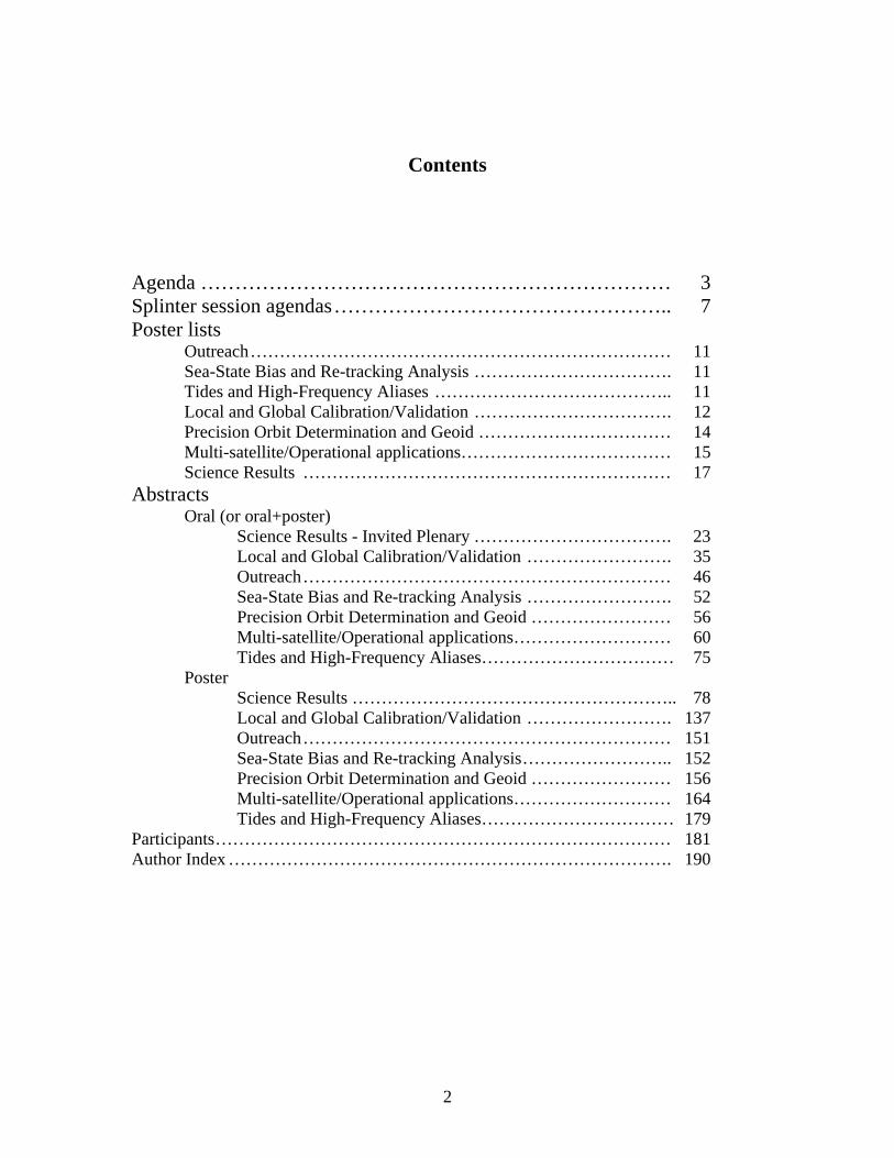
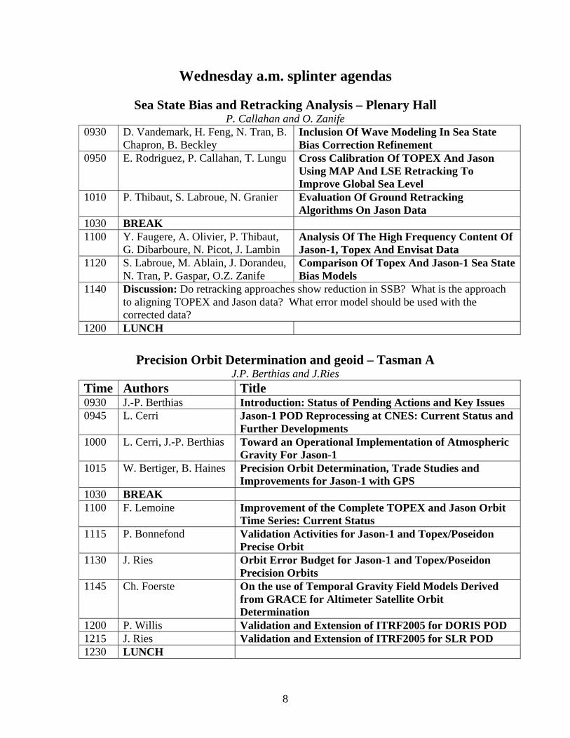
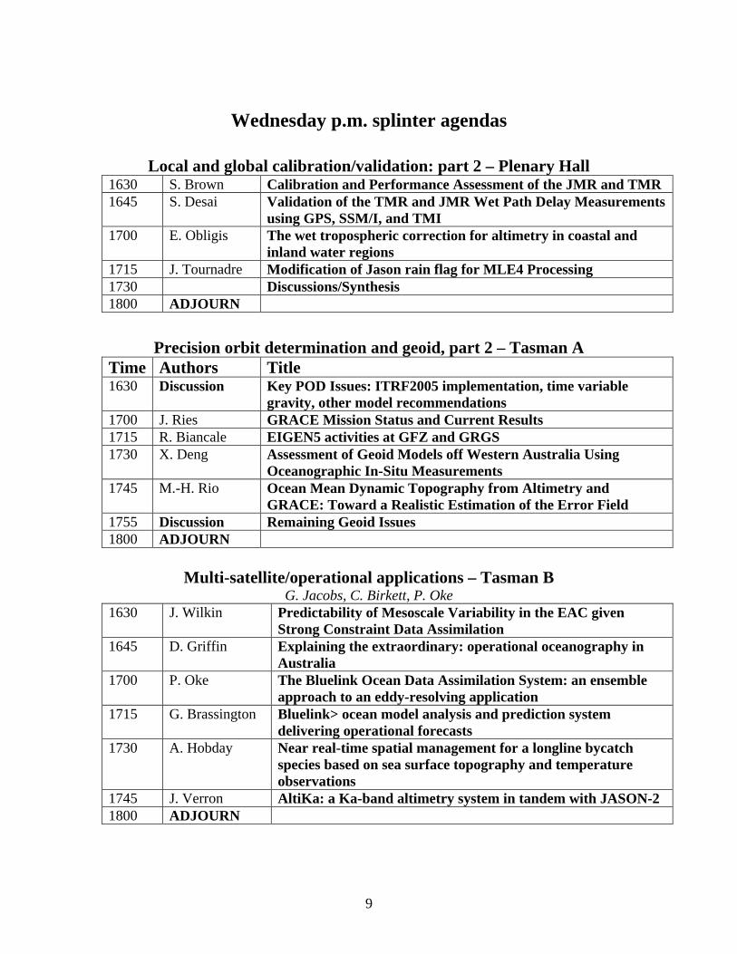
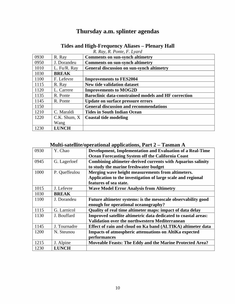
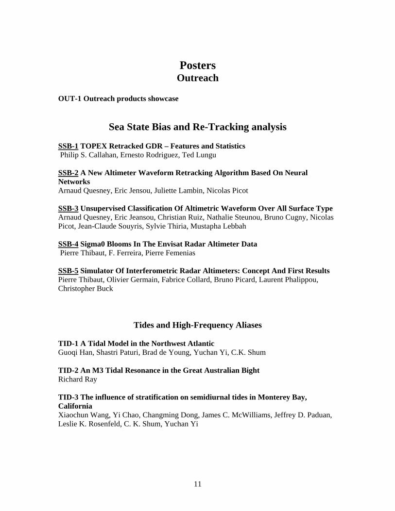
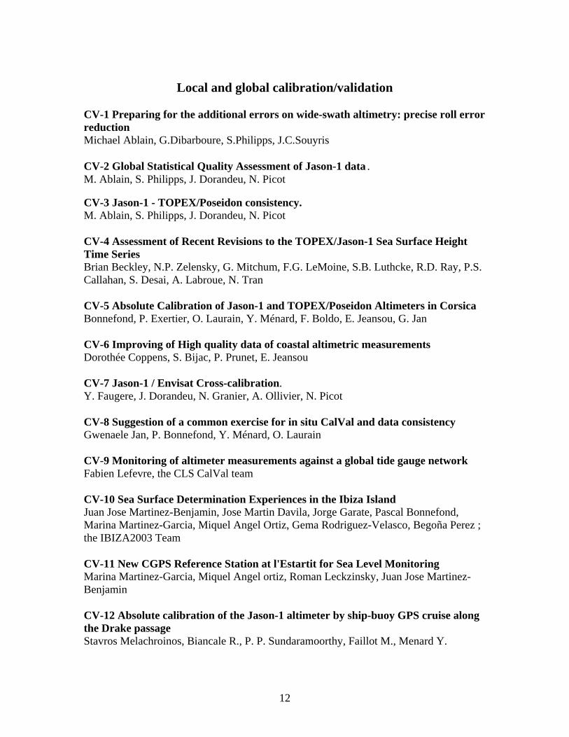
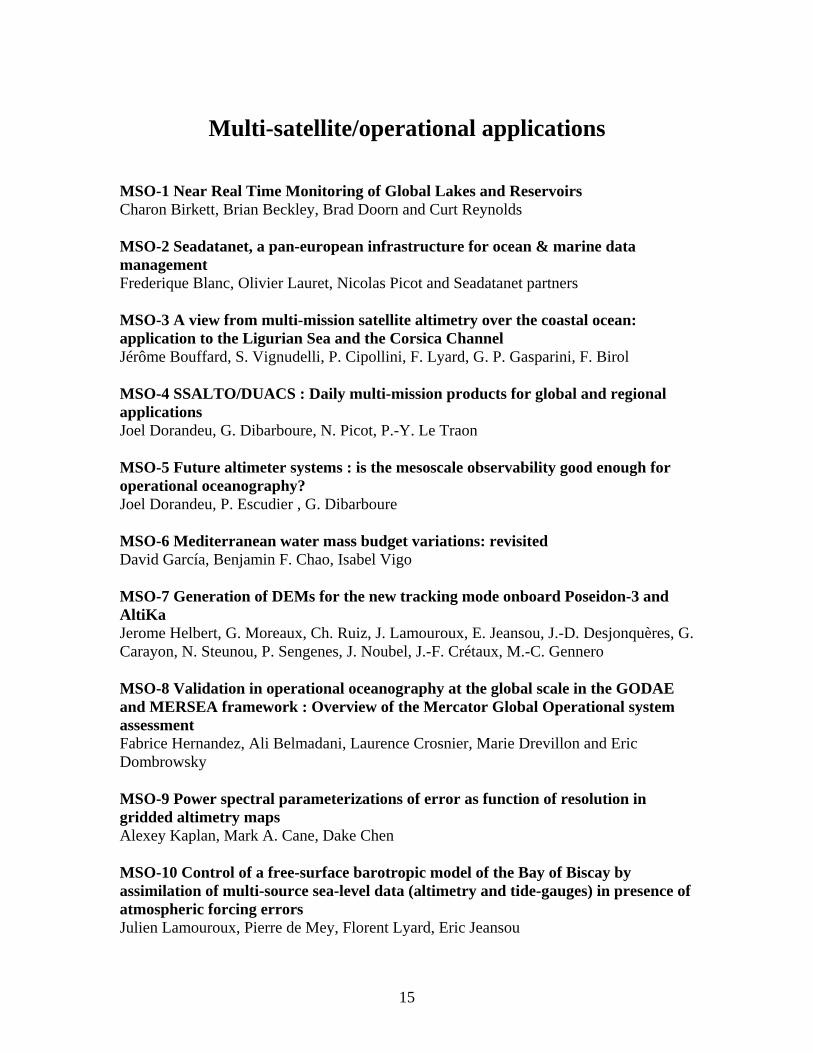
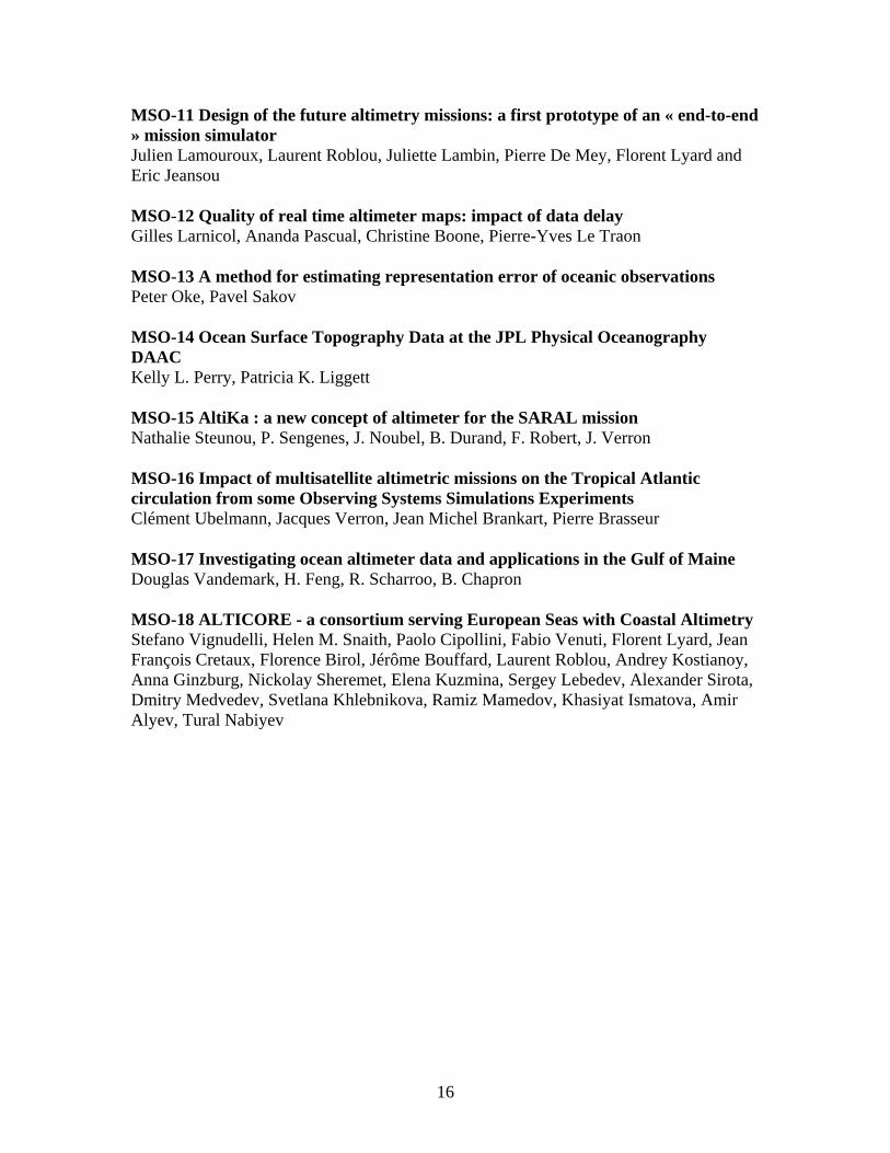
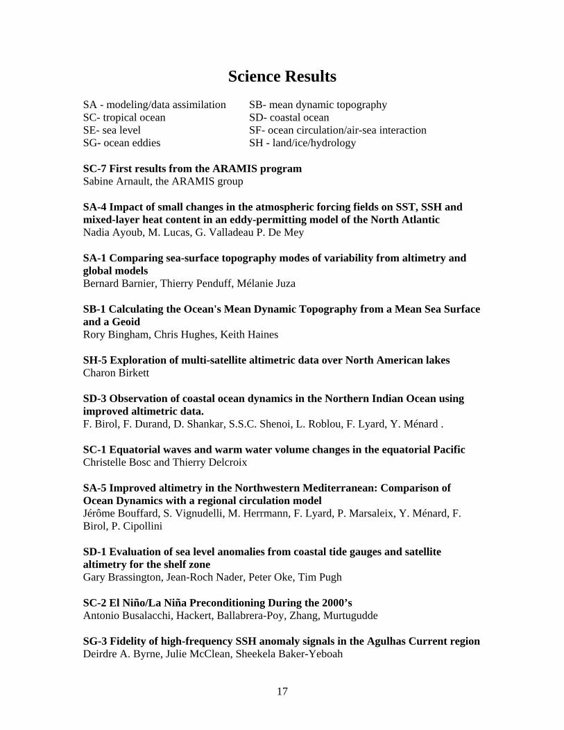
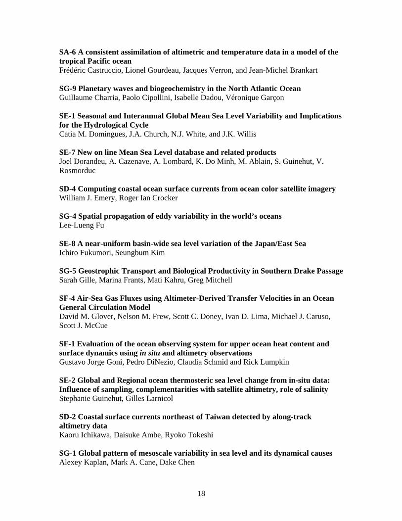
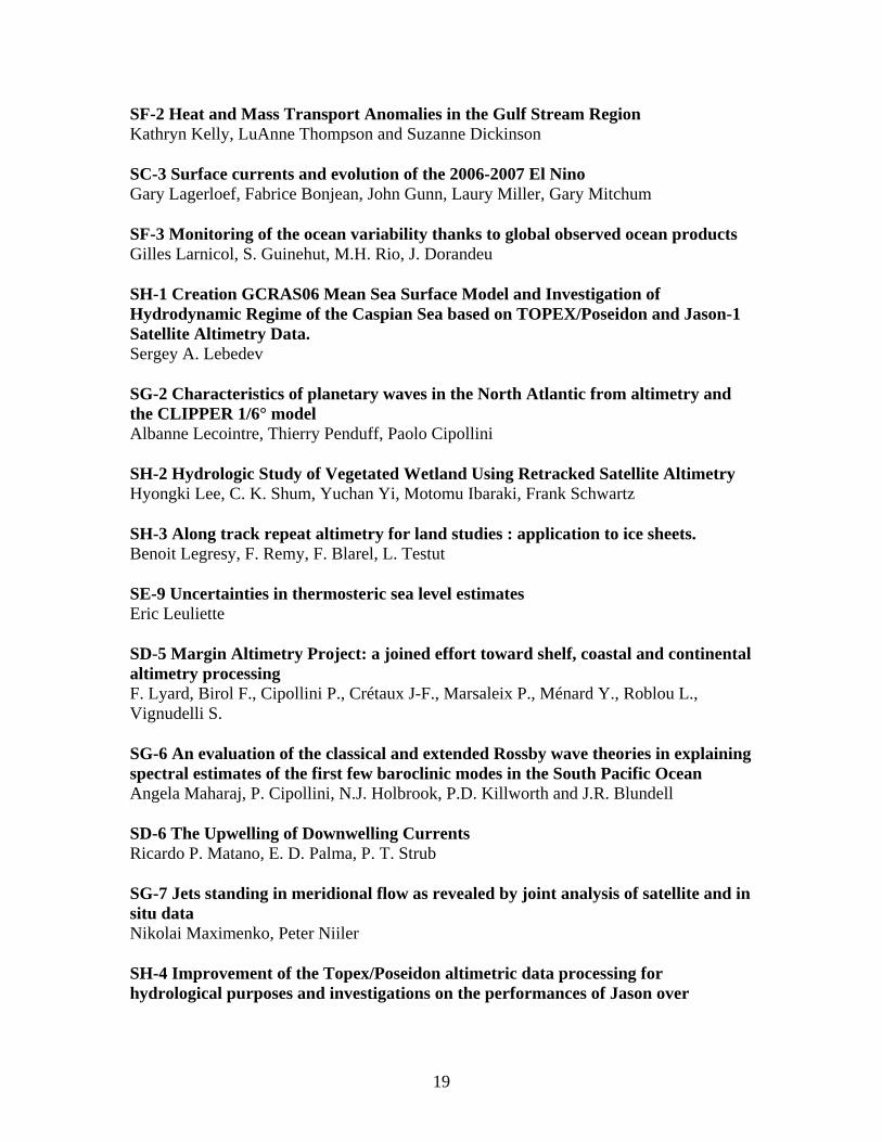
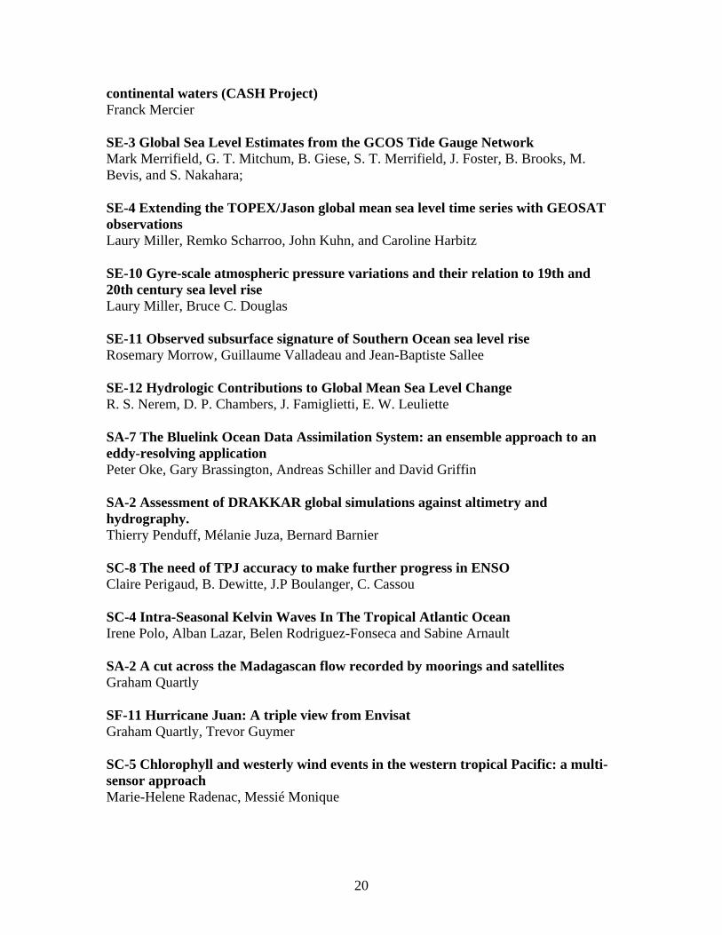