Embed Size (px)
Citation preview

From: RIES, A. C., BUTLER, R. W. H. & GRAHAM, R. H. (eds) 2007. Deformation of the Continental Crust: TheLegacy of Mike Coward. Geological Society, London, Special Publications, 272, 321–343.0305-8719/07/$15 © The Geological Society of London 2007.
The Andes extend for about 7000 km along thewest coast of South America (Fig. 1). At thisconvergent plate margin, the Nazca Plate andother oceanic plates subduct beneath the conti-nental part of the South American Plate. Themost notable topographic features of the Andesare: (1) several peaks over 6000 m; (2) a wide cen-tral plateau (Altiplano–Puna); (3) strong bendsto north and south of the plateau; (4) belts trend-ing east–west at the northern and southern edgesof South America. The last are transcurrentboundaries, where continental South Americaabuts oceanic micro-plates (Caribbean in thenorth, Scotia in the south).
The main cause of high altitude in the Andesis a thick crust. The Moho is abnormally deepbeneath the Andes, reaching 70 km beneath theAltiplano (Wigger et al. 1994; Yuan et al. 2002).Elsewhere across South America, except on the
continental shelf, the Moho is at normal or near-normal depth. Abnormal crustal thickness in theAndes is mainly due to east–west shortening,in response to rapid convergence at the Pacificmargin. Magmatism is a secondary contributorto crustal thickness.
The average width and elevation of the Andesvaries along strike, as does the amount of short-ening. This variation correlates with changesin the dip and perhaps in the buoyancy of thesubducting oceanic plates (Jordan et al. 1983;Gutscher et al. 2000; Gutscher 2002). Which isthe cause and which is the consequence? Howdoes the structural style vary along strike? Doesit change gradually or suddenly? Does it correlatewith oroclinal bending of the mountain belt(Isacks 1988)?
Further questions are about timing. Sincewhen has shortening accumulated? Is it relatively
Distribution, timing, and causes of Andean deformationacross South America
PETER R. COBBOLD1, EDUARDO A. ROSSELLO1,2, PIERRICK ROPERCH1,3,CÉSAR ARRIAGADA1,4, LUIS A. GÓMEZ1,5 & CLAUDIO LIMA1,6
1Géosciences-Rennes (UMR6118 du CNRS), Université de Rennes 1, 35042 Rennes Cedex,France (e-mail: [email protected])
2CONICET y Departamento de Ciencias Geológicas, Universidad de Buenos Aires,Buenos Aires, Argentina
3IRD (UR154–LMTG), 14 rue Edouard Belin, 31400 Toulouse France4Departamento de Geología, Universidad de Chile, Casilla 13518, Correo 21,
Santiago, Chile5Ecopetrol, Bogotá, Colombia
6CENPES, Petrobras, Rio de Janeiro, Brazil
Abstract: The Andean Orogeny in South America has lasted over 100 Ma. It comprises thePeruvian, Incaic and Quechuan phases. The Nazca and South American plates have beenconverging at varying rates since the Palaeocene. The active tectonics of South America arerelatively clear, from seismological and Global Positioning System (GPS) data. Horizontalshortening is responsible for a thick crust and high topography in the Andes, as well as in SEBrazil and Patagonia. We have integrated available data and have compiled four fault maps atthe scale of South America, for the mid-Cretaceous, Late Cretaceous, Palaeogene and Neo-gene periods. Andean compression has been widespread since the Aptian. The continentalmargins have registered more deformation than the interior. For the Peruvian phase, notenough information is available to establish a tectonic context. During the Incaic phase,strike-slip faulting was common. During the Quechuan phase, crustal thickening has beenthe dominant mode of deformation. To investigate the mechanics of deformation, we havecarried out 10 properly scaled experiments on physical models of the lithosphere, containingvarious plates. The dominant response to plate motion was subduction of oceanic lithospherebeneath continental South America. However, the model continent also deformed internally,especially at the margins and initial weaknesses.

322 P. R. COBBOLD ET AL.
recent, or does Andean deformation have a longhistory? Did it go through phases of increasedactivity?
A closer look at the topography of SouthAmerica will show that high altitudes also occurwell outside the Andes (Fig. 1). Over much ofPatagonia, altitudes reach 1000 m. In the prov-ince of Buenos Aires, basement blocks reach
1243 m. In SE Brazil, a plateau rises eastward,reaching nearly 3000 m near the coast. TheGuiana Highlands do reach 3000 m. Corre-spondingly, the Moho is anomalously deep inthese areas, reaching 43 km beneath SE Brazil(see references given by Cobbold et al. 2001) and46 km beneath the Guiana Plateau (Schmitzet al. 2002). Between the highlands are large
Fig. 1. Current topography of South America and surrounding tectonic plates. Spot heights are in metres. (Noticealtitudes over 6000 m in Andes; close to 3000 m in Guiana Highlands and SE Brazil; and over 1000 m inPatagonia.) Background is shaded relief map of South America and surrounding ocean floor. This is not a mapprojection, but a 2D plot of latitude v. longitude.

323ANDEAN DEFORMATION ACROSS SOUTH AMERICA
depressions, almost at sea level. What causessuch anomalous values of altitude and crustalthickness? Could it be Andean compression?Why do the anomalies occur in specific places?
The current paper follows the outline of aprevious talk (Cobbold et al. 1996). However, itincludes more data. We consider first the plate-tectonic context of South America. Next wesummarize the active deformation, according torecent geophysical and geological investigations.Then we discuss the history of deformation. Weconsider areas where the quality of exposure isgood at the surface, or where the petroleumindustry has acquired subsurface data. The bestconstraints on the style and timing of deforma-tion come from sedimentary basins, where stratahave accumulated over long periods of time andages are unequivocal. Two outstanding butneglected examples are the Atacama Basin ofnorthern Chile and the Neuquén Basin of west-ern Argentina. Good data also come from thepassive margin of SE Brazil and from the EasternCordillera of Colombia. On the strength of theseand other data, we have compiled new fault mapsfor Andean deformation at the scale of SouthAmerica. Finally, we have resorted to physicalmodelling, as a way of explaining some of ourobservations.
Plate tectonics
The South American Plate is partly continentaland partly oceanic (Fig. 1). On all sides, except inCentral America, the surrounding plates are oce-anic. Currently, the Nazca, Cocos and Caribbeanplates all subduct beneath continental SouthAmerica. Since the Late Cretaceous, this scenariohas not changed very much, except that theNazca and Cocos plates appeared at 23.4 Ma, bysplitting of the Farallon Plate (see Tebbins &Cande 1997), and that the ridges between adja-cent oceanic plates have migrated northwardswith respect to South America (Nürnberg &Müller 1991). A more significant complicationhas been collision with Central America, whichstarted in the Miocene. Almost certainly, themain causes of Andean Orogeny were, andcontinue to be, rapid convergence between theNazca and South American plates and thermalweakening of the crust above the subductionzone (Isacks 1988). At the Caribbean and Scotianmargins, convergence and transcurrent motionshave introduced significant local complexities.However, there is no evidence that any continent,other than Central America, has collided withSouth America since the Late Cretaceous.
A factor that is less easy to take into account isplate motion with respect to an underlying fixed
mantle. Silver et al. (1998) have suggested thatwestward motion of South America inducesa significant drag at the base of the lithosphereand therefore modifies the balance of horizontalforces. However, the possible consequences ofthis model for Andean Orogeny remain to beexplored.
Convergence at the Pacific margin was fasterthan usual during the Eocene and late Mioceneand this may explain the Incaic and Quechuaphases of the Andean Orogeny (Pardo-Casas &Molnar 1987; Somoza 1998). Unfortunately,plate reconstructions are less precise for earlierperiods, because oceanic crust of that age hasbeen subducted and its magnetic anomalies arenot available for study (Nürnberg & Müller1991).
Current deformation
Stress
The World Stress Map is a global compilationof contemporary tectonic stress data. The stressmaps are available online (Reinecker et al. 2004)and show the orientation of the greatest horizon-tal compressive stress (SH). The data comefrom focal mechanisms of earthquakes, boreholebreakouts and other reliable sources. For SouthAmerica, the data come mainly from seismicallyactive areas, including the Andes but also Brazil(Fig. 2). Unfortunately, data are sparse forPatagonia, although the area is seismically active.
In general, seismic activity is more widespreadthan the World Stress Map would suggest. Thisis because many earthquakes have not yieldedreliable fault plane solutions. In South America,seismic activity is especially widespread, not onlyover the highlands, but also over many of thesedimentary basins and even the continentalmargins. Thus almost the entire continent isactively deforming in one way or another.
According to the World Stress Map, SouthAmerica is dominantly undergoing thrust fault-ing, as a result of horizontal compression. Over-all, SH is close to east–west and this would appearto reflect rapid convergence at the Pacificmargin. However, in the NW and SE corners ofSouth America, respectively, SH trends NW–SEand NE–SW. These directions are compatiblewith strike-slip faulting at the northern andsouthern continental margins, and also withcontinuing collision of Central America(Pennington 1981). On a more local scale, in theforearc of the Andes and on their eastern slopes,SH tends to be perpendicular to the maintopographic scarps. Thus gravitational forcesmay contribute to the local state of horizontalcompression.

324 P. R. COBBOLD ET AL.
Fig. 2. Current stress in South America (World Stress Map, 2004 release, Reinecker et al. 2004). (Notice thrustfaults (TF) over much of continent, strike-slip faults (SS) at northern and southern margins and normal faults(NF) in high Andes of Peru. Other faults are unclassified (U). Map projection is Mercator.

325ANDEAN DEFORMATION ACROSS SOUTH AMERICA
Thrust faulting also occurs in the highlands ofSE Brazil and the Amazon Basin. Although notin the same database, data are available atregional scale for SE Brazil, including the off-shore continental margin, where focal mecha-nisms indicate thrust faulting (Assumpção 1998).Thus it is reasonable to infer that at least part ofthe currently abnormal crustal thickness of SEBrazil is due to recent shortening and thickening(Cobbold et al. 2001).
Strike-slip faulting is common in NW SouthAmerica, near the transcurrent boundary of theCaribbean Plate. Normal faulting occurs at theeastern end of this boundary. Normal faulting isalso common in the high Andes of northern Peru,where SH trends more nearly east–west.
GPS velocities
The Global Positioning System (GPS) hasallowed measurements to be made of changes inposition (displacements) over a period of severalyears. Where there is a displacement gradient,the problem is to know how much of the strainis elastic and how much is non-elastic orpermanent.
The first data for South America, althoughsubject to error, seemed to indicate that the Cen-tral Andes were shortening horizontally, whereasthe foreland was not (Norabuena et al. 1998).Updated results, part of SNAPP (South America–Nazca Plate motion Project; World WideWeb Address: http://www.earth.northwestern.edu/research/snapp.html), are similar (Fig. 3).Like SH in the World Stress Map (Fig. 2), GPSvelocity vectors trend broadly east–west (Fig. 3).However, recent surveys seem to indicate thatonly a small portion of the GPS signal is dueto permanent deformation (O. Heidbach, pers.comm.). Following major earthquakes at Anto-fagasta (1995) and Arequipa (June 2001), a largepart of the strain recovered and was presumablyelastic. Thus longer-term observations wouldappear to be necessary.
A separate dataset is available for the NWcorner of South America (Trenkamp et al. 2002).Relative to stable South America, the NW corneris moving to the NE, causing a combination ofshortening and strike-slip motion.
Palaeomagnetic data
Palaeomagnetic data have shown that the curva-ture of the Central Andes is mainly due to defor-mation; in other words, that it is an orocline(Randall 1998, and references therein; Coutandet al. 1999b; Roperch et al. 2000; Lamb 2001;Arriagada et al. 2003; Gilder et al. 2003; Rousse
et al. 2003; Richards et al. 2004). This is animportant fact, which helps us to understandhow deformation has accumulated in the highestand widest part of the Andes. Because thecurvature of the Andes coincides with that of thecoastline, it may be that oroclinal bending isresponsible for both features.
We have synthesized the available data in theform of four maps (Fig. 4), showing the amountof rotation for rocks in four age groups: Neo-gene, Palaeogene, Mesozoic and Palaeozoic. Asimple pattern emerges, in which rotations areclockwise in the southern part of the centralAndes and counter-clockwise in the northernpart. We infer that (1) oroclinal bending hasoccurred since the Cretaceous, and (2) theolder the rocks, the larger is the amount ofrotation. In other words, oroclinal bending hasaccumulated progressively since the Cretaceous.
For the modern forearc of northern Chile andsouthern Peru, the palaeomagnetic data showthat most of the rotation occurred before theNeogene, and probably in the Eocene (Arriagadaet al. 2003). If further data bear out this conclu-sion, it has to be accepted that the Central Andeshave a long history and that Neogene deforma-tion is no more than a final, and perhaps small,fraction of it.
Fault maps
We have compiled four diagrammatic maps,summarizing the style and timing of deformationacross continental South America (Figs 5–8).The maps have not been compiled accuratelyusing, for example, a geographical informationsystem. Instead they are schematic, and shouldbe considered as illustrations or reviews ofcurrent knowledge.
The maps are labelled (1) mid-Cretaceous,(2) Late Cretaceous, (3) Palaeogene, and (4)Neogene. For the purposes of this paper, thesenames will be used informally, to represent (1)the Aptian to Albian, (2) the Cenomanian toMaastrichtian, (3) the Palaeocene to Oligocene,and (4) the Miocene to Recent. The last threemaps encompass the Peruvian, Incaic andQuechua phases of Andean Orogeny, as definedby Steinmann (1929). In his view, these phaseswere relatively well-defined and separate events.However, there is some evidence that compres-sional basins have been forming intermittentlysince the Late Cretaceous (Noblet et al. 1996).
The quality and abundance of our fault dataare not even. On the Neogene map, fault tracesare relatively abundant in the highlands,where outcrop is of good quality, and in the

326 P. R. COBBOLD ET AL.
Fig. 3. Current GPS velocities in Central and Northern Andes. Reference values (bottom left) are for velocity ofNazca Plate with respect to South America, according to GPS measurements and plate model NUVEL-1A.Background is shaded relief map of South America and surrounding ocean floor. This is not a map projection,but a 2D plot of latitude v. longitude.
sedimentary basins, where petroleum explora-tion has been active (Fig. 5). On the other threemaps, fault traces are sparse. However, thatdoes not necessarily mean that pre-Neogenedeformation was less intense. An absence of datamay simply reflect the age of the rocks. In theforeland, old rocks have subsided beneath morerecent sediment. In the mountains, they haveundergone uplift and exhumation. In general,the older the deformation, the poorer is theremaining evidence.
Neogene (Fig. 5)
On the Neogene map, reverse faults dominate.Most of them are in the Andes, where they tendto coincide with current topographic scarps.We infer that the mountains have been througha period of uplift in the Neogene, as a result ofcrustal shortening and thickening.
(1) In the Central Andes, the dominant faultvergence is eastward in the eastern Sub-Andes,and westward on the western sides of the Eastern

327ANDEAN DEFORMATION ACROSS SOUTH AMERICA
Fig. 4. Tectonic rotations in Central and Peruvian Andes. Data are from Randall (1998) and more recentpublications (Coutand et al. 1999; Roperch et al. 2000; Lamb 2001; Arriagada et al. 2003; Gilder et al. 2003;Rousse et al. 2003; Richards et al. 2004). Rotations (open arrows) and their error ranges (black triangular sectors)are with respect to current north. Senses of rotation (clockwise in south, counter-clockwise in north) may explaintrends of Andes and coastline. For Mesozoic and Cenozoic host rocks, magnitude of rotation increases with age(in Ma, white boxes). This is not a map projection, but a 2D plot of latitude v. longitude.
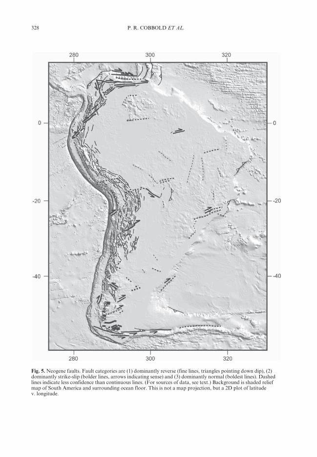
328 P. R. COBBOLD ET AL.
Fig. 5. Neogene faults. Fault categories are (1) dominantly reverse (fine lines, triangles pointing down dip), (2)dominantly strike-slip (bolder lines, arrows indicating sense) and (3) dominantly normal (boldest lines). Dashedlines indicate less confidence than continuous lines. (For sources of data, see text.) Background is shaded reliefmap of South America and surrounding ocean floor. This is not a map projection, but a 2D plot of latitudev. longitude.
329ANDEAN DEFORMATION ACROSS SOUTH AMERICA
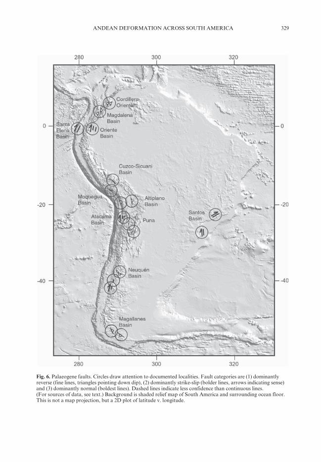
Fig. 6. Palaeogene faults. Circles draw attention to documented localities. Fault categories are (1) dominantlyreverse (fine lines, triangles pointing down dip), (2) dominantly strike-slip (bolder lines, arrows indicating sense)and (3) dominantly normal (boldest lines). Dashed lines indicate less confidence than continuous lines.(For sources of data, see text.) Background is shaded relief map of South America and surrounding ocean floor.This is not a map projection, but a 2D plot of latitude v. longitude.

330 P. R. COBBOLD ET AL.
Fig. 7. Late Cretaceous faults. Circles draw attention to documented localities. Fault categories are (1)dominantly reverse (fine lines, triangles pointing down dip), (2) dominantly strike-slip (bolder lines, arrowsindicating sense) and (3) dominantly normal (boldest lines). Dashed lines indicate less confidence than continuouslines. (For sources of data, see text.) Background is shaded relief map of South America and surrounding oceanfloor. This is not a map projection, but a 2D plot of latitude v. longitude.

331ANDEAN DEFORMATION ACROSS SOUTH AMERICA
Fig. 8. Mid-Cretaceous faults. Circles draw attention to documented localities. Fault categories are (1)dominantly reverse (fine lines, triangles pointing down dip), (2) dominantly strike-slip (bolder lines, arrowsindicating sense) and (3) dominantly normal (boldest lines). Dashed lines indicate less confidence than continuouslines. (For sources of data, see text.) Background is shaded relief map of South America and surrounding oceanfloor. This is not a map projection, but a plot of latitude v. longitude.

332 P. R. COBBOLD ET AL.
Cordillera (Allmendinger et al. 1997; Baby et al.1997; Müller et al. 2002; Echavarria et al. 2003)and Western Cordillera (Muñoz & Charrier1996). Thus the Eastern Cordillera is the surfaceexpression of a large crustal pop-up. Between theEastern and Western cordilleras is the AltiplanoBasin, which went through a late stage of devel-opment in the Neogene (Lamb & Hoke 1997;Lamb et al. 1997; Rochat et al. 1999). The mainreverse faults of the Central Andes are deep-seated, but they branch upward into thin-skinnedstructures, especially in the Sub-Andes. Thewestward vergence of the Eastern Cordillera isinherited from the Late Palaeozoic, when crustalthickening was also active (Müller et al. 2002).Cleaved Ordovician slates are overlain uncon-formably by Cretaceous redbeds, which them-selves were deformed in Palaeogene and Neogenetimes. Also inherited in part, from the shape ofa Palaeozoic basin, is the arcuate form of theSub-Andes (Baby et al. 1996).
(2) Across the high plateau (Puna) of NWArgentina, reverse faults lie between alternatingranges and basins (Allmendinger et al. 1997;Coutand et al. 2001).
(3) Reverse faults also bound most of theuplifted basement blocks in the Pampean rangesof NW Argentina (Allmendinger et al. 1983;Jordan & Allmendinger 1986; de Urreiztieta et al.1996). Again, the dominant vergence is westward.In the southern ranges, the reverse faults haveformed by reactivation of Early Cretaceous riftbasins (Schmidt et al. 1995; Webster et al. 2004).
(4) In Peru and Ecuador, reverse faults arethe main structural features of the cordillerasand Sub-Andes (Mathalone & Montoya 1995;Steinmann et al. 1999; Gil Rodríguez et al. 2001;Hermoza et al. 2005).
(5) Reverse faults are common beneathNeogene strata of the retro-arc foreland basin inEcuador (Baby et al. 1999) and northern Peru(Gil Rodríguez et al. 2001), where they haveformed by right-lateral transpressional reactiva-tion of Mesozoic normal faults.
(6) The High Andes of west–central Argentinaand central Chile are mainly due to reversefaulting of Neogene age (Ramos et al. 1996).
(7) Reverse faults occur in and around thePantanal Basin of western Brazil (Milani et al.1990), near the geographical centre of SouthAmerica.
(8) The Guiana highlands are seismicallyactive and the crust is thick, but whether ornot this is due to Neogene shortening remainssomething of a mystery.
(9) The cordilleras of Colombia and Venezu-ela are mainly crustal pop-ups, which haveformed by reactivation of Mesozoic rift basins, ina context of right-lateral transpression (Colletta
et al. 1990, 1997; Taboada et al. 2000; Branquetet al. 2002).
(10) Transpression also explains the recentaltitudes and scarps on the Atlantic margin ofBrazil (Cobbold et al. 2001). Active fault tracesline the Taubaté Rift and the River Paraíba doSul, as far as the coast. In the Taubaté Rift, Neo-gene wrenching has folded and faulted Oligocenelacustrine strata.
(11) In Patagonia, reverse and strike-slipfaults of Neogene age have been described inthe Andes (Ramos 1989; Cembrano et al. 1996;Diraison et al. 1998), and recent faults are visibleon published geological maps and satelliteimages of the foreland.
(12) Strike-slip faults prevail at the southernand northern edges of South America, which aretranscurrent plate boundaries. At the northernedge the motion is right-lateral (Kellogg et al.1985; Trenkamp et al. 2002), whereas at thesouthern edge it is left-lateral (Cunningham1993; Diraison et al. 2000).
(13) In the Amazon Basin of Brazil, Neogenestrike-slip faulting has reactivated a Palaeozoicrift (Mossman et al. 1984). The faults trend east–west as far as the margin, where they run intoseismically active oceanic fracture zones.
(14) Normal faults along the Magellan Straitindicate that the island of Tierra del Fuego hasbeen separating from mainland Patagonia andthat the principal compression is NE–SW(Diraison et al. 1997, 2000). Normal faults alsooccur to the north, as far as Lago GeneralCarrera in Chile, where they coincide with thesubducted East Chile Rise (Lagabrielle et al.2004).
(15) The Gulf of Guayaquil is a pull-apartbasin, containing some 5000 m of Plio-Pleistocene strata (Deniaud et al. 1999). Normalfaults, reverse faults and strike-slip faults forma horsetail splay at the SW end of the Dolores–Guayaquil Megashear, which coincides with asharp bend in the Andes and adjacent coastline.
Palaeogene (Fig. 6)
(1) In the Central Andes, reverse faults of Palaeo-gene age were active in the forearc of Peru(Noblet et al. 1996) and northern Chile(Arriagada et al. 2002, 2006), in the AltiplanoBasin and Cordillera Oriental of Bolivia (Lamb& Hoke 1997; Lamb et al. 1997; Müller et al.2002), and in several intramontane basins of thehigh plateau (Puna) of NW Argentina (Coutandet al. 2001; Carrapa et al. 2005). Horton (2005)has identified a formerly widespread foredeep, inwhich middle Eocene to Oligocene strata accu-mulated during a period of significant shorteningto the west. Such a distribution indicates that

333ANDEAN DEFORMATION ACROSS SOUTH AMERICA
the Andes have propagated eastward since thePalaeocene (McQuarrie et al. 2005).
(2) In the Western Cordillera of central Peru,the Incaic phase of deformation resulted in foldsand reverse faults, which are overlain in regionalunconformity by well-dated Eocene strata andvolcanic rocks (Steinmann 1929; Noble et al.1979, 1990).
(3) Reverse faults of Palaeogene age wereactive in the Oriente Basin of Ecuador(Christophoul et al. 2002), in the EasternCordillera of Colombia (Julivert 1963; De Freitaset al. 1997; Gómez 2003), and in the adjacentMagdalena Valley (Schamel 1991; Laumonieret al. 1996; Gómez et al. 2003).
(4) In Patagonia, there was thrusting andstrike-slip faulting in the foothills of the NeuquénBasin (Cobbold & Rossello 2003) and in theMagallanes foreland basin (Ramos 1989;Alvarez-Marrón et al. 1993; Diraison et al. 2000;Ghiglione & Ramos 2005).
(5) In SE Brazil, older structures underwenttranspressional reactivation in the Palaeogene(Cobbold et al. 2001).
Late Cretaceous (Fig. 7)
(1) In the Central Andes, reverse faults of LateCretaceous age controlled subsidence of aforeland basin, now the Atacama Basin in theforearc of northern Chile (Arriagada et al. 2002,2006; Mpodozis et al. 2005). Reverse faults alsoappeared in the Copiapó area, inverting earlierMesozoic rifts (Mpodozis & Allmendinger 1993).
(2) Reverse faults were active in the OrienteBasin of Ecuador (Baby et al. 1999).
(3) In the Neuquén Basin of northernPatagonia, thrusting led to regional subsidencein a continental foreland basin, where redbedsaccumulated (Cobbold & Rossello 2003). Thesame association occurs further south, in theChubut Basin.
(4) In the southernmost Andes, thrust tecton-ics caused regional subsidence in the Magallanesforeland basin and simultaneous uplift of meta-morphic rocks in Cordillera Darwin (Dalziel &Palmer 1979; Nelson et al. 1980; Winslow 1982;Klepeis 1994; Coutand et al. 1999a; Diraisonet al. 2000; Ghiglione & Ramos 2005).
(5) In SE Brazil, the coastal ranges underwentuplift and exhumation (Cobbold et al. 2001).
(6) On the Atlantic margin of NE Brazil, therewere phases of transpressional deformation inthe Piauí Basin (Zalán et al. 1985) and in thePotiguar Basin.
Mid-Cretaceous (Fig. 8)
Although for many years the mid-Cretaceouswas seen as a period of rifting or passive
subsidence, evidence is accumulating for an onsetof compressional deformation in the Aptian.
(1) Growth strata from the Neuquén Basin(Cobbold & Rossello 2003) and the AtacamaBasin (Arriagada et al. 2002, 2006; Mpodoziset al. 2005) point clearly to a context of shorten-ing and thickening. In both basins, transitionalevaporites and continental redbeds overliemarine strata that accumulated in a rift settingduring the Jurassic and Early Cretaceous.
(2) In what is now the Coastal Range of cen-tral Chile, ductile shortening occurred during themid-Cretaceous (Arancibia 2004).
(3) In the Magallanes Basin, the earliest phaseof uplift, erosion and formation of a forelandbasin was of mid-Cretaceous age (Winslow 1982;Diraison et al. 2000).
(4) In the San Julián Basin, offshore southernPatagonia, an Early Cretaceous rift basin becamestrongly inverted, folded and faulted underAptian transpression (Homovc & Constantini2001).
(5) The same can be said for SE and NEBrazil, where compressional reactivation of thecontinental margin started shortly after theformation of an Aptian break-up unconformity(Cobbold et al. 2001; Meisling et al. 2001).
(6) The Amazon Basin, which formed in a riftsetting during the Palaeozoic, went through aphase of strong wrenching (Szatmari 1983),sometime between the Early Jurassic and theCenomanian, but most probably in the mid-Cretaceous. Right-lateral wrenching acted alongthe Amazon Basin (Caputo 1991), while, in thenascent Equatorial Atlantic, Africa was pullingaway in a right-lateral sense from SouthAmerica. The wrenching was responsible forstrike-slip faults, reverse faults, and large folds,which uplifted the Precambrian basement.Redbeds of Albian to Cenomanian age areunconformable upon it.
Summary
The amount of available data decreases accord-ing to its geological age, but otherwise the fourfault maps are broadly similar.
(1) All show reverse faulting in the CentralAndes.
(2) All show reverse faulting in Patagonia.(3) All show compressional or transpressional
reactivation in SE Brazil.(4) All show strike-slip faulting in the south-
ernmost Andes.(5) Two of them show strike-slip faulting in
the northernmost Andes.(6) Two of them show strike-slip reactivation
of the Amazon rift.(7) Two of them show compressional reactiva-
tion in NE Brazil.

334 P. R. COBBOLD ET AL.
The most obvious differences are as follows.(1) Neogene deformation is strongest in the
Central Andes.(2) Palaeogene deformation is prevalent in the
Northern, Central and Southern Andes.(3) Cretaceous deformation appears to be
prevalent in southern, eastern and central SouthAmerica (as far north as Ecuador).
The last statement should be qualified,because it may reflect the availability of data.Otherwise, one is struck by the almost ubiquitousnature of compressional deformation through-out South America since the mid-Cretaceous.This makes sense, in that the mid-Cretaceous wasa period of plate reorganization, following theopening of the South Atlantic (Nürnberg &Müller 1991). Ever since then, one would expectridge push to have been active in the SouthAtlantic, as well as in the Pacific, keeping SouthAmerica in a state of generalized compression.
Because the four fault maps are for periodswhen faulting appears to have been unusuallyactive, the intervening periods remain somewhatof a mystery. One such period is the Oligocene. Ithas been suggested that the Oligocene was a timeof normal faulting in SW South America (Jordanet al. 2001; Pananont et al. 2004). This is a subjectof intense interest and debate.
That compression caused shortening andthickening in the Andes is understandable, if ahigh heat flow was responsible for softening, butwhy did deformation occur repeatedly in otherareas, such as SE Brazil or the Amazon Basin?Was it simply that these areas were crustal weak-nesses, prone to reactivation, or did they respondto stress concentrations, resulting from condi-tions at the irregular boundaries of SouthAmerica?
Physical models
To obtain some insights into the mechanics ofdeformation at the scale of South America, 10experiments on physical models were carried outat Géosciences-Rennes in 1992 and 1994. Theyfollowed earlier work during which limited sub-duction of oceanic lithosphere had been observedin physical models (Pinet & Cobbold 1992;Pubellier & Cobbold 1996) and they served asa template for experiments on subduction thatwere performed later at Géosciences-Rennes(Faccenna et al. 1996). However, the work onSouth America was not published at the time,because it seemed premature. Here two of theexperiments are described (Figs 9 and 10). We donot pretend that they reproduce faithfully whathas occurred in South America, but we believe
that they provide some insights into potentialmechanisms of deformation at continental scale.
The model materials were (1) heavy sand(quartz sand from Fontainebleau, France), forthe brittle oceanic crust; (2) light sand (a mixtureof quartz sand and ethyl cellulose), for the brittlecontinental crust; (3) light silicone putty (GommeGS1R, manufactured by Rhône-Poulenc), forthe ductile continental crust; (4) heavy silicone (amixture of light silicone and powdered galena),for the mantle lithosphere; (5) clear honey for theasthenosphere (Table 1). The models were prop-erly scaled for gravitational forces (Table 2). Themodel ratio of length was 107. For further detailsof scaling and of the experimental technique, thereader may consult earlier publications (Davy &Cobbold 1988, 1991; Pinet & Cobbold 1992;Pubellier & Cobbold 1996).
The models were constructed and deformedwithin a square box, 110 cm wide and 30 cmdeep. First, the box was filled with honey. Next, alayer of heavy silicone was floated onto it. Then,a patch of light silicone was added, to representductile continental crust. Finally, a layer of lightor heavy sand completed the layering. A travel-ling trough poured the sand in thin layers ofuniform thickness and a mask was used to obtainthe required shape of the model continent.
To obtain transform boundaries withinoceanic crust, the sand was siphoned off alongnarrow strips, so that the heavy silicone rose tothe surface along them. To initiate subductionzones, thin strips of powdered bismuth sulphidewere added at the surface.
Deformation was imposed by one or moremobile plates, which travelled horizontally atsteady preset speeds, without touching thebottom of the box.
Experiment 1 (Fig. 9)
The objectives of this experiment were two.Would rapid subduction of oceanic lithospherecause shortening of an adjacent continent?Would initial weaknesses within the continentlead to heterogeneous shortening?
For simplicity, the continent was initiallyrectangular and homogeneous, except for aninitial zone of weakness, oblique to the margin,where sand was thinner (1 mm). The zone ofweakness was meant to represent a pre-existingstructure, such as one of the Mesozoic rifts ofSouth America.
To encourage subduction, a thin strip ofpowdered bismuth sulphide was added to the freeupper surface, at the edge of the oceanic lithos-phere. Being heavy, the bismuth sulphidemimicked in a simple way the increase in weight

335ANDEAN DEFORMATION ACROSS SOUTH AMERICA
Fig. 9. Physical model of subduction and oroclinal bending. Photographs show the upper surface of the model,before deformation (a), after 2 h (b), and after 21.5 h (c). Initial spacing of grid lines (dark) was 5 cm. Thecontinent (pale) was initially rectangular and homogeneous, except for an oblique zone of weakness (darker,dashed outline). Subduction of oceanic lithosphere (grey) was stimulated by adding a heavy strip of powderedbismuth sulphide (black) at the western edge of the continent. A single piston (right), advancing at 5 mm h−1,caused compression and rapid subduction. Close-up views (d)–(f) of rectangular boxes shown in (a)–(c) showprogressive deformation of the initial weakness and consequent oroclinal bending of the continental margin. Theheavy strip underwent variable amount of subduction. The experiment was performed at Géosciences-Rennes on10 June 1992 by E.A.R. and P.R.C.

336 P. R. COBBOLD ET AL.
Fig. 10. Physical model of plate tectonics around South America. Photographs show upper surface of model,before deformation (a), after 6 h of deformation (b), and after 14 h (c). Initial spacing of grid lines (dark) was5 cm. Reinforced markers (dashed lines) are for better interpretation. The continent (bottom centre) had theshape of South America (SAm) and was homogeneous, except for an initial weakness (dotted outline).Subduction of oceanic lithosphere was stimulated by adding heavy strips of powdered bismuth sulphide (black) atthe western edge of continent and along the Antilles arc (a). Initial faults were made by siphoning off sand. Onepiston (top left), advancing at 5 mm h−1, pushed the Nazca–Caribbean Plate (Nz-Ca) and North American Plate(NAm) eastward, but not the Antarctic Plate (An). A second piston (right) pushed all plates westward at2.5 mm h−1. Subducting Nazca Plate reached 7 cm under South America (continuous-line arrow, c). The edge ofthe continent became eroded (about 5 cm) by subduction (a). Transform motions accumulated on initial faults.Close-up (d) of the rectangular box in (c) shows details of deformation. Northern and southern parts ofcontinental South America rotated clockwise and counter-clockwise, respectively. The experiment was performedat Géosciences-Rennes on 24 June 1994 by C.L., E.A.R. and P.R.C.
337ANDEAN DEFORMATION ACROSS SOUTH AMERICA
that results from cooling and ageing of anoceanic lithosphere in nature.
Compression was applied at the eastern sideof the continent (right, Fig. 9) by a plate slidinghorizontally at 5 mm h−1. Because of friction atlateral boundaries, the compressive stress wasalmost certainly greatest next to the piston. Theplate velocity was much greater than the rate ofrollback of the slab under its own weight. Theexperiment lasted 21.5 h (equivalent to 122 Ma innature).
In the first stages of deformation, a thrustfault formed at the continental margin and theoceanic lithosphere started to subduct. However,after 2 h, subduction became irregular and thecontinent deformed (Fig. 9b). In particular,the initial weakness shortened and thickened(Fig. 9e). Another zone of deformation, markedby en echelon folds and thrusts, formed acrossthe NW corner of the continent. Where the conti-nent shortened, the oceanic plate subducted less.To north and south of the continent, subductionzones formed within the oceanic lithosphere.
As deformation accumulated in the zone ofinitial weakness, a large block to the south of itrotated clockwise, whereas areas to the northof it bent in oroclinal fashion (Fig. 9e and f). Thefinal result was an asymmetrically sinuous mar-gin, much like the west coast of South America.All this time, the adjacent oceanic lithospheresubducted, but did not deform internally, exceptby bending.
In conclusion, subduction initiated at themargin between continental and oceanic lithos-pheres, even though the greatest compressionwas on the other side of the continent. Rapidsubduction resulted in deformation next to theconvergent margin. The pattern of deformationreflected the mechanical heterogeneity of thecontinent. Large blocks rotated by slipping onthe subduction zone, and the margin becameasymmetrically curved.
Experiment 2 (Fig. 10)
The objective of this experiment was to investi-gate how a more realistic plate configurationmight influence the pattern of continentaldeformation.
Initially, the continent had the true currentshape of South America and it was homoge-neous, except for an initial zone of weakness,oblique to the margin, where the sand wasthinner (1 mm). As in the previous experiment,this zone of weakness was designed to representa pre-existing structure, such as one of theMesozoic rifts of South America. The surround-ing oceanic lithosphere was divided into plates.The boundaries between them were createdartificially.
To nucleate subduction, two thin strips ofpowdered bismuth sulphide were added to thefree upper surface, (1) at the edge of the oceaniclithosphere, next to the western margin of thecontinent, and (2) across the oceanic lithosphere,
Table 1. Physical properties of model materials
Material Density Viscosity Cohesion Internal friction Thickness of Thickness of(g cm−3) (Pa s) (Pa) (deg.) continent (mm) ocean (mm)
Light sand 1.2 0 45 2 0Heavy sand 1.5 50 45 0 3Light silicone 1.16 10000 2 0Heavy silicone 1.35 50000 4 4Honey 1.37 100 200 200
Table 2. Characteristic values and scaling
System Length Thickness Density Stress Viscosity Strain rate Time Velocity(m) (m) (kg m−3) (Pa) (Pa s) (s−1) (s) (m s−1)
Nature 750E+04 300E+02 300E+01 900E+06 100E+20 900E-16 111E+11 270E-11(7500 km) (30 km) (900 MPa) (0.35 Ma) (8.5 cm a−1)
Model 750E-03 300E-05 150E+01 450E-01 100E+02 450E-05 222E-00 135E-07(75 cm) (3 mm) (45 Pa) (3.7 min) (5 mm h−1)
Ratio 100E+05 100E+05 200E-02 200E+05 100E+16 200E-13 500E+08 200E-06
338 P. R. COBBOLD ET AL.
to the north of the continent. The latter repre-sented the convergent boundary (Antilles sub-duction zone) between the Caribbean and SouthAmerican plates.
Two other faults were created within theoceanic lithosphere by siphoning off the sand, sothat the underlying silicone rose to the surface.The faults represented the boundaries between(1) the Caribbean and North American platesand (2) the Nazca and Antarctic plates. TheNazca and Caribbean plates initially formed asingle plate.
A rigid western sidewall pushed the Nazca–Caribbean Plate, and the strip to the north of it,at a velocity of 5 mm h−1 (equivalent to 8.5 cm a−1
in nature). The direction of motion was at about80° to the continental margin (as occurs in SouthAmerica today). This action simulated ridgepush from the East Pacific Rise. Simultaneously,a rigid eastern sidewall pushed all the plates west-ward at a velocity of 2.5 mm h−1, simulating ridgepush from the Mid-Atlantic Rise. The experi-ment lasted 14 h (equivalent to 80 Ma in nature).As in the previous experiment, the plate velocitieswere greater than the rate of rollback of theslab under its own weight. Because of low shearstrength, the artificial faults behaved as trans-form boundaries. Between them, compressivestress was probably almost uniform across themoving Nazca–Caribbean Plate.
In the first stages of deformation, thrust faultsformed at the western margin of the continentand to the north of it. Immediately, the advanc-ing oceanic lithosphere subducted. Bridging thegap between subduction zones, a transcurrentfault formed at the northern margin of thecontinent. After 2 h, a zone of thrusting andhigh topography, resembling Central America,appeared spontaneously within the moving oce-anic plates. Subduction continued in the Antilleszone, but at about half the rate of subductionat the main convergent margin. By the end ofthe experiment, the Nazca Plate had subductedabout 7 cm (arrow, Fig. 10d), or 700 km innature. To this should be added about 5 cm(500 km in nature) of subduction-erosion at theedge of the continent.
The grids show that the northern and centralparts of the continent rotated clockwise by about10° with respect to the surrounding oceanicplates. In contrast, the southern part (Patagonia)rotated counter-clockwise. The clockwise rota-tion of the northern and southern parts probablyresulted from (1) rapid advance of the Nazca andCaribbean plates, relative to the Antarctic Plate,and (2) frictional drag at the northern boundary.The counter-clockwise rotation of the southernpart may have been due to drag at its southern
boundary. The relative rotation between conti-nental and oceanic parts of South Americaresulted in deformation along the continentalmargins. In particular, there was shortening andthickening along the SE margin, and rifting atthe western margin next to the triple junction(Fig. 10d).
Horizontal compression was responsible formore generalized deformation at the continentalmargins. Because the eastern margins wereoblique to the greatest stress, they took up strike-slip motion, right-lateral at the SE margin, andleft-lateral at the NW margin. The wrenchingresulted in en echelon folds and reverse faults.Between zones of wrenching, the two easternapices of the continent thrust over the adjacentoceanic lithosphere. At the western margin, nextto the subduction zone, the zone of initial weak-ness took up some shortening, although less sothan in the previous experiment. Elsewhere, thecontinent suffered little internal deformation.
Discussion
The fault maps presented here show thatcompressional deformation in continental SouthAmerica has accumulated primarily in theAndes, but also at other locations around themargins, especially SE Brazil and Patagonia.Moreover, deformation has been recurrent inthese areas. This is not surprising, because theplate configuration and general directions ofmotion around continental South America havenot changed greatly since the mid-Cretaceous.Mechanically speaking, the boundary conditionshave remained relatively stable. Minor changesin the direction and speed of plate motions canaccount for variations in the rate of deformationand in structural style (the phases of Steinmann1929).
Experiment 2, which had stable boundaryconditions, also showed recurrent deformationalong certain segments of the continental margin.In particular, it showed (1) strike-slip deforma-tion at the northern and southern margins of thecontinent, as well as the SE and NW margins,and (2) thrusting around the eastern coastalpromontories of Brazil and southern Patagonia.The former is easily understood in terms of east–west compression and lateral friction. In con-trast, the latter results from wholesale rotation ofnorthern and southern parts of the continent.Such a complex motion has not been suggestedbefore for the real South America, but it mightexplain the shortening and topography of thecoastal mountains of SE Brazil and the MauriceEwing Bank (south of the Falkland Islands).

339ANDEAN DEFORMATION ACROSS SOUTH AMERICA
In Experiment 1, where the boundary condi-tions were highly simplified, an internal weaknessled to a sinuous margin, involving large rotationsof crustal blocks. This provides an explanationfor the Bolivian orocline, where rotations haveaccumulated since the Cretaceous, in a largePalaeozoic foreland basin, next to a Mesozoic riftin the south.
Thus the main cause of oroclinal bending andother variations in structural style along theAndes may be mechanical heterogeneity withinthe continent, rather than variations in the sub-ducting slab. Indeed, the importance of palaeo-geography and pre-existing faults has beenemphasized before, for example for NW Argen-tina (Allmendinger et al. 1983; Grier et al. 1991;Kley et al. 2005), Bolivia (Baby et al. 1996), Peru(Gil Rodríguez et al. 2001), and the Andes ingeneral (Cobbold et al. 1996; Kley et al. 1999;Jacques 2003). Probably, the subject deservesmore widespread recognition and further study.Typically, a continent is more heterogeneousthan an oceanic lithosphere. The former is olderand has inherited weaknesses, whereas the latteris younger and more uniform, as a result ofconsolidation at mid-oceanic ridges.
Conclusions
(1) Compressional deformation is widespreadin continental South America, especially at themargins, and it has been accumulating since themid-Cretaceous.
(2) According to geophysical data (topogra-phy, crustal thickness, GPS velocities, seismicactivity, stress maps), shortening and thickeningare continuing in the Andes, as well as in SEBrazil.
(3) From geological data, we have compiledmaps for mid-Cretaceous, Late Cretaceous,Palaeogene and Neogene faulting. At all periods,faulting was dominant in the Andes, but it alsooccurred at northern and southern transcurrentboundaries, on the Atlantic margin, inPatagonia, and even in the Amazon Basin.
(4) Because deformation was recurrent atthese localities, we infer that it was mainly due toreactivation of crustal weaknesses, and to specialconditions on the boundaries of South America.
(5) Our physical models may provide someexplanation of the above processes. The domi-nant response to plate motion was subduction ofoceanic lithosphere beneath continental SouthAmerica. However, the continent also deformedinternally, especially at the margins.
(6) In one experiment, a zone of initial weak-ness next to the convergent margin shortenedpreferentially, causing large rotations of adjacent
blocks and generating curvature of the margin.Such a process may help to explain the develop-ment of the Bolivian orocline.
(7) In another experiment, where the modelcontinent had a broadly triangular shape, resem-bling South America, the oblique NE and SWmargins deformed in strike-slip mode, the easternapices of the continent thrust over the adjacentoceanic lithosphere, and large parts of the conti-nent rotated, causing reverse faulting at the SEmargin. Such motions may explain the complexi-ties of deformation at the scale of South America.
P.R.C. first gave a talk on this subject in 1996, at a meet-ing in St. Malo. M. Coward encouraged us to publishthe results. South America was among his many inter-ests. In 1969, he and P.R.C. took part in a memorable9 month field campaign to the Andes (Imperial CollegeAndean Volcanoes Project). Over the following years,we had many enthusiastic discussions about SouthAmerica. We thank O. Heidbach of the World StressMap project for useful remarks and for permission topublish Figure 2. The constructive comments of thereviewers, A. Tankard and P. Baby, resulted in a bettermanuscript.
References
ALLMENDINGER, R. W., RAMOS, V. A., JORDAN, T. E.,PALMA, M. & ISACKS, B. L. 1983. Paleogeographyand Andean structural geometry, northwestArgentina. Tectonics, 2, 1–16.
ALLMENDINGER, R. W., JORDAN, T. E., KAY, S. M. &ISACKS, B. L. 1997. The evolution of the Altiplano–Puna plateau of the Central Andes. Annual Reviewof Earth and Planetary Sciences, 25, 139–174.
ALVAREZ-MARRÓN, J., MCCLAY, K. R., HARAMBOUR,S., ROJAS, L. & SKARMETA, J. 1993. Geometry andevolution of the frontal part of the Magallanesforeland thrust and fold belt (Vicuña Area), Tierradel Fuego, Southern Chile. AAPG Bulletin, 77,1904–1921.
ARANCIBIA, G. 2004. Mid-Cretaceous crustal shorten-ing: evidence from a regional-scale ductile shearzone in the Coastal Range of central Chile (32°S).Journal of South American Earth Sciences, 17,209–226.
ARRIAGADA, C., COBBOLD, P., MPODOZIS, C. &ROPERCH, P. 2002. Cretaceous to Paleogenecompressional tectonics during deposition ofthe Purilactis Group, Salar de Atacama. Fifth Inter-national Symposium on Andean Geodynamics,Toulouse, Extended Abstracts. IRD Editions, Paris,41–44.
ARRIAGADA, C., ROPERCH, P., MPODOZIS, C.,DUPOND-NIVET, G., COBBOLD, P. R., CHAUVIN, A.& CORTÉS, J. 2003. Paleogene clockwise tectonicrotations in the forearc of central Andes,Antofogasta region, northern Chile. Journal ofGeophysical Research, 108(B1), 2002, doi:10.1029/2001JB001598.

340 P. R. COBBOLD ET AL.
ARRIAGADA, C., COBBOLD, P. R. & ROPERCH, P. 2006.The Salar de Atacama basin: a record of Cretareousto Paleogene Compresional tectonics in the CentralAndes. Tectonics 25, TC1008, doi:10.1029/2004TC001770.
ASSUMPÇÃO, M. 1998. Seismicity and stresses in theBrazilian passive margin. Bulletin of the Seismologi-cal Society of America, 88, 160–169.
BABY, P., SPECHT, M., OLLER, J., MONTEMURRO, G.,COLLETTA, B. & LETOUZEY, J. 1996. TheBoomerang–Chapare transfer zone (Recent OilDiscovery Trend in Bolivia): structural interpreta-tion and experimental approach. In: ROURE, F.,ELLOUZ, N., SHEIN, V. S. & SKVORTSOV, I. (eds)Geodynamic Evolution of Sedimentary Basins.Technip, Paris, 203–218.
BABY, P., ROCHAT, P., MASCLE, G. & HÉRAIL, G. 1997.Neogene shortening contribution to crustal thicken-ing in the back arc of the Central Andes. Geology,25, 883–886.
BABY, P., RIVADENEIRA, M., CHRISTOPHOUL, F. &BARRAGÁN, R. 1999. Style and timing of deforma-tion in the Oriente Basin of Ecuador. FourthInternational Symposium on Andean Geodynamics,Göttingen, Extended Abstracts. IRD Editions, Paris,68–72.
BRANQUET, Y., CHEILLETZ, A., COBBOLD, P. R., BABY,P., LAUMONIER, B. & GIULIANI, G. 2002. Andeandeformation and rift inversion, eastern edge ofCordillera Oriental (Guateque–Medina area),Colombia. Journal of South American EarthSciences, 15, 391–407.
CAPUTO, M. V. 1991. Solimões megashear: intraplatetectonics in northwestern Brazil. Geology, 19,246–249.
CARRAPA, B., ADELMANN, D., HILLEY, G. E.,MORTIMER, E., SOBEL, E. R. & STRECKER, M. R.2005. Oligocene range uplift and development ofplateau morphology in the southern central Andes.Tectonics, 24, TC4011, doi:10.1029/2004TC001762.
CEMBRANO, J., HERVÉ, F. & LAVENU, A. 1996. TheLiquiñe Ofqui fault zone: a long-lived intra-arc faultsystem in southern Chile. Tectonophysics, 259,55–66.
CHRISTOPHOUL, F., BABY, P. & DÁVILA, C. 2002. Strati-graphic responses to a major tectonic event ina foreland basin: the Ecuadorian Oriente Basinfrom Eocene to Oligocene times. Tectonophysics,345, 281–298.
COBBOLD, P. R. & ROSSELLO, E. A. 2003. Aptian torecent compressional deformation, foothills of theNeuquén Basin, Argentina. Marine and PetroleumGeology, 20, 429–443.
COBBOLD, P. R., SZATMARI, P., LIMA, C. & ROSSELLO,E. A. 1996. Cenozoic deformation across SouthAmerica: continent-wide data and analogue models.Third International Symposium on Andean Geo-dynamics, St. Malo, Extended Abstracts, ORSTOM,Paris, 21–24.
COBBOLD, P.R., MEISLING, K. & MOUNT, V. S. 2001.Reactivation of an obliquely rifted margin, Camposand Santos basins, southeastern Brazil. AAPGBulletin, 85, 1925–1944.
COLLETTA, B., HÉBRARD, F., LETOUZEY, J., WERNER,P. & RUDKIEWICZ, J.-L. 1990. Tectonic style and
crustal structure of the Eastern Cordillera (Colom-bia) from a balanced cross-section. In: LETOUZEY, J.(ed.) Petroleum and Tectonics in Mobile Belts.Technip, Paris, 81–100.
COLLETTA, B., ROURE, F., DE TONI, B., LOUREIRO, D.,PASSALACQUA, H. & GOU, Y. 1997. Tectonic inher-itance, crustal architecture, and contrasting struc-tural styles in the Venezuelan Andes. Tectonics, 16,777–794.
COUTAND, I., DIRAISON, M., COBBOLD, P. R., GAPAIS,D., ROSSELLO, E. A. & MILLER, M. 1999a. Structureand kinematics of a foothills transect, Lago Viedma,southern Andes (49°30pS). Journal of SouthAmerican Earth Sciences, 12, 1–15.
COUTAND, I., ROPERCH, P., CHAUVIN, A., COBBOLD, P.R. & GAUTIER, P. 1999b. Vertical axis rotationsacross the Puna plateau (northwestern Argentina)from paleomagnetic analysis of Cretaceous andCenozoic rocks. Journal of Geophysical Research,104, 22965–22984.
COUTAND, I., COBBOLD, P. R., DE URREIZTIETA, M.et al. 2001. Style and history of Andean deforma-tion, Puna plateau, northwestern Argentina.Tectonics, 20, 210–234.
CUNNINGHAM, W. D. 1993. Strike-slip faults in thesouthernmost Andes and the development of thePatagonian orocline. Tectonics, 12, 169–186.
DALZIEL, I. W. D. & PALMER, F. K. 1979. Progressivedeformation and orogenic uplift at the southernextremity of the Andes. Geological Society ofAmerica Bulletin, 90, 259–280.
DAVY, P. & COBBOLD, P. R. 1988. Indentation tectonicsin nature and experiment. 1. Experiments scaled forgravity. Bulletin of the Geological Institutions ofUppsala, New Series, 14, 129–141.
DAVY, P. & COBBOLD, P. R. 1991. Experiments onshortening of a 4-layer model of the continentallithosphere. Tectonophysics, 188, 1–25.
DE FREITAS, M., FRANÇOLIN, J. B. M. & COBBOLD, P.R. 1997. The structure of the Axial Zone of theCordillera Oriental, Colombia. VI SimposioBolivariano, Memorias, Tomo II. AsociaciónColombiana de Geólogos y Geofísicos del Petróleo,Bogotá, 38–41.
DENIAUD, Y., BABY, P., BASILE, C., ORDÓÑEZ, M.,MONTENEGRO, G. & MASCLE, G. 1999. Ouvertureet évolution tectono-sédimentaire du golfe de Gua-yaquil: bassin d’avant-arc néogène et quaternaire duSud des Andes équatoriennes. Comptes Rendus del’Académie des Sciences, Série IIA, 328, 181–187.
DE URREIZTIETA, M., GAPAIS, D., LE CORRE, C.,COBBOLD, P. R. & ROSSELLO, E. 1996. Cenozoicdextral transpression and basin development at thesouthern edge of the Puna Plateau, northwesternArgentina. Tectonophysics, 254, 17–39.
DIRAISON, M., COBBOLD, P. R., GAPAIS, D. &ROSSELLO, E. A. 1997. Magellan Strait: part of aNeogene rift system. Geology, 25, 703–706.
DIRAISON, M., COBBOLD, P. R., ROSSELLO, E. A. &AMOS, A. J. 1998. Neogene dextral transpressiondue to oblique convergence across the Andes ofnorthwestern Patagonia, Argentina. Journal ofSouth American Earth Sciences, 11, 519–532.

341ANDEAN DEFORMATION ACROSS SOUTH AMERICA
DIRAISON, M., COBBOLD, P. R., GAPAIS, D., ROSSELLO,E. A. & LE CORRE, C. 2000. Cenozoic crustal thick-ening, wrenching and rifting in the foothills of thesouthernmost Andes. Tectonophysics, 316, 91–119.
ECHAVARRIA, L., HERNÁNDEZ, R., ALLMENDINGER, R.& REYNOLDS, J. 2003. Subandean thrust and foldbelt of northwestern Argentina: geometry andtiming of the Andean evolution. AAPG Bulletin, 87,965–985.
FACCENNA, C., DAVY, P., BRUN, J.-P., FUNICIELLO, R.,GIARDINI, D., MATTEI, M. & NALPAS, T. 1996. Thedynamics of back-arc extension: an experimentalapproach to the opening of the Tyrrhenian Sea.Geophysical Journal International, 126, 781–795.
GHIGLIONE, M. & RAMOS, V. 2005. Progression ofdeformation and sedimentation in the southernmostAndes. Tectonophysics, 405, 25–46.
GILDER, S., ROUSSE, S., FARBER, D., MCNULTY, B.,SEMPERE, T., TORRES, V. & PALACIOS, O. 2003.Post-Middle Oligocene origin of paleomagneticrotations in the Upper Permian to Lower Jurassicrocks from northern and southern Peru. Earth andPlanetary Science Letters, 210, 233–248.
GIL RODRÍGUEZ, W., BABY, P. & BALLARD, J.-F. 2001.Structure et contrôle paléogéographique de lazone subandine péruvienne. Comptes Rendus del’Académie des Sciences, Série IIA, 333, 741–748.
GÓMEZ, E., JORDAN, T., ALLMENDINGER, R.,HEGARTY, K., KELLY, S. & HEIZLER, M. 2003.Controls on architecture of the Late Cretaceous toCenozoic southern Middle Magdalena Valley basin,Colombia. Geological Society of America Bulletin,115, 131–147.
GÓMEZ, L. A. 2003. Evolution tectonique, systèmespétroliers et prospectivité de la Vallée Moyenne duMagdalena et de la Cordillère Orientale, Colombie.PhD thesis, Université de Rennes 1.
GRIER, M. E., SALFITY, J. A. & ALLMENDINGER, R. W.1991. Andean reactivation of the Cretaceous Saltarift, northwestern Argentina. Journal of SouthAmerican Earth Sciences, 4, 351–372.
GUTSCHER, M.-A. 2002. Andean subduction stylesand their effect on thermal structure and interplatecoupling. Journal of South American Earth Sciences,15, 3–10.
GUTSCHER, M.-A., SPAKMAN, W., BIJWAARD, H. &ENGDAHL, E. R. 2000. Geodynamics of flat subduc-tion: seismicity and tomographic constraints fromthe Andean margin. Tectonics, 19, 814–833.
HERMOZA, W., BRUSSET, S., BABY, P., GIL, W.,RODDAZ, M., GUERRERO, N. & MOLANDO, B. 2005.The Huallaga foreland basin evolution: thrustpropagation in a deltaic environment, northernPeruvian Andes. Journal of South American EarthSciences, 19, 21–34.
HOMOVC, J. F. & CONSTANTINI, L. 2001. Hydrocarbonexploration potential within intraplate shear-relateddepocenters: Deseado and San Julián basins, south-ern Argentina. AAPG Bulletin, 85, 1795–1816.
HORTON, B. K. 2005. Revised deformation history ofthe central Andes: inferences from Cenozoicforedeep and intermontane basins of the EasternCordillera, Bolivia. Tectonics, 24, TC3011, doi:10.1029/2003TC001619.
ISACKS, B. 1988. Uplift of the central Andean plateauand bending of the Bolivian orocline. Journal ofGeophysical Research, 93, 3211–3231.
JACQUES, J. M. 2003. A tectonostratigraphic synthesisof the Sub-Andean basins: implications for the geo-tectonic segmentation of the Andean Belt. Journalof the Geological Society, London, 160, 687–701.
JORDAN, T. E. & ALLMENDINGER, R. W. 1986. TheSierras Pampeanas of Argentina: a modern ana-logue of Rocky Mountain foreland deformation.American Journal of Science, 286, 737–764.
JORDAN, T. E., ISACKS, B. L., ALLMENDINGER, R. W.,BREWER, J. A., RAMOS, V. A. & ANDO, C. A. 1983.Andean tectonics related to geometry of subductedNazca plate. Geological Society of America Bulletin,94, 341–361.
JORDAN, T. E., BURNS, W. M., VEIGA, R., PÁNGARO,F., COPELAND, P., KELLEY, S. & MPODOZIS, C.2001. Extension and basin formation in the south-ern Andes caused by increased convergence rate: amid-Cenozoic trigger for the Andes. Tectonics, 20,308–324.
JULIVERT, M. 1963. Los rasgos tectónicos de la Sabanade Bogotá y los mecanismos de deformación delas estructuras. Boletín de Geología, UniversidadIndustrial de Santander, 13–14, 5–102.
KELLOGG, J. N., OGUJIOFOR, I. J. & KANSAKAR, D. R.1985. Cenozoic tectonics of the Panama and NorthAndes blocks. VI Latin American GeologicalCongress, Bogotá, Colombia, Memoirs, 1, 40–59.
KLEPEIS, K. A. 1994. Relationship between uplift of themetamorphic core of the southernmost Andes andshortening in the Magallanes foreland fold andthrust belt, Tierra del Fuego, Chile. Tectonics, 13,882–904.
KLEY, J., MONALDI, C. R. & SALFITY, J. A. 1999.Along-strike segmentation of the Andean foreland:causes and consequences. Tectonophysics, 301,75–94.
KLEY, J., ROSSELLO, E. A., MONALDI, C. R. &HABIGHORST, B. 2005. Seismic and field evidencefor selective inversion of Cretaceous normal faults,Salta rift, northwest Argentina. Tectonophysics,399, 155–172.
LAGABRIELLE, Y., SUÁREZ, M., ROSSELLO, E. A.,HÉRAIL, G., MARTINOD, J., RÉGNIER, M. & DE LA
CRUZ, R. 2004. Neogene to Quaternary tectonicevolution of the Patagonian Andes at the latitudeof the Chile Triple Junction. Tectonophysics, 385,211–241.
LAMB, S. 2001. Vertical axis rotation in the Bolivianorocline, South America 1. Paleomagnetic analysisof Cretaceous and Cenozoic rocks. Journal ofGeophysical Research, 106, 26605–26632.
LAMB, S. H. & HOKE, L. 1997. Origin of the highplateau in the Central Andes, Bolivia, SouthAmerica. Tectonics, 16, 623–649.
LAMB, S., HOKE, L., KENNAN, L. & DEWEY, J. 1997.Cenozoic evolution of the Central Andes in Boliviaand northern Chile. In: BURG, J.-P. & FORD, M.(eds) Orogeny Through Time. Geological Society,London, Special Publications, 121, 237–264.
LAUMONIER, B., BRANQUET, Y., LOPÈS, B., CHEILLETZ,A., GIULIANI, G. & RUEDA, F. 1996. Mise en

342 P. R. COBBOLD ET AL.
évidence d’une tectonique compressive Eocène–Oligocène dans l’Ouest de la Cordillère Orientalede Colombie, d’après la structure en duplex desgisements d’émeraude de Muzo et de Coscuez.Comptes Rendus de l’Académie des Sciences, SérieIIA, 323, 705–712.
MATHALONE, J. M. P. & Montoya, M.R. 1995. Petro-leum geology of the Sub-Andean basins of Peru.In: TANKARD, A. J., SUÁREZ, S. R. & WELSINK, H. J.(eds) Petroleum Basins of South America. AmericanAssociation of Petroleum Geologists, Memoirs, 62,423–444.
MCQUARRIE, N., HORTON, B. K., ZANDT, G., BECK, S.& DECELLES, P. G. 2005. Lithospheric evolution ofthe Andean fold–thrust belt, Bolivia, and the originof the central Andean plateau. Tectonophysics, 399,15–37.
MEISLING, K., COBBOLD, P. R. & MOUNT, V. S. 2001.Segmentation of an obliquely rifted margin,Campos and Santos basins, southeastern Brazil.AAPG Bulletin, 85, 1903–1924.
MILANI, E. J., KINOSHITA, E. M., DE ARAÚJO, L. M. &DA CRUZ CUNHA, P. R. 1990. Bacía do Paraná:posibilidades petrolíferas da calha central. Boletimde Geociências da Petrobràs, 4, 21–34.
MOSSMAN, R., FALKENHEIM, F. U. H., GONÇALVES, A.& NEPOMUCENO FILHO, F. 1984. Oil and gas poten-tial of the Amazon Paleozoic basins. In: HALBOUTY,M. T. (ed.) Future Petroleum Provinces of the World.American Association of Petroleum Geologists,Memoirs, 40, 207–247.
MPODOZIS, C. & ALLMENDINGER, R. W. 1993. Exten-sional tectonics, Cretaceous Andes, northernChile. Geological Society of America Bulletin, 105,1462–1477.
MPODOZIS, C., ARRIAGADA, C., BASSO, M., ROPERCH,P., COBBOLD, P. & REICH, M. 2005. Late Mesozoicto Paleogene stratigraphy of the Salar de Atacamabasin, Antofagasta, Northern Chile: Implicationsfor the tectonic evolution of the Central Andes.Tectonophysics, 399, 125–154.
MÜLLER, J. P., KLEY, J. & JACOBSHAGEN, V. 2002.Structure and Cenozoic kinematics of the EasternCordillera, southern Bolivia (21°S). Tectonics,21(5), 1037, doi:10.1029/2001TC001340.
MUÑOZ, N. & CHARRIER, R. 1996. Uplift of the westernborder of the Altiplano on a west-vergent thrustsystem, Northern Chile. Journal of South AmericanEarth Sciences, 9, 171–181.
NELSON, E. P., DALZIEL, I. W. D. & MILNES, A. G.1980. Structural geology of the Cordillera Darwin –collisional-style orogenesis in the southernmostChilean Andes. Eclogae Geologicae Helveticae, 73,727–751.
NOBLE, D. C., MCKEE, E. & MÉGARD, F. 1979. EarlyTertiary ‘Incaic’ tectonism, uplift, and volcanicactivity, Andes of central Peru. Geological Society ofAmerica Bulletin, 90, 903–907.
NOBLE, D. C., MCKEE, E., MOUIER, T. & MÉGARD, F.1990. Cenozoic stratigraphy, magmatic activity,compressive deformation, and uplift in northernPeru. Geological Society of America Bulletin, 102,1105–1113.
NOBLET, C., LAVENU, A. & MAROCCO, R. 1996. Con-cept of continuum as opposed to periodic tectonismin the Andes. Tectonophysics, 255, 65–78.
NORABUENA, E. O., LEFFLER, G. L., MAO, A. et al.1998. Space geodetic observations of Nazca–SouthAmerica convergence across the central Andes.Science, 279, 358–362.
NÜRNBERG, D. & MÜLLER, D. 1991. The tectonicevolution of the South Atlantic from Late Jurassicto Present. Tectonophysics, 191, 27–53.
PANANONT, P., MPODOZIS, C., BLANCO, N., JORDAN, T.E. & BROWN, L. D. 2004. Cenozoic evolution of thenorthwestern Salar de Atacama Basin, northernChile. Tectonics, 23, TC6007, doi:10.1029/2003TC001595.
PARDO-CASAS, F. & MOLNAR, P. 1987. Relative motionof the Nazca (Farallon) and South American platessince Late Cretaceous time. Tectonics, 6, 233–248.
PENNINGTON, W. D. 1981. Subduction of the easternPanama Basin and seismotectonics of northwesternSouth America. Journal of Geophysical Research,86, 10753–10770.
PINET, N. & COBBOLD, P. R. 1992. Experimentalinsights into the partitioning of motion withinzones of oblique subduction. Tectonophysics, 206,371–388.
PUBELLIER, M. & COBBOLD, P. R. 1996. Analogue mod-els for the transpressional docking of volcanic arcsin the Western Pacific. Tectonophysics, 253, 33–52.
RAMOS, V. A. 1989. Andean foothills structures innorthern Magallanes basin, Argentina. AAPGBulletin, 73, 887–903.
RAMOS, V. A., CEGARRA, M. & CRISTALLINI, E. 1996.Cenozoic tectonics of the High Andes of west–central Argentina (30–36°S latitude). Tectono-physics, 259, 185–200.
RANDALL, D. E. 1998. A new Jurassic–Recent apparentpolar wander path for South America and a reviewof central Andean tectonic models. Tectonophysics,299, 49–74.
REINECKER, J., HEIDBACH, O., TINGAY, M.,CONNOLLY, P. & MÜLLER, B. 2004. The 2004 releaseof the World Stress Map. World Wide WebAddress: http://www.world-stress-map.org/
RICHARDS, D. R., BUTLER, R. F. & SEMPERE, T. 2004.Vertical-axis rotations determined from paleomag-netism of Mesozoic and Cenozoic strata of theBolivian Andes. Journal of Geophysical Research,109, B07104, doi:10.1029/2004JB002977.
ROCHAT, P., HÉRAIL, G., BABY, P. & MASCLE, G. 1999.Bilan crustal et contrôle de la dynamique érosiveet sédimentaire sur les mécanismes de formationde l’Altiplano. Comptes Rendus de l’Académie desSciences, Série IIA, 328, 189–195.
ROPERCH, P., FORNARI, M., HÉRAIL, G. & PARRAGUEZ,G. V. 2000. Tectonic rotations within the BolivianAltiplano: implications for the geodynamic evolu-tion of the central Andes during the late Tertiary.Journal of Geophysical Research, 105, 795–820.
ROUSSE, S., GILDER, S., FARBER, D., MCNULTY, B.,PATRIAT, P. & TORRES, V. R. 2003. Paleomagnetictracking of mountain building in the Peruvian

343ANDEAN DEFORMATION ACROSS SOUTH AMERICA
Andes since 10 Ma. Tectonics, 22, 1048, doi:10.1029/2003TC001508.
SCHAMEL, S. 1991. Middle and Upper Magdalenabasins, Colombia. In: BIDDLE, T. (ed.) ActiveMargins. American Association of PetroleumGeologists, Memoirs, 52, 283–301.
SCHMIDT, C. J., ASTINI, R. A., COSTA, C. H., GARDINI,C. E. & KRAEMER, P. E. 1995. Cretaceous rifting,alluvial fan sedimentation, and Neogene inversion,southern Sierras Pampeanas, Argentina. In:TANKARD, A. J., SUÁREZ S. R. & WELSINK, H. J.(eds) Petroleum Basins of South America. AmericanAssociation of Petroleum Geologists, Memoirs, 62,341–358.
SCHMITZ, M., CHALBAUD, D., CASTILLO, J. & IZARRA,C. 2002. The crustal structure of the Guyana Shield,Venezuela, from seismic refraction and gravity data.Tectonophysics, 345, 103–118.
SILVER, P. G., RUSSO, R. M. & LITHGOW-BERTELLONI,C. 1998. Coupling of South American and Africanplate motion and plate deformation. Science, 279,60–63.
SOMOZA, R. 1998. Updated Nazca (Farallon)–SouthAmerica relative motions during the last 40 My:implications for mountain building in the centralAndean region. Journal of South American EarthSciences, 11, 211–215.
STEINMANN, G. 1929. Geologie von Peru. Karl Winter,Heidelberg.
STEINMANN, M., HUNGERBÜHLER, D., SEWARD, D. &WINKLER, W. 1999. Neogene tectonic evolution andexhumation of the southern Ecuadorian Andes: acombined stratigraphy and fission-track approach.Tectonophysics, 307, 255–276.
SZATMARI, P. 1983. Amazon rift and Pisco-Juruá fault:Their relation to the separation of North Americafrom Gondwana. Geology, 11, 300–304.
TABOADA, A., RIVERA, L. A., FUENZALIDA, A. et al.2000. Geodynamics of the Northern Andes: subduc-tions and intracontinental deformation (Colombia).Tectonics, 19, 787–813.
TEBBINS, S. F. & CANDE, S. C. 1997. Southeast Pacifictectonic evolution from Early Oligocene to Present.Journal of Geophysical Research, 102, 12061–12084.
TRENKAMP, R., KELLOGG, J. N., FREYMUELLER, J. T. &MORA, H. P. 2002. Wide plate margin deformation,southern Central America and northwestern SouthAmerica, CASA GPS observations. Journal ofSouth American Earth Sciences, 15, 157–171.
WEBSTER, R. E., CHEBLI, G. A. & FISCHER, J. F. 2004.General Levalle basin, Argentina: a frontier LowerCretaceous rift basin. AAPG Bulletin, 88, 627–652.
WIGGER, P. J., SCHMITZ, M., ARANEDA, M. et al. 1994.Variation in the crustal structure of the SouthernCentral Andes deduced from seismic refractioninvestigations. In: REUTTER, K.-J., SCHEUBER, E. &WIGGER, P. J. (eds) Tectonics of the SouthernCentral Andes. Structure and Evolution of an ActiveContinental Margin. Springer, Berlin, 23–48.
WINSLOW, M. A. 1982. The structural evolution of theMagallanes Basin and neotectonics in the southern-most Andes. In: CRADDOCK, C. (ed.) AntarcticGeoscience. University of Wisconsin Press, Madi-son, 143–154.
YUAN, X., SOBOLEV, S. V. & KIND, R. 2002. Mohotopography in the Central Andes and itsgeodynamic implications. Earth and PlanetaryScience Letters, 199, 389–402.
ZALÁN, P. V., NELSON, E. P., WARME, J. E. & DAVIS,T. L. 1985. The Piauí Basin: Rifting and wrenchingin an Equatorial Atlantic transform basin. In:BIDDLE, K. T. & CHRISTIE-BLICK, N. (eds) Strike-slip Deformation, Basin Formation and Sedimenta-tion. Society of Economic Paleontologists andMineralogists, Special Publications, 37, 177–192.