Embed Size (px)
Citation preview

County Name Dist. Tax Dist Name2006 Tax
Rate
2006 SPTRC Rate (Real
Estate & Other Personal Property)
2006 SPTRC Rate (Business Personal
Property)
2006 Homestead Rate (State) Apply to Net Tax Liability
2006 County COIT Homestead (if
applicable) Apply to Net Tax Liability**
01 Adams 001 NORTH BLUE CREEK TOWNSHIP 2.1824 29.7228 19.2999 16.6108 Not Applicable01 Adams 002 SOUTH BLUE CREEK TOWNSHIP 2.2177 30.1758 19.2969 17.4482 Not Applicable01 Adams 003 NORTH FRENCH TOWNSHIP 2.1635 29.9283 19.4684 16.7187 Not Applicable01 Adams 004 SOUTH FRENCH TOWNSHIP 2.1988 30.3821 19.4646 17.5647 Not Applicable01 Adams 005 HARTFORD TOWNSHIP 2.2529 30.1247 18.9968 17.8363 Not Applicable01 Adams 006 JEFFERSON TOWNSHIP 2.2324 30.2259 19.1712 17.7447 Not Applicable01 Adams 007 KIRKLAND TOWNSHIP 2.1941 29.7898 19.1971 16.8980 Not Applicable01 Adams 008 NORTH MONROE TOWNSHIP 2.1558 29.9638 19.5381 16.6727 Not Applicable01 Adams 009 SOUTH MONROE TOWNSHIP 2.1911 30.4186 19.5326 17.5225 Not Applicable01 Adams 010 BERNE CITY-MONROE TOWNSHIP 3.0405 26.6033 14.0759 19.1161 Not Applicable01 Adams 011 MONROE TOWN-MONROE TOWNSHIP 2.7066 27.5231 15.5619 18.4838 Not Applicable01 Adams 012 PREBLE TOWNSHIP 2.5364 26.5069 17.2805 14.0606 Not Applicable01 Adams 013 ROOT TOWNSHIP 2.4957 26.5285 17.5622 13.6682 Not Applicable01 Adams 014 DECATUR CITY-ROOT TOWNSHIP 3.3723 24.4905 12.9971 17.0477 Not Applicable01 Adams 015 ST. MARYS TOWNSHIP 2.2002 29.7628 19.1439 16.9330 Not Applicable01 Adams 016 UNION TOWNSHIP 2.5464 26.3679 17.2124 13.9260 Not Applicable01 Adams 017 WABASH TOWNSHIP 2.2140 30.3109 19.3307 17.6468 Not Applicable01 Adams 018 BERNE CITY-WABASH TOWNSHIP 3.0541 26.5739 14.0133 19.1593 Not Applicable01 Adams 019 GENEVA TOWN 3.3825 26.4878 12.6528 21.0784 Not Applicable01 Adams 020 SOUTH WASHINGTON TOWNSHIP 2.2059 29.7375 19.0944 16.9657 Not Applicable01 Adams 021 NORTH WASHINGTON TOWNSHIP 2.5359 26.5081 17.2838 14.0577 Not Applicable01 Adams 022 DECATUR CITY-WASHINGTON TOWNSH 3.4070 24.5067 12.8647 17.2717 Not Applicable01 Adams 023 MONROE TOWN-WASHINGTON TOWNSHI 2.7488 27.4078 15.3231 18.6447 Not Applicable
The District Number is the DLGF district number and may differ from the district number used by the county. Therefore, use the district description when determining the district.
Updated 04/13/07 **Porter County Homestead rate of 5.6107 is CEDIT Homestead 1 of 97

County Name Dist. Tax Dist Name2006 Tax
Rate
2006 SPTRC Rate (Real
Estate & Other Personal Property)
2006 SPTRC Rate (Business Personal
Property)
2006 Homestead Rate (State) Apply to Net Tax Liability
2006 County COIT Homestead (if
applicable) Apply to Net Tax Liability**
The District Number is the DLGF district number and may differ from the district number used by the county. Therefore, use the district description when determining the district.
02 Allen 038 ABOITE TOWNSHIP (11) 2.4426 22.4026 14.9384 10.7736 5.298202 Allen 039 ADAMS TOWNSHIP (12) 2.6589 24.1157 14.4854 14.2133 6.989902 Allen 040 ADAMS TOWNSHIP-TRANSPORTATION 2.6982 24.0557 14.2745 14.4249 7.093902 Allen 041 NEW HAVEN CITY ADAMS TWP TRANS 3.3385 21.8701 11.5369 14.8128 7.284802 Allen 042 CEDAR CREEK TOWNSHIP (13) 2.3741 25.2956 16.2235 13.6015 6.68902 Allen 043 GRABILL TOWN (40) 2.9902 24.2125 12.8803 16.7456 8.235302 Allen 044 EEL RIVER TOWNSHIP (14) 2.4058 22.5325 15.2109 10.5853 5.205702 Allen 045 JACKSON TOWNSHIP (15) 2.3653 25.3715 16.2834 13.6397 6.707802 Allen 046 JEFFERSON TOWNSHIP (16) 2.4198 25.0935 15.9168 13.7206 6.747602 Allen 047 NEW HAVEN JEFFERSON TWP TRANS 3.3232 21.8785 11.5899 14.7507 7.254202 Allen 048 LAFAYETTE TOWNSHIP (17) 2.5141 22.6278 14.4642 11.8172 5.811502 Allen 049 LAKE TOWNSHIP (18) 2.4663 22.1219 14.8379 10.4752 5.151502 Allen 050 MADISON TOWNSHIP (19) 2.4112 25.0718 15.9743 13.5996 6.688102 Allen 051 MARION TOWNSHIP (20) 2.3927 25.0723 16.0974 13.4156 6.597602 Allen 052 MAUMEE TOWNSHIP (21) 2.4590 24.6283 15.6639 13.3220 6.551502 Allen 053 WOODBURN CITY (55) 2.9593 23.2776 13.0142 14.9823 7.368102 Allen 054 MILAN TOWNSHIP (22) 2.3752 25.2499 16.2157 13.5358 6.656702 Allen 055 MONROE TOWNSHIP (23) 2.4147 25.2175 15.9496 13.8795 6.825802 Allen 056 MONROEVILLE TOWN (45) 3.0538 24.2166 12.5607 17.2273 8.472202 Allen 057 PERRY TOWNSHIP (24) 2.4228 22.3613 15.1043 10.4686 5.148302 Allen 058 HUNTERTOWN TOWN (42) 2.5061 22.1376 14.6020 10.8389 5.330402 Allen 059 PLEASANT TOWNSHIP (25) 2.3876 25.5490 15.8089 14.6526 7.205902 Allen 060 PLEASANT TOWNSHIP-TRANS (47) 2.4269 25.4642 15.5492 14.8809 7.318202 Allen 061 SCIPIO TOWNSHIP (26) 2.3703 25.4559 16.2530 13.8317 6.802302 Allen 062 SPRINGFIELD TOWNSHIP (27) 2.4001 24.9660 16.0477 13.3125 6.546902 Allen 063 ST. JOSEPH TOWNSHIP (28) 2.4918 24.9648 15.2021 14.5722 7.166402 Allen 064 ST. JOSEPH TOWNSHIP-TRANS (77) 2.5311 24.8927 14.9665 14.7908 7.273902 Allen 065 WASHINGTON TOWNSHIP (29) 2.3342 25.4626 16.2284 13.8755 6.823702 Allen 066 WASHINGTON TOWNSHIP-TRANS (87) 2.3735 25.3717 15.9598 14.1264 6.947102 Allen 067 WAYNE TOWNSHIP (31) 2.4658 25.3746 15.3088 15.1044 7.428202 Allen 068 WAYNE TOWNSHIP-TRANS (30) 2.5051 25.2895 15.0697 15.3207 7.534602 Allen 069 FORT WAYNE ADAMS TWP FT WAYNE 3.4089 23.9017 11.1116 18.8209 9.255802 Allen 070 FORT WAYNE ADAMS TWP EACS (65) 3.4837 23.7117 11.0553 18.5811 9.137802 Allen 071 FORT WAYNE PLEASANT TWP (70) 3.3880 23.9219 11.1801 18.7637 9.227802 Allen 072 FORT WAYNE ST. JOSEPH TWP (75) 3.3946 23.8138 11.1583 18.6047 9.149602 Allen 073 FT WAYNE WASHINGTON TWP (80) 3.3823 23.9110 11.1989 18.7116 9.202102 Allen 074 FORT WAYNE WAYNE TWP (91-95) 3.4662 23.8357 10.9278 18.9811 9.334702 Allen 075 FORT WAYNE ABOITE TWP (59) 3.5366 21.7889 10.3169 16.4277 8.078902 Allen 076 FORT WAYNE WAYNE FIRE DIST (96 3.1765 24.1742 11.8924 18.1412 8.921602 Allen 077 FT WAYNE ADAMS TWP NH-PARK-EAC 3.4773 23.7184 11.0757 18.5629 9.128902 Allen 079 ZANESVILLE TOWN (44) 2.6708 22.2398 13.6505 12.4101 6.103102 Allen 080 FT WAYNE PLEASANT - FIRE (71) 3.0983 24.2790 12.1916 17.8792 8.792702 Allen 082 LEO-CEDARVILLE-CEDAR CREEK TWP 2.6267 24.4891 14.6636 14.5743 7.167402 Allen 085 NEW HAVEN ST.JOE 3.1476 21.9889 12.0360 14.2908 7.028
Updated 04/13/07 **Porter County Homestead rate of 5.6107 is CEDIT Homestead 2 of 97

County Name Dist. Tax Dist Name2006 Tax
Rate
2006 SPTRC Rate (Real
Estate & Other Personal Property)
2006 SPTRC Rate (Business Personal
Property)
2006 Homestead Rate (State) Apply to Net Tax Liability
2006 County COIT Homestead (if
applicable) Apply to Net Tax Liability**
The District Number is the DLGF district number and may differ from the district number used by the county. Therefore, use the district description when determining the district.
02 Allen 087 EEL RIVER HUNTERTOWN 2.5087 22.1354 14.7618 10.8571 5.339402 Allen 088 N.H. ST. JOE ANNEX 3.1476 0.0000 0.0000 0.0000 Not Applicable02 Allen 091 FT.WAYNE PERRY 3.5154 21.7331 10.4096 16.2044 7.969102 Allen 092 N.H. ADAMS ASHFORD 3.3385 21.8711 0.0000 14.8122 7.284402 Allen 093 N.H. JEFFERSON EASTBRK 3.3232 21.8770 11.5896 14.7517 7.254702 Allen 094 N.H. ADAMS WOODFLD 3.3385 21.8710 10.9362 14.8123 7.284502 Allen 095 FW WASHINGTON ANNEX 3.3823 23.9106 11.1995 18.7119 9.202202 Allen 096 N,H,ADAMS WOODFLD II 3.3385 21.8833 0.0000 14.7952 7.276
Updated 04/13/07 **Porter County Homestead rate of 5.6107 is CEDIT Homestead 3 of 97

County Name Dist. Tax Dist Name2006 Tax
Rate
2006 SPTRC Rate (Real
Estate & Other Personal Property)
2006 SPTRC Rate (Business Personal
Property)
2006 Homestead Rate (State) Apply to Net Tax Liability
2006 County COIT Homestead (if
applicable) Apply to Net Tax Liability**
The District Number is the DLGF district number and may differ from the district number used by the county. Therefore, use the district description when determining the district.
03 Bartholomew 001 CLAY TOWNSHIP 1.9861 30.6469 20.9040 15.7350 Not Applicable03 Bartholomew 002 COLUMBUS CITY-CLAY TOWNSHIP 2.7848 28.0649 14.8976 20.4840 Not Applicable03 Bartholomew 003 CLIFTY TOWNSHIP 1.9167 31.9160 21.6594 16.8705 Not Applicable03 Bartholomew 004 COLUMBUS TOWNSHIP 1.9905 31.2183 20.8571 16.8715 Not Applicable03 Bartholomew 005 COLUMBUS CITY-COLUMBUS TOWNSHI 2.7918 28.0115 14.8708 20.4444 Not Applicable03 Bartholomew 006 FLATROCK TOWNSHIP 2.3014 26.3719 16.8447 14.4926 Not Applicable03 Bartholomew 007 COLUMBUS CITY-FLATROCK TOWNSHI 3.1791 24.4563 0.0000 18.1835 Not Applicable03 Bartholomew 008 CLIFFORD TOWN 2.5098 26.0712 0.0000 16.0954 Not Applicable03 Bartholomew 009 GERMAN TOWNSHIP 1.9142 31.6640 21.6884 16.3494 Not Applicable03 Bartholomew 010 EDINBURGH TOWN 3.9990 26.5795 12.5823 21.3514 Not Applicable03 Bartholomew 011 HARRISON TOWNSHIP 1.9514 31.1019 21.2737 15.9745 Not Applicable03 Bartholomew 012 HAWCREEK TOWNSHIP 2.3645 26.0550 16.3950 14.6311 Not Applicable03 Bartholomew 013 HARTSVILLE TOWN 2.5066 26.0793 15.4861 16.0803 Not Applicable03 Bartholomew 014 HOPE TOWN 2.7420 25.3023 14.1382 16.7396 Not Applicable03 Bartholomew 015 JACKSON TOWNSHIP 1.8993 32.0553 21.8563 16.8082 Not Applicable03 Bartholomew 016 OHIO TOWNSHIP 1.9658 30.7457 21.1216 15.5680 Not Applicable03 Bartholomew 017 ROCKCREEK TOWNSHIP 1.8995 31.9182 21.8565 16.5524 Not Applicable03 Bartholomew 018 SANDCREEK TOWNSHIP 1.9131 31.7649 21.7018 16.5186 Not Applicable03 Bartholomew 019 ELIZABETHTOWN TOWN 2.0081 31.5546 20.6679 17.8053 Not Applicable03 Bartholomew 020 WAYNE TOWNSHIP 1.9218 31.5374 21.6027 16.2524 Not Applicable03 Bartholomew 021 COLUMBUS CITY-WAYNE TOWNSHIP 2.7794 28.0689 14.9371 20.4468 Not Applicable03 Bartholomew 022 JONESVILLE TOWN 2.0463 31.3719 20.2888 18.0857 Not Applicable03 Bartholomew 023 EDINBURGH TOWN-BARTHOLOMEW SCH 3.7532 25.9212 11.0617 22.4659 Not Applicable03 Bartholomew 024 COLUMBUS CITY-HARRISON TOWNSHI 2.7895 28.0354 14.8438 20.4695 Not Applicable
Updated 04/13/07 **Porter County Homestead rate of 5.6107 is CEDIT Homestead 4 of 97

County Name Dist. Tax Dist Name2006 Tax
Rate
2006 SPTRC Rate (Real
Estate & Other Personal Property)
2006 SPTRC Rate (Business Personal
Property)
2006 Homestead Rate (State) Apply to Net Tax Liability
2006 County COIT Homestead (if
applicable) Apply to Net Tax Liability**
The District Number is the DLGF district number and may differ from the district number used by the county. Therefore, use the district description when determining the district.
04 Benton 001 Bolivar Township 2.2663 29.7833 19.6880 16.1027 Not Applicable04 Benton 002 Otterbein (Bolivar) 2.7651 28.5721 16.1364 19.4995 Not Applicable04 Benton 003 Center Township 2.1700 31.2986 20.5616 17.5039 Not Applicable04 Benton 004 Fowler (Center) 3.2012 28.2346 13.9381 22.3117 Not Applicable04 Benton 005 Gilboa Township 2.2292 36.0070 26.3637 16.8776 Not Applicable04 Benton 006 Grant Township 2.2832 30.0735 19.5422 16.8677 Not Applicable04 Benton 007 Boswell (Grant) 3.1857 27.7825 14.0060 21.3657 Not Applicable04 Benton 008 Hickory Grove Township 2.2600 30.9152 19.7428 18.1127 Not Applicable04 Benton 009 Ambia (Hickory Grove) 3.1031 28.9961 14.3785 23.0563 Not Applicable04 Benton 010 Oak Grove Township 2.2278 31.0348 20.0281 17.8748 Not Applicable04 Benton 011 Oxford (Oak Grove) 3.0030 28.8315 14.8581 21.9905 Not Applicable04 Benton 012 Parish Grove Township 2.1325 31.6183 20.9231 17.5171 Not Applicable04 Benton 013 Pine Township 2.1430 31.3906 20.8208 17.2546 Not Applicable04 Benton 014 Richland Township 2.1878 31.2590 20.3943 17.7018 Not Applicable04 Benton 015 Earl Park (Richland) 2.8033 29.5548 15.9164 21.6837 Not Applicable04 Benton 016 Union Township 2.1268 31.6284 20.9793 17.4444 Not Applicable04 Benton 017 York Township 2.1817 30.9011 21.0236 16.0102 Not Applicable
Updated 04/13/07 **Porter County Homestead rate of 5.6107 is CEDIT Homestead 5 of 97

County Name Dist. Tax Dist Name2006 Tax
Rate
2006 SPTRC Rate (Real
Estate & Other Personal Property)
2006 SPTRC Rate (Business Personal
Property)
2006 Homestead Rate (State) Apply to Net Tax Liability
2006 County COIT Homestead (if
applicable) Apply to Net Tax Liability**
The District Number is the DLGF district number and may differ from the district number used by the county. Therefore, use the district description when determining the district.
05 Blackford 001 HARRISON TOWNSHIP 2.9029 25.6038 15.4679 15.2591 Not Applicable05 Blackford 002 MONTPELIER CITY 3.6963 24.0705 12.1477 17.5866 Not Applicable05 Blackford 003 JACKSON TOWNSHIP 2.8008 25.7223 16.0318 14.6121 Not Applicable05 Blackford 004 DUNKIRK CITY (SHADYSIDE) 3.9119 25.4204 10.0456 23.0905 Not Applicable05 Blackford 005 LICKING TOWNSHIP 2.8412 25.6385 15.8038 14.8126 Not Applicable05 Blackford 006 HARTFORD CITY 3.9917 23.7973 11.2488 18.4433 Not Applicable05 Blackford 007 SHAMROCK LAKES TOWN 3.2143 25.2860 13.9717 16.9642 Not Applicable05 Blackford 008 WASHINGTON TOWNSHIP 2.8040 25.7178 16.0135 14.6319 Not Applicable
Updated 04/13/07 **Porter County Homestead rate of 5.6107 is CEDIT Homestead 6 of 97

County Name Dist. Tax Dist Name2006 Tax
Rate
2006 SPTRC Rate (Real
Estate & Other Personal Property)
2006 SPTRC Rate (Business Personal
Property)
2006 Homestead Rate (State) Apply to Net Tax Liability
2006 County COIT Homestead (if
applicable) Apply to Net Tax Liability**
The District Number is the DLGF district number and may differ from the district number used by the county. Therefore, use the district description when determining the district.
06 Boone 001 CENTER TOWNSHIP 2.3386 21.6495 15.1460 9.2966 Not Applicable06 Boone 002 LEBANON CITY 2.7679 20.6532 12.7969 11.0894 Not Applicable06 Boone 003 ULEN TOWN 2.4977 21.3740 14.1795 10.2455 Not Applicable06 Boone 004 CLINTON TOWNSHIP 1.7025 28.3744 20.4124 12.4502 Not Applicable06 Boone 005 EAGLE TOWNSHIP 2.2664 18.4423 13.4539 6.8504 Not Applicable06 Boone 006 ZIONSVILLE TOWN 2.6199 17.2589 11.6385 7.6079 Not Applicable06 Boone 007 HARRISON TOWNSHIP 1.6973 28.4001 20.4749 12.3969 Not Applicable06 Boone 008 JACKSON TOWNSHIP 1.7147 28.2567 20.2672 12.4727 Not Applicable06 Boone 009 ADVANCE TOWN 2.4130 23.9347 14.4020 14.0358 Not Applicable06 Boone 010 JAMESTOWN TOWN 2.0084 26.3458 17.3036 13.7499 Not Applicable06 Boone 011 JEFFERSON TOWNSHIP 1.8148 27.3558 19.1492 12.6526 Not Applicable06 Boone 012 MARION TOWNSHIP 1.7042 33.2325 24.3881 14.8363 Not Applicable06 Boone 013 PERRY TOWNSHIP 2.0748 23.1486 17.0718 8.8562 Not Applicable06 Boone 014 SUGAR CREEK TOWNSHIP 1.8790 26.7517 18.4950 12.6249 Not Applicable06 Boone 015 THORNTOWN TOWN 2.1700 25.7101 16.0148 14.6168 Not Applicable06 Boone 016 UNION TOWNSHIP 2.2798 18.4532 13.3748 6.9749 Not Applicable06 Boone 017 WASHINGTON TOWNSHIP 1.8110 27.3967 19.1894 12.6609 Not Applicable06 Boone 018 WORTH TOWNSHIP 2.2011 21.7104 16.0922 8.0373 Not Applicable06 Boone 019 WHITESTOWN TOWN 2.3445 22.2256 15.1079 10.2498 Not Applicable06 Boone 020 WHITESTOWN - PERRY 2.2927 22.6691 15.4494 10.4562 Not Applicable
Updated 04/13/07 **Porter County Homestead rate of 5.6107 is CEDIT Homestead 7 of 97

County Name Dist. Tax Dist Name2006 Tax
Rate
2006 SPTRC Rate (Real
Estate & Other Personal Property)
2006 SPTRC Rate (Business Personal
Property)
2006 Homestead Rate (State) Apply to Net Tax Liability
2006 County COIT Homestead (if
applicable) Apply to Net Tax Liability**
The District Number is the DLGF district number and may differ from the district number used by the county. Therefore, use the district description when determining the district.
07 Brown 001 HAMBLEN TOWNSHIP 1.5370 28.1898 18.5620 15.0161 Not Applicable07 Brown 002 JACKSON TOWNSHIP 1.5409 28.1232 18.5151 14.9715 Not Applicable07 Brown 003 VAN BUREN TOWNSHIP 1.5431 28.1750 18.4887 15.1042 Not Applicable07 Brown 004 WASHINGTON TOWNSHIP 1.5467 27.9752 18.4457 14.8185 Not Applicable07 Brown 005 NASHVILLE TOWN 1.8395 26.7956 15.5096 17.2671 Not Applicable07 Brown 006 HAMBLEN FIRE DISTRICT 1.5510 28.2348 18.3945 15.3572 Not Applicable
Updated 04/13/07 **Porter County Homestead rate of 5.6107 is CEDIT Homestead 8 of 97

County Name Dist. Tax Dist Name2006 Tax
Rate
2006 SPTRC Rate (Real
Estate & Other Personal Property)
2006 SPTRC Rate (Business Personal
Property)
2006 Homestead Rate (State) Apply to Net Tax Liability
2006 County COIT Homestead (if
applicable) Apply to Net Tax Liability**
The District Number is the DLGF district number and may differ from the district number used by the county. Therefore, use the district description when determining the district.
08 Carroll 001 ADAMS TWP 1.9192 32.1748 21.4858 17.6507 Not Applicable08 Carroll 002 BURLINGTON TOWNSHIP 1.8596 32.4584 21.7530 17.7522 Not Applicable08 Carroll 003 BURLINGTON (BURLINGTON) 2.3659 30.1301 17.0977 20.8904 Not Applicable08 Carroll 004 CARROLLTON TOWNSHIP 1.7556 33.3880 23.0415 17.3963 Not Applicable08 Carroll 005 CLAY TOWNSHIP 1.8943 30.9945 21.3237 15.6964 Not Applicable08 Carroll 006 DEER CREEK TOWNSHIP 2.3447 26.4366 16.3658 15.3328 Not Applicable08 Carroll 007 DELPHI (DEER CREEK) 3.8292 24.7980 10.0211 22.0074 Not Applicable08 Carroll 008 DEMOCRAT TOWNSHIP 1.8779 31.6974 21.5411 16.6540 Not Applicable08 Carroll 009 JACKSON TOWNSHIP 2.2647 26.8231 16.9439 15.1203 Not Applicable08 Carroll 010 CAMDEN (JACKSON) 3.3030 25.0236 11.6174 20.0259 Not Applicable08 Carroll 011 JEFFERSON TOWNSHIP 1.9124 32.1127 21.5623 17.4059 Not Applicable08 Carroll 012 YEOMAN (JEFFERSON) 2.1734 30.9362 18.9728 19.4015 Not Applicable08 Carroll 013 LIBERTY TOWNSHIP 2.2372 26.9552 17.1522 15.0309 Not Applicable08 Carroll 014 MADISON TOWNSHIP 2.1695 26.9329 17.6875 14.1718 Not Applicable08 Carroll 015 MONROE TOWNSHIP 1.9368 30.9378 20.8860 16.3014 Not Applicable08 Carroll 016 FLORA (MONROE) 2.9481 27.5917 13.7213 21.4544 Not Applicable08 Carroll 017 ROCK CREEK TOWNSHIP 2.4142 26.5690 15.8947 16.2809 Not Applicable08 Carroll 018 TIPPECANOE TOWNSHIP 2.1617 26.9350 17.7513 14.0775 Not Applicable08 Carroll 019 WASHINGTON TOWNSHIP 1.7418 33.4274 23.2242 17.1658 Not Applicable
Updated 04/13/07 **Porter County Homestead rate of 5.6107 is CEDIT Homestead 9 of 97

County Name Dist. Tax Dist Name2006 Tax
Rate
2006 SPTRC Rate (Real
Estate & Other Personal Property)
2006 SPTRC Rate (Business Personal
Property)
2006 Homestead Rate (State) Apply to Net Tax Liability
2006 County COIT Homestead (if
applicable) Apply to Net Tax Liability**
The District Number is the DLGF district number and may differ from the district number used by the county. Therefore, use the district description when determining the district.
09 Cass 001 ADAMS TOWNSHIP 2.5351 31.5487 19.2949 20.0494 Not Applicable09 Cass 002 BETHLEHEM TOWNSHIP 2.5611 31.2711 19.0990 19.8350 Not Applicable09 Cass 003 BOONE TOWNSHIP 2.8393 27.0565 15.8431 17.2173 Not Applicable09 Cass 004 ROYAL CENTER TOWN 3.7549 26.0868 11.9799 21.3762 Not Applicable09 Cass 005 CLAY TOWNSHIP 3.1118 22.2682 13.1556 13.1303 Not Applicable09 Cass 006 LOGANSPORT CITY-Clay Twp. 4.6383 22.0676 8.8260 19.0302 Not Applicable09 Cass 007 CLINTON TOWNSHIP 3.1198 22.2640 13.1217 13.1720 Not Applicable09 Cass 008 DEER CREEK TOWNSHIP 2.7175 28.5301 17.2046 17.7483 Not Applicable09 Cass 009 EEL TOWNSHIP 3.2687 22.2259 12.5239 13.9715 Not Applicable09 Cass 010 LOGANSPORT CITY-Eel Twp. 4.6674 22.0502 8.7708 19.0802 Not Applicable09 Cass 011 HARRISON TOWNSHIP 2.8941 26.5900 15.5431 16.8541 Not Applicable09 Cass 012 JACKSON TOWNSHIP 2.6741 28.6038 17.4836 17.4443 Not Applicable09 Cass 013 GALVESTON TOWN 3.3185 26.7094 14.0885 19.2865 Not Applicable09 Cass 014 JEFFERSON TOWNSHIP 2.7973 27.2615 16.0809 17.2154 Not Applicable09 Cass 015 MIAMI TOWNSHIP-Southeastern Sc 2.7006 28.3307 17.3120 17.2191 Not Applicable09 Cass 016 MIAMI TOWNSHIP-Logansport Comm 3.1053 22.1511 13.1831 12.9024 Not Applicable09 Cass 017 NOBLE TOWNSHIP-Pioneer Regiona 2.8140 27.4321 15.9857 17.6665 Not Applicable09 Cass 018 NOBLE TOWNSHIP-Logansport Comm 3.1220 22.3739 13.1125 13.3626 Not Applicable09 Cass 019 LOGANSPORT CITY-Noble Twp. 4.6465 22.0886 8.8103 19.0881 Not Applicable09 Cass 020 TIPTON TOWNSHIP 2.7902 27.4262 16.7562 16.4664 Not Applicable09 Cass 021 ONWARD TOWN 3.3400 27.0672 14.0005 20.0697 Not Applicable09 Cass 022 WALTON TOWN 3.4185 26.5302 13.6765 19.5946 Not Applicable09 Cass 023 WASHINGTON TOWNSHIP-Southeaste 2.7586 28.4072 16.9482 17.9264 Not Applicable09 Cass 024 WASHINGTON TOWNSHIP-Logansport 3.1633 22.3310 12.9412 13.5405 Not Applicable09 Cass 025 LOGANSPORT CITY-Washington Twp 4.6552 22.0767 8.7938 19.0917 Not Applicable09 Cass 026 LOGANSPORT CITY-Clinton Twp. 4.6559 22.0816 8.7925 19.1011 Not Applicable09 Cass 027 LOGANSPORT CITY-WASH TWP-SE SC 4.2505 25.9959 10.9995 22.6960 Not Applicable
Updated 04/13/07 **Porter County Homestead rate of 5.6107 is CEDIT Homestead 10 of 97

County Name Dist. Tax Dist Name2006 Tax
Rate
2006 SPTRC Rate (Real
Estate & Other Personal Property)
2006 SPTRC Rate (Business Personal
Property)
2006 Homestead Rate (State) Apply to Net Tax Liability
2006 County COIT Homestead (if
applicable) Apply to Net Tax Liability**
The District Number is the DLGF district number and may differ from the district number used by the county. Therefore, use the district description when determining the district.
10 Clark 003 CHARLESTOWN TWP 1.8564 37.0998 25.4319 20.7758 Not Applicable10 Clark 004 CHARLESTOWN CITY 2.5351 31.0108 18.6233 20.1104 Not Applicable10 Clark 005 JEFFERSONVILLE TWP-OFW 1.8897 36.3027 24.9838 19.9023 Not Applicable10 Clark 006 JEFFERSONVILLE TWP-IFW 1.9486 35.9104 24.2286 20.6612 Not Applicable10 Clark 007 JEFF TWP-CLARK PARK-OFW 2.0235 34.9981 23.3318 20.1023 Not Applicable10 Clark 008 JEFF TWP-CLARK PARK-IFW 2.0824 34.7511 22.6782 20.7332 Not Applicable10 Clark 009 JEFFERSONVILLE CITY-OFW 2.9710 32.6356 15.8669 27.8796 Not Applicable10 Clark 010 JEFFERSONVILLE CITY-IFW 3.0299 32.5115 15.5590 28.1335 Not Applicable10 Clark 011 CLARKSVILLE TOWN-OFW 3.6812 25.6519 12.8395 19.3010 Not Applicable10 Clark 012 CLARKSVILLE TOWN-IFW 3.7401 25.6612 12.6376 19.6217 Not Applicable10 Clark 013 CLARKSVILLE TOWN-GCS-OFW 3.1408 30.0136 15.0046 24.0188 Not Applicable10 Clark 014 CLARKSVILLE TOWN-GCS-IFW 3.1997 29.9442 14.7284 24.3252 Not Applicable10 Clark 025 BETHLEHEM TOWNSHIP 1.8628 37.4211 25.3444 21.6143 Not Applicable10 Clark 026 CARR TOWNSHIP 2.1142 28.3342 17.9837 16.1755 Not Applicable10 Clark 027 MONROE TOWNSHIP 2.0997 28.6096 18.1082 16.4750 Not Applicable10 Clark 028 OREGON TOWNSHIP - NWFPD 1.8631 37.4220 25.3404 21.6226 Not Applicable10 Clark 029 OWEN TOWNSHIP 1.8711 37.3104 25.2322 21.5785 Not Applicable10 Clark 030 SILVER CREEK TOWNSHIP 2.1157 28.3364 17.9711 16.1996 Not Applicable10 Clark 031 SELLERSBURG TOWN 2.8204 26.0381 13.4809 19.0153 Not Applicable10 Clark 032 UNION TOWNSHIP 2.1016 28.3652 18.0917 16.0626 Not Applicable10 Clark 033 UTICA TOWNSHIP 1.8512 36.9446 25.5034 20.3221 Not Applicable10 Clark 034 WASHINGTON TOWNSHIP 1.8523 37.5115 25.4884 21.5497 Not Applicable10 Clark 035 WOOD TOWNSHIP 2.0116 28.3381 18.9012 14.7488 Not Applicable10 Clark 036 NEW PROVIDENCE TOWN 2.4770 27.8396 15.3498 19.3851 Not Applicable10 Clark 037 UTICA TOWN 2.0756 35.6186 22.7462 22.3940 Not Applicable10 Clark 038 OREGON TOWNSHIP-CFPD 1.8615 37.0697 25.3616 20.8369 Not Applicable10 Clark 039 JEFF CITY-UTICA TWP-OFW 2.9253 32.9845 16.1145 28.1944 Not Applicable10 Clark 040 CLARKSVILLE TOWN-SCT-TFPD 2.9036 26.2758 13.0690 20.0633 Not Applicable10 Clark 041 CHAS CITY-UTICA TWP 2.5232 30.9133 18.7126 19.7822 Not Applicable
Updated 04/13/07 **Porter County Homestead rate of 5.6107 is CEDIT Homestead 11 of 97

County Name Dist. Tax Dist Name2006 Tax
Rate
2006 SPTRC Rate (Real
Estate & Other Personal Property)
2006 SPTRC Rate (Business Personal
Property)
2006 Homestead Rate (State) Apply to Net Tax Liability
2006 County COIT Homestead (if
applicable) Apply to Net Tax Liability**
The District Number is the DLGF district number and may differ from the district number used by the county. Therefore, use the district description when determining the district.
11 Clay 001 BRAZIL TOWNSHIP 2.2551 30.4846 17.3562 21.1519 Not Applicable11 Clay 002 BRAZIL CITY - BRAZIL TOWNSHIP 3.0570 28.0344 12.8034 23.7040 Not Applicable11 Clay 003 CASS TOWNSHIP 2.0855 32.0964 18.7677 21.9844 Not Applicable11 Clay 004 DICK JOHNSON TOWNSHIP 2.0835 32.3559 18.7857 22.4685 Not Applicable11 Clay 005 HARRISON TOWNSHIP 2.0681 32.0514 18.9256 21.6352 Not Applicable11 Clay 006 CLAY CITY TOWN 2.6386 30.6536 14.8337 25.5506 Not Applicable11 Clay 007 JACKSON TOWNSHIP 2.0378 32.3511 19.2069 21.7615 Not Applicable11 Clay 008 BRAZIL CITY - JACKSON TOWNSHIP 3.0155 28.2913 12.9869 23.9152 Not Applicable11 Clay 009 LEWIS TOWNSHIP 2.2454 30.3616 20.6682 15.5900 Not Applicable11 Clay 010 PERRY TOWNSHIP 2.0535 32.2724 19.0601 21.8488 Not Applicable11 Clay 011 POSEY TOWNSHIP 2.0525 32.2978 19.0694 21.8838 Not Applicable11 Clay 012 BRAZIL CITY - POSEY TOWNSHIP 3.0160 28.3135 12.9766 23.9616 Not Applicable11 Clay 013 STAUNTON TOWN 2.2868 31.6735 17.1156 23.8629 Not Applicable11 Clay 014 SUGAR RIDGE TOWNSHIP 2.0480 32.2705 19.1114 21.7604 Not Applicable11 Clay 015 CENTER POINT TOWN 2.1853 31.8870 17.9106 22.9823 Not Applicable11 Clay 016 VAN BUREN TOWNSHIP 2.0888 32.0856 18.7380 22.0120 Not Applicable11 Clay 017 CARBON TOWN 2.3092 31.2861 16.9496 23.3670 Not Applicable11 Clay 018 KNIGHTSVILLE TOWN 2.2573 31.4551 17.3394 23.0649 Not Applicable11 Clay 019 HARMONY TOWN 2.4400 29.1058 16.0409 20.6401 Not Applicable11 Clay 020 WASHINGTON TOWNSHIP 2.0396 32.3431 19.1899 21.7737 Not Applicable
Updated 04/13/07 **Porter County Homestead rate of 5.6107 is CEDIT Homestead 12 of 97
County Name Dist. Tax Dist Name2006 Tax
Rate
2006 SPTRC Rate (Real
Estate & Other Personal Property)
2006 SPTRC Rate (Business Personal
Property)
2006 Homestead Rate (State) Apply to Net Tax Liability
2006 County COIT Homestead (if
applicable) Apply to Net Tax Liability**
The District Number is the DLGF district number and may differ from the district number used by the county. Therefore, use the district description when determining the district.
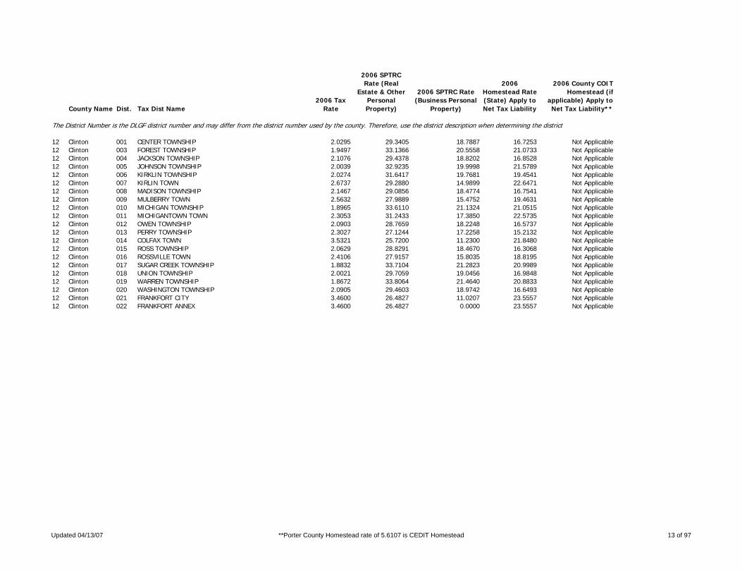
12 Clinton 001 CENTER TOWNSHIP 2.0295 29.3405 18.7887 16.7253 Not Applicable12 Clinton 003 FOREST TOWNSHIP 1.9497 33.1366 20.5558 21.0733 Not Applicable12 Clinton 004 JACKSON TOWNSHIP 2.1076 29.4378 18.8202 16.8528 Not Applicable12 Clinton 005 JOHNSON TOWNSHIP 2.0039 32.9235 19.9998 21.5789 Not Applicable12 Clinton 006 KIRKLIN TOWNSHIP 2.0274 31.6417 19.7681 19.4541 Not Applicable12 Clinton 007 KIRLIN TOWN 2.6737 29.2880 14.9899 22.6471 Not Applicable12 Clinton 008 MADISON TOWNSHIP 2.1467 29.0856 18.4774 16.7541 Not Applicable12 Clinton 009 MULBERRY TOWN 2.5632 27.9889 15.4752 19.4631 Not Applicable12 Clinton 010 MICHIGAN TOWNSHIP 1.8965 33.6110 21.1324 21.0515 Not Applicable12 Clinton 011 MICHIGANTOWN TOWN 2.3053 31.2433 17.3850 22.5735 Not Applicable12 Clinton 012 OWEN TOWNSHIP 2.0903 28.7659 18.2248 16.5737 Not Applicable12 Clinton 013 PERRY TOWNSHIP 2.3027 27.1244 17.2258 15.2132 Not Applicable12 Clinton 014 COLFAX TOWN 3.5321 25.7200 11.2300 21.8480 Not Applicable12 Clinton 015 ROSS TOWNSHIP 2.0629 28.8291 18.4670 16.3068 Not Applicable12 Clinton 016 ROSSVILLE TOWN 2.4106 27.9157 15.8035 18.8195 Not Applicable12 Clinton 017 SUGAR CREEK TOWNSHIP 1.8832 33.7104 21.2823 20.9989 Not Applicable12 Clinton 018 UNION TOWNSHIP 2.0021 29.7059 19.0456 16.9848 Not Applicable12 Clinton 019 WARREN TOWNSHIP 1.8672 33.8064 21.4640 20.8833 Not Applicable12 Clinton 020 WASHINGTON TOWNSHIP 2.0905 29.4603 18.9742 16.6493 Not Applicable12 Clinton 021 FRANKFORT CITY 3.4600 26.4827 11.0207 23.5557 Not Applicable12 Clinton 022 FRANKFORT ANNEX 3.4600 26.4827 0.0000 23.5557 Not Applicable
Updated 04/13/07 **Porter County Homestead rate of 5.6107 is CEDIT Homestead 13 of 97

County Name Dist. Tax Dist Name2006 Tax
Rate
2006 SPTRC Rate (Real
Estate & Other Personal Property)
2006 SPTRC Rate (Business Personal
Property)
2006 Homestead Rate (State) Apply to Net Tax Liability
2006 County COIT Homestead (if
applicable) Apply to Net Tax Liability**
The District Number is the DLGF district number and may differ from the district number used by the county. Therefore, use the district description when determining the district.
13 Crawford 001 BOONE TOWNSHIP 3.8514 23.2216 10.7062 18.2568 Not Applicable13 Crawford 002 ALTON TOWN 3.8514 23.2216 10.7103 18.2568 Not Applicable13 Crawford 003 JENNINGS TOWNSHIP 3.7780 23.1720 10.9142 17.8694 Not Applicable13 Crawford 004 LEAVENWORTH TOWN 3.9961 23.0874 10.3186 18.5940 Not Applicable13 Crawford 005 JOHNSON TOWNSHIP 3.7336 23.2436 11.0440 17.8011 Not Applicable13 Crawford 006 LIBERTY TOWNSHIP 3.8748 23.2308 10.6416 18.3666 Not Applicable13 Crawford 007 MARENGO TOWN 4.2903 23.1379 9.6110 19.7108 Not Applicable13 Crawford 008 OHIO TOWNSHIP 3.7474 23.1857 11.0034 17.7626 Not Applicable13 Crawford 009 PATOKA TOWNSHIP 3.8899 22.9918 10.6003 18.0221 Not Applicable13 Crawford 010 STERLING TOWNSHIP 3.8899 22.9956 10.6003 18.0285 Not Applicable13 Crawford 011 ENGLISH TOWN 4.3875 22.8232 9.3981 19.4827 Not Applicable13 Crawford 012 UNION TOWNSHIP 3.8975 22.9601 10.5796 17.9987 Not Applicable13 Crawford 013 WHISKEY RUN TOWNSHIP 3.9918 22.4741 10.3297 17.5447 Not Applicable13 Crawford 014 MILLTOWN TOWN 4.8593 22.2340 8.4855 19.8007 Not Applicable13 Crawford 015 CAREFREE TOWN 3.7780 23.1720 0.0000 17.8694 Not Applicable13 Crawford 016 JOHNSON TOWNSHIP-ENGLISH FIRE 3.8822 22.9979 10.6213 18.0018 Not Applicable
Updated 04/13/07 **Porter County Homestead rate of 5.6107 is CEDIT Homestead 14 of 97

County Name Dist. Tax Dist Name2006 Tax
Rate
2006 SPTRC Rate (Real
Estate & Other Personal Property)
2006 SPTRC Rate (Business Personal
Property)
2006 Homestead Rate (State) Apply to Net Tax Liability
2006 County COIT Homestead (if
applicable) Apply to Net Tax Liability**
The District Number is the DLGF district number and may differ from the district number used by the county. Therefore, use the district description when determining the district.
14 Daviess 001 BARR TOWNSHIP 2.3584 27.7228 16.8476 16.8521 Not Applicable14 Daviess 002 CANNELBURG TOWN 2.6196 27.4176 15.1688 18.9029 Not Applicable14 Daviess 003 MONTGOMERY TOWN 2.8473 26.6016 13.9550 19.2984 Not Applicable14 Daviess 004 BOGARD TOWNSHIP 2.6431 25.9535 15.6793 15.5404 Not Applicable14 Daviess 005 ELMORE TOWNSHIP 2.6657 25.7281 15.5464 15.3537 Not Applicable14 Daviess 006 ELNORA TOWN 3.3513 24.7042 12.3659 18.3528 Not Applicable14 Daviess 007 HARRISON TOWNSHIP 2.6956 24.9329 14.5891 15.4331 Not Applicable14 Daviess 008 MADISON TOWNSHIP 2.6941 25.8039 15.3824 15.7312 Not Applicable14 Daviess 009 ODON TOWN 3.1772 24.9011 13.0435 17.6839 Not Applicable14 Daviess 010 REEVE TOWNSHIP 2.4913 27.5917 15.9488 18.0087 Not Applicable14 Daviess 011 ALFORDSVILLE TOWN 2.8961 26.6537 13.7187 19.7511 Not Applicable14 Daviess 012 STEELE TOWNSHIP 2.6579 25.9275 15.5920 15.6275 Not Applicable14 Daviess 013 PLAINVILLE TOWN 3.3381 24.6791 12.4149 18.2366 Not Applicable14 Daviess 014 VAN BUREN TOWNSHIP 2.6250 25.9875 15.7874 15.4352 Not Applicable14 Daviess 015 VEALE TOWNSHIP 2.6550 24.8214 14.8121 14.9118 Not Applicable14 Daviess 016 WASHINGTON TOWNSHIP 2.6460 24.5854 14.8625 14.4398 Not Applicable14 Daviess 017 WASHINGTON CITY 4.1726 22.5783 9.4249 19.0280 Not Applicable
Updated 04/13/07 **Porter County Homestead rate of 5.6107 is CEDIT Homestead 15 of 97

County Name Dist. Tax Dist Name2006 Tax
Rate
2006 SPTRC Rate (Real
Estate & Other Personal Property)
2006 SPTRC Rate (Business Personal
Property)
2006 Homestead Rate (State) Apply to Net Tax Liability
2006 County COIT Homestead (if
applicable) Apply to Net Tax Liability**
The District Number is the DLGF district number and may differ from the district number used by the county. Therefore, use the district description when determining the district.
15 Dearborn 001 CAESAR CREEK TOWNSHIP 2.1349 25.9202 18.3369 11.4630 Not Applicable15 Dearborn 002 CENTER TOWNSHIP 2.0865 26.0556 18.7637 11.0449 Not Applicable15 Dearborn 003 AURORA CITY-CENTER TOWNSHIP 2.8133 24.2779 13.9160 15.3260 Not Applicable15 Dearborn 004 CLAY TOWNSHIP 2.1225 25.8643 18.4452 11.2082 Not Applicable15 Dearborn 005 DILLSBORO TOWN 2.4902 24.8523 15.7218 13.6084 Not Applicable15 Dearborn 006 HARRISON TOWNSHIP 2.2474 21.7391 14.6949 10.0809 Not Applicable15 Dearborn 007 WEST HARRISON TOWN 2.8741 21.3716 11.4905 14.0746 Not Applicable15 Dearborn 008 HOGAN TOWNSHIP 2.1227 25.9669 18.4434 11.3817 Not Applicable15 Dearborn 009 JACKSON TOWNSHIP 2.2350 21.7792 14.7765 10.0269 Not Applicable15 Dearborn 010 KELSO TOWNSHIP 2.2314 21.7734 14.8005 9.9837 Not Applicable15 Dearborn 011 ST. LEON TOWN 2.2311 21.7823 14.8023 9.9947 Not Applicable15 Dearborn 012 LAWRENCEBURG TOWNSHIP 1.8987 35.8502 27.4502 14.6665 Not Applicable15 Dearborn 013 LAWRENCEBURG CITY-A 2.6478 31.3659 19.6838 19.0634 Not Applicable15 Dearborn 015 AURORA CITY-LAWRENCEBURG TOWNS 2.6149 31.2795 19.9316 18.4949 Not Applicable15 Dearborn 016 GREENDALE TOWN-A 2.7619 30.7195 18.8690 19.1576 Not Applicable15 Dearborn 018 LOAGAN TOWNSHIP 2.2584 21.7110 14.6233 10.1396 Not Applicable15 Dearborn 019 MANCHESTER TOWNSHIP 2.1354 25.5139 18.3338 10.7962 Not Applicable15 Dearborn 020 MILLER TOWNSHIP 2.2398 21.7554 14.7449 10.0351 Not Applicable15 Dearborn 021 SPARTA TOWNSHIP 2.1064 25.7691 18.5863 10.8375 Not Applicable15 Dearborn 022 MOORES HILL TOWN 2.4073 25.2615 16.2632 13.4848 Not Applicable15 Dearborn 023 WASHINGTON TOWNSHIP 2.1040 25.9382 18.6073 11.0859 Not Applicable15 Dearborn 024 YORK TOWNSHIP 2.2568 21.7620 14.6336 10.2044 Not Applicable15 Dearborn 025 GREENDALE TOWN-B 2.7619 30.7192 18.8692 19.1577 Not Applicable15 Dearborn 026 LAWRENCEBURG CITY-B 2.6478 31.3659 19.6838 19.0634 Not Applicable
Updated 04/13/07 **Porter County Homestead rate of 5.6107 is CEDIT Homestead 16 of 97

County Name Dist. Tax Dist Name2006 Tax
Rate
2006 SPTRC Rate (Real
Estate & Other Personal Property)
2006 SPTRC Rate (Business Personal
Property)
2006 Homestead Rate (State) Apply to Net Tax Liability
2006 County COIT Homestead (if
applicable) Apply to Net Tax Liability**
The District Number is the DLGF district number and may differ from the district number used by the county. Therefore, use the district description when determining the district.
16 Decatur 001 ADAMS TOWNSHIP 1.8161 33.1918 22.2155 18.4010 Not Applicable16 Decatur 002 ST. PAUL TOWN-ADAMS TOWNSHIP 2.2898 31.0783 17.6195 21.8708 Not Applicable16 Decatur 003 CLAY TOWNSHIP 1.8358 33.0285 21.9771 18.4817 Not Applicable16 Decatur 004 MILFORD TOWN 2.1406 31.2555 18.8494 20.2160 Not Applicable16 Decatur 005 CLINTON TOWNSHIP 1.8140 33.2158 22.2412 18.4045 Not Applicable16 Decatur 006 FUGIT TOWNSHIP 1.8132 32.9485 22.2512 17.8684 Not Applicable16 Decatur 007 JACKSON TOWNSHIP 1.8283 33.0380 22.0674 18.3495 Not Applicable16 Decatur 008 MARION TOWNSHIP-SOUTH 1.8049 33.0274 22.3534 17.8503 Not Applicable16 Decatur 009 MARION TOWNSHIP NORTH 2.0349 26.8764 17.9211 13.7164 Not Applicable16 Decatur 010 MILLHOUSEN TOWN-MARION TOWNSHI 1.9534 32.3584 20.6485 19.3786 Not Applicable16 Decatur 011 SALTCREEK TOWNSHIP 1.8152 33.1761 22.2265 18.3518 Not Applicable16 Decatur 012 NEW POINT TOWN 2.1051 31.6888 19.1655 20.5322 Not Applicable16 Decatur 013 SANDCREEK TOWNSHIP 1.8894 32.4968 21.3536 18.4883 Not Applicable16 Decatur 014 WESTPORT TOWN 2.3194 30.3446 17.3948 20.8219 Not Applicable16 Decatur 015 WASHINGTON TOWNSHIP 2.0684 26.9565 17.6308 14.2993 Not Applicable16 Decatur 016 GREENSBURG CITY 3.0166 23.5818 12.0526 16.8975 Not Applicable
Updated 04/13/07 **Porter County Homestead rate of 5.6107 is CEDIT Homestead 17 of 97

County Name Dist. Tax Dist Name2006 Tax
Rate
2006 SPTRC Rate (Real
Estate & Other Personal Property)
2006 SPTRC Rate (Business Personal
Property)
2006 Homestead Rate (State) Apply to Net Tax Liability
2006 County COIT Homestead (if
applicable) Apply to Net Tax Liability**
The District Number is the DLGF district number and may differ from the district number used by the county. Therefore, use the district description when determining the district.
17 Dekalb 001 BULTER TOWNSHIP 2.0056 28.3991 18.3977 15.6445 Not Applicable17 Dekalb 002 CONCORD TOWNSHIP 2.3421 24.3908 15.3792 13.3488 Not Applicable17 Dekalb 003 ST. JOE TOWN 2.7843 24.8207 12.9367 17.7043 Not Applicable17 Dekalb 004 FAIRFIELD TOWNSHIP 2.0800 27.2113 18.0702 14.0652 Not Applicable17 Dekalb 005 FRANKLIN TOWNSHIP 1.5059 35.0886 23.2465 20.4329 Not Applicable17 Dekalb 006 HAMILTON TOWN 1.7717 32.6814 19.7610 21.4991 Not Applicable17 Dekalb 007 GRANT TOWNSHIP 2.1691 27.4339 17.3280 15.5976 Not Applicable17 Dekalb 008 WATERLOO TOWN-GRANT TOWNSHIP 3.0075 25.7092 12.4976 19.9177 Not Applicable17 Dekalb 009 JACKSON TOWNSHIP 1.9837 28.1435 18.9476 14.3333 Not Applicable17 Dekalb 010 AUBURN CITY-JACKSON TOWNSHIP 2.6794 25.7231 14.0279 17.6347 Not Applicable17 Dekalb 011 KEYSER TOWNSHIP 1.9891 28.4574 18.5503 15.5096 Not Applicable17 Dekalb 012 AUBURN CITY-KEYSER TOWNSHIP 2.5988 26.0384 14.1982 17.9294 Not Applicable17 Dekalb 013 GARRETT CITY 2.6429 25.7533 13.9587 17.7919 Not Applicable17 Dekalb 014 ALTONA TOWN 2.3987 27.5510 15.3844 18.8123 Not Applicable17 Dekalb 015 NEWVILLE TOWNSHIP 2.2897 25.0333 15.7311 13.8974 Not Applicable17 Dekalb 016 RICHLAND TOWNSHIP 1.9797 28.4074 18.9858 14.7392 Not Applicable17 Dekalb 017 CORUNNA TOWN 3.3587 25.2200 11.1905 21.0124 Not Applicable17 Dekalb 018 SMITHFIELD TOWNSHIP 1.9960 28.2502 18.8308 14.7035 Not Applicable17 Dekalb 019 ASHLEY TOWN 2.8307 25.6847 13.2782 18.6979 Not Applicable17 Dekalb 020 WATERLOO TOWN-SMITHFIELD TOWNS 3.0074 25.6885 12.4981 19.8763 Not Applicable17 Dekalb 021 SPENCER TOWNSHIP 2.2967 25.1336 15.6832 14.1379 Not Applicable17 Dekalb 022 STAFFORD TOWNSHIP 2.2813 24.9344 15.7889 13.6450 Not Applicable17 Dekalb 023 TROY TOWNSHIP 2.2835 24.9201 15.7741 13.6439 Not Applicable17 Dekalb 024 UNION TOWNSHIP 2.0408 28.0166 18.4175 14.9352 Not Applicable17 Dekalb 025 AUBURN CITY-UNION TOWNSHIP 2.6734 25.7302 14.0594 17.5998 Not Applicable17 Dekalb 026 WILMINGTON TOWNSHIP 2.3071 24.6765 15.6125 13.4775 Not Applicable17 Dekalb 027 BUTLER CITY 3.1814 23.6095 11.3219 18.0153 Not Applicable17 Dekalb 028 AUBURN CITY - GRANT TOWNSHIP 2.6925 24.2193 0.0000 19.7282 Not Applicable
Updated 04/13/07 **Porter County Homestead rate of 5.6107 is CEDIT Homestead 18 of 97

County Name Dist. Tax Dist Name2006 Tax
Rate
2006 SPTRC Rate (Real
Estate & Other Personal Property)
2006 SPTRC Rate (Business Personal
Property)
2006 Homestead Rate (State) Apply to Net Tax Liability
2006 County COIT Homestead (if
applicable) Apply to Net Tax Liability**
The District Number is the DLGF district number and may differ from the district number used by the county. Therefore, use the district description when determining the district.
18 Delaware 001 CENTER TOWNSHIP 2.8330 27.8216 17.3109 16.3099 Not Applicable18 Delaware 002 CENTER TOWNSHIP - MUNCIE SANIT 3.1341 26.8109 15.6484 17.0818 Not Applicable18 Delaware 003 MUNCIE CITY - CENTER TOWNSHIP 4.2665 25.6967 11.4988 21.4009 Not Applicable18 Delaware 004 DELAWARE TOWNSHIP 2.5697 25.7961 16.2042 14.4777 Not Applicable18 Delaware 005 ALBANY TOWN - DELAWARE TOWNSHI 3.0398 24.8856 13.6990 16.6800 Not Applicable18 Delaware 006 HAMILTON TOWNSHIP 2.6017 25.4137 16.0048 14.1285 Not Applicable18 Delaware 007 HAMILTON TWP - MUNCIE SANITARY 2.9028 24.5721 14.3452 15.1852 Not Applicable18 Delaware 008 HARRISON TOWNSHIP 2.3164 28.7867 18.3429 16.4257 Not Applicable18 Delaware 009 HARRISON TWP - MUNCIE SANITARY 2.6175 27.4655 16.2339 17.3432 Not Applicable18 Delaware 010 LIBERTY TOWNSHIP 2.5441 26.8901 16.4519 15.9907 Not Applicable18 Delaware 011 SELMA TOWN 3.0161 26.0024 13.8791 18.3499 Not Applicable18 Delaware 012 MONROE TOWNSHIP 2.9780 22.9960 14.6568 12.1291 Not Applicable18 Delaware 013 MONROE TOWNSHIP - MUNCIE SANIT 3.2791 22.4729 13.3119 13.2349 Not Applicable18 Delaware 014 MT PLEASANT TOWNSHIP 2.4640 27.1817 16.5362 16.3735 Not Applicable18 Delaware 015 MT PLEASANT TWP - MUNCIE SANIT 2.7651 26.1057 14.7362 17.2323 Not Applicable18 Delaware 016 MUNCIE CITY - MT PLEASANT TWP 4.1342 24.1542 9.8598 21.1081 Not Applicable18 Delaware 017 YORKTOWN TOWN 2.9288 24.7184 13.9180 16.0681 Not Applicable18 Delaware 018 NILES TOWNSHIP 2.5787 25.9398 16.1472 14.8084 Not Applicable18 Delaware 019 ALBANY TOWN - NILES TWP 3.0715 24.8041 13.5590 16.7509 Not Applicable18 Delaware 020 PERRY TOWNSHIP 2.4929 27.3908 16.7893 16.3522 Not Applicable18 Delaware 021 SALEM TOWNSHIP 2.5181 29.5426 19.1321 16.5489 Not Applicable18 Delaware 022 UNION TOWNSHIP 2.5905 25.8241 16.0742 14.7220 Not Applicable18 Delaware 023 EATON TOWN 3.3842 23.8813 12.3055 17.0327 Not Applicable18 Delaware 024 WASHINGTON TOWNSHIP 2.3171 28.9053 18.3372 16.6485 Not Applicable18 Delaware 025 GASTON TOWN 3.2662 26.3415 13.0100 20.2699 Not Applicable18 Delaware 026 DALEVILLE TOWN 2.9406 28.0693 16.3841 18.1946 Not Applicable18 Delaware 027 CHESTERFIELD TOWN 3.3475 27.1636 14.3932 19.6378 Not Applicable18 Delaware 028 HAMILTON SANITARY MUNCIE 4.3427 23.1691 9.5924 19.7920 Not Applicable18 Delaware 029 LIBERTY MUNCIE 4.2866 24.0016 9.7640 20.9762 Not Applicable18 Delaware 030 MUNCIE ANNEX 4.2776 25.6802 11.4662 21.4215 Not Applicable18 Delaware 031 MT. PLEASANT-MUNCIE-CNTY TIF 4.1453 24.1439 9.8311 21.1288 Not Applicable18 Delaware 032 YORKTOWN ANNEX 2.9440 24.5664 0.0000 15.9164 Not Applicable
Updated 04/13/07 **Porter County Homestead rate of 5.6107 is CEDIT Homestead 19 of 97

County Name Dist. Tax Dist Name2006 Tax
Rate
2006 SPTRC Rate (Real
Estate & Other Personal Property)
2006 SPTRC Rate (Business Personal
Property)
2006 Homestead Rate (State) Apply to Net Tax Liability
2006 County COIT Homestead (if
applicable) Apply to Net Tax Liability**
The District Number is the DLGF district number and may differ from the district number used by the county. Therefore, use the district description when determining the district.
19 Dubois 001 BAINBRIDGE TOWNSHIP 1.8962 29.0147 21.4471 11.9402 Not Applicable19 Dubois 002 JASPER CITY 2.4635 26.4648 16.5082 15.1646 Not Applicable19 Dubois 003 BOONE TOWNSHIP 1.8844 29.0846 21.5815 11.8500 Not Applicable19 Dubois 004 CASS TOWNSHIP 2.2806 24.2269 17.2253 10.3489 Not Applicable19 Dubois 005 HOLLAND TOWN 3.1065 23.0891 12.6458 15.2081 Not Applicable19 Dubois 006 COLUMBIA TOWNSHIP 2.1214 27.9280 19.7451 12.7165 Not Applicable19 Dubois 007 FERDINAND TOWNSHIP 2.0875 27.3907 19.9531 11.4726 Not Applicable19 Dubois 008 FERDINAND TOWN 2.5461 25.7115 16.3592 14.1000 Not Applicable19 Dubois 009 HALL TOWNSHIP 2.0681 28.3475 20.2539 12.6512 Not Applicable19 Dubois 010 HALL TOWNSHIP II 2.1062 27.9850 19.8873 12.5940 Not Applicable19 Dubois 011 HARBISON TOWNSHIP 2.0828 28.3074 20.1110 12.8045 Not Applicable19 Dubois 012 HARBISON TOWNSHIP II 2.1065 27.9841 19.8847 12.5964 Not Applicable19 Dubois 013 JACKSON TOWNSHIP 2.0780 27.3187 20.0443 11.2098 Not Applicable19 Dubois 014 JEFFERSON TOWNSHIP 2.0722 27.4453 20.1003 11.3381 Not Applicable19 Dubois 015 BIRDSEYE TOWN 2.4361 26.3331 17.0983 14.0410 Not Applicable19 Dubois 016 MADISON TOWNSHIP 1.8844 29.0846 21.5814 11.8500 Not Applicable19 Dubois 017 MARION TOWNSHIP 2.0714 28.2977 20.2217 12.6148 Not Applicable19 Dubois 018 MARION TOWNSHIP II 2.1103 27.9697 19.8489 12.6272 Not Applicable19 Dubois 019 PATOKA TOWNSHIP 2.3095 24.1866 17.0098 10.6025 Not Applicable19 Dubois 020 HUNTINGBURG CITY 3.0270 23.0476 12.9779 14.6559 Not Applicable19 Dubois 021 JASPER MADISON 2.4644 26.4624 16.5137 15.1697 Not Applicable
Updated 04/13/07 **Porter County Homestead rate of 5.6107 is CEDIT Homestead 20 of 97

County Name Dist. Tax Dist Name2006 Tax
Rate
2006 SPTRC Rate (Real
Estate & Other Personal Property)
2006 SPTRC Rate (Business Personal
Property)
2006 Homestead Rate (State) Apply to Net Tax Liability
2006 County COIT Homestead (if
applicable) Apply to Net Tax Liability**
The District Number is the DLGF district number and may differ from the district number used by the county. Therefore, use the district description when determining the district.
20 Elkhart 001 BAUGO TOWNSHIP 2.4853 22.4163 14.8443 10.9310 Not Applicable20 Elkhart 002 ELKHART CITY-BAUGO TOWNSHIP 3.7495 22.0520 9.8387 17.5526 Not Applicable20 Elkhart 003 BENTON TOWNSHIP 2.3530 24.3764 16.1280 12.2162 Not Applicable20 Elkhart 004 MILLERSBURG TOWN-BENTON TOWNSH 3.0537 23.8384 12.4285 16.7791 Not Applicable20 Elkhart 005 CLEVELAND TOWNSHIP 2.1969 27.0623 17.1075 15.2862 Not Applicable20 Elkhart 006 ELKHART CITY-CLEVELAND TOWNSHI 3.3306 25.2236 11.2842 20.8785 Not Applicable20 Elkhart 007 CLINTON TOWNSHIP 2.2920 24.5667 16.5573 11.8922 Not Applicable20 Elkhart 008 MILLERSBURG TOWN-CLINTON TOWNS 3.0440 23.8572 12.4673 16.7546 Not Applicable20 Elkhart 009 CONCORD TOWNSHIP 2.2795 22.8871 14.1952 12.6242 Not Applicable20 Elkhart 011 ELKHART CITY-CONCORD TOWNSHIP- 3.3553 23.0179 9.6438 19.4576 Not Applicable20 Elkhart 012 ELKHART CITY-CONCORD TOWNSHIP- 3.3247 25.2486 11.3042 20.8929 Not Applicable20 Elkhart 013 GOSHEN CITY-CONCORD TOWNSHIP 2.9856 22.6911 10.8380 17.1719 Not Applicable20 Elkhart 014 ELKHART TOWNSHIP 2.3397 22.9344 14.7853 11.8432 Not Applicable20 Elkhart 015 GOSHEN CITY-ELKHART TOWNSHIP 3.1258 22.2153 11.0670 16.0521 Not Applicable20 Elkhart 016 HARRISON TOWNSHIP 2.2276 26.3208 16.9127 14.3015 Not Applicable20 Elkhart 017 WAKARUSA TOWN-HARRISON TOWNSHI 2.8361 24.6683 13.2839 16.9254 Not Applicable20 Elkhart 018 JACKSON TOWNSHIP 2.3619 24.4459 16.0673 12.4204 Not Applicable20 Elkhart 019 JEFFERSON TOWNSHIP 2.0186 27.4021 17.9818 14.5333 Not Applicable20 Elkhart 020 LOCKE TOWNSHIP 2.0869 26.8791 18.0533 13.5194 Not Applicable20 Elkhart 021 NAPPANEE CITY-LOCKE TOWNSHIP 3.2060 23.8601 11.7513 17.8117 Not Applicable20 Elkhart 024 OLIVE TOWNSHIP 2.2150 26.3260 17.0090 14.1639 Not Applicable20 Elkhart 025 WAKARUSA TOWN-OLIVE TOWNSHIP 2.8409 24.6363 13.2615 16.9043 Not Applicable20 Elkhart 026 OSOLO TOWNSHIP 2.1543 27.3431 17.4458 15.2566 Not Applicable20 Elkhart 027 ELKHART CITY-OSOLO TOWNSHIP 3.3105 25.2544 11.3527 20.8304 Not Applicable20 Elkhart 028 UNION TOWNSHIP 2.3315 25.0031 16.1588 13.2079 Not Applicable20 Elkhart 029 NAPPANEE CITY-UNION TOWNSHIP 3.1861 23.8768 11.8246 17.7322 Not Applicable20 Elkhart 030 WASHINGTON TOWNSHIP 2.0732 27.7332 18.1281 14.8858 Not Applicable20 Elkhart 031 BRISTOL TOWN 2.5572 26.3340 14.6971 17.6926 Not Applicable20 Elkhart 032 YORK TOWNSHIP 1.9850 27.7507 18.2860 14.6721 Not Applicable20 Elkhart 034 MIDDLEBURY TOWNSHIP 2.0320 27.0475 17.8632 14.1004 Not Applicable20 Elkhart 035 MIDDLEBURY TOWN 2.5433 24.8599 14.2719 15.7820 Not Applicable20 Elkhart 036 GOSHEN CITY-HARRISON TOWNSHIP 3.0178 24.3903 12.4518 17.6295 Not Applicable
Updated 04/13/07 **Porter County Homestead rate of 5.6107 is CEDIT Homestead 21 of 97

County Name Dist. Tax Dist Name2006 Tax
Rate
2006 SPTRC Rate (Real
Estate & Other Personal Property)
2006 SPTRC Rate (Business Personal
Property)
2006 Homestead Rate (State) Apply to Net Tax Liability
2006 County COIT Homestead (if
applicable) Apply to Net Tax Liability**
The District Number is the DLGF district number and may differ from the district number used by the county. Therefore, use the district description when determining the district.
21 Fayette 001 COLUMBIA TOWNSHIP 2.3794 30.6075 19.5478 17.8505 Not Applicable21 Fayette 002 CONNERSVILLE TOWNSHIP 2.3940 30.5428 19.4286 17.9217 Not Applicable21 Fayette 003 CONNERSVILLE CITY-CONNERSVILLE 3.9820 26.2490 11.6806 22.1239 Not Applicable21 Fayette 005 FAIRVIEW TOWNSHIP 2.3848 30.5835 19.5035 17.8769 Not Applicable21 Fayette 006 GLENWOOD TOWN-FAIVIEW TOWNSHIP 3.3776 27.4725 13.7713 21.1591 Not Applicable21 Fayette 007 HARRISON TOWNSHIP 2.3981 30.5248 19.3953 17.9415 Not Applicable21 Fayette 008 CONNERSVILLE CITY-HARRISON TOW 3.9698 26.2682 11.7164 22.1043 Not Applicable21 Fayette 010 JACKSON TOWNSHIP 2.3750 30.6271 19.5840 17.8287 Not Applicable21 Fayette 011 JENNINGS TOWNSHIP 2.3658 30.6685 19.6602 17.7831 Not Applicable21 Fayette 012 ORANGE TOWNSHIP 2.3851 30.5821 19.5011 17.8784 Not Applicable21 Fayette 013 GLENWOOD TOWN-ORANGE TOWNSHIP 3.3781 27.4713 13.7524 21.1603 Not Applicable21 Fayette 014 POSEY TOWNSHIP 2.4014 30.4095 19.3687 17.7691 Not Applicable21 Fayette 015 WATERLOO TOWNSHIP 2.3775 30.6160 19.5634 17.8410 Not Applicable
Updated 04/13/07 **Porter County Homestead rate of 5.6107 is CEDIT Homestead 22 of 97

County Name Dist. Tax Dist Name2006 Tax
Rate
2006 SPTRC Rate (Real
Estate & Other Personal Property)
2006 SPTRC Rate (Business Personal
Property)
2006 Homestead Rate (State) Apply to Net Tax Liability
2006 County COIT Homestead (if
applicable) Apply to Net Tax Liability**
The District Number is the DLGF district number and may differ from the district number used by the county. Therefore, use the district description when determining the district.
22 Floyd 001 FRANKLIN TOWNSHIP 2.0952 28.7691 19.3341 14.8350 Not Applicable22 Floyd 002 GEORGETOWN TOWNSHIP 2.1264 28.2322 19.0504 14.3288 Not Applicable22 Floyd 003 GEORGETOWN TOWN 2.3272 28.3039 17.4068 17.0231 Not Applicable22 Floyd 004 GREENVILLE TOWNSHIP 2.1144 28.4332 19.1585 14.5146 Not Applicable22 Floyd 005 GREENVILLE TOWN 2.1607 28.7107 18.7480 15.6519 Not Applicable22 Floyd 006 LAFAYETTE TOWNSHIP 2.0862 28.6599 19.4175 14.5099 Not Applicable22 Floyd 007 NEW ALBANY TOWNSHIP 2.1308 28.2843 19.0111 14.4822 Not Applicable22 Floyd 008 NEW ALBANY CITY 2.9573 28.3445 13.6924 22.9018 Not Applicable
Updated 04/13/07 **Porter County Homestead rate of 5.6107 is CEDIT Homestead 23 of 97

County Name Dist. Tax Dist Name2006 Tax
Rate
2006 SPTRC Rate (Real
Estate & Other Personal Property)
2006 SPTRC Rate (Business Personal
Property)
2006 Homestead Rate (State) Apply to Net Tax Liability
2006 County COIT Homestead (if
applicable) Apply to Net Tax Liability**
The District Number is the DLGF district number and may differ from the district number used by the county. Therefore, use the district description when determining the district.
23 Fountain 001 CAIN TOWNSHIP 1.9246 33.4801 21.5930 20.0143 Not Applicable23 Fountain 002 HILLSBORO TOWN 2.3010 32.0578 18.0610 23.0734 Not Applicable23 Fountain 003 DAVIS TOWNSHIP 2.5147 25.4077 16.3451 13.6076 Not Applicable23 Fountain 004 FULTON TOWNSHIP 2.1002 30.4245 20.3480 16.2207 Not Applicable23 Fountain 005 JACKSON TOWNSHIP 1.9492 33.5387 21.3205 20.5900 Not Applicable23 Fountain 006 WALLACE TOWN 1.9558 33.5366 21.2455 20.7084 Not Applicable23 Fountain 007 LOGAN TOWNSHIP 2.5072 25.4269 16.3940 13.5664 Not Applicable23 Fountain 008 ATTICA CITY 3.1909 24.6817 12.8813 17.5475 Not Applicable23 Fountain 011 RICHLAND TOWNSHIP 1.9392 33.5655 21.4305 20.4582 Not Applicable23 Fountain 012 MELLOTT TOWN 2.2357 29.5546 18.5894 17.4358 Not Applicable23 Fountain 013 NEWTOWN TOWN 2.1590 32.3937 19.2487 21.7767 Not Applicable23 Fountain 014 SHAWNEE TOWNSHIP 2.3723 26.3662 17.3262 13.7503 Not Applicable23 Fountain 015 TROY TOWNSHIP 2.1608 30.5952 19.7775 17.4569 Not Applicable23 Fountain 016 COVINGTON CITY 2.9409 28.6427 14.5313 22.1488 Not Applicable23 Fountain 017 VAN BUREN TOWNSHIP 2.0718 32.3663 20.0589 20.3810 Not Applicable23 Fountain 018 VEEDERSBURG TOWN 2.3985 30.8668 17.3267 21.9358 Not Applicable23 Fountain 019 WABASH TOWNSHIP 2.0786 30.7644 20.5594 16.5081 Not Applicable23 Fountain 020 MILLCREEK TOWNSHIP 2.0042 33.1814 20.7356 20.8619 Not Applicable23 Fountain 021 KINGMAN TOWN 2.4978 30.7148 16.6377 22.7555 Not Applicable
Updated 04/13/07 **Porter County Homestead rate of 5.6107 is CEDIT Homestead 24 of 97

County Name Dist. Tax Dist Name2006 Tax
Rate
2006 SPTRC Rate (Real
Estate & Other Personal Property)
2006 SPTRC Rate (Business Personal
Property)
2006 Homestead Rate (State) Apply to Net Tax Liability
2006 County COIT Homestead (if
applicable) Apply to Net Tax Liability**
The District Number is the DLGF district number and may differ from the district number used by the county. Therefore, use the district description when determining the district.
24 Franklin 001 BATH TOWNSHIP 1.9942 29.9035 20.1412 15.5982 Not Applicable24 Franklin 002 BLOOMING GROVE TOWNSHIP 1.8701 32.2327 20.5636 19.2856 Not Applicable24 Franklin 003 BROOKVILLE TOWNSHIP 1.9093 31.7997 20.1415 19.1454 Not Applicable24 Franklin 004 BROOKVILLE TOWN 2.4368 30.7663 15.7814 24.2412 Not Applicable24 Franklin 005 BUTLER TOWNSHIP-EAST 1.8604 32.1655 20.6712 18.9785 Not Applicable24 Franklin 006 BUTLER TOWNSHIP-WEST 1.6066 37.4392 25.9754 20.5226 Not Applicable24 Franklin 007 FAIRFIELD TOWNSHIP 1.8698 32.2322 20.5671 19.2791 Not Applicable24 Franklin 008 HIGHLAND TOWNSHIP 1.8611 32.2214 20.6631 19.0995 Not Applicable24 Franklin 009 CEDAR GROVE TOWN 1.9260 32.1218 19.9670 20.0558 Not Applicable24 Franklin 010 LAUREL TOWNSHIP 1.9289 31.8157 19.9369 19.5123 Not Applicable24 Franklin 011 LAUREL TOWN 2.2326 31.4198 17.2252 23.1819 Not Applicable24 Franklin 012 METAMORA TOWNSHIP 1.9335 31.7652 19.8894 19.4927 Not Applicable24 Franklin 013 POSEY TOWNSHIP 1.9130 31.8698 20.1026 19.3444 Not Applicable24 Franklin 014 RAY TOWNSHIP 1.6679 36.8594 25.0209 20.9996 Not Applicable24 Franklin 015 BATESVILLE CITY 2.1217 33.3270 19.6693 22.9429 Not Applicable24 Franklin 016 OLDENBURG TOWN 1.9042 35.2825 21.9160 23.1322 Not Applicable24 Franklin 017 SALT CREEK TOWNSHIP-NORTH 1.8697 32.1938 20.5682 19.2028 Not Applicable24 Franklin 018 SALT CREEK TOWNSHIP-SOUTH 1.6159 37.4411 25.8260 20.7954 Not Applicable24 Franklin 019 SPRINGFIELD TOWNSHIP 1.8722 32.1210 20.5406 19.1075 Not Applicable24 Franklin 020 MT. CARMEL TOWN 1.8562 32.3285 20.7178 19.2181 Not Applicable24 Franklin 021 WHITEWATER TOWNSHIP 1.8710 32.1800 20.5538 19.1998 Not Applicable24 Franklin 022 RAY TOWNSHIP FIRE TERR. 1.7263 35.4630 24.1744 19.5908 Not Applicable24 Franklin 023 SALT CREEK SOUTH FIRE TERR. 1.6769 35.9564 24.8866 19.3593 Not Applicable24 Franklin 024 BUTLER WEST FIRE TERR 1.6704 35.9728 24.9836 19.2232 Not Applicable24 Franklin 025 BUTLER EAST FIRE TERR 1.9242 31.0676 19.9880 18.0058 Not Applicable24 Franklin 026 SALT CREEK NORTH FIRE TERR 1.9307 31.0697 19.9170 18.1200 Not Applicable
Updated 04/13/07 **Porter County Homestead rate of 5.6107 is CEDIT Homestead 25 of 97

County Name Dist. Tax Dist Name2006 Tax
Rate
2006 SPTRC Rate (Real
Estate & Other Personal Property)
2006 SPTRC Rate (Business Personal
Property)
2006 Homestead Rate (State) Apply to Net Tax Liability
2006 County COIT Homestead (if
applicable) Apply to Net Tax Liability**
The District Number is the DLGF district number and may differ from the district number used by the county. Therefore, use the district description when determining the district.
25 Fulton 001 AUBBEENAUBBEE TOWNSHIP 1.8771 30.3515 17.9138 20.0007 Not Applicable25 Fulton 002 HENRY TOWNSHIP 2.6496 25.2664 15.4719 14.6785 Not Applicable25 Fulton 003 AKRON TOWN 3.3117 24.7849 12.3786 18.4738 Not Applicable25 Fulton 004 LIBERTY TOWNSHIP 2.1731 33.7008 22.5086 18.9072 Not Applicable25 Fulton 005 FULTON TOWN 3.0265 30.9442 16.1620 23.9750 Not Applicable25 Fulton 006 NEWCASTLE TOWNSHIP 2.5968 25.4795 15.7864 14.5681 Not Applicable25 Fulton 007 RICHLAND TOWNSHIP 2.1502 28.5577 18.4245 15.8860 Not Applicable25 Fulton 008 ROCHESTER TOWNSHIP 2.1742 28.5118 18.2211 16.1224 Not Applicable25 Fulton 009 ROCHESTER CITY 2.8883 26.2732 13.7162 19.0758 Not Applicable25 Fulton 011 KEWANNA TOWN 2.9516 30.5251 16.5718 22.4940 Not Applicable25 Fulton 012 WAYNE TOWNSHIP 2.2021 33.3657 22.2122 18.7470 Not Applicable25 Fulton 013 UNION TWP - ROCHESTER SCHOOLS 2.1706 28.8940 18.2512 16.7636 Not Applicable25 Fulton 014 UNION TWP - EASTERN PULASKI SCHOOLS 2.1435 32.0161 20.1893 19.4843 Not Applicable25 Fulton 015 UNION TWP - CASTON SCHOOLS 2.1939 33.8582 22.2952 19.5801 Not Applicable
Updated 04/13/07 **Porter County Homestead rate of 5.6107 is CEDIT Homestead 26 of 97

County Name Dist. Tax Dist Name2006 Tax
Rate
2006 SPTRC Rate (Real
Estate & Other Personal Property)
2006 SPTRC Rate (Business Personal
Property)
2006 Homestead Rate (State) Apply to Net Tax Liability
2006 County COIT Homestead (if
applicable) Apply to Net Tax Liability**
The District Number is the DLGF district number and may differ from the district number used by the county. Therefore, use the district description when determining the district.
26 Gibson 001 BARTON TOWNSHIP 2.5026 31.0491 19.8382 18.2103 Not Applicable26 Gibson 002 MACKEY TOWN 2.9784 29.3073 16.6693 20.0234 Not Applicable26 Gibson 003 SOMERVILLE TOWN 2.5209 30.9967 19.6981 18.3451 Not Applicable26 Gibson 004 CENTER TOWNSHIP 2.4880 31.1421 19.9546 18.1968 Not Applicable26 Gibson 005 FRANCISCO TOWN 3.0130 29.2006 16.4779 20.1269 Not Applicable26 Gibson 006 COLUMBIA TOWNSHIP 2.6898 30.1400 18.4576 18.7295 Not Applicable26 Gibson 007 OAKLAND CITY 3.6580 26.2957 13.5723 19.3344 Not Applicable26 Gibson 009 HAUBSTADT TOWN 2.7018 27.3763 16.0117 17.5266 Not Applicable26 Gibson 017 WASHINGTON TOWNSHIP 2.2842 29.3161 18.6394 16.9173 Not Applicable26 Gibson 018 WHITE RIVER TOWNSHIP 2.3507 29.0525 18.1120 17.2708 Not Applicable26 Gibson 019 HAZELTON TOWN 2.6544 27.6651 16.0412 18.0018 Not Applicable26 Gibson 020 PATOKA TOWN 2.4495 28.5167 17.3818 17.4466 Not Applicable26 Gibson 021 MONTGOMERY TOWNSHIP 2.3182 29.3581 18.6610 16.9598 Not Applicable26 Gibson 022 OWENSVILLE TOWN 3.4590 26.1359 12.5066 20.6661 Not Applicable26 Gibson 023 WABASH TOWNSHIP 2.3529 29.2200 18.3855 17.1438 Not Applicable26 Gibson 024 JOHNSON TOWNSHIP 2.2876 29.2709 18.9107 16.4056 Not Applicable26 Gibson 025 UNION TOWNSHIP 2.3012 29.3555 18.7989 16.7365 Not Applicable26 Gibson 026 FORT BRANCH TOWN 2.6600 28.0936 16.2632 18.4269 Not Applicable26 Gibson 027 PATOKA TOWNSHIP 2.6608 26.5210 16.0012 16.0348 Not Applicable26 Gibson 028 PRINCETON CITY 3.8886 24.6508 10.9489 20.3666 Not Applicable
Updated 04/13/07 **Porter County Homestead rate of 5.6107 is CEDIT Homestead 27 of 97

County Name Dist. Tax Dist Name2006 Tax
Rate
2006 SPTRC Rate (Real
Estate & Other Personal Property)
2006 SPTRC Rate (Business Personal
Property)
2006 Homestead Rate (State) Apply to Net Tax Liability
2006 County COIT Homestead (if
applicable) Apply to Net Tax Liability**
The District Number is the DLGF district number and may differ from the district number used by the county. Therefore, use the district description when determining the district.
27 Grant 001 CENTER TOWNSHIP 2.4843 32.0755 22.0514 16.5286 Not Applicable27 Grant 002 MARION CITY-CENTER TOWNSHIP 4.1692 25.8440 13.1396 19.1878 Not Applicable27 Grant 004 FAIRMONT TOWN 3.2107 25.3159 12.6562 18.9852 Not Applicable27 Grant 006 FRANKLIN TOWNSHIP-MARION SCHOO 2.4093 32.4339 22.7378 16.0727 Not Applicable27 Grant 007 FRANKLIN TOWNSHIP-OAK HILL SCH 2.5350 28.1229 18.8877 14.3904 Not Applicable27 Grant 008 MARION CITY-FRANKLIN TOWNSHIP 4.1623 25.7586 13.1614 19.0040 Not Applicable27 Grant 009 SWEETSER TOWN-FRANKLIN TOWNSHI 2.7525 27.0546 17.3972 14.8307 Not Applicable27 Grant 010 GREEN TOWNSHIP 2.3837 27.1668 17.0471 15.5619 Not Applicable27 Grant 011 JEFFERSON TOWNSHIP 2.3246 26.7678 17.2391 14.5731 Not Applicable27 Grant 012 MATTHEWS TOWN 3.0725 25.0629 13.0426 17.9655 Not Applicable27 Grant 013 UPLAND TOWN 2.8127 25.4889 14.2474 16.8971 Not Applicable27 Grant 015 LIBERTY TOWNSHIP 2.3300 27.4908 17.4401 15.5249 Not Applicable27 Grant 016 MILL TOWNSHIP 2.6877 26.3945 16.1067 15.6543 Not Applicable27 Grant 017 MARION CITY-MILL TOWNSHIP 4.2429 22.8088 10.2430 18.2899 Not Applicable27 Grant 018 GAS CITY-MILL TOWNSHIP 3.4137 24.4155 12.6396 17.4493 Not Applicable27 Grant 019 JONESBORO TOWN 3.3851 24.6402 12.7882 17.6142 Not Applicable27 Grant 020 MONROE TOWNSHIP 2.2645 27.0967 17.6968 14.4412 Not Applicable27 Grant 021 PLEASANT TOWNSHIP-MARION SCHOO 2.3860 32.7214 22.9606 16.2500 Not Applicable27 Grant 022 PLEASANT TOWNSHIP-OAK HILL SCH 2.5117 28.3558 19.0630 14.5276 Not Applicable27 Grant 023 MARION CITY-PLEASANT TOWNSHIP 4.1486 25.8730 13.2049 19.1405 Not Applicable27 Grant 024 SWEETSER TOWN-PLEASANT TOWNSHI 2.7388 27.2344 17.4817 15.0104 Not Applicable27 Grant 025 RICHLAND TOWNSHIP 2.5539 28.2177 18.7482 14.7758 Not Applicable27 Grant 026 CONVERSE TOWN 3.5085 25.9820 13.6474 18.6645 Not Applicable27 Grant 027 SIMS TOWNSHIP 2.6281 27.9858 18.2188 15.1905 Not Applicable27 Grant 028 SWAYZEE TOWN 3.1103 26.7102 15.3940 17.2933 Not Applicable27 Grant 029 VAN BUREN TOWNSHIP 2.4154 26.4165 16.5911 14.9551 Not Applicable27 Grant 030 VAN BUREN TOWN 3.3917 24.3197 11.6407 18.7635 Not Applicable27 Grant 031 WASHINGTON TOWNSHIP-EASTBROOK 2.2959 26.9995 17.4543 14.6444 Not Applicable27 Grant 032 WASHINGTON TOWNSHIP-MARION SCH 2.4234 32.5249 22.6053 16.4652 Not Applicable27 Grant 033 MARION CITY-WASHINGTON TOWNSHI 4.1571 25.8612 13.1778 19.1600 Not Applicable27 Grant 034 FAIRMONT TOWNSHIP 2.4040 27.2603 16.9030 15.9473 Not Applicable27 Grant 035 FOWLERTON TOWN 2.9680 25.8810 13.6989 18.4190 Not Applicable27 Grant 036 GAS CITY-JEFFERSON TOWNSHIP 3.2007 24.1663 12.4766 17.1872 Not Applicable27 Grant 037 GAS CITY-MONROE TOWNSHIP 3.1967 24.1424 12.4923 17.2010 Not Applicable27 Grant 038 GAS CITY-CENTER TOWNSHIP 3.3400 28.2281 16.3469 18.5386 Not Applicable27 Grant 040 MARION CITY-MONROE TOWNSHIP 4.0259 22.5040 9.9538 18.1386 Not Applicable
Updated 04/13/07 **Porter County Homestead rate of 5.6107 is CEDIT Homestead 28 of 97

County Name Dist. Tax Dist Name2006 Tax
Rate
2006 SPTRC Rate (Real
Estate & Other Personal Property)
2006 SPTRC Rate (Business Personal
Property)
2006 Homestead Rate (State) Apply to Net Tax Liability
2006 County COIT Homestead (if
applicable) Apply to Net Tax Liability**
The District Number is the DLGF district number and may differ from the district number used by the county. Therefore, use the district description when determining the district.
28 Greene 001 BEECH CREEK TOWNSHIP 2.8349 23.6835 13.2682 15.2852 Not Applicable28 Greene 002 CASS TOWNSHIP 2.6133 31.4458 20.9161 17.2027 Not Applicable28 Greene 003 NEWBERRY TOWN 3.2835 29.0253 16.6458 19.5336 Not Applicable28 Greene 004 CENTER TOWNSHIP 2.8665 23.2840 13.1219 14.8359 Not Applicable28 Greene 005 FAIRPLAY TOWNSHIP 2.5860 31.5010 21.1369 16.9461 Not Applicable28 Greene 006 SWITZ CITY-FAIRPLAY TOWNSHIP 2.8623 30.4215 19.0971 18.2286 Not Applicable28 Greene 007 GRANT TOWNSHIP 2.5509 31.6648 21.4277 16.7783 Not Applicable28 Greene 008 SWITZ CITY-GRANT TOWNSHIP 2.8371 30.5424 19.2664 18.1840 Not Applicable28 Greene 009 HIGHLAND TOWNSHIP 2.8313 24.3432 14.7897 14.1428 Not Applicable28 Greene 010 JACKSON TOWNSHIP 2.8744 23.3626 13.0858 15.0188 Not Applicable28 Greene 011 JEFFERSON TOWNSHIP 2.7600 30.4930 19.8043 17.2230 Not Applicable28 Greene 012 WORTHINGTON TOWN 3.3340 28.7627 16.3946 19.4452 Not Applicable28 Greene 015 SMITH TOWNSHIP 2.6278 31.3826 20.8004 17.2721 Not Applicable28 Greene 016 STAFFORD TOWNSHIP 2.5467 31.7451 21.4632 16.8718 Not Applicable28 Greene 017 STOCKTON TOWNSHIP 2.8887 23.2644 14.3910 12.9511 Not Applicable28 Greene 018 LINTON CITY 3.6629 21.9792 11.3492 15.2594 Not Applicable28 Greene 019 TAYLOR TOWNSHIP 2.8022 24.3543 14.9432 13.9338 Not Applicable28 Greene 020 WASHINGTON TOWNSHIP 2.5781 31.4546 21.2015 16.7528 Not Applicable28 Greene 021 LYONS TOWN 3.3330 28.9742 16.3999 19.8289 Not Applicable28 Greene 022 WRIGHT TOWNSHIP 3.0643 23.8767 14.4574 13.8586 Not Applicable28 Greene 023 JASONVILLE CITY 4.2035 22.7167 10.5393 17.6477 Not Applicable28 Greene 024 RICHLAND TOWNSHIP 2.8131 24.3621 14.8853 14.0325 Not Applicable28 Greene 025 BLOOMFIELD TOWN 3.1969 23.7552 13.0983 15.6544 Not Applicable
Updated 04/13/07 **Porter County Homestead rate of 5.6107 is CEDIT Homestead 29 of 97
County Name Dist. Tax Dist Name2006 Tax
Rate
2006 SPTRC Rate (Real
Estate & Other Personal Property)
2006 SPTRC Rate (Business Personal
Property)
2006 Homestead Rate (State) Apply to Net Tax Liability
2006 County COIT Homestead (if
applicable) Apply to Net Tax Liability**
The District Number is the DLGF district number and may differ from the district number used by the county. Therefore, use the district description when determining the district.
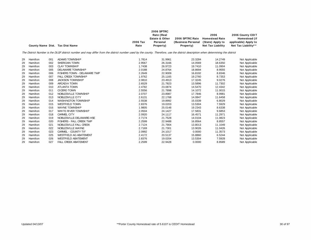
29 Hamilton 001 ADAMS TOWNSHIP 1.7814 31.9961 23.3284 14.2749 Not Applicable29 Hamilton 002 SHERIDAN TOWN 2.9567 26.3166 14.0569 18.6350 Not Applicable29 Hamilton 003 CLAY TOWNSHIP 1.7438 26.9723 19.7410 11.0904 Not Applicable29 Hamilton 005 DELAWARE TOWNSHIP 2.0188 24.8764 18.8694 8.9555 Not Applicable29 Hamilton 006 FISHERS TOWN - DELAWARE TWP 2.2649 22.9009 16.8192 8.8346 Not Applicable29 Hamilton 007 FALL CREEK TOWNSHIP 1.9762 25.1165 19.2760 8.7353 Not Applicable29 Hamilton 008 JACKSON TOWNSHIP 2.0810 23.4913 17.3245 9.0276 Not Applicable29 Hamilton 009 ARCADIA TOWN 2.6529 21.7823 13.5896 11.7302 Not Applicable29 Hamilton 010 ATLANTA TOWN 2.4782 23.0874 14.5470 12.4342 Not Applicable29 Hamilton 011 CICERO TOWN 2.5556 21.7898 14.1072 11.0015 Not Applicable29 Hamilton 012 NOBLESVILLE TOWNSHIP 2.0707 23.8987 17.7846 8.9981 Not Applicable29 Hamilton 013 NOBLESVILLE CITY 2.6131 22.1768 14.0847 11.6458 Not Applicable29 Hamilton 014 WASHINGTON TOWNSHIP 2.5538 19.8992 15.0339 6.8029 Not Applicable29 Hamilton 015 WESTFIELD TOWN 2.8376 19.0203 13.5304 7.5929 Not Applicable29 Hamilton 016 WAYNE TOWNSHIP 1.9805 25.0148 19.2343 8.6338 Not Applicable29 Hamilton 017 WHITE RIVER TOWNSHIP 2.0504 24.1427 17.5831 9.6853 Not Applicable29 Hamilton 018 CARMEL CITY 2.0920 24.1117 16.4571 11.2971 Not Applicable29 Hamilton 019 NOBLESVILLE-DELAWARE-HSE 2.7174 21.7528 14.0104 11.0823 Not Applicable29 Hamilton 020 FISHERS - FALL CREEK TWP 2.2599 22.9488 16.8564 8.8557 Not Applicable29 Hamilton 021 NOBLESVILLE FALL CREEK 2.7124 21.7904 13.8013 11.1049 Not Applicable29 Hamilton 022 NOBLESVILLE WAYNE 2.7169 21.7301 13.9026 11.0426 Not Applicable29 Hamilton 023 CARMEL - COUNTY TIF 2.0992 24.1017 0.0000 11.3573 Not Applicable29 Hamilton 025 WESTFIELD AG ABATEMENT 2.4172 20.5137 15.8860 6.5244 Not Applicable29 Hamilton 026 WESTFIELD ABATEMENT 2.8376 19.0204 13.5304 7.5928 Not Applicable29 Hamilton 027 FALL CREEK ABATEMENT 2.2599 22.9428 0.0000 8.8589 Not Applicable
Updated 04/13/07 **Porter County Homestead rate of 5.6107 is CEDIT Homestead 30 of 97
County Name Dist. Tax Dist Name2006 Tax
Rate
2006 SPTRC Rate (Real
Estate & Other Personal Property)
2006 SPTRC Rate (Business Personal
Property)
2006 Homestead Rate (State) Apply to Net Tax Liability
2006 County COIT Homestead (if
applicable) Apply to Net Tax Liability**
The District Number is the DLGF district number and may differ from the district number used by the county. Therefore, use the district description when determining the district.
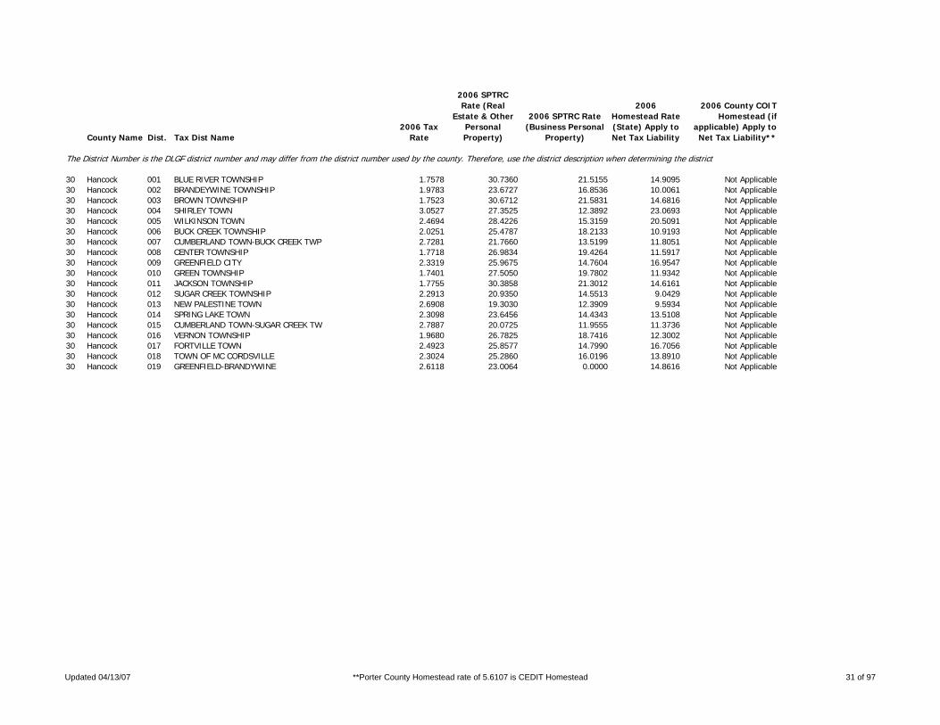
30 Hancock 001 BLUE RIVER TOWNSHIP 1.7578 30.7360 21.5155 14.9095 Not Applicable30 Hancock 002 BRANDEYWINE TOWNSHIP 1.9783 23.6727 16.8536 10.0061 Not Applicable30 Hancock 003 BROWN TOWNSHIP 1.7523 30.6712 21.5831 14.6816 Not Applicable30 Hancock 004 SHIRLEY TOWN 3.0527 27.3525 12.3892 23.0693 Not Applicable30 Hancock 005 WILKINSON TOWN 2.4694 28.4226 15.3159 20.5091 Not Applicable30 Hancock 006 BUCK CREEK TOWNSHIP 2.0251 25.4787 18.2133 10.9193 Not Applicable30 Hancock 007 CUMBERLAND TOWN-BUCK CREEK TWP 2.7281 21.7660 13.5199 11.8051 Not Applicable30 Hancock 008 CENTER TOWNSHIP 1.7718 26.9834 19.4264 11.5917 Not Applicable30 Hancock 009 GREENFIELD CITY 2.3319 25.9675 14.7604 16.9547 Not Applicable30 Hancock 010 GREEN TOWNSHIP 1.7401 27.5050 19.7802 11.9342 Not Applicable30 Hancock 011 JACKSON TOWNSHIP 1.7755 30.3858 21.3012 14.6161 Not Applicable30 Hancock 012 SUGAR CREEK TOWNSHIP 2.2913 20.9350 14.5513 9.0429 Not Applicable30 Hancock 013 NEW PALESTINE TOWN 2.6908 19.3030 12.3909 9.5934 Not Applicable30 Hancock 014 SPRING LAKE TOWN 2.3098 23.6456 14.4343 13.5108 Not Applicable30 Hancock 015 CUMBERLAND TOWN-SUGAR CREEK TW 2.7887 20.0725 11.9555 11.3736 Not Applicable30 Hancock 016 VERNON TOWNSHIP 1.9680 26.7825 18.7416 12.3002 Not Applicable30 Hancock 017 FORTVILLE TOWN 2.4923 25.8577 14.7990 16.7056 Not Applicable30 Hancock 018 TOWN OF MC CORDSVILLE 2.3024 25.2860 16.0196 13.8910 Not Applicable30 Hancock 019 GREENFIELD-BRANDYWINE 2.6118 23.0064 0.0000 14.8616 Not Applicable
Updated 04/13/07 **Porter County Homestead rate of 5.6107 is CEDIT Homestead 31 of 97

County Name Dist. Tax Dist Name2006 Tax
Rate
2006 SPTRC Rate (Real
Estate & Other Personal Property)
2006 SPTRC Rate (Business Personal
Property)
2006 Homestead Rate (State) Apply to Net Tax Liability
2006 County COIT Homestead (if
applicable) Apply to Net Tax Liability**
The District Number is the DLGF district number and may differ from the district number used by the county. Therefore, use the district description when determining the district.
31 Harrison 001 BLUE RIVER TOWNSHIP 1.9989 31.6364 20.5457 18.1696 Not Applicable31 Harrison 002 MILLTOWN TOWN-BLUE RIVER TOWNS 3.6209 25.3116 11.3883 20.8789 Not Applicable31 Harrison 003 BOONE TOWNSHIP 2.0297 30.4992 19.1531 18.2844 Not Applicable31 Harrison 004 LACONIA TOWN 2.1598 30.0226 17.9956 19.2414 Not Applicable31 Harrison 005 FRANKLIN TOWNSHIP 1.9568 29.6401 19.1053 16.7694 Not Applicable31 Harrison 006 LANESVILLE TOWN 2.0914 29.4209 17.8758 18.3206 Not Applicable31 Harrison 007 HARRISON TOWNSHIP 1.9848 30.3671 19.5864 17.3401 Not Applicable31 Harrison 008 CORYDON TOWN 2.4686 29.3531 15.7478 21.5691 Not Applicable31 Harrison 009 HETH TOWNSHIP 2.0455 30.2222 19.0051 18.0043 Not Applicable31 Harrison 010 MAUCKPORT TOWN 2.2344 29.4575 17.4060 19.1482 Not Applicable31 Harrison 011 JACKSON TOWNSHIP 1.9814 31.7704 20.7272 18.1275 Not Applicable31 Harrison 012 CRANDALL TOWN 2.0979 31.8779 19.5737 20.2282 Not Applicable31 Harrison 013 MORGAN TOWNSHIP 2.0249 31.6811 20.2820 18.6875 Not Applicable31 Harrison 014 PALMYRA TOWN 2.1535 31.2731 19.0709 19.8857 Not Applicable31 Harrison 015 POSEY TOWNSHIP 1.9581 30.7002 19.8534 17.5302 Not Applicable31 Harrison 016 ELIZABETH TOWN 2.0546 30.4758 18.9204 18.6150 Not Applicable31 Harrison 017 SPENCER TOWNSHIP 2.0021 31.7012 20.5129 18.3470 Not Applicable31 Harrison 018 MILLTOWN TOWN-SPENCER TOWNSHIP 3.6186 25.3480 0.0000 20.9426 Not Applicable31 Harrison 019 TAYLOR TOWNSHIP 2.0462 29.3311 18.9988 16.3757 Not Applicable31 Harrison 020 WASHINGTON TOWNSHIP 2.0829 30.1248 18.6641 18.3703 Not Applicable31 Harrison 021 NEW AMSTERDAM TOWN 2.0829 30.1242 18.6595 18.3703 Not Applicable31 Harrison 022 WEBSTER TOWNSHIP 2.0234 30.6705 19.2126 18.5099 Not Applicable31 Harrison 023 NEW MIDDLETOWN TOWN 2.0234 30.6701 19.2175 18.5105 Not Applicable31 Harrison 024 MILLTOWN TOWN-SPENCER TOWNSHIP 3.0563 27.7981 13.4910 22.2756 Not Applicable
Updated 04/13/07 **Porter County Homestead rate of 5.6107 is CEDIT Homestead 32 of 97

County Name Dist. Tax Dist Name2006 Tax
Rate
2006 SPTRC Rate (Real
Estate & Other Personal Property)
2006 SPTRC Rate (Business Personal
Property)
2006 Homestead Rate (State) Apply to Net Tax Liability
2006 County COIT Homestead (if
applicable) Apply to Net Tax Liability**
The District Number is the DLGF district number and may differ from the district number used by the county. Therefore, use the district description when determining the district.
32 Hendricks 001 BROWN TOWNSHIP 2.7144 17.3513 11.8715 7.4259 Not Applicable32 Hendricks 002 CENTER TOWNSHIP 2.1368 23.9900 17.0484 10.2284 Not Applicable32 Hendricks 003 DANVILLE TOWN 2.5040 24.1381 14.5472 14.1597 Not Applicable32 Hendricks 007 EEL RIVER TOWNSHIP 1.9811 28.1775 20.0637 12.6526 Not Applicable32 Hendricks 008 NORTH SALEM TOWN 2.6500 27.5431 14.9990 19.3897 Not Applicable32 Hendricks 009 FRANKLIN TOWNSHIP 1.9851 25.3553 18.0862 10.9071 Not Applicable32 Hendricks 010 STILESVILLE TOWN 2.2629 24.9277 15.8652 13.5187 Not Applicable32 Hendricks 011 GUILFORD TOWNSHIP 2.3216 23.9024 16.8390 10.3959 Not Applicable32 Hendricks 012 PLAINFIELD TOWN 3.0199 21.2439 12.9292 11.8245 Not Applicable32 Hendricks 013 LIBERTY TOWNSHIP 2.0280 24.9727 17.7035 10.8514 Not Applicable32 Hendricks 014 CLAYTON TOWN 2.3323 24.9055 15.3935 14.1865 Not Applicable32 Hendricks 015 LINCOLN TOWNSHIP 2.7288 17.1993 11.8088 7.2914 Not Applicable32 Hendricks 016 BROWNSBURG TOWN 3.1988 17.0560 10.0717 9.4308 Not Applicable32 Hendricks 017 MARION TOWNSHIP 1.9413 25.6768 18.7652 10.4153 Not Applicable32 Hendricks 018 MIDDLE TOWNSHIP 2.0616 26.7922 19.2803 11.4924 Not Applicable32 Hendricks 019 PITTSBORO TOWN 2.4028 25.3184 16.5425 13.1613 Not Applicable32 Hendricks 020 UNION TOWNSHIP 1.9496 28.3721 20.3878 12.4844 Not Applicable32 Hendricks 021 LIZTON TOWN 2.5162 27.0212 15.7963 17.2257 Not Applicable32 Hendricks 022 WASHINGTON TOWNSHIP 2.2970 21.3174 15.5225 8.2486 Not Applicable32 Hendricks 023 CLAY TOWNSHIP 2.1645 24.0232 16.5871 10.9618 Not Applicable32 Hendricks 024 AMO TOWN 2.6378 23.4226 13.6123 14.3499 Not Applicable32 Hendricks 025 COATSVILLE TOWN 2.6205 23.9135 13.7006 15.0332 Not Applicable32 Hendricks 026 BROWNSBURG - BROWN TWP 3.1960 17.0807 10.0806 9.4551 Not Applicable32 Hendricks 027 PLAINFIELD - WASHINGTON TWP 2.9823 19.9634 11.9406 11.2267 Not Applicable32 Hendricks 028 BROWNSBURG - MIDDLE TWP 2.6552 23.8313 14.9658 13.0351 Not Applicable32 Hendricks 029 PLAINFIELD - LIBERTY 2.7842 21.7654 12.4665 12.7237 Not Applicable32 Hendricks 030 EEL RIVER - JAMESTOWN 2.2020 28.3752 18.0458 16.1450 Not Applicable32 Hendricks 031 AVON 2.6155 20.3853 13.6327 9.4994 Not Applicable
Updated 04/13/07 **Porter County Homestead rate of 5.6107 is CEDIT Homestead 33 of 97

County Name Dist. Tax Dist Name2006 Tax
Rate
2006 SPTRC Rate (Real
Estate & Other Personal Property)
2006 SPTRC Rate (Business Personal
Property)
2006 Homestead Rate (State) Apply to Net Tax Liability
2006 County COIT Homestead (if
applicable) Apply to Net Tax Liability**
The District Number is the DLGF district number and may differ from the district number used by the county. Therefore, use the district description when determining the district.
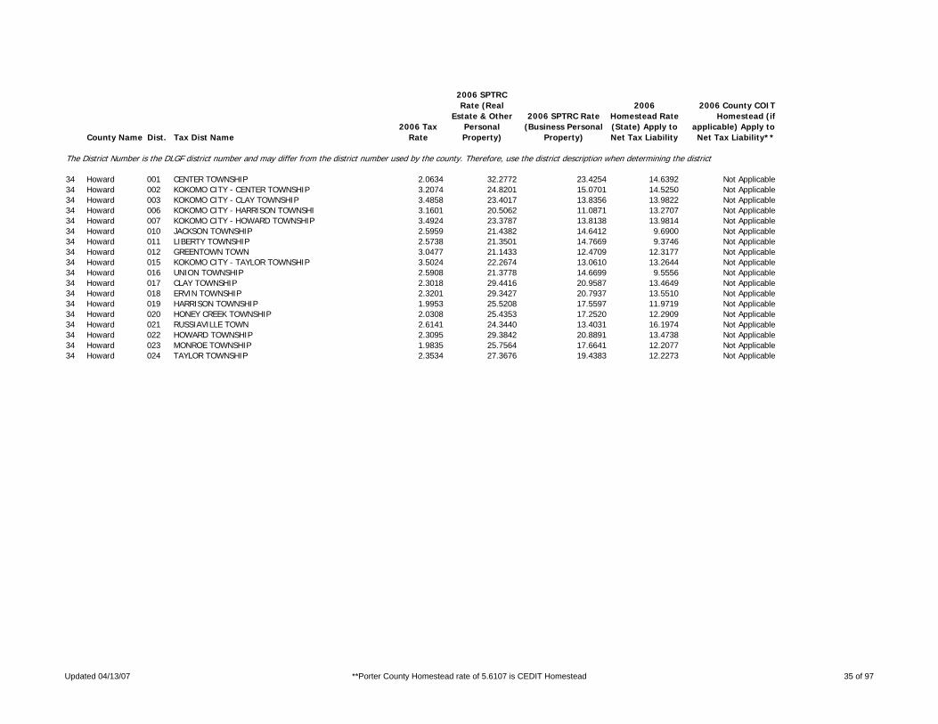
33 Henry 001 BLUE RIVER TOWNSHIP 2.6208 24.9337 15.8052 13.6200 Not Applicable33 Henry 002 MOORELAND TOWN 2.9408 24.2001 14.0866 14.9453 Not Applicable33 Henry 003 DUDLEY TOWNSHIP 2.2312 27.9779 18.1808 15.2350 Not Applicable33 Henry 004 STRAUGHN TOWN 2.5560 26.5405 15.8759 16.2673 Not Applicable33 Henry 005 FALL CREEK TOWNSHIP 2.1631 26.2597 16.1680 15.3273 Not Applicable33 Henry 006 MIDDLETOWN TOWN 2.7665 23.7801 12.6420 16.3669 Not Applicable33 Henry 007 FRANKLIN TOWNSHIP 2.2615 27.7865 17.9369 15.2757 Not Applicable33 Henry 008 LEWISVILLE TOWN 2.6213 26.8316 15.4764 17.3833 Not Applicable33 Henry 009 GREENSBORO TOWNSHIP 2.6248 18.6620 10.9713 10.5900 Not Applicable33 Henry 010 SHIRLEY TOWN 4.0088 18.9981 7.1839 16.3362 Not Applicable33 Henry 011 GREENSBORO TOWN 2.9307 18.7224 9.8219 12.2584 Not Applicable33 Henry 012 KENNARD TOWN 3.0399 18.8447 9.4723 12.9335 Not Applicable33 Henry 013 HARRISON TOWNSHIP 2.1827 25.7161 16.0231 14.6143 Not Applicable33 Henry 014 CADIZ TOWN 2.3029 25.3376 15.1896 15.2256 Not Applicable33 Henry 015 HENRY TOWNSHIP 2.4982 26.9939 17.3367 14.8152 Not Applicable33 Henry 016 NEW CASTLE CITY 3.4848 24.6243 12.4286 18.1215 Not Applicable33 Henry 017 JEFFERSON TOWNSHIP 2.2286 25.4428 15.6932 14.6461 Not Applicable33 Henry 018 SULPHER SPRINGS TOWN 2.3917 25.0983 14.6229 15.6640 Not Applicable33 Henry 019 WEST LIBERTY TOWNSHIP 2.3930 27.6413 18.0988 14.7700 Not Applicable33 Henry 020 EAST LIBERTY TOWNSHIP 2.4985 23.9905 15.2089 12.9396 Not Applicable33 Henry 021 PRAIRIE TOWNSHIP 2.6407 24.5489 15.6860 13.1561 Not Applicable33 Henry 022 MOUNT SUMMIT TOWN 2.6254 25.0422 15.7772 13.8437 Not Applicable33 Henry 023 SPRINGPORT TOWN 2.9202 24.5327 14.1835 15.3587 Not Applicable33 Henry 024 SPICELAND TOWNSHIP 2.1114 29.3234 19.2125 16.0226 Not Applicable33 Henry 025 DUNREITH TOWN 2.2508 28.9113 18.0264 17.1550 Not Applicable33 Henry 026 SPICELAND TOWN 2.3335 28.3291 17.3833 17.1043 Not Applicable33 Henry 027 STONEY CREEK TOWNSHIP 2.3121 24.7328 14.9655 14.5340 Not Applicable33 Henry 028 BLOUNTSVILLE TOWN 2.5750 24.1895 13.4383 15.8836 Not Applicable33 Henry 029 WAYNE TOWNSHIP 2.6352 18.6673 10.9279 10.6576 Not Applicable33 Henry 030 KNIGHTSTOWN TOWN 3.2073 19.3551 8.9786 14.4108 Not Applicable
Updated 04/13/07 **Porter County Homestead rate of 5.6107 is CEDIT Homestead 34 of 97
County Name Dist. Tax Dist Name2006 Tax
Rate
2006 SPTRC Rate (Real
Estate & Other Personal Property)
2006 SPTRC Rate (Business Personal
Property)
2006 Homestead Rate (State) Apply to Net Tax Liability
2006 County COIT Homestead (if
applicable) Apply to Net Tax Liability**
The District Number is the DLGF district number and may differ from the district number used by the county. Therefore, use the district description when determining the district.
34 Howard 001 CENTER TOWNSHIP 2.0634 32.2772 23.4254 14.6392 Not Applicable34 Howard 002 KOKOMO CITY - CENTER TOWNSHIP 3.2074 24.8201 15.0701 14.5250 Not Applicable34 Howard 003 KOKOMO CITY - CLAY TOWNSHIP 3.4858 23.4017 13.8356 13.9822 Not Applicable34 Howard 006 KOKOMO CITY - HARRISON TOWNSHI 3.1601 20.5062 11.0871 13.2707 Not Applicable34 Howard 007 KOKOMO CITY - HOWARD TOWNSHIP 3.4924 23.3787 13.8138 13.9814 Not Applicable34 Howard 010 JACKSON TOWNSHIP 2.5959 21.4382 14.6412 9.6900 Not Applicable34 Howard 011 LIBERTY TOWNSHIP 2.5738 21.3501 14.7669 9.3746 Not Applicable34 Howard 012 GREENTOWN TOWN 3.0477 21.1433 12.4709 12.3177 Not Applicable34 Howard 015 KOKOMO CITY - TAYLOR TOWNSHIP 3.5024 22.2674 13.0610 13.2644 Not Applicable34 Howard 016 UNION TOWNSHIP 2.5908 21.3778 14.6699 9.5556 Not Applicable34 Howard 017 CLAY TOWNSHIP 2.3018 29.4416 20.9587 13.4649 Not Applicable34 Howard 018 ERVIN TOWNSHIP 2.3201 29.3427 20.7937 13.5510 Not Applicable34 Howard 019 HARRISON TOWNSHIP 1.9953 25.5208 17.5597 11.9719 Not Applicable34 Howard 020 HONEY CREEK TOWNSHIP 2.0308 25.4353 17.2520 12.2909 Not Applicable34 Howard 021 RUSSIAVILLE TOWN 2.6141 24.3440 13.4031 16.1974 Not Applicable34 Howard 022 HOWARD TOWNSHIP 2.3095 29.3842 20.8891 13.4738 Not Applicable34 Howard 023 MONROE TOWNSHIP 1.9835 25.7564 17.6641 12.2077 Not Applicable34 Howard 024 TAYLOR TOWNSHIP 2.3534 27.3676 19.4383 12.2273 Not Applicable
Updated 04/13/07 **Porter County Homestead rate of 5.6107 is CEDIT Homestead 35 of 97

County Name Dist. Tax Dist Name2006 Tax
Rate
2006 SPTRC Rate (Real
Estate & Other Personal Property)
2006 SPTRC Rate (Business Personal
Property)
2006 Homestead Rate (State) Apply to Net Tax Liability
2006 County COIT Homestead (if
applicable) Apply to Net Tax Liability**
The District Number is the DLGF district number and may differ from the district number used by the county. Therefore, use the district description when determining the district.
35 Huntington 001 CLEAR CREEK TOWNSHIP 2.1052 29.9697 19.6967 16.4297 Not Applicable35 Huntington 002 DALLAS TOWNSHIP 2.2149 29.4749 18.7212 17.0779 Not Applicable35 Huntington 003 ANDREWS TOWN 3.8974 26.2089 10.6391 23.6316 Not Applicable35 Huntington 004 HUNTINGTON TOWNSHIP 2.3432 28.8879 17.6961 17.6268 Not Applicable35 Huntington 005 HUNTINGTON CITY 3.8685 25.5903 10.7188 22.3843 Not Applicable35 Huntington 006 JACKSON TOWNSHIP 2.0719 30.3075 20.0133 16.5434 Not Applicable35 Huntington 007 ROANOKE TOWN 2.8927 27.7562 14.3345 20.8076 Not Applicable35 Huntington 008 JEFFERSON TOWNSHIP 2.1219 29.9485 19.5417 16.6386 Not Applicable35 Huntington 009 MOUNT ETNA TOWN-JEFFERSON TOWN 2.2341 29.8013 18.5544 17.9341 Not Applicable35 Huntington 010 LANCASTER TOWNSHIP 2.0983 30.0246 19.7615 16.4268 Not Applicable35 Huntington 011 MOUNT ETNA TOWN-LANCASTER TOWN 2.2183 29.8424 18.6933 17.8005 Not Applicable35 Huntington 012 POLK TOWNSHIP 2.1094 30.1390 19.6575 16.8038 Not Applicable35 Huntington 013 MOUNT ETNA TOWN-POLK TOWNSHIP 2.2532 29.7080 18.4087 18.0087 Not Applicable35 Huntington 014 ROCK CREEK TOWNSHIP 2.0775 30.3186 19.9593 16.6506 Not Applicable35 Huntington 015 MARKLE TOWN 3.4494 26.5575 12.0212 22.1682 Not Applicable35 Huntington 016 SALAMONIE TOWNSHIP 2.1704 29.7282 19.1050 16.9314 Not Applicable35 Huntington 017 WARREN TOWN 2.8602 27.5610 14.4975 20.1980 Not Applicable35 Huntington 018 UNION TOWNSHIP 2.0649 30.3599 20.0811 16.5310 Not Applicable35 Huntington 019 WARREN TOWNSHIP 2.1596 29.8112 19.2006 16.9315 Not Applicable35 Huntington 020 WAYNE TOWNSHIP 2.0988 30.0725 19.7568 16.5221 Not Applicable35 Huntington 021 MOUNT ETNA TOWN-WAYNE TOWNSHIP 2.2267 29.8096 18.6152 17.8559 Not Applicable
Updated 04/13/07 **Porter County Homestead rate of 5.6107 is CEDIT Homestead 36 of 97

County Name Dist. Tax Dist Name2006 Tax
Rate
2006 SPTRC Rate (Real
Estate & Other Personal Property)
2006 SPTRC Rate (Business Personal
Property)
2006 Homestead Rate (State) Apply to Net Tax Liability
2006 County COIT Homestead (if
applicable) Apply to Net Tax Liability**
The District Number is the DLGF district number and may differ from the district number used by the county. Therefore, use the district description when determining the district.
36 Jackson 001 BROWNSTOWN TOWNSHIP 1.9314 29.9350 19.6127 16.5004 Not Applicable36 Jackson 002 BROWNSTOWN TOWN 2.5126 28.0712 15.0760 20.2347 Not Applicable36 Jackson 003 CARR TOWNSHIP 3.0955 24.6184 16.3595 12.2712 Not Applicable36 Jackson 004 MEDORA TOWN 3.7155 24.6884 13.6294 16.4462 Not Applicable36 Jackson 005 DRIFTWOOD TOWNSHIP 1.9452 30.2299 19.4737 17.2670 Not Applicable36 Jackson 006 GRASSY FORK TOWNSHIP 1.9367 30.2078 19.5589 17.0887 Not Applicable36 Jackson 007 HAMILTON TOWNSHIP 1.7277 34.3718 24.3461 17.1094 Not Applicable36 Jackson 008 JACKSON TOWNSHIP 1.6882 34.8394 24.9158 17.0571 Not Applicable36 Jackson 009 SEYMOUR CITY-JACKSON TOWNSHIP 2.4838 30.7787 16.9349 22.3993 Not Applicable36 Jackson 010 OWEN TOWNSHIP 1.9460 29.4779 19.4655 15.9011 Not Applicable36 Jackson 011 PERSHING TOWNSHIP 2.0357 29.3590 18.6075 17.0458 Not Applicable36 Jackson 012 REDDING TOWNSHIP 1.6853 34.8231 24.9587 16.9509 Not Applicable36 Jackson 013 SEYMOUR CITY-REDDING TOWNSHIP 2.4809 30.7629 16.9547 22.3364 Not Applicable36 Jackson 014 SALT CREEK TOWNSHIP 1.9877 29.6322 19.0569 16.8313 Not Applicable36 Jackson 015 VERNON TOWNSHIP 2.4261 29.0103 20.4482 13.5084 Not Applicable36 Jackson 016 CROTHERSVILLE TOWN 2.7764 27.6972 17.8682 15.2254 Not Applicable36 Jackson 017 WASHINGTON TOWNSHIP 1.6945 34.8123 24.8230 17.1624 Not Applicable
Updated 04/13/07 **Porter County Homestead rate of 5.6107 is CEDIT Homestead 37 of 97

County Name Dist. Tax Dist Name2006 Tax
Rate
2006 SPTRC Rate (Real
Estate & Other Personal Property)
2006 SPTRC Rate (Business Personal
Property)
2006 Homestead Rate (State) Apply to Net Tax Liability
2006 County COIT Homestead (if
applicable) Apply to Net Tax Liability**
The District Number is the DLGF district number and may differ from the district number used by the county. Therefore, use the district description when determining the district.
37 Jasper 002 Carpenter Township 2.1314 36.9168 27.5714 16.5922 Not Applicable37 Jasper 003 Remington Corp (Carpenter) 2.6307 33.6316 22.3384 19.0577 Not Applicable37 Jasper 019 Barkley Township 1.7201 31.4811 22.3091 14.9922 Not Applicable37 Jasper 020 Gillam Township 1.7827 36.4254 25.0801 19.9875 Not Applicable37 Jasper 021 Hanging Grove Township 1.7615 31.2265 21.7850 15.3758 Not Applicable37 Jasper 022 Jordan Township 1.7612 31.2101 21.7887 15.3396 Not Applicable37 Jasper 023 Kankakee Township 1.7072 31.8026 22.4043 15.4348 Not Applicable37 Jasper 024 Keener Township 1.7509 31.3230 21.8450 15.4568 Not Applicable37 Jasper 025 DeMotte Corp (Keener) 2.2845 28.2394 16.7425 17.9434 Not Applicable37 Jasper 026 Marion Township 1.7824 30.8005 21.5294 15.0053 Not Applicable37 Jasper 027 Rensselaer Corp (Marion) 2.2839 28.9913 16.8020 19.2260 Not Applicable37 Jasper 028 Milroy Township 1.7041 31.5144 22.5188 14.7116 Not Applicable37 Jasper 029 Newton Township 1.7418 31.3185 22.0311 15.1448 Not Applicable37 Jasper 030 Union Township North 1.7066 31.8368 22.4123 15.4856 Not Applicable37 Jasper 031 Union Township South 1.7156 31.4844 22.3678 14.9026 Not Applicable37 Jasper 032 Walker Township 1.7460 31.3580 21.9067 15.4218 Not Applicable37 Jasper 033 Wheatfield Township 1.7411 31.3694 21.9682 15.3423 Not Applicable37 Jasper 034 Wheatfield Corp (Wheatfield) 2.1877 29.5229 17.4835 19.1326 Not Applicable
Updated 04/13/07 **Porter County Homestead rate of 5.6107 is CEDIT Homestead 38 of 97

County Name Dist. Tax Dist Name2006 Tax
Rate
2006 SPTRC Rate (Real
Estate & Other Personal Property)
2006 SPTRC Rate (Business Personal
Property)
2006 Homestead Rate (State) Apply to Net Tax Liability
2006 County COIT Homestead (if
applicable) Apply to Net Tax Liability**
The District Number is the DLGF district number and may differ from the district number used by the county. Therefore, use the district description when determining the district.
38 Jay 010 PENN TOWNSHIP 2.2261 29.4063 17.6532 18.6468 Not Applicable38 Jay 011 PENNVILLE TOWN 2.8846 27.8260 13.6235 22.0399 Not Applicable38 Jay 014 DUNKIRK CITY 3.7153 26.6361 10.5773 24.5160 Not Applicable38 Jay 020 BEARCREEK TOWNSHIP 2.2533 29.0786 17.4402 18.3796 Not Applicable38 Jay 021 BRYANT TOWN 2.6054 28.2142 15.0834 20.4872 Not Applicable38 Jay 022 GREENE TOWNSHIP 2.2235 29.2148 17.6739 18.2606 Not Applicable38 Jay 023 JACKSON TOWNSHIP 2.2480 29.1178 17.4813 18.3867 Not Applicable38 Jay 024 JEFFERSON TOWNSHIP 2.2213 29.2175 17.6914 18.2378 Not Applicable38 Jay 025 KNOX TOWNSHIP 2.2259 29.1983 17.6548 18.2604 Not Applicable38 Jay 026 MADISON TOWNSHIP 2.2396 28.9247 17.5469 17.9293 Not Applicable38 Jay 027 SALAMONIA TOWN 2.3769 28.8980 16.5333 19.4771 Not Applicable38 Jay 028 NOBLE TOWNSHIP 2.2315 29.1482 17.6105 18.2384 Not Applicable38 Jay 029 PIKE TOWNSHIP 2.2304 29.2036 17.6193 18.3266 Not Applicable38 Jay 030 RICHLAND TOWNSHIP 2.2595 29.0567 17.3923 18.4148 Not Applicable38 Jay 031 REDKEY TOWN 3.2364 27.0526 12.1425 22.8922 Not Applicable38 Jay 032 WABASH TOWNSHIP 2.2426 29.1059 17.5233 18.2983 Not Applicable38 Jay 033 WAYNE TOWNSHIP 2.2568 29.0750 17.4131 18.4157 Not Applicable38 Jay 034 PORTLAND CITY 3.4293 26.3048 11.4594 22.5616 Not Applicable
Updated 04/13/07 **Porter County Homestead rate of 5.6107 is CEDIT Homestead 39 of 97
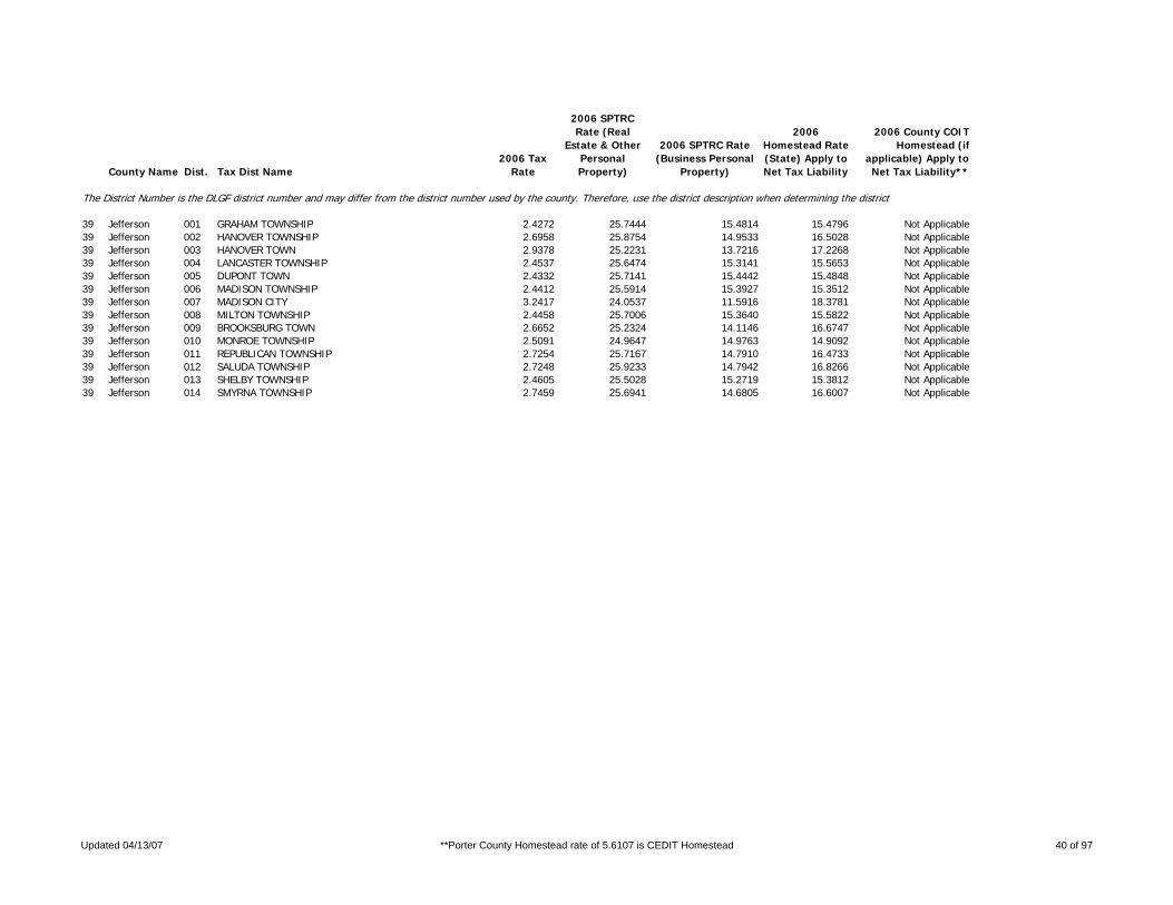
County Name Dist. Tax Dist Name2006 Tax
Rate
2006 SPTRC Rate (Real
Estate & Other Personal Property)
2006 SPTRC Rate (Business Personal
Property)
2006 Homestead Rate (State) Apply to Net Tax Liability
2006 County COIT Homestead (if
applicable) Apply to Net Tax Liability**
The District Number is the DLGF district number and may differ from the district number used by the county. Therefore, use the district description when determining the district.
39 Jefferson 001 GRAHAM TOWNSHIP 2.4272 25.7444 15.4814 15.4796 Not Applicable39 Jefferson 002 HANOVER TOWNSHIP 2.6958 25.8754 14.9533 16.5028 Not Applicable39 Jefferson 003 HANOVER TOWN 2.9378 25.2231 13.7216 17.2268 Not Applicable39 Jefferson 004 LANCASTER TOWNSHIP 2.4537 25.6474 15.3141 15.5653 Not Applicable39 Jefferson 005 DUPONT TOWN 2.4332 25.7141 15.4442 15.4848 Not Applicable39 Jefferson 006 MADISON TOWNSHIP 2.4412 25.5914 15.3927 15.3512 Not Applicable39 Jefferson 007 MADISON CITY 3.2417 24.0537 11.5916 18.3781 Not Applicable39 Jefferson 008 MILTON TOWNSHIP 2.4458 25.7006 15.3640 15.5822 Not Applicable39 Jefferson 009 BROOKSBURG TOWN 2.6652 25.2324 14.1146 16.6747 Not Applicable39 Jefferson 010 MONROE TOWNSHIP 2.5091 24.9647 14.9763 14.9092 Not Applicable39 Jefferson 011 REPUBLICAN TOWNSHIP 2.7254 25.7167 14.7910 16.4733 Not Applicable39 Jefferson 012 SALUDA TOWNSHIP 2.7248 25.9233 14.7942 16.8266 Not Applicable39 Jefferson 013 SHELBY TOWNSHIP 2.4605 25.5028 15.2719 15.3812 Not Applicable39 Jefferson 014 SMYRNA TOWNSHIP 2.7459 25.6941 14.6805 16.6007 Not Applicable
Updated 04/13/07 **Porter County Homestead rate of 5.6107 is CEDIT Homestead 40 of 97

County Name Dist. Tax Dist Name2006 Tax
Rate
2006 SPTRC Rate (Real
Estate & Other Personal Property)
2006 SPTRC Rate (Business Personal
Property)
2006 Homestead Rate (State) Apply to Net Tax Liability
2006 County COIT Homestead (if
applicable) Apply to Net Tax Liability**
The District Number is the DLGF district number and may differ from the district number used by the county. Therefore, use the district description when determining the district.
40 Jennings 001 BIGGER TOWNSHIP 2.2028 25.8324 15.5905 15.4663 Not Applicable40 Jennings 002 CAMPBELL TOWNSHIP 2.1907 25.8458 15.6766 15.3592 Not Applicable40 Jennings 003 CENTER TOWNSHIP 2.1529 25.8287 15.9518 14.9143 Not Applicable40 Jennings 004 NORTH VERNON CITY 3.0525 23.3009 11.2289 17.6282 Not Applicable40 Jennings 005 COLUMBIA TOWNSHIP 2.1699 25.8647 15.8269 15.1646 Not Applicable40 Jennings 006 GENEVA TOWNSHIP 2.1810 25.6007 15.7463 14.8347 Not Applicable40 Jennings 007 LOVETT TOWNSHIP 2.1699 25.8034 15.8269 15.0596 Not Applicable40 Jennings 008 MARION TOWNSHIP 2.1778 25.8341 15.7694 15.1989 Not Applicable40 Jennings 009 MONTGOMERY TOWNSHIP 2.2008 25.6244 15.6046 15.0886 Not Applicable40 Jennings 010 SAND CREEK TOWNSHIP 2.1741 25.6760 15.7963 14.8879 Not Applicable40 Jennings 011 SPENCER TOWNSHIP 2.1687 25.6680 15.8356 14.8149 Not Applicable40 Jennings 012 VERNON TOWNSHIP 2.1353 25.8381 16.0833 14.7318 Not Applicable40 Jennings 013 VERNON TOWN 2.3953 25.6850 14.3376 17.1018 Not Applicable40 Jennings 014 HIDDEN VALLEY 2.1810 25.6007 0.0000 14.8347 Not Applicable
Updated 04/13/07 **Porter County Homestead rate of 5.6107 is CEDIT Homestead 41 of 97

County Name Dist. Tax Dist Name2006 Tax
Rate
2006 SPTRC Rate (Real
Estate & Other Personal Property)
2006 SPTRC Rate (Business Personal
Property)
2006 Homestead Rate (State) Apply to Net Tax Liability
2006 County COIT Homestead (if
applicable) Apply to Net Tax Liability**
The District Number is the DLGF district number and may differ from the district number used by the county. Therefore, use the district description when determining the district.
41 Johnson 001 BLUE RIVER TWP 1.9917 32.7347 25.2641 12.4398 Not Applicable41 Johnson 002 EDINBURG TOWN-EDINBURG LIBRARY 3.7693 28.1873 13.3496 23.1412 Not Applicable41 Johnson 004 BLUE RIVER TWP-AMITY FPD 2.0897 32.1252 24.0795 13.2762 Not Applicable41 Johnson 005 CLARK TOWNSHIP 2.4503 19.9611 13.8630 8.5332 Not Applicable41 Johnson 006 CLARK TOWNSHIP-NEEDHAM FPD 2.4757 20.3497 13.7204 9.3210 Not Applicable41 Johnson 007 CLARK TOWNSHIP-WHITELAND FPD 2.5073 19.7660 13.5479 8.6804 Not Applicable41 Johnson 008 FRANKLIN TOWNSHIP 2.2356 23.8375 16.9379 10.1462 Not Applicable41 Johnson 009 FRANKLIN CITY-FRANKLIN TWP 3.2769 21.1868 11.5494 13.6955 Not Applicable41 Johnson 010 WHITELAND TOWN-FRANKLIN TWP-WF 2.5295 22.9283 14.9749 11.5636 Not Applicable41 Johnson 011 FRANKLIN TWP-AMITY FPD 2.2963 23.7241 16.4913 10.6226 Not Applicable41 Johnson 012 FRANKLIN TWP-NEEDHAM FPD 2.2444 24.0901 16.8712 10.6492 Not Applicable41 Johnson 013 FRANKLIN TWP-BARGERSVILLE FPD 2.3523 23.0121 16.0971 10.0590 Not Applicable41 Johnson 014 FRANKLIN TWP-WHITELAND FPD 2.2760 23.3953 16.6109 9.8781 Not Applicable41 Johnson 015 HENSLEY TOWNSHIP 1.9223 28.0308 19.8577 12.7189 Not Applicable41 Johnson 016 TRAFALGAR TOWN-HENSLEY TWP 2.2896 26.5151 16.6721 15.0020 Not Applicable41 Johnson 017 NEEDHAM TOWNSHIP-NEEDHAM FPD 2.2358 24.1106 16.9364 10.5879 Not Applicable41 Johnson 018 FRANKLIN CITY-NEEDHAM TWP 3.2683 21.1936 11.5797 13.6631 Not Applicable41 Johnson 019 NEEDHAM TOWNSHIP-AMITY FPD 2.2877 23.7435 16.5521 10.5622 Not Applicable41 Johnson 020 NINEVEH TOWNSHIP-NINEVEH FPD 1.9452 27.7234 19.6238 12.5508 Not Applicable41 Johnson 021 PRINCES LAKES TOWN-NINEVEH FPD 2.3750 26.8379 16.0724 16.4800 Not Applicable41 Johnson 022 TRAFALGAR TOWN-NINEVEH TWP 2.2995 26.4393 16.5907 15.0026 Not Applicable41 Johnson 023 PLEASANT TWP-CP SCHOOL 2.4697 20.0815 13.7542 8.8673 Not Applicable41 Johnson 024 PLEASANT TWP-GREENWOOD SCHOOL 1.7843 29.0885 21.3336 12.2461 Not Applicable41 Johnson 025 GRNWD CITY-PLEAS TWP-CP SCHOOL 2.9472 18.7208 11.5242 9.9166 Not Applicable41 Johnson 026 GRNWD CITY-PLEAS TWP-GRNWD SCH 2.2618 25.4125 16.8272 12.8916 Not Applicable41 Johnson 027 NEW WHITELAND TOWN 2.8997 20.4666 11.7145 12.3248 Not Applicable41 Johnson 028 WHITELAND TOWN-PLEAS TWP-WHITE 2.7537 19.6472 12.3356 10.1912 Not Applicable41 Johnson 029 FRANKLIN CITY-PLEASANT TWP 3.5011 18.7191 9.6979 12.4312 Not Applicable41 Johnson 030 GRNWD CITY-PLEAS TWP-CP SCHOOL 2.9498 18.7103 11.5141 9.9149 Not Applicable41 Johnson 031 PLEASANT TWP-CP SCHOOL-GRNWD L 2.4671 20.0962 13.7687 8.8663 Not Applicable41 Johnson 032 PLEASANT TWP-GRNWD SCHOOL-GRNW 1.7817 29.1207 21.3646 12.2546 Not Applicable41 Johnson 033 PLEASANT TWP-WHITELAND FPD 2.5002 19.7395 13.5863 8.5864 Not Applicable41 Johnson 034 UNION TOWNSHIP 2.2253 24.0021 17.0163 10.2955 Not Applicable41 Johnson 035 BARGERSVILLE TOWN-UNION TWP-BF 2.9455 21.3093 12.8555 12.0319 Not Applicable41 Johnson 036 UNION TOWNSHIP-BFPD 2.3498 23.0291 16.1145 10.0611 Not Applicable41 Johnson 037 WHITE RIVER TWP-BFPD 1.9288 28.3459 20.6793 11.9834 Not Applicable41 Johnson 038 WHITE RIVER TWP-WHITE RIVER FP 2.0238 26.8005 19.7086 10.8510 Not Applicable41 Johnson 039 BARGERSVILLE TOWN-WHITE RIVER 2.5245 25.0848 15.7997 13.8813 Not Applicable41 Johnson 040 GRNWD CITY-WHITE RIVER TWP-CNT 2.3021 25.9003 17.3233 12.9643 Not Applicable41 Johnson 041 GRNWD CITY-WR TWP-CG SCH-CNTY 2.3834 24.1978 16.7323 11.0306 Not Applicable41 Johnson 042 GWD CITY-PLEAS TWP-GWD SCH-CO 2.2644 25.3912 16.8082 12.8848 Not Applicable41 Johnson 043 GRNWD CITY-WR TWP-GRNWD SCH-CO 2.2700 25.3750 16.7631 12.9202 Not Applicable41 Johnson 044 HENSLEY FPD-FRANKLIN TWP 2.2278 23.9833 16.9947 10.2926 Not Applicable41 Johnson 046 EDINBURG TOWN-BLUE RIVER TWP-COUNTY LIBRARY 3.7280 28.2959 13.4957 23.1118 Not Applicable
Updated 04/13/07 **Porter County Homestead rate of 5.6107 is CEDIT Homestead 42 of 97

County Name Dist. Tax Dist Name2006 Tax
Rate
2006 SPTRC Rate (Real
Estate & Other Personal Property)
2006 SPTRC Rate (Business Personal
Property)
2006 Homestead Rate (State) Apply to Net Tax Liability
2006 County COIT Homestead (if
applicable) Apply to Net Tax Liability**
The District Number is the DLGF district number and may differ from the district number used by the county. Therefore, use the district description when determining the district.
41 Johnson 047 GWD CITY-CP-CLARK TWP-CO LIB 2.9468 18.7317 0.0000 9.9576 Not Applicable
Updated 04/13/07 **Porter County Homestead rate of 5.6107 is CEDIT Homestead 43 of 97

County Name Dist. Tax Dist Name2006 Tax
Rate
2006 SPTRC Rate (Real
Estate & Other Personal Property)
2006 SPTRC Rate (Business Personal
Property)
2006 Homestead Rate (State) Apply to Net Tax Liability
2006 County COIT Homestead (if
applicable) Apply to Net Tax Liability**
The District Number is the DLGF district number and may differ from the district number used by the county. Therefore, use the district description when determining the district.
42 Knox 001 BUSSERON TOWNSHIP 2.4363 27.2530 18.6233 13.2860 Not Applicable42 Knox 002 OAKTOWN TOWN 2.8351 26.0014 16.0032 15.1322 Not Applicable42 Knox 003 DECKER TOWNSHIP 2.1781 29.2485 17.7543 18.1959 Not Applicable42 Knox 004 HARRISON TOWNSHIP 2.1358 29.2604 18.1056 17.6611 Not Applicable42 Knox 005 MONROE CITY TOWN 2.2754 28.7533 16.9951 18.4839 Not Applicable42 Knox 006 JOHNSON TOWNSHIP 2.2759 28.5394 16.9911 18.0996 Not Applicable42 Knox 007 DECKER TOWN 3.0578 26.3561 12.6468 20.8494 Not Applicable42 Knox 008 PALMYRA TOWNSHIP 2.1839 28.8287 17.7068 17.5021 Not Applicable42 Knox 009 STEEN TOWNSHIP 2.1114 29.5550 18.3149 17.8705 Not Applicable42 Knox 010 WHEATLAND TOWN 2.6777 27.0280 14.4418 19.3184 Not Applicable42 Knox 011 VIGO-SOUTH TOWNSHIP 2.7985 26.6842 16.2127 15.9963 Not Applicable42 Knox 012 BICKNELL CITY-VIGO TOWNSHIP 4.1540 24.3735 10.9225 19.9205 Not Applicable42 Knox 013 EDWARDSPORT TOWN 3.2569 25.7433 13.9299 17.8166 Not Applicable42 Knox 014 SANDBORN TOWN 3.1702 25.9004 14.3120 17.5159 Not Applicable42 Knox 018 WASHINGTON TOWNSHIP 2.5270 27.0549 17.9548 13.9723 Not Applicable42 Knox 019 BICKNELL CITY-WASHINGTON TOWNS 4.1686 24.2946 10.8842 19.8398 Not Applicable42 Knox 020 BRUCEVILLE CIVIL TOWN 3.3023 24.6700 13.7399 16.2516 Not Applicable42 Knox 021 WIDNER TOWNSHIP 2.4194 27.6687 18.7535 13.8048 Not Applicable42 Knox 022 VINCENNES CITY I 3.6711 24.9530 11.5179 20.0505 Not Applicable42 Knox 023 VINCENNES TOWNSHIP-VINCENNES S 2.5323 26.9106 16.6558 15.7140 Not Applicable42 Knox 024 VINCENNES TOWNSHIP-SOUTH KNOX 2.4040 27.3518 16.0429 17.4340 Not Applicable42 Knox 025 VIGO-NORTH TOWNSHIP 2.4403 27.3889 18.5929 13.5675 Not Applicable42 Knox 026 VIGO-CENTRAL TOWNSHIP 2.5715 27.2743 17.6441 14.8307 Not Applicable42 Knox 027 VINCENNES CITY II 3.3854 24.7736 12.4665 18.3231 Not Applicable
Updated 04/13/07 **Porter County Homestead rate of 5.6107 is CEDIT Homestead 44 of 97

County Name Dist. Tax Dist Name2006 Tax
Rate
2006 SPTRC Rate (Real
Estate & Other Personal Property)
2006 SPTRC Rate (Business Personal
Property)
2006 Homestead Rate (State) Apply to Net Tax Liability
2006 County COIT Homestead (if
applicable) Apply to Net Tax Liability**
The District Number is the DLGF district number and may differ from the district number used by the county. Therefore, use the district description when determining the district.
43 Kosciusko 001 CLAY TOWNSHIP 1.5859 32.5223 24.4627 13.3778 Not Applicable43 Kosciusko 002 CLAYPOOL TOWN 2.2522 25.5770 17.2252 12.5692 Not Applicable43 Kosciusko 003 ETNA TOWNSHIP 1.7313 31.4256 23.5314 12.8930 Not Applicable43 Kosciusko 004 ETNA GREEN TOWN 2.0923 29.6358 19.4714 16.1788 Not Applicable43 Kosciusko 005 FRANKLIN TOWNSHIP 2.1911 24.3098 17.2573 10.4357 Not Applicable43 Kosciusko 009 JACKSON TOWNSHIP 1.9774 29.0876 21.3341 12.2460 Not Applicable43 Kosciusko 010 SIDNEY TOWN 2.3269 27.7220 18.1284 14.8658 Not Applicable43 Kosciusko 011 JEFFERSON TOWNSHIP,WEST 1.9127 27.2824 20.3744 10.6398 Not Applicable43 Kosciusko 012 JEFFERSON TOWNSHIP,EAST 1.2821 32.8349 23.9462 14.8217 Not Applicable43 Kosciusko 013 LAKE TOWNSHIP 1.5703 32.4103 24.7058 12.7670 Not Applicable43 Kosciusko 014 SILVER LAKE TOWN 2.5836 20.9621 15.0170 8.4255 Not Applicable43 Kosciusko 015 MONROE TOWNSHIP 1.9061 29.6574 22.1323 11.9816 Not Applicable43 Kosciusko 016 PLAIN TOWNSHIP 1.5629 32.4643 24.8226 12.6729 Not Applicable43 Kosciusko 017 WARSAW CITY-PLAIN TOWNSHIP 2.6292 26.5658 14.7489 18.0227 Not Applicable43 Kosciusko 018 LEESBURG TOWN 1.8845 30.3373 20.5873 15.6765 Not Applicable43 Kosciusko 019 PRAIRIE TOWNSHIP 1.5552 32.7825 24.9456 13.0581 Not Applicable43 Kosciusko 020 SCOTT TOWNSHIP 1.8891 27.3733 20.6288 10.4010 Not Applicable43 Kosciusko 021 SEWARD TOWNSHIP 2.1730 24.1028 17.4011 9.8896 Not Applicable43 Kosciusko 022 BURKET TOWN 2.5326 23.4841 14.9307 12.5198 Not Applicable43 Kosciusko 023 TIPPECANOE TOWNSHIP 1.3120 32.1411 23.4006 14.4260 Not Applicable43 Kosciusko 024 NORTH WEBSTER TOWN 1.7884 28.6463 17.1672 18.0184 Not Applicable43 Kosciusko 025 TURKEY CREEK TOWNSHIP 1.2468 32.9705 24.6242 13.9457 Not Applicable43 Kosciusko 026 SYRACUSE TOWN 2.0364 27.2027 15.0764 18.6566 Not Applicable43 Kosciusko 027 VAN BUREN TOWNSHIP 1.2965 32.3883 23.6804 14.4250 Not Applicable43 Kosciusko 028 MILFORD TOWN 1.8957 27.3268 16.1954 17.1552 Not Applicable43 Kosciusko 029 WASHINGTON TOWNSHIP 1.9789 28.9510 21.3179 12.0327 Not Applicable43 Kosciusko 030 PIERCETON TOWN 2.4842 26.9717 16.9817 15.3213 Not Applicable43 Kosciusko 031 WAYNE TOWNSHIP 1.6623 31.6545 23.3383 13.6280 Not Applicable43 Kosciusko 032 WARSAW CITY-WAYNE TOWNSHIP 2.6181 26.7649 14.8114 18.2809 Not Applicable43 Kosciusko 033 WINONA LAKE TOWN 2.1780 28.0169 17.8100 15.8814 Not Applicable43 Kosciusko 034 HARRISON TOWNSHIP 2.3261 23.6239 16.2558 10.8048 Not Applicable43 Kosciusko 035 MENTONE TOWN-HARRISON TOWNSHIP 2.9742 22.8276 12.7135 14.6783 Not Applicable43 Kosciusko 036 MENTONE TOWN-FRANKLIN TOWNSHIP 2.9838 22.8184 12.6728 14.7229 Not Applicable43 Kosciusko 038 NAPPANEE CITY-JEFFERSON TOWNSH 3.1008 23.7258 12.5675 16.3844 Not Applicable
Updated 04/13/07 **Porter County Homestead rate of 5.6107 is CEDIT Homestead 45 of 97

County Name Dist. Tax Dist Name2006 Tax
Rate
2006 SPTRC Rate (Real
Estate & Other Personal Property)
2006 SPTRC Rate (Business Personal
Property)
2006 Homestead Rate (State) Apply to Net Tax Liability
2006 County COIT Homestead (if
applicable) Apply to Net Tax Liability**
The District Number is the DLGF district number and may differ from the district number used by the county. Therefore, use the district description when determining the district.
44 LaGrange 001 BLOOMFIELD TOWNSHIP 1.7666 32.5861 22.3236 17.0499 Not Applicable44 LaGrange 002 LAGRANGE TOWN 2.6732 29.0723 14.7529 22.6115 Not Applicable44 LaGrange 003 CLAY TOWNSHIP-WEST 1.9919 31.0052 21.4041 15.5857 Not Applicable44 LaGrange 004 CLAY TOWNSHIP-EAST 1.7763 32.4456 22.2017 16.9835 Not Applicable44 LaGrange 005 CLEARSPRING TOWNSHIP 1.9668 31.2267 21.6772 15.5517 Not Applicable44 LaGrange 006 TOPEKA TOWN-CLEARSPRING TOWNSH 3.2259 27.5280 13.2166 22.1176 Not Applicable44 LaGrange 007 EDEN TOWNSHIP 1.9582 31.2237 21.7723 15.3912 Not Applicable44 LaGrange 008 TOPEKA TOWN-EDEN TOWNSHIP 3.2214 27.5292 13.2350 22.0911 Not Applicable44 LaGrange 009 GREENFIELD TOWNSHIP 1.7504 32.8895 22.5302 17.2884 Not Applicable44 LaGrange 010 JOHNSON TOWNSHIP 1.7626 32.7230 22.3743 17.2282 Not Applicable44 LaGrange 011 WOLCOTTVILLE TOWN 2.4847 30.3787 15.8721 23.3370 Not Applicable44 LaGrange 012 LIMA TOWNSHIP 1.7674 32.6453 22.3135 17.1801 Not Applicable44 LaGrange 013 MILFORD TOWNSHIP 1.8178 29.4061 19.0277 16.4659 Not Applicable44 LaGrange 014 NEWBURY TOWNSHIP 1.9521 31.3624 21.8404 15.5377 Not Applicable44 LaGrange 015 SHIPSHEWANA TOWN 3.0738 24.6954 13.7184 16.3260 Not Applicable44 LaGrange 016 SPRINGFIELD TOWNSHIP 1.8258 29.3830 18.9442 16.5559 Not Applicable44 LaGrange 017 VAN BUREN TOWNSHIP 1.9637 31.2748 21.7114 15.5851 Not Applicable44 LaGrange 018 LAGRANGE-CLAY 2.6650 29.0924 14.7984 22.5792 Not Applicable
Updated 04/13/07 **Porter County Homestead rate of 5.6107 is CEDIT Homestead 46 of 97

County Name Dist. Tax Dist Name2006 Tax
Rate
2006 SPTRC Rate (Real
Estate & Other Personal Property)
2006 SPTRC Rate (Business Personal
Property)
2006 Homestead Rate (State) Apply to Net Tax Liability
2006 County COIT Homestead (if
applicable) Apply to Net Tax Liability**
The District Number is the DLGF district number and may differ from the district number used by the county. Therefore, use the district description when determining the district.
45 Lake 001 Calumet Township 5.1138 23.7119 10.7569 19.0196 Not Applicable45 Lake 002 Calumet Township Gary Sanitary 5.5931 22.6675 9.8351 18.5836 Not Applicable45 Lake 003 Gary Corp Calumet Twp Lake Ridge Sch 8.5573 21.0005 6.4280 20.6599 Not Applicable45 Lake 004 Gary Corp Calumet Twp Gary Sch 8.9474 24.1378 9.0635 22.2551 Not Applicable45 Lake 005 Lake Station Corp Calumet Twp 5.6428 18.6872 6.1866 17.2121 Not Applicable45 Lake 006 Griffith Corp Calumet Twp 4.4686 20.3286 7.9518 17.3991 Not Applicable45 Lake 007 Cedar Creek Township 3.0431 21.3542 11.3206 14.2882 Not Applicable45 Lake 008 Lowell Corp Cedar Creek Twp 3.8555 20.5895 8.9357 16.4365 Not Applicable45 Lake 012 Eagle Creek Township 3.0300 21.2789 11.3703 14.0977 Not Applicable45 Lake 013 Hanover Township 3.1217 20.2545 10.5123 13.6834 Not Applicable45 Lake 014 Cedar Lake Corp Hanover Twp 3.6834 19.7634 8.9091 15.1516 Not Applicable45 Lake 015 Saint John Corp Hanover Twp 3.8165 19.3388 8.5987 14.9135 Not Applicable45 Lake 016 Hobart Township 3.0270 25.5647 13.9064 17.5491 Not Applicable45 Lake 017 Gary Corp Hobart Twp River Forest Sch 7.3122 20.8341 5.7561 21.3277 Not Applicable45 Lake 018 Hobart Corp Hobart Twp Hobart City Sch 4.3165 21.7659 9.5938 17.4254 Not Applicable45 Lake 019 Hobart Corp Hobart Hobart City Sch Gary Sanitary 4.7958 20.7408 8.6351 17.1112 Not Applicable45 Lake 020 Lake Station Corp Hobart Twp River Forest Sch 4.7631 22.5348 8.8378 19.8027 Not Applicable45 Lake 021 Lake Station Corp Hobart Twp Lake Station Sch 5.1728 18.5680 6.7483 16.2564 Not Applicable45 Lake 022 New Chicago Corp (Hobart) 3.7869 24.4504 11.1165 19.7673 Not Applicable45 Lake 023 Hammond Corp (North) 5.7135 19.5346 6.3924 18.2927 Not Applicable45 Lake 024 East Chicago Corp (North) 8.2507 22.4453 6.2649 23.3669 Not Applicable45 Lake 025 Whiting Corp (North) 7.3681 22.7439 8.9867 19.9439 Not Applicable45 Lake 026 Highland Corp (North) 3.2683 25.7775 13.0619 19.1876 Not Applicable45 Lake 027 Munster Corp (North) 3.4268 20.9742 9.6072 16.1099 Not Applicable45 Lake 028 Ross Township 2.9411 20.5704 12.9727 10.7172 Not Applicable45 Lake 029 Crown Point Corp Ross Twp 3.6702 19.8498 10.3951 13.2122 Not Applicable45 Lake 030 Merrillville Corp Ross Twp 3.3898 20.0174 11.2540 12.2714 Not Applicable45 Lake 031 Merrillville Corp Ross Twp Gary Sanitary 3.8691 18.9647 9.8599 12.5838 Not Applicable45 Lake 032 Saint John Township 2.3087 30.5756 16.8274 22.1787 Not Applicable45 Lake 033 Griffith Corp Saint John Twp 3.2065 26.4612 12.1163 21.8511 Not Applicable45 Lake 034 Dyer Corp (Saint John) 2.9077 26.5165 13.3481 20.0704 Not Applicable45 Lake 035 Saint John Corp Saint John Twp 2.9888 26.9666 12.9987 21.4207 Not Applicable45 Lake 036 Schererville Corp (Saint John) 2.8193 27.5630 13.7767 21.3158 Not Applicable45 Lake 037 West Creek Township 2.9895 21.3724 11.5242 14.0284 Not Applicable45 Lake 038 Lowell Corp West Creek Twp 3.8351 20.5926 8.9832 16.3743 Not Applicable45 Lake 039 Schneider Corp (West Creek) 4.1242 21.0465 8.3536 18.0067 Not Applicable45 Lake 041 Center Township 3.0608 21.6664 11.3466 14.7555 Not Applicable45 Lake 042 Crown Point Corp Center Twp 3.7042 20.5942 9.3753 15.8240 Not Applicable45 Lake 043 Cedar Lake Corp Center Twp 3.5927 20.8534 9.6653 15.8307 Not Applicable45 Lake 044 Winfield Township 3.0589 21.6668 11.3532 14.7460 Not Applicable45 Lake 045 Hobart Corp Hobart Twp River Forest Sch 4.2234 22.9009 9.9674 18.7888 Not Applicable45 Lake 046 Hobart Corp Ross Twp 4.1282 19.5183 9.2418 14.3011 Not Applicable45 Lake 047 Winfield Corp (Winfield) 3.2106 20.8115 10.8165 14.1360 Not Applicable45 Lake 048 Hobart Corp Ross (TIF Only, see CMT added 049*) 1.2051 16.1824 0.0000 21.6235 Not Applicable
Updated 04/13/07 **Porter County Homestead rate of 5.6107 is CEDIT Homestead 47 of 97

County Name Dist. Tax Dist Name2006 Tax
Rate
2006 SPTRC Rate (Real
Estate & Other Personal Property)
2006 SPTRC Rate (Business Personal
Property)
2006 Homestead Rate (State) Apply to Net Tax Liability
2006 County COIT Homestead (if
applicable) Apply to Net Tax Liability**
The District Number is the DLGF district number and may differ from the district number used by the county. Therefore, use the district description when determining the district.
45 Lake 050 Saint John Township Schererville Water 2.3087 30.5752 0.0000 22.1788 Not Applicable45 Lake 054 Winfield Corp Winfield Water District 3.2931 20.2779 0.0000 13.6724 Not Applicable45 Lake 055 SAINT JOHN TWP SAINT JOHN WATER 2.3981 30.0137 0.0000 22.1035 Not Applicable
Updated 04/13/07 **Porter County Homestead rate of 5.6107 is CEDIT Homestead 48 of 97

County Name Dist. Tax Dist Name2006 Tax
Rate
2006 SPTRC Rate (Real
Estate & Other Personal Property)
2006 SPTRC Rate (Business Personal
Property)
2006 Homestead Rate (State) Apply to Net Tax Liability
2006 County COIT Homestead (if
applicable) Apply to Net Tax Liability**
The District Number is the DLGF district number and may differ from the district number used by the county. Therefore, use the district description when determining the district.
46 LaPorte 001 Cass Township 1.7428 38.1263 25.2819 23.2501 Not Applicable46 LaPorte 002 Wanatah Corp - Cass Twp 2.2328 34.3947 19.7341 25.0285 Not Applicable46 LaPorte 009 Michigan City Corp - Coolspring Twp 3.4595 27.6154 12.5995 23.2341 Not Applicable46 LaPorte 010 Trail Creek Corp - Coolspring Twp 2.7054 29.6309 16.1145 21.5178 Not Applicable46 LaPorte 011 Dewey Township 2.4421 28.5396 17.2222 17.7368 Not Applicable46 LaPorte 012 LaCrosse Corp (Dewey) 3.4087 26.6316 12.3391 21.8185 Not Applicable46 LaPorte 021 Michigan Township 2.1494 31.9006 20.2797 19.1134 Not Applicable46 LaPorte 022 Michigan City Corp - Michigan Twp 3.4581 27.6100 12.6046 23.2161 Not Applicable46 LaPorte 023 Long Beach Corp (Michigan) 2.4145 30.6049 18.0538 20.2588 Not Applicable46 LaPorte 024 Michiana Shores Corp - Michigan Twp 2.3867 30.8082 18.2588 20.3076 Not Applicable46 LaPorte 025 Pottawattamie Park Corp (Michigan) 2.6955 29.8350 16.1745 21.8117 Not Applicable46 LaPorte 026 Trail Creek Corp - Michigan Twp 2.7040 29.6249 16.1198 21.4935 Not Applicable46 LaPorte 027 New Durham Township 2.6207 33.4464 23.5826 16.5994 Not Applicable46 LaPorte 028 Westville Corp (New Durham) 3.2563 31.2036 18.9794 19.9008 Not Applicable46 LaPorte 042 Center Township 2.3068 28.1360 17.1644 17.0994 Not Applicable46 LaPorte 043 LaPorte Corp - Center Twp 3.4134 25.1589 11.5998 20.2913 Not Applicable46 LaPorte 044 Clinton Township 2.4442 28.3616 17.1086 17.5932 Not Applicable46 LaPorte 045 Wanatah Corp - Clinton Twp 2.9062 27.2426 14.3881 19.7864 Not Applicable46 LaPorte 046 Coolspring Township 1 2.1717 31.4950 20.0710 18.6775 Not Applicable46 LaPorte 047 Coolspring Township 2 2.2884 28.2189 17.3058 17.0341 Not Applicable46 LaPorte 048 Galena Township 2.3450 28.3233 17.2612 17.2854 Not Applicable46 LaPorte 049 Hanna Township 2.5750 27.6128 16.2396 17.5970 Not Applicable46 LaPorte 050 Hudson Township 2.4255 27.8572 16.6886 17.3391 Not Applicable46 LaPorte 051 Johnson Township 2.4457 26.7829 16.1642 16.2432 Not Applicable46 LaPorte 052 Kankakee Township 2.4087 27.5696 16.8047 16.6458 Not Applicable46 LaPorte 053 LaPorte Corp - Kankakee Twp 1 3.4596 25.2680 11.7001 20.3337 Not Applicable46 LaPorte 054 LaPorte Corp - Kankakee Twp 2 3.4012 25.1860 11.6415 20.2759 Not Applicable46 LaPorte 055 Lincoln Township 2.4413 27.1303 16.2185 16.7712 Not Applicable46 LaPorte 056 Noble Township 2.4670 28.2218 16.9504 17.5874 Not Applicable46 LaPorte 057 Pleasant Township 2.3974 27.5194 16.5156 17.0034 Not Applicable46 LaPorte 058 LaPorte Corp - Pleasant Twp 3.4109 25.1587 11.6080 20.2785 Not Applicable46 LaPorte 059 Prairie Township 1.3166 21.3988 3.2203 25.9025 Not Applicable46 LaPorte 060 Scipio Township 2.3499 27.6822 16.8494 16.7769 Not Applicable46 LaPorte 061 LaPorte Corp - Scipio Twp 3.4140 25.1648 11.5975 20.3047 Not Applicable46 LaPorte 062 Springfield Township 2.2458 30.7789 19.4087 18.3973 Not Applicable46 LaPorte 063 Michiana Shores Corp - Springfield Twp 2.4009 30.6424 18.1318 20.1655 Not Applicable46 LaPorte 064 Union Township 2.4035 27.8014 16.4733 17.5721 Not Applicable46 LaPorte 065 Kingsford Heights Corp (Union) 2.9613 26.5082 13.3711 20.0213 Not Applicable46 LaPorte 066 Washington Township 2.3680 27.4166 16.7207 16.5043 Not Applicable46 LaPorte 067 Kingsbury Corp (Washington) 2.6536 27.4899 14.9218 19.4122 Not Applicable46 LaPorte 068 Wills Township 2.3473 28.3404 17.2444 17.3424 Not Applicable46 LaPorte 069 Pottawattamie Park Corp (Michigan) MC Sanitary 2.8348 29.4798 14.9404 22.3949 Not Applicable46 LaPorte 070 Long Beach Corp (Michigan) MC Sanitary 2.5538 30.1651 0.0000 21.0096 Not Applicable46 LaPorte 071 Trail Creek Corp - Coolspring Twp MC Sanitary 2.8447 29.2861 15.3229 22.1142 Not Applicable
Updated 04/13/07 **Porter County Homestead rate of 5.6107 is CEDIT Homestead 49 of 97
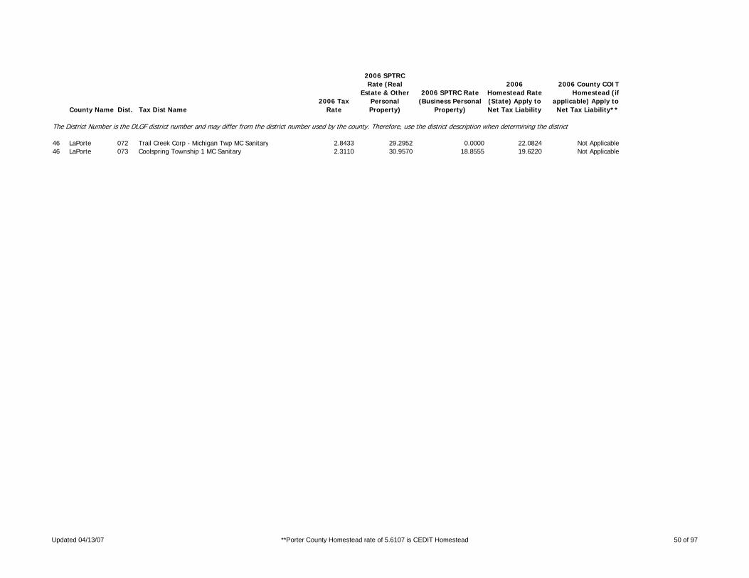
County Name Dist. Tax Dist Name2006 Tax
Rate
2006 SPTRC Rate (Real
Estate & Other Personal Property)
2006 SPTRC Rate (Business Personal
Property)
2006 Homestead Rate (State) Apply to Net Tax Liability
2006 County COIT Homestead (if
applicable) Apply to Net Tax Liability**
The District Number is the DLGF district number and may differ from the district number used by the county. Therefore, use the district description when determining the district.
46 LaPorte 072 Trail Creek Corp - Michigan Twp MC Sanitary 2.8433 29.2952 0.0000 22.0824 Not Applicable46 LaPorte 073 Coolspring Township 1 MC Sanitary 2.3110 30.9570 18.8555 19.6220 Not Applicable
Updated 04/13/07 **Porter County Homestead rate of 5.6107 is CEDIT Homestead 50 of 97

County Name Dist. Tax Dist Name2006 Tax
Rate
2006 SPTRC Rate (Real
Estate & Other Personal Property)
2006 SPTRC Rate (Business Personal
Property)
2006 Homestead Rate (State) Apply to Net Tax Liability
2006 County COIT Homestead (if
applicable) Apply to Net Tax Liability**
The District Number is the DLGF district number and may differ from the district number used by the county. Therefore, use the district description when determining the district.
47 Lawrence 001 BONO TOWNSHIP 2.8507 23.7574 14.5329 13.5508 Not Applicable47 Lawrence 002 GUTHRIE TOWNSHIP 2.4817 26.6315 15.5775 16.8745 Not Applicable47 Lawrence 003 INDIAN CREEK TOWNSHIP 2.4468 26.8763 15.7995 16.9658 Not Applicable47 Lawrence 004 MARION TOWNSHIP 2.8308 23.6030 14.6350 13.1472 Not Applicable47 Lawrence 005 MITCHELL CITY 3.6941 23.2615 11.2149 17.5820 Not Applicable47 Lawrence 006 MARSHALL TOWNSHIP 2.4534 26.7131 15.7571 16.7435 Not Applicable47 Lawrence 007 PERRY TOWNSHIP 2.4624 26.6965 15.6995 16.8022 Not Applicable47 Lawrence 008 PLEASANT RUN TOWNSHIP 2.4553 26.8183 15.7449 16.9473 Not Applicable47 Lawrence 009 SHAWSWICK TOWNSHIP 2.4810 26.5875 15.5818 16.7906 Not Applicable47 Lawrence 010 BEDFORD CITY 3.7457 25.2470 10.3208 22.3635 Not Applicable47 Lawrence 011 OOLITIC TOWN 2.9184 25.8516 13.2467 19.0399 Not Applicable47 Lawrence 012 SPICE VALLEY TOWNSHIP-NORTH 2.4607 26.8306 15.7105 17.0216 Not Applicable47 Lawrence 013 SPICE VALLEY TOWNSHIP-SOUTH 2.8380 23.7874 14.5980 13.5046 Not Applicable
Updated 04/13/07 **Porter County Homestead rate of 5.6107 is CEDIT Homestead 51 of 97

County Name Dist. Tax Dist Name2006 Tax
Rate
2006 SPTRC Rate (Real
Estate & Other Personal Property)
2006 SPTRC Rate (Business Personal
Property)
2006 Homestead Rate (State) Apply to Net Tax Liability
2006 County COIT Homestead (if
applicable) Apply to Net Tax Liability**
The District Number is the DLGF district number and may differ from the district number used by the county. Therefore, use the district description when determining the district.
48 Madison 001 ADAMS TOWNSHIP 2.4164 24.2030 15.0394 13.5404 3.868848 Madison 002 MARKLEVILLE TOWN 2.7241 23.9197 13.3402 15.5743 4.449848 Madison 003 ANDERSON CITY - ANDERSON TOWNS 4.2115 24.1678 11.1662 19.2025 5.486548 Madison 004 COUNTRY CLUB HEIGHTS 2.9328 26.0757 16.0358 15.2118 4.346248 Madison 005 EDGEWOOD TOWN 2.9561 26.6969 15.9087 16.4839 4.709648 Madison 006 RIVER FOREST TOWN 2.9590 26.6875 15.8949 16.5007 4.714548 Madison 007 WOODLAWN HEIGHTS TOWN 3.0116 26.5737 15.7280 16.7147 4.775748 Madison 008 BOONE TOWNSHIP 2.4206 27.4474 16.7871 16.4562 4.701848 Madison 009 DUCK CREEK TOWNSHIP - MADISON 2.4539 27.2064 16.5595 16.3815 4.680548 Madison 010 DUCK CREK TWP - ELWOOD SCH 2.9752 16.5309 8.7535 10.4369 2.981948 Madison 011 ELWOOD CITY - DUCK CREEK TWP 4.7130 16.9310 5.5250 15.3781 4.393748 Madison 012 FALL CREEK TOWNSHIP 2.7224 21.8172 13.3491 12.1311 3.46648 Madison 013 PENDLETON TOWN 3.1778 21.3633 11.4360 14.1392 4.039848 Madison 014 GREEN TOWNSHIP 2.5257 23.1887 14.3885 12.8317 3.666148 Madison 015 INGALLS TOWN 3.3788 20.5387 10.7562 13.7889 3.939748 Madison 016 JACKSON TOWNSHIP 2.3756 26.7911 16.7607 15.3457 4.384448 Madison 017 LAFAYETTE TWP-W CENTRAL SCH 2.5483 25.7806 15.6246 15.3259 4.378948 Madison 018 LAFAYETTE TWP - ANDERSON SCH 2.6735 26.8401 17.5881 14.1613 4.046148 Madison 019 ANDERSON CITY-LAFAYETTE TWP 4.2432 23.9655 11.0829 18.9764 5.421948 Madison 020 FRANKTON TOWN - LAFAYETTE TWP 2.9420 24.8878 13.5348 16.9307 4.837348 Madison 021 MONROE TOWNSHIP 2.2060 30.5503 19.1369 18.4061 5.258948 Madison 022 ALEXANDRIA CITY 3.7566 26.1144 11.2378 22.5508 6.443148 Madison 024 ORESTES TOWN 2.3802 29.2090 17.7361 18.1510 5.18648 Madison 025 PIPE CR.TWP.-W.CENT.SCH. 2.5831 25.8662 15.4142 15.7908 4.511748 Madison 026 PIPE CR.TWP.-ELWOOD SCH. 2.9753 16.5805 8.7521 10.5105 3.00348 Madison 027 ELWOOD CITY-PIPE CR.TWP. 4.7142 16.9318 5.5237 15.3813 4.394748 Madison 028 FRANKTON TOWN-PIPE CR.TWP. 2.9281 25.1593 13.5979 17.3015 4.943348 Madison 029 RICHLAND TOWNSHIP 2.5754 27.4935 18.2600 14.2629 4.075148 Madison 030 ANDERSON CITY-RICHLAND TWP 4.1979 24.1813 11.2013 19.1726 5.477848 Madison 031 STONY CREEK TOWNSHIP 2.5743 26.0452 15.4668 16.0205 4.577348 Madison 032 LAPEL TOWN 3.0512 25.2271 13.0496 18.2407 5.211648 Madison 033 UNION TOWNSHIP 2.7955 26.2566 16.8225 14.3286 4.093948 Madison 034 ANDERSON CITY-UNION TWP 4.1954 24.1869 11.2068 19.1627 5.474948 Madison 035 CHESTERFIELD TOWN 3.5187 25.2826 13.3646 17.8646 5.104248 Madison 036 VAN BUREN TOWNSHIP 2.6159 26.1454 15.5339 16.0923 4.597848 Madison 037 SUMMITVILLE TOWN 3.2012 25.1867 12.6937 18.7028 5.343748 Madison 038 ANDERSON-ADAMS 4.0344 22.1977 9.0080 18.9876 5.42548 Madison 039 ANDERSON-FALL CREEK 4.0333 21.5980 9.0104 17.9814 5.137548 Madison 040 ANDERSON LAF.W.C. 4.0894 23.0651 9.7347 19.4035 5.5439
Updated 04/13/07 **Porter County Homestead rate of 5.6107 is CEDIT Homestead 52 of 97

County Name Dist. Tax Dist Name2006 Tax
Rate
2006 SPTRC Rate (Real
Estate & Other Personal Property)
2006 SPTRC Rate (Business Personal
Property)
2006 Homestead Rate (State) Apply to Net Tax Liability
2006 County COIT Homestead (if
applicable) Apply to Net Tax Liability**
The District Number is the DLGF district number and may differ from the district number used by the county. Therefore, use the district description when determining the district.
49 Marion 101 INDPLS CITY - CENTER TWP 3.5964 25.3787 13.2977 18.1326 5.180749 Marion 102 BEECH GROVE CITY - CENTER TWP 4.1173 19.5131 8.6971 15.0505 4.300249 Marion 200 DECATUR TOWNSHIP - SANITATION 3.4505 17.6627 9.7979 10.6981 3.056649 Marion 201 INDPLS CITY - DECATUR TWP 3.5542 25.3538 13.4634 17.9377 5.125149 Marion 270 INDPLS-DECATUR TWP-POLICE-OUTS 3.8127 17.8844 8.8672 12.3020 3.514949 Marion 274 INDPLS-DECATUR TWP-POLICE & FI 3.7029 19.6282 9.1172 15.1965 4.342349 Marion 300 FRANKLIN TWP-SANITATION 3.4158 18.7444 11.2439 10.3384 2.953949 Marion 302 BEECH GROVE CITY-FRANKLIN TWP 4.0902 19.4414 8.7546 14.8575 4.24549 Marion 320 BEECH GROVE-FRANKLIN TWP-FRANK 3.9855 20.1627 9.6386 14.7665 4.21949 Marion 376 INDPLS-FRANKLIN TWP-FIRE-OUTSI 3.4123 19.3098 0.0000 14.3152 4.08949 Marion 382 FRANKLIN TWP-CONS COUNTY 3.4158 18.7453 11.2336 10.3372 2.953449 Marion 400 LAWRENCE TWP-SANITATION 2.9652 22.0918 12.8559 13.2774 3.793649 Marion 401 INDPLS-LAWRENCE TWP 3.5498 25.3861 13.4725 17.8833 5.109549 Marion 407 LAWRENCE CITY 3.2123 22.3257 11.8600 15.0907 4.311649 Marion 474 INDPLS-LAWRENCE TWP-POLICE & F 3.3881 22.6063 11.2571 16.4352 4.695749 Marion 476 INDPLS-LAWRENCE TWP-FIRE-SAN 3.0259 22.9467 12.6094 14.9726 4.277949 Marion 500 PERRY TWP-SANITATION 2.9894 22.3050 13.0617 13.3244 3.806949 Marion 501 INDPLS-PERRY TWP 3.5527 25.4452 13.4613 18.0022 5.143549 Marion 502 BEECH GROVE - PERRY TWP 4.0736 19.5078 8.7903 14.9127 4.260849 Marion 513 SOUTHPORT-PERRY TWP 2.9266 23.8347 13.3431 15.4278 4.407949 Marion 520 BEECH GROVE - PERRY SCH 3.6284 22.3412 10.7114 16.6965 4.770549 Marion 523 HOMECROFT - PERRY TWP 3.0418 23.0954 12.8066 14.9410 4.268849 Marion 570 INDPLS-PERRY TWP-POLICE-SANITA 3.3516 22.0557 11.6504 14.9523 4.272249 Marion 574 INDPLS-PERRY TWP-POLICE & FIRE 3.4174 22.7552 11.4267 16.4266 4.693349 Marion 576 INDPLS-PERRY TWP-FIRE-SAN 3.0552 23.0985 12.8987 15.0104 4.288749 Marion 600 PIKE TWP-OUTSIDE SANITATION 2.9074 23.0454 13.6791 13.6318 3.894849 Marion 601 INDPLS-PIKE TWP 3.5441 25.4580 13.4938 17.9764 5.136249 Marion 604 CLERMONT - PIKE TWP 2.9567 23.5750 13.4488 14.8330 4.23849 Marion 674 INDPLS-PIKE TWP-POLICE & FIRE- 3.3367 23.2278 11.9193 16.4976 4.713749 Marion 676 INDPLS-FIRE-SAN 2.9745 23.6223 13.3780 15.0264 4.293349 Marion 682 PIKE TWP-CONS COUNTY 2.9074 23.0478 13.6851 13.6276 3.893649 Marion 700 WARREN TWP-SAN 3.3040 21.3250 12.5388 12.5078 3.573749 Marion 701 INDPLS-WARREN TWP 3.5506 25.4197 13.4692 17.9467 5.127649 Marion 702 BEECH GROVE - WARREN TWP 4.0715 19.4763 8.7904 14.8776 4.250849 Marion 716 WARREN PARK-WARREN TWP 3.3146 20.9392 12.4996 11.9581 3.416649 Marion 724 CUMBERLAND TOWN-WARREN TWP 3.8861 21.5555 10.6608 15.5553 4.444449 Marion 770 INDPLS-WARREN TWP-POLICE-SANIT 3.6662 21.1941 11.3002 14.0613 4.017549 Marion 774 INDPLS-WARREN TWP-POLICE & FIR 3.6882 22.0061 11.2339 15.4710 4.420249 Marion 776 INDPLS - FIRE 3.3260 22.2796 12.4275 14.0030 4.00149 Marion 800 WASHINGTON TWP-SAN 2.5590 27.6832 16.7325 16.9600 4.845849 Marion 801 INDPLS-WASHINGTON TWP 3.5537 25.4072 13.4574 17.9423 5.126449 Marion 805 CROWS NEST-WASHINGTON TWP 2.5590 27.6819 16.7149 16.9602 4.845849 Marion 806 HIGHWOODS - WASHINGTON TWP 2.5590 27.6518 16.7029 16.9765 4.850349 Marion 809 NORTH CROWS NEST - WASHINGTON 2.5590 27.6851 16.2227 16.9597 4.8456
Updated 04/13/07 **Porter County Homestead rate of 5.6107 is CEDIT Homestead 53 of 97

County Name Dist. Tax Dist Name2006 Tax
Rate
2006 SPTRC Rate (Real
Estate & Other Personal Property)
2006 SPTRC Rate (Business Personal
Property)
2006 Homestead Rate (State) Apply to Net Tax Liability
2006 County COIT Homestead (if
applicable) Apply to Net Tax Liability**
The District Number is the DLGF district number and may differ from the district number used by the county. Therefore, use the district description when determining the district.
49 Marion 811 ROCKY RIPPLE - WASHINGTON TWP 2.8014 27.3341 15.2929 18.5694 5.305549 Marion 815 SPRING HILL - WASHINGTON TWP 2.5590 27.6830 16.5863 16.9603 4.845949 Marion 817 WILLIAMS CREEK - WASHINGTON TW 2.6323 27.4693 16.2776 17.2992 4.942649 Marion 820 MERIDIAN HILLS - WASHINGTON TW 2.6320 27.4274 16.2666 17.2208 4.920249 Marion 822 WYNNEDALE - WASHINGTON TWP 2.6231 27.3167 16.3559 16.9441 4.841149 Marion 874 INDPLS-WASHINGTON TWP-POLICE & 3.0409 26.7582 14.0494 19.3798 5.537149 Marion 876 INDPLS-WASHINGTON TWP-FIRE 2.6787 27.5918 16.1339 18.1409 5.183549 Marion 900 WAYNE TWP - SAN 3.4685 18.7977 10.2353 11.8098 3.374349 Marion 901 INDPLS - WAYNE TWP 3.5639 25.3981 13.4189 17.9844 5.138549 Marion 904 CLERMONT - WAYNE TWP 3.3665 19.8129 10.5453 12.9430 3.69849 Marion 914 SPEEDWAY - WAYNE TWP 3.1331 26.6576 15.0983 17.6519 5.043549 Marion 930 WAYNE TWP - BEN DAVIS CONSERVA 3.4685 18.7977 10.2352 11.8096 3.374249 Marion 970 INDPLS - WAYNE TWP - POLICE - 3.8307 18.9114 9.2677 13.3199 3.805749 Marion 974 INDPLS - WAYNE TWP - POLICE & 3.7465 19.8984 9.4719 14.5214 4.149149 Marion 976 INDPLS-WAYNE TWP-FIRE 3.3843 19.9223 0.0000 12.8814 3.680249 Marion 979 INDPLS-WAYNE TWP-BEN DAVIS CON 3.3843 19.9223 10.4813 12.9697 3.705449 Marion 982 WAYNE TWP-CONS COUNTY 3.4685 18.7977 10.2354 11.8098 3.3743
Updated 04/13/07 **Porter County Homestead rate of 5.6107 is CEDIT Homestead 54 of 97

County Name Dist. Tax Dist Name2006 Tax
Rate
2006 SPTRC Rate (Real
Estate & Other Personal Property)
2006 SPTRC Rate (Business Personal
Property)
2006 Homestead Rate (State) Apply to Net Tax Liability
2006 County COIT Homestead (if
applicable) Apply to Net Tax Liability**
The District Number is the DLGF district number and may differ from the district number used by the county. Therefore, use the district description when determining the district.
50 Marshall 001 BOURBON TOWNSHIP 1.9728 30.9858 20.6508 16.7721 Not Applicable50 Marshall 002 BOURBON (BOURBON) 2.8798 27.7949 14.1468 21.1701 Not Applicable50 Marshall 005 GERMAN TOWNSHIP 1.8870 30.5510 20.4559 16.2804 Not Applicable50 Marshall 006 BREMEN (GERMAN) 2.6943 27.6732 14.3266 20.6676 Not Applicable50 Marshall 007 GREEN TOWNSHIP 2.0938 26.8748 17.2132 14.7980 Not Applicable50 Marshall 008 ARGOS-GREEN 3.0379 25.5569 11.8637 20.6012 Not Applicable50 Marshall 009 NORTH TOWNSHIP 1.7313 33.6921 22.8502 18.3131 Not Applicable50 Marshall 010 LAPAZ (NORTH) 2.1310 30.9043 18.5644 20.0024 Not Applicable50 Marshall 011 POLK TOWNSHIP 2.0863 28.4515 18.9496 14.8740 Not Applicable50 Marshall 012 TIPPECANOE TOWNSHIP 1.9118 31.4222 21.3099 16.5154 Not Applicable50 Marshall 013 UNION TOWNSHIP 1.7098 29.0201 18.2336 17.0203 Not Applicable50 Marshall 014 CULVER (UNION) 2.4036 26.7814 12.9704 21.1263 Not Applicable50 Marshall 015 WALNUT TOWNSHIP 2.1001 26.8438 17.1614 14.8231 Not Applicable50 Marshall 016 ARGOS-WALNUT 3.0505 25.5326 11.8148 20.6318 Not Applicable50 Marshall 017 WEST TOWNSHIP 2.0620 28.7039 18.7830 15.5849 Not Applicable50 Marshall 018 CENTER TOWNSHIP 2.0811 28.4434 18.6106 15.3902 Not Applicable50 Marshall 019 PLYMOUTH (CENTER) 2.9946 26.3415 12.9335 20.3873 Not Applicable50 Marshall 020 PLY-WEST 2.9937 26.4061 12.9373 20.4976 Not Applicable
Updated 04/13/07 **Porter County Homestead rate of 5.6107 is CEDIT Homestead 55 of 97

County Name Dist. Tax Dist Name2006 Tax
Rate
2006 SPTRC Rate (Real
Estate & Other Personal Property)
2006 SPTRC Rate (Business Personal
Property)
2006 Homestead Rate (State) Apply to Net Tax Liability
2006 County COIT Homestead (if
applicable) Apply to Net Tax Liability**
The District Number is the DLGF district number and may differ from the district number used by the county. Therefore, use the district description when determining the district.
51 Martin 001 CENTER TOWNSHIP 2.4217 26.2058 16.7683 14.3235 Not Applicable51 Martin 002 SHOALS TOWN/CENTER TOWNSHIP 3.4719 24.2092 11.6962 18.4913 Not Applicable51 Martin 003 HALBERT TOWNSHIP 2.4155 26.2217 16.8114 14.2854 Not Applicable51 Martin 004 SHOALS TOWN/HALBERT TOWNSHIP 3.4817 24.1974 11.6633 18.5195 Not Applicable51 Martin 005 LOST RIVER TOWNSHIP 2.4307 26.0314 16.7062 14.1196 Not Applicable51 Martin 006 MITCHELTREE TOWNSHIP 2.5309 25.9380 16.0449 14.9608 Not Applicable51 Martin 007 PERRY TOWNSHIP 2.1797 34.0702 23.7528 17.5270 Not Applicable51 Martin 008 LOOGOOTEE CITY 2.7723 30.6836 18.6755 19.4025 Not Applicable51 Martin 009 CRANE TOWN 2.1624 34.1825 23.9428 17.4253 Not Applicable51 Martin 010 RUTHERFORD TOWNSHIP 2.1922 33.9900 23.6174 17.5995 Not Applicable
Updated 04/13/07 **Porter County Homestead rate of 5.6107 is CEDIT Homestead 56 of 97

County Name Dist. Tax Dist Name2006 Tax
Rate
2006 SPTRC Rate (Real
Estate & Other Personal Property)
2006 SPTRC Rate (Business Personal
Property)
2006 Homestead Rate (State) Apply to Net Tax Liability
2006 County COIT Homestead (if
applicable) Apply to Net Tax Liability**
The District Number is the DLGF district number and may differ from the district number used by the county. Therefore, use the district description when determining the district.
52 Miami 001 ALLEN TOWNSHIP 2.0783 29.2400 18.7566 16.5930 4.740852 Miami 002 MACY TOWN 2.4734 27.8728 15.7613 18.8069 5.373452 Miami 003 BUTLER TOWNSHIP 2.2184 38.1068 26.9600 20.1712 5.763252 Miami 004 CLAY TOWNSHIP 2.2268 38.0387 26.8583 20.2094 5.774152 Miami 005 DEER CREEK TOWNSHIP 2.2196 38.0378 26.9455 20.0501 5.728752 Miami 006 ERIE TOWNSHIP 2.6271 24.4653 15.9096 12.6861 3.624652 Miami 007 HARRISON TOWNSHIP 2.2323 37.9943 26.7921 20.2341 5.781252 Miami 009 JACKSON TOWNSHIP 2.5819 28.3655 18.5445 15.3550 4.387152 Miami 010 AMBOY TOWN 2.9330 27.3641 16.3248 17.0222 4.863452 Miami 011 CONVERSE TOWN 3.4571 26.2370 13.8260 18.8444 5.384152 Miami 012 JEFFERSON TOWNSHIP 2.0589 29.4866 18.9333 16.7622 4.789252 Miami 013 DENVER TOWN 2.2617 28.0544 17.2362 16.8412 4.811752 Miami 014 PERRY TOWNSHIP 2.0582 29.4899 18.9399 16.7579 4.78852 Miami 015 PERU TOWNSHIP 2.6896 24.3615 15.5399 13.0625 3.732152 Miami 016 PERU CITY-PERU TOWNSHIP 4.6140 21.9850 9.0585 18.5576 5.302252 Miami 017 PIPE CREEK TOWNSHIP 2.2177 38.1127 26.9685 20.1680 5.762252 Miami 018 BUNKER HILL TOWN 3.2152 32.4932 18.6021 23.0476 6.58552 Miami 019 RICHLAND TOWNSHIP 2.0461 29.5460 19.0518 16.6824 4.766452 Miami 020 UNION TOWNSHIP 2.0622 29.4715 18.9030 16.7826 4.795152 Miami 021 WASHINGTON TOWNSHIP 2.2312 38.0030 26.8053 20.2292 5.779852 Miami 022 PERU CITY-ANNEX-WASHINGTON TOW 4.2105 28.9294 14.2028 23.2045 6.629952 Miami 023 PERU CITY SOUTH-WASHINGTON TOW 4.5931 21.9941 9.0997 18.5135 5.2896
Updated 04/13/07 **Porter County Homestead rate of 5.6107 is CEDIT Homestead 57 of 97

County Name Dist. Tax Dist Name2006 Tax
Rate
2006 SPTRC Rate (Real
Estate & Other Personal Property)
2006 SPTRC Rate (Business Personal
Property)
2006 Homestead Rate (State) Apply to Net Tax Liability
2006 County COIT Homestead (if
applicable) Apply to Net Tax Liability**
The District Number is the DLGF district number and may differ from the district number used by the county. Therefore, use the district description when determining the district.
53 Monroe 001 BEAN BLOSSOM TOWNSHIP 2.1638 28.2879 19.1304 14.3022 4.086353 Monroe 002 STINESVILLE TOWN 2.3469 27.7375 17.6381 15.6565 4.473353 Monroe 003 BENTON TOWNSHIP 1.8250 30.5556 21.4675 14.6576 4.187853 Monroe 004 BLOOMINGTON TOWNSHIP 2.0773 28.4515 18.8602 15.0139 4.289753 Monroe 005 BLOOMINGTON CITY-BLOOMINGTON T 2.6881 26.4601 14.5694 18.1094 5.174153 Monroe 006 CLEAR CREEK TOWNSHIP 1.9363 30.0336 20.2336 15.6877 4.482253 Monroe 007 INDIAN CREEK TOWNSHIP 1.8586 30.3371 21.0797 14.8844 4.252653 Monroe 008 PERRY TOWNSHIP 1.9184 30.0949 20.4223 15.4973 4.427753 Monroe 009 BLOOMINGTON CITY-PERRY TOWNSHI 2.6881 26.4370 14.5694 18.0686 5.162553 Monroe 010 POLK TOWNSHIP 2.0399 29.6213 19.2078 16.5767 4.736253 Monroe 011 RICHLAND TOWNSHIP 2.2130 27.9001 18.7052 14.2835 4.08153 Monroe 012 BLOOMINGTON CITY-RICHLAND TWP. 3.0053 25.4491 13.7694 17.5468 5.013453 Monroe 013 ELLETSVILLE TOWN 2.8193 24.8877 14.6828 15.2167 4.347653 Monroe 014 SALT CREEK TOWNSHIP 1.8113 30.6532 21.6291 14.5734 4.163953 Monroe 015 VAN BUREN TOWNSHIP 2.0374 28.2047 19.2296 14.0012 4.000453 Monroe 016 BLOOMINGTON CITY-VAN BUREN TWP 2.7199 26.3845 14.3992 18.2350 5.2153 Monroe 017 WASHINGTON TOWNSHIP 1.8170 30.7814 21.5620 14.9180 4.2623
Updated 04/13/07 **Porter County Homestead rate of 5.6107 is CEDIT Homestead 58 of 97

County Name Dist. Tax Dist Name2006 Tax
Rate
2006 SPTRC Rate (Real
Estate & Other Personal Property)
2006 SPTRC Rate (Business Personal
Property)
2006 Homestead Rate (State) Apply to Net Tax Liability
2006 County COIT Homestead (if
applicable) Apply to Net Tax Liability**
The District Number is the DLGF district number and may differ from the district number used by the county. Therefore, use the district description when determining the district.
54 Montgomery 001 BROWN TOWNSHIP 2.0817 28.8451 19.6707 14.4410 Not Applicable54 Montgomery 003 BROWN TOWNSHIP-LR CONSERVANCY 2.0817 28.8450 0.0000 14.4411 Not Applicable54 Montgomery 004 NEW MARKET TOWN-BROWN TOWNSHIP 2.3811 27.7239 17.1971 16.3118 Not Applicable54 Montgomery 005 WAVELAND TOWN 2.3141 27.9906 17.6949 16.0722 Not Applicable54 Montgomery 006 WAVELAND TOWN-LR CONSERVANCY 2.3141 28.0134 17.6896 16.0535 Not Applicable54 Montgomery 007 CLARK TOWNSHIP 2.0221 29.1844 20.2506 14.1299 Not Applicable54 Montgomery 009 LADOGA TOWN 2.5402 26.5039 16.1207 15.8238 Not Applicable54 Montgomery 011 COAL CREEK TOWNSHIP 2.3333 25.2529 16.8165 12.6408 Not Applicable54 Montgomery 012 WINGATE TOWN 2.7529 24.4691 14.2535 15.1477 Not Applicable54 Montgomery 013 NEW RICHMOND TOWN 3.1004 23.9681 12.6559 16.6635 Not Applicable54 Montgomery 014 FRANKLIN TOWNSHIP 2.3949 25.0018 16.3841 12.8694 Not Applicable54 Montgomery 015 DARLINGTON TOWN 2.7985 23.6299 14.0218 14.0916 Not Applicable54 Montgomery 016 MADISON TOWNSHIP 2.5842 24.4276 15.1838 13.6993 Not Applicable54 Montgomery 017 LINDEN TOWN 3.0120 23.5458 13.0268 15.4088 Not Applicable54 Montgomery 018 RIPLEY TOWNSHIP 2.1295 27.9586 19.2285 13.5718 Not Applicable54 Montgomery 019 ALAMO TOWN 2.4207 26.5745 16.9145 14.7318 Not Applicable54 Montgomery 020 SCOTT TOWNSHIP 1.9884 29.3037 20.5937 13.7990 Not Applicable54 Montgomery 022 NEW MARKET TOWN-SCOTT TOWNSHIP 2.2853 28.1192 17.9162 15.8938 Not Applicable54 Montgomery 023 SUGAR CREEK TOWNSHIP 2.3309 25.1409 16.8343 12.4281 Not Applicable54 Montgomery 024 UNION TOWNSHIP-N. MONTGOMERY S 2.4904 23.9755 15.7558 12.1094 Not Applicable54 Montgomery 025 UNION TOWNSHIP-S. MONTGOMERY S 2.1228 27.7756 19.2897 13.1593 Not Applicable54 Montgomery 027 UNION TOWNSHIP-CRAWFORDSVILLE 2.9540 19.8659 13.7874 8.4958 Not Applicable54 Montgomery 028 CRAWFORDSVILLE CITY-N. MONTGOM 3.4614 22.2993 11.3360 15.8028 Not Applicable54 Montgomery 029 CRAWFORDSVILLE CITY-S. MONTGOM 3.0938 24.7075 13.2356 17.0649 Not Applicable54 Montgomery 030 CRAWFORDSVILLE CITY-CRAWFORDSV 3.9250 19.4043 10.3765 12.5456 Not Applicable54 Montgomery 031 NEW MARKET-UNION TOWNSHIP 2.4408 26.8249 16.7777 15.3795 Not Applicable54 Montgomery 032 WALNUT TOWNSHIP 1.9780 29.3731 20.7018 13.7510 Not Applicable54 Montgomery 034 NEW ROSS TOWN 2.2977 26.8352 17.8214 13.7979 Not Applicable54 Montgomery 036 WAYNE TOWNSHIP 2.4196 24.2823 16.2169 11.9302 Not Applicable54 Montgomery 037 WAYNETOWN TOWN 2.8214 23.3773 13.9071 13.8422 Not Applicable
Updated 04/13/07 **Porter County Homestead rate of 5.6107 is CEDIT Homestead 59 of 97

County Name Dist. Tax Dist Name2006 Tax
Rate
2006 SPTRC Rate (Real
Estate & Other Personal Property)
2006 SPTRC Rate (Business Personal
Property)
2006 Homestead Rate (State) Apply to Net Tax Liability
2006 County COIT Homestead (if
applicable) Apply to Net Tax Liability**
The District Number is the DLGF district number and may differ from the district number used by the county. Therefore, use the district description when determining the district.
55 Morgan 001 ADAMS TOWNSHIP 1.8537 26.4542 17.1970 14.0976 Not Applicable55 Morgan 002 ASHLAND TOWNSHIP 1.8570 26.6018 17.1665 14.3978 Not Applicable55 Morgan 003 BAKER TOWNSHIP 1.6351 33.3175 23.2824 16.8551 Not Applicable55 Morgan 004 BROWN TOWNSHIP 2.3245 26.3922 16.3744 15.2428 Not Applicable55 Morgan 005 MOORESVILLE TOWN 2.6655 24.9571 14.2797 15.9360 Not Applicable55 Morgan 006 CLAY TOWNSHIP 1.6340 33.2721 23.2980 16.7410 Not Applicable55 Morgan 007 BETHANY TOWN 1.8819 32.4748 20.2464 20.3148 Not Applicable55 Morgan 008 BROOKLYN TOWN 1.9222 31.7400 19.8048 19.5829 Not Applicable55 Morgan 009 GREEN TOWNSHIP 1.6414 32.8654 23.1931 16.1365 Not Applicable55 Morgan 010 GREGG TOWNSHIP 2.1346 25.7248 17.5556 12.3184 Not Applicable55 Morgan 011 HARRISON TOWNSHIP 1.8666 29.8663 20.3914 15.1312 Not Applicable55 Morgan 012 JACKSON TOWNSHIP 1.9454 30.3276 21.2362 14.6144 Not Applicable55 Morgan 013 MORGANTOWN TOWN 2.5352 28.8224 16.2958 19.7108 Not Applicable55 Morgan 014 JEFFERSON TOWNSHIP 1.6151 33.3117 23.5706 16.3597 Not Applicable55 Morgan 015 MADISON TOWNSHIP 2.0433 26.7714 18.6279 12.4551 Not Applicable55 Morgan 016 MONROE TOWNSHIP 2.2461 24.8606 16.6842 12.1875 Not Applicable55 Morgan 018 RAY TOWNSHIP 1.5666 34.0086 24.3001 16.4767 Not Applicable55 Morgan 019 PARAGON TOWN 2.0850 31.1568 18.2587 20.9836 Not Applicable55 Morgan 020 WASHINGTON TOWNSHIP 1.7001 32.3488 22.3922 16.4838 Not Applicable55 Morgan 021 MARTINSVILLE CITY 2.5722 28.0161 14.8002 20.5628 Not Applicable55 Morgan 022 MONROVIA TOWN 2.5031 25.5572 14.9711 15.9269 Not Applicable
Updated 04/13/07 **Porter County Homestead rate of 5.6107 is CEDIT Homestead 60 of 97

County Name Dist. Tax Dist Name2006 Tax
Rate
2006 SPTRC Rate (Real
Estate & Other Personal Property)
2006 SPTRC Rate (Business Personal
Property)
2006 Homestead Rate (State) Apply to Net Tax Liability
2006 County COIT Homestead (if
applicable) Apply to Net Tax Liability**
The District Number is the DLGF district number and may differ from the district number used by the county. Therefore, use the district description when determining the district.
56 Newton 001 Beaver Township 2.8522 26.6167 14.8835 17.9076 Not Applicable56 Newton 002 Morocco Corp (Beaver) 3.2374 26.5061 13.1127 20.4108 Not Applicable56 Newton 003 Colfax Township 2.5972 27.6991 16.3448 17.5887 Not Applicable56 Newton 004 Grant Township 2.5985 29.2827 17.6531 18.4188 Not Applicable56 Newton 005 Goodland Corp (Grant) 3.2916 27.5439 13.9359 21.0347 Not Applicable56 Newton 006 Iroquois Township 2.6672 28.7309 17.1984 18.1236 Not Applicable56 Newton 007 Brook Corp (Iroquois) 3.5508 27.2431 12.9185 22.0507 Not Applicable56 Newton 008 Jackson Township 2.6200 27.6490 16.2027 17.7192 Not Applicable56 Newton 009 Mount Ayr Corp (Jackson) 3.0006 26.9466 14.1468 19.6232 Not Applicable56 Newton 010 Jefferson Township 2.5844 29.3133 17.7494 18.3225 Not Applicable56 Newton 011 Kentland Corp (Jefferson) 2.9867 28.1355 15.3586 19.9128 Not Applicable56 Newton 012 Lake Township 2.7646 27.0248 15.3552 17.9103 Not Applicable56 Newton 013 Lincoln Township 2.6643 27.3181 15.9332 17.5438 Not Applicable56 Newton 014 McClellan Township 2.6544 27.5602 15.9926 17.8845 Not Applicable56 Newton 015 Washington Township 2.6666 28.9094 17.2022 18.4441 Not Applicable
Updated 04/13/07 **Porter County Homestead rate of 5.6107 is CEDIT Homestead 61 of 97
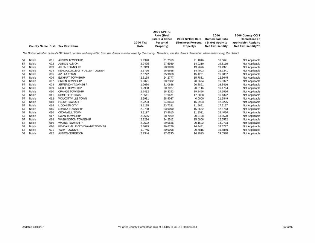
County Name Dist. Tax Dist Name2006 Tax
Rate
2006 SPTRC Rate (Real
Estate & Other Personal Property)
2006 SPTRC Rate (Business Personal
Property)
2006 Homestead Rate (State) Apply to Net Tax Liability
2006 County COIT Homestead (if
applicable) Apply to Net Tax Liability**
The District Number is the DLGF district number and may differ from the district number used by the county. Therefore, use the district description when determining the district.
57 Noble 001 ALBION TOWNSHIP 1.9370 31.2319 21.1846 16.3641 Not Applicable57 Noble 002 ALBION-ALBION 2.7475 27.5989 14.9210 19.6119 Not Applicable57 Noble 003 ALLEN TOWNSHIP 2.0919 28.3938 19.7676 13.4921 Not Applicable57 Noble 004 KENDALLVILLE CITY-ALLEN TOWNSH 2.8716 26.6668 14.4003 18.7341 Not Applicable57 Noble 005 AVILLA TOWN 2.6742 25.9858 15.4231 15.9837 Not Applicable57 Noble 006 ELKHART TOWNSHIP 2.3158 24.2777 15.7831 12.5645 Not Applicable57 Noble 007 GREEN TOWNSHIP 1.9021 30.2302 20.8624 15.0377 Not Applicable57 Noble 008 JEFFERSON TOWNSHIP 1.9650 31.0636 20.8821 16.5416 Not Applicable57 Noble 009 NOBLE TOWNSHIP 1.9908 30.7927 20.6116 16.4764 Not Applicable57 Noble 010 ORANGE TOWNSHIP 2.1482 28.3252 19.2496 14.1816 Not Applicable57 Noble 011 ROME CITY TOWN 2.3511 27.9671 17.5888 16.1372 Not Applicable57 Noble 012 WOLCOTTVILLE TOWN 2.5931 28.9087 0.0000 21.5849 Not Applicable57 Noble 013 PERRY TOWNSHIP 2.2293 24.8663 16.3953 12.6275 Not Applicable57 Noble 014 LIGONIER CITY 3.1195 23.7281 11.6651 17.7137 Not Applicable57 Noble 015 SPARTA TOWNSHIP 2.3788 23.9090 15.3652 12.5763 Not Applicable57 Noble 016 CROMWELL TOWN 3.2197 23.8615 11.3521 18.4016 Not Applicable57 Noble 017 SWAN TOWNSHIP 2.0665 28.7019 20.0108 13.6528 Not Applicable57 Noble 018 WASHINGTON TOWNSHIP 2.3294 24.2512 15.6906 12.6572 Not Applicable57 Noble 019 WAYNE TOWNSHIP 2.0522 29.0636 20.1502 14.0733 Not Applicable57 Noble 020 KENDALLVILLE CITY-WAYNE TOWNSH 2.8629 26.6726 14.4441 18.6777 Not Applicable57 Noble 021 YORK TOWNSHIP 1.9745 30.9998 20.7815 16.5859 Not Applicable57 Noble 022 ALBION-JEFFERSON 2.7344 27.6295 14.9925 19.5570 Not Applicable
Updated 04/13/07 **Porter County Homestead rate of 5.6107 is CEDIT Homestead 62 of 97

County Name Dist. Tax Dist Name2006 Tax
Rate
2006 SPTRC Rate (Real
Estate & Other Personal Property)
2006 SPTRC Rate (Business Personal
Property)
2006 Homestead Rate (State) Apply to Net Tax Liability
2006 County COIT Homestead (if
applicable) Apply to Net Tax Liability**
The District Number is the DLGF district number and may differ from the district number used by the county. Therefore, use the district description when determining the district.
58 Ohio 001 CASS TOWNSHIP 1.7043 38.8910 25.9108 23.7901 Not Applicable58 Ohio 002 PIKE TOWNSHIP 1.7116 38.9659 25.8002 24.1596 Not Applicable58 Ohio 003 RANDOLPH TOWNSHIP 1.6872 39.0181 26.1733 23.5909 Not Applicable58 Ohio 004 RISING SUN CITY 1.9526 36.4870 22.6159 24.4607 Not Applicable58 Ohio 005 UNION TOWNSHIP 1.6882 39.1165 26.1579 23.8385 Not Applicable
Updated 04/13/07 **Porter County Homestead rate of 5.6107 is CEDIT Homestead 63 of 97

County Name Dist. Tax Dist Name2006 Tax
Rate
2006 SPTRC Rate (Real
Estate & Other Personal Property)
2006 SPTRC Rate (Business Personal
Property)
2006 Homestead Rate (State) Apply to Net Tax Liability
2006 County COIT Homestead (if
applicable) Apply to Net Tax Liability**
The District Number is the DLGF district number and may differ from the district number used by the county. Therefore, use the district description when determining the district.
59 Orange 001 FRENCH LICK TOWNSHIP 2.1954 29.4808 19.2072 16.3167 Not Applicable59 Orange 002 FRENCH LICK TOWN 2.8620 28.3005 14.7335 21.1926 Not Applicable59 Orange 003 WEST BADEN TOWN 3.2097 28.0823 13.1374 23.2740 Not Applicable59 Orange 004 GREENFIELD TOWNSHIP 1.8894 33.5535 21.5653 20.2071 Not Applicable59 Orange 005 JACKSON TOWNSHIP 2.0900 30.6712 20.1758 16.9553 Not Applicable59 Orange 006 NORTHEAST TOWNSHIP 1.9719 28.7335 18.6732 15.8104 Not Applicable59 Orange 007 NORTHWEST TOWNSHIP 2.1527 30.4343 19.5881 17.4622 Not Applicable59 Orange 008 ORANGEVILLE TOWNSHIP 1.9791 28.7312 18.6053 15.9130 Not Applicable59 Orange 009 ORLEANS TOWNSHIP 1.9990 28.6589 18.4201 16.0742 Not Applicable59 Orange 010 ORLEANS TOWN 2.5396 27.7105 14.4990 20.4689 Not Applicable59 Orange 011 PAOLI TOWNSHIP 1.8966 33.3460 21.4834 19.9329 Not Applicable59 Orange 012 PAOLI TOWN 2.2478 32.0359 18.1267 22.9212 Not Applicable59 Orange 013 SOUTHEAST TOWNSHIP 1.8622 33.5361 21.8802 19.6418 Not Applicable59 Orange 014 STAMPERSCREEK TOWNSHIP 1.8566 33.7558 21.9462 19.9667 Not Applicable
Updated 04/13/07 **Porter County Homestead rate of 5.6107 is CEDIT Homestead 64 of 97

County Name Dist. Tax Dist Name2006 Tax
Rate
2006 SPTRC Rate (Real
Estate & Other Personal Property)
2006 SPTRC Rate (Business Personal
Property)
2006 Homestead Rate (State) Apply to Net Tax Liability
2006 County COIT Homestead (if
applicable) Apply to Net Tax Liability**
The District Number is the DLGF district number and may differ from the district number used by the county. Therefore, use the district description when determining the district.
60 Owen 016 CLAY TOWNSHIP 2.3324 23.6068 14.6836 13.0823 Not Applicable60 Owen 017 FRANKLIN TOWNSHIP 2.3338 23.6875 14.6748 13.2276 Not Applicable60 Owen 018 HARRISON TOWNSHIP 2.3273 23.8155 14.7157 13.3778 Not Applicable60 Owen 019 JACKSON TOWNSHIP 2.5367 25.3902 16.2893 13.6619 Not Applicable60 Owen 020 JEFFERSON TOWNSHIP 2.3292 23.8006 14.7038 13.3708 Not Applicable60 Owen 021 JENNINGS TOWNSHIP 2.5386 25.4185 16.2771 13.7279 Not Applicable60 Owen 022 LAFAYETTE TOWNSHIP 2.3088 23.7984 14.8336 13.1761 Not Applicable60 Owen 023 MARION TOWNSHIP 2.3303 23.7734 14.6968 13.3362 Not Applicable60 Owen 024 MONTGOMERY TOWNSHIP 2.3079 23.8096 14.8395 13.1860 Not Applicable60 Owen 025 MORGAN TOWNSHIP 2.3139 23.7464 14.8009 13.1389 Not Applicable60 Owen 026 TAYLOR TOWNSHIP 2.5370 25.5468 16.2874 13.9290 Not Applicable60 Owen 027 WASHINGTON TOWNSHIP 2.3744 23.1858 14.4239 12.7754 Not Applicable60 Owen 028 SPENCER TOWN 2.7961 23.4272 12.2485 16.3506 Not Applicable60 Owen 029 WAYNE TOWNSHIP 2.3256 23.8319 14.7265 13.3888 Not Applicable60 Owen 030 GOSPORT TOWN 2.6086 23.8513 13.1289 15.7706 Not Applicable
Updated 04/13/07 **Porter County Homestead rate of 5.6107 is CEDIT Homestead 65 of 97

County Name Dist. Tax Dist Name2006 Tax
Rate
2006 SPTRC Rate (Real
Estate & Other Personal Property)
2006 SPTRC Rate (Business Personal
Property)
2006 Homestead Rate (State) Apply to Net Tax Liability
2006 County COIT Homestead (if
applicable) Apply to Net Tax Liability**
The District Number is the DLGF district number and may differ from the district number used by the county. Therefore, use the district description when determining the district.
61 Parke 001 ADAMS TOWNSHIP 2.2713 26.4691 15.7759 16.2876 Not Applicable61 Parke 002 ROCKVILLE TOWN 2.6977 27.2281 13.2824 21.4632 Not Applicable61 Parke 003 FLORIDA TOWNSHIP 2.7080 22.2954 13.1823 13.1353 Not Applicable61 Parke 004 ROSEDALE TOWN 3.3188 22.3039 10.7561 16.6461 Not Applicable61 Parke 005 GREENE TOWNSHIP 2.1266 29.3158 18.2746 17.4949 Not Applicable61 Parke 006 HOWARD TOWNSHIP 2.1233 29.3326 18.3031 17.4805 Not Applicable61 Parke 007 JACKSON TOWNSHIP 2.2684 31.2376 17.3754 22.5788 Not Applicable61 Parke 008 LIBERTY TOWNSHIP 2.1247 29.3312 18.2910 17.4973 Not Applicable61 Parke 009 PENN TOWNSHIP 2.1593 29.0405 17.9978 17.4294 Not Applicable61 Parke 010 BLOOMINGDALE TOWN 2.4000 28.7086 16.1929 19.6625 Not Applicable61 Parke 011 RACCOON TOWNSHIP 2.6668 22.5950 13.3860 13.3250 Not Applicable61 Parke 012 RESERVE TOWNSHIP 2.7570 22.7269 12.9480 14.1736 Not Applicable61 Parke 013 MONTEZUMA TOWN-RESERVE TOWNSHI 3.5278 22.8756 10.1191 18.5253 Not Applicable61 Parke 014 SUGAR CREEK TOWNSHIP 2.0938 29.3882 18.5610 17.1736 Not Applicable61 Parke 015 UNION TOWNSHIP 2.0728 27.2274 17.2866 15.2993 Not Applicable61 Parke 016 WABASH TOWNSHIP 2.5815 22.7533 13.8283 12.9405 Not Applicable61 Parke 017 MONTEZUMA TOWN-WABASH TOWNSHIP 3.4959 22.8022 10.2110 18.2689 Not Applicable61 Parke 018 MECCA TOWN 2.7528 22.8864 12.9674 14.4056 Not Applicable61 Parke 019 WASHINGTON TOWNSHIP 2.1220 29.3115 18.3142 17.4243 Not Applicable61 Parke 021 MARSHALL TOWN 2.4354 28.6133 15.9575 19.8561 Not Applicable
Updated 04/13/07 **Porter County Homestead rate of 5.6107 is CEDIT Homestead 66 of 97
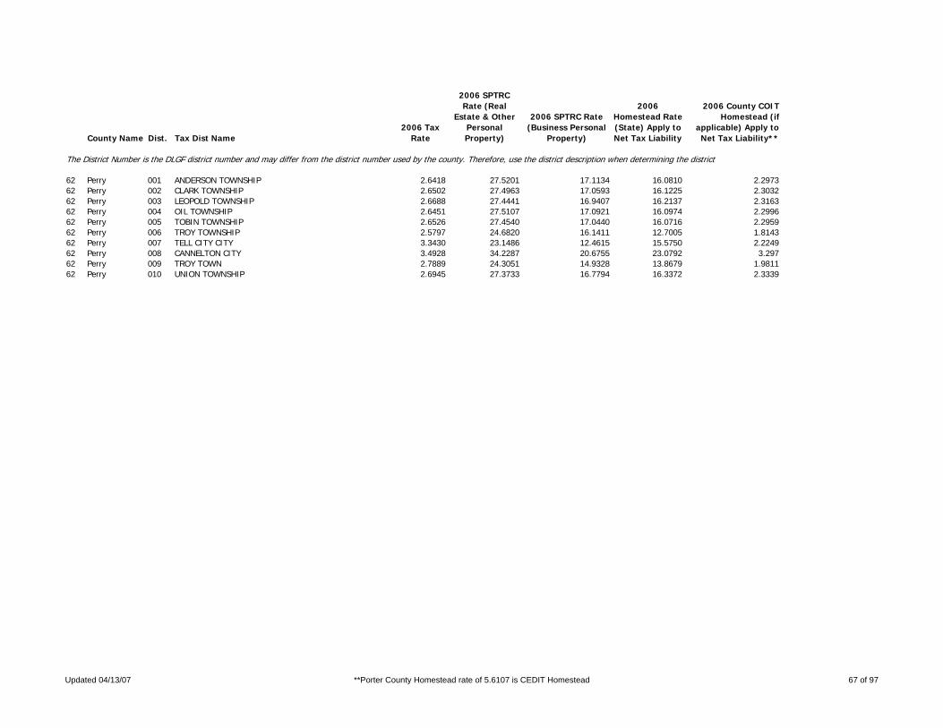
County Name Dist. Tax Dist Name2006 Tax
Rate
2006 SPTRC Rate (Real
Estate & Other Personal Property)
2006 SPTRC Rate (Business Personal
Property)
2006 Homestead Rate (State) Apply to Net Tax Liability
2006 County COIT Homestead (if
applicable) Apply to Net Tax Liability**
The District Number is the DLGF district number and may differ from the district number used by the county. Therefore, use the district description when determining the district.
62 Perry 001 ANDERSON TOWNSHIP 2.6418 27.5201 17.1134 16.0810 2.297362 Perry 002 CLARK TOWNSHIP 2.6502 27.4963 17.0593 16.1225 2.303262 Perry 003 LEOPOLD TOWNSHIP 2.6688 27.4441 16.9407 16.2137 2.316362 Perry 004 OIL TOWNSHIP 2.6451 27.5107 17.0921 16.0974 2.299662 Perry 005 TOBIN TOWNSHIP 2.6526 27.4540 17.0440 16.0716 2.295962 Perry 006 TROY TOWNSHIP 2.5797 24.6820 16.1411 12.7005 1.814362 Perry 007 TELL CITY CITY 3.3430 23.1486 12.4615 15.5750 2.224962 Perry 008 CANNELTON CITY 3.4928 34.2287 20.6755 23.0792 3.29762 Perry 009 TROY TOWN 2.7889 24.3051 14.9328 13.8679 1.981162 Perry 010 UNION TOWNSHIP 2.6945 27.3733 16.7794 16.3372 2.3339
Updated 04/13/07 **Porter County Homestead rate of 5.6107 is CEDIT Homestead 67 of 97

County Name Dist. Tax Dist Name2006 Tax
Rate
2006 SPTRC Rate (Real
Estate & Other Personal Property)
2006 SPTRC Rate (Business Personal
Property)
2006 Homestead Rate (State) Apply to Net Tax Liability
2006 County COIT Homestead (if
applicable) Apply to Net Tax Liability**
The District Number is the DLGF district number and may differ from the district number used by the county. Therefore, use the district description when determining the district.
63 Pike 001 CLAY TOWNSHIP 2.5737 28.4218 16.4798 18.6860 Not Applicable63 Pike 002 JEFFERSON TOWNSHIP 2.6560 28.1608 15.9691 19.0073 Not Applicable63 Pike 003 LOCKHART TOWNSHIP 2.6288 28.1794 16.1344 18.7836 Not Applicable63 Pike 004 LOGAN TOWNSHIP 2.6030 28.3270 16.2943 18.8030 Not Applicable63 Pike 005 MADISON TOWNSHIP 2.6168 28.2541 16.2083 18.8041 Not Applicable63 Pike 006 MARION TOWNSHIP 2.6638 28.1370 15.9224 19.0366 Not Applicable63 Pike 007 MONROE TOWNSHIP 2.6299 28.2418 16.1276 18.9078 Not Applicable63 Pike 008 SPURGEON TOWN 3.0728 26.8117 13.8068 19.9070 Not Applicable63 Pike 009 PATOKA TOWNSHIP 2.7756 27.8092 15.2810 19.4368 Not Applicable63 Pike 010 WINSLOW TOWN 3.7638 25.6202 11.2691 21.6099 Not Applicable63 Pike 011 WASHINGTON TOWNSHIP 2.5677 28.4415 16.5183 18.6617 Not Applicable63 Pike 012 PETERSBURG CITY 3.4388 26.0990 12.3340 20.8614 Not Applicable
Updated 04/13/07 **Porter County Homestead rate of 5.6107 is CEDIT Homestead 68 of 97

County Name Dist. Tax Dist Name2006 Tax
Rate
2006 SPTRC Rate (Real
Estate & Other Personal Property)
2006 SPTRC Rate (Business Personal
Property)
2006 Homestead Rate (State) Apply to Net Tax Liability
2006 County COIT Homestead (if
applicable) Apply to Net Tax Liability**
The District Number is the DLGF district number and may differ from the district number used by the county. Therefore, use the district description when determining the district.
64 Porter 001 BOONE TOWNSHIP 2.9792 18.4100 12.0443 8.7384 5.610764 Porter 002 HEBRON (BOONE) 3.4509 18.1463 10.3980 10.6020 5.610764 Porter 003 CENTER TOWNSHIP 2.2120 23.0085 15.2920 11.2250 5.610764 Porter 004 VALPARAISO (CENTER) 3.0190 21.9678 11.1968 15.4595 5.610764 Porter 005 JACKSON TOWNSHIP 2.0950 26.1341 18.0023 12.3298 5.610764 Porter 006 LIBERTY TOWNSHIP 2.1404 25.7870 17.6206 12.3245 5.610764 Porter 007 CHESTERTON-LIBERTY TWP 2.6532 23.5664 14.2148 13.7030 5.610764 Porter 008 MORGAN TOWNSHIP 2.3954 24.4227 17.0544 10.9193 5.610764 Porter 009 PINE TOWNSHIP-MICH CITY SCH. 1.9802 31.3167 22.0133 15.1721 5.610764 Porter 010 PINE TOWNSHIP-DUNELAND SCH. 2.1403 25.8978 17.6216 12.5089 5.610764 Porter 011 BEVERLY SHORES (PINES) 2.5479 25.8011 17.1084 13.1215 5.610764 Porter 012 PINES TOWN (PINES TWP) 2.2079 30.4135 19.7434 17.1750 5.610764 Porter 013 PLEASANT TOWNSHIP 2.4618 24.3478 16.5943 11.4786 5.610764 Porter 014 KOUTS (PLEASANT) 2.8153 23.1759 14.5109 12.6329 5.610764 Porter 015 PORTAGE TOWNSHIP 2.2075 26.6005 16.9957 14.6561 5.610764 Porter 016 PORTAGE CITY-PORTAGE TWP 2.8431 24.6797 13.1962 17.0757 5.610764 Porter 017 OGDEN DUNES (PORTAGE) 2.3238 27.3995 16.1451 17.3621 5.610764 Porter 018 PORTER TOWNSHIP 2.3177 23.8575 15.5989 12.1480 5.610764 Porter 019 UNION TOWNSHIP 2.1536 26.4230 17.9702 12.8671 5.610764 Porter 020 WASHINGTON TOWNSHIP 2.4192 24.3936 16.8867 11.1206 5.610764 Porter 021 WESTCHESTER TOWNSHIP 2.1508 25.7716 17.5354 12.4275 5.610764 Porter 022 PORTAGE CITY-WESTCHESTER TWP 3.0428 22.6422 12.3951 14.8361 5.610764 Porter 023 CHESTERTON-WESTCHESTER TWP 2.6864 23.5272 14.0392 13.8959 5.610764 Porter 024 BURNS HARBOR (WESTCHESTER) 2.2788 24.9539 16.5503 12.5415 5.610764 Porter 025 DUNE ARCES (WESTCHESTER) 2.4649 25.1205 15.3010 14.6879 5.610764 Porter 026 PORTER TOWN (WESTCHESTER) 2.9272 23.2477 12.8844 15.1225 5.610764 Porter 027 CHESTERTON-JACKSON TWP 2.6387 23.6793 14.2918 13.7723 5.610764 Porter 028 PORTER TWP-W PORTER FIRE 2.3006 23.9040 15.7200 12.0531 5.610764 Porter 029 VALPARAISO-WASHINGTON TWP 3.2938 22.6656 12.3954 14.8745 5.6107
Updated 04/13/07 **Porter County Homestead rate of 5.6107 is CEDIT Homestead 69 of 97

County Name Dist. Tax Dist Name2006 Tax
Rate
2006 SPTRC Rate (Real
Estate & Other Personal Property)
2006 SPTRC Rate (Business Personal
Property)
2006 Homestead Rate (State) Apply to Net Tax Liability
2006 County COIT Homestead (if
applicable) Apply to Net Tax Liability**
The District Number is the DLGF district number and may differ from the district number used by the county. Therefore, use the district description when determining the district.
65 Posey 005 CENTER TOWNSHIP 2.2146 28.2987 19.1126 14.3487 Not Applicable65 Posey 006 HARMONY TOWNSHIP 2.4242 35.3847 27.0719 14.4088 Not Applicable65 Posey 007 NEW HARMONY TOWN 2.9168 32.8324 22.5002 17.2288 Not Applicable65 Posey 008 LYNN TOWNSHIP 2.3103 33.1972 24.2751 14.9591 Not Applicable65 Posey 010 POINT TOWNSHIP 2.2523 33.9131 24.8995 15.2752 Not Applicable65 Posey 011 ROBB TOWNSHIP 2.1895 28.1829 19.3318 13.8034 Not Applicable65 Posey 012 POSEYVILLE TOWN 2.7881 25.1743 15.1814 14.9574 Not Applicable65 Posey 014 SMITH TOWNSHIP 2.2004 28.1124 19.2360 13.8291 Not Applicable65 Posey 015 CYNTHIANA TOWN 2.7817 26.1958 15.2170 16.6619 Not Applicable65 Posey 016 ROBINSON TOWNSHIP 2.2350 27.6294 18.9383 13.4502 Not Applicable65 Posey 017 BLACK TOWNSHIP 2.3131 33.1515 24.2454 14.9215 Not Applicable65 Posey 018 MOUNT VERNON CITY 3.3660 29.1196 16.6613 19.6857 Not Applicable65 Posey 019 MARRS TOWNSHIP 2.2631 33.8175 24.7810 15.2923 Not Applicable65 Posey 020 BETHEL TOWNSHIP 2.3915 27.6848 17.6992 15.4659 Not Applicable65 Posey 021 GRIFFIN TOWN 2.9618 26.2052 14.2892 18.0820 Not Applicable
Updated 04/13/07 **Porter County Homestead rate of 5.6107 is CEDIT Homestead 70 of 97

County Name Dist. Tax Dist Name2006 Tax
Rate
2006 SPTRC Rate (Real
Estate & Other Personal Property)
2006 SPTRC Rate (Business Personal
Property)
2006 Homestead Rate (State) Apply to Net Tax Liability
2006 County COIT Homestead (if
applicable) Apply to Net Tax Liability**
The District Number is the DLGF district number and may differ from the district number used by the county. Therefore, use the district description when determining the district.
66 Pulaski 001 Beaver Township II 2.2498 30.0702 28.5714 18.0079 Not Applicable66 Pulaski 002 Beaver Township I 2.1064 32.6601 20.0934 20.9011 Not Applicable66 Pulaski 003 Cass Township 2.2158 32.0224 19.1013 21.2889 Not Applicable66 Pulaski 004 Cass Township - North 2.5042 25.4053 14.6892 16.0895 Not Applicable66 Pulaski 005 Franklin Township 2.3328 29.7074 18.1531 18.4099 Not Applicable66 Pulaski 006 Harrison Township 2.3454 29.6503 18.0556 18.4595 Not Applicable66 Pulaski 007 Indian Creek Township 2.3338 29.6907 18.1452 18.3915 Not Applicable66 Pulaski 008 Jefferson Township - East 2.3430 29.7074 18.0738 18.5357 Not Applicable66 Pulaski 009 Jefferson Township 2.1996 32.1660 19.2420 21.3389 Not Applicable66 Pulaski 010 Monroe Township 2.3290 29.5834 18.1827 18.1334 Not Applicable66 Pulaski 011 Winamac Corp (Monroe) 3.0295 27.9244 13.9784 21.6710 Not Applicable66 Pulaski 012 Rich Grove Township 2.5016 25.3240 14.7047 15.9269 Not Applicable66 Pulaski 013 Salem Township 2.3456 30.6296 18.0443 20.3192 Not Applicable66 Pulaski 014 Francesville Corp (Salem) 2.8994 29.3244 14.5977 23.3373 Not Applicable66 Pulaski 015 Tippecanoe Township 2.1873 27.9481 15.3730 19.5473 Not Applicable66 Pulaski 016 Monterey Corp (Tippecanoe) 3.0362 26.5655 11.0749 23.6260 Not Applicable66 Pulaski 017 Van Buren Township 2.4120 29.2402 17.5570 18.4923 Not Applicable66 Pulaski 018 White Post Township 2.2872 31.5100 18.5051 21.2668 Not Applicable66 Pulaski 019 Medaryville Corp (White Post) 3.6560 28.2695 11.5769 26.0641 Not Applicable
Updated 04/13/07 **Porter County Homestead rate of 5.6107 is CEDIT Homestead 71 of 97

County Name Dist. Tax Dist Name2006 Tax
Rate
2006 SPTRC Rate (Real
Estate & Other Personal Property)
2006 SPTRC Rate (Business Personal
Property)
2006 Homestead Rate (State) Apply to Net Tax Liability
2006 County COIT Homestead (if
applicable) Apply to Net Tax Liability**
The District Number is the DLGF district number and may differ from the district number used by the county. Therefore, use the district description when determining the district.
67 Putnam 001 CLINTON TOWNSHIP 1.8289 31.5603 21.2978 16.7942 Not Applicable67 Putnam 002 CLOVERDALE TOWNSHIP 2.4319 18.2628 11.4872 9.2843 Not Applicable67 Putnam 003 CLOVERDALE TOWN-CLOVERDALE TOW 2.7135 18.5195 10.2951 11.3049 Not Applicable67 Putnam 004 FLOYD TOWNSHIP 1.8179 31.3491 21.4268 16.1878 Not Applicable67 Putnam 005 FRANKLIN TOWNSHIP 1.8197 32.2386 21.4056 17.9055 Not Applicable67 Putnam 006 ROACHDALE TOWN 2.3436 30.2068 16.6204 21.8026 Not Applicable67 Putnam 007 GREENCASTLE TOWNSHIP 2.0614 28.1255 19.9616 12.7215 Not Applicable67 Putnam 008 GREENCASTLE CITY 2.6650 26.1370 15.4405 16.2194 Not Applicable67 Putnam 009 JACKSON TOWNSHIP 1.8234 31.8610 21.3622 17.2569 Not Applicable67 Putnam 010 JEFFERSON TOWNSHIP 2.6673 23.6222 15.1991 12.3516 Not Applicable67 Putnam 011 MADISON TOWNSHIP 2.0964 27.8587 19.6284 12.7777 Not Applicable67 Putnam 012 MARION TOWNSHIP 2.6489 23.7956 15.3046 12.4795 Not Applicable67 Putnam 013 MONROE TOWNSHIP 1.8321 31.5561 21.2607 16.8471 Not Applicable67 Putnam 014 BAINBRIDGE TOWN 2.4066 28.5274 16.1854 19.3401 Not Applicable67 Putnam 015 RUSSELL TOWNSHIP 1.7946 31.5977 21.7050 16.1981 Not Applicable67 Putnam 016 RUSSELLVILLE TOWN 2.0839 30.9743 18.6917 19.9295 Not Applicable67 Putnam 017 WARREN TOWNSHIP 2.6482 23.7695 15.3087 12.4309 Not Applicable67 Putnam 018 CLOVERDALE TOWN-WARREN TOWNSHI 2.9378 23.3627 13.7995 13.9758 Not Applicable67 Putnam 019 WASHINGTON TOWNSHIP 2.6550 23.6853 15.2694 12.3512 Not Applicable67 Putnam 020 FILLMORE TOWN 2.8509 24.2482 14.2204 14.8264 Not Applicable
Updated 04/13/07 **Porter County Homestead rate of 5.6107 is CEDIT Homestead 72 of 97

County Name Dist. Tax Dist Name2006 Tax
Rate
2006 SPTRC Rate (Real
Estate & Other Personal Property)
2006 SPTRC Rate (Business Personal
Property)
2006 Homestead Rate (State) Apply to Net Tax Liability
2006 County COIT Homestead (if
applicable) Apply to Net Tax Liability**
The District Number is the DLGF district number and may differ from the district number used by the county. Therefore, use the district description when determining the district.
68 Randolph 001 FRANKLIN TOWNSHIP 2.2542 30.3766 18.6244 18.9054 Not Applicable68 Randolph 002 RIDGEVILLE TOWN 3.3983 27.6296 12.3542 23.6402 Not Applicable68 Randolph 003 GREEN TOWNSHIP 2.4496 28.2804 16.9345 17.7182 Not Applicable68 Randolph 004 ALBANY TOWN 2.9143 27.6779 14.2305 20.8188 Not Applicable68 Randolph 005 GREENSFORK TOWNSHIP 2.1880 31.3437 19.1919 19.8235 Not Applicable68 Randolph 006 JACKSON TOWNSHIP 2.3275 29.6912 18.0260 18.5820 Not Applicable68 Randolph 007 MONROE TOWNSHIP 2.4878 28.1722 16.6744 17.9283 Not Applicable68 Randolph 008 FARMLAND TOWN 3.5462 26.1025 11.6979 21.8320 Not Applicable68 Randolph 009 PARKER CITY TOWN 3.0971 26.8919 13.3941 20.6786 Not Applicable68 Randolph 010 STONEY CREEK TOWNSHIP 2.4529 28.2821 16.9116 17.7571 Not Applicable68 Randolph 011 UNION TOWNSHIP 2.1639 27.4838 15.9906 17.7511 Not Applicable68 Randolph 012 LOSANTVILLE TOWN 3.2409 26.0496 10.6758 23.2825 Not Applicable68 Randolph 013 MODOC TOWN 2.9645 26.3262 11.6715 22.2773 Not Applicable68 Randolph 014 WARD TOWNSHIP 2.3303 29.8590 18.0161 18.9103 Not Applicable68 Randolph 015 SARATOGA TOWN 3.2201 27.7376 13.0379 22.7836 Not Applicable68 Randolph 016 WASHINGTON TOWNSHIP 2.2284 31.1594 18.8440 20.0366 Not Applicable68 Randolph 017 LYNN TOWN 2.9737 28.7739 14.1211 23.0409 Not Applicable68 Randolph 018 WAYNE TOWNSHIP 2.2787 29.8539 18.4122 18.2687 Not Applicable68 Randolph 019 UNION CITY 4.7148 25.6414 8.8988 25.2181 Not Applicable68 Randolph 020 WHITE RIVER TOWNSHIP 2.3782 29.6920 17.6534 19.1775 Not Applicable68 Randolph 021 WINCHESTER CITY 3.5991 26.4448 11.6638 22.5065 Not Applicable
Updated 04/13/07 **Porter County Homestead rate of 5.6107 is CEDIT Homestead 73 of 97

County Name Dist. Tax Dist Name2006 Tax
Rate
2006 SPTRC Rate (Real
Estate & Other Personal Property)
2006 SPTRC Rate (Business Personal
Property)
2006 Homestead Rate (State) Apply to Net Tax Liability
2006 County COIT Homestead (if
applicable) Apply to Net Tax Liability**
The District Number is the DLGF district number and may differ from the district number used by the county. Therefore, use the district description when determining the district.
69 Ripley 001 ADAMS TOWNSHIP-SUNMAN DEARBORN 2.1282 28.0781 18.6374 14.7016 Not Applicable69 Ripley 002 ADAMS TOWNSHIP-BATESVILLE SCHO 1.7255 33.6713 22.7501 18.4410 Not Applicable69 Ripley 003 BATESVILLE CITY-ADAMS TOWNSHIP 2.1873 30.7650 17.9469 20.7356 Not Applicable69 Ripley 004 SUNMAN TOWN 2.4172 27.2793 16.4091 16.7416 Not Applicable69 Ripley 005 BROWN TOWNSHIP 2.0007 31.1006 20.3498 17.4761 Not Applicable69 Ripley 006 CENTER TOWNSHIP 2.2488 28.6707 17.9580 16.8209 Not Applicable69 Ripley 007 OSGOOD TOWN 2.7163 27.9225 14.8673 20.2862 Not Applicable69 Ripley 008 DELAWARE TOWNSHIP 2.2553 28.6271 17.9062 16.8233 Not Applicable69 Ripley 009 FRANKLIN TOWNSHIP 2.2107 27.6622 17.2686 16.0924 Not Applicable69 Ripley 010 MILAN TOWN-FRANKLIN TOWNSHIP 2.5099 27.2825 15.2100 18.5941 Not Applicable69 Ripley 011 JACKSON TOWNSHIP 2.1804 28.8872 18.5214 16.3258 Not Applicable69 Ripley 012 NAPOLEON TOWN 2.2747 29.0375 17.7538 17.8091 Not Applicable69 Ripley 013 JOHNSON TOWNSHIP 1.9997 31.1019 20.3599 17.4620 Not Applicable69 Ripley 014 VERSAILLES TOWN 2.3984 29.9372 16.9754 20.7203 Not Applicable69 Ripley 015 LAUGHERY TOWNSHIP-BATESVILLE S 1.7348 33.6314 22.6281 18.5686 Not Applicable69 Ripley 016 LAUGHERY TOWNSHIP JAC CEN DEL 2.1370 29.3985 18.8957 16.6586 Not Applicable69 Ripley 017 BATESVILLE CITY-LAUGHERY SCHOO 2.1861 30.7740 17.9568 20.7369 Not Applicable69 Ripley 018 OTTER CREEK TOWNSHIP 2.0023 31.1555 20.3335 17.6058 Not Applicable69 Ripley 019 HOLTON TOWN 2.5882 29.8282 15.7298 22.5013 Not Applicable69 Ripley 020 SHELBY TOWNSHIP 2.0097 31.1113 20.2587 17.6443 Not Applicable69 Ripley 021 WASHINGTON TOWNSHIP 2.2313 27.6071 17.1090 16.2416 Not Applicable69 Ripley 022 MILAN TOWN-WASHINGTON TOWNSHIP 2.5204 27.2661 15.1460 18.6623 Not Applicable
Updated 04/13/07 **Porter County Homestead rate of 5.6107 is CEDIT Homestead 74 of 97

County Name Dist. Tax Dist Name2006 Tax
Rate
2006 SPTRC Rate (Real
Estate & Other Personal Property)
2006 SPTRC Rate (Business Personal
Property)
2006 Homestead Rate (State) Apply to Net Tax Liability
2006 County COIT Homestead (if
applicable) Apply to Net Tax Liability**
The District Number is the DLGF district number and may differ from the district number used by the county. Therefore, use the district description when determining the district.
70 Rush 001 ANDERSON TOWNSHIP 2.0391 32.3028 21.0664 18.5900 Not Applicable70 Rush 002 CENTER TOWNSHIP 2.0348 32.2558 21.1108 18.4258 Not Applicable70 Rush 003 JACKSON TOWNSHIP 2.0672 32.2725 20.7801 19.0050 Not Applicable70 Rush 004 NOBLE TOWNSHIP 1.9992 32.6283 21.4869 18.5219 Not Applicable70 Rush 005 ORANGE TOWNSHIP 1.9866 32.6547 21.6231 18.3465 Not Applicable70 Rush 006 POSEY TOWNSHIP 2.0902 31.7826 20.5513 18.4397 Not Applicable70 Rush 007 RICHLAND TOWNSHIP 2.0097 32.6119 21.3743 18.6766 Not Applicable70 Rush 008 RIPLEY TOWNSHIP 2.3688 21.1246 12.1576 12.7327 Not Applicable70 Rush 009 CARTHAGE 2.9948 21.4283 9.6163 16.8374 Not Applicable70 Rush 010 RUSHVILLE TOWNSHIP 2.0173 32.5514 21.2940 18.6932 Not Applicable70 Rush 011 RUSHVILLE CITY 3.8697 26.8887 11.1007 24.1857 Not Applicable70 Rush 012 UNION TOWNSHIP 1.9978 32.6469 21.5019 18.5329 Not Applicable70 Rush 013 GLENWOOD CITY 2.9678 29.1571 14.4745 23.2140 Not Applicable70 Rush 014 WALKER TOWNSHIP 2.0203 32.3628 21.2622 18.3810 Not Applicable70 Rush 015 WASHINGTON TOWNSHIP 2.0622 32.2226 20.8303 18.8252 Not Applicable70 Rush 016 RUSHVILLE CITY-JACKSON 3.8811 26.8814 11.0681 24.2217 Not Applicable
Updated 04/13/07 **Porter County Homestead rate of 5.6107 is CEDIT Homestead 75 of 97

County Name Dist. Tax Dist Name2006 Tax
Rate
2006 SPTRC Rate (Real
Estate & Other Personal Property)
2006 SPTRC Rate (Business Personal
Property)
2006 Homestead Rate (State) Apply to Net Tax Liability
2006 County COIT Homestead (if
applicable) Apply to Net Tax Liability**
The District Number is the DLGF district number and may differ from the district number used by the county. Therefore, use the district description when determining the district.
71 St. Joseph 001 CENTRE TOWNSHIP 2.9522 23.0982 12.2925 15.7373 8.352171 St. Joseph 002 SOUTH BEND-CENTRE 5.1338 21.7230 7.0688 20.9675 11.127771 St. Joseph 003 CLAY TOWNSHIP 3.0830 22.4021 11.7710 15.3444 8.143471 St. Joseph 004 SOUTH BEND-CLAY 5.1459 21.7076 7.0522 20.9653 11.126571 St. Joseph 005 MISHAWAKA-CLAY 4.3763 21.7827 8.2684 19.3515 10.270171 St. Joseph 006 INDIAN VILLAGE (CLAY) 3.0820 22.5399 11.7736 15.5647 8.260471 St. Joseph 007 ROSELAND (CLAY) 3.7475 21.5870 9.6838 17.0016 9.02371 St. Joseph 008 GERMAN TOWNSHIP 2.9514 23.1918 12.2957 15.8880 8.43271 St. Joseph 009 SOUTH BEND-GERMAN 5.1376 21.7293 7.0636 20.9856 11.137471 St. Joseph 010 GREENE TOWNSHIP 2.8749 23.5174 12.6230 15.9538 8.466971 St. Joseph 011 HARRIS TOWNSHIP 3.1741 21.3812 12.1809 13.1065 6.955871 St. Joseph 014 LINCOLN TOWNSHIP 2.9635 21.5933 11.7751 14.0256 7.443671 St. Joseph 015 WALKERTON (LINCOLN) 3.7787 21.4350 9.2346 17.3925 9.230471 St. Joseph 016 MADISON TOWNSHIP 3.0045 22.1130 12.8685 13.2932 7.05571 St. Joseph 017 OLIVE TOWNSHIP 3.0172 23.4931 13.2464 15.0001 7.960971 St. Joseph 018 NEW CARLISLE (OLIVE) 3.3065 22.4491 12.0875 14.9645 7.941971 St. Joseph 022 MISHAWAKA(PENN)-PHM SCHOOL 4.6181 20.6944 8.3493 17.4345 9.252771 St. Joseph 023 MISHAWAKA-PENN 4.3868 19.8015 7.5566 17.1004 9.075571 St. Joseph 025 PORTAGE TOWNSHIP 3.1586 22.1295 11.4891 15.3039 8.121971 St. Joseph 026 SOUTH BEND (PORTAGE) 5.1524 21.6906 7.0433 20.9490 11.11871 St. Joseph 027 UNION TOWNSHIP 2.6846 26.1993 14.7372 17.3946 9.231671 St. Joseph 028 LAKEVILLE (UNION) 3.3789 24.8066 11.7090 19.5097 10.354171 St. Joseph 029 WARREN TOWNSHIP 2.9388 23.2102 12.3486 15.8421 8.407671 St. Joseph 030 OSCEOLA (PENN) 3.4519 21.3770 11.2009 14.4968 7.693771 St. Joseph 031 PENN TOWNSHIP-PHM SCHOOL 3.1876 21.3723 12.1294 13.1660 6.987471 St. Joseph 032 PENN-MISHAWAKA SCHOOL 2.9563 20.0961 11.2466 12.4084 6.585371 St. Joseph 033 SOUTH BEND-PENN 5.3877 20.7755 7.1763 19.2254 10.203271 St. Joseph 034 LIBERTY TOWNSHIP 2.9745 22.1143 11.7314 14.9309 7.92471 St. Joseph 035 NORTH LIBERTY (LIBERTY) 3.9761 21.5390 8.7761 18.2182 9.668671 St. Joseph 036 MISHAWAKA-HARRIS 4.5709 20.8570 8.4353 17.5788 9.329371 St. Joseph 037 SOUTH BEND (WARREN) 5.1506 21.7191 7.0456 20.9842 11.136371 St. Joseph 041 S. BEND CENTRE ANNEX #3 5.1338 21.7232 0.0000 20.9673 11.127671 St. Joseph 042 S. BEND PENN PHM ANNEX #1 5.3877 20.7740 0.0000 19.2303 10.2057
Updated 04/13/07 **Porter County Homestead rate of 5.6107 is CEDIT Homestead 76 of 97

County Name Dist. Tax Dist Name2006 Tax
Rate
2006 SPTRC Rate (Real
Estate & Other Personal Property)
2006 SPTRC Rate (Business Personal
Property)
2006 Homestead Rate (State) Apply to Net Tax Liability
2006 County COIT Homestead (if
applicable) Apply to Net Tax Liability**
The District Number is the DLGF district number and may differ from the district number used by the county. Therefore, use the district description when determining the district.
72 Scott 001 FINLEY TOWNSHIP 2.2092 25.7812 16.7942 13.5618 Not Applicable72 Scott 002 JENNINGS TOWNSHIP 2.8081 22.3827 14.8285 10.9004 Not Applicable72 Scott 003 AUSTIN TOWN 3.3599 21.8692 12.3923 13.5850 Not Applicable72 Scott 004 JOHNSON TOWNSHIP 2.2320 25.7223 16.6226 13.7209 Not Applicable72 Scott 005 LEXINGTON TOWNSHIP 2.2009 25.8011 16.8576 13.4999 Not Applicable72 Scott 007 VIENNA TOWNSHIP 2.2116 25.7353 16.7760 13.5117 Not Applicable72 Scott 008 SCOTTSBURG CITY 2.8744 23.4778 12.8815 15.5090 Not Applicable
Updated 04/13/07 **Porter County Homestead rate of 5.6107 is CEDIT Homestead 77 of 97
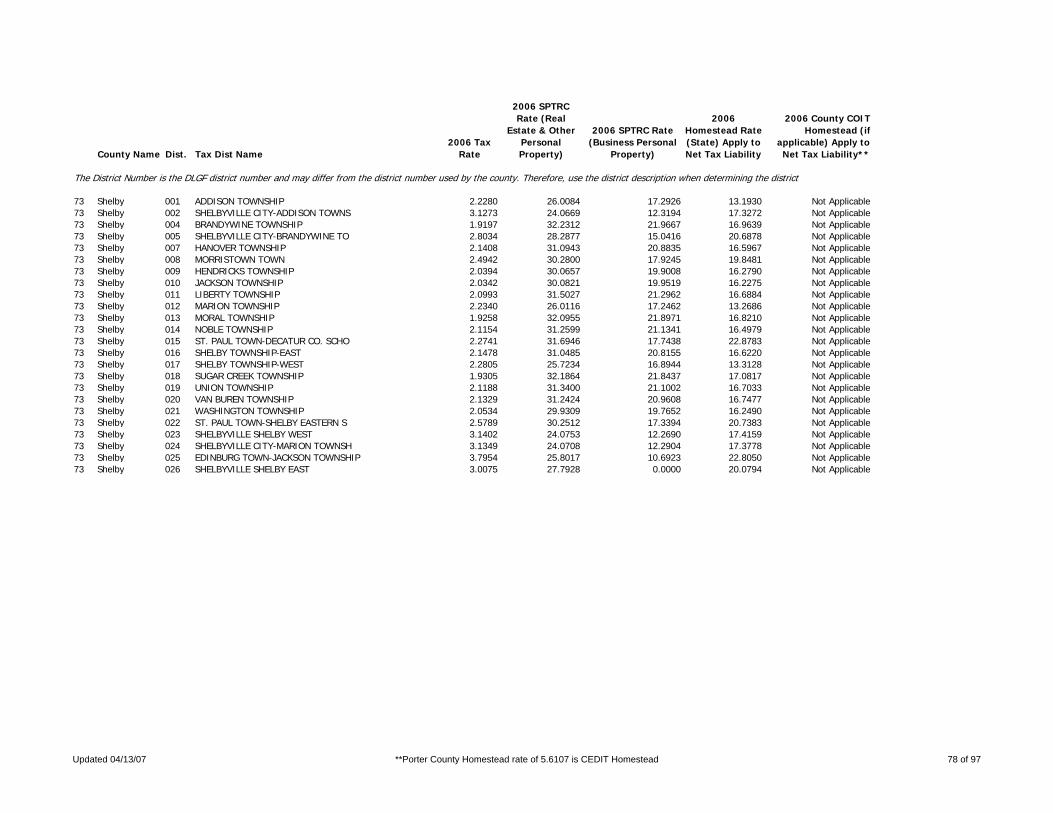
County Name Dist. Tax Dist Name2006 Tax
Rate
2006 SPTRC Rate (Real
Estate & Other Personal Property)
2006 SPTRC Rate (Business Personal
Property)
2006 Homestead Rate (State) Apply to Net Tax Liability
2006 County COIT Homestead (if
applicable) Apply to Net Tax Liability**
The District Number is the DLGF district number and may differ from the district number used by the county. Therefore, use the district description when determining the district.
73 Shelby 001 ADDISON TOWNSHIP 2.2280 26.0084 17.2926 13.1930 Not Applicable73 Shelby 002 SHELBYVILLE CITY-ADDISON TOWNS 3.1273 24.0669 12.3194 17.3272 Not Applicable73 Shelby 004 BRANDYWINE TOWNSHIP 1.9197 32.2312 21.9667 16.9639 Not Applicable73 Shelby 005 SHELBYVILLE CITY-BRANDYWINE TO 2.8034 28.2877 15.0416 20.6878 Not Applicable73 Shelby 007 HANOVER TOWNSHIP 2.1408 31.0943 20.8835 16.5967 Not Applicable73 Shelby 008 MORRISTOWN TOWN 2.4942 30.2800 17.9245 19.8481 Not Applicable73 Shelby 009 HENDRICKS TOWNSHIP 2.0394 30.0657 19.9008 16.2790 Not Applicable73 Shelby 010 JACKSON TOWNSHIP 2.0342 30.0821 19.9519 16.2275 Not Applicable73 Shelby 011 LIBERTY TOWNSHIP 2.0993 31.5027 21.2962 16.6884 Not Applicable73 Shelby 012 MARION TOWNSHIP 2.2340 26.0116 17.2462 13.2686 Not Applicable73 Shelby 013 MORAL TOWNSHIP 1.9258 32.0955 21.8971 16.8210 Not Applicable73 Shelby 014 NOBLE TOWNSHIP 2.1154 31.2599 21.1341 16.4979 Not Applicable73 Shelby 015 ST. PAUL TOWN-DECATUR CO. SCHO 2.2741 31.6946 17.7438 22.8783 Not Applicable73 Shelby 016 SHELBY TOWNSHIP-EAST 2.1478 31.0485 20.8155 16.6220 Not Applicable73 Shelby 017 SHELBY TOWNSHIP-WEST 2.2805 25.7234 16.8944 13.3128 Not Applicable73 Shelby 018 SUGAR CREEK TOWNSHIP 1.9305 32.1864 21.8437 17.0817 Not Applicable73 Shelby 019 UNION TOWNSHIP 2.1188 31.3400 21.1002 16.7033 Not Applicable73 Shelby 020 VAN BUREN TOWNSHIP 2.1329 31.2424 20.9608 16.7477 Not Applicable73 Shelby 021 WASHINGTON TOWNSHIP 2.0534 29.9309 19.7652 16.2490 Not Applicable73 Shelby 022 ST. PAUL TOWN-SHELBY EASTERN S 2.5789 30.2512 17.3394 20.7383 Not Applicable73 Shelby 023 SHELBYVILLE SHELBY WEST 3.1402 24.0753 12.2690 17.4159 Not Applicable73 Shelby 024 SHELBYVILLE CITY-MARION TOWNSH 3.1349 24.0708 12.2904 17.3778 Not Applicable73 Shelby 025 EDINBURG TOWN-JACKSON TOWNSHIP 3.7954 25.8017 10.6923 22.8050 Not Applicable73 Shelby 026 SHELBYVILLE SHELBY EAST 3.0075 27.7928 0.0000 20.0794 Not Applicable
Updated 04/13/07 **Porter County Homestead rate of 5.6107 is CEDIT Homestead 78 of 97

County Name Dist. Tax Dist Name2006 Tax
Rate
2006 SPTRC Rate (Real
Estate & Other Personal Property)
2006 SPTRC Rate (Business Personal
Property)
2006 Homestead Rate (State) Apply to Net Tax Liability
2006 County COIT Homestead (if
applicable) Apply to Net Tax Liability**
The District Number is the DLGF district number and may differ from the district number used by the county. Therefore, use the district description when determining the district.
74 Spencer 001 CARTER TOWNSHIP 2.0698 28.0205 18.5423 14.7481 4.213774 Spencer 002 DALE TOWN 2.4257 26.8438 15.8217 16.8743 4.821274 Spencer 003 SANTA CLAUS TOWN-CARTER TOWNSH 2.3250 26.7549 16.5071 15.6700 4.477274 Spencer 004 CLAY TOWNSHIP 2.0344 28.1602 18.8651 14.4913 4.140374 Spencer 005 SANTA CLAUS TOWN-CLAY TOWNSHIP 2.3223 26.7626 16.5262 15.6543 4.472774 Spencer 006 GRASS TOWNSHIP 2.0704 27.5036 18.5369 13.8527 3.957974 Spencer 007 CHRISNEY TOWN 2.4658 26.5598 15.5646 16.7689 4.791174 Spencer 008 HAMMOND TOWNSHIP-NORTH 2.1003 28.1912 18.2727 15.4694 4.419874 Spencer 009 HAMMOND TOWNSHIP-SOUTH 2.1450 31.1694 21.3755 15.9370 4.553574 Spencer 010 GRANDVIEW TOWN 2.5447 29.4150 18.0183 18.0844 5.16774 Spencer 011 HARRISON TOWNSHIP 2.0223 28.2089 18.9777 14.4014 4.114774 Spencer 012 SANTA CLAUS TOWN-HARRISON TOWN 2.3341 26.7277 16.4404 15.7229 4.492774 Spencer 013 HUFF TOWNSHIP 2.0119 28.2392 19.0758 14.3015 4.086274 Spencer 014 JACKSON TOWNSHIP 2.0577 28.0677 18.6512 14.6616 4.189174 Spencer 015 GENTRYVILLE TOWN 2.5112 25.6483 15.2808 15.6142 4.461274 Spencer 016 LUCE TOWNSHIP 2.4114 28.5358 19.0136 14.9231 4.263774 Spencer 017 OHIO TOWNSHIP 2.1218 31.2916 21.6090 15.7834 4.509574 Spencer 018 ROCKPORT CITY 3.1416 27.6262 14.5947 20.1670 5.762
Updated 04/13/07 **Porter County Homestead rate of 5.6107 is CEDIT Homestead 79 of 97

County Name Dist. Tax Dist Name2006 Tax
Rate
2006 SPTRC Rate (Real
Estate & Other Personal Property)
2006 SPTRC Rate (Business Personal
Property)
2006 Homestead Rate (State) Apply to Net Tax Liability
2006 County COIT Homestead (if
applicable) Apply to Net Tax Liability**
The District Number is the DLGF district number and may differ from the district number used by the county. Therefore, use the district description when determining the district.
75 Starke 001 CALIFORNIA TOWNSHIP-NJSP SCH 2.5823 25.0484 14.2447 16.1438 Not Applicable75 Starke 002 CALIFORNIA TOWNSHIP-KNOX SCH 2.7330 24.7172 13.7870 16.2611 Not Applicable75 Starke 003 CENTER TOWNSHIP 2.6187 24.8695 14.3888 15.6239 Not Applicable75 Starke 004 KNOX CITY (CENTER) 3.7444 22.8578 10.0630 18.5762 Not Applicable75 Starke 007 JACKSON TOWNSHIP 2.4858 25.5704 14.7978 16.2105 Not Applicable75 Starke 008 NORTH BEND TOWNSHIP 2.0260 29.0098 16.5989 19.5802 Not Applicable75 Starke 009 OREGON TOWNSHIP 2.4355 27.1594 15.7567 17.5328 Not Applicable75 Starke 011 RAILROAD TOWNSHIP 2.5621 23.9596 14.3570 14.1437 Not Applicable75 Starke 012 WASHINGTON TOWNSHIP 2.6586 24.8160 14.1728 15.8548 Not Applicable75 Starke 013 WAYNE TOWNSHIP 2.5104 25.0584 14.6527 15.5512 Not Applicable75 Starke 014 NORTH JUDSON TOWN (WAYNE) 3.3998 24.0670 10.8195 19.5399 Not Applicable75 Starke 015 DAVIS TOWNSHIP 2.5569 25.9541 15.0086 16.5558 Not Applicable75 Starke 016 HAMLET TOWN-DAVIS TWP 3.6505 24.4401 10.5124 20.6445 Not Applicable75 Starke 017 HAMLET TOWN-OREGON TWP 3.6474 24.4453 10.5213 20.6400 Not Applicable
Updated 04/13/07 **Porter County Homestead rate of 5.6107 is CEDIT Homestead 80 of 97

County Name Dist. Tax Dist Name2006 Tax
Rate
2006 SPTRC Rate (Real
Estate & Other Personal Property)
2006 SPTRC Rate (Business Personal
Property)
2006 Homestead Rate (State) Apply to Net Tax Liability
2006 County COIT Homestead (if
applicable) Apply to Net Tax Liability**
The District Number is the DLGF district number and may differ from the district number used by the county. Therefore, use the district description when determining the district.
76 Steuben 001 CLEAR LAKE TOWNSHIP 1.4100 33.1428 23.3604 16.3872 Not Applicable76 Steuben 002 CLEAR LAKE TOWN 1.4971 32.3611 22.0018 17.1534 Not Applicable76 Steuben 004 FREMONT TOWN 1.8482 29.1714 17.8221 17.9464 Not Applicable76 Steuben 005 JACKSON TOWNSHIP 1.7173 31.3591 21.7039 15.7545 Not Applicable76 Steuben 006 JAMESTOWN TOWNSHIP 1.4448 32.4546 22.7982 16.0117 Not Applicable76 Steuben 007 MILLGROVE TOWNSHIP 1.7209 31.3345 21.6585 15.7826 Not Applicable76 Steuben 008 ORLAND TOWN 2.1962 27.6081 16.9712 16.4567 Not Applicable76 Steuben 009 OTSEGO TOWNSHIP 1.3421 36.7836 26.0837 18.9571 Not Applicable76 Steuben 010 HAMILTON TOWN 1.6217 33.4853 21.5864 20.0357 Not Applicable76 Steuben 011 PLEASANT TOWNSHIP 1.8881 26.3247 18.7431 11.5253 Not Applicable76 Steuben 012 ANGOLA CITY 2.5759 25.6324 13.7385 17.9126 Not Applicable76 Steuben 013 RICHLAND TOWNSHIP 1.4231 36.0170 24.5997 19.9862 Not Applicable76 Steuben 014 SALEM TOWNSHIP 1.7294 31.2852 21.5519 15.8646 Not Applicable76 Steuben 015 HUDSON TOWN-SALEM TOWNSHIP 2.2178 28.3300 16.8058 18.0092 Not Applicable76 Steuben 016 SCOTT TOWNSHIP 1.7678 28.1378 20.0186 12.6541 Not Applicable76 Steuben 017 STEUBEN TOWNSHIP 1.7972 27.8787 19.6912 12.7147 Not Applicable76 Steuben 018 ASHLEY TOWN 2.6928 26.1608 13.9614 18.5041 Not Applicable76 Steuben 019 HUDSON TOWN-STEUBEN TOWNSHIP 2.2635 25.9373 15.6345 15.5804 Not Applicable76 Steuben 021 YORK TOWNSHIP 1.8518 27.4711 19.1103 12.9102 Not Applicable76 Steuben 022 FREMONT TOWNSHIP 1.4316 32.9499 23.0085 16.6062 Not Applicable
Updated 04/13/07 **Porter County Homestead rate of 5.6107 is CEDIT Homestead 81 of 97

County Name Dist. Tax Dist Name2006 Tax
Rate
2006 SPTRC Rate (Real
Estate & Other Personal Property)
2006 SPTRC Rate (Business Personal
Property)
2006 Homestead Rate (State) Apply to Net Tax Liability
2006 County COIT Homestead (if
applicable) Apply to Net Tax Liability**
The District Number is the DLGF district number and may differ from the district number used by the county. Therefore, use the district description when determining the district.
77 Sullivan 001 CASS TOWNSHIP 2.3527 27.4253 16.1891 17.3402 Not Applicable77 Sullivan 002 DUGGER TOWN 2.9619 26.0589 12.8592 19.9935 Not Applicable77 Sullivan 003 CURRY TOWNSHIP 2.5370 26.0186 15.0130 16.6612 Not Applicable77 Sullivan 004 FARMERSBURG TOWN 2.7555 25.2707 13.8226 17.1579 Not Applicable77 Sullivan 005 SHELBURN TOWN 2.8447 26.0615 13.3892 19.1958 Not Applicable77 Sullivan 006 FAIRBANKS TOWNSHIP 2.3770 27.1865 16.0235 17.1706 Not Applicable77 Sullivan 007 GILL TOWNSHIP 2.4354 22.9378 13.2123 14.1348 Not Applicable77 Sullivan 008 MEROM TOWN 2.9793 22.3547 10.8019 16.6668 Not Applicable77 Sullivan 009 HADDON TOWNSHIP 2.4990 22.8479 12.8760 14.4758 Not Applicable77 Sullivan 010 CARLISLE TOWN 3.1953 22.1620 10.0703 17.3987 Not Applicable77 Sullivan 011 HAMILTON TOWNSHIP 2.4748 22.7796 13.0019 14.1815 Not Applicable77 Sullivan 012 SULLIVAN CITY 3.6245 21.8766 8.8777 18.6355 Not Applicable77 Sullivan 013 JACKSON TOWNSHIP 2.3921 27.4696 15.9225 17.8309 Not Applicable77 Sullivan 014 HYMERA TOWN 2.9285 26.1279 13.0064 19.8947 Not Applicable77 Sullivan 015 JEFFERSON TOWNSHIP 2.4553 27.0608 15.5125 17.7327 Not Applicable77 Sullivan 016 TURMAN TOWNSHIP 2.5111 22.8153 12.8139 14.5125 Not Applicable
Updated 04/13/07 **Porter County Homestead rate of 5.6107 is CEDIT Homestead 82 of 97

County Name Dist. Tax Dist Name2006 Tax
Rate
2006 SPTRC Rate (Real
Estate & Other Personal Property)
2006 SPTRC Rate (Business Personal
Property)
2006 Homestead Rate (State) Apply to Net Tax Liability
2006 County COIT Homestead (if
applicable) Apply to Net Tax Liability**
The District Number is the DLGF district number and may differ from the district number used by the county. Therefore, use the district description when determining the district.
78 Switzerland 001 COTTON TOWNSHIP 1.7037 34.0396 21.8327 20.7271 Not Applicable78 Switzerland 002 CRAIG TOWNSHIP 1.7270 33.7671 21.5381 20.6791 Not Applicable78 Switzerland 003 JEFFERSON TOWNSHIP 1.7038 34.0328 21.8314 20.7157 Not Applicable78 Switzerland 004 VEVAY TOWN 2.2826 30.4745 16.2956 22.8411 Not Applicable78 Switzerland 005 PLEASANT TOWNSHIP 1.7071 33.9851 21.7892 20.6915 Not Applicable78 Switzerland 006 POSEY TOWNSHIP 1.6980 34.0069 21.9059 20.5371 Not Applicable78 Switzerland 007 PATRIOT TOWN 1.8140 33.1353 20.5053 21.1559 Not Applicable78 Switzerland 008 YORK TOWNSHIP 1.6902 33.9824 22.0070 20.3164 Not Applicable
Updated 04/13/07 **Porter County Homestead rate of 5.6107 is CEDIT Homestead 83 of 97

County Name Dist. Tax Dist Name2006 Tax
Rate
2006 SPTRC Rate (Real
Estate & Other Personal Property)
2006 SPTRC Rate (Business Personal
Property)
2006 Homestead Rate (State) Apply to Net Tax Liability
2006 County COIT Homestead (if
applicable) Apply to Net Tax Liability**
The District Number is the DLGF district number and may differ from the district number used by the county. Therefore, use the district description when determining the district.
79 Tippecanoe 001 FAIRFIELD TWP-LSC-B 1.9107 29.1555 20.6863 13.3889 3.825479 Tippecanoe 002 FAIRFIELD TWP-TSC 1.9803 27.4378 19.3334 12.5083 3.573879 Tippecanoe 003 FAIRFIELD TWP-TSC-B 2.0124 27.0502 19.0247 12.3208 3.520279 Tippecanoe 004 LAFAYETTE-FAIRFIELD TWP-LSC-B 2.6105 26.4385 15.1358 17.2087 4.916779 Tippecanoe 005 LAFAYETTE-FAIRFIELD TWP-TSC-B 2.7122 24.9787 14.1115 16.2237 4.635479 Tippecanoe 006 JACKSON TWP-TSC 1.9960 27.3584 19.1809 12.6077 3.602279 Tippecanoe 007 LAURAMIE TWP 2.0031 27.2264 19.1134 12.4861 3.567579 Tippecanoe 008 CLARKS HILL TOWN 2.3745 26.1006 16.1208 15.1200 4.320179 Tippecanoe 009 PERRY TOWNSHIP-TSC 1.9672 27.2953 19.4625 12.0668 3.447679 Tippecanoe 010 PERRY TOWNSHIP-TSC-B 1.9993 26.9077 19.1498 11.8876 3.396479 Tippecanoe 011 RANDOLPH TOWNSHIP-TSC 2.0433 27.0452 18.7369 12.7541 3.64479 Tippecanoe 012 SHEFFIELD TOWNSHIP-TSC 1.9733 27.1408 19.4018 11.8962 3.398979 Tippecanoe 013 DAYTON TOWN-TSC 2.2542 25.6477 16.9845 13.0496 3.728579 Tippecanoe 014 SHELBY TOWNSHIP-BSC 2.1264 30.1042 20.9820 14.6175 4.176479 Tippecanoe 015 SHELBY TOWNSHIP-TSC 1.9598 27.3759 19.5292 12.0903 3.454479 Tippecanoe 016 OTTERBEIN TOWN-BSC 2.7634 27.0521 16.1453 16.7461 4.784579 Tippecanoe 017 TIPPECANOE TOWNSHIP-TSC 1.9660 27.2820 19.4742 12.0256 3.435979 Tippecanoe 018 TIPPECANOE TOWNSHIP-TSC-B 1.9981 26.8943 19.1620 11.8472 3.38579 Tippecanoe 019 BATTLE GROUND TOWN-TSC 2.3457 25.4674 16.3216 13.7431 3.926679 Tippecanoe 020 SHADELAND TOWN-TSC 2.0752 26.9407 18.4493 13.0172 3.719279 Tippecanoe 021 SHADELAND-TSC-B 2.1073 26.5781 18.1683 12.8290 3.665479 Tippecanoe 022 WABASH TOWNSHIP-TSC 1.9618 27.3527 19.5157 12.0822 3.45279 Tippecanoe 023 WABASH TOWNSHIP-TSC-B 1.9939 26.9631 19.2016 11.9021 3.400679 Tippecanoe 024 WABASH TOWNSHIP-WLCS-B 2.1727 33.7263 26.1544 12.7938 3.655379 Tippecanoe 025 WEST LAFAYETTE CITY-TSC-B 2.8136 23.1635 13.6082 13.9289 3.979779 Tippecanoe 026 WEST LAFAYETTE CITY-WLSC-B 2.9924 28.3012 18.9913 14.5429 4.155279 Tippecanoe 027 WASHINGTON TOWNSHIP-TSC 1.9250 27.6899 19.8890 12.0832 3.452479 Tippecanoe 028 WAYNE TOWNSHIP 1.9947 27.2438 19.1938 12.3921 3.540679 Tippecanoe 030 WEA TOWNSHIP-TSC 2.0060 27.0852 19.0858 12.2876 3.510879 Tippecanoe 031 WEA TOWNSHIP-TSC-B 2.0381 26.7084 18.7851 12.1077 3.459379 Tippecanoe 032 LAFAYETTE CITY-WEA TOWNSHIP-LS 2.6182 26.4437 15.0914 17.2855 4.938879 Tippecanoe 033 LAFAYETTE CITY-WEA TOWNSHIP-TS 2.7199 24.9878 14.0716 16.2989 4.656879 Tippecanoe 034 WEST LAFAYETTE CITY-TSC-B-C 2.7024 24.3312 14.1674 15.0437 4.298279 Tippecanoe 035 WEST LAFAYETTE-WLSC-B-C 2.8812 29.5948 19.7243 15.7020 4.486379 Tippecanoe 036 LAFAYETTE SHEFFIELD TSCB 2.6817 25.0489 14.2768 16.0972 4.599179 Tippecanoe 037 LAF WEA TSC-B ANNEX 2.6888 25.0470 14.2392 16.1504 4.6144
Updated 04/13/07 **Porter County Homestead rate of 5.6107 is CEDIT Homestead 84 of 97

County Name Dist. Tax Dist Name2006 Tax
Rate
2006 SPTRC Rate (Real
Estate & Other Personal Property)
2006 SPTRC Rate (Business Personal
Property)
2006 Homestead Rate (State) Apply to Net Tax Liability
2006 County COIT Homestead (if
applicable) Apply to Net Tax Liability**
The District Number is the DLGF district number and may differ from the district number used by the county. Therefore, use the district description when determining the district.
80 Tipton 001 CICERO TOWNSHIP 2.0292 30.0873 19.5669 16.8536 Not Applicable80 Tipton 002 TIPTON CITY 3.6247 23.8943 10.9541 19.0434 Not Applicable80 Tipton 003 JEFFERSON TOWNSHIP 1.9881 30.3595 19.9714 16.7068 Not Applicable80 Tipton 004 KEMPTON TOWN 2.7941 28.4263 14.2103 22.2456 Not Applicable80 Tipton 005 LIBERTY TOWNSHIP 2.0607 28.9435 19.0595 15.5794 Not Applicable80 Tipton 006 SHARPSVILLE TOWN 2.8882 27.0154 13.5986 20.5889 Not Applicable80 Tipton 007 MADISON TOWNSHIP 2.0342 30.3894 19.5188 17.4902 Not Applicable80 Tipton 008 ELWOOD CITY 3.7063 25.0005 10.7099 21.3397 Not Applicable80 Tipton 009 PRAIRIE TOWNSHIP 2.0118 29.3290 19.5228 15.5410 Not Applicable80 Tipton 010 WILDCAT TOWNSHIP 2.1672 28.3521 18.1229 15.9904 Not Applicable80 Tipton 011 WINDFALL TOWN 2.9983 25.8004 13.0994 19.1714 Not Applicable
Updated 04/13/07 **Porter County Homestead rate of 5.6107 is CEDIT Homestead 85 of 97

County Name Dist. Tax Dist Name2006 Tax
Rate
2006 SPTRC Rate (Real
Estate & Other Personal Property)
2006 SPTRC Rate (Business Personal
Property)
2006 Homestead Rate (State) Apply to Net Tax Liability
2006 County COIT Homestead (if
applicable) Apply to Net Tax Liability**
The District Number is the DLGF district number and may differ from the district number used by the county. Therefore, use the district description when determining the district.
81 Union 001 BROWNSVILLE TOWNSHIP 2.4367 26.2923 15.8606 15.8511 Not Applicable81 Union 002 CENTER TOWNSHIP 2.4232 26.2619 15.9489 15.6642 Not Applicable81 Union 003 LIBERTY TOWN 3.5542 24.6891 10.8738 20.5458 Not Applicable81 Union 004 HARMONY TOWNSHIP 2.4372 26.2241 15.8573 15.7379 Not Applicable81 Union 005 HARRISON TOWNSHIP 2.4329 26.3097 15.8854 15.8437 Not Applicable81 Union 006 LIBERTY TOWNSHIP 2.4256 26.3449 15.9332 15.8322 Not Applicable81 Union 007 UNION TOWNSHIP 2.4165 26.3313 15.9932 15.7173 Not Applicable81 Union 008 WEST COLLEGE CORNER TOWN 2.9691 25.4314 13.0166 18.6469 Not Applicable
Updated 04/13/07 **Porter County Homestead rate of 5.6107 is CEDIT Homestead 86 of 97

County Name Dist. Tax Dist Name2006 Tax
Rate
2006 SPTRC Rate (Real
Estate & Other Personal Property)
2006 SPTRC Rate (Business Personal
Property)
2006 Homestead Rate (State) Apply to Net Tax Liability
2006 County COIT Homestead (if
applicable) Apply to Net Tax Liability**
The District Number is the DLGF district number and may differ from the district number used by the county. Therefore, use the district description when determining the district.
82 Vanderburgh 017 ARMSTRONG TOWNSHIP 2.3592 28.2739 17.7068 16.5005 6.388182 Vanderburgh 018 DARMSTADT TOWN-ARMSTRONG TOWNS 2.3913 28.6686 17.4702 17.5838 6.807482 Vanderburgh 019 CENTER TOWNSHIP 2.3384 28.5334 17.8643 16.7204 6.473282 Vanderburgh 020 EVANSVILLE CITY-CENTER TOWNSHI 3.3976 25.3700 12.2951 19.6220 7.596582 Vanderburgh 021 DARMSTADT TOWN CENTER TOWNSHIP 2.4097 28.5088 0.0000 17.5050 6.776982 Vanderburgh 022 GERMAN TOWNSHIP 2.3313 28.7039 17.9187 16.9427 6.559382 Vanderburgh 023 DARMSTADT TOWN-GERMAN TOWNSHIP 2.3913 28.6699 17.4707 17.5819 6.806882 Vanderburgh 024 PERRY TOWNSHIP 2.3405 28.6804 17.8482 17.0109 6.585682 Vanderburgh 025 EVANSVILLE CITY-PERRY TOWNSHIP 3.3997 25.4282 12.2876 19.7361 7.640782 Vanderburgh 026 KNIGHT TOWNSHIP 2.3449 28.5473 17.8147 16.8230 6.512882 Vanderburgh 027 EVANSVILLE CITY-KNIGHT TOWNSHI 3.3900 25.4168 12.3226 19.6631 7.612482 Vanderburgh 028 PIGEON TOWNSHIP 2.4729 28.3821 16.8927 17.9684 6.956482 Vanderburgh 029 EVANSVILLE CITY-PIGEON TOWNSHI 3.4631 25.3332 12.0626 19.9059 7.706482 Vanderburgh 030 SCOTT TOWNSHIP 2.3820 28.1879 17.5373 16.6110 6.430882 Vanderburgh 031 DARMSTADT TOWN-SCOTT TOWNSHIP 2.4086 28.4730 17.3435 17.4270 6.746782 Vanderburgh 032 UNION TOWNSHIP 2.4360 28.0986 17.1484 17.0568 6.6033
Updated 04/13/07 **Porter County Homestead rate of 5.6107 is CEDIT Homestead 87 of 97

County Name Dist. Tax Dist Name2006 Tax
Rate
2006 SPTRC Rate (Real
Estate & Other Personal Property)
2006 SPTRC Rate (Business Personal
Property)
2006 Homestead Rate (State) Apply to Net Tax Liability
2006 County COIT Homestead (if
applicable) Apply to Net Tax Liability**
The District Number is the DLGF district number and may differ from the district number used by the county. Therefore, use the district description when determining the district.
83 Vermillion 001 CLINTON TOWNSHIP 2.7140 24.8528 14.8761 14.8692 Not Applicable83 Vermillion 002 CLINTON CIVIL CITY 3.4534 23.6638 11.6911 17.5662 Not Applicable83 Vermillion 003 FAIRVIEW PARK CIVIL TOWN 2.8504 24.7088 14.1653 15.6855 Not Applicable83 Vermillion 004 UNIVERSAL CIVIL TOWN 2.7370 25.3736 14.7488 15.9425 Not Applicable83 Vermillion 005 EUGENE TOWNSHIP 2.3299 31.0793 19.8214 18.2945 Not Applicable83 Vermillion 006 CAYUGA CIVIL TOWN 3.1475 28.1563 14.6728 21.0201 Not Applicable83 Vermillion 007 HELT TOWNSHIP 2.4504 26.7793 16.4765 15.7595 Not Applicable83 Vermillion 008 DANA CIVIL TOWN 3.0636 25.4224 13.1792 18.3877 Not Applicable83 Vermillion 009 HIGHLAND TOWNSHIP 2.3591 30.9162 19.5760 18.3849 Not Applicable83 Vermillion 010 PERRYSVILLE CIVIL TOWN 2.7676 29.3315 16.6901 20.0400 Not Applicable83 Vermillion 011 VERMILLION TOWNSHIP 2.3548 31.1210 19.6118 18.7141 Not Applicable83 Vermillion 012 NEWPORT CIVIL TOWN 2.7160 29.4661 17.0031 19.7886 Not Applicable
Updated 04/13/07 **Porter County Homestead rate of 5.6107 is CEDIT Homestead 88 of 97

County Name Dist. Tax Dist Name2006 Tax
Rate
2006 SPTRC Rate (Real
Estate & Other Personal Property)
2006 SPTRC Rate (Business Personal
Property)
2006 Homestead Rate (State) Apply to Net Tax Liability
2006 County COIT Homestead (if
applicable) Apply to Net Tax Liability**
The District Number is the DLGF district number and may differ from the district number used by the county. Therefore, use the district description when determining the district.
84 Vigo 001 FAYETTE TOWNSHIP 2.2737 28.5153 16.2453 19.2241 Not Applicable84 Vigo 002 TERRE HAUTE CITY-HARRISON TOWN 3.8740 24.6213 9.5346 22.4163 Not Applicable84 Vigo 003 HONEY CREEK TOWNSHIP 2.3235 28.4164 15.7682 19.7894 Not Applicable84 Vigo 004 HONEY CREEK TOWNSHIP-SANITARY 2.6046 25.4148 14.0788 17.0227 Not Applicable84 Vigo 005 TERRE HAUTE CITY-HONEY CREEK T 3.8389 24.6373 9.6218 22.3152 Not Applicable84 Vigo 006 LINTON TOWNSHIP 2.2262 28.9253 16.5920 19.4349 Not Applicable84 Vigo 007 LOST CREEK TOWNSHIP 2.2320 29.0708 16.5468 19.7759 Not Applicable84 Vigo 008 LOST CREEK TOWNSHIP-SANITARY 2.5131 25.8643 14.6960 16.8722 Not Applicable84 Vigo 009 TERRE HAUTE CITY-LOST CREEK TO 3.8577 24.6291 9.5748 22.3704 Not Applicable84 Vigo 010 SEELYVILLE TOWN 2.7171 25.5526 13.5930 17.9926 Not Applicable84 Vigo 011 NEVINS TOWNSHIP 2.2335 28.8705 16.5378 19.4189 Not Applicable84 Vigo 012 OTTER CREEK TOWNSHIP 2.2267 28.8492 16.5883 19.3001 Not Applicable84 Vigo 013 OTTER CREEK TOWNSHIP-SANITARY 2.5078 25.6605 14.7289 16.4696 Not Applicable84 Vigo 014 TERRE HAUTE CITY-OTTER CREEK T 3.8473 24.5718 9.6014 22.5388 Not Applicable84 Vigo 015 PIERSON TOWNSHIP 2.2662 28.4523 16.2991 19.0244 Not Applicable84 Vigo 016 PRAIRIE CREEK TOWNSHIP 2.2674 28.8018 16.2906 19.6811 Not Applicable84 Vigo 017 PRAIRIETON TOWNSHIP 2.3440 28.7899 15.7582 20.4965 Not Applicable84 Vigo 018 RILEY TOWNSHIP 2.2791 28.6027 16.1719 19.5000 Not Applicable84 Vigo 019 RILEY TOWNSHIP-SANITARY 2.5602 25.5123 14.3999 16.7088 Not Applicable84 Vigo 020 RILEY TOWN 2.5380 27.9842 14.5263 20.9318 Not Applicable84 Vigo 021 SUGAR CREEK TOWNSHIP 2.4276 28.5699 15.2155 20.9394 Not Applicable84 Vigo 022 WEST TERRE HAUTE TOWN 3.6152 26.5433 10.2172 24.8925 Not Applicable84 Vigo 023 TERRE HAUTE CITY -- RILEY TOWN 3.8512 24.6309 9.5912 22.3507 Not Applicable84 Vigo 024 LINTON TOWNSHIP - SANITARY 2.6194 25.3495 13.9998 17.0316 Not Applicable84 Vigo 025 FAYETTE NEW GOSHEN FIRE 2.2842 28.7090 16.1707 19.6980 Not Applicable
Updated 04/13/07 **Porter County Homestead rate of 5.6107 is CEDIT Homestead 89 of 97

County Name Dist. Tax Dist Name2006 Tax
Rate
2006 SPTRC Rate (Real
Estate & Other Personal Property)
2006 SPTRC Rate (Business Personal
Property)
2006 Homestead Rate (State) Apply to Net Tax Liability
2006 County COIT Homestead (if
applicable) Apply to Net Tax Liability**
The District Number is the DLGF district number and may differ from the district number used by the county. Therefore, use the district description when determining the district.
85 Wabash 001 CHESTER TOWNSHIP 2.3235 29.1550 19.4475 15.3466 Not Applicable85 Wabash 002 NORTH MANCHESTER TOWN 3.3102 26.0290 13.6506 18.7422 Not Applicable85 Wabash 003 LAGRO TOWNSHIP 1.9203 32.4214 21.5001 18.1001 Not Applicable85 Wabash 004 LAGRO TOWN 2.7939 29.7049 14.7777 23.7837 Not Applicable85 Wabash 005 LIBERTY TOWNSHIP 1.9031 32.5066 21.6944 17.9421 Not Applicable85 Wabash 006 LAFONTAINE TOWN 2.6687 29.6186 15.4706 22.5139 Not Applicable85 Wabash 007 NOBLE TOWNSHIP 1.8976 32.6293 21.7573 18.0740 Not Applicable85 Wabash 008 WABASH CITY-WABASH COUNTY SCHO 3.3633 27.9870 12.2756 24.4354 Not Applicable85 Wabash 009 WABASH CITY-WABASH CITY SCHOOL 3.6379 29.3768 14.2709 23.9562 Not Applicable85 Wabash 010 PAW PAW TOWNSHIP 1.9459 32.3238 21.2172 18.3808 Not Applicable85 Wabash 011 ROANN TOWN 2.9308 29.2235 14.0879 23.9523 Not Applicable85 Wabash 012 PLEASANT TOWNSHIP 2.2477 29.2717 20.1034 14.5184 Not Applicable85 Wabash 013 WALTZ TOWNSHIP 1.8471 33.0604 22.3521 17.9163 Not Applicable
Updated 04/13/07 **Porter County Homestead rate of 5.6107 is CEDIT Homestead 90 of 97

County Name Dist. Tax Dist Name2006 Tax
Rate
2006 SPTRC Rate (Real
Estate & Other Personal Property)
2006 SPTRC Rate (Business Personal
Property)
2006 Homestead Rate (State) Apply to Net Tax Liability
2006 County COIT Homestead (if
applicable) Apply to Net Tax Liability**
The District Number is the DLGF district number and may differ from the district number used by the county. Therefore, use the district description when determining the district.
86 Warren 001 ADAMS TOWNSHIP 2.1454 29.8345 18.7382 17.7123 Not Applicable86 Warren 002 PINE VILLAGE (ADAMS) 2.9568 27.4080 13.5949 21.3099 Not Applicable86 Warren 003 JORDAN TOWNSHIP 2.1361 29.8555 18.8198 17.6206 Not Applicable86 Warren 004 KENT TOWNSHIP 2.2134 29.5722 18.1624 18.1448 Not Applicable86 Warren 005 STATE LINE (KENT) 2.6721 26.4312 15.0443 17.3348 Not Applicable86 Warren 006 LIBERTY TOWNSHIP 2.1240 29.8903 18.9270 17.5140 Not Applicable86 Warren 007 MEDINA TOWNSHIP 2.3053 30.2721 19.3536 17.5376 Not Applicable86 Warren 008 MOUND TOWNSHIP 2.2282 29.4355 19.1774 16.2817 Not Applicable86 Warren 009 PIKE TOWNSHIP 2.4566 27.0578 16.3644 16.4193 Not Applicable86 Warren 010 WEST LEBANON (PIKE) 3.0373 26.0392 13.2357 19.3886 Not Applicable86 Warren 011 PINE TOWNSHIP 2.1914 29.4410 18.3448 17.6132 Not Applicable86 Warren 012 PRAIRIE TOWNSHIP 2.2881 30.3558 19.4992 17.4592 Not Applicable86 Warren 013 STEUBEN TOWNSHIP 2.1412 29.7128 18.7749 17.4291 Not Applicable86 Warren 014 WARREN TOWNSHIP 2.1226 29.9173 18.9394 17.5438 Not Applicable86 Warren 015 WASHINGTON TOWNSHIP 2.3071 29.0546 17.4248 18.3595 Not Applicable86 Warren 016 WILLIAMSPORT 2.6898 27.6887 14.9457 19.7372 Not Applicable
Updated 04/13/07 **Porter County Homestead rate of 5.6107 is CEDIT Homestead 91 of 97

County Name Dist. Tax Dist Name2006 Tax
Rate
2006 SPTRC Rate (Real
Estate & Other Personal Property)
2006 SPTRC Rate (Business Personal
Property)
2006 Homestead Rate (State) Apply to Net Tax Liability
2006 County COIT Homestead (if
applicable) Apply to Net Tax Liability**
The District Number is the DLGF district number and may differ from the district number used by the county. Therefore, use the district description when determining the district.
87 Warrick 001 ANDERSON TOWNSHIP 2.0012 29.1491 19.8841 14.6461 Not Applicable87 Warrick 002 BOON TOWNSHIP 2.0053 29.3512 19.8434 15.0727 Not Applicable87 Warrick 003 BOONVILLE CITY 3.3288 25.7386 11.9539 20.7899 Not Applicable87 Warrick 005 CHANDLER TOWN-BOON TOWNSHIP 2.3536 27.8382 16.9130 16.9648 Not Applicable87 Warrick 006 CAMPBELL TOWNSHIP 1.9779 29.5175 20.1183 14.9358 Not Applicable87 Warrick 007 GREER TOWNSHIP 2.0312 28.7764 19.5906 14.4451 Not Applicable87 Warrick 008 ELBERFELD TOWN 2.2923 28.1686 17.3600 16.8542 Not Applicable87 Warrick 009 HART TOWNSHIP 2.1842 26.9943 18.2180 13.4636 Not Applicable87 Warrick 010 LYNNVILLE TOWN 2.1994 28.6854 18.0913 16.6368 Not Applicable87 Warrick 011 LANE TOWNSHIP 2.0015 29.4833 19.8813 15.2509 Not Applicable87 Warrick 014 NEWBURGH TOWN 2.3905 27.1465 16.6461 16.1429 Not Applicable87 Warrick 015 OWEN TOWNSHIP 2.1081 28.3205 18.8768 14.7578 Not Applicable87 Warrick 016 PIGEON TOWNSHIP 2.0380 29.0029 19.5251 14.9517 Not Applicable87 Warrick 017 SKELTON TOWNSHIP 2.0329 29.0801 19.5746 15.0124 Not Applicable87 Warrick 018 TENNYSON TOWN 2.3568 27.9981 16.8955 17.2884 Not Applicable87 Warrick 019 OHIO TOWNSHIP 2.0643 28.3674 19.2763 14.2143 Not Applicable87 Warrick 020 CHANDLER TOWN-OHIO TOWNSHIP 2.4361 26.8772 16.3343 16.1483 Not Applicable
Updated 04/13/07 **Porter County Homestead rate of 5.6107 is CEDIT Homestead 92 of 97
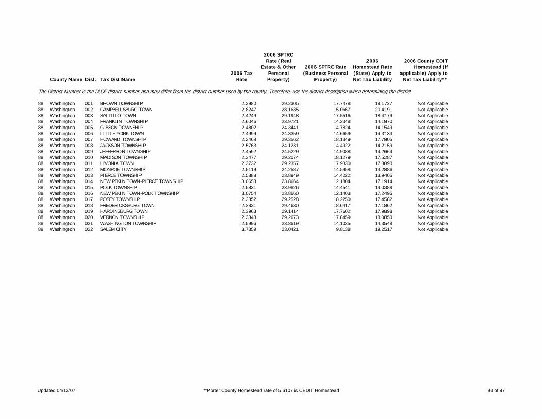
County Name Dist. Tax Dist Name2006 Tax
Rate
2006 SPTRC Rate (Real
Estate & Other Personal Property)
2006 SPTRC Rate (Business Personal
Property)
2006 Homestead Rate (State) Apply to Net Tax Liability
2006 County COIT Homestead (if
applicable) Apply to Net Tax Liability**
The District Number is the DLGF district number and may differ from the district number used by the county. Therefore, use the district description when determining the district.
88 Washington 001 BROWN TOWNSHIP 2.3980 29.2305 17.7478 18.1727 Not Applicable88 Washington 002 CAMPBELLSBURG TOWN 2.8247 28.1635 15.0667 20.4191 Not Applicable88 Washington 003 SALTILLO TOWN 2.4249 29.1948 17.5516 18.4179 Not Applicable88 Washington 004 FRANKLIN TOWNSHIP 2.6046 23.9721 14.3348 14.1970 Not Applicable88 Washington 005 GIBSON TOWNSHIP 2.4802 24.3441 14.7824 14.1549 Not Applicable88 Washington 006 LITTLE YORK TOWN 2.4999 24.3359 14.6659 14.3133 Not Applicable88 Washington 007 HOWARD TOWNSHIP 2.3468 29.3562 18.1349 17.7905 Not Applicable88 Washington 008 JACKSON TOWNSHIP 2.5763 24.1231 14.4922 14.2159 Not Applicable88 Washington 009 JEFFERSON TOWNSHIP 2.4592 24.5229 14.9088 14.2664 Not Applicable88 Washington 010 MADISON TOWNSHIP 2.3477 29.2074 18.1279 17.5287 Not Applicable88 Washington 011 LIVONIA TOWN 2.3732 29.2357 17.9330 17.8890 Not Applicable88 Washington 012 MONROE TOWNSHIP 2.5119 24.2587 14.5958 14.2886 Not Applicable88 Washington 013 PIERCE TOWNSHIP 2.5888 23.8949 14.4222 13.9405 Not Applicable88 Washington 014 NEW PEKIN TOWN-PIERCE TOWNSHIP 3.0653 23.8664 12.1804 17.1914 Not Applicable88 Washington 015 POLK TOWNSHIP 2.5831 23.9826 14.4541 14.0388 Not Applicable88 Washington 016 NEW PEKIN TOWN-POLK TOWNSHIP 3.0754 23.8660 12.1403 17.2495 Not Applicable88 Washington 017 POSEY TOWNSHIP 2.3352 29.2528 18.2250 17.4582 Not Applicable88 Washington 018 FREDERICKSBURG TOWN 2.2831 29.4630 18.6417 17.1862 Not Applicable88 Washington 019 HARDINSBURG TOWN 2.3963 29.1414 17.7602 17.9898 Not Applicable88 Washington 020 VERNON TOWNSHIP 2.3848 29.2673 17.8459 18.0850 Not Applicable88 Washington 021 WASHINGTON TOWNSHIP 2.5996 23.8619 14.1035 14.3548 Not Applicable88 Washington 022 SALEM CITY 3.7359 23.0421 9.8138 19.2517 Not Applicable
Updated 04/13/07 **Porter County Homestead rate of 5.6107 is CEDIT Homestead 93 of 97

County Name Dist. Tax Dist Name2006 Tax
Rate
2006 SPTRC Rate (Real
Estate & Other Personal Property)
2006 SPTRC Rate (Business Personal
Property)
2006 Homestead Rate (State) Apply to Net Tax Liability
2006 County COIT Homestead (if
applicable) Apply to Net Tax Liability**
The District Number is the DLGF district number and may differ from the district number used by the county. Therefore, use the district description when determining the district.
89 Wayne 001 ABINGTON TOWNSHIP 3.0482 22.2187 13.6997 12.2663 Not Applicable89 Wayne 002 BOSTON TOWNSHIP 2.1518 31.7032 21.0639 17.4464 Not Applicable89 Wayne 003 BOSTON TOWN 2.0847 32.7159 21.7427 18.2691 Not Applicable89 Wayne 004 CENTER TOWNSHIP 3.0646 21.7329 13.6267 11.6000 Not Applicable89 Wayne 005 CENTER TOWNSHIP - SANITARY 3.3555 21.8047 12.4454 13.4055 Not Applicable89 Wayne 006 RICHMOND CITY -CENTER TWP 4.3649 21.2825 9.5662 16.6702 Not Applicable89 Wayne 007 CENTERVILLE TOWN 3.7539 21.1885 11.1245 14.3021 Not Applicable89 Wayne 008 CLAY TOWNSHIP 2.3513 26.6028 16.1600 15.9347 Not Applicable89 Wayne 009 GREENS FORK TOWN 3.2637 25.4495 11.6430 20.7424 Not Applicable89 Wayne 010 DALTON TOWNSHIP 2.2715 26.9049 16.7278 15.5937 Not Applicable89 Wayne 011 FRANKLIN TOWNSHIP 2.1991 30.0469 18.1067 19.1170 Not Applicable89 Wayne 012 WHITEWATER TOWN 2.1494 30.2785 18.5219 18.8818 Not Applicable89 Wayne 013 GREENE TOWNSHIP 2.2617 29.6791 17.6058 19.2293 Not Applicable89 Wayne 014 HARRISON TOWNSHIP 2.3152 26.5544 16.4119 15.4659 Not Applicable89 Wayne 015 JACKSON TOWNSHIP 2.3510 27.3986 17.3805 15.4545 Not Applicable89 Wayne 016 CAMBRIDGE CITY TOWN 3.2839 25.3209 12.4430 19.3136 Not Applicable89 Wayne 017 DUBLIN TOWN 2.7022 26.4187 15.1221 17.1954 Not Applicable89 Wayne 018 EAST GERMANTOWN TOWN 2.5342 27.0153 16.1245 16.7146 Not Applicable89 Wayne 019 MOUNT AUBURN TOWN 2.5660 27.0696 15.9240 17.1143 Not Applicable89 Wayne 020 JEFFERSON TOWNSHIP 2.4124 26.4302 15.7508 16.2579 Not Applicable89 Wayne 021 HAGERSTOWN TOWN 3.4167 24.8751 11.1211 20.5052 Not Applicable89 Wayne 022 NEW GARDEN TOWNSHIP 2.2428 29.7492 17.7536 19.1236 Not Applicable89 Wayne 023 FOUNTAIN CITY TOWN 2.8640 28.1830 13.9026 22.2692 Not Applicable89 Wayne 024 PERRY TOWNSHIP 2.3646 26.2808 16.0689 15.5140 Not Applicable89 Wayne 025 ECONOMY TOWN 2.9325 25.8719 12.9567 19.5128 Not Applicable89 Wayne 026 WASHINGTON TOWNSHIP 2.3193 27.3434 17.6181 14.9918 Not Applicable89 Wayne 027 MILTON TOWN 3.0116 25.7938 13.5678 18.4530 Not Applicable89 Wayne 028 WAYNE TOWNSHIP 2.3182 31.3315 19.5523 19.2122 Not Applicable89 Wayne 029 WAYNE TOWNSHIP - SANITARY 2.6091 30.3537 17.3724 20.8755 Not Applicable89 Wayne 030 RICHMOND CITY -WAYNE TWP 3.4238 27.7554 13.2368 22.5081 Not Applicable89 Wayne 031 SPRING GROVE TOWN 2.6443 29.9996 17.1413 20.5736 Not Applicable89 Wayne 032 WEBSTER TOWNSHIP 2.2785 29.6708 17.4758 19.4205 Not Applicable89 Wayne 033 RICHMOND BOSTON TWP AIRPORT 3.3465 0.0000 13.4040 0.0000 Not Applicable89 Wayne 034 RICHMOND CITY-WEBSTER TWP 3.4835 26.4811 0.0000 22.8420 Not Applicable
Updated 04/13/07 **Porter County Homestead rate of 5.6107 is CEDIT Homestead 94 of 97

County Name Dist. Tax Dist Name2006 Tax
Rate
2006 SPTRC Rate (Real
Estate & Other Personal Property)
2006 SPTRC Rate (Business Personal
Property)
2006 Homestead Rate (State) Apply to Net Tax Liability
2006 County COIT Homestead (if
applicable) Apply to Net Tax Liability**
The District Number is the DLGF district number and may differ from the district number used by the county. Therefore, use the district description when determining the district.
90 Wells 001 CHESTER TOWNSHIP 1.9257 33.4945 21.7768 19.7336 Not Applicable90 Wells 002 PONETO TOWN-CHESTER TOWNSHIP 2.6262 30.8214 15.9350 24.0587 Not Applicable90 Wells 003 HARRISON TOWNSHIP 2.1850 30.2543 20.5434 15.5942 Not Applicable90 Wells 004 BLUFFTON CITY-HARRISON TOWNSHI 2.8304 27.7282 15.8590 18.3939 Not Applicable90 Wells 005 PONETO TOWN-HARRISON TOWNSHIP 2.8867 28.4781 15.5499 20.2468 Not Applicable90 Wells 006 VERRA CRUZ TOWN 2.3210 29.5486 19.3392 16.2310 Not Applicable90 Wells 007 JACKSON TOWNSHIP 1.9152 33.7018 21.8962 19.9437 Not Applicable90 Wells 008 JEFFERSON TOWNSHIP 2.2371 32.7114 22.9207 16.2962 Not Applicable90 Wells 009 OSSIAN TOWN 2.5281 30.3987 20.2824 16.2787 Not Applicable90 Wells 010 LANCASTER TOWNSHIP 2.2084 33.1489 23.2186 16.6368 Not Applicable90 Wells 011 BLUFFTON CITY-LANCASTER TWP-N 2.8759 29.9121 17.8296 19.3079 Not Applicable90 Wells 012 BLUFFTON CITY-LANCASTER TWP-BL 2.8151 27.9430 15.9451 18.6486 Not Applicable90 Wells 013 LIBERTY TOWNSHIP 1.9307 33.5109 21.7204 19.8610 Not Applicable90 Wells 014 PONETO TOWN-LIBERTY TWP 2.6338 30.8180 15.9220 24.1160 Not Applicable90 Wells 015 NOTTINGHAM TOWNSHIP 1.9143 33.8620 21.9064 20.2458 Not Applicable90 Wells 016 ROCKCREEK TOWNSHIP 2.2305 32.9096 22.9886 16.5620 Not Applicable90 Wells 017 MARKLE TOWN-ROCKCREEK TOWNSHIP 3.4741 29.1951 14.7596 22.8340 Not Applicable90 Wells 018 UNIONDALE TOWN-ROCKCREEK TOWNS 2.5749 31.5941 19.9140 19.1232 Not Applicable90 Wells 019 UNION TOWNSHIP 2.2144 32.9923 23.1557 16.4414 Not Applicable90 Wells 020 MARKLE TOWN-UNION TOWNSHIP 3.4725 29.1897 14.7666 22.8136 Not Applicable90 Wells 021 UNIONDALE TOWN-UNION TOWNSHIP 2.5733 31.5870 19.9270 19.0939 Not Applicable90 Wells 022 ZANESVILLE TOWN-UNION TOWNSHIP 2.4653 32.3518 20.7988 19.1270 Not Applicable90 Wells 024 BLUFF-LAN/NW/ANNEX 2.8759 29.9136 0.0000 19.3067 Not Applicable
Updated 04/13/07 **Porter County Homestead rate of 5.6107 is CEDIT Homestead 95 of 97

County Name Dist. Tax Dist Name2006 Tax
Rate
2006 SPTRC Rate (Real
Estate & Other Personal Property)
2006 SPTRC Rate (Business Personal
Property)
2006 Homestead Rate (State) Apply to Net Tax Liability
2006 County COIT Homestead (if
applicable) Apply to Net Tax Liability**
The District Number is the DLGF district number and may differ from the district number used by the county. Therefore, use the district description when determining the district.
91 White 001 BIG CREEK TOWNSHIP 2.0450 28.0483 19.9536 12.6003 Not Applicable91 White 002 CHALMERS TOWN 2.4957 27.2358 16.3502 16.7554 Not Applicable91 White 003 CASS TOWNSHIP-Pioneer Regional 2.1703 30.5185 20.7259 15.7852 Not Applicable91 White 004 CASS TOWNSHIP-Twin Lakes Schoo 1.8308 31.9603 22.5246 15.5323 Not Applicable91 White 005 HONEY CREEK TOWNSHIP-North Whi 2.0319 29.7707 20.8730 14.1897 Not Applicable91 White 006 HONEY CREEK TOWNSHIP-Twin Lake 1.8663 31.4851 22.1006 15.3464 Not Applicable91 White 007 REYNOLDS TOWN 2.4001 28.7817 17.6707 17.4733 Not Applicable91 White 008 JACKSON TOWNSHIP 1.9053 31.5126 21.6437 16.1387 Not Applicable91 White 009 BURNETTSVILLE TOWN 1.9812 31.2295 20.8141 16.9624 Not Applicable91 White 010 LIBERTY TOWNSHIP-North White S 1.9503 30.3350 21.7463 13.8079 Not Applicable91 White 011 LIBERTY TOWNSHIP-Twin Lakes Sc 1.7847 32.1794 23.1066 14.9836 Not Applicable91 White 012 LINCOLN TOWNSHIP 1.8629 31.5618 22.1364 15.4250 Not Applicable91 White 013 MONON TOWNSHIP 2.1343 28.7615 19.8716 13.9766 Not Applicable91 White 014 MONON TOWN 2.9858 27.0534 14.2046 19.7276 Not Applicable91 White 015 PRAIRIE TOWNSHIP 2.1021 27.5884 19.4115 12.6473 Not Applicable91 White 016 BROOKSTON TOWN 2.4458 26.8854 16.6837 15.6274 Not Applicable91 White 017 PRINCETON TOWNSHIP 2.1983 32.6130 23.8647 14.5400 Not Applicable91 White 018 WOLCOTT TOWN 2.8324 30.0752 18.5220 18.5050 Not Applicable91 White 019 ROUND GROVE TOWNSHIP 2.1382 32.8244 24.5354 13.8199 Not Applicable91 White 020 UNION TOWNSHIP 1.8855 31.2277 21.8709 15.2381 Not Applicable91 White 021 MONTICELLO CITY 2.6691 28.5410 15.4456 20.5249 Not Applicable91 White 022 WEST POINT TOWNSHIP-Frontier S 2.0044 28.3774 20.3577 12.5407 Not Applicable91 White 023 WEST POINT TOWNSHIP-Tri County 2.1179 33.1513 24.7706 14.0411 Not Applicable
Updated 04/13/07 **Porter County Homestead rate of 5.6107 is CEDIT Homestead 96 of 97

County Name Dist. Tax Dist Name2006 Tax
Rate
2006 SPTRC Rate (Real
Estate & Other Personal Property)
2006 SPTRC Rate (Business Personal
Property)
2006 Homestead Rate (State) Apply to Net Tax Liability
2006 County COIT Homestead (if
applicable) Apply to Net Tax Liability**
The District Number is the DLGF district number and may differ from the district number used by the county. Therefore, use the district description when determining the district.
92 Whitley 001 CLEVELAND TOWNSHIP 2.0950 29.8873 20.1349 15.5788 Not Applicable92 Whitley 002 SOUTH WHITLEY TOWN 2.7798 28.0880 15.1747 20.1119 Not Applicable92 Whitley 003 COLUMBIA TOWNSHIP 2.2890 29.6402 20.4855 14.5727 Not Applicable92 Whitley 004 COLUMBIA CITY 2.9313 26.8505 15.9967 16.6183 Not Applicable92 Whitley 005 ETNA TROY TOWNSHIP 2.1371 30.9166 21.9416 14.5505 Not Applicable92 Whitley 006 JEFFERSON TOWNSHIP 2.1526 30.6564 21.7836 14.3310 Not Applicable92 Whitley 007 RICHLAND TOWNSHIP 2.0538 30.2402 20.5388 15.5756 Not Applicable92 Whitley 008 LARWILL TOWN 2.3686 28.9479 17.8097 17.5581 Not Applicable92 Whitley 009 SMITH TOWNSHIP 1.8357 31.1225 21.6171 15.4564 Not Applicable92 Whitley 010 CHURUBUSCO TOWN 2.4628 29.5535 16.1128 21.3688 Not Applicable92 Whitley 011 THORNCREEK TOWNSHIP 2.2906 29.4839 20.4712 14.3149 Not Applicable92 Whitley 012 UNION TOWNSHIP 2.1385 30.6465 21.9272 14.0810 Not Applicable92 Whitley 013 WASHINGTON TOWNSHIP 2.1904 30.4624 21.4076 14.5841 Not Applicable92 Whitley 014 COLUMBIA CITY/UNION TOWNSHIP 2.9196 26.8867 0.0000 16.5834 Not Applicable
Updated 04/13/07 **Porter County Homestead rate of 5.6107 is CEDIT Homestead 97 of 97