Embed Size (px)
Citation preview

2006 Arch Bridge Assessment Report ofConcrete Open Spandrel Arch Bridges,
Concrete Filled Spandrel Arch Bridges with Three or More Spans,and Stone Spandrel Arch Bridges with Three or More Spans
Completed by:Mathew Brundage-Staff Intern
Brandon Strohl-Staff InternOhio Department of TransportationOffice of Environmental Services
Cultural Resources UnitColumbus, Ohio
August 2006


Ohio’s Spandrel Arch Bridges
In 2006 an inventory of open and closed spandrel arch bridges in Ohio has been
carried out for the Ohio Department of Transportation’s Office of Environmental
Services. The updated inventory provides photos, bridge inspection reports, and histories
for all the bridges visited in this survey. The included bridge inspection reports are coded
according to the 1998 Bridge Inspection Manual. Descriptions and definitions of the
codes can be found in the Appendix.
The bridge update included visits to all of Ohio’s reinforced concrete open
spandrel arch bridges, reinforced concrete closed spandrel arch bridges with three or
more spans, and stone arch bridges with three or more spans. This resulted in a total of
84 bridges, of which 30 are open spandrels, 45 are closed spandrels, and 9 are stone
arches. A map showing the general locations of these bridges is shown below. Tables for
each bridge type are also provided with summaries of all the bridges.

Open Spandrel Arch Bridges

THE REINFORCED CONCRETE OPEN SPANDREL ARCH History, Description, & Significance: The Reinforced Concrete Open Spandrel Arch
was first constructed around 1906. It was the dominant form for concrete bridges in the
1920s and 1930s. By eliminating the walls and fill material of the closed spandrel, dead
loads were reduced and cost savings were seen in materials with the open spandrel.
Aesthetics was another factor with the open spandrel. They had a lightness and visual
appeal and were used in prominent or scenic locations. Open spandrel construction
marked engineering prowess during the 1930s and 1940s. By the 1940s, the open
spandrel concrete structure began to be supplanted by the more pre-stressed beam and
reinforced concrete girder structures. Open spandrel arch bridges have pierced spandrel
wall with no fill material, and the spandrel columns transmit dead and live load from the
deck to the arch. The arch ring may be either solid (barrel) or ribbed. Open spandrel
arch bridges require more formwork to construct than filled spandrel bridges. Open
spandrel concrete arches, while not uncommon, are not as common as many other bridge
types built during this same era. They are significant because they represent the
evolution of concrete technology. To be considered significant, open spandrel arches
should have integrity through the retention of their character-defining features, which
include arch ribs, ring or barrel; spandrel; spandrel columns; railing or parapet; and piers,
abutments, and wingwalls.
[From: A Context for Common Historic Bridge Types by Parsons Brinckerhoff,
October 2005]

SFN
Cou
nty
Mun
icip
ality
Nam
eFa
cilit
y C
arrie
dFe
atur
eIn
ters
ecte
dM
ain
Spa
ns #
Yea
rB
uilt
Loca
tion
UTM
Sta
tus
Dat
e V
isite
dH
ist.
Inte
grity
Not
esP
rese
rvat
ion
Pot
entia
l
0402
192
Ash
tabu
laA
shta
bula
US
20
Ash
tabu
la R
iver
UN
K19
28A
shta
bula
17.5
1830
8.46
3548
0R
emov
edJu
ly 2
5, 2
006
Rep
lace
dR
epla
ced
with
ste
el b
eam
0402
281
Ash
tabu
laC
onne
aut
US
20
Con
neau
t Cre
ek13
1922
Con
neau
tV
iadu
ct17
.537
250.
4643
140
Rem
oved
July
25,
200
6R
epla
ced
Rep
lace
d w
ith s
teel
bea
m
0406
120
Ash
tabu
laW
inds
orTo
wns
hip
US
322
Phe
lps
Cre
ek1
1932
W. o
f SR
534
17.5
0303
3.45
9797
7R
eser
veJu
ly 2
4, 2
006
Exc
elle
ntR
ehab
bed
in 1
993
0503
126
Ath
ens
Coo
lvill
eS
R 1
44H
ocki
ng R
iver
119
300.
3 M
i. N
. of S
R
717
.431
720.
4341
800
Rem
oved
NA
Rem
oved
Rem
oved
on
July
28,
200
6.S
ched
uled
to b
e re
plac
ed o
n ne
w
alig
nmen
t..
0701
599
Bel
mon
tB
lain
eU
S 4
0W
heel
ing
Cre
ek4
arch
es,
11 to
tal
1932
0.9
Mi.
E. o
f CR
21
417
.515
280.
4434
980
Sel
ect
July
5, 2
006
Goo
dM
inor
chi
ppin
g an
d re
bar e
xpos
ure.
1201
654
Cla
rkS
prin
gfie
ldS
R 4
1 (P
lum
St.)
Buc
k C
reek
119
270.
33 M
i. N
. of U
S
4017
.259
261.
4423
823
Rem
oved
June
13,
200
6G
ood
Maj
or re
habi
litat
ion
in 1
991.
Lot
s of
gr
affit
i.
1802
046
Cuy
ahog
aFa
irvie
w P
ark
SR
17
Roc
ky R
iver
7 ar
ches
, 15
tota
l19
3390
0 ft.
E. o
f W
220
St.
17.4
3119
4.45
9119
5S
elec
tJu
ly 2
5, 2
006
Fair
Lots
of e
xpos
ed re
bar,
crum
blin
g,
and
spal
ling.
1830
082
Cuy
ahog
aS
outh
Euc
lidW
ilson
Mill
s R
d.E
uclid
Cre
ek3
1954
-55
1015
ft. E
. of
Gre
en R
oad
17.4
5637
7.45
9848
8S
elec
tJu
ly 2
5, 2
006
Exc
elle
ntA
ppar
ent r
ehab
ilita
tion.
1830
147
Cuy
ahog
aR
ocky
Riv
erH
illia
rd R
d. (C
R
69)
Roc
ky R
iver
319
2591
0 Ft
. W. o
f R
ocky
Riv
er D
r.17
.430
587.
4592
440
Sel
ect
July
25,
200
6Fa
irE
xten
sive
pat
ches
of c
hipp
ing
and
spal
ling.
Lot
s of
exp
osed
reba
r on
pier
s an
d co
lum
ns.
1830
775
Cuy
ahog
aB
entle
yvill
eM
iles
Rd.
Cha
grin
Riv
er1
arch
, 7
tota
l19
57E
. of C
hagr
in
Riv
er R
d.17
.465
154.
4585
673
Non
-S
elec
tJu
ly 2
5, 2
006
Exc
elle
ntR
ehab
bed
in 2
003.
1840
053
Cuy
ahog
aB
erea
Con
rail
Line
Bar
rett
Rd.
219
09N
. of B
agle
y R
d.17
.427
640.
4580
640
Sel
ect
July
25,
200
6P
oor
Maj
or d
eter
iora
tion,
spa
lling
, and
cr
acki
ng.
1901
176
Dar
keG
reen
ville
SR
49
Gre
envi
lleC
reek
119
070.
41 M
i. N
W o
f S
R 1
2116
.701
230.
4441
670
NR
Lis
ted
July
3, 2
006
Goo
dM
inor
con
cret
e ch
ippi
ng a
nd lo
ts o
f gr
affit
i.
2501
449
Fran
klin
Col
umbu
sS
R 3
3O
lent
angy
Riv
er5
1932
0.16
Mi.
E. o
f SR
31
517
.327
600.
4425
730
Res
erve
June
12,
200
6G
ood
Min
or c
oncr
ete
crac
king
.R
ehab
ilita
ted
in 1
999.
2503
212
Fran
klin
Col
umbu
sU
S 6
2 (R
ich
St.)
Sci
oto
Riv
er7
1935
2.11
Mi.
N o
f I-
7017
.328
610.
4424
580
Sel
ect
June
12,
200
6P
oor
Clo
sed
to tr
affic
in 2
002.
Lot
s of
cr
acki
ng a
nd m
issi
ng c
olum
ns.
Rep
lace
men
t sch
edul
ed.
2561
883
Fran
klin
Col
umbu
sC
alum
et S
treet
Gle
n E
cho
Rav
ine
619
2472
5 ft.
N. o
f A
rcad
ia A
ve.
17.3
2872
0.44
3162
0N
on-
Sel
ect
Aug
ust 3
, 200
6G
ood
Are
as w
ith c
rum
blin
g co
ncre
te o
n co
lum
ns.
Lots
of g
raffi
ti.
3105
458
Ham
ilton
Cin
cinn
ati
W. H
ills
Via
duct
I-75,
Rai
l lin
es3
1931
1 M
i. S
. of U
S 5
216
.712
730.
4333
330
Res
erve
June
26,
200
6G
ood
Diff
icul
t to
insp
ect.
3160
777
Ham
ilton
Cin
cinn
ati
Vic
tory
Par
kway
Kem
per L
ane
119
17In
ters
ectio
n of
K
empe
r Lan
e &
P
ark
Ave
.
16.7
1724
0.43
3284
0S
elec
tJu
ne 2
6, 2
006
Exc
elle
ntR
ehab
in 1
990.
3901
505
Hur
onW
akem
anU
S 2
0V
erm
illio
n R
iver
119
337.
86 M
i. E
. of S
R
601
17.3
8276
3.45
6774
3S
elec
tJu
ne 2
8, 2
006
Fair
Larg
e ar
eas
of c
rum
blin
g an
d ex
pose
d re
bar o
n co
lum
ns.
3903
842
Hur
onFi
tchv
ille
Tow
nshi
pU
S 2
50V
erm
illio
n R
iver
119
280.
07 M
i. S
. of S
R
1317
.375
140.
4550
080
Sel
ect
June
28,
200
6G
ood
Som
e sp
allin
g an
d ex
pose
d re
bar.
To b
e re
plac
ed.
4901
029
Mad
ison
Jeffe
rson
Tow
nshi
pU
S 4
0B
ig D
arby
C
reek
819
401.
98 M
i. N
. of S
R
142
17.3
0899
5.44
2410
5N
on-
Sel
ect
June
12,
200
6G
ood
Brid
ge h
as b
een
wid
ened
. S
ome
spal
ling
and
crac
king
on
arch
es a
nd
colu
mns
.
5001
951
Mah
onin
gY
oung
stow
nU
S 6
2 (C
anfie
ld
Roa
d)M
ill C
reek
319
200.
11 M
i. E
of S
R
625
17.5
2664
0.45
4602
0S
elec
tJu
ly 2
4, 2
006
Goo
dM
inor
cra
ckin
g an
d cr
umbl
ing
on
beam
s w
ith s
ome
expo
sed
reba
r.
Mat
eria
l: R
einf
orce
d C
oncr
ete
Ope
n S
pand
rel A
rch
Brid
ges
200
6 Br
idg
e U
pd
ate

SFN
Cou
nty
Mun
icip
ality
Nam
eFa
cilit
y C
arrie
dFe
atur
eIn
ters
ecte
dM
ain
Spa
ns #
Yea
rB
uilt
Loca
tion
UTM
Sta
tus
Dat
e V
isite
dH
ist.
Inte
grity
Not
esP
rese
rvat
ion
Pot
entia
l
Mat
eria
l: R
einf
orce
d C
oncr
ete
Ope
n S
pand
rel A
rch
Brid
ges
5060
540
Mah
onin
gY
oung
stow
nFi
fth A
venu
eC
rand
all R
un1
1920
Nor
ther
nY
oung
stow
n17
.522
60.4
5524
40R
eser
veJu
ly 2
4, 2
006
Goo
dR
ehab
ilita
ted
in 1
991.
5060
850
Mah
onin
gY
oung
stow
nO
hio
Ave
nue
Cra
ndal
l Run
UN
K19
20N
orth
ern
You
ngst
own
17.5
2965
0.45
5236
0R
emov
edJu
ly 2
4, 2
006
Rem
oved
No
brid
ge b
uilt
as re
plac
emen
t.
5630
452
Mon
roe
Ben
ton
Tow
nshi
pTr
ail R
un R
oad
(CR
12)
Littl
eM
uski
ngum
Riv
er1
1936
N. o
f TR
562
17
.491
020.
4385
050
Res
erve
July
5, 2
006
Poo
rA
rch
was
ok,
raili
ng n
eeds
repl
aced
.
7706
871
Sum
mit
Nor
thfie
ldS
R 8
2 (C
hipp
ewa
Rd.
)C
uyah
oga
Riv
er, R
ail L
ine
4 ar
ches
, 15
tota
l19
31C
uy/S
um C
ount
y Li
ne17
.450
840.
4574
380
NR
Lis
ted
July
25,
200
6G
ood
Som
e cr
acki
ng a
nd e
xpos
ed re
bar.
7745
192
Sum
mit
Cuy
ahog
a Fa
llsA
kron
-Cle
vela
ndR
d.M
ud B
rook
119
1820
0 Ft
. N. o
f G
raha
m R
d.17
.457
310.
4555
640
Rem
oved
July
25,
200
6R
epla
ced
Rep
lace
d w
ith s
teel
bea
m
7756
046
Sum
mit
Twin
sbur
gTo
wns
hip
Rav
enna
Rd.
(CH
12
)Ti
nker
s C
reek
119
1720
0 Ft
. N. o
f Old
M
ill R
d.17
.466
000.
4570
300
Non
-S
elec
tJu
ly 2
5, 2
006
Poo
rE
xten
sive
cra
ckin
g, a
nd c
rum
blin
g of
co
ncre
te.
To b
e re
plac
ed.
7802
439
Trum
bull
Nile
sS
outh
Mai
n S
t. (S
R46
)M
ahon
ing
Riv
er,
Rai
l Lin
e10
1932
0.6
Mi.
S. o
f SR
16
917
.519
660.
4558
260
Rem
oved
July
24,
200
6R
epla
ced
Rep
lace
d w
ith s
teel
bea
m
7839
758
Trum
bull
Nile
sO
live
St.
Mah
onin
g R
iver
, R
ail L
ine
2 ar
ches
, 20
tota
l19
20E
xt. o
f SR
351
in
to N
iles
17.5
2198
0.45
5754
0N
on-
Sel
ect
July
24,
200
6Fa
irLo
ts o
f exp
osed
reba
r and
con
cret
e cr
umbl
ing.
8300
038
War
ren
Dee
rfiel
d-H
amilt
onTo
wns
hips
US
22
Littl
e M
iam
i R
iver
619
373
Mi.
N. o
f C
ount
y Li
ne16
.736
880.
4355
700
Sel
ect
June
26,
200
6G
ood
Som
e ch
ippi
ng a
nd e
xpos
ed re
bar o
n co
lum
ns.
200
6 Br
idg
e U
pd
ate

US 20 over the Ashtabula River Bridge # 0402192
ASHTABULA COUNTY Ashtabula, OH
Date Visited: July 25, 2006 The concrete open spandrel, rib arch viaduct designed by J.R. Burkey and built in 1928 has been removed and replaced. The new bridge is a seven span, steel beam bridge. The new bridge has a concrete railing made to look like stone along with a metal railing. A plaque memorializing the old open spandrel bridge has been placed at the new bridge.
Plaque about old bridge displayed at new bridge. Overall view of new bridge, facing west.
Detail view of sidewalk and railing on new bridge. View of roadway from west approach, facing east.

US 20 over Conneaut Creek Bridge # 0402281
ASHTABULA COUNTY Conneaut, OH
Date Visited: July 25, 2006 The Conneaut Viaduct was designed by Wendell P. Brown and was built in 1924. It was a 13 span, open spandrel concrete rib arch bridge and the largest structure ever built on the Ohio highway system at the time of its completion. In 2004 it was removed and replaced with an 8 span, steel beam bridge on a new alignment. The original plaque is now located on the new bridge in addition to a plaque commemorating the old arched bridge.
Plaque with poem about the removed bridge. Overall view of new bridge, facing east.
View of roadway from western approach, looking east. View of east abutment of the removed bridge.

US 322 over Phelps Creek Bridge # 0406120
ASHTABULA COUNTY West of Windsor, OH
Date Visited: July 24, 2006 This bridge is a single span, open spandrel arch bridge that was built in 1932. The structure has great integrity. It was rehabbed in 1993. The arches and columns were all maintained. The bridge had no sidewalk and no plaques. The railings were concrete walls.
View of roadway from western approach, facing east. View of support structure, facing northwest.
View of underside of open spandrel arches, facing west. Overall view of bridge, facing northwest.

State Route 144 over the Hocking River Bridge # 0503126
ATHENS COUNTY Coolville, OH
Date Visited: N/A
This open spandrel arch bridge, originally constructed in 1930, is currently scheduled for replacement. Given the slated removal of the bridge, the recent completion of a Historic American Engineering Record (HAER) for the structure, and the isolated location of the bridge in relation to other structures surveyed for this update, no field review was performed. Pictures from the HAER document are shown below. A dam which existed up river from this structure was removed, resulting in the lower portions of the main arch and piers to become submerged and further degrading the integrity of the structure. The Concrete Arch Supplement of the Historic Bridge Update lists Henry Overman and C.P. Smith of the Bridge Bureau as the primary designers of the structure. This open spandrel bridge was removed on July 28, 2006.
Overall view of bridge, facing northwest. View of support structure, looking north.
View of roadway from southern approach, facing north. Demolition of bridge on July 28, 2006

US 40 over Wheeling Creek and CR 10 Bridge # 0701599
BELMONT COUNTY Blaine, OH
Date Visited: July 5, 2006 This bridge is an eleven span, open spandrel arch bridge that was built in 1933. It is known as the Blaine Hill Viaduct and overlooks the “ S” Bridge. The viaduct is sloped downward toward the east and has one sidewalk on the north side. Stairs leading down below the bridge were located on the northeast end of the structure. It had closed concrete railings that have retained their integrity. The sidewalk was crumbling a little on the east end. Beneath the bridge the arches had no major problems, but had only minor chipping and rebar exposure. A column on the south side is cracked and spalling. Two plaques were mounted on the east end of the bridge and an Ohio historical marker for the viaduct is located beside the “ S” Bridge. The bridge has been named the Arches of Memory and was dedicated to World War I veterans. It was also rededicated in 1982 by the American Legion and Belmont County Council. According to the Historic Bridge Inventory the structure underwent rehabilitation in the early 1980’ s.
View of support structure on south side, facing northwest. Overall view of bridge, facing southeast.
View of roadway from east approach, facing west. Detail of arch and spalling column on south side.

State Route 41 (Plum Street) over Buck Creek Bridge # 1201654
CLARK COUNTY Springfield, OH
Date Visited: June 13, 2006 The Plum Street Bridge is a one span, open spandrel arch bridge built in 1927. The deck and railings look like they were modern replacements. The ribbed arches and columns below had decent integrity. No cracking or spalling in the concrete was noticeable from the south end. This bridge also had a lot of graffiti. Everything within reach was painted all the way up to the top of the arches. The railings were concrete and metal. The identification number “ CLA-41-1848” was posted on both ends of the bridge and there was no plaque or historical information posted.
Overall view of bridge, facing north. Detailed view of inner columns and graffiti on south end.
Detailed view of railing on southwest side. View of roadway from south approach, facing north.

State Route 17 over the Rocky River Bridge # 1802046
CUYAHOGA COUNTY Fairview Park, OH
Date Visited: July 25, 2006 Also known as the Brookpark Viaduct, this bridge is a 15 span, open spandrel arch bridge that was built in 1933. In 1999 the bridge was painted white and the railings were repaired. There is crumbling, spalling, and exposed rebar in some spots along the arches and columns. The underside of the road deck had a lot of rebar exposed. The railings are metal and have rusted a lot. Overall, this bridge is not terrible, but it does not have the best integrity. According to the Historic Bridge Update and the Concrete Arch Supplement, the structure was designed by D.H. Overman and C.P. Smith of the Bureau of Bridges. Originally the structure had Gothic inspired railings and decorative features; however, they were removed during a rehabilitation of the bridge in the mid-1980’ s, which resulted in the addition of two additional lanes of traffic and sidewalks.
View of roadway from western approach, facing east. View of westernmost arch, facing south.
Overall view of support structure, facing east. Detail view of pier and columns, facing south.

Wilson Mills-Monticello Road over Euclid Creek Bridge # 1830082
CUYAHOGA COUNTY South Euclid, OH
Date Visited: July 25, 2006
This bridge is a three span, open spandrel rib arch bridge that was built in 1954-55. The arches and the columns have good integrity as well as the entire structure. The bridge carried 4 lanes of traffic and had a median. A pipeline ran along the middle of the bridge underneath. It had sidewalks on both sides with chain link fences for railings. The concrete has been painted and is now starting to chip away as well as stain the concrete. A plaque with the names of county commissioners and engineers is located at the ends of the bridge.
Overall view of bridge, facing north. View of arches from below bridge, facing west.
View of roadway from west approach, looking east. Detail view of railing with crack on south side.

Hilliard Road (CR 69) over the Rocky River Bridge # 1830147
CUYAHOGA COUNTY Rocky River, OH
Date Visited: July 25, 2006 This bridge is a three arch, open spandrel bridge built in 1925 and rehabilitated in 1983. The four ribbed arches and columns have poor integrity. There were many locations of exposed rebar and there was lots of crumbling, spalling, and cracking. The piers are missing large areas of the concrete cover that protects the rebar. The concrete appears to be peeling away. This bridge had sidewalks on both sides of the roadway with decorative lookouts on the sides of the bridge. The railings were open concrete and there was no plaque displayed. This bridge is in need of rehab. The Concrete Arch Supplement lists Alfred M. Felgate, Cuyahoga County Engineer, as the designer if the structure.
View of roadway from western approach, looking east. View of support structure from beneath bridge.
Detail of spalling on columns. View of bridge with I-90 in foreground, facing southeast.

Miles Road (CR 11) over Chagrin River Bridge # 1830775
CUYAHOGA COUNTY Bentleyville, OH
Date Visited: July 25, 2006 This bridge is a 7 span, open spandrel ribbed bridge built in 1957. The structure was rehabbed in 2003. It has two sidewalks and concrete railings made to look like bricks. The single arch has no deterioration. There is some staining on the bridge that is probably due to poor drainage. Overall, this bridge has very good integrity. Plaques for the rehabbed bridge are located at the end of the bridge.
Overall view of bridge, facing west. View of support structure, facing west.
View of roadway from western approach, facing east. View of south side of bridge and railing.

Conrail Railroad over Barrett Road (CR 178) Bridge # 1840053
CUYAHOGA COUNTY Berea, OH
Date Visited: July 25, 2006 This bridge is a two span, open spandrel bridge built in 1909 to carry a railroad over Barrett Rd. and Rocky River. The entire structure has poor integrity. The piers and arches are deteriorating. There is lots of spalling under the arches and big cracks with trees growing in them. The upper deck is crumbling really badly and there is also a lot of graffiti. There are no plaques at the bridge, but one stone on the south face of the structure is imprinted with the year “ 1909” . This structure is adjacent to two other arched railroad bridges, one of which is still in use.
Overall view of bridge, facing northeast. View of bridge, facing southeast.
Detail view of crumbling concrete on south face of bridge. Close up view of west arch, facing south.

State Route 49 over Greenville Creek Bridge # 1901176
DARKE COUNTY Greenville, OH
Date Visited: July 3, 2006 This bridge, known as the Martha G. Benkert Memorial Bridge, is a single span, open spandrel arch bridge built in 1907. The bridge has been restored and was dedicated to Martha G. Benkert, a Greenville public servant, on January 7, 1996. The bridge had concrete railings with balusters and a sidewalk on each side. The bridge also had decorative lighting by Sternberg. A pipe ran beneath the bridge and through the arch. Overall, the bridge has great integrity. The only problem area was a little bit of concrete chipping on the southwest end. The bridge had a lot of graffiti. The Concrete Arch Supplement describes this bridge as being one of the few three-hinged arch bridges in the United States. This unique design was chosen, along with the decision to not include reinforcing steel in the structure, to allow for the bridge to shift due to temperature and soil conditions at the site. The bridge was extensively rehabilitated in 1990 and received the Ohio Department of Transportation Historic Bridge Preservation Award in 1992.
Overall view of bridge, southwest. Detail of concrete railings on east side.
View from under bridge showing arch and pipe, facing south. View of inner columns and support structure, facing east.

State Route 33 over the Olentangy River Bridge # 2501449
FRANKLIN COUNTY Columbus, OH
Date Visited: June 12, 2006 The State Route 33 Bridge is an open spandrel arch bridge with five spans that was built in 1932. The bridge has been widened by three lanes with the addition of a more modern structure in 1954. The original open spandrel bridge is wide enough to carry the other three lanes of traffic. It was interesting that the beams in the bridge deck extended beyond the side of the bridge. The bridge displayed some minor cracking, but it was rehabilitated in 1999. This was noticeable by the concrete patching on the piers. Overall, the bridge appears to have been maintained and has good integrity.
Center arch of bridge on north side, facing south. View of modern addition on south side, facing northwest.
Close up view of beams on north side, facing east. View of roadway from west approach, facing east.

State Route 62 (Main St.) over the Scioto River Bridge # 2503212
FRANKLIN COUNTY Columbus, OH
Date Visited: June 12, 2006
The Main Street Bridge is a reinforced concrete, open spandrel arch bridge with seven spans that was built from 1935 to 1937 by the General Asphalt Paving Co. The Art Deco styled bridge is supposed to carry traffic on US 62 in only the eastbound direction. However, the bridge has been closed to traffic. According to the 1983 Historic Bridge Inventory, the spans of the bridge range from 72 feet to 116 feet. Each end of the bridge was blocked with fences displaying “ Danger” signs. Traffic has been diverted to the adjacent Town Street Bridge. The inner columns have deteriorated and in some cases were missing. The outer columns on the side of the bridge looked like they have held up to the deterioration. Cracks could be seen in the concrete. The bridge had metal railings between concrete posts and there were no plaques or historical markers posted around the bridge. The bridge was schedule to be replaced in 2002, but nothing has taken place yet.
Overall view of bridge, looking southwest. View of northwest abutment.
Close up view of bridge railings on south face. View of roadway from the east approach, facing west.

Calumet Street over the Glen Echo Ravine Bridge # 2561883
FRANKLIN COUNTY Columbus, OH
Date Visited: August 3, 2006 This bridge is a single arch, open spandrel bridge with six spans. It was built in 1924. The bridge is on a curved alignment, has two sidewalks, and has concrete parapets with aluminum for railings. The road deck, sidewalks, and railings all had good integrity. Underneath, most of the columns have held their integrity. However, one inner column on the north end has crumbling corners with exposed rebar. The south end also has crumbling concrete on the beams and columns. There were no visible problems with the concrete arch. The bridge needs painted to cover a lot of graffiti on it.
Overall view of bridge, facing east. View of roadway from southern approach, facing north.
Detail of crumbling center column on north end of bridge. View of concrete arch from under bridge, facing south.
Western Hills Viaduct over I-75 and Railroad Bridge # 3105458
HAMILTON COUNTY Cincinnati, OH
Date Visited: June 26, 2006 The Western Hills Viaduct has three spans and was built in 1931. It is an open spandrel arch bridge and is very long with a span of 2920 feet. It is difficult to obtain access to the underside of the bridge because it spans Interstate 75, numerous railroads, and private properties/businesses. The bridge also carried an upper and lower deck for traffic. Overall, the bridge has fair integrity, but we were unable to get a good look at most of the structure upon our visit. We did not find any historical markers at this bridge. The 1983 Historic Bridge Inventory lists this bridge as having 49 spans in total, with two open spandrel arches with a length of 120 ft. This double-deck structure has Art Deco pylons with decorative recessed lighting. It is listed as having undergone rehabilitation in the 1970’ s.
View of west approach, facing northeast. View of support structure from under bridge, facing east.
View of roadway from east end of bridge, facing west. View of west approach, facing north.

Victory Parkway over Kemper Lane Bridge # 3160777
HAMILTON COUNTY Cincinnati, OH
Date Visited: June 26, 2006 The Victory Parkway Bridge leading to Cincinnati’ s Eden Park is a single span, open spandrel arch that was built in 1917. The bridge had good integrity and was rehabilitated in 1990. The bridge has been painted recently to cover up graffiti. There was no noticeable cracking or crumbling of the concrete. This bridge had some nice architectural features such as octagonal columns and smaller arches above the main arches. The bridge had concrete railings and lights from the Union Metal Manufacturing Company. Steps were located on the northeast side of the bridge that led down to Kemper Lane. A sign said that these were the Park Avenue Steps and that they were built in 1997. There were no plaques or historical markers about the bridge itself. The Concrete Bridge Update notes J. Robert Biedinger, an engineer for the city of Cincinnati, as the primary architect. The original sidewalk and railings were replaced in 1935, with the roadway and the tops of the support crossbeams were replaced in 1939. Other repairs and reinforcement projects were performed in 1944, 1988, and 1990.
Detail of support pattern from under bridge, facing south. View of support columns on west side of bridge.
View of roadway from north approach, facing south. View of bridge from Kemper Lane, facing east.

US 20 over the Vermilion River Bridge # 3901505
HURON COUNTY Wakeman, OH
Date Visited: June 28, 2006 This bridge is a single span, open spandrel arch bridge that was built in 1933. This bridge was very large and had different architectural elements in the design of the columns. There was some rebar and cracks visible, but overall has good integrity. The biggest problem was crumbling concrete on one of the south columns. The bridge had concrete railings and one sidewalk on the south side. An elevation benchmark has been placed on the wall at the west end. No plaques or historical markers are located at the bridge. A nice stone railroad bridge runs parallel to this structure. The Concrete Arch Supplement lists W.E. Borroughs, of the Ohio Bureau of Bridges as the primary designer. In the 1980’ s the original railings, sidewalk, and roadway were replaced.
View of roadway from east approach, facing west. Overall view of bridge, facing northeast.
View from under bridge showing support structure, facing east. View showing detail on columns and spalling on south side.

US 250 over the Vermilion River Bridge # 3903842
HURON COUNTY Fitchville, OH
Date Visited: June 28, 2006 This bridge is a six span, open spandrel arch bridge built in 1928. Replacement is planned in the future. The bridge had a little bit of crumbling, especially on the beams under the road deck. Staining was also found on the concrete walls. The bridge had no sidewalks and had concrete walls for railings. The railings were cracked exposing rebar. The bridge has been given a protective coating of paint along the top of the bridge and it was widened some time ago. There is a lot of graffiti on the structure. No plaques or historical markers.
Overall view of bridge, facing west. View of roadway from east approach, facing west.
View from under bridge showing support structure, facing east. Detail of cracking and exposed rebar on north railing wall.

US 40 over Big Darby Creek Bridge # 4901029
MADISON/FRANKLIN COUNTIES Date Visited: June 12, 2006
This bridge is an open spandrel arch on US 40 located on the Madison/Franklin County line. It has eight spans. The bridge had easy access to below with access roads on both ends. The bridge has good integrity. It appears that some rehabilitation work has been done to it because many of the piers and arches have been painted, probably to protect the concrete. There was some chipping on the northwest arch and exposed rebar on the underside of the northeast arch. All of the chipping and spalling appears to be contained to just the north side of the bridge. The bridge also has some graffiti and has been shot at with a paintball gun. Overall, the bridge has good integrity.
View of columns, arch, and beams beneath bridge. Detailed view of spalling beneath arch.
View of bridge arches and beams from east end. View of roadway from west approach, facing east.

Lanterman Falls Bridge US 62 (Canfield Road) over Mill Creek
Bridge # 5001951 MAHONING COUNTY
Youngstown, OH Date Visited: July 24, 2006
The Lanterman Falls Bridge is a three span, open spandrel arch bridge that was built in 1920 by N.R. Perterfield, Inc., of Youngstown. This bridge has great integrity. There is some minor crumbling and cracking on a beam under the bridge. The cracks have progressed enough to expose some of the rebar. The bridge had green metal railings and lights by San Juan. Sidewalks were on both sides along with plaques for the original bridge and for the 1990 rehabilitation. The open spandrel bridge had pipelines that ran through the bridge. The bridge is located right beside Lanterman Falls and Mill. There is also a new covered bridge (1988) just upstream of this bridge.
Overall view of bridge, facing northwest. View of bridge and walking path below, facing west.
View of roadway & sidewalk from western approach. View of pathway below bridge on northeast end.

Fifth Avenue over Crandall Run Bridge # 5060540
MAHONING COUNTY Youngstown, OH
Date Visited: July 24, 2006 This bridge is a single span, open spandrel arch bridge with three ribs. It was built in 1920. A bridge replacement was approved in June 1987, but it was rehabilitated in 1991. The bridge still has integrity. The arches and columns are all well maintained. The bridge has sidewalks on both sides with concrete walls to protect pedestrians. The bridge had an open concrete railing and some graffiti below. There were no plaques on the bridge.
View of support structure, facing northwest. Overall view of bridge, facing northeast.
View of roadway and sidewalk from southern approach. Closer view of railing and west side of bridge.

Ohio Avenue over Crandall Run Bridge # 5060850
MAHONING COUNTY Youngstown, OH
Date Visited: July 24, 2006 The open spandrel concrete arch bridge built on Ohio Avenue in 1920 has been removed. Nothing has been built to replace it.
Location of removed Ohio Ave. Bridge, facing north. Railing at north abutment of removed bridge.
Location of the south end of the bridge. Location of Ohio Ave. Bridge, facing south.

County Road 12 over the Little Muskingum River Bridge # 5630452
MONROE COUNTY Benton Township, OH
Date Visited: July 5, 2006 This bridge is a single span, open spandrel arch bridge built in 1936. It was WPA Project No. 11220. The bridge is located far from any towns or significant roads. The concrete arch has good integrity, but the railings were extremely bad. The concrete in the railings consists of very large aggregate, which has caused them to crumble a lot over the years. The rebar in the railings has been pulled out in some locations and is very exposed. One segment of the railing on the east side has broken off leaving an open hole in the center of the bridge. Nothing has been done to close the gap in the railing. There was also a lot of moss growing on the bridge. The north end of the bridge had an elevation benchmark of 699 feet and two plaques displaying builders and county officials at the time of the bridge’ s construction.
View of roadway from north approach, facing south. View of south end of bridge, facing southeast.
View of crumbling railings with exposed rebar on east side. Detail of exposed rebar and crumbling on west side.
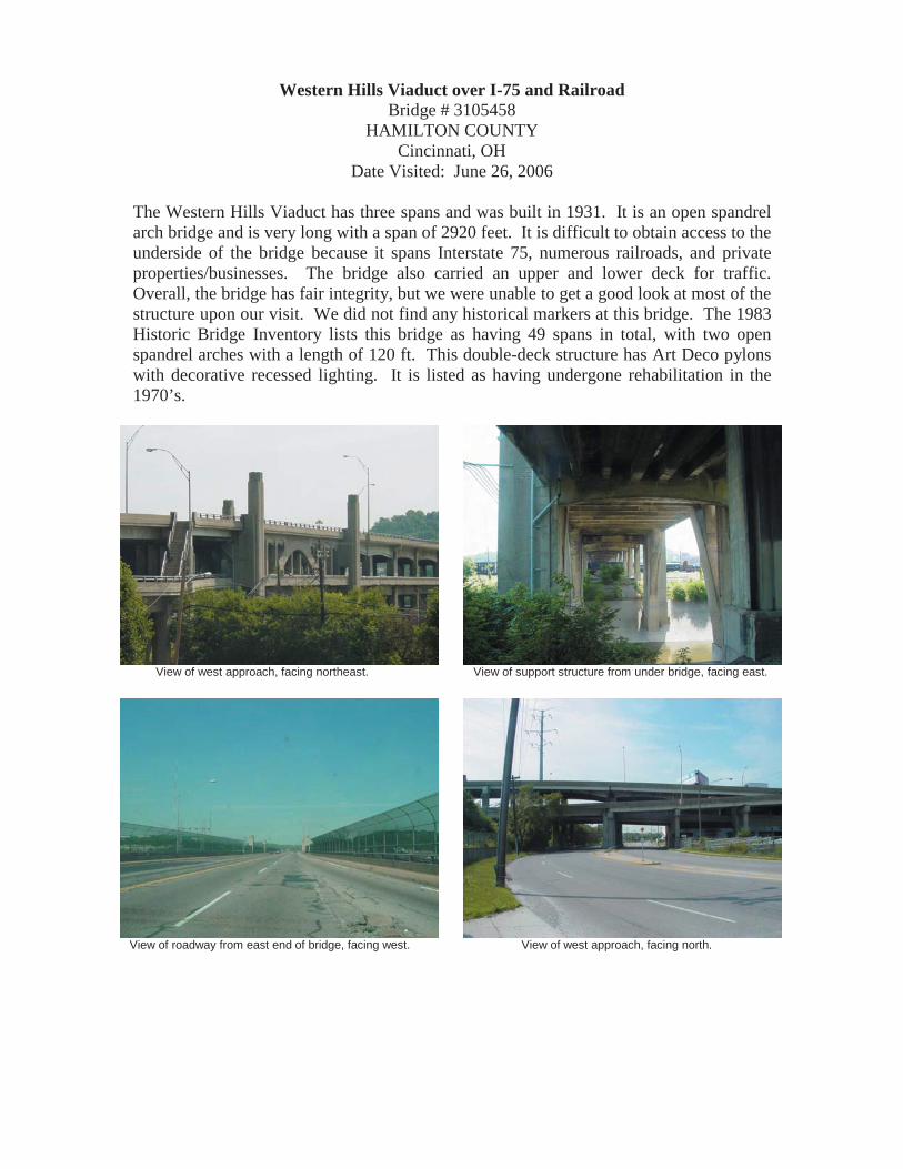
Brecksville-Northfield High Level Bridge State Route 82 over Cuyahoga River, Railroad, & Bike Path
Bridge # 7706871 SUMMIT/CUYAHOGA COUNTY Line
Northfield, OH Date Visited: July 25, 2006
The Brecksville-Northfield Bridge is a 15 span, open spandrel bridge with five arches. It was built in 1931 and rehabilitated in 1989. The bridge has good integrity, but there were some potential problems. A column on the southwest end has a crack and there is some deteriorating concrete and exposed rebar under the arches. The bridge had concrete railings and no sidewalks. It was visible that there has been patching of concrete on some of the columns. This bridge was very high above the river and quite long as it crosses the Cuyahoga Valley. Plaques were on both ends of the bridge. The Concrete Arch Supplement lists W.S. Hindmand, of the Ohio Dept. of Highways Bridge Bureau, as the designer. The bridge underwent rehabilitation in 1991 and won ODOT’ s Historic Bridge Preservation Award.
Overall view of bridge, facing north. Plaque displayed on west end of bridge.
View of roadway from western approach, facing east. View of support structure of bridge, facing southwest.

State Road over Mud Brook Bridge # 7745192
SUMMIT COUNTY Cuyahoga Falls, OH
Date Visited: July 25, 2006
The single span, open spandrel bridge built in 1918 on State Road has been removed. It was replaced and widened with a one span, steel beam bridge.
View of roadway from northern approach, facing south. Overall view of bridge, facing southwest.

Ravenna Road over Tinkers Creek Bridge # 7756046
SUMMIT COUNTY Twinsburg Township
Date Visited: July 25, 2006 This bridge is a single span, open spandrel bridge with 4 ribs. The structure was built in 1917 and rehabilitated in 1932. The bridge had one sidewalk on the northeast side that was added to the bridge. The railings were concrete and different from one side to the other. One side had rectangular openings while the other had rounded openings. The railings were cracking exposing rebar. This bridge was peculiar because three of the arches were together and the fourth one was off to the side. Also, the abutments and wing walls alternated from stone to concrete on different sides when compared to both ends of the bridge. The bridge was falling apart, but there are signs that it is trying to be maintained. The arches are cracking and the road deck and columns are crumbling. One of the arches was wrapped and sealed in a cast and a metal bar was added to support the bridge. There was also some graffiti on the structure and there were no plaques. This bridge is scheduled to be replaced in 2009.
View of roadway from northern approach, facing south. Detailed view of wrapped and sealed arch on north end.
View of support structure, facing south. Detailed view of support structure and crumbling arch.

State Route 46 (S. Main St.) over the Mahoning River & Railroad
Bridge # 7802439 TRUMBULL COUNTY
Niles, OH Date Visited: July 24, 2006
The ten span, open spandrel bridge with a single arch was replaced in 2003. The old open arch bridge was designed by Wendell P. Brown and was built in 1932. The new bridge is a beam bridge on a curved alignment with a sidewalk on the west side. The new bridge also has a chain link fence railing and sidewalk wall barrier. Plaques about the old and new bridges are displayed at the bridge. Photos of the new bridge are shown below.
Overall view of new bridge, facing northeast. View of support structure for the new bridge, facing north.
View of roadway from southern approach of new bridge. Plaque displaying the historic significance of the bridges.

Niles McDonald Viaduct Olive Street over the Mahoning River & Railroad
Bridge # 7839758 TRUMBULL COUNTY
Niles, OH Date Visited: July 24, 2006
The Niles McDonald Viaduct is a 20 span bridge with 2 open spandrel arches. It was built in 1920. The bridge has deteriorated a lot over the years and there is a lot of exposed rebar. Rebar can be seen under the road, on the sides and under the arches, and on the columns. The piers looked like the have retained their integrity even with all the crumbling on the rest of the structure. It had closed concrete walls for railings. It also had a plaque and lots of graffiti.
View of support structure, facing south. View of arch on northwest side of bridge, facing south
View of roadway from southern approach, facing north. View of support structure for northern approach to bridge.

US 22 over the Little Miami River Bridge # 8300038
WARREN COUNTY Date Visited: June 26, 2006
This bridge is a six span, open spandrel arch bridge built in 1937. The bridge has really good integrity. All of the concrete was intact except for one area on the southwest end where some chipping of concrete and rebar was noticed on a column. The bridge had concrete railings with openings that have been filled. It carried a large volume of traffic and there were no sidewalks. No plaques or historic markers are placed on the bridge. According to the Concrete Arch Supplement to the Historic Bridge inventory, each of the six arches are of a different length and the ribs of the arch vary in length and width to compensate for grade changes and to create the illusion of uniformity between the columns. At its date of construction the bridge cost $500,000, and required over one million tons of steel and 9,000 cubic yards of concrete. The bridge was rehabilitated in 1991, resulting in the removal or the original deck, curbs, and railings.
View from under bridge showing support structure, Overall view of bridge, facing east. facing south west.
View of roadway from northeast approach, facing southwest. View of east side of bridge and columns.

Closed Spandrel Arch Bridges With Three or More Spans

THE REINFORCED CONCRETE CLOSED SPANDREL ARCH History, Description, & Significance: Closed spandrel arch bridges are the most basic
of reinforced concrete bridge types. Closed spandrel means that the area between the
deck and the arch ring was filled in. The spandrel wall actually serves as a retaining wall
in the bridge, holding the fill material. Live loads are borne by the fill material and by the
spandrel walls. The arch may be constructed either as a single structural element (barrel)
or in separate parallel longitudinal ribs. The barrel arch design has some structural and
visual similarities to stone arch bridges. The barrel arch is also sometimes faced with
brick or stone, making it appear similar to a masonry arch bridge. This type of bridge is
suitable for short span lengths. Closed spandrel concrete arches predate open spandrels,
as the closed spandrel type harkens back to the stone arches that the earliest forms
imitated. This type was not built for long as engineers realized that significant material
could be saved and a reduction in weight could be achieved by eliminating the filled
section. Hence, open spandrels were born. Filled spandrel concrete arches date primarily
from the earliest decades of reinforced concrete (1890s through 1920s). They are not as
common as many of the standardized bridge types built during this same era, such as
concrete slabs and girders. They are significant because they are not common and
represent the evolution of concrete technology. To be considered significant, filled
spandrel arches should have integrity, through the retention of their character-defining
features: arch ring, barrel, spandrel wall, railing or parapet, end posts, piers and/or
abutments and wingwalls.
[From: A Context for Common Historic Bridge Types by Parsons Brinckerhoff,
October 2005]

SFN
Cou
nty
Mun
icip
ality
Nam
eFa
cilit
y C
arrie
dFe
atur
eIn
ters
ecte
dM
ain
Spa
ns #
Yea
rB
uilt
Loca
tion
UTM
Sta
tus
Dat
e V
isite
dH
ist.
Inte
grity
Not
esP
rese
rvat
ion
Pot
entia
l
0260
118
Alle
nLi
ma
Pie
rce
St.
Otta
wa
Riv
er3
1920
Ent
ranc
e to
Li
ma
Sen
ior
Hig
h
16.7
4410
0.45
1308
0R
emov
edJu
ly 1
3, 2
006
Rep
lace
dR
epla
ced
with
con
cret
e de
ck
0241
636
Alle
nM
ario
nTo
wns
hip
Linc
oln
Hw
y. (S
R
88)
Aug
laiz
eR
iver
319
260.
08 M
i. E
. of
Def
ianc
e TR
16.7
2866
0.45
2474
0R
eser
veJu
ly 1
3, 2
006
Goo
dC
rum
blin
g on
pie
rs a
nd a
butm
ents
.
0260
002
Alle
nLi
ma
Nor
th S
t.O
ttaw
aR
iver
319
1535
00 ft
. E. o
f M
ain
St.
16.2
3886
5.45
1459
2R
emov
edJu
ly 2
6, 2
006
Rep
lace
dR
epla
ced
with
Con
cret
e Fi
lled
0630
543
Aug
laiz
eW
apak
onet
aW
ater
St.
Aug
laiz
eR
iver
319
220.
5 M
i. N
.of
Aug
laiz
e S
t.16
.230
135.
4496
287
Rem
oved
July
26,
200
6R
epla
ced
Rep
lace
d w
ith S
teel
bea
m
0730
696
Bel
mon
tC
oler
ain
Twp.
CR
10
Whe
elin
gC
reek
319
292.
28 M
i. E
. of
CH
417
.513
640.
4437
160
Not
Elig
ible
July
5, 2
006
Poo
rE
rode
d pi
ers
and
bad
raili
ngs.
0730
726
Bel
mon
tC
oler
ain
Twp.
CR
10
Whe
elin
gC
reek
319
301.
73 M
i. E
. of
CH
417
.513
340.
4437
980
Non
-S
elec
tJu
ly 5
, 200
6Fa
irA
rche
s ar
e ok
, but
pie
rs a
nd ra
iling
s ar
e cr
umbl
ing.
0903
361
But
ler
Ham
ilton
SR
129
Gre
atM
iam
i Riv
er5
1915
W. o
f M
onum
ent
Ave
.
16.7
0964
0.43
6394
0R
emov
edJu
ne 2
6, 2
006
Rep
lace
dR
epla
ced
with
con
cret
e rib
bed
arch
.
0930
377
But
ler
Libe
rty &
Fa
irfie
ld T
wp
Line
Libe
rty F
airfi
eld
Rd.
(CR
113
)G
reat
Mia
mi R
iver
619
13N
. of C
anal
R
oad
16.7
1720
0.43
6726
0N
on-
Sel
ect
June
26,
200
6G
ood
Som
e cr
acki
ng a
nd re
bar o
n pi
ers.
0960
020
But
ler
Ham
ilton
Bla
ck S
t.G
reat
Mia
mi R
iver
719
22W
. of U
S 1
2716
.710
167.
4364
852
Sel
ect
June
26,
200
6G
ood
Som
e cr
acki
ng a
nd e
xpos
ed re
bar.
1260
693
Cla
rkS
prin
gfie
ldS
herm
an A
ve.
(203
R)
Buc
k C
reek
419
090.
26 M
i. W
. of
Lago
nda
Ave
.17
.261
070.
4423
600
Sel
ect
June
13,
200
6P
oor
Ext
ensi
ve c
rum
blin
g an
d ba
d ra
iling
.S
ched
uled
to b
e re
plac
ed.
1833
928
Cuy
ahog
aW
alto
n H
ills
Dun
ham
Rd.
(CR
70
)Ti
nker
sC
reek
319
1312
7 ft.
S. o
f B
utto
n R
d.17
.451
510.
4580
150
Rem
oved
July
25,
200
6R
epla
ced
Rep
lace
d w
ith s
teel
bea
m
2130
165
Del
awar
eD
elaw
are
Tow
nshi
p
CR
215
(P
anha
ndle
Roa
d)
Ole
ntan
gyR
iver
319
00E
of U
S 2
3, N
of
Del
awar
e17
.324
020.
4465
100
Non
-S
elec
tJu
ly 2
0, 2
006
Fair
Det
erio
ratin
g ro
ad d
eck
and
expo
sed
reba
r/ R
ehab
ilita
ted
in 1
975.
2501
171
Fran
klin
Dub
linU
S 3
3
Sci
oto
Riv
er &
SR
25
7 S
outh
R
amp
619
351.
22 M
i. E
of
IR 2
7017
.319
440.
4440
260
Sel
ect
July
20,
200
6G
ood
Som
e cr
acki
ng a
nd e
xpos
ed re
bar o
n co
lum
ns a
nd a
rche
s.
2531
488
Fran
klin
Dar
byda
leH
arris
-Geo
rges
Roa
d (C
R 3
)B
ig D
arby
C
reek
319
320.
25 M
i. S
of
SR
665
17.3
1270
0.44
1310
0N
on-
Sel
ect
July
20,
200
6Fa
irC
rum
blin
g on
pie
rs a
nd c
rack
s in
arc
hes.
2532
344
Fran
klin
Can
alW
inch
este
rC
R 2
25Li
ttle
Wal
nut
Cre
ek3
1918
1.6
Mi.
N o
f Li
thop
olis
Rd
17.3
4583
0.44
1090
0N
on-
Sel
ect
July
20,
200
6G
ood
Min
or c
oncr
ete
crum
blin
g.
2531
402
Fran
klin
Col
umbu
sLa
ne A
ve.
Ole
ntan
gyR
iver
419
19.1
Mi.E
ast o
f O
lent
angy
Riv
er R
d.
17.3
2742
0.44
3023
0R
emov
edJu
ne 1
2, 2
006
Rep
lace
dR
epla
ced
with
cab
le-s
taye
d.
2503
697
Fran
klin
Col
umbu
sU
S 6
2S
ciot
oR
iver
719
170.
69 M
i. E
. of
SR
315
17.3
2878
0.44
2485
0N
RLi
sted
June
12,
200
6P
oor
Ext
ensi
ve d
eter
iora
tion
of a
rche
s, p
iers
, an
d ra
iling
s. R
epla
cem
ent s
ched
uled
.
Mat
eria
l: R
einf
orce
d C
oncr
ete
Clo
sed
Spa
ndre
l Fill
ed A
rch
Brid
ges
with
3 o
r Mor
e S
pans
200
6 Br
idg
e U
pd
ate

SFN
Cou
nty
Mun
icip
ality
Nam
eFa
cilit
y C
arrie
dFe
atur
eIn
ters
ecte
dM
ain
Spa
ns #
Yea
rB
uilt
Loca
tion
UTM
Sta
tus
Dat
e V
isite
dH
ist.
Inte
grity
Not
esP
rese
rvat
ion
Pot
entia
l
Mat
eria
l: R
einf
orce
d C
oncr
ete
Clo
sed
Spa
ndre
l Fill
ed A
rch
Brid
ges
with
3 o
r Mor
e S
pans
3260
992
Han
cock
Find
lay
E. M
ain
Cro
ss S
t.E
agle
Cre
ek3
1928
0.15
Mi.
W. o
f B
lanc
hard
St.
17.2
7780
0.45
4623
0N
on-
Sel
ect
June
22,
200
6P
oor
Larg
e pi
eces
of c
oncr
ete
mis
sing
and
lots
of
cru
mbl
ing
and
expo
sed
reba
r.R
epla
cem
ent s
ched
uled
for 2
009
3233
456
Han
cock
Jack
son
Tow
nshi
pTR
173
Bla
ncha
rdR
iver
319
240.
37 M
i. E
. of
TR 2
4017
.284
905.
4540
863
Non
-S
elec
tJu
ly 2
6, 2
006
Goo
dS
ome
crac
king
aro
und
arch
es a
nd s
ome
area
s w
ith e
xpos
ed re
bar.
3502
376
Hen
ryN
apol
eon
SR
108
(Per
ry
St.)
Mau
mee
Riv
er7
1929
N. o
f Mau
mee
A
ve.
16.7
4060
8.45
8556
5R
emov
edJu
ly 1
3, 2
006
Rep
lace
dR
epla
ced
with
arc
hed
stee
l bea
m
4130
650
Jeffe
rson
Wel
lsTo
wns
hip
CR
25
McI
ntyr
eC
reek
319
361.
7 M
i. N
E o
f S
mith
field
17.5
2094
0.44
5953
0N
on-
Sel
ect
July
5, 2
006
Fair
Cor
ruga
ted
rein
forc
emen
t aro
und
arch
es.
4202
589
Kno
xM
iddl
ebur
yTo
wns
hip
SR
95
Nor
thB
ranc
hK
okos
ing
Riv
er
319
141.
6 M
i. E
of
JCT
SR
13
17.3
5914
0.44
8329
0N
on-
Sel
ect
July
20,
200
6G
ood
Som
e cr
acki
ng in
road
way
.
4800
931
Luca
sM
aum
eeU
S 2
0M
aum
eeR
iver
719
28S
. of H
arris
on
St.
17.2
7900
4.46
0380
8R
emov
edJu
ly 2
6, 2
006
Rep
lace
dR
epla
ced
with
arc
hed
stee
l bea
m
4860
349
Luca
sTo
ledo
Sou
th A
ve.
Sw
anC
reek
319
27W
. of
Woo
dsda
le17
.284
450.
4611
790
Sel
ect
July
26,
200
6E
xcel
lent
.R
ehab
ilita
ted.
5535
972
Mia
mi
Piq
uaE
. Mai
n S
t.G
reat
Mia
mi R
iver
519
14E
. of S
. Mai
n S
t.16
.735
200.
4446
440
Rem
oved
July
3, 2
006
Rep
lace
dR
epla
ced
with
arc
hed
stee
l bea
m
5537
126
Mia
mi
Troy
Ada
ms
St.
Gre
atM
iam
i Riv
er7
1922
N. o
f Wat
er
St.
16.7
3824
0.44
3616
0S
elec
tJu
ly 3
, 200
6P
oor
Lots
of c
rum
blin
g an
d ex
pose
d re
bar
arou
nd a
rche
s an
d pi
ers.
To
be re
plac
ed.
5760
550
Mon
tgom
ery
Day
ton
Keo
wee
St.
Gre
atM
iam
i Riv
er5
1931
0.1
Mi.
N. o
f S
tanl
ey A
ve.
16.7
4064
0.44
0794
0R
eser
veJu
ne 2
6, 2
006
Fair
Som
e cr
acks
and
spa
lling
on
arch
es a
nd
brid
ge d
eck.
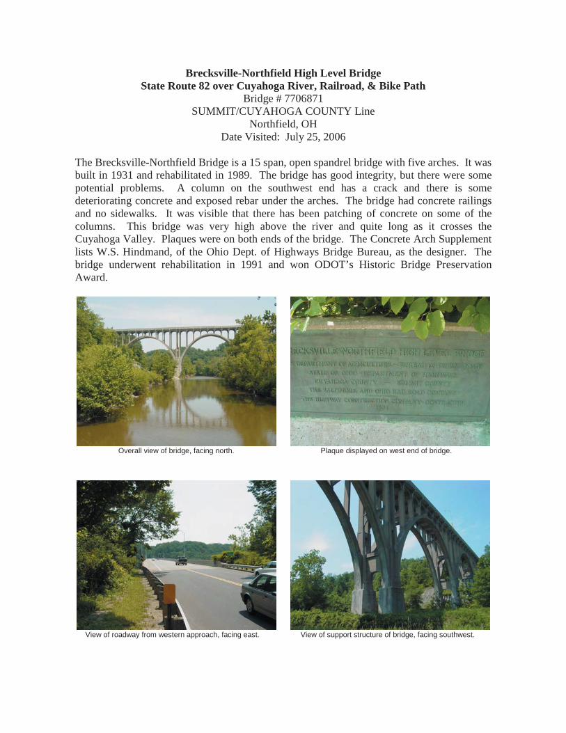
5760
062
Mon
tgom
ery
Day
ton
Was
hing
ton
St.
Gre
atM
iam
i Riv
er7
1906
0.4
Mi.
W. o
f M
ain
St.
16.7
4009
0.44
0361
0S
elec
tJu
ne 2
6, 2
006
Poo
rLa
rge
area
s of
mis
sing
con
cret
e. T
o be
re
plac
ed.
5761
107
Mon
tgom
ery
Day
ton
Find
lay-
Sta
nley
St.
Mad
Riv
er4
1926
0.7
Mi.
N. o
f E
. Thi
rd S
t.16
.743
239.
4406
428
Non
-S
elec
tJu
ly 1
9, 2
006
Rep
lace
dR
epla
ced
with
Ste
el b
eam
5700
493
Mon
tgom
ery
Day
ton
SR
4G
reat
Mia
mi R
iver
719
17.1
3 M
i. E
. of I
-75
16.7
3947
7.44
0435
9R
emov
edJu
ly 1
9, 2
006
Rep
lace
dR
epla
ced
with
con
cret
e rib
bed
arch
5704
030
Mon
tgom
ery
Day
ton
NB
SR
49
(Mon
umen
t Ave
.)G
reat
Mia
mi R
iver
519
090.
61 M
i. W
. of
I-75
16.7
3967
7.44
0499
2S
elec
tJu
ly 1
9, 2
006
Poo
rC
rum
blin
g co
ncre
te a
roun
d ar
ches
and
lots
of
reba
r exp
osed
. To
be
repl
aced
.
5760
003
Mon
tgom
ery
Day
ton
Ste
war
t St.
Gre
atM
iam
i Riv
er7
1911
1 M
i. E
. of I
-75
16.7
4052
0.44
0247
0S
elec
tJu
ly 1
9, 2
006
Poo
rE
xten
sive
cra
ckin
g in
arc
hes
and
crum
blin
g pi
ers.
To
be re
plac
ed.
5760
437
Mon
tgom
ery
Day
ton
Hel
ena
St.
Gre
atM
iam
i Riv
er3
1926
At I
slan
d P
ark
16.7
3996
4.44
0655
9S
elec
tJu
ly 1
9, 2
006
Goo
dM
inor
cra
ckin
g an
d sp
allin
g.
5760
992
Mon
tgom
ery
Day
ton
Web
ster
St.
Mad
Riv
er3
1916
0.5
Mi.
N. o
f E
. Thi
rd S
t.16
.741
244.
4405
628
Non
-S
elec
tJu
ly 1
9, 2
006
Goo
dM
inor
cra
ckin
g an
d cr
umbl
ing
conc
rete
on
pier
s.
200
6 Br
idg
e U
pd
ate

SFN
Cou
nty
Mun
icip
ality
Nam
eFa
cilit
y C
arrie
dFe
atur
eIn
ters
ecte
dM
ain
Spa
ns #
Yea
rB
uilt
Loca
tion
UTM
Sta
tus
Dat
e V
isite
dH
ist.
Inte
grity
Not
esP
rese
rvat
ion
Pot
entia
l
Mat
eria
l: R
einf
orce
d C
oncr
ete
Clo
sed
Spa
ndre
l Fill
ed A
rch
Brid
ges
with
3 o
r Mor
e S
pans
5931
509
Mor
row
Car
ding
ton
Tow
nshi
pC
H 1
1W
hets
tone
Cre
ek3
1924
0.3
Mi.
E. o
f TR
28
17.3
3776
0.44
8469
0N
on-
Sel
ect
June
28,
200
6P
oor
Lots
of c
rum
blin
g on
raili
ngs,
exp
osed
reba
r un
der b
ridge
, and
cru
mbl
ing
pier
s.
6201
202
Otta
wa
Elm
ore
SR
51
Por
tage
Riv
er3
1926
Nor
th S
ide
of
Elm
ore
17.3
0832
0.45
9406
0N
RLi
sted
June
28,
200
6P
oor
Ext
ensi
ve d
eter
iora
tion
of p
iers
and
arc
hes.
To
be
repl
aced
.
6800
300
Pre
ble
Wes
tA
lexa
ndria
US
35
Twin
Cre
ek3
1925
0.17
Mi.
E. o
f A
lexa
ndria
16.7
1236
0.44
0211
0N
on-
Sel
ect
June
26,
200
6G
ood
Som
e cr
acki
ng a
nd s
palli
ng o
n ar
ches
.
6933
416
Put
nam
Sug
ar C
reek
Tw
p.C
R O
ld S
R 1
2O
ttaw
aR
iver
319
322.
7 M
i. S
W o
f S
R 1
1516
.736
650.
4526
880
Res
erve
July
13,
200
6P
oor
Rai
lings
are
cru
mbl
ing
badl
y an
d ex
pose
d re
bar o
n ar
ches
.
7242
298
San
dusk
yFr
emon
tS
tate
St.
(US
20)
San
dusk
yR
iver
519
26E
. of F
ront
St.
17.3
2331
0.45
7920
0S
elec
tJu
ne 2
8, 2
006
Goo
dM
inor
cra
ckin
g an
d so
me
expo
se re
bar
unde
r arc
hes.
7460
066
Sen
eca
Tiffi
nE
lla S
t.S
andu
sky
Riv
er3
1914
S. o
f SR
53
17.3
1640
0.45
5240
5N
on-
Sel
ect
June
22,
200
6G
ood
Cra
ckin
g on
pie
rs.
7500
661
She
lby
Sid
ney
SR
47
Gre
atM
iam
i Riv
er3
1931
.26
Mi.
E. o
f S
R 2
916
.742
290.
4463
260
Sel
ect
July
3, 2
006
Poo
rE
xten
sive
cru
mbl
ing
and
lots
of e
xpos
ed
reba
r.
7630
158
Sta
rkB
ethl
ehem
Tow
nshi
pS
herm
an A
ve.
(CR
272
)Tu
scar
awa
s R
iver
419
270.
8 M
i. S
. of
CR
255
17.4
6286
0.45
0127
0N
on-
Sel
ect
July
10,
200
6P
oor
Cra
ckin
g an
d sp
allin
g on
pie
rs a
nd a
rche
s.
7630
484
Sta
rkE
ast S
parta
Mai
n S
t.N
imis
hille
nC
reek
319
230.
1 M
i. S
. of
CR
162
17.4
7032
0.45
0200
0R
emov
edJu
ly 1
0, 2
006
Rep
lace
dR
epla
ced
with
Ste
el b
eam
7839
804
Trum
bull
War
ren
S. M
ain
St.
Mah
onin
gR
iver
419
18B
etw
een
Fulto
n &
S
prin
g S
t.
17.5
1503
0.45
6391
0N
on-
Sel
ect
July
24,
200
6P
oor
Pie
rs a
re c
rum
blin
g ba
dly
and
arch
es h
ave
lots
of e
xpos
ed re
bar.
7960
018
Tusc
araw
asD
over
Tusc
araw
asA
venu
eTu
scar
awa
s R
iver
319
0710
0' S
of
Fron
t St
17.4
5966
0.44
8510
0R
eser
veJu
ly 2
4, 2
006
Poo
rS
palli
ng a
nd c
rack
ing
on p
iers
and
und
er
arch
es.
Exp
osed
reba
r.
200
6 Br
idg
e U
pd
ate

Pierce Street over the Ottawa River Bridge # 0260118 ALLEN COUNTY
Lima, OH Date Visited: July 13, 2006
The three span, closed spandrel bridge built in 1920 at this location has been removed. The replacement is a three span, steel and concrete beam bridge with two sidewalks and concrete sides with aluminum railings.
Overall view of bridge, facing northwest. Overall view of bridge, facing northeast.
View of roadway from south approach, facing north. View of roadway from north approach, facing south.

Lincoln Highway over the Auglaize River Bridge # 0241636 ALLEN COUNTY Marion Township
Date Visited: July 13, 2006 This bridge is a three span, closed spandrel arch bridge designed by Charles Ash of the Bureau of Bridges and built in 1926. The Auglaize River only runs under the easternmost two spans. Both sides of the bridge had narrow sidewalks with low metal railings that are rusty. According to the Concrete Arch Supplement the original bridge had decorative concrete railings with balusters. The concrete arches were in good, but the bottoms of the piers had some crumbling. The end abutments have also crumbled a little. The roadway had rectangular holes on the sides for water drainage. Overall, this bridge has decent integrity.
Overall view of bridge, facing southwest. Note, holes for runoff. View of roadway from east approach, facing west.
Detail view of cracked and crumbled abutment. Detail view of southeast crumbling pier.

North Street over the Ottawa River Bridge # 0260002 ALLEN COUNTY
Lima, OH Date Visited: July 26, 2006
The closed spandrel arch bridge with three spans that was built in 1915 at this location has been removed. A replacement bridge was recently completed. The new bridge has four arches with a bike path running under the eastern most arch. The bridge is painted to resemble bricks and it has black metal railings. The new bridge is shown in the photos below.
Overall view of new bridge, facing southwest. View of north face of new bridge, facing southwest.
View of south face of new bridge, facing northeast. View of roadway from western approach, facing east.

Water Street over the Auglaize River Bridge # 0630543
AUGLAIZE COUNTY Wapakoneta, OH
Date Visited: July 26, 2006
The original bridge at this location was a three span, closed spandrel arch bridge that was built in 1922. In June of 2001 the bridge was replaced with a three span, steel beam bridge. The new bridge has metal railings along with plaques and a carving of an Indian chief in the concrete abutments.
Overall view of new bridge, facing southeast. Overall view of new bridge, facing southwest.
View of plaque and carving on north end. View of roadway from northern approach facing south.

County Road 10 over Wheeling Creek (South) Bridge # 0730696
BELMONT COUNTY Date Visited: July 5, 2006
This bridge is a three span, closed spandrel built in 1929 by the Luten Bridge Company. It had open concrete railings that were crumbling exposing the rebar. Many of the railings have broken away and have been replaced with guardrails or wood. The bridge had an 18 ton weight limit and had plaques on both ends which have been covered up with the addition of the guardrails. The arches had decent integrity, but the piers have crumbled some, especially the southeast one.
View of concrete arch on south end, facing southwest. View of replaced railing sections on west side.
View of roadway from southern approach, facing north. Detail of crumbling railing with exposed rebar on east side.

County Road 10 over Wheeling Creek (North) Bridge # 0730726
BELMONT COUNTY Date Visited: July 5, 2006
This bridge is located just north of the previous bridge (SFN 0730696). It is a three span, closed spandrel arch bridge built in 1930. It has solid concrete railings made with large aggregate and reinforced with rebar. Some of the railings have crumbled considerably while other areas are a lot better. The arches have good integrity and the piers on the west side have crumbled more than the ones on the east side. No plaques about the bridge are present.
Overall view of bridge, facing southeast. View of roadway from north approach, facing south.
Detail of crumbling railing with exposed rebar. View of exposed rebar along east side concrete railing.

State Route 129 over the Great Miami River
Bridge # 0903361 BUTLER COUNTY
Hamilton, OH Date Visited: June 26, 2006
The original SR 129 Bridge was a five span, closed spandrel arch bridge built in 1915. It is currently being replaced. Half of the new bridge is open to traffic while construction continues on the other half. The arched girder design is being constructed to mimic the outline of the previous bridge. According to the Concrete Arch Supplement it will be the fifth bridge on its location since 1816. The bridge previous to the 1915 concrete bridge was a metal truss bridge which was destroyed by the flooding of the region in 1913.
Overall view bridge replacement, facing southeast. View of new bridge from west approach, facing east.
View of piers & support structure of new bridge, facing south. View of east end abutments, facing east.

County Road 113 (Liberty Fairfield) over the Great Miami River
Bridge # 0930377 BUTLER COUNTY
Date Visited: June 26, 2006 This bridge is a six span, closed spandrel arch bridge built in 1913. It carries a large volume of traffic and has no sidewalks. The railings on the bridge are simply guardrails. The arches of the bridge look like they have retained their integrity, but the piers in the water have cracked and crumbled a bit and you can see rebar in some areas. There were no signs about the bridge except for one with the bridge identification code: BUT 3.803.
View of east side of bridge, facing northwest. View of roadway from southern approach, facing north.
View of west side of bridge from the south end. Detailed view of pier with some exposed rebar on east side.

Black Street over the Great Miami River
Bridge # 0960020 BUTLER COUNTY
Hamilton, OH Date Visited: June 26, 2006
This bridge is a seven span, closed spandrel arch bridge built in 1922. The bridge has reasonable integrity. It appears to be maintained because some of the concrete has been patched in places. However, at mid span some cracks and rebar were present. The bridge had concrete railings, decorative lighting, and flower pots at each end. The sidewalks were uneven and there was some graffiti underneath. There were signs at each end of the bridge that read: Built for the City of Hamilton by the Miami Conservancy District, 1921. According to the Concrete Arch Update the Black Street bridge was the first of four bridges in Hamilton to succumb to the flooding of 1913, and therefore the current bridge was designed to withstand such flooding.
Overall view of bridge, facing southeast. View of roadway and railings from east approach, facing west.
Detailed view of piers on north side of bridge, facing west. View of concrete railing and flower pot on northwest end.

Sherman Avenue over Buck Creek Bridge # 1260693
CLARK COUNTY Springfield, OH
Date Visited: June 13, 2006
The Sherman Ave. Bridge is a closed spandrel, filled arch bridge with four spans. It was built in 1909. This bridge has poor integrity. The arch was deteriorating with a lot of the concrete crumbling away. The abutments on the ends of the bridge may have been replaced because they looked better than the rest of the bridge. The railings were metal and were very rusted and bent. One of the metal railings in the center of the bridge was missing and the missing section was blocked with a guardrail. The sidewalks on both sides of the bridge were also crumbling and had pieces of concrete broken away. The underside of the bridge was very dark and inaccessible, but we could see lots of paint and graffiti. No historical information or plaques were found.
View of roadway from west approach, facing east. View of arch and northwest abutment.
Detailed view of rusted railing and exposed rebar. View of concrete piers and road deck on south side.

Dunham Road (CR 70) over Tinkers Creek Bridge # 1833928
CUYAHOGA COUNTY Walton Hills, OH
Date Visited: July 25, 2006 This bridge is a three span, concrete filled arch bridge that was built in 1913. It has since been removed and recently replaced with a modern beam bridge. The new bridge is also a three span bridge. It has concrete parapets with aluminum railings. There is no plaque at the new bridge.
View of east side of bridge, facing west. Overall view of bridge, facing west.
View of roadway from southern approach, facing north.

County Route 215 over the Olentangy River Bridge # 2130165
DELAWARE COUNTY North of Delaware, OH
Date Visited: July 20, 2006 This bridge is a three span, concrete filled arch bridge built in 1900. It is located immediately off of US Route 23 north of Delaware. A major rehabilitation of the bridge was in 1975. The bridge is a two lane bridge with no sidewalks and low railings. The railings were made of metal and were open at the bottom. The road deck was showing signs of deterioration with exposed rebar. The piers were rounded on the north side and flat on the south. The concrete for the piers has crumbled some, but the arches look good. It was somewhat difficult to get a good look below the bridge and underneath the arches.
View of roadway from eastern approach, facing west. Detail view of crumbling rounded pier & railing on south side.
General view of bridge, looking northeast. Close up view of flat pier on north side of bridge.

U.S. 33 over the Scioto River & SR 257 South Ramp Bridge # 2501171
FRANKLIN COUNTY Dublin, OH
Date Visited: July 20, 2006 The Dublin Bridge is a six span, closed spandrel ribbed bridge built in 1935. It is stone faced and the center rib is like an open spandrel. The deck was replaced in 1986 and is being resurfaced in 2006. The bridge was expanded to add a sidewalk on the north side; however original decorative stone parapets were removed in the process. The original steps leading below the bridge can still be seen under the sidewalk addition. SR 257 passed under the arch span on the east end. The bridge had metal railings and public access underneath on the west end. Under the bridge, a wooden deck and stairs led down to a small park along the river. There were also lights along the stairs and plaques at the ends of the bridge. Below the bridge some cracks and exposed rebar was visible on the concrete columns and arches. Overall, the bridge has good historic integrity with only some minor problem areas. The Concrete Arch Supplement lists D.H. Overman and A.J. Friemoth as the designers of the bridge. Local limestone was the construction material used in the fa ade of the structure.
Overall view of bridge from Scioto River, facing northeast. View of wooden deck and stairs on west end of bridge.
View of roadway from east approach, facing west. View of arches and support structure from under bridge.

Harris-Georges Road (CR 3) over Big Darby Creek Bridge # 2531488
FRANKLIN COUNTY Darbydale, OH
Date Visited: July 20, 2006 This bridge is a three span, concrete filled arch bridge built in 1932. In 1992 the railing and deck were replaced and the concrete was refaced. The bridge has some problem areas. The piers are beginning to crumble and there are some cracks and crumbling along the arches causing rebar to be exposed. The bridge had no sidewalks, but it did have a wide shoulder. Also, there was no railing except for a guardrail across the bridge.
Overall view of bridge, facing northwest. View of roadway from northern approach, facing south.
Detail view of southwest deteriorating pier. View of south end abutments & arch.

County Route 225 over Little Walnut Creek Bridge # 2532344
FRANKLIN COUNTY Canal Winchester, OH
Date Visited: July 20, 2006 This bridge is a three span, concrete filled arch bridge built in 1918. The piers and arches showed signs of minor crumbling of concrete, but it still has good integrity. The bridge had guardrails for railings and no sidewalks. There were very large pieces of concrete lying in the wooded area around the bridge that could have been the remains of the bridge’ s original railings.
Overall view of bridge, facing northeast. View of roadway from northern approach, facing south.
Detail view of pier and railing on east side. View of arch and end abutment on southwest corner.

Lane Avenue over the Olentangy River Bridge # 2531402
FRANKLIN COUNTY Columbus, OH
Date Visited: June 12, 2006 The closed spandrel bridge built in 1919 on Lane Avenue no longer exists. It has been replaced with a cable-stayed suspension bridge with a span of 370 ft. It is the second bridge of its type in Franklin County. The closed spandrel arch bridge was demolished in November 2002. It was a three lane bridge designed by Wilbur J. Watson and consisted of four 97-foot reinforced concrete arch spans, with earth fill and closed spandrel walls. It also had aggregate concrete railings and plaques. The new cable-stayed bridge was open to traffic on November 14, 2003. Photos of the new bridge are shown below.
Plaque on southwest abutment. View of new cable-stayed suspension bridge, facing west.
View of support beams beneath bridge, facing east. View of roadway from west approach, facing east.

State Route 62 (Town St.) over the Scioto River Bridge # 2503697
FRANKLIN COUNTY Columbus, OH
Date Visited: June 12, 2006 This reinforced concrete, closed spandrel bridge has poor integrity. It is a seven span bridge built in 1917. The bridge exhibited major cracking along the arches and sides. There was a lot of spalling and chipping on the structure. Rebar was exposed throughout the entire structure and in some places was no longer supported within the concrete and was left hanging in the air. The exposed rebar showed signs of corrosion resulting in staining of the concrete surface. The railings along both sides of the bridge were also corroded. Many of the balusters have deteriorated and in some cases were missing completely. In many areas the concrete slab railing running along the length of the bridge was tied together and given extra support with metal straps and braces. The bridge is in a state of extensive deterioration. Bridge replacement is scheduled. The Town Street Bridge was intended to carry traffic in one direction (westbound US 62), but since the Main Street bridge adjacent to it has been closed, the Town Street bridge now accommodates traffic in both directions. No historical markers or plaques were found on the bridge. The identification code FRA .62DA 0130 was painted on the southwest end post. The bridge had street lights with small metal plates stating “ Union Metal Manufacturing Co., Danton, OH.” Each arch was also outlined with lights on the side of the bridge.
Overall view of bridge, facing northwest. Detail of deteriorated and missing balusters on north side.
Detail of cracking, spalling, and exposed rebar on north face pier and arch.

East Main Cross St. over Eagle Creek Bridge # 3260992
HANCOCK COUNTY Findlay, OH
Date Visited: June 22, 2006 This bridge is a three span, closed spandrel arch bridge built in 1928. The bridge has very poor integrity. Most of the concrete under the bridge has deteriorated. Large pieces of concrete are missing from the arches leaving rebar completely exposed to the open air and water. Both sides of the bridge were extensively deteriorated, but the north side appeared worse. The bridge is built on a curved alignment and carries one sidewalk on the north side. The bridge has concrete walls for railings and they are not original to the bridge. A plaque was present on the east end of the bridge stating the bridge engineer and county commissioners, surveyor, and auditor. The bridge was constructed by the Luten Bridge Co. and is scheduled for replacement in 2009 with prestressed box beams.
Overall view of bridge, facing southwest. View of roadway from east approach, facing west.
Overall view of bridge, facing northwest. Plaque on northeast corner of bridge.

Jackson Township Road 173 over the Blanchard River Bridge # 3233456
HANCOCK COUNTY Jackson Township
Date Visited: July 26, 2006
This bridge is a reinforced concrete, closed spandrel bride with three spans. It was built in 1924. The bridge is a narrow, one lane road with a 10 ton weight limit. The arches are all good except for the southwest arch, which is beginning to deteriorate exposing rebar. The piers also look to be all right. Another problem area includes some concrete cracking on the northwest pier. In the railing and along the archway is decorative lining. There was no plaque for the bridge and there are no plans for replacement or rehab.
Overall view of bridge, facing west. View of roadway from west approach, facing east.
Detail of cracking in northwest pier. View of south side railing and arch.

State Route 108 over the Maumee River Bridge # 3502376
HENRY COUNTY Napoleon, OH
Date Visited: July 13, 2006 The seven span, closed spandrel bridge built in 1929 at this location was removed in 2004. The replacement is a seven span, arch-beam bridge. It had sidewalks on each side with concrete walls to protect pedestrians from traffic. The railings were brown painted metal and there was decorative lighting. The new bridge was recently opened and no plaques about the old or new bridge are posted.
Overall view of new bridge, facing north. View of decorative lighting, sidewalk, and railings.
Overall view of new bridge, facing south. View of roadway from southern approach, facing north.

County Road 25 over McIntyre Creek Bridge # 4130650
JEFFERSON COUNTY Wells Township, OH
Date Visited: July 5, 2006 This bridge is a three span, closed spandrel arch bridge built in 1936. It was short and narrow. Since the channel of water was so narrow, the creek probably has the tendency to flood easily. This may be why the arches have been reinforced with corrugated aluminum. The piers in the water have crumbled some and there was some minor cracking around the arches. The railings were concrete walls. Overall, this bridge has good integrity.
Overall view of bridge, facing southwest. View of roadway from north approach, facing south.
View of reinforced arches and crumbling pier on west side. View of concrete railing on east side, facing southeast.

State Route 95 over the North Branch of Kokosing River Bridge # 4202589 KNOX COUNTY
North of Fredericktown, OH Date Visited: July 20, 2006
This bridge is a three span, concrete filled arch bridge built in 1914. The bridge has fair integrity. Some problem areas include a loose guardrail post on the southwest end, a large piece of concrete missing from the north arch, and some cracking in the roadway that has exposed rebar. The remaining concrete arches had no major problem areas. The bridge had no sidewalks, guardrails for railings, and the Kokosing River ran only under the middle arch.
Overall view of bridge, facing north. View of roadway from southern approach, looking north.
Detail view of pier and arches on east side of bridge. Detail view of guardrail railing over bridge.

US 20 & State Route 25 over the Maumee River Bridge # 4800931
LUCAS/WOOD COUNTY Maumee, OH
Date Visited: July 26, 2006
This reinforced concrete, closed spandrel bridge with seven spans has been removed and replaced. The original bridge was built in 1928. The new, Fort Meigs Memorial Bridge was constructed in 2001-02 on a curved alignment. This new bridge has open concrete railings and metal barriers to protect pedestrians. Plaques about the new bridge are at both ends.
View of roadway from southern approach of new bridge. Plaque displayed on bridge.
Overall view of new bridge, facing north.

South Avenue over Swan Creek Bridge # 4860349 LUCAS COUNTY
Toledo, OH Date Visited: July 26, 2006
This bridge is a three span, closed spandrel bridge built in 1927. It has two new sidewalk additions that overhang from the original bridge design. The bridge and ribbed arches have been painted. The railings were solid concrete and had only minor cracks. Plaques were also displayed on the bridge.
View of roadway from west approach, facing east. Plaque displayed on bridge.
Overall view of bridge, facing southeast. View of northwest abutment.

East Main Street over the Great Miami River Bridge # 5535972 MIAMI COUNTY
Piqua, OH Date Visited: July 3, 2006
The original five-span, closed spandrel bridge built in 1914 at this location has been removed and is being replaced in 2005/06. The new bridge is currently under construction and is near completion. It has concrete railings and five arches like the first bridge. The girder arch design closely resembles the original filled arch design of the previous bridge. According to the Concrete Arch Supplement the bridge was designed by Daniel Luten to replace a metal truss bridge because he had designed many of the bridges that survived the flooding of 1913.
Overall view of bridge, facing northeast. View of roadway from west approach, facing east.
Detail of concrete arch and railing on south side. View of west end abutments, facing north.

Adams Street over the Miami River Bridge # 5537126 MIAMI COUNTY
Troy, OH Date Visited: July 3, 2006
This bridge is a seven span, closed spandrel arch bridge built in 1922. It has a sidewalk on each side and solid concrete railings that were crumbling in places. The south end has steps leading down beneath the bridge. Below the bridge, the full extent of its deterioration can be seen. The arches are crumbling badly and lots of rebar is exposed. The bridge had lights located along the span and a plaque stating that it was designed and built by the Miami Conservancy District. The bridge has lost its appeal due to years of neglect. According to the Concrete Arch Supplement the current structure was constructed as a replacement for a 1913 bridge in an effort by the Miami Conservancy to stem flooding and reduce the impact of bridges on such natural disasters. This bridge in particular is interesting because of the engineers’ utilization of the previous bridge as a framework for the current structure, in an effort to minimize stream disturbance during construction.
Overall view of bridge, facing southeast. View of roadway from northern approach, facing south.
Detail of exposed rebar around arches. View of deteriorating arches and piers on west side.

Keowee Street over the Great Miami River Bridge # 5760550
MONTGOMERY COUNTY Dayton, OH
Date Visited: June 26, 2006 This bridge is a five span, closed spandrel arch bridge built in 1931 by the Maxon Construction Co., Dayton Ohio. The bridge does not have the best integrity. There was some cracking and spalling present above the arches and on the bridge deck. The sidewalk also had a lot of cracks. The bridge had concrete railings with openings. The railings had a few places where you could see rebar due to cracking in the concrete. On the southeast end of the bridge there are the remains of stairs leading below the bridge to the river. Each end of the bridge had a plaque indicating the builders and construction dates.
Overall view of bridge, facing northwest. View of southern approach, facing north.
Detail of piers on west side of bridge with some crumbling. Detail of cracking & crumbling on northwest arch & railings.
Washington Street over the Great Miami River Bridge # 5760062
MONTGOMERY COUNTY Dayton, OH
Date Visited: June 26, 2006 This bridge is a seven span, closed spandrel arch bridge that was built in 1906. The bridge had extremely poor integrity. The concrete railings were leaning and pulling away from the bridge deck. In many places you could look between the railings and deck to the river below. The lights from the Dayton Lighting Company were also leaning. The piers in the water had large pieces of concrete that have fallen away and there were many cracks. Rebar was showing under each of the arches where concrete has broken off. Both sidewalks have been closed, but this is not clearly marked. However, the bridge was still open to vehicles. The Concrete Arch Update lists the designer of the bridge as the Concrete Steel Engineering Co. While concrete bridges of this size were still experimental at the time, the survival of this and other Dayton bridges from the flood in 1913 led other local communities to replace their lost bridges with concrete arch structures.
Overall view of bridge, facing northwest. Detailed view of piers and crumbling concrete on south face.
View of roadway from east approach, facing west. Detail of separation between railing and sidewalk.

Findlay-Stanley Street over the Mad River Bridge # 5761107
MONTGOMERY COUNTY Dayton, OH
Date Visited: July 19, 2006 The four-span, concrete arch bridge built in 1926 at Findlay-Stanley Street has been removed and replaced. The replacement is not an arched bridge. It is a steel beam bridge with three spans. The new bridge has lights, two sidewalks, and open concrete railings. No plaques were displayed at the bridge.
Overall view of new bridge, facing northwest. View of roadway from southern approach, facing north.
View of Mad River from south end of bridge. View of roadway and railing, facing northwest.

State Route 4 (Fifth St.) over the Great Miami River Bridge # 5700493
MONTGOMERY COUNTY Dayton, OH
Date Visited: July 19, 2006 The seven-span, Fifth Street Bridge carrying State Route 4 over the Great Miami River was removed and has been replaced. The old bridge was built in 1917. The new bridge is a five span bridge with ach facades. It has concrete parapets with aluminum railings. No plaques were displayed at the new bridge. Photos of the new bridge are shown below.
Overall view of new bridge, facing southeast. View of new roadway from western approach, facing east.
Detail view of railing & sidewalk on new bridge, facing east. Close up view of arches on northern face.

Monument Ave. (SR 49 Northbound) over the Great Miami River Bridge # 5704030
MONTGOMERY COUNTY Dayton, OH
Date Visited: July 19, 2006 The five-span Monument Avenue Bridge is a closed spandrel arch bridge designed by E.M Gephart and R.E. Kline and built in 1909. The concrete-steel bridge has very poor integrity and a replacement is planned. Most of the concrete around the arches has crumbled away allowing the rebar to be exposed. The bridge had open metal railings with sidewalks on each side. There were many cracks in the concrete and the piers have crumbled extensively. The north side of the bridge had steps leading below the bridge to a bike path. There were also plaques posted about the bridge.
Overall view of bridge, facing east. Detail view of deteriorating piers, looking west.
View of roadway from western approach, looking east. View of steps to below bridge on northwest corner.

Stewart Street over the Great Miami River Bridge # 5760003
MONTGOMERY COUNTY Dayton, OH
Date Visited: July 19, 2006 The Stewart Street Bridge is a seven span, closed spandrel arch bridge designed by E.M. Gephart and R.E. Kline. It was built in 1911. This concrete-steel bridge is schedule to be replaced soon. Overall, the bridge has poor integrity. The piers were crumbling and there was lots of corrosion. The third pier from the southwest corner has fallen away into the river. The arches were also cracked, exposing rebar. The railings were solid concrete with a design. They had many cracks and the north side railing was beginning to shift outward. Plaques were present on both ends of the bridge and an elevation bench mark was placed on the southwest corner. The plaques displayed the names of designers and builders for the bridge. The Concrete Arch Supplement notes that this bridge was one of the few which survived the severe flooding of 1913.
Overall view of bridge, facing northwest. View of roadway from western approach, facing east.
Detail view of broken and crumbling piers, facing east. Detail view of deteriorating arches and railings.

Island Park Bridge Helena Street over the Great Miami River
Bridge # 5760437 MONTGOMERY COUNTY
Dayton, OH Date Visited: July 19, 2006
The Island Park Bridge is a three span, concrete filled bridge designed by E.R. Smith and J.J. Chamberlain and built in 1926. The bridge looks rehabilitated. It had modern, concrete railings and the arches have been patched. Overall, it has really good integrity. The bridge had decorative concrete ornaments placed in the middle and at the ends. The decorative features and filled railings were darker than the arches. The bridge had some minor cracks and an area of spalling on the northeast arch. It had a sidewalk on each side and plaques on both ends. We could not figure out why the end abutments were designed the way they were. They looked like they could have been fountains in the past.
Overall view of bridge, facing west. View of roadway from western approach, facing east.
View of different concrete in arches & railings. View of decorative features on abutments.

Webster Street over the Mad River Bridge # 5760992
MONTGOMERY COUNTY Dayton, OH
Date Visited: July 19, 2006 This bridge is a three span, concrete filled arch bridge built in 1916. It has been rehabilitated and painted. The bridge looks to have good integrity. The only problem areas were some minor cracking and crumbling on the piers. The railings were solid concrete and the side of the bridge had a rectangular design in the concrete. There are sidewalks on both sides and no plaques.
Overall view of bridge, facing north. Close up view of pier on east side.
View of roadway from northern approach. Detail view of arches and railings, facing southeast.

County Road 11 (Cardington Western Rd) over Whetstone Creek Bridge # 5931509
MORROW COUNTY Cardington, OH
Date Visited: June 28, 2006 This bridge is a three span, closed spandrel arch bridge that was constructed in 1924. The bridge had very poor integrity. The concrete comprising the arches is cracked and deteriorating. A large amount of the northwest pier has broken off and is missing. Rebar is visible on the bridge deck and under the bridge along the top of the arches. The bridge has no sidewalks. A guardrail runs the length of the bridge with concrete posts spaced intermittently across. It looks like the bridge once had a concrete railing placed across these posts. Evidence of this is from a large rectangular piece of concrete lying in the creek below the bridge. The remaining sections of the concrete wall spanning the bridge are very deteriorated. The walls are failing rapidly and the concrete is loose and crumbling. The concrete crumbles by touch. The bridge has a weight limit of 30 tons.
Overall view of bridge, facing southeast. View of roadway from western approach, facing east.
Detail of crumbling concrete on southwest pier. Detail of crumbling railing with exposed rebar, facing north.

State Route 51 over the Portage River Bridge # 6201202
OTTAWA COUNTY Elmore, OH
Date Visited: June 28, 2006 This bridge is located on the north side of Elmore. It is a three span, closed spandrel arch bridge built in 1926. It is scheduled for replacement in 2008. The bridge had concrete railings and one sidewalk on the north side. One section of the railing has been replaced. The bridge also had lights across, which have been removed. The piers of the bridge have deteriorated a lot, especially on the west end. The concrete arches have cracked considerably and rebar is visible. Rebar can also be seen in the crumbling railings. A lot of the concrete is stained and has not retained integrity. No plaques or historical signs were found near the bridge.
Overall view of bridge, facing west. Detail of exposed rebar near arch on northeast end.
View of roadway from west approach, facing southeast. Detail of crumbling railings, on north side.

US 35 over Twin Creek Bridge # 6800300
PREBLE COUNTY West Alexandria, OH
Date Visited: June 26, 2006 This bridge is a three span closed spandrel arch bridge built in 1925 over Twin Creek. The south side of the bridge had some cracking and spalling at the top of each arch. The north side did not have as much cracking in these areas. Otherwise, the bridge has good integrity. Each side of the bridge had concrete walls that were recently painted. An aluminum railing was placed on the south wall and there is a sidewalk only on the south side, which was also painted.
Overall view of bridge, facing northwest. View of roadway from east approach, facing west.
Detailed view of spalling above arch on south side. Detailed view of pier with some crumbling on north side.

Old State Route 12 over the Ottawa River Bridge # 6933416
PUTNAM COUNTY Sugar Creek Township
Date Visited: July 13, 2006 This bridge is a three span, closed spandrel arch bridge built in 1932. It had open concrete railings that were crumbling badly. One section of the railing was completely busted out. The end abutments have crumbled to loose concrete and the piers were also crumbling slightly. The arches on the west end were good, but the east end arch had some exposed rebar. The bridge had guardrails on its approaches and plaques displaying builders and dates of construction on both ends.
Overall view of bridge, facing west. View of roadway from southwest approach, facing northeast.
Detail view of crumbling railing on southwest end. Detail view of crumbling concrete on southwest end.

US 20 (State Street) over the Sandusky River Bridge # 7242298
SANDUSKY COUNTY Fremont, OH
Date Visited: June 28, 2006 This bridge is a five span, closed spandrel arch built in 1926 and reconstructed in 1980. According to the Concrete Arch Supplement this reconstruction consisted of rehabilitation of the arches and the replacement of the roadway, sidewalks and railings. The bridge is located in downtown Fremont. The bridge had a sidewalk on each side and aluminum railings will concrete walls on each end. It had some cracks in the concrete and the piers were crumbling near the surface of the water. Rebar was visible under the bridge at the top of the arches. However, the bridge still has good integrity. The bridge should be maintained to prevent progression of these problem areas. On the west end of the bridge plaques were present on both sides. The plaques indicated the people involved in the bridge’ s construction and reconstruction.
Overall view of bridge, facing west. Detail of piers on north side, facing east.
Detail of cracking along arches on northeast arch. View of roadway from west approach, facing east.

Ella Street over the Sandusky River Bridge # 7460066
SENECA COUNTY Tiffin, OH
Date Visited: June 22, 2006 The Ella Street Bridge is a three span, closed spandrel arch bridge built in 1914. The bridge has three arches and appears to have good integrity. There was a crack on one of the piers on the north side of the bridge. The bridge had aluminum metal railings and a sidewalk on each side. There were concrete barriers between the sidewalk and roadway to protect pedestrians because of the bridge’ s close proximity to a school. No plaques or historical markers were present at the bridge.
View of north side of bridge and concrete arches. View of roadway from east approach, facing west.
Detailed view crack on northeast pier. View of concrete barrier and aluminum railings, facing south.

State Route 47 over the Great Miami River Bridge # 7500661
SHELBY COUNTY Sidney, OH
Date Visited: July 3, 2006 This bridge is a three span, closed spandrel arch bridge that was built in 1931. It has poor integrity and is scheduled to be replaced sometime in the future. The three arches beneath the bridge were crumbling away considerably and a lot of rebar was exposed. The river passed only under the westernmost span of the bridge. The two sidewalks above had many cracks and crumbled sections. The railings were aggregate concrete with some exposed rebar and crumbling. One section of the railing has been replaced. At first glance the bridge does not look really bad, until you look at the arch structure. The Concrete Arch Supplement lists Henry Overman, of the Bureau of Bridges, as the designer of the structure. The update also lists deicing salt as the primary cause of the bridge’ s extensive structural degradation.
Overall view of bridge, facing south. View of roadway from west approach, facing east.
Detail of crumbling railings and exposed rebar on north side. View of crumbling concrete & exposed rebar around arches.

Sherman Church Ave. (CR 272) over the Tuscarawas River Bridge # 7630158 STARK COUNTY
Bethlehem Township Date Visited: July 10, 2006
This bridge is a four span, closed spandrel arch bridge that was built in 1927. It is located on the Stark and Tuscarawas county line. The bridge had aluminum railings on a low concrete wall. The concrete walls were made with large aggregate and were crumbling badly. The piers and sides of the bridge show signs of staining and cracking. There was also some crumbling and spalling around the arches. The bridge did not have sidewalks, but they are not really needed given the bridge’ s location. The county wants to replace this bridge.
Overall view of bridge, facing south. View of railing on west side, facing west.
View of roadway from south approach, facing north. Detail of crumbling railing on east side, facing south.

Main Street over Nimishillen Creek Bridge # 7630484 STARK COUNTY
East Sparta, OH Date Visited: July 10, 2006
The three span, closed spandrel arch bridge at this location was replaced in 2002. The original arched bridge was built in 1923. The new bridge is a steel beam structure with one sidewalk on the west side.
View of roadway from north approach, facing south. Overall view of bridge, facing southwest.
View from under bridge showing support structure. Overall view of bridge, facing southeast.

South Main Street over the Mahoning River Bridge # 7839804
TRUMBULL COUNTY Warren, OH
Date Visited: July 24, 2006 This bridge is a four span, closed spandrel arch that was built in 1917-18. It was refurbished in 1977. The structure has deteriorated extensively and has poor integrity. The piers are crumbling badly with large piece of concrete broken off. The arches are also crumbling exposing rebar. There are large, deep cracks under the arches especially on the east side. The two sidewalks are good. The bridge has aluminum railings and carries a pipeline across. Plaques about the 1917 construction and 1977 rehab are displayed on the bridge.
View of roadway from northern approach, looking south. View of arches and piers on west face of bridge.
Detail view of deteriorating piers on west side. Detail view of spalling and exposed rebar under arches.

Tuscarawas Avenue over the Tuscarawas River Bridge # 7960018
TUSCARAWAS COUNTY Dover, OH
Date Visited: July 24, 2006 This bridge is a three span, closed spandrel arch bridge built in 1907. It had two sidewalks and a pipeline across the bridge. The railings were metal and are rusting badly. The piers look good with no crumbling. However, there is some spalling and cracking under the arches and on the wing walls. These areas also had exposed rebar. The sidewalk on the west side was good, but crumbling on the east side of the bridge. The problem areas on the bridge have already been identified with spray paint indicating plans to rehabilitate this bridge in the future.
Overall view of bridge, facing southwest. View of roadway from northern approach, facing south.
Detail view of sidewalk and rusted railing on west side. View of arch and pier, facing south.
Stone Arch Bridges With Three or More Spans

THE STONE ARCH History, Description, & Significance: Though our earliest stone arch bridge dates from
1697, consistent stone arch construction did not appear until the third decade of the
nineteenth century and was limited to major public work projects such as the canals,
turnpikes, railroads and water supply systems. Early turnpikes such as the National Road
had impressive stone arch bridges in Maryland. Along the road in Ohio, the famous S-
bridges were built. Canals such as the Erie and the Chesapeake & Ohio had stone arch
aqueducts. America's greatest stone arch is the 220-foot span Cabin John Aqueduct
Bridge (1864) over Cabin John Creek in suburban Maryland outside Washington,
DC. It was the longest arch bridge in the world until 1905.
Masonry arch bridges can be composed of either stone or brick, or both, but most
are entirely of stone. Stone and wood were often the most readily available building
materials for bridges long before fabricated metal was introduced towards the middle of
the nineteenth century. Increased use of metal truss bridges on highways from the late
1800s into the early twentieth century, coupled with a decrease in the number of skilled
masons, and advancements in reinforced concrete construction technology in the early
decades of the twentieth century, led to a decline in stone arch bridge construction.
Generally, stone arch bridges built during the nineteenth century are found
today in areas where good stone was available. Stone arches were common in the
first half of the nineteenth century, and a number of these structures still exist. Stone
arch bridges from the late eighteenth and first half of the nineteenth century are highly
significant if they retain their character-defining features. Character-defining features
include the arch ring with keystone, barrel, spandrel wall, parapet, headwalls and
abutments/wingwalls. Piers may also be a character defining feature.
Many of these stone arch structures possess both engineering and historical
significance. Also significant are the Depression-era stone arch bridges, constructed up to
the early 1940s by government work programs. The structures may possess both
engineering and historical significance for their associations with the work programs of
the Great Depression of the 1930s.
[From: A Context for Common Historic Bridge Types by Parsons Brinckerhoff, October 2005]

Sto
ne A
rch
Brid
ges
with
3 o
r Mor
e S
pans
Mat
eria
l: R
einf
orce
d C
oncr
ete
SFN
Cou
nty
Mun
icip
ality
Nam
eFa
cilit
yC
arrie
dFe
atur
eIn
ters
ecte
dM
ain
Spa
ns #
Yea
r Bui
ltLo
catio
nU
TMS
tatu
sD
ate
Vis
ited
His
t.In
tegr
ityN
otes
Pre
serv
atio
n P
oten
tial
0732
141
Bel
mon
tB
lain
eTR
649
Whe
elin
gC
reek
318
280.
25 M
i. W
of
US
40
17.5
1526
0.44
3499
0N
R L
iste
dJu
ly 5
, 200
6E
xcel
lent
Und
ergo
ne m
ajor
reha
bilit
atio
n.
1537
202
Col
umbi
ana
Cen
ter
Tow
nshi
pTR
869
Col
d R
un3
1877
3.3
Mi.
SW
of
Lisb
on17
.513
260.
4510
090
Sel
ect
July
24,
200
6G
ood
Som
e lo
ose
ston
es in
raili
ng.
2931
354
Gre
ene
Ced
arvi
lleTo
wns
hip
Tarb
oxC
emet
ery
Roa
d (C
R 8
1)
Mas
sies
Cre
ek3
ca. 1
850
1.5
Mi.
W o
f C
edar
ville
17.2
5673
0.44
0224
0S
elec
tJu
ly 1
9, 2
006
Exc
elle
ntR
ecen
tly re
habi
litat
ed.
Has
a n
ew c
ast-i
n-pl
ace
conc
rete
dec
k.
4132
904
Jeffe
rson
Cro
ssC
reek
Tow
nshi
pTR
166
Cro
ssC
reek
(Bra
nch)
3P
re-1
900
3.8
Mi.
SW
of
Win
ters
ville
17.5
2226
0.44
6548
0N
on-
Sel
ect
July
24,
200
6Fa
irW
alls
and
raili
ng a
re c
rack
ing
and
crum
blin
g.
4200
632
Kno
xM
t. V
erno
nS
R 1
3K
okos
ing
Riv
er5
1892
.4 M
i. N
of J
CT
SR
586
17.3
7387
0.44
7178
0S
elec
tJu
ly 2
0, 2
006
Exc
elle
ntA
few
loos
e st
ones
. A
rche
s ar
e in
goo
d sh
ape.
4560
108
Lick
ing
New
ark
Che
rry
Val
ley
Rd.
Rac
coon
Cre
ek3
1834
Che
rry
Val
ley
17.3
7418
0.44
3387
0N
on-
Sel
ect
July
5, 2
006
Poo
rFo
rmer
aqu
educ
t now
car
ryin
g tra
ffic.
Woo
den
side
s ha
ve b
een
cove
red
with
co
ncre
te.
4770
579
Lora
inE
lyria
Eas
t Bro
ad S
t.(C
R 3
)B
lack
Riv
er3
1907
400
ft. E
. of E
. B
ridge
St.
17.4
0810
0.45
7992
0S
elec
tJu
ly 6
, 200
6G
ood
Diff
icul
t to
insp
ect.
Rai
lings
hav
e be
en
pain
ted.
6737
080
Por
tage
Ken
tW
est M
ain
St.
Cuy
ahog
aR
iver
3 ar
ches
, 4
tota
l19
31W
. of W
ater
St.
17.4
6980
9.45
5567
4N
R L
iste
dJu
ly 2
5, 2
006
Exc
elle
ntN
o m
ajor
pro
blem
are
as.
Rec
ently
re
stor
ed.
7633
041
Sta
rkC
anal
Fulto
nE
ast M
arke
t S
t.Tu
scar
awas
Riv
er3
ca. 1
900
0.2
Mi.
E. o
f SR
93
17.4
4946
0.45
2645
0S
elec
tJu
ly 1
0, 2
006
Exc
elle
ntR
ecen
tly re
habi
litat
ed.
Rai
ling
has
been
hi
t by
vehi
cle
and
ston
es n
eed
repa
ired.
200
6 Br
idg
e U
pd
ate

Blaine Hill “ S” Bridge Township Road 649 over Wheeling Creek
Bridge # 0732141 BELMONT COUNTY
Blaine, OH Date Visited: July 5, 2006
This bridge is Ohio’ s official Bicentennial Bridge. It is a closed three-span, stone arch bridge built in 1828 and rebuilt in 1916. The bridge partially collapsed in 1998 and was saved from demolition in 1999. Since then the “ S” Bridge has undergone major rehabilitation and been restored. The roadway over the bridge is paved in brick and has stone railings. A drainage system to collect runoff from the hill has been added to prevent water from running across the bridge. The bridge is on a 6.3% gradient and has excellent integrity. An Ohio historical marker has been placed at the east end of the bridge.
Overall view of bridge, facing northwest. View of east approach and water collection channel.
View of roadway from east approach, facing west. Detail of stone arch on east end.

Township Road 842 (Dungannon Rd.) over Cold Creek Bridge # 1537202
COLUMBIANA COUNTY Center Township
Date Visited: July 24, 2006 This bridge is a three span, stone arch bridge that was built in 1877. It is narrow and very short. There are some gaps in the bottom stones and the northwest wall is beginning to lean. The railings are made of stone and the arches are small and in good shape. This is a nice stone bridge that has integrity. The Historic Bridge Inventory lists Ross Rue as the builder of the bridge.
Overall view of bridge, facing northeast. View of roadway from western approach, facing east.
Detail view of stone railing on southwest end. View of north face of bridge and railing.

County Route 81 over Massies Creek Bridge # 2931354
GREENE COUNTY Cedarville Township
Date Visited: July 19, 2006 This bridge is a three span, stone arch bridge built around 1850. It was recently rehabilitated and now has great integrity. It has a new steel reinforced cast-in-place concrete deck. The wing walls had concrete terraced additions that tried to mimic the surrounding stone. The bridge had no railings except for guardrails. There were also no sidewalks or plaques. In reference to the Historic Bridge Update, it appears that a decorative stone fa ade on the sides of the roadway was replaced during the rehabilitation, but the remaining original features seem to be in tact.
Overall view of bridge, facing southeast. View of roadway from northern approach, facing south.
Detail view of stones and arches on east side of bridge. View of northwest wing wall with concrete addition.

Township Road 166 over Cross Creek (Branch) Bridge # 4132904
JEFFERSON COUNTY Southwest of Wintersville, OH
Date Visited: July 24, 2006 This bridge is a three span, stone arch bridge built before 1900. The piers and arches have decent integrity. The bridge had no railings just low, slanted concrete walls. These walls were beginning to crumble and crack some. The bridge crosses a branch of Cross Creek that is dammed up due to a blocked culvert under the parallel railroad. The bridge is located out in an isolated part of the county and gets very little traffic.
Overall view of bridge, facing northeast. View of roadway from southern approach, facing north.
Detail view of low concrete railings on west side. View of center arch, facing east.

State Route 13 over the Kokosing River Bridge # 4200632 KNOX COUNTY Mt. Vernon, OH
Date Visited: July 20, 2006 This bridge is a five span, closed spandrel bridge built in 1892. It is a stone arch bridge. The bridge has excellent integrity and has been maintained. Weak areas in the stones have been filled with concrete to prevent further deterioration. The stones on the west face of the bridge appeared to be loose and in need of more mortar to strengthen them. The bridge carried lots of traffic on five lanes. It had two narrow sidewalks and concrete parapets with aluminum for railings. All of the arches have retained integrity. This bridge did not have a plaque. The Historic Bridge Inventory lists T.B. Townsend and Co. as the builders of the structure.
Overall view of bridge, looking northwest. View of roadway from southern approach, facing north.
Close up view of northwest stone piers. Detail view of arches and modern railing, facing southwest.

Cherry Valley Road over Raccoon Creek Bridge # 4560108
LICKING COUNTY Newark, OH
Date Visited: July 5, 2006 This stone bridge is a three span, closed spandrel arch bridge built in 1834. It was a former aqueduct that is now carrying traffic. The bridge had guardrails for railings and lots of weeds over the span. The west face and piers of the bridge looked good. It has some staining, but no cracking. However, the east side was much worse. It had lots of crumbling and spalling. The piers have crumbled a lot and there was no concrete at all on the southeast end exposing wood that has been cover up with the concrete structure. There were no plaques at this bridge.
Overall view of bridge, facing north. View of wooden substructure on southeast end.
View of crumbling concrete and staining on east face. View of roadway from south approach, facing north.

East Broad St. (CR 3) over the Black River Bridge # 4770579
LORAIN COUNTY Elyria, OH
Date Visited: July 6, 2006 This bridge is a three span, closed spandrel arch bridge built in 1907. The bridge was rehabilitated in 1991. The bridge had open concrete railings that were painted red and white. These railings replaced the aluminum railings and sandstone posts listed in the 1983 Historic Bridge Update. It was a stone arch bridge that had really good integrity. The bridge carried four lanes for vehicles and sidewalks on each side. The west end had a stone wall extension to keep the entire roadway at grade. There were no plaques on the structure. The arches and undersides of the bridge were very difficult to look at because of many trees and other growth.
Overall view of bridge, facing south. View of roadway from west approach, facing east.
View of stone extension on west end, facing southeast. Detail of concrete railing and sidewalk, facing west.

West Main Street over the Cuyahoga River & Railroad Bridge # 6737080
PORTAGE COUNTY Kent, OH
Date Visited: July 25, 2006 This bridge is a four span, stone arch bridge built in 1931. The three western spans are arches while the eastern span passes over the railroad. The remnants of a canal lock also remain adjacent to the bridge. The railings on the bridge are made of metal and there is a sidewalk on both sides. There are also parking spaces on the north side of the bridge. There are not any major problems that can be seen at the bridge. It has great historic integrity. The area below the bridge is a small park with a dam and sidewalks around and under the bridge. This park was recently completed during the town’ s restoration project. There are no plaques about this bridge.
View of roadway from eastern approach, facing west. Overall view of bridge, facing northeast.
View of stone arches on north face of bridge. View of easternmost span over railroad, facing north.

East Market St. over the Tuscarawas River Bridge # 7633041 STARK COUNTY Canal Fulton, OH
Date Visited: July 10, 2006 This bridge is a three span, closed spandrel arch bridge built in 1900. The bridge was rehabilitated in 2000. It is stone arch bridge with brick on the walls of the arches. The railing on the north side was green metal and on the south side was a stone wall. The bridge had one sidewalk on the north side and was protected from the roadway by a concrete wall. The sidewalk was a new addition to the bridge from the recent rehabilitation. It was half brick and half concrete. The bridge has great integrity especially since it was just rehabilitated. The southwest end of the bridge was recently hit by an automobile dislodging some of the stones. A Canal Fulton citizen pointed this out to us and expressed his interested in trying to get it fixed. He has talked to the city about repairing it, but nothing has been done. The damaged stones would have to be re-mortared and the guardrail fixed. The repair would not be a major job. The bridge had a stone carving listing the contractors and builders with the year it was built.
Overall view of bridge, facing east. View of railings and sidewalk on north side, facing west.
Detail of displaced stone on southwest abutment. View of roadway from west approach, facing east.

Appendix

ITEM 66. GENERAL APPRAISAL AND OPERATIONAL STATUS
This is a two part item. The first box is for coding the general, overall condition of the bridge. The second box is for coding the operational status of the bridge. The general appraisal will be based on the existing condition of the bridge as compared to its as-built condition. The load carrying capacity will not be used in evaluating condition items. The fact a bridge was designed for less than current legal loads and may be posted, will have no influence upon condition ratings. The determination of which code applies to each of the items will be based on evaluation of all relevant factors and information. When rating an item, it is not necessary that all listed conditions be met to arrive at a numerical rating. It is recognized that there are unique situations where judgment will be required. Portions of bridges that are being supported or strengthened by temporary members will be rated based on their actual condition, i.e. the temporary members are not considered in the rating of the item. This rating is the same as the lowest rating of either the Superstructure Summary (Item 32), or the Substructure Summary (Item 42) . A bridge with more than 3 steel plates covering large full depth holes in a deck would be a rare example where the deck summary could influence the general appraisal.
Code Description
9 As built condition
8 Very good condition - no problems noted
7 Good condition - some minor problems
6 Satisfactory condition - structural elements show some minor deterioration
5 Fair condition - all primary structural elements are sound, but may have minor section loss, cracking, or spalling. Secondary elements may have significant deterioration
4 Poor condition - advanced section loss, deterioration, or spalling
3 Serious condition - loss of section, deterioration, or spalling have seriously affected primary structural components. Local failures or cracks in concrete or both may be present
2 Critical condition - advanced deterioration of primary structural elements. Fatigue cracks in steel or shear cracks in concrete may be present. Bridge should be closed or closely monitored, until corrective action is taken
1 "Imminent" failure condition - major deterioration or section loss present structural components. Bridge is closed to traffic but corrective action may put back in light service
0 Failed condition - out of service - beyond corrective action
The operational status of the bridge should be coded using the following:
A Open, no restriction B Open, posting recommended but not legally implemented (all signs not in place) C Open, half-width construction
D Open, would be posted or closed except for temporary shoring, etc. to allow for unrestricted traffic
E Open, temporary structure in place to carry legal loads while original structure is closed and awaiting replacement or rehabilitation
G New structure not yet open to traffic K Bridge closed to all traffic P Posted for load-carrying capacity restriction (may include other restrictions) R Posted for other than load-carrying capacity restriction (speed, number of vehicles on
bridge, etc.) X Bridge closed for reasons other than condition or load-carrying capacity

CODING OF INDIVIDUAL ITEMS
This is a physical condition report and therefore all items should be coded based on "as built" condition and should not be coded based on current acceptable standards.
• If poor quality construction will result in accelerated deterioration or result in reduced strength of a member, this condition should be noted in the comments and considered in the rating of that item even though it was built that way. An example would be several bolts are missing from a field splice (they were never installed) on a 2 girder bridge.
In order to promote uniformity between bridge inspectors, these guidelines will be used to rate and code the items.
• Condition ratings are used to describe the existing, in-place bridge as compared to the as-built condition. Condition codes are properly used when they provide an overall characterization of the general condition of the entire component being rated. Conversely, they are improperly used if they attempt to describe localized or nominally occurring instances of deterioration or disrepair. Correct assignment of a condition code must, therefore, consider both the severity of the deterioration or disrepair and the extent to which it is widespread throughout the component being rated.
The load-carrying capacity will not be used in evaluating condition items. The fact that a bridge was designed for less than current legal loads and may be posted will have no influence upon condition ratings.
• Portions of bridges that are being supported or strengthened by temporary members will be rated based on their actual condition; that is, the temporary members are not considered in the rating of the item.
Completed bridges not yet opened to traffic, if rated, will be coded as if open to traffic.
When rating the individual items, it is essential that the Inspector ask the following question: IS IT FUNCTIONING AS DESIGNED?
All individual items should be inspected with this question in mind.
The following codes will be used to rate the condition of all items except the Summary Items, the General Appraisal, Live Load Response, Vertical Clearance and Survey
1 Good Condition No repair required
2 Fair Condition Minor deficiency, item still functioning as designed.
3 Poor Condition Major deficiency, item in need of repair to continue functioning as designed.
4 Critical Condition Item no longer functioning as designed.
The following codes will be used to summarize the condition of all Summary Items and the General Appraisal (Specific descriptions will follow for each Summary item):
9 Excellent condition
8 Very good condition
7 Good condition
6 Satisfactory condition
5 Fair condition
4 Poor condition
3 Serious condition
2 Critical condition
1 "Imminent" failure condition
0 Failed condition

The condition coding system used for the Summary Items and the General Appraisal was developed by the Federal Highway Administration and is being used by all agencies across the United States. The 1-4 Individual Item condition code was developed by the State prior to the Federal code.
Summary Items and General Appraisal
Individual Items Summary Items
9 Excellent
8 Very good
1 Good 7 Good
2 Fair 6 Satisfactory
5 Fair
3 Poor 4 Poor
3 Serious
4 Critical 2 Critical
1 " Imminent" Failure
0 Failed
Exceptions to this correlation should be infrequent. (1%)
The Items on the Inspection Report that are highlighted by condition boxes with bold outlines should carry the most weight in determining the Summary Rating for each subsection as well as the General Appraisal. The summary rating is driven by the box with a bold outline with the worst condition in the worst span, with the exception of expansion joints, bearing devices and backwalls.
������ ����� ������������������������������������� �������� ����!""����
� � ����� ������������������������������������� �������� � �����!�#!����$���� !��������