Embed Size (px)
Citation preview
Funding & Sponsorship provided by:
New York StateDepartment of StateDivision of Coastal Resources
SUNY-ESFCouncil for CommunityDesign Research
State University of New YorkCollege of EnvironmentalScience and Forestry
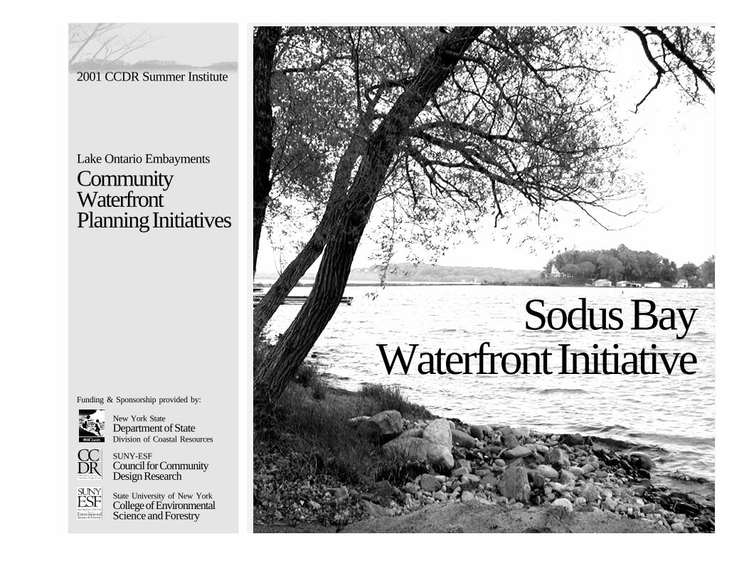
Lake Ontario Embayments
CommunityWaterfrontPlanning Initiatives
2001 CCDR Summer Institute
Sodus BayWaterfront Initiative

inside cover
Sodus BayWaterfront Initiative
Prepared by:
ESF Student Vision Planning Team Lynn Brooks Ginger McGilvray Elizabeth Metz Clemente Toffolo
ESF Student Summer Interns Jan Brath Aimee Fisher Michael Franco Jesse McLean Elizabeth Metz
Project Directors Cheryl Doble Scott Shannon
Prepared for:
The Town of Huron, NY Lois Buckalew, Supervisor
The Town of Sodus Donna Chittenden, Supervisor
The Village of Sodus Point Don Buchwald, Mayor
December 2001
The Town of Huron, the Town of Sodus and the Village ofSodus Point, New York December, 2001
Prepared by:The SUNY ESF Council for Community Design Research
Project Funding:The New York Department of State, Division of Coastal ResourcesThe Coastal Zone Management Act of 1972, as amended and adminis-tered by the Office of Ocean and Coastal Resources Management, Na-tional Oceanic and Atmospheric Administration
AcknowledgmentsWe would like to thank all those in the community that contributedto this project providing information, planning resources andworking space. Special acknowledgment is given to LoisBuckalew, Donna Chittenden and Don Buckwald for theirparticipation in planning meetings and assistance organizingworkshops. We also appreciate the interest and assistanceprovided by Wayne County Planning Department and DirectorSharon Lilla. Finally, we thank the residents of the Sodus Bay areawho attended the workshops and through their participation helpedto shape the proposals presented in this document.
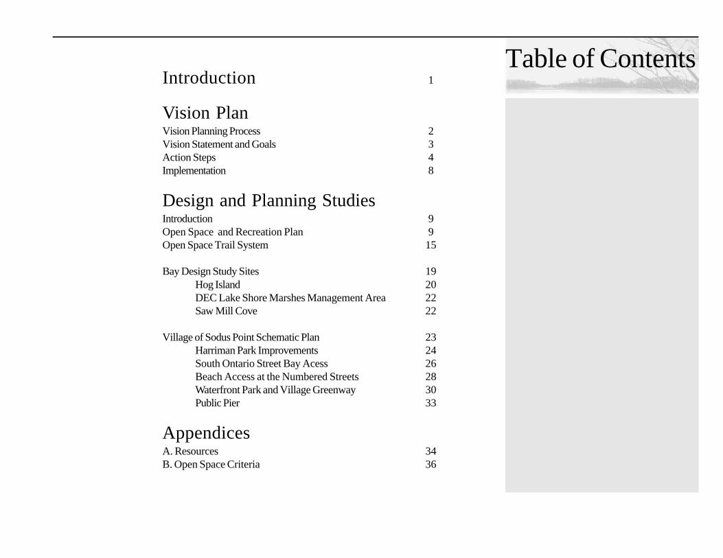
Table of ContentsIntroduction 1
Vision PlanVision Planning Process 2Vision Statement and Goals 3Action Steps 4Implementation 8
Design and Planning StudiesIntroduction 9Open Space and Recreation Plan 9Open Space Trail System 15
Bay Design Study Sites 19Hog Island 20DEC Lake Shore Marshes Management Area 22Saw Mill Cove 22
Village of Sodus Point Schematic Plan 23Harriman Park Improvements 24South Ontario Street Bay Acess 26Beach Access at the Numbered Streets 28Waterfront Park and Village Greenway 30Public Pier 33
AppendicesA. Resources 34B. Open Space Criteria 36

Page 1
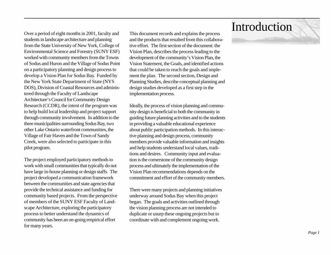
IntroductionOver a period of eight months in 2001, faculty andstudents in landscape architecture and planningfrom the State University of New York, College ofEnvironmental Science and Forestry (SUNY ESF)worked with community members from the Townsof Sodus and Huron and the Village of Sodus Pointon a participatory planning and design process todevelop a Vision Plan for Sodus Bay. Funded bythe New York State Department of State (NYSDOS), Division of Coastal Resources and adminis-tered through the Faculty of LandscapeArchitecture’s Council for Community DesignResearch (CCDR), the intent of the program wasto help build local leadership and project supportthrough community involvement. In addition to thethree municipalities surrounding Sodus Bay, twoother Lake Ontario waterfront communities, theVillage of Fair Haven and the Town of SandyCreek, were also selected to participate in thispilot program.
The project employed participatory methods towork with small communities that typically do nothave large in-house planning or design staffs. Theproject developed a communication frameworkbetween the communities and state agencies thatprovide the technical assistance and funding forcommunity based projects. From the perspectiveof members of the SUNY ESF Faculty of Land-scape Architecture, exploring the participatoryprocess to better understand the dynamics ofcommunity has been an on-going empirical effortfor many years.
This document records and explains the processand the products that resulted from this collabora-tive effort. The first section of the document: theVision Plan, describes the process leading to thedevelopment of the community’s Vision Plan, theVision Statement, the Goals, and identified actionsthat could be taken to reach the goals and imple-ment the plan. The second section, Design andPlanning Studies, describe conceptual planning anddesign studies developed as a first step in theimplementation process.
Ideally, the process of vision planning and commu-nity design is beneficial to both the community inguiding future planning activities and to the studentsin providing a valuable educational experienceabout public participation methods. In this interac-tive planning and design process, communitymembers provide valuable information and insightsand help students understand local values, tradi-tions and desires. Community input and evalua-tion is the cornerstone of the community designprocess and ultimately the implementation of theVision Plan recommendations depends on thecommitment and effort of the community members.
There were many projects and planning initiativesunderway around Sodus Bay when this projectbegan. The goals and activities outlined throughthe vision planning process are not intended toduplicate or usurp these ongoing projects but tocoordinate with and complement ongoing work.

Page 2
Vision Planning Process
Over the course of one academic semester fourstudents worked with residents from the Towns ofHuron and Sodus and the Village of Sodus Point tofacilitate a participatory design and planningprocess that led to the development of an inter-municipal Vision Plan for Sodus Bay. The studentsconducted two community workshops and made afinal presentation of the Vision Plan to the commu-nity at the end of the semester.
Vision planning by definition is the initial and criticalstep in a comprehensive planning process. Visionplanning brings community members together toidentify the unique opportunities and issues facingtheir community. Ultimately, vision planning askscommunity members to look beyond the currentconditions of their community to imagine a desiredfuture for their community. Having a vision plan inplace is important because it helps communitiesmanage changes currently happening and serves toguide the direction of future change.
A Vision Plan is composed of several relatedpieces. The vision statement is an “umbrellastatement” that embodies the collective view for acommunity’s future. Under this vision statementare several goals that describe the purpose orpieces of the vision statement in greater detail.Finally, implementation strategies or action stepsare developed under each goal to describe howthat goal can be achieved.
Students from SUNY ESF worked with thecommunity to develop a vision plan through aseries of workshops. The first workshop, at theHuron Town Hall, provided an introduction to thevisioning process, outlined the scope of the work,described SUNY-ESF’s role in the process anddiscussed the importance of community participa-tion. Community members worked with studentson several participatory exercises aimed at discov-ering the ways in which residents use and value thecommunity. Participants were asked to complete aseries of mapping exercises to identify valuedresources and destinations; daily and seasonalroutes; and to identify seasonal use patterns of theBay. A brainstorming session focused on under-standing what community members perceived asopportunities, concerns and issues, and on howthey envisioned the future of their community.Finally, a photo-survey was distributed for partici-pants to complete. This survey was intended tocollect more detailed information from communitymembers about the opportunities and issues facingthe community and to provide a chance for morepersonal, reflective thought.
At a second meeting in Sodus Point, studentspresented a summary of the information gatheredat the first workshop. The maps created by partici-pants at the first workshop were compiled by topiconto summary maps for review. Participants thenhad an opportunity to edit and add to these maps.In a new mapping exercise, residents were divided
Vision Plan
Residents provided valuable information and feed-back during both the vision planning and designstudies
Page 3
into teams and asked to consider future develop-ment, conservation and preservation that theywould like to see in the community. They pro-duced maps to record their ideas and marked thevarious areas that they thought would be bestsuited for these different activities. These mapsrevealed interesting patterns between developmentand conservation and identified three areas, SodusPoint, Lake Bluff and Bay Bridge where multipleopportunities suggest the need for careful planning.This activity was followed by a brainstormingactivity to identify critical water managementissues, strategies to resolve each issue and thepartners that might assist. The group also com-pleted a photographic survey and ended theworkshop with a review and edit of the draft visionstatement presented by the students.
The last meeting began with a review and analysisof the activities completed at the previous work-shop, followed by a final review of the revisedVision Statement and Goals. Then the studentspresented action steps that the three communitiescould take to begin implementation of their vision.Each of the proposed steps were discussed andrevisions and additions incorporated. Residentsthen indicated their near-term and long-termpriorities by placing a sticker next to specific actionsteps. The draft plan was revised to reflect theresidents’ comments and the priorities noted tohelp guide implementation decisions.
Vision Statement
The combined community vision for Sodus Bayand its environs is to improve water quality, pre-serve and enhance the natural beauty and promotesustainable use by:
• Establishing stewardship of the bay throughshared management and resource allocationamong public agencies and individuals;
• Managing land and water activities to mitigatetheir impact on the water quality of the bay toprotect the bay and its tributaries;
• Protecting and improving natural areas such aswetlands, stream channels and important dry-land areas;
• Providing public access to the bay resourcesand linking compatible activities on and aroundthe Bay to benefit both residents and visitors;and
• Promoting and managing quality developmentand land use patterns that enhance the historicand unique character of the bay area whilebalancing the residential, economic, andecological needs to foster a sense of commu-nity pride and identity.
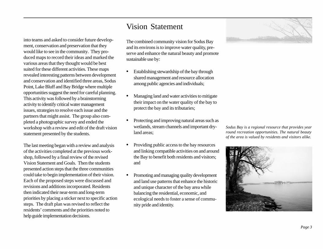
Sodus Bay is a regional resource that provides yearround recreation opportunities. The natural beautyof the area is valued by residents and visitors alike.
Page 4
Goals and Action Steps
Goal 1: Establish stewardship of the Baythrough shared management and resourceallocation among public agencies and individu-als.
• Organize a bay management/preservationcommission with representation from each ofthe three municipalities to coordinate resourcemanagement programs on the Bay. This groupwould serve as an advisory board to each ofthe municipalities to coordinate managementstudies, establish development requirementsand participate in the review of developmentprojects within the Sodus Bay watershed.
• Lobby with other Lake Ontario coastalcommunities for assistance to addresscommon issues identified in the recent studythe “ Lake Ontario Embayment Initiative” andto develop support to fund remediation efforts.
• Provide technical assistance to facilitateand guide local bay management. Anindividual serving as Bay Manager couldprovide management assistance to Sodus Bayby promoting assessment and monitoringstudies, guiding waterfront projects, initiatingeducational programs and providing answersto questions from residents and developers.
• Make local stewardship visible both withinthe three municipalities and to outside visitors.This can be done through local media cover-age, celebrations, public recognition andpromotional fliers and displays.
Goal 2: Manage land and water activities tomitigate their impact on the water quality ofthe bay and its tributaries.
• Enhance existing programs and encouragecomplementary efforts to address weedcontrol in the Bay. This program shouldaddress the weed condition through the entireBay and employ a coordinated and costeffective strategy for its control.
• Mitigate the impact of septic waste on theBay. Seek funding/assistance to conduct afeasibility study to evaluate alternative strate-gies for handling septic wastes. Work withappropriate agencies to implement the mostcost effective solutions.
• Seek assistance to assess the impact ofcommercial and recreational boating on theBay water quality and develop a strategy tomitigate these impacts. This might include a
Page 5
survey of boaters and marinas to determinecurrent practices and to identify actions (suchas the addition of more pump-outs, increaseddocking access, etc.) that would help tomitigate these impacts.
• Continue to work with existing conserva-tion/preservation programs to promotepublic awareness and participation in bestmanagement practices. Seek funding topromote best practices throughout the Baythrough the development of educationalprograms and by providing technical assistanceand incentives to private landowners.
• Establish development review criteria tomitigate impacts on the Bay watershed. Thecriteria should be clearly identified and care-fully reviewed during the development process.
Goal 3: Protect and improve natural areassuch as wetlands, stream channels and impor-tant dry-land areas.
• Develop an Open Space Plan for the Bay.Create a process that coordinates open spaceplanning and acquisition through the threemunicipalities. The plan produced by thisprocess should identify and incorporate areas
around the bay that are unsuitable for develop-ment, are highly sensitive to developmentimpacts, provide scenic views of the bay orhave high value for public use. This shouldalso include areas currently designated forpublic access and recreation, and any devel-oped pedestrian walkways/trails.
• Identify significant and valued naturalareas for preservation and development forpublic access. Consider the conservationvalue and educational potential of each identi-fied site, its accessibility for public use, anddevelopment costs and acquisition strategies ifit is not in public ownership. Based on thefeasibility study prepare funding strategies foracquisition and development of the best-suitedsite.
• Establish Best Development Practices andtie them to local development regulationsand review. Criteria should include but arenot limited to: a plan for erosion controlmanagement during construction, a postconstruction drainage plan, developmentsetbacks from the water and the use of buffersto separate new development from sensitiveresources.
Page 6
Goal 4: Provide public access to Bay re-sources and link compatible activities on andaround the Bay to benefit both residents andvisitors.
• Develop a comprehensive trail system thatlinks residential, commercial, public lands,and points of interest within the bay. Thistrail should support walking, bicycling, andother means of travel as appropriate for thelocation. In addition to linking resources withinthe bay, consider the potential to extend andconnect this trail to regional trails including theSeaway Trail and Erie Canal Bikeway.
• Study the potential to mark the bay en-trance with a gateway/information stationat Sodus Point. Conduct a planning/designfeasibility study to examine the development ofa public landing that would serve as an infor-mation center for visitors arriving in the bay byboat.
• Improve existing public boat launches anddevelop plans for additional public land-ings. Some of the existing launch facilities needupgrading and new sites are desired to allowwater access from the southern and easternsides of the bay.
• Improve and develop public beach andrecreation facilities to meet resident andvisitor needs. Current recreation interests arediverse and existing public spaces may benefitfrom redesign that provides greater flexibility toaccommodate a variety of mixed uses. Con-sider the desirability to distribute beach/recreation opportunities around the bay.Identify appropriate locations considering siteaccessibility, parking capacity and acquisitionstrategies.
• Develop strategies that encourage newdevelopment to tie into public trails andprovide public open space amenities in theirsite development. This could be encouragedthrough development incentives or require-ments.
• As tourism increases, monitor the impact oftraffic on the three municipalities and developstrategies to mitigate impacts.
Goal 5: Promote and manage quality develop-ment and land use patterns that enhance thehistoric and unique character of the Bay areawhile balancing the residential, economic, andecological needs in order to foster a sense ofcommunity pride and identity.
Page 7
• Encourage adaptive reuse, maintenanceand upgrading of existing structures andsites that are currently dilapidated or inneed of repair. Design studies, technicalassistance, incentives and creative fundingmight be used to encourage private actions.Community groups could be approached totake on projects on vacant or public sites.
• Establish coordinated management prac-tices to guide and review future develop-ment in the three municipalities. Criteria fordevelopment in the bay area should be consis-tent among the three municipalities. Environ-mental criteria, design guidelines, and incentiveprograms can be used to encourage develop-ment activities that protect the watershed andmaintain the valued character of the area.
• Waterfront development supports continuedpublic access. Private waterfront develop-ment reduces the potential for future publicaccess to the Bay and Lake. The communitiescan encourage new development to contributeto public open space and public waterfrontaccess by incorporating public access in designproposals or by establishing a development feetied to protecting open space.
• Conduct design studies to analyze and
assess the potential impact that differentdevelopment patterns will have on thelandscape and views around the Bay. Thepotential development of municipal sewer andwater lines will stimulate new residential andcommercial development and support a highersettlement density. Design studies will allow thecommunity to consider different developmentpatterns and their physical impact on thelandscape. This assessment will enable thethree communities to consider desired/compat-ible development patterns and land-use man-agement strategies to guide future develop-ment.
• Manage development in natural areas (e.g.agriculture lands, wetlands, floodplainsetc.) throughout the community to protectvalued resources. Establish design reviewcriteria for specific areas and incorporate landsnot suited for development into an open spaceplan.
• Protect continued agricultural land use inthe bay area. Agriculture has an historic andeconomic importance in the bay area. As newdevelopment occurs the three municipalitiesshould take steps to mitigate the impact of newresidential and commercial activities on agricul-tural practices.
Page 8
mayor met together with Sharon Lilla, director ofWayne County Planning, to decide on the nextsteps to be taken. Collaboration among the threemunicipalities had been the strength of the VisionPlanning process and they decided to start withactivities that would continue to build on thatcollaboration. They identified three initial imple-mentation steps:
1. Preliminary development of an open space andrecreation plan for the Bay.
2. Preparation of an inter-municipal agreementbetween the three municipalities to coordinateplanning activities around the Bay.
3. Consideration of creating a bay managerposition to assist the three communities in theimplementation of the Vision Plan.
Over the summer ESF students and facultyworked with the residents on the open space andrecreation plan, developing a schematic plan andconceptual site designs for public water access andenvironmental education opportunities around theBay. Residents were involved through informalcommunity meetings, public displays, and publicreview sessions. The community reviews andcritiques were crucial to the refinement of thedesigns and the investigation of new opportunities.The following section presents a summary of theopen space, recreation plan and design studies.
Implementation
In May 2001, after completion of the VisioningProcess, The CCDR and NYS DOS organized ameeting that included representatives of the threewaterfront communities and representatives fromseven state agencies to review the Sodus BayVision Plan. Lois Buckalew, Donna Chittenden andDon Buckwald represented the three Sodus BayCommunities at this meeting. The intent of themeeting was to provide a coordinated and efficientforum to review the Vision Plan and discuss theways the different state agencies could help thecommunities forward their vision. A desiredoutcome of this meeting was the discussion ofpotential state assistance and the preliminaryselection of specific projects to be further devel-oped by student interns working on the WaterfrontInitiatives during the summer of 2001.
The agency representatives were impressed withthe comprehensive nature of the Sodus Bay VisionPlan, and the clarity of the goals and action steps.They identified numerous funding programs thatwould not only assist with project implementationbut could also provide management and technicalassistance. The agency representatives identified anumber of initiatives in the Sodus Bay Vision Planthat were worthy of state support and they encour-aged the three leaders to pursue them.
Following the meeting the two supervisors and
Page 9
Design StudiesIntroduction
The development of an open space plan was aspecific action step under Goal 3 of the VisionPlan. The inclusion of recreation in this planrecognized the communities’ desire to identify andpreserve land with unique recreational or educa-tional value for future public development. Thiswork included the development of a schematicopen space plan, a preliminary bike route aroundthe Bay and conceptual site designs for public useat specific identified sites around the bay.
As the students began their data collection andconducted field visits as part of the open spaceinventory, they were also assessing individuallocations to determine their potential as future sitesfor public recreation, conservation and education.Residents had identified a number of sites duringthe workshops and the field visits provided anopportunity to assess each site and to identifyadditional sites with development potential forpublic use. This report begins with a summary ofthe open space plan, proceeds to review thepreliminary bikeway study and then presents theconceptual design studies around the Bay and inSodus Point.
community would like to guide or review futuredevelopment activities to protect valued resources.The establishment of an open space plan cancontribute to the economic value of communitylands and increase recreational opportunities, whilepreserving the ecological balance of interconnectednatural systems and maintaining the area’s historicagricultural tradition. An open space plan providesa framework that will allow the three municipalitiesto manage future growth in a way that protectsvalued resources and encourages desired develop-ment.
The Plan incorporates areas around the Bay thatare unsuitable for development, highly sensitive todevelopment impacts, provide scenic views of thebay or have a high value for public use. Alsoincluded in the plan are areas currently in publicownership, areas with easements designated forpublic access and recreation, and any existingpedestrian and bicycle routes. In addition to theinitial, schematic delineation of a Sodus Bay Open
Open Space & RecreationPlan
The development of this plan is the first step in aprocess to coordinate open space planning in thethree municipalities surrounding the Bay. The intentof Open Space Planning is to identify areas ofenvironmental sensitivity or public value which thecommunity might want to preserve, or on which the
Page 10
Space district, the planning process identified siteswithin this designated open space that have uniquepublic value for conservation, environmentaleducational, and waterfront access.
Goals of Open Space PlanningOpen space is defined as land, which is not inten-sively developed for residential, commercial,industrial or institutional uses. It includes agricul-tural and forest land, undeveloped shoreline, publicpark land and preserves. It also includes undevel-opable land such as wetlands and areas of steepslopes. Land can be designated as part of an openspace plan on the basis of its character, publicvalue and degree of sensitivity to development. Itcan also be designated on the basis of its proximityto such lands when additional open space land isrequired to protect these resources.
The Primary objectives of the Sodus Bay OpenSpace Plan are to:1. Insure preservation and careful planning of
development on prime open space lands.2. Protect environmentally sensitive areas such as
wetlands, habitats, areas of groundwaterrecharge, and prime agricultural soils.
3. Protect the water quality of Sodus Bay.4. Preserve land for the future development of
waterfront access for public recreational andeducational use.
5. Conserve prime agricultural soils.6. Maintain the visual character of the rural
landscape surrounding Sodus Bay.
Open Space Planning CriteriaThe study area includes portions of the Town ofSodus, Huron and Rose and the Village of SodusPoint and extends from the edge of the Bay inlanda distance of two to five miles. Three levels ofcriteria were established to guide the inventory,analysis and designation of the open space lands.The first and highest level of the criteria are associ-ated with land that is not suitable for developmentincluding:1. Wetlands with and without standing water
present2. Areas of steep or unstable slopes, 20 % –
30% or greater3. Areas that provide habitat for endangered
or rare plant and animal speciesThis list also includes Class I agricultural soils,which, while well suited for development, are animportant resource worthy of protection especiallygiven the importance of agriculture in the Towns ofHuron and Sodus.
The next category of criteria are less sensitive butequally important in the preservation of environ-mental and visual quality. They include:1. Existing mature vegetation and woodlands2. Floodways or those areas below the seasonal
high water mark3. Scenic view-sheds in the and around the bay4. Buffer zones surrounding wetlands and signifi-
cant habitats
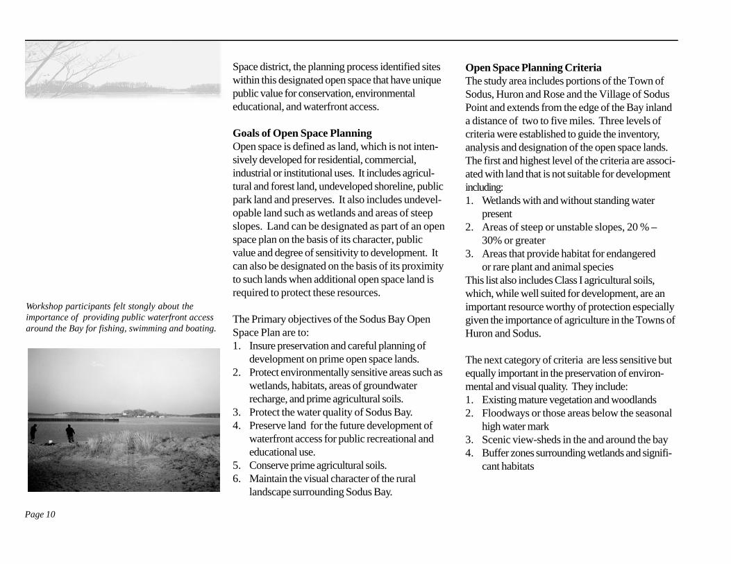
Workshop participants felt stongly about theimportance of providing public waterfront accessaround the Bay for fishing, swimming and boating.
Page 11
Lake Ontario
Sodus Bay
Page 12
Lake Ontario
Sodus Bay
Sodus Bay Open Space Overlay
Page 13
owned lands (see Appendix B).
B. Environmental AnalysisOnce the overlay maps were completed, analysisbegan by overlaying the environmental maps on theland use map. As this process continued it becameclear that there was a correspondence between themaps. Areas of steep slopes were usually thelocation of poor agricultural soils and as a result,mature woodlands. Also located within the areasof steep slopes were watersheds or stream corri-dors and wildlife habitat. The land use map alsorevealed that these areas were consistently desig-nated as vacant or undeveloped on the lands onthe land use map. Areas designated as agriculturalland or presently in production are predominantlylocated on prime agricultural soils and are alsoundeveloped. The Open Space Plan was pro-duced by locating the environmentally sensitiveareas and public lands on the land use map.
C. Delineation of the Open Space OverlayThe schematic open space overlay identifies areasaround the Bay which are currently classified asundeveloped or have a very low density of devel-opment. This overlay district also has extensiveareas of sensitive environmental, cultural and scenicresources. The intent of the Open Space Plan is toidentify lands that should either be protected fromdevelopment or should receive special consider-ation and review if they are developed in the future.While the plan does not identify individual parcelsor list their specific resources, the resource value
Due to the conceptual nature and schematicrepresentation of the Sodus Bay Open Space Plan,a third category was designated, which includeslands that are not necessarily environmentallysensitive but that, due to their proximity to environ-mentally sensitive areas, provide an importantbuffer. This designation depends on location andthe need to provide a protective buffer for desig-nated open space lands.
Open Space Planning ProcessA. InventoryThe development of the Open Space Plan beganwith the inventory of existing land use and propertyownership. A land use map was produced usingdigital data provided by the Wayne County Plan-ning Department. Once the map was completedthe different land uses were classified. This classi-fication was broken down by categories intoagricultural land, undeveloped parcels or vacantlands not in agricultural production, existing publiclands, commercial lands, residential and publiclyowned lands. When these classifications wereapplied to the map, patterns of existing open spacebecame clearly evident.
The second phase of the data analysis was thedevelopment of map overlays to delineate environ-mentally sensitive areas surrounding Sodus Bay.The overlay maps included hydrology, primeagricultural soils, sloped soils or unstable lands,mature woodlands, designated wetlands, rare orendangered species habitat, and existing publicly
Above: Agricultural lands and open space in thetown of Huron contribute to the rural character ofthe aera.
Page 14
and degree of sensitivity can be determined byconsulting the analysis map created for the openspace designation process (see Appendix B).
Village Open SpaceThe village differs from the surrounding towns inmany ways but one of the primary differences is itssettlement density. Like the planning in the twotowns, the village open space planning focuses onissues of environmental conservation, pedestrian
circulation and public lands for active and passiverecreation. Environmentally sensitive areas in thevillage should be identified and protected throughopen space planning. Public access to the water-front is a critical issue in the village. As a primarycommunity asset, the waterfront should be acces-sible to residents and visitors. Development shouldbe carefully considered and designed to protectand accommodate public access. In this samespirit, open space planning in the village and twotowns should be coordinated and connected. Thisplan links the open space system along proposedbike and pedestrian routes.
Implementation of the Open Space PlanOnce mapped, a strategy will be required toprotect the designated open space lands. This canbe accomplished in several ways including: the outright purchase of available properties, the develop-ment of an easement program, and the transfer ofdevelopment rights. A regional or local land trustcould assist the municipalities in this process. Inareas where careful development will not reducethe open space value of a property, developmentguidelines can be prepared to guide future devel-opment so that it occurs in a manner that protectsthe open space value of the property. WayneCounty Planning Department, state agencies andnot-for-profit planning organizations can assist inthis process. An open space plan is not anti-development; instead it encourages thoughtfuldevelopment on the part of both the municipalityand developers. It should provide a framework toguide quality development around the Bay.
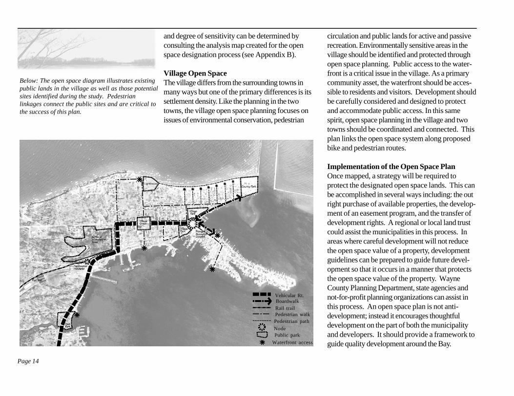
Below: The open space diagram illustrates existingpublic lands in the village as well as those potentialsites identified during the study. Pedestrianlinkages connect the public sites and are critical tothe success of this plan.
Vehicular Rt.BoardwalkRail trailPedestrian walkPedestrian path
NodePublic park
Waterfront access
Page 15
Open Space Trail System
OverviewDuring the vision planning process, residentsexpressed an interest in connecting destinationsaround the Bay by a bike trail (Goal 4). To ad-dress this goal, the design team studied a trailsystem to link resources within the bay area and toconnect the community to regional trails such as theSeaway Trail and the Erie Canal Bikeway. Thisstudy was developed in conjunction with the openspace plan to link publicly owned lands and assureaccess to public sites that may be developed in thefuture.
Route Design CriteriaFor the purposes of this study, no formal criteriawere developed for the designation of bicycle andpedestrian routes. However, consideration wasgiven to factors such as desirable destinations,safety, road width, surface conditions, and steep-ness of grades. The routes shown on the trailsystem diagram were chosen as “best fit” solutionsbetween the design team’s informal criteria, theexisting road conditions of the area, and theexpressed desires of the community. To increasethe development feasibility of the trail system andto expedite its implementation, routes were se-lected that maximize use of existing public right-of-ways and designated bike routes.
Bikeway OpportunitiesDuring the vision planning workshops, residents
identified a number of opportunities that could beincorporated in the design of a bike trail. Each ofthese was considered in the development of theinitial proposal.
1. An abandoned railroad corridor extends southfrom Sodus Point along the west side of the bayto the Town of Newark. This railroad corridorwould be ideal for the creation of a multiuse trailbecause of its minimal grade change and solidbase material. This corridor could be easilymodified to create a trail that would serve bothpedestrians and bicyclists. As a first step, thiscorridor could be developed to connect theVillage of Sodus Point and the Seaway Trail onRoute 104. Programs such as Rails-to-Trailscould help identify potential funding sources.
There are several issues relating to use of therail corridor that would need further consider-ation. First, there is no longer a direct link intothe Village of Sodus Point. Property ownersadjacent to the corridor are currently using theright-of-way and reestablishing this route intothe village center would require the cooperationof these individuals. Secondly, the potential toextend a bike trail along this route from theVillage of Sodus Point to join the Erie Canalbikeway at Newark may also be difficult sinceportions of the route are still an active rail line.
2. State Route 104A, running east-west, south ofSodus Bay, is part of the State designatedSeaway Trail. Already a designated tourist and
Page 16
bicycle route, the Seaway Trail provides anopportunity to connect the Sodus Bay trailsystem to a larger trail network that would allowcertain destinations to become more accessibleto visitors.
While State Route 104A has been designated asa bicycle route along certain segments, theconditions are not always ideal for safe bikeriding. High vehicular speeds and narrowshoulders could potentially result in high-risksituations for less experienced riders.
3. Lake Bluff Road on the eastern side of the Bayprovides vantage points for viewing the Bay anda possible connection to Le Roy Island. Byconnecting to Garner Road the route will lead toChimney Bluffs State Park and Lake ShoreMarshes Wildlife Management Area.
4. Shaker Tract Road was also considered be-cause it passes by many interesting destinationssuch as Alasa Farms, Sawmill Cove, and theShaker Tract. It also provides a more directexperience of the Bay. While this is an interest-ing route, it does not meet all of the designconsiderations. Segments of the route are steepand narrow and could pose a challenge forsome riders and a potential conflict betweenbike riders and cars. Therefore we recommendthat it be considered as a secondary rather thanprimary route on this trail.
4. The Sodus ditch was also mentioned as a
possible connecting route to the Erie CanalBikeway. While we were not able to uncoverenough information regarding the location of theroute and current land ownership along the routethis seems to present an interesting opportunityand should be further investigated with the helpof local residents familiar with this corridor.
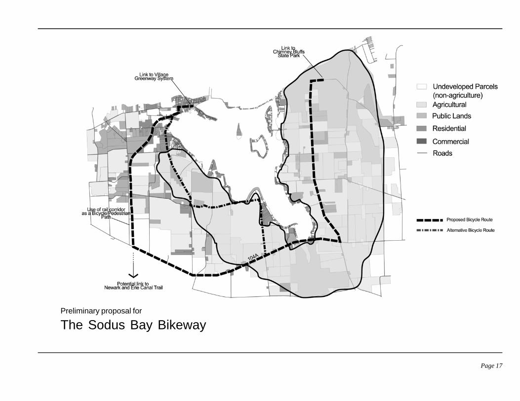
Description of Primary and Secondary RoutesThe proposed bike trail will begin in the Village ofSodus Point and continue around the Bay ending atChimney Bluffs State Park. The study delineatestwo potential routes between the Village and StateRoute 104A. Both the primary and secondaryroutes are extensions of the Greenway Systemwithin the Village of Sodus Point.
1. The primary RouteFrom the Village of Sodus Point, the primaryroute follows the abandoned railroad corridorturning east on Route 104A. The trail thenpasses destinations such as the Bay Bridge andthe DEC Lake Shore Marshes ManagementArea to the south of the bridge before turningnorth on Lake Bluff Road. The route thentravels north along Lake Bluff Road, connectingto Garner Road and terminating at ChimneyBluffs State Park. Should a public gatheringarea be developed at the Hog Island/Le RoyIsland site, a secondary branch could then beextended from the primary route to enableaccess by bicycle.
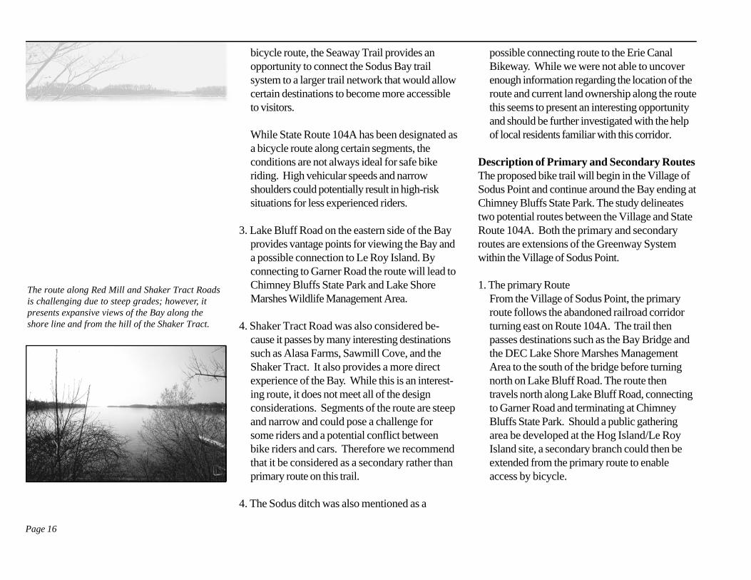
The route along Red Mill and Shaker Tract Roadsis challenging due to steep grades; however, itpresents expansive views of the Bay along theshore line and from the hill of the Shaker Tract.
Page 17
Preliminary proposal for
The Sodus Bay Bikeway
Page 18
2. The Secondary RouteThe secondary trail leaves the village followingRoute 14 south until it meets the Red Mill/Shaker Tract Road. There the route turns east(left) on Red Mill Road where it passes destina-tions such as Alasa Farms, Sawmill Cove, and aviewing point of the Bay on the Shaker Tractbefore turning south along the Shaker TractRoad. At the intersection of the Shaker TractRoad and Route 104A, the secondary trail turnseast to rejoin the primary trail.
Recommended Next StepsA bicycle trail system would provide recreationopportunities for both the residents and visitors.This initial study indicates several developmentopportunities; however, more study is required.To expedite implementation, routes should followexisting corridors and right-of-ways where pos-sible. Routes should be selected to link desirabledestinations and to provide a safe experience forthe user. The following is a list of action steps thatcan be taken to carry the planning and develop-ment of the bike trail forward.• Contact Wayne County Planning for advice
and technical assistance on this project.• Review and revise preliminary criteria devel-
oped in this study to establish planning criteria
that can be used to designate a route.• Where roads meet safety criteria for bike
routes, mark the routes with share the roadsigns and develop a route map showing thebike routes and destinations around the bay.Include the map in promotional brochures andmake the map available to visitors, bike clubsand tourism offices.
• Where roads or routes are not currently suitedfor bikes, develop a strategy for upgrading andimproving them to acceptable standards.
• Determine the feasibility of redeveloping theRR corridor from the village to Rt. 104A.Work with Wayne County Planning on thiseffort and contact NYS DOT, NYSPRHP,and Rails to Trails for possible funding assis-tance on this portion of the trail.
• Identify appropriate sites for parking, informa-tion kiosks and bike racks. Seek funding toprovide these support facilities.
• Further investigate the possibility of creating amultiuse trail between the Village of SodusPoint and the Erie Canal Trail by way of theabandoned railroad corridor or the SodusDitch.
Page 19
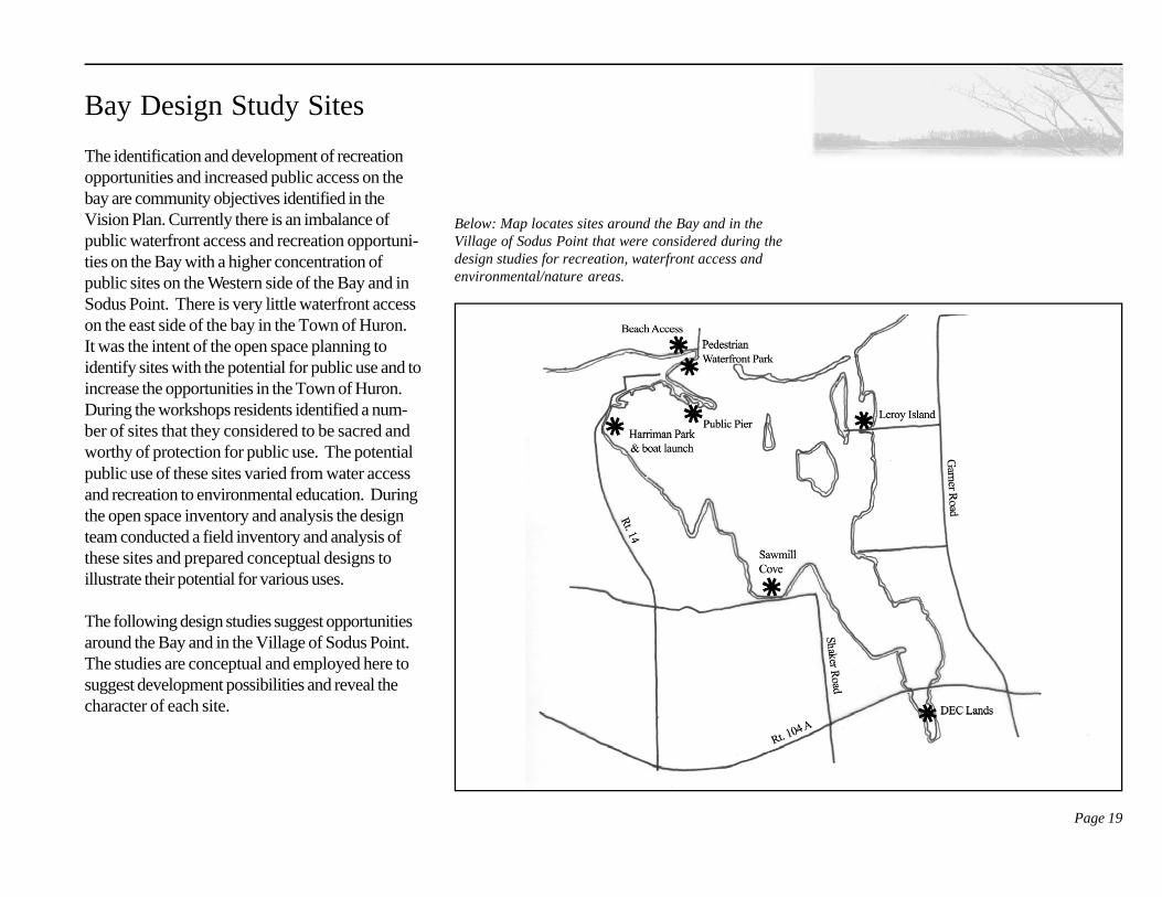
Bay Design Study Sites
The identification and development of recreationopportunities and increased public access on thebay are community objectives identified in theVision Plan. Currently there is an imbalance ofpublic waterfront access and recreation opportuni-ties on the Bay with a higher concentration ofpublic sites on the Western side of the Bay and inSodus Point. There is very little waterfront accesson the east side of the bay in the Town of Huron.It was the intent of the open space planning toidentify sites with the potential for public use and toincrease the opportunities in the Town of Huron.During the workshops residents identified a num-ber of sites that they considered to be sacred andworthy of protection for public use. The potentialpublic use of these sites varied from water accessand recreation to environmental education. Duringthe open space inventory and analysis the designteam conducted a field inventory and analysis ofthese sites and prepared conceptual designs toillustrate their potential for various uses.
The following design studies suggest opportunitiesaround the Bay and in the Village of Sodus Point.The studies are conceptual and employed here tosuggest development possibilities and reveal thecharacter of each site.
Below: Map locates sites around the Bay and in theVillage of Sodus Point that were considered during thedesign studies for recreation, waterfront access andenvironmental/nature areas.
Page 20
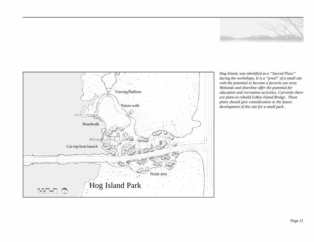
be used for a summer youth program that couldinclude nature study, kayak/canoeing, and fishing.In addition, a small business or concession couldbe established on the site to sell bait and food.
Design Proposal Recommendations
• Build a multipurpose community buildingwith restrooms for community gatherings,nature education and recreation programs.
• Develop a picnic area with tables andgrills. Plant trees as necessary to provideshade.
• Provide an area for a car-top launch forsmall boats, canoes, and kayaks andprovide a small building for small boatstorage and rental.
• Construct a boardwalk that extends outinto LeRoy Island Cove for pedestrianaccess and fishing.
• Provide a nature walk of mown grass thatwould loop from the boardwalk to a largeopen space for picnic and mixed use activi-ties. Include viewing platforms along thewalk.
• Provide benches along the water’s edge andthe nature walk.
• Provide parking for approximately 15 ve-hicles.
• Provide planting buffers in parking areas.
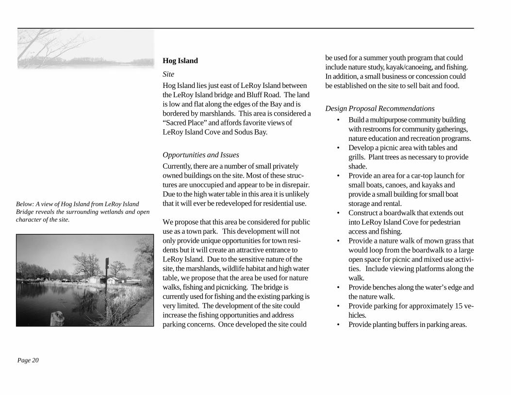
Hog Island
Site
Hog Island lies just east of LeRoy Island betweenthe LeRoy Island bridge and Bluff Road. The landis low and flat along the edges of the Bay and isbordered by marshlands. This area is considered a“Sacred Place” and affords favorite views ofLeRoy Island Cove and Sodus Bay.
Opportunities and Issues
Currently, there are a number of small privatelyowned buildings on the site. Most of these struc-tures are unoccupied and appear to be in disrepair.Due to the high water table in this area it is unlikelythat it will ever be redeveloped for residential use.
We propose that this area be considered for publicuse as a town park. This development will notonly provide unique opportunities for town resi-dents but it will create an attractive entrance toLeRoy Island. Due to the sensitive nature of thesite, the marshlands, wildlife habitat and high watertable, we propose that the area be used for naturewalks, fishing and picnicking. The bridge iscurrently used for fishing and the existing parking isvery limited. The development of the site couldincrease the fishing opportunities and addressparking concerns. Once developed the site could
Below: A view of Hog Island from LeRoy IslandBridge reveals the surrounding wetlands and opencharacter of the site.
Page 21
Hog Island, was identified as a “Sacred Place”during the workshops. It is a “jewel” of a small sitewith the potential to become a favorite use area.Wetlands and shoreline offer the potential foreducation and recreation activities. Currently thereare plans to rebuild LeRoy Island Bridge. Theseplans should give consideration to the futuredevelopment of this site for a small park.
Boardwalk
Car-top boat launch
Nature walk
Viewing Platform
Picnic area
Hog Island Park
Page 22
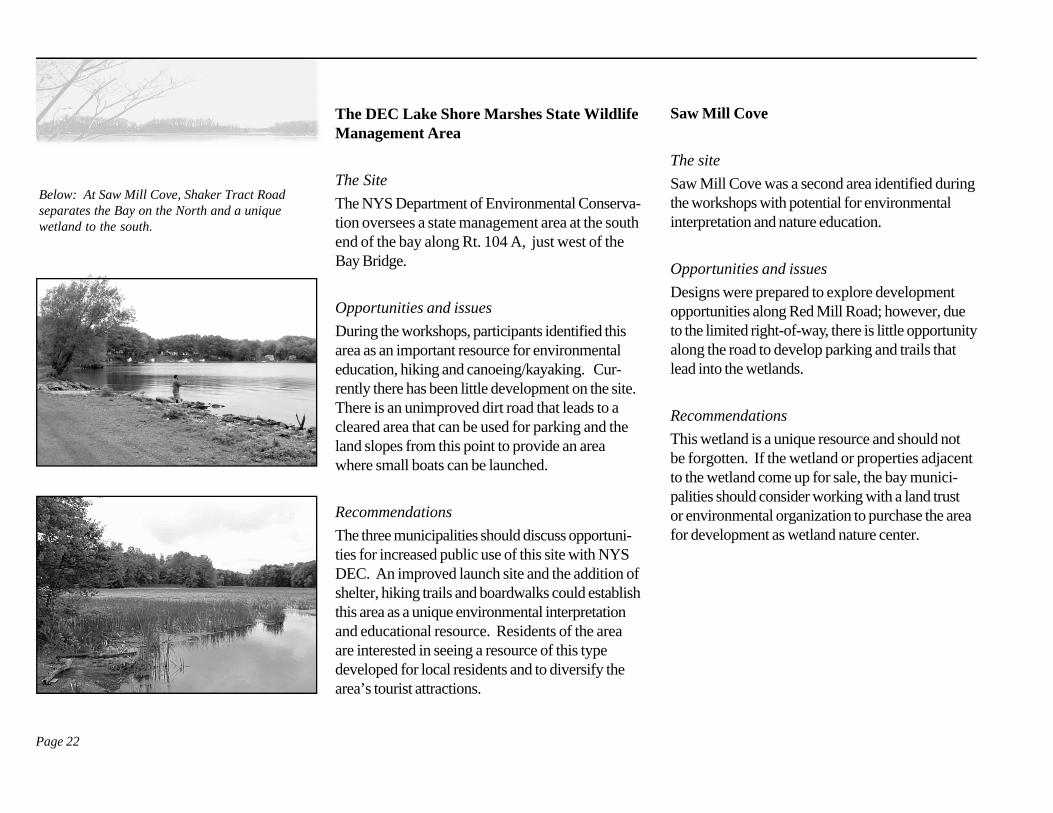
The DEC Lake Shore Marshes State WildlifeManagement Area
The Site
The NYS Department of Environmental Conserva-tion oversees a state management area at the southend of the bay along Rt. 104 A, just west of theBay Bridge.
Opportunities and issues
During the workshops, participants identified thisarea as an important resource for environmentaleducation, hiking and canoeing/kayaking. Cur-rently there has been little development on the site.There is an unimproved dirt road that leads to acleared area that can be used for parking and theland slopes from this point to provide an areawhere small boats can be launched.
Recommendations
The three municipalities should discuss opportuni-ties for increased public use of this site with NYSDEC. An improved launch site and the addition ofshelter, hiking trails and boardwalks could establishthis area as a unique environmental interpretationand educational resource. Residents of the areaare interested in seeing a resource of this typedeveloped for local residents and to diversify thearea’s tourist attractions.
Saw Mill Cove
The site
Saw Mill Cove was a second area identified duringthe workshops with potential for environmentalinterpretation and nature education.
Opportunities and issues
Designs were prepared to explore developmentopportunities along Red Mill Road; however, dueto the limited right-of-way, there is little opportunityalong the road to develop parking and trails thatlead into the wetlands.
Recommendations
This wetland is a unique resource and should notbe forgotten. If the wetland or properties adjacentto the wetland come up for sale, the bay munici-palities should consider working with a land trustor environmental organization to purchase the areafor development as wetland nature center.
Below: At Saw Mill Cove, Shaker Tract Roadseparates the Bay on the North and a uniquewetland to the south.
Page 23
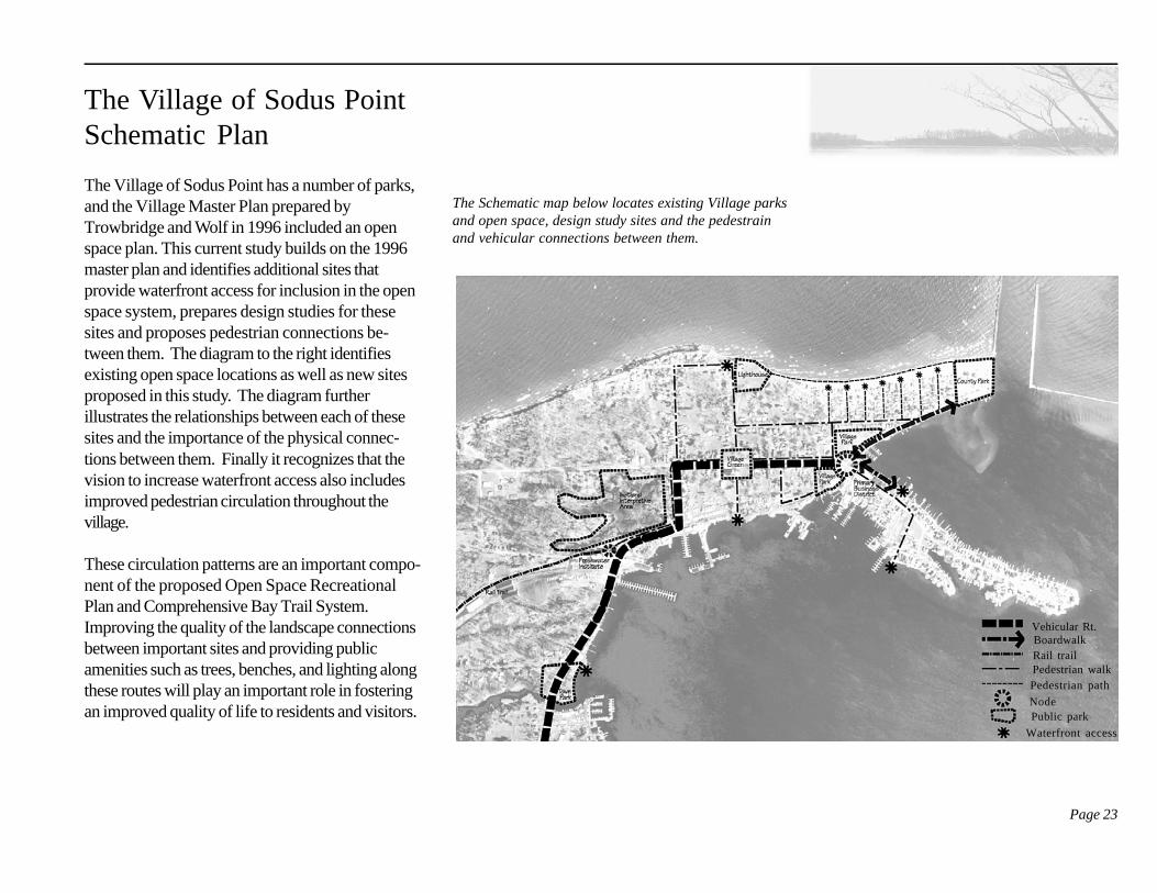
The Village of Sodus PointSchematic Plan
The Village of Sodus Point has a number of parks,and the Village Master Plan prepared byTrowbridge and Wolf in 1996 included an openspace plan. This current study builds on the 1996master plan and identifies additional sites thatprovide waterfront access for inclusion in the openspace system, prepares design studies for thesesites and proposes pedestrian connections be-tween them. The diagram to the right identifiesexisting open space locations as well as new sitesproposed in this study. The diagram furtherillustrates the relationships between each of thesesites and the importance of the physical connec-tions between them. Finally it recognizes that thevision to increase waterfront access also includesimproved pedestrian circulation throughout thevillage.
These circulation patterns are an important compo-nent of the proposed Open Space RecreationalPlan and Comprehensive Bay Trail System.Improving the quality of the landscape connectionsbetween important sites and providing publicamenities such as trees, benches, and lighting alongthese routes will play an important role in fosteringan improved quality of life to residents and visitors.
The Schematic map below locates existing Village parksand open space, design study sites and the pedestrainand vehicular connections between them.
Vehicular Rt.BoardwalkRail trailPedestrian walkPedestrian path
NodePublic park
Waterfront access
Page 24
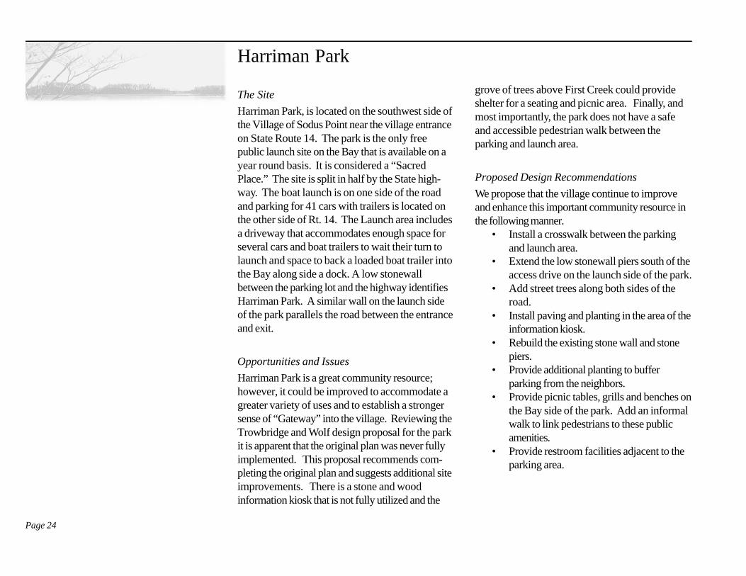
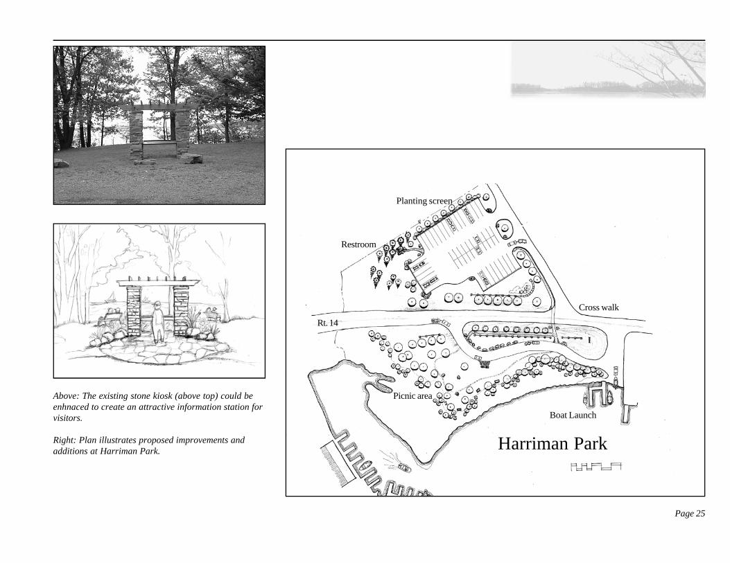
Harriman Park
The Site
Harriman Park, is located on the southwest side ofthe Village of Sodus Point near the village entranceon State Route 14. The park is the only freepublic launch site on the Bay that is available on ayear round basis. It is considered a “SacredPlace.” The site is split in half by the State high-way. The boat launch is on one side of the roadand parking for 41 cars with trailers is located onthe other side of Rt. 14. The Launch area includesa driveway that accommodates enough space forseveral cars and boat trailers to wait their turn tolaunch and space to back a loaded boat trailer intothe Bay along side a dock. A low stonewallbetween the parking lot and the highway identifiesHarriman Park. A similar wall on the launch sideof the park parallels the road between the entranceand exit.
Opportunities and Issues
Harriman Park is a great community resource;however, it could be improved to accommodate agreater variety of uses and to establish a strongersense of “Gateway” into the village. Reviewing theTrowbridge and Wolf design proposal for the parkit is apparent that the original plan was never fullyimplemented. This proposal recommends com-pleting the original plan and suggests additional siteimprovements. There is a stone and woodinformation kiosk that is not fully utilized and the
grove of trees above First Creek could provideshelter for a seating and picnic area. Finally, andmost importantly, the park does not have a safeand accessible pedestrian walk between theparking and launch area.
Proposed Design Recommendations
We propose that the village continue to improveand enhance this important community resource inthe following manner.
• Install a crosswalk between the parkingand launch area.
• Extend the low stonewall piers south of theaccess drive on the launch side of the park.
• Add street trees along both sides of theroad.
• Install paving and planting in the area of theinformation kiosk.
• Rebuild the existing stone wall and stonepiers.
• Provide additional planting to bufferparking from the neighbors.
• Provide picnic tables, grills and benches onthe Bay side of the park. Add an informalwalk to link pedestrians to these publicamenities.
• Provide restroom facilities adjacent to theparking area.
Page 25
Above: The existing stone kiosk (above top) could beenhnaced to create an attractive information station forvisitors.
Right: Plan illustrates proposed improvements andadditions at Harriman Park.
Restroom
Planting screen
Rt. 14
Cross walk
Picnic area
Boat Launch
Harriman Park
Page 26
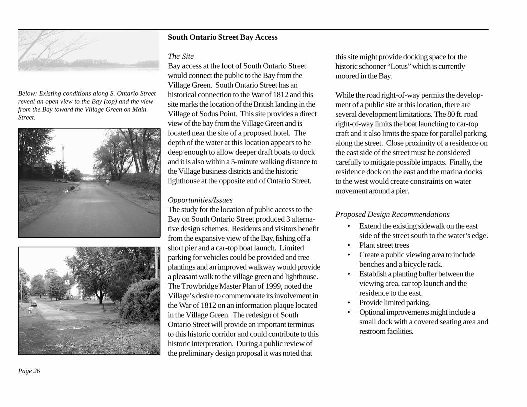
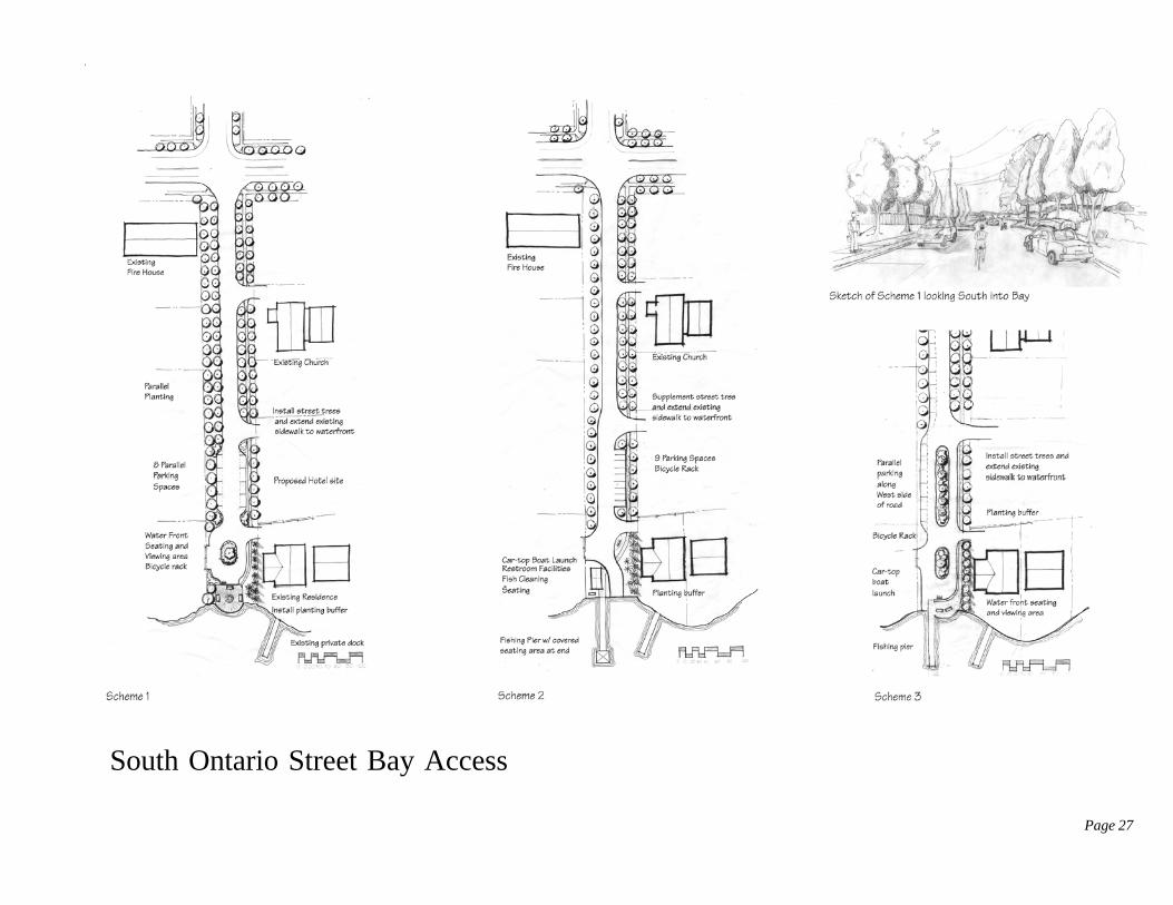
South Ontario Street Bay Access
The SiteBay access at the foot of South Ontario Streetwould connect the public to the Bay from theVillage Green. South Ontario Street has anhistorical connection to the War of 1812 and thissite marks the location of the British landing in theVillage of Sodus Point. This site provides a directview of the bay from the Village Green and islocated near the site of a proposed hotel. Thedepth of the water at this location appears to bedeep enough to allow deeper draft boats to dockand it is also within a 5-minute walking distance tothe Village business districts and the historiclighthouse at the opposite end of Ontario Street.
Opportunities/IssuesThe study for the location of public access to theBay on South Ontario Street produced 3 alterna-tive design schemes. Residents and visitors benefitfrom the expansive view of the Bay, fishing off ashort pier and a car-top boat launch. Limitedparking for vehicles could be provided and treeplantings and an improved walkway would providea pleasant walk to the village green and lighthouse.The Trowbridge Master Plan of 1999, noted theVillage’s desire to commemorate its involvement inthe War of 1812 on an information plaque locatedin the Village Green. The redesign of SouthOntario Street will provide an important terminusto this historic corridor and could contribute to thishistoric interpretation. During a public review ofthe preliminary design proposal it was noted that
this site might provide docking space for thehistoric schooner “Lotus” which is currentlymoored in the Bay.
While the road right-of-way permits the develop-ment of a public site at this location, there areseveral development limitations. The 80 ft. roadright-of-way limits the boat launching to car-topcraft and it also limits the space for parallel parkingalong the street. Close proximity of a residence onthe east side of the street must be consideredcarefully to mitigate possible impacts. Finally, theresidence dock on the east and the marina docksto the west would create constraints on watermovement around a pier.
Proposed Design Recommendations
• Extend the existing sidewalk on the eastside of the street south to the water’s edge.
• Plant street trees• Create a public viewing area to include
benches and a bicycle rack.• Establish a planting buffer between the
viewing area, car top launch and theresidence to the east.
• Provide limited parking.• Optional improvements might include a
small dock with a covered seating area andrestroom facilities.
Below: Existing conditions along S. Ontario Streetreveal an open view to the Bay (top) and the viewfrom the Bay toward the Village Green on MainStreet.
Page 27
South Ontario Street Bay Access
Page 28
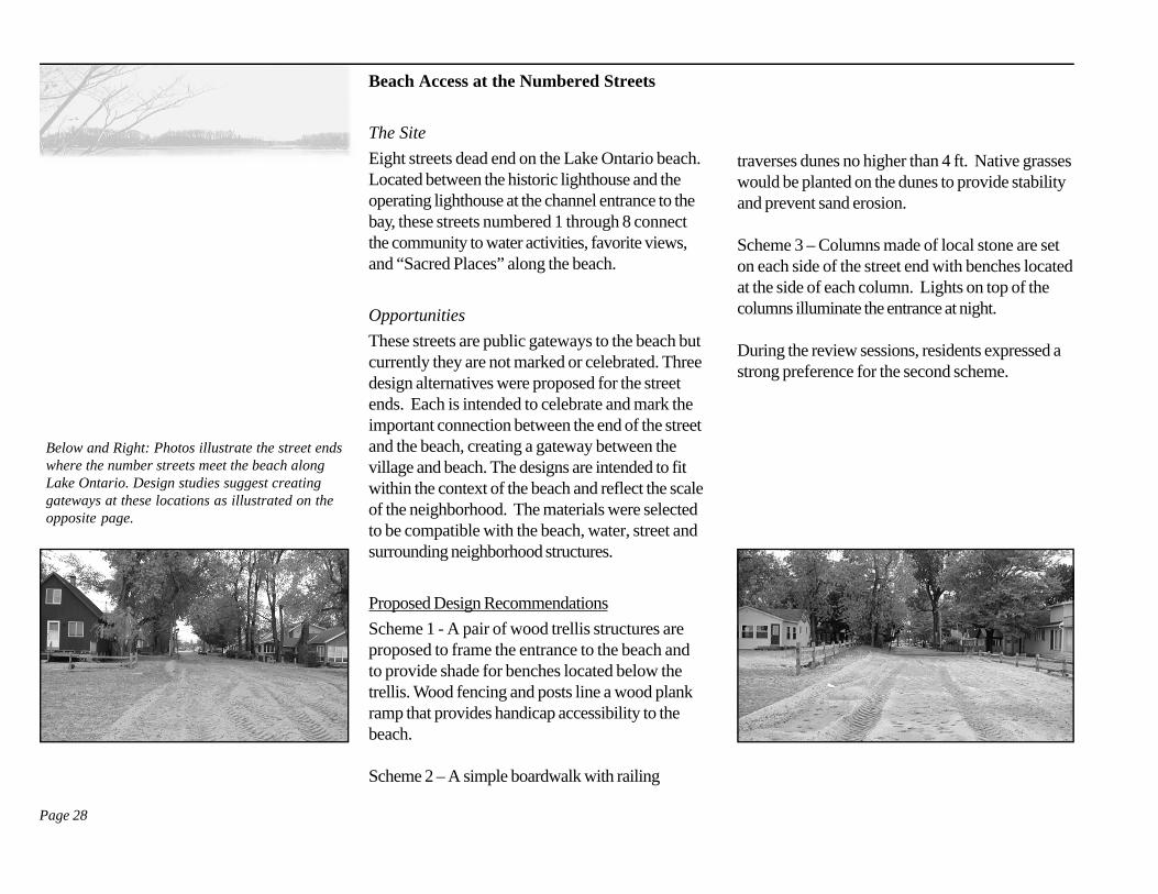
Beach Access at the Numbered Streets
The Site
Eight streets dead end on the Lake Ontario beach.Located between the historic lighthouse and theoperating lighthouse at the channel entrance to thebay, these streets numbered 1 through 8 connectthe community to water activities, favorite views,and “Sacred Places” along the beach.
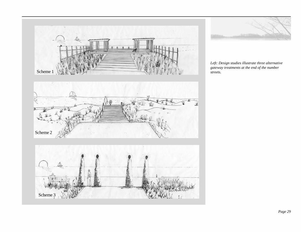
Opportunities
These streets are public gateways to the beach butcurrently they are not marked or celebrated. Threedesign alternatives were proposed for the streetends. Each is intended to celebrate and mark theimportant connection between the end of the streetand the beach, creating a gateway between thevillage and beach. The designs are intended to fitwithin the context of the beach and reflect the scaleof the neighborhood. The materials were selectedto be compatible with the beach, water, street andsurrounding neighborhood structures.
Proposed Design Recommendations
Scheme 1 - A pair of wood trellis structures areproposed to frame the entrance to the beach andto provide shade for benches located below thetrellis. Wood fencing and posts line a wood plankramp that provides handicap accessibility to thebeach.
Scheme 2 – A simple boardwalk with railing
traverses dunes no higher than 4 ft. Native grasseswould be planted on the dunes to provide stabilityand prevent sand erosion.
Scheme 3 – Columns made of local stone are seton each side of the street end with benches locatedat the side of each column. Lights on top of thecolumns illuminate the entrance at night.
During the review sessions, residents expressed astrong preference for the second scheme.
Below and Right: Photos illustrate the street endswhere the number streets meet the beach alongLake Ontario. Design studies suggest creatinggateways at these locations as illustrated on theopposite page.
Page 29
Left: Design studies illustrate three alternativegateway treatments at the end of the numberstreets.Scheme 1
Scheme 2
Scheme 3
Page 30
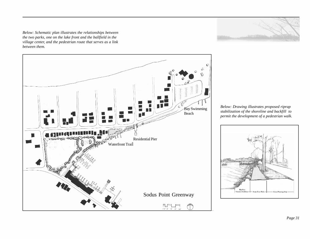
Waterfront Park and Village Greenway
The SiteThis proposal encompasses and connects theSodus Point County Park, a pedestrian walk alongWickham Boulevard, the Village ball park, and theGreig Street business district.
Opportunities and Issues
This proposal provides public access to waterfrontactivities on the bay and links residential, recreationand commercial activities in the village through thedevelopment of a safe pedestrian corridor. Theproposal includes improvements at the countypark, the development of a safe pedestrian walk-way, stabilization of the shoreline and improve-ments to the baseball field in the center of theVillage.
The greenway will be located on an existing publicright of way; however, a short easement overprivate property near the Village ballfield will berequired in order to complete the trail all the wayto the village center. The greenway begins at theCounty Park connects to the Village ball parkalong its eastern edge and extends on to the GreigStreet commercial district. The design proposalsuggests the reorganization of parking around theball field to create an improved pedestrian corri-dor, permit more efficient use of the site, improve
access to docks and launch site and visually markthis civic center of the village. A public boardwalkis suggested along the rear of the Greig Streetcommercial buildings, from which private dockscould extend. The extension of a small pier wouldallow for an information or commercial kioskwhere boats with shallow draft might dock.
Proposed Design Recommendations• Relocate and improve the bay swimming
area.• Construct a waterfront walkway from the
County Park to Greig Street. The walk-way includes a 5ft. wide stone dust trailalong the west end of the bay that runsparallel to Wickham Blvd., along the eastend of the ball park. A boardwalk extendsfrom the walkway behind the Greig Streetcommercial buildings to a small public pier.
• Construct a rip rap edge along the bay sideof the path.
• Plant trees and install residential scalefencing along the north side of the SodusPoint ballfield to delineate the private/public edge and improve the character andquality of the open space for privateresidents and recreational participants.
• Reorganize car and boat trailer parking tomake the most efficient use of the site,
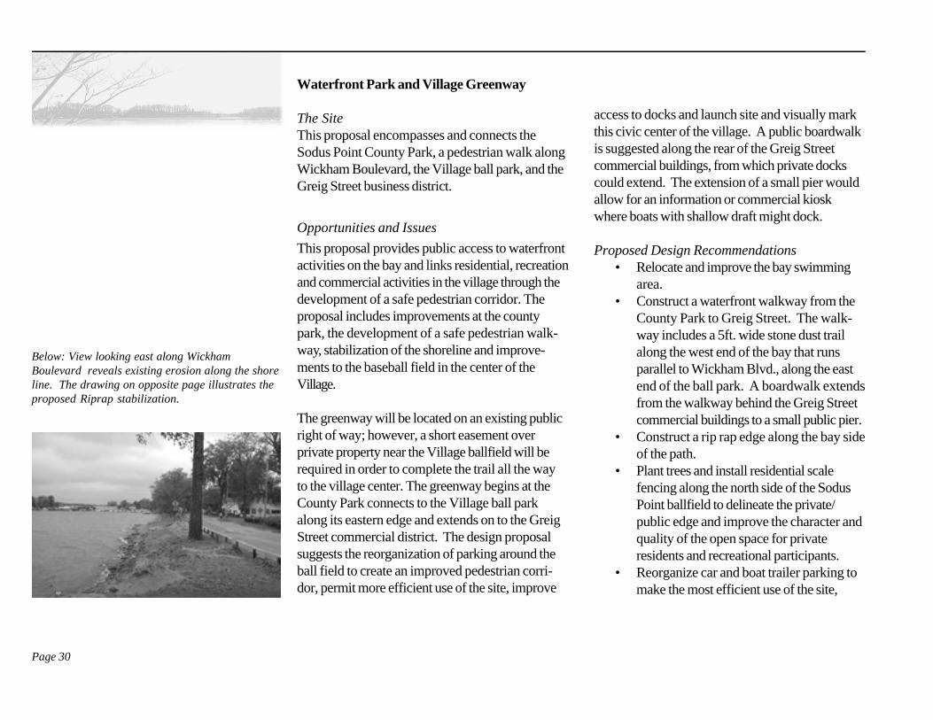
Below: View looking east along WickhamBoulevard reveals existing erosion along the shoreline. The drawing on opposite page illustrates theproposed Riprap stabilization.
Page 31
Below: Drawing illustrates proposed riprapstabilization of the shoreline and backfill topermit the development of a pedestrian walk.
Below: Schematic plan illustrates the relationships betweenthe two parks, one on the lake front and the ballfield in thevillage center, and the pedestrian route that serves as a linkbetween them.
Residential Pier
Bay SwimmingBeach
Waterfront Trail
Sodus Point Greenway
Page 32
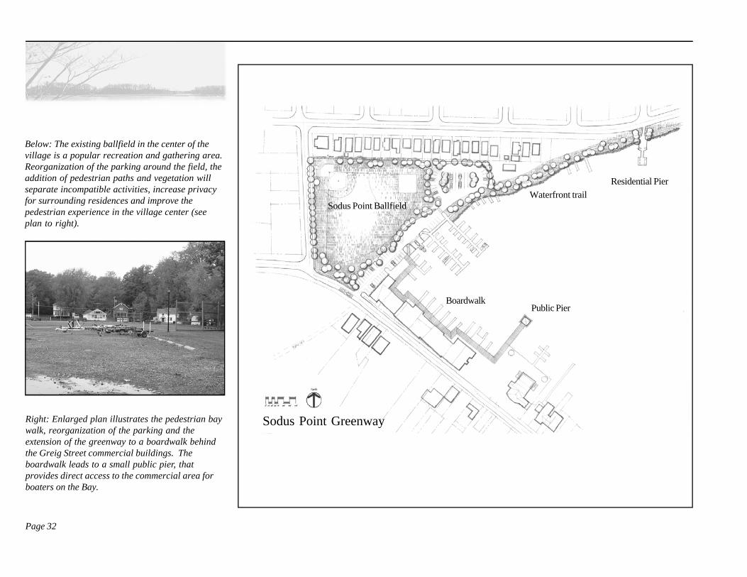
Below: The existing ballfield in the center of thevillage is a popular recreation and gathering area.Reorganization of the parking around the field, theaddition of pedestrian paths and vegetation willseparate incompatible activities, increase privacyfor surrounding residences and improve thepedestrian experience in the village center (seeplan to right).
Residential Pier
Public Pier
Waterfront trail
Boardwalk
Sodus Point Ballfield
Sodus Point GreenwayRight: Enlarged plan illustrates the pedestrian baywalk, reorganization of the parking and theextension of the greenway to a boardwalk behindthe Greig Street commercial buildings. Theboardwalk leads to a small public pier, thatprovides direct access to the commercial area forboaters on the Bay.
Page 33
reduce pedestrian/vehicular conflicts andpermit the greatest use of the ball field.
• Work with commercial businesses todevelop an acceptable proposal for awaterfront boardwalk and pier.
The Park revitalization and Greenway wouldestablish an important link in the Village OpenSpace Plan while supporting residential, recreationand commercial activities in the village center.
Public Pier
The value of a public pier came up many timesduring the vison planning workshops. During thedesign studies residents and students looked atseveral possible sites to locate such a facility. ThePublic Pier identified on the Greenway Planprovides access to the Village commercial districtfor boats with a shallow draught but will not serveas an arrival location for sailboats or large motorcraft that require deep water.
It appears that a docking pier would need to belocated on the south side of the point to haveadequate water depth. South Ontario Street wasconsidered for this purpose; however, adjacentproperties and exisiting docks present constraints.While this might be a good location to dock theLotus, without modifications to the suroundingwaterfront this site would not be able toaccomodate a steady flow of visiting boats.
It appears that the village will need to purchaseproperty to build a pier or negotiate with a privateowner for shared use of a facility somewhare alongthe village’s southern shore.
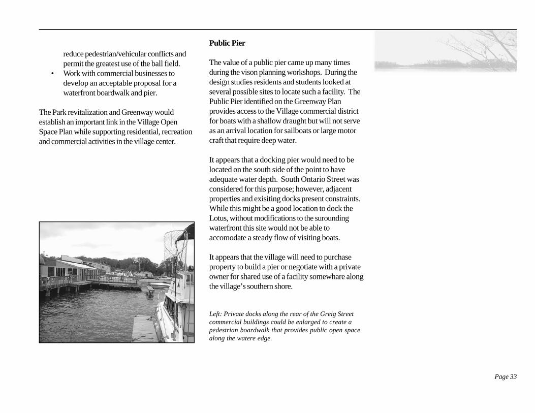
Left: Private docks along the rear of the Greig Streetcommercial buildings could be enlarged to create apedestrian boardwalk that provides public open spacealong the watere edge.
Appendix
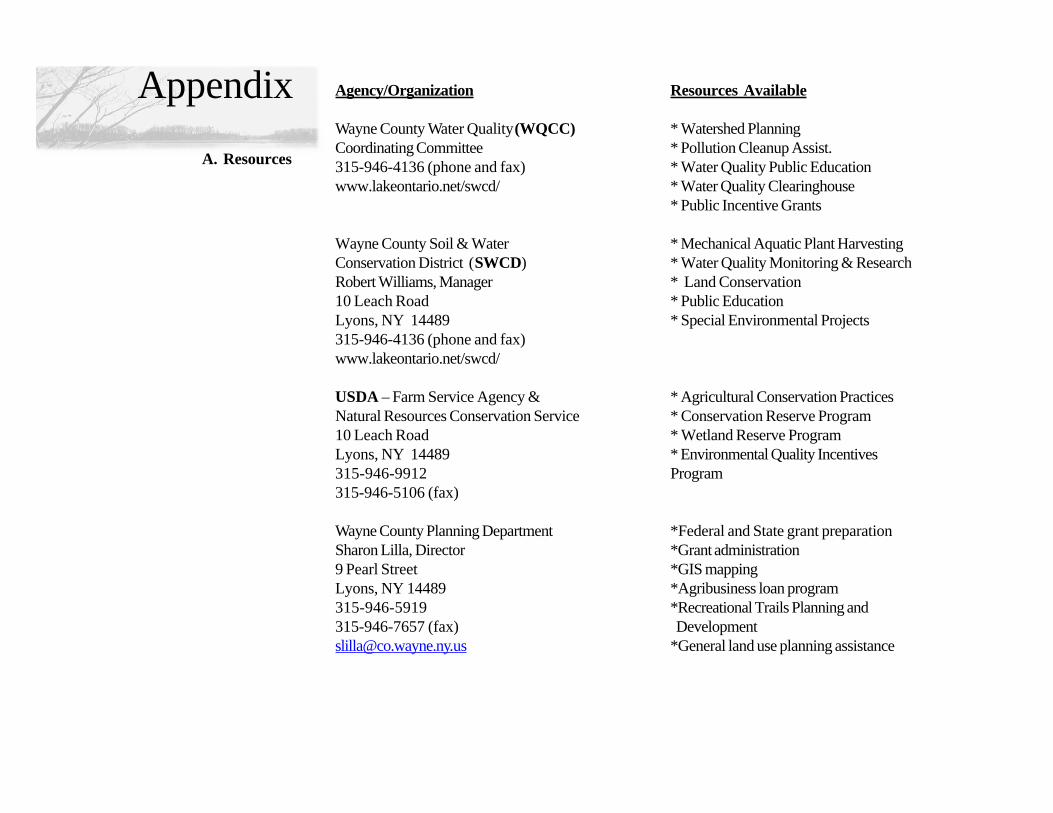
A. Resources
Agency/Organization Resources Available
Wayne County Water Quality (WQCC) * Watershed PlanningCoordinating Committee * Pollution Cleanup Assist.315-946-4136 (phone and fax) * Water Quality Public Educationwww.lakeontario.net/swcd/ * Water Quality Clearinghouse
* Public Incentive Grants
Wayne County Soil & Water * Mechanical Aquatic Plant HarvestingConservation District (SWCD) * Water Quality Monitoring & ResearchRobert Williams, Manager * Land Conservation10 Leach Road * Public EducationLyons, NY 14489 * Special Environmental Projects315-946-4136 (phone and fax)www.lakeontario.net/swcd/
USDA – Farm Service Agency & * Agricultural Conservation PracticesNatural Resources Conservation Service * Conservation Reserve Program10 Leach Road * Wetland Reserve ProgramLyons, NY 14489 * Environmental Quality Incentives315-946-9912 Program315-946-5106 (fax)
Wayne County Planning Department *Federal and State grant preparationSharon Lilla, Director *Grant administration9 Pearl Street *GIS mappingLyons, NY 14489 *Agribusiness loan program315-946-5919 *Recreational Trails Planning and315-946-7657 (fax) [email protected] *General land use planning assistance

Save our Sodus *Develop, support, fund and implement activities,P.O. Box 424 educational programs, initiatives and events toAlton, NY 14413 improve the quality of the water in Sodus Baywww.saveoursodus.org
Great Sodus Bay Association *Promotion of services, businesses, activitiesP.O. Box 137 and events on Sodus BaySodus Point, NY 14555-0137315-483-6391www.greatsodusbay.com
International Freshwater Resource Center *Promotes comprehensive understanding and8241 Sentell Street appreciation of our freshwater resourcesP.O. Box 250Sodus Point, NY 14555-0137315-483-4125www.lakeontario.net/ifrc/[email protected]
Sodus Bay Historical Society *Preservation of historical maritime resources,P.O. Box 94 historical education, community eventsSodus Point, NY 14555-0137 and historical exhibits at the Old Sodus Point315-483-4936 Lighthouse Maritime [email protected]
Finger Lakes – Lake Ontario Watershed *Protect and enhance water resources by Protection Alliance sharing information and data;309 Lake Street collaborating on watershed managementPenn Yan, NY 14527 programs and emphasizing a holistic,315-536-5188 ecosystem approach to water quality315-536-7488 (fax)[email protected]
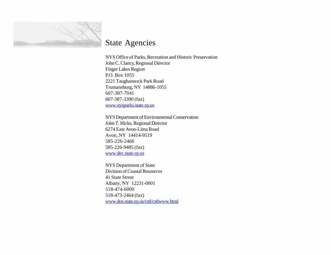
State Agencies
NYS Office of Parks, Recreation and Historic PreservationJohn C. Clancy, Regional DirectorFinger Lakes RegionP.O. Box 10552221 Taughannock Park RoadTrumansburg, NY 14886-1055607-387-7041607-387-3390 (fax)www.nysparks.state.ny.us
NYS Department of Environmental ConservationJohn T. Hicks, Regional Director6274 East Avon-Lima RoadAvon, NY 14414-9519585-226-2466585-226-9485 (fax)www.dec.state.ny.us
NYS Department of StateDivision of Coastal Resources41 State StreetAlbany, NY 12231-0001518-474-6000518-473-2464 (fax)www.dos.state.ny.us/cstl/cstlwww.html
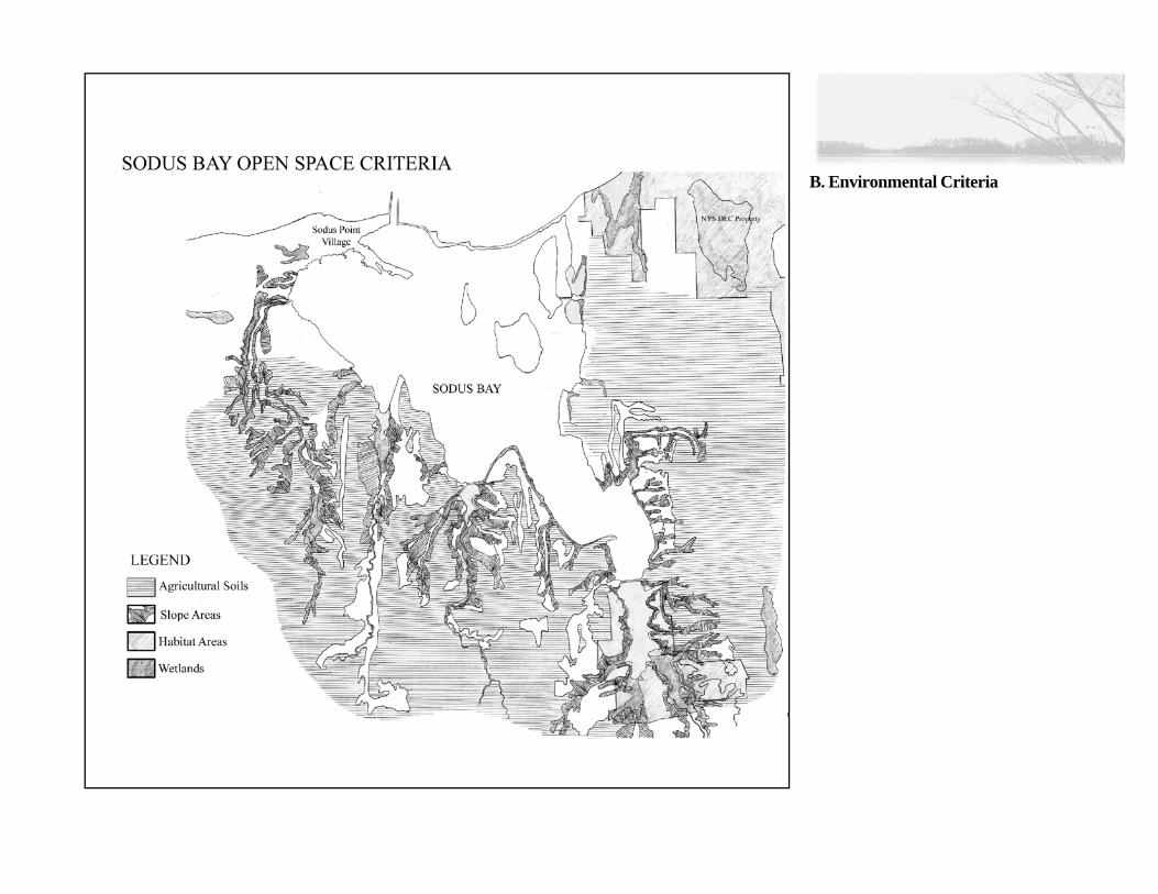
B. Environmental Criteria