Embed Size (px)
Citation preview

C O L U M B I A R I V E R T R E A T Y
H Y D R O M E T E O R O L O G I C A L C O M M I T T E E
2 0 0 1A N N U A LR E P O R T
A P R I L 2 0 0 2


i
C O L U M B I A R I V E R T R E A T Y
H Y D R O M E T E O R O L O G I C A L C O M M I T T E E
2 0 0 1 A N N U A L R E P O R T
Summary
The Columbia River Treaty Hydrometeorological Committee (CRTHMC) was
established in September 1968 by the Entities. The Committee is responsible
for planning and monitoring the operation of data facilit ies in accord with the
Treaty. It also assists the Entities in matters related to hydrometeorological and
water supply forecasting.
In October 2001, the Committee received approval from PEBCOM to adapt a
new way of ensuring that the hydrometeorological network meets Treaty
requirements. This report explains the shift in how the status of the
hydrometeorological network is reported. Rather than providing a catalog of
stations required for Treaty purposes, the Committee will report any changes in
status of Treaty-designated stations.
This report also summarizes Committee activit ies during the 2001 Operating
Year. The current system for data communications and data exchange is
described in detail. Finally, the Committee’s response and action to proposed
changes to the network in 2001 are reported.


iii
C O L U M B I A R I V E R T R E A T Y
H Y D R O M E T E O R O L O G I C A L C O M M I T T E E
2 0 0 1 A N N U A L R E P O R T
Table of ContentsSummary ............................................................................................................ i
Table of Contents ............................................................................................. iii
Acronyms .......................................................................................................... v
Role of the CRTHMC.........................................................................................1
Committee Reports............................................................................................1
Process to Review Proposed Changes to the
Hydrometeorological Network ................................................................4
Step 1 Communicate with data collection agencies............................................4Step 2 Designated Treaty status of stations subject to
operational changes ................................................................................5Step 3 Respond to Data Agencies when a change in
station operation affects treaty operations ..............................................5Step 4 Document committee work ......................................................................6Step 5 Regularly review hydrometeorological data
requirements for Treaty models...............................................................7
2001 Operating Year .........................................................................................7
Summary of Changes to Station Networks ........................................................9
Communication Systems .................................................................................10
CROHMS............................................................................................................11CBT ...............................................................................................................11
Other Communications Systems ............................................................13

Columbia River Treaty Hydrometeoro log ica l Commit tee2001 Annual Repor t
iv
Data Exchange................................................................................................13
Hourly Project data reports.................................................................................14Daily Project data reports ...................................................................................14Meteorological data reports................................................................................15Snow data reports ..............................................................................................15Reservoir Control Center Messages ..................................................................16BPA Messages ...................................................................................................16Water Supply Forecasts .....................................................................................16
Other Operational Issues.................................................................................17
List of References............................................................................................19
Appendix A Introduction to the Committee Terms of
Reference ............................................................................................23
Appendix B Terms of Reference for the CRTHMC........................................27
1 - GENERAL .....................................................................................................272 - COMPOSITION OF COMMITTEE................................................................293 - DUTIES OF THE COMMITTEE ....................................................................29
Appendix C Hydrometeorological data networks...........................................33
Appendix D Models and Planning Studies ....................................................35
Assured Operating Plan .....................................................................................35Detailed Operating Plan .....................................................................................36Actual Energy Regulation...................................................................................36Treaty Storage Regulation .................................................................................37HYDSIM..............................................................................................................38Flood Control Operating Plan.............................................................................38Water supply forecasting....................................................................................39Daily inflow forecasts..........................................................................................43
Appendix E Changes to the Hydrometeorological Network
in 2001 .................................................................................................45
Appendix F Correspondence ........................................................................65

v
C O L U M B I A R I V E R T R E A T Y
H Y D R O M E T E O R O L O G I C A L C O M M I T T E E
2 0 0 1 A N N U A L R E P O R T
Acronyms
AEC - Actual Energy Capability
AER - Actual Energy Regulation
AOP - Assured Operating Plan
BC Hydro - British Columbia Hydro and Power Authority
BPA - Bonneville Power Administration
CBT - Columbia Basin Telecommunications
CROHMS - Columbia River Operational Hydrometeorological
Management System
CRT - Columbia River Treaty
CRTHMC - Columbia River Treaty Hydrometeorological Committee
CRTOC - Columbia River Treaty Operating Committee
DOP - Detailed Operating Plan
EC - Environment Canada
ESA - Endangered Species Act
ESP - Ensemble (or Extended) Streamflow Prediction
FCOP - Flood Control Operating Plan
FRO - Fall runoff, used in Libby water supply forecasting procedure
FTP - File Transfer Protocol
HYDSIM - Hydrologic Simulation model
MSC - Meteorological Service of Canada, Environment Canada

Columbia River Treaty Hydrometeoro log ica l Commit tee2001 Annual Repor t
vi
MSRM - BC Ministry of Sustainable Resource Management
NRCS - Natural Resources Conservation Service
NWPP - Northwest Power Pool
NWRFC - Northwest River Forecast Center, US National Weather
Service
NWSRFS - National Weather Service River Forecast System
Operating Year - October 1 to September 30 (CRTHMC)
August 1 to July 31 (CRTOC)
PEBCOM - Permanent Engineering Board Engineering Committee
PNCA - Pacific Northwest Coordination Agreement
QPF - Quantitative Precipitation Forecast
RCS - Regional Climate Station
RODS - BPA’s Real-time Operations Dispatch and Scheduling
SNOTEL - NRCS snow survey network
SSARR - Synthetic Streamflow and Reservoir Regulation hydrologic
model
TSR - Treaty Storage Regulation study
UBCWM - University of British Columbia Watershed Model
USACE - US Army Corps of Engineers
USBR - US Bureau of Reclamation
WSC - Water Survey of Canada, Environment Canada
WSF - Water Supply Forecast

1
C O L U M B I A R I V E R T R E A T Y
H Y D R O M E T E O R O L O G I C A L C O M M I T T E E
2 0 0 1 A N N U A L R E P O R T
Role of the CRTHMC
The Canadian and United States Entit ies of the CRT established the CRTHMC
in 1968. The mandate of the Committee is primarily to be responsible for
ensuring that hydrometeorological data necessary for the planning and
operation of Treaty project facilit ies are collected and communicated to the
Entities.
The “Introduction to the Terms of Reference for the CRTHMC”, shown in
appendix A, gives a brief history of the Committee.
Committee Terms of Reference are included in appendix B.
Committee Reports
The CRTHMC produced documents that provided catalog listings of Treaty,
Support, and Supplemental stations. These stations are required to plan,

Columbia River Treaty Hydrometeoro log ica l Commit tee2001 Annual Repor t
2
monitor, and operate Treaty projects1. The CRTHMC submitted the first major
compilation of network stations to the Entities in 1975, following the
construction of Mica Dam. The report, entitled “Columbia River Treaty
Hydrometeorological System”, was updated in 1980, 1983, 1987, 1989, 1990
and 1992.
The CRTHMC has not updated the document of station lists since 1992 for
several reasons.
• Appreciable changes to the network had not occurred for severalyears following the issuance of the 1992 document.
• The Committee had not revised official statistical streamflowforecast procedures for several years. BC Hydro revised volumerunoff forecast procedures for Canadian Treaty storage facilities in1997. The Committee deliberated an update of the station listbecause data requirements changed from previous procedures 2 3 4
5.
Until the past few years, several United States agencies, including
the USACE and the NWRFC, had not updated statistical water
supply procedures for basins used to forecast volume runoff for the
Columbia River at The Dalles.
1 The Committee’s Terms of Reference, as shown in appendix B, define Treaty, Support, and Supplemental
designations for CRT stations in the hydrometeorological “system”. The system, which refers to the network of
hydrometeorological stations and not the hydroelectric system, is required to monitor, plan, and operate the
Treaty projects.
2 CRTHMC meeting minutes, 28 October 19973 CRTHMC meeting minutes, 18 November 19984 CRTHMC meeting minutes, 23 November 19995 CRTHMC meeting minutes, 09 November 2000

3
• The Committee was uncertain as to how to designate stations usedin new forecasting procedures being adopted by United Statesagencies. About the same time that the Committee begandeliberating an update to the station list to account for revisedCanadian inflow forecast procedures in 1997, the USACE and BPAwere working with the NWRFC to develop new hydrologicalmodeling procedures for the Columbia River above The Dalles. Theagencies’ strategy was to replace the SSARR hydrological modelwith a new model, NWSRFS, for both operational forecasting andsupport of water supply forecasting.
The agencies adopted several new philosophies in applying the
NWSRFS. First, whereas SSARR bases areal extent of precipitation
over a watershed on observed data at one to a few climate stations,
the NWSRFS uses a larger number of stations. Each modeled basin
typically uses from three to 10 pre-weighted stations to estimate
mean areal precipitation. Those stations not used directly in the
calculation are used to estimate missing data and to validate
questionable data. Second, the NWSRFS requires more
temperature sites than currently used by the SSARR model.
Temperature data are used to determine whether precipitation falls
in the form of snow or rain so that the accumulation of snow across
the basin can be better modeled. Third, BPA is developing a
regression-based system that allows modeled snow water equivalent
values to be updated based on observed field measurements.
The increase in the number of stations required for forecasting purposes meant
that the size of the network catalog would expand dramatically. Committee
members felt that the effort required to maintain a current list of Treaty and
Support stations was not effective in supporting the continuing operation of
hydrometeorological stations for Treaty purposes.
Rather, the CRTHMC considered a new process for ensuring that the integrity of
the hydrometeorological network is maintained. In February 2001, the
Columbia River Treaty Hydrometeoro log ica l Commit tee2001 Annual Repor t
4
Committee forwarded its proposal to PEBCOM6. The essence of the proposal
was to focus on station closures or changes to station operations to ensure that
they do not negatively affect monitoring, planning studies, and project
operations. Completion of station catalogs would no longer be required.
Committee members felt that there was no need to revise its Terms of
Reference because of the change in process.
The PEBCOM approved the revised process in October 20017.
Process to Review Proposed Changes to theHydrometeorological Network
The CRTHMC ensures that the integrity of hydrometeorological stations that are
required to monitor, plan, and operate Treaty facilities is maintained by
following a prescribed process. The process involves several steps, as
described below.
STEP 1 COMMUNICATE WITH DATA COLLECTION AGENCIES
Each year, the Committee formally reminds each contributing data collection
agency or utility to inform the Committee of any impending changes in its
operation of hydrometeorologic stations near or within the Columbia River
basin. A list of agencies and utilities to be contacted is included in Appendix C.
6 CRTHMC. 2001/02.
7 PEBCOM. 2001/10.

5
STEP 2 DESIGNATED TREATY STATUS OF STATIONS SUBJECT TO OPERATIONAL
CHANGES
If informed of a proposed change to the operation of any hydrometeorological
station, the Canadian and United States Sections of the Committee both
determine if the change affects the ability to monitor, plan, or operate a Treaty
facility. Specifically, the Committee will designate a station as Treaty or
Support if data from it are required:
• as input to the AOP
• as input to the DOP
• as input to TSR studies
• as input to HYDSIM
• as input to the NWSRFS or UBCWM models for Columbia River sub-basins
• as input to seasonal water supply forecasting procedures requiredby the FCOP
• to monitor or operate Treaty facilities, including daily and additionalseasonal forecasts for Treaty facilities
Brief descriptions of Treaty planning processes and models are included in
Appendix D.
STEP 3 RESPOND TO DATA AGENCIES WHEN A CHANGE IN STATION OPERATION
AFFECTS TREATY OPERATIONS
Where a change in the operation of a designated Treaty or Support station is
proposed, the Canadian and United States Sections of the CRTHMC will explore
several options:

Columbia River Treaty Hydrometeoro log ica l Commit tee2001 Annual Repor t
6
• If the change in station operation compromises monitoring, planningfor, or operating a Treaty facility, the appropriate Section of theCommittee will urge data collection agencies on its respective sideof the border to continue the current operation of the station.
• Where data collection agencies are unable to continue the currentoperation of a Treaty or Support station, the Committee will examinethe impact that the proposed station change has on monitoring oroperating a Treaty project. The Committee will also examine thepracticality of modifying planning models to accept the proposedstation change. The impact of the change in operation of the stationshould not, in the view of the Committee, deteriorate the accuracy ofmodel results significantly. If the change does not significantlyaffect the ability to monitor, plan, or operate a Treaty facility, theCommittee will not object to the proposed change.
• Where changes to a Treaty or Support station are detrimental toTreaty monitoring, planning, or operations, the CRTHMC will attemptto fund and arrange other resources required to continue theoperation of the station. Alternatively, a suitable replacementstation may be investigated.
STEP 4 DOCUMENT COMMITTEE WORK
The Committee will document the following:
• Committee activity during the operating year, which is defined asOctober 1 to September 30
• changes to the operation of Treaty or Support stations proposedwithin the Committee’s operating year
• the Committee’s response to the proposed changes
• resolution of proposed changes to the hydrometeorological network
• processes to communicate and exchange hydrometeorological data.

7
STEP 5 REGULARLY REVIEW HYDROMETEOROLOGICAL DATA REQUIREMENTS FOR
TREATY MODELS
As required, the Committee will review existing and proposed models used for
CRT planning studies and operations to assess hydrometeorological data
requirements. The Committee will recommend preferred daily and seasonal
forecasting models to be used in CRT operations to the CRTOC.
2001 Operating Year
The 2001 Committee consisted of four members:
UNITED STATES SECTION CANADIAN SECTION
Nancy L. Stephan, BPA Co-chair Eric Weiss, BC Hydro, Chair
Rudd A. Turner, USACE Co-chair Wuben Luo, BC Hydro, Member
Mr. Luo was appointed to replace Mr. Don Druce on 1 October 2000; Mr. Turner
was appointed to replace Mr. Peter Brooks on an interim basis on 17 July 2001.
The Committee met three times and engaged in several conference calls in
order to accomplish its work in 2001. The first meeting was held on November
9, 2000. The meeting was a continuation of previous discussions concerning
the definition of a Treaty station. Each Section brought a station listing with
sites that were to be considered Treaty stations. The size and complexity of the
station list created further discussion as to how, where, and by whom this listing
was to be maintained.
The Committee met on January 17, 2001 to continue the discussion of Treaty
stations and review a paper Eric Weiss had prepared for PEBCOM. The paper
contained proposed changes and future updates of Committee documents,

Columbia River Treaty Hydrometeoro log ica l Commit tee2001 Annual Repor t
8
covering issues ranging from Treaty stations definitions to data exchange and
communication. After lengthy discussion, an overview of the results was
presented at the CRTOC meeting the next day in order to receive comments and
suggestions for proceeding with the paper.
At the joint PEB and Entit ies meeting on February 21, 2001, Nancy Stephan and
Eric Weiss presented a final report entitled “Proposed Strategy for Future
Updates of Committee Documents”. They described a new process for
ensuring the continued operation of stations required to monitor, plan, and
operate CRT facilit ies.
Following the meeting, the Treaty Coordinators wrote to the PEBCOM
requesting approval of the CRTHMC’s proposed changes 8. PEBCOM approved
the process on October 9, 2001.
The Committee also provided the CRTOC with a review of the Libby forecast
procedure for the 2000 water year. The CRTOC tasked the CRTHMC with
looking into the large forecast errors that occurred that year. The main causes
for the large forecast error with the Libby forecast procedure included:
• Record high November runoff due to a heavy, warm rain event thatoccurred late in the month. The November runoff is part of the FROterm in the equation. The FRO term has a relatively smallregression coefficient that normally results in a small contribution tothe overall forecast value. However, the magnitude of the fall runoffthat occurred in 1999 was a major contributor to the overall error.
• Mild winter temperatures. The warm winter made it diff icult toassess the distribution of snowpack in the Libby basin by looking atsnow survey stations used in the procedure. Some snow coursesites used in the Libby basin forecast procedure lie outside thebasin. The representation as well as the uneven distribution
8 CRT Entities letter, June 20, 2001.

9
caused the procedure to have diff iculty assessing the snow packconditions.
• Below normal spring precipitation. The forecast procedure assumesnormal subsequent precipitation. Spring precipitation in the Libbybasin was below normal resulting in a slight decrease in overallrunoff.
The Committee also noted that the July 1, 2000 forecast was based on the
NWRFC’s forecast procedures, since USACE forecast procedures only provide
forecasts through June.
USACE is actively engaged in developing a more accurate and reliable set of
regression equations for Libby. They expect to submit their analysis to the
CRTOC for review during FY2003.
Summary of Changes to Station Networks
The Committee was notif ied of several potential changes to hydrometeorological
station networks in Operating Year 2001. In Canada, nine stations were
referred to the Committee:
• Arrow Creek snow course (report 2)
• Beaverfoot snow course (report 7)
• Field snow course (report 3)
• Gray Creek Lower snow course (report 5)
• Gray Creek Upper snow course (report 6)
• Kicking Horse snow course (report 4)
• Mt. Cook snow pillow (report 9)

Columbia River Treaty Hydrometeoro log ica l Commit tee2001 Annual Repor t
10
• Redfish Creek near Kootenay River snow pillow (report 8)
• Sinclair Pass snow course (report 1)
No changes to stations located in the United States were referred to the
Committee.
Appendix E reports on the status of the station changes. Specifically, the
appendix provides the following details:
• Description of the station
• Measurement frequency
• Associated operating and funding agencies
• The station’s use in planning studies
• Description of the proposed change in operation
• Correspondence log
• Action taken by the Entit ies
• Resolution
Communication Systems
In the 1980 Committee Document, the CRTHMC provided a plan for
communicating the exchange of data. The communications system described
how data from BC Hydro, USACE, BPA, NWRFC, NRCS, USBR and data from
other automated and non-automated hydrometeorological networks were
interfaced with CROHMS.
In the past 5 to 10 years, the nature of communications has changed
significantly. The CBT system, operated by the USACE in Portland, is the
primary communications system for the Columbia River Treaty

11
hydrometeorological network. The CBT system receives data directly from both
USACE and USBR projects and consolidates data collected by other agencies
into CROHMS.
CROHMS
CROHMS is the central system for the collection and redistribution of
hydrometeorological data used in support of the operations of the Treaty
projects. CROHMS computers and databases reside in Portland, Oregon, and
are maintained and operated by the USACE. A number of agencies, including
BC Hydro, BPA, the NWSRFC and the NRCS, exchange data with CROHMS.
CBT
The USACE also operates the CBT system. CBT is one of several major
subsystems of CROHMS. The CBT system provides the primary communications
system between the hydropower projects and the operating agencies. The CBT
system directly receives data from both the USACE and the USBR projects and
consolidates project data collected by other agencies. The following is a list of
the current “members” of the CBT system:
• Avista Corporation, Spokane, WA
• BC Hydro, Vancouver, B.C.
• Bonneville Power Administration, Portland, OR and Vancouver, WA
• Controlled Area Scheduling Service, Spokane, WA
• Eugene Water and Electric Board, Eugene, OR
• PacifiCorp, Portland, OR
• Portland General Electric, Portland, OR
• PP&L Montana, Butte, MT
• Public Utility District No. 1 of Chelan County, WA

Columbia River Treaty Hydrometeoro log ica l Commit tee2001 Annual Repor t
12
• Public Utility District No. 1 of Douglas County, WA
• Public Utility District No. 1 of Pend Oreille County, Newport, WA
• Public Utility District No. 2 of Grant County, WA
• Puget Sound Energy, Redmond, WA
• Seattle City Light, Seattle, WA
• Tacoma Power and Light, Tacoma, WA
• USACE, Portland, OR, Seattle & Walla Walla, WA
• USBR, Boise, ID
Typically, data collection agencies transmit hourly data from their respective
systems to the CBT system in one of two ways. Data are transmitted either via
the CBT web page (HTTP/HTTPS protocols) or direct f ile transfer (FTP
protocol). Specifically;
• BPA, NWRFC, and USBR have direct private circuits to the USACEin Portland to transmit data for the Grand Coulee and Hungry Horseprojects. They may use the Internet as an alternative circuit.
• BC Hydro uses the Internet as its primary telecommunicationscircuit. Data from Canadian locations are first retrieved through aDOMSAT satellite downlink and are then forwarded to CBT via theInternet.
Data collection agencies are also provided with dial-up accounts to the USACE.
These accounts allow access the CBT system over standard public telephone
circuits in the event that the private circuits and the Internet are unavailable.
Information posted to the CBT web pages for retrieval by the CBT community is
accessible only through secure, encrypted transmissions. Public access to the
CBT system is not permitted.
The CBT system operates much like an Email server. Each arriving message is
coded with a list of addressees targeted to receive the message. The content of

13
the message is a text f ield containing the data coded in “CBT Format”, a
convention adapted and used by the operating agencies across the Pacific
Northwest since 1957. The CBT computer in Portland re-posts each message to
the appropriate CBT web page of each agency. It simultaneously forwards the
data to CROHMS and to BPA’s RODS system.
OTHER COMMUNICATIONS SYSTEMS
Other communications systems and networks transmit data into CROHMS. The
NRCS transmits data from SNOTEL stations to the NWRFC in Portland. The
NWRFC then forwards these data to the USACE’s CROHMS system.
Streamflow data for sites in the United States are retrieved from the USACE’s
DOMSAT satellite downlink and input directly to the CROHMS system.
Some data collection agency or other data sources have expanded their
communications systems to include Web pages, anonymous FTP, and NOAA
Port satellite downlinks to supplement communication through the traditional
CBT and CROHMS systems.
Data Exchange
Data exchanged among operational projects and entity agencies may be
categorized according to the type of data and the frequency of transmission.
Types of data include project data, weather and streamflow data, forecasts, as
well as reports and messages. The frequencies of transmission may be hourly,
daily, or monthly. The following sections summarize data exchange categories.

Columbia River Treaty Hydrometeoro log ica l Commit tee2001 Annual Repor t
14
HOURLY PROJECT DATA REPORTS
These reports include hourly project data for the following hydropower projects:
• Libby
• Albeni Falls
• Grand Coulee
• Hungry Horse
• Dworshak
• The Dalles
The CBT system is used to send the following data to CROHMS each hour.
• Inflow
• Outflow
• Spillway flow
• Reservoir and tailwater elevations
• Generation
DAILY PROJECT DATA REPORTS
Daily project data reports are sent to CROHMS just after midnight using the
CBT system. The reports include project data for the following hydropower
projects:
• Libby
• Albeni Falls
• Grand Coulee
• Hungry Horse
• Dworshak
• The Dalles

15
Reports include the following data:
• Instantaneous and daily average inflow
• Daily average outflow
• Daily average spillway flow
• Day-end reservoir and tailwater elevations
• Daily total generation data
METEOROLOGICAL DATA REPORTS
• Meteorological data reports, sent to CROHMS by mid-morning eachday, typically include the following:
• Maximum daily temperature
• Minimum daily temperature
• Instantaneous temperature
• Incremental or accumulated precipitation
Weather data from hydropower projects and Canadian stations are sent to CBT.
Alberta Environment sends precipitation data for one station directly to the
USACE via Email. Weather data for other stations in the United States are
collected by the NWRFC and transferred to the USACE using FTP over a
dedicated circuit.
SNOW DATA REPORTS
Daily SNOTEL data and monthly snow course data for United States stations
are collected by the NRCS and transmitted to the NWRFC.

Columbia River Treaty Hydrometeoro log ica l Commit tee2001 Annual Repor t
16
The NWRFC pulls snow pillow data for Canadian sites from British Columbia’s
MSRM web site. The USACE accesses snow data directly through its circuit to
the NWRFC.
RESERVOIR CONTROL CENTER MESSAGES
Operational messages and instructions for project operations are sent out to the
projects from the USACE Reservoir Control Center throughout the day or night
as needed. Daily f low forecasts submitted by the NWRFC are also included.
These messages are distributed using the CBT system.
BPA MESSAGES
Dedicated circuits between USACE and BPA use FTP to send and receive BPA
messages on the CBT. Messages include:
• Operational messages
• Generation schedules
• Grand Coulee forecasts
• PNCA Entit lements
WATER SUPPLY FORECASTS
Volume runoff forecasts are exchanged by email and posted to the web sites of
the originating agencies for review and coordination with other Treaty
participants.

17
Other Operational Issues
Environment Canada Climate Network: In the coming operating year, EC is
proposing to reduce the size of its regional climate stations that it is committed
to operate to a much smaller network of 50 Regional Climate Stations for Pacific
Region. Based on current funding and staff level, EC will not actively
decommission the non-RCS stations. However if funding problems or observer
issues arise at non-RCS, the station will be discontinued.
If a non-RCS station is to be discontinued and it is on BC Hydro’s required
station list, EC will alert BC Hydro. The normal CRTHMC referral process will
go into effect.
NWSRFS calibrations: The NWRFC continued its calibration of basins for the
new NWSRFS hydrological model. NWRFC and BPA intend to replace natural
f low portion of SSARR with the NWRFC. However, the transition to the
NWSFRS for operational purposes for the Columbia River Basin is not expected
to occur until the spring of 2002.
US statistical forecasting procedures: The NWRFC began efforts to develop
new statistical water supply equations for the Columbia Basin based on
principal component methodology. The NWRFC expects to be completed by
2003.
US communications: During 2001, the communication of Treat data shifted to
an Internet-based method.


19
C O L U M B I A R I V E R T R E A T Y
H Y D R O M E T E O R O L O G I C A L C O M M I T T E E
2 0 0 1 A N N U A L R E P O R T
List of ReferencesBC Hydro. 1985/05. “Memo on Federal-provincial cost sharing of
Columbia River Treaty stations”
Brit ish Columbia Ministry of Environment. 1985/01. “Letter on reduction in
streamflow network”
Brit ish Columbia Ministry of Environment. 1985/01. “Letter on reduction in
streamflow network”
Brit ish Columbia Ministry of Environment. 1989/10. “Letter on reduction in
snow course network”
Brit ish Columbia Ministry of Environment. 1995/07. “Letter on reduction in
snow course network”
Brit ish Columbia. 1962/04. “Terms of the Condit ional Water Licence for
Mica storage”
Canadian and United States Entit ies. 1964. “Annex A of the Columbia
River Treaty”
CRT Entit ies. 2001/06/20. Letter to PEBCOM in support of CRTHMC
proposed strategy for future updates to Committee
documents.
Columbia River Treaty Hydrometeoro log ica l Commit tee2001 Annual Repor t
20
CRT Hydrometeorological Committee. 1969/05. “Recommendation 6 -
Interim plan for exchange of hydrometeorological data”
CRT Hydrometeorological Committee. 1970/11. “Recommendation 7 -
Treaty facilities”
CRT Hydrometeorological Committee. 1968/05. “Introduction to the
Committee Terms of Reference”
CRT Hydrometeorological Committee. 1968/05. “Terms of Reference for
the Columbia River Treaty Hydrometeorological Committee”
CRT Hydrometeorological Committee. 1970/10. “CRT
Hydrometeorological system 1970”
CRT Hydrometeorological Committee. 1975/09. “CRT
Hydrometeorological system 1975”
CRT Hydrometeorological Committee. 1983/09. “Minutes of meeting no.
26”
CRT Hydrometeorological Committee. 1983/10. “CRT
Hydrometeorological system 1983”
CRT Hydrometeorological Committee. 1984/11. “Draft revision of the
Terms of Reference for the Columbia River Treaty
Hydrometeorological Committee”
CRT Hydrometeorological Committee. 1994/11. “Minutes of meeting no.
39”
CRT Hydrometeorological Committee. 1995/10. “Minutes of meeting no.
40”
CRT Hydrometeorological Committee. 1997/10. “Minutes of meeting no.
43”
CRT Hydrometeorological Committee. 1998/11. “Minutes of meeting no.
45”
21
CRT Hydrometeorological Committee. 2001/02. “Proposed strategy for
future updates of Committee Documents”
CRT Permanent Engineering Board. 1985/03. “Letter on the draft revision
of the Terms of Reference for the Columbia River Treaty
Hydrometeorological Committee”
International Task Force on Hydrometeorological Network. 1965/05.
“Recommendation 1 - Stream gaging stations”
International Task Force on Hydrometeorological Network. 1965/11.
“Recommendation 2 - Snow course stations”
International Task Force on Hydrometeorological Network. 1967/06.
“Recommendation 4 - Snow course stations US”
International Task Force on Hydrometeorological Network. 1967/08.
“Recommendation 3 - Meteorological stations”
International Task Force on Hydrometeorological Network. 1967/09.
“Support facilities”
International Task Force on Hydrometeorological Network. 1967/09.
“Classif ication of stations”
International Task Force on Hydrometeorological Network. 1969/09.
“Recommendation 5 - Surface water stations in the US”
PEBCOM. 2001/10. “Approval letter to CRT Entity Coordinators of
CRTHMC’s report entit led, ‘Proposed Strategy for Future
Updates of Committee Documents’ ”
White, R. J. 1984/03. “Notes on CRT Hydrometeorological Committee
Documents draft dated 1983/10”


23
C O L U M B I A R I V E R T R E A T Y
H Y D R O M E T E O R O L O G I C A L C O M M I T T E E
2 0 0 1 A N N U A L R E P O R T
Appendix A Introduction to the Committee Terms ofReference
The Columbia Treaty between Canada and the United States of America relating
to cooperative development of water resources of the Columbia River Basin was
jointly signed by the heads of the respective Governments on January 17, 1961.
Final ratif ication of the Treaty occurred when Canada Ratif ied the Treaty on
September 16, 1964.
Article XIV, Arrangements for Implementation contains:
2. In addition to the powers and duties dealt with specifically
elsewhere in the Treaty, the powers and duties of the entities
include:
e. The establishment and operation of a
hydrometeorological system as required by Annex
A,
Annex A, Principles of Operation states:
2. A hydrometeorological system, including snow courses,
precipitation stations and streamflow gauges will be
established and operated, as mutually agreed by the entities

Columbia River Treaty Hydrometeoro log ica l Commit tee2001 Annual Repor t
24
and in consultation with the Permanent Engineering Board,
for use in establishing data for detailed programming of f lood
control and power operations. Hydrometeorological
information will be made available to the entit ies in both
countries for immediate and continuing use in f lood control
and power operations.
In March of 1965, an International Task Force on Hydrometeorological Network,
Columbia River Treaty was appointed to recommend establishment and
operation of the Hydrometerological Network and procedures for exchange of
information between the two Entities. Each of the Entities was guided by the
following instructions:
A In collaboration with the respective Section of the task force,
participate in the following activities:
1 Recommend additions to the present
hydrometeorological network to provide information
essential to the operation of the Treaty storage to
achieve the benefits contemplated by the Treaty
which will:
a Provide current data on reservoir and
streamflow conditions.
b. Provide sufficient information for
forecasting streamflow on a long-
range (seasonal), medium range (10
days to a month or two), and short-
range (up to 10 days) basis to meet
the operational criteria of each
project.
25
2 Recommend establishment and operation of a
communication system for timely reporting of all
hydrometeorological factors to meet operational
and forecasting requirements.
This system should utilize existing facilitieswhere possible, and new facilities should berecommended where needed.
3 Review the network from time to time and
recommend additions to or deletions from facilit ies
to ensure peak network efficiency.
4 Prepare reports and recommendations to the
entities from time to time as appropriate.
B. In addition, the Entities shall be responsible for the following:
1 Prepare such interim or supplemental reports as
may be needed to adequately inform the Entities
on significant developments, alternative
considerations, and progress.
2 Coordinate activities as needed with the other task
forces.
3 In developing the required network facilities, seek
technical advice and obtain technical assistance,
as necessary, from Canadian and other United
States Agencies such as the Geological Survey,
Soil Conservation Service, and the National
Weather Service as well as within your own
agencies, B.C. Hydro and Power Authority, the
Bonneville Power Administration, and the Corps of
Engineers.

Columbia River Treaty Hydrometeoro log ica l Commit tee2001 Annual Repor t
26
4 Provide the Entit ies with copies of all
correspondence, reports and drafts of reports,
minutes of meetings, and distribution of all
material.
The International Task Force was in operation from 1965 through September 19,
1968. During this period, recommendations were prepared and subsequently
adopted by the Entities with the concurrence of the Permanent Engineering
Board. These recommendations established the basic hydrometeorological
network of stations required by the Entities under the Treaty to provide data
necessary for the operation of the Treaty projects. These were termed “Treaty
Facilit ies.”
The Entities agreed on October 23, 1967, to a definition for other
hydrometeorological stations and communications not considered elements of
the Treaty hydromet system but necessary for operational forecasting for the
Columbia River. These were termed “Supporting Facilities.”
On September 19, 1968, the United States and Canadian Entities agreed to
abolish the Task Force. The Hydrometeorological Committee was established
at the same time. The terms of reference that follow outline the responsibilities
given to the Committee at that time.
This document will be updated from time to time as changes occur in
hydrometeorological requirements or facilit ies listings.

27
C O L U M B I A R I V E R T R E A T Y
H Y D R O M E T E O R O L O G I C A L C O M M I T T E E
2 0 0 1 A N N U A L R E P O R T
Appendix B Terms of Reference for the CRTHMC
May 20, 1968
1 - GENERAL
The Columbia River Treaty Hydrometeorological Committee will be composed of
representatives of each Entity. The Committee will recommend the
establishment of the Columbia River Treaty Hydrometeorological System. This
system (hereinafter called “Treaty Facilities”) and the Supporting Facilit ies
thereto are defined in an agreement between the Canadian and United States
Entities dated October 23, 1967, as follows:
a Treaty Facilit ies
1 The Columbia River Treaty Hydrometeorological
System shall consist of new and existing
streamflow and reservoir gauges, snow courses,
meteorological stations, and other related
hydrometeorological data-collecting facilities a plan
for methods and frequency of reporting, and a

Columbia River Treaty Hydrometeoro log ica l Commit tee2001 Annual Repor t
28
communication system to provide information for
the operation of Duncan, Arrow, Mica and Libby
reservoirs. It shall include hydrometeorological
stations which provide operational and forecasting
data relevant to the flow of the Columbia River at
Birchbank, British Columbia, or at an equivalent
streamflow gauge, and in additioncertain key
streamflow and reservoir gauges on the Columbia
River downstream from Birchbank and [certain key
streamflow and reservoir gauges] on the Clark Fork
- Pend Oreille tributary.
2 All stations included in the System will be as
agreed from time to time by the Entities in
consultation with the Permanent Engineering
Board.
3 Additions to or deletions from the System will be
subject to mutual agreement by the Entit ies with
the objective of assuring continued operation of the
system.
b Supporting Facilities
1 It is desirable to identify other hydrometeorological
stations and communications, not considered as
elements of the system, which provide information
for operational forecasting for the Columbia River.
2 A list of the hydromet stations and communications
referred to in (1) above will be maintained by the
Entities and all elements included in the list will be
identif ied as “supporting facilit ies.”

29
3 Each Entity will make reasonable effort to assure
the continued operation of supporting facilities
located in its own country.
c Supplemental Data
Available hydrometeorological data from any part of the
Basin required by either Entity from time to time will be
provided by the other Entity on request.
2 - COMPOSITION OF COMMITTEE
The Committee will be composed of a United States Section and a Canadian
Section. The members of each Section will be designated by their respective
Entity. One member of each Section will be formally designated as chairman of
the Section.
3 - DUTIES OF THE COMMITTEE
The duties of the Committee will include the following, subject to modification
and addition as may be deemed appropriate by the Entities from time to time.
i Governing Treaty Facilit ies:
a Review existing hydrometeorological facilit ies and where
necessary recommend additions and improvements in order to
develop a hydrometeorological system which will:
1 Provide current data on reservoir streamflow
conditions.

Columbia River Treaty Hydrometeoro log ica l Commit tee2001 Annual Repor t
30
2 Provide sufficient information for forecasting
streamflow to determine operation of the Treaty
projects.
b Recommend establishment of communication for timely
reporting of hydrometeorological information to meet
operation and forecasting requirements. Existing
communication facilit ies should be used where adequate and
new facilities should be recommended where needed.
c Recommend a plan for methods and frequency of reporting.
d Review the system from time to time and recommend
additions or deletions of Treaty Facilities and to insure peak
network efficiency.
ii Governing Supporting Facilities:
Recommend other existing hydrometeorologicalstations and communications not considered asTreaty Facilities for inclusion by the Entities ina list of “Supporting Facilities.”
iii Prepare annual reports reviewing the Committee’s
activit ies for the preceding year and such other
reports and recommendations to the entities from
time to time as appropriate.
iv In the event of any substantial disagreement
between the United States Section, the Chairmen
of the Canadian and United States Sections will
immediately refer the matter to the respective
Entities through the Manager, Canadian Entity

31
Services and the Staff Coordinators for
instructions.
v Consult, and coordinate its work, with the
Columbia River Treaty Operating Committee.
In addition, each Section will be responsible to its respective Entity for the
following:
a Prepare such interim or supplemental reports as may be
needed to keep the appropriate Entity informed on significant
developments, alternative considerations, progress, and
operation of the Treaty Facilit ies and Supporting Facilities.
b Coordinate activities as needed with the appropriate Section
of other Columbia River Treaty committees.
c In determining and reviewing the required Treaty Facilit ies
and Supporting Facilit ies, seek technical assistance as
necessary from other agencies in the appropriate country.
d Provide the appropriate Entity with copies of all
correspondence, reports, and drafts or reports, minutes of
meetings, and the distribution of all material.


33
C O L U M B I A R I V E R T R E A T Y
H Y D R O M E T E O R O L O G I C A L C O M M I T T E E
2 0 0 1 A N N U A L R E P O R T
Appendix C Hydrometeorological data networks
Most hydrometeorological data required for the operation of the Columbia River
Treaty are collected by various federal, provincial, and state agencies. Data
collection agencies include:
• Alberta Environment
• BC Ministry of Environment, Lands, and Parks
• Environment Canada
• US Army Corps of Engineers
• US Bureau of Reclamation
• US Geological Survey
• US National Weather Service River Forecast Center
• US Natural Resources Conservation Service
• Water Survey of Canada
Several electric utilit ies also collect and provide hydrometeorological
information.
• Avista
• BC Hydro
• Bonneville Power Administration

Columbia River Treaty Hydrometeoro log ica l Commit tee2001 Annual Repor t
34
• CASSO Corporation
• Chelan PUD
• Douglas PUD
• Grant PUD
• Idaho Power
• Montana Power
• PacifiCorp
• Pend Oreille PUD
• PP&L Montana
• Utilicorp Networks Canada

35
C O L U M B I A R I V E R T R E A T Y
H Y D R O M E T E O R O L O G I C A L C O M M I T T E E
2 0 0 1 A N N U A L R E P O R T
Appendix D Models and Planning Studies
Several forecasting and operational models require the input of
hydrometeorological data. These models are used to forecast seasonal water
supply or daily inflows, or to plan the operation of Treaty Facilities for power
production or f lood control. The following sections briefly describe these
models.
ASSURED OPERATING PLAN
The Entities jointly prepare an Assured Operating Plan (AOP) each year for the
sixth succeeding Operating Year. For purposes of the AOP, the Operating Year
is defined as August 1 to July 31. The AOP optimizes the system generation
potential, with and without Treaty storage considered. The AOP also provides
the Entities with essential information for effective operational planning of their
respective power systems that are dependent on or coordinated with the
operation of Canadian storage.
Downstream Benefit computations are prepared in conjunction with the AOP.
The computations define the downstream power benefits in the United States
from Canadian storage five years in advance for each year in which the Treaty
is in force.

Columbia River Treaty Hydrometeoro log ica l Commit tee2001 Annual Repor t
36
DETAILED OPERATING PLAN
Each year, the US Entity, in consultation with the Canadian Entity, performs
system regulation studies to develop a Detailed Operating Plan (DOP) for
Canadian Treaty storage reservoirs, the whole of Canadian Treaty storage, and
for Libby reservoir. The DOP is normally developed based on the respective
AOP for that operating year. Planning for the DOP begins in the fall, with the
final Canadian Entity data submittal made by 01 February, prior to the start of
the next August-to-July Operating Year.
ACTUAL ENERGY REGULATION
The Pacific Northwest Coordination Agreement (PNCA) was created in 1964 to
coordinate the utilities and agencies controlling generating facilit ies in the
region for the purpose of optimizing power production while fulf illing project
constraints and non-power uses of the system.
The PNCA requires each party to determine their Actual Energy Capability
(AEC) given their short-term operations. The party’s AEC determines each
party’s interchange, in-lieu, or provisional storage-draft rights or obligations.
Beginning in 1977, PNCA parties decided to have the Northwest Power Pool
(NWPP) use a single hydro model to simulate the coordinated hydro system to
determine each parties AEC and rights and obligations. This hydro model is
called the Actual Energy Regulation (AER). The AER is run at least twice a
month and may be run more often at the request of a PNCA party.
The AER uses the following input to determine the desired storage operation
and to specify the hydroelectric component of each party’s AEC:
• planned loads
• resources

37
• operating criteria, including Endangered Species Act (ESA)operations
• current unregulated streamflow forecasts
• f lood control rule curves
• and operating rule curves
The draft rights and obligations of the Canadian projects at Mica, Arrow, and
Duncan are determined through the Treaty Storage Regulation (TSR) process
and then inserted into the AER studies. While the TSR is very similar to the
AER, it does not incorporate ESA operations.
TREATY STORAGE REGULATION
The Columbia River Treaty was implemented in 1964 to coordinate the
operation of Canadian Columbia basin reservoirs for optimum power and flood
control benefits downstream in Canada and the United States. A Detailed
Operating Plan (DOP) is prepared annually according to the Treaty for this
purpose.
The DOP requires a TSR study as input to determine the monthly storage rights
and obligations for the Canadian reservoirs Mica, Arrow, and Duncan. The TSR
also provides mid-month storage rights and obligations for the months of April
and August. The TSR is similar to the AER, except that ESA-related operating
constraints are not considered and hydro system power loads are estimated
slightly differently. The TSR uses the following input to determine basic
operating requirements for Canadian Treaty reservoirs:
• DOP operating criteria for 76 coordinated system projects in theUnited States and Canada
• current unregulated stream flow forecasts
• f lood control curves
• refill curves

Columbia River Treaty Hydrometeoro log ica l Commit tee2001 Annual Repor t
38
The TSR is normally run twice per month to provide the operation of Canadian
reservoirs for the AER. Either of the Canadian or United States Entities may
request that the TSR be run more often.
Actual operation of the Canadian Treaty storage projects is established by
weekly Entity agreements that are based on the TSR end-of-month storage
results, combined with supplemental operating agreements or f lood control
requirements. TSR operating information for Libby is provided at the weekly
meeting for coordination operations on the Kootenay, but is not used for Libby’s
actual operation.
HYDSIM
HYDSIM is a reservoir simulation model that was developed for planning the
seasonal operation of the Northwest hydropower system. The Canadian and
United States Entit ies use HYDSIM for developing the AOP, DOP, and TSR
studies carried out throughout the year. HYDSIM regulations are divided into 14
intervals during the water year; twelve monthly periods, with both April and
August divided into two. Input to the model includes plant characteristics,
operational data, and rule curves that guide the operation.
FLOOD CONTROL OPERATING PLAN
The FCOP was developed under provisions of the Columbia River Treaty. It
prescribes criteria and procedures by which the Canadian Entity will operate
Mica, Duncan, and Arrow Reservoirs. Libby Reservoir is included in the FCOP
to meet the Treaty requirement to coordinate its operation for f lood control
protection in Canada. The operation of Treaty storage reservoirs is intended to
reduce stages at all potential f lood damage areas in Canada and the United
States to non-damaging levels where possible. During large flood events where

39
f lood damage can not be avoided, the plan aims to control levels to minimize
damage.
The FCOP addresses both local and system flood control requirements. Local
flood control relates to areas immediately downstream of project reservoirs.
System flood control relates to overall system storage operations that reduce
flood potential in Portland, Oregon. Flows on the Columbia River at The Dalles
are used to prescribe system flood control requirements. The operation of
Canadian storage for system flood control requirements is integral and has been
factored into the FCOP.
The plan develops operations for the evacuation and refill phases through the
winter and spring. Operational requirements for system flood control are
determined through the use of reservoir storage diagrams, current operations
guidance, and flood stage levels at damage centers.
The FCOP was initially developed in 1965. Changes to the Libby evacuation
flood control curve were made in 1989. The USACE, Northwestern Division,
North Pacific Region recently published a revised plan in October 1999, entitled
“Columbia River Treaty Flood Control Operating Plan”. Revisions were made in
response to changes in f lood control criteria and development of new evaluation
procedures.
WATER SUPPLY FORECASTING
Columbia River Treaty seasonal water supply forecasts are required for two
reasons. First, they are required to plan the evacuation of storage space from
Treaty reservoirs for f lood control purposes prior to the onset of the spring
freshet (USACE, 1999). Second, they are required to plan reservoir operations
to ensure a reasonable likelihood of refill following the spring freshet.
Seasonal water supply forecasts are generally made over a period of time when
snowmelt runoff predominates. Common forecast periods for Treaty projects are

Columbia River Treaty Hydrometeoro log ica l Commit tee2001 Annual Repor t
40
from the forecast date to the end of July, or to the end of September. Forecasts
are made on the first of each month, usually starting January 019. The last
seasonal inflow forecasts are made on August 01 of each year for Canadian
projects and July 01 for US projects.
Seasonal water supply forecasts are based on either statistical procedures or
conceptual hydrological model simulations.
STATISTICAL PROCEDURES
Statistical procedures are usually developed using linear multiple regression
techniques. Forecast water supply to a reservoir over the coming spring and
summer period is regressed against a variety of predictor variables. These
variables typically include data from a number of hydrometeorologic stations.
Data are used to compute such predictor variables as mountain snow water
equivalent and accumulated valley-bottom precipitation. In addition, such
antecedent conditions as fall precipitation or winter baseflow are commonly
used as predictor variables.
The most recent statistical forecasts for Mica, Arrow, and Duncan Reservoirs
were developed by BC Hydro in 1997 (Luo, 1997). The USACE recently revised
statistical forecast procedures for Libby Reservoir (USACE, 1999). The NWRFC
in Portland, Oregon prepares water supply forecasts for sub-basins throughout
the Columbia River Basin during the winter and early spring in cooperation with
the NRCS, USACE, and others. Agencies rely on hydrometeorological and snow
survey station data throughout the United States and Canadian portions of the
9 The NWRFC prepares three forecasts each month between late December and June. These forecasts
include early-bird, final, and mid-month forecasts. The early-bird and mid-month forecasts use preliminary data
from a subset of stations as input. Final forecasts use observed data through the end of the previous month for
all stations in the forecast procedure. The USACE uses final forecasts to develop flood control operations and
modify reservoir elevation targets each month. Other groups use the water supply forecasts to plan power
production and irrigation needs as well.

41
basin. Statistical procedures produce “official” forecasts used to determine
storage space evacuation from Treaty reservoirs required for f lood control and
refill criteria.
ENSEMBLE STREAMFLOW PREDICTION
A conceptual hydrological model may be used to forecast water supply using a
procedure known as Ensemble Streamflow Prediction, or ESP. Once initial
watershed conditions, such as snowpack and groundwater storage, are
determined on the forecast date, historical weather data are input to the
conceptual model, one year at a time, beginning each time with the current
init ial basin-state conditions. A series of synthetic hydrographs, as shown in
figure 1, is produced. By assuming that each hydrograph simulation has an
equal likelihood of occurring in the coming season, the synthetic series
generated is analyzed to produce a probabilistic forecast of seasonal water
supply over the coming season.
BC Hydro uses the UBC Watershed Model (UBCWM) to simulate flows required
for the ESP procedure, whereas BPA and NWRFC use the NWS River Forecast
System (NWSRFS). Forecasts produced using ESP techniques are generally
used by utilit ies as input to other models to determine probable outcomes of
operations on hydro generation and fisheries operations. They also provide a
valuable comparison to forecasts produced using statistical procedures.

Columbia River Treaty Hydrometeoro log ica l Commit tee2001 Annual Repor t
42
Mica ESP Inflow ForecastAugust 1997
0
25 000
50 000
75 000
100 000
Jan Feb Mar Apr May Jun Jul Aug Sep Oct
Inflow (CFS)
Figure 1 Series of synthetic hydrographs produced using the ESP forecasting
procedure. Forecast date is 01 August in the example
The two forecasting methods have advantages and disadvantages over each
other. One advantage of statistical procedures is that they are relatively easy
to develop. They are also entirely objective; that is, forecasts are deterministic
and consistent, regardless who prepares them. ESP forecasts produced by
conceptual models may be subjective. For example, individual forecasters may
adjust a model’s basin state conditions differently in order to get the model to
“track” observed flows to the forecast date. The subjective adjustments to basin
state conditions can lead to different water supply forecasts. However,
forecasts produced using conceptual models provide the best means available
today for disaggregating seasonal runoff volumes into daily runoff distributions

43
over the forecast period. These distributions are invaluable input to operational
models required for Treaty projects.
DAILY INFLOW FORECASTS
BC Hydro, BPA, and NWRFC independently produce daily inflow forecasts to
assist in planning daily and weekly operations of Treaty facilities.
BC Hydro uses FLOCAST to produce daily reservoir inflow forecasts. FLOCAST
was developed in-house in the mid-1970’s based on algorithms of the Stanford
watershed model. Such basin-state conditions as snow water equivalent and
groundwater are simulated up to the day before the forecast date. Daily total
precipitation, maximum temperature, and maximum freezing level are the
model’s forcing variables. Observed forcing variables over the past f ive days
and quantitative precipitation, temperature, and freezing level forecasts (QPFs)
over the coming five days are input to the model to forecast reservoir inflows
over the combined ten-day period. At BC Hydro, hydrologists produce five-day
inflow forecasts for Mica, Arrow, and Duncan Reservoirs by noon of each
working day. BC Hydro plans to replace FLOCAST with the UBC Watershed
Model in April 2002.
The US Entities produce independent daily forecasts for Canadian and US
projects from Mica to Bonneville Dam and on the Willamette River. BPA and
NWRFC recently converted from the SSARR watershed model to the NWSRFS
model to produce daily reservoir inflow forecasts.
The NWSRFS is a lumped physically-based model that uses mathematical
equations to represent physical processes of the hydrologic cycle. The system
consists of components that model snowpack, soil moisture, time of
concentration of f low, reservoir operations, and river routing. The NWRFS has
been calibrated for 178 sub-basins in the Columbia River basin above The
Dalles. During calibration, as many as 40 years of mean areal precipitation and
temperature data were used to develop model parameters.

Columbia River Treaty Hydrometeoro log ica l Commit tee2001 Annual Repor t
44
In operational use, observed and forecast weather data are input to the model.
Precipitation and temperature data over the past 5 to 10 days are input.
Hydrologists may make minor adjustments to model states and inputs to
improve the simulated streamflow to better match observed flows. BPA
meteorologists forecast future precipitation and temperature that hydrologists
input to the model to generate streamflow forecasts. BPA produces daily
forecasts in 6-hour time steps out 14 days into the future. The NWRFC varies
its forecast period from 3 to 10 days, depending on the time of year and
circumstances.
Hydrologists use model output as primary guidance when issuing an inflow
forecast. However, forecasters often use other available information and data,
as well as their own experience, to adjust model output before issuing a
forecast. The USACE accepts streamflow forecasts from the NWRFC and
regulates inflows to meet project objectives.

45
C O L U M B I A R I V E R T R E A T Y
H Y D R O M E T E O R O L O G I C A L C O M M I T T E E
2 0 0 1 A N N U A L R E P O R T
Appendix E Changes to the HydrometeorologicalNetwork in 2001
The following pages document changes to the Columbia River Treaty
Hydrometeorological Network in Operating Year 2001. Reports for Canadian
stations include:
• Arrow Creek snow course (report 2)
• Beaverfoot snow course (report 7)
• Field snow course (report 3)
• Gray Creek Lower snow course (report 5)
• Gray Creek Upper snow course (report 6)
• Kicking Horse snow course (report 4)
• Mt. Cook snow pillow (report 9)
• Redfish Creek near Kootenay River snow pillow (report 8)
• Sinclair Pass snow course (report 1)
No changes were reported in 2001 for stations United States.

Columbia River Treaty Hydrometeoro log ica l Commit tee2001 Annual Repor t
46
Report No. 1STATION INFORMATION
New Existing
Station NameStation ID
DCP SnowPillowAES SnowCourse
WSC Other (specify)Measurement frequency
AGENCY CRT USEOperator Funder
Can Gov AOPBC Gov DOP
BCH TSRWKP FCOP
AltaEnv OperationsOther (specify) Other (specify)
SUGGESTED CHANGESInitiating Agency New addition
Initiating Date DecommissionContact Funding Cut
RelocationMeasurement Frequency
Other (specify)
Columbia River Treaty Hydrometeorological CommitteeReport on Hydrometeorologic Network Change
Sinclair Pass Snow Course
2C01
Mar 1, Apr 1, May1
October 11, 2000Janis Wright
MSRM/BC GOV
Summary
MSRM/BC Gov would like to discontinue surveys at the snow course due to budget restrictions.

47
Report No. 1CORRESPONDENCE LOG
Notify EntityBPA
USACEDate of Notification
ACTIONS BY ENTITIESNo action required by entities
Modify modelsRequire other agencies to modify station
Require other agencies to relocate stationPending
Change measurement frequency toChange operating agency to
Change funding agency to
REVIEW AND APPROVALCRTHMC U.S. SECTION
NAME SIGNATURE DATE
CRTHMC CANADIAN SECTION
Columbia River Treaty Hydrometeorological CommitteeReport on Hydrometeorologic Network Change
October 11, 2000
Summary
An e-mail note was sent out by E. Weiss to N. Stephan of BPA and P. Brooks of USACE regarding the proposed changes. A reply indicated that the snow course is used in two NWS NWRFC forecast equations and it may also be required in the new NWSRFS streamflow model.
BCH
Summary
An arrangement was made to have MSRM/BC Gov continue with managing the operations of the snow course and BCH cover the operational cost.
Rudd Turner (USACE)
Nancy Stephan (BPA)
Eric Weiss (BCH)

Columbia River Treaty Hydrometeoro log ica l Commit tee2001 Annual Repor t
48
Report No. 2STATION INFORMATION
New Existing
Station NameStation ID
DCP SnowPillowAES SnowCourse
WSC Other (specify)Measurement frequency
AGENCY CRT USEOperator Funder
Can Gov AOPBC Gov DOP
BCH TSRWKP FCOP
AltaEnv OperationsOther (specify) Other (specify)
SUGGESTED CHANGESInitiating Agency New addition
Initiating Date DecommissionContact Funding Cut
RelocationMeasurement Frequency
Other (specify)
Columbia River Treaty Hydrometeorological CommitteeReport on Hydrometeorologic Network Change
Arrow Creek Snow Course
2D11
November 29, 2000Dave Gooding
MSRM/BC GOV
Summary
MSRM/BC Gov advised that the Arrow Creek snow course will be discontinued starting in the coming snow season.

49
Report No. 2CORRESPONDENCE LOG
Notify EntityBPA
USACEDate of Notification
ACTIONS BY ENTITIESNo action required by entities
Modify modelsRequire other agencies to modify station
Require other agencies to relocate stationPending
Change measurement frequencyChange operating agency to
Change funding agency to
REVIEW AND APPROVALCRTHMC U.S. SECTION
NAME SIGNATURE DATE
CRTHMC CANADIAN SECTION
Columbia River Treaty Hydrometeorological CommitteeReport on Hydrometeorologic Network Change
January 17, 2001
Summary
Discontinuation of Arrow Creek snow course was discussed in CRTHMC meeting No. 47 on January 17, 2001.
Summary
The snow course is not used in any CRT volume forecast procedures. Both entities accepted the proposed changes.
Rudd Turner (USACE)
Nancy Stephan (BPA)
Eric Weiss (BCH)

Columbia River Treaty Hydrometeoro log ica l Commit tee2001 Annual Repor t
50
Report No. 3STATION INFORMATION
New Existing
Station NameStation ID
DCP SnowPillowAES SnowCourse
WSC Other (specify)Measurement frequency
AGENCY CRT USEOperator Funder
Can Gov AOPBC Gov DOP
BCH TSRWKP FCOP
AltaEnv OperationsOther (specify) Other (specify)
SUGGESTED CHANGESInitiating Agency New addition
Initiating Date DecommissionContact Funding Cut
RelocationMeasurement Frequency
Other (specify)
Columbia River Treaty Hydrometeorological CommitteeReport on Hydrometeorologic Network Change
Field Snow Course
2A03A
Feb 1, Mar 1, Apr 1, May 1
as a backup for data estimation
Apr 24, 2001Janis Wright
MSRM/BC GOV
Summary
BCH pays for Feb 1, Mar 1, and Apr 1 snow surveys, and MSRM/BC Gov pays for May 1. MSRM proposes to cancel May 1 snow survey due to a lesser snowpack and limited budget.

51
Report No. 3CORRESPONDENCE LOG
Notify EntityBPA
USACEDate of Notification
ACTIONS BY ENTITIESNo action required by entities
Modify modelsRequire other agencies to modify station
Require other agencies to relocate stationPending
Change measurement frequency toChange operating agency to
Change funding agency to
REVIEW AND APPROVALCRTHMC U.S. SECTION
NAME SIGNATURE DATE
CRTHMC CANADIAN SECTION
Columbia River Treaty Hydrometeorological CommitteeReport on Hydrometeorologic Network Change
Apr 24, 2001
Summary
E. Weiss sent an e-mail note to N. Stephan and J. Barton regarding the proposed changes.
Summary
The snow course is not used in any CRT volume forecast procedures. Both entities accepted the proposed changes.
Rudd Turner (USACE)
Nancy Stephan (BPA)
Eric Weiss (BCH)

Columbia River Treaty Hydrometeoro log ica l Commit tee2001 Annual Repor t
52
Report No. 4STATION INFORMATION
New Existing
Station NameStation ID
DCP SnowPillowAES SnowCourse
WSC Other (specify)Measurement frequency
AGENCY CRT USEOperator Funder
Can Gov AOPBC Gov DOP
BCH TSRWKP FCOP
AltaEnv OperationsOther (specify) Other (specify)
SUGGESTED CHANGESInitiating Agency New addition
Initiating Date DecommissionContact Funding Cut
RelocationMeasurement Frequency
Other (specify)
Columbia River Treaty Hydrometeorological CommitteeReport on Hydrometeorologic Network Change
Kicking Horse Snow Course
2A07
Feb 1, Mar 1, Apr 1, May 1, May15
Jan 1 SWE also used for Libby forecast
Apr 24, 2001Janis Wright
MSRM/BC GOV
Summary
BCH pays for Feb 1, Mar 1, and Apr 1 snow surveys, and MSRM/BC Gov pays for May 1&15. MSRM proposes to cancel the regular May 1&15 snow surveys due to typically lesser snowpack on the two dates and limited budget.

53
Report No. 4CORRESPONDENCE LOG
Notify EntityBPA
USACEDate of Notification
ACTIONS BY ENTITIESNo action required by entities
Modify modelsRequire other agencies to modify station
Require other agencies to relocate stationPending
Change measurement frequency toChange operating agency to
Change funding agency to
REVIEW AND APPROVALCRTHMC U.S. SECTION
NAME SIGNATURE DATE
CRTHMC CANADIAN SECTION
Columbia River Treaty Hydrometeorological CommitteeReport on Hydrometeorologic Network Change
Apr 24, 2001
Summary
E. Weiss sent an e-mail note to N. Stephan and J. Barton regarding the proposed changes. The USACE replied with no objections but would like to see Jan 1 included in the snow survey schedule as it is needed for Libby forecast.
Jan 1, Feb 1, Mar 1, Apr 1
Summary
Both entities have no problems with the proposed changes to Kicking Horse snow course survey schedule by MSRM. As requested by USACE, Jan 1 will be included in the snow survey schedule starting in the 2001/02 snow season, the cost of which will be covered by BCH.
Rudd Turner (USACE)
Nancy Stephan (BPA)
Eric Weiss (BCH)

Columbia River Treaty Hydrometeoro log ica l Commit tee2001 Annual Repor t
54
Report No. 5STATION INFORMATION
New Existing
Station NameStation ID
DCP SnowPillowAES SnowCourse
WSC Other (specify)Measurement frequency
AGENCY CRT USEOperator Funder
Can Gov AOPBC Gov DOP
BCH TSRWKP FCOP
AltaEnv OperationsOther (specify) Other (specify)
SUGGESTED CHANGESInitiating Agency New addition
Initiating Date DecommissionContact Funding Cut
RelocationMeasurement Frequency
Other (specify)
Columbia River Treaty Hydrometeorological CommitteeReport on Hydrometeorologic Network Change
Gray Creek Lower
2D05
Jan 1, Feb 1, Mar 1, Apr 1, May 1&15, Jun 1&15
24 April, 2001Janis Wright
MSRM/BC GOV
Summary
West Kootenay Power (WKP) funds the snow surveys at both Gray Creek Upper (2D05) and Gray Creek Lower (2D10) considered discontinuing the funding at both sites as they don't see the direct value of the snow information from their perspective. Dan Egolf of WKP indicated snow survey information directly benefits BCH and therefore the cost should be borne by BCH.

55
Report No. 5CORRESPONDENCE LOG
Notify EntityBPA
USACEDate of Notification
ACTIONS BY ENTITIESNo action required by entities
Modify modelsRequire other agencies to modify station
Require other agencies to relocate stationPending
Change measurement frequency toChange operating agency to
Change funding agency to
REVIEW AND APPROVALCRTHMC U.S. SECTION
NAME SIGNATURE DATE
CRTHMC CANADIAN SECTION
Columbia River Treaty Hydrometeorological CommitteeReport on Hydrometeorologic Network Change
Apr 25, 2001
Summary
The US entity replied that the Feb 1 and Mar 1 measurements at 2D05 are crucial for their volume forecast to Kootenay Lake. BCH uses the Feb 1, Mar 1 and Apr 1 SWE at the two sites in its procedures. WKP utilizes the BCH's forecast in its routing models to provide projections of lake levels to its customers.
Jan 1, Feb 1, Mar 1, Apr 1, May 1
Summary
Snow surveys at the two snow courses are reduced to 5 times per year to Jan 1, Feb 1, Mar 1, Apr 1, May 1. WKP agreed to continue covering the cost (Email note: Degolf to Eweiss, Dec 18, 2000).
Rudd Turner (USACE)
Nancy Stephan (BPA)
Eric Weiss (BCH)

Columbia River Treaty Hydrometeoro log ica l Commit tee2001 Annual Repor t
56
Report No. 6STATION INFORMATION
New Existing
Station NameStation ID
DCP SnowPillowAES SnowCourse
WSC Other (specify)Measurement frequency
AGENCY CRT USEOperator Funder
Can Gov AOPBC Gov DOP
BCH TSRWKP FCOP
AltaEnv OperationsOther (specify) Other (specify)
SUGGESTED CHANGESInitiating Agency New addition
Initiating Date DecommissionContact Funding Cut
RelocationMeasurement Frequency
Other (specify)
Columbia River Treaty Hydrometeorological CommitteeReport on Hydrometeorologic Network Change
Gray Creek Upper
2D10
Jan 1, Feb 1, Mar 1, Apr 1, May 1&15, Jun 1&15
24 April, 2001Janis Wright
MSRM/BC GOV
Summary
West Kootenay Power (WKP) funds the snow surveys at both Gray Creek Upper (2D05) and Gray Creek Lower (2D10) considered discontinuing the funding at both sites as they don't see the direct value of the snow information from their perspective. Dan Egolf of WKP indicated snow survey information directly benefits BCH and therefore the cost should be borne by BCH.

57
Report No. 6CORRESPONDENCE LOG
Notify EntityBPA
USACEDate of Notification
ACTIONS BY ENTITIESNo action required by entities
Modify modelsRequire other agencies to modify station
Require other agencies to relocate stationPending
Change measurement frequency toChange operating agency to
Change funding agency to
REVIEW AND APPROVALCRTHMC U.S. SECTION
NAME SIGNATURE DATE
CRTHMC CANADIAN SECTION
Columbia River Treaty Hydrometeorological CommitteeReport on Hydrometeorologic Network Change
Apr 25, 2001
Summary
BCH uses the Feb 1, Mar 1 and Apr 1 SWE at both Gray Creek Upper and Gray Creek Lower snow courses in its procedures. WKP utilizes the BCH's forecast in its routing models to provide projections of lake levels to its customers.
Jan 1, Feb 1, Mar 1, Apr 1, May 1
Summary
Snow surveys at the two snow courses are reduced to 5 times per year to Jan 1, Feb 1, Mar 1, Apr 1, May 1. WKP agreed to continue covering the cost (Email note: Degolf to Eweiss, Dec 18).
Rudd Turner (USACE)
Nancy Stephan (BPA)
Eric Weiss (BCH)
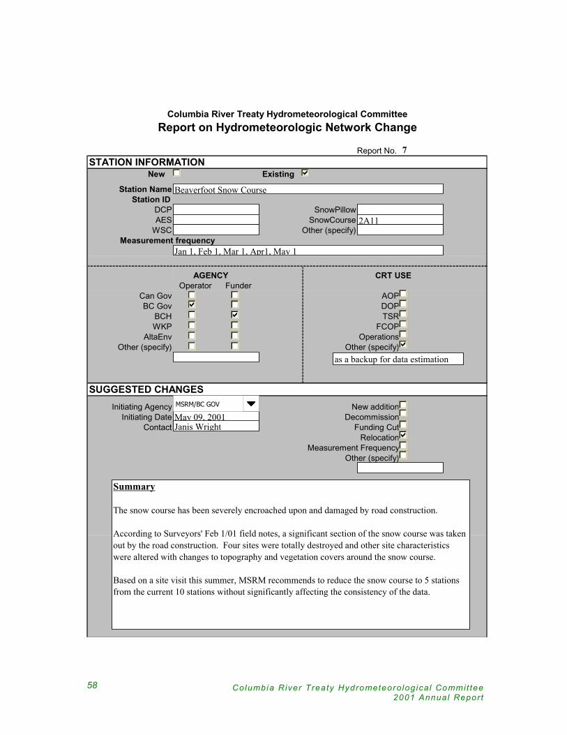
Columbia River Treaty Hydrometeoro log ica l Commit tee2001 Annual Repor t
58
Report No. 7STATION INFORMATION
New Existing
Station NameStation ID
DCP SnowPillowAES SnowCourse
WSC Other (specify)Measurement frequency
AGENCY CRT USEOperator Funder
Can Gov AOPBC Gov DOP
BCH TSRWKP FCOP
AltaEnv OperationsOther (specify) Other (specify)
SUGGESTED CHANGESInitiating Agency New addition
Initiating Date DecommissionContact Funding Cut
RelocationMeasurement Frequency
Other (specify)
Columbia River Treaty Hydrometeorological CommitteeReport on Hydrometeorologic Network Change
Beaverfoot Snow Course
2A11
Jan 1, Feb 1, Mar 1, Apr1, May 1
as a backup for data estimation
May 09, 2001Janis Wright
MSRM/BC GOV
Summary
The snow course has been severely encroached upon and damaged by road construction.
According to Surveyors' Feb 1/01 field notes, a significant section of the snow course was taken out by the road construction. Four sites were totally destroyed and other site characteristics were altered with changes to topography and vegetation covers around the snow course.
Based on a site visit this summer, MSRM recommends to reduce the snow course to 5 stations from the current 10 stations without significantly affecting the consistency of the data.

59
Report No. 7CORRESPONDENCE LOG
Notify EntityBPA
USACEDate of Notification
ACTIONS BY ENTITIESNo action required by entities
Modify modelsRequire other agencies to modify station
Require other agencies to relocate stationPending
Change measurement frequency toChange operating agency to
Change funding agency to
REVIEW AND APPROVALCRTHMC U.S. SECTION
NAME SIGNATURE DATE
CRTHMC CANADIAN SECTION
Columbia River Treaty Hydrometeorological CommitteeReport on Hydrometeorologic Network Change
May 11, 2001
Summary
Notification was sent out by E. Weiss to N. Stephan and J. Barton. Reply from Kevin Berghoff of NWS NWRFC dated 22 May 2001 indicates that the station is used as a backup for estimation of missing data.
Summary
The station is used by BCH and US NWS River Forecast Center as a backup for estimating missing data. Both Canadian and US entities can accept the proposed changes to the station. BCH will continue funding for this snow course.
Rudd Turner (USACE)
Nancy Stephan (BPA)
Eric Weiss (BCH)

Columbia River Treaty Hydrometeoro log ica l Commit tee2001 Annual Repor t
60
Report No. 8STATION INFORMATION
New Existing
Station NameStation ID
DCP SnowPillowAES SnowCourse
WSC Other (specify)Measurement frequency
AGENCY CRT USEOperator Funder
Can Gov AOPBC Gov DOP
BCH TSRWKP FCOP
AltaEnv OperationsOther (specify) Other (specify)
SUGGESTED CHANGESInitiating Agency New addition
Initiating Date DecommissionContact Funding Cut
RelocationMeasurement Frequency
Other (specify)
Columbia River Treaty Hydrometeorological CommitteeReport on Hydrometeorologic Network Change
Redfish Creek near Kootenay River Snowpillow
RFC 490231BA
Hourly data transmitted every 3 hours
September 4, 2001Jim Whyte
MSRM/BC GOV
Summary
A Snowpillow was installed at the Redfish Creek climate station, 6 km North of Harrop Ferry, in the West Arm of Kootenay Lake, on Redfish Cr, for the coming 2001/02 snow season. The original climate station was established about 4 years ago for studies by BC Ministry of Forestry. The station is at elevation 2070 m.

61
Report No. 8CORRESPONDENCE LOG
Notify EntityBPA
USACEDate of Notification
ACTIONS BY ENTITIESNo action required by entities
Modify modelsRequire other agencies to modify station
Require other agencies to relocate stationPending
Change measurement frequency toChange operating agency to
Change funding agency to
REVIEW AND APPROVALCRTHMC U.S. SECTION
NAME SIGNATURE DATE
CRTHMC CANADIAN SECTION
Columbia River Treaty Hydrometeorological CommitteeReport on Hydrometeorologic Network Change
Nov 13. 2001
Summary
Summary
Rudd Turner (USACE)
Nancy Stephan (BPA)
Eric Weiss (BCH)

Columbia River Treaty Hydrometeoro log ica l Commit tee2001 Annual Repor t
62
Report No. 9STATION INFORMATION
New Existing
Station NameStation ID
DCP SnowPillowAES SnowCourse
WSC Other (specify)Measurement frequency
AGENCY CRT USEOperator Funder
Can Gov AOPBC Gov DOP
BCH TSRWKP FCOP
AltaEnv OperationsOther (specify) Other (specify)
SUGGESTED CHANGESInitiating Agency New addition
Initiating Date DecommissionContact Funding Cut
RelocationMeasurement Frequency
Other (specify)
Columbia River Treaty Hydrometeorological CommitteeReport on Hydrometeorologic Network Change
Mt Cook Snowpillow at the Snow Course
4901B0A0, MNC 1E02P1E02
Hourly data transmitted every 3 hours
September 4, 2001Janis Wright
MSRM/BC GOV
Summary
MSRM/BC Gov installed a snow pillow at the existing Mt Cook snow course site to start reporting in the coming snow season. They also pulled out the Gamma ray snow sensors that have been tested at this site in 99/00 and 00/01 snow seasons.
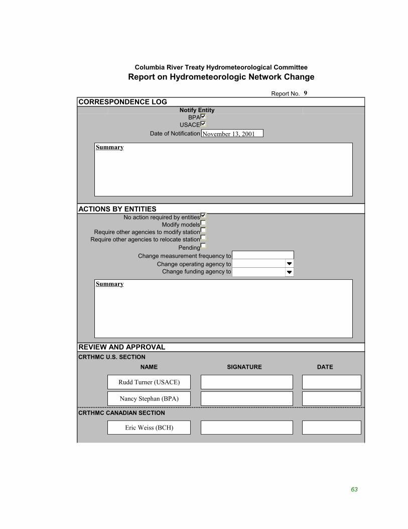
63
Report No. 9CORRESPONDENCE LOG
Notify EntityBPA
USACEDate of Notification
ACTIONS BY ENTITIESNo action required by entities
Modify modelsRequire other agencies to modify station
Require other agencies to relocate stationPending
Change measurement frequency toChange operating agency to
Change funding agency to
REVIEW AND APPROVALCRTHMC U.S. SECTION
NAME SIGNATURE DATE
CRTHMC CANADIAN SECTION
Columbia River Treaty Hydrometeorological CommitteeReport on Hydrometeorologic Network Change
November 13, 2001
Summary
Summary
Rudd Turner (USACE)
Nancy Stephan (BPA)
Eric Weiss (BCH)


65
C O L U M B I A R I V E R T R E A T Y
H Y D R O M E T E O R O L O G I C A L C O M M I T T E E
2 0 0 1 A N N U A L R E P O R T
Appendix F Correspondence
Relevant correspondence in 2001 includes:
CRT Entit ies. 2001/06/20. Letter to PEBCOM in support of CRTHMC
proposed strategy for future updates to Committee
documents.
PEBCOM. 2001/10. Approval letter to CRT Entity Coordinators for
CRTHMC’s report entit led, ‘Proposed Strategy for Future
Updates of Committee Documents’

Columbia River Treaty Hydrometeoro log ica l Commit tee2001 Annual Repor t
66
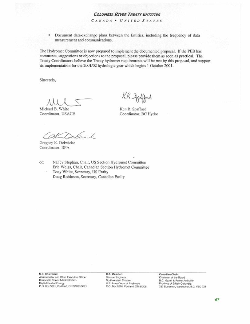
67

Columbia River Treaty Hydrometeoro log ica l Commit tee2001 Annual Repor t
68