Embed Size (px)
Citation preview
Teviot Road, Greenbank138-168 Teviot Road, 456-520 Greenbank Road & 96-102 Brightwell Street, Greenbank
Prepared for
Mirvac Qld
By
Rob Friend & Associates Pty ltd
November 2016
Bushfire Hazard Assessment and Fire Management Plan
PLANS AND DOCUMENTS referred to in the PDA DEVELOPMENT APPROVAL
Approval no:Date:
DEV2016/7682 June 2017
ii
RF15-022 – Teviot Road Greenbank – Bushfire Hazard Assessment and Management Plan 4 November 2016
Rob Friend & Associates Pty ltd
Document Management
Quality Assurance StatementRevision
No.Author Status
Approved for IssueName Date
01 Rob Friend Draft Rob Friend, Director, RF&A Pty. Ltd. 3 November 201602 Rob Friend FINAL Rob Friend, Director, RF&A Pty. Ltd. 4 November 2016
This document has been prepared solely for the benefit of Mirvac Qld, its sub-consultants and Economic DevelopmentQueensland (EDQ) is issued in confidence for the purpose only for which it is supplied which is to provide informationwith regard to bushfire hazards, mitigation and management within the properties identified in this document.Unauthorised use of this document in any form whatsoever is prohibited. No liability is accepted by Rob Friend &Associates Pty Ltd or any employee, contractor or sub-consultant of this company with respect to its use by any otherperson.
This disclaimer shall apply notwithstanding that, the document may be made available to other persons for anapplication for permission or approval or to fulfil a legal obligation.
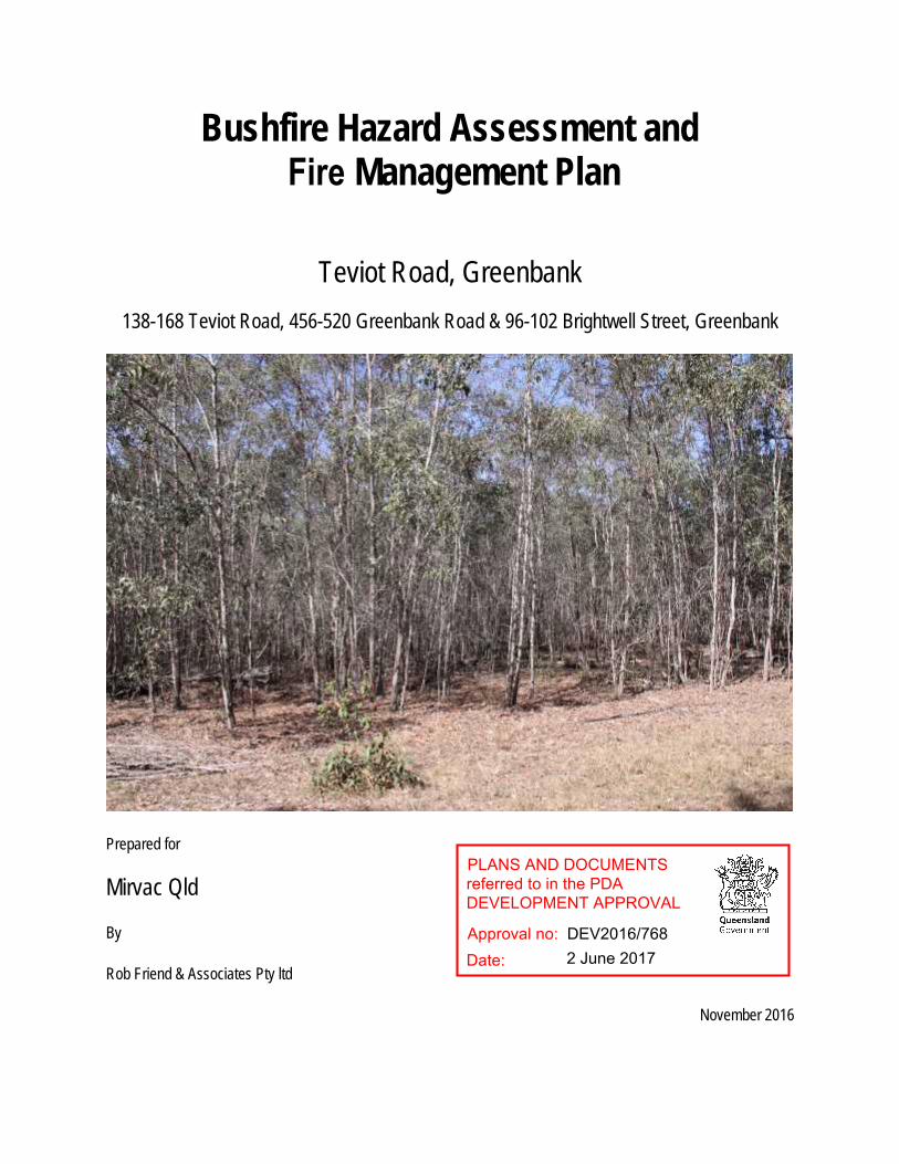
Photograph cover page – Photograph of a typical Acacia regrowth area covering much of the property.
1
RF15-022 – Teviot Road Greenbank – Bushfire Hazard Assessment and Management Plan 4 November 2016
Rob Friend & Associates Pty ltd
Table of Contents
Introduction.................................................................................................................................................. 2Site description............................................................................................................................................ 2
General location.......................................................................................................................................................2Topography..............................................................................................................................................................2Existing Vegetation .................................................................................................................................................2
Development proposal ................................................................................................................................ 3Bushfire Hazard Assessment ..................................................................................................................... 3Bushfire Management Plan......................................................................................................................... 4Appendix A – Figures.................................................................................................................................. 5
2
RF15-022 – Teviot Road Greenbank – Bushfire Hazard Assessment and Management Plan 4 November 2016
Rob Friend & Associates Pty ltd
Introduction
This Bushfire Hazard Assessment and Fire Management Plan has been prepared for Mirvac Qld with respect to thedevelopment application over Area 1 and the immediate vicinity as identified in Figure 1 (see Appendix A). The footprintof Area 1 is located within Mirvac’s Greenbank land holding as identified below:
96-102 Brightwell Street, Greenbank described as Lot 205 on RP845844 (15.9284 ha.), 138-168 Teviot Road, Greenbank, described as Lot 434 on RP845844 (400.8 ha), and 456-520 Greenbank Road, Greenbank, described as Lot 9 on S312355 (64.75 ha).
This fire management plan seeks to provide a number of bushfire management actions with regard to Area 1 of thedevelopment.
Site description
General location
The property is located to the east of Teviot Road, and north of Greenbank Road, Greenbank. To the east is a Councilmanaged bushland park, Wearing Park, along with rural residential allotments primarily accessible from GreenhillRoad, Greenbank. To the north are rural and rural residential allotments around Brightwell Street and Campbell Road.Rural properties also abut the site along its southern boundary and to the west is Teviot Road.
The property has had a history of cattle use prior to the settlement and transfer of land to Mirvac Qld. It is noted thatbalance areas of the property awaiting future development will continue to be managed for rural residential/agriculturalpurposes including the grazing of cattle.
Area 1 is located in the south-western portion of the site abutting Teviot Road and Greenbank Road and within an areawhich has been previous cleared for cattle agistment and as such within an area of low bushfire hazard.
Access to the development will be via a new road from the existing Teviot Road / Pub Lane, Greenbank intersection.
Topography
The landform within this area generally slopes from west to east.
Existing Vegetation
Area 1 is located within a portion of the site that is predominantly clear pastoral land. Such pastoral land is defined asthe area to the south and west of the EPBC excision boundary as shown on Figure 2 of Appendix A.
The pastoral areas within the EPBC excision boundary can be classed as grassland, however depending on rainfalland the commencement of bulk earth works within the property, this grassland may grow to become a hazard.
The hazards presented by this grassland, if it is permitted to grow, prior to being developed maybe sufficient to involvethe adjacent open forests or other bushlands on neighbouring properties as well as produce significant quantities of

3
RF15-022 – Teviot Road Greenbank – Bushfire Hazard Assessment and Management Plan 4 November 2016
Rob Friend & Associates Pty ltd
smoke which could be a safety hazard for vehicles on the surrounding road network. Notwithstanding the above, there-stocking of the property with beef grazing cattle supplemented by slashing (where required) will assist in managingthe abovementioned hazards.
Development proposal
The proposal is to undertake the development of an area identified on the proposal plans as “Area 1”. Area 1 is locatedin the western portion of 138-168 Teviot Road, Greenbank (Lot 434 on RP845844 covering an area of 400.8 hectares)(see Figure 1 of Appendix A).
Area 1 consists of two types of residential uses, Residential – Standard and Residential – Interface Lots – South. Inaddition to the two residential areas, Area 1 will also see part of the Regional Open space/Recreation area establishedin the eastern and lower portions of this area.
It is noted that the proposal will also see the establishment of a 100-metre-wide maintained buffer around the perimeterof the Area 1 footprint and as such no residential lot will be within 100 metres of any area of mapped potential bushfirehazard area.
All hazardous vegetation within the EPBC excision boundary will be cleared on commencement of site works in Area1. This clearing is addressed in technical reporting by Saunders Havill Group in support of the Area 1 developmentapplication.
Bushfire Hazard Assessment
Existing
The Natural Hazards Risks and Resilience - Bushfire hazard area mapping provided by the State Planning Policy ofApril 2016, maps areas of High and Medium potential bushfire intensity over some of the area over which Area 1 willbe developed (see Figure 2).
Post Clearing
The post clearing area within the EPBC excision boundary can be classified as grassland. Therefore, this area isconsidered to be an area of low bushfire risk.
However, areas of medium and high potential bushfire intensity remain outside the EPBC excision area after the EPBCexcision area has been cleared. A 100m potential hazard buffer is required from such medium and high potentialbushfire intensity areas. The post clearing medium and high potential bushfire intensity areas and buffers are shownon Figure 3 of Appendix A.
Figure 3 shows that all residential allotments in Area 1 are outside the potential hazard buffer and are thereforeclassified as having a low bushfire risk, or not in a bushfire prone area.

4
RF15-022 – Teviot Road Greenbank – Bushfire Hazard Assessment and Management Plan 4 November 2016
Rob Friend & Associates Pty ltd
Bushfire Management Plan
No residential allotments in Area 1 are in a bushfire prone area in the post clearing scenario. Therefore, no residentialallotments within Area 1 will be required to be assessed against the Australian Standard Building in a Bushfire ProneArea, AS3959-2009 once such clearing works are complete.
The following land management specifications have been made to ensure the management of the area within theEPBC excision boundary is such that this area remains as an area of low bushfire hazard.
1. The 100-metre-wide buffer is to be maintained by slashing at regular intervals such that the vegetation withinthe buffer is maintained at all times, less than 200 mm in height.
2. A 6-metre-wide fire trail is to be established along the outer edge of the 100-metre-wide buffer and setbackfrom that edge by a maximum of 10 metres. This space allows for effective zone within which to conduct anybushfire suppression operations by Emergency Services if and when required.
3. The fire trail is to have access for Emergency Service and maintenance contractors from: -a. Teviot Road via a locked gateb. Greenbank Road via a locked gatec. At least four points from the internal road network including from the end of the main boulevard road.
This point is to ensure access is directly available to the north and east of this dead end of theboulevard roadway.
4. In the event of a bushfire commencing within the properties owned by Mirvac Qld, the Property Caretaker isto ensure the locked gates which provide access from Teviot and Greenbank Roads are unlocked. However,a key is to be provided to the Greenbank Rural Fire Brigade for their purpose and to enable access at all timesfor any purpose involving the management of bushfire within the whole property.
5
RF15-022 – Teviot Road Greenbank – Bushfire Hazard Assessment and Management Plan 4 November 2016
Rob Friend & Associates Pty ltd
Appendix A – Figures
Figure 1 – Overall Land use plan including Area 1
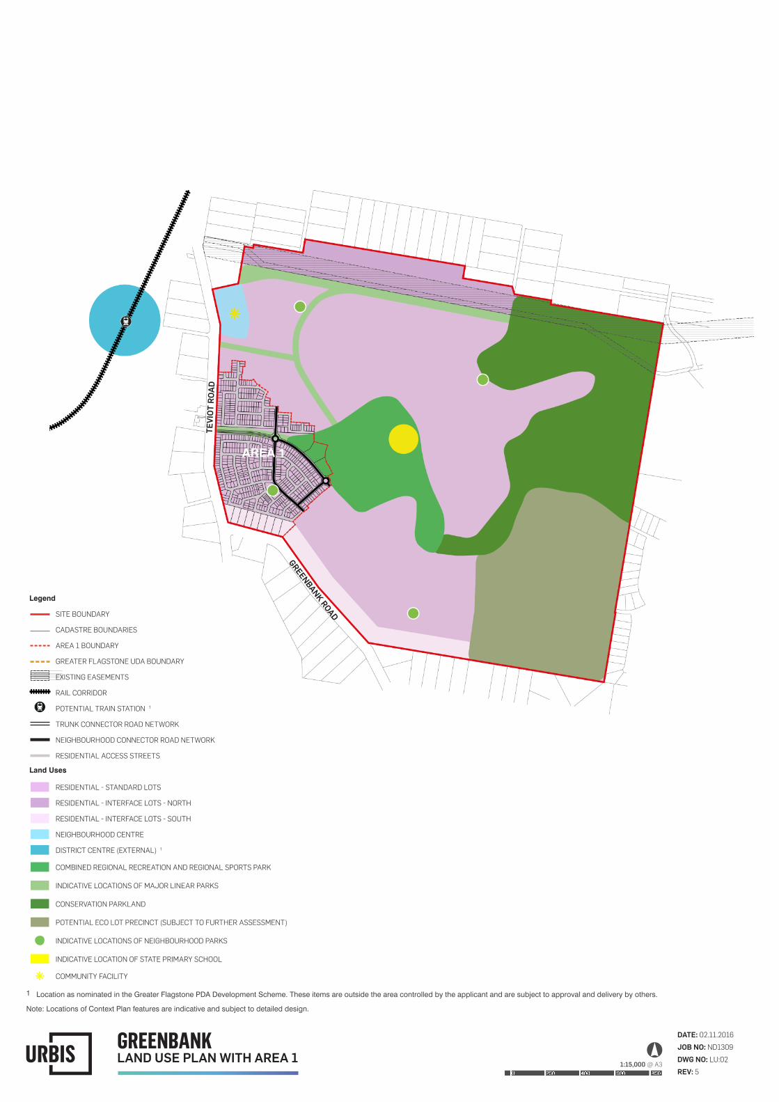
DATE: 02.11.2016JOB NO: ND1309DWG NO: LU:02REV: 5
GREENBANKLAND USE PLAN WITH AREA 1 1:15,000 @ A3
GREENBANK ROAD
TEVI
OT R
OAD
AREA 1
Legend
SITE BOUNDARY
CADASTRE BOUNDARIES
AREA 1 BOUNDARY
GREATER FLAGSTONE UDA BOUNDARY
EXISTING EASEMENTS
RAIL CORRIDOR
POTENTIAL TRAIN STATION 1
TRUNK CONNECTOR ROAD NETWORK
NEIGHBOURHOOD CONNECTOR ROAD NETWORK
RESIDENTIAL ACCESS STREETS
Land Uses
RESIDENTIAL - STANDARD LOTS
RESIDENTIAL - INTERFACE LOTS - NORTH
RESIDENTIAL - INTERFACE LOTS - SOUTH
NEIGHBOURHOOD CENTRE
DISTRICT CENTRE (EXTERNAL) 1
COMBINED REGIONAL RECREATION AND REGIONAL SPORTS PARK
INDICATIVE LOCATIONS OF MAJOR LINEAR PARKS
CONSERVATION PARKLAND
POTENTIAL ECO LOT PRECINCT (SUBJECT TO FURTHER ASSESSMENT)
INDICATIVE LOCATIONS OF NEIGHBOURHOOD PARKS
INDICATIVE LOCATION OF STATE PRIMARY SCHOOL
COMMUNITY FACILITY
1 Location as nominated in the Greater Flagstone PDA Development Scheme. These items are outside the area controlled by the applicant and are subject to approval and delivery by others.
Note: Locations of Context Plan features are indicative and subject to detailed design.

7
RF15-022 – Teviot Road Greenbank – Bushfire Hazard Assessment and Management Plan 4 November 2016
Rob Friend & Associates Pty ltd
Figure 2 – Bushfire hazard plan – Area 1 – Pre-clearing

DATE: 03.11.2016JOB NO: ND1309DWG NO: BF:01REV: -
GREENBANKBUSHFIRE HAZARD PLAN - AREA 1 - EXISTING 1:15,000 @ A3
GREENBANK ROAD
TEVI
OT R
OAD
AREA 1
Legend
SITE BOUNDARY
CADASTRE BOUNDARIES
AREA 1 BOUNDARY
EPBC EXCISION BOUNDARY
HIGH POTENTIAL BUSHFIRE INTENSITY
MEDIUM POTENTIAL BUSHFIRE INTENSITY
POTENTIAL IMPACT BUFFER (100M)
9
RF15-022 – Teviot Road Greenbank – Bushfire Hazard Assessment and Management Plan 4 November 2016
Rob Friend & Associates Pty ltd
Figure 3 - Bushfire hazard plan – Area 1 – Post-clearing land within the EPBC excision boundary

DATE: 03.11.2016JOB NO: ND1309DWG NO: BF:03REV: 1
GREENBANKBUSHFIRE HAZARD PLAN - AREA 1 - POST CLEARING 1:4,000 @ A3
GREENBANK ROAD
TEVI
OT R
OAD
AREA 1
100
100
100
100
100
100
100
100
100
Legend
SITE BOUNDARY
CADASTRE BOUNDARIES
AREA 1 BOUNDARY
EPBC EXCISION BOUNDARY
HIGH POTENTIAL BUSHFIRE INTENSITY
MEDIUM POTENTIAL BUSHFIRE INTENSITY
POTENTIAL IMPACT BUFFER (100M)