Embed Size (px)
Citation preview
2 • Introduction to East Asian Cartography
NATHAN SIVIN AND GARI LEDYARD
SCOPE
"Asia" is a peculiarly European notion. It is an eccentricone by, say, Indian or Chinese standards. Asians seldomfind the idea of Asia meaningful unless they have adoptedWestern categories of thought, and with them Europeanways of lumping things together. The word describes anonentity. Asia is not a continent; it is divided by topographic obstacles almost impassable before moderntimes; it embraces a rich assortment of societies, cultures,and states; and through history it has juxtaposed someof the world's richest and poorest, as it does today.
Nor has any word resembling "East Asia" expressed asense of unity among the countries that have drawn onChinese institutions, ideologies, and techniques. The termdid not exist in the vocabularies of any of its peoplesuntil it was introduced from the West. We find no counterpart of "Europe" or "Western civilization" reflectinga shared consciousness, part of everyone's identity, thatdoes not stop at frontiers. Except for Buddhist pilgrims,itinerant merchants, and occasional diplomats, EastAsians, especially the ruling classes, stayed at home.
Whether the idea of East Asia has any value for thehistory of cartography depends on how one defines it.As a general term for Asia east of the great mountainousbarriers, it has no significance beyond geography. 'Someof the cultures of that region adapted Chinese institutionsand creeds, and others responded to the influence of Indiaas borne by Hinduism and Buddhism. The borderbetween these two zones shifted through history. CentralVietnam remained part of the Indianized Champa stateuntil the 1470s, and the Mekong basin belonged to theKhmer world until the mid-eighteenth century. "EastAsia" has of course been defined and redefined to fitvarious geopolitical ambitions. Those who pushed theGreater East Asia Co-Prosperity Sphere, that watchwordof Japanese territorial ambitions in 1940-41, would havebeen delighted to include India.
"East Asia" is useful mainly as a cultural label. Wemean by it the parts of Asia that were governed by asystem based more or less on the bureaucratic hereditarymonarchy of China. The connection was more than political. In these countries the elite before this century gen-
23
erally were educated in the Chinese classics and literature,wrote in classical Chinese, and were exposed to NeoConfucianism. The last began as a quest for private selfcultivation leading to conscientious public lives, based onthe teachings of Zhu Xi (1130-1200) and others. It keptthat emphasis in independent lineages, but these influenced only a minority of intellectuals. The upper crustgenerally accepted and enforced state-sponsored orthodoxies based on rigid authoritarian interpretations ofZhu's philosophy, beginning in China early in the fourteenth century. In the fifteenth century in Korea and Vietnam, and in the seventeenth century in Japan, the statebegan promoting such orthodoxies. The illiterate orbarely literate majority of the population were indirectlyaffected by the shared "Confucian" ideology of their rulers. Unlike the peoples of Southeast Asia, they directlyexperienced Buddhism in its Mahayana version, asrecorded in Chinese-language canons that literate priestsand monks studied.
These "East Asian" characteristics unite China, Japan,Korea, and Vietnam, the last with qualifications.Although these influences did not strongly affect thesouthernmost parts of its modern territory until aboutfive hundred years ago, the northern part entered theChinese cultural sphere in the second century B.C.
Through history the north was repeatedly conquered andrepeatedly fought free of Chinese control. Its elite evenwhen independent wrote in the Chinese language, andcontinued to do so for some time after all of Vietnambecame a French colony in 1884.
To sum up, despite its geographic and political shortcomings, "East Asia" is unobjectionable as a cultural designation. That suits the needs of this volume. Some mapsare geographic, but cartography is culture.
As the authors make clear, mapmaking and map usein the four countries have been locally diverse, but beforethe twentieth century they were as marked by commonalities as what we find in Europe (which is, after all, asmaller part of the world). But those commonalities donot extend to Southeast Asia-Thailand, Cambodia,Laos, Burma, and Malaya-and so our remarks do notextend to it either. As for the Mongol and Manchu peoples of northeast Asia and the Tibetans, on the whole

24
their elites depended on China for neither language norforms of governance. When Mongols and Manchus conquered part or all of their rich agricultural neighbor, however, their leaders quickly grasped both language andbureaucracy. That does not make them essentially EastAsian in culture, but this volume is an obvious place forreports on Greater Tibet and (more briefly) Mongolia.
THE VARIETY OF EAST ASIA
To assume that adaptations of Chinese culture made EastAsia uniform would leave us unable to account for thedistinct visual worlds that the maps in this volume reveal.Vietnam, Korea, and Japan had their own cultures longbefore they came under Chinese cultural influence. Theirmaterial cultures, from food and housing to ceramics andmetal-working; their archaic ruling structures; their religious traditions, both ancestral rituals and popular formsof reverence for nature and gods; the vernaculars in whichthey spoke, thought, and remembered: all of these differed fundamentally.
The people of these countries were not passive recipients of Chinese influence. They welcomed it at times, atother times rejected it, l and to a remarkable degreedecided for themselves what suited their own circumstances. Buddhism and then N eo-Confucianism indeedbecame a cultural cement, but despite their dependenceon common canons they varied locally in importantways.2 Chinese popular religion had some influence onfolkways elsewhere, but its specialized outgrowthDaoism (which borrowed extensively from esotericTibetan religion and other traditions of Buddhism) hadpractically none.3
Another example of discriminate appropriation is classical Chinese itself. Koreans, Japanese, and Vietnamesemade it a language of learning much as Europeans didLatin, but what they recorded would not have beenunderstandable in many respects to Chinese contemporaries. In any case few Chinese were curious about foreignwritings. They also used the written characters to transcribe their own vernaculars, eventually abbreviating andstylizing them to form the Japanese kana and Vietnamesechuv-nom scripts. The alphabet that has replaced Chinesegraphs in Korea is an essentially independent invention,and modern Vietnamese still use the spelling that theFrench imposed on them.
These adaptations are scarcely surprising. It is naturalto think of China as a homogeneous cultural and politicalunit, but it is too large for that, even today. Just as dynastic change was often barely felt in distant provinces, thediversity of which we have just given examples is mirroredwithin the country. We can, for instance, find consistentlocal variations in the writing of classical Chinese, and
Introduction to East Asian Cartography
recorded dialects used graphs (some of them not foundin so-called Mandarin) in idiosyncratic ways. Just as histories of all Europe are not a staple genre, it is becomingclear that China is too large for much of the generalization customary among historians.4 The linguisticallydiverse peoples of the isolated southern provinces alsochose and adapted from the culture of the political andcommercial centers.
Thus we see that East Asia did not begin as culturallyChinese, and as every reader knows, it did not end thatway. After discussing the ancient Chinese terminologyfor maps, we will return to the cartographic multiplicitythat these civilizational differences bred. (For a generalized time line of East Asian history, see table 2.1.)
TERMS
The Chinese written language was, until about the thirdcentury B.C., largely built on the idea that (proper namesaside) one word should be expressed by one graph. Thisled to magnificent concision, but since the number ofgraphs remained limited, it meant that a given graph mightstand for many related ideas. Ambiguity was later avoidedby combining graphs to make compounds; but in the firstphases of writing, one avoided it by making sure thecontext was specific. Chinese writers did that with greatskill. The problem with reading the early classics is notgenerally that their diction is unclear, but that scholarstoday know too little about the resonances of individual
1. On this point see, for example, Masayoshi Sugimoto and DavidL. Swain, Science and Culture in Traditional Japan: A.D. 600-1854(Cambridge: MIT Press, 1978). This book organizes its narrative aroundalternating periods of "cultural waves," first from China and then fromEurope, and periods in which contacts with foreign countries were cutoff as new ideas and usages were assimilated.
2. It is well known that this is true of Buddhism. There has beenmuch less comparative study of Confucianism, but see in particularWilliam Theodore de Bary and Irene Bloom, eds., Principle and Practicality: Essays in Neo-Confucianism and Practical Learning (NewYork: Columbia University Press, 1979).
3. Except, remarkably, among peoples on the non-Mahayana southern periphery of China. This topic has only recently come under activescrutiny by anthropologists. See Michel Strickmann, "The Tao amongthe Yao: Taoism and the Sinification of South China," in Rekishi niokeru minshu to bunka: Sakai T adao Sensei koki shukuga kinen ronshu (Peoples and cultures in Asiatic history: Collected essays in honorof Professor Tadao Sakai on his seventieth birthday) (Tokyo: KokushoKankokai, 1982), 23-30. The peoples studied in northeast Thailand andLaos are non-Han but originated within the historical borders of China.We refer to the Daoist religious movements, not to the early philosophicclassics that became part of the common literary heritage first of EastAsia and then of the world.
4. The most widely used set of smaller units are the physiographic"macroregions" of G. William Skinner. His most eloquent argumentfor a history based on them is his "The Structure of Chinese History,"Journal of Asian Studies 44 (1985): 271-92.
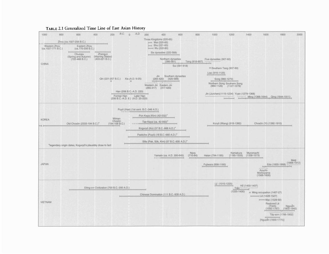
TABLE 2.1 Generalized Time Line of East Asian History
1000 800 600 400 200 B.C. o A.D 200 400 600 800 1000 1200 1400 1600 1600 2000
Song (960-1279)
Northern Song Southern Song(960-1126) (1127-1279)
Southern Tang (937-60)
Liao (916-1125)1
Northern dynasties Five dynasties (907-60), (386-581) I I Tang (618-90V '"I v I - -
Sui (581-618)
Jin Southern dynasties(265-420) (420-589)
I I I I- ~..-A--,
Western JIO Eastem Jin(265-317) (317-420)
Three Kingdoms (220-65)I-( Wei (220-65)_ Shu (221-63)_ Wu (222-80)
Six dynasties (222-589)
Xia (A.D. 9-25)i ~
Chunqlu Zhan9uo(Spring and Autumn) (Warring States)
(722-468 B.C.) (403-221 B.C.)
Oin (221-207 B.C.)M
CHINA
Zhou (ca.1027-256 B.C.)•• I
Western Zhou Eastern Zhou(ca.1027-771 B.C.) (ca.770-256 B.C.)
Han (206 B.C-A.D 220)
Former Han Later Han(206 aC.-A.D. 8) (AD. 25-220)
JIO (Jurchen)(1115-1234) Yuan (1279-1368)~ I'~ Min911368-1644) 10;n,9I1644.-1911)
puy6.~H.a~) (1st cent. B.C.-346 A.D.)
Pon Kaya (Kim) (42-532)"
KOREA
~Old ChosOn (2333-194 B.CY
WimanChosOn
(194-108 B.C.)- •••• Tae Kaya (ca. 42-562f I
KoguryO (Ko) (37 B.C.-668 A.D.)'
Kory6 (Wang) (918-1392) Chown (Yi) (1392-1910)
Paekche (Puy6) (18 B.C.-660 A.DY
'legendary ongm dates; Kogury6's plausibly close to fact
SlIIa (Pak, $Ok, Kim) (57 B.C.-935 A_D.)'~ •.,_.-. I
"'-,Azuchi
Momoyama(1568-1600)
JAPAN
NaraYarnato (ca, A.D. 300-645) (71Q-84) Heian (794-1185)•••• I .....-ciol----;..--.....
, FUjiwara (858-1160) 1
Kamakura Muromachi(1185-1333) (1338-1573)
·_I~"'--- MeljiEdo (1600-1868) l1868-1912)
l--rl
I-
VIETNAM
D6ng-<tn Civilization (700 B.C.-200 AD.)
Chinese Domination (111 B.C.-939 AD.)
,Ly (101Q-1225) , H6 (1400-1407)
.r..~n~(1225-1400) M Ming occupation (1407-27)
_LA (1428-152V_ M~c (1528-92)
Restored LA(T~nh) Ngyutin
(1592-1787) I 1(1802-194,5)... - ~----""'- ~ --,lay-son (1788-1802)
[Nguytin (1600-1775)]
26
words to interpret them as readers did when they werewritten. In all four societies literacy (defined by contemporary standards) was rare, and the elite tended to sharegreat provinces of allusion and symbol.
Nevertheless, in reading ancient documents one oftencomes across a word that, regardless of context, refersto what modern readers consider two or more quite different things. It would be foolish to assume that thelanguage of the time was incapable of resolving the ambiguity. As we can see in one instance after another, thelinguistic ambiguity is there because the ancients' convictions about what ought to be kept separate do nothappen to agree with ours. We can learn from this equivocality if we are attentive to their opinions about thefitness of things without being distracted by our own.The etymology of "map" is a case in point.
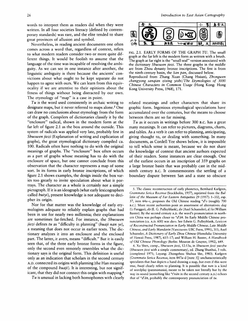
Tu is the word used consistently in archaic writing todesignate maps, but it never referred to maps alone.5 Onecan draw no conclusions about etymology from the formof the graph. Compilers of dictionaries classify it by the"enclosure" radical, shown in the modern form at thefar left of figure 2.1 as the box around the outside. Thissystem of radicals was applied very late, probably first inShuowen jiezi (Explanation of writing and explication ofgraphs), the great etymological dictionary compiled ca.100. Radicals often have nothing to do with the originalmeanings of graphs. The "enclosure" box often occursas a part of graphs whose meaning has to do with theenclosure of space, but one cannot conclude from thisobservation that the character represents a map of somesort. In its forms in early bronze inscriptions, of whichfigure 2.1 shows examples, the design inside the box varies too greatly to invite speculation about what it portrays. The character as a whole is certainly not a simplepictograph. If it is an ideograph (what early lexicographerscalled huiyi), present knowledge is not adequate to decipher its origin.
Nor for that matter was the knowledge of early etymologists adequate to reliably explain graphs that hadbeen in use for nearly two millennia; their explanationsare sometimes far-fetched. For instance, the Shuowenjiezi defines tu as "difficulty in planning" (huaji nan ye),a meaning that does not occur in earlier texts. The dictionary analyzes it into an enclosure and the enclosedpart. The latter, it avers, means "difficult." But it is easilyseen that, of the three early bronze forms in the figure,only the second even remotely resembles what the dictionary says is the original form. This definition is usefulonly as an indication that scholars in the second centuryA.D. connected its origins with planning (the Han meaningof the compound huaji). It is interesting, but not significant, that they did not connect this origin with mapping.6
Tu is unusual in lacking both homophones with clearly
I ntroduction to East Asian Cartography
11]~.1' t-'-~~:i--~~=--~-~':"-----f~---I-~ __~
O~ ----~-=------a.;.;.~;;...-..-.;."".;~~.....t...=.w.__::...:::::J..,;...;...;.;..l,.~:u.
FIG. 2.1. EARLY FORMS OF THE GRAPH TV. The smallgraph at the far left is the modern form as written with a brush.The graph at far right is the "small seal" version associated withthe dictionary Shuowen jiezi. The three graphs in the middleare from Zhou dynasty bronze inscriptions. The first is fromthe ninth-century basin, the San pan, discussed below.Reproduced from Zhang Xuan (Chang Hsiian), Zhongwenchangyong sanqian zixing yishi/The Etymologies of 3000Chinese Characters in Common Usage (Hong Kong: HongKong University Press, 1968), 171.
related meanings and other characters that share itsgraphic form. Ingenious etymological speculations haveaccumulated over the centuries, but the means to choosebetween them are so far missing.
Tu as it occurs in writings before 300 B.C. has a greatmany meanings. It can refer to pictures, diagrams, charts,and tables. As a verb it can refer to planning, anticipating,giving thought to, or dealing with something. In manydocuments, as Cordell Yee shows below, it is impossibleto tell which sense is meant, because we do not sharethe knowledge of context that ancient authors expectedof their readers. Some instances are clear enough. Oneof the earliest occurs in an inscription of 359 graphs ona large bronze basin that was probably cast in the midninth century B.C. It commemorates the settling of aboundary dispute between San and a state so obscure
5. The classic reconstruction of early phonetics, Bernhard Karlgren,Grammata Serica Recensa (Stockholm, 1957), reprinted from the Bulletin of the Museum of Far Eastern Antiquities 29 (1957): 1-332, esp.37, item 64a-c, proposes the Old Chinese reading *d'o (roughly 700B.C.). More recent authorities posit an assortment of alternatives: dag(Li Fanggui), do (E. G. Pulleyblank), da (Axel Schuessler), d/la (WilliamBaxter). By the second century A.D. the word's pronunciation in northern China was perhaps closer to *d'an. Its Early Middle Chinese pronunciation (ca. A.D. 600) was dwo. See Edwin G. Pulleyblank, Lexiconof Reconstructed Pronunciation in Early Middle Chinese, Late MiddleChinese, and Early Mandarin (Vancouver: UBC Press, 1991), 311; AxelSchuessler, A Dictionary of Early Zhou Chinese (Honolulu: Universityof Hawaii Press, 1987), 615-17; and William H. Baxter, A Handbookof Old Chinese Phonology (Berlin: Mouton de Gruyter, 1992), 649.
6. Xu Shen, comp., Shuowen jiezi, 12:13a, in Shuowen jiezi yuezhu(Shuowen jiezi with a simple commentary), ed. Zhang Shunhui, 3 vols.(completed 1971; Loyang: Zhongzhou Shuhua She, 1983). Karlgren(Grammata Serica Recensa, item 847a-d [note 5]) uncharacteristicallyspeculates that hua depicts a hand drawing a map, but even if this weretrue, huaji clearly refers to planning. It is possible that nan is a kindof wordplay (paranomasia), meant to be taken not literally but by theway its sound (something like *t'nan in the second century A.D.) echoesthat of *d'an, probably the contemporary pronunciation of tu.
Introduction to East Asian Cartography
that it has never found its way into the geographical dictionaries. After officials set up boundary posts andexchanged solemn pledges never to encroach on eachother's territories, a tu was executed. Whether this wasprecisely a map is impossible to say, but the contextmakes it reasonably certain that it was some sort of diagram rather than a written record.?
It is interesting to compare the meanings of tu withthose of its counterparts elsewhere. Late Greek chartes,from which "cartography" derives, refers to a sheet ofpapyrus, and late Latin mappa means "a cloth"; both arewords for the material on which a map is drawn. In themain premodern Islamic languages we find a number ofwords derived from roots for "form," "draw," or"paint," at least as broad in scope as tu. The word formap in most Indian languages, derived from an Arabicword, may mean not only a picture but a general description or report. With respect to tu, China would thus beintermediate in concreteness between Europe and India.8
It shares with modern European languages the overlapof sense between "map" and "plan."
In the fourth and third centuries B.C., nouns beganmore often to take the form of two-character compounds, which restrict the possibilities of ambiguity atthe cost of added information. A number of terms thatmean "map" and nothing else appear beginning at thistime. The most prevalent, ditu, combines tu with di, thecommon graph for land or place.9
The appearance of compound words does not meanwe are no longer frustrated by passages that mayor maynot be about maps. The problem, as the authors of thissection explain, is a matter not of language but of culturalpractice. Graphical maps and informational texts in Chinaform a unit that it is not always possible to dissociate,an important point to which we will return.
CONTENTS
Chapters 3-14 on East Asia use the broad definition of"map" characteristic of this History. They include separate chapters on geographic cartography, with attentionto the cosmological and religious significance of maps,in China, Korea, Japan, and Vietnam, and on celestialcartography in China, Japan, and Korea. The chapters ongeographical maps in China present a strikingly new interpretation of their general character. Its potential utilityfor the history of cartography is so great that it calls forfull statement and documentation. To understand inwhat sense this argument is a new departure, it is necessary to pause briefly over the historiography of Chinesemapmaking. But we should emphasize that the rest ofthe volume is amply innovative in ways that reflect thenew scope and emphases of the series.
27
HISTORIOGRAPHY
Western historical studies in East Asian cartographybegan just after the turn of the century with an essay byChavannes.1o This excellent contextual study of whatwere then the two oldest extant Chinese maps was published in Hanoi and then ignored for decades by European compilers of histories. Chavannes, probably thegreatest Sinologist of his era and certainly the broadest,rather than using the maps primarily to illuminate Songculture, concentrated on the question of accuracy in mapping. So did his successors.
In China the "evidential research" scholars who, beginning in the seventeenth century, undertook a massive critical study of the classical heritage were curious about oldmaps as well as every other relic of antiquity.11 Modernstudies began with two papers in a geological journal in1911.12 A book-length survey by Wang Yong (1958)
7. The San pan is one of the most celebrated bronzes in the oldPalace Museum, now in Taipei. A rubbing is clearly reproduced inChinese Cultural Art Treasures: National Palace Museum IllustratedHandbook, 3d ed. (Taipei: National Palace Museum, 1967), diagram10. Because two characters in the sentence after the one we summarizeare unreadable, the syntax is somewhat uncertain. For translated examples of the earliest meanings, "to plan," "planned," "a plan or map,"see Schuessler, Early Zhou Chinese, 615-17 (note 5). This book adducesonly a few bronze inscriptions, however, and those that document tuare not among them. For additional classical meanings see Karlgren,Grammata Serica Recensa (note 5).
8. See the preface and Ahmet T. Karamustafa, "Introduction toIslamic Maps," in The History of Cartography, ed. J. B. Harley andDavid Woodward (Chicago: University of Chicago Press, 1987-), l:xvxxi, esp. xvi-xvii and nn. 7 and 13, and vol. 2.1 (1992), 3-11, esp. 78.
9. A chapter with this title occurs in the eclectic Guanzi ([Book of]Master Guan), which was compiled in the first century B.C. from materials written as early as the fifth century. The chapter seems to be afragment of a lost military manual and probably belongs to a late stratum. It is translated in W. Allyn Rickett, trans., Guanzi: Political, Economic, and Philosophical Essays from Early China (Princeton: Princeton University Press, 1985-), 1:387-91. Some commentators give dituan alternative sense of terrain (a rare but not unique usage). This ratherthan "maps" may be the meaning of the title. The subject of the chapteris in fact terrain and a number of other concerns of the tactician.Although Rickett does not query the translation "maps," see his remarkson 389.
10. Edouard Chavannes, "Les deux plus anciens specimens de lacartographie chinoise," Bulletin de rEcole Fran~aise d'Extreme-Orient3 (1903): 214-47. Earlier writings on the topic, such as William Huttman, "On Chinese and European Maps of China," Journal of the RoyalGeographical Society 14 (1844): 117-27, are much less adequatelyinformed.
11. For instance, Hu Wei's 1697 reconstruction of a map in the Yugong; see his Yu gong zhuizhi (Using an awl to gauge the depths ofthe Yu gong), in Huang Qing jing jie (Explications of the classics fromthe Imperial Qing, compiled 1825-29), ed. Ruan Juan and Yan Jie,27:53b.
12. Zhang Yi, "Zhongguo gudai ditu zhi bijiao" (A comparison ofancient Chinese maps), Dixue Zazhi 2, no. 5 (1911): 1-8, and Tao
28
largely defined the field but has been partly supersededby a new general history.13
There are now a few specialists, of which the bestknown, in addition to the authors of these chapters, areCao Wanru in China, Mei-ling Hsu in the United States,Funakoshi Akio in Japan, and Yi Ch'an (Chan Lee) inKorea. They share with their predecessors the viewpointof the cartographer or geographer; that is, a concern withancient mapmakers as predecessors of modern mapmaking technique (and, particularly in the People's Republicof China, science). Scholars in East Asia for more thantwo generations have concentrated on finding the documents, setting them in order, and describing them to areadership of cartographers and others. They have studied them as unique objects whose documentary and socialmatrices are only incidentally relevant. This largely antiquarian and philological effort has accelerated with thegeneral growth of institutions in the history of scienceand with the remarkable frequency of important archaeological discoveries since the 1950s.
The positivist view of ancient cartography as a gestatingtechnology is still prevalent in China, Japan, and Korea.14
The philological work is generally high in quality andcontinues to add important sources to the accessiblerecord, but evaluations tend to stress documents and"achievements." This is particularly true in the People'sRepublic of China, where the official view of historymakes science an unproblematically progressive force,and where the imperatives of nationalism prod historiansto find Chinese technical priorities. The result of thisscientism has naturally been an emphasis on geographicinformation, accuracy of scale, and elaboration of mapsigns. There has been little attention to the socioeconomic, aesthetic, and moral dimensions. There has beennone at all to the abstract cosmic diagrams of which JohnHenderson shows the historic importance in chapter 8,or to the maps of visionary space that were important inBuddhist and Daoist practice (see chapter 11 for JapaneseBuddhism, and chapter 15 for Tibetan Buddhism).
The most important inquiry in the West, with not alittle influence in East Asia, has been that of Joseph N eedham. His 1959 essay of sixty-odd pages, "QuantitativeCartography in East and West," was (as the title indicates)no exception to the positivist and progressivist trend, andits "East" was China. But it was pathbreaking in severalrespects. He embedded it in a general reconnaissance ofscience and civilization. It focused on well-informedcomparisons with European mapmaking. Needham'scatholic view of science led him to make religious cosmology, Eastern and Western, an integral part of theinquiry, even though he did not examine it in depth. Hiscuriosity about concrete routes of transmission led himto explore the role of the Islamic world as an interme-
I ntroduction to East Asian Cartography
diary between East and West.1S
Cordell Yee shows below the fundamental flaws inNeedham's demonstration that map grids evolved steadily from the Han up to the point when Chinese practicewas replaced by European methods in the seventeenthcentury. Needham's essay was nevertheless a carefullyarticulated and fully documented argument, meant toencourage and ease studies that would test and improveupon it. In that it succeeded. Because of its erudition, ithas not been superseded in any important respect untilthe survey in this volume, which not only corrects theinterpretive errors of this pioneering work but replacesits problematic with a much more commodious one.
THE MEANS AND ENDS OF CARTOGRAPHY
This volume presents the challenge of several humaniststo views that see mapmaking exclusively as science andtechnology. As Yee puts it, "To achieve literacy in traditional Chinese cartography, one needs grounding in thehistory of science and technology, art, literature, government, economics, religion, and philosophy-in short, thepolymath range of the mapmakers" (p. 228 below). Thisis clearly not a view that excludes or diminishes the technical dimension of mapmaking. Yee sees it as one dimension of a larger picture, none of which will make sensewithout a rounded view.
Maps assuredly have been more or less accurate spatialrepresentations that could guide exploration. But as Yeeremarks below, the fact that Chinese cartography shared"the aesthetic principles of painting and poetry" could
Maoli, "Zhongguo dituxue faming zhi yuanshi ji gailiang jinbu zhi cixu"(The origins of cartographic invention and steps toward reform andprogress in China), Dixue Zazhi 2 (1911): no. 11, 1-9, and no. 13, 19.
13. Wang Yong, Zhongguo ditu shi gang (Brief history of Chinesecartography) (Beijing: Sanlian Shudian, 1958). This is a revision of twochapters in Wang Yong's Zhongguo dilixue shi (History of geographyin China) (1938; reprinted Taipei: Shangwu Yinshuguan, 1974). Fourchapters are translated in Donald J. Marion, "Partial Translation ofChung-kuo ti-t'u shih kang by Wang Yung: A Study of Early ChineseCartography with Added Notes, an Introduction and a Bibliography"(M.A. thesis, Graduate Library School, University of Chicago, 1971).The recent history is Lu Liangzhi, Zhongguo dituxue shi (History ofChinese cartography) (Beijing: Cehui Chubanshe, 1984). The most complete bibliography of essays in the field is in Yan Dunjie, Zhongguogudai kejishi lunwen suoyin 1900-1982 (Index of essays on the historyof ancient Chinese science and technology, 1900-1982) (Nanjing:Jiangsu Kexue Jishu Chubanshe, 1986), 127-32 and 907, 79 items to1982. For Western publications and publications on cartography elsewhere in East Asia one must use more general bibliographies.
14. We do not know what historical research and publication areunder way in Vietnam.
15. Joseph Needham, Science and Civilisation in China (Cambridge:Cambridge University Press, 1954-), vol. 3, with Wang Ling, Mathematics and the Sciences of the Heavens and the Earth (1959), 525-90.
Introduction to East Asian Cartography
provide as adequate a theme for its history as could mensuration (p. 164). An impartial survey of maps' place inhistory cannot privilege one role or another. It is equallyworthy of reflection that they were used for education,for aesthetic appreciation, to express emotional states, torepresent power, to settle disputes, to symbolize submission or subordination, and to promise immortality.Yee is not merely suggesting that all these functions bestudied as part of one picture; he and to varying extentsthe other authors show by example how it can be done.
In considering integrally the uses of mapmaking, Yeereveals again and again the wishful thinking to which thesentimental view of cartography as a technical march ofprogress has led. He does not brush aside, as his predecessors have done, these important facts: that too fewmaps survive from before the eleventh century to permitgeneralizations about practice in the first millennium A.D.,
much less earlier; that it was usual even for careful planimetric maps to show certain features such as mountainsand buildings in elevation; that a consistent scale over awhole map is the exception; that the grid found onChinese maps is not based on a coordinate system but isprimarily an aid for estimating distances between points;and that even so grids were still not the norm in officiallysponsored nineteenth-century maps. To the contrary, hetreats these characteristics as valuable evidence for situating cartography in the culture that created it. He thuscorrects once and for all the common fallacy that culturesthat reward literary, artistic, and bureaucratic pursuitscannot encourage technological achievement.
No one will deny, we are sure, that before we comparethe achievements of two cultures, both ought to beunderstood in their own contexts. It remains true thatthis is practically never done, since it demands of specialists an effort at polymathy of precisely the sort Yeehas described. But his example and those of the otherauthors will no doubt encourage others.
John Henderson's discussion of cosmological diagramsin chapter 8 is also characteristically innovative. He shareswith Yee a strong sense of development and change overthe two-thousand-year life span of imperial China. Hiscontribution provides a model for discussing nongeographical maps. His examination of philosophical cosmology furnishes an interesting contrast with the visionary luxuriance of Indian cosmographic mapping asdescribed by Joseph E. Schwartzberg in chapter 15 ofbook 1 of this volume. In this book Kazutaka Unno andSchwartzberg reveal the Japanese and Tibetan Buddhistvisions of the spiritual macrocosm. F. Richard Stephenson and Kazuhiko Miyajima, both historians of astronomy, provide a great deal of reliable information aboutChinese, Japanese, and Korean star maps. The survey ofKorean cartography by Gari Ledyard is attentive to the
29
cultural and social particularities that have shaped cartography, and to interactions with China and the West.John K. Whitmore has provided the little informationabout mapping in Vietnam that is available in presentpolitical circumstances.
TEXT AND MAP
Another portentous conclusion that emerges from thisvolume is that in the Chinese tradition, and to a largeextent throughout East Asia, the map is not always theappropriate unit of study for the history of cartography.This conclusion was natural as a result of taking seriouslythe characteristics of East Asian maps-unavoidable, thatis, for scholars free of the parochiality that has led manyhistorians of science to take as their task explainingChinese inferiority. Yee and his colleagues make a solidcase that what appear to be limitations of East Asian mapsarise from the fact that they are not used alone but areread in conjunction with text. Regularly it turns out thata map contains little quantitative information. In somecases, of course, the makers were incapable of providingit, but in others they intended their map merely to givea quick impression of spatial relationships alongside atext that itemizes distances and directions in great detail.A map mainly meant to complement verbal description,as was common even in late gazetteers, has no need fora scale.
Anyone familiar with East Asian art is aware that painting and calligraphy, depiction and writing, share methods,materials, languages of gesture, and aesthetics. It isobvious, once Yee points it out, that there is no firm line,even that of convention, between painting and map.Cartography was not the province of specialists. Any magistrate was expected to draw a presentable map when onewas needed, because he was trained to write beautifullyand to paint. His staff would probably do the legworkfor a survey if the map were to be based on a new onerather than on old records, and he might have an artiston his staff, but there is no evidence that even the centralgovernment had a special cartographic staff except whenspecial projects made it necessary to organize one.
It was obviously not easy for a literatus to meet thetechnical demands of mapmaking without a good bit ofexperience. But if gentlemen valued the fusion of description and subjective experience when they saw it in landscape painting (or in the calligraphy of a landscape poem),it is not surprising that they should be willing to combinedepiction of mountains and buildings in elevation, as weexperience them, with an overall view from above. Thisis another instance of the commonsense demand for multiple viewpoints that naturally limited the role of convergent perspective in the Chinese visual arts. The chap-

30
ters in this book make all of this clear. They teach ushow important it is not just to look at the map, but toanalyze the interaction between the graphic depiction andthe legend on the map, and between the map and thetextual description that accompanies it-or, more often,that the map accompanies.
We also learn that the shaping force of China on EastAsian cartography was far from total. Both local practiceand competing influences from elsewhere made the mapsof each country distinct.
Although in China, as we have remarked, grids weremeant primarily for estimating distances, the first grids inKorea (1791) established a countrywide standard.National maps had already been evolving for two generations toward fixed scale and orientation, a uniformgrid for the whole country, and the more or less totalbanishment of text. The two maps developed on thisbasis in the nineteenth century used a grid primarily ascoordinates. Their maker, Kim Chongho, who had notechnical peer among makers of national maps in China,numbered his ranks and files to help users find places.Local maps made by others employed the same coordinate system.
There are many such examples of ideas that originatedin one civilization but were used creatively in another.The science of siting (or "geomancy"), which studies theflow of vital substance (qi) through the contours of theland in order to find dynamically balanced sites for buildings and tombs, was Chinese in origin, but only Koreansused it as a structure for national cartography. Again,Islamic materials that the Chinese had found useful onlyfor a map of the "Great Ming" made it possible for theKoreans to produce a genuine world map, the Kangnido.
Unno's contribution makes clear the profound cartographic difference between Japan's Buddhist and Shintocultures on the one hand and the Chinese and Koreancombination of bureaucracy and "Confucian" orthodoxyon the other. In addition, from the seventeenth centuryon, merchants in the evolving Japanese urban milieu commercialized mapmaking. The travelers who filled theroads could choose from dozens of competing routemaps, all in the colorful Edo style. In China and Korea,mapmaking was seldom tied to exploration, but the Bakufu's agents struggled through voyage after voyage toestablish the outlines of Hokkaido and Sakhalin. Thereis no doubt that Vietnamese cartography, once we knowenough about it, will turn out to be equally distinctive.
Another point previously obscured by wishful thinkingis the extremely limited impact of European cartographicmethods and conceptions in China. In the early seventeenth-century Jesuit missionaries were able, in the exceptional circumstances of the Manchu occupation, todemonstrate the superiority of their eclipse prediction
Introduction to East Asian Cartography
technique and in short order take over the Directorateof Astronomy. They succeeded because they and theirhosts had the same uncomplicated view of what constituted a better prediction.
There was no such agreement about what constitutedthe best map. Chinese mapmakers did not see their taskas projecting a spherical earth on a flat surface using rigorously geometric procedures. They did not see the earthpartitioned by lines of longitude and latitude. They werefamiliar with these concepts long before the missionariesarrived, for their mathematical astronomy used eclipticas well as equatorial coordinates; but they had no reasonto project them on the earth. Their essentially numericalapproach to astronomical prediction did not oblige themto decide whether the earth was flat, discoidal, or spherical. It is not precisely that mapmakers were convincedthe earth was flat: that question did not arise in connection with their work. They simply acted as if they weretransferring points from a very large flat surface to asmaller one.
Chapter 7 takes a fresh look at Chinese maps from theseventeenth century on and shows how little they wereaffected by Western innovation. That is true even thoughthe maps Europeans produced for the 1718 national atlas,based on the Beijing prime meridian, represented the stateof the art. Yee points out that because the eighteenthcentury Jesuit maps rigorously used a standardized scale,they did not need a text that listed distances. They wereamong the first in China that were in principle independent of text. Shen Kuo in the eleventh century hadclaimed hyperbolically that his map of China could ifnecessary be reconstructed from his text; here were mapsfrom which a geography handbook could be read.
But the Jesuit atlas did not change provincial and localpractices; the graticule and scale were not widelyadopted, even in late official maps, and no standard everemerged for local government practices. The modernizerswho spread information about the rest of the world werenot cartographically up to date except in the maps theycopied from foreign publications. Their aim was toimprove policy, not mapmaking. Mixed pictorial modesremained common up to the twentieth century, and thepopularity of religious and magical maps was not threatened. This is understandable given the discrepancy at theend of the imperial era in European and Chinese values,especially those that affected the weight given purelytechnical criteria.
European cartographic methods also had little impactin Korea but a great deal in Japan. Despite the Tokugawaregime's strict policy forbidding contact with foreigncountries, Western maps continued to be imported andcopied, and their sale flourished. Japanese were avid formarine charts, adding new data to the Portuguese orig-
Introduction to East Asian Cartography
inals. They were used for navigation to Southeast Asiaand even became cultural icons, awarded to graduatingnavigators as a sort of diploma.
These differences in response and adaptation open upa broad set of questions about cultural interaction. Inquiries in this direction may yield something better than thetrendy notions of "development" and "technology transfer," which assume that only suicidal irrationality keepsthe "underdeveloped" or "less developed" from following the American path to the promised land.
IMPLICATIONS
It may seem paradoxical that this broader view of mapmaking as more than scientific brings the history of cartography into the mainstream of the history of science. Thelatter field has in recent years moved decisively away fromthe narrow focus on technical concepts and activity thatwas the norm fifty years ago. No longer obsessed by themyth of an unending march of progress, historians ofscience are now much better at explaining how valuespervade theories, what scientific practice shares with therest of human activity, and why the benefits and dangers
31
of applying new knowledge are inseparable.Equally stimulating in this audacious new look at old
maps are its implications for other domains of the historyof cartography. When Yee observes that Chinese mapsare redolent of "power, duty, and emotion," what comesto mind is their lack of uniqueness in this respect. Thisredolence is true of all maps, geographic, cosmological,and religious; they differ in how it is true, and to whatextent.
The studies in this book suggest that scrutinizing everydimension and connection of maps in a way sensitive tothe unity of precision and aspiration is likely to yield amore adequate understanding of cartography in everyplace and time, including our own. There is need formore descriptions of individual maps as elegant andperceptive as these. There remain wonders of the quantitative imagination to be found and admired. But indemonstrating so persuasively that the antiquarian andtechnical approaches alone tempt us into blind alleys,and that a more attentive reading of all the evidence cankeep us out of them, the contributors show how muchcan be gained from the broadened definition of cartography on which this History is based.