Embed Size (px)
Citation preview

NASA ISRO Synthetic Aperture Radar (NISAR)
NISAR Science Workshop – 2014Space Applications Centre
NISAR Mission OverviewTapan Misra (ISRO) & Paul Rosen (JPL)
Space Applications Centre (SAC)
2NISAR Science Workshop, SAC Ahmedabad – 17th & 18th Nov. 2014*Mission Concept – Pre-decisional – for Planning and Discussion Purposes Only
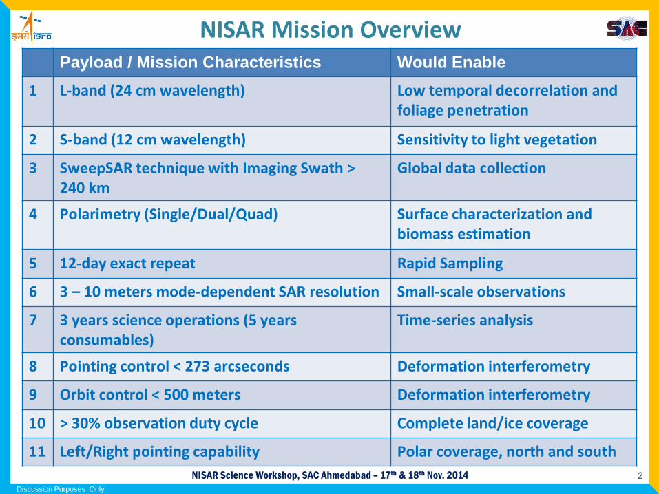
Payload / Mission Characteristics Would Enable1 L-band (24 cm wavelength) Low temporal decorrelation and
foliage penetration
2 S-band (12 cm wavelength) Sensitivity to light vegetation
3 SweepSAR technique with Imaging Swath > 240 km
Global data collection
4 Polarimetry (Single/Dual/Quad) Surface characterization and biomass estimation
5 12-day exact repeat Rapid Sampling
6 3 – 10 meters mode-dependent SAR resolution Small-scale observations
7 3 years science operations (5 years consumables)
Time-series analysis
8 Pointing control < 273 arcseconds Deformation interferometry
9 Orbit control < 500 meters Deformation interferometry
10 > 30% observation duty cycle Complete land/ice coverage
11 Left/Right pointing capability Polar coverage, north and south
NISAR Mission Overview
3NISAR Science Workshop, SAC Ahmedabad – 17th & 18th Nov. 2014
Key Capabilities for NISAR
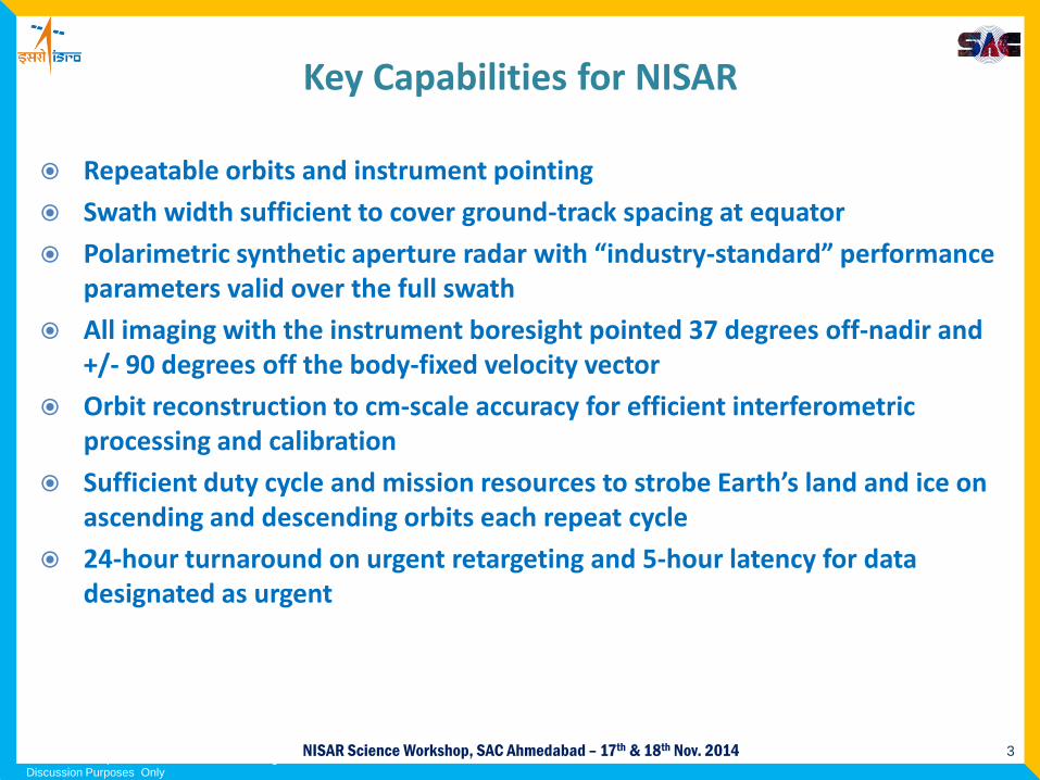
Repeatable orbits and instrument pointing
Swath width sufficient to cover ground-track spacing at equator
Polarimetric synthetic aperture radar with “industry-standard” performance parameters valid over the full swath
All imaging with the instrument boresight pointed 37 degrees off-nadir and +/- 90 degrees off the body-fixed velocity vector
Orbit reconstruction to cm-scale accuracy for efficient interferometric processing and calibration
Sufficient duty cycle and mission resources to strobe Earth’s land and ice on ascending and descending orbits each repeat cycle
24-hour turnaround on urgent retargeting and 5-hour latency for data designated as urgent
*Mission Concept – Pre-decisional – for Planning and Discussion Purposes Only
4NISAR Science Workshop, SAC Ahmedabad – 17th & 18th Nov. 2014
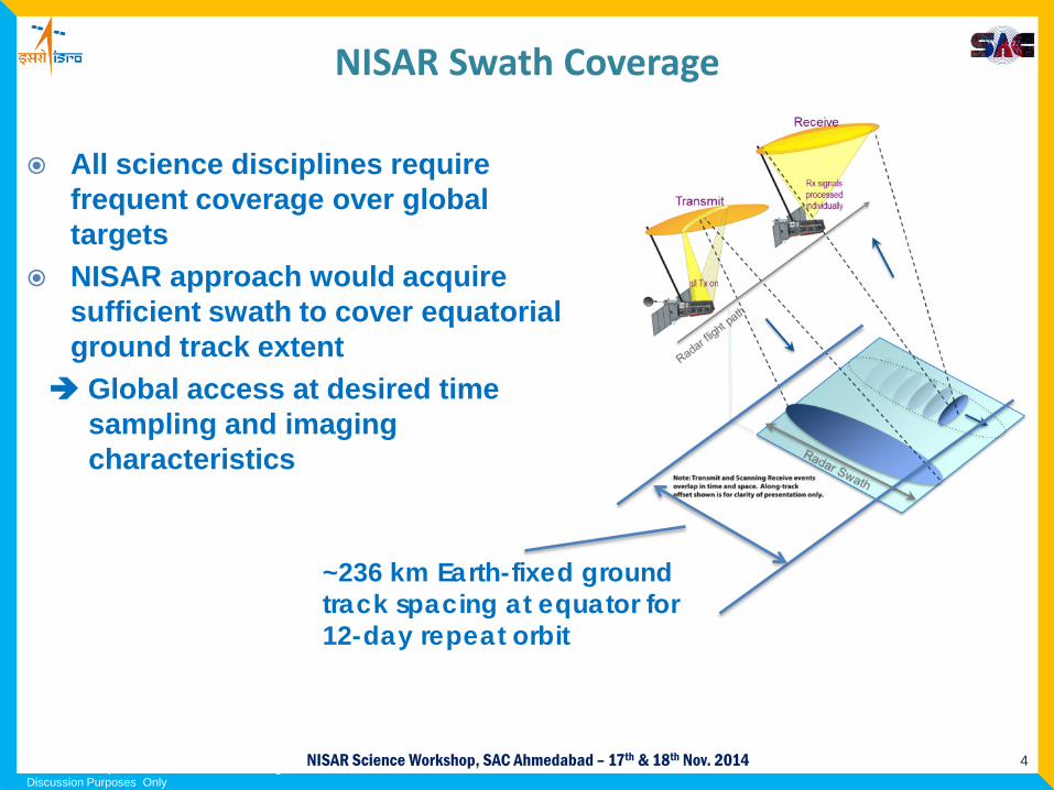
All science disciplines require frequent coverage over global targets
NISAR approach would acquire sufficient swath to cover equatorial ground track extent Global access at desired time
sampling and imaging characteristics
~236 km Earth-fixed ground track spacing at equator for 12-day repeat orbit
*Mission Concept – Pre-decisional – for Planning and Discussion Purposes Only
NISAR Swath Coverage
6NISAR Science Workshop, SAC Ahmedabad – 17th & 18th Nov. 2014
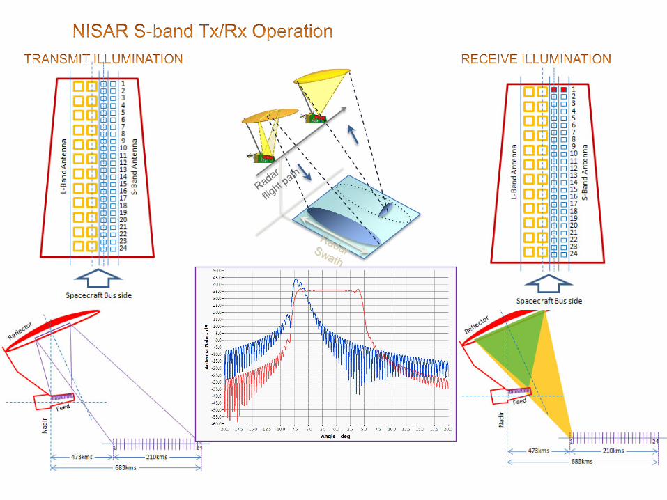
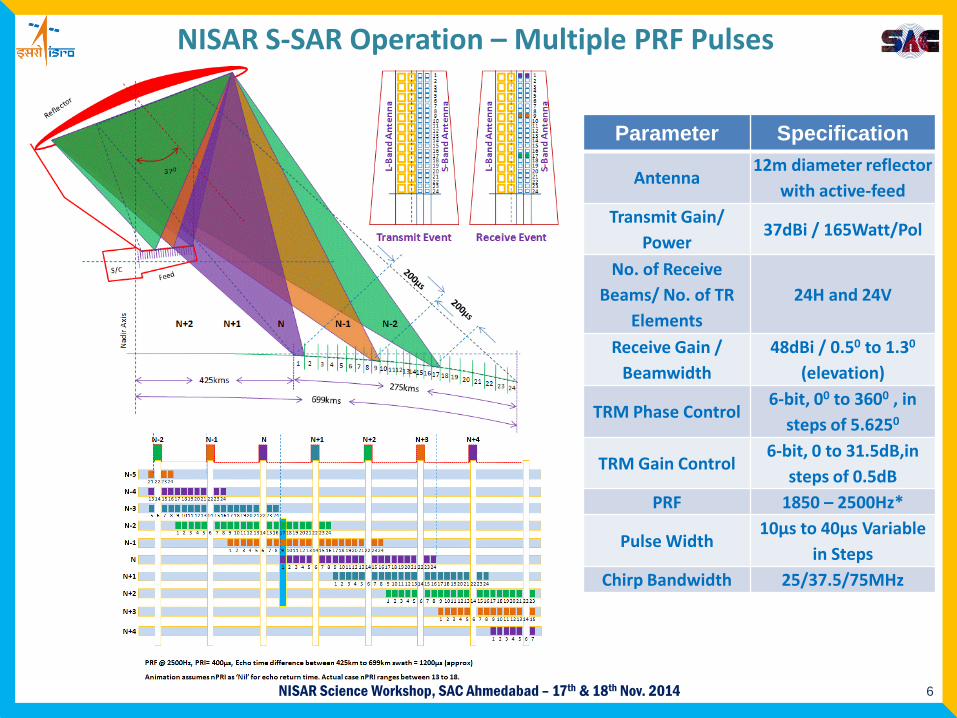
NISAR S-SAR Operation – Multiple PRF Pulses
Parameter Specification
Antenna12m diameter reflector
with active-feedTransmit Gain/
Power37dBi / 165Watt/Pol
No. of Receive Beams/ No. of TR
Elements24H and 24V
Receive Gain / Beamwidth
48dBi / 0.50 to 1.30
(elevation)
TRM Phase Control6-bit, 00 to 3600 , in
steps of 5.6250
TRM Gain Control6-bit, 0 to 31.5dB,in
steps of 0.5dB PRF 1850 – 2500Hz*
Pulse Width10µs to 40µs Variable
in Steps Chirp Bandwidth 25/37.5/75MHz
7NISAR Science Workshop, SAC Ahmedabad – 17th & 18th Nov. 2014
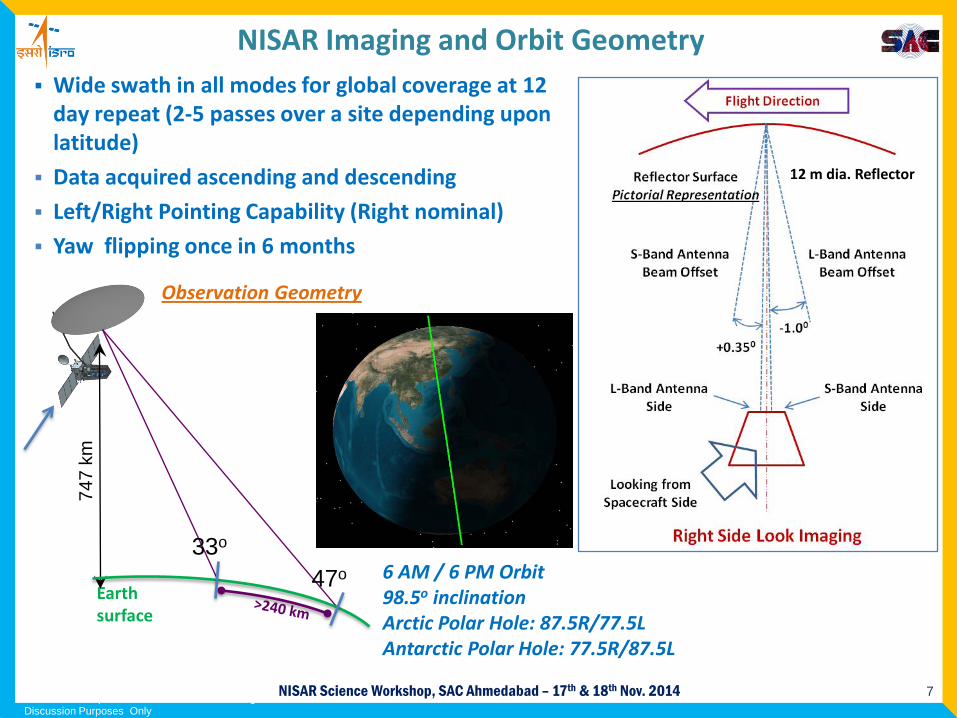
NISAR Imaging and Orbit Geometry Wide swath in all modes for global coverage at 12
day repeat (2-5 passes over a site depending upon latitude)
Data acquired ascending and descending
Left/Right Pointing Capability (Right nominal)
Yaw flipping once in 6 months
747
km
Earth surface
Observation Geometry
12 m dia. Reflector
33o
47o 6 AM / 6 PM Orbit98.5o inclinationArctic Polar Hole: 87.5R/77.5LAntarctic Polar Hole: 77.5R/87.5L
*Mission Concept – Pre-decisional – for Planning and Discussion Purposes Only
8NISAR Science Workshop, SAC Ahmedabad – 17th & 18th Nov. 2014
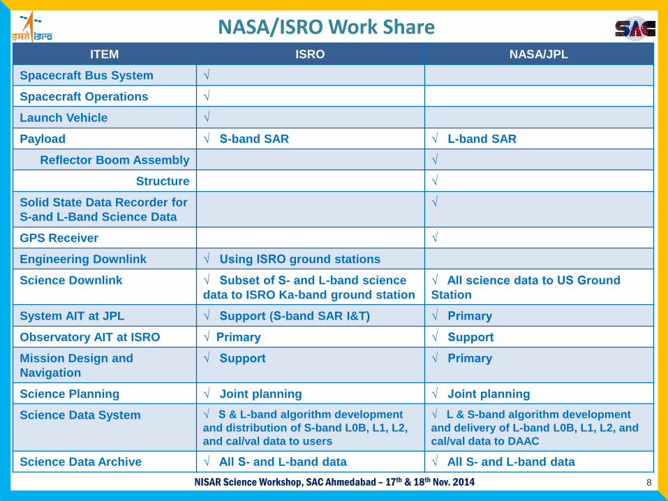
NASA/ISRO Work ShareITEM ISRO NASA/JPL
Spacecraft Bus System √
Spacecraft Operations √
Launch Vehicle √
Payload √ S-band SAR √ L-band SAR
Reflector Boom Assembly √
Structure √
Solid State Data Recorder for S-and L-Band Science Data
√
GPS Receiver √
Engineering Downlink √ Using ISRO ground stations
Science Downlink √ Subset of S- and L-band science data to ISRO Ka-band ground station
√ All science data to US Ground Station
System AIT at JPL √ Support (S-band SAR I&T) √ Primary
Observatory AIT at ISRO √ Primary √ Support
Mission Design and Navigation
√ Support √ Primary
Science Planning √ Joint planning √ Joint planning
Science Data System √ S & L-band algorithm development and distribution of S-band L0B, L1, L2, and cal/val data to users
√ L & S-band algorithm development and delivery of L-band L0B, L1, L2, and cal/val data to DAAC
Science Data Archive √ All S- and L-band data √ All S- and L-band data
9NISAR Science Workshop, SAC Ahmedabad – 17th & 18th Nov. 2014
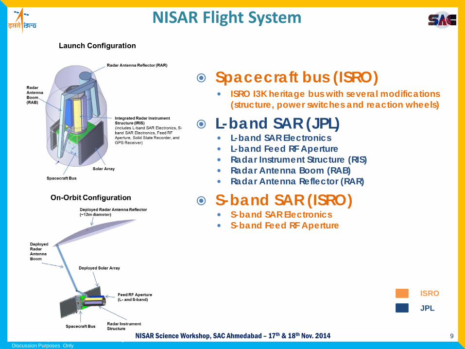
NISAR Flight System
Spacecraft bus (ISRO) ISRO I3K heritage bus with several modifications
(structure, power switches and reaction wheels)
L-band SAR (JPL) L-band SAR Electronics L-band Feed RF Aperture Radar Instrument Structure (RIS) Radar Antenna Boom (RAB) Radar Antenna Reflector (RAR)
S-band SAR (ISRO) S-band SAR Electronics S-band Feed RF Aperture
ISRO
JPL
*Mission Concept – Pre-decisional – for Planning and Discussion Purposes Only
10NISAR Science Workshop, SAC Ahmedabad – 17th & 18th Nov. 2014
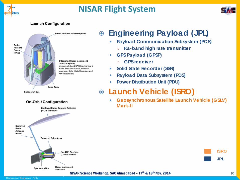
Engineering Payload (JPL) Payload Communication Subsystem (PCS)
○ Ka-band high rate transmitter GPS Payload (GPSP)
○ GPS receiver Solid State Recorder (SSR) Payload Data Subsystem (PDS) Power Distribution Unit (PDU)
Launch Vehicle (ISRO) Geosynchronous Satellite Launch Vehicle (GSLV)
Mark-II
*Mission Concept – Pre-decisional – for Planning and Discussion Purposes Only
ISRO
JPL
NISAR Flight System

11NISAR Science Workshop, SAC Ahmedabad – 17th & 18th Nov. 2014
NISAR Configuration (Stowed)
Radar Antenna Boom -JPL
Radar Antenna Reflector
Radar Instrument Structure
L-band Electronics - JPL
*Mission Concept – Pre-decisional – for Planning and Discussion Purposes Only
S-band Electronics: ISRO
12NISAR Science Workshop, SAC Ahmedabad – 17th & 18th Nov. 2014
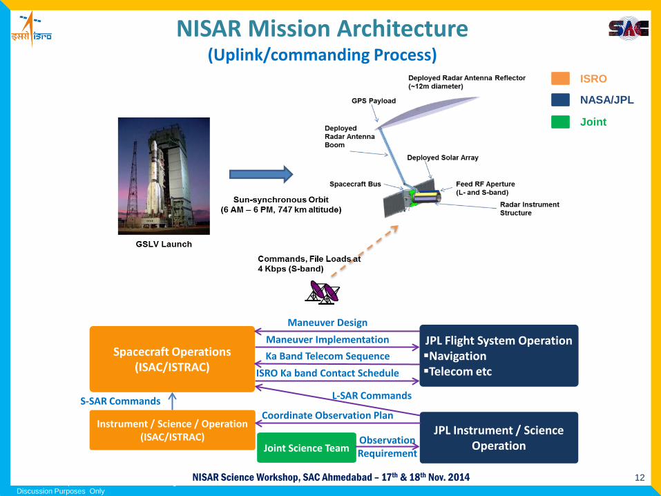
NISAR Mission Architecture(Uplink/commanding Process)
ISRO
NASA/JPL
Joint
*Mission Concept – Pre-decisional – for Planning and Discussion Purposes Only
JPL Flight System OperationNavigationTelecom etc
Spacecraft Operations(ISAC/ISTRAC)
Joint Science Team
Instrument / Science / Operation(ISAC/ISTRAC) JPL Instrument / Science
Operation
Maneuver Design
Maneuver Implementation
ISRO Ka band Contact Schedule
Ka Band Telecom Sequence
L-SAR Commands
Coordinate Observation Plan
Observation Requirement
S-SAR Commands
13NISAR Science Workshop, SAC Ahmedabad – 17th & 18th Nov. 2014
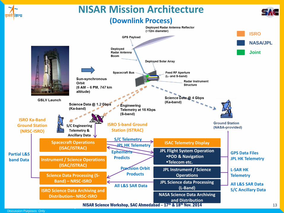
NISAR Mission Architecture(Downlink Process)
*Mission Concept – Pre-decisional – for Planning and Discussion Purposes Only
ISRO
NASA/JPL
Joint
JPL Flight System OperationPOD & NavigationTelecom etc.
Spacecraft Operations(ISAC/ISTRAC)
Instrument / Science Operations(ISAC/ISTRAC)
Science Data Processing (S-Band) – NRSC-ISRO
ISRO Science Data Archiving and Distribution– NRSC-ISRO
ISAC Telemetry Display
JPL Instrument / Science Operations
JPL Science data Processing (L-Band)
NASA Science Data Archiving and Distribution
ISRO Ka-Band Ground Station
(NRSC-ISRO)
Partial L&S band Data
S/C TelemetryJPL HK Telemetry
Ephemeris Predicts
Precision Orbit Products
All L&S SAR Data
GPS Data FilesJPL HK Telemetry
L-SAR HK Telemetry
All L&S SAR DataS/C Ancillary Data
S/C Engineering Telemetry &
Ancillary Data
ISRO S-band Ground Station (ISTRAC)

14NISAR Science Workshop, SAC Ahmedabad – 17th & 18th Nov. 2014
NISAR Observation Concept Science targets are observed in specific fixed modes, with culling at
high latitudes to reduce overlapped data takes
“Background Land” satisfies deformation and biomass objectives
*Mission Concept – Pre-decisional – for Planning and Discussion Purposes Only
Observation Strategy L-band S-band1 Science Target Mode+ Mode2 Background Land DP HH/HV3 Land Ice SP HH4 Sea Ice Dynamics SP VV5 Urban Areas6 US Agriculture QP HH/HV
VV/VH7 Himalayas CP RH/RV8 India Agriculture9 India Coastal Ocean QQP HH/VV
10 Sea Ice Types DP VV/VH
15NISAR Science Workshop, SAC Ahmedabad – 17th & 18th Nov. 2014
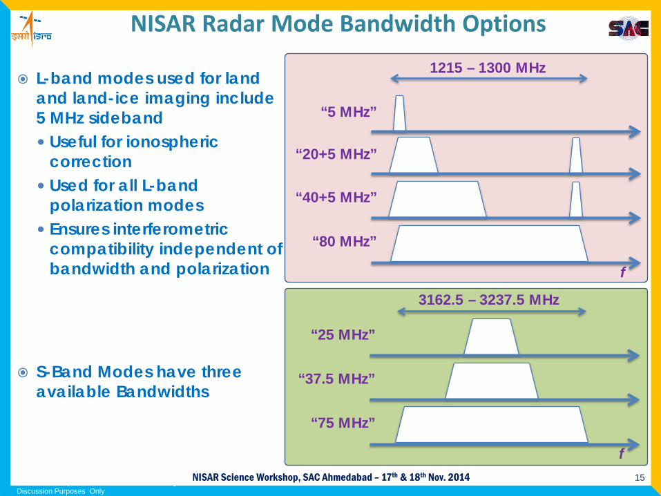
NISAR Radar Mode Bandwidth Options
L-band modes used for land and land-ice imaging include 5 MHz sideband Useful for ionospheric
correction Used for all L-band
polarization modes Ensures interferometric
compatibility independent of bandwidth and polarization
“5 MHz”
“20+5 MHz”
“40+5 MHz”
“80 MHz”
1215 – 1300 MHz
f
“25 MHz”
“37.5 MHz”
“75 MHz”
f
3162.5 – 3237.5 MHz
*Mission Concept – Pre-decisional – for Planning and Discussion Purposes Only
S-Band Modes have three available Bandwidths
16NISAR Science Workshop, SAC Ahmedabad – 17th & 18th Nov. 2014
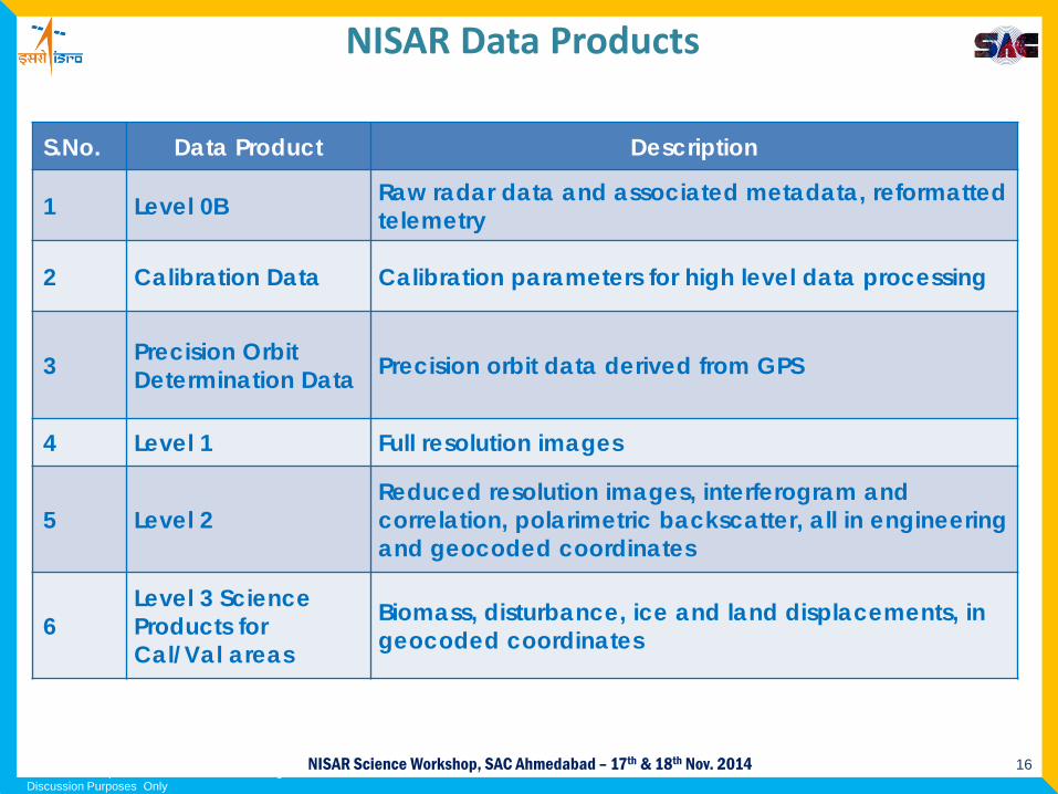
NISAR Data Products
*Mission Concept – Pre-decisional – for Planning and Discussion Purposes Only
S.No. Data Product Description
1 Level 0B Raw radar data and associated metadata, reformatted telemetry
2 Calibration Data Calibration parameters for high level data processing
3 Precision Orbit Determination Data Precision orbit data derived from GPS
4 Level 1 Full resolution images
5 Level 2Reduced resolution images, interferogram and correlation, polarimetric backscatter, all in engineering and geocoded coordinates
6Level 3 Science Products for Cal/Val areas
Biomass, disturbance, ice and land displacements, in geocoded coordinates
17NISAR Science Workshop, SAC Ahmedabad – 17th & 18th Nov. 2014
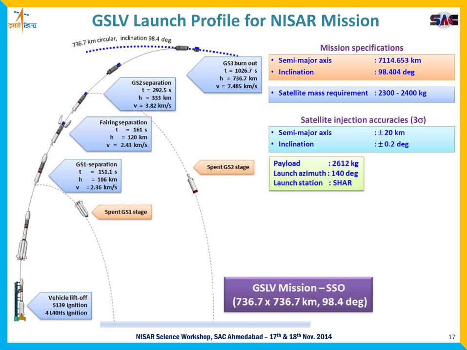
GSLV Launch Profile for NISAR Mission
18NISAR Science Workshop, SAC Ahmedabad – 17th & 18th Nov. 2014
Science Utilization Workshop Goals
Inform and energize larger Indian community of NISAR Encourage scientific partnerships for data utilization Identify leveraging opportunities arising among interagency science
programs Encourage new ways to use NISAR for new science
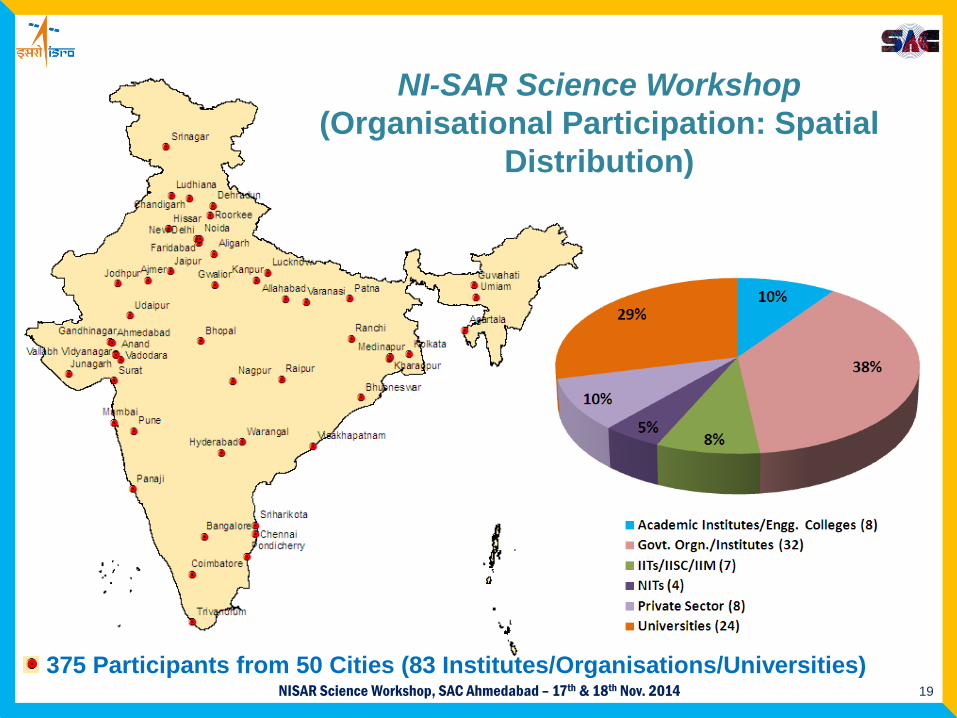
19NISAR Science Workshop, SAC Ahmedabad – 17th & 18th Nov. 2014375 Participants from 50 Cities (83 Institutes/Organisations/Universities)
NI-SAR Science Workshop(Organisational Participation: Spatial
Distribution)
20NISAR Science Workshop, SAC Ahmedabad – 17th & 18th Nov. 2014
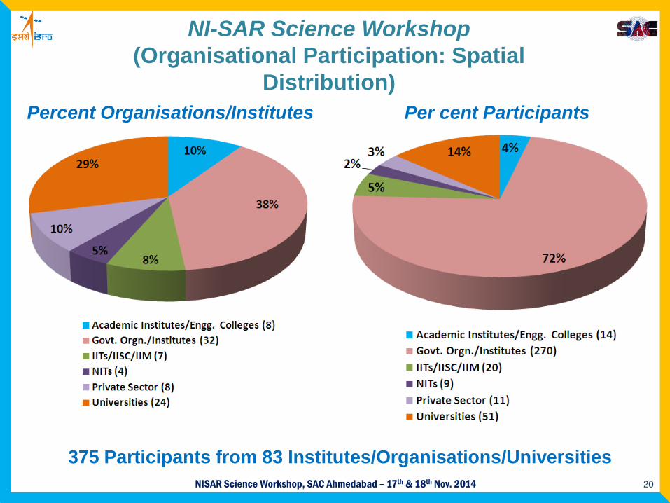
375 Participants from 83 Institutes/Organisations/Universities
NI-SAR Science Workshop(Organisational Participation: Spatial
Distribution)Percent Organisations/Institutes Per cent Participants
21NISAR Science Workshop, SAC Ahmedabad – 17th & 18th Nov. 2014
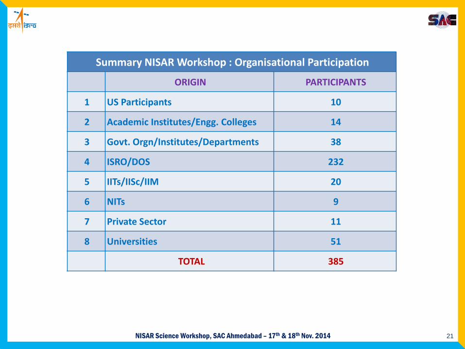
Summary NISAR Workshop : Organisational Participation
ORIGIN PARTICIPANTS
1 US Participants 10
2 Academic Institutes/Engg. Colleges 14
3 Govt. Orgn/Institutes/Departments 38
4 ISRO/DOS 232
5 IITs/IISc/IIM 20
6 NITs 9
7 Private Sector 11
8 Universities 51
TOTAL 385
22NISAR Science Workshop, SAC Ahmedabad – 17th & 18th Nov. 2014
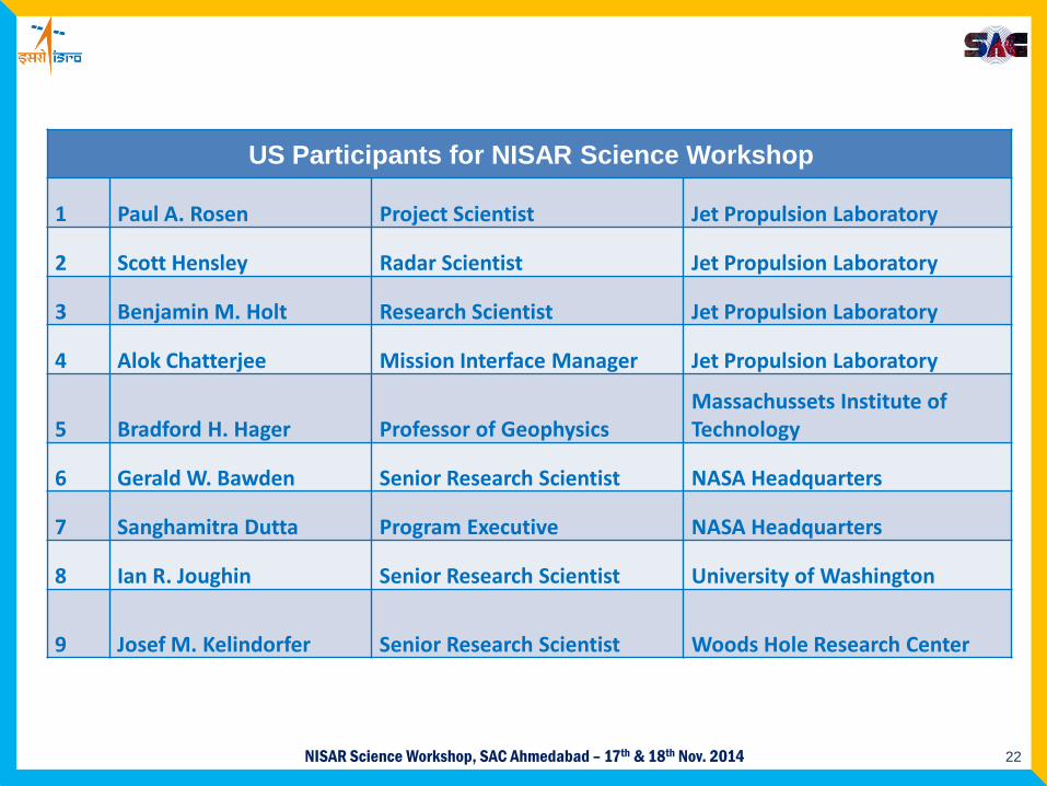
US Participants for NISAR Science Workshop
1 Paul A. Rosen Project Scientist Jet Propulsion Laboratory
2 Scott Hensley Radar Scientist Jet Propulsion Laboratory
3 Benjamin M. Holt Research Scientist Jet Propulsion Laboratory
4 Alok Chatterjee Mission Interface Manager Jet Propulsion Laboratory
5 Bradford H. Hager Professor of GeophysicsMassachussets Institute of Technology
6 Gerald W. Bawden Senior Research Scientist NASA Headquarters
7 Sanghamitra Dutta Program Executive NASA Headquarters
8 Ian R. Joughin Senior Research Scientist University of Washington
9 Josef M. Kelindorfer Senior Research Scientist Woods Hole Research Center
23NISAR Science Workshop, SAC Ahmedabad – 17th & 18th Nov. 2014
Next Slide is a Video
NISAR Mission Overview
Courtesy Dr. Rosen Paul (JPL)

24NISAR Science Workshop, SAC Ahmedabad – 17th & 18th Nov. 2014
25NISAR Science Workshop, SAC Ahmedabad – 17th & 18th Nov. 2014
Thank You

26NISAR Science Workshop, SAC Ahmedabad – 17th & 18th Nov. 2014
Mode # Primary Science Target Freq POL BW [MHz]L1 Background Land L DP HH/HV 20+5L2 Land Ice L SP HH 80L3 Sea Ice Dynamics L SP VV 5L4 Sea Ice Types L DP VV/VH 20+5L5 Urban Areas, Himalayas L DP HH/HV 40+5L6 US & India Agriculture L QP HH/HV/VH/VV 40+5L7 Quasi-Quad Split Spectrum L DP HH/HV 20+ VV/VH 5 20L8 Compact -POL L CP RH/RV 20S1 Solid Earth /Ice/Veg/Coast/Bathymetry S Quasi-Quad 37.5S2 Ecosystem/ Coastal Ocean/ Cryosphere S QDT HH/VV? 25S3 Agriculture /Sea Ice S CP RH/RV 25S4 Glacial Ice – High Resolution S CP RH/RV 37.5S5 Deformation S SP HH (or SP VV) 25S6 Deformation – Max Resolution S SP HH (or SP VV) 75
L5+S4 Glacial Ice – Himalayas L+S L: DP HH/HVS: CP RH/RV
40+537.5
L4+S3 Sea Ice Types L+S L: DP VV/VHS: CP RH/RV
20+525
L6+S3 India Agriculture L+S L: QP HH/HV/VH/VVS: CP RH/RV
40+525
L5+S6 High-Res Deformation(Disaster / Urgent Response) L+S L: DP HH/HV
S: SP HH (or SPVV)40+575
NISAR Science Modes
27NISAR Science Workshop, SAC Ahmedabad – 17th & 18th Nov. 2014
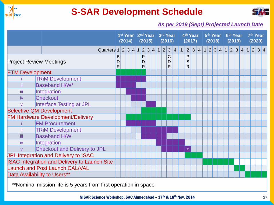
1st Year(2014)
2nd Year(2015)
3rd Year(2016)
4th Year(2017)
5th Year(2018)
6th Year(2019)
7th Year(2020)
Quarters 1 2 3 4 1 2 3 4 1 2 3 4 1 2 3 4 1 2 3 4 1 2 3 4 1 2 3 4
Project Review MeetingsBDR
PDR
CDR
PSR
ETM Developmenti TRiM Developmentii Baseband H/W*iii Integrationiv Checkoutv Interface Testing at JPL
Selective QM DevelopmentFM Hardware Development/Delivery
i FM Procurementii TRiM Developmentiii Baseband H/Wiv Integrationv Checkout and Delivery to JPL #
JPL Integration and Delivery to ISACISAC Integration and Delivery to Launch SiteLaunch and Post Launch CAL/VALData Availability to Users**
**Nominal mission life is 5 years from first operation in space
S-SAR Development ScheduleAs per 2019 (Sept) Projected Launch Date
28NISAR Science Workshop, SAC Ahmedabad – 17th & 18th Nov. 2014
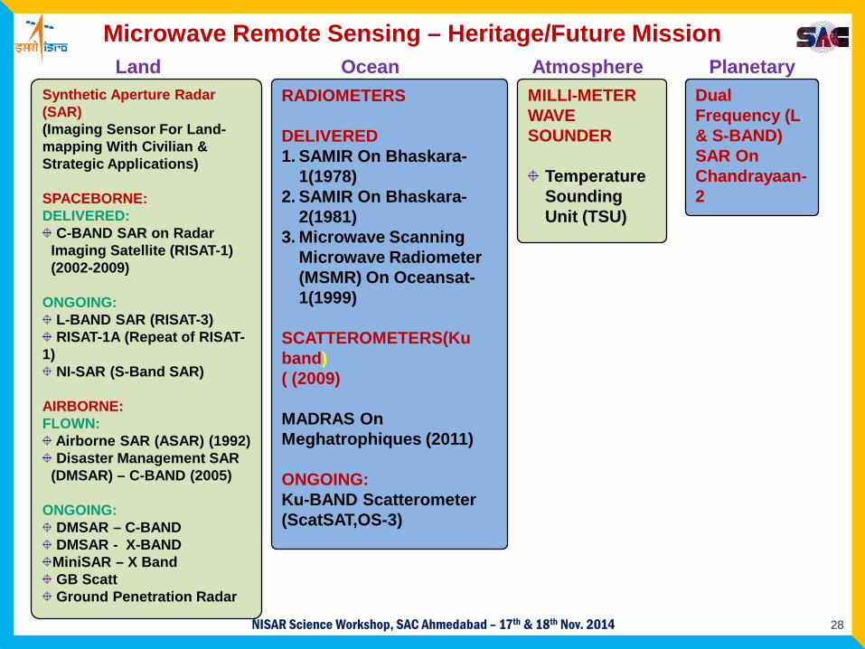
RADIOMETERS
DELIVERED1. SAMIR On Bhaskara-
1(1978)2. SAMIR On Bhaskara-
2(1981) 3. Microwave Scanning
Microwave Radiometer (MSMR) On Oceansat-1(1999)
SCATTEROMETERS(Ku band)( (2009)
MADRAS On Meghatrophiques (2011)
ONGOING:Ku-BAND Scatterometer(ScatSAT,OS-3)
MILLI-METER WAVE SOUNDER
Temperature Sounding Unit (TSU)
Dual Frequency (L & S-BAND) SAR On Chandrayaan-2
PlanetaryLandSynthetic Aperture Radar (SAR)(Imaging Sensor For Land-mapping With Civilian & Strategic Applications)
SPACEBORNE:DELIVERED:
C-BAND SAR on Radar Imaging Satellite (RISAT-1) (2002-2009)
ONGOING:L-BAND SAR (RISAT-3)RISAT-1A (Repeat of RISAT-
1)NI-SAR (S-Band SAR)
AIRBORNE:FLOWN:
Airborne SAR (ASAR) (1992)Disaster Management SAR
(DMSAR) – C-BAND (2005)
ONGOING:DMSAR – C-BANDDMSAR - X-BANDMiniSAR – X BandGB ScattGround Penetration Radar
AtmosphereOceanMicrowave Remote Sensing – Heritage/Future Mission

29NISAR Science Workshop, SAC Ahmedabad – 17th & 18th Nov. 2014
SAC-ISRO SAR Projects – Heritage/Future Mission
Project Freq. Band 20
0120
0220
0320
0420
0520
0620
0720
0820
0920
1020
1120
1220
1320
1420
1520
1620
1720
1820
1920
2020
21
SLAR* XASAR* C
DMSAR* CRISAT-1 C
Ch-II L&SMiniSAR* XRISAT-1A C
L&S Band SAR* L&SNISAR S&L
Operational Phase
Development Phase
Launch Phase
Future Missions
Completed/Operational
*Airborne Missions
Spaceborne Missions