Embed Size (px)
Citation preview
PROPOSED DEVELOPMENT OF PAARL HILLS - MIXED USE
RESIDENTIAL ESTATE, ON PORTION 9 OF FARM RONWE NO. 851
PAARL, WESTERN CAPE
1st DRAFT BASIC ASSESSMENT REPORT
Prepared for:
Mr. Jacob – Frans Muller
Boabab Developments
P.O. Box 880
CapeGate
7550
Tel: 082 850 6160
Email: [email protected]
Prepared by:
Guillaume Nel Environmental Consultants
P.O. Box 2632
Paarl
7620
Tel: (021) 870 1874
Fax: (021) 870 1873
E-mail: [email protected]
GNEC Reference : 20352
DEA&DP Reference: 16/3/3/6/7/1/B3/28/1075/16
Date: 8 July 2016
Table of Contents
Basic Assessment Report In Terms Of The NEMA Environmental Impact Assessment Regulations,
2010 ................................................................................................................................................... 1
ADDENDUM A: MAPS ...................................................................................................................... 86
ADDENDUM B: SITE LAYOUT AND DRAWINGS ............................................................................ 87
ADDENDUM C: SITE PHOTO’S ....................................................................................................... 88
ADDENDUM D: BIODIVERSITY MAP .............................................................................................. 89
ADDENDUM E: LETTERS FROM AUTHORITIES ............................................................................ 90
ADDENDUM F: PUBLIC PARTICIPATION ....................................................................................... 91
ADDENDUM G: SPECIALIST REPORTS ......................................................................................... 92
ADDENDUM H: ENVIRONMENTAL MANAGEMENT PROGRAMME .............................................. 93
ADDENDUM I: TOWN PLANNING APPROVALS ............................................................................. 94
ADDENDUM J: NOTICE OF INTENT TO DEVELOP ........................................................................ 95
List of Figures
Figure 1: Proposed Bulk Water Master Plan (GLS Consulting, 2016) ................................................. 8
Figure 2: Proposed development of Sewer Pipelines (GLS Consulting, 2016) .................................. 10
Figure 3: Existing Access roads to the Property (Element TIA, 2016) ............................................... 12
Figure 4: Location of Proposed Access to the Property (Element Consulting TIA, 2016) .................. 13

First Draft Basic Assessment - Proposed Paarl Hills Development – Portion 9 of Farm Ronwe No. 851
1
1ST DRAFT BASIC ASSESSMENT REPORT
(AUGUST 2010)
Basic Assessment Report In Terms Of The NEMA Environmental Impact Assessment
Regulations, 2010
AUGUST 2010
Kindly note that:
1. This Basic Assessment Report is the standard report required by DEA&DP in terms of the EIA Regulations, 2010 and must be completed for all Basic Assessment applications.
2. This report must be used in all instances for Basic Assessment applications for an environmental authorisation in terms of the National
Environmental Management Act, 1998 (Act No. 107 of 1998) (NEMA), as amended, and the Environmental Impact Assessment Regulations, 2010, and/or a waste management licence in terms of the National Environmental Management: Waste Act, 2008 (Act 59 of 2008) (NEM: WA), and/or an atmospheric emission licence in terms of the National Environmental Management: Air Quality Act, 2004 (Act No. 39 of 2004) (NEM: AQA).
3. This report is current as of 2 August 2010. It is the responsibility of the Applicant / EAP to ascertain whether subsequent versions of
the report have been published or produced by the competent authority.
4. The required information must be typed within the spaces provided in the report. The sizes of the spaces provided are not necessarily indicative of the amount of information to be provided. It is in the form of a table that will expand as each space is filled with typing.
5. Incomplete reports will be rejected. A rejected report may be amended and resubmitted. 6. The use of “not applicable” in the report must be done with circumspection. Where it is used in respect of material information that is
required by the Department for assessing the application, this may result in the rejection of the report as provided for in the regulations. 7. While the different sections of the report only provide space for provision of information related to one alternative, if more
than one feasible and reasonable alternative is considered, the relevant section must be copied and completed for each alternative.
8. Unless protected by law all information contained in, and attached to this report, will become public information on receipt by the
competent authority. If information is not submitted with this report due to such information being protected by law, the applicant and/or EAP must declare such non-disclosure and provide the reasons for the belief that the information is protected.
9. This report must be submitted to the Department at the postal address given below or by delivery thereof to the Registry Office of the
Department. No faxed or e-mailed reports will be accepted. Please note that for waste management licence applications, this report must be submitted for the attention of the Department’s Waste Management Directorate (tel: 021-483-2756 and fax: 021-483-4425) at the same postal address as the Cape Town Office Region A.
10. Unless indicated otherwise, two electronic copies (CD/DVD) and three hard copies of this report must be submitted to the Department.
DEPARTMENTAL DETAILS
CAPE TOWN OFFICE REGION A (Cape Winelands, City of Cape Town: Tygerberg and Oostenberg Administrations)
CAPE TOWN OFFICE REGION B (West Coast, Overberg, City of Cape Town: Helderberg, South Peninsula, Cape Town and Blaauwberg Administrations
GEORGE OFFICE (Eden and Central Karoo)
Department of Environmental Affairs and Development Planning Attention: Directorate: Integrated Environmental Management (Region A2) Private Bag X 9086 Cape Town, 8000 Registry Office 1st Floor Utilitas Building 1 Dorp Street, Cape Town Queries should be directed to the Directorate: Integrated Environmental Management (Region A2) at: Tel: (021) 483-4793 Fax: (021) 483-3633
Department of Environmental Affairs and Development Planning Attention: Directorate: Integrated Environmental Management (Region B) Private Bag X 9086 Cape Town, 8000 Registry Office 1st Floor Utilitas Building 1 Dorp Street, Cape Town Queries should be directed to the Directorate: Integrated Environmental Management (Region B) at: Tel: (021) 483-4094 Fax: (021) 483-4372
Department of Environmental Affairs and Development Planning Attention: Directorate: Integrated Environmental Management (Region A1) Private Bag X 6509 George, 6530 Registry Office 4th Floor, York Park Building 93 York Street George Queries should be directed to the Directorate: Integrated Environmental Management (Region A1) at: Tel: (044) 805 8600 Fax: (044) 874-2423
View the Department’s website at http://www.capegateway.gov.za/eadp for the latest version of this document.
First Draft Basic Assessment - Proposed Paarl Hills Development – Portion 9 of Farm Ronwe No. 851
2
DEPARTMENTAL REFERENCE NUMBER(S)
File reference number (EIA): 6/3/3/6/7/1/B3/28/1075/16
File reference number (Waste):
File reference number (Other):
PROJECT TITLE
PROPOSED DEVELOPMENT OF PAARL HILLS - MIXED USE
RESIDENTIAL ESTATE, ON PORTION 9 OF FARM RONWE NO. 851
PAARL, WESTERN CAPE
DETAILS OF THE ENVIRONMENTAL ASSESSMENT PRACTITIONER (EAP)
Environmental Assessment
Practitioner (EAP): Guillaume Nel Environmental Consultants (GNEC)
Contact person: Guillaume Nel
Postal address: PO Box 2632
Paarl Postal code: 7620
Telephone: 021 870 1874 Cell: 076 684 6566
E-mail: [email protected] Fax: 021 870 1873
EAP Qualifications
MSc En Man (PUK), B(Hons) EN Man (US), B Geography (US), Certificate-
Environmental Law (PUK), Certificate – EIA (PUK), Certificate– EMS 14000
(PUK), Certificate – Air Quality Management (PUK), Certificate–
Environmental Auditing (SABS).
EAP Registrations/Associations SAATCA Certified Environmental Auditor, No. (EMA 375) (2003). Member
of IAIA: ID2406
Details of the EAP’s expertise to carry out Basic Assessment procedures
MSc En Man (PUK), B(Hons) EN Man/GIS (US), B Geography (US), Certificate- Environmental Law
(PUK), Certificate – EIA (PUK), Certificate– EMS 14000 (PUK), Certificate – Air Quality
Management (PUK), Certificate– Environmental Auditing (SABS). Guillaume Nel has fourteen years
relevant experience as an Environmental Assessment Practitioner
First Draft Basic Assessment - Proposed Paarl Hills Development – Portion 9 of Farm Ronwe No. 851
3
EXECUTIVE SUMMARY OF THE CONTENT OF THE BASIC ASSESSMENT REPORT:
Locality: The property is located approximately 3km south east of Paarl CBD, east of the R301
bordered by Drakenstein Road to the north (Please refer to Addendum A for Locality Map). The
subject property’s north / northeastern boundary is along Drakenstein Road that acts as a link Road
between Langenhoven Avenue (R101
Development Proposal: The proposed development will consist of 87 single residential erven, 3
parks (private open space), 396 storage units, a church, gatehouse, a refuse area and a man-made
water reticulation pond in the north-western corner of the property. Parking bays are estimated at
500 for place of worship, 33 bays at the storage yard, 2 parking bays per residential unit and 4 visitor
bays. (Please refer to Addendum B – Site Development Plan).
Access to the property: There are currently two accesses to the subject property, located at
approximately Km 3.9 (Existing Access 2) and Km 4.0 (Existing Access 1). Access to the
development is proposed from Drakenstein Road, approximately 140m west of Existing Access 1
and 230m west of Existing Access 2. The proposed development will only gain access from the
proposed access, Existing Access 1 and Existing Access 2 will not be used to gain access and will
be closed.
Botanical: According to Mucina & Rutherford (2009) the subject property would have historically
been covered in two main vegetation types Boland Granite Fynbos (90%) and Swartland Alluvium
Fynbos (10%). As the property was intensely cultivated no natural vegetation occur on site, also
threatened ecosystems and CBA’s are not present.
Freshwater: An artificial attenuation pond is available in the south western section of the property
and is not incorporated into the new Site Development plan, a new Attenuation pond is designed
and will be located in the north western corner of the site.
Bulk Services: A network upgrade is proposed as the existing infrastructure is under pressure,
however the existing Leliefontein reservoir has sufficient capacity to accommodate the proposed
development. Awaiting confirmation from the Drakenstein Local Municipality.
Heritage: A Notification of Intent to Develop was submitted to Heritage Western Cape (Please refer
to Addendum J – Notice of Intent to Develop). A letter from HWC, dated 4 April 2016, confirmed that
no impact on heritage resources are expected (Case Number: 16031521GT0324E) and “no further
action under Section 38 of the National Heritage Resources Act (Act 25 of 1999) is required”. Please
refer to Addendum E – Letters From Authorities.
Layout 1 (preferred): The total extent of the property is 114 225.60 m2 and the proposed
development includes, 87 Residential Stands approximately 33 064.991 m2, 396 Storage units
approximately 11 548.291 m2, road surface approximately 24 626.774 m2 , 4 open spaces / parks
approximately 11 121.821 m2, gatehouses / security control approximately 308.196 m2, institutional
space approximately 20 000.012 m2, walkways including driveways approximately 11 653.593 m2,
refuse area approximately 252.375 m2, parking bays (place of worship 500 bays, storage yard 33
bays, residential dwellings 2 bays per unit, residential development 4 visitor bays), a servitude /
landscaping buffer approximately 4 380.227 m2 and attenuation pond. (Please refer to Addendum A
– Proposed new Site Development Plan)
First Draft Basic Assessment - Proposed Paarl Hills Development – Portion 9 of Farm Ronwe No. 851
4
SECTION A: ACTIVITY INFORMATION
1. PROJECT DESCRIPTION
(a) Is the project a new development? YES NO
(b) Provide a detailed description of the development project and associated infrastructure.
Background
Boabab Developments (hereafter referred to as the client) wish to develop a medium density
residential estate and storage yard on Portion 9 of Farm Ronwe No. 851. (hereafter referred to as the
property). The property is located approximately 3km south east of Paarl CBD, east of the R301
bordered by Drakenstein Road to the north (Please refer to Addendum A for Locality Map). The
subject property’s north / northeastern boundary is along Drakenstein Road that acts as a link Road
between Langenhoven Avenue (R101).
The total extent of the property 11.4275 Ha and is currently zoned Agriculture in terms of the Paarl
Municipality Zoning Scheme Regulations. This area previously fell under the Section 8 Zoning
Scheme Regulations. An application is made in terms of Section 15 clause (2)(a) and (d) of the
Municipal Land Use Planning By-Law, 2015 for the rezoning and subdivision of Portion 9 of the Farm
No. 851 (Ronwe) from Agricultural Zone I to Subdivisional Area (Land Use Planning Ordinance
Section 8 Scheme Regulations Applicable), in order to establish a residential estate which will
incorporate storage units.
The new zones applicable, as per the site development plan is as follows
Residential Zone I: which include the following land-uses, dwelling-houses (detached building
containing only one dwelling unit).
Institutional Zone II: which include the following land-uses, house of worship (church).
Open Space Zone II: which include the following land-uses, private open space (parks) and
private internal roads.
Special Zone: which would include the following land-uses, storage units. The property is
surrounded mainly by farmland raging from medium to large farms to the north south and
east. The residential development Boschenmeer Golf Estate is located west of the R301.
The proposed development will consist of 87 single residential erven, 3 parks (private open space),
396 storage units, a church, gatehouse, a refuse area and a man-made water reticulation pond in the
north-western corner of the property. Parking bays are estimated at 500 for place of worship, 33 bays
at the storage yard, 2 parking bays per residential unit and 4 visitor bays. (Please refer to Addendum
B – Site Development Plan). The aim of the development is to complement the existing mixture of
residential options by providing well designed residential units at a medium density without
compromising the character of the agricultural and semi-rural nature of the area. This would be
supplemented by storage units; these storage units would be available to rent by the residences of
the development or any private person interested in renting storage space. The proposed medium
density ensures that valuable land within the existing urban edge is optimally used.

First Draft Basic Assessment - Proposed Paarl Hills Development – Portion 9 of Farm Ronwe No. 851
5
Following the development trend of residential zoning towards the property, the property has clearly
been earmarked to be the next development within the urban edge. This has provided the ideal
opportunity for infill development which will contribute to the existing zoning rights of the abutting
Boschenmeer Golf Course and an acceptable zoning in relation to the surrounding agricultural zones.
Topography and Orientation
The topography of the subject property is shaped by a long straight cadastral boundary on the
southern and northern side. On the north-western side, the property has a straight boundary
bordering the neighbouring farm of farm No. 851 Portion 8. The subject property’s moderate contour
intervals allow for various layout designs, as the topography would not be a constraint in the
development. Water drainage will follow the natural fall of the property’s slope towards the lowest
corner (north-western), where a man-made catchment pond will be build.
Overall the site is orientated due to moderate contour intervals creating excellent 360 degree views
toward the surrounding farmland. The orientation allows for good sun penetration, especially in cold
and wet winter months while moderate contour intervals allows for a cooler wind circulation through
the property during the hot summer months. Topography on the property is shaped by a long
cadastral boundary on the southern and northern side. On the north western side the property has an
irregular V-shape which borders neighbouring farms. Due to the historical consecutive poor harvests
on the property, it was financially not viable to farm anymore, therefore all agricultural activities seized
except for a small aged orchard which still remains on the property.
There are two farm dwellings and several farm outbuildings clustered in the southwestern corner of
the subject property. The conditions of the buildings are in a dilapidated state. Besides the farm
outbuildings of which the use is no longer required, the two farm dwellings would be uneconomical to
repair or retrofit. Heritage Western Cape confirmed that the proposed development has no impact on
any heritage resources (Annexure G). As such the existing buildings and structures will not be
incorporated into the proposed development, but will be demolished.
Botanical
According to the National Vegetation Map of South-Africa, Lesotho and Swaziland (Mucina &
Rutherford 2006) the property would historically have been covered in two main vegetation types,
90% Boland Granite Fynbos (FFg2) and 10% Swartland Alluvium Fynbos (Ffa 3).
Boland Granite Fynbos(FFg 2): Classified as Vulnerable (Please refer to Addendum A, Figure 3,
indicated in dark purple), this vegetation occurs on moderately undulating plains and hills, varying
from extensive deep soils, to localised deep soils between large granite domes and sheets. A fairly
dense, 1–2 m tall closed shrubland with occasional low, gnarled trees dotted through the landscape.
A diverse type, dominated by scrub, asteraceous and proteoid fynbos (with Protea repens, P.
burchelli, P. laurifolia with Leucadendron rubrum and L. daphnoides as dominants on drier slopes;
Leucospermum grandiflorum or L. guenzii dominant in seepage areas; and P. neriifolia and
Leucadendron sessile on moist slopes), but with patches of restioid and ericaceous fynbos in wetter
areas. Approximately 14% of the ecosystem is protected in the Hawequas, Hottentots Holland and
Paarl Mountain Nature Reserves, with a further 34% found in Hawequas, Hottentots Holland
First Draft Basic Assessment - Proposed Paarl Hills Development – Portion 9 of Farm Ronwe No. 851
6
mountain catchment areas and Helderberg and Paardenberg Nature Reserves.
Swartland Alluvium Fynbos (Ffa 3) [Critically Endangered] (Addendum A Figure 3, indicated in light
purple). This vegetation occurs in moderately undulating plains, adjacent mountains and in river
basins. The vegetation is a matrix of low, evergreen shrubland with emergent sparse, moderately tall
shrubs and a conspicuous graminoid layer. Proteoid, restioid and asteraceous fynbos types are
dominant, with closed-scrub fynbos common along the river courses. Ericaceous and restioid fynbos
found in seeps. Boundaries are edaphically determined. At least 13 endemic plant species and 57
Red Data List plant species occur in the ecosystem.
As the whole property have been subject to extensive agricultural activities, the property have been
severely disturbed and totally transformed. No naturally occurring vegetation remains on the property
(Please refer to the Addendum A – Vegetation Map).
Freshwater
An artificial catchment pond is present in the south western corner of the property, however as this
serves no purpose for the proposed development it is not included in the SDP. A water reticulation
pond is proposed which will be located in the north western corner of the site. (Please refer to
Addendum A – Maps and Addendum B – Site Development Plan, Stormwater Pond Detail).
Municipal Services
An Engineering Service report has been drafted by Triple Three Engineering Solutions (Pty) Ltd. Civil
services conform to the specifications set out by the Drakenstein Municipality and will be constructed
to the highest standard. All services will effectively tie into the existing municipal networks. The
following sections regarding water provision, sewerage, storm water as per the above mentioned
engineering report.
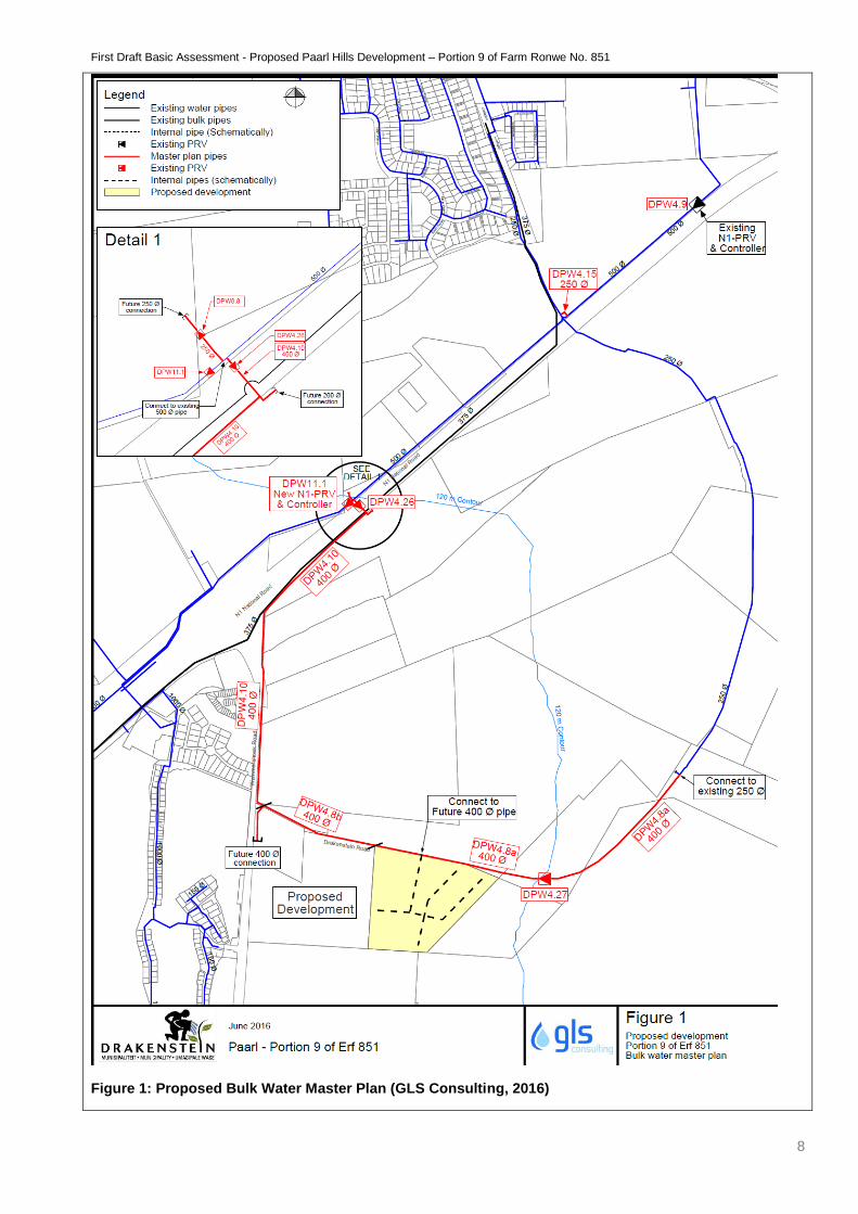
Bulk Water Provision
According to GLS Consulting (Pty) Ltd. and Drakenstein Municipality, there is insufficient capacity
in the existing water reticulation system to accommodate the proposed development to comply with
the pressure and fire flow criteria as set out in the master plan (Figure 1).
Reservoir capacity
The existing Leliefontein reservoir has sufficient capacity to accommodate the proposed
development. Confirmation from the Municipality will be included in the Final BAR.
Static pressure
The static pressure along the proposed supply pipe in the Drakenstein Road will exceed 90 m water
head and a pressure reducing valve (PRV) is proposed on the water supply pipelines to the
development in order to reduce high static pressures in the proposed pipeline.
Implementation
The following items will be required to reinforce the existing water system in order to
accommodate the proposed development together with other future development areas.
Network upgrade:
First Draft Basic Assessment - Proposed Paarl Hills Development – Portion 9 of Farm Ronwe No. 851
7
DPW4.8a : 1 250 m x 400 mm Ø new supply pipe
DPW4.8b : 410 m x 400 mm Ø new supply pipe
DPW4.9 : Decommission existing N1-PRV
DPW4.10 : 1270 m x 400 mm Ø new supply pipe & N1-crossing
DPW4.15 : 250 mm Ø cross-link between 250 mm Ø and 500 mm Ø pipe
DPW11.11 : Install new PRV & controller on existing 500 mm Ø pipe
DPW4.262 : Install new PRV & controller on proposed 400 mm Ø pipe
DPW4.273 : Install new PRV & controller on proposed 400 mm Ø pipe
Take note that the routes of the proposed pipelines are schematically shown on Figure 1, but have To
be finalised subsequent to detail pipeline route investigations.
1. The PRV should be installed at a setting of 25,0 m head (energy grade line = 140 m)
2. Provision should be made for a T-piece on the existing 500 mm diameter bulk pipeline and an
isolating valve in order to accommodate master plan item DPW4.26.
3. The PRV’s should be installed at a setting of 39, 0 m head (energy grade line = 165.1 m).
4. The PRV’s should be installed at a setting of 45, 0 m head (energy grade line = 165.1 m).
The minimum requirements to accommodate the proposed development in the existing system are
master plan item DPW4.27 required to reduce the static pressure at the development, master plan
items DPW11.1, DPW4.9 & DPW4.15 to relocate the existing N1 PRV and a portion of master plan
items DPW4.8a to connect the proposed development to the existing water system.
First Draft Basic Assessment - Proposed Paarl Hills Development – Portion 9 of Farm Ronwe No. 851
8
Figure 1: Proposed Bulk Water Master Plan (GLS Consulting, 2016)
First Draft Basic Assessment - Proposed Paarl Hills Development – Portion 9 of Farm Ronwe No. 851
9
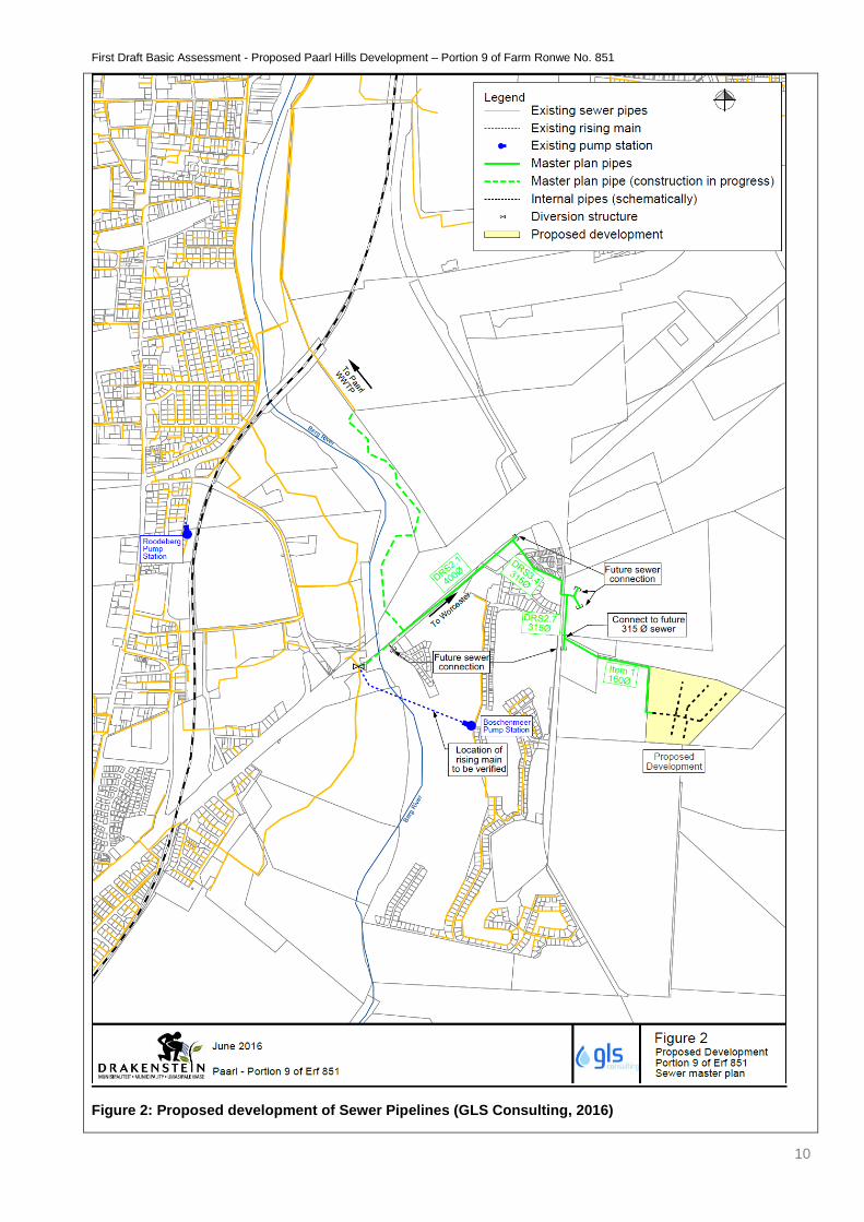
Sewer Network
There is currently no infrastructure between the proposed development and the existing sewer
network.
Implementation of the master plan (Figure 2)
The following link services items will be required to connect the proposed development to the existing
sewer system in order to accommodate the proposed development together with other future
development areas.
Network upgrade is proposed:
Link Item 1 : 680 m x 160 mm Ø new outfall sewer
DRS2.1 : 700 m x 400 mm Ø new outfall sewer
DRS2.7 : 210 m x 315 mm Ø new outfall sewer
DRS3.4 : 410 m x 315 mm Ø new outfall sewer
New bulk water and sewer infrastructure are required to accommodate the proposed development in
the existing water and sewer reticulation networks. The minimum requirements to accommodate the
proposed development in the existing water system are master plan items DPW4.27 (to reduce the
static pressure at the development) DPW11.1, DPW4.9 & DPW4.15 (to relocate the existing N1 PRV)
and DPW4.8a (to connect the proposed development to the existing water system).
First Draft Basic Assessment - Proposed Paarl Hills Development – Portion 9 of Farm Ronwe No. 851
10
Figure 2: Proposed development of Sewer Pipelines (GLS Consulting, 2016)

First Draft Basic Assessment - Proposed Paarl Hills Development – Portion 9 of Farm Ronwe No. 851
11
Storm Water
The stormwater emanating from the development will discharge into an attenuation ponds where after
it will discharge through a new tower spillway structure on the northwestern corner of the
development. The attenuation pond will discharge through a 675mm diameter Class 100D concrete
stormwater pipe, laid in a northwestern direction into the Drakenstein Road’s v-drain in the road
reserve that runs parallel to the northern boundary. The existing v-drain will be upgraded to
accommodate the concentrated flow that the attenuation pond discharges. Additionally, pipe jacking
will be utilised to insert a culvert underneath the existing road to allow the stormwater to flow
underneath the road to the other side’s v-drain from where it will go into the existing network. The
difference in flow due to the proposed development will be absorbed in the attenuation pond as
discussed in more detail in the stormwater management report (Please refer to Addendum G –
Specialist Reports)
Access Roads and Traffic
A traffic impact assessment was conducted by Element Consulting Engineers (Please see refer to
Addendum G) which looked at the existing traffic volumes, trip generation and distribution and an
analysis of the expected traffic that would be generated by the proposed development and the
geometry elements.
The subject property located in Paarl South abuts Drakenstein Road which is a Class 3 Road (District
Distributor) in a semi-rural development environment. Approximately 1.9 km from the N1 (Drakenstein
Road flyover).
There are currently two accesses to the subject property, located at approximately Km 3.9 (Existing
Access 2) and Km 4.0 (Existing Access 1).

First Draft Basic Assessment - Proposed Paarl Hills Development – Portion 9 of Farm Ronwe No. 851
12
Figure 3: Existing Access roads to the Property (Element TIA, 2016)
Access to the development is proposed from Drakenstein Road, approximately 140m west of Existing
Access 1 and 230m west of Existing Access 2. The proposed development will only gain access from
the proposed access, Existing Access 1 and Existing Access 2 will not be used to gain access and
will be closed. Sight distances (road splays) is sufficient in both directions.
First Draft Basic Assessment - Proposed Paarl Hills Development – Portion 9 of Farm Ronwe No. 851
13
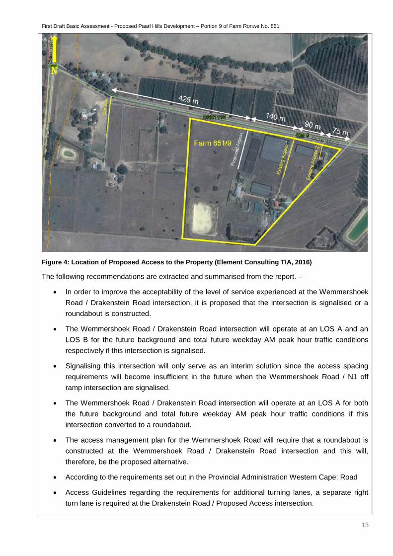
Figure 4: Location of Proposed Access to the Property (Element Consulting TIA, 2016)
The following recommendations are extracted and summarised from the report. –
In order to improve the acceptability of the level of service experienced at the Wemmershoek
Road / Drakenstein Road intersection, it is proposed that the intersection is signalised or a
roundabout is constructed.
The Wemmershoek Road / Drakenstein Road intersection will operate at an LOS A and an
LOS B for the future background and total future weekday AM peak hour traffic conditions
respectively if this intersection is signalised.
Signalising this intersection will only serve as an interim solution since the access spacing
requirements will become insufficient in the future when the Wemmershoek Road / N1 off
ramp intersection are signalised.
The Wemmershoek Road / Drakenstein Road intersection will operate at an LOS A for both
the future background and total future weekday AM peak hour traffic conditions if this
intersection converted to a roundabout.
The access management plan for the Wemmershoek Road will require that a roundabout is
constructed at the Wemmershoek Road / Drakenstein Road intersection and this will,
therefore, be the proposed alternative.
According to the requirements set out in the Provincial Administration Western Cape: Road
Access Guidelines regarding the requirements for additional turning lanes, a separate right
turn lane is required at the Drakenstein Road / Proposed Access intersection.
First Draft Basic Assessment - Proposed Paarl Hills Development – Portion 9 of Farm Ronwe No. 851
14
A total of 143 parking bays should be provided on site for the religious institution.
A total of 43 parking bays should be provided on site for the storage units.
Electricity
The farm currently have 500 KVA 3 phase electricity supplied by Eskom.
(c) List all the activities assessed during the Basic Assessment process:
GN No. R.
983 Activity
No(s):
Describe the relevant Basic Assessment Activity(ies) in writing as per
Listing Notice 1
(GN No. R. 983)
Describe the portion of the development as per
the project description that relates to the
applicable listed activity.
9 The development of infrastructure exceeding 1000
metres in length for the bulk transportation of water
or storm water –
(i) With an internal diameter of 0.36 metres or
more; or
(ii) With a peak throughput of 120 litres per
second
Excluding where –
(a) Such infrastructure is for bulk transportation
of water or storm water or storm water
drainage inside a road reserve; or
(b) Where such development will occur
within an urban area
The proposed development does
entail the construction of pipelines
in order to accommodate the bulk
services to the property. A
network upgrade is proposed as
the current capacity is insufficient.
As the property falls within the
urban edge this activity is not
applicable.
10 The development and related operation of
infrastructure exceeding 1000 metres in length for
the bulk transportation of sewage, effluent, process
water, waste water, return water, industrial
discharge or slimes
(i) With an internal diameter of 0.36 metres or
more; or
(ii) With a peak throughput of 120 litres per
second or more
Excluding where –
(a) Such infrastructure is for bulk transportation
of sewage, effluent, process water, waste water,
The proposed development does
entail the construction of pipelines
in order to accommodate the bulk
services to the property. A
network upgrade is proposed as
the current capacity is insufficient.
As the property falls within the
urban edge this activity is not
applicable
First Draft Basic Assessment - Proposed Paarl Hills Development – Portion 9 of Farm Ronwe No. 851
15
return water, industrial discharge or slimes inside a
road reserve; or
(b) Where such development will occur
within an urban area
27 The clearance of an area of 1 hectares or more, but
less than 20 hectares of indigenous vegetation,
except where such clearance of indigenous
vegetation is required for –
(i)the undertaking of a linear activity; or
(ii)Maintenance purposes undertaken in accordance
with a maintenance management plan
Please note that the definition of Indigenous
Vegetation in terms of this legislation is as follows:
“Indigenous vegetation” refers to vegetation
consisting of indigenous plant species occurring
naturally in an area, regardless of the level of alien
infestation and where the topsoil has not been
lawfully disturbed during the preceding ten years.
The total extent of the property is
11, 4275 Ha, and the development
footprint includes the removal of
10.12 Ha, of completely
transformed vegetation (due to
historic agricultural activities).
*Please note that the property
falls within the urban edge.
28 Residential, mixed, retail, commercial, industrial or
institutional developments where such land was
used for agricultural or afforestation on or after 01
April 1998 and where such development
(i)will occur inside an urban area, where the total
land to be developed is bigger than 5 hectares; or
(ii)will occur outside an urban area, where the total
land to be developed is bigger than 1 hectare;
excluding where such land has already been
developed for residential, mixed, retail, commercial,
industrial or institutional purposes.
The property is currently zoned as
Agriculture I. The development
includes residential estate,
storage yard and a church.
The new zones applicable, as per
the site development plan is as
follows
Residential Zone I: which
include the following land-
uses, dwelling-houses
(detached building containing
only one dwelling unit).
Institutional Zone II: which
include the following land-
uses, house of worship
(church).
Open Space Zone II: which
include the following land-
uses, private open space
(parks) and private internal
roads.
First Draft Basic Assessment - Proposed Paarl Hills Development – Portion 9 of Farm Ronwe No. 851
16
Special Zone: which would
include the following land-
uses, storage units. The
property is surrounded mainly
by farmland raging from
medium to large farms to the
north south and east. The
residential development
Boschenmeer Golf Estate is
located west of the R301.
*Please note that the property
falls within the urban edge and
will entail the removal of more
than 5 hectares.
GN No. R.
985 Activity
No(s):
Describe the relevant Basic Assessment Activity(ies) in writing as per
Listing Notice 3
(GN No. R. 985)
4
The development of a road wider than 4 metres with
a road reserve wider than 4 metres with a reserve
less than 13.5 metres
(f) In Western Cape
(i) Areas outside urban areas;
(aa) Areas containing indigenous vegetation;
(bb) Areas on the estuary side of the development
setback line or in an estuarine functional zone where
no such setback line has been determined or
(ii) In urban areas:
(cc) Areas zoned for conservation or
(dd) Areas designated for conservation use in
Spatial Development Frameworks adopted by the
competent authority.
The proposed development will
only gain access from the
proposed access, Existing Access
1 and Existing Access 2 will not be
used to gain access and will be
closed.
An internal road system will be
developed including 4 lane road
(two lanes entering and two lanes
exiting) approximately 8 metres
wide each to gain access to the
storage yard, church a residential
area.
The internal road system of the
residential estate includes two
lane roads approximately 4 metres
each.
The roads will be accompanied by
a sidewalk of 1 meter each side.
*Please note that the property
falls within the urban edge
12 The clearance of an area of 300 square metres or
more of indigenous vegetation except where such a
clearance of indigenous vegetation is required for
The total extent of the property is
11,4275 Ha, and the development
footprint includes the removal of
First Draft Basic Assessment - Proposed Paarl Hills Development – Portion 9 of Farm Ronwe No. 851
17
maintenance purposes undertaken in accordance
with a maintenance management plan
(a) In Eastern Cape, Free State, Gauteng, Limpopo,
North West and Western Cape provinces:
(i)Within any critically endangered or endangered
ecosystem listed in terms of section 52 of the
NEMBA or prior to the publication of such a list,
within an area that has been identified as critically
endangered in the National Spatial Biodiversity
Assessment 2004;
(ii)Within critical biodiversity areas identified in
bioregional plans;
(iii)Within the littoral active zone or 100 metres
inland from highwater mark of the sea or an
estuarine functional zone, whichever distance is the
greater, excluding where such removal will occur
behind the development setbackline or erven in
urban areas; or
(iv)On land, where, at the time of the coming into
effect of this Notice or thereafter such land was
zoned open space, conservation or had an
equivalent zoning.
10.12 Ha, of completely
transformed vegetation (due to
historic agricultural activities).
*Please note that the property
falls within the urban edge.
If the application is also for activities as per Listing Notice 2 and permission was granted to subject the application to Basic
Assessment, also indicate the applicable Listing Notice 2 activities:
GN No. R. 545
Activity No(s):
If permission was granted in terms of Regulation 20,
describe the relevant Scoping and EIA Activity(ies) in
writing as per Listing Notice 2 (GN No. R. 545)
Describe the portion of the development as per the project
description that relates to the applicable listed activity.
N/A N/A N/A
Waste management activities in terms of the NEM: WA (Government Gazette No. 32368):
GN No. 718 - Category A
Activity No(s): Describe the relevant Category A waste management activity in writing.
N/A N/A
Please note: If any waste management activities are applicable, the Listed Waste Management Activities Additional Information
Annexure must be completed and attached to this Basic Assessment Report as Appendix I.
First Draft Basic Assessment - Proposed Paarl Hills Development – Portion 9 of Farm Ronwe No. 851
18
If the application is also for waste management activities as per Category B and permission was granted to subject the application to Basic
Assessment, also indicate the applicable Category B activities:
GN No. 718 – Category B
Activity No(s): Describe the relevant Category B waste management activity in writing.
N/A N/A
Atmospheric emission activities in terms of the NEM: AQA (Government Gazette No. 33064):
GN No. 248
Activity No(s): Describe the relevant atmospheric emission activity in writing.
N/A N/A
First Draft Basic Assessment - Proposed Paarl Hills Development – Portion 9 of Farm Ronwe No. 851
19
(d) Please provide details of all components of the proposed project and attach diagrams (e.g. architectural drawings or perspectives,
engineering drawings, process flow charts etc.).
Buildings YES NO
Provide brief description:
The proposed development will consist of 87 single residential erven, 3 parks (private open space),
396 storage units, a church, gatehouse, a refuse area and a man-made water reticulation pond in
the north-western corner of the property (Please refer to Addendum B for detailed drawings of the
retention pond).
Infrastructure (e.g. roads, power and water supply/ storage) YES NO
Provide brief description:
Access Roads and Internal Road System
The northern boundary of the property abuts Drakenstein Road which is a Class 3 District Distributor
(DR1110). Access to the property would be obtained from Drakenstein Road. According to the
requirements set out in the Provincial Administration Western Cape: Road Access Guidelines, an
access spacing of 270m is required. The proposed access will be located 425m east and 305m west
of the adjacent intersections and is, therefore, acceptable. Sight distances from the proposed access
intersection are sufficient in both directions. An internal road system will be developed including 4
lane road (two lanes entering and two lanes exiting) approximately 8 metres wide each to gain
access to the storage yard, church a residential area. The internal road system of the residential
estate includes two lane roads approximately 4 metres each. The roads will be accompanied by a
sidewalk of 1 meter each side.
Electricity
The farm currently have 500 KVA 3 phase electricity supplied by Eskom.
Bulk Water
It is recommended that the proposed development should be accommodated in the existing Paarl
Leliefontein reservoir zone. The water reticulation for the proposed development will connect to a
new 400mm diameter water main located in the Drakenstein Road reserve on the northern boundary
of the site as indicated in the attached GLS report (Please refer to Addendum G – Specialists
Report). Currently, there is insufficient network capacity in the existing water reticulation system to
accommodate the proposed development to comply with the pressure and fire flow criteria. There is,
however, enough reservoir capacity from the existing Leliefontein reservoir to accommodate the
proposed development. No other external upgrades are required, the connection to each complex
will include a bulk water meter, sluice valve and fire hydrant to be placed at the entrance to the
proposed developments (Please refer to Addendum B – Water Reticulation Layout.)
First Draft Basic Assessment - Proposed Paarl Hills Development – Portion 9 of Farm Ronwe No. 851
20
Sewerage
Currently, there is no infrastructure between the proposed development and the existing sewer
network, the sewerage network will be upgraded in order to accommodate the proposed
development together with other future development areas. The internal sewerage reticulation will
drain towards a new sewerage system comprising of a 160mm diameter pipe which will be
constructed in the Drakenstein Road reserve area on the northern boundary of the development.
This 160mm diameter link sewer pipe will tie into a new proposed sewer connection (Please refer to
Addendum B – Sewerage reticulation Layout).
Processing activities (e.g. manufacturing, storage, distribution) YES NO
Provide brief description:
N/A
Storage facilities for raw materials and products (e.g. volume and substances to be stored)
Provide brief description YES NO
N/A
Storage and treatment facilities for solid waste and effluent generated by the project YES NO
Provide brief description
N/A
Other activities (e.g. water abstraction activities, crop planting activities) YES NO
Provide brief description
N/A
First Draft Basic Assessment - Proposed Paarl Hills Development – Portion 9 of Farm Ronwe No. 851
21
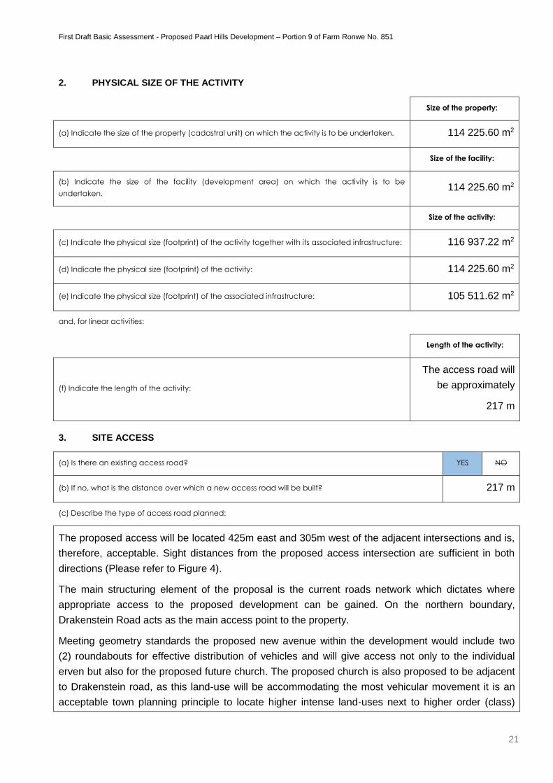
2. PHYSICAL SIZE OF THE ACTIVITY
Size of the property:
(a) Indicate the size of the property (cadastral unit) on which the activity is to be undertaken. 114 225.60 m2
Size of the facility:
(b) Indicate the size of the facility (development area) on which the activity is to be
undertaken. 114 225.60 m2
Size of the activity:
(c) Indicate the physical size (footprint) of the activity together with its associated infrastructure: 116 937.22 m2
(d) Indicate the physical size (footprint) of the activity: 114 225.60 m2
(e) Indicate the physical size (footprint) of the associated infrastructure: 105 511.62 m2
and, for linear activities:
Length of the activity:
(f) Indicate the length of the activity:
The access road will
be approximately
217 m
3. SITE ACCESS
(a) Is there an existing access road? YES NO
(b) If no, what is the distance over which a new access road will be built? 217 m
(c) Describe the type of access road planned:
The proposed access will be located 425m east and 305m west of the adjacent intersections and is,
therefore, acceptable. Sight distances from the proposed access intersection are sufficient in both
directions (Please refer to Figure 4).
The main structuring element of the proposal is the current roads network which dictates where
appropriate access to the proposed development can be gained. On the northern boundary,
Drakenstein Road acts as the main access point to the property.
Meeting geometry standards the proposed new avenue within the development would include two
(2) roundabouts for effective distribution of vehicles and will give access not only to the individual
erven but also for the proposed future church. The proposed church is also proposed to be adjacent
to Drakenstein road, as this land-use will be accommodating the most vehicular movement it is an
acceptable town planning principle to locate higher intense land-uses next to higher order (class)
First Draft Basic Assessment - Proposed Paarl Hills Development – Portion 9 of Farm Ronwe No. 851
22
road networks.
The inner road network consists of access streets which will have effective flow leading to individual
dwelling-houses, ample secure parking is provided. No thoroughfare is possible from the access
streets, this was specifically designed to reduce vehicle speeds and limit the uses to the residents
An internal road system will be developed including 4 lane road (two lanes entering and two lanes
exiting) approximately 8 metres wide each to gain access to the storage yard, church a residential
area. The internal road system of the residential estate includes two lane roads approximately 4
metres each. The roads will be accompanied by a sidewalk of 1 meter each side.
(Please refer to Addendum B – Site Layout and Detailed Drawings of the proposed internal road
network.)
Please Note: indicate the position of the proposed access road on the site plan.
First Draft Basic Assessment - Proposed Paarl Hills Development – Portion 9 of Farm Ronwe No. 851
23
4. DESCRIPTION OF THE PROPERTY ON WHICH THE ACTIVITY IS TO BE UNDERTAKEN AND THE
LOCATION OF THE ACTIVITY ON THE PROPERTY
(a) Provide a description of the property on which the activity is to be undertaken and the location of the activity on the
property.
Portion 9 of Farm No. 851 hereafter referred to as the subject property, is located in Paarl (South),
Western Cape, South Africa in the Drakenstein Municipality. The subject property is approximate
60km from Cape Town. (Please refer to Addendum A: Locality Map) The subject property’s north /
north-eastern boundary is along Drakenstein Road that acts as a link Road between Langenhoven
Avenue (R101). The property was historically utilised for agricultural purposes thus vegetation has
been totally transformed, a prevailing dam is located in the south western section of the property.
The proposed development includes 87 single residential erven, 3 parks (private open space), 396
storage units, a church, gatehouse, a refuse area and a man-made water reticulation pond in the
north-western corner of the property.
(b) Please provide a location map (see below) as Appendix A to this report which shows the location of the property and the location of
the activity on the property; as well as a site map (see below) as Appendix B to this report; and if applicable all alternative properties
and locations.
Locality map:
The scale of the locality map must be at least 1:50 000. For linear activities of more than 25 kilometres, a
smaller scale e.g. 1:250 000 can be used. The scale must be indicated on the map. The map must indicate
the following:
an accurate indication of the project site position as well as the positions of the alternative sites, if any;
road names or numbers of all the major roads as well as the roads that provide access to the site(s)
a north arrow;
a legend;
the prevailing wind direction (during November to April and during May to October); and
GPS co-ordinates (Indicate the position of the activity using the latitude and longitude of the centre point of the site for each alternative site. The co-ordinates should be in degrees and decimal minutes. The minutes should have at least three decimals to ensure adequate accuracy. The projection that must be used in all cases is the WGS84 spheroid in a national or local projection).
Site Plan:
Detailed site plan(s) must be prepared for each alternative site or alternative activity. The site plan must
contain or conform to the following:
The detailed site plan must be at a scale preferably at a scale of 1:500 or at an appropriate scale. The scale must be indicated on the plan.
The property boundaries and numbers of all the properties within 50m of the site must be indicated on the site plan.
The current land use (not zoning) as well as the land use zoning of each of the adjoining properties must be indicated on the site plan.
The position of each element of the application as well as any other structures on the site must be indicated on the site plan.
Services, including electricity supply cables (indicate above or underground), water supply pipelines, boreholes, sewage pipelines, storm water infrastructure and access roads that will form part of the development must be indicated on the site plan.
Servitudes indicating the purpose of the servitude must be indicated on the site plan.
Sensitive environmental elements within 100m of the site must be included on the site plan, including (but not limited to): o Rivers. o Flood lines (i.e. 1:10, 1:50, year and 32 meter set back line from the banks of a river/stream). o Ridges. o Cultural and historical features. o Areas with indigenous vegetation (even if it is degraded or infested with alien species).
Whenever the slope of the site exceeds 1:10, then a contour map of the site must be submitted.
First Draft Basic Assessment - Proposed Paarl Hills Development – Portion 9 of Farm Ronwe No. 851
24
(c) For a linear activity, please also provide a description of the route.
Indicate the position of the activity using the latitude and
longitude of the centre point of the site. The co-ordinates
must be in degrees, minutes and seconds. The minutes should
be given to at least three decimals to ensure adequate
accuracy. The projection that must be used in all cases is the
WGS84 spheroid in a national or local projection.
Latitude (S): Longitude (E):
33o
45‘
59.04“
18o
59‘
23.40“
(d) or:
For linear activities: Latitude (S): Longitude (E):
Starting point of the activity 33o 45‘ 54.20“ 18o 59‘ 24.75“
Middle point of the activity 33o 45‘ 58.13“ 18o 59‘ 23.50“
End point of the activity 33o 46‘ 01.26“ 18o 59‘ 22.52“
Please Note: For linear activities that are longer than 500m, please provide and addendum with co-ordinates taken every 100 meters along
the route.
5. SITE PHOTOGRAPHS
Colour photographs of the site and its surroundings (taken of the site and from the site) with a description of each photograph. The vantage
points from which the photographs were taken must be indicated on the site plan, or locality plan as applicable. If available, please also
provide a recent aerial photograph. Photographs must be attached as Appendix C to this report. It should be supplemented with additional
photographs of relevant features on the site. Date of photographs must be included. Please note that the above requirements must be
duplicated for all alternative sites.
First Draft Basic Assessment - Proposed Paarl Hills Development – Portion 9 of Farm Ronwe No. 851
25
SECTION B: DESCRIPTION OF RECEIVING
ENVIRONMENT
Site/Area Description
For linear activities (pipelines, etc.) as well as activities that cover very large sites, it may be necessary to complete copies of this section for
each part of the site that has a significantly different environment. In such cases please complete copies of Section B and indicate the area
which is covered by each copy No. on the Site Plan.
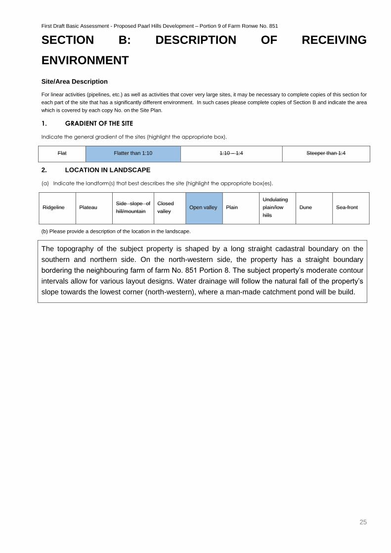
1. GRADIENT OF THE SITE
Indicate the general gradient of the sites (highlight the appropriate box).
Flat Flatter than 1:10 1:10 – 1:4 Steeper than 1:4
2. LOCATION IN LANDSCAPE
(a) Indicate the landform(s) that best describes the site (highlight the appropriate box(es).
Ridgeline Plateau Side slope of
hill/mountain
Closed
valley Open valley Plain
Undulating
plain/low
hills
Dune Sea-front
(b) Please provide a description of the location in the landscape.
The topography of the subject property is shaped by a long straight cadastral boundary on the
southern and northern side. On the north-western side, the property has a straight boundary
bordering the neighbouring farm of farm No. 851 Portion 8. The subject property’s moderate contour
intervals allow for various layout designs. Water drainage will follow the natural fall of the property’s
slope towards the lowest corner (north-western), where a man-made catchment pond will be build.
First Draft Basic Assessment - Proposed Paarl Hills Development – Portion 9 of Farm Ronwe No. 851
26
3. GROUNDWATER, SOIL AND GEOLOGICAL STABILITY OF THE SITE
(a) Is the site(s) located on or near any of the following (highlight the appropriate boxes)?
Shallow water table (less than 1.5m deep) YES NO UNSURE
Seasonally wet soils (often close to water bodies) YES NO UNSURE
Unstable rocky slopes or steep slopes with loose soil YES NO UNSURE
Dispersive soils (soils that dissolve in water) YES NO UNSURE
Soils with high clay content YES NO UNSURE
Any other unstable soil or geological feature YES NO UNSURE
An area sensitive to erosion YES NO UNSURE
An area adjacent to or above an aquifer. YES NO UNSURE
An area within 100m of the source of surface water YES NO UNSURE
(b) If any of the answers to the above are “YES” or “unsure”, specialist input may be requested by the Department.
(Information in respect of the above will often be available at the planning sections of local authorities. Where it exists, the
1:50 000 scale Regional Geotechnical Maps prepared by Geological Survey may also be used).
(c) Please indicate the type of geological formation underlying the site.
Granite Shale Sandstone Quartzite Dolomite Dolorite Other (describe)
Please provide a description.
Soils & Geology (ENPAT)
Land Type: Ga13
Soil: Soils with a diagnostic ferrihumic horizon, predominantly deep (Lamotte form)
Geology: Alluvial and aeolian sand and gravel, underlain by quartzitic sandstone of the
Peninsula Formation, Table Mountain Group.
4. SURFACE WATER
(a) Indicate the surface water present on and or adjacent to the site and alternative sites (highlight the appropriate boxes)?
Perennial River YES NO UNSURE
Non-Perennial River YES NO UNSURE
Permanent Wetland YES NO UNSURE
Seasonal Wetland YES NO UNSURE
Artificial Wetland YES NO UNSURE
Estuarine / Lagoonal wetland YES NO UNSURE
First Draft Basic Assessment - Proposed Paarl Hills Development – Portion 9 of Farm Ronwe No. 851
27
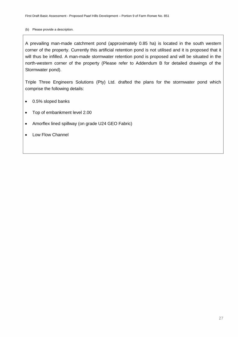
(b) Please provide a description.
A prevailing man-made catchment pond (approximately 0.85 ha) is located in the south western
corner of the property. Currently this artificial retention pond is not utilised and it is proposed that it
will thus be infilled. A man-made stormwater retention pond is proposed and will be situated in the
north-western corner of the property (Please refer to Addendum B for detailed drawings of the
Stormwater pond).
Triple Three Engineers Solutions (Pty) Ltd. drafted the plans for the stormwater pond which
comprise the following details:
0.5% sloped banks
Top of embankment level 2.00
Amorflex lined spillway (on grade U24 GEO Fabric)
Low Flow Channel
First Draft Basic Assessment - Proposed Paarl Hills Development – Portion 9 of Farm Ronwe No. 851
28
5. BIODIVERSITY
Please note: The Department may request specialist input/studies depending on the nature of the biodiversity occurring on the site and
potential impact(s) of the proposed activity/ies. To assist with the identification of the biodiversity occurring on site and the ecosystem status
consult http://bgis.sanbi.org or [email protected]. Information is also available on compact disc (cd) from the Biodiversity-GIS Unit, Ph
(021) 799 8698. This information may be updated from time to time and it is the applicant/ EAP’s responsibility to ensure that the latest
version is used. A map of the relevant biodiversity information (including an indication of the habitat conditions as per (b) below) and must
be provided as an overlay map to the property/site plan as Appendix D to this report.
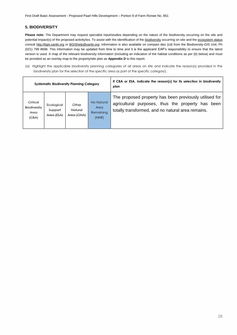
(a) Highlight the applicable biodiversity planning categories of all areas on site and indicate the reason(s) provided in the
biodiversity plan for the selection of the specific area as part of the specific category).
Systematic Biodiversity Planning Category If CBA or ESA, indicate the reason(s) for its selection in biodiversity
plan
Critical
Biodiversity
Area
(CBA)
Ecological
Support
Area (ESA)
Other
Natural
Area (ONA)
No Natural
Area
Remaining
(NNR)
The proposed property has been previously utilised for
agricultural purposes, thus the property has been
totally transformed, and no natural area remains.
First Draft Basic Assessment - Proposed Paarl Hills Development – Portion 9 of Farm Ronwe No. 851
29
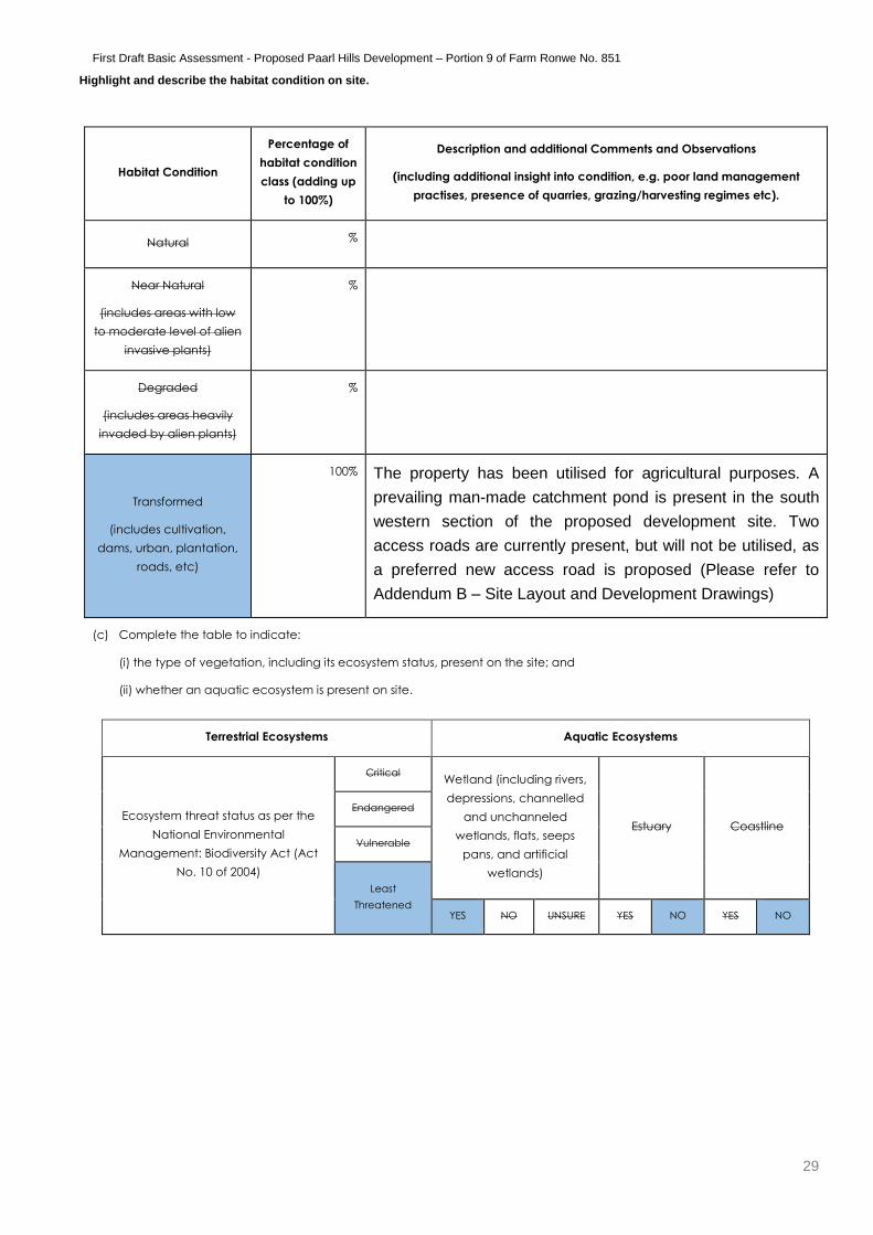
Highlight and describe the habitat condition on site.
Habitat Condition
Percentage of
habitat condition
class (adding up
to 100%)
Description and additional Comments and Observations
(including additional insight into condition, e.g. poor land management
practises, presence of quarries, grazing/harvesting regimes etc).
Natural %
Near Natural
(includes areas with low
to moderate level of alien
invasive plants)
%
Degraded
(includes areas heavily
invaded by alien plants)
%
Transformed
(includes cultivation,
dams, urban, plantation,
roads, etc)
100% The property has been utilised for agricultural purposes. A
prevailing man-made catchment pond is present in the south
western section of the proposed development site. Two
access roads are currently present, but will not be utilised, as
a preferred new access road is proposed (Please refer to
Addendum B – Site Layout and Development Drawings)
(c) Complete the table to indicate:
(i) the type of vegetation, including its ecosystem status, present on the site; and
(ii) whether an aquatic ecosystem is present on site.
Terrestrial Ecosystems Aquatic Ecosystems
Ecosystem threat status as per the
National Environmental
Management: Biodiversity Act (Act
No. 10 of 2004)
Critical Wetland (including rivers,
depressions, channelled
and unchanneled
wetlands, flats, seeps
pans, and artificial
wetlands)
Estuary Coastline
Endangered
Vulnerable
Least
Threatened YES NO UNSURE YES NO YES NO
First Draft Basic Assessment - Proposed Paarl Hills Development – Portion 9 of Farm Ronwe No. 851
30
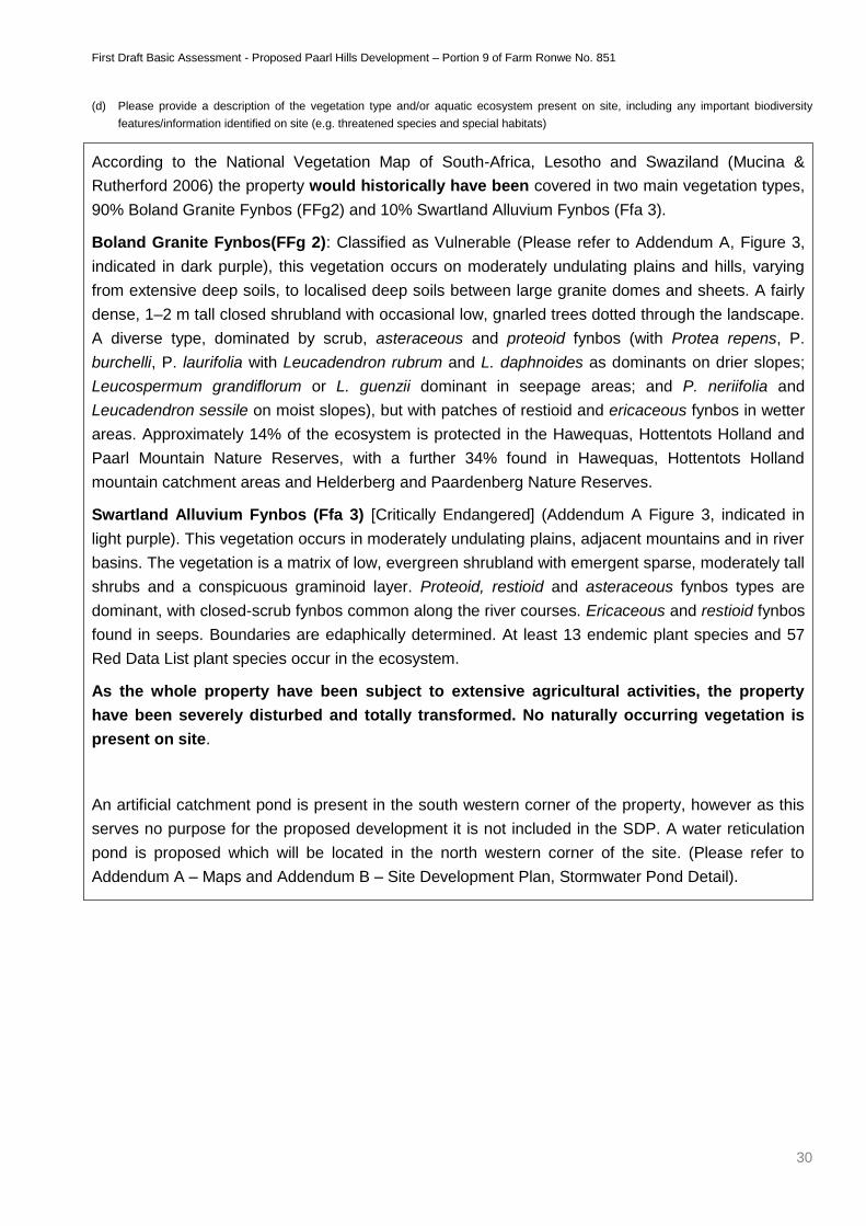
(d) Please provide a description of the vegetation type and/or aquatic ecosystem present on site, including any important biodiversity
features/information identified on site (e.g. threatened species and special habitats)
According to the National Vegetation Map of South-Africa, Lesotho and Swaziland (Mucina &
Rutherford 2006) the property would historically have been covered in two main vegetation types,
90% Boland Granite Fynbos (FFg2) and 10% Swartland Alluvium Fynbos (Ffa 3).
Boland Granite Fynbos(FFg 2): Classified as Vulnerable (Please refer to Addendum A, Figure 3,
indicated in dark purple), this vegetation occurs on moderately undulating plains and hills, varying
from extensive deep soils, to localised deep soils between large granite domes and sheets. A fairly
dense, 1–2 m tall closed shrubland with occasional low, gnarled trees dotted through the landscape.
A diverse type, dominated by scrub, asteraceous and proteoid fynbos (with Protea repens, P.
burchelli, P. laurifolia with Leucadendron rubrum and L. daphnoides as dominants on drier slopes;
Leucospermum grandiflorum or L. guenzii dominant in seepage areas; and P. neriifolia and
Leucadendron sessile on moist slopes), but with patches of restioid and ericaceous fynbos in wetter
areas. Approximately 14% of the ecosystem is protected in the Hawequas, Hottentots Holland and
Paarl Mountain Nature Reserves, with a further 34% found in Hawequas, Hottentots Holland
mountain catchment areas and Helderberg and Paardenberg Nature Reserves.
Swartland Alluvium Fynbos (Ffa 3) [Critically Endangered] (Addendum A Figure 3, indicated in
light purple). This vegetation occurs in moderately undulating plains, adjacent mountains and in river
basins. The vegetation is a matrix of low, evergreen shrubland with emergent sparse, moderately tall
shrubs and a conspicuous graminoid layer. Proteoid, restioid and asteraceous fynbos types are
dominant, with closed-scrub fynbos common along the river courses. Ericaceous and restioid fynbos
found in seeps. Boundaries are edaphically determined. At least 13 endemic plant species and 57
Red Data List plant species occur in the ecosystem.
As the whole property have been subject to extensive agricultural activities, the property
have been severely disturbed and totally transformed. No naturally occurring vegetation is
present on site.
An artificial catchment pond is present in the south western corner of the property, however as this
serves no purpose for the proposed development it is not included in the SDP. A water reticulation
pond is proposed which will be located in the north western corner of the site. (Please refer to
Addendum A – Maps and Addendum B – Site Development Plan, Stormwater Pond Detail).
First Draft Basic Assessment - Proposed Paarl Hills Development – Portion 9 of Farm Ronwe No. 851
31
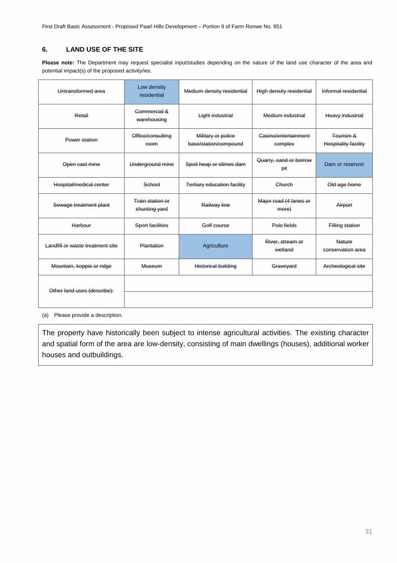
6. LAND USE OF THE SITE
Please note: The Department may request specialist input/studies depending on the nature of the land use character of the area and
potential impact(s) of the proposed activity/ies.
Untransformed area Low density
residential Medium density residential High density residential Informal residential
Retail Commercial &
warehousing Light industrial Medium industrial Heavy industrial
Power station Office/consulting
room
Military or police
base/station/compound
Casino/entertainment
complex
Tourism &
Hospitality facility
Open cast mine Underground mine Spoil heap or slimes dam Quarry, sand or borrow
pit Dam or reservoir
Hospital/medical center School Tertiary education facility Church Old age home
Sewage treatment plant Train station or
shunting yard Railway line
Major road (4 lanes or
more) Airport
Harbour Sport facilities Golf course Polo fields Filling station
Landfill or waste treatment site Plantation Agriculture River, stream or
wetland
Nature
conservation area
Mountain, koppie or ridge Museum Historical building Graveyard Archeological site
Other land uses (describe):
(a) Please provide a description.
The property have historically been subject to intense agricultural activities. The existing character
and spatial form of the area are low-density, consisting of main dwellings (houses), additional worker
houses and outbuildings.
First Draft Basic Assessment - Proposed Paarl Hills Development – Portion 9 of Farm Ronwe No. 851
32
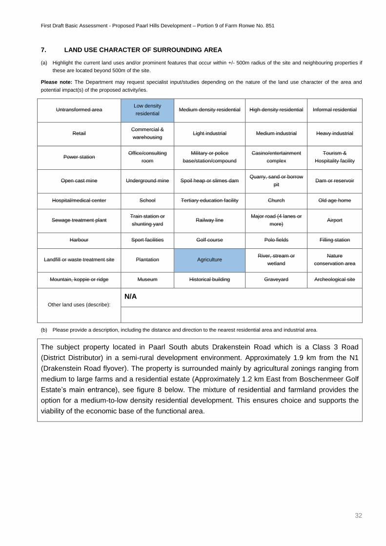
7. LAND USE CHARACTER OF SURROUNDING AREA
(a) Highlight the current land uses and/or prominent features that occur within +/- 500m radius of the site and neighbouring properties if
these are located beyond 500m of the site.
Please note: The Department may request specialist input/studies depending on the nature of the land use character of the area and
potential impact(s) of the proposed activity/ies.
Untransformed area Low density
residential Medium density residential High density residential Informal residential
Retail Commercial &
warehousing Light industrial Medium industrial Heavy industrial
Power station Office/consulting
room
Military or police
base/station/compound
Casino/entertainment
complex
Tourism &
Hospitality facility
Open cast mine Underground mine Spoil heap or slimes dam Quarry, sand or borrow
pit Dam or reservoir
Hospital/medical center School Tertiary education facility Church Old age home
Sewage treatment plant Train station or
shunting yard Railway line
Major road (4 lanes or
more) Airport
Harbour Sport facilities Golf course Polo fields Filling station
Landfill or waste treatment site Plantation Agriculture River, stream or
wetland
Nature
conservation area
Mountain, koppie or ridge Museum Historical building Graveyard Archeological site
Other land uses (describe):
N/A
(b) Please provide a description, including the distance and direction to the nearest residential area and industrial area.
The subject property located in Paarl South abuts Drakenstein Road which is a Class 3 Road
(District Distributor) in a semi-rural development environment. Approximately 1.9 km from the N1
(Drakenstein Road flyover). The property is surrounded mainly by agricultural zonings ranging from
medium to large farms and a residential estate (Approximately 1.2 km East from Boschenmeer Golf
Estate’s main entrance), see figure 8 below. The mixture of residential and farmland provides the
option for a medium-to-low density residential development. This ensures choice and supports the
viability of the economic base of the functional area.
First Draft Basic Assessment - Proposed Paarl Hills Development – Portion 9 of Farm Ronwe No. 851
33
8. SOCIO-ECONOMIC ASPECTS
Describe the existing social and economic characteristics of the community in order to provide baseline information.
The proposed development area falls within the Drakenstein Municipal boundaries (within the
urban edge).
According to the Drakenstein Spatial Development Framework (DSDF) which is an overarching
policy framework that seeks to give long term (20+ years) spatial structure to the greater Municipal
area. As such it encapsulates the spatial direction from the national and provincial sphere and
synthesises it to the long term vision and growth pattern envisaged for the town, not only as a
stand-alone entity but within its regional context. The scale and long term scope of this document
give a specific proposal for the subject property, the subject property is an approved future
development site. This area of development is complimented by the earmarked business /
commercial and mix-use node at the intersection of Drakenstein and Wemmershoek Road. The
policy directives when planning for development is to ensure a coherent, functional and efficient
urban fabric. Key directives out of the DSDF in relation to the subject property is to ensure that
development does not take place outside the urban edge, as to minimise urban sprawl (developing
on valuable agricultural land). That development responds to the socio–economic needs of the
town population in a sustainable manner through the right type of development, i.e. a development
that would have a positive impact on the surrounding properties.
This area is currently under considerable pressure for low density, most notably for low-density
upmarket gated community type of residential development. Future development in this area is
regarded as appropriate given the critical mass of development in this area. The nature of such
development will be considered in order to ensure the creation of an efficient urban structure. The
above would imply that a variety of residential development types could be appropriate, but taking
into account that this property abuts the urban edge that a low-to-medium residential density
would be appropriate.
The proposed development seeks to directly and indirectly respond to various policy statements
relating to ensure an environmental manageable development, ensuring a compact, quality
environment, efficiency, protecting scarce resources by utilising land within the urban footprint
optimally, conforming to structuring elements in the city and district, managing land uses and
directing development to conform to the urban edge as structuring elements.
First Draft Basic Assessment - Proposed Paarl Hills Development – Portion 9 of Farm Ronwe No. 851
34
9. HISTORICAL AND CULTURAL ASPECTS
(a) Please be advised that if section 38 of the National Heritage Resources Act, 1999 (Act No. 25 of 1999), is applicable to your
proposed development, then you are requested to furnish this Department with written comment from Heritage Western
Cape as part of your public participation process. Section 38 of the Act states as follows: “38. (1) Subject to the provisions
of subsections (7), (8) and (9), any person who intends to undertake a development categorised as-
(a) the construction of a road, wall, power line, pipeline, canal or other similar form of linear development or barrier exceeding
300m in length;
(b) the construction of a bridge or similar structure exceeding 50m in length;
I any development or other activity which will change the character of a site-
(i) exceeding 5 000 m2 in extent; or
(ii) involving three or more existing erven or subdivisions thereof; or
(iii) involving three or more erven or divisions thereof which have been consolidated within the past five years; or
(iv) the costs of which will exceed a sum set in terms of regulations by SAHRA or a provincial heritage resources
authority;
(d) the re-zoning of a site exceeding 10 000 m2 in extent; or
(e) any other category of development provided for in regulations by SAHRA or a provincial heritage resources authority,
must at the very earliest stages of initiating such a development, notify the responsible heritage resources authority and furnish it
with details regarding the location, nature and extent of the proposed development.”
(b) The impact on any national estate referred to in section 3(2), excluding the national estate contemplated in section
3(2)(i)(vi) and (vii), of the National Heritage Resources Act, 1999 (Act No. 25 of 1999), must also be investigated, assessed
and evaluated. Section 3(2) states as follows: “3(2) Without limiting the generality of subsection (1), the national estate may
include—
(a) places, buildings, structures and equipment of cultural significance;
(b) places to which oral traditions are attached or which are associated with living heritage;
I historical settlements and townscapes;
(d) landscapes and natural features of cultural significance;
(e) geological sites of scientific or cultural importance;
(f) archaeological and palaeontological sites;
(g) graves and burial grounds, including—
(i) ancestral graves;
(ii) royal graves and graves of traditional leaders;
(iii) graves of victims of conflict;
(iv) graves of individuals designated by the Minister by notice in the Gazette;
(v) historical graves and cemeteries; and
(vi) other human remains which are not covered in terms of the Human Tissue Act, 1983 (Act No. 65 of 1983);
(h) sites of significance relating to the history of slavery in South Africa;
(i) movable objects, including—
(i) objects recovered from the soil or waters of South Africa, including archaeological and palaeontological objects and material,
meteorites and rare geological specimens;
(ii) objects to which oral traditions are attached or which are associated with living heritage;
(iii) ethnographic art and objects;
(iv) military objects;
(v) objects of decorative or fine art;
(vi) objects of scientific or technological interest; and
(vii) books, records, documents, photographic positives and negatives, graphic, film or video material or sound recordings,
excluding those that are public records as defined in section 1(xiv) of the National Archives of South Africa Act, 1996 (Act No. 43
of 1996).”
First Draft Basic Assessment - Proposed Paarl Hills Development – Portion 9 of Farm Ronwe No. 851
35
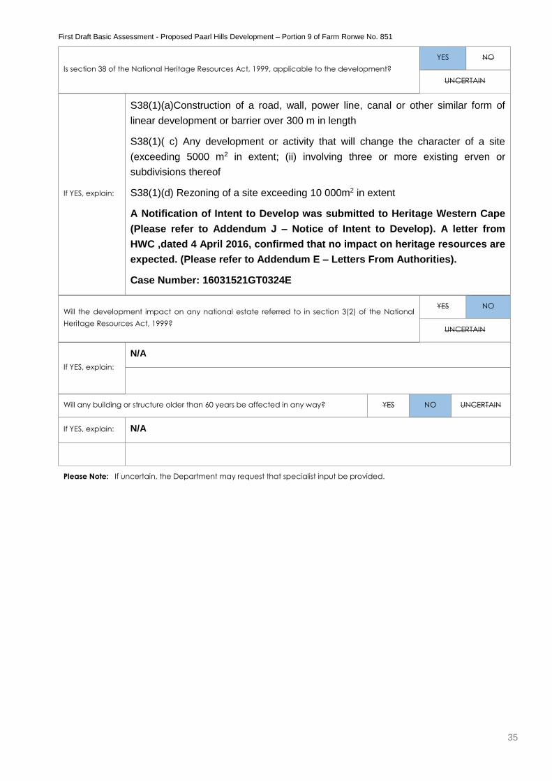
Is section 38 of the National Heritage Resources Act, 1999, applicable to the development?
YES NO
UNCERTAIN
If YES, explain:
S38(1)(a)Construction of a road, wall, power line, canal or other similar form of
linear development or barrier over 300 m in length
S38(1)( c) Any development or activity that will change the character of a site
(exceeding 5000 m2 in extent; (ii) involving three or more existing erven or
subdivisions thereof
S38(1)(d) Rezoning of a site exceeding 10 000m2 in extent
A Notification of Intent to Develop was submitted to Heritage Western Cape
(Please refer to Addendum J – Notice of Intent to Develop). A letter from
HWC ,dated 4 April 2016, confirmed that no impact on heritage resources are
expected. (Please refer to Addendum E – Letters From Authorities).
Case Number: 16031521GT0324E
Will the development impact on any national estate referred to in section 3(2) of the National
Heritage Resources Act, 1999?
YES NO
UNCERTAIN
If YES, explain:
N/A
Will any building or structure older than 60 years be affected in any way? YES NO UNCERTAIN
If YES, explain: N/A
Please Note: If uncertain, the Department may request that specialist input be provided.

First Draft Basic Assessment - Proposed Paarl Hills Development – Portion 9 of Farm Ronwe No. 851
36
10. APPLICABLE LEGISLATION, POLICIES AND/OR GUIDELINES
(a) Please list all legislation, policies and/or guidelines that have been considered in the preparation of this Basic Assessment Report.
LEGISLATION ADMINISTERING AUTHORITY
TYPE
Permit/ license/
authorisation/comment / relevant
consideration (e.g. rezoning or
consent use, building plan approval)
DATE
(if already
obtained):
In terms of the National
Environmental Management
Act, 1998 (GN No. R 983,
GN No R 985, 4 December
2014)
Department of
Environmental Affairs and
Development Planning
Environmental Authorisation Pending
POLICY/ GUIDELINES ADMINISTERING AUTHORITY
Provincial Spatial Development Framework Western Cape Provincial Government
Integrated Development Plan Drakenstein Local Municiplity
DEA&DP NEMA EIA Regulations Guideline & Information
Document Series Guideline on Public Participation July
2006
Department of Environmental Affairs
and Development Planning
DEA&DP NEMA EIA Regulations Guideline & Information
Document Series Guidelines on specialist input
Department of Environmental Affairs
and Development Planning
DEA&DP NEMA EIA Regulations Guideline & Information
Document Series Guideline on Alternatives July 2006
Department of Environmental Affairs
and Development Planning
DEA&DP Guideline for environmental decision-making by
municipalities in the Western cape
Department of Environmental Affairs
and Development Planning
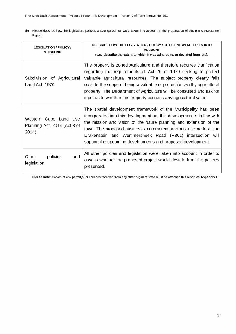
First Draft Basic Assessment - Proposed Paarl Hills Development – Portion 9 of Farm Ronwe No. 851
37
(b) Please describe how the legislation, policies and/or guidelines were taken into account in the preparation of this Basic Assessment
Report.
LEGISLATION / POLICY /
GUIDELINE
DESCRIBE HOW THE LEGISLATION / POLICY / GUIDELINE WERE TAKEN INTO
ACCOUNT
(e.g. describe the extent to which it was adhered to, or deviated from, etc).
Subdivision of Agricultural
Land Act, 1970
The property is zoned Agriculture and therefore requires clarification
regarding the requirements of Act 70 of 1970 seeking to protect
valuable agricultural resources. The subject property clearly falls
outside the scope of being a valuable or protection worthy agricultural
property. The Department of Agriculture will be consulted and ask for
input as to whether this property contains any agricultural value
Western Cape Land Use
Planning Act, 2014 (Act 3 of
2014)
The spatial development framework of the Municipality has been
incorporated into this development, as this development is in line with
the mission and vision of the future planning and extension of the
town. The proposed business / commercial and mix-use node at the
Drakenstein and Wemmershoek Road (R301) intersection will
support the upcoming developments and proposed development.
Other policies and
legislation
All other policies and legislation were taken into account in order to
assess whether the proposed project would deviate from the policies
presented.
Please note: Copies of any permit(s) or licences received from any other organ of state must be attached this report as Appendix E.
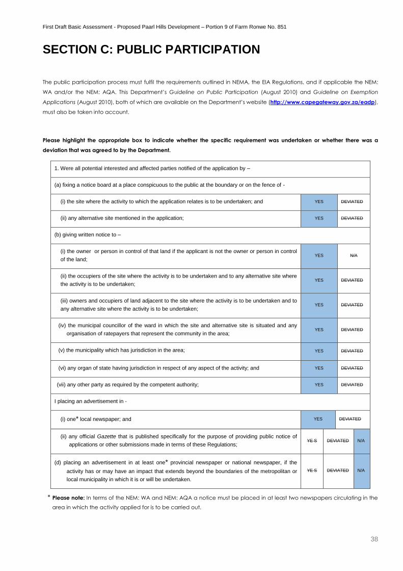
First Draft Basic Assessment - Proposed Paarl Hills Development – Portion 9 of Farm Ronwe No. 851
38
SECTION C: PUBLIC PARTICIPATION
The public participation process must fulfil the requirements outlined in NEMA, the EIA Regulations, and if applicable the NEM:
WA and/or the NEM: AQA. This Department’s Guideline on Public Participation (August 2010) and Guideline on Exemption
Applications (August 2010), both of which are available on the Department’s website (http://www.capegateway.gov.za/eadp),
must also be taken into account.
Please highlight the appropriate box to indicate whether the specific requirement was undertaken or whether there was a
deviation that was agreed to by the Department.
1. Were all potential interested and affected parties notified of the application by –
(a) fixing a notice board at a place conspicuous to the public at the boundary or on the fence of -
(i) the site where the activity to which the application relates is to be undertaken; and YES DEVIATED
(ii) any alternative site mentioned in the application; YES DEVIATED
(b) giving written notice to –
(i) the owner or person in control of that land if the applicant is not the owner or person in control
of the land; YES N/A
(ii) the occupiers of the site where the activity is to be undertaken and to any alternative site where
the activity is to be undertaken; YES DEVIATED
(iii) owners and occupiers of land adjacent to the site where the activity is to be undertaken and to
any alternative site where the activity is to be undertaken; YES DEVIATED
(iv) the municipal councillor of the ward in which the site and alternative site is situated and any
organisation of ratepayers that represent the community in the area; YES DEVIATED
(v) the municipality which has jurisdiction in the area; YES DEVIATED
(vi) any organ of state having jurisdiction in respect of any aspect of the activity; and YES DEVIATED
(vii) any other party as required by the competent authority; YES DEVIATED
I placing an advertisement in -
(i) one* local newspaper; and YES DEVIATED
(ii) any official Gazette that is published specifically for the purpose of providing public notice of
applications or other submissions made in terms of these Regulations; YE S DEVIATED N/A
(d) placing an advertisement in at least one* provincial newspaper or national newspaper, if the
activity has or may have an impact that extends beyond the boundaries of the metropolitan or
local municipality in which it is or will be undertaken.
YE S DEVIATED N/A
* Please note: In terms of the NEM: WA and NEM: AQA a notice must be placed in at least two newspapers circulating in the
area in which the activity applied for is to be carried out.
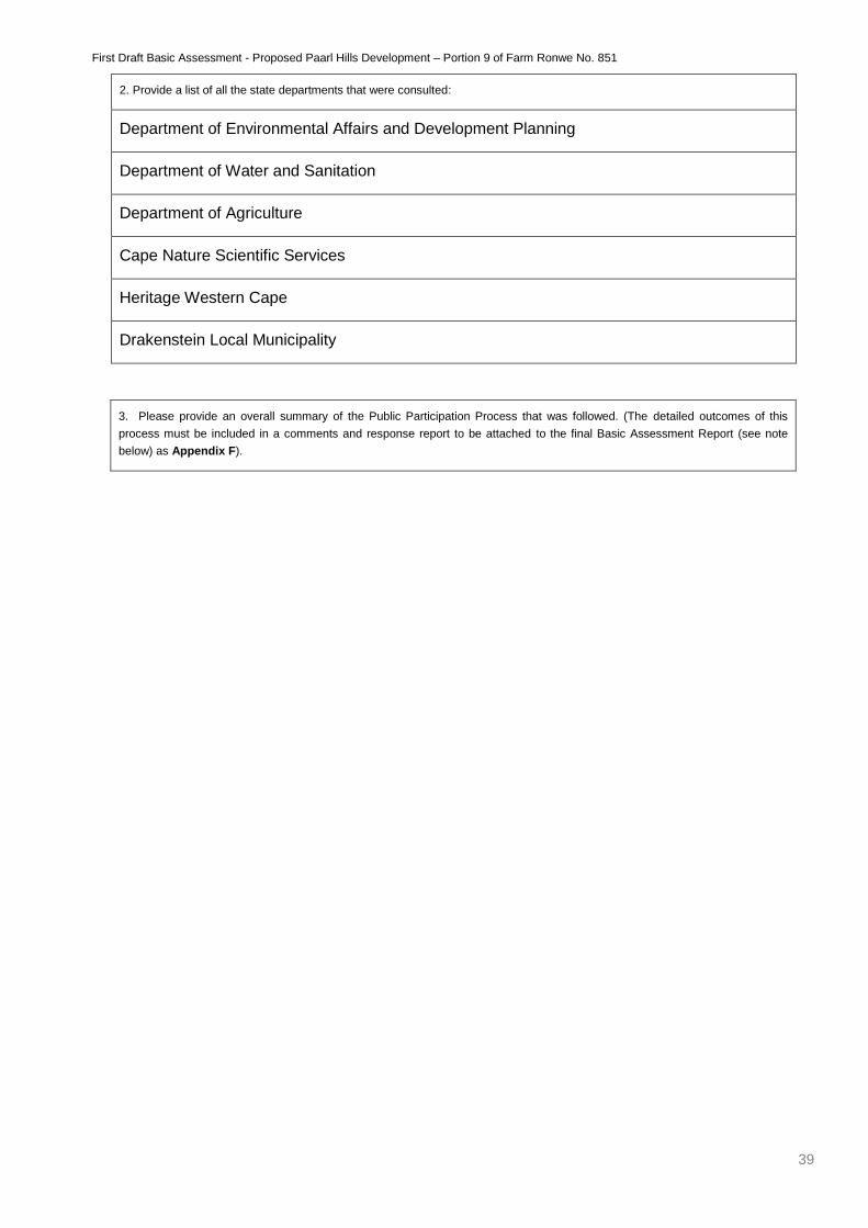
First Draft Basic Assessment - Proposed Paarl Hills Development – Portion 9 of Farm Ronwe No. 851
39
3. Please provide an overall summary of the Public Participation Process that was followed. (The detailed outcomes of this
process must be included in a comments and response report to be attached to the final Basic Assessment Report (see note
below) as Appendix F).
2. Provide a list of all the state departments that were consulted:
Department of Environmental Affairs and Development Planning
Department of Water and Sanitation
Department of Agriculture
Cape Nature Scientific Services
Heritage Western Cape
Drakenstein Local Municipality
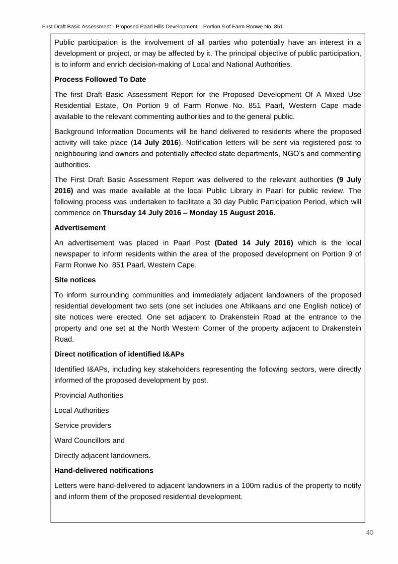
First Draft Basic Assessment - Proposed Paarl Hills Development – Portion 9 of Farm Ronwe No. 851
40
Public participation is the involvement of all parties who potentially have an interest in a
development or project, or may be affected by it. The principal objective of public participation,
is to inform and enrich decision-making of Local and National Authorities.
Process Followed To Date
The first Draft Basic Assessment Report for the Proposed Development Of A Mixed Use
Residential Estate, On Portion 9 of Farm Ronwe No. 851 Paarl, Western Cape made
available to the relevant commenting authorities and to the general public.
Background Information Documents will be hand delivered to residents where the proposed
activity will take place (14 July 2016). Notification letters will be sent via registered post to
neighbouring land owners and potentially affected state departments, NGO’s and commenting
authorities.
The First Draft Basic Assessment Report was delivered to the relevant authorities (9 July
2016) and was made available at the local Public Library in Paarl for public review. The
following process was undertaken to facilitate a 30 day Public Participation Period, which will
commence on Thursday 14 July 2016 – Monday 15 August 2016.
Advertisement
An advertisement was placed in Paarl Post (Dated 14 July 2016) which is the local
newspaper to inform residents within the area of the proposed development on Portion 9 of
Farm Ronwe No. 851 Paarl, Western Cape.
Site notices
To inform surrounding communities and immediately adjacent landowners of the proposed
residential development two sets (one set includes one Afrikaans and one English notice) of
site notices were erected. One set adjacent to Drakenstein Road at the entrance to the
property and one set at the North Western Corner of the property adjacent to Drakenstein
Road.
Direct notification of identified I&APs
Identified I&APs, including key stakeholders representing the following sectors, were directly
informed of the proposed development by post.
Provincial Authorities
Local Authorities
Service providers
Ward Councillors and
Directly adjacent landowners.
Hand-delivered notifications
Letters were hand-delivered to adjacent landowners in a 100m radius of the property to notify
and inform them of the proposed residential development.
First Draft Basic Assessment - Proposed Paarl Hills Development – Portion 9 of Farm Ronwe No. 851
41
Concerns raised by I&Aps
No concerns has been received as of yet. The First Public Participation period commences Thursday
14 July 2016 – Monday 15 August 2016. All comments received from I&APs will be captured on a
stakeholder database, acknowledged by personal letters and forwarded to the relevant environmental
specialists for consideration.
Comments and Response Report
The Comments and Response report will be included (once the Public Participation Period ends) in
the Second Draft Basic Assessment Report.
Please note:
Should any of the responses be “No” and no deviation or exemption from that requirement was requested and agreed to
/granted by the Department, the Basic Assessment Report will be rejected.
A list of all the potential interested and affected parties, including the organs of State, notified and a list of all the register of
interested and affected parties, must be submitted with the final Basic Assessment Report. The list of registered interested and
affected parties must be opened, maintained and made available to any person requesting access to the register in writing.
The draft Basic Assessment Report must be submitted to the Department before it is made available to interested and affected
parties, including the relevant organs of State and State departments which have jurisdiction with regard to any aspect of the
activity, for a 40-day commenting period. With regard to State departments, the 40-day period commences the day after the
date on which the Department as the competent/licensing authority requests such State department in writing to submit
comment. The applicant/EAP is therefore required to inform this Department in writing when the draft Basic Assessment Report
will be made available to the relevant State departments for comment. Upon receipt of the Draft Basic Assessment Report and
this confirmation, this Department will in accordance with Section 24O(2) and (3) of the NEMA request the relevant State
departments to comment on the draft report within 40 days.
All comments of interested and affected parties on the draft Basic Assessment Report must be recorded, responded to and
included in the Comments and Responses Report included as Appendix F to the final Basic Assessment Report. If necessary, any
amendments in response to comments received must be effected in the Basic Assessment Report itself. The Comments and
Responses Report must also include a description of the public participation process followed.
The final Basic Assessment Report must be made available to registered interested and affected parties for comment before
submitting it to the Department for consideration. Unless otherwise indicated by the Department, a final Basic Assessment
Report must be made available to the registered interested and affected parties for comment for a minimum of 21-days.
Comments on the final Basic Assessment Report does not have to be responded to, but the comments must be attached to the
final Basic Assessment Report.
The minutes of any meetings held by the EAP with interested and affected parties and other role players which record the views
of the participants must also be submitted as part of the public participation information to be attached to the final Basic
Assessment Report as Appendix F.
Proof of all the notices given as indicated, as well as of notice to the interested and affected parties of the availability of the
draft Basic Assessment Report and final Basic Assessment Report must be submitted as part of the public participation
information to be attached to the final Basic Assessment Report as Appendix F.
First Draft Basic Assessment - Proposed Paarl Hills Development – Portion 9 of Farm Ronwe No. 851
42
SECTION D: NEED AND DESIRABILITY
Please Note: Before completing this section, first consult this Department’s Guideline on Need and Desirability (August 2010) available on
the Department’s website (http://www.capegateway.gov.za/eadp).
1. Is the activity permitted in terms of the property’s existing land use rights? YES NO Please explain
An application is submitted by TTP Consult according to terms of Section 15 clause (2)(a) and (d) of
the Municipal Land Use Planning By-Law, 2015 for the rezoning and subdivision of Portion 9 of
the Farm No. 851 (Ronwe) from Agricultural Zone I to Subdivisional Area (Land Use Planning
Ordinance Section 8 Scheme Regulations Applicable), in order to establish a residential estate
which will incorporate storage units. The proposed development will consist of 87 single residential
erven, parks (private open space), 396 storage units, a church, gatehouse and a refuse area.
The new zones applicable, as per the site development plan is as follows:
Residential Zone I: which include the following land-uses, dwelling-houses (detached building
containing only one dwelling unit).
Institutional Zone II: which include the following land-uses, house of worship (church).
Open Space Zone II: which include the following land-uses, private open space (parks) and
private internal roads.
Special Zone: which would include the following land-uses, storage units.
First Draft Basic Assessment - Proposed Paarl Hills Development – Portion 9 of Farm Ronwe No. 851
43
2. Will the activity be in line with the following?
(a) Provincial Spatial Development Framework (PSDF) YES NO Please explain
The approved Provincial Spatial Development Framework (PSDF), currently under review, seeks
to give broad spatial directive on an overarching scale and seeks to:
give spatial expression to the Provincial Growth and Development Strategy;
guide municipal integrated development plans and spatial development frameworks
help prioritise and align investment and infrastructure plans of provincial and nation
departments, parastatal’s programmes;
give clear signals to private sector regarding desires development directions;
increase predictability in the development environment and;
redress the spatial legacy of apartheid
It aims to achieve the desired spatial development pattern by setting the goal at achieving
sustainable development. The three pillars of sustainability, namely ecological integrity, social equity
and economic efficiency set the overarching themes in which the 9 strategic objectives are
clustered.
The strategic objectives are as follow:
Objective 1: Align future settlement pattern of the Province with the area of economic potential and
the location of environmental resources.
Objective 2: Deliver human development programmes and basic needs programmes wherever they
are required.
Objective 3: Strategically invest in scare public resources where they will generate the highest socio-
economic returns.
Objectives 4: Support land reform.
Objective 5: Conserve and strengthen the sense of place on important natural, cultural and
productive landscapes, artefacts and buildings.
Objective 6: End the apartheid structure of urban settlements.
Objective 7: Conveniently locate urban activities and promote public and non-motorised transport.
Objective 8: Protect biodiversity and agricultural resources.
Objective 9: Minimise the consumption of scarce environmental resources, particularly water, fuel,
building material, mineral resources, electricity and land.

First Draft Basic Assessment - Proposed Paarl Hills Development – Portion 9 of Farm Ronwe No. 851
44
As such the proposed development on Portion 9 of Farm 851, specifically seeks to maximise the
potential of the subject property which due to its strategic location and nature within the agricultural
context it is set, is grossly underutilised due to the land use rights that have not been kept up with
the development pattern over time. The agricultural zone property has lost its viability in terms
of agricultural potential and thus a residential development would be better suited on the
subject property.
The proposed development specifically seeks to achieve Objectives 1, 3, 6, 7, 8 and 9 by
unlocking the potential of this underutilised, but developable property as an in-fill development
which is well within the urban context in contrast to developments which wishes to extend the urban
edge by an ad-hoc manner. The strategic location ensures that scarce resources such as; water and
electricity are used most cost effectively due to the proximity and ease of service connection into an
existing network. By providing more choices to the residential market, especially in the middle sector
and rental market it provides choices to a wider spectrum of people and income groups. By ensuring
that the density of residential units is optimally implemented without losing the quality of the
environment ensures that the viability of public transport is increased. The proposed residential
development within the urban edge would ease the development pressure of township
establishments outside the urban edge, where valuable agricultural land is still viably utilised
or where critical biodiversity areas are located.
(b) Urban edge / Edge of Built environment for the area YES NO Please explain
The proposed development is located within the urban edge.
First Draft Basic Assessment - Proposed Paarl Hills Development – Portion 9 of Farm Ronwe No. 851
45
(c) Integrated Development Plan and Spatial Development Framework of the
Local Municipality (e.g. would the approval of this application compromise the
integrity of the existing approved and credible municipal IDP and SDF?).
YES NO Please explain
The primary focus of the Drakenstein Municipality Spatial Development Framework (SDF) is geared
towards:
The alleviation of poverty through the spatial restructuring of the municipality over time and in
so doing redress the imbalances created through the system of apartheid;
Reverse the practice of located the poor away from opportunities, facilities and places of
employment in dormitory suburbs on the urban fringe;
Increased densities and a compact urban environment that will spread the benefits of urban
living to a wider section of the population;
Increased accessibility to existing and new services, infrastructure and opportunities to
enhance the overall quality of life of communities;
Providing new and reinforcing existing opportunities for economic development and
spreading the benefits thereof to a large majority of the population;
Protection of the natural resource base of the municipality; and
Protection of the agricultural resource base of the municipality
The proposed development seeks to directly and indirectly respond to various policy statements
relating to ensure an environmental manageable development, ensuring a compact, quality
environment, efficiency, protecting scarce resources by utilising land within the urban footprint
optimally, conforming to structuring elements in the city and district, managing land uses and
directing development to conform to the urban edge as structuring elements
(d) Approved Structure Plan of the Municipality YES NO Please explain
The proposed development is in line with the approved structure plan for Drakenstein Municipality as
it is located within the urban edge.
(e) An Environmental Management Framework (EMF) adopted by the Department
(e.g. Would the approval of this application compromise the integrity of the existing
environmental management priorities for the area and if so, can it be justified in
terms of sustainability considerations?)
YES NO Please explain
The proposed development is in line with the approved Drakenstein EMF. Not only will the proposed
development enhance and upgrade the property where the development will commence but also create jobs
during operational and construction phases.
(f) Any other Plans (e.g. Guide Plan) YES NO Please explain
N/A
First Draft Basic Assessment - Proposed Paarl Hills Development – Portion 9 of Farm Ronwe No. 851
46
3. Is the land use (associated with the activity being applied for) considered within the
timeframe intended by the existing approved Spatial Development Framework (SDF)
agreed to by the relevant environmental authority (i.e. is the proposed development in
line with the projects and programmes identified as priorities within the credible IDP)?
YES NO Please explain
The proposed development is in line with the Provincial Spatial Development Framework (PSDF)
and the Drakenstein Municipality Spatial Development Framework (DSDF). Unlocking the potential
of this underutilised, but developable property as an in-fill development which is well within the urban
context in contrast to developments which wishes to extend the urban edge by an ad-hoc manner.
The strategic location ensures that scarce resources such as; water and electricity are used most
cost effectively due to the proximity and ease of service connection into an existing network. By
providing more choices to the residential market, especially in the middle sector and rental market it
provides choices to a wider spectrum of people and income groups. By ensuring that the density of
residential units is optimally implemented without losing the quality of the environment ensures that
the viability of public transport is increased. The proposed residential development within the urban
edge would ease the development pressure of township establishments outside the urban edge,
where valuable agricultural land is still viably utilised or where critical biodiversity areas are located.
This area is currently under considerable pressure for low density, most notably for low-density
upmarket gated community type of residential development. Future development in this area is
regarded as appropriate given the critical mass of development in this area. The nature of such
development will be considered in order to ensure the creation of an efficient urban structure. The
above would imply that a variety of residential development types could be appropriate, but taking
into account that this property abuts the urban edge that a low-to-medium residential density would
be appropriate.
4. Should development, or if applicable, expansion of the town/area concerned in terms
of this land use (associated with the activity being applied for) occur here at this point
in time?
YES NO Please explain
The proposed development will occur within the urban edge on privately owned property. The
portion of land in question is currently not being utilised to its full potential. Development of this site
will therefore not only have a positive economic spin-off, but will necessitate the purposeful use of
the property.
First Draft Basic Assessment - Proposed Paarl Hills Development – Portion 9 of Farm Ronwe No. 851
47
5. Does the community/area need the activity and the associated land use concerned (is
it a societal priority)? (This refers to the strategic as well as local level (e.g.
development is a national priority, but within a specific local context it could be
inappropriate.)
YES NO Please explain
The proposed development will not only create much needed job opportunities to the local
community during construction and operational phases of development, but also boost the economy
as investment opportunities.
6. Are the necessary services with adequate capacity currently available (at the time of
application), or must additional capacity be created to cater for the development?
(Confirmation by the relevant Municipality in this regard must be attached to the final
Basic Assessment Report as Appendix E.)
YES NO Please explain
All bulk services will be connected to existing infrastructure. According to GLS Consulting (Pty) Ltd.
and Drakenstein Municipality, there is insufficient capacity in the existing water reticulation system to
accommodate the proposed development but the existing Leliefontein reservoir has sufficient
capacity to accommodate the proposed development. Thus a network upgrade is proposed, and
ongoing correspondence with Drakenstein Municipality is underway. (Please refer to Addedendum G
– Specialist Reports)
7. Is this development provided for in the infrastructure planning of the municipality, and if
not what will the implication be on the infrastructure planning of the municipality
(priority and placement of services and opportunity costs)? (Comment by the relevant
Municipality in this regard must be attached to the final Basic Assessment Report as
Appendix E.)
YES NO Please explain
Comment form the Drakenstein Municipality has been requested and a confirmation letter from the
Municipality will be included in the Final BAR.
8. Is this project part of a national programme to address an issue of national concern or
importance? YES NO Please explain
N/A
First Draft Basic Assessment - Proposed Paarl Hills Development – Portion 9 of Farm Ronwe No. 851
48
9. Do location factors favour this land use (associated with the activity applied for) at this
place? (This relates to the contextualisation of the proposed land use on this site
within its broader context.)
YES NO Please explain
The proposed residential estate, storage facilities and church in character and purpose lends itself
well to the location of the property. The property, a landlocked piece of undeveloped unviable
farmland is ideally located in an area that is well in the developing phase with good access from the
northern boundary where it meets Drakenstein Road. The gentle slope of the property provides
excellent natural drainage patterns and good views from the property on the surrounding natural
features that include the Paarl farmlands and mountains. It is clear from a spatial point of view
around this property that it is well suited for development and a very popular area for residences
who wish to settle here due to various reasons, one of which is the close proximity to the Paarl Mall.
Not only is it close to amenities in the area but its close proximity to the CBD of Paarl, and Southern
Paarl industrial area makes it close to work opportunities. Also being in close proximity to the
periphery of the town provides even further opportunities including a more rural-urban feeling
between farmland and the urban setting
10. How will the activity or the land use associated with the activity applied for, impact
on sensitive natural and cultural areas (built and rural/natural environment)? YES NO Please explain
The existing character and spatial form of the area are low-density, consisting of main dwellings
(houses), additional worker houses and outbuildings. The proposed development is designed to
complement the existing rural-urban character and to enhance it with a medium density residential
development and storage units. It aims to enhance the rural-urban character by breaking the
monotonous forms and aesthetics of many of the surrounding rural farmland developments. The
development in terms of land-use is consistent with the predominantly medium agricultural uses in
the area together with low- to medium residential uses. It aims to bring a greater choice to the area
in terms of different forms of residential units but also ensuring that in terms of sizing, it aims to
provide well designed, but compact living units that will cater for the middle-income class. In terms of
the spatial form, it is clear that the development pattern over the past year has dictated the spatial
form, i.e. the growth of the town.
As the property have been subject to intense agricultural activities the total area have been
disturbed and no natural vegetation remains. The site comprise no CBA’s, natural wetlands or
threatened ecosystems, thus the proposed development is favourable.
11. How will the development impact on people’s health and wellbeing (e.g. in terms of
noise, odours, visual character and sense of place, etc)? YES NO Please explain
It is not expected that the proposed project will have a significant noise or visual impacts during the
operational phase and the noise and visual impacts during the construction phase will only be
temporary.
First Draft Basic Assessment - Proposed Paarl Hills Development – Portion 9 of Farm Ronwe No. 851
49
12. Will the proposed activity or the land use associated with the activity applied for,
result in unacceptable opportunity costs? YES NO Please explain
The proposed site is currently not being utilised as does not contain intact natural vegetation in its
entirety. The proposed development will therefore not eliminate active agricultural land or destroy
sensitive vegetation. The proposed project will create jobs during both the construction (temporary
jobs) and operational (temporary and permanent jobs) phases of the proposed project, something
greatly needed in the current economic climate. It is therefore unlikely that the opportunity costs
resulting from the proposed project will be unacceptable.

First Draft Basic Assessment - Proposed Paarl Hills Development – Portion 9 of Farm Ronwe No. 851
50
13. What will the cumulative impacts (positive and negative) of the proposed land use
associated with the activity applied for, be? YES NO Please explain
Considering the proposed development on Portion 9 of Farm 851, the following impacts are
identified:
Vegetation
The proposed development includes the removal of more than 1 ha of vegetation. Since the
proposed development will take place on previously cultivated land no significant impact on flora is
expected, the area would have historically been covered with Boland Granite Fynbos (90%) and
Swartland Alluvium Fynbos (10%). The property has been totally transformed and no natural
vegetation occurs.
Freshwater
No significant impact on freshwater resources are expected the prevailing artificial stormwater pond
(in the south western corner) is not included in the SDP, and an alternative attenuation pond is
proposed in the north western corner of the proposed development. (Please refer to Addendum B –
Site Layout and Detailed Drawings - Storm Water Pond Detail)
Traffic
A detailed Traffic Impact Assessment have been conducted by Element Consulting Engineers (PTY)
Ltd. (Please refer to Addendum G – Specialist Reports). The following recommendations are
extracted and summarised from the report. –
In order to improve the acceptability of the level of service experienced at the Wemmershoek
Road / Drakenstein Road intersection, it is proposed that the intersection is signalised or a
roundabout is constructed.
The Wemmershoek Road / Drakenstein Road intersection will operate at an LOS A and an
LOS B for the future background and total future weekday AM peak hour traffic conditions
respectively if this intersection is signalised.
Signalising this intersection will only serve as an interim solution since the access spacing
requirements will become insufficient in the future when the Wemmershoek Road / N1 off
ramp intersection are signalised.
The Wemmershoek Road / Drakenstein Road intersection will operate at an LOS A for both
the future background and total future weekday AM peak hour traffic conditions if this
intersection converted to a roundabout.
The access management plan for the Wemmershoek Road will require that a roundabout is
constructed at the Wemmershoek Road / Drakenstein Road intersection and this will,
therefore, be the proposed alternative.
According to the requirements set out in the Provincial Administration Western Cape: Road
Access Guidelines regarding the requirements for additional turning lanes, a separate right
turn lane is required at the Drakenstein Road / Proposed Access intersection.
A total of 143 parking bays should be provided on site for the religious institution.
A total of 43 parking bays should be provided on site for the storage units.
First Draft Basic Assessment - Proposed Paarl Hills Development – Portion 9 of Farm Ronwe No. 851
51
Visual
Various methods will be used to reduce the visual impacts of this development where needed. A
5,0m landscape servitude will act as a parallel “buffer zone” between the residential erven and the
storage units, no negative visual impact will exist. Furthermore, appropriate landscaping will be used
on the sidewalks of the entrance / exit avenue of the development, as to enhance the streetscape
which will form the “walls” of the avenue. Landscaping will also be used on the boundaries of the
subject property to create privacy and a sense of place within the development. From a street view
perspective, from Drakenstein Road, the visual impact of the development will also be reduced by
way of landscaping adjacent to the northern boundary of the subject property. (Please refer to
Addendum B – Landscaping and Artist Illustrations of the proposed development).
Noise
Construction activities could be hindrance in terms of noise to the immediate surroundings. During
the operational phase the noise pollution is not expected to be significant. Noise impacts will be
temporary during the construction phase, and the operational phase is not expected to have any
significant noise impacts, as the operations will be the same as the neighbouring environment.
Heritage
HWC confirmed that no impact on heritage resources are expected. (Please refer to Addendum E)
Services
Triple Three Engineering Solutions compiled a Civil Engineering Report, and GLS is currently
consulting with the municipality as a network upgrade is proposed to accommodate the
development. Awaiting confirmation from the Municipality.
Economic
The proposed development will not only boost the local economy, but also create jobs for local
people during the construction and operational phase of the development, which will ultimately
enhance the livelihoods of many.
14. Is the development the best practicable environmental option for this land/site? YES NO Please explain
As the property can no longer be cultivated the site is described as being highly desirable for
alternative development opportunities to effectively utilise the potential of the site.
15. What will the benefits be to society in general and to the local communities? Please explain
The proposed development will be beneficial to the local communities as its residents will not only
boost the economy of the local district but also create job opportunities during the construction and
operational phases of development.
16. Any other need and desirability considerations related to the proposed activity? Please explain
N/A
First Draft Basic Assessment - Proposed Paarl Hills Development – Portion 9 of Farm Ronwe No. 851
52
(17) Please describe how the general objectives of Integrated Environmental Management as set out in section 23 of NEMA have been
taken into account:
The Impact Assessment process conforms to the principles of Integrated Environmental
Management (IEM). The process attempts to identify all potential impacts as well as identify practical
means by which the developer can develop the necessary mitigation measures to manage these
impacts. The EIA process is structured in a way to identify environmental risks, lessen community
conflict by actively promoting public participation, propose the means to minimise adverse
environmental affects and inform all relevant government decision makers.
The impact assessment will ensure that all environmental assessments are integrated into all
aspects of the proposed project’s life cycle, construction/operation and decommissioning.
The EIA process identified all possible impacts. These impacts were evaluated to determine the
actual impact on the environment. The triple bottom approach was taken whereby the socio,
economic and environmental impacts were assessed. This also ensured that Section 2(3) of NEMA
was adhered to.
Section 2(4) of NEMA was further taken into consideration to ensure that ecosystems and loss of
biological diversity are avoided, or, where they cannot be altogether avoided, are minimised and
remedied.
The proposed development on Erf 12935 will be constructed in such a way as to ensure that
pollution and degradation is avoided by the enforcing of the attached Environmental Management
Program (EMP). Waste will be minimised by the implementation of the attached Waste Minimisation
plan which forms part of the project EMP (Please refer to Addendum H).
The cultural impacts were also assessed as an application was submitted to Heritage Western Cape
(no objection towards the proposed development, Please refer to Addendum E).
Waste will be minimized by the implementation of the attached Waste Minimization plan which forms
part of the project EMP.
Although few, the alternatives were also assessed as required by Section 23 (2) (b).
A full public participation as per Section 54 is being undertaken as part of this assessment.
The effects of the activities were assessed to ensure the environmental aspects receive adequate
consideration before construction actions are taken.
First Draft Basic Assessment - Proposed Paarl Hills Development – Portion 9 of Farm Ronwe No. 851
53
(18) Please describe how the principles of environmental management as set out in section 2 of NEMA have been taken into account:
The EIA process identified all possible impacts. These impacts were evaluated to determine the
actual impact on the environment. The triple bottom approach was taken whereby socio, economic
and environmental impacts were assessed. This also ensured that Section 2(3) of NEMA was
adhered to.
Section 2(4) of NEMA was further taken into consideration to ensure that ecosystems and loss of
biological diversity are avoided, or, where they cannot be altogether avoided, are minimised and
remedied.
Cultural impacts were assessed in an application to Heritage Western Cape. It is not foreseen that
any National or Cultural heritage will be disturbed by the proposed development. This has been
confirmed by Heritage Western Cape in the ROD received on the 4th of April 2016 (Please
refer to Addendum E – Letters from Authorities).
Waste will be minimized by the implementation of the attached Waste Minimization plan which forms
part of the project EMP.
Although few, the alternatives were also assessed as required by Section 23(2)b.
A full public participation as per Section 54 is being undertaken as part of this assessment.
First Draft Basic Assessment - Proposed Paarl Hills Development – Portion 9 of Farm Ronwe No. 851
54
SECTION E: ALTERNATIVES
Please Note: Before completing this section, first consult this Department’s Guideline on Alternatives (August 2010) available on the
Department’s website (http://www.capegateway.gov.za/eadp).
“Alternatives”, in relation to a proposed activity, means different means of meeting the general purposes and requirements of the activity,
which may include alternatives to –
(a) the property on which, or location where, it is proposed to undertake the activity;
(b) the type of activity to be undertaken;
I the design or layout of the activity;
(d) the technology to be used in the activity;
(e) the operational aspects of the activity; and
(f) the option of not implementing the activity.
The NEMA prescribes that the procedures for the investigation, assessment and communication of the potential consequences or impacts
of activities on the environment must, inter alia, with respect to every application for environmental authorisation –
ensure that the general objectives of integrated environmental management laid down in NEMA and the National Environmental
Management Principles set out in NEMA are taken into account; and
include an investigation of the potential consequences or impacts of the alternatives to the activity on the environment and assessment
of the significance of those potential consequences or impacts, including the option of not implementing the activity.
The general objective of integrated environmental management is, inter alia, to “identify, predict and evaluate the actual and potential
impact on the environment, socio-economic conditions and cultural heritage, the risks and consequences and alternatives and options for
mitigation of activities, with a view to minimising negative impacts, maximising benefits, and promoting compliance with the principles of
environmental management” set out in NEMA.
1. In the sections below, please provide a description of any indentified and considered alternatives and alternatives that were found to
be feasible and reasonable.
Please note: Detailed written proof the investigation of alternatives must be provided and motivation if no reasonable or feasible
alternatives exist.
(a) Property and location/site alternatives to avoid negative impacts, mitigate unavoidable negative impacts and maximise positive
impacts, or detailed motivation if no reasonable or feasible alternatives exist:
There are no reasonable and/or feasible site alternatives for the proposed development. If
permission for the proposed development on the proposed site is not granted the site will remain in
its current degraded state.
(b) Activity alternatives to avoid negative impacts, mitigate unavoidable negative impacts and maximise positive impacts, or detailed
motivation if no reasonable or feasible alternatives exist:
There are no reasonable or feasible activity alternatives for the proposed site. The proposed area
cannot feasibly be utilised for agriculture. Careful consideration was given to various land use
options and this proposal was the only viable option that fits into the character and compliments the
current land use pattern. Agricultural alternatives (current zoning) were proven not to be viable.
Industry or business uses would be out of place due to the locality of the subject property which
situates on the periphery of the urban edge.
First Draft Basic Assessment - Proposed Paarl Hills Development – Portion 9 of Farm Ronwe No. 851
55
(c) Design or layout alternatives to avoid negative impacts, mitigate unavoidable negative impacts and maximise positive impacts, or
detailed motivation if no reasonable or feasible alternatives exist:
Layout 1 (preferred)
The total extent of the property is 114 225.60 m2 and the proposed development includes, 87
Residential Stands approximately 33 064.991 m2, 396 Storage units approximately 11 548.291 m2,
road surface approximately 24 626.774 m2 , 4 open spaces / parks approximately 11 121.821 m2,
gatehouses / security control approximately 308.196 m2, institutional space approximately 20
000.012 m2, walkways including driveways approximately 11 653.593 m2, refuse area approximately
252.375 m2, parking bays (place of worship 500 bays, storage yard 33 bays, residential dwellings 2
bays per unit, residential development 4 visitor bays), a servitude / landscaping buffer approximately
4 380.227 m2 and attenuation pond.
One access road will provide access to the property. It is envisaged that the southern section
(approximately half of the property) be transformed into a residential estate including recreational
private parks for residents. The northern section will include an institutional zone which will
accommodate the church as well as a special zone to include the storage yard.(Please refer to
Addendum A – Proposed new Site Development Plan)
Alternative layout
An alternative layout included 81 residential units (ranging from 270 – 550 m2 each), an institutional
zone 20 000 m2 and educational zone 7500 m2. Thus no provision was made for a storage yard.
This layout is not preferred by the developer, as it would not ideally utilise the property to its full
potential. The proposed development is situated within the urban edge and the surrounding
properties are currently also in the process of EIA applications for development. The entire area is
envisioned for similar small-medium sized residential developments, and the increasing demand for
storage space inspired the addition of the storage yard to the preferred layout plan.
(d) Technology alternatives (e.g. to reduce resource demand and resource use efficiency) to avoid negative impacts, mitigate unavoidable
negative impacts and maximise positive impacts, or detailed motivation if no reasonable or feasible alternatives exist:
No feasible and or reasonable Technology alternatives to avoid negative impacts exist
First Draft Basic Assessment - Proposed Paarl Hills Development – Portion 9 of Farm Ronwe No. 851
56
(e) Operational alternatives to avoid negative impacts, mitigate unavoidable negative impacts and maximise positive impacts, or detailed
motivation if no reasonable or feasible alternatives exist:
No feasible and or reasonable Operational alternatives to avoid negative impacts exist
(f) the option of not implementing the activity (the No-Go Option):
No-Go Alternative:
Should the activity not be approved the property will remain in its current state This will result in no
development, and no job creation to ultimately enhance the livelihoods of local communities. The
activity will benefit society in general by creating jobs during both the construction (temporary jobs)
and operational (temporary and permanent jobs) phases of the proposed project.
It is GNEC’s objective opinion that the No-Go Alternative should therefore not be supported
in this case.
(g) Other alternatives to avoid negative impacts, mitigate unavoidable negative impacts and maximise positive impacts, or detailed
motivation if no reasonable or feasible alternatives exist:
N/A
(h) Please provide a summary of the alternatives investigated and the outcomes of such investigation:
Please note: If no feasible and reasonable alternatives exist, the description and proof of the investigation of alternatives, together with
motivation of why no feasible or reasonable alternatives exist, must be provided.
The landowner proposed the development of 87 residential dwellings, 396 storage units, and an
institution (church) on Portion 6 of Farm 851, Paarl, Western Cape. The property is situated within
the urban edge of Drakenstein Municipality and according to various policies seems preferable for
future development.
The preferred Layout shows that the entire property will be utilised to its full potential including four
(4) parks / open spaces and a safe environment where residents can relax with exceptional views of
the surrounding landscape. The site has a 360-degree view due to the moderate contour intervals.
To the east a view towards the Hawequas Mountain Catchment Area / Nature Reserve, to the south
a view towards the Hottentots-Holland Mountain Catchment Area, to the west a view towards Paarl
Berg, and towards the north a view of Paarl valley. Excellent views towards the surrounding
farmland are observed in all directions. The orientation also allows for good sun penetration,
especially in cold and wet winter months while the moderate contour intervals allow for a cooler wind
circulation through the property during the hot summer months of the Boland.
As the property has been subject to intense agricultural activities the whole site has been totally
transformed and no indigenous vegetation occurs, from an environmental perspective the
development pose no negative impact and could ultimately improve the state of the environment and
economy by developing this portion.
Should this development not be granted environmental authorisation, the property will remain in its
current state and this is not preferable.
First Draft Basic Assessment - Proposed Paarl Hills Development – Portion 9 of Farm Ronwe No. 851
57
SECTION F: IMPACT ASSESSMENT, MANAGEMENT,
MITIGATION AND MONITORING MEASURES
Please note: The information in this section must be duplicated for all the feasible and reasonable alternatives (where relevant).
1. PLEASE DESCRIBE THE MANNER IN WHICH THE DEVELOPMENT WILL IMPACT ON THE
FOLLOWING ASPECTS:
(a) Geographical and physical aspects:
The proposed project will entail the development of the entire property and the development footprint
will be approximately 116 937.22 m2. As the property has been subject to intense agricultural
activities no natural vegetation occurs on site.
(b) Biological aspects:
Will the development have an impact on critical biodiversity areas (CBAs) or ecological support areas (CSAs)? YES NO
If yes, please describe:
N/A
Will the development have an impact on terrestrial vegetation, or aquatic ecosystems (wetlands, estuaries or the
coastline)? YES NO
If yes, please describe:
N/A
Will the development have an impact on any populations of threatened plant or animal species, and/or on any habitat that
may contain a unique signature of plant or animal species? YES NO
If yes, please describe:
N/A
Please describe the manner in which any other biological aspects will be impacted:
N/A
(c) Socio-Economic aspects:
What is the expected capital value of the activity on completion? Not known at
this stage
What is the expected yearly income or contribution to the economy that will be generated by or as a result of the
activity?
Not known at
this stage
Will the activity contribute to service infrastructure? YES NO
First Draft Basic Assessment - Proposed Paarl Hills Development – Portion 9 of Farm Ronwe No. 851
58
How many new employment opportunities will be created in the construction phase of the activity? Not known
at this stage
What is the expected value of the employment opportunities during the construction phase? Not known
at this stage
What percentage of this will accrue to previously disadvantaged individuals? Not known
at this stage
How will this be ensured and monitored (please explain):
N/A
How many permanent new employment opportunities will be created during the operational phase of the activity? Not known
at this stage
What is the expected current value of the employment opportunities during the first 10 years? Not known
at this stage
What percentage of this will accrue to previously disadvantaged individuals? Not known
at this stage
How will this be ensured and monitored (please explain):
N/A
Any other information related to the manner in which the socio-economic aspects will be impacted:
N/A
(d) Cultural and historic aspects:
No archaeological or historical material is expected to occur on the site as the site has been
severely disturbed by previous agricultural activities. (Please refer to Addendum E – Letters from
Authorities for confirmation from HWC).
Some noise impacts are expected during the construction phase of the activity, but this will only be
temporary in nature.
First Draft Basic Assessment - Proposed Paarl Hills Development – Portion 9 of Farm Ronwe No. 851
59
2. WASTE AND EMISSIONS
(a) Waste (including effluent) management
Will the activity produce waste (including rubble) during the construction phase? YES NO
If yes, indicate the types of waste (actual type of waste, e.g. oil, and whether hazardous or not) and estimated quantity
per type?
Not known
at this
stage
Building rubble
None of this waste will be Hazardous. Building rubble will be disposed of at a licensed
land fill site within the Drakenstein Municipality District.
Will the activity produce waste during its operational phase? YES NO
If yes, indicate the types of waste (actual type of waste, e.g. oil, and whether hazardous or not) and estimated quantity
per type?
General
Domestic
Waste
Where and how will the waste be treated / disposed of (describe)?
If yes, indicate the types of waste (actual type of waste, e.g. oil, and whether hazardous or not) and estimated quantity per type per
phase of the development?
None of this waste will be Hazardous. Domestic waste will be collected on site by the estate and
will be disposed of together with the waste collected from the existing dwellings on site, at a
licensed landfill site in the Drakenstein Municipality District.
Has the municipality or relevant authority confirmed that sufficient capacity exist for treating / disposing of the waste to
be generated by this activity(ies)? If yes, provide written confirmation from Municipality or relevant authority
A network upgrade is proposed. Confirmation will be included in the second Draft
BAR
YES NO
Will the activity produce waste that will be treated and/or disposed of at another facility other than into a municipal
waste stream? YES NO
If yes, has this facility confirmed that sufficient capacity exist for treating / disposing of the waste to be generated by
this activity(ies)? Provide written confirmation from the facility and provide the following particulars of the facility: YES NO
Does the facility have an operating license? (If yes, please attach a copy of the license.) YES NO
Facility name:
Contact person:
Postal address:
Postal code:

First Draft Basic Assessment - Proposed Paarl Hills Development – Portion 9 of Farm Ronwe No. 851
60
Telephone: Cell:
E-mail: Fax:
Describe the measures that will be taken to reduce, reuse or recycle waste:
Please refer to the Waste, Water use and Electricity Consumption Minimization Plan as part
of the EMP (Addendum H).
(b) Emissions into the atmosphere
Will the activity produce emissions that will be disposed of into the atmosphere? YES NO
If yes, does it require approval in terms of relevant legislation? YES NO
Describe the emissions in terms of type and concentration and how it will be treated/mitigated:
N/A
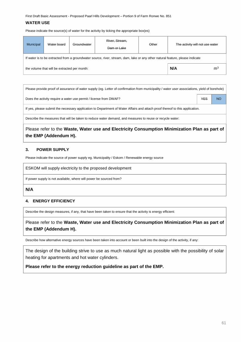
First Draft Basic Assessment - Proposed Paarl Hills Development – Portion 9 of Farm Ronwe No. 851
61
WATER USE
Please indicate the source(s) of water for the activity by ticking the appropriate box(es)
Municipal Water board Groundwater River, Stream,
Dam or Lake Other The activity will not use water
If water is to be extracted from a groundwater source, river, stream, dam, lake or any other natural feature, please indicate
the volume that will be extracted per month: N/A m3
Please provide proof of assurance of water supply (eg. Letter of confirmation from municipality / water user associations, yield of borehole)
Does the activity require a water use permit / license from DWAF? YES NO
If yes, please submit the necessary application to Department of Water Affairs and attach proof thereof to this application.
Describe the measures that will be taken to reduce water demand, and measures to reuse or recycle water:
Please refer to the Waste, Water use and Electricity Consumption Minimization Plan as part of
the EMP (Addendum H).
3. POWER SUPPLY
Please indicate the source of power supply eg. Municipality / Eskom / Renewable energy source
ESKOM will supply electricity to the proposed development
If power supply is not available, where will power be sourced from?
N/A
4. ENERGY EFFICIENCY
Describe the design measures, if any, that have been taken to ensure that the activity is energy efficient:
Please refer to the Waste, Water use and Electricity Consumption Minimization Plan as part of
the EMP (Addendum H).
Describe how alternative energy sources have been taken into account or been built into the design of the activity, if any:
The design of the building strive to use as much natural light as possible with the possibility of solar
heating for apartments and hot water cylinders.
Please refer to the energy reduction guideline as part of the EMP.
First Draft Basic Assessment - Proposed Paarl Hills Development – Portion 9 of Farm Ronwe No. 851
62
6. DESCRIPTION AND ASSESSMENT OF THE SIGNIFICANCE OF IMPACTS PRIOR TO AND AFTER
MITIGATION
Please note: While sections are provided for impacts on certain aspects of the environment and certain impacts,
the sections should also be copied and completed for all other impacts.
(a) Impacts that may result from the planning, design and construction phase (briefly describe and compare the potential
impacts (as appropriate), significance rating of impacts, proposed mitigation and significance rating of impacts after
mitigation that are likely to occur as a result of the planning, design and construction phase.
Potential impacts on geographical and physical
aspects:
Nature of impact: Impacts on existing vegetation
Extent and duration of impact: Long term
Probability of occurrence: Definite
Degree to which the impact can be reversed: High
Degree to which the impact may cause irreplaceable loss
of resources: Improbable
Cumulative impact prior to mitigation: High
Significance rating of impact prior to mitigation
(Low, Medium, Medium-High, High, or Very-High) Low
Degree to which the impact can be mitigated: Low
Proposed mitigation:
As no natural vegetation occurs on the property, it is
only proposed that landscaping for the proposed
project be done with indigenous vegetation.
Cumulative impact post mitigation: Low
Significance rating of impact after mitigation
(Low, Medium, Medium-High, High, or Very-High) Low
First Draft Basic Assessment - Proposed Paarl Hills Development – Portion 9 of Farm Ronwe No. 851
63
Potential impact on biological aspects: Impacts on biological aspects (small rodents living on
the site).
Nature of impact: Long term
Extent and duration of impact: Definite
Probability of occurrence: High
Degree to which the impact can be reversed: Improbable
Degree to which the impact may cause irreplaceable loss
of resources: Low
Cumulative impact prior to mitigation: Low
Significance rating of impact prior to mitigation
(Low, Medium, Medium-High, High, or Very-High) Low
Degree to which the impact can be mitigated: High
Proposed mitigation:
All activities on site must comply with:
The regulations of the Animal Protection Act, 1962 (Act
No. 71 of 1962); and Marine Living Resources Act,
1998 (Act No. 18 of 1998).
All construction workers must be informed that the
intentional killing of any animal is not permitted as
faunal species are a benefit to society. Poaching is
illegal and it must be a condition of employment that
any employee caught poaching will be dismissed.
Employees must be trained on how to deal with fauna
species as intentional killing will not be tolerated. In the
case of a problem animal e.g. a large snake a
specialist must be called in to safely relocate the
animal if the EO or ECO is not able to.
Cumulative impact post mitigation: Low
Significance rating of impact after mitigation
(Low, Medium, Medium-High, High, or Very-High) Low
First Draft Basic Assessment - Proposed Paarl Hills Development – Portion 9 of Farm Ronwe No. 851
64
Potential impacts on socio-economic aspects:
Nature of impact: Provision of temporary jobs during the construction
phase
Extent and duration of impact: Short term – construction.
Probability of occurrence: Definite
Degree to which the impact can be reversed: N/A
Degree to which the impact may cause irreplaceable loss
of resources: N/A
Cumulative impact prior to mitigation: Low Positive
Significance rating of impact prior to mitigation
(Low, Medium, Medium-High, High, or Very-High) Low Positive
Degree to which the impact can be mitigated: N/A, do not want to mitigate positive impacts.
Proposed mitigation: N/A, do not want to mitigate positive impacts.
Cumulative impact post mitigation: Low Positive
Significance rating of impact after mitigation
(Low, Medium, Medium-High, High, or Very-High) Low Positive
Potential impacts on cultural-historical aspects: No impacts of the cultural historical aspects are
foreseen.
Nature of impact: Long term
Extent and duration of impact: Definite
Probability of occurrence: Low
Degree to which the impact can be reversed: Highly unlikely
Degree to which the impact may cause irreplaceable loss
of resources: Low
Cumulative impact prior to mitigation: Low
Significance rating of impact prior to mitigation
(Low, Medium, Medium-High, High, or Very-High) Low
Degree to which the impact can be mitigated: High
First Draft Basic Assessment - Proposed Paarl Hills Development – Portion 9 of Farm Ronwe No. 851
65
Proposed mitigation:
Should any archaeological artefacts be exposed during
construction activities, work on the area where the
artefacts were found shall cease immediately and the
ECO as well as the Local Council shall be notified
within 24 hours.
Upon receipt of such notification, the ECO will arrange
for the excavation to be examined by an Archaeologist.
Under no circumstances shall archaeological artefacts
be removed, destroyed or interfered with.
Any archaeological sites exposed during demolition or
construction activities must not be disturbed prior to
authorisation by the Heritage Western Cape and/or the
South African Heritage Resources Agency on the
appropriate provincial heritage resource agency.
Cumulative impact post mitigation: Low
Significance rating of impact after mitigation
(Low, Medium, Medium-High, High, or Very-High)
No impacts of the cultural historical aspects are
foreseen.
Potential noise impacts: Construction activities.
Nature of impact: Short term – Construction activities will last for a few
months.
Extent and duration of impact: Definite
Probability of occurrence: Low to Medium
Degree to which the impact can be reversed: Low
Degree to which the impact may cause irreplaceable loss
of resources: Low
Cumulative impact prior to mitigation: Low to Medium
Significance rating of impact prior to mitigation
(Low, Medium, Medium-High, High, or Very-High) Low to Medium
Degree to which the impact can be mitigated: Low
Proposed mitigation:
All construction vehicles must be in a good working
order to reduce possible noise pollution.
Work hours during the construction phase shall be
strictly enforced unless permission is given (07H00 –
First Draft Basic Assessment - Proposed Paarl Hills Development – Portion 9 of Farm Ronwe No. 851
66
18H00). Permission shall not be granted without
consultation with the local industries and businesses
by the EO. No work to be done on Sundays.
Since the proposed development is in close proximity
to similar residential developments it is not expected
that the noise impacts during the operational phase will
be significant.
Cumulative impact post mitigation: Low
Significance rating of impact after mitigation
(Low, Medium, Medium-High, High, or Very-High) Construction activities.
Potential visual impacts: Construction activities and operational activities
Nature of impact: Construction - Short term
Extent and duration of impact: Definite
Probability of occurrence: Low to Medium
Degree to which the impact can be reversed: Low
Degree to which the impact may cause irreplaceable loss
of resources: Low
Cumulative impact prior to mitigation: Low
Significance rating of impact prior to mitigation
(Low, Medium, Medium-High, High, or Very-High) Low to Medium
Degree to which the impact can be mitigated: Low
Proposed mitigation:
Shade cloth must be utilised to conceal and minimise
the visual impact of contractor camps, lay down and
storage areas.
Rubble and litter must be removed every two weeks or
more often as the need arises and be disposed of at a
registered landfill site as designated by the City of
Cape Town, Solid Waste removal department.
Cumulative impact post mitigation: Low
Significance rating of impact after mitigation
(Low, Medium, Medium-High, High, or Very-High) Construction activities and operational activities
First Draft Basic Assessment - Proposed Paarl Hills Development – Portion 9 of Farm Ronwe No. 851
67
(b) Impacts that may result from the operational phase (briefly describe and compare the potential impacts (as appropriate),
significance rating of impacts, proposed mitigation and significance rating of impacts after mitigation that are likely to occur
as a result of the operational phase.
Potential impacts on the geographical and physical
aspects:
Nature of impact: Appearance of the site due to proposed development
of new residential dwellings, storage yard and church
Extent and duration of impact: Permanent
Probability of occurrence: Definite
Degree to which the impact can be reversed: N/A
Degree to which the impact may cause irreplaceable loss
of resources:
N/A – As the property has been completely
transformed and disturbed by intense agricultural
activities no significant loss is foreseen.
Cumulative impact prior to mitigation: Low Positive
Significance rating of impact prior to mitigation
(Low, Medium, Medium-High, High, or Very-High) Low Positive
Degree to which the impact can be mitigated: N/A
Proposed mitigation: Landscaping with indigenous vegetation will be done
after construction is done.
Cumulative impact post mitigation: Low Positive
Significance rating of impact after mitigation
(Low, Medium, Medium-High, High, or Very-High) Low Positive
Potential impact biological aspects:
Since the proposed development will take place on
previously cultivated land no significant impact on flora
is expected.
Nature of impact: Permanent.
Extent and duration of impact: Definitely
Probability of occurrence: Low
Degree to which the impact can be reversed: Low
Degree to which the impact may cause irreplaceable loss NA
First Draft Basic Assessment - Proposed Paarl Hills Development – Portion 9 of Farm Ronwe No. 851
68
of resources:
Cumulative impact prior to mitigation: Low
Significance rating of impact prior to mitigation
(Low, Medium, Medium-High, High, or Very-High) NA
Degree to which the impact can be mitigated: NA
Proposed mitigation:
N/A – As the property has been completely
transformed and disturbed by intense agricultural
activities no significant loss is foreseen.
Cumulative impact post mitigation: Low
Significance rating of impact after mitigation
(Low, Medium, Medium-High, High, or Very-High) Permanent.
Potential impacts on the socio-economic aspects:
Positive impacts as this project will provide temporary
jobs during the construction phase and temporary and
permanent jobs during the operational phase
Nature of impact: Short term and long-term – operational phase
Extent and duration of impact: Definite
Probability of occurrence: N/A
Degree to which the impact can be reversed: N/A
Degree to which the impact may cause irreplaceable loss
of resources: Low Positive
Cumulative impact prior to mitigation: Low Positive
Significance rating of impact prior to mitigation
(Low, Medium, Medium-High, High, or Very-High) N/A, do not want to mitigate positive impacts.
Degree to which the impact can be mitigated: N/A, do not want to mitigate positive impacts.
Proposed mitigation: Low Positive
Cumulative impact post mitigation: Low Positive
Significance rating of impact after mitigation
(Low, Medium, Medium-High, High, or Very-High) Provision of temporary and permanent jobs.
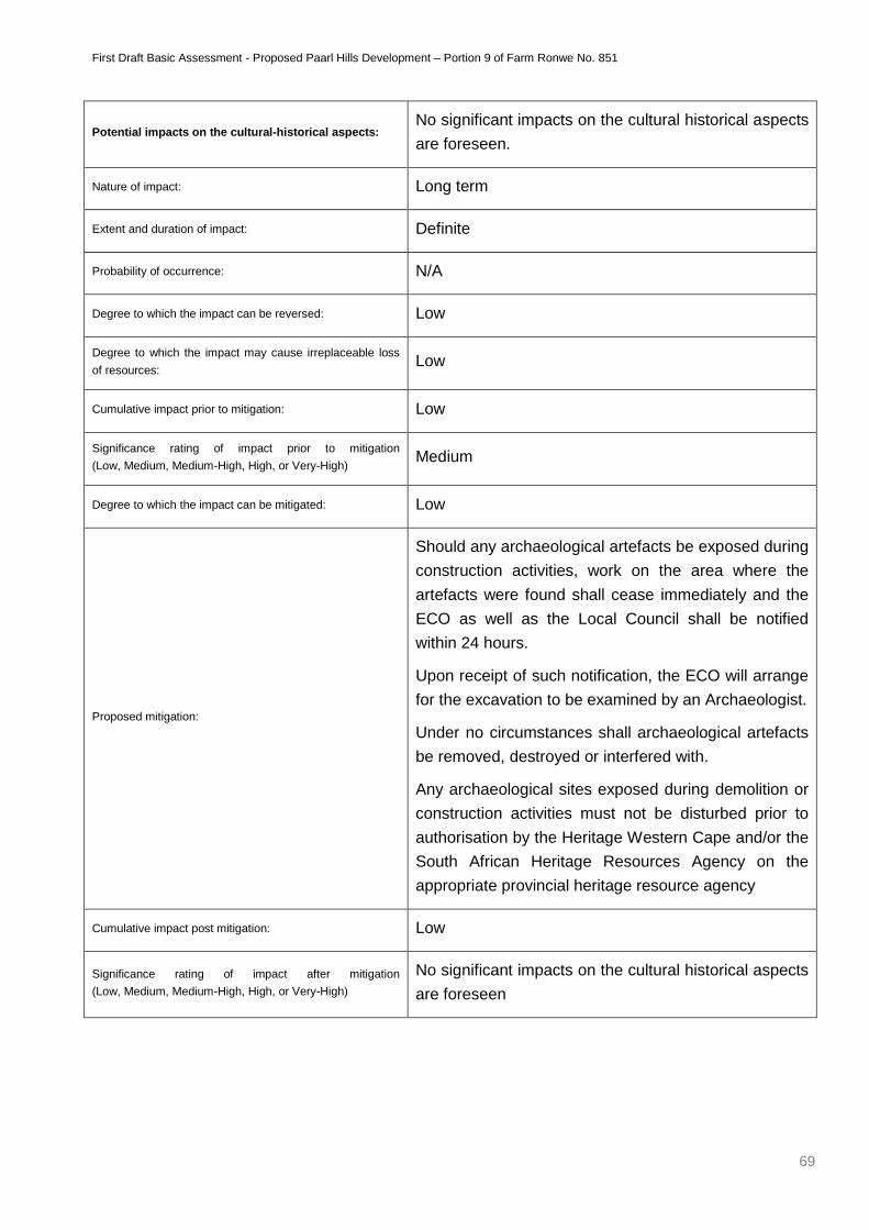
First Draft Basic Assessment - Proposed Paarl Hills Development – Portion 9 of Farm Ronwe No. 851
69
Potential impacts on the cultural-historical aspects: No significant impacts on the cultural historical aspects
are foreseen.
Nature of impact: Long term
Extent and duration of impact: Definite
Probability of occurrence: N/A
Degree to which the impact can be reversed: Low
Degree to which the impact may cause irreplaceable loss
of resources: Low
Cumulative impact prior to mitigation: Low
Significance rating of impact prior to mitigation
(Low, Medium, Medium-High, High, or Very-High) Medium
Degree to which the impact can be mitigated: Low
Proposed mitigation:
Should any archaeological artefacts be exposed during
construction activities, work on the area where the
artefacts were found shall cease immediately and the
ECO as well as the Local Council shall be notified
within 24 hours.
Upon receipt of such notification, the ECO will arrange
for the excavation to be examined by an Archaeologist.
Under no circumstances shall archaeological artefacts
be removed, destroyed or interfered with.
Any archaeological sites exposed during demolition or
construction activities must not be disturbed prior to
authorisation by the Heritage Western Cape and/or the
South African Heritage Resources Agency on the
appropriate provincial heritage resource agency
Cumulative impact post mitigation: Low
Significance rating of impact after mitigation
(Low, Medium, Medium-High, High, or Very-High)
No significant impacts on the cultural historical aspects
are foreseen
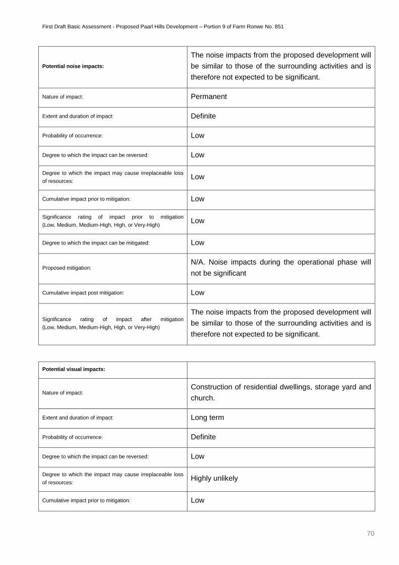
First Draft Basic Assessment - Proposed Paarl Hills Development – Portion 9 of Farm Ronwe No. 851
70
Potential noise impacts:
The noise impacts from the proposed development will
be similar to those of the surrounding activities and is
therefore not expected to be significant.
Nature of impact: Permanent
Extent and duration of impact: Definite
Probability of occurrence: Low
Degree to which the impact can be reversed: Low
Degree to which the impact may cause irreplaceable loss
of resources: Low
Cumulative impact prior to mitigation: Low
Significance rating of impact prior to mitigation
(Low, Medium, Medium-High, High, or Very-High) Low
Degree to which the impact can be mitigated: Low
Proposed mitigation: N/A. Noise impacts during the operational phase will
not be significant
Cumulative impact post mitigation: Low
Significance rating of impact after mitigation
(Low, Medium, Medium-High, High, or Very-High)
The noise impacts from the proposed development will
be similar to those of the surrounding activities and is
therefore not expected to be significant.
Potential visual impacts:
Nature of impact: Construction of residential dwellings, storage yard and
church.
Extent and duration of impact: Long term
Probability of occurrence: Definite
Degree to which the impact can be reversed: Low
Degree to which the impact may cause irreplaceable loss
of resources: Highly unlikely
Cumulative impact prior to mitigation: Low
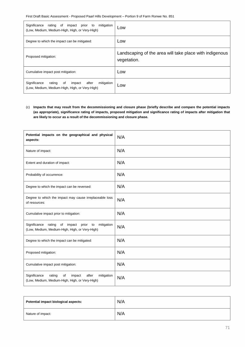
First Draft Basic Assessment - Proposed Paarl Hills Development – Portion 9 of Farm Ronwe No. 851
71
Significance rating of impact prior to mitigation
(Low, Medium, Medium-High, High, or Very-High) Low
Degree to which the impact can be mitigated: Low
Proposed mitigation: Landscaping of the area will take place with indigenous
vegetation.
Cumulative impact post mitigation: Low
Significance rating of impact after mitigation
(Low, Medium, Medium-High, High, or Very-High) Low
(c) Impacts that may result from the decommissioning and closure phase (briefly describe and compare the potential impacts
(as appropriate), significance rating of impacts, proposed mitigation and significance rating of impacts after mitigation that
are likely to occur as a result of the decommissioning and closure phase.
Potential impacts on the geographical and physical
aspects: N/A
Nature of impact: N/A
Extent and duration of impact: N/A
Probability of occurrence: N/A
Degree to which the impact can be reversed: N/A
Degree to which the impact may cause irreplaceable loss
of resources: N/A
Cumulative impact prior to mitigation: N/A
Significance rating of impact prior to mitigation
(Low, Medium, Medium-High, High, or Very-High) N/A
Degree to which the impact can be mitigated: N/A
Proposed mitigation: N/A
Cumulative impact post mitigation: N/A
Significance rating of impact after mitigation
(Low, Medium, Medium-High, High, or Very-High) N/A
Potential impact biological aspects: N/A
Nature of impact: N/A
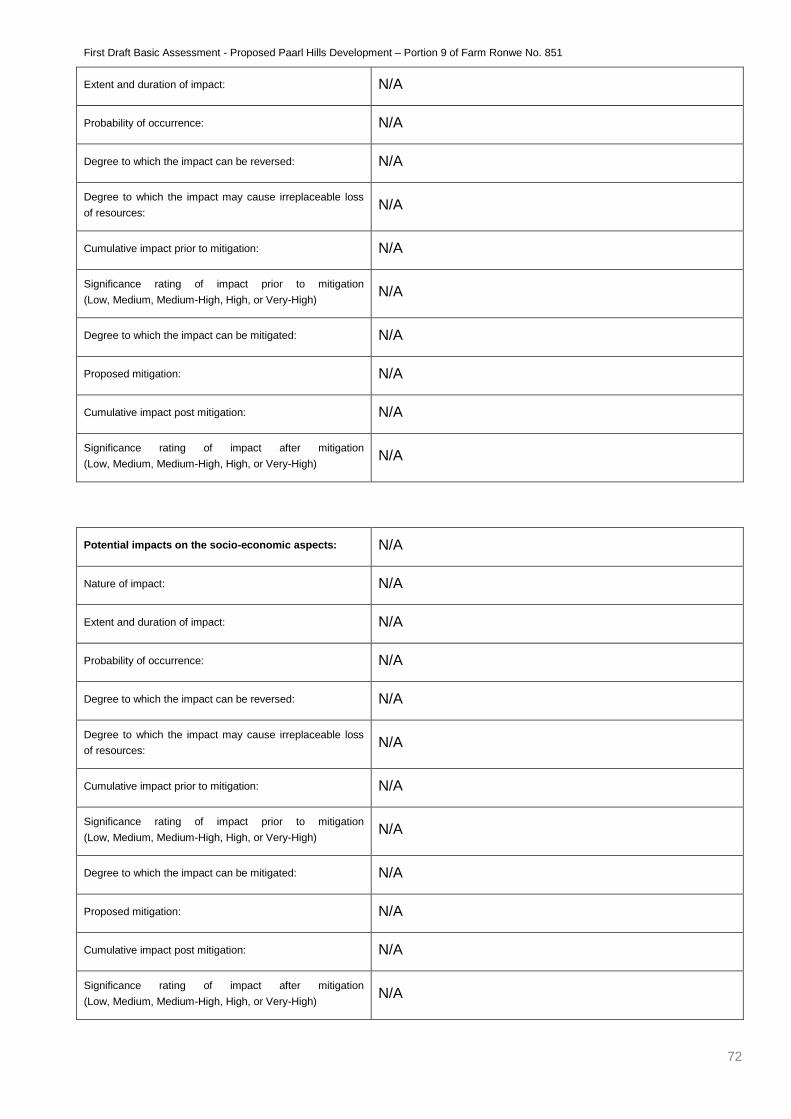
First Draft Basic Assessment - Proposed Paarl Hills Development – Portion 9 of Farm Ronwe No. 851
72
Extent and duration of impact: N/A
Probability of occurrence: N/A
Degree to which the impact can be reversed: N/A
Degree to which the impact may cause irreplaceable loss
of resources: N/A
Cumulative impact prior to mitigation: N/A
Significance rating of impact prior to mitigation
(Low, Medium, Medium-High, High, or Very-High) N/A
Degree to which the impact can be mitigated: N/A
Proposed mitigation: N/A
Cumulative impact post mitigation: N/A
Significance rating of impact after mitigation
(Low, Medium, Medium-High, High, or Very-High) N/A
Potential impacts on the socio-economic aspects: N/A
Nature of impact: N/A
Extent and duration of impact: N/A
Probability of occurrence: N/A
Degree to which the impact can be reversed: N/A
Degree to which the impact may cause irreplaceable loss
of resources: N/A
Cumulative impact prior to mitigation: N/A
Significance rating of impact prior to mitigation
(Low, Medium, Medium-High, High, or Very-High) N/A
Degree to which the impact can be mitigated: N/A
Proposed mitigation: N/A
Cumulative impact post mitigation: N/A
Significance rating of impact after mitigation
(Low, Medium, Medium-High, High, or Very-High) N/A
First Draft Basic Assessment - Proposed Paarl Hills Development – Portion 9 of Farm Ronwe No. 851
73
Potential impacts on the cultural-historical aspects: N/A
Nature of impact: N/A
Extent and duration of impact: N/A
Probability of occurrence: N/A
Degree to which the impact can be reversed: N/A
Degree to which the impact may cause irreplaceable loss
of resources: N/A
Cumulative impact prior to mitigation: N/A
Significance rating of impact prior to mitigation
(Low, Medium, Medium-High, High, or Very-High) N/A
Degree to which the impact can be mitigated: N/A
Proposed mitigation: N/A
Cumulative impact post mitigation: N/A
Significance rating of impact after mitigation
(Low, Medium, Medium-High, High, or Very-High) N/A
Potential noise impacts: N/A
Nature of impact: N/A
Extent and duration of impact: N/A
Probability of occurrence: N/A
Degree to which the impact can be reversed: N/A
Degree to which the impact may cause irreplaceable loss
of resources: N/A
Cumulative impact prior to mitigation: N/A
Significance rating of impact prior to mitigation
(Low, Medium, Medium-High, High, or Very-High) N/A
Degree to which the impact can be mitigated: N/A
Proposed mitigation: N/A
First Draft Basic Assessment - Proposed Paarl Hills Development – Portion 9 of Farm Ronwe No. 851
74
Cumulative impact post mitigation: N/A
Significance rating of impact after mitigation
(Low, Medium, Medium-High, High, or Very-High) N/A
Potential visual impacts: N/A
Nature of impact: N/A
Extent and duration of impact: N/A
Probability of occurrence: N/A
Degree to which the impact can be reversed: N/A
Degree to which the impact may cause irreplaceable loss
of resources: N/A
Cumulative impact prior to mitigation: N/A
Significance rating of impact prior to mitigation
(Low, Medium, Medium-High, High, or Very-High) N/A
Degree to which the impact can be mitigated: N/A
Proposed mitigation: N/A
Cumulative impact post mitigation: N/A
Significance rating of impact after mitigation
(Low, Medium, Medium-High, High, or Very-High) N/A
(d) Any other impacts:
Potential impact: N/A
Nature of impact: N/A
Extent and duration of impact: N/A
Probability of occurrence: N/A
Degree to which the impact can be reversed: N/A
Degree to which the impact may cause irreplaceable loss of
resources: N/A
Cumulative impact prior to mitigation: N/A

First Draft Basic Assessment - Proposed Paarl Hills Development – Portion 9 of Farm Ronwe No. 851
75
Significance rating of impact prior to mitigation
(Low, Medium, Medium-High, High, or Very-High) N/A
Degree to which the impact can be mitigated: N/A
Proposed mitigation: N/A
Cumulative impact post mitigation: N/A
Significance rating of impact after mitigation
(Low, Medium, Medium-High, High, or Very-High) N/A
First Draft Basic Assessment - Proposed Paarl Hills Development – Portion 9 of Farm Ronwe No. 851
76
7. SPECIALIST INPUTS/STUDIES AND RECOMMENDATIONS
Please note: Specialist inputs/studies must be attached to this report as Appendix G. Also take into account the Department’s
Guidelines on the Involvement of Specialists in EIA Processes available on the Department’s website
(http://www.capegateway.gov.za/eadp).
Specialist inputs/studies and recommendations:
GNEC, in our professional capacity as experienced and qualified environmental consultants, believe
that the proposed project be issued a positive environmental authorisation; however this authorisation
must be accompanied with the following requirements:
Appointment of an Environmental Control Officer (ECO) to oversee compliance with the EMP.
Weekly site audits to ensure compliance and to advise on any mitigation measures necessary
to negate any environmental degradation.
The ECO must compile bi-monthly ECO Audit Reports on the state of the environment and
areas of compliance and non-compliance with the EMP. These reports must be made
available to DEA&DP and the City of Cape Town Municipality.
Fines should be included in the EMP to ensure full compliance to the EMP.
8. IMPACT SUMMARY
Please provide a summary of all the above impacts.
Considering the proposed mixed use Paarl Hills development on Portion 9 of Farm Ronwe No. 851,
Paarl, Western Cape. No significant environmental impacts are foreseen as this property comprise
no natural vegetation, no CBA’s or threatened ecosystems. On the contrary the proposed
development could only increase the site in its entirety. Paarl Hills development will not have any
long-term noise pollution, a significant visual impact as the development will safeguard the character
of the surrounding approved developments (such as Boschenmeer Estate). As confirmed by HWC
no significant impacts are expected on heritage or archaeological resources.
9. OTHER MANAGEMENT, MITIGATION AND MONITORING MEASURES
(a) Over and above the mitigation measures described in Section 6 above, please indicate any additional management, mitigation and
monitoring measures.
See attached EMP for complete mitigation measures for the proposed development.
(b) Describe the ability of the applicant to implement the management, mitigation and monitoring measures.
The proponent has the resources necessary to implement the management, mitigation and monitoring
measures as well as the resources to employ the necessary people to do the implementation.
Please note: A draft ENVIRONMENTAL MANAGEMENT PROGRAMME must be attached this report as Appendix H.
First Draft Basic Assessment - Proposed Paarl Hills Development – Portion 9 of Farm Ronwe No. 851
77
SECTION G: ASSESSMENT METHODOLOGIES AND
CRITERIA, GAPS IN KNOWLEDGE, UNDERLAYING
ASSUMPTIONS AND UNCERTAINTIES
(a) Please describe adequacy of the assessment methods used.
The assessment methods used for the proposed project were adequate as all possible impacts were assessed
in detail.
(b) Please describe the assessment criteria used.
The criteria for the description and assessment of environmental impacts were drawn from the National
Environmental Management Act, 1998 (Act No.107 of 1998).
The level of detail was somewhat fine-tuned by assigning specific values to each impact. In order to establish
a coherent framework within which all impacts could be objectively assessed it is necessary to establish a
rating system, which is consistent throughout all criteria. For such purposes each aspect was assigned a
value, ranging from 1-5, depending on its definition.
Potential Impact
This is an appraisal of the type of effect the proposed activity would have on the affected environmental
component. Its description should include what is being affected and how it is being affected.
Extent
The physical and spatial scale of the impact is classified as:
Local
The impacted area extends only as far as the activity, e.g. a footprint.
Site
The impact could affect the whole, or a measurable portion of the site.
Regional
The impact could affect the area including the neighbouring erven and/or farms, the transport routes and the
adjoining towns.
Duration
The lifetime of the impact, which is measured in relation to the lifetime of the proposed base.
Short term
The impact will either disappear with mitigation or will be mitigated through a natural process in a period
shorter than any of the phases.
Medium term
The impact will last up to the end of the phases, where after it will be entirely negated.
First Draft Basic Assessment - Proposed Paarl Hills Development – Portion 9 of Farm Ronwe No. 851
78
Long term
The impact will continue or last for the entire operational lifetime of the Development, but will be mitigated by
direct human action or by natural processes thereafter.
Permanent
This is the only class of impact, which will be non-transitory. Mitigation either by man or natural process will not
occur in such a way or in such a time span that the impact can be considered transient.
Intensity
The intensity of the impact is considered here by examining whether the impact is destructive or benign,
whether it destroys the impacted environment, alters its functioning, or slightly alters the environment itself.
These are rated as:
Low
The impact alters the affected environment in such a way that the natural processes or functions are not
affected.
Medium
The affected environment is altered, but functions and processes continue, albeit in a modified way.
High
Function or process of the affected environment is disturbed to the extent where it temporarily or permanently
ceases.
This will be a relative evaluation within the context of all the activities and the other impacts within the
framework of the project.
Probability
This describes the likelihood of the impacts actually occurring. The impact may occur for any length of time
during the life cycle of the activity, and not at any given time. The classes are rated as follows:
Improbable
The possibility of the impact occurring is none, due either to the circumstances, design or experience.
Possible
The possibility of the impact occurring is very low, due either to the circumstances, design or experience.
Likely
There is a possibility that the impact will occur to the extent that provisions must therefore be made.
Highly Likely
It is most likely that the impacts will occur at some stage of the Development. Plans must be drawn up before
carrying out the activity.
Definite
The impact will take place regardless of any prevention plans, and only mitigation actions or contingency plans
to contain the effect can be relied on.

First Draft Basic Assessment - Proposed Paarl Hills Development – Portion 9 of Farm Ronwe No. 851
79
Determination of Significance – Without Mitigation
Significance is determined through a synthesis of impact characteristics, and is an indication of the importance
of the impact in terms of both physical extent and time scale. The significance of the impact “without
mitigation” is the prime determinant of the nature and degree of mitigation required. Where the impact is
positive, significance is noted as “positive”. Significance is rated on the following scale:
No significance
The impact is not substantial and does not require any mitigation action.
Low
The impact is of little importance, but may require limited mitigation.
Medium
The impact is of importance and is therefore considered to have a negative impact. Mitigation is required to
reduce the negative impacts to acceptable levels.
High
The impact is of great importance. Failure to mitigate, with the objective of reducing the impact to acceptable
levels, could render the entire development option or entire project proposal unacceptable. Mitigation is
therefore essential.
Determination of Significance – With Mitigation
Significance is determined through a synthesis of impact characteristics. It is an indication of the importance of
the impact in terms of both physical extent and time scale, and therefore indicates the level of mitigation
required. In this case the prediction refers to the foreseeable significance of the impact after the successful
implementation of the suggested mitigation measures. Significance with mitigation is rated on the following
scale:
No significance
The impact will be mitigated to the point where it is regarded to be insubstantial.
Low
The impact will be mitigated to the point where it is of limited importance.
Low to medium
The impact is of importance, however, through the implementation of the correct mitigation measures such
potential impacts can be reduced to acceptable levels.
Medium
Notwithstanding the successful implementation of the mitigation measures, to reduce the negative impacts to
acceptable levels, the negative impact will remain of significance. However, taken within the overall context of
the project, the persistent impact does not constitute a fatal flaw.
Medium to high
The impact is of great importance. Through implementing the correct mitigation measures the negative
impacts will be reduced to acceptable levels.
First Draft Basic Assessment - Proposed Paarl Hills Development – Portion 9 of Farm Ronwe No. 851
80
High
The impact is of great importance. Mitigation of the impact is not possible on a cost-effective basis. The impact
continues to be of great importance, and, taken within the overall context of the project, is considered to be a
fatal flaw in the project proposal. This could render the entire development option or entire project proposal
unacceptable.
(c) Please describe the gaps in knowledge.
Municipality should confirm resource availability
(d) Please describe the underlying assumptions.
At present it is assumed that the proposed development will not have a significant impact on any cultural or
archaeological artifacts in the area (HWC confirmed that they have no objection towards the new proposed
development on the property).
(e) Please describe the uncertainties.
The amount of temporary/permanent employees is currently uncertain. People will be appointed as required.
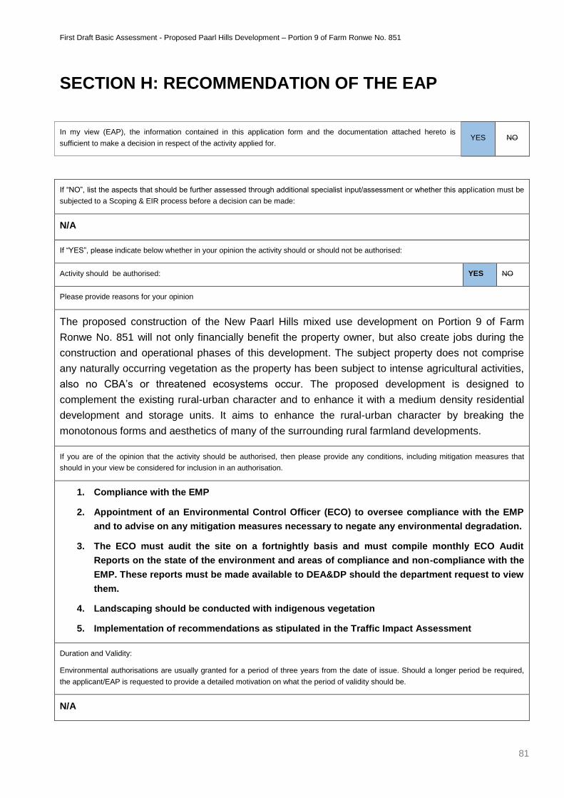
First Draft Basic Assessment - Proposed Paarl Hills Development – Portion 9 of Farm Ronwe No. 851
81
SECTION H: RECOMMENDATION OF THE EAP
In my view (EAP), the information contained in this application form and the documentation attached hereto is
sufficient to make a decision in respect of the activity applied for. YES NO
If “NO”, list the aspects that should be further assessed through additional specialist input/assessment or whether this application must be
subjected to a Scoping & EIR process before a decision can be made:
N/A
If “YES”, please indicate below whether in your opinion the activity should or should not be authorised:
Activity should be authorised: YES NO
Please provide reasons for your opinion
The proposed construction of the New Paarl Hills mixed use development on Portion 9 of Farm
Ronwe No. 851 will not only financially benefit the property owner, but also create jobs during the
construction and operational phases of this development. The subject property does not comprise
any naturally occurring vegetation as the property has been subject to intense agricultural activities,
also no CBA’s or threatened ecosystems occur. The proposed development is designed to
complement the existing rural-urban character and to enhance it with a medium density residential
development and storage units. It aims to enhance the rural-urban character by breaking the
monotonous forms and aesthetics of many of the surrounding rural farmland developments.
If you are of the opinion that the activity should be authorised, then please provide any conditions, including mitigation measures that
should in your view be considered for inclusion in an authorisation.
1. Compliance with the EMP
2. Appointment of an Environmental Control Officer (ECO) to oversee compliance with the EMP
and to advise on any mitigation measures necessary to negate any environmental degradation.
3. The ECO must audit the site on a fortnightly basis and must compile monthly ECO Audit
Reports on the state of the environment and areas of compliance and non-compliance with the
EMP. These reports must be made available to DEA&DP should the department request to view
them.
4. Landscaping should be conducted with indigenous vegetation
5. Implementation of recommendations as stipulated in the Traffic Impact Assessment
Duration and Validity:
Environmental authorisations are usually granted for a period of three years from the date of issue. Should a longer period be required,
the applicant/EAP is requested to provide a detailed motivation on what the period of validity should be.
N/A
First Draft Basic Assessment - Proposed Paarl Hills Development – Portion 9 of Farm Ronwe No. 851
82
SECTION I: APPENDICES
The following appendices must be attached to this report:
Appendix
Tick the box
if Appendix
is attached
Appendix A: Locality map X
Appendix B: Site plan(s) X
Appendix C: Photographs X
Appendix D: Biodiversity overlay map X
Appendix E: Permit(s) / license(s) from any other organ of state including service letters
from the municipality X
Appendix F:
Public participation information: including a copy of the register of interested
and affected parties, the comments and responses report, proof of notices,
advertisements and any other public participation information as required in
Section C above.
X
Appendix G: Specialist Report(s) X
Appendix H : Environmental Management Progamme X
Appendix I: Additional information related to listed waste management activities (if
applicable) X
Appendix J: Any Other (if applicable) (describe) N/A

First Draft Basic Assessment - Proposed Paarl Hills Development – Portion 9 of Farm Ronwe No. 851
83
DECLARATIONS
The Applicant
I …………………………………., in my personal capacity or duly authorised (please circle the applicable
option) by ……………..................................………………… thereto hereby declare that I:
regard the information contained in this report to be true and correct, and
am fully aware of my responsibilities in terms of the National Environmental Management Act of 1998 (“NEMA”) (Act No.
107 of 1998), the Environmental Impact Assessment Regulations (“EIA Regulations”) in terms of NEMA (Government Notice
No. R. 543 refers), and the relevant specific environmental management Act, and that failure to comply with these
requirements may constitute an offence in terms of the environmental legislation;
appointed the environmental assessment practitioner as indicated above, which meet all the requirements in terms of
regulation 17 of GN No. R. 543, to act as the independent environmental assessment practitioner for this application;
have provided the environmental assessment practitioner and the competent authority with access to all information at
my disposal that is relevant to the application;
will be responsible for the costs incurred in complying with the environmental legislation including but not limited to –
o costs incurred in connection with the appointment of the environmental assessment practitioner or any person
contracted by the environmental assessment practitioner;
o costs incurred in respect of the undertaking of any process required in terms of the regulations;
o costs in respect of any fee prescribed by the Minister or MEC in respect of the regulations;
o costs in respect of specialist reviews, if the competent authority decides to recover costs; and
o the provision of security to ensure compliance with the applicable management and mitigation measures;
am responsible for complying with the conditions that might be attached to any decision(s) issued by the competent
authority;
have the ability to implement the applicable management, mitigation and monitoring measures;
hereby indemnify, the government of the Republic, the competent authority and all its officers, agents and employees,
from any liability arising out of, inter alia, the content of any report, any procedure or any action for which the applicant or
environmental assessment practitioner is responsible; and
am aware that a false declaration is an offence in terms of regulation 71 of GN No. R. 543.
Please Note: If acting in a representative capacity, a certified copy of the resolution or power of attorney must be
attached.
Signature of the applicant:
Name of company:
Date:
First Draft Basic Assessment - Proposed Paarl Hills Development – Portion 9 of Farm Ronwe No. 851
84
The independent Environmental Assessment Practitioner (EAP)
I ……………………………………, as the appointed independent environmental practitioner (“EAP”) hereby declare that I:
act/ed as the independent EAP in this application;
regard the information contained in this report to be true and correct, and
do not have and will not have any financial interest in the undertaking of the activity, other than remuneration for work
performed in terms of the NEMA, the Environmental Impact Assessment Regulations, 2010 and any specific environmental
management Act;
have and will not have no vested interest in the proposed activity proceeding;
have disclosed, to the applicant and competent authority, any material information that have or may have the potential
to influence the decision of the competent authority or the objectivity of any report, plan or document required in terms of
the NEMA, the Environmental Impact Assessment Regulations, 2010 and any specific environmental management Act;
am fully aware of and meet the responsibilities in terms of NEMA, the Environmental Impact Assessment Regulations, 2010
(specifically in terms of regulation 17 of GN No. R. 543) and any specific environmental management Act, and that failure
to comply with these requirements may constitute and result in disqualification;
have ensured that information containing all relevant facts in respect of the application was distributed or made available
to interested and affected parties and the public and that participation by interested and affected parties was facilitated
in such a manner that all interested and affected parties were provided with a reasonable opportunity to participate and
to provide comments;
have ensured that the comments of all interested and affected parties were considered, recorded and submitted to the
competent authority in respect of the application;
have kept a register of all interested and affected parties that participated in the public participation process;
have provided the competent authority with access to all information at my disposal regarding the application, whether
such information is favourable to the applicant or not; and
am aware that a false declaration is an offence in terms of regulation 71 of GN No. R. 543.
Note: The terms of reference must be attached.
Signature of the environmental assessment practitioner:
Name of company:
Date:
First Draft Basic Assessment - Proposed Paarl Hills Development – Portion 9 of Farm Ronwe No. 851
85
The independent PERSON WHO COMPILED A SPECIALIST REPORT OR UNDERTOOK A
SPECIALIST PROCESS
I ……………………………………, as the appointed independent specialist hereby declare that I:
act/ed as the independent specialist in this application;
regard the information contained in this report as it relates to my specialist input/study to be true and correct, and
do not have and will not have any financial interest in the undertaking of the activity, other than remuneration for work
performed in terms of the NEMA, the Environmental Impact Assessment Regulations, 2010 and any specific environmental
management Act;
have and will not have no vested interest in the proposed activity proceeding;
have disclosed, to the applicant, EAP and competent authority, any material information that have or may have the
potential to influence the decision of the competent authority or the objectivity of any report, plan or document required
in terms of the NEMA, the Environmental Impact Assessment Regulations, 2010 and any specific environmental
management Act;
am fully aware of and meet the responsibilities in terms of NEMA, the Environmental Impact Assessment Regulations, 2010
(specifically in terms of regulation 17 of GN No. R. 543) and any specific environmental management Act, and that failure
to comply with these requirements may constitute and result in disqualification;
have ensured that information containing all relevant facts in respect of the specialist input/study was distributed or made
available to interested and affected parties and the public and that participation by interested and affected parties was
facilitated in such a manner that all interested and affected parties were provided with a reasonable opportunity to
participate and to provide comments on the specialist input/study;
have ensured that the comments of all interested and affected parties on the specialist input/study were considered,
recorded and submitted to the competent authority in respect of the application;
have ensured that the names of all interested and affected parties that participated in terms of the specialist input/study
were recorded in the register of interested and affected parties who participated in the public participation process;
have provided the competent authority with access to all information at my disposal regarding the application, whether
such information is favourable to the applicant or not; and
am aware that a false declaration is an offence in terms of regulation 71 of GN No. R. 543.
Note: The terms of reference must be attached.
Signature of the specialist:
Name of company:
Date:
First Draft Basic Assessment - Proposed Paarl Hills Development – Portion 9 of Farm Ronwe No. 851
86
ADDENDUM A: MAPS
First Draft Basic Assessment - Proposed Paarl Hills Development – Portion 9 of Farm Ronwe No. 851
87
ADDENDUM B: SITE LAYOUT AND DRAWINGS

First Draft Basic Assessment - Proposed Paarl Hills Development – Portion 9 of Farm Ronwe No. 851
88
ADDENDUM C: SITE PHOTO’S
First Draft Basic Assessment - Proposed Paarl Hills Development – Portion 9 of Farm Ronwe No. 851
89
ADDENDUM D: BIODIVERSITY MAP
First Draft Basic Assessment - Proposed Paarl Hills Development – Portion 9 of Farm Ronwe No. 851
90
ADDENDUM E: LETTERS FROM AUTHORITIES
First Draft Basic Assessment - Proposed Paarl Hills Development – Portion 9 of Farm Ronwe No. 851
91
ADDENDUM F: PUBLIC PARTICIPATION

First Draft Basic Assessment - Proposed Paarl Hills Development – Portion 9 of Farm Ronwe No. 851
92
ADDENDUM G: SPECIALIST REPORTS
a) Traffic Impact Assessment (Element Consulting Engineers)
b) Civil Engineering Report (Triple Three Engineering Solutions)
c) Storm Water Management Report (Triple Three Engineering Solutions)
d) Bulk Services (GLS Consulting)
First Draft Basic Assessment - Proposed Paarl Hills Development – Portion 9 of Farm Ronwe No. 851
93
ADDENDUM H: ENVIRONMENTAL MANAGEMENT PROGRAMME
First Draft Basic Assessment - Proposed Paarl Hills Development – Portion 9 of Farm Ronwe No. 851
94
ADDENDUM I: TOWN PLANNING APPROVALS
First Draft Basic Assessment - Proposed Paarl Hills Development – Portion 9 of Farm Ronwe No. 851
95
ADDENDUM J: NOTICE OF INTENT TO DEVELOP