Embed Size (px)
Citation preview

Geologies.l Features in Mill Creek Park
Youngstown, Ohio
As a i'ulfillment for Geology 570
and as a partial .f'ulfillment for
the requirement of a degree of
Bachelor of Science Degree
~1971 by
John s. Petrek
TABLE OP CONTENTS PAGE
Abstract and Acknowle .. gments i
Chapter I Introd.uction l
Chapter II Mahoning County Backgroun4 3
Chapter III Sharon Conglomerate 6
Chapter IV Quakertown Coal 7
Chapter v Iron Ore 8
Chapter VI Massillon Sandstone 10
Chapter VII Joints 11
Chapter VIII Ice Age 16
Chapter IX Undercutting 26
Chapter x Weathering 28
Chapter XI Oross•becl.ding 29
Chapter XII Pennsylvanian Fossil Collecting 30
Bibliography 31

- i -
ABSTRACT
This paper was written as a partial requirement
for a Bachelor of Science Degree at Ohio State University.
As I was doing my Field work in Mill Creek Park, I would
see men taking a short cut through the Park after work at
the steel mill, young couples strolling down the paths and
others. Most ot them can only appreciate the beauty ot the
Park. Only a select tew can appreciate the geological
beauty that produced this gorge. This paper was written
at a high school level as a tour guide. I hope that the
people who read this paper will see the geological beauty
in Mill Creek Park.
ACKNOWLEDGMENTS
I wish te thank all those responsible for the pro
duction of this paper, especially Dr. Sidney E. White,
Department of Geology at The Ohio State Universit_y~ and
Mr. Ernest Vickers, the Mill Creek Park naturalist, fer
their assistance.

- 1 -
INTRODUCTION
Mill Creek Park consists of gorges varying in width from
a few hundred feet at the Narrows to about a mile in its widest
parts. Its natural beauty lies in its alternating deeply eut
ravines and its wide valley with alluvial bottoms. Along its
clitf walls e.nd lowland plains is an abundant growth ot hardwoo4
and evergreen trees. The souree is a small spring on Cope F'a.rm
at an elevation of 1,175 feet. Prom this point, t'lowing almost
directly North, the creek, aceepting the waters of small tribu
taries, drains an estimate4 80 square miles of countrysi4e descends
3~5 teet before entering the Mahoning River, and a distance of
17! mi.lea.
According to Mr. Ernest Vickers, the Park naturalist,
prior to 1928 Mill Creek flowed uninterruptedly from its source
to Lantel'!llBll Palls impounded the water to torm Lake Newport,
Lake Cohasset, e.nd Le.ke Glacier.

ST.IT£ CE OHIO IEPt\RTMENT rs: NAT\RAL RE50.RCES ONISK>N r;,: GECl.OGtCAL Sl.JNEY, 1966
Seo~
ADAPTED FROM GLACIAL MAP OF OHIO, U.S. GEOL. SURVEY MISC . GEOL. INV. MAP 1-316
GLACIAL DEPOSITS
OF
OHIO
D D D D
D
LEGEND WISCONSIN
Ka.mes and eslcers
Lake deposits
Ground moraine
End moraine
ILLINOIAN
Undifferentiated
KANSAN
Ground moraine

- 3 -
CHAPTER II
MAHONING COUNTY BACKGROUND
Mahoning County lies in a point of time at a crossroads
for its oldest strata outcropping along the Mahoning River from
Niles to the State line belongs to one age, the Mississippian
and the overlying strata belongs to a later age, the Pennsylvanian.
And while the latter of these two groups lies in superposition of
the former, many years might have elapsed before the later strata
was formed near the border of the inland sea that covered this
part of the county.
The older strata, known as the Waverly Group in southern
Ohio, but as the Cuyahoga Group in northern Ohio, having been
raised up from shallow sea bottom, formed at one time the land
surface of this region. (Harper 1948) The topmost member of the
·group now present in the Youngstown area, the stratum known vari
ously as the Cuyahoga Shale or the Shenango Slate and was for a
long eroded by natural climatic agents.
Tb.en crune a subsidence (see Sharon Conglomerate) of the
land--a gradual and intermitted lowering of the surface until the
waters from the sea invaded the land now forming the eastern part
of Ohio. But the land did not sink deeply and the waters flooding
shallow places formed swamps at different times in which grew
dense forest of plant, fern-like palm, and scale trees. Some
trees nearly one hundred feet high attained maturity and fell in
to water and decayed.
Thus was for.med a thick, increasing layer of carbonaceous
matter, until .t'urther subsidence permitted this bed of plant

Scale in Miles 0 20 40 60
.y GEOLOGIC SYSTEM
~ C.=J Permian
C=:J Pennsylvanian
C.=J Mississippian
c==J' Devonian
C=:=J Silurian
C=:=J Ordovician
OHIO DIV I SION OF GEOLOGICAL SURV E Y
GEOLOGIC MAP AND CROSS SECTION OF OHIO
- l+ -
- 5 -
material to be buried by beds of clay, sand or lime mud. Then
this carbonaceous matter after a long period of time was con
solidated into a coal-like substance.
Since the land had been eroded its surface had depr~s
sions and high spots; and as the lower parts of the land surface
sank a little below sea level, these depressions formed the swamp
lands, whereas the high areas were above water lever and still
dry.
In addition to the formation of coal beds in the swamps
of the Pennsylvanian Age, another type of substance was formed,
a material that in later years was a main element in starting
the Mahoning Valley as an industrial eenter--iron ore; for into
the swamps that covered the lowlands of this remote period,
flowed rivers carrying salts derived from the land by the leach
ing waters that drained off the surface of the emerged land. One
of the most essential element so carried by the streams into the
swamps was iron.
- 6 -
CHAPTER III
SHARON CONGLOMERATE
Drive into the Park at Falls Avenue entrance and cross
Slippery Rock Bridge at the foot of the hill. Turn at the next
street and drive to the first ledge of rock at your left close
to driveway entrance. (see map)
By looking carefully, a layer of "pudding stone" can be
found about eight feet above the driveway. This is the famous
Sharon Conglomerate which divides the Mississippian Age from the
Pennsylvanian. The Pennsylvanian is the great coniferous coal
period of the United States. No coal is found below this Sharon
Conglomerate. This is the clearest ''unoonformi ty" between these
two great ages to be found in Mill Creek Park. Notice that the
Mississippian strata seems to dip down to the left and rise to
the right.
The Sharon Conglomerate is much thicker when it was de
posited in the bottom of old Mississippi valleys. That is the
reason the Kennedy Nelson Ledges• cliffs are thirty feet high
because these ledges were in an old valley of the Mississippian
250 million years ago. This thin conglomerate is the same for
mation as the Kennedy Nelson Ledges. Number One coal was laid
down on top of the Sharon Conglomerate, and both faded out on
the sides of the ancient valley. This spot must have been rather
high that no coal was formed over the conglomerate. {Newberry
1878)
- 7 -
CHAPTER IV
QUAKERTOWN COAL
The Quakertown or No. 2 coal (Harper 1948) is persistent
throughout the Youngstown region, but is generally thin and of
no economic importance. It varies in thickness from a simple
streak to a ma.xi.mum of not over two feet. The coal is somewhat
thin at places because of the irregular and discon:f'ormable ma
terial of the Massillon Sandstone, under which it occurs.
The coal exposed west of the Hiawatha Flats (see map)
is one foot ten inches with one foot good coal, five inches of
dark gray shale and five inches of channel coal. The coal may
be chipped out and used for a campfire while picnicing in the
park.

- 8 -
CHAPTER V
IRON ORE
Since iron plays such an important part in the development
of the Mahoning Valley and is very comm.on in Mill Creek, here
is some imtormation on the cycle of iron. The iron dissolved by
surface waters during weathering moves largely in streams ever on
ward toward the sea. Some of it may not reach the sea because it
may be trapped on route. If the iron bearing solutions contact
the early deposited limestones on the way, the iron may be de
posited from solution, or organic matter may do the same. Such
deposition probably will not give rise to commercial deposits, or
if they are likely to be small as in iron ores or impure coal
measure beds. For extensive oxide precipitation, the iron in
solution must reach the sea.
Marine life, now represented by enclosed fossils, was not
dwarfed; therefore, no unusual conditions of environment are in
dicated. The beds above and below the iron ore beds consist of
sandstone and mud.rock with some limestone. The sluggish streruns,
relatively high in iron and low in suspended matter, introduced
the iron, which probably carried as a carbonate or as a colloid.
The iron deposition was deposited either in the form of
hydrous iron oxide (Limonite) or as a ferric oxide (Hematite).
In some places a little calcium carbonate was deposited at the
same time, also diluting the iron ore. But since the calcium
carbonate or limestone is added to the iron ore in order to settle
it, the impurity is not desirable.
- 9 -
Iron ore was one of the chief reasons the Youngstown area
developed into a large industrial area. Here is an example of
the Sharon ore (Stydson 1932) or "Blackboard Ore". These nodules
are chiefly a ferrous carbonate. This ore has little economic
value due to its low iron concentration. Occasionally there is
found limonite (2Fe2o3•3H2o) which is a hydrous hematite (Fe2o3).
This mineral is light red or yellow and its color is proportional
to its Fe content. some are found in concretions. A concretion
is formed if unconsolidated sedimentary matrix is removed from
the solution. They start to deposit and can be found in various
shapes, spherical, oval, disc-shaped and very irregular if two
or more become attached in their growth.

- 10 -
CHAPTER VI
MASSILLON SANDSTONE
The Massillon Sandstone directly overlies the No. 2 coal.
In general, it is a grey coarsed-grained massive rather .fragile on
which weathering becomes stained yellow to reddish brown by iron
oxide {see weathering in Chap. X). Numerous iron streaks and
bands and occasional iron nodule are present in the Massillon
Sandstone. The upper part or the Sandstone is usually more bedded
than the lower part, and cross-bedding is prominent at places.
The Sandstone rests disconrormably on its base, orten cutting out
the No. 2 coal and its clay, as well as several reet or lower stra
ta.
The Massillon Sandstone is patchy in distribution, appar
ently being a channel rill. Where the coarse Sandstone is not
developed, the interval is taken up by arenaceous shale with thin
beds or Sandstone.
The best exposure or Massillon Sandstone is rrom Lake
Newport to Lake Cohasset where it is eighty reet or more in thick
ness. The Sandstone rorms high clirrs along both sides or Mill
Creek, the valley being very narrow.
The lower part or the Sandstone is massive and show dir
rerential weathering. Just below Lanterman Bridge on the eastern
side or the valley {see map) there is a great mass or plant rossils
in the massive Sandstone mainly Sigillaria and Lepidodendron. Ev
idently this is a great pile or plant material which was drirted
in by the currents and buried in the sand.
- 11 -
CHAPTER VII
JOINTS
Joint are cracks and fractures in rock along which there
has been extremely little or no movement. Despite the fact that
points are so common and have been studied widely, they are per
haps the most difficult of all to analyze. The analytical dif
ficulty is a number of fundamental characteristics of these
structures. Thus, there is abundant field evidence that demon
strates that joints may develop at practically all ages in the
history of rocks. In sedimentary rocks, joints may develop
soon after deposition, while the sediments are still unconsoli
dated. They may possibly develop towards the end or a phase or
active tectonic compression, and be associated with faults and
folds. Or they may develop much later, when the phase of active
deformation has subsided.
Joints have been classified under two general grouping:
those resulting from sheer and those caused by tension. It
should be noted that the use of the terms tension joint and shear
joint, do not indicate the type of applied force. All rocks,
weather sedimentary or igneous from the moment of their origin
undergo changes in volume. Sediments formed at the surface are
usually soon buried under succeeding deposits, with consequent
reduction of pore space and change in volume. If this occurs
non-uniformly, strains result and joints may be formed. Later
removal of the overburden by erosion permits cubical expansion
and many of resulting fractures are tension joints or bedding
cleavage. Near and at an exposed surface the volume changes pro-
- 12 -
duced by weathering and repeated heating and cooling must weaken
the rock, and since it is relatively weak in tension a multi
tude of joints are formed.
In examples of tension joints induced by volume change, pro
bably shear is also present. However, the typical joint surfaces
are irregular and curved, which helps to distinguish them from any
sbear fractures which may have been formed at the same time. This
means ot separating shear fractures from tension joints becomes less
dependable it the formation is fine-grained and homogenous like
the Massillon Sandstone.
Tension joints associated with compressive stresses are best
developed if the confining pressures are not large enough to force
the rock to fault along shear planes. This is the case in eastern
Ohio caused by the formation of the Appalachian Mountains. Lateral
relief (for vertical joints) must be relatively easy. Tension
joints can be produced in compression experiments if the compressed
surface are free to more at right angles to the direction of
maximum pressure.
Although joints may strike in all possible direction, there
are generally two directions in an area. After the local pattern
has been established the regional patterns should be determined,
together with its relation to any other structure which may be
present.
By law of least work, failure takes place in a direction os
least resistance. A rock joints because it is brittle and because
a relatively large increase in rock volume is possible. The major

- 13 -
movement is perpendicular to the joint surface and this denotes
a minimum of pressure on this surface. If folding that easy,
lateral relief is necessary for vertical jointing. Thus, in folded
region, there may be t.ension in two directions making possible the
formation of jointing system. One set, that parallels to the
strike of the folds. The other set would be parallel to the direc
tion bf the dip would be the result of the stretching brought about
the plunge or the folds of the Appalachian Mountains. These sets
would intersect at nearly right angles. The strike joints are
more strongly developed than the dip joints because of the shallow
dip in this area and the distance from the active zone.
In the coa1 mining in the eastern part of the state, there
are joint patterns in the coal beds. (Ver Steeg 1942) In the
northern part of the coal mining area, the joint occur usually in
two sets known or the race and the butt joints which lie at
right angles to each other. One set extends in the Northeast and
the other in Northwest. Farther south, one set extends in a di
rection of a few degrees west of north and the other set extends
in a direction a tew degrees west of north or nearly east and
west. The joints are arranged in a.n arc, the convex side to the
west. This corresponds to the curve in a folded Appalachian in
the central and eastern Pennsylvanian in the same latitude.
The eastern part of the United States were involved in two
major orogenies, and the third one in the Permian. This Appala
cian orogeny can be dated by determining the age of the youngest
strata that are affected by deformation (within the deformed
area). This geosyncline had enough energy to cause the jointing

and regional dip in the eastern Ohio.
Another joint system to a small scale are the exf'oliation
joints. These joints are very similar to sheeting joints. Ex.
foliation joints form parallel to the exposed surface of the rock.
i . t
'
----?> ~ V~LL FY r \..V.4L L-
' . I ~ I .
These types of joint occur in rooks of uniform strength and re
sistance such as granite, basalts, and massive sandstone. Ac-
cording to (Billings 1954) joint is a tensional phenomenon due to the
release of load during erosion. The release of the compressional
force on specimens that have been under high conf'ining pressure
sometime cause rupture perpendicular to the axis of compression.
- 15 -
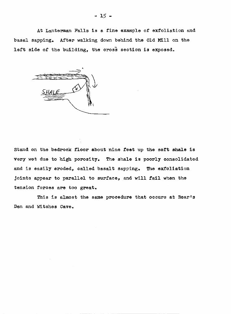
At Lanter'11lan Falls is a fine example of exfoliation and
basal sapping. After walking down behind the Old Mill on the
left side of the building, the cross section is exposed.
Stand on the bedrock floor about nine feet up the sort shale is
very wet due to high porosity. The shale is poorly consolidated
and is easily eroded, called basalt sapping. The exfoliation
joints appear to parallel to surface, and will fail when the
tension forces are too great.
This is almost the same procedure that occurs at Bear's
Den and Witches Cave.

- 16 -
CHAPTER VIII
ICE AGE
What lines the streams of this region originally had is
conjectured from stream beds found buried many feet below the
present surface of the land. It is known that the Mahoning River
flowed, not in its present direction, toward the Ohio River, but
in reverse, toward the present bed of Lake Erie.
The reversal of drainage lines in this part of Ohio was
caused by the great glacial ice cap which moved down from the
Laurentian highlands, disrupted all former principal drainage lines,
and greatly modified the topography.
The Ice Age, as the period is connnonly called, or the Pleis
tocene Epoch, occupied in time not a single episode of ice invasion
but consisted of a succession of ice encroachments over the northern
part of the United States. It is known that the ice advanced
southward for a period of time, then gradually receded northward
as melting took place, the water draining off southward in chan
nels for the most part that were cut by former streams. Upon this
melting and recession there followed a stage of milder and warm.er
climate, known as the interglacial interval which lasted until an
other gradual encroachment would bring the ice sheet with its lobes
southward to work again on the topography of the land.
The advance of the ice cap, known as the Wisconsin Glacial
Stage, produced the most pronounced and characteristic marks on
Ohio, and all glacial traces in Mahoning County and Mill Creek

- 17 -
bed in the soft material; but its bed from the Hiawatha Flats up
stream was solid rock, and this it could not cut into so readily.
As a result there was at first a rapid descent of water, possibly
a rapids of cataract, at the point where the Lanterman Gorge now
begins at the Hiawatha Flats. With time this became more precipi
tous, the waters carrying away the soft materials in the valley of
the Old Mill Creek until they were falling over a ledge and thus be
came a waterfall.
Th.is waterfall, beginning at the ledge on the southern rim
ot the flats has, from the time of the recession of the Wisconsin
Ice Sheet, been retreating upstream as most falls do. But another
tact of geology is demonstrated in this fall of water, since, had not
there been a difference in the hardiness of the rock stratum, no fall
would have been formed, merely a rapids or precipitous flow of water.
So with the steady work of the water itself and the dif
ference in hardness of the underlying strata the falls which began
at Hiawatha Flats has, since the recession of the Ice Sheet, worn
its way backward to its present position at the Lanterman Mill.
And while it has been advancing upstream by the erosive action of
the water on the underlying strata, it has also been lowering its
bed by simple stream erosion in the rock.
As a contrast to the Lanterman Falls are the Cascade Falls
on the west side of the Mill Creek Gorge~ Here, waters flowing in
to the gorge have lowered their bed since the recession of the Wis
consin Sheet, but instead ot a single falls developing through
marked differences in the hardness of the strata, the water has
- 18 -
material was bitten into by the water of Bear Creek, and gradually
the walls of stone were eroded away.
Meanwhile on the opposite side of the rock barrier Mill Creek
was swinging in a wide loop against the same hill; and in the course
of time, with the two streams working on both sides of the hill, the
wall was broken through, Bear Creek flowed in its present direction
towards Mill Creek and the former Bear Creek channel was abandoned,
became a pool of stagnant water, a geological feature which geo
logists call an "ox-bow" or "eut-offn.
In an east-west direction across the axis of the park north
of Hemlock Hill the valley bottom is flat and wide. This open area
and subterranean data reveal that when the Old Mill Creek passed
over the Goldfish Pond a tributary stream entered the park from the
east also. Th.is old tributary valley, filled with glacial debris,
was crossed at right angles by the present Mill Creek and the soft
materials, here as elsewhere, were easily carried away by the
meandering stream.
From their juncture Mill Creek and Bear Creek flowed onward
toward the Mahoning River. But instead of taking the course of the
Old Mill Creek, the waters of the joined streams cut a new channel
--a waterway through the country rock, and not through the glacial
drift lying to the west. Th.is new channel and gorge, the "Narrows",
again demonstrates the relative difference between the work of the
present Mill Creek and the Old Mill Creek which was responsible
for the wide valleys.
As the present Mill Creek flowed through the Hiawatha Flats
clearing it of the glacial till and debris~ it gradually lowered its
- 19 -
also, and the Old Bear Creek, the stream that flowed into Old Mill
Creek, was obliterated; and the present Bear Creek, upon the re
cession of the Ice Sheet, began to flow as an entirely new water
course. But the present Bear Creek, instead ot bearing northeast
ward as its predecessor, flowed almost directly north. Since, however,
this line of drainage had been stopped by the glacial debris dumped
in the vicinity ot the Goldfish Pond, the stream could not pass
this point.
The space between the present White Birch Hill and Hemlock
Hill was, in effect, filled with a continuous earth and rock-frag
ment dam which turned the course of the stream so that it made the
circuit over the area that was once the bed of the Old Mill Creek
and is now the Goldfish Pond.
In its early stages Bear Creek flowed at a higher level,
gradually cutting its bed downward in the soft debris and glacial
materials to a depth of about fifty feet. Evidences of these high
er levels of flow are three stream terraces on the west side of Hem
lock Hill--one, the present stream terrace, the second, that terrace
on which a roadway is laid, and the third, a clearly defined ter
race on the side of Hemlock Hill. Through the ages the stream
has continued to cut its way lower and lower.
Owing to the softness of the glacial dam that barred the
stream and also due to the direct tlow of the stream against this
earth dam, it was not long before the barricading materials were
cut into, borne away and excavated until the stream gradually etched
its way down to the rock strata that was continuous and unbroken
between White Birch Hill and Hemlock Hill. But even this harder
- 20 -
time of its rejuvenation, has been bearing away all the earthy
fill of the valley that now forms Hiawatha Flats.
By its meandering and its cutting away at its valley walls
Mill Creek has laid bare in some instances the path of the Old Mill
Creek, for where it encountered stone-walled sides, it was confined
within its own valley, but where the Old Mill Creek Valley had been
cut and filled with glacial debris, the present Mill Creek could
easily eat into and carry away the unconsolidated materials.
Thus was formed the Amphitheater: the present stream, di
recting its flow against the hill-side, cut away a channel that
looped about in the area now forming the Amphitheather; then aban
doning this channel the stream took its present course.
What happened in the Amphitheater also occurred in the Cove
--that large valley now partially occupied by Lower Lake COhasset.
Here, too, the present Mill Creek found the Old Mill Creek Valley
and carried off the glacial materials.
In some cases also the present Mill Creek abandoned altoget
her the channel of the Old Mill Creek and out across and through
the Massillon Sandstones, forming a new or recent valley which is
characteristically narrow and definitely contrasted with the val
ley of the Old Mill Creek.
In the vicinity of the present Goldfish Pond several inter
esting events took place in geological history. For here two tri
butaries entered the Old Mill Creek, one from the southwest and
another from the east.
The glacier dumped its loads of debris into these old channels

- 21 -
covered by Lower Lake Cohasset and made its way over land and
rock now marked by the Goldfish Pond. From here the Old Mill
Creek was found to have swept in a broad curve across the lower end
of the present Lake Glacier, over Glacier Avenue, Park Way, and
Glacier View Avenue, making its way finally to the Mahoning River
by a channel west of the Narrows through which the present Mill
Creek drains.
This exit channel of the Old Mill Creek left a gap in the
Massillon Sandstones approximately north of the lower end of the
present Glacier Lake and was found of like size and proportion to
the entering portal in the rocky wall of the Mill Creek Gorge.
Heaped into this end of the channel, burying it deeply, here as
elsewhere, and piled into a thick deposit above it, were the gla
cial debris--sand, gravel, and boulder clay.
With its old charmel fil:led and clogged with glacial debris,
the Old Mill Creek disappeared. It could no longer flow in its
buried channel; but with the recession of the ice sheet and the
improvement of climatic conditions a new stream started its course,
the present Mill Creek, from the beginning following quite closely
the course it still pursues.
The present Mill Creek entered more trom the southeast and
flowed smoothly along the rock strata until it reached at a right
angle the glacially drift-tilled valley of the former Old Mill
Creek in what is now Hiawatha :Plats. Here its work was rapid and
telling, tor with its swift flow the present Mill Creek cut down
ward in the soft clay and sand, carried away and transported them
further along downstream; and by meandering, gradually, since the
- 22 -
and drillings made in valleys and hill-tops. A drill hole was sunk
a tew hundred yards west ot Hiawatha Flats and no rock was reached
for 150 feet, indicating that this material passed through was gla
cial till. At a dist,ance of fifty teet below the present level of
the Flats a drill hole indicates that the till is glacial sand and
gravel; and though it is not definitely known how far below, the
bed of the old creek is, geologists estimate that it lies at a
distance of about one hundred feet below the present level of Hi
awatha Flats.
Where the Chestnut Hill Pavilion now stands a well drilled
for water was sunk 130 teet before bed rock was reached. Since at
no other point within the part (except at its north end) does this
wide "break" in the Massillon Sandstones occur so definitely, it
was concluded that the Old Mill Creek entered the park through this
portal in the rook.
Calculations made revealed that the valley of the Old Mill
Creek was twice as deep and about three times as wide as the re
cent or "new" valley ot the present creek. The Hiawatha Flats
show the width of the old river valley; the gorge that extends from
Hiawatha Flats upstream towards the Falls (Lanterman Gorge) repre
sents the work of the present Mill Creek--a sharply contrasted
deep valley compared to the wide valley of the Old Mill Creek.
Further search and tracing produced the facts that the Old
Mill Creek after entering the park area from the south passed Hia
watha Flats, swung over the land now embraced by the Amphitheater,
meandered around and coursed over the lower end of the area now

- 23 -
1500 to 1800 feet thick at its southern edge (near the present
Salem) and about 2500 feet high over the Youngstown area, gouged
the underlying strata, dumped its loads of debris and rocks and
acted like a huge scraper.
A consequence of dumping of glacial materials was a change
in the preglacial land surface, especially the tilling ot valleys
and the cutting of new channels from the ice front. Thus came a
bout the reversal of drainage lines, and the Mahoning River, once
directed toward the Lake Erie region, now had that channel clogged
with glacial debris; instead, .flooding backward from the front of
the ice, it found an eventual outlet southward along the axis of
the Old Mahoning Creek which preglacially had headed near the Ohio
Line and flowed northwest to Youngstown.
So were formed new rivers and water courses. And the gla
cier, dumping and filling, kneading and mashing its loads ot soil,
rook debris and boulders, covered former drainage lines and buried
old channels deeply beneath the present land surface.
In Mill Creek Park the buried channel of an old stream was
discovered early in the history of the area. The depth and width
of this old stream (as discovered by drill holes) as told by John H.
Chase, was of greater proportion than the present Mill Creek stream,
and investigations revealed that the present Mill Creek, tar from
following its ancient forebear, in some cases actually out new
lines of flow across hard sandstone strat~.
Evidence now indicates this Old Mill Creek was preglacial,
but that its channel was greatly deepened in early glacial time.
The course of the Old Mill Creek bed was traced by borings

- 24 -
Park are attributable to this sheet.
From definite geological evidence it is clear that the work
done by the mountains and moving masses of ice changed completely
the drainage lines of Mahoning County as well as the land area of
northeastern Ohio. Thus, the slope of the county is directly trace
able to the work of a southern lobe or tongue of the Wisconsin Sheet
which moved downward from the north and excavated the rocky strata
that lay between the hard-rocked Conglomerate highlands of Geauga
and Portage Counties on the west and the foothills of Pennsylvania
on the east.
The materials thus literally gouged from the rocky strata
below were turned over, worked, kneaded, crushed, ground and re•
duced to rock-flour, sub-angular rock fragments and soil. Since
the eroded rocks were largely sandstone and conglomerate, the re
sultant deposits were sand and gravel mingled with clay derived
from the crushing and grinding of the Waverly and Erie Shales in the
area comprised by TrUmbull and Ashtabula Counties, north of Mahoning
County.
The working over of these ground deposits formed largely the
present soil mantle of this region. For the intimate mixture of
sand, clay and rock fragments formed the glacial till or glacial
drift that was smoothed into all the depressions of the land as
it lay at that time.
The glacier reached a point about twenty-five miles south of
Youngstown, and its work was done on the gradual slope of the land
ever which it advanced, for this region prior to the Glacial Age
lost elevation in general northward; and the ice, probably from

- 25 -
worn the rock bed down gradually with a new irregularities;
and the result has been, not a falls, strictly speaking, but a
cascade with only two well-defined benches or steps. The Cascade
Ravine, like all ravines, valleys and gorges eroded since the end
of the Glacial Period, is another example of a young or new valley.

- 26 -
CHAPTER IX
UNDERCUTTING
Falls and cascades are formed generally by the action
of water flowing over a harder, onto a softer rock stratum; but
another group of agents also produces changes in the sandstone
beds. Mill Creek changes the steep walls as it swings against
the cliff wall, it eats into its side and removes the rock de
tritus that weathered off the exposed rock and fallen to the valley
bottom. This detritus, the protecting talus, is removed so that
the side of the valley is here left steep.
There are two places in Mill Creek Park where huge blocks
of rock have been separated from parent ledges. The Suspension
Bridge rocks (Witches Cave) on the west side of the Flats are
samples of sandstone fallen away from the cliff wall, sometimes
separated by only a few feet, often by tunnels.
Most striking examples of this phenomenon is to be found in
upper Bear's Den Ravine. Here the most rugged scenery is the
huge block of sandstone. According to Naturalist Ernest Vickers,
early investigators, on noting this disarray of stone blocks and
the number and sizes of them, were led to presume that these were
mute witness of the work done when the Wisconsin Ice Lobes were
gouging the region.
After a close study of the rock, it is explained that the
force was the unimportant Bear Creek which flows among the rocks.
At about the present level of the stream the author found a soft

- 27 -
shale, easily excavated and cut away by the running water, such
as that which flows in small Bear Creek. Above this shaley
layer is superposed a hard sandstone layer, massive in texture
and formation. As the stream weaved its way through the valley,
it cut away the easily eroded shaley layer and left the heavy
overhanging sandstone rock lay unsupported {similarly to the basal
sapping at Lanterman Falls); the block of rock would fall off.
- 28 -
CHAPTER X
WEATHERING
This sandstone is made up of sand grains, quartz is more
or less cemented by other minerals. A diluted solution of HCL
was used to test for calcaremite (sandstone with grains or cal
cite). This ~ock weathers more like limestone than as a quartz
ing sandstone. This massive course, Massillon Sandstone, in
weather becomes streaked reddish brown or yellow by the solution
or iron oxide. Here we see different weathering. It comm.only
happens that different parts of the rock weather at different
rates. This iron filled joints in the sandstone may be more re
sistant than the rock itself, and so stand out on a weathered
form as "boxwork or honeycomb''. Under acid conditions, occa
sional action of hydration and solution probably occurring for
the most part immediately following in frequent showers. This
solution is more concentrated in the pits or "nitches" (C. n. Olli er 1969). The resulting fragment may be removed by wind,
rain and wet weather 1'ills. This causes the pits to become en
larged.
- 29 -
CHAPTER XI
CROSS-BEDDING
In some deposition especially in sends certain beds may
exhibit the original lamination oblique to the main stratifica
tion. This structure is called false bedding or cross-bedding
or cross-lamination. It is generally caused by current action
either of wind or ot water. It is found in deltas, torrential
deposits, sand bars in rivers.
bably came from a large delta.
This cross-bedding most pro-
As the fast moving water in the
stream enters a lake the velocity of the stream is dissipated
and since the speed descends the ability to carry particles al
so decreases. Thus we get deposition. Pirst the largest pos
sible are settled out then smaller and smaller particles des
cend until the very finest clay particles are deposited.

- 30 -
CHAPTER XII
PENNSYLVANIAN FOSSIL COLLECTING
On the east side of Mill Creek. just east of Lake Co
hasset Dam (see map) is a fine place to collect Pennsylvanian
fossils. Lepidodendrids scale trees and Calamities can be
found in perfect specimen up to four feet long. These fossils
can be collected and removed from the park.

- 31 -
BIBLIOGRAPHY
Billings, M. P. Structural Geology, Second Ed. Prentice Hall,
New York, 1954.
Harper, A. R. Ohio in the Making. College of' Eduction, The
Ohio State University, 1949.
Newberry, J. s. "Report On the Geology of' Mahoning County,"
Cb.apter LXXXVII, Report of' the Geological Survey Of'
Ohio, Volume III, 1878.
Ollier, c. Weathering. .American Elsevier, New York, 1969.
Ver Steeg, K. "Jointing In the Coal Beds of' Ohio 11 Economic
Geology, Volume LXXXVIII No. 6, 1942.