Embed Size (px)
Citation preview
Consultant Report
Project Number: 45206-001 September 2020
Nepal: Water Resources Project Preparatory Facility Flood Forecasting and Early Warning System: Mohana – Khutiya Basin
This document is being disclosed to the public in accordance with ADB's Access to Information Policy.
WRPriRisNeFlooMoh
4 Apr
RPPFioritysk Maepal od Forechana – K
ril 2019
Mini
F: Prey Riveanage
casting aKhutiya B
istry of Energ
Department
eparaer Basemen
and EarBasin
GOVE
gy, Water Re
t of Water Re
ation osins
nt Pro
ly Warn
ERNMENT O
esources and
esources and
of Flood
oject,
ing Syst
OF NEPAL
d Irrigation
d Irrigation
d ,
tem:
1243 124 124 C:\Users\Erik Klaassen\Documents\Work\01 Project\WRPPF - 383877 MM - Nepal\04
Deliverables\11 FFEWS\Mohana-Khutiya\1\190404 FFWES Mohana Khutiya.docx Mott MacDonald
Mott MacDonald 22 Station Road Cambridge CB1 2JD United Kingdom T +44 (0)1223 463500 F +44 (0)1223 461007 mottmac.com
WRPPF: Preparation of Priority River Basins Flood Risk Management Project, Nepal Flood Forecasting and Early Warning System: Mohana – Khutiya Basin
4 April 2019
Mott MacDonald Limited. Registered in England and Wales no. 1243967. Registered office: Mott MacDonald House, 8-10 Sydenham Road, Croydon CR0 2EE, United Kingdom
Mott MacDonald | WRPPF: Preparation of Priority River Basins Flood Risk Management Project, Nepal Flood Forecasting and Early Warning System: Mohana – Khutiya Basin
383877 | REP | 0040 | 4 April 2019 Flood Forecasting and Early Warning System: Mohana – Khutiya Basin
Issue and Revision Record
Revision Date Originator Checker Approver Description 0 24/11/18 Iqbal
Hassan Christian Hetmank D. Ocio
Christian Hetmank
1st submission
1 04/04/19 Iqbal Hassan
Peter Ede A Akindiji
Christian Hetmank
Final submission
Document reference: 383877 | REP | 0040 Information class: Standard
This document is issued for the party which commissioned it and for specific purposes connected with the above-captioned project only. It should not be relied upon by any other party or used for any other purpose.
We accept no responsibility for the consequences of this document being relied upon by any other party, or being used for any other purpose, or containing any error or omission which is due to an error or omission in data supplied to us by other parties.
This document contains confidential information and proprietary intellectual property. It should not be shown to other parties without consent from us and from the party which commissioned it.
This Report has been prepared solely for use by the party which commissioned it (the 'Client') in connection with the captioned project. It should not be used for any other purpose. No person other than the Client or any party who has expressly agreed terms of reliance with us (the 'Recipient(s)') may rely on the content, information or any views expressed in the Report. This Report is confidential and contains proprietary intellectual property and we accept no duty of care, responsibility or liability to any other recipient of this Report. No representation, warranty or undertaking, express or implied, is made and no responsibility or liability is accepted by us to any party other than the Client or any Recipient(s), as to the accuracy or completeness of the information contained in this Report. For the avoidance of doubt this Report does not in any way purport to include any legal, insurance or financial advice or opinion.
Mott MacDonald | WRPPF: Preparation of Priority River Basins Flood Risk Management Project, Nepal Flood Forecasting and Early Warning System: Mohana – Khutiya Basin
383877 | REP | 0040 | 4 April 2019 Flood Forecasting and Early Warning System: Mohana – Khutiya Basin
Contents
Executive summary 3
1 Introduction 81.1 Project background 81.2 Problem statement 81.3 Understanding the need for an FFEWS 91.4 Study area 91.5 River system in the basin 111.6 CDMA and GSM coverage in Nepal 14
2 Hydro meteorological data 162.1 Introduction 162.2 Hydro-meteorological gauge densities in Nepal and other countries 172.3 Existing hydro-meteorological network Nepal 17
2.3.1 Rainfall 172.3.2 Evaporation 182.3.3 Temperature 18
2.4 Water level stations 182.5 Discharge stations 182.6 Gridded Meteorological data 19
2.6.1 APHRODITE precipitation data 192.6.2 TRMM3B42 Precipitation 192.6.3 MODIS Snow Cover Data 20
2.7 Forecasted Meteorological data 202.8 Summary of availability of data 20
3 DHM and existing flood forecasting models 223.1 DHM’s mandate 223.2 Existing flood forecasting models in Nepal – an overview 233.3 Examples of operational flood forecasting models from other countries 233.4 Dissemination of forecast 24
4 Flood forecasting modelling 254.1 Flood forecasting modelling frame work 254.2 Objectives of flood forecasting modelling 264.3 Gauge-to-gauge correlation 274.4 Hydrological modelling 284.5 Routing modelling 284.6 Hydrodynamic modelling 28
Mott MacDonald | WRPPF: Preparation of Priority River Basins Flood Risk Management Project, Nepal Flood Forecasting and Early Warning System: Mohana – Khutiya Basin
383877 | REP | 0040 | 4 April 2019 Flood Forecasting and Early Warning System: Mohana – Khutiya Basin
4.7 Modelling software 294.8 Modelling software comparative list 304.9 FFEWS cost consideration 30
5 Rain gauge network design 315.1 Introduction 315.2 Auto telemetry rain-gauge 31
5.2.1 Description 315.2.2 Time of observation 325.2.3 Operation and measurement 325.2.4 Data transmission, storage and archive 33
5.3 Radar rain gauge 335.3.1 Description 335.3.2 Specification 33
5.4 Rain gauge network recommended for installation 345.5 Budget for proposed rain gauge network installation 37
6 Hydrometric network design 386.1 Water level gauge network 38
6.1.1 Description 386.1.2 Time of observation 396.1.3 Operation, measurement and maintenance 396.1.4 Data transmission, storage and archive 39
6.2 Discharge measurement stations 396.2.1 Description 396.2.2 Discharge measurement equipment 396.2.3 Cableway flow measurement 406.2.4 Equipment budget for discharge measurement 41
6.3 Hydrometric gauge recommended for installation 426.4 Hydrometric gauging network budget 45
7 Topographic and asset survey 467.1 Topographic survey 467.2 Survey budget 477.3 Satellite imagery 47
8 Flood forecasting model development 488.1 Mathematical modelling 488.2 Rationale for different forecasting approaches 508.3 Gauge-to-gauge correlation 518.4 Hydrological modelling 53
8.4.1 Review of existing data and models 548.4.2 Catchment delineation 54
Mott MacDonald | WRPPF: Preparation of Priority River Basins Flood Risk Management Project, Nepal Flood Forecasting and Early Warning System: Mohana – Khutiya Basin
383877 | REP | 0040 | 4 April 2019 Flood Forecasting and Early Warning System: Mohana – Khutiya Basin
8.4.3 Hydrological input: Rainfall, temperature and PET 558.4.4 Bias correction 558.4.5 Calibration 558.4.6 Validation 56
8.5 Combined rainfall-runoff and gauge-to-gauge correlation 568.6 Pilot pure 2-d modelling 578.7 1-d modelling 59
8.7.1 River network 608.7.2 Calibration and validation 62
8.8 1-d/2-d linked modelling 628.9 Operation of forecasting model 64
8.9.1 Key tasks 648.9.2 Real-time data transmission and maintenance 658.9.3 Existing forecast model operating system within DHM 668.9.4 Delft-FEWS 678.9.5 Dissemination of forecast 688.9.6 Data assimilation 68
8.10 Evaluation of forecast 698.11 Model development schedule 698.12 Model development budget 708.13 Person-months for experts 71
References 73Appendices 75
A. Modelling software comparison 76
B. Comments and responses 79

Mott MacDonald | WRPPF: Preparation of Priority River Basins Flood Risk Management Project, Nepal 1Flood Forecasting and Early Warning System: Mohana – Khutiya Basin
383877 | REP | 0040 | 4 April 2019 Flood Forecasting and Early Warning System: Mohana – Khutiya Basin
List of abbreviations
ADB - Asian Development Bank ASCE - American Society of Civil Engineers CBA - Cost Benefit Analysis CBDRM - Community Based Disaster Risk Management CDMC - Community Disaster Management Committee DDC - District Development Committee DDRC - District Disaster Relief Committee DEM - Digital Elevation Model DEOC - District Emergency Operation Centre DHM - Department of Hydrology and Meteorology DMF - Design and Monitoring Framework DoWRI - Department of Water Resources and Irrigation DPR - Detailed Project Report DWIDM - Department of Water Induced Disaster Management EARF - Environmental Assessment Review Framework EIA - Environmental Impact Assessment EIRR - Economic Internal Rate of Return EMP - Environmental Management Plan EPR - Environmental Protection Rule EWS - Early warning system FFEW - Flood forecasting and early warning FHRMP - Flood Hazard Mapping and Risk Management Project FIRR - Financial Internal Rate of Return FMA - Financial Management Assessment GDP - Gross Domestic Product GESI - Gender and social inclusion GFS - Global forecast system GIS - Geographic information system GLOF - Glacier Lake Outburst Flood GoN - Government of Nepal GPS - Global Positioning System ICIMOD - International Centre for Integrated Mountain Development IEE - Initial Environmental Examination IP - Indigenous People IPP - Indigenous People Plan IPPF - Indigenous People Plan Framework IRP - Involuntary Resettlement Plan IRPF - Involuntary Resettlement Plan Framework LDC - Least Developed Countries MoHA - Ministry of Home Affairs MoEWRI - Ministry of Energy, Water Resources and Irrigation MOUD - Ministry of Urban Development NAPA - National Adaptation Programme of Action NEOC - National Emergency Operation Centre NPR - Nepalese Rupiah NPV - Net Present Value OPEC - Organization of the Petroleum Exporting Countries

Mott MacDonald | WRPPF: Preparation of Priority River Basins Flood Risk Management Project, Nepal 2Flood Forecasting and Early Warning System: Mohana – Khutiya Basin
383877 | REP | 0040 | 4 April 2019 Flood Forecasting and Early Warning System: Mohana – Khutiya Basin
PAM - Project Administration Manual PCP - ADBs Public Communication Policy PEOC - Provincial Emergency Operation Centre PEP PET
- -
People’s embankment program Potential evapotranspiration
PMU - Project management unit PRA - Project Risk Assessment PSA - Poverty and Social Analysis RAH - Resettlement Affected Household RRP - Recommendation Report to the President RUDP - Regional Urban Development Project SDAP - Social Development Action Plan SDG - Sustainable Development Goals SMS - Short Message Service SPRSS - Summary poverty reduction and social strategy SPS - ADB Safeguard Policy Statement TOR - Terms of Reference UK - United Kingdom USD - Unites States Dollar VDC - Village Development Committee WC - Working Committee WECS - Water and Energy Commission Secretariat WRF - Weather research and forecasting WRPPF - Water Resources Project Preparatory Facility
Mott MacDonald | WRPPF: Preparation of Priority River Basins Flood Risk Management Project, Nepal 3Flood Forecasting and Early Warning System: Mohana – Khutiya Basin
383877 | REP | 0040 | 4 April 2019 Flood Forecasting and Early Warning System: Mohana – Khutiya Basin
Executive summary
It has been proposed to develop a flood forecasting and early warning system (FFEWS) for Mohana-Khutiya basin. This includes a simple tool for use with the most advanced hydraulic models being employed in countries like Australia and UK. The simple tool could be operational within eight months or as soon as some hydrometric data become available from the new proposed gauge network. Over a period of three years, advanced hydraulic models will be developed, calibrated, validated and will be made operational as more and more data become available from the new gauging network and new measurements. The following forecasting tools have been proposed:
● Gauge-to-gauge correlation: the simplest and cheapest method, fast to develop, and thus could be operational soon; however, it has a very short lead time and is not appropriate in upper steep slope river reaches. There are also other limitations.
● Combined rainfall-runoff and gauge-to-gauge correlation: due to the addition of a runoff model, the forecast lead time could be up to 72 hours; however, this requires a stage-discharge rating curve at each gauging station; such rating curve is difficult to develop for out-of-bank flow conditions without a hydraulic model.
● 1-d model: this tool will be developed for the entire river system in the Terai and is appropriate for flood forecasting; the same model type is used in Bangladesh.
● 1-d/2-d linked model: this will be the final delivery around month 24; the pure 2-d model and 1-d model will be transformed into a 1-d/2-d linked model; this is the advanced forecast model used in some areas of Australia, UK and Malaysia.
Rationale for different forecasting approaches
The four approaches described above are inter-linked and essential and/or complementing components to the final deliverable/ flood forecasting and early warning system (FFEWS) model, i.e., the 1-d/2-d linked FFEWS model. The rationale, advantages and disadvantages of each approach are described below:
● Gauge-to-gauge correlation: the simplest and cheapest method. This could be an option to use as a quick forecasting tool. It can generate new knowledge, to be translated into the final deliverables (1-d model and 1-d/2-d linked model). Advantages will be that CBDRM could be operational earlier and potential areas of uncertainty in flood level forecast could be identified. DHM is using this method in many of their river basins, e.g., in Karnali. This tool and expertise from DHM could readily be used in this basin with some nominal input from international consultant; as the tool has to be customised for new basin, need for minor changes in code and parameters may be required and thus international consultant’s input is considered. Thus, a minimum budget has been proposed for developing this tool. There will be a deployment time in all of these six basins, for new hydro-meteorological data to become available, and that this work is a good utilisation of the deployment time, as it generates the opportunity for transferring early knowledge to the final product.
● Rainfall runoff model is the main input to all other components: a) gauge-to-gauge correlation, b) 1-d river model, c) pure 2-d model and d) 1-d/2-d linked model. Combining the rainfall model with gauge-to-gauge correlation will increase the lead time (as in the rainfall forecast) up to 24, 48 and 72 hours. However, at the forecasting points, the discharge vs water level rating curve shall be required so that forecasted runoff can be converted to the water level using the rating curve. The rainfall runoff model provides inflows from the upper

Mott MacDonald | WRPPF: Preparation of Priority River Basins Flood Risk Management Project, Nepal 4Flood Forecasting and Early Warning System: Mohana – Khutiya Basin
383877 | REP | 0040 | 4 April 2019 Flood Forecasting and Early Warning System: Mohana – Khutiya Basin
catchment and distributed inflows from intermediate catchments to the 1-d, 2-d and 1-d/2-d linked model. The accuracy of the flow forecast depends on the accuracy of the rainfall forecast, which decreases with increasing lead-time
● The 1-d hydraulic model, as a standalone tool, can be applied as a forecasting tool once it is ready; without the 1-d model, a linked 1-d/2-d model (which is proposed as final deliverable) cannot be developed. Therefore, we have proposed to employ a 1-d model as forecasting tool as soon as it is ready. In any case, for certain reaches of the river, there will only be a 1-d model, as a 1-d/2-d linked model is not feasible to be developed for the entire reach of the river. This tool will also give useful feedback on forecasting performance, which then could be translated into the final deliverable. In summary, 1-d model development is not a duplicating tool; it is an essential pre-requisite. Should DoI and ADB decide not to take forward 1-d/2-d linked modelling, then a 1-d model will be the final product. This is the tool which DHM operate in the Bagmati, Koshi and West Rapti basins. The advantage of a 1-d model is that it runs efficiently, which is a key requirement for real time forecasting. However, a 1-d model does not have direct map output for flood risk or hazard; these require separate and customised GIS development, e.g., as practiced by forecast model in Bangladesh (http://ffwc.gov.bd/). Such a GIS tool is under development within DHM. It will need to be developed in this project in the 1-d only model reaches of the river.
● A 1-d/2-d linked model is the final deliverable; such FFEWS models are already in operation in countries like Australia, New Zealand, Malaysia and UK (Syme, 2007; Huxley, 2016). Therefore, we recommend developing this next generation FFEWS tool, otherwise by the time this project is complete (2-3 years from now), it might seem that Nepal uses less advanced tools than other countries. The 1-d/2-d linked model can forecast flood levels with better accuracy (as it is linked to 2-d floodplain model); flood risk and hazard maps are direct outputs from such modelling. However, run-time is longer than for the 1-d model. As such it is not feasible to develop it for all reaches of the river. For selected river reaches, where such modelling will be useful, like in the Lower Terai, this tool shall be developed using dense cross-sectional data (proposed for this study) in combination with DEM. To overcome run-time issues for real time forecasting, GPU (graphical processing unit) or HPC (heavily parallelised computing) versions of modelling software shall be used.
In several meetings with DHM, the consultant has proposed the development of a similar FFEWS model, with regard to modelling tools and types of models. We have proposed the same type of advanced 1-d model development for FFEWS, which DHM is presently operating in three different basins (West Rapti, Bagmati and Koshi). The same (or similar) modelling software (e.g. MIKE11 and HEC-RAS), for both hydrological and hydrodynamic modelling, has been recommended (in parallel with other software), thus giving DHM wider options to choose from.
Rain gauge network installation
Eleven new auto telemetry rain gauge stations have been proposed for installation. Data will be recorded at 15-minute intervals. There are six existing rain gauge stations within this basin; none of them are telemetry stations (source: http://www.hydrology.gov.np, real time data). This will deliver one rain gauge in every 64km2 over the basin, similar to England where rain gauge density is highest in Europe. Flood prediction in rural and urban areas requires dense spatial gauge networking: one gauge between 10 to 100km2.
Hydrometric gauge network installation
Nine new telemetry hydrometric stations have been proposed: five in Mohana-Godawari and four in Khutiya-Shivaganaga catchments. Data will be recorded at 15-minute intervals. There are two existing hydrometric stations operated by DHM within this basin; neither of them are
Mott MacDonald | WRPPF: Preparation of Priority River Basins Flood Risk Management Project, Nepal 5Flood Forecasting and Early Warning System: Mohana – Khutiya Basin
383877 | REP | 0040 | 4 April 2019 Flood Forecasting and Early Warning System: Mohana – Khutiya Basin
telemetry stations ((source: http://www.hydrology.gov.np, real time data). The locations have been chosen carefully to allow good calibration of runoff from the hydrological model and river levels in the hydrodynamic model. At five stations, both water level and discharge will be recorded, and at four stations, only water level will be recorded. Discharge will be measured using ADCP or propeller type current meter depending on flow condition (at very low flow, ADCP measurement is not suitable). One of the above discharge stations will be a cableway station. Stage-discharge rating curve shall be developed at all five discharge stations. The proposed locations will be finalised through discussion with DHM. DHM’s site selection criteria and criteria in other international manual shall be followed.
Hydrometric equipment
ADCP, DGPS and echo-sounder will be purchased for discharge measurement. This set of equipment will be used for discharge measurement; this basin will have one set of equipment as the discharge measurement frequency are fortnightly, and there are five discharge stations within this basin.
Total three set of equipment has been proposed for six basins (Mohana-khutiya one, Mawa-Ratuwa one, Lakhandei one, and East Rapti, West Rapti and Bakraha none. Bakraha will share the Mawa-Ratuwa one, and East and West Rapti will share from DHM’s existing set of equipment).
Topographic and asset survey
Topographic survey will include river sections sufficiently extended across the adjacent floodplain, any existing structures and a flood embankment profile. Survey will have to be done in the Mohana, Godawari, Monohara, Khutiya and in Shivaganga river. Along 140km, 369 cross-sections will have to be surveyed. In steep river sections for accuracy in hydraulic model, cross-sections between 200 and 500m intervals are generally essential (HEC-RAS, Users’ Manual, Version 4.1, Figure 8-34). We have proposed cross-sections at, on average, 379m intervals.
For topographic survey, no survey equipment has been proposed for purchase; survey will be done through outsourcing.
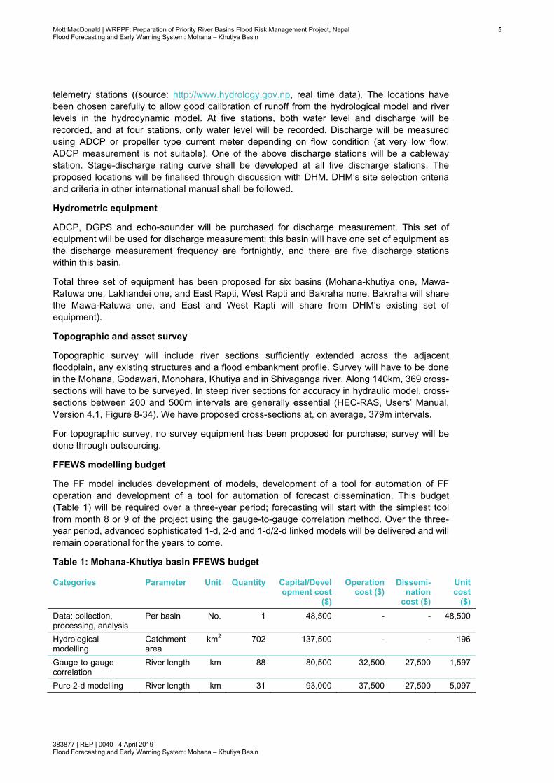
FFEWS modelling budget
The FF model includes development of models, development of a tool for automation of FF operation and development of a tool for automation of forecast dissemination. This budget (Table 1) will be required over a three-year period; forecasting will start with the simplest tool from month 8 or 9 of the project using the gauge-to-gauge correlation method. Over the three-year period, advanced sophisticated 1-d, 2-d and 1-d/2-d linked models will be delivered and will remain operational for the years to come.
Table 1: Mohana-Khutiya basin FFEWS budget
Categories Parameter Unit Quantity Capital/Development cost
($)
Operation cost ($)
Dissemi-nation
cost ($)
Unit cost
($) Data: collection, processing, analysis
Per basin No. 1 48,500 - - 48,500
Hydrological modelling
Catchment area
km2 702 137,500 - - 196
Gauge-to-gauge correlation
River length km 88 80,500 32,500 27,500 1,597
Pure 2-d modelling River length km 31 93,000 37,500 27,500 5,097

Mott MacDonald | WRPPF: Preparation of Priority River Basins Flood Risk Management Project, Nepal 6Flood Forecasting and Early Warning System: Mohana – Khutiya Basin
383877 | REP | 0040 | 4 April 2019 Flood Forecasting and Early Warning System: Mohana – Khutiya Basin
Categories Parameter Unit Quantity Capital/Development cost
($)
Operation cost ($)
Dissemi-nation
cost ($)
Unit cost
($) 1-d modelling River length km 131 144,500 73,500 35,000 1,931 1-d/2-d linked modelling
River length km 52 169,500 64,500 26,250 4,967
Modelling software Suite No. 1 13,000 - - 13,000 Total 686,500 208,000 116,250 Note: Modelling software licence cost is distributed over five basins; software will have multi user network licence, and cost shown here is per basin. West Rapti is excluded from software cost Source: Mott MacDonald
The hydro-meteorological data network budget includes establishing auto-rain gauges (Table 2), and auto and manual water level gauges and discharge measurements (Table 3); discharge measurement is to be carried over a period of three years, while rainfall and water levels are to be collected for three years for this project and also to be maintained beyond the period of this project. Measurement of discharge beyond three years (this project period) will be left to DHM’s choice whether further occasional discharge measurement to be carried out (or not) by their trained technical staff (who will be trained in this project).
Table 2: Budget for proposed rain gauge network in Mohana-Khutiya basin Hydrometeorological data network Mohana-Khutiya budget (US$) No. of
stations No. of
measurements Capital cost/
measurement cost
Unit cost Maintenance cost: 3 years
Total cost
Ground-based tipping bucket auto telemetry
11 - 55,000 5,000 6,000 61,000
Total 11 55,000 5,000 6,000 61,000 Source: Mott MacDonald
Table 3: Water level and discharge gauge network budget in Mohana-Khutiya basin Hydrometric data network Mohana-Khutiya budget (US$) No. of
stations No. of
measurements Capital cost/
measurement cost Unit cost
Operation & Maintenance cost: 3 years
Total cost
Discharge 4 120 520,000 4,333 6,000 526,000 Water level 5 - 35,000 7,000 6,000 41,000 Note: a) Discharge measurement to be carried out fortnightly from mid-May to mid-October; this will be 10 measurements per year, 30 in 3 years at one station and total 120 measurements in 4 stations; b) Operation and maintenance cost is $2,000 per basin for all stations per year; this involves routine site visits, repair and maintenance of the gauge, sediment removal etc. c) Discharge measurement cost is a continuous expenditure, like model development cost (and should be considered similar to capital cost); it includes cost for all skilled human resources and the logistics required
Source: Mott MacDonald
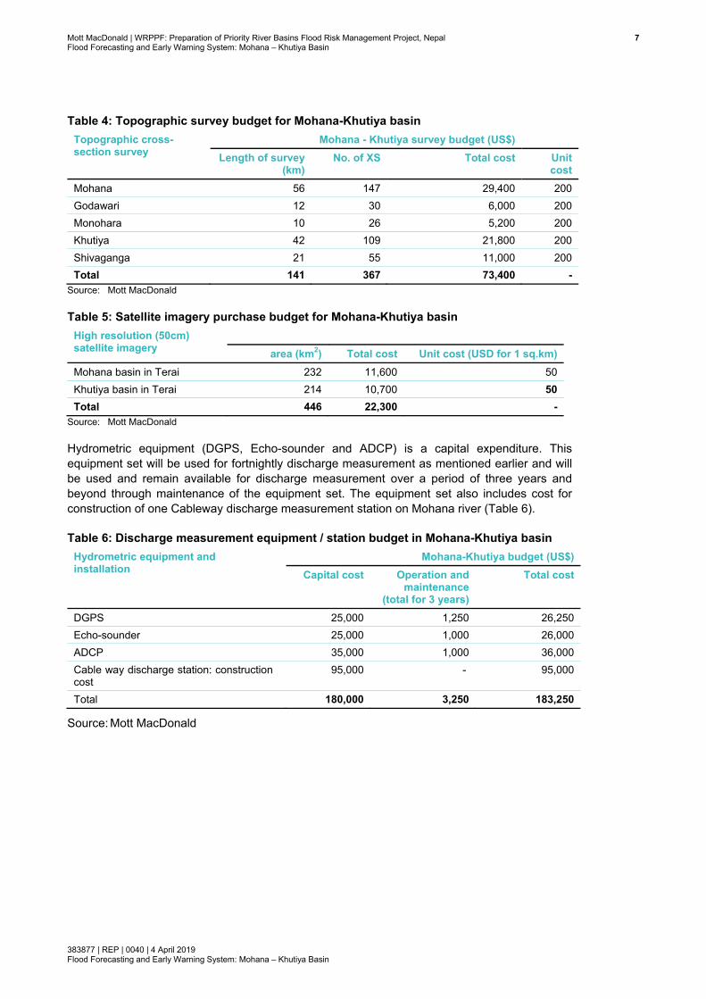
Topographic survey will be outsourced, and thus no procurement of survey equipment is proposed. The budget (Table 4) included here is for surveying cross-sections in Mohana, Godawari, Monohara, Khutiya and Shivaganga rivers. Budget for purchasing high resolution satellite imageries has been included (Table 5) for Mohana and Khutiya basin for lower catchment only in Terai to provide DEM to 1-d and 2-d model development and flood inundation map preparation.
Mott MacDonald | WRPPF: Preparation of Priority River Basins Flood Risk Management Project, Nepal 7Flood Forecasting and Early Warning System: Mohana – Khutiya Basin
383877 | REP | 0040 | 4 April 2019 Flood Forecasting and Early Warning System: Mohana – Khutiya Basin
Table 4: Topographic survey budget for Mohana-Khutiya basin Topographic cross-section survey
Mohana - Khutiya survey budget (US$) Length of survey
(km) No. of XS Total cost Unit
cost Mohana 56 147 29,400 200 Godawari 12 30 6,000 200 Monohara 10 26 5,200 200 Khutiya 42 109 21,800 200 Shivaganga 21 55 11,000 200 Total 141 367 73,400 -
Source: Mott MacDonald
Table 5: Satellite imagery purchase budget for Mohana-Khutiya basin High resolution (50cm) satellite imagery
area (km2) Total cost Unit cost (USD for 1 sq.km)
Mohana basin in Terai 232 11,600 50 Khutiya basin in Terai 214 10,700 50 Total 446 22,300 -
Source: Mott MacDonald
Hydrometric equipment (DGPS, Echo-sounder and ADCP) is a capital expenditure. This equipment set will be used for fortnightly discharge measurement as mentioned earlier and will be used and remain available for discharge measurement over a period of three years and beyond through maintenance of the equipment set. The equipment set also includes cost for construction of one Cableway discharge measurement station on Mohana river (Table 6).
Table 6: Discharge measurement equipment / station budget in Mohana-Khutiya basin Hydrometric equipment and installation
Mohana-Khutiya budget (US$) Capital cost Operation and
maintenance (total for 3 years)
Total cost
DGPS 25,000 1,250 26,250 Echo-sounder 25,000 1,000 26,000 ADCP 35,000 1,000 36,000 Cable way discharge station: construction cost
95,000 - 95,000
Total 180,000 3,250 183,250
Source: Mott MacDonald
Mott MacDonald | WRPPF: Preparation of Priority River Basins Flood Risk Management Project, Nepal 8Flood Forecasting and Early Warning System: Mohana – Khutiya Basin
383877 | REP | 0040 | 4 April 2019 Flood Forecasting and Early Warning System: Mohana – Khutiya Basin
1 Introduction
1.1 Project background Acknowledging the importance of the Terai region to Nepal, the Government of Nepal (GoN), through the Ministry of Energy, Water Resources and Irrigation (MoEWRI), is implementing the ‘Priority River Basins Flood Risk Management Project’ in the Southern Nepal Terai region. The project is the continuation of the pre-feasibility study: Package 3: Flood Hazard Mapping and Risk Management Project (FHMRMP, 2016).
During the pre-feasibility study from the 25 basins, six priority basins were selected and included in the cost-benefit analysis: i) West Rapti, ii) Mawa–Ratuwa, iii) Lakhandei, iv) Mohana -Khutiya, v) East Rapt, vi) Bakraha. Bakraha replaced the Biring basin; the Khutiya basin was added to the Mohana basin, and Mawa was added to the Ratuwa basin.
In this study, feasibility level design for developing an FFEWS in the above basins (excluding West Rapti) has been prepared. Note here that FFEWS for the West Rapti basin is currently being developed by the Department of Hydrology and Meteorology in Nepal, funded by the World Bank in the project ‘Building Resilience to Climate Related Hazards (BRCH)’
This feasibility report for development of FFEWS is for Mohana-Khutiya basin.
1.2 Problem statement Nepal is considered to be one of the most disaster-prone countries in the world. Alongside other natural hazards, such as earthquakes and landslides, flooding poses risk to large sections of the population. Heavy damage to infrastructure, loss of agricultural production, disruption of livelihoods and loss of lives in Nepal due to floods are frequent occurrences during summer monsoons. It is also expected that economic losses associated with floods is likely to rise with increasing economic and development activities in the flood plains.
Holistic management of flood risk requires actions to reduce impact before, during and after extreme events and includes preventive technical measures as well as socioeconomic aspects to reduce vulnerability to hazards. Although flood disaster risk assessment and management processes have been used by the Government agencies in Nepal to help estimate and manage risks associated with floods, these tools are in general not available (other than isolated flood and erosion control structures) in the five basins under this study and as a result may not serve these basins in an optimal way.
One of the first steps in flood disaster risk reduction is to identify risks. Knowledge of risks raises awareness and allows pre-event planning in contrast to post-event response and recovery. In this context, flood risk management must be coordinated with other development activities in the flood plains, and particularly water resources development in a river basin. To do this, it is necessary to understand better the extent to which the current level of information related to flood disaster risk is adequate for development planning, and societal risk management practice and whether or not this level can be improved. Besides, it requires assessing the degree to which flood risk management has been integrated in other development activities so far and whether or not this integration can be improved by a thorough understanding of flood hazards in river basins, especially in Terai with large flat flood plains.
Mott MacDonald | WRPPF: Preparation of Priority River Basins Flood Risk Management Project, Nepal 9Flood Forecasting and Early Warning System: Mohana – Khutiya Basin
383877 | REP | 0040 | 4 April 2019 Flood Forecasting and Early Warning System: Mohana – Khutiya Basin
1.3 Understanding the need for an FFEWS One of the key non-structural measures of reducing flood disaster risks is the provision of a reliable and accurate flood forecasting system including a thorough understanding of flood propagation in rivers and inundation of large flood plains.
Provision of a reliable and accurate flood forecasting system with adequate lead time has been recognised by the Government of Nepal as a key non-structural measure to reduce flood disaster risks. However, due to lack of an integrated hydro-met monitoring network in these six basins and due to lack of real time forecasting technology and tools, the capability to meet the demand of a modern real-time flood forecasting and warning system is limited. An effective flood forecasting and warning system has to be based on hydrological and hydrodynamic models to simulate rainfall-runoff from precipitation and to simulate propagation of floods along the tributaries, main streams and the flood plains. Using real time rainfall data from upper and lower catchments, meteorological forecasts and river gauge data, flood forecasts for up to three days in advance can be developed using the modelling tools. The generated forecasts on flood level and discharge shall be translated easily into understandable warnings including flood inundation maps/risk maps for community-based disaster risk management activities. The forecasts, warnings and risk information shall be disseminated as widely as possible via Internet, mobile phones, public and private media, social media and other means of communication.
Flood risk consists of three key components: i) problem of repeated occurrence, ii) exposure of people ad assets to flood, and iii) vulnerability. FFEWS will reduce exposure and vulnerability of those exposed.
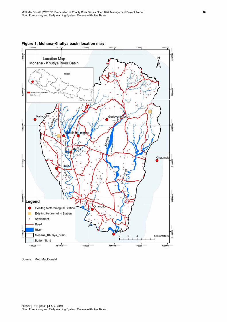
1.4 Study area The catchment of the Mohana Khutiya river basin lies between Northing 3168000m to 3208000m (latitude 28°38′1.76″N and 28°58′59.15″N), and between Easting 448000m to 478000m (longitude 80°31′36.73″E and 80°45′24.74″E) in WGS 84, UTM Zone 44 N (see Figure 1). The basin extends from the Chure Hills (Siwalik Hills, also known as sub-Himalayan hills, at low altitude) in the north and in Terai (meaning low flat land) up to the Indo-Nepal border in the south. The catchment covers an area of 702km2 in the far west of Nepal (Figure 1). The Mohana-Khutiya river system lies in the district of Kailali in Province no 7. This river system has 359 settlements distributed over rural and urban municipalities with a population of 190,063 and 37,681 households (CBS, 2011). Dhangadi and Attrariya are the two major towns located in this catchment.
The basin has two hydrometric stations, which collect water level and occasional discharge, and also seven meteorological stations which collect rainfall (with other meteorological parameters) with another two located close to the catchment boundary.
Mott MacDonaldFlood Forecastin
383877 | REP | 0Flood Forecastin
Figure 1: M
Source: Mott
| WRPPF: Prepang and Early Warn
0040 | 4 April 2019ng and Early Warn
Mohana-Khu
MacDonald
ration of Priority Rning System: Moh
9 ning System: Moh
utiya basin lo
River Basins Floodana – Khutiya Bas
ana – Khutiya Bas
ocation map
d Risk Managemesin
sin
p
ent Project, Nepal 100
Mott MacDonald | WRPPF: Preparation of Priority River Basins Flood Risk Management Project, Nepal 11Flood Forecasting and Early Warning System: Mohana – Khutiya Basin
383877 | REP | 0040 | 4 April 2019 Flood Forecasting and Early Warning System: Mohana – Khutiya Basin
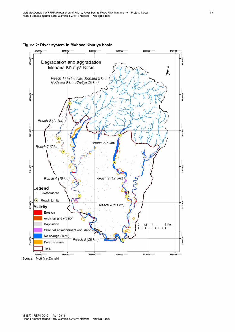
1.5 River system in the basin Brief summary of the river system in this basin is presented below in Table 7 and in Figure 2. Reach-wise detailed classifications of these morphologically active rivers have been presented in a separate report in this study (Mott MacDonald, 2018). A brief description, mainly useful for developing hydrological, hydraulic and flood forecasting models, is presented below.
This catchment originating from Chure Hills is relatively small (702km2), about 1/5th of the size of West Rapti at Bagasoti gauging station. The West Rapti at Bagasoti has a time of concentration of 10hrs (DHM, 2018). Thus, this basin is expected to have much smaller time of concentration. And this will affect both forecast lead time and response time. In steep slope reaches (upper reaches), the flood travel time, in general, is fast. Therefore, gauge to gauge correlation forecasting, which is practised in many basins by DHM in Nepal, will not be generally suitable, particularly in upper reach, as both forecast lead time and response time will become small in this basin. Rivers in Nepal are flashy; as such the lag time (time required to attain peak flow after a rainfall event) is very short. This necessitates that rainfall-runoff and hydraulic models are developed for the well-defined reaches of river and get the benefit of 1 to 3 days of lead time on rainfall forecast from the weather forecast model. The hydraulic model, irrespective of flood lag time, response time and slope of the rivers, will be able to forecast water level and their propagation with same lead time (1 to 3 days) as in weather forecast model. However, depending on the river characteristics, appropriate type of hydraulic model should be developed. In steep slope reaches, flood propagates fast and flooding spreads less in the limited floodplain; so developing 1-d model will be more appropriate in those reaches. In gentle slope reaches, the flood propagation is slow and flood inundates more areas in meandering and braided floodplain; thus, 1d/2d linked model will be more accurate and beneficial to warn people. Considering the characteristic features of the river systems, e.g., hills, river braiding, meandering etc., the types and domains of models, have been identified (see Section 8). However, development of appropriate type of model (1d, 2d or 1d/2d linked) should require several iterations during development stage of these models.
Table 7: Summary of river system in Mohana-Khutiya basin River Reach
ID Reach Characteristics Channel
length (km) Slope (%)
Mohana River
1 Hill 4.97 14.1 2 Fan 8.37 1.1 3 Peripheral fan (Godawari Confluence) 13.87 0.1 4 Flood plain, meander (India border) 21.29 0.1 5 Flood plain, meander (India border-Khutiya) 21.34 0.1
Godawari River
1 Hill 9.26 13.4 2 Braided 6.97 1.2 3 Flood plain, Meander (Mohana Confluence) 6.52 0.2
Monohara 1 Hill 6.29 16.2 2 Braided 4.80 0.9 3 Flood plain, meander (Mohana confluence) 8.59 0.1
Khutiya 1 Hill 19.91 8.3 2 Braided 6.51 1.1 3 Flood plain, Meander (Shivaganga confluence) 15.46 0.2 4 Meander (Mohana confluence (Nepal-India
border) 9.77 0.1
Mott MacDonald | WRPPF: Preparation of Priority River Basins Flood Risk Management Project, Nepal 12Flood Forecasting and Early Warning System: Mohana – Khutiya Basin
383877 | REP | 0040 | 4 April 2019 Flood Forecasting and Early Warning System: Mohana – Khutiya Basin
River Reach ID
Reach Characteristics Channel length (km)
Slope (%)
Shiva Ganga
1 Hill 10.92 14.7 2 Braided 3.78 1.4 3 Flood, plain, meander Shiva Ganga (Khutiya) 19.55 0.2
Source: Mott MacDonald
Mohana river has been divided into five reaches (Table 7). Total length is 70km. Reaches are mainly straight and meandering; there may be transitional lengths between them. The meandering reach is much higher, 57km; the straight/transitional reach is 13km. Channel slope is very steep, particularly in the first hilly reach. In the first two straight reaches, sediments are mainly boulders, gravels and sands, while in the meandering reaches, sediments are sand and silt (and might have a minor fraction of fine gravel).
Godawari is a tributary to the Mohana and located in the Hills. The river has been divided into three reaches (Table 7). Total length is 23km. All reaches tend to be straight, though the third downstream reach tends towards meandering. The first two reaches have steep slopes, and the last reach has relatively mild slopes. Sediments are mainly boulders, gravels and sands in the two steep reaches and sand and silt in the last reach.
Monohara river is a tributary to the Mohana and located in the Hills. Total length is 23km. The river has been divided into three reaches (Table 7). The first two reaches are straight, and the third reach tends towards meandering. The first reach has steep slopes, the other two reaches have relatively mild slopes. Sediments are mainly boulders, gravels and sands in the first two steep reaches and sand and silt in the last reach.
The Khutiya river is the major tributary to the Mohana. The river has been divided into four reaches (Table 7). Total length is 52km. The first reach is straight and the other three in the downstream tend towards meandering. The first and second reaches have steep slopes, and the third and fourth have very mild slopes. Sediments are mainly boulders, gravels and sands in the first two steep reaches, and sand and silt in the last two downstream reaches.
The Shivaganga river is a tributary to the Khutiya; the river has been divided into three reaches (Table 7). Total length is 34km. The first two reaches are straight and the third (downstream) reach is meandering. Straight reaches have steep slopes, while the meandering reach has mild slope. Sediments are mainly boulders, gravels and sands in the first two steep reaches, and sand and silt in the meandering reach.
Mott MacDonaldFlood Forecastin
383877 | REP | 0Flood Forecastin
Figure 2: R
Source: Mott
| WRPPF: Prepang and Early Warn
0040 | 4 April 2019ng and Early Warn
River system
MacDonald
ration of Priority Rning System: Moh
9 ning System: Moh
m in Mohana
River Basins Floodana – Khutiya Bas
ana – Khutiya Bas
a Khutiya ba
d Risk Managemesin
sin
asin
ent Project, Nepal 133

Mott MacDonald | WRPPF: Preparation of Priority River Basins Flood Risk Management Project, Nepal 14Flood Forecasting and Early Warning System: Mohana – Khutiya Basin
383877 | REP | 0040 | 4 April 2019 Flood Forecasting and Early Warning System: Mohana – Khutiya Basin
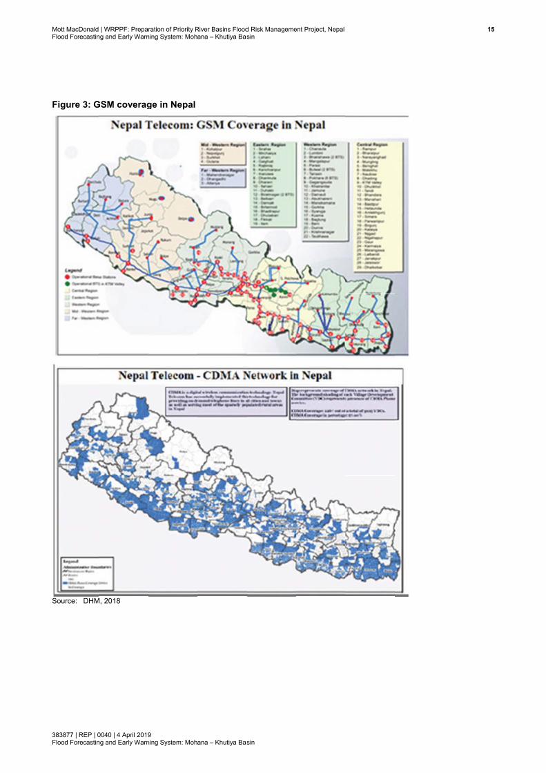
1.6 CDMA and GSM coverage in Nepal Real time data acquisition and the issuing and dissemination of flood alerts and warnings from the FFEWS model are the prime objectives. The proposed FFEWS will primarily use the code-division multiple access (CDMA) and Global System for Mobile communication (GSM) technologies of Nepal for dissemination of the flood alerts and warnings. CDMA technology has been used by NTC while the GSM technology is supported by other mobile providers in Nepal. Ncell is one of the companies with the largest GSM networks in Nepal. Both companies are providing services to DHM for real-time data acquisition. However, these service providers have several gaps in their network coverage. In these gap areas, the hydro-meteorological stations cannot transmit data on a real-time basis. Since these technologies are based on line-of-sight communication, some of the hydrometric stations located in deep gorges do not have connection even within the area of their coverage.
The existing CDMA and GSM in Nepal is shown in Figure 3. This basin, Mohana and Khutiya, seems to have good GSM network, and thus will be very useful for establishing the FFEWS in this basin. However, for installation of any new proposed hydro-meteorological monitoring station, GSM must be checked prior to installation, and if needed, station location could be shifted through discussion with DHM.
Mott MacDonaldFlood Forecastin
383877 | REP | 0Flood Forecastin
Figure 3: G
Source: DHM
| WRPPF: Prepang and Early Warn
0040 | 4 April 2019ng and Early Warn
GSM coverag
M, 2018
ration of Priority Rning System: Moh
9 ning System: Moh
ge in Nepal
River Basins Floodana – Khutiya Bas
ana – Khutiya Bas
d Risk Managemesin
sin
ent Project, Nepal
155
Mott MacDonald | WRPPF: Preparation of Priority River Basins Flood Risk Management Project, Nepal 16Flood Forecasting and Early Warning System: Mohana – Khutiya Basin
383877 | REP | 0040 | 4 April 2019 Flood Forecasting and Early Warning System: Mohana – Khutiya Basin
2 Hydro meteorological data
2.1 Introduction Certain types of hydro-meteorological data are essential for different types of flood forecast modelling. Meteorological data types are: rainfall/precipitation (P), temperature (T) and potential evapotranspiration (PET); they are input data for rainfall-runoff (RR) modelling in any hydrological modelling tool. Hydrological data types are: discharge (Q) and water level (H); they are required at boundary conditions as well as at calibration and validation locations of rainfall runoff (Q required) and 1-d and 2-d hydrodynamic models (both Q and H required).
Development of the base model, whether for flood forecasting or for design of flood protection works, would not essentially be very different. In order to be more run efficient, the forecasting model could be simplified in some places, though not at the expense of accuracy. The model has to be calibrated against several past events and the calibration process would be enhanced by testing a greater number of events. The model should be able to replicate any event, for a wide range of return periods (from very low to high exceedance probability). Both long term data and short-term past storm event records can be used for calibration. Long-term data are more appropriate and do not need to be continuous. During the operational phase of the flood forecasting model, continuous data during monsoon will be essential to collect as the model will operate at real time daily.
Following data will be required at daily or sub-daily temporal resolution in each phase of FFEWS model development, namely, calibration, validation and operational phase.
● Cumulative rainfall; runoff is the response of total rainfall, rather than a rate of rainfall. As such rainfall is required as input to the runoff model
● Mean temperature ● Cumulative PET; for same reason as rainfall, cumulative PET data is used as input in the
runoff model ● Water level ● Discharge
Snow cover data may not be required as the altitude of the basin, is below 3000m, and thus, understood that catchment runoff is not from snow-fed (Putkonen, 2004).
For example, in the calibration phase, parameters’ values within the RR models for each of the sub-catchment will be tuned so that differences (errors) between modelled Q and observed Q are minimum and down to acceptable levels. The level of acceptability needs to be agreed with the client (DHM) and with due reference to best practice RR modelling (DHI, 2014; HEC-HMS). During the validation phase, the performance of the model is evaluated, without changing any parameters established during calibration phase, and similar standard of matching between observed and modelled Q and WL should be obtained; otherwise, a recalibration would be needed followed by validation.
In the event of observed meteorological data are insufficient or not available in all the sub-basins, data from other sources should be explored. This necessitates the consideration satellite-based rainfall, temperature, snow cover etc. Such data are available as gridded data, generally available in good spatial resolution, and are mainly derived from long records of observed gauge-interpolated data (see Section 2.6 for details).
Mott MacDonald | WRPPF: Preparation of Priority River Basins Flood Risk Management Project, Nepal 17Flood Forecasting and Early Warning System: Mohana – Khutiya Basin
383877 | REP | 0040 | 4 April 2019 Flood Forecasting and Early Warning System: Mohana – Khutiya Basin
In this chapter, available data from DHM, and gridded data from a number of sources have been discussed.
2.2 Hydro-meteorological gauge densities in Nepal and other countries Density of hydro-meteorological stations in Nepal and in some other countries in the world is presented in Table 8. The density is mainly dependent on purpose, e.g. the rainfall data will be used for irrigation, flood risk assessment or for flood forecasting purposes. Flood prediction in rural and urban areas requires a dense spatial gauge network, one gauge between 10 to 100km2 and higher temporal measurement frequency between minutes to hour (Berndtsson and Niemczynowicz, 1988).
Table 8: Rainfall gauge density in Nepal and in some selected countries in the world Country Number
of gauges Average area per gauge
(km2) Nepal - 550
Nepal: Siwalik region - 430
Nepal: Terai region - 370 UK 3,214 76 England 2,169 60 France - 116 Netherlands - 130 Germany - 88 USA - 1,040 India - 790
Source: DoWRI (2016) for Nepal and Allot (2010), Met Office, England for other countries
2.3 Existing hydro-meteorological network Nepal DHM is the designated government agency for predicting and disseminating weather-based forecasts and warnings. In June 2018, DHM, maintained a total of 175 hydrometric stations, 337 precipitation gauging stations, 68 climatological stations and 15 synoptic stations. These stations include both real-time telemetry stations and non-telemetric stations.
Among the above stations, DHM, presently maintains a network of 28 hydrometric stations and 88 meteorological stations, as real-time telemetry stations. DHM is further upgrading 59 hydrometric stations to real-time telemetry stations. An additional seven stations are also under consideration for upgrading to real-time telemetry. In total, 182 hydro-meteorological stations are scheduled to become operational as real-time telemetry data acquisition systems in the near future.
2.3.1 Rainfall
Existing metrological stations within Mohana-Khutiya basin are shown in Figure 6. There are seven stations within the basin, and there are two more stations within the 4km buffer zone of the boundary of this basin; none of these stations are rea-time telemetric stations. These rainfall stations are understood to generate daily data. Period of records vary from station to station. However, in general, data are available from the 1970s; for example, Godawari station is operational since June 1976 to present time. While they will be useful for calibration and
Mott MacDonald | WRPPF: Preparation of Priority River Basins Flood Risk Management Project, Nepal 18Flood Forecasting and Early Warning System: Mohana – Khutiya Basin
383877 | REP | 0040 | 4 April 2019 Flood Forecasting and Early Warning System: Mohana – Khutiya Basin
validation of the hydrological model, real time telemetry rainfall at sub-daily frequency, usually 15minute frequency, will be required for hindcasting and forecasting and early warning system. As such new telemetry rain gauges have been proposed (see Section 5).
DHM has planned installation of three radar rain gauges across Nepal. One is under installation at Surkhet near Mohana and one at West Rapti; installation will be completed in a few months. This C-band long range radar has a 400km diameter range. Temporal resolution from bid document is understood to be of a minimum of 1-hour; however, the temporal resolution is to be agreed with DHM. The spatial resolution, though not mentioned in the bid document, could be of 1-km as obtained by long range C-band radar in UK and Germany (Lengfeld et al., undated).
Therefore, the forecasting model development will initially use existing rainfall radar data from DHM (if available) supplemented with gridded rainfall data available from satellite-based sources (see Section 2.6).
2.3.2 Evaporation
The same meteorological stations, which monitor rainfall, also collect daily pan evaporation data. However, hydrological modelling software, like NAM, uses monthly PET. There are seven stations within the basin, and there are two more stations within the 4km buffer zone of the boundary of this basin. Period of records vary from station to station, but in general data are available from the 1970s. Pan evaporation data from these stations will be used in the development of the hydrological model within the FFEWS.
2.3.3 Temperature
The same meteorological stations, which monitor rainfall, also collect temperature, daily minimum and daily maximum data are available from DHM. There are seven stations within the basin, and there are two more stations within the 4km buffer zone of the boundary of this basin. Period of records vary from station to station, but in general data are available from the 1970s. Temperature data from these stations will be used for development of the hydrological model within the FFEWS, in case there is any snow fed runoff in the basin,.
2.4 Water level stations The existing hydrometric stations (water level and discharge) within the Mohana-Khutiya basin are shown in Figure 8. There are two hydrometric stations within this basin – one in Mohana basin and the other in the upper catchment of Khutiya basin. None of these two stations are real-time telemetric station (source: http://www.hydrology.gov.np, real time data), Data from these two stations have not been published by DHM; during visit and discussion with DHM, it seemed that use of the data is also not recommended. Therefore, for development of the FFEWS models in this basin, the water level must have to be obtained from new proposed monitoring stations, which will be real time telemetric data (please see Section 6).
2.5 Discharge stations The existing discharge stations within the Mohana-Khutiya basin are shown in Figure 8. There are two hydrological stations within this basin – one in Mohana basin and the other in the upper catchment of Khutiya basin. None of these two stations are real-time telemetric station (source: http://www.hydrology.gov.np, real time data), Data from these two stations have not been published by DHM; during visit and discussion with DHM, it seemed that use of the data is also not recommended. Therefore, for development of FFEWS models in this basin, discharge must be obtained from new proposed monitoring stations, which will be real time telemetric. Through conversion of water level to discharge, continuous discharge time series will be generated by

Mott MacDonald | WRPPF: Preparation of Priority River Basins Flood Risk Management Project, Nepal 19Flood Forecasting and Early Warning System: Mohana – Khutiya Basin
383877 | REP | 0040 | 4 April 2019 Flood Forecasting and Early Warning System: Mohana – Khutiya Basin
using a discharge vs water level rating curve. The discharge vs water level rating curve will be developed in this project (see Section 6).
2.6 Gridded Meteorological data Gridded time series of meteorological data (rainfall/precipitation, surface temperature, evaporation and snow cover), spreading over the Nepal and border basins in China and India are available from a number of sources. Data are satellite-based, re-analysis based or gauge-
interpolated estimates. Gridded time series data shall be needed due to non-availability or scarcity of hydro-meteorological observations within in these six priority basins. The gridded products available are:
● TRMMv7 precipitation estimates ● APHRODITE precipitation and temperature products ● MODIS snow cover products Availability and quality of some of the gridded data are briefly discussed below.
During model development phase, time series of gridded data could be used from the above sources. However, before use, availability and quality for long records shall be examined.
2.6.1 APHRODITE precipitation data
Asian Precipitation - Highly-Resolved Observational Data Integration Towards Evaluation (APHRODITE) collects and analyses rain gauge observations from thousands of Asian stations; it has about 57 years of daily precipitation (P) datasets available between 1951 and 2007. APHRODITE (APH) precipitation data is gauge-interpolated and takes account of the orographic effect. Temporal resolution of the data is daily; spatial resolution is 0.25° lat/long (approximately 9km cell). APH data also has air temperature data with the same resolution as precipitation data.
APH daily precipitation data is freely available for non-commercial purposes (for Academic Institutions and Researches) provided proper acknowledgement is given. No commercial use is allowed. Use of APH data by Government of Nepal may be considered non-commercial, however, for use of the APH data, permission has to be granted. The spatial coverage of APH monsoon dataset extends from 60°E longitude in the west to 150°E longitude in the east and from 15°S latitude in the south to 55°N in the north. This means APH data cover almost all of Asia, including Nepal. It is available for the period 1951-2007, i.e. 57 years of daily precipitation data for each grid. This implies availability of daily data for calibration and validation of runoff models with long historical records. APH data are available in two spatial resolutions –viz. 0.5° lat/long and 0.25° lat/long. Compared to observed data from existing DHM stations, APH-P provides better spatial resolution of precipitation distribution (as well as for longer periods) over Nepal in this basin and also in the other basins of this study. It is expected that the mean areal precipitation series for each sub-catchment could be obtained from APH-P and will be used for hydrological modelling.
2.6.2 TRMM3B42 Precipitation
Tropical Rainfall Measuring Mission (TRMM) is a joint venture between National Aeronautics and Space Administration (NASA) and Japan Aerospace Exploration Agency (JAXA). TRMM3B42v7 is gauge-adjusted version of satellite-based precipitation estimates of TRMM satellites. The products are continuously released with 2 months of latency period. Spatial resolution is 0.25° lat/long and temporal resolution is three hours. Data are available from January 1998 to the present time. Data are freely available for all purposes. These data will
Mott MacDonald | WRPPF: Preparation of Priority River Basins Flood Risk Management Project, Nepal 20Flood Forecasting and Early Warning System: Mohana – Khutiya Basin
383877 | REP | 0040 | 4 April 2019 Flood Forecasting and Early Warning System: Mohana – Khutiya Basin
complement APHRODITE data which end in 2007. Thus, any calibration and validation of hydrological models beyond 2007 will be carried out using these precipitation data.
2.6.3 MODIS Snow Cover Data
The data on snow cover is required to decide upon the portion of a sub-catchment where snow melt generated runoff is the dominant process. None of the six basins within this study is considered to be under snow cover for significant duration. NASA’s MODIS snow cover product can be obtained freely from NASA’s MODIS link: https://modis.gsfc.nasa.gov/data/dataprod/ mod10.php.
2.7 Forecasted Meteorological data For operation of FFEWS, Quantitative Precipitation Forecast (QPF) estimates are essential, and Quantitative Temperature Forecast (QTF) estimates are desirable. For PET, flood forecasting model often use average of past monthly records.
The Numerical Weather Prediction (NWP) system of Indian Meteorological Department (IMD) provides QPF and QTF estimates which could be obtained through FTP access. IMD forecasts have 9km spatial resolution (0.081° lat/long), has 3-hours temporal resolution and 72-hours lead time. IMD-QPF is available at a finer spatial resolution than GFS (details below on GFS) for catchments in Nepal. Generally, the accuracy of the forecasts from any NWP model deteriorates as lead time increases.
IMD-QTF products have the same spatial and temporal resolutions as that of IMD-QPF products i.e. 0.081° lat/long, three hours temporal resolution and 72-hours lead time.
The Global Forecast System (GFS) is a weather forecast model produced by the National Centers for Environmental Prediction (NCEP) of NOAA. The GFS-QPF with 0.25° lat/long spatial resolution, 3-hours temporal resolution and lead time of 10 days is freely available. It is understood that DHM already uses GFS and The Weather Research and Forecasting (WRF) model to obtain QPF for forecasting in their existing FFEWS models.
As IMD-QPF has finer spatial and temporal resolution, and GFS-QPF is already in use by DHM, IMD and GFS are considered as the best source of QPF available to Nepal catchment at present. The best approach may be to treat IMD-QPF as the primary QPF should DHM be able to sign a treaty with IMD to obtain the IMD-QPF; else GFS-QPF will be used as this is already being used by DHM.
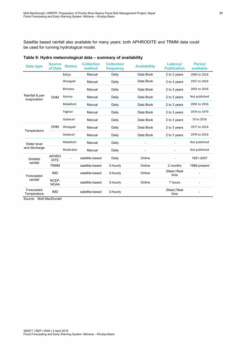
2.8 Summary of availability of data Summary on the availability of existing hydro meteorological data and forecasted rainfall data and their sources are presented in Table 10.
DHM’s rainfall data from DHM are available for a considerable number of years in seven stations, and should be usable for calibration and validation of the rainfall run-off model. However, discharge and water level data are not available in this basin as the data from the two stations data have not been published. In the rainfall data, the published reports of DHM (downloaded from their web site) show missing rainfall data as well. Maximum years of data are missing at Godavari (6 years) and at Teghari, 1980 to present time. We should note here that data from manual stations have been published in Data Book upto 2016, which indicates that DHM needs about 2 to 3 years to organise, analyse and quality check data before officially publishing.
Mott MacDonald | WRPPF: Preparation of Priority River Basins Flood Risk Management Project, Nepal 21Flood Forecasting and Early Warning System: Mohana – Khutiya Basin
383877 | REP | 0040 | 4 April 2019 Flood Forecasting and Early Warning System: Mohana – Khutiya Basin
Satellite based rainfall also available for many years; both APHRODITE and TRMM data could be used for running hydrological model.
Table 9: Hydro meteorological data – summary of availability
Data type Source of Data Station Collection
method Collection frequency Availability Latency/
Publication Period
available
Rainfall & pan evaporation DHM
Baliya Manual Daily Data Book 2 to 3 years 2000 to 2016
Dhangadi Manual Daily Data Book 2 to 3 years 1957 to 2016
Bichawa Manual Daily Data Book 2 to 3 years 2001 to 2016
Atariya Manual Daily Data Book 2 to 3 years Not published
Malakheti Manual Daily Data Book 2 to 3 years 2001 to 2016
Teghari Manual Daily Data Book 2 to 3 years 1976 to 1979
Godavari Manual Daily Data Book 2 to 3 years 19 to 2016
Temperature DHM Dhangadi Manual Daily Data Book 2 to 3 years 1977 to 2016
Godavari Manual Daily Data Book 2 to 3 years 1976 to 2016
Water level and discharge
Malakheti Manual Daily - - Not published
Mudivabar Manual Daily - - Not published
Gridded rainfall
APHRODITE - satellite-based Daily Online - 1951-2007
TRMM satellite-based 3-hourly Online 2 months 1988-present
Forecasted rainfall
IMD satellite-based 3-hourly Online (Near) Real time -
NCEP, NOAA satellite-based 3-hourly Online 7 hours -
Forecasted Temperature IMD satellite-based 3-hourly (Near) Real
time -
Source: Mott MacDonald
Mott MacDonald | WRPPF: Preparation of Priority River Basins Flood Risk Management Project, Nepal 22Flood Forecasting and Early Warning System: Mohana – Khutiya Basin
383877 | REP | 0040 | 4 April 2019 Flood Forecasting and Early Warning System: Mohana – Khutiya Basin
3 DHM and existing flood forecasting models
3.1 DHM’s mandate Department of Hydrology and Meteorology (DHM) is the sole organisation in Nepal responsible for flood forecasting. One of the mandates of DHM is to provide early flood warnings to vulnerable communities and to major stakeholders. DHM, so far, have been able to establish flood Early Warning Systems (EWSs) in major rivers, in a few flashy rivers and in areas downstream of two glacial lakes that are considered potentially dangerous (DHM, 2018). The major river basins covered under EWS are: Karnali, Babai, West Rapti, Narayani, Bagmati, Kamala, Koshi, Kankai and Biring. Details of some of the EWS is discussed in next Section (Section 3.2). DHM’s aim is to extend flood forecasting services throughout the country.
The re-organised structure of the Government of Nepal implemented on 23 February 2018 has created the Ministry of Energy, Water Resources and Irrigation (MoEWRI). DHM used to operate under the Ministry of Environment and Population but now has been brought under the wing of MoEWRI with a mandate to provide weather and flood forecasts. With a new regulatory setup in place, DHM has been mandated to develop EWS including information dissemination components.
The organisational structure of DHM, which combines hydrology and meteorology, puts DHM in an ideal position to generate flood forecasts and issue forecasts and warnings. DHM has also been working with the Ministry of Home Affairs (MoHA), an organisation involved in the entire disaster management cycle, on disseminating flood warnings through National Emergency Operation Centers (NEOCs) and District Emergency Operation Centers (DEOCs). DHM has been supported by WMO since its establishment through collaboration on different meteorological activities and activities related to operational hydrology. As a member of WMO, Nepal has access to global and regional meteorological data required for monitoring and forecasting floods. Furthermore, DHM has received funding for several projects from WMO in the past, including projects on upgrading meteorological observation systems, weather forecasting, agriculture meteorology and hydrological services. In collaboration with the International Center for Integrated Mountain Development (ICIMOD) and countries in the Hindu Kush-Himalayan (HKH) region, WMO has been promoting the World Hydrological Cycle Observation System (WHYCOS) under the name of HKH-HYCOS. DHM has been contributing to this program by sharing real-time data for effective flow forecasting for the rivers originating from the Hindu Kush-Himalayan region.
With the implementation of the project ‘Building Resilience to Climate Related Hazards’ (BRCH), the World Bank has supported DHM by upgrading the existing flood forecasting system in Koshi and Rapti. This five-year project started in 2013 and its goal is to upgrade the real-time data acquisition system and establish an end-to-end flood forecasting system. Upgrading of Koshi and Rapti FFEWS are under progress at the moment. Nepal was also able to receive small grants from the Danish and Finnish governments for promoting DHM’s flood forecasting capabilities. Besides collaborating with the international community, Nepal has also been working closely with its neighbouring countries on upgrading its hydrological and meteorological monitoring systems. Since all the rivers of Nepal merge into the Ganga-Brahmaputra river system, Nepal has bilateral arrangements with India and Bangladesh that support the sharing of hydro-meteorological data and flood information.
Mott MacDonald | WRPPF: Preparation of Priority River Basins Flood Risk Management Project, Nepal 23Flood Forecasting and Early Warning System: Mohana – Khutiya Basin
383877 | REP | 0040 | 4 April 2019 Flood Forecasting and Early Warning System: Mohana – Khutiya Basin
Several INGOs are involved in disaster mitigation in Nepal. Nepal Red Cross Society (NRCS) and UNDP are involved in most of the disaster mitigation activities in Nepal. UNDP has been working with DHM to strengthen Nepal’s hydrological services and promoting community-based flood warning systems. Similarly, small-scale community-based flood warning systems have been implemented by other INGOs either in collaboration with DHM or in collaboration with other government agencies and NGOs. Since flood forecasts and warnings are widely used by communities and with several organisations simultaneously involved in disaster management, there are innumerable stakeholders involved (DHM, 2018).
3.2 Existing flood forecasting models in Nepal – an overview Probabilistic Flood Forecasting Model The model was developed jointly through a research partnership with Lancaster University (UK) and the International NGO Practical Action. The model assimilates rainfall and water levels to generate localised hourly flood predictions, which are presented as probabilistic forecasts, increasing lead times from 2-3 hours to 7-8 hours. The model predicts future water level at a site where thresholds for warning and danger levels are known. In this approach each gauged site where warning thresholds are defined requires its own model. The model was piloted in 2002 for the East Rapti River. The pilot model was enhanced and extended, expanding over the next 10 years to cover eight river basins across Nepal (Karnali, West Rapti, Babai, East Rapti, Narayani, Bagmati, Kankai and Koshi basins (Gautam and Phaiju, 2013). This model was made operational by DHM. Among them, West Rapti, Koshi and Babai FFEWS have been (or being) upgraded to advanced hydrological and hydraulic models (see below).
Advanced hydrological and 1-d hydraulic forecast model Nepal currently has operational flood forecasting models for the Koshi, West Rapti, Bagmati, and Babai catchments based on NAM/MIKE11 or HEC-HMS/HEC-RAS software which use rainfall QPF estimates from GFS and WRF. These models are rainfall-runoff and hydrodynamic models which forecast flows and flood levels. In addition, Nepal has gauge-to-gauge correlation forecasting covering most of the country, except basins smaller than about 300 to 400km2. This was informed by DHM Forecast Specialist during meetings with them between July to October 2018.
The Koshi flood forecasting model uses NAM modelling software for hydrological/rainfall runoff simulation, and MIKE11 for advanced (fully dynamic) 1-d river flow modelling. As the model uses rainfall forecasts from the GFS and WRF model, the lead time is up to 72 hours. The West Rapti flood forecasting model is under development in the same NAM/MIKE11 modelling system and thus has a similar forecasting ability as the Koshi flood forecasting model.
The Bagmati forecasting model is also operational and is developed in the HEC-HMS and HEC-RAS modelling system.
3.3 Examples of operational flood forecasting models from other countries Bangladesh has a dedicated flood warning centre in existence for 30 years, which has a FFEWS for the entire country’s river system in one model; the model is referred to as a super model, developed in the advanced hydrological (rainfall-runoff) modelling tool NAM and 1-d hydrodynamic model developed in the modelling tool MIKE11. The Bangladesh FFEW model has a 72-hour lead time. Similarly, advanced FFEW models have been developed in India for the Bagmati river basin in Bihar, the Krishna and Bhima river basins in Maharashtra, and the Brahmaputra river basin in Assam. Unlike those of Bangladesh and India, the UK’s FFEW models are for smaller catchments/basins because of the hilly terrain of the country and require
Mott MacDonaldFlood Forecastin
383877 | REP | 0Flood Forecastin
separate inmodels for modelling s
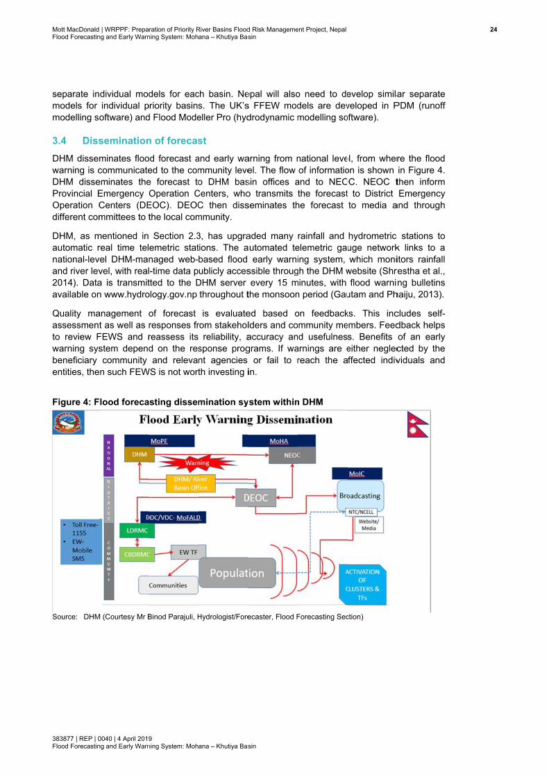
3.4 DissDHM dissemwarning is cDHM disseProvincial EOperation Cdifferent com
DHM, as mautomatic rnational-levand river lev2014). Dataavailable on
Quality maassessmentto review Fwarning sysbeneficiary entities, the
Figure 4: F
Source: DHM
| WRPPF: Prepang and Early Warn
0040 | 4 April 2019ng and Early Warn
dividual modindividual poftware) and
seminationminates floocommunicateeminates theEmergency Centers (DEmmittees to t
mentioned inreal time telvel DHM-manvel, with reala is transmitn www.hydro
anagement ot as well as r
FEWS and rstem dependcommunity
n such FEW
lood foreca
M (Courtesy Mr B
ration of Priority Rning System: Moh
9 ning System: Moh
dels for eacpriority basinsd Flood Mode
n of forecasod forecast aed to the come forecast toOperation C
EOC). DEOCthe local com
Section 2.3emetric statnaged web-l-time data ptted to the Dology.gov.np
of forecast responses frreassess itsd on the resand releva
WS is not wort
asting dissem
Binod Parajuli, H
River Basins Floodana – Khutiya Bas
ana – Khutiya Bas
ch basin. Nes. The UK’seller Pro (hyd
st and early wammunity leveo DHM bas
Centers, whoC then dissmmunity.
3, has upgrations. The abased flood ublicly acces
DHM server throughout t
is evaluaterom stakehol
reliability, asponse prognt agencies th investing i
mination sy
Hydrologist/Fore
d Risk Managemesin
sin
epal will alsos FFEW moddrodynamic m
arning from nel. The flow sin offices ao transmitsseminates th
aded many automated te
early warnissible througevery 15 m
the monsoon
ed based olders and coaccuracy angrams. If wa
or fail to rin.
ystem within
ecaster, Flood F
ent Project, Nepal
o need to dedels are devmodelling so
national leveof informatio
and to NEOthe forecast
he forecast
rainfall and elemetric gaing system,
gh the DHM wminutes, with n period (Gau
on feedbackommunity mend usefulnesarnings are ereach the a
n DHM
Forecasting Sec
evelop similaveloped in Poftware).
el, from wheron is shown
OC. NEOC tt to District to media a
hydrometric uge networkwhich moni
website (Shrflood warni
utam and Ph
ks. This incembers. Feeds. Benefits either neglec
affected indiv
ction)
ar separate PDM (runoff
re the flood in Figure 4. then inform Emergency
and through
c stations to k links to a itors rainfall restha et al., ng bulletins
haiju, 2013).
cludes self-dback helps of an early cted by the viduals and
244

Mott MacDonald | WRPPF: Preparation of Priority River Basins Flood Risk Management Project, Nepal 25Flood Forecasting and Early Warning System: Mohana – Khutiya Basin
383877 | REP | 0040 | 4 April 2019 Flood Forecasting and Early Warning System: Mohana – Khutiya Basin
4 Flood forecasting modelling
4.1 Flood forecasting modelling frame work Flood forecasting models vary in complexity from simple gauge-to-gauge correlations to highly automated integrated catchment flood forecasting models. The degree of automation and sophistication should be considered based on the needs for a particular location and a particular community. While the type of forecast system will be typically based on existing hydrometric networks or the enhancement or development of new networks, the system will need to be achievable and affordable. The type of flood forecasting system will therefore depend on:
● Available data ● Basin characteristics/complexity ● Accuracy and reliability required ● Lead time requirements ● Needs of the flood risk communities ● Ability of the operating organisation to routinely operate, maintain and update the models
Catchment aspects that affect the magnitude and timing of floods are wide and varied. These might include:
● Degree of catchment urbanisation ● Presence of reservoirs and flood storage/attenuation ● Quality of the ratings at gauging stations ● Impact of tributary and ungauged catchments ● Impact of backwater effects, confluences and tidal locations ● Seasonality of rainfall ● Upland areas and snowmelt considerations ● Influence of groundwater
An operational flood warning and forecasting system typically uses some form of hydrological and hydraulic modelling to provide sufficient lead time to avoid loss of life and to allow flood defence measures to be operated. Forecast models are at the heart of reliable operational flood warning systems.
The Mohana-Khutiya basin’s runoff is primarily rain-fed. The upstream catchment in the Chure hills is below 3,000m amsl, and thus, runoff mainly originates from rainfall with a minor component from groundwater (base flow); snow-fed runoff normally should not need to be considered for catchments below 3,000m (Putkonen, 2004).
In the mathematical modelling system for flood forecasting in Mohana-Khutiya basin, three major approaches could be used:
1. Gauge-to-gauge correlation: this is one of the simplest forecasting tools, based on correlation between gauged water level at two stations: an upstream base station and a downstream target station. This method uses flood levels at the base station when the flood has actually arrived (i.e. it uses the real time observed flood level) to estimate the future water level at the target stations. The lead time for forecast in the target station is small, a maximum of probably five to six hours in this basin.

Mott MacDonald | WRPPF: Preparation of Priority River Basins Flood Risk Management Project, Nepal 26Flood Forecasting and Early Warning System: Mohana – Khutiya Basin
383877 | REP | 0040 | 4 April 2019 Flood Forecasting and Early Warning System: Mohana – Khutiya Basin
2. Rainfall-runoff/hydrological modelling: Rainfall-runoff process modelling could be used to improve the forecast accuracy and lead time. The runoff in catchments with elevation below 3,000m (AMSL) can be modelled using a continuous rainfall-runoff model. Since the rivers are perennial in nature, the base flow component in the rainfall-runoff process is adequately represented. These continuous rainfall-runoff models typically require rainfall and PET as input to provide catchment flow as output hydrograph.
3. Channel routing/hydrodynamic modelling: Channel routing is the process which describes the propagation of flood waves along the river. This process can be modelled using hydrologic and/or hydrodynamic modelling. The employment of the model depends upon the need and complexity in the system. 1-d, 2-d and 1-d/2-d linked hydrodynamic models can be developed.
In terms of what types of modelling techniques should be used, the following key factors should be considered:
● Purpose of the study ● Level of complexity for both in-bank flows and out-of-bank flow paths ● Flow controls and structures in the river system ● Flood storages and their representation in the model ● Requirements on the level of model accuracy ● Computational resources available ● Data availability and accuracy ● Availability of time and budget
It is important to use the most appropriate modelling tool for the project rather than merely the tool that is available. Inappropriate tool selection (such as: i) the use of a steady flow model where unsteady flow conditions are prevalent or where storage is important, and ii) use of a 1-d unsteady model, where a 1-d and 2-d linked model is most appropriate, like in a dense urban area) can have significant technical and accuracy implications.
4.2 Objectives of flood forecasting modelling The FFEWS shall deliver the following in each basin:
● Implementation of a web-enabled Windows Application on server for routine operation of FFEWS models, dissemination of forecast and routine update of FFEWS models.
● Integration of the knowledge base from hydrological, hydrodynamic modelling and data analysis.
● Seamless connection to temporal and spatial database. ● Dynamic front end module for modifying model inputs, recalibration, data assimilation and
dissemination of model results. ● Processing of flood forecasting results in GIS environment into maps of flood inundation
extent, depth, arrival time, and duration, with other relevant themes in the background; this will particularly be necessary in the river reaches that use 1-d models;
● In 1-d/2-d linked model reaches; a flood inundation map will be a direct output on the forecasting website and ready for dissemination.
● Design and development of appropriate inundation mapping tools, using appropriate satellite /LiDAR derived from DEM for the critical floodplain to predict inundation.
● Development of a module to generate institutional and community targeted inundation forecasts and alert messages (via SMS) and web-enabled maps.

Mott MacDonald | WRPPF: Preparation of Priority River Basins Flood Risk Management Project, Nepal 27Flood Forecasting and Early Warning System: Mohana – Khutiya Basin
383877 | REP | 0040 | 4 April 2019 Flood Forecasting and Early Warning System: Mohana – Khutiya Basin
● Implementation of a standalone user-friendly application, which integrates the flood forecast model with knowledge base of topographic and thematic GIS data and has the capability to run automatically.
● Module for embankment breaching scenarios or structural failure scenarios, in-built in the forecasting tool; magnitude of flooding through breaching can be more devastating than flooding from embankment over-topping
● Design of appropriate format, content and dissemination protocols to accommodate the current practice within DHM or improvement to the DHM practice for the Flood Alert to flood-affected residents, both designated and broad category to mobile phones in the likely-affected areas
● Post evaluation of performance of forecast accuracy with respect to level and timing each year.
● Obtain feedback from stakeholders and incorporate suggestions on dissemination of forecasts and warning.
4.3 Gauge-to-gauge correlation Flood forecasting in Nepal is mainly operational based on level-to-level (also called gauge-to-gauge) correlation across the country, except in a few basins where advanced hydrodynamic modelling is being developed and applied.
The level-to-level forecasting tools use observed water level data at upstream locations (base stations) to forecast water level at downstream target locations. This method is simple and most cost effective, as it only requires water level data in real time at base station and at target station.
Flood forecasting from gauge-to-gauge relationships has the limitation of needing to wait till the flood is observed at the base station upstream of the forecasting stations. Therefore, in the process, the possible lead time from the catchment lag (from rainfall to water level response), to the base station is lost. Such lead time can be easily added by introducing a hydrological model that can transform the observed precipitation into a simulated hydrograph at the base station. In case of combined use of runoff model and gauge-to-gauge correlation, the base station must have a stage-discharge rating curve, so that forecast runoff from the hydrological model could be transformed into forecast water level using the rating curve.
The gauge-to-gauge correlation procedure does not incorporate any addition of flow between the stretches from base station to the forecasting station nor does this approach consider any breach or over-topping of the embankments between the stretches. The method also does not provide any other information on the water surface profile, e.g. cumulative effect of many control structures in the stretch that is very crucial from the embankment safety and out-of-bank flow situation. Another major limitation to the correlation method is the availability of prediction only at selected sites (target stations) and not all along the main river, let alone the tributaries. Flood maps cannot be generated due to the coarseness of the forecast stations as the forecasts will be only at the gauging points along the river which are normally sparse. Thus, in this method, the inundated area and the time, depth and duration of inundation, which are essential for effective flood management, are not provided to relevant agencies and communities.
Mott MacDonald | WRPPF: Preparation of Priority River Basins Flood Risk Management Project, Nepal 28Flood Forecasting and Early Warning System: Mohana – Khutiya Basin
383877 | REP | 0040 | 4 April 2019 Flood Forecasting and Early Warning System: Mohana – Khutiya Basin
4.4 Hydrological modelling Hydrological, i.e., rainfall-runoff modelling, can be carried out by various modelling software. One essential element is that the rainfall-runoff model should have a proven record of coupling with a river model (hydrodynamic), so that runoff can be applied as inflows to the river model. A coupled hydrological and hydrodynamic model is essential for designing flood forecasting and warning and will allow much higher lead time in forecasting. Some selected hydrological modelling software are discussed below:
● HEC-HMS (coupled to the 1-d river modelling tool HEC-RAS 1-d and 2-d) ● NAM (coupled to the 1-d river modelling tool MIKE11 1-d and MIKE21FM) ● PDM (coupled to the 1-d river modelling tool Flood Modeller Pro, previous name ISIS and
Infoworks ICM Live)
NAM (DHI, 2016) and HEC-HMS (US Army Corps of Engineers, 2017) are deterministic, lumped, conceptual hydrological models, comprised of a set of linked mathematical statements describing, in a simplified quantitative form, the land phase of the hydrological cycle. They mainly simulate surface and sub-surface runoff, and base flow components. The model parameters require calibration against observed runoff. These parameters remain fixed (constant) over time.
The distributed runoff model, e.g., Probability Distributed Model (PDM) from the Centre of Ecology and Hydrology (CEH Wallingford, 2016) accounts for seasonal variation and spatial and temporal effect on parameters (e.g., soil-moisture deficit).
There are many other hydrological modelling systems (e.g., URBS). However, the coupling of a hydrological model with the hydrodynamic model, the capability of automatic parameter adjustment (auto-calibration) and the long-term continuous simulation ability are important when considering selection of tools.
4.5 Routing modelling Normally the upper catchment is simulated without any need for inclusion in hydraulic model. If in the upper hilly catchments in Siwalik hills, the travel of flood waves and their volume and attenuation are found to be important, some of the tributaries in the hills could be considered for routing modelling, e.g. by Muskingum-Cunge flood routing units. The topography could be extracted from DEM for such modelling.
4.6 Hydrodynamic modelling Hydrological and hydrodynamic modelling for flood risk/flood inundation are the key components of a FFEWS. Logically, the hydrological and hydrodynamic flood inundation models are developed first, and then transformed into flood forecasting models.
Hydrological and hydrodynamic flood inundation models for flood forecasting purpose are calibrated and validated over a wide range of flood events, ranging from low flows to extreme high flows. During a monsoon, an extreme flood event can occur; as well a low magnitude flood can also occur. As such a FFEWS model should be ready and applicable for any flow condition. In a hydrodynamic model, accuracy of results, convergence of results (oscillation free results) and stability of model are three key controls. A model, which is suitable and developed for low flows, may generate instability at high flows due large depths in the channel and shallow depths in the floodplain. As the flood forecasting models will be run on real-time, they have to be suitable for all flow conditions. The forecast model run must not crush during monsoon period, e.g., due to model instability.
Mott MacDonald | WRPPF: Preparation of Priority River Basins Flood Risk Management Project, Nepal 29Flood Forecasting and Early Warning System: Mohana – Khutiya Basin
383877 | REP | 0040 | 4 April 2019 Flood Forecasting and Early Warning System: Mohana – Khutiya Basin
Flood inundation models, once calibrated and validated for wide range of flows, will then help to establish the locations for flood warning and to set-up flood alert and warning threshold trigger levels in rivers for out-of-bank flooding, agricultural land flooding and property flooding.
Flood forecasting models operate in real time, and thus, model run-time has to be efficient. To make the model run-time fast, the model will be simplified in reaches away from the area of flood forecasting points. This will be done by increasing the distance between computational nodes maximum permissible limit and by removing other model units, which are less important, e.g., structures which do not create any significant head loss. However, care should be taken as such that the simplified models maintain the same accuracy at the all flood forecasting and calibration points. This process will require several trials so that model accuracy is preserved.
4.7 Modelling software Some widely used flood forecasting modelling tools are presented in Table 10. The modelling software presented are mostly popular and widely used; thus, the list is not exhaustive. A more detailed list is presented in Appendix A.
Table 10: Examples of key modelling software for flood risk and flood forecasting modelling
Model Type Modelling Tools/ Technology Hydrological/rainfall runoff modelling Any lumped conceptual catchment runoff model, e.g,
NAM, HEC-HMS and PDM Hydrodynamic: flood inundation and flood risk modelling
MIKE11, MIKEFLOOD, MIKEURBAN, MIKE21, MIKE GPU MIKE21FM, HEC-RAS, FLOOD modeler Pro (former name ISIS), TUFLOW Classic, TUFLOW FV, TUFLOW GPU, Info-works ICM
Flood forecasting and warning NAM, and MIKE (11, 21FM, URBAN), and HEC-HMS and HEC-RAS, and PDM and Flood Modeller pro and TUFLOW HPC/GPU, and Infoworks ICM-Live etc.
Source: Mott MacDonald
Hydrodynamic modelling techniques are at the core of fluvial flood risk assessment and flood forecasting and warning (WMO, 2011). As a common practice which started in previous decades, hydrodynamic models are often developed and used to simulate the flood water in the river system as well as across the floodplain. They are used to predict the flood depth, water level, velocity, flood extent and even flood hazard level. Generally speaking, the river system is represented using 1-d models as the flow travels in the channel direction when it remains in the river channel, whilst the floodplain is represented using 1-d, quasi 2-d or 2-d models as the flood water spreads in different directions when the water exceeds the river banks. The 1-d river channel and the floodplain models are linked to represent the connection between the river and the floodplain.
It is important to use the most appropriate modelling tool for the project rather than merely the tool that is available. Inappropriate tool selection (such as use of a steady flow model where unsteady flow conditions are prevalent and where storage is important, and use of a 1-d unsteady model, where 1-d and 2-d linked models are most appropriate, such as in a dense urban areas) can have significant technical and accuracy implications for both current and future needs. Several modelling software tools have been tested through benchmarking studies (EA/Defra, 2004 and 2013) and are being employed for flood risk mapping studies around the world (Table 11). In general, software which has not been subject to benchmarking, is not recommended for developing models.
Mott MacDonald | WRPPF: Preparation of Priority River Basins Flood Risk Management Project, Nepal 30Flood Forecasting and Early Warning System: Mohana – Khutiya Basin
383877 | REP | 0040 | 4 April 2019 Flood Forecasting and Early Warning System: Mohana – Khutiya Basin
A list of benchmarked hydrodynamic modelling software is presented in Table 11. Software on this list are widely used in flood risk assessment and flood forecasting in UK, Australia, USA, Bangladesh, India, Nepal and other countries. The benchmarking research of the software was conducted by Environment Agency and Defra of UK (EA/Defra, 2013). DoI and DHM will have the option to choose from the list. If required, it is recommended to consult recommendations and results of the benchmarking study and choose the suite of software best suited for Nepal.
Table 11: List of benchmarked modelling software Software 1-d 2-d 1-d/2-d Source MIKE11/21 http://www.dhigroup.com/Software/WaterResources.aspx HEC-RAS 1-d (see note)
http://www.hec.usace.army.mil/software
Flood Modeller (previously ISIS)
1 https://www.floodmodeller.com/about/
SOBEK https://www.deltares.nl/en/software/sobek/ InfoWorks ICM https://www.innovyze.com/ JFLOW 2 http://www.jbaconsulting.co.uk
TUFLOW 3 1,4 http://www.tuflow.com
1 Available through ISIS-TUFLOW link; 2 Not fully hydrodynamic (does not solve momentum); 3 Available as ESTRY (provided with TUFLOW); 4 Links to ESTRY; HEC-RAS 2-d and 1-d/2-d linked modelling version of software were released in 2016
Source: Environment Agency (http://evidence.environment-agency.gov.uk/FCERM/en/FluvialDesignGuide/Chapter7.aspx?pagenum=5
4.8 Modelling software comparative list In addition to the list of benchmarked software, a comparative tabular list of widely used other hydrological and hydraulic modelling software is presented in Appendix A. DoI and DHM will have the opportunity to choose a suite of modelling tools from this list. In the list, HEC-RAS is a free software, while most of the other widely used software is licensed software. For 1-d/2-d linked modelling and pure 2-d modelling, some software tools such as MIKE FLOOD, MIKE21 and TUFLOW have an advantage as they have been used for several decades. HEC-RAS 1-d/2-d linked version is a recent release from 2016.
4.9 FFEWS cost consideration A number of cost elements are required to operate a flood forecasting and warning system. The following components may need to be considered as part of a whole life cost appraisal:
● Setting up any new organisational structures, if they do not exist ● Installing, operating and maintaining telemetry hydro-meteorological gauge network and
hydrometric equipment ● Maintaining spatial and temporal databases ● Developing, configuring, running and maintaining (and troubleshooting) forecasting models ● Developing, running and maintaining (troubleshooting) systems for generating and
disseminating flood warnings and flood maps ● Buying computer software and hardware to support the above operations ● Obtaining meteorological forecasts from freely available sources, for example, from GFS,
WRF and IMD weather forecast models ● Staff training (continuous) and running flood exercises ● Raising public awareness of flooding and how to respond to flood warnings
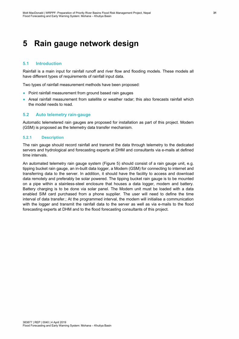
Mott MacDonald | WRPPF: Preparation of Priority River Basins Flood Risk Management Project, Nepal 31Flood Forecasting and Early Warning System: Mohana – Khutiya Basin
383877 | REP | 0040 | 4 April 2019 Flood Forecasting and Early Warning System: Mohana – Khutiya Basin
5 Rain gauge network design
5.1 Introduction Rainfall is a main input for rainfall runoff and river flow and flooding models. These models all have different types of requirements of rainfall input data.
Two types of rainfall measurement methods have been proposed:
● Point rainfall measurement from ground based rain gauges ● Areal rainfall measurement from satellite or weather radar; this also forecasts rainfall which
the model needs to read.
5.2 Auto telemetry rain-gauge Automatic telemetered rain gauges are proposed for installation as part of this project. Modem (GSM) is proposed as the telemetry data transfer mechanism.
5.2.1 Description
The rain gauge should record rainfall and transmit the data through telemetry to the dedicated servers and hydrological and forecasting experts at DHM and consultants via e-mails at defined time intervals.
An automated telemetry rain gauge system (Figure 5) should consist of a rain gauge unit, e.g. tipping bucket rain gauge, an in-built data logger, a Modem (GSM) for connecting to internet and transferring data to the server. In addition, it should have the facility to access and download data remotely and preferably be solar powered. The tipping bucket rain gauge is to be mounted on a pipe within a stainless-steel enclosure that houses a data logger, modem and battery. Battery charging is to be done via solar panel. The Modem unit must be loaded with a data enabled SIM card purchased from a phone supplier. The user will need to define the time interval of data transfer.; At the programmed interval, the modem will initialise a communication with the logger and transmit the rainfall data to the server as well as via e-mails to the flood forecasting experts at DHM and to the flood forecasting consultants of this project.
Mott MacDonaldFlood Forecastin
383877 | REP | 0Flood Forecastin
Figure 5: A
Source: www
5.2.2 T
With a tipptransferred
5.2.3 O
The bucket pulse from switch can a
| WRPPF: Prepang and Early Warn
0040 | 4 April 2019ng and Early Warn
A typical aut
w.phametechnolo
Time of obse
ping bucket automaticall
Operation an
tips when peach tip is salso transmit
ration of Priority Rning System: Moh
9 ning System: Moh
o telemetry
ogy.com
ervation
rain gauge,y at 15-minu
nd measure
precipitation, sensed by tht the pulse to
River Basins Floodana – Khutiya Bas
ana – Khutiya Bas
rain gauge
, rainfall deutes intervals
ment
e.g. of 0.5mhe reed swito a telemetry
d Risk Managemesin
sin
station
pth is recors, or at a freq
mm (resolutiotch and loggy system.
ent Project, Nepal
rded continuquency agree
on of bucket)ged to a data
uously. Rained with client
), has been ca logger. The
nfall data is t (DHM).
collected. A e dual reed
322
Mott MacDonald | WRPPF: Preparation of Priority River Basins Flood Risk Management Project, Nepal 33Flood Forecasting and Early Warning System: Mohana – Khutiya Basin
383877 | REP | 0040 | 4 April 2019 Flood Forecasting and Early Warning System: Mohana – Khutiya Basin
5.2.4 Data transmission, storage and archive
Data should typically be transferred once or twice per day from the gauge station to a central location (server) within DHM for analysis, storage/archive and for FFEWS modelling. Such transfer of data usually increases during times of heightened flood risk. API (application programming interface) shall be developed for access via internet to all gauging stations and for transferring data to the central server. Data could also be transferred to the regional office server where DHM has such facilities. During the model development phase, the modelling team should also have access to the API via internet to download data. In some countries like the UK, the public can download rainfall data using these API.
5.3 Radar rain gauge
5.3.1 Description
Radar rain gauge will not be implemented in this study; however, write-up here is considered for future reference by DHM.
Measuring rainfall by means of radar is not a new technique. The main advantages are that this provides a better spatially distributed measurement than that obtained from point rain gauge alone. Furthermore, the radar rainfall are grid-based outputs, which are becoming more widely used by rainfall runoff models. However, limitations include; measurement accuracy, range, attenuation of signal and calibration, which means that radar measurement does not provide great advantages over ground based rain gauges. Despite these limitations, radar rainfall is useful data which can supplement ground based data if missing from a rain gauge, help correcting suspicious ground based data, and still be used for rainfall runoff modelling where suitable. Ground based rain gauge data will be used to ground truth radar rain gauge. Capital expenditure as well as running costs are high, though there are low cost short range radars.
5.3.2 Specification
In the mountainous terrain in Nepal, precipitation is highly variable both in space and time because of orographic effects and interactions of mountains with wind fields. Moreover, narrow valleys surrounded by high reliefs cannot be effectively monitored by any of the common long-range weather radars because their beam cannot penetrate deep in the valleys due to the shadow effect.
In mountainous regions, gauge network needs to be very dense (Volkman et al., 2010). Thus, to supplement long range radars, X-band short range radar is a good alternative to the common long-range C-band radar for observing precipitation within a valley. It can be installed directly inside the valleys, at lower altitude. Rain gauge networks can be complemented by short range X-band radars. They can provide rainfall estimates with high spatial and temporal resolution and their installation cost is less expensive than C-band radar, allowing the placement of more sensors in order to gain optimised coverage. Examples of such radar are: CASA radar by the Remote Sensing Group (RSG) of Polytechnic of Turin and Local Area Weather Radar (LAWR) by FURUNO, Japan. X-band radar for rainfall estimates should comprise the following specifications:
● Range of 30km to 70km with radar maps produced at 75m to 150m resolution; ● Fitted with series of anti-clutter filters in order to recover, as far as possible, rain signature
even in the presence of clutter; ● Radar maps produced by the X-band mini radar unit are transmitted to the server via in-built
communication network through internet (telemetered);
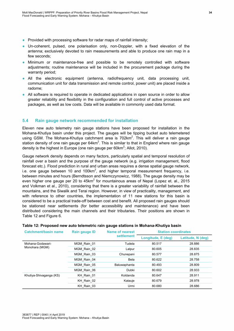
Mott MacDonald | WRPPF: Preparation of Priority River Basins Flood Risk Management Project, Nepal 34Flood Forecasting and Early Warning System: Mohana – Khutiya Basin
383877 | REP | 0040 | 4 April 2019 Flood Forecasting and Early Warning System: Mohana – Khutiya Basin
● Provided with processing software for radar maps of rainfall intensity; ● Un-coherent, pulsed, one polarisation only, non-Doppler, with a fixed elevation of the
antenna; exclusively devoted to rain measurements and able to produce one rain map in a few seconds;
● Minimum or maintenance-free and possible to be remotely controlled with software adjustments; routine maintenance will be included in the procurement package during the warranty period;
● All the electronic equipment (antenna, radiofrequency unit, data processing unit, communication unit for data transmission and remote control, power unit) are placed inside a radome;
● All software is required to operate in dedicated applications in open source in order to allow greater reliability and flexibility in the configuration and full control of active processes and packages, as well as low costs. Data will be available in commonly used data format.
5.4 Rain gauge network recommended for installation Eleven new auto telemetry rain gauge stations have been proposed for installation in the Mohana-Khutiya basin under this project. The gauges will be tipping bucket auto telemetered using GSM. The Mohana-Khutiya catchment area is 702km2. This will deliver a rain gauge station density of one rain gauge per 64km2. This is similar to that in England where rain gauge density is the highest in Europe (one rain gauge per 60km2; Allot, 2010).
Gauge network density depends on many factors, particularly spatial and temporal resolution of rainfall over a basin and the purpose of the gauge network (e.g. irrigation management, flood forecast etc.). Flood prediction in rural and urban areas requires a dense spatial gauge network, i.e. one gauge between 10 and 100km2, and higher temporal measurement frequency, i.e. between minutes and hours (Berndtsson and Niemczynowicz, 1988). The gauge density may be even higher one gauge per 20 to 45km2 for mountainous areas of Nepal (Lopez et. al., 2015 and Volkman et al., 2010), considering that there is a greater variability of rainfall between the mountains, and the Siwalik and Terai region. However, in view of practicality, management, and with reference to other countries, the implementation of 11 new stations for this basin is considered to be a practical trade-off between cost and benefit. All proposed rain gauges should be stationed near settlements (for better accessibility and maintenance) and have been distributed considering the main channels and their tributaries. Their positions are shown in Table 12 and Figure 6.
Table 12: Proposed new auto telemetric rain gauge stations in Mohana-Khutiya basin Catchment/basin name Rain gauge ID Name of nearest
settlement Station coordinates
Longitude, E (deg) Latitude, N (deg) Mohana-Godawari-Monohara (MGM)
MGM_Rain_01 Tudela 80.517 28.886 MGM_Rain_02 Lalpur 80.605 28.835 MGM_Rain_03 Chunepani 80.577 28.875 MGM_Rain_04 Bela 80.622 28.758 MGM_Rain_05 Baluwaphanta 80.493 28.809 MGM_Rain_06 Dubki 80.602 28.933
Khutiya-Shivaganga (KS) KH_Rain_01 Koldanda 80.647 28.911 KH_Rain_02 Katauje 80.679 28.978 KH_Rain_03 Urmi 80.680 28.686

Mott MacDonald | WRPPF: Preparation of Priority River Basins Flood Risk Management Project, Nepal 35Flood Forecasting and Early Warning System: Mohana – Khutiya Basin
383877 | REP | 0040 | 4 April 2019 Flood Forecasting and Early Warning System: Mohana – Khutiya Basin
Catchment/basin name Rain gauge ID Name of nearest ttl t
Station coordinates KH_Rain_04 Shiva Ganga 80.720 28.798 KH_Rain_05 Garbha Durbar 80.762 28.889
Source: Mott MacDonald
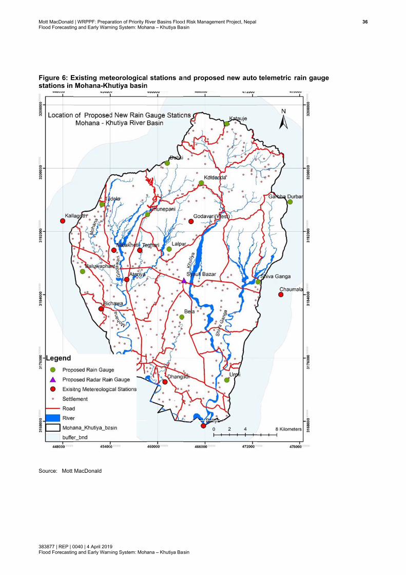
Mott MacDonaldFlood Forecastin
383877 | REP | 0Flood Forecastin
Figure 6: Estations in
Source: Mott
| WRPPF: Prepang and Early Warn
0040 | 4 April 2019ng and Early Warn
Existing metMohana-Kh
MacDonald
ration of Priority Rning System: Moh
9 ning System: Moh
teorologicalhutiya basin
River Basins Floodana – Khutiya Bas
ana – Khutiya Bas
l stations ann
d Risk Managemesin
sin
nd propose
ent Project, Nepal
d new auto telemetric rain gauge
366

Mott MacDonald | WRPPF: Preparation of Priority River Basins Flood Risk Management Project, Nepal 37Flood Forecasting and Early Warning System: Mohana – Khutiya Basin
383877 | REP | 0040 | 4 April 2019 Flood Forecasting and Early Warning System: Mohana – Khutiya Basin
5.5 Budget for proposed rain gauge network installation The budget estimates for the proposed rain gauge network are considered for ground-based telemetric stations. The budget includes procurement, installation, testing, calibration, monitoring, and operation and maintenance for 3 years. Budgets are shown in Table 13.
Table 13: Budget for proposed rain gauge networking in Mohana-Khutiya basin Hydrometeorological data network
Mohana-Khutiya budget (US$)
No. of station
No. of measurement
Capital cost/ measurement
cost
Unit cost Maintenance cost: 3 years
Total cost
Ground-based tipping bucket auto telemetry
11 - 55,000 5,000 6,000 61,000
Total 11 55,000 5,000 6,000 61,000 Source: Mott MacDonald

Mott MacDonald | WRPPF: Preparation of Priority River Basins Flood Risk Management Project, Nepal 38Flood Forecasting and Early Warning System: Mohana – Khutiya Basin
383877 | REP | 0040 | 4 April 2019 Flood Forecasting and Early Warning System: Mohana – Khutiya Basin
6 Hydrometric network design
6.1 Water level gauge network
6.1.1 Description
Flood risk assessment and flood forecasting rely heavily on hydrometric data. Key hydrometric data requirements include river levels, river flow and ground water level.
Any of the following water level monitoring methods are proposed for this project; each approach is telemetric monitoring.
● Measurement by float in a stilling well ● Water Level Radar Sensor ● Water Level Bubbler Sensor
Data will be automatically transferred to the dataset server by GSM telemetry.
Depending on site conditions of the gauging station, one of the monitoring approaches shall be selected. At each telemetric water level station (whether stilling well, radar or bubbler), there will be a manual water level staff gauge. This manual gauge shall be maintained by CBDRM Committee members and can be used by them in the event of a flood alert to communities. This staff gauge should have different distinct colour painting for water levels in flood alert zone, in flood warning zone and in danger level zone (DHM uses such colour level staff gauge).
The water level stations will be included as a forecast point in the FFEWS.
Specification of telemetry kit
The telemetry gauging station should allow:
● Remote monitoring of river levels; ● Transmission of alarms if level rises above user defined thresholds; ● Viewing of historical level data via simple web GUI; ● Transfer of data via API for use in applications and websites; ● Preference for solar powered; which will also include a back power system (battery)
The telemetry system should contain:
● Level Sensor having different options to suit depth of river from shallow depth (0.2 to 0.5m) to several metres of depth (>20m); accuracy 0.5% of range;
● Data logger ● Solar Powered Telemetry Unit with GSM module and antenna built in; ● Sim Card for the warranty period of 5-years, multi network; ● Readings every 15 minutes. ● Transmission of web-based data and alarms by email to designated professionals (DoI/DHM
to provide list of emails of designated persons and professionals, and thresholds for high water levels).
Mott MacDonald | WRPPF: Preparation of Priority River Basins Flood Risk Management Project, Nepal 39Flood Forecasting and Early Warning System: Mohana – Khutiya Basin
383877 | REP | 0040 | 4 April 2019 Flood Forecasting and Early Warning System: Mohana – Khutiya Basin
6.1.2 Time of observation
Stationarity of record, temporal resolution and the overall accuracy of water level data shall be considered. All water level records will be taken at 15-minute intervals in to the data logger, and are to be transmitted via telemetry to the central dataset server at DHM and to the hydrological and database experts at DHM.
6.1.3 Operation, measurement and maintenance
Backup and main recorders should be securely mounted and regularly visited and serviced, at least once every month (or more if required). It should be ensured that the pulleys are operating freely, and the float tape or wire sits properly on the drive pulley. Logbooks should be maintained, and calibration of the level sensor should be checked and reset if required.
Sites with known sediment problems shall be carefully checked at each visit, and if there are any indications of a siltation problem, the stilling well must be flushed as soon as possible or proper flow connection to the sensor must be maintained. The Mohana-Khutiya basin, particularly the Mohana and Khutiya rivers at downstream reaches, carries highly sediment laden flow, and this routine silt management will be required.
6.1.4 Data transmission, storage and archive
Data will typically be transferred once or twice per day to a central location dataset server within DHM for analysis and storage/archive. Such transfer of data usually increases during times of heightened flood risk. In periods of heightened flood risk, even hourly transfer could be required considering the flashy nature of a storm event in the basin. Data could also be transferred from the gauge stations and/or from central dataset server to DHM’s three basin Offices (Karnali Basin Office in Nepalgunj, Narayani Basin Office in Narayanghat and Kosi Basin Office in Biratnagar), and.to the regional offices where DHM has data storing facilities. During the model development phase, the modelling team should also have access to the real time data.
6.2 Discharge measurement stations
6.2.1 Description
Manual discharge measurement stations should be capable of measuring low to moderate flows while the water remains in the channel. For measuring flow beyond certain thresholds, especially when the water level is very high, exceeding the river banks and flowing across the floodplain, the river flows are normally derived from the relationship of stage (level) with discharge, called a stage-discharge relationship or rating curve.
6.2.2 Discharge measurement equipment
Discharge measurement at all stations shall be carried out for a wide range of flows, from low flow to high flows. Discharge measurement is to be carried out fortnightly from mid-May to mid-October at each station. A combination of the following discharge measurement methods can be used:
● Manual measurements using current meter (propeller current meter) during low flows except at the cableway station
● Velocity-depth measurements with ADCP (Acoustic Doppler Current profiler) during medium to high flows, except at the cableway station
Mott MacDonald | WRPPF: Preparation of Priority River Basins Flood Risk Management Project, Nepal 40Flood Forecasting and Early Warning System: Mohana – Khutiya Basin
383877 | REP | 0040 | 4 April 2019 Flood Forecasting and Early Warning System: Mohana – Khutiya Basin
● Cableway discharge measurements using propeller current meter (ADCP may also be mounted if required) at the uppermost hill station, where velocity measurements at medium to high flows are not advisable without cableway owing to safety reasons.
In manual measurement during low flows, cross-section/depth will be measured using a graduated pole, often referred as manual sounding. When depth is increasing and ADCP (with echo-sounder and DGPS) could be used, all discharge measurements shall be carried out using ADCP. While ADCP will provide velocity scatter, echo-sounder will provide depth and DGPS will provide horizontal positioning. The measurements will be carried out using local engine boat/inflatable boat The ADCP discharge measurement could be un-manned. The ARC-Boat (http://www.ceehydrosystems.com/products/unmanned-survey-vessels/arc-boat/) is designed to make safe unmanned discharge measurements in rivers and streams using acoustic ADCPs. The hull design minimises air entrainment for optimum ADCP data quality. With a maximum speed of 4.5m/s (15fps), even high velocity flood stage measurements may be completed. Effects of magnetic interference from the vehicle’s electrical systems are carefully managed to minimise induced compass deflection – critical to obtaining good discharge measurements.
ARC-Boat ADCP measurement at the cableway station could also be considered to replace Cableway depending on the magnitude of velocity and safe operation of measurement.
The budget (unit price) for each discharge measurement at fortnightly intervals is inclusive of all cost elements (2 days input from an equipment engineer including support staff, boats and accessories, travel cost to site, calculation of discharge from raw data, and preparation of report). Discharge measurement equipment (ADCP, DGPS and echosounder) will be provided for this project. Separate budget has been considered for this.
6.2.3 Cableway flow measurement
Slack-line cableways are commonly used for carrying out flow gauging on relatively small rivers and streams. This is particularly useful in rivers in mountainous regions with steep slopes and high velocities. Velocities are measured from a velocity traverse set at a series of fixed depths, and then multiplied with cross-section areas providing total discharge through the river section. Such discharges are useful for developing stage-discharge rating curves. Cableway stations are not suitable where flow goes out of bank and cross-section width is high, e.g., river section in the Terai region.
The components of a slack-line cableway comprise: a static ropeway, suspended between anchor ends; a traveller; a horizontal positioning mechanism; and a lifting mechanism. In operation, the traveller runs on the ropeway and functions as an unmanned ‘cable car’. All operations are carried out from the bank. The horizontal position of the traveller is controlled by means of a manual winch that feeds a line across the span and over a pulley mounted on the far side and back to the traveller. A separate line from a gauging reel feeds out to the traveller, runs over a pulley mounted on the traveller and connects to a current meter and counterweight, thereby suspending these from the traveller. The gauging reel controls the vertical position of the current meter. Depth will be taken by the sounding reel cable at pre-defined vertical positions by lowering the cable to the river bed; then depth data will be converted to obtain cross-section (river bed level with respect to masl) using the water level gauge reading. As ADCP, DGPS and echosounder will also be available, these set of equipment could also be occasionally mounted to the cableway for depth and velocity measurement, if the Equipment Engineer find it practical.
DHM operates cableway discharge measurement in West Rapti at Kusum. A similar cableway should be established at a station at Malakheti on the Mohana river Standard specifications for

Mott MacDonaldFlood Forecastin
383877 | REP | 0Flood Forecastin
establishingUSDA, 2000
Figure 7: Sand currencableway ctailhold on
Source: USDA
6.2.4 E
Acoustic Domeasuremeequipment smeasuremeone set of esix basins, tno equipmeMawa-Ratu
There will bbudget has will be used
| WRPPF: Prepang and Early Warn
0040 | 4 April 2019ng and Early Warn
g cableway c0. A schema
Schematic ont meter: (cable, (4) sfar side
A, 2000
Equipment b
oppler currenent) and DGset only for
ents at four sequipment fothree equipment set has wa, and Eas
be a warrant been consi
d extensively
ration of Priority Rning System: Moh
9 ning System: Moh
could be fouatic of cablew
of a cablew(1) near poounding ree
budget for d
nt profiler forPS (positionthis basin isstations, (foror this basin ment set havbeen consid
st Rapti and W
ty period of dered for op, such cost is
River Basins Floodana – Khutiya Bas
ana – Khutiya Bas
und in manuway system d
way dischargost with puel cable, (5
discharge m
r discharge mn measuremes presented itnightly at eaalone, which
ve been propdered. BakraWest Rapti w
3 years for peration, mas necessary.
d Risk Managemesin
sin
uals, e.g. NEdischarge me
ge measureulley drive 5) traveling
easurement
measuremenent), have bin Table 14ach station)h is located
posed; For Eaha basin wwill use equip
DGPS, Echaintenance a.
ent Project, Nepal
EMS Manuaeasurement i
ement systehousing, (2block, (6) c
t
t, supported been proposebelow. Therin this basinin the far we
East Rapti, Bwill use the epment availa
ho-sounder and servicing
l (NEMS, 20is shown in F
em with sou2) soundingcurrent met
by echosoued. The bude will be ext
n; thus there estern part ofakraha and W
equipment prble within DH
and ADCP. . As the equ
016) and in Figure 7.
unding reelg reel, (3)
ter, and (7)
under (depth dget for one tensive flow is need for f Nepal. For West Rapti, roposed for HM.
However, a uipment set
41
1

Mott MacDonald | WRPPF: Preparation of Priority River Basins Flood Risk Management Project, Nepal 42Flood Forecasting and Early Warning System: Mohana – Khutiya Basin
383877 | REP | 0040 | 4 April 2019 Flood Forecasting and Early Warning System: Mohana – Khutiya Basin
Table 14: Discharge measurement equipment / station budget in Mohana-Khutiya basin Hydrometric equipment and installation
Mohana-Khutiya budget (US$) Capital cost Operation and
maintenance (total for 3 years)
Total cost
DGPS 25,000 1,250 26,250 Echo-sounder 25,000 1,000 26,000 ADCP 35,000 1,000 36,000 Cable way discharge station: construction cost
95,000 - 95,000
Total 180,000 3,250 183,250 Source: Mott MacDonald
6.3 Hydrometric gauge recommended for installation Five hydrometric gauging stations in the Mohana-Godawari and four in the Khutiya-Shivaganaga catchments have been proposed (see Table 15 and Figure 8). All stations are easily accessible and are located near a settlement. All stations have access to GSM (DHM, 2018).
The locations have been chosen carefully, which will allow calibration of runoff from the hydrological model and calibration of river levels in the hydrodynamic model. In the Mohana-Godawari catchment, there will be two water level (WL) and discharge (Q) stations (both parameters at the same station), as well as three WL only (no Q) stations. In the Khutiya-Shivaganga catchment, there will be two WL and Q stations and two WL only (no Q) stations.
Stage-discharge rating curves will be developed at all four discharge stations for generating continuous discharge data and for calibration and validation of hydrological and hydrodynamic model.
The four flow stations will allow calibration and validation of runoff from: i) Godawari river catchment alone, ii) combined runoff from Godawari, Monohara and Mohana catchment at their confluence point and, iii) total runoff from the Mohana catchment at immediately upstream of the confluence with the Khutiya.
Similarly, WL and Q stations in the Khutiya-Shivaganga catchment will allow calibration and validation of runoff from: i) Khutiya catchment at the east-west highway point and, ii) from combined runoff from Khutiya-Shivaganga catchment at downstream of their confluence point. The distribution of WL and Q stations will allow a very dense network for calibration of the hydrodynamic model; such a dense network should be considered essential due to flood forecasting and the relatively steep slope in the upper basin and the mild slope in the lower basin (Mott MacDonald, July 2018).
At all nine hydrometric stations, bed material samples shall be collected, only once; and at four discharge stations, suspended sediment sample shall be collected. Bed material shall be collected from mid-channel, and from bed near the banks. Concentration shall be collected from three positions as minimum over the cross-section. If river depth is high (>3m), we recommend collecting concentration over several vertical positions (e.g. 02d, 0.6d and 0.8d; d is total water depth) at each position. If the depth is shallow (<3m), only one sample at 0.5d is recommended.
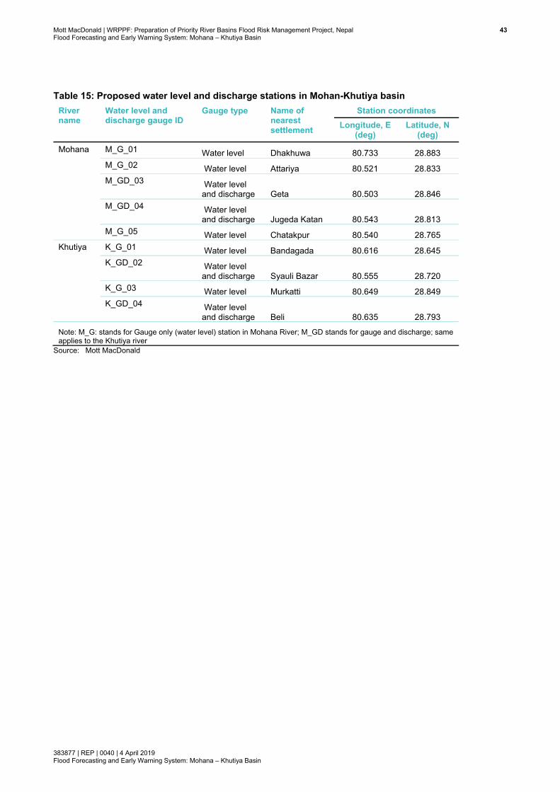
Mott MacDonald | WRPPF: Preparation of Priority River Basins Flood Risk Management Project, Nepal 43Flood Forecasting and Early Warning System: Mohana – Khutiya Basin
383877 | REP | 0040 | 4 April 2019 Flood Forecasting and Early Warning System: Mohana – Khutiya Basin
Table 15: Proposed water level and discharge stations in Mohan-Khutiya basin River name
Water level and discharge gauge ID
Gauge type Name of nearest settlement
Station coordinates Longitude, E
(deg) Latitude, N
(deg) Mohana M_G_01 Water level Dhakhuwa 80.733 28.883
M_G_02 Water level Attariya 80.521 28.833 M_GD_03 Water level
and discharge Geta 80.503 28.846 M_GD_04 Water level
and discharge Jugeda Katan 80.543 28.813 M_G_05 Water level Chatakpur 80.540 28.765
Khutiya
K_G_01 Water level Bandagada 80.616 28.645 K_GD_02 Water level
and discharge Syauli Bazar 80.555 28.720 K_G_03 Water level Murkatti 80.649 28.849 K_GD_04 Water level
and discharge Beli 80.635 28.793
Note: M_G: stands for Gauge only (water level) station in Mohana River; M_GD stands for gauge and discharge; same applies to the Khutiya river
Source: Mott MacDonald
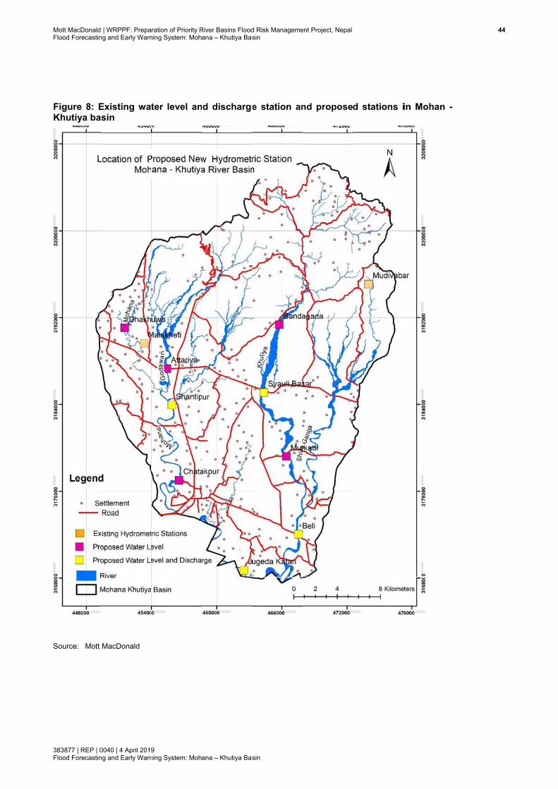
Mott MacDonaldFlood Forecastin
383877 | REP | 0Flood Forecastin
Figure 8: EKhutiya ba
Source: Mott
| WRPPF: Prepang and Early Warn
0040 | 4 April 2019ng and Early Warn
Existing watsin
MacDonald
ration of Priority Rning System: Moh
9 ning System: Moh
ter level an
River Basins Floodana – Khutiya Bas
ana – Khutiya Bas
nd discharge
d Risk Managemesin
sin
e station an
ent Project, Nepal
nd proposed stations iin Mohan -
444
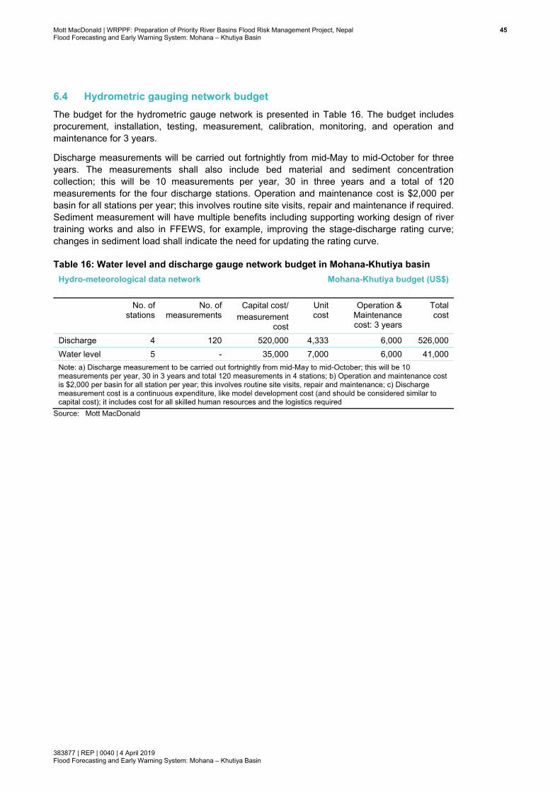
Mott MacDonald | WRPPF: Preparation of Priority River Basins Flood Risk Management Project, Nepal 45Flood Forecasting and Early Warning System: Mohana – Khutiya Basin
383877 | REP | 0040 | 4 April 2019 Flood Forecasting and Early Warning System: Mohana – Khutiya Basin
6.4 Hydrometric gauging network budget The budget for the hydrometric gauge network is presented in Table 16. The budget includes procurement, installation, testing, measurement, calibration, monitoring, and operation and maintenance for 3 years.
Discharge measurements will be carried out fortnightly from mid-May to mid-October for three years. The measurements shall also include bed material and sediment concentration collection; this will be 10 measurements per year, 30 in three years and a total of 120 measurements for the four discharge stations. Operation and maintenance cost is $2,000 per basin for all stations per year; this involves routine site visits, repair and maintenance if required. Sediment measurement will have multiple benefits including supporting working design of river training works and also in FFEWS, for example, improving the stage-discharge rating curve; changes in sediment load shall indicate the need for updating the rating curve.
Table 16: Water level and discharge gauge network budget in Mohana-Khutiya basin Hydro-meteorological data network
Mohana-Khutiya budget (US$)
No. of stations
No. of measurements
Capital cost/ measurement
cost
Unit cost
Operation & Maintenance cost: 3 years
Total cost
Discharge 4 120 520,000 4,333 6,000 526,000 Water level 5 - 35,000 7,000 6,000 41,000 Note: a) Discharge measurement to be carried out fortnightly from mid-May to mid-October; this will be 10 measurements per year, 30 in 3 years and total 120 measurements in 4 stations; b) Operation and maintenance cost is $2,000 per basin for all station per year; this involves routine site visits, repair and maintenance; c) Discharge measurement cost is a continuous expenditure, like model development cost (and should be considered similar to capital cost); it includes cost for all skilled human resources and the logistics required
Source: Mott MacDonald

Mott MacDonald | WRPPF: Preparation of Priority River Basins Flood Risk Management Project, Nepal 46Flood Forecasting and Early Warning System: Mohana – Khutiya Basin
383877 | REP | 0040 | 4 April 2019 Flood Forecasting and Early Warning System: Mohana – Khutiya Basin
7 Topographic and asset survey
7.1 Topographic survey Current river cross-section and topographic data will be required to develop hydrodynamic (1d, 2d and 1d/2d linked model). Latest data will be surveyed during the FFEWS model development period. Existing cross-sectional data in this basin were collected in 2014 (during pre-feasibility, Package 3). Thus, this data is considered old for the dynamic rivers in Nepal; there were additional, but limited, cross-section survey during feasibility study (this study, Package 7). In UK, where rivers are very stable, the Environment Agency (responsible for flood forecasting), updates their models if topography is more than 5 years old. Thus, fresh cross-sectional survey, in higher spatial resolution (than in Package 3 and 7) should be surveyed. This will improve model calibration and validation, forecast accuracy, and inundation maps.
On steep slopes and in meandering/braided rivers, cross-sections between 200m and 500m intervals are essential (HEC-RAS, Users’ Manual, Version 4.1, Figure 8-34) for accurate model calibration, validation and forecast accuracy and for inundation mapping. Cross-sections, on average at 380m intervals, are proposed. Rivers in Nepal, typically, have very steep slopes. Although the Terai region is referred to as a flat region with mild slopes, the slopes are still many times steeper than those in low-lying plains. Moreover, rivers are braided and meandering in nature due to high sediment load. As a result, cross-sections in the dense intervals proposed will be useful.
Topographic survey will include river section, any existing structures and flood embankment profile. Survey will have to be done in Mohana, Godawari, Monohara, Khutiya and in Shivaganga river. In 141km, 367 cross-sections will have to be surveyed.
All cross-sections will cover the river, bank to bank and will be extended into the floodplain to sufficiently high ground of highest historic flood water mark. Horizontal projection for survey will be WGS 84 / UTM zone 45N. Ground elevation will be relative to metre above mean sea level (masl) for controlling vertical datum. All cross-sections shall be connected to Nepal National permanent bench mark for horizontal and vertical datum control. Temporary bench marks (TBM) shall also be established for cross-verification of data. All cross-sections, in a basin, shall be surveyed during dry season, prior to or after monsoon so that cross-sections are stable without much morphological change. All cross-section shall be surveyed in one season. This should not be done that half volume of total survey prior to monsoon, and the rest after the monsoon
Ground elevation (vertical position) in cross-section/topographic survey shall be accurate better than 20mm in case of level survey and be better than 50mm in case of echosounder depth survey. Horizontal position accuracy should be better than 1m. There should be enough vertical points to sufficiently represent a cross-section shape, dense points about 0.5 to 1m apart at scoured part of the cross-section, and less points over shallow sand bars, about 1 to 5m interval.
Bank/defences survey crest levels are to be provided at intervals that will adequately describe the river bank (typically every 10m).
The following deliverables are required:
Channel sections, longitudinal sections and structure elevation drawings in AutoCAD DWG and PDF format;
Mott MacDonald | WRPPF: Preparation of Priority River Basins Flood Risk Management Project, Nepal 47Flood Forecasting and Early Warning System: Mohana – Khutiya Basin
383877 | REP | 0040 | 4 April 2019 Flood Forecasting and Early Warning System: Mohana – Khutiya Basin
Channel section data in the following formats: o Csv or txt or dat file o AutoCAD; and o Section chainage, X (easting), Y (northing), Z(elevation), distance to next
section Width tables for each bridge opening surveyed Cross section location plan in AutoCAD DWG, Shapefile and PDF format; Bank/defence survey location plan in AutoCAD DWG, ESRI shapefile, spreadsheet .csv
or Excel 2007 format and PDF format Site photographs: at least 3 photographs per cross-section, taken one looking
upstream, one looking downstream and one with another good angle
For topographic survey, no survey equipment has been proposed for purchase; survey will be done through outsourcing.
7.2 Survey budget Budget has been decided based on density (no. of cross-sections) of survey, and per cross-section (see Table 17). Topographic survey shall be outsourced and thus no equipment for such survey has been proposed.
Table 17: Topographic survey budget for Mohana-Khutiya basin Topographic cross-section survey
Mohana - Khutiya survey budget (US$) Length of survey
(km) No. of XS Total cost Unit
cost Mohana 56 147 29,400 200 Godawari 12 30 6,000 200 Monohara 10 26 5,200 200 Khutiya 42 109 21,800 200 Shivaganga 21 55 11,000 200 Total 141 367 73,400 -
Source: Mott MacDonald
7.3 Satellite imagery Budget for purchasing high resolution satellite imageries has been included (Table 18) for Mohana and Khutiya basin for lower catchment only in Terai to provide DEM to 1-d and 2-d model development and flood inundation map preparation. High resolution (50cm) Pleiades imageries have been proposed for purchasing. DHM informed that they have already used this imagery in their FFEWS modelling.
Table 18: Satellite imagery purchase budget for Mohana-Khutiya basin High resolution (50cm) satellite imagery
area (km2) Total cost Unit cost (USD for 1
sq.km) Mohana basin in Terai 232 11,600 50 Khutiya basin in Terai 214 10,700 50 Total 446 22,300 -
Source: Mott MacDonald

Mott MacDonald | WRPPF: Preparation of Priority River Basins Flood Risk Management Project, Nepal 48Flood Forecasting and Early Warning System: Mohana – Khutiya Basin
383877 | REP | 0040 | 4 April 2019 Flood Forecasting and Early Warning System: Mohana – Khutiya Basin
8 Flood forecasting model development
8.1 Mathematical modelling It has been proposed to develop a suite of flood forecasting modelling tools. This includes a simple tool for use in combination with the most advanced hydraulic models being employed in countries like Australia and UK. Hydrological model is essential (input) component for each of the forecasting tools. The simple tool, gauge to gauge correlation, could be operational within eight months, or as soon as some hydrometric data becomes available from the new proposed hydrometric and rain gauge network. Over a period of three years, advanced hydraulic models will be developed, calibrated, validated and will be made operational as more data becomes available. A conceptual diagram of different components of the models and link between them are presented in Figure 9. The following forecasting tools have been proposed:
● Gauge-to-gauge correlation: the simplest and cheapest method, fast to develop, and thus could be operational within 7 to 8 months from the inception of the project. However, it has a very short lead time (2 to 5 hours) and is not appropriate in upper steep slope river reaches, as flood wave propagates fast in those reaches and correlation of two gauges is not strong due to presence of pools and riffles.
● Combined rainfall-runoff and gauge-to-gauge correlation: with the addition of a runoff model, the forecast lead time could be extended up to 72 hours. However, this requires a stage-discharge rating curve at each gauging station; such rating curve is difficult to develop for out-of-bank flow conditions without a hydraulic model; as soon the hydraulic model will be developed (within 9 to 10 month), such rating curve will be available from the model
● 1-d model: this tool will be developed for the entire river system in the Terai and is appropriate for flood forecasting which is the same model type used in Bangladesh.
● 1-d/2-d linked model: this will be the final delivery around month 24. A pure 2-d model will be developed and transformed into a 1-d/2-d linked model with the linkage to the 1d model.
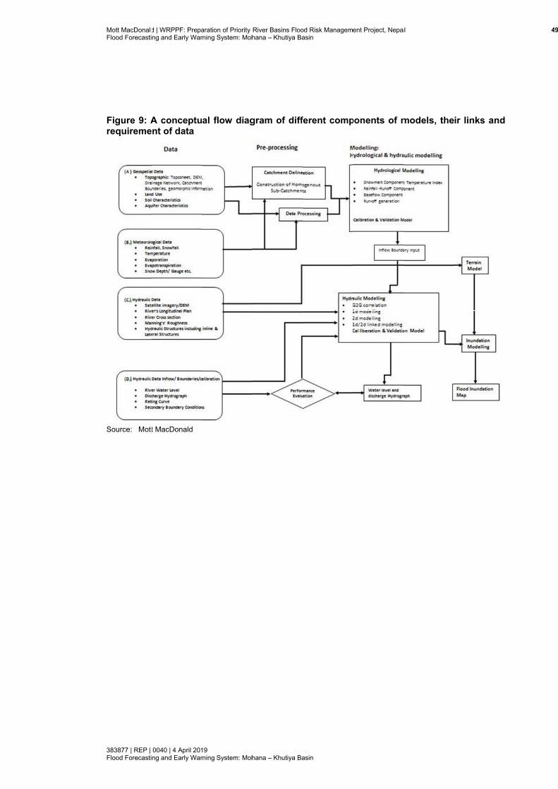
Mott MacDonaldFlood Forecasti
383877 | REP | Flood Forecasti
Figure 9: Arequireme
Source: Mott
d | WRPPF: Prepaing and Early War
0040 | 4 April 201ing and Early War
A conceptuent of data
t MacDonald
aration of Priority rning System: Moh
19 rning System: Moh
al flow diag
River Basins Floohana – Khutiya Ba
hana – Khutiya Ba
gram of diff
od Risk Managemasin
asin
ferent comp
ent Project, Nepa
ponents of m
al
models, their links and
4
d
9
Mott MacDonald | WRPPF: Preparation of Priority River Basins Flood Risk Management Project, Nepal 50Flood Forecasting and Early Warning System: Mohana – Khutiya Basin
383877 | REP | 0040 | 4 April 2019 Flood Forecasting and Early Warning System: Mohana – Khutiya Basin
8.2 Rationale for different forecasting approaches The four approaches described above are inter-linked and essential and/or complementing components to the final deliverable/ flood forecasting and early warning system (FFEWS) model, i.e., the 1-d/2-d linked FFEWS model. The rationale, advantages and disadvantages of each approach are described below:
● Gauge-to-gauge correlation: the simplest and cheapest method. This could be an option to use as a quick forecasting tool. It can generate new knowledge, to be translated into the final deliverables (1-d model and 1-d/2-d linked model). Advantages will be that flood forecasting components of CBDRM could be operational earlier and potential areas of uncertainty in flood level forecast could be identified. DHM is using this method in many of their river basins, e.g. in Karnali. This tool and expertise from DHM could readily be used in this basin with some nominal input from international consultant; as the tool has to be customised for new basin, need for minor changes in code and parameters may be required and thus international consultant’s input is considered. There will be a deployment time in all five basins for the new hydro-meteorological data to become available, so this work is a good utilisation of the waiting time as it generates the opportunity for transferring early knowledge to the final product.
● Rainfall runoff model is an important input to all other components: a) gauge-to-gauge correlation, b) 1-d river model, c) pure 2-d model and d) 1-d/2-d linked model. Combining the rainfall model with gauge-to-gauge correlation will increase the lead time (as in the rainfall forecast) up to 24, 48 and 72 hours. However, at the forecasting points, the discharge vs water level rating curve shall be required so that forecasted runoff can be converted to the water level using the rating curve. The rainfall runoff model provides inflows from the upper catchment and distributed inflows from intermediate catchments to the 1-d, 2-d and 1-d/2-d linked model.
● The 1-d model, as a standalone tool, can be applied as a forecasting tool once it is ready. Without the 1-d model, a linked 1-d/2-d model (which is proposed as a final deliverable) cannot be developed. Therefore, it is proposed to develop a 1-d model as forecasting tool as soon topography has been surveyed. In any case, for certain reaches of the river, there will only be a 1-d model, as a 1-d/2-d linked model is not feasible for the entire reach of the river due to higher model run time, and instability in 1d/2d model in steeper reaches. This tool will also give useful feedback on forecasting performance, which then could be translated into the final deliverable. In summary, 1-d model development is not a duplicating tool; it is an essential pre-requisite. Should DoI and ADB decide not to take forward 1-d/2-d linked modelling, then a 1-d model will be the final product. This is the tool which DHM operate in the Bagmati, Koshi and West Rapti basins. The advantage of a 1-d model is that it runs efficiently, which is a key requirement for real time forecasting. However, a 1-d model does not have direct map output for flood risk or hazard and these would require separate and customised GIS development, e.g. as practiced by forecast model in Bangladesh (http://ffwc.gov.bd/). Such a GIS tool is under development within DHM. It will need to be developed in this project for the 1-d only model reaches of the river
● A 1-d/2-d linked model is the final deliverable; such FFEWS models are already in operation in countries like Australia, New Zealand, Malaysia and UK (Syme, 2007; Huxley, 2016). Therefore, developing the next generation of the FFEWS tool would ensure that by the time the project is complete, Nepal won’t fall behind on national standards. The 1-d/2-d linked model can forecast flood levels with better accuracy (as it is linked to 2-d floodplain model). Further, flood risk and hazard maps are direct outputs from such modelling. However, run-time is longer than for the 1-d model; it requires more accurate DEM and
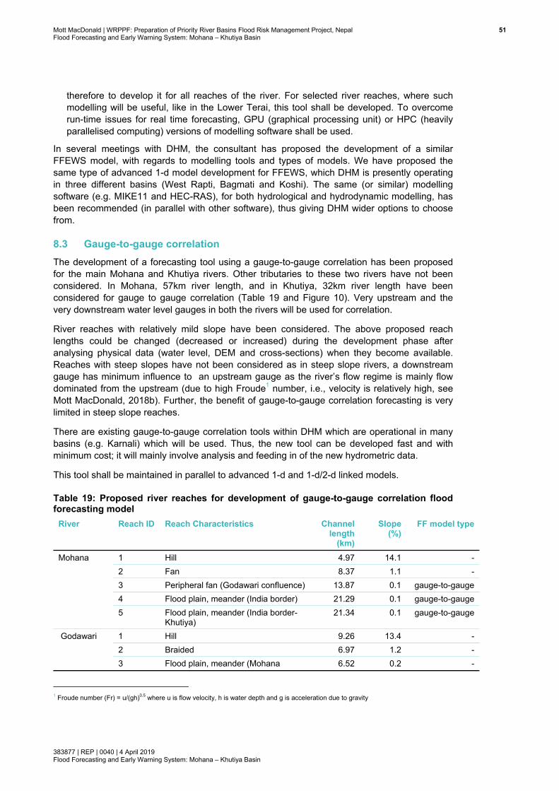
Mott MacDonald | WRPPF: Preparation of Priority River Basins Flood Risk Management Project, Nepal 51Flood Forecasting and Early Warning System: Mohana – Khutiya Basin
383877 | REP | 0040 | 4 April 2019 Flood Forecasting and Early Warning System: Mohana – Khutiya Basin
therefore to develop it for all reaches of the river. For selected river reaches, where such modelling will be useful, like in the Lower Terai, this tool shall be developed. To overcome run-time issues for real time forecasting, GPU (graphical processing unit) or HPC (heavily parallelised computing) versions of modelling software shall be used.
In several meetings with DHM, the consultant has proposed the development of a similar FFEWS model, with regards to modelling tools and types of models. We have proposed the same type of advanced 1-d model development for FFEWS, which DHM is presently operating in three different basins (West Rapti, Bagmati and Koshi). The same (or similar) modelling software (e.g. MIKE11 and HEC-RAS), for both hydrological and hydrodynamic modelling, has been recommended (in parallel with other software), thus giving DHM wider options to choose from.
8.3 Gauge-to-gauge correlation The development of a forecasting tool using a gauge-to-gauge correlation has been proposed for the main Mohana and Khutiya rivers. Other tributaries to these two rivers have not been considered. In Mohana, 57km river length, and in Khutiya, 32km river length have been considered for gauge to gauge correlation (Table 19 and Figure 10). Very upstream and the very downstream water level gauges in both the rivers will be used for correlation.
River reaches with relatively mild slope have been considered. The above proposed reach lengths could be changed (decreased or increased) during the development phase after analysing physical data (water level, DEM and cross-sections) when they become available. Reaches with steep slopes have not been considered as in steep slope rivers, a downstream gauge has minimum influence to an upstream gauge as the river’s flow regime is mainly flow dominated from the upstream (due to high Froude1 number, i.e., velocity is relatively high, see Mott MacDonald, 2018b). Further, the benefit of gauge-to-gauge correlation forecasting is very limited in steep slope reaches.
There are existing gauge-to-gauge correlation tools within DHM which are operational in many basins (e.g. Karnali) which will be used. Thus, the new tool can be developed fast and with minimum cost; it will mainly involve analysis and feeding in of the new hydrometric data.
This tool shall be maintained in parallel to advanced 1-d and 1-d/2-d linked models.
Table 19: Proposed river reaches for development of gauge-to-gauge correlation flood forecasting model
River Reach ID Reach Characteristics Channel length
(km)
Slope (%)
FF model type
Mohana 1 Hill 4.97 14.1 - 2 Fan 8.37 1.1 - 3 Peripheral fan (Godawari confluence) 13.87 0.1 gauge-to-gauge 4 Flood plain, meander (India border) 21.29 0.1 gauge-to-gauge 5 Flood plain, meander (India border-
Khutiya) 21.34 0.1 gauge-to-gauge
Godawari 1 Hill 9.26 13.4 - 2 Braided 6.97 1.2 - 3 Flood plain, meander (Mohana 6.52 0.2 -
1 Froude number (Fr) = u/(gh)0.5 where u is flow velocity, h is water depth and g is acceleration due to gravity

Mott MacDonald | WRPPF: Preparation of Priority River Basins Flood Risk Management Project, Nepal 52Flood Forecasting and Early Warning System: Mohana – Khutiya Basin
383877 | REP | 0040 | 4 April 2019 Flood Forecasting and Early Warning System: Mohana – Khutiya Basin
River Reach ID Reach Characteristics Channel length
(km)
Slope (%)
FF model type
Confluence) Monohara 1 Hill 6.29 16.2 -
2 Braided 4.80 0.9 - 3 Flood plain, meander (Mohana
confluence) 8.59 0.1 -
Khutiya 1 Hill 19.91 8.3 - 2 Braided 6.51 1.1 gauge-to-gauge 3 Flood plain, meander (Shivaganga
confluence) 15.46 0.2 gauge-to-gauge
4 Meander (Mohana confluence (Nepal-India border)
9.77 0.1 gauge-to-gauge
Shiva Ganga
1 Hill 10.92 14.7 - 2 Braided 3.78 1.4 - 3 Flood, plain, meander Shiva Ganga
(Khutiya) 19.55 0.2 -
Source: Mott MacDonald
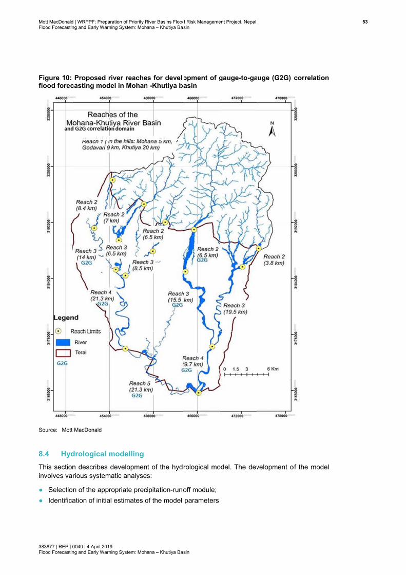
Mott MacDonaldFlood Forecastin
383877 | REP | 0Flood Forecastin
Figure 10: flood forec
Source: Mott
8.4 HydThis sectioninvolves var
● Selection● Identifica
| WRPPF: Prepang and Early Warn
0040 | 4 April 2019ng and Early Warn
Proposed rcasting mod
MacDonald
drological mn describes rious system
n of the appration of initia
ration of Priority Rning System: Moh
9 ning System: Moh
river reacheel in Mohan
modelling developmen
matic analyse
ropriate precl estimates o
River Basins Floodana – Khutiya Bas
ana – Khutiya Bas
es for develon -Khutiya ba
t of the hydrs:
cipitation-runoof the model
d Risk Managemesin
sin
opment of gasin
rological mo
off module; parameters
ent Project, Nepal
gauge-to-ga
odel. The dev
auge (G2G)
velopment o
correlation
of the model
533

Mott MacDonald | WRPPF: Preparation of Priority River Basins Flood Risk Management Project, Nepal 54Flood Forecasting and Early Warning System: Mohana – Khutiya Basin
383877 | REP | 0040 | 4 April 2019 Flood Forecasting and Early Warning System: Mohana – Khutiya Basin
● Selection of the calibration and validation period covering full range of wet and dry events ● Calibration of the model ● Validation of the model ● Sensitivity analysis of the model parameters required to upgrade the model in future.
The runoff model domain shall cover the entire basin area (702km2) from the Chure Hills to the lower Terai up to the Indian border in the south.
8.4.1 Review of existing data and models
● Use the existing hydrological model (Feasibility Study model, Package 7) to improve sub-catchment delineation, parameter (calibration) improvement; model parameterisation using local/donor data; probably modelling tools include HEC-HMS and NAM; DHM is experienced with both tools
● Review available rainfall data from DHM and other secondary sources to provide a representative areal average rainfall
● Cross-check tipping bucket rain gauge with storage gauge data, including double-mass analysis and / or cumulative-mass time series plots
● Review data against general meteorological records, in particular to identify periods where there may have been snow / snow melt
● Comparison of rainfall radar totals with rain gauge information, investigate spatial and temporal distribution of rainfall for selected calibration and validation events
● Provide a commentary on the suitability of weather radar information to supplement gauge rainfall for rainfall-runoff model development
● Assess the availability of data, and the uncertainties in the accuracy of the data and what effect this could have on the reliability and accuracy of model outputs
● Selection of calibration period using long records of meteorological data (minimum of three to five years). A long period of calibration data is essential due to sensitivity of the runoff model to the initial condition
● Selection of validation period using long records of meteorological data (minimum of three to five years); long period of validation data is essential due to sensitivity of the runoff model to the initial condition.
8.4.2 Catchment delineation
The basin shall be divided into smaller hydrologic sub-catchments to define catchment topology according to geomorphologic homogeneity. The following will be considered while delineating the sub-catchments:
● Topography, DEM based on satellite and their resolution, e.g. SRTM 30m, Cartosat-1 or high resolution Pléiades imageries
● Drainage network based on satellite imageries ● Changes in sub-catchment response, key tributaries/confluences, flood storage reservoirs
etc. ● Catchment delineation shall be verified including use of surface water sewer data in
urbanised sub-catchments ● Permanent snowline and snow cover ● Soil/sediment and land use data ● Urbanisation extents: land use in urban areas
Mott MacDonald | WRPPF: Preparation of Priority River Basins Flood Risk Management Project, Nepal 55Flood Forecasting and Early Warning System: Mohana – Khutiya Basin
383877 | REP | 0040 | 4 April 2019 Flood Forecasting and Early Warning System: Mohana – Khutiya Basin
● Embankment layout and location of flood control sluices and structures ● Location of hydrological monitoring sites ● Average annual precipitation over the basin with reasonably good resolution.
8.4.3 Hydrological input: Rainfall, temperature and PET
Key input data for hydrological modelling are:
● Rainfall ● Temperature ● PET
Initially the model development shall start with data available at DHM, if quality data within the basin is unavailable, the nearest met station data shall be used. Gridded rainfall data could be used from satellite-based sources (IMD, APH etc.) where available.
As soon as data from new proposed gauging stations become available (should be available after the first monsoon during the development phase of the project), they shall be used for improving both calibration and validation of the hydrological model.
8.4.4 Bias correction
Gridded rainfall data cannot be directly used for runoff modelling. Bias correction on historical precipitation series shall be developed for using such data in the FFEWS model.
TRMM-P has the highest possible temporal resolution (three hours) of all gridded precipitation data sources, it is freely available, there is a long record of historical archives, and it is probably the most accurate Satellite-based Precipitation Estimate (SPE) available globally. However, SPE requires bias correction. Region-specific bias in TRMM-P exists and the bias increases with smaller spatial scales, higher temporal resolution and higher magnitude of precipitation values. It has also been observed that capacity of TRMM-P in resolving orographic precipitation in Himalaya is limited. Thereby, raw TRMM-P has to be bias corrected (eQM) before it can be used for rainfall-runoff modelling.
8.4.5 Calibration
The calibration period shall cover hydrological data of at least three hydrological years, but preferably five or more. Availability of data, particularly rainfall, from different sources has been shown in Section 2.8, Table 9. The years shall be selected judiciously so that observed rainfall and discharge are available at most observation stations, if not at all stations. Missing, inconsistent and erroneous data, and non-availability of data are generally an issue in data collected from existing sources and secondary sources; examples of such data are point and gridded rainfall, temperature, PET, observed discharges. Therefore, these factors shall be considered while selecting the calibration period. In the hydrological model, as the initial condition is sensitive, the first 3 to 6 months of simulation period shall be considered as initialisation time, and thus shall be ignored while using the model runoff to hydrological model. One key factor of considering longer simulation period for validation (or calibration) is due to this initial condition effect; other factors are to cover wide range of flow condition, which will allow low to high range of flows to the hydrodynamic model. Calibration of runoff model against log record helps finalising catchment parameters, where most hydrological modelling tools, e.g. HEC-HMS, NAM, are conceptual model, and thus, finalising catchment parameters from model runs of short hydrological events (on a scale of weeks to months) can generate mis-leading catchment parameters in the hydrological model.
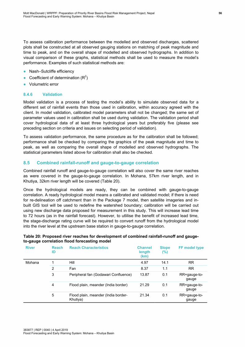
Mott MacDonald | WRPPF: Preparation of Priority River Basins Flood Risk Management Project, Nepal 56Flood Forecasting and Early Warning System: Mohana – Khutiya Basin
383877 | REP | 0040 | 4 April 2019 Flood Forecasting and Early Warning System: Mohana – Khutiya Basin
To assess calibration performance between the modelled and observed discharges, scattered plots shall be constructed at all observed gauging stations on matching of peak magnitude and time to peak, and on the overall shape of modelled and observed hydrographs. In addition to visual comparison of these graphs, statistical methods shall be used to measure the model’s performance. Examples of such statistical methods are:
● Nash–Sutcliffe efficiency ● Coefficient of determination (R2) ● Volumetric error
8.4.6 Validation
Model validation is a process of testing the model’s ability to simulate observed data for a different set of rainfall events than those used in calibration, within accuracy agreed with the client. In model validation, calibrated model parameters shall not be changed; the same set of parameter values used in calibration shall be used during validation. The validation period shall cover hydrological data of at least three hydrological years but preferably five (please see preceding section on criteria and issues on selecting period of validation).
To assess validation performance, the same procedure as for the calibration shall be followed; performance shall be checked by comparing the graphics of the peak magnitude and time to peak, as well as comparing the overall shape of modelled and observed hydrographs. The statistical parameters listed above for calibration shall also be checked.
8.5 Combined rainfall-runoff and gauge-to-gauge correlation Combined rainfall runoff and gauge-to-gauge correlation will also cover the same river reaches as were covered in the gauge-to-gauge correlation. In Mohana, 57km river length, and in Khutiya, 32km river length will be covered (Table 20).
Once the hydrological models are ready, they can be combined with gauge-to-gauge correlation. A ready hydrological model means a calibrated and validated model; if there is need for re-delineation off catchment than in the Package 7 model, then satellite imageries and in-built GIS tool will be used to redefine the watershed boundary; calibration will be carried out using new discharge data proposed for measurement in this study. This will increase lead time to 72 hours (as in the rainfall forecast). However, to utlilise the benefit of increased lead time, the stage-discharge rating curve will be required to convert runoff from the hydrological model into the river level at the upstream base station in gauge-to-gauge correlation.
Table 20: Proposed river reaches for development of combined rainfall-runoff and gauge-to-gauge correlation flood forecasting model
River Reach ID
Reach Characteristics Channel length (km)
Slope (%)
FF model type
Mohana 1 Hill 4.97 14.1 RR 2 Fan 8.37 1.1 RR 3 Peripheral fan (Godawari Confluence) 13.87 0.1 RR+gauge-to-
gauge 4 Flood plain, meander (India border) 21.29 0.1 RR+gauge-to-
gauge 5 Flood plain, meander (India border-
Khutiya) 21.34 0.1 RR+gauge-to-
gauge
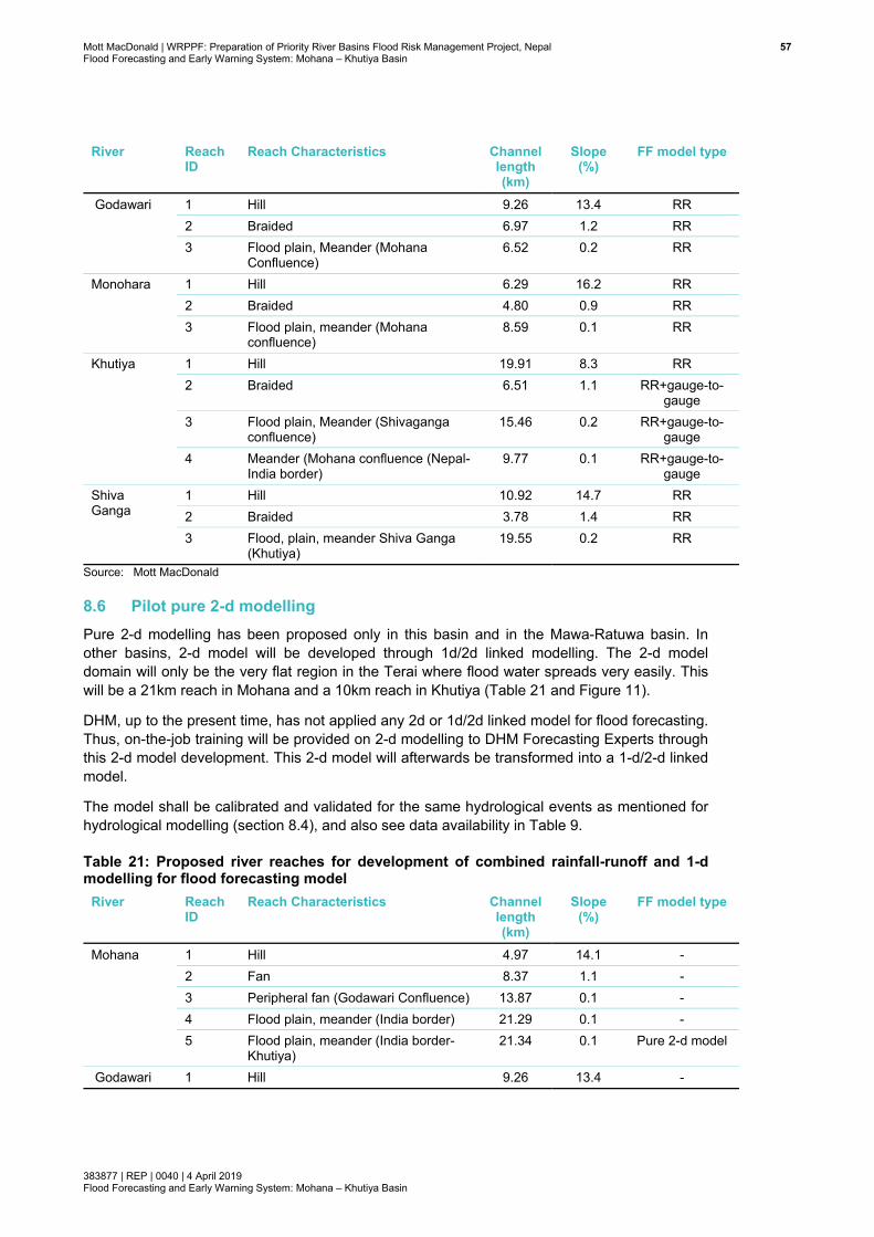
Mott MacDonald | WRPPF: Preparation of Priority River Basins Flood Risk Management Project, Nepal 57Flood Forecasting and Early Warning System: Mohana – Khutiya Basin
383877 | REP | 0040 | 4 April 2019 Flood Forecasting and Early Warning System: Mohana – Khutiya Basin
River Reach ID
Reach Characteristics Channel length (km)
Slope (%)
FF model type
Godawari 1 Hill 9.26 13.4 RR 2 Braided 6.97 1.2 RR 3 Flood plain, Meander (Mohana
Confluence) 6.52 0.2 RR
Monohara 1 Hill 6.29 16.2 RR 2 Braided 4.80 0.9 RR 3 Flood plain, meander (Mohana
confluence) 8.59 0.1 RR
Khutiya 1 Hill 19.91 8.3 RR 2 Braided 6.51 1.1 RR+gauge-to-
gauge 3 Flood plain, Meander (Shivaganga
confluence) 15.46 0.2 RR+gauge-to-
gauge 4 Meander (Mohana confluence (Nepal-
India border) 9.77 0.1 RR+gauge-to-
gauge Shiva Ganga
1 Hill 10.92 14.7 RR 2 Braided 3.78 1.4 RR 3 Flood, plain, meander Shiva Ganga
(Khutiya) 19.55 0.2 RR
Source: Mott MacDonald
8.6 Pilot pure 2-d modelling Pure 2-d modelling has been proposed only in this basin and in the Mawa-Ratuwa basin. In other basins, 2-d model will be developed through 1d/2d linked modelling. The 2-d model domain will only be the very flat region in the Terai where flood water spreads very easily. This will be a 21km reach in Mohana and a 10km reach in Khutiya (Table 21 and Figure 11).
DHM, up to the present time, has not applied any 2d or 1d/2d linked model for flood forecasting. Thus, on-the-job training will be provided on 2-d modelling to DHM Forecasting Experts through this 2-d model development. This 2-d model will afterwards be transformed into a 1-d/2-d linked model.
The model shall be calibrated and validated for the same hydrological events as mentioned for hydrological modelling (section 8.4), and also see data availability in Table 9.
Table 21: Proposed river reaches for development of combined rainfall-runoff and 1-d modelling for flood forecasting model
River Reach ID
Reach Characteristics Channel length (km)
Slope (%)
FF model type
Mohana 1 Hill 4.97 14.1 - 2 Fan 8.37 1.1 - 3 Peripheral fan (Godawari Confluence) 13.87 0.1 - 4 Flood plain, meander (India border) 21.29 0.1 - 5 Flood plain, meander (India border-
Khutiya) 21.34 0.1 Pure 2-d model
Godawari 1 Hill 9.26 13.4 -
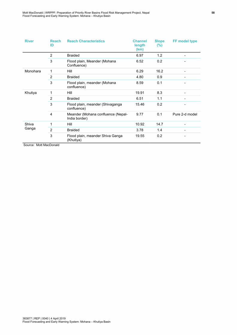
Mott MacDonald | WRPPF: Preparation of Priority River Basins Flood Risk Management Project, Nepal 58Flood Forecasting and Early Warning System: Mohana – Khutiya Basin
383877 | REP | 0040 | 4 April 2019 Flood Forecasting and Early Warning System: Mohana – Khutiya Basin
River Reach ID
Reach Characteristics Channel length (km)
Slope (%)
FF model type
2 Braided 6.97 1.2 - 3 Flood plain, Meander (Mohana
Confluence) 6.52 0.2 -
Monohara 1 Hill 6.29 16.2 - 2 Braided 4.80 0.9 - 3 Flood plain, meander (Mohana
confluence) 8.59 0.1 -
Khutiya 1 Hill 19.91 8.3 - 2 Braided 6.51 1.1 - 3 Flood plain, meander (Shivaganga
confluence) 15.46 0.2 -
4 Meander (Mohana confluence (Nepal-India border)
9.77 0.1 Pure 2-d model
Shiva Ganga
1 Hill 10.92 14.7 - 2 Braided 3.78 1.4 - 3 Flood plain, meander Shiva Ganga
(Khutiya) 19.55 0.2 -
Source: Mott MacDonald
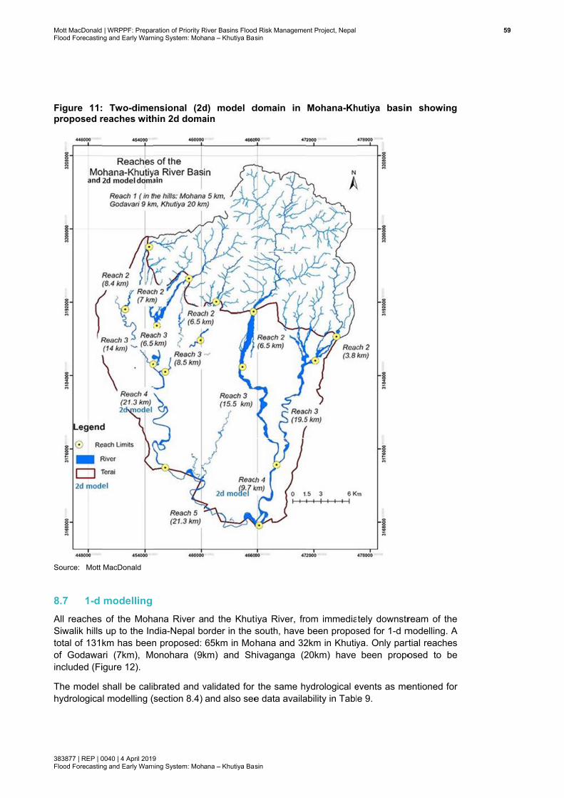
Mott MacDonaldFlood Forecastin
383877 | REP | 0Flood Forecastin
Figure 11:proposed r
Source: Mott
8.7 1-d All reaches Siwalik hillstotal of 131of Godawaincluded (Fi
The model hydrologica
| WRPPF: Prepang and Early Warn
0040 | 4 April 2019ng and Early Warn
: Two-dimereaches with
MacDonald
modelling of the Moh
s up to the Inkm has been
ari (7km), Migure 12).
shall be calil modelling (
ration of Priority Rning System: Moh
9 ning System: Moh
ensional (2dhin 2d doma
ana River andia-Nepal bon proposed: onohara (9k
brated and v(section 8.4)
River Basins Floodana – Khutiya Bas
ana – Khutiya Bas
d) model dain
nd the Khutorder in the s65km in Mo
km) and Sh
validated for and also see
d Risk Managemesin
sin
domain in
tiya River, frosouth, have hana and 32
hivaganga (2
the same he data availa
ent Project, Nepal
Mohana-Kh
om immediabeen propos
2km in Khutiy20km) have
ydrological eability in Tabl
hutiya basin
ately downstrsed for 1-d mya. Only par
been propo
events as mee 9.
n showing
ream of the modelling. A rtial reaches osed to be
entioned for
599

Mott MacDonald | WRPPF: Preparation of Priority River Basins Flood Risk Management Project, Nepal 60Flood Forecasting and Early Warning System: Mohana – Khutiya Basin
383877 | REP | 0040 | 4 April 2019 Flood Forecasting and Early Warning System: Mohana – Khutiya Basin
8.7.1 River network
A forecasting tool in the 1-d modelling approach has been proposed to be developed for the Mohana and Khutiya rivers. Three other tributaries have also been proposed for inclusion in the 1-d model. The Godawari and the Monohara Rivers are two important tributaries of Mohana, and Shivaganga River is also an important tributary for Khutiya River. Thus, these three tributaries shall also be considered during the 1-d modelling for this basin.
The river reaches in the Terai as shown in Figure 1 and Table 7 shall be considered in 1-d river modelling. Runoff from the catchment in the Siwalik Hills shall be routed to the 1-d river model by hydrological modelling. Details of reaches and catchments considered in rainfall runoff (RR) and 1-d river modelling are presented in Table 22. If during the development phase it will be deemed appropriate, depending on topography and channel density in the Siwaliks, flood routing, e.g. based on Muskingum-Cunge, will also be considered. Such hydrological routing may improve flood attenuation, flood volume and flood travel time to the downstream 1-d model in the Terai. The above proposed reach lengths in the 1-d model shall be fine-tuned during the development phase depending on the field conditions as more physical data (water level, discharge, DEM and cross-sections) become available.
A single fluvial model shall be built considering all the main rivers and their tributaries included in the same model set-up. The model, with all interconnected branches, will deliver better results. None of the tributaries/branches shall be built as a separate 1-d model.
Modelling approach shall be submitted for acceptance by the client (i.e., DHM) before model build commences.
Key characteristics of the model shall include:
● ● Distributed inflows to reflect the key hydrological characteristics of the catchment ● All structures which influence flood flows/levels between 50% (generally bank-full discharge)
and 0.1% AEP plus climate change allowance ● All flood defence work ● All model nodes and units are to be geo-referenced, to true geographic co-ordinates (i.e.,
schematic set-up of model units shall not be accepted) ● Channel (1-d), bank to bank ● Floodplain as extended section in 1-d, as flood cells connected to the river (1-d) or as
separate channel and connected to main channel.
Table 22: Proposed river reaches for development of combined rainfall-runoff and 1-d modelling for flood forecasting model
River Reach ID
Reach Characteristics Channel length (km)
Slope (%)
FF model: gauge-to-
gauge correlation
Mohana 1 Hill 4.97 14.1 RR 2 Fan 8.37 1.1 RR+1-d model 3 Peripheral fan (Godawari
Confluence) 13.87 0.1 RR+1-d model
4 Flood plain, meander (India border)
21.29 0.1 RR+1-d model
5 Flood plain, meander (India 21.34 0.1 RR+1-d model
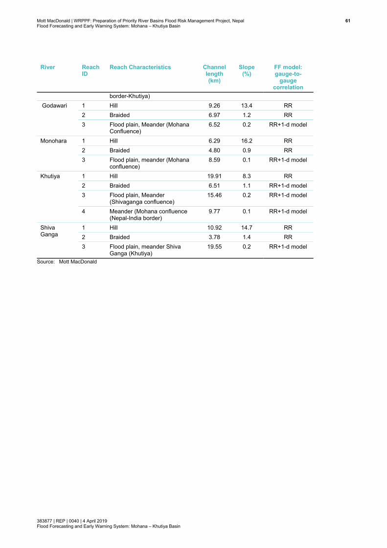
Mott MacDonald | WRPPF: Preparation of Priority River Basins Flood Risk Management Project, Nepal 61Flood Forecasting and Early Warning System: Mohana – Khutiya Basin
383877 | REP | 0040 | 4 April 2019 Flood Forecasting and Early Warning System: Mohana – Khutiya Basin
River Reach ID
Reach Characteristics Channel length (km)
Slope (%)
FF model: gauge-to-
gauge correlation
border-Khutiya) Godawari 1 Hill 9.26 13.4 RR
2 Braided 6.97 1.2 RR 3 Flood plain, Meander (Mohana
Confluence) 6.52 0.2 RR+1-d model
Monohara 1 Hill 6.29 16.2 RR 2 Braided 4.80 0.9 RR 3 Flood plain, meander (Mohana
confluence) 8.59 0.1 RR+1-d model
Khutiya 1 Hill 19.91 8.3 RR 2 Braided 6.51 1.1 RR+1-d model 3 Flood plain, Meander
(Shivaganga confluence) 15.46 0.2 RR+1-d model
4 Meander (Mohana confluence (Nepal-India border)
9.77 0.1 RR+1-d model
Shiva Ganga
1 Hill 10.92 14.7 RR 2 Braided 3.78 1.4 RR 3 Flood plain, meander Shiva
Ganga (Khutiya) 19.55 0.2 RR+1-d model
Source: Mott MacDonald
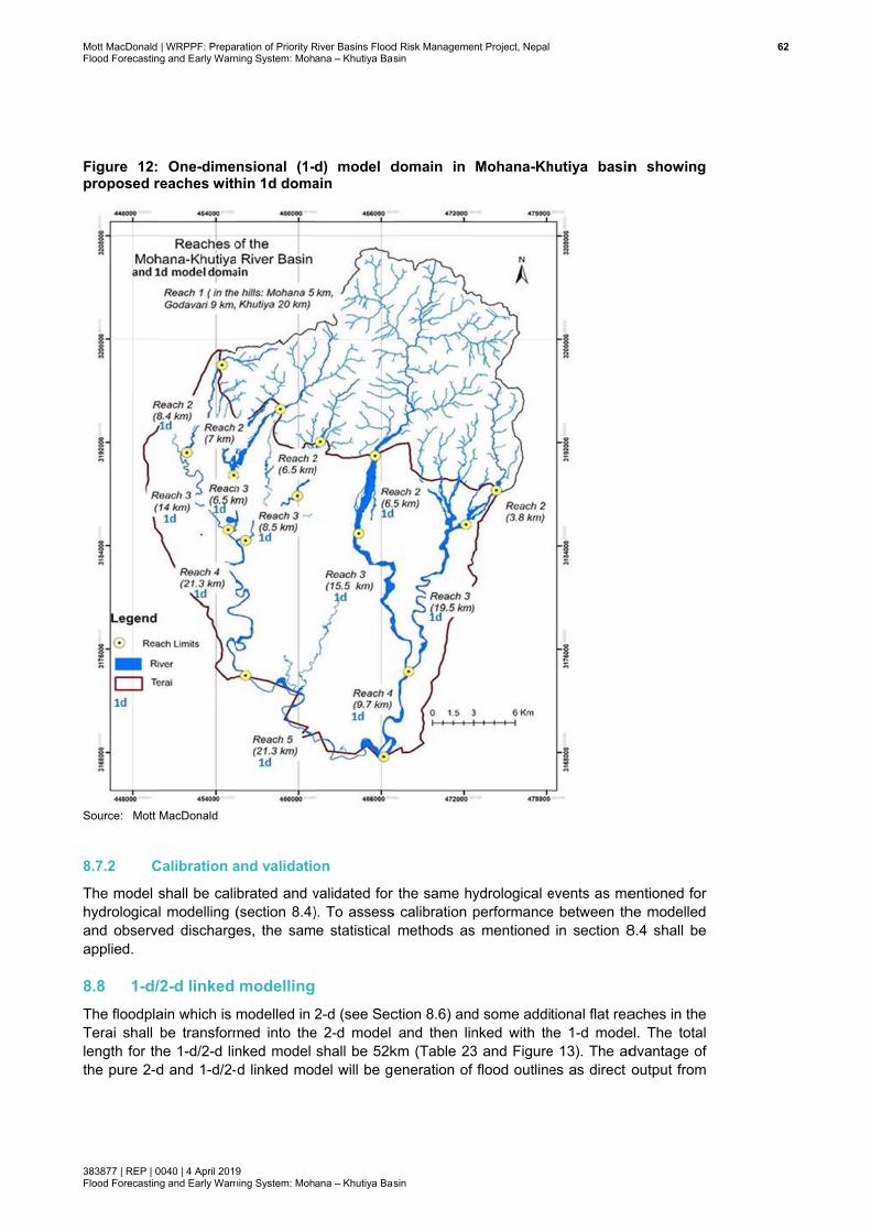
Mott MacDonaldFlood Forecastin
383877 | REP | 0Flood Forecastin
Figure 12:proposed r
Source: Mott
8.7.2 C
The model hydrologicaand observapplied.
8.8 1-d/The floodplaTerai shall length for ththe pure 2-d
| WRPPF: Prepang and Early Warn
0040 | 4 April 2019ng and Early Warn
One-dimereaches with
MacDonald
Calibration a
shall be calil modelling (
ved discharg
/2-d linked ain which is be transform
he 1-d/2-d lind and 1-d/2-
ration of Priority Rning System: Moh
9 ning System: Moh
nsional (1-hin 1d doma
and validatio
brated and v(section 8.4)es, the sam
modellingmodelled in med into thenked model -d linked mod
River Basins Floodana – Khutiya Bas
ana – Khutiya Bas
d) model dain
on
validated for ). To assesse statistical
2-d (see Sec
e 2-d model shall be 52kdel will be g
d Risk Managemesin
sin
domain in
the same hs calibration
methods as
ction 8.6) andand then lin
km (Table 23eneration of
ent Project, Nepal
Mohana-Kh
ydrological eperformance
s mentioned
d some addinked with th3 and Figuref flood outline
hutiya basin
events as mee between th
in section 8
tional flat reahe 1-d modee 13). The ades as direct
n showing
entioned for he modelled 8.4 shall be
aches in the el. The total dvantage of output from
622
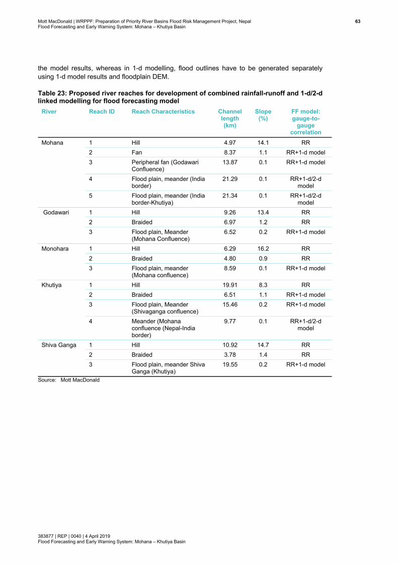
Mott MacDonald | WRPPF: Preparation of Priority River Basins Flood Risk Management Project, Nepal 63Flood Forecasting and Early Warning System: Mohana – Khutiya Basin
383877 | REP | 0040 | 4 April 2019 Flood Forecasting and Early Warning System: Mohana – Khutiya Basin
the model results, whereas in 1-d modelling, flood outlines have to be generated separately using 1-d model results and floodplain DEM.
Table 23: Proposed river reaches for development of combined rainfall-runoff and 1-d/2-d linked modelling for flood forecasting model
River Reach ID Reach Characteristics Channel length (km)
Slope (%)
FF model: gauge-to-
gauge correlation
Mohana 1 Hill 4.97 14.1 RR 2 Fan 8.37 1.1 RR+1-d model 3 Peripheral fan (Godawari
Confluence) 13.87 0.1 RR+1-d model
4 Flood plain, meander (India border)
21.29 0.1 RR+1-d/2-d model
5 Flood plain, meander (India border-Khutiya)
21.34 0.1 RR+1-d/2-d model
Godawari 1 Hill 9.26 13.4 RR 2 Braided 6.97 1.2 RR 3 Flood plain, Meander
(Mohana Confluence) 6.52 0.2 RR+1-d model
Monohara 1 Hill 6.29 16.2 RR 2 Braided 4.80 0.9 RR 3 Flood plain, meander
(Mohana confluence) 8.59 0.1 RR+1-d model
Khutiya 1 Hill 19.91 8.3 RR 2 Braided 6.51 1.1 RR+1-d model 3 Flood plain, Meander
(Shivaganga confluence) 15.46 0.2 RR+1-d model
4 Meander (Mohana confluence (Nepal-India border)
9.77 0.1 RR+1-d/2-d model
Shiva Ganga 1 Hill 10.92 14.7 RR 2 Braided 3.78 1.4 RR 3 Flood plain, meander Shiva
Ganga (Khutiya) 19.55 0.2 RR+1-d model
Source: Mott MacDonald
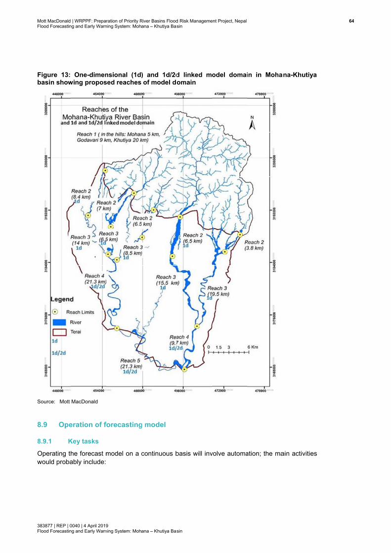
Mott MacDonaldFlood Forecastin
383877 | REP | 0Flood Forecastin
Figure 13: basin show
Source: Mott
8.9 Ope
8.9.1 K
Operating twould proba
| WRPPF: Prepang and Early Warn
0040 | 4 April 2019ng and Early Warn
One-dimenwing propos
MacDonald
eration of f
Key tasks
he forecast mably include:
ration of Priority Rning System: Moh
9 ning System: Moh
nsional (1dsed reaches
forecasting
model on a
River Basins Floodana – Khutiya Bas
ana – Khutiya Bas
) and 1d/2dof model do
g model
continuous b
d Risk Managemesin
sin
d linked momain
basis will inv
ent Project, Nepal
odel domai
volve automa
in in Moha
ation; the ma
ana-Khutiya
ain activities
644
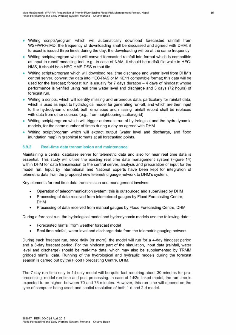
Mott MacDonald | WRPPF: Preparation of Priority River Basins Flood Risk Management Project, Nepal 65Flood Forecasting and Early Warning System: Mohana – Khutiya Basin
383877 | REP | 0040 | 4 April 2019 Flood Forecasting and Early Warning System: Mohana – Khutiya Basin
● Writing scripts/program which will automatically download forecasted rainfall from WSF/WRF/IMD; the frequency of downloading shall be discussed and agreed with DHM; if forecast is issued three times during the day, the downloading will be at the same frequency
● Writing scripts/program which will convert forecasted rainfall into format which is compatible as input to runoff modelling tool, e.g., in case of NAM, it should be a dfs0 file while in HEC-HMS, it should be a HEC-HMS-DSS output file
● Writing scripts/program which will download real time discharge and water level from DHM’s central server, convert the data into HEC-RAS or MIKE11 compatible format; this data will be used for the forecast; forecast run is usually for 7 days duration – 4 days of hindcast whose performance is verified using real time water level and discharge and 3 days (72 hours) of forecast run.
● Writing a scripts, which will identify missing and erroneous data, particularly for rainfall data, which is used as input to hydrological model for generating run-off, and which are then input to the hydrodynamic model; both erroneous and missing rainfall record shall be replaced with data from other sources (e.g., from neighbouring station/grid)
● Writing script/program which will trigger automatic run of hydrological and the hydrodynamic models, for the same number of times during a day as agreed with DHM
● Writing script/program which will extract output (water level and discharge, and flood inundation map) in graphical formats at all forecasting points.
8.9.2 Real-time data transmission and maintenance
Maintaining a central database server for telemetric data and also for near real time data is essential. This study will uitlise the existing real time data management system (Figure 14) within DHM for data transmission to the central server, analysis and preparation of input for the model run. Input by International and National Experts have been kept for integration of telemetric data from the proposed new telemetric gauge network to DHM’s system.
Key elements for real time data transmission and management involves:
Operation of telecommunication system: this is outsourced and supervised by DHM Processing of data received from telemetered gauges by Flood Forecasting Centre,
DHM Processing of data received from manual gauges by Flood Forecasting Centre, DHM
During a forecast run, the hydrological model and hydrodynamic models use the following data:
Forecasted rainfall from weather forecast model Real time rainfall, water level and discharge data from the telemetric gauging network
During each forecast run, once daily (or more), the model will run for a 4-day hindcast period and a 3-day forecast period. For the hindcast part of the simulation, input data (rainfall, water level and discharge) should be real-time data, which may also be supplemented by TRMM gridded rainfall data. Running of the hydrological and hydraulic models during the forecast season is carried out by the Flood Forecasting Centre, DHM. The 7-day run time only in 1d only model will be quite fast requiring about 30 minutes for pre-processing, model run time and post processing. In case of 1d/2d linked model, the run time is expected to be higher, between 70 and 75 minutes. However, this run time will depend on the type of computer being used, and spatial resolution of both 1-d and 2-d model.
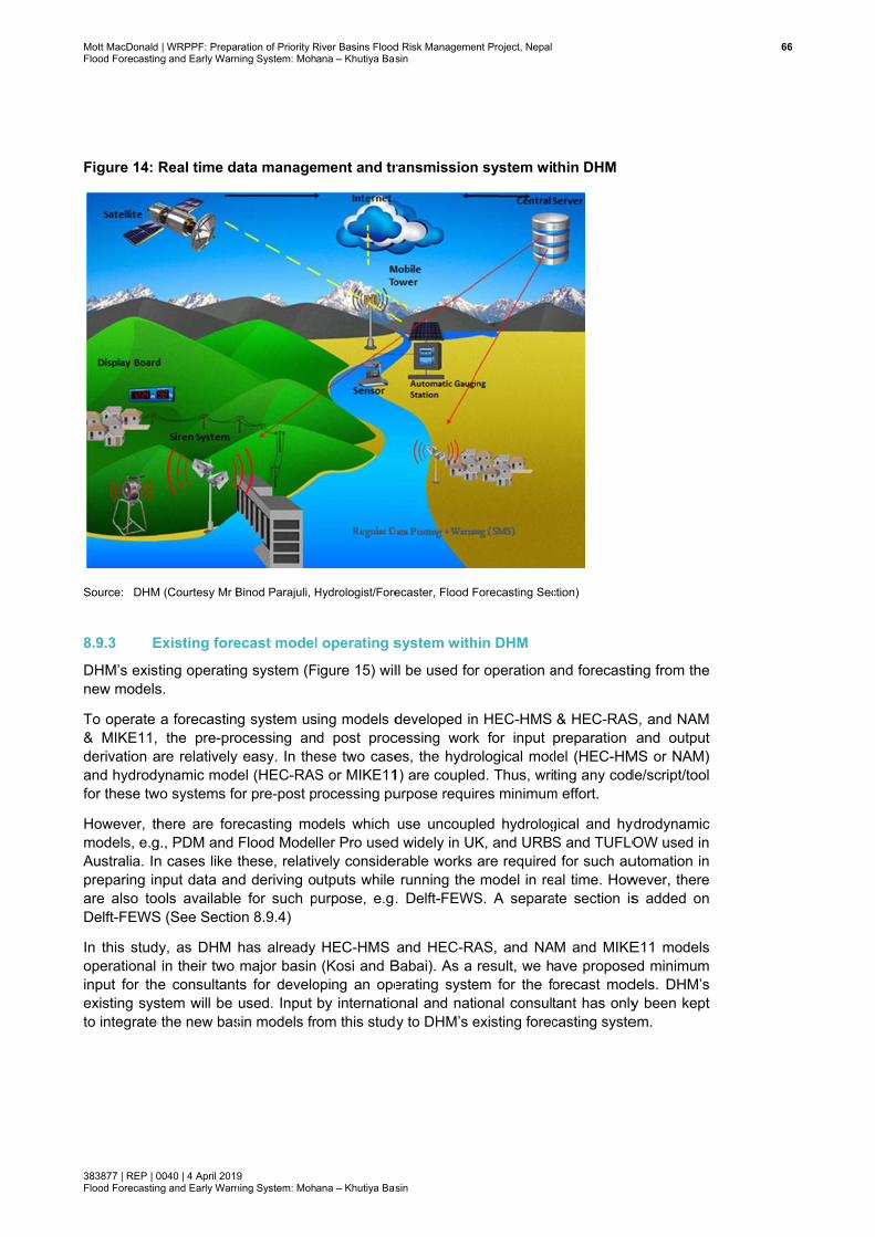
Mott MacDonaldFlood Forecastin
383877 | REP | 0Flood Forecastin
Figure 14:
Source: DHM
8.9.3 E
DHM’s exisnew models
To operate & MIKE11, derivation aand hydrodyfor these tw
However, thmodels, e.gAustralia. Inpreparing inare also tooDelft-FEWS
In this studoperational input for theexisting systo integrate
| WRPPF: Prepang and Early Warn
0040 | 4 April 2019ng and Early Warn
Real time da
M (Courtesy Mr B
Existing fore
ting operatins.
a forecastinthe pre-pro
are relativelyynamic mod
wo systems fo
here are forg., PDM and n cases like nput data anols available
S (See Sectio
y, as DHM in their two e consultant
stem will be the new bas
ration of Priority Rning System: Moh
9 ning System: Moh
ata manage
Binod Parajuli, H
ecast model
ng system (F
g system usocessing any easy. In theel (HEC-RASor pre-post p
recasting moFlood Modethese, relativd deriving o
e for such pon 8.9.4)
has already major basin
ts for develoused. Input
sin models fr
River Basins Floodana – Khutiya Bas
ana – Khutiya Bas
ement and tr
Hydrologist/Fore
l operating s
igure 15) wil
sing models dd post procese two caseS or MIKE11
processing pu
odels which ller Pro usedvely consideutputs while
purpose, e.g.
HEC-HMS (Kosi and B
oping an opeby internatio
rom this stud
d Risk Managemesin
sin
ransmission
ecaster, Flood F
system with
ll be used fo
developed incessing workes, the hydro1) are coupleurpose requi
use uncoupd widely in Uerable works
running the. Delft-FEWS
and HEC-RABabai). As a erating systeonal and naty to DHM’s e
ent Project, Nepal
n system wit
Forecasting Sec
hin DHM
r operation a
n HEC-HMS k for input ological mod
ed. Thus, wrires minimum
pled hydrologK, and URBSare required model in reS. A separa
AS, and NAresult, we h
em for the foional consultexisting forec
thin DHM
ction)
and forecasti
& HEC-RASpreparation del (HEC-HMting any cod
m effort.
gical and hyS and TUFLOd for such aual time. How
ate section is
AM and MIKEave proposeorecast modtant has onlycasting syste
ing from the
S, and NAM and output
MS or NAM) de/script/tool
ydrodynamic OW used in utomation in wever, there s added on
E11 models ed minimum dels. DHM’s y been kept em.
666
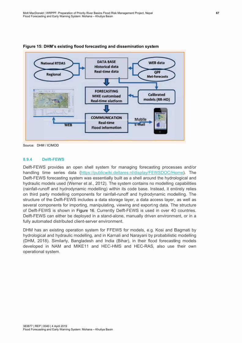
Mott MacDonaldFlood Forecastin
383877 | REP | 0Flood Forecastin
Figure 15:
Source: DHM
8.9.4 D
Delft-FEWShandling tDelft-FEWShydraulic m(rainfall-runon third pastructure ofseveral comof Delft-FEDelft-FEWSfully autom
DHM has ahydrologica(DHM, 201developed operational
| WRPPF: Prepang and Early Warn
0040 | 4 April 2019ng and Early Warn
DHM’s exist
M / ICIMOD
Delft-FEWS
S provides ime series S forecastin
models usednoff and hydarty modellinf the Delft-Fmponents fo
EWS is showS can eitherated distribu
an existing al and hydra18). Similarl
in NAM al system.
ration of Priority Rning System: Moh
9 ning System: Moh
ting flood fo
an open shdata (http
g system wa (Werner et
drodynamic ng componeFEWS includor importing,wn in Figurer be deployeuted client-s
operation syaulic modelliy, Banglade
and MIKE11
River Basins Floodana – Khutiya Bas
ana – Khutiya Bas
orecasting a
hell system ps://publicwikas essentialal., 2012). Tmodelling) w
ents for raindes a data s, manipulatin
e 16. Currened in a standerver enviro
ystem for Fng, and in Kesh and Ind1 and HEC
d Risk Managemesin
sin
and dissemi
for managki.deltares.nlly built as aThe system within its confall-runoff astorage layeng, viewing
ntly Delft-FEd-alone, ma
onment.
FEWS for mKarnali and Ndia (Bihar), C-HMS and
ent Project, Nepal
ination syst
ing forecasnl/display/FEa shell aroun
contains noode base. Inand hydrodyer, a data acand exporti
EWS is usedanually drive
models, e.g.Narayani by in their flooHEC-RAS
em
ting procesEWSDOC/Hond the hydroo modelling cnstead, it enynamic modccess layer,ng data. Th
d in over 40en environm
. Kosi and Bprobabilistic
od forecasti, also use
sses and/or ome). The
ological and capabilities
ntirely relies delling. The as well as
he structure 0 countries.
ment, or in a
Bagmati by c modelling ing models
their own
677
Mott MacDonaldFlood Forecastin
383877 | REP | 0Flood Forecastin
Figure 16: Delft-FEWS
Source: Wern
8.9.5 D
Disseminati
● Writing designat
8.9.6 D
Data assimwith the motechnique cinto the hyuncertainty
The flood fshould havewater level.the forecast
| WRPPF: Prepang and Early Warn
0040 | 4 April 2019ng and Early Warn
Schematic S and links t
ner et al. (2012)
Disseminatio
ion of foreca
script/prograted recipients
Data assimil
milation is a todel dynamiccan be applieydrodynamic assessment
forecasting me the ability t This will allt.
ration of Priority Rning System: Moh
9 ning System: Moh
structure oto other prim
)
on of foreca
st will involve
am, which ws including C
ation
technique fos in order to ed by incorp
model. Furt.
methodologyto assimilatelow the upda
River Basins Floodana – Khutiya Bas
ana – Khutiya Bas
of a flood fomary system
ast
e automation
will disseminCBDRM com
r combining improve the
porating obserthermore, th
y to be appe real time/neating of mod
d Risk Managemesin
sin
forecasting ms within th
n. The main a
ate forecastmittee and o
any measue knowledge erved water he data ass
plied in the ear real timedel results in
ent Project, Nepal
system, shhe operation
activities sha
t including gother stake h
rements of tof the systemlevel and di
similation mo
FFEWS deve telemetry o real time an
owing the pnal environm
all include:
graphical ouolders
the state of m. The data ascharge meaodule can b
velopment inobservations nd improve a
position ofment
utputs to all
the system assimilation asurements
be used for
n this basin of flow and accuracy of
688
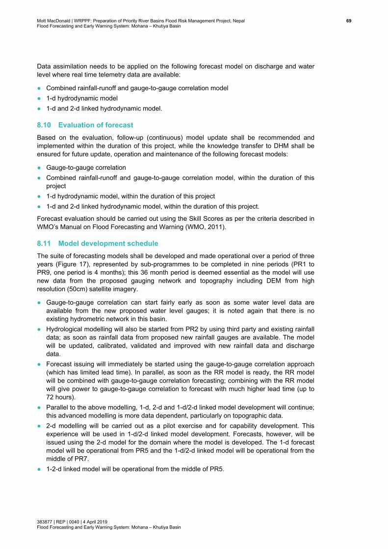
Mott MacDonald | WRPPF: Preparation of Priority River Basins Flood Risk Management Project, Nepal 69Flood Forecasting and Early Warning System: Mohana – Khutiya Basin
383877 | REP | 0040 | 4 April 2019 Flood Forecasting and Early Warning System: Mohana – Khutiya Basin
Data assimilation needs to be applied on the following forecast model on discharge and water level where real time telemetry data are available:
● Combined rainfall-runoff and gauge-to-gauge correlation model ● 1-d hydrodynamic model ● 1-d and 2-d linked hydrodynamic model.
8.10 Evaluation of forecast Based on the evaluation, follow-up (continuous) model update shall be recommended and implemented within the duration of this project, while the knowledge transfer to DHM shall be ensured for future update, operation and maintenance of the following forecast models:
● Gauge-to-gauge correlation ● Combined rainfall-runoff and gauge-to-gauge correlation model, within the duration of this
project ● 1-d hydrodynamic model, within the duration of this project ● 1-d and 2-d linked hydrodynamic model, within the duration of this project.
Forecast evaluation should be carried out using the Skill Scores as per the criteria described in WMO’s Manual on Flood Forecasting and Warning (WMO, 2011).
8.11 Model development schedule The suite of forecasting models shall be developed and made operational over a period of three years (Figure 17), represented by sub-programmes to be completed in nine periods (PR1 to PR9, one period is 4 months); this 36 month period is deemed essential as the model will use new data from the proposed gauging network and topography including DEM from high resolution (50cm) satellite imagery.
● Gauge-to-gauge correlation can start fairly early as soon as some water level data are available from the new proposed water level gauges; it is noted again that there is no existing hydrometric network in this basin.
● Hydrological modelling will also be started from PR2 by using third party and existing rainfall data; as soon as rainfall data from proposed new rainfall gauges are available. The model will be updated, calibrated, validated and improved with new rainfall data and discharge data.
● Forecast issuing will immediately be started using the gauge-to-gauge correlation approach (which has limited lead time). In parallel, as soon as the RR model is ready, the RR model will be combined with gauge-to-gauge correlation forecasting; combining with the RR model will give power to gauge-to-gauge correlation to forecast with much higher lead time (up to 72 hours).
● Parallel to the above modelling, 1-d, 2-d and 1-d/2-d linked model development will continue; this advanced modelling is more data dependent, particularly on topographic data.
● 2-d modelling will be carried out as a pilot exercise and for capability development. This experience will be used in 1-d/2-d linked model development. Forecasts, however, will be issued using the 2-d model for the domain where the model is developed. The 1-d forecast model will be operational from PR5 and the 1-d/2-d linked model will be operational from the middle of PR7.
● 1-2-d linked model will be operational from the middle of PR5.
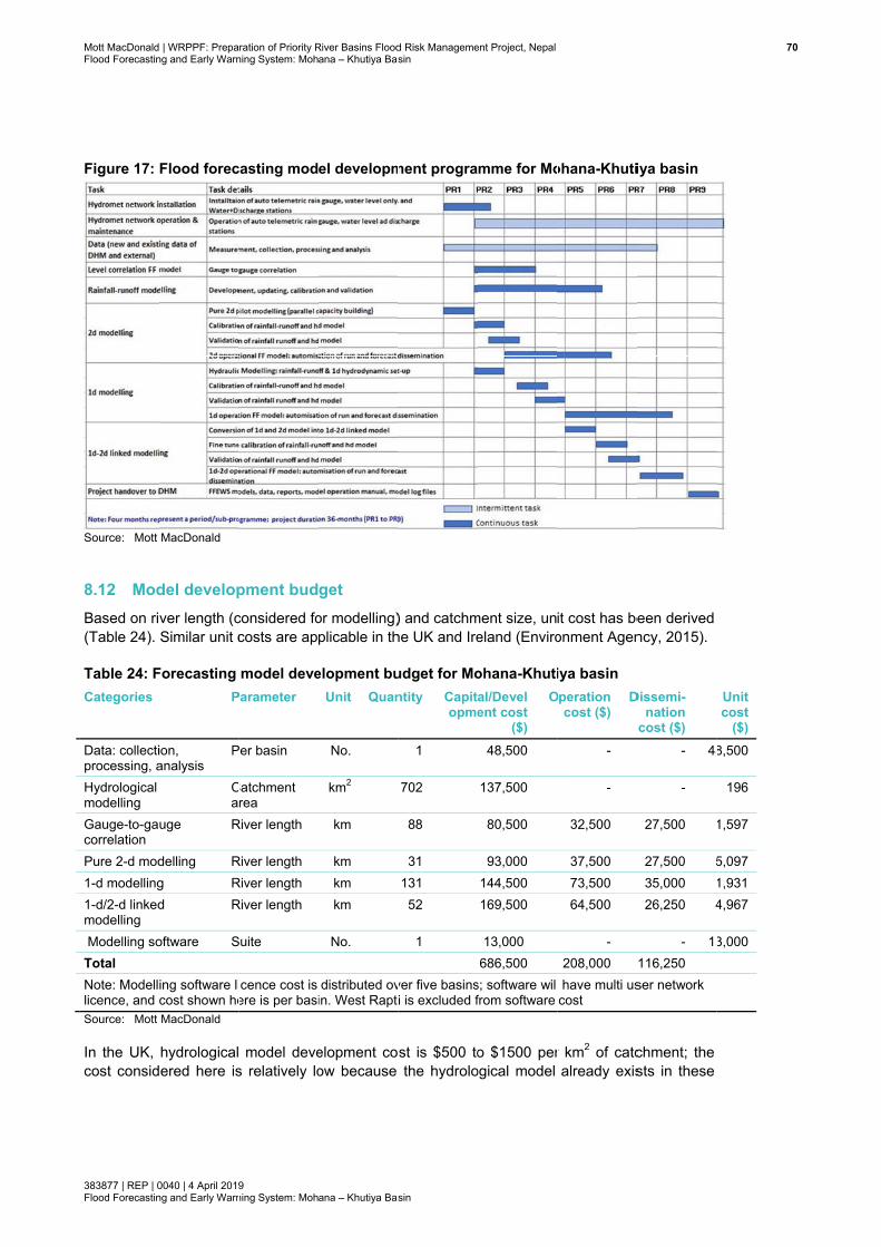
Mott MacDonaldFlood Forecastin
383877 | REP | 0Flood Forecastin
Figure 17:
Source: Mott
8.12 ModBased on ri(Table 24).
Table 24: FCategories
Data: collectiprocessing, aHydrological modelling Gauge-to-gacorrelation Pure 2-d mod1-d modelling1-d/2-d linkedmodelling Modelling soTotal Note: Modelllicence, and cSource: Mott
In the UK, cost consid
| WRPPF: Prepang and Early Warn
0040 | 4 April 2019ng and Early Warn
Flood forec
MacDonald
del developver length (cSimilar unit c
Forecasting P
ion, analysis
P
Ca
uge R
delling Rg Rd R
oftware S
ing software licost shown heMacDonald
hydrologicalered here is
ration of Priority Rning System: Moh
9 ning System: Moh
casting mod
pment budconsidered focosts are ap
model deveParameter
Per basin
Catchment rea
River length
River length River length River length
Suite
icence cost is ere is per basi
model deves relatively lo
River Basins Floodana – Khutiya Bas
ana – Khutiya Bas
el developm
get or modelling)plicable in th
elopment buUnit Quan
No.
km2
km
km km km
No.
distributed ovin. West Rapti
elopment coow because
d Risk Managemesin
sin
ment progra
) and catchmhe UK and Ire
udget for Montity Capit
opme
1
702
88
31 131 52
1
ver five basinsi is excluded f
st is $500 tothe hydrolo
ent Project, Nepal
mme for Mo
ment size, uneland (Enviro
ohana-Khutial/Develent cost
($)
O
48,500
137,500
80,500
93,000 144,500 169,500
13,000 686,500
s; software willfrom software
o $1500 perogical model
ohana-Khuti
it cost has beonment Agen
iya basin Operation
cost ($) D
-
-
32,500
37,500 73,500 64,500
- 208,000
l have multi uscost
r km2 of catcalready exis
iya basin
een derived ncy, 2015).
Dissemi-nation
cost ($) - 48
-
27,500
27,500 535,000 26,250 4
- 13116,250 ser network
chment; the sts in these
70
Unit cost
($) 8,500
196
1,597
5,097 1,931 4,967
3,000
0

Mott MacDonald | WRPPF: Preparation of Priority River Basins Flood Risk Management Project, Nepal 71Flood Forecasting and Early Warning System: Mohana – Khutiya Basin
383877 | REP | 0040 | 4 April 2019 Flood Forecasting and Early Warning System: Mohana – Khutiya Basin
five sub-basins (from pre-feasibility and feasibility level). This advantage will reduce development cost during FFEWS).
8.13 Person-months for experts The suite of FFEWS tools shall be developed first in the Mohana-Khutiya basin, and thus expert input in this basin is higher than for other basins (Table 25).
The next basin shall be Mawa-Ratuwa. Thus, the other basins will benefit from the experience gained from these two basins; as a result, the other three basins will require fewer person-months. The catchment size and river lengths were also key factors in deciding person-months. Gradually with experience, the input from international experts will decrease in other basins than Mohana-Khutiya and Mawa-Ratuwa.
In developing FFEWS in five basins, the inputs of three international experts and four national experts have been considered over a period of three years; one GIS cum data expert (National) has also been considered to support the team. The discipline of both international and national experts shall be:
International
Senior/Principal Hydraulic & flood forecasting modelling expert Hydraulic & flood forecasting modelling expert Hydrologist & flood forecasting modelling expert
National
Hydraulic & flood forecasting modelling expert-I and expert-II Hydrologist & flood forecasting modelling expert-I and expert-II GIS cum data analysis expert
Following activities will be first carried out in this basin. As these activities could easily be applied/customised to other basins, so the cost for these activities will be relatively low in the other basins than this basin.
● A detailed model development conceptualisation document (according to feasibility document) shall be developed for this basin and shall be copied to other basins
● Training and capacity building for 1-d, 2-d and 1-d/2-d linked modelling will be offered to national experts and DHM professionals during development of tools in this basin
● A script for automation of FF model runs in real time shall be developed for this basin, and can be adopted to other basins with very minimum input
● A script for automation of forecast dissemination in real time shall be developed for this basin and can be adopted to other basins with very minimum input.
Further, Mohana-Khutiya is actually two separate basins with separate catchments and river systems, although in this study, both basins were considered as one unit. Thus, cost, in general, is higher in this basin than the other basins.
Considering the above factors, the person-months for Mohana-Khutiya have been calculated as below:
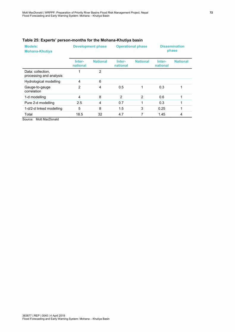
Mott MacDonald | WRPPF: Preparation of Priority River Basins Flood Risk Management Project, Nepal 72Flood Forecasting and Early Warning System: Mohana – Khutiya Basin
383877 | REP | 0040 | 4 April 2019 Flood Forecasting and Early Warning System: Mohana – Khutiya Basin
Table 25: Experts’ person-months for the Mohana-Khutiya basin Models: Mohana-Khutiya
Development phase
Operational phase
Dissemination phase
Inter-
national National Inter-
national National Inter-
national National
Data: collection, processing and analysis
1 2
Hydrological modelling 4 6 Gauge-to-gauge correlation
2 4 0.5 1 0.3 1
1-d modelling 4 8 2 2 0.6 1 Pure 2-d modelling 2.5 4 0.7 1 0.3 1 1-d/2-d linked modelling 5 8 1.5 3 0.25 1 Total 18.5 32 4.7 7 1.45 4
Source: Mott MacDonald
Mott MacDonald | WRPPF: Preparation of Priority River Basins Flood Risk Management Project, Nepal 73Flood Forecasting and Early Warning System: Mohana – Khutiya Basin
383877 | REP | 0040 | 4 April 2019 Flood Forecasting and Early Warning System: Mohana – Khutiya Basin
References
[1] Allot, T (2010), The British Rainfall Network in 2010, https://www.rmets.org/sites/default/files/pdf/presentation/20100417-allott.pdf
[2] Berndtsson, R and Niemczynowicz, J (1988), Spatial And Temporal Scales in Rainfall Analysis Some Aspects And Future Perspectives, Journal of Hydrology, 100 (1988) 293-313
[3] DHM (2018), Standard Operating Procedure for Flood Early Warning System in Nepal
[4] DoI (2016), Package 3: Flood Hazard Mapping and Preliminary Preparation of Flood Risk Management Projects, Final Report – VOLUME 1, Prepared by Lahmeyer International in association with Total Management Services
[5] EA/Defra (2013), Benchmarking the latest generation of 2D hydraulic modelling packages, Report – SC120002
[6] EA/Defra (2004), Benchmarking of hydraulic river modelling software packages, Project Overview, R&D Technical Report: W5-105/TR0, URL for this research is below:
(https://consult.environment-agency.gov.uk/engagement/bostonbarriertwao/results/appendix-6---neelz--s.---pender--g.--2013--benchmarking-the-latest-generation-of-2-d-hydraulic-modelling-packages.-bristol_environment-agency.pdf)
[7] Environment Agency (2015), Cost estimation for flood warning and forecasting – summary of evidence, Report –SC080039/R13
[8] Huxley C (2016), GPU – Next Generation Modelling for catchment Floodplain Management, BMT-WBM, ASFPM Conference
[9] Lopez M/G. et al, (2015). Location and Density of Rain Gauges for the Estimation of Spatial Varying Precipitation. Geografiska Annaler: Ser. A Physical Geography. 97, (1) 167-179
[10] Lengfeld et al. (undated), Pattern: Advantages of High Resolution Weather Radar Network, American Meteorological Society 36th Conference on Weather Radar Networks
[11] Mott MacDonald (2018a), Morphology Assessment: Mohana – Khutiya basin, WRPPF: Preparation of Priority River Basins Flood Risk Management Project, Nepal
[12] Mott MacDonald (2018b), River Hydrology Assessment: Mohana – Khutiya basin, WRPPF: Preparation of Priority River Basins Flood Risk Management Project, Nepal
Mott MacDonald | WRPPF: Preparation of Priority River Basins Flood Risk Management Project, Nepal 74Flood Forecasting and Early Warning System: Mohana – Khutiya Basin
383877 | REP | 0040 | 4 April 2019 Flood Forecasting and Early Warning System: Mohana – Khutiya Basin
[13] NIWA (2014), Climate Manual, National Institute of Water & Atmospheric Research Ltd
[14] Schaake, J., 2004. Application of prism climatologies for hydrologic modeling and forecasting in the western U.S. In Proceedings of 18th Conference on Hydrology. Seattle, Washington, 2004. American Meteorological Society
[15] Smith, P.J., Brown, S and Dugar, S (2017), Community-based early warning systems for flood risk mitigation in Nepal, Nat. Hazards Earth Syst. Sci., 17, 423–437
[16] Syme, B (2007), 2-d and 1-d/2-d modelling, BMT WBM
[17] Volkman T. H.M., Lyon, S. W., Gupta, H. V. and Troch, P. A. (2010), Multicriteria design of rain gauge networks for flash flood prediction in semiarid catchments with complex terrain. Water Resources Research 46, W11554, doi:10.1029/2010WR009145, 16pp
[18] Werner et al. (2012), The Delft-FEWS Flow Forecasting System, Environmental Modelling and Software, 40 (2013), 65-77
[19] WMO (2011), Manual on Flood Forecasting and Warning, WMO-No. 1072

Mott MacDonald | WRPPF: Preparation of Priority River Basins Flood Risk Management Project, Nepal 75Flood Forecasting and Early Warning System: Mohana – Khutiya Basin
383877 | REP | 0040 | 4 April 2019 Flood Forecasting and Early Warning System: Mohana – Khutiya Basin
Appendices
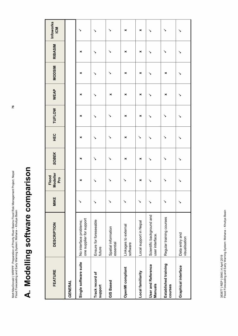
Mot
t Mac
Don
ald
| WR
PPF:
Pre
para
tion
of P
riorit
y R
iver
Bas
ins
Floo
d R
isk
Man
agem
ent P
roje
ct, N
epal
76
Floo
d Fo
reca
stin
g an
d Ea
rly W
arni
ng S
yste
m: M
ohan
a –
Khut
iya
Basi
n 38
3877
| R
EP |
0040
| 4
April
201
9 Fl
ood
Fore
cast
ing
and
Early
War
ning
Sys
tem
: Moh
ana
– Kh
utiy
a Ba
sin
A. M
odel
ling
softw
are
com
paris
on
FEAT
UR
E D
ESC
RIP
TIO
N
MIK
E Fl
ood
Mod
elle
r Pr
o S
OB
EK
H
EC
TUFL
OW
W
EAP
MO
DSI
M
RIB
ASIM
In
fow
orks
IC
M
GE
NE
RA
L
Sing
le s
oftw
are
suite
N
o in
terfa
ce p
robl
ems;
on
e su
pplie
r for
sup
port
x x
x x
x x
x
Trac
k re
cord
of
supp
ort
Ensu
re fo
r for
esee
able
fu
ture
GIS
Bas
ed
Spat
ial i
nfor
mat
ion
esse
ntia
l
x
Ope
nMI c
ompl
iant
Li
nkag
es to
ext
erna
l so
ftwar
e
x
x x
x x
x x
Loca
l fam
iliar
ity
Loca
l sup
port
in N
epal
x
x
x
x x
x x
Use
r and
Ref
eren
ce
Man
uals
Sc
ient
ific
back
grou
nd a
nd
user
inte
rface
.
Esta
blis
hed
trai
ning
co
urse
s R
egul
ar tr
aini
ng c
ours
es
x x
Gra
phic
al in
terf
ace
D
ata
entry
and
vi
sual
isat
ion
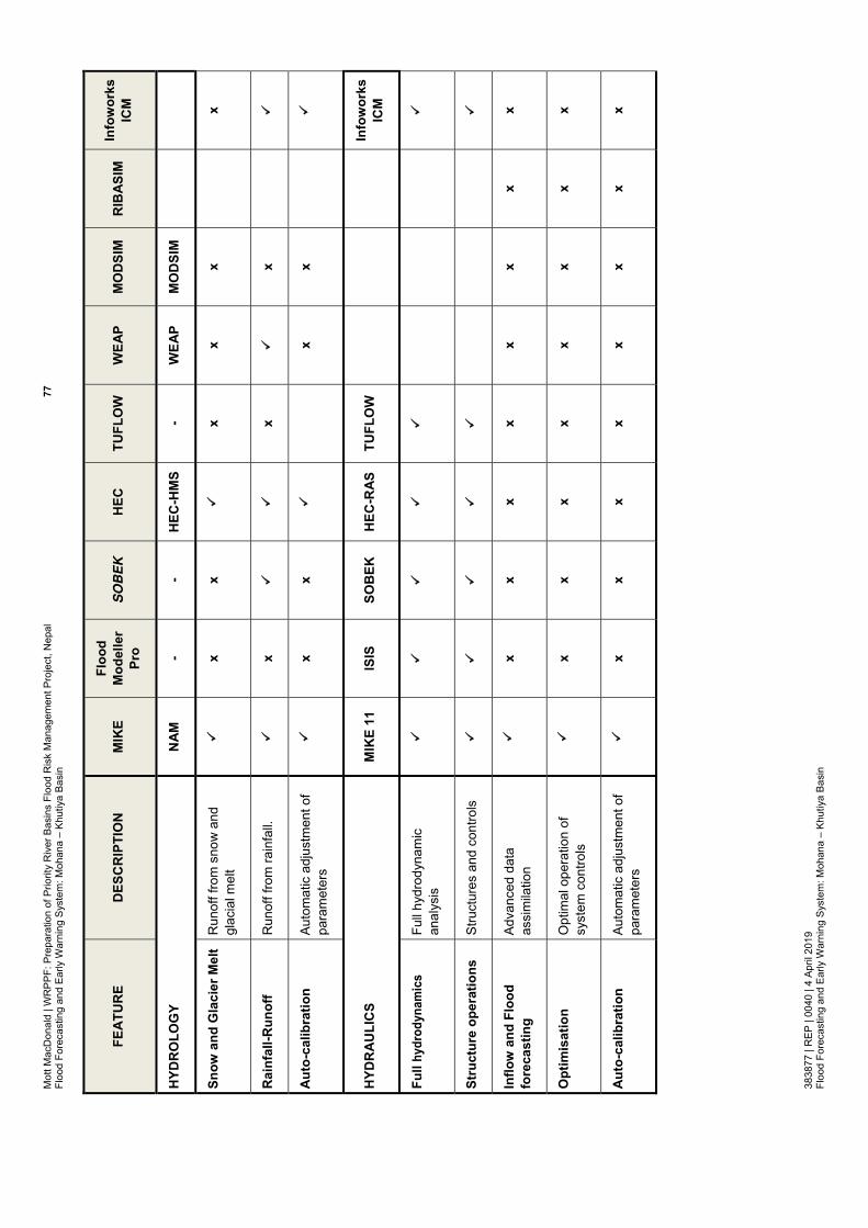
Mot
t Mac
Don
ald
| WR
PPF:
Pre
para
tion
of P
riorit
y R
iver
Bas
ins
Floo
d R
isk
Man
agem
ent P
roje
ct, N
epal
77
Floo
d Fo
reca
stin
g an
d Ea
rly W
arni
ng S
yste
m: M
ohan
a –
Khut
iya
Basi
n 38
3877
| R
EP |
0040
| 4
April
201
9 Fl
ood
Fore
cast
ing
and
Early
War
ning
Sys
tem
: Moh
ana
– Kh
utiy
a Ba
sin
FEAT
UR
E D
ESC
RIP
TIO
N
MIK
E Fl
ood
Mod
elle
r Pr
o S
OB
EK
H
EC
TUFL
OW
W
EAP
MO
DSI
M
RIB
ASIM
In
fow
orks
IC
M
HYD
RO
LOG
Y N
AM
- -
HEC
-HM
S -
WEA
P M
OD
SIM
Snow
and
Gla
cier
Mel
t R
unof
f fro
m s
now
and
gl
acia
l mel
t
x
x
x
x x
x
Rai
nfal
l-Run
off
Run
off f
rom
rain
fall.
x
x
x
Auto
-cal
ibra
tion
Auto
mat
ic a
djus
tmen
t of
para
met
ers
x x
x
x
HYD
RAU
LIC
S M
IKE
11
ISIS
SO
BEK
H
EC-R
AS
TUFL
OW
Info
wor
ks
ICM
Full
hydr
odyn
amic
s Fu
ll hy
drod
ynam
ic
anal
ysis
Stru
ctur
e op
erat
ions
St
ruct
ures
and
con
trols
Inflo
w a
nd F
lood
fo
reca
stin
g Ad
vanc
ed d
ata
assi
mila
tion
x x
x x
x x
x x
Opt
imis
atio
n O
ptim
al o
pera
tion
of
syst
em c
ontro
ls
x x
x x
x x
x x
Auto
-cal
ibra
tion
Auto
mat
ic a
djus
tmen
t of
para
met
ers
x x
x x
x x
x x
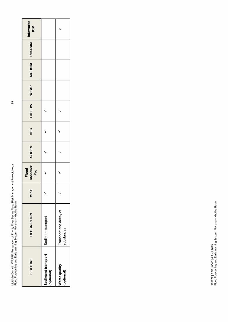
Mot
t Mac
Don
ald
| WR
PPF:
Pre
para
tion
of P
riorit
y R
iver
Bas
ins
Floo
d R
isk
Man
agem
ent P
roje
ct, N
epal
78
Floo
d Fo
reca
stin
g an
d Ea
rly W
arni
ng S
yste
m: M
ohan
a –
Khut
iya
Basi
n 38
3877
| R
EP |
0040
| 4
April
201
9 Fl
ood
Fore
cast
ing
and
Early
War
ning
Sys
tem
: Moh
ana
– Kh
utiy
a Ba
sin
FEAT
UR
E D
ESC
RIP
TIO
N
MIK
E Fl
ood
Mod
elle
r Pr
o S
OB
EK
H
EC
TUFL
OW
W
EAP
MO
DSI
M
RIB
ASIM
In
fow
orks
IC
M
Sedi
men
t tra
nspo
rt
(opt
iona
l) Se
dim
ent t
rans
port
Wat
er q
ualit
y (o
ptio
nal)
Tran
spor
t and
dec
ay o
f su
bsta
nces

Mot
t Mac
Don
ald
| WR
PPF:
Pre
para
tion
of P
riorit
y R
iver
Bas
ins
Floo
d R
isk
Man
agem
ent P
roje
ct, N
epal
79
Floo
d Fo
reca
stin
g an
d Ea
rly W
arni
ng S
yste
m: M
ohan
a –
Khut
iya
Basi
n 38
3877
| R
EP |
0040
| 4
April
201
9 Fl
ood
Fore
cast
ing
and
Early
War
ning
Sys
tem
: Moh
ana
– Kh
utiy
a Ba
sin
B. C
omm
ents
and
resp
onse
s
Tabl
e B
.1: C
omm
ents
on
FFEW
S R
epor
ts fr
om A
DB
C
omm
ents
fro
m A
DB
wer
e ge
neric
for
the
rep
orts
fiv
e ba
sins
: M
ohan
a-Kh
utiy
a, M
awa-
Rat
uwa,
Lak
hand
ei,
Bakr
aha
and
East
Rap
ti an
d
Lakh
ande
i.
C
omm
ents
wer
e re
ceiv
ed in
a M
S W
ord
file
whi
ch a
re p
rese
nted
in T
able
bel
ow
Com
men
ts w
ere
also
rece
ived
on
the
hard
cop
y of
the
Moh
ana-
Khut
iya
(M-K
) Rep
ort o
n ea
ch c
hapt
er (c
hapt
er 0
to 8
). Th
ose
com
men
ts,
thou
gh m
ade
on M
-K re
port,
are
mos
tly g
ener
ic a
nd a
pplic
able
for a
ll th
e ot
her f
our b
asin
s. A
ll co
mm
ents
mad
e on
the
hard
cop
y ha
ve
been
add
ress
ed in
all
five
basi
n re
ports
and
repo
rts h
ave
been
upd
ated
acc
ordi
ngly
. The
cha
nges
mad
e ar
e av
aila
ble
on tr
ack
chan
ges
mod
e. F
or s
ome
com
men
ts, t
here
was
nee
d fo
r a re
spon
se fo
r the
AD
B re
view
er; t
hose
resp
onse
s ar
e m
ade
on th
e pd
f ver
sion
of e
ach
chap
ter.
Res
pons
es fo
r the
se c
omm
ents
are
pre
sent
ed b
elow
.
Ref
eren
ce
Com
men
ts fr
om A
DB
R
eply
con
sulta
nt
1 La
ngua
ge:
En
glis
h ne
eds
to
be
impr
oved
. R
epet
ition
of
text
is o
bser
ved
at m
any
plac
es..
Sugg
estio
ns h
ave
been
pro
vide
d on
a m
arke
d-up
cop
y of
the
Moh
ana-
Khut
iya
FFEW
S re
port.
All s
ugge
stio
ns m
ade
on th
e m
arke
d up
cop
y of
M-K
Rep
ort h
ave
been
add
ress
ed;
rem
oved
repe
titio
n at
pla
ces
and
have
als
o im
prov
ed E
nglis
h.
2 Ex
istin
g hy
drom
et d
ata
: Pro
vide
an
over
view
ta
ble
of th
e ex
istin
g an
d fo
reca
st h
ydro
met
dat
a (ra
infa
ll, w
ater
-leve
ls,
flow
s, t
empe
ratu
re a
nd
evap
otra
nspi
ratio
n), i
nclu
ding
; o
Ty
pe &
sou
rce
We
have
pro
vide
d an
ove
rvie
w in
Tab
le 9
in c
hapt
er 2
.

Mot
t Mac
Don
ald
| WR
PPF:
Pre
para
tion
of P
riorit
y R
iver
Bas
ins
Floo
d R
isk
Man
agem
ent P
roje
ct, N
epal
80
Floo
d Fo
reca
stin
g an
d Ea
rly W
arni
ng S
yste
m: M
ohan
a –
Khut
iya
Basi
n 38
3877
| R
EP |
0040
| 4
April
201
9 Fl
ood
Fore
cast
ing
and
Early
War
ning
Sys
tem
: Moh
ana
– Kh
utiy
a Ba
sin
Ref
eren
ce
Com
men
ts fr
om A
DB
R
eply
con
sulta
nt
o
Lo
catio
n o
Pe
riod
avai
labl
e o
C
olle
ctio
n m
etho
d o
C
olle
ctio
n fre
quen
cy
o
Tran
smis
sion
met
hod
o
Late
ncy
o
Whe
re it
is s
tore
d, e
tc.
3 Pr
ovis
ion
of X
-ban
d R
adar
s: It
has
bee
n fo
und
that
D
HM
(u
nder
th
e W
orld
Ba
nk’s
PP
CR
pr
ojec
t) ha
s in
stal
led
a C
-ban
d ra
dar a
t Sur
khet
, w
hich
cov
ers
an a
rea
with
a r
adiu
s of
250
km
. Si
mila
rly,
DH
M is
in t
he p
roce
ss o
f in
stal
ling
2 m
ore
C-b
and
rada
rs a
t C
entra
l an
d Ea
ster
n N
epal
, an
d se
vera
l x-b
and
rada
rs.
The
C-b
and
rada
rs w
ill co
ver t
he e
ntire
Ter
ai a
nd th
e X-
band
ra
dars
will
cove
r inn
er v
alle
ys.
Ther
efor
e, th
ere
is n
o ne
ed o
f pro
curin
g th
e 5
X-ba
d ra
dars
.
Agre
ed;
We
have
dro
pped
this
item
from
bud
get;
how
ever
, we
have
kep
t the
writ
e-up
in S
ectio
n 5.
3, if
D
HM
wis
hes
to c
onsi
der t
hem
in n
ear f
utur
e. W
ithin
the
text
s, w
e ha
ve m
ade
this
cle
ar th
at X
-ba
nd ra
dar w
ill no
t be
cons
ider
ed in
this
pro
ject
, and
thus
, no
budg
et h
as b
een
incl
uded
.
How
ever
, we
wan
t to
men
tion
that
the
C-B
and
long
rang
e ra
dar,
whi
ch D
HM
is in
the
proc
ess
of
inst
alla
tion
at th
ree
loca
tions
, may
not
be
oper
atio
nal o
r dat
a m
ay n
ot b
e av
aila
ble
durin
g ne
xt 2
to
3 y
ears
, by
whi
ch ti
me
this
pro
ject
may
be
com
plet
ed.
We
also
wan
t to
men
tion
that
tota
l 3 n
os. o
f C-b
and
rada
r acr
oss
Nep
al w
ill pr
ovid
e a
dens
ity o
f on
e ra
dar p
er 4
9,06
0 km
2 in N
epal
, whi
le s
uch
dens
ity, f
or e
xam
ple
in U
K, is
one
C-b
and
rada
r pe
r 14,
264
km
2 .
Ther
efor
e, D
HM
/AD
B, if
wis
hes
in fu
ture
, can
als
o co
nsid
er s
hort
rang
e ra
dar i
nsta
llatio
n.
4 Pr
ovis
ion
of
ADC
Ps:
DH
Ms
has
alre
ady
awar
ded
the
proc
urem
ent
of 5
AD
CPs
(un
der
the
Wor
ld B
ank’
s PP
CR
pro
ject
). O
ut o
f the
se 5
AD
CPS
, DH
M p
lans
to p
rovi
de o
ne e
ach
to it
s ba
sins
offi
ces
at B
iratn
agar
, Po
khar
a, B
haira
wa
and
Koha
lpur
, so
that
thes
e ba
sin
offic
es w
ill be
re
spon
sibl
e fo
r m
easu
ring
disc
harg
e in
all
the
river
s of
Nep
al. T
o su
pple
men
t DH
M’s
AD
CPS
,
We
have
mod
ified
the
disc
harg
e m
easu
rem
ent e
quip
men
t lis
t, ho
wev
er, a
bit
diffe
rent
th
an A
DB’
s su
gges
tion.
We
have
pro
pose
d th
ree
set o
f equ
ipm
ent;
plea
se s
ee o
ur c
onsi
dera
tions
:
M
ohan
a-Kh
utiy
a: o
ne s
et o
f equ
ipm
ent f
or th
is b
asin
alo
ne
(Thi
s ba
sin,
in fa
r wes
t Nep
al, i
s fa
r aw
ay fr
om th
e ot
her f
ive
basi
ns; t
his
basi
n ha
s 12
0dis
char
ge m
easu
rem
ents
dur
ing
thre
e ye
ars;
thus
it w
ill be
ver
y di
fficu
lt fo
r thi
s ba
sin
to s
hare
its
equi
pmen
t with
ano
ther
bas
in. S
imila
rly, i
t will
also
be
diffi
cult
to

Mot
t Mac
Don
ald
| WR
PPF:
Pre
para
tion
of P
riorit
y R
iver
Bas
ins
Floo
d R
isk
Man
agem
ent P
roje
ct, N
epal
81
Floo
d Fo
reca
stin
g an
d Ea
rly W
arni
ng S
yste
m: M
ohan
a –
Khut
iya
Basi
n 38
3877
| R
EP |
0040
| 4
April
201
9 Fl
ood
Fore
cast
ing
and
Early
War
ning
Sys
tem
: Moh
ana
– Kh
utiy
a Ba
sin
Ref
eren
ce
Com
men
ts fr
om A
DB
R
eply
con
sulta
nt
it
mig
ht b
e us
eful
to
prov
ide
two
mor
e AD
CPs
fo
r tra
inin
g an
d as
sp
ares
fo
r m
easu
ring
disc
harg
e in
the
prio
rity
basi
ns.
Ther
efor
e, it
is
sugg
este
d th
at th
e co
nsul
tant
mod
ify th
e lis
t of
equi
pmen
t.
borro
w D
HM
’s e
quip
men
t for
120
mea
sure
men
ts;
M
awa-
Rat
uwa
and
Bakr
aha:
one
set
of e
quip
men
t for
thes
e tw
o ba
sins
M
awa-
Rat
uwa
and
Bakr
aha
will
have
30
mea
sure
men
ts p
er y
ear
for
each
ba
sin
(tota
l 60
mea
sure
men
ts in
two
basi
ns),
and
thes
e tw
o ba
sins
are
sid
e by
sid
e, a
nd th
us s
harin
g on
e eq
uipm
ent s
et in
this
bas
in is
pos
sibl
e. T
hus,
w
e ha
ve p
ropo
sed
one
equi
pmen
t set
for t
hese
two
basi
ns
Wes
t Rap
ti: w
e ar
e no
t pro
posi
ng a
ny e
quip
men
t set
. DH
M’s
equ
ipm
ent w
ill be
use
d in
this
bas
in
Ea
st R
apti
and
Lakh
ande
i: w
e ar
e pr
opos
ing
one
equi
pmen
t set
for t
hese
two
basi
ns; t
his
set w
ill be
sha
red
betw
een
the
two
basi
ns; h
owev
er, o
ccas
iona
lly,
ther
e m
ay b
e ne
ed to
bor
row
DH
M’s
equ
ipm
ent i
n cr
isis
man
agem
ent.
Ther
e w
ill ha
ve 3
0 m
easu
rem
ents
per
yea
r for
eac
h ba
sin
5 D
isch
arge
m
easu
rem
ent
: Th
e co
nsul
tant
is
su
gges
ted
to d
escr
ibe
the
disc
harg
e m
easu
ring
appr
oach
in t
he s
ix b
asin
s (in
clud
ing
the
Wes
t R
apti
Riv
er)
usin
g th
e AD
CPs
. Th
e ap
proa
ch
shou
ld
incl
ude
frequ
ency
, us
e of
bo
ats
or
cabl
eway
s an
d de
velo
pmen
t of
rat
ing
curv
es.
Also
, co
nsul
tant
sh
ould
de
scrib
e th
e in
volv
emen
t of D
HM
’s b
asin
offi
ces
with
a fo
cus
on c
apac
ity b
uild
ing.
We
have
fur
ther
des
crib
ed t
he a
ppro
ach
in S
ectio
n 6.
2.2
for
ADC
P m
easu
rem
ents
, Se
ctio
n 6.
2.3
on c
able
way
dis
char
ge m
easu
rem
ents
, and
Sec
tion
6.3
in m
easu
rem
ent
frequ
ency
. Rat
ing
curv
es in
Sec
tion
6.3,
par
a 3.
Invo
lvem
ent o
f DH
I bas
in o
ffice
:
Agre
ed;
in a
ll di
scha
rge
mea
sure
men
t, t
echn
ical
pro
fess
iona
l fro
m b
asin
/regi
onal
of
fice
of D
HM
will
be in
volv
ed; w
e ha
ve u
pdat
ed te
xts
acco
rdin
gly
in S
ectio
n 6.
2.2,
in
the
para
bel
ow th
e bu
llet p
oint
s
6 D
isch
arge
sta
tions
: S
tream
flow
gau
ging
and
ra
ting
curv
es a
re p
ropo
sed
for o
nly
som
e w
ater
-le
vel
stat
ions
. Pr
ovid
e ex
plan
atio
n fo
r w
hy t
he
wat
er-le
vel-o
nly
stat
ions
will
not b
e ga
uged
.
We
have
incl
uded
suf
ficie
nt n
umbe
r of s
tream
flow
and
ratin
g cu
rve
stat
ions
. Her
e, w
e w
ill ha
ve th
ee d
isch
arge
sta
tions
(on
e ex
istin
g an
d tw
o ne
w)
in a
ppro
xim
atel
y 59
km
reac
h of
the
Moh
ana.
In
Bang
lade
sh a
nd In
dia,
dis
char
ge m
easu
rem
ent s
tatio
ns a
re
at fa
r dis
tanc
es th
an th
is.

Mot
t Mac
Don
ald
| WR
PPF:
Pre
para
tion
of P
riorit
y R
iver
Bas
ins
Floo
d R
isk
Man
agem
ent P
roje
ct, N
epal
82
Floo
d Fo
reca
stin
g an
d Ea
rly W
arni
ng S
yste
m: M
ohan
a –
Khut
iya
Basi
n 38
3877
| R
EP |
0040
| 4
April
201
9 Fl
ood
Fore
cast
ing
and
Early
War
ning
Sys
tem
: Moh
ana
– Kh
utiy
a Ba
sin
Ref
eren
ce
Com
men
ts fr
om A
DB
R
eply
con
sulta
nt
If no
new
trib
utar
y is
join
ing
the
mai
n riv
er o
r if t
he in
term
edia
te c
atch
men
t is
not l
arge
en
ough
, the
n th
ere
is n
o ne
ed to
add
new
dis
char
ge s
tatio
n; a
ll w
ater
leve
l sta
tions
do
not n
eed
to h
ave
flow
gau
ging
as
wel
l; th
is is
the
prac
tice
arou
nd th
e co
untri
es, l
ike
I In
dia,
Ban
glad
esh,
UK
and
in m
any
othe
r cou
ntrie
s.
7 C
alib
ratio
n/va
lidat
ion
data
: T
he c
alib
ratio
n &
valid
atio
n se
ctio
ns o
f th
e re
ports
men
tion
the
need
for c
alib
ratio
n/va
lidat
ion
data
, but
for m
any
basi
ns s
uch
data
are
una
vaila
ble.
Lin
ked
with
th
e ab
ove
bulle
t poi
nt, p
rovi
de a
sum
mar
y of
the
exis
ting
data
ava
ilabl
e fo
r ca
libra
tion/
valid
atio
n.
If no
dat
a ar
e av
aila
ble,
then
the
basi
n’s
wor
ks
prog
ram
me
shou
ld
refle
ct
the
need
to
st
art
colle
ctin
g da
ta
early
fo
r su
bseq
uent
us
e in
ca
libra
tion/
valid
atio
n.
We
have
pro
vide
d an
ove
rvie
w o
f da
ta a
vaila
bilit
y in
Tab
le 9
in S
ectio
n 2.
And
all
hydr
omet
net
wor
k ha
s be
en p
ropo
sed
for
inst
alla
tion
with
in f
irst
six
mon
ths,
so
that
pr
opos
ed m
odel
ling
can
use
the
data
fro
m t
he f
irst
mon
soon
for
cal
ibra
tion
and
valid
atio
n.
8 To
po s
urve
y : E
xpla
in w
hy a
dditi
onal
x/s
sur
vey
is re
quire
d. Is
this
requ
ired
for;
o Ac
cura
cy o
f lev
el fo
reca
st
o Ac
cura
cy o
f inu
ndat
ed a
rea
fore
cast
o R
atin
g cu
rve
exte
nsio
n (b
y hy
drau
lic
mod
el)
We
have
exp
lain
ed th
is in
the
repo
rt in
Cha
pter
7. T
his
surv
ey is
requ
ired
for a
ll th
ree
bulle
t po
ints
as
men
tione
d, a
nd a
s w
ell w
e sh
ould
rep
lace
all
cros
s-se
ctio
ns w
hich
w
ere
surv
eyed
in 2
014;
thes
e w
ill be
mor
e th
an 5
yea
rs o
ld. I
n U
K, w
here
riv
ers
are
very
sta
ble,
the
Envi
ronm
ent A
genc
y (re
spon
sibl
e fo
r flo
od fo
reca
stin
g) u
pdat
es th
eir
mod
el if
topo
grap
hy is
mor
e th
an 6
yea
rs o
ld. H
ere
in N
epal
, we
need
suc
h up
date
ea
rlier
as
the
river
s ar
e m
orph
olog
ical
ly d
ynam
ic. W
e al
so n
eed
mor
e cr
oss-
sect
ions
in
Tea
ri to
dev
elop
1d/
2d li
nked
mod
el a
nd 2
d m
odel
.
9 To
po s
urve
y :
Will
the
x/s
surv
ey i
nclu
de t
he
flood
plai
n, if
so
then
sta
te.
Yes,
cro
ss-s
ectio
ns w
ill be
ext
ende
d to
floo
dpla
in. I
t has
alre
ady
been
men
tione
d in
th
e Ex
ecut
ive
sum
mar
y; w
e ha
ve n
ow a
lso
men
tione
d th
is in
cha
pter
7 a
s w
ell.
10
2D m
odel
ling
– D
TM :
The
pro
pose
d hy
drau
lic
mod
el m
etho
dolo
gy i
nclu
des
2D m
odel
ling
for
som
e ar
eas.
Pr
evio
us
wor
k ha
s sh
own
Than
ks fo
r thi
s co
mm
ent a
nd c
omin
g up
with
you
r sup
port
to in
clud
e so
me
purc
hase
of
bet
ter D
TM b
y di
verti
ng th
e fu
nd o
f X-b
and
Rad
ar.

Mot
t Mac
Don
ald
| WR
PPF:
Pre
para
tion
of P
riorit
y R
iver
Bas
ins
Floo
d R
isk
Man
agem
ent P
roje
ct, N
epal
83
Floo
d Fo
reca
stin
g an
d Ea
rly W
arni
ng S
yste
m: M
ohan
a –
Khut
iya
Basi
n 38
3877
| R
EP |
0040
| 4
April
201
9 Fl
ood
Fore
cast
ing
and
Early
War
ning
Sys
tem
: Moh
ana
– Kh
utiy
a Ba
sin
Ref
eren
ce
Com
men
ts fr
om A
DB
R
eply
con
sulta
nt
in
com
patib
ility
betw
een
the
avai
labl
e SR
TM-
deriv
ed D
TM a
nd t
he s
urve
yed
cros
s-se
ctio
ns.
The
repo
rt do
es
not
outli
ne
how
th
is
inco
mpa
tibilit
y w
ill be
re
solv
ed
eith
er
by
(i)
obta
inin
g a
new
DTM
fro
m a
ltern
ativ
e sa
tellit
e so
urce
s,
or
(ii)
surv
eyin
g th
e flo
odpl
ain,
by
Li
DAR
or
tradi
tiona
l met
hods
. If i
t’s is
pro
pose
d to
use
the
exi
stin
g SR
TM d
eriv
ed D
TM t
hen
cons
ider
atio
n sh
ould
be
give
n to
whe
ther
the
in
accu
raci
es in
the
DTM
are
com
men
sura
te w
ith
the
impr
oved
acc
urac
y of
the
2D a
ppro
ach.
The
co
nsul
tant
may
rec
omm
end
to c
arry
out
top
o su
rvey
s of
the
flood
affe
cted
are
a us
ing
LiD
AR
or a
noth
er m
oder
n m
etho
d. E
xpla
natio
n m
ay
also
be
incl
uded
on
the
use
of a
ccur
ate
DTM
S fo
r Irr
igat
ion
infra
stru
ctur
e pl
anni
ng
by
the
Gov
ernm
ent
of N
epal
. Ad
ditio
nal
cost
of
topo
su
rvey
s m
ay b
e co
vere
d fro
m th
e co
st a
lloca
ted
to X
-ban
d ra
dars
and
AD
CPS
.
We
have
incl
uded
now
the
purc
hase
of P
LEIA
DES
sat
ellit
e im
ager
y, w
hich
DH
M h
as
alre
ady
used
(inf
orm
ed b
y D
HM
Flo
od fo
reca
ster
); th
is im
ager
y is
ava
ilabl
e up
to 5
0cm
re
solu
tion.
The
prop
osed
top
o an
d cr
oss-
sect
ion
surv
ey i
n ea
ch b
asin
will
have
mor
e cr
oss-
sect
ions
in th
e fla
t Ter
ai re
gion
. Thi
s w
as p
artic
ular
ly p
lann
ed w
here
2-d
mod
el w
ill be
bu
ilt a
nd 1
-d/2
-d m
odel
will
be li
nked
. Thi
s w
as a
lread
y m
entio
ned
in th
e re
port.
The
purc
hase
of t
he n
ew D
TM (P
LEIA
DES
) will
help
dev
elop
ing
a be
tter a
nd a
ccur
ate
2-d
mod
el in
com
bina
tion
with
cro
ss-s
ectio
nal d
ata
11
2D m
odel
ling
– co
mpu
tatio
nal t
ime
of r
eal t
ime
inun
datio
n fo
reca
stin
g: M
any
of t
he b
asin
s ar
e fa
st re
spon
ding
(12-
24 h
ours
) and
fore
cast
s w
ill ne
ed t
o be
iss
ued
with
out
unne
cess
ary
dela
y.
The
repo
rt do
es
not
outli
ne
the
estim
ated
in
crea
se
in
com
puta
tiona
l tim
e re
quire
d to
un
derta
ke t
he 2
D m
odel
ling
and
whe
ther
the
tim
e in
crea
se
is
prac
tical
fo
r th
ese
fast
re
spon
ding
cat
chm
ents
.
Sum
mar
y: t
otal
tim
e fo
r is
suin
g fo
reca
st w
ill be
abo
ut 7
0 to
75
min
utes
for
a b
asin
. Fo
reca
st m
odel
ope
ratio
ns a
re d
escr
ibed
in d
etai
ls in
Sec
tion
8.9.
30 m
inut
es o
f da
ta p
roce
ssin
g an
d an
alys
is,
30 m
inut
es o
f m
odel
run
tim
e an
d 15
m
inut
es fo
r dis
sem
inat
ing
the
fore
cast
. Ope
ratio
nal p
hase
will
be re
lativ
ely
easi
er, f
or
whi
ch D
HM
has
alre
ady
exis
ting
syst
em (
sim
ilar
to D
elft-
FEW
S);
so h
opef
ully
the
re
will
not m
uch
issu
es a
t ope
ratio
nal a
nd d
isse
min
atio
n ph
ase.
The
re s
houl
d ha
ve 2
to 3
op
erat
ors
(tech
nici
ans)
to
do t
his
rout
ine
proc
ess
each
day
dur
ing
fore
cast
sea
son
(mon
soon
). An
d co
nsul
tant
(at
lea
st o
ne i
nter
natio
nal
and
one
natio
nal)
from
thi
s pr
ojec
t will
rem
ain
avai
labl
e fu
ll tim
e fo
r thr
ee y
ears
.
The
core
wor
k of
thi
s pr
ojec
t is
the
dev
elop
men
t of
the
mod
els
(runo
ff, 1
d, 2
d an
d

Mot
t Mac
Don
ald
| WR
PPF:
Pre
para
tion
of P
riorit
y R
iver
Bas
ins
Floo
d R
isk
Man
agem
ent P
roje
ct, N
epal
84
Floo
d Fo
reca
stin
g an
d Ea
rly W
arni
ng S
yste
m: M
ohan
a –
Khut
iya
Basi
n 38
3877
| R
EP |
0040
| 4
April
201
9 Fl
ood
Fore
cast
ing
and
Early
War
ning
Sys
tem
: Moh
ana
– Kh
utiy
a Ba
sin
Ref
eren
ce
Com
men
ts fr
om A
DB
R
eply
con
sulta
nt
1d/2
d lin
ked
mod
els)
.
In th
is n
ote,
we
wan
t to
men
tion
that
ther
e ar
e 2d
mod
ellin
g, fo
r flo
od fo
reca
stin
g, in
us
e in
Ind
ia (
Bagm
ati
Riv
er i
n Bi
har)
and
Aust
ralia
, w
here
run
-tim
e in
rea
l-tim
e is
ar
ound
30
min
utes
(we
have
refe
rred
the
liter
atur
e, h
ave
men
tione
d it
at a
num
ber o
f pl
aces
with
in th
e re
port
(Hux
ley,
201
6).
Onc
e th
e fo
reca
sted
rai
nfal
l will
be r
ecei
ved
on a
day
and
rea
l tim
e w
ater
leve
l and
di
scha
rge
data
will
be r
ecei
ved,
afte
r pr
oces
sing
the
dat
a (w
hich
will
also
be
auto
mis
ed li
ke in
Del
ft-FE
WS)
for m
odel
run
(runo
ff m
odel
and
hyd
rody
nam
ic m
odel
), th
e m
odel
s to
com
plet
e ru
n w
ill ta
ke a
bout
30
to 4
0 m
inut
es (
for
all
five
basi
ns,
runn
ing
from
a b
atch
file
).
12
Floo
d fo
reca
stin
g sy
stem
:
The
repo
rts
(esp
ecia
lly A
pp A
) don
’t m
ake
a cl
ear d
istin
ctio
n be
twee
n a
hydr
olog
ical
/hyd
raul
ic
mod
ellin
g sy
stem
and
a f
lood
for
ecas
ting
syst
em.
The
flood
fo
reca
stin
g sy
stem
is
th
e to
ol
whi
ch
inte
grat
es r
eal t
ime
data
, co
nduc
ts m
odel
run
s an
d
crea
tes
flood
fo
reca
sts
and
war
ning
in
clud
ing
Web
pub
licat
ions
and
SM
S al
erts
. A
Fore
cast
ing
syst
em g
ener
ally
nee
d to
car
ry o
ut
the
follo
win
g ac
tiviti
es;
o R
ead
obse
rved
hyd
rom
et a
nd r
ainf
all
fore
cast
.
o Q
ualit
y as
sura
nce
on
obse
rved
an
d fo
reca
st in
put d
ata
o D
eter
min
e ho
w to
inte
rpre
t poo
r qu
ality
or
mis
sing
dat
a (ie
rain
fall
hier
arch
y)
Dis
tinct
ion
betw
een
Hyd
rolo
gica
l and
hyd
raul
ic m
odel
:
Yes,
thi
s is
cor
rect
, in
App
endi
x A,
we
mai
nly
wan
ted
to l
ist
the
hydr
odyn
amic
m
odel
ling
softw
are,
and
then
hav
e ad
ded
in a
ny o
f the
hyd
rody
nam
ic s
oftw
are,
ther
e is
a c
oupl
ed h
ydro
logi
cal s
oftw
are.
In th
e lis
t of m
odel
ling
softw
are
(see
Tab
le 1
1), w
e w
ante
d to
men
tion
key
and
benc
hmar
ked
hydr
odyn
amic
mod
ellin
g so
ftwar
e on
ly, a
nd
wan
ted
to in
clud
e th
ose
whi
ch D
HM
use
s at
pre
sent
.
Ther
e is
no
benc
h m
arki
ng r
esea
rch
(to m
y kn
owle
dge)
for
hyd
rolo
gica
l m
odel
ling
softw
are.
How
ever
, w
e ha
ve d
escr
ibed
thr
ee k
ey h
ydro
logi
cal
mod
ellin
g so
ftwar
e:
NAM
, H
EC-H
MS
and
PDM
am
ong
whi
ch N
AM a
nd H
EC-H
MS
are
bein
g us
ed b
y D
HM
. W
e di
d no
t ai
m t
o de
scrib
e al
l hy
drol
ogic
al a
nd h
ydro
dyna
mic
mod
ellin
g so
ftwar
e av
aila
ble
arou
nd th
e w
orld
. We
are
afra
id, w
e w
ill st
rugg
le w
ith o
ur a
lloca
ted
inpu
t.
Floo
d fo
reca
stin
g sy
stem
:
We
have
now
add
ed o
n Fo
reca
stin
g sy
stem
/Too
l in
Sect
ion
8.9.
2 to
8.9
.4 a
nd D
elft-
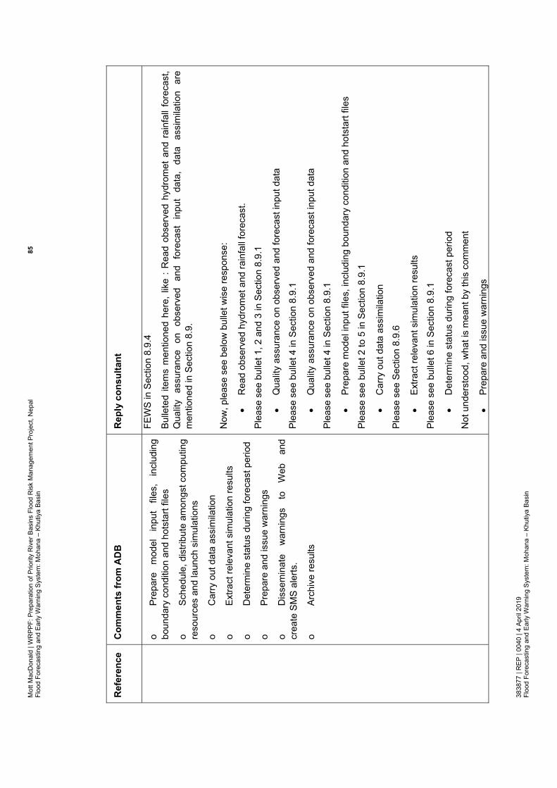
Mot
t Mac
Don
ald
| WR
PPF:
Pre
para
tion
of P
riorit
y R
iver
Bas
ins
Floo
d R
isk
Man
agem
ent P
roje
ct, N
epal
85
Floo
d Fo
reca
stin
g an
d Ea
rly W
arni
ng S
yste
m: M
ohan
a –
Khut
iya
Basi
n 38
3877
| R
EP |
0040
| 4
April
201
9 Fl
ood
Fore
cast
ing
and
Early
War
ning
Sys
tem
: Moh
ana
– Kh
utiy
a Ba
sin
Ref
eren
ce
Com
men
ts fr
om A
DB
R
eply
con
sulta
nt
o Pr
epar
e m
odel
in
put
files
, in
clud
ing
boun
dary
con
ditio
n an
d ho
tsta
rt fil
es
o Sc
hedu
le, d
istri
bute
am
ongs
t com
putin
g re
sour
ces
and
laun
ch s
imul
atio
ns
o C
arry
out
dat
a as
sim
ilatio
n
o Ex
tract
rele
vant
sim
ulat
ion
resu
lts
o D
eter
min
e st
atus
dur
ing
fore
cast
per
iod
o Pr
epar
e an
d is
sue
war
ning
s
o D
isse
min
ate
war
ning
s to
W
eb
and
crea
te S
MS
aler
ts.
o Ar
chiv
e re
sults
FEW
S in
Sec
tion
8.9.
4
Bulle
ted
item
s m
entio
ned
here
, lik
e : R
ead
obse
rved
hyd
rom
et a
nd r
ainf
all f
orec
ast,
Q
ualit
y as
sura
nce
on
obse
rved
an
d fo
reca
st
inpu
t da
ta,
data
as
sim
ilatio
n ar
e m
entio
ned
in S
ectio
n 8.
9.
Now
, ple
ase
see
belo
w b
ulle
t wis
e re
spon
se:
R
ead
obse
rved
hyd
rom
et a
nd ra
infa
ll fo
reca
st.
Plea
se s
ee b
ulle
t 1, 2
and
3 in
Sec
tion
8.9.
1
Q
ualit
y as
sura
nce
on o
bser
ved
and
fore
cast
inpu
t dat
a
Plea
se s
ee b
ulle
t 4 in
Sec
tion
8.9.
1
Q
ualit
y as
sura
nce
on o
bser
ved
and
fore
cast
inpu
t dat
a
Plea
se s
ee b
ulle
t 4 in
Sec
tion
8.9.
1
Pr
epar
e m
odel
inpu
t file
s, in
clud
ing
boun
dary
con
ditio
n an
d ho
tsta
rt fil
es
Plea
se s
ee b
ulle
t 2 to
5 in
Sec
tion
8.9.
1
C
arry
out
dat
a as
sim
ilatio
n
Plea
se s
ee S
ectio
n 8.
9.6
Ex
tract
rele
vant
sim
ulat
ion
resu
lts
Plea
se s
ee b
ulle
t 6 in
Sec
tion
8.9.
1
D
eter
min
e st
atus
dur
ing
fore
cast
per
iod
Not
und
erst
ood,
wha
t is
mea
nt b
y th
is c
omm
ent
Pr
epar
e an
d is
sue
war
ning
s

Mot
t Mac
Don
ald
| WR
PPF:
Pre
para
tion
of P
riorit
y R
iver
Bas
ins
Floo
d R
isk
Man
agem
ent P
roje
ct, N
epal
86
Floo
d Fo
reca
stin
g an
d Ea
rly W
arni
ng S
yste
m: M
ohan
a –
Khut
iya
Basi
n 38
3877
| R
EP |
0040
| 4
April
201
9 Fl
ood
Fore
cast
ing
and
Early
War
ning
Sys
tem
: Moh
ana
– Kh
utiy
a Ba
sin
Ref
eren
ce
Com
men
ts fr
om A
DB
R
eply
con
sulta
nt
Plea
se s
ee b
ulle
t 1 in
Sec
tion
8.9.
5
D
isse
min
ate
war
ning
s to
Web
and
cre
ate
SMS
aler
ts.
Plea
se s
ee b
ulle
t 1 in
Sec
tion
8.9.
5
13
Floo
d fo
reca
stin
g sy
stem
:
Out
line
the
diffe
renc
e be
twee
n an
ope
n so
urce
sof
twar
e w
hich
req
uire
s co
ding
the
se f
eatu
res,
and
a
prop
rieta
ry s
oftw
are
whi
ch in
clud
es m
ost o
f the
in
-bui
lt fu
nctio
nalit
y fo
r the
se fe
atur
es
We
have
now
men
tione
d th
e fu
nctio
nalit
y of
Del
ft-FE
WS
and
use
of t
he e
xist
ing
fore
cast
mod
el o
pera
tion
syst
em w
ithin
DH
M (
see
sect
ion
8.9.
3 an
d 8.
9.4)
14
Floo
d fo
reca
stin
g sy
stem
: Pr
ovid
e a
shor
t ov
ervi
ew o
f Del
ft FE
WS
and
the
fact
that
it c
an
inco
rpor
ate
man
y di
ffere
nt
hydr
olog
ical
an
d hy
drau
lic m
odel
s, in
clud
ing
HEC
and
MIK
E.
Prov
ided
, see
Sec
tion
8.9.
4
Also
pro
vide
d be
low
for r
eady
refe
renc
e
Del
ft-FE
WS
prov
ides
an
open
she
ll sy
stem
for
man
agin
g fo
reca
stin
g pr
oces
ses
and/
or
hand
ling
time
serie
s da
ta
(http
s://p
ublic
wik
i.del
tare
s.nl
/dis
play
/FEW
SDO
C/H
ome)
. Th
e fo
reca
stin
g sy
stem
was
es
sent
ially
bui
lt as
a s
hell
arou
nd th
e hy
drol
ogic
al a
nd h
ydra
ulic
mod
els
used
(Wer
ner
et a
l., 2
012)
. Th
e sy
stem
con
tain
s no
mod
ellin
g ca
pabi
litie
s (ra
infa
ll-ru
noff
and
hydr
odyn
amic
mod
ellin
g) w
ithin
its
code
bas
e. In
stea
d, it
ent
irely
rel
ies
on th
ird p
arty
m
odel
ling
com
pone
nts
for r
ainf
all-r
unof
f and
hyd
rody
nam
ic m
odel
ling.
The
stru
ctur
e of
th
e D
elft-
FEW
S in
clud
es a
dat
a st
orag
e la
yer,
a da
ta a
cces
s la
yer,
as w
ell a
s se
vera
l co
mpo
nent
s fo
r im
porti
ng, m
anip
ulat
ing,
vie
win
g an
d ex
porti
ng d
ata.
The
stru
ctur
e of
D
elft-
FEW
S is
sho
wn
in F
igur
e 16
.
Cur
rent
ly D
elft-
FEW
S is
use
d in
ove
r 40
cou
ntrie
s ov
er t
he w
orld
. D
elft-
FEW
S ca
n ei
ther
be
depl
oyed
in
a st
and-
alon
e, m
anua
lly d
riven
env
ironm
ent,
or i
n a
fully
au
tom
ated
dis
tribu
ted
clie
nt-s
erve
r env
ironm
ent.
DH
M, i
n th
eir e
xist
ing
FFEW
S, (e
.g.,
in K
osi
and
Bagm
ati
by h
ydro
logi
cal
and
hydr
aulic
mod
ellin
g, a
nd i
n Ka
rnal
i an
d N
aray
ani b
y pr
obab
ilistic
mod
ellin
g) u
ses
thei
r ow
n op
erat
iona
l sys
tem
(D
HM
, 201
8).
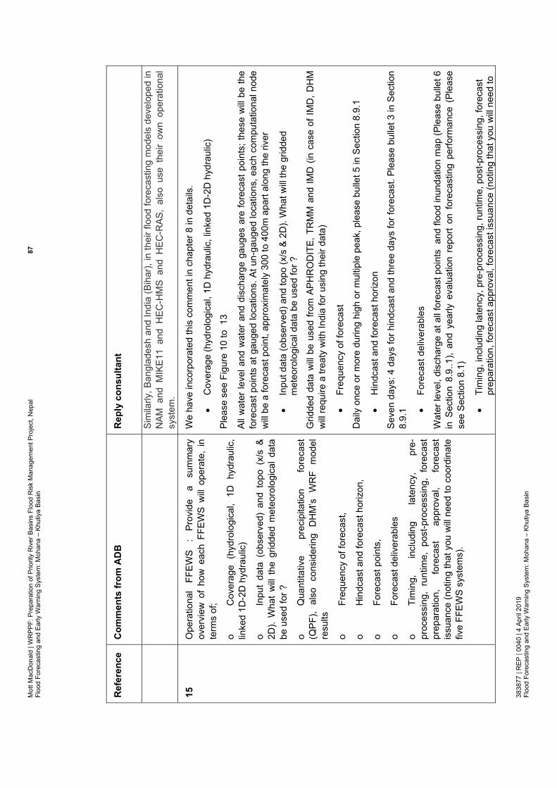
Mot
t Mac
Don
ald
| WR
PPF:
Pre
para
tion
of P
riorit
y R
iver
Bas
ins
Floo
d R
isk
Man
agem
ent P
roje
ct, N
epal
87
Floo
d Fo
reca
stin
g an
d Ea
rly W
arni
ng S
yste
m: M
ohan
a –
Khut
iya
Basi
n 38
3877
| R
EP |
0040
| 4
April
201
9 Fl
ood
Fore
cast
ing
and
Early
War
ning
Sys
tem
: Moh
ana
– Kh
utiy
a Ba
sin
Ref
eren
ce
Com
men
ts fr
om A
DB
R
eply
con
sulta
nt
Sim
ilarly
, Ban
glad
esh
and
Indi
a (B
ihar
), in
thei
r flo
od fo
reca
stin
g m
odel
s de
velo
ped
in
NAM
and
MIK
E11
and
HEC
-HM
S an
d H
EC-R
AS,
also
use
the
ir ow
n op
erat
iona
l sy
stem
.
15
Ope
ratio
nal
FFEW
S :
Prov
ide
a su
mm
ary
over
view
of
how
eac
h FF
EWS
will
oper
ate,
in
term
s of
;
o C
over
age
(hyd
rolo
gica
l, 1D
hyd
raul
ic,
linke
d 1D
-2D
hyd
raul
ic)
o In
put
data
(ob
serv
ed)
and
topo
(x/
s &
2D).
Wha
t w
ill th
e gr
idde
d m
eteo
rolo
gica
l dat
a be
use
d fo
r ?
o Q
uant
itativ
e pr
ecip
itatio
n fo
reca
st
(QPF
), al
so
cons
ider
ing
DH
M’s
W
RF
mod
el
resu
lts
o Fr
eque
ncy
of fo
reca
st,
o H
indc
ast a
nd fo
reca
st h
oriz
on,
o Fo
reca
st p
oint
s,
o Fo
reca
st d
eliv
erab
les
o Ti
min
g,
incl
udin
g la
tenc
y,
pre-
proc
essi
ng,
runt
ime,
pos
t-pro
cess
ing,
for
ecas
t pr
epar
atio
n,
fore
cast
ap
prov
al,
fore
cast
is
suan
ce (n
otin
g th
at y
ou w
ill ne
ed to
coo
rdin
ate
five
FFEW
S sy
stem
s).
We
have
inco
rpor
ated
this
com
men
t in
chap
ter 8
in d
etai
ls.
C
over
age
(hyd
rolo
gica
l, 1D
hyd
raul
ic, l
inke
d 1D
-2D
hyd
raul
ic)
Plea
se s
ee F
igur
e 10
to 1
3
All w
ater
leve
l and
wat
er a
nd d
isch
arge
gau
ges
are
fore
cast
poi
nts;
thes
e w
ill be
the
fore
cast
poi
nts
at g
auge
d lo
catio
ns. A
t un-
gaug
ed lo
catio
ns, e
ach
com
puta
tiona
l nod
e w
ill be
a fo
reca
st p
oint
, app
roxi
mat
ely
300
to 4
00m
apa
rt al
ong
the
river
In
put d
ata
(obs
erve
d) a
nd to
po (x
/s &
2D
). W
hat w
ill th
e gr
idde
d m
eteo
rolo
gica
l dat
a be
use
d fo
r ?
Grid
ded
data
will
be u
sed
from
APH
RO
DIT
E, T
RM
M a
nd IM
D (
in c
ase
of IM
D, D
HM
w
ill re
quire
a tr
eaty
with
Indi
a fo
r usi
ng th
eir d
ata)
Fr
eque
ncy
of fo
reca
st
Dai
ly o
nce
or m
ore
durin
g hi
gh o
r mul
tiple
pea
k, p
leas
e bu
llet 5
in S
ectio
n 8.
9.1
H
indc
ast a
nd fo
reca
st h
oriz
on
Seve
n da
ys: 4
day
s fo
r hin
dcas
t and
thre
e da
ys fo
r for
ecas
t. Pl
ease
bul
let 3
in S
ectio
n 8.
9.1
Fore
cast
del
iver
able
s
Wat
er le
vel,
disc
harg
e at
all
fore
cast
poi
nts
and
floo
d in
unda
tion
map
(Ple
ase
bulle
t 6
in S
ectio
n 8.
9..1
), an
d ye
arly
eva
luat
ion
repo
rt on
for
ecas
ting
perfo
rman
ce (
Plea
se
see
Sect
ion
8.1)
Ti
min
g, in
clud
ing
late
ncy,
pre
-pro
cess
ing,
runt
ime,
pos
t-pro
cess
ing,
fore
cast
pr
epar
atio
n, fo
reca
st a
ppro
val,
fore
cast
issu
ance
(not
ing
that
you
will
need
to

Mot
t Mac
Don
ald
| WR
PPF:
Pre
para
tion
of P
riorit
y R
iver
Bas
ins
Floo
d R
isk
Man
agem
ent P
roje
ct, N
epal
88
Floo
d Fo
reca
stin
g an
d Ea
rly W
arni
ng S
yste
m: M
ohan
a –
Khut
iya
Basi
n 38
3877
| R
EP |
0040
| 4
April
201
9 Fl
ood
Fore
cast
ing
and
Early
War
ning
Sys
tem
: Moh
ana
– Kh
utiy
a Ba
sin
Ref
eren
ce
Com
men
ts fr
om A
DB
R
eply
con
sulta
nt
co
ordi
nate
five
FFE
WS
syst
ems)
.
Thes
e ar
e co
vere
d be
twee
n bu
llet 1
to b
ulle
t 6 in
Sec
tion
8.9.
1 an
d al
so s
ee 8
.9.2
last
pa
ra
16
Cos
t of
m
odel
ling
softw
are
: Th
e co
st
of
mod
ellin
g so
ftwar
e is
list
ed a
s U
SD13
,000
per
ba
sin,
as
sum
ing
the
sam
e so
ftwar
e ca
n be
us
ed f
or t
he f
ive
basi
ns,
tota
ling
USD
65,0
00.
Wha
t abo
ut a
nnua
l mai
nten
ance
cos
ts?
Shou
ld
freew
are
softw
are
be u
sed
then
this
pric
e w
ould
be
ni
l, bu
t th
ere
may
be
ex
tens
ive
codi
ng
requ
irem
ents
. Th
e w
ay t
he c
ost
of m
odel
ling
softw
are
is
pres
ente
d do
es
not
refle
ct
this
. Be
caus
e of
thi
s, p
erha
ps it
sho
uld
be in
clud
ed
as a
sep
arat
e ite
m.
If H
EC-H
MS
and
HEC
-RAS
are
use
d, th
ey w
ill be
free
If M
IKE
is u
sed,
DH
M h
as a
lread
y ha
ve L
icen
ses;
the
y w
ill ne
ed s
ome
addi
tiona
l bu
dget
to
get
mul
tiple
Lic
ense
and
get
the
late
st r
elea
se o
f M
IKE
(rele
ase
2016
or
late
r if a
lread
y av
aila
ble)
In c
ase
of T
UFL
OW
, Flo
od M
odel
ler p
ro o
r Inf
owor
ks IC
M o
r SO
BEK,
the
softw
are
will
have
to
be p
urch
ased
, an
d th
us U
SD 6
5,00
0 ha
ve b
een
kept
; w
e ha
ve t
aken
thi
s pr
ice
from
the
WBM
hom
e pa
ge
17
Cos
ts:
The
exec
utiv
e su
mm
ary
shou
ld i
nclu
de
all c
ost
com
pone
nts,
ie t
opo
surv
ey,
hydr
omet
an
d ra
infa
ll pr
ocur
emen
t an
d O
&M,
mod
ellin
g so
ftwar
e pr
ocur
emen
t and
cod
ing
Incl
uded
in E
S, p
leas
e se
e Ta
ble
1 to
6
18
Res
pons
e tim
e :
Sect
ion
1 sh
ould
out
line
the
resp
onse
tim
es
(eg
time
of
conc
entra
tion,
la
gtim
e) a
t var
ious
loca
tions
in th
e ba
sin.
Thi
s is
im
porta
nt
to
appr
ecia
te
the
need
fo
r ra
pid
fore
cast
s.
Hav
e in
clud
ed it
with
refe
renc
e in
Sec
tion
1.5,
par
a 2.
19
Dat
a flo
w :
A d
iagr
am o
utlin
ing
the
data
flo
ws
(from
ob
serv
ed
to
harv
este
d by
FF
EWS
to
diss
emin
atio
n) w
ould
be
help
ful.
Prov
ided
, see
Fig
ure
14 a
nd s
uppo
rting
text
s in
Sec
tion
8.9.
2, b
ulle
t 1, 2
and
3
20
Wat
er-le
vel g
auge
: D
HM
will
take
ow
ners
hip
of
We
have
pro
pose
d th
ree
type
s of
gau
ges;
dep
endi
ng o
n th
e si
te c
ondi
tion
and
DH
M’s

Mot
t Mac
Don
ald
| WR
PPF:
Pre
para
tion
of P
riorit
y R
iver
Bas
ins
Floo
d R
isk
Man
agem
ent P
roje
ct, N
epal
89
Floo
d Fo
reca
stin
g an
d Ea
rly W
arni
ng S
yste
m: M
ohan
a –
Khut
iya
Basi
n 38
3877
| R
EP |
0040
| 4
April
201
9 Fl
ood
Fore
cast
ing
and
Early
War
ning
Sys
tem
: Moh
ana
– Kh
utiy
a Ba
sin
Ref
eren
ce
Com
men
ts fr
om A
DB
R
eply
con
sulta
nt
th
e ga
uges
. Li
aise
with
DH
M o
n w
hat
type
of
gaug
e th
ey w
ill ac
cept
, si
nce
they
mig
ht o
nly
wan
t do
wnw
ard-
look
ing
rada
r co
mpa
tible
to
th
eir r
ecen
tly in
stal
led
real
tim
e sy
stem
in m
any
basi
ns.
pref
eren
ce,
gaug
e ty
pe w
ill be
sel
ecte
d at
eac
h si
te.
The
thre
e ty
pes
of g
auge
co
nsid
erat
ion
is a
lso
base
d on
spe
cific
atio
ns g
iven
by
RTS
, th
e Ka
thm
andu
bas
ed
hydr
omet
equ
ipm
ent
prov
ider
. Bo
th A
DB
and
DH
M a
dvis
ed t
o co
ntac
t R
TS;
DH
M
how
ever
men
tione
d us
to ta
ke n
ote
that
RTS
is o
nly
thei
r ven
dor
21
O&
M c
osts
: O
utlin
e w
heth
er th
is is
per
yea
r or
over
a n
umbe
r of y
ears
(how
man
y?).
Hav
e m
ade
them
cle
ar in
eve
ry b
asin
rep
ort,
see
Tabl
e 1
to 6
and
als
o pl
ease
see
Fe
asib
ility
Rep
ort,
Cha
pter
6 a
nd A
ppen
dix
E
22
Num
ber
of h
ydro
met
gau
ges
: En
sure
rep
orts
in
dica
te
inte
rnal
ly-c
onsi
sten
t nu
mbe
rs
of
hydr
omet
gau
ges.
The
Moh
ana-
Khut
iya
repo
rt is
inco
nsis
tent
.
Hav
e co
rrect
ed t
hem
in
each
bas
in r
epor
t. So
rry t
hat
we
mad
e so
me
mis
take
s in
nu
mbe
rs, m
ainl
y du
e to
cop
y an
d pa
stin
g
23
Wat
er-le
vel
and
disc
harg
e bu
dget
:
mea
sure
men
t co
st
and
an
O&M
co
st
are
sepa
rate
, w
hat’s
th
e di
ffere
nce
betw
een
mea
sure
men
t and
ope
ratio
n ?
Hav
e cl
arifi
ed it
, Men
tione
d in
not
e (c
) in
Tabl
e 3
and
Tabl
e 16
.
24
Rea
l tim
e da
taba
se (
SCAD
A): I
nclu
de th
e ne
ed
to
deve
lop
a re
al
time
data
ba
se
syst
em
inte
grat
ed
to
DH
M’s
ex
istin
g da
taba
se.
Upd
atin
g an
d m
aint
enan
ce o
f th
e da
taba
se b
y D
HM
sho
uld
also
des
crib
ed
We
will
use
DH
M e
xist
ing
real
tim
e da
taba
se s
yste
m.
We
have
add
ed a
sec
tion
( see
sec
tion
8.9.
2) t
hat d
ata
from
new
tele
met
ric g
auge
s w
ill be
tra
nsm
itted
to
DH
M’s
ser
ver;
how
ever
, co
nsul
tant
for
thi
s pr
ojec
t w
ill do
the
ch
ecki
ng, a
naly
sis
and
qual
ity a
ssur
ance
for
thes
e ne
w g
auge
s; w
e ha
ve c
onsi
dere
d bu
dget
for t
his
25
Floo
d fo
reca
stin
g ap
proa
ches
: T
he t
abul
ated
flo
od f
orec
astin
g ap
proa
ches
(Ta
bles
12,
13,
14
, 15
& 1
6) a
re n
ot c
lear
. Pl
an/s
chem
atic
di
agra
ms
wou
ld m
ake
this
cle
arer
.
Plan
map
add
ed, p
leas
e se
e Fi
gure
s (m
aps)
10
to 1
3
26
Dis
sem
inat
ion
: pr
ovid
e a
sect
ion
on f
orec
ast
diss
emin
atio
n, ie
wha
t, w
hen,
how
, etc
Ad
ded,
ple
ase
see
Sect
ion
8.9,
bul
let 1
to 5
and
als
o Se
ctio
n 8.
9.5

Mot
t Mac
Don
ald
| WR
PPF:
Pre
para
tion
of P
riorit
y R
iver
Bas
ins
Floo
d R
isk
Man
agem
ent P
roje
ct, N
epal
90
Floo
d Fo
reca
stin
g an
d Ea
rly W
arni
ng S
yste
m: M
ohan
a –
Khut
iya
Basi
n 38
3877
| R
EP |
0040
| 4
April
201
9 Fl
ood
Fore
cast
ing
and
Early
War
ning
Sys
tem
: Moh
ana
– Kh
utiy
a Ba
sin
Ref
eren
ce
Com
men
ts fr
om A
DB
R
eply
con
sulta
nt
27
FFEW
S pr
ogra
mm
e : D
o no
t rep
lace
gau
ge-to
-ga
uge
fore
cast
ing,
kee
p it
as a
n al
tern
ativ
e (b
acku
p)
Com
plie
d; g
auge
to g
auge
cor
rela
tion
will
be m
aint
aine
d in
par
alle
l to
othe
r too
l
28
FFEW
S pr
ogra
mm
e : t
o Fi
gure
8 a
dd/c
larif
y;
o G
auge
inst
alla
tion
perio
d
o D
efin
e w
hat Q
1 to
Q8
are
o R
ainf
all-r
unof
f is
a st
anda
lone
act
ivity
o En
sure
cal
ibra
tion
data
are
ava
ilabl
e fo
r ca
libra
tion
activ
ity.
Ther
e m
ay
need
to
be
an
othe
r ca
libra
tion/
valid
atio
n ac
tivity
nea
r th
e en
d w
hen
mor
e da
ta is
ava
ilabl
e.
o En
sure
al
l fiv
e pr
ogra
mm
es
are
not
coin
cide
nt, t
here
sho
uld
be s
ome
stag
ger i
n th
e pr
ogra
mm
es
Cla
rifie
d,
Reg
ardi
ng m
odel
dev
elop
men
t for
five
bas
ins,
we
have
con
side
red
suffi
cien
t res
ourc
e in
put (
3 in
tern
atio
nal a
nd fi
ve n
atio
nal e
xper
ts. T
hus,
the
stag
gerin
g of
act
iviti
es w
ill re
mai
n up
to h
e co
nsul
tant
. The
aim
in th
e pr
ogra
mm
e th
at m
odel
for
each
bas
in w
ill go
in p
aral
lel a
nd s
houl
d be
cal
ibra
ted
and
valid
ated
for
all
thre
e ye
ars,
and
eac
h ba
sin
mod
el w
ill be
han
ded
over
to D
HM
at t
he e
nd o
f 36th
mon
th
29
FFEW
S m
aint
enan
ce
: pr
ogra
mm
e sh
ould
in
clud
e at
lea
st a
3-y
ear
mai
nten
ance
per
iod.
M
aybe
ev
en
a 5-
year
pe
riod
mai
nten
ance
pe
riod.
O
utlin
e w
hat
is
requ
ired
in
the
mai
nten
ance
per
iod;
o Pr
e-se
ason
set
up (2
wee
ks)
o Ea
rly s
easo
n as
sist
ance
(2 w
eeks
)
o O
n-ca
ll tro
uble
-sho
otin
g du
ring
flood
se
ason
o Po
st-s
easo
n re
view
(2 w
eeks
)
Dur
ing
the
perio
d of
dev
elop
men
t of
thi
s pr
ojec
t, w
hich
is t
hree
yea
rs,
ther
e w
ill be
op
erat
ion
and
mai
nten
ance
wor
k an
d co
nsul
tant
will
rem
ain
avai
labl
e fu
ll tim
e fo
r any
su
ppor
t inc
ludi
ng tr
oubl
e sh
ootin
g

Mot
t Mac
Don
ald
| WR
PPF:
Pre
para
tion
of P
riorit
y R
iver
Bas
ins
Floo
d R
isk
Man
agem
ent P
roje
ct, N
epal
91
Floo
d Fo
reca
stin
g an
d Ea
rly W
arni
ng S
yste
m: M
ohan
a –
Khut
iya
Basi
n 38
3877
| R
EP |
0040
| 4
April
201
9 Fl
ood
Fore
cast
ing
and
Early
War
ning
Sys
tem
: Moh
ana
– Kh
utiy
a Ba
sin
Ref
eren
ce
Com
men
ts fr
om A
DB
R
eply
con
sulta
nt
30
Coo
rdin
atio
n of
fiv
e FF
EWS
syst
ems
: ex
plai
n ho
w
the
over
all
syst
em
will
coor
dina
te
five
indi
vidu
al F
FEW
S sy
stem
s.
Thes
e ar
e fiv
e di
ffere
nt b
asin
s an
d fiv
e di
ffere
nt m
odel
s. In
our
sch
edul
e, a
ll fiv
e ba
sin
mod
el w
ill be
dev
elop
ed in
par
alle
l. W
e ha
ve in
clud
ed s
uffic
ient
and
logi
cal h
uman
re
sour
ce (i
nput
) for
this
(see
Sec
tion
8.13
).
For o
pera
tion
and
diss
emin
atio
n, a
s th
ese
will
be a
utom
ated
sys
tem
(exi
stin
g sy
stem
of
DH
M –
the
new
mod
els
will
be c
usto
mis
ed t
o th
e sy
stem
), th
e op
erat
ion
and
diss
emin
atio
n tim
e is
ver
y m
inim
al,
for
five
mod
els
(or
10 m
odel
s),
the
run
will
be
mad
e th
roug
h a
batc
h fil
e. F
or t
he f
irst
thre
e ye
ars,
all
inte
rnat
iona
l an
d na
tiona
l ex
perts
to
geth
er
with
DH
M
expe
rts
will
rem
ain
avai
labl
e. A
fter
3rd
year
, D
HM
co
ntin
ues.
The
y ha
ve s
peci
alis
ts w
ho w
ork
on s
hifts
(DH
M, 2
018)
31
CBR
DM
: Inc
lude
CBR
DM
act
iviti
es in
the
Wes
t R
apti
basi
n ,
as
this
as
pect
w
as
not
fully
co
vere
d in
th
e W
orld
Ba
nk
PPC
R
proj
ect.
CBR
DM
sho
uld
also
foc
us o
n th
e ro
le o
f lo
cal
mun
icip
aliti
es.
Incl
uded
. It i
s in
a s
epar
ate
repo
rt on
CBD
RM
for a
ll si
x ba
sins
32
Floo
d Sh
elte
rs:
Incl
ude
Floo
d Sh
elte
rs in
Wes
t R
apti
Basi
n.
Incl
uded
, ple
ase
see
CBD
RM
Rep
ort,
it is
a s
epar
ate
repo
rt
33
Evac
uatio
n ro
ute:
Inc
lude
the
nee
d to
pre
pare
ev
acua
tion
rout
es in
all
the
basi
ns b
ased
on
2D
mod
el re
sults
and
road
net
wor
k.
Incl
uded
, ple
ase
see
CBD
RM
Rep
ort;
it is
a s
epar
ate
repo
rt
34
Floo
d R
isk:
Inc
lude
the
pro
visi
on o
f flo
od r
isk
asso
ciat
ed w
ith a
n flo
od fo
reca
st e
vent
, so
that
co
mm
uniti
es
and
Gov
ernm
ent
agen
cies
ar
e aw
are
of th
e ris
ks.
Yes,
this
is in
-bui
lt de
liver
able
; flo
od r
isk
map
s w
ill be
issu
ed d
aily
, irr
espe
ctiv
e of
a
maj
or e
vent
or
regu
lar
flow
; Pl
ease
see
bul
let
6 in
Sec
tion
8.9.
1 w
here
we
have
m
entio
ned
flood
map
as
deliv
erab
le in
eac
h fo
reca
st ru
n

Mot
t Mac
Don
ald
| WR
PPF:
Pre
para
tion
of P
riorit
y R
iver
Bas
ins
Floo
d R
isk
Man
agem
ent P
roje
ct, N
epal
92
Floo
d Fo
reca
stin
g an
d Ea
rly W
arni
ng S
yste
m: M
ohan
a –
Khut
iya
Basi
n 38
3877
| R
EP |
0040
| 4
April
201
9 Fl
ood
Fore
cast
ing
and
Early
War
ning
Sys
tem
: Moh
ana
– Kh
utiy
a Ba
sin
Tabl
e B
.2: C
omm
ents
on
FFEW
S R
epor
ts fr
om W
RPPF
(Dat
e of
rece
ipt:
13/0
1/20
19)
Com
men
ts fr
om W
RPP
F w
ere
gene
ric fo
r the
repo
rts o
n fiv
e ba
sins
: Moh
ana-
Khut
iya,
Maw
a-R
atuw
a, L
akha
dei,
Bakr
aha
and
East
Rap
ti
Ref
eren
ce
Com
men
ts
from
: W
RPP
F;
Rec
eive
d on
: 13
/01/
2019
R
eply
con
sulta
nt
Bul
let 1
Th
e la
ngua
ge
of
the
repo
rt ne
eds
to
be
impr
oved
ed
ited
in
stan
dard
fo
rmat
as
te
xt
writ
ing
in a
dditi
on t
o gr
amm
atic
ally
cor
rect
. Al
l th
e te
xt is
to b
e th
orou
ghly
che
cked
.
We
have
gon
e th
roug
h th
e re
port
thor
ough
ly,
have
im
prov
ed t
exts
and
cor
rect
ed
gram
mat
ical
erro
r
Reg
ardi
ng s
tand
ard
form
at a
s te
xt w
ritin
g, t
he r
epor
t ha
s be
en w
ritte
n in
Mot
t M
acD
onal
d’s
stan
dard
tem
plat
e; s
o w
e ho
pe th
e fo
rmat
is a
lrigh
t
Bul
let 2
Ab
brev
iate
d w
ords
are
to b
e st
anda
rdis
ed
We
have
sta
ndar
dise
d ab
brev
iate
d w
ords

Mot
t Mac
Don
ald
| WR
PPF:
Pre
para
tion
of P
riorit
y R
iver
Bas
ins
Floo
d R
isk
Man
agem
ent P
roje
ct, N
epal
93
Floo
d Fo
reca
stin
g an
d Ea
rly W
arni
ng S
yste
m: M
ohan
a –
Khut
iya
Basi
n 38
3877
| R
EP |
0040
| 4
April
201
9 Fl
ood
Fore
cast
ing
and
Early
War
ning
Sys
tem
: Moh
ana
– Kh
utiy
a Ba
sin
Bul
let 3
Th
e re
ports
are
nic
e bu
t I
foun
d so
me
typi
ng
erro
rs a
nd s
ome
tech
nica
l iss
ues
like
inst
alla
tion
of l
ot o
f ra
in g
auge
inc
ludi
ng X
-ban
d ra
dar
inst
alla
tion
and
wat
er
leve
l se
nsor
st
atio
ns
sim
ilar
to t
hat
of U
K an
d Au
stra
lian
stan
dard
. Te
chni
cal
disc
ussi
ons
are
requ
ired
abou
t pr
opos
ed lo
catio
ns a
nd n
umbe
r of s
tatio
ns.
Mai
n is
sue
is s
usta
inab
ility
of t
he s
tatio
ns a
nd
syst
em fo
r ope
ratio
n an
d m
aint
enan
ce a
fter
the
proj
ect.
Prop
osed
wat
er l
evel
sen
sors
lik
e flo
atin
g in
st
illing
wel
l and
pre
ssur
e ai
r bub
ble
sens
ors
are
not o
pera
ble
in h
igh
sedi
men
t loa
d riv
er.
The
hydr
o-m
etric
st
atio
ns
may
ne
ed
spec
ial
stru
ctur
es li
ke fl
ood
pilla
r in
river
cha
nnel
hav
ing
high
fluc
tuat
ions
of w
ater
leve
ls a
nd c
hang
e of
riv
er c
hann
els
as w
ell.
The
deta
il de
sign
of
cabl
eway
is
not
incl
uded
Than
ks fo
r you
r app
reci
atio
n ab
out t
he re
port,
we
have
rem
oved
typi
ng e
rrors
.
Num
ber
of g
roun
d ba
sed
rain
gau
ge s
tatio
ns h
ave
been
dec
ided
bas
ed o
n re
sear
ch
reco
mm
enda
tions
and
bas
ed o
n pr
actic
e, e
.g.,
in E
urop
e (p
leas
e se
e Se
ctio
n 2.
2 of
th
e re
port
for r
efer
ence
). Ke
epin
g in
min
d th
e fu
ture
mai
nten
ance
, the
tota
l num
ber o
f st
atio
ns h
ave
been
cho
sen
on th
e hi
gher
end
of t
he re
com
men
ded
spat
ial d
istri
butio
n.
For f
lood
fore
cast
ing
purp
ose,
one
sta
tion
with
in 1
0 to
100
km
2 is re
com
men
ded.
Our
pr
opos
ed d
istri
butio
n is
one
in
arou
nd 1
00 k
m2 .
The
area
is
even
hig
her
per
one
gaug
e in
big
ger
basi
n lik
e Ea
st a
nd W
est
Rap
ti. B
ased
on
the
perfo
rman
ce o
f th
e FF
EWS
mod
els,
whi
ch w
ill be
dev
elop
ed in
this
stu
dy, w
e ho
pe th
at D
HM
, in
futu
re,
can
add
few
mor
e st
atio
ns b
ringi
ng th
e st
atio
n de
nsity
like
in th
e U
K.
We
have
app
rised
the
num
bers
of g
auge
s an
d th
eir l
ocat
ions
to D
HM
thro
ugh
seve
ral
mee
tings
; w
e al
so
sent
th
ese
docu
men
ts
(Cha
pter
5
and
6)
to
DH
M;
they
re
com
men
ded
to d
ecid
e on
the
num
bers
bas
ed o
n hy
dro-
met
eoro
logi
cal c
limat
e in
N
epal
, w
hich
we
have
com
plie
d th
roug
h lit
erat
ure
and
rese
arch
rev
iew
s. F
urth
er t
o th
is,
we
also
pub
lishe
d tw
o ba
sins
rep
orts
(FS
Rep
ort)
for
M-K
and
M-R
bas
ins
in
adva
nce
in J
uly
2018
sho
win
g th
is s
patia
l dis
tribu
tion
of r
ain
gaug
es,
and
rece
ived
fe
edba
cks
from
AD
B an
d D
OI
and
impl
emen
ted
thos
e in
fin
alis
ing
rain
gau
ge
num
bers
in a
ll si
x ba
sins
.
Reg
ardi
ng X
-Rad
ar r
ain
gaug
e, w
e ha
ve n
ow d
ropp
ed t
his
item
fol
low
ing
ADB;
s ad
vice
(see
AD
B’s
com
men
t 3 in
Tab
le B
.1)
As o
f the
pro
pose
d ne
w s
tatio
ns a
re a
utom
ated
tele
met
ric s
tatio
ns, t
hey
have
min
imal
op
erat
ion
cost
. Th
e m
aint
enan
ce c
ost
is a
lso
min
imal
, w
hich
we
belie
ve N
epal
G
over
nmen
t/DH
M w
ill co
ntin
ue fr
om th
eir a
nnua
l bud
get a
fter t
his
proj
ect i
s co
mpl
eted
We
have
pro
pose
d th
ree
type
s: s
enso
r in
stil
ling
wel
l, ai
r bu
bble
s se
nsor
s an
d ra
dar
sens
or;
deep
enin
g on
site
con
ditio
n an
d D
HM
’s p
refe
renc
e, t
he g
auge
typ
e w
ill be
se
lect
ed d
urin
g pr
ocur
emen
t and
inst
alla
tion.
The
budg
et in
clud
es a
ll in
frast
ruct
ures
for i
nsta
llatio
n of
a g
auge
, rai
n ga
uge
or w
ater
le
vel g
auge
. We
have
men
tione
d th
is in
the
repo
rt (p
leas
e se
e Se
ctio
n 5.
5, p
ara
1) a
s fo
llow
s: th
e bu
dget
incl
udes
pro
cure
men
t, in
stal
latio
n, te
stin
g, c
alib
ratio
n, m
onito
ring,
an
d op
erat
ion
and
mai
nten
ance
for 3
yea
rs

Mot
t Mac
Don
ald
| WR
PPF:
Pre
para
tion
of P
riorit
y R
iver
Bas
ins
Floo
d R
isk
Man
agem
ent P
roje
ct, N
epal
94
Floo
d Fo
reca
stin
g an
d Ea
rly W
arni
ng S
yste
m: M
ohan
a –
Khut
iya
Basi
n 38
3877
| R
EP |
0040
| 4
April
201
9 Fl
ood
Fore
cast
ing
and
Early
War
ning
Sys
tem
: Moh
ana
– Kh
utiy
a Ba
sin
4 R
egar
ding
hy
drol
ogic
al
mod
ellin
g an
d flo
od
early
w
arni
ng
syst
em
deve
lopm
ent,
list
of
mod
els
are
prov
ided
bu
t no
t re
com
men
ded
final
ly a
lthou
gh t
hey
have
est
imat
ed c
ost
for
softw
are
purc
hase
. The
dev
elop
men
t cos
t of t
he
hydr
olog
ic a
nd h
ydra
ulic
mod
el s
hall
redu
ce
sign
ifica
ntly
onc
e it
is b
uilt
for
a ba
sin
and
just
re
plic
ate
with
oth
er w
ith s
mal
l ch
ange
s ba
sed
on d
ata
avai
labi
lity.
The
cost
of
land
acq
uisi
tion
and
fenc
ing
and
civi
l wor
ks e
tc. n
ot m
entio
ned.
Cha
pter
8, i
n Ta
ble
19 to
23,
spe
cific
reac
h-w
ise
mod
els
have
bee
n pr
opos
ed..
Mod
ellin
g co
st:
The
hydr
olog
ical
and
hyd
raul
ic m
odel
s fo
r ea
ch b
asin
are
sep
arat
e m
odel
; i.e
., se
para
te m
odel
set
-up
prep
arat
ion,
sep
arat
e ca
libra
tion
and
valid
atio
n; th
us, t
he c
ost
is a
lmos
t si
mila
r am
ong
the
basi
ns;
how
ever
, as
exp
ert
will
beco
me
expe
rienc
ed
thro
ugh
wor
k in
one
bas
in, t
he c
ost w
ill sl
ight
ly r
educ
e in
oth
er b
asin
s, a
nd w
e ha
ve
cons
ider
ed th
is fa
ctor
, ple
ase
see
text
s ex
plai
ning
this
in S
ectio
n 8.
13
All c
ivil
wor
ks a
nd fe
ncin
g ar
e in
clus
ive
in th
e co
st; p
leas
e se
e Se
ctio
n 5.
5, p
ara
1. W
e as
sum
e th
at a
ll ra
in g
auge
s w
ill be
ins
talle
d at
Gov
ernm
ent/P
ublic
pre
mis
es,
e.g.
, D
HM
O
ffice
pr
emis
e,
DW
IDM
of
fice
prem
ise,
Lo
cal
mun
icip
ality
pr
emis
e,
Adm
inis
tratio
n O
ffice
pre
mis
es, G
ram
Pan
chay
at e
tc.

Mott MacDonald | WRPPF: Preparation of Priority River Basins Flood Risk Management Project, Nepal 1Flood Forecasting and Early Warning System: Mohana – Khutiya Basin
383877 | REP | 0040 | 4 April 2019 Flood Forecasting and Early Warning System: Mohana – Khutiya Basin
mottmac.com


![mohana uravu[1]](https://img.pdfslide.us/doc/110x75/577d296b1a28ab4e1ea6ba92/mohana-uravu1.jpg)