Embed Size (px)
Citation preview
18th ICCRTS
“Collective C2 in Multinational Civil-Military
Operations”
Distributed Simulation with Automated Planning:
Study and Support Tool for Relief Operations in
Conflicted C2 Scenarios
Topic(s): 1 - Modeling and Simulation
2 - Military and Civil-Military Operations
3 - Collaboration, Shared Awareness, and
Decision Making
Henrique Costa Marques
Daniel Ferreira Manso
José M. Parente de Oliveira
Instituto Tecnológico de Aeronáutica
Praça Mal. Eduardo Gomes, 50 – Vila das Acácias
São José dos Campos SP 12.228-900 – BRAZIL
[hmarques, parente, dnl]@ita.br
Point of Contact
Henrique Costa Marques
Instituto Tecnológico de Aeronáutica
Praça Marechal Eduardo Gomes, 50 – Vila das Acácias – São José dos Campos SP -
ZIP:12.228-900 - BRAZIL
+55 12 3947-6855
Report Documentation Page Form ApprovedOMB No. 0704-0188
Public reporting burden for the collection of information is estimated to average 1 hour per response, including the time for reviewing instructions, searching existing data sources, gathering andmaintaining the data needed, and completing and reviewing the collection of information. Send comments regarding this burden estimate or any other aspect of this collection of information,including suggestions for reducing this burden, to Washington Headquarters Services, Directorate for Information Operations and Reports, 1215 Jefferson Davis Highway, Suite 1204, ArlingtonVA 22202-4302. Respondents should be aware that notwithstanding any other provision of law, no person shall be subject to a penalty for failing to comply with a collection of information if itdoes not display a currently valid OMB control number.
1. REPORT DATE JUN 2013 2. REPORT TYPE
3. DATES COVERED 00-00-2013 to 00-00-2013
4. TITLE AND SUBTITLE Distributed Simulation with Automated Planning: Study and SupportTool for Relief Operations in Conflicted C2 Scenarios
5a. CONTRACT NUMBER
5b. GRANT NUMBER
5c. PROGRAM ELEMENT NUMBER
6. AUTHOR(S) 5d. PROJECT NUMBER
5e. TASK NUMBER
5f. WORK UNIT NUMBER
7. PERFORMING ORGANIZATION NAME(S) AND ADDRESS(ES) Technological Institute of Aeronautics,Praca Mal. Eduardo Gomes, 50 ?Vila das Acacias,Sao Jose dos Campos SP 12.228-900 ? Brazil,
8. PERFORMING ORGANIZATIONREPORT NUMBER
9. SPONSORING/MONITORING AGENCY NAME(S) AND ADDRESS(ES) 10. SPONSOR/MONITOR’S ACRONYM(S)
11. SPONSOR/MONITOR’S REPORT NUMBER(S)
12. DISTRIBUTION/AVAILABILITY STATEMENT Approved for public release; distribution unlimited
13. SUPPLEMENTARY NOTES Presented at the 18th International Command & Control Research & Technology Symposium (ICCRTS)held 19-21 June, 2013 in Alexandria, VA. U.S. Government or Federal Rights License
14. ABSTRACT Every year, floods and droughts affect thousands of people that directly or indirectly are dependent onpublic initiatives. However, governments have been shown to be partially or totally incapable of properlyreacting to these disasters. Highlighted among the many reasons for this is the lack of effective planningand situation awareness in scenarios where different support teams are working at the same area withoutcoordination. In this context, simulations may be utilized to increase the planners? understanding of agiven situation and provide a way to avoid the common mistakes that occur during resource allocation insuch situations. The present work is being conducted to establish a distributed simulation environment,with 3D visualization, to support resource allocation planning and to increase the situation awareness. Thisapproach may help managers, planners and operational people understand the scenario evolution whileincreasing the command maturity in such complex endeavor.
15. SUBJECT TERMS
16. SECURITY CLASSIFICATION OF: 17. LIMITATION OF ABSTRACT Same as
Report (SAR)
18. NUMBEROF PAGES
51
19a. NAME OFRESPONSIBLE PERSON
a. REPORT unclassified
b. ABSTRACT unclassified
c. THIS PAGE unclassified
Standard Form 298 (Rev. 8-98) Prescribed by ANSI Std Z39-18
18th ICCRTS - Collective C2 in Multinational Civil-Military Operations
1
Distributed Simulation with Automated Planning:
Study and Support Tool for Relief Operations in
Conflicted C2 Scenarios
Henrique Costa Marques
Daniel Ferreira Manso
José M. Parente de Oliveira Instituto Tecnológico de Aeronáutica
Praça Mal. Eduardo Gomes, 50 – Vila das Acácias
São José dos Campos SP 12.228-900 – BRAZIL [hmarques, parente, dnl]@ita.br
Abstract
Every year, floods and droughts affect thousands of people that directly or
indirectly are dependent on public initiatives. However, governments have been shown
to be partially or totally incapable of properly reacting to these disasters. Highlighted
among the many reasons for this is the lack of effective planning and situation
awareness in scenarios where different support teams are working at the same area
without coordination. In this context, simulations may be utilized to increase the
planners’ understanding of a given situation and provide a way to avoid the common
mistakes that occur during resource allocation in such situations. The present work is
being conducted to establish a distributed simulation environment, with 3D
visualization, to support resource allocation planning and to increase the situation
awareness. This approach may help managers, planners and operational people
understand the scenario evolution while increasing the command maturity in such
complex endeavor.
Introduction
Relevant portions of the Brazilian population are often hit by natural disasters.
Over the past 10 years, it is estimated that eight million people were affected by floods
and droughts across the country [EM-DAT, 2013]. For instance, one may emphasize the
rains in Santa Catarina [SANTA CATARINA, 2009], the flooding in Cubatão, São
18th ICCRTS - Collective C2 in Multinational Civil-Military Operations
2
Paulo [G1 SANTOS, 2013], and the mudslides in the mountainous region of Rio de
Janeiro [BBC, 2011].
In this context, different disasters have been exposing various gaps in the
National Civil Defense System [SINDEC, 2009a, 2009b; BRAZIL, 2010a, 2010b,
2012] and various deficiencies on the responsiveness of municipalities and States.
Among them is the lack of an effective command structure in response to natural
disasters results in a situation in which different organizations take individual actions
without exchanging information or sharing resources. As an outcome, we have
redundant resource allocation, inefficiency, and difficulty to support the needs of the
community in those circumstances.
As an effort to assuage the aforementioned shortcomings, the Federal
Government usually engages the Army, Navy and Air Force in order to assist the Civil
Defense Authority, State Military Fire and Police in the operation coordination, or even
to have full control in the most serious cases, also providing logistical support
[AEROVISÃO, 2009; AGÊNCIA FORÇA AÉREA, 2010].
However, according to the NATO NEC C2 Maturity Model [NATO, 2009],
what prevails, due to the lack of an effective structure of command, is a Conflicted C2
(Command and Control) maturity level of command. At this level, there is no awareness
of each other’s actions, and the restricted resources become less effective and are
allocated with low efficiency.
Nevertheless, to increase the command maturity level it is imperative to have the
ability of partitioning the operational space, avoiding adverse cross-impacts between
the organizations or, even better, having a collaborative planning process with some
coordination among the participants.
Taking into consideration that sharing the common intent is a key element in
mature command and control systems, this research devises a distributed simulation
environment to support the planning phase and after action review (AAR) of conflicted
C2 scenarios during relief operations.
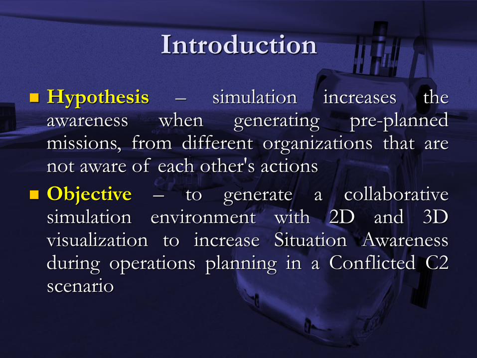
The hypothesis to be validated is the expectation of increasing the awareness,
when generating pre-planned missions, of different organizations that are not aware of

18th ICCRTS - Collective C2 in Multinational Civil-Military Operations
3
each other's actions, through the use of simulation. By generating a collaborative
solution with 2D and 3D visualizations, integrating the different perspectives of each
organization’s plan into a fused view, it is possible to have and share the big picture as a
common operational picture.
The expected result is to increase the organizations’ ability to share resources
and to improve their synergy, allowing them to better manage their available resources
in Conflicted C2 operations. Additionally, the simulation is expected to provide a
valuable tool for an effective after action review, which may provide a clear picture of
the past operation to the planners.
Lastly, we consider it reasonable to emphasize that this research is in progress,
and its first step is to generate the simulation environment, which is the main focus of
the present paper.
In order to contextualize the reader, the paper is structured as follows. The first
section highlights some of the related work under the perspective of Operations
Research and Management Science (OR/MS) and Humanitarian Assistance and Disaster
Relief (HA/DR). Section 2 describes the framework being developed to increase
awareness during planning. Section 3 presents a case study developed and based on a
real case, in the State of Santa Catarina – Brazil, in 2008, and Section 4 concludes the
work with considerations and final remarks.
1 Related Work
Operations Research and Management Science (OR/MS), Humanitarian
Assistance and Disaster Relief (HA/DR) and C2 may be analyzed as somewhat similar
research areas in terms of management focus, decision making process and logistical
and operational environments. Therefore, some of the OR/MS and HA/DR papers that
specifically focus the Disaster Operations Management (DOM) may be highlighted as
related work.
[ALTAY and GREEN, 2006; SIMPSON and HANCOCK, 2009; and
GALINDO and BATTA, 2013] have worked to provide a relevant review of significant

18th ICCRTS - Collective C2 in Multinational Civil-Military Operations
4
research on Disaster Operations Management (DOM). Hereupon, it is possible to
identify several different approaches through the analysis of the three mentioned works.
For instance, we find works investigating management of evacuations
[ABDELGAWAD and ABDULHAI, 2010; CHEN and CHOU, 2009; CHEN and
ZHAN, 2008; CHILDERS, VISAGAMURTHY and TAAFFE, 2009; CHIU and
MIRCHANDANI, 2008], disaster management [COPPOLA, 2011; IFRC, 2010;
LETTIERI, MASELLA and RADAELLI, 2009], logistics [CHANG, TSENG and
CHEN, 2007; NAGURNEY, YU and QIANG, 2011], decision making and decision
support systems [BARKER and HAIMES, 2009; CHIU and ZHENG, 2007;
SNEDIKER, MURRAY and MATISZIW, 2008].
However, even though OR/MS and HA/DR are academically connected by
DOM as a common field of study, few articles related to Command and Control and
Distributed Simulation could be found in the aforementioned domain [ALTAY and
GREEN, 2006; SIMPSON and HANCOCK, 2009; GALINDO and BATTA, 2013].
This omission, therefore, generates a clear gap in the capacity of non-military agencies
for managing HA/DR operations.
Therefore, looking towards a supporting tool which enables the analysis of
Conflicted C2 scenarios and provides motivation to rescue team managers, the research
is working on a proposed framework that is able to generate HA/DR scenarios.
2 Framework to Study Conflicted C2 Scenarios
Considering the dynamic nature of C2 operations, we decided to make use of
simulation tools to support 2D and 3D visualization of the scenario evolution, during
and after relief operations, in a fused view. This is expected to allow an enhancement of
the situational awareness of several organizations involved in the planned missions and
an effective after action review.
Thereby, considering simulation as a tool to help phenomena understanding, we
started to look at available tools that may support the proposed framework by modeling
the aspects of interest.

18th ICCRTS - Collective C2 in Multinational Civil-Military Operations
5
2.1 Distributed Simulation
Many COTS tools are available to develop the devised framework. However,
due to an existing agreement with VT MÄK [VT-MÄK, 2012] in the collaborative
testbed between the C4I Center, at George Mason University (GMU-USA), and the C2
Lab, at Instituto Tecnológico de Aeronáutica (ITA-Brazil), the chosen tool was the VR-
Forces® [VT-MÄK, 2012] simulation tool.
VR-Forces® provides tools for C2 scenario generation and visualization in air,
land and maritime environments, giving us the necessary flexibility to model different
situations. The distributed aspect of the architecture provides the ability to exchange
multiple plans as a set of simulation logs or individual scenario files to be merged,
allowing different sites to visualize, in the same federation, plans from different
organizations, within a common terrain database.
Such a feature increases the awareness of potential conflicts between plans and
also the perception of when the organizations can collaborate with another one by
sharing its resources for different tasks. It is then possible that one organization takes
the responsibility to support the other’s mission due to its resource’s capability.
Finally, as we are building each federate as an organization’s plan, by means of
distributed simulation protocols, it is possible to display all plans together and to
identify the mutual interference during the federation execution.
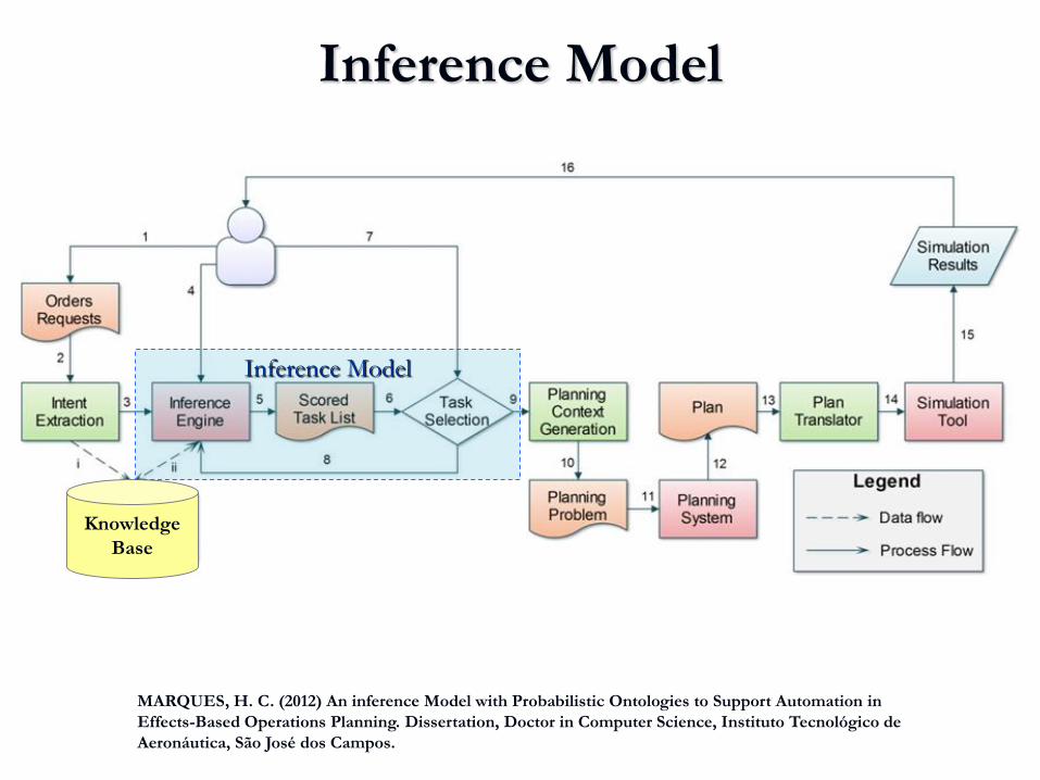
2.2 Inference Model to Support Planning
The proposed approach is a way to give us an answer about how uncoordinated
actions may affect the organizations´ ability to achieve the overall goals during the
relief operation, and what can be done to enhance synergy and efficiency.
Therefore, if we would like to support a future coordination team we should
have methodologies to improve the planning process. Since the coordination between
18th ICCRTS - Collective C2 in Multinational Civil-Military Operations
6
many different organizations is an overwhelming activity, it is essential to recognize
and consider the way each organization behaves during such circumstances.
Considering the difficulty of generating different plans, based on the diversity of
an organization’s operational procedure, the framework uses a semantic approach based
on ontologies.
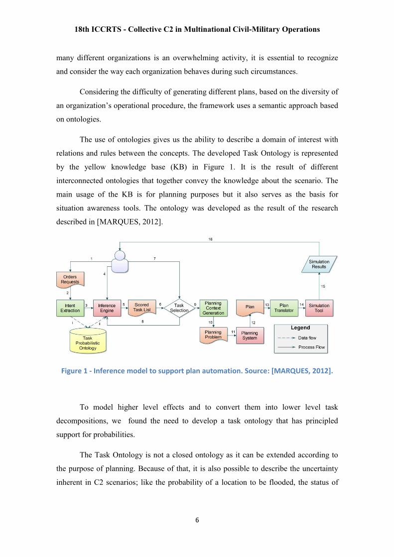
The use of ontologies gives us the ability to describe a domain of interest with
relations and rules between the concepts. The developed Task Ontology is represented
by the yellow knowledge base (KB) in Figure 1. It is the result of different
interconnected ontologies that together convey the knowledge about the scenario. The
main usage of the KB is for planning purposes but it also serves as the basis for
situation awareness tools. The ontology was developed as the result of the research
described in [MARQUES, 2012].
Figure 1 - Inference model to support plan automation. Source: [MARQUES, 2012].
To model higher level effects and to convert them into lower level task
decompositions, we found the need to develop a task ontology that has principled
support for probabilities.
The Task Ontology is not a closed ontology as it can be extended according to
the purpose of planning. Because of that, it is also possible to describe the uncertainty
inherent in C2 scenarios; like the probability of a location to be flooded, the status of

18th ICCRTS - Collective C2 in Multinational Civil-Military Operations
7
people to be rescued, the weather condition in the near future and the availability of
each resource based on each domain (air, land and fluvial).
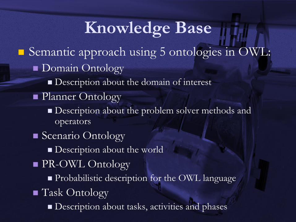
2.2.1 Ontology Description
The overall ontology has the SHOIQ(D) expressivity and is composed of five
sub-ontologies: Domain Ontology, Planner Ontology, Scenario Ontology, PR-OWL
Ontology and the Task Ontology. They are written in OWL with the PR-OWL
extension [COSTA, 2005] and the connections between sub-ontologies are formally
described.
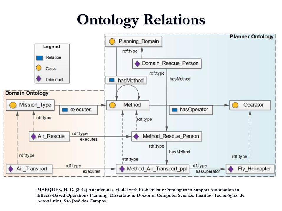
In order to identify the missions that are capable of producing an effect, we have
modeled relations in the ontology as depicted in Figure 2. Such relations are
deterministic and support inferences such as determining which type of mission we can
task in order to achieve the desired effect. However, we are not able to infer through the
deterministic description, how likely we are to achieve the desired effect when that task
is executed.
Figure 2 – Relations between concepts from the Domain and Planner ontologies. Source: [MARQUES, 2012].
Figure 2 also shows the relations between the Domain Ontology and the Planner
Ontology. The type Air_Rescue mission is being related by the Executes relation with
the method Method_Rescue_Person. Such a connection describes the method to be used
during the planning part of the methodology.

18th ICCRTS - Collective C2 in Multinational Civil-Military Operations
8
The uncertainty has to be described through the probabilistic part of the
ontology, based on PR-OWL descriptions of the random variables. For brevity, we will
not give more detailed explanation of the probabilistic description in the ontology, but it
can be found in the work of [MARQUES, 2012]. In short, it is used for the description
of the uncertainty present in the scenario of interest. By describing the possible states of
random variables that express the belief of a given concept, we are able to query the
knowledge base about a specific situation.
2.2.2 Inference Process Description
Given a set of orders, or requests, and through a set of queries on the Task
Ontology the output is a set of tasks that have an associated probability of success to
achieve the desired effect. After choosing among the possible tasks, if one, or more than
one, can be found during the available timeframe, the set is sent to a planning system
that will be responsible to find a plan, if one can be found.
The inference process is responsible for generating the task list. After the task
selection, each organization’s plan is generated. Each plan is then translated into the
simulator syntax and executed as a federate into the distributed simulation environment.
It is interesting to highlight that the most important ontologies of the Knowledge
Base are the Domain Ontology, Task Ontology and the PR-OWL Ontology. The KB
can only provide its outputs if the scenario is completely described. Because of that, the
main work is to establish the KB in such a way that we are able to determine the
resource allocation and based on each organization’s criteria and doctrine.
The implementation of the inference module supporting the resource allocation
is based on two different reasoning procedures. The first one is based on the
deterministic part of the ontology that will map the requests and determine the possible
resources that are capable to support the tasks for each request. The second one is based
on the probabilistic part of the ontology that will receive each possible resource
allocation and will take into account the uncertainty present in the scenario.
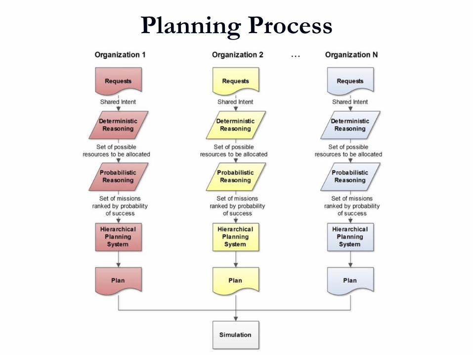
Figure - 3 shows the information flow during planning, as carried out by the
component Planning System in Figure 1, based on the reasoning process’ output. In the
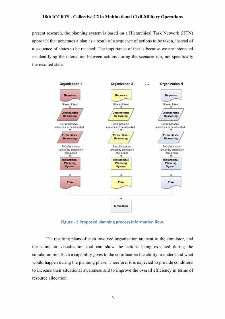
18th ICCRTS - Collective C2 in Multinational Civil-Military Operations
9
present research, the planning system is based on a Hierarchical Task Network (HTN)
approach that generates a plan as a result of a sequence of actions to be taken, instead of
a sequence of states to be reached. The importance of that is because we are interested
in identifying the interaction between actions during the scenario run, not specifically
the resulted state.
Figure - 3 Proposed planning process information flow.
The resulting plans of each involved organization are sent to the simulator, and
the simulator visualization tool can show the actions being executed during the
simulation run. Such a capability gives to the coordinators the ability to understand what
would happen during the planning phase. Therefore, it is expected to provide conditions
to increase their situational awareness and to improve the overall efficiency in terms of
resource allocation.
18th ICCRTS - Collective C2 in Multinational Civil-Military Operations
10
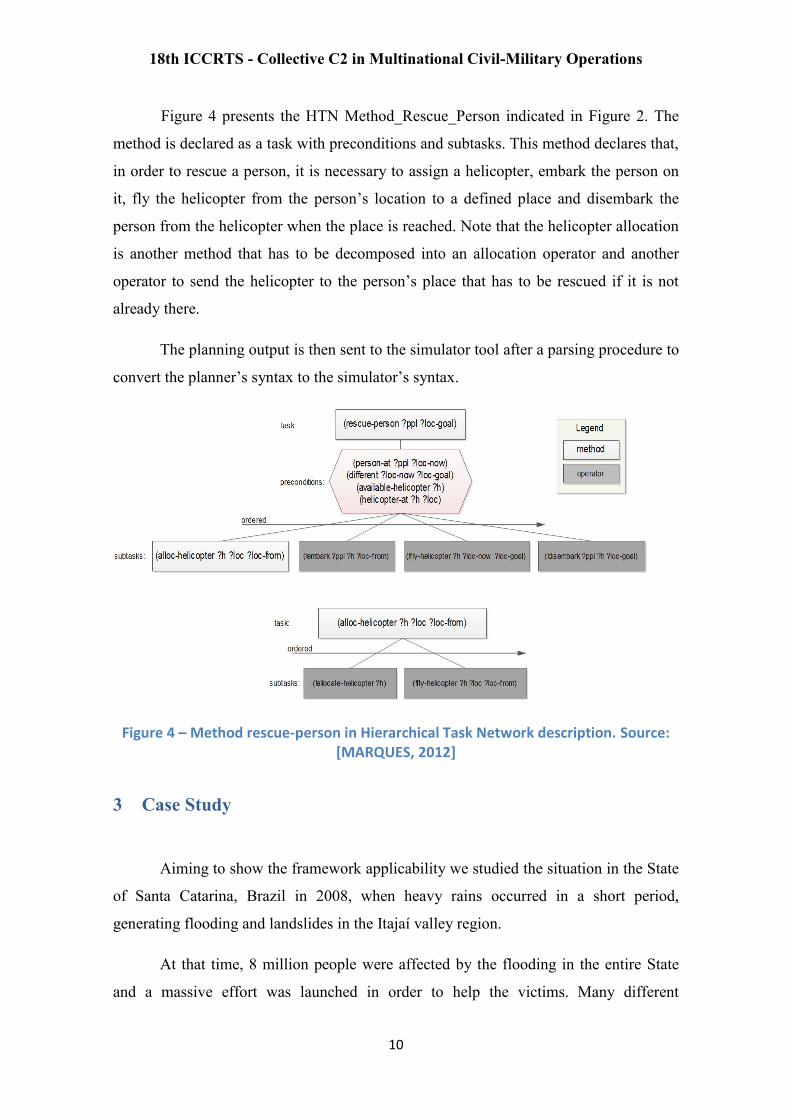
Figure 4 presents the HTN Method_Rescue_Person indicated in Figure 2. The
method is declared as a task with preconditions and subtasks. This method declares that,
in order to rescue a person, it is necessary to assign a helicopter, embark the person on
it, fly the helicopter from the person’s location to a defined place and disembark the
person from the helicopter when the place is reached. Note that the helicopter allocation
is another method that has to be decomposed into an allocation operator and another
operator to send the helicopter to the person’s place that has to be rescued if it is not
already there.
The planning output is then sent to the simulator tool after a parsing procedure to
convert the planner’s syntax to the simulator’s syntax.
Figure 4 – Method rescue-person in Hierarchical Task Network description. Source: [MARQUES, 2012]
3 Case Study
Aiming to show the framework applicability we studied the situation in the State
of Santa Catarina, Brazil in 2008, when heavy rains occurred in a short period,
generating flooding and landslides in the Itajaí valley region.
At that time, 8 million people were affected by the flooding in the entire State
and a massive effort was launched in order to help the victims. Many different
18th ICCRTS - Collective C2 in Multinational Civil-Military Operations
11
organizations and about twelve thousand collaborators were engaged in the relief
operation.
However, because of the sudden devastation caused by the Itajaí River flooding,
which was at about 10 meters above its normal level, the local residents could not flee
in time, increasing the panic and the need to provide transportation by any available
means [SANTA CATARINA, 2009].
For study purposes, the considered scenario will start with a flood of 2 meters,
causing a small impact on the local population. As a consequence, only small groups
will need to be evacuated. In terms of simulation's parameters, only people and
available resources are able to perform actions and to move through the scenario. The
terrain was modeled with few buildings to enhance the simulation performance and to
facilitate the planners’ comprehension.
The simulation is being tuned to be used in a Brazilian Conflicted C2 operation,
where State Military Police has helicopters for search and rescue (SAR) and vehicles for
security patrols, State Military Fire Department has vehicles and boats for SAR, Civil
Defense Authority virtually has no assets and Armed Forces may have all of the
previously mentioned resources.
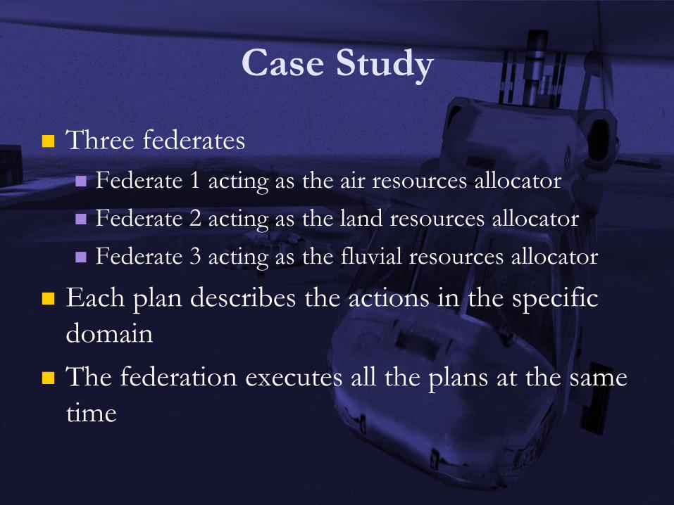
We have divided the resource allocation into three main domains: air, ground
and fluvial. Each federate represents a resource being allocated regarding a domain (e.g.
air resource corresponds to air federation). By doing this, we have a simulation
federation with three federates that describe the plans executed in a specific period of
the relief operation.
Figures 5, 6 and 7 show three views, each one about a distinct federate before
entering the federation. All federates use the same terrain of Itajaí Valley in the specific
period of the scenario evaluation in order to avoid correlation problems.
Figure 5 shows the air domain plan, with many different places to be visited in
order to rescue and to transport people. The blue helicopters’ avatars show the location
of each helicopter. The green avatars show people on the places to be visited by the
helicopters. Red lines are the air corridors to be used during flight, avoiding mid-air

18th ICCRTS - Collective C2 in Multinational Civil-Military Operations
12
collisions when executing the missions. The corridors are useful because such scenario
also models low visibility conditions caused by rain.
Figure 5 – Federate showing the air domain with the air resources allocated to the rescue and transportation missions.
Figure 6 provides the ground domain plan, with trucks as resources to be
allocated and only one place to be visited, on the right corner of the picture.
Figure 6 – Federate showing the ground domain with the ground resources allocated to the rescue and transportation missions.
Figure 7 provides the fluvial domain plan, with two different boat types as
resources to be allocated and two places to be visited, on the up right corner of the

18th ICCRTS - Collective C2 in Multinational Civil-Military Operations
13
picture. We also have routes described by the red lines, pointing out the ability of the
boats to follow those paths.
Figure 7 – Federate showing the fluvial domain with the fluvial resources allocated to the rescue and transportation missions.
Figure 8 provides the federated visualization of the domain plan, with all
resources to be allocated as the integrated planning view. The figure also shows the
simulation being executed and giving the ability to identify possible path conflicts,
inefficient resource allocation, the overall time to complete all the rescue missions and,
as the main contribution, ways to understand the impact of the conflicted command and
control structure.
Figure 8 – Simulation federation running with air, ground and fluvial resources executing rescue and transportation missions in expanded reality (3D).
18th ICCRTS - Collective C2 in Multinational Civil-Military Operations
14
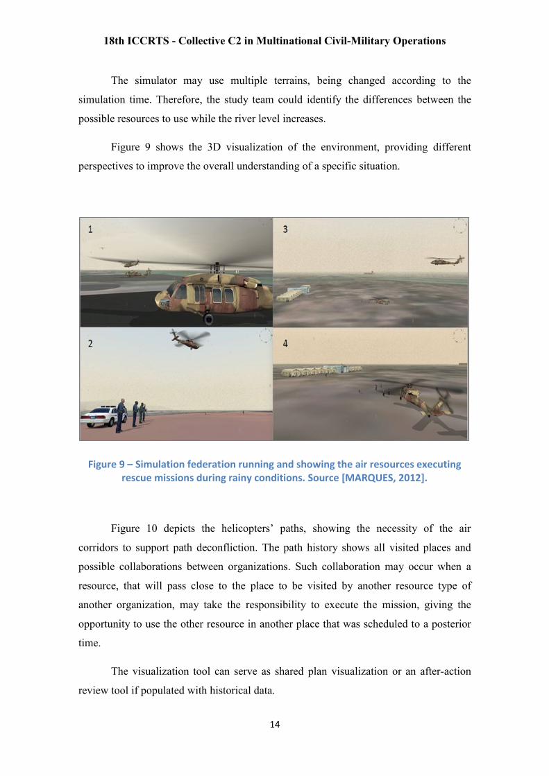
The simulator may use multiple terrains, being changed according to the
simulation time. Therefore, the study team could identify the differences between the
possible resources to use while the river level increases.
Figure 9 shows the 3D visualization of the environment, providing different
perspectives to improve the overall understanding of a specific situation.
Figure 9 – Simulation federation running and showing the air resources executing rescue missions during rainy conditions. Source [MARQUES, 2012].
Figure 10 depicts the helicopters’ paths, showing the necessity of the air
corridors to support path deconfliction. The path history shows all visited places and
possible collaborations between organizations. Such collaboration may occur when a
resource, that will pass close to the place to be visited by another resource type of
another organization, may take the responsibility to execute the mission, giving the
opportunity to use the other resource in another place that was scheduled to a posterior
time.
The visualization tool can serve as shared plan visualization or an after-action
review tool if populated with historical data.

18th ICCRTS - Collective C2 in Multinational Civil-Military Operations
15
Figure 10 – Helicopters’ paths during simulation execution.
4 Considerations and Final Remarks
The present work is being conducted to provide a framework to support the study of
Conflicted C2 operations, focusing on HA/DR operations. The aforementioned
framework uses an inference model based on ontologies, able to describe the differences
between the missions that each organization can perform based on its resources.
In order to provide a set of tasks to be executed through simulation, the selected
missions are sent to a planning tool, generating a hierarchical plan. Each organization
generates its own plan and then sends it to a distributed simulation environment. The
plan execution is made into a federate and integrated into the overall federation.
The terrain is common to all federates, and the federation execution allows
someone to analyze the resource allocation and to perceive the possibilities to improve
synergy, by identifying possibilities of collaboration between organizations.
The framework is able to show different perspectives that are usually hard to
understand during the planning phase. By using such a tool, coordinators may have the
ability to see the scenario as a whole, perceiving the misuse of resources due to the lack

18th ICCRTS - Collective C2 in Multinational Civil-Military Operations
16
of communication between organizations and also the resource utilization in regions
that will be affected before the mission could be accomplished.
As an additional outcome, the simulation provides a better visualization of the
resources’ tracks, giving to the coordination team the ability to understand the possible
path conflicts and the necessity to create air corridors during the scenario evolution,
which is quite hard to get by only using conventional maps and pictures.
This simulation tool can be also used to reproduce the whole operation, serving
as a useful after action review tool, which can improve the lessons learned process.
The case study is being conducted based on a real situation, and the preliminary
results indicate that the approach can be utilized to support coordination teams to
understand what happens in a Conflicted C2 environment during HA/DR operations.
One of the future works is to create a more detailed mission, evolving a scenario
which reproduces the previous condition of 2008, where 80% of the Itajaí City was
totally flooded. Another one is to evolve the Task Ontology to be more general about
HA/DR operations.
Finally, another course of action is to establish some measures of performance in
order to quantify the improvements. After a preliminary analysis, we chose the number
of duplicated assets per task, the total number of launched missions, and the average
waiting time for rescuing people, as we have considered these hard to compute and
required to predict the total number of saved lives.
Acknowledgments
We would like to thank VT-MÄK for the support in ITA/GMU testbed
providing VR-Forces® simulation tools. Also, we would like to thank Brazilian Centro
de Computação de Aeronáutica de São José dos Campos (CCA-SJ) for the 3D terrain
development and support.
18th ICCRTS - Collective C2 in Multinational Civil-Military Operations
17
References
ABDELGAWAD, H., & ABDULHAI, B. (2010). Managing large-scale multimodal
emergency evacuations. Journal of Transportation Safety and Security, 2(2), 122-151.
AEROVISÃO (2009) A Revista da Força Aérea Brasileira. Translation: The Brazilian
Air Force Magazine. Brasília: CECOMSAER, n. 224.
AGÊNCIA FORÇA AÉREA (2010) Saiba como foi o primeiro dia da
Operação: Helicópteros H-1H e H-50 na ajuda humanitária. Translation: Learn how
was the first day: H1-H and H-50 helicopters supporting the humanitarian assistance
operation. Available in: <http://www.fab.mil.br/portal/capa/index.php?mostra=5470>.
Last Accessed in: Apr. 2013.
ALTAY, N., & GREEN Iii, W. G. (2006). OR/MS research in disaster operations
management. European Journal of Operational Research, 175(1), 475-493. doi:
http://dx.doi.org/10.1016/j.ejor.2005.05.016
BBC (2011) Brazil floods: More than 500 dead. Available in:
<http://www.bbc.co.uk/news/world-latin-america-12187985>. Last accessed in: Apr.
2013.
BRASIL (2010a) Presidência da República. Casa Civil. Subchefia para Assuntos
Jurídicos. Decree number 7.257, 4th of August of 2010. Brasília.
BRASIL. (2010b) Presidência da República. Casa Civil. Subchefia para Assuntos
Jurídicos. Law number 12.340. December, 2010. Brasília.
BRASIL. (2012) Presidência da República. Casa Civil. Subchefia para Assuntos
Jurídicos. Law number 12.608. April, 2012. Brasília.
CHANG, M. -., TSENG, Y. -., & CHEN, J. -. (2007) A scenario planning approach for
the flood emergency logistics preparation problem under uncertainty. Transportation
Research Part E: Logistics and Transportation Review, 43(6), 737-754.
CHEN, C. -. F., & CHOU, C. -. (2009) Modeling and performance assessment of a
transit-based evacuation plan within a contraflow simulation environment
CHEN, X., & ZHAN, F. B. (2008) Agent-based modelling and simulation of urban
evacuation: Relative effectiveness of simultaneous and staged evacuation strategies.
Journal of the Operational Research Society, 59(1), 25-33.
CHILDERS, A.K., VISAGAMURTHY, G., TAAFFE, K. (2009) Prioritizing patients
for evacuation from a health-care facility. Transportation Research Board: Journal of the
Transportation Research Board, 2137, pp. 38–45.

18th ICCRTS - Collective C2 in Multinational Civil-Military Operations
18
CHIU, Y. -., & MIRCHANDANI, P. B. (2008) Online behavior-robust feedback
information routing strategy for mass evacuation. IEEE Transactions on Intelligent
Transportation Systems, 9(2), 264-274.
COSTA, P. C. G. da. (2005) Bayesian semantics for the semantic web. Dissertation
(PhD) George Mason University, Fairfax.
COPPOLA, D.P. (2011) Introduction to International Disaster Management.
Butterworth-Heinemann, 2 ed., 696p.
EM-DAT (2013) EMERGENCY EVENTS DATABASE: What’s new?. Available in:
<http://www.emdat.be/result-country-profile?disgroup=natural&country=bra&period=
2003$2012>. Last accessed in: Apr. 2013. Belgium.
GALINDO, G., & BATTA, R. (2013) Review of recent developments in OR/MS
research in disaster operations management. European Journal of Operational
Research(0). doi: http://dx.doi.org/10.1016/j.ejor.2013.01.039
G1 SANTOS (2013) Cubatão, SP, continua em estado de emergência. Translation:
Cubatão, SP, remains in emergency situation. Available in: <
http://g1.globo.com/sp/santos-regiao/noticia/2013/02/cubatao-sp-continua-em-estado-
de-emergencia.html>. Last accessed in: Apr. 2013.
IFRC, (2010) World Disasters Reports 2010: Focus on Urban risk. Retrieved from
<http://www.ifrc.org/en/publications-and-reports/general-publications/#>.
LETTIERI, E., MASELLA, C., & RADAELLI, G. (2009) Disaster management:
Findings from a systematic review. Disaster Prevention and Management, 18(2), 117-
136.MARQUES, H. C. (2012) An inference Model with Probabilistic Ontologies to
Support Automation in Effects-Based Operations Planning. Dissertation, Doctor in
Computer Science, Instituto Tecnológico de Aeronáutica, São José dos Campos.
NAGURNEY, A., Yu, M., QIANG, Q., (2011) Supply chain network design for critical
needs with outsourcing. Papers in Regional Science 90 (1), 123–142.
NATO (2009) The NATO NEC C2 Maturity Model. US DoD CCRP, Washington DC,
December.
SANTA CATARINA (2009) Grupo Reação. Santa Catarina: O maior desastre de sua
história. Translation: Santa Catarina – The worst disaster of its history. Available in:
<http://www.slideshare.net/comissaosantacatarina/defesa-civil-sc>. Last accessed in:
Apr. 2013.
SIMPSON, N. C., & HANCOCK, P. G. (2009). Fifty years of operational research and
emergency response. J Oper Res Soc, 60(S1), S126-S139.
18th ICCRTS - Collective C2 in Multinational Civil-Military Operations
19
SINDEC (2009a) Avaliação de Danos. Ocorrência em Guaratinguetá, SP, 29 dez.
Translation: Damage assessment. Disaster in Guaratinguetá, SP, Dec. 29th
. Available
in: <http://150.162.127.5:8000/e-soll.ceped.aspx>. Last accessed in: Jun. 2012.
SINDEC (2009b) Avaliação de Danos. Ocorrência em São Luiz do Paraitinga, SP, 9
dez. Translation: Damage assessment. Disaster in São Luiz do Paraitinga, Dec. 9th
.
Available in: <http://150.162.127.5:8000/e-soll.ceped.aspx>. Last accessed in: Jun.
2012.
VT-MÄK, 2012 Electronic http://www.mak.com. Last accessed in: Jan. 2013.

Distributed Simulation with
Automated Planning: Study and
Support Tool for Relief
Operations in Conflicted C2
Scenarios Henrique Costa Marques
Daniel Ferreira Manso
José Maria Parente de Oliveira Instituto Tecnológico de Aeronáutica – ITA
Brazil
18th ICCRTS - C2 in Underdeveloped, Degraded and Denied Operational Environments

AGENDA
Introduction
Related Work
Framework for Conflicted C2 Scenarios
Case Study
Conclusion and Final Remarks

Introduction
Brazilian context
Natural disasters
Gaps in the actual C2 process
Military Forces engaged to support relief operations
NATO NEC C2 Maturity Model
Conflicted C2 scenario
Opportunity to use Decision Support Systems to
improve the C2 maturity level
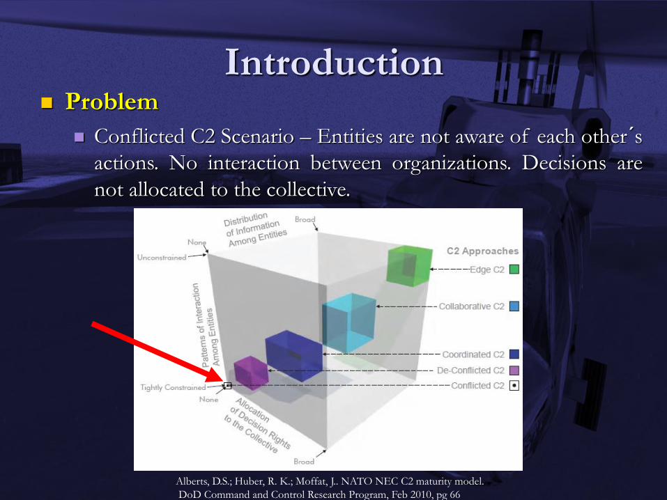
Introduction Problem
Conflicted C2 Scenario – Entities are not aware of each other´s
actions. No interaction between organizations. Decisions are
not allocated to the collective.
Alberts, D.S.; Huber, R. K.; Moffat, J.. NATO NEC C2 maturity model.
DoD Command and Control Research Program, Feb 2010, pg 66

Introduction
Question
How to improve Situation Awareness in such scenario
when the organizations are not required to collaborate
or are not being operationally allocated by a central
coordinator?
Options
Increasing the C2 Maturity level
Centralizing the resource allocation
Improving the coordination among organizations
DSS
Simulation tools
Introduction
Hypothesis – simulation increases the awareness when generating pre-planned missions, from different organizations that are not aware of each other's actions
Objective – to generate a collaborative simulation environment with 2D and 3D visualization to increase Situation Awareness during operations planning in a Conflicted C2 scenario

Related Work
OR/MS, HA/DR and C2 may be considered as somewhat similar research areas in terms of management focus, decision making process and logistical and operational environments.
OR/MS and HA/DR papers that specifically focus on Disaster Operations Management (DOM) may be highlighted as related works.

Related Work
Disaster Operations Management - ALTAY and GREEN, 2006; SIMPSON and HANCOCK, 2009; and GALINDO and BATTA, 2013.
Command and Control – few related articles to HA/DR could be found in the aforementined reviews – gap in the capacity of non-military agencies for managing HA/DR operations.
Distributed Simulation – no related articles found.

Framework
COTS tools
VT-MÄK VR-Forces®
Distributed Simulation environment
HLA/DIS protocol
Each federate acts as a plan execution defined by an
organization responsible for conduct actions in the
scenario
Federation provides a fused view for allocated
resources

Framework
Inference model to support planning
A knowledge base was structured to support task reasoning
based on the effects to be reached and the available resources
Deterministic inference: to identify the adequate resources to the
task to be executed
Probabilistic inference: to identify the probability to achieve the
task based on the resource and environment
For study purpose
To generate Conflicted C2 scenarios to understand the
impact of uncoordinated actions
Before actions being executed (operational level), and after
action review (tactical level)
Inference Model
MARQUES, H. C. (2012) An inference Model with Probabilistic Ontologies to Support Automation in
Effects-Based Operations Planning. Dissertation, Doctor in Computer Science, Instituto Tecnológico de
Aeronáutica, São José dos Campos.
Knowledge
Base
Inference Model
Knowledge Base
Semantic approach using 5 ontologies in OWL:
Domain Ontology
Description about the domain of interest
Planner Ontology
Description about the problem solver methods and operators
Scenario Ontology
Description about the world
PR-OWL Ontology
Probabilistic description for the OWL language
Task Ontology
Description about tasks, activities and phases

Knowledge Base
Why ontologies?
To support different organizations
Different tasks may reach the same effect
Different resources may execute the same task
Probabilistic reasoning based on the scenario
description
Extensible
Planning based on the specific situation
Ontologies allows the description of the differences
between actions, tasks, resources and situations –
context based
Ontology Relations
MARQUES, H. C. (2012) An inference Model with Probabilistic Ontologies to Support Automation in
Effects-Based Operations Planning. Dissertation, Doctor in Computer Science, Instituto Tecnológico de
Aeronáutica, São José dos Campos.
I rdf:type
Legend
Relation
0 aass
+ tldividual
• executes
rdf:type executes
:rdf:type I I
has Method
• hasOperator
Method Rescue Person - -
rdf:type has Method
rdf:type
Planning Process Organization 1
L --:::· J I
Shared Intent
Set of possible resources to be allocated
Set of missions ranked by probability
of success
' hlcal Hie rare Plan Sylle
nlng m
~ PI an
,.. -
I
Organization 2
8 I
Shared ntent
Set of possible resources to be allocated
Set of missions ranked by probability
of success • Hierarch lea I
Planning System
Plan
--
Simulation
Organization N
8 I
Shared Intent
Set of possible resources to be allocated
Set of missions ranked by probability
of success • Hiera rchical
Planning System
~ Plan
- ..... -·1
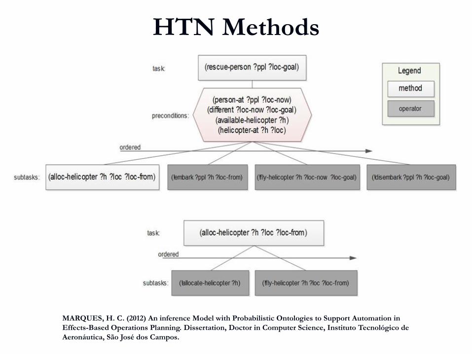
HTN Methods
MARQUES, H. C. (2012) An inference Model with Probabilistic Ontologies to Support Automation in
Effects-Based Operations Planning. Dissertation, Doctor in Computer Science, Instituto Tecnológico de
Aeronáutica, São José dos Campos.
task: (reseueiJerson ?ppl ?loe.goal) Legend
I I method I (person-at ?ppl ?toe -now)
I I (di~rent ?toe-now ?loe.goal) operator precondoons:
(available-helicopter ?h) (helicopter-at ?h ?loc)
ordered / ...........
/ ~
subtasks: (alloe-helicopter ?h ?Joe ?Joe-from) (lelmar1< ?ppl ?h ?loc-I rom) (fly-heltcopler ?h ?loc-now 'llociloal) (ll1Senter1< ?ppl ?h ?loc-goal)
task: (alloe-helicopter ?h ?Joe ?Joe-from)
rdered 0 /~ / ~
sublas ks: (lalocate-helcopter ?h) (fly·heli:opter ?h ?toe ?toe-from)
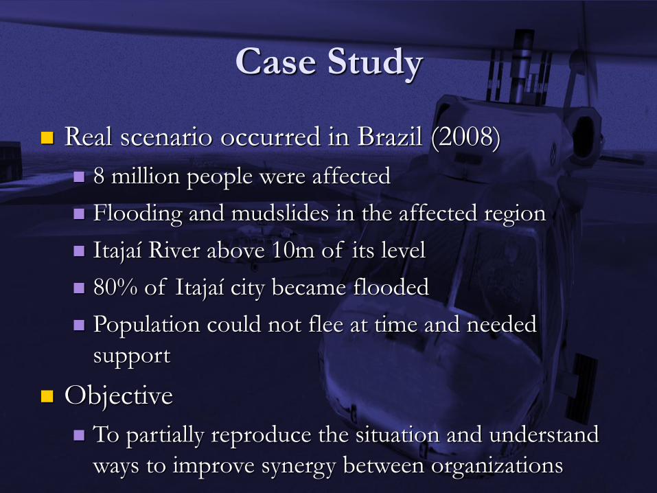
Case Study
Real scenario occurred in Brazil (2008)
8 million people were affected
Flooding and mudslides in the affected region
Itajaí River above 10m of its level
80% of Itajaí city became flooded
Population could not flee at time and needed
support
Objective
To partially reproduce the situation and understand
ways to improve synergy between organizations
Case Study
Three federates
Federate 1 acting as the air resources allocator
Federate 2 acting as the land resources allocator
Federate 3 acting as the fluvial resources allocator
Each plan describes the actions in the specific
domain
The federation executes all the plans at the same
time

Federate 1 – Air Resources
Helicopters
Victims
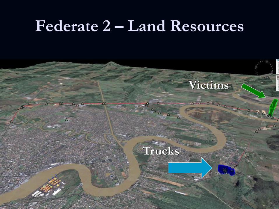
Federate 2 – Land Resources
Trucks
Victims
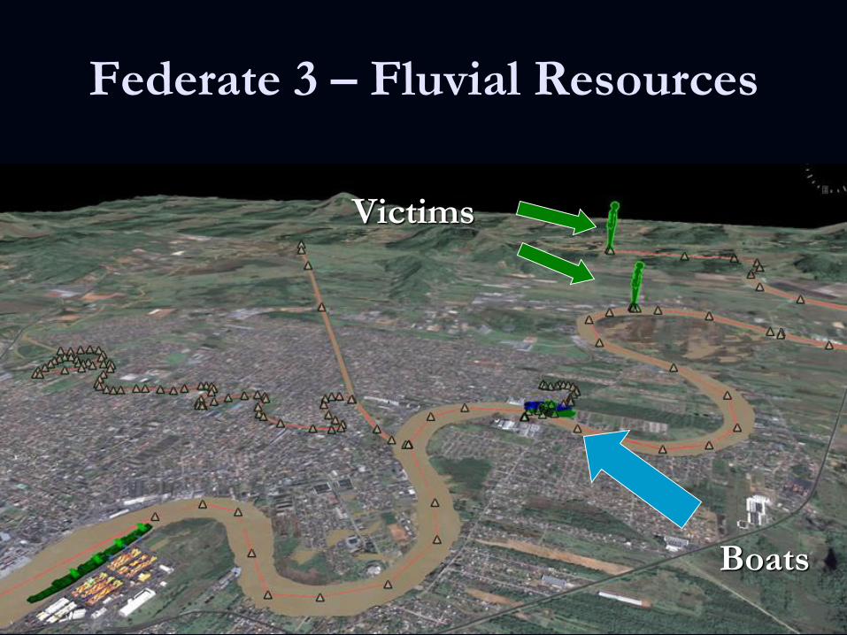
Federate 3 – Fluvial Resources
Boats
Victims

Federation – Fused View

Federation Execution

Path Analysis
\I IE, \ I
Path Analysis .
N
,
" s .
Conclusion
Coordinators may have the ability to see the
scenario as a whole, perceiving the misuse of
resources due to the lack of communication
between organizations and also the resource
utilization in regions that will be affected before
the mission could be accomplished.
Conclusion
The simulation provides a better visualization of
the resources’ tracks, giving to a coordination
team the ability to understand the possible path
conflicts and the necessity to create air corridors
during the scenario evolution, which is quite
hard to get by only using conventional maps and
pictures.

Conclusion
This simulation tool can be also used to
reproduce the whole operation, serving as a
useful after action review tool, which can
improve the lessons learned process.
Future Work
To create a more detailed mission, evolving a scenario
which reproduces the previous condition of 2008,
where 80% of the Itajaí City was totally flooded.
To evolve the Task Ontology to be more general about
HA/DR operations.
To establish some measures of performance in order to
quantify the improvements.
Ex: Number of duplicated assets per task, the total number
of launched missions, and the average waiting time for
rescuing people.

Acknowledgment
VT-MÄK – VR-Forces simulation Tool
Centro de Computação de Aeronáutica de São
José dos Campos (CCASJ) – Terrain Model
Contacts
Henrique Costa Marques – [email protected]
Daniel Ferreira Manso – [email protected]
José Maria Parente de Oliveira – [email protected]

Questions?