Embed Size (px)
Citation preview

/sCOTT CO., KY: 286 sq. mi. " .. was est. in 1792 from part of Woodford Co'. and was named for Gen. Chas. Scott (1739-1813), Rev. War officer and Ky.'s 4th gOY. (1808-1812)." (Book-P. 266); Chas. 'Scott (1739-1813), a vet. of Fr. & Ihd. and Rev. Wars, who later be came Ky. ,Gov. (1808-1812) •. To Ky. as a resi. in 1787. Pop. man; S. Co. was explored in the summer of 1774 by J'ohn Floyd & others seeking land warrants- for Fr. & Ind. War service. He discovered the Royal Spring around which the
\ Geo.' settlement was later est'd. The following yr. a party of Pennsylvanians under the leader ship of John McClelland built a cabin nr. the spring and in 1776 a fort bearing. his name was erected on the hill overlooking the spring.
f' (\.,..0 ~\'" r. ~ C'J..A-~' • c. <'......, 0Ar -l . )

\SCOTT CO. (Ky) has been drained J:iy N. & S. vE_lkhOrm and Eagle Creeks and their branches,
all a part of the Ky. R. System;ll The Lou. So. RR operated from 1889-1900 betw .• Vers. & Geo; I Like other bluegrass co's in the Lex. Metro. area. Scott has long beerr a dorm suburb for Lex.IIThe area that became Scott Co. was 1st
/visited by ~ohn Floyd & his party of surveyor! V in 1774. Settlement followed within a yr. whel
the McClellands. etc. arr. at the springs and est. the sta. that was the forerunner of Geo. It soon became known as Lebancrn.~ •. (Sam'l. M. Wilson of Lex., Ky. in a speech on the occasion of the dedication of a monument at the

Big Spring. 'Repro. in a "Local Rist. Scrapbook" in the Geo. P.L. and Georgetown NEWS, 1920;\\lITimu. plants I Electric Forklift, e'nV'. Controls(;;\:., auto, sliat frames, electric blankets pencils,. Toyota;\\The s. sect. of co. is drained by the Elkhorn Creeks and is part of the
/Inner Bluegrass area of C. Ky •. The n'. sect., that which is drained by Eagle Creek and its branches/is part of the so-called Outer Blue-grass;

The Lou. Southern RR" a branch of the So. Ry. betw. Geo. & Ver., was completed in 1888 .• The Cinc i. So. RR was completed in 1879. (He-Yins said it was in-1876). The Queen & Crescent RR was completed in 1879. The Franltf. & Cinci. R reached Geo. (from Frank.) in 1889 and it arr at Paris in 1890. (Gaines, I) I

V SCOTT' CO" "is divided •. by a ridge that extend thru the ctr. The southern portion is watered by the Elkhorn and its tribs., while the n is nurtered by the E'agle Creek. network." (Bevins on Sadiev., LHL,. 3/J/1963); \\ Scott was the 2nd co. created after the est'mrt. of Ky. as the country's 15th state. In 1794 part of Campb~ll Co. was cut off from it.\I The S. Elk. Creek>separates Scott Co. from Wood Co. on the w., S. Co. is drained by N&S Elk. and EalSle Creeks & their branches .(\ Gen. Chas. Scott-, Rev. War officer,. ne Cumbo Co .• Va. After war moved to Ky., settling on the Ky. R in W. Co. in 1785. Served in the Ind. Wars & as Ky. Gov. 1808-12;
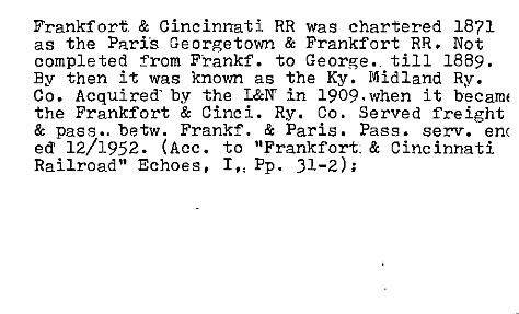
Frankfort & Cincinnati RR was chartered 1871 as the Pari's Ge orgetown & Frankfort RR. Not completed from FrankL to George. till 1889. By then it was known as the Ky. Midland Ry. Co. Acquired' by the L&N' in 1909. when it becamE the Frankfort & Cinci. Ry. Co. Served freight & pass .. betw. Frankf. & Paris. Pass. servo en( eel: 12/1952. (Acc. to "Frankfort: & Cincinnati Railroad" Echoes. I" Pp. 31-2);

V Lytle's Fork of' Eagle Creek; N-. Elkhorn's main tribs. incl. McConnell's Run-and Lecompte's Run; II From Scott- Co. came Harrison Co. in 1793 and Campbell Co. in 1794.1' It is drained by the tribs. of' several n. bank Ky. R. branches: N & S Elkhorn Creeks and Eagle Creek. The northern 1/3 of' the co. is drained by the waters of' Eagle Creek & its branches; II From Scott- Co. came 8 other co's: C:ampbell, Boone, KBnton, Gallatin, Grant, Owen, Pendle-ton, & Harrison; .
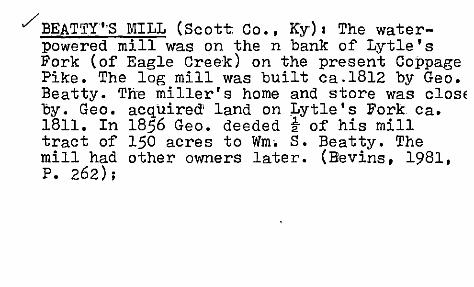
./ BEATTY'-S mILL (Scott: Co., Ky) I The waterpowered mill was on the n bank of Lytle's Fork (of Eagle Creek) on the present Coppage Pike. The log mill was built ca.1812 by Geo. Beatty. ThB miller's home and store was ClOSE by. Geo. acquired' land on Lytle's Fork Ca. 1811. In 1856 Geo. deeded ~ of his mill tract of 150 acres to Wm. S. Beatty. The mill had other owners later. (Bevins, 1981, P.262);
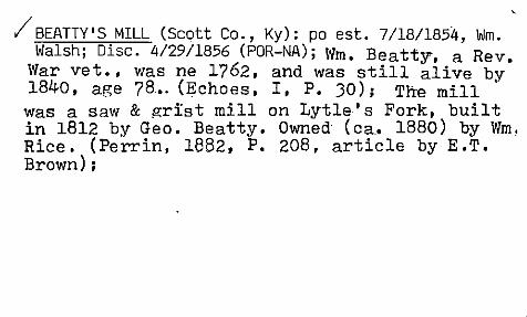
;' BEATTY'S MILL (Scott Co., Ky): po est. 7/18/1854, Wm. Walsh; Disc. 412911856 (POR-NA); Wm. Beatty. a Rev.
War vet •• was ne 1762. and was still alive by 1840. age 78 •. (Echoes. I. P. JO); The mill was a saw & grist mill on Lytle's Fork. built in 1812 by Geo. Beatty. Owned' (ca. 1880) by Wm. Rice. (Perrin. 1882, P. 208. article by E.T. Brown) ;

vBIDDLE (Scott Co.) I-pO est. '6/12/1886, Geo. E. Palmer.; .Disc. eff. 3/3111902 (papers to Geor@ town) (NA); (Pron. "B( ih)d/?l") ~ifXNNII!:XRri~ DK why so named; no one knows thls. It's betw, Long Lick §t.. Double Culvert, on Ky. 620. Now: locally owned groc. store. (Mrs. Mattie Griffith, inter.view, 4/8/1978); Ace. to Geo. E. Palmer 4/1886, this prop. po at Parker Hill would be 0 the ss1de of Little Eagle Creek, 6 mi from Sadieville; In 1899 it was 1 "mi se of Porter PO. (SLR); Extant store run by Billy Ray & Ann. Glass. \'las built "in 1907. (Bevins, 1981,. P. 302); .

BIDDLE (Scott Co., KY)I nr the Salem Meth. Chu •. (Bevins, 1981., .P. 46); Ac~. to 1896 Polk's Gaz., G'lE:;.'i'Palmer was then pm & livestock raiser, L.C. Palmer ran store. Also: a blacksmith shop & :feed mill; Ace:. to O:f:ficial Guide to Rural Mail Box Owners o:f Fay, Bourb. & SeQt~ ~o's. (e1904-?), Maggie. Moses. &
c/CyntIt~aiddle had separate households on RR #1; .

7 BIG EAGLE PO was later called Mallory's Mill ., (com'.) and then Frogtown (COIID • .) This was a viI, with 2 stores, po, mill, Now extinct •. See Perrin's hist. for Mallorys Mill, (Bevins, 1981, P .. 40); John S', Getty had Getty's Tavern on the Lex', -Cinci.. Rd .. 10 mi n. of George, in 1854. (Coleman, STAGECOACH DAYS, P. 179-?); The Big Eagle name applied to stage stop ca. 1838-1842; Boswell Herndon was pm of Big EaglE po from 10/1819 to 6/18JO (POR);

CHOCTAW ACADEMY (Scott Co., Ky) I. No Thomas Ifenderson' is listed in th~ Scott Co. Census (1830) but J·as., Peter, & Wm. Ifenderson were, Acc~ •. to Perrin (i882, Pp •. 160-1), the money due to the Chicka .. & Choctaw for their sale of lands to the US F·ed •. Govt •.. was appropriated'for the educ. of their youth. Dick Johnsol was appointed Super. of this school. He est. it on his Scott. Co •. farm at Blue Spring,
/ c. 1822-3. It was in operation at least by f' 1825·· In 1831 it was moved to another of Col.
Jbhnson's·f'arms,. at White Sulphur Spring. Boarding school with n=200-300 boys at any one time. S'ch. was disc •. 1836 or '37. The cholera epi. hit the sch. in 18331

JThe site o~ Choctaw Academy that ~ad been built by Richard Johnson'was first settled by a Mr. Wood in 1800 and was later bought by Johnson •. It was 6 mi w of George. on the rd. tol Frankf •. (i.e. US 460) .. (Gaines, I, P •. 86) l Choctaw Ind. Acad •. was est. at Blue Spring. the home of Rich'd. M. Johnson. irr 18G5; White Sulphur was an early Cath. settlement; The Choctaw Acad. was est •. at Blue Spring in the early 18205 by Col. Rich'd. M. Johnson as a boarding sCh. for Chicka. & Choctaw Indians •. Exc. for West Pt, this was the only sch. in US run by the War Dept. CB.," 1931 the sch. was moved to White Sulphur Spring and was abandone after the cholera' ~~I'~~ of-<IL<-.I ?-:?O ~,

~The predecessor of Choctaw Academv PO was the BLUE SPRING PO which was est. 12/911826 with Thos.'Henderson, 1st pm. On ~an. 5. 1827 it became Cho~aw Academy with Henderson, pm (POR NA & P&G);

CHo'CTAW',INDIANJ ACADEMY (S'cott Co., Kir): In 1818-Rlch'd. M .•. Johnson "anxious to take posi· tive steps to help the Indian'Oecome assimila' ed into the emerging Am. culture, offered his farm1& facilities for a sch. to be administer· ed by the Ky. Bapt •. Missionary Soc •. "!t opened' that winter. The 1/26/1825 treaty betw. the U; & the Choctaw nation providedi for $6,000 annually for 20 yrs. to educate Choctaw child· ren •. Rev. Thos •. Henderson, a Bapt. minister, was the school's superintendent. By 18)1, whel the school was moved to ~ohnson's White Sulph. Spring farm, enrollment had come to include Pottawatomie, Creek, and Chickasaw boys too:.

The sch. was disc. in 1845 when the Choctaw Indians elected to proviae their own ·schools. One of the academy's buildings is extant. (RevinB., 1981. Pp. 272-3);

CORINTH CHRISTIAN CHURCH (Scott Co. ,Ky) I was org. in 1833. Old log bldg. was destroyed by fire in 1872 and replaced. At the jet. of Skinnersburg & Glass Rds. at Lytle's Fork;

/nAVIS (S'cott_Qo.) I po est. 4/5/1880, John W. Davis ••• Disc. ef:t:'. '11/30/1903 (papers to Sad'ie ville) (NA); (Fron. "Da/v( ih) s'" Used to be a gro. there but no longer. Nr. Hinton (in Harrison Co.), ne of Stonewall on Ky. 32. (Mr~ Mattie G'riff.i th, interview, 4/8/1978); Acc. to John Wm. Davis, the name proposed for this po was Straight Fork ~nd the office would be 3! mi w of Connersville, 4 mi e of Sadieville PO, 2 mi, e of Eagle Creek. A viI. with pop, of 40.(\ On 916/1896, T.B. Lucas pet. for a site ch. 40 ft. s to a pt. on the n bank of the·S. Fk. of Eagle Creek, 4 mi se of Sadiev. PO, 4mi nw of Connersville, 3/4 air mil froll) co. line, (SLR) ;
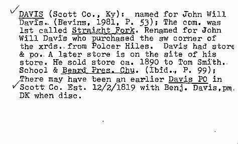
VDAVIS (Scott Co., Ky): named for J"ohn Will Davis.. (B'evins, 1981, P. 53); The com. was 1st called Straight Fork. Renamed for John Will Davis who purchased the sw corner of the xrds •. from Polcer Hiles. Davis had store & po., A later store is on the site of his store. Ire sold store ca. 1890 to Tom Smith., School & Beard' Pres. Chu. (Ibid .,' P. 99); There may have been an earlier Davis PO in
v'Scott- Co. Est. 12/2/1819 with Benj. Davis, pm, DK when disc.

DAVIS (Scptt Co., KY)I was earlier known; as S·traight F'ork •. (B'evins, 1981, P. 278); Benj'. Davis may have lived in the vic. of Sulphur Well Rd., Dry Run Rd, and BUrton Pike. In 182~ he bought St. Ronan's Well from Jas •. Suggett .. (Hevins, 1981" P •. 44) maybe 6 mi ·from Georget. n of the Long Lick. (Gaines, I, P, 117); Acc'.
/
to Beers-Lanagan map (1879), the Straight Fk. PO was on the Big Eagle-Connersville Rd., a little over a miJ from the Harrison Co. line. Po and store. J'. Kitchen;
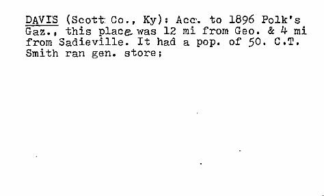
DAVIS (Scott: Co., Ky): Acc~. to 1896 Polk's Gaz., this place was 12 mi from Geo. & 4 mi from Sadieville. It had a pop. of 50. C.T. Smith ran gen. store;

/' STRAIGHT FORK (Scott Co., Ky) :PO est. 10126/1866, Wm. ~ Wiles; 12/31/1877, John Kitchen •• 9/8/1879, Theodore Fish; Disc. 11/21/1879 (POR-NA); Ace. to Wm. M. Wiles, 7/26/1866, the prop. po would serve Wiles and Adams Store,-l mi from the Big Eagle Creek, 5 mi w of Connersville PO. II Ace. to Ibid., 6/28/76, the po was 1 mi e of Big Eagle Creek, 4 mi w of Connersville PO .. (SLR); PO, store, toll house on the J"ohn Kitc~en land, a little ways e of the Davis Xds, betw. Sadieville and Connersville. John had acquired this farm site in 1819. (Bevins, 1981, . P. 53);

v'DELAPLAIN (Scott:CO.)1 po est. as Dry Run. 1/3/1867, Wl!l' H.' qU'!tt •. D~S. c. 9/~/72;' R~i"es' 1/16/73, UrJ.as HambrJ.ck; D~sc·. 11 14/76; He .. est. 9724/77. Wm: J. Neal .••• 4/26 89, B'enj. J. Delaplain •• 6/4/1900, Banj. ~.Delaplain ••• ch. to Delaplain, 7/10/1906, Wm. A. Mathers ••• Dis, eff'. 4730/1931 (mail to Georgetown) (NA); (Pron. nD.(eh)l/a/plann) Settled: by'a Mr. DeLaplain. DK anything about him or. who the place was named for~ •• (Mattie Griff'i tho inter· view. 4/8/1978); Extant store owned by E.E. Muddiman. (B'evins. 1981, P. 302);

j' DRY RUN (Scott Co., Ky): po est. to serve a community called Kinkaid (sic). Acc. to B.J. Oe~plain, 12/26/98, the po would be on the w side of Dry Run, on the rr.l\ Acc. to Wm. A. Mathers, 7/30/1906, the po was now calle OelE!plain (late Dry Run) and the com. was called Kinkaid but it would also be renamed Oel8Plain. The po was 150 yards w of Dry Run, 2* mi s of Rogers Gap PO, 4! mi n'of Georgetown PO, 30 yards 'e of the CNO&TP RR. (SLR)j Acc'. to 1896 Polk's Gaz. it was called Drv Run then and served Kinkaid Sta. on the CNO&TP Ry. Pop. 50; B'.J. Delaplain was pm & storekeeper & rr agent. Had a 2nd store, and several livestock raiers; ,

lDRY RUN' (Scott Co., KY)I The stream now known as Dry Run (a branch of N'. Elkhorn Creek) may earlier have been called Little North Elkhorn (in pion. days);

I'DUVALL (Scott Co., Ky) I This sta. on the C,iilci & Frank. RR was named for Ct. of Appeal: Judge Alvin Duvall, ne Scott. Co., ca 6 mi w of Geor'Se •. (Gaines II, P. 1809); Named for Judge Alvin Duvall, ne Scott Co. The F&C RR was completed from Frank. to Geo. in 1889. This was where the rr crosffed the Duvall Rd. The road which was so named since the very early 19 cent. led to the farm of Cornelius Duvall at the jet. of Duvall Rd. & SebreE' Pike. A 2 story bld~. with the depot, store,& po on the ~round floor and resi. on the 2nd :flloor. Alvin was grandson of Cornelius. The 1st prop. of the sta. was a Mr. Morris. At

least 20 yrs. later/Miss Jessie Richardson was storekeeper. sta. agent. & pm. She was succeeded by Will Richardson who was succeeded by his bro. Jimmy. This sta. was the com. shipping pt. for area & soc. ctr. PO disc. in 1912 (?) Brick sch. on US 227. opp. the sta. est._ c. 1900. Closed in the -1930s and converted' to a home. Store closed with Jimmy's death. Bldg. that housed the depot-store-po burned 4/17/1966. (J.W. Singer ms: "A Hist. 0: Duvall Sta. 1889-1966" in Scott Co. Vert. Files. KHS Libr.);

DUVALL (Scott Co., Ky): po est. 1/20/1896, Franklin Morris; 1/20/1899, Willie A. Richardson; 1/31/1927, James E. Richardson; Disc. eff. 6/15/1927 (mail to Georgetown) (POR-NA); Acc. to Franklin Morris, 1/6196, this prop. po would be 4 mi e of Stamping Ground PO, 6 mi w of Georgetown PO, 3t mi n of Great Crossing PO, It mi n of Elkhorn Creek. On the Ky. Midland Ry betw. Stamp. Ground ~Georgetown. It is ne of White Sulphur which is due s-of Stamp. Ground, 3.4 rail mi se of Gr. Crossing and 6.4 rail mi nw of Georgetown; II Acc. to W.A. Richardson, 11/17/1915, the po was It m~>rof Elkhorn Creek, 3 mi e of Stamping Ground po, and 6 mi w of Georgetown PO. (SLR);

'. Could',,_the( Emerson PO have been named for one of the Emison family of pioneer,osettlers? e.g •.
Ash Emison's Emerson's St tion at Ash Emison's Spring. Ash 1753-1824. Chec~was Ash's orig •. improvement nr his spring,? The spring' was ca. 4 mi n of McClelland's Fort (or Georgetown). Ash was an Irish immi. 'to AIm •. ca 17p2. Moved .to Ky •. 1775 from Westmoreland 'Co •• Pa. In 1782 he entered land (1000 acres) pre'emption that was surveyed 1/5/1783. (Jas. W. Emison,' Jr:"Emisons in America" REG -"of KHS,. Vol. 42 (Apr •. 1944). 'Pp: 139-4]; Emison built saw & grist mills on the ·lower forks of Dry Rum in 1797.· In 1812-15 he built another water

mill 9 mi n,on Eagle Creek, 7/8 mi nnw of the future Sadieville. (~as. Wade Emison, Jr. & W.T. Smith, "Orig._ Land Patents in Georgat:. Area, Scott Co,;, Ky." REG. of KHS, Vol. 41, Apr. 1943,. Pp. 171-75); Emerson's S"ta.', (sic) was built 4/1776 by Ash Emerson at a spring on a br. of Dry Run (of N'. Elkhorn Cr.) in c •. Scoi Co. (Jillson, PION. KY., P. 81); Benj. Emison (ne 3/44) lived next door to C. Emison (2/69) in Dist. #5. Jas. Emison (3/43) also lived in that dist. But no Geo. W. Combs was listed. (1900 Census);

By the very early 19 cent. Hugh & Ash Emison had settled in. the Dry Run and Lane's Run ngbds. in the Eagle Creek hills. They became millers and farmers •. Ash built his first mill in 1797 on Dry Run •. By 1809 he had 'a 2nd mill on Big Eagle. Heired by his son, Wm. (1795-1875). This became an import. mill serving n. Scot~ Co. Ash had 322 acres on Eagle Cr~ek in 1799. Wm. (by 1832) had 1225 acres on Eagle •.. (Bevins, 1981, P. 52); The Emisons lived off' .the.El~ Lick Pi~e, a short distance ne?of Sad l.evl.lle. (Ibl.d., P. 52);

JEMERSON (Scott Co., Ky): po est. 10/4/1888, Amanda M. Coghill; Disc. 21411889 (no papers) (POR-NA);

FINNELL (Scott- Co., Ify): Richard Finnell of Geo. was an operator for the Q&C RR from 1884-1890 when he became agent for the Frankf'. & Cinci. RR. Son of Thos. Finnell, a Geo. peace officer (Marshal) and ne'ph-.' of H.M. Finnell, Scott Co. sheriff & judge. (Gaines I, P. 75); Finnell was nr the bank of East Eagle Creek. Jas. Amos Hamon, stock farmer, merchant, & state legislator, area landowner. (B'evins, 1981, P. 234) j Judge .B.W._ Finnell died 8/19/
~1855; B.W._ FinnBll was the 1st co. judge of Scott Co. 1851+;

;FINNELL (Scott Co., Ky): po est. 6/12/1886, James H. Hamon; 7/27/1895, W.T. Hamon; 6/10/1901, Elbert M. Smith; Disc. eff. 3/31/1902 (papers to Georgetown) (POR-NA); Ace. to James H. Hamon, 2/15/1886, the prop. name for this po is Hamon. The prop. po would be ca. 4 mi w of Leesburg, ! mi w of Eagle Creek. (SLR); Jas. Amos Hamon.' s store closed but the bldg. is extant. Hamon raised thorobred horses on his East Eagle Stock Farm._ (Bevins. 1981. P. J02) i Jas. B'enj. Finnell (ne 1842 in- Boone Co •• Ky. sc-ion of a prom. B. Co. fam.) From 1875 a Georget. atty. (Gaines. II. P. 81) I

· '
FINNELL ('Scott Co., Ky): Acc'. to 1896 Polk's Gaz. ;_f;t had a pop. of 25. W. T. Hamon was pm. He and Jr.A. Hamon ran the gen'l. store. Also there: flour mill, several blacksmiths, wagon & plow +~qtory; Ih the Turkey Creek sect. Nothing~'1'here now. No one knows anything about this' plE.c'e. ("fihn/C) 1"). F'innell Pike was 1st called Holdings Mill Rd. for a local mill. Renamed c. 65 yrs. ago. DK why renamed or why this name. Perhaps it originally led to the Finnell PO. Informant's gt. gt. grandfather was Edwin C. F'innell. He was a millwright, building the rag engines for paper mills. He's

mentioned in the "Bllue Grass Craftsman". Has seen the name with one "1". There are now somE family' members who insist on pronouncing it "fihnl.ehl". (Mattie Griffith. interv •• 4/8/ 1878); .

~SHVILLE (Scott Co., Ky): po est. Fish; Disc. 7128/1841 (PDR-NA);
5/6/1840, Robert H.

-fa lR 'SISTERB R TN (a stream in :Seo tt Co VIl ty, Ky.) Named for RObert I-leClellan's da'll3hters. Check 011 this· •••. Not listed in Field. Confirmed: see my notes of taped interview with Mattie }riffith, 4/8/1978); Ace. to Draper mss (17cc), "the most southeastern !,rong of McConnells Run" was locally called (the) Four Sisters Run, "a nickname given to it by Jos. Burch. the neighborhood.geographer. because the four McClellan sisters 1iveq along this run." They:were: Ruth (Mrs. Geo. Galloway). Eliz. (Mrs. Sam'l. Galloway) •. Margaret- (Mrs. Hugh Dickey). and .Sarah (Mrs. Wm. Dickey). The run is betw. Georgetown & Stamp. Ground. (Gaines. cited in Echoes of thE Pastl Stamp. Ground. Ky. 1775-1975, Womans Club of S.G •• PD. 9-10)

,/ GEORGETOWN (Scott Co., Ky): "This 4th cl. city and seat of Scott Co. is on US 25, 62, and 460, and just w of 1-75, 60 mi e of downtown Lou. In 1782 the Rev. Elijah Craig is said to have founded a commu. near where, 6 yrs. before, the McClelland Bros. & Col. Robt Patterson had est. the shortlived McClellands Sta. Crar~1 named his settlement Lebanon or Lebanon Station, for reasons unknown, and by this name a town was inc. there by the Va. leg. in 1784. In 1790 it was renamed George Town for Geo. Washington at the request of a delegation led by Col. Robt. Johnson. Until 1846 the name was officially spelled as 2 words, tho' acc. to postal records the name of the po, est. on 1/1/1801, with Thos. Lewis, pm, was always sp. as 1 word. There is no basis to the local legend that the place was nam,
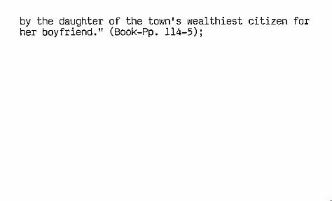
by the daughter of the town's wealthiest citizen for her boyfriend." (Book-Pp. 114-5);
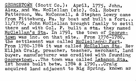
GEORGETOWN (Scott' CO.)I April, 1775, John, Alex. and Wm. McClellan (sic), Col. Robert Patterson, Wm. J\!cConnell, & Stephen Lowry came from Pittsburg, Pa. by boat and built a fort ••• 11/1776, John McClellan brought family to settI there and with Col. P. built a sta. they named McClellan's Sta. In 1791, the town of Georgetown was inc. on that site., From 1776-1780, the settlement was called J\!cClel1arhb Fort. From 1780-1784 it was called McClellan Sta. Rev Elijah Craig, preacher, teacher, merchant, land buyer, manufacturer was credited with founding Georgetown ••• The town was called Lebanon Sta. 1st house built betw. 1784 & l790 ••• Craig acquired land adjacent to Big Spring, known as

Keene Richard's Hill ••• ln 1784, Va. inc. what had been called McClellan's Sta. and re named it Lebanon Sta ••• ln 1790 the Va. Leg. ch. name of L.S. to G'town "at the request of a delegation head by Col. (Robert) Johnson" Undoubtedly named for Geo. Washington. Others say it was named by a local girl, considered the "belle of the town", for her boyfriend. As daughter of a wealthy citizen, she was given the honor of naming it. But thi~s local legend and has no basis. Until 1846, the name was officially spelled as 2 words; ttlbce then as one. The 1st Scott Co. court was held there 9/25/1792 ••• Rev. Craig

laid off' the town in 180~. Thos. W. Martin was appointed the 1st pm of G'town in 1796. He died 1807 and was succeeded by Geo. Miller ••• The spring in town' was locally called The Big Spring. Big Spring Branch "runs along the w. portion of town" and drains into Elkhorn ~reek. Craig died 1808 • •••• (THE B.O. GAINES HIST. OF SCOTT, CO. 190~, 1reprinted 1961, 'Pi>. 5-6, 10, 17, 26, 107 •••• )
" ~I.!v(,v,

GEORGETOWN (Scottc Co., Ky) I. Forerunner I Craigs Station est. here ca. early 1·7.Jl7,. acc. to John-Graves of Fayette Co., as interviewed by Rev. J,ohn-Shane. 1845. (Otto A. Rothert. transcr, .. "Jiohn D. Shane's Interv. with Col. John Graves of F. Co~" Filson Club Hist. Q., Vol. 15. 1941, Pp. ~38-47, 41);

./ GEORGETOWN: (Scott Co., Ky) I McClelland's Fort was on a cliff just above Royal Spring. Built by John & Benj., McClelland,etaL, Jan. 1776; McC'lellan's Fort or Sta. was builtin 10/76 at the Royal Spring. Named for co'-founder John McCle2Ian, and abandoned after an Indian attack. Vic. settled 1776 by John, Alex & Wm. McClellan & other families;

viGEORGETOWN (Scott Co.i: 1st called McClelland's Sta. (sic); est. 1775 at :the site of. the Royal Spring. Abandol1ed because of Indian threats. When "reoccupied in 1784" it was call~d Lebanon. Inc. py Va. Leg. in 1790 as Georgetown for Pres. G.eo. Washing;!;on <.Jillson, . PIONEER KY. ;t'p. 83-4); The Lebanol name is given on the Russell map of 1794. '.' .(Ibid., P. 90).; McClelland's Fort was settin 12/1776 by John, Alex'r. and Vim. McCleH= and. Abandoned after ·a long Indian .siege ••••
. Sometimes the Royal Spring was called The· Big Spring and'sometimes the Horseshoe Spr. (Ibiq., P.94);

GEORGETOWN- (Scott Co., Ky): The Horseshoe Spring, the site of McClelland's Block-house where Ben McClelland lived and the site of th~ present Georgetown. A large spring. Was often called the Royal Spring. (from an interview with a Miss Campbell, descendant of pioneer Dan'l. Campbell, Draper Mss-13C82 acc. to Willard Rouse Jilison, "Early Ky. Hist. in Ms.--A Brief Acct. of the Draper an, Shane Collections" REG. of KHS, VoL 33. Apr 1935, Pp. 137-50, 149);

GEORGETOWN (Scott, Co. ) I si te of mcClelland's (sic) Sta. at Royal'Spring which was discovere 7/9/1774 by Col. John Floyd, etal. It's always been ci~y's source of water, supply. (Highway mark;er ln G'town, acc:. to GUIDE', .No. 63" P. 9) Spelled mcClelland in Collins, 2nd edit.; Royal Spring, a natural spring, still supplies water to G'town. Current effort by Womans Clut to reconstruct mcClelland's (sic) Fort which had been abandoned after an Indian att,ack when
,set'tlers m'Ctv:e:d~o Ft. Harrod. (ace::. to Ann Bevin in Joan Kay's 'S'cptt; Countian Builds Interest in Hist., into a Book" LCJ, 12/2/1975, A8Il-6);
"

1-1 .. _GEORGETOWN (Scott CO.) I Ft. McClelland was at
the h'ead of the Big Springs' Branch. (Mrs. Mary Shipp Hawkins ms. in Gaines, 1904, P. 18); Spring Branch "bursting from a limestone bluff .•. In very early times •• was known as Floyd's Royal Spring. In later:times as the Republicar. and in more modern times as .the Big Spring •••• On the bluff where this spring bursts forth tn 1st settlement or sta. wasmade ••• ln Oct. 1776 CoL ~att'erson, with t-he 2 McClellands'~'~j'i!n & John •• erected a fort or sta. called MdCle~land Fort .... ln 1782, Elijjl.h Craig .... from Vl3:.""and . settled on the lands on which Lebanon Town, afterward,i Georgetown was located.ln 1790, G. was inc. by the Leg. of Va •. and named in honoI

of G • .w ••••• (Craig was) the prop. & founder •• was a Bapt. preacher •••• " Floyd's Royal Spring' Branch was the name ·of the stream c. 1790. "Col. Floyd.: •• had a mil. land warrant for a thousand acres; this survey wa:s on the so. side of N. Elkhorn, and includes'the land on wh:i:ch the town was laid out, and the Spring Branch, and running west, and known as Floyd's Survey, 'and patented in l779."(sic "The town is claimed to have been surveyed.·&
V'laid out by Fielding Bradford.· •••.• n ("Hist." .of G' town" as written by Dr. S.F. Gano, in HIST. OF BOURBON, SCOTT,. HARRISON & NICHOLAS CO's.! 1882, and·repro. in Gaines, 1904, Pp. 18-20); "

I , I --GEORGETOWN (Scott' Co.') : Big, S.prings=Royal
Spring. (Jane Bennett, WPA ms); po est. as Geor,:;etown C.H. 'l/(H!j1801, Thos. Lewis ••• (NA) i
(Pron. DHaw)rw,i>/town") Called McClellands Ilt'a. from 1784--90. ("Mil!kl{'eh)l/."ndz Sta sh-on" Then it becameG Lebanon Station ("L eli' b ,<nl "an Sta/sh"dn"). Renamed to honor Geo. Washingto Thinks McC. Sta. was est. in the fall of 1775. They were raided by the Indians that Xmas and fled to Harrordsburg: Re)3ettled c.,lO yrs. later. There's a con.troversy about whether the sta'. was built on the bluff above Big Spring or at the spring i tse.lf. She thinks the gen' 1. concensus is that it waS built on the bluff •••

~ ""'---
Anne P. COffma-~co. historian, spelled it wi th a term. "nli:,.' No one knows why Elijah Craig named it Le b. Sta. G\~ town was laid off by Fielding Bradford who lived in the Stamp. Ground vic. His bro. ,-" John. was" the founder & owner of the Ky. G"azette ••• (Ma ttie Griffith, interview, 4/8/1978);

-_ I
GEORtiE1COWN (Scott' Co.): Big, Spring nr. town. " ••• it's hidden source of water is inexhaustible." John Floyd, asst. surveyor under Col.
? Wm. Preston, obs~rved it in1774 and 5 yrs. , later acquired a patent to 1000 acres from
Lord Dunsmore 'of,Va. under the name of, "F10ydl Royal Spring." In the spring, 1~'(,I75, a(ifort wal built on the bluff: above the spring • Called McClelland '.s Sta. which became the' nucleus of Georgetown. (.LCJ', 11/1/1936); The spring' provid:es a conti.nual supply of water for G'town. It "has never gone dry and cannot be dammed." (LEX-., HER-LEAD. 6/22/1941) ; .. In fall of 1775, Capt •. 'John McClelland built his fort 'on site of the spring. It17 de'strpyed by P1uggy, chie, of the. Mingo Ind. Parson Craig est. Baptist
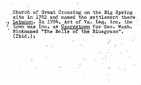
Church of Great Crossing on the Big Spring· site in 1782 and named the settlement there
'( Lebanon. In 1784, Act of Va. Leg. inc. the town was inc. as Georgetown for Geo. Wash •
. Nicknamed "The Belle of the Bluegrass". (Ibid.) ;
...

GREAT CROSSINGS (Scott· C9 •. ): On the site of Great Crossing Sta., c. 2 mi. w. of G'town. Often referred to as Col. Robert Johnson's Station. On the buffalo.path which the Indians. named Alant-o-wami owe e • The Great Crossing Bapt. Chu. was org. at this place in 1785. (Jillson, PIO~EER KY., Pp. 84-5); aka Great Buffalo Crossing, on N •. E1kh:~rnJ.) Creek.' Settled winter of 178)-4 by Col. Robt. Johnson. His home was several hundr'ed yards· of the>Cchurch. H·e was neVa. 7/17/1745 and died at present Warsaw, Ky. 10/15/1815. He 'is said to have sk~tched the 1st known . map of Ky. in 1782. (Ibid., P. 89);
l< I "',,, ~ Ar--n-r

/G'REAT CROSSING (Scott-, Co. ): 1st called "The Great Buffalo Trace" because the buffalo seleci ed this place to cross the Elkhorn. (Collins); Sp. with a final "s" by G'ainesl 3 mi. from G'town. Named "from the fact that the great buffalo trace from interi.or Ky. to the Ohio R. crossed North Elkhorn Cr. at' this pt."(THE B.O. GAINES RIST. OF SCOTT CO., 1904, P. 128);
Grea:t Crossings was the site of Johnson's Ft. considered the 1st permanent settlement in co. Built winter, 1783-4. Robert & wife, Jemima werl bur. i, n li t,tle, chtchYard there. ,Robert"', father of Veep Rich' d .'M 'Johnf!on.,. (Jane Bennett ms; WPA); -, , '? \.\.L~ if- ~'r N ... (7;113""
f;~if4\ e.~~) <fIz~olC- qN..o.:t- R,,~CAoJ'";"-j (.r-i(\ ~ ~ ~~ ~~\orl~h...!\ ..... ('o. ""-.L .. ,-,,, ... II~J nA'~.£...

<.\... <I\'r)\f'\\~ GREAT CROSSINGS (Scott Co.) I Ro~ert 'Johnson "had purc'hased this site in or before 1779. It was a part of John Floyd's survey" of 1774. "It was in sight of Elkhorn cre!lk and the big cross ing of the Buffalo trace across'this stream. Hence the 'name. The place was later known as Great Crossings, and gav.e the name 'of Great Crossings......to the village which grew up around Robert Johnson's or Big Crossing Station; and the same name was also applied to the church built on "the Johnsoh land.'?,.All trace of the fort has now, disapPE.lared. ',' .,In 1785 a phurcp. wa organized. In-time Nbrth Elkhorn was dammed, a mill was erected, a bridge built across t~e stream, some residencbesrnd shops ••• and G.,'
hI' ~ 0.. d'1,. """;"'!' l .H1~ ~r'; ,I ~-~ ,,( -c", ~ t."o .... _,'*

-GREAT CROSSINGS (Scott; Co. h poc dIsc.' efT.
~hl/1905 (mail to G'eorg'town) (NA); (Pron.
"Grat Kr(a:h)s!(ih0z") Today it's locally referred :to simply as "at the Cro'ssings." Now: school, new store, 8-10 houses incl. some pretty old homes. ,At. one time it was thought· the, crossings would be the .county' seat but wasnt. Had a cqvered bridge' there but it's gone. (Mrs. Mattie Gr~ff'ith; interview, 4/8/ 197(31; (cr,<J- L4 L"cA:.- ~,-);, Johnson' Sta'. which lat~r became G:reat XJ.ng. was the '1st perm. settlement in the' co· •. built in late 1783. (B'evins •. Ky. Ency., 1992. Pp. 805-6); ,

GREAT CROSSINGS (Scott Co., Ky): Acc.'to James F. Sconce, 5/18/1868, the po was 20 yards w of N. Elkhorn Creek, 2! mi w of Georgetown PO. I\Acc. to J.W. Jewett, 7/20/1889, the po was sp. one word and was on the n bank of N. Elkhorn Creek, 3 mi w of Georgetown PO, 5! mi neof White Sulphur PO, 2 mi s of the Ky. Midland RR. (SI:.R); The co's 1st perIll!o settlement waS Robt. J'ohnson's fort at Great Xings. The Crossings Chu. was the co's. 1st, est. 5/1785. Robt. Johnson built his fort at Gt. Xing in 1783; Marina Duvall is listed in the 1810 Scott Co. Census; Rev. Mareen or Marion Duval a Bapt. preacher who ,was ordained at Stamp. Ground in 1830 and later pastored the chu. at Mt. I. in Owen Co. Is this,the same man?

GREAT CROSSING (Scott Co., Ky) I Mareene Duvall (1830 Census) and Marina Duvall (1810 Census)', Mareen Duvall, Pas tor of Bapt. Chu. at the S'tamping Ground, died 12/21/1844. Alex'r. Bradford died 10/1824. Preston Calver not Present,. Fabricius C. McCalla died 4/73., He was' a Georget. merchant. Rich'd. ~ohnson deeded him a farm on the Branham's Mill (Galloway) Pike. He was a trustee of Geo.Coll and was active in St. Ground Chu. since 1833. (P.62). Mare err Duvall was son of pion. Cornelius Duvall. (P. 26) (J'.W .. Singer, "A Hist •. of the'Bapt. Chu. at the Stamping Grounl Ky •. 1795--" 1970),

~ '" Y I Y".JA/""1 tI ....,
/GREAT CROSSINGS(Scott-_CcY.)1 4 mi •. from Georgi town named for the fa~ that the great buffall trace from the'Qnueg'l1'~ eolHl-tr"&'0to the Ohio R. crossed the N.Eikhorn Creek at that site. (Jane Bennett, WPJ\I'ms.); :po of Great crossin,s est. -7/1/1811, Marvin (?) Duvall •.•• Disp. 11 1; 1861; Re-est. 12/10/1861,· Jas. W. Helt •.•• (NA)
(" ;"~i"Y- o-!,- Y<-.'::\.); Called Great Crossings in Collins (1st ed.1, etc. but the final "s" has since been dropped and the place is now known as Great Crossing;) Settled ~y Col. Robt.J'ohnsor. Betw. 1784 .... 1790 was thought to be likely seat of new county. (THE B.O. GA NES OF:.SCOTT CO. 1904, repr~nted 1961, P. 6); ~ ~~
Gtv:> J'.r i v--v

VGREAT CROSSING (Scott Co., Ky): "This hamlet with epo is on the present Ky 227, just n of US 460 and It (air) mi w of Georgetown. It grew up around a pion. sta. called (The) Great Crossing or Johnson's Station, built by Va-born Robert Johnson in the winter of 1783-84 at the pt. where the great buffalo path betw. the Bluegrass and the Ohio R. crossed N. Elkhorn Creek. It was also early called Great Buffalo Crossing, and, for most of the 19 cent., Great Crossings, by which name the po, in operation from 1811 to 1905, was known. Since the turn of the present cent it has been Great Crossing and now is locally called simply The Crossing." (Book-P. 124);

, GREAT GROSSING (Scott Co., Ky): That buf:falo ~ actually crossed here was merely inferred_by ~ the pion's. No evidence that they were act~al
ly seen by white men; Buffalo alleged to have crossed the N. Elkhorn on their way to the Ohio R. at this site; Acc. to P&G the Gt. Xings po was est. 1810; ---

-- - _ ,-", 10- '2.. It· ..
J GREENFIELD (Scott Co., Ky): po est. as overton\5/221 1832, Benjamin Wright; ch. to Greenfield, 2/20/1833, Benjamin Wright; Disc. 7/811836 (POR-NA); Greenfielc as a rrste. is shown;?n E.M. MenQenhall's Ry & Township Map of -KY,,--Cinci, 187~ as on the rrt.betw. -Geo. & FrankL, ver:r close to the Franklin Co. line; No Overtons are listed in the 18JO Census for Scott Co; S'everal Overtom liv:ed in Fay •. Co. i.n early 19. cent., ·incl. .. Dr: Jas •. Overton.(MD), a Prof. of Medcineat Transy .. U'. (Ace:. to Ky. Gaz-Staples); Acc. to POR-Pre.f;:1830, Overton PO (Scptt Co.) was est. in 1828 but dk who was 1st pm. Check •••• ;

Waller Overton of Fay. Co. died there on 10/2 /1827. age 79. He was a Rev. War vet. arid Vaborn pion~ settler. To Ky. in 1776. Lived in F. Co. till death. (REG. Vol. 27, 5/1929, P. 530); Was Overton named for the family of Sam'l. R. Overton of Lex. who fought for the Johnsons in the War of 18127 He was son of Waller Overton, a Rev. War vet; Showrron Burr (1839) map·as on highway betw. Frankf •. & Geo., 7 mi due w of Gt. Xings & 8 mi e of Frankf.;

~GREEN'S STORE (Scott Co., Ky): po est. 2/5/1851, Geo. Mallory; Disc. 7129/1852 (POR-NA); Acc. to 1850
. Census. a Geo. Mallory (72)" a merchant. lived in the W. Part of'" Dist. #2;'

~RIFFEEIS MILL (Scott CD., Ky): pO est. 7/18/1854, Geo Griffee; Disc. 912011859 (POR-NA); Gaines (n, P. l6J) SPa it Griffie's Mill po with Simeorr GriffIe, 1st pm. Est. 1852 and closed 1861 "when the pm was arrested and taken to Camp Chase as a pol. prisoner." Same precinct'" as Corinth & Lytles Fk.; SimeonAGriffee's log home was on Lyttle's Fk. of Eagle Creek. Its 2nd floor was used as a commu. granary. (Bevil 1981, P. 59);

HINTON (Scott Co., Ky): po est. 10/15/1877, Thos. Million; 11/511883, Rufus Lancaster ... 9/8/1894, Sa~'l. Gardner (Into Harrison Co. 7/13/1898 for a short t2me, then returned to Scott Co.); 4/19/1900, Lewis ~. Nelson; 7/111904, Bessie Green .. 1/26/1906, LeW1S R. Nelson (into Harrison Co.); On 5/10/1900, no signature stated that this po was 1 mi e of Rays Fork, 3t mi s 01 Corinth PO, 5 mi n of Sadieville PO, 3t mi e of Stone-
~ wall PO, 150 ft. W of the Cinci. So. tracks, 150 ft. from the Harrison Co. line. Here was a depot, school, 3 stores (one with the po in L.R. Nelson's store.) (SLR);

HINTON (Scott Co., KY)I was named for an important area family, descendants of pion • .Tohn Hinton & his son Asher who huil t a log cabin-: in 1790 on the n bank- of Eagle Creekbetw. Turke:yfoot and S'adieville. (Bevins, 1981, P. 39); Acc. to 1896 Polk's Gaz., this place was then in Scott Co. on the CNO&TP Ry and had a pop. of 75. Sam'l. G~ner was pm & storekeep'er. Had also a hotel, 2 other stores sawmill, & blacksmtih shop;

HINTON PO (S'cott-Harrison Co., Ky): Listed' in P&G as in Harrison Co. from 1877-1966; est. in Scott Co. 10/5/1877, Thos. Million; 11/5/ 1883, Rufus Lancaster; 7/13/1898, Lewis R. Nelson; into Scott· Co. on 4/19/1900; back im Harrison Co. 1/26/1906, Lewis R. Nelson1 3/31 1914, Sam'I. Gardner.... Into Harrison Co. the 1st time on 7/13/1898 (POR-NA);

~JOLA (Scott Co., Ky): po est. 4/19/1900, Annie Weber; 10/16/1901, Benj. F. Baldwin; Disc. eff. 7/3111902 (papers to Stamping Ground) (POR-NA); Acc. to Annie Weber, 3/16/1900, the name prop. for this po was Weber and it would be located 3t mi ne of Switzer, 3t mi sw 0: Minorsville, 1 mi s of Cedar Creek, 3t mi w of Stamping Ground PO, and e of the Elmville PO. (SLR); Anna Webe listed in 1900 Census as pm, was nee 7/1874 an was wife of Jos. Weber, a farmer (ne 12/68). They lived in the W. Sto.mp. Ground Pree •. wi th their son Robt. They lived nr. Benj. F. Baldwin (ne 11/1853). They had a neighbor named Julia •. (1900 Census);

vJONES' PO (Scott Co., Ky): po est. 12/9/1829, Peter Jones; Disc. 6/11/1836; Re-est. 5/13/1852, John Jones; 6/27/1856, Peter N. Jones; Disc. 2/10/1863. (POR-NA); Acc'. to Burr, it I S in the extreme n end of the co., on the rd. betw •. Geo. & Cov. Very
1 close to where Ow n, Scott, & Harri. Co's. 'meet; John Jones' Tavern was a stage s~op on
'( the rd. to C~nc~... m~ n of Geo .• Later J known as Slattenv lIe. (Gaines, I, P. 73);
One of the two Jo es Taverns on the Cinci. Rd. was run by Jo n Jones till c. 1860. (B'evins. 1981, P. 23Z;;~Dl' 7,

JOSEPHI'NE (Scott. Co.) I est. c.1881. acc. to ,'", some, it was named for, Mrs. Nancy Josephine '\ -Merrill. Acc'. to others, it was named by the
POD,. James Jackson was the 1st pm. He was succeeued by·N.D. Redding ••• lst store was est by Redding & Griffith in 1883 •••• (P. ,163) (by Jonathan Lancaster, in B..O. ,GAINES HIST. OF SCOT~ CO., 1904, reprinted 1961); po est. 9/23/1880, James Jr. Jackson ••• -Disc. 7/13/83; Re-est. 11/30/83, Nathaniel D.,Redding ••• Disc 8/15/1913 (mail to Sadieville) (NA) ; .

v,;OSEPHINE (Scott. Co;'): (Pron. "Dj(oh)s!~/ feen") Est.18al. Named for Mrs. Nancy Josephene Murrellvwhose husband was a Union officer DK when or by whom it·', was 1st set·ned. Tried to track this down but couldnt find anyone who knew further back than Mrs. Murrell. She dk of any other name for it. ·Now; a few homes no longer'the store. Locally still called J/sjPhige. (Mrs. Mattie Griffith, interview,
. ~ 197 Ii Acc. to 1896 Polk's Gaz., H.E. Jones was pm & storekeeper. It had a wagon factory, furn. fact., dfstillery, flour mill, saw mill, another store run by C.D. Murrell, blacksmi'ths;

~SEPHINE (Scott Co., Ky):"This epo was on Lyttles Fk. of Eagle Creek and Ky 32, 12t (air) mi nnw of Georgetown. It was est. on Sept. 23, 1880 with James J. Jackson, pm, and named for Mrs.. Nancy Josephine Murrell the wife of a Union Army officer. It closed in 1913. II (Book-P. 155);

~JOSEPHINE (Scott CD., Ky): Acc. to James J. Jackson. 9/15/1880, the prop. name for this po was Lyttles Fork and it would serve the area at Jacksons Bridge. It would be located 3 t mi e of Rock Dale PO, 5 mi n of Long Lick PO, 3t mi w of Ex Hill PO (?), on the w side of Lyttles Fk. It Acc. to Nathaniel D. Redding, 11/1/83, the po was 3t mi e of Rockdale PO, 3 mi w of Porter PO, 5 mi n of Long Lick PO, on the w side of Lyttle Fk. (sic). (SLR)j

/CaPt, Wm. Lytle, pion., came from Cumbo Co., Pa. His land warrant was entered on 7/9/1783 and surveyed on 2/11/1785; DK how he pron. hi: name~but Scott Countians have always pron. it LOld In) (Mattie Griffith" interv., 418/78);
, ,

KINKEAD (Scott Co .• Ky): family which originally sp. its name Kincaid. Came from Stirlingshire. Scot. Wm. Kinkead. ne Carlisle. Pa. 1736 to Augusta Co •• Va. by 1747. Rev. War vet. To Woodford Co •• Ky. 1789 and bought Cave Spring estate. Lived there till death in 1820. His 12 children were all born in Va. A grandson (thru son John) was Wm. Blackburn Kinkead who moved' t Lex. and became a judge. He was also a scholar. All the Kinkeads had'~ left Wooaf Co ~ by the end of the C.W. (Railey •• Woodf. Co .. 1968. Pp. 69-70) ;
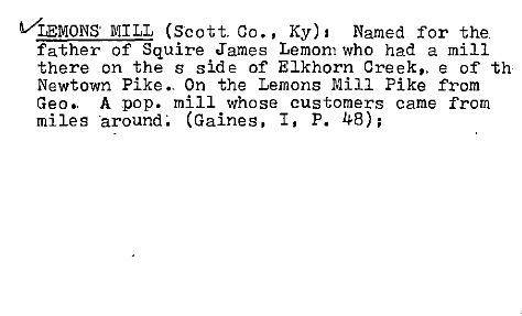
VLEMONS'MILL (Scott. Co., Ky) I Named for the. father of Squire ~ames Lemon1who had a mill there on the s side of Elkhorn Creek,. e of th Newtown Pike., On the Lemons Mill Pike from Geo., A pop. mill whose customers came from miles 'around; (Gaines, I, P. 48);

JLEMON'S MILL (Scott Co.): .undershot water mill at the" jpt. of Lemons Mill Pike and" Newtown Pike"(earlier known as. Henrys Mill' PiKe; 5 rili. from George:toVin. Built 'on N.' Elkhorn Creek by Jas. Lemon ,in the 1830s. to grind ' corn, wheat,,' and barley. 'Three story fram'e
- bldg. Probably on s'i,te of an earl ier milL Ceased operation and torn down in ,1908. Site later used 'for pic'nics, politica:l- rallies. More recently as an amusement park known as Rogers Park. ("Historic Ky~" _,cal. -by J-. Winstop Coleman;" LEX. HER-LEAD". 6/7/1964, P. "59;
'" '. .

/LEMON"'S MILL (Scott: Co., Ky) I Built betw •. 18JO-J8 by Jos. Lemon on the site of an bIder mill. run by him and built by his father-in- . law J.oshua Leatherer •. Undershot waterwheeL. Water-powered •. Torn town in 1908 •. Mili ti'a musters, picnics, and poli ti'cal ralli.e-s were held on its grounds •. (Bevins, 1981" Pp. 260-61) ;

LEMON'S MILL (Scott Co., Ky) I on N. Elkhorn Creek. Acer.. to Ann-_Bevins: A Hist. of':-Scott Co. As Told by Selected Buildings, Joshua Leatherer applied to build the mill in 1799. Sometime after 1817, when his only daughter, Margaretta married Joseph Innes a War of 1812 Captain. the site became k own as Lemon's Mill. Lemon was one~ of t e county's richest and most influential citiz ns. (Betty, Lee -Mastin, "Merry Christmases" 0 Cecil &: Clara Bell's home at L.M •• Lex. H r-Leader, 12/25/1988, P. Ja),

LEMON'S MILL (Scott- Co.): 5 mi. from G'town. In the sw section of co. Place was named for the father of the late Squire James Lemon as he had est. mill there on the Elkhorn in pioneer times. Mill was famous for years. _
1 By mid-19JOs, the old mill was still standing •••• (Jane Bennett, WPA ms); Lemons Mill was not at the site of New Zion (q.v.) L.M. was located just Defore you get_to Newtown, almos in NewtoWn, just before the bridge over Elkhol'l
1, Cree-k, nr. to the head of Elkhorn. The LemqJig wer~ an early family. e.'g. Jos.' Lemon, aOIllerc -ta;i1lor of Georgetown ,l:tJ 1846 (acc;. to Gaines, Vo:t: 2, P. 67). (Mrs. 't1}attie Griffith, 4/8h~)

! '1 LH('ERSON (Scott Co., Ky): po est. 6123/1900, Geo. W. Combs; Disc. eff. 6/30/1903 (papers to Midw~y) (POR-NA);
Ace. to Geo. W. Combs, the prop. name for thlS po was Zion Hill and it would be 2 mi s of Davis Depot, 2 mi n of Faywood, on the s side of S. Elkhorn Creek, a viI. of 275 pop. (SLR);

LENERSONr (S'cott Co., Ky) I Amanda M. Coghill (1829-1909) was probably the wife of Wm. Coghill (1824-1896) and were buried at Stamping Ground Hapt. Chu. Cern.; Beers-Lanagan map (1879) shows W. Coghill living t mi ne of Watkinsville. And B. Emerson is shown as Ii vir 1 mi e,and just sw of S. Elkhorn Creek; The
j post C.W. co~ •. of Zion Hill was in the bend of S. Elkhorn Creek, in the sw corner of the co. Zion Hill Bapt. Chu.;

~LITTLE EAGLE (Scott Co., Ky): po est. as Big Eagle on 4/1/1816 with Thos. S. Theobald ... Disc. 7/28/1841; Reest. 10/26/1841, John Lindsy (sic); 11/2/1846, Wm. Herriott; ch. to Little Eagle 9/29/1g49, John S. Getty; 1/7/1859, Mrs. Frances Brockman ... 10120/1864, Mrs. Frances Brockman; Disc. 8/17/1865; Re-est. 10/17/1865, Milford Truitt; 11/19/1867, Geo. W. Whitton; Disc. 5/11 1878 (POR-NA); Acc. to G.W. Whitton, 7/12/1876, the_po was 1 mi n of Little Eagle Creek, 5t mi due s of Stonewall PO, 6 mi sw of Straight Fork PO. It was named for the stream. It was It mi s of Big Eagle Creek, on the r betw. Lex. & COy. and 12 mi n of Georgetown PO, it mi w of the Cinci Chattanooga Southern RR. (SLR);

.J Li Ule Eagle Creek is 12 mi. long. Big 'EagJ:e Creek (not Eagle Creek) is 17 mi long and heads at the confI. of RogerS' Gap & muddy Fore Creeks and extends n.' & w. to join Little Creek to form (the main) Eagle Creek. Eagle Creek is shown on John Filson's 178~ map. A BGN decis~on-ap"provIng this" ca. 1962 or '6J; Big Eagle Cr •. rises nr. Lee-sburg (Harri.. Co). and joins Ky. R. at Monterey. (sic). Little Eagle heads 7 mi IT- of Geo.. at joins Big Eagle at Walls Millon the Cinei.. PikE!'. (Perrin, 1882, P. 208);

~ONGLICK (Scm.t';1;; Co.) I po est. as Long Lick. 1/14/1828. Hiram Kelly (.e-aphw-p-?-) •• Disc. 5/31/ ).848; He-est. 6/18/1878. Millard F. Griffith ••• ~:isl&:~ n.ch. to Longlick. 8/28/1895 • .Tas. W. Palmer; Disc. eft'.". 7/31/1902°(papers to Stamp •
. Ground) (NA); (Pron. "L(aw)'11 L(ih)k") buffalo congregated in herds there to lick the salt rock at Long Lick. Now: no stores but a Rapt. chur. and 2-3 homes. Betw. Minorsville & Biddle on Rt. 1059. ,DK if it had anothe~ name. On some of the older maps' they'd identify Long Lick
I (stream) as Long Branch, a trib. of Ea,gle Cree'k (Mrs. Mat~ie Griffith. interview. 4/8/1978);

V LONG LICK (Scott. Co •. ): "Wll~re the buffaloe·s. would literally take long licks of salt and go on their way to/ the Ohio Hi crossing'Elkhorn Creek at Great Crossings \sic) which takes its name from the fact that the great
. herds of buffalo made (tilrix:) this their crossing place of Elkhorn Creek." (sic) (Echoes, P. 107)1 Named "because of the buffaloes congregating there in herds licking the salt roc •••• " (P. 164- of the B. 0.. GAINES HIST. OF SCO CO. 1904-, reprinted 1961, Vol. 2)I~Ac~. to Polk (1896), Long Lick: A.T. Griff~th was pm,
,-A.F. Griffith had gen. store. Covington Bros. ran saw & grist mill. Blacksmith ShOPI

v:' LONG LICK (Scott CD., Ky): Acc. to M.F. Griffith, 6/5/ 1878, the po was 5 mi s of Rockdale PO, ~ of Skinnersburgh PO, on the w bank of Lyttles Fk. t\ Acc. to Jas. W. Palmer, 9/24/1895, the po as Long lick was 1 mi w of Lyttles Fk, 12 mi from Georgetown PO 3 mi n of Skinner burgh PO, 3 mi w of Biddle PO. (SLR); "This settlement with epo at the jct. of Ky 32 and 1059, 9 (air) mi nnw of Georgetown, was probably named for its location on Longlick Branc~of Lyttles Fk. of Eagle Creek, on WhOSE banks the buffalo herds would gather for long licks of the salt rock on their migrations to the Ohio R. The po was est. as Long Lick on Jan. 16, 1828, with Hiram Kelly, pm, and respelled Long lick in 1895. It was dis( in 1902." (Book-P. 178); ,.. _ _ ,\ 'rur. M>
S" l'\~ D,,("'t-e 1'0' <9J"

McCONNELS RUN (Scottt Co.. Ky.) Near the Fayette Co. line. (See Fayette Co. DAR ms. on p.n'.--"Sources of Fayette Co. Names U
) •••••

MILLER'S RUN (Scott Co •• Ky): Named for Wm. & ~ohrrMiller. leaders of pioneer settlement in the vic. c .l.::i7 5. They were from Penna. (See Harrison Heritage Homes edit. & supple. to Cynth. Demo. 8/21/1975. P. 2. article by Chas. Fe ix); .

'/MINORSVILLE (Scott Co., Ky): Acc. -to J. T. Reynolds, 6/8/1870, the prop. po would be 4t mi ne of Stamping Ground PO. Vil. of 100 pop.{l Acc. to W.O. "errell, 11/2/1885, the po was 3t mi w of Long Lick PO. (SLR); "This hamlet with epo at the jct. of Ky 227 and 1874, 1 (air) mi nw of Georgetown, may have been settled in the 1830s on part of a 2000 acre mil. grant rec'd. by Jeremiah Minor for Rev. War services and undoubtedly named for him. A po was est. on Aug. 29, 1870 -with storekeeper S.T. Reynolds as pm and disc. in 1902." (Book-P. 199); Jeremiah Minor was ne 1745 and still alive by 1840, age 95. Rev. War vet. (Echoes, I. P. 30);

/ MINORSVILLE (S'cott Co., Ky) I Named for J:eremia Minor, orig. landowner. Centered at the H.D. Ferrell. house in which the local po was located. Extant but vacant. (E~vins, 1981, P. 102); Acc. to 1896 Polk's Gaz., this place had a PO! of 50 •. Davidson & Petty had the gen. store;

')VIINORSYILLE (Scott Co.) 12 mI. from G'town. (Gaines, 1904, P. 128); po est. 8/29/1870, J.T. Reynolds •••• (NA); Disc. eff. 7/31/1902 (papers to Stamping Ground) (NA); (Pron. "M(eye) # (ah)n!erz/v(ih)l") Nr. the head of LeComptes Run. ~amed for Jeremiah Minor who rec' d. a 2000 acre grant for Rev. War service. (Echoes ," Ppi;> 105-6) "In the 1830s, Alex'r. Hamilton purchased land. at. Minorsv. His home is the oldest house in M'ville and is still being used as a residenc;~,!."~." The earliest known business is a g~n~~~ store run by J. T. Reynolds from 1867-80. -.•• Several !lIDs, drugstor"e, Q:aYte HOlfse now the .Alsop Hse=the center of hlst 1. rJIlnorsv ••• '~famrIT$ry
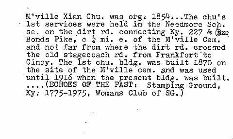
M"'ville Xian Chu. was org,' 1854 •.• The chu's 1st services were helo in the Needmore Sch. se. on the ,dirt rd. connecting Ky. 227 &~] Bonds Pike, c i mi. e. of the M' ville Cern. ' and not far from where the dirt rd. crossed the old stagecoach rd. from Frankfort 'to Cincy. The 1st chu. bldg. was "built 1870 on the site of the M'ville cern. a.nd was used until 1916 when the present bldg. was built • • • • • (ECHOES OF THE PAST I Stamping Ground, Ky~ 1775-1975. Womans Club of SG.)

~UDDY FORD (Scott CD., Ky): Acc. to Hugh Sharon, 6/26/ 1889, the prop. po would be 3 mi n of Oxford PO, 5 mi e of Rogers Gap PO. On Eagle Creek. ViI. of 50 pop. (SLR) "This settlement just off Ky 922, 6t (air) mi nne of Georgetown, was named for its location nr. the mouth of Muddy Ford Creek, a branch of the W. Fk. of Eagle Creek. The creek, first settled by the Barnhills of Buchanan Cc Va. in 1792, is said to have been named for the large quantities of mud it deposited when it overflowed its banks, probably at some natural fording place. Hugh ShannCn, the local storekeeper, maintained the po from its i ception on Oct. 21, 1890 till it closed less thar 3 yrs
l• later." (Book-P. 207); ~ s f---o ~ "'--'- .f' "'-~

/MUDDY FORD (Scott Co •. ) I Presumably named for its location by the mouth of Muddy Ford Creek (check) at the West Fk. of Eagle Creek, c. 9 mi. nne of Georgetown. (Dom. Case Brief, BGN, "Muddy Ford Cree'k" 5/25/1962); P.O. was loca-
ted in Hugh Sharon's store. 1st store run by Don Barnhill, 1870 ••• (P.56) 1st settlers were the Barnhill Bros. and their sister from Buch. Co., Va. 1792. Saml..:l. Barnhill; one of the bros., rec' d. tract for Rev. War service •. Died 1840. Other-early families: Sharons, Petits, Shirlys, Williramsons ••• (P. 54) ••• (SCOTT_ CO. HIST.' 1954 by the Co .• Homemakers Clubs, repro. & donated to KHS in ms. form, 1975);
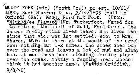
"MUDDY FORK' (sic) (Scott Co.): ,Po est. 10/21/ 1890, Hu~h Sharon; Disc.;7/14/1893 (mail to Oxford'.) (NA); Muddy Fora not Fork. (Pron. UM(uh)d!ee F(aw)rdu)Nr. Turkeyfoot. Named for its site at the mouth of Muddy F.ord Cree'k. The Sharon family still lives there. Has lived the} since that vic. was 1st set-ned. ,Acc-'. to Mrs. Sharon,!lr.F!" is there at the mouth of the creel Now: nothrng but 1-2 homes. The creek does run ov.er the road and leaves a lot of mud and alwaJ has. It must have been a~NN±~ fording place over the creek. Mostly a farming area. Doesnt think it had 'another name. (Mattie Griffith, 4/8/78) -
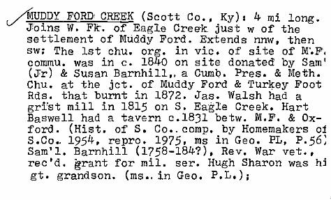
AU~DY FORD CREEK (Scott Co., ,Ky) I 4 mi long . .)Tol.ns W. Fit. of Eagle Creek Just w of the settlement of Muddy Ford. Extends nnw, then sw: The 1st chu. org. in vic. of site of M'.F'. commu. was in c. 1840 on site donated by Sam' (JTr) & Susan Barnhill" a Cumbo Pres. & Me~h. Chu. at the jet. of Muddy Ford & Turkey Foot Rds. that burnt in 1872. Jas. Walsh had a gri'st mill in 1815 on S. Eagle Creek. Hart Baswell had a tavern c.18Jl betw. M.F. & Oxford. (Hist. of S. Co •. comp. by Homemakers oj S.Co •. 1954, repro. 1975, ms in Geo. PL, P.56; Sam'l. Barnhill (1758-184?), Rev. War vet., rec'd. ~rant for mil. ser. Hugh Sharon was hj gt. grandson. (ms •. in Geo. P.L.);
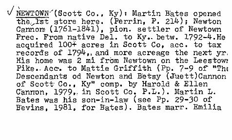
J NEWTOWN.'(Scott: Co .• Ky) I Martin Bates opened the,,,lst store here. (Perrin, P. 214); Newton Cannon (1761-1841), pion. settler of Newtown Prec. From native Del. to Ky •. betw. 1792-4.He acquired 100+ acres in Scott Co, ace. to tax record's of 1794,. and more acreage the nem yr, His home was 2 mi from Newtown on the Lees"towl Pike •. Ace'. to Mattie Griffith (pp. 7-9 of "ThE Descendants od Newton and Betsy (Jruett)Cannon of Scott- Co •• Ky" compo by Harold & Ellen C'anrnon. 1979 •. in Scott Co. P.L.). Martin L. Bates was his son-in-law (see Pp. 29-30 of B'evins, 1981, for Bates). Bates marr. Emilia

Cannon (1808-1840) •. Martin's dates=1804 to 1887. Acc'. to Gaines (II" P. 172) Bates opened a gen. store in Newtown~ He moved his family to St. Louis, Mo •. in 1850. (Ibid. P. 177) ;

V NEWTOWN (Scot"t_Co.) : {Pron. IINyu/townll }The commu. may ~ave been named for Newton Cannun but this has never been documented. He.'s known'to have paid taxes there in 1794. He owned property ~n Harrison & Scott Co's. and was in Harrison Co. in '93. DK when Newtown was named. Lemons Mill was at the Newtown
1 site. (ilL eh m nz M ih 1"). And Sleepy HoI. (.11 Slee ee .H ah 1 ." II , DK why called S. H. DK where Rogers Park was. It was a shortlivec dance hall; not a commu •• just a park. ("R( ah)d,i/erz p( ah).rk" ) • Newtown . was settled in· the 1790s. Now: gro. several homes. HorsE farm ••••• (Mattie Griffith, 4/8/78);'

.;- / NEWTOWN (Scott Co. ); Acc:'. to Gaines (1904). a
7 grain shipping pt.- on the Frankfort ~ Cincy. , RR. Farming village ••• (THE B. O. GAINES HIST.
OF SCOTT' CO;. 1904. reprinted 1961:. Pp. 171-2) 5 mi. from Georgetown. (Ibid •• P. ~8)1 po est. 11/2/1832. Hiram Otwell (or earlier) •••• (NA) , Settled 1775 by Virginians. 1st mill was Lemons Millon the N. Elkhorn Creek. Run by Joshua Leathers ... (Pp. 38-9). The mill site. in 1948. was called Sleepy Hollow and formerly Rogers Park-and was. a park & rec. area ••• (P.3S Vil. at the jet. of Lex. & Lee£burg Pikes. Farmers who owned land there sold lots to tradesmen for busi. establishments. Martin
ea. e:.r -r. '~Y1-(,( f'+~,.)

Bates had a gen'l. store •••• P •. G. (P.41) Depot on the Ky. Midland. RR. 1st train in 1889 •••• (P. 42) A farming trade center •.•• (P. 45). (SCOTT. CO. HIST., 1954 by the Co. Homemakers Clubs, repro; & donated to KHS in ms-form,1975); €'o~{);.t~.«.fJ.'fI'ioll'l?1
(1M. -\ .... '\-Lo~~X('lA)/ '.

" ~I t'1(('f70 NEWTOWN (Scott CO.)I Lemon's Millon the Nort Elkhorn was built by Joshua Leathers ••• (P. 213 Newtown=nr. the Fayette Co. line at the j'ct. of the Lex. & the Leesburg Pikes ••• (Perrin. 1882. P. 214); Acc. to C. G. Beadle ," the po was 1 mi e of Elkhorn Creek, 4 mi w of Centerville PO, 5 mi e of Georgetown PO. llAcc. to Stephen Arnsparger, 11/2/1885, the po was 1 mi w of Elkhorn Creek (sic), 4 mi w of Centerville PO, 5 mi e of Georgetown PO, 4 mi sw of Oxford PO. \( Acc. to Ibid. 4114/1900, the po was 1 mi n (sic) of Elkhorn Cr, 4 rail mi w of Centerville po, 4 m e of Georgetown PO, 4 mi s of Oxford PO, 60 rods n of Ky Midland RR. \\Acc. to H. L. Sallee, 10/22/1915, the po was 2 mi w of Elkhorn Cr, ! mi w of Cherry Run, 5 mi e of Georgetown PO, i mi n of the F&C RR. Newtown was the name of the rr sta. too. (SLR)j

./ NEWTOWN' (S'cott. Co., Ky-); Xrds I Geo. -Paris & Lex-LeesburlS Pikes. This strategic location influenced' commu. dev •. 'lil.. ca •. 18]0 was called Newtown maybe for Newton Cannon, an early prop. (~evins, 1981, P. 29); Newton Cannon was his family's Scott Co. prog.. He came from Del. and sett~ed in S. Co. in ]79]. (IbIQ., P. 100); PO est. as Newtown on 1/2/
1826, with Martin L. ~ates, 1st pm (POR-pre 18]0) ;

NEW ZION (Scott- Co.): Settled c.1878. (Nt! Z(eye)~(ah)n") B'lackcommunity. Chur-. still there. Thinks they named the commu. for the Zion Chu. and prefixed~ the "New" for its prox to Newtown. Gro. bldg. still there and some nice homes. New Zion Chu. Doesnt think it had another name. Mr. Canby Clay's g~. grandfathel built the 1st house th~re; thinks his name wa! also Clay. This was a large brick house. He W1
a black. (Mrs. Mattie Griffith, interview, 4/8/1978) ;

NEW ZION (Scott Co., Ky;<)(:) (F123se) Land donated to 2 ex-slaves, Promis King and CaJ,vin Hampton, by Mr. G"ough (or Golf or Goult). They, in turn, sold the land later to other blacks. (Peter Craig Smith, "Negro Hamlets and Gentleman Farms" PhD Diss., UK Geog. Dept., 1972, P. 55)

/ ~~EGA'(~cott CD., Ky): po est. 3/3/1896', Geo.-. W. Robey; Disc. eff. 7/31/1902 (papers to Sfamping Ground) (PORNA);Acc. to Geo. W. Robey, 1/21/1896, this prop. po
would be 3 mi n of Longlick PO, 3! mi e of Suterville PO, 4 mi s of Josephine PO, on the east bank of Lyttle~ Fork. (SLR); Acc'. to 1900 Census. Geo. W. Robey I a merchant •. was ne 12/1852 and lived in Mag. Dist. #4. Other Robeys lived in this prec. bul nat nr. him; The Robeys lived on the road botw Skinnersburg.& Long Lick. acc. to BeersLanagan map. 1879);

Acc, to Mendenhall"s 1917 Guide & Road Map 0 Ky. (Cinci.) OMEGA ·is s of the road b.etw. Josephine & Porter and ne of' Longlick and es of Rockdale. About due w of Davis. Draw straight line betw. Minorsv., Longlick, Omeg and"Porter; On the Nat']. Map Co's. early 1920' s r,o?d map of Ky,. Omega is shown sw of Porter and ene of Sutersv.", a little n of a line due w of Davis" and a little's of line due w of'Sadiev. On the 'road betw. Longlick Porter; .

/oWENS (Scott Co., Ky): PO est. 8/5/1833, Thomas Owens; Disc. 4/5/1839; Re-est. 7/19/1839, Thos. Owens; Disc. 1/3/1843 (POR-NA); Ace. to Burr (1839), this po was on the rd. betw. Geo. & Long Lick, 8 mi nw of Geo •. and 3 mi se of Long Lick PO, 5 (rd) mi due n of Stamp. Ground;

J OXFORD (Scott Co.) I A ;e~y-~ariy -~~-ttl~ment. Jesse Browning was~stsettler of area, Imi. ne of the viI. Chas. Hamilton settled c •. ~ mi n. of the vil ••• (P. 172) 5 mi. from Georgetown. Laid out by,lst resident, a Mr. Patterson who'owned the surrounding land. Ist'called Patterson's Cross,RoadQ (sic) With each new owne:r- came a n.ch.,--Burkley's Cross Rd. t (sic), Marion Cross Roads', and Oxford. Dk why so-named. Shoe shops, blacksmith & wood shop were early industries. B.P; Anderson had the 1st ~~o):'e.\ •• JP. I?3.) ~THE B.O •. GAINESHIST. O. SCOTT: ,CO", 1904, ,reprl.nted 1961); po est. as Marion, 4/1/1836, Cary 'A. Ward •• to Oxford, 4/14/1846, Hartw'ell, E.Boswell who' was/aI/SO the pm of Marion ':bef 0 re the change I 12 31 46, ... , ____ A fAl' ........ A -(MfI.'. ,...~r-".~t-l?J"'i"I/,r. ..... rY') -.L.

O}wORD' CHRISTIAN: CHURCH , (Scott Co., Ky) I
Ace:. to marker on-_ Oxford Rd.', US 62, 5 _mi. from Georgetown. Org. at the old Sugar Ridge Schoolhouseon-,7/18J1. Frame structure erecte in 1847. Repaire,d in 1881. Brick church bldg. erected c. 1900. Still standing. The OxfDrd community was laid out and settled by its proprietor, Mr. Patterson. (Updated Guide to Ky. Hist' 1. Highway Markers, compiled by Dianne __ Wells & Mary Lou S. Madigan, KHS, No. 1701) c -

~XFORD (Scott- Co.): Trading center. Earliest settlers of vic. incl. Chas. Hamilton, John Ritchie, and James Risk ••• (P. 211) Vill.=5 mi. from Georgetown. Settled and laid out by a Mr. Patterson who owned the land in the vic. 1st called Patterson's Cross Road (sic). Name-ch. with successive owners to Burkley's Cross Rds., Marion Cross Roads, and then Oxford. DK why so named. In the early days it was considered a wild place but later became "quiet, respectable and prosperous village." ... (P. 212) (Perrin, 1882);
,

/oXFORD, (Scott Co.) I F,ormer1y Marion. 5 mi. fr@j Georgetown. ,Inc. ,2/2,7/1844. (Gai'nes •. 1904, P. I28); (Pron. 11Ah,bc/ferd") No one, knows_hoV\
Oxford got its name:-:l'Mattie Griffith, interview, 478/1978); Now: 2 churches. an abandoned sch. grocery. antique store. -c. doz 'homes. (Obs 1978); Est. _ 2/27/1844 as lilarion(ACTS 184)/4, P. 190); name changed to Oxford, 2/21/1849 (ACT 1848/9, P. 232); ,
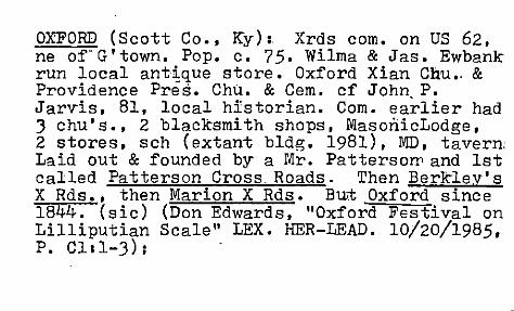
OXFORD (Scott Co •• Ky): Xrds com. on US 62. ne of"G'town. Pop. c. 75. Wilma & Jas. Ewbank run local ant~que store. Oxford Xian Chu •. & Providence Pres. Chu. & Cern. cf John P. Jarvis. 81. local historian. Com. earlier had 3 chu's •• 2 blacksmith shops, MasonicLodge, 2 stores. sch (extant bldg. 1981), MD. tavern: Laid out & founded by a Mr. Patters ow and 1st called Patterson Cross Roads. Then Berklev's X Rds •• then Marion X Rds. But Oxford since 1844. (sic) (Don Edwards. "Oxford Festival on Lilliputian Scale" LEX. HER-LEAD. 10/20/1985. P. ClI1-3);

, OXFORD (~~ott Co., Ky): Ace. to Douglas P. Moore (?), ; 117(1870, the po was 5 mi sw of Leesburg PO, 6 mi ne 01 Georgetown PO, 4 mi nw of Newtown PO. (lAce. to H.F. Juett, 1/14/1878, the po was 5 mi e of Georgetown PO, 5 mi w of Leesburg PO, 3t mi se of Kincaid PO (sic) (SLR); Oxfora was, earlier' called Barkleys Xrd's
for Ro bt. Barkley, son of piolT'. Ma ttl'rew Bark-(ley. Ro bt • lived' on the nw corner of the
Cynthiana Rd. & the Newtown-Muddy Ford Rds. (Eevi'ns,.1981. P., 26); Its orig. site waS 1st known as" Patterson's Cross Roads. then Barklev's X Rds •• then Marion. Was nr th~ jet. of the old Oxford' Pike ( rd. betw. Geo. & Cynth.) and the Oxford-Newtown Pike tol Mudd'y Ford &

Turkeyfoot. In the late 18JOs Cary A •. Ward started selIing lots in the present Oxford. This continued to the early 1850s. Oxford was then on the Muddy Ford Rd •. (B'evins. 1981:. P. 171); c. 19871 antique shop owned by Jas. Louis ,Ewbank & his wife Wilma;

· / ~I!/f!> f' e5bl vrPAYNES~ (Scott Co., Ky): Acc. to James Wm. Craig,
3/15/1 ,the po was 1 mi ne of S. Elkhorn Creek, 6 m: s of Georgetown PO. l (Acc. to Ibid., 3/15/1870, the po was 1 mi e of S. Elkhorn Creek.(\ Acc. to signature undecipherable, 6/1876, the po was 1 mi e of S. Elkhorn Creek. (SLR); "This rail ctr. is where the L&N RR crosses US 62, 4t (air) mi sw of Georgetown. From 1792 to 1834 when the Lex. & Ohio RR est. a sta. there on its Lex.-Frank. rte., this site was a supply pt. for freight hauled by wagon. The sta. was named for the Payne family of local landowners whose progenitor, Gen. John Payne, had succeeded John Floyd as Virginia's surveyor of Ky. lands and was Scott Co's 1st jllstice. The po of Payne's Depot was est. on Jan. 31, 1852 with Gen.Payne's son Asa as the 1st pm. It closed in 1925." (r· "l-'2.J?- 0./2 B D "w\'

PAYNES: DEPOT (S'cott Co.): ("Panz Dee/p(oh)"; (Mattie Gr,iffith, 4/8/1978 ); A rrr- jct~ and shipping pt. (KY. A GUIDE TO THE BLUEGRASS STATE", Fed. Writers Prc;>j. of WPA ,Ky '0' ci939. U.Ky. reprinted NY: Hastings Hse., 1954, P. 353.); John F •. Payne died 7/12/1876 •.. He was son of Col. Asa Payne, ne Scott Co. 3/19/1788 and died 1887 in Mercer Co. was a Scott Co.
j ' farmer and magistrate and fought in W of 1812 He was son .of Gen. John Payne who had succeed ed John Floyd as Va. Surveyor and was the 1st justice of Scott Co. (Gaines, 1904, Pp. 4~-5)

PAYNES DEPOT (Scott Co.): po est. as Pa*ne's v' Depot 1/31/1852, Asa Payne •. Disc. 10/18/ 1;
He-est. 11/21761, Gabriel P •. Long ••• Disc. 2/1. /1925 (mail to Lexington) (NA); 6 mi. from Georg~toVln. A rr sta. which was the only shipping pt. for G'town. from 1/1835 when the 1st train came thru until the completion or@ the Cincy. Southern HR in 1879. Before 1835, it was a supply pt. from 1792 for freight hauled by wagon •••• (P.59) The sta. was named for John F. Payne. He was ne Paynes Depot 11/25/1815. He ownea 600 acres of farm land. (P. 60). In: the early 1880s" it was a thri wing vil. with po,4 gen. stores, other shops, shipping ~t. for area farmers. Freight sta. & depot •••• {P.60)(SCmT CO. HIST. 1954 by the C .... • """ •• 'L_ '\

PATIffi'S DEPOT' (Scott Co .• Ky) I Acc~. to 1896 Polk's Gaz •• it had a pop. of 125, 2 stores. 2 flour mills, & a lumber co;

PEA RIDGE (Sqott Co •• Ky):. A black resort in the late 1880s. c .10 mi. from Georgetown. Referred to by Gaines in his Scott Co. hist. P. J88. Also mentions a place called Watkins ville nearby. (Peter Craig Smith, "Negro Hamlets and Gentleman Farms" PhD Diss., UKGeog. Dept. 1972, P. 61)·
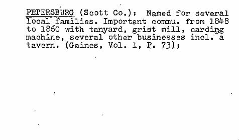
PETERSBURG (Scott Co.): Named for several local families. Important commu. from 1848 to 1860 with tanyard. grist mill. carding machine. several other businesses incl. a tavern. (Gaines. Vol. 1. ~. 73);

PORTER (Scott Co.); store & po est. 1878 witt bldg. ofjmain highway. Edward Vance ran the
~tore. (aCOTE CO. HIST., c1954 by the Co. Homemakers Clubs. Repro. & donated to the KHS in ms. form, 1975); po est. 10/25/1880, John E. Vance ••• Disc. eff. 8/15/1906 (mail to Sadieville) (NA); (Pron. "P(aw)r/ter") Couldr find out anything about Porter except its location. Nothing there now except the chur. Ir nw section of co. c. 4 mi. from Owen Co. line DK of·Edward or John E. Vance. (Mattie Griff: ith, interview, 4/8/1978);

I PORTER (Scott Co., Ky): Acc. to John E. Vance, 9115/80, the prop. names for this new office were: Ex Hill, Little Eagle, Non Hope (?) and the po would be I mi w of Eagle Creek, 3* mi e of Lyttles Fork PO, 4! mi w of Sadiev"ille PO. II Acc; to J. E. Vance, 6/411886, the po was 2 mi sw of Eagle Creek, 3! mi w of Josephine PO, 4 mi~of Sadieville po, 4! mi sw of Stonewall PO, 4!-5 m: ne of Skinnersburg PO. (SLR)j ca.,'lBBO, a commu. wi th"S'ch, Xian Chu., store, grist mill, 12 home ,with a pop. of 53. (Gaines II, P. 164); Ace to 1896 Polk',s Gaz •• T.J. Penn- had gen. sto e & Wm. Marshall was blacksmith; John E. Va ce was lo~al storekeeper. This was at jet. of: the mt. I. & Josephine Rds. Vias a viI;
6Y' Q... '("0" IY1 .

RAYS FORK (Scott Co., Ky): Acc. to John F. Smith, 8/21 1856, this was a site ch. 1 mi s (?) to a pt. 4t mi s of Jones PO, 5 mi n of Little Eagle PO, 7 mi w of Rutland po.II Acc. to Ibid., 9114/1865, the po was 18 mi n of Georgetown PO, 1 mi s of Rays Fork (Creek); Acc. to Ibid., 6/16/1868, the po was now Stonewall and was 4 mi s of Gouges PO, 6 mi w of Rutland PO. \\Acc. to W.C. Tucker, 6/28/1876, the po was 2t mi n of Big Eagle Cr.11 Acc. to L.D. Harris, 11/2/1885, the p~ was 2t mi e of Big Eagle Creek, 3 mi w of Hinton PO. \1 On 8/1/1905, Robt. Gillispie pet. for a site ch. 220 yards n to a pt. 4 mi w of Hinton PO, 3 mi w of Eagle Creek. Vil. of 40 pop. (SLR);
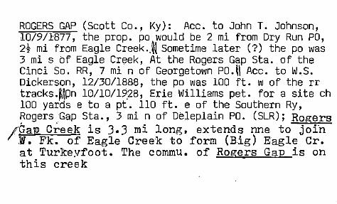
ROGERS GAP (Scott Co., Ky): Acc. to John T. Johnson, 10/9/1877, the prop. po would be 2 mi from Dry Run PO, 2t mi from Eagle Creek .. ll Sometime later (?) the po was 3 mi s of Eagle Creek, At the Rogers Gap Sta. of the Cinci So. RR, 7 mi n of Georgetown PO. II Acc. to W.S. Dickerson, 12/30/1888, the po was 100 ft. w of the rr tracks .Mpn 10110/19,28, Erie Williams pet. for a site ch 100 yards e to a pt. 110 ft. e of the Southern Ry, ~ogers Gap Sta., 3 mi n of Deleplain PO. (SLR); Rogers
/Gap Creek is 3.3 mi long. extends nne to join W. Fk. of Eagle Cree"k to form (Big) Eagle Cr. at Turkeyfoot. The commu. of Rogers Gap is on this creek

I\ROGERS GAP (Scott: Co.) I po est. 5/5/1879, Theis. T. Hedger ... Disc •. en •. 4/30/19?e; (mail to Geoit'~town) (NA); (Pron. "R(ah)dj erz Gh(ae)p'). Nr.Turkeyfo.ot & Muddy Ford. Ace:'. to a local resident,. the site was donated to the rr by a Mr. Rogers but he dk his 1st name RR came in c.1878.-, She doesnt think there are any Rogers still there •. (Mrs. Mattie Griffith interview, 4/8/1978); Wm. Rogers, pion'.; arr. at B"1:'Yans Sta'. in 1783 and thence to Sco1;t Co, in 1785. Settled in area betw.·Geo. & Gt. Xing'. Son Jos; moved to Dry Run' ar:ea. Jios.:s son W~. A; Rogers settled sof Rogers' Gap ln thE!' 1850s. This gap was "a passage on the old

Turkeyfoot Rd." to the Ohio R. and a sta. on the Cinei-. So. RR built in the 1870s. Wm. A. dIed in 1875. (Bevins, 1981, P. 48); The pioneers Valentine and Geo. Rogers, boug~t land nw of Delaplaim drained by the Rogers Gap B'r. of Dry Run Creek. Valentine was the son of Jos. Rogers.CIbid., P. 89); Ace. to 1896 Polk's Gaz •• this place had a pop. of 80 and was a sta. on the Cincy. So, Ry. L.Ni. Burges~was pm & rr agent. ~ohnson & Burgess ran the gen., store;

'.
The ROYAL SPRING gushes from a hill of limestoh~rock to/ the wend of town and joins the N. Elkhorn Creek t mi away. Water suppliec the town--furnished drinking water and power for the commu. ever since discovery; George. was founded c. 1790 around the Royal Spring which had been disc." by John Floyd in 1774. This ha,s been a never-ceasing source of wate.r for the commu; The Rev. Elijah Craig owned" th, site of" Geo. He laid it out. Act of"Va.'s G.A 12/1790 created the town; McClelland's Fort was on a hillside at or very close to the spring;I\Geo. on US 25,62,,460 & just w of I-75

v/In July i774 John Floyd. surveying land for Fr. & Ind. War vets.-. discovered spring that he named Roval Spring. McClelland's Sta. was abandoned 12/29/1776 after Indian attack. In 1782 Rev. Elijah Craig re-occupied the site & the town was soon est. as Lebanon. Inc. by Va G.A. 1784. And renamed George Town in 1790. Two yrs. later. when the co. was est •• it was named its seat. It was not until 1846 that th name was officially sp. one word. For most ,0
its 200 yr. hist. it was a trade & processing ctr. for area farm prod'ts. Geo. owed its later dev. to 1-75 and nw non-agri. industr's most notably Toyata in 19871

~ - ." SADIEVILLE (Scott County, Kentucky) Named for Mis~ Sadie Pack. (AC~. to' Coffman in a letler to Steel, 5/9/1922) (steel files, C.G.N., Washington, D.C.} (Check) "
Named for Mrs. Sadie pec~;r a resioent (1\cc. to HardY's thes.is, U oK 0, 1949, Po 490)
po est. 1/14/1878," .Fas; W. Jones.o.(NA);
Inc. 3/5/1880 (ACTS, 1879, Vol. 2, Po" 996);

jSADIEVILLE (Scott Co.) I 12 mi. from Georgetown 13 mi. from Cyntniana. Inc. 1880. Named for Mrs. Sadie Pack, wife of Richard Pack, a leading citizen of'the co. She died 1895. She was; most respected citizen.(P. 166). J.W. Jones built the 1st store. rr shipping sta. 1st pm was J.W. Jones.' •• (P.167~ (THE B.O. GAINES HIST OF SCOTTCO •. ,1904, repr~ted 1961, Pp. 166-70) Inc. 1880 and named q.,':} (>~. -:roe. fY\lI.l ~ for Mrs. Sadie Pack',. . . wife of Ricnard Pack. (SCOTT CO. HIST., 1954, by Co. Homemakers 'Clubs, repro. & donated to KHS in m~ form. 1975);

jS'ADIEVILLE (Scott C'o.) I Town occupies exactly 1 sq. mi. Founded 1879 3 yrs. ~rom date of completion of the Cincy. So. RR. 12 mi. from Georgetown. Influenced by location of rr. Onci import. shipping pt. ~~med for Mrs. Sadie Pac! "beloved" citizen who \d'ied 1895. (cf Gaines' History ••• ) Town"bisected"by Eagle Creek, the prin. stream through northern section of the county. Passes thru the farming area called "The OU'j;~r Bluegrass." (.-••• ) (Ann (:B'evins, "S'adieville in (banter of Scott-·Earm Area" LEX:. HER-LEAD. 3/3/1963);

,-It-t\"
-SADIEVILLE (Scott Co.) I -(pron. "Sa/dee/v( ih)l Named for Mrs. Sadie Pack. DK when or by whom
- it was settled.--Became a town when- rr went thru .. c1878-9. Before then, homes -& woods.
- Never -had 8l1other _name. Now: g .. ~. store, smal bank .. That's about all that's left.-.The other store bldgs. are vacant.D£,O. (Mrs. Mattie Gri-ffHh" interview, 4/8/1978); A station on the Cincy-, Southern RR. Est. at the time the rr.was built thru,-.c.1876. Inc. 1881.~POP;
_, (1880)=c.75. (Perr:m, 1882,-,P •. 209); . -. -.- . - S(c::)
- . -'

VSADIEVILLE (Scott Co., Ky): "This 6th cl. city with po is on Eagle Creek where Ky 32 crosses the So. Ry tracks, 11 (air) mi n of Georgetown. Founded on the Cinci. So. RR, completed thru this site in 1876, it was named for Sadie Pack, a highly respected citizen. The po was est. on Jan. 14, 1878 by Jas. W. Jones, who opened the 1st store there about that time. The town was inc. in 1880." (Book-P. 260); It's been the trac ctr. for n sect. of Scott Co. since 1877. (Bevins);

\ SADIEVILLE (Scott Co., Ky): Acc. to W. Truitt, 12/241 1~98~the po was 150 ft. e of the CNO&TP RR, 1/8 mi s of Big Eagle Creek, 4 mi w of Davis PO, 4 mi e of Porter PO, 5 mi s of Hinton PO, 3 mi from the co. line, (I Acc. to Richard S. Hayden, 7/25/1939, the po was 15i ft. n of the CNO&TP sta., 300 yards e of Eagle Creek, 3t air (4 rd.) mi from the Harrison Co. line, It mi e of US 25, 6 mi s of Hinton PO (in Harrison Co.), 15 mi n of Georgetown PO .. (SLR); Named for Sadie Pack
I (Mrs. 'Richard F. Pack). Site was nee Sarah Martha ~dmissn •. daughter of Wm. & Nancy (Kanna)'Efuison. (Bevins. 1981. P. 52), She wa1 granddaughtIT of AS.h Emison. pion. miller and landowner.- The Cinci. So. arr. in area in the

mid 1870s. Engineers would stop at her home and be "elegantly entertained" by -her. S'o they named tlte-1:r new sta •. S'adieville. The town was inc. in 1880 D¥ that name. Site died in 1895. (Ibid., P. 232); S'adie was "hostess to the construction engineers working on the (Cinci.So.)". Rapid growth betw. 1880 & 1905, By 1905. :i;'the place had 20 businesses, 2 banks I flour mill, F.D." hotel, 4 chu's., 3 fllDs, sch, and newsp. The 1st house in town was built in 1877 by Polk Fields. (Ibid., P. 248);

SAND LICK (Scott Co.) I (pron~ "S(ae)nd L(ih)k School built there c1893. On land donated by a Mr. Jones but dk his 1st name, In his will, it was to revert to his-heir.s after the sch. closed. Spelled 2 words. DK if a commu. there Assumes so. Nothing there now. cf· Echoes. (Mattie Griffi th,_' interview, 4/8/1978);
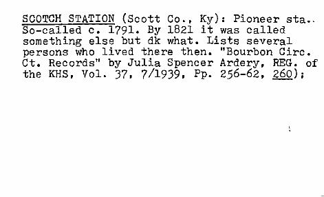
SCOTCH STATION (Scott Co .• Ky): Pioneer sta .. So-called c. 1791. By 1821 it was called something else but dk what. Lists several persons who lived there then. "Bourbon Circ. Ct. Records" by Julia Spencer Ardery. REG. of the KHS. Vol. 37. 7/1939. Pp. 256-62. 260);

SHAWNEE TRACE (Scott Co., Ky): "There was also the i ',~hawne~ Trace', so called, made by Capt. Jonn' Holder and his company, on Bowman: expedi tion against the Shawne.es in Ohio in 1779." (Sam' 1. ~lilson, "Shawnee Warriors at the Blue Licks" REG'. of the KHS, Vol. 32, April 1934, Pp. 160-68, 162);

SKINNERSBURG (Scott Co., Ky):Acc. to Andrew J. Bromback, 1/3/1899, the po was on McConne1s Run, 4 mi se of Long Lick PO, 7t mi nw of Georgetown PO, 3 mi e of Stamping Ground PO, 3 mi e of Ky. Midland RR, 3 mi nne of Duvall PO. (SLR); "Referred to im some early
deeds as Sltinnersville." (B'evins. 1981, P.IO]) Acc. to 1880 Census. Wm. Skinner lived in the Lvtles Fk. Dist •. He was age 26; ~ •. Skinner 11 ved in Big Eagle Frec. (1870 Cens.us); Ace'. 't( 1896 Polk's Gaz., G.M. Breen had a gro. & T.R. Burgess' had a gen. store i .

SKINNERSBURG (Scott. Co.) I po· est. as Skinners burgh, 6/6/1878, Jl"as. C. Murrel ••• ch. to Skinnersburg, 1/23/1894, Geo. M .• Breen ••• Disc. eff". 7/31/1902 ?eapers to Stamping G'round) (Nfl (Pron. "Sk(ih)n erz/berg"). Co\i:ldnt find oui< anything about this place. Now: nothing but 1 or 2 homes. DK of any present county families named Skinner. (Mrs. Mattie Griffith, interview, 4/8/1978); Hezekiah'Skinner is listed in the 1850 'Scott: Co. Census, eastern part of the co; Wm. Skinner's 100 acres on Eagle Creel in Qwen Co. were surveyed 7/11/1845 .. (Acc'. to Book'15, P. 401) (Jillson, II, P. 1700);

'SKULLBUSTER (Scott: Co.): "got its name from door o:t"l"the Corinth Church (sic). The door wils.)s'o built that when a tall person walked through, if he -not stogp (sic), He would have (sic) - a knot on his head.", (Ben B. Quilling;. ' of Georgetown, Ky. in a letter to m~; 2/231 1978); (Pron."Sk(uh)l/b(uh)st/er") The chu. is now the-Corinth Xian Chu. ("K(ah)r/(ih)nth S'buster was named oy John Cartinhour._He wen into the chu. 'with a friend who was so tall his head struck- the cap of the door. Mr. C. remarked to him -"Look:- out, you'll bust your skull." Present -brick struc-ture is -not the' same 'as in C'hour'stime.-The orig. log chur. was builtin the 1830s. DK if a communIty

was there before the chur. was so named. No commu, there now. Now at site:. chur. & cern. The old store there is now gone. 1-2 homes. Everyone called it Skullbuster; it was not a nickname •. People would refer to' someone living down around Skullbuster. ·This name iJ not given on contemporary maps •. It's .near Parish Lakes in no. part of the co ••• Nr. th! Long ~ick Pike. DK of any other name applie( to that vic. (Mrs. Mattie Griffith, inter.:. view, 4/8/1978); .

SKULL BUSTER CHURCH (sic) (Scott; CO.)I The Christian Church at Corinth, Lytle's Fk., was est. l:ietw. 1837-1842. 1st a log bldg, . 16x18 ft. For a long time called "Skull buster" "The way it got.its name was by Mr. John Cartenhour, who died just a short time ·since. A young man and a friend, a very tall man, was entering (sic ) the house toge.ther and the tall man struck his head against the cap of the door and Mr. Cartenhour remarked to him, to look. out or he would 'bust his skull,' hence the name.' Skull-buster. '" 2nd bldg. erec(\;ed 1859 by$bediaWallace and funded l:iy Robert Whi tter ••• (Edward Stockdell" im THE B.O., . GAINES HIST. OF SCOTT: CO. 1904, reprinted 1961 P. 163); .

SKULL BUSTER (Sic) (Scott- Co .• Ky): Two possible deriva.txons: a skull-shaped rock nearby or "violemce of the style of fig;hting." (Ace'. to B.W. Jones) (00.' Ladd, 4/17/ 1941, WPA ms. on·Ky. place names); The Skullbuster commu., a xrds centering on the Corinth Xian Chu. was named by John'Cartinhour •. "In the early years after the construction of the old log meetinghouse, Car. & Scott B' •. ~ones. were attending a mtg. when the taller of the two struck his head a fierce blow on the low doorway lintel." (Bevins, 1981, Po 61);

I
SODOM (Scott Co.): "A village known as Sodom once existed in this precinct (White Sulphur),;. but 'has passed away •••• " It was in the central part of the prec. ~~id out by Jas. and George Ware, the earliest settlers. Est. 1825. Had a pop. of 150 at one time. ViI. was est. around the Ware's cotton and hemp factory on South Elkhorn. Henry Hardy had a tannery .• Also a shoeshop and a carding machine were located there and a nearby grist mill on South Elkhorn built by Geo. Ware in 1825. Alex'r. Bell had store. Thriving until the r~pulled trade to other localities. Sodom "disappeared as effect ually as if it shared the fate of its namesake of Biblical notoriety ••• and many of the

citizens of White Sulphur have forgotten itf existence •••• Not a trace of it is to be seer except the old mill race." (Perrin, 1882, P. 202);

/ \SODOM (Woodford Co.), ("S(ah)d/am") Not at
the/site of Coles ~avern. cf J.W. McDaniels (slc) re- that whole section of the county. An old mill town. crr Atlas. It was n. of the rr betw. Midway and Spring Sta. but s. of S. Elkhorn Creek. N. of the Leestown 'Pike, in front of the Wates place now owned by T.M. Roach, acc. to Woman's Club Hist. of Midway: "Once there was a manufacturing town named Sodom on the banks of the Elkhorn Creek nr. the old Waverly home, shown on the old map of w,. Co. as Waverly, owned by D.C. Humphreys, known also as Fishers MiIl. Here at Sodom there were flour & grist mills, powered by

the race mills of,' the Elkhorn (sic). There were also cot~on and hemp factories •••• They played such an important part in the economy of the early settlers. Those at Sodom have also been reduced to a few crumbling rocks and dust as if they had never been." Eisher's Mill was run by a local family. Sodom was just a vil •. built up around the mills. The Fisher home' was at Midway", just below the rrtracks, 1000 yards nw of 164, out of Midway, n. of Leestown Pike (US461). DK why/how named Sodom. Sodom is. no more ••• (Lucile S. Davis, interview, 7/15/78);

SODOM (Scott-, Co.): Never heard of it nor ·knows anyol1e whd has. NoJi d'oes she know wher,e Junip~r Springs was/is. Doesnt think the
,covered bridge is stilL standing. (Mrs. Matifie Griffith, ,interview', 4/871978); Suppos~ ed to have been popu~atedby'slayes c1830s.' .Ac~. to', trad.', their masters lived nr. the sight of the covered bridge that crosses the stream that separates Scott & Woodford Co's. and on the hilrs overlookil1g the then FisherE Mill. T,he wog.den bridge is where 'Pepper Pike . cros'ses the S. Elkhorn 'Creek. By·' 1936, only the bridge Vias ,left to marK ,the ·commu •. At one "time, this town may have been 2nd to . G:eorgetown 'in size .• ' It was laid out in 1825., By 1880 it was .gone. ~~l?~icac~·,r1~me. (M.Ladd,

SODOM (and Juniper Springs) (Scott Co.) I
Supposedly inhabited by Colored people--slaves before the C.W. who "supplied labor for the various industries ••• Their masters, ace' •. to lore, lived near the bridge site, connecting Scott & Woodford, on the several hills about what· then was Fisher's Mill. 'Only the old covered wooden bridge where the Pepper Pike cross-es S. Elkhorn Creek reminds the modern way,flarer of the region of Sod om. The little town was probably second in size,in Scott; Co. Sodom was laid out in 1825. By 1880 had vanished." (M. Ladd, WPA G'eneral names-"Springs--Licks" folder); ~ l..;"I. =n' __
. 'B'" i"6-/ ( 1 ~ 3 Y (~,p·I.~

SODOM (Scott Co.). The Ladd article was derived from "Old Covered Bridge Only Marker at Site of Sodom, Once-Thriving Scott Town" in LEX. LEADER, 8/3/1934); The site was several hundred yards downstream from the old covered bridge which was still standing by 1934. At peak it had pop. of 150 with: cotton & hemp factories, tannery, carding machine, shoeshop distillery, store. All that was left of the site (c1934) was Old Juniper's Spring, 2t mi. nw of Midway & 10 mi. sw of G'town. Town laid out 1825 bY Geo. & Jas. Ware, local residents Gone by l~OO. Spring named for Old ~uniper, ancten~ ~~gro, ?neo~ th; last persons to live on he· s~ • ShU :&i1owlng by 1934., ~ ,C 1\,1<\).
U ,

I / -"l ...
SODOM (or LITTLE SODOM) (Woodford Co., Ky) I
was nickname for Woodford Settlement. See Barker's ~ map. This is site of Rfchard Cole. Sr's tavern. On what waS" early called the Coles Rd., then Lee~town Rd., now US 421. The tavern burned in 1811. The settlement faded out with the cl:ev. of Midway. Riverboat and barge men on the trip to NO would have to walk back to Ky.~hey had to be tough, reliant, a~gressive. A rowdy bunch much given to heavy drinking and fighti'ng when they:::.~visi ted Cole! Their behavior gave it that name. (~im Sames. interv. 5/8/1992);

SODOM (Woodford Co.): Manufacturing town on the Elkhorn Creek" nr. the old Waverly home owned by D.C. Humphreys-and aka Fishers Mill and Waverly. Here were grist and flour mills, cotton and h~~p factories •.•• (Lucile S. Davis "Hist'1. Tidbits" col. in the Woodford SUN, 6/1/1978, P. 3);

/ '.' ~ SPRlNG/DALE (sic (Scott Co., Ky): po est. as Cave
8, Lewis C. Suggitt; changed to Spring Dale 5/1/1 , .Lewis C. Suggitt; D.isc. 7/11/1853
ave Springs was several hundred rds. s of Run Bridge. The latter was 3 mi from Geo •. on 1000 acre tract of Col. Robt. Sanders. The Geo. & Lex. Tpk. crossed this bridge. The springs were on the side of the rd. Spring came from a cave and resembled a well. (Gaines I, Pp. 46-7); Lewis C. Suggett-in 1846 sold tc Jas. Kelly a log house on the Oakland Branch Tpk. (Fevins, 1981, P. 44); Col. Rob~ •. SanderE built So.Co's 1st tavern: im 1791 at a spring on the w side of the Lexo Rd •. ,. 3 mi s of Geo •• a

f'ew hundred yards from the Cave Run B:ridge. This was a large frame structure. (Gaines' I. P. 73); Ace. to 1850 Census. Lewis C. SUligett (52)! a manufacturer. lived in the W. Part of" D1st. #2;

J'~l""i "'I V?~ GESR8E!f0iiN- (Scott Co. ) I Anthony Lind~ey (si built a fort on LeCompte's Run, c1790 ••. (P.l Spell McClellan's name without the term. lid" So we assume it was spelled both ways. Lindsay (sic) Sta. consisted of 3 log cabins wit a stockade to hold"the livestock. It was located at the" jct."of the present Cedar Rd. & Rt. 227 ... (Pp. 47-8) (ECHOES OF THE PAST. Stamp,fi5.€i G"round·, Ky. 1'l75-1975, Womans Club of S. G.) ;

STAlVIPING GROUND (S'cott~ Co.) I (pron. "St(ae~ , l!!!!l27(ihb Grownd") '9 mi. from Georgetown.
The 1st sett'lement in the co. "The buffalo V congregated at the salt springs an~ stamped
the ground." She's'sure they were actually seen stamping the ground by the early pioneeJ: rather than their presence inferred. DK of a Hendersonville po but referred me to a retired Sadieville pm', Hill Marshall (who now carries the mail from G'town to Sadiev:) ••• (Mrs. Mat-eie Griff'i th, interview, 4/8/1978);

tSTAHPING GROli~D (:Scott Co/-', Ey.) "This thriving village 011 the 1'late7''' 0/1 North ElkhoF!1 Cre-:k in :Scott Co Ul1ty Vas orisinally a Gatl1E;ring place of vast herci's of buffalo. Before ':ihite men came to I~ent:uckyl s blue grass region this ul'ehistoric animal reIldesvo us on the great -buffalo path o'alled by the Indians-Al~nant-o-1'lami01'lee--l'Ias one of the choioest herding spots ill the great j'iilderness." (i'iil1aJ Rouse Jillson, PIOllEES KENTUJI<:Y, Franli:fort: The :state Jo umal Co., 1934, P. 102.) ,

STAMPING GROUND (Scott Co.): Shopping ctr. is planned. Branch bank and ele. sch. (c~974); Nearly destroyed by the tornado of 4/3/1974. Small CBD on both sides of US227 was rebuilt. Along with most of the homes and 3 chu's. Ele sch. was remodeled. Pop. increased from 400 to 600 from 1974 to 1979. Most of the pop. are "elderly". ('.'Stubborn Town Just Keeps Bouncing"Back" LEX. HER-LEADER, 4/8/1979. P. Jl:2-5, J2:l-4);

STAMPING' GROUND PO (Scott Co., Ky) I 1st pm was Alex'r. Hradford who was appointed 6116/ 1816; succeeden n/2/1819 by Andrew Calvert; then Fabricus C. McCalla 2126/1834; then Lewis Calvert 2/20/1835 •••• No mention of a Hendersonvil!e PO or a Herndonsville PO. (Echoes, I. P. 33); P&G has a Hendersonville PO in S'cott Co. from 1830~1834; No Herndonsv PO in P&G;

./ STAMPING GROUND (S'coti'; Co" Ky): In 1816 Robt ~ohnson' s estate "gave title" to this si tel'to Jos., & Scott Herndon. On 9/5/1817 the town was laid off and lots were sold. Several early deeds refer to the commu. as Herndonsville. (* ~ohnson's 162 acre farm), (Anrn Bevins, 1981" P •. 90) I
STAlVIPING GROUND' (with or without a hyphen between the two words) used as a generic or designator.
"Near the licks the buffalo might even trampl down all the growth. Such a place was called a stamping-ground. That too became the name of a town, and still an American may call his own particular haunts his stampingground." (Geo. R. Stewart, NOTL, 1967, P.152
9 mi. from Georgetownl inc. 1/24/1834; Named for the herds of buffalo attracted there by the salt water deposits"tramped or stamped down the undergrowth & soil for a great distance around." (Jane Bennett, WPA ms);

(STAMPING GROUND (Scott Co.) 1;';~'~k~:Us ~~- { .. from the fact that ~ f rst settlement of the country the buffalo use to congregate at i;. the sal t (ll'ix:l:a
STAMPING GROUND (Scott CO.), Garrett L. Robey, became pm 3/19/1958 and still is.
v"'''Irot known when or by whom the ,1st settlement was made within the city limits itself. The town was inc. in 1834 •••• S,O"G. took its name from the fact that in the 'first settlement of the county the herds of buffalo usee to congregate at the salt springs. They tran ped,or stamped down the soil for a great diE tanc'e around the spring as they stood under the shade of the trees waiting to get water, The to\vn grew up around the spring called Buffalo'Springs (sic). SG is located on the
;W9ters -of N. Elkhorn Creek •. , •• :' (ECHOES OF T} ~ o;:::r:i. ~ .r. <). IM" J 1 '1,> -I ~ "l S", \r ~ r cl..o..l. l' r-."",. {)"I'I

:STlIHPIHG GR01ND (~Soott County, ICy.) (F6701'i) "Ifuen explorers first caDe to thils section of Kentuclcy they found a large trail or buffalo road heading in a northeast-south~l.est direction The trail led to a lar3e spring of oold, clear '-iatel'. The stamping of ~Ihole herds of i'lild buf:'alo had packed the ground for hundreds of feet around the spri~g. nThe!exp:\.orers called th plaoe 'B;1lffalo :Stamp~ng \:iro Und.' It' >'Ia s from this that the tO~il1 of :Stamping Ground derived its name, because it ,'ias bUilt on this large area a11d nOI'/' oompletely s'l.l.ri"ounds the spring." (Q, Uimby, :SCRll TC!{ ilNELE, P. 317, from 100 al po st master) _

S,TAlVIPING GROUND (Scott, Co.): Town est. around the old Buffalo Spring, never failing even in severe drought. "An old resident explained that the buffaloes were accustomed to congregate near the spring and 'stomp around' and thus the early settlers called the area 'a stomping ground'. Later the name, through constant repetition, was changed to Stamping Ground. The rr which runs at the outskirts of the city is built in tHe direct path made by the roaming ~Nff) animals when they made freCJ.uent trips from the western barrens ••• " (Eunic-e Cunningham, "Town Traces Unique Name to Buffaloes" LEX. LEAD. ANNIV. ED. 1888-1938, 6/30/~9~8, Sec. 3. P. 11:5-8);

J STAMPING GROUND (Scott- Co., Ky): laid out in 1817 on site that Jos. & Scott Herndon had bought from Robt. Johnson. The sudden death of Scott pre~ded the development of-
rHerndonsville. (Bevins, 1981, P. 143); A !v;?
~He~sonville PO was est. in Sco~t Co. o~IAU~ 24, 1828 with~ewis Calvert, pm; Disc. 5/19/-1830; Re-est. 6/12/1830, Lewis Calvert; 12/1/ 1833, Present Calvert (POR-Pre 1830); The S.Gl
I po was est. 1814. (ace. to 200th Anni. of S.G I bv local Ruritan Club); Est. at the site of a buffalo spring and wallowing ground.laid out
1 in 1818 and inc. in 1834. 0t the main rd. bet1 'Frank. & Cinci. Its severa1catere<;s taverns/
to trave:fers. (B'evins);

STAMPING GROUND (Scott. Co.): Area 1st explorec 4/1775 by \'1m. McConnell, Chas. Lecompte, etaI. from Pa •••• In their party was Anthony Lindsay. c. 1790 Lindsay built fort there on old buffalc trace (main road betw'. GeorgelVown & Ohio 'R.) called Lindsay's Fort. He is buried 100 yrds. north. (Hi~hway markers at S.G. acc~ to GUIDE, ~o's. 217 & 218, P. 36); Anthony Lindsay built fort or sta. nr. S .• G'. in 1790, a "reg'I. stopping place for all travelers" betw. G' town & th Ohio R. (E.T. Brown on S.G,. in the HIST. OF FOU COUNTIES, pub. in 1882, repro. in qaines, 1904, P. 161);

STAMP:ENG GROUNDi~~t~ Co.): Inc. 1/24/18)4-. Nine mi. from G~town. The xeroxed hist. of S.G. was by ~.~Brown for Tom Combs' hist. published in 1882 ... (P.16d) (B.O. GKINES HIST. OF SCOTT CO" 1904-, reprinted 1961); ~So namec from the fact that the herds of buffalo which resorted here for salt water tramped or stamped down the undergrowth and soil for a great distance around." qbid .. P. 128); "Great herds of buffalo gathered there to stamp around and drink some of the finest water that a spring affords ••• called 'BUfralo Springs' from which thousands of gallons of good whiskey was made." (sic) (Collins in ibid.);

l..STAMP~NG GROUND (Scott Co.) I "Anthony Lindsay, ne 1736, died 1808. Served with Geo •. Wash. at the time Wash. & Braddock marched' ago the Fr. & Ind. at Ft. Duquesne, 7/1755. In bearing dispatches to Gov. Dinwiddie of V he stopped at the ~ome of Nicholas Dorset±J a large landowner ~n Md., where he met·& tel in love with 'Dorsey' s . daughter, RacheL •• Ab.out 1789 he 'left Md .. , lo.cated in Ky. in that part which became Scott Co ... " His son "settled nr. S.G. where he built LIND,SAYS FORT~' (Son's dates=1767 to 1831 in Scott- Co. The fort)became a stopping pIace for travelers. The site of this fort has been marked t a bronze plaque by the KHS. It was'over the
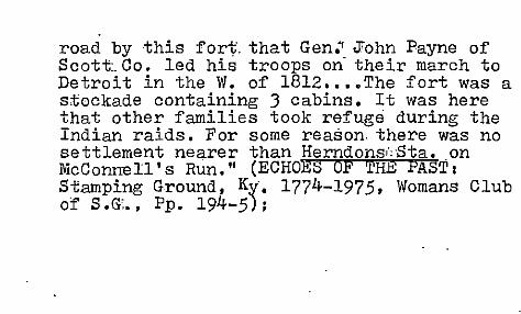
road by this fort. that Gen." John Payne of Scott. Co. led his troops on their march to Detroit in the W. of 1812 •••• The fort was a stockade containing J cabins. It was here that other families took refuge during the Indian raids. For some reason. there was no settlement nearer than Herndons i ,-5ta. on McConnell's Run." (ECHOES OF 'mE PAST: Stamping Ground, Ky: 1774-1975, Womans Club of S.G ... Pp. 194-5).

'-. ! .•.. {,
STAMPING G'ROUND (Sc'6'tt: Co.): Thos. Herndon 8 Cornelius Duvall settled on McConnels Run c. 1790 •• :Herndon was one of 'the earliest settlers of this section' 'of co. He moved' to thE vic. and built a log home on the h~ll.e. of McConn,el,ls Run Br:idge on the .road betw'. SG' &: G'town. (Echoes, P. 9): S.G.' po ,est. 6/16/
,+.8+6, Alex'r. Bradford: .,;Thos. Herndon's St. . • •• Ldc~ted'·on ihe~dge of a cln:r..'. :'only a '
few ·sto"l1.es remain to mark the,r site. (Ibid., -- P. 38). The 'town of S;G. :was laid out 1817 ,/ on land bought by' Jos •. & Scott, Herndon ,?efol V Robt. Johnson"s death J.n 1815. ,Scott "dJ.ed.
Defore he & bro. could develop plans for a

planned to q
town which they NaNia/call Herndonyille •••• (Echoes, P. 40); ffenry'Herndon lived in
Geo. in the 1830s; Thos. Herndon was one of the charter members of' the Stainp. Gr.' Hap. Ch' that had been est. in 1795 and was 1st called McC'onnBll's Chu. He and, Cornelius Duvall settled on McConnells Rurr; c. 1790. (Acc'. to Perrin,,'1882, from an article by E.T. Brown on St., Gr' •. ; S'tamp. Ground was nicknamed Old Stamp •. (Gaines II,. P. 162);

\ .,/ J STAIiI'PING GROUND (Scott:: Co', ) lOne of 3 such places known in pioneer Ky. "As the animals shed the hair of their hind@uarters. these portions became very sensitive to insect bite: for this reason they had r:ecourse t,o rolling in mud or clay which forms a protective cover for several days. These stamping grounds or wallows would normally be found near water and on the established game trails. Here all the grass and underbrush would be trampled down, leaving a bare spot composing several acres." Three such S.G. ,"confirmed by early :records" but only one, in Scott" Co., survives ~n the name of a community. (P. 197) Ivlarq uis

Ciillmes in a deposition once stated ,:!;hat pionee'r hunters actually called this "the stamping ground.'" This was aka "Lecounts Stamping Ground", on Lecount's Branch. (P. 204) .... (Neal Hammo'n, "Ifist'c. Lawsuits of the 18th Cent. tocating'The Stamping Ground REG. OF THE KHS. Vol. 69(3), 7/1971, Pp. 197-2IS); '.

/STAMPING GROUND (Scott Co., Ky): "This 6th cl. city with po is on Ky 227 and Locust Fk. of N. Elkhorn Creel 6t (air) mi nw of Georgetown. It has generally been assumed that large herds of buffalo, gathering at a salt spring here, trampled or stamped a considerable acreage of undergrowth and soil as they waited under the shade of the trees to taste the water. But Neal Hammon has offered another explanation: 'As the animals shed the hair of their hindquarters, these positions became very sensitive to insect bites; for this reason they had recourse to rolling in mud or clay which forms a protective cover for several days. These stamping grounds or wallows would normally be found near water and on the established game trails.

Here all the grass and underbrush would be trampled down, leaving a bare spot composing several acres.' Three such 'stamping grounds' were recorded in pion. days but only this survives in the name of a commu. A po called Stamping Grounds (sic) was est. at or nr. thE spring on Oct. 1, 1816, with Alex'r. Bradford, pm, but was disc. after only a few yrs. The town was laid out in 1817 and another po, est. perhaps in 1823 as Herndor ville, (sic)was renamed Stamping Ground in 1834, the year the..'town was inc." (Book-P. 281);

/STONEWALL (Scott- Co.) 16 mi. from a'toVin. (Gai'nes, 1904, P. 128); po est. as Ray's Fork, 2/26/1849, Robinson Jones ••• Disc. 6/23/1855; Re-est. 8/21/56, John F. Smith •• Disc. 1/20160; Re-est. 5~/60' Samuel W. Lucas; Disc. 2/10/63 Re-est. 9' 26 65, John F. Smith; ch. to Stonewall, 11 27~867' John F. Smith ••• Disc. 7/1/75 Re-est. 8/20/75, Wm. C. Tucker.(". (N;!!) I He est.) 9/6/75, Watson C. Tucker ••• Dis~. eff'.1 8/15/190 1
(mail to Sadieville) (NA); (Pron. "Stohn/ ' w(aw)l") On US25 but cou1dnt find out how it got its name. Heard of Rays Fork but dk who named for. (Mrs. Mattie Griffith, 4/8/78);

VSTONEWALL (Scott Co., Ky) I Acc:. to trad., thi: was on site of tavern & stage stop and was named for Stonewall Jackson.- (Gaines, II, P. 171); Alfred Ray is listed in 1850 Scott Co. Census; Rav's Fork po from 1849-1855; then Ravs Fork from 1856-1867 (POR-NA); Acc:. to Polk's 1896 Gaz., this place had a pop. of 50 Mallory & Neal gen'l. store; May also have been named for area stone fences; Ray's Fork was called such at least by 1811, aCc. to records;

./SUTERVILLE (Scott Co., Ky) I Xrds~ vil., Site was once owned by J.A. Suter, before 1874. (Bevins, 1981,. P. 224); Acc. to 1896 Polk's Gaz., Riddle & Son had the local gen. store; Ac~. to Lake's (1882) maps of Franklin Co., G.W. Suter (MD) was ne 1819 in Pranklin Co. & had a Peak's Mill PO address and B.P'. Suter. a farmer, was ne Owen Co. and carne to Frankl. Co. in 1865 and had a Switzer's PO address;

~SUTERVILLE (Scott Co., Ky): po est. 2/11/1885, James B. Glass; 4/11/1890, James F. Addison .•. 3/18/1904, Jos. B. Glass; Disc. eff. 8/15/1905 (mail to Stamping Ground (POR-NA); Ace. to James B. Glass, 6/19/1884, the prop. name was Sutersville. The po would be 3 mi se of Harmon PO, 4 mi n of Minorsville PO, 4t mi s of Rockdale PO, 1 mi s of Caney Fork. Not a viI. (SLR); Harrison W. Suter is listed in the 1850 Census,(See;j;;j;-geT) but for Franklin Co.: Jesse A •. Suter is same bUlt for Owen Co. No Suter is listed· in 1850 Scot~ Co. Census;

~ARLETON' (Scott C·o •• K.V): J'eremiah Tarleton "pioneer who was instrUlJlental in est. (the) Cath'., commu. ail1l. parish"a:t what b-ecame White Sulphur. He too settled in Scott Co. im1786. Died in'1827, or '26. He opened 'a tavern in the vic. ca. 1800 and soon became one of the co's. largest landowners. His sons and sonsin-law heired his holdings. In 1829 J'as. Comcrs bought land from Geo. Tarleton. (Combs was pm,of Tarleton PO). Combs bought 149 acres and the Tarleton Tavern from Geo. (liP.. P • 16); f-h..- '" e ~",' "'-.f'
,~~ I

A-URKEYFOOT (Scott Co., Ky): "Little remains of this 19 cent. indo town on Ky 620, 8 (air) mi nne of Georgetown. The area was settled around 1790 and named, possibly by Col. Robert Patterson, for the resemblance to a turkey's foot of the jct. of the 3 forks of Eagle Creek. The town of Turkeyfoot was founded around 1817 and the local po was est. on Jan. 31, 1831 with Bushrod W. Wash, pm. After an intermittent existence, it close in 1886." (Book-P. 299); Acc'. to P&G, Turkey Foot po operated from 1826-18831 By 1,880 Turkeyf'.
was a small vil •. with store, po, blacksmi thshop, chu., Masonfc lodge,. several homes. Settled' ca. 1790 by Wm •. rance •. (Perrin,. 1882,. P •. 210) 1
TURKEYFOOT (S'cott Co., Ky) I: The vic; was /named by Col. Robt. Patterson ca .1780 for the
3 forks of Eagle Creek that resemble the 3 toed foot of a turkey. Col. P. was ~t McClelland's Sta. in 1775 and was a co-founder of Lex. Several of his associates in depositions (1817) confirmed his naming of this sitel ~ohn Stevenson, Jacou Stucker. Thos.
~ ..
Herndon. The site was settled ca. 1790 by Wm'. Vance. In 1854 the local Xian Chu. was est. Mandeville Hinton (ca. 1879) was pm and local storekeeper. (Bevins, 1981, Pp. 99-100);

/TURKEYFOOT (Scott Co.): Vil. s@ttled,c.1790 by Wm. Vance. Mills; tanneries, distill'eries ••• TurkeyfoorJ;' Hd. betw. Harrison Co. & Georgetown, Hoad laid out in c.1795. Spelled one word ••• (The B.O. Gaines Hist. of Scott Co., 1904, reprinted 1961, P. 171); po est. 1/31/1831,1"''l.-{,. Bushrod W. Wash (or earlier::?) .. Disc • .? /13/38; He-est. 4/24/1851, Thos. L. Moore; Disc. 1016/ 1851; He-est. 11/3/51, Jas. Fields ••• Disc. 9/ 20118,59; He-est. 3/1/1860,. Geo. W. Bates; Disc 5/16/62; He-est. 1/10/71, Jas. D. Foone; Disc. 7/16173; He-est. 7/10178, Mandeville Hinton; Disc. 4/24/83; He-est. 2/10/85, ~as. S. Parker; Disc? 6/19/86, (no papers sent)@ (NA);
(~~ -\-0 rJ "Vlf)

'<IlL ... nJl.A.N'~ "'*"'" JTURKEY FOOT (Sco~t. Co.):~. to depos1tions
made by pioneer "Settl~ in 1817. the site was named for the resemblance to a turkey's foot of the J-branches"w~~ flowed into-Little Eagle Creek.." .. Ace. t~~~e deponent. Jacob Stucker. Co,l~·~Patterson t.old him that he had named- the site Turkeyf'oot (sic) "from the manner in whicb the forks meet"., in 1783 or • 84. For several decades after 1817. the community_established
.. there (and called Turkeyfoo~) was a thriving industrial town'with mills, tanneries, an~ distilleries. ,The Hintons ,and -Carrs may (have been first settlers c.1790. By 1966r;J it, :Was a small viI. with a church •••• (Ann Bevins;-- '.'Turke tg~t (onew0f,d) was the Pla~ - Where J F.orks ,
e rs e cted l y, [ e ~.:. y I{/, 'fi I 'rio (,) • : .. -

TURKEY FOOT (Scott Co., Ky): Acc. to J.O. Boone, 12/121 1870 (the re-est. po) woyld be w bank of Eagle Creek, 4 mi s of Little Eagle PO.II Acc. to Mandeville Hinton, 7/2/1878, the po was on the s. bank of Eagle Creek, 5 mi s of Sadieville PO, 3 mi e of Rogers Gap RR Sta. Not a viI. (SLR); .,~
7/11 tlS'Y, To-.$', f'~(. ~~

TURKEYFOOT (Scott Co. ) :' ,(prone ,"Ter/kee/foot" Now: home. Was a store there till c. 8-10 yrs 9-go. Otherwise, there's nothing there. Used t (~e a flourishing trading com~u. for area farm 'ers. (Mrs. Mattie Griffith, interview, 4/8/ 1978); Earliest settlers, c1790=Wm. Vance, Asher Hinton, Benj. C~rr, etc. Named for the "fancied resemblance of the junction of (3) streams to a turkey's" foot." They are the Eas and West Forks 'of Big Eagle which unite to form Big Eagle Creek. (Perrin, 1882. P. ,210) This was once ,a thriving xrds vile on the mai rd. from Lex. to the Ohio R. Bypassed by newer roads;

WHITE SULPHUR (Scott Co., Ky): Pop. 150. Leo T. Twyman, pm & gro. (lS96 Polk Gaz.);
/wHITE SULPHUR (Scott Co., Ky): "Little remains of a famed antebellum health resort centered at the jct. of the present US 460 and the Ironworks Rd., 7 (air) mi w of Georgetown. The site was first owned by Col. Rich'd. M. Johnson, who est. the resort in the early 1830Sin the vic. of several white sulphur springs. The-local po, est, as Tailton on June 23, 1837, with James Combs, pm, was moved to and/or renamed White Sulphur the following year. It was disc. in 1902." (Book-P .. 317) j
Cath., commu. settled' 1786' by Maryland Catholics detracted from their' orig •. intention of joining other. Cath's., in Nelson Co. P'amilies Degan arri ving from M'd., in 1786. (B'evirrs, 1981,. P •. 16);

~vmITE,SULPHUR (Scott CO.)I Named for the white sulphur springs, a famed health resort from 1830-1850. Many persons from allover were attracted by its mineral water. Several large bldgs. constructed and as many as 500 guests could be accommodated,at one time. The springs were run by Moran & Johnson. The resort was 7 mi. from G'town and .10 mi. from Frankfo'rt. The land' .on w!iich the, 'springs &. resort were located was '1st owned by Col. Richard Johnson. Near here Col. Johnson moved his Indian school from Blue Lick S~rings & buil t the Choctaw Academy.' •• (P .158) cf Perrin~ 1882 hist ••• By the turn of the cent., White

Sulphur was a little viI. with sch., gro., blacksmith shop. A farming town. No longer a great resort •••.. (P.159) (THE B.D. GAINES HIST. .OF SCOTT~ CO .• , 1904, reprinted 1961); Acc. to Neuman C. Lucas, 12/28/1898, the· po was Ii mi from the co. line, It mi n of S. Elkhorn Creek, 2 3/4 mi e of Woodlake PO. (SLR); Jas. Combs bought
V Jeremiah Tarleton's log tavern in 1829. The tavern had been built in the 1780s. (Bevins, 1981, P. 233);
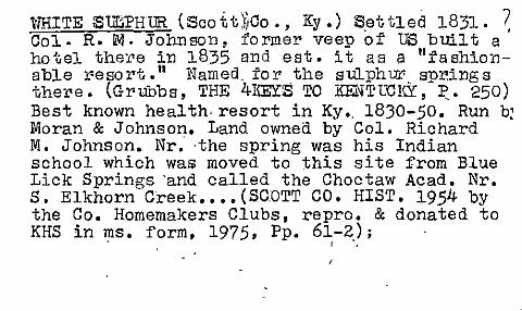
i'nUTE Sur:;PHUR (Scott'hCo., Ky.) Settled 1831. ~ Col. R. M. Johnson, former veep of US bUilt a ho'Gel there in 1835 and est. it as a "fashionable resort." Named. for the sulphw. .. springs there. (Grubbs, THE 4Irn:YS TO KENTUCICY, ~. 250) Best known health· resort in Ky •. 18)0-50. Run b~ Moran & Johnson. Land owned by Col. Richard M. Johnson. Nr: ·the spring was his Indian school which was moved to this site from Blue Lick Springs 'and called the Choctaw Acad. Nr. S. Elkhorn Creek •••• (SCOTT CO. HIST. 1954 by the Co. Homemakers Clubs, repro. & donated to KHS in ms. form, 1975, Pp. 61-2); . , .

WHITE SULPHUR (Scott Co.) I Vill. on the Georgetown-Frankfort Pike, c. 8 mi. from G'town. 1st house built 1831 and its 1st ~WN* RX)occupant, Jas. Hendrickson, was a b~acksmith. Spring led to the dev. of a "fashionable resort"-with the building of a hotel there in 1835 by Col. Dick Johnson. By 1880, had a sch., store, 7 homes. Named for the white s~lphur spring which had been the site of Col. Johnson's Indian school._ .• 0 (Perrin, 1882, P. 202);

WHITE SULPHUR (Scott- Co.) I (Pron. tlW(eye)~-3;(. ./ (ah)t!s(uh)l!fertl ) "Named for white sulphur
Springs. Used for medicinal purposes. A healtl resort from 18JO-50.Located on-the Frankfort Pike by St. Pius, Cath. Chu. DK who was the lsi settler or built the resort. The Choctaw Acad,
'? c.4-5 mi. from G'eorgetowm was on the S'.G. Rd. L not too far from W.S •. ( .... ) Never heard of .
Tail ton as either a place name. ;or a, family naIl Ann Bevins had an article on W.S. in an early 1960s issue of LEX. LEADER •••• Now at site: just church and cem. acros,scthe rd.from chu. (mattie Griffith, _4/8/1978) j

./WHITE sULPHUR '(~c~'tt' 'Co. ) I octa;A;;-~de~ C(..r,,\
had a po est. 1/5/1827, Thos. Henderson &p , _0 ); Disc. 1/14/1840 (NA); p.o. called
,!!'-hi 1 tml. was est. 6/2)/1837, James Combs; ch. I to White Sulphur, 9/22/1838, Lewis Calvert ••• , 9/8/1840, Thos.,Henderson •• Disc. 3/22/44;
Re-est. 5/3/44, ~aniel Vand~rslice ••• Disc. ll/12/186lli; Re-est. 3/1/1865, Thos. J. McClelland •.• (NA); 10 mi. from G'town. (Gaine: 1904, P.128); l?o disc. eff. 5/15/1902 (paper to Georgetown) (NA); , ,
._ !u. (..-G<j' _I~) ~~'e"'-"'). (~-t-q-~ 4"~ ~' ,j+-, ,
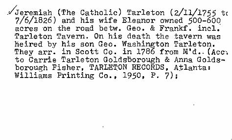
.viJeremiah (The Catholic) Tarleton (2/11/1755 tc 7/6/1826) and his wife Eleanor owned 500-600 acres on the road be tw. Geo. & FrankL incl.' Tarleton Tavern. On his death the tavern was heired by his son Geo. Washington Tarleton. Theyarr. in Scott Co. in 1786 from M'd •. (Acc'. to Carrie Tarleton Golds:Dorough & Anna Goldsborough Fisher, TARLETON RECORDS, Atlanta: Williams Printing Co., 1950, P. 7);

/ ZION HILL (Scott" Co;, Ky): Negroe s bought lots from local landowner, Hill Robinson. D: when. Negro church org. in 1872. (Peter Craig-::j,Smi th, "Negro Hamlets and Gentleman Farms" PhD Diss., UK Geog. Dept., 1972, P. 55); Black hamlet est. for freed slaves. DK when. Local chu. was org. 1872. Long a source of labor for area horse farms. But now in a period of transition to non-farm employment. ~efore the·mid 1920s, its pop. supplied the hemp producers of the Bluegras with labor supply. Could walk to work. Prod'n. declined after the mid 1920s. (Karl B. Raitz, THE KY. BLUEGRASS: ·A REG'L. PROFILE & GUIDE, UNC-CH, Dept. of Geog. Studies in Geog. No. 14, 1980, Pp. 107-8)

Charles H. Long 502 'Ii. Clin ton Georgetovm, Ky.
, , (
1" Ace. t.o Buck Scalf/ he might be interested ir the P.N. Survey. He s an industrial ene;ineer and is interested in regional history.J
He didnt anm'rer my letters of 5/23/1971 or 3/3/1972.
Buck says there's an old 2 vol. history of Scott Co. reo Sadieville, etc. Buck has it.
~ "r"'".

1475. '_Eberhardt, Dr. R. H., and other2./' Pageant of Scott County History. 1774-1924. 23 cm. 55 pp. illustrations, printed wrappers. I Published by ~ Georgetown Co11egi/. '=Georgetown,-Ky~/: 1924 KYU;KYF Series of pageants depicting various events in Scott County history, as the Choctaw Indian School and McClelland's Fort.