Embed Size (px)
Citation preview
Avenor
173-179 Walker Street & 11-17 Hampden St, North Sydney —
Aeronautical Impact Assessment for Planning Proposal
Version 1.1 19 March 2019
strategic airspace
Prepared by Consultants: Strategic Airspace
Strateg ic Ai rspace Pty L imited
AB N: 60 097 85 7 4 15
PO Box 253, Bondi Junct ion NSW 1355 Au stra l ia
Tel : +61 2 9211 0085
Emai l - Attn : [email protected]
Client: Property Holdings Pty Ltd
Avenor
Document Control
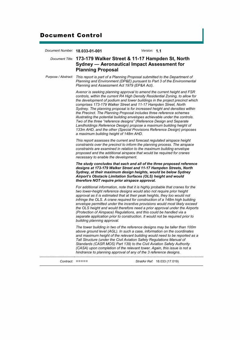
Document Number: 18.033-01-001 Version: 1.1
Document Title: 173-179 Walker Street & 11-17 Hampden St, North Sydney — Aeronautical Impact Assessment for Planning Proposal
Purpose / Abstract: This report is part of a Planning Proposal submitted to the Department of Planning and Environment (DP&E) pursuant to Part 3 of the Environmental Planning and Assessment Act 1979 (EP&A Act).
Avenor is seeking planning approval to amend the current height and FSR controls, within the current R4 High Density Residential Zoning, to allow for the development of podium and tower buildings in the project precinct which comprises 173-179 Walker Street and 11-17 Hampden Street, North Sydney. The planning proposal is for increased height and densities within the Precinct. The Planning Proposal includes three reference schemes illustrating the potential building envelopes achievable under the controls. Two of the three “reference designs” (Reference Design and Separate Landholdings Reference Design) propose a maximum building height of 133m AHD, and the other (Special Provisions Reference Design) proposes a maximum building height of 148m AHD.
This report assesses the current and forecast regulated airspace height constraints over the precinct to inform the planning process. The airspace constraints are examined in relation to the maximum building envelope proposed and the additional airspace that would be required for cranes necessary to enable the development.
The study concludes that each and all of the three proposed reference designs at 173-179 Walker Street and 11-17 Hampden Streets, North Sydney, at their maximum design heights, would be below Sydney Airport’s Obstacle Limitation Surfaces (OLS) height and would therefore NOT require prior airspace approval.
For additional information, note that it is highly probable that cranes for the two lower-height reference designs would also not require prior height approval as it is estimated that at their peak heights, they too would not infringe the OLS. A crane required for construction of a 148m high building envelope permitted under the incentive provisions would most likely exceed the OLS height and would therefore need a prior approval under the Airports (Protection of Airspace) Regulations, and this could be handled via a separate application prior to construction. It would not be required prior to building planning approval.
The tower building in two of the reference designs may be taller than 100m above ground level (AGL). In such a case, information on the coordinates and maximum height of the relevant building would need to be reported as a Tall Structure (under the Civil Aviation Safety Regulations Manual of Standards (CASR MOS) Part 139) to the Civil Aviation Safety Authority (CASA) upon completion of the relevant tower. Again, this issue is not a hindrance to planning approval of any of the 3 reference designs.
Contract: StratAir Ref: 18.033 (17.019)
Change History
Version Versn Date Version By QA By Version / Change Description
1.0 Draft 04-Mar-2019 C. Pak-Poy J. McCarthy Preliminary version for team review
1.1 19-Mar-2019 C. Pak-Poy J. McCarthy Amend Reference Design naming; incorporate new planning-related text; amended plan imagery
Distribution Control
Legend: Uncont Uncontrolled Document StratAir Strategic Airspace Client Avenor AsA Airservices Australia APT,
SACL Sydney Airport Sydney Airport Corporation Ltd
Infrastructure, DIRDC
Department of Infrastructure, Regional Development & Cities
CASA Civil Aviation Safety Authority
Issue Version Issue Date Issue Purpose / Description Copy No Copy Recipient
1.0 DRAFT 04-Mar-2019 Distribution to Client for review Uncont StratAir, Client
1.1 19-Mar-2019 Final Version Uncont StratAir, Client
This document was prepared by Strategic Airspace Pty Limited on behalf of client Avenor Copyright © Strategic Airspace Pty Limited, 2019
All Rights Reserved. No part of this document or its entirety may be divulged, commercialised, translated, reproduced and/or copied in any form or by any means without the express and prior written permission of
the copyright holder. Whilst this document has been prepared using all due and customary care, StratAir reserves the right to
correct any errors, omissions or misrepresentations. The authorised recipient of this document is hereby granted permission to use the contents of this document and to make and transmit copies in a secure manner for the purposes of evaluation or the report contents;
liaison with its consultants and relevant State and/or international authorities for the purposes of verification, regulatory and operational impact, and/or approvals; and any pursuant negotiation with StratAir as part of its
project evaluation and completion processes. In the event of translation for this purpose and any discrepancies between the translated and original
versions, this original text will prevail.
173-179 Walker Street & 11-17 Hampden Street North Sydney — Aeronautical Height Assessment for Planning
For: Avenor Report by Strategic Airspace
March 2019 i 18.033 [18.033-Avenor_173-179Walker+11-17Hamden_NSyd_AeroImpact_v1.1.docx]
Contents
Change History ................................................................................................. iv Distribution Control ........................................................................................... iv
1. Executive Summary ........................................................................................ 1
2. Introduction ..................................................................................................... 5 2.1 The Precinct Description ........................................................................... 5 2.2 The Proposed Development from the Aviation Perspective ...................... 7
3. Aeronautical Impact Context.......................................................................... 7 3.1 Location of the Proposed Development .................................................... 7 3.2 Methodology .............................................................................................. 8
3.2.1 Airspace Regulations ................................................................................. 8 3.2.2 Prescribed Airspace ................................................................................... 9 3.2.3 Note about Heights: Australian Height Datum (AHD) vs Above
Ground Level (AGL) ................................................................................. 10 3.2.4 Making an Application for an Aviation-related Airspace
Height Approval ....................................................................................... 10
4. Analysis .......................................................................................................... 11 4.1 OLS Analysis ........................................................................................... 11 4.2 PANS-OPS Analysis ................................................................................ 13
4.2.1 “Area” Procedures .................................................................................... 14 A Minimum Sector Altitudes (MSAs) ............................................................................... 14 B Circling Minima ............................................................................................................. 14
4.2.2 Instrument Approaches & Missed Approaches ........................................ 15 A Approach Procedures to RWY 16L .............................................................................. 15 B Missed Approach Segments of Approach Procedures for RWY 07 and
RWY 34R ..................................................................................................................... 15 4.2.3 Departures ............................................................................................... 15
4.3 Other Assessment Considerations .......................................................... 16 4.3.1 Radar Terrain Clearance Chart (RTCC) / Minimum Vector Altitude
(MVA) Surface ......................................................................................... 16
5. Conclusion ..................................................................................................... 18
Tables
Table 1 — Short Summary — Airspace Height Constraints ........................... 3 Table 2 — Summary — Tower Buildings, Airspace Impact & Approvability
Implications ................................................................................. 3
Table 3 — Summary — Airspace Height Constraints................................... 11
Table 4 — OLS Height Impact & APAR Approval Implications .................... 12
Table 5 — PANS-OPS Height Limit Summary ............................................. 14 Table 6 — PANS-OPS Height Impact & APAR Approval Implications ......... 14
173-179 Walker Street & 11-17 Hampden Street North Sydney — Aeronautical Height Assessment for Planning Report by Strategic Airspace For: Avenor
ii March 2019 [18.033-Avenor_173-179Walker+11-17Hamden_NSyd_AeroImpact_v1.1.docx] 18.033
Table 7 — Other Assessable Height Limitations — including the RTCC MVA Limit .......................................................................................... 16
Table 8 — Summary —Airspace Impact & Approvability Implications ......... 18
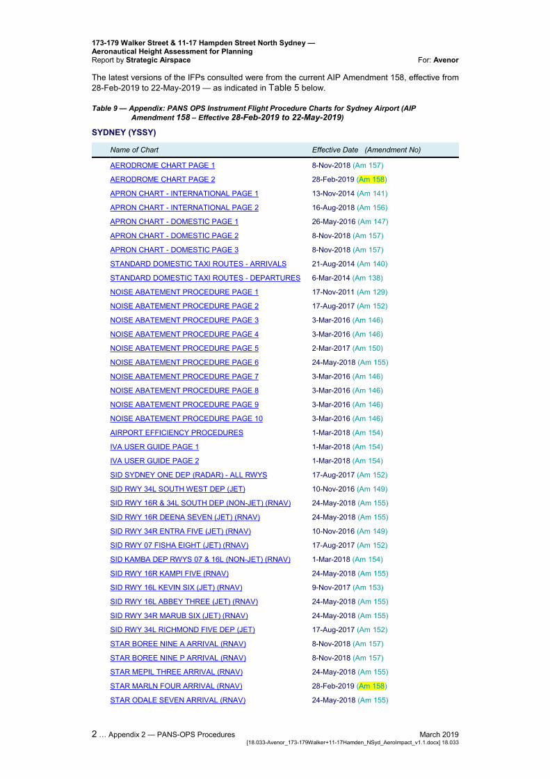
Table 9 — Appendix: PANS OPS Instrument Flight Procedure Charts for Sydney Airport (AIP Amendment 158 – Effective 28-Feb-2019 to 22-May-2019) ......................................................................... 2
Figures
Figure 1 — Precinct Location .......................................................................... 1
Figure 2 — East Walker Street Precinct in relation to Sydney Airport ............ 2 Figure 3 — 173-179 Walker Street and 11-17 Hampden Street
Reference Design ....................................................................... 6
Figure 4 — Special Provisions Reference Design, East Walker Street Precinct, North Sydney ............................................................... 6
Figure 5 — Location of Aeronautical Assessment Coordinate ....................... 7 Figure 6 — East Walker Street Precinct in relation to Sydney Airport (Large
Format) ....................................................................................... 8
Figure 7 — Precinct in relation to Sydney Airport’s OLS .............................. 12
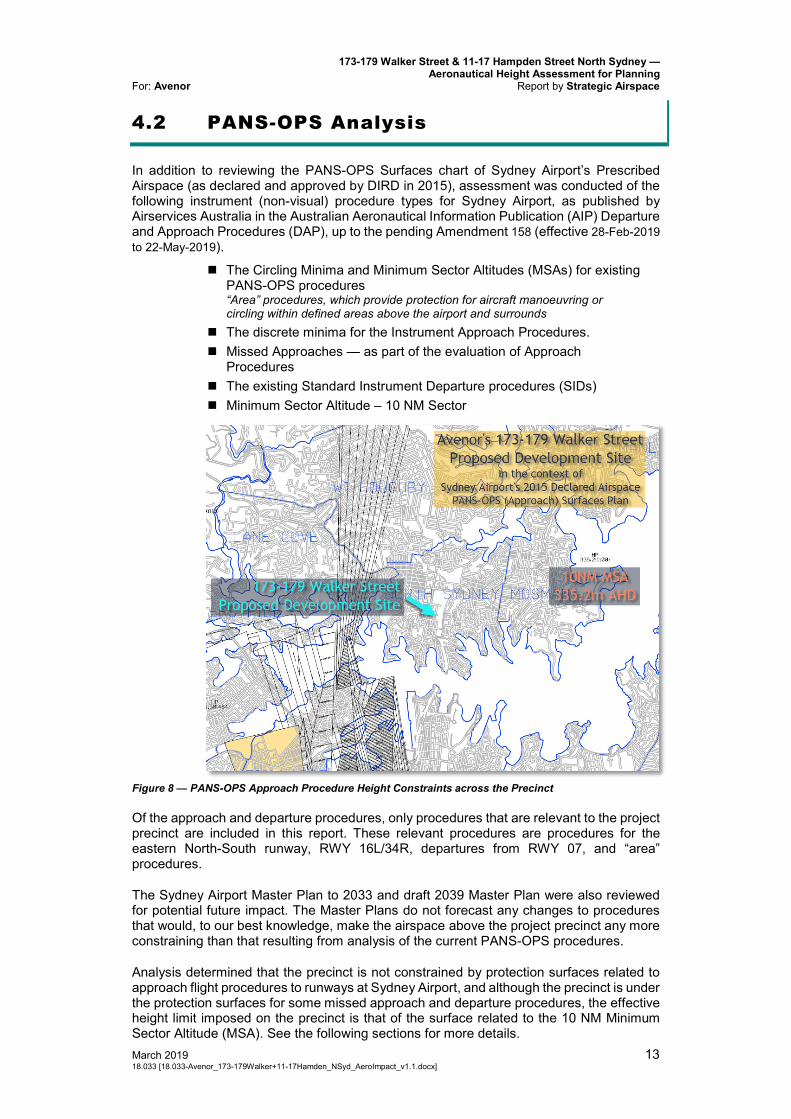
Figure 8 — PANS-OPS Approach Procedure Height Constraints across the Precinct ..................................................................................... 13
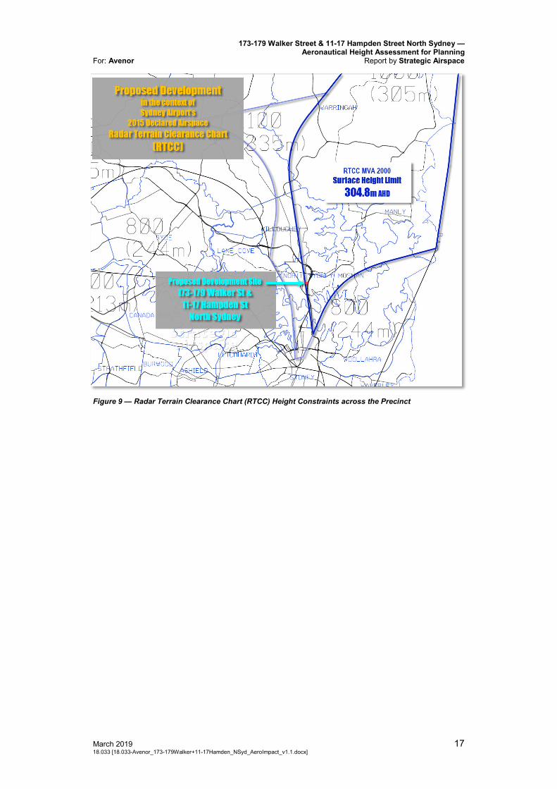
Figure 9 — Radar Terrain Clearance Chart (RTCC) Height Constraints across the Precinct ................................................................... 17
Appendices
Appendix 1 — Abbreviations
Appendix 2 — PANS-OPS Procedures
173-179 Walker Street & 11-17 Hampden Street North Sydney — Aeronautical Height Assessment for Planning
For: Avenor Report by Strategic Airspace
March 2019 1 18.033 [18.033-Avenor_173-179Walker+11-17Hamden_NSyd_AeroImpact_v1.1.docx]
1. Executive Summary
This report is part of a Planning Proposal submitted to the Department of Planning and Environment (DP&E) pursuant to Part 3 of the Environmental Planning and Assessment Act 1979 (EP&A Act).
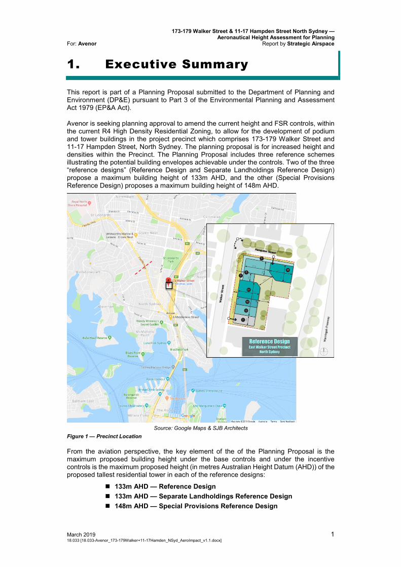
Avenor is seeking planning approval to amend the current height and FSR controls, within the current R4 High Density Residential Zoning, to allow for the development of podium and tower buildings in the project precinct which comprises 173-179 Walker Street and 11-17 Hampden Street, North Sydney. The planning proposal is for increased height and densities within the Precinct. The Planning Proposal includes three reference schemes illustrating the potential building envelopes achievable under the controls. Two of the three “reference designs” (Reference Design and Separate Landholdings Reference Design) propose a maximum building height of 133m AHD, and the other (Special Provisions Reference Design) proposes a maximum building height of 148m AHD.
Source: Google Maps & SJB Architects
Figure 1 — Precinct Location
From the aviation perspective, the key element of the of the Planning Proposal is the maximum proposed building height under the base controls and under the incentive controls is the maximum proposed height (in metres Australian Height Datum (AHD)) of the proposed tallest residential tower in each of the reference designs:
133m AHD — Reference Design 133m AHD — Separate Landholdings Reference Design 148m AHD — Special Provisions Reference Design
173-179 Walker Street & 11-17 Hampden Street North Sydney — Aeronautical Height Assessment for Planning Report by Strategic Airspace For: Avenor
2 March 2019 [18.033-Avenor_173-179Walker+11-17Hamden_NSyd_AeroImpact_v1.1.docx] 18.033
The airspace constraints are examined in relation to the maximum building heights proposed and the additional airspace that would be required for cranes necessary to enable the development.
This report has been prepared having regard to Prescribed Airspace for Sydney Airport. It examines the current and forecast regulated airspace height limits constraints overhead the precinct that are related to aviation airspace protection requirements and which would:
a) Trigger the requirement to apply for an airspace height approval; b) Constrain the maximum permissible building envelope heights; and c) Constrain the maximum permissible heights for cranes that would be
required to enable construction of the proposed development.
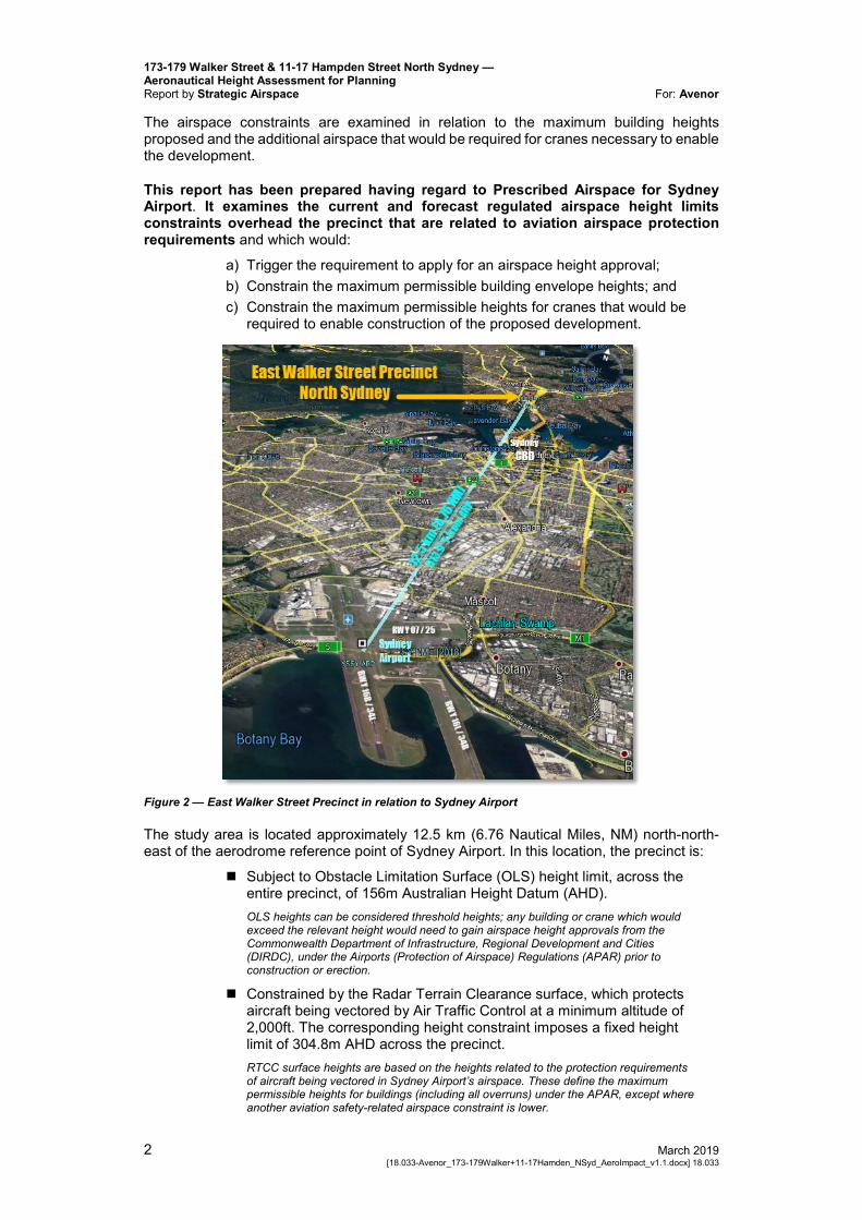
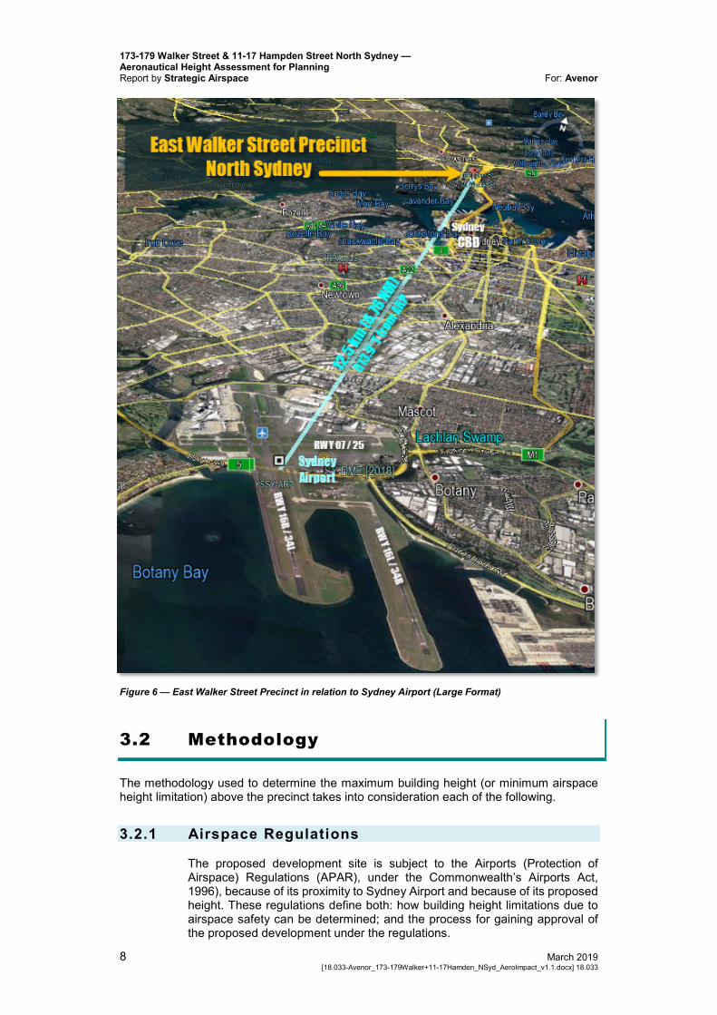
Figure 2 — East Walker Street Precinct in relation to Sydney Airport
The study area is located approximately 12.5 km (6.76 Nautical Miles, NM) north-north-east of the aerodrome reference point of Sydney Airport. In this location, the precinct is:
Subject to Obstacle Limitation Surface (OLS) height limit, across the entire precinct, of 156m Australian Height Datum (AHD). OLS heights can be considered threshold heights; any building or crane which would exceed the relevant height would need to gain airspace height approvals from the Commonwealth Department of Infrastructure, Regional Development and Cities (DIRDC), under the Airports (Protection of Airspace) Regulations (APAR) prior to construction or erection.
Constrained by the Radar Terrain Clearance surface, which protects aircraft being vectored by Air Traffic Control at a minimum altitude of 2,000ft. The corresponding height constraint imposes a fixed height limit of 304.8m AHD across the precinct. RTCC surface heights are based on the heights related to the protection requirements of aircraft being vectored in Sydney Airport’s airspace. These define the maximum permissible heights for buildings (including all overruns) under the APAR, except where another aviation safety-related airspace constraint is lower.
173-179 Walker Street & 11-17 Hampden Street North Sydney — Aeronautical Height Assessment for Planning
For: Avenor Report by Strategic Airspace
March 2019 3 18.033 [18.033-Avenor_173-179Walker+11-17Hamden_NSyd_AeroImpact_v1.1.docx]
The relevant airspace constraints overhead the study area are summarised as follows: Table 1 — Short Summary — Airspace Height Constraints
Height Limits
(m AHD) Height Limit Detail Comment
156 OLS Outer Horizontal Surface (OLS OHS)
THRESHOLD HEIGHT limits (depicted in Figure 6, p12) Any development that would exceed the relevant limiting heights across the precinct would require a prior ‘airspace height’ approval from the Department of Infrastructure and Regional Development under the Airports (Protection of Airspace) Regulations (or APAR). ALL of the proposed Reference Designs, at their top heights, would be BELOW the OLS and would therefore NOT require prior airspace approval. Cranes that would not infringe the OLS would not require prior airspace approval. This would be applicable to the two Reference Designs with the maximum building heights of 133m AHD.
304.8 Radar Terrain Clearance Chart (RTCC) / Minimum Vector Altitude (MVA) Surface
This constraint is the maximum permissible building height (including crane heights) that would be approved by the aviation authorities in the relevant areas (see Figure 9, p17) The vertical space available between the maximum proposed building height and the applicable airspace height constraint leaves ample room for cranes. This is likely to be applicable only for the Reference Design for which the maximum building height proposed is 148m AHD, as a crane may need to exceed the OLS.
N/A or >304.8
PANS-OPS & Other height surfaces
Less constraining and therefore not relevant to approval.
Table 2 — Summary — Tower Buildings, Airspace Impact & Approvability Implications
Reference Design(s)
Max Design Height
(m AHD)
Penetration or CLEAR
of OLS 156m AHD
CLEAR of RTCC MVA
Surface 304.8m AHD* Approvability Comment
Reference Design
Separate Landholdings
Reference Design
133 23 171.8 Buildings would NOT require prior approval under APAR. CRANES highly unlikely to infringe the OLS and would therefore not require prior approval under APAR.
Special Provisions Reference
Design
148 8 156.8 Buildings would NOT require prior approval under APAR. A Crane required for construction of the tower only may infringe the OLS, in which case an application would need to be made under the APAR prior to construction. Given the ample height clearance available, there is no reason why approval could not be expected. This issue should not be considered a hindrance to building planning approval.
* The RTCC MVA Surface Height Limit is more restrictive than the PANS-OPS Surface Height limit — and hence should be regarded as the maximum permissible height limit that is applicable to the approvability of cranes that would be required for construction of the development.
173-179 Walker Street & 11-17 Hampden Street North Sydney — Aeronautical Height Assessment for Planning Report by Strategic Airspace For: Avenor
4 March 2019 [18.033-Avenor_173-179Walker+11-17Hamden_NSyd_AeroImpact_v1.1.docx] 18.033
Table 1 above summarises the maximum proposed heights of the reference designs in relation to the OLS height as well as the constraining maximum permissible obstacle height, which in this case is based on the RTCC/MVA PANS-OPS surface height because the PANS-OPS surfaces are higher.
It is clear from the analysis results that each and all of the three proposed reference designs at 173-179 Walker Street and 11-17 Hampden Streets, North Sydney, at their maximum design heights, would be below Sydney Airport’s Obstacle Limitation Surfaces (OLS) height and would therefore NOT require prior airspace approval
As such, each and all of the three proposed reference designs proposed for the project precinct at 173-179 Walker Street and 11-17 Hampden Street North Sydney would not require a prior aviation-related airspace height approval.
For additional information, note that it is highly probable that cranes for the two lower-height reference designs would also not require prior height approval as it is estimated that at their peak heights, they too would not infringe the OLS. A crane required for construction of a 148m high building envelope permitted under the incentive provisions would most likely exceed the OLS height and would therefore need a prior approval under the Airports (Protection of Airspace) Regulations, and this could be handled via a separate application prior to construction. It would not be required prior to building planning approval.
The tower building in two of the reference designs may be taller than 100m above ground level (AGL). In such a case, information on the coordinates and maximum height of the relevant building would need to be reported as a Tall Structure (under the Civil Aviation Safety Regulations Manual of Standards (CASR MOS) Part 139) to the Civil Aviation Safety Authority (CASA) upon completion of the relevant tower. Again, this issue is not a hindrance to planning approval of any of the 3 reference designs.
In conclusion, from an aviation perspective, we anticipate no barrier to approval of the Planning Proposal for the development of 173-179 Walker and 11-17 Hampden Streets, North Sydney.
173-179 Walker Street & 11-17 Hampden Street North Sydney — Aeronautical Height Assessment for Planning
For: Avenor Report by Strategic Airspace
March 2019 5 18.033 [18.033-Avenor_173-179Walker+11-17Hamden_NSyd_AeroImpact_v1.1.docx]
2. Introduction
This report is part of a Planning Proposal submitted to the Department of Planning and Environment (DP&E) pursuant to Part 3 of the Environmental Planning and Assessment Act 1979 (EP&A Act).
Avenor is seeking planning approval to amend the current height and FSR controls, within the current R4 High Density Residential Zoning, to allow for the development of podium and tower buildings in the project precinct which comprises 173-179 Walker Street and 11-17 Hampden Street, North Sydney. The planning proposal is for increased height and densities within the Precinct. The Planning Proposal includes three reference schemes illustrating the potential building envelopes achievable under the controls. Two of the three “reference designs” (Reference Design and Separate Landholdings Reference Design) propose a maximum building height of 133m AHD, and the other (Special Provisions Reference Design) proposes a maximum building height of 148m AHD.
The airspace constraints are examined in relation to the maximum building height proposed and the additional airspace that would be required for cranes necessary to enable the development.
This report has been prepared having regard to Prescribed Airspace for Sydney Airport. It examines the current and forecast regulated airspace height limits constraints overhead the precinct that are related to aviation airspace protection requirements and which would
a) Trigger the requirement to apply for an airspace height approval; b) Constrain the maximum permissible building envelope heights; and c) Constrain the maximum permissible heights for cranes that would be
required to enable construction of the proposed development.
2.1 The Precinct Description
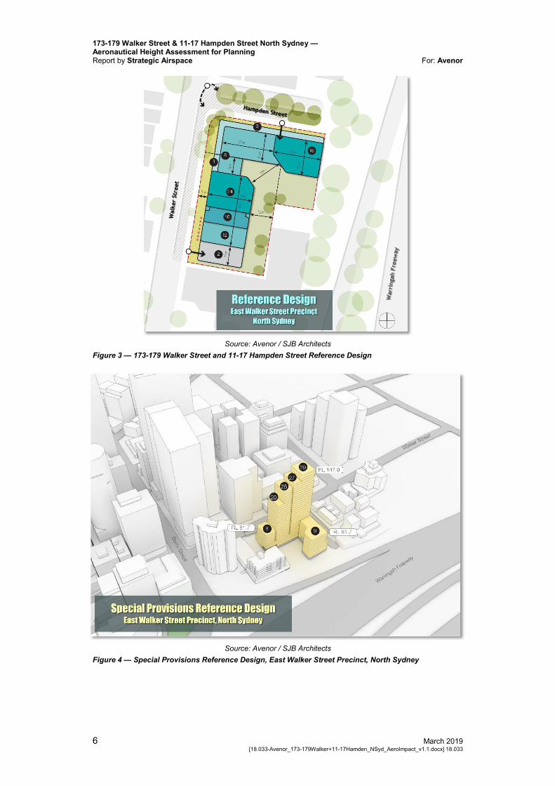
The Precinct currently consists of 7 lots which will be redeveloped to serve as the location for a new high-density residential tower. Many tall towers can already be found in close proximity to the Precinct. Recent amendments to the North Sydney LEP (Amendment No. 23) and the proposed amendments to the Ward Street Precinct will enable buildings to be developed to a similar height as this proposed development.
173-179 Walker Street & 11-17 Hampden Street North Sydney — Aeronautical Height Assessment for Planning Report by Strategic Airspace For: Avenor
6 March 2019 [18.033-Avenor_173-179Walker+11-17Hamden_NSyd_AeroImpact_v1.1.docx] 18.033
Source: Avenor / SJB Architects
Figure 3 — 173-179 Walker Street and 11-17 Hampden Street Reference Design
Source: Avenor / SJB Architects
Figure 4 — Special Provisions Reference Design, East Walker Street Precinct, North Sydney
173-179 Walker Street & 11-17 Hampden Street North Sydney — Aeronautical Height Assessment for Planning
For: Avenor Report by Strategic Airspace
March 2019 7 18.033 [18.033-Avenor_173-179Walker+11-17Hamden_NSyd_AeroImpact_v1.1.docx]
2.2 The Proposed Development from the Aviation Perspective
From the aviation perspective, the key element of the of the Planning Proposal is the maximum proposed building height under the base controls and under the incentive controls is the maximum proposed height (in metres Australian Height Datum (AHD)) of the proposed tallest residential tower in each of the reference designs:
133m AHD — Reference Design 133m AHD — Separate Landholdings Reference Design 148m AHD — Special Provisions Reference Design
The airspace constraints are examined in relation to the maximum building height proposed and the additional airspace that would be required for cranes necessary to enable the development.
3. Aeronautical Impact Context
3.1 Location of the Proposed Development
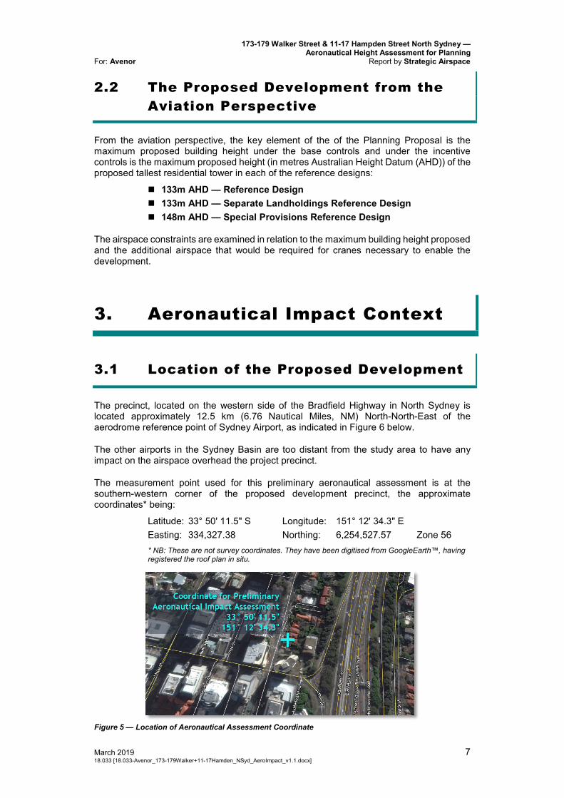
The precinct, located on the western side of the Bradfield Highway in North Sydney is located approximately 12.5 km (6.76 Nautical Miles, NM) North-North-East of the aerodrome reference point of Sydney Airport, as indicated in Figure 6 below.
The other airports in the Sydney Basin are too distant from the study area to have any impact on the airspace overhead the project precinct.
The measurement point used for this preliminary aeronautical assessment is at the southern-western corner of the proposed development precinct, the approximate coordinates* being:
Latitude: 33° 50' 11.5" S Longitude: 151° 12' 34.3" E Easting: 334,327.38 Northing: 6,254,527.57 Zone 56 * NB: These are not survey coordinates. They have been digitised from GoogleEarth™, having registered the roof plan in situ.
Figure 5 — Location of Aeronautical Assessment Coordinate
173-179 Walker Street & 11-17 Hampden Street North Sydney — Aeronautical Height Assessment for Planning Report by Strategic Airspace For: Avenor
8 March 2019 [18.033-Avenor_173-179Walker+11-17Hamden_NSyd_AeroImpact_v1.1.docx] 18.033
Figure 6 — East Walker Street Precinct in relation to Sydney Airport (Large Format)
3.2 Methodology
The methodology used to determine the maximum building height (or minimum airspace height limitation) above the precinct takes into consideration each of the following.
3.2.1 Airspace Regulations
The proposed development site is subject to the Airports (Protection of Airspace) Regulations (APAR), under the Commonwealth’s Airports Act, 1996), because of its proximity to Sydney Airport and because of its proposed height. These regulations define both: how building height limitations due to airspace safety can be determined; and the process for gaining approval of the proposed development under the regulations.
173-179 Walker Street & 11-17 Hampden Street North Sydney — Aeronautical Height Assessment for Planning
For: Avenor Report by Strategic Airspace
March 2019 9 18.033 [18.033-Avenor_173-179Walker+11-17Hamden_NSyd_AeroImpact_v1.1.docx]
The Prescribed Airspace Regulations, and their impact upon building height limitations, are described below.
3.2.2 Prescribed Airspace
Prescribed airspace, under these regulations, includes at minimum:
Obstacle Limitation Surfaces (OLS) The OLS surfaces are used to identify buildings and other structures that may
have an impact upon the safety or regularity of aircraft operations at an airport. This impact depends upon both the type of operations at the aerodrome and which OLS surfaces are penetrated by a (proposed) building or structure.
The OLS are flat and rising (invisible) surfaces around the airport. They are based on the geometry of the airport and its runways and therefore they rarely change.
If a permanent building development (or temporary crane) that is proposed at a height that will penetrate (exceed) the height limit of an OLS surface, then an application must be made to the Commonwealth Department of Infrastructure, Regional Development and Cities (DIRDC) — via the closest airport, and with copies to any other potentially affected airport — for an airspace height approval prior to construction of the permanent development &/or erection of the temporary crane obstacle. Such applications should demonstrate the proposed building development does not penetrate or adversely affect surfaces protecting the instrument flight procedures (PANS-OPS surfaces); radar vectoring; navigation infrastructure; or anything else that might affect the safety or regularity of operations at the airport.
PANS-OPS Surfaces PANS-OPS surfaces represent the protection surfaces for published
instrument flight procedures to and from the airport. These surfaces comprise flat, sloping and complex surface components.
PANS-OPS surfaces must not be penetrated by either permanent or temporary buildings or structures. However, for a variety of reasons, PANS-OPS surfaces can and do change over time.
As flight procedures are changed from time to time (usually by Airservices) , the PANS-OPS Surface Plan published by an airport may not reflect the current situation — which is why we not only reference the airport’s plans but also review the published charts for current (or pending) instrument flight procedures and evaluate the associated PANS-OPS height limits. The regulations also make a provision for any factor which may be deemed to adversely affect the safety, regularity or efficiency of aircraft operations at an airport. In light of this, it is necessary to consider the following factors.
Other Considerations Sydney Airport’s Declared Airspace Plans additionally include: Radar Terrain Clearance Charts (RTCC), which depict the areas and
height limits related to the Minimum Vector Altitudes (MVAs) used by Air Traffic Controllers when vectoring aircraft;
Lighting and visual guidance protection plans — used for approach guidance by aircraft, especially at night and in times of poor visibility; and
Navaid and radar evaluation / protection surface plans.
Other Factors Protection for other Instrument Flight Procedure surfaces, where the
procedures are not classified as PANS-OPS and/or have been omitted from Sydney Airport’s declared PANS-OPS surfaces charts. These may include a variety of Required Navigation Procedures (RNP).
Airline Engine-Out (Contingency) Take-Off Splays (as per Civil Aviation Order 20.7 1b) These are generally assessed independently by the airlines as part of their
173-179 Walker Street & 11-17 Hampden Street North Sydney — Aeronautical Height Assessment for Planning Report by Strategic Airspace For: Avenor
10 March 2019 [18.033-Avenor_173-179Walker+11-17Hamden_NSyd_AeroImpact_v1.1.docx] 18.033
own evaluations of any given airspace height application, but it is prudent to evaluate any potential impact in advance.
Other miscellaneous factors that may be considered as potential safety issues by any of the key stakeholders, and the Civil Aviation Safety Authority (CASA) in particular.
Note: Airspace that is approved by the Department of Infrastructure and Regional Development as Declared Airspace is considered part of an airport’s Prescribed Airspace.
3.2.3 Note about Heights: Australian Height Datum (AHD) vs Above Ground Level (AGL)
All “heights” provided in this document are elevations expressed in metres in the Australian Height Datum (AHD) — and thus they are true elevations, and NOT heights above ground level (AGL).
For estimating maximum development heights AGL, the ground elevationAHD should be subtracted from the airspace height limitsAHD.
Note also for aviation-related airspace height limits, any building height approval under the Airports (Protection of Airspace) Regulations is regarded as inclusive of the building itself, plus all rooftop furniture and overruns (plant buildings, lift risers, antennae, etc).
3.2.4 Making an Application for an Aviation-related Airspace Height Approval
All applications under APAR must be submitted to DIRDC, at the appropriate time, through the closest relevant airport — in this case, Sydney Airport. Applications should include aeronautical impact assessment reports — such as this, but which are based on the most current plans for the proposed development available at the time and/or the Construction Management Plan (CMP) in the case of crane applications.
Safety impact assessments and mitigation strategies may need to be included in the aeronautical study, depending on the nature and location of the development relative to the airspace restrictions and other aeronautical impact factors.
Separate applications for cranes will also be required at the appropriate times during the construction period, prior to their installation and operation.
173-179 Walker Street & 11-17 Hampden Street North Sydney — Aeronautical Height Assessment for Planning
For: Avenor Report by Strategic Airspace
March 2019 11 18.033 [18.033-Avenor_173-179Walker+11-17Hamden_NSyd_AeroImpact_v1.1.docx]
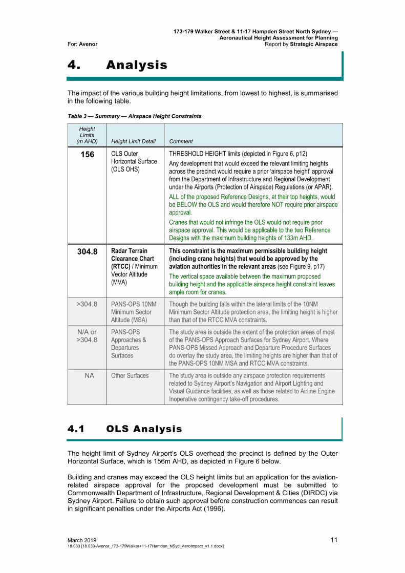
4. Analysis
The impact of the various building height limitations, from lowest to highest, is summarised in the following table.
Table 3 — Summary — Airspace Height Constraints
Height Limits
(m AHD) Height Limit Detail Comment
156 OLS Outer Horizontal Surface (OLS OHS)
THRESHOLD HEIGHT limits (depicted in Figure 6, p12) Any development that would exceed the relevant limiting heights across the precinct would require a prior ‘airspace height’ approval from the Department of Infrastructure and Regional Development under the Airports (Protection of Airspace) Regulations (or APAR). ALL of the proposed Reference Designs, at their top heights, would be BELOW the OLS and would therefore NOT require prior airspace approval. Cranes that would not infringe the OLS would not require prior airspace approval. This would be applicable to the two Reference Designs with the maximum building heights of 133m AHD.
304.8 Radar Terrain Clearance Chart (RTCC) / Minimum Vector Altitude (MVA)
This constraint is the maximum permissible building height (including crane heights) that would be approved by the aviation authorities in the relevant areas (see Figure 9, p17) The vertical space available between the maximum proposed building height and the applicable airspace height constraint leaves ample room for cranes.
>304.8 PANS-OPS 10NM Minimum Sector Altitude (MSA)
Though the building falls within the lateral limits of the 10NM Minimum Sector Altitude protection area, the limiting height is higher than that of the RTCC MVA constraints.
N/A or >304.8
PANS-OPS Approaches & Departures Surfaces
The study area is outside the extent of the protection areas of most of the PANS-OPS Approach Surfaces for Sydney Airport. Where PANS-OPS Missed Approach and Departure Procedure Surfaces do overlay the study area, the limiting heights are higher than that of the PANS-OPS 10NM MSA and RTCC MVA constraints.
NA Other Surfaces The study area is outside any airspace protection requirements related to Sydney Airport’s Navigation and Airport Lighting and Visual Guidance facilities, as well as those related to Airline Engine Inoperative contingency take-off procedures.
4.1 OLS Analysis
The height limit of Sydney Airport’s OLS overhead the precinct is defined by the Outer Horizontal Surface, which is 156m AHD, as depicted in Figure 6 below.
Building and cranes may exceed the OLS height limits but an application for the aviation-related airspace approval for the proposed development must be submitted to Commonwealth Department of Infrastructure, Regional Development & Cities (DIRDC) via Sydney Airport. Failure to obtain such approval before construction commences can result in significant penalties under the Airports Act (1996).

173-179 Walker Street & 11-17 Hampden Street North Sydney — Aeronautical Height Assessment for Planning Report by Strategic Airspace For: Avenor
12 March 2019 [18.033-Avenor_173-179Walker+11-17Hamden_NSyd_AeroImpact_v1.1.docx] 18.033
Conversely, airspace height approvals are not required for any buildings or cranes that would not exceed the OLS height limits.
Neither the Sydney Airport Master Plan to 2033 nor the draft Master Plan to 2039 forecast any changes to the aerodrome that would occasion a change to the OLS. Thus, the current OLS is anticipated to remain in force for the planning horizon of the project.
Figure 7 — Precinct in relation to Sydney Airport’s OLS
Table 4 — OLS Height Impact & APAR Approval Implications
Reference Design(s)
Max Design Height
(m AHD)
Penetration or CLEAR of OLS
156m AHD Approvability Comment
Reference Design
Separate Landholdings
Reference Design
133 23 Does NOT require prior APAR approval. Cranes that would operate with a maximum height below 156m AHD would not require prior approval under APAR. Given the 23m margin, it is highly likely that all cranes could operate without infringing the OLS height.
Special Provisions Reference
Design
148 8 Does NOT require prior APAR approval. Cranes that would operate with a maximum height below 156m AHD would not require prior approval under APAR. It is likely that a crane required for construction of the tower building would infringe the OLS. This would require a separate application for the crane only and approval under APAR prior to construction.
The above table shows that the tallest towers of each and all of the Reference Designs, at their proposed maximum heights, would NOT infringe the OLS height limit. Thus, under the APAR, it would not be necessary to seek prior airspace height approval for the proposed development.
Note however that any tower that exceeds 100m in height above ground level (AGL) and did not require prior approval under APAR is still regarded under the Civil Aviation Safety Regulations (CASR) as a Tall Structure. As such, pursuant to the CASR Manual of Standards (MOS) Part 139, upon completion of construction the coordinate and height information pertaining to the relevant building must be submitted to the Civil Aviation Safety Authority (CASA) for inclusion in the national Tall Structure (Vertical Obstruction) register.
173-179 Walker Street & 11-17 Hampden Street North Sydney — Aeronautical Height Assessment for Planning
For: Avenor Report by Strategic Airspace
March 2019 13 18.033 [18.033-Avenor_173-179Walker+11-17Hamden_NSyd_AeroImpact_v1.1.docx]
4.2 PANS-OPS Analysis
In addition to reviewing the PANS-OPS Surfaces chart of Sydney Airport’s Prescribed Airspace (as declared and approved by DIRD in 2015), assessment was conducted of the following instrument (non-visual) procedure types for Sydney Airport, as published by Airservices Australia in the Australian Aeronautical Information Publication (AIP) Departure and Approach Procedures (DAP), up to the pending Amendment 158 (effective 28-Feb-2019 to 22-May-2019).
The Circling Minima and Minimum Sector Altitudes (MSAs) for existing PANS-OPS procedures “Area” procedures, which provide protection for aircraft manoeuvring or circling within defined areas above the airport and surrounds
The discrete minima for the Instrument Approach Procedures. Missed Approaches — as part of the evaluation of Approach
Procedures The existing Standard Instrument Departure procedures (SIDs) Minimum Sector Altitude – 10 NM Sector
Figure 8 — PANS-OPS Approach Procedure Height Constraints across the Precinct
Of the approach and departure procedures, only procedures that are relevant to the project precinct are included in this report. These relevant procedures are procedures for the eastern North-South runway, RWY 16L/34R, departures from RWY 07, and “area” procedures.
The Sydney Airport Master Plan to 2033 and draft 2039 Master Plan were also reviewed for potential future impact. The Master Plans do not forecast any changes to procedures that would, to our best knowledge, make the airspace above the project precinct any more constraining than that resulting from analysis of the current PANS-OPS procedures.
Analysis determined that the precinct is not constrained by protection surfaces related to approach flight procedures to runways at Sydney Airport, and although the precinct is under the protection surfaces for some missed approach and departure procedures, the effective height limit imposed on the precinct is that of the surface related to the 10 NM Minimum Sector Altitude (MSA). See the following sections for more details.
173-179 Walker Street & 11-17 Hampden Street North Sydney — Aeronautical Height Assessment for Planning Report by Strategic Airspace For: Avenor
14 March 2019 [18.033-Avenor_173-179Walker+11-17Hamden_NSyd_AeroImpact_v1.1.docx] 18.033
Table 5 — PANS-OPS Height Limit Summary
Procedure Height Limit
(m AHD) Description
Minimum Sector Altitude (MSA)
335.2 The 10 NM Minimum Sector Altitude of 2100 ft results in this surface height constraint. This limit applies across the entire precinct.
Circling Areas N/A This precinct is outside the extent of the Circling Areas.
Approaches and Missed Approaches to all Runways
N/A or >335.2
Outside the lateral protection areas of many procedures. Where protection surfaces overlay the study area, the lowest limit is higher than that of the maximum permissible obstacle constraint imposed by the 10NM MSA (see below).
Departures N/A or >335.2
Where protection surfaces overlay the study area, the lowest limit is higher than that of the maximum permissible obstacle constraint imposed by the 10NM MSA (see below).
Table 6 — PANS-OPS Height Impact & APAR Approval Implications
Reference Design(s)
Max Design Height
(m AHD)
CLEAR of PANS-OPS 335m AHD Approvability Comment
Reference Design
Separate Landholdings
Reference Design
133 202.2 Buildings do not require prior approval (refer Table 4, p12). Cranes required for the tallest tower(s) are also unlikely to infringe the OLS, but if they did they would not be tall enough to infringe the limiting PANS-OPS height. Refer also Table 8 (p18)
Special Provisions Reference
Design
148 187.2 Buildings do not require prior approval (refer Table 4, p12). Cranes required for the tallest tower(s) are also unlikely to infringe the OLS, but if they did they would not be tall enough to infringe the limiting PANS-OPS height. Refer also Table 8 (p18)
Further details are provided in the following sections.
4.2.1 “Area” Procedures
A Minimum Sector Alt i tudes (MSAs)
The MSA protects area manoeuvring by aircraft within defined sectors. The relevant sector is a circular area of 10 NM in radius (plus a 5NM buffer) around the airport. The height restriction imposed by 10NM MSA is lower than the limits imposed by other procedures (eg, departure procedures) which also overlay the precinct.
Procedure Feature and / or Restriction Description
10NM MSA A horizontal surface: • 335.2m
See Figure 8 above. Covers the entire precinct.
B Circl ing Minima The precinct is outside the extent of the circling procedures.
173-179 Walker Street & 11-17 Hampden Street North Sydney — Aeronautical Height Assessment for Planning
For: Avenor Report by Strategic Airspace
March 2019 15 18.033 [18.033-Avenor_173-179Walker+11-17Hamden_NSyd_AeroImpact_v1.1.docx]
4.2.2 Instrument Approaches & Missed Approaches
The impact of each of the relevant PANS-OPS protection surfaces for current approach and departure procedures for Sydney Airport are summarised below. The lateral extent of restrictions is shown in the diagrams (where appropriate).
A Approach Procedures to RWY 16L
The precinct is laterally clear of the protection surfaces of the following procedures:
RWY 16L RNAV(GNSS) Approach RWY 16L ILS and GLS Approaches
Approaches to other runways are too far from the North Sydney precinct to warrant consideration in this study.
B Missed Approach Segments of Approach Procedures for RWY 07 and RWY 34R
The precinct is unconstrained by the following procedures, either because the limiting heights are so high (higher than other more restrictive surfaces) or the area is laterally outside the protection surfaces.
RWY 34R RNAV(GNSS) Missed Approach RWY 34R ILS and GLS Missed Approaches
Missed Approaches from other runways are too far from the East Walker Street Precinct to warrant consideration in this study.
4.2.3 Departures
Height limitations may be imposed by departure procedures from both RWY34R and RWY07, but the limiting heights overhead the project precinct are significantly higher than the limit imposed by the 10NM MSA. For example, the most restrictive of the height limits from any departure, as shown on Sydney Airport’s 2015 Declared Airspace chart for Omnidirectional Radar Departures, is above 380m AHD. However, this particular chart is not entirely correct and is also obsolete due to changes to procedures since the time it was drafted and approved, and also because of a change in the PANS-OPS departure criteria at the end of 2016. StratAir’s independent calculations of the PANS-OPS omnidirectional departure procedures indicate that the height constraints from the current procedures (from RWY34R and RWY07) are of the order of ~460m AHD.
173-179 Walker Street & 11-17 Hampden Street North Sydney — Aeronautical Height Assessment for Planning Report by Strategic Airspace For: Avenor
16 March 2019 [18.033-Avenor_173-179Walker+11-17Hamden_NSyd_AeroImpact_v1.1.docx] 18.033
4.3 Other Assessment Considerations
The following table provides a brief assessment of other considerations.
Table 7 — Other Assessable Height Limitations — including the RTCC MVA Limit
Procedure Height Limit
(m AHD) Description
Radar Terrain Clearance Chart (RTCC) / Minimum Vector Altitude (MVA)
304.8 This height constraint is applicable over the precinct. This is the limit related to the Minimum Vectoring Altitude (MVA), which is used by air traffic controllers. This information is sourced from the RTCC published as part of Sydney Airport’s Prescribed Airspace Plans.
Navigation Infrastructure
N/A The proposed development is too far from the airport to affect any navigation infrastructure.
Airlines Engine Out Procedures
N/A Engine Out procedures (from RWY 34R, the most relevant take-off runway end for these procedures) are designed and maintained by each of the passenger transport aircraft operators in accordance with the relevant regulations. All such procedures necessarily take into account Sydney Tower Eye in the Sydney CBD, which is closer to the airport and taller than the highest Reference Design of the proposed development. As such this proposal will not adversely affect any contingency procedures.
Helicopter Procedures related to the Nearest Strategic Helicopter Landing Site (SHLS)
N/A The nearest SHLS is located at the North Shore Hospital in St Leonards, which is too far to be considered relevant.
There are no other considerations that might limit the building height at the precinct.
4.3.1 Radar Terrain Clearance Chart (RTCC) / Minimum Vector Altitude (MVA) Surface
The surface depicted in Sydney Airport’s Radar Terrain Clearance Chart (RTCC) overhead the precinct protects the airspace used by air traffic controllers as the lowest Minimum Vector Altitude (MVA) they can use for vectoring aircraft. The RTCC / MVA surface height limit overhead the entire study area that is indicated by the RTCC chart is a 2000ft sector, which results in a surface height limit of 304.8m AHD*. (The precinct is very close to the line that separates two RTCC surface height limits; the adjacent one to the west and possibly covering part of the precinct having a surface height limit of 335.28m AHD. For the purposes of the assessment, the more conservative height constraint of 304.8m is assumed).
This surface constraint becomes the effective limit as it is lower than surface heights related to the PANS-OPS approach and departure procedures which cover the precinct area. The relevant RTCC surface boundary is depicted in relation to the precinct in Figure 9 below.
173-179 Walker Street & 11-17 Hampden Street North Sydney — Aeronautical Height Assessment for Planning
For: Avenor Report by Strategic Airspace
March 2019 17 18.033 [18.033-Avenor_173-179Walker+11-17Hamden_NSyd_AeroImpact_v1.1.docx]
Figure 9 — Radar Terrain Clearance Chart (RTCC) Height Constraints across the Precinct
173-179 Walker Street & 11-17 Hampden Street North Sydney — Aeronautical Height Assessment for Planning Report by Strategic Airspace For: Avenor
18 March 2019 [18.033-Avenor_173-179Walker+11-17Hamden_NSyd_AeroImpact_v1.1.docx] 18.033
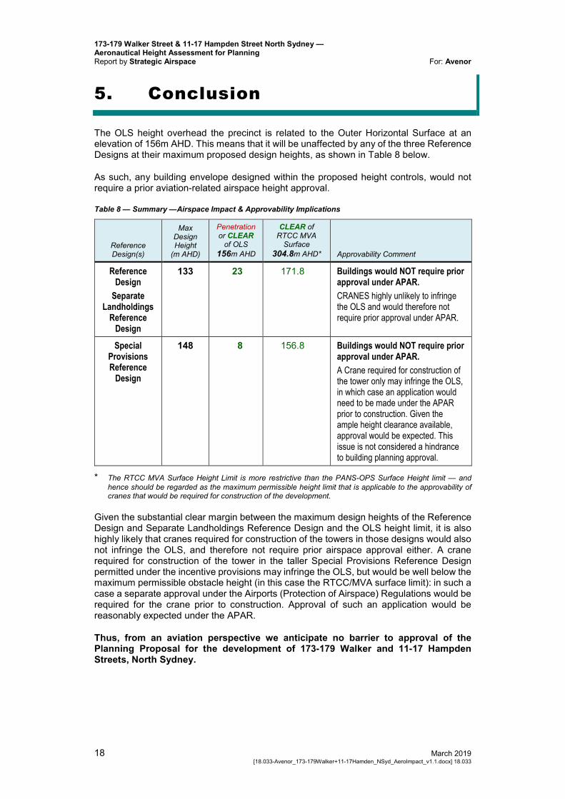
5. Conclusion
The OLS height overhead the precinct is related to the Outer Horizontal Surface at an elevation of 156m AHD. This means that it will be unaffected by any of the three Reference Designs at their maximum proposed design heights, as shown in Table 8 below.
As such, any building envelope designed within the proposed height controls, would not require a prior aviation-related airspace height approval.
Table 8 — Summary —Airspace Impact & Approvability Implications
Reference Design(s)
Max Design Height
(m AHD)
Penetration or CLEAR
of OLS 156m AHD
CLEAR of RTCC MVA
Surface 304.8m AHD* Approvability Comment
Reference Design
Separate Landholdings
Reference Design
133 23 171.8 Buildings would NOT require prior approval under APAR. CRANES highly unlikely to infringe the OLS and would therefore not require prior approval under APAR.
Special Provisions Reference
Design
148 8 156.8 Buildings would NOT require prior approval under APAR. A Crane required for construction of the tower only may infringe the OLS, in which case an application would need to be made under the APAR prior to construction. Given the ample height clearance available, approval would be expected. This issue is not considered a hindrance to building planning approval.
* The RTCC MVA Surface Height Limit is more restrictive than the PANS-OPS Surface Height limit — and hence should be regarded as the maximum permissible height limit that is applicable to the approvability of cranes that would be required for construction of the development.
Given the substantial clear margin between the maximum design heights of the Reference Design and Separate Landholdings Reference Design and the OLS height limit, it is also highly likely that cranes required for construction of the towers in those designs would also not infringe the OLS, and therefore not require prior airspace approval either. A crane required for construction of the tower in the taller Special Provisions Reference Design permitted under the incentive provisions may infringe the OLS, but would be well below the maximum permissible obstacle height (in this case the RTCC/MVA surface limit): in such a case a separate approval under the Airports (Protection of Airspace) Regulations would be required for the crane prior to construction. Approval of such an application would be reasonably expected under the APAR.
Thus, from an aviation perspective we anticipate no barrier to approval of the Planning Proposal for the development of 173-179 Walker and 11-17 Hampden Streets, North Sydney.
173-179 Walker Street & 11-17 Hampden Street North Sydney — Aeronautical Height Assessment for Planning
For: Avenor Report by Strategic Airspace
March 2019 18.033 [18.033-Avenor_173-179Walker+11-17Hamden_NSyd_AeroImpact_v1.1.docx]
A P P E N D I C E S

173-179 Walker Street & 11-17 Hampden Street North Sydney — Aeronautical Height Assessment for Planning
For: Avenor Report by Strategic Airspace
March 2019 Appendix 1 — Abbreviations … 1 18.033 [18.033-Avenor_173-179Walker+11-17Hamden_NSyd_AeroImpact_v1.1.docx]
APPENDIX 1 — ABBREVIATIONS
173-179 Walker Street & 11-17 Hampden Street North Sydney — Aeronautical Height Assessment for Planning Report by Strategic Airspace For: Avenor
2 … Appendix 1 — Abbreviations March 2019 [18.033-Avenor_173-179Walker+11-17Hamden_NSyd_AeroImpact_v1.1.docx] 18.033
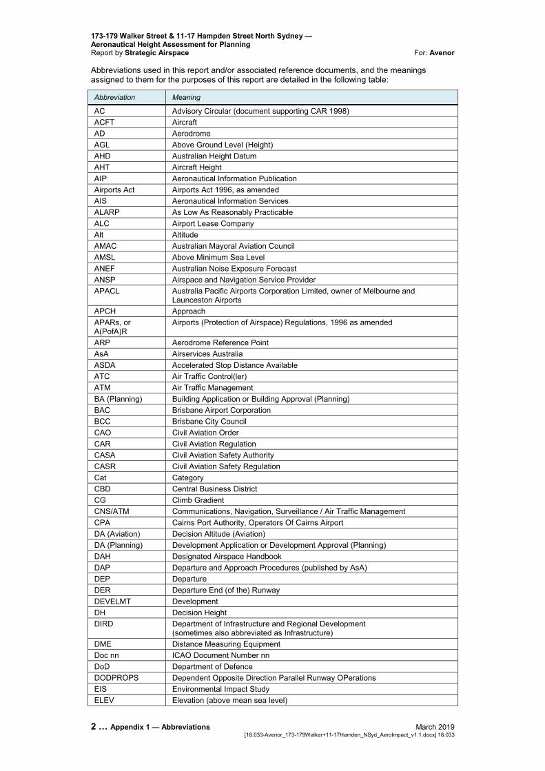
Abbreviations used in this report and/or associated reference documents, and the meanings assigned to them for the purposes of this report are detailed in the following table:
Abbreviation Meaning
AC Advisory Circular (document supporting CAR 1998) ACFT Aircraft AD Aerodrome AGL Above Ground Level (Height) AHD Australian Height Datum AHT Aircraft Height AIP Aeronautical Information Publication Airports Act Airports Act 1996, as amended AIS Aeronautical Information Services ALARP As Low As Reasonably Practicable ALC Airport Lease Company Alt Altitude AMAC Australian Mayoral Aviation Council AMSL Above Minimum Sea Level ANEF Australian Noise Exposure Forecast ANSP Airspace and Navigation Service Provider APACL Australia Pacific Airports Corporation Limited, owner of Melbourne and
Launceston Airports APCH Approach APARs, or A(PofA)R
Airports (Protection of Airspace) Regulations, 1996 as amended
ARP Aerodrome Reference Point AsA Airservices Australia ASDA Accelerated Stop Distance Available ATC Air Traffic Control(ler) ATM Air Traffic Management BA (Planning) Building Application or Building Approval (Planning) BAC Brisbane Airport Corporation BCC Brisbane City Council CAO Civil Aviation Order CAR Civil Aviation Regulation CASA Civil Aviation Safety Authority CASR Civil Aviation Safety Regulation Cat Category CBD Central Business District CG Climb Gradient CNS/ATM Communications, Navigation, Surveillance / Air Traffic Management CPA Cairns Port Authority, Operators Of Cairns Airport DA (Aviation) Decision Altitude (Aviation) DA (Planning) Development Application or Development Approval (Planning) DAH Designated Airspace Handbook DAP Departure and Approach Procedures (published by AsA) DEP Departure DER Departure End (of the) Runway DEVELMT Development DH Decision Height DIRD Department of Infrastructure and Regional Development
(sometimes also abbreviated as Infrastructure) DME Distance Measuring Equipment Doc nn ICAO Document Number nn DoD Department of Defence DODPROPS Dependent Opposite Direction Parallel Runway OPerations EIS Environmental Impact Study ELEV Elevation (above mean sea level)
173-179 Walker Street & 11-17 Hampden Street North Sydney — Aeronautical Height Assessment for Planning
For: Avenor Report by Strategic Airspace
March 2019 Appendix 1 — Abbreviations … 3 18.033 [18.033-Avenor_173-179Walker+11-17Hamden_NSyd_AeroImpact_v1.1.docx]
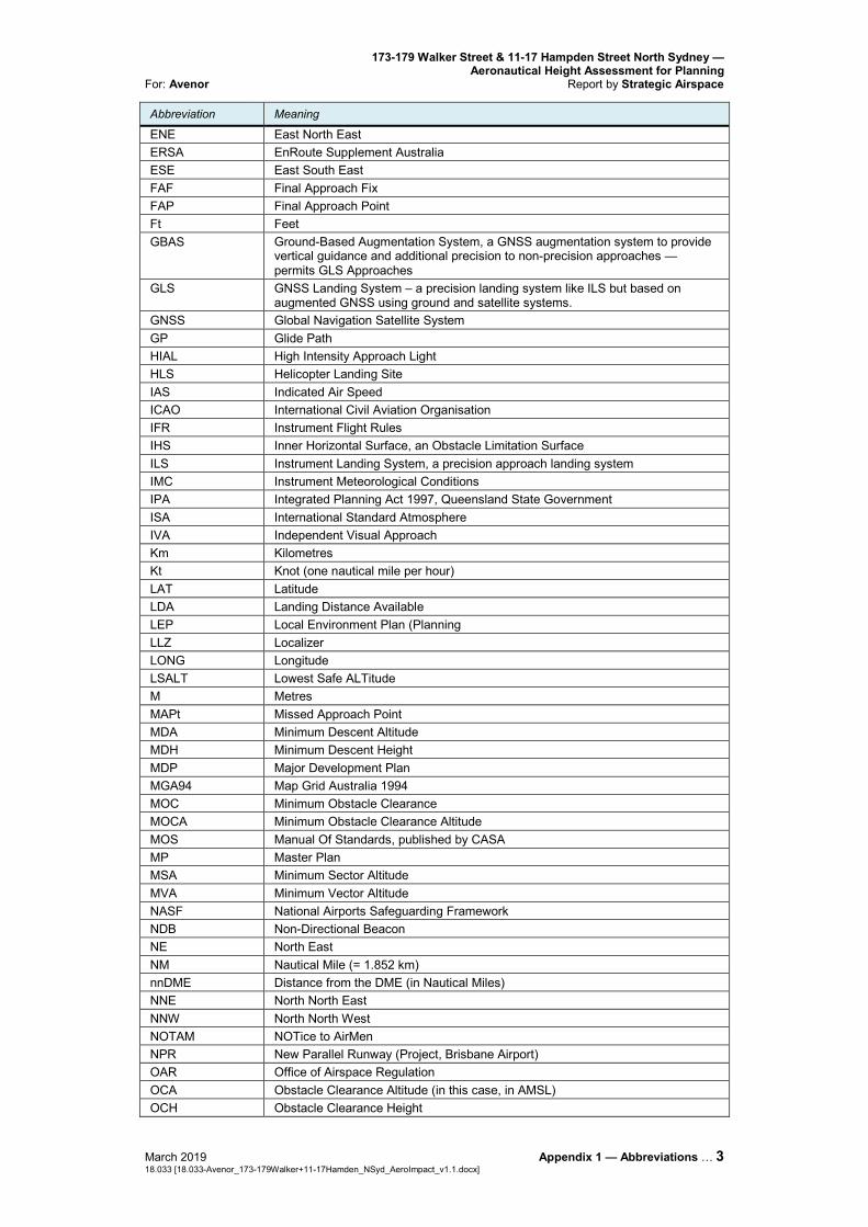
Abbreviation Meaning
ENE East North East ERSA EnRoute Supplement Australia ESE East South East FAF Final Approach Fix FAP Final Approach Point Ft Feet GBAS Ground-Based Augmentation System, a GNSS augmentation system to provide
vertical guidance and additional precision to non-precision approaches — permits GLS Approaches
GLS GNSS Landing System – a precision landing system like ILS but based on augmented GNSS using ground and satellite systems.
GNSS Global Navigation Satellite System GP Glide Path HIAL High Intensity Approach Light HLS Helicopter Landing Site IAS Indicated Air Speed ICAO International Civil Aviation Organisation IFR Instrument Flight Rules IHS Inner Horizontal Surface, an Obstacle Limitation Surface ILS Instrument Landing System, a precision approach landing system IMC Instrument Meteorological Conditions IPA Integrated Planning Act 1997, Queensland State Government ISA International Standard Atmosphere IVA Independent Visual Approach Km Kilometres Kt Knot (one nautical mile per hour) LAT Latitude LDA Landing Distance Available LEP Local Environment Plan (Planning LLZ Localizer LONG Longitude LSALT Lowest Safe ALTitude M Metres MAPt Missed Approach Point MDA Minimum Descent Altitude MDH Minimum Descent Height MDP Major Development Plan MGA94 Map Grid Australia 1994 MOC Minimum Obstacle Clearance MOCA Minimum Obstacle Clearance Altitude MOS Manual Of Standards, published by CASA MP Master Plan MSA Minimum Sector Altitude MVA Minimum Vector Altitude NASF National Airports Safeguarding Framework NDB Non-Directional Beacon NE North East NM Nautical Mile (= 1.852 km) nnDME Distance from the DME (in Nautical Miles) NNE North North East NNW North North West NOTAM NOTice to AirMen NPR New Parallel Runway (Project, Brisbane Airport) OAR Office of Airspace Regulation OCA Obstacle Clearance Altitude (in this case, in AMSL) OCH Obstacle Clearance Height
173-179 Walker Street & 11-17 Hampden Street North Sydney — Aeronautical Height Assessment for Planning Report by Strategic Airspace For: Avenor
4 … Appendix 1 — Abbreviations March 2019 [18.033-Avenor_173-179Walker+11-17Hamden_NSyd_AeroImpact_v1.1.docx] 18.033
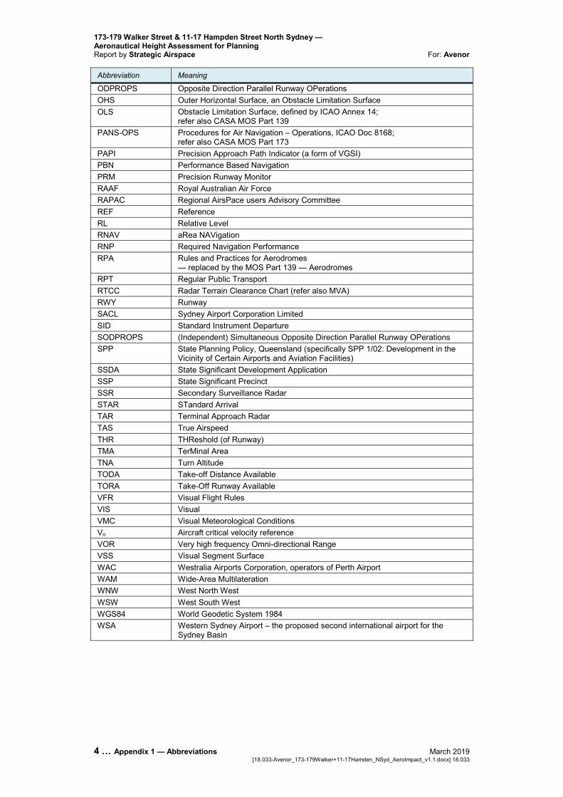
Abbreviation Meaning
ODPROPS Opposite Direction Parallel Runway OPerations OHS Outer Horizontal Surface, an Obstacle Limitation Surface OLS Obstacle Limitation Surface, defined by ICAO Annex 14;
refer also CASA MOS Part 139 PANS-OPS Procedures for Air Navigation – Operations, ICAO Doc 8168;
refer also CASA MOS Part 173 PAPI Precision Approach Path Indicator (a form of VGSI) PBN Performance Based Navigation PRM Precision Runway Monitor RAAF Royal Australian Air Force RAPAC Regional AirsPace users Advisory Committee REF Reference RL Relative Level RNAV aRea NAVigation RNP Required Navigation Performance RPA Rules and Practices for Aerodromes
— replaced by the MOS Part 139 — Aerodromes RPT Regular Public Transport RTCC Radar Terrain Clearance Chart (refer also MVA) RWY Runway SACL Sydney Airport Corporation Limited SID Standard Instrument Departure SODPROPS (Independent) Simultaneous Opposite Direction Parallel Runway OPerations SPP State Planning Policy, Queensland (specifically SPP 1/02: Development in the
Vicinity of Certain Airports and Aviation Facilities) SSDA State Significant Development Application SSP State Significant Precinct SSR Secondary Surveillance Radar STAR STandard Arrival TAR Terminal Approach Radar TAS True Airspeed THR THReshold (of Runway) TMA TerMinal Area TNA Turn Altitude TODA Take-off Distance Available TORA Take-Off Runway Available VFR Visual Flight Rules VIS Visual VMC Visual Meteorological Conditions Vn Aircraft critical velocity reference VOR Very high frequency Omni-directional Range VSS Visual Segment Surface WAC Westralia Airports Corporation, operators of Perth Airport WAM Wide-Area Multilateration WNW West North West WSW West South West WGS84 World Geodetic System 1984 WSA Western Sydney Airport – the proposed second international airport for the
Sydney Basin
173-179 Walker Street & 11-17 Hampden Street North Sydney — Aeronautical Height Assessment for Planning
For: Avenor Report by Strategic Airspace
March 2019 Appendix 2 — PANS-OPS Procedures … 1 18.033 [18.033-Avenor_173-179Walker+11-17Hamden_NSyd_AeroImpact_v1.1.docx]
APPENDIX 2 — PANS-OPS PROCEDURES
173-179 Walker Street & 11-17 Hampden Street North Sydney — Aeronautical Height Assessment for Planning Report by Strategic Airspace For: Avenor
2 … Appendix 2 — PANS-OPS Procedures March 2019 [18.033-Avenor_173-179Walker+11-17Hamden_NSyd_AeroImpact_v1.1.docx] 18.033
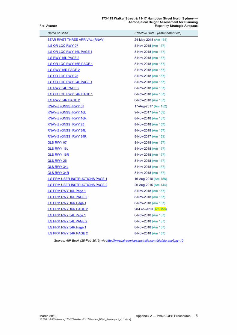
The latest versions of the IFPs consulted were from the current AIP Amendment 158, effective from 28-Feb-2019 to 22-May-2019 — as indicated in Table 5 below.
Table 9 — Appendix: PANS OPS Instrument Flight Procedure Charts for Sydney Airport (AIP Amendment 158 – Effective 28-Feb-2019 to 22-May-2019)
SYDNEY (YSSY)
Name of Chart Effective Date (Amendment No)
AERODROME CHART PAGE 1 8-Nov-2018 (Am 157) AERODROME CHART PAGE 2 28-Feb-2019 (Am 158) APRON CHART - INTERNATIONAL PAGE 1 13-Nov-2014 (Am 141) APRON CHART - INTERNATIONAL PAGE 2 16-Aug-2018 (Am 156) APRON CHART - DOMESTIC PAGE 1 26-May-2016 (Am 147) APRON CHART - DOMESTIC PAGE 2 8-Nov-2018 (Am 157) APRON CHART - DOMESTIC PAGE 3 8-Nov-2018 (Am 157) STANDARD DOMESTIC TAXI ROUTES - ARRIVALS 21-Aug-2014 (Am 140) STANDARD DOMESTIC TAXI ROUTES - DEPARTURES 6-Mar-2014 (Am 138) NOISE ABATEMENT PROCEDURE PAGE 1 17-Nov-2011 (Am 129) NOISE ABATEMENT PROCEDURE PAGE 2 17-Aug-2017 (Am 152) NOISE ABATEMENT PROCEDURE PAGE 3 3-Mar-2016 (Am 146) NOISE ABATEMENT PROCEDURE PAGE 4 3-Mar-2016 (Am 146) NOISE ABATEMENT PROCEDURE PAGE 5 2-Mar-2017 (Am 150) NOISE ABATEMENT PROCEDURE PAGE 6 24-May-2018 (Am 155) NOISE ABATEMENT PROCEDURE PAGE 7 3-Mar-2016 (Am 146) NOISE ABATEMENT PROCEDURE PAGE 8 3-Mar-2016 (Am 146) NOISE ABATEMENT PROCEDURE PAGE 9 3-Mar-2016 (Am 146) NOISE ABATEMENT PROCEDURE PAGE 10 3-Mar-2016 (Am 146) AIRPORT EFFICIENCY PROCEDURES 1-Mar-2018 (Am 154) IVA USER GUIDE PAGE 1 1-Mar-2018 (Am 154) IVA USER GUIDE PAGE 2 1-Mar-2018 (Am 154) SID SYDNEY ONE DEP (RADAR) - ALL RWYS 17-Aug-2017 (Am 152) SID RWY 34L SOUTH WEST DEP (JET) 10-Nov-2016 (Am 149) SID RWY 16R & 34L SOUTH DEP (NON-JET) (RNAV) 24-May-2018 (Am 155) SID RWY 16R DEENA SEVEN (JET) (RNAV) 24-May-2018 (Am 155) SID RWY 34R ENTRA FIVE (JET) (RNAV) 10-Nov-2016 (Am 149) SID RWY 07 FISHA EIGHT (JET) (RNAV) 17-Aug-2017 (Am 152) SID KAMBA DEP RWYS 07 & 16L (NON-JET) (RNAV) 1-Mar-2018 (Am 154) SID RWY 16R KAMPI FIVE (RNAV) 24-May-2018 (Am 155) SID RWY 16L KEVIN SIX (JET) (RNAV) 9-Nov-2017 (Am 153) SID RWY 16L ABBEY THREE (JET) (RNAV) 24-May-2018 (Am 155) SID RWY 34R MARUB SIX (JET) (RNAV) 24-May-2018 (Am 155) SID RWY 34L RICHMOND FIVE DEP (JET) 17-Aug-2017 (Am 152) STAR BOREE NINE A ARRIVAL (RNAV) 8-Nov-2018 (Am 157) STAR BOREE NINE P ARRIVAL (RNAV) 8-Nov-2018 (Am 157) STAR MEPIL THREE ARRIVAL (RNAV) 24-May-2018 (Am 155) STAR MARLN FOUR ARRIVAL (RNAV) 28-Feb-2019 (Am 158) STAR ODALE SEVEN ARRIVAL (RNAV) 24-May-2018 (Am 155)
173-179 Walker Street & 11-17 Hampden Street North Sydney — Aeronautical Height Assessment for Planning
For: Avenor Report by Strategic Airspace
March 2019 Appendix 2 — PANS-OPS Procedures … 3 18.033 [18.033-Avenor_173-179Walker+11-17Hamden_NSyd_AeroImpact_v1.1.docx]
Name of Chart Effective Date (Amendment No)
STAR RIVET THREE ARRIVAL (RNAV) 24-May-2018 (Am 155) ILS OR LOC RWY 07 8-Nov-2018 (Am 157) ILS OR LOC RWY 16L PAGE 1 8-Nov-2018 (Am 157) ILS RWY 16L PAGE 2 8-Nov-2018 (Am 157) ILS OR LOC RWY 16R PAGE 1 8-Nov-2018 (Am 157) ILS RWY 16R PAGE 2 8-Nov-2018 (Am 157) ILS OR LOC RWY 25 8-Nov-2018 (Am 157) ILS OR LOC RWY 34L PAGE 1 8-Nov-2018 (Am 157) ILS RWY 34L PAGE 2 8-Nov-2018 (Am 157) ILS OR LOC RWY 34R PAGE 1 8-Nov-2018 (Am 157) ILS RWY 34R PAGE 2 8-Nov-2018 (Am 157) RNAV-Z (GNSS) RWY 07 17-Aug-2017 (Am 152) RNAV-Z (GNSS) RWY 16L 9-Nov-2017 (Am 153) RNAV-Z (GNSS) RWY 16R 8-Nov-2018 (Am 157) RNAV-Z (GNSS) RWY 25 8-Nov-2018 (Am 157) RNAV-Z (GNSS) RWY 34L 8-Nov-2018 (Am 157) RNAV-Z (GNSS) RWY 34R 9-Nov-2017 (Am 153) GLS RWY 07 8-Nov-2018 (Am 157) GLS RWY 16L 8-Nov-2018 (Am 157) GLS RWY 16R 8-Nov-2018 (Am 157) GLS RWY 25 8-Nov-2018 (Am 157) GLS RWY 34L 8-Nov-2018 (Am 157) GLS RWY 34R 8-Nov-2018 (Am 157) ILS PRM USER INSTRUCTIONS PAGE 1 16-Aug-2018 (Am 156) ILS PRM USER INSTRUCTIONS PAGE 2 20-Aug-2015 (Am 144) ILS PRM RWY 16L Page 1 8-Nov-2018 (Am 157) ILS PRM RWY 16L PAGE 2 8-Nov-2018 (Am 157) ILS PRM RWY 16R Page 1 8-Nov-2018 (Am 157) ILS PRM RWY 16R PAGE 2 28-Feb-2019 (Am 158) ILS PRM RWY 34L Page 1 8-Nov-2018 (Am 157) ILS PRM RWY 34L PAGE 2 8-Nov-2018 (Am 157) ILS PRM RWY 34R Page 1 8-Nov-2018 (Am 157) ILS PRM RWY 34R PAGE 2 8-Nov-2018 (Am 157)
Source: AIP Book (28-Feb-2019) via http://www.airservicesaustralia.com/aip/aip.asp?pg=10


![Chapter 173-505 WAClawfilesext.leg.wa.gov/law/WACArchive/2018a/WAC 173... · (8/26/05) [Ch. 173-505 WAC p. 1] Chapter 173-505 Chapter 173-505 WAC INSTREAM RESOURCES PROTECTION AND](https://img.pdfslide.us/doc/110x75/5f3d87ebe97fec5dee3cba18/chapter-173-505-173-82605-ch-173-505-wac-p-1-chapter-173-505-chapter.jpg)