Embed Size (px)
Citation preview

18 Geomorphology and Policy forRestoration of Impounded AmericanRivers: What is 'Natural?'
William L. Graf Department of Geography, Arizona State University
ABSTRACT
Geomorphology as a natural science is returning to its roots of a close association withenvironmental resource management and public policy. The science, after an insularperiod emphasizing mostly basic research questions, has graduated to a more mature phasewherein there is a new emphasis on application of established theory to address issues ofsocial concern. In this new phase, geomorphology must become more interactive withother environmental sciences, and must establish socially relevant paradigms for researchand teaching. An example of geomorphology's new directions is the research activity influvial geomorphology directed to the restoration of rivers downstream from Americandams. The era for construction of large dams is over in the United States, leaving thenation with a fragmented river system and new social values that emphasize restorationthrough the Federal Power Act, Endangered Species Act, and Safety of Dams Act. Thenation's rivers are now divided into segments, with some parts dominated by the directeffects of dams, some by indirect effects, and some in a preserved, unaffected state. Toenhance river restoration, policymakers are focusing on dams, modifying them, changingtheir operating rules (on the Colorado, Trinity, Gunnison, and Kissimmee rivers), and insome cases removing them (on the Elwha, Kennebec, Milwaukee, and Gila rivers). Theobjective of these measures is to return the downstream landscape to its original, naturalcondition, yet geomorphic and ecologic changes related to the dams are not completelyreversible. The issue of what is natural, and how closely restored systems can approximatenatural conditions downstream from dams are challenging policy and scientific questionsfor fluvial geomorphology. Reaches downstream from the dams have experienceddepartures from natural conditions by changes in their hydrology (water yield,________________________________________________________________________The Scientific Nature of Geomorphology: Proceedings of the 27th Binghamton Symposium in Geomorphology held 27-29September 1996. Edited by Bruce L. Rhoads and Colin E. Thorn. 1996 John Wiley & Sons Ltd.

444 SCIENTIFIC NATURE OF GEOMORPHOLOGY
peak flows, low flows, timing of discharge events), sedimentology (sediment discharge,size distribution of sediment), geomorphology (channel and floodplain forms andprocesses), and biotic systems (riparian vegetation, fish, and wildlife). The underlyinggeomorphology of the systems helps determine what is natural and how closely restorationcan approximate original conditions. Policy analysis by geomorphologists providespredictions of outcomes from a variety of options, whereas basic science seeks generalexplanation. Geomorphological science can contribute directly to policy analysis bymodification of its traditional objectives: (1) defining what is natural by Quaternarystudies and historical geomorphology; (2) explaining the operations of the present systemby empirical process studies; and (3) analyzing policy options by use of predictive models.To be useful to policymakers, the reductionist, analytic investigations of fluvialgeomorphology must evolve into an integrative, synthesizing science.
INTRODUCTION
During its early years as a definable science, geomorphology had a close association withresource assessment and public policy for management of the environment. As economicdevelopment connected to the Industrial Revolution stimulated the investigation of theresource potential of landscapes around the globe in the nineteenth century,geomorphology simultaneously emerged as a science to explain surface processes (Tinkler1985). By the mid-twentieth century, this connection between the practical and thetheoretical had broken down, however, and emphasis in geomorphological research hadshifted to highly focused theoretical work that sought to exclude the human variable fromits analysis of environmental systems. While this work resulted in sophisticated theory forgeomorphic systems, the implementation of those theories in problem solving was a lowpriority, and the connections of geomorphology with other sciences as well as withdecision-makers waned. As the functional relationships among various natural systemshave become increasingly apparent in the last two decades, geomorphology as a sciencehas partly returned to its historical roots by becoming less insular, by addressing theproblems of applying theoretical constructs to problems of interest to decision-makers,and connecting to scientists in other disciplines such as zoology, botany, hydrology, andenvironmental design. It would be a daunting task to survey the connections between geomorphology andpolicy for all the varied branches of the science. Instead, it is the purpose of this chapter toexplore how the science is addressing the connection in fluvial geomorphology for theproblems associated with the downstream impacts of dams. These problems are instructivebecause they are typical of the multifaceted aspect of many environmental issues, and theyillustrate how geomorphological research can inform decision-makers using empiricalevidence supported by theoretical interpretations. Fluvial geomorphology and thedownstream impacts of dams is also a suitable venue for exploring science and policybecause the issue is a global one of major importance. There are 2357 dams with largereservoirs (those containing more than 108 m3
or 105 acre-ft), with their waters inundatinga surface area the size of California (L'vovich and White 1990). Of the total discharge ofthe 139 largest river systems of the northern hemisphere, 77% is directly affected by dams(Dynesius and Nilsson 1994).

GEOMORPHOLOGY FOR RESTORATION OF AMERICAN RIVERS 445
Downstream geomorphological impacts of dams and associated channelization worksare large scale, and include changes in channel sizes, patterns, sinuosity, and hydraulicproperties as a result of changes in flow regimes and sediment loads (Brookes 1988).Changes by dams to river systems in Europe, for example, are a legacy of human-inducedchannel changes that began in Roman times (van Urk and Smit 1989), and that havebecome progressively more prominent since the Middle Ages (Decamps et al. 1994).Changes in rivers of Spain, France, Italy, and Greece brought about by humans are on ascale of Quaternary-long changes resulting from hydroclimatologic influences (Lewin etal. 1995). Large rivers in Asia, especially China, have an equally long history of theimpact of dams with major changes in geomorphology as the result. In the UnitedKingdom the rivers are generally smaller than those in China, but they experience similarsubstantial adjustments (Carling 1987; Zhou and Pan, 1994). In Australia, rivers havebiological, hydrological, and geomorphological configurations that owe much to thehistories of their dams (Warner 1988; Benn and Erskine 1994). Tropical rivers, with theirhigh volume throughputs of water also evidence wide-ranging impacts of dams and theiroperations (Pickup 1980; Pickup and Warner 1984).
The fluvial system of the United States is not a natural river network. Dams have animpact on flow in every major stream in the conterminous 48 states, and the nation has 87dams that impound reservoirs of 1.2 x 10⁹ m3 (I X 106 acre-ft) or more (Graf 1993, pp.36-38). More than 50 000 dams of all sizes have a storage capacity that is more than threetimes greater than the mean annual runoff of the country's surface (Table 18.1). Chan-nelization, bank stabilization, and artificial works line thousands of kilometres of whatwere once natural channels (Lagasse 1994; Simons and Simons 1994). By certaindefinitions, the nation has about 5.1 X 10⁶ km (3.2 x 10⁶ miles) of stream channels(Echeverria et al. 1989), but 17% is under reservoir waters, and of the remainder, humanactivities have altered all but about 2%. The Wild and Scenic Rivers System permanentlyprotects from development only about 0.3%. The period of large dam construction is nowover, but the period of river presentation is just beginning (Figure 18.1). The result of damconstruction and piecemeal preservation efforts is a fragmented river system, wheresegments dominated by engineering works are interspersed with segments that approachnatural conditions. Administration as well as physical processes in these systems are
Table 18.1 Reservoirs and dams in the United States
Reservoir capacity (acre-ft) Number Total capacity (acre-ft)
> 10 000 000 5 121 670 1001 000 000-10 000 000 82 186 480 100100 000-1 000 000 482 136 371 90050 000-100 000 295 20 557 00025 000-50 000 374 13 092 0005000-25 000 1411 15 632 00050-5000a 50 000b 5 000 000< 50' 2 000 000 10 000 000Total 508 803 100a Mean reservoir size estimated to be 100 acre- ft.b US Army Corps of Engineers estimates.c Mean reservoir size estimated to be 5 acre-ft.Source: Data from US Army Corps of Engineers, compilation from Graf (1993, p. 17).

446 SCIENTIFIC NATURE OF GEOMORPHOLOGY
Figure 18.1 The temporal characteristics of policy changes for United States rivers as reflected bythe timing of completion of large dams (those with reservoir capacity greater than 1 000 000 acre-ft)and designation of preserved rivers under the Wild and Scenic Rivers Act. Data from Graf 1993, pp.36-42
poorly integrated, and demand new scientific theory for their understanding, and newpolicy perspectives for their management.
This artificial system conflicts with current American social values as expressed in lawsand regulations to preserve and restore at least some fluvial environments for recreation,aesthetic purposes, and especially wildlife habitat. At the national level, the WildernessAct (1964), Wild and Scenic Rivers Act (1968), Endangered Species Act (1973), CleanWater Act (1977), and numerous state river preservation systems are expressions of anational ethic emphasizing the desire for natural conditions associated with rivers. Whilepreservation is a matter of legal protection of the resource as it exists, landscape orecosystem restoration is an active intervention requiring considerable knowledge andexpertise. The fundamental question in river resource management in the twenty-firstcentury is likely to be all-encompassing: how can the nation foster economic developmentwhile at the same time preserving and enhancing environmental quality? The issue is notlimited to water resources, but rather includes all physical, chemical, and biologicalaspects of the fluvial system (Gregory et al. 1991). The geomorphic and hydrologiccomponents form the foundation of this complex environmental system, and anysuccessful policy designed to manage the system must account for their behavior.
The purpose of this chapter is to explore the opportunities for interaction betweenscience and policy in restoring the nation's rivers to more stable, more natural conditions.The chapter seeks to identify commonalities in research from several rivers, and to bringunity to a group of efforts that often have operated in isolation from each other. Thefollowing pages explore three aspects of river restoration related to dams. First, how doscience and policy interact with regard to river management to restore river systems?Second, the goal of restoration is a natural system, but what do we mean by 'natural' in
GEOMORPHOLOGY FOR RESTORATION OF AMERICAN RIVERS 447
this application? Finally, what can we learn from specific applications of restorationscience and policy?
INTERACTION OF POLICY AND SCIENCE
Policymakers are legislators, elected executive officials, and agency personnel who havebeen entrusted by the public to provide overall administrative leadership. They are alsoadministrators of private business concerns, as well as participants in nongovernmentalorganizations and groups who seek to influence the course of events (National ResearchCouncil 1995). The researchers who provide scientific knowledge for policy includeprivate consultants, university faculty, and government employees. The formal contactsbetween researchers and policymakers are usually in the form of contracts addressingparticular applied problems using a body of more general basic knowledge, so that thedistinction between basic and applied science is often indistinct. Formal contacts alsooccur in the form of expert testimony before courts, administrative law judges, or advisorypanels.
In the United States, the most important federal agencies dealing with river restorationinclude the US Army Corps of Engineers, Bureau of Reclamation, Fish and WildlifeService, Environmental Protection Agency, and the Department of Energy. The Corps ofEngineers undertakes projects designed for flood control in a partnership arrangementwith other sponsors who may be federal, state, or local agencies (Black 1987, pp. 98-116).The Corps also administers Section 404 of the Clean Water Act, which governs theissuance of permits for altering the channels of the 'waters of the United States', a legaldesignation that includes most major rivers in the nation. The Bureau of Reclamation is awater resource development agency charged with supplying water to agricultural andurban users (Holmes 1972; Office of the Federal Register 1983). The Fish and WildlifeService administers the Endangered Species Act, and so is concerned with the protectionand enhancement of habitats, particularly wetlands, that support wildlife. TheEnvironmental Protection Agency is responsible for administering the Clean Water Act, apolicy that focuses mostly on chemical quality of water, including sediment as a pollutant.The Department of Energy, through its administration of the national laboratories, isconcerned with water and sediment pollution associated with the nation's nuclear weaponsprogram.
The geomorphologists who may influence decisions in these agencies fall into one ofthree categories (Kodras and Jones 1990): researchers outside the state, researchers whoare outside consultants to the state, and those directly employed by the state. Thoseresearchers outside government, mostly university-based researchers, derive funding froma variety of sources, but maintain a critical independence from the governmental agency,because their employment does not directly depend on the government. Their agendasmay be driven by the availability of funding in various topical areas, but because theyhave a range of choices for funding sources they adopt research subjects based partly onpersonal preferences. Their work may subsequently support particular positions adoptedby decision-makers. The outside agents enjoy considerable independence, but at the priceof relative isolation from the policymakers, and their input is usually indirect. Thoseresearchers who act as consultants provide input for particular cases defined a priori by thefunding agency. They have direct access to the decision-makers, but they rarely set their
448 SCIENTIFIC NATURE OF GEOMORPHOLOGY
own agendas. Finally, researchers employed by government agencies are agents of thestate, and though they lack the independence of other investigators, they are in positions todirectly influence decision-makers.
In the past two decades, policymakers and scientists involved in river issues haveundergone significant changes in emphasis that are mutually supportive. Policymakersdealing with rivers have reflected the increasing interest among the American public inenvironmental quality by emphasizing habitat preservation and restoration. The objectiveof these efforts has been to reduce the impacts of human activities, particularly onwildlife, by maintaining and enhancing entire riparian and fluvial ecosystems, throughintegrated basins management (Gore and Shields 1995). At the same time, fluvialgeomorphology has become increasingly systems-oriented, with more emphasis on theintegrative aspects of the science (Hugget 1985). Geomorphological research is now oftenassociated with ecosystem- or watershed-scale investigations rather than isolating a singleor a few key components of the river. This trend toward synthesis leads to broaderconclusions and results more likely to be of direct use to decision-makers than thereductionist, analytic approaches dominant in the 1960s and 1970s.
PRESENT STATE OF GEOMORPHOLOGY AND POLICY
The rapid increase in demand for geomorphic knowledge with policy implications isespecially noticeable in river restoration efforts. Projects presently under consideration forrestoration efforts include the removal of the Columbia Falls Dam on Pleasant River,Maine, and modification of operational rules for Sheppard Dam on the Brazos River,Texas; Kingsley Dam on the Platte River, Nebraska; Hawk's Nest Dam on the New River,West Virginia; the San Luis Reservoir system in southern California; and the operation ofseveral dams on the Columbia River in the Pacific Northwest (E. Hunt 1988). Within thenext few years, this list may grow with several anticipated additions (Table 18.2).
Heretofore, fluvial restoration has been largely the purview of zoologists, botanists, andengineers, but geomorphology is an important component of any effort to successfullyrestore rivers to more natural arrangements. Basic geomorphic research, theory building,and application are beneficial in answering three questions facing all river restorationwork in reaches affected by dams. First, what is natural? Quaternary studies and historicalgeomorphologic investigations can establish the characteristics of the channel and near-channel processes and landforms before the installation of dams. Second, how does thesystem work with dams in place? Empirical investigations that focus on system operation,integrating the artificially controlled hydrology, landform, sediment, and bioticcomponents can make contributions to understanding the dynamics of the presentsituation. Third, what is likely to happen if there are structural or operational changes toenhance restoration? Predictive studies based on spatially variable, iterative modelsrooted in basic geomorphic and physical principles can provide improved predictions fordecision-makers. Many geomorphologists are already involved in work exemplifyingthese questions including individuals or groups in the US Geological Survey and at severaluniversities, including Johns Hopkins, Colorado State, University of Wyoming, Utah StateUniversity, Arizona State University, and the University of California, Berkeley.
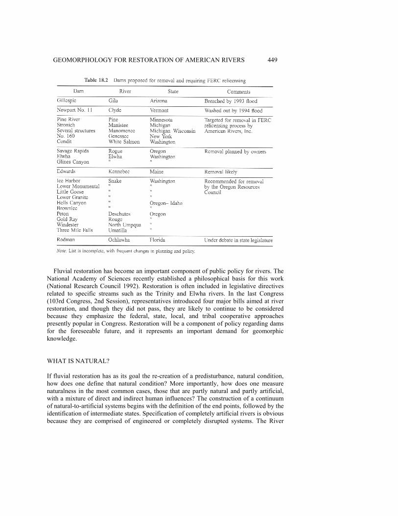
GEOMORPHOLOGY FOR RESTORATION OF AMERICAN RIVERS 449
Fluvial restoration has become an important component of public policy for rivers. TheNational Academy of Sciences recently established a philosophical basis for this work(National Research Council 1992). Restoration is often included in legislative directivesrelated to specific streams such as the Trinity and Elwha rivers. In the last Congress(103rd Congress, 2nd Session), representatives introduced four major bills aimed at riverrestoration, and though they did not pass, they are likely to continue to be consideredbecause they emphasize the federal, state, local, and tribal cooperative approachespresently popular in Congress. Restoration will be a component of policy regarding damsfor the foreseeable future, and it represents an important demand for geomorphicknowledge.
WHAT IS NATURAL?
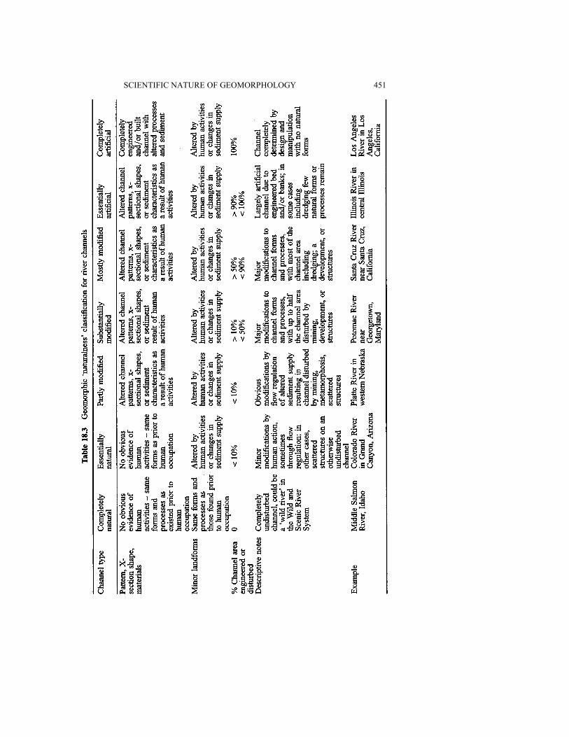
If fluvial restoration has as its goal the re-creation of a predisturbance, natural condition,how does one define that natural condition? More importantly, how does one measurenaturalness in the most common cases, those that are partly natural and partly artificial,with a mixture of direct and indirect human influences? The construction of a continuumof natural-to-artificial systems begins with the definition of the end points, followed by theidentification of intermediate states. Specification of completely artificial rivers is obviousbecause they are comprised of engineered or completely disrupted systems. The River
450 SCIENTIFIC NATURE OF GEOMORPHOLOGY
Walk along the San Antonio River in downtown San Antonio, Texas, is a famous exampleof such a system. With its water flows controlled by gates, its channel defined by cementwalls, its vegetation consisting of imported plants, and its built landscape, the River Walkis completely unlike the ecosystem it replaced.
Artificial river reaches are those experiencing the effects of human activities, eitherdirectly or indirectly. Built environments in and near rivers obviously impact fluvialprocesses locally, but other impacts may propagate themselves to distant locationsdownstream. Modifications of flow characteristics by a dam, for example, affect thegeomorphology of the river for a considerable distance, in some larger rivers for morethan 100 km (Williams and Wolman 1984). Enhanced or depleted sediment supply has acompound effect downstream by changing the particle sizes and geographic distributionsof deposits. The deposits, in turn, exert partial control over biotic distributions andinfluence the fate of contaminants in the system.
The natural end of the spectrum for ecosystems in general (not limited to rivers) is alsorelatively easy to define, with some attempts now established in law. Section 2 of the 1964Wilderness Act defines a natural system (including rivers) in the formal sense ofwilderness: 'A wilderness, in contrast with those areas where man and his own worksdominate the landscape, is hereby recognized as an area where the earth and itscommunity of life are untrammeled by man, where man himself is a visitor who does notremain' (Public Law 88-577; Hendee et al. 1978, p. 68).
The 1968 Wild and Scenic Rivers Act (Public Law 90-5423) codified definitions ofnaturalness specifically for rivers. Section 16(a) of the Act defines a river as 'a flowingbody of water or estuary or a section, portion, or tributary thereof, including rivers,streams, creeks, runs, kills, rills, or small lakes'. The law contains a scale based mostly onaccessibility, degree of disruption, and the presence of control structures (Coyle 1988, pp.14-16). Section 2(b) of the 1968 Act specifies that a wild river is free of impoundments, isgenerally inaccessible by trail, and is essentially primitive and unpolluted (Palmer 1993).The completely natural river channel in the classification used in this chapter is analogousto the 'wild' river as defined by the Act, but it is also free from upstream dams that mightindirectly alter its hydrology and geomorphology.
By beginning with these extreme conditions of completely artificial and completelynatural channels, and continuing with admittedly arbitrary gradations between them, it ispossible to develop a formal classification for geomorphic naturalness for rivers (Table18.3). This classification pertains only to the geomorphology of the rivers, but similarclassifications are possible to define departures from natural conditions for any aspect ofthe river ecosystem, such as hydrology, riparian botanical or zoological communities, orchemical characteristics. Such classifications, used in tandem with the one given here,could address the statistical characteristics of the flow regime, water temperature and pHconditions, ratios of native to introduced fish species, dominance of exotic as opposed tonative vegetation, and the concentrations of indicator chemical compounds or elements inwater and sediment.
A recent application of the geomorphic naturalness scale in Table 18.3 to centralArizona rivers showed that the majority of the channel reaches were in the range of partlymodified to mostly modified, with essentially artificial channels common in urban areas(Graf et al. 1994, a,b). Even in the rivers subjected to extensive engineering, however,there were many segments of channel that were essentially natural. From a naturalness
SCIENTIFIC NATURE OF GEOMORPHOLOGY 451

452 SCIENTIFIC NATURE OF GEOMORPHOLOGY
perspective, the river is segmented into reaches of varying characteristics, with eachsegment evidencing distinct physical processes and requiring specific policyconsiderations. Decision-makers (the Corps of Engineers and its partner agencies at thenational, state, and local level) used the classification as a basis for selecting channelsegments for emphasis in restoration efforts. Generally, they will invest resources in thesegments that are partly modified in an attempt to change them to essentially natural.Modifications (direct or indirect) to other channel segments are so substantial thatreturning them to the more natural end of the scale would be too costly. Similarapplications of the naturalness scale are possible in a variety of environments, though itmay be much more difficult in forested areas (Gregory and Davis 1992).
The objective of fluvial restoration, the conversion of affected channels to ones that aremore natural in morphology and function, is one of the primary purposes of soundenvironmental management for rivers. Although planners and engineers have a longhistory of interest in channel design, it has only been in recent years that geomorphologistshave begun to apply their scientific understanding to design problems. In an earlyBinghamton Geomorphology Symposium, for example, Keller (1975) reviewed thesignificant differences between natural and designed channels, pointing out that designmight easily incorporate more natural configurations. Geomorphologists have developedthe theme of designing rivers to contain natural roughness elements in arrangements thatmimic undisturbed natural streams (e.g. Gregory et al. 1994). Richards et al. (1987), usingexamples from Scotland, Saudi Arabia, and Honduras, showed how geomorphologicalperspectives can improve engineering and management solutions in a wide variety ofconditions. Newbury (1995) pointed out that restoration efforts are more likely to besuccessful if traditional engineering tools such as the Chezy equation receive newinterpretations to produce more natural and less artificial designs.
SPECIFIC APPLICATIONS OF RESTORATION POLICY AND SCIENCE
Since about 1980, two avenues for change have emerged for dam and river restoration.Each involves substantial policy changes, each produces changes in the fluvial landscape,and each requires new geomorphological research. First, the management of large publicdams has begun to include changes in operating rules that enhance downstreamrestoration. Second, owners of smaller private dams are redesigning their structures orremoving them for environmental enhancement in a federal relicensing procedure.Geomorphic research using basic theoretical concepts is a common approach for policyformulation to restore fluvial environments. The following pages provide examples at avariety of scales to illustrate the relationship between geomorphological research andrestoration policy. The examples are in two broad categories: operating rules for largepublic dams, and the removal of smaller private dams.
Operating Rules for Large Public Dams
It has only been in recent decades that the impact of large dams on downstreamecosystems has become apparent. Upstream inundation and loss of riparian habitat isobvious, but the alteration of downstream geomorphic conditions is substantial andfar-reaching.

GEOMORPHOLOGY FOR RESTORATION OF AMERICAN RIVERS 453
Depending on the purpose of the dam and its operating rules, a variety of hydrologicchanges occur in downstream flow. Most often, dam operations reduce annual floodpeaks, while increasing seasonal low flows in some cases, or eliminating low flows inothers. Dams operated for hydroelectric power production introduce short-term flowfluctuations that have no natural counterpart. Some of the most obvious geomorphicchanges are channel scour and armoring for a limited distance below the structures,accumulation of tributary sediments in the main channel and valley, conversion of channelpatterns from braided to meandering, channel shrinkage, beach and bar expansion, andfloodplain expansion (Williams and Wolman 1984; Petts 1979, 1980). These geomorphicchanges, in association with the changes in flow regime, result in a new substrate andhydrologic environment for riparian vegetation, with concomitant changes in wildlifepopulations. Fluvial restoration in these instances depends on changing the operating rulesof the dams so that they more closely mimic natural flow regimes. Recent examples of thisstrategy include operations at Glen Canyon Dam on the Colorado River, dams on theGunnison River, Trinity Dam on the Trinity River, and structures on the Kissimmee River(see Figure 18.2 for locations).
Glen Canyon Dam
The 1962 closure of Glen Canyon Dam on the Colorado River brought about remarkablechanges in the flow of the river downstream through Grand Canyon. The dam impoundsthe second largest reservoir in the country, Lake Powell, with a maximum storage capacityof 33.7 x 10⁹ m3 (27.3 x 10⁶ acre-ft), about two years' mean water yield of the river. Thedam eliminated periodic major floods, some as great as 8500 m3 s-1 (300 000 cfs),sustained low flows throughout the year at levels significantly greater than under naturalconditions, and terminated the upstream contributions of sediment (Figure 18.3).

454 SCIENTIFIC NATURE OF GEOMORPHOLOGY
Figure 18.3 Annual water yield and sand transport in the Grand Canyon of the Colorado Riverbelow Glen Canyon Dam, Arizona, showing two impacts of Glen Canyon Dam: (a) a regularizedannual water yield and (b) a reduced transport capacity as a result of reduced flood flows. Data fromUS Bureau of Reclamation (1994, pp. 73 and 85)

GEOMORPHOLOGY FOR RESTORATION OF AMERICAN RIVERS 455
Operation of the dam for hydroelectric power production introduced the most radicalchanges in the flow regime. In response to daily variations in demand for electricity in theregional power grid, the dam's penstocks and turbines released as much as 850 m3 s-1 (30000 cfs) during evening hours, and as little as 28.3 m3 s-1
(1000 cfs) during the morninghours. The result was a daily fluctuation in river stage in the Grand Canyon of up to 4 m(13 ft).
The new regime caused widespread geomorphic and ecologic adjustments in the GrandCanyon, which is part of a national park. The change from warm, silty waters to cold,clear waters released from the dam altered the fish population by creating conditionsunfavorable for endangered native fishes such as the humpback chub and razorback sucker(Minckley 1991). Meanwhile, artificially introduced trout flourished. Before theinstallation of the dam, large-caliber sediment brought down to the main channel by debrisflows and floods from tributaries came to rest in the main channel forming rapids, butperiodic major floods moved some of these materials into downstream pools (Webb et al.1987). After the closure of the dam, the highest flows were absent, and debris accumulatedin increasingly large rapids. Additionally, the geomorphology of the channel marginschanged in response to the lack of large floods. Sand deposits stranded high above the newwater levels eroded and desiccated, while eroding beaches and bars near the flow marginlost material to channel pools without the replenishment that would have occurred innatural floods (Schmidt and Graf 1990). Riparian vegetation which depended upon thesesubstrates also changed, and new plant assemblages became common. The invasion oftamarisk, an exotic shrub and tree, had begun before the closure of the dam andaccelerated afterwards (Carothers and Brown 1991, pp. 111-128).
These downstream hydrologic, geomorphic, and ecologic impacts were not of concernwhen the dam was authorized and built. Congress authorized the dam for water storage,sediment control, and power generation, with only minor consideration given to recreationand wildlife (mostly related to the upstream reservoir). By the 1980s, however, the publicperceived the downstream changes as a major problem, and the environmental qualityethic had given the geomorphology and ecology of the Grand Canyon new value (NationalResearch Council 1987, pp. 15-20). The beaches were critical to the maintenance of thecanyon's $20 million per year whitewater rafting industry, native fishes protected underthe Endangered Species Act were declining, and the riparian vegetation supported avariety of desirable wildlife.
Spurred by a lawsuit by river users, the Bureau of Reclamation established the GlenCanyon Environmental Studies (GCES) in 1982. With a budget that has grown to severalmillion dollars per year by 1995, the GCES has investigated the hydrologic, geomorphic,and ecologic processes in the river environment downstream from Glen Canyon Dam. Inwhat was probably the largest-scale geomorphic experiment ever conducted, the operatorscontrolled the dam discharges for a year, testing the hydrologic and geomorphic impactsof various discharge magnitudes, durations, and ramping rates. They have producedhundreds of reports that provide the most extensive knowledge base available for a canyonriver. The primary geomorphologic/hydrologic conclusions are that (1) the reducedtransport capacity of the river is roughly adequate to carry the available sediment inputsfrom tributaries below the dam, (2) under normal present conditions, beaches will slowlyerode, losing their sediment to nearby pools in the channel, (3) waters below the dam aretoo cold for a vigorous native fishery
456 SCIENTIFIC NATURE OF GEOMORPHOLOGY
Improved, scientifically based understanding of the canyon river processes has resultedin remarkable policy adjustments for operating the dam in a manner that facilitates therestoration of more natural conditions downstream. The Bureau partially simulatesseasonal variation in flows, trying to strike a balance between truly natural discharges andlegal requirements for water storage and delivery as outlined in a set of court decisions,treaties, and laws collectively known as the 'Law of the River'. Dam operators may allowan occasional (about once every five years) 'flood' of about 1275 m3 s-1 (45 000 cfs) toscour sediment from pools and deposit it on rebuilt beaches and bars. The agency is alsoexploring the possibility of a multiple outlet withdrawal structure designed to take waterfrom the reservoir at various depths, a method to increase the temperature of tail watersdownstream from the dam (US Bureau of Reclamation 1994). Adaptive managementallows operators to change strategy in response to changing conditions downstream asindicated by long-term monitoring.
Glen Canyon Dam is the largest structure to have modified operating rules in favor ofextensive restoration, but the modifications are a result of 13 years of intensivegeomorphic and other types of research with the expenditure of as much as $100 million.The outcomes of management decisions have a certain degree of predictability in theGrand Canyon. It will never be possible to restore the canyon to the natural conditions thatprevailed there before the introduction of exotic species and the installation of the dam. Itis possible, however, to move the canyon environment across the naturalness scale to aposition less dominated by artificial hydrographs and landforms.
Gunnison River Dams
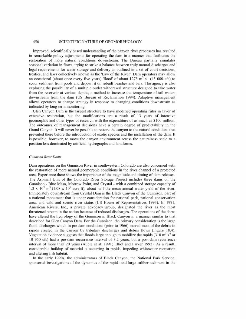
Dam operations on the Gunnison River in southwestern Colorado are also concerned withthe restoration of more natural geomorphic conditions in the river channel of a protectedarea. Experience there shows the importance of the magnitude and timing of dam releases.The Aspinall Unit of the Colorado River Storage Project includes three dams on theGunnison - Blue Mesa, Morrow Point, and Crystal - with a combined storage capacity of1.3 x 109 m3
(1.08 x 10⁶ acre-ft), about half the mean annual water yield of the river.Immediately downstream from Crystal Dam is the Black Canyon of the Gunnison, part ofa national monument that is under consideration for national park, national conservationarea, and wild and scenic river status (US House of Representatives 1993). In 1991,American Rivers, Inc., a private advocacy group, designated the river as the mostthreatened stream in the nation because of reduced discharges. The operations of the darnshave altered the hydrology of the Gunnison in Black Canyon in a manner similar to thatdescribed for Glen Canyon Dam. For the Gunnison, the primary consideration is the largeflood discharges which in pre-dam conditions (prior to 1966) moved most of the debris inrapids created in the canyon by tributary discharges and debris flows (Figure 18.4).Vegetation evidence suggests that floods large enough to mobilize the rapids (310 m3 s-1
or10 950 cfs) had a pre-dam recurrence interval of 3.2 years, but a post-dam recurrenceinterval of more than 20 years (Auble et al. 1991; Elliot and Parker 1992). As a result,considerable buildup of material is occurring in rapids, impeding whitewater recreationand altering fish habitat.
In the early 1990s, the administrators of Black Canyon, the National Park Service,sponsored investigations of the dynamics of the rapids and large-caliber sediment in the
GEOMORPHOLOGY FOR RESTORATION OF AMERICAN RIVERS 457
Figure 18.4 Annual flood series and the monthly mean discharges of the Gunnison River, at EastPortal, Colorado, below the Gunnison River dams, showing two impacts of dam operations after1966: more consistent low flows, and generally reduced maximum flows. US Geological Surveydata, also given by Chase (1992, p. 75)
canyon with respect to flood discharges. In support of the research, the Bureau ofReclamation manipulated the discharges from Crystal Dam to create artificial 'floods' of 22m3 s-1 (775 cfs) in September 1990 and 45 m3 s-1 (1500 cfs) in November 1990. Trackingof tagged boulders in rapids showed that at these discharges some debris on thedownstream side of the bars was mobilized. Extension of the empirical observations usingHEC-2 (a Corps of Engineers computer program) calculations for water surface profilessuggested that at the pre-dam common maximum flows of 310 m3 s-1 all but the largestparticles would be mobilized (Chase 1992).
In response to these findings, the National Park Service, Bureau of Reclamation, USFish and Wildlife Service, and the state of Colorado have agreed to new operating rules forthe dams of the Aspinall Unit on a four-year experimental basis (US Bureau ofReclamation 1991-93). During one year, the dams will release a spring 'flood' of 57-142 m3
s-1 (2000-5000 cfs), in one year of 142-283 m3 s-1 (5000-10000 cfs), in one year of greaterthan 340 m3 s-1 (12 000 cfs), and in one year greater than 424 m3 s-1 (15 000 cfs). The'floods', released during the naturally occurring peak flow period of May 15 to June 15,will provide a restoration of more natural hydrologic and geomorphic conditions, andreturn the rapids to a more dynamic state.
Trinity and Lewiston Dams
Experimental discharges and changes in operation rules also play a role in fluvialrestoration mandated by Congressional legislation on the Trinity River in northernCalifornia, where experience shows the irreversibility of some dam impacts. Two dams areat issue: the Trinity Dam for water storage, and Lewiston Darn, a reregulation structure (a

458 SCIENTIFIC NATURE OF GEOMORPHOLOGY
relatively small dam downstream from a larger one designed to modify short-term releasesfrom the large structure and to generate hydroelectric power). The Trinity Dam impoundsa reservoir with a capacity of 3.02 x 10⁹ m3 (2.45 X 10⁶ acre-ft) as part of the Bureau ofReclamation's Central Valley Project, while Lewiston Dam has a reservoir of minimalcapacity (US Bureau of Reclamation 1981). When Congress authorized the Central ValleyProject in 1955 for water resource development, it stipulated that impacts on otherresources would be minimized. After the completion of Trinity Dam in 1962 and LewistonDam in 1963, however, the project diverted 80% of the Trinity River's discharge andeliminated the normal peak flows of the river in the spring of each year (US Senate 1984).As a result, the salmonid fishery, once the most important fishery in California for chinookand steelhead salmon, was virtually eliminated. Before the installation of the dams, therivers had gravel beds with particular grain-size distributions which were the spawninggrounds for the fish (Figure 18.5). Although fine materials occurred in the river, the springflows flushed them downstream and maintained the gravel beds (Kondolf and Wolman1993). After closure of the darns, the general flows declined and the lack of peak springflows allowed the buildup of fine materials on the bed, blanketing the gravel and elim-inating the spawning areas (Majors 1989). Minimum flows were 4.25 m3 s-1 (150 cfs) until1981, when they were increased to 8.5 m3 s-1 (300 cfs) (Cassady et al. 1994). The
Figure 18.5 Salmonid spawning gravel sizes for various species compared to the natural sediment ingroups of representative rivers showing the narrow range of useful sediment sizes. Data forspawning from Kondolf and Wolman (1993), general river data from US Geological Surveyinformation

GEOMORPHOLOGY FOR RESTORATION OF AMERICAN RIVERS 459
influx of fine material was further aggravated by logging on steep slopes in the watershedwhich accelerated slope erosion and increased sediment loading to the streams.
By the early 1980s, an intergovernmental task force had brought about someadjustments in an attempt to restore the fishery. A sand dredging system removed somefine sediment from one of the major sources of fine sediment, the Grass ValleyWatershed, and the Bureau of Reclamation restored some streamflows from LewistonDam. These efforts did not restore the anadromous fish habitat to an acceptable degree,and recreational, scenic, and wildlife resources were still in a substantially modifiedcondition. In 1984, Congress authorized $33 million to manage and restore the fishery,with another $2.4 million for monitoring (Public Law 98-541, the Trinity River BasinRestoration Act).
From the geomorphic perspective, the Trinity River presented a problem in sedimenttransport and channel response to changing flow patterns. As the channel became smallerand dominated by fine materials after dam closure, vegetation invaded the channel andnear-channel environment. In 1992, an experimental flow of 170 m3 s-1
(6000 cfs) wasreleased from Lewiston Dam in an attempt to flush fine materials from the system andexpose the underlying gravel, but the vegetation and altered channel configurationsprevented a return to the original, natural conditions. Sediment mobility was indeedincreased, but much of the sediment was derived from bank erosion rather than thechannel floor. Conversely, many areas were surprisingly resistant to erosion because oftheir vegetation cover (Pitlick 1992). It thus appears that restoration of the Trinity River toanything approaching its pre-dam natural state is unlikely.
Kissimmee River Structures
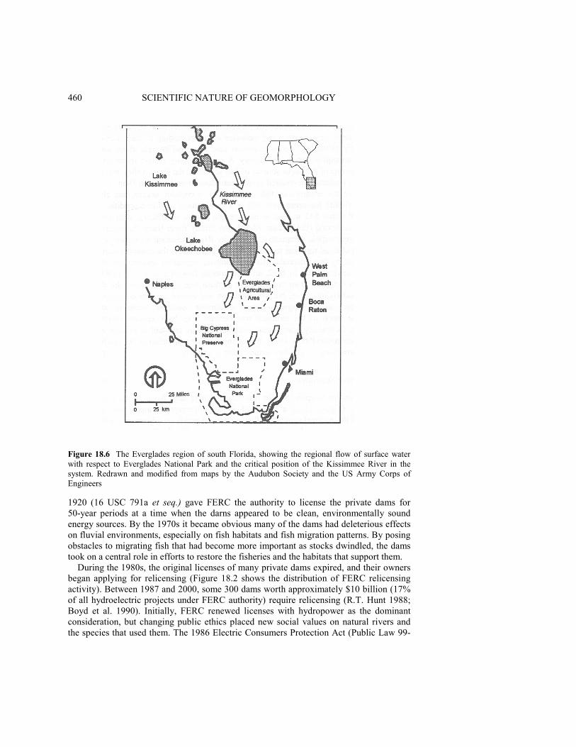
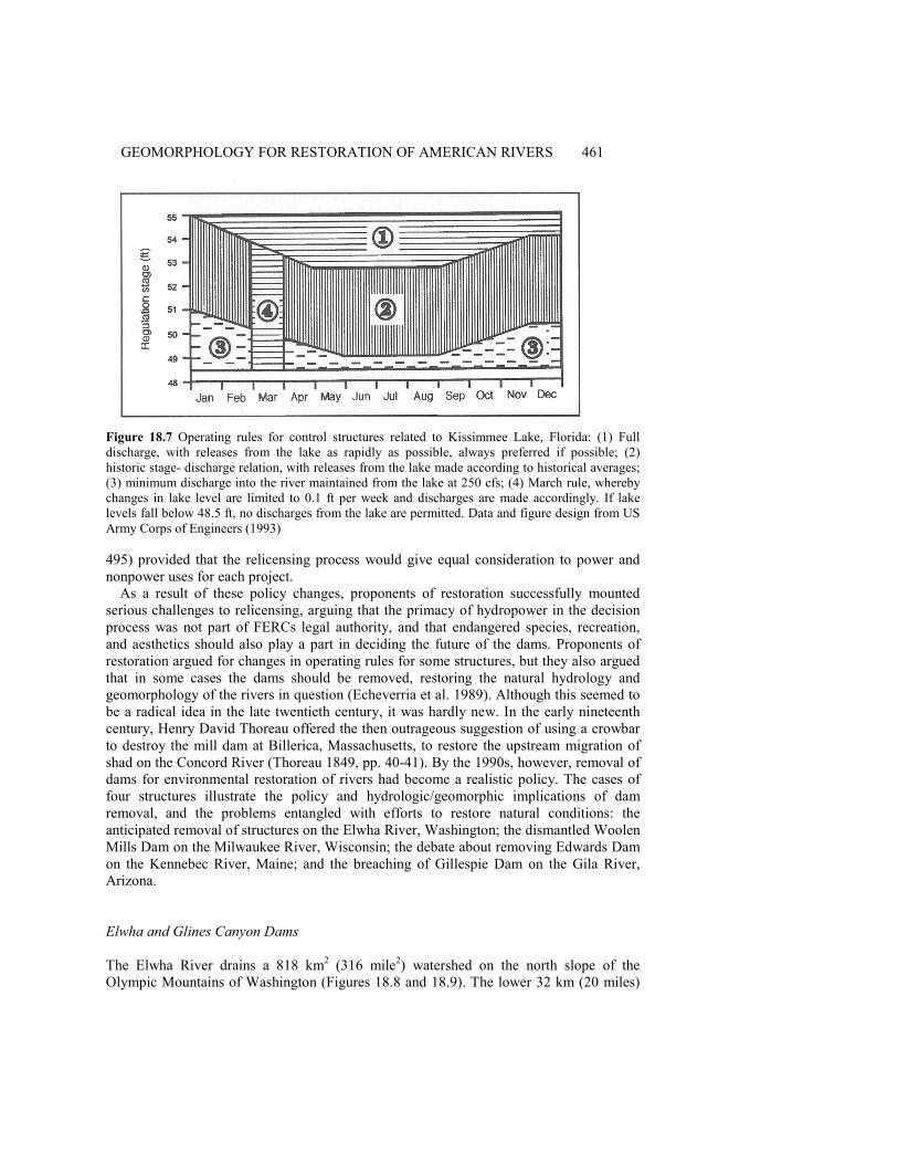
Not all adjustments in operations for restoration involve large dams. In the Everglades ofsouth Florida (Figure 18.6), a region of almost imperceptible topographic relief, therestoration of the regional southward flow of water depends on adjustments in operationsof low gates and pumps along the Kissimmee River and in the Everglades area south ofLake Okeechobee (Cushman 1994). In the first major civil works project on an Americanriver to be reversed, the Corps will also restore the straightened course of the Kissimmeeto its natural meandering configuration, and return water-level fluctuations in lakes andthe integrated stream network to more natural timing and ranges. The Corps' operationalchanges will increase the annual period of inundation for the 41 700 ha (108 000 acres)Shark River Slough addition to Everglades National Park (Figure 18.7), returning thehydrologic portion of the ecosystem to more natural arrangements (US Army Corps ofEngineers 1993). The total cost of the restoration project, now under way, will be morethan $500 million (US Office of Assistant Secretary of the Army 1992).
Relicensing and Removal of Private Dams
Although the federal government built and manages the largest dams in the United States,private interests have constructed thousands of smaller ones. Most of the private structurescompleted during the period 1930-60 were primarily for hydroelectric generation. Becausethe structures use the 'waters of the United States' (rivers administered by the federalgovernment), the Federal Energy Regulatory Commission (FERC, originally the FederalPower Commission) licenses their operation. The Federal Water Power Act of
460 SCIENTIFIC NATURE OF GEOMORPHOLOGY
Figure 18.6 The Everglades region of south Florida, showing the regional flow of surface waterwith respect to Everglades National Park and the critical position of the Kissimmee River in thesystem. Redrawn and modified from maps by the Audubon Society and the US Army Corps ofEngineers
1920 (16 USC 791a et seq.) gave FERC the authority to license the private dams for50-year periods at a time when the darns appeared to be clean, environmentally soundenergy sources. By the 1970s it became obvious many of the dams had deleterious effectson fluvial environments, especially on fish habitats and fish migration patterns. By posingobstacles to migrating fish that had become more important as stocks dwindled, the damstook on a central role in efforts to restore the fisheries and the habitats that support them.
During the 1980s, the original licenses of many private dams expired, and their ownersbegan applying for relicensing (Figure 18.2 shows the distribution of FERC relicensingactivity). Between 1987 and 2000, some 300 dams worth approximately $10 billion (17%of all hydroelectric projects under FERC authority) require relicensing (R.T. Hunt 1988;Boyd et al. 1990). Initially, FERC renewed licenses with hydropower as the dominantconsideration, but changing public ethics placed new social values on natural rivers andthe species that used them. The 1986 Electric Consumers Protection Act (Public Law 99-
GEOMORPHOLOGY FOR RESTORATION OF AMERICAN RIVERS 461
Figure 18.7 Operating rules for control structures related to Kissimmee Lake, Florida: (1) Fulldischarge, with releases from the lake as rapidly as possible, always preferred if possible; (2)historic stage- discharge relation, with releases from the lake made according to historical averages;(3) minimum discharge into the river maintained from the lake at 250 cfs; (4) March rule, wherebychanges in lake level are limited to 0.1 ft per week and discharges are made accordingly. If lakelevels fall below 48.5 ft, no discharges from the lake are permitted. Data and figure design from USArmy Corps of Engineers (1993)
495) provided that the relicensing process would give equal consideration to power andnonpower uses for each project.
As a result of these policy changes, proponents of restoration successfully mountedserious challenges to relicensing, arguing that the primacy of hydropower in the decisionprocess was not part of FERCs legal authority, and that endangered species, recreation,and aesthetics should also play a part in deciding the future of the dams. Proponents ofrestoration argued for changes in operating rules for some structures, but they also arguedthat in some cases the dams should be removed, restoring the natural hydrology andgeomorphology of the rivers in question (Echeverria et al. 1989). Although this seemed tobe a radical idea in the late twentieth century, it was hardly new. In the early nineteenthcentury, Henry David Thoreau offered the then outrageous suggestion of using a crowbarto destroy the mill dam at Billerica, Massachusetts, to restore the upstream migration ofshad on the Concord River (Thoreau 1849, pp. 40-41). By the 1990s, however, removal ofdams for environmental restoration of rivers had become a realistic policy. The cases offour structures illustrate the policy and hydrologic/geomorphic implications of damremoval, and the problems entangled with efforts to restore natural conditions: theanticipated removal of structures on the Elwha River, Washington; the dismantled WoolenMills Dam on the Milwaukee River, Wisconsin; the debate about removing Edwards Damon the Kennebec River, Maine; and the breaching of Gillespie Dam on the Gila River,Arizona.
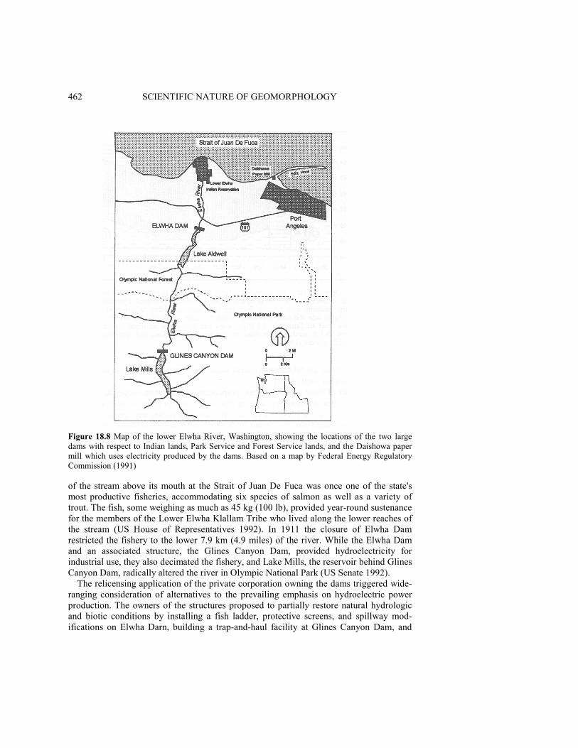
Elwha and Glines Canyon Dams
The Elwha River drains a 818 km2 (316 mile2) watershed on the north slope of theOlympic Mountains of Washington (Figures 18.8 and 18.9). The lower 32 km (20 miles)
462 SCIENTIFIC NATURE OF GEOMORPHOLOGY
Figure 18.8 Map of the lower Elwha River, Washington, showing the locations of the two largedams with respect to Indian lands, Park Service and Forest Service lands, and the Daishowa papermill which uses electricity produced by the dams. Based on a map by Federal Energy RegulatoryCommission (1991)
of the stream above its mouth at the Strait of Juan De Fuca was once one of the state'smost productive fisheries, accommodating six species of salmon as well as a variety oftrout. The fish, some weighing as much as 45 kg (100 lb), provided year-round sustenancefor the members of the Lower Elwha Klallam Tribe who lived along the lower reaches ofthe stream (US House of Representatives 1992). In 1911 the closure of Elwha Damrestricted the fishery to the lower 7.9 km (4.9 miles) of the river. While the Elwha Damand an associated structure, the Glines Canyon Dam, provided hydroelectricity forindustrial use, they also decimated the fishery, and Lake Mills, the reservoir behind GlinesCanyon Dam, radically altered the river in Olympic National Park (US Senate 1992).
The relicensing application of the private corporation owning the dams triggered wide-ranging consideration of alternatives to the prevailing emphasis on hydroelectric powerproduction. The owners of the structures proposed to partially restore natural hydrologicand biotic conditions by installing a fish ladder, protective screens, and spillway mod-ifications on Elwha Darn, building a trap-and-haul facility at Glines Canyon Dam, and
GEOMORPHOLOGY FOR RESTORATION OF AMERICAN RIVERS 463
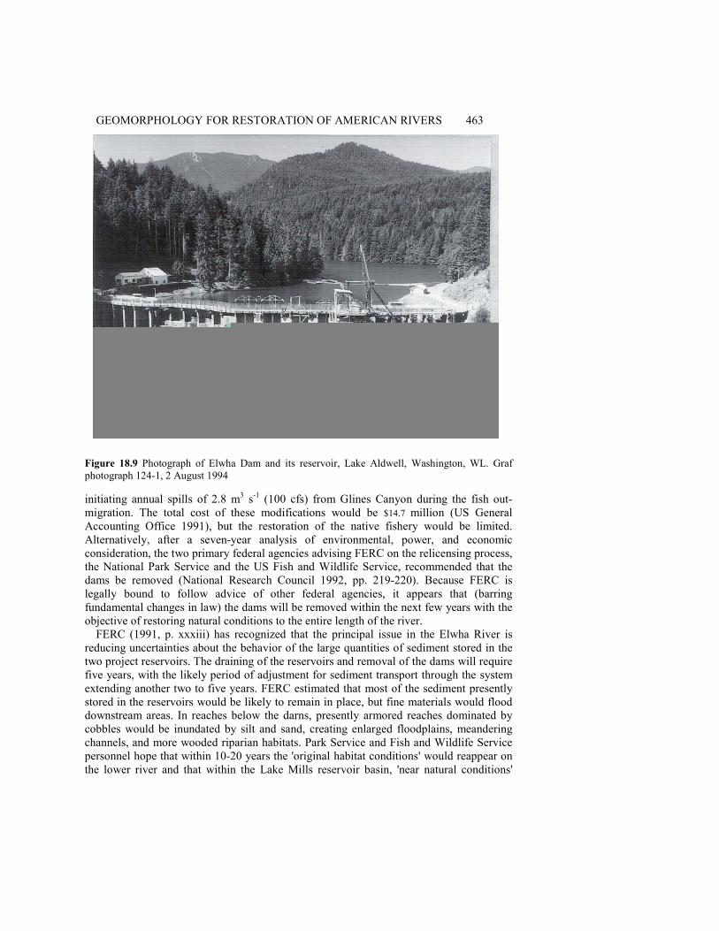
Figure 18.9 Photograph of Elwha Dam and its reservoir, Lake Aldwell, Washington, WL. Grafphotograph 124-1, 2 August 1994
initiating annual spills of 2.8 m3 s-1 (100 cfs) from Glines Canyon during the fish out-migration. The total cost of these modifications would be $14.7 million (US GeneralAccounting Office 1991), but the restoration of the native fishery would be limited.Alternatively, after a seven-year analysis of environmental, power, and economicconsideration, the two primary federal agencies advising FERC on the relicensing process,the National Park Service and the US Fish and Wildlife Service, recommended that thedams be removed (National Research Council 1992, pp. 219-220). Because FERC islegally bound to follow advice of other federal agencies, it appears that (barringfundamental changes in law) the dams will be removed within the next few years with theobjective of restoring natural conditions to the entire length of the river.
FERC (1991, p. xxxiii) has recognized that the principal issue in the Elwha River isreducing uncertainties about the behavior of the large quantities of sediment stored in thetwo project reservoirs. The draining of the reservoirs and removal of the dams will requirefive years, with the likely period of adjustment for sediment transport through the systemextending another two to five years. FERC estimated that most of the sediment presentlystored in the reservoirs would be likely to remain in place, but fine materials would flooddownstream areas. In reaches below the darns, presently armored reaches dominated bycobbles would be inundated by silt and sand, creating enlarged floodplains, meanderingchannels, and more wooded riparian habitats. Park Service and Fish and Wildlife Servicepersonnel hope that within 10-20 years the 'original habitat conditions' would reappear onthe lower river and that within the Lake Mills reservoir basin, 'near natural conditions'
464 SCIENTIFIC NATURE OF GEOMORPHOLOGY
would be restored in about the same time period. In addition to eliminating about $16.5million in electricity production per year used by the nearby Daishowa paper mill, theestimated cost of removal of the two structures is $64.3 million (US General AccountingOffice 1991).
These prognostications are problematic. There are no formal empirical studies thatdocument and quantify fluvial responses to the removal of large structures like the ElwhaRiver dams, though US Geological Survey researchers are investigating the case. Theexcavation of previously stored sediment from the reservoirs after dam removal is likely tobe a complex, multistage process that has not been widely documented or successfullymodeled and predicted. The downstream fate of these sediments in the Elwha system isalso more of a guess than a science, because although fine sediments moved through thesystem before the closure of the dams, they did so on a continuous basis in relatively lowannual amounts. The disposition of huge masses of fine materials released into the riverduring a brief period is largely unknown, and immediate floodplain constructiondownstream is without historical precedent. Although presently available theory andmodeling technology allow some reasonable estimates, it appears that the best experienceis that from unintended dam breaches and natural dam failures (Jarrett and Costa 1986).These limited efforts aside, the issue of the geomorphic impact of dam removal remains alargely unstudied aspect of fluvial processes, and increases the uncertainty in managingthe Elwha situation.
In addition to the scientific question, the policy considerations in the Elwha case arealso at the edge of established practice. The contention that reservoir areas anddownstream segments will be restored to natural conditions within two decades is unlikelyif strict definitions of 'completely natural' are applied. The large amounts of sedimentremaining within the Lake Mills and Lake Aldwell areas will produce channel and bankconditions never before seen in the area, and broad downstream floodplains are probablynot natural. The objectives of management on the river are to return natural hydrologicconditions to benefit the fishery, but the fluvial geomorphology will probably besubstantially modified (as defined in Table 18.3). Whether or not this partial restoration isacceptable from an ecosystem and landscape management standpoint is an unansweredquestion.
Edwards Dam
Privately owned low dams in the northeastern United States are also under considerationfor removal. The best example is probably Edwards Dam, a run-of-the-river structure onthe Kennebec River near Augusta, Maine (American Rivers, Inc. 1994, p. 4; Williams1993). Constructed in 1837 for sawmill and canal operations, and later modified forhydroelectric production, the dam prevents the upstream migration of Atlantic salmon, andrestricts the habitat of shad, smelt, and sturgeon (Egan 1990). Despite the modifications tothe dam to improve fish passage, state officials and nongovernmental organizationsconcluded the changes were inadequate, and the state legislature passed a resolution in1990 calling for the removal of the structure. In 1994, FERC began investigating of thefeasibility and impact of removing the dam, and the issue is not yet settled.
From a scientific perspective, removal of Edwards Dam and other similar structures onNew England rivers poses different questions than removal of dams on the Pacific coast.
GEOMORPHOLOGY FOR RESTORATION OF AMERICAN RIVERS 465
Because the eastern structures are only a few metres high and are often run-of-the-river,they do not significantly alter the hydrology of the streams, and prediction of thehydrologic effects of their removal is fairly straightforward. The stored sediment andaltered channel gradients pose the most important problems. The removal of the structuresinevitably produces short-term downstream impacts through remobilized sediment. Themasses of sediments themselves may be of only minor concern, but the chemical qualityof the materials is a potential pollution problem. New England and the eastern UnitedStates was the hearth of American industrialization, and throughout the nineteenth centuryheavy manufacturing without environmental quality controls dominated the waterways.These industries released to the streams huge (but unmeasured) amounts of heavy metalswhich became attached to the sediments. Some of these contaminated sediments moved tothe long-term sinks of the ocean or Great Lakes, where they now occur as easily defined,but isolated, components of the bottom sediments (Thomas 1972). Large amounts ofcontaminated sediment also came to rest behind the dams where they have remainedinterred. Removal of the structures raises the possibility of their remobilization anddeposition on floodplains downstream.
An area where this issue is of enough concern to prevent dam removal is the BlackstoneRiver system in central Massachusetts. Low dams have converted the river into a chain oflakes near the old manufacturing town of Worcester. Through the late 1800s, Worcesterwas a major metal machining center, and at one time was the greatest producer of metalwire in the world. Lead, zinc, copper, cadmium, and a variety of other contaminants frommanufacturing are now trapped in sediments behind the dams, which also act as localsinks for runoff from abandoned factory areas. To remove the structures would be to riskhazardous remobilization of the contaminants which are more easily managed in place. Inthese cases, environmental restoration may be less desirable than containment ofcontaminated sediments.
Unlike their western counterparts, the streams of the central Atlantic and New Englandstates offer numerous examples of dam removal that might be analyzed for the long-termimpact of such efforts. On almost every stream with perennial flow, the eighteenth andearly nineteenth century saw the construction of mills and associated dams for thegrinding of grain and powering machinery. Between about 1870 and 1930, with the adventof a centralized industrial economy, many of these mills ceased production, and ownersremoved the dams. Such sites now provide analogs for analysis and prediction of theeffects of anticipated additional dam removals.
Woolen Mills Dam
Some empirical evidence regarding removal is available from the case of at least onestructure in the Midwest. The Woolen Mills Dam, constructed in 1919, produced a head of4.2 m (14 ft) and a small reservoir affecting 2.4 km (1.5 miles) of the Milwaukee River inWest Bend, Wisconsin (Nelson and Pajak 1990). By the late 1980s, however, the stateDepartment of Natural Resources determined that the dam was unsafe and developed a10-year plan for its removal. Using suitability models for establishing habitat forsmallmouth bass, northern pike, and common carp, administrators restored the channel toemphasize sport fishing in an urban park setting (National Research Council 1992, p.

466 SCIENTIFIC NATURE OF GEOMORPHOLOGY
220). The resulting river is not even essentially natural according the scale in Table 18.2,but it is now closer to the natural side of the scale than it was previously.
Gillespie Dam
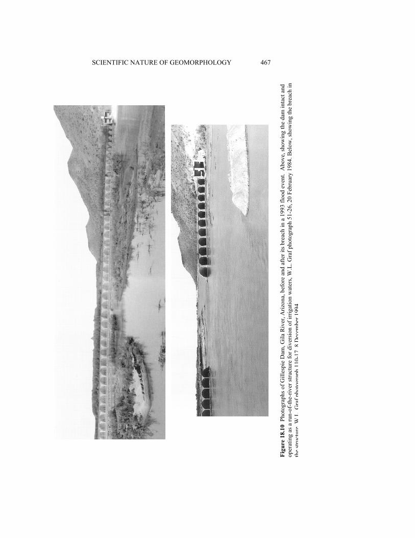
Gillespie Dam on the Gila River of central Arizona provides an unintentional example ofthe impacts of dam removal. The dam was built in 1921 as a 7.6 m (25 ft) high irrigationdiversion structure at a constriction in the Gila River Valley west of Phoenix, Arizona(Lecce 1988). Within two years of its closure, sediment had accumulated to the 485 m(1600 ft) wide crest of the dam, and by the 1980s the wedge of stored sediment extended11.3 km (7 miles) upstream. During flood events, water passed over the dam, but duringmost of year, the dam diverted all of the flow into canals. Despite surviving several floodsof over 2830 m3 s-1
(100 000 cfs), on 9 and 10 January 1993, the dam breached during aflood of up to 4245 m3 s-1
(150 000 cfs), developing a gap 54.5 m (180 ft) wide andextending from the crest to the base of the structure (Figure 18.10). Within two weeks,channel erosion removed more than half the sediment stored behind the dam, evacuating itthrough the breach and distributing it along 24 km (15 miles) of the compound channel (awell-defined low-flow invert within a broader, braided high-flow channel) downstream.The deposition of fine sands elevated the bed as much as 2 m (6 ft) in some locations.
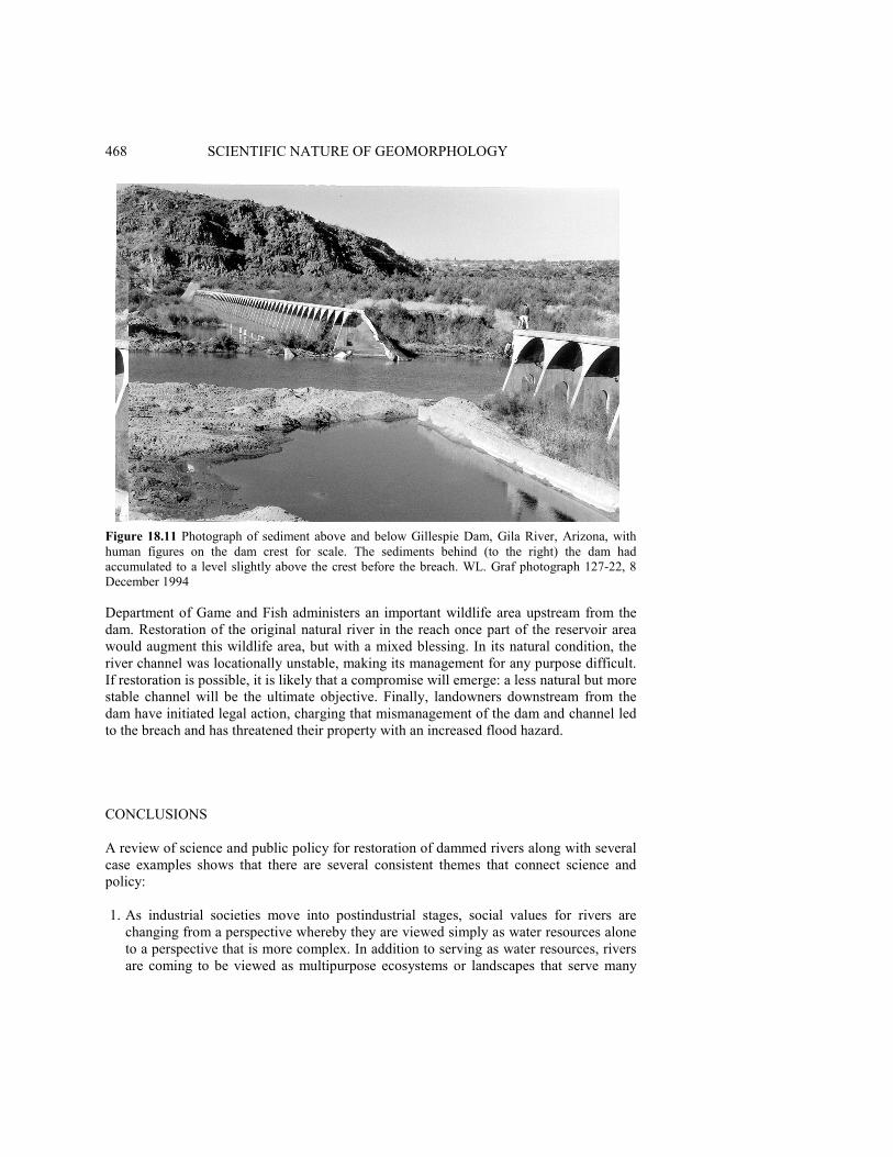
The breach caused a virtually instantaneous drop in base level of over 6.5 m (20 ft), butupstream migration of the resulting knickpoint did not produce a confined trench throughthe accumulated sediments. Lateral migration of the channel within the reservoir areaexcavated wide swaths of material and left crenelated margins in the remaining sediments.If the breach is not repaired, and restoration of the stream is possible, the long-termstability of the remaining sediments is an unresolved problem (Figure 18.11).
Public policy regarding Gillespie Dam is unsettled. Management options includerepairing the dam, removing it completely, or leaving it in its present breached condition(Flood Control District of Maricopa County, Internal Project Review, 17 November1994). The owners of the dam, a Swiss corporation with investment interests in the 10 100ha (25 000 acres) irrigated by the water diversions from the structure, are seeking the mostcost-effective solution to the problem. Because the owners installed a new pumpedwithdrawal system to supply irrigation water, they are not likely to repair the dam unlessthey are forced to do so by regulators. From the public perspective, there are five major issues, illustrating the administrativecomplexity associated with fluvial restoration connected with dams: environmentalquality, dam safety, flood control, fluvial restoration, and liability. First, any alterations orwork in the channel will require a permit from the Corps of Engineers under Section 404of the Clean Water Act. The Corps is actively pursuing restoration of some segments ofthe river, and is likely to evaluate any option with that goal in mind. Second, the stateDepartment of Water Resources is responsible for the safety of the structure, andengineering evaluations are required to assess the soundness of the remaining structure,especially its survivability during future floods. Third, the county flood control district isresponsible for flood protection downstream from the site, as well as administering theNational Floodplain Insurance Program of the Federal Emergency Management Agency.The flood control district is now employing geomorphic studies to assess the effect ofchannel changes downstream from the dam on flood potential. Fourth, the state
SCIENTIFIC NATURE OF GEOMORPHOLOGY 467
Figu
re 1
8.10
Pho
togr
aphs
of G
illes
pie
Dam
, Gila
Riv
er, A
rizon
a, b
efor
e an
d af
ter i
ts b
reac
h in
a 1
993
flood
eve
nt.
Abo
ve, s
how
ing
the
dam
inta
ct a
ndop
erat
ing
as a
run-
of-th
e-riv
er st
ruct
ure
for d
iver
sion
of i
rrig
atio
n w
ater
s, W
.L. G
raf p
hoto
grap
h 51
-26,
20
Febr
uary
198
4. B
elow
, sho
win
g th
e br
each
inth
est
ruct
ure,
W.L
.Gra
fpho
togr
aph
110-
17,8
Dec
embe
r199
4
468 SCIENTIFIC NATURE OF GEOMORPHOLOGY
Figure 18.11 Photograph of sediment above and below Gillespie Dam, Gila River, Arizona, withhuman figures on the dam crest for scale. The sediments behind (to the right) the dam hadaccumulated to a level slightly above the crest before the breach. WL. Graf photograph 127-22, 8December 1994
Department of Game and Fish administers an important wildlife area upstream from thedam. Restoration of the original natural river in the reach once part of the reservoir areawould augment this wildlife area, but with a mixed blessing. In its natural condition, theriver channel was locationally unstable, making its management for any purpose difficult.If restoration is possible, it is likely that a compromise will emerge: a less natural but morestable channel will be the ultimate objective. Finally, landowners downstream from thedam have initiated legal action, charging that mismanagement of the dam and channel ledto the breach and has threatened their property with an increased flood hazard.
CONCLUSIONS
A review of science and public policy for restoration of dammed rivers along with severalcase examples shows that there are several consistent themes that connect science andpolicy:
1. As industrial societies move into postindustrial stages, social values for rivers arechanging from a perspective whereby they are viewed simply as water resources aloneto a perspective that is more complex. In addition to serving as water resources, riversare coming to be viewed as multipurpose ecosystems or landscapes that serve many

GEOMORPHOLOGY FOR RESTORATION OF AMERICAN RIVERS 469
objectives. Some of these objectives are compatible with each other, but it is notpossible to maximize all the objectives.
2. Social values place increasing emphasis on a particular objective, the preservation orrestoration of 'natural' conditions that are conductive to achieving goals related to (inorder of established public preference) fish and wildlife management, recreation, andaesthetics.
3. Throughout much of the world, rivers are fragmented or segmented, divided intocompletely or partially controlled reaches by dams, with each reach exhibiting ageomorphological behavior that is markedly different from other nearby reaches.Theoretical models that view the river system as highly integrated must be modified toaccount for this segmentation.
4. It is rarely possible to restore truly natural conditions to regulated rivers, and even ifdams are removed, the probability of reestablishing original pre-dam conditions isunknown, but it is likely to be variable from one case to another.
5. Dams impose hydrologic and sedimentologic changes on downstream reaches. Damsusually have one or more of the following hydrologic impacts: reduced annual wateryield, reduced flood peaks, altered low flows (eliminated, or in other cases, sustained athigher than natural levels), altered seasonality of flow variation. Sedimentologicimpacts include reductions in downstream sediment discharges, changes in bed materialsize, and concomitant upstream storage which is remobilized if the dam is removed orbreached, raising problems of sedimentation and contaminant mobility
6. Because of these hydrologic and sedimentologic changes, geomorphic conditions inchannels downstream from the structures evolve into distinctly unnaturalconfigurations. These configurations depend not only on the presence of the structures(for which we have some theory), but also on operating rules for the dams (for whichwe have little theory).
7. Riparian vegetation and zoological communities are intimately related to thehydrologic, sedimentologic, and geomorphic conditions, but our knowledge about theseconnections is only now evolving into formal understanding.The primary consideration in establishing policy for river restoration is to address the
problem of 'what is natural?' It is unlikely that long reaches of American rivers will everreturn to their original, truly natural states, and they are likely to remain in their frag-mented condition (Graf 1993; Dynesius and Nilsson 1994), with preserved or restoredreaches interspersed with developed and dammed reaches. The rivers are therefore likelyto operate as segmented systems, and though effects in one reach are likely to be trans-mitted downstream, different segments perform different geomorphologic functions andrequire different policy strategies. But it is possible to make them more natural than theyare at present by selective removal of dams and alteration of operating rules for theremaining structures. Policy-making for rivers is often a perceptual issue (Gregory andDavis 1993), but the decision about how far to go in making rivers more natural is partlypolitical (what does society want?), partly scientific (what is possible?), and partly eco-nomic (what can society afford?). Based on previously established basic understanding ofthe systems (e.g. Petts 1984; Williams and Wolman 1984), geomorphologists can askmeaningful research questions with understandable, convincing answers. Management canthen proceed confidently on the basis of established and accepted research, with fluvial

470 SCIENTIFIC NATURE OF GEOMORPHOLOGY
changes anticipated and taken into account. The science of geomorphology can thus helpresolve the dominant philosophical conflict in management of the nation's rivers in thetwenty-first century: how to maintain viable economic development of the resource for thepresent while simultaneously preserving a quality environment for the future.
By addressing questions of interest to policyrnakers, the public, and other sciences,geomorphology returns to its intellectual roots, but to do so, its practitioners must focustheir efforts on subjects that others truly care about rather than on topics only of interest toa limited number of geomorphologists. Geomorphologists must more often participate inthe evolving complex interactions among Earth and life scientists to address issues ofecosystem quality and restoration (Naiman et al. 1995). The recent experiences ofgeomorphologists as outlined in this chapter show that such interactions can be fruitful onan administrative as well as scientific basis. Whether they like it or not, the scientist andpolicyrnaker are destined to be partners.
ACKNOWLEDGEMENTS
Ginger Hinchman greatly assisted the early construction of this chapter by obtaininginformation and documents related to the case examples. I greatly appreciate the efforts ofKen Gregory and Doug Sherman who materially improved the chapter with theirthoughtful review suggestions.
REFERENCES
American Rivers, Inc. 1994. Hydropower reform, American Rivers, 22(3), 5.Auble, G.T., Friedman, J. and Scott, M.L. 1991. Riparian Vegetation of the Black Canyon of the
Gunnison River, Colorado: Composition and Response to Selected Hydrologic Regimes Basedon a Direct Gradient Assessment Model, report by the US Fish and Wildlife Service for theNational Park Service, Water Resources Division, National Park Service, Ft Collins, Colo.
Bern, P.C. and Erskine, W.D. 1994. Complex channel response to flow regulation: Cudgegong Riverbelow Windamere Dam, Australia, Applied Geography, 14, 153-168.
Black, P.E. 1987. Conservation of Water and Related Land Resources (2nd edn), Roman &Littlefield, Totowa, NJ, 336 pp.
Boyd, D.W., Nease, R.F., Rice, J.S. and Taleb-lbrihim, M. 1990. Evaluating Hydro RelicensingAlternatives: Impacts on Power and Nonpower Values of Water Resources, Contract ReportGS-6922, Project 2694-7, Electric Power Research Institute, Palo Alto, Calif
Brookes, A. 1988. Channelized Rivers: Perspectives for Environmental Management, Wiley,Chichester, 326 pp.
Carling, P.A. 1987. Bed stability in gravel streams, with reference to stream regulation and ecology,in River Channels: Environment and Process, edited by K.S. Richards, Blackwell, London, pp.321-347.
Carothers, S.W and Brown, B.T. 1991. The Colorado River through the Grand Canyon: NaturalHistory and Human Change, University of Arizona Press, Tucson, 235 pp.
Cassady, J.C., Cross, J.B. and Calhoun, F. 1994. Western Whitewater from the Rockies to thePacific, North Fork Press, Berkeley, Calif, 314 pp.
Chase, K.J. 1992. Gunnison River thresholds for gravel and cobble motion, Black Canyon of theGunnison National Monument, MS thesis, Colorado State University, Ft Collins, Colo., 192 pp.
Coyle, K.J. 1988. The American Rivers Guide to Wild and Scenic River Designation, AmericanRivers, Inc., Washington, DC, 59 pp. Plus 10 appendices.
GEOMORPHOLOGY FOR RESTORATION OF AMERICAN RIVERS 471
Cushman, J.H., Jr. 1994. Federal agencies have plans to restore Florida Everglades to a more naturalstate, New York Times, 28 September, p. A10.
Decamps, H., Fortune, M. and Gazelle, F. 1994. Historical changes of the Garonne River, SouthernFrance, in Historical Change of Large Alluvial Rivers: Western Europe, edited by G.E. Petts, H.Moller and A.L. Roux, Wiley, Chichester, pp. 249-267.
Dynesius, M. and Nilsson, C. 1994. Fragmentation and flow regulation of river systems in thenorthern third of the world, Science, 266, 753-762.
Echeverria, J.D., Barrow, P. and Ross-Collins, R. 1989. Rivers at Risk: The Concerned CitizenGuide to Hydropower, Island Press, Washington, DC, 216 pp.
Egan, T. 1990. Dams may be razed so the salmon can pass, New York Times, 15 July, pp. 1, 14.Elliott, J.G. and Parker, R. 1992. Potential climate-change effects on bed-material entrainment,
Gunnison Gorge, Colorado, in Proceedings, American Water Resources Association, 28thAnnual Conference and Symposia, Reno, Nevada, November, 1992, pp. 751-759.
FERC (Federal Energy Regulatory Commission) 1991. Draft environmental impact statement forElwha and Glines Canyon Dams, Federal Energy Regulatory Commission, Washington, DC.
Gore, J.A. and Shields, F.D. Jr. 1995. Can large rivers be restored? Bioscience, 45, 142-152.Graf, W.L. 1993. Landscapes, commodities, and ecosystems: the relationship between policy and
science for American Rivers, in Sustaining Our Water Resources, 10th Anniversary Symposium,Water Science and Technology Board, National Research Council, National Academy Press,Washington, DC, pp. 11-42.
Graf, W.L., Beyer, P.J., Rice, J. and Wasklewicz, T.A. 1994a. Geomorphic Assessment of the LowerGila River, West Central Arizona, Contract Report DACW09-94-M-0494, Part 1, US ArmyCorps of Engineers, Arizona Area Office, Phoenix.
Graf, W.L., Beyer, P.J. and Wasklewicz, T.A. 1994b. Geomorphic Assessment of the Lower SaltRiver, Central Arizona, Contract Report DACW09-94-M-0494, Part 2, US Army Corps ofEngineers, Arizona Area Office, Phoenix.
Gregory, K.J. and Davis, R.J. 1992. Coarse woody debris in stream channels in relation to riverchannel management in woodland areas, Regulated Rivers, 7, 117-137.
Gregory, K.J. and Davis, R.J. 1993. The perception of riverscape aesthetics: an example from twoHampshire rivers, Journal of Environmental Management, 39, 171-182.
Gregory, K.J., Gurnell, A.M., Hill, C.T. and Tooth, S. 1994. Stability of the pool-riffle sequence inchanging river channels, Regulated Rivers, 9, 35-43.
Gregory; S.U., Swanson, F.J., McKee, W.A. and Cummings, K.W. 1991. An ecosystem perspectiveof riparian zones, Bioscience, 41, 540-551.
Hendee, J.C., Stankey, G.H. and Lucas, R.C. 1978. Wilderness Management, MiscellaneousPublication 1365, US Department of Agriculture, Washington, DC.
Holmes, B.H. 1972. A History of Federal Water Resources Programs, Miscellaneous Publication1233, US Department of Agriculture, Washington, DC.
Hugget, R. 1985. Earth Surface Systems, Springer-Verlag, Berlin, 270 pp.Hunt, E. 1988. Down by the River: The Impact of Federal Water Projects and Policies on Biological
Diversity, Island Press, Washington, DC.Hunt, R.T. 1988. Guide for Developing a Hydro Plant Relicensing Strategy, Vol. 1, Major Issues
and R&D Needs, Research Report AP- 6038, Project 2694-5, Electric Power Research Institute,Palo Alto, Calif
Jarrett, R.D. and Costa, J.E. 1986. Hydrology, geomorphology, and dam- break modeling of the July15, 1982 Lawn Lake Dam and Cascade Lake Dam failures, Larimer County, Colorado. USGeological Survey Professional Paper 1369.
Keller, E.A. 1975. Channelization: environmental, geomorphic, and engineering aspects, inGeomorphology and Engineering, edited by D.E. Coates, Dowden, Hutchinson, and Ross,Stroudsburg, Penn., pp. 115-140.
Kodras, J.E. and Jones, J.P. 1990. Academic research and social policy, in GeographicalDimensions of US Social Policy, edited by J.E. Kodras and J.P. Jones, Edward Arnold, London,pp. 237-248.
Kondolf, G.G. and Wolman, M.G. 1993. The sizes of salmonid spawning gravels, Water ResourcesResearch, 9 ,2275-2284.

472 SCIENTIFIC NATURE OF GEOMORPHOLOGY
Lagasse, RR 1994. Variable response of the Rio Grande to darn construction, in The Variability ofLarge Alluvial Rivers, edited by S.A. Schumm and B.R. Winkley, American Society of CivilEngineers, New York, pp. 395-422.
Lecce, S.A. 1988. Gillespie Dam, in The Salt and Gila Rivers in Central Arizona: A GeographicField Trip Guide, edited by W.L. Graf, Department of Geography Publication 3, Arizona StateUniversity, Department of Geography, Tempe, pp. 169-180.
Lewin, J., Macklin, M.G. and Woodward, J.C. (eds) 1995. Mediterranean Quaternary RiverEnvironments, A.A. Balkema, Rotterdam, 292 pp.
L'vovich, M.I. and White, G.F. 1990. Use and transformation of terrestrial water systems, in TheEarth as Transformed by Human Action: Global and Regional Changes in the Biosphere overthe Past 300 Years, edited by B.L. Turner, W.C. Clark, R.W. Kates, J.F. Richards, J.T. Matthewsand W.B. Meyer, University of Cambridge Press, Cambridge, pp. 235-252.
Majors, J.E. 1989. Opportunities to protect instream flows and wetland uses of water in California,Biological Report 89, US Fish and Wildlife Service, Washington, DC.
Minckley, W.L. 1991. Native fishes of the Grand Canyon region: an obituary?, in Colorado Riverand Ecology and Dam Management, National Research Council, National Academy Press,Washington, DC, pp. 124-177.
Naiman, R.J., Magnuson, J.J., McKnight, D.M., Stanford, J.A. and Karr, J.R. 1995. Freshwaterecosystems and their management: a national initiative, Science, 270, 584-585.
National Research Council 1987. River and Dam Management: A Review of the Bureau ofReclamation 's Glen Canyon Environmental Studies, National Academy Press, Washington, DC.
National Research Council 1992. Restoration of Aquatic Ecosystems, National Academy Press,Washington, DC.
National Research Council 1995. Rediscovering Geography: New Relevance for the New Century,National Academy Press, Washington, DC.
Nelson, J.E. and Pajak, P. 1990. Fish habitat restoration following dam removal on a warmwaterriver, in The Restoration of Midwestern Stream Habitat, Proceedings of a Symposium held at the52nd Midwest Fish and Wildlife Conference, Rivers and Streams Technical Committee, 4-5December 1990, Minneapolis, Minn., pp. 53-63.
Newbury, R. 1995. Rivers and the art of stream restoration, in Natural and AnthropogenicInfluences in Fluvial Geomorphology, edited by J.E. Costa, P.J. Miller, K.W. Potter and P.R.Wilcock, American Geophysical Union, Washington, DC, pp. 137-150.
Office of the Federal Register 1983. United States Organization Manual: 1983-1984, USGovernment Printing Office, Washington, DC.
Palmer, T. 1993. The Wild and Scenic Rivers of North America, Island Press, Washington, DC, 338pp.
Petts, G.E. 1979. Complex response of river channel morphology subsequent to reservoirconstruction, Progress in Physical Geography, 3, 329-362.
Petts, G.E. 1980. Morphological changes of river channels consequent upon headwaterimpoundment, Journal of the Institute of Water Engineers and Scientists, 34, 374-382.
Petts, G.E. 1984. Impounded Rivers: Perspectives for Ecological Management, Wiley, New York,326 pp.
Pickup, G. 1980. Hydrologic and sediment modeling studies in the environmental impact assessmentof a major tropical dam project, Earth Surface Processes, 5, 61-75.
Pickup, G. and Warner, R.F. 1984. Geomorphology of tropical rivers, 11, channel adjustment tosediment load and discharge in the Fly and Lower Purari Rivers, Papua New Guinea, Catena,supplement 5, 13-46.
Pitlick, J. 1992. Stabilizing effects of riparian vegetation during an overbank flow, Trinity River,California, EOS, Supplement 73, 231.
Richards, K.S., Brunsden, D., Jones, D.K.C. and McCaig, M. 1987. Applied fluvial geomorphology:river engineering project appraisal in its geomorphologic context, in River Channels:Environment and Process, edited by K.S. Richards, Blackwell, London, pp. 348-382.
Schmidt, J.C. and Graf, J.B. 1990. Aggradation and degradation of alluvial sand deposits,1965-1986, Colorado River, Grand Canyon National Park, Arizona, US Geological SurveyProfessional Paper 1493, 32 pp.
GEOMORPHOLOGY FOR RESTORATION OF AMERICAN RIVERS 473
Simons, R.K. and Simons, D.B. 1994. An analysis of Platte River channel changes, in TheVariability of Large Alluvial Rivers, edited by S.A. Schumm and B.R. Winkley, AmericanSociety of Civil Engineers, New York, pp. 341-361.
Thomas, R.L. 1972. The distribution of mercury in the sediment of Lake Ontario, Canadian Journalof Earth Science, 9, 63 6-65 1.
Thoreau, H.D. 1849. A Week on the Concord and Merrimack Rivers, reprinted 1961, SignetClassics, New York, 339 pp.
Tinkler, K.J. 1985. A Short History of Geomorphology, Barnes and Noble, Totowa, NJ, 317 pp.US Army Corps of Engineers 1993. Central and Southern Florida Project, Environmental
Restoration of the Kissimmee River, Florida, Final Integrated Feasibility Report andEnvironmental Impact Statement, US Army Corps of Engineers, Washington, DC.
US Bureau of Reclamation 1981. Central Valley Project: Historical Background and EconomicImpacts, US Department of Interior, Washington, DC.
US Bureau of Reclamation 1991-93. Annual Reports, US Bureau of Reclamation, US Department ofInterior, Washington, DC.
US Bureau of Reclamation 1994. Final Environmental Impact Statement, Operation of Glen CanyonDam, 2 vols, US Bureau of Reclamation, Salt Lake City.
US General Accounting Office 1991. Hydroelectric Dams: Costs and Alternatives for RestoringFisheries in the Elwha River, report to the Chairman, Subcommittee on Oversight andInvestigations, Committee on Energy and Commerce, US Government Printing Office,Washington, DC.
US House of Representatives 1992. Joint hearings on H.R. 4844, Elwha River Ecosystem andFisheries Restoration Act, 102nd Congress, 2nd Session, Government Printing Office,Washington, DC.
US House of Representatives 1993. H.R. 1321, Black Canyon National Conservation Act, 102ndCongress, 2nd Session, Government Printing Office, Washington, DC.
US Office of the Assistant Secretary of the Army for Civil Works 1992. Kissimmee Riverrestoration study, Letter from Chief of Engineers, Submitting a Report Pursuant to Section 116(h)of the Water Resource Development Act of 1990, US Army Corps of Engineers, Washington,DC.
US Senate 1984. Fish and wildlife restoration in the Trinity River, Senate Report 98-647, toAccompany H.R. 1438, Calendar No. 1295, 98th Congress, 2nd Session, Government PrintingOffice, Washington, DC.
US Senate 1992. Report to Accompany S. 2527, Elwha River Ecosystem and Fisheries RestorationAct, 102nd Congress, 2nd Session, Government Printing Office, Washington, DC.
Van Urk, G. and Smit, H. 1989. The Lower Rhine; geomorphological changes, in Historical Changeof Large Alluvial Rivers: Western Europe, edited by G.E. Petts, H. Moller and A.L. Roux, Wiley,Chichester, pp. 167-184.
Warner, R.F. 1988. Human impacts on river channels in New South Wales and Victoria, in TheFluvial Geomorphology of Australia, edited by R.F. Warner, Academic Press, Sydney, pp.343-363.
Webb, R.H., Rink, G.R. and Pringle, P.T. 1987. Debris flows from tributaries of the Colorado River,Grand Canyon National Park, Arizona, US Geological Survey Open-File Report 87-118.
Williams, G.P. and Wolman, M.G. 1984. Downstream effects of dams on alluvial rivers, USGeological Survey, Professional Paper 1286.
Williams, T. 1993. Freeing the Kennebec River, Audubon, 95, 36-42.Zhou, Z. and Pan, X. 1994. Lower Yellow River, in The Variability of Large Alluvial Rivers, edited
by S.A. Schumm and B.R. Winkley, American Society of Civil Engineers, New York, pp.341-361.